
Merrill Town City Zoning Code
DIVISION 17.2
ZONING DISTRICTS
17.2.01 - PURPOSE AND INTENT.
All lands located within the jurisdiction of this chapter are hereby divided into zoning districts of such number and character as are necessary to achieve compatibility of land uses within each district, to implement the Lincoln County comprehensive plan and component town land use plans, and to achieve the other stated purposes of this chapter.
17.2.02 - DESCRIPTION OF BASE ZONING DISTRICTS.
Areas within the jurisdiction of this chapter are divided into the following base zoning districts:
RURAL ZONING DISTRICTS:
(F)
Forestry District
(A)
Agriculture District
(RL2)
Rural Lands "2 per 40" District
(RL4)
Rural Lands "4 per 40" District
RESIDENTIAL ZONING DISTRICTS:
(SR)
Suburban Residential District
(RR1)
Rural Residential 30,000 District
(RR2)
Rural Residential 40,000 District
(RR3)
Rural Residential 50,000 District
(RR4)
Rural Residential 100,000 District
(RR5)
Rural Residential 200,000 District
(MR)
Mixed Residential District
(MH)
Manufactured/Mobile Home Park District
NONRESIDENTIAL ZONING DISTRICTS:
(RE)
Recreation District
(PB)
Planned Business District
(GB)
General Business District
(CMU)
Crossroads Mixed Use District
(PI)
Planned Industrial District
(GI)
General Industrial District
PLANNED DEVELOPMENT DISTRICTS:
(PD)
Planned Development District (labeled by year and approval order in year, e.g., PD 04-2)
17.2.03 - MAP OF BASE ZONING DISTRICTS.
Base zoning districts established by this chapter are shown on the Official Zoning Map of Lincoln County, which together with all explanatory materials thereon, is hereby made part of this chapter. Where the Official Zoning Map does not indicate a base zoning district for a particular area, unless the Map is in error, that area is either within the corporate limits of a city, within an area subject to extraterritorial zoning, and/or not subject to any rules associated with a base zoning district.
17.2.04 - INTERPRETATION OF BASE ZONING DISTRICT BOUNDARIES.
The following rules shall be used to determine the precise location of any base zoning district boundary shown on the Official Zoning Map of Lincoln County:
(1)
Base zoning district boundaries shown as following or approximately following the limits of any city or County boundary shall be construed as following such limits.
(2)
Base zoning district boundaries shown as following or approximately following public streets or railroad lines shall be construed as following the centerline of such streets or railroad lines.
(3)
Base zoning district boundaries shown as following or approximately following platted lot lines, ordinary high water marks, or other property lines as shown on the Lincoln County parcel maps shall be construed as following such lines.
(4)
No lot or tax parcel under one quarter-quarter section in area shall be divided into more than one base zoning district following initial town and County adoption of the Official Zoning Map, unless that lot or tax parcel is legally divided so that new lot lines and new zoning boundaries coincide.
(5)
Base zoning district boundaries shown as following or approximately following the centerlines of streams, rivers, or other continuously flowing watercourses shall be construed as following the channel centerlines of such watercourses, and, in the event of a natural change in the location of such streams, rivers, or other watercourses, the zoning district boundary shall be construed as moving with the channel centerline.
(6)
Base zoning district boundaries shown as separated from any of the features listed in paragraphs (1) through (5) above shall be construed to be at such distances as shown on the Official Zoning Map.
(7)
Where the exact location of a base zoning district boundary, as shown on the Official Zoning Map, is uncertain, the boundary location shall be determined by the Zoning Administrator.
17.2.05 - REGULATIONS APPLICABLE TO ALL LAND USES.
All uses of land initiated within the jurisdiction of this chapter on, or following, the effective date of this chapter shall comply with all provisions of this chapter. Such provisions directly relate to the protection of the health, safety, and general welfare of the residents of Lincoln County. Specifically:
(1)
LAND USE STANDARDS. All uses of land shall comply with all requirements of this chapter pertaining to the types of uses to which land is put within particular base zoning districts. Land uses that are not listed in a specific zoning district are not permitted in such zoning district, except as legal nonconforming uses. The treatment of all land uses in the various zoning districts is provided in Section 17.2.100, each of the listed land uses is described in detail in Division 17.3; nonconforming uses are addressed in Division 17.7.
(2)
DIMENSIONAL STANDARDS. All development of land shall comply with all requirements of this chapter pertaining to minimum and maximum permitted dimensional standards, including but not limited to lot area and width, building coverage, density, building height, yards, and setbacks. Most dimensional standards are addressed in Division 17.4.
(3)
PERFORMANCE STANDARDS. (Am. #2006-06-477) All development of land shall comply with all requirements of this chapter pertaining to the performance of development projects, including but not limited to issues of access, parking, loading, storage, lighting, screening, noise, vibration, odors, heat, glare and smoke. Most performance standards are addressed in Division 17.5.
(4)
SIGN STANDARDS. All development of land shall comply with all requirements of this chapter pertaining to the type and amount of signage. Sign standards are included in Division 17.6.
(5)
PROCEDURES. All development of land shall comply with the procedures of this chapter necessary to secure review and approval of development projects. Such procedures are included in Division 17.8.
17.2.10 - F FORESTRY DISTRICT.
(1)
INTENT. This district is intended to foster long-term investment in and proper management of Lincoln County's public and privately-owned forest areas. Appropriate multiple uses include commercial forest production and processing, recreation, nonmetallic mineral extraction as a conditional use, and seasonal dwellings on private lands. This district is intended be compatible with provisions of the Wisconsin's Forest Crop Law and Managed Forest Land programs.
(2)
LAND USES PERMITTED BY RIGHT OR AS A CONDITIONAL USE. Refer to the tables in Section 17.2.100 for a list of principal and accessory land uses that are permitted by right or as conditional uses in this district. The uses listed in the tables refer to the detailed land use descriptions contained in Division 17.3, which also includes parking standards. In addition, within the F Forestry district, manufactured homes and mobile homes shall be for seasonal use only as permitted by right uses.
(3)
DIMENSIONAL STANDARDS. Refer to the table in Section 17.2.101 for a list of dimensional standards, yards, building height, and other bulk regulations for development in this district.
17.2.11 - A AGRICULTURE DISTRICT.
(1)
INTENT. This district is intended to preserve Lincoln County's agricultural land for food and fiber production; protect productive farms by preventing land use conflicts between incompatible uses; support agricultural processing and service industries; provide reasonable opportunities to supplement farm income through compatible business opportunities and limited housing development; and preserve rural character in farming areas.
(2)
LAND USES PERMITTED BY RIGHT OR AS A CONDITIONAL USE. Refer to the tables in Section 17.2.100 for a list of principal and accessory land uses that are permitted by right or as conditional uses in this district. The uses listed in the tables refer to the detailed land use descriptions contained in Division 17.3, which also includes parking standards.
(3)
DIMENSIONAL STANDARDS. (Am. #2006-11-491) Refer to the table in Section 17.2.101 for a list of dimensional standards, yards, building height, and other bulk regulations for development in this district. Refer to Wis. Adm. Code ATCP 51 for standards related to certain livestock facilities covered under those rules. In addition, the maximum development density in this district shall be the equivalent of one new nonfarm dwelling unit for every 35 contiguous acres owned as of the date of adoption of this chapter, as calculated under Section 17.8.70.
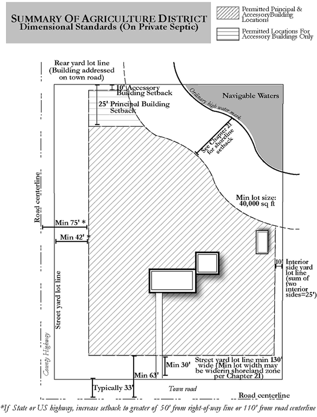
AGRICULTURE DISTRICT
Maximum Development Density: One housing unit per 35 acres.
17.2.12 - RL2 RURAL LANDS "2 PER 40" DISTRICT.
(1)
INTENT. This district is intended to preserve rural character and promote continued low-intensity and open space uses in areas of the County not envisioned for intensive agricultural or commercial forestry use. Appropriate uses include continued low-impact farming and forestry where viable, single family residences up to a density not exceeding 2 dwelling units per 40 acres owned, and associated home occupations and other limited compatible business opportunities.
(2)
LAND USES PERMITTED BY RIGHT OR AS A CONDITIONAL USE. Refer to the tables in Section 17.2.100 for a list of principal and accessory land uses that are permitted by right or as conditional uses in this district. The uses listed in the tables refer to the detailed land use descriptions contained in Division 17.3, which also includes parking standards.
(3)
DIMENSIONAL STANDARDS. Refer to the table in Section 17.2.101 for a list of dimensional standards, yards, building height, and other bulk regulations for development in this district. In addition, the maximum development density in this district shall be the equivalent of 2 new nonfarm dwelling units for every 40 contiguous acres owned as of the date of adoption of this chapter, as calculated under Section 17.8.70.
17.2.13 - RL4 RURAL LANDS "4 PER 40" DISTRICT.
(1)
INTENT. This district is intended to preserve rural character and promote continued low-intensity and open space uses in areas of the County not envisioned for intensive agricultural or commercial forestry use. Appropriate uses include continued low-impact farming and forestry where viable, single family residences up to a density not exceeding 4 dwelling units per 40 acres owned, and associated home occupations and other limited compatible business opportunities.
(2)
LAND USES PERMITTED BY RIGHT OR AS A CONDITIONAL USE. Refer to the tables in Section 17.2.100 for a list of principal and accessory land uses that are permitted by right or as conditional uses in this district. The uses listed in the tables refer to the detailed land use descriptions contained in Division 17.3, which also includes parking standards.
(3)
DIMENSIONAL STANDARDS. Refer to the table in Section 17.2.101 for a list of dimensional standards, yards, building height, and other bulk regulations for development in this district. In addition, the maximum development density in this district shall be the equivalent of 4 new nonfarm dwelling units for every 40 contiguous acres owned as of the date of adoption of this chapter, as calculated under Section 17.8.70.
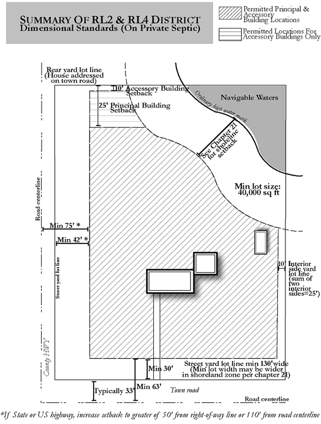
RL2 & RL4 DISTRICT
Maximum Development Density:
RL2 = 2 housing units per 40 acres
RL4 = 4 housing units per 40 acres
17.2.20 - SR SUBURBAN RESIDENTIAL DISTRICT.
(1)
INTENT. This district is intended for single-family and two-family dwellings, along with compatible home occupations, small-scale institutional and recreational uses, and low-intensity, pre-existing agricultural uses. The district is designed for existing or planned residential development areas near cities, in crossroad hamlets, in intensively developed waterfront areas, or in conservation neighborhoods.
(2)
LAND USES PERMITTED BY RIGHT OR AS A CONDITIONAL USE. Refer to the tables in Section 17.2.100 for a list of principal and accessory land uses that are permitted by right or as conditional uses in this district. The uses listed in the tables refer to the detailed land use descriptions contained in Division 17.3, which also includes parking standards.
(3)
DIMENSIONAL STANDARDS. Refer to the table in Section 17.2.101 for a list of dimensional standards, yards, and other bulk regulations for development in this district. Because of the district's minimum permitted lot size, all nonagricultural uses shall be served by public sanitary sewer or a private group waste treatment system serving 5 or more principal buildings. Where such services are unavailable, density and dimensional standards otherwise applicable in the RL2 Rural Lands district shall apply.
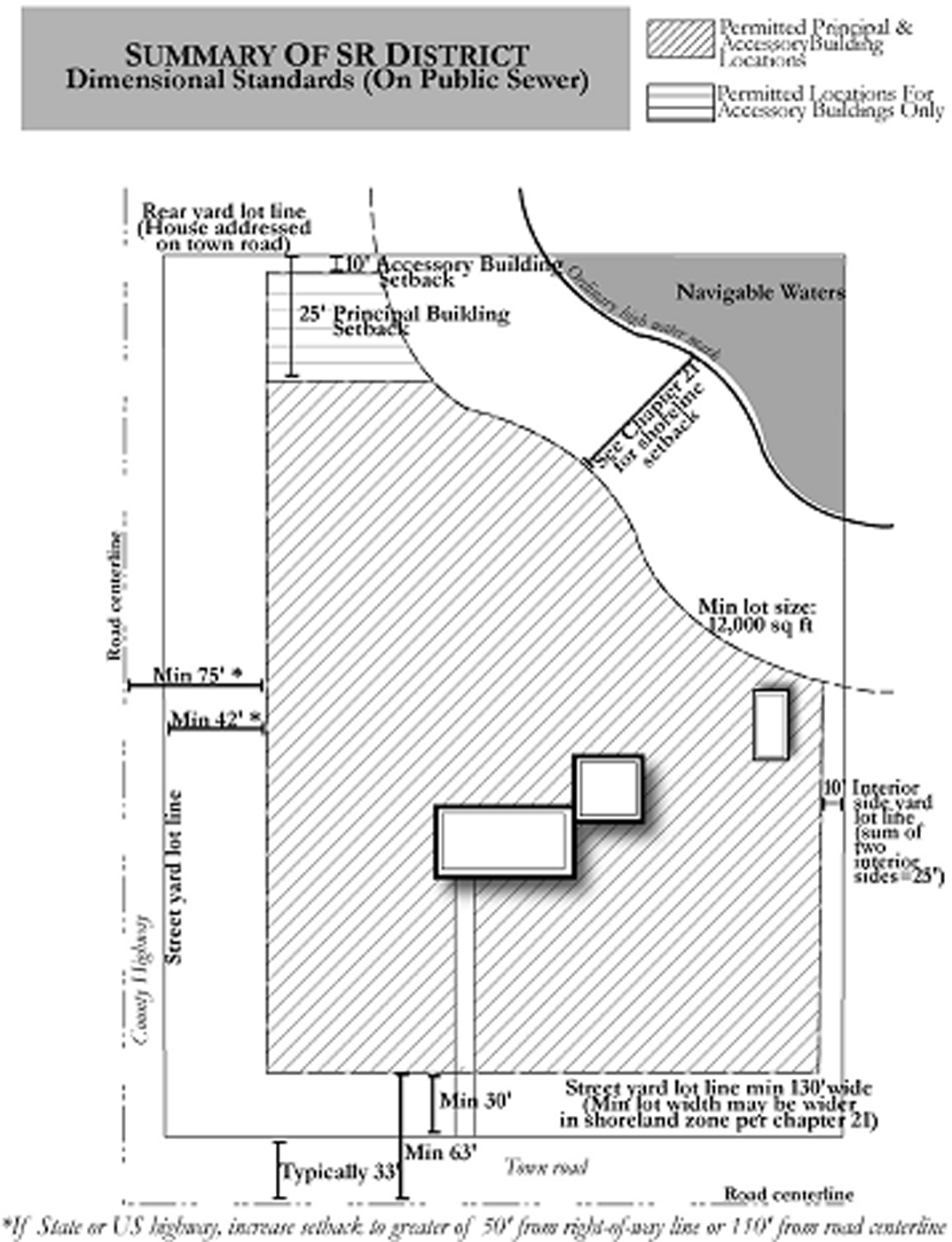
SR DISTRICT
17.2.30 - RR1 RURAL RESIDENTIAL 30,000 DISTRICT.
(1)
INTENT. This district is intended for single-family and two-family dwellings on small rural lots, along with compatible home occupations, small-scale institutional and recreational uses, and low-intensity agricultural uses. This district is primarily designed for existing residential areas served by private on-site waste treatment systems and that meet the lot size standards. Mapping of this district in areas planned for new development should be limited because of the district's small minimum lot size relative to requirements for on-site waste treatment requirements.
(2)
LAND USES PERMITTED BY RIGHT OR AS A CONDITIONAL USE. Refer to the tables in Section 17.2.100 for a list of principal and accessory land uses that are permitted by right or as conditional uses in this district. The uses listed in the tables refer to the detailed land use descriptions contained in Division 17.3, which also include parking standards.
(3)
DIMENSIONAL STANDARDS. Refer to the table in Section 17.2.101 for a list of dimensional standards, yards, and other bulk regulations for development in this district.
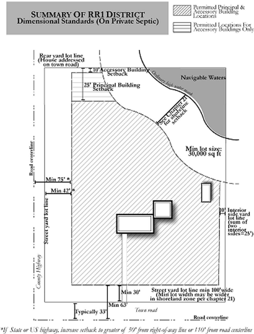
RR1 DISTRICT
17.2.31 - RR2 RURAL RESIDENTIAL 40,000 DISTRICT.
(1)
INTENT. This district is intended for single-family and two-family dwellings on relatively small rural lots, along with compatible home occupations, small-scale institutional and recreational uses, and low-intensity agricultural uses. The appropriateness of mapping this district in areas planned for residential development should be carefully considered because of the district's minimum lot size relative to requirements for on-site waste treatment systems.
(2)
LAND USES PERMITTED BY RIGHT OR AS A CONDITIONAL USE. Refer to the tables in Section 17.2.100 for a list of principal and accessory land uses that are permitted by right or as conditional uses in this district. The uses listed in the tables refer to the detailed land use descriptions contained in Division 17.3, which also includes parking standards.
(3)
DIMENSIONAL STANDARDS. Refer to the table in Section 17.2.101 for a list of dimensional standards, yards, and other bulk regulations for development in this district.
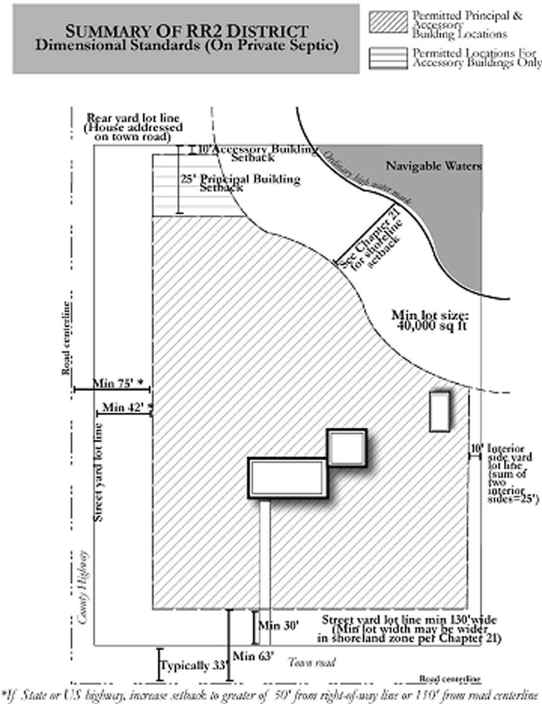
RR2 DISTRICT
17.2.32 - RR3 RURAL RESIDENTIAL 50,000 DISTRICT.
(1)
INTENT. This district is intended for single-family and two-family dwellings on moderately sized rural lots, along with compatible home occupations, small-scale institutional and recreational uses, and low-intensity agricultural uses. This district should generally be mapped in areas where public water and sewer services are not currently available or planned. This district also provides opportunities for slightly smaller minimum lot sizes in conservation neighborhood developments, where preservation of rural character, natural areas, farmland, and/or scenic views is emphasized.
(2)
LAND USES PERMITTED BY RIGHT OR AS A CONDITIONAL USE. Refer to the tables in Section 17.2.100 for a list of principal and accessory land uses that are permitted by right or as conditional uses in this district. The uses listed in the tables refer to the detailed land use descriptions contained in Division 17.3, which also includes parking standards.
(3)
DIMENSIONAL STANDARDS. Refer to the table in Section 17.2.101 for a list of dimensional standards, yards, and other bulk regulations for development in this district.
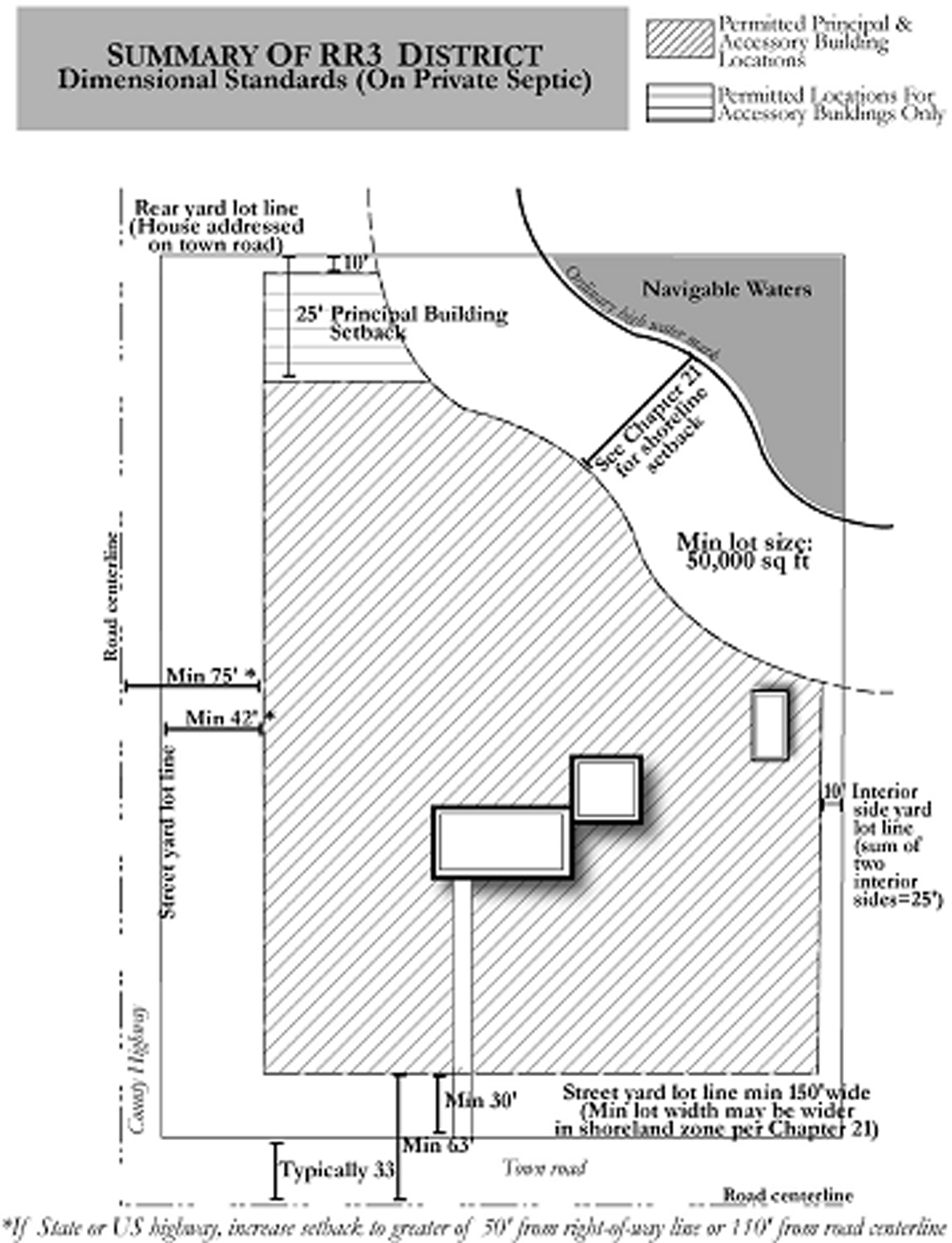
RR3 DISTRICT
17.2.33 - RR4 RURAL RESIDENTIAL 100,000 DISTRICT.
(1)
INTENT. This district is intended for single-family and two-family dwellings on relatively large rural lots, along with compatible home occupations, small-scale institutional and recreational uses, and low-intensity agricultural uses. This district should be mapped in areas where public water and sewer services are not currently available or planned. This district also provides opportunities for slightly smaller minimum lot sizes in conservation neighborhood developments, where preservation of rural character, natural areas, farmland, and/or scenic views is emphasized.
(2)
LAND USES PERMITTED BY RIGHT OR AS A CONDITIONAL USE. Refer to the tables in Section 17.2.100 for a list of principal and accessory land uses that are permitted by right or as conditional uses in this district. The uses listed in the tables refer to the detailed land use descriptions contained in Division 17.3, which also includes parking standards.
(3)
DIMENSIONAL STANDARDS. Refer to the table in Section 17.2.101 for a list of dimensional standards, yards, and other bulk regulations for development in this district.
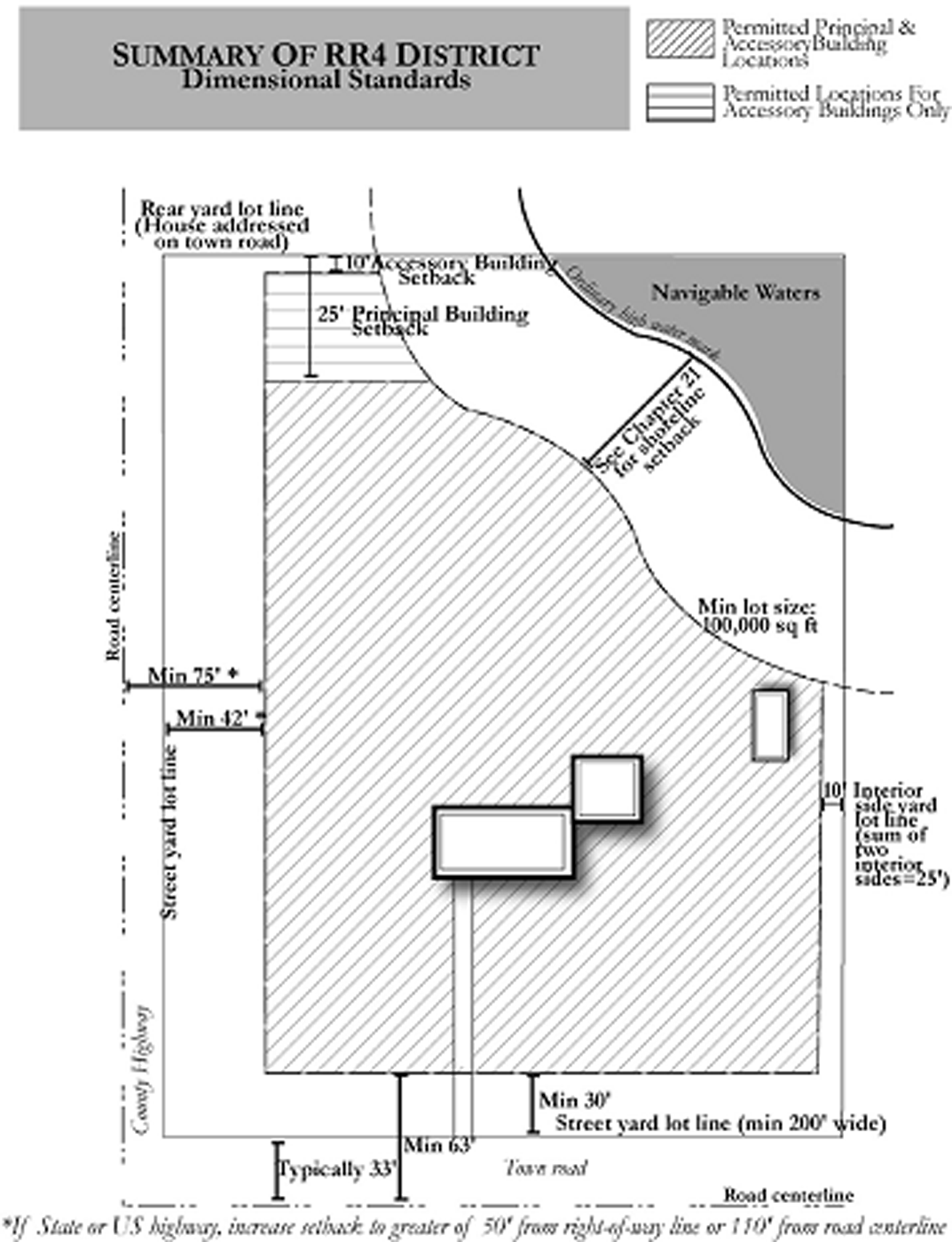
RR4 DISTRICT
17.2.34 - RR5 RURAL RESIDENTIAL 200,000 DISTRICT.
(1)
INTENT. This district is intended for single-family and two-family dwellings on large rural lots, along with compatible home occupations, small-scale institutional and recreational uses, and low-intensity agricultural uses. This district should be mapped in areas where public water and sewer services are not currently available or planned. This district also provides opportunities for slightly smaller minimum lot sizes in conservation neighborhood developments, where preservation of rural character, natural areas, farmland, and/or and scenic views is emphasized.
(2)
LAND USES PERMITTED BY RIGHT OR AS A CONDITIONAL USE. Refer to the tables in Section 17.2.100 for a list of principal and accessory land uses that are permitted by right or as conditional uses in this district. The uses listed in the tables refer to the detailed land use descriptions contained in Division 17.3, which also includes parking standards.
(3)
DIMENSIONAL STANDARDS. Refer to the tables in Section 17.2.101 for a list of dimensional standards, yards, and other bulk regulations for development in this district.

RR5 DISTRICT
17.2.40 - MR MIXED RESIDENTIAL DISTRICT.
(1)
INTENT. This district is intended for a mix of residential development types and densities, along with compatible home occupations, small-scale institutional and recreational uses, and existing low-intensity agricultural operations. Minimum required lot dimensions depend both on the number of dwelling units and the type of sanitary waste treatment method.
(2)
LAND USES PERMITTED BY RIGHT OR AS A CONDITIONAL USE. Refer to the tables in Section 17.2.100 for a list of principal and accessory land uses that are permitted by right or as conditional uses in this district. The uses listed in the tables refer to the detailed land use descriptions contained in Division 17.3, which also includes parking standards. New development in this district shall be subject to site plan approval under Section 17.8.40.
(3)
DIMENSIONAL STANDARDS. Refer to the table in Section 17.2.101 for a list of dimensional standards, yards, and other bulk regulations for development in this district.
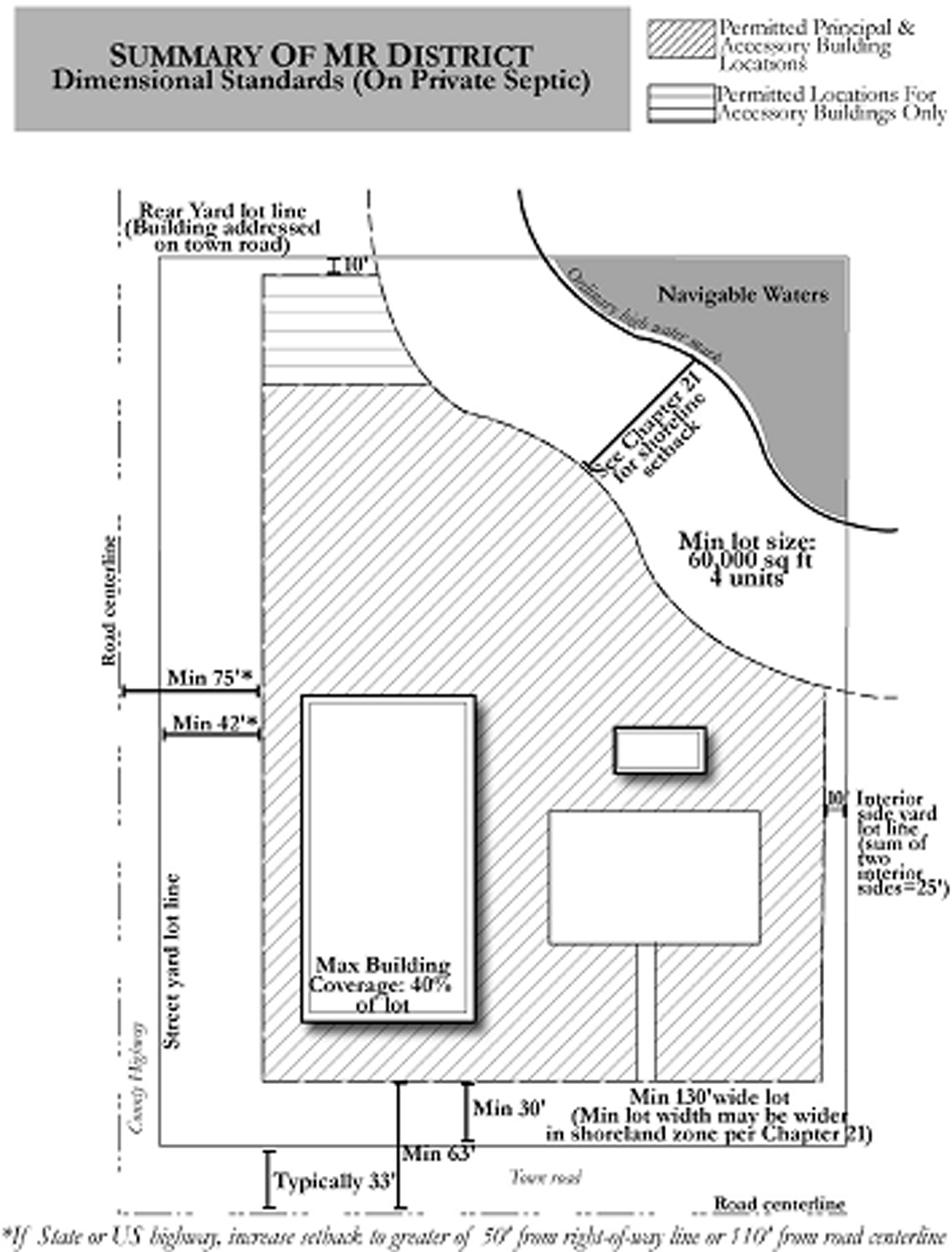
MR DISTRICT
17.2.41 - MH MOBILE HOME PARK DISTRICT.
(1)
INTENT. This district is intended to provide a safe, attractive, and functional environment for mobile and manufactured home parks and subdivisions, where the characteristics of manufactured homes do not allow them to be classified as single-family dwellings per Section 17.3.03. The district shall be mapped only where the mobile or manufactured home park will be provided with public sanitary sewer service or served by a private group waste treatment system.
(2)
LAND USES PERMITTED BY RIGHT OR AS A CONDITIONAL USE. Refer to the tables in Section 17.2.100 for a list of principal and accessory land uses that are permitted by right or as conditional uses in this district. The uses listed in the tables refer to the detailed land use descriptions contained in Division 17.3, which also includes parking standards. In addition, laundries, washrooms, recreation rooms, maintenance equipment storage, and one office associated with each mobile or manufactured home park shall be permitted as accessory land uses by right. New development in this district shall be subject to site plan approval under Section 17.8.40.
(3)
DIMENSIONAL STANDARDS:
(a)
Minimum Mobile or Manufactured Home Park Size: 10 acres.
(b)
Minimum Mobile or Manufactured Home Lot or Rental Site Size: 6,000 square feet.
(c)
Minimum Perimeter Yard for Mobile or Manufactured Home Park: 40 feet.
(d)
Minimum Lot or Rental Site Width: 50 feet.
(e)
Street Yard Requirements: For public roads, see Section 17.4.10. For interior park service roads, 20 feet.
(f)
Building Setback Requirements:
1.
Principal structures: No part of any mobile or manufactured home shall be located closer than 30 feet from any other mobile or manufactured home, including additions and appurtenances.
2.
Accessory structures: 10 feet from any other accessory structure or any mobile or manufactured home, including a home's additions or appurtenances.
(g)
Shoreland Zone Dimensional Requirements: All lands within 1,000 feet of the ordinary high water mark of lakes, ponds, or flowages and all lands within 300 feet of the ordinary high water mark of rivers and navigable streams, or to the landward side of the floodplain associated with the river or stream, whichever is greater, shall also be subject to the dimensional requirements for shoreland development in Chapter 21 of the Lincoln County Code of Ordinances, with the more restrictive provisions controlling in the event of conflict with the density, intensity, and bulk requirements of this section.
(h)
Off-Street Parking Requirements: As prescribed in Section 17.3.03(8).
(i)
Other Standards: See Section 17.3.03(8).
17.2.50 - RE RECREATION DISTRICT.
(1)
INTENT. This district is generally intended to accommodate recreational land uses serving the needs and interests of tourists and/or the local population. The district is further intended to create a high-quality environment for groupings of recreational uses. Appropriate uses include campgrounds, parks, lodging facilities, restaurants, recreational clubs, golf courses, and small-scale retail and service uses, but not year-round housing or intensive commercial or industrial uses.
(2)
LAND USES PERMITTED BY RIGHT OR AS A CONDITIONAL USE. Refer to the tables in Section 17.2.100 for a list of principal and accessory land uses that are permitted by right or as conditional uses in this district. The uses listed in the tables refer to the detailed land use descriptions contained in Division 17.3, which also includes parking standards. In addition, all uses including a building or buildings totaling 20,000 square feet or greater shall be conditional uses. New development in this district shall be subject to site plan approval under Section 17.8.40.
(3)
DIMENSIONAL STANDARDS. Refer to the table in Section 17.2.102 for a list of dimensional standards, yards, and other bulk regulations for development in this district.
RE DISTRICT
17.2.51 - PB PLANNED BUSINESS DISTRICT.
(1)
INTENT. This district is intended to accommodate high-quality retail, commercial service, lodging, and office uses, with attention towards site design, building design, landscaping, signage, lighting, and towards minimizing impacts on surrounding land uses. New and expanded developments within this district should assist in implementing the commercial development design recommendations in the adopted Lincoln County comprehensive plan.
(2)
LAND USES PERMITTED BY RIGHT OR AS A CONDITIONAL USE. Refer to the tables in Section 17.2.100 for a list of principal and accessory land uses that are permitted by right or as conditional uses in this district. The uses listed in the tables refer to the detailed land use descriptions contained in Division 17.3, which also includes parking standards. In addition, all uses including a building or buildings totaling 20,000 square feet or greater shall be conditional uses. New development in this district shall be subject to site plan approval under Section 17.8.40.
(3)
DIMENSIONAL STANDARDS. Refer to the tables in Section 17.2.102 for a list of dimensional standards, yards, and other bulk regulations for development in this district.
PB DISTRICT
17.2.52 - GB GENERAL BUSINESS DISTRICT.
(1)
INTENT. This district is intended to accommodate retail, commercial service, lodging, and office uses, with modest attention towards site design, building design, landscaping, signage, and lighting, and towards minimizing impacts on surrounding land uses.
(2)
LAND USES PERMITTED BY RIGHT OR AS A CONDITIONAL USE. Refer to the tables in Section 17.2.100 for a list of principal and accessory land uses that are permitted by right or as conditional uses in this district. The uses listed in the tables refer to the detailed land use descriptions contained in Division 17.3, which also includes parking standards.
(3)
DIMENSIONAL STANDARDS. Refer to the table in Section 17.2.102 for a list of dimensional standards, yards, and other bulk regulations for development in this district.
GB DISTRICT
17.2.53 - CMU CROSSROADS MIXED USE DISTRICT.
(1)
INTENT. This district is intended to accommodate historic or planned future collections of small-scale, often pedestrian-oriented indoor commercial, office, institutional, residential, and open space uses, in which community character is protected through building scale, appearance, landscaping, signage, and lighting. This district should be generally mapped at or near road crossings that serve as gathering points for rural communities. Gleason is an example of a historic area where this district may be mapped, and a model for the intended mix of uses and appearance for other areas where the district may be mapped.
(2)
LAND USES PERMITTED BY RIGHT OR AS A CONDITIONAL USE. Refer to the tables in Section 17.2.100 for a list of principal and accessory land uses that are permitted by right or as conditional uses in this district. The uses listed in the tables refer to the detailed land use descriptions contained in Division 17.3, which also includes parking standards. In addition, all uses including a building or buildings totaling 5,000 square feet or greater shall be conditional uses. New development in this district shall be subject to site plan approval under Section 17.8.40.
(3)
DIMENSIONAL STANDARDS. Refer to the table in Section 17.2.102 for a list of dimensional standards, yards, and other bulk regulations for development in this district.
CMU DISTRICT
17.2.61 - PI PLANNED INDUSTRIAL DISTRICT.
(1)
INTENT. This district is intended to accommodate high-quality manufacturing, assembly, office, and storage land uses, with attention towards site design, building design, landscaping, signage, lighting, and towards minimizing impacts on surrounding land uses. New and expanded developments within this district should assist in implementing the industrial development design recommendations in the Lincoln County Comprehensive Plan.
(2)
LAND USES PERMITTED BY RIGHT OR AS A CONDITIONAL USE. Refer to the tables in Section 17.2.100 for a list of principal and accessory land uses that are permitted by right or as conditional uses in this district. The uses listed in the tables refer to the detailed land use descriptions contained in Division 17.3, which also includes parking standards. In addition, all uses including a building or buildings totaling 20,000 square feet or greater shall be conditional uses. New development in this district shall be subject to site plan approval under Section 17.8.40.
(3)
DIMENSIONAL STANDARDS. Refer to the table in Section 17.2.102 for a list of dimensional standards, yards, and other bulk regulations for development in this district.
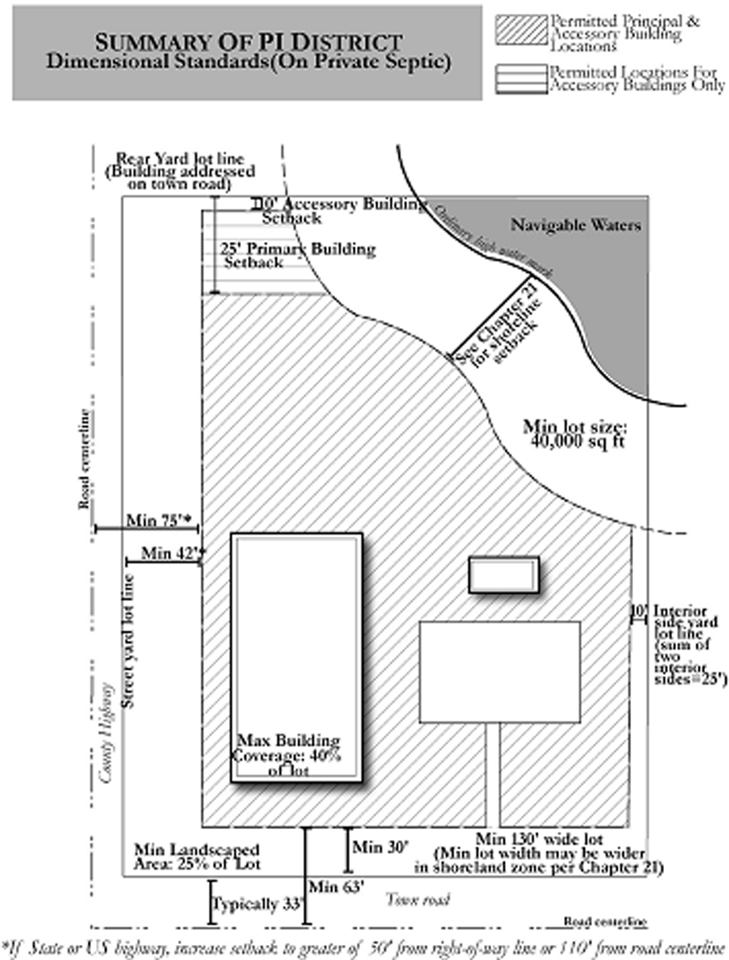
PI DISTRICT
17.2.62 - GI GENERAL INDUSTRIAL DISTRICT.
(1)
INTENT. This district is intended to accommodate manufacturing, assembly, office, storage, and other higher-impact land uses, with modest attention towards site design, building design, landscaping, signage, and lighting.
(2)
LAND USES PERMITTED BY RIGHT OR AS A CONDITIONAL USE. Refer to the tables in Section 17.2.100 for a list of principal and accessory land uses that are permitted by right or as conditional uses in this district. The uses listed in the tables refer to the detailed land use descriptions contained in Division 17.3, which also includes parking standards.
(3)
DIMENSIONAL STANDARDS. Refer to the table in Section 17.2.102 for a list of dimensional standards, yards, and other bulk regulations for development in this district.
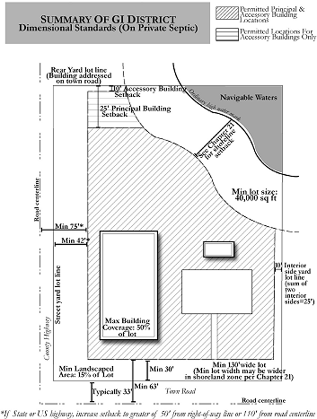
GI DISTRICT
17.2.70 - PD PLANNED DEVELOPMENT DISTRICT.
(1)
INTENT. This district is intended to promote improved design and innovative land uses in the County in accordance with the Lincoln County Comprehensive Plan and town land use plans. This district allows variation in the relationship of uses, structures, and open spaces in developments that are conceived and implemented as cohesive, unified projects. These unified projects must be developed in accordance with detailed site plans approved by both the town and County following a careful review process. In exchange for this detailed planning, this district offers flexibility from standards required in other zoning districts.
(2)
LAND USES PERMITTED BY RIGHT OR AS CONDITIONAL USES. Any permitted or conditional use in any other base zoning district in this chapter, if such uses are specifically shown, listed, or included within plans for the associated development and approved by the affected town and Lincoln County. Only those uses included in such approved plans shall be permitted. New development in this district shall be subject to site plan approval under Section 17.8.40.
(3)
DIMENSIONAL STANDARDS.
(a)
Maximum Building Coverage: As specified in approved plans for the development.
(b)
Minimum Landscaped Area Percentage: As specified in approved plans for the development.
(c)
Minimum Lot Size and Width: As specified in approved plans for the development.
(d)
Street Yard Requirements: As prescribed in Section 17.4.10(1).
(e)
Other Yard Requirements: As specified in approved plans for the development.
(f)
Shoreland Zone Dimensional Requirements: All lands within 1,000 feet of the ordinary high water mark of lakes, ponds, or flowages and all lands within 300 feet of the ordinary high water mark of rivers and navigable streams, or to the landward side of the floodplain associated with the river or stream, whichever is greater, shall also be subject to the dimensional requirements for shoreland development in Chapter 21 of the Lincoln County Code of Ordinances, with the more restrictive provisions controlling in the event of conflict with the dimensional requirements of this section.
(g)
Building Height Requirements: As specified in approved plans for the development.
(h)
Off-Street Parking Requirements: Dimensional standards as prescribed in Section 17.5.03.
17.2.80 - DESCRIPTION OF OVERLAY ZONING DISTRICTS.
This chapter employs overlay zoning districts to protect natural resources and unique geographic areas. Where mapped, the requirements in an overlay zoning district will apply in addition to the requirements in the underlying base zoning district, with the more restrictive provision applying in the event of any conflict. The overlay zoning districts shall be designated as follows:
(FW)
Floodway Overlay District
(FF)
Floodfringe Overlay District
(GFP)
General Floodplain Overlay District
(S)
Shoreland Overlay District
(SW)
Shoreland-Wetland Overlay District
(W)
Wetland Overlay District
(H51)
Highway 51 Overlay District
Lincoln County is required by Wisconsin Statutes to establish zoning districts covering floodplain, shoreland, and wetland areas, as defined by such Statutes. Also per Wisconsin Statutes, the FW, FF, GFP, S, SW, and W overlay districts shall apply throughout the unincorporated area of Lincoln County, where landscape conditions require their mapping. Other overlay zoning districts described in this section shall apply only in portions of the unincorporated area where the town government has adopted County zoning and where such districts have been mapped on the Official Zoning Map.
17.2.81 - MAP OF OVERLAY ZONING DISTRICTS.
Overlay zoning districts established by this chapter are shown on the Official Zoning Map of Lincoln County, which together with all the explanatory material thereon, is hereby made part of this chapter.
17.2.82 - INTERPRETATION OF OVERLAY ZONING DISTRICT BOUNDARIES.
The following rules shall be used to determine the precise location of any overlay zoning district boundary shown on the Official Zoning Map of Lincoln County:
(1)
Refer to Chapter 20 of the Lincoln County Code of Ordinances for the establishment and interpretation of the FW Floodway, FF Floodfringe, and GFP General Floodplain overlay district boundaries shown on the Official Zoning Map.
(2)
Refer to Chapter 21 of the Lincoln County Code of Ordinances for the establishment and interpretation of the S Shoreland overlay district boundaries shown on the Official Zoning Map.
(3)
Boundary determinations for the SW Shoreland-Wetland and W Wetland overlay zoning districts shall be made by the Zoning Administrator following review of the Wisconsin Department of Natural Resources Wisconsin Wetland Inventory maps. Where an apparent discrepancy exists between a SW Shoreland-Wetland or W Wetland overlay district boundary shown on the Official Zoning Map or Wisconsin Wetland Inventory maps and actual field conditions, the Zoning Administrator shall contact the appropriate district office of the Department of Natural Resources to determine if the boundary as mapped is in error. If the Department of Natural Resources staff concur with the Zoning Administrator that a particular area was incorrectly mapped as a wetland, Lincoln County may immediately grant or deny appropriate permits in accordance with the regulations applicable to the correct base zoning district (i.e., without the SW or W overlay zoning district designation). The Zoning Administrator shall initiate a zoning map amendment to correct these mapping discrepancies following the procedures established in Section 17.8.25.
(4)
Boundary determinations for the H51 Highway 51 overlay district shall be made by the Zoning Administrator by scaling distances from the Official Zoning Map or its digital map source.
17.2.90 - FW FLOODWAY, FF FLOODFRINGE, AND GFP GENERAL FLOODPLAIN OVERLAY DISTRICTS.
Refer to Chapter 20 of the Lincoln County Code of Ordinances for regulations applicable in the FW Floodway, FF Floodfringe, and GFP General Floodplain overlay districts shown on the Official Zoning Map. In general, these overlay districts are mapped by the Federal Emergency Management Agency in certain areas along navigable waters that have a one percent chance of flooding in any given year (100-year floodplain).
17.2.91 - S SHORELAND OVERLAY ZONING DISTRICT.
Refer to Chapter 21 of the Lincoln County Code of Ordinances for regulations applicable in the S Shoreland overlay districts shown on the Official Zoning Map. This overlay zoning district applies to all lands within 1,000 feet of the ordinary high water mark of lakes (including glacial pothole lakes), ponds, or flowages and all lands within 300 feet of the ordinary high water mark of rivers and navigable streams, or to the landward side of the floodplain associated with the river or stream, whichever is greater.
17.2.92 - SW SHORELAND-WETLAND OVERLAY ZONING DISTRICT.
(1)
INTENT. This overlay zoning district is intended to maintain safe and healthful conditions; prevent water pollution; protect fish spawning grounds and wildlife habitat; preserve shore cover and natural beauty; manage flooding; protect personal property and real estate; and control building and development in wetlands. When development is permitted in the SW Shoreland-Wetland district, the development should occur in a manner that minimizes adverse impacts upon the wetland.
(2)
JURISDICTION. The regulations specified within this Shoreland-Wetland overlay zoning district shall apply to all wetlands of 5 acres or more located within the boundaries of mapped S Shoreland overlay districts. A portion of a wetland which is less than 5 acres in size and which is located in the unincorporated shoreland district within the County shall be included in the SW Shoreland-Wetland district where the wetland as a whole is 5 acres or larger, but extends into the corporate limits of a city or village, across the County boundary, or across the S Shoreland overlay district limit.
(3)
LAND USES PERMITTED BY RIGHT. The following uses shall be allowed, subject also to the S Shoreland zoning regulations contained in Chapter 21 of the Lincoln County Code of Ordinances, the provisions of Chs. 30 and 31, Wis. Stats., and the provisions of other applicable local, State, and Federal laws:
(a)
Activities and uses which do not require the issuance of a zoning permit, but which must be carried out without any filling, flooding, draining, dredging, ditching, tiling or excavating except as allowed under subsections (b) and (c):
1.
Hiking, fishing, trapping, hunting, swimming and boating.
2.
The harvesting of wild crops, such as marsh hay, ferns, moss, wild rice, berries, tree fruits and tree seeds, in a manner that is not injurious to natural reproduction of such crops.
3.
The pasturing of livestock.
4.
The cultivation of agricultural crops.
5.
The practice of silviculture, including the planting, thinning and harvesting of timber.
6.
The construction or maintenance of duck blinds.
(b)
Uses which do not require the issuance of a zoning permit and which may include limited filling, flooding, draining, dredging, ditching, tiling or excavating, but only to the extent specifically provided below:
1.
Temporary water level stabilization measures necessary to alleviate abnormally wet or dry conditions that would have an adverse impact on silvicultural activities if not corrected.
2.
The cultivation of cranberries, including flooding, dike and dam construction or ditching necessary for the growing and harvesting of cranberries.
3.
The maintenance and repair of existing agricultural drainage systems where permissible by §30.20, Wis. Stats., including ditching, tiling, dredging, excavating and filling necessary to maintain the level of drainage required to continue the existing agricultural use. This includes the minimum filling necessary for disposal of dredged spoil adjacent to the drainage system provided that the filling is permissible by Ch. 30, Wis. Stats., and that dredged spoil is placed on existing spoil banks where possible.
4.
The construction or maintenance of fences for the pasturing of livestock, including limited excavating and filling necessary for such construction or maintenance.
5.
The construction or maintenance of piers, docks or walkways built on pilings, including limited excavating and filling necessary for such construction and maintenance.
6.
The maintenance, repair, replacement or reconstruction of existing town and County highways and bridges, including limited excavating and filling necessary for such maintenance, repair, replacement or reconstruction.
(c)
Uses which require the issuance of a zoning permit under Section 17.8.50 of this chapter, and which may include limited filling, flooding, draining, dredging, ditching, tiling or excavating, but only to the extent specifically provided below:
1.
The construction and maintenance of roads which are necessary to conduct silvicultural activities or agricultural cultivation, provided that:
a.
The road cannot as a practical matter be located outside a wetland.
b.
The road is designed and constructed to minimize adverse impact upon the natural functions of the wetland.
c.
The road is designed and constructed with the minimum cross-sectional area practical to serve the intended use.
d.
Road construction activities are carried out in the immediate area of the roadbed only.
2.
The construction or maintenance of nonresidential buildings, provided that:
a.
The building is essential for and used solely in conjunction with the raising of waterfowl, minnows or other wetland or aquatic animals, or some other use permitted in the shoreland-wetland districts.
b.
The building cannot, as a practical matter, be located outside the wetland.
c.
Such building is not designed for human habitation and does not exceed 500 square feet in gross floor area.
d.
Only limited filling or excavating necessary to provide structural support for the building is authorized.
3.
The establishment of public and private parks and recreation areas, natural and outdoor education areas, historic and scientific areas, wildlife refuges, game bird and animal farms, fur animal farms, fish hatcheries, and public boat launching ramps and attendant access roads, provided that:
a.
Any private development is used exclusively for the permitted use and the applicant has received a permit or license under Ch. 29, Wis. Stats., where applicable.
b.
Filling or excavating necessary for the construction or maintenance of public boat launching ramps or attendant access roads is allowed only where such construction or maintenance meets the criteria in subsection (c)1., above.
c.
Ditching, excavating, dredging or dike and dam construction in public and private parks and recreation areas, natural and outdoor education areas, historic and scientific areas, wildlife refuges, game bird and animal farms, fur animal farms and fish hatcheries is allowed only for the purpose of improving wildlife habitat and to otherwise enhance wetland values.
4.
The construction or maintenance of electric, gas, telephone, water and sewer transmission and distribution facilities, by public utilities and cooperative associations organized for the purpose of producing or furnishing heat, light, power or water to their members and the construction or maintenance of railroad lines provided that:
a.
The transmission and distribution facilities and railroad lines cannot, as a practical matter, be located outside the wetland.
b.
Such construction or maintenance is done in a manner designed to minimize adverse impact upon the natural functions of the wetland.
(4)
PROHIBITED USES. Any use not listed in subsection (3) is prohibited, unless the wetland or portion of the wetland has been rezoned by amendment of this chapter in accordance with Section 17.8.25 and §59.69(5)(e), Wis. Stats.
17.2.93 - W WETLAND OVERLAY ZONING DISTRICT.
(1)
INTENT. This overlay zoning district is intended to maintain safe and healthful conditions; prevent water pollution; protect wildlife habitat; manage flooding; protect personal property and real estate; and control building and development in wetlands. When development is permitted in the W Wetland district, the development should occur in a manner that minimizes adverse impacts upon the wetland.
(2)
JURISDICTION. The regulations specified within the W Wetland overlay zoning district shall apply to all wetlands of 5 acres of more located outside of the boundaries of mapped S Shoreland overlay districts. A portion of a wetland which is less than 5 acres in size and which is located in the unincorporated area within the County shall be included in the W Wetland district where the wetland as a whole is 5 acres or larger, but extends into the corporate limits of a city or village or across the County boundary.
(3)
LAND USES PERMITTED BY RIGHT.
(a)
Hunting, trapping, fishing.
(b)
Silviculture uses.
(c)
Pasturing of livestock.
(d)
Cultivation of agricultural crops, including cranberries.
(e)
Harvesting of wild crops, such as marsh hay, ferns, moss, wild rice, berries, tree fruits and tree seed, in a manner that will not injure the natural reproduction of such crops.
(f)
Construction and maintenance of fences; maintaining, repair, replacement or reconstruction of existing town and County roads and bridges.
(g)
Seasonal picnic areas.
(h)
Public utilities and services.
(i)
Construction of new roads if permitted under WisDNR or Army Corps of Engineers regulations (Federal, State, County, or town). (Am. #2006-06-477)
(j)
Establishment of public and private parks and recreation areas, natural and outdoor education areas, historic and scientific areas, wildlife refuges and game farms.
(k)
Removal of top soil if permitted under WisDNR or Army Corps of Engineers regulations.
(l)
Ditching, filling, excavating or dredging if permitted under WisDNR or Army Corps of Engineers regulations. (Am. #2006-06-477)
(4)
PROHIBITED USES. Any use not listed in subsection (3) or (4) is prohibited, unless the wetland or portion of the wetland has been rezoned by amendment of this chapter in accordance with Section 17.8.25 and §59.69(5)(e), Wis. Stats.
17.2.94 - H51 HIGHWAY 51 OVERLAY ZONING DISTRICT.
(1)
INTENT. The purpose of the H51 Highway 51 overlay district is to maintain and enhance the aesthetic appeal, community character, scenic beauty, natural landscape, dark sky, traffic safety, long-term economic health, and orderly development along and generally visible from Highway 51. The provisions of this section supplement the regulations applicable in base zoning districts covering lands also mapped within the H51 district.
(2)
JURISDICTION. The regulations specified within this section shall apply to all properties indicated as being within the H51 district on the Official Zoning Map, where approved by both the town and County. Where so approved, the district boundaries are intended to extend to 1,500 feet in either direction from the centerline of Highway 51, except where otherwise indicated on the Official Zoning Map.
(3)
SITE PLANNING. Petitioners submitting an application for development approval of a project including a nonresidential use or multiple-family dwelling shall be required to meet the site plan submittal and approval provisions in Section 17.8.40.
(4)
DESIGN STANDARDS. The Land Services Committee shall use as criteria for review of all proposed site plans and subdivisions in the H51 district the "Recommended Guidelines for the Highway 51 Image Corridor" included in the Lincoln County Comprehensive Plan and any related guidelines adopted by the affected town board. (Am. #2018-05-659)
17.2.100 - PERMITTED AND CONDITIONAL LAND USES BY ZONING DISTRICT.
The tables included in this section list the various land uses that are allowed as permitted by right uses and conditional uses in the various base zoning districts. Detailed descriptions and regulations associated with each of the land uses are included in Division 17.3. Use of these tables shall be guided by the following provisions:
(1)
Land uses designated with a "P" in the tables are permitted by right in the associated base zoning district, per any additional requirements associated with the specific base zoning district, any additional requirements under applicable overlay zoning districts, the associated land use description included in Division 17.3, any other requirements of this chapter, and all other applicable County, State and Federal regulations.
(2)
Land uses designated with a "C" in the tables are conditional uses in the associated base zoning district, subject to all the requirements listed as applicable to uses permitted by right in subsection (1) above, plus any additional requirements applied as part of the conditional use process described under Section 17.8.30. Each application for, and instance of, a conditional use shall be considered a unique situation and shall not be construed as precedence for similar requests.
(3)
Land uses for which a blank space is shown in a cell of the tables are not allowed as either permitted by right or conditional uses within the associated base zoning district. Existing land uses fitting that description may be allowed to continue as legal nonconforming uses per the provisions of Section 17.7.01.
(4)
Although a land use may be indicated as a permitted by right or conditional use in a particular zoning district, it does not follow that such a land use is permissible on every parcel in such district. No land use is permissible on a parcel unless it can be located thereon in full compliance with all of the standards and regulations of this chapter applicable to the specific land use and parcel in question, unless an appropriate variance has been granted pursuant to Section 17.8.60.
P = Use permitted by right
C = Use permitted as conditional use
Empty cell = Use prohibited or nonconforming in district
(Am. #2008-07-529; #2023-03-738)
P = Use permitted by right
C = Use permitted as conditional use
Empty cell = Use prohibited or nonconforming in district
(Am. #2006-06-477; #2023-03-738)
P = Use permitted by right
C = Use permitted as conditional use
Empty cell = Use prohibited or nonconforming in district
(Am. #2019-08-677; #2023-03-738)
P = Use permitted by right
C = Use permitted as conditional use
Empty cell = Use prohibited or nonconforming in district
(Am. #2023-03-738)
P = Use permitted by right
C = Use permitted as conditional use
Empty cell = Use prohibited or nonconforming in district
(Am. #2018-05-659; #2023-03-738)
P = Use permitted by right
C = Use permitted as conditional use
Empty cell = Use prohibited or nonconforming in district
(Am. #2006-06-477; #2018-05-659; #2023-03-738)
P = Use permitted by right
C = Use permitted as conditional use
Empty cell = Use prohibited or nonconforming in district
(Am. #2006-06-477; #2016-08-629; #2022-12-732; #2023-03-738; Am. # 2025-04-779)
17.2.101 - RURAL/RESIDENTIAL ZONING DISTRICT DIMENSIONAL STANDARDS.
NOTES:
SF = Single-family dwelling; TF = Two-family dwelling; Other = All other land uses allowed in district; DU = Dwelling unit; A = Acre
All lands within 1,000 feet of the ordinary high water mark of lakes, ponds, or flowages and all lands within 300 feet of the ordinary high water mark of rivers and navigable streams, or to the landward side of the floodplain associated with the river or stream, whichever is greater, shall also be subject to the dimensional requirements for shoreland development in Chapter 21, with the more restrictive provisions controlling in the event of conflict with dimensional requirements in this table.
1 A larger lot size may be required by town or County subdivision ordinance.
2 The maximum number of individual sites intended for principal buildings within a condominium plat or for a tourist lodging land use shall not exceed the total obtained by dividing the gross site area by the minimum lot size within the zoning district for the type of land use that will be constructed within the condominium plat or tourist lodging development.
3 Nonfarm development density provisions to be calculated per Section 17.8.70.
4 Except where a greater setback is required for a specific land use listed in Division 17.3.
5 Smaller lot sizes and widths permitted where public sewer service available.
6 Includes manufactured homes and mobile homes.
7 If served by public sanitary sewer service or a private group waste treatment system serving 5 or more lots, the minimum lot size is 12,000 square feet and the minimum width is 70 feet.
8 For multiple-family dwellings, minimum lot size is 40,000 square feet for the first 2 dwelling units plus 10,000 square feet for each additional unit. If served by public sanitary sewer, minimum lot size is 16,000 square feet for the first 2 dwelling units plus 4,000 square feet for each additional unit and minimum lot width is 100 feet.
9 There shall generally be a maximum of one principal building per lot, except in the PD and MR zoning districts, and in cases where all dimensional requirements of this chapter could be met for each principal building if the lot were later divided and no principal building is closer than 25 feet from another principal building.
(Am. #2018-05-659)
17.2.102 - NONRESIDENTIAL ZONING DISTRICT DIMENSIONAL STANDARDS.
NOTES:
Powts = Minimum lot size or width if lot served by private on-site waste treatment system.
Other = Minimum lot size or width if lot served by public sanitary sewer service or private group waste treatment system serving 5 or more lots.
MBC = Maximum percentage of lot that may be covered by buildings.
MLA = Minimum percentage of lot that must be landscaped (green space).
All lands within 1,000 feet of the ordinary high water mark of lakes, ponds, or flowages and all lands within 300 feet of the ordinary high water mark of rivers and navigable streams, or to the landward side of the floodplain associated with the river or stream, whichever is greater, shall also be subject to the dimensional requirements for shoreland development in Chapter 21, with the most restrictive provisions controlling in the event of conflict with dimensional requirements in this table.
1 A larger lot size may be required by town or County subdivision ordinances.
2 Except where a greater setback is required for a specific land use listed in Division 17.3.
3 There shall generally be a maximum of one principal building per lot, except in the PD and MR zoning districts, and in cases where all dimensional requirements of this chapter could be met for each principal building if the lot were later divided and no principal building is closer than 25 feet from another principal building.
(Am. #2018-05-659)