
Mesquite City Zoning Code
PART 4
- PD AND OVERLAY DISTRICTS
4-100 - DISTRICTS ESTABLISHED[9]
For the purpose of this ordinance, the following Planned Development District, Overlay Districts and Form-Based Districts are established.
Editor's note— Ord. No. 3911, § 1(1), adopted November 5, 2007, amended 4-100, in its entirety, to read as herein set out. Prior to inclusion of said ordinance, 4-100 pertained to similar subject matter. See also the Code Comparative Table.
4-200 - RESERVED[10]
Editor's note— Ord. No. 5153, § 2(Exh. B), adopted Jan. 21, 2025, repealed §§ 4-200—4-202, which pertained to Planned Development District Regulations, and derived from Ord. No. 3031, § 1, adopted May 1, 1995; Ord. No. 3458, § 1, adopted Oct. 15, 2001; Ord. No. 3874, § 1, adopted July 16, 2007; and Ord. No. 5083, § 2(Exh. A), adopted Nov. 20, 2023.
4-300 - FLOODPLAIN OVERLAY DISTRICT REGULATIONS[11]
Cross reference— Drainage, flood control, § 11-26 et seq.
4-400 - MESQUITE LANDMARKS (ML) AND HISTORIC PRESERVATION OVERLAY DISTRICTS (H-POD) DESIGNATIONS AND REGULATIONS[12]
Editor's note— Ord. No. 4738, § 4(Exh. B), adopted November 4, 2019, repealed the former § 4-400, §§ 4-401—4-403, and enacted a new § 4-400 as set out herein. The former § 4-400 pertained to similar subject matter and derived from Ord. No. 1135, adopted September 4, 1973; and Ord. No. 2569, adopted November 21, 1988.
Cross reference— Historic preservation, § 5-431 et seq.
4-500 - RESERVED[13]
Editor's note— Ord. No. 3922, § 1(2), adopted December 17, 2007, repealed § 4-500, which pertained to restaurant-private club overlay district regulations. See also the Code Comparative Table.
4-700 - MESQUITE ARENA/RODEO ENTERTAINMENT OVERLAY DISTRICT REGULATIONS[14]
Editor's note— Ord. No. 3814, § 1, adopted August 7, 2006, amended 4-700, in its entirety, to read as herein set out. Prior to inclusion of said ordinance, 4-700 pertained to similar subject matter.
4-101 - PD - Planned Development District.
A.
In general. A Planned Development (PD) District is essentially a customized zoning district that provides some flexibility to traditional zoning requirements. The purpose of a PD District is to encourage the unified design of residential, commercial, industrial, and institutional uses, including combinations of uses that are not otherwise attainable under conventional base zoning districts. PDs are also intended to encourage flexible and creative planning, to ensure compatibility of land uses, and to allow for the adjustment of changing demands to meet the current needs of the community. PDs may include uses, regulations, and other requirements that vary from the base zoning districts contained within the Mesquite Zoning Ordinance (MZO), or from other ordinances, rules, or regulations of the City.
B.
Process and procedures. Planned Development (PD) Districts are approved and amended in accordance with Part 5, 5-300, Sec. 5-311 (Planned Development (PD) Districts).
C.
PD ordinances not codified. Planned Development (PD) Districts are approved, and may also be amended, by the City Council in uncodified ordinances. Said ordinances shall remain on-file with the City Secretary's Office and shall be made available on the City's Internet web-site.
D.
Official zoning map. The location and boundaries of any PD Districts, established by this Zoning Ordinance, are set forth in the official Zoning Map of the City of Mesquite, Texas, as periodically amended.
(Ord. No. 3911, § 1(1), 11-5-07; Ord. No. 5153, § 2(Exh. B), 1-21-25)
4-102 - Overlay zoning districts.
An overlay zoning district is zoning, applied over one or more other districts, creating an additional, mapped zone that is superimposed over the conventional zoning districts. The regulations for properties included in the overlay district are in addition to those of the underlying base zoning district or any other applicable underlying districts. Development within any overlay zoning district must conform to the requirements of all zones, or the more restrictive of the zones, unless otherwise provided.
The following overlay zoning districts typically provide for a higher level of regulation but may also provide for exemptions or less restrictive standards.
Overlay zoning districts are approved and amended in accordance with Part 5, 5-300, Sec. 5-312 (Overlay Districts and Other Types of Districts).
The location and boundaries of the following overlay districts, established by this Zoning Ordinance, are set forth in the official Zoning Map of the City of Mesquite, Texas, as periodically amended.
A.
Reserved.
B.
FP—Floodplain Designation Overlay District.
1.
Prefix designation. The Floodplain Designation Overlay District prefix designation shall be FP.
2.
Creation. There shall be an overlay district known as FP—Floodplain Overlay District established for lands which have a history of inundation or is determined to be subject to flood hazard.
3.
Regulations. See Section 4-300 for FP—Floodplain Overlay District regulations.
C.
ML and H-POD—Historic Designations.
1.
ML—Mesquite Landmarks.
a.
Prefix designation. Officially designated Mesquite Landmarks shall have a prefix designation of ML.
b.
Designation.
(1)
Individual properties may be officially designated as local historic landmarks and shall be referred to as Mesquite Landmarks (ML). See Section 4-400 for more information regarding the Mesquite Landmark (ML) designation process and procedures.
(2)
A Mesquite Landmark (ML) shall be designated by ordinance of the City Council and listed in the Mesquite Local Register.
(3)
For a complete listing of officially designated Mesquite Landmarks see Part 8.—City of Mesquite, Texas, Landmark Register of Historic Places.
c.
Regulations. Once an individual building, land, property, site, structure or object is officially designated as a Mesquite Landmark (ML), the property owners shall comply with the requirements and regulations in Section 4-400 and any other applicable ordinances or other regulations of the City.
2.
H-POD—Historic Preservation Overlay Districts.
a.
Prefix designation. Any area designated as a Historic Preservation Overlay District shall have a prefix designation of H-POD.
b.
Designation.
(1)
Areas may be officially designated as areas of pre-historic, historic, architectural, archeological, or cultural significance and shall be referred to as an H-POD—Historic Preservation Overlay District. See Section 4-400 for more information regarding the H-POD designation process and procedures.
(2)
An H-POD—Historic Preservation Overlay District shall be designated by ordinance of the City Council and listed in the Mesquite Local Register.
(3)
For a complete listing of officially designated H-PODs—Historic Preservation Overlay Districts see Part 8.—City of Mesquite, Texas, Landmark Register of Historic Places.
c.
Regulations. Once an area is officially designated as an H-POD—Historic Preservation Overlay District, the property owners in the H-POD, for both contributing and non-contributing properties, shall comply with the requirements and regulations in Section 4-400 and any other applicable ordinances or regulations of the City.
D.
H-PC—Hotel-Private Club Overlay District.
1.
Prefix designation. The Hotel-Private Club Overlay District prefix designation shall be H-PC.
2.
Creation. There shall be an overlay district known as H-PC—Hotel-Private Club Overlay District established to provide regulations for area hotels and private clubs.
3.
Regulations. See Section 4-600 for H-PC—Hotel-Private Club Overlay District regulations.
E.
MA/RE—Mesquite Arena-Rodeo Entertainment Overlay District.
1.
Prefix designation. The Mesquite Arena-Rodeo Entertainment Overlay District prefix designation shall be MA/RE.
2.
Creation. There shall be an overlay district known as MA/RE—Mesquite Arena-Rodeo Entertainment Overlay District established for the encouragement of the concentration of recreational, entertainment and cultural uses within the overlay district to compliment the Mesquite Arena and Convention Center.
3.
Regulations. See Section 4-700 for MA/RE—Mesquite Arena-Rodeo Entertainment Overlay District regulations.
F.
TERRA—Town East Retail and Restaurant Area Overlay District.
1.
Prefix designation. The Town East Retail and Restaurant Area Overlay District prefix designation shall be TERRA.
2.
Creation. There shall be an overlay district known as TERRA—Town East Retail and Restaurant Area Overlay District established for accommodating further development of retail, restaurants, theaters, and selected entertainment uses as well as encouraging diversification to office and hotel uses.
3.
Regulations. See Section 4-800 for TERRA—Town East Retail and Restaurant Area Overlay District regulations.
G.
MP-SC—Military Parkway-Scyene Corridor Overlay District.
1.
Prefix designation. The Military Parkway-Scyene Corridor Overlay District prefix designation shall be MP-SC.
2.
Creation. There shall be an overlay district known as MP-SC—Military Parkway-Scyene Corridor Overlay District is, in general, positioned centrally between the MA/RE—Mesquite Arena-Rodeo Entertainment Overlay District, the DT—Downtown Overlay District, and IH-635 and the rail line north of Scyene. The MP-SC—Military Parkway-Scyene Corridor Overlay District is established to encourage an attractive and effective gateway into downtown and to link all the important above-mentioned assets and land uses together.
3.
Regulations. See Section 4-900 for MP-SC—Military Parkway-Scyene Corridor Overlay District regulations.
H.
SLH—Skyline Logistics Hub Overlay District.
1.
Prefix designation. The Skyline Logistics Hub Overlay District prefix designation shall be SLH.
2.
Creation. There shall be an overlay district known as SLH—Skyline Logistics Hub Overlay District and, in general, is established for the diverse manufacturing and distribution uses that congregate around the Big Town and Town East Boulevards, and that stretch from Interstate Highway 30 to Skyline Boulevard, which form the heart of Mesquite's industrial sector.
3.
Regulations. See Section 4-930 for SLH—Skyline Logistics Hub Overlay District regulations.
I.
SF—Sherwood Forest Overlay District.
1.
Prefix designation. The Sherwood Forest Overlay District prefix designation shall be SF.
2.
Creation and purpose. There shall be an overlay district known as SF—Sherwood Forest Overlay District established primarily for implementing the strategies of the Sherwood Forest Neighborhood Plan adopted by the City Council on March 5, 2007.
3.
Regulations. See Section 4-950 for SF—Sherwood Forest Overlay District regulations.
(Ord. No. 3911, § 1(1), 11-5-07; Ord. No. 3984, § 1(1), 9-2-08; Ord. No. 4738, § 3(Exh. A), 11-4-19; Ord. No. 5153, § 2(Exh. B), 1-21-25)
4-103 - Form-based districts.
Form-based zoning districts are approved and amended in accordance with Part 5, 5-300, Sec. 5-312 (Overlay Districts and Other Types of Districts).
A.
Truman Heights Neighborhood. There shall be a district known as the THN - Truman Heights Neighborhood District which constitutes one (1) of the instruments for implementing the public purposes and objectives of the Truman Heights Neighborhood Plan adopted by the City Council on March 19, 2007. The form-based elements of the THN district are designed exclusively for the residential area and adjacent commercial corridors that comprise the Truman Heights Neighborhood Sustainability Zone. There shall be only one (1) contiguous THN district within the City. Any expansion of the district shall be bounded at least on one (1) side by an existing THN district boundary.
B.
Kaufman-Interstate 20. There shall be a district known as the K20 - Kaufman-Interstate 20 District which serves as the primary method for implementing the Regional Sector Plan and strategic policies of the Comprehensive Plan Element for the Extraterritorial Jurisdiction adopted by the city council on August 4, 2008. The K20 district is intended for use in conjunction with the development of land east of the East Fork of the Trinity River. However, upon approval of the city council, the K20 district may be applied to other areas of the city under consideration as certain SmartCode ® community types. Similar to the PD-Planned Development district floating zone, the K20 zoning shall require the submission and approval of a regulating plan and shall not attach to land until such zoning is approved.
C.
North Gus Thomasson Corridor. There shall be a district known as the NGTC - North Gus Thomasson Corridor District, which constitutes one (1) of the instruments for implementing the public purposes and objectives of the Casa View Heights Neighborhood Plan adopted by the city council on April 2, 2007. The form-based elements of the NGTC district are designed exclusively for the commercial corridor that is embedded within the Casa View Heights Neighborhood Sustainability Zone as amended. There shall be only one (1) contiguous NGTC district within the city. Any expansion of the district shall be bounded at least on one (1) side by an existing NGTC district boundary.
D.
Traditional neighborhood mixed residential (TNMR). There shall be a district known as the TNMR - Traditional Neighborhood Mixed Residential District, which is intended to implement the public purposes and policies of the Urban Multifamily Residential designation in the Mesquite Comprehensive Plan. The form-based design standards of the TNMR district are targeted specifically for infill locations that are sites for new multifamily residential development located outside the boundaries of the other form-based districts enumerated in this Section.
(Ord. No. 3911, § 1(1), 11-5-07; Ord. No. 3984, § 1(2), 9-2-08; Ord. No. 4022, § 1(1), 12-15-08; Ord. No. 4098, § 1(4), 6-7-10; Ord. No. 4122, § 1(3), 12-6-10; Ord. No. 5153, § 2(Exh. B), 1-21-25)
4-301 - Floodplain prefix.
The FP prefix designation constitutes a zoning overlay district, and the addition or removal of the FP prefix constitutes zoning action requiring due process provided under state law. Further public notice to all downstream property owners within the City of Mesquite with like FP zoning is required prior to any such zoning action. To provide for the appropriate use of land which has a history of inundation or is determined to be subject to flood hazard and to promote the health, safety and general welfare of the community, portions of certain districts are designated with a FP prefix and shall be subject to the following provisions.
4-302 - Permitted uses.
In this district no land shall be used except for one (1) or more of the following permitted uses to the extent that they are not prohibited by other regulations or ordinances and provided that such uses do not require above-ground structures, filling or storage of material or equipment except as herein specifically authorized.
A.
Agricultural activities. Including the ordinary cultivation of land or legal forms of animal husbandry.
B.
Electrical substation.
C.
All types of local utilities. Including but not limited to water distribution and waste water collection systems, water and waste water treatment facilities and water quality/monitoring stations or other structures required to provide water and sewerage, telephone, gas and electrical services.
D.
Parks, community centers, playgrounds, public golf courses.
E.
Private commercial open area amusements. Such as golf courses, driving ranges, archery courses and similar uses when approved by conditional use zoning action.
F.
Facilities that would warrant no flood protection. Such as accessory private open space in conjunction with commercial or residential development, community unit recreational areas or recreation developments.
G.
Parking areas. Associated with a part of contiguous land use.
No building or structure shall be erected in that portion of a district designated with a FP prefix other than those listed in this section. There shall be no dumping, excavation, storage or filling operations within that portion of a district having a FP prefix designation except under conditions of this ordinance and the City of Mesquite comprehensive drainage ordinance which applicable sections are hereby made a part of this ordinance.
Editor's note— There is no additional text with the catchlines of paragraphs B and D above.
4-303 - Special conditions.
A.
Conditions for adding prefix. The city council may, after a public hearing, amend the zoning classification of any property by adding the FP prefix designation, upon recommendation of the city manager's office based on hydraulic engineering studies indicating new boundaries of the area that is subject to inundation by flood waters. The city council shall provide for the addition of such floodplain FP prefix designation to the zoning district maps.
B.
Conditions for removal of prefix. The city council, in considering and determining its recommendation relative to any application for the removal of the FP prefix designation, shall require the applicant to furnish to the department of community development, as provided in the City of Mesquite comprehensive drainage ordinance, fill and development plans, (hydraulic calculations concerning maximum high water and flow rates and their effect on abutting, lateral, and downstream properties) and data concerning the operation, location, function and characteristics of any use of land or building proposed. The application will not be scheduled for public hearing until the city engineer certifies information furnished is adequate for review and comment as required in this section.**
Each request for the removal of the FP prefix designation shall be evaluated as to its probable effect on the adjacent property up-stream and downstream and the community welfare and may be approved or denied as the findings indicate appropriate.
The city council may, after public hearing and upon recommendation of the city manager's office after a written report has been submitted by the director of parks and recreation, and director of community development, authorize the removal of the FP prefix designation form an area on a preliminary basis. Upon such authorization by the city council, the director of community development will issue a "floodplain modification permit" to said applicant. The director of community development shall report to the city council after the necessary site work including excavation, filling and grading according to approved plans has been completed to the required elevation in keeping with all of the requirements of the City of Mesquite comprehensive drainage ordinance, and the requirements as may have been outlined by the city council, at which time the city council may then finalize ordinance action to remove the FP prefix designation from the zoning district maps.
Any dumping, excavation, storage or filling operations within that portion of a district having a FP prefix prior to the issuance of a "floodplain modification permit" as specified above is illegal, and such operation shall cease until such time the FP designation is removed in accordance with the above section and the City of Mesquite comprehensive drainage ordinance, which applicable sections are hereby made a part of this ordinance.
C.
Responsibility for flooding. The fact that land or property is or is not within a district having a FP prefix shall not constitute assurance that such land or property is not subject to local flooding and the designation of the floodplain prefix in this ordinance shall not be so interpreted.
D.
Special provisions. The director of community development may authorize filling operations to be conducted in any existing excavation, depression, or hole within that portion of a district having a FP prefix designation, provided the elevation of the proposed fill does not exceed the average of the contiguous floodplain elevations.
Existing structures located in the FP district not provided for herein shall be nonconforming and any improvements thereto shall be in conformance with Section 1-300.
The director of community development, by written permit, may authorize limited channel and site improvements in an FP district if it is determined by the city engineer that the channel and terrain flow characteristics are not significantly changed. In which case the area of FP prefix designation may be modified to the extent indicated by the improvements authorized by the director of community development as in other cases. This area should generally not exceed ten (10) percent of the FP portion on the lot.
4-401 - In General.
A.
Purpose. To assist with establishing and promoting a unique identity that reflects the City of Mesquite's character, enhances its aesthetics, and celebrates its business community and neighborhoods through historic preservation, adaptive reuse, and revitalization.
B.
Authority. This section, and related sections, with regard to designation and regulation of individual Mesquite Landmarks and historic districts is enabled by the Texas Local Government Code, Title 7, Subtitle A, Chapter 211 and the Mesquite City Charter Article III, Sec. 27—Zoning.
Charter reference— Zoning, Article III, Section 27.
State Law reference— General Zoning Regulations, V.T.C.A. Local Govt. Code, §§ 211.001, 211.003, and 211.0165.
C.
Abbreviations, Acronyms and Definitions. Abbreviations, acronyms and definitions which may be used within this Zoning Ordinance or other City resource materials in association with Mesquite Landmarks and historic preservation may be found in Section 6-200.
D.
Standards Incorporated by Reference as Guidelines. The Secretary of the Interior's Standards for the Treatment of Historic Properties with Guidelines for Preserving, Rehabilitating, Restoring and Reconstructing Historic Buildings, as may be amended, are hereby adopted by reference and are only to be used as a guideline unless otherwise required by State or federal law.
(Ord. No. 4738, § 4(Exh. B), 11-4-19)
4-402 - Historic Resource Surveys.
A.
Purpose. The purpose of completing historic resource surveys is to identify and gather historic information on buildings, structures, objects, sites, property or land in the City that are at least fifty (50) years or older that may qualify for designation as a historic resource. The Landmark Commission, or its designees, or the Historic Preservation Officer, or his/her designees, may conduct surveys for existing and potential historic resources as needed.
B.
Adopted Surveys.
1.
2010 Historic Resources Survey. The following Historic Resource Survey titled "2010 Historic Resources Survey" is hereby adopted by reference and shall be kept on file with the City Secretary.
2.
Reserved.
C.
Survey Data. Historic resource surveys may vary in scope and detail however all surveys should include, at a minimum, the following information for all properties within the survey:
1.
Location of the property.
2.
Photographs of the property.
3.
Date of construction or approximate date of construction.
4.
Architectural style of the structure.
5.
Defining architectural details, including their materials, color, and condition.
6.
Accessory structures and landscape features.
D.
Building Category and Integrity Evaluation. After information for the historic resource survey is compiled, the Landmark Commission shall review the properties surveyed to determine:
1.
Whether the buildings, structures, objects, sites, or properties are historic or non-historic, if based upon the age of the subject property and its historical, architectural, or cultural significance.
2.
Whether the properties would be classified as contributing, compatible, or non-contributing to the surveyed area or the overall history and character of the City or other jurisdiction should the area be designated as a H-POD—Historic Preservation Overlay District.
3.
To what extent each building, structure, object, site, property or land retains its key, character-defining features.
E.
Map. A historic resource survey map should be included with the survey showing the location of all potential or existing contributing properties, compatible properties, and non-contributing properties.
F.
Approval. The Landmark Commission shall approve the results of any historic resource survey. Approval of a survey shall not establish any additional restrictions upon the properties within the survey, nor shall the building or structure categorization make any property within the survey subject to the historic preservation regulations of this Zoning Ordinance unless or until a property or group of properties are officially designated as a Mesquite Landmark (ML) or an H-POD—Historic Preservation Overlay District through the official designation process in this Zoning Ordinance.
Cross reference— Mesquite Landmark (ML) Individual Designations, Section 4-403; Historic Preservation Overlay District (H-POD) Designations, Section 4-404.
G.
Requests for Determination of Contributing, Compatible, and Non-Contributing Status. Requests for determination of whether a building, structure, object, site, property or land are considered contributing, compatible or non-contributing to a Mesquite Landmark (ML) or to any H-POD—Historic Preservation Overlay District shall be made on an application obtained from the Historic Preservation Officer. The Historic Preservation Officer shall review the application for completeness and shall make a determination whether the subject of the application is contributing, compatible or non-contributing within thirty (30) days of deeming the application complete. The Historic Preservation Officer shall retain, for such period as required under applicable record retention law, a written statement summarizing the reasons for the determination. The Historic Preservation Officer may, at his or her discretion, present the application to the Landmark Commission for their recommendation.
(Ord. No. 4738, § 4(Exh. B), 11-4-19)
4-403 - Mesquite Landmark (ML) Individual Designations.
A.
Purpose. The purpose of designating local individual Mesquite Landmarks (ML) is to bring the historic designation to the attention of the general public, officially recognize its unique qualities that add to the character of the City, and assist in protecting it from improper exterior changes or an improper hasty demolition, removal, or relocation.
B.
Criteria for Designation of a Mesquite Landmark (ML). The designation of "Mesquite Landmark" and/or "ML" may be applied to:
1.
Any building, structure, object, site, property, or land, including a protected tree; and
2.
At least fifty (50) years old; and
3.
Deemed to have Pre-historic Significance, Historic Significance, Architectural Significance, Archeological Significance, or Cultural Significance, as defined in Section 6-200, to the City, State or nation; and
4.
Receives a review and recommendation, either for approval or denial, from the Mesquite Landmark Commission; and
6.
City Council approves the designation by ordinance with:
a.
Simple Majority Vote. A simple majority vote of all members of the City Council (i.e., 4 favorable votes) if the Owner of record consents to the designation.
Charter reference— Art. IV, Sec. 17.
State Law reference— Tex. Loc. Gov't Code Ann. § 211.0165.
b.
Three-Fourths Vote. A three-fourths (¾) vote of all members of the City Council is required for approval (i.e., 6 favorable votes) if the Owner of record does not consent to the designation along with first receiving a three-fourths (¾) favorable vote for recommendation of approval (i.e., 6 favorable votes) by the Landmark Commission.
State Law reference— Tex. Loc. Gov't Code Ann. § 211.0165.
C.
Application.
1.
Property Owner-Initiated Designation.
a.
Applicant. Any person or business entity having a proprietary interest in a property may submit an application to designate the property as a Mesquite Landmark (ML).
b.
Application and fees. Applications shall be made in writing on a form suitable to the Director of Planning and Development Services, or his/her designees, and accompanied by payment of the appropriate fee to be charged by the City for administering the application. See Appendix D of Mesquite City Code for applicable fees.
c.
Consent of all Owners of record. A complete Historic Designation Application for property owner-initiated designation of an individually designated local Mesquite Landmark (ML) shall require the signatures of all owners of record of the property, or their authorized agents.
2.
City-Initiated Designation.
a.
Landmark Commission recommendation to City Council. The Landmark Commission may recommend to the City Council an application be submitted to designate any building, structure, object, site, property, or land, including a protected tree within the incorporated limits of the City as a Mesquite Landmark (ML).
b.
City Council. The City Council may, on its own motion or upon the recommendation received from the Landmark Commission, direct the City Manager to initiate designation proceedings. Upon approval of such motion, the Historic Preservation Officer, or his/her designees, shall prepare a Historic Designation Application including a request for a zoning map amendment and a zoning text amendment to the Zoning Ordinance on behalf of the City of Mesquite. Property owner signatures are not required.
D.
Review and Recommendation by the Landmark Commission.
1.
Schedule Public Hearing. Upon staff's acceptance and determination of a complete application, the Historic Preservation Officer, or his/her designees, shall schedule a public hearing at the next practicable Landmark Commission meeting.
2.
Notice and Publication. The matter shall proceed in the same manner as a request for both a map amendment and text amendment to the Zoning Ordinance; except that the Landmark Commission shall make the recommendation to the City Council without the need for the Planning and Zoning Commission's review and recommendation.
3.
Recommendation. The Landmark Commission shall make a recommendation, either for approval or denial, to the City Council as to whether or not the building, structure, object, site, property, or land is eligible for a Mesquite Landmark (ML) designation according to the criteria for designation and the merits of the application.
a.
Recommendation for Approval.
(1)
Owner Consent—Simple Majority Vote. If the Owner of record consents to the designation a simple majority vote of a quorum, of the Landmark Commission present and voting, is required to recommend designation.
(2)
No Owner Consent—Three-fourths Vote. If the Owner of record does not consent to the designation a three-fourths (¾) vote (i.e., 6 favorable votes), of all members of the Landmark Commission, is required to recommend designation. If three-fourths (¾) of the Landmark Commission members do not recommend approval, the application is deemed denied and shall not be forwarded to the City Council for consideration.
State Law reference— Tex. Loc. Gov't Code Ann. § 211.0165.
b.
Recommendation for Denial.
(1)
Owner Consent. If the owner consents to the designation, but the Landmark Commission recommends denial of the application, the application shall still continue to the City Council for consideration.
(2)
No Owner Consent. If the Owner of record does not consent to the designation, and the Landmark Commission recommends denial of the application, the application is deemed denied and shall not be forwarded to the City Council for consideration.
State Law reference— Tex. Loc. Gov't Code Ann. § 211.0165.
E.
Decision by the City Council.
1.
Schedule Public Hearing. Upon receiving a recommendation by the Landmark Commission, the matter shall be scheduled by staff for the next practicable City Council meeting for a public hearing.
2.
Notice. The matter shall proceed in the same manner as a request for both a map amendment and text amendment to the Zoning Ordinance; except that the Landmark Commission shall make the recommendation to the City Council without the need for the Planning and Zoning Commission's review and recommendation.
State Law reference— Tex. Loc. Gov't Code Ann. § 211.0165.
3.
Decision.
a.
Vote requirement to approve the designation of a local Mesquite Landmark (ML).
(1)
Owner Consent—Simple Majority Vote. If the Owner of record consents to the designation, regardless of the MLC recommendation, the City Council may approve the designation with a simple majority vote of all members (i.e., 4 favorable votes).
Charter reference— Art. IV, Sec. 17.
State Law reference— Tex. Loc. Gov't Code Ann. § 211.0165.
(2)
No Owner Consent—Three-Fourths Vote. If the Owner of record does not consent to the designation a three-fourths (¾) vote, of all members of the City Council, (i.e., 6 favorable votes), is required to approve the designation, along with first receiving a three-fourths (¾) favorable vote for recommendation of approval by the Landmark Commission.
State Law reference— Tex. Loc. Gov't Code Ann. § 211.0165.
b.
In the event the City Council approves the designation of the local Mesquite Landmark (ML) the following shall occur concurrently:
(1)
Map Amendment to the Zoning Ordinance. A map amendment shall be made to the official Zoning Map of the City of Mesquite, Texas, as periodically amended, depicting the property being designated "ML" for an individually designated local Mesquite Landmark.
(2)
Text Amendment to the Zoning Ordinance. The City of Mesquite, Texas, Landmark Register of Historic Places shall be updated to add the designated local Mesquite Landmark (ML).
4.
Resubmission of application. If the City Council does not approve the designation, a resubmittal of an application on the same request shall not be permitted within one (1) year of the City Council hearing, unless the Landmark Commission determines that unique and compelling circumstances exist and approves the resubmission of the application by a majority vote of a quorum, of the Landmark Commission, present and voting. If the Landmark Commission approves the resubmission of an application, the resubmittal is deemed a new application for purposes of process, procedures, and applicable fees. See Appendix D of Mesquite City Code for applicable fees.
F.
Decision Recordation. Upon passage by the City Council of an ordinance designating property as "ML," the City Secretary shall file a copy of the ordinance with the appropriate county clerk, in accordance with State law, and the appropriate county tax assessor, together with a written notice briefly stating the fact of the designation and shall send a copy of such notice by certified mail to the owner and/or owner of record of the affected property. Designated individual local Mesquite Landmarks (ML) shall be governed by the Zoning Ordinance of the City and the ordinance establishing the Mesquite Landmark (ML) and any other applicable City Code, regulation or law.
(Ord. No. 4738, § 4(Exh. B), 11-4-19; Ord. No. 4906, § 2(Exh. A), 10-18-21)
State Law reference— General Zoning Regulations, V.T.C.A. Local Govt. Code, § 211.001 et seq.
4-404 - Historic Preservation Overlay District (H-POD) Designations.
A.
Purpose. The purpose of designating a geographically and locally defined area, or multiple areas, that possess a significant concentration, linkage, or continuity of properties as an H-POD—Historic Preservation Overlay District is to bring the historic designation to the attention of the general public, officially recognize its unique qualities that add to the character of the City, and assist in protecting individual properties within the H-POD from improper exterior changes or improper hasty demolitions, removals, or relocations.
B.
Criteria for Designation of an H-POD—Historic Preservation Overlay District. The designation of "Historic Preservation Overlay District" and/or "H-POD" may be applied to a geographically and locally defined area (or multiple areas) that possess a significant concentration, linkage, or continuity of properties, including buildings, structures, sites, objects or landscapes that:
1.
At least seventy-five (75) percent of the properties are at least fifty (50) years old; and
2.
Are deemed to have Pre-historic Significance, Historic Significance, Architectural Significance, Archeological Significance, or Cultural Significance, as defined in Section 6-200; and
3.
In the case of:
a.
Property owner-initiated designations the receipt of the written support and consent of at least sixty (60) percent of the property owners of record within the proposed area; or
b.
City-initiated designations, property owner signatures are not required; and
4.
Historic buildings, structures, sites, objects or landscapes need not be contiguous for an area to constitute an H-POD and
5.
Receives a review and recommendation, either for approval or denial, from the Mesquite Landmark Commission; and
6.
City Council approves the designation by ordinance with:
a.
Simple Majority Vote. A simple majority vote of all members of the City Council (i.e., 4 favorable votes) if the Owner(s) of record consent to the designation.
Charter reference— Art. IV, Sec. 17.
State Law reference— Tex. Loc. Gov't Code Ann. § 211.0165.
b.
Three-Fourths Vote. A three-fourths (¾) vote of all members of the City Council is required for approval (i.e., 6 favorable votes) if any Owner of record does not consent to the designation along with first receiving a three-fourths (¾) favorable vote for recommendation of approval (i.e., 6 favorable votes) by the Landmark Commission.
State Law reference— Tex. Loc. Gov't Code Ann. § 211.0165.
C.
Application.
1.
Property Owner-Initiated Designation.
a.
Applicant. Any person or business entity having a proprietary interest in a property, within the subject area, may submit an application to designate any locally defined area (or multiple areas) as a H-POD - Historic Preservation Overlay District.
b.
Application and fees. Applications shall be made in writing on a form suitable to the Director of Planning and Development Services, or his/her designees, and accompanied by payment of the appropriate fee to be charged by the City for administering the application. See Appendix D of Mesquite City Code for applicable fees.
c.
Sixty (60) Percent Owner Consent.
(1)
General rule. A Historic Designation Application for property owner-initiated designation of any H-POD - Historic Preservation Overlay District must contain the signatures of property owners of record, or authorized agents, of at least sixty (60) percent of the total number of lots or parcels of land in the proposed district boundaries, as determined by the most recently approved municipal tax roll in which the district is located.
(2)
Calculation of the Sixty (60) Percent.
(a)
For purposes of calculating the support of sixty (60) percent of the property owners of record, each property as listed on the tax rolls shall be counted individually, regardless of whether an individual or group owns multiple properties within the proposed area.
(b)
Additionally, for properties owned by more than one party, only one (1) property owner of record need submit written support in order for the Historic Preservation Officer to count the property in the calculation.
2.
City-Initiated Designation.
a.
Landmark Commission recommendation to City Council. The Landmark Commission may recommend to the City Council an application be submitted to designate any locally defined area (or multiple areas) within the incorporated limits of the City as an H-POD - Historic Preservation Overlay District.
b.
City Council. The City Council may, on its own motion or upon the recommendation received from the Landmark Commission, direct the City Manager to initiate designation proceedings. Upon approval of such motion, the Historic Preservation Officer, or his/her designees, shall prepare a Historic Designation Application including a request for a zoning map amendment and a zoning text amendment to the Zoning Ordinance on behalf of the City of Mesquite. Property owner signatures are not required.
D.
Review and Recommendation by the Landmark Commission.
1.
Schedule Public Hearing. Upon staff's acceptance and determination of a complete application, the Historic Preservation Officer, or his/her designees, shall schedule a public hearing at the next practicable Landmark Commission meeting.
2.
Notice and Publication. The matter shall proceed in the same manner as a request for both a map amendment and text amendment to the Zoning Ordinance; except that the Landmark Commission shall make the recommendation to the City Council without the need for the Planning and Zoning Commission's review and recommendation.
3.
Recommendation. The Landmark Commission shall make a recommendation, either for approval or denial, to the City Council as to whether or not the locally defined area (or multiple areas) within the incorporated limits of the City is eligible for designation as an H-POD - Historic Preservation Overlay District according to the criteria for designation in and the merits of the application.
a.
Recommendation for Approval.
(1)
Owner(s) Consent—Simple Majority Vote. If the Owner(s) of record consent to the designation a simple majority vote of a quorum, of the Landmark Commission present and voting, is required to recommend designation.
(2)
No Owner Consent—Three-Fourths Vote. If any Owner of record does not consent to the designation a three-fourths (¾) vote (i.e., 6 favorable votes), of all members of the Landmark Commission, is required to recommend designation. If three-fourths (¾) of the Landmark Commission members do not recommend approval, the application is deemed denied and shall not be forwarded to the City Council for consideration.
b.
Recommendation for Denial.
(1)
Owner(s) Consent. If the Owner(s) of record consent to the designation, but the Landmark Commission recommends denial of the application, the application shall still continue to the City Council for consideration.
(2)
No Owner Consent. If any Owner(s) of record do not consent to the designation, and the Landmark Commission recommends denial of the application, the application is deemed denied and shall not be forwarded to the City Council for consideration.
F.
Decision by the City Council.
1.
Schedule Public Hearing. Upon receiving a recommendation by the Landmark Commission, the matter shall be scheduled by staff for the next practicable City Council meeting for a public hearing.
2.
Notice. The matter shall proceed in the same manner as a request for both a map amendment and text amendment to the Zoning Ordinance; except that the Landmark Commission shall make the recommendation to the City Council without the need for the Planning and Zoning Commission's review and recommendation.
State Law reference— Tex. Loc. Gov't Code Ann. § 211.0165.
3.
Decision.
a.
Vote requirement to approve the designation of a H-POD—Historic Preservation Overlay District.
(1)
Owner(s) Consent—Simple Majority Vote. If the Owner(s) of record consent to the inclusion of their property within the H-POD, regardless of the MLC recommendation, the City Council may approve the designation with a simple majority vote of all members (i.e., 4 favorable votes).
Charter reference— Art. IV, Sec. 17.
State Law reference— Tex. Loc. Gov't Code Ann. § 211.0165.
(2)
No Owner(s) Consent—Three-Fourths (¾) Vote. If any Owner of record does not consent to the inclusion of their property within the H-POD, a three-fourths (¾) vote, of all members of the City Council, (i.e., 6 favorable votes), is required to approve the designation, along with first receiving a three-fourths (¾) favorable vote (i.e., 6 favorable votes) for recommendation of approval by the Landmark Commission.
Charter reference— Art. IV, Sec. 17.
State Law reference— Tex. Loc. Gov't Code Ann. § 211.0165.
b.
In the event the City Council approves the designation of the H-POD—Historic Preservation Overlay District, the following shall occur concurrently:
(a)
Map Amendment to the Zoning Ordinance. A map amendment shall be made to the official Zoning Map of the City of Mesquite, Texas, as periodically amended, depicting the area designated as "H-POD."
(b)
Text Amendment to the Zoning Ordinance.
(a)
If applicable, the Zoning Ordinance shall be updated to include any specific design standards for individual H-PODs to provide for enhanced protection of the area's specific development patterns.
(b)
The City of Mesquite, Texas, Landmark Register of Historic Places shall be updated to add the designated H-POD—Historic Preservation Overlay District.
4.
Resubmission of Application. If the City Council does not approve the designation, a resubmittal of an application on the same request shall not be permitted within one (1) year of the City Council hearing, unless the Landmark Commission determines that unique and compelling circumstances exist and approves the resubmission of the application by a majority vote of a quorum, of the Landmark Commission, present and voting. If the Landmark Commission approves the resubmission of an application, the resubmittal is deemed a new application for purposes of process, procedures, and applicable fees. See Appendix D of Mesquite City Code for applicable fees.
G.
Decision Recordation. Upon passage by the City Council of an ordinance designating an area as an "H-POD," the City Secretary shall file a copy of the ordinance with the appropriate county clerk, in accordance with State law, and the appropriate county tax assessor, together with a written notice briefly stating the fact of the designation. Designated H-POD—Historic Preservation Overlay District shall be governed by the Zoning Ordinance of the City and the ordinance establishing the H-POD—Historic Preservation Overlay District and any other applicable City Code, regulation or law.
(Ord. No. 4738, § 4(Exh. B), 11-4-19; Ord. No. 4906, § 2(Exh. A), 10-18-21)
Charter reference— Art. IV, Sec. 17.
State Law reference— General Zoning Regulations, V.T.C.A. Local Govt. Code, § 211.001 et. seq.
4-405 - Amendments to Existing Designations or Removal of the Designation.
The same application and procedure that is followed for the designation of Mesquite Landmarks (ML) or H-PODs—Historic Preservation Overlay Districts shall apply for amending existing designations or removing the designation, except:
1.
An owner of any individual property within any H-POD—Historic Preservation Overlay District may submit an application to remove only their property from the district without requiring the signatures of at least sixty (60) percent of the total number of lots or parcels of land within the district boundaries.
2.
An owner of any individual property within any H-POD—Historic Preservation Overlay District may submit an application to amend the categorization of their property on any Historic Resource Survey as a contributing property, compatible property, or non-contributing property without requiring the signatures of at least sixty (60) percent of the total number of lots or parcels of land within the district boundaries.
Cross reference— Historic Resource Surveys, Section 4-402.
3.
The Landmark Commission or the Historic Preservation Officer may initiate proposed amendments to an individually designated local Mesquite Landmark (ML) or H-POD—Historic Preservation Overlay District ordinance.
(Ord. No. 4738, § 4(Exh. B), 11-4-19)
4-406 - Overview of Regulations.
A.
In General. Buildings, lands, properties, sites, structures and objects individually designated as local Mesquite Landmarks (ML) or within designated and mapped H-POD—Historic Preservation Overlay District(s), within the city limits of the City shall be regulated in accordance with this Zoning Ordinance.
B.
Activities Regulated. Any activity involving exterior features and/or exterior architectural features, of a Mesquite Landmark (ML) or within any H-POD—Historic Preservation Overlay District, shall be harmonious with the special character of the historic designation. However, not all activities involving such exterior features require a formalized approval; but said activities are still required to be harmonious with the special character of the historic designation.
C.
Building Permits and Other Regulated Permits. A Certificate of Appropriateness or a Certificate of Demolition, Removal, or Relocation shall be obtained prior to the Building Official or other City official issuing a building permit or any other regulated permit.
D.
Design Standards.
1.
General Design Standards. General design standards are required to provide the basic protection of the traditional character and development patterns of Mesquite Landmarks (ML) and any H-POD—Historic Preservation Overlay District.
Cross reference— General Design Standards, Section 4-407.
2.
Specific Design Standards. Any ordinance by the City Council designating any H-POD may also require and incorporate specific design standards for the H-POD, in addition to the general design standards, to provide for enhanced protection of the area's specific development patterns.
Cross reference— Specific Design Standards, Section 4-408.
E.
Determination of No Material Effect—Administrative Approval for a CA. Upon review of a complete application for a Certificate of Appropriateness (CA) the Historic Preservation Officer, or his/her designees, may administratively approve the application by making a "determination of no material effect" indicating approval for any ordinary repair and maintenance as defined by this Zoning Ordinance in Section 6-200. The Historic Preservation Officer making a determination of no material effect will serve as administrative approval of the Certificate of Appropriateness.
Cross reference— Certificate of Appropriateness, Section 4-409.
F.
Certificate of Appropriateness (CA). A Certificate of Appropriateness is required when an alteration or other activity, excluding demolition, removal, and relocation, on a Mesquite Landmark (ML) or a contributing property, compatible property, non-contributing property or any other historic resource within any H-POD—Historic Preservation Overlay District will (1) create a material change in exterior appearance or exterior feature(s), and (2) said alteration or other activity requires any regulated permit. A Certificate of Appropriateness shall be obtained prior to the Building Official or other City official issuing a building permit or any other regulated permit.
Cross reference— Certificate of Appropriateness, Section 4-409.
G.
Certificate of Demolition, Removal or Relocation. Unless otherwise excepted, a Certificate of Demolition, Removal, or Relocation is required to demolish, remove, or relocate a Mesquite Landmark (ML), a contributing property or any other historic resource within any H-POD—Historic Preservation Overlay District. A Certificate of Demolition, Removal, or Relocation shall be obtained prior to the Building Official or other City official issuing a permit.
Cross reference— Certificate of Demolition, Removal, or Relocation, Section 4-410.
H.
Exception for Economic Non-Viability.
1.
Certificate of Appropriateness. In accordance with this Zoning Ordinance, Exceptions for Economic Non-Viability may generally be issued when the property owner has shown he/she will be deprived of any reasonable economic return on the property if not allowed to proceed with the requested alteration or other activity.
When seeking an Exception for Economic Non-Viability, in association with a Certificate of Appropriateness, the exception authorizes an alteration or other activity to any Mesquite Landmark (ML), contributing properties, compatible properties, non-contributing properties or any other historic resource within any H-POD—Historic Preservation Overlay District.
Cross reference— Certificate of Appropriateness, Section 4-409.
2.
Certificate of Demolition, Removal or Relocation. In accordance with this Zoning Ordinance, Exceptions for Economic Non-Viability may generally be issued when the property owner has shown he/she will be deprived of any reasonable economic return on the property if not allowed to proceed with the requested alteration or other activity.
When seeking an Exception for Economic Non-Viability, in association with a Certificate of Demolition, Removal, or Relocation, the exception authorizes an alteration or other activity to any Mesquite Landmark (ML), contributing properties, or any other historic resource within any H-POD—Historic Preservation Overlay District.
Cross reference— Certificate of Demolition, Removal, or Relocation, Section 4-410.
(Ord. No. 4738, § 4(Exh. B), 11-4-19)
Cross reference— General Design Standards, Section 4-407; Specific Design Standards, Section 4-408; Certificate of Appropriateness, Section 4-409; Certificate of Demolition, Removal, or Relocation, Section 4-410.
4-407 - General Design Standards.
A.
Purpose. General design standards are required to provide the basic protection of the traditional character and development patterns of Mesquite Landmarks (ML) and any H-POD—Historic Preservation Overlay District. General design standards ensure, as far as reasonably possible, that the exterior features of Mesquite Landmarks, or buildings, structures, sites or objects, and their associated features located within any H-POD—Historic Preservation Overlay District remain in harmony with the character defining features of the historic designation.
B.
The Secretary of the Interior's Standards. The Secretary of the Interior's Standards for the Treatment of Historic Properties with Guidelines for Preserving, Rehabilitating, Restoring and Reconstructing Historic Buildings may be used as a guideline unless otherwise required by State or federal law.
C.
In General.
1.
All exterior features and/or exterior architectural features shall be harmonious with the special character of the Mesquite Landmark (ML) or any H-POD—Historic Preservation Overlay District.
2.
In considering new construction, rehabilitation, restoration, alterations, and additions to existing properties or vacant lots, the Landmark Commission shall not discourage contemporary design or adaptive reuse techniques when such activities do not destroy significant historical, architectural, or cultural material, and such design is compatible with the size, scale, color, material, and character of the property, neighborhood, or environment.
3.
Whenever possible, new additions or alterations to buildings, structures, objects, or sites shall be accomplished in such a manner that, if the additions or alterations were to be removed in the future, the essential form and integrity of the building, structure, object, or site would be unimpaired.
4.
The Landmark Commission shall not seek to impose architectural styles from particular historic periods.
D.
Design Standards for New Construction, Rehabilitation, Restoration, Alterations, and Additions. The following list of general design standards shall be considered in the review of applications for a Certificate of Appropriateness. These standards apply to new construction, rehabilitation, restoration, alterations, and additions to an existing historic designated individual local Mesquite Landmark (ML), and to contributing, compatible, and non-contributing properties within any H-POD—Historic Preservation Overlay District, both commercial and residential.
1.
Scale: Height and Width. The height-width ratio, that is, the relationship between the height and width of the front facade, (in the case of corner lots, two facades including porches, wings and porte-cocheres), should be of similar proportions to the neighboring buildings. Where the height regulations or allowed height encroachments of the underlying district conflict with these height requirements, the height requirements of the Mesquite Landmark (ML) or the H-POD—Historic Preservation Overlay District shall control.
2.
Massing and Building Form. To maintain the existing character of the Mesquite Landmark (ML) or H-POD, any new construction or alteration should have similar massing and building form among buildings and structures in the immediate vicinity. Massing is defined as the three-dimensional geometric composition of a building, or the overall "bulk" of a building and how the building is placed on its site.
3.
Setback. The construction of additions and new buildings and structures shall be congruous with the setbacks of any typical well-related nearby building and structure within two blocks and compatible with the character of the Mesquite Landmark (ML) or H-POD. Where the setbacks or allowed encroachments of the underlying district conflict with these setback requirements, the setbacks of the Mesquite Landmark (ML) or the H-POD—Historic Preservation Overlay District shall control.
4.
Orientation and Site Coverage. The principal facades of new buildings and structures within the district should be oriented parallel to the street. Main entryways should be located along these principal facades. Lot coverage, or that percentage of lot area covered by buildings and structures on a lot, should be of a similar proportion to the site coverage on adjacent lots.
5.
Alignment, Rhythm and Spacing. Along a block, the uniformity of the proportions of the facades and the spacing of the buildings and structures must be considered to achieve harmony along the streetscape. Spacing between buildings and structures should be consistent along the street.
6.
Maintaining Materials within the District. It is important to utilize the types of building materials that are commonly used on the Mesquite Landmark (ML) or found within the district. Material types which are not commonly found on the Mesquite Landmark (ML) or found within the H-POD may detract from the continuity and character of the area.
7.
Trim and Detail: Link between Old and New. Any new construction or alteration should be complimentary and harmonious with surrounding historic buildings and structures without necessarily duplicating its detail.
8.
Facade Proportions and Window Patterns. The front facades of buildings and structures within the district may vary in style and detail; however, certain proportional relationships shall exist among buildings and structures in the immediate vicinity. It is important to maintain the relationship between the width and height of the front elevation of buildings and structures in the immediate vicinity. Also, the proportion of openings within the street side facade should reflect the same relationships within existing facades along the street, or visible from the street.
9.
Entrances and Porch Projections. The design of porches in new construction and alterations on a Mesquite Landmark (ML) or within any H-POD should capture the character of the porches on historic buildings within the district without imitating them. However, new buildings or structures should reflect the pattern of raising the first floor a few steps above street level if this pattern exists within the district. Ornamentations and details of new porches and entrances should also be complimentary and harmonious with surrounding historic buildings or structures without necessarily duplicating its detail.
10.
Roof Forms. It is important to use similar roof and parapet forms drawn from historic buildings and structures within the district.
11.
Maintaining Quality within the District. In new construction and alterations, the quality of materials, design, detailing and execution should be present to assure the continued positive character of the district. Modest buildings and structures constructed on relatively low budgets can show quality of design and detail with careful material selection and construction.
(Ord. No. 4738, § 4(Exh. B), 11-4-19)
4-408 - Specific Design Standards.
A.
Purpose. Specific design standards are required to provide for enhanced protection of the traditional character and development patterns of any H-POD—Historic Preservation Overlay District. Specific design standards may be applied to any H-POD—Historic Preservation Overlay District to ensure, as far as reasonably possible, that the exterior features of Mesquite Landmarks (ML), or buildings, structures, sites or objects, and their associated features, located within any H-POD remain in harmony with the character defining features of the historic designation.
B.
General Design Standards. Any specific design standards contained in this Section are in addition to, and not in lieu of, the general design standards.
Cross reference— General Design Standards, Section 4-407.
C.
List of H-POD—Historic Preservation Overlay Districts with Specific Design Standards.
1.
Reserved.
(Ord. No. 4738, § 4(Exh. B), 11-4-19)
Cross reference— General Design Standards, Section 4-407.
4-409 - Certificate of Appropriateness.
A.
Review Required.
1.
Defined. A Certificate of Appropriateness is an order issued by the Mesquite Landmark Commission. The order indicates approval of plans for an alteration or other activity, excluding demolition, removal, and relocation, to a designated individual local Mesquite Landmark (ML) or to contributing properties, compatible properties, non-contributing properties or any other historic resource within any H-POD—Historic Preservation Overlay District.
2.
Purpose. The intent of the Certificate of Appropriateness is to ensure that the integrity and character of Mesquite's historic resources and designations are maintained.
3.
When Required. A Certificate of Appropriateness is required when the alteration or other activity, excluding demolition, removal, and relocation, will:
a.
Create a material change in exterior appearance or exterior feature(s), and
b.
Said alteration or other activity requires any regulated permit.
4.
Exception for Economic Non-Viability.
a.
In general. An Exception for Economic Non-Viability may generally be issued, by the Landmark Commission, when the property owner has shown he/she will be deprived of any reasonable economic return on the property if not allowed to proceed with the requested alteration or other activity.
b.
Authorization. When seeking an Exception for Economic Non-Viability, in association with a Certificate of Appropriateness, the exception authorizes an alteration or other activity to any Mesquite Landmark (ML), contributing properties, compatible properties, non-contributing properties or any other historic resource within any H-POD—Historic Preservation Overlay District.
c.
Criteria for exception. An Exception for Economic Non-Viability may be issued when the alteration or other activity, associated with a Mesquite Landmark (ML), contributing properties, compatible properties, non-contributing properties or any other historic resource within any H-POD—Historic Preservation Overlay District, will:
(1)
Create a material change in exterior appearance or exterior feature(s); and
(2)
Said alteration or other activity requires any regulated permit; and
(3)
For which a Certificate of Appropriateness and/or Certificate of Demolition, Removal, or Relocation "has been denied" or "would be denied"; and
(4)
The property owner has shown he/she will be deprived of any reasonable economic return on the property if not allowed to proceed with the requested alteration or other activity.
5.
Emergency Repairs and Emergency Demolitions. See Section 4-411.
6.
Building Permit and Site Plan Approval. Unless where otherwise excepted by this Zoning Ordinance, a Certificate of Appropriateness must be approved prior to issuance of any building permit or site plan approval. The Certificate of Appropriateness application shall be in addition to, and not in lieu of, any required building permit. Issuance of any necessary permits and approval of any plans from the building inspections, planning, public works, or environmental health departments are required with an approved Certificate of Appropriateness before work can commence.
B.
Approval Standards. It is not the intention of these regulations to require the reconstruction or restoration of individual or original buildings and/or prohibit the demolition, removal, or relocation of the same. Upon review of the application for a Certificate of Appropriateness, the Landmark Commission must balance the following standards in making any decision for approval:
1.
Whether the proposed activity involving exterior features and/or exterior architectural features is harmonious with the special character of the Mesquite Landmark (ML) or H-POD.
2.
Whether the proposed activity will adversely affect any exterior feature and/or exterior architectural feature.
3.
Whether the proposed activity will adversely affect the historic character of the landmark, site, building, structure, landscape and/or object.
4.
In considering new construction, if a contemporary design or adaptive reuse technique is used, the architectural styles from particular historic periods are not required; however, a determination regarding whether the contemporary design or adaptive reuse technique is harmonious with the character of the Mesquite Landmark (ML) or H-POD is required.
5.
Whether the proposed activity is in compliance with the general design standards contained in Section 4-407 and any applicable specific design standards adopted by ordinance of the City Council.
C.
Procedure.
1.
Application Required. The owner, owner of record, or his/her agent (e.g., lessee, architect, contractor, etc.) shall submit a completed application for a Certificate of Appropriateness requesting a review of the proposed changes.
2.
Historic Preservation Officer Review.
a.
The Historic Preservation Officer (HPO) may meet with the applicant as needed and review the proposed work according to the approval standards. The HPO may make a determination of no material effect and administratively approve the application or the HPO shall forward the application to the Landmark Commission for review and decision.
b.
HPO Decision—Determination of No Material Effect. Upon review of a complete application for a Certificate of Appropriateness the Historic Preservation Officer, or his/her designees, may administratively approve the application by making a "determination of no material effect" indicating approval for any ordinary repair and maintenance as defined by this Zoning Ordinance in Section 6-200.
The Historic Preservation Officer making a determination of no material effect will be administrative approval of the Certificate of Appropriateness and may be issued when:
(1)
The proposed activity is not an alteration, construction, demolition, removal, relocation or excavation as defined by this Zoning Ordinance in Section 6-200; and
(2)
The proposed activity does not create a material change of exterior appearance or does not create a major change in the exterior architectural features and appearance or exterior features of a building, structure, object, site, property, or land, including a protected tree; and
(3)
The proposed activity nonetheless does require a regulated permit.
3.
Landmark Commission Review and Decision. The Landmark Commission must render a decision to deny, approve, or approve with modifications the application within sixty (60) calendar days of the receipt of the application for a Certificate of Appropriateness by the Planning and Development Services Department. The Landmark Commission shall in its review consider the approval standards and issue a decision regarding a Certificate of Appropriateness to:
a.
Deny;
b.
Approve; or
c.
Approve with modifications.
4.
Building Inspections Department.
a.
Notice of Decision. The Historic Preservation Officer shall provide a written notice of the decision to the Building Inspections Department and the applicant within ten (10) calendar days after the date of decision by either the Historic Preservation Officer or the Landmark Commission.
b.
Deemed Approved. If the Historic Preservation Officer or Landmark Commission has taken no action within sixty (60) calendar days of the original receipt of the application, the Certificate of Appropriateness is automatically deemed approved and the building permit or other regulated permit shall be issued by the Building Inspection Department, unless other regulation or law prevents said issuance.
5.
Changes in Building or Site Plans Following a Decision. The applicant shall be allowed to work with the Historic Preservation Officer to resolve any issues that may arise during the permit review process. No change shall be made in the application for any building permit or other regulated permit after issuance of a Certificate of Appropriateness without resubmittal to the Historic Preservation Officer.
D.
Appeals.
1.
Appeal of Historic Preservation Officer Decision to the Landmark Commission. The applicant, or any aggrieved party, may appeal the decision of the Historic Preservation Officer to the Landmark Commission by filing a written request with the Director of Planning and Development Services within ten (10) calendar days of the date of decision. The Historic Preservation Officer shall schedule the appeal for the next practicable Landmark Commission meeting.
2.
Appeal of Landmark Commission Decision to the Board of Adjustment. If the Landmark Commission has denied the Certificate of Appropriateness, the Applicant may file in writing a notice of appeal to the Board of Adjustment, with the Director of Planning and Development Services, within ten (10) calendar days after the date of decision by the Landmark Commission.
a.
The notice of appeal shall set forth in clear and concise fashion the basis for the appeal.
b.
The written notice of appeal shall be sent to the property owner of record by the Director of Planning and Development Services, or his/her designees.
c.
The Director of Planning and Development Services shall place the appeal on the next practicable Board of Adjustment Agenda, and the Applicant shall be notified of the date of the hearing.
d.
The Board of Adjustment, utilizing the approval standards, shall:
(1)
Deny;
(2)
Approve, with or without conditions, or
(3)
Remand the item to the Historic Preservation Officer or the Landmark Commission for further proceedings.
3.
Resubmittal Following a Decision.
a.
Resubmittal of Application—After Decision Where No Appeal is Made. Where no appeal is made to the Landmark Commission or Board of Adjustment, whichever the case may be, a resubmittal of application will not be accepted for additional hearing within one (1) year from the date of final decision except upon written request by the Applicant indicating the incorporation of changes in plans and specifications to the original application as recommended by the Historic Preservation Officer or Landmark Commission. A resubmittal of application is deemed a new application for purposes of process, procedures, and applicable fees. See Appendix D of Mesquite City Code for applicable fees.
b.
Resubmittal of Application—After an Appeal and Decision is Made. A resubmittal of application will not be accepted for additional hearing within one (1) year from the date of final decision except upon written request by the Applicant indicating the incorporation of changes in plans and specifications to the original application as recommended by the Historic Preservation Officer or Landmark Commission. A resubmittal of application is deemed a new application for purposes of process, procedures, and applicable fees. See Appendix D of Mesquite City Code for applicable fees.
E.
Expiration and Extensions.
1.
Expiration. Each Certificate of Appropriateness issued pursuant to this section shall expire and be void after one (1) year unless the construction, alteration or activity has commenced.
2.
Extensions. Requests for extensions should be addressed to the Historic Preservation Officer prior to the date of expiration and should include the following:
a.
Reason for requesting the extension; and
b.
A timetable for starting and completing work.
3.
Extensions limited. If there are no amendments to the previously approved Certificate of Appropriateness, extensions may be granted by the Historic Preservation Officer for any time period up to one (1) year provided no combination of previous extensions exceeds a total of one (1) year from the original expiration date.
4.
Revocation of Certificate of Appropriateness. Failure to complete the work within the required time, including any extension(s), may result in the revocation of the Certificate of Appropriateness.
5.
Appeals. The holder of an expired Certificate of Appropriateness, or a Certificate of Appropriateness that the Historic Preservation Officer finds inappropriate to extend, may appeal the request for extension to the Landmark Commission. The requested extension shall be scheduled to be heard at the next practicable Landmark Commission meeting.
(Ord. No. 4738, § 4(Exh. B), 11-4-19)
4-410 - Certificate of Demolition, Removal, or Relocation.
A.
Review Required.
1.
Defined. A Certificate of Demolition, Removal, or Relocation is an order issued by the Mesquite Landmark Commission. The order indicates approval of plans for demolition, removal, and/or relocation to a designated individual local Mesquite Landmark (ML), to contributing properties, or other historic resources within any H-POD—Historic Preservation Overlay District.
2.
Purpose. The intent of the Certificate of Demolition, Removal, or Relocation is to preserve historic and architectural resources of the City through limitations on demolition and removal of historic resources and designations to the extent it is economically feasible, practical, and necessary. The demolition, removal or relocation of individually designated local Mesquite Landmarks (ML), contributing properties, or other historic resources within any H-POD—Historic Preservation Overlay District diminishes the City's historic character, significance, and authenticity and is generally discouraged.
3.
When Required. Unless otherwise excepted by this Zoning Ordinance, no permit shall be issued by the Building Official to demolish, remove, or relocate a Mesquite Landmark (ML), a contributing property or other historic resource within any H-POD—Historic Preservation Overlay District without a Certificate of Demolition, Removal, or Relocation. The following require review by the Historic Preservation Officer or Landmark Commission:
a.
Individually designated local Mesquite Landmark (ML). The Landmark Commission shall render a decision to delay, deny, or grant a Certificate of Demolition, Removal, or Relocation.
b.
Contributing Property located within any H-POD—Historic Preservation Overlay District. The Landmark Commission shall render a decision to delay, deny, or grant a Certificate of Demolition, Removal, or Relocation.
c.
Historic resources such as buildings, structures, objects, sites and landscape features identified as integral to the historic interpretation or integrity of an area where a historic resource survey has been conducted. The Landmark Commission shall render a decision to delay, deny, or grant a Certificate of Demolition, Removal, or Relocation.
4.
Exception for Economic Non-Viability.
a.
In general. An Exception for Economic Non-Viability may generally be issued, by the Landmark Commission, when the property owner has shown he/she will be deprived of any reasonable economic return on the property if not allowed to proceed with the requested alteration or other activity.
b.
Authorization. When seeking an Exception for Economic Non-Viability, in association with a Certificate of Demolition, Removal, or Relocation, the exception authorizes an alteration or other activity to any Mesquite Landmark (ML), contributing properties, or any other historic resource within any H-POD—Historic Preservation Overlay District.
c.
Criteria for exception. An Exception for Economic Non-Viability may be issued when the alteration or other activity, demolition, removal or relocation of a Mesquite Landmark (ML), contributing properties, or any other historic resource within any H-POD—Historic Preservation Overlay District will:
(1)
Create a material change in exterior appearance or exterior feature(s); and
(2)
Said alteration or other activity requires any regulated permit; and
(3)
For which a Certificate of Appropriateness and/or Certificate of Demolition, Removal, or Relocation "has been denied" or "would be denied"; and
(4)
The property owner has shown he/she will be deprived of any reasonable economic return on the property if not allowed to proceed with the requested alteration or other activity.
5.
Emergency Repairs and Emergency Demolitions. See Section 4-411.
6.
Building Permit and Site Plan Approval. Unless where otherwise excepted by this Zoning Ordinance, a Certificate of Demolition, Removal, or Relocation must be approved prior to issuance of any building permit or site plan approval. The Certificate of Demolition, Removal, or Relocation application shall be in addition to, and not in lieu of, any required building permit. Issuance of any necessary permits and approval of any plans from the building inspections, planning, public works, or environmental health departments are required with an approved Certificate of Demolition, Removal, or Relocation before work can commence.
B.
Approval Standards. It is not the intention of these regulations to require the reconstruction or restoration of individual or original buildings and/or prohibit the demolition, removal, or relocation of the same. Upon review of the application for a Certificate of Demolition, Removal, or Relocation, the Landmark Commission must balance the following standards in making any decision for approval:
1.
Whether the building, land, property, site, structure or object has Pre-historic Significance, Historic Significance, Architectural Significance, Archeological Significance, or Cultural Significance, as defined by this Zoning Ordinance in Section 6-200, and the importance of said significance to the community.
2.
The current condition of the property.
3.
The proposed new use of the property.
4.
Whether the proposed demolition, removal, or relocation will adversely affect the historic character of any H-POD—Historic Preservation Overlay District or of any individual site, building, structure, landscape and/or object.
5.
Whether denial of the proposed demolition, removal, or relocation would prevent the property owner from earning a reasonable economic return on the property.
C.
Procedure.
1.
Application Required. A property owner of record or his or her designee seeking a demolition, removal, or relocation to a designated Mesquite Landmark (ML), to contributing properties, or other historic resources within any H-POD—Historic Preservation Overlay District shall submit a completed application for a Certificate of Demolition, Removal, or Relocation. The application must be signed and sworn to by all the owners of record of the property or their duly authorized representatives. The application must provide all necessary documentation as proof to establish the necessity of a Certificate of Demolition, Removal, or Relocation.
2.
Historic Preservation Officer Review. The Historic Preservation Officer (HPO) may meet with the applicant as needed and review the proposed work according to the approval standards. The HPO is not authorized to make a determination of no material effect in association with a Certificate of Demolition, Removal, or Relocation and shall not administratively approve the application; therefore, the HPO shall forward the application to the Landmark Commission for review and decision.
3.
Landmark Commission Review. If the structure proposed for demolition, removal, or relocation is an individually designated Mesquite Landmark (ML), is classified as a contributing property, or other historic resource within any H-POD—Historic Preservation Overlay District, the Historic Preservation Officer shall schedule a public hearing for the next practicable Landmark Commission meeting. At least ten (10) calendar days prior to the public hearing, the applicant(s) shall be given written notice of the hearing to the address provided in the application. At the hearing, the commission shall review and consider all submitted documents and testimony of any interested parties.
4.
Landmark Commission Decision. The Landmark Commission must render a decision to delay, approve, or deny the application within sixty (60) calendar days of the receipt of the application for a Certificate of Demolition, Removal, or Relocation by the Planning and Development Services Department. The Landmark Commission shall in its review consider the approval standards and issue a decision regarding a Certificate of Demolition, Removal, or Relocation to:
a.
Delay;
b.
Approve; or
c.
Deny.
5.
Building Inspections Department.
a.
Notice of Decision. The Historic Preservation Officer shall provide a written notice of the decision to the Building Inspections Department and the applicant within ten (10) calendar days after the date of decision by the Landmark Commission.
b.
Deemed Approved. If the Landmark Commission has taken no action within sixty (60) calendar days of the original receipt of the application, the Certificate of Demolition, Removal, or Relocation is automatically deemed approved and the building permit or other regulated permit shall be issued by the Building Inspection Department, unless other regulation or law prevents said issuance.
6.
Demolition Delay.
a.
Suspension of the application by the Landmark Commission.
(1)
In the interest of identifying alternatives to save a building or structure, the Landmark Commission may suspend an application for removal, relocation, or demolition of an individually designated Mesquite Landmark (ML), contributing properties or other historic resources within any H-POD—Historic Preservation Overlay District.
(2)
The demolition, removal, or relocation of the structure may be delayed, and, in that event, the application shall be suspended for a period not exceeding ninety (90) calendar days from the date of the Landmark Commission review hearing.
(3)
Within the suspension period, the Landmark Commission may request an extension of the suspension period by the Board of Adjustment.
(a)
Board of Adjustment review for determination of extension of the suspension period. After notice to the Applicant and a public hearing, if the Board of Adjustment determines that there are likely to be reasonable grounds for preservation, the Board of Adjustment may extend the suspension period for an additional period not exceeding one hundred twenty (120) calendar days, for a total of not more than two hundred forty (240) calendar days from the date of the application for Certificate of Demolition, Removal, or Relocation.
(b)
Permits not authorized. During the period of suspension of the application, no permit shall be issued for such demolition, relocation, or removal, nor shall any person demolish, remove, or relocate the structure, except as otherwise provided by this Zoning Ordinance.
(4)
Salvage plan prepared by Landmark Commission.
(a)
Salvage plan. During the suspension time of the delay period, the Landmark Commission may prepare and submit to the applicant a salvage plan, which may suggest proposals to preserve the site for purposes consistent with this Zoning Ordinance. The plan may include recommendations for complete or partial tax abatements, tax credits, or authority for alteration or construction not inconsistent with the purposes of this section, and other actions allowable by law. The plan may also include an architectural salvage plan if the structure cannot be saved.
(b)
Alternatives to demolition, removal or relocation. The owner shall conduct in good faith, with the local and state preservation organizations and interested parties, a diligent effort to seek an alternative to demolition, removal, or relocation.
(c)
Approval. If a reasonable agreement for salvage cannot be obtained with the applicant, then the Certificate of Demolition, Removal, or Relocation shall be issued at the end of the delay period or an earlier date upon motion and approval of the Landmark Commission.
b.
Prohibitions for delay. Demolition delay shall not be ordered for properties that request relief based on the fact that they are not economically viable or for properties that are a threat to public health or safety.
D.
Appeals.
1.
Appeal of Landmark Commission Decision to the Board of Adjustment. If the Landmark Commission has denied the Certificate of Demolition, Removal, or Relocation, the Applicant may file in writing a notice of appeal to the Board of Adjustment, with the Director of Planning and Development Services, within ten (10) calendar days after the date of decision by the Landmark Commission.
a.
The notice of appeal shall set forth in clear and concise fashion the basis for the appeal.
b.
The written notice of appeal shall be sent to the property owner of record by the Director of Planning and Development Services, or his/her designees.
c.
The Director of Planning and Development Services shall place the appeal on the next practicable Board of Adjustment Agenda, and the Applicant shall be notified of the date of the hearing.
d.
The Board of Adjustment, utilizing the approval standards, shall:
(1)
Deny;
(2)
Approve, with or without conditions; or
(3)
Remand the item to the Historic Preservation Officer or the Landmark Commission for further proceedings.
2.
Resubmittal Following a Decision.
a.
Resubmittal of Application—After Decision Where No Appeal is Made. Where no appeal is made to the Landmark Commission or Board of Adjustment, whichever the case may be, a resubmittal of application will not be accepted for additional hearing within one (1) year from the date of final decision except upon written request by the Applicant indicating the incorporation of changes in plans and specifications to the original application as recommended by the Historic Preservation Officer or Landmark Commission. A resubmittal of application is deemed a new application for purposes of process, procedures, and applicable fees. See Appendix D of Mesquite City Code for applicable fees.
b.
Resubmittal of Application—After an Appeal and Decision is Made. A resubmittal of application will not be accepted for additional hearing within one (1) year from the date of final decision except upon written request by the Applicant indicating the incorporation of changes in plans and specifications to the original application as recommended by the Historic Preservation Officer or Landmark Commission. A resubmittal of application is deemed a new application for purposes of process, procedures, and applicable fees. See Appendix D of Mesquite City Code for applicable fees.
E.
Expiration and Extensions.
1.
Expiration. Each Certificate of Demolition, Removal, or Relocation issued pursuant to this section shall expire and be void after one (1) year unless the demolition, removal or relocation has commenced.
2.
Extensions. Requests for extensions should be addressed to the Historic Preservation Officer prior to the date of expiration and should include the following:
a.
Reason for requesting the extension; and
b.
A timetable for starting and completing work.
3.
Extensions limited. If there are no amendments to the previously approved Certificate of Demolition, Removal, or Relocation, extensions may be granted by the Historic Preservation Officer for any time period up to one (1) year provided no combination of previous extensions exceeds a total of one (1) year from the original expiration date.
4.
Revocation of Certificate of Demolition, Removal, or Relocation. Failure to complete the work within the required time, including any extension(s), may result in the revocation of the Certificate of Demolition, Removal, or Relocation.
5.
Appeals. The holder of an expired Certificate of Demolition, Removal, or Relocation or a Certificate of Demolition, Removal, or Relocation that the Historic Preservation Officer finds inappropriate to extend, may appeal the request for extension to the Landmark Commission. The requested extension shall be scheduled to be heard at the next practicable Landmark Commission meeting.
(Ord. No. 4738, § 4(Exh. B), 11-4-19)
4-411 - Emergency Repairs and Emergency Demolitions.
A.
Emergency Repairs. If a historic designation is unexpectedly damaged and the Historic Preservation Officer determines that additional deterioration is likely to occur without immediate repair, the Historic Preservation Officer may authorize the property owner, or agent on behalf of the property owner, to take immediate temporary measures to stabilize and protect the structure. In such cases, the property owner of record, or agent on behalf of the property owner of record, shall apply for a Certificate of Appropriateness within ten (10) calendar days of completion of the emergency corrective measures. The corrective measures authorized under this Section shall not permanently alter the exterior architectural features of the historic designation.
B.
Emergency Demolition, Removal or Relocation. If any Mesquite Landmark (ML) or property within an H-POD—Historic Preservation Overlay District, regardless of classification, is deemed by the Building Official to pose an immediate threat to public health or safety, a Certificate of Demolition, Removal or Relocation for total or partial demolition, removal, or relocation may be approved by the Historic Preservation Officer at any time.
(Ord. No. 4738, § 4(Exh. B), 11-4-19)
4-412 - Minimum Maintenance Requirement and Prevention of Deterioration.
A.
In General. Mesquite Landmarks (ML), contributing properties, or other historic resources within any H-POD—Historic Preservation Overlay District shall be maintained in accordance with the minimum property, structural, health, and safety standards as adopted by the City. Owners and/or owners of record, of an individually designated local Mesquite Landmark (ML), contributing properties, or other historic resources within any H-POD—Historic Preservation Overlay District, shall not permit the property to fall into a serious state of disrepair so as to result in the deterioration of any exterior features or exterior architectural feature which would produce a detrimental effect upon the character of the historic designation or the life and character of the property itself. Failure to provide the minimum maintenance required by this section may result in a finding of Deterioration by Neglect.
Cross reference— Procedure to Address Deterioration by Neglect, Section 4-413.
B.
Minimum Maintenance Requirements for Prevention of Deterioration. Owners and/or owners of record shall be required to fulfill a minimum level of maintenance on their property in order to keep it from deteriorating. Any of the following are prima facie evidence of a serious state of disrepair:
1.
Deterioration of exterior features or exterior architectural features that causes delamination, instability, loss of shape and form, or crumbling.
2.
Deterioration that causes a detrimental effect upon:
a.
Any designated individual local Mesquite Landmark (ML); or
b.
The special character or the unique attributes of any historic resource or contributing property, such as a building, structure, object, site, or landscape within the boundaries of any H-POD—Historic Preservation Overlay District as a whole.
(Ord. No. 4738, § 4(Exh. B), 11-4-19)
4-413 - Procedure to Address Deterioration by Neglect.
Failure to provide the minimum maintenance required by Section 4-412 of this Section may result in a finding of Deterioration by Neglect. If conditions of neglect are present or suspected, the Historic Preservation Officer, in coordination with the Building Official, is authorized to lawfully investigate in an effort to prevent further deterioration.
A.
General Procedure to address Deterioration by Neglect.
1.
Documentation of neglect. The Historic Preservation Officer and Building Official shall document evidence of disrepair or neglect.
2.
Notification of owner. The owner shall be notified in writing, providing specific information about the alleged deterioration, and requesting that the owner to appear before the Landmark Commission at the next practicable regular meeting of the Landmark Commission. The notification shall be sent to the owner by registered mail.
3.
Hearing. The Landmark Commission shall conduct a hearing. The purpose of the hearing is to enable the commission to make a fuller and more accurate determination of the existence and degree of deterioration and, the urgency for corrective action. The owner may appear before the Landmark Commission in person or by agent.
4.
Required action upon finding of deterioration by neglect. If the Landmark Commission determines that the deterioration has produced a detrimental effect on the architectural significance and/or historic integrity of the property or district, the Historic Preservation Officer, in coordination with the Building Official, shall take the following actions:
a.
Send notice to the owner, by certified mail, describing the required repairs or stabilization and specifying:
(1)
The repairs must be started within sixty (60) calendar days; and
(2)
A date by which the repairs must be completed; as determined by the Landmark Commission.
b.
Meet with the owner within ninety (90) calendar days after the notice is sent, if the Historic Preservation Officer determines that it would be useful to discuss progress in making repairs and consider any issues that may delay completion of repairs.
c.
Administratively approve a certificate of appropriateness, if necessary, to expedite work.
B.
Appeals. An owner or owner of record may appeal the decision of the Landmark Commission to the Board of Adjustment by filing a written request with the Director of Planning and Development Services within ten (10) calendar days of the date of decision. The Director of Planning and Development Services shall schedule the appeal for the next practicable Board of Adjustment meeting.
C.
Case May Be Referred to the City Attorney's Office. The Historic Preservation Officer or Building Official may refer a Deterioration by Neglect case to the City Attorney for enforcement of this section.
D.
Other Law Applicable. The requirements of this section do not prohibit enforcement and prosecution under any other applicable law.
(Ord. No. 4738, § 4(Exh. B), 11-4-19)
4-414 - Prohibited Acts, Penalty for Violation and Enforcement.
A.
Prohibited Acts. It shall be unlawful to construct, reconstruct, remove, structurally alter, remodel, renovate, restore, demolish, raze, maintain, or failure to maintain any Mesquite Landmark (ML), contributing property, or historic resource within any H-POD—Historic Preservation Overlay District in violation of the provisions of this Zoning Ordinance. In addition to other remedies, the City may institute any appropriate action or proceedings to prevent such unlawful construction, restoration, demolition, razing, maintenance, or failure to maintain, to restrain, correct, or abate such violation.
B.
Penalty for Violation. Any violation of the provisions or terms of this Section by any person, firm, business entity, or corporation shall be a misdemeanor offense and shall be subject to a fine in accordance with Chapter 1, Section 1-6 of the Mesquite City Code for each offense. Every day a violation continues shall constitute a separate offense unless some other time period is specified.
Cross reference— General penalties; applicability; continuing violations, City Code Chapter 1, Section 1-6.
C.
Enforcement.
1.
Work and Inspection. All work performed pursuant to a Certificate of Appropriateness or Certificate of Demolition, Removal, or Relocation issued under this Zoning Ordinance shall conform to all of its requirements. It shall be the duty of the Historic Preservation Officer, or his/her designees, to inspect periodically to assure such compliance.
2.
Stop-Work Order.
a.
In the event of any of the following, or upon notification of such fact by the Landmark Commission and verification by the Historic Preservation Officer, the Building Official shall issue a stop-work order and all work shall immediately cease:
(1)
Work is not being performed in accordance with a Certificate of Appropriateness or a Certificate of Demolition, Removal, or Relocation; or
(2)
No certificate has been approved.
b.
Upon issuance of a stop-work order, the property owner shall be required to apply for a Certificate of Appropriateness or Certificate of Demolition, Removal, or Relocation and receive approval.
c.
No further work shall be undertaken on the project as long as a stop-work order is in effect until a decision is rendered by the Historic Preservation Officer or Landmark Commission on the application.
D.
Other Approvals. All required permits must be issued and plans approved by the building inspections, planning, public works, and environmental health departments before work can commence under an approved Certificate of Appropriateness or Certificate of Demolition, Removal, or Relocation.
(Ord. No. 4738, § 4(Exh. B), 11-4-19)
4-415 - Authority to Acquire Historic Sites.
The City may, by gift, devise, purchase, or eminent domain proceeding, acquire land, historic buildings, sites or landmarks as permitted by and in accordance with State law.
(Ord. No. 4738, § 4(Exh. B), 11-4-19)
State Law reference— Acquisition and maintenance of historic sites, V.T.C.A. Local Government Code, § 331.001 et seq.
4-416 - Authority to Preserve Substandard Building as Historic Property.
Upon the City of Mesquite's designation as a certified local government by the State Historic Preservation Officer, the City shall obtain authority to, and may, preserve a substandard building as historic property as permitted by and in accordance with State law.
(Ord. No. 4738, § 4(Exh. B), 11-4-19)
State Law reference— Additional authority to preserve substandard building as historic property, V.T.C.A. Local Govt. Code, § 214.00111.
4-601 - H-PC Hotel-private club prefix.
The H-PC prefix designation constitutes a zoning overlay district, and the addition or removal of the H-PC prefix constitutes zoning action requiring due process required under state law. No land within the city except the following described area shall be designated H-PC without the requisite notice and public hearings provided by state law.
Land zoned H-PC hotel-private club: All land zoned either C or LC at the time of such H-PC use and which has access onto one (1) of the following:
a.
A freeway service road;
b.
A major thoroughfare within five hundred (500) feet of a freeway right-of-way; or
c.
A secondary commercial street which intersects either a freeway service road or a major thoroughfare and with no ingress or egress to a single-family residential district.
(Ord. No. 3831, § 1(3), 9-18-06)
4-602 - Permitted uses.
In this district no land shall be used except for one (1) or more of the following uses to the extent that they are not prohibited by other regulations or ordinances.
A.
Standard district. All uses permitted and as regulated in the standard zoning district for which the land is zoned. (All land in the overlay district shall retain standard zoning designation until changed through appropriate zoning action of the city council and, except for the additional use permitted herein shall retain all characteristics of such standard zoning district.)
B.
Hotel-private club use. Hotel-private club use as hereinafter regulated.
4-603 - Required conditions.
No land in this district shall be used for hotel-private club use unless such land shall meet all of the following conditions:
A.
Location. The premises shall not be located less than three hundred (300) feet from any public school and not less than five hundred (500) feet from any established detached single-family residential subdivision on the same side of a freeway right-of-way. Other separation requirements of City Code Section 8-840 shall not apply.
B.
The facility housing a private club use must be a full service hotel and must include at a minimum the following characteristics:
1.
Two hundred (200) rooms
2.
All room access from internal hallways
3.
An internal full-service restaurant
4.
Banquet - meeting room - ballroom facilities (a minimum two and one-half [2.5] percent of the gross floor area)
5.
A minimum four-story height
C.
Bar area. The bar area shall have no exterior entrances.
D.
Signs. No signs advertising the sale of alcoholic beverages shall be permitted[;] provided, however, this shall not prohibit use of established trade names of establishments.
E.
Drink promotions. Drinks shall not be offered for sale at a price reduced from the customary price during a specific period for promotional purposes. (Sometimes called "happy hour" or similar promotional activities designed to stimulate the sale of alcohol.)
F.
Dancing. Qualification as a hotel-private club shall include approval of dancing.
(Ord. No. 3831, § 1(4), 9-18-06; Ord. No. 3922, §§ 1(3), (4), 12-17-07; Ord. No. 5061, § 8(Exh. G), 9-5-23; Ord. No. 5083, § 2(Exh. A), 11-20-23)
Cross reference—Certificate of Occupancy, Mesquite Zoning Ordinance, Part 5, 5-100, Sec. 5-106.
4-701 - Purpose and scope.
The Mesquite Arena/Rodeo Entertainment overlay district is designed to encourage the concentration of recreational, entertainment and cultural uses to complement the Mesquite Arena/Convention Center; to provide additional recreational, entertainment and cultural activities within the city for the use and benefit of the citizens of the city and region; and to strengthen the role of the Mesquite Arena/Convention Center area as a regional entertainment district, emphasizing establishments attracting a regional patronage and complementary community-oriented establishments.
(Ord. No. 3814, § 1, 8-7-06)
4-702 - MA/RE Mesquite Arena/rodeo entertainment prefix.
The MA/RE prefix designation constitutes a zoning overlay district and includes the one hundred eleven and one-half (111.5) acres of land south and west of Scyene Road and IH-635 as shown in the attached Exhibit "A." The addition or removal of the MA/RE prefix or the uses listed below constitutes zoning action requiring due process required under state law. The city shall have only one (1) contiguous Mesquite Arena-Rodeo Entertainment overlay district.
(Ord. No. 3814, § 1, 8-7-06)
4-703 - Permitted uses.
In this district, no land shall be used except as listed below to the extent that it is not prohibited by other regulations and ordinances.
A.
Standard district. All uses permitted in the existing zoning district for which the land is zoned. (All land in the overlay district shall retain its existing zoning designation and all characteristics of such existing zoning, except for the additional uses permitted or excluded herein.)
1.
Excluded uses:
Special trade contractors
Bus stop/shelter
Hardware/garden supply stores
Auto and home supply stores
Limited gasoline sales
Coin-operated laundries/dry cleaning
Laundry, garment services
Equipment rental, household and medical
Automotive repair services
Miscellaneous repair services
Residential care institutions
Churches and other places of assembly, except in freestanding buildings
Schools, public or private
2.
Additional uses:
Coin-operated gamerooms (a)
Billiards rooms (a)
Concession sales of alcoholic beverages (a) or (b)
Dance floors, incidental to a principal use
Bowling centers
Commercial indoor sports (a)
(a) Incidental uses in buildings of two hundred thousand (200,000) square feet or larger.
(b) In conjunction with a city-approved special event.
B.
For clarification. Uses identified in section 3-203 as requiring a conditional use permit will require a conditional use permit in the MA/RE overlay district except as listed in section 4-703.A.
C.
Location of certain establishments with private clubs. For full-service hotels with private clubs, the separation requirements of City Code Section 8-840 shall not apply.
(Ord. No. 3814, § 1, 8-7-06; Ord. No. 3831, § 1(5), 9-18-06; Ord. No. 3922, §§ 1(5), (6), 12-17-07)
4-704 - Development criteria.
All developments, buildings, paving, lighting, etc., shall adhere to the development standards of the underlying zoning district except:
A.
All rooftop equipment shall be screened from view.
B.
The minimum landscaping for any development within the overlay shall be fifteen (15) percent of the site area.
C.
All development shall meet the minimum parking standards as set out in the Mesquite Zoning Ordinance, except multi-use facilities of two hundred thousand (200,000) square feet or greater where the parking requirement shall be based on the predominate use in the facility.
Off-site parking shall be allowed provided such parking is adjacent to and under the control of the use for which the parking is required.
(Ord. No. 3814, § 1, 8-7-06)
4-705 - Prerequisite conditions.
Prior to approval of any development pursuant to the provisions under this section, the property owners within the MA/RE overlay district shall:
Present for review and approval a traffic impact analysis (TIA), prepared and sealed by a qualified, licensed engineer in accordance with the City of Mesquite Traffic Engineering Division's current requirements for preparing a traffic impact analysis (TIA). The TIA must identify potential problems and the effective improvements to alleviate the problems. The TIA must be submitted to the traffic engineering division for technical staff review prior to presentation to city council.
(Ord. No. 3814, § 1, 8-7-06)
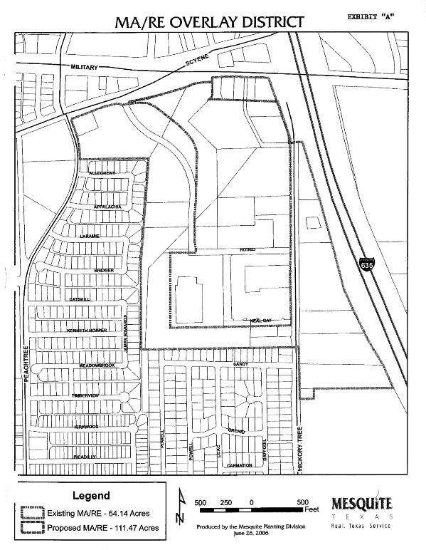
4-801 - Purpose and scope.
The Town East area has emerged as the major business center for eastern Dallas County. The pattern of growth in the area has created a concentration of retail and entertainment uses (restaurants and theaters) unforeseen at the time most of the area zoning was adopted. Because of the concentration of these uses, the orientation of the area to family services, the congestion of traffic, and the critical importance of the area in the city's tax structure, some modification of zoning regulation is deemed necessary to assure the on-going viability of the businesses and the value of their improvements. Through the adoption of an overlay district, selected regulations can be adjusted as needed without unnecessarily revising other aspects of the current zoning. The overlay approach therefore provides the least disruptive method of addressing the needed issues.
The overlay district will accommodate further development of retail, restaurants, theaters, and selected entertainment uses similar to the existing development. Diversification to office and hotel uses is encouraged both due to the synergy that the variety of uses can create, as well as for the differentiated traffic pattern created by these uses, i.e. traffic generated at times other than the current retail peaks.
On the other hand, the overlay will restrict uses which might be detrimental to the overall viability and integrity of the area. Specifically, uses with the following characteristics are restricted:
1.
Uses which generate truck traffic or display other traffic characteristics which would create greater disruption in this area due to the already congested traffic conditions.
2.
Uses with visual or aesthetic characteristics which are normally not present or desirable in a quality retail/entertainment area.
3.
Uses with disruptive characteristics, which are generally only accommodated in heavy commercial areas, or which are generally incompatible with family- and customer-oriented retail and entertainment uses.
(Ord. No. 3097, § 1, 6-17-96)
4-802 - TERRA - Town East Retail and Restaurant Area Prefix.
The TERRA prefix designation constitutes a zoning overlay district, and the addition or removal of the TERRA prefix constitutes zoning action requiring due process required under state law. The city shall have only one contiguous Town East Retail and Restaurant Area District.
(Ord. No. 3097, § 1, 6-17-96)
4-803 - Permitted uses.
In this district, no land shall be used except for one or more of the following uses to the extent that they are not prohibited by other regulations and ordinances.
A.
Standard district. All land in the overlay district shall retain its existing zoning designation and all characteristics of such zoning, except as modified herein.
B.
Reserved.]
C.
Restricted uses. In the TERRA overlay, the following uses shall require approval of a conditional use permit in accordance with 5-300. When a use is allowed in the underlying existing zoning district by the schedule of permitted uses (3-203) as a permitted use or conditional use permit, application may be made in the TERRA overlay for approval as a conditional use permit. The restricted uses shall be indicated with an asterisk (*) on the schedule of permitted uses (3-203).
Outdoor Storage
1.
Accessory and primary outdoor storage as defined in 3-603
Construction
2.
SIC Division C - Building, Construction, and Special Trade Contractors
3.
SIC 078 Landscape/Horticultural Services
Manufacturing and Wholesale Trade
4.
SIC Division D - Manufacturing
5.
SIC Division F - Wholesale Trade
Motor Freight and Warehousing
6.
SIC 42-Motor Freight Transportation, Warehousing, including miniwarehousing
Outdoor Sales Lots
7.
Any Outdoor Sales Lot as defined in 3-602
8.
SIC 527 Mobile Home Dealers
9.
SIC 549b Farmer's Market
10.
SIC 551 and 552 Motor Vehicle Dealers
11.
SIC 555 Boat Dealers
12.
SIC 556 Recreation Vehicle, Utility Trailer Dealers
13.
SIC 557 Motorcycle Dealers
14.
SIC 5999c Gravestone, Monument Dealers
15.
SIC 5999f Swimming Pool/Spa Sales
Sale of Used Merchandise
16.
SIC 593 Used Merchandise Stores/Antique Stores, including Pawnshops
17.
SIC 5999a Auction Rooms
18.
SIC 5999e Sales Barns/Flea Markets
Service and Repair Establishments
19.
SIC 721 Laundry, Cleaning, Garment Services in facilities larger than three thousand five hundred (3,500) square feet
19a.
SIC 7299 Body Art/Decoration
20.
SIC 7342 Disinfecting/Exterminating Services
21.
SIC 7349 Building Maintenance Services
22.
SIC 7353 Heavy Equipment Rental
23.
SIC 7359b Equipment Rental, Other than Household
24.
SIC 7623 Refrigeration Repair
25.
SIC 764 Reupholstery/Furniture Repair
26.
SIC 7692 Welding Shops
27.
SIC 7694 Armature Rewinding Shops
28.
SIC 7699e Metalsmiths
29.
SIC 7699f Boiler, Tank Cleaning/Repair
30.
SIC 7699g Septic Tank Cleaning
31.
SIC 7699h Farm Machinery Repair
32.
SIC 7699i Heavy Equipment Repair
Automotive Repair and Services
33.
SIC 753b Major Automobile Repair
34.
SIC 753c Collision Services
35.
SIC 7513 Truck Rental/Leasing
36.
SIC 7519 Trailer/Recreational Vehicle Rental/Leasing
37.
SIC 752c Heavy Load Vehicle Parking
38.
SIC 7549b Towing/Wrecker Services
39.
SIC 554b Truck Stop/Heavy Load Facility
(Ord. No. 3097, § 1, 6-17-96; Ord. No. 3296, § 1, 5-17-99; Ord. No. 3309, § 1.B., 7-19-99; Ord. No. 3831, § 1(6), 9-18-06; Ord. No. 3922, § 1(7), 12-17-07)
4-901 - Purpose and scope.
The Military Parkway-Scyene Corridor is positioned centrally between the Mesquite Arena and Rodeo Entertainment District, the downtown and historic square area, and IH-635 and the rail line north of Scyene. The purpose of the MP-SC overlay district is to create an attractive and effective gateway into downtown and link these important assets and land uses. To this end, the MP-SC overlay district is intended to:
• Provide for a selective palette of retail/entertainment uses while accommodating a limited mix of residential and service uses that compliment the retail development or that support pedestrian- and transit-oriented design.
• Avoid familiar "strip" patterns of development by encouraging multi-use development on large or unified parcels that minimize access points, allow for three hundred sixty-degree design and reduce auto-dominated frontage.
• Establish non-traditional setback, parking standards, lighting, signage and other site planning features that create a distinct and cognizable "sense of place" on Military Parkway and Scyene Road.
• Encourage pedestrian activity on the street frontage, between major uses and with links to the parks and recreation trail system.
• Preserve long-term opportunities for incorporating transit-oriented development.
(Ord. No. 3846, § 1, 12-18-06)
4-902 - Military Parkway-Scyene Corridor Overlay District Prefix.
The MP-SC prefix designation is a zoning overlay district. After the effective date of this ordinance, the addition or removal of the MP-SC prefix constitutes zoning action requiring due process required under state law. No land within the city except the following described area shall be designated MP-SC without the requisite notice and public hearing provided by state law. The city shall have only one (1) contiguous Military Parkway-Scyene Corridor District.
Land Zoned MP-SC Military Parkway-Scyene Corridor. All land, regardless of zoning on the effective date of this ordinance, which is located between IH-635 and Carmack Street, and which is situated:
A.
Between Military Parkway and Scyene Road; or
B.
With frontage on the south right-of-way line of Military Parkway or surrounded by land with such frontage.
(Ord. No. 3846, § 1, 12-18-06)
4-903 - Permitted uses.
In this district no land shall be used except for one (1) or more of the following uses to the extent that they are not prohibited by other regulations or ordinances.
A.
Standard district. All land in the overlay district shall retain its existing zoning designation and all characteristics of such zoning, except as modified herein.
B.
Private club. As hereinafter regulated.
C.
Restricted uses.
1.
Except for the uses listed in paragraphs 3. and 4. of this subsection, all uses within the MP-SC overlay district shall require approval of a conditional use permit in accordance with section 5-300 and the supplemental criteria established herein. When a use is allowed in the underlying existing zoning district by the schedule of permitted uses (section 3-203) as a permitted use or conditional use permit, application may be made in the MP-SC overlay district for approval as a conditional use permit.
2.
In addition to the review criteria for a conditional use permit enumerated in section 5-303, the planning commission and city council shall consider the following:
(a)
Conformance to planning principles. That the proposed use conforms to the comprehensive plan and the purposes of the MP-SC overlay district.
(b)
Support for residents or customers. That the proposed use will support the retail and service needs of the residents of the overlay district or the customers of the uses that are permitted-by-right within the overlay district. Support may be evidenced, among other ways, by a public pedestrian connection to the residents or the customer-based uses that will benefit from the proposed use.
3.
The uses permitted-by-right in the MP-SC overlay district include, and are expressly limited to, the following:
Residential uses:
(a)
Multi-family dwellings not exceeding seventy-five (75) percent of the floor-area of a building in a vertical mixed-use development. No multi-family use is permitted at ground level. Multi-family use exceeding the vertical development ratio shall require a conditional use permit.
Retail trade:
(b)
SIC 525 Hardware Stores.
(c)
SIC 53 General Merchandise Stores.
(d)
SIC 54 Food Stores.
(e)
SIC 554a Limited Gasoline Sales (incidental to Convenience Stores only).
(f)
SIC 56 Apparel, Accessory Stores.
(g)
SIC 57 Furniture, Home Furnishings.
(h)
SIC 5812 Eating Places, except Drive-In Restaurants or Restaurants with Drive-Through Facilities.
(i)
SIC 591 Drug, Proprietary Stores.
(j)
SIC 594 Miscellaneous Shopping Goods Stores.
(k)
SIC 599 Retail Stores NEC, except SIC 5999 Miscellaneous Retail NEC.
Services:
(l)
SIC 701a General Service Hotel/Motel.
(m)
SIC 7011 Bed and Breakfast Inns.
(n)
SIC 7219 Laundry, Garment Services NEC.
(o)
SIC 724 Barber Shops.
(p)
SIC 725 Beauty Shops.
(q)
SIC 725 Shoe Shine and Repair.
(r)
SIC 7334 Photocopying, Duplicating Services.
(s)
SIC 7336 Commercial Art, Graphics Design.
(t)
SIC 763 Watch, Clock, Jewelry Repair.
(u)
SIC 7991 Physical Fitness Facilities.
(v)
SIC 7999c Commercial Art Galleries, Museums.
(w)
SIC 81 Legal Services.
(x)
SIC 835 Child Day Care Services.
(y)
SIC 84 Museums, Art Galleries, Arboreta, Zoos.
(z)
SIC 87 Engineering, Accounting, Research, Management Services.
Accessory uses and structures:
(aa)
Parking.
4.
The following uses are expressly prohibited within the MP-SC overly district, provided that any such use that exists as of December 18, 2006, and which is lawfully operating as of said date, shall not be classified as nonconforming under section 1-301 A. The right to operate any such use shall terminate if the use is discontinued for one (1) year or more.
Construction:
(a)
SIC 15 Building Contractors.
(b)
SIC 16 Heavy Construction Contractors.
(c)
SIC 17 Special Trade Contractors.
Manufacturing:
(d)
SIC 20-39 (All manufacturing uses).
Transportation and utilities:
(e)
SIC 42 Motor Freight Transportation and Warehousing.
(f)
SIC 44 Water Transportation.
(g)
SIC 45 Air Transportation.
(h)
SIC 46 Pipelines.
(i)
SIC 49 Electric, Gas, Sanitary Sewer, except SIC 49b Business Office.
Wholesale trade:
(j)
SIC 50-51 (All wholesale trade use, durable and non-durable).
Retail trade:
(k)
SIC 55 Automobile Dealers, Service Stations except as provided for in Subsection 3, above.
Services:
(l)
SIC 735 Miscellaneous Equipment Rental, Leasing.
(m)
SIC 75 Automotive Repair and Services.
(n)
SIC 836c Residential Care Institutions.
(o)
SIC 86 Membership Organizations as the primary use of tracts greater than one (1) acre.
(Ord. No. 3846, § 1, 12-18-06; Ord. No. 4285, § 1, 9-16-13)
4-904 - Required conditions.
All establishments in the MP-SC overlay district shall meet the following conditions, in addition to any stipulations or conditions of approval under the conditional use permit provisions of this ordinance.
A.
Private clubs (in conjunction with full-service hotel only). A private club may be housed within a full-service hotel on land zoned either LC or C and shall comply with the following:
1.
Location: The premises shall not be located less than three hundred (300) feet from any school. Other separation requirements of City Code Section 8-840 shall not apply.
2.
Minimum capacity: The hotel shall contain a minimum of one hundred (100) rooms, all with access from internal hallways, and shall contain an internal restaurant.
3.
Primary use: The hotel shall constitute not less than sixty (60) percent of the gross floor area of the structure.
4.
Access: The bar area shall have no exterior entrance.
5.
Signs: No signs advertising the sale of alcoholic beverages shall be permitted; however, this shall not prohibit use of established trade names of establishments.
6.
Drink promotions: Drinks shall not be offered for sale at a price reduced from the customary price during a specific period for promotional purposes (sometimes called "Happy Hour" or similar promotional activities designed to stimulate the sale of alcohol).
B.
Site design and maintenance. The site of any proposed establishment within the MP-SC overlay district shall be designed and developed in accordance with this section in addition to all other requirements of the city's ordinances and in accordance with any and all design standards adopted by the city council specifically for the MP-SC overlay district and on file in the planning office when application is made for any proposed establishment. In the event of a conflict between this section and other provisions of the city's ordinances, this section shall prevail. In the event of a conflict between this section and the Design Standards adopted for the MP-SC overlay district, the design standards shall prevail. The board of adjustment is not authorized to grant relief from the provisions of this subsection.
1.
In the front and exterior side yards, not less than seventy-five (75) percent of the building profile shall be built to the right-of-way line. For eating establishments other than drive-in restaurants or restaurants with drive-through facilities, the amount of the building profile built to the right-of-way line may be reduced below seventy-five (75) percent when:
(a)
The area between the building facade and the right-of-way line is used for seating for the eating establishment;
(b)
Ingress and egress are provided from the area to the interior of the eating establishment; and
(c)
Not less than twenty-five (25) percent of the building profile is built to the right-of-way line.
2.
Every establishment shall have not less than one (1) customer entrance on each street frontage. An establishment with two (2) intersecting street frontages may have a single customer entrance on a forty-five-degree plane to the intersecting right-of-way lines. Entrances shall be designed as an elevated stoop, gallery or a doorway with awning except on façades lined with an arcade.
3.
Any area between the building façade and the right-of-way line shall be landscaped. Such landscaping shall be in addition to and not included in meeting normal landscaping requirements for the site.
4.
The height of the building shall be constructed to the required building enclosure ratio as specified in the table below. The design shall be presumed to meet this design standard when the height is greater than the percentage of the optimum width of the adjacent street right-of-way in Column C. The Director may approve a building constructed at a lesser height if the street frontage is activated by patron seating, building fenestration that meets the Design Standards, and the enhanced landscape and pedestrian walkway assembly shown in Diagram 4.
5.
Vehicle access to the parking footprint shall be solely via a rear access drive from a side street other than Military Parkway or Scyene Road, or a shared access drive as provided in this paragraph. A tract without connection to a side street and without adjacency to a shared access drive on an abutting parcel, or a tract with a width of more than two hundred (200) feet at the frontage line of Military Parkway or Scyene Road, may have one (1) shared access drive on Military Parkway or Scyene Road not exceeding twelve (12) feet in half-width to access the parking footprint. Shared access drives shall be located at the lot line of an abutting buildable parcel. All rear access drives and shared access drives shall be configured to provide future rear access to both the servient tract and the dominant abutting parcel, which shall be secured with a cross access easement. After September 16, 2013, any plat or replat of land within the MP-SC Overlay District shall provide for access as required herein.
6.
A building that is constructed for, or intended to accommodate, multiple tenants at ground level shall not present a building profile to a public street that is greater than five (5) times the height of the building.
7.
Spaces separating buildings on the same tract along the same street frontage shall be designed to provide a pedestrian access way from the public right-of-way to the rear of the buildings. A sidewalk shall be installed in the access way connecting to the public sidewalk.
8.
All parking shall be designed within the parking footprint. The parking footprint shall have a minimum twenty-five-foot setback from the adjacent right-of-way. The parking profile shall not exceed ten (10) percent of the property frontage on Military Parkway, Scyene Road or Gateway Boulevard. A development that achieves a building enclosure ratio that is less than or equal to seventy-five (75) percent of the required ratio may expand its parking profile to twenty (20) percent. A vertical mixed-use development that is constructed equal to or taller than the required height is eligible for a shared parking benefit.
9.
The same masonry materials that are used on the building façade of a public street shall "wrap" around the building and be used on all elevations. Metal exterior siding is prohibited on primary and secondary façades in the overlay.
10.
Pole signs and portable signs are prohibited. The City, working in concert with property owners, may erect one (1) or more landmark or wayfinding signs identifying the Military Parkway-Scyene Corridor area.
11.
Outdoor sales, display or storage is prohibited, Section 3-600 et seq. notwithstanding.
12.
Any premises that abut the City's adopted pedestrian and bicycle trail system shall, as a condition of site plan approval, and if the City deems it necessary to secure public access, dedicate an access easement of sufficient width and roughly proportional to the impact of the development from the premises to the City system.
13.
Fuel pumps as provided for in Section 4-903.C.3(e) above shall comply with the following development standards:
(a)
A maximum of eight (8) fueling positions shall be permitted.
(b)
Fuel pumps and related canopies shall be located within the parking footprint.
(Ord. No. 3846, § 1, 12-18-06; Ord. No. 3922, § 1(8), 12-17-07; Ord. No. 4284, § 1, 9-16-13; Ord. No. 4285, § 1, 9-16-13; Ord. No. 5061, § 8(Exh. G), 9-5-23; Ord. No. 5083, § 2(Exh. A), 11-20-23)
Cross reference—Certificate of Occupancy, Mesquite Zoning Ordinance, Part 5, 5-100, Sec. 5-106.
4-905 - Definitions.
For purposes of this ordinance, the following terms shall have the meanings ascribed to them in this section. The diagrams (Diagram 1, etc.) that illustrate various terms are considered part of the definition to which they refer.
Building profile means the apparent width of a building when viewed from the street. A development with multiple street frontages will have one (1) building profile for each frontage. (Diagram 1)
Building enclosure ratio refers to the proportionate relationship between the total distance between buildings on both sides of the adjacent street and the height of a building. (Diagram 2)
Director means the Director of Community Development or his designee.
Parking footprint means the area defined by the rear building facade(s) and the rear setback lines. (Diagram 3)
Parking profile means the apparent width of the parking area and access drives when viewed from the street. (Diagram 3)
Optimum width of street right-of-way refers to the planned or future right-of-way width as approved on the city's thoroughfare plan.
Shared parking benefit refers to a concession made for parking in a mixed-use development that has the effect of lowering the minimum parking requirement based upon variations in parking demand by time of day and land use relationships that induce single auto trips. The shared parking benefit is determined separately for each mixed-use development according to standards recommended by the Urban Land Institute.
Vertical mixed-use refers to stacking different uses on different floors of a multi-story building.
Walkway Assembly means enhanced pedestrian and landscape improvements installed in the public right-of-way (Diagram 4).
Diagram 1 Building Profile
Diagram 2 Building Enclosure Ratio
Diagram 3 Parking Footprint and Parking Profile
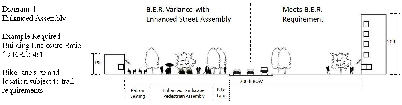
Diagram 4 Enhanced Assembly
(Ord. No. 3846, § 1, 12-18-06; Ord. No. 4284, § 1, 9-16-13)
4-931 - Purpose and scope.
The diverse manufacturing and distribution uses that congregate around the Big Town and Town East Boulevards, and that stretch from Interstate Highway 30 to Skyline Boulevard, form the heart of Mesquite's industrial sector. Businesses within the area depend primarily upon long-haul carriers for shipping and delivery to a degree not found anywhere else in the City. The purpose of the Skyline Logistics Hub Overlay District is to enhance the economic stature of the sector and deal with some of the externalities of such intense activity. To this end, the District is intended to:
•
Create identity for the concentration of industrial land uses within the area, and provide opportunities for transportation funding through programs that support industrial and economic development.
•
Recognize the importance of the area to the City's economic well-being, and preserve and encourage the further development of available land within the area for industry, which creates jobs and improves the tax base.
•
Protect through reasonable regulation the residential enclaves within and on the boundary of the area from the external impacts of heavy industry, trucking and land uses that support trucking activity.
•
Adopt responsible environmental and aesthetic measures to bring visual order, cleanliness and appeal to the Big Town Gateway in keeping with the industrial character of the area.
(Ord. No. 4371(TA No. 2015-01), § 1(1), 7-20-15)
4-932 - Skyline Logistics Hub Overlay District Prefix.
The SLH prefix designation is a zoning overlay district. After the effective date of this ordinance, the addition or removal of the SLH prefix constitutes zoning action requiring due process under State law. No land within the City except the following described area shall be designated SLH without the requisite notice and public hearing provided by State law. The City shall have only one contiguous Skyline Logistics Hub District.
Land Zoned SLH Skyline Logistics Hub.
All land, regardless of zoning on the effective date of this ordinance, as depicted on the official zoning map of the City of Mesquite which is bounded:
A.
On the west by a line formed by the western city limits of Mesquite and the western lot line of Samuel Boulevard Business Park, Block 2, Lot 1;
B.
On the north by Interstate Highway 30;
C.
On the northeast by a line formed by the western lot lines of the East Meadows Addition, Block A, Lots 12R & 13 and East Meadows Mesquite K8 Addition, Block A, Lot 2R;
D.
On the east along a line formed by East Meadows Boulevard, U.S. Highway 80, Forney Avenue, South Town East Boulevard, Skyline Drive, Interstate Highway 635, the Union Pacific Rail Road and the easternmost boundary of Skyline Industrial Village Subdivision Sections 2 and 3; and
E.
On the south by Military Parkway.
(Ord. No. 4371(TA No. 2015-01), § 1(1), 7-20-15; Ord. No. 5076, § 2(Exh. A), 10-16-23)
4-933 - Permitted uses.
In this District no land shall be used except for one or more of the following uses to the extent that they are not prohibited by other regulations or ordinances.
A.
Standard district. All land in the overlay district shall retain its underlying zoning designation and all characteristics of such zoning, except as modified herein.
B.
Restricted uses.
1.
Except for the uses listed in paragraphs 2 and 4 of this subsection, all uses within the SLH District shall be governed by the requirements of the underlying zoning district and shall be permitted, prohibited or subject to a Conditional Use Permit in accordance with the Schedule of Permitted Uses (§ 3-203), § 5-300 and the supplemental criteria established herein.
2.
Within the underlying Commercial and Industrial zoning districts, the following uses may be permitted upon approval of a Conditional Use Permit in accordance with § 5-300, et seq., the criteria in paragraph 3 of this Section, and shall comply with the conditions set forth in Section 4-934 herein.
Services:
(a)
SIC 752c Parking of Heavy Load Vehicles as the principal use
(b)
SIC 753b Major Automobile Repair for heavy load vehicles, as a principal or accessory use
3.
When reviewing an application for a Conditional Use Permit for the uses enumerated in paragraph 2 of this Section, the Planning & Zoning Commission and City Council may consider the following additional criteria:
(a)
Conformance to planning principles. That the proposed use conforms to the Comprehensive Plan and the purposes of the SLH Overlay District.
(b)
Support for industrial users. That the proposed use will support the needs of the current or future industrial users of the overlay district. Support may be evidenced, among other ways, by adjacency to the industrial user or the special needs of the heavy load vehicles or drivers that service the industrial user.
(c)
Protection of residential areas. That the proposed use will not adversely impact the quiet enjoyment of residential property and repose of residential users, within or outside the overlay district.
4.
The following uses are expressly prohibited within the SLH Overlay District, provided that any such use that exists as of October 16, 2023, and which is lawfully and actively operating as of said date, may continue to operate as a nonconforming use subject to the terms of Section 1-300, et seq.
Transportation, Utilities:
Retail Trade:
Services:
Public Administration:
Other:
(Ord. No. 4371(TA No. 2015-01), § 1(1), 7-20-15; Ord. No. 4528, § 1(3), 12-18-17; Ord. No. 5076, § 2(Exh. A), 10-16-23)
4-934 - Required conditions.
All establishments in the SLH Overlay District shall meet the following conditions, in addition to any stipulations or conditions of approval under the Conditional Use Permit ("CUP") provisions of this ordinance.
A.
Site design and maintenance. The site of any proposed use or structure within the SLH Overlay District shall be designed and developed in accordance with this Section in addition to all other requirements of the City's ordinances. In the event of a conflict between this Section and other provisions of the City's ordinances, this Section shall prevail.
1.
Where internal circulation for heavy load vehicles is improved, the Director may allow the number of parking lot trees required in Section 1A-200(B) to be clustered or distributed in a manner that improves the aesthetics of the site.
2.
The minimum landscaping of a parcel with a District Gateway site shall be increased by an amount equal to five percent of the site area, and such area shall be distributed within the private frontage of the primary thoroughfare abutting the site that also serves as an entry to the Skyline LH Overlay District. In addition to all other requirements of Chapter 1A-200, not less than 50 percent of the total landscaped frontage (consisting of the minimum landscape requirements plus the increased landscape area) shall consist of defined planting beds with drought tolerant materials from Chapter 1A-500, et seq.
3.
When a use in a Commercial or Industrial district is across either a divided boulevard or an undivided street from a residential use or district, and the Commercial or Industrial use includes a hardscaped frontage, the use in the Commercial or Industrial district shall provide a minimum 25-foot wide visual or sound attenuation buffer within the private frontage as prescribed in Section 4-935.
4.
The parking of heavy load vehicles on the premises of the restricted uses enumerated in Section 4-933(B)(2) shall constitute outdoor storage for purposes of Section 3-603, and such uses shall comply with the requirements for outdoor storage in said Section; provided that in addition to all other requirements, the screening shall consist of an eight-foot masonry wall. Wood or chain link screening is prohibited.
5.
Private vehicular cross access, as evidenced by easement, covenant or the presence of an improved or unimproved vehicular connection between parcels, shall be prohibited between any of the restricted uses enumerated in Section 4-933(B)(2) and any other use.
6.
No owner of a premises, or operator or manager-on-duty of any use with the district, shall allow any unmounted trailer to be parked or stored on the premises, or suffer or permit the owner or driver of a heavy load vehicle to park or store an unmounted trailer on the premises, unless the parking or storage of unmounted vehicles is expressly authorized on the certificate-of-occupancy and the parking or storage is in compliance with any conditions therein, or unless the parking or storage is incidental to a use authorized on the certificate-of-occupancy.
7.
No plat or replat of a parcel shall be approved if the purpose of such plat or replat is to defeat the application of any provision of this Section.
(Ord. No. 4371(TA No. 2015-01), § 1(1), 7-20-15; Ord. No. 4528, § 1(4), 1(5), 12-18-17; Ord. No. 5061, § 8(Exh. G), 9-5-23; Ord. No. 5076, § 2(Exh. A), 10-16-23; Ord. No. 5083, § 2(Exh. A), 11-20-23)
Cross reference—Certificate of Occupancy, Mesquite Zoning Ordinance, Part 5, 5-100, Sec. 5-106.
4-935 - Walls and buffering.
When any buffer or masonry screening, retaining or sound attenuation wall is required by Section 4-934, or the approved Site Plan or engineering plans, or as a condition of a Planned Development district, or by incentive or development agreement with the City, such buffer or wall shall be installed in accordance with this Section.
A.
The visual or sound attenuation buffer required by Section 4-934(C)(3) shall be designed and constructed according to the following standards:
1.
If the hardscaped frontage is designed and intended exclusively for use by passenger vehicles and light trucks, the 25-foot buffer shall consist of a fully landscaped strip that includes an earthen berm with a minimum height of four feet. All other requirements of Chapter 1A-300 shall apply.
2.
If the hardscaped frontage is designed or intended for use, in whole or in part, by heavy load vehicles, the 25-foot buffer shall consist of a sound attenuation wall eight feet in height set at the innermost edge of the buffer and a fully landscaped strip with tree line between the wall and the property line. All other requirements of Chapter 1A-300 shall apply.
B.
A masonry screening wall required by Section 1A-300, et seq., or Sections 4-935(4)-(5) shall be designed and constructed in accordance with the City's Engineering Design Manual, as amended.
C.
A concrete or masonry retaining or sound attenuation wall shall be designed and constructed with approval of the City Engineer, and Building Official if applicable. Absent a written agreement with the City:
1.
The concrete retaining wall shall be textured by form-liner or rustication; and
2.
The concrete or masonry retaining or sound attenuation wall shall be of a natural earth-tone color.
D.
The maximum height of a sound attenuation wall shall be 10 feet. If upon demonstrated need that an attenuating barrier higher than 10 feet is required to effectively protect a residential use or district from an adjacent industrial use or district, the 10-foot wall shall be constructed atop an earthen berm approved by the City Engineer and landscaped on the non-industrial side in accordance with the approved Site Plan.
(Ord. No. 4371(TA No. 2015-01), § 1(1), 7-20-15; Ord. No. 5076, § 2(Exh. A), 10-16-23)
Sec. 4-936 - Definitions.
Private frontage: The area of a site situated between the street property line and a line coplanar with the façade of the primary structure. The private frontage is comprised of a mandatory landscaped frontage consisting of turf, planting beds, trees and other amenities adjoining the public sidewalk or parkway, and a hardscaped frontage, if any, consisting of parking areas, access drives, internal drive aisles and shopfront walkways.
(Ord. No. 4371(TA No. 2015-01), § 1(1), 7-20-15; Ord. No. 5076, § 2(Exh. A), 10-16-23)
Editor's note— Ord. No. 5076, § 2(Exh. A), adopted Oct. 16, 2023, repealed Section 4-936 and renumbered the former Section 4-937 as Section 4-936. Former Section 4-936 pertained to District Gateways and derived from Ord. No. 4371(TA No. 2015-01), § 1(1), adopted July 20, 2015.
4-951 - Purpose and scope.
On March 5, 2007, the Mesquite City Council adopted the Sherwood Forest Neighborhood Plan. The Plan contains strategies to modify the preferred locations for retail use and preserve the prevailing residential site design and architectural standards of the neighborhood. The purpose of the Sherwood Forest Overlay District is to implement the strategies of the Plan with minimal disruption to the basic regulatory fabric that already exists for the area. To this end, the SF Overlay District is intended to:
• Accommodate a limited mix of neighborhood-oriented commercial and service uses along Scyene Road that compliment the residential core of the neighborhood.
• Amend certain non-residential construction, parking, landscaping and signage standards within the zoning districts that impact Sherwood Forest.
• Amend obsolete design standards in undeveloped planned developments districts that are incompatible with adjacent residential subdivisions.
• Maintain the distinct character of the residential core with infill housing that is architecturally compatible.
(Ord. No. 3914, § 1, 11-19-07)
4-952 - Sherwood Forest Overlay District Prefix.
The SF prefix designation is a zoning overlay district. After the effective date of this ordinance, the addition or removal of the SF prefix constitutes zoning action requiring due process required under state law. No land within the city except the following described area shall be designated SF without the requisite notice and public hearing provided by state law. The city shall have only one (1) contiguous Sherwood Forest Overlay District.
Land Zoned SF Sherwood Forest.
All land, regardless of zoning on the effective date of this ordinance, which is located within Census Tract 176.03 Block Group 2, which is bounded by:
A.
Scyene Road to the north, Peachtree Road to the east, W. Bruton Road to the south, and S. Sam Houston to the west.
(Ord. No. 3914, § 1, 11-19-07)
4-953 - Permitted uses.
In this district no land shall be used except for one (1) or more of the following uses to the extent that they are not prohibited by other regulations or ordinances.
A.
Standard district. All land in the overlay district shall retain its existing zoning designation and all characteristics of such zoning, except as modified herein.
B.
Non-residential uses—Restricted.
1.
Except for the uses listed in paragraphs 3. and 4. of this subsection, all uses within the underlying non-residential zoning districts of the SF Overlay District shall require approval of a conditional use permit in accordance with Section 5-300 and the supplemental criteria established herein. When a use is allowed in the underlying zoning district by the schedule of permitted uses (Section 3-203) as a permitted use or conditional use permit, application may be made in the SF Overlay District for approval as a conditional use permit.
2.
In addition to the review criteria for a conditional use permit enumerated in Section 5-303, the planning commission and city council shall consider the following:
(a)
Conformance to planning principles. That the proposed use conforms to the Comprehensive Plan and the purposes of the SF Overlay District.
(b)
Support for residents. That the proposed use will support the retail and service needs of the residents of the overlay district.
3.
The uses permitted-by-right in the non-residential zoning districts of the SF Overlay District include, and are expressly limited to, the following:
Retail Trade
Services
Accessory Uses and Structures
4.
The following uses are expressly prohibited within the SF Overlay District:
Construction
Manufacturing
Transportation and Utilities
Wholesale Trade
Retail Trade
Finance, Insurance and Real Estate
Services
Accessory Uses and Structures
C.
Supplemental residential uses. In addition to the uses provided in Section 2-203, the following use shall be allowed as a conditional use permit within those underlying residential zoning districts of the SF Overlay District that are located north of S. Sam Houston Road:
1.
SIC 7011 Bed and Breakfast Inns, not exceeding five (5) rooms for public accommodation.
(Ord. No. 3914, § 1, 11-19-07)
4-954 - Required conditions.
All lots, tracts or parcels within the SF Overlay District shall be designed, developed, rehabilitated and maintained in accordance with this section in addition to all other requirements of the city's ordinances, including any stipulations or conditions of approval under the conditional use permit provisions of this ordinance. In the event of a conflict between this section and other provisions of the city's ordinances, this section shall prevail. The board of adjustment is not authorized to grant relief from the provisions of this subsection.
A.
Non-residential site design and maintenance. Notwithstanding the underlying non-residential zoning classifications and conditional use permits that exist within the district, all non-residential site design, construction, rehabilitation and property maintenance shall comply with the following standards:
1.
Structures shall comply with the community appearance manual.
2.
Lot coverage shall not exceed fifty (50) percent. The total of all impervious surfaces shall not exceed seventy (70) percent of the area of the site.
3.
Landscape areas shall, at a minimum, be equal in size to at least twenty-five (25) percent of the site. Not less than twenty (20) percent of the landscape area between the main building and the front and/or exterior side property lines shall be improved with landscape beds.
4.
A one-story building that is constructed for, or intended to accommodate, multiple tenants shall not present a building profile to a public street that is greater than five (5) times the height of the building.
5.
Pole signs are prohibited. The city, working in concert with property owners, may erect one (1) or more neighborhood designation or wayfinding signs identifying the SF Overlay District area.
6.
Stalls for drive-in restaurants shall be situated behind the front facade of the primary structure.
7.
Outdoor sales, display or storage is prohibited, Section 3-600 et seq. notwithstanding.
8.
A mixed-use development, or dissimilar uses on adjoining lots by written agreement approved by the director, may be entitled to a shared parking benefit, as determined according to the factors below.
TABLE 1
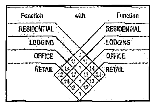
9.
Any premises that abut the city's pedestrian and bicycle trail system shall, if the city deems it necessary to secure public access, dedicate an access point of sufficient width from the premises to the city system as a condition of site plan approval.
B.
Residential site design and maintenance. Notwithstanding the underlying residential or planned development-residential zoning classifications that exist within the district, all residential infill site design, construction, rehabilitation and property maintenance shall comply with the following standards:
1.
The minimum residential lot and unit size requirements shall be as follows:
2.
The front setback shall fall within the range.
3.
The height and width of the primary facade of new buildings shall fall within the range.
4.
The height of new foundations shall fall within the range.
5.
The height and width of porches shall fall within the range.
6.
The pitch of new roofs shall be designed to fall within the range.
7.
Within the District north of S. Sam Houston Road, cementious-fiberboard may be considered as masonry for purposes of § 2-303.
8.
For additions, the facade materials, roof materials, doors and windows shall be compatible to those used on the existing house.
9.
Additions shall be made to the rear or side of the house only. Additions taller than the primary facade shall be made to the rear of the house to keep the original scale of the facade consistent with adjacent buildings.
10.
The building official may authorize porches to extend into the front yard setback to maintain consistency with similarly sited porches along the street.
11.
Fences, if provided in the front yard of the building, shall be painted wood or wrought iron with a maximum height of three and one-half (3½) feet and not less than fifty (50) percent through vision. Fences in the rear yard of the building may be of wood board, painted wood, wrought iron or chain link.
12.
For tracts exceeding two hundred fifty (250) feet in depth, no more than four (4) vehicles or equipment may be parked on an improved surface in the rear yard for purposes of City Code Section 10-14(c).
(Ord. No. 3914, § 1, 11-19-07; Ord. No. 4372(TA No. 2015-02), § 1(2), 7-20-15)
4-955 - Definitions.
For purposes of this ordinance, the following terms shall have the meanings ascribed to them in this section.
Building profile means the apparent width of a building when viewed from the street. A development with multiple street frontages will have one (1) building profile for each frontage.
Shared parking benefit refers to a concession made for parking in a mixed-use development that has the effect of lowering the minimum parking requirement based upon variations in parking demand by time of day and land use relationships that induce single auto trips. The shared parking benefit is the sum of the parking requirements for all uses divided by the factor shown in Table 1.
(Ord. No. 3914, § 1, 11-19-07; Ord. No. 4372(TA No. 2015-02), § 1(3), 7-20-15)
4-1001 - Purpose and scope.
The core of the Truman Heights neighborhood is located in the triangle between N. Galloway Avenue on the west, U.S. Highway 80, and Hillcrest Avenue on the south. In March 2007, the City Council adopted the Truman Heights Neighborhood Plan as a revitalization strategy for improving the neighborhood. Truman Heights is part of a larger, yet walkable, neighborhood sustainability zone that encompasses an adjacent commercial corridor on both sides of N. Galloway Avenue in addition to the neighborhood's residential core.
The purpose of the Truman Heights Neighborhood zoning district is to integrate the residential functions and supporting commercial services in a form that increases buildable densities in a pedestrian-oriented, visually attractive environment. With an emphasis on form, rather than the separation of land uses, the district not only encourages, but also mandates building disposition and configuration in a manner that is unique in the City of Mesquite. In doing so, the district is designed to preserve the character of the neighborhood's residential core with contextual infill standards and provide a straightforward, visual prescription for revitalization of the N. Galloway corridor.
(Ord. No. 3911, § 1(2), 11-5-07)
4-1002 - Truman Heights Neighborhood district.
The THN zoning classification is a mixed-use district that stands separate and apart from all other zoning districts in the city. It is not an overlay district. The city shall have only one (1) contiguous Truman Heights Neighborhood District.
(Ord. No. 3911, § 1(2), 11-5-07)
4-1003 - Truman Heights Revitalization Code.
From and after November 5, 2007, the uses and buildings on all land rezoned to THN shall conform exclusively to the Truman Heights Revitalization Code, adopted concurrent with the creation of the THN district and as subsequently amended, and which is incorporated herein as if set forth in full.
(Ord. No. 3911, § 1(2), 11-5-07; Ord. No. 4187, § 1, 11-7-11)
4-1021 - Purpose and scope.
The North Gus Thomasson Corridor is a commercial corridor adjacent to the Casa View Heights neighborhood, which is situated generally northwest of the intersection of Gus Thomasson Road and Oates Drive. In April 2007, the city council adopted the Casa View Heights Neighborhood Plan that included strategies for reconnecting the residential core of the neighborhood with the Gus Thomasson commercial area and revitalizing the corridor. Both the commercial corridor and the Casa View Heights neighborhood are part of a walkable neighborhood sustainability zone that encompasses properties fronting Gus Thomasson Road north from Interstate Highway 30 to the Mesquite city limits.
The purpose of the North Gus Thomasson Corridor zoning district is to integrate residential and neighborhood-scaled commercial functions in a form that increases buildable densities in a pedestrian-oriented, visually attractive environment. With an emphasis on form, rather than the separation of land uses, the district not only encourages, but also mandates building disposition and configuration in a manner that is unique in the City of Mesquite. In doing so, the district is designed to provide a straightforward, visual prescription for revitalization of the North Gus Thomasson corridor over time.
(Ord. No. 4022, § 1(2), 12-15-08)
4-1022 - North Gus Thomasson Corridor District.
The NGTC zoning classification is a mixed-use district that stands separate and apart from all other zoning districts in the city. It is not an overlay district. The city shall have only one (1) contiguous North Gus Thomasson Corridor District.
(Ord. No. 4022, § 1(2), 12-15-08)
4-1023 - North Gus Thomasson revitalization code.
From and after December 15, 2008, the uses and buildings on all land rezoned to NGTC shall conform exclusively to the North Gus Thomasson Corridor Revitalization Code, adopted concurrent with the creation of the NGTC district and as subsequently amended, and which is incorporated herein as if set forth in full.
(Ord. No. 4022, § 1(2), 12-15-08; Ord. No. 4187, § 1, 11-7-11)
4-1101 - Purpose and scope.
On August 21, 2006, the city annexed 2.2 square miles of sparsely inhabited greenfield territory situated in Kaufman County. The newly annexed territory is centered on the Interstate 20 corridor. Annexation of the area was preceded by a year-long study of the economic impacts of growth in the corridor. The study concluded that annexation could produce a net positive economic benefit for the city if residential and commercial growth occurred in an orderly manner and at certain requisite densities. The territory was annexed into the city under the default Agricultural zoning classification pending the development of a plan for fiscally supportable growth and the adoption of regulatory controls to implement the plan. By the time the planning process began in the spring of 2007, new concerns were surfacing over the price of oil and its effect upon conventional suburban lifestyles, the pressing need to reshape the city's image through quality development and the challenges of taking joint responsibility to prepare the region for a more sustainable future. The Comprehensive Plan Element for the Extraterritorial Jurisdiction ("the ETJ Plan") adopted by the city council on August 4, 2008, addresses these issues and many more.
The purpose of the Kaufman - Interstate 20 (K20) District is to provide the first tier of regulations designed to implement the ETJ Plan. As new development occurs, the K20 district is uniquely crafted to guide that development in a manner that is consistent with the goals and strategic policies of the ETJ Plan. The district uses principles of the SmartCode ® to funnel development into growth sectors of varying intensity in locations identified by the ETJ Plan. Within each sector, the district prescribes certain community types in an effort to foster the creation of walkable, complete neighborhoods. Development proceeds upon approval of a regulating plan built around transect zones that are SmartCode ® allocated according to each community type. Form standards ensure that buildings and streets contribute to a pedestrian-oriented, visually attractive environment. As the regulating plan is built out over time, the result is a place that is distinctive, less auto-dependent and mixed use, populated by housing that offers income and generational diversity.
(Ord. No. 3984, § 1(3), 9-2-08)
4-1102 - Kaufman-Interstate 20 District.
The K20 zoning classification is a floating district that attaches to a parcel or parcels only upon approval of a regulating plan by the city council. It is not an overlay district. The following properties shall be subject to the application of the K20 district:
A.
All land within the city limits of the City of Mesquite that are situated east of the East Fork of the Trinity River;
B.
Other land designated by the city council for development as a clustered land development (CLD), traditional neighborhood development (TND), town center development (TCD) or regional center development (RCD) (east of the Mesquite Airport as depicted in the ETJ Plan) in accordance with principles of the SmartCode ® ;
C.
New territory annexed into the City of Mesquite for either full or limited purposes; and
D.
Land within the city's extraterritorial jurisdiction pursuant to a development agreement with the landowner.
(Ord. No. 3984, § 1(3), 9-2-08)
4-1103 - K20 interim development code.
After the effective date of this ordinance [section], and except as modified herein, all new subdivisions, development and new land uses on property enumerated in section 4-1102 as subject to the application of the K20 district shall conform exclusively to the Kaufman-Interstate 20 Interim Development Code, adopted concurrent with the creation of the K20 district, and which is incorporated herein as if set forth in full. Property that is zoned agricultural on the date that it becomes subject to the application of the K20 district may continue to be developed and used according to the terms of the AG district, provided that this exception shall not apply to the subdivision of land into one (1) or more tracts of less than five (5) acres for residential use or when subdivision of the property requires installation of a street under the subdivision ordinance.
(Ord. No. 3984, § 1(3), 9-2-08)
4-1501 - Purpose and scope.
Historically multifamily development has been viewed as inimical to single-family neighborhoods. Multifamily uses were walled-off from neighborhoods and employed as transitional land uses to shield neighborhoods from commercial corridors. The purpose of the Traditional Neighborhood Mixed Residential (TNMR) zoning district is to create communities consisting of multifamily housing and other housing types that are well-designed and integrated into the surrounding neighborhood. Using familiar form-based concepts such as enclosure, walkability, connectivity, complete streets and step-down density, the district seeks to expand housing choice in a traditional pedestrian-scaled development that builds on, supports and reconnects the existing urban fabric. In that sense, the TNMR district is not only appropriate but highly desirable for infill locations.
(Ord. No. 4098, § 1(5), 6-7-10; Ord. No. 4122, § 1(4), 12-6-10)
4-1502 - Site plan required.
A.
All development within the TNMR district shall comply with a site plan approved in accordance with the City's procedural and substantive requirements for site plan review. In addition to all other submittal requirements, a site plan for development within the TNMR district shall include the following:
1.
Designation of all building types
2.
Designation of all frontage types
3.
Location, number and dimension of any on-street parking spaces
4.
Right-of-way improvements including sidewalks, street trees, etc.
5.
All open spaces and any improvements within the open spaces
B.
Upon written request of the applicant, the Director of Community Development ("Director") may, but shall not be required to, permit a practice that is not consistent with or covered by a specific provision of the TNMR district but is justified by its intent. The Director's decision to approve a request, in whole or in part, shall be made in writing and made a permanent part of the final site plan.
(Ord. No. 4098, § 1(5), 6-7-10; Ord. No. 4122, § 1(4), 12-6-10)
4-1503 - Permitted building types.
A.
All development shall include a minimum of two (2) building types from the list below not including accessory units and mixed use buildings. Each building type provided (excluding accessory units and mixed use buildings) shall constitute a minimum of ten (10) percent of the dwelling units found within the development. Each building type is limited to specific frontage types as found in parentheses following the building type.
B.
The following uses are permitted in a mixed use building:
1.
Upper floors: Office, residential, lodging and parking.
2.
Ground floor: Retail, office and parking.
(Ord. No. 4098, § 1(5), 6-7-10)
4-1504 - Setback requirements.
A.
Except as required for step-down design in Section 4-1505, the setback requirements in the TNMR district shall be determined by the frontage type.
1.
Gallery, doorway and arcade frontage types:
a.
Front setback: Zero feet maximum.
b.
Gallery or arcade columns: Three (3) feet from curb maximum.
c.
Side setback: Ten (10) feet maximum.
d.
Rear setback:
i.
With rear alley: Five (5) feet maximum or sixteen (16) feet minimum.
ii.
Without rear alley: Five (5) feet minimum.
2.
Common lawn, front yard and forecourt building types:
a.
Front setback: Fifteen (15) feet maximum.
b.
Side setback: Ten (10) feet maximum.
c.
Rear setback:
i.
With rear alley: Five (5) feet maximum or sixteen (16) feet minimum.
ii.
Without rear alley: Five (5) feet minimum.
3.
Dooryard, terrace/light court:
a.
Front setback: Eight (8) feet minimum; twenty (20) feet maximum.
b.
Side setback: Ten (10) feet maximum.
c.
Rear setback:
i.
With rear alley: Five (5) feet maximum or sixteen (16) feet minimum.
ii.
Without rear alley: Five (5) feet minimum.
B.
Accessory units shall be placed between the rear façade line of the main structure and the rear lot line.
(Ord. No. 4098, § 1(5), 6-7-10; Ord. No. 4122, § 1(5), 12-6-10)
4-1505 - Development standards.
1.
Block size: The maximum block perimeter shall be two thousand (2,000) feet, and the maximum block face between intersections shall be seven hundred (700) feet.
2.
Lot width: The minimum lot width for detached structures shall be twenty-five (25) feet; sixteen (16) feet for attached structures.
3.
Connectivity: Public streets, sidewalks, bike paths and trails existing or planned at the edge of the development shall be continued through the interior of the development. If not practical, a public street, path or trail may be laid at the boundary of the development and shall be connected to the development through a series of private internal sidewalks, paths or trails. The development shall link to abutting nonresidential uses with improved openings at the edge.
4.
Parking and access:
a.
Minimum of one (1.0) and maximum of one and one-half (1.5) spaces per dwelling unit,
b.
May exceed the maximum only if parking is shared or structured,
c.
Off-street, surface parking shall be restricted to the third layer.
d.
Parking for apartment buildings shall be structured and lined on street frontages.
e.
Parking on the ground floor level of mixed use buildings shall be lined with office or retail along all street frontages.
f.
Access drives shall be limited to ten (10) feet in the first layer.
5.
Open space: Not less than five (5) percent of the area of the development shall be set aside and equipped as functional open space. Streams, creeks or other watercourses shall be daylighted and naturally vegetated.
6.
Street trees: Street trees will be planted in an allee that extends the full length of all roadways excluding alleys, service drives and driveways, and shall meet the following standards:
a.
A variety of species shall be used from block to block; one (1) species may be used on both sides of a street for the entire length of a block.
b.
Street trees shall be planted no more than twenty (20) feet on-center unless the size of the species selected at maturity and other site features such as infrastructure and utilities justify a greater distance.
c.
Responsibility for the care, maintenance or replacement of street trees shall remain with the abutting property owner.
7.
Sidewalks: Sidewalks shall be provided along all streets, establish a minimum parkway of seven (7) feet, and meet the following standards:
a.
Unless stated otherwise in this subsection, sidewalks shall have a minimum width of five (5) feet.
b.
Where sidewalks are adjacent to gallery, arcade or doorway frontage types, the sidewalk shall be a minimum of seven (7) feet in width.
c.
Sidewalks that serve as extensions of the city's bike and trails master plan shall be sized, vegetated and marked accordingly.
d.
A series of sidewalks interior to a development shall connect all buildings, open spaces and common use facilities.
8.
Step-down: Where applicable, the maximum height of buildings, the minimum front setback of buildings and the minimum lot width shall be modified through step-down design.
(Ord. No. 4098, § 1(5), 6-7-10)
4-1506 - Façade appearance and landscaping.
All buildings within the development except single-family detached housing shall comply with the Community Appearance Manual and the following requirements, whichever is more restrictive:
1.
Apartment buildings: Not less than fifty (50) percent of the unitized masonry requirement shall be satisfied with the use of unitized stone. Not less than twenty (20) percent of the pervious area in the first layer shall be improved with landscape beds.
(Ord. No. 4098, § 1(5), 6-7-10)
4-1507 - Definitions.
For purposes of the TNMR district, the following terms shall have meaning ascribed to them in this Section:
Building types:
Accessory unit: A dwelling unit that is located over a garage on the same lot as the main structure. An accessory unit may also be a single story dwelling unit, not associated with a garage, located on the same lot as the main structure. An accessory unit may be attached or detached from the main structure.
Apartment building: A structure with more than two (2) dwelling units on one (1) lot.
Flat over flat (duplex): A structure with two (2) dwelling units placed one (1) above the other.
Paired house (duplex): A structure with two (2) dwelling units placed one (1) beside the other sharing a common wall.
Single-family detached house: One (1) dwelling unit on its own lot, detached from structures on adjoining lots. An accessory unit may be located on the same lot as a single-family detached house; the accessory unit may be attached or detached to the single-family detached house.
Townhouse: A dwelling unit attached by a common wall to at least one (1) other dwelling unit. A townhouse is generally a fee simple unit, from ground to roof, with no units above or below. Structures containing townhouses must contain at least three (3) dwellings.
Frontage types:
Arcade: A frontage type wherein the façade is a colonnade that overlaps the sidewalk, while the façade at sidewalk remains the frontage line.
Common lawn: A frontage type wherein a group of buildings share a common lawn. The frontage has a visual relation to the street and to the buildings across the lawn.
Doorway: A frontage type wherein the façade is aligned with the sidewalk and the entry is a door flush with the façade or recessed into the façade.
Dooryard: A frontage type wherein the façade is set back from the frontage line by an at-grade courtyard. This type buffers residential use from urban sidewalks and removes the private yard from public encroachment.
Forecourt: A frontage type wherein a portion of the façade is close to the frontage line and the central portion is set back. The forecourt created is suitable for vehicle drop offs.
Front yard: A frontage type wherein the façade is set back from the frontage line with an attached porch permitted to encroach.
Gallery: A frontage type wherein the façade is aligned close to the frontage line with an attached cantilevered shed or a lightweight colonnade overlapping the sidewalk.
Storefront: A frontage type wherein the façade is aligned close to the frontage line with the building entrance at sidewalk grade. It has substantial glazing on the sidewalk level and an awning that may overlap the sidewalk.
Terrace/light court: A frontage type wherein the façade is set back from the frontage line by an elevated terrace or sunken light court. The sunken court can potentially access an additional unit below grade. This type buffers residential use from urban sidewalks and removes the private yard from public encroachment.
Layer means the depths of a lot (as shown below) within which certain elements are permitted.
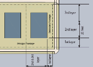
Range means the average of the actual referenced dimension or specification (e.g., height) of existing buildings or lots.
Step-down design means the process of gradually adjusting a design dimension or specification at the edge of a development to substantially match the range in an adjacent single-family residential neighborhood.
(Ord. No. 4098, § 1(5), 6-7-10; Ord. No. 4122, § 1(6), 12-6-10)