
Montgomery City Zoning Code
ARTICLE VI
GENERAL PROVISIONS
Sec. 1. - Reductions in lot area prohibited.
No lot shall be reduced in area so that yards and other open spaces total less than the minimum area required under this ordinance, unless and until the planning commission has granted a variance as provided for in the subdivision regulations of the City of Montgomery.
Sec. 2. - Corner visibility in all districts except B-1-a, B-1-b, B-2 and M-3.
In all districts except as noted above, no fence, wall, shrubbery, sign, marquee or other obstruction to vision between the heights of 3½ feet and 15 feet above street level shall be permitted within 20 feet of the intersection of the right-of-way lines of two streets or railroads or of a street and a railroad right-of-way line.
Sec. 3. - Future street lines.
On any lot which, at the time of adoption of this ordinance or at the time this ordinance is changed by amendment hereafter, may be reduced in area by widening a public street to a future street line as indicated on the duly adopted "major street plan" or as same may be hereafter amended, the minimum required yards, the minimum required lot area, the maximum required lot width and the maximum building area shall be measured by considering the future street lines as the lot lines of such lot.
Sec. 4. - Location of accessory structures on lots used for residential purposes.
Accessory structures in residential districts and on any lot used primarily for residential purposes shall conform to the following regulations:
a.
No accessory structure shall be erected in any required front or side yard. Accessory structures shall not exceed two stories in height and shall not cover more than 30 percent of any required rear yard and shall be at least five feet from all lot lines and ten feet from any other structure on the same lot.
b.
On any lot adjoining along its side lot line another lot which is in a residential district, no part of any accessory building shall be located with 60 feet of any front lot line.
c.
On any corner lot adjoining in the rear another lot which is in a residential district, no part of any structure within 25 feet of the common lot line shall be nearer the side street lot line than the least depth of any required front yard for a dwelling on such adjoining lot along such side street.
d.
Plant nurseries and greenhouses are permitted; provided, no sales are made from the premises; and provided, further, that all accessory structures and material storage facilities larger than 300 square feet in area are located not less than 20 feet from all property lines and no closer than ten feet to any other structure.
e.
Reserved.
f.
Satellite antennas (radio and television) are permitted in addition to other accessory structures provided the unit, dish, rod or other component of the structure does not exceed 24 feet in height, 13 feet in diameter and shall meet all setback requirements as set forth in this section of the ordinance (Ord. No. 31-73). Roof-mounted satellite antennas shall not exceed 13 feet in diameter and shall not extend over 15 feet above the height limits established for the district in which it is located and no such antennas shall be used for any type commercial use or advertising purposes. All other satellite antennas in residential districts shall be permitted only on appeal to the board of adjustment. Commercial satellite antennas shall be approved by the planning commission as set forth in article I, classification and establishment of districts, section 12, development plan (Ord. No. 31-73).
(Ord. No. 13-64; Ord. No. 34-65; Ord. No. 69-83, § 1, 9-27-1983)
Sec. 5. - Off-street loading.
a.
On the same lot with every structure or use hereafter erected or created there shall be provided and maintained space when required in article VII for loading and unloading of materials, goods or things and for delivery and shipping so that vehicles for these services may use this space without encroaching on or interfering with the public use of streets and alleys by pedestrians and vehicles.
b.
Where any structures are enlarged or any use is extended so that the size of the resulting occupancy comes within the scope of this section, the full amount of off-street loading space shall be supplied and maintained for the structure or use in its enlarged or extended size. Where the use of a structure or land or any part thereof is changed to a use requiring off-street loading space under this article, the full amount of off-street loading space shall be supplied and maintained to comply with this article.
c.
For the purpose of this section, an off-street loading space shall be an area at least 12 feet wide by 45 feet long with 14½-foot vertical clearance. Each off-street loading space shall be accessible from a street or alley and arranged for convenient and safe ingress and egress by motor truck and/or trailer combination.
d.
Off-street loading space shall be provided and maintained in accordance with the following schedule:
(1)
For each retail store, storage, warehouse, wholesale establishment, industrial plant, factory, freight terminal, market, restaurant, mortuary, laundry, dry cleaning establishment or similar use which has an aggregate floor area of:
(a)
Over 10,000 square feet but not over 25,000 square feet, one space.
(b)
Over 25,000 square feet but not over 60,000 square feet, two spaces.
(c)
Over 60,000 square feet but not over 120,000 square feet, three spaces.
(d)
Over 120,000 square feet but not over 200,000 square feet, four spaces.
(e)
Over 200,000 square feet but not over 290,000 square feet, five spaces.
(f)
For each additional 90,000 square feet over 290,000 square feet or fraction thereof, one space.
(2)
For each apartment building having over 50 dwelling units, one space.
(3)
For each auditorium, convention hall, exhibition hall, museum, hotel, apartment, hotel, office building, sports arena, stadium, hospital, sanitarium, welfare institution or similar use which has an aggregate gross floor area of:
(a)
Over 10,000 square feet but not over 40,00 square feet, one space.
(b)
For each additional 60,000 square feet over 40,000 square feet or major fraction thereof, one space.
(4)
For any use not specifically mentioned in this section, the requirements for off-street loading for a use which is so mentioned and to which the unmentioned use is similar shall apply.
e.
Off-street loading facilities supplied to meet the needs of one use shall not be considered as meeting the off-street loading needs of any other use.
f.
No area or facility supplied to meet the required off-street parking facilities for a use shall be utilized for or deemed to meet the requirements of this article for off-street loading facilities.
g.
Nothing in this section shall prevent the collective, joint or combined provision of off-street loading facilities for two or more buildings or uses, provided that such off-street loading facilities are equal in size and capacity to the combined requirements of the several buildings or uses and are so located and arranged as to be usable thereby.
h.
Plans for buildings or uses requiring off-street loading facilities under the provisions of this article shall clearly indicate the location, dimensions, clearance and access of all such required off-street loading facilities.
Sec. 6. - Use and maintenance of parking lots in office (O-1) or residential (R-60-a) and R-60-m districts.
Off-street parking space shall be maintained in accordance with the following specifications:
a.
Shall be used only by:
(1)
Passenger vehicles; or
(2)
Vehicles up to one-half ton manufacturer's capacity rating having wheels not to exceed 17 inches; and
(3)
Not be used for the parking or storage of automobile trailers;
b.
Shall not be used for the sale, repair, dismantling or servicing of any vehicles, equipment, materials or supplies.
c.
Shall be graded for proper drainage and provided with a paved surface maintained at all times in such a manner as to prevent the release of dust and to be free of dust, trash and debris.
d.
Shall be provided with entrances and exits so located as to minimize traffic congestion.
e.
Shall be provided with wheel guards or bumper guards so located that no part of parked vehicles will extend beyond the parking space.
f.
Lighting facilities shall be so arranged that they neither unreasonably disturb occupants of adjacent residential properties nor interfere with traffic.
g.
May have not more than one attendant shelter building conforming to all setback requirements for structures in the district and which shelter building shall contain not more than 50 square feet of gross floor area.
h.
Protective wall. The parking area shall be provided with a continuous wall not over five feet in height and not less than three feet in height located in the perimeter of the parking area and next to the yards required in this section.
i.
Yards. Along any street the lot shall provide a front yard not less than 20 feet in depth nor less than the front yard of any existing residential structure immediately adjacent and on either side of the lot. The front yard space shall not be used or occupied for any purpose except as permitted or required in this section. No rear yards or side yards are required except as specified in this paragraph.
j.
Landscaping. All front yard spaces between the walls required by this section and the street line shall be planted and kept in lawn that is maintained so as to present a healthy, neat and orderly appearance. The required yard shall be kept free from refuse and debris.
k.
Sign for identification of the use, provided it complies with the following requirements:
(1)
Such sign shall not exceed 20 square feet in area nor five feet in height.
(2)
Such sign may be illuminated by a nonoscillating, concealed light source, but illumination by any spotlight or floodlight shall be prohibited.
l.
Provision shall be made by means of gate or chain so that the lot may be closed at night to prevent unauthorized persons from parking on the lot.
Sec. 6a. - Residence lots that may be used for off-street parking.
When, its judgment, the public convenience and welfare will be substantially served and the appropriate use of neighboring property will not be substantially or permanently injured, the board of adjustment may, in specific cases, permit the use of a lot or lots under the same ownership in a residential district immediately adjacent to any office, business or industrial district, even if separated therefrom by an alley, for the parking of passenger cars, provided no fee is charged, under such safeguards and conditions as the board may require for the adequate protection of the more restricted property. (Applicable paragraphs of section 6 above shall be used as a guide in granting this special permission.)
(Ord. No. 34-65)
Sec. 7. - Fences and walls.
Fences and walls may be erected, placed, maintained or grown along a lot line of property zoned for office or residential use, or adjacent thereto a height not exceeding seven feet above the ground except in an R-20-t, R-24-t, PGH-35 and PGH-40 districts, where an eight-foot height limit shall be permitted, provided the main structure has yard space as required by this ordinance, except that no such fence or wall located in a required front or street side yard shall exceed a height of three feet. (Height of wall shall be measured from the lowest ground elevation on either side of a joint property line.)
(Ord. No. 49-65; Ord. No. 69-83, § 1, 9-27-1983)
Sec. 8. - Transitional use.
Editor's note— Ord. No. 63-2005, § I, adopted September 20, 2005, amended § 8, subsections 8—8.10 in their entirety to read as herein set out. Formerly, § 8 pertained to landscaping provisions and derived from Ord. No. 26-2000, § I, adopted July 5, 2000.
Sec. 8.1. - Minimum landscaping requirements for off-street parking.
Purpose. The minimum landscaping requirements for off-street parking are provided to enhance the appearance of buildings and their parking areas, to increase the amount of shade within the parking areas, reduce the rate of stormwater runoff, and to minimize the impact of parking lots on adjacent land uses.
Applicability.
(a)
Newly constructed parking lots. The landscaping requirements of this ordinance shall apply to all newly constructed parking lots of ten or more spaces.
(b)
Existing parking lots. When any existing parking lot, including those previously with less than ten spaces, is expanded to include a total of at least 50 spaces, the expanded parking lot shall comply with the requirements of this ordinance. Any changes to landscaping in existing parking lots must meet or exceed the amount and type of landscaping previously maintained.
(c)
Maintenance.Section 8.7 shall apply to all off-street parking, whether newly constructed or existing under the previous landscape ordinance.
(Ord. No. 63-2005, § I, 9-20-2005)
Sec. 8.2. - Definitions.
Caliper refers to the diameter of a tree six inches above ground level.
Canopy tree refers to a tree that typically reaches a mature height of 40 ft. or greater.
DBH (diameter at breast height) refers to the diameter of a tree four and one-half feet above ground level.
Dripline refers to the perimeter of a tree's canopy.
Landscaping refers to the treatment of grade, groundcover, vegetation and ornamentation for a given area. Landscaping shall include plant materials such as trees, shrubs, groundcovers, perennials and annuals; and any other materials such as rocks, water, walls and fences; and any other feature affecting layout and use of the site.
Outparcel refers to a parcel of land within a larger development that is developed as a site for a separate stand-alone building with its own separate parking.
Parking area shall be the paved area including parking spaces and abutting isle ways.
Parking lot shall be defined as any off-street area where vehicles will be parked, serviced, or stored.
Parking space refers to a delineated area reserved for the parking of a single vehicle.
Understory tree refers to a tree that typically reaches a mature height of 30 feet or less.
(Ord. No. 63-2005, § I, 9-20-2005)
Sec. 8.3. - Landscape plan review and approval.
Prior to the approval of a development plan, the landscape plan must be approved by the urban forester. A preliminary plan which lacks the planting schedule and installation details may be submitted for approval with the initial development plan. A final landscape plan meeting all of the requirements of section 8.4 must be submitted and approved before the development plan will be released for permitting. The architect, landscape architect, engineer, surveyor of record, horticulture professional, or landscape contractor shall certify that the landscape plan submitted meets the minimum landscape requirement for off-street parking.
(Ord. No. 63-2005, § I, 9-20-2005)
Sec. 8.4. - Landscape plan submittal requirements.
Format and materials. The landscaping plan and details shall be drawn to the same standard scale as the development plan. Landscape plans shall be included in the development plan submitted to the urban forester.
General information. Complete landscape plans submitted for review and approval shall include the following:
(a)
A title block, showing the title of the development, the name and address of the owner/developer, the name and address of the person or firm preparing the plan, the date of preparation, the scale, the north point, and the date of all revisions.
(b)
A location map, showing the relative location of the site to the nearest existing public street intersection.
(c)
The boundaries of the subject property including the location and description of all adjoining property, the location and names of all adjoining streets and easements.
(d)
The required number of parking spaces and the proposed number of parking spaces of subject property/development.
(e)
Location and dimensions of all entrances and exits of the parking lot and the manner in which vehicles will be parked, and the location and names of all utility lines, easements or right-of-ways on, or adjacent to, the site.
(f)
All details needed to communicate appearance, and methods of construction and/or installation. International Society of Arboriculture tree installation details are required.
(g)
A planting schedule, keyed to the plant materials shown on the landscape plan, listing all proposed plant materials by botanical name, common name and cultivar, if any, quantity of materials, size of materials at planting, plant spacing, and existing trees approved for use.
(Ord. No. 63-2005, § I, 9-20-2005; Ord. No. 33-2017, § 1, 4-4-2017)
Sec. 8.5. - General requirements.
Landscape improvements to parking lots shall be subject to the following requirements:
8.5.1
Site protection and general planting requirements.
(a)
Topsoil. To the extent practicable, topsoil moved during the course of construction shall be preserved and stockpiled for re-use on the site.
(b)
Existing trees. Preservation of each existing healthy tree of an approved species, within required landscape areas, shall count toward fulfillment of these requirements.
(1)
The existing tree to be preserved must be approved by the urban forester to receive credit.
(2)
Existing trees that are credited towards meeting the requirements of this section shall be subject to the same maintenance and replacement requirements as newly planted trees.
(3)
Each existing tree that is credited towards meeting the requirements of this section shall reduce the number of required parking spaces by two. This subparagraph shall supersede and take precedence over article III, section 3(c) of the city's zoning ordinance.
(c)
Slope plantings. Landscaping of all cuts and fills and/or terraces shall be matted or protected until plant cover is adequate to control erosion.
(d)
Size of landscape material. Trees shall be a minimum of two and one-half inches in caliper and 12 feet high. Shrubbery shall have a minimum 18-inch height at installation (seven gallon container stock).
(e)
Quality of landscape material. Landscape material shall conform to the American Standard for Nursery Stock (ANSI Z60.1).
(Ord. No. 63-2005, § I, 9-20-2005; Ord. No. 33-2017, § 1, 4-4-2017)
Sec. 8.6. - Landscaping requirements.
8.6.1.
Perimeter planting requirements for parking areas (public R.O.W. excluded).
(a)
A continuous perimeter planting strip, exclusive of access driveways, with an average width of eight feet adjacent to public right-of-way and four feet adjacent to property lines, measured from the edge of the parking area, is required. Existing street trees may be applied towards perimeter planting requirements along public right-of-way.
(b)
Canopy trees are required, and trees shall be planted on 40- to 50-foot centers. In the event that pre-existing overhead utility lines prevent the use of canopy trees, understory trees shall be planted on 30- to 40-foot centers. Minimum lateral separation from overhead utilities shall be 20 feet for canopy trees. At least two separate species must be used. Monocultures are prohibited. Shrubbery capable of forming a minimum three-foot high evergreen hedge shall be provided in the landscape areas adjacent to public right-of-way.
(c)
Planting strips are to be sodded, seeded, or mulched so as to leave no bare ground after landscape materials have been installed.
(d)
Existing trees which meet, in whole or in part, the perimeter and internal planting requirements, may be applied toward requirements. During construction, trees or groups of trees that are being preserved must have a barrier constructed to the drip-line of the tree or group of trees, given the specific site considerations.
(e)
Trees which meet the perimeter planting requirements, whether existing or new, may be counted as one parking space per tree and be used to fulfill the total parking requirement up to 25 percent of the parking required. Use of trees to fulfill the parking requirements must be noted on the development plan. This subparagraph shall supersede and take precedence over article III, section 3(c) of the city's zoning ordinance.
(f)
Landscaping in and adjacent to parking lots shall not obstruct the driver's view of the right-of-way at driveways and intersections, including that from adjoining properties.
(g)
In all districts, no fence, wall, shrubbery, sign, marquee or other obstruction to vision between the heights of three and one-half feet and 15 feet above street level shall be permitted within 20 feet of the intersection of the right-of-way lines of two streets, or railroads, or of a street and a railroad right-of-way, subject to the requirements of the traffic engineer.
(h)
In the event that non-residential development borders residential areas, a ten-foot wide landscape buffer shall be required along the common property boundary. Canopy trees are required in the landscape buffer, and shall be planted on 20-foot centers in order to form a screen at maturity. All other aspects of the landscape buffer shall conform to the requirements of this section. Residential boundaries MUST be noted on the development plan. Previously platted lots at the adoption of this section may be exempt from 8.6.1(h) if this requirement adversely affects minimum parking requirements.
(i)
An irrigation system shall be required in all landscape areas where 25 or more parking spaces are constructed.
8.6.2.
Internal planting requirements for parking areas.
(a)
Based on parking area size and layout, trees shall be planted within the paved parking area so that each parking space is within 60 feet or less of a tree. Perimeter trees and street trees as outlined above may be used to satisfy this requirement.
(b)
There shall be no more than 12 contiguous parking spaces without a landscape island. Trees and shrubbery are required in the landscape island. A landscape island used to satisfy this requirement shall contain a minimum of 250 square feet of area per tree with a minimum width of eight feet. Tree size and spacing are the same as for the perimeter planting requirements. Shrubbery shall be provided in the island at the minimum rate of two plants per tree.
(c)
Landscape islands, based on the above requirements, shall be sodded, seeded or mulched.
(d)
Interior landscape islands may be counted as two parking spaces per island and be used to fulfill the total parking requirement of the development. Use of landscape islands to fulfill parking requirements must be noted on the development plan. This subparagraph shall supersede and take precedence over article III, section 3(c) of the city's zoning ordinance.
(e)
An irrigation system shall be required in all landscape areas where 25 or more parking spaces are constructed.
(f)
Bio-retention as part of the landscape is encouraged and may be used to meet these requirements.
(g)
Internal landscape islands are not required in display areas for the purpose of automobile.
(Ord. No. 63-2005, § I, 9-20-2005; Ord. No. 33-2017, § 1, 4-4-2017)
Sec. 8.7. - Maintenance.
a)
The owner shall be responsible for maintaining all landscaping in good condition. The maintenance required under this section shall include the prompt replacement of all dead or damaged landscaping materials, whether from natural or unnatural causes, so as to insure continued compliance with the requirements of this ordinance.
b)
Any person, firm or corporation, violating or failing to comply with any of the requirements or provisions of this ordinance, including but not limited to maintenance, shall be punished by a fine of not more than $300.00 per violation. A failure to remedy or correct a violation of this ordinance, within 30 days, after having received written notice of the violation, shall continue a separate and distinct violation and will subject the person, firm or corporation to an additional fine.
c)
The proceeds of all fines levied by the Montgomery municipal court under subparagraph (B), shall be earmarked for the use by the city and marked in compliance and enforcement of this ordinance and the city's litter, weed and mud control ordinance.
d)
Any person, firm or corporation fined under this section shall have the right to appeal to the circuit court of the city, as mandated by state law.
(Ord. No. 63-2005, § I, 9-20-2005)
Sec. 8.8. - Compliance.
The architect, landscape architect, engineer, surveyor of record, horticulture professional, or landscape contractor for each project must certify to the urban forester that the landscaping has been installed to meet the minimum requirements of this ordinance. The site will be inspected before a final certificate of occupancy will be issued.
In the event that inclement weather delays the installation of landscape materials, the developer may make a written request for an extension to the time of completion. The request must specifically state the reason for the delay as well as an estimated date for completion. Failure to complete the installation within 15 days of specified date will constitute non-compliance and will be subject to a fine and/or revocation the certificate of occupancy.
(Ord. No. 63-2005, § I, 9-20-2005)
Sec. 8.9. - Approved tree list.
Any existing tree to be credited as part of the landscaping requirements of this ordinance must meet the minimum DBH requirements of this table. The tree must also be of good health, retain its natural form, and its mature growth must not conflict with public utilities.
CANOPY TREES
UNDERSTORY TREES
(Ord. No. 63-2005, § I, 9-20-2005)
Sec. 9. - Abatement of nuisances creating hazards or nuisances.
The board of adjustment may require the conduct of any use, conforming or nonconforming, which results in unreasonable noise, smoke, gas, vibration, fumes, odors, dust, fire, radio interference or explosion hazard or nuisance to surrounding property to be modified or changed to abate such hazard to health, comfort and convenience. The board may direct the administrative official to issue an abatement order, but such order may be directed only after a public hearing by the board, notice of which shall be sent by certified mail to the owners or operators of the property on which the use is conducted in addition to due notice by advertisement in a newspaper of general circulation. A hearing to consider issuance of an abatement order shall be held by the board either upon petition signed by any person affected by the hazard or nuisance or upon the initiative of the board. An abatement order shall be directed by the board only upon reasonable evidence of hazard or nuisance, and such order shall specify the date by which the hazard or nuisance shall be abated.
Cross reference— General nuisances, § 12-31 et seq.
Sec. 10. - Group housing projects.
In the case of a housing project consisting of a group of two or more buildings to be constructed on a plat of ground of at least one acre not subdivided into the customary streets and lots and not to be so subdivided or where existing or contemplated street and lot layout make it impractical to apply the requirements of this ordinance to the individual buildings in such housing projects, the application of such requirements to such housing projects shall be done by the planning commission, in a manner that will be in harmony with the character of the neighborhood, will insure substantially the same character of the occupancy, a density of land use no higher, and a standard of open space at least as high as required by this ordinance in the district in which the proposed project is to be located, and will provide layout, design, and public utilities in harmony with the general requirements and minimum standards of design of the subdivision regulations of the municipality. An office to help in the management of the group housing project shall be considered a permitted accessory use.
In no case shall the board of adjustment authorize a use or a building height or building area prohibited in the district in which the housing project is to be located.
Group housing is not permitted in the following districts: R-125, R-100, R-85, R-75-s, R-65-s, R-60-s, R-50, Agr-1, Agr-2, O-1, O-2, B-2, B-3, B-4, B-5, M-1, M-2, M-3, R-99-s, and R-99-p.
(Ord. No. 85-71, § 1; Ord. No. 31-73)
Sec. 10.1. - Townhouses.
a.
No building permit shall be issued for townhouses, and the board of adjustment shall not issue a special exception involving townhouses, except upon a favorable or conditionally favorable report from the planning commission. Prior to issuing a favorable report the planning commission shall seek the advice and recommendations of the department of planning and development, and shall determine that the proposed townhouses are designed in such a manner as to be in harmony with the character of the surrounding neighborhood. Where conditions are attached by the planning commission, they shall be included as part of the building permit. If special exception is involved, the board of adjustment shall not grant such exception except with the conditions attached by the planning commission, but the board may add conditions in granting approval.
b.
It is the intent of this ordinance that townhouses in areas where they are or may be permitted:
(1)
May be appropriately intermingled with other types of housing,
(2)
Shall not form long, unbroken lines of row housing,
(3)
Shall constitute groupings making efficient, economical, comfortable, and convenient use of land and open space and serving the public purposes of zoning by means alternative to conventional arrangements of yards and building areas.
c.
In line with the general considerations above, the following site plan and design criteria are established:
(1)
Not more than six contiguous townhouses shall be built in a row with the same front line, and not more than 12 townhouses shall be contiguous. In groups of townhouses consisting of more than six units, the required difference in front line shall be a minimum of three feet.
(2)
Minimum width for the portion of the lot on which a townhouse is to be constructed shall be 20 feet.
(3)
Minimum lot area shall be 2,000 square feet.
(4)
No portion of a townhouse or accessory structure in or related to one townhouse complex shall be closer than 20 feet to any portion of a townhouse or accessory structure related to another townhouse complex, or to any building outside the townhouse area.
(5)
Each townhouse shall be constructed on its own lot. Townhouses constructed in condominium developments may be excepted from this requirement by the planning commission.
(6)
No side yards shall be required except at the unattached ends of a townhouse complex, in which case the minimum width shall be ten feet. Minimum depth of front yard shall be 20 feet.
(7)
Each townhouse shall have on its own lot one yard containing not less than 400 square feet, reasonably secluded from view from streets or from neighboring property. In condominium townhouse developments not subdivided into individual lots, one yard containing not less than 400 square feet, reasonably secluded from view from streets or from neighboring property, shall be provided contiguous to, and for the private use of the occupants of, each dwelling unit.
(8)
Off-street parking shall be provided at the rate of two spaces per townhouse. Insofar as practicable, off-street parking facilities shall be grouped in bays, whether adjacent to streets or in the interior of blocks. No off-street parking space shall be more than 100 feet by the most direct pedestrian route from a door of the dwelling unit it is intended to serve.
(9)
In townhouse developments with a total area greater than five acres at least 20 percent of the total area shall be devoted to common open space, exclusive of parking areas of accessory buildings. Such common open areas may include recreational facilities. Provisions satisfactory to the city commission and approved by the city attorney shall be made to assure that common open areas for the use and enjoyment of occupants of townhouses shall be maintained in a satisfactory manner without expense to the general taxpayer. In addition, the developer of a townhouse development or homeowners association created by the developer, by recorded covenants and restrictions, shall preserve for the owners and occupants of the development such lands set aside for open areas, parks or recreational use, and the common off-street parking spaces established for the development.
(10)
Story and building height requirements shall be in accordance with those specified for the district in which the townhouse is located.
(Ord. No. 31-73)
Sec. 10.2. - Planned unit developments (PUD).
Overview. Planned unit development (PUD) is defined as tracts of land under unified control consisting of at least 15 contiguous acres under unified control, planned and developed as a whole in a single development operation, or a definitely programmed series of development operations, including all lands and buildings. Suitability of such tracts for the plans and development proposed for the PUD district shall be determined by the existing and prospective character of surrounding development, and by reference to the comprehensive plan.
Information required with application.
A.
Land developed for residential and non-residential uses in accordance to a master or development plan must include a map showing all uses and be established as part of the PUD approval process. Plans should include streets, lots or building sites, site plans, setbacks and elevations for all major buildings as intended to be located, constructed, and used; and detailed plans for other uses and improvements on the land as related to the building; and other requirements as noted below to be established as part of the PUD approval process; and
B.
Evidence of provision for operation and maintenance of such areas, improvements, facilities, and services as well be for common use by some or all of the occupants of the development, but will not be provided, operated, or maintained at general expense; and
C.
A traffic analysis indicating the probable effect of the proposed development on traffic patterns and capacities of adjacent street in the immediate area.
Items to be established as part of PUD approval.
A.
Allowed uses. A list of uses to be allowed in a PUD must be established as part of the PUD approval process.
B.
Lot size. Lot size requirements must be established as part of the PUD approval process. The size and width of lots located along any PUD district boundary must have a lot area and width that is at least as large as the lots in any abutting R district. This requirement may be waived if the city council determines that buffering or other techniques have been used to mitigate any adverse impacts on the compatibility of abutting developments.
C.
Residential density. The maximum allowable residential density must be established as part of the PUD approval process.
D.
Setbacks. Setback standards must be established as part of the PUD approval process.
E.
Height. Building height standards must be established as part of the PUD approval process.
F.
Parking. Off-street parking requirements must be established as part of the PUD approval process.
G.
Other items. The planning commission or the city council may establish additional criteria for the approval or rezoning of the PUD application as they deem appropriate.
Development plan approval required. Approval of a PUD master plan and plat must occur before any building permit is issued and before any development takes place in a PUD district. Permits may be issued for a development phase if a development takes place in a PUD district. Permits may be issued for a development phase if a development plan has been approved for the entire PUD and a plat has been approved for the subject phase.
Application filing. Complete applications for PUD master plan approval must be filed with appropriate personnel in the planning department at the same time that the PUD zoning map amendment application is filed. PUD applications may be filed only by the subject landowner or the subject landowner's authorized agent.
Procedure. PUDs require concurrent approval of a zoning map amendment and major development plan. Those procedures govern unless expressly modified by provisions of this section.
A.
The planning commission must hold a public hearing on the proposed PUD zoning map amendment and major development plan. Following the close of the hearing, the planning commission must vote to recommend that the proposed PUD zoning map amendment and development plan be approved; approved with conditions or modifications; or denied.
B.
After action by the planning commission, the city council must convene its own public hearing on the proposed PUD zoning map amendment and development plan.
C.
Following the close of the public hearing, the city council may act to approve the proposed PUD zoning map amendment and development plan, approve the proposed PUD zoning map amendment and development plan with modifications, or deny the proposed PUD zoning map amendment and development plan. The city council may also return the application to the planning commission for further consideration, together with a written explanation of the reasons for doing so.
Changes to approved PUD.
A.
Minor changes involving changes to lot size, setbacks, heights and parking must be submitted to the appropriate personnel in the planning department, planning controls division to be put on the planning commission agenda for review and decision.
B.
Major changes involving use (rezoning) must be submitted to the appropriate personnel in the planning department, planning controls division to be put on the planning commission agenda for consideration and will then go to city council for final approval.
(Ord. No. 31-73; Ord. No. 3-2013, § I, 1-15-2013)
Editor's note— Ord. No. 3-2013, § I, adopted January 15, 2013, changed the title of section 10.2 from "Planned unit development residential districts" to "Planned unit developments (PUD)." The historical notation has been preserved for reference purposes.
Sec. 10.3. - Mobile dwellings.
The regulations and requirements in this section are designed to ensure protection of health, safety and welfare of both the residents of mobile dwellings and residents of neighboring property.
General requirements. No mobile dwelling shall be occupied for dwelling purposes unless the same is located in a mobile dwelling park or subdivision; except, however, that an individual mobile dwelling shall be allowed as a use permitted on appeal in Agr-1 and Agr-2 zones. Mobile dwellings may be used as accessory structures provided that they are not used for sleeping purposes, and that they meet all requirements of this ordinance for the appropriate use.
No mobile dwelling shall be admitted to any park unless it meets all code requirements of the City of Montgomery.
No mobile dwelling park can be operated until a permit to operate the park has been obtained from the building department.
No building permit shall be issued for construction of a mobile dwelling park and the board of adjustment shall not issue a special exception involving a mobile dwelling park, except upon a favorable or conditionally favorable report from the planning commission. Prior to issuing a favorable report the planning commission may seek the advice and recommendations of the department of planning and development. Where conditions are attached by the planning commission, they shall be included as a part of the building permit. If special exception is involved, the board of adjustment shall grant such exception with the conditions attached by the planning commission, but the board may add conditions in granting approval.
The following information shall be submitted to the planning commission for its evaluation by the person, firm, or organization seeking to develop the land in question:
a.
Area and dimensions of the proposed park.
b.
Location of all drives, and mobile dwelling layout.
c.
Location of water and sewer lines; water supply, and sewage disposal areas.
d.
A preliminary drainage plan for the park prepared by a registered engineer.
e.
Location and dimension of all buffers, office structures, and recreational areas and open spaces.
f.
A traffic analysis, showing the effect of the proposed mobile dwelling park on neighborhood streets.
Development standards. Except where specified, the development standards which follow apply to mobile dwelling parks and mobile dwelling subdivisions.
a.
Buffers:
(1)
Each boundary of a mobile dwelling park or subdivision must be at least 100 feet from any residential property or industrial property line located outside the park or subdivision, unless separated therefrom by a natural or artificial barrier.
(2)
A strip of land at least 25 feet in width shall be maintained as a landscape area abutting all mobile dwelling park or subdivision property lines.
b.
Utilities. Each mobile dwelling lot shall have attachments for waste disposal and water supply facilities, properly connected to an approved method of sewage disposal and water supply.
c.
Required open space:
(1)
Each mobile dwelling park shall provide land for open space, which may be used for recreational purposes but which may not be used for parking or for accessory structures. Such open space shall total at least 13 percent of the gross land area of the park. This requirement does not apply to mobile dwelling subdivisions.
(2)
Mobile dwelling subdivisions greater than five acres in total area shall include open space equal to ten percent of the total area. Such open space may be used for recreational purposes but may not be used for parking or accessory structures. Provision shall be made, by covenant or other means satisfactory to the city attorney, to ensure that such open space shall be preserved and maintained for the use of the residents of the subdivision, without expense to the City of Montgomery.
d.
Additional requirements:
(1)
A mobile dwelling park shall consist of not less than ten contiguous acres of land. This requirement does not apply to mobile dwelling subdivisions.
(2)
No mobile dwelling park office or service building shall be closer to a public street right-of-way line than 80 feet.
(3)
No additions shall be made to a mobile dwelling except a canopy and/or porch on three sides, or an addition made by the mobile dwelling manufacturer.
(4)
All mobile dwellings shall be anchored against wind or storm damage via a method approved by the building department.
(5)
The space under a mobile home dwelling shall not be used for storage.
(6)
At least 200 cubic feet of enclosed storage area shall be provided for each mobile dwelling lot at a distance of not more than 100 feet from the particular lot the storage space is intended to serve. This requirement does not apply to mobile dwelling subdivisions.
(7)
All mobile dwellings shall be placed on pads approved by the building department, except in the case where the mobile dwelling wheels are sunk in the ground and the mobile dwelling is at ground level.
(8)
All mobile dwelling parks must be divided into lots. Regulations governing lot sizes and spacing requirements are contained in article VII of this ordinance.
e.
Traffic and circulation:
(1)
Access to the park or subdivision shall not require intensive use of minor established residential streets.
(2)
All access driveways and interior streets of mobile dwelling parks must be at least 30 feet in width. Requirements contained in the subdivision regulations of the City of Montgomery shall govern in the case of mobile dwelling subdivision.
(3)
All access driveways and interior streets of mobile dwelling, parks, and all walkways, shall be hard surfaced and lighted at night. This requirement does not apply to mobile dwelling subdivisions.
f.
Single mobile dwellings. Where single mobile dwellings are permitted by the board of adjustment in agr-1 and agr-2 districts they shall be subject to the following regulations:
(1)
Such mobile dwellings shall be in compliance with all codes of the City of Montgomery.
(2)
The minimum lot size shall be 10,000 sq. ft., with a 100-foot minimum width.
(3)
The lot must have access to a public road.
(4)
A permit must be obtained from the building department. Such permit shall remain in force for two years and shall be renewable upon application to the building department. In the event the property on which the mobile dwelling is located is rezoned to a classification other than agr-1 and agr-2, the mobile dwelling shall then be governed by the regulations for lawful nonconforming uses, as contained in article I, section 6 of this ordinance.
(5)
The board of adjustment shall add such additional requirements in individual cases as may be deemed by the board to be appropriate.
(Ord. No. 31-73)
Sec. 10.4. - Travel trailers.
The following regulations shall apply to travel trailer parks wherever they may be permitted:
General requirements:
a.
Each travel trailer park shall have direct access to a numbered state or federal highway; or be near an interchange of an interstate highway.
b.
Spaces shall be rented by the day or week only.
c.
Lots in mobile dwelling parks may not be used for travel trailers.
Development standards:
a.
The travel trailer park shall consist of not less than ten contiguous acres of land.
b.
The maximum density of travel trailer parks shall not exceed 15 sites per acre of usable land, not including land set aside for open space, as defined by this ordinance; buffer strips or street right-of-way.
c.
Streets in travel trailer parks will be private and properly stabilized. Private streets may be paved as follows:
One-way vehicular travel .....12 feet
Two-way vehicular travel .....20 feet
d.
There must be a landscaped buffer strip of not less than 50 feet in depth along major streets abutting a travel trailer park and landscaped buffer strip not less than 25 feet in depth along the other boundaries of the park.
e.
Each travel trailer site shall contain a stabilized vehicular parking pad composed of shell, marl, paving or other suitable material.
f.
Each travel trailer park shall provide land for open space. The required open space shall equal not less than ten percent of the gross land area of the park. Such required open space shall not be used for parking or for accessory structures, but may be used for recreational uses.
g.
Sanitary facilities for travel trailer parks shall be in compliance with requirements of the State of Alabama and the county health department.
h.
No part of a travel trailer placed on a site shall be closer than ten feet to any part other travel trailer. No permanent external apparatuses such as carports, cabanas, or patios may be attached to a travel trailer and the removal of wheels and the placement of the unit on a permanent foundation is prohibited.
i.
Sites may be occupied by travel trailers not exceeding eight feet in width and 36 feet in length.
j.
The board of adjustment shall not receive applications for special exceptions or variances involving travel trailer parks until such application has been first submitted to the planning commission for its review and recommendation. Such application shall be accompanied by information required for mobile dwelling parks, as stated in article VI of this ordinance.
k.
After all required improvements have been completed for a park, or an approved construction unit of a park, the building department shall certify the completed sites as approved of occupancy. Until a site is approved for occupancy, no travel trailer shall be placed thereon.
(Ord. No. 31-73)
Sec. 10.5. - Recreational vehicles.
The following regulations apply to recreational vehicles stored outside an approved travel trailer park:
a.
Recreational vehicles may not be stored on public streets.
b.
Recreational vehicles shall be stored in such a manner as to be substantially hidden from public view.
c.
Recreational vehicles stored on private property shall be stored behind building setback lines as defined by this ordinance.
d.
Individual recreational vehicles may be stored on private property as long as they are in compliance with the above requirements. Upon objection by residents of neighboring property the board of adjustment shall have the power to modify the above requirements or to revoke the privilege of storing recreational vehicles on private property in individual cases. Provided, however, that such action of the board shall not take place until after a public hearing on the matter has been held.
(Ord. No. 31-73)
Sec. 10.6. - Reserved.
Editor's note— Ord. No. 3-2013, § II, adopted January 15, 2013, repealed the former section 10.6 in its entirety, which pertained to nonresidential planned unit developments, and derived from Ord. No. 31-73.
Sec. 10.7. - Modular dwelling.
The regulations and requirements in this section are designed to ensure protection of health, safety and welfare of both the residents of the modular dwelling and residents of neighborhood property.
General requirements:
a.
No modular dwelling shall be occupied for dwelling purposes unless the same is located in the proper zoning district or unless the proper variance has been granted by the board of adjustment as provided for in this ordinance. (Ordinance No. 31-73)
b.
It is the intent of this ordinance that modular dwellings in areas where they are or may be permitted:
(1)
Shall not be permitted use unless and until it [they] meet and comply with all requirements applicable to single-family dwelling and possess all necessary permits and other certification as required by the state, county and the city codes, laws or regulations that may apply either pursuant to or adopted after the adoption of this ordinance, i.e., that which is more stringent shall apply.
(2)
Shall be at least 20 feet in width and shall meet the minimum square footage requirement of any restriction of plats, deeds or private contract if such are greater than the provisions of this ordinance, i.e., that which is more restrictive shall apply.
(3)
Shall be placed on a permanent foundation constructed with material customarily used in conventional type residential developments and shall be attached and or anchored thereto; in compliance with all applicable state, county or city code, standard, regulation or laws and with manufacturers' installation specifications, i.e., that which is more stringent shall apply.
(4)
Minimum distance from top of the foundation to the eaves of the dwelling shall be eight feet as measured at the highest elevation of the foundation to the lowest elevation of the eaves.
(5)
Shall have a pitched roof composed of a material customarily used on conventional dwellings including asbestos, fiberglass, shake, asphalt or tile.
(6)
Shall be allowed as a use permitted in the following districts:
(7)
Shall be allowed as a use permitted on appeal to the board of adjustment as a special exception in the following districts:
AGR-I
AGR-R
(Ord. No. 69-83, § 1, 9-27-1983)
Sec. 10.8. - Patio-garden home (PGH-35).
a.
No building permit shall be issued for patio homes and the board of adjustment shall not issue a special exception or variance involving patio homes, except upon a favorable or conditionally favorable report from the planning commission. Prior to issuing a favorable report, the planning commission shall seek the advice and recommendations of the planning controls division, and shall determine that the proposed patio homes are designed in such a manner as to be in harmony with the character of the surrounding neighborhood. Where conditions are attached by the planning commission, they shall be included as part of the building permit. If special exception or variances are involved, the board of adjustment shall not grant such exception except with the conditions attached by the planning commission, but the board may add conditions in granting approval.
b.
It is the intent of this ordinance that patio homes in areas where they are or may be permitted:
(1)
May be appropriately intermingled with other types of housing; shall constitute groupings making efficient, economical, comfortable, and convenient use of land and open space and serving the public purposes of zoning by means alternative to conventional arrangements of yards and building areas.
c.
In line with general considerations above, the following site plan and design criteria are established:
(1)
Not more than two contiguous patio homes shall be connected.
(2)
Each patio home shall be constructed on its own lot, and shall be a minimum width of 35 feet at the building line, minimum lot area shall be 3,500 square feet.
(3)
Each patio home lot shall have one side yard with a minimum of eight feet. Minimum depth of front yards shall be 20 feet. Minimum depth of rear yards shall be 15 feet. Side yards may be averaged but shall not be less than six feet. Fireplace and chimney may be placed in the side or rear yard setback, provided they do not project beyond the 30-inch permitted roof overhang and provided they do not restrict or obstruct any drainage or drainage easement, either existing or proposed.
(4)
The required eight-foot side yard must be kept perpetually free of permanent obstructions, accessory structures, walls and fences without gates.
(5)
Privacy fences or walls may be placed on or along any lot lines provided that such fences or walls are not constructed in such a manner as to block any local lot drainage and provided gates or other openings are provided that will not restrict access for fire protection. An eight-foot maximum height limit will be permitted for privacy fences or walls located on or along any required side or rear yard.
(6)
Each patio home shall have on its own lot one yard containing not less than 525 square feet, reasonably secluded from view of streets or neighboring property.
(7)
Maximum lot coverage permitted for the main dwelling shall be 100 percent of the permitted building area, not including coverage permitted for accessory buildings or structures.
(8)
Off-street parking shall be provided at the rate of two spaces per dwelling unit and shall be located within the interior of the lot. Garages shall not be credited toward the parking requirements, if said garage is a part of the main dwelling or attached to the main dwelling.
(9)
The exterior walls of the patio home, or any accessory structures located on the zero foot side yard setback shall not project over the property line. Roof overhang may penetrate maintenance and drainage easement of the adjacent lot a maximum of 30 inches, provided the roof shall be so designed that water runoff shall be restricted to the drainage easement area.
(10)
No windows, doors, or other openings shall be permitted on the zero foot side line of any patio home unit. Where adjacent zero lot line dwellings are not constructed against or along a common lot line, a perpetual wall maintenance easement of three feet in width along and parallel to the adjacent lot shall be provided.
(11)
Where adjacent zero lot line dwellings are not constructed against or along a common lot line, a perpetual drainage easement shall be provided, which shall be approved by the city engineering department. Fences and walls may be located on or along this easement, provided gates or other openings that will not block local lot drainage are maintained. A hold harmless agreement shall be required.
(12)
The lot adjacent to the zero setback side yard must be under the same ownership at the time of initial construction (ensuring that a developer does not infringe on the property rights of owners of adjacent tracts) or a ten-foot side setback shall be required, provided the adjacent property is not zoned for patio homes or is not a permitted use in the adjacent zoning district.
(13)
No accessory structures shall be erected in a required front, side, street side yard or open space. Accessory structures shall be permitted in the rear yard and shall not exceed 1½ stories in height and shall not cover more than 25 percent of the required rear yard, and shall be permitted a zero foot setback from the rear yard and side property lines and five feet from any other structure on the same lot. These requirements shall not apply to unattached open carports and garages.
(14)
Unattached garages and carports shall be permitted in addition to the 25 percent coverage for accessory structures, but shall not exceed 600 square feet in area, and shall not be placed in any required front, side or street side yard or open space and shall not exceed 1½ stories in height and shall be permitted a zero setback from the rear and side property lines and five feet from any other structure on the same lot.
(Ord. No. 69-83, § 1, 9-27-1983)
Sec. 10.9. - Patio-garden home (PGH-40).
a.
No building permit shall be issued for patio homes and the board of adjustment shall not issue a special exception or variance involving patio homes, except upon a favorable or conditionally favorable report from the planning commission. Prior to issuing a favorable report, the planning commission shall seek the advice and recommendations of the planning controls division, and shall determine that the proposed patio homes are designed in such a manner as to be in harmony with the character of the surrounding neighborhood. Where conditions are attached by the planning commission, they shall be included as part of the building permit. If special exceptions or variances are involved, the board of adjustment shall not grant such exception except with the conditions attached by the planning commission, but the board may add conditions in granting approval.
b.
It is the intent of this ordinance that patio homes in areas where they are or may be permitted:
(1)
May be appropriately intermingled with other types of housing; shall constitute groupings making efficient, economical, comfortable, and convenient use of land and open space and serving the public purposes of zoning by means alternative to conventional arrangements of yards and building areas.
c.
In line with general considerations above, the following site plan and design criteria are established:
(1)
Not more than two contiguous patio homes shall be connected.
(2)
Each patio home shall be constructed on its own lot, and shall be a minimum width of 40 feet at the building line, minimum lot area shall be 4,000 square feet.
(3)
Each patio home lot shall have one side yard with a minimum of ten feet. Minimum depth of front yards shall be 20 feet. Minimum depth of rear yards shall be 15 feet. Side yards may be averaged but shall not be less than eight feet. Fireplace and chimney may be placed in the side or rear yard setback, provided they do not project beyond the 30-inch permitted roof overhang and provided they do not restrict or obstruct any drainage or drainage easement, either existing or proposed.
(4)
The required ten-foot side yard must be kept perpetually free of permanent obstructions, accessory structures, walls and fences without gates.
(5)
Privacy fences or walls may be placed on or along any lot lines provided that such fences or walls are not constructed in such a manner as to block any local lot drainage and provided gates or other openings are provided that will not restrict access for fire protection. An eight-foot maximum height limit will be permitted for privacy fences or walls located on or along any required side or rear yard.
(6)
Each patio home shall have on its own lot one yard containing not less than 600 square feet, reasonably secluded from view of streets or neighboring property.
(7)
Maximum lot coverage permitted for the main dwelling shall be 100 percent of the permitted building area not including coverage permitted for accessory buildings or structures.
(8)
Off-street parking shall be provided at the rate of two spaces per dwelling unit and shall be located within the interior of the lot. Garages shall not be credited toward the parking requirements, if said garage is a part of the main dwelling or attached to the main dwelling.
(9)
The exterior walls of the patio home, or any accessory structures located on the zero roof side yard setback shall not project over the property line. Roof overhang may penetrate maintenance and drainage easement of the adjacent lot a maximum of 30 inches, provided the roof shall be so designed that water runoff shall be restricted to the drainage easement area.
(10)
No windows, doors, or other openings shall be permitted on the zero foot side line of any patio home unit. Where adjacent zero lot line dwellings are not constructed against or along a common lot line, a perpetual wall maintenance easement of three feet in width along and a parallel to the adjacent lot shall be provided.
(11)
Where adjacent zero lot line dwellings are not constructed against or along a common lot line, a perpetual drainage easement shall be provided, which shall be approved by the city engineering department. Fences and walls may be located on or along this easement provided gates or other openings that will not block local lot drainage are maintained. A hold harmless agreement shall be required.
(12)
The lot adjacent to the zero setback side yard must be under the same ownership at the time of initial construction (ensuring that a developer does not infringe on the property rights of owners or adjacent tracts) or a ten-foot side setback shall be required, provided the adjacent property is not zoned for patio homes or is not a permitted use in the adjacent zoning district.
(13)
No accessory structures shall be erected in a required front, side, street side yard or open space. Accessory structures shall be permitted in the rear yard and shall not exceed 1½ stories in height and shall not cover more than 25 percent of the required rear yard, and shall be permitted a zero foot setback from the rear yard and side property lines and five feet from any other structure on the same lot. These requirements shall not apply to unattached open carports and garages.
(14)
Unattached garages and carports shall be permitted in addition to the 25 percent coverage for accessory structures, but shall not exceed 600 square feet in area, and shall not be placed in any required front, side or street side yard or open space and shall not exceed 1½ stories in height and shall be permitted a zero setback from the rear and side property lines and five feet from any other structure on the same lot.
(Ord. No. 69-83, § 1, 9-27-1983)
Sec. 10.10. - Office complex.
a.
No building permit shall be issued for an office complex and the board of adjustment shall not issue a special exception or variance involving an office complex, except upon a favorable or conditionally favorable report from the planning commission. Prior to issuing a favorable report, the planning commission shall seek the advice and recommendations of the planning controls division, and shall determine that the proposed office complex is designed in such a manner as to be in harmony with the character of the surrounding neighborhood. Where conditions are attached by the planning commission, they shall be included as part of the building permit. If special exceptions or variances are involved, the board of adjustment shall not grant such exception except with the conditions attached by the planning commission, but the board may add conditions in granting approval.
b.
It is the intent of this ordinance that office complexes, in areas where they are or may be permitted:
(1)
May be appropriately intermingled with other types of offices.
(2)
Shall not form long, unbroken lines of offices.
(3)
Shall constitute groupings making efficient, economical, comfortable, and convenient use of land and open space and serving the public purposes of zoning by means alternative to conventional arrangements of yards and building areas.
c.
In line with the general considerations above, the following site plan and design criteria are established:
(1)
Not more than six contiguous offices shall be built in a row with the same front line, and not more than 12 offices shall be contiguous. In groups of offices consisting of more than six units, the required difference in front line shall be a minimum of three feet.
(2)
Minimum width for the portion of the lot on which an office is to be constructed shall be 20 feet.
(3)
Minimum lot area shall be 3,000 square feet.
(4)
No portion of an office or accessory structure in or related to one office complex shall be closer than 20 feet to any portion of an office unit or accessory structure related to another office complex, or to any building outside the complex area.
(5)
Each office shall be constructed on its own lot. Offices constructed in condominium developments may be excepted from this requirement by the planning commission.
(6)
No side yards shall be required except at the unattached ends of office complexes, in which case the minimum width shall be 20 feet. Minimum depth of the front yard shall be 20 feet; and the minimum depth of the rear yard shall be 20 feet.
(7)
Off-street parking shall be provided at the rate of one space per 200 square feet of gross floor area. Insofar as practicable, off-street parking facilities shall be grouped in bays, whether adjacent to streets or in the interior of blocks. No off-street parking space shall be more than 100 feet by the most direct pedestrian route from a door of the office unit it is intended to serve.
(8)
Story and building height requirements shall be in accordance with those specified for the district in which the office complex is located.
(Ord. No. 69-83, § 1, 9-27-1983)
Sec. 10.11. - Railroad cars.
For the purpose of this ordinance the following regulations shall apply to the use of railroad cars other than in general railway operation:
(a)
Railroad cars may be utilized in the following named districts and shall be preceded by the submission of a development plan to the planning commission in compliance with the provisions of this ordinance (Ordinance No. 31-73):
(b)
Railroad cars shall be a permitted use in an agr-I, agr-II and flood hazard (FH) districts as an accessory use for storage purposes, provided no lot or parcel of land used in conjunction with it is less than five acres. Any lot or parcel of land less than five acres shall be permitted on appeal to the board of adjustment, as a special exception.
(c)
All railroad cars approved by the planning commission, board of adjustment or an administrative official shall be as compatible in appearance with the surrounding property as is reasonably possible, and shall comply with any and all special conditions and safeguards placed on said approval.
(d)
All foundations for use in conjunction with railroad cars shall be approved by the chief building official whether or not the railroad cars are to be a temporary or permanent use.
(Ord. No. 69-83, § 1, 9-27-1983)
[Sec.] 10.13. - Cemeteries.
For the purposes of this ordinance the following regulations shall apply to establish a cemetery.
a.
Make application to the planning controls division of the city;
b.
Applicant will submit six copies of a detailed development plan showing all planned improvements for proposed cemetery, together with a report from the Montgomery County Health Department indicating the suitability of the proposed cemetery site;
c.
The planning controls division will circulate among the city departments for review, copies of the development plan;
d.
The planning controls division will place the development plan on the agenda of the planning commission, notify adjoining and adjacent property owners by certified letter and public notice will be given as required;
e.
The planning commission will make a recommendation to the council for or against their approval; and
f.
Upon approval by the city council in accordance with Code of Ala. 1975, § 11-47-40, petitioner may obtain a building permit and commence development of the cemetery.
(Ord. No. 10-2002, § 1, 4-2-2002)
Cross reference— Cemeteries, ch. 7.
Sec. 10.14. - Overlay district.
For the purpose of this ordinance the City Council may approve certain additional activities in addition to those permitted or permitted on appeal in the underlying zoning district. Such additional activities and the area in which they are permitted shall be clearly described.
(Ord. No. 4-2004, § 1, 1-6-2004)
Editor's note— While Ord. No. 2-2004, designated the above section as section 10.13, the editors have redesignated it as section 10.14, due to the existence of a section 10.13 added in 2002.
Sec. 10.14.1. - [Vending district.]
A.
Findings and purpose.
1.
The primary purpose of the public streets and sidewalks is the use by vehicular and pedestrian traffic.
2.
Vending on the public sidewalks promotes the public convenience by contributing to an active and attractive pedestrian environment.
3.
Reasonable regulation of sidewalk vending is necessary to protect the public health, safety and welfare.
4.
The regulations contained in this ordinance do not prohibit free speech but merely regulate activities which are commercial in nature.
5.
The granting of licenses for the use of public sidewalks is subject to such conditions as the City of Montgomery may impose to protect the public health, safety, welfare and convenience.
B.
Definitions. For purposes of this article, the following definitions shall apply:
1.
Vending districts means the zone or area specifically designated for sidewalk vending.
2.
Cart means any portable vending device, pushcart, or any other wheeled vehicle or device which may be moved without the assistance of a motor and which is not required to be licensed and registered by the Department of Motor Vehicles, used for the displaying, storing or transporting of articles offered for sale by a vendor, and which does not exceed four feet in width, six feet in length, excluding trailer hitch or handle bars, and five feet in height, excluding canopy or cover. A cart that is towable by means of a trailer hitch is permitted provided it does not exceed the aforementioned size limits.
3.
Vendor means any person engaged in the selling, or offering for sale, of food, beverages or merchandise on the public streets or sidewalks from a cart or kiosk.
4.
City means The City of Montgomery.
5.
Kiosk means a small roofed structure, typically located on a sidewalk with one or more open sides used to vend merchandise.
6.
Use of the term cart hereafter shall be interpreted to include kiosk.
C.
Permitted areas (legal description). Commence at the SE corner of Section 12, T16N, R17E. Run north along the East line of said section a distance of 830 ft. to the south-southeast corner of the intersection of South Court Street and Washington Avenue. This being the Point of Beginning. Thence run West a distance of 62 ft. to the northwest right of way of Church Street. Thence run North a distance of 65 ft. to a point along the southeastern perimeter of the One Court Square building. Thence run along the eastern building perimeter a distance of 655 ft. more or less to the northernmost corner of said building, to include the park at Court Square, adjacent to and on the east side of said building. Thence run S51°W a distance of 940 ft. to a point on the southeast Right of Way of Montgomery Street about mid block between Molton and Catoma Streets. Thence run N40°W a distance of 2,055 ft. to a point along the Alabama River. Thence follow a course upstream along a curve, concave northwesterly, whose radius is 2,250 ft.; with a chord bearing N27°E, for a distance of 1,958 ft. Thence run S89.635°E a distance of 82.62 ft. to the northwest corner of parcel 11-01-12-01-000-019.000. Thence leaving the river, run along the northern boundary of said parcel the following courses: N89.155°E for 306 ft.; S0.377°W for 29.325 ft.; N90°E for 149.283 ft.; N25.587°E for 85.56 ft.; N90°E for 37.503 ft. to the northeast corner of said parcel adjacent to the western ROW of CSX. Thence run S64°E a distance of 825.5 ft. to the southeast corner of the intersection of North Court Street and Pollard Street. Thence run South a distance of 1,609 ft. to the southeast corner of North Court Street and Madison Avenue. Thence run N87.7°E for a distance of 52 ft. Thence run S2.5°E a distance of 273.5 ft. to the northwest corner of the intersection of Coosa Street and Monroe Street. Thence run S38°E 92.7 ft. to the northeast corner of the intersection of Coosa Street and Monroe Street. Thence run N87.4°E a distance of 2,755 ft. to the northeast corner of the intersection of Monroe Street and Union Street. Thence run S2.5°E a distance of 960 ft. to the southeast corner of the intersection of Union Street and Washington Avenue. Thence run S87.5°W a distance of 2,853 ft. to the southeast corner of the intersection of Washington Avenue and South Court Street. Thence run S38.55°W a distance of 82 ft. to the Point of Beginning.
D.
Permitted merchandise. No merchandise shall be sold by a vendor from a cart or kiosk in a vending district except the merchandise approved. Permitted merchandise shall be limited to rental of boats, jet skis (or similar water sports equipment), food and non-alcoholic beverages such as, but not limited to, biscuits or sandwiches made from biscuits, hot dogs, sausages, bagels, pastries, candy, fresh fruit, tamales, burritos, kebabs, sushi, chicken, beef or pork meat, prepackaged sandwiches, chips, popcorn, nuts, pretzels, ice products, ice cream, milk products, frozen yogurt, hot and cold beverages containing no alcohol, and condiments related to permitted merchandise. Tobacco products are not permitted merchandise.
E.
License required.
1.
It shall be unlawful to sell, or offer for sale, any food, beverage or merchandise on any street or sidewalk within the city from a cart without first obtaining a business license therefore.
2.
A nonexclusive license for not more than one year may be granted for the operation of one or more carts at locations within a vending district.
3.
An annual license fee of $300.00 per cart shall be paid in advance. One business license for each cart shall be required at the applicable rate pursuant to the business license ordinance.
4.
A license may not be transferred in any manner.
5.
The provisions of this article shall not apply to festivals, community projects, or public events which occur on a periodic basis and which are specifically approved by city council. (Jubilee Cityfest is an example of a public event for which this license would not be valid and to which vendors must obtain an additional permit from the festival sponsor for time and locations available within the Jubilee Cityfest.)
F.
Application for license. The application for a vendor's license shall include the following information:
1.
The name, home and business address of the applicant, and the name and address of the owner, if other than the applicant, of the cart to be used in the operation of the vending business.
2.
A description of the type of food, beverage or merchandise to be sold.
3.
A list of the proposed location or locations of the vending cart(s) for which a license is sought.
4.
A description and photograph or drawing of the cart or carts proposed to be used.
5.
The location and description of off-street cart storage facilities.
6.
The method and routes for transporting carts to and from sidewalk locations and storage facilities.
7.
The names, addresses and percentage of stock owned by shareholders in a corporate applicant, and the percentage interest of each partner in a partnership applicant.
8.
Copy of insurance policy or binder.
9.
Such information as the applicant may choose or as may be requested by the city.
G.
Issuance.
1.
Any license issued pursuant to this ordinance shall be subject to modification by ordinance at any time deemed necessary for protection of public interests. Any license shall be granted as a privilege and not as a matter of right. Vending at any location may be temporarily suspended or relocated by the city upon reasonable notice when private or public construction or activities of the city make it in conflict with, unsafe or impractical to allow vending.
2.
In determining the acceptability of an application, the city may consider any factors presented in the application, at a public hearing, or in any staff report or investigation of matters related to the past record and ability of the applicant to perform conditions of this ordinance and the license in a manner which serves the public interests.
3.
When an applicant is denied a license, the applicant shall be notified in writing the reason for the denial for the license no later than 30 days after the filing of completed application for a vendor's license.
4.
It will be presumed that the owner of a food service business (restaurant) selling the same merchandise approved for a location within 100 feet of the principal public entrance to the food services business area can best serve the public convenience and interests.
H.
Inspection and insurance.
1.
A certificate of inspection or compliance as required by applicable health regulations and evidence of compliance with the health code shall be filed with the city clerk before any sales are made from carts.
2.
Proof of an insurance policy, issued by an insurance company licensed to do business in the State of Alabama, protecting the owner and the city from all claims for damages to property and bodily injury, including death, which may arise from operations under or in connection with the owner shall be filed with the city clerk prior to issuance of the license and annually. Such policy shall be a general liability policy naming the vendor as insured and the City of Montgomery as an additional insured in an amount not less than $500,000.00 per occurrence and $1,000,000.00 aggregate combined single limit for bodily injury, personal injury and property damage. The policy shall specifically provide that the insurer shall provide written notice to the City of Montgomery at least 30 days prior to cancellation, termination or modification of the coverage provided to the city.
I.
Locations. No cart location in a vending district shall be:
1.
Within 100 feet of the principal public entrance to any food service business (restaurant) area not owned by the vendor if said restaurant sells the same merchandise approved for sale by a vendor.
2.
At any location which does not provide a clear passageway for pedestrians of at least four feet in width.
3.
Within ten feet of any entranceway to any building.
4.
Within 50 feet of any driveway entrance to a police or fire station, or within 25 feet of any other driveway.
5.
At any location where it would obstruct pedestrian traffic at crosswalks or sight clearance at intersections.
6.
Within 25 feet of any bus stop sign.
7.
Away from curbside of street.
8.
In a vehicle parking space or travel lane of any street.
9.
Within 100 feet of the entrance of a church, temple, synagogue or mosque.
J.
Prohibited conduct. No vendor shall:
1.
Vend on any sidewalk except those permitted by this or any other City of Montgomery ordinance.
2.
Vend between: 2:00 a.m. and 6:00 a.m.
3.
Leave any cart unattended.
4.
Store, park, or leave any cart overnight on any street or sidewalk.
5.
Sell food or beverages for immediate consumption unless there is a litter receptacle which is available for patrons' use.
6.
Leave any location without first picking up, removing and disposing of all trash or refuse remaining from sales made by the vendor.
7.
Allow any items relating to the operation of the vending business to be placed anywhere other than in, on or under the cart.
8.
Set up, maintain or permit the use of any table, crate, carton, rack, or any other device to increase the selling or display capacity of the cart.
9.
Solicit or conduct business with persons in motor vehicles.
10.
Sell anything other than that for which a license to vend has been issued.
11.
Sound or permit the sounding of any device, including but not limited to, generators or any other loud mechanisms or equipment which produces a loud and raucous noise or use or operate any loud speaker, public address system, radio, sound amplifier or similar device to attract the attention of the public.
12.
Vend without the insurance coverage specified in this ordinance.
13.
Allow the cart or any other item relating to the operation of the vending business to lean against or hang from any building or other structure lawfully placed on public property without the owner's permission.
14.
Locate carts in any manner to impede pedestrian access to vehicle(s) parked in adjacent parking spaces.
15.
Burn wood or charcoal.
16.
Produce smoke.
17.
Vending within prohibited locations.
18.
Vending alcoholic beverages of any description.
K.
Advertising. No advertising shall be permitted on any cart except to identify the name or identity of the product or item for sale, or the name of the vendor, and the posting of prices.
L.
Renewal. All licenses are valid, unless revoked or suspended prior to expiration, during the license year for which issued regardless of date of issuance.
M.
Denial, suspension and revocation. Any license may be denied, suspended or revoked by the City of Montgomery for any of the following reasons:
1.
Fraud or misrepresentation contained in the application for a license.
2.
Fraud or misrepresentation made in the course of carrying on the business of vending.
3.
Conduct of the licensed business in such manner as to create a public nuisance, or constitute a danger to the public health, safety, welfare or morals.
4.
Conduct which is contrary to any of the provisions of this article or the license.
5.
A determination by the City of Montgomery that a location or locations should be removed from the vending district area.
6.
Unfit - according to Health Department standards, regulations or rules, or any other reasonable standard.
(Ord. No. 5-2004, § 1, 1-6-2004; Ord. No. 18-2009, § 1, 5-5-2009; Ord. No. 39-2013, § 1, 8-20-2013)
Editor's note— While Ord. No. 5-2004 designated the above section as section 10.13.1, it has been redesignated as section 10.14.1 to preserve format.
Sec. 10.14.2. - SmartCode.
Article 1. General to All Plans
1.1
AUTHORITY
1.1.1
The action of Montgomery, Alabama, in the adoption of this Code is authorized under Sections 11-52-70 through 84, Code of Alabama, 1975, as amended.
1.1.2
This Code is adopted as one of the instruments of implementation of the public purposes and objectives of the adopted Comprehensive City Plan of Montgomery as amended. This Code is declared to be in accord with the Comprehensive Plan Montgomery as amended and is deemed necessary to promote the health, safety, and general welfare of the City of Montgomery and its residents.
1.1.3
This Code was adopted by and amended by vote of the Montgomery City Council.
1.2
PURPOSE
The purpose of this Code is to enable and encourage the implementation of the following policies:
1.2.1
The Region
a.
That the region should retain its natural infrastructure and visual character derived from topography, woodlands, farmlands, riparian corridors, and coastlines.
b.
That growth strategies should encourage infill and redevelopment in parity with new communities.
c.
That development contiguous to urban areas should be structured in the neighborhood pattern and be integrated with the existing urban pattern.
d.
That development non-contiguous to urban areas should be organized in the pattern of clusters, traditional neighborhoods or villages, and regional centers.
e.
That Affordable Housing should be distributed throughout the region to match job opportunities and to avoid concentrations of poverty.
f.
That transportation corridors should be planned and reserved in coordination with land use.
g.
That green corridors should be used to define and connect urbanized areas.
h.
That the region should include a framework of transit, pedestrian, and bicycle systems that provide alternatives to the automobile.
1.2.2
The Community
a.
That neighborhoods and regional centers should be compact, pedestrian-oriented, and mixed-use.
b.
That neighborhoods and regional centers should be the preferred pattern of development and that districts specializing in single-use should be the exception.
c.
That ordinary activities of daily living should occur within walking distance of most dwellings, allowing independence to those who do not drive.
d.
That interconnected networks of Thoroughfares should be designed to disperse and reduce the length of automobile trips.
e.
That within neighborhoods, a range of housing types and price levels should be provided to accommodate diverse ages and incomes.
f.
That appropriate building densities and land uses should be provided within walking distance of transit stops.
g.
That civic, institutional, and commercial activity should be embedded in downtowns, not isolated in remote single-use complexes.
h.
That schools should be sized and located to enable children to walk or bicycle to them.
i.
That a range of open space including parks, squares, and playgrounds should be distributed within neighborhoods and urban zones.
1.2.3
The Block and the Building
a.
That buildings and landscaping should contribute to the physical definition of thoroughfare as civic spaces.
b.
That development should adequately accommodate automobiles while respecting the pedestrian and the spatial form of public space.
c.
That the design of streets and buildings should reinforce safe environments, but not at the expense of accessibility.
d.
That architecture and landscape design should grow from local climate, topography, history, and building practice.
e.
That buildings should provide their inhabitants with a clear sense of geography and climate through energy efficient methods.
f.
That Civic Buildings and public gathering places should be provided locations that reinforce community identity and support self-government.
g.
That Civic Buildings should be distinctive and appropriate to a role more important than the other buildings that constitute the fabric of the city.
h.
That the preservation and renewal of historic buildings should be facilitated to affirm the continuity and evolution of society.
i.
That the harmonious and orderly evolution of urban areas should be secured through form-based codes.
1.3
APPLICABILITY
1.3.1
The SmartCode is an option for development in the City of Montgomery, Alabama, and exists parallel to the existing Zoning Ordinance of the City of Montgomery, Alabama. Once a Developer or landowner makes application for the development of their property pursuant to the SmartCode, they shall rezone the property to SmartCode and be bound to the provisions of the SmartCode and prohibited from using the Zoning Ordinance unless stated otherwise in the SmartCode.
1.3.2
Provisions of this Code are activated by "shall" when required; "should" when recommended; and "may" when optional.
1.3.3
The provisions of this Code, when in conflict, shall take precedence over those of other codes, ordinances, regulations, and standards (Existing Local Codes) except the Local Health, Safety, Building & Fire Code and the Local Historic Preservation Ordinance. Nothing in the SmartCode shall be interpreted as requiring a violation of State or Federal law.
1.3.4
The Existing Local Codes continue to be applicable to issues not covered by this Code.
1.3.5
Terms used throughout this Code shall take their commonly accepted meanings or as defined in the Definitions of Terms. In the event of conflicts between these definitions and those of the Existing Local Codes, those of this Code shall take precedence.
1.3.6
The Article 8 Definitions of Terms contains regulatory language that is integral to this Code.
1.3.7
If any provision or provisions of this Code shall be held to be invalid, illegal, unenforceable or in conflict with existing laws, the validity, legality and enforceability of the remaining provisions shall not in any way be affected or impaired.
1.4
PROCESS
1.4.1
Sectors (defined in Article 2) are comprised of Open Spaces and Communities (defined in Articles 3 and 4) which are comprised of Transect Zones (defined by the elements appropriate to them in Article 5 and in Article 7 Standards & Tables).
1.4.2
The standards for community types and the standards for each Transect Zone should be determined through a process of public consultation with approval by the Montgomery City Council. Once these determinations have been incorporated into this Code and the associated plans, projects that do not require a Variance and projects that require Warrants only shall be processed administratively.
1.4.3
The City of Montgomery Department of Economic & Community Development (Land Use Division) shall establish a Consolidated Review Committee (CRC) comprised of a representative from the Land Use Division, the City Engineer's Office, the City Traffic Engineer's Office, the City Fire Department, the Montgomery Water Works Board, a designee of the Mayor, a designee of the City Council member in whose district this Code is sought, and the Chairperson and Vice-Chairperson of the Montgomery Planning Commission.
1.4.4
The CRC shall be the administrative approval body for SmartCode applications not in full compliance, except for rezoning, platting, and granting of variances. Variances in SmartCode include Exceptions and Warrants.
a.
The CRC will review each Article 3 (New Community Plans), Article 5a and 5b application and within thirty (30) days, the CRC shall take one of the following actions:
b.
Approve the Article 3 (New Community Plans), 5a or 5b application,
c.
Identify those modifications that would allow approval of Article 3 (New Community Plans), 5a or 5b application, or
d.
Disapprove the Article 3 (New Community Plans), 5a or 5b application.
1.4.5
Notice of Decision
a.
Notice of the decision, including the CRC's findings and basis for decision in light of the application meeting the criteria outlined in the Article being submitted, shall be mailed or emailed to the applicant and all other parties who have made a written request for notification.
b.
Upon approval by the CRC, a New Community or Infill Plan shall, upon request in writing submitted to the CRC by the landowner or landowner's agent, be placed on the next available Montgomery Planning Commission agenda for recommendation and to the City Council for rezoning approval. If rezoning is approved by City Council, final plat approval should be submitted to Planning Commission.
1.4.6
Appeals
a.
Except where this SmartCode provides for an appeal to another quasi-judicial or administrative body, any person, official or agency aggrieved by a final decision on an application provided for in this SmartCode desiring to appeal said decision shall file the appeal in the district court of Montgomery County within thirty (30) days of the making of the decision.
b.
A landowner or developer may appeal a decision of the CRC to the Montgomery City Council.
1.4.7
Violations
Should a violation of an approved plan occur during construction, the Land Use Division has the right to require the landowner or developer to stop, remove, and or mitigate the violation, or to require the landowner or developer to secure an exception to cover the violation.
1.4.8
Rezoning
After the CRC approves of the Plan, a developer or landowner must petition for the land at issue to be rezoned to a SmartCode District pursuant to the rezoning requirements set forth in Article IV, Zoning Ordinance.
1.4.9
Greenfield Development
For a Greenfield project meeting the minimum contiguous acreage requirement (according to development type, see Article 3.2), the developer shall submit the following documents to the Land Use Division for CRC consideration before work may be done on the site:
a.
As described in Article 3, the initial site plan submission should show how proposed plan responds to existing conditions (i.e. topographic, adjacent developments and roads for connecting, natural and man-made features) (3.1.5, 3.1.6, 3.6.2, and Table 3).
b.
Designate type of community to be built (CLD, TND, RCD, TOD); illustrate location of the Transect Zones which will convey the intended density of the development pedestrian Sheds on site map.
c.
Identify on site plan locations for civic space and civic functions 3.7.1, 3.7.2.
d.
Greenfields also require, before preliminary site and building approval, an Article 5.1.5a submission which illustrates building disposition (see Tables 14 and 15), building configuration (Table 8 and Table 14), building function (Table 10), and parking standards (Tables 11 and 12). Platting request and Article 5.1.5a submittal should be done concurrently. For final approval, an Article 5.1.5b submission which illustrates the architectural standards, landscape standards, signage standards, and ambient standards. These standards differ by Transect, refer to each Transect in Article 5 and the relevant Tables to determine project specific requirements.
e.
The initial submission may include the entire development design, including all the above elements, or it may be submitted as one (1), two (2), or three (3) separate documents over time, depending upon the needs of the developer to begin project, work out details of the Article 5.1.5a and 5.1.5.b requirements. See the referenced articles and tables for more in depth description of details for submission.
1.4.10
Infill Development
Any development in an area that has had previous development is infill development. An infill project may consist of a single building or a few buildings that are in an area already under SmartCode control. Or infill may be a large area (40 or more acres) that will require an area plan and rezoning to SmartCode. Upon CRC approving the plan for Article 4 and Article 5, the intended parcels for development will need to be submitted to the Land Use Division for application to change zoning to SmartCode. A single lot or building will abide by the general standards plus requirements specific to Transect in which project is located. If the project consists of forty (40) acres or more, the Land Use Division or developer shall prepare an Infill Plan to guide development (see Articles 4.1.1, 4.1.2, 4.1.3).
1.4.11
Modifications to Submitted Plan
a.
An applicant who wishes to alter or revise an approved Article 3, 4, 5.1.5a or 5.1.5b plan shall contact the Land Use Division.
b.
The CRC is authorized to approve, without public notice, any modification that complies with the approval criteria as long as the CRC determines that the proposed modification does not represent a material change that would create a substantial adverse impact on surrounding landowners.
c.
If Transects have been designated within an existing SmartCode Plan which has been approved by the Planning Commission and City Council, a requested change in the Transect designation will be considered as a Zoning Change request and processed as such through the Planning Commission and City Council.
1.5
VARIANCES
1.5.1
There shall be two (2) levels of Variance: Warrants and Exceptions. The Land Use Division shall determine whether a variance requires a warrant or exception.
1.5.2
A Warrant permits a practice that is not consistent with a specific provision of this Code, but is justified by the Intent Section 1.2 (as determined by the Land Use Division) or by hardship. Warrants may be granted administratively by the CRC.
1.5.3
Exceptions permit practices that are not consistent with a provision of the Intent Section 1.2, as determined by the Land Use Division. Exceptions shall be granted only by the City of Montgomery Board of Adjustment.
1.5.4
The request for an exception shall not subject the entire application to public hearing, but only that portion necessary to rule on the issue under consideration.
1.5.5
Warrants and exceptions shall be considered unique and shall not set precedent for others.
1.5.6
The following standards and requirements shall not be available for warrants or exceptions:
a.
The allocation ratios of each transect zone in Greenfield developments.
b.
The required provision of rear alleys and rear lanes.
c.
The permission to build ancillary units.
d.
The requirements of parking location.
1.5.7
Any requested variance that is over 10% of the requirements of SmartCode, shall be deemed an exception and must be presented to the Board of Adjustment for their action.
1.6
INCENTIVES
1.6.1
To encourage the use of this Code, the Montgomery City Council shall grant the following incentives, to the extent authorized by state law:
a.
Applications in full compliance will be processed administratively.
b.
The application process will be expedited.
c.
The traffic report shall be waived.
d.
A one - two story density bonus will allow developer building a certified green (energy saving) building to add one or two stories above the height allowance. Two stories may be built if developer attains points for maximum rating; one story allowed for points to attain a less than maximum certification.
1.7
HAZARD MITIGATION STANDARDS
1.7.1
To encourage thoughtful building to acknowledge both the special concerns when building within, and the value of flood plains, floodways, steep slopes, natural resources of agricultural lands, forests, animal and mineral resources.
1.7.2
Federal, state and local laws mandate strict compliance with increasing environmental protection ordinances, especially Low Impact Development (LID). These protect the environment as well as monetary resources from increasing amounts of property destruction that is occurring during natural disasters. Prevention of loss of life and property will be the underlying goal.
1.7.3
The following practices shall be incorporated in building and developing property within the Montgomery boundaries:
a.
Building in floodway shall be subject to City of Montgomery Flood Ordinance.
b.
Swales, rain gardens, green roofs, use of impermeable surfaces, liberal provision of green space in every area so community will help absorb rainfall rather than overloading the existing storm sewers. Also, cisterns and water collection enhancements (i.e. gutters along public and private buildings, provisions of land for community gardens, and provision of "Strong Rooms" or Storm Shelter in Civic buildings and offering of these in residences.
c.
Lot coverage by development is found on Table 14E. The City of Montgomery's Engineering Department will have current ADEM standards for amount of water required to be handled per each property development and for practices of silt and contaminants detainment during construction.
Article 2. Sector Scale Plans
2.1
INSTRUCTIONS
2.1.1
This article governs the preparation of Regional Scale Plans that allocate Sectors and for lands within the City of Montgomery that have been mapped pursuant to this Article.
2.1.2
Regional Plans shall integrate the largest practical geographic area, overlapping property lines as necessary and municipal boundaries if possible.
2.1.3
Regional Plans shall be prepared by the Land Use Division or under its supervision. The process shall involve citizen participation and the approval of the Planning Commission and adoption by the City Council.
2.2
(O-1) PRESERVED OPEN SPACE
2.2.1
The Preserved Open Sector shall be assigned to open space that is protected from development in perpetuity. The Preserved Open Sector includes areas under environmental protection by law or regulation, as well as land acquired for conservation through purchase, by easement, or by donation.
2.2.2
The Preserved Open Sector shall consist of the aggregate of the following categories:
a.
Surface Water Bodies
b.
Protected Wetlands
c.
Protected Habitat
d.
Riparian Corridors
e.
Purchased Open Space
f.
Conservation Easements
g.
Transportation Corridors
h.
Residual to Clustered Land Developments (CLD)
2.2.3
Development and construction within the Preserved Open Sector and the specifications required to do so shall be determined on an individual project basis in public hearing for the recommendation of the City Planning Commission and approval by City Council.
2.3
(O-2) RESERVED OPEN SECTOR
2.3.1
The Reserved Open Sector shall be assigned to open space that should be, but is not yet, protected from development.
2.3.2
The Reserved Open Sector shall consist of the aggregate of the following categories:
a.
Flood Way and Flood Fringe
b.
Steep Slopes
c.
Open Space to be acquired
d.
Corridors to be acquired
e.
Buffers to be acquired
f.
Legacy Woodland
g.
Legacy Farmland
h.
Legacy Viewsheds
2.4
(G-1) RESTRICTED GROWTH SECTOR
2.4.1
The Restricted Growth Sector shall be assigned to areas that have value as open space but nevertheless are subject to development, either because the zoning has already been granted or because there is no legally defensible reason, in the long-term, to deny it.
2.4.2
Within the Restricted Growth Sector, Clustered Land Developments (CLD) shall be permitted by Right. CLDs shall consist of no more than one (1) Standard Pedestrian Shed with that portion of is site assigned to the T1 Natural or T2 Rural Zones as specified in Section 3.2.1.
2.5
(G-2) CONTROLLED GROWTH SECTOR
2.5.1
The Controlled Growth Sector shall be assigned to those locations where development is encouraged, as it can support mixed-use by virtue of proximity to a thoroughfare or fixed transit route.
2.5.2
Within the Controlled Growth Sector, Traditional Neighborhood Developments (TND) shall be permitted by right, as well as CLDs. TNDs shall consist of at least one (1) partial or entire Standard Pedestrian Sheds as specified in Tables 11 and 12.
2.6
(G-3) INTENDED GROWTH SECTOR
2.6.1
The Intended Growth Sector shall be assigned to those locations that can support substantial mixed use by virtue of proximity to an existing or planned regional thoroughfare and/or transit.
2.6.2
Within the Intended Growth Sector, communities in the pattern of Regional Center Developments (RCD), as well as TNDs, shall be permitted by right.
2.6.3
Any TND or RCD on an existing or projected rail or Bus Rapid Transit (BRT) network may be redesigned in whole or in part as TOD and permitted the higher Density represented by the Effective Parking allowance in Tables 11 and 12. The use of a TOD overlay requires approval by Variance.
2.7
(G-4) INFILL GROWTH SECTOR
2.7.1
The Infill Growth Sector shall be assigned to areas already developed. Such areas may include conventional suburban developments, greyfield and brownfield sites, and historic urban areas.
2.8
(SD) SPECIAL DISTRICTS
2.8.1
Special District designations shall be assigned to areas that, by their intrinsic size, function, or configuration, cannot conform to the requirements of a CLD or a TND as set forth in Article 3.
2.8.2
Conditions of development for districts shall be reviewed by the Planning Commission who shall forward a recommendation to the City Council for final approval. Alternatively, the provisions of the Zoning Ordinance shall remain applicable to Special Districts.
2.9
EXISTING LOCAL CODES
Within the Growth Sectors, development according to the Existing Local Codes remains as an option.
Article 3. New Community Plans
3.1
INSTRUCTIONS
3.1.1
Once Greenfield land has been rezoned as a SmartCode district, this Code shall be the exclusive and mandatory zoning regulation for the land within that SmartCode District. Whenever utilized, the provisions of this Code shall be applied in their entirety.
3.1.2
Incentives for the use of SmartCode are listed in Section 1.6.
3.1.3
New Community Plans may be prepared by a landowner, a developer, or by the Land Use Division.
3.1.4
New Communities of the types planned according to the provisions of this Code shall be approved administratively by the CRC.
3.1.5
When developing a New Community Plan, one should consult surveys of existing conditions showing the site, adjacent developments, connecting Thoroughfares, natural features and man-made traces. The design of the New Community Plan shall respond to these existing conditions to the satisfaction of the CRC.
3.1.6
New Community Plans shall include a Regulating Plan consisting of one or more maps showing the following for each Community Unit in the Plan area, in compliance with the standards described in this Article:
a.
Transect Zones: Article 3.3
b.
Civic Zones: Article 3.6
c.
Special Districts, if any: Articles 3.2.5, 6, and definition page 78
d.
Special Requirements, if any: Article 3.7
e.
Numbers of Warrants or Variances requested, if any
3.1.7
Remnants of the site outside the Pedestrian Sheds may be warranted as Natural Zones (T1 and O1), Rural Zones (T2 and O2), Sub-Urban Zones (T3) or Civic Space (CS).
3.1.8
New Community Plans shall include one set of preliminary site plans for each Transect Zone, as provided by Table 14 and Article 3.3.
3.1.9
New Community Plans shall include a Building Plan in accordance with the requirements and timing of Article 5.
3.2
COMMUNITY TYPES
3.2.1
Clustered Land Development (CLD)
a.
A CLD shall be permitted by right for New Community Plans of at least 40 contiguous acres, within the G-1 Restricted Growth Sector and the G-2 Controlled Growth Sector.
b.
A CLD shall consist of no more than one Standard Pedestrian Shed including T2, T3, and T4 Zones as specified in Table 14A. However, a minimum of 50% of the parcel shall be permanently allocated to O1, Preserved Open Space as described in Article 2.2.
c.
The urbanized area of a CLD shall consist of the Transect Zone requirements of a CLD as specified in Table 14A.
3.2.2
Traditional Neighborhood Development (TND)
a.
TNDs shall be permitted within the G-2 Controlled Growth Sector, the G-3 Intended Growth Sector, and the G-4 Infill Growth Sector.
b.
TNDs, as well as CLDs, shall be permitted by right for New Community Plans of at least 40 contiguous acres. The simultaneous planning of adjacent parcels is encouraged.
c.
A TND shall consist of one Standard Pedestrian Shed including T3, T4-R, T4-O, T4-C and T5 Zones as specified in Table 14A. Larger sites shall be designed and developed as multiple Pedestrian Sheds, each with the individual Transect Zone requirements of a TND as specified in Table 14A.
3.2.3
Regional Center Development (RCD)
a.
RCDs shall be permitted by right for New Community Plans of at least 160 contiguous acres within the G-3 Intended Growth Sector and the G-4 Infill Growth Sector. The simultaneous planning of larger and adjacent parcels is encouraged.
b.
An RCD shall be limited to one long 1/2 mile radius pedestrian shed including T4 and T5, Zones as specified in Table 14A, and may be adjoined without buffers by one or more standard 1/4 mile radius Pedestrian Shed with the individual Transect Zone requirements of an RCD as specified in Table 14A.
3.2.4
Transit-Oriented Development (TOD)
a.
RCDs that are on an existing or projected transit network shall be re-designated TOD.
3.2.5
Special Districts (SD)
a.
Special Districts shall be areas dedicated for certain functions that by virtue of size or incompatibility with other surrounding Building Functions cannot meet the requirements for any transect zone or combination of transect zones. Conditions of development shall be determined through review and recommendations by the Planning Commission with final approval by the City Council.
3.3
TRANSECT ZONES
3.3.1
Transect Zones shall be assigned and mapped on each New Community Plan according to the percentages allocated on Tables 3 and 14A.
3.3.2
A transect zone may include any of the elements indicated for its T-zone number throughout this Code, in accordance with intent described in Table 2 and the metric standards summarized in Table 14.
3.3.3
The Transect Zones defined for Montgomery, Alabama are:
a.
T1: Natural Zone consists of lands approximating or reverting to a wilderness condition, including lands unsuitable for settlement due to topography, hydrology, or vegetation.
b.
T2: Rural Zone consists of sparsely settled lands in open or cultivated states. These include woodland, agricultural land, grassland, and irrigable desert. Typical buildings are farmhouses, agricultural buildings, cabins and villas.
c.
T3: Sub-Urban Zone consists of low density residential areas, adjacent to higher density zones that have some mixed use. Planting is naturalistic and setbacks are relatively deep. Blocks may be larger and road irregular to accommodate natural conditions.
d.
T4-R: General Urban Restricted Zone consists of some mixed use but is primarily residential. It may have a wide range of building types: single, sideyard, and rowhouses. Setbacks and landscaping vary. Commercial entities are limited (see Table 10) and may be located only on corner lots.
e.
T4-O: General Urban Open Zone consists of mixed use, with a greater variety of commercial functions and locations allowed more than what is allowed in T4-R. Commercial uses are not limited to corner lots.
f.
T4-C: General Urban Corridor Zone consists primarily of commercial and higher density residential uses. T4-C Zone is generally an elongated zone only a parcel or one block deep along an arterial or high volume commercial street, such as streets with entrance/exits from freeways and interstates.
g.
T5: Urban Center Zone consists of higher density mixed use buildings that accommodate retail, offices, rowhouses and apartments. It has a tight network of streets, with wide sidewalks, steady street tree planting and buildings set close to the sidewalks.
h.
CV: Civic Zone identifies land controlled by the State of Alabama, other sovereigns and their subsidiaries and therefore not subject to the zoning laws of the City of Montgomery.
i.
SD: Special District designation shall be assigned to areas that, by their intrinsic function, disposition, or configuration, cannot conform to one of the normative transect zones or community types specified by this Code. Typical districts may include large parks, institutional campuses, refinery sites, airports, etc.
j.
OZ: Overlay Zone is useful to protect or enhance specific characteristics without changing the underlying zoning of an area. Overlay Zones are used to protect environmental concerns, impose higher standards of design, such as to provide a buffer of safety around an airport; also may provide for different standards in a specified area to allow a use or standard not always associated with the lawful zoning but would enhance the area to provide a needed service.
3.4
ENVIRONMENTAL REQUIREMENTS
3.4.1
Specific to Natural and Rural Zones (T1, T2, O-1, O-2)
a.
Categories of conditions listed in Article 2.2.2 are considered protected and development encroaching into or requiring mitigation to proceed are to be avoided.
b.
The public frontage (Tables 4A and 14C) shall include trees of various species, naturalistically clustered, as well as low maintenance understory. Sod shall be permitted only by Warrant. The introduced landscape shall consist primarily of native species requiring minimal irrigation, fertilization, and maintenance.
c.
All Impermeable surfaces shall be minimized and confined to the ratio of lot coverage by building specified in Table 14E.
d.
Stormwater management on thoroughfares shall be primarily through retention and percolation, channeled by curbside swales.
3.4.2
Specific to Sub-Urban Zones (T3)
a.
The public frontage (Tables 4A and 14C) shall include trees of various species, naturalistically clustered, as well as low maintenance understory. The introduced landscape shall consist primarily of native species requiring minimal irrigation, fertilization and maintenance.
b.
All impermeable surfaces shall be minimized and confined to the ratio of lot coverage by building specified in Table 14E.
c.
Stormwater management on Thoroughfares shall be primarily through retention and percolation, channeled by curbside swales.
3.4.3
Specific to General Urban Zones (T4-R, T4-O, and T4-C)
a.
The public frontage (Tables 4A and 14C) shall include trees planted in a regularly spaced allee pattern of single or alternated species with shade canopies of a height that, at maturity, clears three stories but remains predominantly clear of building frontages. The introduced landscape shall consist primarily of durable species tolerant of soil compaction. See Table 4B.
b.
All Impermeable surfaces shall be confined to the ratio of lot coverage by building as specified in Table 14E.
c.
Stormwater management on thoroughfares and lots shall be primarily through underground storm drainage channeled by raised curbs.
3.4.4
Specific to Urban Center (T5)
a.
The riparian corridors of waterways may be embarked and crossed by thoroughfares as required by the thoroughfare network.
b.
The public frontage (Tables 4A and 14C) shall include trees planted in allees of a single species with shade canopies of a height that, at maturity, clears three stories, but remains predominantly clear of building frontages. The introduced landscape shall consist primarily of durable species tolerant of soil compaction. See Table 4B.
c.
All Impermeable surfaces shall be confined to the ratio of lot coverage by building as specified in Table 14E.
d.
Stormwater management shall be primarily through underground storm drainage channeled by raised curbs.
3.5
STREETSCAPE REQUIREMENTS
3.5.1
General
a.
Thoroughfares are intended for use by vehicular and pedestrian traffic and to provide access to lots and open spaces.
b.
Thoroughfares consist of vehicular lanes and public frontages (Table 15A). The lanes provide the traffic and parking capacity. They consist of vehicular lanes in a variety of widths for parked and for moving vehicles. The frontages contribute to the character of the Transect Zone. They include the types of sidewalks, curbs, streetlights and street trees.
c.
Thoroughfares should be designed in context with the urban form and desired design speed of the transect zones through which they pass. Thoroughfares that pass from one transect zone to another shall adjust their public frontages accordingly or, alternatively, the transect zone may follow the alignment of the thoroughfare to the depth of one lot, retaining a single public frontage throughout its trajectory.
d.
Within the more rural transect zones (T1 through T3, O1 and O2) pedestrian comfort shall be a secondary consideration of the thoroughfare. Design conflict between vehicular and pedestrian movement shall be generally decided in favor of vehicular mobility.
e.
Within the more urban transect zones (T4-T5) pedestrian comfort shall be a primary consideration of the thoroughfare. Design conflict between vehicular and pedestrian movement shall be decided in favor of the pedestrian.
3.5.2
Thoroughfares
a.
The thoroughfare network shall be designed to define blocks not exceeding the size prescribed in Table 14B. The size shall be measured as the sum of lot frontage lines.
b.
All thoroughfares shall terminate at other thoroughfares, forming a network. Internal thoroughfares shall connect whenever possible to those on adjacent sites. A cul-de-sac shall be permitted only when warranted by natural site conditions.
c.
Lots shall enfront a vehicular thoroughfare; however, up to 20% of the lots within each transect zone may enfront a pedestrian passage.
d.
Thoroughfares along a designated secondary grid (Section 3.8.1a) may be exempt from the specified frontage requirements.
e.
A bicycle network consisting of trails, routes and lanes should be provided throughout as defined in the Definitions of Terms and permitted in Table 14C. The community bicycle network should be connected to existing or proposed networks whenever possible.
3.5.3
Public Frontages
a.
Public Frontages shall be designed as shown in Table 4 and allocated within transect zones as specified in Table 14C.
b.
Within the public frontages, trees and lights shall be as shown in Tables 4 and 5. The spacing may be adjusted by warrant to accommodate specific site conditions.
3.5.4
Specific to Special Districts
a.
The standards for thoroughfares and public frontages within districts shall be determined by warrant.
3.6
CIVIC FUNCTIONS
3.6.1
General
a.
Places for public use shall be required for each New Community Plan and shall be designated on the New Community Plan as Civic Space (CS) and Civic Building (CB).
b.
Civic Spaces are public sites permanently dedicated to open space.
c.
Civic Buildings are sites dedicated for buildings generally operated by not-for-profit organizations dedicated to culture, education, government, transit, and municipal parking, or for a use approved by the Montgomery City Council.
d.
Parking for civic spaces shall be determined by warrant. Civic Parking lots may remain unpaved if graded, compacted, and landscaped.
3.6.2
Civic Space (CS) Specific to T3-T5 Zones
a.
Each pedestrian shed shall assign at least 5% of its urbanized area to civic space.
b.
Civic spaces shall be designed as generally described in Table 13 and approved by the CRC and permitted in transect zones pursuant to Table 14D.
c.
Each pedestrian shed shall contain at least one main civic space. The main civic space shall be within 800 ft. of the geographic center of each pedestrian shed, unless topographic conditions, existing thoroughfare alignments, or other circumstances require otherwise.
d.
Civic space shall have a portion of its perimeter enfronting a thoroughfare.
e.
Civic spaces are permitted within Special Districts.
f.
Parks may be permitted in T4-T5 Zones by warrant (Table 14D).
3.6.3
Civic Buildings (CB) Specific to T3-T5 Zones
a.
The developer shall covenant to construct a meeting hall or a third place in proximity to the main civic space of each pedestrian shed. Its corresponding public frontage shall be equipped with a shelter and bench for a transit stop.
b.
Civic building sites shall not occupy more than 20% of the area of each pedestrian shed.
c.
Civic building sites should be located within or adjacent to civic spaces, or at the axial termination of significant thoroughfares.
d.
Civic buildings shall not be subject to the standards of Article 5. The particulars of the design of civic buildings shall be approved by warrant by the CRC.
e.
Parking for civic buildings shall be adjusted by warrant. Civic parking lots may remain unpaved if graded, compacted, and landscaped.
f.
Civic buildings may be permitted within special districts by exception.
3.6.4
Civic Functions Specific to O1, O2, T1 and T2 Zones
a.
Civic buildings and spaces related to education, recreation and culture may be erected within O1 (Preserved Open), O2 (Reserved Open), T1 (Natural) and T2 (Rural Zones) by exception.
b.
Those portions of the O1, O2, T1 and T2 Zones that occur within a development parcel are an integral part of the civic function allocation and should conform to one or more of the types specified in Table 13.
3.7
SPECIAL REQUIREMENTS
3.7.1
A New Community Plan shall designate the following special requirements:
a.
A differentiation of the thoroughfares as a primary-grid (P-Grid) and a secondary-grid (S-Grid). Buildings along the P-Grid shall be held to the highest standard of this Code in support of pedestrian activity. Buildings along the S-Grid may be more readily considered for warrants and exceptions allowing automobile-oriented standards. The frontages assigned to the S-Grid shall not exceed 30% of the total length within a pedestrian shed. Parking lots not associated with a building may be allowed on S-grids and on all three layers, but must respect lot coverage for permeable surface in the respective T-Zone and meet landscaping requirements, Table 6.
b.
A designation for mandatory or recommended retail frontage requiring that a building provide a shopfront at sidewalk level along the entire length of the frontage. The shopfront shall be no less than 70% glazed in clear glass and provided with an awning overlapping the sidewalk as generally illustrated in Table 7. The first floor shall be confined to retail use through the depth of the second layer.
c.
Awnings, galleries, stoops (anything hanging over a public sidewalk) are allowed but require approval by City Council. The gallery and arcade frontage may be combined with a retail frontage as shown in Table 7.
d.
A designation of coordinated streetscape frontage, requiring that the public and private frontages be coordinated as a single, coherent landscape and paving design.
e.
A designation of terminated vista locations, requiring that the building be provided with architectural articulation of a type and character that responds to the location as approved by the CRC.
f.
A designation for cross block passages, requiring a minimum 8 ft. wide pedestrian access be reserved as close to mid-block as possible.
Article 4. Infill Plans
4.1
INSTRUCTIONS
4.1.1
Within the G-4 Infill Growth Sector of the Regionall Plan (Article 2), or other infill projects, the Land Use Division shall prepare or have prepared on its behalf, infill plans to guide further development.
4.1.2
Infill plans shall be prepared in a process of public consultation, as determined and organized by the Land Use Division. Infill plans shall require approval by the Montgomery City Council except for infill plans prepared pursuant to Section 4.1.3 or infill plans on property located on the Downtown Transect Map (which shall not be subject to 4.1.4, 4.1.5, or 4.5). The requirements of such plans are mandatory.
4.1.3
For any site greater than 40 contiguous acres, the landowner or developer may initiate the preparation of an infill plan subject to the provisions of Article 4, except that a CLD shall not be permitted as part of an infill plan.
4.1.4
An infill plan shall identify, assign, and follow the requirements of the community types described in Section 4.3.
a.
The outline(s) of the pedestrian shed(s) and the boundaries of the community unit(s).
b.
Transect zones within each pedestrian shed, assigned according to an analysis of existing conditions and future needs.
c.
A thoroughfare network existing or planned.
d.
Any special districts, Article 4.3.3.
e.
Any special requirements, Article 4.5.
f.
A record of any warrants or exceptions.
g.
Detailed provisions for site and building development as described in Article 5.
4.1.5
An infill plan shall consist of two maps: A map of the planned area with its transect zones, and a map assigning the special requirements as provided in Section 4.5.
4.2
COMMUNITY TYPES
4.2.1
Urban Neighborhoods
Urban Neighborhoods shall be urbanized areas that are primarily residential. Infill plans that include Urban Neighborhoods shall be based on conserving, completing, or creating Transect-based urban structure. An Urban Neighborhood shall be defined by a single standard Pedestrian Shed. Its physical center should be located at an important traffic intersection associated with a civic or commercial institution. The edges of the Urban Neighborhood should blend into an adjacent Urban Neighborhood or Downtown without buffer. Transect maps for Urban Neighborhoods shall comport with the requirements of a TND as set forth in Table 14. The minimum acreage for an Urban Neighborhood is 40 acres.
4.2.2
Downtown
Montgomery, Alabama shall have one Downtown area. Downtown shall be an urbanized area that is primarily mixed-use. A master plan has been adopted for Downtown Montgomery that is based on conserving, completing, or creating transect-based urban structure. The Downtown is mapped along important commercial corridors. Downtown should be the location of large commercial and retail uses as well as government and other civic institutions of regional importance. The edges of a Downtown should blend into adjacent neighborhoods without buffer. Transect maps for Downtown shall comport with the requirements of a RCD as set forth in Table 14. The minimum acreage for a Downtown is 160 acres.
4.2.3
Specialized Districts (SD)
Districts shall be areas dedicated for certain uses that by virtue of size or function cannot meet the requirements for any transect zone or combination of transect zones. Districts should be created by the Land Use Division in the process of preparing an Infill Plan.
4.3
TRANSECT ZONES
4.3.1
Infill Plans shall consist of TNDs and RCDs and TODs composed of transect zones as set forth in Table 14.
4.4
CIVIC FUNCTIONS
4.4.1
General
a.
Community Plans shall designate, or allow by variance, Civic Space (CS) and Civic Buildings (CB).
b.
Civic Functions may be warranted as long as they do not occupy more than a total of 20% of the area of each pedestrian shed. A civic function requiring more than 20% of the pedestrian shed shall be subject to the creation of a specialized district with its own standards.
c.
Parking for civic functions shall be determined by warrant.
4.4.2
Civic Space (CS)
a.
Civic spaces may be approved by warrant in any transect zone.
b.
Civic spaces shall be generally designed as described in Table 13.
4.4.3
Civic Building (CB)
a.
Civic Buildings shall be approved by warrant in any transect zone on sites reserved for civic buildings.
b.
Civic buildings shall not be subject to the requirements of Article 5. The particulars of their design shall be determined by exception.
4.5
SPECIAL REQUIREMENTS
4.5.1
An Infill Plan shall designate the following special requirements:
a.
A differentiation of the thoroughfares as a Primary-Grid (P-Grid) and a Secondary-Grid (S-Grid). Buildings along the P-Grid shall be held to the highest standard of this Code in support of pedestrian activity. Buildings along the S-Grid may be more readily considered for warrants and exceptions allowing automobile-oriented standards. The frontages assigned to the S-Grid shall not exceed 30% of the total length within a pedestrian shed. Parking lots not associated with a building may be allowed on S-grids and on all three layers, but must respect lot coverage for permeable surface in the respective T-Zone and meet landscaping requirements (Table 6).
b.
A designation for mandatory and recommended retail frontage requiring that a building provide a shopfront at sidewalk level along the entire length of the frontage. The shopfront shall be no less than 70% glazed in clear glass and provided with an awning overlapping the sidewalk as generally illustrated in Table 7. The first floor shall be confined to retail use through the depth of the second layer.
c.
A designation for mandatory and recommended gallery and arcade frontage, requiring that a building provide a permanent cover over the sidewalk, either cantilevered or supported by columns. The gallery and arcade frontage may be combined with a retail frontage as shown in Table 7.
d.
A designation of coordinated streetscape frontage, requiring that the public and private frontages be coordinated as a single, coherent landscape and paving design.
e.
A designation of terminated vista locations, requiring that the building be provided with architectural articulation of a type and character that responds to the location as approved by the CRC.
f.
A designation for cross block passages, requiring a minimum 8 ft. wide pedestrian access be reserved between buildings on the first floor.
4.6
PRE-EXISTING CONDITIONS
4.6.1
Existing buildings that do not conform to the provisions of this Code may continue in use as they are. For all non-conforming buildings, the goal of any modification shall be toward compliance with this Code. At such time when considering major renovations/substantial modifications that will require a building permit (see Article 1, Section 6 of the Zoning Ordinance), the CRC shall determine which provisions of this Article shall apply.
4.6.2
Existing buildings that when renovated have at any time received a certificate of occupancy shall not require upgrade to the current Montgomery City Building Code and may meet the standards of the Code under which they were originally permitted.
4.6.3
The modification of existing buildings is permitted by right if such changes result in greater conformance with the specifications of this Article.
4.6.4
Where buildings exist on adjacent lots, the Land Use Division may require that a proposed building match one or the other of the adjacent setbacks and heights rather than the provisions of this Code.
4.6.5
The restoration or rehabilitation of an existing building shall not require the provision of parking nor on-site stormwater retention/detention in addition to that existing.
Article 5. Building Plans
5.1
INSTRUCTIONS
5.1.1
Lots and buildings located within a Community Plan subject to this Code shall be subject to the requirements of this Article.
5.1.2
A landowner or a developer may have Building Plans prepared on their behalf.
5.1.3
Landowners and developers following Building Plans in full compliance required only administrative approval by the Land Use Division.
5.1.4
The requirements described in this Article shall control Building Disposition, Building Configuration and Building Function, as well as their architectural, landscape, parking, signage, and ambient standards.
5.1.5
Building Plans shall show the following, in compliance with the standards described in this Article:
a.
For preliminary site and building approval:
Building Disposition
Building Configuration
Building Function
Parking Standards
b.
For final approval, in addition to the above:
Architectural Standards
Landscape Standards
Signage Standards
Ambient Standards
Hazard Mitigation Standards
5.2
PRE-EXISTING CONDITIONS
5.2.1
Existing buildings that do not conform to the provisions of this Code may continue in use as they are. For all non-conforming buildings, the goal of any modification shall be toward compliance with this Code. At such time when considering major renovations/substantial modifications that will require a building permit (see Article 1, Section 6 of the Zoning Ordinance), the CRC shall determine which provisions of this Article shall apply.
5.2.2
The restoration or rehabilitation of an existing building shall not require the provision of parking in addition to that existing nor on-site stormwater retention/detention in addition to that existing. Existing parking requirements that exceed those for this Code may be reduced as provided by Tables 11 and 12.
5.3
SPECIFIC TO NATURAL AND RURAL ZONES (O1, O2, T1, T2)
5.3.1
Buildings in the T1 Zone are permitted by exception, and in the T2 Zone by warrant. Permission to build in T1 and the standards for building disposition, building configuration, building function, parking, architectural, environmental, and ambient standards shall be determined concurrently in public hearing of the Montgomery City Council.
5.4
SPECIFIC TO SUB-URBAN ZONES (T3)
5.4.1
(T3) Building Disposition
a.
Newly platted lots shall be dimensional as shown graphically on the Community Plan and platted or re-platted according to the standards of Tables 9 and 14E, G, and H, and the procedure documented in the Subdivision Regulations.
b.
One principal building at the frontage, and one outbuilding to the rear, may be built on each lot as shown in Table 15C.
c.
Buildings shall be disposed in relation to the boundaries of their lots according to Table 9 and Tables 14G and H.
d.
Lot coverage by any impermeable surface shall not exceed that shown in Table 14E.
e.
Facades shall be built parallel to the principal frontage line or parallel to the tangent of a curved principal frontage line.
f.
Setbacks for principal buildings shall be as shown in Table 14F. In the case of an infill lot, setbacks shall match one of the existing adjacent setbacks unless existing setbacks do not conform to SmartCode standards.
g.
Rear setbacks for outbuildings shall be a minimum of 12 ft. measured from the center line of the alley or rear lane easement. In the absence of rear alley or lane, the rear setback shall be as shown in Table 14F.
h.
Upon approval by City Council, the following elements are allowed: awnings may encroach the public sidewalk without limit; Stoops may encroach one hundred percent (100%) of the depth of the setback; open porches and awnings may encroach up to fifty percent (50%) of the depth of the setback; balconies and bay windows may encroach up to twenty five percent (25%) of the depth of the setback.
i.
Loading docks and service areas shall be permitted on frontages only by warrant.
j.
For buildings on secondary grids, parking lots may be allowed on the frontages by warrant (see Section 5.9.1a).
5.4.2
(T3) Building Configuration
a.
Private frontage types shall conform to the requirements set forth in Table 7 and Table 14H.
b.
Building heights shall be as described in Table 8 and allocated in Table 14I.
5.4.3
(T3) Building Function
a.
Buildings in each transect zone shall conform to the functions described in Table 10 or 11.
b.
Specific building function shall be as shown in Tables 10 and 11.
5.4.4
(T3) Parking Standards
a.
Vehicular parking shall be provided as required and adjusted for mixed-use as shown in Tables 11 and 12.
b.
On-street parking available along the frontage lines that correspond to each lot shall be counted toward the parking requirement of the building on the lot.
c.
Parking shall be accessed by the alley or rear lane, when such are available on the Community Plan.
d.
The required parking may be provided within 1/4 mile of the site that it serves by warrant. The required parking may be purchased or leased from a civic parking reserve within a 1/4 mile of the site that it serves.
e.
Parking in conjunction with an existing building on the same lot shall be located within lot layers as described in the sections for specific transects beginning at 5.4.4 and shown in Table 15.
f.
Within T4-T5 Zones, a minimum of one (1) bicycle rack place shall be provided within the public or private frontage for every 10 vehicular parking spaces.
g.
Maximum parking ratios may be established by the CRC.
h.
Open parking areas shall be located at the second and third lot layers, except that driveway aprons and drop-offs may be located at the first layer. Garages shall be located at the third layer as illustrated in Table 15D.
i.
Parking may be accessed from the frontage by means of a driveway.
5.4.5
(T3) Architectural Standards
a.
Building wall materials may be combined on each facade only horizontally, with the heavier below the lighter.
b.
Streetscreens should be between 3.5 and 8 ft. in height and constructed of a material matching the adjacent building facade. The Streetscreen may also be a hedge (to be maintained according to City Landscape Ordinance) or fence. Streetscreens shall have openings no larger than necessary to allow automobile and pedestrian access. In addition, all streetscreens over 4 ft. high should be 30% permeable or articulated.
c.
All openings, including porches, galleries, arcades and windows, with the exception of storefronts, shall be square or vertical in proportion.
d.
Openings above the first story shall not exceed 50% of the total building wall area, with each facade being calculated independently
e.
The facades on retail frontages shall be detailed as storefronts and glazed with clear glass no less than 70% of the sidewalk-level story.
f.
Doors and windows that operate as sliders are prohibited along frontages.
g.
Pitched roofs, if provided, shall be symmetrically sloped no less than 5:12, except the porches and attached sheds may be no less than 2:12.
h.
Flat roofs shall be enclosed by parapets a minimum of 42 in. high, or as required to conceal mechanical equipment to the satisfaction of the CRC.
i.
In a parking structure or garage, each level counts as a single story, regardless of its relationship to habitable stories.
j.
Height limits do not apply to attics or raised basements, masts, belfries, clock towers, chimney flues, water tanks, or elevator bulkheads.
k.
The exterior finish material on all facades shall be limited to brick, wood siding, cementitous material ("Hardy Plank") and/or stucco.
l.
Balconies and porches shall be made of painted wood, same material as covering the structure, or new technology materials such as cement board that CRC may approve.
m.
Buildings shall have sloped roofs.
n.
Fences, if provided, shall be at the required setback and height as indicated in Table 14K.
o.
Fences may be of painted wood board, chain link, brick, stone, or stucco. Table 14L.
p.
Barbed wire and razor wire are not allowed in residential or commercial areas.
5.4.6
(T3) Environmental Standards
a.
The landscape installed shall consist primarily of native species requiring minimal irrigation, fertilization and maintenance.
b.
All impermeable surfaces by building shall be minimized and confined to the ratio of lot coverage by building shown in Table 14E.
c.
The management of stormwater shall be primarily through retention and percolation on the individual lot or through swales in the public frontage.
5.4.7
(T3) Landscape Standards
a.
A minimum of one tree to match the species of street trees on the public frontage shall be planted within the first layer private frontage for each 30 ft. of frontage line as illustrated in Tables 4, 7 and 15D.
b.
The first lot layer as shown in Table 15D shall consist of trees of various species, naturalistically clustered, as well as low maintenance understory. Sod shall be permitted by Right.
5.4.8
(T3) Signage Standards
a.
Blade sign for each business may be permanently installed perpendicular to the facade. Such a sign shall not exceed a total of 4 sq. ft.
b.
Allowed signage may be lit externally only with full-spectrum source, unless otherwise specified.
c.
There shall be no signage permitted for home occupations. Commercial entities within a T3 Transect are not allowed any additional signs.
5.4.9
(T3) Ambient Standards
a.
Streetlights shall be of a general type illustrated in Table 5.
b.
Outdoor storage shall be screened from view from any frontage [by] a Streetscreen in conformance with Table 6.
5.5
SPECIFIC TO GENERAL URBAN ZONES (T4) (INCLUDES T4-R, T4-O, T4-C)
5.5.1
(T4) Building Disposition
a.
Newly platted lots shall be dimensional as shown graphically on the Community Plan and platted or re-platted according to the standards of Tables 9 and 14E, G, and H, and the procedure documented in the Subdivision Regulations.
b.
One principal building at the frontage, and one outbuilding to the rear, may be built on each lot as shown in Table 15C.
c.
Buildings shall be disposed in relation to the boundaries of their lots according to Table 9 and Tables 14G and H.
d.
Lot coverage by all impermeable surfaces shall not exceed that shown in Table 14E.
e.
Facades shall be built parallel to the principal Frontage Line or parallel to the tangent of a curved principal Frontage Line.
f.
Setbacks for principal buildings shall be as shown in Table 14F. In the case of an infill lot, setbacks shall match one of the existing adjacent setbacks. If existing setbacks do not conform to SmartCode standards, the Land Use Controls Division will work with the developer to make setback recommendations to be approved by the CRC.
g.
Rear setbacks for outbuildings shall be a minimum of 12 ft. measured from the center line of the alley or rear lane easement. In the absence of rear alley or lane, the rear setback shall be as shown in Table 14F.
h.
Upon approval by City Council, the following elements are allowed: awnings may encroach the public sidewalk without limit; Stoops may encroach 100% of the depth of the setback; open porches and awnings may encroach up to 50% of the depth of the setback; balconies and bay windows may encroach up to 25% of the depth of the setback.
i.
Loading docks and service areas shall be permitted on frontages only by warrant.
j.
For buildings on Secondary Grids, parking lots may be allowed on the frontages by warrant.
k.
A minimum residential housing mix of three types (none less than 20%) shall be required in the General Urban Zone, selected from Table 9.
l.
A zero setback pursuant to an approved New Community Plan of Infill Plan provided a 5 ft. clear path is available for pedestrians in the public frontage.
5.5.2
(T4) Building Configuration
a.
Private Frontage types shall conform to the requirements set forth in Table 7 and Table 14H.
b.
Building heights shall be as described in Table 8 and allocated in Table 14I.
c.
Specific Building Configuration shall be as shown in Table 9, and summarized in Tables 14K and J.
5.5.3
(T4) Building Function
a.
Buildings in each Transect Zone shall conform to the functions described in Tables 10 and 11.
b.
Accessory uses of Limited Lodging or Limited Office shall be permitted within an outbuilding.
5.5.4
(T4) Parking Standards
a.
Vehicular parking shall be provided as required and adjusted for mixed-use as shown in Tables 11 and 12.
b.
On-street parking available along the Frontage Lines that correspond to each lot shall be counted toward the parking requirement of the building on the lot.
c.
Parking shall be accessed by the Alley or Rear Lane, when such are available on the Community Plan.
d.
The required parking may be provided within 1/4 mile of the site that it serves by warrant. The required parking may be purchased or leased from a Civic Parking Reserve within a 1/4 mile of the site that it serves.
e.
Parking in conjunction with an existing building on the same lot shall be located within lot layers as described in the sections for specific transects beginning at 5.5.4 and shown in Table 15.
f.
Within T4-T5 Zones, a minimum of one (1) bicycle rack place shall be provided within the Public or Private Frontage for every 10 vehicular parking spaces.
g.
Maximum Parking Ratios may be established by the CRC.
h.
All parking areas except for driveways shall be located at the Third Layer as illustrated in Table 15D. Garages shall be at the Third Layer. Provision for parking lot as sole use to be in all three layers, if along a secondary grid.
i.
Parking shall be accessed from a Rear Alley or Rear Lane.
5.5.5
(T4) Architectural Standards
a.
Building wall materials may be combined on each facade only horizontally, with the heavier below the lighter.
b.
Streetscreens should be between 3.5 and 8 ft. in height and constructed of a material matching the adjacent building facade. The Streetscreen may also be a hedge (maintained according to City Landscape Ordinance) or fence. Streetscreens shall have openings no larger than necessary to allow automobile and pedestrian access. In addition, all Streetscreens over 4 ft. high should be 30% permeable or articulated.
c.
All openings, including porches, galleries, arcades and windows, with the exception of storefronts, shall be square or vertical in proportion.
d.
Openings above the first story shall not exceed 50% of the total building wall area, with each facade being calculated independently.
e.
The facades on retail frontages shall be detailed as storefronts and glazed with clear glass no less than 70% of the sidewalk-level story.
f.
Doors and windows that operate as sliders are prohibited along frontages.
g.
Pitched roofs, if provided, shall be symmetrically sloped no less than 5:12, except the porches and attached sheds may be no less than 2:12.
h.
Flat roofs shall be enclosed by parapets a minimum of 42 in. high, or as required to conceal mechanical equipment to the satisfaction of the CRC.
i.
In a parking structure or garage, each level counts as a single story, regardless of its relationship to habitable stories.
j.
Height limits do not apply to attics or raised basements, masts, belfries, clock towers, chimney flues, water tanks, or elevator bulkheads.
k.
The exterior finish materials on all facades shall be limited to brick, clapboard, siding, cementitious material ("Hardy Plank") and/or stucco.
l.
Balconies and porches shall be made of painted wood or metal or of like material to construction of structure.
m.
Buildings shall have sloped roofs. Buildings with flat roofs shall be allowed in T4-O and T4-C which are in accordance with Section 5.5.5h.
n.
Fences, if provided shall be within the First Lot Layer as illustrated in Tables 14K and 15D. Fences at other Layers may be of same material as structure, painted wood board, or chain link. See also Table 14K and L.
5.5.6
(T4) Environmental Standards
a.
The species of landscape installed shall consist primarily of durable species tolerant of soil compaction.
b.
All impermeable surfaces shall be confined to the ratio of lot coverage by building, as shown in Table 14E.
c.
Management of stormwater shall be primarily off-site through underground storm drainage. There shall be no retention or detention required on the individual lot. Low impact development should be considered to help ease existing storm sewers and encourage water conservation.
5.5.7
(T4) Landscape Standards
a.
A minimum of one (1) tree to match the species of street trees on the Public Frontage shall be planted within the First Layer Private Frontage for each 30 ft. of Frontage Line as illustrated in Tables 4, 7 and 15D.
b.
Lawn shall be permitted.
5.5.8
(T4) Signage Standards
a.
One blade sign for each business may be permanently installed perpendicular to the facade. Such a sign shall not exceed a total of 12 sq. ft.
b.
Allowed signage may be lit externally only with full-spectrum source, unless otherwise specified.
c.
T4-O and T4-C shall allow blade signs up to 15 sq. ft., there must be at least 8 ft. of clearance between walkway and bottom of sign.
d.
T4-C shall allow band signs of 3 ft. in height by any length.
5.5.9
(T4) Ambient Standards
a.
Streetlights shall be of a general type illustrated in Table 5.
b.
Outdoor storage shall be screened from view from any frontage by a Streetscreen in conformance with Section 5.5.5b.
5.6
SPECIFIC TO URBAN CENTER ZONES (T5)
5.6.1
(T5) Building Disposition
a.
Newly platted lots shall be dimensional as shown graphically on the Community Plan and platted or re-platted according to the standards of Tables 14E, G, and H, and the procedure documented in the Subdivision Regulations.
b.
One principal building at the frontage, and one outbuilding to the rear, may be built on each lot as shown in Table 15C.
c.
Buildings shall be disposed in relation to the boundaries of their lots according to Table 9 and Tables 14F and H.
d.
Lot coverage by all impermeable surfaces shall not exceed that shown in Table 14E.
e.
Facades shall be built parallel to the principal Frontage Line or parallel to the tangent of a curved principal Frontage Line.
f.
Setbacks for principal buildings shall be as shown in Table 14F. In the case of an infill lot, setbacks shall match one of the existing adjacent setbacks. If existing setbacks do not conform to SmartCode standards, Land Use Controls and the Developer will work out setback recommendations for CRC approval.
g.
Rear setbacks for outbuildings shall be a minimum of 12 ft. measured from the center line of the alley or rear lane easement. In the absence of rear alley or lane, the rear setback shall be as shown in Table 14F.
h.
Facades shall be built parallel to the principle frontage line along a minimum of 70% of its length on the setbacks shown in Table 14G. In the absence of a building along the remainder of the Frontage Line, a streetscreen shall be built co-planar with the facade.
i.
Buildings shall have their principal pedestrian entrance on a Frontage Line.
5.6.2
(T5) Building Configuration
a.
Private Frontage types shall conform to the requirements set forth in Table 7, and Table 14H.
b.
Building heights shall be as described in Table 8, and allocated in Table 14I.
c.
A first level residential or lodging function shall be raised a minimum of 2 ft. from average sidewalk grade.
5.6.3
(T5) Building Function
a.
Buildings in each Transect Zone shall conform to the functions described in Tables 10 and 11.
5.6.4
(T5) Parking Standards
a.
Vehicular parking shall be provided as required and adjusted for mix-use as shown in Tables 11 and 12.
b.
On-street parking available along the Frontage Lines that correspond to each lot shall be counted toward the parking requirement of the building on the lot.
c.
Parking shall be accessed by the Alley or Rear Lane, when such are available on the Community Plan.
d.
The required parking may be provided within 1/4 mile of the site that it serves by warrant. The required parking may be purchased or leased from a Civic Parking Reserve within 1/4 mile of the site that is serves.
e.
Parking in conjunction with an existing building on the same lot shall be located within Lot Layers as described and shown in Table 15.
f.
A minimum of one (1) bicycle rack place shall be provided within the Public or Private Frontage for every 10 vehicular parking spaces.
g.
Maximum Parking Ratios may be established by the CRC.
h.
All parking areas shall be located at the Third Lot Layer and masked by a streetscreen of Liner Building as shown in Table 15D.
i.
Parking shall be accessed from a Rear Alley.
j.
The required parking may be provided on sites elsewhere within the same Pedestrian Shed by Warrant.
k.
Parking lots not associated with a building may be allowed on S-grids and in all three layers, but must respect lot coverage for permeable surface in the respective T Zone.
l.
Pedestrian entrances to all parking lots and Parking Structures shall be directly from a Frontage Line. Only underground parking facilities may be entered by pedestrian directly from a Principal Building.
m.
The vehicular entrance of a parking lot or garage on a frontage shall be no wider than 30 ft.
5.6.5
(T5) Architectural Standards
a.
Building wall materials may be combined on each Facade only horizontally, with the heavier below the lighter.
b.
Streetscreens should be between 3.5 and 8 ft. in height and constructed of a material matching the adjacent building facade. The Streetscreen may also be a hedge (maintained according to City Landscape Ordinance) or fence. Streetscreens shall have openings no larger than necessary to allow automobile and pedestrian access. In addition, all Streetscreens over 4 ft. high should be 30% permeable or articulated.
c.
All openings, including porches, galleries, arcades and windows, with the exception of storefronts, shall be square or vertical in proportion.
d.
Opening above the first story shall not exceed 50% of the total building wall area, with each facade being calculated independently.
e.
The facades on retail frontages shall be detailed as storefronts and glazed with clear glass no less than 70% of the sidewalk-level story.
f.
Doors and windows that operate as sliders are prohibited along frontages.
g.
Pitched roofs, if provided, shall be symmetrically sloped no less than 5:12, except the porches and attached sheds may be no less than 2:12.
h.
Flat roof shall be enclosed by parapets a minimum of 42 in. high, or as required to conceal mechanical equipment to the satisfaction of the CRC.
i.
In a parking structure or garage, each level counts as a single story, regardless of its relationship to habitable stories.
j.
Height limits do not apply to attics or raised basements, masts, belfries, clock towers, chimney flues, water tanks, or elevator bulkheads.
k.
The exterior finish materials on all facades shall be limited to stone, brick, cementitous board ("Hardy Plank") and/or stucco.
l.
Balconies, galleries and arcades shall be made of concrete, painted wood or metal.
m.
Buildings may have flat roofs enclosed by parapets or sloped roofs.
n.
Streetscreens shall be located coplanar with the building facade line as shown in Table 15D.
5.6.6
(T5) Environmental Standards
a.
The landscape installed shall consist primarily of durable species tolerant of soil compaction.
b.
Impermeable surfaces shall be confined to the ratio of lot coverage as shown in Table 14E.
c.
Management of stormwater shall be primarily off-site through underground storm drainage. There shall be no retention or detention required on the individual lot. Low Impact Design should be used to alleviate stress on existing storm drainage system especially in infill areas.
5.6.7
(T5) Landscape Standards
a.
A minimum of one tree to match the species of street trees on the Public Frontage shall be planted within the First Layer Private Frontage for each 30 ft. of Frontage Line as illustrated in Tables 4B, 7 and 15D.
b.
The First Layer as shown in Table 15D shall be landscaped or paved to match the Enfronting Public Frontage as shown in Table 4.
[c.]
Trees shall be a species with shade canopies that, at maturity, remain clear of building frontages.
5.6.8
(T5) Signage Standards
a.
Allowed signage may be externally lit, may contain neon, and signage within the shopfront glazing may be neon lit.
b.
Band sign. A single external band sign may be applied to the facade of each building, providing that such sign not exceed three feet in height by any length. For buildings of ten stories or more, a band sign at ten stories or higher may be nine feet in height by any length.
c.
Blade sign.
1.
Single-tenant building. One blade sign allowed for each facade along a public frontage, not to exceed 28 square feet, to be applied either to the facade above the entrance to the business, or anywhere on the facade along the public frontage, or to either side of the business entrance adjacent to the door, with a minimum eight feet of clearance between bottom of sign and walkway.
2.
Multi-tenant building. In buildings with multiple tenants that do not have direct frontage to the public right-of-way or public alley, either/or shall apply:
i.
One blade sign for each business may be applied to the facade directly above the main entrance of the building, in which case multiple blade signs shall be stacked one above the other, not to exceed 15 square feet per sign, or
ii.
One blade sign identifying the building may be applied at any location on the facade; and may have one outdoor display case, not to exceed six square feet, applied to the facade of the building adjacent to the main entrance.
d.
Awning sign. Awnings are permitted across the entire length of the facade of the building, or one awning per window and door, and may contain business identification and and/or business logo on the canopy, and may contain lettering or numbers on the valance.
5.6.9
(T5) Sidewalk Signs
a.
A-frame or other self-supporting design, no more than 4 ft. in height or 2 ft. wide.
b.
May be used during the hours the business is open, but must be removed from public walkway after hours.
c.
This sign may only be on sidewalk directly in front of the establishment to which it belongs. Must be placed so it does not block any public entrance or required emergency exit from a building. Taking into consideration existing obstacles such as parking meters, street signs, newspaper vending bins, fire hydrants, trash cans, planters and bus stop benches, there must be clear passage of at least 6 ft.
d.
Sidewalk signs may not be separately illuminated nor electrified in any way.
5.6.10
(T5) Ambient Standards
a.
Streetlights shall be of a general type illustrated in Table 5.
b.
Outdoor storage shall be screened from view from any frontage with a streetscreen in conformance with Section 5.4.5b.
5.7
CIVIC FUNCTIONS
5.7.1
General
a.
Community Plans shall designate, or allow by deviation, Civic Space (CS) and Civic Building (CB).
b.
Civic Functions may be warranted so long as they do not occupy more than a total of 20% of the Pedestrian Shed. A Civic Function requiring more than 20% of the pedestrian shed shall be subject to the creation of a specialized district.
c.
Parking for Civic Functions shall be determined by warrant.
5.7.2
Civic Space (CS)
a.
Civic Space may be approved in any Transect Zone.
b.
Civic Spaces shall be generally designed as described in Table 13.
5.7.3
Civic Building (CB)
a.
Civic Buildings shall be approved by exception or warrant in any transect zone, on sites reserved for them.
b.
Civic Buildings shall not be subject to the requirements of Article 5. The particulars of their design shall be determined by exception.
5.8
SPECIAL REQUIREMENTS
5.8.1
A Community Plan may designate the following special requirements:
a.
A differentiation of the thoroughfares as a primary-grid and a secondary grid. Buildings along the P-grid shall be held to the highest standard of this Code in support of pedestrian activity. Buildings along the S-grid may be more readily considered for warrants and exceptions allowing automobile oriented standards. The frontages assigned to the S-grid shall not exceed 30% to the total length within a Pedestrian Shed.
b.
A designation for mandatory or recommended retail frontage requiring that a building provide a shopfront at sidewalk level along the entire length of the Frontage. The shopfront shall be no less than 70% glazed in clear glass and provided with an awning overlapping the sidewalk as generally illustrated in Table 7. The first floor shall be confined to retail use through the depth of the second layer.
c.
A designation for mandatory or recommended gallery frontage, requiring that a building provide a permanent cover over the sidewalk, either cantilevered or supported by columns. The gallery frontage may be combined with a retail frontage as shown in Table 7.
d.
A designation of coordinated streetscape frontage, requiring that the public and private frontages be coordinated as a single, coherent landscape and paving design.
e.
A designation of terminated vista location, requiring that the building be provided with architectural articulation of a type and character that responds to the location as approved by the CRC.
f.
Designation for cross block passages, requiring a minimum 8 ft. wide pedestrian access be reserved as close to mid-block as possible.
g.
A designation of buildings of value, requiring that such buildings [and structures may be altered or demolished only when in accordance] with municipal preservation standards and protocols.
Article 6. Special Districts and Overlays
6.1
INSTRUCTIONS
6.1.1
Special Districts require a large amount of land and generally support a single use that may have multiple buildings or land requirements that are not typically supportive of SmartCode principles. Examples include, but are not limited to: airports, downtown college campus, state government campus, large manufacturing facility.
6.1.2
A Special District has no specific criteria to be met by the developer, but to do a project that would be classified as a Special District due to the requirement for an amount of land that would be larger than 25% of a Pedestrian Shed, the developer would need to submit a Table 15 showing the specifics of the particular project.
6.1.3
Projects that would provide for facilities that would emit noxious odors or create unusually loud noises on regular basis or that would have activities that could cause damage or harm and must have a safety zone are not suitable for placing within a SmartCode environment even as a Special District. An example of this is an airport.
6.2
Special District criteria require CRC and Planning Commission approval.
6.3
Overlays are defined and written by the Department of Economic & Community Development to enhance or protect a specific characteristic. An Overlay Zone provides these specific enhancements and characteristics as specified but the Overlay Zone has no definite boundaries or locations until designated by the Department of Economic & Community Development or requested by either the public and approved by the Planning Commission and City Council.
Article 7. Standards and Tables
Table 1 - Outline of SmartCode
Table 2 - Transect Zone Descriptions
Table 3 - Sector/Community Allocation
Table 4A - Public Frontages - General
Table 4B - Public Frontages - Specific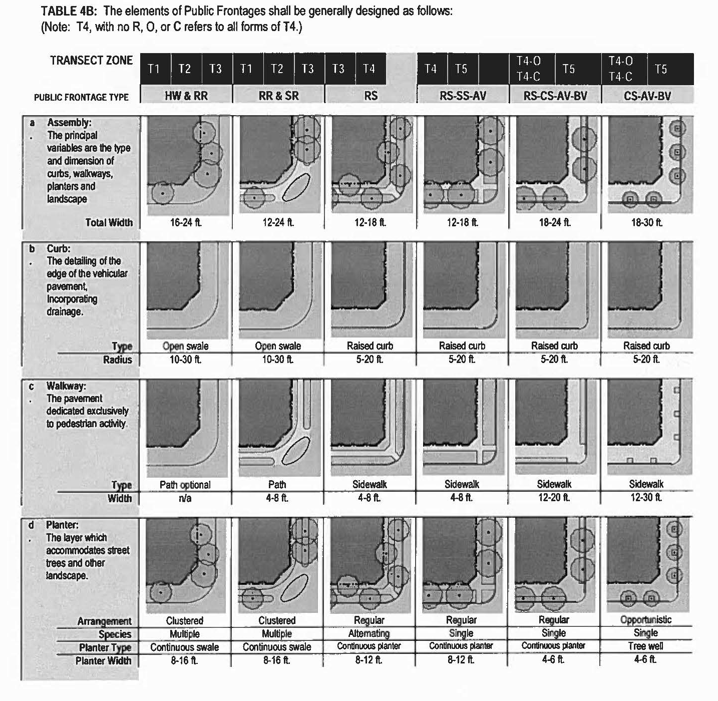
Table 5 - Public Lighting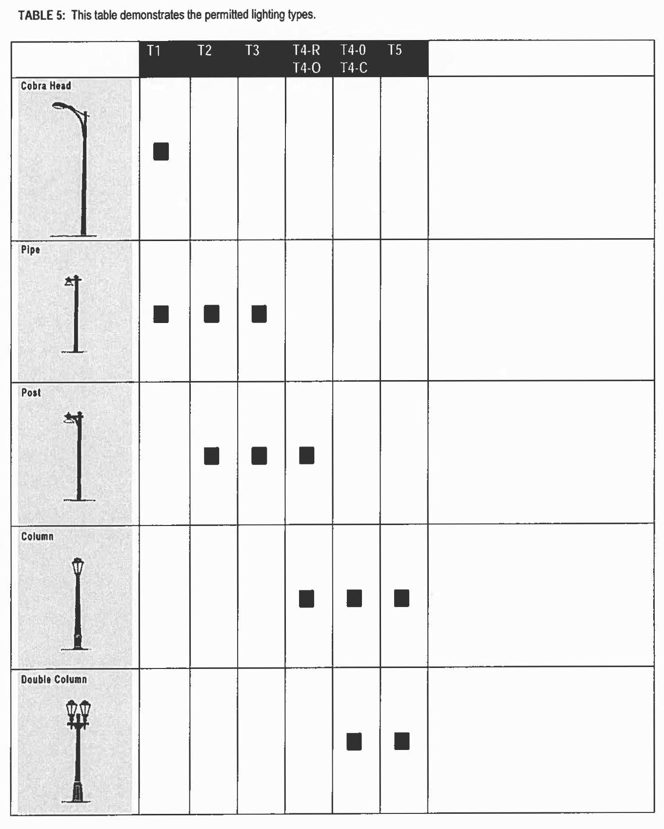
Table 6 - Landscaping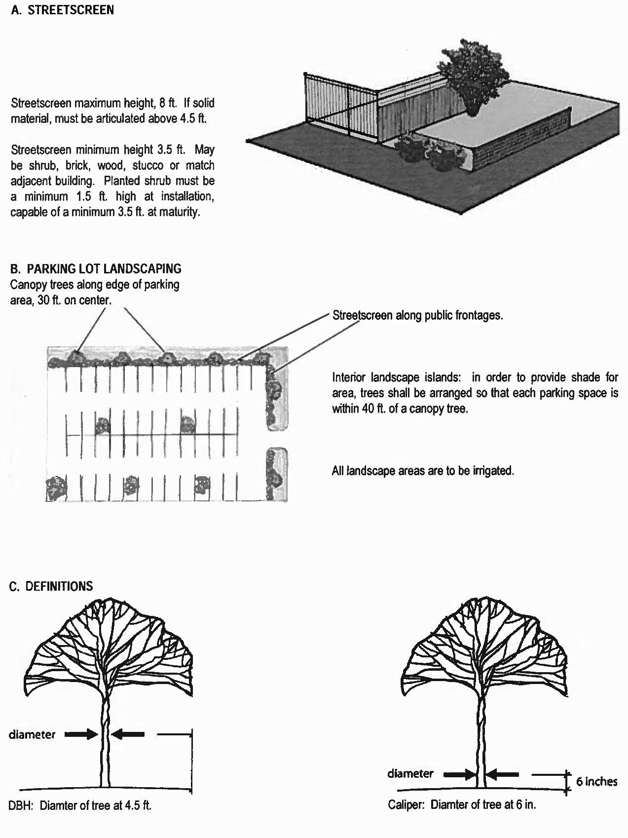
Table 7 - Private Frontages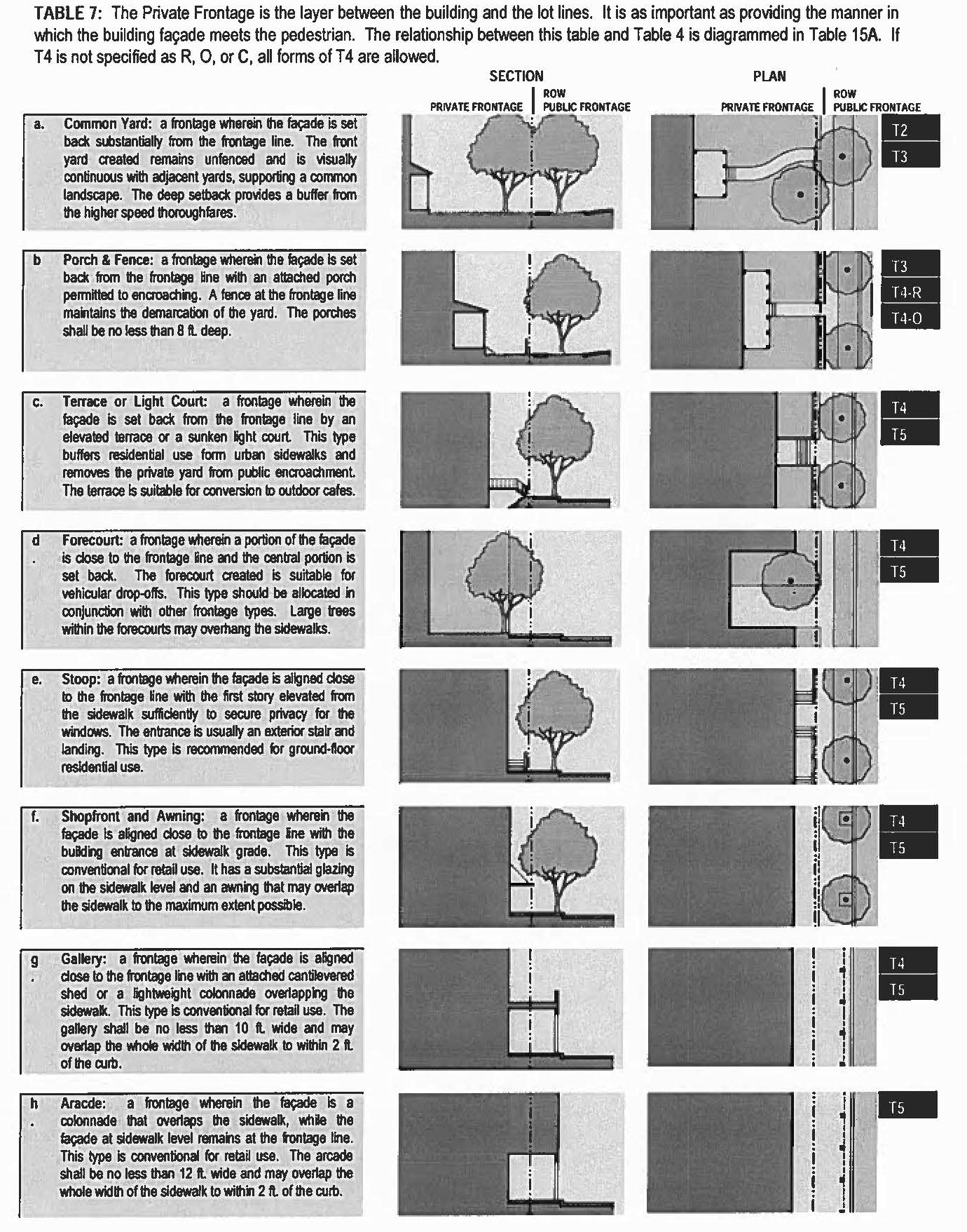
Table 8 - Building Configuration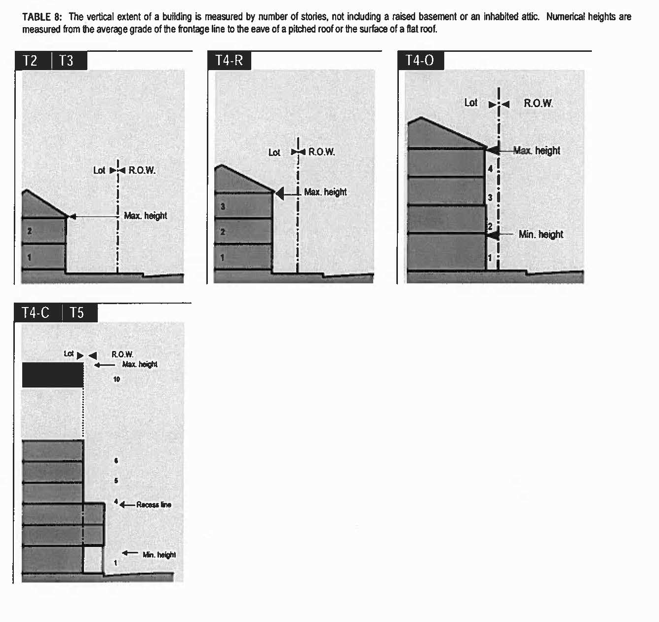
Table 9 - Building Disposition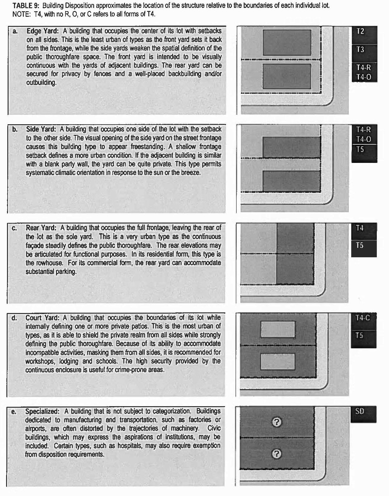
Table 10 - Building Function, Specific
R = By Right E = By Exception W = By Warrant
Tables 11 and 12 - Building Function and Parking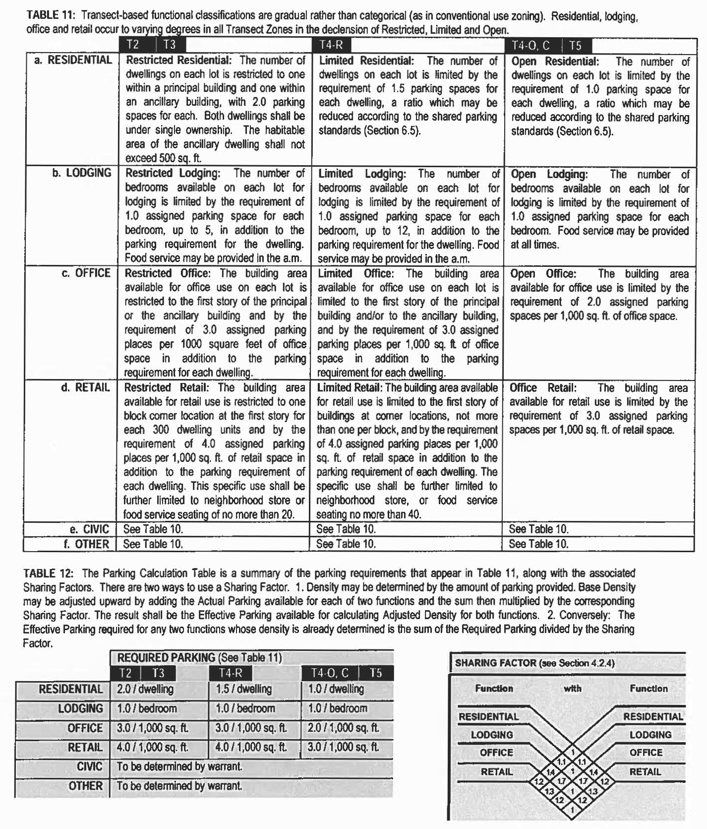
Table 13 - Civic Space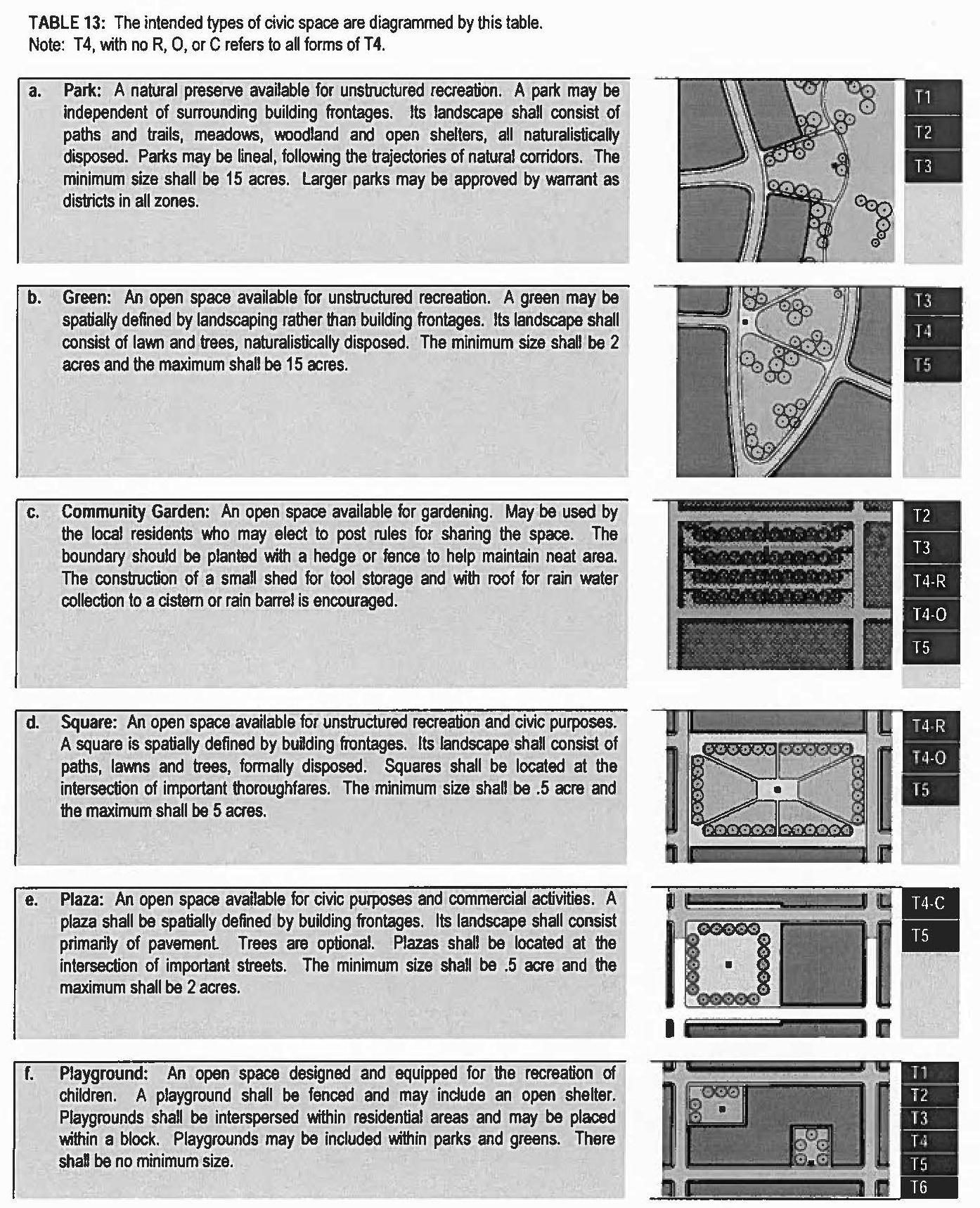
Table 14 - Summary of Transect Zones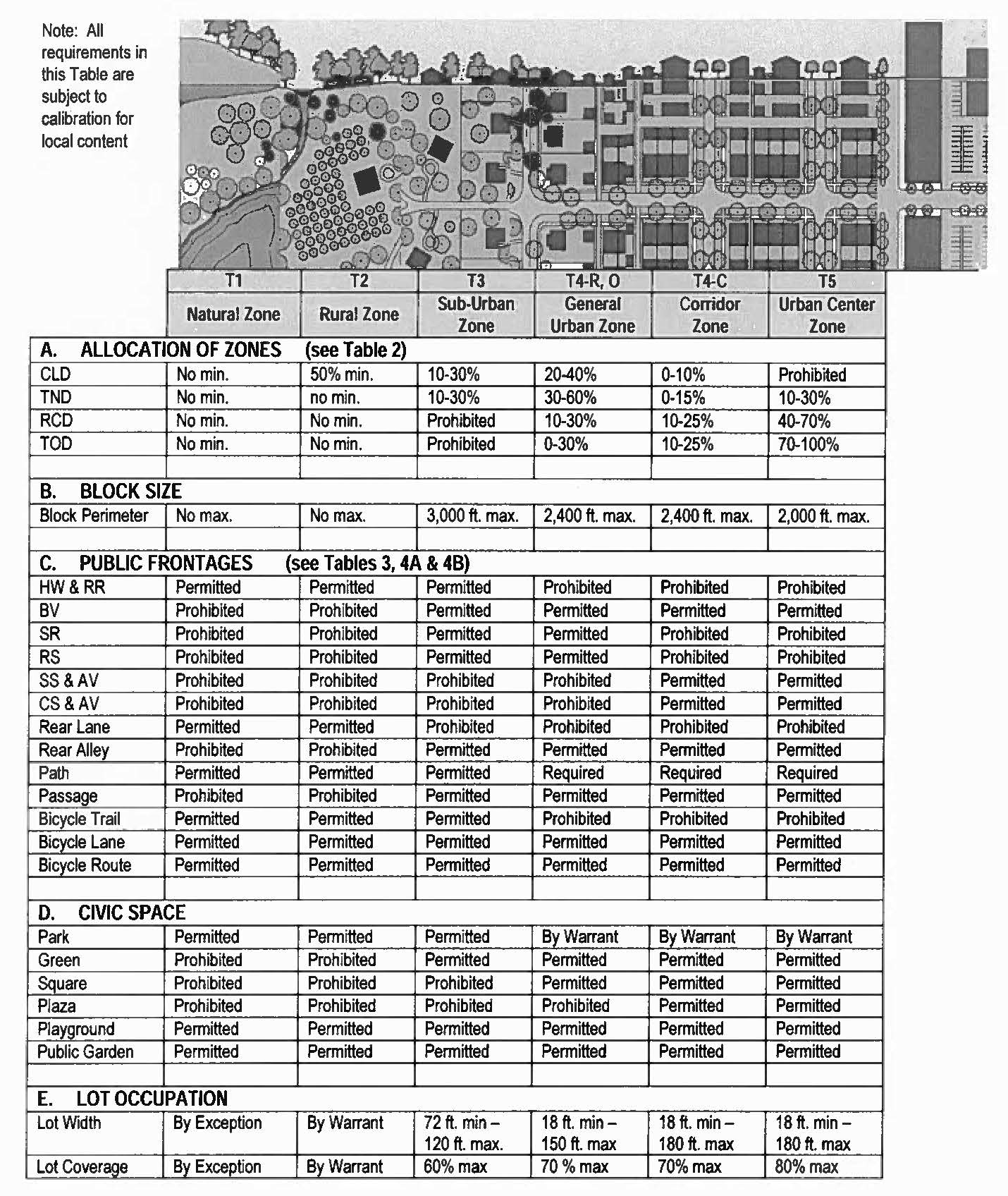
Table 14 - Summary of Transect Zones (cont.)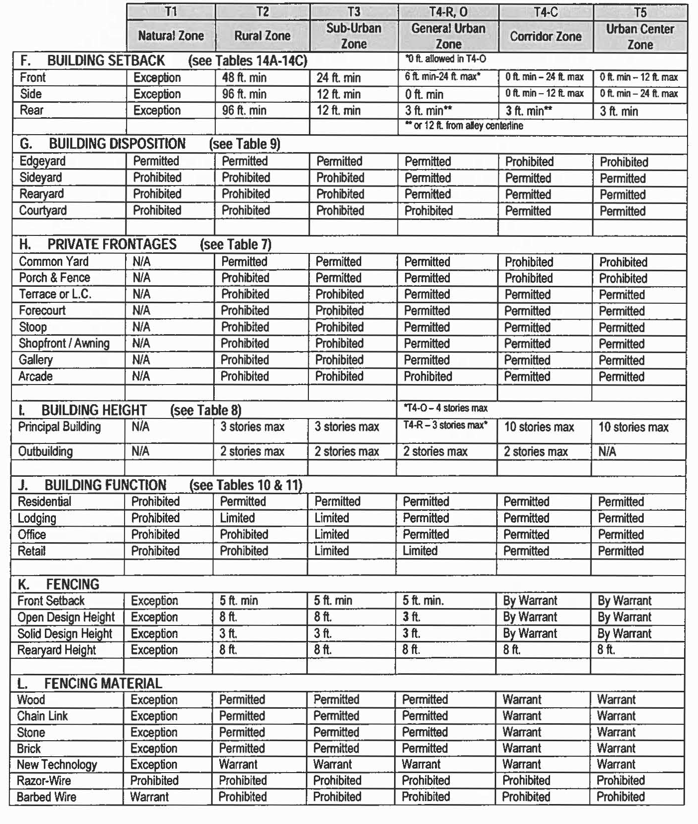
Illustration 14A: Transect Graphics - T3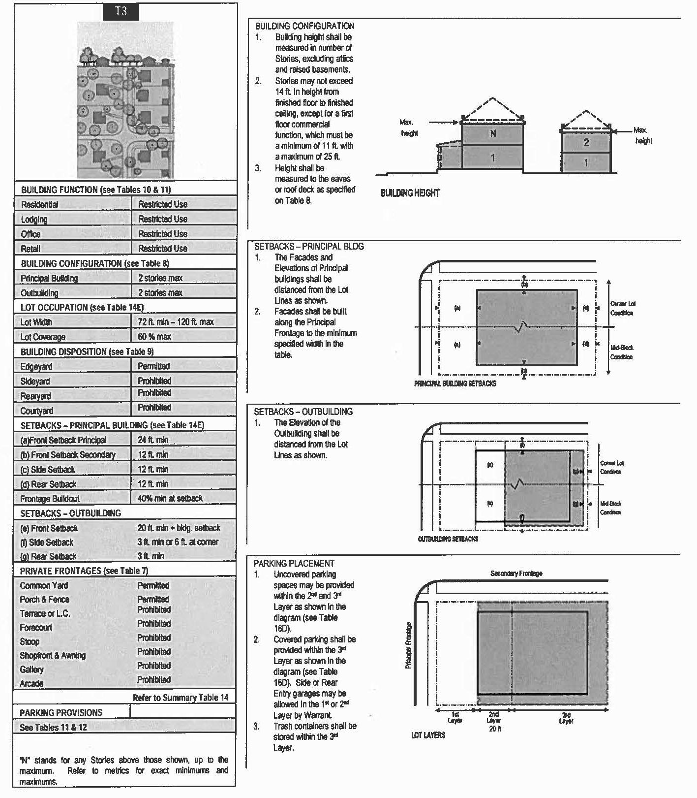
Illustration 14B: Transect Graphics - T4-R, T4-O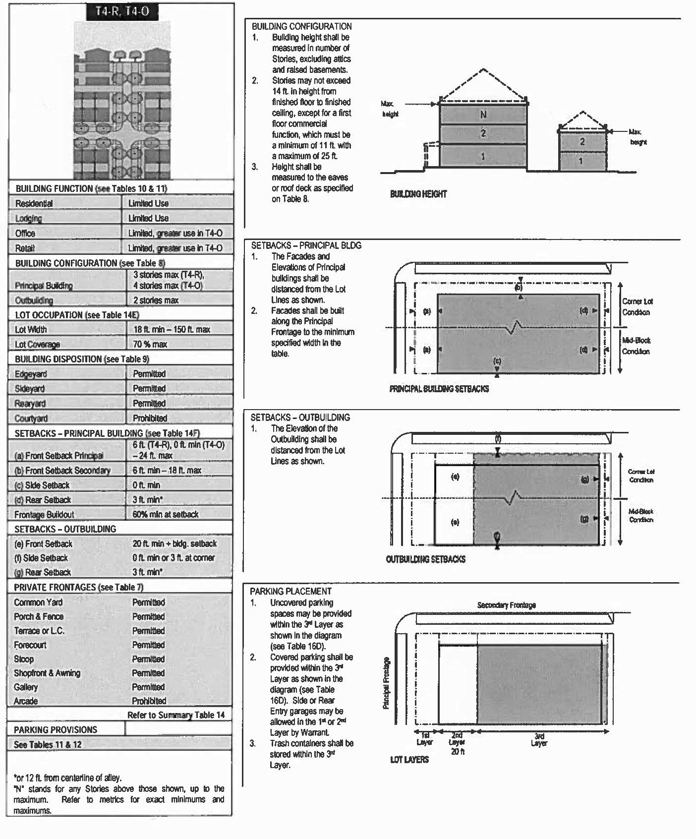
Illustration 14C: Transect Graphics - T4-C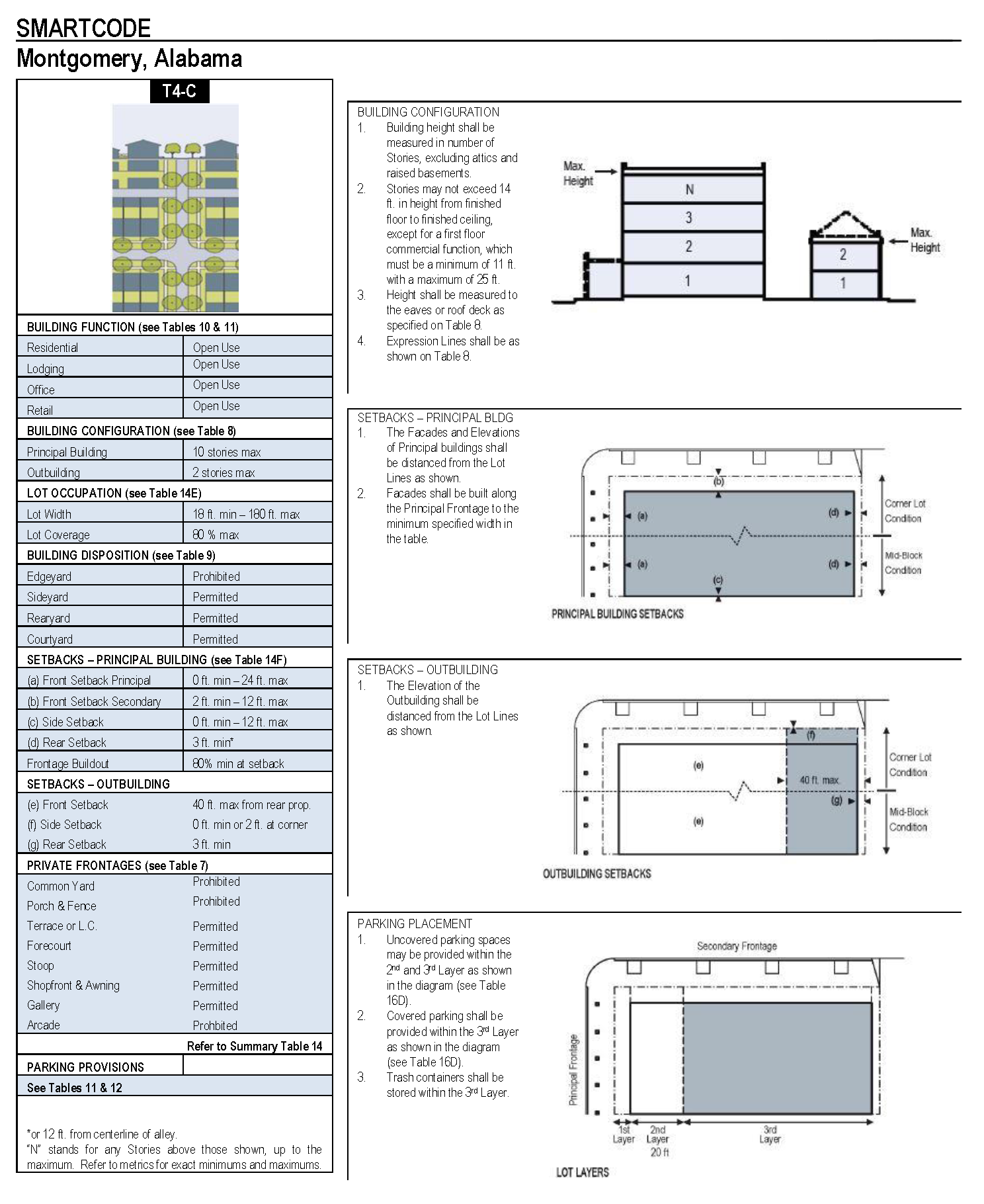
Illustration 14D: Transect Graphics - T5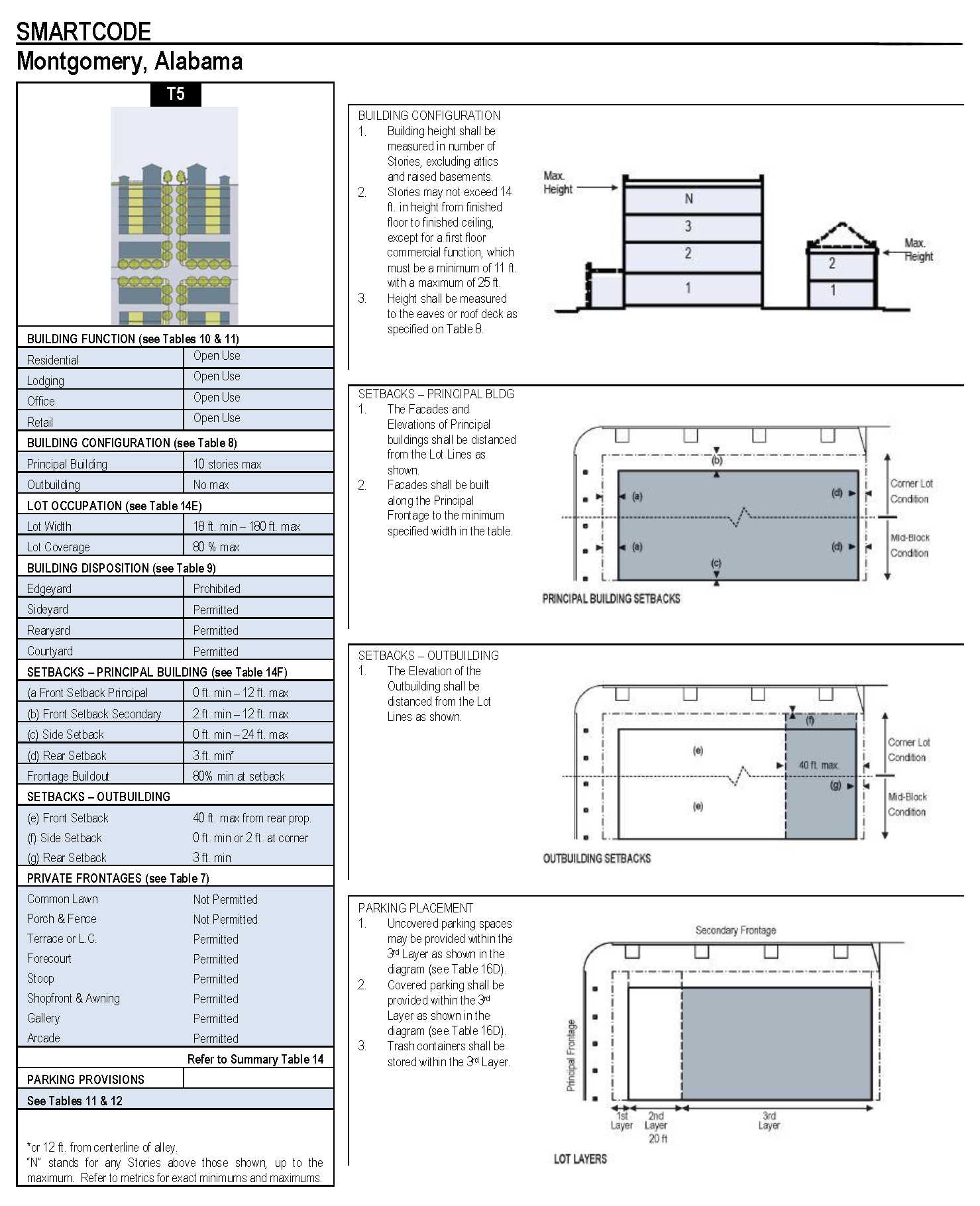
Table 15 - Illustration of Some Terms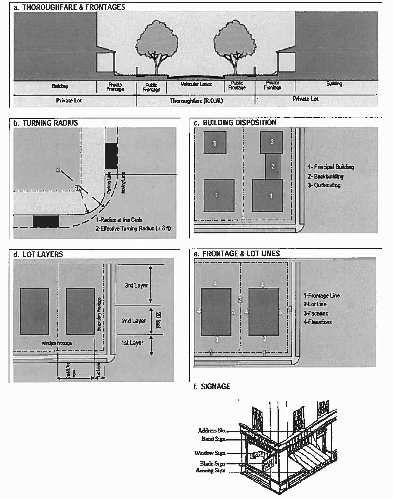
Article 8. Special District-Medical (SD-M)
1.1
AUTHORITY
1.1.1
The inclusion of the use of Special Districts as floating zones to provide for specific entities that are important to an urban area, but due to their specific purpose or nature, fall outside of the accepted commercial, office, institutional and residential definitions in the SmartCode, adopted by amendment to SmartCode, Ordinance No. 35-2007 and Ordinance No. 3-2006 and authorized by: Section 11-52-70 through 84, Code of Alabama, 1975, as amended.
1.1.2
This Code is adopted as one of the instruments of implementation of the public purposes and objectives of the adopted Comprehensive City Plan of Montgomery as amended. This Code is declared to be in accord with the Comprehensive City Plan of Montgomery as amended and is deemed necessary to promote the health, safety, and general welfare of the City of Montgomery and its residents.
1.1.3
This Code was adopted and amended by vote of the Montgomery City Council.
1.2
PURPOSE
1.2.1
The purpose of the Special District-Medical (SD-M) is to identify and protect areas within the City to allow for efficient and necessary expansion of medical facilities to meet future needs of area residents.
a.
As population needs increase and technology changes, health care needs most likely will demand greater facilities.
b.
In order to protect the existing major medical facilities in Montgomery, each of which has huge financial investments in their respective campus, future growth should be encouraged in close proximity to the existing facilities.
c.
Careful thought should be taken with new development in these areas in order that it is compatible with the goal to have adequate health and emergency medical care in close proximity to area residents.
1.3
APPLICABILITY
1.3.1
See Montgomery SmartCode.
1.4
PROCESS
1.4.1
A Special District is established to provide for a variety of development types that are not specifically included in the SmartCode Transects. Examples of special districts: hospitals, colleges, airports, heavy industrial.
1.4.2
Once the need for a Special District is determined by either the City of Montgomery's Long Range/Comprehensive Plan, or by a specific use, such as college, airport, hospital, etc., a study should be conducted and data collected by or for the Montgomery Department of Economic & Community Development which includes meeting with neighbors and property owners as well as with the leaders/developers requesting consideration for development or expansion.
1.4.3
Following public meetings for presenting possible Special Districts and publishing the relevant maps to show the extent and purpose of the special district for public scrutiny, the specifics of the special district shall be defined by tables and articles that document the allowed form and uses contained within the Special District. The maps, tables, and articles shall be presented to the Land Use Controls Division of the Department of Economic & Community Development which will disseminate the information to the various oversight departments within the City (Long Range Planning, Engineering, Traffic Engineering, Fire Department, and any others deemed necessary) and utilities. Comments from these departments will be attached to the map, tables, and articles and presented to Planning Commission and City Council for final vote.
1.5
DEVIATIONS
1.5.1
Deviations shall follow Montgomery SmartCode.
1.5.2
The allocations of Transects, traffic thoroughfares, alleys and residential densities do not follow the SmartCode but rather are established within the tables, maps and articles defining the Special District.
2.1
INSTRUCTIONS
2.1.1
There is no minimum or maximum size requirement.
2.1.2
Size of Special District should be determined by need requirements imposed due to intended use.
The desired land requirement does not have to be under total control by developer at the time of establishing the Special District, but all land being requested for the future growth or protection of the special use must have strong rationale to support claims for restricting use of surrounding property.
2.1.3
Special District-Medical may be developed by any number of developers as long as the use is consistent to creating a medical complex.
3.1
THOROUGHFARES, SIDEWALKS, BIKE LANES
3.1.1
It is recognized that numerous types of vehicles will be using the facilities and that the need for emergency care facilities will require access by ambulance, police and fire vehicles as well as by private automobiles. The emphasis is on safety for all users and expediting emergency vehicles.
3.1.2
Layout and thoroughfare connections will be deferred to the professional developing the plan unless there are serious concerns from the City Departments. City concerns will be addressed by data and rationale from the developer.
3.1.3
The increased possibility of wheel chairs and other ambulatory assistance must inform the construction of sidewalks and curb cuts. Bike lanes shall be limited to the roads, not to be placed on trails through the complex or paths on sidewalks.
3.1.4
Stormwater management should primarily be through underground storm drains channeled by raised curbs
4.1
PARKING STANDARDS
4.1.2
Parking spaces and sharing factors are found on Tables 8 and 9. Where possible, parking should be in parking structures or behind buildings in order not to contribute to creating long distances for patients, visitors, and customers to have to traverse to reach needed facility.
4.1.3
Parking lots should meet landscape and access standards required by SmartCode and Urban Forestry requirements.
5.1
SIGNAGE
5.1.1
Wayfinding signs should be strategically placed to allow for clear instructions as to locations and services but to not block line of sight of drivers of vehicles.
5.1.2
Wayfinding signs should not contain advertisements of any kind.
5.1.3
Buildings may have both monument signs, which should not exceed 6 ft. in height, and band signs, which may be up to 3 ft. in height by any length.
5.1.4
Only buildings with an emergency facility or services open during the night may have internal lighting.
5.1.5
Billboard signs may not be used.
6.1
LIGHTING
6.1.1
Lighting should be of a scale to match architecture and human elements. Follow SmartCode descriptions and Table 3. It is permissible to select a standard light structure/design to be used throughout Special District in order to create uniform, consistent appearance.
7.1
PUBLIC SPACE AND GREEN SPACE
7.1.1
Public space and green space is not mandatory but are allowed and may be used to create a sense of place within the special district.
7.1.2
Playgrounds with equipment are not permitted unless fenced and attached to a structure such as a daycare center or family dormitory, if permitted.
8.1
SmartCode shall be followed for all other concerns not covered by these articles concerning the Special District-Medical.
Table 1 - Transect Zone Descriptions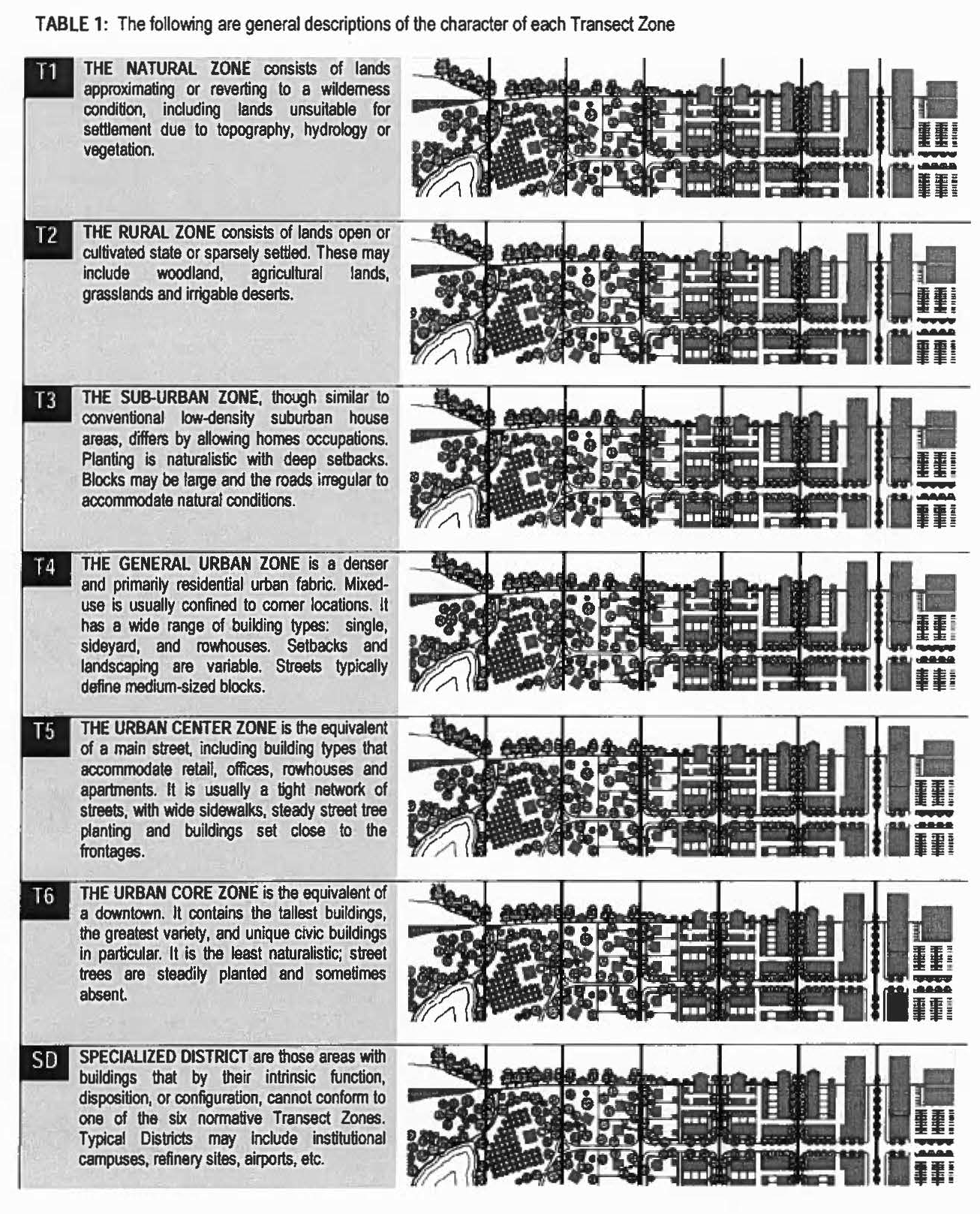
Table 2A - Public Frontages - General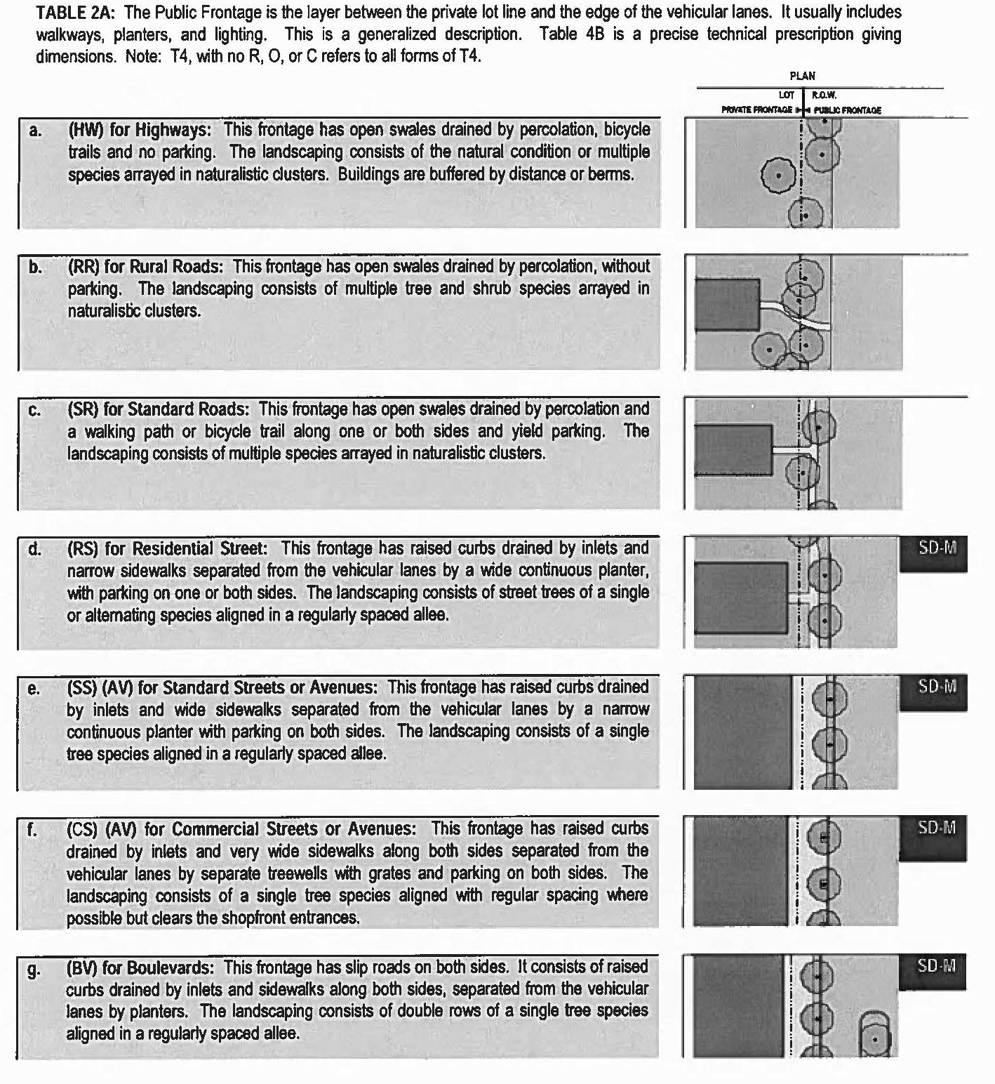
Table 2B - Public Frontages - Specific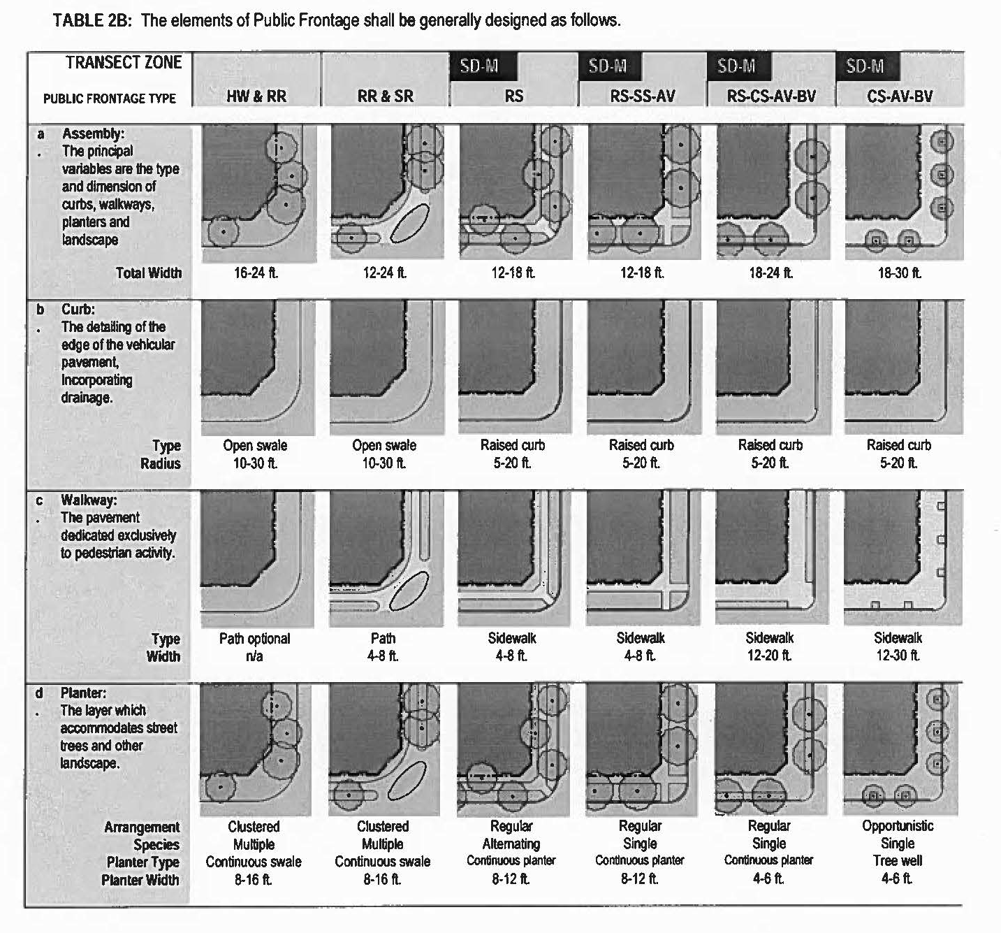
Table 3 - Public Lighting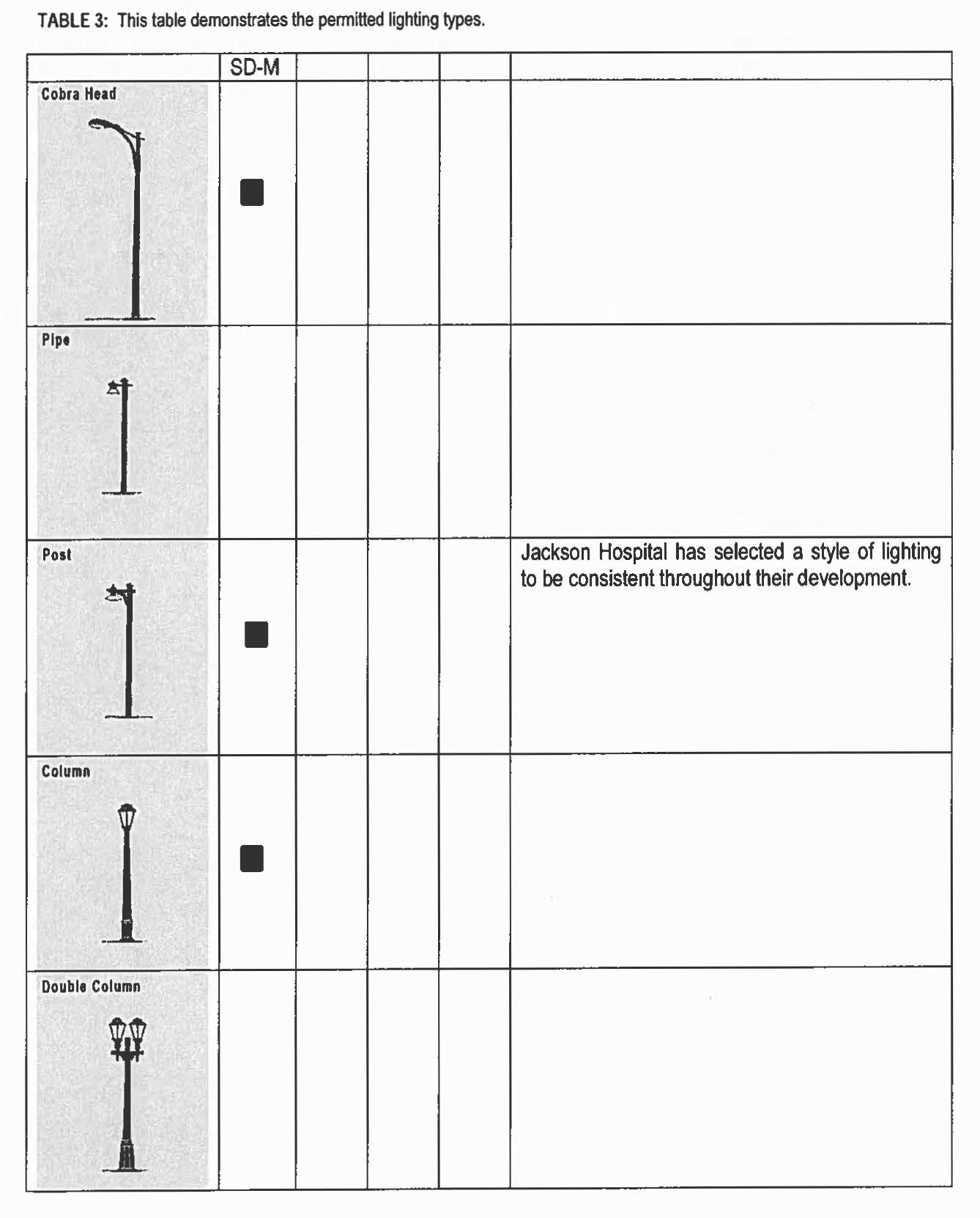
Table 4 - Private Frontages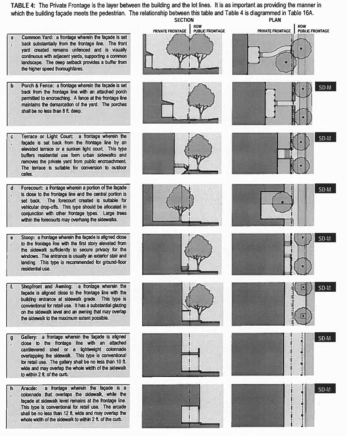
Table 5 - Building Configuration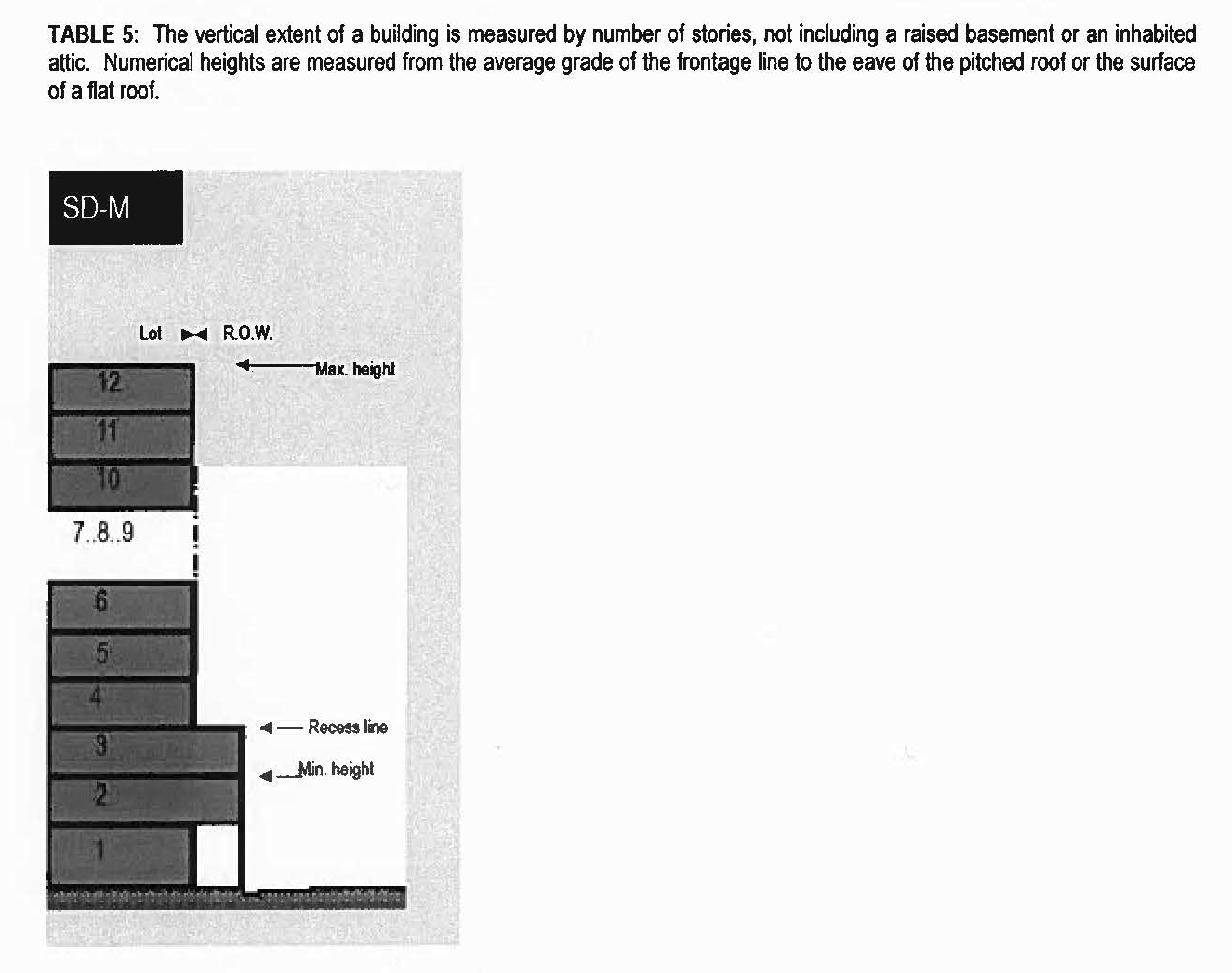
Table 6 - Building Disposition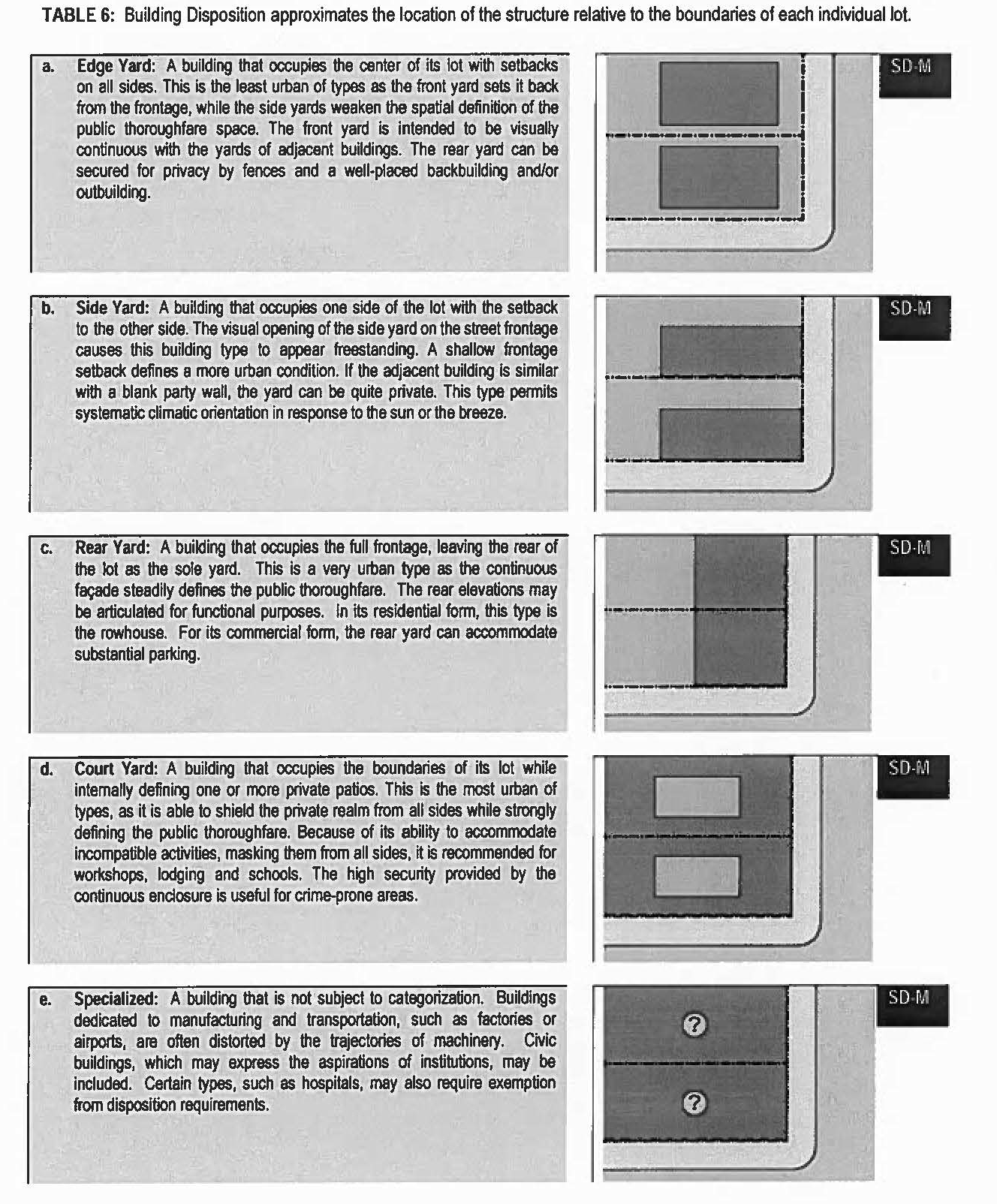
Table 7 - Building Function - Specific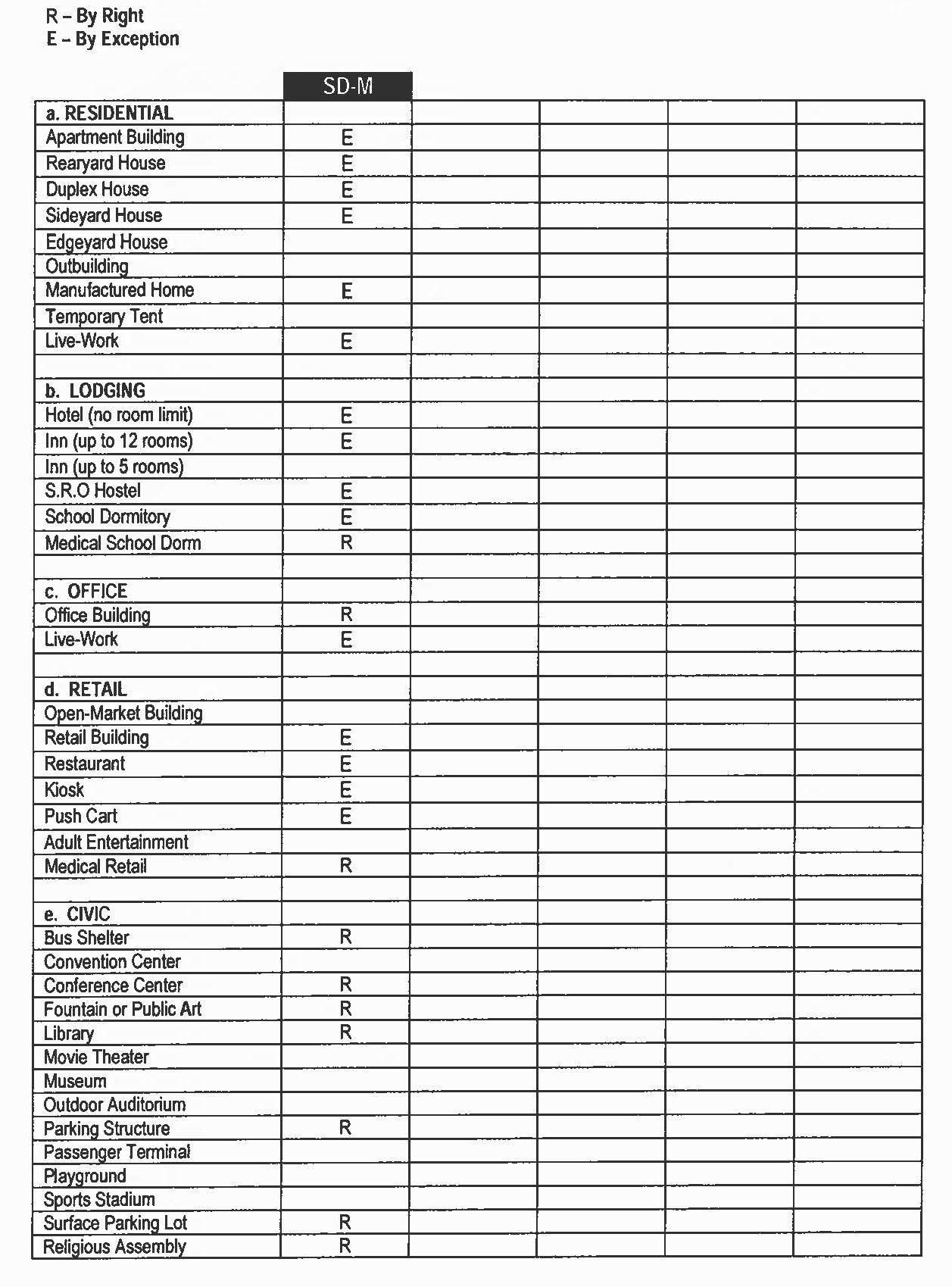
Table 7 - Building Function - Specific (cont.)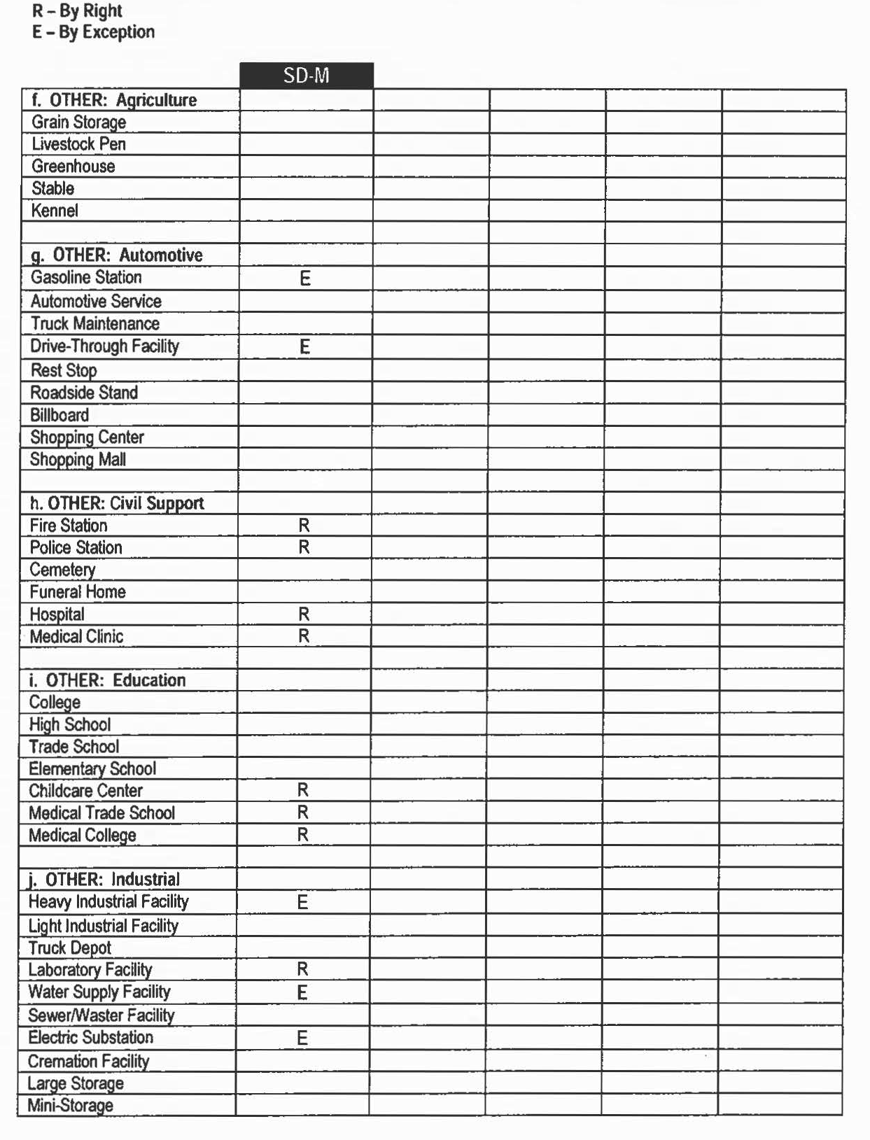
Tables 8 and 9 - Building Function and Parking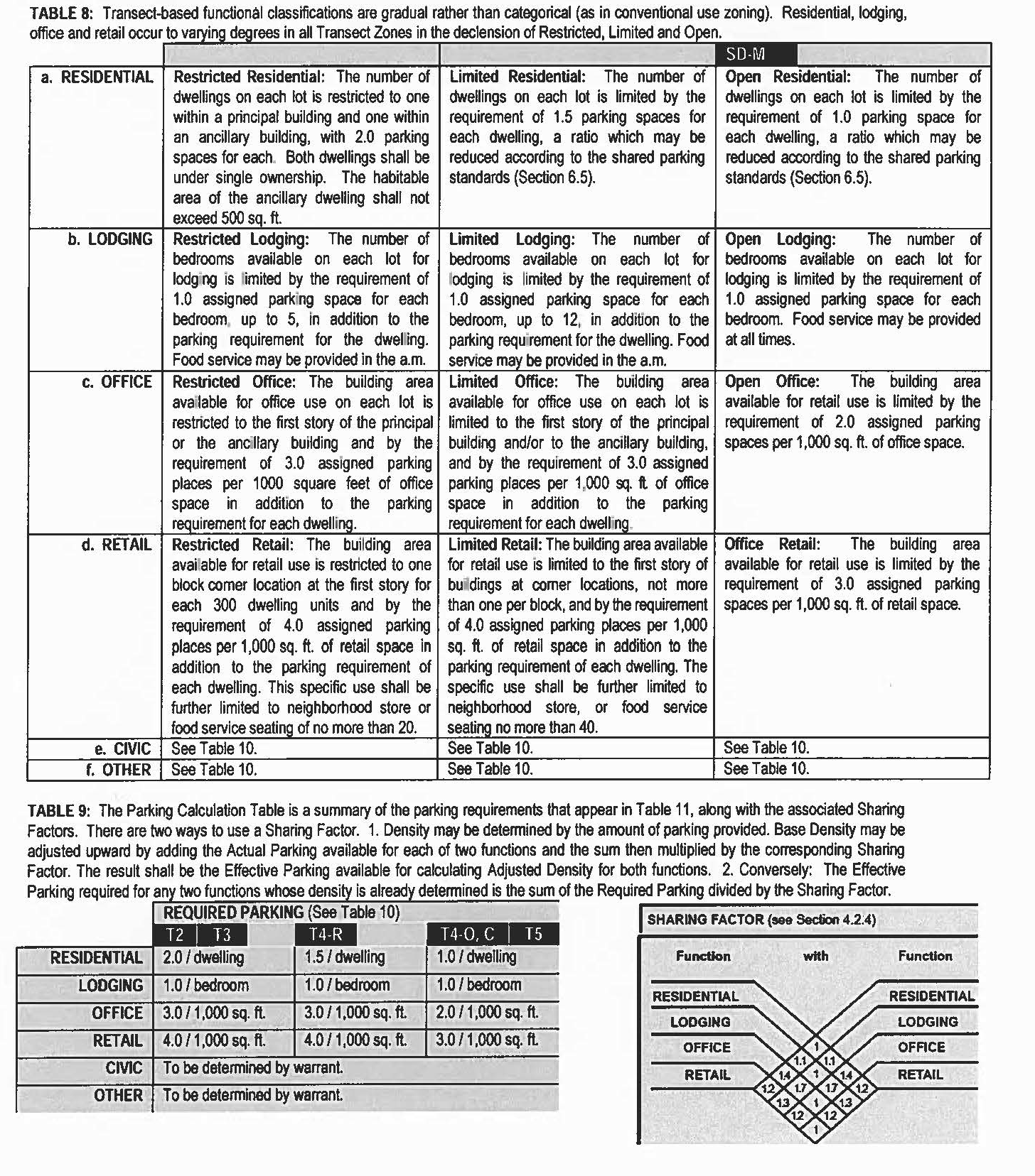
Table 10 - Civic Space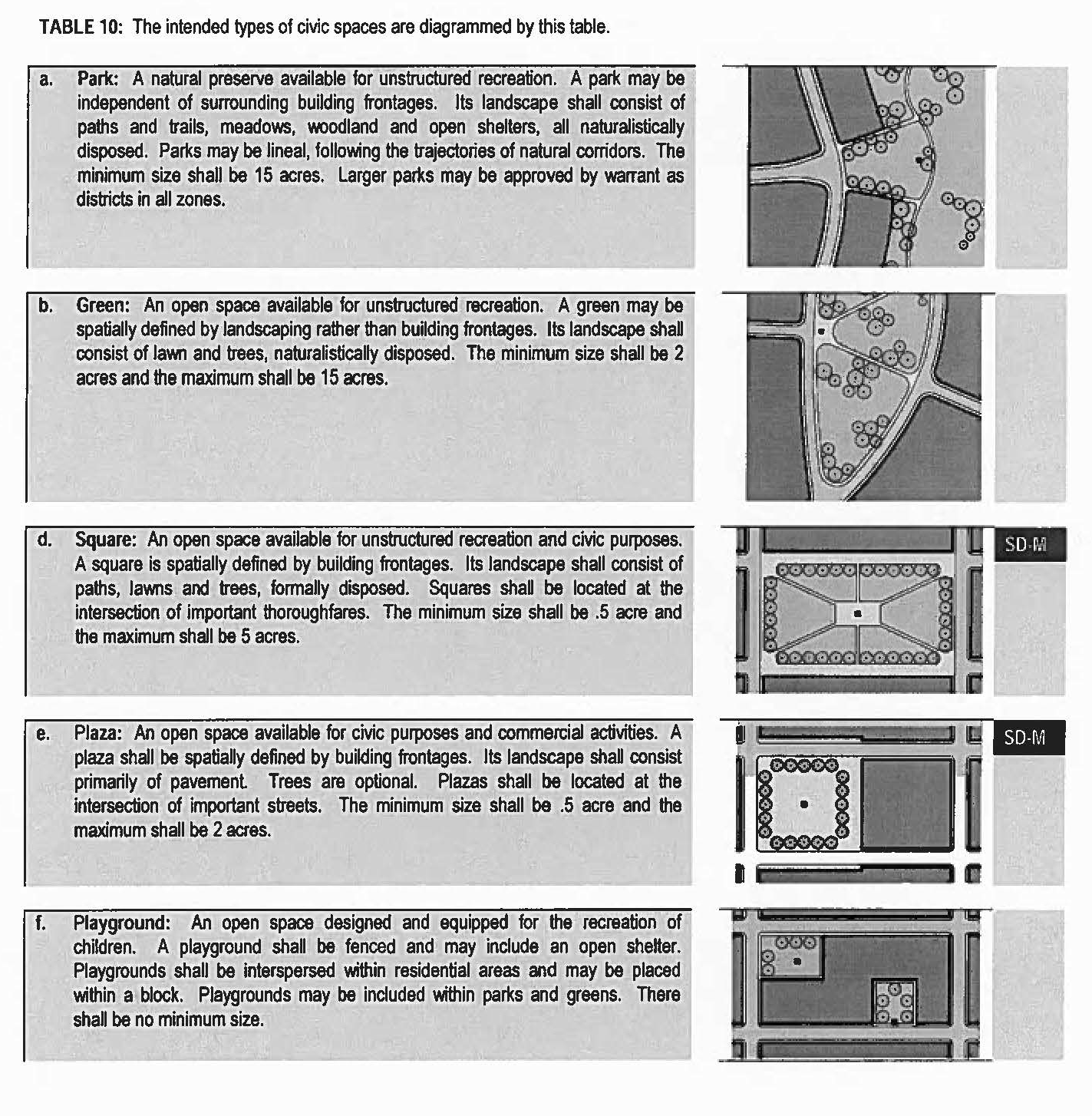
Table 11 - Summary of Special District Features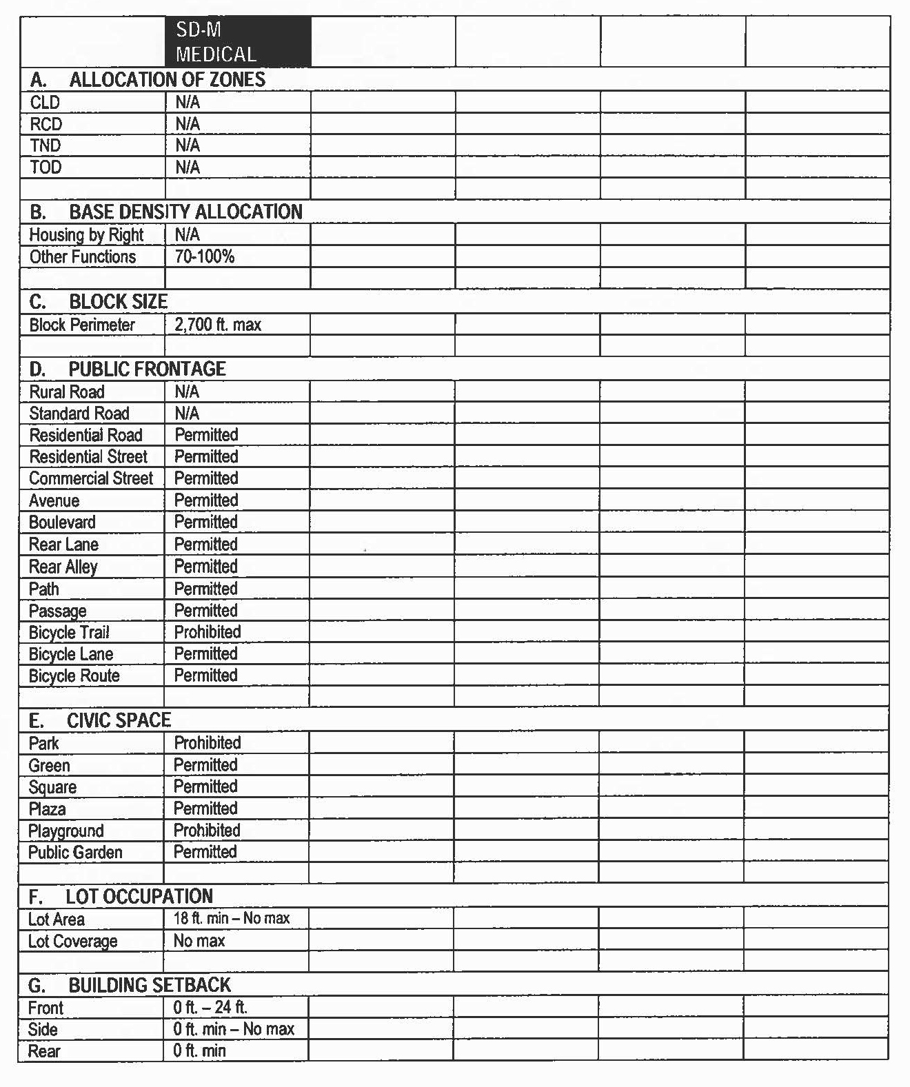
Table 11 - Summary of Special District Features (cont.)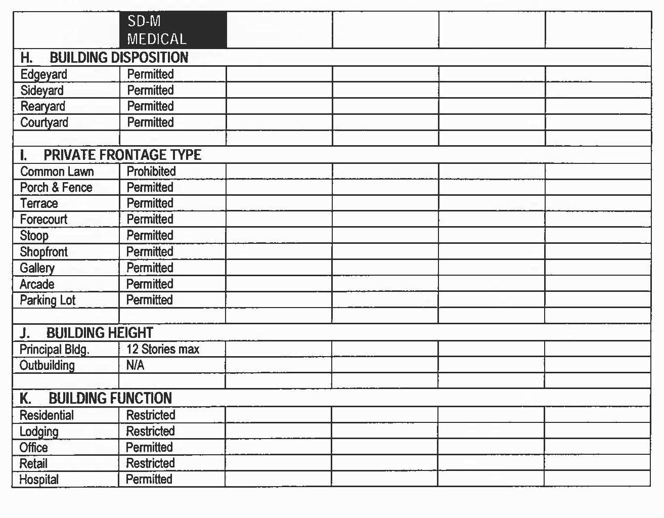
[Article 9.] Definition of Terms
Definitions. This Article provides definitions for terms in this Code that are technical in nature or that otherwise may not reflect a common usage of the term. If a term is not defined in this Article, then the Land Use Division shall use the latest version of Webster's Dictionary.
Actual Parking: The number of existing parking spaces.
Adult Daycare: A facility which provides limited supervision and basic services on a part-time basis by day or evening, but not overnight, to three or more adults other than family/employee occupying the premises. The term does not include community residential homes, nursing home facilities or institutions for the aged.
Affordable Housing: Dwellings consisting of rental units or for-sale units. Both shall be economically within the mean of the equivalent of the starting salary of a local elementary school teacher.
Accessory Building: An outbuilding with an Accessory Unit.
Accessory Structure (Agriculture): Any associated structure related to agricultural products, tools, equipment or other similar functions.
Accessory Unit: An apartment not greater than 600 sq. ft. sharing ownership and utility connections with a Principal Building. An Accessory Unit may or may not be within an Outbuilding. Accessory Units do not count toward maximum density calculations (see Tables 12 & 16).
Adjusted Parking: The amount of required parking adjusted by the Sharing Factor in Table 12.
A-Grid: Or Primary Grid, See Primary-Secondary Grid.
Allee: A regularly spaced and aligned row of trees usually planted along a Thoroughfare or Pedestrian Path.
Alley: A thoroughfare designated to be a secondary means of vehicular access to the rear or side of properties. An alley may connect to a vehicular driveway located to the rear of lots providing access to outbuildings, service areas and parking; and may contain utility easements.
Ancillary Unit: See Accessory Unit.
Apartment: A dwelling unit sharing a building and a lot with other dwellings and/or uses. Apartments may be for rent or for sale as condominiums.
Arcade: A private frontage conventional for retail use wherein the façade is a colonnade supporting habitable space that overlaps the sidewalk, while the façade at sidewalk level remains at the frontage line (see Table 7).
Assisted Living: A system of housing and limited care that is designed for senior citizens who need some assistance with daily activities but do not require care in a nursing home.
Auto-Related Commercial Establishments: A place of business serving auto-related needs including, but not limited to: car rental, car wash, gas station, mechanic offering minor repairs, retail sales such as auto parts, tire store, indoor car sales. Uses not included: major mechanical work; body work; painting; steam cleaning; welding; outdoor car sales; storage of automobiles not in operating condition; commercial parking lot or commercial garage; or any work involving undue noise, glare, fumes or smoke, all of which are considered auto-related industrial activities.
Avenue (AV): A Thoroughfare or high vehicular capacity and low speed. Avenues are short distance connectors between urban centers. Avenues may be equipped with a landscaped median. Avenues become collectors upon exiting urban areas.
Backbuilding: A single-story structure connecting a principal building to an outbuilding (see Table 16).
Bed and Breakfast: An owner occupied lodging type offering bedrooms; permitted to serve food to guests.
B-Grid: Or Secondary Grid, see Primary-Secondary Grid.
Bicycle Lane (BL): A thoroughfare dedicated to bicycle use running within a moderate-speed vehicular thoroughfare, demarcated by striping.
Bicycle Route (BR): A thoroughfare suitable for the shared use of bicycles and automobiles moving at low speeds.
Bicycle Trail (BT): A thoroughfare running independently of a high-speed vehicular thoroughfare.
Block: The aggregate of the private lots, passages, rear lanes, and alleys, circumscribed by thoroughfares.
Block Face: The aggregate of all the building facades on one side of a block.
Boarding House: A lodging house at which meals are provided.
Boulevard: A thoroughfare designed for high vehicular capacity and moderate speed. Boulevards are long-distance thoroughfares traversing urbanized areas. Boulevards are usually equipped with slip roads buffering sidewalks and buildings. Boulevards become arterials upon exiting urban areas.
Brownfield: An area having been previously used primarily as an industrial or commercial site with perceived or actual presence of environmentally hazardous substance.
Building Configuration: The form of a building as defined by its massing, private frontage, and height.
Building Disposition: The placement of a building on its lot (see Table 9).
Building Function: The uses accommodated by a building and its lot. Functions are categorized as Restricted, Limited, or Open, according to the intensity of the use (see Tables 10 and 11).
Building Height: The vertical extent of a building measured in stories, not including a raised basement or a habitable attic. Building height limits do not apply to masts, belfries, clock towers, chimney flues, water tanks, elevator bulkheads, and similar structures. Building height shall be measured from the average grade of the enfronting thoroughfare (see Table 8).
Building Type: A structure category determined by function, disposition on the lot, and configuration, including frontage and height.
By Right: A proposal for a building or community plan that complies with this Code and may thereby be processed administratively, without public hearing.
Childcare: A facility where six (6) or more children are cared for on a part-time basis by day or by night including after-school care. The term does not include community based residential facilities, family care homes, foster homes, group homes, rehabilitation or detention centers, orphanages, or other places operating primarily for remedial care.
CLD: Cluster Land Development. A freestanding neighborhood. Because of a location away from transportation, a CLD has a weak commercial center.
Civic: The term defining not-for-profit organizations dedicated to arts, culture, education, recreation, government, transit and municipal parking.
Civic Building: Civic Buildings shall be public sites dedicated for buildings operated by not-for-profit organizations dedicated to culture, education, government, transit and municipal parking, or for a use approved by the City Council. Civic Buildings shall not be subject to the architectural standards of Article 5.
Civic Function: Premises used by organizations considered to support the common good of the community. Uses include educational, cultural, social service, and religious not-for-profit organizations
Civic Use: See Civic Function.
Civic Parking Reserve: Parking structure or lot within a quarter-mile of the site that it serves. Space may be leased or purchased from this reserve to satisfy parking requirements.
Civic Space: An open area dedicated for public use. Civic space types are defined by the combination of certain physical constants including the relationship between their intended use, their size, their landscaping, and their enfronting buildings. (See Table 13.)
Commercial: The term collectively defining workplace, office and retail functions.
Commercial Street (CS): See Table 3C.
Common Destination: An area of focused community activity, usually defining the approximate center of a pedestrian shed. It may include without limitation one or more of the following: a civic space, a civic building, a commercial center, or a transit station, and may act as the social center of a neighborhood.
Community: A regulatory category defining the physical form, density, and extent of a settlement. The three community types addressed in this Code are CLD, TND, and RCD. The TOD community type may be created by an overlay on TND or RCD.
Community Garden: A grouping of garden plots available for small-scale cultivation, generally to residents of apartments and other dwelling types without private gardens. Available for small-scale cultivation, generally to residents of apartments, and other dwelling types, without private gardens. Community gardens should accommodate individual storage sheds.
Community Pattern: The physical form of a settlement. Variations are due to the particulars of the site: density, spatial definition program, transportation, and implementation. Transect-based community patterns are socially and functionally variegated; they are walkable, and they manifest a gradient from urban to rural.
Community Residence: Residential facility for non-related persons needing assistance to integrate into the community.
Conference Center: A center where conferences can be conducted.
Configuration: The form of a building, based on its massing, private frontage, and height.
Consolidated Review Committee (CRC): A committee of one representative from each of the regulatory agencies that have jurisdiction over the approval of a project.
Context: Surroundings made up of the particular combination of elements that create specific habitat.
Convention Center: A large civic building or group of buildings designed for conventions, industrial shows, and the like; having large unobstructed exhibit areas and often including conference rooms, hotel accommodations, restaurants, and other facilities.
Corridor: A linear geographic system incorporating transportation and/or greenway trajectories. A transportation corridor may be a linear urban transect zone.
Courtyard Building: A building that occupies the boundaries of its lot while internally defining one or more private patios.
Curb: The edge of the vehicular pavement detailed as a raised curb or flush to a swale. The curb usually incorporates the drainage system (see Table 4A & B).
Design Speed: The velocity at which a thoroughfare tends to be driven without the constraints of signage or enforcement. There are three ranges of speed: Very low (below 20 mph), Low (20-25 mph), Moderate (25-35 mph), High (above 35 mph). Lane width is determined by desired design speed.
Disposition: The placement of a building on its lot. See Table 9.
District: See Specialized District.
Domiciliary: Providing care and living space.
Drive-Through/Drive-In Facility: A place of business including drive-through banks or teller windows, drive-through eating and drinking establishments, drive-through windows at liquor or other stores, or at laundry and dry cleaning facilities, car washes, and similar facilities, but excludes automotive service stations.
Driveway: A vehicular lane within a lot, usually leading to a garage. A driveway in the first layer may be used for parking if it is no more than 18 ft. wide, thereby becoming subject to the constraints of a parking lot.
Duplex House: A building that is divided into two living units sharing a common wall.
Edgeyard Building: A building that occupies the center of its lot with setbacks on all sides.
Effective Parking: The amount of parking required for mixed use after adjustment by the shared parking factor (see Tables 11 and 12).
Effective Turning Radius: The measurement of the inside turning radius taking parked cars into account.
Elevation: An exterior wall of a building not along the public right-of-way (see Table 16).
Encroachment: Any structural element that breaks the plane of a vertical or horizontal regulatory limit, extending into a setback, into the public frontage, or above a height limit.
Enfront: To place an element along a frontage line, as in "porches enfront the street."
Entrance, Principal: The main point of access for pedestrians into a building.
Exception: A Variance that permits a practice that is not consistent with a provision or intent of this Code.
Facade: The exterior wall of a building that is set along a public Right-of-way frontage line. (See Table 16).
Final Plat: A map of a land subdivision prepared in a form suitable for filing of record with necessary affidavits, dedications, restrictions, and acceptances, and with complete bearings and dimensions of all lines defining lots and blocks, streets, alleys, public areas and other dimensions of land.
First Lot Layer: The portion of a lot measured from the property line on the principal frontage to the building frontage/front setback.
Forecourt: A private frontage wherein a portion of the facade is close to the frontage line and the central portion is set back (see Table 7).
Frontage: The area between a building facade and the front setback, inclusive of its built and planted components. Frontage is divided into private frontage and public frontage (see Tables 4A and 7).
Frontage Line: (Front setback) Those lot lines that coincide with a public frontage. Facades along frontage lines define the public realm and are therefore more regulated than the elevations that coincide with other lot lines (see Table 16).
Gallery: A private frontage conventional for retail use wherein the facade is aligned close to the frontage line with an attached cantilevered shed or lightweight colonnade overlapping the sidewalk (see Table 7).
Gas Station: A retail business that sells motor vehicle fuel, related motor vehicle products, and which also sell food and beverage items.
Greenfield: An area that consists of open fields and farmland which has not been previously developed.
Green: A civic space type for unstructured recreation, spatially defined by landscaping rather than building frontages (see Table 13).
Greenhouse: A building, room, or area, usually made of transparent or opaque material, in which temperature is maintained within a desired range, used for cultivating plants or growing plants out of season.
Greenway: An open space corridor or largely natural conditions, which may include trails for bicycles and pedestrians.
Group Home: A residence for persons requiring care or supervision.
Halfway House: A residence for individuals after release from institutionalization (as for mental disorder, drug addiction, or criminal activity) that is designed to facilitate their readjustment to private life.
Heavy Industrial: Industrial facilities that conduct their operation in such manners that results are created or apparent outside an enclosed building that are incompatible with adjacent or nearby non-industrial uses.
Highway: A thoroughfare intended primarily to serve through traffic traveling medium to long distances.
Home Occupation: Non-retail commercial enterprises. The work quarter should be invisible from the frontage located either within the house or in an outbuilding. Permitted activities are defined by the restricted office category (see Table 10).
Infill: Land which has been previously developed property.
Inn: A commercial establishment that provides lodging, food, etc., for public, especially travelers; small hotel; a tavern.
Inside Turning Radius: The curved edge of a thoroughfare at an intersection, measured at the inside edge of the vehicular tracking. The smaller the turning radius, the smaller the pedestrian crossing distance and the more slowly the vehicle is forced to make the turn (see Tables 3 and 16).
Kiosk: A small, self-standing structure used for commercial purposes. Examples include, but are not limited to, a newsstand or ticket booth.
Layer: A range of depth of a lot within which certain elements are permitted (see Table 16).
Light Industrial: Industrial facilities that conduct their operations in such manners that no results are created or apparent outside an enclosed building that are incompatible with adjacent or nearby non-industrial uses.
Liner Building: A building specifically designed to mask a parking garage from a frontage. A liner building, if less than 30 ft. deep and two (2) stories, shall be exempt from parking requirements.
Live-Work: A dwelling unit that contains a commercial component. A live-work unit is a fee-simple unit on its own lot with commercial component limited to the ground level.
Lodging: Premises available for daily and weekly renting of bedrooms. The area allocated for food service shall be calculated and provided with parking according to retail use.
Lot Line: The boundary that legally and geometrically demarcates a lot (see Tables 14F & 16).
Lot Width: The length of the Principal Frontage line of a lot.
Main Civic Space: The main civic space shall be within 800 ft. of the geographic center of each pedestrian shed, unless prevented by topographic conditions or pre-existing thoroughfare alignments as determined by the CRC.
Manufacturing: Premises available for the creation, assemblage, and/or repair of artifacts; and including their retail sale.
Meeting Hall: A building available for gatherings. It should accommodate at least one room equivalent to a minimum of 10 sq. ft. per projected dwelling unit(s) within the pedestrian shed in which the meeting hall is located.
Mixed Use: Multiple functions within the same building and/or adjacent building, or in multiple buildings within the same area by adjacency. Mixed use is one of the principles of TND development from which many of its benefits are derived, including compactness, pedestrian activity, and parking space reduction.
Neighborhood: A mostly residential area, often with a recognizable edge. For the purposes of this Code, a "complete neighborhood" is further defined as consisting of one pedestrian shed (1/2 mile diameter) with a mixed-use center.
Nonconformity: An existing function, structure, lot or site improvement that was in compliance with the zoning regulations that were applicable to it when it was established, and for which all required permits were issued, but which does not conform in whole or in part to the regulations of this Section. Such nonconformity is legal and may continue except as regulated by this Code.
Office: Premises available for the transaction of general business but excluding retail, artisanal and manufacturing uses.
Open Parking Lot: A parking lot on a parcel, not in conjunction with a building. May be on the frontage and within the first and second lot layers by warrant, except for corner lots at intersections with an A-Grid, or Primary Grid.
Outbuilding: An accessory building, usually located towards the rear of the same lot as the principal building. A backbuilding sometimes connects it to the principal building.
Overlay Zone: A designation of special zoning concerns which impose different restrictions or requirements on an area without altering the underlying zoning. Usually used to enhance or protect specific environmental characteristics or needs for an area.
Park: A civic space type that is a natural preserve available for unstructured recreation (see Table 13).
Parking Structure: A building containing two or more stories of parking. Parking structure shall have liner buildings at the first story or higher. Parking structures not on a primary grid are exempt and may be unlined.
Passage (PS): A pedestrian connector passing between buildings, providing shortcuts through long blocks and connecting rear parking areas to frontages. Passages may be roofed over.
Path (PT): A pedestrian way traversing a park or rural area, with landscape matching the contiguous open space. Paths should connect directly with the urban sidewalk network.
Pedestrian Shed: An area defined by the average distance that may be applied to determine the size of a neighborhood or extent of a community. A standard pedestrian shed is ¼ of a mile radius, or 1,320 ft. With transit available or proposed, a long pedestrian shed has an average walking distance of a ½ mile, or 2,640 ft. Pedestrian sheds are oriented towards a central destination containing one or more important intersections, meeting places, civic spaces, civic buildings, and the capacity to accommodate a T5 transect zone in the future.
Planter: The element of the public streetscape which accommodates street trees. Planters may be continuous or individual.
Plat: A subdivision as it is represented as a formal document by drawing and writing, and which is presented to the Planning Commission for review and approval in accordance with the Subdivision Regulations and to the governing body for the acceptance of easements and dedications.
Primary-Secondary Grid: Thoroughfare designations appearing on the Regulating Plan. Buildings on the P-Grid/A-Grid are subject to all of the provisions of this Code. Buildings on the S-Grid/B-Grid are exempt from certain provisions, allowing for warranted open parking lots, unlined parking decks, drive-through and hermetic building fronts.
Principal Building: The main building on a lot, usually located toward the frontage (see Table 16).
Principal Frontage: The private frontage designated to bear the address and principal entrance to the building, and the measure of minimum lot width. See Frontage.
Private Frontage: The privately held layer between the frontage line and the principal building facade. The structures and landscaping within the private frontage may be held to specific standards. The variables of private frontage are the depth of the setback and the combination of architectural elements such as fences, stoops, porches, and galleries (see Table 7).
Public Frontage: The area between the curb of the vehicular lanes and the frontage line. Elements of the public frontage include the type of curb, walk, planter, street tree, and streetlight (see Table 4).
Push Cart: A small, mobile and wheeled device that is utilized for temporary commercial purposes.
RCD: Regional Center Development. A community type consisting of one long pedestrian shed with strong town center. The minimum developable area of a RCD/TOD is 160 acres.
Rear Alley (RA): A vehicular driveway located to the rear of lots providing access to service areas and parking, and containing utility easements.
Rear Lane (LA): A vehicular driveway located to the rear of lots providing access to parking and outbuildings and containing utility easements. Rear lanes may be paved lightly to driveway standards. Its streetscape consists of gravel or landscaped edges, no raised curb and is drained by percolation.
Rearyard Building: A building that occupies the full frontage line, leaving the rear of the lot as the sole yard. This is a more urban type, as the continuous facade spatially defines the public thoroughfare. For its residential function, this type yields a rowhouse. For its commercial function, the rear yard can accommodate substantial parking.
Recess Line: A line prescribed for the full width of a facade, above which there is a setback of a minimum distance, such that the height to this line, not the overall building height, effectively defines the enclosure of the enfronting public space (see Table 8).
Rescue Mission: A facility providing personal assistance to individuals in need. Such assistance to individuals may include temporary shelter, food services provisions, counseling, instruction, medical services, and other incidental services.
Residential: Premises available for long-term human dwelling.
Residential Street (RS): See Street.
Retail: Premises available for the sale of merchandise and food service.
Retail Frontage Line: Frontage lines designated on a community plan that require the provision of a shopfront, causing the ground level to be available for retail use.
Road (RD): A local, rural, and suburban thoroughfare of low vehicular speed and capacity. Its public frontage consists of swales drained by percolation and walkable path or bicycle trail along one or both sides. The landscaping consists of multiple species composed in naturalistic clusters. This type is allocated to the more rural transect zones (T1-T3).
Rural Road (RR): See Road.
Second Lot Layer: The 20 ft. immediately following the First layer of a lot (See Table 16D).
Secondary Grid: See Primary-Secondary Grid.
Setback: The area of a lot measured from the lot line to a building facade or elevation. This area must be maintained clear of permanent structures with the exception of: galleries, fences, garden walls, arcades, porches, stoops, balconies, bay windows, terraces and decks (that align with the first story level) which are permitted to encroach into the setback (see Section 4.2.1 and Table 14F).
Shared Parking: An accounting for parking spaces that are available to more than one function. The requirement is reduced by a factor, shown as a calculation. The shared parking ratio varies according to multiple functions in close proximity, which are unlikely to require the spaces at the same time (see Tables 11 and 12).
Shopfront: A private frontage conventional for retail use, with substantial glazing and an awning, wherein the facade is aligned close to the frontage line with the building entrance at sidewalk grade (see Table 7).
Sideyard Building: A building that occupies one side of the lot with a setback to the other side.
Sidewalk: The paved layer of the public frontage dedicated exclusively to pedestrian activity.
Sign: Any identification, description, illustrations, or device, illuminated or non-illuminated, that is visible from a public right-of-way or is located on private property and visible to the public and which directs attention to a product, place, activity, person, institution, business, message or solicitation, including any permanently installed or situated merchandise, with the exception of window displays, and any letter, numeral, character, figure, emblem, painting, banner, pennant, placard or temporary sign designed to advertise, identify or convey information.
Specialized Building: A building that is not subject to residential, commercial or lodging classification. Most specialized buildings are dedicated to manufacturing and transportation, and are distorted by the trajectories of machinery.
Specialized District (SD): Specialized District designations shall be assigned to areas that, by their intrinsic function, disposition, or configuration, cannot conform to one of the six normative transect zones or four community types specified by this Code. Typical districts may include large parks, institutional campuses, refinery sites, airports, etc.
Standard Road (SR): See Road and Table 4A.
Standard Street (SS): See Street.
Story: A habitable level within a building of no more than 14 ft. in height from finished floor to finished ceiling. Attics and raised basements are not considered stories for the purposes of determining building height.
Streamside Corridor: The zone within which a waterway flows, its width to be variably interpreted according to the transect zone.
Street (ST): A local urban thoroughfare of low speed and capacity. Its public frontage consists of raised curbs drained by inlets and sidewalks separated from the vehicular lanes by a planter and parking on both sides. The landscaping frontage consists of raised curbs drained by inlets and sidewalks separated from the vehicular lanes by a planter and parking on both sides. The landscaping consists of regularly placed street trees. This type is permitted within the more urban transect zones (T4-T5).
Streetscape: The urban element that establishes the major part of the public realm. The streetscape is composed of thoroughfares (travel lanes for vehicles and bicycles, parking lanes for cars, and sidewalks or paths for pedestrians) as well as the visible private frontages (building facades and elevations, porches, yards, fences, awnings, etc.), and the amenities of the public frontages (street trees and plantings, benches, and streetlights, etc.).
Streetscreen: Sometimes called Streetwall. A wall built along the frontage line, or coplanar with the facade, often for the purpose of masking a parking lot from the thoroughfare. Streetscreens shall be between 3.5 and 8 ft. in height and constructed of a material matching the adjacent building facade. The streetscreen may be a hedge or fence. Streetscreens shall have openings no larger than is necessary to allow automobile and pedestrian access. In addition, all streetscreens over 4 ft. high should be 30% permeable or articulated to avoid blank walls.
Substantial Modification: Alterations to a building that will add more than 50% to the existing building size.
Terminated Vista: A location at the axial conclusion of a thoroughfare. A building located at a terminated vista designated on a Community Plan is required to be designed in response to the axis.
Third Lot Layer: The back portion of a lot, immediately following the second lot layer (see Table 16D).
Third Place: A private building that includes a space for unstructured social gathering. Third places are usually bars, cafes, and corner stores.
Thoroughfare: A passage for traveling that incorporates moving lanes and parking lanes within a right-of-way (see Tables 3 and 16).
TND: Traditional Neighborhood Development. A community type consisting of one or more pedestrian sheds plus a mixed-use center or corridor. The minimum developable area of a TND is 80 acres.
TOD: Transit-Oriented Development. TOD is Regional Center Development (RCD) with transit available or proposed.
Towing Service: Establishment which provides for the removal and temporary storage (maximum 30 days) of vehicles, but does not include disposal, permanent disassembly, salvage or accessory storage of inoperable vehicles.
Town Center: The mixed-use center or main commercial corridor of a community. A town center in a hamlet or small TND may consist of little more than a meeting hall, corner store, and main civic space. A town center for RCD or TOD communities may be a substantial downtown commercial area, often connected to other town centers by transit.
Transect: A system of ordering human habitats in a range from the most natural to the most urban. The SmartCode is based upon transect zones which describe the physical character of place at any scale, according to the density and intensity of land use and urbanism.
Transect Zone (T-Zone): Transect Zones are administratively similar to the land use zones in conventional codes, except that in addition to the usual building use, density, height, and setback requirements, other elements of the intended habitat are integrated, including those of the private lot and building and the enfronting public streetscape. The elements are determined by their location on the transect scale. The T-Zones are: T1 (Natural), T2 (Rural), T3 (Sub-Urban), T4 (General Urban), T5 (Urban Center), and T6 (Urban Core) (see Table 1). NOTE: Montgomery, at the time of adoption of this Code, does not have sufficient density to have property zoned as T6.
Transition Line: A horizontal line spanning the full width of a facade, expressed by a material change or by a continuous horizontal articulation such as a cornice or a balcony.
Type: A form category determined by function, disposition, and configuration, including size or extent. There are community types, street types, and civic spaces types.
Urban Neighborhood: A TND community type within an urbanized area (see TND).
Urban Street: See Table 3C.
Variance: An administrative technique granting relief from the provisions of this Code. There are two types of variances available in SmartCode: Warrants and Exceptions (see Section 1.5).
Warrant: A type of variance that permits a practice that is not consistent with a specific provision of this Code, but is justified by its intent or by hardship.
(Ord. No. 3-2006, 1-17-2006; Ord. No. 35-2007, 5-1-2007; Ord. No. 6-2012, § 1, 1-17-2012; Ord. No. 51-2012, § 1, 8-7-2012; Ord. No. 58-2014, § 1, 10-7-2014; Ord. No. 27-2017, 3-7-2017; Ord. No. 54-2018, 9-4-2018; Ord. No. 28-2019, § 1, 8-6-2019)
Sec. 11. - Definitions.
For the purpose of this ordinance words used in the present tense include the future, the singular number includes the plural, and the singular. Words and terms are defined as follows:
Accessory structure or use. One which:
(a)
Is subordinate to and serves the principal building or principal use;
(b)
Is subordinate in area, extent, or purpose to the principal building or principal use served;
(c)
Contributes to the comfort, convenience, or necessity of occupants of the principal building or principal use served; and
(d)
Is located on the same zoning lot as the principal building or principal use served, with the single exception of such accessory off-street parking facilities as are permitted to locate elsewhere than on the same zoning lot with the building or use served.
Accessory use. A use customarily incidental and subordinate to the principal use or building and located on the same lot with such principal use or building.
Administrative official. Such person or persons designated by the board of commissioners to administer and enforce this ordinance.
Alteration and altered. The word "alteration" shall include any of the following:
(a)
Any addition to the height or depth of a building or structure;
(b)
Any change in the location of any of the exterior walls of a building or structure;
(c)
Any change in the interior accommodations of a building or structure.
In addition to the foregoing, a building or structure shall be classified as altered when it is repaired, renovated, remodeled, or rebuilt at a cost in excess of 50 percent of its value prior to the commencement of such repairs, renovation, remodeling or rebuilding.
Antenna and/or aerial. A usually metallic structure or device (as a dish, rod or wires) for radiating or receiving radio and television transmission waves, whether conventional or by satellite, for the purpose of carrying, magnifying and transferring the signals into the interior of buildings.
Apartment. A building which is used as a residence for three or more families living in separate dwelling units.
Awning. A shelter attached to and hanging from a vertical surface of a building without any other support from the ground.
Block. The word block as herein used shall be construed to be that portion on either side of the street considered, upon which the building is proposed, bounded by the nearest intersecting streets.
Boarding house. A building other than a hotel, cafe, or restaurant where, for compensation, meals are provided for three or more persons.
Building. Any structure having a roof supported by columns or walls, including tents, lunch wagons, dining cars, trailers and similar structures whether stationary or moving.
Building area. The portion of the lot occupied by the main building, including porches, carports, accessory buildings, and other structures.
Building line. A line showing the nearest distance to the street property line or lines that it is permissible to build a structure, either to be in compliance with this chapter or in compliance with a plat, deed or private contract.
Condominium. A multi-unit dwelling, group of multi-unit dwellings, townhouse complex, group of townhouse complexes, or any combination thereof, each of whose residents, known as unit owners, enjoys exclusive ownership of his individual apartment or dwelling unit holding fee simple title thereto, while retaining an undivided interest, as a tenant in common, in the common facilities and areas of the building or buildings and grounds which are used by all the residents.
Drive-in restaurant. A restaurant or public eating business so conducted that food, meals, or refreshments are brought to the motor vehicles for consumption by the customer or patron.
Drive-in theatre. A theatre so arranged and conducted that the customer or patron may view the performance while seated in a motor vehicle.
Dry cleaners:
Small dry cleaners. Cleaning plants using nonflammable, nonexplosive type cleaning solvent, occupying not more than 1,500 square feet of floor space, operating not more than two delivery and pickup trucks and employing not more than four persons, exclusive of sales clerks and truck drivers.
Large dry cleaners. Cleaning plants occupying more than 1,500 square feet of floor space, and employing more than four persons, exclusive of sales clerks and truck drivers.
Dwelling. A house or other building used primarily as an abode for one or two families, except that the word "dwelling" shall not include boarding or rooming houses, tents, tourist camps, hotels, trailers, trailer camps, or other structures designated or used primarily for transient residents.
Dwelling, one-family. A dwelling containing only one dwelling unit.
Dwelling, two-family. A dwelling containing two dwelling units.
Dwelling, multi-family. Any dwelling containing at least two but not more than four dwelling units, excluding row dwelling.
Dwelling unit. A building or a portion thereof, designed for and occupied by one family for living and sleeping purposes with kitchen facilities for the exclusive use of one family.
Family. Any number of individuals living together as a single housekeeping unit and doing their cooking on the premises.
Home occupation. A use conducted entirely within a dwelling and carried on solely by the inhabitant thereof, using no more than 25 percent of total floor area, and which use is clearly incidental and secondary to the use of the dwelling purposes, and does not change the character thereof, and in which any signs advertising said home occupation are limited to one sign, not over two square feet in area, and also in which there is no public display of goods. Examples of home occupations are: dressmaking, the taking of boarders and the leasing or renting of rooms, tutoring, and teaching the fine arts; shall not include beauty parlor, furniture upholstering, office for any professional or office for a building.
Hotel. Any building or portion thereof which contains at least ten guest rooms intended for occupancy by individuals for compensation whether paid directly or indirectly.
Illegal nonconforming building. Any structure which was erected or altered outside the provisions of a prior zoning ordinance.
Illegal nonconforming use. Any use which on the effective date of this ordinance, was operating outside the provisions of a prior zoning ordinance, such as dine and dance establishment operating in a residential zone in defiance of zoning restrictions.
Kitchen facilities. A portion of a building used for the preparation of meals, and for the purpose of this ordinance, shall include a sink or similar fixture for washing dishes.
Legal nonconforming structure. Any structure which was lawfully erected or altered in conformity with all applicable municipal ordinances, or through variance granted by the board of adjustment, but which structure does not comply with all the provisions this ordinance establishes, for structures in the district in which the same is located.
Legal nonconforming use. A use which, on the effective date of this ordinance, was lawfully operated in accordance with the provisions of any prior zoning ordinance, or through variance granted by the board of adjustment, but which use is not a permitted use as established by this ordinance in the district in which the use is located.
Living quarters. Housing providing facilities for sleeping and bathing.
Lot. A piece, parcel, or lot of land occupied or intended to be occupied by one main building, accessory building, uses customarily incidental to such main buildings and such open spaces as are provided in this ordinance, or as are intended to be used with such piece, parcel or plot of land. (Two or more platted lots may be combined to create lot as defined herein.)
Mobile dwelling. Any vehicle or similar portable structure mounted or designed for mounting on wheels, used or intended for use for permanent dwelling purposes, including structural additions, except parked and unoccupied camping-type trailers. Any vehicle or structure shall be deemed to be a mobile dwelling whether or not the wheels have been removed therefrom and whether or not resting on temporary or permanent foundations.
Mobile dwelling park. A tract of land under unified control which has been developed with all necessary facilities and services in accordance with a development plan meeting all the requirements of this ordinance which is intended for the express purpose of providing a satisfying living environment for mobile dwelling residents on a long-term occupancy basis.
Mobile dwelling subdivision. A tract of land with individually owned lots which has been developed with all necessary facilities and services in accordance with a development plan meeting all the requirements of this ordinance and subdivision regulations of the City of Montgomery which is intended for the express purposes of providing a satisfying living environment for mobile dwelling residences on a long-term occupancy basis.
Modular dwelling. A dwelling unit constructed by the assembly of two or more premanufactured units, section or module to be placed on a permanent foundation, thereby creating a permanent residence which shall comply with all provisions as set forth in article VI, general provisions, section 10.7 (modular dwelling) and article VIII, district regulations of this ordinance (Ord. No. 31-73), the Montgomery building code and any state, county or city code, laws or regulations that may apply either pursuant to or created and adopted after the adoption of this ordinance.
Motor court. A building or group of buildings containing one or more guest rooms having separate outside entrances for each such room or suite of rooms and for which rooms or suites of rooms automobile parking space is provided.
Nonconforming use. Any use of any structure or land which originally lawful does not conform with the provisions of this ordinance or any subsequent amendments thereto for the district in which it is located.
Nonresidential planned unit development. For the purposes of this ordinance nonresidential planned unit development is defined as:
(A)
Land under unified control, planned and developed as a whole in a single development operation or a definitely programmed series of development operations, including all lands and buildings; and
(B)
Land developed for nonresidential uses in accordance with a development plan approved by the planning commission; and
(C)
Tracts of land under unified control consisting of at least ten contiguous acres of land.
Office complex. A group of not less than four nor more than 12 offices connected by party walls.
Offices. Space or rooms used for professional, administrative, clerical and similar uses.
Parking space. The space necessary to park an automobile. Not less than an area nine feet wide and 18 feet long shall be provided for each parking space, and all parking spaces required shall be provided with necessary lanes and maneuvering areas.
Patio-garden home. A single-family dwelling located on its own lot, having only one side yard required, or two single-family dwellings connected by a firewall as required by the building code with only one side yard required per dwelling, with 600 square feet of court yard, patio or open space provided per dwelling, or as otherwise stated in this ordinance.
Planned unit development. For the purposes of this ordinance a planned unit development is defined as:
(A)
Land under unified control, planned and developed as a whole in a single development operation or a definitely programmed series of development operations, including all lands and buildings; and
(B)
Developed primarily for residential uses, with such other uses as may be permitted by this ordinance upon approval of the planning commission.
Recreational vehicle. For the purposes of this ordinance a recreational vehicle shall consist of any of the following as herein defined:
(A)
A travel trailer is a vehicular portable structure mounted on wheels, of such size or weight as not to require special highway movement permits when drawn by a stock passenger automobile; primarily designed and constructed to provide temporary living quarters for recreation, camping, or travel use.
(B)
A camping trailer is a vehicular portable structure mounted on wheels, constructed with collapsible partial side walls or fabric, plastic, or other pliable material for folding compactly while being drawn by another vehicle, and when unfolded at the site or location, providing temporary living quarters; and whose primary design is for recreation, camping, or travel use.
(C)
A truck camper is a portable structure, designed to be loaded onto, or affixed to, the bed/or chassis of a truck, constructed to provide temporary living quarters for recreation, camping or travel use.
(D)
A motor home is a structure built on and made an integral part of a self-propelled motor vehicle chassis other than a passenger car, primarily designed to provide temporary living quarters for recreation, camping and travel.
(E)
A boat is any recreational vehicle designed or intended for operation on water. Boats and trailers to transport same shall be considered a recreational vehicle, and subject to the same requirements and restrictions applying to other recreational vehicles.
Roadside stand. A structure for display, and sale of products with no space for customers within the structure itself.
Rooming house. Any building or portion thereof which contains not less than three or more than nine guest rooms which are designed or intended to be used, let, or hired out for occupancy by individuals for compensation, whether paid directly or indirectly.
Self-service laundry. A structure containing washing machines, usually drying machines, and dry cleaning machines which are coin-operated by the customer. It may or may not have an attendant.
Semipublic buildings. Structures for the use of a group, the membership of which is open to the public, such as churches, Y.M.C.A. and Y.W.C.A. facilities, private schools, hospitals and nursing homes, colleges and health clubs, county clubs, tennis clubs, etc., but not including profit-making organizations.
Story. That portion of a building included between the surface of any floor and the surface of the floor next above, or if there be no floor above it, then the space between such floor and the ceiling next above it.
Streets. Any public way set aside for common travel more than 21 feet in width if such existed at the time of enactment of this ordinance, or such right-of-way 40 feet or more in width if established thereafter.
Structure. Anything constructed or erected which requires location on the ground or attached to something having a location on the ground, including among other things, signs, billboards, fences, walls and satellite television and radio antennas, but not including telephone poles, overhead wires, wire fences and other fences less than three feet high, retaining walls or terraces.
Townhouse. A single-family residential building attached to a series of other single-family residential buildings by not more than two party walls. Townhouses shall be built in groups of not less than four nor more than 12 townhouses connected by party walls. As used herein, "townhouse" refers to single-family residential buildings, as described above, intended for sale to individuals or families, and not to residential units intended for rental purposes, whatever their configuration, and platted or individual lots.
Townhouse complex. A group of not less than four nor more than 12 townhouses connected by party walls.
Traffic analysis. As used in this ordinance, the term traffic analysis shall be deemed to consist of the following:
(A)
The current capacities of existing streets adjacent to the development; and
(B)
Current traffic counts on these streets; and
(C)
Developer's estimate of the amount of traffic that will be generated by the proposed development.
Information required in (A) and (B) above shall be limited to the information which is available to the developer from the city, county, and state agencies.
Travel trailer park. A tract of land under unified ownership which has been developed with all necessary facilities and services in accordance with a development plan meeting all the requirements of this ordinance and which is intended for the express purpose of providing a satisfactory living environment for travel trailer residents on a temporary basis.
Uses. The purpose for which land or a building or other structure is designed, arranged, or intended, or for which it is or may be occupied or maintained.
Yard. An open space on the lot with the main building left open, unoccupied and unobstructed by structures from the ground to the sky except as otherwise provided in this chapter. Yards shall be measured from the wall of the structure to the property line, unless the overhang exceeds 30 inches, in which case the yard shall be measured from the overhang plus 30 inches. (Thus, if a ten-foot side yard is required and the roof overhangs five feet, the wall must be 12½ [feet] from the side property line.)
Front yard. The yard extending across the entire width of the lot between the main building including covered porches, and the front lot line, or if an official future street right-of-way line has been established, between the main building including covered porches and the right-of-way line. On corner lots, the narrower side shall be considered the front, regardless of the location of the main entrance of the dwelling. Where both frontages of the lot are equal, the front yard shall be considered the side on which the majority of the lots front in the block.
Rear yard. The yard extending across the entire width of the lot between the main building, including covered porches, and the rear lot line.
Side yard. The yard extending along a side lot line, from the front yard to the rear yard, between the main building, including covered porches and carports, and such lot line.
(Ord. No. 31-73; Ord. No. 69-83, § 1, 9-27-1983)