
Moore City Zoning Code
CHAPTER 5
SUBDIVISION REGULATIONS
823(16)
956.20 (Easement Vacation)
1049.24
1050.24
1051.24
824(16)
1031.23
1036.23
40.25
51.26
889(18)
33.25
972.21
900(19)
1019.23
993(21)
Sec 12-501 General
- Title. This chapter may be known and cited as the "City of Moore Subdivision Regulations" and will be referred to herein as "this chapter".
- Referenced documents. The "Design Criteria and Construction Standards" are hereby adopted as a part of this chapter and shall be in full force and effect from and after the effective date of the ordinance from which this chapter is derived. This document, herein referred to as "design standards," shall be maintained by and kept current by the city engineer and/or community development director and is available for viewing in the office of the city clerk.
- Authority. These regulations and minimum standards for land development are adopted by resolution of the planning commission and ratified by ordinance of the city in accordance with the provisions in 11 O.S. §§ 45-101—45-105.
- Application to types of subdividing. These regulations and development standards shall apply to the following forms of land subdivision, whether presently within the corporate limits of the city or platted as an addition thereto for future, contemplated annexation:
- The division of land into two or more tracts, lots, sites, or parcels not covered by the lot-split procedure contained herein, any part of which, when subdivided, shall contain less than five acres in area;
- The division of land, previously subdivided or platted, into tracts, lots, sites or parcels of less than five acres in area;
- The dedication, vacation or reservation of any public or private easement through any tract of land regardless of the area involved, including those for use by public and private utility companies; or
- The dedication or vacation of any street or alley through any tract of land regardless of the area involved.
- Code compliance. All building and construction codes of the city, inspection provisions and fees shall be fully applicable to additions without the corporate limits by platted and contemplated for future annexation. Failure or refusal of the developers or builders to adhere to any city ordinance prior to annexation shall be a valid basis to deny city services.
- Purpose. The city subdivision regulations as adopted shall serve the following purposes:
- The regulation of land subdivision for residential and other uses is widely accepted as a function of municipal government in the United States. It has become widely recognized as a method of ensuring sound community growth and the safeguarding of the interests of the homeowner, the subdivider and the local government. The business of building a city requires the safeguarding of these interests and the assurances that land subdivision will provide permanent assets to the community.
- These regulations of land subdivision seek to prevent excessive governmental operating costs. At the same time they seek to ensure to the maximum degree possible the means whereby land can be developed for the highest possible use as determined by consideration of social, economic and environmental factors with all of the necessary protections for the prevention of deterioration, obsolescence, slums, and blight.
- Further, these regulations and standards for the subdivision and improvement of land for urban use are to make provisions for adequate light, air, open spaces, drainage, transportation, public utilities and other needs, to ensure the development and maintenance of a healthy attractive and efficient community that provides for the conservation and protection of its human and natural resources; they are designed, intended and should be administered in a manner to:
- Implement the city's comprehensive plan in relation to:
- The use of land and land use relationships;
- The transportation system, including, but not limited to, highways, streets, alleys, and sidewalks;
- Community facilities, including recreational and educational facilities, fire stations, etc.;
- The extension or expansion of the sanitary sewer system, including adequate easements to accommodate lines and facilities;
- The appropriate disposition of surface runoff water; and
- The accommodation of all other utilities within adequate easements;
- Protect and provide for the public health, safety and general welfare of the city;
- Provide for adequate light, air and privacy to secure safety from fire, flood and other physical dangers and to prevent overcrowding of the land;
- Provide neighborhood conservation and prevent the development of slums and blight;
- Harmoniously relate the development of the various tracts of land to the existing community and facilitate the future development of adjoining tracts;
- Provide that the cost of improvements which primarily benefit the tract of land being developed be borne by the developers of the tract, and that the cost of improvements which primarily benefit the whole community be borne by the whole community;
- Provide the best possible design for the tract;
- Reconcile any differences of interests; and
- Establish adequate and accurate records of land subdivision.
- Implement the city's comprehensive plan in relation to:
- Policy. It is the policy of the planning commission of the city that these regulations are adopted for the purpose of establishing standards for reviewing of plans, plats, and replats as provided for in 11 O.S. § 45-105.
- Violation and penalty.
- No building permit shall be issued for any new structure or change, improvement or alteration of any existing structure on any tract of land which does not comply with all of the provisions of this chapter.
- A violation of this chapter shall be deemed an offense and punishable by fine. Any person, firm or corporation who violates or refuses to comply with any of the provisions of these regulations shall be fined as provided in section 1-108 for each offense. Each day a violation is permitted to exist shall constitute a separate offense.
(LDC 1991, § 12-501; Ord. No. 393(02), 12-2-2002)
Sec 12-502 Subdividing General Procedure
- Plat approval. For all cases of subdividing within the scope of these regulations, a plat of the land in question, or an easement with a description in writing where appropriate, shall be drawn and submitted to the planning commission and city council for their approval or disapproval, as provided hereafter in these regulations. The subdividing process shall consist of the following procedures:
- Preliminary and subsequent final platting is required for the following types of land subdivision:
- The division of unplatted land within any residential, commercial, or industrial zoning district resulting in two or more tracts, lots or parcels.
- The subdivision of unplatted land within the A-1 or A-2 zoning district resulting in five or more tracts, lot or parcels, any part of which, when subdivided contains less than ten acres in area.
- A simplified plat is required for the division of unplatted land for the conveyance of a single tract, lot or parcel. The simplified plat requirements are the same as described in section 12-533.
- A lot split plat is required for the division of unplatted land in the A-1 or A-2 zoning district into four or fewer parcels, as described in section 12-543.
- Preliminary and subsequent final platting is required for the following types of land subdivision:
- Filing fee. To defray partially the costs of notification and administration procedures there shall be paid to the clerk at the time of submission of the preliminary and final plats a fee in the amount as set by the city council by motion or resolution.
- Agenda. Each plat submitted for preliminary or final approval shall be placed on the agenda of the planning commission only after fulfilling the appropriate requirements of these regulations. However, a plat not meeting all of the requirements may be submitted providing the subdivider presents with the plat a written request for specific exceptions and explains the reasons therefor.
- Official recording. No plat or other land subdivision instrument shall be filed in the office of the county clerk until it shall have been approved by the planning commission and by the city council as hereinafter set forth. Before recording the final plat, digital as-built drawings shall be submitted to the community development and GIS departments in AutoCAD or GIS shapefile format. All final plats shall be filed within two years of date of approval by the planning commission and city council, and no lots shall be sold from any plat until recorded. Time extensions of the two-year filing requirement may be granted by the planning commission upon review of the final plat and a finding that circumstances prevail substantially as of the time of original approval.
- Exemption. Plats containing four lots or fewer may be exempted from the provisions of all or part of procedural provisions contained in articles C, D and F of this chapter upon written approval of the community development director; provided, however, that all other provisions of these regulations, including those relating to design and improvements, shall be complied with.
- Data required. To assist in incorporating plats into the city's GIS mapping system plats must be provided in AutoCAD or GIS shapefile format. Templates of these file types are available in the community development department.
(LDC 1991, § 12-502; Ord. No. 393(02), 12-2-2002)
Amended by Ord. 823(16) on 7/5/2016
Sec 12-503 City Council May Amend
The city council may, from time to time, adopt, amend and make public rules and regulations for the administration of these regulations to the end that the public be informed and the approval of plats be expedited. These regulations may be enlarged or amended by the city council after public hearing, due notice of which shall be given as required by law.
(LDC 1991, § 12-503; Ord. No. 393(02), 12-2-2002)
Sec 12-504 Requirements
- Compliance to this Code. No subdivider shall subdivide any tract of land that is located within the city or within its exclusive extraterritorial jurisdiction and neither within another city nor within the exclusive extraterritorial jurisdiction of another city, as defined by the Oklahoma Statutes, except in conformity with the provisions of this chapter.
- Compliance to other codes. All subdivisions and development shall comply with other adopted codes whether specified herein or not, including, but not limited to, the city zoning ordinance" and Moore Plan 21.
- Penalty for violation. Any person, firm or corporation who shall violate any of the provisions of this chapter or who shall fail to comply with any provision hereof shall be guilty of a misdemeanor and, upon conviction, shall be subject to a fine as allowable by state law, and each day that such violation continues shall constitute a separate offense and shall be punishable accordingly. Prosecution or conviction under this provision shall never be a bar to any other remedy or relief for violations of this chapter.
- Improvements required.
- The subdivider shall furnish, extend, install and/or construct all infrastructure, including, but not limited to, the water and sanitary sewer systems and the street and drainage facilities necessary for the proper development of the subdivision. All such facilities shall be designed and constructed in accordance with the design standards referenced as part of this chapter, and other standards, specifications and drawings as may be hereafter adopted, approved by the city council and placed on file in the office of the city clerk.
- Where considered necessary by the city engineer and/or community development director the facilities shall be sized in excess of that dictated by the design standards to provide for future growth and expansion, and will conform to the water and sewer extension policy.
(LDC 1991, § 12-504; Ord. No. 393(02), 12-2-2002)
Sec 12-505 Variances
Whenever the tract to be subdivided is of such unusual size or shape or is surrounded by such development or unusual conditions that the strict application of the requirements contained in these regulations would result in substantial hardship or inequity, the planning commission may vary or modify, except as otherwise indicated, such requirements of design, but not of procedure or improvements, so that the subdivider may develop his property in a reasonable manner, but so, at the same time, that the public welfare and interests of the city are protected and general intent and spirit of these regulations be preserved. Such modification may be granted upon written request of the subdivider stating the reasons for each modification and may be waived by three-fourths affirmative vote of the regular membership of the planning commission and confirmed by a simple majority vote of the city council.
(LDC 1991, § 12-505; Ord. No. 393(02), 12-2-2002)
Sec 12-506 Vacation Of Public Way Or Easement
A formal application may be initiated by the planning commission or city council or by property owners owning more than one-half the total frontage of the public way or easement sought to be closed. Said application is filed with the community development department.
(LDC 1991, § 12-506; Ord. No. 393(02), 12-2-2002)
Sec 12-507 Closing A Public Way
SECTION 12-507 CLOSING A PUBLIC WAY A. The following public way designated on the final plat map of the Minute Shopping Center and more particularly described as a public way lying in the Northwest Quarter (NW/4) of Section 23, Township 10 North, Range 3 West, of the Indian Meridian, Cleveland County, Moore, Oklahoma, being more particularly described as follows: COMMENCING at the northeast corner of Block 4 of MINUTE SHOPPING CENTER; THENCE South 89°44’34” West, along the north line of said Block 4, a distance of 147.67 feet to the northeast corner of a 20 foot Drainage and Utility Easement as created by the aforesaid plat of Minute City Shopping Center and the POINT OF BEGINNING; THENCE South 44°41’28” East, along the northerly line of said easement, a distance of 140.64 feet to a point on the westerly line of a 65 foot Drainage and Utility Easement as created by aforesaid plat; THENCE South 00°42’46” West, along said westerly line a distance of 28.80 feet to the southerly corner of aforesaid 20 foot easement; THENCE North 44°41’28” West, along the southerly line of said 20 foot easement, a distance of 180.98 feet to a point on the north line of said Block 4; THENCE North 89°44’34” East, along said north line, a distance of 28.01 feet to the POINT OF BEGINNING. Said described strip of land contains an area of 3,216 square feet or 0.0738 acres, more or less. The Oklahoma State Plane Coordinate System (NAD83 South Zone) using the bearing of North 00°42’46” West as the west line of the subject property was used as the basis of bearing for this survey. To achieve plat bearings a clockwise rotation of 00°18’06” from the southwest corner of the subject property will be required. B. The City of Moore expressly retains the absolute right to reopen the above-described public way by ordinance whenever: 1. The municipal governing body deems necessary; or 2. An application of the property owners owning more than one-half in area of the property abutting on the public way or easement previously closed is filed with the governing body. C. The closing of the above-described public way shall not affect the right to maintain, repair, reconstruct, operate or remove utility, public service corporation, or transmission company facilities or service therein, nor shall this closing affect private ways existing by operation of law unless released in writing executed by the owners thereof.
Adopted by Ord. 956.20 (Easement Vacation) Easement Vacation-Minute City Shopping Center on 1/19/2021
Sec 12-511 General
Whenever any subdivision of land is proposed, before any contract is made for the sale of any part of the land, before any permit for the erection of a structure in such proposed subdivision shall be granted, the owner of the land or his agent shall apply for and secure the approval of the planning commission of such proposed subdivision. The proposed subdivision shall conform to the general procedure described as follows:
- Preliminary plat.
- Final plat and construction plans.
- Posting of inspection fees and maintenance bonds.
- Construction improvements.
- City acceptance of improvements.
- Filing of the final plat.
(LDC 1991, § 12-511; Ord. No. 393(02), 12-2-2002)
Amended by Ord. 1049.24 on 4/15/2024
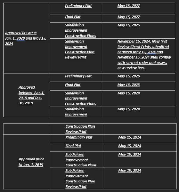
Sec 12-512 Expiration Of Plats, Subdivision Improvement Construction Plans And Subdivision Improvement Construction Plan Review Prints Approved Prior To February 20, 2024
- It is the policy of the city to consider the subdivision of land and its subsequent development to be subject to control by the city pursuant to the comprehensive plan for the orderly, planned, efficient , and economic development of the city. As the city adopts new standards and provisions for subdividing land, it shall be deemed necessary to public health, safety and general welfare that plats not yet complete and subdivision improvement construction plans and associated review prints not yet approved or developed shall expire as set forth in the table below.
- A preliminary or final plat may be extended for a period not to exceed one (1) year beyond the plat's expiration date listed in Section 12-512(A). A request for extension shall be submitted to the director of community development in writing at least thirty (30) calendar days prior to the expiration of the plat, and shall include reasons why the plat should be extended. The director of community development will review the extension request and shall approve it, approve it with conditions, or deny the extension request within thirty (30) calendar days, the extension shall be deemed to be approved.
- In considering an extension, the director of community development shall consider whether the following conditions exist:
- A final plat has been submitted and/or approved for any portion of the property shown on the preliminary plat;
- Construction plans have been submitted and/or approved for any portion of the property shown on the preliminary and/or final plat;
- Construction is occurring on the subject property;
- The preliminary plat complies with new ordinances that impact the health, safety and general welfare of the community; and/or
- There is a need for a park, school or other public facility or improvement on the property
- In granting an extension, the director of community development may impose such conditions as are needed to ensure that the land will be developed in a timely fashion and that the public interest is served.
- Any extension may be predicated upon compliance with new development regulations and/or the applicant waiving any vested rights.
- The denial of an extension by the director of community development may be appealed to the City Council.
- A written request for such appeal shall be received by the director of community development within fourteen (14) calendar days following the denial.
- The City Council shall hear and consider such an appeal within thirty (30) calendar days following director of community development's receipt of the appeal request.
- The decision of the city council is final.
Adopted by Ord. 1049.24 on 4/15/2024
Sec 12-521 General Requirements
- Purpose. The purpose of the preliminary plat is to provide early illustration of the nature of a proposed subdivision. This step in the process occurs prior to the preparation of detailed drawings of construction details in order that conflicts with surrounding lands, community plans or other factors might be avoided at an early time. Discussion of intentions or anticipated development approaches with the staff is welcomed and encouraged at any time, including prior to the actual preparation of a preliminary plat.
- Submittal. The subdivider shall prepare a preliminary plat for submission to the planning commission and submit the same in accordance with the director of community development's requirements, as provided in the application. An application for a preliminary plat shall be accompanied by the following. Multiple plans may be shown on one (1) sheet only if all information is readable and clearly identified. Plans shall be separated for clarity upon request of the director of community development.
- Preliminary Drainage Plan
- Preliminary Utility Plan
- Parks and Open Space Plan
- Preliminary Site Development Plan
- Street Layout Plan
- Other plans if deemed necessary for thorough review by the director of community development.
- Code compliance. The preliminary plat must comply with all city codes and ordinances, including but not limited to the following:1.
- Comprehensive Plan (including all associated maps and plans);
- Zoning Ordinance;
- International Building Codes, as adopted;
- Stormwater Management Design Criteria;
- International Fire Code, as adopted;
- Other applicable portions of this Code;
- Applicable fee ordinance/fee schedule;
- Park dedication ordinance;
- Engineering documents including but not limited to construction details; and
- Federal, state and local Environmental regulations.
(LDC 1991, § 12-521; Ord. No. 393(02), 12-2-2002)
Amended by Ord. 1050.24 on 4/15/2024
Sec 12-522 Application Conference
- Purpose. A preliminary plat application conference is required prior to the submittal of the Preliminary Plat. The purpose of the application conference is to give the developer an opportunity to:
- Discuss the proposed development with the director of public works, the planning director and the city engineer;
- Obtain copies of all forms, publications, design criteria, and standards available from the city; and
- Determine whether the current zoning is appropriate for the proposed development or if rezoning may be required.
- Conference to streamline process. The plan submittal and the conference provide an opportunity for the developer and the city to communicate and streamline the platting process.
- Submittal. The submittal for the application conference shall be a freehand pencil sketch or computer drawn sketch to approximate scale showing streets, lots, public areas, floodplains, proposed utility lines and drainage plan.
(LDC 1991, § 12-522; Ord. No. 393(02), 12-2-2002)
Amended by Ord. 1050.24 on 4/15/2024
Sec 12-523 RESERVED
(LDC 1991, § 12-523; Ord. No. 393(02), 12-2-2002)
Amended by Ord. 1050.24 on 4/15/2024
Sec 12-524 Contents Of Preliminary Plat
- General. The preliminary plat shall be drawn at a scale of not less than 100 feet to one inch and shall contain or be accompanied by the following information:
- The scale, north point, and date;
- The proposed name of the subdivision;
- The name and address of owner of record, the subdivider and of the registered engineer or registered land surveyor;
- A key map showing the location of the proposed subdivision referenced to existing or proposed major streets and to government section lines, and including the direction and number of acres of the drainage area of which the proposed subdivision is a part; (See also subsection (A)(10) of this section)
- The names, with location of intersecting boundary lines, of adjoining subdivisions and the location of city limits, if falling within or immediately adjoining the tract;
- The land contours with vertical intervals not greater than two feet referenced to a United States geological survey or coast and geodetic survey benchmark or monument;
- The location of existing buildings, water, watercourses, and the location of dedicated streets at the point where they adjoin or are immediately adjacent to the subdivision; provided, however, that actual measured distances shall not be required;
- The length of the boundaries of the tract, measured to the nearest foot, and the proposed location and width of streets, alleys, easements and setback lines and the approximate lot dimensions;
- The location, approximate size and type of sanitary and storm sewers, water mains, culverts, power and natural gas lines and other surface and subsurface structures and pipelines existing within or immediately adjacent to the proposed subdivision; and the location, layout, type and proposed size of the following structures and utilities:
- Water mains;
- Sanitary sewer mains, submains and laterals;
- Storm sewers, culverts and drainage structures; and
- Street improvements;
- The location of all drainage channels and subsurface drainage structures, and the proposed method of disposing of all runoff from the proposed subdivision, and the location and size of all drainage easements relating thereto, whether they are located within or outside of the proposed plat;
- The classification of every street easement within or adjacent to the subdivision in accordance with the intended use of the street based on the proposed design. This shall be done by placing the appropriate term:
- Arterial;
- Collector;
- Residential collector;
- Residential local; and
- A title block appearing at the lower left-hand corner which shall include:
- Name of the subdivision.
- Name and seal of the engineer of record or registered surveyor.
- Scale.
- Restrictive covenants. In such cases where a property owners association (POA) will be established, the subdivider shall submit with the submission of the preliminary plat, ten copies of all restrictive and protective covenants that will be proposed for filing with the final plat.
(LDC 1991, § 12-524; Ord. No. 393(02), 12-2-2002)
Amended by Ord. 1050.24 on 4/15/2024
Sec 12-525 Planning Commission Action, Preliminary Plat Method Of Approval
- Planning commission. The planning commission shall approve, approve conditionally, disapprove, or table the plat within sixty (60) days of the date of its submission by the applicant. Approval is subject to action of the city council. If the preliminary plat is disapproved or approved conditionally, the reason for such action shall be recorded in the minutes of the commission meeting. (A copy of the minutes of the meeting shall be transmitted to the subdivider.) The reasons for disapproval or conditional approval shall refer specifically to those parts of the general plan, land use plan, or specific regulations with which the plat does not conform. On conditionally approving the plat, the director of community development may require submission of a revised plat. Unless stipulation for additional time is agreed to by the subdivider, if no action be taken by the planning commission at the end of sixty (60) days after submission, the plat shall be deemed to have been approved subject to action by the city council.
- City council. The city council will either concur in the action of the planning commission or take such exceptions as it may elect. If the plat conforms to all of the standards, or after agreement with the applicant is reached upon any revision which shall be filed with the planning commission or a revised copy, the subdivider may proceed with the laying out of streets and roads, the preparation of utility plans and with the preparation of a final plat. Unless stipulation for additional time is agreed to by the subdivider, if no action be taken by the city council at the end of sixty (60) days after submission to the council by the planning commission, the plat shall be deemed to have been approved.
(LDC 1991, § 12-525; Ord. No. 393(02), 12-2-2002)
Sec 12-526 Preliminary Plat Expiration
- Five-year validity.
- The approval of a preliminary plat shall remain in effect for a period of five (5) years following the date of approval, during which period the applicant shall submit and receive approval for construction plans and a final plat for the land area shown on the preliminary plat.
- If construction plans and a final plat application have not been approved within the five-year period, the preliminary plat shall expire.
- Phased developments—Partial construction plans and final plat. If construction plans and a final plat for only a portion of the land area shown on the preliminary plat are approved by the end of the five-year period, then the preliminary plat for the remainder of the land not included on the construction plans or final plat shall expire on such date.
- Relationship to construction plans. A preliminary plat shall remain valid for five (5) years or the period of time in which approved construction plans are valid, whichever is greater.
- Void if not extended. If the preliminary plat is not extended as provided in Section 12-527, Preliminary plat extension, it shall expire and shall become null and void.
Sec 12-527 Preliminary Plat Extension
- A preliminary plat may be extended for a period not to exceed one (1) year beyond the preliminary plat's expiration date. A request for extension shall be submitted to the director of community development in writing at least thirty (30) calendar days prior to expiration of the preliminary plat, and shall include reasons why the preliminary plat should be extended.
- The director of community development will review the extension request and shall approve it, approve it with conditions, or deny the extension request within thirty (30) calendar days following the official filing date of the request. Should the director of community development fail to act on an extension request within thirty (30) calendar days, the extension shall be deemed to be approved.
- In considering an extension, the director of community development shall consider whether the following conditions exist:
- A final plat has been submitted and/or approved for any portion of the property shown on the preliminary plat;
- Construction plans have been submitted and/or approved for any portion of the property shown on the preliminary plat;
- Construction is occurring on the subject property;
- The preliminary plat complies with new ordinances that impact the health, safety and general welfare of the community; and/or;
- There is a need for a park, school or other public facility or improvement on the property.
- In granting an extension, the director of community development may impose such conditions as are needed to ensure that the land will be developed in a timely fashion and that the public interest is served. Any extension may be predicated upon compliance with new development regulations and/or the applicant waiving any vested rights.
- The denial of an extension by the director of community development may be appealed to the City Council. A written request for such appeal shall be received by the director of community development within fourteen (14) calendar days following the denial. The City Council shall hear and consider such an appeal within thirty (30) calendar days following director of community development's receipt of the appeal request. The decision of the city council is final.
Adopted by Ord. 1050.24 on 4/15/2024
Sec 12-531 General Requirements
- Purpose. The purpose of the final plat is to create a recorded document which accurately describes the subdivision land, both as to accurate dimensions, and as to legal provisions which are pertinent to the subdivision. Much of the reason for this step is to make the transfer of the land more simple and certain. Land sales by reference to a legally filed plat are generally less complicated and more likely to provide the precise legal situation sought. The certainty of such sales derives from the assurance of an accurate survey and processes designed to ensure the provision of facilities necessary to service the land.
- Submittal. The subdivider shall prepare a final plat and submit the same in accordance with the director of community development’s requirements, as provided in the application. The final plat shall be submitted to the office of the planning commission secretary not less than forty-five (45) days before the planning commission meeting at which it is to be considered for final approval. At the same time, there shall be submitted proposed subdivision improvement construction plans and specifications for all improvements and the proposed restrictions in final form; provided, however, that the final plat may be approved subject to later submission of final subdivision improvement construction plans and specifications.
- Code compliance. The final plat shall comply with all city codes and ordinances.
- Control network. All plans shall be submitted in NAD 1983 HARN Oklahoma State Plane South, US feet coordinates using city survey monuments.
(LDC 1991, § 12-531; Ord. No. 393(02), 12-2-2002)
Amended by Ord. 823(16) on 7/5/2016
Amended by Ord. 1051.24 on 4/15/2024
Sec 12-532 Planning Commission Action, Final Plat Method Of Approval
- Application required. The subdivider shall prepare a final plat and submit in accordance with the director of community development's requirements, as provided in the application.
- The application includes certifications to the compliance of the plat with pertinent regulations and with the requirements of good engineering practices. The application and certification are to be executed by a registered professional engineer or licensed land surveyor holding a license to practice in the state
- Time of submission. The final plat of the proposed subdivision shall be submitted to the planning commission and city council for final approval within five (5) years of the date on which the preliminary plat was approved, unless a preliminary plat extension has been granted as outlined in Section 12-527.
(LDC 1991, § 12-532; Ord. No. 393(02), 12-2-2002)
Amended by Ord. 823(16) on 7/5/2016
Amended by Ord. 1051.24 on 4/15/2024
Sec 12.532.1 Final Plat Expiration
- The approval of a final plat shall remain in effect for a period of two (2) years following the date of approval by City Council, during which period the applicant shall submit and receive approval for subdivision improvement construction plans and complete construction of all subdivision improvements for the land area shown on the final plat. If construction of all subdivision improvements has not been completed and accepted by the city council within the two-year period, the final plat shall expire, provided, however, that the final plat shall remain valid for the period of time in which approved subdivision improvement construction plans are valid, whichever time is greater.
- Void if not extended. If the final plat is not extended as provided in Section 12-532.2, it shall expire and shall become null and void.
Adopted by Ord. 1051.24 on 4/15/2024
Sec 12-532-2 Final Plat Extension
- Final Plat Extension. A final plat may be extended for a period not to exceed one (1) year beyond the final plat's expiration date. A request for extension shall be submitted to the director of community development in writing at least thirty (30) calendar days prior to expiration of the final plat, and shall include reasons why the final plat should be extended. The director of community development shall review the extension request and shall approve it, approve it with conditions, or deny the extension request within thirty (30) calendar days following the official filing date of the request. Should the director of community development fail to act on an extension request within thirty (30) calendar days, the extension shall be deemed to be approved.
- Extension considerations. In considering an extension, the director of community development shall consider whether the following conditions exist:
- Construction plans have been submitted and/or approved for the property shown on the final plat;
- Construction is occurring on the subject property;
- The final plat complies with new ordinances that impact the health, safety and general welfare of the community; and/or
- There is a need for a park, school or other public facility or improvement on the property.
- Extension conditions. In granting an extension, the director of community development may impose such conditions as are needed to ensure that the land will be developed in a timely fashion and that the public interest is served. Any extension may be predicated upon compliance with new development regulations and/or the applicant waiving any vested rights.
- Appeal of the director’s denial of the final plat extension. The denial of an extension by the director of community development may be appealed to the City Council. A written request for such appeal shall be received by the director of community development within fourteen (14) calendar days following the denial. The City Council shall hear and consider such an appeal within thirty (30) calendar days following director of community development's receipt of the appeal request.
Adopted by Ord. 1051.24 on 4/15/2024
Sec 12-533 Contents
- Plat preparation. The final plat shall be prepared by a registered professional engineer or registered land surveyor holding a license to practice in the state. The plat must bear the seal and signature of a registered land surveyor.
- Drafting. The final plat shall be drawn at a scale of 100 feet to the inch from an accurate survey and on sheets whose dimensions are 24 inches by 36 inches. On the first sheet of every plat, there shall be a key map showing the location of the subdivision referenced to government survey section lines and major streets. If more than two sheets are required for the plat, the key map shall show the number of the sheet for each area. The borders of the sheets shall be 1½ inches at top and bottom, two inches at left, and one inch at right.
- Contents. The final plat shall show:
- The location and description of all section corners and permanent survey monuments in or near the tract, to at least one of which the subdivision shall be referenced;
- The length of all required lines dimensioned in feet and decimals thereof, and the value of all required true bearings and angles dimensioned in degrees and minutes, as hereafter specified;
- The boundary lines of the land being subdivided fully dimensioned by length and bearings, and the location of boundary lines of adjoining land, with adjacent subdivisions identified by official names. Material which is not a part of the subdivision shall be shown in dashed or dotted lines;
- The lines of all proposed streets fully dimensioned by the lengths and bearings or angles;
- The lines of all proposed alleys. Where the length or direction of an alley is not readily discernable from data given for lot and block lines, the length and bearing shall be given;
- The widths, and names where appropriate, of all proposed streets and alleys, and of all adjacent streets, alleys and easements which shall be properly located;
- The lines of all proposed lots fully dimensioned by lengths and bearings or angles, except that where a lot line meets a street line at right angles, the angle may be shown as a symbol;
- The outline of any property which is offered for dedication to public use fully dimensioned by lengths and bearings, with the areas other than streets to be marked "public";
- The blocks numbered consecutively throughout the entire subdivision and the lots numbered consecutively throughout each block, with areas to be excluded from platting marked "reserved" or "not a part";
- The location of all building lines, setback lines, and easements for public services or utilities with dimensions showing their locations;
- The radii, arcs, points of tangency, points of intersection, and central angles and curve data for curvilinear streets and radii for all property returns;
- The proper acknowledgements of owners and the consent by the mortgagee to plat dedications;
- The following which shall be made and shown on a reproducible tracing:
- Owner's certificate and dedication, signed;
- Surveyor's certificate of survey;
- Certificate for release of mortgage for any portion dedicated to the public;
- Reference to any separate instruments, including restrictive covenants, filed in the office of the county clerk which directly affect the land being subdivided;
- Certificate of planning commission approval;
- Certification of city council's acceptance of streets, easements and public land dedications; and
- County treasurer's certificate;
- A title which shall include:
- Name of the subdivision;
- Name of the city, county and state; and
- Location and description of the subdivision referenced to section, range and township;
- A title block appearing at the lower left-hand corner which shall include:
- Name of the subdivision;
- Name and seal of the registered land surveyor;
- Scale.
(LDC 1991, § 12-533; Ord. No. 393(02), 12-2-2002)
Sec 12-534 Construction Plans
- General. Subdivision Improvement Construction plans shall include the following:
- All improvements shall be designed in accordance with the design standards referenced as part of this article.
- Three copies of complete construction plans, specifications, engineering calculations and detailed cost projections for streets, drainage, sanitary sewers, water distribution, and any other improvements to be constructed, are required to be submitted with the final plat. Construction plans must be 100 percent complete at the time of submittal. Any incomplete sets of construction plans shall be returned and unreviewed.
- The construction plans shall be submitted in accordance with the director of community development's requirements, as provided in the application.
- Each sheet of the construction plans shall contain a title block, including space for the notation of revisions. This space is to be completed with each revision to the plan sheet and shall clearly note the nature of the revision and the date that the revision was made. This title block shall be located at the lower left hand corner of each sheet submitted.
- Each sheet of the construction plans shall include north arrow, scale, date, and benchmark description to sea level datum.
- The specifications and each construction plan sheet shall bear the seal and signature of the licensed professional engineer who prepared the plans.
- Paving plans. The construction plans, at a minimum, shall include a plan and profile of each street with stationing, top of curb grades, if applicable, or street centerline, borrow ditch flowline and existing and proposed ground lines. The typical cross section of proposed streets shall show the width of roadway, pavement type and location and width of sidewalk.
- Sanitary sewer and water plans. The construction plans, at a minimum, shall include a plan and profile of proposed sanitary sewers with stationing, grades, pipe sizes, and materials indicated and showing locations of manholes, cleanouts, etc., and a plan of the proposed water distribution system showing pipe sizes and location of valves, fire hydrants and fittings, etc. Application construction details shall be included with the construction plans.
- Storm drainage plan. The construction plans shall include stormwater detention plans and erosion plans, and shall include the following:
- The construction plans shall include a general location map of the subdivision showing the entire watershed (a U.S.G.S. quadrangle is satisfactory) and the limits of all on-site and off-site stormwater draining to the project.
- The construction plans shall include calculations showing the anticipated stormwater flow, including watershed area, percent runoff, runoff factors, storm intensity and time of concentrations showing basis for design.
- The construction plans shall include a plan and profile of proposed storm sewers or channels, showing stationing, hydraulic data, pipe grades, sizes and materials, manholes, inlets, pipe connections, outlet structures, etc.
- The construction plans shall include a detailed plan for any bridges, culverts, catchbasins, any other drainage structures or any other improvements to be made and shall include all of the following:
- The open channel or storm drain grades, design flow, design velocity, capacity and hydraulic grade line;
- A plan and profile of all culverts under any street with the design flow of water, headwater, and tailwater depth and tail water capacity;
- The size of all driveway culverts to carry the design flow of water at each point of installation;
- Typical ditch sections and the width of any right-of-way or easement needed;
- A summary sheet of all drainage facilities;
- The seal and signature, prominently displayed on each sheet, of the licensed professional engineer responsible for the design.
- The plat shall notify that the filling or obstruction within the floodplain and drainage easements shall be prohibited.
- Other Reports as Needed. Other reports may be required as directed by the city consulting engineer, community development director, or the fire marshal, and shall be included with the submittal of the construction plans. Such reports shall summarize calculations and other such engineering information pertaining to the major items of design. It shall be used during the review to determine whether the facilities proposed for construction have been designed in accordance with the intent of the design standards.
(LDC 1991, § 12-534; Ord. No. 393(02), 12-2-2002)
Amended by Ord. 824(16) on 7/5/2016
Amended by Ord. 1051.24 on 4/15/2024
Sec 12-535 Subdivision Improvement Construction Plans Review And Approval
- Review and approval action. The director of community development, or their designee, shall be the responsible official for review and approval of subdivision improvement construction plans. The director of community development, or their designee, shall approve, approve subjectsubjectto or, or deny such plans.
- Subdivision Improvement Construction Plan Review Prints shall be reviewed by the director of community development, or their designee, for compliance with City Code and accepted engineering standards. The director of community development, or their designee, shall approve, approve subject to modifications, or cause the revision and resubmittal of subdivision improvement construction plan review prints.
- Revision and resubmittal of subdivision improvement construction plan review prints may occur as often as necessary for the approval of plans. However, beginning with the sixth review print submittal, a new review fee shall be charged for each submitted review print.
- Subdivision Improvement Construction Plan Review Prints shall be valid for a period of six (6) months. If a resubmittal of a review print is not received within a six (6) month period from the date of the notice of revise and resubmit, the review print submittal will be voided and a new subdivision construction plan review print shall be submitted along with the application form and review fees.
- Expiring Subdivision Improvement Construction Plan Review Prints may be extended for a period not to exceed six (6) months beyond the expiration date. A request for extension shall be submitted to the director of community development in writing at least thirty (30) calendar days prior to expiration of the review prints, and shall include reasons why the review prints should be extended. The director of community development shall review the extension request and shall approve it, approve it with conditions, or deny the extension request within thirty (30) calendar days following the official filing date of the request. Should the director of community development fail to act on an extension request within thirty (30) calendar days, the extension shall be deemed to be approved. In considering an extension, the director of community development shall consider whether the following conditions exist:
- Any other Subdivision Improvement Construction plans for any public or private improvement have been approved for the property shown on the final plat;
- Construction is occurring on the subject property;
- The subdivision improvement construction plan review print complies with new ordinances that impact the health, safety and general welfare of the community.
- In granting an extension, the director of community development may impose such conditions as are needed to ensure that the land will be developed in a timely fashion and that the public interest is served.
- Any extension may be predicated upon compliance with new development regulations and/or the applicant waiving any vested rights.
- Effect of approved subdivision improvement construction plans. Approval of subdivision improvement construction plans authorizes the applicant to schedule a pre-construction meeting with the appropriate city staff and upon completion of a pre-construction meeting and payment of all fees and bonds, be released for construction.
(LDC 1991, § 12-535; Ord. No. 393(02), 12-2-2002)
Amended by Ord. 1051.24 on 4/15/2024
Sec 12-536 Expiration Date For Subdivision Improvement Construction Plans
- The approval of subdivision improvement construction plans shall remain in effect for a period of one (1) year from the date of approval, or for the duration of construction of the project once commenced; provided that, progress towards completion of the project continues to be demonstrated to the satisfaction of the director of community development, unless the construction plans are extended in accordance with Section 12-536.
(LDC 1991, § 12-536; Ord. No. 393(02), 12-2-2002)
Amended by Ord. 823(16) on 7/5/2016
Amended by Ord. 1051.24 on 4/15/2024
Sec 12-536-1 Extension Of Subdivision Improvement Construction Plans
- Subdivision Improvement Construction plans may be extended for a period of six (6) additional months beyond the expiration date. A request must be made in writing to the director of community development for such extension prior to expiration of the plans, and shall include reasons why the plans should be extended. The community development director, or their designee, will review the extension request, and shall approve, approve with conditions, or deny the extension request within thirty (30) calendar days following the official filing date. Should the community development director, or their designee, fail to act on an extension request within thirty (30) calendar days, the extension shall be deemed to be approved.
- Extension criteria. The director of community development shall extend the subdivision improvement construction plan approval for a period of six (6) additional months beyond the plans' expiration date if:
- The construction plans comply with new ordinances that impact the health, safety and general welfare of the city; and
- Demonstrable progress towards completion of the project continues to be demonstrated to the satisfaction of the director of community development.
- Conditions. In granting an extension, the director of community development may impose such conditions as are needed to ensure that the land will be developed in a timely fashion and that the public interest is served. Any extension may be predicated upon compliance with new development regulations and/or the applicant waiving any vested rights.
Adopted by Ord. 1051.24 on 4/15/2024
Sec 12-537 Recording Of Plat
After final approval of the plat and the affixing of all required signatures on the original tracing, the subdivider shall provide the planning commission secretary with one reproducible transparency, and a digital file in either AutoCAD or GIS shapefile format. The final plat shall be filed with the county clerk, meeting all requirements for such filing after final criteria are met.
- Final plat is approved by the city council and all revision required by the city council are complete;
- All required signatures have been obtained;
- All required fees have been paid in full;
- All public improvements have been constructed, inspected, approved and dedicated to the city, or surety bonds or letter of credit have been posted and the plat and all as-built plans have been submitted in either AutoCAD or GIS shapefile format;
- The developer has provided proof that private restrictions have been filed of record; and
- The developer has provided all required maintenance bonds.
(LDC 1991, § 12-537; Ord. No. 393(02), 12-2-2002)
Amended by Ord. 823(16) on 7/5/2016
Amended by Ord. 1051.24 on 4/15/2024
Sec 12-538 Sale Of Lots
The sale of lots by a developer of an addition prior to the final approval and recording of the final plat of the addition is hereby prohibited and no deed of conveyance shall be recorded in the office of the county clerk prior to that time.
(LDC 1991, § 12-538; Ord. No. 393(02), 12-2-2002)
Sec 12-539 -As Built Plans
- Data Requirements. Before recording the final residential plat or issuing a final commercial Certificate of Occupancy, digital as-built drawings including but not limited to public infrastructure and private drainage systems, shall be submitted to the Community Development department in AutoCAD format, or in another format as approved by the GIS department, that is importable into the City's GIS system. All plans shall be submitted in NAD 1983 HARN Oklahoma State Plane South, US feet coordinates using City of Moore Survey Monuments. The following data shall be required, as applicable;
- Plat, including the following:
- Parcels;
- Rights-of Way;
- Subdivisions;
- Easements;
- Curb; and
- Road Centerlines
- Public Water Utility, including the following:
- Waterlines with size and materials;
- Fire hydrants;
- Valves;
- Service connections; and
- Fittings (Reducer, Tee, Plug, etc.)
- Public Sanitary Sewer Utility, including the following:
- Gravity flow sewerlines with size and materials;
- Force main sewerlines with size and materials; and
- Manholes with flow line elevations.
- Storm Drainage Utility, Public and Private, including the following:
- Pipes with size, material, upstream and downstream elevation, and slope;
- Ditches and swales with materials, upstream and downstream elevation, and slope;
- Discharge structure with material, rim elevation and invert depth;
- Junction chamber;
- Stormsewer manholes with rim elevation, invert elevation and depth;
- Stormsewer inlets with rim elevation, invert elevation and depth;
- Storm discharge points;
- Stormwater weirs with material;
- Storm culverts with material and diameter;
- Storm open drains; and
- Detention ponds with area in square feet.
- Plat, including the following:
- Fee-in-lieu of submittal. The design engineer or developer may authorize the City to collect as-built data for a fee in lieu of providing the as-built plan data to the City. If the engineer or developer chooses to provide their own as-built plan data to the City, no building permit or certificate of occupancy shall be issued until all as-built plan data that is importable to the City's GIS is provided to the Community Development Department.
Amended by Ord. 1031.23 on 6/19/2023
Sec 12-541 General
- Replats required. A replat is required for property in which there has been a change in lot allocation, dedicated infrastructure or easements.
- Requirement waived. The community development director may waive this requirement if the replat involves minor changes.
- Certified copies required. Certified copies of the entire subdivision and deed restrictions shall accompany replats.
- Subject to final plat requirements. Replats are subject to the same requirements as final plats, and shall contain the information required by this article.
(LDC 1991, § 12-541; Ord. No. 393(02), 12-2-2002)
Sec 12-542 Application
Application procedure shall be that of the final plat and shall contain information required by this article.
(LDC 1991, § 12-542; Ord. No. 393(02), 12-2-2002)
Sec 12-543 Lot-Splits
- Purpose. The purpose of providing for the processing of lot-split plats is to facilitate the conveyance of simple property divisions. Those matters which shall be considered as lot-splits shall be those with involve the dividing or redividing of a single parcel of land into not more than four resulting parcels, and which dividing shall not involve the extension, opening, vacating, narrowing, or change of alignment of any thoroughfare, street, right-of-way, or easement. The determination of eligibility for processing as a lot-split plat shall be made from the records of the ownership of the property as of the date that these regulations are officially adopted. The division of properties may be processed as lot-split plats only to the extent of the creation of three divisions, resulting in four parcels, additional to those properties on file with the county clerk as of the above stated date.
- Community development director approval. The city council may empower the community development director, or his designee, to approve such lot-split applications as meet the following conditions:
- Where the resulting parcels are all larger than five acres;
- Where the proposal is for the purposes of shifting property lines with the result that there are no more land parcels created than before the action; or
- Where the proposal does not involve the dedication or vacation of any public rightsof-way or easements.
- City council approval. In cases where the proposed lot-split cannot be approved by the community development director acting as the designated representative of the city council, the proposal shall be set for consideration by the city council. In the event of a denial of a lot-split proposal by the city council, the reasons therefor shall be set down in writing, and at the option of the applicant an appeal may be taken to district court.
- Deed required. As a minimum, the processing of a lot-split shall require the presentation of the instruments by which the interests in the land shall be conveyed (deed).
- Survey required. A before and after surveyor drawing shall be required for a lot-split to be considered.
- Other submissions. The community development director shall inform the applicant of additional items which are necessary for full consideration of the request. These additional items may include:
- A simplified lot-split plat;
- Restrictive covenants;
- State health department approvals of water or sewer provisions;
- A property legal description;
- A survey certificate of the property;
- Other information important to consideration of the application;
- A site plan which shall include the following:
- Public improvements and utilities;
- Existing and proposed improvements.
(LDC 1991, § 12-543; Ord. No. 393(02), 12-2-2002)
Sec 12-551 Urban Design Principles
The design of each subdivision is important to the overall nature of the community, and it is important how the individual subdivisions fit together to make up the community. That is much of the reason for community-wide planning for physical features such as land use, circulation systems, community facilities and public utilities. Quality design of subdivisions is also important to the private economic sector because good design helps to sell developments in a competitive market, saves development costs and increases profits. Because these areas have been considered in the processes that led to the general plan and the land use plan it shall be necessary for each subdivision to be designed in accordance with the principles of design established in the general plan and the land use plan and in accordance with the following general principles:
- It is intended that the city urban area should be designed as a group of integrated residential neighborhoods and appropriate commercial and industrial and public facilities. The neighborhood, a planning unit, is intended as an area principally for residential use, and of a size shopping facilities to serve the residents of the neighborhood should be provided and designed as an integral part of each neighborhood.
- Each subdivision shall provide for the continuation of all arterial streets and highways as shown on the major street plan. Arterial streets should be located on the perimeter of the residential neighborhood;
- Minor streets shall be designed to provide access to each parcel of land within the residential neighborhood and within industrial areas, and in a manner that will discourage use by through traffic. They should be planned so that future urban expansion will not require the conversion of minor streets to arterial routes;
- Collector streets should be designed to provide a direct route from other minor streets to the major street system;
- Ingress and egress to residential properties should be provided only on minor streets;
- Pedestrian ways should be separated from roadways used by vehicular traffic. Sidewalks should be designed to provide all residential building sites with direct access to all neighborhood facilities, including the elementary schools, parks and playgrounds, churches and shopping centers; and
- Minimum standards for development are contained in the zoning regulations. However, the general plan expresses policies which are intended to achieve optimum quality of development in the urban area. If only the minimum standards are followed, as expressed by the various ordinances regulating land development, a standardization of development will occur. This will produce a monotonous urban setting. Subdivision design should seek a quality to carry out the purpose and spirit of the policies expressed in the general plan and in these regulations rather than be limited to the minimum standards required herein.
- The size of lots and blocks and other areas for residential, commercial, industrial and public uses should be designed to provide adequate light, air, open space, landscaping and off-street parking and loading facilities.
- The arrangement of lots and blocks and the street system should be designed to make the most advantageous use of topography and natural physical features. Tree masses and large individual trees should be preserved. The system of sidewalks and roadways and the lot layout should be designed to take advantage of the visual of the area.
- Access to residential lots should be arranged from local streets. If a development is platted with no lots having frontage orientation onto a collector street, and with restrictive covenants prohibiting driveway access onto a collector street, then the surface width of the collector street may be reduced to 32 feet.
(LDC 1991, § 12-551; Ord. No. 393(02), 12-2-2002)
Sec 12-552 Street Design Standards
- Conformity to comprehensive plan. The arrangement, character, extent, width, grade and location of all streets shall conform to all of the elements of the comprehensive plan and shall be designed in accordance with the following provisions:
- Major streets shall be planned to conform with the major street plan;
- Whenever a subdivision abuts or contains an existing or proposed major street, the planning commission may require service streets, reverse frontage with screen planting contained in a nonaccess reservation along the rear property line, deep lots, or such other treatment as may be necessary for adequate protection of residential properties and to afford separation of arterial and local traffic;
- Where a subdivision borders on or contains a railroad right-of-way or limited access highway right-of-way the planning commission may require a street approximately parallel to and on each side of such right-of-way at a distance suitable for the appropriate use of intervening land. Such distances also shall be determined with due regard for the requirements of approach grades and future grade separation structures;
- Reserve strips controlling access to streets shall be prohibited except where their control is placed in the city under conditions approved by the planning commission and acceptable to the subdivider;
- Where the plat to be submitted includes only part of the tract owned or intended for development by the subdivider, a tentative plan of a proposed future street system for the unsubdivided portion may be required by the planning commission;
- Where a tract is subdivided into larger than normal building lots or parcels, such lots or parcels shall be arranged to permit the logical locations and opening of future streets and appropriate resubdivision, with provision for adequate utility easements;
- Minor streets shall be laid out so that their use by arterial traffic will be discouraged;
- Streets shall intersect at approximately right angles.
- Street jogs. Street jogs with centerline offsets of less than 200 feet shall be avoided.
- Street right-of-way widths. Street right-of-way widths shall be in accordance with the land use plan and the general plan and, where not designated therein, shall conform with the following requirements. The paved width of all streets shall be adequate to serve the existing and future estimated traffic load for the facility and shall comply with the design standards.
Major Streets ROW Width Paving Width Arterials 130 ft. 50 ft. Major collector 100 ft. 50 ft. Minor Streets Collector 60 ft. 36 ft. Commercial 60 ft. 36 ft. Industrial 60 ft. 36 ft. Residential estates 50 ft. 24 ft. Minor residential 50 ft. 26 ft. Cul-de-sac 50 ft. 26 ft. - Cul-de-sac length. A cul-de-sac shall not be utilized for more than 35 lots and shall be provided with a turnaround having a radius of not less than 50 feet at the property line and not less than 38 feet at the curbline. If there is provided in the center of the turnaround an unpaved island, it shall be improved with landscaping that will not interfere with sight distance, and the design shall be approved by the city engineer or the community development director.
- Street stubs. The arrangement of streets shall be such as to cause no hardship in the subdividing of adjacent properties. The planning commission may require the dedication of street rights-of-way to facilitate the development of adjoining properties. At the time of development adjoining existing street stubs, all street stubs shall be utilized to connect to surrounding neighborhoods, or the street stub shall be developed as a bulb or pedestrian walkway, or the street stub shall be removed at the expense of the developer.
- Private roads. Private roads shall be constructed to city standards and shall be inspected by the construction inspector of the community development department. Private roads shall conform to the requirements as set forth in article A of this chapter.
- Rural Residential Roads. Rural Residential Roads shall provide rural and emergency access to residential lots within the A-1 Rural Agricultural and A-2 Suburban Agricultural Zoning Districts. These roads shall be constructed to the Rural Residential Standard Detail as published in the City of Moore Construction Details.
- Rural Residential Roads and the associated drainage shall be constructed within a private drainage and access easement. Said easement shall be a minimum of 20-feet in width and a maximum of 40-feet in width, with the exact width determined by the Community Development Director, or their designee. Factors to be used in determining the final easement width shall include, but not be limited to, drainage and the number of lots being served.
- A draft private maintenance agreement shall be submitted to the City for approval prior to construction of the rural residential road that assigns maintenance responsibilities for the road among the property owners. The maintenance agreement must be filed of record at the Cleveland County Clerk prior to the construction of the roadway.
- Rural Residential roadways shall be maintained by the property owner(s) at all times to allow emergency access.
- Rural Residential roadways shall be named in the naming convention established by City Code and the owner(s) shall cause a street sign(s) meeting the adopted City of Moore Street Sign Standards to be installed and maintained as required by the Community Development Director, or their designee.
(LDC 1991, § 12-552; Ord. No. 393(02), 12-2-2002)
Amended by Ord. 1036.23 on 10/2/2023
Amended by Ord. 40.25 on 7/7/2025
Amended by Ord. 51.26 on 2/2/2026
Sec 12-553 Easement Design Standards
- Rear utility easements required. Where alleys are not provided, easements not less than ten feet wide shall be provided along each rear lot line. A five-foot easement along side lot lines of individual lots may be required where necessary for use by public and private utilities. The planning commission may require easements of greater width for the extension of main storm and sanitary sewers and other utilities where it is deemed necessary.
- Utility easements adjacent to unplatted land required. When a subdivision is adjacent to unplatted land, the easements for public and private utilities shall be:
- Provided as 20 feet wide on the land being subdivided; or
- Provided as ten feet wide on the land being subdivided with an easement ten feet wide being presented adjacent and simultaneous to the presentation to the final plat.
- Sight triangle required. In order to provide for traffic safety, there shall be platted on each corner of each intersection of two streets a sight triangle which shall be described as a triangle having 25-foot sides on each of the street rights-of-way, or a radius of 25 feet. The plat or the covenants of the addition shall clearly prohibit any construction or planting of landscaping materials that reach greater than two feet in height in this right-of-way.
(LDC 1991, § 12-553; Ord. No. 393(02), 12-12-2002)
Sec 12-554 Public Areas And Open Space
Public parks, playgrounds, school sites and other public areas and open spaces shall be provided in accordance with the requirements and standards set forth in the city's comprehensive plan, parks and recreation master plan, and in the ordinances relating thereto.
(LDC 1991, § 12-554; Ord. No. 393(02), 12-2-2002)
Sec 12-555 Block Design Standards
- Determination of design. The lengths, width and shapes of blocks shall be determined with due regard for the following:
- Provision of adequate building sites suitable to the special needs of the type of use contemplated;
- Zoning requirements as to lot sizes and dimensions;
- Needs for convenient access, circulation, control and safety of street traffic; and
- Limitations and opportunities of topography.
- Block length. Blocks for residential use shall not be longer than 1,800 feet, measured along the centerline of the block. When a block exceeds 600 feet in length, the planning commission may require a dedicated easement not less than five feet in width and a paved crosswalk not less than five feet in width to provide pedestrian access across the block.
- Block width. Blocks used for residential purposes should be of sufficient width to allow for two tiers of lots of appropriate depth, but should be not less than 200 feet in width. Blocks intended for business and industrial use should be of a width suitable for the intended use, with due allowance for off-street parking and loading facilities.
(LDC 1991, § 12-555; Ord. No. 393(02), 12-2-2002)
Sec 12-556 Lot Design Standards
Double frontage and reverse frontage lots should be avoided except where they are needed to provide for the separation of development from traffic arteries or to overcome specific disadvantages of topography and orientation. A planting screen easement of at least 20 feet shall be provided along the portion of the lots abutting such a traffic artery or other use where screening is required. There shall be no right-of-access across a planting screen easement.
(LDC 1991, § 12-556; Ord. No. 393(02), 12-2-2002)
Sec 12-557 Fire Protection Standards
In areas of the city where city water service is available, all buildings shall be serviced by fire hydrants installed in accordance with standards and specifications of this Code. In residential subdivisions, fire hydrants shall not be located more than 500 feet from any building. In commercial subdivisions, fire hydrants shall not be located more than 300 feet from any building.
(LDC 1991, § 12-557; Ord. No. 393(02), 12-2-2002)
Sec 12-558 Subdivision Access Standards
- 30 lots or less. Subdivisions with 30 lots or less may be developed with only one means of access to an existing public street. The design of the entrance street shall, at a minimum, comply with the design standards for local residential streets, or the design standards of an approved planned unit development.
- 31 to 100 lots. Subdivisions with 31 to 100 lots that do not provide two separate means of access directly to an arterial street, or indirectly through an existing subdivision, may be developed with only one means of access designed as follows:
- The access or entrance street may be designed as a collector street with no residential driveway taking access from the collector street up to the first intersection. This design requires an emergency access road constructed to city fire department standards; or
- The single entrance into an addition may be constructed with a divided median with the driving lanes on both sides maintaining a minimum paving width of 20 feet. The access or entrance street may extend no more than 300 feet before two alternate routes must loop through the addition so that access to the entrance street is feasible from both directions. An emergency access road is not required for this design.
- 101 to 200 lots. Subdivisions with 101 to 200 lots may be constructed with a single entrance but must have an emergency access road constructed to city fire department standards. The single entrance must be designed with a divided median with the driving lanes on both sides maintaining a minimum paving width of 20 feet. The access or entrance street may extend no more than 300 feet before two alternative routes through the addition are provided. The alternate routes must loop through the addition so that access to the entrance street is feasible from both directions. An emergency access road constructed to city fire department standards is required.
- More than 200 lots. Subdivisions with more than 200 lots must be constructed with two separate means of access by either directly to an arterial street, or indirectly through an existing subdivision, one point of access being exclusively an arterial street.
(LDC 1991, § 12-558; Ord. No. 393(02), 12-2-2002)
Sec 12-559 Residential Landscaping Requirements
- Landscaping required. In all platted residential subdivisions, landscaping shall be required along the perimeter of subdivision abutting an arterial street or major collector road. The minimum requirements shall be as follows:
- One tree shall be required for every 50 feet of arterial or major collector road frontage. The trees may be grouped or spaced. Each tree shall have a minimum of two-inch caliper.
- Trees and shrubs planted within the city should be selected due to their ability to respond to the environmental conditions within the city. The factors to be considered in tree selection are soil conditions in relation to growth, the tree's ability to cope with the climate, and its survival rate as an urban tree. Low maintenance, a moderate growth rate, and aesthetic quality should also be considered.
- Landscaping plan. A landscaping plan detailing the location, species, and caliper of all trees and shrubs to be planted must be submitted with the preliminary plat. The plantings shall be clearly identified with a summary detailing the species, size, and number of plantings. In the event that a perimeter fence is erected around a subdivision, the fence shall also be shown on such landscaping plan with the building materials to be utilized.
(LDC 1991, § 12-559; Ord. No. 393(02), 12-2-2002)
Sec 12-561 General Provisions
- Improvement compliance. All improvements shall be designed and installed in accordance with all of the elements of the general plan and shall meet the minimum standards established by the ordinances and regulations relating thereto.
- Improvement inspection fees. The city shall charge and collect inspection fees in all unplatted and platted developments for all water, sanitary or storm sewer and paving improvements based on the cost of the improvements as set by the council by motion or resolution.
- Plan preparation. Plans for the improvements herein required shall be prepared by a qualified engineer, registered to practice in the state. Two sets of prints of the proposed plans and specifications for all improvements shall be filed with the community development department at the time of the submission of the final plat. One set of as built plans and specifications, certified and signed by an engineer registered to practice in the state, shall be filed with the community development department prior to the acceptance by the city council of any improvement installed by the subdivider.
- Permanent markers. Each lot and block corner shall be marked with iron pipes or pins not less than three-eighths-inch in diameter and not less than 18 inches long driven to the surface.
- Work order required. A work order issued by the community development director shall be required prior to any installation of public improvements. This work order shall be issued only after approval of construction plans by the city's engineer, or his designee.
- Survey control network preservation. Any improvement work for development shall be designed and performed to preserve the existing City of Moore survey monuments. In the event that a survey monument is removed, destroyed, or relocated for development, the city shall charge and collect a re-setting fee as established in the adopted fee schedule.
(LDC 1991, § 12-561; Ord. No. 393(02), 12-2-2002)
Amended by Ord. 889(18) on 8/20/2018
Sec 12-562 Improvement Alternatives
- Surety bonds. In lieu of completion of the improvements herein required, the city council may require the subdivider to file the following instruments:
- An executed surety bond; and
- An executed agreement guaranteeing installation of improvements.
- Surety bond procedures. These instruments shall be conveyed to the community development director and he shall deposit them with the city clerk; after acceptance by the city council they shall be on file as the subdivider's good and faithful assurance of the installation of the improvements. The amount of the bond shall be 100 percent surety, and sufficient to cover 1½ times the entire cost, as estimated by the subdivider and approved by the city engineer, of the installation of all specified improvements. The term of the bond shall be until the completion of the installation of the improvements according to the plans and specifications as approved by the planning commission, but not to exceed two years.
- Restrictions. In any case, where the city council does not require instruments for surety of improvements required herein, no building shall be permitted on any lot or in any area in a subdivision where the proposed construction will produce run-off or require utility services that affect other areas or lots located within or outside the subdivision until all improvements are installed as needed for the protection of the affected area, unless a bond in the amount of 100 percent of the estimated cost of such improvements is posted for the portion of the drainage or utility improvements that will protect the affected area.
- Letter-of-credit. In lieu of filing the surety bond and agreement as outlined above, the subdivider may secure and place on deposit with the city an irrevocable letter-of-credit written by a bank certified to do business in the state. Such letter-of-credit shall be drawn in favor of the city, shall be irrevocable for the surety term of two years, and shall be for 1½ times the entire cost of improvements as estimated by the subdivider and approved by the city engineer.
(LDC 1991, § 12-562; Ord. No. 393(02), 12-2-2002)
Sec 12-563 Street Improvements
The subdivider of any subdivision designed to be used for residential, commercial, industrial or other purposes shall lay out, grade and otherwise improve all streets that are designated on the approved plat or that directly serve the subdivision in accordance with the specifications of the city and in accordance with the following provisions:
- State or federal highway standards. The design of an improvement of an intersection of any new street with an existing state or federal highway shall be in accordance with the specifications of the state department of transportation, but in no case shall the standard be less than the applicable specifications of the city. All applicable state and federal permits are required prior to construction.
- Driveways. All driveways which connect with public streets shall be constructed in accordance with the design standards and shall include the following:
- Maximum width for a residential driveway shall be 30 feet;
- Maximum width for a commercial driveway shall be 30 feet; however, this does not include width of any median;
- Maximum width for a commercial driveway with a median greater than ten feet will be considered as two separate drives, and must meet drive separation, or curb cut, requirements.
- Joint application. These regulations shall apply jointly with the adopted standard development details to the construction of streets of arterial, major collector, collector, commercial, industrial, residential estates, minor residential, and culs-de-sac. These regulations provide for both concrete construction and asphalt as an alternate.
- Curb cuts. No curb cut onto an arterial or major collector road shall be permitted for any purpose within 125 feet from the centerline of an intersecting arterial or major collector roadway. Curb cuts shall be measured from the center of the street to the center of the curb cuts. Curb cuts on arterial and major collector roadways shall be minimized and will be approved at the building permit stage. Curb cuts shall be inspected by the community development department prior to the pouring of the concrete.
- Street offsets. Streets shall not have an offset, or jog, of less than 200 feet measured from the centerlines.
(LDC 1991, § 12-563; Ord. No. 393(02), 12-2-2002)
Sec 12-564 Water Lines
- Code compliance. The subdivider shall install water lines and fire hydrants, and installation shall be in accordance with the city specifications governing water line construction. The standards for water line and fire hydrant construction are shown on the city's adopted standard detail sheets.
- Public water extension. Public water shall be extended to serve all zoning districts, with the following exceptions:
- Residential developments in the A-1 Rural Agricultural Zoning District.
- Residential subdivisions in the A-2 Suburban Agricultural District or the RE Residential Estates Zoning District located 2,640 feet (one-half mile) or further from existing public water pending planning commission and city council approval.
(LDC 1991, § 12-564; Ord. No. 393(02), 12-2-2002)
Sec 12-565 Sanitary Sewers
- Installation required. The subdivider shall install sanitary sewers whenever a sanitary sewer is reasonably accessible as determined by the planning commission. Sanitary sewers shall be installed in accordance with the specifications governing sanitary sewer construction. The standards for sewer construction are shown on the city's adopted standard detail sheets.
- Public sanitary sewer extension. Public sanitary sewer shall be extended to serve all zoning districts, with the following exceptions:
- Residential developments in the A-1 Rural Agricultural Zoning District.
- Residential subdivisions in the A-2 Suburban Agricultural District or the RE Residential Estates Zoning District located 2640 feet (one-half mile) or further from existing public sanitary sewer pending planning commission and city council approval.
- If existing topography does not permit gravity flow to the existing city sanitary sewer system.
- Septic system regulations. Whenever a sanitary sewer is not reasonably accessible, septic tanks or other unit disposal systems may be used in accordance with all applicable state and county regulations.
- Sanitary disposal system may be required. When subdivisions contain ten acres or more, the planning commission may require the subdivider to install sanitary sewers and a disposal system that is adequate to serve all of the lots within the subdivision.
- Minimum service standards for a sanitary sewer lift station. Subdividers shall be allowed to construct sanitary sewer lift stations that meet all city, state, and federal requirements to service subdivisions with no less than 50 household units. The city shall charge a sanitary sewer lift station impact fee per household unit at the time of development in an amount established in adopted fee schedule.
(LDC 1991, § 12-565; Ord. No. 393(02), 12-2-2002; Ord. No. 693(11), 4-4-2011)
Sec 12-566 Sidewalks
- Pedestrian access. The planning commission may require, in order to facilitate pedestrian access from roads to schools, parks, playgrounds, or other nearby roads, perpetual unobstructed easements at least six feet in width. Easements shall be indicated on the plat and paving must be installed as required by the planning commission.
- Sidewalks required. All subdivisions shall provide for the installation of sidewalks on all arterial roads, collector roads, and on the local road network, including easements and common areas, except no sidewalks shall be required for residential acreage subdivisions (A-1, A-2, and RE zoning districts) on the local road network.
- Pedestrian access installation fee.
- In lieu of constructing sidewalks on arterial or collector roads, the developer may, pay to the city an amount necessary to construct all sidewalks on arterial or collector roads when the roadway is:
- An unimproved roadway with bar ditches;
- A federal, state, or city-funded roadway project scheduled for construction; or
- As approved by the city council.
- The amount shall be determined by the community development director based upon quantity of materials and work required using current prices. The collected pedestrian access installation fees shall be used for capital improvements to the pedestrian transportation infrastructure, including sidewalks, transportation trails, and drainage projects as necessary to complete the pedestrian projects.
- In lieu of constructing sidewalks on arterial or collector roads, the developer may, pay to the city an amount necessary to construct all sidewalks on arterial or collector roads when the roadway is:
(LDC 1991, § 12-566; Ord. No. 393(02), 12-2-2002; Ord. No. 413(03), 7-7-2003)
Sec 12-567 Maintenance And Supervision
- Purpose. Where the subdivision contains sewers, sewage treatment plants, water supply systems, or other physical facilities necessary or desirable for the welfare of the area, or that are of common use or benefit which are not or cannot be satisfactorily maintained by an existing public agency, provisions shall be made which are acceptable to the agency having jurisdiction over the location and maintenance of such facilities for the proper and continuous operation, maintenance and supervision of such facilities.
- Maintenance bond required. At the time of the acceptance of subdivision improvements, the developer or contractor shall be required to post a maintenance bond for ten percent of the construction cost of the subject improvements. This bond shall be for the assurance of the serviceability of facilities installed and shall be given as an irrevocable guarantee. The term of maintenance bonds shall be two years on water and sewer improvements and two years on street and drainage improvements. These maintenance bonds shall be irrevocable.
(LDC 1991, § 12-567; Ord. No. 393(02), 12-2-2002)
Sec.12-571 General
- Applicability. This article shall apply to all residential subdivision plats having a dwelling unit density or greater than one unit per 0.75 net acres, and/or the owners or applicants for approval thereof, pursuant to the authority of the City Charter. Anything herein to the contrary notwithstanding all final plats submitted to the city from and after the effective date of the ordinance from which this article is derived shall meet the requirements of this article, regardless of whether the preliminary plat had been approved before or after the effective date of the ordinance from which this article is derived.
- Dedication of land. Land accepted for dedication under the requirements of this article shall be conveyed by dedication within the plat to be filed for record in the office of the county clerk, and by warranty deed transferring property in the fee simple to the city.
- Open space credit. In the alternative of dedication of parkland as described in subsection (B) of this section, land will not be required to be dedicated or conveyed to the city, where a private park and/or open space for park and recreation purposes is provided in a proposed subdivision and such space is to be privately owned and maintained by the future residents of the subdivision; such areas shall be credited against the requirements of dedication for park and/or open space and recreation purposes, as set forth in section 12-1202, or the payment of fees in lieu thereof, as set forth in section 12-1204, provided the park board finds it is in the public interest to do so, and that the following standards are met:
- That yards, court areas, setbacks and other open areas required to be maintained by the zoning and building regulations shall not be included in the computation of such private park and/or open space;
- That the private ownership and maintenance of the open space is adequately provided for by written agreement;
- That the use of the private park and/or open space is restricted for park and recreational purposes by recorded covenants which run with the land in favor of the future owners of property within the tract and which cannot be defeated or eliminated without the consent of the city council;
- That the proposed private park and/or open space is reasonably adaptable for use for park and recreational purposes, taking into consideration such factors as size, shape, topography, geology, access and location of the private open space land; and
- That facilities proposed for the park and/or open space are in substantial accordance with the provisions of the city's comprehensive plan and parks and recreation master plan and are approved by the city council.
(LDC 1991, § 12-571; Ord. No. 393(02), 12-2-2002)
Sec 12-572 Reservation Of Future Park And/Or Open Space Or The Contribution Of Money
- Park board determination. The determination as to whether the subdivider will contribute land or money will be made by the park board. This decision may be appealed to the city council. In the case of any appeal, the matter shall be presented first to the park board and then to the planning commission. Upon review, the park board and the planning commission shall make recommendations to the city council.
- Park board recommendation. In those cases where a dedication of land is required and no appeal is involved, the park board shall review the plans and make recommendation to the planning commission. Consistent with the recommendations of the park board, the subdivider shall prepare and submit a preliminary plat to the planning commission.
(LDC 1991, § 12-572; Ord. No. 393(02), 12-2-2002)
Sec 12-573 Standards For Determining Amount Of Land And/Or Fee
- Required formula. The acreage to be contributed concurrent with the final approval by the city council of any residential subdivision plat shall be determined by the following formula:
2.5 acres × each 1,000 persons projected to occupy the fully developed subdivision = amount of land to be contributed, which is:
0.002 acres × number of persons per dwelling unit × number of dwelling units projected for subdivision = amount of land to be contributed.
In determining the number of persons projected to occupy a subdivision, the park board will use the most recent federal decennial census statistics on number of persons per dwelling unit for the city - Park board review. In those instances where the formula used above shows that less than 2,500 persons will ultimately occupy any given subdivision as reflected by the preapplication submitted for review, the park board shall review said plans and promptly recommend whether land or money should be required of the subdivider.
- If the park and/or open space is to be required, then the amount of land determined by subsections (A) and (B) of this section shall be reserved and delineated on the preapplication plans submitted to the park board and the preliminary plat submitted to the planning commission. The appropriate portion thereof (as determined by the above formula) shall be dedicated or conveyed to the city at the time of recording the final plat.
- If a fee in lieu of a land contribution is required, the amount of fee shall be determined at the time of final platting, according to the following formula: Fair market value of land per acre times the amount of land required to be dedicated according to subsections (A) and (B) of this section equals the fee in lieu of land dedication.
- The subdivider shall tender and pay said fee immediately prior to recording the final plat.
- Time of determining value of land. The fair market value of the land shall be determined no more than six months before submission of the final plat to the city council.
- Basis for determining the value of land. The representative cash value of the land that would otherwise be required to be dedicated shall be the full and fair market value of the raw land plus a proportionate share of those incidental costs as defined in section 12-1205(b)(3) which would be attached to a subdivider in those cases where land itself was given. Such value shall be determined by averaging the value of all residentially zoned acreage in the preliminary plat.
- Method of determining value of land. The fair market value shall be determined by negotiations between the subdivider and the city. If negotiations have failed to reach agreement by the time the final plat is submitted, then within five days an appraisal board shall be appointed to determine the fair market value, whose appraisal shall be final and binding on both parties. The appraisal board shall consist of three qualified real estate appraisers, one selected by the city, one selected by the subdivider, and one selected by the chosen appraisers. The appraiser's fee shall be paid jointly by the subdivider and the city, with the city's share coming from the park fee fund. Within ten days, the appraisal board shall tender a report of the fair market value of the land as of the date the appraisal board was appointed.
- In such case as the council, upon the recommendation of the park board, shall determine, a subdivider may dedicate more land than would be required by the formulas herein set out and receive a written credit against future mandatory park land dedications. Where a subdivider dedicates land against future requirements, the development which is thereby relieved of all or part of its mandatory park land dedication requirement must be in the same general area, to be at the city's sole determination. The credit shall attach to the relieved land and remain with the relieved land, regardless of change in ownership thereof.
- In the event a subdivider deviates from the approved preliminary plat in final platting or rezones land within the preliminary plat which has the effect of increasing the density of population over the earlier population density estimates made under this article, or where the use of property is changed from a nonresidential use to a residential use, the owner or subdivider shall be obligated to provide additional land or fee based on the value of the previously platted land to compensate for the increase in population. Such contribution shall be made prior to the city issuing a building permit or occupancy permit.
(LDC 1991, § 12-573; Ord. No. 393(02), 12-2-2002)
Sec 12-574 Suitability Of Land
Any land dedicated to meet the requirements of this article shall be reasonably located and adaptable for use as an active neighborhood park and recreation facility. Such determination shall be made by the park board, whose recommendation will be forwarded to the planning commission for recommendation to the city council. Factors to be used in evaluating the adequacy of the proposed park and recreation areas include, but are not limited to, the following:
- Unity. The dedicated land should form a single parcel or tract of land at least three acres in size unless the park board determines that a smaller tract would be in the public interest, or that additional contiguous land will be reasonably available for dedication to or purchase by the city.
- Shape. The shape of the parcel or tract of land to be dedicated should be appropriate for parks and recreation purposes (i.e., softball, tennis and usable open space).
- Access. Public access to park land delineated on a preliminary plat shall be ensured by a provision of at least 30 feet of street frontage in a manner satisfactory to the park board. At the time the land abutting the delineated area is developed, the subdivider of such abutting land shall furnish and pay for paving all abutting street frontage. In those cases where the park board deems it appropriate, it may recommend to the city council that the subdivider provide water and sewer services to one side of the lineated area, meeting the requirements as determined by the community development director.
- Topography. The land to be dedicated to meet the requirements of this article shall be suitable for parks, open spaces, and recreational activities. The city's comprehensive plan and parks and recreation master plan shall be considered when evaluating land proposals for dedication.
- Location. The land to be dedicated shall be located so as to serve the recreation and open space needs of the subdivision for which the dedication was made. However, an evaluation of possible locations would also include factors such as freedom from possible safety hazards (i.e., major thoroughfares).
- Cost. Land to be dedicated shall be viewed in terms of the costs of development and maintenance once it becomes park land.
- Useable open space. The term "useable open space" is defined to mean any parcel of land that meets the requirements as to suitability as detailed in section 12-1205, and does not necessarily require that the land be appropriate for such recreation purposes as softball, tennis and organized sports. Useable open space will be determined by the parks board; uses would include, but not be limited to, the following: hiking trails, arboretum, bird walks, picnic areas, existing or planned greenbelt areas to be left in their natural state, and similar uses that would benefit the public either from natural beauty or open space type of recreation use.
(LDC 1991, § 12-574; Ord. No. 393(02), 12-2-2002)
Sec 12-575 Use Of Money Paid In Lieu Of Dedication Of Land And Fees Charged For Development Of Neighborhood Parks
- Fee in lieu of. The money paid in by owners, subdividers, and applicants at final approval of subdivision plats in lieu of the dedication of land and the interest accrued thereon shall be deposited in the hotel/motel occupancy tax account, shall be held in said fund to be used only for fees associated with the appraisal board and the purchasing of park and recreation land or capital improvements.
- Park fee required. There shall be a fee charged per dwelling unit in an amount established in adopted fee schedule for all residential and multifamily building permits, said moneys shall be used exclusively in the development of neighborhood parks.
(LDC 1991, § 12-575; Ord. No. 393(02), 12-2-2002)
Sec 12-576 Form Of Dedication
Land accepted for dedication under the requirements of this article shall be conveyed by either of the following methods:
- By dedication within the plat to be filed for record in the office of the county clerk, and by warranty deed transferring the property in fee simple to the city; or
- By credit for private park and/or open space. Where a private park and/or open space for park and recreational purposes is provided in a proposed subdivision and such space is to be privately owned and maintained by the future residents of the subdivision, such areas shall be credited against the requirement of dedication for park and/or open space and recreation purposes, as set forth in section 12-1202, or the payment of fees in lieu thereof, as set forth in section 12-1204, provided the park board review committee finds it is in the public interest to do so, and that the following standards are met:
- That yards, court areas, setbacks and other open areas required to be maintained by the zoning and building regulations shall not be included in the computation of such private park and/or open space;
- That the private ownership and maintenance of the open space is adequately provided for by written agreement;
- That the use of the private park and/or open space is restricted for park and recreational purposes by recorded covenants which run with the land in favor of the future owners of property within the tract and which cannot be defeated or eliminated without the consent of the city council;
- That the proposed private park and/or open space is reasonably adaptable for use for park and recreational purposes, taking into consideration such factors as size, shape, topography, geology, access and location of the private open space land; and
- That facilities proposed for the park and/or open space are in substantial accordance with the provisions of the city's comprehensive plan and parks and recreation master plan and are approved by the city council.
(LDC 1991, § 12-576; Ord. No. 393(02), 12-2-2002)
Sec 12-581 General Requirements
- Required standards. All gated communities shall comply with the following site standards:
- No public street shall be obstructed. Gated access will only be considered for private streets, approved planned unit developments, apartment projects, or other subdivision plats approved by the city council for private streets;
- The gate shall be located a sufficient distance from a public street to allow three cars to line up at the gate without interfering with vehicles utilizing the public street; however, in no case shall the gate be located closer than 70 feet from the curb or edge of pavement of a public street;
- A turnaround lane shall be provided for vehicles unable to enter the gated community;
- Road spikes, barbs or other tire damaging devices shall not be allowed;
- The city council shall approve all circulation plans for this type of development and may require multiple entrances;
- Adopted city standards for streets, sidewalks, fire lanes, fire hydrants, and other engineering and development requirements shall apply to controlled access developments;
- The minimum gate opening width, including clearance for all improvements related to the gate, shall not be less than 20 feet if accommodating two directions of traffic and no less than 14 feet for each gate accommodating each direction of traffic;
- An entry key pad shall be located on a pedestal near the normal access route. The access code shall be given to the fire department, police department and all other emergency and city services;
- An emergency release hitch pin shall be installed on the control arm. This hitch pin, when removed, will detach the control arm from the gate and allow the gate to swing open freely with manual intervention;
- A battery backup system shall be provided for each gate. The batteries shall be trickled charged to maintain electrical energy, and in the event of loss of normal electrical current, cause the gate to open and stay open until reset by a responsible member of the homeowners' association;
- The location of all entrance pedestals, emergency pull boxes, key pads, hitch pins, related equipment, operation of gate, signage, opening design, swinging or sliding operation of the gate, or any other design specifications shall be constructed and installed in accordance with the plans approved by the community development director and the fire chief;
- Should any problem occur in the operation of the gate, or any violation of this section occur, the gate shall remain open and accessible until the problem is resolved and/or the gate is repaired and tested; and
- When a covered entry is requested, the minimum height shall be no less than 16 feet.
- Requirement of emergency rapid access devices for gated communities.
- Gated communities shall include all controlled access gates that serve housing developments, apartment complexes, townhouse complexes, and any other controlled access gates where a gated access affect's the health, safety, and welfare of the public served.
- Emergency rapid access devices. For the purpose of this section, emergency rapid access devices shall include an entry key pad, rapid access key boxes, keyed switches, and keyed padlocks. The keys and devices shall be UL certified and approved by the fire chief or his designee.
- Requirement. All new gated communities as described in subsection (B)(1) of this section shall install and maintain rapid entry devices as described in subsection (B)(2) of this section. All existing gated communities as described in subsection (B)(1) of this section shall install and maintain rapid entry devises as described in subsection (B)(2) of this section within 60 days of the effective date of this section.
- Homeowners' association required. A homeowners' association or apartment/townhouse manager or apartment/townhouse manager shall be established for all controlled access communities. The homeowners' association will be responsible for the following:
- Providing the names, addresses, and emergency contact numbers of all officers or managers to the fire department and the police department.
- Maintenance and repairs of the private streets and/or fire lanes, and to provide the funds therefor through the use of assessments.
- Maintenance, testing and repairs of all functions of the gate.
- Establishing the access code to the gate and ensuring that the fire department, police department and other emergency services have the proper code number. Changing the code shall not be permitted without proper notification.
- Accompanying the fire department during annual inspection and testing of the operating systems.
- Maintaining a service agreement with a qualified contractor to ensure yearround maintenance.
(LDC 1991, § 12-578; Ord. No. 393(02), 12-2-2002)
Amended by Ord. 33.25 on 2/3/2025
Sec 12-582 Administration
- The city manager, upon recommendation of the community development director, fire chief and police chief, shall approve an access agreement with the developer, homeowners' association, or other responsible property owners, providing for an annual inspection of each gate to ensure that each gate is tested to meet all of the requirements of this article prior to it being approved for operation or continued operation. The access agreement shall include a hold harmless clause, wherein the developer, homeowners' association, or other responsible property owners agree to hold the city harmless in the event that the emergency devices on the gates fail, and the fire department or police department are compelled to crash the gates in order to respond to an emergency call or situation. In the event that damage to any city-owned vehicle is caused by the failure of the developer, homeowners' association, or other responsible property owners to notify in a timely fashion the fire department and the police department of a new access code, or failure to submit a key to a new lock on the emergency pull box, the developer, homeowners' association, or other responsible property owners shall be liable for the cost of repairs to city owned equipment as a result of a crash of the gate.
- Verification of the access agreement and a copy thereof shall be kept on file at the fire department and the police department, along with the contractor's name, address, 24-hour telephone numbers, and the developer, homeowners' representative, or responsible property owners name, address, and emergency access telephone numbers shall be minimum requirements for approval of the annual inspection of the gate. The fire department shall conduct the annual inspection on the anniversary date each year of the date of approval of the access agreement.
(LDC 1991, § 12-579; Ord. No. 393(02), 12-2-2002)
Sec 12-591 General
- It is the goal of this article to limit stormwater runoff rates after development to their historic rates or less, as an aid in erosion control and to decrease the probability of downstream flooding.
- The purpose of this article is to establish standard principles and practices for the design and construction of drainage systems within the city.
- The City's design criteria and minimum drainage requirements are published in the City of Moore, Oklahoma Stormwater Management Criteria Update, latest edition, and shall be utilized for all new development and redevelopment within the City of Moore.
(LDC 1991, § 12-581; Ord. No. 393(02), 12-2-2002)
Amended by Ord. 972.21 on 6/21/2021
Sec 12-611 Definitions
The following words, terms and phrases, when used in this article shall have the meanings ascribed to them in this section, except where the context clearly indicates a different meaning:
Capital improvement means and includes transportation system planning, preliminary facility engineering, engineering or design study, land surveys, land acquisition, permitting and construction, erection or placement of facilities, including, but not limited to:
- Acquisition of land for right-of-way or facility purposes;
- Construction of access, paving and parking facilities;
- Provision for relocation of water, sewer, or other utility lines and mains to facilities;
- Site development activities involving grading, shaping, berming and landscaping and vegetation; and
- Provision, construction or erection of bridges, placement, and lighting.
Expansion of the capacity of a system facility applies to all land acquisition or to the addition, extension, or expansion of transportation facilities.
Fee payer means a person commencing a land development activity which generates construction or placement of a residential or nonresidential dwelling unit and which requires the issuance of a building permit, or the approval and recordation of a final subdivision plat or map.
Traffic impact study means a study which quantifies the changes in traffic levels and translates these changes into transportation impacts in the vicinity of the project. The traffic impact study will identify on-site and off-site transportation system improvements needed to accommodate the additional traffic associated with new development.
Senior housing is a housing development intended for senior citizens as defined by the current AARP standards. For the intent and purposes of this code, a senior housing development shall be one in which, at a minimum, 60 percent of the living units are built to current ADA standards.
Restaurant, fast food/fast casual is an eating establishment that has a drive-thru window for service and/or convenience. These establishments are generally characterized by long hours of service, a high dining-in customer turnover rate of less than one hour, and do not provide full table service.
Restaurant, other is an eating establishment with no drive-thru window. These establishments are generally characterized by low customer turnover rate of more than one hour, and provides full table service.
Personal storage facility, also known as mini-storage, is defined as buildings containing individual rental storage facilities not exceeding 800 square feet per unit. These facilities are not used to house businesses of any kind.
(LDC 1991, § 12-591; Ord. No. 393(02), 12-2-2002)
Amended by Ord. 900(19) on 3/4/2019
Sec 12-612 Imposition Of Transportation Impact Fees
Except as provided in section 12-613 of this Code, any person after the effective date of this chapter seeking the issuance of a building permit for any structure subject to the provisions of the city's building code, or any person seeking to record a final plat pursuant to the subdivision regulations of the city, shall be required to pay a transportation impact fee in the manner and amount set forth in this chapter.
(LDC 1991, § 12-592; Ord. No. 393(02), 12-2-2002)
Amended by Ord. 900(19) on 3/4/2019
Sec 12-613 Computation Of Transportation Fees
The amount of the impact fee shall be determined by the schedule set forth below. In the event of a single building with more than one land use category, the fees shall be computed proportionately by gross square footage within the building.
TRANSPORTATION IMPACT FEE SCHEDULE
LAND USE CLASSIFICATIONS
| Type of Land Use | Type of Assessment | Impact Fees |
| RESIDENTIAL | ||
| Single Family R-1 | Per Lot | $900.00 |
| Multi Family R-2, R-3, R-4, R-5 | Per Unit | $600.00 |
| Senior Housing | Per Unit | $300.00 |
| RETAIL AND COMMERCIAL* | ||
| Gas or Convenience Stores | Gross Square Feet | $5.00; $5,000 minimum |
| Restaurant, Fast Food/Fast Casual | Gross Square Feet | $4.00; $4,000 minimum |
| Restaurant, Other | Gross Square Feet | $0.50 |
| All other retail or commercial | Gross Square Feet | $0.50 |
| Office** | Gross Square Feet | $0.35 |
| Industrial*** | Gross Square Feet | $0.50 |
| Industrial, Personal Storage Facility | Gross Square Feet | $0.15 |
| Institutional | Gross Square Feet | $0.35 |
*Commercial or retail developments that either generate 200 trips or greater per peak hour (a.m. or p.m.) or 2,000 or greater trips per day, or are 50,000 gross square feet or larger shall require the performance of a traffic impact study (TIS). The TIS shall be conducted by a qualified traffic engineer. Transportation impact fees or improvements shall be assessed based on the results of the study in lieu of the above impact fee.
**Office developments that are 50,000 square feet or larger shall require the performance of a TIS. The TIS shall be conducted by a qualified traffic engineer. Transportation impact fees or improvements shall be assessed based on the results of the study in lieu of the above impact fee.
***Industrial developments that are 50,000 square feet or larger shall require the performance of a TIS. The TIS shall be conducted by a qualified traffic engineer. Transportation impact fees or improvements shall be assessed based on the results of the study in lieu of the above impact fee.
Adjustments: On January 1, 2000, and on the first day of each year thereafter, the community development director shall review the fees. The director shall adjust the fees based on the most recent consumer price index published by the bureau of labor statistics.
(LDC 1991, § 12-593; Ord. No. 393(02), 12-2-2002)
Amended by Ord. 900(19) on 3/4/2019
Amended by Ord. 1019.23 on 2/7/2023
Sec 12-614 Payment Of Fees
The fee payer shall pay the transportation impact fee required by this chapter to the city manager or his designee prior to the issuance of a building permit for any structure subject to the provisions of the city's building code, or prior to the recordation of a final plat for any subdivision. No such permit may be issued or plat recorded for any such activity until the required fee is paid.
(LDC 1991, § 12-594; Ord. No. 393(02), 12-2-2002)
Amended by Ord. 900(19) on 3/4/2019
Sec 12-615 Transportation Impact Fee Trust Fund Established
There is hereby established a single transportation impact fee district, which includes the entire corporate limits of the city, for the collection and expenditure of all fees provided for herein.
(LDC 1991, § 12-595; Ord. No. 393(02), 12-2-2002)
Amended by Ord. 900(19) on 3/4/2019
Sec 12-616 Use Of Funds
Funds collected from transportation impact fees shall be used only to pay for capital improvements to the transportation system within the corporate limits of the city, as recommended in the transportation system plan or the most current capital improvements plan as follows:
- Capital Improvements to the arterial roadway system;
- Capital Improvements to the commercial collector roadway system; and
- Matching funds to obtain state or federal surface transportation program funds.
transportation impacttransportation impacttransportationimpactNo fees shall be used to pay for transportation operating or residential street repairs.
(LDC 1991, § 12-596; Ord. No. 393(02), 12-2-2002)
Amended by Ord. 900(19) on 3/4/2019
Amended by Ord. 993(21) on 11/1/2021
Sec 12-617 Credits
A fee payer shall be given dollar for dollar credits for the actual development costs, if any, he may be required to make or may voluntarily make; or an equivalent offset of dollar for dollar for such improvements previously made in the course of land development activities, where such costs are or were for land, facilities, or improvements to the transportation system, adjacent to the fee payer's development.
(LDC 1991, § 12-597; Ord. No. 393(02), 12-2-2002)
Amended by Ord. 900(19) on 3/4/2019
Sec 12-618 Appeals
- If the fee payer disagrees with the land use classification assigned for the computation of the transportation impact fee, or the fee payer disputes the result of such calculation as being not in proportion to the estimated traffic generation by the development, the fee payer shall have the option of appealing such fees to the community development director. All appeals shall be made in writing to the director.
- Land use classification. If the fee payer disagrees with how the development is classified in the computation of fees, the fee payer may appeal to the community development director for a reclassification. The appeal shall be accompanied by supporting evidence and materials for city consideration and analysis.
- Fee adjustment. If the fee payer seeks to pay less fees than is established by the fee schedule for the particular land use classification, the fee payer may perform an independent fee calculation for the land use or business activity for which the permit is sought. Such independent calculation shall determine the proportionately different costs incurred by the city in the provision of transportation capital improvements to serve the development in question. Any such independent calculation shall be prepared and presented by qualified professionals and follow best practices and methodologies. Such calculations and evidence shall be provided by a licensed traffic engineer in the State of Oklahoma.
- A fee shall be charged for the processing and analysis of all appeals, as established in the city's schedule of fees.
(LDC 1991, § 12-598; Ord. No. 393(02), 12-2-2002)
Amended by Ord. 900(19) on 3/4/2019
Sec 12-621 Definitions As Used In Chapter 5
The following words, terms and phrases, when used in this chapter, shall have the meanings ascribed to them in this section, except where the context clearly indicates a different meaning:
Alley means a minor right-of-way dedicated to public use, which gives a secondary means of vehicular access to the back or side of properties otherwise abutting a street, and which may be used for public utility purposes.
As-built plan means a revised set of drawings reflecting all changes made in the specification and construction drawings during the construction process. The drawing shows the exact dimension, geometry and location of all elements of the improvements completed.
Block means a parcel of land, intended to be used for urban purposes, which is entirely surrounded by public streets, highways, railroad rights-of-way, public walks, parks or green strips, rural land or drainage channels or a combination thereof.
Building line or setback line means a line designating the area outside of which buildings may not be erected.
City means the City of Moore, Oklahoma.
City council means the city council of the City of Moore, Oklahoma.
Construction plan or drawing means a technical drawing showing what is to be built; also called plans, blueprints, or working drawings.
Development means the erection, construction, or change of use of buildings; or the erection or construction of any additions to existing buildings where outer walls are added or altered as to location, but not including alterations or remodeling of buildings where said outer walls are not added or altered as to location.
Easement means a grant by the property owner to the public, a corporation, or persons, of the use of a strip of land for specific purposes.
General plan means the comprehensive development plan for the city which has been officially adopted to provide long range development policies for the area subject to urbanization in the foreseeable future and which includes, among other things, the plan for land use, land subdivision, circulation and community facilities; also known as the comprehensive plan, or the Moore Plan 21.
Lot means a subdivision of a block or other parcel intended as a unit for the transfer of ownership or for development.
Lot, corner, means a lot located at the intersection of and abutting on two or more streets.
Lot, double frontage, means a lot which runs through a block from street to street and which has two nonintersecting sides abutting on two or more streets.
Lot line adjustment means a relocation of the lot lines of two or more lots included in a plat which is filed of record, for the purpose of making necessary adjustments to building sites.
Lot, reverse frontage, means a double frontage lot which is to be developed with the rear yard abutting a major street and with the primary means of ingress and egress provided on a minor street.
Planning commission means the planning commission of the city.
Plat, final, means a map of land subdivision prepared in a form suitable for filing of record with necessary affidavits, dedications and acceptances, and with complete bearings and dimensions and curve data of all lines defining lots and blocks, streets and alleys, public areas and other dimensions of land.
Plat, preliminary, means a map of a proposed land subdivision showing the character and proposed layout of the tract in sufficient detail to indicate the suitability of the proposed subdivision of land.
Public improvements means any utility, structure, or modification of topography which is, or will be, located within, under, or over a right-of-way or easement of record and which is, or will be, owned and/or maintained by other than the individual owner of record.
Street means a public or private right-of-way which affords the primary means of access to abutting property.
Street, collector, means a street which collects traffic from other minor streets and serves as the most direct route to a major or a community facility.
Street, cul-de-sac, means a minor street having one end open to vehicular traffic and having one closed end.
Street, frontage or service, means a street auxiliary to and located on the side of a major street for service to abutting properties and adjacent areas and for control of access.
Street, major, means a freeway, principal arterial, or minor arterial designated on the adopted Moore Plan 21.
Street, minor, means a street whose primary purpose is to provide access to adjacent properties and which is designed so that its use by arterial traffic will be discouraged.
Street, public, means any preexisting county road heretofore annexed by the city and which forms a part of said city be reason of such annexation, or any street or road granted or dedicated to and accepted by the city.
Street, residential estate type, means a local street in a residential estate (RE) or agricultural (A-1, A-2) zone or district.
Subdivider means any person, firm, partnership, corporation or other entity, acting as a unit subdividing or proposing to subdivide land as herein defined; also known as the developer.
Subdivision means the division or redivision of land into two or more lots, tracts, sites or parcels for the purpose of transfer of ownership or for development, or the dedication or vacation of a public or private right-of-way or easement.
(LDC 1991, pt. 12, ch. 5, art. L; Ord. No. 393(02), 12-2-2002)
Amended by Ord. 823(16) on 7/5/2016
Sec 12-631 Appendices On File
The following appendices are on file in the office of the city clerk:
| Appendix 1 | Design Criteria and Construction Standards |
| Appendix A | Preliminary Plat Application |
| Appendix B | Final Plat Application |
(LDC 1991, pt. 12, ch. 5, art. M)