
Morris Town Shawano County
City Zoning Code
City Zoning Code
ARTICLE XI
- REFERENCE MATERIAL
Secs. 40-796, 40-797. - Reserved.
Editor's note— Ord. No. 4-24, adopted May 22, 2024, repealed §§ 796, 797, which pertained to Land evaluation and site assessment system considerations and criteria, county site assessment checklist and derived from Ord. No. 7-14, apps. A, B, 1-28-2022.
Sec. 40-798. - Development review process summaries.
(a)
The graphics on the following pages summarize the county's development review processes for the following actions:
(1)
Amendments to the official zoning map (rezones), as more completely described in section 40-230.
(2)
Conditional use permits, as more completely described in section 40-231.
(3)
Variances, as more completely described in section 40-233.
(b)
Professional staff from the county planning and development department may amend or add to these graphics on an as-needed basis, provided that the processes continue to reflect the official development review process requirements described in article VIII of this chapter. In the event of any conflict or need for interpretation, the requirements of article VIII of this chapter shall control over the graphics and information in this section.
Figure 40-798-1. Summary of Key County Development Review Processes Amendments to
the Official Zoning Map (Rezoning)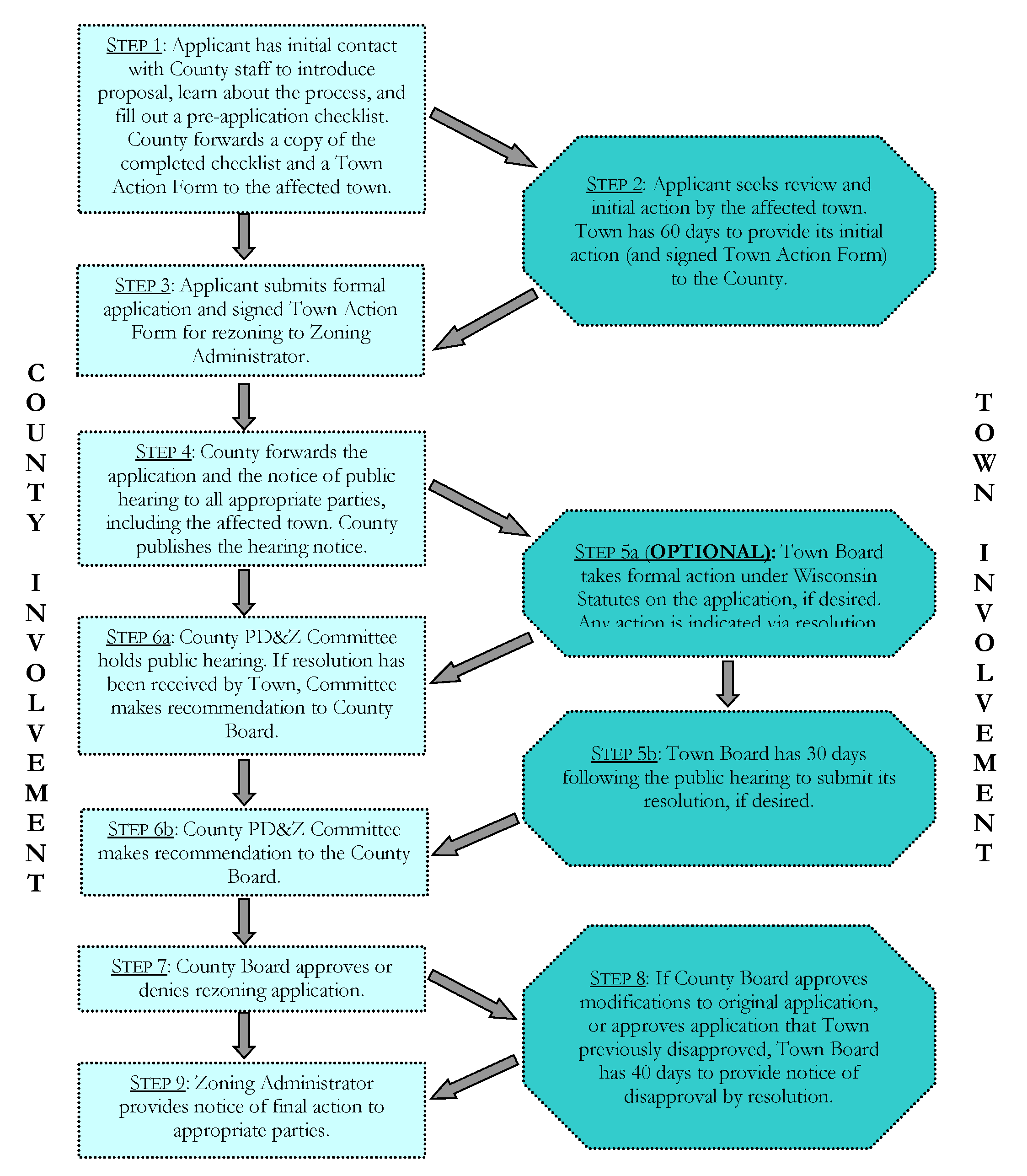
Figure 40-798-2. Summary of Key County Development Review Processes Conditional Use
Permits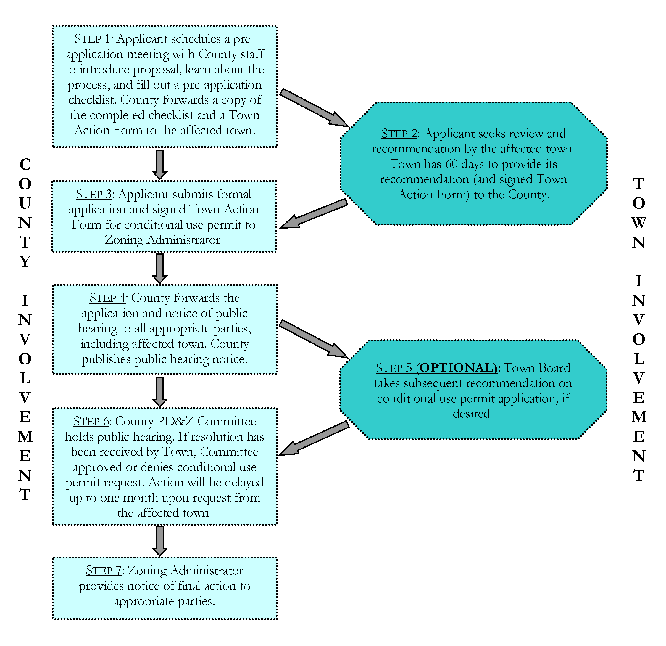
Figure 40-798-3. Summary of Key County Development Review Processes Variances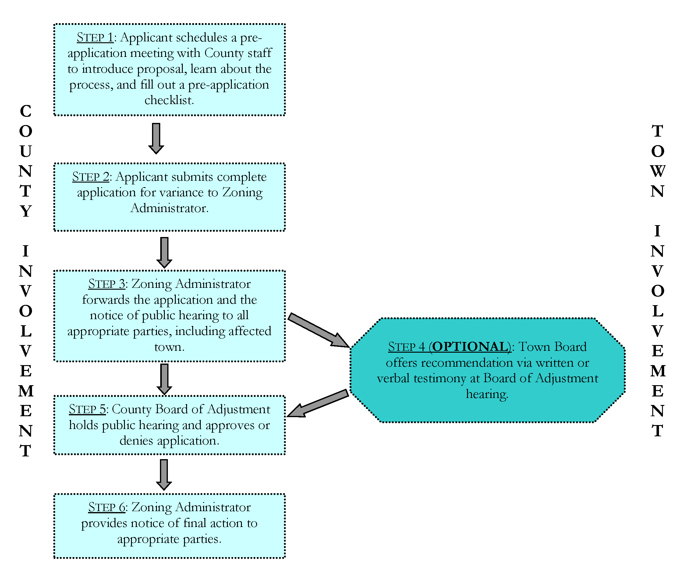
(Ord. No. 7-14, app. C, 1-28-2022)
Sec. 40-799. - Animal unit density worksheet.
(Ord. No. 7-14, app. D, 1-28-2022; Ord. No. 10-25, § 1, 5-28-2025)
Sec. 40-800. - Farmland and forest preservation area residential density policies.
The following policies and programs are applicable within areas that are mapped as farmland and forest preservation area within farmland preservation plan maps in the county comprehensive plan. These policies and programs are copied directly from the comprehensive plan, repeated here for easy reference when implementing applicable sections of this chapter. In the event of any conflict between the following policies and programs and those included within the adopted the chapter or comprehensive plan, such as a result of county board adopted amendments to those documents, the policies and programs within the adopted this chapter or comprehensive plan shall prevail.
(1)
Primary implementing zoning districts. Utilize the county's FP Farmland Preservation Districts, or town zoning equivalents, as the primary zoning districts to implement farmland and forest preservation area policies. Such county FP districts have been developed to be DATCP-certified farmland preservation zoning districts, which makes farmers within such zoning districts eligible for state income tax credits if minimum farm income and conservation requirements are also met.
(2)
Additional compatible zoning options. No county zoning districts aside from the FP districts are intended to be DATCP-certified farmland preservation zoning districts. Still, lands that are zoned RPOS Recreation and Public Open Space District and OAR Open Lands and Residential District within the chapter are also consistent with farmland and forest preservation area policies, and therefore may be mapped over lands planned in farmland and forest preservation area, under the following circumstances:
a.
Some combination of county and local ordinances restricts the development of new subdivision plats (five plus lot developments) in such RPOS or OAR zoned areas, AND
The county wishes to include the RPOS and OAR districts among those zoning districts that are consistent with farmland and forest preservation area policies. The ability to map such RPOS and OAR zoned areas within the planned farmland and forest preservation area maintains eligibility for such lands to be designated within an agricultural enterprise area in the future. Such designation would require subsequent state approval following another local planning, mapping, and petition process.
The OAR, RPOS, and other non-certified zoning districts focused on non-agricultural development may also be utilized on an occasional basis over lands planned in the farmland and forest preservation area, to reflect pre-existing land use and zoning patterns or per the non-farm development policies that follow.
(3)
Agricultural-related and forestry-related businesses. Enable a wide range of agricultural-related and forestry-related uses that support farming and forestry within the farmland and forest preservation area, along with home occupations and other uses that are compatible with the purpose of the farmland and forest preservation area and state law. For additional detail, refer to permitted and conditional use lists and performance standards in this chapter, in towns where such ordinance is applicable.
(4)
Conversion of farmland. Minimize the conversion of prime farmland for residences, residential driveways, and nonfarm development. Per Wis. Stats. § 91.01(25)a and this plan, prime farmland include areas of Class I, II, and III soils, as represented on map 4. New nonfarm development shall be sited in a manner that facilitates crop or forestry production on the remaining lands.
(5)
Residential lots resulting from farm consolidation. When the owner of a residence existing before the establishment of county FP zoning over the land desires to divide the land occupied by such residence and accessory buildings from the farm, in conjunction with a farm consolidation, the resulting residential lot should be as small as practical, considering the desire to keep accessory buildings with the residence and the future probability that farm animals will be kept on the lot.
(6)
Existing residences: Residences, regardless of occupancy, existing as of January 1, 2014 may be permitted in a certified district as listed under Section ATCP 49.22.
(7)
New and replacement farm residences. Enable new and replacement farm residences by right within the farmland and forest preservation area to facilitate new investments in farming, replacement of aging farm residences, and intergenerational transfers. The county in this chapter provides additional detail on what constitutes a farm residence. The resulting farm residence lot or home site should be as small as practical, considering the desire to keep accessory buildings with the residence and the future probability that farm animals will be kept on the lot.
(8)
New nonfarm residential lot sizes and density. Within parts of the farmland and forest preservation area that are also under the county's zoning jurisdiction:
a.
Enable minimum new lot sizes in accordance with applicable standards of this chapter.
b.
Do not permit subdivision plats (five plus lot developments) in the farmland and forest preservation area, instead directing them to areas planned for more intensive residential development.
c.
Enable the clustering of two to four residential lots, except where clustering near a farm residence and associated farm activities would create potential use incompatibilities. Clusters may be sited within each ¼ ¼ section owned, focused in one ¼ ¼ section if multiple ¼ ¼ sections are owned, or some combinations (see example in Figure 40-800-3; figure numbers in this section do not echo figure numbers in the comprehensive plan).
d.
Except where the town has adopted a stricter policy, allow the following alternative maximum residential density options. The density option utilized will depend on the landowner's preferred residential lot sizes, which may vary on a ¼ ¼ section by ¼ ¼ section basis.
1.
Two residences per every ¼ ¼ section of land (40 acres), including both farm residences and nonfarm residences, provided that lots for new nonfarm residences are no greater than two acres each.
2.
One residence per every ¼ ¼ section of land (40 acres), including both farm residences and nonfarm residences, where lots for new nonfarm residences are greater than two acres each.
e.
See Figures 40-800-1 through 40-800-3 for further information and examples of how these lot size and density policies can be executed, except where the affected town has adopted a stricter policy. (For example, at the time of writing, Maple Grove restricted nonfarm residences to only those intended for the parent or child of the operator of farm, up to a maximum of two such residences per farm, where such parent or child either does or did at one time earn more than 50 percent of his or her gross income from the farm.)
(9)
New nonfarm residences require rezoning. For lands in the farmland and forest preservation area under county zoning jurisdiction, require the rezoning of land for nonfarm residences away from an FP zoning district, in accordance with the maximum residential density policy under policy 8. See Figures 40-800-1 through 40-800-3 for examples of how rezoning will be used to execute the residential density policy within the farmland and forest preservation area and under the county's zoning jurisdiction, except where the affected town has adopted a stricter policy. The following are the preferred county zoning districts for when nonfarm residences are proposed:
a.
Where the subdivider does not wish to allow farm animals on the new residential lots, the R-R Residential-Rural District is preferred.
b.
Where the subdivider wishes to enable the keeping of farm animals on the new residential lots, or does not subdivide a lot from the original parcel, the A-R Agriculture-Residential District is preferred.
Figure 40-800-1. Residential Development Options Within Farmland and Forest Preservation
Area (No Pre-Existing Residence)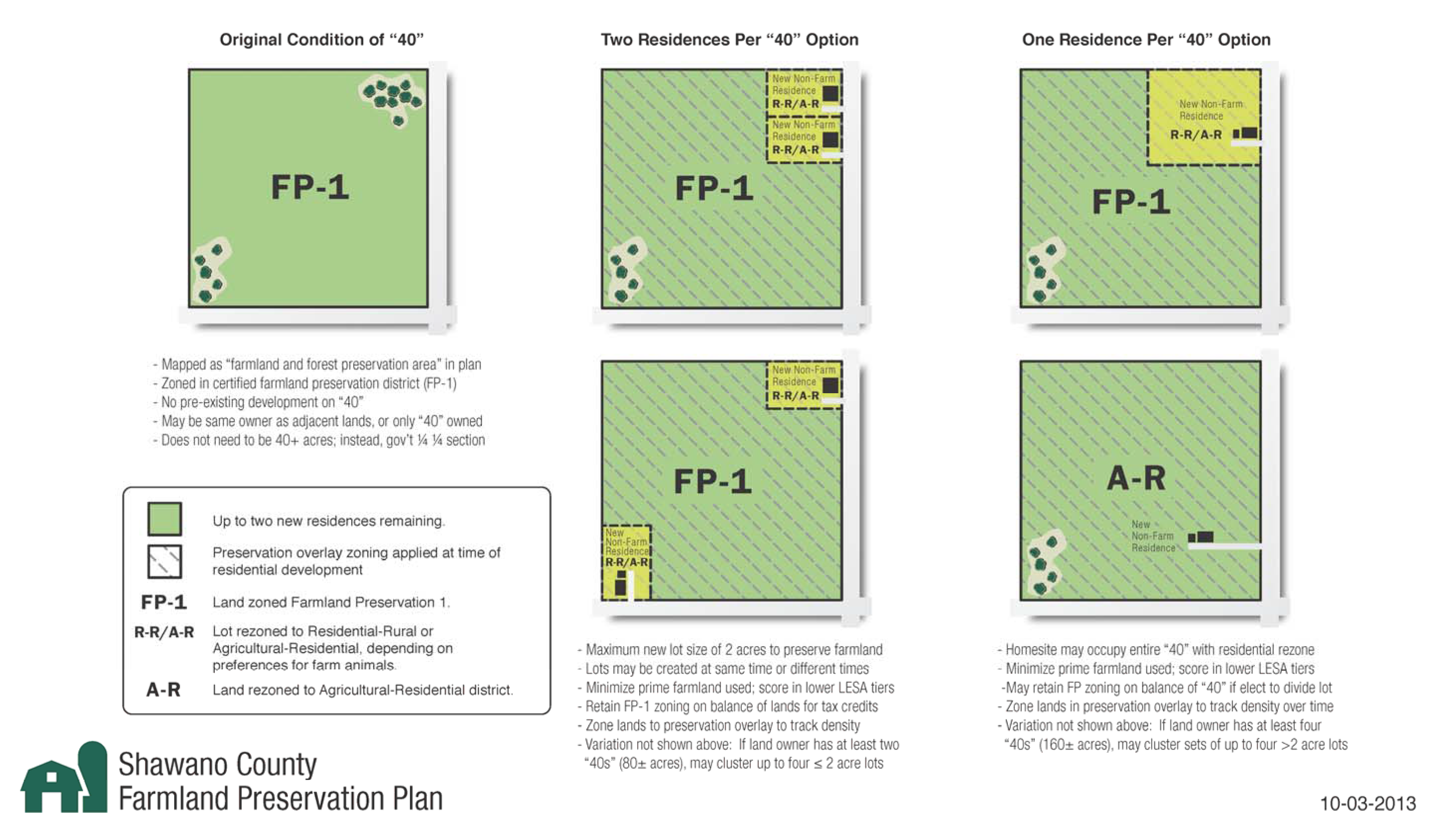
Figure 40-800-2. Residential Development Options Within Farmland and Forest Preservation
Area (with Pre-Existing Farm Residence)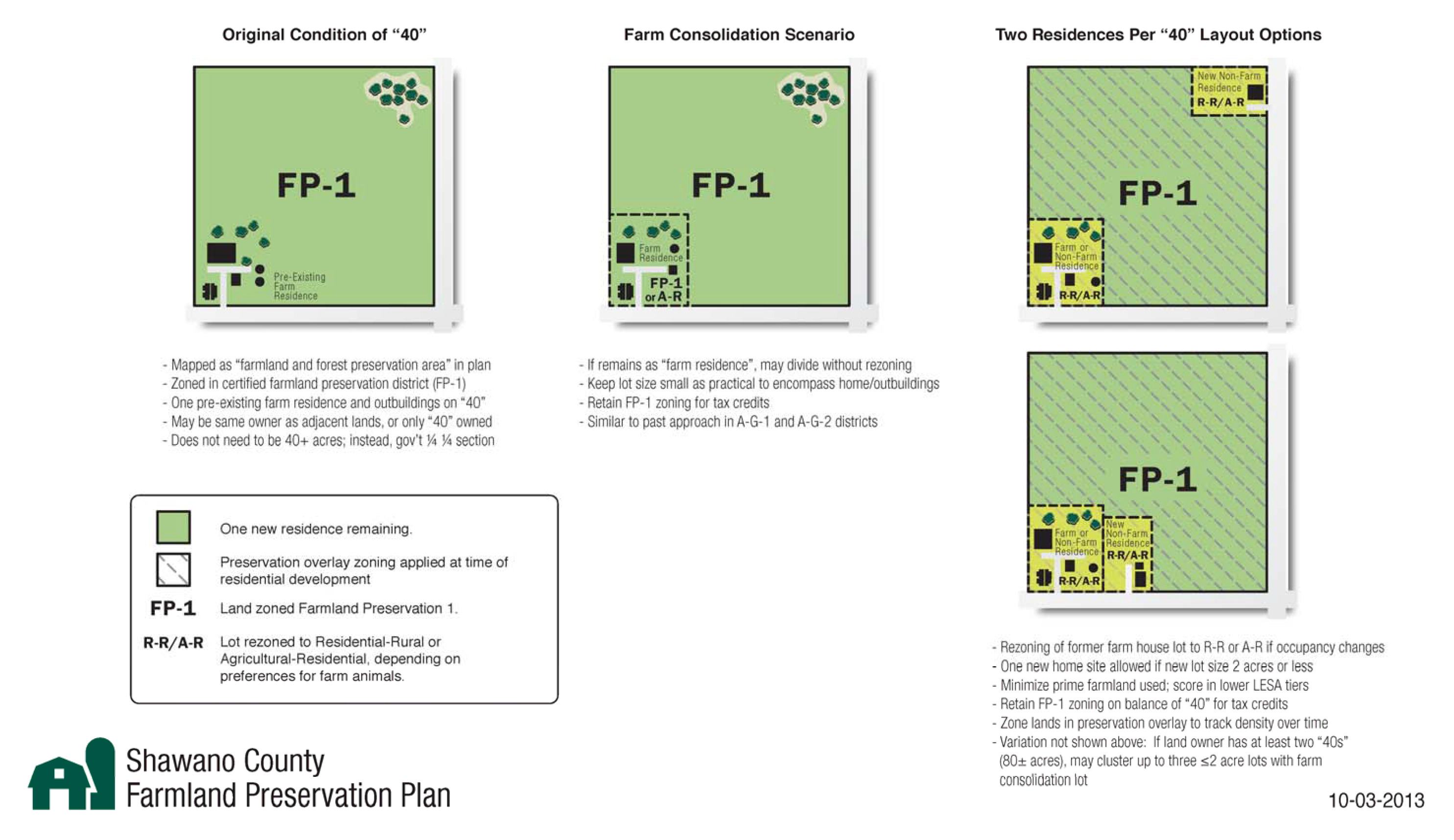
Figure 40-800-3. Residential Development Clustering Option Within Farmland and Forest
Preservation Area (80-Acre Clustering Example)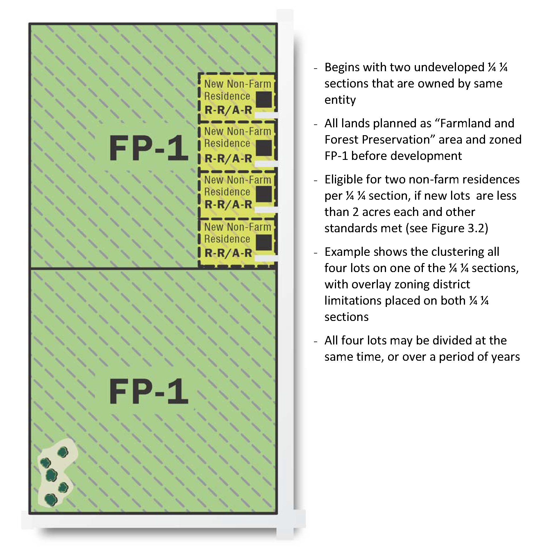
(10)
Rezoning criteria. Whenever land is proposed for rezoning from a DATCP-certified county FP zoning district (or from a certified farmland preservation zoning district in a town zoning ordinance) to a non-DATCP-certified zoning district, it is required that the following criteria are met:
a.
The land is better suited for a use not allowed in the FP district, or certified town farmland preservation zoning district.
b.
The rezoning is consistent with this the county comprehensive plan, including its farmland preservation plan component, and the applicable town comprehensive plan.
c.
The rezoning will not substantially impair or limit current or future agricultural use of surrounding parcels of land that are zoned for or legally restricted to agricultural use.
(11)
Support for complementary town policies. Where associated policies within the adopted town comprehensive plan are stricter than county policies for lands within a particular designated farmland and forest preservation area, support the town in its actions on zoning and land division requests, so that the stricter policy based on the town's comprehensive plan may be applied.
(12)
Potential agricultural enterprise areas (AEAs): Support town/property owner initiated petitions to DATCP to establish new AEAs in Shawano County, provided that county planning and development staff determines that the proposed AEA is entirely within a farmland and forest preservation area and is otherwise consistent with this plan and DATCP criteria. AEAs enable farmland preservation tax credits at higher levels than otherwise possible within the planned farmland and forest preservation area. Beginning in tax year 2023, the tax credit have been updated to the following:
•
$10.00/acre for landowners with a farmland preservation agreement signed after July 1, 2009 and located in an agricultural enterprise area, or for landowners who have modified an agreement initially signed before July 1, 2009
•
$10.00/acre for landowners in an area zoned for farmland preservation
•
$12.50/acre for landowners in an area zoned for farmland preservation and in an agricultural enterprise area with a farmland preservation agreement signed after July 1, 2009, or in an area zoned for farmland preservation and with a farmland preservation agreement modified after July 1, 2009
Eligibility requirements and additional information about the program can be found on the Wisconsin Department of Agriculture, Trade and Consumer Protection website at https://datcp.wi.gov/Pages/Programs___Services/AgriculturalEnterpriseAreas.aspx
(13)
Land conservation. As budget resources allow, work through the land conservation division to assist farmers in the farmland and forest preservation area and FP zoning districts achieve soil and water conservation compliance to maintain tax credit eligibility.
(Ord. No. 7-14, app. E, 1-28-2022)

