
Mountain Park City Zoning Code
ARTICLE XXXIV
DEVELOPMENT REGULATIONS
34.1 - Scope and intent.
This article includes a variety of development related regulations which are designed to insure that development, and infrastructure additions and improvements are provided in the best interest of the health, safety and welfare of the citizens of Fulton County, and to assure that development regulations and review procedures are standardized and equitably applied.
34.2 - Compliance.
Any land disturbance activity or any development activity must comply with the development standards of Fulton County along with any other applicable local or state regulations. Compliance with the provisions of this article, and actions to bring about compliance with this article shall be in accordance with administrative guidelines of the Environment and Community Development Department. (Amended 11/3/93, 2/7/01)
34.3 - Appeals.
The Director of the Environment and Community Development Department shall administratively consider variance appeals to article XXXIV in accordance with article XXII, Appeals. (Amended 11/3/93, 2/7/01)
34.4 - Permit and sign-off requirements.
These standards acknowledge or establish Fulton County requirements for permits for development of properties within the unincorporated area of Fulton County. All development shall comply with these and other requirements including, but not limited to, the Fulton County Tributary Buffer Ordinance, the Fulton County Tree Preservation Ordinance and Administrative Guidelines, the Fulton County Sediment and Erosion Control Ordinance, and the Georgia Metropolitan Area River Protection Act.
34.4.1 Land disturbance permit prerequisites. Prior to the issuance of a land disturbance permit or the issuance of a certificate of occupancy for each phase of development, the following documents shall be submitted to the Director of the Environment and Community Development Department for approval. (Amended 11/3/93, 2/7/01)
A.
Site plan. A site plan which meets or exceeds the requirements contained herein and the Environment and Community Development Department administrative guidelines, and incorporates the following therein: (Amended 2/7/01)
1.
A certified boundary description based on a survey of the entire property.
2.
A graphic representation of those conditions of zoning which can be graphically represented. This is not intended to require that conditions of zoning be written-out on a site plan.
3.
Zoning case number and other relevant file numbers.
B.
Grading plan with phasing.
C.
Erosion and sediment control plan. A separate sheet depicting erosion and sediment control measures as required by the State of Georgia.
D.
Landscape/tree protection plan. A detailed landscape or tree protection plan for all required buffers, landscape strips, tree protection zones, and screened areas. If project completion does not coincide with an appropriate planting season, or if water prohibitions are in effect, a performance bond may be posted to delay planting until an appropriate time approved by the Fulton County Arborist. (Amended 3/6/91, 03/03/04)
E.
Storm water management plan. (Name Changed 7/7/93)
1.
Evaluate the downstream ditch stability and bank erosion protection potential of existing downstream conveyance system. Provide all necessary documentation to the Department of Public Works, Storm Water Management Section at construction drawing phase.
2.
Contact the Department of Public Works, Storm Water Management Section to arrange an on-site evaluation as to the location of storm water facility, discharge path of detention/retention pond and other downstream constraints.
3.
The design discharge at the outlet of drainage system shall not result in velocities that equal/exceed the erosive velocity or the existing receiving channel/draw, unless dissipation and erosion protection measures are placed at the outlet. Said documentation shall be provided to the Department of Public Works, Storm Water Management Section.
4.
Provide downstream analysis of the flood discharge timing effect on the existing conveyance systems due to each storm frequency.
5.
All natural streams within the limit of the project must be stable and be expected to remain stable under ultimate development or provide appropriate erosion protection for the streams subject to the approval of the Department of Public Works, Storm Water Management Section.
6.
Evaluate the downstream effect from storm water management structures and the development, hydrologic-hydraulic engineering studies shall extend downstream to a point where the proposed development represents less than ten percent of the total watershed to this point.
7.
The result of the extended downstream point analysis (ten percent point) shall be included in the hydrologic study submitted with the storm water management plan. Said documentation is subject to approval by the Department of Public Works, Storm Water Management Section.
8.
Provide detention/retention as maybe required by Fulton County subject to the approval of the Department of Public Works.
9.
The development site shall be graded in such a manner that the surface runoff does not affect down stream lots, flow through lots shall be collected and conveyed in appropriate storm drainage system. Documentation shall be provided at construction drawing phase.
10.
Water intake and discharge points in a single-family residential development to be a minimum of 15 feet from any existing or proposed residential structure and to be at a minimum of five feet above and/or five feet below any existing or proposed buildable area. (Added 9/1/99)
F.
Other plans, as applicable.
1.
Water and waste water plans.
a.
Water and waste water systems constructed under the jurisdiction of Fulton County government shall abide by the department of public works.
b.
Fulton County Public Works/government does not guarantee the availability of water or waste water capacity.
c.
Matters pertaining to septic systems shall be determined by the Fulton County Board of Health.
d.
The project being proposed shall utilize one geographical information system (GIS) monument as the development's benchmark. Furthermore, the developer shall abide by all provisions of the Fulton County "Monument Resolution," as established by the Department of Public Works.
e.
Matters pertaining to pump stations shall be pre-reviewed by the Department of Public Works, Engineering Support Services Division, with regards to current policy, prior to the submittal of project design drawings.
f.
All appropriate fees shall be paid by the developer prior to the issuance of any land disturbance permits.
g.
The developer is required to extend the water pipe line system across the entire length of road frontage, within the right-of-way.
h.
At the time of design review, the Department of Public Works, Engineering Support Services Division may require the developer to connect (loop) the project to the adjoining property, for flow enhancement of the public water system.
i.
Rerouting of existing water pipe lines and/or waste water pipe lines shall be pre-approved by the Department of Public Works, Engineering Support Services Division, prior to the submittal of project design drawings.
j.
As part of the project, the developer is required to network the waste water pipe line system to all upstream properties.
k.
Easements dedicated to Fulton County government shall abide by all established standards. All easements shall be obtained and approved by the Department of Public Works, Engineering Support Services Division.
l.
Conflicts, with other review disciplines of Fulton County government shall be submitted to and resolved by the Department of Public Works, Engineering Support Services Division.
2.
Profiles of roads and sewers.
3.
Traffic signs and striping.
4.
Standard construction details.
5.
Proposed permanent stormwater management plan.
6.
A traffic impact mitigation plan which details an owner's or developer's plan to address the number of trips that their development will produce when such development is within one mile of a roadway operating at a level of service D or lower as established by the Department of Public Works. This plan shall include, but is not limited to roadway improvements including costs and other proposals such as providing transit access, transit use incentives, car/van pooling, bicycle path construction, internal sidewalk construction, and lunch trip reduction, which when combined mitigate the traffic impact of the proposed development and shall also include a time table for the construction/implementation of improvements and who will be financially responsible for them. (Added 4/3/02)
G.
Permits, agreements, studies as applicable.
1.
An approved curb cut permit from the Georgia Department of Transportation or the Fulton County Development Services Department.
2.
Board of health approvals.
3.
Right-of-way dedication.
a)
Property owners be required to dedicate at no cost to Fulton County, along the entire frontage, sufficient right-of-way to provide a minimum 10.5 foot shoulder behind any required project improvement subject to the approval of the director of public works.
4.
Off-site transportation improvement funds and agreements.
5.
Fire department approval.
6.
Sanitary sewer pre-treatment approval.
7.
Siltation Study. (Added 3/4/92, Amended 7/7/93, 11/3/93, 2/7/01)
a.
At the discretion of the Director of the Environment and Community Development Department, submit prior to the issuance of a land disturbance permit and prior to recording of the final plat for each phase of development, base siltation studies of any water bodies located on the development site and on adjacent properties. Said studies shall identify, for removal by the applicant, prior to recording of the final plat for each phase of development, all siltation resulting from the development. (Amended 2/7/01)
b.
At the discretion of the Director of the Environment and Community Development Department, prior to the recording of the final plat for the final phase of development, submit a performance bond for the removal of any siltation resulting from the development. The performance bond shall remain on file in the Environment and Community Development Department until release of the occupancy certificates for a minimum of 90 percent of all residences permitted pursuant to the development or three years from the date of the first certificate of occupancy, whichever is earlier. (Amended 2/7/01)
34.4.2 Prerequisite to occupancy permit inspection. The Public Works Department and/or the Inspections and Zoning Enforcement Department shall notify the Environment and Community Development Department in writing of holds on the issuance of a certificate of occupancy on a project. (Amended 11/3/93, 2/7/01)
A.
Single-family residential. Before a certificate of occupancy may be considered by the Environment and Community Development Department for any dwelling located in a subdivision, the items listed under "B"., below, must have been signed-off on by the Environment and Community Development Department as complete for that phase of the subdivision in which a dwelling is located. (Amended 2/7/01)
B.
All structures except single-family residential. Before a certificate of occupancy may be considered for a structure, including the first of several structures within a development, the following must have been signed-off on as complete by the Environment and Community Development Department: (Amended 2/7/01)
1.
Required landscaping.
2.
Required buffers.
3.
Required tree protection measures.
4.
Required walls and fences.
(Amd. No. 09-0766, pt. 3, 8-5-09)
34.4.3.7(g) Siltation study. See section 34.4.1(G)(7) (Moved 7/7/93)
(Ord. No. 18-0340, Att. A, 5-16-18)
34.5 - Site improvement standards.
These standards shall regulate site improvement, and the provision of amenities related to site improvement.
34.5.1 Off-street parking. Property owners shall provide and maintain off-street parking throughout construction. Parking on any lot other than the lot for which a building permit is issued must be approved for a temporary parking lot by the Environment and Community Development Department. (Amended 11/3/93, 2/7/01)
34.5.2 Interparcel access. Interparcel access shall be provided to adjacent properties upon determination by the Director of the Environment and Community Development Department that such access is in the best interest of the public health, safety or welfare. (Amended 11/3/93, 2/7/01)
34.5.3 Sidewalks/curb and gutters. (Amended 11/03/93, 02/07/01, 03/03/04, 04/05/06) Sidewalk, curb and gutter shall be provided for all development projects as determined by the Department of Environment and Community Development. When required, sidewalk, curb and gutter shall be constructed in accordance with the Department of Public Works Standard Plans (also known as Standard Details).
34.5.4 Detention/retention. On-site storm water detention facilities shall not be located within any required buffer or landscape strip. Detention facilities shall not be located within parking or loading areas unless approved by the department of public works. A minimum 20-foot wide landscape strip planted to buffer standards shall be provided around the exterior of the detention area outside of the access easement or as may be approved by the Fulton County Arborist. (Added 3/6/91) (Amended 07/07/93, 04/05/95, 11/03/04)
34.5.5 Compliance with tree preservation ordinance. Prior to applying for a land disturbance permit, the owner shall arrange with the county arborist, through the Director of the Environment and Community Development Department, for an on-site evaluation of existing specimen trees and stands of trees, and an evaluation of buffers and tree protection zones. At a minimum, the tree density requirements prescribed by the Fulton County Tree Preservation Ordinance Administrative Guidelines shall be provided and permanently maintained. (Added 4/7/93, Amended 11/3/93, 2/7/01)
34.5.6 Subdivision access. Any subdivision of land for single family that has new roads providing direct access to the lots within the subdivision shall be limited to newly constructed internal roads. (Added 9/4/91)
34.5.7 Minimum setback for new street. The right-of-way for new streets must be located a minimum of 50 from any peripheral property line adjoining AG-1 and residentially zoned property unless interparcel access is required. (Added 12/4/91)
34.5.8 Arborist notification. Contact the Director of the Environment and Community Development Department, prior to the application for a land disturbance permit, to arrange with the county arborist an on-site evaluation of existing specimen trees/stands, buffers, and tree protection zones within the property boundaries and otherwise to ascertain compliance with the Tree Preservation Ordinance. (Added 12/4/91, Amended 4/7/93, 11/3/93, 2/7/01)
34.5.9 Dams. All dams within the jurisdiction of Fulton County shall comply with the provisions of the Safe Dam Act and Rules of Georgia Department of Natural Resources.
34.5.10 Development in or near a transmission line easement. (Added 8/4/99, Amended 06/04/14)
A.
Definitions. Words and phrases used in this article shall have the meanings set forth in this section. Words and phrases not defined in this section, but defined in the Zoning Resolution of Fulton County, shall be given the meanings set forth in such resolution. All other words and phrases shall be given their common, ordinary meaning, unless the context clearly requires otherwise. Section headings or captions are for reference purposes only and shall not be used in the interpretation of this article.
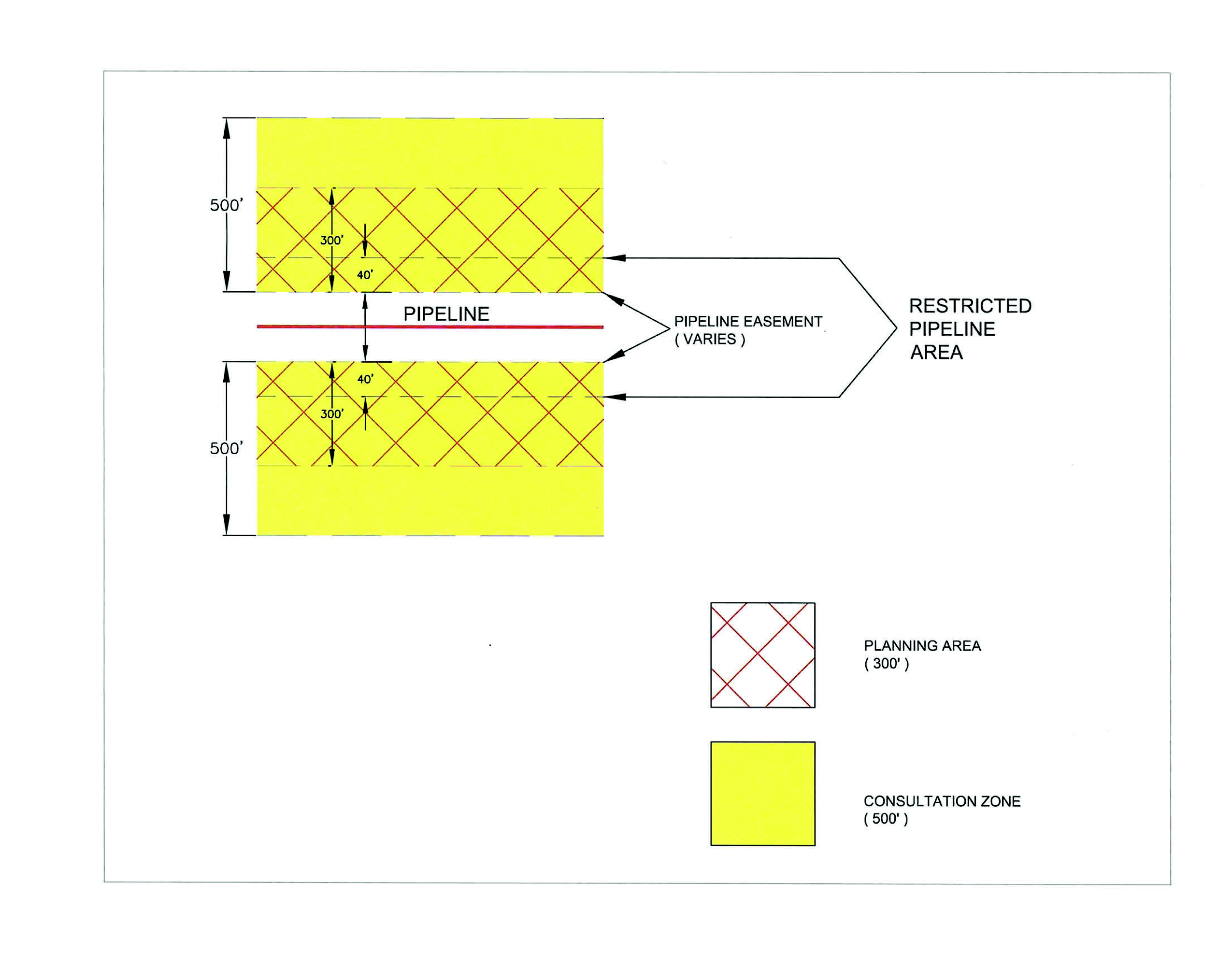
Consultation zone. An area within 500 feet from a transmission line easement.
Development permit. For the purposes of the consultation zone requirements, any permit for activity that involves construction, grade modification, excavation, blasting, land clearing, or the deposit of earth, rocks or other materials that places an additional load upon the soil. Construction that involves work totally within an existing building footprint, such as residential remodeling projects, is specifically exempted from these consultation zone requirements.
Environmental justice working group. A board of commissioners established group of key personnel from Fulton County departments and agencies whose activities relate to or impact environmental justice matters.
New construction. Construction after June 2, 2014 of a structure intended for human occupancy, and includes the construction of a new structure, the construction of an addition to an existing structure and the reconstruction of a portion of an existing structure. The term excludes an addition to or the reconstruction or replacement of a structure existing on June 2, 2014 used for:
1.
Single-family residential use;
2.
Townhouse use;
3.
Duplex, triplex or quadruplex use;
4.
Multi-family residential use;
5.
Mobile home residential use; or
6.
Nonresidential buildings occupied by human beings.
Person. Any individual, firm, joint venture, entity, partnership, corporation, association or cooperative.
Planning area. The area within 300 feet of a transmission line easement.
Restricted pipeline area. The area within 40 feet of a transmission line easement and the area within a transmission line easement.
Transmission line. See article III, section 3.3.20.
Use requiring evacuation assistance. A land use which includes the following:
1.
Congregate living;
2.
Convalescent services;
3.
Detention facilities;
4.
Day care services (commercial);
5.
Hospital;
6.
Medical offices exceeding 5,000 square feet of gross floor area;
7.
Private primary educational facilities;
8.
Private secondary educational facilities;
9.
Public primary educational facilities;
10.
Public secondary educational facilities; and
11.
Retirement housing development.
B.
Consultation zone.
1.
Consultation zone distance.
a.
A consultation zone is hereby established for any parcels within 500 feet from a transmission line easement.
2.
Consultation zone notification.
a.
At application for a development permit, zoning or use permit, Fulton County staff shall notify the individual that they are within the consultation zone, explain the relevant application procedures, and provide contact information for the applicable pipeline operator(s). This same procedure shall be followed whenever an individual inquires about development regulations or zoning restrictions for property within the consultation zone.
b.
A complete application for a development permit, zoning or use permit within a designated consultation zone must include written verification from the applicant that:
1.
Applicant has contacted the pipeline operator(s) and has provided them with documentation detailing the proposed development type and place of the activity; and
2.
The pipeline operator(s) has reviewed the documents;
3.
The written verification required by this section can be in any form acceptable to the director of the department planning and community services, including electronic communications, so long as it is clear that the pipeline operator(s) has received and reviewed documentation showing the proposed information concerning any impact the activity will have upon the integrity of the transmission line(s). The verification should include all comments received from the operator or a notice from the operator indicating that the operator has no comments;
4.
If the operator does not respond within 30 days after being contacted and provided information by the developer pursuant to b.1. above, then the director of planning and community services may waive the requirement for written verification given under b.3. above.
C.
Planning area.
1.
Whereas a proposed use within a consultation zone requires notification to and a review by the pipeline operator(s), additional procedures are required in planning areas based upon characteristics of the transmission line(s) and potential for impact to people and property. Planning areas are hereby established within 300 feet of transmission line(s) easement.
2.
Application process within a planning area.
a.
At application for a development permit, zoning or use permit, Fulton County staff shall notify the individual that they are within the planning area and explain the relevant requirements.
b.
Development within the planning area shall meet the requirements under section D (Development near a transmission line) below.
c.
The plat must provide a note that all existing transmission lines or transmission line facilities through the residential or commercial development have been shown, or that there are no known transmission lines or transmission line facilities within the limits of the residential or commercial development.
d.
The location of all transmission lines and related easements shall be shown on all preliminary plat, zoning, building, and record plat maps when proposed development is within the planning area.
D.
Development near a transmission line.
1.
A use requiring evacuation assistance is prohibited in a structure intended for human occupancy that is located within the 300-foot planning area. This prohibition does not apply to a structure that is located between 40 and 300 feet of a pipeline if the Fulton County Environmental Justice Working Group determines, after receiving a recommendation from the fire marshal, that:
a.
The structure has a performance-based design that provides an adequate time period for occupant evacuation to a safe place in the event of a transmission line leak or fire associated with the transmission line, after considering:
1.
The requirements of the current adopted edition of the National Fire Protection Association 101 Life Safety Code and International Fire Code;
2.
The site and structure design;
3.
The structure's building materials;
4.
The structure's distance from the transmission line;
5.
The use of radiant energy barriers;
6.
Access to the site and the structure by emergency responders;
7.
Available on-site resources for emergency responders;
8.
The topography and other natural features;
9.
The use of the structure; and
10.
The evacuation capability of the occupants.
b.
The structure incorporates a system for the early detection and notification of a transmission line leak, if the fire chief determines that an appropriate system is commercially available.
2.
A person may not build new construction within 125 feet of a transmission line easement unless the fire marshall determines that:
a.
The new construction has a performance-based design that provides a minimum one-hour time period for occupant evacuation to a safe place in the event of a transmission line leak or a fire associated with the transmission line, in accordance with the current adopted edition of the National Fire Protection Association 101 Life Safety Code and International Fire Code; and
b.
The new construction incorporates a system for the early detection and notification of a transmission line leak, if the fire chief determines that an appropriate system is commercially available; or
c.
The new construction complies with the standards for construction near a transmission line prescribed by the Fire Criteria Manual.
3.
A person may not place a structure or excavate within a restricted pipeline area. This prohibition does not apply to:
a.
The transmission line or an appurtenance;
b.
A facility that produces, consumes, processes, or stores the product transported by the transmission line, including a power generation facility;
c.
A utility line that crosses the restricted pipeline area, including an appurtenance to the line;
d.
A utility service connection;
e.
A road;
f.
A surface parking lot; or
g.
A structure or excavation that the director determines does not disturb the transmission line or impede its operation. The director in his/her determination shall consult Appendix A - Appropriateness of Proposed Land Uses within a Transmission Line Easement and section 4. below, to assist in the final determination.
4.
Before a person may place a road, surface parking lot, structure, utility line or otherwise excavate in a restricted pipeline area, the person must:
a.
Deliver to the director a certification by a registered engineer stating that the proposed construction activity and structure are designed to prevent disturbing the transmission line or impeding its operation; and
b.
Provide notarized documentation that the pipeline or transmission line easement owner has been notified of the proposed development activity.
5.
If a proposed use is subject to any required determination in sections 1 through 4 above, the county's response and the results of the review will be provided to the applicant within ten business days of the county's acceptance of the complete application package. The office of planning and community services in collaboration with Fulton County Fire and Rescue shall determine when such submissions are deemed complete.
E.
Platting transmission lines/pipelines.
1.
A developer shall determine whether a transmission line crosses a proposed development.
2.
A developer shall depict on the plat a restricted pipeline area, if any.
3.
A residential lot that is less than one acre in size may not include a restricted pipeline area.
4.
A person may not place a structure or excavate within a restricted pipeline area. This prohibition does not apply to:
a.
The transmission line or an appurtenance;
b.
A facility that produces, consumes, processes, or stores the product transported by the transmission line, including a power generation facility;
c.
A utility line that crosses the restricted pipeline area, including an appurtenance to the line;
d.
A utility service connection;
e.
A road;
f.
Surface parking lot; or
g.
A structure or excavation that the director determines does not disturb the transmission line or impede its operation.
5.
Before a person may place a road, surface parking lot, or utility line in a restricted pipeline area, the person must:
a.
Deliver to the director a certification by a registered engineer stating that the proposed construction activity and structure are designed to prevent disturbing the transmission line or impeding its operation; and
b.
Provide notarized documentation that the pipeline or transmission line easement owner has been notified of the proposed development activity.
F.
Severability. Should any article, section, clause, or provision of this article be declared by a court of competent jurisdiction to be invalid, such action shall not affect the validity of the ordinance as a whole or any part hereof other than the part so declared to be invalid, it being the intent of the county that each article, section, clause, and provision hereof be severable.
G.
Effective date. This ordinance shall be in full force and take effect from and after the date of its final passage and approval.
H.
Savings. Nothing contained herein shall in any manner be deemed or construed to alter, modify, supersede, supplant or otherwise nullify any other ordinance of the county or the requirements thereof whether or not relating to or in any manner connected with the subject matter hereof, unless expressly set forth herein.
APPENDIX A - Appropriateness of Proposed Land Uses within a Restricted Pipeline Area
The purpose of this table is to increase awareness and encourage early communication among key stakeholders when considering changes to an existing land use or new land use development within an existing restricted pipeline area.
This table provides a list of common land use activities and is only meant to provide guidance to those tasked with determining whether the proposed land use is acceptable or not. There will be variances in the application of these rules from operator to operator based on site-specific conditions, operator practices, and evolving safety regulations and concerns. Therefore, this table should be referenced only for general informational purposes. Stakeholders should consult with the appropriate pipeline operator for acceptable land uses within a restricted pipeline area.
34.5.11. Burying of construction material. No person shall bury unused, scrap, waste, excess or discarded construction material without the approval of a use permit for an inert waste landfill in accordance with article XIX. Any person who violates this provision shall be deemed guilty of a misdemeanor and subject to the provisions of article XXIX, Violation and Penalty. (Added 12/1/99)
34.5.12. Wastewater pump and lift stations. A minimum 50-foot buffer and 10-foot improvement setback shall be provided along all property lines adjacent to residentially and/or agriculturally zoned properties used for residential or public recreational purposes. (Added 09/01/04)
34.5.13. South Fulton Greenway Trail Master Plan. At the time of application for a land disturbance permit or building permit, development projects with frontage adjacent to roads identified on the South Fulton Greenway Trail Master Plan Map shall incorporate a multi-use path subject to the approval of the director of the environment and community development. (Amd. No. 10-0379, 4-7-10)
34.5.14. Reserved.
34.5.15. Reserved.
34.5.16. Cluster mailboxes.
A.
Applicable districts:
1.
All residential districts or districts with residential components when developed with residential units.
2.
Non-residential districts and interior building cluster mailboxes are exempt from the design and location standards of this section.
3.
Procedural standards are applicable to all cluster mailbox installations.
B.
Procedural standards:
1.
Prior to the submission of the preliminary plat, approval of the United States Postal Service (USPS) must be obtained and attached with the plat.
2.
Where a final plat is recorded with a performance bond, the surety shall cover the cluster-style mailbox kiosk and the installation shall occur prior to any certificate of occupancy being issued for a residential structure shown on the plat.
3.
Cluster-style mailbox kiosks shall be installed prior to the issuance of a certificate of occupancy for any residential structure that will be served by a cluster-style mailbox.
4.
The cost of installation, including but not limited to box units, architectural elements, landscaping, concrete pad and concrete/masonry or stone sidewalk access, shall be borne by the developer.
5.
Maintenance of the cluster-style mailbox kiosk, landscaping, trash can and surrounding areas shall be borne by the home owners association (HOA) of the neighborhood/development. Where no HOA exists, maintenance and associated costs shall be the responsibility of the homeowners served by the cluster mailbox kiosk.
6.
Cluster-style mailbox kiosks shall be exempt from the setback requirements of the zoning district; however all structures shall require a separate building permit and must meet or exceed all applicable building code.
C.
Design standards:
1.
All cluster-style mailbox units shall be incorporated into a cluster-style mailbox kiosk unless the cluster-style mailbox units are located interior to a building or as may be approved by the director.
2.
Cluster-style mailbox kiosks shall be compatible with other streetscape elements and be architecturally enhanced with building materials and details typical of the architectural style of the neighborhood/development.
a.
Cluster-style mailbox kiosks shall be located away from any location where, by reason of the position, shape or color, it may interfere with, or obstruct the view of or be confused with any authorized traffic control device.
b.
Provide a four-foot-wide impervious surface parallel to the kiosk and a roof overhang for a weather free standing location wherever the individual mailboxes are to be accessed.
c.
Provide landscaping consistent with the landscape theme of the neighborhood/development.
d.
Provide a trash receptacle at each clustered mailbox location.
e.
Provide lighting.
3.
Cluster-style mailbox kiosks shall have a base of a width not less than the width of the cluster mailbox structure itself.
4.
Cluster-style mailbox kiosks shall have a minimum four-foot-wide concrete/masonry or stone access from the street and/or sidewalk.
5.
Cluster-style mailbox kiosks shall provide access compliant with the Americans with Disability Act (ADA).
6.
Cluster-style mailbox kiosks shall provide a paved area with ingress/egress to allow vehicles to pull off, park and re-enter the roadway safely while retrieving mail.
7.
Cluster-style mailbox kiosks shall be located in areas that will best allow for vehicle parking. Parking layout is to be designed in a manor so as to not create pedestrian safety or vehicle safety issues as determined by the Fulton County Traffic Engineer.
_____
8.
Minimum required parking shall be required as follows:
_____
9.
Access drives and parking areas shall be constructed to Fulton County road standards or as approved by the director of the department.
D.
Location standards:
1.
The location of the cluster-style mailbox is to be approved by the county and by the USPS.
2.
Cluster-style mailbox kiosks shall be prohibited from being located within the public right-of-way.
3.
Clustered mailboxes shall be placed so as to not adversely affect the privacy of residents.
4.
Cluster-style mailbox kiosks shall not be installed within a cul-de-sac bulb.
5.
Cluster-style mailbox kiosks shall be located away from the intersection of any street and in no case closer than 75 feet measured from the street centerline in order to prevent obstruction of free and clear vision.
6.
Clustered mailboxes shall be centrally located, offering easy pedestrian access to all residents. Cluster-style mailbox kiosks shall be located no more than one-fourth mile from the property line of those residents served by the cluster-style mailbox kiosk. Distance shall be measure as a radius drawn from the cluster-style mailbox kiosk.
7.
No driveway or street access shall be constructed within five feet of a cluster-style mailbox kiosk and vice versa.
E.
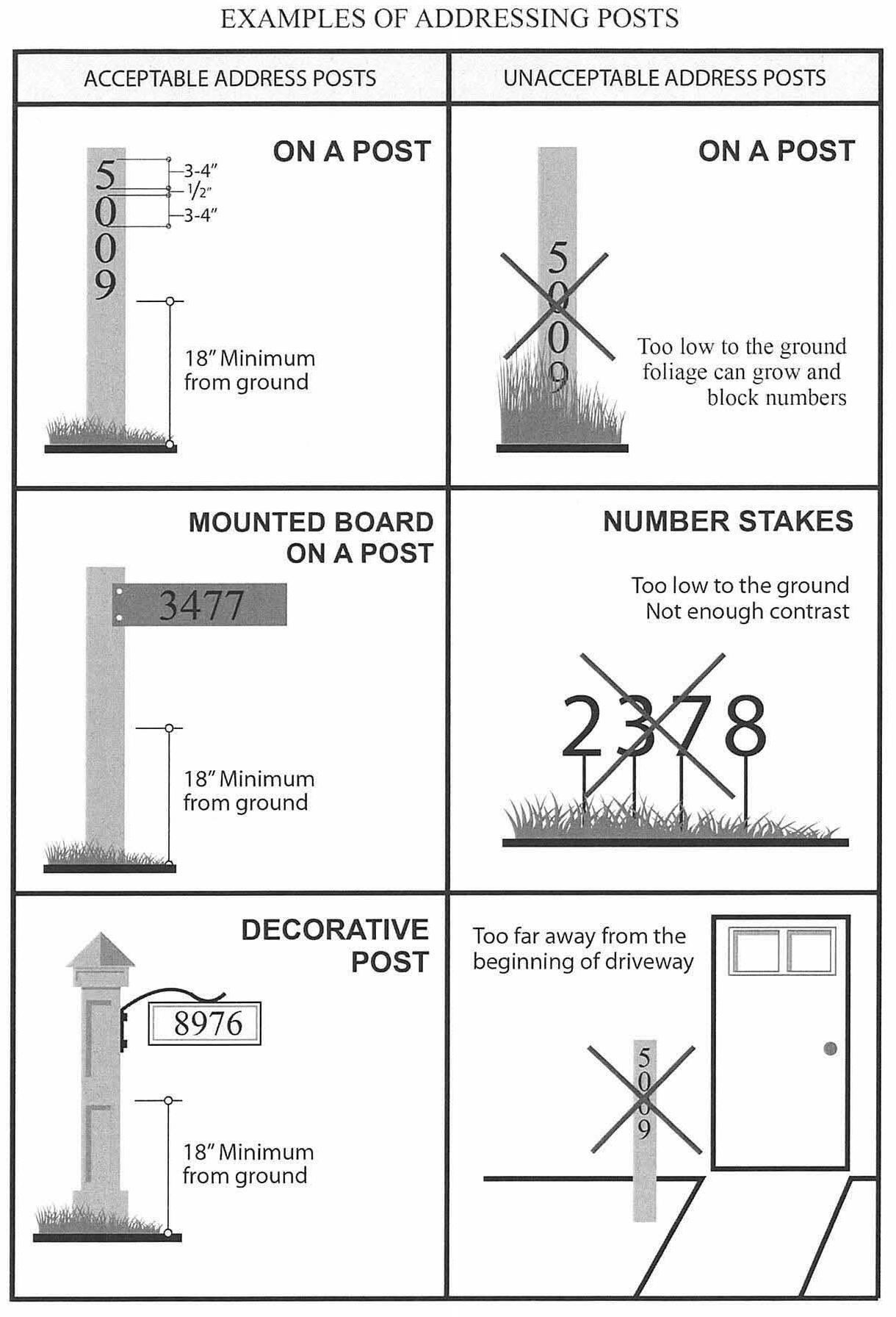
Address post:
1.
Each residential one- or two-family dwelling shall have its address number posted on a mailbox or addressing post located at or near the main entrance or vehicle access point to the property.
2.
The address post shall not exceed six inches by six inches in dimension.
3.
One-third of the total length of the address post shall be buried in the ground and the address post shall be secured in the ground i.e. surrounded by concrete.
4.
Such address numbers shall have a minimum stroke height of three inches and shall be a color that contrasts with the surrounding surface so as to be readily identifiable.
5.
Such numbers shall have a minimum one-half inch between numbers.
6.
Address numbers shall not be placed within 18 inches of the ground.
7.
Address numbers must be clearly visible on both sides of the post, and shall face the direction of traffic.
8.
The post shall not be obstructed from view by any means.
9.
The property owner shall have the responsibility of ensuring compliance with the requirements of this section, regardless of whether the premises are leased or owner-occupied.
The following diagram has been provided as reference for acceptable and unacceptable installation, of the address posts and address numbers.
(15-0273, 4-1-15; 16-0363, pt. 1, 5-4-16)
34.6. Timber harvesting. (Added 3-6-91; Deleted 12-1-99)
34.7. Cemeteries. In a parcel with a cemetery, burial ground, human remains or burial object(s), there shall be no land disturbing activity or timbering unless approved by the Department of Environment and Community Development. The person or entity seeking a permit shall also comply with O.C.G.A. § 36-72-4. If a parcel is adjacent to a cemetery, there shall be no land disturbance in that parcel unless approved by the Department of Environment and Community Development.
The following development standards shall be required as a part of the application process for a land disturbance permit or building permit on any parcel with a cemetery or on any parcel adjacent to a cemetery:
A.
A report prepared by an archeologist determining the boundary of the cemetery and stating the number of graves believed to be present and their location as can be determined from the use of minimally invasive investigation techniques, including remote sensing methods and the use of metal probes.
B.
A survey of the cemetery prepared by or under the direction of a registered surveyor showing the location of the boundaries of the cemetery or burial ground based on an archeologist's report.
C.
A 25-foot natural undisturbed buffer with a 10-foot improvement setback shall be provided around the perimeter of the outermost burials, as determined by an archeologist, if a cemetery is located on the parcel of land to be developed. If a cemetery is adjacent to the parcel to be developed, a 25-foot natural undisturbed buffer with a 10-foot improvement setback shall be provided along common property lines on the parcel where the land disturbance permit or building permit is being sought.
D.
A temporary tree protection fence shall be installed on the outer perimeter of the 25-foot undisturbed buffer before any land disturbing activity occurs. If the cemetery is located on an adjacent parcel, the tree protection fence shall be located along common property lines. The temporary tree protection fence shall remain in place until construction is completed.
E.
A permanent 6-foot high fence or wall with a gate shall be constructed along the perimeter of a cemetery on a parcel for which land disturbing activity is sought. The fence shall be constructed of a durable metal material. At minimum fence shall be black vinyl clad chain-link. Uncoated chain-link fence is prohibited. The location of the fence shall be as determined by an archaeologist. If the cemetery is located on an adjacent parcel, the fence shall be located interior to the required buffer and improvement setback or along the common property line(s) as may be approved by the Fulton County Arborist. The gate shall have a latch and be 4 feet wide if the cemetery is inactive or 10 feet wide if active.
F.
Uninhibited daylight access to the cemetery shall be provided via a 20-foot graveled easement to the cemetery from the nearest public road. The easement shall be recorded in the Fulton County Courthouse.
G.
A maintenance plan for a cemetery located on the parcel for which a land disturbance permit or building permit is sought shall be developed and implemented.
H.
The location of a cemetery, as identified by the surveyor, shall be included on the recorded plat.
I.
A small plaque/marker with the name of the cemetery, range of burials and any other historical information may be placed on the cemetery fence. (Added 2-1-06)