
Murray County Unincorporated
City Zoning Code
City Zoning Code
CHAPTER 2
LAND USE DISTRICT ORDINANCE
ARTICLE I. - TITLE
This ordinance shall be known as the Land Use District Ordinance of Murray County, Georgia, regulating the location, height, bulk and size of buildings and other structures; the use of buildings, structures, and land for business, industry, residence, public activities and other purposes; and for dividing the incorporated area into districts for such purposes and establishing boundaries therefore; providing for a board of appeals, defining its power and duties; the method of administration, amendment and enforcement; prescribing penalties for the violation of its provisions; repealing conflicting resolutions; and other matters.
(Ord. No. 53, 8-5-2003)
ARTICLE II. - ENACTMENT
WHEREAS, the Constitution of the State of Georgia, effective July 1, 1983, provides in Article IX, Section II, Paragraph IV thereof, that the governing authority of the County may adopt plans and exercise the power of zoning; and
WHEREAS, the Georgia General Assembly has enacted the Georgia Planning Act of 1989, (Georgia Laws, 1989, pp. 1317—1391, Act 634) which among other things provides for local governments to adopt plans and regulations to implement plans for the protection and preservation of natural resources, the environment, vital areas, and land use; and
WHEREAS, the Georgia Department of Community Affairs has promulgated Minimum Standards and Procedures for Local Comprehensive Planning (Chapter 110-3-2 of Rules of the Georgia Department of Community Affairs) to implement the Georgia Planning Act of 1989, said standards and procedures were ratified by the Georgia General Assembly, and said rules require local governments to describe regulatory measures and land development regulations needed to implement local Comprehensive Plans; and
WHEREAS, the Georgia Department of Natural Resources has promulgated Rules for Environmental Planning Criteria, commonly known as the "Part Five" Standards, said rules were ratified by the Georgia General Assembly, and said rules require local governments to plan for the protection of the natural resources, the environment, and vital areas of the state; and
WHEREAS, the Commissioner has adopted a Comprehensive Plan in accordance with the requirements of the Georgia Planning Act of 1989, Rules of the Georgia Department of Community Affairs, and Rules of the Georgia Department of Natural Resources, and said plan has been revised from time to time; and
WHEREAS, the Comprehensive Plan specifies a number of goals and policies that are not currently implemented by the County's land use regulations; and
WHEREAS, the Commissioner desires to help assure the implementation of its Comprehensive Plan; and
WHEREAS, the Commissioner desires to promote the health, safety, welfare, morals, convenience, order, and prosperity of the county and its citizens;
WHEREAS, the Commissioner desires to promote responsible growth, lessen congestion in the public thoroughfares, secure safety from fire and health dangers, and promote desirable living conditions; and
WHEREAS, the Commissioner desires to regulate the height, bulk, and the size of buildings and structures; and
WHEREAS, the Commissioner desires to classify land uses, establish procedures and regulations for the subdivision and development of land, and regulate the distribution and density of uses on the land to avoid both the undue concentration of population and the inappropriate dispersion of population, prevent the encroachment of incompatible land uses within residential areas, and preserve property values; and
WHEREAS, the Commissioner desires to provide for economically sound and stable land development by assuring the provision in land developments of adequate streets, utilities, services, traffic access and circulation, public open spaces, and maintenance continuity; and
WHEREAS, the Commissioner finds that the regulations contained in this resolution are the minimum necessary to accomplish the various public purposes; and
WHEREAS, the General Assembly of the State of Georgia enacted Ga. Laws 1985, page 1139, Act. No. 662, providing for an amendment to Title 36 of the Official Code of Georgia Annotated, codified as O.C.G.A. Sections 36-66-1 et seq., so as to provide procedures for the exercise of zoning powers by cities and counties; and
WHEREAS, appropriate public notice and hearing have been accomplished; and
WHEREAS, the planning commission has considered this matter;
NOW THEREFORE BE IT RESOLVED by the Commissioner, and it is hereby resolved by the authority of the same, that the following or chapters and sections known collectively as the Murray County Land Use District Ordinance is hereby enacted into law.
ADOPTION AND EFFECTIVE DATE
This ordinance is hereby adopted this 5th day of August, 2003, and shall be effective immediately upon its adoption, the public welfare demanding it.
COMMISSIONER ___________
ATTEST:
APPROVED AS TO LEGAL FORM AND SUFFICIENCY:
(Ord. No. 53, 8-5-2003)
ARTICLE III. - DEFINITIONS
Except as specifically defined herein, all words used in this ordinance have their customary dictionary definitions. Unless otherwise expressly stated, the following words shall have the meaning herein indicated.
ARTICLE IV. - GENERAL PROVISIONS[2]
State Law reference— State minimum standards building codes, O.C.G.A. § 8-2-20 et seq., authority for land use regulation for protection of natural resources, environment, etc., O.C.G.A. § 12-2-8; authority to create bodies or agencies for exercise of zoning authority, O.C.G.A. § 36-66-2.
ARTICLE VII. - BUFFER REQUIREMENTS
To minimize future potential conflicts between non-compatible land uses and to protect the health, safety, and general welfare, a buffer shall be required whenever two adjoining properties are in different land use districts as shown in the following Table 7.1.
TABLE 7.1
BUFFER REQUIREMENTS BETWEEN LAND USE DISTRICTS
Least Intensive District ..... Most Intensive District
(Ord. No. 53, 8-5-2003; Amend. of 11-6-2018(1))
[Sec.] 3.1 - Definitions.
Abandoned property. Wrecked or derelict property having no value other than nominal salvage value, if any, which has been left abandoned and unprotected from the elements and shall include wrecked, inoperative, or partially dismantled motor vehicles, trailers, boats, machinery, refrigerators, washing machines, plumbing fixtures, furniture, and any other similar article which has no value other than nominal salvage value, if any, and which has been left abandoned and unprotected from the elements.
Accessory structure. A structure detached from a principle building on the same lot and customarily incidental
and subordinate to the principle building. See Figure 1: Accessory Structure.
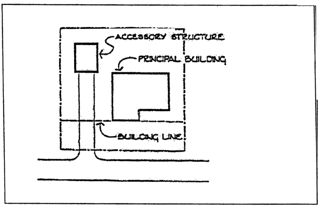
Figure 1: Accessory Structure
Addition. (To an existing building). Any walled and roofed expansion to the perimeter of a building in which the addition is connected by a common load-bearing wall other than a firewall. Any walled and roofed addition that is connected by a firewall or is separated by independent perimeter load-bearing walls is new construction.
Agricultural. The commercial cultivation or growth from the land of agronomic, horticultural, floricultural, forestry, dairy, livestock, poultry, and apiarian products.
Agricultural equipment. Agricultural equipment consists of farm field and farmstead machinery used for the production of crops and agricultural livestock, horticulture and landscaping. The following is a nonexhaustive list of examples meeting the above criteria:
Wheel and track-laying agricultural tractors, planting and fertilizing machinery, tillage equipment, fertilizer and chemical application equipment, harvesting machinery, haying and mowing machinery, milking machines and other farm dairy equipment, poultry equipment, barnyard equipment, sprayers and irrigation equipment, grain dryers and blowers, commercial turf and grounds care equipment, wagons, trailers and parts for farm machinery.
Alley. A public thoroughfare which affords only a secondary means of access to abutting property.
Alteration. Any change in the supporting members of a building or structure such as bearing walls, columns, and girders, except such emergency change as may be required for safety purposes; any addition to a building; any change in use from that of one district classification to another; or, any movement of a building from one location to another.
Anaerobic digester. An enclosed vessel that processes organic material under anaerobic conditions to produce biogas and digestate.
Animal Husbandry. The production of animals (livestock) and/or the by-product thereof.
Animal quarters. Any structure which surrounds or is used to shelter, care for, house, feed, exercise, train, exhibit, display or show any animals, other than fenced pasture land for grazing.
Apartment. See "Dwelling, multi-family".
Bed and breakfast home. A single-family dwelling occupied by the owner as his/her principal residence that offers transient lodging accommodations and breakfast for compensation provided that: the rental occupants shall not reside at the bed and breakfast for more [than] seven consecutive days; breakfast is the only meal served and only to registered overnight guests; no person not a resident on the premises is employed; the exterior appearance of the dwelling is not altered from its residential character except for safety purposes; and, the identification sign shall be no larger than two square feet and not internally lighted.
Bed and breakfast inn. A building, not necessarily owner-occupied, that offers transient lodging accommodations and breakfast for four or more guest rooms for compensation provided that:
(1)
It complies with the same licensing, inspection and taxation requirements as hotels, motels, and restaurants.
(2)
If within a residential district, the building shall be residential in character.
(3)
Breakfast is the only meal served and only to overnight guests.
(4)
The owner shall provide one off-street parking space for each rental room and one space for each employee.
(5)
In a residential district, signage shall be limited to one sign and maximum size of two square feet.
Bioenergy processing facility. A facility that converts organic waste materials like food scraps, animal manure, and agricultural waste into renewable energy, such as biogas, and nutrient-rich soil amendments. These facilities use processes like anaerobic digestion or combustion to break down organic matter, producing electricity, heat, or renewable natural gas, and byproducts like digestate.
Biogas. A renewable energy source that can be used in variety ways, such as to fuel engines and supply homes and businesses through the natural gas pipeline.
Boarding house. A dwelling, permanently occupied by the owner or operator, where sleeping accommodation and meals served upon the table family style with no provision for cooking in any of the occupied rooms are provided for five or more persons not of the same family by prearrangement for definite periods and for compensation.
Buffer. A portion of a lot set aside for screening or blocking noise, light, glare, visual
or other nuisances; to block physical passage to dangerous areas; or to reduce air
pollution, dust, dirt, and litter. A buffer may contain a vegetated area or other
barriers, such as a berm, wall or fence. See Figure 2: Buffer.
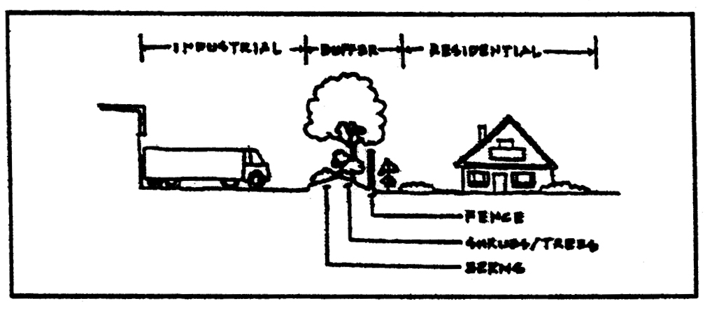
Figure 2: Buffer
Building. Any structure having a roof supported by columns or walls designed or built for the support, enclosure, shelter, or protection of persons, animals, chattels, or property of any kind.
Building height. The vertical distance measured from the highest grade adjacent to the highest point of roof surface of a flat roof, to the deck line of a mansard roof, or to the average height between eaves and ridges of a gable, hip, or gambrel roof.
Building setback line. A line establishing the minimum allowable distance between the main or front wall of a principal building and the street right-of-way line or another building wall and a side or rear property line when measured perpendicularly thereto. Covered porches, whether enclosed or not, shall be considered as a part of the building and shall not project into any required yards. For purposes of this ordinance, a building setback line and minimum required yard shall be considered the same. (See setback line.)
Business service establishment. A facility engaged in support functions to establishments operating for a profit on a fee or contract basis, including, but not limited to: advertising agencies, photocopying, blueprinting and duplication services, mailing agencies, commercial art and graphic design, personnel supply services and employment agencies, computer and data processing services, detective, protective, and security system services, accounting, auditing, and bookkeeping services, publications and business consulting firms, food catering, interior decorating, and locksmiths.
Caretaker dwelling or employee residence. An accessory single-family dwelling placed on an occupied tract for use by a farm worker or other tract owned by the same owner of the agricultural activity and that is a part of the same farming operation.
Cemetery, private. Any plot of ground, building, mausoleum, or other enclosure used for the burial of deceased persons of one collateral line of descent.
Cemetery, public. A plot of ground, building, mausoleum, or other enclosure not located on property owned by or adjacent to a religious institution but used for the burial of deceased persons.
Cemetery, religious institution. A plot of ground, building, mausoleum, or other enclosure owned by or adjacent to a religious institution and used for the burial of deceased persons who are generally members of that religious institution.
Child care facility. A building or portion of a building wherein care and supervision of 19 or more persons away from their place of residence for less than 24 hours per day on a regular basis is provided for compensation and is licensed by the State of Georgia. For children, the outdoor play area shall be enclosed by a fence of not less than four feet in height in the rear yard only. For the purposes of this ordinance, the term "child care" shall include but not be limited to the terms "day care", "nursery school", "early learning center", "pre-kindergarten", "private kindergarten", "play school", and "pre-school".
Child Care home, family. A home occupation which provides care and supervision for six or less persons who are not residents of the premises, by a State of Georgia registered resident adult for less than 24 hours per day on a regular basis for compensation.
Child care center, group. A building or portion of a building wherein care and supervision of seven to 18 persons away from their place of residence for less than 24 hours a day is provided on a regular basis for compensation and is licensed by the State of Georgia.
Church. A religious institution that has been granted 501(c) tax exempt status by the Internal Revenue Service and whose property is deemed tax exempt by the Murray County Tax Assessor.
Clinic. A building or a portion of a building where patients are not lodged overnight, but are admitted for examination and treatment by one or more physicians or dentists practicing together.
Club, private. A building or portion thereof or premises owned or operated by a corporation, association, person or persons for a social, educational or recreational purpose but not primarily for profit or to render a service which is customarily carried on as a business.
Commissioner. The Murray County Commissioner.
Comprehensive plan. The joint Murray county and cities of Chatsworth and Eton Comprehensive Plan, as adopted and as may be subsequently amended by Murray County.
Conditional uses. A use not ordinarily permitted but which may be permitted upon the imposition of conditions related to the promotion of the public health, safety, morals, or general welfare and designed to minimize the negative impact on surrounding lands. Such conditions may include, but are not limited to, restriction on land use; height, setback and other non-use requirements; physical improvements to the property and infrastructure serving the property. A conditional use must be approved as specified in the Murray County Land Use Procedures and Standards Ordinance (Ordinance #52).
Condominium. A building or group of buildings, in which units are owned individually, and the structure, common areas and facilities are owned by all the owners on a proportional, undivided basis.
Confined feeding operation. Confinement of 50 or more animals in buildings or lots with less than 50 percent ground cover for a period of 45 days or more over a 12-month period.
Development. Any man-made change to improved or unimproved real estate, including, but not limited to, buildings or other structures, mining, dredging, filling, grading, paving, excavating, drilling operations, or permanent storage of materials.
Digestate. The residual solids or liquids remaining after organic material has been processed in an anaerobic digester. Digestate is rich in nutrients and can be used as animal bedding, fertilizer, and solid amendment. Digestate is also a foundation material for bio-based products such as bioplastics.
District. A delineated section or sections of Murray County for which regulations governing the use of buildings and premises, the height of buildings, the size of yards, and the intensity of use are uniform.
Drive-in. Any use providing the opportunity of selling, serving, or offering goods or services directly to customers waiting in vehicles or customers who return to their vehicles to consume or use the goods or services while on the premises of the principal use.
Dwelling. A building which is designed or used exclusively for residential purposes, including single-family, and multi-family buildings, rooming and boarding houses, fraternities, sororities, dormitories, manufactured homes, and industrialized homes but not including hotels and motels.
Dwelling, apartment. See "Dwelling, multi-family".
Dwelling, loft. A dwelling unit located on the floor(s) above a ground level commercial business.
Dwelling, single-family attached. A building containing two or more dwelling units, each of which is deeded with separate ownership and has primary ground floor access to the outside and which are attached to each other by party walls without openings. The term can include fee-simple townhouses and condominiums.
Dwelling, single-family detached. A residential building containing not more than one dwelling unit entirely surrounded by open space. A single-family detached dwelling includes site-built houses, manufactured homes and industrialized homes. All single-family detached dwellings are further defined by compatibility standards as provided in section 6.3.
Dwelling, multi-family. A building designed as two or more separate units for or occupied exclusively by two or more families.
Dwelling unit. One or more rooms located within a building and forming a single habitable unit with individual permanent sanitary and kitchen facilities and is used or intended to be used for living, sleeping, cooking, and eating purposes. Units in motels, or other structures designed for transient residence are not included.
Easement. The right of a person, government agency, or public utility company to use public or private land owned by another for a specific purpose.
Event center. A facility used for weddings, anniversaries, birthdays, showers, reunions, recitals, dances, and ethnic and religious celebrations, etc. The accommodations can include sleeping, eating, and recreation. The site shall be of sufficient size to accommodate all off-street parking associated with an individual event.
Existing construction. Any structure for which the "start of construction" commenced before the effective date of this ordinance.
Family. One or more individuals permanently occupying a dwelling unit and living as a single housekeeping unit, as distinguished from persons occupying a boarding house, group home, or hotel, as defined in this ordinance.
Farm dwelling. Any residence owned or occupied by the farm owners, operators, tenants, or seasonal or year-round hired workers.
Feedstock. Any organic material used in the production of mulch or compost or processed in an anaerobic digester.
Flea market. A building or open area in which stalls or sales areas are set aside, and rented or otherwise provided, and which are intended for use by various unrelated individuals to sell articles that are either homemade, homegrown, handcrafted, old, obsolete, or antique and may include the selling of goods at retail by businesses or individuals who are generally engaged in retail trade.
Flood. A rise in stream flow or stage that results in temporary inundation of the areas adjacent to the channel.
Floor area, gross. The gross heated areas of all floors, measured from the exterior faces of the exterior walls of the building.
Frontage, street. The distance of a lot abuts on a street; the front lot line (See Figure 3: Lot).
Fur farm. Any place that regularly breeds and raises rabbits, mink, foxes or other fur or hide-bearing animals for the harvesting of their skins.
Garage, private. An accessory building designed or used for the storage of motor-driven vehicles owned and used by the occupants of the buildings to which it is accessory.
Garage, general service. A building or portion thereof, other than a private, storage, or parking garage, designed or used for equipping, servicing, repairing, hiring, selling, or incidental short term storing of motor-driven vehicles, but not including the storage of wrecked or junked vehicles, to which repairs are not intended to be made.
Grade. The average level of the finished ground surface adjacent to the exterior walls of the building.
Group home. A residence composed of non-related individuals with one or more surrogate parents that function as a singular housekeeping unit. All group homes shall be approved and licensed by the State of Georgia Department of Human Resources.
Halfway house/rehabilitation center. A building for temporary residence by non-related persons, who are recovering from alcohol abuse or other chemical-based substances, or transitional or conditional release from a correctional facility, or in lieu of incarceration by court order, with one or more surrogate parents that provide services that may include room, meals, supervision, rehabilitation, drug testing and counseling to enable residents to move back into society and live independently.
Hardship. An unusual situation on the part of an individual property owner, which will not permit him/her to enjoy the full utilization of his/her property, which is given to others within the county. A hardship exists only when it is not self-created, or when it is not economic in nature.
Hazardous waste. Any solid waste which has been defined as a hazardous waste in regulations, promulgated by the administrator of the United States Environmental Protection Agency (US EPA) pursuant to the federal act, which are in force and effect on February 1, 1988, codified as 40 C.F.R. Section 261.3.
Health department. The Murray County Health Department and/or the Georgia Department of Human Resources.
Health officer. The legally designated health authority of Murray County, or the State of Georgia, or an authorized agent.
Heated floor area. The gross heated living area, measured from the exterior faces of the exterior walls of the building, exclusive of basements, decks, porches, garages, and living areas having clear headroom of less than five feet.
Home occupation. An occupation carried on by an occupant of a dwelling unit as a secondary use, which is clearly incidental to the use of the dwelling unit for residential purposes and operated in accordance with the provisions of these regulations.
Horticulture. The cultivation of fruits, vegetables, flowers, and plants.
Impervious surface. A man-made structure or surface, which prevents the infiltration of storm water into the ground below the structure or surface. Examples are buildings, roads, driveways, parking lots, decks, swimming pools, or patios.
Industrialized home. Any structure or component thereof which is wholly or in substantial part made, fabricated, formed, or assembled in manufacturing facilities for installation on a building site and has been manufactured in such a manner that all parts or processes cannot be inspected at the installation site without disassembly, damage to, or destruction thereof. Industrialized buildings are constructed and regulated in accordance with the "Industrialized Building Act", Georgia Law 1982 pp. 1637—1643 (Official Code of Georgia Annotated, Title 8, Chapter 2, Article 2, Part 1).
An industrialized home is a single-family detached dwelling and its placement in a residential district must meet the compatibility standards as provided in section 6.3.
Institution. A public or semi-public building occupied by a governmental entity, non-profit corporation or non-profit establishment for public use.
Junk. Wrecked or inoperative motor vehicle(s), scrap copper, scrap brass, scrap rope, scrap glass, scrap rags, scrap metal, scrap paper, scrap batteries, scrap appliance, scrap beds and bedding, scrap rubber, scrap tires, scrap motor vehicle parts, scrap furniture, scrap wood, scrap building materials, scrap tools or other used materials that have been abandoned from their original use but may or may not be used again in their present form or in a new form.
Junkyard/salvage yard/wrecking yard. A lot, parcel of land, structure, individual, or part thereof, involving the storage, disassembly or processing of wrecked automobiles, trucks, other vehicles, equipment, machinery or commercial/residential appliances. Such uses shall be considered junkyards whether or not all or part of such operations are conducted inside a building or in conjunction with, addition to, or accessory to other uses of the premises.
Kennel. Any location where breeding, raising, boarding, caring for, and the keeping of more than three dogs or cats or other small animals or combination thereof (except litters or animals not more than 6 months of age) is carried on for commercial purposes.
Kindergarten. Any premises or portion thereof used for educational work or parental care of children of less than the age required for enrollment in the public or private school system.
Land-disturbing activity. Any grading, scraping, excavating, or filling of land, clearing of vegetation; and any construction, rebuilding, or alteration of a structure. Land-disturbing activity shall not include activities such as ordinary maintenance and landscaping operations, individual home gardens, yard and grounds upkeep, repairs, additions or minor modifications to a single family dwelling, and the cutting of firewood for personal use.
Livestock. The "livestock" as used herein shall mean and include cattle, horses, goats, sheep, swine, poultry, ducks, geese and other fowl; and rabbits, minks, foxes, and other fur or hide bearing animals customarily bred or raised in captivity for the harvesting of their skins; whether owned or kept for pleasure, utility or sale.
Loading space. A space having a minimum dimension of 13.5 by 60 feet and a vertical clearance of at least 14.5 feet within the main building or on the same lot, providing for the standing, loading, or unloading of trucks.
Lot. A parcel of land separated from other parcels by description (such as on a subdivision plat of record or as a survey map or plat) or by metes and bounds, and intended for use, transfer of ownership, or for building development.
Lot area, minimum. The smallest permitted total horizontal area within the lot lines of a lot. Lot area shall not include any portion of a dedicated right-of-way. Lot size square footage calculations shall exclude any areas reserved for rights-of-way upon which construction is prohibited (i.e., easements for ingress and egress to other lots or properties, major power line transmission easements, etc.). Lot size calculations shall not include strips of property with widths less than the minimum building line dimension of the particular use district intended to provide access to a given lot or parcel; provided, however, land less than the minimum building width requirements may be considered as part of the square footage lot size calculation in those instances where lots lines are radial to a curved street or cul-de-sac on a subdivision plat approved by the Planning Commission.
Lot, corner. A lot abutting upon two or more streets at their intersection.
Lot, through. A lot other than a corner lot abutting two streets.
Lot of record. A lot which exists prior to the first published notice or subsequent amendment of this ordinance, as shown or described on a plat or deed in the records of the local registry of deeds.
Lot width. The width of the lot at the front building setback line.
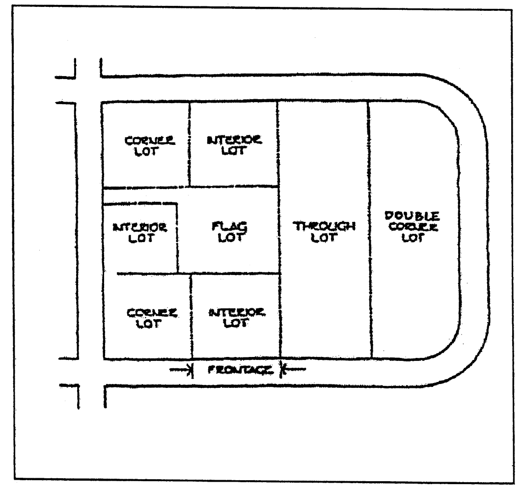
Figure 3: Lot
Manufactured home. A structure defined by and constructed in accordance with the National Manufactured Housing Construction and Safety Standards Act of 1974 as amended, 42 U.S.C. 5401, et seq. The definition at the date of adoption of this part is as follows:
Manufactured home means a structure, transportable in one or more sections, which, in the traveling mode, is eight body feet or more in width or 40 body feet or more in length, or, when erected on site, is 320 or more square feet, and which is built on a permanent chassis and designed to be used as a dwelling with or without a permanent foundation when connected to the required utilities, and includes the plumbing, heating, air-conditioning, and electrical system contained therein; except that such term shall include any structure which meets all the requirements and the manufacturer voluntarily files a certification required by the Secretary of Housing and Urban Development complying with the standards established under this title.
A manufactured home is a single-family detached dwelling and its placement in a residential district must meet the compatibility standards as provided in section 6.2.
Manufactured home/mobile home park. Premises where three or more mobile home/manufactured home dwelling units are parked for living or sleeping purposes, regardless of whether or not a charge is made for such accommodation, or where spaces or lots are set aside and offered for rent for use by mobile homes/manufactured homes for living or sleeping purposes, including any land, building, structure or facility used by occupants of mobile homes/manufactured homes on such premises. This definition shall not include mobile homes/manufactured homes sales lots.
Manure storage structure. A structure, either covered or uncovered, used to store manure from a confined feeding operation, which has walls and a floor constructed of concrete, concrete block, wood, steel, or similar materials.
Mobile home. A structure, transportable in one or more sections, which, in the traveling mode, is eight body feet or more in width or 40 body feet or more in length or, when erected on site, is 320 or more square feet and which is built on a permanent chassis and designed to be used as a dwelling with or without a permanent foundation when connected to the required utilities and includes the plumbing, heating, air-conditioning, and electrical systems contained therein and manufactured prior to June 15, 1976.
Mobile office. A factory fabricated structure designed to be transported on its own wheels, detachable wheels, flatbed or trailer and used or intended to be used or occupied for the transportation of business or the rendering of a professional service.
Modular home. See "Industrialized home".
Motel. A permanent building or group of permanent buildings in which overnight sleeping accommodations are provided for travelers and having a parking space near or adjacent to the entrance of the room. Such use has 80 percent of the rooms occupied by a different registered guest every five days, provides patrons with daily maid service, 24 hour desk/counter clerk service, and a telephone switchboard service to receive incoming/outgoing messages, and shall comply with the applicable requirements of the County Health Department and O.C.G.A. § 31-28-1 et seq., and may provide additional services such as restaurants, retail gift shops, meeting rooms, swimming pools, and exercise facilities.
Multi-family dwelling. See "Dwelling, multi-family".
Murray County. A political subdivision of the State of Georgia, which includes its governing authority, the commissioner, any and all departments of the county, and any other agency or entity created by the county.
Neighborhood center. A building or facility used to provide recreational, social, educational and cultural activities for an area of community, which is owned and operated by the management agency of that community, or the Homeowner's Association of that community. A community can be an incorporated area, a developed subdivision, or a planned development.
New construction. Any structure for which the "start of construction" commenced on or after the effective date of this ordinance.
Non-conforming use. The use of any building or land which was lawful at the time of passage of this ordinance, or amendment thereto, but which use does not conform, after the passage of this ordinance or amendment thereto, with the regulations of the district in which it is situated.
Nursery school. See "Kindergarten".
Nursing home. An extended or intermediate care facility licensed or approved to provide full-time convalescent or chronic care to individuals who, by reason of advanced age, chronic illness or infirmity, are unable to care for themselves.
On-site sewage management system. See "Sewage management system, on-site".
Parking area. An open, unoccupied space used or required for temporary parking of vehicles exclusively and in which no gasoline or vehicular accessories are sold or no other business is conducted.
Parking lot. An open area used exclusively for the temporary storage of motor vehicles and within which motor fuels and oils may be sold and fees charged, but no vehicles are to be equipped, repaired, or sold.
Parking space. A space, enclosed or unenclosed, having an area of not less than 180 square feet (nine ;ft; × 20;ft;) exclusive of access, permanently reserved for the temporary storage of one vehicle and having access to a street or alley.
Permit. Any written authorization for building, construction, alteration, development, occupancy, or other matter required by this ordinance to be approved a designated commission, board, official, or employee. The person to whom such permit is issued shall be known as the "permittee."
Personal care home or home. Any dwelling, whether operated for profit or not, which undertakes through its ownership or management to provide or arrange for the provision of housing, food service, and one or more personal services for two or more adults who are not related to the owner or administrator by blood or marriage. For the purpose of these rules, Personal Care Homes shall be classified as: Family care personal care home, group personal care home, or congregate personal care home. This term does not include buildings, which are devoted to independent living units, which include kitchen facilities in which residents have the option of preparing and serving some or all of their own meals or boarding facilities, which do not provide personal care.
(1)
"Family personal care home" means a home for adults in a family type residence, noninstitutional in character, which offers care to two through six persons.
(2)
"Group personal care home" means a home for adult persons in a residence or other type building(s), noninstitutional in character, which offers care to seven through 15 persons.
(3)
"Congregate Personal Care Home" means a home for adults, which offers care to 16 or more persons.
Planned center, shopping, office or industrial. Any planned concentration of at least three business establishments, which also provides planned and shared parking, access, and service.
Planning commission. The Murray County Land Use Planning Commission.
Plat. A map, plan or layout of a county, city, town, lot, section, subdivision, or development indicating the location and boundaries of properties.
Premises. A lot, together with all buildings and structures existing thereon.
Principal building. A building in which is conducted the main or principal use of the lot in which said building is situated.
Principal use. The primary purpose for which land or a building is used.
Private land. All lands and buildings not owned by governments.
Producer. The owner or operator of the confined feeding operation.
Putrescible wastes. Wastes that are capable of being quickly decomposed by microorganisms. Examples of putrescible wastes include but are not necessarily limited to kitchen wastes, animal manure, offal, hatchery and poultry processing plant wastes, and garbage.
Recorded plat. A plat recorded in the Office of the Clerk of Superior Court of Murray County.
Right-of-way. An area or strip of land, either public or private, on which a right of use has been recorded. A right-of-way, as distinguished from an easement, is owned in fee-simple title by Murray County or other government, a duly organized homeowners' or property owners' association, or any other person.
Right-of-way line. The dividing line between a lot, tract, or parcel of land and a contiguous right-of-way.
Rooming house. A dwelling, permanently occupied by the owner or operator, where only sleeping accommodation is provided for five or more permanent occupants not of the same family by prearrangement for definite periods and for compensation and which makes no provision for cooking in any of the occupied rooms.
Service station. Any building, structure, or land use that is primarily used for the dispensing, sale, or offering for sale at retail any automobile fuels, oils, or accessories, but not including major repair work such as motor overhaul, body and fender repair or spray painting.
Setback. The mean horizontal distance between the front street right-of-way line and the front line of the building or the allowable building lines as defined by the front yard regulations of this ordinance.
Sewage management system, on-site. A sewerage management system other than a public or community sewerage system, serving single or multiple buildings, manufactured or mobile homes, residences or other facilities designed for human occupancy or congregation, as approved by the county board of health.
Sewage treatment system, public or community. Any sewage treatment system, including pipe lines or conduits, pumping station, force mains and all other constructions, devices, and appliances appurtenant thereto, designed for treating or conducting sewerage for treatment and disposal into lakes, streams or other bodies of surface water.
Shopping center. A group of two or more commercial establishments planned, constructed and managed as a total entity with customer and employee parking provided on-site, provision for goods delivery separated from customer access, aesthetic considerations and protection from the elements.
Start of construction. Means erection of temporary forms, pouring of slabs or footings, installation of piers or columns; or the actual start of a building or altering a structure either temporary or permanent.
Stockyard. A place where transient cattle, sheep, swine, or horses are kept.
Story. That portion of a building between the surface of a floor and the surface of the floor next above it, or, if there is no floor above it, then the space between the floor and the ceiling.
Story, half. A space under a sloping roof which has the line of intersection of roof decking and wall face not more than three feet above the top floor level, and in which space not more than two-thirds of the floor area is finished off for use. A half-story containing independent apartment or living quarters shall be counted as a full story.
Street. A public or private thoroughfare which meets locally established design standards and which affords the principal means of access to abutting property however designated as a street, highway, thoroughfare, parkway, road, avenue, boulevard, or place.
(1)
Minor or local street. Street used primarily for access to the abutting properties and serving travel demands in the immediate area.
(2)
Collector. Those streets so designated on the Georgia D.O.T. Functional Classification System Map, and those streets which otherwise function to serve local traffic movements by collecting or distributing traffic from or to local, other collector, and/or arterial streets.
(3)
Major thoroughfare or arterial. Those streets so designated on the County Functional Classification System Map and those streets which otherwise function to move high volumes of traffic between principal traffic generators (such as residential, commercial, and industrial sectors) at moderate speeds and with minimum conflict to movements.
Structure. Anything constructed or erected, the use of which requires a location on the ground, or attached to something having a location on the ground, including but not limited to buildings, signs, billboards, back stops for tennis courts, fences, radio and water towers, grain and feed elevators.
Townhouse. See "Dwelling, multi-family".
Tree. A woody perennial plant having a single (usually elongate) main stem including but not limited to a shrub or vine of arboreal form.
Water systems.
Public water system. A system for the provision to the public of piped water for human consumption, if such system has at least 15 service connections, or regularly serves an average of at least 25 individuals daily, at least 60 days out of the year in accordance with the rules of Georgia Department of Natural Resources, Environmental Protection Division, Chapter 391-3-5, "Rules for safe drinking water."
Governmental public water system. A public water system, which is owned and operated by a governmental entity, or a legislatively created authority.
Non-governmental public water system. A public water system, which is owned and operated by any non-governmental entity.
Community water system. A system serving more than one single-family dwelling but fewer than the connections and/or persons required to be considered a public water system. Such systems are subject to approval of the Murray County Health Department.
Individual water supply system. A system of piping, pumps, tanks, or other facilities, which utilizes groundwater to supply a single-family dwelling.
Wild animal. Any living member of the animal kingdom, including those born or raised in captivity; but excluding human beings, livestock, dogs and cats, rodents, hybrid animals that are part wild, captive-bred species of common cage birds and aquarium-kept fish, amphibians and reptiles.
Yard. An open space on a lot situated between the principal building or use on the lot and a lot line and unoccupied by any structure except as otherwise provided herein. See Figure 4: Yard.
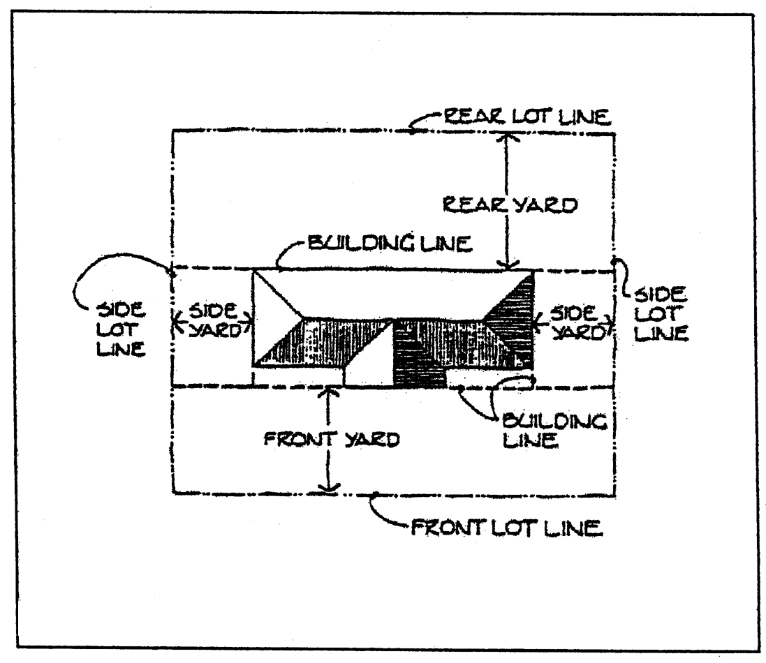
Figure 4: Yard
Yard, front. An open, unoccupied space on the same lot with a principal building or use, extending the full width of the lot and located between the right-of-way line and the front line of the building projected to the side lines of the lot.
Yard, rear. An open space on the same lot with a principal building or use, unoccupied except by an accessory building or use, extending the full width of the lot and located between the rear line of the lot and the rear line of the building or use projected to the side lines of the lot.
Yard, side. An open, unoccupied space on the same lot with a principal building or use, located between the building or use and the side line of the lot and extending from the rear line of the front yard to the front line of the rear yard. See Figure 4: Yard.
(Ord. No. 53, 8-5-2003; Ord. No. 53, Amend. No. 1, 12-15-2004; Ord. No. 53, Amend. No. 3, 7-5-2005; Amend. No. 11, § (1), 11-6-2011; Amend. of 7-1-2014; Amend. of 2-1-2016; Amend. of 2-21-2018; Amend. of 11-6-2018(1); Amend. of 12-20-2025(1))
[Sec.] 4.1 - Use of land.
No land shall be used except for a purpose permitted in the district in which it is located.
(Ord. No. 53, 8-5-2003)
[Sec.] 4.2 - Use of buildings.
No building or structure shall be erected, converted, enlarged, reconstructed, moved, structurally altered or used, except for a use permitted in the district in which such building or structure is located.
(Ord. No. 53, 8-5-2003)
[Sec.] 4.3 - Location of buildings.
Every building hereafter erected, converted, enlarged, reconstructed, moved or structurally altered shall be located on a lot as herein defined except as approved by the Board of Appeals under Article 12.
(Ord. No. 53, 8-5-2003)
[Sec.] 4.4 - Height of buildings.
No building shall be erected, converted, enlarged, reconstructed, moved or structurally altered to exceed the height limit herein established for the district in which such building is located except for the following:
(Ord. No. 53, 8-5-2003)
[Sec.] 4.5 - Minimum space requirements.
No building or use shall be erected, converted, enlarged, moved or structurally altered except in conformity with the minimum lot area or other space requirements for the district in which such building is located.
(Ord. No. 53, 8-5-2003)
[Sec.] 4.6 - Temporary buildings.
Temporary buildings shall not be permitted in any district except when they are used in conjunction with construction work or pending completion of a permanent building. Such building shall be used for a period not to exceed one year and shall be removed when the construction of the permanent building is completed.
(Ord. No. 53, 8-5-2003)
[Sec.] 4.7 - Number of single family detached dwellings per lot.
No more than one single-family dwelling shall be permitted on a lot in all zone districts except AG. In the AG zone there may be up to four single-family residential dwellings on any parcel of land under single ownership (three plus the owner's dwelling) where the following conditions can be met:
4.7-1
AG District.
a.
The additional dwellings may be occupied by either blood relatives to the owner of the property and said blood relationships shall extend to but not beyond the second descending and ascending generation, or full time caretaker employees of the property owner who are part of the farming operations and responsible for the agricultural production of the property.
b.
No commercial use of the second, third, or fourth dwelling will be allowed and no rental charge can be placed on these residential uses.
c.
Individual power supply sources shall be provided to each dwelling and each utility installation shall meet such standards as have been adopted by local authorities.
d.
Permits for construction will not be issued prior to the approval of each of the aforementioned conditions by the land development officer. In addition the land development officer must approve changes in use or occupancy.
(Ord. No. 53, 8-5-2003; Ord. No. 53, Amend. No. 1, 12-15-2004)
[Sec.] 4.8 - Number of principal buildings per lot.
Except for the following uses, only one principal building, together with its customary accessory buildings, shall be permitted to occupy each lot:
•Single family detached dwellings in the agriculture district as specified in [Sec.] 4.7
•Public/institutional buildings.
•Multiple-family dwellings in the multi-family residential district.
•Commercial/industrial buildings in the neighborhood commercial, highway commercial and industrial districts.
The above provisions shall not be construed to allow the erection of any building or portion of a building outside of the buildable area of the lot or the intermingling of uses.
(Ord. No. 53, 8-5-2003)
[Sec.] 4.9 - Use of yards.
The minimum yards, parking spaces and open spaces required for each building existing on the effective date of this appendix, or for any building hereafter erected or structurally altered, shall not be encroached upon or considered as part of the yard, parking space or open space required for any other structure, nor shall any lot area be reduced below the lot area per requirements of this appendix for the district in which such lot is located except as otherwise provided in this appendix.
(Ord. No. 53, 8-5-2003)
[Sec.] 4.10 - Requirements for building permit.
No building shall be erected, converted, enlarged, reconstructed, moved or structurally altered except upon application for and issuance of a building permit by the Building Inspector.
(Ord. No. 53, 8-5-2003)
Authority to require county building permit, O.C.G.A. § 36-13-2; county permitting process for mechanical, plumbing and electrical installations, O.C.G.A. § 48-13-29.
[Sec.] 4.11 - Streets.
Traffic control devices. If the traffic to be generated by a use in a non-residential district will demand traffic control devices to insure public safety, the developer shall install such necessary devices. Such determination shall be made by the Murray County Director of Public Works, in consultation with the Georgia Department of Transportation, and approved by the Murray County Commissioner.
State Department of Transportation approval. All entrances or exits of any street or drive, public or private, from or to any State highway, or any planned or in progress Department of Transportation reconstruction projects where the State does not own right-of-way, shall be approved by the State Department of Transportation prior to the construction of such street or drive, or the issuance of any development permit for any improvement to be served by such street or drive.
(Ord. No. 53, 8-5-2003)
State Law reference— Road systems, O.C.G.A. § 32-4-1; powers and duties regarding roads, O.C.G.A. § 32-4-40 et seq.
[Sec.] 4.12. - Use of fences.
With the exception of the Agriculture Zone District, the use of agriculture type fencing is prohibited in all other zone districts, except when approved in conjunction with a conditional use as outlined in the Murray County Land Use Standards and Procedures Ordinance.
(Amend. of 7-1-2014)
[Sec.] 4.13 - Halfway house/rehabilitation center.
In compliance with O.C.G.A. § 36-66-4, any such halfway house, drug rehabilitation center, or other such facility for the treatment of drug dependency, location or relocation, shall require a public hearing at least six months and not more than nine months prior to the date of final action on any zoning decision (i.e., rezoning, annexation, or conditional use review). A sign posted on the subject property and a published notice shall contain a prominent statement that the proposed zoning decision relates to or will relocate a halfway house, drug rehabilitation center, or other facility for the treatment of drug dependency. The above public hearing is in addition to the public hearing that may be required nearest to making a zoning decision per the requirements of appendix B, land use procedures and standards ordinance, of The Code of Murray County. The latter posted and published notices shall appear at least 15 days and not more than 45 days prior to the date of this public hearing. In either public hearing, the published notice shall be at least six column inches in size and shall not be located in the classified advertising section of the newspaper.
(Amend. of 7-1-2014)
[Sec.] 5.1 - Establishment of districts.
In order to carry out the intent and purpose of this appendix, unincorporated Murray County is hereby divided into the following districts:
5.1-1
Agricultural (AG). This zoning district is comprised primarily of open farm land and land used for intensive agricultural, livestock and poultry production and forestry activity. The intent of the regulations is to encourage maintenance of the rural character of openness and discourage the subdivision of land, which is better suited to agricultural and forestry usage. Permitted and conditional uses shall be as provided in Table 6.4.
5.1-2
Commercial agriculture district (CA). This district is designed to accommodate a large-scale farming operation geared toward production of crops, livestock and confined feeding operations, for commercial purposes with widespread distribution to wholesalers or retail outlets. Permitted and conditional uses shall be as provided in Table 6.4.
5.1-3
Rural residential district (RR). This district is intended to permit a combination of low density residential uses of various types, limited agricultural activities, and other uses commonly found in rural areas. Low density development is required because areas may lack adequate public water and/or environmental constraints such as poor soils and steep slopes are present. Permitted and conditional uses shall be as provided in Table 6.4.
5.1-4
Suburban residential district (SR). The purpose of this district is primarily to provide for single family residential development with a limited number of other uses. Permitted and conditional uses shall be as provided in Table 6.4.
5.1-5
Multi-family residential (MFR). This district is established as a medium density residential district allowing a minimum of two and a maximum of four dwelling units per lot. Multiple structures per lot shall be permitted in this district. Because of the increased density allowed in this district, any such lots shall be served by public water and shall meet the requirements of the Murray County Health Department for sewage disposal. Permitted and conditional uses shall be as provided in Table 6.4.
5.1-6
Manufactured home park district (MHP). This district is designed to encourage the development of manufactured home parks and related facilities within a well-planned environment. Permitted and conditional uses shall be as provided in Table 6.4.
5.1-7
Neighborhood commercial district (NC). This district is designed to provide suitable areas for the retailing of goods and the provision of services to adjacent and nearby residential neighborhoods. Permitted and conditional uses shall be as provided in Table 6.4; however, business and service establishments shall not exceed 2,500 square feet in size.
5.1-8
Highway commercial district (HC). The purpose of this district is to provide appropriate locations for a wide variety of commercial activities that will serve a large market area. This district will be generally located along the major arterial highways or where these highways meet. Emphasis is also placed on creating commercial nodes or cluster developments rather than strip developments. Permitted and conditional uses shall be as provided in Table 6.4.
5.1-9
Industrial district (I). The purpose of this district is to provide suitable areas for warehousing, distribution, manufacturing and other intensive activities of an industrial nature. Permitted and conditional uses shall be as provided in Table 6.4.
(Ord. No. 53, 8-5-2003; Amend. of 11-6-2018(1))
[Sec.] 5.2 - District map.
The boundaries of the land use districts are shown on the map designated as the "Official Land Use District Map." This map and all notations, references, and other information shown thereon are a part of this appendix and have the same force and effect as if the district map and all the notations, references and other information shown thereon were fully set forth and described herein, which district map is properly attested and is on file with the Murray County Clerk.
(Ord. No. 53, 8-5-2003)
[Sec.] 5.3 - District boundaries.
5.3-1
The district boundaries shown on the district map are generally intended to follow streets, alleys, or lot lines; where the districts designated on said map are bounded by such street, alley or lot line, the centerline of the street or alley or the lot line shall be the boundary of the district unless such boundary is otherwise indicated on the map. In all other cases, the district boundary line shall be determined by use of the scale appearing on the Land Use District Map.
5.3-2
When the boundary line of a district divides a lot or tract held in single ownership at the time of adoption of this ordinance, the boundary line may be allowed to extend a distance of not more than 50 feet to the least restricted land use district.
5.3-3
Upon initial adoption of this land use district ordinance, properties held in single ownership that contain more than one principal use will be considered for land use district designations appropriate for acknowledging the existing use(s) or in cases the where uses do not currently exist. Appropriate land use district designations will be considered for all or portions of property when such boundaries are consistent with the adopted Comprehensive Plan, Future Land Use Map. The existence of principal uses and the area assigned to such use shall be based upon objective physical evidence of separate actual uses of the parcel present at the site at which it occurs. Any disputes regarding actual principal uses shall be resolved pursuant to the procedures set forth in the Land Use Procedures and Standards Ordinance of Murray County for the redistricting of property.
(Ord. No. 53, 8-5-2003; Ord. No. 53, Amend. No. 2, 5-3-2005)
[Sec.] 6.1 - District lot area, yard and height standards.
The requirements regarding lot size, building size, and building placement on the lot for each district shall be met as indicated in Article 4: General Provisions, and Table 6.1: District Area, Yard, and Height Requirements.
Table 6.1: District Area Yard and Height Requirements
(Amend. of 6-5-2018(1); Amend. of 11-6-2018(1); Amend. of 2-3-2023(1))
Table 6.2
Subdivision Lot Sizing
To provide for the orderly and safe development of property utilizing on-site sewage management systems, minimum lot sizes have been established. Larger lot sizes may be required to meet the requirements of this rule depending on the proposed development of the property. County zoning authorities may require larger minimum lot sizes; the larger minimum lot sizes will take precedence.
1.
Lot sizing requirements are as follows for single family dwellings such as mobile homes, stick built homes, modular homes, etc. On individual lots in subdivisions and residential lots at large in the county.
Minimum (Min.) Lot Sizes, and Maximum (Max.) allowable Sewage Flow with Types of Water Supply System.
***Slope over 35 percent cannot be utilized for individual sewage disposal systems except in cases where special studies submitted by a Registered Engineer show that site modifications can overcome slope limitations. Said studies must meet current state guidelines.
A.
The above minimum lot sizes are for the typical size home (three bedroom) with basic appurtenances such as: driveway, minimum number of trees, and water supply line. For each additional bedroom over three, a minimum of 3,000 square feet per bedroom of useable soils area (suitable for use for an individual onsite sewage management system) shall be provided for installation of the individual sewage management system. At a minimum, 50 percent of the platted lot shall be useable soils exclusive of the building site, drive, right-of-way, easements and buffers; when served by public/community water, 30 percent when served by individual wells.
B.
The County Board of Health will also require larger lot sizes when physical factors indicate the need to do so. These factors include, but are not limited to, the availability of sufficient unobstructed land areas for an approved on-site sewage management system and approved replacement system, need for subsurface drainage or adverse topographic features or landscape position.
C.
Lots shall be a minimum width of 125 feet or 150 feet (single-family dwellings and duplexes—125 feet, multi-family—150 feet) in the area where an approved on-site sewage management system and replacement system are to be located.
1.
Where on-site sewage management systems and community or public water are used, minimum lot sizes may be reduced by up to 50 percent. However, no lot should be less than 30,000 square feet. No lot size reduction will be allowed on slopes of greater than 35 percent.
2.
The total area encompassed by the access easement or "panhandle" shall not be included in computing the functional area of the lot for sewage disposal purposes. [3]
3.
Lots utilizing drip emitter systems shall be a minimum of one and one-half acres.
4.
The maximum daily sewage flow for each lot or parcel of land shall not exceed 600 gallons/acre/day when served by non-public or individual water supply or 1,200 gallons/acre/day when served by a public water/common supply system. When sewage flows exceed these quantities (600 or 1,200 gallons/acre/day as indicated) for a given structure, the minimum lot size or parcel of land shall increased proportionally. All lots must have sufficient unobstructed land area for an approved on-site sewage management system and approved complete replacement system. Lots platted before the adoption of these rules and regulations which do not meet the minimum lot size may be approved provided there is sufficient area available to locate the proposed structure, on-site sewage disposal system, and other appurtenances and the complete replacement of the on-site sewage management system.
D.
For multi-family units (i.e. Duplexes, apartments, etc.) lot size shall be increased by 25 percent for each unit above the initial unit.
(Ord. No. 53, 8-5-2003; Ord. No. 53, Amend. No. 2, 5-3-2005; Amend. of 2-3-2023(1))
Note— Except allowed by Section 4.7
[Sec.] 6.2 - Dwelling compatibility standards.
All single family detached dwellings including site-built homes, industrialized homes, and manufactured homes must comply with the compatibility standards of the Land Use District where they are proposed to be located. When a building permit is sought, the land development officer shall make a determination if the proposed dwelling meets the compatibility criteria for the type allowed in the land use district as shown in Table 6.3.
If the land development officer finds that the proposed dwelling meets the compatibility criteria, approval of the building permit will be granted. Those who disagree with the land development officer's findings may appeal the decision through the board of appeals as described in article XII.
Table 6.3:
Compatibility Standards for
Single-Family Detached Dwellings
(Ord. No. 53, 8-5-2003)
[Sec.] 6.3 - Permitted uses.
Permitted and conditional uses shall be as provided in Table 6.4. Each use is mutually exclusive and does not encompass other uses listed in the table. A use denoted by the letter "X" means it is permitted outright. A use denoted by the letter "C" is permitted only if approval is granted by the Murray County Commission subject to the Murray County Land Use Procedures and Standards Ordinance, (Ordinance No. 52). A blank space means it is not permitted. For uses not included on this list and where the land development officer is unable to determine clear placement, application shall be made to the board of appeals for interpretation.
(Ord. No. 53, 8-5-2003; Ord. No. 53, Amend. No. 1, 12-15-2004)
Table 6.4:
PERMITTED USES
(Ord. No. 53, 8-5-2003; Ord. No. 53, Amend. No. 1, 12-15-2004; Ord. No. 53, Amend. No. 5, 12-5-2006; Ord. No. 53, Amend. No. 6, 3-3-2009; Ord. No. 53, Amend. No. 7, 12-1-2009; Amend. No. 9, 7-5-2011; Amend. No. 11, §§ (2), (3), 11-6-2011; Amend. of 7-1-2014; Amend. of 2-1-2016; Amend. of 2-21-2018; Amend. of 6-5-2018(1); Amend. of 6-5-2018(2); Amend. of 6-5-2018(4); Amend. of 6-5-2018(5); Amend. of 11-6-2018(1); Amend. of 9-7-2021(1), Amend. of 11-2-2021(1); Amend. of 12-20-2025(1))
Note— After the initial adoption of this land use district ordinance thru December 31, 2004, it is determined by the land development officer that a parcel of property was not designated to the correct land use district, due to improper or out-dated information, he/she may at their discretion designate said parcel to the appropriate land use district.
[Sec.] 7.1 - Buffer requirements between commercial livestock operations and residential uses.
When a property located within the commercial agriculture district proposes to engage in a confined feeding operation (CFO) adjacent to properties located within the rural residential, suburban residential, multi-family, manufactured home park, neighborhood commercial, highway commercial and industrial land use districts, or if properties located within these districts propose to develop adjacent to a CFO, either property or both properties (when both are initially undeveloped) will be subject to a 500-foot building or use setback including a 150-foot vegetated buffer from all adjoining property lines, regardless of land use district, as outlined in sections 7.4 and 7.5. This vegetative buffer shall extend along the entire portion of the property line abutting the CFO and extend 100 feet in each direction beyond the facilities as shown in the following illustration. Visual buffers that utilize natural vegetation or plantings, shall be of a size and thickness sufficient to provide a visual barrier between the CFO within 12 months from the completion of construction of the CFO. The use of existing vegetation is encouraged.
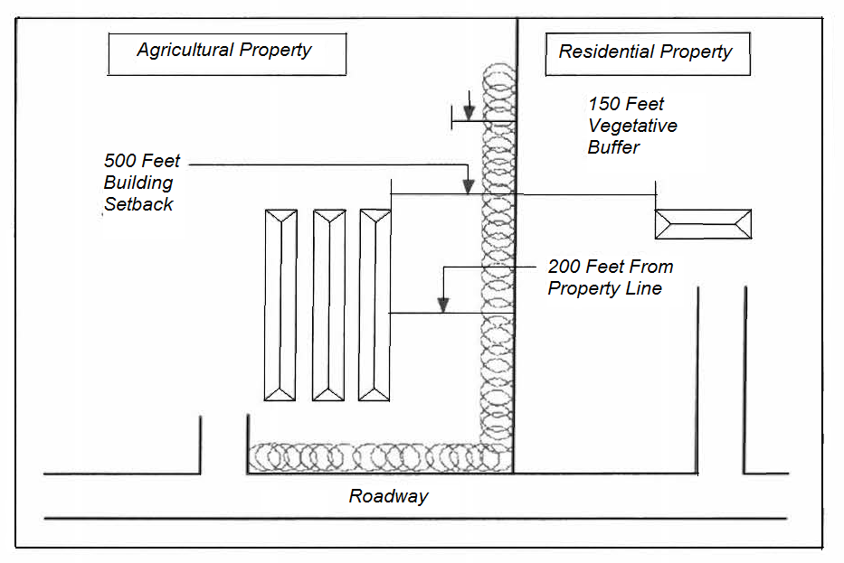
Illustration of Vegetative Buffer
(Ord. No. 53, 8-5-2003; Amend. of 8-1-2006(3); Amend. of 11-6-2018(1); Amend. of 9-7-2021(1), Amend. of 10-05-2021(1))
[Sec.] 7.2 - Buffer requirements between residential, commercial and industrial districts.
When two adjoining properties are in different land use districts, the property within the more intensive district is required to provide the buffer type as indicated in Table 7.1 when acquiring a building permit unless the buffer was pre-existing. When two adjoining vacant parcels are in different zone districts as indicated in Table 7.1, no buffer is required when the parcel in the less intensive district acquires a building permit.
Type A buffer requirement. The required buffer shall have not less than a 12-foot width and shall consist of plantings which meet the screening standards of section 7.3.
Type B buffer requirement. The required buffer shall have not less than a 30-foot width and shall consist of plantings plus a fence, wall (not otherwise a part of a structure), or a berm, or any combination thereof, which meets the screening standards of section 7.3.
(Ord. No. 53, 8-5-2003)
[Sec.] 7.3 - Screening standards.
Screening is a method of visually shielding or obscuring one use from another by fence, walls, berms or densely planted vegetation.
Plantings. Plantings shall consist of either trees or shrubs or any combination of both. Planted areas shall be located along the abutting property lines or in areas that will provide the best screening effectiveness.
If trees or large shrubs are used solely as the screening device, they shall be any evergreen species from the list provided by the land development officer which, under normal growing conditions, will attain a minimum height of eight feet and a canopy spread of ten feet within four years. They shall be planted a minimum 20 feet on center as shown in the following illustration.

Illustration of Trees and Large Shrubs for Screening
If trees are used in combination with shrubs, they may be of any species from the list provided by the land development officer. Small trees shall be planted 30 feet on center, and large trees 40 feet on center as shown in the following illustration. Shrubs shall be any evergreen species from the list provided by the Land Development Officer planted four feet on center as shown in the following illustration. Shrubs shall initially be of any size, which would normally attain a minimum height of six feet within three years after planting.
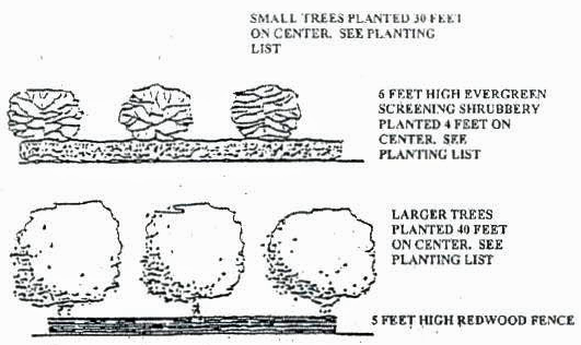
Illustration of Shrubs, Small Trees and Large Trees Plantings
Walls. Walls shall be of masonry construction and a minimum height of eight feet. The wall shall be placed on the edge of the buffer nearest the most intense land use.
Fences. Fences shall be a minimum of eight feet in height and constructed of standard wood fencing materials and methods or chain link with woven inserts that will provide 90 percent visual blockage as shown in the examples provided by the land development officer. The fence shall be placed on the edge of the buffer nearest the more intense land use.
Berms. Earthen berms shall have a minimum height of eight feet.
(Amend. of 7-1-2014)
[Sec.] 7.4 - Buffer design.
All buffers required by this article shall conform to the following specifications:
7.4-1
Prior to development, a buffer plan shall be required to show the types and locations of all plantings within a required buffer. If a site plan is required, a buffer plan shall be incorporated as part of the site development plan.
7.4-2
Landscaping within buffer areas shall be used to screen objectionable views or nuisances, such as parking and service areas, refuse containers, air conditioning units and transformers.
7.4-3
Existing on-site trees may be credited as meeting the requirements of this article if the land development officer determines that such plant materials achieve the purposes of this article.
(Ord. No. 53, 8-5-2003)
[Sec.] 7.5 - Location of buffers.
Buffers shall be located on the outer perimeter of a lot or parcel along all lot lines adjoining dissimilar districts including adjacent property lines, which may be separated by an existing or proposed public right-of-way. Buffers shall not be located on any portion of existing, dedicated, or reserved public or private street right-of-way.
(Ord. No. 53, 8-5-2003)
[Sec.] 7.6 - Variances.
The requirements of this article may be waived by the appropriate agency under any of the following conditions:
7.6-1
If it is clearly demonstrated that the existing topography and/or vegetation will achieve the purposes of this article.
7.6-2
If it is clearly demonstrated that for topographic reasons, no required screening device could possibly screen the ground level activities of the use from the first floor view of the residential structure abutting the use.
7.6-3
The adjoining property owners mutually agree in writing that the required buffer is not necessary for satisfactory use and enjoyment of their property rights.
7.6-4
It is clearly demonstrated that an existing (or proposed) public right-of-way separation between adjoining properties will achieve the purposes of this article.
[Sec.] 7.7 - Use of buffers.
A buffer may be used for some forms of passive recreation such as pedestrian, bike or equestrian trails, or as a storm water retention area provided that: 1) no planted materials shall be eliminated; and 2) the total width of the required buffer area shall be maintained.
(Ord. No. 53, 8-5-2003)
[Sec.] 7.8 - Maintenance.
The responsibility for maintenance of buffers shall remain with the owner of the property. Any required plant that has died shall be replaced. Maintenance of planted areas shall consist of mowing, removal of litter and dead plant materials, and necessary pruning. Fences and walls shall be kept in a condition that meets the requirements of this article.
(Ord. No. 53, 8-5-2003)
[Sec.] 7.9 - Failure to comply with these provisions.
See articles XV and XVIII of this appendix for enforcement and penalty provisions.
[Sec.] 7.10 - Surety for buffer installation.
When the date for issuing a certificate of occupancy does not coincide with the planting conditions that are necessary to install a required buffer, the land development officer shall accept a letter of credit or other acceptable surety for the buffer installation. Such surety shall be in the amount and form satisfactory to the land development officer and shall certify the following:
(1)
That the creditor does guarantee funds in an amount to cover the cost of installing all buffers as estimated and approved by the land development officer;
(2)
That in case of failure of the developer to complete the specified improvements, the creditor shall pay the government immediately, and without further action, such funds as are necessary to finance the completion of those improvements up to the limit of the secured credit; and
(3)
That the letter of credit or other surety may not be withdrawn or reduced in amount until released by the after final inspection and certification of approval of the buffer by the land development officer.
(Ord. No. 53, 8-5-2003)
[Sec.] 8.1 - Lots of record.
Any lot of record which is legal on the date of the first published notice of this appendix, may be used subject to the following exceptions and modifications:
8.1-1
Use of substandard lots. Where the owner of a lot at the time of the adoption or amendment of this appendix does not own sufficient area and width to enable him to conform to the dimensional requirements of this article, such lot may be used as a building site.
8.1-2
Individual lot not meeting minimum lot dimension requirements. In addition to section 8.1-1, in any residential district, any lot of record existing at the time of adoption or amendment of this appendix which has a width or area less than that required by this appendix may be used as a building site for a single-family dwelling only.
In the case of such a lot, when it is not possible to provide the required side yards and at the same time build a minimum width single-family dwelling, the Board of Appeals is empowered to hear the request for a minimum variance.
8.1-3
If two or more adjoining lots with continuous frontage are in a single ownership at any time after the adoption (or amendment) of this appendix and such lots individually are too small to meet the yard, width, or area requirements of the district in which they are located, such groups of lots shall be considered as a single lot or several lots of minimum permitted size and the lot or lots in one ownership shall be subject to the requirements of this appendix.
8.1-4
All facilities used in conjunction with an event center shall comply with all local, state, and federal building requirements with respect to group assembly, and shall comply with all local, state, and federal environmental requirements with respect to sewage disposal, floodplain management, erosion and sediment control, and stormwater management.
(Ord. No. 53, 8-5-2003; Ord. No. 53, Amend. No. 1, 12-15-2004; Amend. of 2-1-2016)
[Sec.] 8.2 - Area, yard, and height regulations.
8.2-1
Lot area. Hereafter, no lot shall be reduced in size so that lot width, size of yards, lot area per family or any other requirement of this appendix is not maintained under the following conditions. This limitation shall not apply:
(1)
When a portion of a lot is acquired for a public purpose.
(2)
To dormitories, fraternities, sororities and other similar living quarters which are accessory to a permitted use and which have no cooking facilities in individual rooms.
(3)
To rental units in a hotel, motel, motor lodge, tourist home or to rooms in a rooming or boarding house.
8.2-2
Yards and open space.
(1)
Whenever a lot abuts upon a public alley, one-half of the alley width may be considered as a portion of the required yard.
(2)
Every part of a required yard shall be open to the sky so that projections such as sills, window air conditioning units, chimneys or cornices and ornamental features may not extend into a required yard.
(3)
Notwithstanding other provisions of this appendix, fences, walls, and hedges, driveways, and buffer areas may be permitted in any required yard or along the edge of any yard provided that no fence, wall or hedge along the street sides of corner lots shall violate the corner visibility provisions of this ordinance.
(4)
Minimum distances between principle buildings located on the same lot:
a.
Front to front arrangements .....50 feet
b.
Front to rear arrangements .....50 feet
c.
Rear to rear arrangements .....50 feet
d.
Front to side arrangements .....40 feet
e.
Side to side arrangements .....20 feet
f.
All other arrangements .....20 feet
8.2-3
Front yards.
(1)
Where an official line has been established for the future widening or opening of a street or major thoroughfare upon which a lot abuts, the depth of a front or side yard shall be measured from such official line to the nearest line of the building.
(2)
On through lots, the required front yard shall be provided on each street.
(3)
Corner lots shall meet the minimum front yard requirements on the sides adjacent to both streets and the remaining yards shall be considered side yard requirements.
(4)
Open, unenclosed porches, platforms, or paved terraces, which are not covered by a roof or canopy and do not extend above the level of the first floor of the building, may extend or project into the required setback area if it is less than six feet long.
(5)
Within the same block and zoning district, when 25 percent or more of the existing buildings which are located within 200 feet of each side of a lot have less than the minimum required setback, the required front setback of such lot should not exceed the average of the existing front setbacks.
8.2-4
Side yards.
(1)
For the purpose of the side yard regulations, a group of commercial buildings separated by common or party walls shall be considered as one building occupying one lot.
8.2-5
Fences and walls. No fence or freestanding wall in a required yard other than a retaining wall shall be more than eight feet in height, or be constructed in a public right-of-way unless otherwise specified.
8.2-6
Confined feeding operation—setbacks. Unless more stringent local, state, or federal regulations exist, the following minimum set-back distances shall apply to all confined feeding operations:
8.2-7
Confined feeding operation. There shall be a maximum of four enclosures (barns, stables, poultry houses, pens, or other types of enclosures per 25 acres. For operations with more than four major livestock enclosures, there shall be an additional minimum land area requirement of five acres per major livestock enclosure. In the case of poultry houses, there shall be a maximum of four hen houses or eight broiler houses per CFO.
8.2-8
Fans — poultry houses. Poultry house owners or operators shall be prohibited from situating poultry houses such that tunnel fans are pointed towards public roadways or residences not owned by the owner or operator within 1,320 feet.
8.2-9
Storage of animal waste or dead animals. Buildings used for storage of animal waste or dead animals shall be located no closer than 300 feet from any property line or 750 feet from any neighboring residential dwelling.
8.2-10
Odor, dust, pest, water supply plan and nutrient management plan. The producer (owner or operator) shall submit plans for odor, dust, pest, water supply plan and nutrient management plan for review 30 days prior to filing for a rezone or permit. Such plans, as approved by the county land use planning commission, shall remain in effect and enforceable for the life of the approved confined feeding operation.
8.2-11
Site plans. The producer (owner or operator) of a proposed or expansion of a confined feeding operation (CFO), shall submit detailed site plans (plans), which shall be drawn at a scale not smaller than 100 feet to one inch. However, where the size of the proposed CFO exceeds 100 acres, the scale may be no smaller than 200 feet to one inch. The plans shall be drawn in permanent ink upon reproducible material and unless specifically waived, in whole or in part by the county land development officer. The plans must be submitted for review 30 days prior to filing for a rezone or permit and shall include:
(1)
The proposed name of any new roads and existing roads within or adjacent to the proposed CFO.
(2)
The name, address, and telephone number of the person to be notified of action.
(3)
The graphic scale, north arrow, and date of preparation.
(4)
The total acreage in single parcel ownership by the developer, the total number of acres being developed.
(5)
A general location map which does not have to be to scale, showing the proposed development in relation to other adjacent properties and existing roads in the county.
(7)
The location, zoning classification(s) and dimensions of all boundary lines of the parcel to the nearest one one-hundredth of a foot, the deed record names of adjacent owners.
(8)
Prominent drainage features, such as lakes, depressions, streams, environmentally sensitive areas: location of major river corridors, water supply watersheds, groundwater recharge areas, wetlands, the boundary and elevation of the 100-year floodplain, as determined by past history of flooding or the best available data, and location of receiving waters, etc. which may affect the CFO design, shall be shown.
(9)
Front, side, and rear structure or building setback lines.
(10)
Certificates of approval. Each CFO site plan submitted, shall carry certificates of approval, signed by the appropriate governmental authorities for Murray County. The following certificates may apply; if not, then statements appropriate to the development may be prepared after consultation with the county land development officer:
Certificate of Approval of Water Supply System
I hereby certify that the water supply system as designed, is approved and is in
accordance with the requirements
of ___________
Name of Utility
By: ___________ Date: ________
Certificate of Approval Proposed Site Plan
I hereby certify that the CFO Site Plan shown hereon has been reviewed by the
Murray County Land Use Planning Commission and the Murray County Land
Development Officer and has been found to comply with the Murray County Land Use
Requirements for Confined Feeding Operations, with the exception of such
variances, if any, as are noted upon this Site Plan.
8.2-12
Application permit. Proof of contract or commitment shall be required before zoning applications or building permits will be considered.
(Ord. No. 53, 8-5-2003; Amend. of 11-6-2018(1); Amend. of 9-7-2021, Amend. of 10-5-2021)
[Sec.] 8.3 - Corner visibility.
No sign, fence, wall, hedge, planting, or other obstruction to vision, extending to a height in excess of three feet above the established street grade, shall be erected, planted, or maintained within the area of a corner lot that is included between the lines of the intersecting streets and a straight line connecting them at points 25 feet distant from the intersection of the street lines.
(Ord. No. 53, 8-5-2003)
[Sec.] 8.4 - Accessory uses and structures.
8.4-1
An accessory structure shall not be permitted in any required front yard setback in the SR District.
8.4-2
No accessory building or structure shall be erected beyond a required yard line along any street.
8.4-3
Residential accessory uses in the RR, SR, MFR and MHP districts, such as garages, greenhouses or workshops, shall not be rented or occupied for commercial purposes.
8.4-4
All residential accessory buildings must be located at least ten feet from the principal building.
8.4-5
Filling station pumps and pump islands where permitted may occupy the required yards, provided that they shall not be less than 15 feet from street lines; canopies, whether attached or detached from the principal building must be at least 14 feet in height and the outermost edge shall be five feet from any property line.
8.4-6
All non-residential accessory buildings shall only be used by the owners, employees, lessee, or tenants of the premises, and shall meet the setback requirements of the principal building.
8.4-7
An open or unenclosed swimming pool may occupy a required rear or side yard, provided that the pool is not located closer than six feet to a rear lot line or ten feet to an interior side lot line. A three-feet wide walk space shall be provided between pool walls and protective fences or barrier walls.
(Ord. No. 53, 8-5-2003)
[Sec.] 8.5 - Home occupations.
The conduct of business in residential units in the AG, RR, SR, MFR and MHP Districts is permitted under the provisions of this section. The intent of this section is to ensure the compatibility of home occupations with other uses permitted in these districts and not create a nuisance to residents from excessive noise, traffic, smoke, fire hazards, and other possible negative effects from commercial activity. Therefore, home occupations must meet the following requirements:
8.5-1
A home occupation must be clearly subordinate to the principle use of a parcel. In the RR, SR, MFR and MHP Districts, no more than 25 percent of the floor area of the dwelling unit may be used for home occupation purposes or for storage purposes in connection with a home occupation. An accessory building cannot be used in conjunction with a home occupation in the SR, MFR and MHP Districts.
In RR Districts, no more than 600 square feet or in AG Districts, no more than 2,400 square feet of an accessory building may be used for home occupation purposes or for storage purposes in connection with a home occupation.
8.5-2
The home occupation is limited to employment of residents of the property plus not more than one additional person.
8.5-3
A home occupation shall not produce objectionable noise, dust, vibrations, glare, fumes, or electrical interference detectable by normal means outside the structure.
8.5-4
A home occupation shall not constitute a fire hazard to neighboring residences.
8.5-5
No traffic shall be generated by a home occupation in greater volumes than would normally be expected in a residential neighborhood, and any need for parking generated by the conduct of such home occupation shall be met off-street.
8.5-6
On premise retail sales are prohibited except for the sale of products or goods produced or fabricated on the premises as a result of the home occupation.
8.5-7
There shall be no exterior indication of the home occupation or variation from the residential character of the principal use.
8.5-8
There shall be no more than two clients on premises at a time for any home occupation.
8.5-9
No commercial telephone directory listing, newspaper, radio, or television service shall be used to advertise the location of a home occupation to the general public.
8.5-10
The following is a non-exhaustive list of examples of permissible home occupations providing they meet the above criteria:
(1)
Architectural services.
(2)
Art studio.
(3)
Consulting services.
(4)
Data processing.
(5)
Dental technician and laboratory.
(6)
Direct sale product distribution (Amway, Avon, Jaffra, Tupperware, Herbalife) provided there is no production on premises.
(7)
Drafting and graphic services.
(8)
Dressmaking, sewing, tailoring, contract sewing (one machine).
(9)
Electronic assembly.
(10)
Engineering service.
(11)
Financial planning or investment services.
(12)
Flower arranging.
(13)
Home office.
(14)
House cleaning service.
(15)
Insurance sales or broker.
(16)
Interior design.
(17)
Laundry and ironing service.
(18)
Locksmith.
(19)
Real estate sales or broker.
(20)
Telephone answering, switchboard call forwarding.
(21)
Tutoring, including all indoor and outdoor instructional services limited to two students at a time.
(22)
Writing, computer programming.
(23)
Barber shop.
(24)
Beauty shop.
(25)
Catering.
8.5-11
The following is a non-exhaustive list of examples of prohibited home occupations:
(1)
Ambulance service.
(2)
Appliance repair.
(3)
Auto repair.
(4)
Restaurants and associated food preparation.
(5)
Tow truck services.
(6)
Veterinary uses (including care, grooming or boarding).
(7)
Junkyard, salvage yard, wrecking yard.
(Ord. No. 53, 8-5-2003; Ord. No. 53, Amend. No. 5, 12-5-2006; Amend. of 2-21-2018; Amend. of 6-5-2018(3))
[Sec.] 8.6 - Electric transformer station, gas regulator station, telephone exchange, and water control facility.
8.6-1
Such uses shall be essential for service to the area in which located.
8.6-2
Any building or structure, except an enclosing fence, shall be setback not less than 20 feet from any property line and shall meet all applicable yard requirements in excess thereof.
8.6-3
Such uses shall be enclosed by a fence not less than eight feet in height.
8.6-4
The required front yard and other open space on the premises outside the fenced area shall be grassed, landscaped, and maintained in an appropriate manner.
8.6-5
The storage of vehicles and equipment on the premises shall be prohibited.
8.6-6
The site and development plans shall be approved by the enforcement officer to ensure compatibility of facilities with the neighborhood in which they are located.
(Ord. No. 53, 8-5-2003; Ord. No. 53, Amend. No. 6, 3-3-2009)
[Sec.] 9.1 - Purpose.
The purpose of this article is to provide regulations to foster safe and efficient circulation of vehicles and pedestrians on private and public streets and to minimize nuisances from on-street parking.
(Ord. No. 53, 8-5-2003)
[Sec.] 9.2 - Off-street parking.
(a)
Off-street automobile parking and storage. Off-street automobile parking and storage space shall be provided on every lot on which any of the uses mentioned in this section are hereafter established. Such automobile parking or storage space shall be provided with vehicular access to a street or alley and shall be equal in area to at least the minimum requirements for the specific uses as set forth in Table 9.1. Each automobile parking space shall be at least eight feet six inches wide and 18 feet long.
If the required automobile parking or storage space cannot be provided on the same lot on which the principal use is located, the board of appeals may permit such space to be provided on other off-street property provided such space is within 500 feet of such principal use. Such space shall be associated with the permitted use and shall not thereafter be reduced or encroached upon in any manner.
All off-street automobile parking and storage space except for single-family residential uses shall be so arranged that vehicles will not be required to back onto a public, street, road, or highway when leaving the premises.
Gross leasable area (GLA) is the total building floor area in square feet that a developer may lease. Gross floor area (GFA) is the sum of the areas of several floors of a building, including all areas for human occupancy, as measured from the exterior faces of the walls, but excluding unenclosed porches, interior parking spaces, or any space where the floor to ceiling height is less than six feet, six inches.
(b)
Improvement and maintenance. Off-street parking areas shall be graded to insure proper drainage, surfaced with all-weather gravel, asphalt or concrete materials, and maintained in a clean, orderly, and dust-free condition.
(c)
Marking. In all commercial and industrial zone districts, if the off-street parking area is surfaced with concrete or asphalt, each parking space shall be painted with stripes, not less than three-inches wide, running the length of each of the longer sides of the space or by other acceptable methods which clearly delineate the parking space within the parking lot. If the off-street parking area is surfaced with all-weather gravel materials, a bumper guard or wheel stop shall be installed to mark each space.
(d)
Handicapped parking. Parking for the handicapped within a non-residential district shall be provided at a size, number, and location according to the requirements of the American Disabilities Act Accessibility Guidelines (ADAAG), published by the U.S. Architectural and Transportation Barrier Compliance Board (ATBCB), as amended.
(Ord. No. 53, 8-5-2003)
[Sec.] 9.3 - Residential parking.
All parking areas serving single-family detached or attached dwellings shall conform to the following requirements:
(1)
If garages or carports are converted to living area, then the off-street parking requirements must be met elsewhere on the lot.
Table 9.1
(Ord. No. 53, 8-5-2003; Amend. of 7-1-2014; Amend. of 2-1-2016; Amend. of 2-21-2018; Amend. of 10-3-2023(1))
[Sec.] 9.4 - Off-street loading and unloading space.
Every building or structure used for business, trade for industry, shall provide space as indicated herein for the loading and unloading of vehicles off the street or public alley. Such space shall have access to an alley or if there is no alley, to a street. Such space shall be so arranged that no vehicle is required to back onto a public street, road or highway in order to leave the premises.
(1)
Retail business and services. Space ten feet by 25 feet for each 20,000 square feet of total floor area or fraction thereof.
(2)
Wholesale and industry. One space ten feet by 50 feet for each 10,000 square feet of floor area plus one additional space for each 60,000 additional square feet of total floor area or fraction thereof.
(3)
Bus and truck terminals. Sufficient space to accommodate the maximum number of busses or trucks to be stored or to be loading or unloading at the terminal at any one time.
(Ord. No. 53, 8-5-2003)
[Sec.] 10.1 - Purpose.
The purpose of this article is to provide for the continuation and, within a suitable period of time, elimination of existing uses of property that do not conform to the requirements of this appendix upon its adoption or subsequent amendment.
(Ord. No. 53, 8-5-2003)
[Sec.] 10.2 - Non-conforming use.
10.2-1
Any structure or use of land existing at the time of enactment or subsequent amendment of this zoning ordinance, but not in conformity with its use provisions, may be continued with the following limitations:
(1)
A non-conforming use may not be changed to another non-conforming use.
(2)
A non-conforming use may not be reestablished after discontinuance of that use for one year.
(3)
A non-conforming use or structure may not be enlarged beyond its size at the time the use or structure becomes non-conforming. This includes, but is not limited to, the size of the building, the number of employees, operation during other hours of the day or night, the use of additional land, and more powerful or additional equipment.
(4)
A non-conforming structure may not be rebuilt, altered, repaired or replaced after incurring damages that exceed 75 percent of the fair market value of the structure at the time immediately preceding the occurring of such damage, with the exception of an individual's primary dwelling which may be replaced regardless of the damaged incurred. A non-conforming mobile home may not be replaced after it is removed from the property.
(5)
The board of appeals may grant the change, reestablishment or enlargement of a non-conforming use or the enlargement, rebuilding, alteration, repair or replacement of a non-conforming structure upon the following findings:
a.
The change, reestablishment, enlargement, rebuilding, alteration, repair or replacement would be no more detrimental to the surrounding area than the existing or previous use;
b.
The structure cannot be economically modified so as to be suitable for uses in the district;
c.
The structure would have to be removed to permit development of the property for conforming uses;
d.
The structure has such value that removal to permit development of the conforming uses would cause economic hardship to the owner;
e.
The proposed change, reestablishment, enlargement, rebuilding, alteration, replacement or repair would not cause substantial detriment to the public good or impair the purposes and intent of this ordinance;
f.
The requirements for changing to a different Land Use District would prevent the current district from being changed to a classification that would allow the proposed change, reestablishment, enlargement, rebuilding, alteration, repair or replacement.
10.2-2
Applications submitted to the board of appeals requesting the change, reestablishment, enlargement, rebuilding, alteration, repair or replacement of a non-conforming use structure shall include the following information:
(1)
The applicant shall bear the burden of providing conclusive evidence to the board of appeals that the use or structure is legally non-conforming. The evidence may include, but is not limited to, business licenses, tax receipts, utility bills, telephone bills, IRS documents and affidavits.
(2)
The applicant shall submit a plat or an accurate site plan, drawn to scale, showing the dimensions of the lot, size and location of all structures and their distance from all property lines, the names of all streets which the property abuts, and parking spaces.
(3)
If the request is for a commercial use or structure, a written description shall be submitted to describe the business. This description shall include hours of operation, number of employees, equipment used, products made or sold, type of signs, and other information as needed for the board of appeals to reach a decision.
(4)
The applicant shall provide evidence to the Board of Appeals on how the proposed change, reestablishment, enlargement, rebuilding, alteration, repair or replacement will comply with the current zoning, health and building requirements.
10.2-3
If the requested change, reestablishment, enlargement, rebuilding, alteration, repair or replacement is approved, the board of appeals may place conditions on the approval to ensure protection of the surrounding area. The applicant is responsible for conformance with these conditions.
(Ord. No. 53, 8-5-2003; Ord. No. 53, Amend. No. 4, 8-1-2006)
[Sec.] 11.1 - Enforcement officer.
The provisions of this appendix shall be administered and enforced by the land development officer who is given the authority to perform these functions. The land development officer's duties shall include receiving applications, inspecting premises, issuing building permits and certificates of occupancy for uses and structures that meet the requirements of this appendix and other duties that are authorized by the commissioner.
(Ord. No. 53, 8-5-2003)
[Sec.] 11.2 - Building permit and manufactured home location permit.
11.2-1
Building permit. A building permit, to indicate and insure compliance with all provisions of this appendix, shall be required for any proposed use of lands or buildings before any improvements or grading of lands or any alteration or construction of buildings commences.
11.2-2
Manufactured home location permit. A building permit shall be required for the construction of a manufactured home stand, or the placement of a manufactured home on an individual lot.
State Law reference— Building permit and manufactured home location permit, O.C.G.A. § 8-2-26.
[Sec.] 11.3 - Application.
All applications for building permits shall be made to the land development officer. A dimensioned site plan may be required.
11.3-1
Site plan requirements. The dimensioned site plan may be required to include any/or all of the following information:
a.
Name. Name(s) of the proposed development. Names, address(es), and phone number(s) of the owner(s) and the designer(s) of the site plan and his seal.
b.
Date. Date, north arrow, and graphic scale.
c.
Survey boundaries. Surveyed boundaries of the entire tract and their relationship to adjoining properties, public rights-of-way, and easements.
d.
Location map. A general location map at a scale of one inch equals two thousand feet (1;inch; = 2,000;ft;) indicating existing zoning on or adjacent to the site, adjoining roads, and the adjacent areas are required.
e.
Building locations. Location of all proposed buildings, their shape, size, and setback in appropriate scale.
f.
Parking and loading. All required parking and loading facilities for non-residential uses.
g.
Right-of-way. Show the location, with lengths and widths, and the name or purpose of all rights-of-way of streets, roads, alleys, railroads, public crosswalks, and applicable easements.
h.
Buffers. Show the location and design of the proposed buffer and landscaping for the proposed development.
i.
Environmentally sensitive areas. Location of major river corridors, steep slopes, and elevation of the 100-year floodplain as determined by the past history of flooding or the best available data.
j.
Proposed improvements. The names, where appropriate, and locations and dimensions of proposed streets, alleys, sidewalks, easements, buildings, parking and loading, dumpsters, recreation areas and facilities, yards and other open spaces.
k.
Adjacent developments. All other information concerning the lot or adjoining lots as may be essential to determine whether the proposed development meets the provisions of this appendix shall be included in the sketch plan.
(Ord. No. 53, 8-5-2003)
[Sec.] 11.4 - Issuance.
If the proposed excavation, filling, or construction as set forth in the application is in conformity with the provisions of this appendix, then the Land Development Officer of Murray County shall issue a building permit upon payment of the required fee. If a building permit is refused, the land development officer shall state such refusal in writing with cause. The land development officer shall not issue any permit if the land or building as proposed to be used, constructed or altered would be in violation to any provisions of this appendix or any codes and laws of Murray County, or the state, or federal government, except as provided herein.
(Ord. No. 53, 8-5-2003)
[Sec.] 11.5 - Duration of permit validity.
The permit shall become invalid if the work authorized by the permit is suspended or abandoned for a period of one year.
(Ord. No. 53, 8-5-2003)
[Sec.] 11.6 - Appeals from decisions.
It is the intention of this article that all questions arising in connection with the administration and enforcement of this appendix shall be presented to the board of appeals only on appeals from the decision of such official.
(Ord. No. 53, 8-5-2003)
[Sec.] 11.7 - Certificate of occupancy.
A certificate of occupancy issued by the land development officer is required in advance of the occupancy or use of the following:
11.7-1
Any building, structure, land, or premises.
11.7-2
Any building or structure hereafter erected or moved.
11.7-3
Any building hereafter altered, so as to affect the front, side, or rear yards thereof, or its height.
11.7-4
Any building, structure, or premises in which there is a change of occupancy or use.
Within five days after the application for a certificate of occupancy and payment of any required fees, the land development officer shall sign and issue a certificate of occupancy if the proposed use of land or building, as stated on the certificate of occupancy and signed by the owner or his appointed agent, is found to conform to the applicable provisions of this appendix, and if the building, as finally constructed, complies with the plans submitted for the building permit.
(Ord. No. 53, 8-5-2003)
State Law reference— Certificates of occupancy, O.C.G.A. § 8-2-26.
[Sec.] 11.8 - Denial of certificate of occupancy.
A certificate of occupancy shall not be issued unless the proposed use of a building or land conforms to the applicable provisions of this appendix, or unless the building, as finally constructed, complies with the plans upon which the building permit was issued. The land development officer shall state in writing the reasons for denying such certificate of occupancy.
(Ord. No. 53, 8-5-2003)
[Sec.] 11.9 - Records of applications and certificates.
Records of application for all building permits, occupancy certificates with said permits, and occupancy certificates and denials shall be kept on file in the office of the land development officer, and copies shall be furnished on request per county policy.
(Ord. No. 53, 8-5-2003)
[Sec.] 12.1 - Board of appeals.
The Board of Appeals of Murray County shall hear all appeals to this appendix. The word "board" when used in this appendix shall be construed to mean the board of appeals.
(Ord. No. 53, 8-5-2003)
[Sec.] 12.2 - Powers and duties.
The board of appeals shall have the following powers and duties in regards to this appendix:
12.2-1
Variances. The board shall hear and decide applications for variances from the development requirements of this appendix, but only where by reason of exceptional narrowness, shallowness or shape of a specific piece of property, which at the time of adoption of this appendix, was a lot or plat of record; or where, by reason of exceptional topographic conditions or other extraordinary or exceptional conditions of a piece of property, the strict application of the said development requirements of this appendix would result in practical difficulties to, or undue hardship upon the owner of such property. In granting a variance, the board may attach thereto such conditions regarding the location, character and other features of the proposed building, structure, or use as it may deem advisable so that the purpose of this appendix will be served. However, the board shall not be authorized to grant a density variance or a use variance to permit a use in a district in which the use is prohibited.
No variance shall be authorized unless the board finds that all of the following conditions exist:
a.
That the special circumstances or conditions applying to the building or land in question are peculiar to such premises and do not apply generally to other land or buildings in the vicinity.
b.
That the granting of the application is necessary for the preservation and enjoyment of a property right and not merely to serve as a convenience to the applicant.
c.
That the condition from which relief of a variance is sought did not result from action by the applicant.
d.
That the authorizing of the variance will not impair an adequate supply of light and air to adjacent property or unreasonably increase the congestion in public streets, increase the danger of fire, imperil the public safety, unreasonably diminish or impair established property values within the surrounding areas or in any other respect impair the health, safety, comfort, morals or general welfare of the inhabitants of Murray County.
12.2-2
Appeals. The board shall hear and decide appeals where it is alleged by the appellant that there is an error in any order, requirement, development or building permit decision, determination or refusal made by the land development officer or other administrative officials in the administration or enforcement of any provisions of this appendix. Such appeals shall be in accordance with the following:
a.
An appeal to the board of appeals may be taken by any person, firm or corporation aggrieved or by any governmental officer, department, board or agency affected by any decision of the land development officer with respect to this appendix. Such appeal shall be made within ten days following notification of the disputed decision, by filing with the land development officer a notice of appeal and specifying the grounds thereof. The land development officer shall forthwith transmit to the board all the papers constituting the record upon which the action appealed from was taken.
b.
An appeal stays all legal proceedings in furtherance of the action appealed from unless the land development officer certifies to the board of appeals, after the notice of appeal shall have been filed, that by reason of facts stated in the certificate a stay would, in his opinion, cause imminent peril to life and property, in which case proceedings shall not be stayed otherwise than by a restraining order which may be granted by a court of competent jurisdiction.
c.
The appellant and any public agency or private individual shall be entitled to present evidence on matters before the board.
d.
The board may, in conformity with this appendix, reverse or affirm, wholly or partly, or may modify the order, requirement, decision, or determination appealed from, and to that end shall have all the powers of the land development officer. The board may direct the issuance of a permit. It shall be the duty of the land development officer to carry out the decisions of the board.
12.2-3
Special exceptions. To hear and decide the following exceptions to the terms of this appendix provided that such exceptions shall impose appropriate conditions and safeguards:
a.
District boundary interpretations as provided in section 5.3.
b.
Temporary use.
c.
Interpretation of uses not listed in Table 6.4.
(Ord. No. 53, 8-5-2003; Amend. No. 9, 12-7-2010)
[Sec.] 12.3 - Public hearings.
Within a reasonable time after receiving an application and before making a decision, the board shall hold a public hearing, then shall act on all requests for variances, appeals and special exceptions.
12.3-1
Applications. Application for a hearing and decision on requests for variances, appeals and special exceptions shall be filed with the land development officer on forms provided by Murray County at least 15 days prior to the meeting at which they are to be heard. Each application shall contain such information as the land development officer may require, to enable the board to make its decision. Each application for a variance shall include a plat, sketch, drawing, or aerial photograph as determined by the land development officer or designee. Any or all of the following information may also be required by the land development officer or designee.
a.
All property lines, with dimensions and location of building setback lines.
b.
Location of buildings and other structures, creeks, and easements referenced to the property line of the tract.
c.
North arrow.
12.3-2
Notice of hearing.
a.
At least 15, but not more than 45 days prior to the date set by the board of appeals for the hearing, a written notice shall be published in a newspaper of general circulation in Murray County setting forth the time, place, and purpose of the hearing.
b.
At least 15 days notice of the time and place of the hearing shall be sent to the applicant and the owners of all properties abutting or across the street from the property with which the hearing is concerned. In addition, the land development officer shall post, in a conspicuous place on the property a sign or signs which shall contain information as to the date, time, and purpose of the hearing before the board, at least 15 days before the hearing. However, acts of vandalism or natural occurrences which limit the effectiveness of posting the property for public notice shall not void the proceedings or actions taken under this article.
12.3-3
Hearing procedure. The board shall adopt such rules and regulations for the conduct of the public hearings as are consistent with State law and are appropriate to its responsibilities, which shall be published and available to the public, including rules on the presentation of evidence.
(Ord. No. 53, 8-5-2003; Amend. No. 10, 11-1-2011)
[Sec.] 12.4 - Assistance by land development officer.
The land development officer shall provide such technical and clerical assistance as the board may require and shall maintain permanent and complete records of the activities of the board.
(Ord. No. 53, 8-5-2003)
[Sec.] 12.5 - Fees.
To defray a portion of the costs occasioned thereby, no appeal from the decision of the land development officer and no application for a special exception, variance, or appeal shall be entered on the docket of, heard by, or ruled by the board until there has been paid to the office of the board by the appellant, an administrative fee, which fee shall be remitted to the Murray County Clerk. No fee shall be required for an interpretation of this article when there is a variation between the street layout on the ground and the street layout as shown on the zone district map. Neither Murray County, nor any officer, agent or employee of Murray County acting in his official capacity, nor any agency of the county shall be required to pay a fee under this article.
(Ord. No. 53, 8-5-2003; Ord. No. 53, Amend. No. 1, 12-15-2004)
[Sec.] 12.6 - Appeals from action of the board.
Any party aggrieved by a final judgment or decision of the board may within 30 days thereafter appeal therefrom to the Superior Court. The appellant shall furnish the board a written notice of appeal specifying the judgment or decision from which appeal is taken. In case of such appeal, the board shall cause a transcript of the proceedings in the case to be certified to the court to which the appeal is taken and the case shall, in such court, be a new trial.
(Ord. No. 53, 8-5-2003)
[Sec.] 13.1 - Amendments.
This appendix, including the official land use district map, may be amended by the Murray County Commissioner upon his/her own motion, in accordance with the requirements of the adopted Murray County Land Use Procedures Ordinance, as amended (see appendix A). All applications to amend the official land use district map shall be filed in the office of the Murray County Land Use Official.
(Ord. No. 53, 8-5-2003; Amend. No. 9, 12-7-2010)
[Sec.] 14.1 - Remedies.
14.1-1
Whenever any work is being done in violation of any provision of this ordinance, or in variance with the terms of any permit issued for such work, the land development officer may order all work on the job stopped until such violation or variance is eliminated and any work or installation made in violation of the ordinance corrected. Such stop order, if oral, shall be followed by a written stop order within 24 hours (excluding Saturday, Sunday or holidays). It shall be unlawful to do or perform any work in violation of such stop order except as may be necessary to prevent injury or damage to persons or property. Such stop order may be revoked by the land development officer or by ordinance of the Murray County Commissioner.
14.1-2
Whenever any building or structure is being erected, constructed, re-constructed, rehabilitated, altered, repaired, converted, or maintained in violation of any provision of this appendix, Murray County may file appropriate action for equitable relief on emergency basis or otherwise in a court of proper jurisdiction to prevent the violation, further violation or damage resulting from such violation and shall be entitled to all relief as provided under applicable law.
(Ord. No. 53, 8-5-2003)
[Sec.] 14.2 - Penalties for violation.
Any person who is guilty of violating, by act or omission, any provision of this appendix shall be punishable by a fine not exceeding $1,000.00 or six months in jail or both, in the Magistrate Court of Murray County. Where such an act or omission is continued in violation of the provisions of these regulations after notice of such violation by the land development officer, each day such violation continues may be deemed a separate punishable violation.
(Ord. No. 53, 8-5-2003)
State Law reference— Authority for and limitations of penalties for violation of county ordinance, O.C.G.A. § 15-10-60; O.C.G.A. § 36-1-20.
[Sec.] 15.1 - Validity.
Should any article, clause or provision of this appendix be declared by a court of competent jurisdiction to be invalid, such action shall not affect the validity of the appendix as a whole or any part hereof other than the part so declared to be invalid; each article, clause and provision hereof being declared severable.
(Ord. No. 53, 8-5-2003)
[Sec.] 15.2 - Repeal of conflicting ordinances and validity of prior approvals and actions.
This is the Land Use District Ordinance of Murray County, Georgia, and all other conflicting ordinances are hereby repealed; provided, that nothing herein shall be construed as repealing or modifying the conditions of operation or conditions of site development accompanying the zoning approvals or use permits issued for developments already in progress before adoption of this appendix; however, modification or repeal of these past conditions of approval may be accomplished as provided by this appendix.
All variances and exceptions heretofore granted by the commissioner or other applicable authority shall remain in full force and effect; all terms, conditions and obligations previously imposed shall remain in effect and be binding. Prior ordinances shall remain in effect insofar as required for the initiation of any proceedings against such violations and for the prosecution of any violations heretofore commenced.
(Ord. No. 53, 8-5-2003)