
Norman City Zoning Code
ARTICLE 36
V ZONING
8-27-2020
O-2223-23
O-2425-32
O-2324-51
O-2223-04
O-1920-56
O-2324-40
O-2425-6
O-2324-39
O-2324-54
O-2425-10
O-2122-16
O-2021-31
O-2425-17
O-2122-07
O-2122-06
O-2324-24
O-2425-14
36-501 Citation
This chapter is adopted in pursuance of the authority granted by the Charter of the City, article XIX, sections 1 through 4 and is in exercise of that authority. It is founded upon and implements the Comprehensive Plan and all incorporated master plans including but not limited to the Land Use Plan, and as amended, and shall be construed in connection therewith. It shall be known as the zoning ordinance of the City and may be so cited.
36-502 Purpose And Necessity
The regulations contained herein are necessary to encourage the most appropriate uses of land; to maintain and stabilize the value of property; to reduce fire hazards and improve public safety and safeguard the public health; to decrease traffic congestion and its accompanying hazards; to prevent undue concentration of population, and to create a comprehensive and stable pattern of land uses upon which to plan for transportation, water supply, sewerage, schools, parks, public utilities, and other facilities.
(Ord. No. 884, art. I, § 2)
36-503 Nature Of Zoning Plan
This chapter classifies and regulates the use of land, buildings, and structures within the City limits, as hereinafter set forth. The regulations contained herein are necessary to promote the health, safety, convenience, and welfare of the inhabitants by dividing the City into zones and regulating therein the use of the land as to height and number of stories of buildings, coverage of the land by buildings, size of yards and open spaces, density of population and location and use of buildings.
(Ord. No. 884, art. I, § 3)
36-504 Regulation Of Use, Height, Area, Yards And Open Spaces
Except as hereinafter otherwise provided, no land shall be used and no building, structure, or improvement shall be made, erected, constructed, moved, altered, enlarged, or rebuilt which is designed, arranged or intended to be used or maintained for any purpose or in any manner except in accordance with the use, height, area, yard and space requirements established in the district in which such land, building, structure, or improvement is located, and in accordance with the provisions of the articles contained herein relating to any or all districts.
(Ord. No. 884, art. I, § 4)
36-505 Zones
- Zoning map. The City is hereby divided into zones as shown on the zoning map (Map No. 1, dated July 13, 1954) filed with the City Clerk, and as recorded by description NCC 36-506. The map and all explanatory material thereon is hereby made a part of this chapter.
- Districts. Zones shall be designated as follows:
- PUD, Planned Unit Developments;
- A-l, General Agricultural District;
- A-2, Rural Agricultural District;
- RE, Residential Estate Dwelling District;
- R-1, Single-Family Dwelling District;
- R-1-A, Single-Family Attached Dwelling District;
- R-2, Two-Family Dwelling District;
- RM-2, Low Density Apartment District;
- RM-4, Mobile Home Park District;
- RM-6, Medium Density Apartment District;
- R-3, Multifamily Dwelling District;
- RO, Residence-Office District;
- O-1, Office-Institutional District;
- CO, Suburban Office Commercial District;
- C-l, Local Commercial District;
- C-2, General Commercial District;
- TC, Tourist Commercial District;
- CR, Rural Commercial District;
- C-3, Intensive Commercial District;
- I-l, Light Industrial District;
- I-2, Heavy Industrial District;
- M-1, Restricted Industrial District;
- MUD, Mixed-Use Development District;
- FH, Flood Hazard District;
- PL, Park Land District;
- HD, Historic District;
- Airport Height Overlay District;
- Northern Community Separator Overlay District;
- PCZOD, Porter Corridor Zoning Overlay District;
- CCFBC, Center City Form-Based Code;
- CNZOD, Central Norman Zoning Overlay District;
- Specific district regulations are set forth in division 2 of this article.
(Ord. No. 884, art. I, § 5; Ord. No. O-9091-40; Ord. No. O-0405-24; Ord. No. O-0910-26; Ord. No. O-1011-2; Ord. No. O-1022; Ord. No. O-1225; Ord. No. O-1371; Ord. No. O-1617-35; Ord. No. O-1617-41; Ord. No. O-1855; Ord. No. O-1899; Ord. No. O-2329; Ord. No. O-7475-48; Ord. No. O-7576-24; Ord. No. O-8586-16; Ord. No. O-9293-30; Ord. No. O-9899-36)
36-506 Interpretation Of District Boundaries
Where uncertainty exists with respect to the boundaries of any of the aforesaid districts, as shown on the zoning map, the following rules shall apply:
- Where district boundaries are indicated as approximately following the center lines of streets or highways, street lines or highway right-of-way lines, such center lines, street lines, or highway right-of-way lines shall be construed to be such boundaries.
- Where district boundaries are so indicated that they approximately follow the lot lines, such lot lines shall be construed to be said boundaries.
- Where district boundaries are so indicated that they are approximately parallel to the center lines or street lines of streets, or the center lines or right-of-way lines of highways, such district boundaries shall be construed as being parallel thereto and at such scaled distance therefrom as indicated on the zoning map.
- Where the boundary of a district line follows a railroad line such boundary shall be deemed to be located on the easement line to which it is closest, which shall completely include or exclude the railroad easement unless otherwise designated.
(Ord. No. 884, art. I, § 7)
36-507 Vacation Of Public Easements
Whenever any street, alley or other public easement is vacated, the district classifications of the property to which the vacated portions of the land accrue shall become the classification of the vacated land.
(Ord. No. 884, art. I, § 8)
36-508 Nonconforming Uses
- Continuation. Any use or structure existing at the time of enactment or subsequent amendment of this chapter, but not in conformity with its provisions, may be continued with the following limitations. Any use or building which does not conform to the provisions of this chapter may not be:
- Changed to another nonconforming use.
- Re-established after discontinuance for two years.
- Extended except in conformity to this chapter.
- Termination/rebuilding. A nonconforming use terminates when the structure housing the use is destroyed by the intentional act of the owner or the owner's agent, except:
- If a structure housing a nonconforming use is damaged or destroyed other than by the intentional act of the owner or the owner's agent, a person may restore or reconstruct the structure.
- The structure can only be restored or reconstructed so as to have the same approximate height and floor area that it had immediately prior to the damage or destruction.
- The property owner has the burden of proof to establish the height and floor area of the structure immediately prior to the damage or destruction.
- A restoration or reconstruction in violation of this subsection immediately terminates the right to operate the nonconforming use.
- A person may renovate, remodel or repair a nonconforming structure if the work does not increase the degree of nonconformity.
(Ord. No. 884, art. I, § 9; Ord. No. O-1314-15, 4-22-2014)
36-509 PUD, Planned Unit Developments
- Statement of purpose. It is the intent of this section to encourage developments with a superior built environment brought about through unified development and to provide for the application of design ingenuity in such developments while protecting existing and future surrounding areas in achieving the goals of the comprehensive plan of record. The PUD, Planned Unit Development District herein established is intended to provide for greater flexibility in the design of buildings, yards, courts, circulation, and open space than would otherwise be possible through the strict application of other district regulations. In this way, applicants may be awarded certain premiums in return for assurances of overall planning and design quality, or which will be of exceptional community benefit, and which are not now required by other regulations. By permitting and encouraging the use of such procedures, the Planning Commission and City Council will be able to make more informed land use decisions and thereby guide development more effectively in the best interest of the health, safety, and welfare of the City. Specifically, the purposes of this section are to encourage:
- A maximum choice in the types of environment and living units available to the public.
- Provision of more usable and suitably located open space, recreation areas, or other common facilities than would otherwise be required under conventional land development regulations.
- Maximum enhancement and minimal disruption of existing natural features and amenities.
- Comprehensive and innovative planning and design of diversified developments which are consistent with the Comprehensive Plan, including the Land Use Plan, and remain compatible with surrounding developments.
- More efficient and economic use of land resulting in smaller networks of utilities and streets, thereby lowering costs.
- Preparation of more complete and useful information which will enable the Planning Commission and City Council to make more informed decisions on land use. The PUD, Planned Unit Development regulations are designed to provide for small- and large-scale developments incorporating a single type or a variety of residential, commercial, industrial and related uses which are planned and developed as a unit. Such development may consist of individual lots, or it may have common building sites. Private or public common land and open space must be an essential, major element of the development, which is related to, and affects, the long-term value of the homes and other development. A planned unit development shall be a separate entity with a distinct character that respects and harmonizes with surrounding development.
- Uses permitted.
- In addition to zoning districts established elsewhere in this chapter, a planned unit development zoning district is established and shall be designated on the zoning district map, upon application of the landowner and approval by the City Council. In order to increase creativity and flexibility in the development of areas suitable for a planned unit development, there are no specifically prescribed uses which are permitted within the boundaries of a planned unit development. The developer shall be responsible for preparation of a list of permitted uses within the specific planned unit development requested. The development of the list shall take into account the nature and purpose of the planned unit development area, and such uses and locations shall be appropriate in order to protect and be in harmony with surrounding development. At the time of the pre-application plan and conference, the applicant shall generally describe the nature and types of land uses to be located within the boundaries of the PUD district. At the time of zoning application and consideration of the preliminary plat, a specific written list of uses to be permitted by right shall be submitted for review by the Planning Commission. Following approval by the Planning Commission and City Council, the list of specific uses permitted by right shall serve as the control list in issuance of building permits and certificates of occupancy.
- In addition to the above-permitted uses that are established by right, certain other uses may be prescribed by the developer in accordance with the restrictions included herein and said uses are designated as conditional permit uses. These uses more intensely dominate the area in which they are located than do other uses which might be permitted in the PUD district and, as such, they require special considerations and restrictions. If the developer and/or Planning Commission agree that certain conditional permit uses should be included within the PUD district, the applicant shall precisely indicate the specific use, its location, area to be included, maximum building square footage, and such other information, as required by the Planning Commission, to properly and comprehensively evaluate the nature and impact of such conditional permit uses. When such conditional permit uses are approved at the time of rezoning, they shall not be subsequently changed to any other use until and unless they are changed to another use that is permitted by right, or the new proposed use if not permitted by right in a PUD district is resubmitted for rezoning approval.
- Standards of development.
- Ownership control. Applicants eligible for preliminary plan review must be the landowners of record, holders of a lease for not less than 50 years, or their authorized agent and beneficiaries of all properties in question. The approved final development plan shall be binding on all subsequent owners of the land until revised or repealed as authorized in this section.
- Minimum district area. Eligible properties must be five acres or larger in size (gross acreage).
- Parking and off-street loading. All uses established within a planned unit development shall provide standards for off-street parking and loading and related landscaping provisions which generally follow the regulations found in NCC 36-548, 36-550, and 36-551 and are found to provide adequate parking and landscaping for the uses proposed. However, the requirements for individual structures or lots may be met through either provision of adequate parking on the lot on which structure is so located, or upon adjacent property which is under the control of a property owners' association to which said lot is an automatic participant.
- Perimeter requirements. In order to ensure compatibility with surrounding development, the developer shall submit specific information as to the setbacks, building height, coverage factors and other elements necessary for all perimeter lots that are adjacent to the boundary of the PUD district, or adjacent to any boundary or perimeter street right-of-way. While no specific setback requirements are herein established, the Planning Commission shall consider the nature, extent and character of the adjacent development and shall take into consideration the types of area regulations applicable to those adjacent properties.
- Open space requirements. Common open space constitutes an essential ingredient in a planned unit development and is one of the most basic and important design elements. Open space should be distributed more or less equitably throughout the PUD district in relationship to the dwelling units and other use areas that are intended to be served by the common open space. Adequate guarantees must be, provided that the common open space areas are preserved and maintained for those purposes only. A property owners' association shall be required if other arrangements satisfactory to the City have not been made, for improving, operating and maintaining all such common open space areas, and other communally-owned facilities. Open space shall be evaluated utilizing the following general guidelines:
- A minimum of ten to 15 percent of the gross acres of any residential planned unit development shall be designated as common open space;
- No more than one-half of the common open space may be covered by water;
- Recreation facilities or structures and their accessory uses located in common areas shall be considered as usable open space as long as the total impervious surfaces such as paving and roofs constitute no more than ten percent of the total open space; and
- A minimum of ten percent of the gross area of the nonresidential components of any planned unit developments shall be designated as landscaped open space, not to be used for streets or parking.
- Property owners' associations. The developer shall create such legal entities as appropriate to undertake and be responsible for the ownership, operation, construction and maintenance of private roads, parking areas, common usable open space, community facilities, recreation areas, buildings, lighting, security measures, and similar common elements in a planned unit development. All legal instruments setting forth a plan or manner of permanent care and maintenance of such open space, recreational areas, and communally-owned facilities shall be approved by the City Attorney as to legal form and affect, and by City Council as to the suitability of the proposed use of the open areas.
- Duplexes. Within the Central Core Area of the City (see map exhibit to NCC 36-550), any two-family (duplex) structure with four or more bedrooms per unit is required to be sprinkled per the requirement in section P2904 of the International Residential Code (IRC) or NFPA 13D, or as these documents are amended.
- Theaters. A theater, including one that sells alcoholic beverages in compliance with State law, may be incorporated into appropriate planned unit developments.
- Application procedures. The planned unit development application procedure shall consist of three phases.
- Preapplication conference. Before submitting an application for any planned unit development, the landowner, or his authorized agent, shall confer with City staff in order to become familiar with the planned unit development review process. The staff will inform the applicant of any perceived potential problems that might arise. A further purpose of the preapplication conference is to make sure that the applicant has, or will be able to submit, the necessary information for filing the application. The intent of this conference is to provide guidance to the applicant prior to incurring substantial expense in the preparation of detailed plans, surveys and other data required in a preliminary development plan. After the preapplication conference, the proposed development may be heard before the Planning Commission as an informational item. At the conference, the applicant shall submit a site plan and such other narrative or other graphic information the applicant deems pertinent to the City's initial review and evaluation of the potential of the planned unit development proposed. The preapplication plan shall include the following:
- Boundaries of the property involved;
- Existing zoning of the area and zoning of adjoining properties;
- Existing roadways, easements and waterways;
- A general plan of development at a level of detail sufficient to indicate to the City the nature and scope of the project as to its magnitude in terms of approximate number and types of dwelling units, location and extent of nonresidential elements, proposed locations of major open space areas, and major circulation facilities; and
- Proposed treatment of the perimeter of the planned unit development.
- Zoning application. After receiving written comments following the preapplication conference, the applicant may proceed in preparing a formal application for a planned unit development. The application shall consist of a simultaneous submission of a rezoning application, preliminary plat, and proposed development plan. The preliminary plat shall conform to all requirements contained in NCC ch. 30, with the exception of certain design requirements regarding lot dimensions, setbacks, etc., that are specifically exempted or modified by provisions of this chapter. In addition to the required preliminary plat, the rezoning application/development plan shall include at least the following information:
- Proposed title of the project and name of any engineer, architect, land planner, landscape architect, or company responsible for various elements of the plan.
- General development plan of the tract indicating the location of different land uses, dwellings by types and numbers, areas designated for commercial, industrial and other nonresidential uses, and areas proposed for open space and recreational use. For all residential areas, the site plan shall clearly indicate the type and number of dwellings to be located per parcel, lot or block in accordance with the preliminary plat. For all commercial and other nonresidential uses, the areas shall clearly be indicated in accordance with lots, parcels or blocks; and each such parcel shall indicate the type of building proposed, the use of any proposed building, number of stories, and gross square footage to be included on each parcel. The boundaries of all open space areas shall be clearly indicated, along with the form of proposed ownership; that is, by property owners' association, public park, or other legal entity; and, in such case where more than one property owners' association is being created, documentation shall be clearly submitted as to which areas will have automatic membership into said associations. This requirement shall not be interpreted as requiring a detailed site development plan which includes the exact boundaries and locations of all structures proposed for construction.
- All setback lines for all properties shall be shown.
- If the project is to be developed in more than one phase, the boundaries of each proposed phase shall be clearly indicated on the development plan.
- Calculations shall be submitted of the total number of gross acres in the project, and the acres and percentages thereof proposed to be devoted to the several dwelling types, commercial or other nonresidential uses, as well as streets, parks, schools, and other reservations.
- Tabulation of the total number of dwelling units by various types in the project or if the project is to be developed in phases, by each phase within the project.
- The preliminary development plan will be reviewed by staff and be forwarded to the Planning Commission. A public hearing for the preliminary plat and Development Plan shall be set not later than the second regular meeting after filing and shall be legally advertised as specified in this chapter.
- At the public hearing before the Planning Commission, the applicant and interested citizens will have the opportunity to discuss the merits of the planned unit development proposal. The Planning Commission will assess the proposal in light of ordinance guidelines and will take action after weighing the recommendations of the staff, the applicant's presentation, and the community's response. The Commission shall approve, recommend approval conditioned on specified modifications, or recommend disapproval of the planned unit development proposal.
- After the preliminary development plan is reviewed by the Planning Commission, it will be forwarded to the City Council for their action. The City Council may grant, deny, defer for requested changes or information, or return the application to the Planning Commission for further study. Applicant-requested postponements shall be governed as set forth in Section 36-571. The Council may direct the Planning Commission to reconsider specific aspects of the preliminary development plan.
- If the City Council approves the preliminary development plan, it shall be in the form of an ordinance which shall specify all conditions and schedules necessary to ensure that the proposed planned unit development is accomplished. The applicant is permitted to construct the planned unit development in more than one phase or stage of construction. In such cases, the applicant shall clearly indicate on the site plan map the boundaries of each proposed phase. If the sequence of construction of various portions of the development is to occur in phases or stages, then the open space and/or recreational facilities should be developed or committed thereto in proportion to the number of dwelling units intended to be developed during any given stage of construction. Additionally, the applicant shall submit a schedule of construction for the project or for each phase within the project indicating the sequence of development according to residential type and other nonresidential construction within the project.
- Final plat/development plan. The applicant shall have three years from the date of the City Council approval to submit the final development plan/plat. In cases where a phased preliminary development plan is approved, an approved submission schedule for incremental final development plan/plat shall be followed. Requests for extensions of time shall be submitted in writing to the City Council which may grant one extension of not less than one year nor more than three years. Requests for time extensions must be made within three years of the date of the City Council approval. Failure to submit a final development plan, or ask for an extension, shall be sufficient cause for the City Council to revoke the ordinance and the approved preliminary development plan. The Planning Commission shall review the final development plan/final plat to determine that no substantial changes were made to those elements of the plan agreed upon in the preliminary development plan. If substantial changes are found to have been made to the agreed elements, then the application must be resubmitted for preliminary development plan review. The final development plan/plat shall be deemed to be in substantial compliance with the preliminary development plan, provided that the plan/plat does not:
- Increase proposed floor area for nonresidential use by more than five percent;
- Increase total building coverage by more than five percent;
- Increase building height by more than five percent;
- Increase total number of dwelling units by more than five percent within a given phase. Fluctuation greater than the above shall be permissible, provided overall density is maintained;
- Substantially change the location of any nonresidential areas as shown on the approved Preliminary Plan;
- Significantly modify the location or design of minor streets, cul-de-sacs, alleys, or facilities for water, stormwater, and sanitary sewer;
- Significantly change the phasing plan or the development schedule.
- All other changes in the planned unit development including changes in the list of permissible uses must be made under the procedures that are applicable to the initial approval of a planned unit development project. The burden shall be upon the landowner to demonstrate good cause for any variation between the preliminary plan previously approved and the final plan/plat submitted for approval.
- The final development plan and final plat shall be reviewed by staff and their recommendation shall be forwarded to the Planning Commission not later than the second regular meeting after filing. If the Planning Commission finds that only minor differences exist in the final development plan/plat, then it shall be forwarded to the City Council for their approval.
- Preapplication conference. Before submitting an application for any planned unit development, the landowner, or his authorized agent, shall confer with City staff in order to become familiar with the planned unit development review process. The staff will inform the applicant of any perceived potential problems that might arise. A further purpose of the preapplication conference is to make sure that the applicant has, or will be able to submit, the necessary information for filing the application. The intent of this conference is to provide guidance to the applicant prior to incurring substantial expense in the preparation of detailed plans, surveys and other data required in a preliminary development plan. After the preapplication conference, the proposed development may be heard before the Planning Commission as an informational item. At the conference, the applicant shall submit a site plan and such other narrative or other graphic information the applicant deems pertinent to the City's initial review and evaluation of the potential of the planned unit development proposed. The preapplication plan shall include the following:
- Submission requirements. As part of the application process for a planned unit development, the applicant shall be required to submit the following documents and information:
- Preliminary development plan submittal.
- A statement describing the general character of the total development and including the rationale behind the assumptions and choices represented in the application.
- Quantitative data including the following information:
- Parcel size;
- Types and numbers of permitted uses and floor areas of each category of use;
- Proposed building coverage; and
- Total acreage of common open space by type.
- A site plan meeting the following requirements:
- Submitted on one or more sheets not to exceed 24 inches by 36 inches, including a small-scale vicinity map;
- To scale (scale indicated) and directionally oriented, such scale to be as large as possible in order to indicate as much detail as possible;
- Proposed lot lines;
- Existing and proposed circulation system of all streets, including off-street parking areas, service areas, loading areas, and major points of access to public rights-of-way (ingress and egress);
- Existing and proposed pedestrian circulation systems;
- Proposed treatment of the perimeter of the property, including materials and techniques used such as screens, fences and walls, as well as description of uses, setbacks, and the relationship to surrounding uses;
- General schematic landscape plan of the treatment of the area used for private and common open spaces;
- Location and size of all areas to be conveyed, dedicated, or reserved as common open spaces, public parks, recreational areas, school sites, and similar public and semi-public use;
- Location, dimensions, nature of all existing and proposed easements and public improvements;
- General location of structures other than single-family detached units;
- Indication of existing natural features of the property, including watercourses, floodplains, unique natural features, and vegetation;
- A legal description of the total site proposed for development;
- A development schedule indicating the approximate date when construction of the planned unit development, or phases of the planned unit development, can be expected to begin and be completed;
- A statement of the applicant's intentions with regard to the future selling or leasing of all, or portions, of the planned unit development, including land areas and dwelling units; and
- A preliminary plat submitted in accordance with NCC ch. 30.
- Final development plan/final plat. In addition to the information previously submitted with the preliminary development plan, the final development plan/plat shall contain or include the following:
- A description of the maintenance provisions of the development;
- A final subdivision plat;
- A survey of the property;
- Any changes to the approved development schedule, including:
- Starting date;
- Dates when various phases are projected to be completed.
- A site plan identical to that submitted with the preliminary development plan, including any amendments or changes;
- A landscaping and screening plan showing the location, size, and specific types of landscaping materials, fencing and other buffers; and
- All legal instruments or covenants in a recordable form. Any such covenants shall stipulate that items of interest to the City, such as the development schedule, permitted and conditional uses, and disposition of any required open space, may not be altered by the developer or the property owner's association without the specific approval of the City.
- Preliminary development plan submittal.
- Revocation.
- Causes for revocation. The Planning Commission shall recommend to the City Council that any previous planned unit development approval be revoked and all building permits be voided under the following circumstances:
- If the applicant has not submitted a final development plan to the City within three years from the date of the adoption of the ordinance by the City Council, except where a time extension has been granted by the City Council.
- If the applicant does not adhere to the phased development schedule as approved by the City Council.
- Procedures.
- Extensions. In those cases where no final development plan has been submitted but the applicant is seeking an extension of time, such application shall be made to the Planning Commission. After their review, the item shall be forwarded to the City Council with a recommendation that an extension be granted or that the PUD be revoked. The City Council shall grant the requested extension or revoke the ordinance granting the planned unit development.
- Revocation. In those cases where no final development plan has been submitted or an extension applied for, notice by certified mail shall be sent to the landowner or his authorized agent notifying him of his alleged default and setting a time at which he shall appear before the Planning Commission to show cause why steps should not be taken to totally or partially revoke his planned unit development. The Planning Commission's recommendation shall be forwarded to the City Council for disposition, as in original approvals.
- New application after revocation. In the event any planned unit development is revoked by the City Council because any of the above defaults have occurred, no further development may occur without a new application for rezoning having first been filed with the Planning and Community Development Department.
- Effect. In the event of revocation, any completed portions of the development, or those portions for which building permits have been issued, shall be treated to be a whole and effective planned unit development.
- Causes for revocation. The Planning Commission shall recommend to the City Council that any previous planned unit development approval be revoked and all building permits be voided under the following circumstances:
- Administration. Applications for any building permit within an approved, recorded final plat of a planned unit development which are at variance with the standards and conditions set forth in the approved PUD may be approved by the Planning Director within the following guidelines:
- Does not increase the proposed floor area for nonresidential use by more than five percent. Does not increase total number of dwelling units by more than five percent within a given phase.
- Does not increase total building coverage by more than five percent.
- Does not increase building height by more than five percent.
- Provides for a decrease of up to ten percent in either land coverage, height, or number of dwelling units.
- The owner did not adjust the factors found in subsection (g)(1), (2), or (3) of this section at the time of submission of the final development plan as prescribed in subsection (d)(3) of this section. Upon adoption of the schedule of construction, the Planning Director shall be responsible for enforcing this schedule. If the Planning Director determines that the rate of construction of residential units or nonresidential structures differs from the construction schedule, he shall so notify the developer in writing. Thereafter, the Planning Director shall advise a developer as necessary to correct said schedule, and upon continued violation of this subsection may suspend the developer from further construction of dwelling units or nonresidential structures until compliance is achieved. Any such suspension may be appealed to the Planning Commission and City Council following the procedures outlined above for revocation.
(Ord. No. O-9091-40, 7-23-1991; Ord. No. O-1718-51, 8-23-2017; Ord. No. O-1718-14, 12-28-2017; Ord. No. O-1718-47, 7-26-2018)
36-510 SPUD, Simple Planned Unit Developments
- General description. The SPUD, Simple Planned Unit Development is a special zoning district that provides an alternate approach to the conventional land use controls and to a PUD, Planned Unit Development to maximize the unique physical features of a particular site and produce unique, creative, progressive, or quality land developments.
- The SPUD may be used for particular tracts or parcels of land that are to be developed, according to a SPUD narrative and a development plan map and consist of less than five acres.
- The SPUD is subject to review procedures by Planning Commission and adoption by City Council.
- Statement of purpose. It is the intent of this section to encourage developments with a superior built environment brought about through unified development and to provide for the application of design ingenuity in such developments while protecting existing and future surrounding areas in achieving the goals of the Comprehensive Plan, including the Land Use Plan. In addition, the SPUD provides for the following:
- Encourage efficient, innovative use of land in the placement and/or clustering of buildings in a development and protect the health, safety and welfare of the community.
- Contribute to the revitalization and/or redevelopment of areas where decline of any type has occurred. Promote infill development that is compatible and harmonious with adjacent uses and would otherwise not be an area that could physically be redeveloped under conventional zoning.
- Maintain consistency with the City's zoning ordinance, and other applicable plans, policies, standards and regulations on record, including the Comprehensive Plan.
- Approval of a zone change to a SPUD adopts the master plan prepared by the applicant and reviewed as a part of the application. The SPUD establishes new and specific requirements for the amount and type of land use, residential densities, if appropriate, development regulations and location of specific elements of the development, such as open space and screening.
- Uses permitted. In addition to zoning districts established elsewhere in this chapter, a simple planned unit development zoning district is established and shall be designated on the zoning district map, upon application of the landowner and approval by the City Council. There are no specifically prescribed uses which are permitted within the boundaries of a simple planned unit development. The developer shall be responsible for preparation of a list of permitted uses within the specific simple planned unit development requested.
- Master plan.
- The basis for review and approval of a SPUD application shall be the SPUD narrative and SPUD development plan map, which shall be adopted as a part of the ordinance for rezoning in conformance with the requirements described in the regulations.
- The SPUD master plan shall consist of two elements:
- SPUD narrative; and
- The site development plan map.
- Criteria for review and approval.
- The applicant should be prepared to provide amenities and services that may not be required or possible under the current conventional zoning. Review and approval of a SPUD is, therefore, a process of negotiation between the City government and the applicant to achieve the intent and purpose of the regulations of the Comprehensive Plan, including the Comprehensive Plan while maintaining/establishing compatible uses abutting one another.
- The following factors should be specifically included as review criteria for the evaluation of a SPUD application. Other factors not listed herein may also be considered in the review process in order to respond to specific design and land use proposals.
- The proposed SPUD shall be designed to provide for the unified development of the area in accordance with the spirit and purpose of the adopted Comprehensive Plan and the land uses and zoning districts adjacent to said proposal.
- Density, land use, and intensity will be based on the SPUD narrative and development plan map and be in conformance with the Comprehensive Plan, including PlanComprehensivetheplan of record.
- Location and type of housing shall be established in a general pattern and shown on the development plan map and outlined in the narrative as supporting documentation.
- Minimum design and construction standards for streets and alleys shall meet the requirements adopted in the subdivision regulations or other policies on record.
- Standards of development.
- The site development plan shall include the following: north arrow, all property lines, all adjacent street and alley rights-of-way, show the center line of each and any street names, the location of driveway approaches both on-site and across the street.
- Identify the uses to be allowed in the district;
- Maximum height of all buildings;
- Maximum number of buildings;
- Designating on the development plan the front, side and rear of the lots, with setbacks (if any);
- Description of the sight-proof screening requirements;
- Description of all outdoor/exterior lighting to be regulated on site;
- Master sign plan for the site is required;
- The applicant must show how drainage/stormwater management methods will be addressed so as to not impact adjacent property owners;
- A description of the architecture of all buildings including exterior building materials;
- A statement indicating the percentage of open space for the site;
- A detail of the parking area must be shown on the site development plan.
- Within the Central Core Area of the City (see map exhibit to NCC 36-550), any two-family (duplex) structure with four or more bedrooms per unit is required to be sprinkled per the requirement in section P2904 of the International Residential Code (IRC) or NFPA 13D, or as these documents are amended.
- A theater, including one that sells alcoholic beverages in compliance with State law, may be incorporated into appropriate simple planned unit developments.
- The site development plan shall include the following: north arrow, all property lines, all adjacent street and alley rights-of-way, show the center line of each and any street names, the location of driveway approaches both on-site and across the street.
- General design and development guidelines.
- Amenities. Amenities should be considered as an important justification for development and City approval of a SPUD. The applicant should be prepared to provide amenities and services that may not be required or possible in a conventional development such as additional landscaping, usable open space fencing, limiting curb cuts, limits of no access, sidewalks and pedestrian ways where it is necessary to provide for public safety, minimal signage to provide development compatible with adjacent developments and neighborhoods.
- Land area. The land area allowed under a SPUD is less than five acres in size.
- Off-street parking, loading and access. All uses should contain adequate parking on private property to provide parking, loading and maneuvering of vehicles in accordance with the regulations established in NCC 36-548. The applicant may request a parking variance within the SPUD narrative.
- Relationship to abutting uses. The master development plan map should show graphically the treatment, what will be employed to separate the SPUD uses from abutting properties, including commitments to landscaping, screening, earthen berms or similar techniques.
- It is appropriate to specifically establish areas with height limitations where a transition to more intense uses is proposed or where a higher intensity development is proposed to abut a lower intensive area.
- The applicant may request a variance to the landscaping requirements established in NCC 36-551 within the SPUD narrative.
- Common access. In office, commercial or industrial developments, the SPUD development plan should establish specific standards and locations for common access driveways both within the development and abutting arterial streets.
- Application procedures. The application procedures for the SPUD shall follow the procedures listed in NCC 36-509(d).
- Submission requirements. The submission requirements for the SPUD shall follow the requirements listed in NCC 36-509(e).
- Revocation. The revocation of a SPUD shall follow the procedure listed in NCC 36-509(f).
- Administration. The Planning Director shall be permitted to approve minor amendments and adjustments to the SPUD narrative or site development plan map, provided the following conditions are satisfied:
- The project boundaries are not altered.
- Uses other than those specifically approved in the SPUD are not added. Percentage of area devoted to specific uses may not be increased or decreased by more than 20 percent of the area devoted to the specific use. Uses may be deleted, but not to the extent that the character of the project is substantially altered.
- The allocation of land to particular uses, or the relationship of uses within the project, is not substantially altered.
- The density of housing is not increased by more than 20 percent or decreased by more than 20 percent.
- The land area allocated to nonresidential uses is not increased or decreased by more than 20 percent.
- Floor area, if prescribed, is not increased or decreased by more than 20 percent.
- Floor area ratios, if prescribed, are not increased.
- Open space areas or ratios, if prescribed, are not decreased.
- Screening and fencing requirements, provided amendments shall not substantially alter the SPUD.
- Height restrictions, yard requirements, lot coverage restrictions, and other area, height and bulk requirements prescribed in the SPUD are not altered by more than 20 percent.
- The circulation system is not substantially altered in design, configuration or location, and has the approval of the Public Works Department.
- The design and location of access points to the project are not substantially altered, either in design or capacity and have the approval of the Public Works Department.
- Determination of the Director. The Director shall determine if proposed amendments to an approved SPUD satisfy the above criteria. If the Director finds that these criteria are not satisfied, an amended SPUD shall be submitted for full review and approval by Planning Commission and City Council.
(Ord. No. O-1718-14, 12-28-2017; Ord. No. O-1718-47, 7-26-2018; Ord. No. O-1718-51, 8-23-2018)
36-511 A-1, General Agricultural District
- General description. This district is intended to provide a zoning classification for the land situated on the fringe of the urban area that is used for agricultural purposes but will be undergoing urbanization in the future. Most of these areas will be in close proximity to residential and commercial uses. Therefore, the agricultural activities conducted in this district should not be detrimental to urban land uses. It is not intended that this district provide a location for a lower standard of residential development than is authorized in other districts. The types of uses, area and intensity of use of land which is authorized in this district is designed to encourage and protect agricultural uses until urbanization is warranted and the appropriate change in district classification is made.
- Uses permitted. Property and buildings in an A-1, General Agricultural District shall be used only for the following purposes:
- Detached one-family dwelling.
- Church, temple or other place of worship.
- Public school or school offering general educational courses the same as ordinarily given in the public schools and having no rooms regularly used for housing or sleeping.
- Agricultural crops.
- The raising of farm animals in accordance with the City ordinances, but not the operation of commercial feed pens for cattle or hogs. On all tracts of land less than 40 acres, the raising of hogs shall be prohibited, and on all larger tracts the number of hogs shall not exceed 20 grain-fed, plus three grain-fed hogs for each additional 40 acres. Hogs shall not be located closer than 200 feet from the property line of the tract on which they are located.
- All of the following uses:
- Country club.
- Family day care home.
- Golf course (excluding miniature golf courses).
- Home occupation.
- Library.
- Park or playground.
- Farm or garden.
- Type 1 mobile home.
- Accessory buildings including barns, sheds, and other farm buildings which are not part of the main principal.
- One accessory dwelling unit ("ADU").
- Medical marijuana commercial grower, as allowed by State law.
- Medical marijuana education facility (cultivation activities only), as allowed by State law.
- Short-term rentals.
- Special use. The following uses may be permitted, after review, in accordance with NCC 36-560:
- Municipal use, public buildings and public utility.
- Agri-wedding event venues as regulated in NCC 36-561(a).
- Tiny houses as regulated in NCC 36-561(b).
- Area regulations.
- Front yard. All buildings shall be set back from street or section line right-of-way lines to comply with the following front yard requirements:
- The minimum depth of the front yard shall be 25 feet.
- When a lot has double frontage the front yard requirements shall be provided on both streets.
- Side yard.
- For dwellings of one story located on interior lots there shall be a side yard on each side of the main building of not less than five feet and of not less than eight feet for dwellings of more than one story, except as hereinafter provided in NCC 36-544. For unattached buildings of accessory use, including ADUs, there shall be a side yard of not less than five feet; provided, however, that unattached one-story buildings of accessory use shall not be required to set back more than three feet from an interior side lot line when all parts of the accessory building are located not less than 60 feet from the front property line.
- For dwellings and accessory buildings located on corner lots there shall be a side yard setback from the intersecting street property line of not less than 15 feet in case such lot is back-to-back with another corner lot, and 20 feet in every other case. The interior side yard shall be the same as for dwellings and accessory buildings on an interior lot.
- Principal and accessory buildings, other than dwellings, shall set back from all exterior and interior side lot lines a distance of not less than 35 feet.
- Rear yard. There shall be a rear yard for a main building of not less than 20 feet or 20 percent of the depth of the lot, whichever amount is smaller. Unattached buildings of accessory use may be located in the rear yard of a main building.
- Lot width. For dwellings there shall be a minimum lot width of 50 feet at the front building line, and such lot shall abut on a street for a distance of not less than 35 feet.
- Intensity of use.
- For each principal dwelling and buildings accessory thereto, including ADUs, there shall be a lot area of not less than two acres.
- Where a lot has less area than herein required and all of the boundary lines of that lot touch lands under other ownership at the effective date of the ordinance from which this section is derived, July 13, 1954, that lot may be used for one single-family dwelling unit and one ADU or for the uses set forth in this subsection b, but not for the raising of animals.
- For churches, principal and accessory buildings other than dwellings, and buildings accessory to dwellings the lot area shall be adequate to provide the yard areas required by this section and the off-street parking areas recommended in NCC 36-548 through 36-552.
- Coverage. Principal and accessory buildings shall not cover more than 25 percent of the lot area on interior lots, and 30 percent of the lot area on corner lots. Accessory buildings, including ADUs, shall not cover more than 20 percent of the rear yard.
- Front yard. All buildings shall be set back from street or section line right-of-way lines to comply with the following front yard requirements:
(Ord. No. O-8586-82, 6-24-1986; Ord. No. O-8687-49, 3-14-1987; Ord. No. O-1617-31, 5-23-2017; Ord. No. O-1718-36, 3-27-2018; Ord. No. O-1718-38, 3-27-2018; Ord. No. O-1819-17, 12-11-2018; Ord. No. O-1920-4, 8-29-2019; Ord. No. O-1225, § 1)
36-512 A-2, Rural Agricultural District
- General description. This district is intended to provide a zoning classification for land situated relatively remote from the urban area which is used for agricultural and related purposes and will not be undergoing urbanization in the immediate future. The types of uses, the area and the intensity of use of land which is authorized in this district is designed to encourage and protect all agricultural uses until urbanization is warranted and the appropriate change in district classification is made. Areas included within this district are considered to be sufficiently remote from developed urban areas that exploration for and production of oil and gas will not be hazardous or detrimental to persons and property within the developed portions of the City. Further, the purpose of the following regulations for properties within the Ten Mile Flat Conservation Area, is to:
- Address unique conditions in the area commonly known as Ten Mile Flat, much of which land lies within the historical floodplain of Ten Mile Creek and the South Canadian River;
- To protect exceptional and irreplaceable natural resources located in the Ten Mile Flat area; and
- To protect against flood damage in the 100-year floodplain and other floodprone areas within the Ten Mile Flat area.
- Uses permitted. Property and buildings in an A-2, Rural Agricultural District shall be used only for the following purposes:
- Detached one-family dwelling.
- Church, temple or other place of worship.
- Public school or school offering general educational courses the same as ordinarily given in the public schools and having no rooms regularly used for housing or sleeping.
- Agricultural crops.
- The raising of farm animals.
- All of the following uses:
- Country club.
- Family day care home.
- Golf course (excluding miniature golf courses).
- Home occupation.
- Library.
- Park or playground.
- Plant nursery.
- Accessory buildings, including barns, sheds and other farm buildings which are not part of the principal building.
- One accessory dwelling unit ("ADU").
- Type 2 mobile home.
- Medical marijuana commercial grower, as allowed by State law.
- Medical marijuana education facility (cultivation activities only), as allowed by State law.
- Short-term rentals.
- Special use. The following uses may be permitted, after review, in accordance with NCC 36-560:
- Skeet and trap shooting, public or private.
- Riding academy and public stable.
- Dry dock boat storage, but not including sales or service.
- A home-oriented retail fish bait establishment, with accessory retail sales, conforming with all of the following requirements:
- Said establishment shall be operated solely by the owner-occupant and members of his immediate family, all of whom shall be permanent residents on the premises.
- Said establishment shall be operated as a secondary function to the dwelling unit located on the premises.
- The operation of said establishment, including vehicle parking, shall not encumber more than 15,000 square feet of the land area owned by the owner-occupant of the dwelling unit existing on the premises.
- Said establishment may be operated either in an existing structure or part thereof, or in a constructed accessory structure having a horizontal roof coverage of the ground below of not more than 300 square feet.
- Retail sales of accessory retail merchandise associated with said establishment shall not encumber more than 100 square feet of floor area within the covered area permitted in subsection (c)(4)d of this section.
- University or college offering undergraduate and/or graduate degrees.
- Rodeo facilities and show barns.
- Recreational camp.
- Slaughterhouse, conforming with all of the following requirements:
- The business must be limited to custom slaughtering;
- Employees must be limited to residents living on the site;
- Offal and blood waste from processing must be removed and not be disposed of on site; and
- The use and the disposal of the waste from the use shall not be permitted in the Little River Watershed.
- Commercial storage of liquified petroleum.
- Type I bed and breakfast establishment.
- One, and only one, of the specific uses permitted in the M-1, Restricted Industrial District, except NCC 36-531(b), for which application is made.
- Veterinary clinic/hospital.
- Zoological park, with limited auxiliary uses, currently licensed by the federal government as an exhibitor with a Class "C" license, as defined in the Animal Welfare Act, as amended by the Act of December 23, 1985.
- Crematorium, subject to all the following conditions and requirements:
- Crematoriums shall meet the setback requirements of the underlying zoning district, except that they will be located a minimum of 400 feet from any residential building, measured from the closest point of the crematorium building to the nearest residential building.
- Facilities shall meet all applicable State and federal requirements for incineration equipment and shall be licensed at all times.
- All storage shall be inside.
- Incinerator stacks shall not be located on the front side of the roof of any structure facing the street.
- Crematoriums shall have direct vehicle access to an arterial street.
- Municipal use, public buildings and public utility.
- Agri-wedding event venues as regulated in NCC 36-561(a).
- Tiny houses as regulated in NCC 36-561(b).
- Area regulations.
- Front yard. The minimum front yard shall be 50 feet or 100 feet from the center line of the public street or road, whichever distance shall be the greater.
- Side yard. The minimum side yard shall be 25 feet.
- Rear yard. The minimum rear yard shall be 50 feet.
- Lot width. The minimum lot width shall be 330 feet measured at the front building line, and such lot or parcel on which a dwelling structure is or to be located shall abut on a single public street or road officially opened by action of the City Council a distance of not less than 250 feet.
- Administrative adjustments. In cases where the dimensions or configuration of proposed lots must be modified in order to comply with requirements pertaining to transfer of density out of floodplain areas, the Director of Planning and Community Development shall have the authority to modify the proposed area regulations in subsections (a) through (d) of this section by 20 percent.
- Intensity of use.
- For each principal dwelling or other permitted use allowed within the district, and buildings accessory thereto, including ADUs, there shall be a lot area of not less than ten acres. Notwithstanding, only one principal dwelling and one ADU may be permitted on any legal A-2 parcel.
- Where required by NCC 36-533(b)(7) in order to accomplish the transfer of density out of the floodplain areas, lots may be reduced to a minimum of two acres.
- However, in the area depicted as Ten Mile Flat Conservation Area (as delineated on the attached Ten Mile Flat Conservation Area map dated November 16, 2004, and made a part of this chapter hereto), the lot area shall be not less than 20 acres, except, as provided below.
- Where a lot has less area than herein required and all of the boundary lines of that lot touch lands under other ownership at the effective date of the ordinance from which this section is derived, July 13, 1954, of this section that lot may be used for the purpose authorized in this district.
- Coverage. Principal and accessory buildings shall not cover more than 25 percent of the lot area on interior lots, and 30 percent of the lot area on corner lots. Accessory buildings, including ADUs, shall not cover more than 20 percent of the rear yard. In the Ten Mile Flat Conservation Area as depicted on the attached map, the principal and accessory buildings shall not cover more than 15 percent of the lot area and accessory buildings, including ADUs, shall not cover more than ten percent of the rear yard.
- Building envelope. In the Ten Mile Flat Conservation Area, the area required for any building envelope (as defined in NCC 36-533(c), as amended) for permissible principal and accessory buildings and on-site waste disposal systems shall be minimized to the maximum extent feasible. When applicable, all building envelopes and the location and extent of on-site waste disposal systems shall be subject to approval of the Floodplain Permit Committee.
Ten Mile Flats Area Map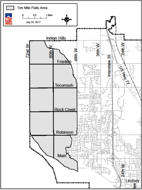
(Ord. No. O-2432, 8-3-1971; Ord. No. O-7475-4, 7-9-1974; Ord. No. O-7879-42, 1-30-1979; Ord. No. O-8182-5, 10-13-1981; Ord. No. O-8182-32, 1-5-1982; Ord. No. O-8384-135, 6-19-1984; Ord. No. O-8485-65, 6-11-1985; Ord. No. O-8687-9, 8-5-1986; Ord. No. O-8687-49, 3-14-1987; Ord. No. O-8990-42, 7-24-1990; Ord. No. O-9293-38, 8-24-1993; Ord. No. O-9495-28, 1-24-1995; Ord. No. O-9596-19, 12-12-1995; Ord. No. O-9697-37, 3-11-1997; Ord. No. O-9697-42, 5-27-1997; Ord. No. O-0405-23, 11-16-2004; Ord. No. O-1213-17, 11-27-2012; Ord. No. O-1255, § 1; Ord. No. O-1375, § 1; Ord. No. O-1617-31, 5-23-2017; Ord. No. O-1718-36, 3-27-2018; Ord. No. O-1718-38, 3-27-2018; Ord. No. O-1739; Ord. No. O-1793; Ord. No. O-1819-17, 12-11-2018; Ord. No. O-1920-4, 8-29-2019; Ord. No. O-2165; Ord. No. O-2432)
36-513 RE, Residential Estate Dwelling District
- Purpose. This district is established to provide for a low population density in the Rural Character Area as reflected in the Land Use Plan. The principal use of land is for single-family detached dwellings and related recreational, religious, and educational facilities. These areas are intended to be defined and protected from encroachment by uses which are incompatible with a residential environment.
- Uses permitted. Property and buildings in an RE, Residential Estate Dwelling District shall be used only for the following purposes:
- Detached one-family dwelling.
- Family day care home.
- General purpose farm or garden.
- Type 1 Mobile Home.
- Accessory buildings, including barns, sheds and other farm buildings which are not a part of the main building.
- Home occupation.
- One accessory dwelling unit ("ADU")
- Short-term rentals.
- Special use. The following uses may be permitted, after review, in accordance with NCC 36-560, provided that structures incidental to these uses are located at least 50 feet from any property line.
- Church, temple, or other place of worship.
- School offering general educational courses the same as ordinarily given in public schools and having no rooms regularly used for housing and sleeping.
- Publicly-operated recreation or water supply.
- Municipal use, public buildings and public utility.
- Private recreation operated on a non-profit basis for residents of the subdivision or immediate area.
- Type I bed and breakfast establishment.
- Tiny houses as regulated in NCC 36-561(b).
- Area and setback regulations.
- Front yard. All buildings shall be set back from street right-of-way lines to comply with the following front yard requirements:
- The minimum depth of the front yard shall be 50 feet.
- When a lot has double frontage the front yard requirements shall be provided on both streets.
- Side yard.
- The minimum width of side yard shall be 25 feet for the principal structure. Unattached one-story buildings of accessory use, including ADUs, shall be located at least ten feet from the side property line, or 15 feet if more than one-story, provided such structures are located within the rear half of the lot.
- On any corner lot a building shall set back from the right-of-way line of the intersecting street a distance of at least 40 feet.
- Rear yard. There shall be a rear yard having a depth of at least 30 feet. Unattached one-story buildings of accessory use, including ADUs, shall be set back at least ten feet from the rear property line or utility easement, or 15 feet if more than one story, provided such structures are located within the rear half of the lot.
- Lot width. There shall be a minimum lot width of 150 feet at the building line, and such lot shall abut on a street for a distance of not less than 65 feet except that on a cul-de-sac turn-around this may be reduced to 50 feet.
- Lot depth. The maximum depth of any lot shall be not more than four times the lot width or 640 feet, whichever be greater.
- Intensity of use. There shall be a lot area of not less than two acres, except that where a lot or parcel has less area than herein required and all boundary lines of that lot touch lands under other ownership on the effective date of the ordinance from which this article is derived, May 8, 1962, that lot may be used for any of the uses permitted by this section but may not be split or divided into smaller lots or parcels; provided, however, that the lot size may be reduced to one acre in those cases where the rear one acre portion of the lot is either being dedicated to the public for park or drainage purposes, or reserved by plat as common open space for recreation or drainage purposes.
- Limit on buildings. Not more than one principal building and one accessory dwelling unit shall be constructed on any one lot.
- Front yard. All buildings shall be set back from street right-of-way lines to comply with the following front yard requirements:
- Height regulations. Except, as provided in NCC 36-546, no building shall exceed 35 feet in height.
(Ord. No. O-8182-32, 1-5-1982; Ord. No. O-8586-82, 6-24-1986; Ord. No. O-8687-49, 3-14-1987; Ord. No. O-8990-42, 7-24-1990; Ord. No. O-9091-9, 12-11-1990; Ord. No. O-9293-38, 8-24-1993; Ord. No. O-9596-19, 12-12-1995; Ord. No. O-9697-42, 5-27-1997; Ord. No. O-0607-6, 8-22-2006; Ord. No. O-1371, § 10; Ord. No. O-1617-31, 5-23-2017; Ord. No. O-1718-36, 3-27-2018; Ord. No. O-1920-45, 7-23-2020)
36-514 R-1, Single-Family Dwelling District
- Uses permitted. Property and buildings in an R-1, Single-Family Dwelling District shall be used only for the following purposes:
- Detached one-family dwelling.
- Family day care home.
- General purpose farm or garden.
- Home occupation.
- Municipal recreation or water supply.
- Accessory buildings.
- One accessory dwelling unit with a total area of no more than six hundred fifty square feet (650 SF) ("ADU"), except that this use shall not be adopted by reference into the uses allowed in R-2 ("Two-Family Dwelling District"), RM-2 ("Low-Density Apartment District"), and R-3 ("Multifamily Dwelling District").
- Commercial parking only on days when the University of Oklahoma football team plays at home, subject to the following restrictions and conditions:
- On all sides of the parking area abutting other property a barrier shall be erected so as to prevent vehicles from damaging fences, trees, shrubs or other improvements on the adjoining property, such barrier to be at least two feet within the property line of the property used for parking. All vehicles shall be parked within the property line of such property.
- An attendant over 18 years of age shall be on duty at all times when vehicles are parked on the property.
- All papers, containers and other trash shall be removed from the premises immediately after the vehicles have been removed.
- No vehicle shall ever be parked between the property line and any adjoining street.
- Unless a driveway is provided, a wooden or metal incline shall be placed in the gutter next to the curb on any street where there is a concrete curb, and the same shall be removed immediately after the last parked vehicle has departed. Such incline shall not exceed 25 feet in length or 12 inches in width.
- Any violation of the foregoing restrictions, whether by the owner of the property, driver of a vehicle, or other person, shall constitute an offense, and in addition to the other penalties provided by law, the owner or operator of such property so used for parking, upon conviction of such offense, shall not use said property for such purpose for the remainder of the year during which such violation occurs.
- Model home, subject to an annual permit, as defined in NCC 36-101, for no more than four years.
- Short-term rentals.
- Special use. The following uses may be permitted, after review, in accordance with provisions contained in NCC 36-560:
- Municipal use, public building and public utility.
- Public or private golf courses including any country clubs, club houses, or any accessory commercial enterprises.
- Church, temple or other place of worship.
- School offering general educational courses the same as ordinarily given in public schools and having no rooms regularly used for housing and sleeping.
- Type I bed and breakfast establishment.
- Model home accessory parking lot, with the following conditions:
- The parking lot must be adjacent to a permitted model home. The parking lot must be completely removed when the model home reverts to residential use.
- The lot must be designed and built to City standards, including surface material and drainage approved by the City Engineer, and striped or curbed (or bumper blocks installed) to safely allow its use.
- The rear and side abutting other residences should be screened with a six-foot opaque fence, which may not extend beyond the front of the model home.
- Sidewalks must be installed across both the model home and the parking lot.
- A ten-foot landscape strip must be installed between the public sidewalk and parking area, and a five-foot strip along the side and rear of the lot. The lot should be landscaped with trees and shrubs.
- No lighting is allowed other than low-voltage landscape fixtures.
- Area regulations.
- Front yard. All buildings shall be set back from street right-of-way lines to comply with the following front yard requirements:
- The minimum depth of the front yard shall be 25 feet.
- When a lot has double frontage, the front yard requirements shall be provided on both streets, unless a limits of no access has been established across the rear of the lot.
- Side yard.
- Except as hereinafter provided in NCC 36-515 and 36-544, there shall be a side yard on each side of a principal building which shall have a width of not less than five feet; unattached, one-story buildings of accessory use, including ADUs, shall be set back five feet from any side lot line; provided, however, that accessory buildings shall not be required to set back more than three feet from the interior side lot line when all parts of said building are located not more than 50 feet from the rear property line or rear utility easement line.
- On any corner lot a main building shall set back from the right-of-way line of the intersecting street a distance of 15 feet in case such lot is back-to-back with another corner lot, and 20 feet in every other case. Accessory buildings, including ADUs, shall be set back from the right-of-way line of the intersecting street ten feet in case such lot is back-to-back with another corner lot, and 20 feet in every other case.
- In no case shall a garage which faces a street be located closer than 20 feet to that street property line.
- Rear yard. There shall be a rear yard having a depth of not less than 20 feet or 20 percent of the depth of the lot, whichever amount is smaller; unattached one-story buildings of accessory use, including ADUs, shall set back one foot from the utility easement or alley line.
- Lot width. There shall be a minimum lot width of 50 feet at the building line, and such lot shall abut on a street for a distance of not less than 35 feet.
- Intensity of use. There shall be a lot area of not less than 6,000 square feet, except that where a lot has less area than herein required, either in existence on the effective date of the ordinance from which this section derived, July 13, 1954, or by subdivision complying with NCC 30-605 and all the boundary lines of that lot touch lands under other ownership that lot may be used for any of the uses permitted by this section.
- Impervious area. The total amount of impervious area, including all buildings and permanently paved areas shall not cover more than 65 percent of a lot. Paving for parking as required in NCC 36-548, including other impervious surfaces, shall not cover more than 50 percent of the required 25-foot front yard, and comply with NCC 36-550(a)(3). Total impervious area of the front yard can be increased to 70 percent when one or more of the following circumstances occur:
- The driveway is needed to access a garage for three or more cars;
- The driveway is part of a circular driveway that includes a landscaped separation from the sidewalk; or
- The driveway is located on a cul-de-sac lot with lot frontage of less than 40 feet.
- Limit on buildings. Not more than one principal dwelling and one ADU shall be constructed on any one lot.
- Front yard. All buildings shall be set back from street right-of-way lines to comply with the following front yard requirements:
- Height regulations.
- Except, as provided in NCC 36-546, no building shall exceed two stories in height. A three-story building may be constructed if the side yards are increased an additional five feet.
- Any accessory building, including an ADU, shall not exceed a wall height of ten feet unless the required side and rear yard setbacks are increased by one foot for each additional foot of wall height above ten feet; provided, however, that no accessory building shall exceed the height of the principal building to which it is accessory.
(Ord. No. O-7778-22, 11-1-1977; Ord. No. O-7778-60, 5-2-1978; Ord. No. O-7778-68, 10-3-1978; Ord. No. O-7980-27, 2-5-1980; Ord. No. O-8485-91, 7-9-1985; Ord. No. O-8990-42, 7-24-1990; Ord. No. O-9091-40, 7-23-1991; Ord. No. O-9293-38, 8-24-1993; Ord. No. O-9596-19, 12-12-1995; Ord. No. O-9697-7, 8-27-1996; Ord. No. O-9900-21, 1-11-2000; Ord. No. O-0102-27, 3-26-2002; Ord. No. O-0708-36, 4-22-2008)
36-515 R-1-A, Single-Family Attached Dwelling District
- Purposes. The R-1-A district is designed to allow single-family residential development that utilizes common wall technology and zero lot line construction to provide an alternative housing form which is compatible with other types of low-density residential development.
- Uses permitted. Property and buildings in the R-1-A district shall be used only for the following purposes:
- Any use permitted in the R-1 district.
- Attached one-family dwellings.
- Detached, zero-lot line, one-family dwellings.
- Special use. The following uses may be permitted, after review, in accordance with the provisions contained in NCC 36-560:
- Municipal use, public building and public utility.
- Public or private golf courses, including any country clubs, club houses, or any accessory commercial enterprises.
- Church, temple or other place of worship.
- School offering general educational courses the same as ordinarily given in public schools and having no rooms regularly used for housing and sleeping.
- Area regulations. Property and buildings in the R-1-A district shall be subject to the following area regulations:
- All uses and buildings other than single-family dwellings shall be subject to the area regulations of the R-1 district.
- Single-family dwellings.
- Front yards. The minimum depth of the front yard shall be 20 feet.
- Side yards.
- For attached dwellings, a zero side yard is allowed along a common wall when both units are built at the same time, provided that the remaining side yard is ten feet or greater.
- For unattached dwellings, including garages, one side yard may be reduced to zero, provided:
- A ten-foot maintenance and open space easement is secured on the lot adjoining the reduced side yard.
- The remaining side yard is not less than ten feet and is perpetually maintained free and clear from any obstructions, other than a two-foot eave overhang, landscaping, and fencing.
- The wall located at the zero side yard setback is constructed with maintenance-free masonry and has no window or door openings.
- No portion of the dwelling or architectural features projects over any property line.
- The zero side yard is not adjacent to a public or private right-of-way.
- For all other unattached dwellings, side yard setbacks shall be five feet.
- On any corner lot a building shall be set back from the right-of-way line of the intersecting street a distance of 15 feet in case such lot is back-to-back with another corner lot, and 20 feet in every other case.
- In no case shall a garage which faces a street be located closer than 20 feet to that street property line.
- Rear yards. There shall be a rear yard of not less than 20 feet. Unattached accessory buildings shall be set back one foot from any utility easement, alley easement, or rear lot line.
- Lot width. There shall be a minimum lot width of not less than 45 feet at the building line, and no lot shall abut a street for a distance of less than 35 feet.
- Accessory buildings. Except as hereinafter provided in NCC 36-544; unattached, one-story buildings of accessory use shall be set back five feet from any interior side lot line; provided, however, that accessory buildings shall not be required to set back more than three feet from the interior side lot line when all parts of said building are located not more than 50 feet from the rear property line or rear utility easement line. Such structures may not be constructed within any required ten-foot maintenance easement.
- Intensity of use.
- Lot area. There shall be a lot area of not less than 4,500 square feet per lot.
- Impervious area. The total amount of impervious area, including all buildings and permanently paved areas shall not cover more than 65 percent of a lot. Paving for parking as required in NCC 36-548, including other impervious surfaces, shall not cover more than 50 percent of the required 20-foot front yard and comply with NCC 36-550(a)(3). Total impervious area of the front yard can be increased to 70 percent when one or more of the following circumstances occur:
- The driveway is needed to access a garage for three or more cars;
- The driveway is part of a circular driveway that includes a landscaped separation from the sidewalk; or
- The driveway is located on a cul-de-sac lot with lot frontage of less than 40 feet.
- Height regulations.
- Except, as provided in NCC 36-546, no building shall exceed 27 feet in height, unless side and rear setback lines are increased one foot for each additional foot of height above 27 feet; however, the maximum height allowed shall be 35 feet.
- Any accessory building exceeding 12 feet in height shall have the required side and rear yard setbacks increased by one foot for each additional foot of height above 12 feet; provided, however, that no accessory building shall exceed the height of the principal building to which it is accessory.
(Ord. No. O-9697-7, 8-27-1996; Ord. No. O-0708-36, 4-22-2008)
36-516 R-2, Two-Family Dwelling District
- Uses permitted. Property and buildings in an R-2, Two-Family Dwelling District shall be used only for the following purposes:
- Any uses permitted in R-1, Single-Family Dwelling District.
- One single-family dwelling.
- One two-family dwelling (duplex).
- One single-family dwelling and a garage apartment.
- Accessory buildings and uses customarily incidental to any of the above uses when located on the same lot.
- Special use. The following uses may be permitted, after review, in accordance with NCC 36-560:
- Municipal use, public building and public utility.
- Public or private golf courses, including any country clubs, club houses, or any accessory commercial enterprises.
- Church, temple or other place of worship.
- School offering general educational courses the same as ordinarily given in public schools and having no rooms regularly used for housing and sleeping.
- Type I bed and breakfast establishment.
- Library/museum.
- Off-street parking lot to be used as open space for vehicular parking, provided that such parking lot is adjacent to the land on which the principal use is located or separated therefrom only by a street or alley if the principal use is in the CO, C-1, C-2, C-3, I-1, I-2, R-1, R-2, or R-3 districts. This shall not be construed as permitting separately-operated commercial parking lots.
- Area regulations.
- Front yard. The minimum depth of the front yard shall be 25 feet.
- Side yard. The minimum width of a side yard for a main building or garage apartment shall be five feet.
- Rear yard. There shall be a rear yard of not less than 20 feet; one-story unattached buildings of accessory use shall set back one foot from the utility easement or alley line and garage apartments shall be set back ten feet from the rear lot line.
- Lot width. There shall be a minimum lot width of 50 feet at the building line for a single-family dwelling or a two-family dwelling; such lot shall abut on a street for a distance of not less than 35 feet.
- Intensity of use.
- There shall be a lot area of not less than 5,000 square feet for a single-family dwelling; 7,000 square feet for a two-family dwelling or a single-family dwelling and a garage apartment on the same lot.
- Where a lot has less area than herein required, either in existence on the effective date of the ordinance from which this section derived, July 13, 1954, or by subdivision complying with NCC 30-605 and all boundary lines of that lot touch lands under other ownership. that lot may be used only for the uses permitted in R-1, Single-Family Dwelling District.
- Accessory buildings shall not cover more than 20 percent of the rear yard.
- Impervious area. The total amount of impervious area, including all buildings and permanently paved areas shall not cover more than 65 percent of a lot. Paving for parking as required in NCC 36-548, and other impervious surfaces, shall not cover more than 50 percent of the front yard. Total impervious area of the front yard can be increased to 70 percent when one or more of the following circumstances occur:
- The driveway is needed to access a garage for three or more cars;
- The driveway is part of a circular driveway that includes a landscaped separation from the sidewalk; or
- The driveway is located on a cul-de-sac lot with lot frontage of less than 40 feet.
- Limit on buildings. No more than one main building shall be constructed on each lot containing 5,000 square feet of land used for single-family purposes and 7,000 square feet for two family purposes, or a single-family dwelling and a garage apartment.
- Within the Central Core Area of the City (see map exhibit to NCC 36-550), any two-family (duplex) structure with four or more bedrooms per unit is required to be sprinkled per the requirement in section P2904 of the International Residential Code (IRC) or NFPA 13D, or as these documents are amended.
- Height regulations.
- Except, as provided in NCC 36-546, no building shall exceed two stories in height. A 2 1/2-story or three-story building may be constructed if the side yards are increased an additional five feet.
- Any accessory building shall not exceed a wall height of ten feet unless the required side and rear yard setbacks are increased by one foot for each additional foot of wall height above ten feet; provided, however, that no accessory building shall exceed the height of the principal building to which it is accessory.
(Ord. No. O-7778-60, 5-2-1978; Ord. No. O-8990-42, 7-24-1990; Ord. No. O-9293-38, 8-24-1993; Ord. No. O-9596-19, 12-12-1995; Ord. No. O-0708-36, 4-22-2008; Ord. No. O-1718-47, 7-26-2018)
36-517 RM-2, Low-Density Apartment District
- Purposes. The RM-2 district is designed to provide areas for low-density multifamily housing which will be compatible, in terms of limitations of bulk and the providing of open space, with adjoining single-family and two-family development.
- Uses permitted. Property and buildings in the RM-2 district shall be used only for the following purposes:
- Any uses permitted in the R-1 district.
- Attached single-family dwellings or detached zero lot line single-family dwellings, provided that such uses comply with the area regulations in NCC 36-515(d).
- Two-family dwelling (duplex), or a single-family dwelling with a garage apartment.
- Apartment buildings, containing four or fewer units.
- Accessory buildings and uses customarily incidental to any of the above uses when located on the same lot.
- Special use. The following uses may be permitted, after review, in accordance with NCC 36-560:
- Municipal use, public building and public utility.
- Public or private golf courses, including any country clubs, club houses, or any accessory commercial enterprises.
- Church, temple or other place of worship.
- School offering general educational courses the same as ordinarily given in public schools and having no rooms regularly used for housing and sleeping.
- Type I bed and breakfast establishment.
- Type II bed and breakfast establishment.
- Childcare center.
- Library/museum.
- Off-street parking lot to be used as open space for vehicular parking, provided that such parking lot is adjacent to the land on which the principal use is located or separated therefrom only by a street or alley if the principal use is in the CO, C-1, C-2, C-3, I-1, I-2, R-1, R-2, or R-3 districts. This shall not be construed as permitting separately-operated commercial parking lots.
- Convalescent home, rest home, or nursing home; or, a fraternity or sorority house, provided that where any such use abuts another property in a residential district, the minimum yards along the common boundaries shall be at least 20 feet.
- Roominghouse or boardinghouse, subject to the requirements of NCC 36-558.
- Area regulations. Property and buildings in the RM-2 district shall be subject to the following area regulations:
- Front yard. The minimum depth of the front yard shall be 25 feet.
- Side yards. The minimum width of the side yard for any use including a garage apartment shall be at least five feet, except, as provided in NCC 36-544.
- Rear yard. The minimum depth of the rear yard shall be 20 feet; one story unattached buildings of accessory use shall be set back one foot from the utility easement or alley line, and garage apartments shall be set back ten feet from the rear lot line.
- Lot width. There shall be a minimum lot width of 50 feet at the building line for a single-family dwelling or for a two-family dwelling, and ten feet additional width for each additional family occupying the lot. Such lot shall abut on a street not less than 35 feet.
- Intensity of use.
- The minimum area of a lot for residential use shall be 5,000 square feet, subject to the provisions of NCC 36-544(g).
- There shall be not less than 3,250 square feet of lot area per family on any lot.
- The ratio of floor area to lot area shall not exceed 0.40.
- Impervious area. The total amount of impervious area, including all buildings and permanently paved areas shall not cover more than 65 percent of a lot. Paving for parking as required in NCC 36-548, including other impervious surfaces, shall not cover more than 50 percent of the required 25-foot front yard, and comply with NCC 36-550(a)(3). Total impervious area of the front yard can be increased to 70 percent when one or more of the following circumstances occur:
- The driveway is needed to access a garage for three or more cars;
- The driveway is part of a circular driveway that includes a landscaped separation from the sidewalk; or
- The driveway is located on a cul-de-sac lot with lot frontage of less than 40 feet.
- Duplexes. Within the Central Core Area of the City (see map exhibit to NCC 36-550), any two-family (duplex) structure with four or more bedrooms per unit is required to be sprinkled per the requirement in section P2904 of the International Residential Code (IRC) or NFPA 13D, or as these documents are amended.
- Height regulations.
- Except, as provided in NCC 36-546, no building shall exceed three stories in height.
- Any accessory building shall not exceed a wall height of ten feet unless the required side and rear yard setbacks are increased by one foot for each additional foot of wall height above ten feet; provided, however, than no accessory building shall exceed the height of the principal building to which it is accessory.
(Ord. No. O-7677-10, 11-2-1976; Ord. No. O-7778-60, 5-2-1978; Ord. No. O-7778-68, 10-3-1978; Ord. No. O-8182-45, 3-9-1982; Ord. No. O-8990-42, 7-24-1990; Ord. No. O-9293-38, 8-24-1993; Ord. No. O-9596-19, 12-12-1995; Ord. No. O-9697-6, 8-27-1996; Ord. No. O-0708-36, 4-22-2008; Ord. No. O-1718-47, 7-26-2018)
36-518 RM-4, Mobile Home Park District
- Purposes. The RM-4 district is designed to encourage the developing of properly planned mobile home parks in residential environments, as well as to protect existing mobile home parks.
- Uses permitted. Property and buildings in the RM-4 district shall be used only for the following purposes:
- Mobile home park, subject to those provisions in NCC 20.64 which relate to mobile home parks.
- Accessory buildings and uses customarily incidental to any of the above uses when located on the same lot.
- Mobile home subdivision.
- Short-term rentals.
- Special use. The following uses may be permitted, after review, in accordance with NCC 36-560:
- Municipal use, public building and public utility.
- Public or private golf courses, including any country clubs, club houses, or any accessory commercial enterprises.
- Church, temple or other place of worship.
- School offering general educational courses the same as ordinarily given in public schools and having no rooms regularly used for housing and sleeping.
- Type I bed and breakfast establishment.
- Type II bed and breakfast establishment.
- Childcare center, as specified in NCC 36-566.
- Library/museum.
- Off-street parking lot to be used as open space for vehicular parking, provided that such parking lot is adjacent to the land on which the principal use is located or separated therefrom only by a street or alley if the principal use is in the CO, C-1, C-2, C-3, I-1, I-2, R-1, R-2, or R-3 districts. This shall not be constructed as permitting separately-operated commercial parking lots.
- Area regulations.
- Mobile home subdivisions.
- Front yard. The minimum depth of the front yard shall be 25 feet.
- Side yard. The minimum width of the side yard shall be 20 feet. One-story unattached buildings of accessory use shall be set back one foot from the utility easement or alley line.
- Rear yard. The rear yard requirements shall be the same as those in the R-1 district.
- Lot width. Side lot lines need not be at right angles to straight street lines or radial to curved street lines. Minimum effective lot widths shall be 40 feet measured at the front building line and such lot shall abut a public street for a distance of not less than 25 feet. The minimum effective lot width of a mobile home lot shall be determined, for interior lots, by measuring the shortest distance at right angles across the lot from one diagonal to the other, and for corner lots, the measurement shall be made at right angles from the diagonal having the greatest divergence from perpendicular to the street, through the midpoint of the rear line of the required front yard, to the opposite lot line.
- Intensity of use. There shall be a lot area of not less than 4,000 square feet. The minimum size of a mobile home subdivision shall be ten acres.
- Greenbelt planting strip. All mobile home subdivisions shall have a greenbelt planting strip, not less than 20 feet in width, along all subdivision boundaries. Such greenbelt shall be composed of one row of deciduous and/or evergreen trees, spaced not more than 40 feet apart, and not less than three rows of shrubs, spaced not more than eight feet apart and which grow to a height of five feet or more after one full growing season and which shrubs will eventually grow to a height of not less than 12 feet.
- Impervious area. The total amount of impervious area, including all buildings and permanently paved areas shall not cover more than 65 percent of a lot.
- Mobile home parks are regulated under NCC 20.64.
- For all other uses, area regulations shall be the same as those in the RM-2 district.
- Mobile home subdivisions.
- Height regulations. Any accessory building shall not exceed a wall height of ten feet unless the required side and rear yard setbacks are increased by one foot for each additional foot of wall height above ten feet.
(Ord. No. O-9596-19, 12-12-1995; Ord. No. O-0708-36, 4-22-2008)
36-519 RM-6, Medium-Density Apartment District
- Purposes. The RM-6 district is designed to encourage the developing of neighborhoods having a variety of dwelling types, including townhouses, thus providing for the varying requirements of families. The regulations are intended to ensure compatibility with adjacent existing and proposed low-density apartment development.
- Uses permitted. Property and buildings in the RM-6 district shall be used only for the following purposes:
- Any uses permitted in the RM-2 district.
- Apartment buildings.
- Townhouse development, the plat of which meets the requirements of NCC 36-556.
- Accessory buildings and uses customarily incidental to any of the above uses when located on the same lot.
- Special use. The following uses may be permitted, after review, in accordance with NCC 36-560:
- Municipal use, public building and public utility.
- Public or private golf courses, including any country clubs, club houses, or any accessory commercial enterprises.
- Church, temple or other place of worship.
- School offering general educational courses the same as ordinarily given in public schools and having no rooms regularly used for housing and sleeping.
- Type I bed and breakfast establishment.
- Type II bed and breakfast establishment.
- Childcare center, as specified in NCC 36-566.
- Library/museum.
- Off-street parking lot to be used as open space for vehicular parking, provided that such parking lot is adjacent to the land on which the principal use is located or separated therefrom only by a street or alley if the principal use is in the CO, C-1, C-2, C-3, I-1, I-2, R-1, R-2, or R-3 districts. This shall not be construed as permitting separately-operated commercial parking lots.
- Fraternal service organization not conducted for profit.
- Office buildings for professional, business, administrative, and medical personnel, provided that:
- No retailing, wholesaling, or servicing of merchandise shall be permitted on the premises;
- No storage or display of merchandise to be serviced or offered for sale elsewhere be permitted on the premises.
- Funeral parlor, mortuary.
- Pre-packaged food store and toiletries within apartment buildings or complexes wherein there are a minimum of 150 family dwelling units, provided that:
- Such store is limited to the main floor or below of the building in which it is located;
- There is no direct entrance thereto from any public street, sidewalk or other public way;
- No part of such store, or its entrance, is visible from any public way, street or sidewalk;
- That such store shall not be advertised in any manner;
- In reviewing any application for permission to establish and operate any such store in any apartment building or complex, the following matters shall be considered:
- The proximity of other business or commercial districts, and whether or not the proposed store would constitute an independent commercial enterprise, as opposed to any accessory use to the tenants of the apartment complex;
- Service entrances for delivery vehicles and adequate space for the parking of customers;
- The size and character of the apartment building or complex, since the tenants thereof will be expected to furnish substantially all of the financial support of such store.
- Any ordinance hereafter enacted granting permission for the establishment and operation of any pre-packaged food store after review, may set forth restrictions as to the space to be occupied, provisions for the automatic termination of permission for violations, and any other reasonable conditions which to the Commission may seem proper.
- Convalescent home, rest home, or nursing home; or, fraternity or sorority house, provided that where any such use abuts another property in a residential district, the minimum yards along the common boundaries shall be at least 20 feet.
- Roominghouse or boardinghouse, subject to the requirements of NCC 36-558.
- Area regulations. Property and buildings in the RM-6 district shall be subject to the following area regulations:
- Front yard. The minimum depth of the front yard shall be 25 feet.
- Side yard. The minimum width of the side yard shall be five feet, except as required for tall or accessory buildings by the provisions of subsection (d)(5) of this section.
- Rear yard. The minimum depth of the rear yard shall be 20 feet. One-story unattached buildings of accessory use shall be set back one foot from the utility easement or alley line.
- Intensity of residential use. One-family and two-family dwellings.
- Minimum lot area. The minimum area of a lot for single-family use shall be 5,000 square feet, subject to the provisions of NCC 36-544(g), and the minimum area of a lot for two-family use shall be 6,500 square feet.
- Accessory buildings shall not cover more than 20 percent of the rear yard.
- Intensity of residential use. Apartment houses and quasi-unit quarters.
- Minimum lot area. The minimum area of a lot for apartment house use shall be 9,000 square feet.
- Floor area ratio. The ratio of floor area to the land area of the site shall not exceed four-tenths (0.4).
- Open space ratio. The ratio of open space to floor area shall be at least one and eight-tenths (1.8).
- Livability space ratio. The ratio of livability space to floor area shall be at least 95 hundredths (0.95).
- Recreation space ratio. The ratio of recreation space to floor area shall be at least 13 hundredths (0.13).
- Intensity of nonresidential use. In any nonresidential building, the ratio of floor area to lot area shall not exceed one-half.
- Impervious area. The total amount of impervious area, including all buildings and permanently paved areas shall not cover more than 65 percent of a lot.
- Duplexes. Within the Central Core Area of the City (see map exhibit to NCC 36-550), any two-family (duplex) structure with four or more bedrooms per unit is required to be sprinkled per the requirement in section P2904 of the International Residential Code (IRC) or NFPA 13D, or as these documents are amended.
- Height regulations.
- Structures exceeding three stories in height shall be set back from side and rear lot lines abutting other property in residential districts at least five feet for each story above three.
- Any accessory building shall not exceed a wall height of ten feet unless the required side and rear yard setbacks are increased by one foot for each additional foot of wall height above ten feet; provided, however, that no accessory building shall exceed the height of the principal building to which it is accessory.
(Ord. No. O-7778-60, 5-2-1978; Ord. No. O-7778-68, 10-3-1978; Ord. No. O-8990-42, 7-24-1990; Ord. No. O-9293-38, 8-24-1993; Ord. No. O-9596-19, 12-12-1995; Ord. No. O-9697-6, 8-27-1996; Ord. No. O-0708-36, 4-22-2008; Ord. No. O-1718-47, 7-26, 2018; Ord. No. O-1961)
36-520 R-3, Multifamily Dwelling District
- Uses permitted. Property and buildings in R-3, Multifamily Dwelling District shall be used only for the following purposes:
- Any use permitted in R-1.
- Two-family dwelling (duplex), or a single-family dwelling and a garage apartment.
- Apartment house.
- Accessory buildings and uses customarily incidental to any of the above uses when located on the same lot.
- Special use. The following uses may be permitted, after review, in accordance with NCC 36-560:
- Funeral parlor and mortuary.
- Convalescent home, rest home, or nursing home; or, fraternity or sorority house, provided that where any such use abuts another property in a residential district, the minimum yards along the common boundaries shall be at least 30 feet.
- Municipal use, public building and public utility.
- Public or private golf courses, including any country clubs, club houses, or any accessory commercial enterprises.
- Church, temple or other place of worship.
- School offering general educational courses the same as ordinarily given in public schools and having no rooms regularly used for housing and sleeping.
- Type I bed and breakfast establishment.
- Type II bed and breakfast establishment.
- Childcare center, as specified in NCC 36-566.
- Library/museum.
- Off-street parking lot to be used as open space for vehicular parking, provided that such parking lot is adjacent to the land on which the principal use is located or separated therefrom by a street or alley if the principal use is in the CO, C-1, C-2, C-3, I-1, I-2, R-1, R-2, or R-3 districts.
- Office buildings for professional, business, administrative, and medical personnel, provided that:
- No retailing, wholesaling, or servicing of merchandise shall be permitted on the premises;
- No storage or display of merchandise to be serviced or offered for sale elsewhere be permitted on the premises.
- Roominghouse or boardinghouse, subject to the requirements of NCC 36-558.
- Area regulations.
- Front yard. The minimum depth of the front yard shall be 25 feet.
- Side yard. The minimum width of the side yard shall be five feet.
- Rear yard. The minimum depth of the rear yard shall be 20 feet. One-story unattached buildings of accessory use with a ten-foot wall height shall be set back one foot from the utility easement or alley line.
- Lot width. There shall be a minimum lot width of 50 feet at the building line for single-family and two-family dwellings, and ten feet additional width for each additional family occupying the structure; such lot shall abut on a street not less than 35 feet.
- Intensity of use.
- There shall be a lot area of not less than 5,000 square feet for a single-family dwelling, and 7,000 square feet for a two-family dwelling or a single-family dwelling and a garage apartment on the same lot.
- There shall be a lot area of not less than 9,000 square feet for apartment houses, and 3,000 square feet additional area for each dwelling unit more than three on the lot.
- When a lot of less area than herein required, either in existence on the effective date of the ordinance from which this section derived, July 13, 1954, or by subdivision complying with NCC 30-605 having all boundary lines touching lands under other ownership, that lot may be used only for the uses permitted in R-1, Single Family Dwelling District.
- Accessory buildings shall not cover more than 30 percent of the rear yard.
- Impervious area. The total amount of impervious area, including all buildings and permanently paved areas shall not cover more than 65 percent of a lot. Paving for parking as required in NCC 36-548, and other impervious surfaces, shall not cover more than 50 percent of the front yard and comply with NCC 36-550(a)(3). Total impervious area of the front yard can be increased to 70 percent when one or more of the following circumstances occur:
- The driveway is needed to access a garage for three or more cars;
- The driveway is part of a circular driveway that includes a landscaped separation from the sidewalk; or
- The driveway is located on a cul-de-sac lot with lot frontage of less than 40 feet.
- Duplexes. Within the Central Core Area of the City (see map exhibit to NCC 36-550), any two-family (duplex) structure with four or more bedrooms per unit is required to be sprinkled per the requirement in section P2904 of the International Residential Code (IRC) or NFPA 13D, or as these documents are amended.
- Height regulations.
- Except, as provided in NCC 36-546, no buildings shall exceed three stories in height.
- Any accessory building exceeding 12 feet in height shall have the required side and rear yard setbacks increased by one foot for each additional foot of height above 12 feet; provided, however, that no accessory building shall exceed the height of the principal building to which it is accessory.
(Ord. No. O-8990-42, 7-24-1990; Ord. No. O-9899-42; Ord. No. O-9293-38, 8-24-1993; Ord. No. O-9596-19, 12-12-1995; Ord. No. O-9697-6, 8-27-1996; Ord. No. O-0708-36, 4-22-2008; Ord. No. O-1718-47, 7-26, 2018)
36-521 RO, Residence-Office District
- Purposes. The RO district is designed to provide areas for high density residential development; limited offices, convenience goods stores, and personal service establishments in conjunction with residential uses; primarily in the vicinity of the campus business district.
- Uses permitted. Property and buildings in the RO district shall be used only for the following purposes:
- Any uses permitted in the RM-6 district; provided, however, that the minimum yards established for certain uses in NCC 36-517(b)(2), shall be 20 feet.
- Any use permitted in the R-3 district.
- Artist and photographer studio, but not including the processing of film for others.
- Medical or dental clinic or laboratory.
- Office of non-profit association.
- Office of such professional person as accountant, architect, attorney, business or management consultant, court reporter, dentist or dental surgeon, engineer, geologist or geophysicists, linguist, landscape architect, optometrist without sales, osteopathic physician, planning consultant, psychologist, physician or surgeon, or registered nurse.
- Prescription pharmacy (only when provided in conjunction with subsection (b)(4) of this section).
- Accessory buildings and uses customarily incidental to any of the above uses when located on the same lot.
- Convenience goods and services as follows but only in conjunction with residential uses in a mixed building as qualified below:
- Convenience goods stores, similar to the following uses:
- Drugstore or proprietary store;
- Florist;
- Food store, including bakery (retail only);
- Gift, novelty, or souvenir shop;
- Hardware store;
- Ice vending establishment;
- Limited price variety store;
- Newsstand;
- Paint, glass, or wallpaper store;
- Retail spirits store;
- Tobacco store.
- Personal service establishments, similar to the following uses:
- Barber shop;
- Custom dressmaker, milliner, or tailor;
- Dry-cleaning pickup or self-service;
- Dry-cleaning plant limited to 7,000 square feet of floor area;
- Hat cleaning or repair shop;
- Laundry pickup or self-service;
- Optician or optometrist;
- Pressing, alteration, or garment repair;
- Shoeshine or repair shop.
- In the case of a mixed building, the floor area devoted to nonresidential uses shall not exceed one-third of the floor area devoted to residential uses; in calculating such ratio, common areas serving both residential and nonresidential areas shall be excluded.
- Convenience goods stores, similar to the following uses:
- Certain requirements for Tobacco and E-Cigarette Retailers. Any use under this Subsection which involves a tobacco or e-cigarette store shall comply with the requirements described under NCC § 36-567.1 “Restrictions on Tobacco and E-cigarette Retailers.
- Special use. The following uses may be permitted, after review, in accordance with NCC 36-560:
- Direct mail business.
- Municipal use, public building and public utility.
- Public or private golf courses, including any country clubs, club houses, or any accessory commercial enterprises.
- Church, temple or other place of worship.
- School offering general educational courses the same as ordinarily given in public schools and having no rooms regularly used for housing and sleeping.
- Type I bed and breakfast establishment.
- Type II bed and breakfast establishment.
- Childcare center, as specified in NCC 36-566.
- Library/museum.
- Off-street parking lot to be used as open space for vehicular parking, provided that such parking lot is adjacent to the land on which the principal use is located or separated therefrom only by a street or alley if the principal use is in the CO, C-1, C-2, C-3, I-1, I-2, R-1, R-2, or R-3 districts.
- Fraternal service organization not conducted for profit.
- Funeral parlor and mortuary.
- Pre-packaged food store and toiletries within apartment buildings or complexes wherein there are a minimum of 150 dwelling units, provided that:
- Such store is limited to the main floor or below of the building in which it is located;
- There is no direct entrance thereto from any public street, sidewalk or other public way;
- No part of such store, or its entrance, is visible from any public way, street or sidewalk;
- That such store shall not be advertised in any manner;
- In reviewing any application for permission to establish and operate any such store in any apartment building or complex, the following matters shall be considered:
- The proximity of other business or commercial districts, and whether or not the proposed store would constitute an independent commercial enterprise, as opposed to any accessory use to the tenants of the apartment complex;
- Service entrances for delivery vehicles and adequate space for the parking of customers;
- The size and character of the apartment building or complex since the tenants thereof will be expected to furnish substantially all of the financial support of such store.
- Any ordinance hereafter enacted granting permission for the establishment and operation of any pre-packaged food store after review, may set forth restrictions as to the space to be occupied, provisions for the automatic termination of permission for violations, and any other reasonable conditions which to the Commission may seem proper.
- Medical marijuana dispensary, Tier I medical marijuana processor, or Tier II medical marijuana processor, as allowed by State law (only when in conjunction with residential uses in a mixed building).
- Area regulations. Property and buildings in the RO district shall be subject to the following area regulations:
- Front yard. The minimum front yard shall be ten feet.
- Side yards. The minimum width of the side yard shall be five feet, except as required for tall buildings by the provisions of subsection (e) of this section.
- Rear yard. There shall be a rear yard of not less than ten feet; one-story unattached buildings of accessory use shall be set back one foot from the utility easement or alley line, and garage apartments shall be set back ten feet from the rear lot line.
- Lot width. There shall be a minimum lot width of 50 feet at the building line for a single-family dwelling or for a two-family dwelling, and ten feet additional width for each additional family occupying the lot. Such lot shall abut on a street not less than 35 feet.
- Intensity of residential use; options.
- Large lots. In the case of a lot which is either at least 40,000 square feet in area or bounded on all sides by streets, alleys, railroads, public lands, or physical barriers, the provisions of either subsection (d)(6) or (7) of this section shall apply, at the option of the applicant for a building permit.
- Small lots. In the case of all other lots, the provisions of subsection (d)(6) of this section shall apply.
- Intensity of residential use; general option.
- Minimum lot area. The minimum area of a lot for residential use shall be 6,000 square feet, subject to the provisions of NCC 36-544(g).
- Floor area ratio. The ratio of floor area to lot area shall not exceed six-tenths (0.6).
- Accessory buildings shall not cover more than 30 percent of the rear yard.
- Intensity of residential use; large lot option.
- The ratio of floor area to the land area of the site shall not exceed eight-tenths (0.8).
- The ratio of open space to floor area shall be at least 85 hundredths (0.85).
- The ratio of livability space to floor area shall be at least four-tenths (0.4).
- The ratio of recreation space to floor area shall be at least 95 thousandths (0.095).
- Accessory buildings shall not cover more than 30 percent of the rear yard.
- Intensity of mixed-uses. The residential portion of a mixed building shall be subject to the intensity provisions of residential buildings. The ratio of the floor area of a mixed building to the area of the lot or the land area shall not exceed the following limits:
- General option: 0.80.
- Large lot option: 1.00.
- Intensity of nonresidential uses.
- Floor area ratio. The ratio of the floor area of a nonresidential building to the area of the lot or the land areas shall not exceed the following limits:
- General option: 1.00.
- Large lot option: 1.25.
- Floor area ratio. The ratio of the floor area of a nonresidential building to the area of the lot or the land areas shall not exceed the following limits:
- Impervious area. The total amount of impervious area, including all buildings and permanently paved areas shall not cover more than 65 percent of a lot. Paving for parking as required in NCC 36-548, including other impervious surfaces, shall not cover more than 50 percent of the required ten-foot front yard, and comply with NCC 36-550(a)(3). Total impervious area of the front yard can be increased to 70 percent when one or more of the following circumstances occur:
- The driveway is needed to access a garage for three or more cars;
- The driveway is part of a circular driveway that includes a landscaped separation from the sidewalk; or
- The driveway is located on a cul-de-sac lot with lot frontage of less than 40 feet.
- Duplexes. Within the Central Core Area of the City (see map exhibit to NCC 36-550), any two-family (duplex) structure with four or more bedrooms per unit is required to be sprinkled per the requirement in section P2904 of the International Residential Code (IRC) or NFPA 13D, or as these documents are amended.
- Height regulations.
- In the RO district there shall be no limit on height of structures, provided that any portion of a structure exceeding 35 feet in height is set back from side and rear lot lines abutting other property in residential districts at least one-third foot for each additional foot of height.
- Any accessory building shall not exceed a wall height of ten feet unless the required side and rear yard setbacks are increased by one foot for each additional foot of wall height above ten feet; provided, however, that no accessory building shall exceed the height of the principal building to which it is accessory.
- Plot plans required. A plot plan shall be submitted with each application of rezoning of land to the RO district. Such plot plans shall reflect as a minimum the information set forth in NCC 36-571(e).
(Ord. No. 2244, 1-27-1970; Ord. No. O-7778-60, 5-2-1978; Ord. No. O-7778-68, 10-3-1978; Ord. No. O-8182-41, 2-9-1982; Ord. No. O-1961; Ord. No. O-8485-22, 10-23-1984; Ord. No. O-8990-42; Ord. No. O-9293-38; Ord. No. O-9596-19, 12-12-1995; Ord. No. O-9697-6, 8-27-1996; Ord. No. O-0708-36, 4-22-2008; Ord. No. O-1718-47, 7-26-2018; Ord. No. O-1718-51, 8-23-2018; Ord. No. O-1819-17, 12-11-2018; Ord. No. O-1920-4, 8-29-2019; Ord. No. O-1920-39, 4-23-2020)
36-522 O-1, Office-Institutional District
- General description. This district is intended to provide a place for those types of institutional and office activities that require separate buildings and building groups surrounded by landscaped yards and open area. Land, space and aesthetic requirements of these uses allow them to be located at the perimeter of residential neighborhoods. The district can be an effective buffer between less intensive residential areas and the retail, wholesale and industrial areas of the community.
- Uses permitted. Property and buildings in O-1, Office-Institutional District shall be used only for the following purposes:
- Any of the following uses:
- Art gallery.
- Assembly halls.
- Laboratories for research and testing, including medical marijuana testing laboratories, as allowed by State law, where all work is housed in buildings.
- Libraries.
- Museums.
- Music conservatories.
- Office buildings and offices for such professional services as accountant, architect, attorney, business or management consultant, court reporter, dentist or dental surgeon, engineer, geologist or geophysicists, linguist, landscape architect, optometrist, optician, osteopathic physician, planning consultant, psychologist, physician or surgeon, or registered nurse; provided, however, that no retail sales nor stock of goods shall be permitted other than the incidental sale of merchandise within the above professional offices or a pharmacy which may be located only in a building providing space for medical offices. Funeral homes and mortuaries shall not be considered professional services permitted in this district.
- Public and private schools and college with students in residence and dormitories associated therewith.
- Trade schools and schools for vocational training.
- Churches, temples or other places of worship.
- Fraternal service organization not conducted for profit.
- Recreation uses associated with any of the uses listed under subsection (a) of this section and maintained primarily for the benefit and use of the occupants thereof.
- Shops and stores associated with and incidental to the uses listed subsection (a) of this section maintained for serving only the occupants thereof.
- Buildings and structures and uses customarily incidental to the above uses.
- Short-term rentals.
- Any of the following uses:
- Special use. The following uses may be permitted, after review, in accordance with NCC 36-560:
- Hospital, provided that:
- Proposed site shall have a minimum 500-foot frontage on a principal urban arterial;
- No ingress or egress shall be allowed except from arterial streets;
- Buffer strips shall be provided between adjoining residentially zoned properties:
- No structure shall be closer than 200 feet from the residentially zoned properties;
- A landscaped area 50 feet in width, or 20 feet with a six-foot brick, or decorative masonry wall, shall be provided along shared property lines; and
- There shall be a minimum ten-acre site with an additional one acre for each additional ten beds or fraction thereof above 100 beds.
- Funeral parlor, mortuary, and crematorium so long as the crematorium is attached to the funeral parlor or mortuary and complies with the following conditions and requirements:
- Any building which incorporates a crematorium use shall meet the setback requirements of the underlying zoning district.
- Facilities shall meet all applicable State and federal requirements for incineration equipment and shall be licensed at all times.
- All storage shall be inside.
- Incinerator stacks shall not be located on the front side of the roof of any structure facing the street.
- Mixed building in which one or more dwelling units may be located on the second floor, provided that:
- First floor use is a permitted use in the district;
- Only two-story structures are involved;
- The minimum area of a lot shall be 6,000 square feet;
- The ratio of floor area to lot area shall not exceed six-tenths (0.6).
- The following uses if contained within an office building of not less than 10,000 square feet of floor area and not located in a mixed residential/commercial use building:
- Photo studio.
- Barber shop.
- Beauty shop.
- High impact institutional use.
- Off-street parking lot to be used as open space for vehicular parking, provided that such parking lot is adjacent to the land on which the principal use is located or separated therefrom only by a street or alley if the principal use is in the CO, C-1, C-2, C-3, I-1, or I-2 district.
- Childcare center, as specified in NCC 36-566.
- Municipal use, public buildings and public utility.
- Medical marijuana research facility, as allowed by State law.
- Hospital, provided that:
- Area requirements.
- Front yard. The front yard regulations shall be the same as those in R-1, Single-Family Dwelling District.
- Side yard. The side yard requirements shall be the same as R-3, Multifamily Dwelling District.
- Rear yard. The rear yard requirements shall be the same as the R-1, Single-Family Dwelling District.
- Lot width. For all uses, there shall be a minimum lot width of 50 feet at the building line.
- Coverage. Buildings and structures shall not cover more than 50 percent of the lot area, and in no case shall the gross floor area of the building exceed the total area of the lot.
- Limit on buildings. The limit on the number of buildings shall be in accordance with the coverage requirements set forth in subsection (d)(5) of this section.
- Open landscaped yards. All yards adjacent to a street or residential district which are created by the setback requirements contained herein shall be maintained as open landscaped yards bisected only by access drives, and their use for any other purpose, including off-street parking, is specifically prohibited.
- Height regulations.
- Except, as provided in NCC 36-546, no building shall exceed 27 feet in height, unless side and rear setback lines are increased one foot for each additional foot of height above 27 feet; however, the maximum height allowed shall be 35 feet.
- Any accessory building exceeding 12 feet in height shall have the required side and rear yard setbacks increased by one foot for each additional foot of height above 12 feet; provided, however, that no accessory building shall exceed the height of the principal building to which it is accessory.
- Plot plans required. A plot plan shall be submitted with each application of rezoning of land to the O-I district. Such plot plans shall reflect as a minimum the information set forth in NCC 36-571(e).
(Ord. No. O-7677-29; Ord. No. O-8687-54, 4-14-1987; Ord. No. O-8990-42, 7-24-1990; Ord. No. O-9293-38, 8-24-1993; Ord. No. O-9596-19, 12-12-1995; Ord. No. O-9697-51, 6-10-1997; Ord. No. O-9899-21, 1-12-1999; Ord. No. O-1314-13, 11-22-2013; Ord. No. O-1617-31, 5-23-2017; Ord. No. O-1819-17, 12-11-2018; Ord. No. O-1920-4, 8-29-2019; Ord. No. O-1920-45, 7-23-2020; Ord. No. O-2109)
36-523 CO, Suburban Office Commercial District
- General description. This commercial district is intended to provide a place for those types of institutional and commercial activities that require separate buildings and building groups surrounded by landscaped yards and open area. Land, space and aesthetic requirements of these uses make desirable a suburban location near residential neighborhoods or rural countryside, and away from the concentration of people and traffic of the retail, wholesale and industrial areas of the community.
- Uses permitted. Property and buildings in a CO, Suburban Office Commercial District shall be used only for the following purposes:
- Any of the following uses:
- Apartment hotel.
- Art gallery.
- Assembly halls of non-profit corporations.
- Laboratories for research and testing where all work is housed in buildings and no smoke, noise, odor, dust or other element of operation is more intense outside the confines of the building than that which normally prevails in an R-3, Multifamily Dwelling District. For the purposes of this section, the term "laboratories" includes Medical Marijuana Testing Laboratories, as allowed by State law, that fully comply with this provision.
- Libraries.
- Museums.
- Music conservatories.
- Office buildings and offices for such professional services as accountant, architect, attorney, business or management consultant, court reporter, dentist or dental surgeon, engineer, geologist or geophysicist, linguist, landscape architect, optometrist, optician, osteopathic physician, planning consultant, psychologist, physician or surgeon, or registered nurse; provided, however, that no retail sales nor stock of goods shall be permitted other than the incidental sale of merchandise within the above professional offices or a pharmacy which may be located only in a building providing space for medical offices. Funeral homes and mortuaries shall not be considered professional services permitted in this district.
- Public and private schools and college with students in residence and dormitories associated therewith.
- Trade schools and schools for vocational training.
- Churches
- Childcare center, as specified in NCC 36-566.
- Short-term rentals; provided, however, that all of the above listed uses are designed to have only limited contact with the general public, and their operation does not involve the sale of merchandise at retail, except as an incidental operation; and further, provided that no smoke, noise, odor, dust or other element of operation is more intense than that normally generated in an R-3, Multifamily Dwelling District.
- Recreation uses associated with any of the uses listed under subsection (a) of this section and maintained primarily for the benefit and use of the occupants thereof.
- Shops and stores associated with and incidental to the uses listed under subsection (a) of this section maintained for serving only the occupants thereof.
- Buildings and structures and uses customarily incidental to the above uses.
- Name plate and signs relating only to the use of the premises and services provided therein.
- Any of the following uses:
- Special use. The following uses may be permitted, after review, in accordance with NCC 36-560:
- Emergency medical transportation services.
- Funeral parlor, mortuary, and crematorium so long as the crematorium is attached to the funeral parlor or mortuary and complies with the following conditions and requirements:
- Any building which incorporates a crematorium use shall meet the setback requirements of the underlying zoning district.
- Facilities shall meet all applicable State and federal requirements for incineration equipment and shall be licensed at all times.
- All storage shall be inside.
- Incinerator stacks shall not be located on the front side of the roof of any structure facing the street.
- Mixed building in which one or more dwelling units may be located on the second floor, provided that:
- First floor use is a permitted use in the district;
- Only two-story structures are involved;
- The minimum area of a lot shall be 6,000 square feet;
- The ratio of floor area to lot area shall not exceed six-tenths (0.6).
- The following uses if contained within an office building of not less than 10,000 square feet of floor area and not located in a mixed residential/commercial use building:
- Photo studio.
- Barber shop.
- Beauty shop.
- Off-street parking lot to be used as open space for vehicular parking, provided that such parking lot is adjacent to the land on which the principal use is located or separated therefrom only by a street or alley if the principal use is in the CO, C-1, C-2, C-3, I-1, or I-2 district.
- Municipal use, public buildings and public utility.
- Medical marijuana research facility, as allowed by State law.
- Area requirements.
- Front yard. The front yard regulations shall be the same as those in R-1, Single-Family Dwelling District.
- Side yard. The side yard requirements shall be the same as R-3, Multifamily Dwelling District.
- Rear yard. The rear yard requirements shall be the same as the R-3, Multifamily Dwelling District.
- Lot width. For all uses, there shall be a minimum lot width of 50 feet at the building line.
- Coverage. Buildings and structures shall not cover more than 50 percent of the lot area, and in no case shall the gross floor area of the building exceed the total area of the lot.
- Limit on buildings. The limit on the number of buildings shall be in accordance with the coverage requirements set forth in subsection (d)(5) of this section.
- Height regulations. Except, as provided in NCC 36-546, no buildings shall exceed 3 1/2 stories or 45 feet in height.
- Off-street parking. All off-street parking lots which are constructed to provide parking for vehicles associated with any of the uses permitted in subsections (a) and (b) of this section shall comply with the provisions of NCC 36-550(b) and (c).
(Ord. No. O-7677-29, 2-8-1977; Ord. No. O-9596-19, 12-12-1995; Ord. No. O-0203-46, 5-27-2003; Ord. No. O-1314-13, 11-22-2013; Ord. No. O-1617-31, 5-23-2017; Ord. No. O-1819-17, 12-11-2018; Ord. No. O-1920-4, 8-29-2019; Ord. No. O-1022, § I; Ord. No. O-1100, § I; Ord. No. O-1349, § 5; Ord. No. O-2109).
36-524 C-1, Local Commercial District
- General description. This commercial district is intended for the conduct of retail trade and to provide personal services to meet the regular needs and for the convenience of the people of adjacent residential areas. It is anticipated that this district will be the predominately used commercial district in the community. Because these shops and stores may be an integral part of the neighborhood closely associated with residential, religious, recreational, and educational elements, more restrictive requirements for light, air, open space, and off-street parking are made than are provided in other commercial districts.
- Uses permitted. Property and buildings in a C-1, Local Commercial District shall be used only for the following purposes:
- Any use permitted in CO, except for medical marijuana testing laboratories, as set forth in NCC 36-523(a)(4).
- The following uses shall be permitted, provided that no individual use shall exceed a gross floor area of 35,000 square feet and that no outdoor storage or display of materials or goods is permitted:
- Antique shop.
- Appliance store.
- Artist materials supply, or studio.
- Automobile parking lots.
- Automobile supply store.
- Baby shop.
- Bakery goods store.
- Bank.
- Barber shop, or beauty parlor.
- Book or stationery store.
- Camera shop.
- Candy store.
- Catering establishment.
- Childcare establishment.
- Clothing or apparel store.
- Dairy products or ice cream store.
- Delicatessen store.
- Dress shop.
- Drug store or fountain.
- Dry-cleaning and laundry plant with no more than three dry-cleaning machines and/or laundry pick-up station.
- Dry goods store.
- Fabric or notion store.
- Florist.
- Furniture store.
- Gift shop.
- Grocery or supermarket.
- Hardware store.
- Hotel or motel.
- Interior decorating store.
- Jewelry shop.
- Key shop.
- Leathergoods shop.
- Medical marijuana dispensary, as allowed by State law.
- Messenger or telegraph service.
- Office business.
- Outdoor or indoor courts for handball, racquet ball, tennis, or sports activity of a similar nature (lighted outdoor courts shall not to be operated later in the evening than 10:00 p.m. and lighting must be arranged to direct light away from any adjoining property in a residential district).
- Painting and decorating shop.
- Pet shop.
- Pharmacy.
- Photographer's studio.
- Radio and television sales and service.
- Restaurant. A restaurant may include live entertainment and/or a dance floor, (all such activity fully within an enclosed building) provided the kitchen remains open with full food service whenever live entertainment is offered.
- Retail spirits store.
- Self-service laundry.
- Sewing machine sales.
- Sporting goods sales.
- Shoe store or repair shop.
- Tailor shop.
- Theater (excluding drive-in theaters), including one that sells alcoholic beverages in compliance with State law.
- Tier I medical marijuana processor, as allowed by State law.
- Tier II medical marijuana processor, as allowed by State law.
- Toy store.
- Any other retail store, shop or establishment serving the neighborhood in the manner Stated above which in the opinion of the Planning Commission is similar in character to those above-enumerated and is not more obnoxious or detrimental to the area in which it is located, by reason of noise, offensive odor, smoke, dust, vibration, traffic congestion or danger to life and property.
- Name plate and sign relating only to the use of the store and premises or products sold on the premises.
- Accessory buildings used primarily for any of the above-enumerated purposes may not have more than 40 percent of the floor area devoted to purposes incidental to such primary use.
- Certain requirements for Tobacco and E-Cigarette Retailers. Any use under this Subsection which involves a tobacco or e-cigarette store shall comply with the requirements described under NCC § 36-567.1 “Restrictions on Tobacco and E-cigarette Retailers.
Note: The following uses are specifically prohibited: Laundry and dry-cleaning establishments where cleaning or laundering is done on premises, major auto repairs, and manufacturing.
- Special use. The following uses may be permitted, after review, in accordance with NCC 36-560:
- Emergency medical transportation services.
- Funeral parlor, mortuary, and crematorium so long as the crematorium is attached to the funeral parlor or mortuary and complies with the following conditions and requirements:
- Any building which incorporates a crematorium use shall meet the setback requirements of the underlying zoning district.
- Facilities shall meet all applicable State and federal requirements for incineration equipment and shall be licensed at all times.
- All storage shall be inside.
- Incinerator stacks shall not be located on the front side of the roof of any structure facing the street.
- Mixed building in which one or more dwelling units may be located on the second floor, provided that:
- First floor use is a permitted use in the district;
- Only two-story structures are involved;
- The minimum area of a lot shall be 6,000 square feet;
- The ratio of floor area to lot area shall not exceed six-tenths (0.6).
- Automobile service station.
- Any use listed in subsection (b)(2) of this section which exceeds a gross floor area of 35,000 square feet.
- Liquified petroleum gas sales and storage when such use is clearly subordinate and accessory to the primary usage of the property.
- Municipal use, public buildings and public utility.
- Medical marijuana education facility, as allowed by State law.
- Medical marijuana research facility, as allowed by State law.
- Medical marijuana testing laboratory, as allowed by State law.
- Tier III medical marijuana processor, as allowed by State law.
- Area requirements.
- Front yard. A 25-foot setback is required for all buildings. Across the entire front of all lots (and the street side of any corner lot) in plats filed after November 7, 2005, a minimum ten-foot landscape strip shall be installed, which may not be encroached upon by parking. One eight-foot-tall shade (canopy) tree per each 20 feet of lot frontage and one three-gallon shrub per five feet of building frontage shall be installed within this landscape strip. Clustering of these required plantings may be allowed, if approved by the City Forester or his designee. Such planting should be covered by the three-year maintenance bond required when new landscaping is installed with the parking lot on the same tract. All species are to be approved by the City Forester.
- Side yard.
- For uses other than dwelling, no side yard shall be required except on the side of a lot adjoining a dwelling district in which case there shall be a side yard of not less than five feet.
- Whenever the rear lot line of a corner lot of a local business district abuts a dwelling district, the side yard setback adjacent to the street shall be 15 feet.
- Rear yard. Rear yard shall not be required for retail establishments; except where a rear lot line abuts upon a dwelling district and the commercial building is designed to be serviced from the rear, there shall be provided a rear yard of not less than 30 feet for lots without alleys and 20 feet for lots with alleys; and further, provided that in no case where the rear lot lines abut a dwelling district shall the commercial building be erected closer than three feet to the rear lot line.
- Height regulations. Except, as provided in NCC 36-546, no building shall exceed 2 1/2 stories or 35 feet in height.
(Ord. No. O-8485-62, 2-5-1985; Ord. No. O-8485-89, 6-11-1985; Ord. No. O-9192-17, 11-12-1991; Ord. No. O-9192-18, 11-12-1991; Ord. No. O-9596-19, 12-12-1995; Ord. No. O-9697-51, 6-10-1997; Ord. No. O-0102-26, 3-12-2002; Ord. No. O-0102-51, 6-25-2002; Ord. No. O-0203-46, 5-27-2003; Ord. No. O-0304-29, 10-28-2003; Ord. No. O-0405-60, 9-27-2005; Ord. No. O-1314-13, 11-22-2013; Ord. No. O-1617-31, 5-23-2017; Ord. No. O-1718-51, 8-23-2018; Ord. No. O-1819-17, 12-11-2018; Ord. No. O-1920-4, 8-29-2019; Ord. No. O-1920-39, 4-23-2020; Ord. No. O-1920-45, 7-23-2020; Ord. No. O-1971)
36-525 C-2, General Commercial District
- General description. This commercial district is intended for the conduct of personal and business services and the general retail business of the community. Persons living in the community and in the surrounding trade territory require direct and frequent access. Traffic generated by the uses will be primarily passenger vehicles and only those trucks and commercial vehicles required for stocking and delivery of retail goods.
- Uses permitted. Property and buildings in a C-2, General Commercial District shall be used only for the following purposes:
- Any use permitted in C-1, Local Commercial District.
- Any special use permissible in C-1, except for mixed buildings and crematoriums attached to a funeral parlor or mortuary, Tier III medical marijuana processor, and Medical Marijuana Research Facility, is allowed in the C-2 district.
- Amusement enterprises.
- New automobile sales and services, new machinery sales and services, and public garage, provided no gas or gasoline is stored above ground; used automobile sales, automobile and machinery repairing if conducted wholly within a completely enclosed building, but not including automobile or machinery wrecking establishments or junk yards.
- Automobile, farm implement and machinery repair, sales and service, but not automobile wrecking yards or junk yards.
- Automobile service station.
- Bakery.
- Bath.
- Bus terminal.
- Carpenter and cabinet shop.
- Cleaning and dyeing works.
- Drive-in movie theater.
- Electric sales and service.
- Electric transmission station.
- Feed and fuel store.
- Frozen food locker.
- Glass shop.
- Golf course, miniature or practice range.
- Heating, ventilating or plumbing supplies, sales and service.
- Ice plant or storage house for ice and food housing not more than ten tons capacity.
- Laundry.
- Lodge hall.
- Lumber and building materials sales yard.
- Medical marijuana dispensary, as allowed by State law.
- Music, radio or television shop.
- Outdoor advertising signs.
- Pawn shop.
- Printing plant.
- Sign painting shop.
- Small animal hospital.
- Storage warehouse.
- Tier I medical marijuana processor, as allowed by State law.
- Tier II medical marijuana processor, as allowed by State law.
- Trailer camp.
- Used auto sales.
- Wholesale distributing center.
- Buildings, structures, and uses accessory and customarily incidental to any of the above uses, provided:
- There shall be no manufacture, processing or compounding of products other than such as are customarily incidental or essential to retail establishments.
- The Planning Commission makes a determination that such operations are not objectionable due to noise, odor, dust, smoke, vibration, danger to life and property or other similar causes which are injurious to the health or safety of the neighborhood.
- Any other retail or wholesale store, shop or establishment which in the opinion of the Planning Commission is of similar character to those enumerated in this section and is not more objectionable to the area in which located due to reasons specified in subsection (b)(6)b of this section.
- Special use. The following uses may be permitted, after review, in accordance with NCC 36-560:
- Adult entertainment uses, as provided in NCC 36-567.
- Metal casting studio for works of art.
- Only works of art may be produced at the facility.
- The facility may not process more than 2,500 pounds of metal per week.
- The casting process is limited to two days per week, and can only occur between 7:00 a.m. and 7:00 p.m.
- Raw materials and unfinished artwork may be stored outdoors only if such material is completely screened by sight-proof fencing.
- Bait shop.
- Bar, lounge, or tavern.
- Mini-warehouse, provided that:
- A ten-foot landscaped yard shall be maintained along all side or rear property boundaries. If the rear boundary abuts any residential zoning district, the landscape area must be increased to 20 feet. All such landscape areas must be installed outside of any required fencing, which must be opaque if the abutting property is zoned for any residential use;
- A 20-foot landscape strip shall be maintained across the front of the property, which shall include a minimum six-foot wall composed of masonry and/or wrought iron;
- All landscape areas shall contain at least one tree per 20 linear feet of perimeter, with evergreen specimens comprising 50 percent of the total number of trees;
- The front facade of all buildings abutting a street shall be constructed of brick, masonry, or stone;
- All remaining perimeter walls must be masonry, brick, or patterned tilt-up concrete designed to simulate their appearance and color. Metal wall siding can only be used on interior walls;
- All roofs shall be installed with a minimum 4:12 pitch and constructed of composition shingles or standing-seam metal. No galvanized or corrugated metal roofs shall be used;
- Only fully shielded lighting may be used within the facility. No lighting may be installed on perimeter buildings that is oriented out to the perimeter;
- No new mini-storage facility may be approved that is not at least one-quarter mile away (measured along principal road frontages) from another such facility that is over one acre in size.
- Live entertainment venue.
- Residential unit for a night watchman or caretaker.
- Liquified petroleum gas sales and storage, when such use is clearly subordinate and accessory to the primary usage of the property.
- Mixed building in which one or more dwelling units may be located on the upper floors, provided that:
- First floor use is a permitted use in the district;
- The minimum area of a lot shall be 6,000 square feet.
- High impact institutional use.
- Funeral parlor, mortuary, and crematorium so long as the crematorium is attached to the funeral parlor or mortuary and complies with the following conditions and requirements:
- Any building which incorporates a crematorium use shall meet the setback requirements of the underlying zoning district.
- Facilities shall meet all applicable State and federal requirements for incineration equipment and shall be licensed at all times.
- All storage shall be inside.
- Incinerator stacks shall not be located on the front side of the roof of any structure facing the street.
- Crematorium, subject to all the following conditions and requirements:
- Crematoriums shall meet the setback requirements of the underlying zoning district, except that they will be located a minimum of 400 feet from any RE, R-1, R-2, and R-3 zoning districts and 100 feet from all other zoning districts measured from the closest point of the building to the nearest residential district.
- Facilities shall meet all applicable State and federal requirements for incineration equipment and shall be licensed at all times.
- All storage shall be inside.
- Incinerator stacks shall not be located on the front side of the roof of any structure facing the street.
- Crematoriums shall have direct vehicle access to an arterial street.
- Municipal use, public buildings and public utility.
- Medical marijuana education facility, as allowed by State law.
- Medical marijuana research facility, as allowed by State law.
- Medical marijuana testing laboratory, as allowed by State law.
- Tier III medical marijuana processor, as allowed by State law.
- Medical marijuana waste facility (incineration only), as allowed by State law.
- Area regulations.
- Front yard. All buildings shall be set back from any abutting street right-of-way at least ten feet. Across the entire front of all lots (and the street side of any corner lot) in plats filed after November 7, 2005, a minimum ten-foot landscape strip shall be installed, which may not be encroached upon by parking. One eight-foot-tall shade (canopy) tree per each 20 feet of lot frontage and one three-gallon shrub per five feet of building frontage shall be installed within this landscape strip. Clustering of these required plantings may be allowed, if approved by the City Forester or his designee. Such planting should be covered by the three-year maintenance bond required when new landscaping is installed with the parking lot on the same tract. All species are to be approved by the City Forester.
- Side yard. For uses other than dwelling, no side yard shall be required except on the side of a lot adjoining a residential zoning district in which case there shall be a side yard of not less than five feet.
- Rear yard. Rear yard shall not be required for retail establishment; except where a rear lot line abuts upon a dwelling district and the commercial building is designed to be serviced from the rear, there shall be provided a rear yard of not less than 30 feet for lots without alleys and 20 feet for lots with alleys; and further, provided that in no case where the rear lot line abuts a dwelling district shall the commercial building be erected closer than three feet to the rear lot line.
- Height regulations. There shall be no height limit for any building or structure in this district.
(Ord. No. O-7677-23, 11-30-1976; Ord. No. O-7980-14; Ord. No. O-7980-66, 8-5-1980; Ord. No. O-8485-89, 6-11-1985; Ord. No. O-8788-8, 10-13-1987; Ord. No. O-9192-17, 11-12-1991; Ord. No. O-9192-18, 11-12-1991; Ord. No. O-9596-19, 12-12-1995; Ord. No. O-9798-16, 12-9-1997; Ord. No. O-9899-7, 9-22-1998; Ord. No. O-0102-51, 6-25-2002; Ord. No. O-0304-29, 10-28-2003; Ord. No. O-0405-60, 9-27-2005; Ord. No. O-0809-42, 5-26-2009; Ord. No. O-1213-17, 11-27-2012; Ord. No. O-1314-13, 11-22-2013; Ord. No. O-1617-31, 5-23-2017; Ord. No. O-1819-17, 12-11-2018; Ord. No. O-1920-4, 8-29-2019; Ord. No. O-1920-39, 4-23-2020; Ord. No. O-1920-45, 7-23-2020)
36-526 TC, Tourist Commercial District
- General description. This district is intended to accommodate the grouping of those commercial activities necessary to supply the normal needs of tourists, and to protect these against other incompatible commercial uses. This district is intended to be located in defined areas and will be permitted at the intersection of primary arterials or highways and section line roads east of 72nd Avenue East which serve as the primary entrances of major public recreational areas. For the purpose of this chapter, only State Highway No. 9, Alameda Drive, and 120th Avenue North shall be designated as primary entrances to major public recreational areas.
- Uses permitted.
- Any of the following uses:
- Amusement enterprises.
- Boat and marine sales and service.
- Cafeteria or restaurant.
- Drive-in restaurant.
- Dry dock boat storage.
- Gift, novelty or souvenir store.
- Hotel, motel, tourist court.
- Ice dispensing machine (and other outdoor-type automatic vending machines).
- Medical Marijuana Dispensary, as allowed by State law.
- Miniature golf course.
- Offices accessory to main use.
- Parks or playgrounds.
- Parking lot or structure, non-commercial accessory to and within 200 feet.
- Pre-packaged food store.
- Service station.
- Tier I medical marijuana processor, as allowed by State law.
- Tier II medical marijuana processor, as allowed by State law.
- Travel trailer court.
- Sporting goods store, including sale of live bait.
- Childcare center, as specified in NCC 36-566.
- Short-term rentals.
- Any use which, in the opinion of the Planning Commission, would be similar in character to those above-enumerated and is not more obnoxious or detrimental to the area in which it is located, by reason of noise, offensive odor, smoke, dust, vibration, traffic congestion or danger to life and property than those uses enumerated above.
- Certain requirements for Tobacco and E-Cigarette Retailers. Any use under this Subsection which involves a tobacco or e-cigarette store shall comply with the requirements described under NCC § 36-567.1 “Restrictions on Tobacco and E-cigarette Retailers.
- Any of the following uses:
- Special use. The following uses may be permitted, after review, in accordance with NCC 36-560:
- Any permitted use in NCC 36-526(b) which exceeds 35 feet in height.
- Live entertainment venue.
- Laundry, self service, in conjunction with travel trailer court.
- Nightclub or tavern.
- Liquified petroleum gas sales and storage when such use is clearly subordinate and accessory to the primary usage of the property.
- Municipal use, public buildings and public utility.
- Area regulations.
- Front yard. The minimum front yard shall be 50 feet or 100 feet from the center line of the public street or road, whichever distance shall be the greater.
- Side yard. The minimum side yard shall be 25 feet.
- Rear yard. The minimum rear yard shall be 50 feet.
- Lot width. The minimum lot width shall be 150 feet measured at the front building line.
- Height regulations. Except, as provided in NCC 36-546, or 36-526(c), no building shall exceed 35 feet in height.
- Special provisions.
- There shall be no outdoor storage, display, or use within any required front, side or rear yard setback other than parking, loading and unloading, and landscaping.
- Off-street parking requirements shall be the standards prescribed in NCC 36-548.
(Ord. No. O-9192-17, 11-12-1991; Ord. No. O-9596-19, 12-12-1995; Ord. No. O-1617-31, 5-23-2017; Ord. No. O-1819-17, 12-11-2018; Ord. No. O-1920-4, 8-29-2019; Ord. No. O-1920-39, 4-23-2020; Ord. No. O-1920-45, 7-23-2020; Ord. No. O-0102-51)
36-527 CR, Rural Commercial District
- General description. This commercial district is intended for the conduct of retail trade and to provide personal services to meet the regular needs and convenience of rural residents. It is anticipated that this district will be the predominately used commercial district in rural Norman. It is intended that this zoning district be located at the intersection of improved section line roads.
- Uses permitted. Property and buildings in a CR, Rural Commercial District shall be used only for the following purposes:
- No individual use shall exceed a gross floor area of 35,000 square feet:
- Artist material supply, studio or hobby shop.
- Automobile service station.
- Bank.
- Barber shop, or beauty parlor.
- Childcare center.
- Clothing and dry goods store.
- Farm feed store.
- Firewood sales.
- Florist.
- Grocery or supermarket.
- Hardware store.
- Key shop.
- Medical marijuana dispensary, as allowed by State law.
- Office building and offices for such professional services as accountant, architect, attorney, business or management consultant, court reporter, dentist or dental surgeon, engineer, geologist or geophysicist, linguist, landscape architect, optometrist, optician, osteopathic physician, planning consultant, psychologist, physician or surgeon, or registered nurse. Funeral homes and mortuaries shall not be considered professional services permitted in this district.
- Pharmacy.
- Plant nursery.
- News stand and tobacco store.
- Restaurant.
- Retail spirits store.
- Shoe store or repair shop.
- Tier I medical marijuana processor, as allowed by State law.
- Tier II medical marijuana processor, as allowed by State law.
- Any uses which, in the opinion of the Planning Commission, would be similar in character to those above-enumerated and is not more obnoxious or detrimental to the area in which it is located, by reason of noise, offensive odor, smoke, dust, vibration, traffic congestion, or danger to life and property than those uses enumerated above.
- Certain requirements for Tobacco and E-Cigarette Retailers. Any use under this Subsection which involves a tobacco or e-cigarette store shall comply with the requirements described under NCC § 36-567.1 “Restrictions on Tobacco and E-cigarette Retailers.
- No individual use shall exceed a gross floor area of 35,000 square feet:
- Special use. The following uses may be permitted, after review, in accordance with NCC 36-560:
- Any use listed in NCC 36-527(b)(1) which exceeds a gross floor area of 35,000 square feet.
- Any use listed in NCC 36-527(b)(1) which exceeds 35 feet in height.
- Automobile sales and service.
- Boat sales and services.
- Farm implement sales and service.
- Theater, indoor, including one that sells alcoholic beverages in compliance with State law.
- Veterinary hospital.
- Liquified petroleum gas sales and storage when such use is clearly subordinate and accessory to the primary usage of the property.
- Municipal use, public buildings and public utility.
- Medical marijuana commercial grower, as allowed by State law.
- Medical marijuana education facility (cultivation activities only), as allowed by State law.
- Area regulations.
- Front yard. The minimum front yard shall be 50 feet or 100 feet from the center line of the public street or road, whichever distance shall be the greater.
- Side yard. The minimum side yard shall be 25 feet.
- Rear yard. The minimum rear yard shall be 50 feet.
- Lot width. The minimum lot width shall be 150 feet measured at the front building line.
- Height regulations. Except, as provided in NCC 36-546 or 36-527(c), no building shall exceed 35 feet in height.
(Ord. No. O-8485-32; Ord. No. O-9192-17, 11-12-1991; Ord. No. O-9596-19, 12-12-1995; Ord. No. O-1617-31, 5-23-2017; Ord. No. O-1718-51, 8-23-2018; Ord. No. O-1819-17, 12-11-2018; Ord. No. O-1920-4, 8-29-2019; Ord. No. O-1920-39, 4-23-2020)
36-528 C-3, Intensive Commercial District
- General description. This commercial district is intended for the conduct of personal and business services and the general retail business of the community. It differs from other commercial districts in that off-street parking is not required. This district was created primarily for those commercial areas which already were so intensely developed that they could not comply with the provisions for other commercial districts in this chapter.
- Uses permitted. Property and buildings in a C-3, Intensive Commercial District shall be used only for the following purposes:
- Any use permitted in the C-2, General Commercial District, except as enumerated below:
- New or used automobile, farm implement, and machinery sales and services.
- Automobile, farm implement, and machinery repair and service.
- Drive-in movie theater.
- Drive-in restaurant.
- Golf course.
- Heating, ventilating, or plumbing supplies, sales, and service, unless conducted entirely within a completely enclosed building.
- Lumber and building materials sales yard.
- Outdoor advertising signs.
- Outdoor courts for handball, racquetball, tennis, or sports activity of a similar nature.
- Storage warehouse.
- Trailer camp.
- Wholesale distributing center.
- Buildings and structures and uses accessory and customarily incidental to any of the above uses, provided:
- There shall be no manufacture, processing or compounding of products other than such as are customarily incidental or essential to retail establishments.
- The Planning Commission makes a determination that such operations are not objectionable due to noise, odor, dust, smoke, vibration, danger to life and property or other similar causes which are injurious to the health or safety of the neighborhood.
- Any other retail or wholesale store, shop or establishment which in the opinion of the Planning Commission is of similar character to those enumerated in this section and is not more objectionable to the area in which located due to reasons specified in section (b)(2) of this section.
- Any use permitted in the C-2, General Commercial District, except as enumerated below:
- Special use. The following uses may be permitted, after review, in accordance with NCC 36-560:
- Adult entertainment uses, as provided in NCC 36-567.
- Bar, lounge, or tavern.
- Drive-in restaurant.
- Light manufacturing or assembly operations, even though otherwise limited to I-1 district, meeting the following requirements:
- Similar in character to operations normally associated with a retail business.
- Conducted in conjunction with a retail business with one-fourth of the building used for commercial purposes and completely separated from the manufacturing portion by a fixed wall with not more than one door therein for use by employees.
- Conducted entirely within an enclosed building, same to be a building already in existence, but this shall not be construed to prevent alterations to an existing building.
- Not objectionable due to noise, odor, dust, smoke, vibration, danger to life and property or otherwise injurious to the health and safety of the neighborhood.
- Live entertainment venue.
- Mixed building in which one or more dwelling units may be located on the upper floors, provided that the first floor use is a permitted use in the district.
- Liquified petroleum gas sales and storage when such use is clearly subordinate and accessory to the primary usage of the property.
- Funeral parlor, mortuary, and crematorium so long as the crematorium is attached to the funeral parlor or mortuary and complies with the following conditions and requirements:
- Any building which incorporates a crematorium use shall meet the setback requirements of the underlying zoning district.
- Facilities shall meet all applicable State and federal requirements for incineration equipment and shall be licensed at all times.
- All storage shall be inside.
- Incinerator stacks shall not be located on the front side of the roof of any structure facing the street.
- Crematorium, subject to all the following conditions and requirements:
- Crematoriums shall meet the setback requirements of the underlying zoning district, except that they will be located a minimum of 400 feet from any RE, R-1, R-2, and R-3 zoning districts and 100 feet from all other zoning districts measured from the closest point of the building to the nearest residential district.
- Facilities shall meet all applicable State and federal requirements for incineration equipment and shall be licensed at all times.
- All storage shall be inside.
- Incinerator stacks shall not be located on the front side of the roof of any structure facing the street.
- Crematoriums shall have direct vehicle access to an arterial street.
- Municipal use, public buildings and public utility.
- Medical marijuana education facility, as allowed by State law.
- Medical marijuana research facility, as allowed by State law.
- Medical marijuana testing laboratory, as allowed by State law.
- Tier III medical marijuana processor, as allowed by State law.
- Area regulations. Rear yard shall not be required for retail establishments, except where a rear lot line abuts upon a dwelling district and the commercial building is designed to be serviced from the rear, there shall be provided a rear yard of not less than 30 feet for lots without alleys and 20 feet for the lots with alleys; and further, provided that in no case where the rear lot line abuts a dwelling district shall the commercial building be erected closer than three feet to the rear lot line.
- Height regulations. There shall be no height limit for any building or structure in this district.
(Ord. No. O-7677-47, 5-3-1977; Ord. No. O-7980-66, 8-5-1980; Ord. No. O-8485-25, 10-23-1984; Ord. No. O-8788-8, 10-13-1987; Ord. No. O-9192-17, 11-12-1991; Ord. No. O-9192-18, 11-12-1991; Ord. No. O-9596-19, 12-12-1995; Ord. No. O-0102-50, 5-28-2002; Ord. No. O-0102-51, 6-25-2002; Ord. No. O-0304-29, 10-28-2003; Ord. No. O-1213-17, 11-27-2012; Ord. No. O-1314-13, 11-22-2013; Ord. No. O-1617-31, 5-23-2017; Ord. No. O-1819-17, 12-11-2018; Ord. No. O-1920-4, 8-29-2019; Ord. No. O-1920-39, 4-23-2020)
36-529 I-1, Light Industrial District
- Uses permitted. Property and buildings in an I-1, Light Industrial District shall be used only for the following purposes:
- Any of the following uses:
- Automobile sales and service, but not including automobile or machinery wrecking establishments or junk yards.
- Boat sales and service.
- Building materials sales yard, including the sale of rock, sand, gravel, and cement and the like as an incidental part of the main business. This shall not be construed as permitting a cement batch plant or transit mix plant.
- Contractor's equipment storage yard or yard for rental equipment of a type commonly used by contractors.
- Crematorium, subject to all the following conditions and requirements:
- Crematoriums shall meet the setback requirements of the underlying zoning district, except that they will be located a minimum of 400 feet from any RE, R-1, R-2, and R-3 zoning districts and 100 feet from all other zoning districts measured from the closest point of the building to the nearest residential district.
- Facilities shall meet all applicable State and federal requirements for incineration equipment and shall be licensed at all times.
- All storage shall be inside.
- Incinerator stacks shall not be located on the front side of the roof of any structure facing the street.
- Crematoriums shall have direct vehicle access to an arterial street.
- Funeral parlor, mortuary, and crematorium so long as the crematorium is attached to the funeral parlor or mortuary and complies with the following conditions and requirements:
- Any building which incorporates a crematorium use shall meet the setback requirements of the underlying zoning district.
- Facilities shall meet all applicable State and federal requirements for incineration equipment and shall be licensed at all times.
- All storage shall be inside.
- Incinerator stacks shall not be located on the front side of the roof of any structure facing the street.
- Farm machinery or contractor's machinery storage yard.
- Mobile home and camper sales.
- Office buildings and offices for such professional services as accountant, architect, attorney, business or management consultant, court reporter, dentist or dental surgeon, engineer, geologist or geophysicist, linguist, landscape architect, optometrist, optician, osteopathic physician, planning consultant, psychologist, physician or surgeon, or registered nurse; provided, however, that no retail sales nor stock of goods shall be permitted other than the incidental sale of merchandise within the above professional offices or a pharmacy which may be located only in a building providing space for medical offices. Funeral homes and mortuaries shall not be considered professional services permitted in this district.
- Public utility service company yard or electric receiving or transforming station.
- Truck and farm implement sales and service.
- Truck terminal.
- Veterinary hospital.
- Warehousing.
- Trade schools and schools for vocational training.
- Impoundment yard, subject to the following conditions:
- The operator of the storage facility must obtain both a City license to operate an impoundment yard and a State wrecker license;
- All areas used for the storage of impounded vehicles shall be completely screened by an eight-foot-tall opaque fence, and maintained in good condition;
- All public parking areas shall be paved in accordance with City standards. However, areas used for storage of disabled vehicles shall, at a minimum, be surfaced with at least six inches of crushed rock, preferably limestone with appropriate gradations, installed on a sub-base which has been cleared and grubbed, properly graded and compacted, and consists of a suitable soil (one with a low to moderate plasticity index);
- No disabled automobiles, parts, or salvage material of any kind shall be stored outside or above the fence.
- The following uses when conducted within a completely enclosed building:
- Manufacture of beer, wine and spirits and associated sales of those products manufactured on-site, subject to the following conditions and requirements and compliant with the State Alcoholic Beverage Laws and Enforcement Commission (ABLE):
- Compliance with all applicable State ABLE laws regarding manufacturing and packaging of beer, wine and spirits;
- Compliance with all applicable State ABLE laws regarding on-site serving of alcoholic beverages (beer, wine and spirits) and pre-packaged sales, as well as retailing of associated merchandise;
- Licensure with the State ABLE and the City.
- The manufacture, compounding, processing or treatment of such products as bakery goods, candy, cosmetics, dairy products, drugs, perfumes, pharmaceuticals, toiletries, and food products.
- The manufacture, compounding, assembling, or treatment of articles or merchandise from the following previously prepared materials: Bone, cellophane, canvas, cloth, cork, feathers, felt, fiber, fur, glass, hair, horn, leather, paper, plastics, precious or semi-precious metals or stone, shell, textiles, tobacco, wood, yarn, and paint not employing a boiling process.
- The manufacture of pottery and figurines or other similar ceramic products, using only previously pulverized clay, and kilns fired only by electricity or gas.
- The manufacture and maintenance of electric and neon signs, commercial advertising structures, light sheet metal products, including heating and ventilating ducts and equipment, cornices, eaves, and the like.
- Manufacture of musical instruments, toys, novelties, and rubber and metal stamps.
- Machine shop excluding punch presses over 20 tons rated capacity, drop hammers, and automatic screw machines.
- Assembly of electrical appliances, electronic instruments and devices, radios and phonographs, including the manufacture of small parts only, such as coils, condensers, transformers, crystal holders and the like.
- Laboratories. Experimental, photo or motion picture, film or testing. For the purposes of this section, the term "laboratories" includes medical marijuana testing laboratories, as allowed by State law, that fully comply with this provision.
- Poultry or rabbit killing incidental to a retail business on the same premises.
- Foundry casting light weight non-ferrous metals.
- Tire retreading and recapping when incidental to a retail tire business.
- Pipe storage yard.
- Machinery or equipment storage yard.
- Medical marijuana commercial grower, as allowed by State law.
- Medical marijuana education facility, as allowed by State law.
- Medical marijuana processor (any tier, except that Tier I and Tier II will not be allowed to have on-site sales), as allowed by State law.
- Medical marijuana storage facility.
- Medical marijuana waste facility (incineration and/or composting only), as allowed by State law.
- Manufacture of beer, wine and spirits and associated sales of those products manufactured on-site, subject to the following conditions and requirements and compliant with the State Alcoholic Beverage Laws and Enforcement Commission (ABLE):
- Buildings, structures and uses accessory and customarily incidental to any of the above uses.
- Any other light industrial use, building or structure which, in the opinion of the Planning Commission, is of similar character to those enumerated in this section and is not more objectionable due to noise, odor, dust, smoke, vibration, danger to life and property or other similar causes which are injurious to the health or safety of the neighborhood; provided, however, the uses permitted under this section shall be conducted in such a manner that no dust or noxious fumes or odors will be emitted beyond the property line of the lot on which the use is located and no material or equipment shall be kept, stored or displayed outside the confines of an enclosed building or operation conducted unless it is to be screened by ornamental fences, walls, or evergreen planting that it cannot be seen from a public street.
- Any of the following uses:
- Special use. The following uses may be permitted, after review, in accordance with NCC 36-560:
- Pre-packaged food store located within industrial parks, provided that:
- Each industrial park be limited to one such use; and
- Only industrial parks larger than 50 acres in size shall qualify for consideration.
- Schools, public and private.
- Liquified petroleum gas sales and storage when such use is clearly subordinate and accessory to the primary usage of the property.
- Church, temple or other place of worship.
- Municipal use, public buildings and public utility.
- Medical marijuana dispensary, as allowed by State law.
- Medical marijuana research facility, as allowed by State law.
- Tier I medical marijuana processor, as allowed by State law.
- Tier II medical marijuana processor, as allowed by State law.
- Pre-packaged food store located within industrial parks, provided that:
- Area regulations.
- Front yard. Within all plats filed after November 7, 2005, a 25-foot front building setback line shall be established. Across the entire front of all new lots (and the street side of any corner lot) a minimum ten-foot landscape strip shall be installed, which may not be encroached upon by parking or outdoor storage. One eight-foot-tall shade (canopy) tree per each 20 feet of lot frontage and one three-gallon shrub per five feet of building frontage shall be installed within this landscape strip. Clustering of these required plantings may be allowed, if approved by the City Forester or his designee. Such planting should be covered by the three-year maintenance bond required when new landscaping is installed with the parking lot on the same tract. All species are to be approved by the City Forester. Signs may be installed in any required landscape area.
- Side yard.
- For uses other than dwelling, no side yard shall be required except on the side of a lot adjoining a residential zoning district in which case there shall be a side yard of not less than five feet.
- Street side corner setback shall be 15 feet.
- Rear yard. Whenever the rear yard adjoins a residential zoning district, the minimum building setback for principal and accessory buildings shall be 30 feet, unless a rear alley is provided.
- Height regulations. Where a lot adjoins a dwelling district, the building shall not exceed three stories or 45 feet in height, unless it is set back one foot from all yard lines for each foot of additional height above 45 feet.
(Ord. No. O-7172-28, 11-2-1971; Ord. No. O-7879-66, 5-1-1979; Ord. No. O-8384-85; Ord. No. O-8384-95, 2-7-1984; Ord. No. O-8586-12, 10-8-1985; Ord. No. O-8687-53, 9-29-1987; Ord. No. O-8788-36, 4-26-1988; Ord. No. O-9192-17, 11-12-1991; Ord. No. O-9495-5, 8-23-1994; Ord. No. O-9596-19, 12-12-1995; Ord. No. O-0001-2, 8-8-2000; Ord. No. O-0405-60, 9-27-2005; Ord. No. O-1112-33, 5-24-2012; Ord. No. O-1213-17, 11-27-2012; Ord. No. O-1314-13, 11-22-2013; Ord. No. O-1617-16, 1-10-2017; Ord. No. O-1617-31, 5-23-2017; Ord. No. O-1819-17, 12-11-2018; Ord. No. O-1920-4, 8-29-2019; Ord. No. O-1920-39, 4-23-2020)
36-530 I-2, Heavy Industrial District
- Uses permitted. Property and buildings in an I-2, Heavy Industrial District may be used for any use except as qualified below:
- All residential uses are prohibited except sleeping facilities required by night watchmen and caretakers employed upon the premises.
- All uses not complying with this chapter, or any other County, State or federal regulation or law, are prohibited.
- All of the following uses are prohibited until they have received the express approval of the City Planning Commission. The Planning Commission may require approval of the County Health Department, the County Engineer, the State Fire Marshal and other State and County regulating agencies and may attach to the approval specific restrictions designed to protect the public welfare.
- Acid manufacture.
- Cement, lime, gypsum or plaster of Paris manufacture.
- Explosives manufacture or wholesale storage.
- Gas manufacture.
- Petroleum or its products, refining.
- Wholesale storage of gasoline, or liquefied petroleum products.
- All of the following uses are specifically prohibited in the I-2, Heavy Industrial District, to wit:
- Automobile or equipment salvage or junk yard.
- Building material salvage yard.
- Junk or salvage yard of any kind.
- Scrap metal storage yard.
- Used building materials storage yard.
- Any other operation which in the opinion of the Planning Commission is similar in operation or appearance to the uses listed in subsection (a)(4)a through e of this section.
- The uses listed under subsection (a)(4) of this section are permitted in the I-2, Heavy Industrial District when conducted in strict compliance with the following regulations and conditions:
- All such uses shall be completely enclosed by an eight-foot-high solid fence of redwood, fiberglass, plastic, aluminum, or masonry; provided, however, that a gate for ingress and egress shall be permitted; further, provided that the height of the fence may be reduced to six feet when the use is conducted at an elevation two feet or more above the crown of the adjacent roadway; and further, provided that a steel mesh fence may be substituted for a solid fence on the rear of the use and up to the rear three-fourths of the side of the use when the use abuts either an I-2 or an A-2 zone and the portion may not be seen from a public street or road which shall be determined by the Building Inspector.
- Said fence shall be set back 90 feet from any highway, section line road, or arterial street or road; provided, however, that when said road is served by a frontage road or adequate right-of-way has been acquired by the public to provide for a frontage road the setback may be reduced to 40 feet; provided further that no temporary or permanent building shall be erected within the 90-foot setback, when required, or the 40-foot setback in all other cases.
- Off-street parking for customer and employee cars must be provided on the lot; provided, however, that when a 90-foot setback is required, no parking shall be permitted in the first 50 feet adjacent to the street, highway or road; provided further that any area designated or used for parking outside the fenced area shall be surfaced to specifications provided by the City Engineer.
- When a setback of the fence is required, the 40 feet adjacent to the fence shall be landscaped, paved, or maintained in a good appearance by other means.
- The burning of wrecked or discarded automobiles or any parts thereof or junk or any waste materials shall be prohibited.
- Whenever a required fence is adjacent to a residential or commercial zone it shall be set back 25 feet.
- No junk, parts, disabled automobiles, or salvage material of any kind shall be stored outside or above the fence.
- No advertising, display, or used or salvage materials of any kind shall be displayed outside or above the fence except that one sign which complies with the requirements of NCC ch. 28 may be erected. In no case shall any provisions of this chapter be interpreted to permit the use of discarded, disabled, or wrecked automobiles, trucks, equipment, appliances, or parts to be used for advertising or identification purposes.
- Whenever an owner or representative of a nonconforming use under this section applies for and is granted I-2, Heavy Industrial District zoning, he shall have a period not to exceed three months to bring the use into complete conformity with the provisions of this section.
- Crematorium is a permitted use subject to all the following conditions and requirements:
- Crematoriums shall meet the setback requirements of the underlying zoning district, except that they will be located a minimum of 400 feet from any RE, R-1, R-2, and R-3 zoning districts and 100 feet from all other zoning districts measured from the closest point of the building to the nearest residential district.
- Facilities shall meet all applicable State and federal requirements for incineration equipment and shall be licensed at all times.
- All storage shall be inside.
- Incinerator stacks shall not be located on the front side of the roof of any structure facing the street.
- Crematoriums shall have direct vehicle access to an arterial street.
- Height regulations. Where a lot adjoins a dwelling district, the building shall not exceed three stories or 45 feet, unless it is set back one foot from all yard lines for each foot of additional height above 45 feet.
- Area regulations.
- Front yard. Within all plats filed after November 7, 2005, a 25-foot front building setback line shall be established. Across the entire front of all new lots (and the street side of any corner lot) a minimum ten-foot landscape strip shall be installed, which may not be encroached upon by parking or outdoor storage. One eight-foot-tall shade (canopy) tree per each 20 feet of lot frontage and one three-gallon shrub per five feet of building frontage shall be installed within this landscape strip. Clustering of these required plantings may be allowed, if approved by the City Forester or his designee. Such planting should be covered by the three-year maintenance bond required when new landscaping is installed with the parking lot on the same tract. All species are to be approved by the City Forester. Signs may be installed in any required landscape area.
- Side yard.
- For uses other than dwelling, no side yard shall be required except on the side of a lot adjoining a residential zoning district in which case there shall be a side yard of not less than five feet.
- Street side corner setback shall be 15 feet.
- Rear yard. Whenever the rear yard adjoins a residential zoning district, the minimum building setback for principal and accessory buildings shall be 30 feet.
- Fences. The location and setback of all required fences shall be governed by subsection (a)(5) of this section.
(Ord. No. O-0405-60, 9-27-2005; Ord. No. O-0506-60; Ord. No. O-1041, § 2; Ord. No. O-1112-33, 5-24-2012; Ord. No. O-1213-17, 11-27-2012; Ord. No. O-1366, §§ 1, 2; Ord. No. 884, art. II, § 8)
36-531 M-1, Restricted Industrial District
- Description and purpose. The M-1, Restricted Industrial District is intended to provide an environment exclusively for and conducive to the development and protection of modern administrative facilities, office buildings, research institutions, specialized manufacturing plants, warehouse and similar enterprises that are conducted so the noise, odor, smoke, dust, vibration, heat, and glare of each operation is completely confined within an enclosed building. Buildings in this district should be architecturally attractive and surrounded by landscaped yards. Particular attention should be given to integrating uses and the design of buildings on the periphery of the district with uses in adjacent districts. Enterprises operating in this district may require direct access to rail, air, or street transportation facilities; however, the size and volume of raw materials, partially processed or finished products involved with each industrial activity should not produce the volume of freight generated by the uses of light or heavy industrial districts. Surface transportation routes servicing M-1, Restricted Industrial Districts should not bisect residential areas and should include only arterial streets and highways as designated in the Transportation Plan of the City.
- Uses permitted. The uses listed below shall be permitted subject to use conditions referenced in this section and as they may be regulated by other sections of the City ordinances.
- Assembly without fabrication. The assembly of any light machinery, appliances, business machines, and similar equipment, from previously fabricated parts; vocational training.
- Fabrication or processing of the following products:
- Art and handicraft items.
- Bakery goods.
- Book binding and tooling.
- Carpentry, custom woodworking, or custom furniture making.
- Clothing and needlework from prepared material.
- Dairy products.
- Instruments; professional, scientific, controlling, musical, or similar precision.
- Jewelry.
- Optical goods.
- Printing and publishing.
- Laboratories; experimental, photo or motion picture, film, or testing. For the purposes of this section, the term "laboratories" includes medical marijuana testing laboratories, as allowed by State law, that fully comply with this provision.
- Mail order house.
- Medical marijuana commercial grower, as allowed by State law.
- Medical marijuana education facility, as allowed by State law.
- Medical marijuana processor (any Tier, except that Tier I and Tier II will not be allowed to have on-site sales), as allowed by State law.
- Medical marijuana storage facility.
- Market research.
- Office buildings.
- Systems development.
- Trade schools and schools for vocational training.
- Accessory uses permitted. Any use, including, but not necessarily limited to the list below, which is customarily incidental and of secondary significance to the principal use, shall be permitted, as follows:
- Employee cafeteria.
- Employee recreation area.
- Night watchman quarters.
- Parking lot.
- Sign.
- Employee day care facility.
- Special use. The following uses may be permitted, after review, in accordance with NCC 36-560:
- Electric substation.
- Food manufacture; packing and processing.
- Manufacture of toys, novelties, and rubber and metal stamps.
- Paper products manufacture.
- Sewage disposal plant or lift station.
- Schools, public and private.
- Municipal use, public buildings and public utility.
- Medical marijuana dispensary, as allowed by State law.
- Medical marijuana research facility, as allowed by State law.
- Tier I medical marijuana processor, as allowed by State law.
- Tier II medical marijuana processor, as allowed by State law.
- Use conditions. All uses shall be governed by applicable provisions of the City Code, and the following uses are specifically identified as subject to the requirements of sections of this chapter as indicated.
- All yard areas required under this section, and other yards and open spaces existing around buildings, shall be landscaped and maintained in a neat and orderly condition.
- All of the uses permitted under this section shall have their primary operations conducted entirely within enclosed buildings, and shall not emit glare, dust, smoke, or noxious odor or fumes outside of the building housing the operation or produce a noise level or vibration at the property line that is greater than the average noise or vibration level occurring on the adjacent street. Any article or material stored permanently or temporarily outside of an enclosed building as an incidental part of the operation shall be so screened by ornamental walls and fences or evergreen plantings that it cannot be seen from public streets or adjacent lots when viewed by a person standing at ground level.
- Whenever this industrial district is established so as to abut the side or rear line of a lot in a residential district, an opaque ornamental fence, wall, or dense evergreen hedge not less than five feet high and not more than six feet high, shall be constructed and maintained in good condition along said side or rear lot line up to, but not beyond, the abutting residential setback building line. In addition, the lighting, including any permitted illuminated sign, shall be arranged so that there will be no annoying glare directed or reflected toward residential buildings in a residential district.
- Signs are permitted, but they shall be in conformance with the following:
- The only types of signs permitted are parking signs, directional signs, and signs which identify the name or type of business conducted within such structure.
- All signs identifying the name or type of business shall be wall or ground signs which shall not be located more than 24 feet above the ground. No one sign may exceed 100 square feet in area (one face) and the sum total of the area of all signs measured in square feet shall not exceed 200 square feet measuring one face only.
- The total number of all signs identifying the name or type of business shall not exceed four signs and not more than two for each street frontage.
- Ground signs shall be located not less than 25 feet back from any public right-of-way.
- Parking signs may be wall, ground, or projected signs.
- All flashing, revolving, and intermittently lighted signs are expressly prohibited.
- Bulk and area regulations. Uses shall conform to the following requirements.
- In no instance shall a structure, parking lot, or anything other than a landscaped yard be located closer than 50 feet to any residential or agricultural district.
- All buildings shall be set back from the front, side, and rear lot lines a distance of not less than 25 feet.
- All yards adjacent to a street which are created by the setback requirements contained herein shall be maintained as open landscaped yards bisected only by access drives, and their use for any other purpose including off-street parking, is specifically prohibited.
- Each individual use shall be located on a lot having not less than 20,000 square feet in area.
- Lot coverage.
- Main and accessory buildings shall not cover more than 50 percent of the lot area.
- The coverage of main and accessory buildings plus the area used or designed for use by parking and loading facilities, plus any area of outside storage, shall not exceed 80 percent of the lot area. Not less than 20 percent of the lot area shall be maintained as open landscaped yard.
- The maximum floor area ratio of all buildings shall not exceed 1.0.
- Height limitation. No building or structure shall exceed 45 feet in height, except that this height limitation may be exceeded if the required minimum depth of all yards is increased one foot for each foot by which the height of such structure exceeds 45 feet.
(Ord. No. 2329, 12-29-1970; Ord. No. O-8586-12, 10-8-1985; Ord. No. O-9596-19, 12-12-1995; Ord. No. O-1617-31, 5-23-2017; Ord. No. O-1819-17, 12-11-2018; Ord. No. O-1920-4, 8-29-2019; Ord. No. O-1920-39, 4-23-2020)
36-532 MUD, Mixed-Use Development District
- Intent. The primary purpose of the MUD, Mixed-Use Development District is to create an environment which permits a mix of housing types, commercial businesses, offices, and institutional buildings in a pedestrian-oriented neighborhood with a sense of community and place. Specifically, the MUD, Mixed-Use Development District is intended to:
- Create a mixed-use, pedestrian friendly character that combines modern urban design with the essence of an older downtown.
- Allow a range of small scale commercial and institutional uses within easy walking distance of adjoining neighborhoods.
- Accommodate a variety of housing types and discourage one housing type from dominating the streetscape.
- Ensure that commercial and institutional uses have a character that is compatible with residences within the development.
- Promote pedestrian orientation of streets and buildings.
- Develop businesses, institutions, streets, parks, and homes that facilitate social interaction as well as create a sense of privacy.
- Alleviate the perceived impact of high-intensity developments by requiring them to be of a pedestrian scale and orientation.
- Give priority to pedestrian movement, access to buildings, open spaces, and streets.
- Create a street circulation system that provides safe and convenient multi-modal access compatible with new and existing adjacent neighborhoods.
- Use scale, building orientation, landscaping and signage to establish community identity.
- Use open and recreational spaces as community focal points.
- Provide recreational opportunities where possible.
- Ensure that new development is compatible with adjacent neighborhoods.
- Uses permitted.
- Residential uses.
- Live/work units, where a single space is used jointly for a permitted nonresidential use as well as a residence for the owner or operator of the nonresidential use.
- General neighborhood-oriented retail uses, including, but not limited to, the following:
- Antique store.
- Art gallery.
- Bank (drive-through must be at side or rear of structure).
- Book store, music store.
- Camera shop.
- Candy, ice cream, or confection shop.
- Catering business.
- Clothing and apparel store.
- Day care facility (child or adult).
- Design offices, including, but not limited to, interior decorator (including sales).
- Florist.
- Food or drug stores (bakery, delicatessen, grocery, pharmacy).
- Health club or spa.
- Indoor arcade, including electronic amusement.
- Jewelry store.
- Key shop.
- Medical marijuana dispensary, as allowed by State law.
- Office use (including medical offices).
- Personal services.
- Pet store.
- Repair shop.
- Retail spirits store.
- Shoe shop (including repair).
- Small electronic equipment (including sales and repair).
- Tier I medical marijuana processor, as allowed by State law.
- Tier II medical marijuana processor, as allowed by State law.
- Toy store
- Hotel.
- Outdoor temporary sales, such as a public market for the sale of produce, provided the operation does not completely obstruct any public sidewalk.
- Parking garage, with limited access to the principal street. Structured parking facilities located adjacent to a public street shall contain retail or office uses on the first floor fronting the street or be wrapped with development of equal or greater height than the parking structure.
- Recreational facilities within a public or private park.
- Restaurants (including outside seating but not drive-through facilities).
- Schools (public or private).
- Self-service laundry.
- Short-term rentals.
- Studios and shops of artists and artisans (including sales).
- Any use which, in the opinion of the City Council, would be similar in character to those enumerated above and is not more obnoxious or detrimental to the area in which it is located by reason of noise, offensive odor, smoke, dust, vibration, traffic congestion, or danger to life and property.
- Prohibited uses.
- Adult entertainment businesses.
- Auto-oriented uses.
- Building material storage yards.
- Gas stations.
- Junk yards.
- Kennels with outdoor runs.
- Mini-storage facilities.
- Outdoor display of merchandise shall not be permitted overnight.
- Uses where the outdoor storage or display of products is the principal activity, such as new or used automobile sales lots.
- Special use. City Council may approve the following special uses after review and in accordance with NCC 36-560:
- Bar, tavern, or night club.
- Bed and breakfast.
- Place of worship.
- Single or multi-story nonresidential buildings for any permitted use listed above, without residential uses on the upper floors, provided other residential uses are included in the application which comprise 50 percent of the gross floor area of all buildings within the development.
- Single or multi-story nonresidential buildings for any permitted or special use listed in this section which contains more than 20,000 square feet.
- Theater with no more than 500 seats, including one that sells alcoholic beverages in compliance with State law.
- Municipal use, public buildings and public utility.
- Medical marijuana education facility, as allowed by State law.
- Tier III medical marijuana processor, as allowed by State law.
- Density and mix.
- Density. Maximum allowed density is 30 dwelling units per gross acre. A mixture of residential types is required. A mixture of densities and house sizes is encouraged to provide a range of housing choices.
- Mixed-use requirements. Residential uses shall comprise a minimum of 50 percent of the gross building area within the development, but no more than 75 percent. Nonresidential uses shall comprise a minimum of ten percent of the gross building area within the development, but no more than 25 percent. Open space shall comprise a minimum 20 percent of the gross land area of the development, including any drainage areas. Multi-story mixed-use buildings are required as follows:
- If the ground floor use is an authorized retail use, office or residential uses must occur on the upper floors.
- If the ground floor use is an authorized office use, residential uses must occur on the upper floors.
- If the ground floor use is a live/work unit, there is no requirement for any upper-story use.
- Residential mix. The development shall include a minimum of two different types of housing, such as single-family attached, duplex, townhouse, condominiums or apartments. To qualify as one of the two housing types, a housing type must comprise a minimum 25 percent of the total number of housing units in the development. On tracts larger than five acres, three different housing types must be included, with the smallest qualifying type comprising a minimum 15 percent of the total housing units in the development, and no single housing type shall exceed 50 percent of the total number of units. Residential use may occur in a single-story or multi-story building.
- General layout, setbacks and height.
- General layout.
- In general, mixed-use developments shall be laid out so the nonresidential buildings are located close to the center of the development, close to major roads, close to bus stops, or close to the central open space.
- Nonresidential buildings shall be grouped together along streets, so it is a short walking distance from one building to the next.
- Nonresidential buildings shall be located to make walking to the central open space or residential areas as short as possible.
- Single-family attached, duplex, townhouse, condominiums, or multifamily apartments should be located near the nonresidential uses and the central open space.
- Mixed residential neighborhoods should be designed so that different housing types are in close proximity to each other.
- Housing types shall be mixed along a street to create variety.
- Streets within this development shall be interconnected with each other and, if possible, should be connected with adjacent neighborhoods in a grid or modified grid pattern. The use of cul-de-sacs should be minimized or restricted to solutions that alleviate specific design issues.
- Setbacks.
- Side yard setbacks may be zero, except when buildings in this district abut property zoned for single-family detached dwellings. In that case, side yard setback must be a minimum of five feet for two-story buildings, plus an additional five feet for each additional two stories, or portion thereof.
- Rear yard setback may be zero, except when buildings in this district abut property zoned for single-family detached dwellings. In that case, the rear yard setback must be a minimum of ten feet for two-story buildings, plus an additional ten feet for each additional two stories, or portion thereof.
- Height. No buildings shall be over six stories, unless specifically approved by City Council.
- General layout.
- Design standards. All development within this district shall comply with the following design standards:
- Pedestrian design standards.
- Sidewalks must be installed to connect public walkways to all front building entrances, parking areas, central open space, and any other destination that generates pedestrian traffic.
- Sidewalks shall connect to existing sidewalks on abutting tracts and other nearby pedestrian destination points.
- Sidewalks abutting residential uses must be a minimum five feet wide. Sidewalks abutting nonresidential or mixed-use buildings must be a minimum ten feet wide. Outdoor seating for such uses as sidewalk cafes requires sidewalks that are a minimum 16 feet wide.
- Nonresidential building design standards.
- No individual nonresidential use within a mixed building may exceed 20,000 square feet (all floors included).
- Front facades of buildings shall be oriented toward commercial/main streets within the mixed-use tract and must include an unlocked public entrance within this facade.
- When buildings are located on corners, the entrance shall be located on the corner with appropriate building articulation, such as a chamfered corner, turret, canopy, or other similar building feature. If approved on the site plan by City Council, front facades may be allowed to face one street if the facade will extend an existing commercial district located on the same street.
- Blank unarticulated walls shall not be permitted along any exterior wall facing a street, parking area, or walking area. Such walls shall have architectural treatments that are the same as the front facade, including consistent style, materials, colors, windows, and details.
- The ground floor front facades of retail uses, personal service businesses, and restaurants shall consist of a minimum 40 percent window area, with views provided through these windows into the business.
- For all other uses, ground floor walls facing a street or walking area shall contain a minimum 15 percent window area, with views provided through these windows into the business.
- In no case may the principal facade contain more than 75 percent window area.
- Opaque, dark-tinted, or reflective glass is not allowed.
- Buildings must have a minimum five-foot off-set in all facades for every 40 feet of continuous facade. Such off-sets may be met through the use of bay windows, porches, porticos, building articulation, towers, and other architectural treatments.
- Buildings should generally be constructed at the front property line but may be set back five feet from the property line to accommodate architecturally required indentions or to allow for increased public sidewalk or plaza areas. Building step-backs are permitted above the second floor of any building. Awnings and balconies are encouraged as a pedestrian amenity and may extend into the public right-of-way, provided they comply with the 2006 International Building Code (IBC) section 3202.
- Building materials, windows, doors, and architectural detailing should be compatible with adjoining residential buildings within the development.
- Facades of all buildings facing the street shall be two stories, or a minimum of 22 feet in height if single story.
- Residential building design standards.
- Dwellings must have a primary entrance in the front facade.
- Residential buildings without nonresidential uses must be located no less than five feet and no more than ten feet from the front property line. Building step-backs are permitted above the second floor of any building.
- Residential uses other than multifamily apartments must have the first floor elevated a minimum of two feet above grade.
- Architectural extensions such as porches, balconies, bay windows, and awnings may extend into any required setback, but not more than half the distance of the setback. Uncovered stairs may extend to the front property line.
- The front yard may contain fencing and retaining walls not more than four feet in height above the sidewalk.
- Duplexes. Within the Central Core Area of the City (see map exhibit to NCC 36-550), any two-family (duplex) structure with four or more bedrooms per unit is required to be sprinkled per the requirement in section P2904 of the International Residential Code (IRC) or NFPA 13D, or as these documents are amended.
- Parking standards.
- Off-street parking for residential uses must be accessed from a rear alley or shared driveway that accesses the rear of each lot.
- Off-street parking shall be located to the side or rear of nonresidential buildings. Required parking for nonresidential uses may be located in a common parking facility or garage, provided such facility is located within 200 feet (including rights-of-way) of the boundary line of the nonresidential use.
- Driveways crossing public sidewalks may not exceed ten percent of a block face. No more than one two-way driveway shall be permitted in any one block face unless the block is longer than 400 feet.
- Parking areas shall be screened from adjacent residential uses, streets and walkways by means of opaque fences or walls, trees, and shrubs as per NCC 36-550. Parking lots and pathways accessing those lots should be adequately illuminated, but only full cut-off fixtures may be used to minimize lighting impacts.
- The off-street parking requirements contained in NCC 36-548, including accessory bicycle parking, shall be followed, except as authorized below in Table X.
- Ten percent of the parking required by NCC 36-548 may be met by counting new on-street parking spaces. The total amount of parking that is provided may not equal more than 110 percent of the amount required by NCC 36-548.
- Except for on-street parking, all new parking areas shall be landscaped in compliance with NCC 36-551.
- Shared parking is required for all uses in this district, except for on-site parking provided for single-family attached or townhouse units. The utilization rates in the following table provide the basis for calculation of the number of parking spaces required with shared parking. The adjusted off-street parking requirement for the development is the largest of the five "time of day" column sums in the below table.
Table X. Shared Parking Table
(For Calculating Adjusted Parking Requirements)Category Morning Noon Afternoon Late Afternoon Evening Residential 80 percent 60 percent 60 percent 70 percent 100 percent Office 100 percent 80 percent 100 percent 85 percent 35 percent Retail 60 percent 75 percent 70 percent 65 percent 70 percent Restaurant/Bar 20 percent 100 percent 30 percent 30 percent 100 percent All other uses 100 percent 100 percent 100 percent 100 percent 100 percent
- Pedestrian design standards.
- Off-street loading areas, outdoor storage, and trash disposal areas.
- All loading areas and loading docks shall be located to the side or rear of buildings. Loading docks shall not be visible from public streets. All loading areas and loading docks shall be set back a minimum 25 feet from residential property lines and shall be screened with a masonry wall (not included unpainted plain CMU block) to minimize the visual impact on abutting residences.
- In developments where a dumpster is required, it shall be contained within a dumpster enclosure that completely hides the refuse area and is located to the side or rear of the building. All outdoor trash enclosure areas shall be set back a minimum 25 feet from residential property lines and shall be in compliance with the standards adopted by the Engineering Design Criteria (Standard 1009.1 Drawing GC3).
- Sign guidelines. Signage shall be permitted in accordance with the sign code, NCC ch. 28, except as follows:
- Freestanding pole-mounted ground signs are not permitted.
- One low monument sign on an individual lot is permitted as long as it is at the entrance to a parking area or a business square. Such sign shall have a maximum height of six feet and shall not be larger than 24 square feet per face.
- Projecting signs are encouraged and must be mounted perpendicular to the building face.
- Open space standards.
- Open space is an important organizing element within a mixed-use development and must be integrated into the overall design of the project. Open space, both public and private, shall be distributed throughout the development and should provide not only aesthetic quality, but serve recreational and civic functions as well. A variety of types of open spaces should always be conveniently accessible to all residents and provide physical linkages throughout the neighborhood. It should also provide gathering places for residents and places for social interaction. In a neighborhood area with small lots or higher density buildings, public open spaces are critical components, and must be coordinated with the overall pedestrian system of sidewalks and pathways.
- Various types of open space may be provided but must include a central open space such as a park, square, or plaza.
- Additional open spaces may include active recreation facilities as well as passive open spaces such as greenways, creeks, detention ponds, drainage areas, or other similar types of open space.
- No portion of any building lot or road right-of-way area may be used for meeting the minimum required amount of total open space.
- The dedication of public park land shall be regulated in accordance with NCC ch. 30 and is based on the expected residential population of the proposed development.
- Total open space. The following quantities of open space shall be provided in all developments:
Type of Open Space Minimum Amount to be Provided Total Open Space 20 percent of gross tract area; total open space includes the central open space and drainage areas Central Open Space 7 percent of gross tract area - Central open space requirements.
- Central open space design options. The central open space, typically a neighborhood park, square, or plaza, shall meet one of the following design options:
- Configured so that a circle with a radius of 50 feet can fit within the confines of the open space; or
- Be surrounded along at least 45 percent of its perimeter by roads with sidewalks. When an open space is directly fronted on at least two sides by nonresidential or multifamily buildings with public doors facing the open space, the City Council may allow the percentage of street frontage to be reduced to 20 percent of the open space perimeter.
- Additional central open space/park guidelines.
- Detention basins and other stormwater impounding areas, except for permanent wet ponds, may not be counted toward satisfying the central open space area requirement.
- The central open space shall be located near the middle of the development and shall be easily and conveniently accessible by sidewalk or paved trail from all dwelling units and nonresidential buildings in the development. Ninety percent of the lots within the development shall be located within a quarter mile of the central open space.
- In order to facilitate public interaction, the central open space shall be improved with a focal point such as a gazebo, public art or sculpture, pavilion, or paved patio area with a fountain to help identify the park as a primary gathering place for the development. The area of this focal point shall be a minimum of 300 square feet in size.
- The central open space in the development should be accessible by pedestrians, bicycles, and vehicles. Sidewalks shall be provided adjacent to all roadways and shall be a minimum of six feet wide and not be adjacent to the curb.
- Display of public art in plaza areas is encouraged.
- The central open space is a key component of a mixed-use development. It and all other common elements should be owned and maintained by a mandatory property owner's association.
- Central open space design options. The central open space, typically a neighborhood park, square, or plaza, shall meet one of the following design options:
- Open space is an important organizing element within a mixed-use development and must be integrated into the overall design of the project. Open space, both public and private, shall be distributed throughout the development and should provide not only aesthetic quality, but serve recreational and civic functions as well. A variety of types of open spaces should always be conveniently accessible to all residents and provide physical linkages throughout the neighborhood. It should also provide gathering places for residents and places for social interaction. In a neighborhood area with small lots or higher density buildings, public open spaces are critical components, and must be coordinated with the overall pedestrian system of sidewalks and pathways.
- Landscape and buffer requirements for mixed-use developments.
- Within all mixed-use developments, trees shall be planted along all streets, but are not required adjacent to public and private alleys.
- In front of residential buildings, street trees shall be located within a planting strip a minimum of six feet wide within the street right-of-way.
- In front of nonresidential or mixed-use buildings, street trees may be planted in tree wells installed within the ten-foot (or wider) sidewalk. Tree wells shall be a minimum of four feet by four feet wide by 3 1/2 feet deep. Larger wells are recommended and could be connected together as a continuous planting pit to facilitate an underground watering system. Tree wells shall be covered by tree grates, concrete unit pavers, or cobbles.
- Within any central open space, street trees are required adjacent to the perimeter sidewalk which surrounds the open space.
- Trees shall generally be spaced 50 feet on center, but may vary to minimize conflicts with utilities such as street lights.
- A buffer between mixed-use developments and any surrounding residential developments shall be established by a minimum ten-foot landscape area. The buffer shall be landscaped with a mixture of trees, shrubs, flowers or grasses, and include a six-foot masonry wall (not unpainted, plain CMU block). Landscape materials should include native species when appropriate.
- Within all mixed-use developments, trees shall be planted along all streets, but are not required adjacent to public and private alleys.
(Ord. No. O-0910-26, 4-27-2010; Ord. No. O-1617-31, 5-23-2017; Ord. No. O-1718-47, 7-26-2018; Ord. No. O-1718-51, 8-23-2018; Ord. No. O-1819-17, 12-11-2018; Ord. No. O-1920-4, 8-29-2019; Ord. No. O-1920-39, 4-23-2020)
36-533 FH, Flood Hazard District
- Statutory Authorization. Description and purpose. The Legislature of the State of Oklahoma has in the Oklahoma Floodplain Management Act, Sections 1601 through 1620.1 of Title 82 of the Oklahoma Statutes, delegated the responsibility, and authorized local governments, to adopt and enforce regulations designed to minimize flood losses within this Flood Hazard District. The FH, Flood Hazard District includes special flood hazard areas which are subject to periodic or occasional flooding during a one-percent chance flood, and for which special regulations are applied in addition to or in combination with other zoning regulations applying to these areas to guide the type and manner of floodplain use so that it is consistent with the land use needs of the City. The City thus declares that it is the purpose of this Flood Hazard District to exercise this delegated authority, to promote the public health, safety and general welfare and to minimize public and private losses due to flood conditions in specific areas by provisions designed to:
- Protect human life and health;
- Minimize expenditure of public money for costly flood control projects;
- Minimize the need for rescue and relief efforts associated with flooding and generally undertaken at the expense of the general public;
- Minimize prolonged business interruptions;
- Minimize damage to public facilities and utilities such as water and gas mains, electric, telephone and sewer lines, streets and bridges located in floodplains;
- Help maintain a stable tax base by providing for the sound use and development of floodprone areas in such a manner as to minimize future flood blight areas;
- Control in special flood hazard areas, uses such as fill dumping, storage of materials, structures, buildings and any other works which, acting alone or in combination with other existing or future uses, would cause damaging flood heights or erosive velocities by obstructing flows and reducing floodplain storage;
- Ensure that potential buyers are notified that property is in a floodprone area;
- Meet the needs of the streams to carry floodwaters and protect the creek channels and floodplains from encroachment so that flood heights and flood damage will not be increased;
- Enhance existing protections for residents, structures, and public facilities from flood damage;
- Preserve floodplain areas for their open space and natural habitat values; and
- Establish provisions and procedures that will provide additional protections for floodplain areas with no net loss of allowable density on affected lots and parcels.
- Methods. In order to accomplish its purposes, this chapter uses the following methods:
- Restrict or prohibit uses that are dangerous to health, safety or property in times of flood, or cause excessive increases in flood heights or velocities;
- Require that uses vulnerable to floods, including facilities which serve such uses, be protected against flood damage at the time of initial construction;
- Control the alteration of natural floodplains, stream channels, and natural protective barriers, which are involved in the accommodation of floodwaters;
- Control filling, grading, dredging and other development which may increase flood damage;
- Prevent or regulate the construction of flood barriers which will unnaturally divert floodwaters or which may increase flood hazards to other lands;
- Require the transfer of structures and buildings from portions of the lot in the floodplain to upland areas out of the floodplain;
- Seek ways to reduce loss of natural floodplain areas and enhance natural and beneficial functions of floodplains in areas facing development.
- To secure this protection from flooding, the objectives of this section are to ensure the retention of sufficient floodway area to convey flood flows; to designate a minimum flood protection elevation; to reduce the height and violence of floods insofar as such are increased by any artificial obstruction; and to ensure the proper floodproofing of structures subject to flooding. The purpose of the FH, Flood Hazard District is to provide that designated special flood hazard areas are developed only in the interest of the community's general health, safety, and welfare. The FH, Flood Hazard District is not for the purpose of encouraging development in areas of special flood hazard.
- To further the interest of the community's general health, safety and welfare, any violation of this section shall be deemed to constitute a public nuisance.
- This chapter is not intended to repeal, abrogate, or impair any existing easements, covenants, or deed restrictions. However, where this chapter and another ordinance, easement, covenant, or deed restriction conflict or overlap, whichever imposed the more stringent restrictions shall prevail.
- Definitions. The following words, terms and phrases, when used in this section, shall have the meanings ascribed to them in this subsection, except where the context clearly indicates a different meaning:
100-year flood. (See One-percent chance flood.)
100-year floodplain means the land area that is inundated by floodwaters during a 100-year flood. See Special flood hazard area.
500-year flood means the flood having a 0.2-percent chance of being equaled or exceeded in any given year.
Accessory structure. See Appurtenant structure.
Appeal means a request for a review of the Floodplain Permit Committee's interpretation of any provision of this section, FH, Flood Hazard District.
Appurtenant structure means a structure which is on the same parcel of property as the principal structure to be insured and the use of which is incidental to the use of the principal structure.
Area of shallow flooding means a designated AO or AH zone on the City's flood insurance rate map (FIRM) with a one-percent chance or greater annual chance of flooding to an average depth of one to three feet where a clearly defined channel does not exist, where the path of flooding is unpredictable and where velocity flow may be evident. Such flooding is characterized by ponding or sheet flow.
Base flood. (See One-percent chance flood.)
Base flood elevation (BFE) means the elevation in feet above mean sea level of the one-percent chance flood or sometimes referred to as the 100-year flood, the regulatory flood or the base flood.
Base level engineering (BLE) means a automated riverine hydrologic and hydraulic modeling approach that builds on lessons learned to produce a base line understanding of flood risk to communities, produced to support the assessment and maintenance of the national flood hazard inventory.
Basement means any area of the building having its floor subgrade (below ground level) on all sides.
Breakaway fence means a fence that is designed to allow the passage of water and debris without impeding the flow. The panels or components shall be hinged or attached by other approved means to the fence rails and/or posts to prevent the panels or components from coming apart and becoming floodwater debris.
Building construction means the erection, construction, or alteration of buildings; or the erection or construction of any additions to existing buildings where outer walls are added or altered as to location, but not including alterations or remodeling of buildings where said outer walls are not added or altered as to location.
Building envelope means an area of land within a buildable parcel or lot within which all site structures, buildings, other hardscape elements, and on-site waste disposal systems shall be contained, except driveways. The building envelope also includes any building overhangs, eaves, protruding architectural features (e.g., chimneys), and similar elements. Gardens and landscaping may be located outside building envelopes. Staff shall have discretion as to whether to include lateral lines associated with on-site septic systems within the building envelope depending on site topography.
Channel means the geographical area within the natural or artificial banks of a watercourse having a drainage area of 40 acres or more which is required to convey continuously or intermittently flowing water.
Compensatory storage means stormwater storage that is built to replace storage volume that is lost due to development encroaching into the floodplain.
Cumulative Cost is the sum of the cost of repairs, construction, rehabilitation, addition, or other improvement of a structure divided by the assessed market value of a structure at the time that a cost is incurred and is calculated over the immediate past 10-year period.
Development means any manmade change to improved or unimproved real estate, including, but not limited to, buildings or other structures, mining, dredging, filling, grading, paving, excavation, drilling, or storage of equipment or materials.
Dike means a manmade structure, usually an earthen embankment, designed and constructed in accordance with sound engineering practices to contain, control, or divert the flow of water so as to provide protection from flooding. (See Levee.)
Elevation means the height above mean sea level based on the North American Vertical Datum of 1988 (NAVD 88). (See Water surface elevation.)
Environmentally sensitive areas means portions of a parcel that contain high-value wetlands, wildlife habitat, or other natural resources identified on applicable local, State, and federal maps or surveys.
Existing manufactured home park or subdivision means a manufactured home park or subdivision for which the construction of facilities for servicing the lots on which the manufactured home is to be affixed (including, at a minimum, the installation of utilities, the construction of streets, and either final site grading or the pouring of concrete pads) is completed before the applicable effective date of the current floodplain management regulations adopted by the City.
Expansion to an existing manufactured home park or subdivision means the preparation of additional sites by the construction of facilities for servicing the lots on which the manufactured home is to be affixed, including the installation of utilities, the construction of streets, and either final site grading or the pouring of concrete pads.
Flow line means the lowest point of a channel cross-section. When the point for multiple cross-sections are plotted on a map they appear as a line depicting where the deepest part of the stream is located.
Fill means any natural or manmade material originating from offsite and/or onsite that is placed on the ground as a permanent alteration of the surface of the floodplain.
Flood or flooding means a general and temporary condition of partial or complete inundation of normally dry land areas from:- The overflow of inland waters.
- The unusual and rapid accumulation or runoff of surface waters from any natural source.
Flood insurance study means the official report provided by the Federal Emergency Management Agency. The report contains flood profiles, the water surface elevation of the base flood, as well as the flood boundary-floodway map.
Flood protection elevation means the elevation to which buildings and other uses regulated by this chapter are required to be elevated or floodproofed, including freeboard.
Flood protection system means those physical structural works for which funds have been authorized, appropriated, and expended and which have been constructed specifically to modify flooding in order to reduce the extent of the areas within the City subject to a special flood hazard and the extent of the depths of associated flooding. Such a system typically includes hurricane tidal barriers, dams, reservoirs, levees or dikes. These specialized flood-modifying works are those constructed in conformance with sound engineering standards.
Floodplain or floodprone areas means any land area susceptible to being inundated by water from any natural source. (See Flooding.)
Floodplain administrator means a person accredited by the State Water Resources Board and designated by a floodplain board, to administer and implement laws and regulations relating to the management of the floodplains.
Floodplain management means the operation of an overall program of corrective and preventive measures for reducing flood damage, including, but not limited to, emergency preparedness plans, flood control works and floodplain management regulations.
Floodplain management regulations means zoning ordinances, subdivision regulations, building codes, health regulations, special purpose ordinances (such as a floodplain ordinance, grading ordinance and erosion control ordinance) and other applications of police power. The term "floodplain management regulations" describes such State or local regulations, in any combination thereof, which provide standards for the purpose of flood damage prevention and reduction.
Floodproofing means any combination of structural and non-structural additions, changes, or adjustments to structures which reduce or eliminate flood damage to real estate or improved real property, water and sanitary facilities, structures and their contents.
Floodway (regulatory floodway) means the channel of a river or other watercourse and the adjacent land areas that must be reserved in order to discharge the base flood without cumulatively increasing the water surface elevation more than a designated height.
Freeboard means a factor of safety usually expressed in feet above a flood level for the purposes of floodplain management. Compensates for the many unknown factors that could contribute to flood heights greater than the height calculated for a selected size flood and floodway conditions, such as wave action, bridge openings, and the hydrological effect of urbanization of the watershed.
Highest adjacent grade means the highest natural elevation of the ground surface prior to construction next to the proposed walls of a structure.
Historic structure means any structure that is:- Listed individually in the National Register of Historic Places in Oklahoma maintained by the Oklahoma Historical Society or preliminarily determined by the Secretary of the Interior as meeting the requirements for individual listing on the National Register;
- Certified or preliminarily determined by the Secretary of the Interior contributing to the historical significance of a registered historic district or a district preliminarily determined by the Secretary to qualify as a registered historic district;
- Individually listed on a State inventory of historic places in States with historic preservation programs which have been approved by the Secretary of the Interior; or
- Individually listed on a local inventory or historic places in communities with historic preservation programs that have been certified either;
- By an approved State program as determined by the Secretary of the Interior; or
- Directly by the Secretary of the Interior in States without approved programs.
Locate means to construct, place, insert or excavate.
Lowest floor means the lowest floor of the lowest enclosed area (including basement). An unfinished or flood-resistant enclosure, usable solely for parking or vehicles, building access or storage in an area other than a basement area is not considered a building's lowest floor, provided that such enclosure is not built so as to render the structure in violation of the applicable non-elevation design requirements of section 60.3 of the National Flood Insurance Program Regulations.
Manufactured home means a structure transportable in one or more sections, which is built on a permanent chassis and is designed for use with or without a permanent foundation when connected to the required utilities. For floodplain management purposes the term "manufactured home" also includes park trailers, travel trailers, recreational vehicles and other similar vehicles placed on a site for greater than 18 consecutive days unless it meets the definition of a recreational vehicle. For insurance purposes, the term "manufactured home" does not include park trailers, travel trailers, and other similar vehicles.
Manufactured home park or subdivision means a parcel (or contiguous parcels) of land divided into two or more manufactured home lots for rent or sale.
Market Value means, for the purposes of determining substantial improvement, the value of a structure and any attached improvements. The assessed value of a structure, as determined by the Cleveland County Assessor, shall be presumed to be the market value unless evidence of an alternative valuation is presented to and accepted by the Floodplain Permit Committee. The Floodplain Permit Committee is ultimately responsible for determining the market value of a structure, although an appeal can be made to the Board of Adjustment.
Maximum extent feasible means no prudent, practical, and feasible alternative exists, and all possible planning to minimize potential harm has been undertaken. Economic considerations may be taken into account but shall not be the overriding factor in determining maximum extent feasible.
Mean sea level means for the purposes of the National Flood Insurance Program, the North American Vertical Datum (NAVD) of 1988 or other datum, to which base flood elevations shown on the City's flood insurance rate map are referenced.
New construction means for the purpose of determining insurance rates, structures for which the start of construction commenced on or after the effective date of an initial FIRM or after December 31, 1974, whichever is later, and includes any subsequent improvements to such structures. For floodplain management purposes, the term "new construction" means structures for which the start of construction commenced on or after the effective date of the current floodplain management regulation adopted by the City and includes any subsequent improvements to such structures.
Nonconforming structure means any legally existing building which fails to comply with the provisions of this chapter.
New manufactured home park or subdivision means a manufactured home park or subdivision for which the construction of facilities for servicing the lots on which the manufactured homes are to be affixed (including at a minimum, the installation of utilities, the construction of streets, and either final site grading or the pouring of concrete pads) is completed on or after the effective date of the current floodplain management regulations adopted by the City.
Obstruction means an artificial obstruction, such as any dam, wall, wharf, embankment, levee, dike, pike, abutment, excavation, channel rectification, bridge, conduit, culvert, building, structure, wire, fence, rock, gravel, refuse, fill, or other analogous structure or matter in, along, across, or projecting into any floodway which may impede, retard, change the direction of the flow of water, or increase the flooding height, either in itself or by catching or collecting debris carried by such water, or that is placed where the natural flow of the water would carry the same downstream to the damage or detriment of either life or property.
One-percent chance flood means the flood having a one-percent chance of being equaled or exceeded in any given year. (See 100-year flood, Base flood, and Regulatory flood.)
Regulatory flood. (See One-percent chance flood.)
Regulatory floodway means the channel of a river or other watercourse and the adjacent land areas that must be reserved in order to discharge the base flood without cumulatively increasing the water surface elevation more than a designated height.
Recreational vehicle means a vehicle which is:- Built on a single chassis;
- 400 square feet or less when measured at the largest horizontal projections;
- Designed to be self-propelled or permanently towable by a light-duty truck; and
- Designed primarily not for use as a permanent dwelling, but as temporary living quarters for recreational, camping, travel, or seasonal use.
Start of construction means the date the building permit was issued, provided the actual start of construction, repair, reconstruction, placement, or other improvement was within 180 days of the permit date. The actual start means either the first placement of permanent construction of a structure on a site, such as the pouring of slab or footings, the installation of piles, the construction of columns, or any work beyond the stage of excavation; or the placement of a manufactured home on a foundation. Permanent construction does not include land preparation, such as clearing, grading, and filling; nor does it include the installation of streets and/or walkways; nor does it include excavation for basement, footings, piers or foundations or the erection of temporary forms; nor does it include the installation on the property of accessory buildings, such as garages or sheds not occupied as dwelling units or not part of the main structure. For a substantial improvement, the actual start of construction means the first alteration of any wall, ceiling, floor, or other structural part of a building, whether or not that alteration affects the external dimensions of the building.
Stream bank means the point where the incised bed of a stream intersects the adjacent plain.
Structure means a walled and roofed building, including a gas or liquid storage tank, that is principally above ground, as well as a manufactured home.
Substantial damage means damage of any origin sustained by a structure whereby the cost of restoring the structure to its before damaged condition would equal or exceed 50 percent of the market value of the structure before the damage occurred.
Substantial improvement means any combination of repairs, reconstruction, rehabilitation, addition, or other improvement of a structure, the cost of which equals or exceeds 50 percent of the market value of the structure before start of construction of the improvement. This includes structures which have incurred substantial damage, regardless of the actual repair work performed. The cost used in the substantial improvement determination shall be the cumulative costs of all previous improvements for a specific building or structure during the immediate past 10-year period. The term "substantial improvement" does not, however, include either:- Any project for improvement of a structure to correct existing violations of State or local health, sanitary, or safety code specifications which have been identified by the local code enforcement official and which are the minimum necessary conditions; or
- Any alteration of an historic structure, provided that the alteration will not preclude the structure's continued designation as an historic structure.
Violation means the failure of a structure or other development to be fully compliant with the community's floodplain management regulations. A structure or other development without the elevation certificate, other certifications, or other evidence of compliance required in section 60.3(b)(5), (c)(10), or (d)(3), of the National Flood Insurance Program regulations is presumed to be in violation until such time as that documentation is provided.
Water surface elevation means the height, in relation to the North American Vertical Datum (NAVD) of 1988 (or other datum, where specified), of floods of various magnitudes and frequencies in the floodplains of riverine areas. (See Elevation.) - Identification, establishment and amendment of the district.
- Flood hazard lands governed by this section. The areas of special flood hazard identified by the Federal Emergency Management Agency in a scientific and engineering report entitled, "The Flood Insurance Study for Cleveland County, Oklahoma and Incorporated areas" dated January 15, 2021, as may be updated time to time by letters of map change adopted by City Council, with accompanying flood insurance rate maps (FIRM) are hereby adopted by reference and declared to be a part of this chapter. This flood insurance study, with its accompanying FIRM, also known as the official flood hazard district maps, are hereby adopted by reference and declared to be part of this chapter and may be amended or revised from time to time by the City Council according to procedures established by FEMA. The official flood hazard district maps shall be placed on file with the City Clerk and copies shall be maintained in the Planning and Community Development Department and the Public Works Department for public review.
- Establishment of FH, Flood Hazard District as an overlay. The mapped special flood hazard areas shall be designated as the FH, Flood Hazard District. This district overlays other zoning districts and the regulations of the FH, Flood Hazard District apply in addition to the district regulations of the underlying district. Whenever a conflict in requirements results, the most stringent requirements shall apply.
- Amendments to the district boundaries, letter of map revision (LOMR). The boundaries of the Flood Hazard District may be amended from time to time when more current or precise technical flood hazard information becomes available and approved by FEMA. Based upon the technical analysis approved by FEMA the City Council shall formally amend the zoning district boundaries consistent with a letter of map revision from FEMA.
- The degree of flood protection required by this chapter is considered reasonable for regulatory purposes and is based on scientific and engineering considerations. On rare occasions, greater floods can and will occur and flood heights may be increased by manmade or material causes.
- This chapter does not imply that land outside the special flood hazard areas or uses permitted within such areas will be free from flooding or flood damages. This chapter shall not create liability on the part of the community or any official or employee thereof for any flood damages that result from reliance on this chapter or any administrative decision lawfully made thereunder.
- Land uses.
- Uses allowed without a floodplain permit. The uses listed below having a low flood-damage potential and posing little obstruction to flood flows, if allowed in the underlying district, shall be allowed, provided they do not require structures, fill or storage of materials or equipment. In addition, no use shall adversely affect the efficiency or restrict the capacity of the channels or floodways of any tributary to the main stream, drainage ditch, or any other drainage facility or system.
- Agricultural uses such as general farming, pasture, grazing, outdoor plant nurseries, horticulture, viticulture, truck farming, forestry, sod farming, and wild crop harvesting;
- Private and public recreational uses such as golf courses, bikeways, tennis courts, driving ranges, archery ranges, picnic grounds, boat launching ramps, swimming areas, parks, wildlife and nature preserves, game farms, fish hatcheries, shooting preserves, target ranges, trap and skeet ranges, hunting and fishing areas, hiking and horseback riding trails;
- Accessory residential uses such as lawns, gardens and play areas.
- General standards. In all special flood hazard areas, the following provisions are required for all new construction and substantial improvements and a floodplain permit is required:
- Modification of the floodplain, including, but not limited to, excavating, filling, dredging, channelizing and paving may be permitted under the following circumstances. Any permit granted for the modification of the floodplain hereunder shall be limited to the minimum amount of modification necessary to achieve the permitted outcome. Permits for such modifications shall be required from the Floodplain Permit Committee as outlined in subsection (f) of this section and may require a letter of map revision (LOMR) from FEMA. An application for a LOMR will be forwarded to FEMA by the Floodplain Administrator upon approval of the Floodplain Permit Committee except, as provided in subsection (e)(2)r of this section:
- The proposed modification is being done for the purpose of elevating individual residential and nonresidential structures, including driveways providing access to those structures;
- The proposed modification is for the purpose of constructing ponds less than five acres associated with farming and ranching activity;
- The proposed modification is part of a river or stream bank stabilization or reinforcement project;
- The proposed modification is required to construct or repair public roads or bridges; or
- The proposed modification is proposed as part of a redevelopment or reclamation project outlined in section (e)(2)q of this section;
- All new construction or substantial improvements shall be designed (or modified) and adequately anchored to prevent flotation, collapse or lateral movement of the structure resulting from hydrodynamic and hydrostatic loads, including the effects of buoyancy;
- Any new construction or substantial improvement which would individually or when combined with all other existing and anticipated development expose additional upstream, downstream or adjacent properties to adverse flood effects that would otherwise not be exposed to such effects due to the regulatory flood shall not be permitted;
- Any new construction or substantial improvement which would increase velocities or volumes of floodwaters to the extent that significant erosion of floodplain soils would occur either on the subject property or on some other property either upstream or downstream shall not be permitted;
- Compensatory storage must be provided within the general location of any storage that is displaced by fill or other development activity and must serve the equivalent hydrologic function as the portion which is displaced with respect to the area and elevation of the floodplain;
- All new construction, substantial improvements, or other development (including fill) shall not be permitted within the floodplain area, unless it is demonstrated that the effect of the proposed development will not increase the water surface elevation of the base flood by more than five hundredths (0.05) of a foot on any adjacent property;
- Fill shall be protected against erosion and sedimentation by such measures as rip-rap, vegetative cover, bulkheading, or sedimentation basins as approved by the City Engineer;
- All new construction or substantial improvements shall be constructed by methods and practices that minimize flood damage;
- All new construction or substantial improvements shall be constructed with materials resistant to flood damage;
- All new construction or substantial improvements shall be constructed with electrical, heating, ventilation, plumbing, and air conditioning equipment and other service facilities that are designed and/or located so as to prevent water from entering or accumulating within the components during conditions of flooding. All public utilities and facilities shall be constructed so as to minimize flood damage;
- All new and replacement water supply systems shall be designed to minimize or eliminate infiltration of floodwaters into the system;
- New and replacement sanitary sewage systems shall be designed to minimize or eliminate infiltration of floodwaters into the system and discharge from the systems into floodwaters;
- On-site waste disposal systems shall be located to avoid impairment to them or contamination from them during flooding;
- The storage or processing of materials that are in time of flooding buoyant, flammable, explosive, or could be injurious to human, animal or plant life is prohibited except, as provided in subsection (e)(4) of this section.
- Storage of material or equipment may be allowed if not subject to major damage by floods and firmly anchored to prevent flotation or if readily removable from the area within the time available after the issuance of flood warning by the National Weather Service.
- Recreational vehicles placed on sites within Zones AE on the community's FIRM either:
- Be on the site for fewer than 180 consecutive days;
- Be fully licensed and ready for highway use; or
- Meet the permit requirements of subsection (e)(2)a of this section and the elevation and anchoring requirements for manufactured homes in subsection (e)(3)a of this section.
- Redevelopment or reclamation projects. Projects that propose to reduce flood hazards through the removal of existing non-compliant development and which provide beneficial improvements to the function of the floodplain, including increased storage capacity, reduced velocities and erosion, restored natural functions of the floodplain, and improved discharge efficiency, through appropriate modifications to the existing character and topography of the floodplain.
- The following floodplain modifications approved by the Floodplain Permit Committee shall also require approval by the City Council. A project report and the recommendations of the Floodplain Permit Committee's conditional approval will be provided to City Council at the time of Council's consideration of approval of such a floodplain permit. For projects that require platting, this information will be presented at the time Council considers the preliminary plat. For projects that do not require platting, the report will be made to Council prior to issuance of the floodplain permit.
- A modification of the floodplain that results in a change of ten percent or more in the width of the floodplain.
- The construction of a pond with a water surface area of five acres or more.
- Any modifications of the stream banks or flow line within the area that would be regulatory floodway, unless the work is being done by the City staff as part of a routine maintenance activity.
- Any redevelopment or reclamation project, as provided for in section (e)(2)q of this section.
- Modification of the floodplain, including, but not limited to, excavating, filling, dredging, channelizing and paving may be permitted under the following circumstances. Any permit granted for the modification of the floodplain hereunder shall be limited to the minimum amount of modification necessary to achieve the permitted outcome. Permits for such modifications shall be required from the Floodplain Permit Committee as outlined in subsection (f) of this section and may require a letter of map revision (LOMR) from FEMA. An application for a LOMR will be forwarded to FEMA by the Floodplain Administrator upon approval of the Floodplain Permit Committee except, as provided in subsection (e)(2)r of this section:
- Specific standards that require floodplain permits (A, AE, AH, AO Zones). Uses requiring a floodplain permit involving structures, fill, excavation, mining, or storage of materials or equipment may be permitted only upon issuance of a special permit, as provided in subsection (f) of this section. Floodplain permit uses shall consist of any of the following uses which are permitted in the underlying district:
- Residential structures.
- Residential structures, including both site-built and manufactured homes, shall be constructed on fill so that the lowest floor including basement, ductwork, mechanical and electrical equipment including furnaces, water heaters, and air conditioners, etc. is at least two (2) feet above the base flood elevation. The fill shall be at a level no lower than one (1) foot above the base flood elevation for the particular area and shall extend at such elevation at least fifteen feet (15') beyond the limits of any structure or building erected including any attendant utility and sanitary facilities.
- All manufactured homes to be placed within Zone A shall be installed using methods and practices which minimize flood damage. For the purpose of this requirement, manufactured homes must be elevated and anchored to resist flotation, collapse or lateral movement. Methods of anchoring may include, but are not limited to, use of over-the-top or frame ties to ground anchors. Manufactured homes are to be placed or substantially improved on a permanent foundation such that the lowest floor including ductwork, mechanical and electrical equipment including furnaces, water heaters, and air conditioners, etc. of the manufactured home is elevated at least two feet above the base flood elevation for the particular area in which the home is to be located. In the A-2, Rural Agricultural District, each dwelling unit or manufactured home must be located on a lot containing at least ten acres, or a legal lot filed of record prior to February 25, 1997. In the Ten Mile Flat Conservation Area as described in NCC 36-512, for property within the A-2, Rural Agricultural District, as amended, each dwelling unit or manufactured home must be located on a lot containing at least 20 acres, or a legal lot filed of record prior to December 16, 2004.
- A floodplain permit may be issued for the reconstruction, rehabilitation or restoration of historic structures.
- Nonresidential construction. New construction and substantial improvement of any commercial, industrial or other nonresidential structures shall be constructed on fill as in subsection (e)(3)a of this section, including any attendant utility and sanitary facilities, shall be designed so that the lowest floor including basement, ductwork, mechanical and electrical equipment including furnaces, water heaters, and air conditioners ect. is elevated at least two feet above base flood elevation and the fill shall be at a level no lower than one foot above the base flood elevation for the particular area and shall extend at such elevation at least 15 feet beyond the limits of any structure or building erected thereon. A registered professional engineer shall submit a certification to the Director of Public Works that the standards of this chapter, as proposed in subsection (e)(1) and (2) of this section, are satisfied.
- Agricultural buildings. New agricultural buildings not intended for human occupancy may be granted a variance by the Floodplain Permit Committee to the requirements of subsection (e)(3)c of this section, requiring fill and a finished floor elevated two feet above base flood elevation, provided that there is no off-site adverse impact on abutting properties, all utility services are floodproofed, and the requested variance is reasonably related to the principal agricultural use of the property.
- Enclosures. New construction and substantial improvements, with fully enclosed areas below the lowest floor that are solely used for parking of vehicles, building access, or storage in an area other than a basement that are subject to flooding shall be designed to automatically equalize hydrostatic flood forces on exterior walls by allowing for the entry and exit of floodwaters. Designs for meeting this requirement must either be certified by a registered professional engineer or architect or meet or exceed the following minimum criteria:
- A minimum of two openings having a total net area of not less than one square inch for every square foot of enclosed area subject to flooding shall be provided;
- The bottoms of all openings shall be no higher than one foot above grade;
- Openings may be equipped with screens, louvers, valves, or other coverings or devices, provided that they permit the automatic entry and exit of floodwaters.
- Alteration, addition, or repair to a nonconforming structure.
- Extraction of sand, gravel and other materials.
- Stables and riding academies.
- Industrial/commercial uses such as loading areas, parking areas, airport landing strips.
- All new fences or replacement of existing fences in the SFHA require a floodplain permit. Approved fences shall be designed and installed to be breakaway or in some other manner so that flows will not be impeded.
- Residential structures.
- Special requirements for drilling oil and gas wells in a special flood hazard area (SFHA).
- Base flood elevation determination. For areas designated as zone AE the flood insurance rate map (FIRM) base flood elevations (BFE) are provided and usually a floodway is mapped. For areas designated as zone A on the FIRM only a floodplain boundary is provided, and the applicant must provide a BFE based on an acceptable method of determination.
- Floodways. If the drilling site is in the floodway portion of the floodplain, the developer (i.e., petroleum company) will have to demonstrate through an engineering study that there will be no increase in flood stages during the discharge of the one-percent chance caused by the development. No reserve pits will be allowed within the floodway, as Stated in the City Oil and Gas Ordinance.
- Buildings and other structures. Any buildings and other structures (including fuel storage tanks) in the floodplain will either have to be elevated to or above the BFE or floodproofed (made watertight) to that elevation. Any electrical and mechanical equipment must be elevated or floodproofed to the BFE. Any storage tanks and any equipment at the site that could be damaged by floodwaters will have to be elevated above the BFE or made watertight and anchored to resist floatation, collapse and lateral movement. A registered engineer will have to certify the design of the floodproofing measures. As this is nonresidential construction, the drill site and road to the well does not need to be elevated. The drilling operation shall comply with all other local, State and federal requirements prior to issuance of a floodplain development permit. All new or replacement flowlines, pipelines, etc., that will cross rivers, streams, creeks, and channels, shall be bored to be below the bed. The depth below the bed shall be a minimum of ten feet. The pipe used for the crossing shall be one pipe grade higher, or have a wall thickness twice the thickness of the standard pipe used for the flowline, pipeline, etc. If the flowline, pipeline, etc. becomes exposed, the crossing must be rebored. The ground surface shall not be disturbed within 50 feet of the river, stream, creek, or channel banks.
- Prohibited uses.
- Manufactured home parks shall not be constructed in any areas of the FH, Flood Hazard District;
- Any encroachments, including fill, new construction, substantial improvements, and other development, within any floodway of the designated FH, Flood Hazard District that would result in any increase in flood levels during the occurrence of the one-percent chance flood are prohibited.
- Standards for subdivision proposals.
- All subdivision proposals shall be consistent with subsection (e)(2) of this section;
- All proposals for the development of subdivisions shall meet all applicable permitting requirements of this chapter;
- Base flood elevation data shall be generated for any subdivision proposals and other proposed land development activity, if not otherwise provided pursuant to subsections (a) and (b) of this section;
- All subdivision proposals shall have adequate drainage provided to reduce exposure to flood hazards;
- All subdivision proposals shall have public utilities and facilities such as sewer, gas, electrical and water systems located and constructed to minimize or eliminate infiltration or flood damage;
- Whenever possible, a proposed subdivision which contains some land within the floodplain shall be developed using the planned unit development process, so that dwelling units could be located out of the floodplain and such areas left undeveloped or without residential structures.
- Floodways. Located within special flood hazard areas established in subsection (e)(1) of this section are areas designated as floodways. Since the floodway is an extremely hazardous area due to the velocity of floodwaters which carry debris, potential projectiles and erosion potential, encroachments are prohibited, including fill, new construction, substantial improvements and other development unless certification by a professional registered engineer is provided demonstrating that encroachments shall not result in any increase in flood levels within the community during the occurrence of the base flood discharge.
- Special floodplain and building construction regulations applicable to Little River and its mapped tributaries.
- Applicability. The provisions of this subsection (e)(8) shall apply to all construction on all properties located within the floodplain of the Little River and its tributaries within the boundaries of the City as depicted on FEMA Map Panels 40027C0170J (January 15, 2021), 40027C0190K (January 15, 2021), 40027C0191J (February 20, 2013), 40027C0195J (February 20, 2013), 40027C0210H (September 26, 2008), 40027C0215H (September 26, 2008), 40027C0220H (September 26, 2008), 40027C0230H (September 26, 2008), 40027C0240H (September 26, 2008), 40027C0245H (September 26, 2008), 40027C0260J (January 15, 2021), 40027C0280H (September 26, 2008), 40027C0285H (September 26, 2008), 40027C0290H (September 26, 2008), 40027C0305H (September 26, 2008), 40027C0310H (September 26, 2008), 40027C0315H (September 26, 2008), 40027C0320H (September 26, 2008), 40027C0330H (September 26, 2008), 40027C0335H (September 26, 2008), 40027C0340H (September 26, 2008), and 40027C0345H (September 26, 2008), and shall supersede any conflicting regulations contained in this section.
- Building construction within floodplain prohibited. No building construction shall be allowed within the floodplain of the Little River and its tributaries except, as provided in this subsection (e)(8).
- Parcels and lots located partially within the floodplain-transfer of permitted development density. Any development resulting in the construction of buildings or other structures on a parcel partially located in the floodplain, shall be located wholly in upland areas of the parcel outside the floodplain. This procedure will not result in a change to the density permitted in underlying zoning district. Examples A and B of this procedure are located in the appendix at the end of this section.
- Reduction in minimum lot size. To accommodate transfers of permissible residential density, as provided above, the minimum lot size in land zoned A-2, Rural Agricultural District, subject to this subsection (e)(8) may be reduced from ten acres to a minimum of two acres. The process that allows this transfer is through the City rural certificate of survey to ensure that proper restrictions are put in place at the time of development.
- Lot configuration and building envelopes. To the maximum extent feasible, lots subject to this subsection (e)(8) shall be configured so that they lie entirely out of the floodplain with any remainder parcel being preserved, as provided in subsection (e)(8)g of this section. As an alternative, lots may be configured so that portions are located within the floodplain. However, building envelopes of such lots shall be delineated to lie to the maximum extent feasible outside the floodplain. All building permits with building envelopes partially within the floodplain shall be subject to approval of the Floodplain Permit Committee in keeping with the purpose of this subsection (e)(8). If no other option for access is practicable, driveways may be located within the floodplain.
- Exception for parcels and lots located entirely within the floodplain and/or lacking sufficient upland building area. For any legal parcel or lot existing as of the date of the ordinance from which this amendment is derived (November 16, 2004) that is located entirely within the floodplain and/or lacks sufficient upland building area to transfer allowable density, as required by this section, development may be allowed in the floodplain subject to the following requirements:
- Residential structures shall be constructed on fill so that the lowest floor (including the basement) is at least two feet above the base flood elevation. The fill shall be at a level no lower than one foot above the base flood elevation for the particular area and shall extend at such elevation at least 15 feet, beyond the limits of any structure or building erected thereon;
- The area required for any building envelope for permissible principal and accessory buildings and on-site waste disposal systems shall be minimized to the maximum extent feasible and shall be located as far as possible from the Little River or tributary channel and environmentally sensitive areas on the lot. All building envelopes and the location and extent of on-site waste disposal systems shall be subject to approval of the Floodplain Permit Committee in keeping with the purposes of this subsection (e)(8).
- Floodplain land conservation. Any portion of a parcel or lot located in a floodplain and not part of an approved building envelope shall be permanently protected from development as private or public open space through a mechanism acceptable to and approved by the City. Such mechanism may include, but is not limited to, a conservation easement, permanent deed restriction, or transfer to a non-profit conservation organization or government entity.
- Uses allowed without a floodplain permit. The uses listed below having a low flood-damage potential and posing little obstruction to flood flows, if allowed in the underlying district, shall be allowed, provided they do not require structures, fill or storage of materials or equipment. In addition, no use shall adversely affect the efficiency or restrict the capacity of the channels or floodways of any tributary to the main stream, drainage ditch, or any other drainage facility or system.
- Floodplain permit administration.
- The Director of Public Works is hereby appointed the Floodplain Administrator to administer and implement the provisions of this chapter and other appropriate sections of 44 CFR (National Flood Insurance Program Regulations) pertaining to floodplain management. Floodplain permits are required for uses which must receive special attention to prevent obstruction of floodways, threats to other lands from floating debris, and substantial damage to the uses themselves.
- Uses listed above requiring a floodplain permit may be allowed only upon issuance of a special permit by a super majority vote of five or more of the Floodplain Permit Committee composed of the Director of Planning and Community Development, the Director of Public Works, City Engineer, the Subdivision Development Manager, the Planning Services Manager and two citizens appointed by the Mayor with advice and consent of the Council. The citizen members of the Floodplain Permit Committee shall serve staggered three-year terms. All members shall have successfully completed the basic floodplain training offered by the State Water Resource Board or equivalent training or education, and at least one member shall be a Certified Floodplain Manager. The Floodplain Permit Committee shall meet on an as-needed basis the first and third Monday of each month and shall post public notice accordingly. Floodplain permit application forms shall be furnished by the Department of Public Works. Upon receiving an application for the special permit involving the use of fill, construction of structures, or storage of materials, the Committee shall, prior to rendering a decision thereon, obtain and study essential information and request technical advice as appropriate. Such information and technical advice becomes a part of the application and is retained with the application.
- The Committee may require the applicant to furnish any or all of the following information as it deems necessary for determining the suitability of the particular site for the proposed use, and the information becomes a part of the application and is retained with the application:
- The following information will be required on every application submitted to the Floodplain Permit Committee:
- Plans drawn to scale showing the nature, location, dimensions, and elevation of the lot, existing or proposed structures, fill, storage of materials, floodproofing measures, and the relationship of the above to the location of the channel, floodway, and the flood protection elevation.
- A typical cross-section or more if required by the Floodplain Permit Committee showing the channel of the stream, elevation of land areas adjoining each side of the channel, cross-sectional areas to be occupied by the proposed development, and high water information.
- Plans (plan view) showing elevations or contours of the ground; pertinent structure, fill, or storage elevations; size, location, and spatial arrangement of all proposed and existing structures on the site; location and elevations of streets, water supply, sanitary facilities; photographs showing existing land uses and vegetation upstream and downstream, soil types, and other pertinent information.
- A profile showing the slope of the bottom of the channel or flow line of the stream.
- Elevation (in relation to mean sea level) of the floodplain and lowest floor (including basement) of all new construction and substantially improved structures.
- Description of the extent to which any watercourse or natural drainage will be altered or relocated as a result of proposed development.
- A certified list of names and addresses of all record property owners within a 350-foot-radius of the exterior boundary of the subject property not to exceed 100 feet laterally from the special flood hazard area. The radius to be extended by increments of 100 linear feet until the list of property owners includes not less than 15 individual property owners of separate parcels or until a maximum radius of 1,000 feet has been reached. A certified list of names and addresses of all record property owners within a 350-foot-radius of the exterior boundary of the subject property not to exceed 100 feet laterally from the special flood hazard area. The radius to be extended by increments of 100 linear feet until the list of property owners includes not less than 15 individual property owners of separate parcels or until a maximum radius of 1,000 feet has been reached. Public notification shall be provided in writing prior to the date of the Floodplain Permit Committee meeting to review the application and shall include the date, time and place of the meeting.
- For proposed development within any flood hazard area (except for those areas designated as regulatory floodways), certification that a rise of no more than five hundredths of a foot (0.05) will occur on any adjacent property in the base flood elevation as a result of the proposed work. For proposed development within a designated regulatory floodway, certification of no increase in flood levels within the community during the occurrence of the base flood discharge as a result of the proposed work. All certifications shall be signed and sealed by a registered professional engineer licensed to practice in the State.
- The following information may be required by the Floodplain Permit Committee if the committee believes that the information will improve the quality of the decision for the application:
- Specifications for building construction and materials, floodproofing, filling, dredging, grading, channel improvement, storage of materials, water supply, and sanitary facilities.
- Such other pertinent information as may be required to analyze the specific situation.
- Elevation in relation to mean sea level to which any nonresidential structure shall be floodproofed.
- A certificate from a registered professional engineer or architect that the nonresidential floodproofed structure shall meet the floodproofing criteria of this chapter.
- The following information will be required on every application submitted to the Floodplain Permit Committee:
- Expert technical assistance. The Floodplain Permit Committee may transmit one copy of the information described in subsection (e)(1) of this section to a designated independent engineer or other expert person or agency for technical assistance, where necessary, in evaluating the proposed project in relation to flood heights and velocities, the seriousness of flood damage to the use; the adequacy of the plans for protection; and other technical matters, with any attendant costs to be assumed by the applicant. Based upon review of the technical information available, the Committee shall determine the specific flood hazard at the site, evaluate the suitability of the proposed use in relation to the flood hazard, and issue the requested floodplain permit or advise the applicant that his request was not approved. The Floodplain Permit Committee shall also be responsible for the following:
- Where interpretation is needed as to the exact location of the boundaries of the special flood hazard areas (for example, where there appears to be a conflict between a mapped boundary and actual field conditions) the Floodplain Permit Committee shall make the necessary interpretation.
- The Floodplain Permit Committee shall ensure that the flood carrying capacity within the altered or relocated portion of any watercourse is maintained.
- In A Zones, in the absence of FEMA BFE data and floodway data, the Floodplain Permit Committee shall obtain, review, and reasonably utilize other BFE, BFL, and floodway data as a basis for elevating residential structures above the base flood level, and for floodproofing or elevating nonresidential structures above the base flood level.
- Where BFE data are utilized in Zone A, obtain and maintain records of the lowest floor and floodproofing elevations for new and substantially improved construction.
- When a regulatory floodway has not been designated, the Floodplain Permit Committee shall not permit any new construction, substantial improvements, or other development (including fill) within Zones A, A1-30 and AE on the community's FIRM, unless it is demonstrated by the applicant that the cumulative effect of the proposed development, when combined with all other existing and anticipated development, will not increase the water surface elevation of the base flood more than five hundredths of a foot (0.05) on any adjacent property.
- Approval or denial. Approval or denial of a floodplain permit request, as required by subsection (e)(4)a and b of this section, by the Floodplain Permit Committee shall be based on all of the provisions of this chapter and the following relevant factors:
- The danger to life and property due to flooding or erosion damage;
- The susceptibility of the proposed facility and its contents to flood damage and the effect of such damage on the individual owner;
- The danger that materials may be swept onto other lands to the injury of others;
- The compatibility of the proposed use with existing and anticipated development;
- The safety of access to the property in times of flood for ordinary and emergency vehicles;
- The costs of providing governmental services during and after flood conditions including maintenance and repair of streets and bridges, and public utilities and facilities such as sewer, gas, electrical and water systems;
- The expected heights, velocity, duration, rate of rise and sediment transport of the floodwaters and the effects of wave action, if applicable, expected at the site;
- The necessity to the facility of a waterfront location, where applicable;
- The availability of alternative locations, not subject to flooding or erosion damage, for the proposed use;
- The relationship of the proposed use to the City's adopted Comprehensive Plan, including the Land Use Plan, for that area.
- Conditions attached to floodplain permits. Upon consideration of the factors of the specific floodplain permit use and the purposes of this chapter, the Floodplain Permit Committee may attach such conditions to the granting of such permits as it deems necessary to further the purposes of this chapter. Among such conditions without limitation because of specific enumeration may be included:
- Modification of waste disposal and water supply facilities.
- Limitations on periods of use and operation.
- Imposition of operational controls, sureties, and deed restrictions.
- Requirements for construction of channel modifications, dikes, levees, and other protective measures.
- Floodproofing measures such as the following shall be designed consistent with the flood protection elevation for the particular area, flood velocities, durations, rate of rise, hydrostatic and hydrodynamic forces, and other factors associated with the base flood. The following floodproofing measures, among others, may be required:
- Anchorage to resist flotation and lateral movement;
- Installation of watertight doors, bulkheads, and shutters, or similar methods of construction;
- Reinforcement of walls to resist water pressures;
- Use of paints, membranes, or mortars to reduce seepage of water through walls;
- Addition of mass or weight to structures to resist flotation;
- Installation of pumps to lower water levels in structures;
- Construction of water supply and waste-treatment systems so as to prevent the entrance of floodwaters;
- Installation of pumping facilities or comparable practices for subsurface drainage systems for buildings to relieve external foundation wall and basement flood pressures;
- Construction to resist rupture or collapse caused by water pressure or floating debris;
- Installation of valves or controls on sanitary and storm drains which will permit the drains to be closed to prevent back-up of sewage and stormwaters into the buildings or structures. Gravity draining of basements may be eliminated by mechanical devices;
- Location of all electrical equipment, circuits, and installed electrical appliances in a manner which will ensure they are not subject to flooding and to provide protection from inundation by the regulatory flood;
- Location of any structural storage facilities for chemicals, explosives, buoyant materials, flammable liquids, or other toxic materials which could be hazardous to public health, safety, and welfare in a manner which will ensure that the facilities are situated at elevations above the height associated with the base flood elevation or are adequately floodproofed to prevent flotation of storage containers, or damage to storage containers which could result in the escape of toxic materials into floodwaters.
- Requirements for reclamation actions following extraction operations.
- All floodplain permits shall expire two years after approval by the Floodplain Permit Committee.
- Appeals. Appeals from any decision of the Floodplain Permit Committee may be taken by any person or persons, jointly or severally, aggrieved by any decision of the Committee, to the Board of Adjustment. The Board of Adjustment shall consider the appeal at a regular or special meeting as soon as practicable and make its decision on the suitability of the proposed use in relation to the flood hazard. Any persons aggrieved by the decision of the Board of Adjustment may appeal such decision to a court of competent jurisdiction. At least two members of the Board of Adjustment shall have successfully completed the eight-hour basic floodplain training offered by the State Water Resource Board or equivalent training or education.
- Variances. After proper application, a variance may be granted by the Board of Adjustment:
- New construction and substantial improvements to be erected on a lot of one-half acre or less in size contiguous to and surrounded by lots with existing structures constructed below the base flood elevation, providing the relevant factors in subsection (e)(3) of this section have been fully considered. As the lot size increases beyond the one-half acre, the technical justification required for issuing the variance increases.
- Reconstruction, rehabilitation, repair, or restoration of historic structures upon the determination that the proposed work shall not preclude the structure's continued designation as a historic structure and the exception is the minimum necessary to preserve the historic character and design of the structure.
- Variances shall not be issued within any designated floodway if any increase in flood levels during the base flood discharge would result.
- Prerequisites for granting variances:
- Variances shall only be issued upon a determination that the variance is the minimum necessary, considering the flood hazard, to afford relief.
- Variances shall only be issued upon:
- Showing a good and sufficient cause;
- A determination that failure to grant the variance would result in exceptional hardship to the applicant; and
- A determination that the granting of a variance will not result in increased flood heights, additional threats to public safety, extraordinary public expense, create nuisances, cause fraud on or victimization of the public, or conflict with existing local laws or ordinances.
- Any applicant that is issued a variance shall be given written notice that the cost of flood insurance will be commensurate with the increased risk resulting from the lowest floor elevation below the base flood elevation.
- Implementation. The Director of Public Works will administer and implement the provisions of this article and will:
- Maintain and hold open for public inspection all records pertaining to the provisions of this chapter, and shall report any actions involving appeals, Floodplain Permit Committee decisions, or other activities covered by this chapter to the Federal Emergency Management Agency upon request.
- Review permits for proposed development to ensure that all necessary permits have been obtained from those federal, State or local governmental agencies from which prior approval is required.
- Cause all construction activity permitted under the provisions of this Code to be inspected for compliance with the provisions of this Code and the design as approved.
- Notify adjacent property owners and the State Water Resources Board prior to any alteration or relocation of a watercourse and submit evidence of such notification to FEMA.
- Special floodplain and development regulations applicable to Little River and its mapped tributaries. Parcels and lots located partially within the floodplain-transfer of permitted development density.
- Example A: Smith owns a ten-acre lot adjacent to the Little River. The underlying A-2, Rural Agricultural zoning allows one unit per ten acres. Seven acres of the parcel lie in the floodplain, and three acres on an upland portion outside the mapped floodplain. Smith would still be allowed to build on the lot, but it would have to be sited on the three acres outside the floodplain. Any septic system would also be located outside the floodplain to the maximum extent feasible.
- Example B: Farmer Brown owns a 40-acre parcel that could be divided into four ten-acre building sites under the applicable A-2 zoning. 30 acres of the parcel are located in the floodplain, and ten acres are outside. To subdivide the parcel, Brown would be required to cluster the building site (to a maximum of four lots) on the ten acres outside the floodplain. Each of the lots could be reduced in size to two acres, as provided below. As an alternative, up to four ten-acre lots could be created, all having some portion in the floodplain. However, Brown would work with staff to identify building envelopes located outside the floodplain within each lot.
- Compliance. No structure or land shall hereafter be located, altered, or have its use changed without full compliance with the terms of this chapter and other applicable regulations.
- Interpretation. In the interpretation and application of this chapter, all provisions shall be:
- Considered as minimum requirements;
- Liberally construed in favor of the governing body; and
- Deemed neither to limit nor repeal any other powers granted under State statutes.
- Boundary interpretation. Where the district boundaries are indicated by elevation; the elevation at a particular point shall be determined and that point shall be the district boundary. The exact boundary of the floodplain shall be determined by elevation.
- Enforcement of violations. The Planning and Community Development Department is authorized to issue citations as set forth below:
- Each day during which a violation exists shall constitute a separate offense.
- For each offense cited, a penalty of not less than $50.00 nor more than $750.00 shall be assessed to:
- The owners of record; and/or
- Any person employed in connection therewith and who may have assisted in the commission of such violation.
- In addition to the penalties provided in NCC 1-114, the City may institute appropriate actions or proceedings at law or equity for the enforcement of the provisions of this article or to correct the violations thereof. The conviction and punishment of any person hereunder shall not relieve such person from the responsibility to correct prohibited buildings, structures, obstructions, or improvements, nor prevent the enforcement, correction, or removal thereof.
- The legally recorded owner of any property located in a special flood hazard area onto which fill material of any nature has been applied, with or without his knowledge and in violation of the provisions of this article, shall immediately, and at his expense, remove all such material upon written request to do so by the Director of Public Works. Upon failure of the property owner to complete this work in a timely manner, the City Council may order the work to be completed and expenses charged to the property owner or levied against the property.
- Any and all apprehended persons depositing fill material of any nature in violation of this article shall be prosecuted to the fullest extent of the law.
- Restriction of wastewater treatment facility service area.
- There shall be no new development permitted within the special flood hazard, as defined on the latest publication of the National Flood Insurance Program's flood insurance rate map, which would generate wastewater to be transported to the City Wastewater Treatment Facilities. This restriction does not apply to any development, which in the opinion of the Floodplain Permit Committee by its nature must be located on or adjacent to water.
- A waiver of service area restrictions may be considered by the Floodplain Permit Committee upon written request by the applicant. Upon review of the request to waive the service area restriction, the Floodplain Permit Committee may submit, if it concurs with the waiver request, a formal application for a waiver to the Regional EPA Administrator. The Regional Administrator, after considering the Floodplain Permit Committee's application and all other relevant information on a proposed development's effects on the natural functions and values of the affected floodplain, may waive the service area restriction in individual cases.
- Emergency authority. The Floodplain Administrator shall have the emergency authority during times of flooding to approve any temporary measure that he, in his sole professional judgment, determines is necessary to protect life, property and/or the community from the eminent threat of any associated flood hazards. Upon cessation of the flooding event and at the earliest possible time, any approved temporary measure meeting the definition of the floodplain development and subject to this chapter shall be removed or shall be subject to review by the Floodplain Permit Committee under the requirement of this chapter for approval or disapproval as a permanent floodplain development.
(Ord. No. O-7475-48, 7-8-1975; Ord. No. O-7778-28, 5-2-1978; Ord. No. O-7778-34, 5-9-1978; Ord. No. O-7778-71, 6-27-1978; Ord. No. O-8081-25, 1-6-1981; Ord. No. O-8586-81, 6-3-1986; Ord. No. O-8687-57, 4-28-1987; Ord. No. O-8889-34, 2-28-1989; Ord. No. O-9697-38, 3-11-1997; Ord. No. O-0203-52, 6-24-2003; Ord. No. O-0405-22, 11-16-2004; Ord. No. O-0405-23, 11-16-2004; Ord. No. O-0607-39, 5-22-2007; Ord. No. O-0607-55, 6-12-2007; Ord. No. O-0809-3, 8-12-2008; Ord. No. O-1213-25, 1-8-2013; Ord. No. O-1617-34, 5-23-2017; Ord. No. O-1617-38, 6-26-2017; Ord. No. O-2122-25, 1-18-2021; Ord. No. O-2223-1)
36-534 PL, Park Land District
- Description and purpose. The PL, Park Land District is intended to provide a special zoning district to accomplish the reservation and later use of land for park and open space purposes.
- Uses permitted. Uses listed below shall be permitted in the district:
- Public parks, open space and recreational areas.
- Agricultural crops.
- Grazing of animals.
- Uses prohibited. Uses listed below shall be prohibited in the district:
Mineral exploration, including drilling for oil and gas.
(Ord. No. O-7576-24, 1-27-1976; Ord. No. O-9495-17, 10-11-1994)
36-535 HD, Historic District
- Description and purpose.
- The Historic District Ordinance (HDO) and its regulations may be applied to property located in any zoning district in accordance with the provisions of this chapter. The HDO is intended to be an overlay zoning district and the regulations imposed by such district shall be in addition to the regulations of the underlying zoning district applicable to the subject parcel.
- The City hereby declares that the historical, architectural, cultural, and aesthetic features of the City represent some of the finest and most valuable resources of the City, and such resources are the embodiment of the heritage of the people of the City. Therefore, it is hereby declared that the purposes of this chapter, to be known as the Historic District Ordinance, shall be as follows:
- To promote the creation of historic districts for the educational, cultural, economic, and general welfare of the public through preservation, protection, and regulation of areas, buildings, and sites of historical interest throughout the City.
- To safeguard the heritage of the City by preserving and regulating historic landmarks and districts which reflect elements of its cultural, social, political, and architectural history.
- To preserve and enhance the environmental quality of neighborhoods.
- To strengthen the City's economic base by the stimulation of conservation and reuse.
- To ensure the harmonious, orderly, and efficient growth and development of the municipality.
- To enable preservation activities that preserve and enhance property values.
- To safeguard the heritage of the City by preserving and regulating historic district structures in such a way that maintains or restores their historic integrity while allowing modern day uses and conveniences for their residents.
- Definitions. The following words, terms and phrases, when used in this section, shall have the meanings ascribed to them in this subsection, except where the context clearly indicates a different meaning:
Addition means construction that increase the size of the original structure by building outside of the existing structure. Additions can be either horizontal or vertical.
Alteration means an act that changes one or more of the exterior architectural features of a structure or its appurtenances, including, but not limited to, the erection, construction, reconstruction, or removal of any structure or appurtenance.
Appropriate means typical of the historic architectural style, compatible with the character of the historic district, and consistent with the Preservation Guidelines of the City.
Architectural resources means districts, structures, buildings, monuments, sites, or landscaping which possess local interest or artistic merit or which are particularly representative of their class or period, or represent achievements in architecture, engineering, or design.
Certificate of appropriateness (COA) means the official document issued by the Historic District Commission approving any application affecting the exterior of any structure designated by the authority of this chapter for permission to construct, erect, demolish, remove, relocate, reconstruct, restore, or alter said structure.
Commission means the Historic District Commission of the City.
Compatible means a design or use that does not conflict with the historical appearance of a building or district and does not require irreversible alteration.
Contributing resource means a resource, a building, site, or district, that retains its essential architectural integrity in design and whose architectural style is typical of or integral to a historic district.
Elevation means an exterior wall of a structure.- Front elevation means the facade or face of a structure which is visible and prominent from a public right-of-way and which often has distinguishing architectural features. Structures on corner lots shall be considered to have two front elevations. No structure shall be considered to have more than two front elevations.
- Primary elevation means the front or side elevation of a structure.
- Rear elevation means an elevation parallel to the front facade; the rear elevation usually includes the back door of the structure.
- Secondary elevation means the rear elevation of a structure.
- Side elevation means a wall adjacent to the front elevation that is usually visible from a public right-of-way.
Historic district means a geographically definable area with a concentration or linkage of significant sites, buildings, structures, or monuments; or an individual structure, building, site or monument which contributes to the cultural, social, political, or architectural heritage of the City.
Historic Preservation Officer means the chief staff person responsible for historic preservation in the City's Planning and Community Development Department.
Historic property means any individual structure, building, site or monument which contributes to the historic, architectural, archeological and/or cultural heritage of the City as determined by the Historic District Commission.
Historic resources means sites, districts, structures, buildings, monuments, major landscape features that represent facets of history in the locality, State or nation; places where significant historical or unusual events occurred; places associated with a personality or group important to the past.
Infill construction means construction on property between or adjacent to existing buildings.
In kind means to replace existing materials or features with materials of identical design, size, texture and composition. (See Matching.)
Landmark means an individual structure, building, site, or monument that contributes to the historical, architectural, or archaeological heritage of the City.
Matching, in historic rehabilitations, means the use of replacement materials that are identical to the original in composition, size, shape, and profile. (See In kind.)
National Register of Historic Places means the national list of districts, sites, buildings, structures, and objects significant in American history, architecture, archeology, engineering and culture, maintained by the Secretary of the Interior under authority of section 101(a)(1)(A) of the National Historic Preservation Act, as amended.
Non-contributing resource means a building, structure, or site that does not add to the historic significance of a property or district, and which detracts from the visual integrity or interpretability of an historic district.
Ordinary maintenance and repair means work meant to remedy damage or deterioration of a structure or its appurtenances, and which will involve no change in materials, dimensions, design, configuration, texture or visual appearance to the exterior of an historic structure. Ordinary maintenance and repair shall include, but is not limited to, painting and reroofing.
Original means buildings, building materials or features that were present during the period of significance for the historic district.
Period of Significance means the span of time during which a group of properties attained the significance that makes them eligible for designation as a historic district.
Preservation means the adaptive use, conservation, protection, reconstruction, rehabilitation, or stabilization of buildings, districts, monuments, sites, or structures significant to the heritage of the people of Norman. The following terms further define types of preservation activities:- Adaptive use means the restrained alteration of a historical or architectural resource to accommodate uses for which the resource was not originally constructed, but in such a way so as to maintain the historical and architectural character of the resource.
- Conservation means the sustained use and appearance of a resource essentially in its existing State.
- Historic reconstruction means the act or process of duplicating the original structure, building form and materials by means of new construction based on documentation of the historic condition.
- Historic rehabilitation means the act or process of making a compatible use for a property through repair, alterations, and additions while preserving those portions or features which convey its historic, cultural or architectural values.
Relocation means the movement of repositioning of a primary or accessory structure on its original site, or from one location to another.
Restoration means the process of accurately recovering all or a part of the form and details of a resource and its setting as it appeared at a particular period by means of the removal of later work and the replacement of missing earlier work.
Secretary of the Interior Standards of Historic Buildings means a set of principles established in 1977 and amended periodically thereafter. bv the Secretary of the Interior, who is responsible for all national preservation programs under Department of the Interior authority and for advising federal agencies on the preservation of historic properties listed or eligible for listing in the National Register of Historic Places. The Norman Historic District Commission utilizes the Secretary of Interior Standards as basis for developing the City of Norman Preservation Guidelines as well as for design review.
Significant characteristics means those characteristics that are important to or expressive of the historic or architectural quality and integrity of the resources and its setting and which include, but are not limited to, building material, detail, height, proportion, rhythm, scale, setback, setting, shape, street accessories, and workmanship.- Building mass means describes the relationship of a building's height to its width and depth.
- Building materials means the physical characteristics which create the aesthetic and structural appearance of the resource, including, but not limited to, a consideration of the texture and style of the components and their combinations, such as brick, stone, shingle, wood, concrete, or stucco
- Detail means architectural aspects which, due to particular treatment, draw attention to certain parts or features of a structure.
- Height means the vertical dimension of a given structure, building or monument.
- Proportion means the relative physical sizes within and between buildings and building components.
- Rhythm means a discernible pattern of shapes, including, but not limited to, windows, doors, projections, and heights, within a building, structure or monument, or a group of same.
- Scale means the proportion of parts of a building, structure, or monument to one another and to the human figure.
- Setting means the surrounding structures, monuments, and landscaping which establish the visual, aesthetic, or auditory qualities of the historic or architectural resources.
- Shape means the physical configuration of structures or landscaping and their component parts.
- Street accessories means those sidewalk or street fixtures which include, but are not limited to, trash receptacles, benches, signs, lights, hydrants, and landscaping.
State Historic Preservation Officer (SHPO) means the official within the State who has been delegated and appointed by the Governor to administer the Historic Preservation Program in the State.
State Register of Historic Places means the State list of districts, sites, buildings, structures and objects significant in State history, architecture, archeology, engineering and culture, maintained by the State Historic Preservation Officer, under the authority of 53 O.S. §§ 351--355.
Streetscape means the view along a street from the perspective of a driver or pedestrian, of the natural and manmade elements in or near the street right-of-way, including buildings and their relationship to street trees, lawns, landscape buffers, signs, street lights, above-ground utilities, drainage structures, sidewalks, bus stop shelters and street furniture.
Structure means anything constructed or erected, the use of which requires permanent location on the ground, or which is attached to something having a permanent location on the ground. These include, but are not limited to, buildings, fences, walls, driveways, sidewalks and parking areas. - District regulations. The following regulations shall be applicable to the HD, Historic District and shall control the use of all properties within such district:
- Any person responsible for a structure, building, landmark, or monument within a HD district shall keep all of the exterior portions of such resources in good repair.
- The erection, moving, demolition, removal, rehabilitation, reconstruction, restoration, or alteration of the exterior of any structure is prohibited unless a certificate of appropriateness (COA) is granted by the Historic Commission of the City, unless such certificate is not required by subsection (h) of this section.
- Changes to rear elevations do require a COA; however, the rear elevation of a historic structure is considered a secondary elevation and is, therefore, regulated to a lower standard to allow flexibility for additions or other modern-day appurtenances.
- Permitted uses. Property located within the Historic District, may be used for only those purposes permitted within the zoning district in which such property is located, subject to compliance with all regulations imposed by such zoning district and subject to compliance with all provisions of the article.
- Historic District Commission.
- Creation. There is hereby created an Historic District Commission of the City. The Commission shall be composed of nine members in accordance with the following requirements:
- Five of the members shall be owners of property in existing historic districts. At least three of these five members shall also reside in historic districts.
- Two of the members shall be persons with specialized technical expertise in structural engineering, law, real estate, building construction, or similar fields.
- Two of the members shall be persons with specific professional backgrounds in areas such as history, architecture, planning, landscape architecture, archaeology, or related fields.
- Provided that all of the above criteria for membership composition are met, remaining Commission appointments may be filled by at-large City residents who have some demonstrated knowledge, experience, expertise or interest in historic preservation.
- Duties of Historic District Commission. Unless otherwise specified in this article, the duties of the Historic District Commission shall be as follows:
- Prepare or cause to be prepared a comprehensive inventory of historical, architectural and archaeological resources within the City, and to update same on a regular basis.
- Prepare or cause to be prepared a general historic preservation plan to be incorporated within the Comprehensive Plan of the City.
- Review, revise, or cause to be reviewed or revised the Preservation Guidelines (formerly known as the Design Guidelines) that govern the Historic District Commission's review of applications for certificates of appropriateness.
- Prepare findings of fact relating to the recommendation for designation of historic, architectural, and archaeological resources.
- Prepare findings of fact pursuant to action taken by the Historic District Commission relating to certificates of appropriateness.
- Make recommendations to City Council concerning the development of historic preservation plans historical and historical easements.
- Make recommendations to City Council concerning grants from federal, State, or private sources, and the utilization of budgetary appropriations to promote the preservation of historic, architectural, and archaeological resources; and when so directed by Council, the Historic District Commission may oversee historical projects or programs.
- Develop rules governing the meetings of the Historic District Commission and the standards for materials presented to the Commission.
- Make recommendations to the Council, Planning Commission and/or other bodies regarding historic designations, certificates of appropriateness, and the amendment and enforcement of this article and other City ordinances.
- Comment and make recommendations on actions undertaken by other City agencies or governmental units with respect to the effects of their actions upon historic, architectural, and archaeological resources.
- Conduct a periodic review of the status of designated historic districts and individual landmarks and provide periodic reports on the findings of said, along with any resolutions for action, as considered appropriate.
- Any other functions as imposed by this article, or which may be specified by the City Council.
- Continuation in office. Historic District Commission members shall be appointed to staggered, three-year terms. No member shall serve more than three consecutive terms. Members who have served more than three consecutive terms may be reappointed after having rotated off the Commission for at least one full year. Members shall continue in office during their term until such time that:
- Their term expires and their successor has been appointed and approved;
- They die;
- They resign;
- They are removed by a majority action of the Council;
- They are no longer a City resident;
- They are hired as a full-time City employee;
- They absent themselves from three consecutive meetings, and such absences are shown by the official minutes of that board or commission.
- Meetings and rules of Commission. The Commission shall be empowered to adopt rules for the conduct of its business. The Commission shall elect a Chairman who shall serve for one year or until his success takes office, and who shall be eligible for reelection. All meetings of the Commission shall be open to the public. Any person, or his duly appointed representative, shall be entitled to appear and be heard on any matter before the Commission. The Commission shall keep a record of its proceedings, a copy of which shall be filed for public view in the office of the City Clerk.
- Quorum. A quorum shall consist of five members.
- Historic Preservation Officer. The Historic Preservation Officer is the City's representative to the Historic District Commission. He shall act in an advisory capacity only and may participate in the Commission's discussions but may not have a vote in any Commission decisions.
- Creation. There is hereby created an Historic District Commission of the City. The Commission shall be composed of nine members in accordance with the following requirements:
- Historic District designation.
- Procedure for designation of Historic District. Historic District designation is an overlay to the City zoning ordinance. Either the City Council or individual property owners or their authorized agents may recommend tracts and sites for inclusion within an Historic District in the same manner prescribed for the designation of other zoning districts by this Code and subject to compliance with this section. Rezoning application fees in the case of Historic District designation shall be waived, though applicants for Historic District status are still responsible for all other associated costs of district designation.
- Commission review. All recommendations of tracts and sites for inclusion within the Historic District shall first be reviewed and considered by the Historic District Commission. The Commission shall forward its recommendation regarding a proposed district designation to the Planning Commission for recommendation to the City Council. Any such application shall be made upon forms and pursuant to standards set by the Planning Commission for the purpose of rezoning.
- Required documentation. After the Historic District Commission has reviewed and approved a proposal to designate a historic district, any individual or group seeking to designate or expand a historic district shall be responsible for providing the following:
- A current historic survey of all structures in the proposed district;
- A certified ownership list of all property owners within the district as well as properties within the 350-foot notification boundary surrounding the district;
- A zoning application made on forms and pursuant to standards set by the Planning Commission for the purpose of rezoning;
- A legal notice published in the newspaper of record advertising the request for the formation of the Historic District;
- Copies of deeds for all properties to be rezoned.
- Expansion of an existing Historic District. Parcels may be added to an existing Historic District, provided the following criteria are in place:
- The parcels have been previously surveyed and deemed to be eligible for Historic District designation.
- The parcels are contiguous with an existing district.
- The parcels include at least one whole block, both sides of the street.
- After these criteria are met, the procedure for expanding a district is the same as the designation of a new Historic District described above.
- Notice of consideration. Notice of consideration of a historic district designation by the Historic District Commission shall be the same as is required for consideration of the adoption or amendment of zoning district boundaries by the City Council. As a part of such notice, the Historic Preservation Officer shall notify the owners of record of affected properties by mail of the proposed designation and include a letter outlining the basis for the designation.
- Expert testimony. The Historic District Commission may solicit and present expert testimony or documentary evidence regarding the historic, architectural, archeological, or cultural importance of the property proposed for designation.
- Written description. As part of every such designation, or amendment of a designation, the Historic District Commission shall describe in writing the attributes of the area or site designated as such attributes relate to and comply with the review criteria for district designation, as provided in this section.
- Commission notification of designation. The Historic Preservation Officer shall officially notify the Historic District Commission of all approvals or disapprovals of designation ordinances at the next regular meeting of the Historic District Commission following Council action.
- Amendment or repeal. Historic District designations may be amended or repealed in the same manner and according to the same procedure, as provided herein for the original designation.
- No alterations while Historic District designation pending. No application for a permit to construct, alter, demolish, remove, or relocate any characteristic of a designated site, building, structure, district, open space or monument filed subsequent to the day that an application has been filed or a resolution adopted to initiate designation of proposed Historic District status shall be approved by the City while proceedings are pending regarding such historic preservation district designation application, unless such work is determined by the Historic District Commission to be essential to the preservation or stabilization of the resources.
- Criteria for Historic District designation. A concentration of significant sites, structures, buildings, including surrounding open space, may be designated for preservation and may be included within the historic district if such possesses at least one of the following attributes within the categories below:
- Historical, cultural category:
- Has significant character, interest or value as part of the development, heritage or cultural characteristics of the locality, State, or nation; or is associated with the life of a personality significant to the past;
- Is the site of a historic event with a significant effect upon the development, heritage, or cultural characteristics of the locality, State, or nation;
- Exemplifies the cultural, political, economic, social, or historic heritage of the community.
- Architectural, engineering category:
- Portrays the environment in an era of history characterized by a distinctive architectural style;
- Embodies those distinguishing characteristics of an architectural type engineering specimen;
- Is the work of a designer or architect or contractor whose individual work has influenced the development of the community or of this nation;
- Contains elements of design, detail, materials, or craftsmanship which represent a style unique to the past;
- Is a part of or related to a square, park or other distinctive area and thus should be developed and preserved according to a plan based upon a historical, cultural, or architectural motif;
- Represents an established and familiar visual feature of the neighborhood, community, or sky-line owing to its unique location or singular physical characteristic.
- Archeological category:
- Has yielded, or is likely to yield information important to history or prehistory based upon physical evidence;
- Is part of or related to a distinctive geographical area which should be developed or preserved according to a plan based on cultural, historic, or architectural motifs.
- Historical, cultural category:
- Certificates of appropriateness.
- COA required. A certificate of appropriateness shall be required in the following instances before the commencement of work upon any structure or site located within a Historic District:
- Whenever such work includes alteration to the exterior of any building, structure or site, including erection, moving, demolition, reconstruction, or restoration, except when such work satisfies all the requirements for ordinary maintenance and repair, as defined in subsection (b) of this section.
- Whenever such work requires a building permit issued by the City.
- Whenever such work includes the construction or enlargement of a driveway or parking area.
- General provisions and procedures for certificates of appropriateness. No building permit shall be issued by the City for any structure or site located within the Historic District until the application for such permit has been reviewed by the Historic District Commission and a certificate of appropriateness approved by the Historic District Commission.
- Submitting COA application materials. When applying for a certificate of appropriateness, the applicant shall furnish all , required COA application packet information listed in 36-535(g)9(a) with sufficient detail to clearly illustrate the applicant's intent. Incomplete applications will not be forwarded to the Commission for reivew. Applicants may meet and consult with the Historic Preservation Officer before submitting an application. Applicants may also request a meeting with the Historic District Commission before submitting an application in order to receive feedback from the Commission on a forthcoming application. Such request must be filed by the submission deadline.
- Historic District Commission review. Upon receipt of the application for a certificate of appropriateness, the Historic District Commission shall determine whether the proposed work is of a nature which will adversely affect any historical or architectural resource and whether such work is appropriate and consistent with the spirit and intent of this chapter and the Preservation Guidelines. The Historic District Commission shall apply the criteria established by this chapter and the Preservation Guidelines and based thereon shall approve or disapprove requests for certificates of appropriateness. If the Historic District Commission denies a certificate of appropriateness, no permit shall be issued, and the applicant shall not proceed with the proposed work. NCC 36-V establishes the process for appealing decisions of the Historic District Commission.
- Development of Preservation Guidelines. The Historic District Commission shall develop such guidelines as it may find necessary to supplement the provisions of this chapter and to inform owners, residents, and the general public of those techniques which are considered most appropriate for undertaking work relating to historical and architectural resources. The Historic District Commission shall have the opportunity to advise the City Council concerning provisions in the building, electrical, plumbing, heat and air and housing codes and other codes which affect preservation work.
- Infill construction. In the case of new or infill construction in Historic Districts, it is not the intent of this chapter to limit new construction to any one period or architectural style, but to preserve the overall integrity of Historic Districts and architectural resources and to ensure that new construction is compatible with existing historic and architectural resources. In the case of denial of plans by the Historic District Commission, the Commission shall State in writing the reasons for such denial and may include suggestions of the Commission in regard to actions the applicant might take to secure the approval of the Commission.
- Archaeological resources. With regard to the development of a property containing a designated archeological resource, a certificate of appropriateness shall be required prior to the issuance of the permit for which the applicant has applied; and further, the following requirements shall be satisfied:
- Archeological resources shall be protected from inappropriate or improper digging by demonstration by the applicant that the appropriate permits and standards are met for study as set by the Oklahoma Archaeological Survey.
- Any discovered materials shall be properly recorded, reported, stored, or exhibited according to the standards set by the Oklahoma Archaeological Survey.
- All development affecting the designated archeological resource shall provide for the permanent preservation of the resources or provide for the completion of the necessary work as recommended by a qualified archeologist.
- Prior to the hearing by the Historic District Commission for issuance of the certificate of appropriateness, the applicant or the Commission shall cause to have presented and shall review the comments and recommendations of a qualified archeologist with respect to the resource under consideration and the application which would affect it.
- Compliance with COA. The Historic District Commission may approve certificates of appropriateness subject to certain conditions to be Stated in writing. Work performed pursuant to the issuance of a certificate of appropriateness shall conform to the conditions of such certificate, if any. It shall be the duty of the Historic Preservation Officer of the City to inspect from time to time any work performed pursuant to a certificate of appropriateness to ensure such compliance. In the event that such work is not in compliance, the Historic Preservation Officer shall issue a stop work order. The Historic District Commission may request by resolution that the Historic Preservation Officer inspect work at a particular location and, if found to be non-compliant, issue a stop work order.
- COA application requirements and procedures. Property owners, developers or agents applying for a certificate of appropriateness shall be required to submit the following as applicable:
- Application. An application form for a certificate of appropriateness shall be obtained from and filed with the Historic Preservation Officer. Application requests for certificates of appropriateness shall be considered by the Historic District Commission at its next regular monthly meeting, provided that an application has been filed, complete in form and content, by the submission deadline for the Historic District Commission; otherwise, consideration shall be deferred until the following meeting. Application requests require the following support documents:
- Standard COA application form as developed by the Historic Preservation Officer.
- Plot plans drawn to scale, showing the location of existing structures, major trees, and property lines easements and rights-of-way.
- Scaled elevation drawings of any proposed exterior modifications. Proposals that include vertical additions, expansions of building footprint of more than 25 percent of original area, or new construction shall include elevation drawings depicting subject property and also primary structures on adjacent properties.
- Architectural drawings depicting the proposed alterations.
- Proposals from contractors, if any.
- Material samples and/or specification sheets.
- Photographs of subject property and materials or items to be altered.
- Copy of the property deed to demonstrate ownership.
- A certified list of adjacent property owners in any direction of the subject property.
- Required procedures for certificate of appropriateness:
- Notification of Historic District Commission. Upon receipt of an application for a certificate of appropriateness, the Historic Preservation Officer shall notify the Historic District Commission at least five days before the regularly scheduled monthly meeting.
- Notification of affected property owners. All recorded property owners immediately adjacent to or directly across the street or alley in any direction from the subject property shall be notified of an application for a certificate of appropriateness. This notice, as provided by the Historic Preservation Officer, shall contain adequate information to notify adjacent property owners of the specific request of the applicant for a certificate of appropriateness, as well as the time, date, and place of the meeting of the Historic District Commission at least (7) seven days before the hearing. In addition, the Historic Preservation Officer shall post a sign in the yard of the subject property at least (7) seven days before the hearing that shall include the time, date, and place of the meeting of the Historic District Commission. The sign shall be removed (10) ten days after the application is reviewed.
- Action required. The Historic District Commission shall take official action upon any application for a certificate of appropriateness at the next regularly scheduled meeting based on established meeting times.
- Special public hearings. All regular meeting of the Historic District Commission are considered public hearings. If the Historic District Commission deems it necessary, a special public hearing may be held concerning any actions of the Commission in the discharge and conduct of its duties. Hearings shall be properly advertised and conducted as a public meeting.
- Issuance of certificate of appropriateness. If the Historic District Commission determines that the proposed construction, rehabilitation, reconstruction, alteration, restoration, moving, or demolition of a structure is appropriate, it shall approve and issue to the applicant a certificate of appropriateness.
- Denial of certificate of appropriateness. If the Historic District Commission determines that a certificate of appropriateness should not be issued, it shall place in its records the reason for the denial and shall notify the applicant of such determination, including a copy of its reasons, and its recommendations, if any, as they appear in the records of the Commission.
- Notification of Building Official. Upon the issuance or denial of a certificate of appropriateness, the Historic District Commission shall transmit a letter to the Building Official stating that a certificate of appropriateness has or has not been approved and issued to the property in question.
- Resubmitting of an application. If the Historic District Commission determines that a certificate of appropriateness should not be issued, a new application may be submitted on the proposed construction, rehabilitation, reconstruction, alteration, restoration, or moving, only if substantive change is made to the original plans for the proposed work. In such a case, applicants will be required to submit a new application with all supporting documentation, including the payment of another application fee and a certified list of adjacent property owners.
- Amending a COA. A request to amend a certificate of appropriateness currently in effect requires the submission of a new COA application form listing the requested amendment(s) along with any required supporting documents such as elevations, site plan, specification sheets and pictures. The application fee shall be waived for COA amendment requests. Proposed amendment requests filed complete, in form and content, by the submission deadline shall be reviewed by the Historic District Commission at the next regularly scheduled meeting.
- Time limits of certificate of appropriateness. A certificate of appropriateness issued by the Historic District Commission shall become null and void if construction, reconstruction, alteration, restoration, moving or demolition has not commenced within (12) twelve months of the date of issuance orissuanceor if a building permit has not been issued within (12) months. An extension of time for the certificate of appropriateness, not to exceed six months, may be granted by the Historic Preservation Officer upon review, provided such extension request is submitted in writing prior to expiration of the certificate of appropriateness. The Historic Preservation Officer may grant a maximum of (2) two extensions of time. Any additional request for an extension of time would require review by the Historic District Commission.
- Review criteria.
- The Historic District Commission shall have responsibility for reviewing requests for building and demolition permits for designated historic structures within any area designated as a historic district, and for issuing or denying certificates of appropriateness for such requests. The purpose of this section to specify for Historic District Commission members policies and criteria that they shall follow in reaching decisions on matters relative to such changes.
- Review criteria, procedural policies and consequences of decisions will extend beyond the tenure of any Historic District Commission members. It is essential that policies be based on consistency and basic preservation guidelines. Highest priority should go to the preservation and restoration of historically and architecturally significant structures and sites that express the unique characteristics of the particular periods in which they were built.
- Preservation Guidelines. In addition to the above-mentioned criteria, the Historic District Commission shall use specific Preservation Guidelines which shall be prepared by the Commission to outline and describe the evaluation criteria used in assessing the appropriateness of proposed project work within the designated Historic Districts. These Preservation Guidelines shall be prepared and periodically amended by Historic District Commission action as part of the regular duties of the Commission and shall be adopted by the Commission prior to their application in the review process.
- Secretary of the Interior standards. The Historic District Commission shall utilize those criteria in "Secretary of the Interior's Standards for Rehabilitation and Guidelines for Rehabilitating Historic Buildings (Revised 2017)." The Standards are as follows:
- Every reasonable effort shall be made to provide a compatible use for a property which requires minimal alteration of the building, structure or site and its environment, or to use a property for its originally intended purpose.
- The distinguishing original qualities or character of a building, structure, or site and its environment should not be destroyed. The removal or alteration of any historic material or distinctive architectural features should be avoided when possible.
- All buildings, structures and sites shall be recognized as products of their own time. Alterations that have no historical basis and which seek to create an earlier appearance shall be discouraged.
- Changes which may have taken place in the course of time are evidence of the history and development of a building, structure or site and its environment. These changes may have acquired significance in their own right, and this significance shall be recognized and respected.
- Distinctive stylistic features or examples of skilled craftsmanship which characterize a building, structure or site shall be treated with sensitivity.
- Deteriorated architectural features shall be repaired rather than replaced, wherever possible. In the event replacement is necessary, the new material should match the material being replaced in composition, design, color, texture and other visual qualities. Repair or replacement of missing architectural features should be based on accurate duplications of features, substantiated by historic, physical or pictorial evidence rather than on conjectural designs or the availability of different architectural elements from other buildings or structures.
- The surface cleaning of structures shall be undertaken with the gentlest means possible. Sandblasting and other cleaning methods that will damage the historic building materials shall not be undertaken.
- Every reasonable effort shall be made to protect and preserve archeological resources affected by, or adjacent to, any project.
- Contemporary design for alterations and additions to existing properties shall not be discouraged when such alterations and additions do not destroy significant historical, architectural or cultural material, and such design is compatible with the size, scale, color, material and character of the property, neighborhood or environment.
- Wherever possible, new additions or alterations to structures shall be done in such a manner that if such additions or alterations were to be removed in the future, the essential form and integrity of the structure would be unimpaired.
- Reviewing non-contributing structures. Non-contributing structures should be controlled only to the degree necessary to make them compatible with the general atmosphere of any district with regard to exterior alteration, additions, signs, site work and related activities.
- Application. An application form for a certificate of appropriateness shall be obtained from and filed with the Historic Preservation Officer. Application requests for certificates of appropriateness shall be considered by the Historic District Commission at its next regular monthly meeting, provided that an application has been filed, complete in form and content, by the submission deadline for the Historic District Commission; otherwise, consideration shall be deferred until the following meeting. Application requests require the following support documents:
- COA required. A certificate of appropriateness shall be required in the following instances before the commencement of work upon any structure or site located within a Historic District:
- Demolitions.
- General provisions. No structure or resource within any Historic District shall be demolished and/or removed unless such demolition has been reviewed by the Historic District Commission and a certificate of appropriateness for such demolition and/or removal has been granted.
- Procedure and postponement orders.
- The Historic District Commission shall hold a public hearing for the purpose of considering certificates of appropriateness for demolition or removal. After such hearing, the Historic District Commission may approve the certificate of appropriateness authorizing the demolition or may enter an order postponing demolition for up to 90 days.
- At the conclusion of such period of postponement as specified in the Historic District Commission's order, the Commission shall within 45 days thereafter hold a second public hearing to consider whether or not to recommend to the City Council that additional postponement of demolition be ordered.
- In the event that the Historic District Commission recommends additional postponement to the City Council, the City Council shall hold a public hearing for the purpose of considering additional postponement of demolition.
- After such public hearing, the City Council may enter an order approving the demolition or may enter an order postponing demolition for an additional period not to exceed 60 days from the date of such order. At the conclusion of this final postponement period, the City Council shall hold a public hearing and may either approve the requested demolition or may disapprove such requested demolition. In the event demolition is not approved, no demolition shall occur. For the purposes of this chapter, the term "demolition" shall include removal.
- Criteria for review of demolitions. The Historic District Commission and City Council shall be guided by the following criteria in considering certificates of appropriateness and authorizations for demolition or removal of structures or sites within the Historic District:
- The purposes and intent of this chapter.
- The degree to which the proposed removal of the historical resource would damage or destroy the integrity and continuity of the Historic District of which it is a part.
- The nature of the resource as a representative type of style of architecture, a socio-economic development, a historical association, or other element of the original designation criteria applicable to such structure or site.
- The condition of the resource from the standpoint of structural integrity and the extent of work necessary to stabilize the structure.
- The alternatives available to the demolition applicant, including:
- Donation of the subject structure or site to a public or benevolent agency.
- Donation of a part of the value of the subject structure or site to a public or benevolent agency, including the conveyance of historical easements.
- The possibility of sale of the structure or site, or any part thereof, to a prospective purchaser capable of preserving such structure or site.
- The potential of such structure or site for renovation and its potential for continuing same.
- The potential of the subject structure or site for rezoning in an effort to render such property more compatible with the physical potential of the structure.
- The ability of the subject structure or site to produce a reasonable economic return on investment to its owner; provided, however, that it is specifically intended that this factor shall not have exclusive control and effect but shall be considered along with all other criteria contained in this section.
- Exceptions to COA. A certificate of appropriateness shall not be required under the following conditions:
- No exterior changes. No COA is required for any work affecting the exterior of a structure that does not alter the character of the exterior appearance of the resource; or for any work for which a building permit or any other City permit or certificate is not required for any work where the purpose of such work is stabilization and/or ordinary maintenance and repair. The painting or repainting of any structure shall be considered ordinary maintenance and repair, regardless of color.
- Meets all requirements for ordinary maintenance and repair. See subsection (b) of this section for definition of the term "ordinary maintenance and repair." Any work not satisfying all of the requirements for ordinary maintenance and repair as defined in subsection (b) of this section shall not be considered ordinary maintenance and repair. The construction or enlargement of a driveway or parking area shall not be considered ordinary maintenance and repair.
- Interior changes only. Any work affecting the interior of a structure for which a building permit or any other City permit or certificate is required but which does not alter the exterior appearance of the structure does not require a certificate of appropriateness.
- Administrative bypass for the certificate of appropriateness. A certificate of appropriateness may be granted by the Historic Preservation Officer or authorized designee as listed in the current edition of the Historic District Guidelines. The Historic Preservation Officer shall inform the Historic District Commission of Administrative Bypass actions at its next regular meeting. If a request for Administrative Bypass is denied by the Historic Preservation Officer, the applicant shall have the right to submit an application for a Certificate of Appropriateness to the Historic District Commission to be reviewed at its next regularly scheduled meeting time in order to request formal action regarding approval or denial of the Certificate of Appropriateness. All application fees and requirements shall apply.
- Appeals.
- Any person aggrieved by a decision of the Historic District Commission, excluding postponements as defined in subsection (b) of this section, shall have such right of appeal to the Board of Adjustment within ten days from the decision of the Historic District Commission.
- Aggrieved persons must exhaust all administrative processes before any appeal is valid.
- Penalty.
- Any person, firm or corporation who violates any provision of this chapter shall, upon conviction, be punished by a fine, as provided for in NCC 36-569(a). A violation exists whenever there is a performance of an act which is prohibited by the provisions of this chapter, or a failure to perform an act which is required by this chapter. Each day this chapter is violated shall be considered a separate offense.
- In case any building or structure is erected, constructed, externally reconstructed, externally altered, added to or demolished in violation of this chapter, the City or any person may institute an appropriate action or proceeding in a court with competent jurisdiction to prevent such unlawful erection, construction, reconstruction, exterior alteration, addition or demolition, and the violating party shall pay all court costs and expenses, including reasonable attorney's fee, if the Court should find in favor of the City or persons suing on behalf of the City to enforce this chapter.
- City Council approval of revisions to Preservation Guidelines.
- Upon receiving or drafting a proposed revision of the Preservation Guidelines, the Historic District Commission shall submit said revisions to the City Council along with a recommendation for approval or disapproval. Said report shall outline efforts made to gather community input from residents of the Historic District as well as summarize such input.
- Upon City Council receiving said revisions, City Council shall have the duty to review proposed revisions and vote to either approve or disapprove the inclusion of the revisions in the Preservation Guidelines during the next available City Council meeting. The effective date of any approved revisions shall be 30 days from the date the City Council vote on the proposed revisions is recorded.
(Ord. No. O-9293-30, 8-10-1993; Ord. No. O-9900-11, 10-12-1999; Ord. No. O-0405-26, 11-23-2004; Ord. No. O-0506-56, 6-27-2006; Ord. No. O-0708-35, 4-22-2008; Ord. No. O-0910-12, 12-12-2009; Ord. No. 0-2122-31, 01-25-2022; Ord. No. O-2021-31)
36-536 Max Westheimer Airport Overlay District
This section is adopted pursuant to the authority conferred by 3 O.S. § 103. It is hereby found that an obstruction has the potential for endangering the lives and property of users of Max Westheimer Airport, and property or occupants of land in its vicinity; that an obstruction may affect existing and future instrument approach minimums of Max Westheimer Airport; and that an obstruction may reduce the size of areas available for the landing, takeoff, and maneuvering of aircraft, thus tending to destroy or impair the utility of Max Westheimer Airport and the public investment therein. Accordingly, it is declared:
- That the creation or establishment of an obstruction has the potential of being a public nuisance and may injure the region served by Max Westheimer Airport;
- That it is necessary in the interest of the public health, public safety, and general welfare that the creation or establishment of obstructions that are a hazard to air navigation be prevented; and,
- That the prevention of these obstructions should be accomplished, to the extent legally possible, by the exercise of the police power without compensation.
It is further declared that the prevention of the creation or establishment of hazards to air navigation, the elimination, navigation, or marking and lighting of obstructions are public purposes.
(Ord. No. O-9899-36, 6-22-1999)
36-537 Airport Height Zoning
- Short title. This section shall be known and may be cited as the Airport Height Zoning Ordinance.
- Definitions. The following words, terms and phrases, when used in this article, shall have the meanings ascribed to them in this section, except where the context clearly indicates a different meaning:
Airport means Max Westheimer Airport.
Airport elevation means 1,182 feet above mean sea level as shown on the Airport Layout Plan.
Approach surface means a surface longitudinally centered on the extended runway centerline, extending outward and upward from the end of the primary surface and at the same slope as the approach zone height limitation slope set forth in subsection (d) of this section. In plan the perimeter of the approach surface coincides with the perimeter of the approach zone.
Approach, transitional, horizontal, and conical zones, mean these zones are set forth in subsection (d) of this section.
Board of Adjustment. The City existing Zoning Board of Adjustment shall act as the Airport Zoning Board of Adjustment.
Conical surface means a surface extending outward and upward from the periphery of the horizontal surface at a slope of 20 to 1 for a horizontal distance of 4,000 feet.
Hazard to air navigation means an obstruction determined to have a substantial adverse effect on the safe and efficient utilization of the navigable airspace.
Height means for the purpose of determining the height limits in all zones set forth in this article and shown on the zoning map, the datum shall be mean sea level elevation unless otherwise specified.
Horizontal surface means a horizontal plane 150 feet above the established airport elevation, the perimeter of which in plan coincides with the perimeter of the horizontal zones.
Larger than utility runway means a runway that is constructed for and intended to be used by propeller driven aircraft of greater than 12,500 pounds maximum gross weight and jet powered aircraft.
Nonconforming structure means any pre-existing structure or object of natural growth which is inconsistent with the provisions of this article or an amendment thereto.
Nonprecision instrument runway means a runway having an instrument approach procedure utilizing navigation facilities with only horizontal guidance, or area type navigation equipment, for which a straight-in nonprecision instrument approach procedure has been approved or planned.
Obstruction means any structure, growth, or other object, including a mobile object, which exceeds a limiting height set forth in subsection (d) of this section.
Person means an individual, firm, partnership, corporation, company, association, joint stock association or government entity; includes a trustee, a receiver, an assignee, or a similar representative of any of them.
Precision instrument runway means a runway having an existing instrument approach procedure utilizing an Instrument Landing System (ILS), Differential Global Positioning System (DPGS) or a Precision Approach Radar (PAR). The term “precision instrument runway” also means a runway for which a precision approach system is planned and is so indicated on an approved Airport Layout Plan or any other planning document.
Primary surface means a surface longitudinally centered on a runway. When the runway has a specially prepared hard surface, the primary surface extends 200 feet beyond each end of that runway. The width of the primary surface is set forth in subsection (c) of this section. The elevation of any point on the primary surface is the same as the elevation of the nearest point on the runway centerline.
Runway means a defined area on an airport prepared for landing and take-off of aircraft along its length.
Structure means an object, including a mobile object, constructed or installed by man, including, but without limitation, buildings, towers, cranes, smokestacks, earth formation, oil/gas rigs, overhead transmission lines or objects of natural growth such as trees.
Transitional surfaces mean these surfaces extend outward at 90 angles to the runway centerline and the runway centerline extended at a slope of seven feet horizontally for each foot vertically from the sides of the primary and approach surfaces to where they intersect the horizontal and conical surfaces. Transitional surfaces for those portions of the precision approach surfaces, which project through and beyond the limits of the conical surface, extend a distance of 5,000 feet measured horizontally from the edge of the approach surface and at 90 degree angles to the extended runway centerline. - Airport zones. In order to carry out the provision of this chapter, there are hereby created and established certain zones which include all of the land lying beneath the approach surfaces, transitional surfaces, horizontal surfaces, and conical surfaces as they apply to Max Westheimer Airport. Such zones are shown on Max Westheimer Airport Airspace Drawing consisting of one sheet, prepared by BARNARD DUNKELBERG and COMPANY, Inc. dated June 21, 1996, which is attached to ordinance from which this chapter is derived. An area located in more than one of the following zones is considered to be only in the zone with the more restrictive height limitation. The various zones are hereby established and defined as follows and as defined in FAR Part 77, hereby incorporated by reference:
- Precision instrument runway approach zone. The inner edge of this approach zone coincides with the width of the primary surface and is 1,000 feet wide. The approach zone expands outward uniformly to a width of 16,000 feet at a horizontal distance of 50,000 feet from the primary surface. Its centerline is the continuation of the centerline of the runway.
- Runway larger than utility with a visibility minimum as low as three-quarter mile nonprecision instrument approach zone. The inner edge of this approach zone coincides with the width of the primary surface and is 1,000 feet wide. The approach zone expands outward uniformly to a width of 4,000 feet at a horizontal distance of 10,000 feet from the primary surface. Its centerline is the continuation of the centerline of the runway.
- Transition zones are hereby established adjacent to each instrument and non-instrument runway and approach zone as indicated on the zoning maps.
- Horizontal zones are hereby established by swinging arcs of 5,000 feet radii for all non-instrument runways and 10,000 feet for all instrument runways from the center of each end of the primary surface of each runway and connecting the adjacent arcs by drawing lines tangent to those arcs. The horizontal zone does not include the approach and transitional zones.
- Conical zone for instrument and non-instrument runway is hereby established as the area that commences at the periphery of the horizontal zone and extends outward therefrom a horizontal distance of 4,000 feet. The conical zone does not include the instrument and non-instrument approach zones and transition zones and horizontal zone.
- Airport zone height limitations. Except as otherwise provided in this chapter, no structure shall be erected, altered, or maintained, and no tree shall be allowed to grow in any zone created by this chapter to a height in excess of the applicable height herein established for such zone. Such applicable height limitations are hereby established for each of the zones in question as follows and as defined in FAR Part 77, hereby incorporated by reference:
- Precision instrument runway approach zone. Slopes 50 feet outward for each foot upward beginning at the end of and at the same elevation as the primary surface and extending to a horizontal distance of 10,000 feet along the extended runway centerline; thence slopes upward 40 feet horizontally for each foot vertically to an additional horizontal distance of 40,000 feet along the extended runway centerline.
- Runway larger than utility with a visibility minimum as low as three-quarter mile non-precision instrument approach zone. Slopes 34 feet outward for each foot upward beginning at the end of and at the same elevation as the primary surface and extending to a horizontal distance of 10,000 feet along the extended runway centerline.
- Transition zone. Slopes seven feet outward for each foot upward beginning at the sides of and at the same elevation as the primary surface, and extending to a height of 150 feet above the airport elevation. In addition to the foregoing, there are established height limits sloping seven feet outward for each foot upward beginning at the sides of and at the same elevation as the approach surface, and extending to where they intersect the conical surface. Further, where the precision instrument runway approach zone projects through and beyond the conical zone, there are established height limits sloping seven feet outward for each foot upward beginning at the sides of and at the same elevation as the approach surface, and extending a horizontal distance of 5,000 feet from the edge of the instrument approach zone measured at right angles to the extended runway centerline.
- Horizontal zone. Established at 150 feet above the established airport elevation.
- Conical zone. Slopes 20 feet outward for each foot upward beginning at the periphery of the horizontal and at 150 feet above the airport elevation and extending to a height of 350 feet above the airport elevation.
- Excepted height limitation. Nothing in this article/regulation shall be construed as prohibiting the construction or maintenance of any structure, or growth of any tree to a height up to 50 feet above the surface of the land.
- Nonconforming structures.
- Regulations not retroactive. The regulations prescribed in this chapter shall not be construed to require the removal, lowering, or other change or alteration of any structure or tree not conforming to the regulations as of the effective date of the ordinance from which this chapter is derived, or otherwise interfere with the continuing use of a nonconforming structure. Nothing contained herein shall require any change in the construction or alteration of any structure, the construction or alteration of which was begun prior to the effective date of the ordinance from which this chapter is derived, and is diligently prosecuted.
- Marking and lighting. Notwithstanding subsection (e)(1) of this section, the owner of any existing nonconforming structure may be notified of such nonconforming structure. Through such notification, such owner will be advised of the need for installation, operation, and maintenance thereon of such markers and lights as deemed advisable by the FAA to indicate to the operators of aircraft in the vicinity of the airport the presence of such airport obstruction. Such markers and lights, if installed, would be installed, operated, and maintained at the expense of Max Westheimer Airport.
- Permits.
- Future structures. Except as specifically provided in subsection (a)(1)a through c of this section, no structure shall be erected or otherwise established in any zone hereby created unless a permit therefor shall have been applied for and granted. Each application for a permit shall indicate the purpose for which the permit is desired, with sufficient particularity to permit it to be determined whether the resulting structure would conform to the regulations herein prescribed. If such determination is in the affirmative, the permit shall be granted. No permit for a structure inconsistent with the provisions of this chapter shall be granted unless a variance has been approved in accordance with subsection (f)(1)d of this section.
- In the area lying within the limits of the horizontal zone and conical zone, no permit shall be required for any structure less than 75 feet of vertical height above the ground, except when, because of terrain, land contour, or topographic features, such structure would extend above the height limits prescribed for such zones.
- In areas lying within the limits of the approach zones but at a horizontal distance of not less than 4,200 feet from each end of the runway, no permit shall be required for any structure less than 75 of vertical height above the ground, except when such structure would extend above the height limit prescribed for such approach zones.
- In the areas lying within the limits of the transition zones beyond the perimeter of the horizontal, no permit shall be required for any structure less than 75 feet of vertical height above the ground, except when such structure, because of terrain, land contour, or topographic features, would extend above the height limit prescribed for such transition zones.
- Nothing contained in any of the foregoing exceptions shall be constructed as permitting or intending to permit any construction or alteration of any structure in excess of any of the height limits established by this chapter except as set forth in subsection (d)(6) of this section.
- Existing structures. No permit shall be granted that would allow the establishment or creation of an obstruction or permit a nonconforming structure to become a greater hazard to air navigation, than it was on the effective date of the ordinance from which this chapter is derived or any amendments thereto or than it is when the application for a permit is made. Except as indicated, all applications for such a permit shall be granted.
- Nonconforming structures abandoned or destroyed. Whenever the Planning and Community Development staff determines that a nonconforming structure has been abandoned or more than 80 percent torn down, physically deteriorated, or decayed, no permit shall be granted that would allow such structure to exceed the applicable height limit or otherwise deviate from the zoning regulations.
- Variances. Any person desiring to erect or increase the height of any structure, not in accordance with the regulations prescribed in this chapter, may apply to the Board of Adjustment for a variance. The application for a variance from such regulations shall be accompanied by a determination from the Federal Aviation Administration as to the effect of the proposal on the operation of air navigation facilities and the safe, efficient use of navigable airspace. If the FAA does not respond to the application within 30 days after receipt, the Board of Adjustment may act on its own to grant or deny said application. The Board of Adjustment shall have the power to authorize, upon appeal in specific cases, such variances from the terms of this chapter as will not be contrary to the public interest where, owing to special conditions, a literal enforcement of the provisions would result in an unnecessary hardship. A variance from the terms of this chapter shall not be granted by the Board of Adjustment unless and until an applicant shall submit to the Board of Adjustment a written application indicating:
- That special conditions and circumstances exist that are peculiar to the land, structure, or building involved and are not applicable to other lands, structures, or buildings in the same district;
- That the literal interpretation of the provisions of this chapter would deprive the applicant of rights commonly enjoyed by other properties in the same district under the terms of this chapter;
- The process and fees charged shall comply with the requirements as delineated in the City, NCC 36-501.
- Obstruction marking and lighting. Any permit or variance granted may, if such action is deemed advisable to effectuate the purpose of this chapter and is reasonable in the circumstances, be so conditioned as to require the owner of the structure in question to install, operate, and maintain, at the owner's expense, such markings and lights as may be necessary.
- Future structures. Except as specifically provided in subsection (a)(1)a through c of this section, no structure shall be erected or otherwise established in any zone hereby created unless a permit therefor shall have been applied for and granted. Each application for a permit shall indicate the purpose for which the permit is desired, with sufficient particularity to permit it to be determined whether the resulting structure would conform to the regulations herein prescribed. If such determination is in the affirmative, the permit shall be granted. No permit for a structure inconsistent with the provisions of this chapter shall be granted unless a variance has been approved in accordance with subsection (f)(1)d of this section.
- Enforcement. It shall be the duty of the Director of Planning and Community Development, or his designee, to administer and enforce the regulations prescribed herein. Applications for permits and variances shall be made to the City upon a form published for that purpose. Applications required by this chapter to be submitted to the City shall be promptly considered and granted or denied. Application for action by the Board of Adjustment shall be forthwith transmitted by the Director of Planning and Community Development, or his designee.
- Appeals.
- Any person aggrieved, or any taxpayer affected by any decision of the City made in the administration of this chapter, may appeal to the Board of Adjustment.
- All appeals hereunder must be taken within a reasonable time, as provided by the rules of the Board of Adjustment, by filing with the Department of Planning and Community Development a notice of appeal specifying the grounds thereof. The Department of Planning and Community Development shall forthwith transmit to the Board of Adjustment all the papers constituting the record upon which the action appealed from was taken.
- An appeal shall stay all proceedings in furtherance of the action appealed from unless the Department of Planning and Community Development certifies to the Board of Adjustment, after the notice of appeal has been filed with it, that by reason of the facts stated in the certificate a stay would in the opinion of the Department of Planning and Community Development cause imminent peril to life or property. In such case, proceedings shall not be stayed except by order of the Board of Adjustment on notice to the Department of Planning and Community Development and on due cause shown.
- The Board of Adjustment shall fix a reasonable time for hearing appeals, give public notice and due notice to the parties in interest (the applicant and the Airport Administrator), and decide the same within a reasonable time. Upon the hearing, any part may appear in person or by agent or by attorney.
- The Board of Adjustment may, in conforming with the provisions of this chapter, reverse or affirm in whole or in part, or modify the order, requirement, decision, or determination appealed from and may make such order, requirement, decision, or determination as may be appropriate under the circumstances.
- Judicial review. Any person aggrieved, or any taxpayer affected, by any decision of the Board of Adjustment, may appeal to the District Court, as provided in the Oklahoma Statutes.
- Penalties. Each violation of this chapter or of any regulation, order, or ruling promulgated hereunder shall constitute a misdemeanor and, upon conviction, be punishable, as provided for in NCC 36-569(b).
- Conflicting regulations.
- Where there exists a conflict between any of the regulations or limitations prescribed in this chapter and any other regulations applicable to the same area, whether the conflict be with respect to the height of structures, or any other matter, the more stringent limitation or requirement shall govern and prevail.
- No portion of this chapter is intended to negate the requirement of an applicant for a building permit to file an FAA Form 7460-1 with the Federal Aviation Administration and present the form to the City prior to receiving a building permit. The City will provide such forms to the applicant.
- Applicants must provide the City with a legal description and height of all proposed structures above site elevation. The City may require site elevation and latitude/longitude of the proposed structures.
(Ord. No. O-9899-36, 6-22-1999)
36-539 PCZOD, Porter Corridor Zoning Overlay District
- Purpose. The purpose of this overlay district is to provide regulations that create a buffer between commercial and residential areas that protects both land use types yet encourages redevelopment of the Porter Avenue Corridor based on the vision and policies of the Plan whose boundaries are shown on exhibit A, dated July 1, 2010, attached hereto and made a part hereof.
- Intent. Porter Avenue is a central corridor within the City. It has historical significance as a former U.S. highway and for decades was the City's thriving automotive business corridor. Porter Avenue is also a gateway to downtown Norman and has the opportunity to become an extension of Main Street. Due to Porter Avenue's significance and potential for redevelopment within the City, the PCZOD, Porter Corridor Zoning Overlay District is established. It is intended as a first step to provide the following for properties at the commercial/residential edge:
- Balance business interests along the corridor with the interests of adjacent neighborhoods;
- Maintain the integrity and improve viability of the adjacent residential neighborhoods;
- Emphasize pedestrian movement and pedestrian orientation of streets and buildings;
- Ensure that new development and expansion of existing commercial and institutional uses are compatible with existing uses, with the historic scale and character of the area, and with adjacent residential uses;
- Maintain and enhance property values.
- General provisions. The reviews, procedures, submittal requirements, recording requirements, and regulations of NCC chs. 30 and 36 shall apply to all properties designated as lying within the PCZOD, Porter Corridor Zoning Overlay District.
- Boundary. The boundary of the PCZOD, Porter Corridor Zoning Overlay District shall include those properties which are adjacent to the extent of commercial development line as shown on exhibit A and are on the Porter Avenue side of that line.
- Applicability. The standards of this section shall apply to the following changes on properties defined in subsection (d) of this section:
- Any new construction on a lot.
- Any demolition and reconstruction on a lot.
- Any expansion of a parking lot.
- Any property that is rezoned for commercial land uses.
- Any proposed modifications to this Zoning Overlay District shall require actual notice to the affected property owners.
- Appeals. Appeals from administrative decisions by the Director shall be to City Council through the Planning Commission. These decisions may include, but are not limited to, decisions concerning the interpretation or administration of this chapter. The fee for such an appeal shall be the same fee as an appeal on a zoning action.
- Relationship to underlying zoning district. The provisions of the Porter Corridor Overlay District are in addition to the requirements of the underlying zoning district for a subject property and supersede the zoning district requirements. If there is any question about which provision is the most restrictive, this determination will be made by the Director of Planning and Community Development.
- Uses permitted. Uses permitted and as regulated by the underlying zoning district.
- Design standards. The intent of the design standards is to create a buffer area between commercial and residential land uses. These standards cover three main areas of concern; buffer walls, buffer landscaping, and parking lot design.
- Buffer walls.
- Intent. The buffer wall is intended to provide a permanent, solid separation between commercial and residential land uses. These walls define the extent of commercial development line. The following are the requirements for buffer walls:
- Separation walls shall be used as a buffer when any commercial land use abuts any residential land use.
- Walls shall be both decorative and functional in nature and contribute to the overall visual quality of the project or development, though not become a dominant visual feature.
- All buffer walls shall tier up from four feet at the street to six feet along the backyard section of an adjacent residential lot.
- All buffer walls shall include a ten-foot landscape strip on the commercial side with no automobile overhang, or 12 feet with an automobile overhang.
- Design and materials. Walls shall be constructed of materials and finishes compatible with the adjacent building architecture.
- Walls shall be of two-sided construction and a minimum of four feet and a maximum of six feet high, including decorative elements.
- Walls shall be constructed from durable material such as stone, brick, or stucco. Cast stone caps and other decorative elements are also encouraged.
- Concrete walls are permitted when faced with masonry, stucco or stone, or if the surface is scored or textured.
- Decorative columns integrated into buffer walls may exceed maximum height (four to six feet) by up to 12 inches.
- Intent. The buffer wall is intended to provide a permanent, solid separation between commercial and residential land uses. These walls define the extent of commercial development line. The following are the requirements for buffer walls:
- Buffer landscaping.
Intent. The buffer landscaping is intended to provide an area of landscaping to separate the commercial land use from the residential land use. The following are the requirements for buffer landscaping:- The landscape buffer shall be a minimum of ten feet.
- The landscaping shall be planted immediately adjacent to the buffer wall identified in subsection (i)(1) of this section and shall be landscaped on the commercial side of the buffer wall.
- The landscaping shall consist of trees and shrubs as well as ground cover.
- The landscaping buffer shall contain only landscaping. No structures, containers, receptacles, vehicles, etc., are allowed.
- Parking lot design.
Intent. To decrease the negative visual impact of parking areas located adjacent to residential property by the following:- The layout of the parking lot shall include the requirements of subsections (i)(1)a and b of this section.
- Landscaping as required per NCC 36-551 except that any commercially-zoned property shall have a ten-foot landscape strip between the abutting right-of-way line and the parking lot.
- Parking lot lighting shall meet the following standards:
- A concealed light source of the cut-off variety shall be used to prevent glare onto adjacent buildings and residences.
- The maximum height of parking lot poles shall be 20 feet measured from finished grade.
- Light poles shall be located within medians wherever possible and shall have a maximum base height of three feet, unless otherwise approved through the development approval process.
Exhibit "A" Porter Corridor Plan Boundary Map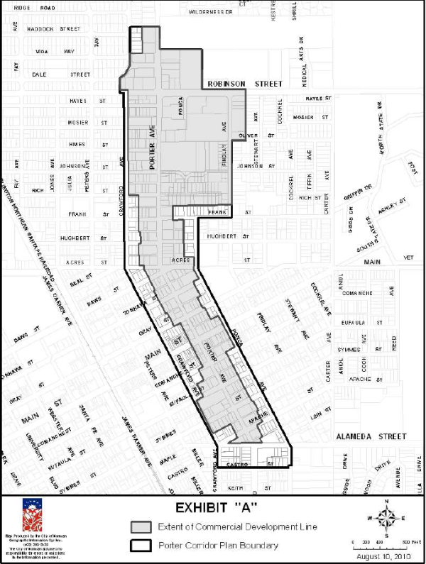
- Buffer walls.
(Ord. No. O-1011-2, 8-10-2010)
36-540 CCFBC, Center City Form-Based Code
- The Center City Form-Based Code, as expressly adopted by reference herein, shall be hereby amended as follows: In Part I, General Provisions, section 104 (Other Applicable Regulations), on Page 2, to add the following subsection C:
Within the Center City Form-Based Code Area of Norman exhibited in this section, and as that area is contained within the Central Core Area of Norman (see map exhibit to NCC 36-550) any two-family (duplex) structure with four or more bedrooms per unit is required to be sprinkled per the requirement in section P2904 of the International Residential Code (IRC) or NFPA 13D, or as these documents are amended. In Appendix B, section 3 (Standards of Development), to add the following subsection (h):
(h) Central Core Area of Norman sprinkling requirements. Within the Center City Form-Based Code Area of Norman exhibited in this section, and as that area is contained within the Central Core Area of Norman (see map exhibit to NCC 36-550) any two-family (duplex) structure with four or more bedrooms per unit is required to be sprinkled per the requirement in section P2904 of the International Residential Code (IRC) or NFPA 13D, or as these documents are amended. - The Center City Form-Based Code, as expressly adopted by reference herein, shall be hereby amended as follows:
In Appendix B, section 3 (Standards of Development), to add the following subsection (i):
(i) A theater, including one that sells alcoholic beverages in compliance with State law, may be incorporated into appropriate CCPUDs.
http://www.normanok.gov/sites/default/files/Planning/Images/FINAL%20Center%20City%20Form%20Based%20Code%20July%202017.pdf
Center City Form-Based Code Area Map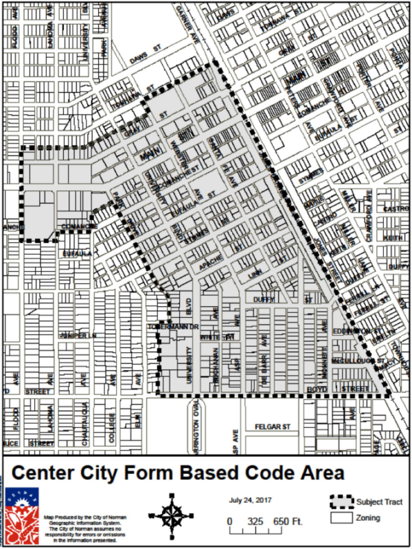
(Ord. No. O-1617-35, 5-23-2017; Ord. No. O-1718-47, 7-26-2018; Ord. No. O-1718-51, 8-23-2018)
36-541 CNZOD, Central Norman Zoning Overlay District
- Purpose. The purpose of the CNZOD, Central Norman Zoning Overlay District is to provide regulations to protect the unique and distinctive residential neighborhoods which contribute to the overall character and identity of Central Norman.
- Intent. The purpose of this residential overlay district is as follows:
- Protect and strengthen desirable and unique physical features, maintain integrity of the neighborhood, design characteristics, and recognize identity and charm;
- Promote and provide for appropriate revitalization of the neighborhood;
- Reduce conflict and prevent blighting caused by incompatible and insensitive development, and promote new compatible development;
- Stabilize property values;
- Provide residents and property owners with a planning tool for future development;
- Promote and retain affordable housing stock;
- Encourage housing that promotes aging in place;
- Ensure harmonious, orderly and efficient growth and redevelopment of the City.
- General provisions. The application processing, procedures, submittal requirements, recording requirements and regulations of NCC chs. 30 and 36 shall apply to all properties designated as lying within the CNZOD, Central Norman Zoning Overlay District.
- Boundary. The general area of the CNZOD, Central Norman Zoning Overlay District is located north of Boyd Street, south of Robinson Street and situated between the railroad tracks and Porter Avenue; more particularly the CNZOD includes the residentially zoned lots in the Old Silk Stocking Neighborhood and the R-3 zoned lots included in the Miller Historic District and the R-3 lots to the south and west of the Miller Historic District; as shown on the attached map, Central Norman Zoning Overlay District Boundary (exhibit 1).
- Applicability. The standards of this section shall apply to the following changes on properties defined in subsection (d) of this section:
- Any new construction of a residential structure on a vacant lot, which includes a bedroom count of four or more.
- Any new construction which adds to or alters an existing residential structure on a lot including any interior remodel which increases the bedroom count to five or more.
- Any demolition of an existing residential structure and reconstruction on a lot which includes a bedroom count of four or more.
- An addition/alteration of an existing structure that adds one additional bedroom to the existing structure which increases the total bedroom count to four or fewer is exempt from the requirements of subsection (h) of this section.
- Relationship to underlying zoning district. The provisions of the CNZOD, Central Norman Zoning Overlay District are in addition to the requirements of the underlying zoning district for a subject property and supersede the zoning district requirements. If there are any disputes about which provision is the most restrictive, this determination will be made by the Director of Planning or a designee.
- Uses permitted. Uses permitted and as regulated by the underlying zoning district.
- Special use.
- All residential units having four or more bedrooms per unit require approval from City Council of a special use permit pursuant to special use permit procedures contained within NCC 36-560.
- The term "bedroom" means an enclosed space within a dwelling unit that is not a garage, foyer, kitchen, bathroom, dining area or living room, that has at least seventy square feet of floor area. Dens, studies or other rooms which are capable of being used for sleeping quarters that contain a closet, or to which a closet could be added, shall also be considered a bedroom.
- Site development for new construction. As listed in subsection (e)(1) through (3) of this section.
- Parking.
- There shall be one parking space per bedroom provided on-site for each unit with four or more bedrooms. Standard parking space shall be 8 1/2 feet by 19 feet or nine feet by 18 feet.
- Tandem parking is allowed on-site; tandem parking will allow for no more than two parking spaces in depth.
- Landscaping and screening requirements.
- Landscaping requirements. All off-street parking areas used for residential purposes in any zoning district within the CNZOD, having at least four uncovered parking spaces and/or other vehicular use areas containing at least 600 square feet of open impervious area to be used as parking, the owners shall provide peripheral and street landscaping as required in NCC 36-564.
- Screening requirements. All off-street parking areas used for residential purposes in any zoning district within the CNZOD, having at least four uncovered parking spaces and/or other vehicular use areas containing at least 600 square feet of open impervious area to be used as parking, the owners shall screen from any abutting lot zoned or used for single-family purposes by a solid opaque fence at least six feet in height.
Exhibit 1. Central Norman Zoning Overlay District Boundary Map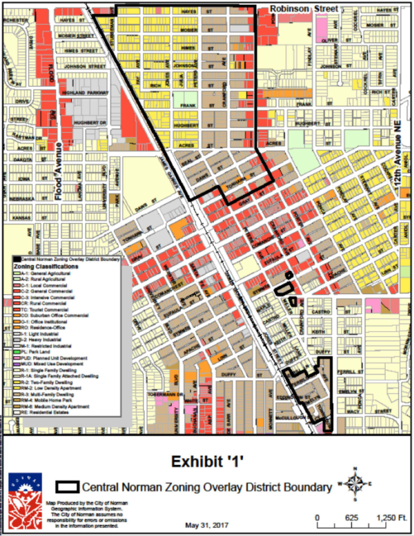
- Parking.
(Ord. No. O-1617-41, 6-27-2017)
36-542 Applicability Of Additional District Provisions
36-543 Determination Of Applicable Regulations
- Conditions of a more restricted district. Whenever the district regulations permit in one district a use also permitted in a more restrictive district, such use shall be subject to the conditions set forth in the regulations of the more restrictive district, unless otherwise provided herein.
- Conditions applicable to principal and accessory uses. In any district where a use is permitted as both a principal and an accessory use, the regulations applying to the principal use shall apply.
36-544 Open Space
- Eaves, cornices, windowsills and belt courses may project into any required front, rear, or side yard not to exceed two feet. No other part of a building shall project into any required side yard except that uncovered, open steps may project into a side yard not to exceed three feet, six inches. Uncovered, open porches may project into a required front yard not to exceed five feet.
- Land set aside for off-street parking may be counted as a part of the required open space or yard in any district, except, as provided herein with respect to livability space and recreation use in RM and RO districts.
- Where the dedicated street right-of-way is less than 50 feet, the depth of the front yard shall be measured from a point 25 feet from the center line of the street to the front building line.
- No dwelling shall be erected on a lot which does not abut on at least one public street for at least 35 feet and have a width of at least 50 feet at the building lines; provided, however, that any lot, or portion thereof, which is set forth on a recorded plat shall not be divided or attached to another lot, or portion thereof, in a manner that will create a dwelling site which has less width at the front building line than the narrowest width lot, measured at the front building line, which fronts on the same street as said dwelling site and which is located within the same block, or is across the street from the same block, in which said dwelling site is located.
- Side yard width on corner lots shall be 15 feet where the lots are back-to-back or have double frontage, and 20 feet in every other case.
- No minimum lot sizes and open space areas are prescribed for business and industrial districts. It is the intent of this chapter that lots of sufficient size be used by any business or industry to provide adequate parking and loading and unloading space required for normal operation of the enterprise.
- If any lot is smaller than the minimum requirements herein contained, but all sides of said lot touch lands under other ownership at the time of the passage of this chapter, the lot shall be used for no residential purposes other than a single-family dwelling.
- On any corner lot no wall, fence, sign, structure, or any plant growth having a height in excess of three feet above the elevation of the crown of the adjacent roadway surface shall be maintained within a triangle formed by drawing a line through the point of intersection of the required or created front and side building setback lines along the streets, said line forming the hypotenuse of an isosceles triangle. In no case shall the equal sides of the triangle so formed be required to be in excess of 30 feet. No automobile may be parked within or on the street side of the above-described triangle; provided, however, that curb cuts may be permitted within this triangle at the intersection of local streets in a single-family zoning district when, in the opinion of the City Engineer, such curb cuts will not create unsafe conditions. (See appendix E.)
- No open space or lot area required for a building or structure shall during its life be occupied by, or counted as open space for, any other building or structure.
(Ord. No. O-1983)
36-545 Communication Facilities
- Purpose. The intent of these provisions is to provide for the continued establishment of new wireless communication providers and the expansion of existing wireless communication services within the City, while simultaneously protecting neighborhoods, all through minimizing adverse visual and operational effects of facilities through careful design, sighting, screening, camouflage, and co-location.
- Definitions. The following words, terms and phrases, when used in this section, shall have the meanings ascribed to them in this subsection, except where the context clearly indicates a different meaning:
Antenna means communications equipment that transmits or receives electromagnetic radio frequency signals used in the provision of wireless services.
Applicable codes means uniform building, fire, electrical, plumbing, or mechanical codes adopted by the City, a recognized national code organization, local amendments to those codes, and applicable federal regulations.
Applicant means a person or entity who submits an application pursuant to this section.
Application means a request submitted by an applicant:- For a permit to construct a commercial communication tower or antenna;
- For a permit to co-locate an antenna or a small wireless facility; or
- To approve the installation or modification of a commercial communication tower, antenna, utility pole or wireless support structure.
- A utility pole owned or operated by the City in the right-of-way or easement, including light poles, traffic signals, and structures for signage; and
- A pole or similar structure owned or operated by the City that supports only wireless facilities, but does not include a commercial communication tower.
Commercial communications tower means a structure composed of a single spire erected and maintained by a public service corporation or a communications service provider that supports antennas used as part of a cellular mobile telephone communication system, and an accessory building not to exceed 400 square feet used to house equipment necessary for the operation of the cellular communication monopole and related facilities. The term "commercial communications tower" shall not include a utility pole or television and radio transmission towers.
Communications service provider means a cable operator, as defined in 47 USC 522(5), a provider of information service, as defined in 47 USC 153(24), a telecommunications carrier, as defined in 47 USC 153(51) or a wireless provider.
Day means calendar day.
Decorative pole means a pole specifically designed and placed for aesthetic purposes and on which no appurtenances or attachments, other than a small wireless facility, light fixtures, or specially designed informational or directional signage or temporary holiday or special event attachments, have been placed or are permitted to be placed pursuant to City ordinances and policies.
Electric distribution pole means a pole used to support an electric distribution system.
Fee means a one-time charge.
Rate means a recurring charge.
Right-of-way means the area within the jurisdiction of the City that is on, below, or above a public roadway, highway, street, sidewalk, alley or similar property or a public easement that authorizes the deployment sought by the wireless provider but does not include a federal interstate highway.
Small communication tower means a tower, possibly guy-wired, and no more than 190 feet tall, where antennas and communications equipment are placed to serve residential properties with internet service.
Small wireless facility and small cell facility mean a wireless facility that meets both of the following criteria:- Each antenna of the wireless provider could fit within an enclosure of no more than six cubic feet in volume or, in the case of an antenna that has exposed elements, and all of its exposed elements could fit within an enclosure of no more than six cubic feet; and
- All other wireless equipment associated with the facility is cumulatively no more than 28 cubic feet in volume. Ancillary equipment such as: electric meters, concealment elements, telecommunications demarcation box, ground-based enclosures, grounding equipment, power transfer switches, cut-off switches, and vertical cable runs for the connection of power and other services are not included in the equipment volume calculation.
Utility pole means a pole or similar structure that is used in whole or in part for the purpose of carrying electric distribution lines or cables or wires for telecommunications, cable or electric service, or for lighting, traffic-control, signage, or a similar function regardless of ownership, including a City-owned pole. The term "utility pole" shall not include structures supporting only wireless facilities.
Wireless facility means equipment at a fixed location that enables wireless communications between user equipment and a communications network, including:- Equipment associated with wireless communications; and
- Radio transceivers, antennas, coaxial or fiber-optic cable, regular and backup power supplies, and comparable equipment, regardless of technological configuration.
The term "wireless facility" includes small wireless facilities. The term "wireless facility" does not include the structure or improvements on, under, or within which the equipment is co-located, or coaxial or fiber optic cable that is between wireless support structures or utility poles or that is otherwise not immediately adjacent to or directly associated with a particular antenna.
Wireless provider means a wireless infrastructure provider or a wireless services provider.
Wireless services means any services, whether at a fixed location or mobile, provided using wireless facilities.
Wireless services provider means a provider of wireless services.
Wireless support structure means a freestanding structure, such as a monopole; commercial communication tower, either guyed or self-supporting; billboard; or other existing or proposed structure designed to support or capable of supporting wireless facilities. The term "wireless support structure" shall not include a utility pole. - Commercial communications towers.
- Zoning. Commercial communications towers are prohibited within any public right-of-way or residential zoning district. Such towers are allowed by right within the PL, C-1, C-2, C-3, I-1, I-2, M-1, A-1 and A-2 zoning districts subject to the restrictions contained herein.
- Parcel size. The parcel on which the commercial communications tower is proposed to be located should be of sufficient size to accommodate the tower and any support facilities, and also include access to a public street or accessible parking area. Ownership of lease of a separate parcel to accommodate the tower and support facilities may require platting and improvements before construction permits can be issued.
- Construction. In order to minimize visual impacts that can result from the presence of such facilities, towers (including attached antennas) are limited to monopole construction and may not exceed 200 feet in height, except in the PL and C-1 zoning districts where height is limited 90 feet.
- Setbacks. No commercial tower shall be located closer than 200 feet to the boundary line of any property zoned or used for any residential purpose or within 200 feet of any residential structure on the same lot. In the PL and C-1 districts, the tower or structure must observe a setback from any property line zoned or used for a residential purpose a distance equal to twice the height of the structure. All towers shall observe a minimum setback from any abutting street right-of-way equal to the height of the tower.
- Appearance. No lights, signals, or illumination shall be permitted on any tower unless required by the Federal Communications Commission (FCC), Federal Aviation Administration (FAA), or City agency. No commercial advertising, signage, or flags shall be allowed on any tower. This shall not prevent the joint use of a legal existing sign structure as a support mechanism for antennas or microwave dishes. Towers and accessory facilities should be colored or painted in muted tones that minimize their visibility, unless otherwise required by the FCC or FAA. Within the PL and C-1 district, only towers utilizing stealth technology will be allowed. The term "stealth tower" means a commercial communications tower that is incorporated into other equipment such that the facility is not readily recognizable as telecommunications equipment, and in fact may have a different primary function. Stealth towers may include, but are not limited to, sports lighting facilities at athletic fields, flagpoles which have fully enclosed antennas, shoe box or shielded parking lot lights with fully enclosed or shielded antennas, crosses, church steeples, or clock towers. Such facilities may replicate, duplicate, or simulate the construction of common structures that serve a dual purpose. Any rejection by staff of proposed stealth technology may be appealed to the Board of Adjustment.
- Site design. The area containing the monopole and accessory structures and any immediate surrounding area utilized for servicing of the communication tower shall be secured by a seven-foot-tall chain link fence, and the area within the fence paved or graveled and kept weed-free. Other than the street side of the site, any side that faces any residential use shall include opaque fencing and six-foot-tall evergreen shrubs or trees spaced six feet on center that are sufficient to screen the site. If security lighting is installed, such light should be directed into the site and only triggered by motion detectors.
- Co-location. To minimize tower proliferation, all reasonable efforts should be made to co-locate facilities on existing or new towers. If not possible, communication towers shall be located at least 1,000 feet apart. Antennas may be placed wholly within any building legally permitted in a commercial or industrial zoning district, or any publicly-owned building. A commercial antenna may be mounted flush to the exterior of such buildings if painted and integrated into the overall architectural design. Roof-mounted antennas may not extend more than 20 feet above the highest point of the roof structure, provided any supporting equipment is screened from nearby residential districts. Antennas may be attached to any utility structure (such as a water tower or electrical transmission tower) or public building not located in a street right-of-way, if the property is owned by a government or public agency, further, provided that the antennas do not extend more than 20 feet above the height of the structure.
- Application process. Before any construction permit can be issued, an application for a pre-development meeting must be submitted which complies with the requirements of NCC 36-571 and demonstrates compliance with the provisions contained herein, as well as applicable building codes, including an engineer's structural certification of the tower structure.
- Maintenance, operation and removal. The owner of the communication tower shall ensure that it is maintained in compliance with applicable codes and the applicable standards for commercial communication towers established by the Telecommunications Industries Association, as may be amended from time to time, in order to ensure the structural integrity of the tower. The failure to maintain structural integrity through compliance with these standards is hereby declared a public nuisance and the commercial communication tower may be abated, including the removal of the commercial communication tower under authority of and in compliance with the City Council's powers to declare and abate public nuisances. No antenna may be used which, by design or by actual operation, causes interference on any frequency actually used by any police, fire, or public ambulance service having authority or jurisdiction over any portion of the City.
- Removal of abandoned towers. Any commercial communication tower that is not actually used as an antenna support for a continuous period of 12 months shall be considered abandoned, and the permit owners for such antennas or commercial communication tower shall remove same at their expense within 90 days of receipt of notice from the City notifying the permit owner of said abandonment. In the event that such a commercial communication tower is not removed, notice of the intent by the City to remove shall be given to the applicant and to the owner of the real estate on which the commercial communication tower is located if different from the applicant. Abandoned commercial communication towers are hereby declared a public nuisance, removable by the City Council in accordance with nuisance abatement procedures or through the claims on a posted bond.
- Expiration of application. An application for a commercial communication tower shall be valid for no more than six months, unless a valid building permit is issued, and construction proceeds diligently.
- Television and radio transmission towers.
- Zoning. Television and radio transmission towers are permitted on private property only as a special use granted by the City Council in the A-2 zoning district and outside of the area contained between 48th Avenue West and 48th Avenue East, in accordance with NCC 36-560. Because of the potential visual impact of all transmission towers, the notification area for the special use required by NCC 36-560 shall be increased to include all property owners within one-half mile from the applicant's property. Towers in excess of 200 feet in height must be located at least one mile from any subdivision filed of record and served by public water and sewer systems.
- Construction. The FCC must authorize the height of any television or radio transmission tower. Towers up to 200 feet in height must be of a monopole design. Guyed structures are permitted if taller than 200 feet, provided engineering data is provided that shows a collapsed structure will be contained within the area of the guy wires, and the entire facility is located on the applicant's property.
- Setback. The tower must observe a setback from any property line equal to 50 percent of the height of the tower, but not less than 200 feet. Guy wire anchors must be located at least 25 feet from any property line.
- Appearance. No lights, signals, or illumination shall be permitted on any tower unless required by the FCC, the FAA, or any City agency. If lighting is required, only dual lighting shall be allowed (white lights during the day, red lights at night). All lighting shall be the least intrusive on nearby properties. No commercial advertising, signage, or flags shall be allowed on any tower. Towers and accessory facilities should be colored or painted in muted tones that minimize their visibility, unless otherwise required by the FCC or FAA.
- Co-location. To minimize tower proliferation, all reasonable efforts should be made to co-locate facilities on existing or new towers. Provision should be made on new transmission towers to allow antennas for personal wireless service or mobile radio service systems.
- Site design. All proposed or contemplated structures, towers, parking, and fencing must be included on a proposed site plan and shall provide for adequate landscaping to mitigate any visually intrusive elements from nearby property owners.
- Small communication towers.
- Zoning. Small communication towers are allowed on private property in the RE, A-1, A-2, C-2, C-3, I-1, I-2 and M-1 districts, provided they conform to the provisions contained herein. Small communication towers are not permitted within any public right-of-way.
- Construction. Small communication towers must not exceed 190 feet in height and shall be constructed in compliance with all applicable codes. An engineer's structural certification of tower structure must be submitted with a building permit application.
- Setback. Towers shall be set back from the property line a distance that protects adjacent property owners and/or habitable structure from damage if the tower collapses. The area of fall cannot be located on an adjacent property not owned by the applicant or on the public right-of-way. A certified engineer's report is required to verify adequate area of fall and guy wire installation. Towers shall observe a minimum setback from any abutting street right-of-way equal to the height of the tower.
- Appearance. No lights, signals, or illumination shall be permitted on any tower unless required by the FCC, FAA, or City agency. No commercial advertising, signage, or flags shall be allowed on any tower. Towers and accessory facilities should be colored or painted in muted tones that minimize their visibility, unless otherwise required by the FCC or FAA.
- Removal. If a small communication tower becomes inoperable and is not put back into service within six months, the owner of the tower shall remove the small communication tower and other related equipment.
- Small cell facilities.
- Permitted use. Co-location of a small wireless facility or a new or modified utility pole or wireless support structure for the co-location of a small cell facility shall be a permitted use in all zoning categories subject to the provisions of this subsection (f). However, any wireless provider that seeks to construct or modify a utility pole, wireless support structure or wireless facility that exceeds the height or size limits contained in this subsection (f), shall be subject to applicable zoning requirements and applicable codes.
- Permit required. No person or entity shall place a small wireless facility in the right-of-way without first filing a small wireless facility siting application and obtaining a building permit.
- Siting applications.
- The siting application shall be made by the wireless provider or its duly authorized representative and shall include the following:
- The applicant's name, address, telephone number, and email address;
- The names, addresses, telephone numbers, and e-mail addresses of all consultants, if any, acting on behalf of the applicant with respect to the filing of the application;
- A siting map depicting the location of proposed sites for small wireless facilities and related construction and engineering drawings for each location sufficient to demonstrate compliance with the provisions herein. Small cell facilities on existing poles, new poles, or modified poles shall not interfere with vehicular access to adjacent property; nor shall they be placed in a location that would interfere with an existing individual tree's canopy, nor block or encroach upon any sidewalk or walkway or placed unreasonably near another similar structure. For applications to co-locate on an existing pole, the applicant should provide an engineering analysis that demonstrates conformance with applicable codes, construction drawings stamped by a professional engineer licensed in Oklahoma, and a description of any make-ready work required, including any modification or replacement of the pole. Up to 25 proposed small cell facilities can be covered by one application.
- If a small wireless facility is proposed to replace an existing pole, or be located on an existing pole, the application shall indicate the owner of said pole.
- A statement of compliance with all applicable codes from a licensed engineer.
- Siting applications to co-locate facilities. An application fee equal to $200.00 each for the first five small wireless facilities on the same application and $100.00 for each additional small wireless facility on the same application. An application fee equal to $200.00 each for the first five small wireless facilities on the same application and $100.00 for each additional small wireless facility on the same application.
- Spacing Requirements. An application for a new wireless support structure within a 500-foot radius of an existing approved wireless support structure, utility pole, or other similar structure shall not be approved unless the applicant submits written documentation affirming that the new wireless support structure cannot be accommodated on such existing structure or pole due to one (1) or more of the following reasons: (a) The proposed small cell facility would exceed the structural capacity of existing or approved wireless support structures, utility pole, or other similar structures and that such existing structures or poles cannot be reinforced, modified, or replaced to accommodate the planned facility at a reasonable cost; or (b) The proposed small cell facility would cause interference impacting the usability of other existing telecommunications equipment at the site if placed on existing or approved wireless support structures, utility poles, or other similar structures, and that such interference cannot be prevented at a reasonable cost; or (c) Existing or approved wireless support structures, utility poles, or other similar structures cannot accommodate the planned small cell facility at a height necessary to function reasonably; or (d) The applicant is unable to enter into reasonable lease terms with owners of existing or approved wireless support structures, utility poles, or other similar structures; or (e) For other good cause shown as determined by City staff.
- Siting applications for installation, modification or replacement of a utility pole and associated co-location. An application fee equal to $350.00 per pole on the same application.
- Within 20 days of receiving an application, the City will determine and notify the applicant in writing whether the application is complete. If an application is incomplete, the City will specifically identify the missing information in its written communication to the applicant. The processing deadlines set forth herein will be tolled from the time the City sends the notice of incompleteness to the time the applicant provides the missing information. The processing deadline may also be tolled by agreement of the applicant and the City.
- An application shall not be required for routine maintenance, or the replacement of a small wireless facility with another small wireless facility that is substantially similar or smaller in size, weight and height, or for installation, placement, maintenance, operation or replacement of micro-wireless facilities that are strung on cables between existing utility poles in compliance with the National Electric Safety Code.
- Review time for applications to co-locate facilities. The City will issue a written decision in response to an application to co-locate small cell facilities within 60 days of receipt of the application. If the written decision is to deny the application, reasons for such denial shall be included in the written communication to the applicant. If the City does not issue a written decision within the prescribed time frame, the application will be deemed approved.
- Review time for applications for installation, modification or replacement of a utility pole and association co-locate. The City will issue a written decision in response to an application to install, modify or replace a utility pole and any associated co-location within 75 days of receipt of the application. If the written decision is to deny the application, reasons for such denials shall be included in the written communication to the applicant. If the City does not issue a written decision within the prescribed time frame, the application will be deemed approved.
- Appeals from the denial of a siting application. Upon receipt of a notice of the City's written decision to deny all or part of a siting application, the applicant may choose to cure the deficiencies in the application or may appeal the denial. If the applicant chooses to cure the deficiencies identified by the City, the application must be resubmitted within 30 days of the denial and will not require payment of an additional application fee. Upon receipt of a revised application, the City shall have an additional 30 days to approve or deny the revised application. Applicants may appeal the decision of an Administrative Official regarding a submitted siting application in accordance with NCC 36-570(f).
- The siting application shall be made by the wireless provider or its duly authorized representative and shall include the following:
- Height of small wireless facilities and associated poles and support structures.
- Small wireless facilities, and new or modified utility poles and wireless support structures for the co-location of small wireless facilities may be placed in the right-of-way as a permitted use subject to the following requirements:
- Each new or modified utility pole installed in the right-of-way shall not exceed the greater of ten feet above the tallest existing utility pole as of November 1, 2018, located within 500 feet of the new pole in the same right-of-way, or 50 feet above ground level.
- Each new small wireless facility in the right-of-way shall not exceed ten feet above an existing utility pole in place as of November 1, 2018, or for small wireless facilities on a new utility pole, above the height permitted for a new utility pole under subsection (f)(4)a.1 of this section.
- Small wireless facilities may be placed on property owned, leased, or otherwise controlled by the City only pursuant to a commercial lease approved by the City Council.
- Small wireless facilities, and new or modified utility poles and wireless support structures for the co-location of small wireless facilities may be placed in the right-of-way as a permitted use subject to the following requirements:
- Small wireless facilities standards.
- All small wireless facilities affixed to a utility pole which has exterior exposure shall be as close to the color of the utility pole as is commercially available to the wireless provider.
- The design and maintenance of all small wireless facilities, cables, wires, appurtenances, and utility poles, shall include the use of materials, colors, textures, screening and landscaping that will blend the small wireless facilities, appurtenances and utility poles to the natural setting or the built environment of the primary use.
- All small wireless facilities affixed to a decorative light pole must be installed in such a way that the cables, wires, appurtenances, and facilities are concealed within the pole to the maximum extent possible.
- Relocation or modification of small cell facilities. Within 60 days following written notice issued from the City, a wireless provider shall, at its own expense, protect, support temporarily or permanently disconnect, remove, relocate, change or alter the position of any small wireless facilities within the right-of-way whenever the City has determined that such removal, relocation, change, or alteration is reasonably necessary for the construction, repair, maintenance, or installation of any City improvement in or upon, or the operations of the City in or upon, the right-of-way, or if the City has determined that the facility's signal is interfering with other signals for traffic-control devices or emergency communications.
- Emergency removal or relocation of small cell facilities. The City retains the right and privilege to cut or move any small wireless facility located within the rights-of-way of the City, as the City may determine to be necessary, appropriate or useful in response to any public health or safety emergency. If circumstances permit, the City shall notify the wireless provider and provide the wireless provider an opportunity to move its own facilities prior to cutting or removing a facility and shall notify the wireless provider after cutting or removing a small wireless facility.
- Abandonment of facilities. A small wireless facility that is not operated for a continuous period of 12 months shall be considered abandoned, and the owner of the facility must remove the small wireless facility within 90 days after receipt of written notice from the City notifying the owner of the abandonment.
- Damage to the right-of-way. A wireless provider shall repair all damage to the right-of-way directly caused by the activities of the wireless provider in the right-of-way and return the right-of-way to its functional equivalence before the damage. If the wireless provider fails to make the necessary repairs within two weeks of written notice, the City may make the repairs and charge the wireless provider the reasonable, documented cost of such affairs. A wireless provider shall be required to comply with right-of-way and vegetation management practices adopted by the City.
- Proprietary powers reserved. Nothing in this section concerning the regulation of what is legally permissible or legally forbidden interferes with the proprietary right of the City Council to control the property held in the City's name or in the name of any of its trusts as either a corporate owner or as public trustee.
(Ord. No. O-9596-40, 5-28-1996; Ord. No. O-9899-33, 4-27-1999; Ord. No. O-0304-69, 5-25-2004; Ord. No. O-0809-14, 12-9-2008; Ord. No. O-1718-14, 12-28-2017; Ord. No. O-1819-18, 11-27-2018; Ord. No. O-2122-7)
36-546 Height
The regulations herein set forth qualify or supplement, as the case may be, the specific district regulations appearing in NCC 36-V.
- In measuring heights, a habitable basement or attic shall be counted as a story, provided that it is less than six feet above average grade for more than 50 percent of the total building perimeter. A story in a sloping roof, the area of which story at a height of five feet above the floor does not exceed two-thirds of the floor area of the story immediately below it and which does not contain an independent apartment, shall be counted as a half-story.
- Chimneys, elevators, flagpoles, spires, tanks, water towers, and other projections not used for human occupancy may extend above the height limit. This shall not be construed to allow a commercial communication tower.
- Churches, schools, hospitals, sanitariums, and other public and semi-public buildings may be built to a height of 55 feet or four stories if the minimum depth of front and rear yards and the minimum width of side yards required in the district are increased by one foot for each foot by which the height of such public or semi-public structure exceeds the height limit in feet prescribed for other structures in the district.
(Ord. No. O-0708-36; Ord. No. 884, art. III, § 3)
36-547 Exterior Appearance
- All new construction after October 28, 2005, must include masonry facades as outlined below. These requirements shall apply to all principal structures and accessory buildings larger than 108 square feet. For the purposes of this section, the term "masonry materials" means and includes brick, slump-faced or decorative concrete masonry unit (CMU), stucco, concrete (poured in place, pre-cast or tilt-wall) with aggregate, sandblasted or textured coating finish, stone, rock or other structural material of equal durability and architectural effect. Smooth-faced CMU, except as accent to approved finish material, shall not be installed on any commercial facade or the principal facade of any industrial building.
- Buildings requiring masonry on all sides. All buildings constructed on property zoned O-1, CO, C-1, C-2, and C-3, according to the City's official zoning map, shall have all exterior walls constructed using masonry material covering at least 80 percent of said walls, exclusive of all windows, doors, roofs, glass, or sidewalk and walkway covers.
- Buildings requiring masonry along street frontage only. All buildings constructed on property zoned I-1, I-2, or M-1, according to the City's official zoning map, shall have all principal facades (which is any side of a building that faces or is oriented toward any abutting street) constructed using masonry material covering at least 80 percent of said walls, exclusive of all windows, doors, roofs, glass, or sidewalk and walkway covers. This provision shall apply only to those structures adjacent to any State highway or an urban arterial as identified on the Comprehensive Plan, including the Transportation Plan, as amended or replaced with subsequent plans, and to any industrial lot abutting any zoning district other than industrial. This provision shall not apply to lots of record as of the date of adoption of the ordinance from which this chapter is derived if a building permit is obtained within one year after the effective date of the ordinance from which this article is derived, September 27, 2005.
- Buildings within any PUD. Any commercial or nonresidential use within a planned unit development shall have all exterior walls constructed using masonry material covering at least 80 percent of said walls, exclusive of all windows, doors, roofs, glass, or sidewalk and walkway covers, unless waived by the City Council when the PUD is approved.
- Special uses. Any institutional or nonresidential special use in any zoning district shall have all exterior walls constructed using masonry material covering at least 80 percent of said walls, exclusive of all windows, doors, roofs, glass, or sidewalk and walkway covers, unless waived by the City Council as part of the approval.
- Outdoor storage or display of materials and goods is prohibited in the CO and C-1 districts and within any required setback area in the TC district, as well as all public rights-of-way. However, in all commercial districts, an exception is granted for items located within five feet of the primary structure for display of vending machines, newspaper racks, bagged ice storage, small-scale propane sales, and other such similar items, provided that no such items encroach onto a public right-of-way or easement. In all other commercial zoning districts after October 28, 2005, the following criteria must be observed:
- In those zoning districts that allow outdoor storage or display of merchandise, such items may not be located immediately adjacent to any public right-of-way, but instead must be stored or displayed no closer than half the distance between the right-of-way and the principal building, or 25 feet, whichever is greater. However, display of living plant materials and ornamental statuaries may occur at any location so long as it does not create a visual barrier to traffic and is not within ten feet of a public right-of-way. This exception does not include landscape timbers, blocks, stones, bags of wood chips or soil, fencing materials, or other similar items.
- In those districts that allow the sale or repair of vehicles, where the principal use of the premises involves the sale and display of finished vehicles, such as automobiles, boats, recreational vehicles, construction vehicles and heavy equipment, no special setbacks are required other than landscaping that would be required for parking areas and buildings by other sections of this chapter. Vehicles or equipment may not be parking or displayed within any required landscape area.
- In no instance shall outside display of merchandise be located within, nor encroach upon, a fire lane, maneuvering aisle, or a parking space necessary to meet the minimum parking requirements of all of the uses on the lot.
- All existing outdoor storage areas must comply with the requirements of this subsection within two years of October 28, 2005, the effective date of the ordinance from which this article is derived, or seek approval by the City Council for a revised site plan that shows substantial compliance with these requirements. For all new or expanded areas of outside display or storage, such locations must be clearly identified on a site plan that has been approved by the City Council.
(Ord. No. O-0405-59, 9-27-2005)
36-548 Off-Street Parking Requirements
- Duty to provide and maintain off-street parking. The duty to provide and maintain the off-street parking spaces herein required shall be the joint and several responsibilities of the operator and owner of the use and the operator and owner of the land on which, or the structure or structures in which, is located the use or uses for which off-street parking space is required to be provided and maintained. Each parking space shall have minimum dimensions of 8 1/2 feet by 19 feet, plus adequate space for ingress and egress. No land shall be used or occupied, no structure shall be designed, erected, altered, used, or occupied, and no use shall be operated unless the off-street parking space herein required is provided in at least the amount specified, and maintained in the manner herein set forth; provided, however, that where off-street parking space is not provided or maintained for land, structures, or uses actually used, occupied, and operated as of July 1966, it shall not be required under this chapter.
- Number of off-street parking spaces required. Off-street parking spaces for motor vehicles shall be provided in at least the amount shown in the following list:
Use Spaces Required Dwellings and Lodgings: Single and two-family dwellings 2 per primary du, ADU more than 650 sq ft in area (where allowed), and garage apartment (where allowed) Fraternity or sorority houses 1 for each accommodation Mobile homes (park/subdivision) 2 per mobile home - Number of Off-Street Parking Spaces Recommended. Except for lots in the C-3, Intensive Commercial District, off-street parking spaces for motor vehicles are recommended to be the amount shown in the following list:
Use Minimum Recommended Dwellings and Lodgings: Apartments and apartment hotels 1.2 per du Boarding or rooming houses 1 per boarding or rooming unit Hotels or motels 1 each room in addition to spaces recommended for restaurant facilities Retail Trade: Department and variety stores 1 per 200 sq. ft. CSA Food and drug stores 6 + 1 per 200 sq. ft. CSA over 1,000 sq. ft. Furniture store, motor vehicle sales 1 per 500 sq. ft. GFA Liquor stores 3 + 1 per 300 sq. ft. GFA over 500 sq. ft. Night club or tavern 1 per 50 sq. ft. CSA Radio and television sales and/or repair 1 per 200 sq. ft. CSA or 1 per 175 sq. ft. GFA, whichever is greater Restaurants, drive-in and fast-food takeout 1 per 100 sq. ft. GFA Restaurants (except above) 1 per 50 sq. ft. CSA Shopping Centers: (including up to 10 percent office use) a. 25,000--400,000 Gross 4 spaces per 1,000 sq. ft. GLA b. 400,000--600,000 GLA 4.5 spaces per 1,000 sq. ft. GLA c. Over 600,000 GLA 5.0 spaces per 1,000 sq. ft. GLA In addition to the base ratio, for theaters, when in conjunction with a shopping center: d. Less than 100,000 GLA 3 per 100 seats e. 100,000--200,000 GLA 3 per 100 seats (over 450) f. Over 200,000 GLA 3 per 100 seats (over 750) In addition to the basic ratio, for food services when in conjunction with a shopping center (but not more than 10 percent of GLA). Food services does not include grocery stores: g. 25,000--100,000 10 per 1,000 sq. ft. of food service tenant h. 100,000--200,000 6 per 1,000 gross sq. ft. of food service tenant i. 200,000--600,000 No additional parking (other than basic index) j. Over 600,000 Reduction of 4 spaces per 11,000 gross sq. ft. of food service tenant Various specialty shops (camera, gifts, jewelry, etc.) 3 + 1 per 200 sq. ft. CSA over 500, or 1 per 275 sq. ft. GFA over 400, whichever is greater Services: Amusement establishments 1 per ea. 4 patrons (capacity) Automobile service stations 2 per service bay and 1 each service vehicle and 1 each 2 employees Banks or savings and loan companies 1 per 150 sq. ft. CSA Barber shops 1.5 per chair and 1 per each 2 employees Beauty parlor 2 per operator station and 1 per each 2 employees Bowling alleys 5 per lane and spaces required for affiliated uses Churches 1 per 4 seats in sanctuary Clubs or lodges (private, nonprofit) 1 per 50 sq. ft. of assembly area Crematorium 1 per 1,000 sq. ft. of floor area or portion thereof Funeral parlors or mortuaries 5 and 1 per 5 seats in largest chapel Hospitals and sanitariums 1 per 1 bed, 1 per hospital or staff doctor, and 1 per each employee at maximum shift Medical or dental clinics or offices 3 per treatment room and 1 each doctor or dentist Nursing, convalescent, or rest homes 1 per 4 beds and 1 per each 2 employees Offices, business or professional 1 per 300 sq. ft. GFA Private Schools: Nursery school, day care center, or elementary school 1 per employee and adequate off-street area for pick-up and delivery of children Nonboarding junior and senior high schools 1 per employee and 1 per each 8 students Self-service laundries, dry-cleaning 0.5 per machine Theaters, auditoriums 1 per 4 seats Manufacturing, Storage, and Wholesale: Manufacturing 2 + 1 per 3 employees and 1 per company vehicle* Printing and publishing 1 per 2 employees Warehousing (mini-storage) 1 per 8 rental units Warehousing (general) 10 percent GFA Wholesale establishments 2 + 1 per 3 employees and 1 per company vehicle *Note: Spaces required for company vehicles shall vary as to size so as to adequately accommodate the vehicle usually occupying the spaces. For uses not covered above, the requirements listed below are applicable: USE MINIMUM RECOMMENDED Retail stores and service establishments 1 per 200 sq. ft. CSA or 1 per 275 sq. ft. GFA, whichever is greater Other commercial and industrial 0.75 x maximum number of employees on premises at any one time. Note: The term "CSA" is an abbreviation for the term "customer service area" and means the total area available for regular customer service both inside and outside commercial establishments. Storage and kitchen areas and toilet facilities are not included. The term "du" means and is an abbreviation for the term "dwelling unit." The term "GFA" means and is an abbreviation for the term "gross floor area." The term "GLA" means and is an abbreviation for the term "gross leasable area." - Other factors determining off-street parking requirements.
- Fractional spaces. When determination of the number of spaces required by this chapter results in a requirement of a fractional space, any fraction less than one-half shall be disregarded and any fraction of one-half or more shall require one space.
- Enlarged/changed use.
- Residential uses. Whenever there occurs a change in residential use, by either an increase or a decrease in the number of units or by a change in the type of residential use, all the required off-street parking, including the parking provided for the existing use, shall conform to the requirements herein established.
- Nonresidential use. Whenever nonresidential land, structures, or uses are enlarged, expanded, or changed there shall be provided for the increment only of such land, structures, and uses enlarged, expanded or changed and maintained as herein required, at least the amount of off-street parking space that would be required hereunder if the increment were a separate land, structure, or use. However, where a lot with an existing structure is cleared and a new structure is erected thereon, there shall be provided and maintained off-street parking space as required herein.
- Joint use. When an off-street parking space is used jointly by two or more uses with different requirements, or two or more uses having the same requirements, an area shall be provided equal to the total of requirements of all uses.
- Landscaping of existing parking lots. A ten percent reduction in the number of spaces required by this chapter is permitted when landscaping as required by NCC 36-551 is provided for existing parking lots that are not subject to landscaping requirements. Landscaping improvements must be acceptable to the Director of Planning.
- Bicycle parking facilities.
- Accessory bicycle parking. For all buildings and structures erected and all uses of land established after the effective date of the ordinance from which this article is derived (July 23, 2009), accessory bicycle parking shall be provided as required by these regulations. Where a building permit has been issued prior to the effective date of the ordinance from which this article is derived, and provided that construction is begun within 180 days of such effective date, bicycle parking facilities in the amounts required for the issuance of said building permit are not required.
- Bicycle parking for expansion of main use. Whenever the existing use of a building or structure is enlarged or expanded, or additional parking installed for such expansion, bicycle parking facilities shall be provided for the new increment only of such enlarged or expanded building or parking area in at least the amount that would be required if the enlarged use or expanded parking area was a separate use or parking area.
- Residential use. For residential lots containing more than three dwelling units on the same lot, there shall be one bicycle parking space provided for the first eight car parking spaces, and one bicycle space for each ten car spaces provided thereafter. Single-family, two-family, and three-family units on the same lot are exempt from the requirement to provide bicycle parking facilities.
- Commercial, industrial, office, and institutional uses. For other nonresidential uses, there shall be one bicycle parking space provided for any parking area containing at least eight car spaces, and one additional bicycle space for each 20 car spaces thereafter.
- Design. Each bicycle parking space shall be sufficient to accommodate a bicycle at least six feet in length and two feet wide and shall be provided with some form of stable frame permanently anchored to the ground or the building structure to which a bicycle frame and both wheels may be conveniently secured, with at least two points of contact with the bicycle, using a chain and padlock and/or U-shaped locking device. Figure 1 shows the types of racks that are recommended and those that may not be used. The separation of the bicycle parking spaces, and the amount of corridor space shall be adequate for convenient access to every space when the parking facility is full. Figure 2 shows the minimum dimensions for bicycle racks in open or enclosed areas.
- Location. All bicycle parking spaces required by this chapter shall be located on the same zoning lot as the use served and shall be located in a clearly designated, safe and convenient location near the entrance of the use being served and within view of pedestrian traffic, if possible, to reasonably reduce the likelihood of bicycle theft. In multifamily areas, bicycle parking should be distributed throughout the complex near the entrance to each major building, preferably in a well-lighted area that is weather protected.
- Surface. Bicycle parking facilities shall be designed and maintained to be mud and dust free. A durable hard surface is required, but alternative paving material may be used, including gravel or stone, provided that edging materials such as landscape timbers, are used so that the bicycle parking area is clearly demarcated, and the rock material is contained.
Figure 1. Types of Bicycle Racks Recommended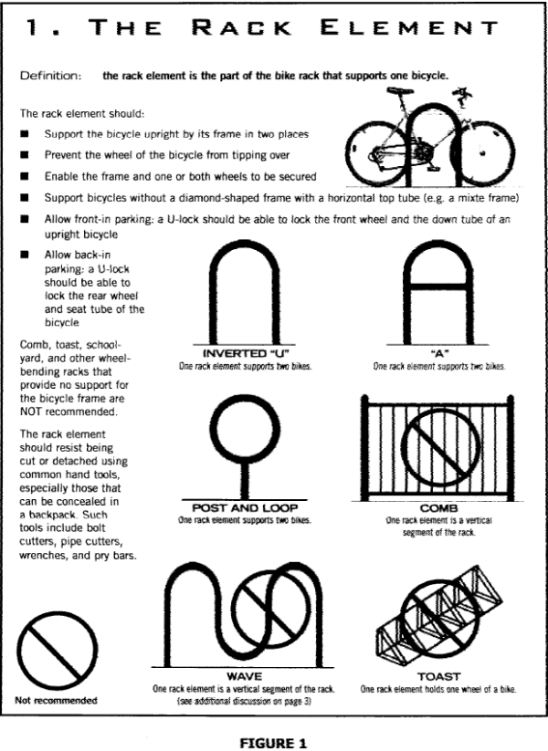
Figure 2. Minimum Dimensions for Bicycle Racks in Open or Enclosed Areas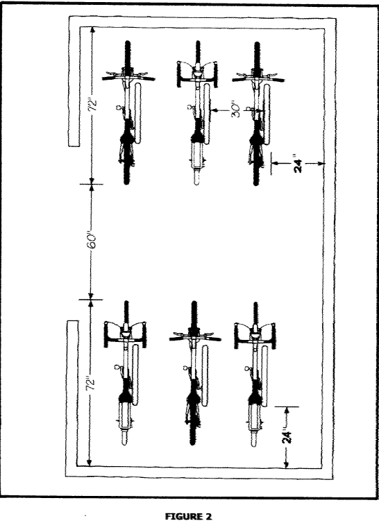
(Ord. No. O-7576-60, 3-1-1977; Ord. No. O-8687-48, 3-24-1987; Ord. No. O-9596-28, 3-26-1996; Ord. No. O-9697-51, 6-10-1997; Ord. No. O-0405-30, 1-24-2006; Ord. No. O-0809-44, 6-23-2009; Ord. No. O-1213-17, 11-27-2012; Ord. No. O-2122-6)
36-549 Commercial Outdoor Lighting Standards
- Purpose and intent. It is the intent of this section to define practical and effective measures by which the obtrusive aspects of commercial outdoor light usage can be minimized, while preserving safety, security, and the night-time use and enjoyment of property. These measures are intended to reduce light spillover, minimize glare, and decrease resource waste.
- Conformance with applicable codes. All new commercial outdoor lighting shall be installed in conformance with the provisions of this chapter, as well as the currently adopted versions of the building code, the electrical code, and the sign code of the City as applicable and under appropriate permit and inspection, whichever is the more restrictive.
- Applicability.
- Building construction. For all public or private commercial, industrial, institutional, and multifamily land uses, developments, buildings, and structures that require a permit subsequent to the effective date of the ordinance from which this section is derived (July 22, 2011), all new outdoor lighting fixtures shall meet the requirements of this section of the Code. These lighting regulations do not apply to properties zoned or used for single-family or two-family dwellings.
- Exempt lighting. The following luminaires and lighting systems are exempt from these requirements:
- Internally illuminated signs.
- Temporary lighting for theatrical, television, and performance areas.
- Lighting for non-commercial public or private athletic fields and recreational facilities, although any such lighting should be mounted, aimed, and shielded so that lighting primarily falls within the boundaries of such athletic fields and recreational facilities and lights are extinguished when not in use.
- Lighting in swimming pools and other water features governed by the most recently adopted National Electrical Code.
- Lighting for police, fire, and other emergency services, or required by any State or federal agency, such as the FAA.
- Interior lighting.
- Temporary holiday lighting.
- Low-voltage landscape lighting.
- Exterior lights that are mounted within interior courtyards or other areas of the building that are not visible from any abutting residential property.
- Decorative and architectural lighting of bridges, public monuments, or public art, although all luminaires should be installed to minimize glare and be shielded such that no glare is visible from any abutting property.
- New street lights installed within public rights-of-way.
- New lighting to be placed on historic properties such that it is important that the new lighting be in harmony with the period lighting of the property.
- Luminaires that are used exclusively to provide emergency power illumination at exit discharge locations that operate only from an emergency power source in the event of a normal power failure.
- Prohibited lighting. The following luminaires and lighting systems may not be used or installed within the City:
- The use of laser source light or any similar high-intensity light for outdoor advertising or entertainment.
- The operation of searchlights for advertising purposes.
- Compliance.
- Whenever a complaint about lighting is received, it shall be investigated to determine if corrective action is warranted. Corrective action is warranted when a Code Enforcement or Police Officer finds evidence of glare; light spillover onto property zoned or used for single- or two-family dwellings located either adjacent to or across the street from the subject property; or a visible bulb from an adjacent single- or two-family property. Corrective action includes, shielding, re-aiming, or replacement of a fixture with a full cut-off fixture.
- A one-time hardship extension may be administratively granted for up to 180 days, but the applicant must agree in writing to comply with this section of the Code and submit a plan for compliance.
- If the administrative exception is denied that decision may be appealed to the Board of Adjustment, who may grant the extension as a special exception.
- An additional one-year extension above the six-month administrative extension may be granted as a special exception by the Board of Adjustment provided:
- Lights within 25 feet of any residential boundary have been modified to comply with this section; and
- The extent of the renovation is large enough to require additional time based on the difficulty in finding compatible lights or the cost of the retrofit must be amortized over a longer time frame.
- General outdoor lighting standards.
- Fixture standards.
- Except as otherwise provided, all new nonexempt outdoor lighting fixtures shall be full cut-off fixtures mounted horizontally to the ground that prevent excessive light from going upward; outdoor luminous tube lighting does not require shielding.
- Ordinary maintenance of existing fixtures, including replacement of lamps, is specifically allowed. If existing fixtures are removed in order to upgrade, redesign, or reconfigure the lighting design on the property, then such fixtures must conform to the requirements of this section.
- Pole mounted lights.
- The maximum light level at any point on a property line of a parcel zoned or used for single- or two-family dwellings, located either adjacent to or across the street from the subject property, shall not exceed 0.2 footcandles.
- Shielding must be permanently installed to ensure continued compliance with this requirement.
- Parking lots should be illuminated to a minimum level of 0.2 footcandles.
- Light poles installed within 25 feet of any residential property line or public right-of-way may not exceed 20 feet in height. All other light poles may not exceed 30 feet in height except in instances of the expansion of a development, pole height may correspond with the height of existing poles. Height is measured to the underside of the lens and includes any concrete base.
- Lights mounted to walls of buildings or structures.
- All wall-mounted lighting on buildings or structures shall be full cut-off fixtures.
- When such new lights are installed on a wall, the lights may not exceed a mounting height above the roof line of the building or structure.
- New lights mounted on the underside of any roof overhang shall be fully recessed so that the lens cover is flush with the bottom surface of the overhang.
- Accent lighting.
- Except as allowed under subsection (f)(2) of this section, new fixtures used for accent lighting shall be full cut-off, or directionally shielded lighting fixtures that are aimed and controlled so that the directed light is substantially confined to the object intended to be illuminated. All such lights shall be aimed and shielded to prevent excessive light from going upward.
- Fixture types may include floodlights, wall sconces, lanterns, recessed can lights, architectural or decorative lights, or any other fixture that meets the intent of this section. Decorative architectural wall mounted fixtures are not required to be cut-off, semi cut-off, or full cut-off fixtures, so long as such fixtures do not result in any glare as later defined or light spillover of greater than 0.2 footcandles onto any residential property zoned or used for single- or two-family dwellings located either adjacent to or across the street from the subject property.
- Lighting required for the night-time display of the American flag may be of any type or intensity, but if directed up towards the flag, the light fixtures shall be installed to minimize glare and shielded such that the light source is not visible from any property zoned or used for single- or two-family dwellings located either adjacent to or across the street from the subject property.
- Canopy lighting. New lighting under canopies shall be adequate to facilitate the activities taking place in such locations (a minimum of 0.2 footcandles). Any facility utilizing a drive-through area such as banks, service stations, convenience stores, car washes, etc., shall comply with the following requirements:
- New light fixtures mounted in canopies or soffits for drive-through locations shall be installed so that the bulb is fully recessed, and the lens is flush with the bottom surface of the canopy, soffit, or overhang.
- Fuel dispensing locations shall be illuminated so that the minimum lighting level is at least ten lumens per square foot of the canopy area.
- Automated teller machines (ATMs) shall be illuminated so that the minimum lighting level is at least five lumens per square foot measured within a ten-foot-radius of the ATM.
- Fixture standards.
- Lighting plan requirements.
- Site plan required. All applications for building permits subject to this section which involve the installation of new outdoor lighting shall include an accurate site plan of the proposed development indicating the location of property lines, and all existing and proposed land improvements, including, but not limited to, buildings, parking lots, aisles and driveways, streets, sidewalks and walkways, landscaped areas, and accessory structures and the location and type of all exterior lighting fixtures.
- Required application information. In addition to the requirements in subsection (f)(1) of this section, all applications for building permits subject to this section which exceed 7,500 square feet of new construction in an office category, or 5,000 square feet of new construction for all other categories of use within this section, and involve the installation of new outdoor lighting shall include the following information:
- A photometric plan, prepared by a professional engineer, electrical contractor, or representative of the lighting industry, at a scale no smaller than one inch equals 60 feet when the subject property is adjacent to or across the street from property zoned or used for single- or two-family dwellings. When such a plan is submitted, it shall be accompanied by a written opinion from a professional engineer, electrical contractor, or representative of the lighting industry that the lighting plan complies with the standards of this section.
- The estimated footcandles at ten feet beyond all property boundaries that are adjacent to or are across the street from single- or two-family residential zones or uses.
- To the extent that such information is readily available from the supplier of each light source, a table indicating the type, light source, wattage, initial output in lumens, light loss ratio, height of luminaires above grade, and the maximum to minimum ratio.
- To the extent that such information is readily available from the supplier of each light source, manufacturer's catalogue specifications of all luminaires to be used, indicating the design, refractor (lens) type, cut-off angle (cut-off, semi cut-off or full cut-off), and any special features affecting the performance of the light.
- An applicant may submit a photometric plan, prepared by a professional engineer, electrical contractor, or representative of the lighting industry, at a scale no smaller than one inch equals 60 feet that demonstrates compliance with this chapter. If such a plan is submitted, it shall create a legal presumption that the subject property is in compliance with this chapter.
- Additional submission requirements. The above required plans, descriptions and data shall be sufficiently complete to enable the designated official to readily determine whether compliance with the requirements of this section will be met. If such plans, descriptions and data are not reasonably sufficient, the applicant shall submit such additional evidence as reasonably requested by the City.
- Lamp or fixture substitution. After any permit has been issued, manufacturer's specifications showing the substitute is equivalent to the approved fixture must be submitted to the City before any new outdoor light fixture or the type of light source therein is changed, together with adequate information to ensure compliance with this section.
- Certification of installation. For projects using 200,000 lumens or more a registered professional engineer shall certify in writing to the City that all lighting was installed in accordance with the approved plans.
(Ord. No. O-1011-44, 6-21-2011; Ord. No. O-1213-38, 3-26-2013)
36-550 Development And Maintenance Of Off-Street Parking Facilities
- Location of off-street parking spaces.
- Paved parking, residential. In a residential district, no part of a lot or tract shall be used as a parking space for a motor vehicle, boat, trailer, or other vehicle of equivalent or larger size, except upon an approved pavement surface which meets the requirements of this section.
- Paved parking, commercial. In a commercial district, no part of a lot or tract shall be used as a parking space for a motor vehicle, boat, trailer, or other vehicle of equivalent or larger size, except upon an approved pavement surface which meets the requirements of this section. Vehicle and equipment storage yards that are completely enclosed by an opaque fence are excepted from this requirement.
- Citations for illegal parking, issuance. Whenever any vehicle without a driver is found parked or stopped in violation of the restriction imposed by this section, the inspector finding the vehicle shall take its registration number and any other information displayed on the vehicle which may identify its owner, and shall conspicuously affix to the vehicle a citation in writing on a form provided by the City for the owner of the vehicle to answer the charge against him within ten days at the time and place specified in the citation; or, if the registration cannot be obtained, mail a notice letter to the property owner, tenant, or occupant of such location that such vehicle appears to be in violation of this section and that he has ten days from the date of the notification and the posting of the property to relocate the vehicle onto a legal parking surface. If the vehicle is not moved to a legal parking surface within the specified time period, the inspector may issue a citation to the property owner. The inspector shall deliver copies of the citation to the Traffic Division of the municipal Court.
- Administrative payment of citation. Any person may elect to pay a fine to the Court Clerk in lieu of appearing before the municipal Court for formal arraignment.
- Persons electing to so administratively pay their fines, shall first file with the Court Clerk an appearance form, a guilty plea form, and a court appearance waiver form.
- Persons electing to so administratively pay their fines shall pay $20.00 per each violation.
- Formal arraignment. Any person electing to appear before the municipal Court for formal arraignment, shall be subject, upon conviction, to a fine of not less than $20.00 nor more than $200.00 per each violation.
- Failure to comply with citation. If the owner of the vehicle does not respond in obedience to a citation affixed to the vehicle within a period of ten days, the citation shall be deemed to be delinquent, and a warrant shall be issued. In the event that the citation is thereafter prosecuted in the Court, the citation shall substantially conform to the requirements of NCC 22-103.
- Administrative payment of citation. Any person may elect to pay a fine to the Court Clerk in lieu of appearing before the municipal Court for formal arraignment.
- Presumption in reference to illegal parking.
- In any prosecution charging a violation of this section, proof that the vehicle described in the citation was parked in violation of this section, together with proof that the defendant named in the citation was at the time the citation was issued the registered owner of the vehicle, shall constitute in evidence a prima facie presumption that the registered owner of the vehicle was the person who parked or placed the vehicle at the point where, and for the time during which, the violation occurred.
- The provisions of subsection (4)a of this section shall apply only when the procedure prescribed in this section has been followed.
- Relation to premises. Such off-street parking space may occupy part of any required yard but may not occupy any required livability space. For any new commercial or industrial use, required off-street parking, which because of the size or location of the parcel cannot be provided on the same zoning lot with the principal use, may be provided on other property not more than 200 feet distant from the building site subject to guarantees acceptable to the Director of Planning and Community Development, but the applicant may appeal such guarantees to the City Manager. Such parking space shall be deemed to be required parking associated with permitted principal use and shall not thereafter be reduced or encroached upon in any manner. For any new residential use off-street parking shall be provided on the same tract, adjacent to said tract, or essentially in line with same tract across the alley or street right-of-way therefrom but not more than 200 feet distant from the building site.
- Parking in the central core area.
- The Central Core Area, as defined by City Council per the attached map exhibit, is generally defined as that area south of Robinson Street, west of 12th Avenue (East), north of Imhoff Road, and east of Berry Road.
- Within the Central Core Area, residential uses shall mean single-family dwellings, duplexes, triplexes, apartments, roominghouses and boardinghouses, and fraternities and sororities, but not any commercial, industrial, or institutional use.
- All new or expanded open parking areas for any residential use shall first be installed adjacent to any existing alley. Before new parking can be added in the front or side yard of the structure, parking must be installed in the rear yard to the maximum extent possible. New or expanded driveways within the front yard shall only be allowed when they are used to provide access to new parking areas in the rear yard. New or expanded parking areas within the front yard will only be approved after a review and determination by the Planning and Community Development Department that no other reasonable option exists. Such determination may be appealed to the Board of Adjustment.
- For any residential use, the total amount of impervious area, including, but not limited to, parking areas, patios, swimming pools, tennis courts, sidewalks and other similar permanent improvements, together with the ground floor surface area of all principal and accessory structures, may not exceed 65 percent of the total lot area. This percentage shall not apply when existing pavement is repaired or replaced (but not expanded), although a permit for such work shall still be obtained.
- When parking areas for residential uses are proposed on lots that are adjacent to or across the street from the principal residential use, the above limitations shall apply.
- Vision clearance at intersections. Off-street parking shall observe the provisions of NCC 36-544(h). Also, when a driveway intersects a public right-of-way, an unobstructed cross-visibility at a level between two and eight feet shall be allowed in the triangular areas on both sides of the driveway; two sides of each triangle being ten feet in length from the point of intersection of the driveway and public right-of-way and the third side being a line connecting the ends of the other two sides. No parking shall be permitted in these triangular areas.
- Development and maintenance of off-street parking facilities.
- Plans and permits. The construction, expansion, or modification of any driveway or parking area requires that a permit be issued by the Public Works Department and Planning and Community Development Department. An applicant for a building permit must submit plans showing the off-street parking required by this chapter. These plans must show location, arrangement, and dimensions of the off-street parking, turning spaces, drives, aisles, and ingress and egress in a matter satisfactory for the safety and convenience of pedestrian, as well as vehicular, traffic. The plans must also show landscaping materials and screening. A title block will accompany the plan showing scale date, north arrow, name and address of property owner, and person drawing parking and landscaping plan.
- Size. Each space shall be at least 8 1/2 feet wide and 19 feet long.
- Access. Adequate access drive shall be provided for all parking spaces not abutting a public street or alley. Ingress and egress driveways shall be no wider than 30 feet for residential uses, and 35 feet for commercial/industrial uses, exclusive of curb returns. The minimum driveway width shall be ten feet, except in the HD (Historic District) where the minimum width shall be eight feet, and the maximum width shall be ten feet unless the driveway was historically wider. Within the HD area only, two driveway ribbons of 18 inches in width are allowed.
- Screening. All commercial, industrial, and multifamily uses and all open off-street parking areas with more than five spaces that are located within 20 feet of a common property line shall be screened from any adjoining residentially zoned lot by a solid and opaque ornamental fence, wall, dense evergreen hedge, berm, or effective equivalent or combination, having a height of not less than six feet. Such fence, wall, hedge, or effective equivalent shall be maintained in good condition. Parking for all residential uses that is added in the rear yard must be screened from all abutting properties zoned or used for residential purposes, except that new parking which directly abuts an alley need not be screened from the alley. Whenever parking is installed in a front or side yard that is not perpendicular to the abutting street, those spaces must be set back from the front (or side) property line and sidewalk a minimum distance of ten feet. Within that ten-foot area, low-growing shrubs must be planted three feet on center and maintained in good order to screen the parking vehicle from the street. Shrubs must be at least 12 inches tall when planted and be a species that will grow to approximately three feet in height at maturity. A three-foot tall stone or masonry wall may be constructed as an alternative.
- Impervious area. For any residential use, the total amount of pavement, including, but not limited to, parking areas, patios, swimming pools, tennis courts, sidewalks and other similar permanent improvements, together with the ground floor surface area of all principal and accessory structures, may not exceed 65 percent of the total lot area. This percentage shall not apply when existing pavement is repaired or replaced (but not expanded), although a permit for such work shall still be obtained.
- Improvement.
- Surfacing, marking, and drainage. All off-street parking spaces and their access roads shall be paved with an all-weather surface of asphaltic concrete, Portland cement concrete or any equivalent material acceptable to the City Engineer and maintained such that no dust will result from continued use. Spaces shall be arranged and marked so as to provide for orderly and safe parking. Drainage shall be provided to dispose of all surface water without crossing sidewalks. For lots in the A-2, A-1, or RE districts which do not touch or face land zoned an urban residential designation (R-1, R-1-A, R-2, RM-2, RM-4, RM-6, R-3, or RO) the access driveway for a single-family dwelling may be paved with gravel or stone.
- Existing nonconforming parking. Gravel, crushed stone, or rock may no longer be used for paring in the urban area, except for parking areas which were established before July 1966, and are continuously maintained in accordance with the maintenance requirements of the currently adopted International Property Maintenance Code, which is adopted in NCC 16-VI. If the owner of a nonconforming gravel parking area fails to maintain such area in an orderly and weed-free condition, a notice violation can be issued. Failure to correct any deficiency within the prescribed time frame shall result in the property losing its legal, nonconforming status, and require the improvement of the lot to the then-current requirements of this section.
- Barriers/bumpers. Except for parking areas provided for single-family and two-family units, suitable barriers or curbs shall be provided to protect public sidewalks. Wheel or bumper guards shall be located so that no part of any vehicle shall extend beyond the parking area, intrude on pedestrian ways, or come in contact with walls, fences or plantings.
- Landscaping. From the effective date of the ordinance from which this article is derived, all new off-street parking areas with six or more spaces shall be landscaped as per the requirements of NCC 36-551. For enlarged parking areas, only the increment of expansion shall be subject to landscaping requirements.
- Waiver of surfacing requirements for those who are disabled. The Planning Director may, upon written request, consider a waiver of surfacing requirements which would permit persons with a disability to park their vehicles on unimproved front or side yard surfaces in order to allow access to a walkway suitable for safe transport to their dwelling unit. Consideration will be given only to individuals that qualify for emergency access grant funds as administered by the City and to owners of vehicles currently displaying a handicapped person decal. The applicant shall, in writing, describe why he is unable to comply with the parking ordinance and what special needs will be met through a waiver. After review of the letter of application, the Planning Director shall either approve or deny the request. The Director's decision may be appealed to the Board of Adjustment.
- Additional requirements for parking lots permitted as a special use and for parking lots for uses adjacent to a residential use or district. In any case where:
- Special use is granted for the use of property for off-street parking in a residential district;
- When parking is provided for a commercial, industrial or church use and abuts or faces a residential district; or
- When parking is provided for a multifamily use abutting or facing a single-family use or district, the following restrictions shall apply:
- The sides and rear of any such lot shall be screened from the residential district by a solid and opaque ornamental fence, wall, dense evergreen hedge, berm, or effective equivalent, having a height of not less than six feet. Such fence, wall, hedge, or effective equivalent, shall be maintained in good condition and observe the setback requirement of subsection (c)(3)b of this section.
- No parking shall be permitted within a front yard setback line established 20 feet back of the property line of interior and corner lots wherever the parking lot immediately abuts or is directly across the street from the front yard of a residential unit, except as amended by NCC 36-551(b)(2). On a corner lot the requirements regarding sight triangles set forth in NCC 36-544(i) must be met.
- All yards shall be landscaped with grass, shrubs, or evergreen ground cover and maintained in good condition the year around.
- Any lighting that is installed shall have minimal impact on abutting properties. All lights must be shielded or oriented so that the light source does not shine onto nor is visible from any abutting property or right-of-way.
- Parking, stopping, standing between curb and private property.
- No person shall park, stop or stand any motor vehicle in the space between the curbline of the street and the private property line on any street unless there be an approved cutback especially provided for such purpose. This section shall not be construed to prevent parking of vehicles outside of the front property line of residential property where commercial parking is allowed as a use permissible on certain days or as special use.
- In the event the owner of any land lying between the right-of-way lines of the street and setback lines of his tract desires to surface with concrete or asphalt he shall first submit the plans and specifications of the proposed cut, paving, drainage, and lot design to the City Engineer for said Engineer's approval. In no case shall parking be permitted or any cutback for ingress and egress be constructed with the sight triangle specified in NCC 36-544(i). In addition, whenever a new curb or parking area is installed, it shall be so designed and used such that parked vehicles will not protrude into the traffic lane portion of the street.
- Space requirements at various parking angles. The table provided below furnishes the aisle width, curb length and center-to-center widths required at various parking angles. The space requirements applicable for eight-foot six-inch stall width shall be met or exceeded.
Core Area Map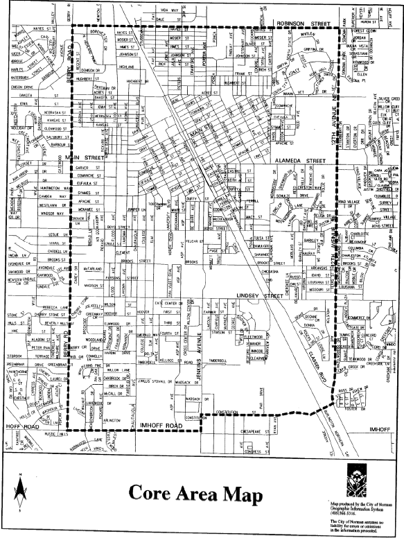
Table of Aisle Width, Curb Length and Center-to-Center Widths Required at Various Parking Angles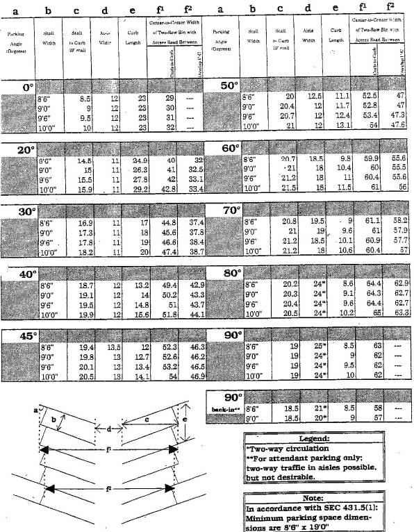
(Ord. No. O-7980-2; Ord. No. O-8788-27, 1-12-1988; Ord. No. O-8788-57, 6-28-1988; Ord. No. O-8889-41, 4-11-1989; Ord. No. O-9091-28, 4-23-1991; Ord. No. O-9899-26, 3-23-1999; Ord. No. O-0405-30, 1-24-2006; Ord. No. O-0506-62, 7-25-2006; Ord. No. O-1314-15, 4-22-2014)
36-551 Landscaping Requirements For Off-Street Parking Facilities
- Intent of landscaping requirements. The intent of this section is to protect and promote the public health, safety and welfare by requiring the landscaping of parking areas which will serve to reduce wind and air turbulence, heat and noise, and the glare of automobile lights; to prevent soil erosion; to reduce the level of carbon dioxide and return pure oxygen to the atmosphere; to provide shade; to visually enhance the appearance of parking areas; and to generally promote a healthful and pleasant environment. All areas used for the display, parking, or storage of any and all types of vehicles, boats, or construction equipment are subject to provisions herein.
- Landscaping requirements. For all off-street parking areas, in any zoning district, having at least six parking spaces and/or other vehicular use areas of at least 900 square feet of impervious area to be used as parking, the owners shall provide peripheral landscaping and street landscaping as indicated below.
- Peripheral landscaping requirements.
- Peripheral landscaping shall be required along any side of a parking area that abuts adjoining property that is not a street or alley right-of-way.
- A landscaping strip no less than five feet in width shall be located between the parking area and the abutting property lines.
- At least one tree for each 40 linear feet or fraction thereof shall be planted in each landscaping strip. The required trees may be evenly spaced or grouped. The remaining area must be covered with solid sod or live ground cover.
- In addition to the required trees, a wall, fence, hedge, berm, or other durable landscape barrier shall be planted or installed. The height of any such hedge or barrier shall be no less than six feet. Such barrier shall not extend beyond the front setback line established on the adjoining lot, except as necessary to completely screen any parking.
- At least one shrub or vine for each ten feet of non-living durable barrier (such as a wall or fence) shall be planted between the parking lot and the barrier.
- Peripheral landscaping requirements shall not be applicable in the following situations:
- To those portions of the property that are opposite a building located on the abutting property line.
- Where the abutting property is zoned for nonresidential uses or is used for another parking area, only the tree provision and the landscape strip, planted with grass or ground cover, shall be required.
- 20 percent of the trees for peripheral landscaping requirements can be evergreens that normally grow to an overall height of a minimum of 15 feet.
- Street landscaping requirements.
- Street landscaping shall be required along any side of a parking lot that abuts the right-of-way of any street, road or highway.
- A landscaping strip ten feet in depth shall be located between the abutting right-of-way and the parking lot. For parking lots which are zoned residentially or lie adjacent to or directly across the street from residentially zoned land, a landscaping strip 20 feet in depth shall be provided. If a three-foot to four-foot masonry or rock wall is installed adjacent to the parking area, the required landscaping strip may be reduced to ten feet in depth.
- At least one tree for each 40 linear feet or fraction thereof shall be planted in the landscaping strip. The required trees may be evenly spaced or grouped. The remaining area must be planted with solid sod or live ground cover.
- A hedge, landscaped berm, or other living durable plant barrier shall extend the entire length of the landscaping strip. The height of any such barrier or hedge shall be no more than three feet. The first ten feet on both sides of any driveway pavement is excluded from this requirement but shall be planted with grass or ground cover.
- In lieu of the requirements of subsections (c) and (d) of this section, at least one tree for each 20 linear feet or fraction thereof shall be planted in the landscaping strip. The required trees may be evenly spaced or grouped.
- Peripheral landscaping requirements.
- Landscaping requirements for off-street parking and other vehicular use areas having more than 30 parking spaces. The owners shall provide peripheral landscaping and street landscaping, as indicated above and interior landscaping, as indicated below.
- Automatic irrigation shall be provided to all required landscape areas.
- Interior landscaping requirements.
- Off-street parking areas shall have at least 15 square feet of interior landscaping for each parking space excluding those spaces abutting a perimeter for which landscaping is required by other sections hereof and excluding all parking spaces which are directly served by an aisle abutting and running parallel to such a perimeter.
- Each separate landscaped area shall contain a minimum of 200 square feet, shall have a minimum dimension of at least five feet, and shall include at least two trees. The remaining area shall be landscaping material not to exceed three feet in height, except for incidental pathways or sidewalks.
- The total number of trees shall not be less than one for each 100 square feet or fraction thereof of required interior landscaped area.
- Landscaping and islands shall be reasonably dispersed throughout the interior of the parking lot. Each row of parking which terminates within the interior of the lot shall be terminated with a landscaped island. No parking space shall be located more than 85 feet from a portion of landscaped open space required by this section.
- Plant material. Species of plant material shall be acceptable to the Director of Planning (see appendix F for a list of acceptable plant materials).
- Trees.
- For the purposes of this chapter, the term "tree" means any self-supporting woody plants which usually produce one main trunk and normally grow to an overall height of a minimum of 15 feet in the County. No one species may constitute more than 50 percent of the tree species that are planted, unless the number of trees to be installed is less than three.
- Trees having an average natural spread of crown less than 15 feet may be substituted by grouping the same so as to create the equivalent of a 15-foot crown spread. Trunks must be maintained in a clean condition over five feet of clear wood.
- Deciduous tree species shall be a minimum of eight feet overall height, with a minimum caliper of 1 1/2 inches immediately after planting. Evergreen trees shall be a minimum of six feet in height.
- Trees of species whose roots are known to cause damage to public roadways or other public works shall not be planted closer than 12 feet to such public works, unless the tree root system is completely contained within a barrier acceptable to the Director of Planning.
- Shrubs and hedges.
- For the purposes of this chapter, the term "shrub" means any woody plant that usually remains low and produces shoots or trunks from the base.
- Hedges, where required shall be a minimum of two feet in height when measured immediately after planting and shall be maintained so as to form a continuous, unbroken, solid, visual screen within a maximum of one year after planting.
- Vines. For the purposes of this chapter, the term "vine" means plants which normally require support to reach mature form.
- Trees.
- Alternative landscaping method, xeriscape design. In order to conserve water, the City does encourage the application of xeriscape design principles when meeting the landscaping requirements of this section. The term "xeriscape" is derived from a Greek word meaning "dry." The desired effect is not the creation of a desert environment, but the use of appropriate materials and methods to create a green environment with a lower demand for water. The following principles guide this philosophy.
- Planning and design. Consider the use of the landscape areas as well as the type of soil and exposure to the sun. On-site detention is often required in new developments. It should be incorporated into the overall landscape design.
- Limited turn area. Ground cover must be installed to prevent soil erosion. Limit turf areas, which have a high demand for water, to locations that will be subject to heavy foot traffic. Consider the use of native grasses that are more drought tolerant, such as Buffalo Grass.
- Efficient irrigation. Group plants with similar water needs so that the appropriate amount of water can be applied at the right time. Plan to irrigate turf areas separately from other plants. Trees and shrubs should be watered deeply to encourage good root development. Use different types of sprinkler heads for different purposes and consider drip irrigation for certain plant groups. Timers and water-sensing devices that respond to rain and soil moisture are recommended for all new installations.
- Soil improvement. Protect existing topsoil by stockpiling it during construction, and control erosion using good construction practices. Test and analyze the soil and add organic matter to loosen soil. Gypsum should be added to heavy clay soils to lower its pH and loosen the soil.
- Appropriate plant selection. Many varieties of drought tolerant plants are available that have a lower demand for water, once established. Native species are better adapted to this climatic zone and should be used.
- Mulch. Mulch should be used around all newly planted trees and shrubs, as it saves moisture, reduces weed growth, and adds interest, while reducing the need for turf. Mulch should be three inches deep, over soil that is covered with a breathable fabric. Avoid the use of solid plastic sheeting.
- Maintenance. Turf areas should not be kept too short. Mowing height should be raised during hot summer months. Turf areas should be mowed using a mulching mower, and clippings left on the lawn to decompose and add nutrients back into the soil. Trees should be pruned to enhance their appearance, improve their health, and allow good vision throughout the parking area.
- Other requirements for landscaped areas.
- Installation.
- All landscaping shall be installed according to accepted planting procedures and landscaped areas must be protected from vehicular encroachment by installing curbs, bumper blocks, or other permanent barriers.
- A certificate of occupancy is required for all parking areas having six or more spaces and no certificate will be issued unless the landscaping meets the requirements herein provided. Due to weather, season, or climatic conditions unsuitable for planting, the installation of landscaping may be deferred by providing a performance agreement in the form of cash or a certificate of deposit equal to 125 percent of the cost of providing and installing all required plant materials, including any required irrigation system. The estimate shall be prepared by a registered landscape architect or licensed nurseryman. The installation will be deferred until the next growing season, but no longer than nine months.
- Maintenance.
- The owners shall be responsible for providing, protecting, and maintaining all landscaping in growing and healthy condition; shall replace it when necessary; and shall keep it reasonably free from debris. Maintenance and replacement shall be ensured by providing a maintenance and replacement guarantee in the form of cash, a certificate of deposit, a letter of credit, or surety bond equal to 50 percent of the cost of all plant materials including installation before a certificate of occupancy is issued. Said deposit will be held for a period of three years after the initial installation is completed and will be returned to the owner after reinspection of the property to verify the viability of all required plant materials.
- Should the owner not maintain the property, as provided in subsection (m)(2)a of this section, the City has the authority to enter the premises upon written notice and perform the necessary maintenance. The cost of performing said maintenance shall be certified by the Director of Planning and transmitted to the owner. Should the owner fail to pay the cost of maintenance within 30 days of receipt of said notice, the cost shall become a lien on the property.
- Permanent automatic irrigation is required for all interior islands in parking areas with more than 30 spaces. Automatic irrigation is not required for smaller lots, although provision for watering all plant material must be addressed. At a minimum, hose bibs must be installed throughout the lot so that no landscape area is more than 100 feet from a water source.
- Installation.
- Landscape plan, submittal requirements. Four copies of a detailed landscape plan must be submitted in conjunction with any application for a building permit that includes six or more parking spaces, and shall include the following:
- The location of existing property lines and dimensions of the tract, accurately drawn to scale.
- The location of existing and proposed utilities and all easements on or adjacent to the lot.
- The location of all existing and proposed buildings and parking areas, including the exact number of parking spaces.
- The location and dimensions of all required landscape areas, including the approximate square footage of each interior island.
- Detailed sprinkler diagram.
- A tabulation of all plant materials, by Latin name, common name, size, type, and number of species.
- The plan shall clearly indicate the location of all plant material that is included in the tabulation.
- The location, height, and type of screening or fencing that will be installed.
(Ord. No. O-9091-28, 4-23-1991; Ord. No. O-9394-27, 2-8-1994; Ord. No. O-9899-26, 3-23-1999; Ord. No. O-0203-10, 10-22-2002; Ord. No. O-0809-29, 1-27-2009; Ord. No. O-1617-42, 6-27-2017)
36-552 Fencing, Walls, And Screening
- In a residentially zoned district, fencing or screening may not project forward of a required front setback line, unless such fencing is less than four (4) feet in height. Fencing along the side or rear property lines:
- In any district zoned A-1, A-2, or RE, upon submittal of an application and necessary information, as required by the Planning and Community Development Department, an applicant may seek the approval of the Administrative Review Committee for alternative fence heights. The Administrative Review Committee shall be composed of the City Engineer, the Traffic Engineer, the Building Official and the Director of Planning and Community Development, or their designee. The Administrative Review Committee may approve such requests where all of the following occur:
- The City Engineer evaluates and approves the proposed fence location and height, taking into consideration applicable codes;
- The Traffic Engineer evaluates and approves the proposed fence location and height, taking into consideration application codes;
- The Building Official evaluates and approves the application in light of applicable codes and regulations; and
- The Director of Planning and Community Development or their designee evaluates and approves the application in light of applicable Norman zoning and development codes, regulations, guidelines and policies.
- Such screening must be continuously maintained in good condition and repaired or replaced within a reasonable time period.
- Fencing along the side or rear property lines:
- May be erected within any utility easement but is subject to removal by any franchised utility company whenever installation or repair of their facilities is required.
- Excepting an allowance obtained pursuant to subpart (b) herein, may not exceed eight (8) feet in height, unless the written consent of the abutting property owner is secured, or the Board of Adjustment approves the height, location, and materials as a special exception.
- May not be constructed of corrugated fiberglass, corrugated metal, or unpainted sheet metal, nor contain any barbed wire.
- Walls of brick or masonry material, which require a permanent foundation, may not be constructed within any designated utility easement without the written consent of all affected utility franchise holders.
- For parking areas containing six (6) or more parking spaces and/or other vehicular use areas of at least 900 square feet of impervious area to be used as parking, the owners shall screen from any abutting lot zoned or used for single-family purposes by a solid opaque fence at least six (6) feet in height.
- The side and rear property boundaries of all lots used for commercial, industrial, and multifamily uses shall be screened from any abutting lot zoned or used for single-family or two-family purposes by a solid opaque fence at least six (6) feet in height.
- Such fence shall be constructed of any material except for corrugated fiberglass, corrugated metal, or unpainted sheet metal, nor contain any barbed wire.
- No screening may exceed eight (8) feet in height, unless approved by the City Council as part of a specific site plan or granted as a special exception by the Board of Adjustment.
- Any fence requiring a permanent foundation may not be constructed within a utility easement unless written approval has been granted by all affected utility franchise holders.
- Whenever the proposed use abuts a public alley that is shared with one- or two-family dwellings, opaque screening shall be installed on the commercial, industrial, or multifamily property, and shall be solid and continuous except for requiring openings or access drives.
- Such screening must be continuously maintained in good condition and repaired or replaced within a reasonable time period.
(Ord. No. O-9899-26, 3-23-1999; Ord. No. O-1617-42, 6-27-2017)
36-553 (RESERVED)
36-554 Short-Term Rentals
- No person shall manage or operate a short-term rental without a license and appropriate fees paid, as provided in the City fee schedule, NCC 20-2706.
- An applicant may be issued no more than four short-term rental licenses; unless the applicant complies with NCC 36-560.
- Short-term rentals are not permitted outdoors, in an accessory structure (e.g., shed, garage, etc.) or in a recreational vehicle.
- Only one party of guests are permitted per short-term rental and anyone under the age of 18 years is prohibited from renting the short-term rental.
- Use of the short-term rental for any commercial or social events is prohibited.
- The short-term rental shall outwardly appear as a residential dwelling.
- Short-term rentals shall not adversely affect the residential character of the neighborhood, nor shall the use generate noise, vibration, glare, odors, or other effects that unreasonably interfere with any person's enjoyment of his residence.
- A licensee or guest of a short-term rental shall not use or allow use of sound equipment, amplified music and musical instruments.
- A licensee or guest of a short-term rental shall not violate any parking ordinances of this Code of Ordinances.
- A licensee of a short-term rental who does not reside within the City metro area must identify an individual to serve as a local contact to respond to emergency conditions.
- A local contact designated in the license application must be present within the City metro area and be available to respond within one hour after being notified of an emergency by a guest of the short-term rental, by a City employee, or by an individual.
- If there is a change related to a local contact, the licensee must provide updated or new information to the City Clerk in writing within three business days.
- The license holder shall provide the valid license number on any listing advertising or soliciting the property for use as a short-term rental. The license holder shall only advertise the short-term rental as allowed by their short-term rental license. An owner, or a person in control of a dwelling, may not advertise or promote, or allow another to advertise or promote, the dwelling as a short-term rental if the dwelling is not licensed by the City as a short-term rental.
- If a building permit prohibiting occupancy of the structure is active, no person may occupy, for sleeping or living purposes, the structure until final inspections have been passed, the building permit is closed, and a certificate of occupancy granted.
Cross reference--See NCC 20-XXVII.
36-555 Group Housing Project
In the case of a housing project consisting of a group of two or more buildings to be constructed on a plot of ground of at least three acres not subdivided into the customary streets and lots, and which will not be so subdivided, or where the existing or contemplated street and lot layout make it impracticable to apply the requirements of this chapter to the individual buildings in such housing project, the application of such requirements to such housing project shall be done by the Planning Commission in a manner that will be in harmony with the character of the neighborhood, will insure a density of land use no higher and a standard of open space at least as high as required by this chapter in the district in which the proposed project is to be located. In no case shall the project be authorized if it includes a use or building height prohibited in the district in which the housing project is to be located.
(Ord. No. 884, art. III, § 5)
36-556 Townhouse Development
- Townhouses shall be subject to the following area regulations:
Table I. Bulk and Area Requirements for Townhouse DevelopmentsAreas in Square Feet (Distances in Linear Feet) Type of Regulation RM-6 district RO district Lot area, minimum: Townhouse development 24,000 24,000 Individual townhouse lot 1,500 1,500 Townhouse development lot area, per townhouse lot 2,400 2,400 Lot width, minimum: Interior lots 20 20 End lots: Abutting a side street 35 30 Not abutting a side street 30 30 Yards, minimum: Front yards 25 10 Rear yards: Backing on a street 25 10 Not backing on a street 15 15 Side yards: Interior lots -- -- End lots: Interior side -- -- Side abutting a street 15 10 Side abutting other property 10 10 Floor area ratio, maximum: Ratio of total floor area to land area of townhouse development 0.4 0.8 Ratio of townhouse floor area to area of individual townhouse lot 0.6 1.2 Coverage, maximum, in percent: Of townhouse individual lot 50 50 Of required rear yard 20 30 - In each townhouse development there shall be common livability space in the amount of at least 350 square feet per dwelling unit. Each common livability space which is provided to meet this requirement shall be at least 3,500 square feet in area and shall have a least dimension of not less than 60 feet.
- Townhouses shall be permitted only in recorded townhouse plats, prepared in accordance with the townhouse plat provisions of the subdivision regulations of the City.
(Ord. No. O-1900)
Cross reference--NCC 36-557 and 36-558.
36-557 Entrance To Dwelling Units In Apartment Houses And Group Dwellings
- Each dwelling unit in an apartment house, group dwelling, or mixed building shall front either on a street or other permanent open space at least 30 feet wide or on an outer court. The least width of such court if flanked by buildings on one side only, shall be:
1 to 1.5 stories 30 feet 2 to 2.5 stories 35 feet 3 to 3.5 stories 40 feet 4 stories or more 45 feet - If flanked by buildings on both sides, the least width of such court shall be:
1 to 1.5 stories 30 feet 2 to 2.5 stories 50 feet 3 to 3.5 stories 60 feet 4 stories or more 70 feet - Such court shall extend clear and unobstructed to the sky and shall extend clear and unobstructed of the same width to a public street or to another court of equal or greater width which extends to a public street. Where there are buildings on both sides and they are of different numbers of stories, the average number of stories shall determine the width of the required court.
36-558 Roominghouse Or Boardinghouse
A roominghouse or boardinghouse can only be established as a special use granted by the City Council, after review by the Planning Commission. NCC 36-560 outlines the procedural requirements which govern all special use applications. The following use restrictions govern the operation of a roominghouse or boardinghouse.
- No individual cooking facilities may be installed in any rooming unit.
- Meal service that is provided within a boardinghouse is limited to residents only. Sale of food and beverages to other than residents is prohibited.
- An on-site resident-manager shall be designated by the owner/operator, who shall be in charge of the facility.
- To the extent feasible, parking should be located to the side or rear of the structure. When front yard parking is used, no more than 40 percent of the required front yard may be hard-surfaced for parking.
- Five thousand square feet of lot area is required for the first rooming unit (or resident manager), plus 2,000 square feet of lot area for each additional rooming unit.
- Each roominghouse or boardinghouse must obtain and maintain a current roominghouse or boardinghouse permit. Failure to renew such a permit shall constitute grounds for revocation of the City Council's approval of a special use, after public hearing.
(Ord. No. O-9697-6, 8-27-1996)
36-559 Distributed (Small) Wind Turbines
- Intent. To provide for the development of clean, renewable energy resources while protecting the public health, safety and welfare of the community. The City finds these regulations are necessary to ensure that distributed (small) wind turbines are appropriately designed and safely sited and installed. This chapter establishes the regulations and criteria which allow distributed (small) wind turbines as compatible accessory uses in residential districts.
- Definitions. The following words, terms and phrases, when used in this section, shall have the meanings ascribed to them in this subsection, except where the context clearly indicates a different meaning:
Distributed (small) wind turbine means a wind energy conversion system consisting of a wind turbine, tower, and associated control or conversion electronics, which has a rated capacity of not more than ten kilowatts and is intended to primarily reduce on-site consumption of utility power. A system is considered a residential distributed (small) wind turbine only if it supplies electrical power solely for on-site use, except that when a parcel on which the system is installed also receives electrical power supplied by a utility company, excess electrical power generated and not presently needed for on-site use may be used by the utility company.
Tower means the vertical component of a wind energy conversion system that elevates the wind turbine generator and attached blades above the ground. - Regulations. Distributed (small) wind turbines are a permitted use in the RE, A-1 and A-2 zoning districts subject to the following:
- Only one distributed (small) wind turbine per residential lot.
- The maximum rotor diameter for small wind turbines shall be 30 feet.
- The tower height shall be limited to 120 feet.
- No tower is permitted that requires any lighting except under federal, State or local law.
- There shall be a minimum of 30 feet between the ground and the lowest point of the rotor blade. No blades may extend over parking areas, driveways, sidewalks or right-of-way.
- Unauthorized access to the tower shall be prevented by design with a minimum of 12 feet from the ground to the bottom of the ladder. All doors to small wind turbine towers and electrical equipment shall be locked.
- No part of the small wind turbine structure, including guy wire anchors, may extend within ten feet of the property boundaries of the installation site.
- Small wind turbines shall be set back, a distance equal to the total height of the wind turbine from the natural grade of the ground supporting the pad to the tip of the blade in the vertical position measured along the vertical axis of the tower, from existing inhabited structures, overhead utility lines, and public roads or rights-of-way. The setback zone can fall within the limits of the Flood Hazard Overlay District.
- All wiring from the tower to the residence shall be underground.
- All small wind turbines shall be equipped with manual (electronic or mechanical) and automatic overspeed controls to limit the blade rotation speed to within the design limit of the residential wind energy system.
- In all residential districts the maximum decibel level at the property line shall be 65 decibels.
- Appearance. The distributed (small) wind turbine and tower shall have a flat finish as applied by the manufacturer. The objective is to have the equipment as inconspicuous as practicable.
- Application information. All building applications shall include the following:
- A site plan showing:
- Property lines and physical dimensions of the subject property within two times the total height from the tower location;
- Location, dimensions, and types of existing structures, impervious surfaces and fencing on the property;
- Location of the proposed wind system tower, foundations, guy anchors, and associated equipment;
- The right-of-way of any public road that is contiguous with the property;
- Any overhead utility lines.
- Distributed (small) wind turbine system specifications, including manufacturer and model, rotor diameter, tower height, and tower type (freestanding or guyed).
- Tower foundation blueprints or drawings signed by a professional engineer licensed to practice in the State.
- Tower blueprint or drawing signed by a professional engineer licensed to practice in the State.
- Prior to the issuance of a certificate of completion, built to plans shall be submitted to the City signed by a professional engineer licensed to practice in the State.
- A site plan showing:
- Maintenance. The applicant shall maintain the distributed (small) wind turbine and related equipment in good condition and shall provide a written report of inspection and maintenance every two years to the Building Official who will provide a form for the report. The report shall be signed by the original installer of the system or someone of equivalent qualifications.
- Insurance. Prior to the issuance of a building permit for the installation of a distributed (small) wind turbine, the applicant shall provide the Building Official with evidence that the homeowner's insurance policy has been endorsed to cover damage or injury that might result from the installation and operation of the small wind turbine system.
- Removal. If a distributed (small) wind turbine becomes inoperable and is not put back into service within six months, the property owner shall remove the small wind turbine, tower, and other related equipment.
(Ord. No. O-1718-14, 12-28-2017)
Cross reference--NCC 36-560.
36-560 Special Uses
Any use designated as a special use under any zoning district is not appropriate for each and every parcel of land which is included in the pertinent zoning district. However, upon review, the City Council may determine that one or more special uses should be approved for a specific parcel of land. Such approval, by ordinance duly adopted by the City Council, may come after a public notice and a hearing by the Planning Commission. Any such approval may be made conditional on the subject parcel of land meeting and maintaining specific requirements and/or conditions.
- Application and fee. Application for a special use shall be filed with the Director of Planning and Community Development Department. The application shall include the following:
- Name and address of the owner, and also applicant if different from the owner. (The City may initiate the application.)
- Address and legal description of the property.
- If the applicant is not the legal owner of the property, a statement that the applicant is either the authorized agent for the owner of the property or has a lawful right to acquire use and possession of the property.
- A statement describing the nature and operating characteristics of the proposed special uses. For uses potentially generating high volumes of vehicular traffic, the Director may require specific information relative to the anticipated peak loads and peak use periods, the ability of the use to meet performance standards, or substantiating the adequacy of proposed parking, loading, and circulation facilities.
- A site plan, drawn to scale, showing the location and dimensions of boundary lines, with distances and bearings, easements, required yards and setbacks, and all existing and proposed buildings, parking and loading areas, ingress and egress, the location of existing and proposed landscaped areas, utility or service areas, fencing and screening, signs and lighting.
- Application for a special use and for rezoning for the same property may be made concurrently, subject to the fees applicable to both a special use and rezoning. The Planning Commission shall hold the public hearing on the rezoning and the special uses at the same meeting and may combine the two hearings. If the City Council modifies a recommendation of the Commission on a concurrent zoning reclassification, the special uses application may, if the City Council deems it necessary, be referred back to the Planning Commission in the same manner as a new application; provided, however, that no additional fee shall be required.
- A filing fee of $400.00, plus $10.00 per acre.
- In order to properly evaluate the proposed special uses, the Planning Director may require the following additional information:
- Preliminary building elevations for all new or renovated structures, indicating height, bulk, and general appearance.
- Preliminary improvement plans for any alteration of existing watercourses or drainage features, proposed streets and alleys, and the location of the 100-year floodplain.
- The relationship of the site and the proposed use to surrounding uses, including pedestrian and vehicular circulation, current use of nearby parcels, and any proposed off-site improvements to be made.
- Review and evaluation criteria. The Planning Commission shall review and evaluate any special use proposal and recommend to the City Council using the following criteria:
- Conformance with applicable regulations and standards established by this article.
- Compatibility with existing or permitted uses on abutting sites, in terms of building height, bulk and scale, setbacks and open spaces, landscaping and site development, and access and circulation features.
- Compatibiity (or lack thereof) with the applicable Comprehensive Plan, including the Land Use Plan.
- Potentially unfavorable effects or impacts on other existing or permitted uses on abutting sites, to the extent such impacts exceed those which reasonably may result from use of the site by a permitted use. (Note: Throughout this section, the term "permitted use" means any use authorized as a matter of right under the applicable zoning district.)
- Modifications to the site plan which would result in increased compatibility, or would mitigate potentially unfavorable impacts, or would be necessary to conform to applicable regulations and standards and to protect the public health, safety, morals, and general welfare.
- Safety and convenience of vehicular and pedestrian circulation in the vicinity, including traffic reasonably expected to be generated by the proposed special use and other uses authorized and anticipated in the area, considering existing zoning and land uses in the area.
- That any conditions applicable to approval are the minimum necessary to minimize potentially unfavorable impacts on nearby uses and to ensure compatibility of the proposed special use with existing or permitted uses in the surrounding area.
- Planning commission hearing and recommendation. The Planning Commission shall hold a public hearing on each application for a special use. Public notification requirements shall be the same as a rezoning procedure. At the public hearing, the Commission shall review the application and shall receive public comments concerning the proposed use and the proposed conditions under which it would be operated or maintained. The Planning Commission may recommend that the City Council establish conditions of approval. Conditions may include, but shall not be limited to, requirements for special yards, open spaces, buffers, fences, walls, and screening; requirements for installation and maintenance of landscaping and erosion control measures; requirements for street improvements and dedications, regulation of vehicular ingress and egress, and traffic circulation, regulation of signs; regulation of hours or other characteristics of operation; and such other conditions as the Commission may deem necessary to ensure compatibility with surrounding uses, this Zoning Ordinance, the Comprehensive Plan, and to preserve the public health, safety, and welfare.
- City Council approval. Granting a special use shall be considered a privilege bestowed by the City Council for a specific use at a specific location. Special uses may be granted by the City Council with such requirements and/or conditions, as the Council deems appropriate, and as described in subpart (c). Such requirements and/or conditions shall be continually complied with by the applicant and his successors and assigns. At the time of issuance of a certificate of occupancy for the initial operation of a special use, the City shall cause the property legal description and conditions of approval established by the City Council to be filed in the Tract Index of the County Clerk's office. Prior to such filing, the applicant shall be afforded an opportunity to review the instrument to be filed, for correctness.
- Violations. For any reason, if any requirement or condition specified in the authorizing special use ordinance is violated, said violation constitutes a violation of this chapter and subjects the violator to the fines and penalties contained herein. Further, such a violation constitutes grounds for the City Council to remove or amend, by ordinance, the previously authorized special use and any concurrent rezoning.
- If it is determined by the Planning Director or the City Manager that there is a violation of any applicable provision of this section, or a failure to comply with conditions imposed by any special use ordinance on the property, then the Planning Director or the City Manager may initiate any or all of the following actions to remedy the situation, including:
- Specify the nature and extent of any such violations and specify reasonable time to correct such violations;
- Report such violations to the Code Enforcement Official and initiate action in the same manner as any other violation of this chapter;
- Schedule a public hearing before the City Council to review such matter and consider revocation, by ordinance, of the granting of a special use for said property.
- Whenever any one or more of the foregoing actions is initiated, notice shall be given to the property owner of record by any means then authorized by the State Pleading Code for service of summons in a civil action. Further, if the property is occupied, such notice shall also be given, by first-class mail or hand-delivery, addressed to "Tenant, Owner, or Manager" at the property address.
- If it is determined by the Planning Director or the City Manager that there is a violation of any applicable provision of this section, or a failure to comply with conditions imposed by any special use ordinance on the property, then the Planning Director or the City Manager may initiate any or all of the following actions to remedy the situation, including:
- Expiration for non-use.
- The authority to issue initial construction or initial occupancy permits pursuant to the granting of a special use shall expire two years after the City Council approves the special use, unless the City Council includes a different time limit as a specific condition of approval. This time period to initially establish a special use may be extended for a maximum of an additional two years by action of the City Council, upon receipt of a timely request from the owner of said property, when it determines that conditions have not substantially changed since the time of original approval.
- In any case where the special use is not activated in accordance with the times specified in the preceding section, or where the special use has been discontinued for two continuous years, then authority for such a special use ceases to exist and the owner must reapply in order to establish or re-establish said special use.
- Change of ownership. A special use may be transferred to a new owner provided:
- Written notification is sent to the Planning Director indicating date of transfer, name and address of new owner, and a statement acknowledging any conditions attached to the special use and the intent to continuously comply;
- A transfer fee is paid; and
- An inspection of the property reveals continued compliance with all original conditions.
- Special uses which were formerly described as uses permitted on review or conditional use permits.
- A use legally established pursuant to a conditional use permit or permissive use rezoning prior to the date of adoption of these zoning regulations shall be deemed pre-existing and, shall be permitted to continue, provided that it is operated and maintained in accordance with any conditions prescribed at the time of its establishment. If such a structure is destroyed by fire, explosions, or act of God, it may be rebuilt, if compliance with all conditions stipulated in its enabling ordinance are complied with.
- Expansion of a pre-existing permissive use or conditional use permit shall be permitted only upon the granting of a special use as prescribed in these regulations.
- Certain requirements for Tobacco and E-Cigarette Retailers. Any use under this Section which involves a tobacco or e-cigarette store shall comply with the requirements described under NCC § 36-567.1 “Restrictions on Tobacco and E-cigarette Retailers.
(Ord. No. O-9596-11, 10-24-1995)
36-561 Regulations For Special Uses
- Agri-wedding event venues.
- General description. The purpose of this section is to provide for the orderly development of an agri-wedding venue; an agri-wedding venue is a small, intermediate or large agri-wedding venue within the City approved under a special use permit in the A-1, General Agricultural District, or A-2, Rural Agricultural District. Granting of a special use shall be considered a privilege bestowed by the City Council for a specific use at a specific location. Special use may be granted by the City Council with additional requirements and or conditions not listed in this section.
- Use as agri-wedding venue. This use may be allowed on parcels of ten acres or larger in size. The suitability of a parcel for an agri-wedding venue shall be determined by the characteristics of the site and by the unique capacity of the parcel to accommodate the use while preserving the essential rural character of the area and the site on which the use is located, by the ability of the parcel to accommodate the use without negative impact on the general health, safety, and welfare of the community, and by other factors the City may deem appropriate for consideration depending on the location of the property.
- Definitions. The following words, terms and phrases, when used in this section, shall have the meanings ascribed to them in this subsection, except where the context clearly indicates a different meaning:
Agri-wedding venue means a wedding venue located on agriculturally zoned land that is operated by the property owner or their designee. The site provides facilities for weddings such as a kitchen and/or outdoor barbecue/cooking facilities, dressing rooms, event rooms and bathroom facilities that are available to the private group. This use does not include outdoor concerts, live music events or retreat events not associated with a wedding venue. The agri-wedding venue may be accommodated on the following acreages:- Small: Ten acres or larger; 100 or fewer guests.
- Intermediate: 20 acres or larger; 200 or fewer guests.
- Large: 40 acres or larger; 300 or fewer guests.
- Conditions of use.
- Pre-development meeting. A pre-development meeting is required for all applications per NCC 36-571.
- Ownership. The owners of the property must be the operator of the wedding event business and the operator or designee must be on the premises for the duration of each event.
- Agricultural use. Sales tax exemption for an agricultural business on-site is required.
- Maximum number of guests. The maximum number of guests is dependent on parcel size; small, intermediate, large, as defined above.
- Food and beverages. The serving of food and beverages is permitted only as part of the ceremony/event. Any on-site preparation and handling of food or beverages must comply with all applicable federal, State or local standards.
- Hours of operation. Ceremonies are limited to no more than four times per week. Ceremonies and associated activities shall only be allowed between the hours of 10:00 a.m. to 10:00 p.m. Sunday through Wednesday and 10:00 a.m. to 12:00 midnight Thursday through Saturday. All lights associated with the facility must be turned off at the designated time/day.
- Overnight accommodations. Overnight accommodations are allowed if approved as part of the special use permit.
- Off-street parking. Off-street parking shall be required in the ratio of one parking space for each three attendees based on the maximum number of attendees planned for the site. The off-street parking area and the number of parking spaces shall be documented on the approved site plan. Parking areas consisting of dirt/grass, gravel, asphalt or concrete are considered an approved parking surface for this use. Access points/entry at the street must be maintained and kept clear of dirt and mud. On-street parking is prohibited. Possible traffic management plans to accommodate larger events shall be submitted as part of the application for a special use. The plan shall address traffic-control, including traffic movement to the public street system from the site. Wedding venue facilities shall not be located on a privately maintained road unless approved by all adjacent property owners responsible for maintaining the private road.
- Setbacks. The minimum setbacks from neighboring houses and property lines for the various activities associated with the venue shall be as follows:
- Parking: 100 feet from residential property lines; 200 feet from neighboring houses.
- Outdoor/indoor activity spaces: 300 feet from residential property lines; 400 feet from neighboring houses.
- Landscaping/screening. Landscaping shall be required to buffer the use from adjacent land uses and to provide screening when such screening does not presently exist on the site. A landscape plan shall be submitted in conjunction with the special use application. Each landscape plan will be reviewed on its own merits based on adjacent use and location of facilities on-site and approved as part of the special use.
- Grading plan. Any proposed grading shall observe all requirements of NCC ch. 30, subdivisions. If a grading plan is required, it shall be submitted in conjunction with the special use application.
- Structures.
- Building permits are required of all new and addition/alteration applications for the site. All existing or proposed structures to be used for the wedding venue shall be inspected by the City Building Official and must meet applicable building code and local amendments as adopted. The site must comply with fire and life safety requirements and a certificate of occupancy is required prior to operations.
- Temporary structures. Temporary structures, including tents and canopies, are allowed and are required to adhere to all building codes.
- Sanitary facilities. Sanitary facilities adequate for the number of attendees shall be provided. Portable toilets may be approved for temporary use and must be screened from view from roads and neighboring properties by landscaping or wooden enclosure. No portable toilets shall be located closer than 400 feet from a neighboring residential structure. Maintenance schedule of these facilities must be provided with the application.
- Lighting. All outdoor pole mounted lighting fixtures; i.e., security lights, 400 feet or less from a neighboring house must be full cut-off fixtures. All wall mounted lights and accessory lights must be full cut-off fixtures as described in NCC 36-549.
- Noise. Unless otherwise approved by City Council as part of the special use request, wedding venues shall follow standards per NCC 16-II, except that the venue shall be permitted to have 12 noise variance permits annually.
- Sound amplification. Amplification of sound is allowed only in conjunction with the wedding ceremony and reception and noise permit if applicable as noted in subsection (a)(4)o of this section.
- Waste. All solid waste must be stored in a manner that prevents the propagation, harborage, or attraction of flies, rodents, or other nuisance conditions and must be removed at least once every seven days by City Sanitation Services. Review of sanitation removal/pick-up plan shall be approved by City Sanitation Services.
- Signage. Requested square footage of signage proposed for the site must be included in the request for special use permit.
- Other activities. Other than the wedding ceremonies and receptions approved by City Council, no other commercial events may be conducted on the site.
- Variation of requirements. City Council may vary any of these requirements listed depending on the ability of the site to accommodate the proposed use.
- Tiny house regulations.
- General description. The purpose of this section is to provide regulations to allow tiny houses in the rural areas of the City.
- Definition. The term "tiny house" means a dwelling unit that is 400 square feet or less in floor area excluding lofts.
- Conditions of use.
- One tiny house is allowed per lot.
- All tiny houses must have adequate water and wastewater disposal systems and be connected to electricity prior to habitation.
- Inspections for all units shall be made on site by City Building Inspectors and must meet all appropriate City Code requirements. Tiny houses must be placed on site with all plumbing, electrical and mechanical components exposed for inspection and be anchored to a permanent foundation as approved by the Building Official.
- Tiny houses shall be constructed in accordance with the tiny house regulations in IRC appendix Q as found in NCC 6-209(g)(61).
- Allowance for tiny houses as temporary dwelling units. Tiny houses on wheels may be used as a temporary dwelling unit in the A-1, A-2 and RE zoning districts if needed to house the owners of property affected by wildfires, flooding or other natural disasters with the following conditions:
- The affected property owner must apply for and receive a building permit within a year from the date of destruction of their permanent residence in order to continue to be able to reside within the temporary dwelling; however, this time limit may be amended upon showing good cause for such an extension.
- Tiny homes must have adequate water and wastewater disposal systems and be connected to electricity prior to habitation.
- Tiny homes as temporary dwelling units may not be located within ten feet of property lines, within sight triangles or over utility easements.
- Property owners shall remove the temporary dwelling or make the necessary changes for the property to be in conformance with the regulations of the zoning district in which the property is located within a time limit established by the City Manager (or his designee) or prior to the issuance of a certificate of occupancy for the new permanent structure on the subject property; however, these time limits may be amended upon showing good cause for such an extension.
(Ord. No. O-1718-36, 3-27-2018; Ord. No. O-1718-38, 3-27-2018)
36-562 Portable Storage Containers And Roll-Off Trash Containers
- Applicability. The provisions of this section shall apply to the location and duration of use of portable storage containers and roll-off trash containers on any property within the City.
- Definitions. The following words, terms, and phrases, when used in this section, shall have the meanings ascribed to them in this section. Where terms are not defined in this section, and are defined in other adopted ordinances, such terms shall have the meaning as ascribed to them as in those ordinances. Where terms are not defined through the methods authorized by this section, such terms shall have ordinarily accepted meanings as the context implies.
Portable storage container means any self-supporting metal container, usually metal or metal-framed, designed and used for the storage of personal or business property of a non-hazardous nature which is typically rented or leased to owners or occupants of property for their temporary use and which is typically delivered and removed by truck.
Roll-off trash container means a large metal container designed and used for the temporary storage of refuse, rubbish, trash, garbage, junk, debris, offal, or any material rejected as useless and fit only to be thrown away. Such container is typically rented or leased to owners or occupants of property for their temporary use, and which is typically delivered and removed by truck. The term "roll-off trash container" shall not be interpreted to refer to a trash container or dumpster that is stored in a more permanent manner on the property and is referenced or regulated by the engineering design criteria, and further is required to be screened from public view. The term "roll-off trash container" shall not be interpreted to include recycling facilities. - Condition and maintenance. All portable storage containers and roll-off trash containers shall be delivered and maintained in good condition, free from rodents, insects, graffiti, vulgar and/or pornographic words or pictures. It shall be the responsibility of the property owner or occupant and the supplying company to maintain the portable storage containers or roll-off trash containers in accordance with the provisions of this section.
- Placement and duration of use.
- Temporary. On all property zoned or used for residential, commercial, or industrial purposes, storage containers or roll-off trash containers may remain in use only so long as a valid building or trade permit is in place for the property on which the container is placed. No separate permit is required so long as the use is indicated on the approved site plan or building permit for the project. When no building permit is in effect, a roll-off container may not be placed on a lot for more than 30 days unless authorized in writing by the Director of Planning or his designee. In residentially zoned areas, the container must be placed on the driveway or other approved pavement and may not extend into the public right-of-way. Should existing site conditions not allow for the placement of a portable storage container in full compliance with these provisions, exceptions may be considered, and written approval granted on a case-by-case basis by the Director of Planning or his designee, after consultation with the Public Works Director and the Fire Marshal.
- Seasonal. Metal storage containers may be temporarily located on property that is zoned for commercial or industrial use for no more than three months within the same calendar year, provided that a building permit is issued for each such container. Containers cannot be vertically stacked and should not be placed in front of the principal structure but must be located at the side or rear of the structure to minimize any visual impact from abutting streets. As a temporary use, they may occupy no more than ten percent of the required parking for the on-site principal use.
- Permanent. Storage containers may be permanently located on property zoned or used for industrial purposes, provided that a building permit is issued for the container, which must be properly anchored or tied down to resist lateral movement or overturning. If over 400 square feet, containers must be placed on a permanent foundation. Containers may not be permanently located in areas that are zoned commercial. Containers may not be placed in front of the principal structure, must observe all required setbacks, and may not be placed within any right-of-way, utility easement, or required landscape area. In industrial areas, such containers are exempt from the requirement to be clad in masonry material but must be located at the side or rear of the lot and painted in a muted color that complements the principal structure on the lot. If the lot is not already screened from abutting residential uses, opaque screening must be installed to at least screen the container from abutting residential use. Signs relating to the on-site business may not be permanently or temporarily attached to any container that will be permanently located on a site.
- Residential. In areas which are residentially zoned, when no building or trade permit is in effect for the property, a portable storage container may be placed on the driveway or other approved pavement for a period not to exceed 14 days, provided that the container is not located within any public right-of-way and does not block any public sidewalk. The Planning Director, or his designee, may grant one 14-day extension, for good cause, when requested in writing. A container may not be placed on the same property more than three non-consecutive times in a one-year period. Failure to remove a container after the initial 14-day period, unless extended, may result in charges filed by the City for failure to comply with this section. Such containers may not be permanently located in areas that are residentially zoned.
- Nonconforming uses. Any portable on demand storage unit in existence as of the effective date of the ordinance from which this article is derived, which is in violation hereof shall be deemed a nonconforming use. Such nonconforming uses shall not in any manner be enlarged, extended, or altered except that such uses may be changed so as to comply with the provisions of this chapter. Such uses as are deemed nonconforming uses pursuant to the terms of this chapter shall be permitted to continue for five years after the adoption of the ordinance from which this chapter is derived, unless such use is terminated for any reason whatsoever prior thereto for a period of 30 days or more, thereafter such nonconforming use shall terminate or come into compliance with the terms of this section.
(Ord. No. O-0809-21, 12-23-2008)
Cross reference--NCC 36-563 and 36-564.
36-563 Sales Prohibited From Residences Or Garages
It shall be unlawful to sell, offer for sale, or otherwise place up for sale to the public any goods, wares or merchandise from any residence or garage appurtenant thereto except as might otherwise be permitted by this chapter. Provided, however, owners and possessors of the property from which said sales might be conducted shall be permitted to sell, offer for sale and to place up for sale goods, wares and merchandise owned by them for a period of no less than six months, provided further, however, that in no event shall any goods, wares or merchandise purchased by the owners, or possessor of said premises, or by others, for resale to the public be sold, offered for sale or otherwise placed up for sale from said premises.
(Ord. No. O-2085, § 1)
36-564 Home Occupations
The standards for home occupations in this chapter are intended to ensure compatibility with other permitted uses and with the residential character of the neighborhood, plus a clearly secondary or incidental status in relation to the residential use of the dwelling unit as the criteria for determining whether a proposed accessory use qualifies as a home occupation. (Cross reference NCC 36-101.)
- Home occupations are permitted accessory uses in districts with residential uses, where allowed, only if all the following conditions are observed:
- Such occupation shall be conducted solely by resident occupants in their dwelling unit and no employees shall be permitted;
- No more than one room or 25 percent of the gross area of one floor of said dwelling unit, whichever is less, shall be used for such purpose;
- No mechanical equipment is used, or activity is conducted which creates any noise, dust, odor, or electrical disturbance beyond the confines of the lot on which said occupation is conducted;
- There shall be no sale or display of merchandise;
- There shall be no outside storage of any kind related to the home occupation;
- The use may increase vehicular traffic flow and parking by no more than one additional vehicle at a time, except as otherwise specifically provided herein;
- Only one sign may be allowed. The sign shall not exceed one square foot in area, shall be non-illuminated, and shall display only the name of the occupant and/or the name of the home occupation; and
- In the case of a beauty shop, barber shop, or other personal service salon or establishment, no more than two personal vehicles of customers may be parked within reasonably close proximity of the home occupation premises, or on the home occupation premises, at any one time.
- The following uses by the nature of the investment or operation have a tendency once started to rapidly increase beyond the limits permitted for home occupations and thereby impair the use and value of a residentially zoned area for residential purposes. Therefore, the uses specified below shall not be permitted as home occupations: auto repair, major or minor; carpentry work; dance instruction; medical or dental offices; painting of vehicles, trailers, or boats; private schools with organized classes; childcare establishment; radio or television repair; upholstering; restaurant; or rest home.
- Marijuana establishments shall not be permitted as home occupations.
(Ord. No. O-1819-17, 12-11-2018)
36-565 Bed And Breakfast Establishments
- All bed and breakfast establishments are considered accessory residential uses and can only be established by the issuance of a conditional use permit. NCC 36-560 outlines the procedural requirements which govern all such applications.
- There are two basic categories of bed and breakfast establishments, distinguished primarily by size.
- Type I is principally used as a single-family dwelling, with the provision of guest lodging a secondary feature, and must conform to all the following conditions:
- May be permitted in any residential or agricultural zoning district.
- No more than four guest bedrooms may be provided.
- No individual cooking facilities may be installed in any guest room.
- Meal service is limited to resident guests only. Sale of food and beverages to other than overnight guests is strictly prohibited.
- The owner shall reside on-premises.
- One parking space shall be provided for the owner, plus two spaces for each three rooms, or fraction thereof, that serve as guests bedrooms. If overflow parking cannot be accommodated on-street, additional on-site parking may be considered.
- To the extent feasible, parking should be located to the side or rear of the structure. When front yard parking is used, no more than 40 percent of the required front yard be hard surfaced for parking. All new parking areas are required to provide full retention of stormwater.
- Any proposed additions must be compatible with the architectural style and building materials of the dwelling. Additions which do not comply with the applicable setback requirements may not be submitted to the Board of Adjustment as a request for a variance.
- A landscaping and screening plan must be submitted which enhances the appearance of the site by reducing or screening all parking areas to minimize their visual intrusion on abutting properties. No lighting or signage may be installed which has not been reviewed as part of the proposed development plan. Low wattage or low intensity light fixtures are preferred.
- Type II also serves as a residence, but because of the increased number of guest rooms and additional parking this category of use is not appropriate in all residential districts. The following conditions must be observed:
- May only be permitted in multifamily dwelling districts, specifically RM-2, RM-6, R-3, or RO.
- One guest room may be permitted for each 2,000 square feet of lot area, up to a maximum of eight guest rooms.
- No individual cooking facilities may be installed in any guest room.
- Meal service is limited to resident guests only. Sale of food and beverages to other than overnight guests is strictly prohibited.
- The owner shall reside on-premises.
- One parking space shall be provided for the owner, plus two spaces for each three rooms, or fraction thereof, that serve as guests bedrooms. If overflow parking cannot be accommodated on-street, additional on-site parking may be considered.
- To the extent feasible, parking should be located to the side or rear of the structure. When front yard parking is used, no more than 40 percent of the required front yard be hard surfaced for parking. All new parking areas are required to provide full retention of stormwater.
- Any proposed additions must be compatible with the architectural style and building materials of the dwelling. Additions which do not comply with the applicable setback requirements may not be submitted to the Board of Adjustment as a request for a variance.
- A landscaping and screening plan must be submitted which enhances the appearance of the site by reducing or screening all parking areas to minimize their visual intrusion on abutting properties. No lighting or signage may be installed which has not been reviewed as part of the proposed development plan. Low wattage or low intensity light fixtures are preferred.
- Type I is principally used as a single-family dwelling, with the provision of guest lodging a secondary feature, and must conform to all the following conditions:
(Ord. No. O-9293-38, 8-24-1993; Ord. No. O-0203-13, 11-26-2002)
36-566 Childcare Establishments
- A family day care home is an accessory use allowed by right in any agricultural or residential zoning district. A maximum of seven children is allowed, which includes the resident caregiver's own preschool children under five years of age. Employees other than resident family members are not allowed. Such uses must be operated so as not to be intrusive to their neighbors. The play yard should be completely enclosed by a six-foot tall, opaque, fence. While hours of operation are not prescribed, the use is intended to provide part-time care for children. Such uses must maintain a license issued by the Department of Human Services.
- Childcare centers are allowed as a special use that may be granted in any of the multifamily zoning districts. They must be operated as an accessory use in the operator's home and may contain a maximum of 12 children. As a special use, the City may impose conditions on the amount of parking, the hours of operation, the number of employees, the type of fencing and screening, or any other aspect that could impact the surrounding neighborhood.
- A childcare center of any size could be granted as a special use if operated as an accessory use in conjunction with an institutional use, such as a church or school.
- Larger childcare centers that are not operated in conjunction with an institutional use are allowed by right in any of the commercial zoning districts. A State license is required for any childcare center.
(Ord. No. O-9596-19, 12-12-1995)
36-567 Adult Entertainment Uses
In order for any of the following uses to locate, relocate, remodel, alter or rebuild, it shall be necessary to first obtain zoning as a use permitted only upon review of the Planning Commission and City Council.
- Purpose. It has become apparent that the concentration of adult entertainment uses in the City tends to result in the blighting and deterioration of those areas subject to such concentration. Accordingly, it is deemed necessary to regulate such uses in a manner reasonably calculated to prevent the occurrence of such deleterious effects upon surrounding properties.
- Development regulations for adult entertainment uses. Any person applying for rezoning as a use permissible on review in order to locate, remodel, alter, rebuild, or relocate any of the above referenced uses within The City must show that said use will comply with the following developmental criteria as well as all others contained within this article generally:
- Adult entertainment uses as specified hereinabove shall be permitted to locate only in the C-2 and the C-3 zoning districts, as uses permitted upon review.
- No such zoning shall be granted for any proposed location which is within a 1,000-foot-radius of any other adult entertainment use as specified hereinabove.
- No adult entertainment use shall be allowed to locate within a 500-foot-radius of any church, public or private school (type which offers a compulsory education curriculum) or public or private park. Nor shall any adult entertainment uses be allowed to locate within 500 feet of any area zoned for residential use.
- All distances required to be met pursuant to the terms of this section shall begin at the property line of the proposed use and are measured to the nearest property line of the public or private lot, school, park, church, residentially zoned lot, or adult entertainment use within the proscribed distance, if any.
- Nonconforming uses.
- Any business in existence as of the effective date of the ordinance from which this article is derived, which is in violation hereof shall be deemed a nonconforming use. Such nonconforming uses shall not in any manner be enlarged, extended, altered or rebuilt except that such uses may be changed so as to comply with the provisions of this chapter.
- Such uses as are deemed nonconforming uses pursuant to the terms of this chapter shall be permitted to continue for three years after the adoption of the ordinance from which this chapter is derived, unless such use is terminated for any reason whatsoever prior thereto for a period of 30 days or more, thereafter such nonconforming use shall terminate or come into compliance with the terms of this section.
- First use deemed complying. In the event that any two or more adult entertainment uses are located within 1,000 feet of each other as of the effective date of the ordinance from which this article is derived, that adult entertainment use which shall have first been licensed or continually operated shall be deemed to be the complying use. The person, firm, corporation or other entity responsible for the operation or management of the adult entertainment use in such cases shall have the responsibility of proving to the Director of the Planning and Community Development Department or his designated representative by documented evidence the date on which such adult entertainment use was first licensed or began continuous operation.
(Ord. No. O-8788-8, 10-13-1987)
36-567.1 Restrictions On Tobacco And E-Cigarette Retailers
- Definitions. For the purposes of this Subsection only, the following meanings shall apply:
- School means any property, building, permanent structure, facility, auditorium, stadium, arena or recreational facility owned, leased or under the control of a public school district or private school or any educational facility that is accredited by the state of Oklahoma.
- School shall include all licensed childcare facilities, kindergartens, elementary schools, which may include either K-6 or K-8, and all secondary schools
- School shall include any institution within the Oklahoma State System of Higher Education or any other public or private college or university that is accredited by a national accrediting body.
- Playgrounds means any area used for outdoor play or recreation, especially by children, and often containing recreational equipment such as slides and swings.
- Tobacco product means any product that is made from or derived from tobacco, or that contains nicotine, that is intended for human consumption or is likely to be consumed, whether smoked, heated, chewed, absorbed, dissolved, inhaled or ingested by any other means, including, but not limited to, a cigarette, a cigar, pipe tobacco, chewing tobacco, snuff, or snus. Tobacco product also means electronic smoking devices and any component or accessory used in the consumption of a tobacco product, such as filters, rolling papers, pipes, and liquids used in electronic smoking devices, whether or not they contain nicotine. Tobacco product does not include drugs, devices, or combination products authorized for sale by the U.S. Food and Drug Administration, as those terms are defined in the Federal Food, Drug and Cosmetic Act.
- Electronic smoking device means any device that may be used to deliver any aerosolized or vaporized substance to the person inhaling from the device, including, but not limited to, an e-cigarette, e-cigar, e-pipe, vape pen, or e-hookah. Electronic smoking device includes any component, part, or accessory of the device, and also includes any substance that may be aerosolized or vaporized by such device, whether or not the substance contains nicotine. Electronic smoking device does not include drugs, devices, or combination products authorized for sale by the U.S. Food and Drug Administration, as those terms are defined in the Federal Food, Drug, and Cosmetic Act.
- School means any property, building, permanent structure, facility, auditorium, stadium, arena or recreational facility owned, leased or under the control of a public school district or private school or any educational facility that is accredited by the state of Oklahoma.
- A business license issued by the City of Norman shall only be located or operated at locations permitted by the City’s zoning or planning laws. The location of a tobacco or e-cigarette store is specifically prohibited within three hundred feet (300’) of any playground, school, or other facility when the facility is being used primarily by persons under twenty-one (21) years of age. The distance shall be measured as the shortest straight line distance from the property line of the proposed tobacco or e-cigarette store to the property line of the entities listed below:
- Public or Private School
- Playgrounds
- Facility used primarily by persons under twenty-one (21) years of age
- Legal Non-conforming Use. Current license tobacco or e-cigarette store(s) within three hundred feet (300’) of the above described locations are permitted to continue operations despite this amendment to the zoning ordinance. If a current license tobacco/ or e-cigarette store is sold, then the new owner would no longer be able to use the legal non-conforming use to obtain a license.
36-568 Building Permit
- Enforcement. This chapter shall be enforced by the Building Official appointed by the City Manager. It shall be unlawful for an owner to permit or do the following: Change the use of land or structure; erect, alter or move any structure; install or modify any impervious area, such as a driveway, drive approach, patio, tennis court, sidewalk, or similar permanent improvement until the Building Official has issued a building permit certifying that the plans and intended use of land, buildings, and structures are in conformity with this chapter and NCC ch. 6.
- Application. The building inspector may require every applicant for a building permit to furnish the following information:
- A plat drawn to scale, showing the actual size and location on the lot of existing buildings and structures and the lines within which the proposed building or structure shall be erected or altered.
- A declaration of the existing and intended use of each building or part of a building, the number of families and the housekeeping units the building is designed to accommodate.
- A plot plan drawn to scale showing all existing and proposed impervious pavement, including any existing gravel areas, with a calculation of the percentage of existing and proposed impervious surfaces, including buildings.
- Such other information with regard to the lot and neighboring lots and their use as may be necessary to determine and provide for the enforcement of these regulations.
- Building plans, construction documents, product information, and other submittals as required to verify compliance with adopted codes and ordinances.
(Ord. No. O-0405-30, 1-24-2006; Ord. No. O-0506-35, 2-28-2006; Ord. No. 884, art. IV, § 1)
36-569 Violations And Penalties
- Except as otherwise provided, any person convicted of violating the provisions of this chapter or failing to comply with the provisions of this chapter, shall be punished by a fine of not less than $50.00, nor more than $750.00 for each such violation or failure to comply. Each day that a violation or failure to comply exists shall constitute a separate and district offense, and any one or more of such offences may be set out in any complaint of information filed.
- Any person convicted of violating the provisions of the following ordinances, upon a conviction, shall be punished by a fine of not less than $50.00 nor more than $750.00 and up to 60 days in jail. Each day that a violation or failure to comply exists shall constitute a separate and distinct offense, and any one or more of such offenses may be set out in any complaint or information filed.
- The provisions of this chapter shall apply to, cover and affect any person, firm, corporation or group of persons acting individually or in concert, who violate or refuse to comply with any of the provisions, sections, rules or regulations of this chapter.
- Multiple offenses shall be treated as described in NCC 2-202.
(Ord. No. O-8081-44, 4-7-1981; Ord. No. O-8283-05, 8-31-1982; Ord. No. O-9596-45, 5-14-1996; Ord. No. O-9900-11, 10-12-1999; Ord. No. O-0506-10, 9-27-2005)
36-570 Board Of Adjustment
- Establishment of a Board of Adjustment and proceedings thereof. A Board of Adjustment and rules for the conduct of proceedings are hereby established, as provided in NCC 2-III and 2-IV.
- Duties of an administrative official, Board of Adjustment, City Council, and courts on matters of appeal.
- It is the intent of this chapter that all questions of interpretation and enforcement shall be first presented to an administrative official, and that such questions shall be presented to the Board of Adjustment only on appeal from the decision of an administrative official, and that recourse from the decision of the Board of Adjustment shall be by appeal to the District Court as herein provided.
- It is further intent of this chapter that the duties of the City Council, in connection with this chapter, shall not include hearing and deciding questions of interpretation and enforcement that may arise. The procedure for deciding such questions shall be as Stated in this section and this chapter. Under this chapter, the City Council shall have only the duties of:
- Considering, adopting, or rejecting proposed amendments, or repealing this chapter, as provided by law; and
- Establishing a schedule of fees for appeals hereunder for building permits and all other expenses connected with the enforcement of this chapter.
- Powers. The Board of Adjustment shall have the following powers:
- Upon proper application, to hear and decide appeals where it is alleged there is error in any order, requirement, decision, or determination made by an administrative official, as well as the Historic District Commission, in the enforcement of this chapter or any other ordinance adopted pursuant thereto.
- Upon proper application to hear and decide special exceptions to the terms of this chapter as hereinafter enumerated in subsection (g) of this section and as enumerated in NCC ch. 28.
- Upon proper application, to hear and authorize in specific cases such variances from the terms of this chapter as are allowed under subsection (j) of this section.
- Decisions of the Board of Adjustment.
- In exercising the above-mentioned powers, the Board of Adjustment shall reverse or affirm, wholly or in part, shall modify the order, requirement, decision, or determination appealed from, shall make such order, requirement, decision, or determination as ought to be made, so long as such action is in conformity with the terms of this chapter, and to that end shall have the powers of an administrative official from whom the appeal is taken.
- The concurring vote of four members of the Board shall be necessary to reverse any order, requirement, decision, or determination of the administrative official, to decide in favor of the applicant on any matter upon which it is required to pass under this chapter, or to affect any variation in the application of this chapter.
- Appeals from the Board of Adjustment.
- Any person, Board, taxpayer, department, or bureau of the City aggrieved by any decision of the Board of Adjustment may, within ten days after the meeting wherein such decision was reached, seek review by the District Court and also by filing a copy with the City Clerk and with the Chairman of the Board of Adjustment, a notice of appeal, which said notice shall specify in detail the grounds of such appeal. Upon filing of the notice of appeal, as herein provided, said Board shall forthwith cause to be transmitted to the Court Clerk of the District Court the original, or certified copies, of all the papers constituting the record in the case, together with the order, decision, or ruling of the Board. Said case shall be heard and tried de novo in the District Court as in all other civil actions. Failure to file an appeal shall mean the Board's action is considered final.
- An appeal to the District Court from the Board of Adjustment stays all proceedings and the action appealed from unless the Chairman of the Board of Adjustment, from which the appeal is taken, certifies to the Court Clerk after the notice of appeal has been filed, that by reason of fact Stated in the certificate a stay would in his opinion cause imminent peril to life or property. In such case, proceedings shall not be stayed other than by a restraining order, which may be granted by the District Court upon application or notice to an administrative official in charge of the enforcement of the terms and provisions of this chapter, upon notice to the Chairman of the Board of Adjustment from which the appeal is taken, and upon due cause being shown the Court may reverse or affirm, wholly or partly, or modify, the decision brought up for review.
- Procedure for appeal of the decision of an administrative official or Historic District Commission to the Board of Adjustment. Appeals may be taken to the Board of Adjustment by any person aggrieved or by any officer or bureau of the governing body of said City affected by any decision of an administrative official concerning interpretation or administration of this chapter. Such appeals shall be taken within a reasonable time, not to exceed 30 days, by filing with an administrative official and with the Board of Adjustment, a notice of appeal specifying the grounds thereof. In addition, such person shall deposit with the Planning and Community Development Department a fee of $150.00 to cover the cost and expense of appeal to the Board of Adjustment.
- An administrative official shall forthwith transmit to the Board of Adjustment all papers constituting the record upon which the action appealed from was taken.
- The Board of Adjustment shall fix a reasonable time for the hearing of an appeal give public notice thereof, as well as due notice to the parties in interest, and shall decide the same within a reasonable time. At the hearing, any party may appear in person or by agent or attorney.
- An appeal stays all proceedings in furtherance of the action appealed from unless an administrative official from whom the appeal is taken certifies to the Board of Adjustment after the notice of appeal is filed with him, that by reason of fact Stated in the certificate a stay would, in his opinion, cause imminent peril to life and property. In such case, proceedings shall not be stayed other than by restraining order, which may be granted by the Board of Adjustment or by a court of competent jurisdiction upon application, upon notice to an administrative official from whom the appeal is taken, and upon due cause being shown.
- Special exceptions defined and enumerated.
- The term "special exception" means a use that would not be appropriate generally or without restriction throughout the zoning district but which if controlled as to number, area, location, or relation to the neighborhood, would promote the public health, safety, welfare, morals, order, comfort, convenience, appearance, prosperity, or general welfare. Such uses may be permitted in such zoning districts as special exceptions if specific provision for such special exceptions is made hereafter.
- The Board of Adjustment is hereby empowered and authorized to grant the following specific exceptions, to wit:
- To permit the extension of a district where the boundary line of a district divides a lot in single ownership as shown of record.
- To interpret the provisions of the ordinance where the street layout actually on the ground varies from the street layout as shown on the map fixing the several districts, which map is attached to and made a part of this ordinance.
- To grant exceptions to the off-street parking requirements as set forth in Article 36, Section 548, when it is determined that the size and shape of the lot to be built on is such that off-street parking provisions could not be complied with, that the proposed use of land is similar in nature to adjacent land uses, and that the proposed use will not create undue traffic congestion in the adjacent streets.
- To permit new structures and substantial improvements to be erected in the designated floodway of the Flood Hazard District on a lot of one-half acre or less in size contiguous to and surrounded by lots of existing structures constructed below the base flood level when (1) good and sufficient cause is shown (2) it is determined that the exception is the minimum necessary (considering the flood hazard) to afford relief, and (3) that the granting of the exception will not result in increased flood heights, additional threats to public safety, extraordinary public expense, create nuisances, cause fraud on or victimization of the public, or conflict with existing ordinances.
- To allow the continued use of a legal non-conforming gravel driveway and/or parking area within the Central Core Area (as defined) when it can be determined that both of the following conditions are met (1) the parking area has existed since July 1966, and (2) the owner has agreed to install permanent of semi-permanent borders to aid in visually verifying the actual extent of usage.
- Where an ADU is not already existing on a parcel, to permit a mobile home to serve as a temporary second dwelling to relieve a medical hardship. The application must include a doctor's statement indicating that the patient is in need of the care of his or her family. The mobile home must meet all City of Norman Building Code requirements and State of Oklahoma requirements for septic systems. The Exception can be approved for up to three years on any lot that is five acres or greater in the A-2 zoning district. The Exception can be renewed every three years by filing an application for an administrative extension, including a new doctor's statement. Only two (2) administrative extensions may be granted. If a third extension is needed, a new application will be required for Board of Adjustment review. Once the need for the mobile home no longer exists, the mobile home must be removed. While an applicant utilizes this special exception, an ADU may not be added to the same parcel.
- Procedure for application for special exceptions. Applications may be taken to the Board of Adjustment for special exceptions to this chapter, above-defined and enumerated in subsection (g) of this section, by any person aggrieved or by any officer or bureau of the governing body of said City. A special exception shall not be granted by the Board of Adjustment unless and until:
- An applicant shall submit to the Board of Adjustment a written application for said special exception indicating the section of this chapter under which the special exception is sought and stating the grounds upon which it is requested. An application for a special exception to the provisions of NCC ch. 28 shall include the following plans and information:
- The name, address, and telephone number of the owner or person entitled to possession of the sign and of the sign contractor or erector;
- The location by street address of the proposed sign structure;
- A site plan, drawn to scale, showing the location of the proposed sign, the location of existing or proposed buildings or other structures on the lot, the location of existing signs and proposed signs on the premises, the location of public rights-of-way on or adjacent to the property, and the location of vehicular entrances or exits on the property;
- Elevation drawings of the proposed sign, drawn to scale, showing major dimensions of the proposed sign, including height, clearance above sidewalks and distance of projection from the building, proposed sign copy, and pertinent architectural details and location of any landscaping to be provided in connection with the sign;
- Type and location of proposed illumination;
- Elevation or perspective drawings, or photographs, showing the architectural design and construction materials of existing or proposed building on the lot, when such information is pertinent to the application;
- Any additional information which the applicant feels may support the request.
- A fee of $200.00 shall be paid to the Planning and Community Development Department to cover the cost and expense of the appeal to the Board of Adjustment.
- The applicant shall submit with each application a list of names and addresses of all record property owners within a 300-foot-radius of the exterior boundary of the subject property, said radius to be extended by increments of 100 linear feet until the list of property owners includes not less than 15 individual property owners of separate parcels or until a maximum radius of 1,000 feet has been reached. Said list shall be current and certified by a professional engineer, an attorney, a registered surveyor, a bonded abstractor, or the County Assessor. Maps and forms to accomplish the above requirement will be available at the City Planning and Community Development Department.
- Upon receipt of said written application, fee, and list, notice of public hearing before the Board of Adjustment shall be given by publication in a newspaper of general circulation in the City not less than ten days before the meeting of the Board. In addition, notice by the Chairman of said Board to all owners of property within a 300-foot or larger radius of the exterior boundary of the subject property shall be mailed not less than ten days before the meeting of the Board. Said notice shall contain:
- Legal description of the property and the street address or approximate location in the City;
- Present zoning classification of the property and the nature of the exception requested;
- Date, time, and place of hearing.
- An applicant shall submit to the Board of Adjustment a written application for said special exception indicating the section of this chapter under which the special exception is sought and stating the grounds upon which it is requested. An application for a special exception to the provisions of NCC ch. 28 shall include the following plans and information:
- Hearing of the Board of Adjustment on a special exception. The public hearing shall be held in accordance with the following provisions:
- At said hearing, any party may appear in person or by agent or attorney;
- In those instances where a special exception is granted the Board of Adjustment shall make a finding that the granting of such special exception will not adversely affect the public interest;
- In granting any special exception, the Board of Adjustment shall prescribe the appropriate conditions and safeguards in conformity with this chapter. Violation of such conditions and safeguards, when made a part of the terms under which the special exception is granted, shall be deemed a violation of this chapter and punishable under the penalty sections of this chapter. The Board of Adjustment shall prescribe a time limit within which the action for which the special exception is required shall be begun or completed, or both. Failure to begin or complete, or both, such action within the time limit set shall void the special exception.
- Variance defined. The term "variance" means a relaxation of the terms of this chapter, when such variance will not be contrary to the public interest, and where, owing to the conditions peculiar to the property and not the result of the actions of the applicant, a literal enforcement of the ordinance would result in unnecessary and undue hardship, as hereinafter defined. As in this chapter a variance is authorized for any development standard contained in NCC 36-III and 36-IV except where a special exception is defined and enumerated in NCC 36-570.
- Procedure for application for variances. The Board of Adjustment shall have the power to authorize, upon appeal in specific cases, such variances from the terms of this chapter as will not be contrary to the public interest where, owing to special conditions, a literal enforcement of the provisions would result in an unnecessary hardship. A variance from the terms of this chapter shall not be granted by the Board of Adjustment unless and until:
- An applicant shall submit to the Board of Adjustment a written application indicating:
- That special conditions and circumstances exist that are peculiar to the land, structure, or building involved and are not applicable to other lands, structures, or buildings in the same district;
- That the literal interpretation of the provisions of this chapter would deprive the applicant of rights commonly enjoyed by other properties in the same district under the terms of this chapter;
- That the special conditions and circumstances do not result from the actions of the applicant;
- That granting the variances requested will not confer on the applicant any special privilege that is denied by this chapter to other lands, structure, or buildings in the same district;
- A fee of $200.00 shall be paid to the Planning and Community Development Department to cover the cost and expense of the appeal to the Board of Adjustment;
- The applicant shall submit with each application a list of names and addresses of all record property owners within a 300-foot-radius of the exterior boundary of the subject property, said radius to be extended by increments of 100 linear feet until the list of property owners includes not less than 15 individual property owners of separate parcels or until a maximum radius of 1,000 feet has been reached. Said list shall be current and certified by a professional engineer, an attorney, a registered surveyor, a bonded abstractor, or the County Assessor. Maps and forms to accomplish the above requirement will be available at the City Planning and Community Development Department;
- Upon receipt of said written application, fee, and list, notice of public hearing before the Board of Adjustment shall be given by publication in a newspaper of general circulation in the City not less than ten days before the meeting of the Board. In addition, notice of public hearing shall be given by mailing written notice by the Chairman of said Board to all owners of property within a 300-foot or larger radius of the exterior boundary of the subject property. Said notice shall contain:
- Legal description of the property and the street address or approximate location in the City;
- Present zoning classification of the property and the nature of the variance requested;
- Date, time, and place of hearing.
- A variance from the terms of NCC ch. 28 shall not be granted by the Board of Adjustment unless and until an applicant shall comply with all provisions of this section and also indicate by written application that:
- There are special circumstances or conditions such as the existence of buildings, topography, vegetation, sign structure or other matters on right-of-way, which would substantially restrict the effectiveness of the sign in question; provided, however, that such special circumstances or conditions must be peculiar to the particular business or enterprise to which the applicant desired to draw attention and do not apply generally to all business or enterprises.
- The variance would be in general harmony with the purposes of this Code, and specifically would not be injurious to the neighborhood in which the business or enterprise to which the applicant desired to draw attention is located.
- The variance is the minimum one necessary to permit the applicant to reasonably draw attention to his business or enterprise.
- A minor variance may be granted by the Board of Adjustment for an encroachment upon any required building setback line when that encroachment represents approximately ten percent of the required yard or involves only a minor portion of the structure.
- A minor variance may be granted only upon a finding by the Board of Adjustment that the application of the ordinance to the particular property would create an unnecessary hardship, that there are peculiar conditions of the property which contributed to the encroachment, and relief, if granted, would not cause detriment to the surrounding properties or the public good, or impair the purposes and intent of the ordinance.
- A fee of $300.00 dollars shall be paid to the Planning and Community Development Department to cover the cost and expense of the appeal to the Board of Adjustment.
- The applicant shall submit with each application an accurate list of names and addresses of all record property owners adjacent to, or directly across the street, from the subject property. Notice, by certified mail, shall be mailed not less than ten days before the meeting of the Board, and shall contain the facts listed in subsection (l)(4) of this section.
- An applicant shall submit to the Board of Adjustment a written application indicating:
- Hearing of the Board of Adjustment on a variance. The public hearing shall be held in accordance with the following provisions:
- At said hearing, any party may appear in person or by agent or attorney;
- The Board of Adjustment shall make a finding that the requirements of subsection (l)(1) of this section have been met by the applicant for variance;
- The Board of Adjustment shall further make a finding that the reason set forth in the application justifies the granting of the variance and that the variance is the minimum variance that will make possible the reasonable use of the land, structure, or building;
- The Board of Adjustment shall further make a finding that the granting of the variance will be in harmony with the purpose and intent of this chapter, will not be injurious to the neighborhood, or will not be otherwise detrimental to the public welfare;
- The Board of Adjustment, in granting any variance, shall prescribe appropriate conditions and safeguards in conformity with this chapter. Violation of such conditions and safeguards, when made a part of the terms under which the variance is granted, shall be deemed a violation of this chapter and shall be punishable under the penalty section of this chapter;
- The Board of Adjustment shall under no circumstances grant a variance to allow a use not permissible under the applicable terms of this chapter or other general ordinance of said City with respect to the use district concerned, nor shall the Board of Adjustment hear or decide upon any matters that could be determined by regular zoning procedures before the Planning Commission and City Council of the City; nor grant any variance by reason of the existence of nonconforming uses in the district concerned or in adjoining districts;
- For the purposes of this chapter, the term "hardship" means a hardship peculiar to the property of the applicant that is of such a degree of severity that its imposition is not necessary to carry out the spirit of this chapter and that would amount to substantial and unnecessary waste of the property;
- The Board of Adjustment shall not have the authority to grant any variance which would increase the maximum permitted sign area on a single lot or building as specified in this code, or to allow any sign classified as a prohibited sign as specified in NCC 28-403.
- Provisions of chapter declared to be minimum requirements. The provisions of this chapter, in their interpretation and application, shall be held to be minimum requirements adopted for the promotion of public health, safety, morals, or general welfare. Wherever the requirements of this chapter are at variance with the requirements of any of the lawfully adopted rules, regulations, ordinances, deed restrictions, or covenants, the most restrictive or that imposing the higher standard shall govern.
(Ord. No. O-7778-70, 6-27-1978; Ord. No. O-7879-41, 3-27-1979; Ord. No. O-7879-41, 1-30-1979; Ord. No. O-8586-86, 5-27-1986; Ord. No. O-8788-48, 5-10-1988; Ord. No. O-8990-43, 7-10-1990; Ord. No. O-9091-10, 12-11-1990; Ord. No. O-9192-43, 4-28-1992; Ord. No. O-9192-48, 4-28-1992; Ord. No. O-9394-19, 12-28-1993; Ord. No. O-0405-30, 1-24-2006; Ord. No. O-0506-35, 2-28-2006; Ord. No. O-1314-15, 4-22-2014; Ord. No. O-1920-44, 7-23-2020; Ord. No. O-1920-51, 7-23-2020; Ord. No. O-2021-31; Ord. No. O-2223-20, 1-24-23)
36-571 Amendments
- Not all requested zoning amendments are appropriate for the subject parcel or area of land. However, upon review, the City Council may determine that a zoning amendment or reclassification may be appropriate for a specific parcel or area of land. Such approval, by ordinance duly adopted by the City Council, may come after a public notice and a hearing by the Planning Commission. Any such approval shall take into account those facts and circumstances necessary to confirm consistency with applicable regulations and standards designed to protect the public health, safety, morals, and general welfare, including the Comprehensive Plan and the Land Use Plan.
- Pre-development meeting. When a formal application is filed that would amend the Land Use Plan, rezone any parcel larger than 40 acres, or grant a special use on a tract, or allow for the issuance of a construction permit for a new commercial communication tower (cell tower), a pre-development informational meeting must be held before the item can be considered by the Planning Commission. Any applicant contemplating rezoning of any parcel containing less than 40 acres may voluntarily requests a pre-development meeting, subject to the same filing requirements. If an applicant has chosen not to schedule a pre-development information meeting and his application generates a filed protest comprising at least 20 percent of the required notification area, the item must be postponed until such a pre-development meeting can be held before the City Council considers the application.
- Purpose; items to include for meeting to occur. The purpose of the meeting is to allow surrounding neighbors to meet with the applicant in an informal setting and gain information about the proposed application. In order for the meeting to occur, the following items must accompany your completed application to the Planning and Community Development Department:
- The written legal description of the property.
- A written description of the proposed project which provides details of the proposal, such as the proposed use and the number and type of buildings. The narrative should provide as much detail as practicable, without being lengthy or technical.
- A generalized site plan must accompany any request for commercial, industrial, multifamily, special use, or construction of a new commercial communication tower, showing proposed buildings, parking, driveway entrances, landscaping areas, and screening. A 24-inch by 36-inch full-sized drawing and an 8 1/2-inch by 11-inch reduction must be submitted.
- A certified ownership list for all property within a 350-foot-radius of the exterior boundary of the subject request, said radius to be extended by increments of 100 feet until the list of property owners includes not less than 15 separate parcels, or until a maximum radius of 1,000 feet has been reached.
- Procedure for Submittal of Application.
- A complete pre-development application packet must be filed in the Planning and Community Development Department by 4:00 p.m. 17 days before the regularly scheduled pre-development meeting. The Planning and Community Development Department will make available the pre-development packet to the City's website as soon as possible but no later than ten days before the regularly scheduled pre-development meeting. At that same time, an application packet may also be submitted for a plan amendment, rezoning, or special use permit. By submitting both application packets at the same time, the application will be scheduled for a pre-development meeting, and then a Planning Commission hearing in the month immediately subsequent to the pre-development meeting.
- However, if the application for Planning Commission hearing is not received in the Planning and Community Development Department with the pre-development application according to the above deadline, the application will be scheduled for a Planning Commission hearing at the time that application is received in the Planning and Community Development Department.
- Pre-development meetings will be held on an as-needed basis, and are anticipated to occur once a month. Staff will notify all persons identified on the certified ownership list and will include a copy of the written description of the proposed project as well as any reduced drawings. If an applicant does not submit an application for Planning Commission within six months from the date of the pre-development meeting, a new pre-development meeting must be held prior to the Planning Commission hearing.
- Public hearing. The City Council may, from time to time on its own motion or on petition, after public notice and hearing by the Planning Commission, amend the regulations and districts herein established. No change in regulations, restrictions, or district boundaries shall become effective until after a public hearing held in relation thereto, at which parties in interest and citizens shall have an opportunity to be heard. The parties in interest and citizens shall be notified of the public hearing in the following manner:
- At least 20 days' notice of the time and place of such hearing shall be published in an official paper or paper of general circulation in the City; and
- In addition, 20 days' notice of public hearing of any change in zoning shall be given by mailing written notice by the secretary of the Planning Commission to all owners of property within a 350-foot-radius of the exterior boundary of the subject property, said radius to be extended by increments of 100 linear feet until the list of property owners includes not less than 15 individual property owners of separate parcels or until a maximum radius of 1,000 feet has been reached.
- Said notice shall contain:
- Legal description of the property and the street address or approximate location in the City or town;
- Present zoning and classification of the property and the classification sought by the applicant; and
- Date, time, and place of the public hearing.
- Passage by the City Council.
- Every such proposed change in regulations, restrictions, and boundaries shall be referred to the City Planning Commission for public hearing, report, and recommendation. In case of a protest against such change, signed by the owners of 20 percent or more of the area of the lots included in such proposed change, such amendment shall not become effective except by the favorable vote of three-fourths of all the members of the City Council.
- In case of a protest against such change, signed by the owners of 50 percent or more of the area within a 350-foot or larger radius of the exterior boundary of the subject property, such change shall not become effective except by the favorable vote of three-fourths of all the members of the City Council.
- Whenever the owners of 51 percent of the land in any area shall present a petition duly signed and acknowledged requesting an amendment of the regulations prescribed for such area, it shall be the duty of the City Council to vote upon such amendment within 90 days of the filing of same by the petitioners with the City Clerk. If any area is hereafter transferred to another district by amendment of district boundaries, as provided in this section, buildings or premises existing at the time of passage of the ordinance from which this chapter is derived shall apply to buildings or premises existing in such transferred area at the time of passage of such amendment.
- Absent unique or extenuating circumstances, an application pursuant to this Section may be postponed one (1) time as a matter of right, to a date certain, upon request of the applicant and approval by City Council. Any further requests for postponement will be reviewed by City Council and is entirely subject to its discretion in approving or disapproving any such request by applicant. Protests addressed by subpart (b) above shall not affect the threshold for City Council approval respecting postponements pursuant to this sub-section.
- Filing fees.
- For each petition for amendment to this chapter or Land Use Plan, the applicant shall pay for the cost of publishing legal notice and the Planning and Community Development Department shall collect a fee as hereinafter set forth:
- Agricultural and single-family (A-1, A-2, R-1, R-1-A, RE and PL): $200.00, plus $6.00 per acre or increment thereof.
- Two-family, multifamily, and mobile home (R-2, R-3, RM-2, RM-4, RM-6, and RO): $250.00, plus $10.00 per acre or increment thereof.
- Commercial (O-1, CO, C-1, C-2, C-3, TC, and C-R): $300.00, plus $10.00 per acre or increment thereof.
- Industrial (M-1, I-1, and I-2): $350.00, plus $10.00 per acre or increment thereof.
- Special use with no change in zoning district: $400.00, plus $10.00 per acre.
- Planned unit developments: $500.00, plus $10.00 per acre or increment thereof.
- Historic district: No filing fee.
- Historic district, certificate of appropriateness: Applications for any building permit involving any exterior modifications for property located within a designated Historic District must first be granted a certificate of appropriateness by the Historic District Commission. Applications before the Historic District Commission are $75.00 per application.
- Any proposed amendment of the Land Use Plan whether or not accompanied by a rezoning request: $150.00 flat fee.
- Pre-development informational meeting: $125.00 for each separate meeting that is requested.
- The area of each request and/or subdivisions thereof shall be computed and certified by a registered engineer, architect, or qualified surveyor and submitted with each application.
- The applicant shall submit with each application a list of names and addresses of all record property owners within a 350-foot-radius of the exterior boundary of the subject property, said radius to be extended by increments of 100 linear feet until the list of property owners includes not less than 15 individual property owners of separate parcels or until a maximum radius of 1,000 feet has been reached. Said list shall be current and certified by a registered professional engineer, a registered land surveyor, an attorney, a bonded abstractor, or the County Assessor. Maps and forms to accomplish the above requirement are available at the City Planning and Community Development Department.
- Filing fees will be computed by the Planning and Community Development Department on each application before it is filed with the City Clerk.
- For each petition for amendment to this chapter or Land Use Plan, the applicant shall pay for the cost of publishing legal notice and the Planning and Community Development Department shall collect a fee as hereinafter set forth:
- Automatic review of commercially zoned lands. The Commission of the City shall review or cause to be reviewed by the Planning Commission of said City, which Planning Commission shall subsequently make recommendations to said City Commission, all tracts, parcels, lots, or other lands zoned for commercial purposes after said land has been zoned for such commercial purposes a period of five years. Such review shall determine whether or not development has commenced in pursuance of or because of such commercial zoning; the intent of the owner of such property or of the original applicant with respect to the development thereof, if no such development has occurred within the next preceding five-year period, and to determine any other or all factors with respect to such land which will aid the City Commission in determining whether or not to rezone such land to its original or prior zoning classification; provided, however, the City Commission shall not rezone any such land to any prior zoning classification until such time as all requirements of law with respect to notice and hearing have been satisfied.
- Plot plans required. In order to protect the general health, peace, safety, and welfare of the City and its citizens and their property, the City Commission shall, require the submission of plot plans and/or affidavits or memorandums of intent with all applications for the rezoning of land to any commercial or industrial classification, or to the RO, Residence-Office District. For the purpose of this chapter, such plot plans shall reflect, but shall not necessarily be limited to, the following:
- The exterior property lines of the lot or piece of real property concerned; any existing structures on the lot or piece of land; the lines within which any contemplated structure is to be constructed;
- A statement or other evidence of the type of structure to be placed on said land; and
- All proposed setbacks, right-of-way or easement dedications, and parking, and further providing that any substantial divergence from the plot plans, affidavits or memorandum of intent on which such commercial zoning may have been based shall result in the immediate cancellation of such commercial zoning after notice and hearing thereof, unless said plot plan has theretofore been amended by the City Council.
- Reapplication for a change in zoning. After an application to amend the regulations and districts herein established for a particular tract of land has been rejected by the City Council, no further application to amend the regulations and districts for the same tract of land shall be considered by the Planning Commission or the City Council for a period of one year from the date of the City Council's rejection, unless:
- The application is for a different zoning district than the district for which the prior rezoning request was rejected; or
- A substantial change in the condition of the neighborhood has occurred since the prior rejection by the City Council. For the purposes of this section, a substantial change in the condition of the neighborhood shall mean:
- The granting of rezoning for a more intensive use for a tract of land within 300 feet of the exterior boundary of the tract of land in question.
- A change in the designation of a street on the City's major streets and highways plan which abuts the tract of land in question.
(Ord. No. O-2407, 6-8-1971; Ord. No. O-7374-71; Ord. No. O-8384-16, 10-11-1983; Ord. No. O-8990-43, 7-10-1990; Ord. No. O-9091-10, 12-11-1990; Ord. No. O-9394-19, 12-28-1993; Ord. No. O-0405-61, 9-27-2005; Ord. No. O-0506-35, 2-28-2006; Ord. No. O-0506-56, 6-27-2006; Ord. No. O-0809-14, 12-9-2008; Ord. No. O-1011-24, 12-28-2010; Ord. No. O-1213-31, 3-26-2013)
36-572 Classification Of New Additions
- The zoning classification of all land areas annexed to the City should be made a part of the annexing ordinance or passed by separate ordinance at the time of passage of the annexing ordinance.
- In the event no zoning classification is made of any annexed territory then that area shall be and is classified as R-1, Single-Family Residential District; provided, however, that within a period of time not to exceed four months after the date of passage of the annexing ordinance by the City Commission the Planning Commission shall study said area and recommend to the City Commission the zoning classification of said annexed area. Thereupon, the City Commission shall, after public hearing classify all of said annexed area by placing it in one or more zones as established by this chapter.
(Ord. No. 884, art. IV, § 5)