
Oakville City Zoning Code
CHAPTER 17
12 - DISTRICTS, DISTRICT BOUNDARIES, AND OFFICIAL ZONING MAP
Sections:
17.12.010 - Purpose.
The UDC classifies land within the city of Oakville into various zoning districts. Each zoning district set forth in the following sections shall guide the use of the application of the zones and designations to all lands in the city of Oakville. The purpose statements of each zoning district shall also guide interpretation and application of land use regulations within the zoning districts, and any changes to the range of uses within each zoning district made through amendments to the UDC.
(Ord. 560 § 2(part), 2007).
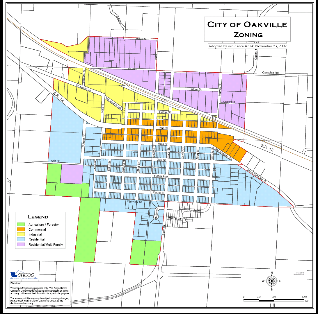
17.12.020 - City of Oakville zoning map.
A.
The city of Oakville zoning map, on file with the office of the city clerk-treasurer, is the official zoning map for the city. This zoning map shall graphically show the location of zoning districts within the city and bear the original approving signatures of the mayor and city clerk-treasurer.
B.
Reproducible copies of the zoning map are available for public review and purchase through the city clerk-treasurer.
(Ord. 560 § 2(part), 2007).
17.12.030 - Establishment of zoning district boundaries.
In order to accomplish the purposes of this chapter, the following zoning districts and zoning map symbols are established:
Table 17.12.030. Zoning Symbol Definitions
Residential District:
A.
The residential (R) zone provides for uses, structures, and activities compatible with neighborhoods consisting predominately of single-family dwelling units and designated manufactured homes.
1.
Residential: Multifamily Residential (R-MFR): Such areas as are designated Residential-Multifamily Residential (R-MFR) shall be for uses as are allowed in a "R" zone, as well as for multifamily dwelling units. A condition precedent for permitting of multifamily structures and activities in a R-MFR zone is the availability and installation of sewerage treatment facilities approved by the appropriate governmental agencies capable of supporting multifamily activities.
2.
Manufactured Home. No manufactured (or mobile) home, as that term in defined within this code or applicable state law, may be placed upon property within the corporate limits unless it is a new manufactured home. For purposes of this provision, a manufactured home which has not been previously sold by a retailer of such units or placed upon a property for other than display purposes shall be presumptively deemed to be new per RCW 35A.21.312. Additionally, the date of construction of the manufactured (or mobile) home shall be less than five years prior to the date of proposed installation. Any manufactured home installed in the city which is not installed upon a continuous cement or concrete block foundation shall have skirting of cementous or masonry panels installed upon framing of pressure treated or otherwise rot resistant material.
B.
The commercial (C) district provides for a wide range of small to medium commercial uses and professional offices concentrated in the historic downtown area of the city. Uses in this district serve the needs of the immediate area, as well as tourists to the community. The commercial district is a compact, intensive activity center that emphasizes pedestrian access to and between businesses.
C.
The old town overlay (OTO) zone is an area of focussed maintenance and enhancement of Oakville's town character to protect the livability and small town character of the community. Businesses and structures within this zone are encouraged to participate in the following goals:
1.
New structures in the old town overlay district shall be constructed so that they are abutting the sidewalk and have their main entrances and front facades facing Pine Street.
2.
Parking for new structures in the old town overlay district shall be located behind the building, away from Pine Street.
3.
Where remodels affect more than one exterior wall of an existing building, or affect the street facing facade, the applicable elements shall reflect this section.
4.
Businesses within the old town overlay district shall provide an aesthetically pleasing trash receptacle or an aesthetically pleasing bench adjacent to the sidewalk.
D.
The industrial (I) district provides space for manufacturing, storage, forestry, wholesale sales, outdoor storage, transshipment, and other intensive uses that meet environmental regulations, but require separation from residential and commercial uses in the city.
E.
The agricultural forestry (AF) zone encourages protection of greenways, agricultural resources and open spaces within the city's limits. Land uses in this zone include large lot residential, noncommercial forests, critical areas with restricted development potential, undeveloped parkland, and areas protected by open space designations or long-term conservation easements.
(Ord. 560 § 2(part), 2007).
(Ord. No. 574, § II, 11-23-2009)
17.12.040 - Zoning district boundaries.
A.
Whenever an uncertainty exists as to the boundaries of a zoning district as shown in the city of Oakville zoning map, the following rules shall apply:
1.
Zoning district boundaries shown as approximately following legally created lot lines shall be construed as following such lot lines.
2.
Zoning district boundaries shown as approximately following the centerline of rivers and streams shall be construed as following such centerline. In the event of a change in the shoreline of the waterway, the boundary shall be construed as moving with the actual shoreline.
3.
Upon official vacation of a street or alley, the vacated area shall acquire the zoning district classification of the lot to which it reverts.
4.
In the case of a zone boundary that divides property without relying on lot lines, the location of the boundary shall be determined by use of the scale on the zoning map.
B.
Future adjustments to zoning district boundaries shall follow lot lines, natural landforms, or the centerline of streets and alleys.
(Ord. 560 § 2(part), 2007).
17.12.050 - Property without zoning district designation.
Any property within the boundaries of the city of Oakville not clearly designated by the zoning map shall be designated single-family residential (R) district.
(Ord. 560 § 2(part), 2007).
17.12.060 - Annexed property.
A.
Unless a different zoning classification is established pursuant to the provisions of Subsection B., all newly annexed properties shall assume the zoning district classification prescribed in the Municipal Code which is most similar to that applicable to it prior to annexation; PROVIDED THAT, if no such zoning exists and the alternative authorized pursuant to subparagraph B is not utilized, it shall be classified as shown upon the then applicable future land use map of the City's Comprehensive Land Use Plan or, if not designated on that map, the general-residential (G-R) district,
B.
If either the applicant requesting the annexation or the City Council proposes the zoning classification after annexation is to be other than the classification which would be established by Subsection A., the public notice for the hearing on the annexation request shall include the requested or suggested zoning classification. If the zoning classification is proposed by the City Council, the following provisions shall apply:
1.
The petitioner or petitioners shall be given written notification of the proposed classification at least fourteen calendar days prior to the date of the public hearing.
2.
Upon receipt of that notification, the petitioner or petitioners shall have the right to withdraw their request to be annexed so long as [a] such request is received no less than seven calendar days prior to the date of the hearing and [b] the Council does not agree by action to annex the subject property with the zoning classification, if any, which was set forth in the Petitioner's request to annex or the classification established pursuant to Subsection A.
C.
In the event the alternative processes authorized by Subsection B. have been initiated, the zoning district specified in the ordinance implementing the annexation shall be the zoning classification of the property. That classification either may be the specific zone indicated in the public notice or the presumptive zoning classification resulting from the application of the provisions of Subsection A.
All newly annexed territories shall assume the zoning district designation as shown in the proposed zoning for Oakville of the Oakville comprehensive plan, or if not designated on that map, the residential (R) district.
(Ord. 560 § 2(part), 2007).
(Ord. No. 611, § II, 4-11-2016)
17.12.070 - Rezones.
Any person may present to the land use hearing examiner and to the city council an application duly signed requesting a reclassification of property. The hearing examiner, after open record public hearing and investigation and within forty-five days after receipt of said application, shall transmit to the city council recommendations thereon in writing stating reasons provided the hearing examiner determines that the applicant provided adequate information to make a recommendation. Upon receipt of a recommendation from the hearing examiner on a proposed reclassification, the city council shall at the next regular meeting of the council set a time and place for a closed public hearing thereon and give public notice as described in this section. The city council shall take final action within forty-five days after the closing of its public hearing provided the city council determines it has adequate information from the applicant and/or hearing examiner to make a decision. The city council may act by either passing an amending ordinance or declining to amend. If the city council declines to amend, notice of that fact shall be transmitted by the city clerk to the applicant.
The city council may, on its own motion, initiate proceedings for the reclassification of property or the amendment of the terms of this title or of any map or maps which are a part of this title.
All applications for rezones, except those initiated by the city shall be accompanied by the fee for a rezone as set by the city council.
Notice of public hearings of the hearing examiner and the city council relating to applications to reclassify property or amend the terms of this title or map or maps which are a part of this title, shall conform to Section 17.04.140 of this title, except that notice of the application and public hearing shall be mailed to owners of record of property within three hundred feet of the exterior boundaries of the property which is the subject of any request to reclassify.
Any decision approving or disapproving any reclassification of property shall be reviewable for unlawful, arbitrary, capricious, or corrupt action or nonaction before the superior court. The action may be brought by any person who deems himself aggrieved thereby; provided, that the appeal shall be filed in the appropriate court within twenty-one days from the date any decision to be reviewed was made; provided that, in the event a lesser time for appeal is set by any applicable law, including the Land Use Petition Act (RCW 36.70C), that lesser time shall be applicable as the time by which any appeal must be taken.
(Ord. 560 § 2(part), 2007).