
Orange County Unincorporated
City Zoning Code
City Zoning Code
ARTICLE 2
- THE COMPREHENSIVE ZONING CODE
Sec. 7-9-19.1. - Title and authority.
Title 7, Division 9, Article 2, of the County of Orange Codified Ordinances shall be known as "The Comprehensive Zoning Code of the County of Orange," "Zoning Code", or "this Code." Whenever reference is made to any portion of the ordinance set out in this Article or of any other law or ordinance, the reference applies to all amendments and additions hereafter made to this Article. The Comprehensive Zoning Code is adopted by the Board of Supervisors pursuant to Section 11 of Article XI of the constitution of the State of California, as may be amended, in compliance with and pursuant to the authority contained in Title 7 of the Planning and Zoning Law of the Government Code, and is also adopted in compliance with Division 20 of the Public Resources Code, as may be amended, and the authority contained in Section 65859 et seq. of the California Coastal Act, as may be amended.
(Ord. No. 20-006, § 1, 7-28-20)
Sec. 7-9-19.2. - Purpose and objectives.
The purpose of this Code is to implement the County's General Plan, and in the Coastal Zone, the Local Coastal Program, and to protect and promote the public health, safety, peace, comfort, convenience, prosperity, and general welfare. More specifically, the Comprehensive Zoning Code is adopted in order to achieve the following objectives:
(a)
To enhance and implement the General Plan and Local Coastal Program.
(b)
To provide a guide for the growth and physical development of the County in a manner that shall progressively achieve the arrangement of land uses proposed in and consistent with the goals and policies of the General Plan and Local Coastal Program.
(c)
To promote economic development and job creation and secure for the citizens of Orange County the social and economic advantages resulting from an orderly planned use of its land resources.
(d)
To encourage, classify, designate, regulate and appropriately locate the uses of land, buildings and structures to serve the needs of agriculture, commerce, industry, residential development, and other activities.
(e)
To establish conditions which shall allow all of these land uses to exist in harmony within the community.
(f)
To prevent the overcrowding of land, to avoid undue concentration of population, and to maintain a suitable balance between structures and open spaces.
(g)
To lessen congestion on streets and to promote a safe, efficient traffic circulation system.
(h)
To ensure that adequate off-street parking and loading facilities shall be installed and maintained.
(i)
To facilitate adequate provisions for community utilities, such as transportation, water, sewage, schools, parks and other public requirements.
(j)
To protect and enhance real property values.
(k)
To promote the stability of existing land uses and to protect them from incompatible and harmful intrusion.
(Ord. No. 20-006, § 1, 7-28-20)
Sec. 7-9-20. - Applicability of the Zoning Code.
(a)
Property to which applicable: The Zoning Code shall apply to all property within the unincorporated area of the County of Orange, except as otherwise provided by this section.
(b)
Duplicated regulation. Whenever any provision of the Zoning Code and any other provision of law, whether set forth in this Code or in any other law or ordinance, impose overlapping or contradictory requirements, or certain restrictions covering any of the same subject matter, that provision which is more restrictive or imposes higher standards shall control, except as otherwise expressly provided in the Zoning Code. In no case shall a resolution supersede or overrule an ordinance. However, subject to applicable State and Federal law, a discretionary permit approved per section 7-9-125 may have more restrictive site development standards than specified in an enabling ordinance. Where specifically allowed by the enabling ordinance, a discretionary permit may have less restrictive site development standards.
(c)
Indeterminate applicability. When the provisions of this Zoning Code, or a planned community or specific plan text, do not clearly define or designate a use within a specific category, when the nature or characteristics of a use are such that the use could be included within more than one (1) definition, and when there is some uncertainty as to which regulations are applicable in a specific instance, the Director shall determine which regulations are applicable. Whenever reference is made to any regulations of this Zoning Code, the reference applies to all amendments and additions now or hereafter made. Uses, structures, conditions, and situations that are not addressed in a planned community or specific plan text, but are addressed in the Zoning Code, shall be governed by the Zoning Code.
(d)
Separability. If any portion of the Zoning Code is, for any reason, declared by a court of competent jurisdiction to be invalid or ineffective in whole or in part, such decision shall not affect the validity of the remaining portions thereof. The Board of Supervisors hereby declares that it would have enacted the Zoning Code and each portion thereof irrespective of the fact that any one (1) or more portions be declared invalid or ineffective.
(e)
Conformity with the Comprehensive Zoning Code required. Except as otherwise allowed by section 7-9-115, "Nonconforming Uses," or as authorized by Variance, no uses or structures shall be established, substituted, expanded, constructed, altered, moved, maintained, or otherwise changed, and no lot lines shall be created or changed, except in conformity with the Zoning Code.
(f)
Validity. The issuance of granting of a permit or approval of plans and specifications shall not be construed to be a permit for, or an approval of, any violation of any provisions of this Code. The issuance of a permit shall not prevent the Director from thereafter requiring the correction of violations of this Code or of any other ordinance of the County.
(g)
Road right-of-way. Dedicated public street right-of-way areas shall not be subject to the land use regulations of the County, including but not limited to the Zoning Code, specific plans and planned communities. However, all uses and structures within the coastal zone may be subject to a Coastal Development Permit. Within private street areas and streets offered for dedication to the public but not accepted, the Zoning Code applies in its entirety.
(h)
Land owned by or leased to the County. Land owned in fee by the County or land leased to the County shall not be subject to the land use regulations of the County, including but not limited to the Zoning Code, specific plans and planned communities. However, all uses and structures within the coastal zone may be subject to a Coastal Development Permit.
(i)
General Plan consistency required. Any permit, license or approval issued pursuant to this Code shall be consistent with the General Plan. In any case where there is a conflict between this Code and the General Plan, the General Plan shall prevail.
(j)
Fees and/or deposits. The Board of Supervisors shall establish by ordinance, and may amend and revise from time to time, fees and/or deposits for processing discretionary permit applications and other permits authorized or required by this Code. All fees and/or deposits shall be paid at the time an application is filed, and no processing shall commence until the fees and/or deposits are paid in full.
(Ord. No. 20-006, § 1, 7-28-20)
Sec. 7-9-21. - Relation to other regulations.
(a)
General. The regulations of the Zoning Code and requirements or conditions imposed pursuant to this Code shall not supersede any other regulations or requirements adopted or imposed by the Board of Supervisors of the County, the State of California, or any federal agency that has jurisdiction by law over uses and development authorized by this Code. All uses and development authorized by this Code shall comply with all other such regulations and requirements. Where conflict occurs between the provisions of the Code and any other County Code, chapter, resolution, guideline or regulation, the more restrictive provisions shall control, unless otherwise specified.
(b)
Permit Streamlining Act. It is the intent of this Code that all actions taken by the decision-making body pursuant to this Code that are solely adjudicatory in nature be within a time frame consistent with the provisions of Government Code Section 65920 et seq., (the Permit Streamlining Act), as may be amended. Nothing in this Code shall be interpreted as imposing time limits on actions taken by the decision-making body pursuant to this Code that are legislative in nature or that require both adjudicatory and legislative judgments.
(c)
Private agreements: The Zoning Code is not intended to abrogate, annul, or impair any easement, covenant, or other agreement between parties, except that where the Zoning Code imposes a greater restriction or higher standard than that required by such agreement, the Zoning Code shall control.
(d)
Relation to prior Code. The provisions of this Code supersede all prior zoning regulations codified in Article 2 of the Codified Ordinances and any amendments. No provision of this Code shall validate any land use or structure established, constructed or maintained in violation of all prior versions of Zoning Code, unless such validation is specifically authorized by this Code and is in conformance with all other regulations.
(e)
Application during local emergency. The Board of Supervisors may authorize a deviation from a provision of this Code during a local emergency declared and ratified under the Codified Ordinances. The Board of Supervisors may authorize a deviation by resolution without notice or public hearing.
(Ord. No. 20-006, § 1, 7-28-20)
Sec. 7-9-22.1. - This Code consists of seven Subarticles:
(a)
Subarticle 1: Introductory Provisions.
(b)
Subarticle 2: Base Districts.
(c)
Subarticle 3: Overlay, Combining, and Other Districts.
(d)
Subarticle 4: Site Development Regulations.
(e)
Subarticle 5: Standards for Specific Uses and Activities.
(f)
Subarticle 6: Administration and Permits.
(g)
Subarticle 7: General Terms.
(Ord. No. 20-006, § 1, 7-28-20)
Sec. 7-9-22.2. - Types of regulations.
Four (4) types of zoning regulations control the use and development property to which this Code applies:
(a)
Land use regulations. These regulations specify land uses permitted, conditionally permitted, or specifically prohibited in each zoning district, and include special requirements, if any, applicable to specific uses. Land use regulations for base zoning districts and for overlay and other districts are in Subarticles 2 and 3 of this Code. Certain regulations, applicable in some or all of the districts, and performance standards which govern special uses, are in Subarticles 4 and 5.
(b)
Development regulations. These regulations control the height, bulk, location, and appearance of structures on development sites. Development regulations for base zoning districts and for overlay and other districts are in Subarticles 2 and 3 respectively of this Code. Development standards and site regulations that apply throughout most or all of the unincorporated area of the county are in Subarticle 4. These include regulations for parking, setbacks, landscaping, and irrigation. Development regulations and procedural requirements applicable to specific uses in some or all districts are in Subarticle 5. These include regulations for accessory uses, signs, antennas, wireless communications facilities, and nonconforming uses.
(c)
Administrative regulations. These regulations in Subarticle 6 of this Code contain detailed procedures for the administration of zoning regulations, and include procedures, processes, and standards for discretionary and ministerial permit applications and other permits.
(d)
General Terms. Subarticle 7 provides a list of use classifications and definitions used in the Code. However, definitions contained in specific Zoning Code sections are to be used specifically for those sections.
(Ord. No. 20-006, § 1, 7-28-20; Ord. No. 24-004, § 1, 6-25-24)
Sec. 7-9-23.1. - General rules for construction of language.
The following general rules of construction shall apply to the textual provisions of the Comprehensive Zoning Code:
(a)
The specific shall supersede the general.
(b)
In the case of any difference of meanings or implication between the text of the provision and any caption or illustration, the text shall control.
(c)
"Shall" is mandatory. "May" is discretionary.
(d)
Words used in the present tense include the future, and words used in the singular include the plural, and the plural the singular, unless the context clearly indicates the contrary.
(e)
Unless the context clearly indicates the contrary, the following conjunctions shall be interpreted as follows:
(1)
"And" indicates that all connected items or provisions shall apply.
(2)
"Or" indicates that the connected items or provisions may apply singly or in any combination.
(3)
"Either … or" indicates that the connected items or provisions shall apply but not in combination.
(f)
All public officials, bodies, and agencies to which reference is made are those of the County of Orange unless otherwise indicated.
(Ord. No. 20-006, § 1, 7-28-20)
Sec. 7-9-23.2. - General terms.
(a)
County means the County of Orange including any special district governed by the Board of Supervisors.
(b)
Days included within a specific time period do not include the day action was taken but include all subsequent days unless the last day falls upon a Saturday, Sunday, or upon a legal County holiday, in which case the next business day shall be the last day of the time period.
(c)
Director means the Deputy Director, OC Public Works/Manager, OC Development Services, Planning Division ("Director"), or designee, authorized agent, or representative.
(d)
General Plan means the County of Orange General Plan.
(e)
Government Code means the California Government Code.
(f)
State means the State of California.
(g)
Zoning Code means the Comprehensive Zoning Code of the County of Orange, including zoning district maps and planned community or specific plan development plan maps and texts adopted pursuant to or as an amendment to sections 7-9-25.1, 7-9- 47, 7-9-132, and 7-9- 133.
(Ord. No. 20-006, § 1, 7-28-20)
Sec. 7-9-23.3. - Fractions.
Whenever this Code requires consideration of distances, parking spaces, dwelling units, or other aspects of development or the physical environment that are expressed in numerical quantities and the result of a calculation contains a fraction of a whole number, the results shall be rounded as follows:
(a)
General rounding. Fractions of one-half (0.5) or greater shall be rounded up to the nearest whole number, and fractions of less than one-half (0.5) shall be rounded down to the nearest whole number, except as otherwise provided.
(b)
Dwelling unit rounding. Numerical quantities and the result of a calculation that contain a fraction of a whole number, shall be rounded up to the nearest whole number.
(Ord. No. 20-006, § 1, 7-28-20; Ord. No. 24-004, § 2, 6-25-24)
Sec. 7-9-24.1. - Purpose.
The purpose of this section is to explain how to calculate various measurements to which these regulations refer.
(Ord. No. 20-006, § 1, 7-28-20)
Sec. 7-9-24.2. - Determining floor area.
The sum of the gross horizontal floor area of all floors of a building or other enclosed structure measured from the exterior finished wall surface measured in square feet.
(a)
Included in floor area. Floor area includes, but is not limited to, usable basements and cellars that are below the roof and within the outer surface of the main walls of principal or accessory buildings or the centerlines of party walls separating such buildings or portions thereof or within lines drawn parallel to and two (2) feet within the roof line of any building without walls. In the case of a multi-story building that has covered or enclosed stairways, stairwells or elevator shafts, the horizontal area of such features shall be counted only once at the floor level of their greatest area of horizontal extent.
(b)
Excluded from floor area. Floor area does not include mechanical, electrical, and communication equipment rooms that are less than two percent (2%) of the building's gross floor area; areas that qualify as usable open space; and areas used for off-street parking spaces or loading spaces, driveways, ramps between floors of a multi-level parking garage, and maneuvering aisles that are located below the finish grade of the property.
(c)
Non-residential structures and uses. In commercial, professional and administrative office or industrial buildings, or building complexes, areas used in common such as covered malls, walkways, patio areas, and entries open to and directly connecting with outside areas shall not be included when calculating off-street parking requirements. In the case of a multi-story building that has covered or enclosed stairways, stairwells or elevator shafts, the horizontal area of such features shall be counted only once at the floor level of their greatest area of horizontal extent.
(Ord. No. 20-006, § 1, 7-28-20)
Sec. 7-9-24.3. - Determining building site area.
The net development area calculated by measuring the building site horizontally as a level plane and excluding rights-of-way or easements that prohibit the surface use of the site, except easements for open space purposes on single-family lots. (Examples of open space easements include, but are not limited to, resource preservation and scenic easements.) The minimum building site area shall be undivided and relatively compact although the entire building site may be larger with diffuse parts.
(Ord. No. 20-006, § 1, 7-28-20)
Sec. 7-9-24.4. - Building site coverage, maximum.
The relationship between the ground floor area of the building or buildings and the project net development area of the site. Site coverage shall be computed by deducting from the gross site area any ultimate street rights-of-way together with all rights-of-way and all easements that prohibit the surface use of the site, except easements for open space purposes on single-family lots. (Examples of open space easements include, but are not limited to, resource preservation and scenic easements.) The following structures shall be excluded when calculating site coverage:
(a)
Unenclosed decks, patio slabs, porches, landings, balconies, and stairways less than eighteen (18) inches in height at the surface of the deck and less than six (6) feet above grade for railings.
(b)
Swimming pools and hot tubs not enclosed in roofed structures or decks.
(c)
One (1) small, non-habitable accessory structure under one hundred twenty (120) square feet in area.
FIGURE 7-9-24.4: DETERMINING SITE COVERAGE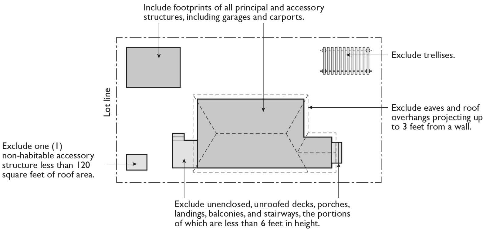
(Ord. No. 20-006, § 1, 7-28-20)
Sec. 7-9-24.5. - Measuring building site width and depth.
(a)
Calculation of the building site width.
(1)
The measurement shall be taken only within the building site area.
(2)
Calculate the average of a minimum of five (5) straight lines which best represent the average width of the building site area, the five (5) lines are determined using the process below:
a.
Front property line.
1.
Measure the length of the front property line.
2.
If the front property line is curved and/or composed of two (2) or more lines, use a straight line to measure the distance between the points where the front property line meets the side property line.
b.
Rear property line.
1.
Measure the length of the rear property line.
2.
If the rear property line is curved and/or composed of two (2) or more lines, use a straight line to measure the distance between the points where the rear property line meets the side property line.
3.
Minimum of three (3) evenly spaced lines between the front and rear property line:
i.
Determine the mid-point between the front and rear property line, as measured along each side property line, and connect with a straight line.
ii.
Determine the point halfway between the mid-point and the front property line, as measured along each side property line, and connect with a straight line.
iii.
Determine the point halfway between the mid-point and the rear property line, as measured along each side property line, and connect with a straight line.
(3)
All determinations of the building site width of a lot are subject to confirmation by the Director.
(b)
Calculation of the building site depth.
(1)
The measurement shall be taken only within the building site area.
(2)
Calculate the average of a minimum of five (5) straight lines which best represent the average depth of the building site area, the five (5) lines are determined using the process below:
a.
Right side property line:
1.
Measure the length of the right-side property line.
2.
If the right-side property line is curved and/or composed of two (2) or more lines, use a straight line to measure the distance between the points where the right-side property line meets the front and rear property line.
b.
Left (opposite) side property line:
1.
Measure the length of the left side property line.
2.
If the left side property line is curved and/or composed of two (2) or more lines use a straight line, measure the distance between the points where the left side property line meets the front and rear property line.
3.
Minimum of three (3) evenly spaced lines between the right and left side property line.
i.
Determine the mid-point between the right and left side property line, as measured along the front and rear property line, and connect with a straight line.
ii.
Determine the point halfway between the mid-point and the right-side property line, as measured along the front and rear property line, and connect with a straight line.
iii.
Determine the point halfway between the mid-point and the left side property line, as measured along the front and rear property line, and connect with a straight line.
(3)
All determinations of the building site depth of a lot are subject to confirmation by the Director.
Figure 7-9-24.5: Determining Building Site Width and Depth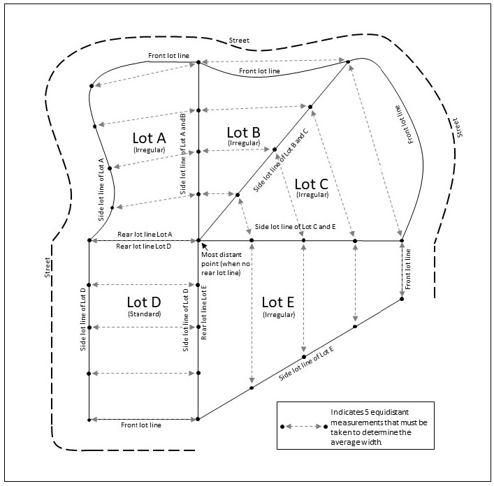
(Ord. No. 20-006, § 1, 7-28-20)
Sec. 7-9-24.6. - Determining building site frontage.
(a)
Corner lot: The front of a lot is the narrowest dimension of the lot with street frontage so long as the rear setback requirements are met.
(b)
Through lot that abuts two (2) streets that do not intersect: The front setback of a through lot abuts the street that neighboring lots use to provide primary access.
(Ord. No. 20-006, § 1, 7-28-20)
Sec. 7-9-24.7. - Determining setbacks.
A setback line defining a required setback is parallel to and at the specified distance from the corresponding front, side, or rear property line. The following special regulations for determining shall apply when a lot abuts an alley or proposed street.
(a)
Side setbacks. If a side lot line abuts an alley, the setback shall be considered an interior side setback rather than a corner side setback. In computing the minimum setback for any lot where such setback abuts an alley, no part of the width of the lane may be considered as part of the required setback.
(b)
Rear setbacks. In computing the depth or a rear setback from any building where such setback opens on alley, private street, public park or public beach, one-half (0.5) of the width of such alley, street, park or beach may be deemed to be a portion of the rear setback, except that under this provision, no rear setback shall be less than fifteen (15) feet.
(c)
Setbacks from street. If a property abuts an existing or ultimate right-of-way street for which the existing right-of-way is narrower than the right-of-way ultimately required for the street, the required setback shall be established from the ultimate right-of-way rather than the property line.
(Ord. No. 20-006, § 1, 7-28-20)
Sec. 7-9-24.8. - Measuring distances.
(a)
Measurements at shortest distance. When measuring a required distance, such as the minimum distance between a structure and a lot line, the measurement is made at the shortest distance between the two (2) objects.
(b)
Distances are measured horizontally. When determining distances for setbacks and structure dimensions, all distances are measured along a horizontal plane from the appropriate line, edge of building, structure, storage area, parking area, or other object. These distances are not measured by following the topography or slope of the land.
(c)
Measurements involving a structure. Measurements involving a structure are made to the closest support element of the structure. Structures or portions of structures that are entirely underground are not included in measuring required distances.
(d)
Measurement of vehicle stacking or travel areas. Measurement of a minimum travel distance for vehicles, such as front-entry garage entrance setbacks and stacking lane distances, are measured down the center of the vehicle travel area.
(e)
Measuring a buffer or radius. When a specified land use is required to be located a minimum distance from another land use, the minimum distance is measured in a straight line from all points along the lot line of the subject project, in all directions.
FIGURE 7-9-24.8: MEASURING DISTANCES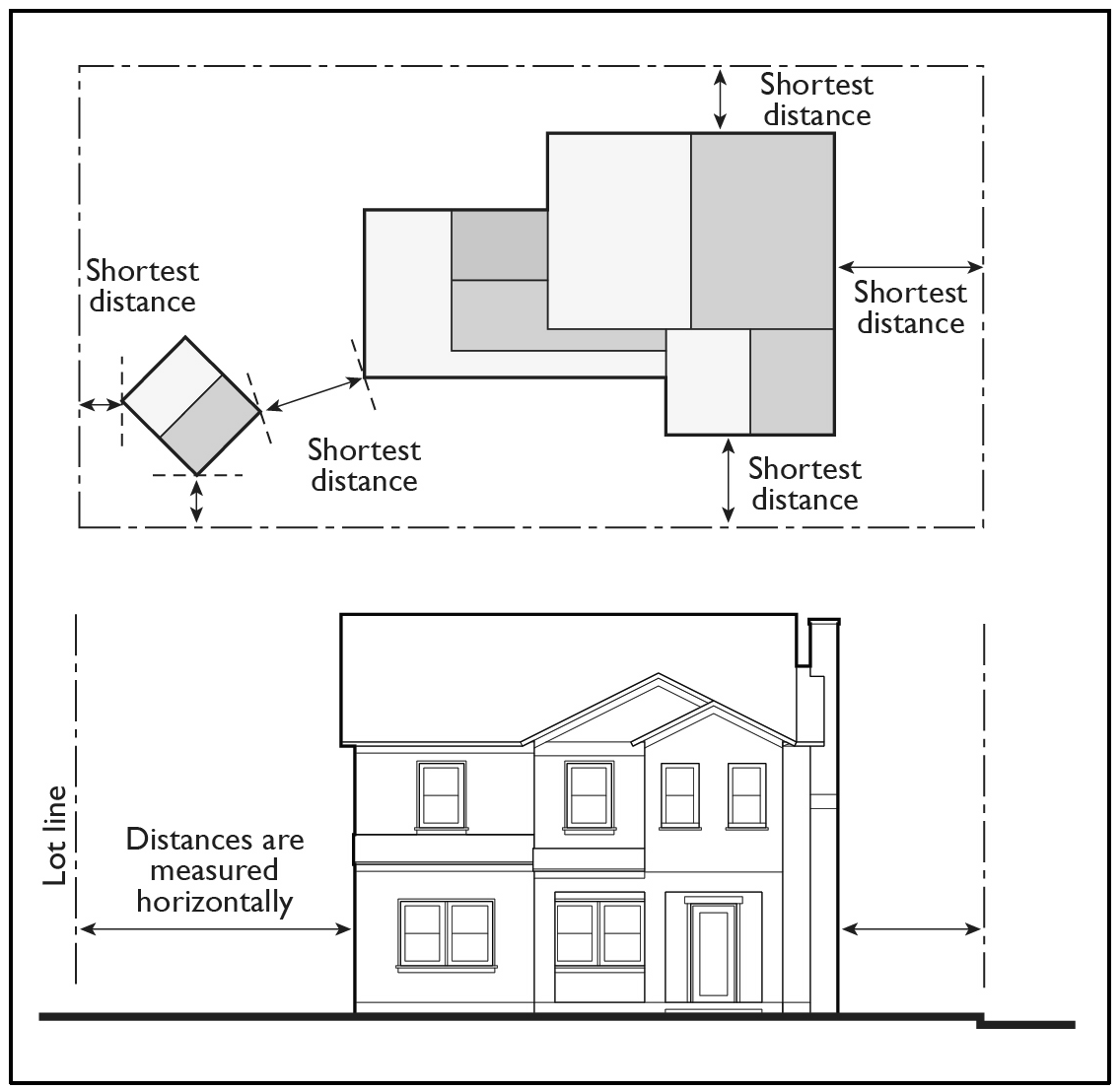
(Ord. No. 20-006, § 1, 7-28-20)
Sec. 7-9-24.9. - Determining grade ground level.
(a)
Grade, Ground level. The average elevation, determined by averaging the elevations of four (4) or more points as necessary, at the building site boundary line where it is less than five (5) feet from the building or at five (5) feet outside the perimeter of the bearing or foundation line of building.
(1)
Architectural projections extending less than five (5) feet from the exterior wall are excluded.
(2)
When there is more than one (1) building on a site, average grade is calculated separately for each building.
(b)
Finished grade. The final grade of the site is the elevation at the base of the exterior surface of the building wall, which conforms to the approved plan for the whole site.
(c)
Natural grade. The undisturbed elevation of the ground prior to human intervention.
(Ord. No. 20-006, § 1, 7-28-20)
Sec. 7-9-24.10. - Measuring height.
This section shall also apply to planned communities and specific plan areas unless otherwise stated. Height is the vertical distance from finished grade to the highest point of a building or structure.
(a)
Measuring building height. When a building site slopes in any direction at an average grade of more than ten percent (10%) within the front fifty (50) feet of the building site, building height is the vertical distance above an inclined slope to the top of the structure, including screened mechanical and electrical fixtures. The inclined slope is established by enclosing the structure with an imaginary line five (5) feet outside of the perimeter of the structure, or at the property line if it is less than five (5) feet from the structure, and by assuming that all ground area closer is flat. See diagram for building height.
FIGURE 7-9-24.10(a) MEASURING BUILDING HEIGHT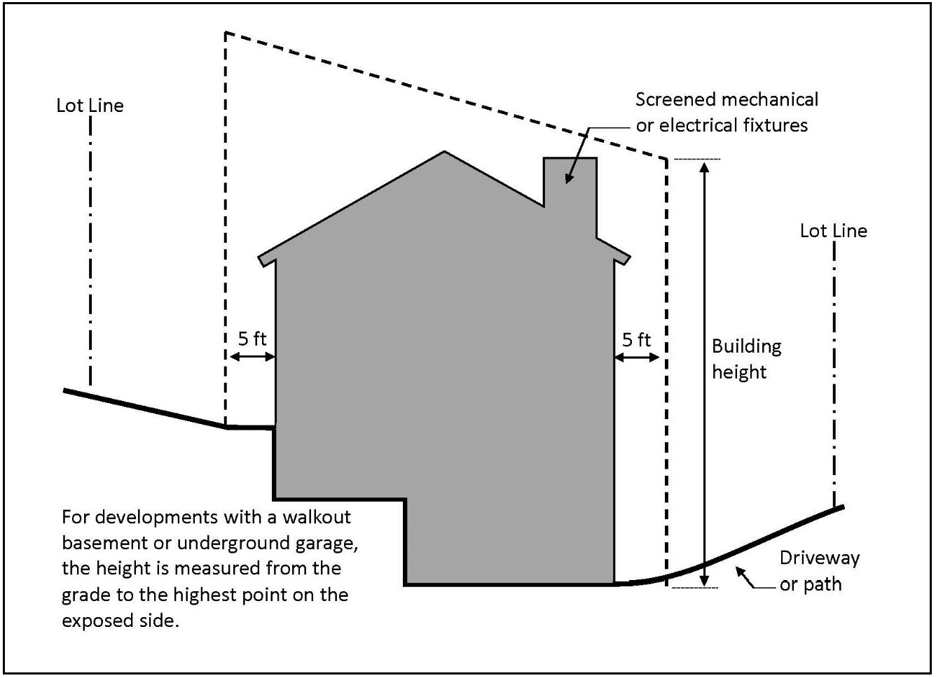
(b)
Measuring height of fences and walls. Fence/wall heights shall be measured from the base of the fence/wall to the top on interior or exterior side, whichever is greater. The height of any fence or wall shall be determined by measuring the vertical distance from the base of the fence or wall, at the lowest existing grade on such fence or structure, to the highest point of such structure on the interior or exterior of the structure, whichever is greater. In the case of walls that are parallel to and within five (5) feet of a public sidewalk or other public way, grade shall be the finished elevation of the closest point on the sidewalk or public way.
(1)
Measuring the height of fences on retaining walls. The height of a fence that is on top of a retaining wall is measured from the base of the wall, at the lowest existing grade on such wall, to the highest point of the fence on the highest side of the wall.
FIGURE 7-9-24.10(b) MEASURING HEIGHT OF FENCES ON RETAINING WALLS IN FRONT SETBACK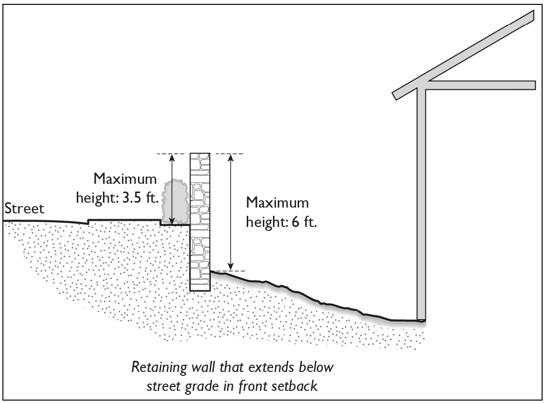
(Ord. No. 20-006, § 1, 7-28-20)
Sec. 7-9-25.1. - Scope of the Comprehensive Zoning Code and adoption of zoning district maps.
This article includes zoning maps, general provisions, special regulations and a set of general district regulations limiting and controlling the uses of land, the density of population, the uses and locations of structures, the height and bulk of structures, the areas and dimensions of sites; the size, height and location of signs; the installation and maintenance of screening and landscaping; the control of vehicular access and the requirement of off-street parking and loading facilities. In addition, this article includes planned community and specific plan maps and texts adopted by ordinance. Sectional district maps, precise plan and specific plan maps, oil field maps, district-C maps, flood insurance rate maps, flood boundary and floodway maps, and all other maps that were officially adopted pursuant to or as an amendment to section 7-9-25 prior to the effective date of Ordinance No. 2142 are included within the term "zoning district map," and all such maps and all subsequently adopted zoning district maps are and shall be a part of this section.
(Ord. No. 20-006, § 1, 7-28-20)
Sec. 7-9-25.2. - Establishment of districts and interpretation of district boundaries.
(a)
The unincorporated territory of the County of Orange has been divided into zoning districts, as set forth in Title 7, Division 9, Article 2 of the Codified Ordinances of the County of Orange, as determined and defined by officially adopted zoning maps. Each zoning district map showing the classifications and boundaries of district shall, upon adoption in the manner required by the Planning and Zoning Law, be a part of this article.
(b)
Where uncertainty exists as to the boundaries of districts shown on an official zoning district map, the following rules shall apply:
(1)
Boundaries indicated as approximately following the centerlines of streets, highways or alleys shall be construed to follow such centerlines;
(2)
Boundaries indicated as approximately following the right-of-way lines of streets, highways, or alleys, shall be construed to follow such the right-of-way lines, and in event of change in the right-of-way line shall be construed as moving with the right-of-way line;
(3)
Boundaries indicated as approximately following shorelines shall be construed to follow such shorelines, and in the event of change of the shoreline, shall be construed as moving with the actual shoreline; boundaries indicated as approximately following the centerlines of streams, rivers, canals, lakes or other bodies of water, of flood control channels shall be construed to follow such centerlines.
(4)
Boundaries indicated as approximately following platted lot lines shall be construed to follow such lot lines.
(5)
Boundaries indicated as parallel to or extensions of features indicated in subsections (1) through (4) above shall be so construed; distances not specifically indicated on the official zoning district map shall be determined by the scale of the map.
(6)
Where a street or alley is vacated or abandoned the regulations applicable to the property to which it is reverted shall apply to such vacated or abandoned street or alley.
(7)
In case any further uncertainty exists, the Planning Commission shall determine the location of boundaries.
(c)
Designation of base zoning districts.
Table 7-9-25.2(c) lists the base zoning districts into which the County is divided with their map symbols and corresponding General Plan land use designations.
(d)
Designation of Overlay and Combining Districts.
Table 7-9-25.2(d) lists Overlay, Combining, and Other Districts into which the County is divided with their map symbols. These districts may be combined with the base zoning districts listed in Table 7-9-25.2(c), Base Zoning Districts pursuant to Article 2, Subarticle 3 of the Zoning Code. In any district where the base zoning district symbol is followed by one of the following district symbols, the additional requirements, limitations, and standards of the overlay or combining district may apply.
(Ord. No. 20-006, § 1, 7-28-20; Ord. No. CA 22-01, 9-27-22; Ord. No. 22-003, § 1, 9-27-22; Ord. No. 24-004, § 3, 6-25-24)
Sec. 7-9-30.1. - Purpose and intent.
The purpose of the Agriculture and Open Space Districts is to promote the preservation and protection of resource areas including agricultural lands, cultural-historic resources, significant wildlife habitats, and biotic resources that shape the overall urban form of the County as well as lands that provide outdoor recreation opportunities.
The specific designations and additional purposes of the Agriculture and Open Space Districts are:
(a)
The A1 "General Agricultural" District is established to provide for agriculture, outdoor recreational uses, and those low-intensity uses which have a predominately open space character. It is also intended that this district may be used as an interim zone in those areas which the General Plan may designate for more intensive urban uses in the future.
(b)
The B1 "Buffer" District is established to provide open space areas for the purpose of: 1) buffering two (2) areas of use that are incompatible, or 2) preserving an area with unique or sensitive environmental features, or 3) linking other open space areas, or 4) shaping urban form. Normally, such areas would be narrow strips or small plots of land.
(c)
The OS "Open Space" District is established to provide relatively large open space areas for the preservation of natural resources, for the protection of valuable environmental features, for outdoor recreation and education, and for the public health and welfare.
(d)
The R/OSP "Research/Open Space Park" District is established to provide for the creation and maintenance of research and development facilities and related uses where the intent of the design, location and arrangement of uses and structures is to maintain an open space character and prevent potentially significant adverse environmental impacts.
(Ord. No. 20-006, § 1, 7-28-20)
Sec. 7-9-30.2. - Land use regulations.
Table 7-9-30.2 and section 7-9-30.4, "Supplemental regulations," prescribe the land use regulations for Agricultural and Open Space Districts. The regulations for each district are established by letter designations listed below. These designations apply strictly to the permissibility of land uses; applications for buildings or structures may require discretionary review. Principal permitted uses, which do not require a discretionary permit, shall comply with section 7-9-121.
(a)
"P" designates principal permitted uses. Permitted uses shall comply with section 7-9-121.
(b)
"SDP" designates uses that are principal permitted uses subject to the approval of a Site Development Permit.
(c)
"UP" designates uses that are principal permitted uses subject to the approval of a Use Permit.
(d)
"#" indicates the uses that shall comply with specific limitations listed at the end of the table.
(e)
"—" designates uses that are not permitted.
(f)
"NA" designates development standards that are not applicable.
Land use classifications and definitions are located in sections 7-9-134 and 7-9-135. In cases where a specific land use or activity is not defined, the Director shall assign the land use or activity to a classification that is substantially similar in character. Use classifications and sub-classifications not listed in Table 7-9-30.2 or not found to be substantially similar to the uses below shall be prohibited. The table also notes additional use regulations that apply to various uses. Section numbers in the right-hand column refer to other related sections of this Zoning Code.
In the Agriculture and Open Space Districts, the following uses are prohibited:
(a)
Commercial Stockpiling or Processing of Manure.
(Ord. No. 20-006, § 1, 7-28-20)
Sec. 7-9-30.3. - Site Development Standards.
Table 7-9-30.3 and section 7-9-30.4, "Supplemental regulations," prescribe the site development standards for Agricultural and Open Space Districts. Additional regulations are denoted with section numbers in the right-hand column, which refer to other related sections of this Zoning Code.
(Ord. No. 20-006, § 1, 7-28-20)
Sec. 7-9-30.4. - Supplemental Regulations.
(a)
Accessory uses and structures: Per section 7-9-116.
(b)
Fences, walls, and hedges: Per section 7-9-64.
(1)
For R/OSP: Fencing Within Setback Areas: Fencing shall be of a rustic or rural character and per section 7-9-64.
(c)
Garages and carports: Per section 7-9-70.
(d)
Grading and excavation: Per section 7-9-66.
(e)
Landscaping and irrigation: Per section 7-9-68.
(f)
Lighting and illumination: Per section 7-9-67.
(g)
Nonconforming uses and structures: Per section 7-9- 115.
(h)
Off-street parking and loading: Per section 7-970.
(1)
For R/OSP: Off-street parking: Off-street parking shall be provided as required by section 7-9-70 of the Zoning Code except that medical research uses shall provide one (1) stall per four hundred (400) square feet of gross floor area.
(i)
Pets and animals: Per section 7-9-105.
(j)
Screening and landscaping: Per section 7-9-71.
(1)
Landscaping for R/OSP: Per section 7-9-71.2.
(2)
Screening for R/OSP: Per section 7-9-71.1.
(k)
Signs: Per section 7-9-114.
(1)
For B1: No commercial signs.
(l)
Temporary uses and structures: Per section 7-9-117.
(m)
Waste management and hazardous materials: Per section 7-9-118.
(1)
For R/OSP: In addition, all storage of cartons, refuse and other trash shall be stored within a building or within an area enclosed by a masonry wall not less than six (6) feet in height. If unroofed, no such area shall be within fifty (50) feet of any residential or agricultural zoning district boundary.
(Ord. No. 20-006, § 1, 7-28-20)
Sec. 7-9-31.1. - Purpose and Intent.
The purpose of the Single-Family Residential districts is to provide for a range of low-density single-family development that is compatible with the natural terrain and conforms to the County's residential growth projections. Housing types range from rural, large-lot estates to medium-density single-family attached and detached residential neighborhoods. These districts also include a variety of neighborhood-serving facilities and services such as schools, childcare facilities, community assembly facilities as well as local and community open space, trails, and parks.
(a)
The AR "Agriculture Residential" District is established to provide for the development and maintenance of medium density single-family residential neighborhoods in conjunction with agricultural and outdoor recreational uses.
(b)
The E1 "Estates" District is established to provide for the development and maintenance of very-low density single-family residential neighborhoods in conjunction with limited agricultural uses. A rural or estate type character with open space and deep setbacks shall predominate. Only those uses are permitted that are complementary to, and can exist in harmony with, this character.
(c)
The RHE "Residential Hillside Estates" District is established to provide for the development and maintenance of low-medium-density single-family residential neighborhoods in hillside areas in such a manner that they may be compatible with areas of steep irregular terrain. Only those uses are permitted which are complementary to and can exist in harmony with such a hillside residential neighborhood.
(d)
The E4 "Small Estates" District is established to provide for the development and maintenance of low-medium-density single-family residential neighborhoods in which open spaces and deep setbacks predominate. Only those uses are permitted that are complementary to and can exist in harmony with such a residential neighborhood.
(e)
The RE "Residential Estates" District is established to provide for the development and maintenance of low-density single-family residential neighborhoods in which large building sites and generous open spaces are featured. Only those uses are permitted that are complementary to and can exist in harmony with such a residential neighborhood.
(f)
The R1 "Single-Family Residence" District is established to provide for the development and maintenance of medium density single-family detached residential neighborhoods. Only those uses are permitted that are complementary to and can exist in harmony with such a residential neighborhood.
(g)
The RS "Residential Single-Family" District is established to provide for the development and maintenance of medium-density single-family attached or detached residential neighborhoods in which flexibility of development and optimum utilization of each building site are featured. Only those uses are permitted that are complementary to and can exist in harmony with such a residential neighborhood.
(Ord. No. 20-006, § 1, 7-28-20)
Sec. 7-9-31.2. - Land Use Regulations.
Table 7-9-31.2 and section 7-9-31.4, "Supplemental regulations," prescribe the land use regulations for Single-Family Residential Districts. The regulations for each district are established by letter designations listed below. These designations apply strictly to the permissibility of land uses; applications for buildings or structures may require discretionary review.
(a)
"P" designates principal permitted uses. Permitted uses, except those in R1, shall comply with section 7-9-121.
(b)
"SDP" designates uses that are principal permitted uses subject to the approval of a Site Development Permit.
(c)
"UP" designates uses that are principal permitted uses subject to the approval of a Use Permit.
(d)
"#" indicates the use classification shall comply with specific limitations listed at the end of the table.
(e)
"—" designates uses that are not permitted.
(f)
"NA" designates development standards that are not applicable.
Land use classifications and definitions are located in sections 7-9-134 and 7-9-135. In cases where a specific land use or activity is not defined, the Director shall assign the land use or activity to a classification that is substantially similar in character. Use classifications and sub-classifications not listed in the table or not found to be substantially similar to the uses below shall be prohibited. The table also notes additional use regulations that apply to various uses. Section numbers in the right-hand column refer to other related sections of this Zoning Code.
In the Single-Family Residential Districts, the following uses are prohibited:
(a)
Commercial stockpiling or processing of manure.
(b)
Keeping pets or animals for any commercial purpose unless otherwise provided for by an approved Use Permit.
(c)
Storage of vehicles, equipment, or products related to a commercial activity not permitted in this district.
(Ord. No. 20-006, § 1, 7-28-20; Ord. No. 24-004, § 4, 6-25-24)
Sec. 7-9-31.3. - Site Development Standards.
Table 7-9-31.3 and section 7-9-31.4, "Supplemental regulations," prescribes the site development standards for Single-Family Residential Districts. Additional regulations are denoted with section numbers in the right-hand column, which refer to other related sections of this Zoning Code.
(Ord. No. 20-006, § 1, 7-28-20)
Sec. 7-9-31.4. - Supplemental regulations.
(a)
Accessory uses and structures: Per section 7-9-116.
(b)
Fences, walls, and hedges: Per section 7-9-64.
(c)
Garages and carports: Per section 7-9-70.
(d)
Grading and excavation: Per section 7-9-66.
(e)
Landscaping and irrigation: Per section 7-9-68.
(f)
Lighting and illumination: Per section 7-9-67.
(g)
Nonconforming uses and structures: Per section 7-9-115.
(h)
Off-street parking and loading: Per section 7-9-70.
(i)
Pets and animals: Per section 7-9-105.
(j)
Screening and landscaping: Per section 7-9-71.
(k)
Signs: Per section 7-9-114.
(l)
Swimming pools and spas: Per section 7-9-116.2.
(m)
Temporary uses and structures: Per section 7-9-117.
(n)
Waste management and hazardous materials: Per section 7-9-118.
(Ord. No. 20-006, § 1, 7-28-20)
Sec. 7-9-32.1. - Purpose and intent.
The purpose of the Multifamily Residential districts is to provide for medium- to high-density residential development. These districts also include a variety of neighborhood-serving facilities and services such as schools, childcare facilities, community assembly facilities as well as local and community open space, trails, and parks.
(a)
The R2 "Multifamily Dwelling" District is established to provide for the development and maintenance of high-density multifamily residential neighborhoods with a low building height and a minimum amount of open space at a minimum density of thirty (30) dwelling units per acre. Those uses are permitted that are complementary to and compatible with such a residential neighborhood.
(b)
The R3 "Apartment" District is established to provide for the development and maintenance of high-density multifamily residential neighborhoods with taller buildings and a minimum amount of open space at a minimum density of thirty (30) dwelling units per acre. Only those uses which are compatible with high-density residential uses are permitted.
(c)
The R4 "Suburban Multifamily" District is established to provide for the development and maintenance of high-density multifamily residential neighborhoods with a moderate amount of open spaces at a minimum density of thirty (30) dwelling units per acre. Only those uses are permitted that are complementary to and are compatible with such a residential neighborhood.
(Ord. No. 20-006, § 1, 7-28-20; Ord. No. 24-004, § 5, 6-25-24)
Sec. 7-9-32.2. - Land use regulations.
Table 7-9-32.2 and section 7-9-32.4, "Supplemental regulations," prescribes the land use regulations for Multifamily Residential Districts. The regulations for each district are established by letter designations listed below. These designations apply strictly to the permissibility of land uses; applications for buildings or structures may require discretionary review.
(a)
"P" designates principal permitted uses.
(b)
"SDP" designates uses that are principal permitted uses subject to the approval of a Site Development Permit.
(c)
"UP" designates uses that are principal permitted uses subject to the approval of a Use Permit.
(d)
"#" indicates the use classification shall comply with specific limitations listed at the end of the table.
(e)
"—" designates uses that are not permitted.
(f)
"NA" designates development standards that are not applicable.
Land use classifications and definitions are located in sections 7-9-134 and 7-9-135. In cases where a specific land use or activity is not defined, the Director shall assign the land use or activity to a classification that is substantially similar in character. Use classifications and sub-classifications not listed in the table or not found to be substantially similar to the uses below shall be prohibited. The table also notes additional use regulations that apply to various uses. Section numbers in the right-hand column refer to other related sections of this Zoning Code.
In the Multifamily Residential Districts, the following uses are prohibited:
(g)
Apiaries.
(h)
Keeping pets or animals for any commercial purpose unless otherwise provided for by an approved permit.
(i)
The storage of vehicles, equipment, or products related to a commercial activity not permitted in this district.
(Ord. No. 20-006, § 1, 7-28-20; Ord. No. 24-004, § 6, 6-25-24)
Sec. 7-9-32.3. - Site Development Standards.
This section, including Table 7-9-32.3, and section 7-9-32.4, "Supplemental regulations," specify the site development standards for Multifamily Residential Districts.
(a)
Access to units.
(1)
Each residential unit shall have one (1) front door. A front door shall be defined as the primary doorway that visitors and guests are directed to enter the residential unit from a publicly accessible exterior area (e.g., parking lot, sidewalk, driveway, etc.).
(2)
Doorways providing direct access from a publicly accessible exterior area into a residential unit shall only be allowed in common living areas subject to the following exceptions:
a.
One (1) doorway into one (1) bedroom for each residential unit.
b.
Doorways into a garage.
c.
Doorways into areas with no internal access to the residential unit (e.g., storage closets).
d.
Doorways required by other local governmental agencies (e.g., Orange County Fire Authority, Orange County Health Care Agency, etc.).
(3)
If a stairwell is separated by an interior doorway or other partially framed-in opening from other common living areas there shall be no direct exterior access into the stairwell area.
(4)
A maximum of one (1) kitchen for each residential unit shall be permitted.
(5)
The floor plan shall not be designed in a way that would allow splitting into two (2) or more separate residential units with simple or minor changes as determined by the Director.
(6)
Multifamily residential projects with two (2) or more units shall provide a minimum of one hundred fifty (150) square feet of exterior open space per dwelling unit of which a minimum of one hundred (100) square feet shall be private and accessible directly from the residential unit. The balance of open space shall be provided on-site as common open space area.
(b)
In Table 7-9-32.3, additional regulations are denoted with section numbers in the right hand column, which refer to other related sections of this Zoning Code.
(Ord. No. 20-006, § 1, 7-28-20; Ord. No. 24-004, § 7, 6-25-24)
Sec. 7-9-32.4. - Supplemental regulations.
(a)
Accessory uses and structures: Per section 7-9-116.
(b)
Fences, walls, and hedges: Per section 7-9-64.
(c)
Garages and carports: Per section 7-9-70.
(d)
Landscaping and irrigation: Per section 7-9-68.
(e)
Lighting and illumination: Per section 7-9-67.
(f)
Nonconforming uses and structures: Per section 7-9-115.
(g)
Off-street parking and loading: Per section 7-9-70.
(h)
Planned (unit) developments: Per section 7-9-47.
(i)
Screening and landscaping: Per section 7-9-71.
(j)
Signs: Per section 7-9-114.
(k)
Swimming pools and spas: Per section 7-9-116.2.
(l)
Temporary uses and structures: Per section 7-9-17.
(m)
Waste management and hazardous materials: Per section 7-9-118.
(Ord. No. 20-006, § 1, 7-28-20)
Sec. 7-9-33.1. - Purpose and intent.
The purpose of the Commercial Districts is to accommodate a range of retail, office and community uses and services to serve surrounding neighborhoods, the larger community, and the region and are sited at appropriate locations and compatible with surrounding development. Commercial development and other non-residential uses and services shall be sited at locations accessible to all transportation modes where a safe means of travel can be provided to users along the right-of-way. Residential rental projects that are one hundred percent (100%) affordable and emergency shelters, multi-service centers, and low-barrier navigation centers that provide services for persons experiencing homelessness, are also permitted in Commercial Districts, pursuant to section 7-9-44, "Housing Opportunities" Overlay District.
(a)
The C1 "Local Business" District is established to provide for the development and maintenance of medium-intensity commercial uses serving the needs of both the surrounding neighborhood and the local community. All commercial uses and their related products in the C1 districts shall be contained entirely within a completely enclosed structure, except for parking and loading areas, and except for outdoor uses expressly permitted by an approved Site Development Permit or Use Permit.
(b)
The C2 "General Business" District is established to provide for the development and maintenance of high-intensity commercial uses which serve the local community but which may not be compatible with surrounding residential uses or certain commercial uses.
(c)
The CN "Commercial Neighborhood" District is established to provide for the development and maintenance of low-intensity commercial uses which serve the immediate needs of the surrounding neighborhood. Such uses are to be grouped in small areas of three (3) to eight (8) acres and designed so that adverse impacts on residential properties are minimized. Business hours in the CN District shall be limited to the hours between 6:00 a.m. and 10:30 p.m. unless otherwise provided for by a Use Permit approved by the Zoning Administrator. All commercial uses and their related products in the CN district shall be contained entirely within a completely enclosed structure, except for parking and loading areas and except for outdoor uses expressly permitted by an approved Site Development Permit or Use Permit.
(Ord. No. 20-006, § 1, 7-28-20; Ord. No. CA 22-01, 9-27-22; Ord. No. 22-003, § 1, 9-27-22; Ord. No. 24-004, § 8, 6-25-24)
Sec. 7-9-33.2. - Land Use Regulations.
Table 7-9-33.2 and section 7-9-33.4, "Supplemental regulations," prescribe the land use regulations for Commercial Districts. The regulations for each district are established by letter designations listed below. These designations apply strictly to the permissibility of land uses; applications for buildings or structures may require discretionary review.
(a)
"P" designates principal permitted uses.
(b)
"SDP" designates uses that are principal permitted uses subject to the approval of a Site Development Permit.
(c)
"UP" designates uses that are principal permitted uses subject to the approval of a Use Permit.
(d)
"#" indicates the use classification shall comply with specific limitations listed at the end of the table.
(e)
"—" designates uses that are not permitted.
(f)
"NA" designates development standards that are not applicable.
Land use classifications and definitions are in sections 7-9-134 and 7-9-135. In cases where a specific land use or activity is not defined, the Director shall assign the land use or activity to a classification that is substantially similar in character. Use classifications and sub-classifications not listed in the table or not found to be substantially similar to the uses below shall be prohibited. The table also notes additional use regulations that apply to various uses. Section numbers in the right-hand column refer to other related sections of this Zoning Code.
(Ord. No. 20-006, § 1, 7-28-20; Ord. No. CA 22-01, 9-27-22; Ord. No. 22-003, § 1, 9-27-22; Ord. No. 24-004, § 9, 6-25-24)
Sec. 7-9-33.3. - Site development standards.
Table 7-9-33.3 and section 7-9-33.4, "Supplemental regulations," prescribe the development standards for Commercial Districts. Additional regulations are denoted with section numbers in the righthand column, which refer to other related sections of this Code.
(Ord. No. 20-006, § 1, 7-28-20; Ord. No. 24-004, § 10, 6-25-24)
Sec. 7-9-33.4. - Supplemental regulations.
(a)
Business Hours:
(1)
For CN: Business hours shall be limited to the hours between 6:00 a.m. and 10:00 p.m. unless otherwise provided for by a Use Permit approved by the Zoning Administrator.
(b)
Enclosed Uses:
(1)
For CN: All commercial uses and their related products shall be contained entirely within a completely enclosed structure, except for parking and loading areas and except for outdoor uses expressly permitted by an approved Site Development Permit or Use Permit.
(c)
Landscape and irrigation: Per section 7-9-68.
(1)
For CN: Landscaping per section 7-9-71.2.
(d)
Lighting and illumination: Per section 7-9-67.
(e)
Off-street parking and loading: Per section 7-9-70.
(1)
For CN: All loading operations shall be performed on-site and loading areas shall be screened by a landscape or architectural feature.
(f)
Nonconforming uses and structures: Per section 7-9-115.
(g)
Planned (unit) developments: Per section 7-9-48.
(h)
Screening and landscaping: Per section 7-9-71.
(i)
Signs: Per section 7-9-114.
(1)
For CN: Wall Signs. There shall be no more than one (1) such sign per public entrance for each use.
(2)
For CN: Freestanding signs. Not more than one (1) freestanding sign shall be permitted on each site.
(j)
Temporary uses and structures: Per Section 7-9-117.
(k)
Vehicular Access Regulations: Street openings in the C1 and C2 Districts shall be a minimum of twenty-two (22) feet apart and twenty-two (22) feet from any existing street openings, measured at the ultimate street right-of-way line; however, every building site shall be permitted to have at least one (1) street opening.
(l)
Waste management and hazardous materials: Per section 7-9-118.
(m)
In addition, all storage of cartons, containers, and trash in the C1, C2, and CN Districts shall be enclosed by a wall not less than six (6) feet in height. If unroofed, no such area shall be located within forty (40) feet of any district zoned for residential or agricultural uses.
(Ord. No. 20-006, § 1, 7-28-20; Ord. No. 24-004, § 11, 6-25-24)
Sec. 7-9-34.1. - Purpose and Intent.
The Employment Districts are areas intended for use by employment generators, which are usually light and service industries or professional-administrative uses that have few nuisance or hazard problems. The uses shall be compatible with one (1) another and with surrounding development. Locations shall be transit accessible and provide opportunities for transportation demand management measures to reduce the potential for congestion and facilitate access to transit. Sites shall be designed to promote safe and comfortable travel by pedestrians, bicyclists, and public transportation riders.
(a)
The M1 "Light Industrial" District is established to provide for the development and maintenance of light industrial uses and industry-supporting activities. Industry supporting activities are those activities which tend to promote the vitality of light industrial areas by providing a convenient location for services incidental to the conduct of business of the permitted uses, thus internalizing vehicle trips for such services. Industry-supporting activities are typically those which naturally locate in an industrial area because the principal part of their business activity is derived from such areas. It is intended that these regulations promote the effective operation of light industrial uses by site design and by excluding incompatible uses. It is also intended that potentially significant adverse environmental impacts on the surrounding community be prevented. In those areas of the district where a wide mix of older general retail commercial uses have been established, a secondary intent shall be to support appropriate new uses of high quality over simple consistency with these older, established uses. Residential rental projects that are one hundred percent (100%) affordable and emergency shelters, multi-service centers, and low-barrier navigation centers that provide services for persons experiencing homelessness, are also permitted in the M1 "Light Industrial" District, pursuant to section 7-9-44, "Housing Opportunities" Overlay District.
(Ord. No. 20-006, § 1, 7-28-20; Ord. No. CA 22-01, 9-27-22; Ord. No. 22-003, § 3, 9-27-22; Ord. No. 24-004, § 12, 6-25-24)
Sec. 7-9-34.2 - Land Use Regulations.
Table 7-9-34.2 and section 7-9-34.4, "Supplemental regulations," prescribe the land use regulations for the Employment District. The regulations for the district are established by letter designations listed below. These designations apply strictly to the permissibility of land uses; applications for buildings or structures may require discretionary review.
(a)
"P" designates principal permitted uses.
(b)
"SDP" designates uses that are principal permitted uses subject to the approval of a Site Development Permit.
(c)
"UP" designates uses that are principal permitted uses subject to the approval of a Use Permit.
(d)
"#" indicates the use classification shall comply with specific limitations listed at the end of the table.
(e)
"—" designates uses that are not permitted.
(f)
"NA" designates development standards that are not applicable.
Land use classifications and definitions are in sections 7-9-134 and 7-9-135. In cases where a specific land use or activity is not defined, the Director shall assign the land use or activity to a classification that is substantially similar in character. Use classifications and sub-classifications not listed in the table or not found to be substantially similar to the uses below shall be prohibited. The table also notes additional use regulations that apply to various uses. Section numbers in the right-hand column refer to other related sections of this Zoning Code.
In the Employment Districts, the following uses are prohibited:
(a)
Mining or processing of cement, sand, gravel, clays, and other minerals or earth products.
(Ord. No. 20-006, § 1, 7-28-20; Ord. No. CA 22-01, 9-27-22; Ord. No. 22-003, § 3, 9-27-22; Ord. No. 24-004, § 13, 6-25-24)
Sec. 7-9-34.3. - Site Development Standards.
Table 7-9-34.3 and section 7-9-34.4, "Supplemental regulations," prescribe the development standards for the Employment District. Additional regulations are denoted with section numbers in the right-hand column, which refer to other related sections of this Zoning Code.
(Ord. No. 20-006, § 1, 7-28-20; Ord. No. 24-004, § 14, 6-25-24)
Sec. 7-9-34.4. - Supplemental regulations.
(a)
Accessory uses and structures: Per section 7-9-116.
(b)
Landscaping and irrigation: Per section 7-9-68.
(b)
Lighting and illumination: Per section 7-9-67.
(c)
Nonconforming uses and structures: Per section 7-9-115.
(d)
Off-street parking and loading: Per section 7-9-70.
(1)
For M1: All loading operations shall be performed on the building site and shall be screened by a landscape or architectural feature in such a manner as not to be visible from a public street or from adjacent residential or agricultural districts.
(e)
Screening and landscaping: Per section 7-9-71.
(f)
Signs: Per section 7-9-114.
(g)
Temporary uses and structures: Per Section 7-9-117.
(h)
Trash and Storage Area: All storage of cartons, containers and trash shall be enclosed by a building or by a wall not less than six (6) feet in height. If unroofed, no such area shall be located within forty (40) feet of any district zoned for residential or agricultural use.
(i)
Waste management and hazardous materials: Per section 7-9-118.
(Ord. No. 20-006, § 1, 7-28-20)
Sec. 7-9-35.1. - Purpose and intent.
Rock, sand, aggregate, gravel, earth, clay and similar materials are valuable natural resources whose recovery in a responsible manner is encouraged. These regulations are intended to provide for surface mining, and quarrying, and processing of these materials in a manner that is both environmentally sensitive and compatible with existing and future land uses. These regulations are also intended to implement the Surface Mining and Reclamation Act (SMARA) and the regulations of the State Mining and Geology Board (California Code of Regulations, Title 14, Division 2, Chapter 8, Subchapter 1, Section 3500 et seq., as may be amended). These regulations, together with the "Sand, Gravel and Mineral Extraction Code of the County of Orange" (Division 10), are intended to ensure that sites are excavated in a safe and reasonable manner with progressive reclamation to a natural appearing or otherwise usable condition compatible with adjacent areas. When a conflict exists between this Code and SMARA, SMARA and the associated State regulations shall be the controlling authority.
(Ord. No. 20-006, § 1, 7-28-20)
Sec. 7-9-35.2. - Applicability.
These regulations apply to all existing and future pits or operations that are being used or are proposed to be used for mining, quarrying, or commercial extraction of sand, gravel, rock, aggregate, clay or similar materials within the unincorporated territory of the County of Orange. For any site placed in the SG "Sand and Gravel Extraction" District between March 30, 1973, and January 1, 1976, the legal description of the property, the general plan of operation, the ultimate use proposal, and the Rehabilitation Plan and any amendments thereto in effect on January 1, 1976, and the standards formerly set forth in Section 7-9-351.8 of the Codified Ordinances of the County of Orange shall constitute an SG Site Permit for purposes of these regulations. Such permits may be acted upon pursuant to Sections 7-9-125.9 and 7-9-125.8 of this Code without effect to the underlying property SG zoning. Pursuant to State Public Resources Code, Section 2714, as may be amended, these regulations shall not apply to the following:
(a)
Excavation operations incidental to the development of property in which a specified quantity of material is to be removed to a predetermined elevation so that, upon completion, the site shall be left suitable for development, and for which a valid grading permit is in force. The predetermined elevation shall be the finished surface shown on the grading plan. However, this exception shall not apply to any such excavation operations which are not completed within one (1) year from the date excavation operations are commenced. There shall be no renewals or extensions of this one (1) year period.
(b)
Commercial batch plants and processing, or storage of sand, gravel, rock, aggregate, clay or similar materials where no extraction or excavation operations are conducted on the site. A grading permit may be required for disposal of waste material, as determined by the Building Official.
(Ord. No. 20-006, § 1, 7-28-20)
Sec. 7-9-35.3. - Definitions.
This section defines terms that have specific application to the SG "Sand and Gravel Extraction" District and shall apply in addition to the definitions in Article 1, Division 10 of Title 7, the Sand, Gravel and Mineral Extraction Code. Definitions of terms that apply in all County zoning districts are in Article 2, Subarticle 7, General Terms, of this Zoning Code.
Extraction Plan: See "Operation Plan."
Operation Plan: A map or set of maps supported by text and map notes which fully illustrate and set forth the mining limits of operation for each extraction area within the project. The plan also depicts all additional permitted uses, the horizontal and vertical limits of grading, cross sections of slopes to be formed or modified, existing vegetation, stockpile areas for storage of overburden, office, weigh station, roads, driveways and parking areas internal to the site.
Reclamation: The combined process of land treatment that minimizes water degradation, air pollution, damage to aquatic or wildlife habitat, flooding, erosion, and other adverse effects from surface mining operations, including adverse surface effects incidental to underground mines, so that mined lands are reclaimed to a usable condition which is readily adaptable for alternate land uses and create no danger to public health or safety. The process may extend to affected lands surrounding mined lands and may require backfilling, grading, resoiling, revegetation, soil compaction, stabilization, or other measures.
Reclamation Plan: A map or set of maps supported by text and map notes which fully illustrate and set forth the logistics (means and project phasing) to restore to a natural appearing or otherwise usable condition the project site in conformance with Sections 2772 and 2773 of SMARA and Section 3500 of the State Mining and Geology Board regulations. In addition, when appropriate the plan shall include a landscaping plan for the revegetation of the site prepared by a licensed landscape architect.
Sand and Gravel Site Permit: A discretionary permit which sets forth the means and order which an area zoned SG "Sand and Gravel Extraction" shall be surface mined or quarried and restored to a natural or otherwise usable condition following such activities. The permit is supported by a comprehensive set of maps and text delineating all uses permitted on the particular site. The permit also consists of an operation plan, a drainage and erosion control plan, a vehicular access plan and the reclamation plan.
(Ord. No. 20-006, § 1, 7-28-20)
Sec. 7-9-35.4. - Uses permitted subject to an SG Site Permit.
The following uses may be permitted with an SG Site Permit. Land use classifications and definitions are in sections 7-9-134 and 7-9-135. In cases where a specific land use or activity is not defined, the Director shall assign the land use or activity to a classification that is substantially similar in character. Use classifications and sub-classifications not listed below or not found to be substantially similar to the uses below shall be prohibited.
(a)
Surface mining and quarrying of rock, sand, gravel, aggregate, earth, clay and similar materials.
(b)
Storage, stockpiling, distribution and sale of rock, sand, gravel, aggregate, earth, clay and similar materials.
(c)
The installation and operation of plants or apparatus for rock, aggregate, and other salvaged construction materials such as salvaged asphalt, rubber tires (rubberized asphalt), glass (road base) or concrete crushing or cement treatment of base materials, and appurtenant screening, blending, washing, loading, and conveyer facilities.
(d)
Concrete batching plants and mixing plants for either portland cement or asphaltic concrete, and other related products.
(e)
The manufacture of concrete and clay products and prestressed structural units in conjunction and concurrent with excavation on the site.
(f)
Sanitary landfilling, including inert materials disposal sites.
(g)
Shops, garages and warehouses for the repair, maintenance and storage of equipment and supplies necessary for the conduct of the uses permitted.
(h)
Offices for the conduct of the uses permitted.
(i)
Not more than two (2) single-family dwelling units for employees engaged in guarding or carrying on the uses permitted.
(j)
Public and private parks and recreation areas and appurtenant buildings and improvements when they are compatible with all other authorized uses on the site and the reclamation of the site.
(k)
Agricultural and other types of open space uses.
(l)
Other uses necessary or incidental to surface mining and quarrying operations on the site, including but not limited to the storage and servicing of mining and constructive equipment used on-site.
(Ord. No. 20-006, § 1, 7-28-20)
Sec. 7-9-35.5. - Site Development Standards.
The establishment, operation, and maintenance of the uses permitted in the SG District by section 7-9-35.4 shall be in compliance with the following standards unless otherwise provided for by an SG Site Permit approved by the Planning Commission.
(a)
Depth: Excavation in any pit-type of mining operation shall not exceed one hundred fifty (150) feet in depth as measured from existing grade.
(b)
Drainage and erosion control: Surface drainage shall be controlled to prevent the addition of silt or loose material above that naturally occurring in any existing drainage course or encroaching upon adjoining property and improvements. All provisions to control watercourses shall be designed to prevent overflow or diversion of water away from the natural point of discharge.
(c)
Dust control: Roads, driveways and parking areas on the site shall be maintained to control dust.
(d)
Off-Street Parking and Loading: Per SG Site Permit.
(1)
All loading operations shall be performed on the building site and shall be screened by a landscape or architectural feature in such a manner as not to be visible from a public street or from adjacent residential or agricultural districts.
(e)
Nonconforming Use and Structures: Per section 7-9-115.
(f)
Reclamation schedule: Reclamation of each area shall commence as soon as excavation operations or other SG related operations have been completed within an area, and continue in a diligent manner prior to or concurrently with the extension of excavation operations to a new area.
(g)
Removal of buildings and equipment: Buildings and equipment used in surface mining and quarrying operations shall be removed within six (6) months of the termination of surface mining and quarrying operations on the site.
(h)
Screening and Landscaping: Extracting and processing operations shall be screened in such a manner that they are not readily visible from any public street. Screening shall be set back at least twenty (20) feet from any intersection of driveways, streets or sidewalks.
(i)
Setbacks: Per sections 7-9-127, 7-9-128, and 7-9-137.
(j)
Signs: Per section 7-9-114.
(k)
Waste Management and Hazardous Materials: Per section 7-9-118.
(Ord. No. 20-006, § 1, 7-28-20)
Sec. 7-9-35.6. - Contents of SG Site Permit applications.
Applications for SG Site Permits shall include all the information required by Section 2772 of the California Public Resources Code (SMARA), including the following:
(a)
Plan of operations:
(1)
Recent aerial photograph of the site.
(2)
Property lines and lease lines, including a legal description of the site.
(3)
The existing topography of the site and land within five hundred (500) feet of the site and any existing structures, watercourses, levees, drainage facilities, utility easements and facilities, roads and driveways existing within said areas.
(4)
The location and condition of any abandoned pits and previously mined areas on the site.
(5)
The area or areas to be excavated and typical cross sections of slopes to be formed or modified.
(6)
The depth of all proposed excavations.
(7)
The sequence and approximate time frames within which the areas shown are proposed to be excavated and otherwise used including days and hours of operation.
(8)
The location of all proposed structures, including processing plants and appurtenant equipment and fences. Where such facilities are proposed to be relocated over the course of the life of the SG Site Permit, their various proposed locations shall be shown.
(9)
Existing vegetation.
(10)
A report of a comprehensive soils engineering and engineering geological investigation prepared by a registered civil engineer and a certified engineering geologist, relative to the setbacks, slopes and excavations proposed.
(11)
Landscaping, if any, proposed to be planted in addition to that indicated on the reclamation plan.
(12)
Details of areas for the storage of overburden and waste material and any proposed berms.
(13)
Roads, driveways and parking areas on the site for all equipment and employees' cars.
(b)
Drainage and erosion control plan:
(1)
The location and approximate depth of proposed settling basins, desilting ponds, recycling ponds and other bodies of water. Where such facilities are proposed to be relocated over the course of the life of the SG Site Permit, their various proposed locations shall be shown.
(2)
The existing groundwater level and annual fluctuation of all areas to be excavated where appropriate.
(3)
Methods to be taken for the disposition of drainage and for the control of erosion, erosion cutback and sedimentation.
(4)
If applicable, provisions to be taken for the conservation and protection of groundwater. Approvals obtained or required from the appropriate Regional Water Quality Control Board shall be indicated.
(c)
Vehicular access plan: A vehicular access plan describing, in addition to the points of ingress and egress to the site, the streets and highways to be used by vehicles going to and coming from the site, and the type and size and quantity of vehicles anticipated. This plan shall be designed in a manner so as to minimize additional vehicular traffic over local residential streets.
(d)
Reclamation plan: A reclamation plan consisting of a map or maps and appurtenant notes which fully illustrate and set forth how and when each portion of the site shall be restored to a natural appearing or otherwise usable condition which is readily adaptable for alternative land uses and creates no danger to public health or safety. In addition, the plan shall include a revegetation or landscaping plan. The revegetation or landscaping plan shall take into account the nature of the soil on the site and appropriate plant materials. The reclamation plan shall conform to SMARA, the Orange County Sand, Gravel, and Mineral Extraction Code, and the regulations of the State Mining and Geology Board, as may be amended, (California Code of Regulations, Chapter 8, Title 14, Section 3500 et seq.)
(e)
Other exhibits and plans as may be required in compliance with current provisions of SMARA.
(Ord. No. 20-006, § 1, 7-28-20)
Sec. 7-9-35.7. - Approval of SG Site Permit applications.
(a)
SG Site Permits shall be processed for approval in the same manner as Area Plans per section 7-9-125.
(b)
Reclamation plans and any amendments thereto shall be transmitted to the State Department of Conservation for review and comment forty-five (45) days prior to any approval action by the County.
(c)
The Director may approve operations which deviate from an SG Site Permit for a period of up to one hundred twenty (120) days, provided that changed circumstances necessitate such a deviation and that the public health, safety, or welfare are not endangered by such a deviation. If the Director approves the temporary deviation, then the Director shall notify the Planning Commission who may then revoke or modify the approval. There may not be an extension beyond the initial 120-day period of the deviation.
(Ord. No. 20-006, § 1, 7-28-20)
Sec. 7-9-35.8. - Reclamation of mined areas required.
(a)
Where an SG Site Permit has been issued or a reclamation plan has been approved, persons owning the land which is the subject of the SG Site Permit or reclamation plan shall undertake or cause to be undertaken, in a timely manner, the reclamation of any area used for surface mining and quarrying operations in accordance with said SG Site Permit or reclamation plan.
(b)
The failure to undertake or cause to be undertaken reclamation work required by subsection (a) in a timely manner shall be, and the same is hereby declared to be, unlawful and a public nuisance endangering the health, safety, and general welfare of the public and a detriment to the surrounding community. There shall be a hearing held by the Board of Supervisors on due notice to the owner and operator to determine the fact of noncompliance with subsection (a) and the extent of the public nuisance.
(c)
In addition to any other remedy provided by law for the abatement, removal and enjoinment of such public nuisance, the Board of Supervisors, after notice and hearing as per subsection (b), may cause the necessary remedial and reclamation work to be done, and the cost thereof shall be assessed against the owners of the property. The notice shall be in writing and mailed to all persons whose names appear on the latest equalized assessment roll as owners of the real property at the addresses shown on said assessment roll, or as otherwise known by the Board of Supervisors to be the owners or operators of the property involved. The Director shall also cause at least one (1) copy of such notice to be posted in a conspicuous place on the premises. No assessment shall be held invalid for failure to post or to mail or correctly address any notice if this section has been substantially complied with.
(d)
The Board of Supervisors shall at the hearing make findings which specify the unlawful condition and the corrective work required to be done, and if said corrective work is not commenced thirty (30) days after receipt of such order and diligently prosecuted to completion, the County of Orange may cause such work to be done; in which case, the cost and expense of such work, including the incidental expenses incurred by the County, shall be assessed against the owners of the property and become a lien upon such property.
(e)
If upon the expiration of the thirty-day period provided for in this section the work has not been done or commenced, and is not being prosecuted with diligence, the County shall proceed to do such work or cause such work to be done. Upon completion of such work, the Director shall file a written report with the Board of Supervisors setting forth the fact that the work has been completed and the cost to be assessed. The Board of Supervisors shall thereupon fix a time and place for hearing protests against the assessment of the cost of such work. The Clerk of the Board of Supervisors, directed by the Board, shall thereafter give notice in writing to the owners and operators of the property of the hour and place that the Board shall pass upon said report and shall hear protests against said assessments. Such notice shall also set forth the amount of the proposed assessment. Upon the date and hour set for the hearing of protests, the Board shall hear and consider the report from the Director and all protests, if there be any, and then proceed to confirm, modify or reject the assessments.
(f)
A list of assessments as finally confirmed by the Board shall be sent to the Tax Collector for collection. If any assessment is not paid within ten (10) days after its confirmation by the Board, the Clerk of the Board of Supervisors shall cause to be filed in the office of the County Recorder of the County of Orange a notice of lien.
(g)
From and after the date of the recordation of such notice of lien, the amount of the unpaid assessment shall-be a lien on the property against which the assessment is made, and such assessment shall bear interest at the rate of six (6) percent per annum until paid in full. Such lien shall continue until the amount of the assessment and all interest thereon shall have been paid. The lien shall be subordinate to tax liens and all fixed special assessment liens previously imposed upon the same property but shall have priority over all contractual liens which may thereafter be created against the property. From and after the date of recordation of such notice of lien, all persons shall be deemed to have notice of the content thereof.
(Ord. No. 20-006, § 1, 7-28-20)
Sec. 7-9-36. - MX "Mixed-Use" District.
All references to this section shall include sections 7-9-36.1 through 7-9-36.5.
(Ord. No. 24-004, § 15, 6-25-24)
Sec. 7-9-36.1. - Purpose and intent.
The purpose of the "Mixed-Use" District (MX) regulations is to facilitate the vertical and horizontal mixing of retail, office, and multifamily residential uses and the development of mixed-use buildings accommodating both high-density residential and employment activities. In both infill contexts and in larger projects, these regulations shall facilitate the inclusion of cultural, civic, educational, and urban recreational uses and support transit-oriented development and alternative modes of transportation.
(Ord. No. 24-004, § 15, 6-25-24)
Sec. 7-9-36.2. - Uses Permitted.
(a)
All mixed-use projects containing market-rate multifamily residential units and commercial space, shall be subject to a Use Permit acted on by the Planning Commission.
(b)
Projects that contain only multifamily residential units shall be permitted subject to a Site Development Permit.
(c)
Residential condominium, stock cooperative, and community apartment projects are permitted subject to a Use Permit acted on by the Planning Commission.
(d)
Multifamily residential projects that reserve one hundred percent (100%) of its units for lower income households, shall be subject to a ministerial Affordable Housing Permit as set forth in section 7-9-124.3.
(Ord. No. 24-004, § 15, 6-25-24)
Sec. 7-9-36.3. - Additional land use regulations.
(a)
All mixed-use projects shall provide multifamily residential units on no less than fifty percent (50%) of the total floor area for the project.
(b)
Only dwelling units shall be allowed above the ground level in any mixed-use building.
(c)
No automobile/vehicle sales and services shall be allowed, including automobile/vehicle service and repair (major and minor), service and gas stations, and automobile/vehicle washing and services as part of the mixed-use project.
(d)
No wholesale trade, warehouse, storage, and distributions shall be allowed.
(Ord. No. 24-004, § 15, 6-25-24)
Sec. 7-9-36.4. - Site development standards.
The following base district development standards and parking regulations may be modified if requested by the applicant as an incentive in the density bonus application process pursuant to section 7-9-87 and the Orange County Housing Opportunities Manual. Notwithstanding section 7-9-36, all fully residential projects shall be subject to the Land Use Regulations, Site Development Standards, and Supplemental Regulations set forth in section 7-9-32 and applicable to the R3 "Apartment" District. For mixed-use developments within Specific Plan areas and/or Planned Communities, the relevant Specific Plan or Planned Community development standards shall apply.
(a)
Maximum building height. Shall be sixty-five (65) feet. An increase in the maximum building height of up to twelve (12) feet may be approved as an incentive if the project is eligible for a density bonus pursuant to section 7-9-87.
(b)
Building setbacks. Shall be the minimum required setbacks pursuant to section 7-9-61.9.
(c)
Minimum residential density. The minimum residential density for a mixed-use, or fully residential project, shall be thirty (30) dwelling units per acre (net development area) with a minimum area of one thousand-four hundred (1,400) square feet per unit.
(d)
Maximum residential density. The maximum residential density for a mixed-use, or fully residential project, shall be forty-four (44) dwelling units per acre (net development area) with a minimum area of one thousand (1,000) square feet per unit. An increase in residential density may be achieved if the project is eligible for a density bonus pursuant to section 7-9-87.
(e)
Minimum usable open space for residential uses. One hundred fifty (150) square feet per dwelling unit of which one hundred (100) square feet shall be private and accessible from the dwelling unit. The balance may be provided by common area open space.
(f)
Off-street parking for mixed-use projects. The number of parking spaces required for both commercial and residential uses shall be consistent with Government Code 65863.2. If the development is located farther than one-half (½) mile from public transit, the following parking requirements shall apply. The number of parking spaces required for residential uses shall be added to the number of parking spaces required for non-residential uses to determine the total number of parking spaces required for the project.
(1)
Off-street parking requirements for market-rate residential units.
a.
Zero to one-bedroom dwelling units. One (1) off-street parking space for each dwelling unit.
b.
Two-bedroom dwelling units. One and a half (1.5) off-street parking spaces for each dwelling unit.
c.
Three (3) or more bedroom dwelling units. Two (2) off-street parking spaces for each dwelling unit, plus one-half (0.5) off-street parking space for each bedroom in excess of three (3).
d.
Required spaces shall be off-street and located within two hundred (200) feet walking distance along a pedestrian path (i.e., sidewalk, crosswalk, etc.) of the dwelling unit they serve.
e.
For "wrap-around" multifamily, multi-story residential developments, where the units surround an interior parking structure, the required spaces shall be off-street and located within two hundred (200) feet of the elevator servicing the units.
f.
Off-street guest parking for residential units is not required.
(2)
Off-street parking spaces required for affordable housing residential units shall be calculated using one (1) of the following:
a.
The parking requirements set forth in State Density Bonus Law or other applicable State law.
b.
The County's residential off-street parking requirements for affordable housing projects if one hundred percent (100%) of the units are affordable pursuant to section 7-9-70.
c.
Required spaces shall be off-street and located within two hundred (200) feet walking distance along a pedestrian path (i.e., sidewalk, crosswalk, etc.) of the dwelling unit they serve.
d.
For "wrap-around" multifamily, multi-story residential developments, where the units surround an interior parking structure, the required spaces shall be off-street and located within two hundred (200) feet of the elevator servicing the units.
e.
Off-street guest parking for residential units is not required.
(3)
Off-street parking spaces required for non-residential uses shall be pursuant to section 7-9-70.
a.
Ground level retail and restaurants. One (1) for each two hundred (200) square feet of gross floor area. Up to twenty percent (20%) of the gross floor area may be restaurant use.
b.
Ground level office uses. One (1) for each one hundred fifty (150) square feet of gross floor area.
(g)
Off-street parking for fully residential projects. The number of parking spaces required shall be consistent with Government Code 65863.2. If the development is located farther than one-half (½) mile from public transit, the Off-Street Parking and Loading Regulations set forth in section 7-9-70 for multifamily residential uses shall apply. Sec. 7-9-36.5. Supplemental regulations.
(Ord. No. 24-004, § 15, 6-25-24)
Sec. 7-9-36.5. - Supplemental Regulations.
(a)
Street Frontage Improvements. New mixed-use development shall provide street frontage improvements in accordance with the following.
(1)
Between the Property Line and Curb.
a.
Sidewalks. Sidewalks shall be provided if none exist or if the existing sidewalks are in poor condition.
b.
Street furniture. Trash receptacles, benches, bike racks, and other street furniture shall be provided.
c.
Street lights. Pedestrian-scaled street lights, including attachments from which banners may be hung, may be required.
d.
Street trees. Shade trees shall be planted in compliance with applicable County standards.
(2)
Interior from Property Line. Except where occupied by a building or necessary for parking access, the street frontage, for a depth of ten (10) feet from the property line, shall be utilized for pedestrian circulation or active outdoor uses, including, but not limited to outdoor dining; paved for public uses so that it functions as part of a wider public sidewalk; or improved with landscaping, public art, and/or pedestrian amenities, such as outdoor seating.
(b)
Building Orientation and Entrances.
(1)
Buildings shall be oriented to face public streets.
(2)
At least one (1) entrance shall be provided per one hundred (100) linear feet of building frontage unless the building has unique security needs.
(3)
Entrances located at corners shall generally be located at a 45-degree angle to the corner and shall have a distinct architectural treatment to animate the intersection and facilitate pedestrian flow around the corner.
(4)
Entrances to residential units shall be physically separated from the entrance to the permitted commercial uses and clearly marked with a physical feature incorporated into the building or an appropriately scaled element applied to the facade.
(c)
Ground Level Openings for Non-Residential Uses. Exterior walls facing and within twenty (20) feet of a front or street side building line shall include windows, glass doors, or other openings for at least sixty percent (60%) of the building wall area located between two and one-half (2.5) and seven (7) feet above the level of the sidewalk. No wall facing a street and within twenty (20) feet of a front or street side building line may run in a continuous plane for more than twenty-five (25) feet without a window or other opening.
FIGURE 7-9-36.5. REQUIRED OPENINGS FOR NON-RESIDENTIAL USES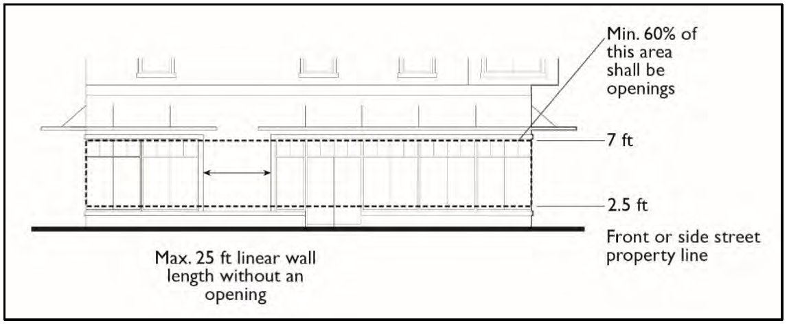
(1)
Design of Required Openings. Openings fulfilling this requirement shall have transparent glazing and provide views into work areas, display areas, sales areas, lobbies, or similar active spaces, or into window displays that are at least three (3) feet deep.
(2)
Exceptions for Parking Garages. Multi-level garages are not required to meet the building transparency requirement of this subsection.
(d)
Pedestrian Access.
(1)
Internal Connections. On sites greater than two and one-half (2.5) acres in size, a system of pedestrian walkways shall connect all buildings on a site to each other, to on-site automobile and bicycle parking areas, and to any on-site open space areas or pedestrian amenities.
(2)
To Circulation Network. Regular connections between on-site walkways and the public sidewalk and other planned or existing pedestrian routes and trails shall be provided. An on-site walkway shall connect the primary building entry or entries to a public sidewalk on each street frontage.
(3)
To Neighbors. Direct and convenient access shall be provided from commercial and mixed-use projects to adjoining residential and commercial areas to the maximum extent feasible, while still providing for safety and security.
(4)
Interior Pedestrian Walkway Design.
a.
Walkways shall have a minimum clear, unobstructed width of six (6) feet, where feasible, and shall be hard-surfaced with concrete, stone, tile, brick, or comparable material.
b.
Where a required walkway crosses driveways, parking areas, or loading areas, it shall be clearly identifiable through the use of a raised crosswalk, a different paving material, or similar method and shall meet ADA requirements.
c.
Where a required walkway is parallel and adjacent to an auto travel lane, it shall be raised or separated from the auto travel lane by a raised curb at least four (4) inches high, bollards, or other physical barrier.
(e)
Parking area design. Parking lot design, including screening and landscaping, shall be per section 7-9-70.4(b) "Parking Area Design."
(Ord. No. 24-004, § 15, 6-25-24)
Sec. 7-9-40.- CD "Coastal Development District".
All references to this district shall include sections 7-9-40.1 through 7-9-40.8.
(Ord. No. 20-006, § 1, 7-28-20)
Sec. 7-9-40.1. - Purpose and intent.
The purpose of the CD "Coastal Development District" is to implement the California Coastal Act (Division 20 of the Public Resources Code) and the certified Local Coastal Programs of the County of Orange. It is intended that these procedures and regulations constitute the minimum standards for all development projects within the Coastal Zone.
(Ord. No. 20-006, § 1, 7-28-20)
Sec. 7-9-40.2. - Application; interpretation of boundaries.
(a)
This district may be combined with any other district. In any district where the district symbol is followed by, as part of such symbol, a parenthetically enclosed "(CD)," the additional requirements, limitations, and standards of this district shall apply. The district symbol shall constitute the base district, and the (CD) suffix shall constitute the combining district. In the event of conflicting provisions between the base district and the combining district, the requirements of the CD District shall take precedence.
(b)
The provisions of this section are in addition to the provisions of sections 7-9-20 and 7-9-25.2. Where uncertainty exists as to the exact location of the CD District boundary, the following rules shall apply.
(1)
When a portion of a building site lies, or appears to lie, partially within the CD District and any existing or proposed development of such building site is within the CD District, the building site shall be considered to be within the CD District.
(2)
When a portion of a building site lies, or appears to lie, partially within the CD District and no development of such building site is within the CD District, the building site shall be considered to be not within the CD District.
(3)
When a public or private street or a highway lies partially within the CD District, the entire width of that portion of such street or highway lying partially within the CD District shall be considered to be within the CD District.
(Ord. No. 20-006, § 1, 7-28-20)
Sec. 7-9-40.3. - Definitions.
The following definitions shall apply to all areas within the CD District. In case of a conflict between the definitions contained in this section and those contained in sections 7-9-134 and through 7-9-135, the definitions contained in this section shall prevail within the CD District.
Aggrieved person. Any person who, in person or through a representative, appeared at a public hearing regarding a Coastal Development Permit; or who, prior to action on a Coastal Development Permit, informed the County in writing of his concerns about an application for such permit; or who for good cause was unable to do either and objects to the action taken on such permit and wishes to appeal such action to a higher authority.
Appealable development. Any Coastal Development Permit application that may be appealed to the California Coastal Commission pursuant to the Coastal Act of 1976, as amended.
Approving authority. Any person, committee, commission or board authorized by the applicable zoning or specific plan regulations, or by the provisions of this district to approve, conditionally approve or disapprove a Coastal Development Permit or discretionary permit application or project.
Certified Local Coastal Program (LCP). A plan for the use of property within the Coastal Zone, together with the Zoning Code, zoning district maps and other necessary implementing actions, which has been adopted by the County of Orange and certified by the California Coastal Commission pursuant to the Public Resources Code. A certified LCP may include individual geographic segments.
Coastal bluff.
(a)
Any bluff where the toe of the slope is now, or within the past two hundred (200) years has been, subject to marine erosion;
(b)
Any bluff where the toe of the slope is not now or was not historically subject to marine erosion, but the toe of which lies within an area otherwise identified in the Public Resources Code Section 30603(a)(1) or (a)(2), as may be amended.
Coastal Commission. The California Coastal Commission established pursuant to the California Coastal Act (Division 20 of the Public Resources Code).
Coastal Development Permit. A permit issued by the County of Orange or the Coastal Commission which is an approval of a use subject to the provisions of section 7-9-40 and the California Coastal Act.
Coastal Zone. That area of land and water extending seaward to the State's outer limit of jurisdiction and the unincorporated portion of the County of Orange specified on a Coastal Zone map adopted by the State Legislature as adjusted by the Coastal Commission pursuant to the requirements of the California Coastal Act.
Development. Means, on land, in or under water, the placement or erection of any solid material or structure; discharge or disposal of any dredged material or of any gaseous, liquid, solid, or thermal waste; grading, removing, dredging, mining, or extraction of any materials. Change in the density or intensity of use of land, including, but not limited to, subdivision pursuant to the Subdivision Map Act, and any other division of land, including lot splits, except where the land division is brought about in connection with the purchase of such land by a public agency for public recreational use. Change in the intensity of use of water, or of access thereto; construction, reconstruction, demolition, or alteration of the size of any structure, including any facility of any private, public, or municipal utility; and the removal or harvesting of major vegetation other than for agricultural purposes, and kelp harvesting.
Development project. Any of the uses, activities or structures listed under the definition of "development" when carried out, undertaken or established individually or independently of any other such use, activity or structure; or any group or combination of the listed uses, activities or structures which combine to form, or are a component part of an integrated project.
Energy facility. Any public or private processing, producing, generating, storing, transmitting, or recovering facility for electricity, natural gas, petroleum, coal or other source of energy.
Estuary. All areas within the mean high tide line of any coastal water body subject to tidal action, usually semi-enclosed by land, having open, partially obstructed or intermittent exchange with the open sea and in which ocean water is at least occasionally diluted by fresh water runoff from the land.
First public road paralleling the sea. The inland right-of-way line of that street or highway nearest to the sea which is generally parallel to the sea and which:
(a)
Is lawfully open and suitable for uninterrupted use by the public;
(b)
Is maintained by a public agency;
(c)
Is an improved all-weather road open to motor vehicle traffic in at least one direction;
(d)
Is not subject to any restrictions on use by the public except during an emergency or for military purposes; and which
(e)
Connects with other public roads providing a continuous access system and generally parallels and follows the shoreline of the sea so as to include all portions of the sea where the physical features such as bays, lagoons, estuaries and wetlands cause the waters of the sea to extend landward of the generally continuous coastline.
(f)
Whenever no public road can be designated which conforms to all provisions of (a) through (e) above, and a public road does exist which conforms to all provisions of (a) through (d) above, the effect of designating the first public road paralleling the sea shall be limited to the following.
(1)
All parcels between the Pacific Ocean and such other public road; and
(2)
Those parcels immediately adjacent to the sea and inland of such other public road.
Inland extent of the beach. The rocky shoreline to the toe of the bluff, all wet and dry sand area to the seaward vegetation line, toe of the bluff, or to a linear feature such as a sea wall, a road, or other permanent structures.
Local Coastal Program. See "Certified Local Coastal Program."
Major energy facility. Any energy facility exceeding fifty thousand dollars ($50,000), or such minimum as may be adopted by the State of California, in actual or estimated cost of construction.
Major public works project. Any public works project exceeding fifty thousand dollars ($50,000), or such other minimum as may be adopted by the State of California, in actual or estimated cost of construction.
Person. Any individual, organization, partnership, or other business association or corporation, including any utility and any federal, state, local government, or special district or an agency thereof.
Principal permitted use. The permitted main use that is designated specifically in the zoning district or specific plan regulation district of each specific certified LCP segment.
Public trust lands. All lands subject to the Common Law Public Trust for commerce, navigation, fisheries, recreation and other public purposes, including tidelands, submerged lands, beds of navigable lakes and rivers, and historic tidelands and submerged lands that are presently filled or reclaimed and which were subject to the public trust at any time.
Public works.
(a)
All production, storage, transmission, and recovery facilities for water, sewerage, telephone, and other similar utilities owned or operated by any public agency or by any utility subject to the jurisdiction of the California Public Utilities Commission, except for energy facilities.
(b)
All public transportation facilities, including streets, roads, highways, public parking lots and structures, ports, harbors, airports, railroads, and mass transit facilities and stations, bridges, trolley wires, and other related facilities.
(c)
All publicly financed recreational facilities, all projects of the State Coastal Conservancy, and any development by a special district.
(d)
All community college facilities.
Sea. The Pacific Ocean and all harbors, bays, channels, estuaries, salt marshes, sloughs, and other areas subject to tidal action through any connection with the Pacific Ocean, excluding non-estuarine rivers, streams, tributaries, creeks, and flood control and drainage channels.
Stream. A natural watercourse identified as a stream on a map adopted pursuant to a certified Local Coastal Program, or as designated by a solid or dotted line on the USGS 7.5 minute quadrangle series map. The bank of the stream shall be defined as the watershed and relatively permanent elevation or acclivity at the outer line of the stream channel that separates the bed from the adjacent upland, whether valley or hill, and serves to confine the water within the bed and to preserve the course of the stream. In areas where the stream has no discernible bank, the boundary shall be measured from the line closest to the stream where riparian vegetation is permanently established. Channelized streams not having significant habitat value shall not be considered.
Structure. Includes, but is not limited to, any building, road, pipe, flume, conduit, siphon, aqueduct, telephone line, and electrical power transmission and distribution line.
Submerged lands. Lands that lie below the line of mean low tide.
Tidelands. Lands that are located between the line of mean high tide and mean low tide.
Wetland. Lands within the Coastal Zone that may be covered periodically or permanently with shallow water, and including salt water marshes, freshwater marshes, open or closed brackish water marshes, swamps, mud flats, and fens.
(Ord. No. 20-006, § 1, 7-28-20)
Sec. 7-9-40.4. - Coastal Development Permit required.
Except as otherwise provided by section 7-9-40.5, any person, partnership, corporation or state or local government agency proposing to undertake any development project within the CD District shall obtain approval of a Coastal Development Permit in compliance with the provisions of this District. A tentative tract map shall not be approved and a building permit, grading permit, or encroachment permit shall not be issued prior to the issuance of a Coastal Development Permit unless the project is categorically exempted per section 7-9-40.5.
It is the intent of these regulations to minimize the number of times a development project shall be required to secure a Coastal Development Permit. Whenever a proposed development project includes more than one "development," as defined in section 7-9-40.3, it is intended that, where feasible, the "developments" be integrated into one development project and that the Coastal Development Permit application be processed at the most appropriate stage of the project. Any such Coastal Development Permit application shall include such information and details as necessary to permit an appropriate decision to be made for all stages or phases of the development project.
(Ord. No. 20-006, § 1, 7-28-20)
Sec. 7-9-40.5. - Exemptions.
Development projects listed below are exempt from the requirement for having an approved Coastal Development Permit from the County of Orange. A current record of all categorically exempted developments shall be available for public and Coastal Commission review and shall include the following information for each. name of applicant, location of the project, and brief description of the project. Exempt projects are as follows;
(a)
Development projects, included in any categorical exclusion list adopted pursuant to the certified Local Coastal Program and to Section 30610(e) the Public Resources Code, as may be amended.
(b)
Improvements to an existing structure, with the exception of the following.
(1)
Improvements to any structure located.
a.
On a beach;
b.
In a wetland;
c.
Seaward of the mean high tide line; or
d.
Where the dwelling or proposed improvement would encroach within fifty (50) feet of the edge of a coastal bluff.
(2)
Improvements to any structure located between the sea and the first public road paralleling the sea or within three hundred (300) feet of the inland extent of a beach or of the mean high tide line of the sea where there is no beach, whichever is the greater distance.
(3)
Improvements to any structure located within significant scenic resources areas as designated by the certified Local Coastal Program or the Coastal Commission when such improvements would constitute or result in any of the following.
a.
An increase of ten (10) percent or more of the internal floor area of the existing structures on the building site.
b.
An increase in the floor area in any amount when the structure has previously been improved in compliance with these exemptions as described in this section.
c.
The construction of an additional story or a loft.
d.
The construction, placement or establishment of any detached structure.
(4)
Any significant alteration of land form, or removal or placement of vegetation, on a beach, wetland, sand dune, within one hundred (100) feet (fifty (50) feet for a single-family dwelling) of the edge of a coastal bluff, or in an area of natural vegetation designated by the Coastal Commission as significant natural habitat.
(5)
Expansion or construction of a water well or septic system.
(6)
Improvements in any area where the Coastal Commission has determined to have a critically short water supply that shall be maintained for the protection of coastal resources or public recreational use. Such improvement would be a major water user not essential to residential use, including, but not limited to, swimming pools and landscape irrigation systems.
(7)
Any improvements when the Coastal Development Permit issued for the original structure indicated that future additions would require a subsequent Coastal Development Permit.
(8)
Improvements to any structure or change in occupancy that would result in an increase in the intensity of the uses on the building site.
(9)
Improvements that convert any existing structures from a multiple unit rental use or visitor serving commercial use to a condominium, stock cooperative, or time share project.
(10)
Public works facility.
(c)
Maintenance dredging of existing navigation channels or moving dredged material from such channels to a disposal area outside the Coastal Zone, pursuant to a permit from the United States Army Corps of Engineers.
(d)
Repair or maintenance activities that do not result in any addition to, enlargement, or expansion of, the object of such repair or maintenance activities, with the exception of the following.
(1)
Repair or maintenance of a sea wall revetment, bluff retaining wall, breakwater, groin, culvert, outfall or similar shoreline work which involves substantial alteration of the foundation, including pilings and other surface and subsurface structures.
(2)
The placement, whether temporary or permanent, of riprap, or artificial berms of sand, or any other form of solid material, on a beach or in coastal waters, streams, wetlands, estuaries, or on shoreline protective works.
(3)
The replacement of twenty (20) percent or more of the materials of an existing structure with materials of a different kind.
(4)
The presence, whether temporary or permanent, of mechanized construction equipment or construction materials on any sand area or, coastal bluff or within twenty (20) feet of coastal waters or streams.
(5)
Any method of routine maintenance dredging that involves.
a.
The dredging of one hundred thousand (100,000) cubic yards or more within a twelve (12) month period.
b.
The placement of dredged spoils of any quantity on any sand area, within fifty (50) feet of the edge of a coastal bluff or environmentally sensitive habitat area, or within twenty (20) feet, of coastal waters or streams.
c.
The removal, sale, or disposal of dredged spoils of any quantity that would be suitable for beach nourishment in an area the Coastal Commission has declared by resolution to have a critically short sand supply that shall be maintained for protection of structures, coastal access or public recreational use.
(6)
Any repair or maintenance to facilities or structures or work located in any sand area, within fifty (50) feet of the edge of a coastal bluff or environmentally sensitive habitat area; or within twenty (20) feet of any coastal waters or streams that include.
a.
The placement or removal, whether temporary or permanent, of riprap, rocks, sand or other beach materials or any other forms of solid materials.
b.
The presence, whether temporary or permanent, of mechanized equipment or construction materials.
(e)
The installation, testing, and placement in service or the replacement of any necessary utility connection between an existing service facility and any development approved pursuant to this district.
(f)
The replacement of any structure, other than a public works facility, destroyed by natural disaster, provided any such replacement structure conforms to applicable current zoning regulations, is designed and intended for the same use as the destroyed structure, does not exceed the floor area, height, or bulk of the destroyed structure by more than ten (10) percent, and is sited in the same location on the same building site as the destroyed structure.
(g)
Development projects on tidelands, submerged lands, or on public trust lands, whether filled or unfilled, when such projects are permitted pursuant to a Coastal Development Permit issued by the Coastal Commission.
(h)
Projects normally requiring a Coastal Development Permit but which are undertaken by a public agency, public utility or person performing a public service as emergency measures to protect life and property from imminent danger or to restore, repair or maintain public works, utilities and services during and immediately following a natural disaster or serious accident, provided the Director, and the Executive Director of the Coastal Commission are notified within three (3) days after the disaster or discovery of the danger regarding the type and location of the emergency measures to be performed. This exemption does not apply to the erection, construction, or placement of any structure with an estimated cost or market value in excess of twenty-five thousand dollars ($25,000.00) in a permanent location.
(i)
Ongoing routine repair and maintenance activities of local governments, state agencies, and public utilities (such as railroads) involving shoreline works protecting transportation roadways, as specified in Board of Supervisors' Resolution No. 82-1917, adopted on December 22, 1982.
(Ord. No. 20-006, § 1, 7-28-20; Ord. No. CA 22-01, 9-27-22; Ord. No. 22-003, § 4, 9-27-22)
Sec. 7-9-40.6. - Coastal Development Permit procedures.
See section 7-9-127.1, Coastal Development Permit Procedures.
(Ord. No. 20-006, § 1, 7-28-20)
Sec. 7-9-40.7. - Open space easements and public access documents.
When a Coastal Development Permit requires dedication of a public access, open space, or a conservation easement prior to recordation of a final tract or parcel map or prior to issuance of the Coastal Development Permit, the legal dedication document shall be approved by the Director, OC Public Works or designee, and the Executive Director of the Coastal Commission prior to such recordation or permit issuance. The offer of dedication shall be processed in the following manner.
(a)
After the Director has approved the offer of dedication, the offer of dedication, together with a copy of the Coastal Development Permit conditions and findings, shall be forwarded to the Executive Director for review and approval. The Executive Director shall, within fifteen (15) working days after receipt of the documents, notify the Director and the applicant of any recommended changes to the dedication offer.
(b)
If the Director has not received a notice of recommended changes from the Executive Director at the end of the fifteen (15) working day period, the map may be recorded or the permit may thereafter be issued in compliance with applicable County procedures and regulations.
(c)
If the Executive Director has recommended changes in the offer of dedication, the subject map shall not be recorded, nor shall the permit be issued, until the offer of dedication has been revised in a manner satisfactory to, and as approved by, the Director and the Executive Director.
(Ord. No. 20-006, § 1, 7-28-20)
Sec. 7-9-40.8. - Enforcement provisions.
The purpose of this section is to provide regulations and procedures that shall ensure compliance with the California Coastal Act and with the requirements of all certified Local Costal Programs and the provisions of this District.
(a)
Violations. The following provisions are applicable within the CD District. A violation of a certified Local Coastal Program (LCP) may be prosecuted by the County of Orange in the name of the people of the State of California, or may be redressed by civil action.
Any person who violates any provision of the LCP shall be subject to a civil fine of not to exceed ten thousand dollars ($10,000.00). In addition to any other penalties, any person who intentionally and knowingly performs any development in violation of the LCP shall be subject to a civil fine of not less than fifty dollars ($50.00) nor more than five thousand dollars ($5,000.00) per day for each day in which such violation occurs.
(b)
Revocations. Failure of any person to abide by and faithfully comply with any and all conditions that may be attached to the approval of a permit issued pursuant to the provisions of this District shall constitute grounds for the revocation of said permit.
The failure of any Coastal Development Permit application to be processed in compliance with the requirements and procedures of this District shall constitute grounds for revocation for such permit.
(c)
Judicial review. Any violation of the Zoning Code within the District shall also constitute a violation of Division 20 Section 30000 et seq. of the Public Resources Code and shall be subject to the remedies, fines and penalties provided in Division 20, Chapter 9, Section 30800 et seq. of the Public Resources Code, as may be amended.
(Ord. No. 20-006, § 1, 7-28-20)
Sec. 7-9-41. - E "Equine Combining" District.
All references to this section shall include sections 7-9-41.1 through 7-9-41.8.
(Ord. No. 20-006, § 1, 7-28-20)
Sec. 7-9-41.1. - Purpose and intent.
The E "Equine" District is established to allow the keeping of horses, ponies, donkeys, or mules in certain developed residential areas up to specified numbers, so that residents may retain and preserve a semi-rural environment, including the retention of equestrian uses.
(a)
The purpose of this district is to specify the number of horses, ponies, donkeys or mules which are allowed on residential properties.
(b)
The intent is to maintain the rural, open space character of the County's traditional equestrian communities.
(Ord. No. 20-006, § 1, 7-28-20)
Sec. 7-9-41.2. - Application.
This district may be combined with any other district. In any district where the district symbol is followed by, as a part of such symbol, the parenthetically enclosed letter "(E)", the additional requirements and procedures contained in this section shall apply. The district symbol shall constitute the base district and the (E) suffix indicates that the combining district also applies. Any ambiguity or conflict shall be resolved by the Director pursuant to section 7-9-20.
(Ord. No. 20-006, § 1, 7-28-20)
Sec. 7-9-41.3. - General regulations.
The following regulations shall be applicable to all properties located in any (E) District.
(a)
The regulations applicable to principal uses and structures in the underlying base district shall apply.
(b)
The total number of horses, ponies, donkeys, or mules on a property shall not exceed one (1) per five thousand (5,000) square feet unless a greater number is approved through a Recreational Equine Use Permit.
(c)
For purposes of these regulations, the breeding of horses, ponies, donkeys, or mules owned or leased by the property owner, resident, lessee, members of his/her immediate family, and/or mares present on the property temporarily for breeding purposes shall not be considered a commercial use.
(Ord. No. 20-006, § 1, 7-28-20)
Sec. 7-9-41.4. - Recreational Equine Use Permit.
(a)
(1)
A Recreational Equine Use Permit approved by the Zoning Administrator shall be obtained for the keeping of more than one (1) horse, pony, donkey or mule, or any combination thereof, for every five thousand (5,000) square feet on properties with an (E) designation. No more than one (1) horse, pony, donkey, or mule per three thousand five hundred (3,500) square feet shall be permitted under this section.
(2)
No Recreational Equine Use Permit shall be granted unless all subject horses, ponies, donkeys, or mules are owned or leased by the property owner, resident, lessee, members of his/her immediate family, and any mares present on the property temporarily are for breeding purposes.
(3)
The property owner, resident or lessee shall at any time after the filing of the permit application, and at all times after such permit is issued, make available proof of ownership of each horse, pony, donkey or mule on the property to any County representative.
(4)
The Zoning Administrator shall provide forty-five (45) days for review and comment from the applicable citizens' advisory body(ies) designated by the Board of Supervisors regarding the application for a Recreational Equine Use Permit prior to the issuance of such permit. If no response is received from such citizens' advisory body(ies) within the forty-five-day comment period, the citizens' body(ies) shall be deemed to have no objection to the issuance of the permit.
(5)
In addition to the foregoing, notice of the consideration of the permit shall be given as specified in section 7-9-125.4.
(b)
Recreational Equine Use Permit Application submittal requirements. In addition to the information required by section 7-9-125, each Recreational Equine Use Permit application shall include a signed declaration from the applicant attesting to the fact that the ownership of all of the horses, ponies, donkeys, or mules on the property conforms with 7-9-41.4(a)(2) above.
(c)
An applicant for the Recreational Equine Use Permit may keep horses, ponies, donkeys, or mules subject to the application on the property during the application process until notice has been received of the final disposition of the application.
(Ord. No. 20-006, § 1, 7-28-20)
Sec. 7-9-41.5. - Revocation of Recreational Equine Use Permit.
The Zoning Administrator shall conduct proceedings to revoke a Recreational Equine Use Permit pursuant to section 7-9-125.9 if a violation of any of its provision occurs. Wherever the term "Planning Commission" is used in that section, it shall mean "Zoning Administrator" for the purposes of revocation pursuant to this section only. An appeal of a decision of the Zoning Administrator upon a revocation proceeding to the Planning Commission shall be conducted pursuant to section 7-9-125.10.
(Ord. No. 20-006, § 1, 7-28-20)
Sec. 7-9-41.6. - Nonconforming uses.
(a)
For the purpose of determining whether or not an equine use was lawfully established, any property having a total area of more than five thousand (5,000) and less than ten thousand (10,000) square feet on the effective date of this ordinance shall be permitted to maintain no more than two (2) horses, ponies, donkeys, or mules, or any combination thereof, as a legal, nonconforming use recognized under this ordinance, without obtaining a Recreational Equine Use Permit pursuant to section 7-9-41.4 and 7-9-125.
(b)
Consistent with Zoning Code section 7-9-115(c), a Recreational Equine Use Permit approved by the Zoning Administrator pursuant to section 7-9-41.4 and 7-9-125 shall be obtained for the keeping of more than two (2) horses, ponies, donkeys, or mules, or any combination thereof, on any property having a total area of more than five thousand (5,000) square feet and less than ten thousand (10,000) square feet. The density provision of section 7-9-41.4(a)(1) shall not apply to a property of this size.
(Ord. No. 20-006, § 1, 7-28-20)
Sec. 7-9-41.7. - Corral setbacks.
The following corral setbacks shall be allowed.
(a)
Except for those regulations regarding the proximity of neighboring residential windows with equine specified in the Health Code, open rail corral fences up to five (5) feet in height with visual through-line-of-sight may be allowed up to a street right-of-way line through which no vehicular access is taken.
(b)
Those areas with vehicular intersection access shall have such fences angle back from the access points by following the angle line between two (2) points located on, and fifteen (15) feet distant from, the point of intersection of the access way and the street right-of-way line.
(Ord. No. 20-006, § 1, 7-28-20)
Sec. 7-9-41.8. - Severability.
If any provision of this section or the application of any such provision to any person or circumstances, shall be held invalid, the remainder of this section to the extent it can be given effect, or the application of such provision to persons or circumstances other than those as to which it is held invalid, shall not be affected thereby, and to this extent the provisions of this section are severable.
(Ord. No. 20-006, § 1, 7-28-20)
Sec. 7-9-42. - FP "Floodplain" Overlay District.
All references to this section shall include sections 7-9-42.1 through 7-9-42.12. The California Legislature has in Government Code sections 65302, 65560, and 65800 conferred upon local governments the authority to adopt regulations designed to promote the public health, safety, and general welfare of its citizenry. Therefore, the County of Orange does hereby adopt the following floodplain management regulations.
(Ord. No. 20-006, § 1, 7-28-20)
Sec. 7-9-42.1. - Purpose and intent.
The purposes of the FP "Floodplain" District include.
(a)
Prevention of loss of life and property and to minimize economic loss caused by flood flows.
(b)
Establishment of criteria for land management and land use in flood-prone areas that are consistent with the criteria promulgated by the Federal Emergency Management Agency (FEMA) for the purpose of providing flood insurance eligibility for property owners.
(c)
Regulation and control of use of land below the elevation of the base flood flow within the floodplain.
(d)
Compliance with the Cobey-Alquist Floodplain Management Act requirements for floodplain management regulations.
(Ord. No. 20-006, § 1, 7-28-20)
Sec. 7-9-42.2. - Definitions.
The following definitions apply for floodplain management purposes in addition to any applicable definitions found in section 7-9-135, and those definitions incorporated from the County's adoption of the California Building Code and International Building Code.
Accessory structure. A subordinate building located on a building site with a primary use which is ancillary to that of a main building or primary use of the land.
Alteration of watercourse. Any change, addition, or modification to a watercourse made by excavating, or placing fill, rock protection, or structural improvements.
Base flood. The flood having a one percent chance of being equaled or exceeded in any given year, i.e., "100-year flood."
Basement. Any area of the building having its floor subgrade—i.e., below ground level, on all sides.
Breakaway wall. A wall that is not part of the structural support of the building and is intended through its design and construction to collapse under specific lateral loading forces, without causing damage to the elevated portion of the building or supporting foundation system.
Coastal floodplain development study. A County of Orange report contains technical criteria and standards necessary to provide protection of property from the ocean along the unincorporated coastal plain.
Coastal high hazard area. The area subject to ocean related hazards, including but not limited to storms, hurricane wave wash, and tsunamis.
Design flood. The flood having a one-percent chance of being equaled or exceeded in any given year or an area designated as a flood hazard area on the County's legally designated flood hazard map.
Design flood elevation (DFE). The elevation of the "design flood," including wave height, relative to the datum specified on the County's legally designated flood hazard map.
Development. Any man-made change to residential and non-residential improved or unimproved real estate, including but not limited to buildings or other structures, mining, dredging, filling, grading, paving, excavation or drilling operations or storage of equipment or materials.
Dry floodproofing. A combination of measures that results in a structure, including the attendant utilities and equipment and sanitary facilities, being watertight with all elements substantially impermeable and with structural components having the capacity to resist flood loads.
Encroachment on floodplain. The advance or infringement of uses, plant growth, fill, excavation, new construction, substantial improvements, buildings, permanent structures, or other development into a floodplain which may impede or alter its flow capacity.
Existing manufactured home park or subdivision. A manufactured home park or subdivision for which the construction of facilities for servicing the lots on which the manufactured homes are to be affixed (including, at a minimum, the installation of utilities, the construction of streets, and either final site grading or the pouring of concrete pads) is completed before October 29, 1980.
Expansion to an existing manufactured home park or subdivision. The preparation of additional sites by the construction of facilities for servicing the lots on which the manufactured homes are to be affixed (including the installation of utilities, the construction of streets, and either final site grading or the pouring of concrete pads).
Flood. A general and temporary condition of partial or complete inundation of land areas from the overflow of inland and tidal waters, and the rapid accumulation of run-off of surface waters from any source and mudslides (i.e., mudflows) which are proximately caused or precipitated by accumulations of water on or under the ground.
Flood control project. A dam or barrier designed and constructed to keep water away from or out of a specific area, including but not limited to levees, floodwalls, and channelization.
Flood damage-resistant material. Any construction material capable of withstanding direct and prolonged contact with floodwaters without sustaining any damage that requires more than cosmetic repair.
Flood hazard area. The greater of the two (2) following areas: 1) The area within a floodplain subject to a one-percent or greater chance of flooding in any year, or 2) The area designated as a flood hazard area on the County's legally designated flood hazard map.
Flood insurance rate map (FIRM) and flood boundary and floodway map. The official maps on which the Federal Insurance Administration has delineated the areas of special flood hazard, the risk premium zones, and the floodways applicable to the community.
Flood insurance study. The official report provided by the Federal Insurance Administration that includes flood profiles, the flood insurance rate map, the flood boundary and floodway map, and the water surface elevation of the base flood.
Floodplain. The land area adjacent to a watercourse and other land areas susceptible to being inundated by water.
Floodplain administrator. The Director of OC Public Works (OCPW), or his or her designee who has the authority to administer, implement, and enforce "Floodplain" District regulations and grant or deny applicable development permits.
Floodproofing. Any combination of structural and nonstructural additions, changes or adjustments to structures which reduce or eliminate flood damage to real estate or improved real property, water and sanitary facilities, structures, and their contents.
Floodway. The channel of a river or other watercourse and that part of the floodplain reasonably required to discharge the base flood without cumulatively increasing the water surface elevation more than one (1) foot.
Freeboard. An additional amount of height of a structure above the Base Flood Elevation used as a factor of safety (e.g., one foot above the Base Flood) in determining the level at which a structure's lowest floor must be elevated or floodproofed to be in accordance with state or community floodplain management regulations.
Highest adjacent grade. The highest natural elevation of the ground surface prior to construction next to the proposed walls of a structure.
Historic structure. Any structure that is:
(1)
Listed individually in the National Register of Historic Places (a listing maintained by the Department of Interior) or preliminarily determined by the Secretary of the Interior as meeting the requirements for individual listing on the National Register;
(2)
Certified or preliminarily determined by the Secretary of the Interior as contributing to the historical significance of a registered historic district or a district preliminarily determined by the Secretary to qualify as a registered historic district;
(3)
Individually listed on a state inventory of historic places in states with historic preservation programs which have been approved by the Secretary of Interior; or
(4)
Individually listed on a local inventory of historic places in communities with historic preservation programs that have been certified either by an approved state program as determined by the Secretary of the Interior or directly by the Secretary of the Interior in states without approved programs.
Light-duty truck. A vehicle with a gross vehicle weight up to eight thousand five hundred (8,500) pounds which has a curb weight of up to six thousand (6,000) pounds and has a basic vehicle frontal area of up to forty-five (45) square feet, which is designed primarily for purposes of transportation of property or is a derivation of such a vehicle, or designed primarily for purposes of transportation of persons and has a capacity of more than twelve (12) persons, or available with special features enabling off-street or off-highway operation and use.
Lowest floor. The lowest floor of the lowest enclosed area (including basement or cellar). An unfinished or flood resistant enclosure, usable solely for parking of vehicles, building access or storage in an area other than a basement area is not considered a building's lowest floor; provided, that such enclosure is not built so as to render the structure in violation of the applicable non-elevation design requirements of sections 7-9-42 through 7-9-42.12.
Manufactured home. A structure, transportable in one (1) or more sections, which is built on a permanent chassis and is designed for use with or without a permanent foundation when connected to the required utilities. For floodplain management purposes the term "manufactured home" also includes park trailers, travel trailers and other similar vehicles placed on a site for greater than one hundred eighty (180) consecutive days.
Manufactured home park or subdivision. A parcel (or contiguous parcels) of land divided into two (2) or more manufactured home lots for rent or sale.
Market value. For the purposes of a structure, means the value determined by estimating the cost to replace the structure in new condition and adjusting that cost figure by the amount of depreciation which has accrued since the structure was constructed.
(1)
The cost of replacement of the structure shall be based on a square foot cost factor determined by reference to a building cost estimating guide recognized by the building construction industry.
(2)
The amount of depreciation shall be determined by taking into account the age and physical deterioration of the structure and functional obsolescence as approved by the Floodplain Administrator, but shall not include economic or other forms of external obsolescence.
Use of replacement costs or accrued depreciation factors different from those contained in recognized building cost estimating guides may be considered only if such factors are included in a report prepared by an independent professional appraiser and supported by a written explanation of the differences.
New construction. For floodplain management purposes, means structures for which the "start of construction" commenced on or after October 29, 1980, and includes any subsequent improvements to such structures.
New manufactured home park or subdivision. A manufactured home park or subdivision for which the construction of facilities for servicing the lots on which the manufactured homes are to be affixed (including at a minimum, the installation of utilities, the construction of streets, and either final site grading or the pouring of concrete pads) is completed on or after October 29, 1980.
Nuisance. Shall be considered to be a condition on real property, caused, maintained, or permitted to exist in violation of any of the laws, statutes, and ordinances which the County or Flood Control District is authorized to enforce including but not limited to violations relating to permit conditions.
Permit for floodplain development. Any permit for development and/or use of property within the floodplain provided by the Zoning Code.
Recreational Vehicle. A vehicle which is:
(1)
Built on a single chassis;
(2)
Four hundred (400) square feet or less when measured at the largest horizontal projection;
(3)
Designed to be self-propelled or permanently towable by a light-duty truck; and
(4)
Designed primarily not for use as a permanent dwelling but as temporary living quarters for recreational, camping, or seasonal use.
Riverine. Relating to, formed by, or resembling a river (including tributaries), stream, brook, etc.
Reference vertical datum. The National Geodetic Vertical Datum (NGVD) of 1929 or the North American Vertical Datum (NAVD) of 1988, as applicable, to which base flood elevations shown on a community's flood insurance rate map are referenced by the Federal Emergency Management Agency.
Sand dunes. Naturally occurring accumulations of sand in ridges or mounds landward of the beach.
Special flood hazard area (SFHA). An area in the floodplain subject to a one (1) percent or greater chance of flooding in any given year. It is shown on an FHBM or FIRM as Zone A, AO, A1-A30, AE, A99, AH, V1-V30, VE or V.
Start of construction. Includes substantial improvement and other proposed new development and means the date the building permit was issued, provided the actual start of construction, repair, reconstruction, rehabilitation, addition, placement, or other improvement was within one hundred eighty (180) days from the date of the permit. The actual start means either the first placement of permanent construction of a structure on a site, such as the pouring of slab or footings, the installation of piles, the construction of columns, or any work beyond the stage of excavation; or the placement of a manufacture home on a foundation. Permanent construction does not include land preparation, such as clearing, grading, and filling; nor does it include the installation of streets and/or walkways; nor does it include excavation for a basement, footings, piers, or foundations or the erection of temporary forms; nor does it include the installation on the property of accessory buildings, such as garages or sheds not occupied as dwelling units or not part of the main structure. For a substantial improvement, the actual start of construction means the first alteration of any wall, ceiling, floor, or other structural part of a building, whether or not that alteration affects the external dimensions of the building.
Structure. A walled and roofed building that is principally above ground; this includes a gas or liquid storage tank or a manufactured home.
Substantial damage. Damage of any origin sustained by a structure whereby the cost of restoring the structure to its before damaged condition would equal or exceed fifty percent (50%) of the market value of the structure before the damage occurred.
Substantial improvement. Any reconstruction, rehabilitation, addition, or other improvement of a structure, the cost of which equals or exceeds fifty percent (50%) of the market value of the structure before the "start of construction" of the improvement. This term includes structures which have incurred "substantial damage," regardless of the actual repair work performed. The term does not, however, include either:
(1)
Any project for improvement of a structure to correct existing violations or state or local health, sanitary, or safety code specifications which have been identified by the local code enforcement official and which are the minimum necessary to assure safe living conditions; or
(2)
Any alteration of a "historic structure," provided that the alteration will not preclude the structure's continued designation as a "historic structure."
Variance. A discretionary grant of permission to depart from the specific requirements of this Code that is warranted when, due to special circumstances regarding the physical characteristics of the property, the strict application of standards would deprive the property of privileges available to other property in the same zoning classification.
Violation. The failure of a structure or other development to be fully compliant with sections 7-9-42 through 7-9-42.12. A structure or other development without the elevation certificate, other certifications, or other evidence of compliance required in sections 7-9-42 through 7-9-42.12 is presumed to be in violation until such time as that documentation is provided.
Watercourse. A lake, river, creek, stream, wash, arroyo, channel, or other topographic feature on or over which waters flow at least periodically. Watercourse includes specifically designated areas in which substantial flood damage may occur.
(Ord. No. 20-006, § 1, 7-28-20; Ord. No. 25-011, § 1, 5-20-25)
Sec. 7-9-42.3. - Application.
(a)
"Floodplain" Districts. These "Floodplain" District ("FP District") regulations apply per section 7-9-25.1, special flood hazards, those areas of the County which, under present conditions, are subject to periodic flooding and accompanying hazards.
(1)
The FP-1 is intended to be applied to areas shown as "floodway" on the December 3, 2009 or most current federal FIRMs and FBFMs and areas in which the County has determined that a floodway exists.
(2)
The FP-2 applies to areas shown as "A," "A1" through "A30," "AO," "AE," "AH," "A99" and "M" on the December 3, 2009 or most current federal FIRMs and FHBMs and to areas in which the County has determined to be a special flood hazard area.
(3)
The FP-3 applies to areas shown as "V" and "V1" through "V30," and "VE" on the December 3, 2009 or most current federal FIRMs or FHBMs and to areas in which the County has determined to be a coastal high hazard area.
(4)
This district may be combined with any other district. In any district where the district symbol is followed by parenthetically enclosed "(FP-1)," "(FP-2)," or "(FP-3)," the additional requirements, limitations, and standards of this district shall apply. The district symbol shall constitute the base district, and the FP suffix shall constitute the combining district. In the event of less restrictive conflicting provisions between the base district and the combining district, the requirements of the FP-1, FP-2 or FP-3 shall take precedence.
(5)
The areas of special flood hazard identified by FEMA in the Flood Insurance Study (FIS) for Orange County, California and incorporated areas dated December 3, 2009, with accompanying FIRMs and FBFMs, dated December 3, 2009, and all subsequent amendments and/or revisions, are hereby adopted and incorporated by reference and declared to be a part of sections 7-9-42 through 7-9-42.12. This FIS and attendant mapping is the minimum area of applicability of sections 7-9-42 through 7-9-42.12 and which is recommended to the Board of Supervisors by the Floodplain Administrator. The FIS, FIRMs and FBFMs are on file at the Orange County Flood Control District, at its current address.
(b)
No structure or land shall hereafter be constructed, located, extended, converted, or altered without full compliance with the terms of sections 7-9-42 through 7-9-42.12 and other applicable regulations. Violation of the requirements (including violations of conditions and safeguards) shall constitute a misdemeanor as governed by section 7-9-130. Nothing herein shall prevent the County of Orange from taking such lawful action as is necessary to prevent or remedy any violation.
(c)
The degree of flood protection required by sections 7-9-42 through 7-9-42.12 is considered reasonable for regulatory purposes and is based on scientific and engineering considerations. Larger floods can and shall occur on rare occasions. Flood heights may be increased by man-made or natural causes. Sections 7-9-42 through 7-9-42.12 does not imply that land outside the areas of special flood hazards or uses permitted within such areas shall be free from flooding or flood damages. Sections 7-9-42 through 7-9-42.12 shall not create liability on the part of the County of Orange or the Orange County Flood Control District, or its officers or employees thereof, for any flood damages that result from reliance on sections 7-9-42 through 7-9-42.12 or any administrative decision lawfully made hereunder.
(d)
These "Floodplain" District regulations are not intended to repeal, abrogate, or impair any existing easements, covenants, or deed restrictions. However, where these regulations and another ordinance, easement, covenant, or deed restriction conflict or overlap, whichever imposes the more stringent restrictions shall prevail.
(e)
In the interpretation and application of sections 7-9-42 through 7-9-42.12, all provisions shall be considered as minimum requirements, liberally construed in favor of the County of Orange, and deemed neither to limit nor repeal any other powers granted under state statutes.
(f)
Until a regulatory floodway is adopted, no new construction, substantial improvement, or other development (including fill) shall be permitted within FIRM Zones A1-30 and AE, unless it is demonstrated that the cumulative effect of the proposed development, when combined with all other development, shall not increase the water surface elevation of the base flood more than one (1) foot.
(g)
Floodproofing regulations shall apply to new construction or substantial improvement of residential and nonresidential structures. The floodproofing methods used shall be determined by project type and shall be subject to applicable local, State, and Federal regulations, including the National Flood Insurance Program.
(1)
Dry floodproofing methods shall be utilized for new construction or substantial improvements of nonresidential structures. Appropriate design and construction methods, along with attendant utility and sanitary facilities, shall be utilized to ensure that the structure is watertight with substantially impermeable walls that are adequate to withstand the flood depths, pressures, velocities, impact and uplift forces, and other factors associated with the base flood.
(2)
Wet floodproofing shall be applied to new construction or substantial improvement of residential structures. Permanent or contingent measures shall be utilized to prevent or provide resistance to damage from flooding by allowing water to enter the structure.
(h)
This ordinance and the various parts thereof are hereby declared to be severable. Should any section of this ordinance be declared by the courts to be unconstitutional or invalid, such decision shall not affect the validity of the ordinance as a whole, or any portion thereof other than the section so declared to be unconstitutional or invalid.
(i)
Permits shall be required for all proposed construction and other development within Special Flood Hazard Areas (SFHA) on the Flood Insurance Rate Map (FIRM).
(j)
These regulations, in conjunction with the building codes, provide minimum requirements for development located in flood hazard areas, including the subdivision of land; filling, grading and other site improvements; installation of utilities; installation, placement and replacement of manufactured homes; placement of recreational vehicles; installation of tanks; temporary structures and temporary or permanent storage; accessory utility and miscellaneous buildings and structures; certain building work exempt from permit under the building codes; and flood control projects.
(Ord. No. 20-006, § 1, 7-28-20; Ord. No. 25-011, § 2, 5-20-25)
Sec. 7-9-42.4. - Responsibilities of Floodplain Administrator.
The Director of OC Public Works (OCPW), or designee, is hereby appointed as Floodplain Administrator as defined in section 7-9-135, and has the authority to administer, implement, and enforce "Floodplain" District regulations, and grant or deny development permits. The duties and responsibilities of the Floodplain Administrator shall include, but not be limited to, the following.
(a)
Permit review. Review all applications to determine that.
(1)
Permit requirements of sections 7-9-42.1 through 7-9-42.12 have been satisfied.
(2)
All other required state and federal permits have been obtained.
(3)
The site is reasonably safe from flooding.
(4)
The proposed development does not adversely affect the carrying capacity of areas where base flood elevations have been determined, but a floodway has not been designated. This means that the cumulative effect of the proposed development, when combined with all other existing and anticipated development, shall not increase the water surface elevation of the base flood more than one (1) foot.
(b)
Review and use of any other base flood data. When base flood elevation data had not been provided in an application for a site development permit, the Floodplain Administrator shall obtain, review, and reasonably utilize any base flood elevation (BFE) and floodway data available from a federal or state agency or other source. In FIRM Zone A, in the absence of FEMA BFE data and floodway data, other available data shall be considered as basis for elevating residential structures to or above base flood level, and for floodproofing or elevating nonresidential structures to or above base flood level.
(c)
Notification of other agencies. Prior to the alteration or relocation of a watercourse, the Floodplain Administrator shall notify adjacent communities and the California Department of Water Resources, and submit evidence of such to FEMA. Assurance shall be given that the flood carrying capacity within the altered or relocated portion of said watercourse is maintained.
(d)
Documentation of Floodplain Development. Documentation and records regarding floodplain development shall be maintained and made available to the public in accordance with Federal and State law. Where BFE data are utilized, records of lowest floor and floodproofing elevations for new construction and substantial improvements shall be obtained and maintained.
(e)
License status verification. All professional engineers and architects certifying development projects in the unincorporated area shall be California-registered and shall provide a copy of their current professional license to the Floodplain Administrator.
(Ord. No. 20-006, § 1, 7-28-20; Ord. No. 25-011, § 3, 5-20-25)
Sec. 7-9-42.5. - Uses permitted.
The following uses and specifically identified structures complying with section 7-9-121 are permitted in the FP-1, FP-2, and FP-3 except as prohibited by section 7-9-42.
(a)
Agriculture.
(b)
Public flood control facilities and devices.
(c)
Public utility facilities.
(d)
Public parks and recreation areas.
(e)
Accessory uses and structures entirely of a storage nature that are less than one hundred twenty (120) square feet in floor area or five hundred (500) square feet for a wood frame garage;
(f)
Walls, wood fences, and chain link fences that satisfy the applicable development standards of sections 7-9-42 through 7-9-42.12.
(g)
All recreational vehicles placed in Zones A1-30, AH, AE, V1-30 and VE on the community's FIRM shall:
(1)
Be on the site for fewer than one hundred eighty (180) consecutive days.
(2)
Be fully licensed and ready for highway use. For purposes of this section, a recreational vehicle is ready for highway use if it is on its wheels or jacking system, is attached to the site only by quick disconnect type utilities and security devices, and has no permanently attached additions.
(3)
Meet the requirements for Coastal Development Permits in sections 7-9-42 through 7-9-42.12 and the elevation and anchoring requirements for manufactured homes.
(Ord. No. 20-006, § 1, 7-28-20)
Sec. 7-9-42.6 - Uses permitted subject to a Site Development Permit.
The following uses are permitted, subject to the approval of a Site Development Permit per section 7-9-125 except as prohibited by section 7-9-42.
(a)
FP-2. Other structures and uses, including manufactured homes, permitted by the base district which meet the following additional standards shall:
(1)
Be designed and adequately anchored to prevent flotation, collapse or lateral movement resulting from hydrodynamic and hydrostatic levels, including the effects of buoyancy.
(2)
Be constructed with materials resistant to flood damage.
(3)
Be constructed by methods and practices that minimize flood damage.
(4)
For buildings including manufactured homes, the elevation of the lowest floor, including the basement or cellar, shall be at least one (1) foot above the base flood elevation. In FIRM Zone AO, new and substantially improved residential structures shall have their lowest floor (including basement) elevated above the highest adjacent grade and at least as high as the depth number on the FIRM plus one (1) foot, or not less than three (3) feet if a depth number is not specified. In FIRM Zone AO, new and substantially improved nonresidential structures shall have their lowest floor (including basement) elevated above, or completely floodproofed above, the highest adjacent grade and to at least as high as the depth number on the FIRM plus one (1) foot, or not less than three (3) feet if a depth number is not specified. (Informational Note: Flood insurance may still be required of the property owner by the lender if the building pad or foundation is at or below the base flood elevation.)
(5)
Be designed so as to not significantly redirect flood flows against other unprotected structures and properties.
(6)
For manufactured homes that are placed or substantially improved, on sites located: (1) outside of a pre-existing manufactured home park or subdivision; (2) in a new manufactured home park or subdivision; (3) in an expansion to a pre-existing manufactured home park or subdivision; or (4) in a pre-existing manufactured home park or subdivision upon which a manufactured home has incurred "substantial damage" as the result of a flood, shall:
a.
Within Zones A1-30, AH, and AE on the County's FIRM, be elevated on a permanent foundation such that the lowest floor of the manufactured home is elevated to at least one (1) foot above the base flood elevation and be securely fastened to an adequately anchored foundation system to resist flotation, collapse, and lateral movement. Within Zone AO on the County's FIRM, be elevated on a permanent foundation such that the lowest floor of the manufactured home is elevated above the highest adjacent grade and at least as high as the depth number on the FIRM, plus one (1) foot, or not less than three (3) feet if a depth number is not specified and be securely fastened to an adequately anchored foundation system to resist flotation, collapse, and lateral movement.
b.
Within Zones V1-30, V, and VE on the County's FIRM, meet the requirements for coastal high hazard areas.
(7)
For manufactured homes that are placed or substantially improved on sites in an existing manufactured home park or subdivision within Zones A1-30, AH, AO, AE, V1-30, V, and VE on the County's FIRM that are not subject to the provisions of "(6)" above, shall be securely fastened to an adequately anchored foundation system to resist flotation, collapse, and lateral movement, and be elevated so that the lowest floor of the manufactured home is elevated to at least one (1) foot above the base flood elevation.
(8)
For manufactured homes, upon the completion of the structure, the elevation of the lowest floor including basement shall be certified by a California-registered civil engineer or California-licensed land surveyor, and verified by the community building inspector to be properly elevated. Such certification and verification shall be provided to the Floodplain Administrator.
(b)
FP-3. All structures and uses permitted under subsection (a) above which meet the following additional standards and be certified by a California-registered professional engineer or architect.
(1)
Satisfy the design criteria of the Coastal Flood Plain Development Study.
(2)
All new residential and non-residential construction and substantial improvements to existing structures and buildings shall be elevated on adequately anchored pilings or columns and securely anchored to such pilings or columns so that the bottom of the lowest horizontal structural member of the lowest floor (excluding the pilings or columns) is elevated to or above the base flood level. The pile or column foundation and structure attached thereto shall be anchored to resist flotation, collapse, and lateral movement due to the effects of wind and water loads acting simultaneously on all building components. Water loading values used shall be those associated with the base flood. Wind loading values used shall be those required by applicable state or local building standards. Structures in FIRM Zone V shall have the bottom of the lowest horizontal structural member of the lowest floor be elevated to at least one (1) foot above the base flood elevation. (Informational Note: Flood insurance may still be required of the property owner by the lender if the building pad or foundation is at or below the base flood elevation.)
(3)
Located landward of the reach of the mean high tide.
(4)
All new construction and substantial improvements shall have the space below the lowest floor free of obstructions or constructed with breakaway walls. Such enclosed space shall not be used for human habitation and shall be usable solely for the parking of vehicles, building access, or storage.
(5)
Fill shall not be used for the structural support of buildings.
(6)
Man-made alteration of sand dunes that would increase potential flood damage is prohibited.
(Ord. No. 20-006, § 1, 7-28-20; Ord. No. 25-011, § 4, 5-20-25)
Sec. 7-9-42.7. - Uses permitted subject to a Use Permit.
The following uses are permitted in the FP-1, FP-2, and FP-3 subject to a Use Permit approved by the Zoning Administrator.
(a)
Commercial extraction related to flood control purposes.
(Ord. No. 20-006, § 1, 7-28-20)
Sec. 7-9-42.8. - Prohibited uses.
The following structures and uses are specifically prohibited in the FP-1, FP-2, and FP-3.
(a)
Structures and uses that would increase flood elevations during the occurrence of a base flood discharge.
(b)
Landfills, excavations, and grading or the storage of materials and equipment that would result in any diversion or increase in erosion, flood elevations, or related hazards to people or property.
(c)
Storage or disposal of floatable substances and materials or of chemicals, explosives, and toxic materials.
(d)
FP-3 only.
(1)
The use of fill for structural support of buildings.
(2)
The placement of manufactured homes except in manufactured home parks and subdivisions.
(e)
Specifically prohibited in any area under the control of the Orange County Flood Control District are structures, other than public flood control facilities and devices and public utility facilities, that have not been reviewed and approved by the Floodplain Administrator for compliance with this section.
(f)
Any encroachments within an adopted regulatory floodway are prohibited, including but not limited to fill, new construction, substantial improvements, and other development, unless certification by a California-registered civil engineer is provided, with hydrologic and hydraulic analyses demonstrating that the proposed encroachment shall not result in any increase in flood levels during the occurrence of the base flood discharge.
(Ord. No. 20-006, § 1, 7-28-20; Ord. No. 25-011, § 5, 5-20-25)
Sec. 7-9-42.9. - Site Development Permit procedures.
In addition to the requirements of section 7-9-125, Site Development Permits shall be in compliance with the following procedures:
(a)
A California-registered professional civil engineer or architect shall certify in the application the following.
(1)
Any available base flood data has been reasonably utilized, including data from Federal, State, and County sources.
(2)
The standards in section 7-9-42 have been satisfied.
(3)
Applicable dry or wet floodproofing have been applied to the project.
(4)
The flood carrying capacity within any altered or relocated portion of a watercourse is maintained.
(5)
Electrical, heating, and plumbing equipment, including electrical panels, water heaters, and water filtration systems, is designed and located to prevent water from entering or accumulating within the components during conditions of flooding and elevated to at least one (1) foot above the base flood elevation.
(6)
Water supply systems are designated to minimize or eliminate infiltration of floodwaters into the systems.
(7)
Sanitary sewerage systems are designed to minimize or eliminate infiltration of floodwaters into the system and discharges from the systems into floodwaters.
(8)
On-site waste disposal systems are located to avoid impairment or contamination during flooding.
(9)
Fully enclosed areas below the lowest floor are designed to automatically equalize hydrostatic flood forces on exterior walls by allowing for the entry and exit of floodwaters or, within the FP-3, are enclosed within breakaway walls.
(10)
On slopes and in FIRM Zones AO and AH, adequate drainage paths are provided to guide floodwaters around and away from proposed structures.
(11)
All subdivision proposals and other proposed development shall have public utilities and facilities such as sewer, gas, electrical and water systems located and constructed to minimize flood damage.
(12)
All subdivision proposals and other proposed developments greater than fifty (50) lots or five (5) acres shall require base elevation data.
(b)
Applications shall include submittal of detailed drainage studies and plans indicating how site grading, in conjunction with any necessary drainage conveyance systems, shall provide structures that are safe from flood flows that may be expected from floods up to and including the base flood. The grading plan shall include on-site finished grade elevations and the base flood elevations, both related to the applicable reference vertical datum. Building plans shall show the elevation of the bottom of the lowest floor, including basements and cellars.
(c)
The applications shall include a County of Orange "Elevation Certificate" identifying the base flood elevation and certifying that the planned elevation of the lowest floor, including basements, is at least one (1) foot above the base flood elevation.
(d)
The application shall include evidence that all necessary permits as required by Federal and State law, including Section 404 of the Federal Water Pollution Control Act Amendments of 1972, have been received.
(e)
All Site Development Permits shall be conditioned as follows.
(1)
Prior to issuance of final certificates of use and occupancy for any building, the applicant shall submit to the Manager, Building Inspection the County of Orange "Elevation Certificate" identifying the base flood elevation and certifying that the constructed elevation of the lowest floor, including basements, is at least one (1) foot above the base flood elevation.
(2)
When base flood elevation changes occur due to physical alterations, the applicant shall submit technical or scientific data as part of their application to FEMA for a letter of map revision (LOMR). This data shall be submitted to FEMA within six months of information becoming available, or issuance of final certificate of use and occupancy for any building, whichever comes first.
(3)
Prior to issuance of any building permit for flood control projects, all LOMRs, if required for the project, shall be submitted to the satisfaction of the Floodplain Administrator. Building permits shall not be issued based on conditional letters of map revision (CLOMR's) from FEMA, only upon a final LOMR.
(4)
Prior to issuance of any grading or building permit, the applicant shall demonstrate to the satisfaction of the Floodplain Administrator that the proposed development would not adversely affect the carrying capacity of areas where base flood elevations have been determined but a floodway has not been designated. This means that the cumulative effect of the proposed development when combined with all other existing and anticipated development shall not increase the water surface elevation of the base flood more than one (1) foot.
(Ord. No. 20-006, § 1, 7-28-20; Ord. No. 25-011, § 6, 5-20-25)
Sec. 7-9-42.10. - Nonconforming uses and structures in FP Districts.
Any use or structure lawfully existing on any property that is made nonconforming by the application of the FP District regulations, or by any amendment of the FP District regulations, shall be subject to the provisions of section 7-9-115, except as follows.
Repairs or improvements done in any period of twelve (12) months not exceeding fifty percent (50%) of the value of the building, as determined by the Floodplain Administrator, shall be exempt from the FP District regulations, provided that the square footage of the building, as it existed at the time this article or amendments thereto take effect, are not increased.
(Ord. No. 20-006, § 1, 7-28-20)
Sec. 7-9-42.11. - Exceptions to FP District regulations.
The Floodplain Administrator may determine that certain properties within an FP District are not required to comply with the provisions of the FP District regulations when any of the following circumstances or conditions are present.
(a)
The zoning map includes property within an FP District that does not meet the purpose and intent for that district. The Floodplain Administrator's determination shall be based upon a study of topographic and base flood elevation contours on the subject property and on such additional information as he/she finds necessary or appropriate. Additional information may include evidence of flood protection or floodproofing, if applicable, to protect against the base flood and improvements in compliance with the County's flood control and flood protection standards and policies for streams, channels, storm drains or landfills fully offsetting flood surface elevations established by appropriate maps and/or computations.
(b)
If the property is also included within a floodplain on a FIRM or a FBFM, the appropriate approvals from FEMA have been obtained.
(Ord. No. 20-006, § 1, 7-28-20)
Sec. 7-9-42.12. - Variances from FP District site development standards.
(a)
A variance from FP District site development standards may be requested and is processed pursuant to section 7-9-125. No such variance shall be approved without the following findings in addition to those specified in section 7-9-125.
(1)
That granting of this variance will shall not result in increased flood heights, additional threats to public safety, or extraordinary public expense, create a nuisance, or cause fraud on or victimization of the public. In examining this requirement, the approving authority decision-making body has considered that every reconstructed or newly constructed building adds to government responsibilities and remains a part of the community for fifty (50) to one hundred (100) years. Buildings that are permitted to be constructed below the base flood elevation are subject during all those years to increased risk of damage from floods, while future owners of the property and the community as a whole are subject to all the costs, inconvenience, danger, and suffering that those increased flood damages bring. In addition, future owners may purchase the property, unaware that it is subject to potential flood damage, and can be insured only at very high flood insurance rates;
(2)
That hardship circumstances (identified in the approval action) are exceptional, unusual, and peculiar to the property involved. Mere economic or financial hardship alone is not exceptional here. (Eligibility of a structure to be placed in the National Register of Historic Structures may be found to be such a circumstance); and
(3)
That the variance is the minimum necessary, considering the flood hazard, to afford relief. Minimum necessary means to afford relief with a minimum of deviation from the requirements of sections 7-9-42 through 7-9-42.12.
(b)
The issuance of a variance is for floodplain management purposes only. Insurance premium rates are determined according to actuarial risk and are not modified by the granting of a variance.
(c)
The issuance of a variance must not cause fraud on or victimization of the public. Buildings that are permitted to be constructed below the base flood elevation are subject to increased risk of damage from floods, while future owners of the property and the community as a whole are subject to all the costs, inconvenience, danger, and suffering that those increased flood damages bring.
(Ord. No. 20-006, § 1, 7-28-20; Ord. No. 25-011, § 7, 5-20-25)
Sec. 7-9-44. - H "Housing Opportunities" Overlay District.
All references to this section shall include sections 7-9-44.1 through 7-9-44.8.
(Ord. No. 20-006, § 1, 7-28-20)
Sec. 7-9-44.1. - Purpose and intent.
The purpose of the H "Housing Opportunities" Overlay District (H) is to provide for the development of affordable rental housing within commercial and/or industrial districts, and on building sites zoned for high density residential uses in which all of the housing units are reserved for households which earn eighty (80) percent or less of the County median income as verified by the County of Orange, and seventy (70) percent of the units are reserved for low income households and thirty (30) percent of the units are reserved for very low income households. This section also provides regulations intended to facilitate the establishment of emergency shelters, multi-service centers and low-barrier navigation centers for persons experiencing homelessness pursuant to applicable State law. The intent is to facilitate the realization of affordable housing objectives presented in the Orange County Housing Element of the General Plan.
(Ord. No. 20-006, § 1, 7-28-20; Ord. No. CA 22-01, 9-27-22; Ord. No. 22-003, § 5, 9-27-22)
Sec. 7-9-44.2 - Application.
(a)
These H overlay district regulations apply to residential rental projects and owner-occupied projects that are one hundred percent (100%) affordable and, emergency shelters, multi-service centers, and low-barrier navigation centers for persons experiencing homelessness that are located in one of the following base commercial or industrial zoning districts.
(1)
C1 "Local Business" District.
(2)
C2 "General Business" District.
(3)
CN "Commercial Neighborhood" District.
(4)
MX "Mixed-Use" District.
(5)
M1 "Light Industrial" District.
(b)
The H overlay district regulations apply to residential rental projects that are one hundred percent (100%) affordable that are located on building sites without an existing multifamily residential use in one of the following multifamily zoning districts.
(1)
R2 "Multifamily Dwellings" District.
(2)
R3 "Apartment" District.
(3)
R4 "Suburban Multifamily Residential" District.
(c)
Residential rental projects and emergency shelters, and low-barrier navigations centers to which this section applies include the following.
(1)
Projects located on building sites and/or within structures without existing residential, commercial and/or industrial uses.
(2)
Projects located on building sites and/or within structures that include residential, commercial and/or industrial uses.
(3)
Projects wherein residential uses replace residential, commercial and/or industrial uses in a pre-existing structure.
(d)
In all cases, residential projects, emergency shelters, multi-service centers, and low-barrier navigation centers shall conform to all of the regulations in this section, including the site development standards.
(e)
Any commercial, and/or industrial uses shall satisfy the base district regulations.
(Ord. No. 20-006, § 1, 7-28-20; Ord. No. CA 22-01, 9-27-22; Ord. No. 22-003, § 5, 9-27-22; Ord. No. 24-004, § 16, 6-25-24)
Sec. 7-9-44.3. - Site Development Permit.
The residential projects, emergency shelters, multi-service centers, and low-barrier navigation centers for persons experiencing homelessness allowed herein shall be subject to the approval of a Site Development Permit unless otherwise stated. Residential projects that are one hundred percent (100%) affordable shall be approved through an Affordable Housing Permit pursuant to 7-9-124.3.
(Ord. No. 20-006, § 1, 7-28-20; Ord. No. CA 22-01, 9-27-22; Ord. No. 22-003, § 5, 9-27-22; Ord. No. 24-004, § 17, 6-25-24)
Sec. 7-9-44.4. - Temporary uses permitted.
Certain temporary uses, permitted per section 7-9-117, are allowed.
(Ord. No. 20-006, § 1, 7-28-20; Ord. No. 22-003, § 5, 9-27-22)
Sec. 7-9-44.5. - Accessory uses permitted.
The following accessory uses and structures are permitted when associated with, and subordinate to, a permitted residential use on the same building site and when consistent with the approved Site Development Permit for the project and any other regulations in this Zoning Code that apply. Accessory uses ancillary to the primary permitted use shall not exceed twenty-five percent (25%) of total floor area of the permitted primary use.
(a)
Garages and carports.
(b)
Fences and walls.
(c)
Patio covers.
(d)
Swimming pools.
(e)
Signs per section 7-9-114 except no roof signs or projecting signs.
(f)
Noncommercial keeping of pets and animals.
(g)
Home occupations.
(h)
Manager's unit, which is exempt from affordability requirements.
(i)
Child day care center/early education facility per the Housing Opportunities Manual.
(j)
General administrative office permitted only if ancillary to the primary permitted use.
(k)
Accessory uses and structures that the Director finds are consistent with the design of the project and the purpose and intent of these overlay regulations.
(Ord. No. 20-006, § 1, 7-28-20; Ord. No. 22-003, § 5, 9-27-22; Ord. No. 24-004, § 18, 6-25-24)
Sec. 7-9-44.6. - Housing Opportunities Manual.
The Planning Commission shall adopt such guidelines, design criteria, and procedures as may be necessary or convenient to administer this section in compliance with the Housing Element. The Director shall revise these guidelines, design criteria, and procedures as necessary to administer this section. If the subject revisions are substantial or significant as determined by the Director, the proposed revisions may be referred to the Planning Commission for adoption. Such guidelines, design criteria, and procedures shall be referred to as the "Orange County Housing Opportunities Manual."
(Ord. No. 20-006, § 1, 7-28-20; Ord. No. CA 22-01, 9-27-22; Ord. No. 22-003, § 5, 9-27-22)
Sec. 7-9-44.7 - Site development standards for residential uses.
(a)
The site development standards for residential uses shall be as follows.
(1)
For sites located within a multifamily residential zoning district, the base district site development standards shall apply except that the base density shall be 70 dwelling units per acre (net development area).
(2)
For sites located within a commercial or industrial zoning district, the site development standards for the R3 "Apartment" District shall apply except that the base density shall be 70 dwelling units per acre (net development area) and maximum building height shall be sixty-five (65) feet.
(3)
The number of off-street parking spaces required shall be calculated using one of the following:
a.
The parking requirements set forth in State Density Bonus Law or other applicable State law.
b.
The County's residential off-street parking requirements for affordable housing pursuant to section 7-9-70.
(4)
Other standards as may be provided in the Orange County Housing Opportunities Manual.
(b)
Density bonuses, development incentives, and/or waivers of development standards may be granted pursuant to section 7-9-87.
(c)
A graduated density incentive shall be granted when parcels smaller than one-half (0.5) acre are consolidated as part of a project. The increased density shall be in addition to any other density bonus available under this Zoning Code, to a maximum of forty-five percent (45%) total, and shall be calculated as follows.
(Ord. No. 20-006, § 1, 7-28-20; Ord. No. CA 22-01, 9-27-22; Ord. No. 22-003, § 5, 9-27-22)
Sec. 7-9-44.8. - Emergency shelter and multi-service center for persons experiencing homelessness (multi-service center) site development standards and operational requirements.
(a)
One (1) County-sponsored multi-service center may be permitted in the unincorporated area with a maximum of two hundred (200) beds. The County-sponsored multi-service center may be granted a waiver from the standards and requirements of this section by the Director.
(b)
An emergency shelter or multi-service center shall not be allowed on parcels or building sites which share a side parcel line with a residential use.
(c)
An emergency shelter or multi-service center shall comply with the site development standards of the base district.
(d)
In addition to the base district site development standards, an emergency shelter or multi-service center shall comply with the following standards and requirements.
(1)
A management and operations plan shall be submitted for review and approval prior to operation of the emergency shelter and/or multi-service center. The management and operations plan shall comply with the Orange County Housing Opportunities Manual.
(2)
No facility shall be permitted less than three hundred (300) feet from another emergency shelter or multi-service center, measured from the nearest property lines.
(3)
Emergency shelters may have a maximum of fifty (50) beds. Larger emergency shelters, up to a maximum of one hundred fifty (150) beds, may be permitted subject to approval of a Use Permit per section 7-9-126.2.
(4)
Multi-service centers shall be associated with an emergency shelter and shall be subject to the same limitations as section 7-9-44.8 (d)(3) above unless co-sponsored by the County.
(5)
Off-street parking shall be provided at a rate of one (1) space per four (4) beds, plus one (1) space for each staff person (paid or volunteer) on duty.
(6)
An intake and waiting area shall be provided with a minimum floor area of ten (10) square feet per bed. Exterior waiting area shall be physically separated and visually screened from the public right-of-way and be of sufficient size to prevent queuing in public right-of-way.
(7)
One (1) toilet and shower shall be provided for each ten (10) beds. Separate facilities shall be provided for men and women.
(8)
Bike racks shall be provided on site for use by staff and clients.
(9)
The following may be provided inside the facility, kitchen, dining hall, laundry facilities and storage lockers.
(10)
On-site management shall be required at all times that the shelter is in operation and the number of staff on duty shall be addressed in the approved management plan.
(11)
An on-site covered trash enclosure shall be provided.
(12)
An emergency shelter or multi-service center shall be open twenty-four (24) hours a day unless an exemption is granted.
(13)
Maximum consecutive length of stay shall be one hundred eighty (180) days.
(14)
Facility operator shall remove any trash from the premises daily and ensure there is no loitering.
(e)
In the event of a conflict between the base district regulations and these standards, the provisions of this section shall control.
(Ord. No. 20-006, § 1, 7-28-20; Ord. No. CA 22-01, 9-27-22; Ord. No. 22-003, § 5, 9-27-22)
Sec. 7-9-44.9. - Low-Barrier Navigation Center site development standards and operational requirements.
A Low-Barrier Navigation Center is a housing-first, low-barrier, service-enriched shelter focused on moving people experiencing homelessness into permanent housing that provides temporary living facilities (i.e., emergency shelter) while case managers connect persons experiencing homelessness to income, public benefits, health services, shelter, and housing. "Low-barrier" means best practices to reduce barriers to entry, and may include, but is not limited to, the following:
(1)
The presence of partners if it is not a population-specific site, such as for survivors of domestic violence or sexual assault, women, or youth.
(2)
Pets.
(3)
The storage of possessions.
(4)
Privacy, such as partitions around beds in a dormitory setting or in larger rooms containing more than two beds, or private rooms.
(5)
Eligibility and intake requirements should be minimal and simple to promote access and should not exclude persons who are experiencing mental health and substance use concerns, and/or medical issues, or establish requirements that these areas be addressed prior to entry.
(a)
A County-sponsored Low-Barrier Navigation Center may be granted a waiver from the standards and requirements of this section by the Director.
(b)
A Low-Barrier Navigation Center shall be permitted in nonresidential zones permitting multifamily uses.
(c)
A Low-Barrier Navigation Center shall not be allowed on parcels or building sites which share a side parcel line with a residential use.
(d)
A Low-Barrier Navigation Center shall meet the following requirements.
(1)
It shall offer services to connect people experiencing homelessness to permanent housing.
(2)
It shall be linked to a coordinated entry system and the Homeless Management Information System.
(3)
It shall implement the use of "Housing First" pursuant to Welfare and Institutions Code Section 8255.
(e)
Within 30 days of receipt of an application for a Low-Barrier Navigation Center, the County shall notify a developer whether the developer's application is complete pursuant to Section 65943.
(f)
Within 60 days of receipt of a completed application for a Low-Barrier Navigation Center development, the County shall act upon its review of the application.
(g)
A Low-Barrier Navigation Center shall comply with the site development standards of the base district.
(h)
In addition to the base district site development standards, Low-Barrier Navigation Center shall comply with the following standards and requirements.
(1)
A management and operations plan shall be submitted for review and approval prior to operation of the Low-Barrier Navigation Center. The management and operations plan shall comply with the Orange County Housing Opportunities Manual and the County of Orange Standards of Care for Emergency Shelter Providers (Standards of Care).
(2)
No facility shall be permitted less than three hundred (300) feet from another Low Barrier Navigation Center, emergency shelter, or multi-service center, measured from the nearest property lines.
(3)
The emergency shelter portion of the Low Barrier Navigation Center shall have a maximum of two-hundred (200) beds.
(4)
Off-street parking shall be provided at a rate of one (1) space per four (4) beds, plus one (1) space for each staff person (paid or volunteer) on duty.
(5)
An intake and waiting area shall be provided with a minimum floor area of ten (10) square feet per bed. Exterior waiting area shall be physically separated and visually screened from the public right-of-way and be of sufficient size to prevent queuing in public right-of-way.
(6)
One (1) toilet and shower shall be provided for each ten (10) beds. Separate facilities shall be provided for men and women.
(7)
Bike racks shall be provided on site for use by staff and clients.
(8)
The following may be provided inside the facility, kitchen, dining hall, laundry facilities, and storage lockers.
(9)
On-site management shall be required at all times that the shelter is in operation and the number of staff on duty shall be addressed in the approved management plan.
(10)
An on-site covered trash enclosure shall be provided.
(11)
The Low-Barrier Navigation Center shall be open twenty-four (24) hours a day unless an exemption is granted.
(12)
Maximum consecutive length of stay in the Low-Barrier Navigation Center shall be one hundred eighty (180) days.
(13)
Facility operator shall remove any trash from the premises daily and ensure there is no loitering.
(i)
In the event of a conflict between the base district regulations and these standards, the provisions of this section shall control.
(Ord. No. CA 22-01, 9-27-22; Ord. No. 22-003, § 5, 9-27-22)
Sec. 7-9-45. - Reserved.
Editor's note— Ord. No. 24-004, § 19, adopted June 25, 2024, repealed § 7-9-45 and §§ 7-9-45.1—7-9-45.6, which pertained to the MX "Mixed-Use" Overlay District and derived from Ord. No. 20-006, § 1, adopted July 28, 2020.
Sec. 7-9-46. - O "Oil Production" Combining District.
In any district where the district symbol is followed by, as a part of such symbol, parenthetically enclosed letter "(O)," oil drilling and production of oil, gas and other hydrocarbon substances is permitted.
All drilling and production of oil, gas and other hydrocarbon substances, permitted pursuant to this section are subject to the regulations of the Orange County Oil Code (Sec. 7-8-1 through 7-8-53).
(Ord. No. 20-006, § 1, 7-28-20)
Sec. 7-9-47. - PC "Planned Community" Combining District.
All references to this section shall include sections 7-9-47.1 through 7-9-47.10.
(Ord. No. 20-006, § 1, 7-28-20)
Sec. 7-9-47.1. - Purpose and intent.
The purpose of PC "Planned Community" Combining District (PC) is to provide the authority, regulations and procedures whereby large land areas can be planned, zoned, developed, and administered as individual integrated communities. It is intended that each planned community shall be planned so as to take maximum advantage of its location, environment, and physical features. Each individual planned community is expected to establish its own character in conformance with its own unique set of land use regulations, consistent with the enabling regulations and procedures set forth for this district.
The enabling regulations of this district are intended to provide the minimum regulations necessary to allow each planned community to be developed as an individual community and to provide for convenient administration of land use regulations after the original development has taken place. These regulations are also intended to provide such directions and requirements as are necessary to provide assurance that planned community programs shall be arranged, and language shall be used, in such a manner that regulations and other information may be easily located and clearly understood, and shall require a minimum amount of time to administer.
The land use regulations of each planned community shall be known as the Planned Community (PC) Program and shall consist of the following.
(a)
A PC text, per section 7-9-47.5, specifying regulations such as uses permitted and site development standards applicable to all areas of the planned community.
(b)
A statistical summary, per section 7-9-47.6, regulating the maximum/minimum of certain aspects of development for the PC as a whole.
(c)
A PC zoning map, per section 7-9-47.7, showing the exterior boundaries of the planned community and any applicable overlay or combining districts.
(d)
A PC development map per section 7-9-47.8, showing certain general and certain detailed information such as the general location of infrastructure facilities and a detailed statistical table regulating land uses in each PC planning area.
(Ord. No. 20-006, § 1, 7-28-20)
Sec. 7-9-47.2. - General provisions and regulations.
This section includes those general provisions and regulations that are specifically applicable to all planned communities.
(a)
Standard Provisions. Each planned community is subject to the following standard general provisions in addition to other provisions of the Zoning Code. For convenient reference they may be included verbatim in any PC Program at the option of the preparer of the plan, but shall not be changed.
(1)
All construction and development within the "Planned Community" shall comply with applicable provisions of the Uniform Building Code and the various related mechanical, electrical, plumbing codes, the Grading and Excavation Code and the Subdivision Code and Sign Code, as currently adopted by the Board of Supervisors. In case of a conflict between the specific provisions of any such code and these regulations, the provisions of those codes shall prevail.
(2)
The setback and building height requirements shall be as specified by each land use district of the PC Program. The methods used for determining building setbacks and building heights shall be the same as those used in the Zoning Code.
(3)
All building sites shall comply with the provisions of section 7-9-61.1 "Building site requirements."
(4)
If an issue, condition or situation arises or occurs that is not sufficiently covered or provided for in the PC Program so as to be clearly understandable, the Director shall determine which regulations are applicable. Those regulations of the Zoning Code that are applicable for the most similar use, issue, condition or situation shall be used by the Director, as guidelines to resolve the unclear issue, condition, or situation.
(5)
All conditions, requirements and standards, indicated graphically or in writing as part of any approved discretionary permit or detail plan granted by authority of these regulations shall have the same force and effect as these regulations. Any use or development established as a result of such approved permit or plan but not in compliance with all such conditions, requirements, or standards shall be in violation of this PC Program. The provisions of section 7-9-130, "Enforcement Procedures," are applicable to this PC Program.
(6)
If any portion of these regulations is, for any reason, declared by a court of competent jurisdiction to be invalid or ineffective, in whole or in part, such decision shall not affect the validity of the remaining portions thereof. The Board of Supervisors hereby declares that it would have enacted these regulations and each portion thereof irrespective of the fact that any one (1) or more portions be declared invalid or ineffective.
(7)
The meaning and construction of words, phrases, titles and terms used in this PC Program shall be the same as provided in section 7-9-134 and 7-9-135 of the Zoning Code except as otherwise provided herein.
(8)
When any section of the Zoning Code states that the regulations of that section, or that the uses permitted by that section, are applicable to all districts or all building sites, or language to that effect, those regulations are also applicable to each planned community. If any of the provisions in this planned community are in conflict with the provisions of any such Zoning Code section, the provisions of the Zoning Code section shall prevail.
(9)
The provisions of section 7-9-70, "Off-street parking and loading," are applicable to this planned community except where otherwise expressly listed as exceptions in the PC text.
(10)
All discretionary actions permitted or required in this planned community shall be consistent with the types of permits listed in section 7-9-125, and all such actions shall be processed in compliance with the procedures set forth in section 7-9-125.
(11)
An Annual Monitoring Report (AMR) shall be prepared and submitted in the fall of each year to the Director. The submittal of an AMR is required for conformance with the Growth Management Program of the Land Use Element of the Orange County General Plan and the County's Annual Development Monitoring Program. The Board of Supervisors, in the annual adoption of the Development Monitoring Program may identify a significant imbalance between development projections and planned infrastructure or in the proportionate development of residential, commercial and employment land uses. The Board of Supervisors may then defer subdivision approval within the "Planned Community" until approaches capable of resolving imbalances are proposed to and approved by the Board of Supervisors. The AMR will be the project proponent's opportunity to demonstrate mitigation measures and implementation strategies which will ensure adequate infrastructure for the community.
(b)
Non-standard Provisions. Additional provisions, designed and applied generally to an individual planned community may also be included.
(c)
General Regulation. The following uses and activities are permitted in all planned communities in compliance with the specified regulations.
(1)
Mobilehomes. In any district or area where single-family homes are a permitted use, the permitted use shall be deemed to be as follows.
a.
Single-family dwelling (one (1) per building site) or single-family mobilehome (one (1) per building site) in compliance with the provisions of section 7-9-92.2.
(2)
Mobilehome parks and mobilehome subdivisions. In any district or area planned and zoned to permit residential uses, mobilehome parks and mobilehome subdivisions are permitted subject to the regulations of section 7-9-92.
(3)
The conversion of existing duplex and multifamily rental developments to residential condominiums, stock cooperatives, and community apartments shall be subject to section 7-9-89 and subject to the issuance of a Use Permit per section 7-9-125.
(4)
Community care facilities in compliance with section 7-9-95.
(5)
Automobile service stations in compliance with section 7-9-50 and only on those sites designated in the PC Program.
(6)
Any other use in compliance with the PC Program and the Zoning Code, including any applicable overlay/combining district regulations.
(Ord. No. 20-006, § 1, 7-28-20)
Sec. 7-9-47.3. - Planned Community Program required.
Any application for a change of zone to place property in the PC "Planned Community" District shall be accompanied by a PC Program for the entire property. Said PC Program shall be subject to approval by the Orange County Planning Commission and adoption by the Orange County Board of Supervisors in accordance with the provisions of section 7-9-47.9 of this Code.
(Ord. No. 20-006, § 1, 7-28-20)
Sec. 7-9-47.4. - Applicability.
After a PC Program has been adopted or amended by the Board of Supervisors, it shall become effective thirty (30) days later. Then all development, redevelopment and uses within the boundaries of the planned community shall thereafter comply with the regulations of this district, the adopted or amended PC Program, and all other applicable zoning regulations. Upon adoption, each PC Program becomes a part of the Zoning Code and the PC zoning map is thereafter a zoning district map.
(Ord. No. 20-006, § 1, 7-28-20)
Sec. 7-9-47.5. - PC Program text.
A text shall be adopted by ordinance which specifies the land use regulations and procedures applicable to all areas within the boundaries of the planned community. Each land use category shall correspond to one (1) or more identified planning areas on the PC development map.
When the text refers to any portion of the Zoning Code and provides for exceptions to the referenced portion, all such exceptions shall be clearly and specifically identified. Regulations for each land use category within the planned community shall include at least the following.
(a)
Purpose and Intent Statement. Each land use category shall have a general description and a brief summary explaining the purpose and intent of that land use category.
(b)
Principal Permitted Uses Section. Each such section shall include a list of uses per the following categories if applicable.
(1)
Principal permitted uses not subject to discretionary land Use Permits, plans or approvals.
(2)
Principal permitted uses subject to a Coastal Development Permit per section 7-9-40.
(3)
Principal use(s) per the Coastal Act.
(4)
Appealable uses per the Coastal Act.
(5)
Principal permitted uses subject to a Site Development Permit per section 7-9-125.
(6)
Principal permitted uses subject to a Use Permit per section 7-9-125.
(c)
Accessory Permitted Uses Section. This section shall be included in any land use category where uses, structures and activities other than main or principal uses are permitted. When a main or principal use is permitted subject to approval of a discretionary permit, ancillary and accessory uses, structures and activities are also permitted subject to approval of the same discretionary permit.
(d)
Prohibited Uses Section. Each land use category shall include a prohibited uses section for the purpose of clarifying which land uses and groups of uses, if any, are specifically not permitted.
(e)
Site Development Standards Section. All of the standards listed in the following items (1) and (2) shall be included in each such section even if the standards are not applicable to a certain land use category. In any land use category where a standard will not be applied, the section shall list the standard and state, as appropriate, "none," "no minimum," "no maximum," or "not applicable."
(1)
Each land use category shall include standards for the following.
a.
Minimum building site area.
b.
Maximum building height.
c.
Minimum building setback requirements.
d.
Signs (refer to section 7-9-51 or 7-9-114).
e.
Minimum net development area per unit (multifamily areas).
f.
Trash and refuse disposal (all areas except single-family).
g.
Off-street parking and loading (refer to section 7-9-70).
(2)
Standards for the following are also required for commercial, professional, industrial and mixed-use land use categories.
a.
Loading.
b.
Screening.
c.
Landscaping.
d.
Lighting.
e.
Floor area ratio.
(3)
Additional standards that may be necessary or appropriate may be included in any land use category.
(f)
Boundary Description. A precise description, either by record of survey or metes and bounds, of the external boundaries of all land located within the planned community shall also be included within the text. Such description shall be consistent with the PC zoning map.
(Ord. No. 20-006, § 1, 7-28-20)
Sec. 7-9-47.6. - Statistical summary.
A statistical summary shall be adopted by ordinance and shall include the following information.
(a)
The types of uses proposed, consistent with the land use categories included in the text.
(b)
The maximum number of dwelling units proposed.
(c)
The minimum number of acres of open space.
(d)
The maximum number of acres of each nonresidential land use category.
(e)
Any additional statistical information that may be appropriate.
All such information shown in the statistical summary shall be consistent with the information shown on the PC Development map and with the regulations in the PC text. The statistical summary shall be separately labeled but bound/located with the PC text. Any proposed change in the planned community that would result in a change to the statistical summary shall require an amendment to the PC Program.
(Ord. No. 20-006, § 1, 7-28-20)
Sec. 7-9-47.7. - PC zoning map.
The PC zoning map shall be adopted by ordinance. It shall be drawn in sufficient detail to enable a reader to determine approximately where proposed uses and projects will be located in relation to overlay districts and arterial highways. All existing and proposed arterial highways within the planned community shall be shown consistent with the Master Plan of Arterial Highways in effect at the time of adoption of the map. The exterior boundaries of the map shall be precise and consistent with the boundary description included in the PC text.
Additionally, the boundaries of applicable overlay/combining districts that have been adopted by separate ordinance shall be shown on the map. Such overlay/combining districts may include the following.
(a)
Section 7-9-40 - CD "Coastal Development" District.
(b)
Section 7-9-42 - FP "Floodplain" District.
(c)
Section 7-9-46 - O "Oil Production" District.
(d)
Section 7-9-49 - SH "Scenic Highway" District.
(e)
Section 7-9-50 - SS "Service Station" District.
(f)
Section 7-9-51 - SR "Sign Restrictions" District.
(Ord. No. 20-006, § 1, 7-28-20)
Sec. 7-9-47.8. - PC development map.
A PC development map shall initially be adopted by resolution by the Board of Supervisors. Thereafter, it may be amended by the Planning Commission per section 7-9-47.
(a)
Planning Areas. The PC development map shall cover all the territory included within the boundaries of the PC zoning map. When a PC development map shows a planned community divided into two (2) or more planning areas, those planning areas shall be accurately depicted so that the boundary lines can be easily determined. Each planning area shall be identified by letter, number or symbol. Each planning area shall correspond to one (1) and only one (1) land use category with the possible exception of Zoning Code overlay districts and PC overlay land use categories.
The depiction of each planning area may be by dimensions, by topographical points or lines, by physical features or by other identifiable objects or points either on the ground or shown on the map. When a boundary is an arterial highway and the arterial highway is realigned, the boundary shall automatically move to coincide with the realigned highway and an amendment to the PC development map shall not be required. Modifications to the boundaries not to exceed ten percent (10%) of the acreage of any planning area may occur with an approved subdivision map, Site Development Permit, Use Permit, or Area Plan. Modification of ten percent (10%) or more shall require an amendment to the development map by the planning commission.
(b)
Contents. The PC development map shall be drawn to scale and include the following information (the Director may require other information).
(1)
Title block (planned community name and date drawn); graphic scale and north arrow, and vicinity drawings.
(2)
Detailed statistical table regarding proposed land use categories, densities or intensities, and gross acreage for each planning area. Terminology shall be consistent with the PC text and statistics shall be consistent with the statistical summary.
(3)
Proposed topography, indicating in a general manner areas to be graded and areas to remain in a natural state.
(4)
Existing and proposed freeways, arterial highways, and commuter collector streets as shown on the MPAH.
(5)
Adopted regional riding, hiking and bicycle trails, regional parks, and other regional open space areas and uses consistent with the General Plan.
(6)
Areas of development subject to exterior noise levels in excess of 65 CNEL resulting from aircraft.
(7)
Earthquake faults and geologically unstable areas which preclude any development.
(8)
Existing major flood control, sewerage, water, and other utility facilities and easements which restrict surface uses/development.
(9)
Existing physical or cultural features and resources which are intended to be preserved or salvaged, including archeological, paleontological, and historical sites and structures, and vegetative communities, including rare or endangered species which preclude development.
(10)
General location of proposed local parks and community facilities such as schools, libraries, fire stations, and sheriff stations.
(Ord. No. 20-006, § 1, 7-28-20)
Sec. 7-9-47.9. - Adoption and amendment procedures.
A PC Program is initially processed and adopted per section 7-9-132 except that the PC development map is adopted by resolution, while the PC text, zoning map, and statistical summary are adopted by ordinance.
After the PC development map has been adopted by the Board of Supervisors, it may be amended by the Planning Commission after a duly noticed public hearing. However, if an amendment would change a policy approved by the Board of Supervisors, the Planning Commission shall make a recommendation and forward the proposed amendment to the Board for final action. Amendments to the PC development map shall be recorded with the County Recorder by the Director.
(Ord. No. 20-006, § 1, 7-28-20)
Sec. 7-9-47.10. - Previously adopted development plan and supplementary text.
Any "development plan and supplementary text" that was adopted and effective prior to the effective date of this ordinance may remain in effect. Any such "development plan and supplementary text" may be amended in a manner consistent with the format of the previously adopted "development plan and supplementary text" or may be amended so as to be consistent with the regulations of section 7-9-47, as amended.
If a "development plan and supplementary text" makes reference to site development standards in the Zoning Code that no longer exist, the site development standards for new development shall be determined via an approved Use Permit per section 7-9-125.
(Ord. No. 20-006, § 1, 7-28-20)
Sec. 7-9-48. - PD "Planned Development" Combining District.
All references to this section shall include sections 7-9-48.1 through 7-9-48.6.
(Ord. No. 20-006, § 1, 7-28-20)
Sec. 7-9-48.1. - Purpose and intent.
The purpose of the PD "Planned Development" Combining District is to provide flexibility whereby land may be developed utilizing innovative site planning techniques (e.g., clustering of units and shared parking) to produce a development project that will preserve the community health, safety and general welfare and maintain the character of the surrounding neighborhood.
The regulations of this district are intended to produce planned development projects that assure adequate levels of open space, light, and air, and density of land uses, which provide for better use of common areas, open space, and off-street parking facilities. They also provide for safe and efficient vehicular and pedestrian circulation. These regulations are intended to be utilized only for planned development projects and shall not be utilized for the establishment of individual land uses or structures unless they would become an integral part of an existing planned development.
(Ord. No. 20-006, § 1, 7-28-20)
Sec. 7-9-48.2. - Application.
In any district where the district symbol is followed by, as a part of such symbol, the letters "(PD)," planned development projects shall be permitted subject to the use regulations, development standards, and other provisions set forth in this section. The district symbol shall constitute the base district, and the PD suffix shall constitute the combining district. Projects located within this district that are not a planned development, or not part of a planned development, shall comply with the regulations of the base district and are not subject to the provisions of this section.
(Ord. No. 20-006, § 1, 7-28-20)
Sec. 7-9-48.3. - Principal uses permitted subject to a Use Permit.
In the PD District the following principal uses are permitted, subject to the approval of a Use Permit by the Planning Commission per section 7-9-125.
(a)
Planned (unit) developments not otherwise permitted through base district regulations.
(b)
Any other use which the Planning Commission finds consistent with the purpose and intent of this district.
(Ord. No. 20-006, § 1, 7-28-20)
Sec. 7-9-48.4. - Accessory uses permitted.
In the PD District accessory uses and structures that are customarily associated with and subordinate to a permitted principal use within the same project net development area, that are consistent with the design of the planned development project, and that are consistent with the purpose and intent of this district are permitted subject to a Use Permit, or a changed plan per section 7-9-125, or as stated below.
For residential planned developments, the following accessory structures and uses are permitted subject to an approved Site Development Permit or changed plan per section 7-9-125.
(a)
Patio covers.
(b)
Sunscreens.
(c)
Spas, jacuzzies, and swimming pools.
(d)
Accessory uses and structures that the Director finds to be consistent with the design of the planned development project and consistent with the purpose and intent of this district.
(Ord. No. 20-006, § 1, 7-28-20)
Sec. 7-9-48.5. - Prohibited uses.
Uses not permitted by section 7-9-48.3 or 7-9-48.4 are specifically prohibited.
(Ord. No. 20-006, § 1, 7-28-20)
Sec. 7-9-48.6. - Site development standards.
The following site development standards are in addition to the site development standards of the base district, unless otherwise stated below.
(a)
Building site area. For planned developments, the project's net development area shall be used. The size, location, and configuration of individual lots shall be determined by the required Use Permit and the tract map for the project.
(b)
Building site coverage. For planned developments, there shall be no maximum building coverage for any individual site. However, the project's net development area shall not exceed the following building coverage.
(1)
Forty percent (40%) for residential projects.
(2)
Twenty-five percent (25%) for office and commercial projects.
(3)
Thirty-five percent (35%) for industrial projects.
(c)
Area per unit. For residential planned developments, there shall be no minimum land area per unit for any individual site. However, the project's net development area shall have an average land area per unit no less than the minimum area per unit required by the base district or per section 7-9-61.2, unless otherwise stated. (Note. This is normally designated by a number following the district symbol "PD" and enclosed in parenthesis on the zoning district map.)
(d)
Number of dwelling units. The project net development area divided by the minimum land area per dwelling unit shall determine the maximum number of permitted dwelling units for the project.
(e)
Building setbacks. For planned developments, building locations need not satisfy the base district setback regulations but shall be determined by the approved Use Permit. Building locations shall be dimensioned on the Use Permit plans including distances between buildings and distances from streets and common driveways.
(f)
Planned development projects shall provide the following unless a waiver is granted as part of the Use Permit process.
(1)
Open space. Planned developments shall maximize common open space and provide an adequate level of private open space for each unit. The intent of this district is to provide the opportunity to maximize common open space areas and minimize overall impacts to the site.
(2)
Sidewalks. Planned developments shall provide accessible sidewalks adjacent to each private road to ensure safety of pedestrians within the planned development.
(3)
Walls. Planned developments shall construct a wall or privacy fence around the entire development.
(Ord. No. 20-006, § 1, 7-28-20)
Sec. 7-9-49. - SH "Scenic Highway" Combining District.
All references to this section shall include sections 7-9-49.1 through 7-9-49.5.
(Ord. No. 20-006, § 1, 7-28-20)
Sec. 7-9-49.1. - Purpose and intent.
The purpose of the SH "Scenic Highway" Combining District is to preserve and enhance the natural or man-made scenic beauty and resources along a highway designated as a "scenic corridor" in the Master Plan of Scenic Highways of the Orange County General Plan.
(Ord. No. 20-006, § 1, 7-28-20)
Sec. 7-9-49.2. - Application.
This district may be combined with any other district. In any district where the district symbol is followed by, as a part of such symbol, parenthetically enclosed letters "(SH)," the additional requirements and procedures contained in this section shall apply. The district symbol shall constitute the base district and the (SH) suffix shall constitute the combining district.
(Ord. No. 20-006, § 1, 7-28-20)
Sec. 7-9-49.3. - Uses permitted subject to a Site Development Permit.
All principal and accessory uses that are permitted by the base district regulations and that are visible from a point five (5) feet high at the center line of the scenic highway are permitted subject to the approval of a Site Development Permit per section 7-9-49.5 and 7-9-125. The applicant shall be responsible for providing the necessary information to determine that a project is not visible as described above and thus not subject to these district regulations.
(Ord. No. 20-006, § 1, 7-28-20)
Sec. 7-9-49.4. - Uses prohibited.
The following uses are specifically prohibited.
(a)
Uses that cannot meet the aesthetic purpose and intent of the district.
(b)
Uses not permitted by the base district regulations.
(Ord. No. 20-006, § 1, 7-28-20)
Sec. 7-9-49.5. - Site development standards.
(a)
Signs. All signs shall conform to the regulations of the SR "Sign Restrictions" District, section 7-9-51.
(b)
Utilities. Where practical all utilities, including the linkage between main line and structures, shall be underground.
(Ord. No. 20-006, § 1, 7-28-20)
Sec. 7-9-50. - SS "Service Station" Combining District.
All references to this section shall include sections 7-9-50.1 through 7-9-50.6.
(Ord. No. 20-006, § 1, 7-28-20)
Sec. 7-9-50.1. - Purpose and intent.
The purpose of SS "Service Station" Combining District is to establish uniform standards in order to control the location, design and maintenance of automobile service stations. This district is intended to be applied to limited locations in order to minimize an excess of service station sites and only to permit such sites upon presentation of sufficient evidence that the need for such a facility is convincingly demonstrated.
(Ord. No. 20-006, § 1, 7-28-20)
Sec. 7-9-50.2. - Application.
This district may be combined with any commercial or industrial district and with any commercial or industrial area designated within any PC "Planned Community" District for the optional establishment of an automobile service station use. In any district where this symbol is followed by, as part of such symbol, parenthetically enclosed letters "(SS)", the additional requirements and standards contained within this district shall apply for establishment, maintenance and operation of a service station use. The district symbol shall constitute the base district, and the (SS) suffix shall constitute the combining district. Uses not part of or related to a service station are not subject to these regulations.
(Ord. No. 20-006, § 1, 7-28-20)
Sec. 7-9-50.3. - Principal uses permitted subject to a Use Permit.
(a)
In the SS district, the following principal uses are permitted, subject to the approval of a Use Permit by the Zoning Administrator per section 7-9-125.
(1)
Uses permitted by the base district regulations.
(2)
Automobile service stations not otherwise permitted through base district regulations.
(b)
Any other use is permitted that the Planning Commission finds consistent with the purpose and intent of this district per section 7-9-125.
(Ord. No. 20-006, § 1, 7-28-20)
Sec. 7-9-50.4. - Accessory uses permitted.
In the SS district, the following accessory uses and structures are permitted when customarily associated and subordinate to a permitted principal use on the same building site.
(a)
Sale of petroleum products, tires, batteries and related automotive accessories.
(b)
Minor automobile maintenance repair, washing and lubricating services.
(c)
Utility trailer rentals per section 7-9-50.6(b).
(d)
Signs per section 7-9-114. Signs are permitted in conformance with the regulations of the Orange County Sign Code subject to the following limitations.
(1)
The total area for all signs on the premises shall not exceed three hundred (300) square feet.
a.
One (1) monument/ground identification sign not exceeding a total area of one hundred (100) square feet or four (4) feet in height may be located anywhere on the premises.
b.
For each service station site, one (1) monument/ground gasoline price sign not exceeding thirty (30) square feet is required, and shall indicate.
1.
The actual price per gallon or liter, including taxes, of each grade of gasoline being sold from the premises.
2.
Whether any grade of gasoline normally offered for sale from the premises is currently not being offered for sale.
(2)
The maximum height of any sign or sign structure shall not exceed twenty-four (24) feet unless said sign is located within five hundred (500) feet from a freeway in which case the maximum height shall not exceed thirty (30) feet.
(3)
The maximum sign area of any sign shall not exceed one hundred (100) square feet in area.
(4)
Banner signs and advertising devices/advertising displays are prohibited on any service station building site.
(e)
Accessory uses and structures that the Director finds to be consistent with the purpose and intent of this district.
(Ord. No. 20-006, § 1, 7-28-20)
Sec. 7-9-50.5. - Prohibited uses.
Uses not permitted by section 7-9-50.3 or 7-9-50.4 are specifically prohibited.
(Ord. No. 20-006, § 1, 7-28-20)
Sec. 7-9-50.6. - Site development standards.
The following site development standards are in addition to the site development standards of the base district unless otherwise stated below.
(a)
Building setbacks. Seventeen (17) feet from the ultimate street right-of-way line, or as otherwise provided in subsection (b) of this section, except canopy roofs over pump islands may be cantilevered to within five (5) feet of the ultimate right-of-way line. Setbacks from other than right-of-way lines shall be as required by the applicable base district or building line designations established in sections 7-9-61.8, 7-9-61.10, and 7-9-116.
(b)
Utility Rental trailers.
(1)
A maximum of ten (10) rental trailers shall be permitted on any service station site except where such site is contiguous to land zoned for residential or agricultural uses, where the maximum shall be five (5) trailers.
(2)
Such trailers shall be screened or stored in an enclosure.
(Ord. No. 20-006, § 1, 7-28-20)
Sec. 7-9-51. - SR "Sign Restrictions" Combining District
All references to this section shall include sections 7-9-51.1 through 7-9-51.8.
(Ord. No. 20-006, § 1, 7-28-20)
Sec. 7-9-51.1. - Purpose and intent.
The purpose of the "SR Sign Restriction" Combining District is to establish standards for the control of signs in areas of the County that require protection of vistas of the natural landscape, scenic corridors and highways, recreational facilities and routes used for access to recreational areas and facilities. The intent of these regulations is to minimize the number of signs and to encourage the use of sound planning and design principles in the use of signs to complement the main use of the property and not disrupt nearby visual amenities and vistas within the scenic corridors.
(Ord. No. 20-006, § 1, 7-28-20)
Sec. 7-9-51.2. - Application.
This district may be combined with any other district. In any district where the district symbol is followed by, as a part of such symbol, parenthetically enclosed letters, "(SR)," the additional limitations on signs, specified by this section shall apply. The district symbol shall constitute the base district, and the (SR) suffix shall constitute the combining district. The restrictions herein are in addition to the provisions of section 7-9-114 "Signs."
(Ord. No. 20-006, § 1, 7-28-20)
Sec. 7-9-51.3. - Wall signs.
Business or identification wall signs shall not exceed one (1) square foot of sign area for each linear foot of frontage of the building, or portion thereof, involved. The total aggregate sign area for such signs shall not exceed one hundred fifty (150) square feet for each business. If the building frontage of any business is less than twenty-five (25) feet, only one (1) sign, having a maximum area of twenty-five (25) square feet, shall be permitted for each such business.
(Ord. No. 20-006, § 1, 7-28-20)
Sec. 7-9-51.4. - Monument/ground signs.
(a)
One (1) business or identification sign, including the foundation, not exceeding fifty (50) square feet in area or four (4) feet in height is permitted. One (1) additional business or identification sign is permitted on each additional street frontage that is in excess of ninety-nine (99) feet in length.
(b)
A business or identification sign, including the foundation, measuring more than fifty (50) square feet in area and/or exceeding four (4) feet in height may be permitted subject to a Site Development Permit per section 7-9-125. In addition to the requirements of section 7-9-125, applications for signs shall be accompanied by drawings, drawn to scale, indicating the size, color, method and intensity of illumination, height, sign area, and general location of all signs on the building site.
(Ord. No. 20-006, § 1, 7-28-20)
Sec. 7-9-51.5. - Temporary signs.
Temporary construction signs, real estate signs and travel direction signs are permitted in compliance with the requirements of this section and section 7-9-51.8. However, no such sign shall be more than sixteen (16) feet in height or the following square feet in area.
(a)
Construction signs. Thirty-two (32) square feet.
(b)
Real estate signs.
(1)
Residential.
a.
Four (4) or less units per building site. Six (6) square feet.
b.
Five (5) or more units per building site. Thirty-two (32) square feet.
(2)
Nonresidential. Thirty-two (32) square feet.
(c)
Travel direction signs. Per section 7-9-114.
(d)
Residential tract signs. Per section 7-9-117.7.
(Ord. No. 20-006, § 1, 7-28-20)
Sec. 7-9-51.6. - Sign programs.
(a)
A sign program is intended to provide incentive and latitude in order to achieve variety and appealing design for shopping/office centers, and industrial parks. With a Site Development Permit approved per section 7-9-125, the requirements of sections 7-9-51.3 and 7-9-51.4 may be modified for such centers and parks. Multiple building sites that share a common access may develop a sign program provided that, shopping/office centers, and industrial parks shall contain the following minimum net acreage.
(1)
Shopping/office centers. Three (3) acres.
(2)
Industrial parks. Twenty (20) acres.
(b)
In addition to the requirements of section 7-9-125, the application for a sign program shall be accompanied by the following documents.
(1)
Coverage area. A map, drawn to scale, delineating the site proposed to be included with the sign program.
(2)
Building elevations. Drawings and/or sketches indicating the exterior surface details of all structures on the site.
(3)
Signing. Drawings, drawn to scale, indicating the sign copy size, method and intensity of illumination, height, sign area and general location of all signs.
(Ord. No. 20-006, § 1, 7-28-20)
Sec. 7-9-51.7. - Signs permitted subject to Zoning Administrator approval.
Except for signs specifically prohibited in section 7-9-51.8, any sign may be permitted subject to a Use Permit approved by the Zoning Administrator per section 7-9-125.
(Ord. No. 20-006, § 1, 7-28-20)
Sec. 7-9-51.8. - Signs prohibited.
The following signs are prohibited.
(a)
Off-site signs.
(b)
Roof and projecting signs.
(c)
Banner signs.
(d)
Electronic message center signs.
(e)
Portable signs.
(f)
Signs specifically prohibited by the base district.
(g)
Pole signs.
(Ord. No. 20-006, § 1, 7-28-20; Ord. No. 24-004, § 20, 6-25-24)
Sec. 7-9-52. - S "Specific Plan" District.
Specific plans are regulatory documents established by the County to carry out specific purposes, as authorized by the Government Code, for specific geographic areas shown on the Zoning Map. They are governed by a set of policies, diagrams, maps, and development standards that address specific subjects, such as land use, physical development, community design, transportation and public improvements, or impose requirements for detailed master plans that may be applicable in sub-areas within the specific plan area.
Specific plans shall be prepared, reviewed, adopted, and amended pursuant to section 7-9-133 "Specific plans."
(Ord. No. 20-006, § 1, 7-28-20)
Sec. 7-9-60.- Purpose.
All references to this section shall include sections 7-9-61 through 7-9-61.19. These regulations apply to all districts, planned communities and specific plan areas, unless otherwise specified.
(Ord. No. 20-006, § 1, 7-28-20)
Sec. 7-9-61.1. - Building site requirements.
No building permit and no certificate of use and occupancy shall be issued for a building or use of land until the Director has verified by official records that the parcel of land upon which such building or use of land is to be established is a building site.
(Ord. No. 20-006, § 1, 7-28-20)
Sec. 7-9-61.2. - Establishing district symbols for building site requirements.
In any district the minimum required building site area or width or the maximum permitted building height may be different from that set forth in the regulations of the district if so specified on the zoning district map. Such specifications shall be shown in the following manner:
(a)
A number preceding and connected by a hyphen with the district symbol shall designate the minimum required building site width in feet.
Example: 150-CH
(b)
A number following and connected by a hyphen with the district symbol shall designate the minimum required building site area. Where the number is greater than one hundred (100), it shall indicate the area in square feet; where the number is less than one hundred (100), it shall indicate the area in net acres.
Example: CC-10,000 or CN-4
(c)
A number following the district symbol and enclosed by parentheses shall designate the minimum number of square feet of land area required for each dwelling unit.
Example: R4-(4,000), or R4-(4,000) PD(3,000)
(d)
In any district the maximum building height may be different from that set forth in the regulations of the district by designation of such different height limit upon an official zoning district map as follows: Where a number is shown below and separated by a line from the district symbol or symbols, said number shall designate the maximum height of any building or structure in feet.
Example: CC/65
(Ord. No. 20-006, § 1, 7-28-20)
Sec. 7-9-61.3. - Building site reduced by acquisition for public use.
(a)
Unimproved Building Site: If a portion of building site containing no structures is acquired for public use by condemnation, dedication, purchase or any other means, the status of the remainder of the building site shall be determined as follows:
(1)
If such remainder has eighty percent (80%) or more of the required area and width required by the district regulations at the-time of acquisition, such remainder shall constitute a building site.
(2)
If such remainder has less than eighty percent (80%) but not less than fifty percent (50%) of the required area or width, or both, but otherwise meets all of the requirements for a building site, the public agency concerned may file an application for a Use Permit, whether or not the acquisition has been completed, to establish if such remainder shall constitute a building site.
(3)
A property owner may apply for a Use Permit at any time to establish the status of such remainder.
(b)
Improved Building Site: If a portion of a building site improved with structures is acquired for public use by condemnation, dedication, purchase or any other means, the status of the remainder of the building site shall be determined as follows:
(1)
If such remainder has eighty percent (80%) or more of the area and width required by the district regulations at the time of acquisition, such remainder shall constitute a building site.
(2)
If such remainder has less than eighty percent (80%) but not less than fifty percent (50%) of the required area or width, or both, but otherwise meets all of the requirements for a building site, the public agency concerned may file an application for a Use Permit, whether or not the acquisition has been completed, to establish if such remainder shall constitute a building site.
(3)
If such remainder has setbacks or distances between buildings which have eighty percent (80%) or more of the depth or width, or both, required for each of such spaces, they shall constitute the required spaces.
(4)
If such remainder has setbacks or distances between buildings which have less than eighty percent (80%) but not less than sixty percent (60%) of depth or width, or both, required for each of such spaces, the public agency concerned may file an application for a Use Permit, whether or not the acquisition has been completed, to establish if such spaces shall constitute the required spaces.
Furthermore, the public agency concerned may file an application for a Use Permit, whether or not the acquisition has been completed, to establish yards or distances, between buildings associated with structures to be relocated, consisting of less than eighty percent (80%) of the depth or width, or both, required for such space.
(5)
A property owner may apply for a Use Permit at any time to establish the status of such remainders.
(c)
Conflicts With Other Requirements: Any conflict with the requirements of the Zoning Code other than those inherent in preceding paragraphs (a) and (b), caused by acquisition for public use by condemnation, dedication, purchase or any other means, shall be subject to approval by the approving authority as provided for in section 7-9-125. Any Use Permit application filed pursuant to the provisions of this section shall not be approved unless the approving authority finds:
(1)
The remainder of the building site is appropriate for the uses permitted by the applicable zoning regulations and will not result in the creation of any hazardous or nuisance activities or conditions; and
(2)
Any permitted use existing or to be established on the remainder portion will not create any conditions or situations that may be objectionable, detrimental or incompatible with other permitted uses on surrounding properties.
(Ord. No. 20-006, § 1, 7-28-20)
Sec. 7-9-61.4. - Lawful, nonconforming building sites.
(a)
Any parcel of land that was established as a building site by the recordation of a final tract map, a final parcel map, a record of survey recorded pursuant to an approved division of land, a lot line adjustment, a certificate of compliance, or by a deed of conveyance or contract of sale or in any other legal manner recorded prior to May 24, 1962, and which complied with all of the requirements of all the County ordinances in effect at the time of recordation in the office of the County Recorder (or the Los Angeles County Recorder, if recorded prior to the formation of Orange County) may be used as a building site even when the lot area, width, or depth is less than required by the regulations for the zoning district in which the site is located.
(b)
Substandard building sites that were legally established pursuant to sub-section (a) and are subsequently reduced in area by rights-of-way or easements that prohibit the surface use of property may be established as legal building sites if the Director determines that the site will be able to provide a building envelope comparable to similar building sites in the area.
(Ord. No. 20-006, § 1, 7-28-20)
Sec. 7-9-61.5. - Creation of new building sites.
A new building site may be created by the recordation of a final tract map or a final parcel map. A building site cannot be created with a finance and conveyance map. The creation of any building site shall conform to the following requirements:
(a)
Each building site shall be shown on the recorded document as a numbered lot or parcel.
(b)
Each building site shall either:
(1)
Abut a public street, having a right of access for vehicles and pedestrians, and enjoy practical and physical access to such street, for a minimum width of twenty (20) continuous feet; or
(2)
Have a recorded right of access for vehicles and pedestrians for a minimum continuous width of twenty (20) feet (sixteen (16) feet paved) via street or other vehicular accessway, and enjoy practical and physical access, from the building site to a public street.
(Ord. No. 20-006, § 1, 7-28-20)
Sec. 7-9-61.6. - Lot line adjustments.
A lot line adjustment shall be processed pursuant to the Subdivision Code and shall not require the approval of an area Variance Permit if the following finding is made:
(a)
Each building site is of sufficient area and width to comply with the area and width requirements for the zoning district in which it is located.
(b)
Any substandard lot that is part of a lot line adjustment may not decrease in area as a result of the lot line adjustment.
(Ord. No. 20-006, § 1, 7-28-20)
Sec. 7-9-61.7. - Building site area.
(a)
Building site area shall be calculated by measuring the site horizontally as a level plane. Rights-of-way or easements that prohibit surface use of the site, except easements for open space purposes on single-family lots, shall be excluded from the calculation. (Examples of open space easements include, but are not limited to, resource preservation and scenic easements.) The minimum building site area required by the applicable district or planning area regulations shall be undivided and relatively compact although the entire building site may be larger with diffuse parts.
(b)
That portion of a panhandle or flag building site that is used for access purposes and is under forty (40) feet in width shall not be used in calculating the area of the building site.
(Ord. No. 20-006, § 1, 7-28-20)
Sec. 7-9-61.8. - Building line regulations for main buildings and structures.
Main buildings and structures, and attached accessory buildings may be constructed or placed on any portion of a building site except within the following areas:
(a)
Within the ultimate right-of-way, as defined, shown as existing on the Master Plan of Arterial Highways or within the ultimate right-of-way, as defined, of any local or private street.
(b)
Within the setback area established by the designation of a building line on a precise plan of highway alignment or an official zoning district map.
(c)
Within the setback area specified by an applicable building line plan adopted in compliance with the provisions of section 7-9-61.10(a).
(d)
Within the setback area designated by the applicable district regulations, unless otherwise specified.
(e)
Within the setback area designated by the Building Lines Chart, section 7-9-61.9, unless otherwise specified by the provisions of section 7-9-61.10. Unless otherwise specified by ordinance applicable to the property, the setback distance from any local street and existing arterial highway shall be measured from the ultimate right-of-way line, as defined, of such street or highway.
(Ord. No. 20-006, § 1, 7-28-20)
Sec. 7-9-61.9. - Building line designation.
Where there is no building line or setback area designated on a precise plan of highway alignment or official zoning district map, where there is no applicable adopted building line plan and when the zoning district regulations and the zoning ordinance applicable to a building site do not specify a building line or a minimum setback distance, the building line for each building site shall be as specified by Table 7-9-61.9: Building Lines Chart and setback illustrations A, B, C, and D as follows:
*Required for one (1) side of building site only.
A.
Ten percent (10%) of average ultimate net width of building site—Maximum twenty (20) feet.
B.
Five (5) feet; add one (1) foot for each additional story over two (2).
C.
Ten (10) feet one (1) side only or ten (10) feet total of two (2) sides combined.
D.
In computing the depth or a rear setback from any building where such setback opens on alley, private street, public park, or public beach, one-half (0.5) of the width of such alley, street, park, or beach may be deemed to be a portion of the rear setback, except that under this provision, no rear setback shall be less than fifteen (15) feet.
E.
If no openings, such as windows, doors, and circulation vents, exist on the side of the building facing the property line, this setback may be reduced to fifteen (15) feet.
F.
Zoning Districts R2, R3, R4 subject to section 7-9-124.3.
ILLUSTRATION A
Setbacks for Main Building AR, A1, R1, R2, R3, R4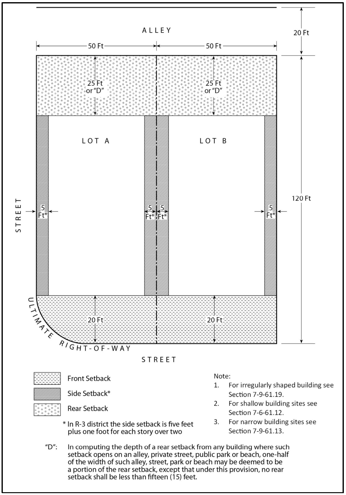
ILLUSTRATION B
E-4 Setbacks for Main Building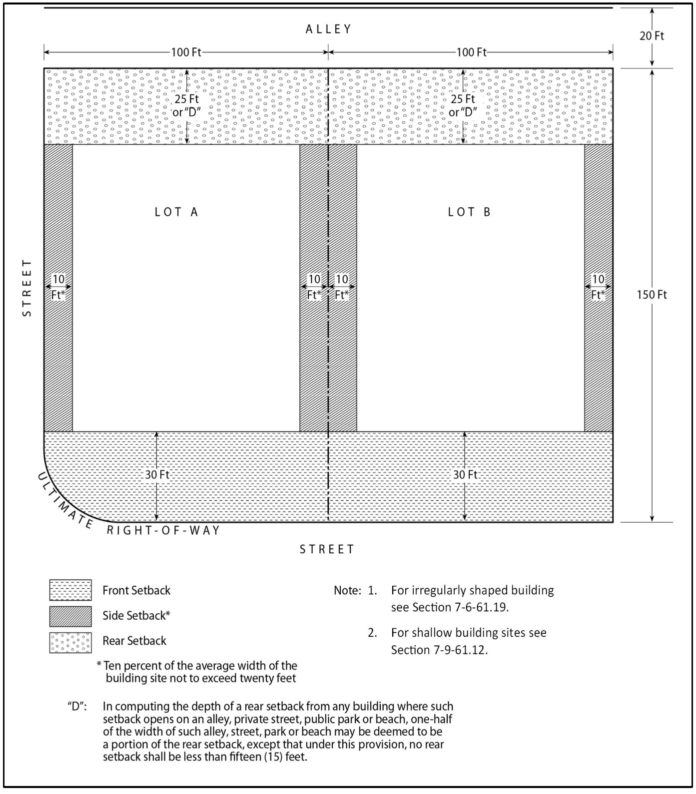
ILLUSTRATION C
RS Main Building Setbacks (35% coverage)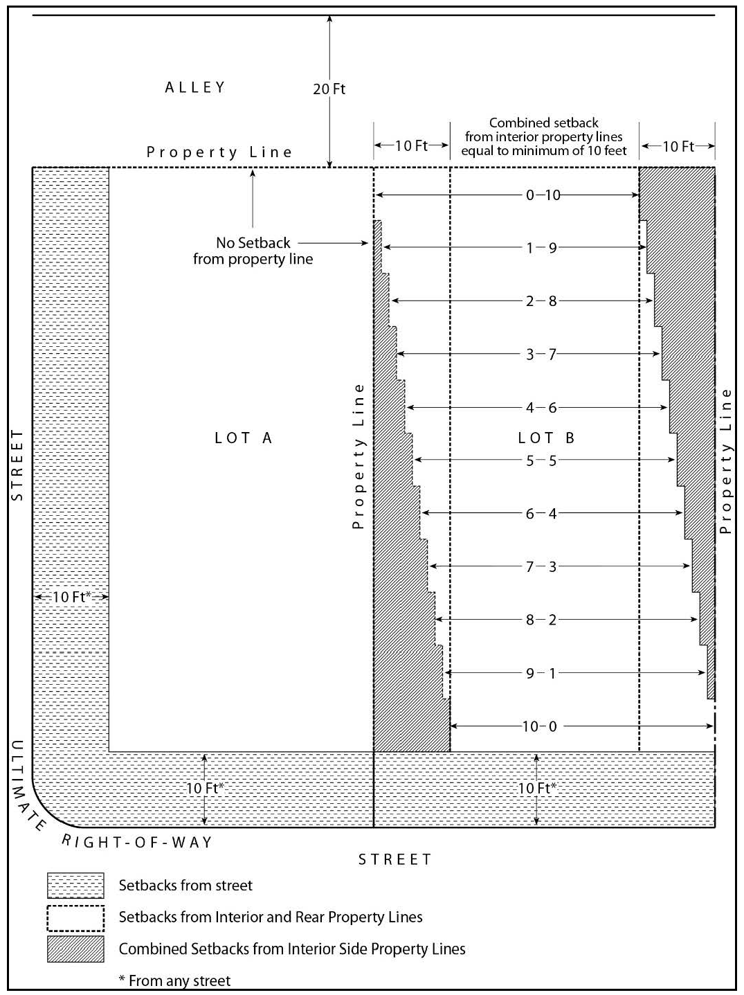
(Ord. No. 20-006, § 1, 7-28-20; Ord. No. 24-004, § 21, 6-25-24)
Sec. 7-9-61.10. - Exceptions to building lines chart.
The building line for a main building or structure, or attached accessory building may be different than the building line specified by Table 7-9-61.9: Building Lines Chart when otherwise permitted by the provisions of subsection (a), "Building Line Plan," or by the provisions of this section.
(a)
Building Line Plan. A building line plan is a development plan designating the required setbacks for main buildings and structures, accessory buildings and structures or both, for a designated area, designated area such as that of an entire Tract Map. Unless otherwise required by the provisions of section 7-9-61.8 (a) or (b) a building line plan may be adopted in compliance with the following provisions:
(1)
A building line plan shall be adopted in the same manner as a Use Permit after required public hearings before the Planning Commission per section 7-9-125.
(2)
A building line plan may be either graphic or descriptive. It shall include sufficient information to clearly designate the real property and the types of structures it is applicable to and how required setbacks are determined.
Whenever a building line plan has been adopted it shall supersede the provisions of the Building Lines Chart in this section and the exceptions to the Building Lines Chart listed in this section.
(Ord. No. 20-006, § 1, 7-28-20)
Sec. 7-9-61.11. - Building line on panhandle building site.
In the case of a panhandle building site, the building lines shall be set back a minimum of ten (10) feet from any property line, except as otherwise specified in this Zoning Code.
(Ord. No. 20-006, § 1, 7-28-20)
Sec. 7-9-61.12. - Building line on shallow building site.
When a building site has an average depth of less than one hundred (100) feet but more than seventy-five (75) feet, any required front and rear building line setbacks need not be more than twenty percent (20%) of such average depth; and when a building site has an average depth of seventy-five (75) feet or less, any required front and rear building line setbacks need not be more than fifteen percent (15%) of such average depth, but in no event shall any required front or rear building line setback be less than five (5) feet.
(Ord. No. 20-006, § 1, 7-28-20; Ord. No. CA 22-01, 9-27-22; Ord. No. 22-003, § 6, 9-27-22)
Sec. 7-9-61.13. - Building line on narrow building site.
When a building site has an average width of less than fifty (50) feet, any required building line setback from the interior side property lines need not be more than ten percent (10%) of such average width but in no event less than three (3) feet.
ILLUSTRATION D
Panhandle Lot Setbacks
(Ord. No. 20-006, § 1, 7-28-20)
Sec. 7-9-61.14. - Building line based on average of adjoining sites.
Where a building site is situated between two (2) building sites, each of which has a main building within forty (40) feet of said building site which projects into the required front setback area, the front building line for said building site need not be set back farther than the average of the setbacks of the two (2) adjoining buildings.
(Ord. No. 20-006, § 1, 7-28-20)
Sec. 7-9-61.15. - Building line on building site adjacent to a projecting building on one side.
Where a building site abuts and has a sideline common to a site which has a main building within forty (40) feet of said common sideline which projects into the required front setback area on one side and abuts a vacant building site, a street or permanent open space on the opposite side, the front building line for said building site need not be set back further than the average of the existing setback on one side and the setback required by the Building Lines Chart for said building site.
(Ord. No. 20-006, § 1, 7-28-20)
Sec. 7-9-61.16. - Balconies, decks, porches, terraces, exterior steps and exterior stairways.
Balconies, decks, porches, terraces, exterior steps in excess of thirty (30) inches in height and exterior stairways, unroofed and unenclosed, may project not more than three (3) feet into any required side setback area or the distance required between buildings on the same building site and not more than five (5) feet into any required front or rear setback area, but in no event shall such balconies, decks, porches, terraces, exterior steps or exterior stairways be closer than two (2) feet to any side property line or three (3) feet to any front or rear property line of a building site, when projecting into any required setback area.
Sec. 7-9-61.17. - Eaves, cornices, canopies and cantilevered roofs.
Eaves, cornices, canopies, or cantilevered roofs as part of the main structure may project a maximum of forty percent (40%) into any required side setback and twenty-five percent (25%) into any required front or rear setback and forty percent (40%) into the space required between buildings on the same building site, but in no event shall such eaves, cornices, canopies or cantilevered roofs be closer than two (2) feet to any front, side or rear line of the building site when projecting into a required setback area.
(Ord. No. 20-006, § 1, 7-28-20)
Sec. 7-9-61.18. - Chimneys, fireplaces, wing walls and other minor architectural features.
Masonry chimneys, fireplaces, wing walls, bay windows, and other minor architectural features that do not add floor space, may project into any required front, side or rear setback area a maximum of twenty-four (24) inches, but in no event shall such chimneys, fireplaces, wing walls and other minor architectural features project into any required setback area so as to be closer than three (3) feet to any property line of the building site.
(Ord. No. 20-006, § 1, 7-28-20)
Sec. 7-9-61.19 - Setbacks determined by Director.
Where a building site is situated such that the front, side and rear property lines are not readily determinable, required setbacks shall be as determined by the Director in compliance with the following criterion:
Required setbacks shall not permit the placement of buildings on the site in a manner that will constitute a grant of special privileges inconsistent with the limitations placed on other properties in the vicinity and incompatible with surrounding uses.
(Ord. No. 20-006, § 1, 7-28-20)
Sec. 7-9-62. - Building and structure heights, and exceptions to height limits.
The height of any structure shall not exceed the building height limits specified in the district regulations as measured pursuant to section 7-9-24, Rules for Measurement, except as-specified-in this section. None of the following vertical projections shall permit habitable space above the height limit. The total aggregate coverage of projections shall not exceed thirty percent (30%) of a roof's area. This limitation shall not apply to solar energy systems (see section 7-9-72). This section shall also apply to planned communities and specific plan areas unless otherwise stated.
(a)
Radio and television antennas. Radio and television antennas, not including dish antennas, may exceed the district building height limit by ten (10) feet. However, FCC licensed amateur ham radio operators may have radio towers seventy (70) feet in height measured from ground level. A higher height limit for all radio and television antennas may be provided by a Use Permit approved by the Zoning Administrator per section 7-9-125.
(b)
Architectural features.
(1)
Towers, gables, spires, flagpoles, and architectural features not for sleeping or eating quarters or for any commercial purpose may exceed the district building height limit by ten (10) feet subject to a Use Permit approved by the Zoning Administrator per section 7-9-125.
(2)
Elevators, appropriately screened mechanical units, and chimneys which do not exceed ten percent (10%) of the roof area, nor exceed the district height limitation by more than eight (8) feet shall be permitted.
(c)
Hazards to air navigation. No person, firm or corporation shall undertake construction or alteration which meets the notice criteria of Subpart B, Title 14, Part 77 of the Code of Federal Regulations, as may be amended, outside the exterior boundaries of any airport (including heliports) available for public use or any military airport, without first notifying the Federal Aviation Administration of the proposed construction, as required by Subpart B of Part 77, as may be amended, and receiving, and presenting to the Director a determination from the FAA that such construction does not constitute a hazard to air navigation.
(d)
Oil derricks. Permitted derricks for drilling oil may be one hundred thirty-six (136) feet in height.
(e)
Signs. In no case shall the height of any sign exceed the building height limit specified in the district regulations. See section 7-9-114 of this Zoning Code for additional height requirements for signs.
(Ord. No. 20-006, § 1, 7-28-20)
Sec. 7-9-63. - Dedications, improvements and fees required.
The purpose of these provisions is to clarify and amplify regulations applying throughout the County, and to set forth other regulations applying to certain areas. The General Regulations apply to all zones and all uses of land unless otherwise stated. When two (2) or more conflicting regulations apply to the same property, the more restrictive shall apply. Violation of the General Regulations is a violation of the Zoning Code.
(Ord. No. 20-006, § 1, 7-28-20)
Sec. 7-9-63.1. - Street and highway dedications and improvements.
(a)
When a building site abuts and enjoys a right of vehicular access to or from a local street or arterial highway, no building permit and no zoning compliance determination shall be issued for any use except single-family dwellings until the right-of-way for such street or highway, for the length of the frontage of the site actually to be used for such purposes, including parking, has been dedicated to or vested in the County of Orange and such right-of-way has been improved by installation of paving, curbs, gutters, drive approaches, sidewalks where required and street drainage, in compliance with the provisions and specifications of "Standard Plans, Orange County Public Works Department, " as may be amended.
(b)
If at the time of development of the property, the Director finds that the installation of such improvement is physically inappropriate prior to commencement of development of the property, the property owner may enter into an agreement with the County of Orange guaranteeing the installation of such improvements within a specified time; and the County may require a faithful performance bond, a cash deposit, a letter of credit, or such other means that will guarantee the completion of such improvements.
(Ord. No. 20-006, § 1, 7-28-20)
Sec. 7-9-63.2 - Drainage fees and dedications.
(a)
When a building site is located within the boundaries of an adopted master plan of drainage, no building permit and no certificate of use and occupancy shall be issued for any use except single-family dwellings until drainage fees pertaining to the gross area of the site have been paid in the amount set forth in the drainage fee schedule adopted by the Board of Supervisors in conjunction with the adoption of such master plan of drainage.
(b)
At the discretion of the Board of Supervisors, dedication of rights-of-way, actual construction, installation or design by a registered civil engineer of improvements described in such adopted master plan of drainage, or any combination thereof, may be accepted in lieu of the payment of the aforementioned fees. The funds derived from the drainage fees imposed shall be utilized only for the construction of local drainage facilities for the disposal of surface and storm waters from the local drainage area in which such building or land is located.
(Ord. No. 20-006, § 1, 7-28-20)
Sec. 7-9-64. - Fences, walls, and hedges.
The regulations in this section apply to any type of fence, wall, retaining wall, sound attenuation wall, or screen, in addition to the applicable requirements of the district in which it is located except for fences and walls that are located within the interior of an approved tract map and are part of the initial development of that tract map shall be exempt from these regulations. Subsections (d) and (e) only shall also apply to hedges, or thick growth of shrubs, bushes, or trees. Fence/wall heights shall be measured from the base of the fence/wall to the top on interior or exterior side, whichever is greater. See fence/wall heights illustration, Figure 7-9-64.
FIGURE 7-9-64 - PERMITTED FENCE/WALL HEIGHTS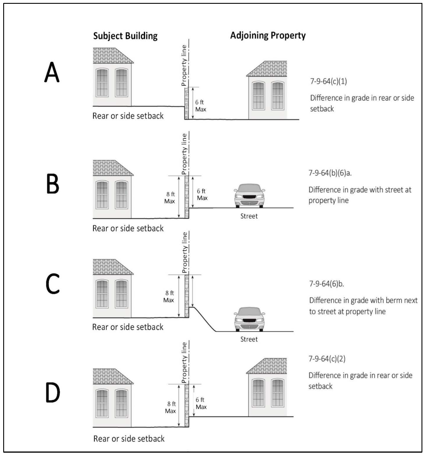
FIGURE 7-9-64 - PERMITTED FENCE/WALL HEIGHTS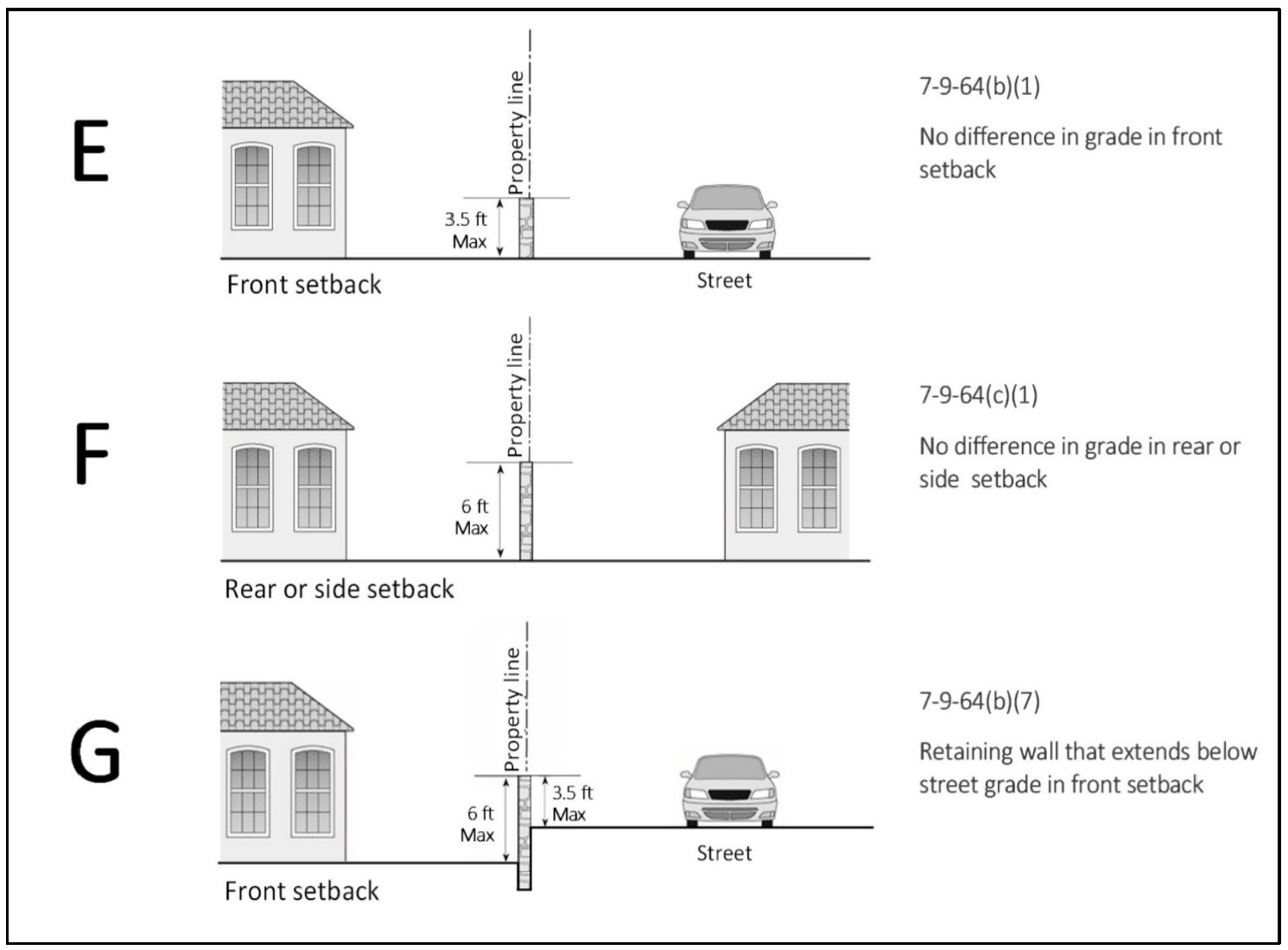
(a)
Main building area. In the area where a main building may be constructed, the district building height regulations apply.
(b)
Setback areas bordering streets.
(1)
The maximum height of solid fencing shall be three and one-half (3.5) feet within any required front setback area up to a maximum depth of twenty (20) feet.
(2)
The maximum height of open fencing and pilasters shall be a maximum of five (5) feet within any required front setback area.
(3)
Fences located within a front setback shall not use chain link fencing.
(4)
The maximum height shall be six (6) feet within any rear or side setback area (through which no vehicular access is taken) adjoining a street.
(5)
That portion of a building site where vehicular access rights have been dedicated to a public agency may have a six (6) foot high fence/wall.
(6)
Fences/walls that the County requires for sound attenuation bordering freeways or major arterial highways may be six (6) feet high and as high as eight (8) feet if:
a.
The freeway/major arterial is elevated two (2) feet or more above the building site elevation, or
b.
The exterior side measurement of the wall is not more than six (6) feet in height.
(7)
Where the elevation of the street is higher than the front setback area, the maximum height of a retaining wall shall be three and one-half (3.5) feet within any required front setback area and the exposed area of the retaining wall shall be a maximum of six (6) feet.
(c)
Setback areas not bordering streets.
(1)
The maximum height shall be six (6) feet within any required front, rear, or side setback area not adjoining a street.
(2)
However, where the elevation of an adjoining building site to the side or rear is higher than the base of the fence or wall in the side or rear setback area, the height of the fence or wall may be measured from the elevation of the adjoining building site to the top of the fence or wall and in no case shall such fence or wall exceed eight (8) feet from the base of the fence/wall to the top.
(d)
Access intersection area. Notwithstanding "b" above, the maximum height shall be three and one-half (3.5) feet within five (5) feet of the point of intersection of:
(1)
An ultimate street right-of-way line and an interior property line;
(2)
An ultimate street right-of-way line and the edge of a driveway or vehicular accessway;
(3)
An ultimate street right-of-way line and an alley right-of-way line; and
(4)
The edge of a driveway or vehicular accessway and an alley right-of-way line.
(e)
Street intersection areas. Notwithstanding "b" above, the maximum height shall be three and one-half (3.5) feet within the triangular area formed by drawing a straight line between two (2) points located on, and fifteen (15) feet distant from, the point of intersection of two (2) ultimate street or highway right-of-way lines extended.
FIGURE 7-9-64(d) and (e) ACCESS/STREET INTERSECTION AREAS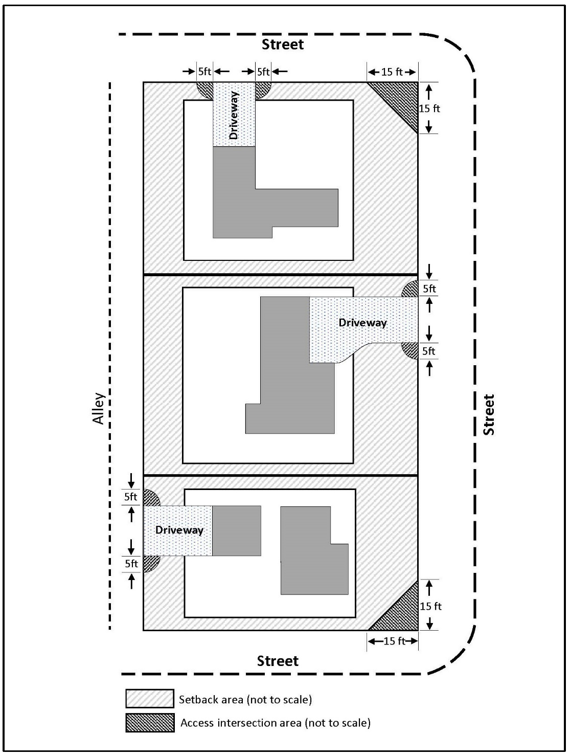
(f)
Modifications permitted. Exceptions and modifications to the fence and wall height provisions may be permitted subject to the approval of Site Development Permit by the Director for fences/walls eight (8) feet or less, or approval of a Use Permit for fences/walls greater than eight (8) feet by the Zoning Administrator per section 7-9-125. In addition to the findings required by section 7-9-125, the following findings shall also be made prior to the approval of a fence or wall height Use Permit application:
(1)
The height and location of the fence or wall as proposed will not result in or create a traffic hazard.
(2)
The location, size, design and other characteristics of the fence or wall will not create conditions or situations that may be objectionable, detrimental or incompatible with other permitted uses in the vicinity.
(Ord. No. 20-006, § 1, 7-28-20; Ord. No. 24-004, § 22, 6-25-24)
Sec. 7-9-65. - Elevated driveway on steep topography.
Except as otherwise limited by the provisions of section 7-9-116, where the ground surface slopes down from the street providing vehicular access to a building site, an elevated driveway connecting the dwelling and garage with the street may be installed within the setback area in compliance with the following provisions:
(a)
The ground surface elevation of the building site along a line twenty (20) feet from and parallel to the street right-of-way line shall be a minimum of at least five (5) feet lower than the street elevation.
(b)
The maximum width of the driveway shall be twenty (20) feet.
(c)
A handrail not exceeding three and one-half (3.5) feet in height may be installed along the edges of the driveway.
(d)
A stairway may be constructed from the driveway to the ground surface.
(Ord. No. 20-006, § 1, 7-28-20; Ord. No. 24-004, § 23, 6-25-24)
Sec. 7-9-66. - Grading and excavation.
(a)
Grading and excavation regulations adopted in a planned community text or a specific plan shall supersede this section.
(b)
A Site Development Permit issued pursuant to section 7-9-125 shall be required if any grading operation involves:
(1)
More than ten thousand (10,000) cubic yards on a building site; or
(2)
More than five hundred (500) cubic yards on a slope greater than thirty percent (30%).
(c)
A Site Development Permit shall not be required under the following conditions:
(1)
Grading conducted in compliance with the following permits/approvals which authorize grading:
a.
Sand and gravel site permit.
b.
Tentative tract map.
c.
Area Plan.
d.
Use Permit.
e.
Coastal Development Permit.
(2)
Emergency grading to correct recent acts of nature in order to comply with the requirements of the Grading Code and Fire Code for public safety purposes and not related to new development.
(d)
For purposes of this section, the total number of cubic yards shall be the larger of cut (including any export) or fill (including any import).
(e)
No zone changes or discretionary permit per Zoning Code section 7-9-125 shall be approved for property on which a violation of the provisions of the Grading and Excavation Code exists, including work performed not in accordance with approved grading plans, unless conditioned to require such violation to be corrected or mitigated to the satisfaction of the Building Official prior to the issuance of any building permits.
(Ord. No. 20-006, § 1, 7-28-20; Ord. No. CA 22-01, 9-27-22; Ord. No. CA 22-01, 9-27-22; Ord. No. 24-004, § 24, 6-25-24)
Sec. 7-9-67. - Lighting and illumination.
All lighting shall be designed and located so as to confine direct rays to the premises.
(Ord. No. 20-006, § 1, 7-28-20)
Sec. 7-9-68. - Landscape and irrigation code.
This section and sections 7-9-68.1 through 7-9-68.6 shall apply to all planting, irrigation, and landscape-related improvements including landscape projects as defined, within the unincorporated area of the County of Orange. These sections may be referred to collectively as the "Landscape Irrigation Code."
(Ord. No. 20-006, § 1, 7-28-20)
Sec. 7-9-68.1. - Purpose.
The purpose of the following provisions is to comply with the requirements of California Code of Regulations, Title 23, Division 2, Chapter 2.7, as may be amended, to enact an ordinance that is at least as effective in conserving water as the State Model Water Efficient Landscape Ordinance developed pursuant to the requirements of Executive Order No. B-29-15 in the context of conditions in the County of Orange, in order to:
(a)
Promote the values and benefits of landscapes while recognizing the need to invest water and other resources as efficiently as possible.
(b)
Establish a structure for planning, designing, installing, and maintaining and managing water efficient landscapes in new construction and rehabilitated projects.
(c)
Establish provisions for water management practices and water waste prevention for existing landscapes.
(d)
Use water efficiently without waste by setting a Maximum Applied Water Allowance as an upper limit for water use and reduce water use to the lowest practical amount.
(Ord. No. 20-006, § 1, 7-28-20)
Sec. 7-9-68.2. - Applicability.
(a)
These provisions apply to all of the following landscape projects in all zoning districts:
(1)
New landscape projects with an aggregate landscape area equal to or greater than five hundred (500) square feet, requiring a building or landscape permit, plan check or design review;
(2)
Rehabilitated landscape projects with an aggregate landscaped area equal to or greater than two thousand five hundred (2,500) square feet, requiring a building or landscape permit, plan check or design review;
(3)
New or rehabilitated landscape projects with an aggregate landscape area of two thousand five hundred (2,500) square feet or less may comply with the performance requirements of this section or conform to the prescriptive measures contained in Appendix A of the Guidelines;
(4)
New or rehabilitated projects using treated or untreated graywater or rainwater capture on site, any lot or parcels within the project that has less than two thousand five hundred (2,500) square feet of landscape area and meets the lot or parcel's landscape water requirement (Estimated Total Water Use) entirely with the treated or untreated graywater or though stored rainwater capture on site is subject only to Appendix A of the Guidelines.
(b)
Section 7-9-68.5(b) shall apply to:
(1)
All landscaped areas, whether installed prior to or after January 1, 2010.
(2)
All landscaped areas installed after the effective date of this section to which section 7-9-68.5(a) is applicable.
(c)
These provisions do not apply to:
(1)
Registered local, state, or federal historical sites;
(2)
Ecological restoration projects that do not require a permanent irrigation system.
(3)
Mined-land reclamation projects that do not require a permanent irrigation system.
(4)
Plant collections, as part of botanical gardens and arboretums open to the public.
(Ord. No. 20-006, § 1, 7-28-20)
Sec. 7-9-68.3. - Definitions.
The following definitions apply to the specialized items in these provisions:
Aggregate landscape areas pertain to the areas undergoing development as one (1) project or for production home neighborhoods or other situations where multiple parcels are undergoing development as one (1) project, but eventually be individually owned.
Applied water means the portion of water supplied by the irrigation system to the landscape.
Budget-based tiered-rate structure means tiered or block rates for irrigation accounts charged by the retail water agency in which the block definition for each customer is derived from lot size or irrigated area and the evapotranspiration requirements of landscaping.
Community aesthetics evaluation means while not subject to a permit, plan check or design review, the community aesthetics evaluation may be performed to ensure the aesthetic standards of the community and irrigation efficiency intent is maintained.
Ecological restoration project means a project where the site is intentionally altered to
Estimated applied water use means the average annual total amount of water estimated to be necessary to keep plants in a healthy state, calculated as provided in the Guidelines. It is based on the reference evapotranspiration rate, the size of the landscape area, plant water use factors, and the relative irrigation efficiency of the irrigation system.
ET adjustment factor or "ETAF" is equal to the plant factor divided by the irrigation efficiency factor for a landscape project, as described in the Guidelines. The ETAF is calculated in the context of local reference evapotranspiration, using site-specific plant factors and irrigation efficiency factors that influence the amount of water that needs to be applied to the specific landscaped area.
A combined plant mix with a site-wide average plant factor of 0.5 (indicating a moderate water need) and average irrigation efficiency of 0.71 produces an ET adjustment factor of (0.7) = (0.5/0.71), which is the standard of water use efficiency generally required by this Landscape Irrigation Code and the Guidelines, except that the ETAF for a special landscape area shall not exceed 1.0.
Guidelines refers to the Guidelines for Implementation of the Landscape Irrigation Code, as adopted by the Board of Supervisors of the County of Orange, which describes procedures, calculations, and requirements for landscape projects subject to this Landscape Irrigation Code.
Hardscapes means any durable material or feature (pervious and non-pervious) installed in or around a landscaped area, such as pavements or walls. Pools and other water features are considered part of the landscaped area and not considered hardscapes for purposes of this Landscape Irrigation Code.
Irrigation efficiency means the measurement of the amount of water beneficially used divided by the amount of water applied. Irrigation efficiency is derived from measurements and estimates of irrigation system characteristics and management practices. The irrigation efficiency for purposes of this Landscape Irrigation Code is 0.75 for overhead spray devices and 0.81 for drip systems.
Landscaped area means all the planting areas, turf areas, and water features in a landscape design plan subject to the maximum applied water allowance and estimated applied water use calculations. The landscaped area does not include footprints of buildings or structures, sidewalks, driveways, parking lots, decks, patios, gravel or stone walks, other pervious or non-pervious hardscapes, and other non-irrigated areas designated for non-development (e.g., open spaces and existing native vegetation).
Landscape contractor means a person licensed by the State of California to construct, maintain, repair, install, or subcontract the development of landscape systems.
Landscape documentation package means the documents required to be provided to the County for review and approval of landscape design projects, as described in the Guidelines and section 7-9-68.4.
Landscape project means total area of landscape in a project, as provided in the definition of "landscaped area," meeting the requirements of section 7-9-68.2.
Local agency means a city or county, including a charter city or charter county, that is authorized to implement, administer, and/or enforce any of the provisions of the Landscape Irrigation Code on behalf of the County. The local agency may be responsible for the enforcement or delegation of enforcement of this Landscape Irrigation Code including, but not limited to, design review, plan check, issuance of permits, and inspection of a landscape project.
Local water purveyor means any entity, including a public agency, city, county, or private water company that provides retail water service.
Maximum applied water allowance or "MAWA" means the upper limit of annual applied water for the established landscaped area as specified in Section 2.2 of the Guidelines. It is based upon the area's reference evapotranspiration, the ET Adjustment Factor, and the size of the landscaped area. The Estimated Applied Water Use shall not exceed the Maximum Applied Water Allowance. MAWA = (ETo) (0.62) ((ETAF × LA) + ((1−ETAF) × SLA))
Mined-land reclamation projects means any surface mining operation with a reclamation plan approved in accordance with the Surface Mining and Reclamation Act of 1975.
New construction means, for the purposes of this Landscape Irrigation Code, a new building with a landscape or other new landscape such as a park, playground, or greenbelt without an associated building.
Non-pervious means any surface or natural material that does not allow for the passage of water through the material and into the underlying soil.
Pervious means any surface or material that allows the passage of water through the material and into the underlying soil.
Permit means an authorizing document issued by local agencies for new construction or rehabilitated landscape.
Plant factor or plant water use factor is a factor, when multiplied by ETo, that estimates the amount of water needed by plants. For purposes of this Landscape Irrigation Code, the plant factor range for very low water use plants is 0 to 0.1; the plant factor range for low water use plants is 0 to 0.3; the plant factor range for moderate water use plants is 0.4 to 0.6; and the plant factor range for high water use plants is 0.7 to 1.0. Plant factors cited in this Landscape Irrigation Code are derived from the publication "Water Use Classification of Landscape Species." Plant factors may also be obtained from horticultural researchers from academic institutions or professional associations as approved by the California Department of Water Resources (DWR).
Recycled water or reclaimed water means treated or recycled waste water of a quality suitable for non-potable uses such as landscape irrigation and water features. This water is not intended for human consumption.
Reference evapotranspiration or "ETo" means a standard measurement of environmental parameters which affect the water use of plants. ETo is given expressed in inches per day, month, or year as represented in Appendix A of the Guidelines, and is an estimate of the evapotranspiration of a large field of four-to seven-inch tall, cool-season grass that is well watered. Reference evapotranspiration is used as the basis of determining the Maximum Applied Water Allowances.
Rehabilitated landscape means any re-landscaping project that meets the applicability criteria of section 7-9-68.2(a), where the modified landscape area is greater than two thousand five hundred (2,500) square feet.
Smart irrigation controller means an automatic irrigation controllers utilizing either evapotranspiration or soil moisture sensor data with non-volatile memory shall be required for irrigation scheduling in all irrigation systems, recommending U.S. EPA WaterSense labeled devices as applicable.
Special landscape area means an area of the landscape dedicated solely to edible plants such as orchards and vegetable gardens, areas irrigated with recycled water, water features using recycled water, and recreational areas dedicated to active play such as parks, sports fields, golf courses, and where turf provides a playing surface.
Turf means a ground cover surface of mowed grass. Annual bluegrass, Kentucky bluegrass, Perennial ryegrass, Red fescue, and Tall fescue are cool-season grasses. Bermudagrass, Kikuyugrass, Seashore Paspalum, St. Augustinegrass, Zoysiagrass, and Buffalo grass are warm-season grasses.
Valve means a device used to control the flow of water in an irrigation system.
Water feature means a design element where open water performs an aesthetic or recreational function. Water features include ponds, lakes, waterfalls, fountains, artificial streams, spas, and swimming pools (where water is artificially supplied). The surface area of water features is included in the high water use hydrozone of the landscaped area. Constructed wetlands used for on-site wastewater treatment, habitat protection or storm water best management practices that are not irrigated and used solely for water treatment or storm water retention are not water features and, therefore, are not subject to the water budget.
(Ord. No. 20-006, § 1, 7-28-20)
Sec. 7-9-68.4. - Implementation procedures and landscape documentation package.
(a)
Prior to installation, a landscape documentation package shall be submitted to the County for review and approval of all landscape projects subject to the provisions of this Landscape Irrigation Code. Any landscape documentation package submitted to the County shall comply with the provisions of the Guidelines.
(b)
The landscape documentation package shall include a certification by a professional appropriately licensed in the State of California stating that the landscape design and water use calculations have been prepared by or under the supervision of the licensed professional and are certified to be in compliance with the provisions of this Landscape Irrigation Code and the Guidelines.
(c)
As part of the landscape documentation package, landscape and irrigation system plans shall be prepared and certified by a professional appropriately licensed in the State of California prior to the issuance of building permits and the application for a landscape documentation package as defined in sections 7-9-68.3 and this section 7-9-68.4. Landscape and irrigation plans shall be submitted to the County for review and approval with appropriate water use calculations and include:
(1)
Project description. A summary of the project, property, provisions for water conservation technologies, plant use and groupings, the use of recycled water (if any), the capture and retention of stormwater onsite, and any special issues that the plan check reviewer would need to be aware of;
(2)
Water efficient landscape worksheet. A report of analysis and calculations for establishing an estimated annual water use budget that shall not exceed the maximum applied water allowance. The MAWA and EAWU shall be calculated based on completing the water efficient landscape worksheets (in accordance with the Guidelines, Section 2.2 Water Efficient Landscape Calculations and Alternatives).
(3)
Erosion and sediment control plans. To be submitted, as appropriate, as a grading permit application of soil assessment and management to prevent excessive erosion and runoff, as required under Section 7-1-805 of the County of Orange Grading and Excavation Code and Grading Manual;
(4)
Landscape design plans. To be submitted per County of Orange requirements and include fire prevention (defensible space and fuel modification) requirements with approval(s) from the local fire authority;
(5)
Irrigation design plans. To be submitted per County of Orange requirements and include provisions for the use of automatic irrigation systems and irrigation schedules based on climatic conditions, specific terrains, soil types, and other environmental conditions while minimizing irrigation overspray and runoff;
(6)
Grading plans. To be submitted, as appropriate, as a grading permit application when required under Section 7-1-805 of the County of Orange Grading and Excavation Code and Grading Manual.
(d)
Verification of compliance of the landscape installation with the approved plans shall be obtained through a certificate of use and occupancy or permit final process, as provided below and in the Guidelines.
(e)
Prior to final inspection, closure of a building or grading permit, and issuance of a certificate of use and occupancy, the following shall be submitted to demonstrate compliance with section 7-9-68.4:
(1)
Certification by either the signer of the landscape design plan, the signer of the irrigation design plan, or the licensed landscape contractor that the landscape project has been installed per the approved landscape documentation package.
(2)
Documentation of the irrigation scheduling parameters used to set the controller(s).
(3)
Documentation of the specified landscape and irrigation maintenance schedule.
(4)
Provisions for landscape maintenance practices that foster long-term landscape water conservation.
(5)
An irrigation system audit report.
(Ord. No. 20-006, § 1, 7-28-20)
Sec. 7-9-68.5. - Landscape water use standards.
(a)
For applicable landscape installation or rehabilitation projects subject to Section 7-9-68.2 of this Landscape Irrigation Code, the estimated applied water use allowed for the landscaped area shall not exceed the MAWA calculated using an ET adjustment factor of 0.55, except for special landscaped areas where the MAWA is calculated using an ET adjustment factor of 1.0; or the design of the landscaped area shall otherwise be shown to be equivalently water-efficient in a manner acceptable to the County; as provided in the Guidelines.
(b)
Irrigation of all landscaped areas shall be conducted in a manner conforming to the rules and requirements, and shall be subject to penalties and incentives for water conservation and water waste prevention, as determined and implemented by the local water purveyor, or as mutually agreed by local water purveyor and the County.
(c)
These landscape water use standards shall not apply to registered local, state, or federal historical sites; ecological restoration projects that do not require a permanent irrigation system; mined-land reclamation projects that do not require a permanent irrigation system; or plant collections, as part of botanical gardens and arboretums open to the public.
(d)
Only Sections 2.8 and 2.9 of the Guidelines shall apply to new landscape installations or landscape rehabilitation projects at cemeteries.
(e)
Existing landscapes installed before January 1, 2010 that exceed one (1) acre shall comply with the requirements of their retail water purveyor to meet the landscape Maximum Applied Water Allowance.
(Ord. No. 20-006, § 1, 7-28-20)
Sec. 7-9-68.6. - Guidelines.
(a)
Detailed guidelines for the application and implementation of this Landscape Irrigation Code, including technical compliance and calculations are set forth in appendix A to the Landscape Irrigation Code, entitled, "Guidelines for Implementation of the Orange County of Orange Landscape Irrigation Code" which is incorporated by reference and made a part of this Landscape Irrigation Code.
(b)
The authority to implement and modify these guidelines as appropriate is delegated to the Planning Commission. Any such action of the Planning Commission may be appealed to the Board of Supervisors as provided in section 7-9-125 of this Zoning Code.
(c)
The guidelines are complementary to the regulations of the Orange County Zoning Code. If an issue arises between the guidelines and the Zoning Code that is not sufficiently clear, the Zoning Code shall prevail.
(Ord. No. 20-006, § 1, 7-28-20)
Sec. 7-9-70. - Off-street parking and loading regulations.
All references to this section shall include sections 7-9-70.1 through 7-9-70.11. These regulations apply to all districts, planned communities and specific plan areas, unless otherwise specified.
(Ord. No. 20-006, § 1, 7-28-20)
Sec. 7-9-70.1. - Purpose and intent.
The intent of the Off-Street Parking Regulations is to provide sufficient on-site parking to accommodate the majority of traffic generated by the range of uses that might locate at the site over time and to incentivize multimodal transportation and transportation demand management (TDM) measures. Parking requirements should be balanced with measures to establish and maintain an active pedestrian network by minimizing the potential for pedestrian, bicycle, and vehicle conflicts as much as possible. The parking facilities for motor vehicles required by this section are assumed to be the minimum which shall be required by the various land use categories. However, the parking and maneuvering facilities required by this section should not be used as a fixed standard to determine the amount of off-street parking which may be adequate for any-specific use.
Reductions to minimum parking requirements may be permitted subject to approval of an off-street parking alternative Use Permit to the Zoning Administrator which would allow the developer to demonstrate through a parking study that the requirements exceed the needed supply as provided for in section 7-9-70.9, "Alternatives to Off-Street Parking Requirements." It is intended that these regulations shall result in the installation of properly designed parking facilities of sufficient capacity to minimize traffic congestion, enhance public safety, generally provide for the parking of motor vehicles at locations other than on the streets, and without imposing unnecessary costs and barriers to development while ensuring safe passage of pedestrians to and from parked vehicles.
(Ord. No. 20-006, § 1, 7-28-20)
Sec. 7-9-70.2. - General requirements.
(a)
Location of off-street parking.
(1)
Required parking facilities shall be located on the same building site and conveniently proximate to the use or uses they serve, except as otherwise provided in sections 7-9-70.3, 7-9-70.4, and 7-9-70.9.
(2)
Property within the ultimate right-of-way of a street (either public or private) shall not be included in provision of the minimum parking unless otherwise specified.
(b)
Accessibility: All required off-street parking spaces shall be designed, located, constructed and maintained so as to be fully and independently usable and accessible at all times.
(c)
Usability:
(1)
The required off-street parking facilities, garages, carports, parking structures and driveways shall not be used for any activity that would preclude the use of the area for purposes other than the temporary storage of motor vehicles except as provided for in this Code.
(2)
Unless otherwise provided by an approved discretionary permit, no owner or tenant shall lease, rent or otherwise make unavailable to intended users any off-street parking spaces required by this article.
(d)
Solar energy collector on carports.
(1)
Photovoltaic equipment, as defined by section 7-9-72, "Solar Energy Systems," may be installed on the roof of carports for the purpose of collecting, storing, or transferring solar energy as part of a larger solar energy system installed in structure(s) on the same building site without additional discretionary permit.
(2)
The maximum height of solar energy collector equipment on carport roofs shall not exceed the maximum height of the underlying district.
(e)
Access to Arterial Highways.
(1)
Wherever access to a parking area is off an arterial highway designated on the Master Plan of Arterial Highways, parking spaces, driveways and maneuvering areas shall be designed so that motor vehicles may enter the arterial highway traveling in a forward direction.
(2)
Vehicular access to arterial highways designated on the Master Plan of Arterial Highways shall be permitted only in accordance with specifically approved driveway locations and access design.
(f)
Maximum Grades Permitted.
(1)
Whenever access is taken from a street, alley or driveway to an off-street parking area serving four (4) or less dwelling units, the driveway or other vehicular accessway shall have a maximum grade of plus fifteen percent (+15%) or minus six percent (-6%), measured from the street, alley or driveway grade along the driveway center line, for a distance of not less than eighteen (18) feet from the street, alley or driveway right-of-way line.
(2)
Whenever access is taken from a street, alley or driveway to an off-street parking area serving industrial, commercial or professional uses, public or community facilities, or five (5) or more dwelling units, the driveway or other vehicular accessway shall have a maximum grade of plus fifteen percent (+15%) or a minus two percent (-2%), measured from the street, alley or driveway grade along the driveway center line for a distance of not less than eighteen (18) feet from the street, alley or driveway right-of-way line.
a.
Any deviation from the above dimensions shall require approval by the Director in consultation with the County Traffic Engineer. Approval of such deviations shall not require a separate discretionary approval.
(3)
The maximum grades in (1) and (2) shall generally provide adequate sight distance at street level and prevent vehicles from dragging on extreme grade breaks. Exceptions may be approved by the Director, where physical design prevents such extreme grade breaks and provides safe sight distance.
(4)
Off-street parking spaces and the abutting parking aisles shall have a maximum grade of two percent (2%) for retail commercial and five (5%) percent for all other uses. Said grade shall be measured across the parking space and the abutting parking aisle in any direction. (See diagram in section 7-9-70.5.)
(5)
Ramps or driveways providing vehicular access within the interior of an off-street parking area located beyond eighteen (18) feet from the ultimate right-of-way line of a street, alley or driveway shall have a maximum slope of plus or minus twenty percent (20%). When such ramp or driveway slopes exceed plus or minus ten percent (10%), the ramp or driveway design shall include transitions not less than eight (8) feet in length, having a slope equal to one-half the ramp slope. (See diagram in section 7-9-70.5). When parking is provided on a ramp, the maximum slope shall not exceed six percent (6%).
(g)
Parking Area Notices and Directional Instructions. Notwithstanding the regulations of any district or any planned community, parking area notices, each not to exceed two (2) square feet in area, and directional instructions lettered on the paved surface of driveways and parking areas are permitted for parking facilities serving industrial, commercial or professional uses; public or community facilities; and five (5) or more residential dwelling units. Such parking notices may contain the name of the owner or occupant of the property and only such words and symbols that are directly related or essential to parking, enforcement or the direction of vehicular traffic within the parking area.
(h)
Paving: Parking spaces, driveways, and maneuvering areas shall be paved and permanently maintained with permeable or impervious paving materials. Temporary parking spaces, driveways, and maneuvering areas may use decomposed granite or other stable, all-weather surfacing. Where feasible, curbing should direct drainage to landscaped areas and/or allow for percolation or runoff.
(i)
Lighting: Any lights used to illuminate the parking spaces or driveways shall be designed and located so that direct rays are confined to the property on which the parking spaces and driveways are located.
(j)
Change or Increase in Use of Property: Whenever the occupancy or use of any premises which is not in compliance with off-street parking requirements is changed to a different use or the existing use is altered, enlarged, expanded or intensified, parking to meet the requirements of this section shall be provided for the new use or occupancy. To support the continued occupancy and adaptive reuse of existing commercial and industrial buildings, this provision shall not apply to alterations of uses less than two thousand (2,000) square feet or five percent (5%) of the total floor area (whichever is greater), up to fifty percent (50%) total.
(k)
Fractional Parking Spaces: Whenever the computation of the total or cumulative number of off-street parking spaces required by this section results in a fractional parking space, one (1) additional parking space shall be required for one-half or more fractional parking space and any fractional space less than one-half of a parking space shall not be counted.
(l)
Accessible Parking Facilities: Public accommodations or facilities, including industrial, commercial, professional, institutional, and multifamily dwellings of five (5) or more units shall provide accessible parking spaces in compliance with the current version of the Board-adopted California State Building Code and Federal "ADA Standards for Accessible Design." For additional information on accessible design contact: Office of the State Architect
Access Compliance Unit
1102 Q Street, Suite 5100
Sacramento, CA 95811
http://www.dgs.ca.gov/dsa/Programs/progAccess.aspx
(Ord. No. 20-006, § 1, 7-28-20)
Sec. 7-9-70.3. - Off-street parking requirements for residential uses.
Off-street parking facilities shall be provided for all residential uses in compliance with section 7-9-70.2 and this section.
(a)
Size of parking spaces:
(1)
Each required covered off-street parking space shall be in a garage or carport a minimum of ten (10) feet in width and twenty (20) feet in length of an area unobstructed by objects such as trash cans and the door-swing of a man-door. In garages or carports containing two (2) or more side-by-side parking spaces, the required minimum width may include the exterior walls or supports of the structure, provided minimum unobstructed dimensions of nine (9) feet in width and eighteen (18) feet in length per parking space are met.
(2)
Uncovered off-street parking spaces shall be a minimum of nine (9) feet in width and eighteen (18) feet in length per parking space. In measuring the length of paving required for uncovered parking spaces, allowance may be made for up to two (2) feet of vehicular projection beyond the bumper or tire stop if such projection does not interfere with screening or pedestrian use. The vehicle bumper may overhang a sidewalk up to two (2) feet only if the remaining sidewalk has an unobstructed width of at least four (4) feet at all times, except under (g)(3) following.
(3)
When a side of any space abuts a building, fence, support column or other obstruction which interferes in any way with access to a motor vehicle, the space shall be a minimum of two (2) feet wider than otherwise required by this section.
(4)
Uncovered off-street parking spaces located parallel to and adjoining private accessways shall not be less than eight (8) feet in width and eighteen (18) feet in depth, with a minimum of eight (8) feet separating each pair of such parking spaces as shown in the diagram in section 7-9-70.5.
(b)
Driveways:
(1)
Single-family residence driveways shall be paved to a minimum of ten (10) feet in width from access street or alley to the garage maneuvering area.
(2)
Driveways providing access to garages, carports and uncovered parking areas serving two (2), three (3) or four (4) dwelling units shall be paved to a minimum of twelve (12) feet wide for one-way traffic and sixteen (16) feet wide for two-way traffic, except when a wider width is required for maneuvering area in front of the garages, carports or uncovered parking spaces.
(3)
Driveways providing access to garages, carports and uncovered parking areas serving five (5) or more dwelling units shall be paved to a minimum of twelve (12) feet wide for one-way traffic and twenty-four (24) feet wide for two-way traffic, except when a wider width is required for maneuvering area in front of the garages, carports or uncovered parking spaces. Additional width may be required as necessary to provide transition to a driveway approach.
(4)
Driveways shall only provide access to an approved garage, carport, uncovered parking space, or parking area.
(c)
Maneuvering areas: Of the following requirements, numbers one (1) through four (4) do not apply to building sites with one single-family dwelling that has an attached or detached front-entry garage and a driveway twenty (20) feet or less which is centered to the garage door opening, or to building sites with more than one single-family dwelling. Maneuvering areas for access into and out of side-entry garages carports and uncovered parking spaces shall have minimum widths as follows:
(1)
Side-entry and Detached Garages: Thirty (30) feet of unobstructed area (measured from garage door to opposite end of driveway), unless modified by (4) below.
(2)
Carports: Twenty-eight (28) feet of unobstructed area (measured from outward end of parking stall), unless modified by (4) below.
(3)
Uncovered parking: Twenty-four (24) feet of unobstructed area (measured from outward end of parking stall), except for one-way driveways per section 7-9-70.5.
(4)
Reductions: The required width may be reduced by a maximum of four (4) feet if one or more of the following applies:
a.
Where there is no physical barrier over six (6) inches in height on the same lot opposite a side-entry garage or carport entry that would prevent a motor vehicle from projecting beyond the driveway maneuvering area, the required width may be reduced a maximum of two (2) feet.
b.
Where a one-car garage has an interior width in excess of ten (10) feet and a door wider than eight (8) feet, the maneuvering area in front of such garage may be reduced by the same amount that the width of the garage door exceeds eight (8) feet, to a maximum reduction of two (2) feet.
c.
If the garage is a two-car or more structure and the garage door is at least sixteen (16) feet wide, the maneuvering area may be reduced a maximum of two (2) feet.
(5)
Any requested deviation from the above dimensions requires the approval of the Director in consultation with the County Traffic Engineer. Approval of such deviations shall not require a separate discretionary approval.
FIGURE 7-9-70.3(C) MANEUVERING AREA (FOR ILLUSTRATION ONLY)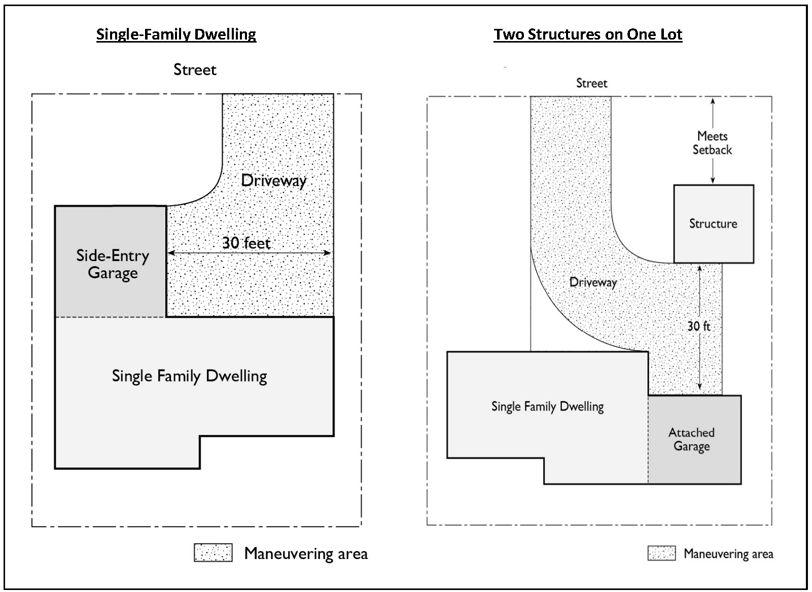
(d)
Garages and carports. The placement or construction of garages and carports on any building site used for residential purpose, including residential areas within planned communities and specific plans, shall comply with the setback requirements for a main building except as otherwise specified as follows:
(1)
Garage entry location. When the building line is closer than twenty (20) feet from the ultimate right-of-way of a street or from a common driveway providing primary access and circulation to other dwelling units, attached and detached garages shall be located so that the garage entry is a minimum of twenty (20) feet, at the closest point from the right-of-way. However, if the garage has a roll-up door, that distance may be reduced to eighteen (18) feet. See illustration for garage entry location.
FIGURE 7-9-70.3(d)(1) GARAGE ENTRY LOCATION (FOR ILLUSTRATION ONLY)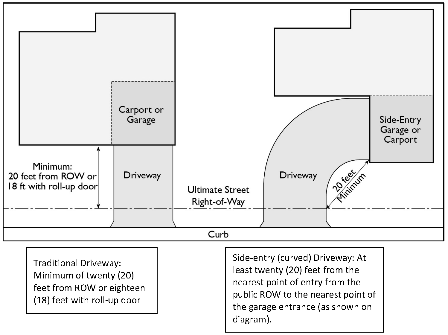
(2)
Garage access from alleys and driveways. When alleys, private streets or common driveways are provided specifically as vehicular access to garages and carports and when separate access and circulation systems are provided for pedestrians, guests and emergency vehicles, attached and detached garages and carports may be placed anywhere within the rear setback area to within a minimum of five (5) feet from such alley, private street or common driveway.
(3)
Detached garages and carports. Except as otherwise specified in subsections 1. and 2. preceding, detached garages and carports may be placed or constructed any place within the required rear or interior side setback area except within those areas where fences and walls are limited to a maximum height of three and one-half (3.5) feet as specified in section 7-9-64.
(e)
The minimum number of off-street parking spaces required for each category of residential use shall be as follows:
(f)
Location of residential parking spaces:
(1)
Required spaces including guest or unassigned spaces shall be off-street and located within two hundred (200) feet walking distance along a pedestrian path (i.e., sidewalk, crosswalk, etc.) of the dwelling unit they serve.
(2)
For "wrap-around" multifamily, multi-story residential developments, where the units surround an interior parking structure, the required spaces including guest or unassigned spaces shall be off-street and located within two hundred (200) feet of the elevator servicing the units.
(3)
Assigned spaces shall be designated as to the dwelling unit to which they are assigned on all plot plans submitted for permits.
(g)
Parking area design: Common off-street parking areas, including multiple garages and carports serving five (5) or more dwelling units, shall comply with the following unless a modification to requirements in sub-sections 1 and 2 below is approved pursuant to the provisions in section 7-9-70.9, "Alternatives to Parking Regulations."
(1)
The off-street parking area shall be designed so that a vehicle within the parking area shall not have to enter a street to move from one location to any other location within that parking area.
(2)
Parking and maneuvering areas, including garages and carports, shall be designed so that any vehicle can leave the parking area and enter into the nearest street traveling in a forward direction.
(3)
Bumpers, curbs, or tire stops shall be provided at the end of each uncovered parking space along any property line, abutting a public walkway, street or alley, except where screening is positioned, to ensure that the motor vehicle will not extend into the public right-of-way or public walkway. To ensure four (4) feet of unobstructed sidewalk at all times, the public walkway may be six (6) feet wide with a curb and no tire stop, or four (4) feet wide with a tire stop at least two (2) feet away to ensure the motor vehicle will not overhang onto the walkway.
(4)
No perpendicular parking, covered or uncovered, shall be permitted on an entrance road of a multifamily project within a minimum of sixty (60) feet from the intersection of an arterial or collector street. The measurement shall be taken from the near curb face of the arterial or collector street.
(5)
Parking and maneuvering areas shall be arranged so that any vehicle can leave the parking area and enter into an adjoining vehicular right-of-way traveling in a forward direction.
(6)
No dead-end parking aisles serving more than five (5) consecutive stalls will be permitted unless said aisle is provided with a turnaround area constructed in a manner meeting the approval of the Director.
(h)
Location of driveway on a corner lot: When a building site abuts two (2) intersecting streets, the driveway approach shall be located within the half of either street frontage that is farthest from the intersection of the two (2) streets. If one of the intersecting streets is an arterial highway, the driveway approach shall be off the other street.
(i)
Screening: Uncovered off-street parking spaces shall be screened whenever such parking spaces abut the boundary of the building site or are located between a building or buildings and an abutting street, with screening materials not less than three and one-half (3.5) feet in height, and in compliance with section 7-9-64, "Fences, Walls, and Hedges." Pedestrian access shall be provided wherever feasible. It may consist of one (1) or any combination of the following types:
(1)
Walls. A wall shall consist of concrete, stone, brick, tile or similar type of solid masonry material a minimum of four (4) inches thick. Walls shall be designed and constructed to avoid interfering with drainage.
(2)
Fences, solid. A solid fence shall be constructed of wood or other materials to form an opaque screen.
(3)
Fences, open. An open-weave or mesh-type fence shall be combined with plant materials to form an opaque screen.
(4)
Hedges. Plant materials, when used as a screen, shall consist of compact evergreen plants. They shall be of a kind, or used in such a manner, as to provide screening having a minimum thickness of two (2) feet, within eighteen (18) months after initial planting.
(Ord. No. 20-006, § 1, 7-28-20; Ord. No. 24-004, § 25, 6-25-24)
Sec. 7-9-70.4. - Off-street parking requirements for non-residential uses.
The following off-street parking requirements are applicable to all uses other than residential uses (industrial, commercial, professional, community or recreational facility, and institutional districts) set forth in section 7-9-70.3 and are in addition to the general requirements set forth in section 7-9-70.2.
(a)
Size of parking spaces:
(1)
All covered or uncovered off-street parking spaces, except as noted below, shall be a minimum clear unobstructed nine (9) feet in width and eighteen (18) feet in length.
(2)
Parking spaces parallel to a curb may be eight (8) feet in width and eighteen (18) feet in length, with a minimum of eight (8) feet separating each pair of such parking spaces.
(3)
When a side of any space abuts a building, fence, support column or other obstruction which interferes in any way with access to a motor vehicle, the space shall be a minimum of two (2) feet wider than the standard required width.
(4)
In measuring the length of paving required for uncovered parking spaces, allowance may be made for vehicular projection beyond a bumper or tire stop, if such projection does not interfere with screening or pedestrian use, except under (b)(4) following. See illustration under (5) for examples of permitted projection.
(5)
Permitted projection of cars in parking spaces can be as follows:
FIGURE 7-9-70.4(5) - LENGTH OF PAVING REQUIRED FOR UNCOVERED PARKING SPACES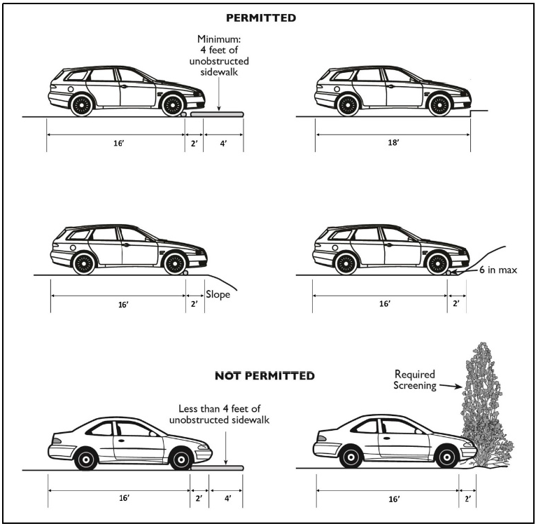
(b)
Parking facility design:
(1)
Off-street parking facilities shall be designed so that a car within a facility shall not have to enter a street to move from one location to any other location within that parking facility.
(2)
On industrial or office sites, separate noncontiguous parking facilities may be provided with independent entrances for employee and visitor parking, provided the designated use is clearly identified on all plot plans submitted for permits.
(3)
Parking and maneuvering areas shall be arranged so that any vehicle can leave the parking area and enter into an adjoining vehicular right-of-way traveling in a forward direction.
(4)
No dead-end parking aisles serving more than five (5) consecutive stalls shall be permitted unless said aisle is provided with a turnaround area constructed in a manner meeting the approval of the Director.
(5)
Bumpers or tire stops shall be provided along any abutment to a pedestrian walkway, access or driveway, street or alley, except where screening is positioned, to ensure that the motor vehicle shall extend into these areas no more than two (2) feet and only if the pedestrian sidewalk is a minimum of six (6) feet wide to ensure a minimum width of four (4) feet of unobstructed sidewalk at all times.
(6)
The point of exit or entry from any off-street parking space shall not be closer than twenty (20) feet from the curb face of the ultimate curbline at a street opening.
(7)
All paved parking stalls, except parallel spaces which may be single line, shall be clearly outlined with double or hairpin lines or special paving techniques on the surface of the parking facility. (See diagram in section 7-9-70.5.)
(c)
Parking accessways. Parking accessways are those driveways that provide ingress or egress from a street to the parking aisles, and those driveways providing interior circulation between parking aisles. No parking is permitted on an accessway.
(1)
All parking facilities taking access from an arterial highway shall have a parking accessway between the highway and the parking aisles.
(2)
Parking accessways from arterial highways shall not have parking spaces taking direct access therefrom and shall not be intersected by a parking aisle or another parking accessway for a minimum distance of thirty (30) feet for projects with 0—200 parking spaces, fifty (50) feet for 201—350 spaces, seventy (70) feet for 351—450 spaces, and ninety (90) feet for 451 spaces or more. All distances shall be measured from the curb face of the ultimate curbline of the adjacent street.
(3)
Parking accessways from nonarterial highways shall be not less than twenty (20) feet in length from the ultimate curbline of the adjacent street.
(4)
One-way accessways shall have a minimum width of fifteen (15) feet unless it is a fire lane, which requires a minimum of twenty (20) feet.
(5)
Two-way accessways shall have a minimum width of twenty-eight (28) feet.
(d)
Parking aisles. Parking aisles are driveways which provide direct access to parking spaces. Parking aisles shall have a minimum width of fourteen (14) feet as provided in section 7-9-70.5. In no case shall the parking aisles for two-way traffic be less than twenty-four (24) feet in width.
(e)
Number of required off-street parking spaces:
(1)
The minimum number of off-street parking spaces required shall be in compliance with the listed requirements set forth for each general category of land use in sections 7-9-70.6.
(2)
Whenever any commercial/industrial use is located on a building site that is also used for residential purposes, parking facilities shall be provided for the residential use as required, in addition to the parking required for the nonresidential use or uses.
(f)
Landscaping. Landscaping of parking areas shall be provided in accordance with the provisions of the applicable land use district regulations. In all cases, space within the off-street parking area not utilized for driveways, maneuvering areas, parking stalls or walkways shall be landscaped. Landscaped areas shall be separated from paved driveway, parking space and maneuvering areas by a minimum six (6) inch high barrier.
Shade trees shall be planted throughout the parking area, including at the end of each parking aisle and along its boundary. There shall be no more than six (6) adjacent parking spaces between each landscaped planter that shall include a tree. These landscaped planters shall be no smaller than twenty-five (25) square feet in size, not counting the 6-inch concrete curb surrounding the planter. Newly planted trees shall be a minimum of fifteen (15) gallons in size.
FIGURE 7-9-70.4(F) - PARKING LOT LANDSCAPING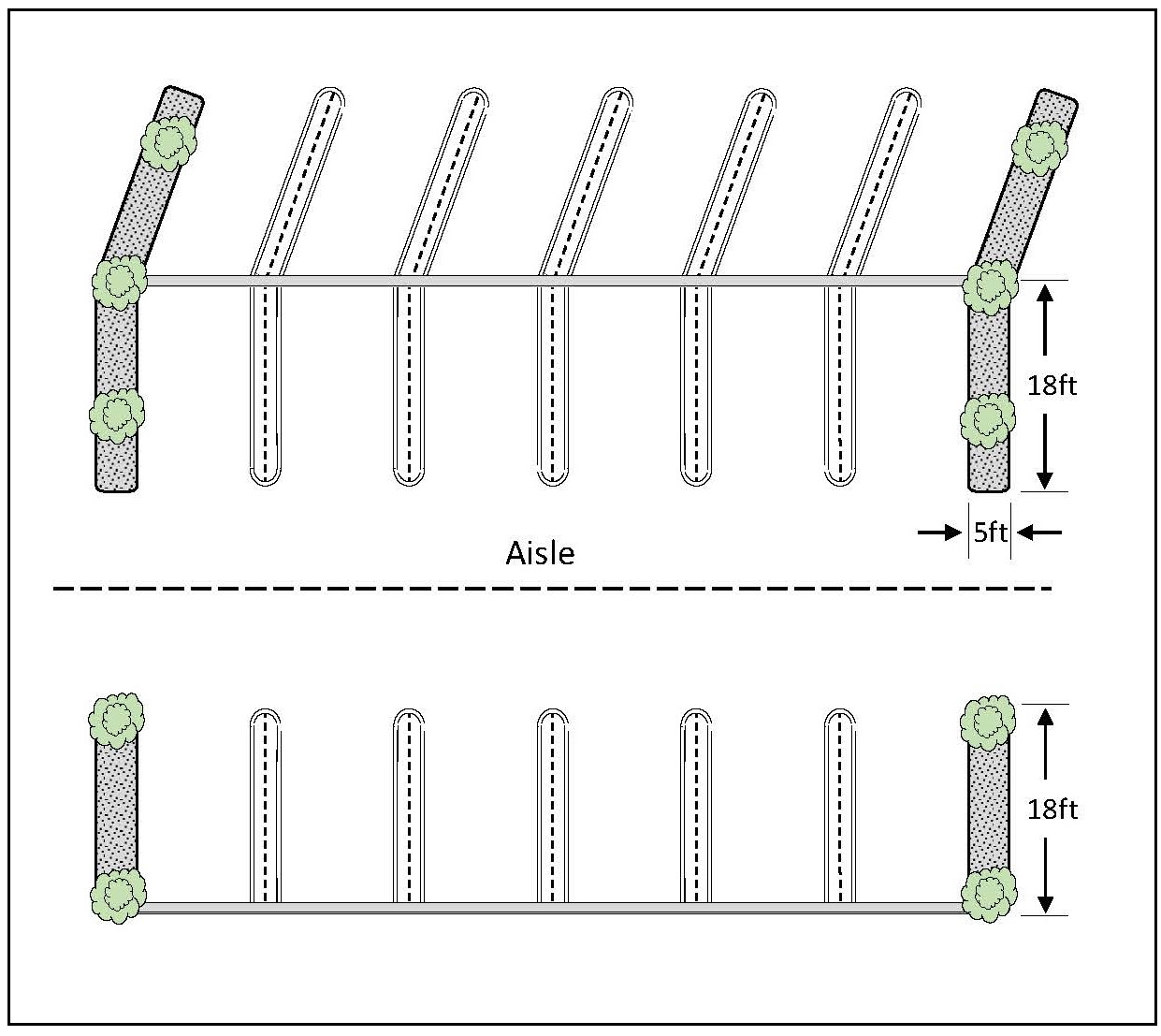
(g)
Screening. Open parking spaces and parking structures shall be screened in accordance with section 7-9-70.3, whenever such parking is adjacent to a street right-of-way and when the street separates such parking from any district zoned for residential or agricultural uses. Screening shall be located adjacent to the inside edge of any required boundary landscaping and to the outside edge of the paved parking area when there is no landscaping.
(h)
Vehicular access standards. A Site Development Permit, Use Permit or Coastal Development Permit, for the CR, CC, CH and CN Districts shall be in substantial conformity with the following:
(1)
The first street opening from an intersection should be a minimum of one hundred ten (110) feet from the point of intersection of the ultimate right-of-way lines of the abutting streets.
(2)
The second street opening should be a minimum of three hundred (300) feet from the point of intersection of the ultimate right-of-way lines of the abutting streets.
(3)
Any additional street openings should be a minimum of three hundred (300) feet, from center to center from any other street opening except in the CN District, where the distance between street openings should be a minimum of one hundred fifty (150) feet from center to center.
(4)
There should be a minimum distance of twenty-two (22) feet measured at the ultimate property line, between a street opening in this district and any existing street opening in any other district.
(i)
Joint use of parking facilities: Uses on multiple building sites may share common parking facilities within one (1) or more parking areas located within such multiple building sites, provided the following requirements are met:
(1)
A detailed parking plan, showing all common parking facilities, shall be approved by the Director.
(2)
Parking facilities shall be on the same side of the street as the uses they serve and the closest parking stall shall be within three hundred (300) feet of the uses they serve as measured from the property line.
(3)
Adequate assurance is provided to guarantee that required parking shall continue to be maintained in compliance with applicable provisions of section 7-9-70.
(4)
The assurance required by (3) and the parking plan required by (1) shall be recorded in the office of the Orange County Recorder.
(5)
Individual uses which result in a parking demand more than is provided by the existing parking on the site shall be required to provide added parking as required by Director. See section 7-9-70.6.
(Ord. No. 20-006, § 1, 7-28-20)
Sec. 7-9-70.5. - Design requirements.
(a)
Off-Street Parking Stall and Access Standards.
AISLE WIDTHS
Note: For parking lot landscaping requirements, please see Figure 7-9-70.4(f)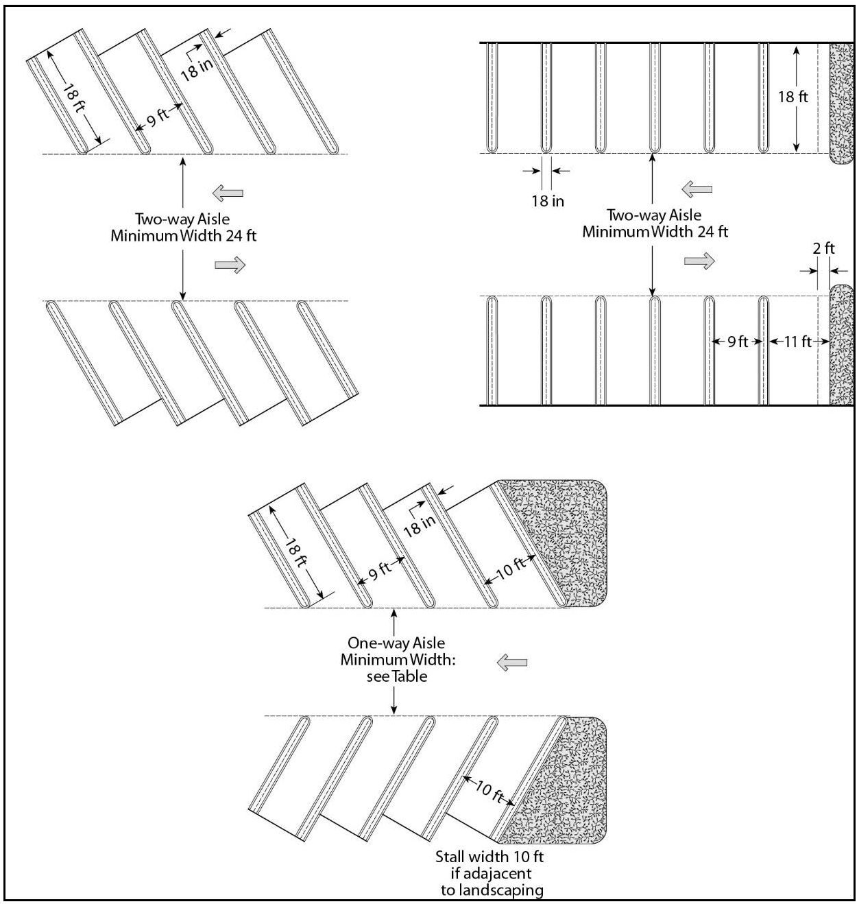
ACCESSWAYS AND PARKING AISLES
Note: For parking lot landscaping requirements, please see Figure 7-9-70.4(f)
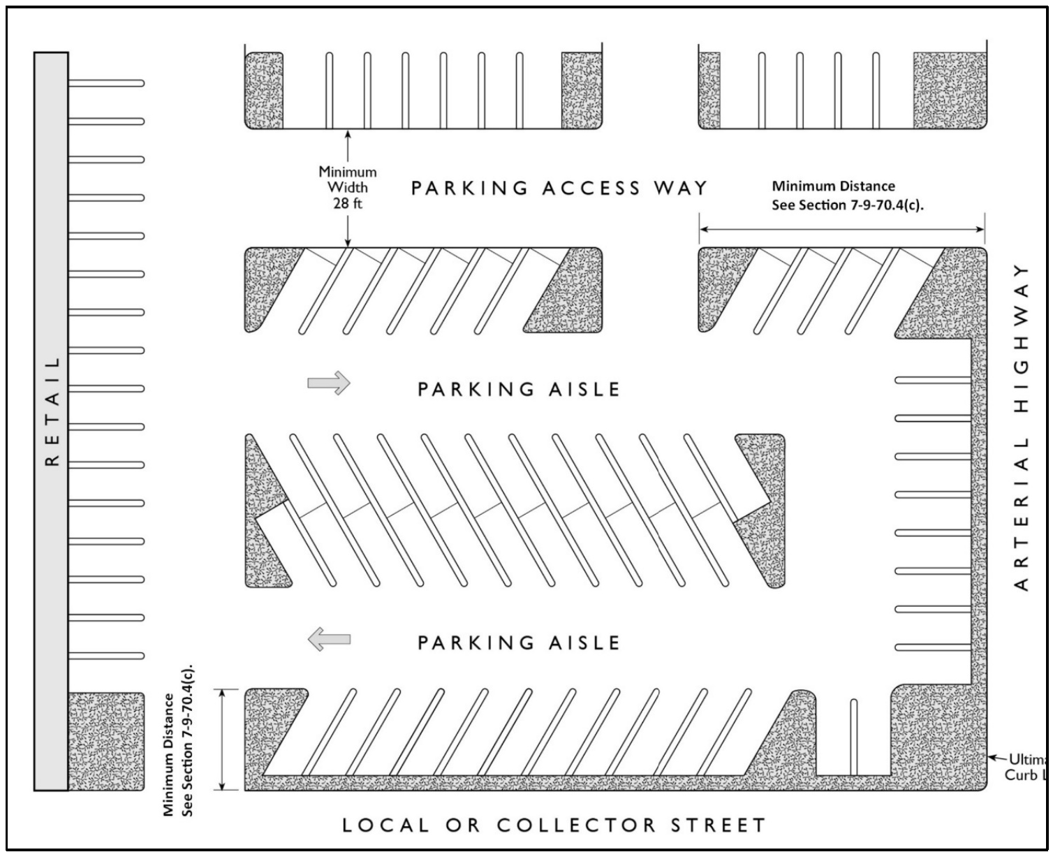
HAIRPIN STRIPING DESIGN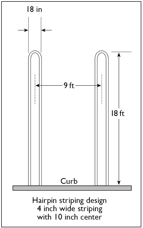
PARALLEL PARKING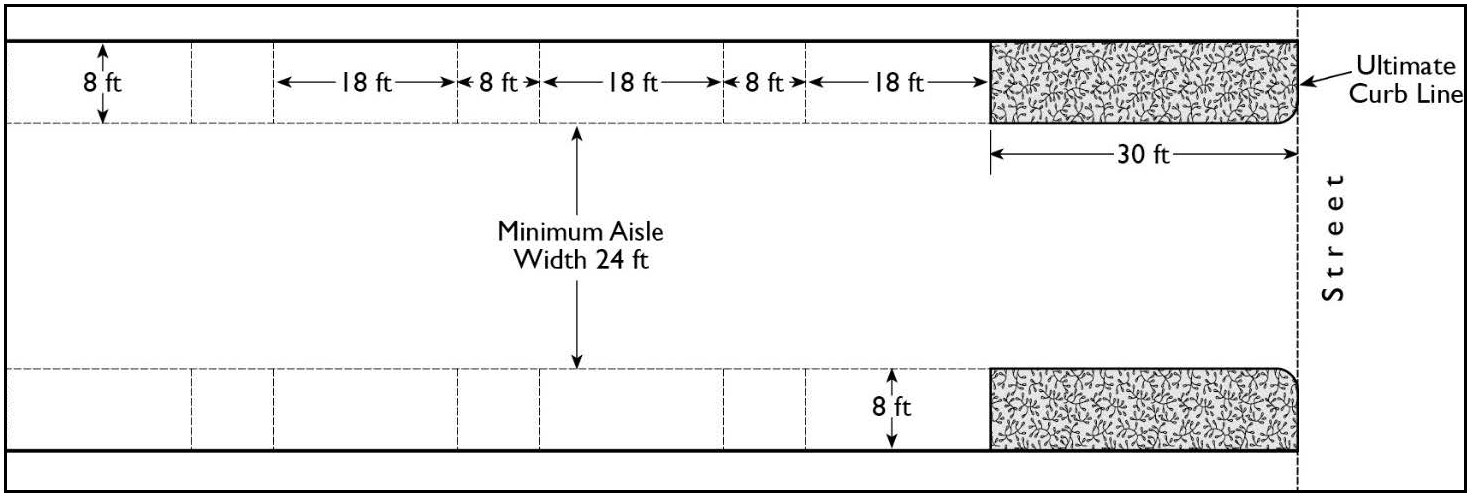
ACCESSIBLE PARKING STALLS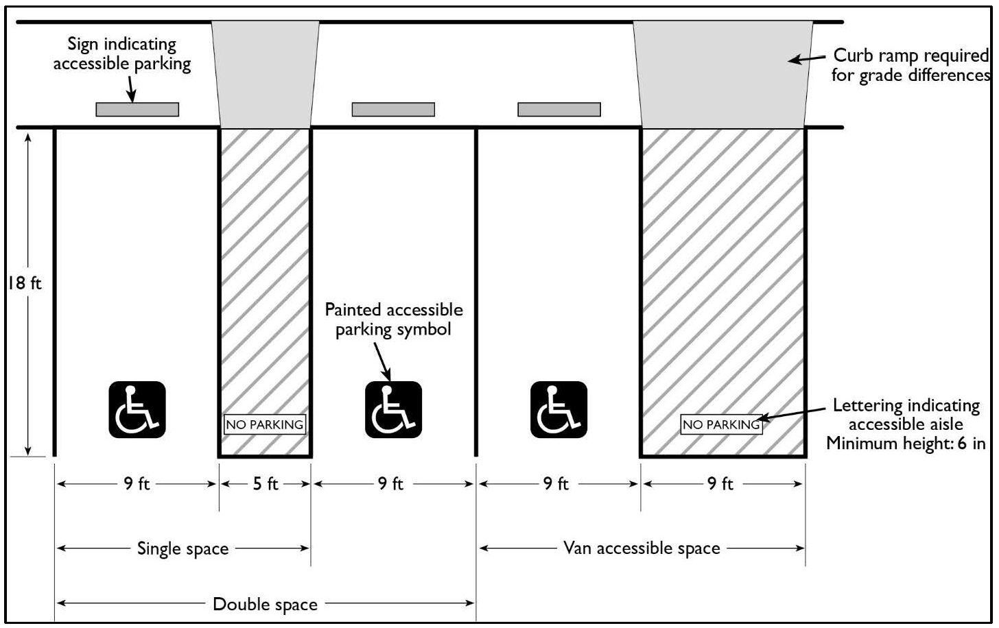
ACCESSWAY GRADE AT STREET ROW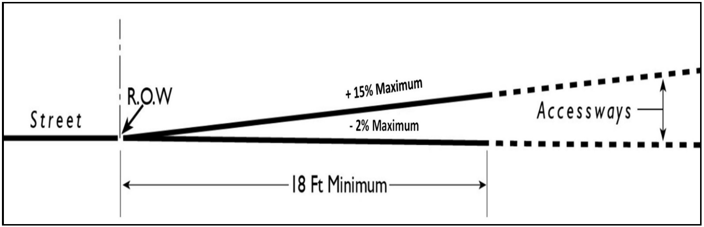
DRIVEWAY OR PARKING STRUCTURE RAMP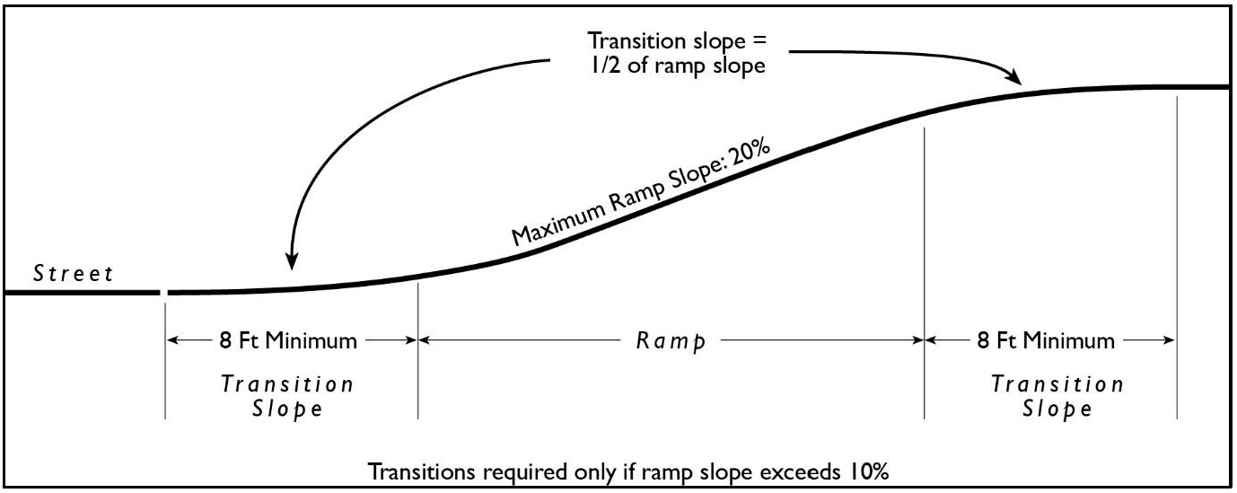
MAXIMUM PARKING STALL AND PARKING AISLE GRADES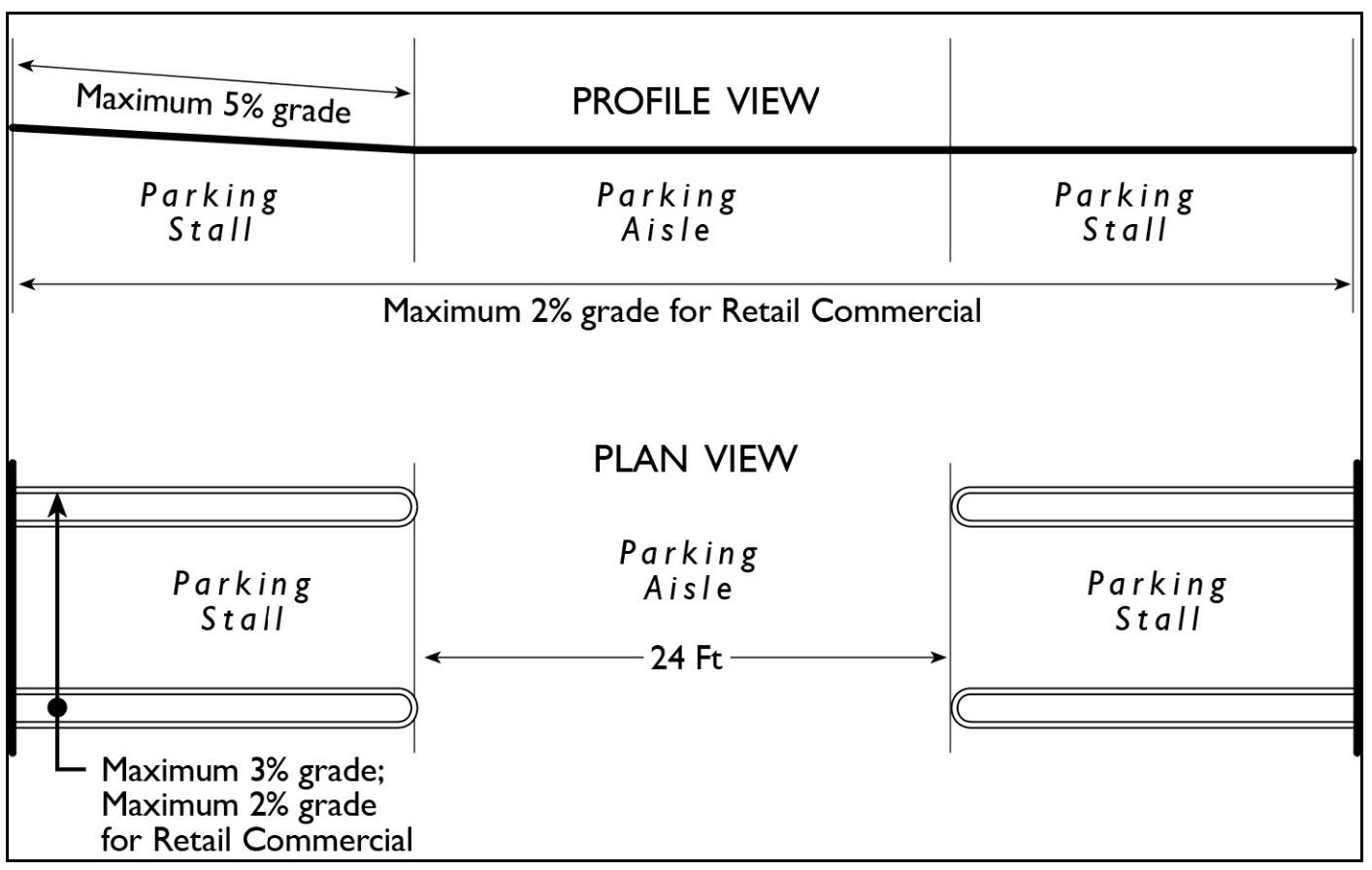
(b)
Minimum Parking Aisle Width for One-Way Traffic:
(c)
Minimum Parking Aisle Width for Two-Way Traffic: For two-way traffic, aisle widths and maneuvering areas shall be a minimum of twenty-four (24) feet wide.
(Ord. No. 20-006, § 1, 7-28-20)
Sec. 7-9-70.6. - Number of off-street parking spaces required for non-residential uses.
(a)
All land uses shall provide off-street parking in compliance with the following requirements unless otherwise modified by the provisions contained in section 7-9-70.9. The off-street parking requirements listed under this section are the minimum requirements for each specific use; however, it shall be the responsibility of the developer, owner or operator of any specific use to provide adequate off-street parking, even though such parking may be in excess of the minimum requirements set forth in this section.
(b)
Requirements Not Specified: If no provisions for the required number of off-street parking spaces are set forth in these regulations, or the provisions are not clear for any specific use or uses, the Director shall determine the number of off-street parking spaces required.
(Ord. No. 20-006, § 1, 7-28-20)
Sec. 7-9-70.7. - Parking calculations.
The following rules shall apply when calculating the number of required parking spaces.
(a)
Multiple Uses. Unless otherwise expressly stated, when two (2) or more uses are located on the same parcel of land or within the same building, the number of off-street parking spaces required shall be the sum total of the requirements of the various individual uses computed separately in accordance with this section.
(b)
Area-based standards.
(1)
Unless otherwise expressly stated, all area-based (square footage) parking standards shall be computed on the basis of gross floor area, determined by the outside dimensions of the building or tenant space, less any area within the building devoted to parking.
(2)
The Director may determine the area measurement for uses or portions of uses not located within buildings.
(Ord. No. 20-006, § 1, 7-28-20)
Sec. 7-9-70.8. - Loading requirements.
Non-residential uses that involve the receipt of distribution of materials or merchandise shall provide vehicle loading spaces in compliance with the following requirements:
(a)
Location. Loading spaces shall be provided on the same lot on which the use for which they are required is located except that the Director may approve a plan to allow loading spaces in a common loading area that serves multiple adjacent uses and located on an adjacent lot within three hundred (300) feet of the lot on which the use requiring the loading spaces is located.
(b)
Maintenance. Loading areas shall be paved to support anticipated traffic volumes and weights; properly graded for drainage; and maintained in good condition free of weeds, dust, trash, and debris.
(c)
Maneuvering Areas. All off-street loading spaces and stacking areas shall be designed and located so that there is sufficient off-street maneuvering area to accommodate vehicles using the loading spaces. Maneuvering areas shall be designed to accommodate the largest vehicle intended to use the loading spaces and shall not be encumbered by parking stalls or physical obstructions.
(d)
Landscaping and Screening. All loading spaces and maneuvering areas and the driveways serving them shall be landscaped or screened in compliance with the requirements of the district in which the loading area is located.
(Ord. No. 20-006, § 1, 7-28-20)
Sec. 7-9-70.9. - Alternatives to off-street parking regulations.
(a)
Required Findings for Approval. In addition to the required findings for approval of any Use Permit in section 7-9-126.2 Required Findings, an application for a Use Permit for a parking reduction shall only be approved if the decision-making body makes all of the findings of this section that are applicable to the particular project, as stated.
(1)
All Projects. For any project for which a parking reduction is requested, the decision-making body make all of the following findings based on information in the record:
a.
The use will adequately be served by the proposed parking demand requirement as determined in the parking study; and
b.
If required, a parking study prepared by an independent traffic engineering professional approved by the County supports the proposed reduction.
(2)
Shared (Joint) Parking. Where a shared parking facility serving more than one use is proposed, a parking study shall be required and the decision-making body shall only approve a parking reduction if it finds that:
a.
The peak hours of use shall not overlap or coincide to the degree that peak demand for parking spaces from all uses shall be greater than the total supply of spaces;
b.
The proposed shared parking to be provided shall be adequate to serve each use; and
c.
A written agreement between landowner(s) and the County, in a form satisfactory to County Counsel, has been submitted to and approved by the Director. This agreement shall be in a form capable of and subject to being recorded to constitute a covenant running with the land and shall include:
1.
A guarantee that there shall be no substantial alteration in the uses that will create a greater demand for parking;
2.
A guarantee among the landowner(s) for access to and use of the shared parking facilities;
3.
A provision that the County may require parking facilities in addition to those originally approved upon a finding that adequate parking to serve the use(s) has not been provided; and
4.
A provision stating that the agreement shall not be modified or terminated without the approval of the Director.
(3)
Other Parking Reductions. Use Permits to the Zoning Administrator for a parking reduction that do not involve a shared parking facility shall be approved by the decision-making body only if a finding can be made that special conditions including, but not limited to, the nature of the proposed operation; proximity to frequent transit service; transportation characteristics of persons residing, working, or visiting the site; or because the applicant has undertaken a transportation demand management program shall reduce parking demand at the site below the level of the normal requirement.
(b)
Monitoring of TDM Programs. Any project that is granted a parking reduction based on measures that intended to reduce parking demand shall submit an Annual Status Report to the County. The report shall be in a manner prescribed by the Director, and shall describe the implementation and maintenance of trip reduction measures and the parking demand generated by the project. Annual Status Reports shall be reviewed to determine if property owners have implemented and/or maintained the trip reduction program. The Director may request auditable documentation to determine compliance.
(Ord. No. 20-006, § 1, 7-28-20; Ord. No. CA 22-01, 9-27-22; Ord. No. 22-003, § 8, 9-27-22; Ord. No. 24-004, § 26, 6-25-24)
Sec. 7-9-70.10. - Bicycle parking.
Bicycle parking is required for multi-unit residential buildings and nonresidential development in compliance with the requirements of the California Green Building Standards Code, Section 5.106.4, as may be amended.
(Ord. No. 20-006, § 1, 7-28-20)
Sec. 7-9-70.11. - Recreational vehicle parking.
Parking of recreational vehicles in residential and non-residential zones shall meet the requirements of County of Orange Codified Ordinance Section 3-13-6, as may be amended.
(Ord. No. 20-006, § 1, 7-28-20)
Sec. 7-9-71. - Screening and landscaping.
All references to this section shall include sections 7-9-71.1 through 7-9-71.2. Where required by the district regulations, the following minimum requirements shall apply.
(Ord. No. 20-006, § 1, 7-28-20)
Sec. 7-9-71.1. - Screening.
(a)
An opaque screen shall be installed and maintained along all district boundaries where the premises abut areas zoned for residential or agricultural uses. A screen shall consist of one (1) or any combination of the following types:
(1)
Walls: A wall shall consist of concrete, stone, brick, tile or similar type of solid masonry material a minimum of four (4) inches thick.
(2)
Berms: A berm shall be not more than twenty (20) feet in width at the base. It shall be constructed of earthen materials and it shall be landscaped.
(3)
Fences, solid: A solid fence shall be constructed of wood or other materials and shall form an opaque screen.
(4)
Fences, open: An open weave or mesh type fence shall be combined with plant materials to form an opaque screen.
(5)
Hedges: Plant materials, when used as a screen, shall consist of compact evergreen plants. They shall be of a kind, or used in such a manner, so as to provide screening, having a minimum width of two (2) feet within eighteen (18) months after initial installation. Permanent watering facilities shall be provided. If, eighteen (18) months after installation, plant materials have not formed an opaque screen, or if an opaque screen is not maintained, the Director shall require that either walls, berms, or a solid fence be installed.
(b)
Screen heights shall not be less than six (6) feet in height except where a shorter height is required by section 7-9-64, "Fences, Walls, and Hedges."
(c)
No signs or sign supports except those specified in the off-street parking regulations shall be permitted on any required screening.
(Ord. No. 20-006, § 1, 7-28-20)
Sec. 7-9-71.2. - Landscaping.
Landscaping, consisting of trees, shrubs, vines, ground cover, turf, or any combination thereof, shall be installed and maintained subject to the following standards:
(a)
Boundary landscaping is required for a minimum depth equal to the required setback distance or ten (10) feet (whichever is less) along all property lines abutting streets except for the required street openings.
(b)
Landscaping along all streets and boundaries shall comply with section 7-9- 64, "Fences, Walls, and Hedges."
(c)
Any landscaped area shall be separated from an adjacent parking or vehicular area by a wall or curb at least six (6) inches higher than the adjacent parking or vehicular area.
(d)
Permanent watering facilities shall be provided for all landscaped areas and be operated and maintained in an efficient manner.
(e)
Required landscaping shall be maintained in a neat, clean and healthy condition. This shall include proper pruning, mowing of lawns, weeding, removal of litter, fertilizing and watering as needed, and replacement of plants when necessary.
(f)
For landscape projects subject to section 7-9-68 of this Zoning Code, a Landscape Documentation Package as defined in section 7-9-68.3 shall be submitted and approved pursuant to the requirements set forth in section 7-9-68.3 and 7-9-68.4 and the Guidelines applicable thereto prior to the issuance of building permits. A Certificate of Completion shall be submitted and approved prior to the closure of the permit.
(Ord. No. 20-006, § 1, 7-28-20)
Sec. 7-9-72. - Solar energy systems.
This section establishes regulations for the construction and installation of energy collectors of small to medium solar energy systems.
(Ord. No. 20-006, § 1, 7-28-20)
Sec. 7-9-72.1. - Purpose.
This section is intended to allow for timely and cost-effective installations that shall:
(a)
Provide for the placement of small to medium solar energy systems to enable generation of electricity from the sun, for on- and/or off-site uses, thereby reducing the consumption of electricity supplied by utility companies.
(b)
To minimize potential adverse impacts associated with solar energy systems.
(Ord. No. 20-006, § 1, 7-28-20)
Sec. 7-9-72.2. - Definitions.
(a)
Solar Energy Collector. Equipment constructed or installed on, or located near the exterior of, any structure for the purpose of collecting, storing, or transferring solar energy.
(b)
Solar Energy System. Any of the following:
(1)
Any solar collector or other solar energy device whose primary purpose is to provide for the collection, storage, and distribution of solar energy for space heating, space cooling, electric generation, or water heating.
(2)
Any structural design feature of a building whose primary purpose is to provide for the collection, storage, and distribution of solar energy for electricity generation, space heating, space cooling, or water heating.
(Ord. No. 20-006, § 1, 7-28-20)
Sec. 7-9-72.3. - Standards.
(a)
Ground-mounted solar energy collectors. Ground-mounted solar energy collectors shall be installed and maintained in accordance with the following requirements:
(1)
Location. Ground-mounted solar energy collectors are permitted in all zoning districts. In residential districts, solar energy collectors and their mounting framework shall not be located, installed, and maintained within the front setback and shall not to be visible from the public right-of-way adjacent to the front, side, or rear property line. In nonresidential districts, solar energy collectors may be visible from the public right-of-way with approval of a Site Development Permit.
(2)
Height. In residential districts, the height of a ground-mounted solar energy collector system shall not exceed twelve (12) feet unless within three (3) feet of the property line, where the maximum height shall be eight (8) feet. The maximum height shall be twenty-five (25) feet when located on a non-residential property not abutting a residential zone. The maximum height of a ground-mounted solar energy collector system shall be fifteen (15) feet when located on a non-residential property abutting a residential zone.
(3)
Setbacks. Installations less than six (6) feet in height may project up to two (2) feet into a required setback. Installations six (6) feet or more in height shall be setback a minimum of eight (8) feet from all property lines.
(b)
Roof-mounted solar energy collectors. In addition to the other requirements set forth in this section, roof-mount solar energy collectors shall be installed and maintained in accordance with the following requirements:
(1)
Height. Photovoltaic solar energy systems on the roof may extend up to five (5) feet above the height limit in the district in which it is located or the roof surface on which they are installed.
(2)
Solar water or swimming pool heating systems may extend up to seven (7) feet above the height limit in the district in which it is located or the roof surface on which they are installed.
(c)
Roof-mounted solar energy collectors on carports. See section 7-9-70.2(d).
(Ord. No. 20-006, § 1, 7-28-20)
Sec. 7-9-85.- Purpose and applicability.
The purpose of Subarticle 5 is to prescribe standards and requirements that apply, except as otherwise specified, to certain specific uses that are permitted or conditionally permitted in several or all zoning districts. These standards shall be used in conjunction with the standards for each zoning district to minimize the impacts of these uses and activities on surrounding properties. In any case of conflict, the standards specific to the zoning district shall override these regulations.
(Ord. No. 20-006, § 1, 7-28-20)
Sec. 7-9-86. - Multifamily residential standards and requirements.
In addition to the requirements for each district, the following procedure and standards are applicable to the construction, establishment and maintenance of any multifamily residential project consisting of five (5) or more dwelling units in any district in which they are permitted. The procedures and standards are not applicable to single-family and to multiple-family projects of four (4) or less dwelling units.
(a)
Prior to issuance of a building permit or a grading permit a Site Development Permit shall be approved by the Director or by the Planning Commission when the Director determines that the public would be better served by a public hearing before the Planning Commission.
(b)
The Director shall approve or conditionally approve an application for a multifamily Site Development Permit in compliance with the procedures required by section 7-9-125 after having determined that, in accordance with any necessary conditions, the project shall comply with all applicable regulations of the district in which the property is located, and with all of the following additional standards and requirements:
(1)
All of the infrastructure facilities shall be adequate to serve the project when all conditions are complied with, without overloading such facilities to the detriment of other uses in the vicinity.
(2)
Ingress and egress between the project and abutting streets shall be adequate to serve the project and shall be in compliance with the Standard Plans, OC Public Works, as amended.
(3)
Open space and recreation facilities shall be sufficient to serve the needs of the occupants and shall be in compliance with applicable County standards for open space and recreation.
(4)
Parking areas shall be well lighted and shall be situated in such a manner that entrances to individual parking spaces, garages and carports shall be commonly visible from dwelling units. Parking areas and facilities shall be situated in a manner that shall make them more convenient for occupants to use than on-street parking.
(5)
Solid waste disposal stations shall be provided within enclosed areas which shall be conveniently accessible for all dwelling units and for trash pickup trucks.
(6)
Any additional features necessary to comply with County standards, such as screening, sound attenuation, architectural design, etc., shall comply with applicable County standards and regulations.
(c)
The Planning Commission may approve an application for a multifamily Site Development Permit in compliance with the public hearing and Use Permit procedures required by section 7-9-125. The standards listed in paragraph (b) may be used as criteria for making a determination.
(d)
Each multifamily project shall be established and maintained in compliance with the approved Site Development Permit.
(Ord. No. 20-006, § 1, 7-28-20)
Sec. 7-9-87.1. - Purpose and intent.
This section is intended to comply with the requirements of California Government Code Section 65915 et seq. ("State Density Bonus Law"), and Government Code Section 65915, et seq., as may be amended from time to time, regarding the provision of a density bonus or other incentives to facilitate the production of affordable housing, senior citizen housing, or child care facilities. The amount of density bonus and the number and type of incentives shall be determined in a manner consistent with State Density Bonus Law and Government Code Section 65915, as may be amended from time to time.
(Ord. No. 20-006, § 1, 7-28-20; Ord. No. 24-004, § 27, 6-25-24)
Sec. 7-9-87.2. - General provisions.
(a)
State law governs. When a conflict occurs between the provisions of this section and State law, State law shall govern.
(b)
Compatibility. Affordable and market-rate units shall be comparable in appearance, materials, and finish quality. Affordable units shall also be dispersed throughout the entire development.
(c)
Density compliance plan. A "Density Bonus Compliance Plan" shall be approved concurrently with approval of the project requesting a density bonus or other incentive. This Density Bonus Compliance Plan shall stipulate the terms of the affordability and/or occupancy requirements on the housing development, including, but not limited to, the duration of the restrictions. Compliance with the terms of this Density Bonus Compliance Plan shall be monitored on a regular basis by the County of Orange. The Plan shall be recorded as a restriction on the parcel or parcels on which the affordable housing units shall be constructed.
(d)
Construction with other applicable zoning regulations. Notwithstanding any permitted density bonus or incentive granted pursuant to this section, any project receiving a density bonus hereunder shall otherwise be consistent with the applicable zoning and land use regulations and requirements, including permitted uses.
(e)
Availability. Affordable housing units shall be constructed concurrently with and made available for qualified occupants at the same time as market-rate units within the same project, unless both the County and the developer agree in the Density Compliance Plan to an alternative schedule for development.
(f)
Effect of granting density bonus. The granting of a density bonus under this section shall not, in and of itself, be interpreted to require a General Plan amendment, Zoning Code or Zoning Map amendment, or other discretionary approval.
(g)
Parking. The developer may request to utilize the parking requirements set forth in State Density Bonus Law or the County's residential off-street parking requirements for affordable housing projects.
(Ord. No. 20-006, § 1, 7-28-20; Ord. No. 24-004, § 28, 6-25-24)
Sec. 7-9-87.3. - Requirements and standards for granting a density bonus and incentives.
(a)
Granting a density bonus and incentives for a mixed-use development project. The granting of a density bonus and incentives for a mixed-use development project shall comply with the provisions of Government Code Section 65915.7, et seq., as may be amended.
(b)
Granting a density bonus and incentives for a housing development project. The County shall grant one (1) density bonus when an applicant seeks and agrees to construct a housing development, excluding any units permitted by the density bonus awarded, that shall contain housing for any one (1) of the following household income groups, as defined by State law.
(1)
Very Low Income Households. A minimum of five percent (5%) of the total dwelling units of a housing development for very low income households Section 50105 of the Health and Safety Code, as may be amended.
(2)
Low Income Households. A minimum of ten percent (10%) of the total dwelling units of a housing development for lower-income households as defined in Section 50079.5 of the Health and Safety Code, as may be amended.
(3)
Senior Citizen Housing Development. A senior citizen housing development, as defined in Sections 51.3 and 51.12 of the Civil Code, as may be amended, or mobile home park that limits residency based on age requirements for housing for older persons, pursuant to Section 798.76 or 799.5 of the Civil Code, as may be amended.
(4)
Student Housing Developments. A minimum of twenty percent (20%) of the total dwelling units for lower income students in housing developments for students, as defined by Government Code Section 65915, as may be amended.
(5)
Transitional Foster Youth, Disabled Veterans, or Homeless Persons Housing Developments. A minimum of ten percent (10%) of the total dwelling units with rents restricted at very low income level in housing developments for: transitional foster youth as defined by the Education Code, Section 66025.9, as may be amended, disabled veterans as defined by Government Code Section 18541, as may be amended, or homeless persons as defined by the Federal McKinney-Vento Homeless Assistance Act (42 U.S.C. Sec. 11301 et seq.), as may be amended.
(6)
For-Sale Housing Developments. A minimum of ten percent (10%) of the total dwelling units in a common interest development, are sold to persons and families of moderate income, as defined in Section 50093 of the Health and Safety Code, as may be amended, provided that all units in the development are offered to the public for purchase.
(7)
100% Affordable Housing Development. Pursuant to Government Code Section 65915, as may be amended, housing developments with one hundred percent (100%) of the units affordable to lower income households (excluding the manager's unit), except that up to twenty percent (20%) of the total units may be for moderate income households, are eligible for a density bonus of up to eighty percent (80%) of the number of lower income units.
(c)
Second density bonus available. A second density bonus may be available to projects meeting the requirements for the second density bonus under Government Code Section 659715, Subdivision (v).
(d)
Calculation of density bonus(es). The amount of bonus density to which a developer is entitled shall vary according to the amount by which the percentage of affordable housing units equals or exceeds the percentage established in State Density Bonus Law. The density bonus shall not be included when determining the number of housing units that are to be affordable. The calculation of the density bonus awarded shall be pursuant to Government Code Section 65915, et seq., as may be amended.
(e)
Incentives. In addition to a density bonus, an applicant whose project meets the requirements of this section may request up to five (5) incentives pursuant to State Density Bonus Law. The calculation of the incentives awarded shall be pursuant to Government Code Section 65915, et seq.
(Ord. No. 20-006, § 1, 7-28-20; Ord. No. 24-004, § 29, 6-25-24)
Sec. 7-9-87.4. - Procedure.
A request for density bonus or other incentives pursuant to State Density Bonus Law shall be processed as part of an application in compliance with and subject to the provisions and requirements of section 7-9-125. No additional discretionary approval shall be required as a result of a request for or the granting of a density bonus or other incentive that is available pursuant to current State Density Bonus Law.
(Ord. No. 20-006, § 1, 7-28-20; Ord. No. 24-004, § 30, 6-25-24)
Sec. 7-9-88. - Single room occupancy.
(a)
Single room occupancy (SRO) facilities shall be permitted in any district, planned community, or specific plan area zoned for hotels subject to the approval of a Use Permit by the Planning Commission per section 7-9-125.
(b)
SRO units shall have a minimum of one hundred (100) net square feet of space for a single occupancy and one hundred twenty (120) square feet for two (2) person occupancy. The calculation for net floor space in the sleeping area includes built-in cabinets, sinks, and closets, but excludes toilet compartments. A unit larger than two hundred twenty-five (225) square feet shall be deemed an efficiency dwelling unit and not a SRO.
(c)
SRO facilities shall be treated as nonresidential uses. As such, section 7-9-87 does not apply and residential dwelling unit limitations (e.g., statistical summary) are not applicable.
(d)
Unless modified parking requirements are approved subject to the requirements of section 7-9 4.9, Alternatives to off-street parking regulations, the off-street SRO parking requirement shall be one-half (0.5) for each SRO unit, plus one (1) for each employee.
(e)
A management plan shall be submitted as part of the Use Permit application for review and approval by the Planning Commission. The management plan shall contain management policies, operations, emergency procedures, security program, rental procedures, maintenance plans, and staffing needs.
(f)
An on-site twenty-four-hour manager is required in every SRO project. In addition, a single manager's unit shall be provided which shall be designed as a complete residential unit, and be a minimum of two hundred twenty-five (225) square feet in size.
(Ord. No. 20-006, § 1, 7-28-20; Ord. No. 24-004, § 31, 6-25-24)
Sec. 7-9-89. - Condominium conversions.
All references to this section shall include sections 7-9-89.1 through 7-9-89.5.
(Ord. No. 20-006, § 1, 7-28-20)
Sec. 7-9-89.1. - Purpose and intent.
The purpose of this section is to provide standards and criteria for regulating the conversion of duplex or multifamily dwelling units, including units in a rental mobilehome park, to residential condominium, stock cooperative and community apartment types of ownership; for determining when such conversions are appropriate; to provide for the public health, safety and general welfare, and to provide adequate off-street parking and to mitigate any hardship caused by the displacement of tenants.
The provisions and procedures of this section shall apply to all conversions of existing duplex and multifamily dwelling rental units to residential condominiums, stock cooperatives and community apartments notwithstanding any other provision of this Code or any planned community ordinance.
(Ord. No. 20-006, § 1, 7-28-20)
Sec. 7-9-89.2. - Standards.
Conversion projects shall conform to the standards and requirements applicable to the district in which the proposed project is located at the time of approval.
(Ord. No. 20-006, § 1, 7-28-20)
Sec. 7-9-89.4. - Application requirements.
Each application for conversion project shall be accompanied by the following in addition to the standard filing requirements for a Use Permit application:
(a)
An engineering report on the general condition of all structural, electrical, plumbing, and mechanical elements of the existing development including noise insulation, and the estimated cost of repair or improvement, if any. Said report shall be verified, dated and signed by the Director and be made available to prospective buyers.
(b)
A complete mailing list of all tenants occupying the subject property and two (2) corresponding sets of stamped addressed envelopes. Within fifteen (15) days after the filing of the application, the Director shall notify each tenant of the application, forward a copy of the above-required engineering report, and list the procedures to be followed. The Director shall mail a notice of public hearing at least fifteen (15) days before the hearing to each tenant on the mailing list.
(c)
Each application for a conversion project shall be accompanied by a housing program. Said program shall include, but not be limited to the following:
(1)
The means by which the provision of affordable housing shall be achieved.
(2)
A housing report addressing the balance of housing in the community analysis area, including vacancy rates and other available housing of similar type and rent, the current rents and estimated monthly payments and fees of the units to be converted and all improvements and/or renovations contemplated.
(3)
As applicable, the estimated costs for movement of each mobilehome to an available reasonably comparable space.
(4)
A survey of existing tenants as to their length of occupancy, the number of those who shall purchase one of the units.
(5)
A relocation plan which identifies the steps which shall be taken to ensure the successful relocation of each tenant in the event that the conversion takes place. The relocation plan shall also state what specific relocation assistance existing tenants shall be given, including the cost of physical moving, first and last months' rent, security and cleaning deposits, phone connection and utility deposits. Particular consideration shall be given to the elderly, handicapped, families with children, and other tenants who may encounter difficulty in finding a new residence.
(Ord. No. 20-006, § 1, 7-28-20)
Sec. 7-9-89.5. - Tenant provisions.
(a)
The property owner shall provide tenants a ninety-day preemptive right to purchase a unit or right of exclusive occupancy upon more favorable terms and conditions than those on which such unit or share shall be initially offered to the general public. Such right shall be irrevocable for a period of ninety (90) days after the commencement of sales and notification of the tenant of such right.
(b)
The property owner shall provide all tenants a minimum of one hundred eighty (180) days' advance notice of the termination of their tenancy, except that a one-year notice shall be provided for units in a mobilehome park. Each application for conversion shall include assurance that this requirement shall be satisfied.
(Ord. No. 20-006, § 1, 7-28-20)
Sec. 7-9-90. - Accessory dwelling units (ADU) and junior accessory dwelling units (JADU).
In conformance with California Government Code Section 65852.2, as may be amended, in any district, including planned community and specific plan areas, where a dwelling unit exists or is proposed on a building site zoned for single-family residential purposes, or where a multifamily residential structure(s) exists, the property owner may establish through a ministerial permit process an attached or detached accessory dwelling unit and/or a junior accessory dwelling unit contained within a dwelling unit subject to the following:
(a)
Single-family residential districts.
(1)
Pursuant to California Government Code Section 65852.2, as may be amended, a building site may be developed with an existing or proposed single-family (primary) dwelling, accessory dwelling unit, and/or junior accessory dwelling unit subject to the provisions of this section.
(2)
A property owner may establish one (1) accessory dwelling unit attached to a proposed or existing primary dwelling, or one (1) detached accessory dwelling unit, either new construction or within a converted existing accessory structure.
a.
A newly constructed attached or detached accessory dwelling unit, located within the building site area, shall not exceed twelve hundred (1,200) square feet in size.
1.
If the accessory dwelling unit is attached to the existing or proposed primary dwelling, the accessory dwelling unit shall not exceed fifty percent (50%) of the existing floor area, up to a maximum of twelve hundred (1,200) square feet. The fifty percent (50%) of the existing floor area maximum shall not apply if it does not permit at least an eight hundred (800) square foot attached accessory dwelling unit that is at least sixteen (16) feet in height and located no closer than four (4) feet to the side and rear property lines to be constructed in compliance with all other applicable development standards.
b.
A newly constructed attached or detached accessory dwelling unit, that is not converted from an existing structure, located in part or whole within the side or rear underlying district setback area, shall not exceed eight hundred (800) square feet in size, sixteen (16) feet in height, and located no closer than four (4) feet to the side and rear property lines.
c.
An existing accessory structure may be converted to an accessory dwelling unit. The accessory dwelling unit shall not exceed the square footage of the converted structure, to a maximum of twelve hundred (1,200) square feet.
(3)
A property owner may establish one (1) junior accessory dwelling unit proposed within an existing or proposed primary dwelling, or within an existing or proposed accessory dwelling unit.
a.
The junior accessory dwelling unit shall be converted from space within the primary dwelling or a portion of an existing accessory dwelling unit.
b.
A junior accessory dwelling unit shall not exceed five hundred (500) square feet in size.
c.
The building site's owner shall occupy a dwelling unit on the building site.
d.
The junior accessory dwelling unit shall comply with Government Code Section 65852.22, as may be amended, except as otherwise stated in this section.
(b)
Multifamily residential districts.
(1)
Accessory dwelling units in multifamily residential districts shall only be permitted on properties with existing established multifamily residential projects.
(2)
An accessory dwelling unit shall not exceed twelve hundred (1,200) square feet in size.
(3)
The maximum number of accessory dwelling units established from converted areas of the multifamily residential structures(s) shall not exceed twenty-five percent (25%) of the number of existing (non-accessory dwelling) units rounded down to the next whole number, with a minimum of one (1) unit.
(4)
Accessory dwelling units permitted within portions of existing multifamily residential structures shall only be constructed in areas that are not used as livable space, including but not limited to: storage rooms, boiler rooms, passageways, attics, basements, or garages. Existing structures shall not be enlarged to accommodate or enlarge an accessory dwelling unit.
(5)
In addition to accessory dwelling units permitted within converted portions of the existing multifamily residential structures, a maximum of two (2) detached accessory dwelling units may be constructed.
(6)
A detached accessory dwelling unit shall be allowed in a side or rear setback area provided that the maximum height of the structure does not exceed sixteen (16) feet and it maintains a minimum four (4) foot side and rear setback.
(c)
Development standards.
(1)
If required, the existing primary dwelling or converted existing accessory structure may include an expansion of not more than one hundred fifty (150) square feet beyond their existing physical dimensions to accommodate ingress and egress for the accessory dwelling unit or junior accessory dwelling unit. The expansion shall be counted towards the maximum square footage allowable for the unit.
(2)
Accessory and junior accessory dwelling units shall comply with all applicable building codes.
(3)
Each accessory or junior accessory dwelling unit shall have direct exterior access.
(4)
All side and rear setbacks shall be sufficient for fire and safety.
(5)
The accessory or junior accessory dwelling unit is not intended for sale separate from the primary dwelling but may be rented as a long-term rental (more than thirty (30) days). The accessory or junior accessory dwelling unit(s) shall not be used as a short-term rental (less than thirty (30) days).
(6)
Adequate water and sewage service are available. If a private sewage disposal system (onsite wastewater treatment system) is required, such system shall comply with the Orange County Plumbing Code and any applicable Federal, State and local health and safety regulations regarding private sewage disposal systems.
(7)
A new or separate utility connection directly between the accessory or junior accessory dwelling unit and the utility or a related connection fee or capacity charge shall not be required if the unit is attached to or contained within the space of an existing primary dwelling or accessory structure.
(8)
An accessory dwelling unit shall not be considered a new residential use for the purposes of calculating local agency connection fees or capacity charges for utilities, including water and sewer service.
(d)
Parking.
(1)
One (1) parking space per accessory dwelling unit is required, except in the instances listed in subsections (2) and (4). Where a parking space is required, it may be provided as tandem parking in an existing parking area or on an existing driveway.
(2)
No additional parking is required for junior accessory dwelling units.
(3)
No replacement of removed parking spaces shall be required for an existing garage, carport, or covered parking garage that is converted to an accessory dwelling unit or removed to accommodate the construction of an accessory dwelling unit.
(4)
No parking is required for an accessory dwelling unit in any of the following instances:
a.
The accessory dwelling unit is located within a one-half mile walk of public transit.
b.
The accessory dwelling unit is located within an architecturally and historically significant historic district.
c.
The accessory dwelling unit is attached to or contained within the existing primary residence or an existing accessory structure.
d.
When on-street parking permits are required but not offered to the occupant of the accessory dwelling unit.
e.
When there is an existing car share service pick-up/drop-off location located within one block of the accessory dwelling unit.
f.
If the accessory dwelling unit has no bedrooms.
(Ord. No. 20-006, § 1, 7-28-20)
Sec. 7-9-91. - Guesthouses.
In any district, including planned community and specific plan areas, where a single-family dwelling exists on a parcel zoned for such purposes, the property owner may establish a guesthouse as defined by this section, subject to the following requirements:
(a)
Only one (1) guesthouse shall be allowed per building site.
(b)
There shall be no kitchen or cooking facilities in any structure defined by this Zoning Code as a guesthouse.
(c)
A guesthouse shall not be rented.
(d)
Guesthouses six hundred forty (640) square feet or less in floor area shall not require a discretionary permit unless it is required for the main residence.
(e)
Guesthouses over six hundred forty (640) square feet in floor area on building sites of one (1) acre or larger shall require a Site Development Permit.
(f)
Guesthouses over six hundred forty (640) square feet in floor area on building sites less than one (1) acre shall require a Use Permit approved by the Zoning Administrator.
(g)
The following enclosed structures shall be defined as guesthouses:
(1)
An attached, habitable structure, larger than sixty-four (64) square feet, with no internal access to the existing single-family dwelling.
(2)
An attached, non-habitable structure containing a bathtub or shower with no internal access to the existing single-family dwelling.
(3)
A detached, habitable structure larger than sixty-four (64) square feet.
(4)
A detached, non-habitable structure with bathtub or shower, except structures used as a garage.
(Ord. No. 20-006, § 1, 7-28-20)
Sec. 7-9-92. - Mobilehome regulations.
The following regulations shall apply to all mobilehomes and mobilehome developments where such uses are permitted by the provisions of the base district. All references to this section shall include sections 7-9-92.1 through 7-9-92.2.
(Ord. No. 20-006, § 1, 7-28-20)
Sec. 7-9-92.1. - Mobilehome development regulations.
The regulations of this section shall apply to all new mobilehome developments and to the expansion of existing developments. These regulations are established so that mobilehome developments may be evaluated under conditions that shall ensure their compatibility with other permitted uses in the district.
(a)
Use Permit required: When permitted by applicable zoning district regulations, mobilehome developments are permitted subject to the approval of a Use Permit and in compliance with the provisions of this section.
(b)
Number of units permitted. Number of mobilehome dwelling units permitted is the same as the maximum number of dwelling units permitted by the applicable district regulations.
(c)
Site development standards:
(1)
Setbacks: Per the applicable district regulations.
(2)
Off-street parking: As required by section 7-9-70, except as follows:
a.
Two (2) parking spaces for each mobilehome dwelling unit.
1.
Required parking spaces shall be within two hundred (200) feet of the mobilehome they serve.
2.
Required spaces may be in tandem when the decision-making body finds there are adequate guarantees that each of the two (2) tandem spaces shall remain available and accessible for the same dwelling unit.
b.
Additional guest parking, as follows:
1.
One (1) parking space for each four (4) mobilehome dwelling units.
2.
Mobilehomes shall not be farther than three hundred (300) feet from a guest parking space.
(d)
Screening and landscaping: Opaque screening and landscaping treatment continuously along the perimeter of the development shall be provided per section 7-9-71 in a manner compatible with existing surrounding development.
(e)
Design criteria. Each development shall be designed in compliance with the following criteria:
(1)
Circulation. Vehicular and pedestrian ways shall be separate, and adequate sight distance and warning information shall be maintained wherever such ways intersect.
(2)
Trash and refuse storage. Where individual trash pickup is not provided, common trash storage areas shall be provided as follows:
a.
Mobilehomes shall not be located farther than one hundred (100) feet from a trash storage area.
b.
Each trash and refuse storage area shall be within a totally enclosed structure with a minimum height of six (6) feet.
(f)
Exceptions: When the decision-making body finds that any of the regulations of subsections (c) and (d) of this section are excessive when applied to a specific mobilehome development, or that there are special circumstances applicable to the subject property that cause any of these regulations to be unnecessary or inappropriate, an exception of deviation from such regulations may be approved as a part of the Use Permit for the mobilehome development.
(Ord. No. 20-006, § 1, 7-28-20)
Sec. 7-9-92.2. - Mobilehome installation.
Each mobilehome installed on its own building site shall comply with the requirements of this section.
(a)
Installation standards: Each mobilehome installation shall comply with the following standards:
(1)
Each mobilehome installation shall comply with the site development standards for a single-family dwelling in the applicable zoning district.
(2)
Each mobilehome shall be placed on a foundation system. The foundation shall be either:
a.
A solid concrete or masonry wall under the outside perimeter of the mobilehome; or
b.
Piers or other open construction meeting the requirements of the currently effective County Building Code, combined with skirting placed around the outside wall of the mobilehome in such a manner that the exterior siding appears to start at ground level.
(b)
Exterior siding. The exterior siding of the mobilehome shall be similar in appearance to siding material customarily used in conventionally built single-family dwellings.
(c)
The roof.
(1)
Material shall be of fire-retardant composition shingles, tile or treated wood shingles.
(2)
Shall have a pitch similar in appearance to roofs of the same material on single-family dwellings in the neighborhood.
(3)
Shall be of a color that is not in conflict with existing structures in the vicinity.
(4)
Shall have an eave and gable overhang of not less than twelve (12) inches, measured perpendicularly from the vertical side of the mobilehome.
(d)
Siding, roof materials. The exterior siding and roof materials of the garage or carport shall appear to be the same as the mobilehome siding/roof materials.
(e)
Garage. When an enclosed garage is not provided, each mobilehome installation shall have a separate, fully enclosed accessory structure with not less than one hundred sixty (160) cubic feet of storage area.
(Ord. No. 20-006, § 1, 7-28-20)
Sec. 7-9-93. - Short-term rentals.
(a)
Purpose. The purpose of this section is to regulate short-term rentals, as defined below, to avoid impacts to traffic, noise, parking and the overall nature of a neighborhood's residential character.
(b)
Applicability. This section applies to the unincorporated areas including planned community and specific plan areas.
(c)
Definition. "Short-term rental" means a rental of all or any part of a dwelling unit to a person(s) as lodging for a period of less than thirty (30) days.
(d)
Permitted.
(1)
Short-term rentals are permitted in single-family dwelling units within single-family residential districts or designated single-family residential areas subject to a Short-term Rental Permit to the Director.
(2)
Short-term rentals are permitted in multifamily residential districts or designated multifamily residential areas subject to a Short-term Rental Permit to the Director.
(3)
Short-term rentals are permitted in commercial districts or designated commercial areas within a previously approved residential dwelling unit subject to a Short-term Rental Permit to the Director.
(e)
Short-term rental permits shall be granted if the following performance and development standards are met:
(1)
The rental property does not display any on-site exterior signs advertising the short-term rental.
(2)
Property owner shall apply for permit renewal every two (2) years.
(3)
Property owner shall maintain good standing by complying with all County regulations or the permit shall be revoked, and any future permit applications for the property may be negatively impacted. Two (2) violations related to the Ordinance shall discontinue short-term rental operations for up to one (1) year.
(4)
A change in ownership shall terminate the short-term rental permit.
(5)
Short-term rentals shall be used only for lodging accommodations and shall not be used for any other purpose.
(6)
Accessory Dwelling Units shall not be used as short-term rentals.
(7)
Prior to occupancy, the property owner shall obtain the name, address, and driver's license number or a copy of the passport of the primary adult occupant of the short-term rental. The property owner shall require that same adult to sign a formal acknowledgement that he or she is legally responsible for compliance by all occupants and guests of the County's short-term rental provisions and applicable regulations. This information shall by readily available upon request by Orange County Sheriff or OC Development Services.
(8)
The short-term rental shall have a minimum of two (2) off-street parking spaces available at all times utilizing either the garage and/or driveway for guests.
(9)
The maximum number of vehicles allowed at the short-term rental shall be limited to one (1) vehicle per one (1) bedroom unit or two (2) vehicles per two (2) or more bedrooms within the short-term rental. The Director may increase the maximum number of vehicles allowed based on existing site conditions as part of a permit application or renewal.
(10)
The maximum overnight occupancy of the short-term rental shall be limited to two (2) persons per bedroom plus two (2) additional persons within the short-term rental. The Director may approve a greater maximum number of overnight occupants on a case-by-case basis, as part of a permit application or renewal.
(11)
Quiet Hours: Pursuant to the County of Orange Noise Control Ordinance (section 4-6-5), occupants shall comply with the exterior noise standards by prohibiting continuous noise higher than fifty-five (55) decibels from 7:00 a.m. to 10:00 p.m. and fifty (50) decibels from 10:00 p.m. to 7:00 a.m. in all residential property.
(12)
Each lease or rental agreement for a short-term rental shall include the following terms, notifications, and disclosures, which shall also be posted in a clearly visible location inside the short-term rental:
a.
The maximum number of occupants that are permitted and notification that failure to conform to the maximum occupancy is a violation.
b.
The number of parking spaces provided and the location of assigned parking and maximum number of vehicles that are permitted.
c.
Notification that the occupant may be cited or fined by the County and/or immediately evicted by the property owner for violating any applicable regulations, including quiet hours.
d.
The name of the property owner or designee, and a telephone number at which that party may be reached at all times.
(Ord. No. 20-006, § 1, 7-28-20)
Sec. 7-9-94. - Community assembly facilities.
Community and religious assembly facilities shall be located, developed, and operated in compliance with the following standards.
(a)
Development Standards. Development shall comply with the Property Development Standards of the District in which the project is located.
(b)
Buffer. A minimum twenty (20) foot perimeter buffer shall be included adjacent to any residential use or district. This buffer area may be used for parking or landscaping but shall not be used for structures or outside activities, however there shall always be a minimum ten (10) foot landscape setback when abutting a residential district.
(c)
Outdoor Recreation. Outdoor recreation areas for programmed activities, such as basketball courts, soccer fields, softball fields, etc., shall be at least twenty (20) feet from any residential use or district.
(d)
Shared Parking. Parking for a facility may be shared and the shared parking agreement shall be consistent with section 7-9-70, Off-Street Parking and Loading.
(e)
Outdoor Lighting. Outdoor lighting shall not exceed an intensity of one (1) foot candle of light throughout the facility and shall be directed toward the site.
(Ord. No. 20-006, § 1, 7-28-20)
Sec. 7-9-95. - Community care facilities, congregate living health facilities, alcoholism or drug abuse recovery/treatment facilities, child day care facilities, and group homes.
(a)
Purpose. The purpose of this section is to regulate community care facilities, alcoholism or drug abuse recovery/treatment facilities, congregate living health facilities, child care facilities, and group homes, as defined in the following section, to avoid impacts to noise and traffic, preserve safety, provide adequate on street parking, and to preserve the overall nature of a neighborhood's residential character.
(b)
Applicability. This section applies to the unincorporated area including planned community and specific plan areas.
(Ord. No. 20-006, § 1, 7-28-20)
Sec. 7-9-95.1 - Definitions.
The following definitions apply for community care facilities and group home purposes in addition to any applicable definitions found in section 7-9-134/135, and those definitions incorporated from the County's adoption of the California Building Code and International Building Code.
Alcoholism or drug abuse recovery/treatment facilities. Pursuant to Health and Safety Code Section 11834.02, as may be amended, alcoholism or drug abuse recovery/treatment facilities shall be state-licensed and/or certified and includes any premises, place, or building that provides residential non-medical services to adults who are recovering from problems related to alcohol, drug, or alcohol and drug misuse or abuse, and who need alcohol, drug, or alcohol and drug recovery treatment or detoxification services.
Community care facility. Community care facilities shall be licensed by the California Department of Social Services (CDSS). These facilities provide non-medical, residential care, and supervision to children or adults in need of a supportive living environment. The services provided may include assistance in dressing and bathing; supervision of client activities; monitoring of food intake; or oversight of the client's property. Pursuant to Health and Safety Code Section 1502, as may be amended, community care facilities include the following: residential facility providing 24-hour care; adult day program; therapeutic day services facility; foster family agency; foster family care home; small family home; social rehabilitation facility; community treatment facility; full-service adoption agency; noncustodial adoption agency. This definition does not include In-home Family Child Care or Child Care Centers/Early Education Facilities.
Congregate living health facility. A facility, which is licensed by the State of California pursuant to Section 1250 of the Health and Safety Code, as may be amended, to provide inpatient care, including the following basic services: medical supervision, 24-hour skilled nursing and supportive care, pharmacy, dietary, social recreational, and other services for persons who are terminally ill, ventilator dependent, or catastrophically and severely disabled.
Disabled. See "handicapped."
Group home. A facility that is being used as a supportive living environment for persons who are considered handicapped under State or Federal law. A group home operated by a single operator or service provider (whether licensed or unlicensed) constitutes a single facility, whether the facility occupies one (1) or more dwelling units. Group homes shall not include the following: (1) community care facilities; (2) any group home that operates as a single housekeeping unit.
Handicapped. As more specifically defined under the fair housing laws, a person who has a physical or mental impairment that limits one or more major life activities, a person who is regarded as having that type of impairment, or a person who has a record of that type of impairment, not including current, illegal use of a controlled substance.
Household. Includes all people occupying a single dwelling unit. A household shall also mean all people occupying two (2) dwelling units on the same site if both units are used as group homes owned or operated by the same operator.
Integral facilities. Any combination of two (2) or more group homes which may or may not be located on the same or contiguous parcels of land, that are under the control and management of the same owner, operator, management company or licensee or any affiliate of any of them, and are integrated components of one (1) operation shall be referred to as Integral Facilities and shall be considered one (1) facility for purposes of applying Federal, State and local laws to its operation. Examples of such Integral Facilities include, but are not limited to, the provision of housing in one (1) facility and recovery programming, treatment, meals, or any other service or services to program participants in another facility or facilities or by assigning staff or a consultant or consultants to provide services to the same program participants in more than one (1) licensed or unlicensed facility.
Integral Uses. Any two (2) or more residential care programs commonly administered by the same owner, operator, management company or licensee, or any affiliate of any of them, in a manner in which participants in two (2) or more care programs participate simultaneously in any care or recovery activity or activities so commonly administered. Any such integral use shall be considered one (1) use for purposes of applying Federal, State and local laws to its operation.
Operator. A company, business or individual who provides residential services, i.e., the placement of individuals in a residence, setting of house rules, and governing behavior of the residents. Operator does not include a property owner or property manager that exclusively handles real estate contracting, property management and leasing of the property, and that does not otherwise meet the definition of operator.
Referral facility. A community care facility or a group home where one (1) or more person's residency in the facility is pursuant to a court order or directive from an agency in the criminal justice system.
Single housekeeping unit. Means that the occupants of a dwelling unit have established ties and familiarity with each other, jointly use common areas, interact with each other, share meals, household activities, and expenses and responsibilities; membership in the single housekeeping unit is fairly stable as opposed to transient, members have some control over who becomes a member of the household, and the residential activities of the household are conducted on a nonprofit basis. There is a rebuttable presumption that integral facilities do not constitute single housekeeping units. Additional indications that a household is not operating as a single housekeeping unit include but are not limited to: the occupants do not share a lease agreement or ownership of the property; members of the household have separate, private entrances from other members; members of the household have locks on their bedroom doors; members of the household have separate food storage facilities, such as separate refrigerators.
Sober living home. A type of group home operated as a cooperative living environment providing an alcohol and drug-free home for persons recovering from alcoholism and/or drug abuse, which are not required to be licensed by the State. Sober living homes for six (6) or fewer residents are allowed in residential districts, subject to a Group Home Permit. Sober living homes of seven (7) or more residents shall be permitted in any district, planned community, or specific plan area zoned for multifamily residential uses subject to the issuance of a Use Permit by the Planning Commission per section 7-9-125 and compliance with certain conditions. Residents may actively participate in recovery programs outside of the home such as detoxification, educational counseling, individual or group counseling sessions, or treatment/recovery planning. A sober living home may provide services to the residents such as dining, housekeeping, security, medical, transportation, and recreation, but shall not dispense medications to the residents. Sober living homes shall not include the following: (1) community care facilities; (2) any sober living home that operates as a single housekeeping unit.
(Ord. No. 20-006, § 1, 7-28-20)
Sec. 7-9-95.2 - Community care facilities.
Pursuant to Health and Safety Code Section 1502, a community care facility means any facility, place, or building that is maintained and operated to provide non-medical residential care, day treatment, adult day care, or foster family agency services. This does not include In-home Family Child Care or Child Care Centers/Early Education Facilities.
(a)
Community care facilities serving six (6) or less persons shall be permitted in any district, planned community, or specific plan area zoned for residential or agricultural uses and shall be regarded as a single-family dwelling for purposes of zoning and land use regulations.
(b)
Community care facilities serving seven (7) to twelve (12) persons, shall be permitted in any district, planned community, or specific plan area zoned for residential or agricultural uses subject to the issuance of a Use Permit by the Planning Commission per section 7-9-125.
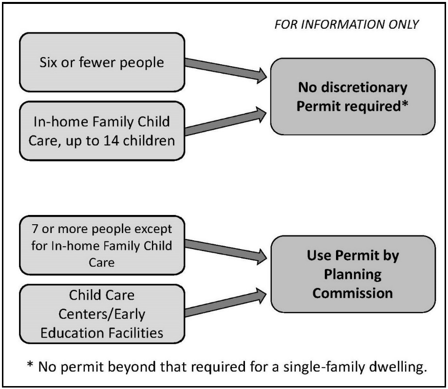
(Ord. No. 20-006, § 1, 7-28-20)
Sec. 7-9-95.3. - Congregate living health facilities.
Congregate living health facilities licensed by the State pursuant to Section 1250 of the Health and Safety Code, as may be amended, are permitted subject to compliance with the applicable development standards of the district, planned community or specific plan, and the following requirements:
(a)
A congregate living health facility serving six (6) or fewer persons shall be permitted in any district, planned community, or specific plan area zoned for residential or agricultural uses and shall be regarded as a single-family dwelling for purposes of zoning and land use regulations.
(b)
A congregate living health facility serving from seven (7) to a maximum of twelve (12) persons shall be permitted in any district, planned community, or specific plan area zoned for residential or agricultural uses subject to the issuance of a Use Permit by the Planning Commission pursuant to section 7-9-125. A congregate living health facility shall:
(1)
Demonstrate compatibility with adjacent development and land uses.
(2)
Provide adequate on site parking for the number of residents and staff.
(3)
Provide adequate screening of the facility by landscaping and/or fencing and useable open space in compliance with the requirements of these regulations.
(4)
Comply with signage and lighting requirements applicable to the district, planned community, or specific plan area where the facility is located.
(c)
A congregate living health facility serving more than twelve (12) persons may be permitted in any district, planned community, or specific plan area zoned for either multifamily residential or hotels subject to the approval of a Use Permit by the Planning Commission pursuant to section 7-9-125.
(d)
Units contained in any congregate living health living facility shall not be considered "dwelling units" and shall not be subtracted from the total number of allowed dwelling units for a planned community or specific plan area.
(Ord. No. 20-006, § 1, 7-28-20)
Sec. 7-9-95.4. - Alcoholism or drug abuse recovery/treatment facilities.
(a)
Alcoholism or drug abuse recovery/treatment facilities serving six (6) or less persons shall be permitted in any district, planned community, or specific plan area zoned for any residential uses.
(b)
Alcoholism or drug abuse recovery/treatment facilities serving seven (7) or more persons shall be permitted in any district, planned community, or specific plan area zoned for multifamily residential uses subject to the issuance of a Use Permit by the Planning Commission per section 7-9-125, subject to the following condition:
(1)
The alcoholism or drug abuse recovery/treatment facility serving seven (7) or more persons shall be located at least one thousand (1,000) feet, as measured from the closest property lines, from any sober living home, or from any other state-licensed and/or certified alcoholism or drug abuse recovery/treatment facility serving seven (7) or more persons, unless the reviewing authority determines that such location will not result in an over-concentration of similar uses.
(Ord. No. 20-006, § 1, 7-28-20)
Sec. 7-9-95.5 - Child Day Care Facilities.
(a)
In-home family child care, small. Licensed child care provided within a dwelling unit which provides day care for up to eight (8) children, less than eighteen (18) years of age, including children who reside at the home and shall be permitted in any district, planned community, or specific plan area zoned for residential or agricultural uses.
(b)
In-home family child care, large. Licensed child care provided within a dwelling unit which provides day care for up to fourteen (14) children, less than eighteen (18) years of age, including children who reside at the home and shall be permitted in any district, planned community, or specific plan area zoned for residential or agricultural uses.
(c)
Child care centers/early education facilities. Child care centers and/or early education facilities serving more than fourteen (14) persons may be permitted in any district, planned community, or specific plan area (except in designated airport accident potential zones) where this use is not otherwise identified as a permitted use, subject to the approval of a Use Permit by the Planning Commission per section 7-9-125.
(Ord. No. 20-006, § 1, 7-28-20)
Sec. 7-9-95.6 - Group homes.
Purpose. This section is intended to preserve the residential character of residential neighborhoods and to further the purposes of the California Fair Employment and Housing Act (FEHA), the Fair Housing Act Amendments (FHAA), and the Lanterman Act by, among other things: (1) ensuring that group homes are entitled to the special accommodation and/or additional accommodation provided under the Orange County Codified Ordinances; (2) limiting the secondary impacts of group homes by reducing noise and traffic, preserving safety, and providing adequate on-street parking; (3) providing an accommodation for the handicapped that is reasonable to the opportunities afforded nonhandicapped individuals to use and enjoy a dwelling unit in a single-family neighborhood; and (4) to provide comfortable living environments that will enhance the opportunity for the handicapped and for recovering addicts to be successful in their programs.
(a)
Group Home Permit required. A group home that may otherwise be considered an unpermitted use shall be permitted in any district, planned community, or specific plan area zoned for residential districts with a Group Home Permit provided:
(1)
An application for a group home is submitted to the Director by the owner/operator of the group home. The application shall provide the following: (1) the name, address, phone number and driver's license number of the owner/operator; (2) the name, address, phone number and driver's license number of the house manager; (3) a copy of the group home rules and regulations; (4) written intake procedures; (5) the relapse policy; (6) an affirmation by the owner/operator that only residents (other than the house manager) who are handicapped as defined by state and federal law shall reside at the group home; (7) blank copies of all forms that all residents and potential residents are required to complete; (8) if the group home operator is not the property owner, written approval from the property owner to operate a group home shall be submitted with the application; and (9) any applicable fee or deposit as approved by the Orange County Board of Supervisors. No person shall open a group home prior to issuance of a Group Home Permit.
(2)
If the group home is located in a single-family residential district, the group home shall have six (6) or fewer residents, not counting a house manager, but in no event shall have more than seven (7) residents. If the dwelling unit has an accessory dwelling unit, residents of both units shall be combined to determine whether or not the limit of six (6) residents has been exceeded.
(3)
The group home shall not be located in an accessory dwelling unit unless the primary dwelling unit is used for the same purpose.
(4)
The group home shall have a house manager who resides at the group home or any multiple of persons acting as a house manager who are present at the group home on a 24-hour basis and who are responsible for the day-to-day operation of the group home.
(5)
All garage and driveway spaces associated with the dwelling unit shall, at all times, be available for the parking of vehicles. Residents and the house manager may each only store or park a single vehicle at the dwelling unit or on any street within three hundred (300) feet of the dwelling unit. The vehicle shall be operable and currently used as a primary form of transportation for a resident of the group home.
(6)
Residents shall not require and operators shall not provide "care and supervision" as those terms are defined by Section 80001(c)(3) of title 22, California Code of Regulations, as may be amended.
(7)
Integral facilities shall not be permitted. Applicants shall declare, under penalty of perjury, that the group home does not operate as an integral facility.
(8)
The property shall be fully in compliance with all building codes, codified ordinances, and Zoning Code of the County of Orange.
(9)
At least forty-eight (48) hours prior to a resident's emergency eviction from or involuntary termination of residency in a group home, the operator shall:
a.
Notify the person designated as the resident's emergency contact or contact of record that the resident will no longer be residing at the home.
b.
Contact the Orange County Health Care Agency OC Links Referral Line and/or another entity designated by the County to determine the services available to the resident, including, but not limited to, alcohol and drug inpatient and outpatient treatment.
c.
Provide the information obtained regarding services available to the resident (see paragraph (9)b. of this subsection) and any other treatment provider or service to the resident prior to his or her release on a form provided by the County and obtain the resident's signed acknowledgement thereon.
d.
Provided, however, that if the resident's behavior results in immediate termination of residency pursuant to rules approved by the County as part of the Group Home Permit for that facility, the operator shall comply with paragraphs a. through c. of subsection (a)(9) as soon as possible.
(10)
Prior to a resident's eviction from or involuntary termination of residency in a group home, the operator thereof shall also:
a.
Make available to the resident transportation to the address listed on the resident's driver license, state-issued identification card, or the permanent address identified in the resident's application or referral to the group home.
b.
Provided, however, that should the resident decline transportation to his or her permanent address or otherwise has no permanent address, then the operator shall make available to the resident transportation to another group home or residential care facility that has agreed to accept the resident.
(11)
The group home operator shall maintain records for a period of one (1) year following eviction from or involuntary termination of residency of an resident that documents compliance with subsections (a)(9) and (a)(10) of this section; provided, however, that nothing herein shall require an operator of a group home to violate any provision of State or Federal law regarding confidentiality of health care information. The group home operator may not satisfy the obligations set forth in subsection (a)(11) of this section by providing remuneration to the resident for the cost of transportation.
(12)
In addition to the regulations outlined above, in subsections (a)(1) through (a)(11) of this section, the following shall also apply to sober living homes:
a.
The sober living home shall not be located within one thousand (1,000) feet, as measured from the closest property lines, of any other sober living home or from any state licensed and/or certified alcoholism or drug abuse recovery/treatment facility.
b.
All residents, other than the house manager, shall be actively participating in legitimate recovery programs, including, but not limited to, Alcoholics Anonymous or Narcotics Anonymous, and the sober living home shall maintain current records of meeting attendance. Under the sober living home's rules and regulations, refusal to actively participate in such a program shall be cause for eviction.
c.
The sober living home's rules and regulations shall prohibit the use of any alcohol or any non-prescription drugs at the sober living home or by any resident either on- or off-site. The sober living home shall also have a written policy regarding the possession, use, and storage of prescription medications. The facility cannot dispense medications but shall make them available to the residents. The possession or use of prescription medications is prohibited except for the person to whom they are prescribed, and in the amounts/dosages prescribed. These rules and regulations shall be posted on-site in a common area inside the dwelling unit. Any violation of this rule shall be cause for eviction under the sober living home's rules for residency and the violator cannot be re-admitted for at least ninety (90) days. Any second violation of this rule shall result in permanent eviction. Alternatively, the sober living home shall have provisions in place to remove the violator from contact with the other residents until the violation is resolved.
d.
The number of residents subject to the sex offender registration requirements of Penal Code Section 290, as may be amended, shall not exceed the limit set forth in Penal Code Section 3003.5, as may be amended, and shall not violate the distance provisions set forth in Penal Code Section 3003, as may be amended.
e.
The sober living home shall have a written visitation policy that shall preclude any visitors who are under the influence of any drug or alcohol.
f.
The sober living home shall have a good neighbor policy provided as part of the group home application that shall direct residents to be considerate of neighbors, including refraining from engaging in excessively loud, profane, or obnoxious behavior that would unduly interfere with a neighbor's use and enjoyment of their dwelling unit. The good neighbor policy shall establish a written protocol for the house manager/operator to follow when a neighbor complaint is received.
g.
The sober living home shall not provide any of the following services as they are defined by Section 10501(a) of Title 9, California Code of Regulations, as may be amended: detoxification; educational counseling; individual or group counseling sessions; and treatment or recovery planning.
(13)
An applicant for a Group Home Permit may seek relief from the strict application of this section by submitting an application to the Director setting forth specific reasons as to why accommodation over and above this section is necessary under State and Federal laws, pursuant to Section 7-9-129.
(b)
The Group Home Permit shall be issued by the Director as a ministerial matter if the applicant is in compliance or has agreed to comply with subsections (a)(1) through (a)(11) above, and (a)(12), if applicable. The Group Home Permit shall be denied or revoked, by the Director under any of the following circumstances:
(1)
Any owner/operator or staff person has provided materially false or misleading information on the application or omitted any pertinent information.
(2)
Any owner/operator or staff person has an employment history in which he or she was terminated during the past two (2) years because of physical assault, sexual harassment, embezzlement or theft; falsifying a drug test; and selling or furnishing illegal drugs or alcohol.
(3)
Any owner/operator or staff person has been convicted of or pleaded nolo contendere, within the previous seven (7) to ten (10) years, to any of the following offenses:
a.
Any sex offense for which the person is required to register as a sex offender under California Penal Code Section 290, as may be amended, (previous ten (10) years).
b.
Arson offenses violations of Penal Code Sections 451-455, as may be amended, (previous seven (7) years.
c.
Violent felonies, as defined in Penal Code Section 667.5, as may be amended, which involve doing bodily harm to another person (previous ten (10) years).
d.
The unlawful sale or furnishing of any controlled substances (previous seven (7) years).
(4)
Any owner/operator or staff person is on parole or formal probation supervision on the date of the submittal of the application or at any time thereafter.
(5)
The owner/operator accepts residents, other than a house manager, who are not handicapped as defined by the FHAA and FEHA.
(6)
A Group Home Permit for a sober living home shall also be denied or revoked by the Director under any of the following additional circumstances:
a.
Any owner/operator or staff person of a sober living home is a recovering drug or alcohol abuser and upon the date of application or employment has had less than one (1) full year of sobriety.
b.
The owner/operator of a sober living home fails to immediately take measures to remove any resident who uses alcohol or illegally uses prescription or non-prescription drugs, or who is not actively participating in a legitimate recovery program from contact with all other sober residents.
c.
The sober living home, as measured from the closest property lines, shall not be located within one thousand (1,000) feet of any other sober living home or state licensed and/or certified alcoholism or drug abuse recovery/treatment facility. If a state licensed and/or certified alcoholism or drug abuse recovery/treatment facility moves within one thousand (1,000) feet of an existing sober living home this shall not cause the revocation of the sober living home's permit.
(7)
For any other significant and/or repeated violations of this section and/or any other applicable laws and/or regulations.
(8)
Revocation shall not apply to any group home, which otherwise would cause it to be in violation of this section, that has obtained a reasonable accommodation pursuant to section 7-9-129.
(c)
Use Permit Required. Group and sober living homes serving more than seven (7) persons shall be permitted in any district, planned community, or specific plan area zoned for multifamily residential uses subject to the issuance of a Use Permit by the Planning Commission per section 7-9-125, subject to the following condition:
(1)
Sober living homes shall be located at least one thousand (1,000) feet, as measured from the closest property lines, from any other sober living home, or from any state-licensed and/or certified alcoholism or drug abuse recovery/treatment facility serving seven (7) or more persons, unless the reviewing authority determines that such location will not result in an over-concentration of similar uses.
(d)
Compliance of existing group homes.
(1)
Existing group homes shall apply for a Group Home Permit within ninety (90) days of the effective date of the group home regulations.
(2)
Existing group homes shall have one (1) year from the effective date of the group home regulations to comply with its provisions, provided that any existing group home, which is serving more than six (6) residents, shall first comply with the six (6) resident maximum.
(3)
Existing group homes obligated by a written lease exceeding one (1) year from the effective date of the ordinance, or whose activity involves investment of money in leasehold or improvements such that a longer period is necessary to prevent undue financial hardship, are eligible for up to one (1) additional year grace period pursuant to approval of a Group Home Permit.
(e)
Expiration.
(1)
A Group Home Permit shall expire and be of no further force or effect if after establishment, the use or activity for which the permit was approved is discontinued or abandoned for a period of six (6) months.
(Ord. No. 20-006, § 1, 7-28-20)
Sec. 7-9-96. - Health Care facilities.
Health care facilities are licensed by the State and include facilities that provide outpatient treatment to patients and those facilities that provide care to patients admitted for a 24-hour stay or longer.
(a)
Pursuant to Health and Safety Code Section 1200, as may be amended, a "clinic" means an organized health facility that provides direct medical, surgical, dental, optometric, or podiatric services, or treatment, to patients who remain less than 24 hours. This includes primary care clinics such as community clinics and free clinics, and specialty clinics such as surgical clinics, chronic dialysis clinics, rehabilitation clinics, and alternative birth centers.
(b)
Pursuant to Health and Safety Code Section 1250, as may be amended, a "health facility" means a facility, place, or building that is organized, maintained, and operated for the diagnosis, care, prevention, and treatment of human illness for one (1) or more persons, and to which persons may be admitted for a 24-hour stay or longer. This includes general acute care hospitals ("hospitals"), skilled nursing facilities, hospices, congregate living health facilities, and intermediate care facilities.
Health care facilities are licensed by the State. These facilities provide treatment on an outpatient basis, or care to patients admitted for a 24-hour stay or longer. This includes acute care hospitals, urgent care clinic, primary care clinics, other clinics, skilled nursing facilities, and hospices.
(Ord. No. 20-006, § 1, 7-28-20)
Sec. 7-9-98. - Senior living facilities.
A senior living facility may be permitted in any district, planned community, or in any specific plan area zoned for multifamily residential or commercial uses subject to compliance with the applicable standards of the district and the following requirements:
(a)
The approval of a Use Permit by the Planning Commission per section 7-9-125, unless otherwise authorized by an administrative Site Development Permit in accordance with the base district regulations. Development standards shall be per the base district, unless the decision-making body makes the appropriate findings to approve a modified development standard.
(b)
Each senior living facility Use Permit or Site Development Permit application shall be reviewed on a case-by-case basis and shall:
(1)
Demonstrate compatibility with adjacent development;
(2)
Provide a parking study that shall be used to determine if a modification to the base district parking standards shall be necessary to accommodate the anticipated traffic generation and on-site parking demand of the residents, staff, employees and guests of the type and size of facility proposed.
(3)
Provide the location of all services (including the dining hall, commercial kitchen, gift shop, salon, fitness center, meeting rooms, etc.) and how they are to be accessed by residents and non-residents, including deliveries, and including universal design features in compliance with the Americans with Disabilities Act (ADA).
(c)
Units contained in any senior living facility shall not be considered "dwelling units" and shall not be subtracted from the total number of allowed dwelling units for a planned community or specific plan area.
(Ord. No. 20-006, § 1, 7-28-20)
Sec. 7-9-100. - Community gardens.
In addition to the requirements for each district, the following performance and development standards shall apply to the establishment and operation of community gardens in any district in which they are permitted:
(a)
Lot. The lot shall be vacant with no minimum lot size required. The community garden shall be the primary use on the lot which it is located.
(b)
Accessorystructures. Accessory structures are limited to storage sheds, plant cultivation structures (greenhouses, hoophouses. and cold frames), benches, bike racks, raised planting beds, compost or waste bins, picnic tables, fences, and rain barrel systems. Individual structures shall not exceed one hundred twenty (120) square feet in size or twelve (12) feet in height. The combined area of all structures shall not exceed fifteen percent (15%) of the garden area. All structures shall meet the setback requirements of the underlying zoning district and section 7-9-61.
(c)
Fencing. Community gardens shall be fenced in accordance with the site development standards of the underlying zoning district. Fencing in the front setback shall be transparent.
(d)
Signs. One (1) sign per street frontage is permitted. Signs shall not exceed four (4) square feet of sign face area and shall not exceed six (6) feet in height. The sign shall include a contact telephone number and/or contact e-mail address/website address for the garden coordinator. No advertising for garden sponsors, donors, supporters, suppliers, etc. is permitted on site.
(e)
Water.
(1)
A metered water supply connection shall be provided.
(2)
Sprinkler systems are prohibited: all watering shall be by hose or watering can. Informational materials supplied by the garden coordinator to plot holders shall include advice on water conservation, mulching, effective watering techniques, etc.
(f)
Compost. Compost materials shall be stored within an enclosed container at least three (3) feet from adjacent property in a manner that is not visible from adjacent property, limits odor, prevents infestation, and meets state water quality/runoff management requirements.
(g)
Trash. A suitably sized trash receptacle shall be placed on-site.
(h)
Outdoor lighting. No outdoor lighting is permitted.
(i)
Operational standards.
(1)
Allowable uses include the cultivation of fruits, vegetables, plants, flowers, or herbs. The cultivation of cannabis and any other plant prohibited by State and/or Federal law are prohibited.
(2)
Gardening activities shall be conducted between the hours of 7:00 a.m. to dusk.
(3)
Mechanized tools (tillers, trimmers, etc.) or flame-producing tools are prohibited.
(4)
On-site sales of produce or any other items are prohibited.
(5)
The site shall be designed and maintained so that water and fertilizer shall not drain onto adjacent property or the public right-of-way.
(6)
No synthetic pesticides or herbicides shall be used.
(7)
No fresh manure shall be used.
(8)
Entrance gates (if any) shall be secured with a key or combination lock.
(9)
Rules and regulations. A bulletin board (or similar) shall be erected on the site listing the rules and regulations that apply to garden users. The bulletin board shall not be visible from the public right of way to minimize the risk of vandalism.
(10)
Maintenance. Garden areas shall be maintained in good condition to prevent overgrown plots, unmaintained common areas, accumulation of trash, blight, and other nuisances.
(Ord. No. 20-006, § 1, 7-28-20)
Sec. 7-9-101. - Farmers' markets.
In addition to the requirements for each district, the following performance and development standards shall apply to the establishment and operation of farmers' markets in any district in which they are permitted:
(a)
Application requirements. A farmer's market shall not be subject to section 7-9-117.9, "Special Gathering." A temporary Use Permit is required for open air markets that shall be held no more than four (4) times per year. Ongoing open air farmers' markets are permitted subject to the approval of a Site Development Permit and compliance with all applicable requirements of this section.
(b)
Operator. The market operator and/or individual vendors shall secure all necessary licenses, certificates and health permits, and all agricultural products shall meet all pertaining health and safety standards.
(c)
Management plan. A management plan shall be submitted as part of the approval of a Site Development Permit, including the following:
(1)
Identification of (a) market manager(s), who shall be present during all hours of operation.
(2)
A set of operating rules addressing the governance structure of the market; the method of assigning booths and registering vendors; hours of operation; maintenance; security; refuse collection; and parking.
(d)
Off-street parking. One (1) vehicle parking space per vendor shall be provided in the parking area. Alternative parking arrangements, including shared parking, may be considered by the Director in determining whether sufficient parking is provided.
(e)
Hours of operation. Market activities shall be conducted between the hours of 7:00 a.m. and 8:00 p.m. Set-up and clean-up and take-down shall occur between 6:00 a.m. and 9:00 p.m.
(f)
Waste disposal. Adequate composting, recycling, and trash containers shall all be covered, provided during hours of operation, and shall be removed from site for appropriate disposal. The site shall be cleaned at the end of each day of operations, including the removal of all stalls and debris.
(g)
Performances. Live musical and other performances may be approved with appropriate permits; a temporary Use Permit for one-time events or a Site Development Permit for ongoing events.
(Ord. No. 20-006, § 1, 7-28-20)
Sec. 7-9-102. - Fruit and vegetable gardening
These regulations are provided to encourage the establishment of private gardens that are harmonious with the residential neighborhood in which they are located.
(a)
Flower, fruit and vegetable gardening is allowed in all residential districts subject to the following performance and development requirements.
(1)
Gardens and gardening are allowed anywhere on the subject property unless otherwise prohibited.
(2)
Prepared foods produced by cottage food operations utilizing produce grown on site shall not be sold on-site.
(3)
All activities associated with the on-site growing, harvesting, and selling of produce shall be completely contained on the subject property. No related activities shall be located in part or whole on any public or private right-of-way area, including but not limited to sidewalks, streets, or parkways.
(b)
On-site sales, temporary signs and displays are allowed, subject to the following rules and regulations and applicable Federal, State and local regulations.
(1)
Only produce grown on-site shall be sold on-site by those who reside at the subject property.
(2)
Produce shall only be sold whole and raw.
(3)
The sale of produce shall only take place on the weekend, and federal holidays during daylight hours.
(4)
The sign shall only remain posted during the time the produce is for sale.
(5)
Signage shall be limited to one (1) temporary sign located on-site not to exceed six (6) square feet in area.
(6)
Any sign posted on a structure shall not exceed a maximum height of six (6) feet measured to the top of the sign.
(7)
The sale of produce shall be conducted within a maximum area of one hundred (100) square feet.
(8)
Any structures associated with sale of produce shall not exceed eight (8) feet in height.
(9)
The sign and any structures associated with the sale of produce shall be visible only during the sale of produce.
(c)
Compost materials shall be contained in a manner that is not visible from the adjacent property, limits odor, prevents infestation, and meets state water quality/runoff management requirements while ensuring proper ventilation to prevent any fire hazards.
(d)
The outdoor cultivation of cannabis is prohibited pursuant to the County of Orange Commercial Cannabis Activities and Outdoor Personal Cultivation Prohibition Ordinance.
(Ord. No. 20-006, § 1, 7-28-20)
Sec. 7-9-103. - County of Orange commercial cannabis activities and outdoor personal cultivation prohibition ordinance.
(a)
Definitions. For the purposes of this section, the following definitions shall apply:
(1)
"Cannabis" or "Marijuana" means all parts of the plant Cannabis sativa Linnaeus, Cannabis Indica, or Cannabis ruderalis, whether growing or not; the seeds thereof; the resin, whether crude or purified, extracted from any part of the plant; and every compound, manufacture, salt, derivative, mixture, or preparation of the plant, its seeds, or resin. "Cannabis" also means the separated resin, whether crude or purified, obtained from cannabis. "Cannabis" also means marijuana as defined by Section 11018 of the Health and Safety Code, as may be amended, as enacted by Chapter 1407 of the Statutes of 1972. The term "cannabis" shall also have the same meaning as set forth in Section 19300.5(f) of the California Business and Professions Code, as may be amended from time to time. "Cannabis" does not include the mature stalks of the plant, fiber produced from the stalks, oil or cake made from the seeds of the plant, any other compound, manufacture, salt, derivative, mixture, or preparation of the mature stalks (except the resin extracted therefrom), fiber, oil, or cake, or the sterilized seed of the plant which is incapable of germination. For the purpose of this chapter, "cannabis" does not mean "industrial hemp" as defined by Section 81000 of the Food and Agricultural Code or Section 11018.5 of the Health and Safety Code, as may be amended.
(2)
"Cannabis cultivation" shall mean any activity involving the planting, growing, harvesting, drying, curing, grading, or trimming of cannabis, and shall also include the possession, manufacturing, processing, storing, laboratory testing, transporting, distribution, delivery, or sale of cannabis, whether all or any combination of those activities, and whether for medical or non-medical purposes or sale.
(3)
"Cannabis dispensary" shall mean a facility or location, whether fixed or mobile, where cannabis or cannabis products are offered, made available to, or provided, either individually, or in any combination, with or without remuneration, for medical purposes or otherwise. A dispensary includes those facilities defined as "dispensary" by Business and Professions Code section 19300.5, as enacted, or as hereafter amended. Cannabis dispensary or marijuana dispensary shall also mean "Retailer" and "Distributor" and "Microbusiness" as defined by Business and Professions Code section 26070, as enacted, or as hereafter amended.
(4)
"Commercial Cannabis activity" includes the cultivation, manufacture, distribution, processing, storing, laboratory testing, packaging, labeling, transportation, delivery or sale of cannabis and cannabis products whether for medical or non-medical purposes.
(5)
"Commercial cannabis cultivation" or "Commercial marijuana cultivation" shall mean cannabis cultivation, as defined in this section, for commercial use or purposes, and whether for medical or non-medical purposes. For the purpose of this subsection, "processing" (as contained in the definition of cannabis cultivation) shall mean any method used to prepare cannabis or its by-products for commercial retail and/or wholesale sale, including without limitation drying, cleaning, curing, packaging, and extraction of active ingredients to create cannabis products or cannabis-related products and concentrates.
(6)
"Cannabis products" shall mean cannabis that has undergone a process whereby the plant material has been transformed into concentrate, including, but not limited to, concentrated cannabis, edible or topical product containing cannabis or concentrated cannabis and other ingredients.
(7)
"Delivery" shall mean the commercial transfer of cannabis or cannabis products to a customer whether for medical or non-medical purposes. "Delivery" also includes the use by a retailer of any technology platform owned and controlled by the retailer.
(8)
"Distribution" means the procurement, sale, and transport of cannabis and cannabis products between licensees whether for medical or non-medical purposes.
(9)
"License" means a state license issued under the Medicinal and Adult-Use Cannabis Regulation and Safety Act, Business and Professions Code, section 26000, et seq, as may be amended.
(10)
Manufacture means to compound, blend, extract, infuse, or otherwise make or prepare a cannabis product whether for medical or non-medical purposes.
(11)
"Manufacturer" means the production, preparation, propagation, or compounding of cannabis or cannabis products either directly or indirectly or by extraction methods, or independently by means of chemical synthesis, or by a combination of extraction and chemical synthesis at a fixed location that packages or repackages cannabis or cannabis products, or labels or relabels its container.
(12)
"Operation" means any act encompassing commercial cannabis activity, as defined herein, or any commercial transfer of cannabis or cannabis products.
(13)
"Personal cannabis cultivation" or "Personal marijuana cultivation" shall mean cannabis cultivation for personal use, medicinal use, or purposes in accordance with all applicable State laws.
(14)
"Testing Laboratory" means a laboratory, facility or entity that offers or performs tests of cannabis or cannabis products.
(b)
Prohibited activities.
(1)
A cannabis dispensary, as defined in this chapter, is expressly prohibited and not an allowable activity within any zoning district within unincorporated areas of Orange County.
(2)
Commercial cannabis cultivation, as defined in this chapter, is expressly prohibited and not an allowable activity within any zoning district within unincorporated areas of Orange County.
(3)
Delivery services shall not locate their distribution center within any zoning district within unincorporated areas of Orange County.
(4)
A Manufacturer, as defined in this chapter, is expressly prohibited and not an allowable activity within any zoning district within unincorporated areas of Orange County.
(5)
Testing Laboratories, as defined in this chapter, are expressly prohibited and not an allowable activity within any zoning district within unincorporated areas of Orange County.
(6)
Personal cannabis cultivation, as defined in this chapter, shall not exceed the number of living plants permitted by California Health and Safety Code Sections 11362.1 and 11362.2, as may be amended. Personal cannabis cultivation is limited solely to inside a person's private residence, or inside an accessory structure to a private residence located on the grounds of the private residence, that is fully enclosed and secure. Personal cannabis cultivation is expressly prohibited outdoors upon the grounds of any private residence or any other outdoor location within unincorporated.
(c)
Public Nuisance. Any activity or condition caused, or permitted to exist, in violation of any provision of this chapter shall be, and is hereby declared to be, a public nuisance and may be summarily abated by the County pursuant to Section 731, as may be amended, of the California Code of Civil Procedure or any other remedy available at law.
(d)
Violations.
(1)
In addition to any other remedies permitted by this chapter or available at law, the County Counsel may bring a civil action for injunctive relief and civil penalties against any person who violates any provision of this chapter. In any civil action that is brought pursuant to this chapter, a court of competent jurisdiction may award civil penalties and costs to the prevailing party.
(2)
Any violation of this chapter shall be a misdemeanor, punishable as provided by State law.
(Ord. No. 20-006, § 1, 7-28-20)
Sec. 7-9-104. - Home occupations.
In addition to the requirements for each district, the following performance and development standards shall apply to the establishment and operation of home occupations in any district in which they are permitted:
(a)
Purpose and intent: These regulations are provided so that certain incidental and accessory uses may be established in residential neighborhoods under conditions that shall ensure their compatibility with the neighborhood. They are intended to protect the rights of the residents to engage in certain home occupations that are harmonious with a residential environment.
(b)
Home occupations permitted: Home occupations are permitted when conducted as an accessory use to a residential use in any district that specifies home occupations as a permitted use, subject to the requirements of subsection (c) of this section.
(c)
General requirements: The establishment and conduct of home occupations shall comply with the following requirements.
(1)
A cottage food operation shall comply with all applicable State regulations and shall not sell any prepared foods on-site.
(2)
Microenterprise home kitchen operations, if authorized by the County Board of Supervisors, shall comply with all local regulations established by the Orange County Health Care Agency pursuant to State law.
(3)
There shall be no exterior evidence of the conduct of a home occupation.
(4)
A home occupation shall be conducted only within the enclosed living area of the dwelling unit.
(5)
A home occupation shall not generate any offensive or objectionable noise, dust, vibration, smell, smoke, heat, glare, or radiation. Electrical or mechanical equipment, which creates visible or audible interference in radio or television receivers or causes fluctuations in line voltage outside the dwelling unit shall be prohibited.
(6)
A home occupation shall not have more than one (1) client on the premises at any given time.
(7)
The establishment and conduct of a home occupation shall not change the principal character or use of the dwelling unit involved.
(8)
There shall be no signs.
(9)
Required residential off-street parking shall be maintained.
(10)
A home occupation shall not create greater vehicular or pedestrian traffic than normal for the district in which it is located.
(11)
Distribution, transporting, manufacturing, cultivating or delivery of cannabis or cannabis products from the home is not permitted as a home occupation.
(Ord. No. 20-006, § 1, 7-28-20)
Sec. 7-9-105. - Pets and animals.
The keeping of domestic pets and animals is permitted subject to the following requirements.
(a)
Permitted in all residential and agricultural zones subject to all applicable County, State, and Federal regulations.
(b)
Pursuant to section 4-1-76, a maximum of three (3) dogs and a maximum of three (3) cats, over the age of four (4) months is permitted on each lot unless an animal permit issued by the County has been obtained.
(c)
Crowing fowl shall only be allowed on lots or parcels zoned as A1 "General Agriculture."
(d)
In addition to the required setbacks in sections 7-960, and 7-9-116, pens, cages, and other structures specifically for keeping birds or animals, other than in the residence, shall be located at least twenty-five (25) feet from any residential window located on an adjoining building site.
(e)
Exceptions to the provisions of subsections (c) and (d) above shall require a Site Development Permit.
(f)
The types, number and manner in which pets and animals are kept shall comply with provisions of this Zoning Code and any other requirements imposed by the County Health Officer or the Director of OC Community Resources.
(Ord. No. 20-006, § 1, 7-28-20)
Sec. 7-9-106. - Animal hospitals and clinics.
In addition to the requirements of each district, the following performance and development standards shall apply to the establishment, maintenance and operation of animal hospitals and clinics in any district in which they are permitted:
(a)
All animal service and confinement areas shall be in an air conditioned and sound-attenuated building.
(b)
Air conditioning shall be sound attenuated so as to minimize noise from within the building.
(1)
Facilities for housing of not less than five (5) animals shall be maintained on-site.
(2)
Runs shall be in an air-conditioned and sound-attenuated building.
(3)
All facilities for treatment and confinement of animals shall be designed, installed, or constructed and maintained in a manner meeting the approval of the Director.
(Ord. No. 20-006, § 1, 7-28-20)
Sec. 7-9-107. - Electric vehicle charging stations.
The installation and operation of electric vehicle charging stations shall comply with the applicable California Building Code(s) and shall be approved by the Building Official.
(Ord. No. 20-006, § 1, 7-28-20)
Sec. 7-9-108. - Small wind energy systems.
The purpose of this section is to promote distributed generation small wind energy systems while providing for minimum site performance and development standards that safeguard the environment and adjacent properties. In addition to the requirements for each district, the following performance and development standards shall apply to the installation of small wind energy systems. The intent is to provide standards for the safe and effective construction of small wind energy systems for on-site home, commercial, and agricultural use within non-urbanized areas.
A small wind energy system may be installed only on parcels located outside "urbanized" areas, i.e., within the "non-urbanized" area. "Urbanized area" is defined in accordance with Government Code Section 65944(d)(2), as may be amended, as one (1) of the following: an urbanized area as defined in paragraph (2) of subdivision (d) of Section 65944, as may be amended; or a county as defined in Section 56023, as may be amended, and as depicted on the County's Map of Non-Urbanized Areas. The applicant may submit demographic information from a reputable source demonstrating that the system shall be located in a non-urbanized area subject to the approval of the Director. A "small wind energy system" or "system" is defined as a wind energy conversion system consisting of a wind turbine, a tower, and associated control or conversion electronics that has a rated capacity of not more than fifty (50) kilowatts (kw) per customer site, consistent with the requirements of Public Resources Code Section 25744(b)(3), as may be amended, and that shall be used primarily to reduce on-site consumption of utility power.
(a)
Definitions.
(1)
Blade. The aerodynamic surface that catches the wind. Most commercial turbines have three blades.
(2)
Guy Wire. A tensioned cable designed to add stability to tall, narrow structures; frequently used to support wind turbines.
(3)
Tower. The base structure that supports and elevates a wind turbine rotor and nacelle.
(b)
Permitted use.
(1)
The installation of a small wind energy system of forty-five (45) feet or less shall be permitted in the non-urbanized area in any district subject to the approval of a Use Permit approved by the Zoning Administrator unless otherwise prohibited by any of the following: General plan, specific plan, planned community text, California Coastal Commission, a local coastal program; a land use plan adopted by Airport Land Use Commission; a Alquist-Priolo Earthquake Fault Zoning Act; a scenic highway plan; a conservation or open space easement; a protected open space agreement; a listing of the site in a historic register; or a Williamson Act contract.
(2)
The installation of a small wind energy system of more than forty-five (45) feet and up to eighty (80) feet shall be permitted in the non-urbanized area in any district subject to the approval of a Use Permit approved by the Planning Commission unless otherwise prohibited by any of the following: General plan, specific plan, planned community text, California Coastal Commission, a local coastal program; a land use plan adopted by Airport Land Use Commission; a Alquist-Priolo Earthquake Fault Zoning Act; a scenic highway plan; a conservation or open space easement; a protected open space agreement; a listing of the site in a historic register; or a Williamson Act contract.
(c)
Building site area. Minimum lot size shall be one (1) acre.
(d)
Height. For purposes of calculating height, the height shall mean the distance from the ground to the top of the blade in the vertical position. Maximum tower height shall be eighty (80) feet unless applicant can demonstrate to the satisfaction of the Director, that special circumstances exist that require a tower to be up to, but no more than, one hundred (100) feet in height. An application for a small wind energy system shall include evidence that proposed height of the tower does not exceed the height recommended by the manufacturer or distributor of the system. In no event shall the tower height exceed the applicable limits established by the Federal Aviation Administration (FAA).
(e)
Number of units.
(f)
Setback. Minimum setback for the system shall be at least two (2) times the height of the system from any property line. Minimum distance between towers shall be at least one and one-half (1.5) times the height of the taller tower. No part of the system, including guy wire anchors, shall extend closer than thirty (30) feet from any property line. The system shall also meet any fire setback requirements.
(g)
System. Wind turbine shall meet minimum ratings from the California Energy Commission (CEC) and the system shall comply with all FAA requirements. Application shall include system specifications, including electrical components, and may be required to include an acknowledgement from the electrical service provider of the proposed system.
(h)
Noise. The applicant shall demonstrate that the system shall be operated in such a manner as to comply with the requirements set forth in Title 4, Division 6 of the Codified Ordinances of the County of Orange, entitled "Noise Control."
(i)
Tower. Tower structure shall not have any climbing apparatus within the first twelve (12) feet from the ground and shall be designed to prevent climbing within the first twelve (12) feet from the ground. Tower and all associated system structures shall be treated with non-reflective colors to provide concealment of the facilities and to minimize visual disruption. No flags, streamers or decorative items shall be attached to system tower or turbine.
(j)
Wind turbine. The system shall use a wind turbine approved by the California Energy Commission (CEC) as qualifying under its Emerging Renewables Program pursuant to Public Resources Code Section 25744, as may be amended, or has been certified by a national program recognized and approved by the CEC.
(k)
The minimum distance between the ground and any part of the turbine blade shall be fifteen (15) feet.
(l)
Notice. Notice of the application shall be provided to property owners within three hundred (300) feet of the property line. Applicant may also be required to publish a public notice in a newspaper of general circulation. Systems proposed in agricultural areas shall require special notice to pest control aircraft.
(m)
If the proposed system is within one thousand (1,000) feet of a military installation, within special use airspace, or beneath a low-level flight path as defined by Public Resources Code Section 21098, the applicant shall comply with Section 65944, as may be amended.
(n)
The applicant shall comply with all FAA notice requirements for proposed systems within an Airport Planning Area, and shall notify the County Airport Land Use Commission (ALUC) which shall also review the application.
(o)
Visual effects. System shall not substantially obstruct views of adjacent property owners. No system shall be visible from a scenic highway or landscape corridor. System shall be placed or constructed so that the entire system is below any major ridgeline.
(p)
Signs. No sign shall be attached to the system, except for signs that identify the manufacturer, installer, or owner of the system; or public health and safety signs applicable to the installed system. Signs shall be no larger than four (4) square feet, unless approved by the decision-making body, and shall not be located at the base of the system within ten (10) feet of the ground.
(q)
Lighting. Tower structure lighting shall be prohibited unless required by the FAA, FCC or building code.
(r)
Landscaping. Landscaping shall be provided to screen accessory structures from roads and adjacent residences in compliance with section 7-9-71.
(s)
Inoperation. System shall be removed if inoperable for more than twelve (12) consecutive months.
(t)
Additional application requirements. The application shall include standard drawings and an engineering analysis of the system's tower, showing compliance with the current version of the Building Code and certification by a professional mechanical, structural or civil engineer licensed in the State of California. The application shall demonstrate that the system is designed to meet the most stringent wind requirements (Uniform Building Code wind exposure D), the requirements for the worst seismic class (Seismic 4), and the weakest soil class, with a soil strength of not more than one thousand (1,000) pounds per square foot. The application shall also include line drawings of the electrical components of the system in sufficient detail to allow for a determination that the manner of installation conforms to the National Electric Code.
(u)
Compliance with FAA requirements. The system shall comply with all applicable FAA requirements, including Subpart B (commencing with Section 77.11) of Part 77 of Title 14 of the Code of Federal Regulations regarding installations close to airports, and the State Aeronautics Act (Part 1 (commencing with Section 21001) of Division 9 of the Public Utilities Code), as may be amended. A system that complies with this subdivision shall be deemed to meet the applicable health and safety requirements regarding civil aviation.
(Ord. No. 20-006, § 1, 7-28-20)
Sec. 7-9-109. - Wireless communications facilities.
This section shall be referred to as the "County of Orange Wireless Communications Facilities on Private Property Ordinance."
(a)
Purpose. The purpose of this section is to provide a uniform and comprehensive set of standards for the development of wireless communications facilities and the installation of wireless antennas and related equipment on private property in the unincorporated area. The regulations contained herein are designed to protect and promote public health, safety, community welfare and aesthetic qualities of the unincorporated area. These regulations encourage managed development of wireless communications infrastructure while providing a public review process to ensure a balance between the community's concerns for aesthetics and location and the interest in establishing such facilities.
The purpose in regulating the development and siting of wireless communications facilities is to encourage economic development, preserve aesthetics and other community values and discourage proliferation of above-ground equipment. These regulations encourage collocation of wireless communications facilities, and require the use of natural and architectural screening in a manner that is compatible with the existing development policies and constraints that have been applied uniformly and historically throughout the unincorporated area.
The County of Orange Wireless Communications Facility Ordinance is limited to the County's review of the location and aesthetic development of wireless communications facilities and establishing reasonable time, place and manner limitations. these regulations comply with the Communications Act of 1934, as amended by the Telecommunications Act of 1996, applicable regulations of the Federal Communications Commission, and State law. these regulations are not intended to unduly restrict the development of necessary wireless communications facilities or conflict with existing public utility franchises.
(b)
Definitions.
Alternative Structure: Manmade trees, clock towers, utility structures and similar alternative-design mounting structures that conceal or minimize the presence of antennas, tower or support structure.
Antenna: One (1) or more rods, poles, panels, discs, dishes, or similar devices used to transmit, receive, or transmit and receive radio frequency signals or electromagnetic signals, including but not limited to an omni-directional antenna (whip), directional antenna (panel), and parabolic antenna (dish), but excluding any pole or antenna mount.
Base Station: The equipment and non-tower supporting structure at a fixed location that enable FCC-licensed or authorized wireless communications between user equipment and a communications network. A "non-tower support structure" means any structure (whether built for wireless purposes or not) that supports wireless transmission equipment.
California Public Utilities Commission (CPUC). An independent commission of the State of California that regulates all public utilities providing intrastate service within the State.
Camouflage. Incorporation of elements and/or techniques designed to mask or blend a wireless communications facility with the surrounding environment in such a manner to render it generally less noticeable to the casual observer. these types of facilities may include antennas located on ground mounted or building mounted antennas that blend with the surroundings and base station equipment screened by landscaping.
Collocation/Collocated. The placement or installation of wireless transmission equipment on an existing structure for the purpose of transmitting or receiving radio frequency signals for communications purposes. Collocated equipment may be separately owned and used by more than one person or entity.
Existing Structure. A tower or base station, utility structure, building or other existing object is an existing structure, for purposes of this section, if it has been reviewed and approved under the applicable County regulations or under another state or local regulatory review process. An existing structure need not be an existing wireless communications facility.
Federal Aviation Administration (FAA). The federal agency responsible for regulating civil aviation and air traffic control to promote safety.
Federal Communications Commission (FCC). The independent commission of the federal government with interstate jurisdiction over all matters pertaining to communications by wire or radio in the United States.
Height. The distance measured from the finished grade to the highest point on the tower or antenna, including the base pad and any antenna. In the case of a building tower, the height includes the portion of the building on which it is mounted. Towers that are adjustable in height shall be measured to the maximum height which the structure is capable of reaching.
Minor Change. Any modification to an existing wireless communications facility or any collocation to an existing structure that does not meet the definition of substantial modification.
Radio frequency (RF) emissions. Electromagnetic signals transmitted and received using wireless communications antenna(s).
Open Space District. Zoning District, or specific plan or planned community land use designation, which is intended to preserve natural resources and/or protect valuable, unique or sensitive environmental features.
Residential District. Zoning District, or specific plan or planned community land use designation, which has "single-family dwelling or mobilehome" as a principal permitted use.
Stealth. Wireless communications facility designed with concealment elements so visibility of any antenna or other transmission equipment associated with the facility is generally unnoticeable and so that the wireless facility fits into the context of its surroundings. By way of example, and not of limitation, a faux pine tree in an area with other natural pine trees would be considered stealth.
Substantial Change. Any modification to a wireless communications facility or any collocation to an existing structure that substantially changes the physical dimensions of the existing facility or structure. Shall have the same meaning as the term "substantial change" or "substantially change" as defined in Title 47, Code of Federal Regulations, section 1.40001(b)(7), as may be amended, which is any of the following criteria:
(1)
It increases the height of the tower by more than 10%, or by the height of one additional antenna array with separation from the nearest existing antenna not to exceed twenty feet, whichever is greater; it protrudes from the edge of the tower more than twenty feet, or more than the width of the tower structure at the level of the appurtenance, whichever is greater.
(2)
It involves installation of more than the standard number of new equipment cabinets for the technology involved, but not to exceed four cabinets.
(3)
It entails any excavation or deployment outside the current site of the tower or base station.
(4)
It would defeat the existing concealment elements of the tower or base station.
(5)
It does not comply with conditions associated with the prior approval of construction or modification of the tower or base station unless the non-compliance is due to an increase in height, increase in width, addition of cabinets, or new excavation that does not exceed the corresponding "substantial change" thresholds identified above.
Tower. Any structure built for the purpose of supporting any FCC-licensed or authorized antennas and their associated facilities.
Transmission Equipment. Any equipment that facilitates transmission for any FCC-licensed or authorized wireless communication service, including, but not limited to, radio transceivers, antennas and other relevant equipment associated with and necessary to their operation, including coaxial or fiber-optic cable, and regular and backup power supply.
Wireless Communications Facility (or Wireless Facility or Wireless Facilities). All equipment and other improvements installed for the purpose of providing wireless transmission of voice, data, images or other information, including, but not limited to, cellular phone service, personal wireless services, and paging services, consisting of equipment and network components, such as towers, utility poles, transmitters, base stations and emergency power systems. A wireless communications facility does not include on-site radio or television broadcast facilities.
(c)
Applicability.
(1)
This section applies to all permit applications to construct, install, collocate, or modify, and/or operate a wireless communications facility or transmission equipment received after the effective date of this section on private property.
(2)
This section shall not apply to:
a.
Any amateur radio antennas and related facilities subject to FCC PRB1 or California Government Code section 65850.3, as may be amended.
b.
Any Over-the-Air-Receiving-Devices ("OTARDs") as defined in 47 C.F.R. § 1.4000 et seq.
c.
Temporary Emergency Towers. Any applicant that seeks a permit to install a wireless communications facility necessary to protect public health, safety or welfare during an emergency shall submit an application for a temporary emergency-Use Permit no later than one (1) calendar day after the installation of such wireless communications facility. The Director may approve such temporary wireless facility without regard for the other provisions in this section for no more than thirty (30) days. The owner of any wireless communications facility installed pursuant to this subsection shall immediately remove such facility at the end of the thirty (30) day period or the conclusion of the emergency, whichever occurs first. The County may remove any wireless communications facility installed pursuant to this subsection at the owner's cost immediately at the end of the thirty (30) day period or the conclusion of the emergency, whichever occurs first. No predictable or prior-scheduled event, including without limitation, any sporting event, entertainment event or civic event, constitutes an "emergency" for the purposes of this section.
d.
Wireless facilities or equipment owned and operated by CPUC-regulated electric companies for use in connection with electrical generation, transmission and distribution facilities subject to CPUC General Order 131-D.
(d)
Permitted Use. Subject to the provisions of this section, the construction, installation, collocation, modification and/or operation of a wireless communications facility or transmission equipment shall be permitted in any district, including Specific Plan areas and Planned Communities. This section shall not apply to private property in those Specific Plan areas and Planned Communities in which the Board of Supervisors adopted or approved wireless communications facility standards prior to the effective date of this ordinance.
(e)
Approvals Required for Wireless Communications Facilities. In a residential or open space district, or when within one hundred (100) feet of a residential or open space district as measured from the parcel line, new wireless communications facilities and substantial changes to an existing tower or existing structure shall be permitted subject to a Use Permit to the Zoning Administrator. Minor changes to an existing tower or existing structure shall be permitted and subject to a changed plan.
In commercial/industrial districts, when more than one hundred (100) feet from a residential or open space district as measured from the parcel line, new wireless communications facilities and substantial changes to an existing tower or existing structure shall be permitted subject to a Site Development Permit. Minor changes to an existing tower or existing structure shall be permitted and subject to a changed plan.
(f)
Permit Application Requirements. An application for a wireless communications facility shall meet the requirements of the "County of Orange Wireless Communications Facility Manual," as approved by the Director, including the submittal of items listed in the "County of Orange Wireless Communications Facility Submittal Checklist," and all such other information and/or materials that the County may, from time-to-time, publish as required for a complete application.
(g)
Master Plan.
(1)
An applicant may elect to submit a Master Plan that contains more than one (1) wireless communications facility. The Master Plan may contain new wireless communications facilities, collocations or a combination of both. The facilities contained in the Master Plan shall meet all requirements set forth in this section. The Master Plan shall be subject to a Use Permit to the Planning Commission.
(2)
If the Master Plan proposes a deviation from any performance or site development standard, it shall demonstrate to the satisfaction of the Planning Commission that it would be technically infeasible to meet such standard. In addition to making findings pursuant to section 7-9-125.6, the Planning Commission shall make the following findings prior to final action:
a.
It has been demonstrated that adherence to applicable zoning regulations shall make one (1) or more of the wireless communications facilities contained in the Master Plan technically infeasible.
b.
The alternative development standard(s) shall result in an equivalent or better project in terms of adverse impacts and public benefits to the immediate and surrounding community.
c.
The proposed wireless communications facilities in the Master Plan are the least intrusive means by which to locate and design the facilities.
d.
Subsequent to approval of a Master Plan, any proposed deviation to a wireless communications facility contained in that Master Plan shall make that facility subject to section 7-9-109, unless an alternative approval process for deviations has been specified in the approved Master Plan.
(h)
Wireless Facility Design Standards.
(1)
The applicant shall demonstrate to the satisfaction of the Director that the wireless communications facility is the least intrusive means by which to locate and design the facility. "Least intrusive means" means that all new wireless communications facilities and substantial changes shall be designed to minimize aesthetic and visual impacts, and shall include appropriate stealth or camouflage techniques given the proposed location, design, visual environment and nearby uses and/or structures. Wireless facilities shall be located in areas where existing topography, vegetation, buildings or other structures naturally conceal the facility. An applicant may be required to provide an alternative site and design analysis and demonstrate why other suitable locations do not exist.
(2)
In and within one hundred (100) feet of all residential and open space districts, new towers shall be stealth. In commercial and industrial districts, new towers shall be camouflaged.
(3)
A new tower visible by a motorist driving on a scenic highway (including landscape corridors and viewscape corridors as defined in the Orange County General Plan) shall be stealth and placed or constructed so that the entire wireless facility is below any major ridgeline (as defined by the General Plan or Specific Plan).
(4)
If the applicant demonstrates to the satisfaction of the decision-making body that stealthing the facility is infeasible, then the applicant shall be required to camouflage the facility.
(5)
Modifications to existing wireless communications facilities shall match the level of stealth or camouflage of the facility, as applicable.
(6)
All new wireless communications facilities shall collocate on an existing wireless communications facility or other existing structures to the maximum extent feasible.
(7)
All transmission equipment and associated enclosures for new wireless communications facilities and substantial changes shall be designed to include appropriate stealth or camouflage techniques given the proposed location, design, visual environment and nearby uses and/or structures. In addition, it shall also be situated in a manner that utilizes existing natural or man-made features including, but not limited to, topography, vegetation, buildings or other structures to minimize visible impact from roads and residences.
(8)
Ground-mounted transmission equipment and associated enclosures for new wireless communication facilities and substantial changes shall be located either underground or completely within a fenced area. Such fence shall not exceed a maximum height of six (6) feet unless the applicant demonstrates a valid safety consideration that justifies a taller fence. No transmission equipment or associated enclosures shall protrude above the fence. Any chain link fence shall be concealed with landscaping that extends the full length and width of the fence. If technically infeasible to locate the structures underground or within a fenced area, they shall be designed to include appropriate stealth or camouflage techniques given the proposed location, design, visual environment, and nearby uses and/or structures.
(9)
All pole-mounted or wireless tower-mounted transmission equipment shall be mounted as close as technically feasible to the pole or tower so as to reduce the overall visual profile, and shall be camouflaged by painting with non-reflective colors and textured to match the support pole or wireless tower.
(10)
On all new wireless communication facilities and substantial changes, all cables, jumpers, conduits and other connections between transmission equipment and/or associated structures shall be either completely enclosed or placed underground to the maximum extent feasible.
(11)
All wireless communications towers shall be designed to prevent climbing within the first twelve (12) feet from the ground.
(12)
All wireless communications towers shall be constructed from concrete, steel, or wood.
(13)
All wireless communications facilities shall be painted or treated with non-reflective colors to provide concealment of the facility and to minimize visual disruption.
(14)
No tower shall exceed the maximum permissible height for structures in the underlying zoning district.
(15)
A tower located in or within one hundred (100) feet of residential, open space or commercial zoning districts as measured from the parcel line, shall be designed to the lowest feasible height to reasonably achieve the applicant's technical objective.
(16)
There shall be a minimum of three hundred (300) feet between any two towers. This separation requirement does not apply to collocated equipment.
(17)
Unless the County explicitly allows otherwise on a case-by-case basis, no sign shall be attached to the facility, except signs that identify the wireless communications facility owner and/or operator, and are required to comply with State or Federal law.
(18)
Lighting shall be prohibited unless otherwise required under Federal Aviation Administration ("FAA") regulations. Applicants shall install only timed or motion-sensitive lights and design all lights associated with the wireless communications facility so that direct light rays shall be confined to the premises.
(19)
The facility shall comply with all applicable FAA requirements of Part 77 of Title 14 of the Code of Federal Regulations regarding installations close to airports, and the State Aeronautics Act (Part 1 (commencing with Section 21001) of Division 9 of the Public Utilities Code), as may be amended. If a proposed wireless communications facility is within an Airport Planning Area, the Director shall submit the application to the County Airport Land Use Commission (ALUC).
(20)
Any permit application that includes a request for a deviation from any performance or site development standard shall demonstrate to the satisfaction of the decision-making body that it would be technically infeasible to meet such standard. In addition to making findings pursuant to 7-9-125.6, the decision-making body shall make the following findings prior to final action:
a.
It has been demonstrated that adherence to applicable zoning regulations shall make the project technically infeasible.
b.
The proposed wireless communications facility is the least intrusive means by which to locate and design the facility to the extent feasible.
(i)
Public Notice. If the proposed wireless communications facility is within one thousand (1,000) feet from a military installation, within special use airspace, or beneath a low-level flight path as defined by California Government Code Section 65940, as may be amended, the applicant shall be required to comply with California Government Code Section 65944, as may be amended.
For Use Permits, notice to the public shall be provided pursuant to section 7-9- 125.
(j)
Applicability of the Middle Class Tax Relief and Job Creation Act of 2012. Notwithstanding section 7-9-125.3(i), if the applicant demonstrates to the satisfaction of the Director that Section 6409(a) of the Middle Class Tax Relief and Job Creation Act of 2012, codified as Title 47, United States Code, Section 1455(a), as may be amended or interpreted by a court of competent jurisdiction, applies to the proposed minor modification, then the Director may not deny the changed plan application.
(k)
Appeals. A decision or action pursuant to this section may be appealed in accordance with the provisions of section 7-9-125.10.
(l)
Legal Nonconforming Use.
(1)
Any wireless communications facility that is lawfully constructed, erected, or approved prior to the adoption of this section, in compliance with all applicable laws, and which facility does not conform to the requirements of this section, shall be accepted and allowed as a legal nonconforming use for a ten (10) year period beginning on the effective date of this section.
(2)
Legal nonconforming facilities shall comply at all times with the laws, ordinances and regulations in effect at the time the permit was granted, and any applicable Federal and State laws as they may be amended or enacted, and shall at all times comply with any conditions of approval.
(3)
At the end of the ten (10) year period, or prior to improving the facility through a substantial change, if earlier, the permittee shall apply for a Use Permit to bring the facility to existing standards.
(m)
Maintenance Requirements.
(1)
At all times, a wireless communications facility shall comply with all applicable rules and regulations related to public health and safety, including, without limitation, all applicable rules and regulations related to human exposure to electromagnetic radio frequency emissions.
(2)
At all times, a wireless communications facility, including all transmission equipment, associated improvements and concealment elements, shall be maintained in neat, clean and safe condition. The County may take actions reasonably necessary to maintain a wireless communications facility when the owner fails to comply with this section either after ten (10) days' notice or immediately in the case of an emergency. The owner shall reimburse the County for any costs to maintain a wireless communications facility within thirty (30) days after receipt of written notice.
(n)
Change of Ownership. The owner or operator shall provide written notice to the Director within thirty (30) days after a transfer of ownership or authorization to operate the wireless communications facility. The written notice shall include (1) the transfer date; and (2) full contact information for the transferee, including a name, direct phone number and mailing address.
(o)
Abandonment. Any permittee or operator who intends to, or does abandon or discontinue use of a wireless communications facility for any reason, shall do all of the following:
(1)
Except where discontinuance is due to the revocation of a permit, on or before the sixtieth (60th) day before the final day of use, notify the Director in writing, specifying the date of the intended abandonment or discontinuance and the applicable permit number.
(2)
Within one hundred and eighty (180) days after the abandonment or discontinuance, at the permittee's sole expense, remove any wireless communications facility and all its associated equipment in compliance with all applicable health and safety requirements and restore the site to the condition that existed before installation of the wireless communications facility, or as otherwise required by the Director.
(3)
At any time after one hundred and eighty (180) days following the abandonment or discontinuation, without further notice to the applicant, the Director may remove and store the wireless communications facility, repair any damage to the premises caused by such removal, and restore the premises as the Director deems appropriate. The permittee, and all prior owners and operators of the wireless communications facility, shall be jointly and severally liable for the entire cost of such removal, repair, restoration, and storage, and shall remit payment to the County promptly after demand for payment is made. The County may, instead of storing the removed wireless communications facility equipment, convert it to the County's use, sell it, or dispose of it in any manner deemed appropriate by the County.
(p)
Conflicting Ordinances. In the event that any County ordinance or regulation, in whole or in part, conflicts with any provisions in this section, the provisions of this section shall control.
(q)
Severability. In the event that a court of competent jurisdiction holds any section, subsection, paragraph, sentence, clause or phrase in this section unconstitutional, preempted or otherwise invalid, the invalid portion shall be severed from this section and shall not affect the validity of the remaining portions of this section.
(Ord. No. 20-006, § 1, 7-28-20)
Sec. 7-9-110. - Heliports/helistops.
If compatible with the purpose and intent of the applicable zoning district, heliports/helistops are allowed subject to a Use Permit approved by the Zoning Administrator per section 7-9-125. All heliports/helistops are subject to review by the Airport Land Use Commission and FAA and State Division of Aeronautics regulations. Additionally, if approved, heliports/helistops located in residential areas shall not operate between the hours of 9:00 p.m. and 7:00 a.m. unless otherwise provided for by the required Use Permit. However, emergency medical flights are exempted from this restriction.
(Ord. No. 20-006, § 1, 7-28-20)
Sec. 7-9-111. - Drive-through facilities and drive-in/drive-thru restaurants.
Drive-through facilities and drive-in/drive-thru restaurants shall be located, developed, and operated in compliance with the following standards, in any commercial zoning district where they are permitted:
(a)
Screening and Landscaping. In addition to complying with the landscaping standards in section 7-9-71 "Screening and Landscaping," additional screening and landscaping may be required where necessary to prevent visual impacts on adjacent residential districts.
(b)
Parking. Parking shall be provided pursuant to section 7-9-70 "Off-Street Parking and Loading Regulations."
(c)
Circulation. Drive-through facilities and drive-in/drive-thru restaurants shall provide safe, unimpeded movement of vehicles at street access points, in travel aisles, and parking areas. A detailed plan of development depicting directional movements for interior traffic circulation shall be provided for review by the Director.
(d)
Pedestrian Walkways. Vehicle aisles shall not intersect with interior pedestrian walkways, unless no alternative exists. In such cases, pedestrian walkways shall have clear visibility, emphasized by enhanced paving or markings.
(e)
Stack parking. Areas for stack parking shall be provided to ensure vehicle queue shall not interfere with public rights-of-way, private streets, or with on- or off-site parking and circulation. Stacking area size requires approval by the Director.
(f)
Screening. Each drive-through and drive-in/drive-thru restaurant aisle shall be screened with a combination of decorative walls and landscape to a height of thirty-six (36) inches to prevent headlight glare and direct visibility of vehicles from adjacent streets and parking lots.
(g)
Trash and Waste.
(1)
Garbage and trash containers shall be provided in locations suitably enclosed and screened so as not to be visible from a public right-of-way.
(2)
A waste receptacle shall be placed near the entry way to the drive-through facility and drive-in/drive-thru restaurant.
(3)
The site shall be maintained free of litter and graffiti at all times. The owner or operator shall provide for daily removal of trash, litter, and debris from the site and on all abutting sidewalks within one hundred (100) feet of the site. The owner or operator shall remove graffiti within seventy-two (72) hours.
(4)
One (1) permanent, non-flammable trash receptacle shall be installed near to the entrance/exit of the building.
(h)
Site Design.
(1)
Drive-through and drive-in/drive-thru elements shall be placed to the side or rear of the building.
(2)
Drive-through and drive-in/drive-thru windows shall be oriented away from the street frontage and provide adequate screening measures through landscaping and design to minimize visibility of the drive-through.
(3)
The design of freestanding drive-through and drive-in/drive-thru facilities shall be compatible with the principal building, in terms of building color, materials, and form.
(Ord. No. 20-006, § 1, 7-28-20)
Sec. 7-9-112. - Bus stop benches and shelters.
The regulations in this section pertain to bus stop benches and shelters, including their related signs, when located within a dedicated road right-of-way area only. All such benches/shelters shall be subject to an encroachment permit per sections 6-1-120 et seq. This section supersedes earlier adopted regulations in planned community or specific plan texts which may be in conflict with this section. Bus bench/shelter signs shall not be subject to Zoning Code, planned community or specific plan regulations regarding off-site signs.
(Ord. No. 20-006, § 1, 7-28-20)
Sec. 7-9-113. - Transportation demand programs.
All references to this section shall include sections 7-9-113.1 through 7-9-113.4.
(Ord. No. 20-006, § 1, 7-28-20)
Sec. 7-9-113.1. - Purpose and intent.
It is the purpose and intent to meet the requirements of Government Code Section 65089.3(a)(2), as may be amended, to mitigate the impacts that development projects (as specified in section 7-9-113.3) may have on transportation mobility, congestion and air quality and to promote transportation demand management strategies.
(Ord. No. 20-006, § 1, 7-28-20)
Sec. 7-9-113.2. - Definitions.
For purposes of this section, the definitions for the following terms shall apply:
Alternative Transportation Mode. Any mode of travel that serves as an alternative to the single occupant vehicle. This can include all forms of ridesharing, public transit, bicycling or walking.
Building Size. The total gross floor area as defined in section 7-9-24.2 measured in square feet of a building or group of buildings at a worksite. Includes the total floor area of new development and total expended floor area of existing facilities.
Carpool. Two (2) to six (6) persons traveling together in a single vehicle.
Employee. Any person employed by a firm, person(s), business, educational institution, nonprofit agency or corporation, government agency, or other entity. "Employee" shall include persons employed on a full-time, part-time, or temporary basis.
Mixed-Use Development. Appropriate land uses include, but are not limited to, residential, commercial, office, industrial park, civic, cultural, educational facilities, and child care facilities.
Vanpool. Seven (7) or more persons traveling together in a single vehicle.
Worksite. A building or group of buildings which are developed as a single project, and which serve(s) as the place of employment, base of operation, or predominant location of an employee or group of employees.
(Ord. No. 20-006, § 1, 7-28-20)
Sec. 7-9-113.3. - Applicability.
(a)
These regulations apply to any discretionary permit per section 7-9-125 for commercial, industrial, institutional, office/professional or other uses which are estimated to employ one hundred (100) or more persons, as determined by the employee generation factors specified under the subsection (d). This also includes any discretionary permit for an existing facility which is expanding its use to add one hundred (100) or more employees. In the case of an expanded use, these regulations shall apply only to the newly expanded portion. These regulations do not apply to a facility expanding its use by less than one hundred (100) employees.
(b)
These regulations apply to all districts, planned communities and specific plan areas including those covered by development agreements. These regulations shall supersede other ordinances adopted previously in which there is a conflict.
(c)
Notwithstanding subsection (a) above, the following uses and activities shall be specifically exempt from the provisions of this section:
(1)
Temporary construction activities on any affected project, including activities performed by engineers, architects, subcontractors and construction workers.
(2)
Other temporary activities per section 7-9-117 or as authorized by the Director, when such temporary activities are for a period not to exceed thirty (30) days and occur no more than once a year.
(d)
Employee generation factors shall be based on one (1) of the following:
(1)
Employment projections developed by the property owner, subject to approval by the Director.
(2)
Building sizes considered equivalent to the one hundred (100) employee threshold as follows:
**The employment projection for a mixed use development shall be calculated on a case-by-case basis based upon the proportion of development devoted to each type of use.
(Ord. No. 20-006, § 1, 7-28-20)
Sec. 7-9-113.4. - Site development standards.
Development projects subject to this section shall comply with the following site development standards through the discretionary approval of precise plans of development:
(a)
Parking for Carpool Vehicles.
(1)
The following minimum percentages of the total required parking spaces for the worksite per section 7-9-70 shall be reserved and designated for employee carpool vehicles by marking such spaces "Carpool Only":
(2)
Carpool spaces shall be located near the building's employee entrance(s) or at other preferential locations within the employee parking areas as approved by the Director.
(b)
Parking for Vanpool Vehicles. Parking for vanpool vehicles shall be provided as follows unless determined otherwise by the decision-making body, per section 7-9-125.
(1)
The number of vanpool parking spaces shall be at least five percent (5%) of the employee carpool parking spaces and reserved for such by marking the spaces "Vanpool Only." (NOTE: These spaces shall replace five percent (5%) of the carpool spaces.)
(2)
For parking structures, vanpool vehicle accessibility shall include a minimum seven (7) foot two (2) inch vertical clearance.
(3)
Vanpool parking spaces shall be located near employee entrance(s) or other preferential locations within the employee parking areas as approved by the Director.
(c)
Bicycle Parking.
(1)
Bicycle parking facilities shall be provided within the worksite at the minimum rate of one bicycle parking space for every twenty-five (25) employees, in a secure location, and near employee entrances for use by employees or tenants who commute to the worksite by bicycle. Maximum number of bicycle parking spaces required is fifty (50) spaces.
(2)
A bicycle parking facility shall be a stationary object to which the user can lock the bicycle frame and both wheels with a user-provided six-foot cable and lock.
(d)
Shower Facilities. Shower facilities shall be provided for use by employees who commute to the worksite by means other than a motorized vehicle, unless determined otherwise by the decision-making body, at the time of approving the discretionary permit under section 7-9125. The use of such facilities shall be provided at no fee or charge to the employee user. The design of such facilities shall be shown on the plot plans in the permit application and conform to the following:
Shower facilities shall be provided at a minimum rate as follows:
(e)
Locker Facilities. Locker facilities shall be provided for use by employees who commute to the worksite by means other than a motorized vehicle. The use of such facilities shall be provided at no fee or charge to the employee user. The design of such facilities shall be shown on the plot plans in the permit application. Lockers shall be provided at a minimum ratio of one (1) for every twenty-five (25) employees. Maximum number of lockers required is fifty (50) lockers.
(f)
Commuter Information Area. A commuter information area shall be provided within the worksite to offer employees appropriate information on alternative transportation modes. This area shall be centrally located and accessible to all employees and shall be of sufficient size to accommodate such information on alternative transportation modes.
(g)
Passenger Loading Areas. Passenger loading areas to embark and disembark passengers from rideshare vehicles within the worksite shall be provided as follows unless determined otherwise by the decision-making body at the time of approving the discretionary permit under section 7-9-125.
(1)
Passenger loading area shall be large enough to accommodate the number of waiting vehicles equivalent to one percent (1%) of the total required parking for the project. Maximum loading area size required for less than one thousand (1,000) employees shall be large enough to accommodate four (4) waiting vehicles. Maximum loading area size for one thousand (1,000) or more employees shall be large enough to accommodate six (6) waiting vehicles.
(2)
The passenger loading areas shall be located as close as possible to the identified employee entrance(s) and shall be designed in a manner that does not impede vehicular circulation in the parking area or in adjoining streets.
(h)
Transit/bus stops. Bus shelters, pullouts, and pads shall be provided as necessary in consultation with, and approved by affected transit service providers unless determined otherwise by the decision-making body at the time of approving the discretionary permit under section 7-9-125.
(Ord. No. 20-006, § 1, 7-28-20)
Sec. 7-9-114. - Signs.
All references to this section shall include sections 7-9-114.1 through 7-9-114.10. In addition to the requirements for each district and the regulations of the Sign Code, the following sign regulations shall apply.
(Ord. No. 20-006, § 1, 7-28-20)
Sec. 7-9-114.1 - Sign definitions.
See section 7-9-135, "Definitions."
(Ord. No. 20-006, § 1, 7-28-20)
Sec. 7-9-114.2. - Purpose.
The purpose of this section is to minimize visual clutter, enhance safety through design and placement of signs, and preserve the aesthetics and character of the community balancing the needs of residents, businesses, institutions, and visitors for adequate identification, communication, and advertising with the objectives of protecting public safety and welfare and preserving and enhancing the aesthetic character and environmental values of the community.
(Ord. No. 20-006, § 1, 7-28-20)
Sec. 7-9-114.3. - Applicability.
This section regulates signs that are located or mounted on private property. The provisions in this section apply in all Zoning Districts except where expressly stated otherwise. No sign within the regulatory scope of this section shall be erected or maintained anywhere except in conformity with this section.
(Ord. No. 20-006, § 1, 7-28-20)
Sec. 7-9-114.4. - General requirements for all signs.
(a)
Signs shall comply with this Code. In all zones, only such signs as are specifically permitted in this Code may be placed, erected, maintained, displayed or used, and the placement, erection, maintenance, display or use of signs shall be subject to all restrictions, limitations and regulations contained in this Code. The placement, erection, maintenance, display or use of all other signs is prohibited.
(b)
Severability. If any subarticle, section, subsection, paragraph, subparagraph, sentence, phrase, clause term or word in this section is declared invalid, such invalidity shall not affect the validity or enforceability of the remaining portions of the section.
(1)
Message Neutrality. It is the County's policy to regulate signs in a constitutional manner that is content neutral as to noncommercial messages that are within the protections of the First Amendment to the U.S. Constitution and the corollary provisions of the California Constitution.
(2)
Message Substitution. A noncommercial message of any type may be substituted, in whole or in part, for any duly permitted commercial message, and any noncommercial message may be substituted, in whole or in part, for any other noncommercial message.
(c)
No Additional Approval. Such substitution of message may be made without any additional approvals. The purpose of this section is to prevent any inadvertent favoring of commercial speech over noncommercial speech, or favoring of any particular noncommercial message over any other noncommercial message.
(1)
Limitations. This message substitution provision does not: 1) create a right to increase the total amount of signage on a parcel, lot or land use; 2) affect the requirement that a sign structure or mounting device be properly permitted; 3) allow a change in the physical structure of a sign or its mounting device; or 4) authorize the substitution of an off-site commercial message in place of an on-site commercial message or in place of a noncommercial message.
(2)
Changes to Copy of Approved Signs. Changes to the copy of approved signs that were legally established and have not been modified so as to become illegal are exempt from permitting pursuant to this section. Changes to copy do not include changes to the type or level of illumination of an approved sign.
(3)
Location of Non-Commercial Message Signs. The on-site/off-site distinction applies only to commercial messages on signs.
(4)
Property Owner's Consent. No sign may be displayed without the consent of the legal owner(s) of the property on which the sign is mounted or displayed.
(5)
Illumination. The illumination of signs, from either an internal or external source, shall be designed to avoid negative impacts on surrounding rights-of-way and properties. The following standards apply to all illuminated signs:
a.
Light Intensity. Lighted and illuminated signs shall be designed and installed so that direct light rays shall be confined to the site. Sign lighting shall not be of an intensity or brightness that shall create a nuisance for residential buildings in a direct line of sight to the sign.
(6)
Materials. Signs shall be made of sturdy, durable materials. Paper, cardboard, or other material subject to rapid deterioration can only be used for signs that comply with applicable requirements for temporary signs. Fabric signs are restricted to temporary signs. See also sections 7-1-137 and 7-1-138 of the Orange County Codified Ordinances.
(7)
Public safety. All signs and sign structures shall be designed and located so as not to create a sight distance safety problem for vehicle or pedestrian traffic.
(8)
Signs abutting residential areas. Except for signs provided for by an approved Site Development Permit, when any district boundary abuts an area zoned for residential uses and the distance from said boundary is:
a.
Within fifty (50) feet: Freestanding and roof signs are not permitted and wall signs facing said boundary shall not be lighted or illuminated.
b.
From fifty (50) to one hundred (100) feet: Signs shall not be lighted or illuminated on any side facing said boundary, and freestanding and roof signs shall not exceed a maximum height of twenty-five (25) feet.
c.
One hundred (100) feet or more: Freestanding and roof signs shall not exceed a maximum height of twenty-five (25) feet plus one (1) foot of height for each ten (10) feet of horizontal distance over one hundred (100) feet.
(Ord. No. 20-006, § 1, 7-28-20)
Sec. 7-9-114.5. - Rules for sign measurement.
(a)
Calculation of Sign Area. The area of an individual sign shall be calculated according to the following provisions. Sign area does not include the supports, uprights or structures on which any such sign is supported shall not be included in determining the sign area unless such supports, uprights or structure are or is designed in such a manner as to form an integral background of the display.
(1)
Single-faced signs. Where only one face of a sign includes written copy, logos, emblems, symbols, ornaments, illustrations, or other sign media, the sign area includes the entire area within which a single continuous perimeter of not more than eight (8) straight lines enclose the extreme limits of writing, representation, emblem or any figure of similar character, together with any material or color forming any integral part of the display or used to differentiate such sign from the background against which it is placed.
(2)
Multi-faced signs. In the case of a sign design with more than one (1) exterior surface, e.g. double face sign, the area shall be computed as including only the maximum single display surface which is visible from any ground position at one (1) time.
(b)
Sign height: The greatest vertical distance measured from the ground level at finished grade directly beneath the sign to the highest point at the top of the sign including any structural or architectural components of the sign. Signs shall not exceed the building height limit of the district in which they are located. When signs are constructed on hillsides or embankments where the sign supports are at varying lengths, height shall be measured from the horizontal midpoint of the sign.
(Ord. No. 20-006, § 1, 7-28-20)
Sec. 7-9-114.6. - Prohibited signs/advertising device.
The following signs/advertising devices are prohibited:
(a)
Advertising device/display. Unless allowed by the applicable district regulations or Site Development Permit, advertising devices/displays such as balloons, flags and pennants are prohibited.
(b)
Banner signs.
(c)
Flashing/blinking signs. Unless expressly allowed by the applicable district regulations, flashing or blinking signs of any type, excluding time and temperature signs, are prohibited.
(d)
Portable signs.
(e)
Signs which simulate or imitate in size, color, lettering or design any traffic sign or signal, or any words, phrases, symbols or characters in a manner to interfere with, mislead or confuse traffic.
(f)
Electronic message center signs.
(g)
Permanent pole signs.
(h)
Pylon signs.
(Ord. No. 20-006, § 1, 7-28-20)
Sec. 7-9-114.7. - Exempt signs.
The following shall be permitted without permits and shall not count toward the total sign area limit for a site if they comply with the requirements of this section:
(a)
Address signs that are required by and conform to the Building Code.
(b)
Signs in Enclosed Areas: Signs, located within buildings, malls, courts, arcades or other enclosed areas where such signs are not visible from any point on the boundary of the site.
(c)
Signs that are less than six (6) square feet in area.
(Ord. No. 20-006, § 1, 7-28-20)
Sec. 7-9-114.8. - Temporary signs.
(a)
Temporary signs are allowed in any district subject to the following limitations and the applicable requirements of any specific plan:
(1)
Limits. The total area for all temporary signs displayed simultaneously one (1) parcel do not exceed six (6) square feet in Single-Family Residential and Open Space Districts and thirty-two (32) square feet in all other Districts. Temporary signage shall also comply with any additional limitations regarding maximum sign area, maximum number of allowed signs, and permitted types of signs that are specified in this section.
(2)
Material. Temporary signs shall not be made of standard paper or other materials subject to rapid deterioration.
(3)
Illumination. All temporary signs are unlighted and unilluminated.
(4)
Duration. Temporary signs remain displayed for no more than ninety (90) days with the following exceptions:
a.
Real estate signs. On-site signs may be displayed on property that is being actively marketed for lease or for sale in any district. Such signs shall be removed within seven (7) days following the closing of the proposed transaction or the withdrawal of the offer or solicitation.
b.
Construction site signs. Freestanding or wall signs may be displayed on the lot or parcel on which the construction is occurring pursuant to a valid permit during the construction period. Such signs and support structures shall be removed prior to release for occupancy.
c.
Residential tract sales and rentals. Signs may be established within the area of an approved tentative tract to be used solely for the first sale of homes or the first rental of apartments in projects of twenty (20) or more units within the same tract, subject to the provisions of this section subject to the following conditions:
1.
Such signs shall have a time limit of existence concurrent with the use of the permitted temporary offices.
2.
Signs up to sixty-four (64) square feet maximum in area are permitted at each street entrance.
3.
Additional signage, exclusive of (3) above, is allowed subject to the approval of the Zoning Administrator but shall not exceed a total of one hundred (100) square feet in area.
(Ord. No. 20-006, § 1, 7-28-20)
Sec. 7-9-114.9. - Permitted signs by zoning district.
(a)
Signs allowed in agricultural, open space, and residential districts.
(1)
Signs allowed without a permit. The following signs are permitted without a permit in Agricultural, Open Space, and Residential Districts:
a.
On any developed lot, permanent, non-illuminated freestanding signs, provided that:
b.
The total area of all such signs shall not exceed one and one-half (1.5) square feet per lot.
c.
No sign shall exceed six (6) feet in height.
d.
Window signs, provided that the total area of the window signs does not exceed ten percent (10%) of the aggregate window area on a single side of a wall.
(2)
Signs allowed with a permit. The following signs may be erected, maintained, and or displayed in any Agricultural and Open Space district with a Sign Permit:
a.
Civic Activity Signs.
b.
Freestanding Signs.
c.
Projecting Signs.
d.
Roof Signs.
e.
Wall Signs.
(3)
Maximum sign area: In Agricultural, Open Space, and Residential Districts, the maximum allowable, permittable sign area on a lot for permanent signs, exclusive of the area of exempt signs, is as follows:
a.
One (1) square foot of sign area is allowed for each linear foot of building frontage, up to a maximum of one hundred fifty (150) square feet for each sign and three hundred (300) square feet for all signs for each entity.
b.
If the building frontage of any entity is less than fifty (50) feet, only one (1) sign having a maximum area of fifty (50) square feet shall be permitted.
(b)
Signs allowed in Mixed-Use and Commercial Districts, except CN.
(1)
Signs allowed without a permit. The following signs are permitted without a permit on any developed lot in Mixed-Use and Commercial Districts, except CN:
a.
Non-illuminated freestanding signs if:
1.
The total area of all such signs shall not exceed six (6) square feet per lot.
2.
No sign exceeds six (6) feet in height.
(2)
Signs allowed with a permit. The following signs may be erected, maintained, and/or displayed in Mixed-Use and Commercial Districts except CN, with a sign permit:
a.
Billboards subject to approval of a Use Permit.
b.
Civic activity signs.
c.
Freestanding signs.
d.
Projecting signs.
e.
Roof signs.
f.
Wall signs.
(3)
Maximum sign area: In Mixed-Use and Commercial Districts, except CN, the maximum allowable, permittable sign area on a lot for permanent signs, exclusive of the area of exempt signs, is as follows:
a.
Two (2) square feet of sign area is allowed for each linear foot of building frontage, up to a maximum of one hundred fifty (150) square feet for each sign and six hundred (600) square feet for all signs for each entity.
b.
If the building frontage of any entity is less than fifty (50) feet, only one (1) sign having a maximum area of fifty (50) square feet shall be permitted.
(4)
Signs allowed without a permit. The following signs are permitted without a permit in Mixed-Use and Commercial Districts, except CN.
a.
On any developed lot, permanent, non-illuminated freestanding signs, provided that:
1.
The total area of all such signs shall not exceed six (6) square feet per lot.
2.
No sign shall exceed six (6) feet in height.
b.
Window signs, provided that the total area of window signs does not exceed fifteen percent (15%) of the aggregate window area on a single side of a wall.
(5)
Signs allowed with a permit. The following signs may be erected, maintained, and/or displayed in Mixed-Use and Commercial Districts except CN, with a Sign Permit:
a.
Billboards, with a Use Permit.
b.
Civic activity signs.
c.
Freestanding signs.
d.
Projecting signs.
e.
Roof signs.
f.
Wall signs.
(6)
Maximum sign area: In Mixed-Use and Commercial Districts, except CN, the maximum allowable, permittable sign area on a lot for permanent signs, exclusive of the area of exempt signs, is as follows:
a.
Two (2) square feet of sign area is allowed for each linear foot of building frontage, up to a maximum of one hundred fifty (150) square feet for each sign and six hundred (600) square feet for all signs for each entity.
b.
If the building frontage of any entity is less than fifty (50) feet, only one (1) sign having a maximum area of fifty (50) square feet shall be permitted.
(c)
Signs allowed in Employment, Industrial, and CN District.
(1)
Signs allowed without a permit. The following signs are permitted without a permit in Mixed-Use, Commercial, Employment and Industrial districts:
a.
On any developed lot, permanent, non-illuminated freestanding signs, provided that:
1.
The total area of all such signs shall not exceed six (6) square feet per lot.
2.
No sign shall exceed six (6) feet in height.
b.
Window signs, provided that the total area of the window signs does not exceed fifteen percent (15%) of the aggregate window area on a single side of a wall.
(2)
Signs allowed with a permit. In the Employment, Industrial, and CN Districts, the following signs may be erected, maintained, and/or displayed with a sign permit:
a.
Billboards, only in the C1 and C2 Districts, subject to a Use Permit to the Zoning Administrator.
b.
Civic activity signs.
c.
Freestanding signs. In the CN District, no more than one (1) freestanding sign is permitted on each lot.
d.
Projecting signs, except in the CN district, where they are prohibited.
e.
Roof signs, except in the CN district, where they are prohibited.
f.
Wall signs. In the CN district, there shall be no more than one (1) wall sign per public entrance per each use.
(d)
Signs allowed in other districts. As provided in the Zoning Code.
(e)
Signs for specific uses. The following standards apply to specific uses. Signs shall also comply with the standards applicable to the district in which the use is located.
(1)
Wind Energy Systems. Signs located on wind energy systems shall be no larger than four (4) square feet, unless approved by the decision-making body, and shall not be located at the base of the system within ten (10) feet of the ground.
(2)
Residential Tract Sales and Rentals: Within an area of an approved tentative tract to be used solely for the first sale of homes or the first rental of apartments in projects of twenty (20) or more units within the same tract, or, in larger developments with an approved specific plan or approved planned community plan, for the first sale of homes or the first rental of apartments within a planning area when a planning area has been defined within the approved specific plan or approved planned community plan, signs are permitted subject to the following conditions:
a.
Signs shall have a time limit of existence concurrent with the use of the permitted temporary offices.
b.
Signs up to sixty-four (64) square feet maximum in area are permitted at each street entrance.
c.
Additional signage, exclusive of (3) above, is allowed but shall not exceed a total of one hundred (100) square feet in area.
(Ord. No. 20-006, § 1, 7-28-20; Ord. No. 24-004, § 32, 6-25-24)
Sec. 7-9-114.10. - Permits required.
(a)
Sign Permit per the Sign Code Required. A Sign Permit, per the Sign Code, is required to erect, install, structurally alter, or relocate any non-exempt sign.
(b)
Sign Permit required. Any sign over six (6) square feet in area shall require a Sign Permit pursuant to this section in addition to any other discretionary permit as may be required by the Zoning Code.
(c)
Encroachment Permit. Signs that project or extend into the public right-of-way require an encroachment permit issued by the County per section 6-1-1.
(d)
Use Permit: A planned community may have a master travel direction sign program approved for the entire planned community subject to a Use Permit approved by the Zoning Administrator per section 7-9-125, subsections a. through f. above, and the following additional regulations:
(1)
No travel direction signs shall be permitted in the public road right-of-way without approval of an encroachment permit pursuant to sub-section (c).
(2)
The Use Permit shall identify all specific sign locations, dimensions, and designs.
(3)
The Use Permit shall have a time limit of four (4) years unless otherwise provided for by the Use Permit.
(4)
Each sign structure shall require a separate Sign Permit per the Sign Code. The application for the Sign Permit shall be accompanied by financial security meeting the approval of the Director, for the purpose of covering the cost of removing the sign structure. If the sign structure is not removed before the Use Permit expires, the County shall have the right to remove the sign structure.
(e)
Site Development Permit. Signs in other than public road right-of-way areas and not part of a master sign program may be allowed subject to a Site Development Permit approved per section 7-9-125, subsections a. through f. above, and the following additional regulations.
(1)
Each sign structure shall require a separate Site Development Permit and Sign Permit per the Sign Code.
(2)
The Site Development Permit shall have a time limit of three (3) years maximum.
(3)
The application for the Sign Permit shall be accompanied by financial security meeting the approval of the Director for the purpose of covering the cost of removing the sign structure. If the sign structure is not removed when the permit expires, the County shall have the right to remove the sign structure.
(Ord. No. 20-006, § 1, 7-28-20; Ord. No. CA 22-01, 9-27-22; Ord. No. 22-003, § 9, 9-27-22)
Sec. 7-9-114.11. - Signs permitted subject to a Site Development Permit.
Except for signs specifically prohibited, any sign may be permitted subject to an approved Site Development Permit per section 7-9-125 if it is consistent with the purpose and intent of the applicable district.
(Ord. No. 20-006, § 1, 7-28-20)
Sec. 7-9-115. - Nonconforming uses and structures.
(a)
Uses lawfully established. Uses that were lawfully established but are now nonconforming with existing zoning regulations may be continued. However, except per subsection (c) below, the use may not be increased and the structures or land area related to the nonconforming use may not be expanded in size. Repairs or improvements to structures related to nonconforming uses shall be regulated by (b) below. If a nonconforming use is discontinued for a period of one (1) year, future use of said land shall be in conformity with all existing zoning regulations. A nonconforming use of a building may be changed to another nonconforming use of the same or more restricted classification, "restriction" being defined as the numerical parking requirement per section 7-9-70 for the intended use.
(b)
Structures lawfully established. Structures that were lawfully established but are now nonconforming with existing site development standards may be continued.
(1)
Repairs or improvements. Repairs or improvements done in a period of twelve (12) months not exceeding fifty percent (50%) of the value of the structure, as determined by the Director, shall be permitted.
(2)
Destroyed structures. If a structure is destroyed by fire, flood, explosion, act of God or public enemy to the extent of more than fifty percent (50%) of the value thereof, as determined by the Director, then the said structure and use and occupancy thereof shall be subject to all existing zoning regulations.
(3)
Additions or enlargements. A nonconforming structure which conforms to use but which does not conform to the development standards, may be added to or enlarged only to the extent that such addition or enlargement fully complies with the existing development standards.
(4)
Determination of value. In making his determination of the value of the structure as provided herein, the Director may utilize any appropriate data available including, but not limited to, recent comparable sales information and County Assessor assessments to the extent that these, in his opinion, are reflective of true market value. The determination of the Director may be appealed to the Planning Commission per section 7-9-125.10.
(c)
Exceptions. Exceptions to the regulations in (a) and (b) above may be granted with a Use Permit approved by the Planning Commission per section 7-9-125.
(Ord. No. 20-006, § 1, 7-28-20)
Sec. 7-9-116. - Accessory uses and structures.
These regulations apply to all districts, planned communities, and specific plan areas, unless otherwise specified.
(Ord. No. 20-006, § 1, 7-28-20)
Sec. 7-9-116.1. - General Standards.
(a)
Permitted accessory uses and structures. Accessory uses and structures shall be located on the same building site as the associated pre-existing principal use. In addition to the principal uses and structures expressly included in a zoning district, planned community, or specific plan, accessory uses and structures which are associated with and subordinate to a permitted and preexisting principal use on the same building site and which are consistent with the purpose and intent of the applicable zoning district, planned community, or specific plan are permitted. Whenever there is a question as to whether a specific use or structure is permitted as an accessory use, the Director shall make the determination.
(b)
Discretionary action required: Accessory uses and structures shall be subject to a discretionary action per section 7-9-125 (i.e., approved permit, amended permit, or changed plan) when one (1) or more of the following apply:
(1)
Required by other zoning regulations.
(2)
The principal use is subject to a discretionary permit and the accessory structure is over six (6) feet in height, not including travel direction signs.
(c)
Location of certain attached accessory structures. Accessory structures that are attached to a main building, are enclosed, and are over eight (8) feet in height shall comply with the setback requirements for a main building, except as provided in this section.
(d)
Location of other accessory structures. The building face of any detached accessory structure shall be at least three (3) feet from the building face any other structure and the eaves or projections of any structures shall not be closer than two (2) feet apart. Accessory structures other than in (c) above, shall be permitted anywhere on the same building site as the pre-existing primary use except within the following areas, unless otherwise permitted by this section:
(1)
Within the ultimate right-of-way.
(2)
Within the area designated on an approved building line plan as a setback area applicable to accessory buildings.
(3)
Within those areas where fences and walls are limited to a maximum height of three and one-half (3.5) feet, as specified in section 7-9-64.
(4)
Within the required front setback area unless provided for by a Use Permit approved by the Zoning Administrator.
(5)
Within the panhandle portion of a panhandle building site.
(e)
Height limit. Accessory structures, which are within the required setback areas shall be limited to twelve (12) feet in height, unless sited within three (3) feet of a property line, in which case it shall be limited to eight (8) feet in height. However, the height limit may be increased to the maximum allowed in section 7-9-24.10 with a Use Permit approved by the Zoning Administrator.
(f)
Building site coverage within setback areas. Accessory structures shall be limited to the following site coverage within the required setback area:
(g)
Up to twenty-five percent (25%) building site coverage of the required front setback area shall be allowed for unenclosed structures if provided for by a Use Permit approved by the Zoning Administrator.
(h)
Exempt structures. The following accessory structures shall be exempt from the requirements of this section but are subject to compliance with all other provisions.
(1)
One (1) small, detached, non-habitable accessory structure, for every 7,200 square feet of building site area, that contain less than one hundred twenty (120) square feet of fully enclosed floor area, is located at least three (3) feet away from the rear and side property line, is placed at least six (6) feet away from another building or structure located on the same property, and where no portion of the structure is greater than eight (8) feet in height. Only one (1) of these structures shall be excluded when calculating for site coverage. Such structures shall not be located in any front yard area. Any additional non-habitable accessory structure up to one hundred twenty (120) square feet will require a Zoning Land Use Certificate.
(2)
Flag poles that do not convey a commercial message and are no more than five (5) feet high, and are located at least three (3) feet from and rear or side property lined, and five (5) feet from any front property line.
(Ord. No. 20-006, § 1, 7-28-20; Ord. No. 24-004, § 33, 6-25-24)
Sec. 7-9-116.2. - Swimming pools and spas.
Swimming pools shall not be constructed within three (3) feet of an ultimate vehicular right-of-way or property line or within those areas described by section 7-9-64 (d) and (e).
(Ord. No. 20-006, § 1, 7-28-20)
Sec. 7-9-117. - Temporary uses and structures.
This section establishes standards and requirements for certain uses that are intended to be of limited duration and that shall not permanently alter the character or physical features of the sites where they occur.
(Ord. No. 20-006, § 1, 7-28-20)
Sec. 7-9-117.1. - Agricultural product sales.
A temporary stand for the sale of agricultural products, other than Christmas trees and pumpkins, shall be permitted in any agricultural, commercial or industrial district or in similar areas of planned communities and specific plans, unless otherwise prohibited, and on all church and school sites and on vacant residential property abutting arterial highways subject to the following requirements:
(a)
Establishment of use/time limit. Prior to beginning sale of any product, the applicant shall obtain a building permit and temporary certificate of use and occupancy for land from the County of Orange. The certificate shall be issued for a period of time not to exceed one hundred eighty (180) days in any calendar year from date of issue.
(b)
Produce stand.
(1)
The floor area of the stand shall not exceed four hundred (400) square feet.
(2)
The stand shall not have a permanent foundation.
(3)
No stand shall be less than twenty (20) feet from the right-of-way line of any street or highway.
(c)
Produce to be sold. The produce to be sold shall be stored and displayed at all times entirely within the produce stand. Selling shall only occur during daylight hours.
(d)
Removal of facility. The facility shall be removed and the site cleared of all debris and restored to the condition prior to the establishment of the facility within fourteen (14) days of the expiration of the time limit.
(e)
Signs. Total signage shall not exceed eighty (80) square feet in area. Only one (1) ground sign limited to eight (8) feet in height shall be permitted. Roof signs and wall signs shall also be permitted. No flags, banners, or pennants shall be allowed. The sign copy may be changed at will to reflect new produce being sold.
(f)
Sale of cannabis or edible products that contain cannabis is prohibited.
(g)
Site Development Permit. In addition to the above requirements, an approved Site Development Permit per section 7-9-125 shall be required when the sales facility is located in a residential district or area.
(Ord. No. 20-006, § 1, 7-28-20)
Sec. 7-9-117.2. - Commercial coaches.
In all commercial districts and similar areas of planned communities and specific plans, unless otherwise specifically prohibited, a temporary commercial coach may be permitted subject to approval of a Site Development Permit per section 7-9-125 in compliance with the following provisions:
(a)
Time limitation: A Site Development Permit application for a temporary commercial coach may be approved for a maximum of two (2) years from the date of approval.
(b)
Cash bond: A cash bond in the amount of five hundred dollars ($500.00) for each commercial coach unit shall be posted with the Director to guarantee the removal of each commercial coach unit upon the expiration of the Site Development Permit.
(Ord. No. 20-006, § 1, 7-28-20)
Sec. 7-9-117.3. - Construction office.
The temporary use of a construction office during the construction of a main building on the same site shall be permitted upon the following conditions.
A temporary construction office shall be removed or shall be converted to a permitted use prior to the issuance of a certificate of use and occupancy for the main building or buildings. If construction is phased over a length of time, the permit may provide that certificates of use and occupancy may be issued for completed buildings, except the last buildings to be completed, prior to removal or conversion of the temporary use.
(Ord. No. 20-006, § 1, 7-28-20)
Sec. 7-9-117.4. - Continued use of an existing building during construction.
The use of an existing, lawfully established building may continue during construction or relocation of another building on the same building site, in compliance with the following provisions:
(a)
Conformity with regulations. Prior to occupancy of a new building, the existing building shall be brought into conformity with any additional regulation rendered applicable by the placement of any new building on the site. Conformity shall be accomplished by removal, reconstruction, relocation, conversion, change of use or any combination thereof.
(b)
Guarantee of completion. The Director shall require the landowner to provide a guarantee, which may include a bond, to ensure full compliance with the zoning regulations upon completion of the new building or sooner if, in the Director's opinion, work pertaining to the completion of all facilities required by law is not being diligently pursued.
(Ord. No. 20-006, § 1, 7-28-20)
Sec. 7-9-117.5. - Mobilehome residence.
(a)
Temporary mobilehome during construction of dwelling. In all residential districts and similar areas of planned communities and specific plans, a temporary mobilehome is permitted during the construction of a permanent dwelling subject to the approval of a Site Development Permit application per section 7-9-125 and the following additional requirements:
(1)
Such temporary mobilehome shall be located on the same building site and concurrent with the construction of a permanent dwelling.
(2)
Such temporary mobilehome shall be permitted for a period of time not to exceed one (1) year, or until the issuance of a Certificate of Use and Occupancy for the main building, whichever occurs first. Extensions of time may be granted per section 7-9-125.
(b)
Temporary mobilehome as additional dwelling. In all residential districts and similar area of planned communities and specific plans, a temporary mobilehome, ancillary to an existing dwelling on the same building site, is permitted subject to the approval of a Site Development Permit application per section 7-9-125 and the following additional requirements:
(1)
The application shall include evidence as necessary to explain the need and the temporary nature of the proposed use.
(2)
The application shall be approved only when there are adequate guarantees that the mobilehome shall be removed and the property shall be restored to its original state or to a permitted use within sixty (60) days after the expiration date of the Use Permit.
(3)
Any permit approved by the provisions of this section shall be for a maximum of two (2) years after the issuance of a Certificate of Use and Occupancy for such use unless a shorter period of time is specified by the permit.
(Ord. No. 20-006, § 1, 7-28-20)
Sec. 7-9-117.6. - Public display of fireworks.
A one-day public display of fireworks between June 30 and July 7, including the accessory sales by nonprofit organizations of food, beverages, and merchandise (other than fireworks), shall be permitted in any district, planned community, or specific plan area subject to a permit issued by the Fire Chief. Notwithstanding any other land use regulations, a discretionary zoning permit shall not be required.
(Ord. No. 20-006, § 1, 7-28-20)
Sec. 7-9-117.7. - Residential tract sales and rentals.
Temporary real estate offices and related signs may be established within the area of an approved tentative tract to be used solely for the first sale of homes or the first rental of apartments in projects of twenty (20) or more units within the same tentative tract, or, in larger developments with an approved specific plan or approved planned community plan, for the first sale of homes or the first rental of apartments within a planning area when a planning area has been defined within the approved specific plan or approved planned community plan, subject to the provisions of this section.
(a)
Building site not required: Notwithstanding the provisions of section 7-9-61.1, the parcel of land on which a temporary real estate office is established is not required to be a building site provided the parcel is precisely described.
(b)
Type of permit required: The proposed real estate office may be permitted subject to the approval of a Site Development Permit per section 7-9-125.
(1)
The Site Development Permit shall include a phasing plan to address parking and pedestrian access during the future build out phase of models or sales offices.
(2)
A changed plan shall be required if there are any future changes to the phasing plan that directly affect the build out of models, sales offices, accessibility or required parking lot, and/or affect safety, including but not limited to traffic and pedestrian safety.
(c)
Permitted structures and facilities: The following structures and facilities are permitted in conjunction with the establishment of a temporary real estate office in conformance with an approved Site Development Permit or Use Permit:
(1)
Model homes in compliance with the zoning regulations applicable to the properties that are being sold.
(2)
Garages, attached and detached, in compliance with the zoning regulations applicable to the properties that are being sold.
(3)
Temporary sales office buildings, or commercial coach.
(4)
Accessory buildings and structures in compliance with the zoning regulations applicable to the properties that are being sold.
(5)
Recreational facilities that shall be a permanent portion of the subdivision in compliance with the zoning regulations applicable to the properties that are being sold.
(6)
Permanent streets and driveways that shall be part of the subdivision after the abandonment of the real estate office use.
(7)
Temporary children's playgrounds.
(8)
Temporary and permanent fencing, walks and structural amenities.
(9)
Temporary vehicle parking and maneuvering areas to provide off-street parking as necessary for employees and guests.
(10)
Temporary vehicular accessways.
(d)
Requirements for approval. Any approving action shall include those conditions and requirements deemed to be necessary or advisable to protect the public safety and the general welfare and adequate guarantees that the structures and facilities shall be removed or made consistent with applicable zoning regulations within ninety (90) days after the expiration of the permit. In addition to those findings required for the approval of an application, any approving action for a temporary real estate office shall also include the following findings:
(1)
The access, parking and circulation facilities will shall not result in excess traffic congestion or traffic safety hazards.
(2)
The operation of the real estate office and associated activities will shall not conflict with adjacent and nearby residential uses.
(3)
Signs: Signs in connection with the uses permitted above shall be permitted subject to the requirements of section 7-9-114 within a tract on the following conditions:
a.
The sign copy shall be limited to matters relating to the tract within which the signs are located.
b.
Such signs shall have a time limit of existence concurrent with the use of the permitted temporary offices.
c.
Signs up to sixty-four (64) square feet maximum in area are permitted at each street entrance.
d.
Additional signage, exclusive of (3) above, is allowed but shall not exceed a total of one hundred (100) square feet in area.
(Ord. No. 20-006, § 1, 7-28-20)
Sec. 7-9-117.8. - Seasonal product sales.
Temporary Christmas tree, Halloween pumpkin, and similar seasonal product sales facility shall be permitted in any agricultural, commercial, or industrial district or in similar areas of planned communities and specific plans, unless otherwise prohibited, and on all church sites and school sites and on vacant residential property abutting arterial highways subject to the following requirements:
(a)
Date of Opening for Christmas tree sales. A Christmas tree sales facility shall not be open for business during any calendar year prior to the day after Thanksgiving. However, ministerial permits needed to establish the business shall be issued by November 15.
(b)
Date of Opening for Halloween pumpkin sales. A Halloween pumpkin sales facility shall not be open for business during any calendar year prior to October 4.
(c)
Merchandise to be sold. A permitted seasonal product sales facility shall not engage in the sale of any merchandise not directly associated with the subject product including, but not limited to, Christmas trees and Christmas decorations, Halloween pumpkins and decorations, etc.
(d)
Electrical permit. The applicant shall secure an electrical permit from the Director if the facility is to be energized.
(e)
Removal of facility. The facility shall be removed and the site shall be cleared of all debris and restored to the condition prior to the establishment of the facility, within fourteen (14) days after the holiday with which the sales are associated.
(f)
Fire prevention standards. Each Christmas tree sales facility shall comply with fire prevention standards as approved and enforced by the County Fire Chief.
(g)
Site Development Permit. In addition to the above requirements, an approved Site Development Permit per section 7-9-125 shall be required when the sales facility is located in a residential district or area.
(Ord. No. 20-006, § 1, 7-28-20)
Sec. 7-9-117.9. - Special gatherings.
The regulations of this section pertain to the temporary use of property for special gatherings, including but not limited to pageants, fairs, carnivals, commercial filming, and large athletic, religious, or entertainment events, except as covered by section 7-9-117.
Such activities are permitted, without regard for other land use regulations to the contrary, in any zoning district, planned community, or specific plan area in compliance with the following provisions:
(a)
Gatherings of greater than one hundred (100) people, spectators, and participants inclusive, shall require approval of a Site Development Permit per section 7-9-125.
(b)
A Zoning Use Certificate shall be required for gatherings of one hundred (100) people or less, spectators and participants inclusive, per section 7-9-125.11(a).
(c)
The temporary use shall be permitted for a period not to exceed ten (10) consecutive days. Events recurring more than four (4) times in a calendar year are not considered temporary.
(d)
The Director may require a cash bond or other guarantee for removal of the temporary use, cleanup, and restoration of the activity site within seven (7) days of the activity conclusion.
(e)
Applications for permits/certificates required by (a), (b), and (c) above shall be referred by the Director to other affected County agencies as may be appropriate for review and comment.
(f)
Related issues, including but not limited to police/security, food and water supply, use of tents and canopies, sanitation facilities, medical services, noise, signage, fire protection, and traffic control, shall be satisfactorily addressed as may be required by the Director, Sheriff, Fire Chief, or Health Officer in their administration of other County codes. Such other codes may require the applicant to obtain permits such as building, electrical, health and tent permits.
(g)
Farmers' Markets established and operated in compliance with County requirements are recurring outdoor gatherings that are not subject to regulation under this section.
(h)
Activities conducted on property owned by or leased to the County and public road rights-of-way may require an encroachment permit issued by the Director.
(Ord. No. 20-006, § 1, 7-28-20; Ord. No. 24-004, § 34, 6-25-24)
Sec. 7-9-117.10. - Temporary outdoor sales of merchandise.
Temporary outdoor sales including, but not limited to swap meets, grand opening events, and other special sale events may be permitted in compliance with the following requirements:
(a)
Swap meets.
(1)
Shall not be permitted more than four (4) times in any twelve (12) month period and shall have a duration of no more than seven (7) days during each occurrence.
(b)
Temporary outdoor sales associated with a business located within a building.
(1)
Shall not be permitted more than four (4) times in any twelve (12) month period and shall have a duration of no more than seven (7) days during each occurrence.
(2)
Shall be on the same site as the business and shall be located on a paved or concrete area on the same lot as the structure(s) containing the business with which the temporary sale is associated.
(3)
Location of the displayed merchandise shall not disrupt the normal circulation of the site, nor encroach upon driveways, pedestrian walkways, or required landscaped areas, or obstruct sight distances or otherwise create hazards for vehicle or pedestrian traffic.
(Ord. No. 20-006, § 1, 7-28-20)
Sec. 7-9-118. - Waste management and hazardous materials.
In addition to the requirements for each district, the following procedures are applicable to the principal uses and activities listed below:
(a)
Hazardous materials disclosure: Prior to issuance of certificates of use and occupancy for commercial uses listed in (c), the applicant shall comply with title IV, division 3, article 4 of the County's Codified Ordinances, in a manner approved by the Fire Department.
(b)
Waste management: Prior to issuance of certificates of use and occupancy for commercial uses listed in (c), the applicant shall provide plans or identify measures to comply with chapter 6.5 State Health and Safety Code and title 22 Administrative Code, in a manner approved by the Health Care Agency and sewer agency.
(c)
List of activities to which this section is applicable:
(1)
Automotive and vehicle maintenance, repair, or painting.
(2)
Chemical and commercial cleaning product distribution/sales.
(3)
Cleaners, self-service laundries, and vehicle washes.
(4)
Home improvement product, lumber, and hardware sales.
(5)
Manufacturing.
(6)
Medical facilities.
(7)
Metal plating.
(8)
Mining and extraction.
(9)
Nurseries.
(10)
Oil and gas exploration and extraction.
(11)
Paint and finishing product sales.
(12)
Photoprocessing.
(13)
Recreation facilities such as golf courses, yacht clubs, and amusement parks.
(14)
Recycling or resource recovery with potential for contact with hazardous materials.
(15)
Research, laboratory, and testing facilities.
(16)
Service stations.
(17)
Transportation service facilities.
(18)
Utilities.
(19)
Waste disposal and treatment operations.
(20)
Wrecking and salvage facilities.
(21)
Other generation of hazardous waste, including material(s) to be disposed of by sanitary sewer.
(d)
Underground storage tanks. Prior to issuance of certificates of use and occupancy for underground tanks to store any hazardous materials, the applicant shall provide plans or identify measures to comply with chapter 6.7 State Health and Safety Code and title 23 Administrative Code, in a manner approved by the Health Care Agency.
(e)
Approval. Approval of any hazardous waste treatment, storage, disposal, or transfer facility as a use consistent with the purpose and intent of any zoning district shall be subject to the requirement that continuing authority be vested in the Orange County Fire Authority or Health Care Agency to suspend operations for public safety reasons.
(Ord. No. 20-006, § 1, 7-28-20)
Sec. 7-9-119. - Waste transfer/materials recovery facilities.
In addition to the requirements for each district, the following requirements are applicable to the construction, establishment and maintenance of transfer/materials recovery facilities. These requirements are provided in an effort to facilitate responsible development of transfer/materials recovery facilities, resulting in the reduction of solid waste entering County land-fills.
(Ord. No. 20-006, § 1, 7-28-20)
Sec. 7-9-119.1. - Use Permit required.
If compatible with the purpose and intent of the applicable zoning district, a transfer/material recovery facility is allowable subject to a Use Permit approved by the Zoning Administrator per section 7-9-125. Such facilities are subject to review by OC Waste and Recycling and the Health Care Agency (Local Enforcement Agency (LEA)).
Such facilities shall, at a minimum, meet the following requirements in addition to the applicable requirements for the district:
(a)
Incorporate fencing and/or landscaping to screen structures and operations.
(b)
Schedule hours of operation that minimize potential impacts, including, but not limited to, traffic and noise.
(c)
Design facilities so as to minimize potential impacts, including, but not limited to, noise and odor.
(d)
Provide a detailed description of all proposed operations including haul routes, types of machinery, types of structures, material processing data and site restoration (closure) plans.
(Ord. No. 20-006, § 1, 7-28-20)
Sec. 7-9-120. - Adult entertainment businesses.
(a)
Purpose and Intent. Special locational regulation of adult entertainment business is necessary to ensure that adverse effects caused by operational characteristics shall not contribute to the blighting or downgrading of the surrounding neighborhoods. The primary purpose of the regulation is to prevent the concentration or clustering of these businesses in any area.
(b)
Definitions. For the purposes of this section, the term "adult entertainment business" is defined to include each and every one of the following described uses:
(1)
Adult bookstore. An establishment having as a substantial or significant portion of its stock in trade books, magazines, or other periodicals which are distinguished or characterized by their emphasis on matter depicting, describing or relating to "specified sexual activities" or "specified anatomical areas" or an establishment with a segment or section devoted to the sale or display of such material.
(2)
Adult business. Either: (1) any business which is conducted exclusively for the patronage of adults, and as to which minors are specifically excluded from patronage thereat, by law except any business licensed by the State Department of Alcoholic Beverage Control; or (2) any business, other than those expressly specified in this section, where employees or patrons expose "specified anatomical areas" or engage in "specified sexual activities"; or (3) any other business or establishment which offers its patrons services or entertainment characterized by an emphasis on matter depicted, exposing, describing, or discussing or relating to "specified sexual activities" or "specified anatomical areas." Adult business shall not be deemed to include the practice of any of the healing arts by any person licensed therefor under the California Business and Professions Code.
(3)
Adult hotel or motel. A hotel or motel wherein material is presented which is distinguished or characterized by an emphasis on matter depicting, describing or relating to "specified sexual activities" or "specified anatomical areas."
(4)
Adult mini-motion picture theater. An enclosed building with a capacity for less than fifty (50) persons used for presenting material distinguished or characterized by an emphasis on matter depicting or relating to "specified sexual activities" or "specified anatomical areas" for observation by patrons therein.
(5)
Adult motion picture arcade. Any place to which the public is permitted or invited wherein coin or slug-operated or electronically, electrically or mechanically controlled still or motion picture machines, projectors or other image-producing devices are maintained to show images to five (5) or fewer persons per machine at any one (1) time, and where the images so displayed are distinguished or characterized by an emphasis on depicting or describing "specified sexual activities" or "specified anatomical areas."
(6)
Adult motion picture theater. An enclosed building with a capacity of fifty (50) or more persons used for presenting material distinguished or characterized by an emphasis on matter depicting, describing or relating to "specified sexual activities" or "specified anatomical areas" for observation by patrons therein.
(7)
Cabaret. A nightclub, theater or other establishment which features live performances by topless and/or bottomless dancers, go-go dancers, exotic dancers, strippers, or similar entertainers, where such performances are distinguished or characterized by an emphasis on "specified sexual activities" or "specified anatomical areas."
(8)
Encounter center or rap studio. Any business agency, or person who, for any form of consideration or gratuity, provides a place where two (2) or more persons may congregate, assemble or associate for the primary purpose of engaging in, describing or discussing "specified sexual activities" or exposing "specified anatomical areas.
(9)
Figure model studio. Any premises or mobile facility where there is conducted the business or transaction of furnishing, providing or procuring figure models who pose for the purpose of being observed or viewed by any person, or being sketched, painted, drawn, sculptured, photographed, filmed, videotaped, or otherwise similarly depicted in the nude before persons who pay a fee, or any other thing of value, as consideration, compensation or gratuity, for the right or opportunity to so observe a figure model, or for admission to, permission to or as a condition of, remaining on the premises. "Figure model studio" does not include any studio or classroom which is operated by any public agency, or any public or private educational institution authorized under California Education Code Section 94300 et seq., as may be amended, to issue and confer a diploma or degree.
(10)
Specified sexual activity. Includes the following:
a.
Actual or simulated sexual intercourse, oral copulation, anal intercourse, oral anal copulation, bestiality, direct physical stimulation of unclothed genitals, flagellation or torture in the context of a sexual relationship, or the use of excretory functions in the context of a sexual relationship, and any of the following depicted sexually oriented acts or conduct: anilingus, buggery, coprophagy, coprophilia, cunnilingus, fellatio, necrophilia, pederasty, pedophilia, picquerism, sapphism, zooerasty.
b.
Clearly depicted human genitals in a state of sexual stimulation, arousal or tumescence.
c.
Use of human or animal ejaculation, sodomy, oral copulation, coitus, or masturbation.
d.
Fondling or touching of nude human genitals, pubic region, buttocks or female breasts.
e.
Masochism, erotic or sexually oriented torture, beating or the infliction of pain.
f.
Erotic or lewd touching, fondling or other sexually oriented contact with an animal by a human being.
g.
Human excretion, urination, menstruation, vaginal or anal irrigation.
(11)
Specified anatomical areas: Includes any of the following:
a.
Less than completely and opaquely covered: (a) human genitals or pubic region; (b) buttock and (c) female breast below a point immediately above the top of the areola.
b.
Human male genitals in a discernibly turgid state, even if completely and opaquely covered.
(c)
The establishment, operation and maintenance of any adult entertainment business is subject to the following regulations:
(1)
Location: In any zoning district where the adult entertainment business would otherwise be permitted, it is unlawful to establish an adult entertainment business if the location of the business is:
a.
Within five hundred (500) feet of any area zoned for residential use.
b.
Within one thousand (1,000) feet of any other adult entertainment business.
c.
Within one thousand (1,000) feet of any existing church, park or educational institution utilized by minors.
(2)
Adult entertainment businesses shall be subject to the regulations applicable to the most similar non-adult entertainment use allowed in the subject district.
(3)
Establishment: The establishment of any adult entertainment business includes the opening of such a business as a new business, the relocation of such business, or the conversion of an existing use or premises to any adult entertainment business use.
(Ord. No. 20-006, § 1, 7-28-20)
Sec. 7-9-121. - Resource modification activities.
Such activities as fuel modification, agricultural use, landscaping, removal of vegetation or grading, in areas identified by the General Plan, and implementing Specific Plan or Local Coastal Program, applicable Resource Management Plan or final CEQA document as having specified biotic resources of significance, shall comply with all relevant policies and measures contained therein.
(Ord. No. 20-006, § 1, 7-28-20)
Sec. 7-9-124.- Ministerial permits and procedures.
The purpose of sections 7-9-124 through 7-9-124.3 is to define a set of procedures that are common to the application for, and processing of ministerial permits and approvals provided for in the Zoning Code, except as superseded by a specific requirement of the Zoning Code or State law.
(Ord. No. 24-004, § 35, 6-25-24)
Sec. 7-9-124.1. - Ministerial permits and procedures.
(Ord. No. 24-004, § 35, 6-25-24)
Sec. 7-9-124.2. - Flexible Development Standards.
Purpose and Intent. The purpose of this section is to provide the Director with the authority to allow deviations from the minimum development standards for setbacks and height as otherwise set forth in this Ordinance provided that certain conditions exist. The intent of this section is to promote the orderly and efficient development and redevelopment of property within the County.
(a)
Application. The Flexible Development standards apply to multifamily developments that are in one (1) of the following base multifamily or mixed-use zoning districts.
(1)
R2 "Multifamily Dwellings" District.
(2)
R3 "Apartment" District.
(3)
R4 "Suburban Multifamily Residential" District.
(4)
MX "Mixed-Use"
(b)
Flexible Development Standard Permit. Determination of the applicability of flexible development standards shall be subject to the approval of a Flexible Development Standard Permit.
(c)
The following flexible development standards may be applicable where adherence to setback and/or height requirements would preclude the properties' ability to meet the minimum density standards established by the zoning district:
(1)
Setbacks. A reduction in the required setbacks set forth in section 7-9-32.3 and section 7-9-36.3, may be requested for a minimum of five (5) feet or up to a ten percent (10%) reduction, whichever is greater.
(2)
Height. Requests for height increases may be made for up to sixty-five (65) feet in height.
(Ord. No. 24-004, § 35, 6-25-24)
Sec. 7-9-124.3. - Affordable Housing Permit.
The purpose of the Affordable Housing Permit is to ensure a streamlined, by-right approval of eligible affordable rental housing and owner-occupied housing within the Mixed-Use and high-density residential districts in which the affordable housing units are reserved for households which earn eighty (80) percent or less of the County median income as verified by the County of Orange. The intent is to facilitate of affordable housing objectives presented in the Orange County Housing Element of the General Plan.
(a)
The Affordable Housing permit regulations apply to residential rental and owner-occupied projects of five (5) or more units that are at least twenty percent (20%) affordable that are located in one of the following base zoning districts.
(1)
R2 "Multifamily Dwellings" District.
(2)
R3 "Apartment" District.
(3)
R4 "Suburban Multifamily Residential" District.
(4)
C1 "Local Business "District.
(5)
C2 "General Business" District.
(6)
CN "Commercial Neighborhood" District.
(7)
M1 "Light Industrial" District.
(8)
MX "Mixed-Use" District
(b)
Residential projects that are one hundred percent (100%) affordable shall also conform to regulations in section 7-9-44.
(c)
In all cases, residential projects shall conform to all of the regulations in this section, including the site development standards.
(d)
Determination of the applicability of affordable housing development standards shall be subject to the approval of an Affordable Housing Permit.
(e)
Temporary uses permitted. Certain temporary uses, permitted per section 7-9-117, are allowed.
(f)
Accessory uses permitted. The following accessory uses and structures are permitted when associated with, and subordinate to, a permitted residential use on the same building site and when consistent with the approved Site Development Permit for the project and any other regulations in this Zoning Code that apply. Accessory uses ancillary to the primary permitted use shall not to exceed twenty five percent (25%) of total floor area of the permitted primary use.
(1)
Garages and carports.
(2)
Fences and walls.
(3)
Patio covers.
(4)
Swimming pools.
(5)
Signs per section 7-9-114 except no roof signs or projecting signs.
(6)
Noncommercial keeping of pets and animals.
(7)
Home occupations.
(8)
Manager's unit, which is exempt from affordability requirements.
(9)
Child day care center/early education facility per the Housing Opportunities Manual.
(10)
General administrative office permitted only if ancillary to the primary permitted.
(11)
Accessory uses and structures that the Director finds are consistent with the design of the project and the purpose and intent of these overlay regulations.
(g)
Site Development Standards. The site development standards for affordable housing residential uses shall be as follows.
(1)
For sites located within the Mixed-Use or multifamily residential zoning district, the base district site development standards shall apply.
(2)
For sites located within a commercial or industrial zoning district, the site development standards for the R3 "Apartment" District shall apply.
(3)
The parking requirements set forth in State Density Bonus Law or other applicable State law.
(4)
Other standards as may be provided in the Orange County Housing Opportunities Manual.
(h)
Density bonuses, development incentives, and/or waivers of development standards may be granted pursuant to section 7-9-87.
(Ord. No. 24-004, § 35, 6-25-24)
Sec. 7-9-125. - Discretionary permits and procedures.
The purpose of sections 7-9-125 through 7-9-125.12 is to define a set of procedures that are common to the application for and processing of all discretionary permits and approvals provided for in the Zoning Code, except as superseded by a specific requirement of the Zoning Code or State law.
(Ord. No. 20-006, § 1, 7-28-20; Ord. No. 24-004, § 36, 6-25-24)
Sec. 7-9-125.1. - Applications.
Each application for a discretionary permit shall be filed with the Director on a form prescribed by, and with all documents and information required by the Director. The Director shall provide written filing instructions, specifying information and materials required, and all required forms at no charge to any person requesting such instructions.
(a)
Authority to File Applications. The following persons and/or entities are considered qualified applicants and have authority to file an application for review or approval under the Zoning Code:
(1)
The owner of the subject property ("owner"), including any person, corporation, partnership or other legal entity that has a legal or equitable title to land that is the subject of a development proposal.
(2)
The owner's agent, with written consent of the owner.
(3)
The purchaser of the subject property, with written consent of the owner.
(4)
A lessee, with written consent of the owner.
(b)
Withdrawal. At the request of the applicant at any time, the applicant's discretionary permit application shall be withdrawn. Thereafter, such application shall be null and void.
(c)
Application Contents.
(1)
Submissions. Unless otherwise specified, all applications shall be consistent with the County's filing instructions, which may be revised from time to time.
(2)
Electronic submission. The electronic submission of application materials may be required.
(3)
Additional information and materials. The applicant may be requested to submit additional information and materials from the applicant when necessary to complete the review of the project. The information and materials may include, but are not limited to, written descriptions, photographs, plans, drawings, maps, renderings, models, material samples and other items necessary to describe existing conditions and the proposed project.
(4)
Submittal Waivers. Certain submittal requirements may be waived to tailor the requirements to the information necessary to review the particular application.
(Ord. No. 20-006, § 1, 7-28-20)
Sec. 7-9-125.2. - Fees.
A filing fee to defray the cost of processing and notification for each discretionary permit application and appeal shall be paid by the property owner or his authorized agent or by the appellant at the time the application or appeal is accepted. Such fees shall be in accordance with the fee schedule currently in effect as adopted by resolution of the Board of Supervisors. When different types of permits are combined per section 7-9-125.3(d), the type of permit application requiring the highest fee shall be the applicable fee for the combined application.
(a)
Waiver of fees: The filing fee shall be waived for an application filed by any city, county, district, state or federal government, or agency thereof. The Board of Supervisors may establish by resolution procedures for consideration of requests by applicants for waiver of permit fees.
(b)
Refund of fee: The Director may refund a filing fee in whole upon a determination that the application was erroneously required or filed. The Director may refund a fee pro rata, based on the cost of processing the application, if the application is withdrawn prior to a decision thereon.
(Ord. No. 20-006, § 1, 7-28-20)
Sec. 7-9-125.3. - Review of applications.
All discretionary permit applications shall be processed in compliance with the following procedures, and with the additional procedures of section 7-9-40 for any application within the "Coastal Development" District. If the Director determines, on a case-by-case basis, that the public interest would be better served, a permit application may be forwarded to the Planning Commission or Zoning Administrator for action that would otherwise be acted on by the Director. Likewise, if the Director determines, on a case-by-case basis, that the public interest would be better served, a permit application may be forwarded to the Planning Commission that would otherwise be acted on by the Zoning Administrator. Any permit acted on by the Planning Commission shall not require action by the Director or Zoning Administrator and any permit acted on by the Zoning Administrator shall not require action by the Director.
(a)
Review for Completeness.
(1)
No application shall be deemed accepted until a determination has been made by the Director that the application is complete and in compliance with the filing instructions.
(2)
No application shall be deemed complete or incomplete until the applicant has submitted a signed Indemnification Agreement pursuant to the County's filing instructions.
(3)
The Director shall determine whether an application is complete within thirty (30) days of the date that the application is filed with the required fee or deposit. If the Director does not make such determination within a thirty (30) day period, the application is deemed complete pursuant to Government Code Section 65943, as may be amended and shall be processed accordingly.
(4)
The Director and the applicant may mutually agree in writing to extend this time period.
(b)
Incomplete Application.
(1)
Notification Required. If an application is determined to be incomplete within thirty (30) days of the date that the application is filed with the required fee or deposit, the Director shall provide written notification to the applicant listing the application for permit(s), forms, information and any additional fees or deposits that are necessary to complete the application.
(2)
Zoning Violations. An application may be deemed incomplete if conditions exist on the site in violation of the Zoning Code or any permit or other approval granted in compliance with the Zoning Code, unless the proposed project includes a correction of the violation(s).
(3)
Notification of Deficiencies. If an application is incomplete, the Director shall provide written notification to the applicant specifying that OC Development Services shall not process an incomplete application. The application shall then be classified as "incomplete."
(c)
Complete Application.
(1)
Determination of Complete Application. An application is complete when the Director determines that it is submitted on the required form, includes all the necessary information to decide whether the application complies with the requirements of the Zoning Code, and is accompanied by the applicable fee(s) or deposit(s). The Director's decision is final and not subject to review.
(d)
Combined Application. At the discretion of the Director, different types of permits may be combined in one application and processed with one application number and one fee so long as all the applicable permit processing requirements, including all required findings, are satisfied.
(1)
When a permit requiring a public hearing is combined with one not requiring a public hearing, the combined application shall require a public hearing.
(2)
Action by the Planning Commission on a permit application shall take precedence over action by the Director and Zoning Administrator.
(e)
Review by citizens' advisory body. If the zoning ordinance for a planned community or specific plan require the Director to forward discretionary permit applications to a designated citizens' body for review and comment, the applications shall be forwarded pursuant to the by-laws of the advisory body.
(f)
Action by the decision-making body on discretionary permit applications.
(1)
The decision-making body shall take one of the following actions for each application:
a.
Approve. There are no conditions or requirements other than those specified by the application. After the date of final determination and after compliance with section 7-9-125.3(h) ("Required submission of revised plans"), if applicable, the proposed project may be established in compliance with all applicable regulations and with the provisions of the application approved.
b.
Disapprove.
c.
Conditionally approve. Any application may be approved subject to the performance of, or compliance with, conditions. Conditions may require dedication of land, installation of improvements, the posting of financial security to guarantee performance of conditions, and other conditions necessary to achieve the objectives of the General Plan and the Zoning Code. No conditions shall be included that would require dedication or improvements or for other purposes not reasonably related to the use of the property which is the subject of the application. After the date of final determination and after compliance with section 7-9-125 the proposed project may be established in compliance with all applicable regulations, with the provisions of the application as approved, and with the provisions and requirements of the conditions of approval.
(2)
Action in writing. The determination on each application, including any required findings and any other reasons that serve to explain the determination, and all conditions of approval, shall be in writing. A copy of the written determination shall be forwarded to the applicant following the date of final determination and shall be made available, at cost, to any person desiring a copy of such determination.
(3)
Final determination. The determination of the decision-making body shall be effective fifteen (15) days after the date the decision is made, and after all appeals, if any, have been acted on. However, when an application accompanies or relies on the approval of a Coastal Development Permit, the determination of such application shall not be effective until the Coastal Development Permit is effective in compliance with the provisions of section 7-9-40.
(4)
Effective Date. General Plan amendments are effective on the date of adoption by the Board of Supervisors. Zoning Code amendments and Zone Changes are effective thirty (30) days after date of adoption by the Board of Supervisors.
(g)
Action by the Planning Commission on legislative actions. The Planning Commission shall either recommend or not recommend adoption by the Board of Supervisors of proposed General Plan amendments, Zoning Code amendments, Zone Changes, Specific Plan adoptions, and Specific Plan amendments unless another decision-making body is specified by the Specific Plan.
(h)
Required submission of revised plans. When the approving authority approves an application for any discretionary permit in a manner that is different from that which was presented to them, they may require revised plans to be submitted as a condition of approval. No building or grading permits or certificates of use and occupancy authorized by a discretionary permit shall be issued until such revised plans are submitted to the Director and found by the Director or his designee to be consistent with the action of the approving authority. If such revision is not submitted within thirty (30) days, or as otherwise specified by the approving authority, after the date of final determination, the permit shall thereafter be null and void. However, prior to the expiration of this period, the Director may grant one extension of time of any additional period if it is requested and justified by the applicant.
(i)
Changed plan. A plan that is modified from a previously approved discretionary permit. A change plan may expand or alter the approved use, or modify the building footprint or floor area and shall comply with the spirit and intent of the original approving action. An applicant may initiate a request for approval of a changed plan upon the submittal of the applicable form, materials, and fees. The Director may make the following determinations with respect to the change(s) to an approved plan.
(1)
If the Director determines that the proposed change to the plan is a minor amendment of no significant effect regarding land use or to a previous CEQA determination, and complies with the spirit and intent of the original approving action, the Director may approve the changed plan, in writing, without further compliance with section 7-9-125 without further discretionary permit prior to the issuance of any applicable permit(s).
(2)
If the Director determines that the proposed change to the plan does not comply with the spirit and intent of the original approving action or is a change of potential significant effect, the changed plan shall be subject to compliance with section 7-9-125.
(3)
Information regarding an approved change plan shall be added to the official record of the original approving action.
(j)
Minor Modification. A plan that is modified from a previously approved discretionary permit. A minor modification shall not expand or alter the approved use or modify the building footprint or floor area and shall comply with the spirit and intent of the original approving action. An applicant may initiate a request for approval of a minor modification upon the submittal of the applicable form, materials, and fees. The Director may make the following determinations with respect to the modification(s) to an approved plan.
(1)
If the Director determines that the proposed modification to the approved plan is a minor modification of no effect regarding land use or to a previous CEQA determination, and is in substantial compliance with the spirit and intent of the original approving action, the Director may approve the modified plan, in writing, without further compliance with section 7-9-125 prior to the issuance of any applicable permit(s).
(2)
If the Director determines that the proposed modification is not in substantial compliance with the spirit and intent of the original approving action or is a change of potential significant effect, the modification shall be subject to compliance with section 7-9-125.
(3)
Information regarding an approved minor modification plan shall be added to the official record of the original approving action.
(Ord. No. 20-006, § 1, 7-28-20)
Sec. 7-9-125.4. - Public hearings: scheduling and notice.
(a)
Public Hearings. Zoning Code amendments, General Plan amendments, Specific Plan adoptions and amendments, zone changes, and discretionary permits requiring a public hearing shall also require public notification of that public hearing. However, the failure of any person or entity to receive notice shall not constitute grounds for any court to invalidate the action of the decision-making body.
(1)
Scheduled hearings. A public hearing shall be scheduled at the earliest available appropriate date of a regularly scheduled meeting of the decision-making body, in compliance with the provisions of this section. At the scheduled public hearing, the decision-making body may take action on the application, may continue the application to a specified date, or may take the application under submission. When an application is taken under submission, no further testimony shall be heard and no further evidence shall be presented until the application is rescheduled for a new public hearing in compliance with these provisions. An application that has been taken under submission may later be taken out of submission for the purpose of taking action on the application, without scheduling a new public hearing, provided no additional testimony is heard and no further evidence is presented.
(2)
Public notice requirements. Not less than ten (10) calendar days prior to the hearing, the Director shall:
a.
Prepare a public notice which includes the date, time and place of the hearing, the application number, the applicant's name, the location of the property affected, and a description of the use proposed.
b.
Mail or deliver the notice of the hearing to:
1.
The owner of the subject real property or to his authorized agent.
2.
The project applicant.
3.
Each local agency expected to provide water, sewage, streets, roads, schools, or other essential facilities or services to the project, whose ability to provide these facilities and services may be significantly affected.
4.
All owners of real property as shown on the latest equalized assessment roll within three hundred (300) feet of the subject real property.
5.
If the number of owners to whom notice would be mailed is greater than one thousand (1,000), the Director may instead place a display advertisement of at least one-eighth page in a newspaper of general circulation at least ten (10) days prior to the hearing.
c.
Publish a legal notice in a newspaper of general circulation or post a notice in two (2) public places in the County and in one (1) place at the subject site for discretionary permits requiring a public hearing.
d.
Publish a legal notice in a newspaper of general circulation for Zoning Code amendments, General Plan amendments, Specific Plan adoptions and amendments, and Zone Changes including those associated with a discretionary permit.
e.
Provide any other notice required by law.
(Ord. No. 20-006, § 1, 7-28-20)
Sec. 7-9-125.5. - Tie votes.
If action on a discretionary permit, General Plan amendment, Zoning Code amendment, Specific Plan adoption or amendment, Planned Community adoption or amendment, or a Zone Change results in a tie vote by the decision-making body, that shall constitute disapproval of the: 1) proposed permit, 2) permit appeal (i.e., original action stands), 3) proposed permit revocation (i.e., permits remains valid), 4) proposed Zone Change, 5) proposed Specific Plan adoption or amendment, 6) proposed Planned Community adoption or amendment, 7) proposed General Plan amendment, or 8) proposed Zoning Code amendment, as applicable, unless the decision is appealed to the Board of Supervisors, in which such case a tie vote on a California Environmental Quality Act (CEQA) determination shall result in a denial of the project and any attendant approvals and discretionary permits, regardless of whether the proposed CEQA determination was approved or denied by the Planning Commission.
(Ord. No. 20-006, § 1, 7-28-20)
Sec. 7-9-125.6 - Findings Required.
(a)
For all discretionary permits. The following findings, based on information in the record, shall be made by the approving authority prior to the approval of any discretionary permit:
(1)
General Plan. The use or project proposed is consistent with the General Plan.
(2)
Zoning Code. The use, activity or improvement(s) proposed is consistent with the provisions of the Zoning Code.
(3)
CEQA. The approval of the permit application is in compliance with the requirements of the California Environmental Quality Act.
(4)
Compatibility. The location, size, design and operating characteristics of the proposed use will not create conditions or situations that may be incompatible with other permitted uses in the vicinity.
(5)
General welfare. The approval of the permit application will not result in conditions or circumstances contrary to the public health and safety and the general welfare.
(6)
Public Facilities. The approval of the permit application is in compliance with Codified Ordinances Section 7-9-711.
(d)
For Variance applications. In addition to the findings required by paragraph one (1) of this subsection, the following findings shall be made by the approving authority prior to the approval of any Variance application:
(1)
Special circumstances. There are special circumstances applicable to the subject building site which, when applicable zoning regulations are strictly applied, deprive the subject building site of privileges enjoyed by other property in the vicinity and subject to the same zoning regulations. (The special circumstances shall be specified in the adopted finding.)
(2)
No special privileges. Approval of the application will not constitute a grant of special privileges which are inconsistent with the limitations placed upon other properties in the vicinity and subject to the same zoning regulations, when the specified conditions are complied with.
(e)
Modified development standards. If the land use regulations of a planned community or specific plan allow a discretionary permit, other than a Variance Permit, to modify the site development standards to be less restrictive than otherwise stated in the enabling ordinance, the following finding shall be made in addition to "(1)" above:
"The alternative development standard(s) will result in an equivalent or better project in terms of adverse impacts and public benefits to the immediate and surrounding community."
(f)
New use allowed. Where the enabling ordinance authorizes a discretionary permit to allow a principle use not specifically identified as permitted or prohibited, the following additional finding shall be made in addition to "(1)" above:
"The proposed use is consistent with the purpose and intent of the (name) district/planning area."
(Ord. No. 20-006, § 1, 7-28-20)
Sec. 7-9-125.7. - Period of validity, establishment and expiration of permit.
(a)
Period of Validity. The period of validity shall begin on the date of action as set forth above and shall expire if not established as set forth below.
(1)
For area plans and reclamation plans: Indefinite unless otherwise stated in the permit or other applicable regulations.
(2)
For all other discretionary permits: Three (3) years or as stated in the permit.
(3)
If a ministerial permit which was needed to implement the discretionary permit has been issued during the period of validity described above, then the period of validity shall be extended to coincide with the period of validity of that ministerial permit, but only to the extent necessary to implement that ministerial permit.
(4)
Notwithstanding subsections (1), (2), and (3), a discretionary permit for a project which was approved in conjunction with a vesting tentative map approved pursuant to Subdivision Code section 7-9-236 shall be valid for at least one (1) year after the date such subdivision map or any increment to which the permit applies is recorded. Such discretionary permits may be identified on the application as associated with a vesting tentative map.
(5)
Notwithstanding subsections (1), (2), (3), and (4), the period of validity of a discretionary permit is extended for a period equal to the time during which a lawsuit seeking to set aside approval of the permit (or other permits, subdivision maps, and zone changes that are directly related to the same development project as the subject permit) is pending in a court of competent jurisdiction. The applicant shall provide documentation to the satisfaction of the Director of the beginning and ending of the litigation.
(6)
Prior to the expiration of the period provided by the subsections (1), (2), and (3) above, a single one-year extension may be granted by the Director provided that both the following conditions have been satisfied:
a.
The extension of time has been requested and adequately justified by the applicant, and
b.
There has been no applicable change in the underlying zoning regulations for the subject site and proposed use.
(b)
Establishment: A discretionary permit shall be deemed established if, during the period of validity:
(1)
In the case of a discretionary permit where ministerial permits are required, such ministerial permits are finalized, but only to the extent authorized by such ministerial permits.
(2)
In the case of a discretionary permit where no ministerial permits are required, the use authorized by the permit is actually commenced.
(3)
In circumstances where a certificate of use and occupancy is required, such certificate shall be issued.
(c)
Expiration: A discretionary permit shall expire and be of no further force or effect if:
(1)
The permit is not established during the period of validity; or
(2)
After establishment, the use or activity for which the permit was approved is discontinued or abandoned for a period of one (1) year.
(Ord. No. 20-006, § 1, 7-28-20)
Sec. 7-9-125.8. - Amendments.
Any discretionary permit may be amended any number of times by the approval of a subsequent application. Amendments may include revised conditions of approval, revisions and refinements of an approved permit, and new or additional uses.
All amendments shall be for the same parcel of property for which a discretionary permit was previously approved. Amendments shall be filed prior to the expiration of the previously approved permit, and they shall be filed in compliance with the filing procedures and payment of the filing fee required for an original application and shall be processed in the same manner as an original application.
(Ord. No. 20-006, § 1, 7-28-20)
Sec. 7-9-125.9. - Revocation of permit.
(a)
Grounds for Revocation: Any discretionary permit may be revoked by the Planning Commission pursuant to the provisions of this section on any of the following grounds:
(1)
Such approval was based on inaccurate or misleading information.
(2)
The permittee has failed to abide by and faithfully comply with one (1) or more of the conditions upon which the permit was granted or extended.
(3)
A change in conditions occurring after the original grant of the approval or the continuation of the use as approved is contrary to public health, safety or general welfare, or is detrimental or incompatible with other permitted uses in the vicinity.
(4)
The findings which were the basis for the original permit approval can no longer be made.
(5)
Regulations applicable when the permit was approved have been amended.
(b)
Procedure: Prior to any revocation, the Planning Commission shall hold a public hearing. The hearing shall be preceded by notice given in the same manner as was required to be given for consideration of issuance of the permit except that the permittee shall be given not less than fifteen (15) days' notice. The notice shall state the causes for which revocation is to be considered.
(c)
Revocation Action: Following the hearing, the Planning Commission may revoke the permit, impose additional conditions on the permit, or revoke the permit subject to reinstatement upon compliance with specified conditions.
(d)
Amortization: If a revocation of any approval is ordered, the Planning Commission may at the same time provide for a reasonable period of time to amortize any lawful existing uses on the site. Extensions of this time period may be granted for good cause shown on later application to the approving authority by any affected person.
(e)
Appeal: Any action by the Planning Commission pursuant to this section may be appealed as set forth in section 7-9-125.10.
(Ord. No. 20-006, § 1, 7-28-20)
Sec. 7-9-125.10. - Appeals.
Any decision of the Director, Zoning Administrator, or the Planning Commission regarding the action taken on a discretionary permit application may be appealed to a Board of Appeals in compliance with the provisions of this section.
(a)
Board of Appeals.
(1)
The Planning Commission shall constitute the Board of Appeals for decisions by the Director, and Zoning Administrator. The Planning Commission's decisions on such appeals shall be final, unless the California Environmental Quality Act determination is being appealed, in which case both the CEQA determination and the discretionary permit determination are appealable to the Board of Supervisors from the Planning Commission as set forth in section 7-9-125.10(a)(3).
(2)
The Board of Supervisors shall constitute the Board of Appeals for decisions by the Planning Commission. Matters originally heard by the Planning Commission shall be appealable to the Board of Supervisors. Matters heard by the Planning Commission on appeal are not appealable to the Board of Supervisors unless the California Environmental Quality Act determination is being appealed in which case both the CEQA determination and the discretionary permit determination are appealable to the Board of Supervisors from the Planning Commission, as set forth in section 7-9-125.10(a)(3).
(3)
The Board of Supervisors shall constitute the final Board of Appeals for any and all decisions related to appeals of California Environmental Quality Act (CEQA) determinations. For any CEQA determination appeals the Board of Supervisors shall also constitute the final Board of Appeals as well for all attendant approvals and discretionary permits.
(b)
Who may appeal. Any interested person or party may appeal a decision of the Director, Zoning Administrator, or Planning Commission regarding the action taken on a discretionary permit application, upon submittal of the required documents and information and payment of the required fee.
(c)
Procedure:
(1)
Timeliness. Except as otherwise provided by section 7-9- 40 for appeals to the Coastal Commission, an appeal shall be filed within fifteen (15) calendar days of the date on which the decision being appealed was rendered. If the fifteenth day is a nonworking day for the County, the appeal period shall be extended to include the next County working day. No appeal shall be accepted after the appeal period has expired.
(2)
Required documents. Each appeal shall be accompanied by such other documents and information the Director deems to be necessary to adequately explain and to provide proper notification for the appeal. Each appeal shall set forth specifically and in detail the grounds for the appeal. The Board of Appeals may refuse to consider issues not raised in the written appeal.
(3)
Time for action. Not later than ninety (90) days from the end of the appeal period, the Board of Appeals shall consider the appeal. The Board of Appeals may: 1) take action on the appeal, or 2) may continue the appeal, or 3) may refer the application back to the approving authority with directions.
(4)
Public hearing requirements. The appeal of an approving authority's determination that required a public hearing shall also require a public hearing. Notice and schedule requirements for an appeal hearing shall be identical as those for an original hearing.
(5)
Forwarding of records. When an appeal has been accepted, the Director shall forward to the Board of Appeals all documents and information on file pertinent to the appeal, together with the minutes or official action of the approving authority, and a report on the basis of the decision and the appropriateness of the appeal.
(d)
Nature of decisions: The Board of Appeals shall consider the appeal at an appropriate public meeting or public hearing, including all information and evidence submitted with the original application, and any additional information and evidence the appellant may submit which the Board finds to be pertinent.
The action of the Board of Appeals shall be one (1) or more of the following in compliance with the same procedures and requirements as were applicable to the approving authority:
(1)
Approve or disapprove the appeal.
(2)
Approve or disapprove the original application.
(3)
Add, modify or delete conditions of the original application;
(4)
Approve a modified application submitted by original applicant.
(5)
Refer the application back to the decision-making body with directions for action by the approving authority or for recommendations or reports to the Board of Appeals.
(Ord. No. 20-006, § 1, 7-28-20)
Sec. 7-9-125.11. - Zoning Code Compliance Determination.
Requests for Zoning Use Certificates, interpretations of the Zoning Code, and verifications of prior approvals or permits may be made to the Director. Requests shall be in writing; the Director shall respond to each within thirty (30) days.
(a)
Zoning Use Certificates.
(1)
Zoning Use Certificate Required: No vacant land in any zone established under the provisions of this Code shall hereafter be occupied or used, except for agricultural uses other than livestock farming, poultry or small animal raising or dairying; and no building hereafter erected, structurally altered or moved in any such zone shall be occupied or used until a Zoning Use Certificate has been issued by the Director.
(2)
Application for Building: Application for a certificate of use and occupancy for a new building or for an existing building that has been altered or moved shall be made in compliance with the provisions of the Uniform Building Code as adopted by the Board of Supervisors.
(3)
Application for Zoning Use Certificate: Written application for a Zoning Use Certificate for the use of vacant land or for a change in the permitted use of land, as herein provided, shall be made before any such land shall be so occupied or used, except for agricultural purposes other than livestock farming, poultry or small animal raising or dairying.
(4)
Administration: No Zoning Use Certificate shall be issued until the Director finds that the building or proposed use of building or land complies with all applicable zoning regulations and with the conditions and requirements of any applicable discretionary permit. A record of all Zoning Use Certificates shall be kept on file permanently in the office of the Director, and copies shall be furnished on request to any person having a proprietary or tenancy interest in the building or land affected.
(5)
Filing Fee: A filing fee to defray the cost of processing applications for Zoning Use Certificates shall be paid in accordance with the fee schedule currently in effect as adopted by the Board of Supervisors.
(b)
Interpretations of the Zoning Code and verifications of prior approvals or permits.
(1)
Application for Zoning Research Verification Letter. Written application for a Zoning Research Verification Letter to request an interpretation of provisions of the Zoning Code or to verify prior approvals or permits issued for a parcel shall be submitted to the Director.
(2)
Appeals: An interpretation or verification cannot be appealed.
(3)
Filing Fee: A filing fee to defray the cost of processing applications for Zoning Research Verification Letters shall be paid in accordance with the fee schedule currently in effect as adopted by the Board of Supervisors.
(Ord. No. 20-006, § 1, 7-28-20)
Sec. 7-9-125.12. - Limitations of actions.
An action or proceeding to attack, review, set aside, void, or annul any decisions on a discretionary permit involving matters listed in Government Code Sections 65901 or 65903, as may be amended, or concerning any of the proceedings, acts, or determinations taken, done, or made prior to such decision, or to determine the reasonableness, legality, or validity of any conditions attached thereto, shall not be maintained by any person unless the action or proceeding is commenced within thirty (30) days after the date of the decision. Thereafter, all persons are barred from any such action or proceeding or any defense of invalidity or unreasonableness of that decision or of these proceedings, acts, or determinations.
(Ord. No. 20-006, § 1, 7-28-20)
Sec. 7-9-126. - Site Development Permits, Use Permits, Special Use Permits, and Variance Permits.
The purpose of sections 7-9-126 through 7-9-126.4 is to establish specific requirements for Site Development Permits, Use Permits, special permits, and Variance Permits, and to list what projects or activities are exempt from these permit requirements.
(Ord. No. 20-006, § 1, 7-28-20)
Sec. 7-9-126.1 - Site Development Permits.
(a)
The purpose of a Site Development Permit is to provide for action by the Director on detailed development plans for a proposed use. Uses that require a Site Development Permit are regarded as having a relatively low potential for adverse impacts on the subject site or surrounding community due to the nature or magnitude of the use vis-a-vis the sensitivity of the subject site or surrounding community.
(1)
A Site Development Permit is a detailed plan of development and shall include the same elements described for Use Permits. An application for a Site Development Permit shall comply with the County's filing instructions which may be changed from time to time.
(2)
A Site Development Permit is a discretionary permit that shall be subject to Director approval, unless otherwise specified. If the land use regulations of a planned community or a specific plan allow a Site Development Permit to modify the site development standards to be less restrictive than otherwise stated in the enabling ordinance, such a Site Development Permit shall always require a public hearing before the Zoning Administrator.
(3)
If the land use regulations of a planned community or specific plan allow a Site Development Permit to authorize a use not specifically identified as permitted by the enabling ordinance, such Site Development Permit shall always require a public hearing before the Planning Commission.
(4)
Establishment, maintenance and operation of the use or uses proposed by the application shall be in compliance with the information and specifications shown on the approved Site Development Permit.
(Ord. No. 20-006, § 1, 7-28-20)
Sec. 7-9-126.2. - Use permits.
The purpose of a Use Permit is to provide for the public review of detailed plans for a proposed use during a public hearing held by either the Zoning Administrator or Planning Commission. Uses that require a Use Permit are regarded as having a relatively moderate to high potential for adverse impacts on the subject site or surrounding community due to the nature of magnitude of the use vis-a-vis the sensitivity of the subject site or surrounding community.
(a)
A Use Permit is a detailed plan of development and shall include the following:
(1)
A description of the use(s) and operating characteristics.
(2)
A plot plan showing the location of all uses.
(3)
Supplementary exhibits, as necessary, to show other information which may be required such as building elevations, landscaping, and grading.
(4)
Conditions of approval.
(b)
Establishment, maintenance and operation of the use or uses proposed by the application shall be in compliance with the information and specifications shown on the approved Use Permit.
(c)
The following are types of Use Permits:
(1)
Off-street parking alternative Use Permit: This is processed as a Use Permit to the Zoning Administrator and is subject to the additional findings of section 7-9-70.
(2)
Condominium conversion Use Permit: This is processed as a Use Permit to the Planning Commission and is subject to the special requirements of section 7-9-89.
(Ord. No. 20-006, § 1, 7-28-20)
Sec. 7-9-126.3. - Exemptions to Discretionary Permits.
(a)
Administrative/professional offices and retail/service businesses that are permitted subject to a Site Development Permit are exempt from the requirement for that permit if all of the below listed criteria are satisfied. However, permitted uses that are more specifically identified in the district regulations (e.g., automobile repair shops) are not subject to this exemption.
(b)
Commercial uses that are permitted subject to a Use Permit approved by the Planning Commission or Zoning Administrator may be permitted subject to a Site Development Permit approved by the Director if all the criteria listed in (a) above are satisfied and the commercial use will not be within three hundred (300) feet of a residential use. However, this exemption shall not apply to modifications of site development standards or uses not specifically listed as permitted.
(c)
When the Board of Supervisors has declared a natural disaster, for a period of six (6) months thereafter, unless another period of time is designated by the Board of Supervisors, the requirement for any Use Permit or Site Development Permit otherwise required to rebuild structures damaged by the disaster that had been lawfully established and that are proposed to be substantially the same and in compliance with all site development standards, may be waived by the Director.
(Ord. No. 20-006, § 1, 7-28-20)
Sec. 7-9-126.4 - Variance permits.
(a)
Variance. Variances from applicable site development standards may be approved for a building site. All Variance Permit applications shall comply with the County's filing instructions, which can change from time to time, and shall be subject to a public hearing. The Zoning Administrator is the decision-making body for all Variance Permit applications. When a Variance Permit application is approved, the approved plot plan shall be a detailed plan of development, and establishment, maintenance, and operation of the use or uses permitted by the approval of the application shall be in compliance with the information shown on the plot plan, as approved.
(b)
Findings required forVariance Permit applications. In addition to the findings required by section 7-9-125.6, the following findings shall be made by the decision-making body prior to the approval of any Variance Permit application:
(1)
Special circumstances. There are special circumstances applicable to the subject building site that, when applicable zoning regulations are strictly applied, deprive the subject building site of privileges enjoyed by other property in the vicinity and subject to the same zoning regulations. (The special circumstances shall be specified in the adopted finding.)
(2)
No special privileges. Approval of the application will not constitute a grant of special privileges that are inconsistent with the limitations placed upon other properties in the vicinity and subject to the same zoning regulations, when the specified conditions are complied with.
(Ord. No. 20-006, § 1, 7-28-20)
Sec. 7-9-127. - Coastal Development Permits.
Section 7-9-127 establishes procedures for reviewing and approving Coastal Development Permits that are required in the CD "Coastal Development" Combining District.
(Ord. No. 20-006, § 1, 7-28-20)
Sec. 7-9-127.1. - Coastal Development Permit Procedures.
(a)
Approving Authority and Appellate Body. Each Coastal Development Permit application shall be processed in compliance with the requirements for Use Permits per section 7-9-126.2 unless otherwise stated herein. Normally, the decision-making body for Coastal Development Permits shall be the Zoning Administrator and the Planning Commission the appellate body. However, when the Director determines that the public interest would be better served, the Director may forward the application the Planning Commission for action. In such cases, the Board of Supervisions shall serve as the appellate body.
(b)
Application Requirements. Each application for a Coastal Development Permit shall be filed in the form and number prescribed by the Director and shall be accompanied by:
(1)
Payment of fee set by the Board of Supervisors.
(2)
A location map showing the area to be developed in relation to nearby lots, streets, highways and major natural features such as the ocean, beaches, wetlands and other major landforms.
(3)
A plan, drawn to scale, in sufficient detail to indicate compliance with the certified Local Coastal Program (LCP).
(4)
Any additional information determined by the Director to be necessary for evaluation of the proposed development.
(c)
Referral of Application. It shall be the duty of the Director to:
(1)
Forward applications for comment to other reviewing officials and/or agencies as may be required by Local Coastal Program policies; and
(2)
Forward each application for a Coastal Development Permit, together with his recommendation thereon, to the approving authority for action.
Any person may submit written comments on an application for a Coastal Development Permit, at any time prior to the close of the applicable public hearing. Written comments shall be submitted to the Director who shall forward them to the decision-making body.
(d)
Public Notice.
(1)
A notice shall be mailed or delivered by the Director at least ten (10) calendar days before the public hearing on Coastal Development Permit applications to the following people and agencies:
a.
Applicant.
b.
All persons owning property within three hundred (300) feet from the exterior boundaries of the premises to which the application pertains.
c.
All persons residing on a building site within one hundred (100) feet from the exterior boundaries of the premises to which the application pertains.
d.
The Coastal Commission.
e.
Any board or committee as provided in the certified LCP.
f.
Public agencies which, in the judgment of the Director may have an interest in the project.
g.
All persons who have submitted a written request for public notice of all Coastal Development Permit applications or who have submitted a written request for public notice for any development of the subject property, and who have submitted self-addressed, stamped envelopes.
(2)
Contents of Notice.
a.
A statement that the development is within the Coastal Zone.
b.
The date of filing of the application and the name of the applicant.
c.
The number assigned to the application.
d.
A brief description of the development and its proposed location.
e.
The date, time and place at which the application will be heard by the local approving authority.
f.
A brief description of the general procedure for the conduct of the hearing and possible actions.
g.
The system for County and Coastal Commission appeals.
h.
The fee for filing appeals.
(3)
Notice of Continued Public Hearing. If a hearing on a Coastal Development Permit is continued to a time which has not been stated in the initial notice or stated at the public hearing, notice of the continued hearing shall be provided in the same manner and within the same time limits as required in subsections (1) and (2) above.
(e)
Findings. A Coastal Development Permit application may be approved only after the decision-making body has made the findings required in section 7-9-125.6 and below:
(1)
Specific factual findings that the proposed development project conforms to the certified Local Coastal Program and, where applicable, with the public access and recreation policies of Chapter Three of the Coastal Act.
(2)
In addition to the findings required for a Variance Permit by section 7-9-126.4, the following finding shall also be made: "Approval of the application will result in a project that is in full compliance with the requirements of the certified land use plan."
(Ord. No. 20-006, § 1, 7-28-20)
Sec. 7-9-127.2. - Appeal Procedures for Coastal Development Permits.
(a)
Appeals to the Appellate Body. The decision-making body's decision regarding any Coastal Development Permit application may be appealed in compliance with the provisions of section 7-9-125.10. Any person may submit written comments on a Coastal Development Permit at any time prior to the close of the applicable public hearing. Written comments shall be submitted to the Director, who shall forward them to the appellate body.
(b)
Notice of final County decision. Within seven (7) calendar days of (A) the appellate body decision or (B) the expiration of the fifteen (15) calendar day appeal period to the appellate body, a notice of it shall be sent by first class mail to the following:
(1)
The applicant.
(2)
All persons who have submitted a written request for notification of action on this specific permit and who have submitted self-addressed, stamped envelopes.
(3)
The Coastal Commission district office.
(4)
Any board or committee as provided by the certified LCP.
The notice shall include conditions of approval and written findings. For decisions on developments that are appealable to the Coastal Commission, the notice shall include procedures for appeal of the County decision on the Coastal Development Permit to the Coastal Commission. (Coastal Act/30333, 30620; 14. Cal Code of Regulations/13571(a)), as may be amended.
(c)
Final County Decision. The County's decision on the Coastal Development Permit application shall be considered final when both the following occur:
(1)
All findings required by section 7-9-125 have been adopted; and
(2)
All rights to appeals before the appellate body have been exhausted.
However, the County's final decision shall not become effective if either of the following occur:
a.
The notice of final County action does not meet the requirements of subsection (b) above.
b.
An appeal is filed with the Coastal Commission prior to expiration of the Coastal Commission appeal period.
When either of the circumstances above occur, the Executive Director of the Coastal Commission shall, within five (5) calendar days of receiving the notice of final local government action, notify the County that the effective date of the County action has been suspended.
(d)
Appeals to the Coastal Commission.
(1)
Appealable Developments. A decision regarding a Coastal Development Permit application for any of the following projects may be appealed to the Coastal Commission. Any such development may be appealed directly to the Coastal Commission without exhausting the appeal procedures to the appellate body provided such appeal complies with the adopted regulations of the Coastal Commission.
a.
Development projects approved by the County located within any appealable area, as follows:
1.
All area between the sea and the first public road paralleling the sea, or within three hundred (300) feet of the inland extent of any beach or the mean high tide line of the sea where there is no beach, whichever is the greater distance;
2.
All areas not included in paragraph 1, above that are located on tidelands, submerged lands, public trust lands, within one hundred (100) feet of any wetland, estuary, or stream and all areas within three hundred (300) feet, both seaward and landward, of the top of the seaward face of any coastal bluff;
3.
All areas not included within paragraph 1, or 2, above that are located in a sensitive coastal resource area.
b.
Any development project approved by the County that is not designated as the "principal permitted use" as defined in sec. 7-9-40.3;
c.
Any development project that constitutes a major public works projects or a major energy facility.
(2)
Appeal Procedures.
a.
An appeal of a decision may be filed by the applicant, by an aggrieved person, or by any two (2) members of the Coastal Commission.
b.
An appeal of a decision shall be filed before the expiration of the ten-working-day appeal period. The ten-working-day appeal period begins the day following receipt by the Coastal Commission of the county's notice of Final Action that meets the requirements of section (g) above.
(e)
Failure to Act Notice.
(1)
Notification by Applicant. If the County has failed to act on an application within the time limit set forth in Government Code Sections 65950—69957.1, thereby approving the development by operation of law, the person, claiming a right to proceed pursuant to Government Code Sections 65950—65957.1 shall notify, in writing, the County and the Coastal Commission of his or her claim that the development has been approved by operation of law. Such notice shall specify the application that is claimed to be deemed approved.
(2)
Notification by County. If it is determined by the Director, that the time limits established pursuant to Government Code Sections 65950 through 65957.1 have expired, and the notice required by law has occurred, the Director shall, within seven (7) calendar days of such determination, notify the Coastal Commission and any persons or group entitled to receive notice pursuant to section 7-9-127.1 above that the application has been approved by operation of law pursuant to Government Code Sections 65950—65957.1 and, if applicable, that the application may be appealed to the Coastal Commission pursuant to section 7-9-127.1 above. This section shall apply equally to a determination by the County that the development has been approved by operation of law and to a judicial determination that the development has been approved by operation of law.
(Ord. No. 20-006, § 1, 7-28-20)
Sec. 7-9-128. - Area Plans.
An area plan contains detailed information and addresses a portion of the real property inside the boundaries of a previously adopted Planned Community or Specific Plan. An area plan shall be approved prior to or concurrent with, the approval of a tentative subdivision map or Site Development Permit for any portion of a planned community or specific plan. The area plan may have less restrictive site development standards if allowed by the enabling ordinance.
Area plans shall be subject to the regulations of the adopted Specific Plan or Planned Community in which it is located. The Planning Commission is the decision-making body for all area plan applications and amendments.
After the date of final determination and after compliance with section 7-9-125.3(h) "Required submission of Revised plans," an approved area plan shall be applicable to the development of all real property included within the boundaries of such area plan until such time as it is amended or rendered invalid by amendment of the zoning regulations or feature plan applicable to the property. All grading, development and improvements shall be in substantial conformance with the provisions of the currently approved area plan.
(Ord. No. 20-006, § 1, 7-28-20)
Sec. 7-9-129. - Reasonable Accommodation.
California and Federal laws (42 USC §3600, et seq. and Government Code §12900, et seq.), as may be amended, provide individuals with disabilities the civil right to access publicly funded buildings, facilities and programs, or privately funded housing, including single-family and multifamily dwellings, and public accommodations on an equal basis with others who are not disabled. This section establishes the County procedures for reviewing and approving requests for reasonable accommodation in housing for persons with disabilities, which require a modification or waiver of the requirements of the Zoning Code in conformance with Title 7, Division 1, Sec. 7-1-2 of the Codified Ordinances of the County of Orange, applicable fair housing laws and related statutes.
(a)
County's reasonable accommodation policy. Any disabled person, or their representative, may request an accommodation from any of the County's land use, zoning or building laws, rules, policies, practices and/or procedures when accommodation is reasonable and necessary to afford the person(s) equal opportunity to access publicly-funded buildings, facilities or programs, or privately-funded housing, including single-family and multi-unit dwellings and public accommodations on an equal opportunity basis with others who are not disabled.
(b)
Notice to the public of availability of accommodation process. Notice of the availability of reasonable accommodation shall be displayed at OC Public Works/OC Development Services and on the department's website. A fact sheet regarding the County's reasonable accommodation policy and process shall also be available.
(c)
Requesting reasonable accommodation.
(1)
Any eligible person may request a reasonable accommodation in land use, zoning and building regulations, policies, practices and procedures.
(2)
Requests for reasonable accommodation shall be in writing, may be submitted concurrently with any application for discretionary or ministerial permit, and shall include the following information:
a.
Name and address of the individual(s) requesting reasonable accommodation.
b.
Name and address of the property owner(s).
c.
Address of the property for which accommodation is requested.
d.
Description of the requested accommodation and the regulation(s), policy or procedure from which accommodation is being requested.
e.
Reason the requested accommodation is necessary for the individual(s) with the disability to use and enjoy the dwelling.
(3)
Any information identified by an applicant as confidential, including documentation relating to the disability involved, shall be retained in a manner so as to respect the privacy rights of the applicant and shall not be made available for public inspection.
(4)
A request for reasonable accommodation in regulations, policies, practices and procedures may be filed at any time that the accommodation may be necessary to ensure equal access to housing. A reasonable accommodation does not remove an individual's obligations to comply with other applicable regulations.
(5)
If an individual needs assistance in making the request for reasonable accommodation, the County shall provide assistance.
(d)
Decision-making body.
(1)
For purposes of this section, the decision-making body is the Director.
(2)
Requests for reasonable accommodation shall be reviewed by the Director, using the criteria set forth in this section.
(3)
The Director shall notify the applicant within thirty (30) calendar days of the application submittal date whether the application is deemed complete or incomplete.
(4)
The Director shall issue a written decision on a request for reasonable accommodation within sixty (60) days of the date the application has been determined to be complete, and may either grant, grant with specified reasonable conditions, or deny a request for reasonable accommodation in accordance with the required findings set forth in subsection (d).
(5)
If necessary to reach a determination on the request for reasonable accommodation, the Director may request further information from the applicant consistent with fair housing laws, specifying in detail the information that is required. In the event a request for additional information is made, the sixty (60) day period to issue a decision shall not begin until after the application has been deemed complete.
(e)
Required findings. The written decision to grant, grant with specified reasonable conditions, or deny a request for reasonable accommodation shall be based on the following factors:
(1)
Whether the housing, which is the subject of the request for reasonable accommodation, shall be used by an individual with disabilities protected under the law.
(2)
Whether the requested accommodation is necessary to make housing available to an individual with disabilities protected under the law.
(3)
Whether the requested accommodation would impose an undue financial or administrative burden on the County.
(4)
Whether the requested accommodation would require a fundamental alteration in the nature of the County's land use and zoning or building program.
(f)
Written decision on the request for reasonable accommodation.
(1)
The written decision on the request for reasonable accommodation shall explain in detail the basis of the decision, including the Director's findings. All written decisions shall give notice of the applicant's right to appeal and to request reasonable accommodation in the appeals process as set forth below. The notice of decision shall be sent to the applicant by certified mail.
(2)
The written decision of the Director shall be final unless an applicant appeals it to the Planning Commission.
(3)
If the Director fails to render a written decision on the request for reasonable accommodation within the sixty (60) day time period from the date the application is deemed complete, the request shall be deemed granted.
(4)
While a request for reasonable accommodation is pending, all laws and regulations otherwise applicable to the property that is the subject of the request shall remain in full force and effect.
(g)
Appeals.
(1)
Within thirty (30) days of the date of the Director written decision, an applicant may appeal an adverse decision. Appeals shall be made in writing.
(2)
If an individual needs assistance in filing an appeal on an adverse decision, the County provide assistance to ensure the appeals process is accessible.
(3)
All appeals shall contain a statement of the grounds for the appeal. Any information identified by an applicant as confidential shall be retained in a manner so as to respect the privacy rights of the applicant and shall not be made available for public inspection.
(4)
Nothing in this procedure shall preclude an aggrieved individual from seeking any other remedy available.
(5)
Appeals of any decision by the Director shall be to the Planning Commission. The decision of the Planning Commission shall be final.
(Ord. No. 20-006, § 1, 7-28-20)
Sec. 7-9-130. - Enforcement procedures.
The purpose of the enforcement procedures is to ensure compliance with the Zoning Code. They shall be deemed to exclude other remedial measures.
(Ord. No. 20-006, § 1, 7-28-20)
Sec. 7-9-130.1. - Enforcement.
(a)
Director: The Director, or his designated agent(s), may enforce the provisions of the Zoning Code pertaining to the use of land, the erection, construction, reconstruction, moving, conversion, alteration, or addition to any building or structure.
(b)
Code Enforcement Officer: The Code Enforcement Officer of Orange County, or his designated agent(s), may enforce the provisions of the Zoning Code pertaining to the use, condition, and maintenance of properties.
(c)
Sheriff: The Sheriff of Orange County, or his deputies, and of all officers of the County otherwise charged with the enforcement of the law, may enforce the Zoning Code.
(d)
Other: All other officials, employees, agencies, and departments of Orange County vested with the authority to issue permits, certificates, or licenses shall comply with the Zoning Code and shall issue no permits, certificates, or licenses in conflict with the Zoning Code. The issuing of a permit which is in conflict with the applicable Zoning Code shall not constitute a waiver of the provisions of that applicable Zoning Code.
(Ord. No. 20-006, § 1, 7-28-20)
Sec. 7-8-130.2. - Inspection to ensure compliance.
Whenever they shall have cause to suspect a violation of any provision of the Zoning Code or whenever necessary to investigate either an application for granting, extension or modification, or an action to suspend or revoke a discretionary permit; or whenever necessary to investigate a proposed zone change, the officials responsible for enforcement or administration of the Zoning Code, or their designated agent(s), may, after permission from the owner or occupant, enter any building site, or building or structure thereon, for the purpose of investigation provided they shall do so in a lawful manner. If the owner and/or occupant refuses to grant the officials permission to enter the premises, the officials may obtain a search warrant for entrance onto the premises.
(Ord. No. 20-006, § 1, 7-28-20)
Sec. 7-9-130.3. - Violations of the Zoning Code.
(a)
Misdemeanor:
(1)
All violations of the Zoning Code committed by any person, whether as agent, employee, officer, principal or otherwise, shall be a misdemeanor.
Every person who knowingly provides false information on any type of Zoning Code-related application or map filed with OC Development Services shall be guilty of a misdemeanor.
(2)
Every person who fails to stop work when so ordered by the Director because of an apparent violation of the Zoning Code shall be guilty of a misdemeanor.
(3)
Every person who, having received notice to appear in court to answer a related charge, willfully fails to appear shall be guilty of a misdemeanor.
(4)
A misdemeanor may be prosecuted by the County in the name of the people of the State of California or may be redressed by civil action. Each violation is punishable by a fine of not more than twenty five hundred dollars ($2500.00), or by imprisonment in the County jail for a term of not more than six (6) months, or both such fine and imprisonment.
(5)
Every person found guilty of a violation shall be deemed guilty of a separate offense for every day during any portion of which the violation is committed, continued, or permitted by such person.
(b)
Public Nuisance:
(1)
Any building or structure erected, constructed, moved, altered or maintained and/or any use of property contrary to the provisions of the Zoning Code shall be and the same is hereby declared to be unlawful and a public nuisance; and any failure, refusal, or neglect to obtain a permit as required by the terms of the Zoning Code shall be prima facie evidence of the fact that a public nuisance has been committed.
(2)
The County may commence an appropriate civil action to abate a public nuisance and/or to collect a civil penalty. Any civil action shall be preceded by a finding by the Board of Supervisors, the Director or his/her designee that a violation of the Zoning Code has occurred.
(3)
The civil penalty shall not exceed twenty five hundred dollars ($2500.00) for each day on which such violation occurs. In addition, the civil penalty for violation of an abatement order shall be twenty five hundred dollars ($2500.00).
(4)
The abatement of a public nuisance may be made at the expense of the owner of the property on which the nuisance is located. If the County abates the public nuisance, the costs of such abatement shall be charged to the owner of the premises involved. The Director may apply to the Board of Supervisors to cause costs for such work to be paid and levied as a special assessment against the property and collected in the manner provided for special assessments.
(c)
Injunction: The Zoning Code may also be enforced by injunction issued by the Superior Court upon suit by the County of Orange.
(d)
Revocation: [Repealed by Ord. No. 3880.]
(e)
Fees To Correct Violation: Failure to pay fees and obtain applicable permit(s) shall be deemed a violation of this Code. Violation shall result in the assessment of double permit fees prior to permit issuance. Payment of a double fee shall not relieve any person from fully complying with the requirements of this Code nor from any other of the penalties prescribed herein.
(f)
Remedies: All of the foregoing remedies shall be cumulative and not exclusive, except when otherwise provided.
(Ord. No. 20-006, § 1, 7-28-20)
Sec. 7-9-131. - General Plan Amendments.
This section establishes procedures for amending the General Plan as provided for in State law when there are compelling reasons to do so. These circumstances include, but are not limited to, changes in State or Federal law and opportunities that were unanticipated at the time of General Plan adoption or the last amendment.
(Ord. No. 20-006, § 1, 7-28-20)
Sec. 7-9-131.1. - Applicability.
The procedures of this section apply to all proposals to revise any Element of the General Plan including exhibits that illustrate the application of its provisions.
(Ord. No. 20-006, § 1, 7-28-20)
Sec. 7-9-131.2. - Initiation.
An amendment to the General Plan may be initiated by:
(a)
An applicant/property owner.
(b)
Planning Commission.
(c)
Board of Supervisors.
(Ord. No. 20-006, § 1, 7-28-20)
Sec. 7-9-131.3. - Procedures.
An application for an amendment to the General Plan shall be filed and processed in accordance with the provisions of this section, and considered by the Board of Supervisors with a recommendation from the Planning Commission. It shall be processed in conformance with Government Code Section 65350 et seq., as may be amended. Its approval shall be by resolution, and it is subject to referendum.
(a)
Required Information. In addition to any other application requirements, an application for a General Plan amendment shall include a statement, supported by documentation, which describes how the proposed amendment conforms to the General Plan's goals and the benefit to the public that will result from approving the proposed change or changes to the General Plan.
(b)
Director's Report. The Director shall prepare a report and recommendation to the Planning Commission, which shall include, but is not limited to, a discussion of how the proposed amendment complies with the purposes of this Zoning Code and the General Plan's goals, and a determination as to whether the proposed amendment shall require amendment to other adopted plans.
(c)
Planning Commission Recommendation. The Commission's recommendation shall be forwarded to the Board of Supervisors for action on the proposed amendment.
(Ord. No. 20-006, § 1, 7-28-20)
Sec. 7-9-131.4. - Planning Commission Action on General Plan Amendments.
The Planning Commission shall hold a public hearing noticed and conducted as required by section 7-9-125.4 and shall then vote on its recommendation on the proposed amendment.
(a)
Recommendation Against Private Application. If the amendment under consideration was initiated by an applicant and the Planning Commission recommends against the adoption of such amendment, the application is denied, and the Board of Supervisors is not required to take any further action on the amendment unless the Planning Commission's decision is appealed.
(b)
All Other Situations. Following the public hearing, the Planning Commission shall submit a recommendation on the proposed amendment and environmental determination to the Board of Supervisors. The recommendation shall include the reasons for the recommendation; the extent to which the proposed amendment meets the purposes of this Code; the consistency of the proposed amendment with the General Plan and any other adopted plan; and any changes to the amendment that the Commission deems necessary to ensure internal consistency of the General Plan and consistency with other adopted plans, or to reduce environmental impacts.
(Ord. No. 20-006, § 1, 7-28-20)
Sec. 7-9-132. - Zoning Code amendments and zone changes.
All references to this section shall include section 7-9-132.1 through 7-9-132.3.
A Zoning Code amendment may be initiated by the Board of Supervisors or the Planning Commission. A zone change application, including those for planned communities, may be initiated by the Board of Supervisors, the Planning Commission or the owner(s) of the subject real property. All Zoning Code amendments and zone changes shall be adopted in compliance with the provisions and procedures of this section, and applicable sections of the Government Code.
(Ord. No. 20-006, § 1, 7-28-20)
Sec. 7-9-132.1. - Zoning Code amendment.
All ordinances which change any of the language or provisions of this Code are Zoning Code amendments. Whenever the Board of Supervisors or the Planning Commission initiates a Zoning Code amendment, the Director or the County Counsel shall prepare an exhibit, including proposed language and terminology and any additional information and documents deemed necessary for the Planning Commission and the Board of Supervisors to take action. Such exhibit shall be available for public inspection in the appropriate County offices and shall be supplied, at cost, to all persons desiring a copy, at least ten (10) days prior to the scheduled Planning Commission public hearing date. The exhibit shall also be available for public inspection in the Clerk of the Board office at least five (5) days prior to the scheduled Board of Supervisors public hearing.
(Ord. No. 20-006, § 1, 7-28-20)
Sec. 7-9-132.2. - Zone changes.
Any ordinance that reclassifies property from one zoning district to another zoning district (i.e., change the zoning/sectional district map), and any adoption of or revision to a PC Planned Community text, zoning map, or statistical summary is a zone change.
(a)
Zone change applications
(1)
Filing instructions: Whenever the owner(s) of any real property desires a reclassification of (their) property, the owner(s) may submit an application for a change of zone to the Director. Each application shall be filed with the Director, on a form prescribed, by and with all documents and information required by the Director. The Director shall provide written filing instruction and required forms at no charge to any person requesting such instruction.
All applications shall be signed by the owner of record of the real property proposed to be rezoned, except as otherwise provided, as follows:
a.
An application may be signed by an agent for the property owner when a statement, signed by the property owner, specifically authorizing the agent to represent him or her, is submitted with the application.
b.
When the property proposed to be reclassified is owned by a company or organization, the application may be signed by an officer of such company or organization authorized to sign the application.
c.
When some or all of the property proposed to be reclassified is owned in common by two (2) or more persons, the application may be signed by a person duly authorized by the common owners to represent them in such application.
d.
When a portion of a Planned Community has been developed and sold to ultimate property owners, and such property is included within the application, the owner/developer of the remaining undeveloped land may sign the application. In such instance, the applicant shall include, in addition to the required mailing list, the names, addresses and envelopes for all owners whose property would be rezoned if the application is approved.
e.
When a zone change is initiated by the Planning Commission or the Board of Supervisors the property owner's signature is not required.
(2)
Submittal of application: When an application for a change of zone has been submitted, the Director shall determine whether such application is complete and shall transmit such determination to the applicant. In the event the application is determined to be incomplete, the Director, shall specify those parts of the application which are incomplete and shall inform the applicant, in writing the manner in which they can be made complete.
(3)
Acceptance of application: No application for a change of zone shall be accepted for processing by the Director, until a determination has been made that the application and all accompanying information is complete and in compliance with the filing instructions.
(b)
Zoning conditions: A zoning ordinance may include conditions requiring a dedication of real property, installation of facilities and improvements, special development standards, additional review requirements, and other requirements deemed necessary to protect the public health and welfare and to provide assurance that the subject property will be used in compliance with the intent of the General Plan and the Zoning Code.
Whenever a zoning ordinance includes conditions, such conditional zoning shall be designated on the official zoning district map by a parenthetically enclosed (C) and number(s) following the zoning designation, thus (C 001, 002). Each number following the "C" shall represent a condition applicable to the property. A verbatim record of zoning conditions adopted by zoning ordinance shall be maintained by the Director, in a Zoning Conditions Log.
This provision does not apply to conditional zoning adopted prior to November 1, 1981.
(c)
Filing fee: The cost of processing, notification, publication and distribution for each zone change application and resultant zoning ordinance shall be paid by the property owner or his agent in accordance with policy established by resolution of the Board of Supervisors.
The Director, may establish incremental deposit requirements commencing with the application submittal. Upon termination or completion of the application, a final accounting of total costs expended by the County to process and finalize the application shall be made and forwarded to applicant(s) who shall pay any deficiency or who may request a refund in the case-of a previous overpayment.
(Ord. No. 20-006, § 1, 7-28-20)
Sec. 7-9-132.3. - Zoning Ordinance adoption and amendment procedure.
(a)
Planning Commission Hearing: The Planning Commission shall hold a public hearing for all proposed zoning ordinances except those that do not affect the permitted uses of real property within the unincorporated area of Orange County. The Planning Commission may take action or may continue the public hearing to a specified date. The Planning Commission action shall be to recommend to the Board of Supervisors that the proposed zoning ordinance be approved, disapproved, or conditionally approved. The Planning Commission may also act to withdraw a proposed zoning ordinance without a public hearing with the concurrence of the applicant.
(b)
Transmittal to Board of Supervisors: The recommendations of the Planning Commission together with the findings and additional documents and information shall be transmitted to the Board of Supervisors. In the case of a recommendation by the Planning Commission for the disapproval of a change of zone, the application shall be transmitted to the Board only upon written request of the applicant. Such written request shall be submitted to the Director within fifteen (15) calendar days after the Planning Commission action. Failure of the applicant to submit such a request within fifteen (15) calendar days shall result in termination of the case, and the action of the Planning Commission shall thereafter be final.
(c)
Board of Supervisors Hearing: The Board of Supervisors shall hold at least one (1) public hearing for each proposed zoning ordinance. The Board of Supervisors may take action, may continue the public hearing to a specified date, or may refer the proposed zoning ordinance back to the Planning Commission or Director. The action of the Board of Supervisors shall be to approve, disapprove or conditionally approve the request or proposal of the applicant or initiator and to adopt such ordinance as it finds appropriate and consistent with its findings. The Board of Supervisors may also act to withdraw a proposed zoning ordinance without a public hearing, with the concurrence of the applicant.
(d)
Publication After Adoption and Effective Date of Nonurgency Ordinances: Within fifteen (15) days after adoption of a zoning ordinance by the Board of Supervisors, the ordinance shall be published in a newspaper of general circulation in the County. The ordinance will then become effective thirty (30) days after adoption by the Board.
(1)
Code amendments: When the zoning ordinance is a code amendment, the amendment, as adopted, shall be published. However, if the amendment is lengthy or complex, a summary of the amendment may be published, at the option of the County.
(2)
Zone changes: When the zoning ordinance is a zone change, the ordinance and the zoning district map shall be published. If the ordinance adopts a complex zone change, such as a planned community or amendment, or a specific plan or amendment, the publication shall include either the textual portion of the zone change or a summary of the zone change, at the option of the County.
(Ord. No. 20-006, § 1, 7-28-20)
Sec. 7-9-133. - Specific Plans.
The provisions of sections 7-9-133.1 through 7-9-133.4 shall be known as the Specific Plan Procedures. All references to this section shall include sections 7-9-133.1 through 7-9-133.4.
When deemed to be necessary for the orderly implementation of the General Plan and when deemed to be in the public interest the Board of Supervisors may adopt a specific plan by ordinance or by resolution. Specific plans may be initiated by the Board of Supervisors, Planning Commission, or an applicant/property owner. Preparation and processing of specific plans shall be in compliance with the provisions of the California Government Code and this section. A specific plan may be prepared with a text, statistical summary, statistical table, zoning map, and development map as described and regulated in section 7-9-47.
(Ord. No. 20-006, § 1, 7-28-20)
Sec. 7-9-133.1. - Preparation and Review Procedures for Specific Plans.
(a)
Preparation. Specific plans may be prepared by the Director, by contract with a private planning or engineering firm, or by arrangement with the property owner(s).
(b)
Cost of preparation and processing: When the Board of Supervisors finds that a specific plan would provide a property owner with a planning or design service, the Board may specify that an appropriate charge for preparation of the specific plan be borne by such property owner.
The method for determining costs of preparation and making payment shall be as specified in the resolution adopted at the time of initiation of the specific plan and the final amounts shall be fixed upon adoption of the specific plan.
(c)
Procedure:
(1)
Planning Commission hearing: The Planning Commission shall hold a public hearing pursuant to the provisions of the California Government Code for all proposed specific plans. The Planning Commission may take action or may continue the proposed plan to a specified date. Action by the Planning Commission shall be to recommend to the Board of Supervisors that the proposed specific plan be approved, disapproved, or conditionally approved.
(2)
Transmittal to Board of Supervisors: The recommendation of the Planning Commission together with additional related documents and information shall be transmitted to the Board of Supervisors. The transmittal may also include any pertinent information with regard to the reasons for the Planning Commission decision.
(3)
Board of Supervisors hearing: The Board of Supervisors shall hold at least one (1) public hearing for each proposed specific plan pursuant to the provisions of the California Government Code. The action of the Board of Supervisors shall be to approve, disapprove or conditionally approve the proposed specific plan and to adopt the necessary resolution or ordinance, as appropriate.
(Ord. No. 20-006, § 1, 7-28-20)
Sec. 7-9-133.2 - Adoption of specific plan by resolution.
When a specific plan is intended to provide clarification and specific information with regard to the policies and concepts expressed within the General Plan, but not to provide the regulations necessary for implementation, such specific plan may be adopted by resolution of the Board of Supervisors.
(a)
Contents of plan: A specific plan resolution may include all of the details, concepts and programs deemed necessary to ensure common understanding and implementation of the General Plan as applicable to the area and the issues covered by the specific plan It shall include such direction and provisions deemed necessary to provide for the implementation of the General Plan.
(b)
Regulations excluded: A specific plan resolution shall not include regulations and requirements for implementation of the General Plan, and any specific plan which contains such implementation regulations shall not be adopted by resolution.
(Ord. No. 20-006, § 1, 7-28-20)
Sec. 7-9-133.3. - Adoption of specific plan by ordinance.
Regulations within a specific plan shall be adopted by the Board of Supervisors by ordinance. Such plan may either supplement or supersede all land use regulations applicable to the subject property, including all previously adopted ordinances, standards and guidelines deemed to be necessary for the orderly and systematic implementation of the General Plan.
(a)
Scope of plan: Each specific plan ordinance shall include such regulatory texts and maps necessary to provide the regulations for the development, maintenance and use of the subject real property in compliance with the policies and programs of the General Plan. Each plan shall specify clearly how and to what extent such plan is to supplement or supersede any adopted ordinances, regulations and standards. Where not otherwise addressed by a specific plan all currently adopted ordinances, regulations and standards of the County of Orange are applicable.
(b)
Coordination with others: When a specific plan ordinance is intended to include items and issues that are not within the normal purview of the Planning Agency, (e.g. OC Development Services or OC Public Works) the preparer of the plan shall consult with such persons and organizations deemed appropriate to ensure orderly implementation of the specific plan.
(c)
Designation on zoning map: Adoption of a specific plan ordinance shall also include adoption of an appropriate zoning district map. The zoning district map shall not indicate zoning for the area within the specific plan but shall show the letter S within a circle. Thereafter, all land use, development and improvements shall conform to the provisions of the adopted specific plan.
(Ord. No. 20-006, § 1, 7-28-20)
Sec. 7-9-133.4 - Specific Plan Amendments.
Any specific plan may be amended by the same procedure as the plan was adopted. Any adopted specific plan may also be repealed by the same procedure as the plan was originally adopted. Prior to the adoption of a resolution or ordinance to repeal and discontinue a specific plan, the Board of Supervisors shall find that the plan is no longer necessary for the orderly and systematic implementation of the General Plan.
(a)
Where a specific plan has been adopted by ordinance, the repealing ordinance shall include provisions for the application of appropriate zoning to the area covered by the repealed plan.
(b)
A specific plan amendment may be initiated by the owner(s) of subject property per the procedures for zone changes in section 7-9-132.2.
(Ord. No. 20-006, § 1, 7-28-20)
Sec. 7-9-134.1. - Purpose and Applicability.
Use classifications describe one (1) or more uses of land having similar characteristics but do not list every use or activity that may appropriately be within the classification. The Director shall determine whether a specific use shall be deemed to be within one (1) or more use classifications or not within any classification in this section. The Director may determine that a specific use shall not be deemed to be within a classification, whether or not named within the classification, if its characteristics are substantially incompatible with those typical of uses named within the classification.
(Ord. No. 20-006, § 1, 7-28-20)
Sec. 7-9-134.2. - Residential Uses.
(a)
Single-Family Dwelling.
(1)
Detached. A dwelling unit designed for occupancy by one (1) household, located on a single lot (1) that does not contain any other dwelling unit (except an Accessory Dwelling Unit where permitted), and not attached to another dwelling unit. This classification includes mobilehomes and individual manufactured housing units installed on a foundation system.
(2)
Attached. A dwelling unit designed for occupancy by one (1) household that is located on a single lot and shares a common wall with another single-family dwelling.
(b)
Duplex. A permanent building containing two (2) dwelling units.
(c)
Accessory dwelling unit. A dwelling unit providing complete independent living facilities for one (1) or more persons that is located on a parcel with another primary, single-family dwelling as defined by Government Code Section 65852.2, as may be amended. It shall include permanent provisions for living, sleeping, eating, cooking, and sanitation on the same parcel as the single-family dwelling's location. An accessory dwelling unit may be within the same structure as the primary unit, in an attached structure, or in a separate structure on the same parcel. This use is distinguished from a duplex. See section 7-9-90, "Accessory dwelling units."
(d)
Junior accessory dwelling unit. Pursuant to California Government Code Section 65852.22, as may be amended, a junior accessory dwelling unit means a unit that is no more than five hundred (500) square feet in size and contained entirely within an existing or proposed single-family dwelling unit. A junior accessory dwelling unit shall include an efficiency kitchen (sink, cooking appliances, food preparation counter, and storage cabinets) and may include separate sanitation facilities, or may share sanitation facilities with the existing structure.
(e)
Multifamily dwelling. Two (2) or more dwelling units within a single building or within two (2) or more buildings on the same site or lot. Types of multifamily dwellings include garden apartments, senior citizen housing developments, apartments, and condominium buildings.
(f)
In-home family child care. A home at which the resident of the home provides regular non-medical care, protection, and supervision of one (1) to eight (8) children for periods of less than twenty-four (24) hours per day. The provider shall be licensed per the State Health and Safety Code unless specifically exempted therein. See section 7-9-95.5, "Child day care facilities."
(1)
Small. A facility that provides care for eight (8) or fewer children, including children who reside at the home and are under the age of ten (10).
(2)
Large. A facility that provides care for up to fourteen (14) children, including children who reside at the home and are under the age of ten (10).
(g)
Family foster care home. The occupancy of a single-family dwelling unit by six (6) or fewer foster children living with foster parents, in whose care they have been placed, and other family members.
(h)
Mobilehome.
(1)
A structure transportable in one (1) or more sections, designed to be used with or without a permanent foundation system. Mobilehome does not include recreational vehicle, commercial coach, noncommercial coach or factory-built housing.
(2)
A trailer coach designed to be used without a permanent foundation and which is in excess of eight (8) feet in width and in excess of forty (40) feet in length.
(i)
Mobilehome parks. Any area or tract of land with two (2) or more lots that are rented, leased, or owned to accommodate mobilehomes for human habitation in accordance with Health and Safety Code Section 18214, as may be amended, including facilities and amenities used in common by occupants who rent, lease, or own spaces for mobilehomes through a subdivision, cooperative, condominium, or other form of resident ownership.
(j)
Supportive Housing: Housing with no limit on length of stay, that is occupied by the target population for the housing as identified by the provider, and that is linked to onsite or offsite services that assist the supportive housing resident in retaining the housing, improving his or her health status, and maximizing his or her ability to live and, when possible, work in the community. Supportive housing that is provided in single family dwelling, multifamily dwelling units, residential care facilities, or boarding house uses, shall be permitted, conditionally permitted or prohibited in the same manner as the other single-family dwelling, multifamily dwelling units, residential care facilities, or boarding house uses under this Code.
(k)
Transitional housing. As defined by Government Code Section 65582, as may be amended, dwelling units with a limited length of stay that are operated under program requirements that require the termination of assistance and recirculation of the assisted unit to another eligible program recipient at a predetermined future point in time that shall be no less than six (6) months from the beginning of the assistance. Transitional housing projects may be designated for homeless or recently homeless individuals or families transitioning to permanent housing. Transitional housing may be provided in a variety of residential housing types including single-family and multifamily dwellings.
(Ord. No. 20-006, § 1, 7-28-20)
Sec. 7-9-134.3. - Public/semi-public uses.
(a)
Cemetery. Establishments primarily engaged in operating sites or structures reserved for the interment of human or animal remains, including mausoleums, burial places, columbariums, and memorial gardens.
(b)
Community assembly facility. A facility for public or private meetings including community centers, banquet centers, religious assembly facilities, civic auditoriums, union halls, meeting halls for clubs and other membership organizations. This classification includes functionally related facilities for the use of members and attendees such as kitchens, multi-purpose rooms, and storage. It does not include gymnasiums or other sports facilities, convention centers, or facilities, such as child care centers, early education facilities, and schools that are separately classified and regulated. See section 7-9-94, "Community assembly facilities."
(c)
Community garden. An area of land managed and maintained by a public or non-profit organization or a group of individuals to grow and harvest food crops and/or ornamental crops, such as flowers, for personal or group use, consumption, or donation. Community gardens may be divided into separate plots for cultivation by one (1) or more individuals or may be farmed collectively by members of the group and may include common areas maintained and used by group members. Community gardens may be accessory to public or institutional uses such as parks, schools, community centers, or religious assembly uses. This classification does not include gardens that are on a property in residential use when access is limited to those who reside on the property. Personal and commercial cannabis cultivation is prohibited in community gardens.
(d)
Cultural institutions and facilities. A facility engaged in activities to serve and promote aesthetic and educational interest in the community that are open to the public on a regular basis. This includes performing arts centers for theater, music, dance, and events; spaces for display or preservation of objects of interest in the arts or sciences; libraries; museums; historical sites; aquariums; art galleries; and zoos and botanical gardens. This does not include educational institutions.
(e)
Educational Institutions.
(1)
Colleges and trade schools, public or private. Educational institutions of higher education providing curricula of a general, religious or professional nature, typically granting recognized degrees, including conference centers and academic retreats associated with such institutions. This classification includes junior/community colleges, business and computer schools, management training, technical and trade schools, but excludes personal instructional services such as music lessons.
(2)
Schools, public or private. Facilities for primary or secondary education, including public schools, charter schools, and private and parochial schools having curricula comparable to that required in the public schools of the State of California.
(f)
Emergency shelters. As defined by Section 50801 of the California Health and Safety Code, as may be amended, housing with minimal supportive services for persons experiencing homelessness that is limited to occupancy of one-hundred eighty (180) consecutive days or less and from which no individual or household may be denied emergency shelter because of an inability to pay. This classification includes facilities that provide temporary shelter, meals, showers, and other related services to persons experiencing homelessness and where on-site supervision is provided whenever the shelter is occupied.
(g)
Government buildings. Administrative, clerical, or public contact offices of a government agency, including postal facilities and courts, together with incidental storage and maintenance of vehicles. This classification includes law enforcement stations, fire stations, corporation yards, equipment service centers, and similar facilities that primarily provide maintenance and repair services and storage facilities for vehicles and equipment.
(h)
Health care facility. Health care facilities are licensed by the State and include facilities that provide outpatient treatment to patients and those facilities that provide care to patients admitted for a 24-hour stay or longer.
(1)
Pursuant to Health and Safety Code Section 1200, as may be amended, a "clinic" means an organized health facility that provides direct medical, surgical, dental, optometric, or podiatric services, or treatment, to patients who remain less than 24 hours. This includes primary care clinics such as community clinics and free clinics, and specialty clinics such as surgical clinics, chronic dialysis clinics, rehabilitation clinics, and alternative birth centers.
(2)
Pursuant to Health and Safety Code Section 1250, as may be amended, a "health facility" means a facility, place, or building that is organized, maintained, and operated for the diagnosis, care, prevention, and treatment of human illness for one (1) or more persons, and to which persons may be admitted for a 24-hour stay or longer. This includes general acute care hospitals ("hospitals"), skilled nursing facilities, hospices, congregate living health facilities, and intermediate care facilities.
(i)
Low-Barrier Navigation Center. Pursuant to Government Code Section 65660, as may be amended, a "Low Barrier Navigation Center" means a Housing First, low-barrier, service enriched shelter focused on moving people experiencing homelessness into permanent housing that provides temporary living facilities while case managers connect persons experiencing homelessness to income, public benefits, health services, shelter, and housing. "Low Barrier" means best practices to reduce barriers to entry, and may include, but is not limited to, the following:
(1)
The presence of partners if it is not a population-specific site, such as for survivors of domestic violence or sexual assault, women, or youth.
(2)
Pets.
(3)
The storage of possessions.
(4)
Privacy, such as partitions around beds in a dormitory setting or in larger rooms containing more than two beds, or private rooms.
(5)
Eligibility and intake requirements should be minimal and simple to promote access and should not exclude persons who are experiencing mental health and substance use concerns, and/or medical issues, or establish requirements that these areas be address prior to entry.
Pursuant to Government Code Section 65662, as may be amended, a Low-Barrier Navigation Center shall:
(1)
Offer services to connect people to permanent housing through a services plan that identifies services staffing.
(2)
Be linked to a coordinated entry system, so that staff in the interim facility or staff who collocate in the facility may conduct assessments and provide services to connect people to permanent housing. "Coordinated entry system" means a centralized or coordinated assessment system developed pursuant to Section 576.400(d) or Section 578.7(a)(8), as applicable, of Title 24 of the Code of Federal Regulations, as those sections read on January 1, 2020, and any related requirements, designed to coordinate program participant intake, assessment, and referrals.
(3)
Comply with Chapter 6.5 (commencing with Section 8255) of Division 8 of the Welfare and Institutions Code.
(4)
Have a system for entering information regarding client stays, client demographics, client income, and exit destination, as well as service provision occurring within the Low Barrier Navigation Center through the local Homeless Management Information System as defined by Section 578.3 of Title 24 of the Code of Federal Regulations.
(j)
Multi-service center for persons experiencing homelessness. A facility which serves as a regional resource hub that provides emergency shelter beds and supportive services and is operated under the auspices of a government or non-profit agency. A multi-service center for persons experiencing homelessness shall have an emergency shelter component and a resource/services component that provides supportive services to individuals and families experiencing homelessness. These supportive services include intake, assessment, and linkages to public benefits, mental health, behavioral health, physical health, and employment and housing resources. Services provided by the emergency shelter component shall address basic and immediate necessities, such as overnight shelter, showers, food, medical attention, and mental health services, as well as higher level needs including, but not limited to, computer access, job training and placement, life skills coaching, and legal assistance.
(k)
Park. An area of outdoor natural, semi-natural, or planted space set aside for enjoyment and recreation by the general public, or for the protection of wildlife or natural habitats.
(1)
Passive. Parks that are designed for activities that require only minimal disruption of natural sites with limited vehicle access and may include riding and hiking trails, viewpoints, and wildlife corridors.
(2)
Active. Parks developed with attractions that are intended to facilitate active and/or team play such as playgrounds, playing fields, swimming pools, outdoor fitness stations, golf courses, and sport courts. These parks may also offer picnic areas, community centers, and a variety of concessions.
(l)
Park and recreation facilities. Typically located in public parks, this classification includes playing fields, sport courts, gymnasiums, swimming pools, picnic facilities, golf courses, bicycle rentals, community centers, and botanical gardens, as well as food concessions. These facilities may also provide access to historical, archeological, and paleontological sites, wildlife preserves, or marine preserves.
(m)
Parking, vehicle, public or private. Surface lots and structures for use of occupants, employees, or patrons on the subject site or offering automobile parking to the public when such use is not incidental to another on-site activity.
(Ord. No. 20-006, § 1, 7-28-20; Ord. No. CA 22-01, 9-27-22; Ord. No. 22-003, § 10, 9-27-22)
Sec. 7-9-134.4. - Commercial Uses.
(a)
Adult entertainment business. See section 7-9-120, "Adult entertainment businesses."
(b)
Animal sales, care, and services. Retail sales and veterinary services related to the care, grooming, and boarding of household pets including:
(1)
Animal sales, pet stores, and grooming. Facilities may provide one (1) or more of the following: retail sale of household pets, retail sale of pet-related supplies, and/or grooming services. This classification excludes dog walking and similar pet care services not carried out at a fixed location.
(2)
Kennel. Any property where four (4) or more dogs, or four (4) or more cats, over the age of four (4) months, are kept or maintained for any business purpose, whether or not for profit, including, but not limited to, animal rescuers but excepting veterinary clinics and veterinary hospitals.
(3)
Pet day care service. A facility for keeping dogs, cats, or other household pets, not owned by the owner or operator, for periods of less than twenty-four (24) hours.
(4)
Veterinary or animal clinic. Provides veterinary services for small pets and animals. This classification allows 24-hour accommodation of animals receiving medical services and may also include kennels and/or grooming facilities.
(c)
Automobile/vehicle/vessel sales and services. Retail or wholesale businesses that sell, lease, rent, and/or repair automobiles, recreational vehicles, light duty trucks, vans, trailers, boats and motorcycles, including the following:
(1)
Alternative fuels and recharging facility. A facility offering motor vehicle fuels not customarily offered by commercial refueling stations as well as equipment to recharge electric-powered vehicles. This classification does not include facilities within public garages or other stations that are accessory to a permitted use.
(2)
Auction. A facility that sells new or used automobiles and other vehicles through a bidding process.
(3)
Automobile/vehicle/vessel rentals. Rental of automobiles, vehicles, trailers, boats, trucks, and motorcycles. Typical uses include car rental agencies or car sharing services.
(4)
Automobile/vehicle/vessel sales and leasing. Sale or lease, retail or wholesale, of automobiles, light trucks, motorcycles, motor homes, boats, and trailers, together with associated repair services and parts sales, but excluding body repair and painting. Typical uses include automobile dealers and recreational vehicle sales and leasing agencies. This classification does not include automobile/vehicle/vessel brokerage and other establishments which solely provide services of arranging, negotiating, assisting, or effectuating the purchase of a automobile/vehicle/vessel for others.
(5)
Automobile/vehicle/vessel service and repair, major. Repair of automobiles, trucks, motorcycles, motor homes, boats and recreational vehicles, including the incidental sale, installation, and servicing of related equipment and parts, generally on an overnight basis. This classification includes repair shops, body and fender shops, transmission shops, wheel and brake shops, glass services, vehicle painting and tire sales and installation, but excludes vehicle dismantling or salvaging and tire retreading or recapping.
(6)
Automobile/vehicle/vessel service and repair, minor. The service and repair of automobiles, light-duty trucks, boats, and motorcycles, including the incidental sale, installation, and servicing of related equipment and parts. This classification includes the replacement of small parts and liquids as an accessory use to a gasoline sales station or accessories and supply store, and smog checks, tire sales and installation, radio/electronics installation, air conditioning/heater service, and the sale of related parts and accessories, quick-service oil, tune-up and brake and muffler shops where repairs are made or service provided in enclosed bays and no vehicles are stored overnight. This classification excludes disassembly, removal or replacement of major components such as engines, drive trains, transmissions or axles; body and fender work, vehicle painting or other operations that generate excessive noise, objectionable odors or hazardous materials, and towing services. It also excludes repair of heavy trucks, limousines, or construction vehicles.
(7)
Automobile Service and gas stations. Establishments primarily engaged in retailing automotive fuels or retailing these fuels in combination with activities, such as providing minor automobile/vehicle repair services; selling automotive oils, replacement parts, and accessories; and/or providing incidental food and retail services. This classification includes "mini marts" that sells products, merchandise, or services that are not directly related to the operation of motor vehicles where such sale is by means other than vending machines.
(8)
Automobile/vehicle washing and services. Washing, waxing, or cleaning of automobiles or similar light vehicles.
(9)
Car sharing service. Car sharing refers to a type of automobile rental where automobiles are stored within a permitted and defined area. These automobiles are typically rented out for shorter periods of time (usually on a per hour basis) and often intended for shorter distance trips. Membership in the car share service is typically required. Excludes taxi and ride hail/rideshare services.
(d)
Banks and financial institutions.
(1)
Bank, credit union, or savings and loan. A state or federally chartered financial institution providing retail banking services. This classification includes only those institutions engaged in the on-site circulation of money, including credit unions, but excluding check-cashing businesses. For administration, headquarters, or other offices of banks and credit unions or commercial credit institutions without retail banking services/on-site circulation of money.
(2)
Drive-through banking service. A facility where banking services are obtained by motorists without leaving their vehicles.
(e)
Bar. See Eating and Drinking Establishments.
(f)
Building materials, sales, and service. Establishments whose primary activity is retail sales or rental of building supplies or equipment. This classification includes lumberyards, tool and equipment sales or rental establishments, and includes establishments devoted principally to taxable rental of equipment to individuals and business, and whose activities may include storage and delivery of items to customers. This classification includes lumberyards, tool and equipment sales or rental establishments, and includes establishments devoted principally to taxable retail sales to individuals for their own use. This definition does not include Construction and Material Yards, hardware stores less than ten thousand (10,000) square feet in floor area, plant nurseries, or establishments engaged in the business of selling, leasing, or otherwise transferring any firearms or ammunition.
(g)
Business Services. Establishments primarily engaged in rendering services to other business establishments on a fee or contract basis, such as advertising and mailing, building maintenance, personnel and employment services, management and consulting services, protective services, equipment rental and leasing, photo finishing, copying and printing, travel, office supply, and similar services.
(h)
Catering service. A business that prepares food for consumption on the premises of a client or at any other location separate from where the food was prepared.
(i)
Commercial recreation. Any use or activity where the primary intent is to provide amusement, pleasure or sport and that is operated for financial gain.
(1)
Outdoor. Outdoor facilities including, but not limited to: driving ranges and golf courses; country clubs; riding, yacht, tennis or swimming clubs; swimming or wave pools; miniature golf courses; archery ranges, paintball field/park; or zipline facility. This classification may include restaurants, snack bars, and other incidental food and beverage services to patrons.
(2)
Indoor. Indoor facilities typically include: fitness centers; gymnasiums; handball or racquetball facilities; ice or roller skating rinks; swimming pools; bowling alleys; billiard parlors; health and athletic clubs; and amusement arcades. This classification may include restaurants, snack bars, and other incidental food and beverage services to patrons.
(3)
Cinemas. Also known as movie theaters. Facilities for the indoor display of films and motion pictures on single or multiple screens. This classification may include incidental food and beverage service to patrons.
(4)
Theaters. Facilities for dramatic, musical, or live performances on a stage. This classification may include incidental food and beverage services to patrons.
(j)
Eating and drinking establishments. Businesses primarily engaged in serving prepared food and/or beverages for consumption on or off the premises.
(1)
Bars/night clubs/lounges. Businesses licensed by the State to sell and serve alcoholic beverages for consumption on the premises as a primary use and including on-site service of alcohol including beer, wine, and mixed drinks. This use includes micro-breweries where alcoholic beverages are sold and consumed on-site and any food service is subordinate to the sale of alcoholic beverages.
(2)
Restaurant. Establishments where food and beverages may be consumed on the premises, taken out, or delivered. This classification includes drive-thru and drive-up establishments, cafes, cafeterias, coffee shops, delicatessens, fast-food restaurants, sandwich shops, limited-service pizza parlors, self-service restaurants, sit-down restaurants, and snack bars with indoor or outdoor seating for customers. This classification includes bakeries that have tables for on-site consumption of products. It excludes catering services that do not sell food or beverages for on-site consumption.
(k)
Fitness center. Also known as health club, gym, or instructional studio. A commercial facility providing equipment and/or instruction designed to promote or improve the health of its clients. This includes studios that provide instruction in martial arts, yoga practice, gymnastics, and other physical exercise.
(l)
Funeral parlors and interment services. Establishments primarily engaged in the provision of services, involving the care, preparation, or disposition of the human remains and conducting memorial services. Typical uses include a crematory, columbarium, mausoleum, or mortuary.
(m)
Home occupation. Commercial uses that are incidental and secondary to the primary residential use of a dwelling and maintained by a resident or residents who are permanent occupants of the dwelling. Typical uses include business and professional offices, cottage food operations, limited instructional services, and urban agriculture. See section 7-9-104, "Home occupations," for further details.
(n)
Lodging and visitor services.
(1)
Bed and breakfast. A residential structure that is in residential use by the property owner or manager who lives on the site and within which up to five (5) bedrooms are rented for overnight lodging and where meals may be provided.
(2)
Hotels and motels. An establishment providing temporary overnight lodging to transient patrons. These establishments may provide additional services, such as conference and meeting rooms, restaurants, bars, or recreation facilities available to guests or to the general public. This use classification includes hostels, motor lodges, and tourist courts, but does not include boarding houses, time-share uses, or a bed and breakfast use within a single-family residence, which are separately defined and regulated.
(3)
Recreational vehicle parks. A facility that provides short-term rental spaces and support facilities for overnight use by persons with recreational vehicles.
(4)
Time share use. A multi-unit residential development in which a purchaser receives the right in perpetuity, for life, or for a term of years, to the recurrent, exclusive use or occupancy of a lot, parcel, unit, or segment of real property, annually or on some other periodic basis, for a specified period of time that has been or shall be allotted from the use or occupancy periods into which the project has been divided.
(o)
Maintenance and repair services. Establishments engaged in the maintenance or repair of office machines, household appliances, furniture, and similar items. This classification excludes maintenance and repair of motor vehicles and personal apparel.
(p)
Media-production facility. A facility that provides indoor commercial and public communication uses, as well as outdoor sets, backlots, and other outdoor facilities for motion picture, television, video, sound, computer, and other communications media production. Indoor communication uses include without limitation radio and television broadcasting, receiving stations and studios with facilities entirely within buildings. This classification does not include antennas and transmission towers (e.g., Wireless Telecommunication Facility).
(q)
Mobile food facility/vendor. A self-contained truck or trailer or non-motorized push cart that is readily movable without disassembling and is used to sell or prepare and serve food. This classification includes push carts used in conjunction with a commissary, commercial kitchen, or other permanent food facility upon which food is sold or distributed at retail.
(r)
Offices. Offices of firms, organizations, or public agencies providing professional, executive, management, administrative or design services, such as accounting, architectural, computer software design, engineering, graphic design, interior design, investment, insurance, and legal offices, excluding financial institutions with retail banking services. This classification also includes corporate headquarters and offices where medical and dental services are provided by physicians, dentists, chiropractors, acupuncturists, optometrists, and similar medical professionals, including medical/dental laboratories within medical office buildings, but excludes clinics, independent research laboratories, and hospitals.
(1)
Business, professional, and technology. Offices and/or corporate headquarters of firms, organizations, or agencies providing professional, executive, management, administrative, financial, accounting, or legal services, but excluding those that primarily provide direct services to patrons that visit the office.
(2)
Medical and dental. Offices providing consultation, diagnosis, therapeutic, preventive, or corrective personal-treatment services by doctors and dentists; medical and dental laboratories that see patients; and similar practitioners of medical and healing arts for humans licensed for such practice by the State of California. Incidental medical and/or dental research within the office is considered part of the office use if it supports the on-site patient services.
(3)
Walk-in clientele. Offices providing direct services to patrons or clients that with or without prior appointments. This use classification includes employment agencies, insurance agent offices, real estate offices, travel agencies, utility company offices, and offices for elected officials. It does not include financial institutions or check-cashing facilities, which are separately classified and regulated.
(4)
Wholesale business office. Samples on the premises are made available for inspection by customers but no warehousing is allowed.
(s)
Outdoor sales, temporary outdoor sales of merchandise. See section 7-9- 117.10.
(t)
Outdoor sales, seasonal product sales. See section 7-9-117.8.
(u)
Pawn shop. Establishments engaged in the buying or selling of new or secondhand merchandise and offering loans in exchange for personal property.
(v)
Personal services.
(1)
General personal services. Provision of recurrently needed services of a personal nature. This classification includes barber shops and beauty salons, seamstresses, tailors, dry cleaning agents (excluding large-scale bulk cleaning plants), shoe repair shops, self-service laundries, photocopying and photo finishing services, and travel agencies mainly intended for the consumer. This classification also includes massage establishments that are in full compliance with the applicable provisions of the County of Orange Codified Ordinances, and in which all persons engaged in the practice of massage are certified pursuant to the California Business and Professions Code Section 4612, as may be amended. This classification does not include fitness centers.
(2)
Regulated personal services. An establishment whose principal business activity is one (1) or more of the following: 1) using ink or other substances that result in the permanent coloration of the skin through the use of needles or other instruments designed to contact or puncture the skin, or 2) creation of an opening in the body of a person for the purpose of inserting jewelry or other decoration.
(Ord. No. 20-006, § 1, 7-28-20)
Sec. 7-9-134.5. - Industrial Uses.
(a)
Commercial kitchen. Kitchens used for the preparation of food to be delivered and consumed off-site. Typical uses include catering facilities. This classification does not include businesses involved in the processing or manufacturing of wholesale food products.
(b)
Building, construction, and industrial materials storage. Storage of construction materials or equipment on a site other than a construction site.
(c)
Custom manufacturing. Establishments primarily engaged in on-site production of goods by hand manufacturing or artistic endeavor, which involves only the use of hand tools or small mechanical equipment and the incidental direct sale to consumers of only those goods produced on-site. Typical uses include ceramic studios, candle-making shops, woodworking, and custom jewelry manufacturers.
(d)
General manufacturing. Manufacturing of products from extracted or raw materials or recycled or secondary materials, or bulk storage and handling of such products and materials. This classification includes operations, such as biomass energy conversion, food and beverage processing, production apparel manufacturing, photographic processing plants, leather and allied product manufacturing, bottling plants, wood product manufacturing, paper manufacturing, chemical manufacturing, plastics and rubber products manufacturing, nonmetallic mineral product manufacturing, primary metal manufacturing, fabricated metal product manufacturing (welding shops), metal plating, and automotive and heavy equipment manufacturing.
(e)
Limited industrial. Establishments engaged in light industrial activities taking place primarily within enclosed buildings and producing minimal impacts on nearby properties. This classification includes manufacturing or assembly of finished parts or products primarily from previously prepared materials; micro-breweries where retail sales are clearly incidental, and no alcoholic beverages are consumed on-site; wineries; commercial laundries and dry-cleaning plants; monument works; printing, engraving and publishing; computer and electronic product manufacturing; furniture and related product manufacturing; and industrial services.
(f)
Media production. Establishments engaged in the production of movies, video, music and similar forms of intellectual property. Typical facilities include movie and recording studios and production facilities, distribution facilities, editing facilities, catering facilities, printing facilities, post-production facilities, set construction facilities, sound studios, special effects facilities and other entertainment-related production operations. This classification does not include facilities for live audiences (See Commercial entertainment and recreation) or transmission and receiving equipment for radio or television broadcasting.
(1)
Support facility. Administrative and technical production support facilities such as offices, editing and sound recording studios, film laboratories, and similar functions that occur entirely within a building.
(2)
Full-service facility. Indoor and outdoor production facilities, distribution facilities, post-production facilities, set construction facilities, sound stages, special effects facilities, and other media-related production operations.
(g)
Oil and gas facilities. Onshore support facilities related to processing/treatment/storage/ distribution activities for pre-existing licensed offshore oil and gas production. This classification excludes any activities or facilities directly or indirectly associated with hydraulic fracturing, drilling, or reworking wells to expand capacity.
(h)
Recycling facilities. A facility for receiving, temporarily storing, transferring and/or processing materials for recycling, reuse, or final disposal. This use classification does not include waste-transfer facilities that operate as materials recovery, recycling, and solid-waste-transfer operations and are classified as industrial uses.
(1)
Recycling collection facility. An incidental use that serves as a neighborhood drop-off point for the temporary storage of recyclable materials, but where the processing and sorting of such items is not conducted on-site.
(2)
Recycling processing facility. A facility that receives, sorts, stores and/or processes recyclable materials.
(i)
Research and development/technology. A facility for scientific research and the design, development, and testing of electrical, electronic, magnetic, optical, pharmaceutical, chemical, and biotechnology components and products in advance of product manufacturing. This classification includes assembly of related products from parts produced off-site, where the manufacturing activity is secondary to the research and development activities.
(j)
Salvage and wrecking. Storage and dismantling of vehicles and equipment for sale of parts, as well as their collection, storage, exchange or sale of goods, including, but not limited to any used building materials, used containers or steel drums, used tires, and similar or related articles or property.
(k)
Sanitary landfill. A type of solid waste disposal facility where non-hazardous waste material is deposited and managed by spreading, compacting to the smallest practical volume, and applying soil and other cover material over all exposed waste.
(l)
Landfill gas recovery operations. As landfill cells are filled with waste, methane gas, a byproduct of any decomposing material, is collected from within the waste through a system of vertical wells and pipelines and directed to a separate on-site treatment facility. The treated landfill gas is either pumped off-site to a manufacturer near the landfill to supplement or replace their natural gas usage or is used to generate electricity right at the landfill that is delivered to the electrical grid.
(m)
Waste transfer facility. A facility that operates as a materials recovery, recycling and solid waste transfer operation providing solid waste recycling and transfer services for other local jurisdictions and public agencies that are not located within the County. The facility sorts and removes recyclable materials (including paper, metal, wood, inert materials such as soils and concrete, green waste, glass, aluminum and cardboard) through separation and sorting technologies to divert these materials from the waste stream otherwise destined for a sanitary landfill.
(n)
Vehicle/equipment facilities.
(1)
Heavy vehicle and large equipment sales/rental, service, and repair. An establishment that sells/rents and may provide service and repairs to construction, farm or other heavy equipment, this classification does not include automobiles, trucks, and other passenger vehicles used for personal or business travel.
a.
Commercial Vehicles and Equipment. A facility that sells/rents or services and makes repairs to construction, farm, or other heavy equipment, as well as vehicles for moving or towing property (such as cranes, earthmoving equipment, forklifts, tractors, heavy trucks, cargo trucks, vans, and trailers). b. Recreational Vehicles. An establishment that sells, rents and/or leases motor homes, trailers, and boats, including incidental storage, installation of accessories, and maintenance. This classification also includes facilities that service or repair recreational vehicles. (2) Towing services. A facility that dispatches tow trucks and provides temporary storage of operative or inoperative vehicles. This classification does not include automobile wrecking or dismantling.
(3)
Vehicle storage. A facility for the storage of operative cars and other fleet vehicles, trucks, buses, recreational vehicles, campers, boats, and other motor vehicles. Includes facilities for the storage and/or servicing of fleet vehicles.
(o)
Warehouse storage and distribution.
(1)
Wholesale storage and distribution. Warehouse facilities without sales to the public on-site or direct public access. except for public storage in a small, individual space exclusively and directly accessible to a specific tenant. This classification includes mini-warehouses.
(2)
Chemical, mineral, and explosives storage. Storage of hazardous materials, including but not limited to: bottled gas, chemicals, minerals and ores, petroleum or petroleum-based fuels, fireworks, and explosives.
(3)
Indoor warehousing and storage. Storage within an enclosed building of commercial goods prior to their distribution to wholesale and retail outlets and the storage of industrial equipment, products, and materials, including but not limited to automobiles, feed, and lumber. Also includes cold storage, draying or freight, moving and storage, and warehouses. This classification excludes the storage of hazardous chemical, mineral, and explosive materials.
(4)
Outdoor storage. Storage of vehicles, commercial goods, or materials outside.
(5)
Wholesaling and distribution. Indoor storage and sale of goods to other firms for resale; storage of goods for transfer to retail outlets of the same firm; or storage and sale of materials and supplies used in production or operation, including janitorial and restaurant supplies. Wholesalers are primarily engaged in business-to-business sales, but may sell to individual consumers through mail or internet orders. They normally operate from a warehouse or office having little or no display of merchandise, and are not designed to solicit walk-in traffic. This classification does not include wholesale sale of building materials.
(6)
Mail-order businesses. Also known as direct-mail marketing. Indoor storage and distribution of goods made available for direct sale to customers through catalogs or websites. Distribution to the customer is accomplished through the use of a mail or delivery service.
(Ord. No. 20-006, § 1, 7-28-20)
Sec. 7-9-134.6. - Transportation, Communication, and Utility Uses.
(a)
Airports and heliports. Facilities for the takeoff and landing of airplanes and helicopters, including runways, helipads, aircraft storage buildings, public terminal buildings and parking, air freight terminals, baggage handling facilities, aircraft hangar and public transportation and related facilities, including bus operations, servicing and storage. This classification also includes support activities such as fueling and maintenance, storage, airport operations and air traffic control, incidental retail sales, coffee shops and snack shops, and airport administrative facilities, including airport offices, terminals, operations buildings, communications equipment, buildings and structures, control towers, lights, and other equipment and structures required by the United States Government and/or the State for the safety of aircraft operations.
(b)
Bus/rail passenger station. Facilities for passenger transportation operations. This classification includes rail and bus stations and terminals but does not include terminals serving airports or heliports. Typical uses include ticket purchasing and waiting areas out of the public right of way, restrooms, and accessory uses such as cafes.
(c)
Car share service. See section 7-9-134.4 "Car sharing service."
(d)
Communication facilities. Facilities for the provision of broadcasting and other information-relay services through the use of electronic and telephonic mechanisms.
(1)
Antenna and transmission towers. Broadcasting and other communication services accomplished through electronic or telephonic mechanisms, as well as structures and equipment cabinets designed to support one (1) or more reception/transmission system(s). Typical uses include wireless telecommunication towers and facilities, radio towers, television towers, telephone exchange/microwave relay towers, and associated equipment cabinets and enclosures.
(2)
Facilities within buildings. Facilities located completely within a building including communication equipment and storage devices such as computer servers.
(e)
Freight/truck terminals, transfer stations, and warehouses. Facilities for freight, courier, and postal services. This classification does not include local messenger and local delivery services.
(f)
Utilities, major. Includes utility buildings and structures such as generating plants, electric substations, cogeneration facilities, commercial renewable energy facilities, water or wastewater treatment plants, telephone switching facilities, and similar facilities of public agencies or public utilities that are subject to land use permit requirements as provided for in Government Code Section 53091, as may be amended.
(g)
Utilities, minor. Facilities necessary to support established uses involving only minor structures, such as overhead electrical distribution lines, and underground electrical, water, and sewer lines.
(h)
Wind energy conversion system. A wind energy conversion system consists of a wind turbine and associated control or conversion electronics, including appurtenances, such as a tower or ladder.
(Ord. No. 20-006, § 1, 7-28-20)
Sec. 7-9-134.7. - Agricultural and Extractive Uses.
(a)
Agricultural processing. Establishments performing a variety of operations on crops after harvest, to prepare them for market on-site or further processing and packaging at a distance from the agricultural area, including but not limited to: alfalfa cubing; hay baling and cubing; corn shelling; drying of corn, rice, hay, fruits and vegetables; pre-cooling and packaging of fresh or farm-dried fruits and vegetables; grain cleaning and custom grinding; custom grist mills; custom milling of flour, feed and grain; sorting, grading and packing of fruits and vegetables; tree nut hulling and shelling; production of wine; alcohol fuel production; and receiving and processing of green material, other than that produced on-site. This classification does not include cannabis processing, commercial composting, wineries, or the stockpiling or processing of manure for commercial purposes.
(b)
Agricultural mineral: Any mineral substance, mixture of mineral substances or mixtures of mineral and organic substances produced, labeled and sold as a soil additive which does not require licensing by the State of California as a fertilizer pursuant to the California Agricultural Code, Title 3, Agriculture, as may be amended.
(c)
Agricultural-support services. Agriculturally related services, such as storage of agricultural products; sales, maintenance, and repair of farm machinery and equipment; farm animal veterinary clinics; custom farming services; agriculturally related building, feed, and farm-supply stores; agricultural waste handling and disposal services; and other similar related services.
(d)
Animal raising. The commercial raising, grazing, or feeding of farm or ranch type animals for animal products, animal increase, or value increase, and dairying as an accessory use on farms with dairy cattle. This does not include livestock feeding ranches.
(e)
Extractive activities. Mining, quarrying, and extraction of rock, sand, aggregate, gravel, earth, clay, gas, oil and other natural resources.
(1)
Quarrying and mining. The process of removing or extracting stone, rock, aggregate, sand, gravel, earth, clay or similar material from an open excavation but not including extraction by underground method. Also known as surface mining.
(2)
Oil exploration and drilling. The process of drilling for oil, gas and other hydrocarbon substances pursuant to the regulations of the Orange County Oil Code (Sections 7-8-1 through 7-8-53 of the County of Orange Codified Ordinances).
(f)
Compostable Material Handling Facility or Operation. An operation or facility that processes, transfers, or stores compostable materials. Handling of compostable materials results in controlled biological decomposition. Handling includes composting, screening, chipping and grinding, and storage activities related to the production of compost, compost feedstocks, and chipped and ground materials. Includes: agricultural material composting operations; green material composting operations and facilities; vegetative food material composting facilities; research composting operations; chipping and grinding operations and facilities; and, biosolids composting operations. A compostable materials handling facility or operation does not include activities excluded from regulation pursuant to Title 14 of California Code of Regulations, Section 17855, as may be amended.
(1)
Compost. The product resulting from the controlled biological decomposition of organic wastes that are source separated from the municipal solid waste stream, or which are separated at a centralized facility. "Compost" includes vegetable, yard, and wood wastes which are not hazardous waste pursuant to Public Resources Code, Section 40116, as may be amended.
(g)
Crop cultivation. The cultivation of tree, vine, field, forage, and other types of crops intended to provide food or fibers. The classification excludes the cultivation of cannabis, wholesale or retail nurseries.
(h)
Farm. An area of land and its buildings used for growing crops and/or raising animals, typically under the control of one (1) owner or manager.
(i)
Farmworker housing. A housing accommodation developed for and/or provided to farmworkers including any living quarters, dwelling, boarding house, tent, barracks, bunkhouse, maintenance-of-way car, mobilehome, manufactured home, recreational vehicle, travel trailer, or other housing accommodation maintained in one (1) or more buildings and on one (1) or more sites. This housing shall meet all applicable State and Federal regulations.
(1)
Farmworker dwelling unit. A single-family residential unit providing accommodations for six (6) or fewer farmworkers at any one (1) time.
(2)
Farmworker housing complex. Farm employee housing other than a farmworker dwelling unit that is licensed by the State and contains a maximum of thirty-six (36) beds if the housing consists of any group living quarters, such as a barrack or a bunkhouse, or contains a maximum of twelve (12) residential units. A farmworker housing complex shall be occupied exclusively by farmworkers and their households.
(j)
Greenhouse. A structure with permanent structural elements (e.g., footings, foundations, plumbing, electrical wiring) used for cultivation and to shade or protect plants from climatic variations. This classification includes facilities associated with and accessory to greenhouses, such as shade structures and hoop structures, packing and shipping facilities, paved parking and driveways, and other accessory structures (e.g., boiler rooms and storage sheds).
(k)
Livestock feeding ranches. Where domesticated animals are raised in an agricultural setting to produce commodities such as meat, eggs, milk, fur, leather, and wool. The term is sometimes used to refer solely to those that are bred for consumption.
(l)
Permanent facilities for the sale of agricultural products grown on-site. These facilities are located on the site of agricultural operations and used to sell fresh produce, eggs and other goods produced on the farm. This includes processed products such as jams, preserves, pickles, juices, cured olives, and other "value-added" products made with ingredients produced on the farm. This definition does not include wineries.
(m)
Urban farm. An agricultural use in an urban area, in a zoning district where urban land uses predominate. Urban farms may be of any size, though permit requirements may differ. Community gardens, community-supported agriculture farms, and private farms are all considered urban farms.
(Ord. No. 20-006, § 1, 7-28-20)
Sec. 7-9-135.1. - Title, purpose and applicability.
The purpose of these provisions is to promote consistency and precision in the interpretation of the Comprehensive Zoning Code. The meaning and construction of words and phrases as set forth shall apply throughout this Code, except where the context of such works or phrases clearly indicates a different meaning or construction. Definitions contained in specific Zoning Code provisions are to be used specifically for those sections and shall supersede conflicting definitions contained in section 7-9-135.
Abutting or adjoining. Having a common boundary, except that parcels having no common boundary other than a common corner shall not be considered abutting.
Access. The place or way through which pedestrians and/or vehicles shall have safe, adequate, and usable ingress and egress to a property or use.
Access intersection area. See "visibility triangle."
Accessory building. See "Building, accessory."
Accessory dwelling unit. See section 7-9-134.2.
Accessory use. See "Use. Accessory use."Adjacent. Directly abutting, having a boundary or property line(s) in common or bordering directly, or contiguous to.
Administrative office. A place of business for the rendering of services or general administration but excluding retail sales.
Adult entertainment business. See section 7-9-120.
Advertising device/display. See section 7-9-114.1.
Affordable housing unit. A residential dwelling unit which shall be reserved for rent or sale to eligible households based upon housing cost and household income levels at extremely low, very low, low, or moderate income as established by the California Department of Housing and Community Development (HCD) or U.S. Department of Housing and Urban Development (HUD).
Agent. A person who has been given written authorization by the property owner to represent and act for a property owner in contacts with the County.
Aggrieved person. Any person or party who objects to the action taken on a discretionary permit and wishes to appeal such action to the appropriate Board of Appeals.
Agriculture. The production, keeping or maintenance of plants and/or animals useful to people, including but not limited to food and fiber crops, livestock forage and grazing, orchards, and plant nursery. This includes apiaries and produce stands that sell products produced on-site. Agriculture does not include the production, cultivation, or distribution of cannabis.
Agricultural (farm) employee. A person who works full or part-time (twenty-four (24) hours or more per week) in the service of a bona fide commercial operation(s) that pertains to agriculture, as determined by the County Agricultural Commissioner.
Agricultural mineral. Any mineral substance, mixture of mineral substances or mixtures of mineral and organic substances produced, labeled and sold as a soil additive which does not require licensing by the State of California as a fertilizer pursuant to the California Agricultural Code, Title 3, Agriculture, as may be amended.
Alcoholism or drug abuse recovery/treatment facilities. Pursuant to Health and Safety Code Section 11834.02, as may be amended, alcoholism or drug abuse recovery/treatment facilities shall be state-licensed and/or certified and includes any premises, place, or building that provides residential non-medical services to adults who are recovering from problems related to alcohol, drug, or alcohol and drug misuse or abuse, and who need alcohol, drug, or alcohol and drug recovery treatment or detoxification services.
Alley. A public way permanently reserved primarily for secondary vehicular service access to the rear or side of properties otherwise abutting on a street.
Alteration. Any change, addition, or modification that changes the exterior architectural appearance or materials of a structure or object. Alteration includes changes in exterior surfaces, changes in materials, additions, remodels, demolitions, and relocation of buildings or structures, but excludes ordinary maintenance and repairs.
Animal clinic. See section 7-9-134.4.
Animal hospital, livestock. A place where livestock (horses, cows, etc.) and small animals are given medical or surgical treatment. Boarding of animals shall be incidental to such hospital use.
Apartment. Self-contained dwelling unit, with kitchen and a bathroom, occupied or suitable for occupation as a residence for living and sleeping purposes within a multifamily dwelling. See " multifamily dwelling."
Apiary. A place or structure in which bees and beehives are kept and maintained, usually for the purpose of harvesting the honey they produce.
Applicant. The person, partnership, corporation, or government agency applying for any permit defined by the Zoning Code.
Archeological site. A place (or group of physical sites) in which evidence of past activity is preserved (either prehistoric, historic, or contemporary) and which has been, or may be, investigated.
Architectural feature. An exterior building feature, including a roof, walls, windows, doors, porches, posts, pillars, recesses or projections, and exterior articulation or walls, and other building surfaces.
Area per unit. The net land area of a building site, in square feet, divided by the number of dwelling units on the building site.
Area plan. A plan that provides detailed information regarding a portion of the real property within the boundaries of a previously adopted planned community or specific plan.
Area, project net. See "project net development area."
Area median income (AMI). Median income of households in the County adjusted for size as determined by the U.S. Department of Housing and Urban Development and published by the California Department of Housing and Community Development pursuant to Health and Safety Code Section 50052.5, as may be amended.Arterial highway. A street classified as a Principal, Major, Primary, Secondary, or Collector arterial highway in the Transportation Element of the General Plan.
Assessed value. The value of a structure or land, as shown in the records of the Orange County Assessor.
Attached building or structure. Two (2) or more buildings or structures that are physically connected with a wall, roof, deck, floor, bearing or support structures, trellises, architectural features, or any other structure at least five (5) lineal feet in length and thirty (30) inches in height above finished grade.
Attic. The space between the ceiling of the uppermost story and the roof assembly of a structure.
Awning. An architectural projection that provides weather protection, identity, or decoration, and is wholly supported by the building to which it is attached. An awning is typically constructed of non-rigid materials on a supporting framework that projects from and is supported by the exterior wall of a building.
Balcony. A platform that projects from the wall of a building thirty (30) inches or more above grade that is accessible from the building's interior, is not accessible from the ground, and is not enclosed by walls on more than two (2) sides (see also Deck).
Basement. A story partly or fully underground.
Bathroom. A room containing a toilet and a sink, and also may include bathing facilities (tub and/or shower).
Bay window. A large window, or set of windows, the top of which projects outward from the wall of a building and the bottom of the window(s) return into the wall above the floor.
Bed and breakfast (B and B). Any building or portion thereof with access provided through a common entrance to less than six (6) guest rooms having no cooking facilities and which are rented on a weekly basis or less. Meals may or may not be provided.
Bedroom. Any room located in a dwelling unit or accessory dwelling unit that can be used for sleeping purposes designed to provide privacy for the occupant. Due to the layout of the floor plan, rooms designated as dens, lofts, studios, game rooms, home offices, libraries, craft rooms, or other similar habitable spaces, may be considered a bedroom unless the adjacent areas are separated by an unframed opening which is at least five (5) feet wide or where the shared/common is at least fifty percent (50%) open and unobstructed to the adjacent room, whichever is greater. The decision-making body for the proposed use shall determine how many bedrooms are in a dwelling unit.
Best management practices (BMPs). Activities, practices, and procedures to prevent or reduce the discharge of pollutants directly or indirectly to the municipal storm drain system and waters of the United States. Best Management Practices include: treatment facilities to remove pollutants from stormwater; operating and maintenance procedures; facility management practices to control runoff, spillage, or leaks of non-stormwater, waste disposal, and drainage from; erosion and sediment-control practices; and the prohibition of specific activities, practices, and procedures, and such other provisions as the County determines appropriate for the control of pollutants.
Board of Supervisors. The Orange County Board of Supervisors. See Codified Ordinances, Charter, Article I, Section 101.
Boarding and rooming house: A building other than a hotel, motel or bed and breakfast including onsite accessory structures, with guest rooms where lodging for two (2) or more persons, who are not living as a single housekeeping unit, is provided with or without meals for monetary or non-monetary consideration under two (2) or more written or oral agreements or leases for periods of at least thirty (30) days. This definition does not include Community Care Facilities, Alcoholism or Drug Abuse Recovery/Treatment Facilities, Group Homes, Sober Living Homes, or Correctional Facilities.
Boat. Boat means a vehicle or vessel designed for operation as a watercraft propelled by sail or one (1) or more electric or internal combustion engines.
Breweries. A property where beer is produced, bottled, and may be sold on-site.
Buffer. An open area or barrier used to separate potentially incompatible activities and/or development features; for example, a required setback to separate an area of development from environmentally sensitive habitat, to reduce or eliminate the effects of the development on the habitat.
Building. Any structure having a roof supported by columns or walls.
Building, accessory. A subordinate building located on a building site with a primary use which is ancillary to that of a main building or primary use of the land.
Building code. Any regulations adopted by the County governing the type and method of construction of buildings and structures, including sign structures.
Building face. The general outer surface of the structure or walls of a building. Where bay windows or pillars project beyond the walls, the outer surface of the windows or pillars is the face of the building.
Building height. The height of a building is the vertical distance from finished grade to the highest point of a building or structure. See section 7-9-24.10(a), Measuring building height.
Building line. An imaginary line on a building site specifying the closest point from an ultimate right-of-way line or a property line where a main building may be located. It may be a line shown as such on a map entitled "Precise Plan of Highway Alignment" or any other officially adopted precise plan, and any amendments thereto. If no such precise plan has been adopted, the building line shall be a line as specified on the Building Lines Chart in Table 7-9-61.9. When computed from Table 7-9-61.9, , the building line shall be at the required distance from, and measured at right angles to, the ultimate right-of-way line or property line.
Building site. A parcel or contiguous parcels of land which was established in compliance with the building site requirements of this code.
Building site area. The net development area calculated by measuring the building site horizontally as a level plane and excluding rights-of-way or easements that prohibit the surface use of the site, except easements for open space purposes on single-family lots. (Examples of open space easements include, but are not limited to, resource preservation and scenic easements.) The minimum building site area shall be undivided and relatively compact although the entire building site may be larger with diffuse parts.
Building site coverage. The relationship between the horizontal area covered by enclosed structure(s) and the net development area of the site. The building site coverage shall be described as a percentage (%) of the net development area of the site. Said net development area shall be computed by deducting from the gross site area any ultimate street rights-of-way together with all rights-of-way and all easements that prohibit the surface use of the site, except easements for open space purposes on single-family lots. (Examples of open space easements include, but are not limited to, resource preservation and scenic easements.) Unenclosed post-supported roofs over patios and walkways, unenclosed post-supported eave overhangs and swimming pools shall not constitute buildings for the purpose of this definition.
Building site, panhandle or flag. A building site wherein the only vehicular access to the site is by way of a corridor or vehicular accessway which serves no other property, is less than forty (40) feet wide and is more than forty (40) feet long.
Building site, shoreline. A parcel of land abutting both a public or private beach or public or private harbor and a public or private street or highway.
Building site, through. A building site having frontage on two (2) parallel or approximately parallel streets.
Building site depth. See section 7-9-24.5, "Measuring Building Site Width and Depth."
Building site width. See section 7-9-24.5, "Measuring Building Site Width and Depth."
Butler pantry. An area for food storage and preparation that is auxiliary to and separate from a kitchen and serves a similar function.
Cabana. An unenclosed accessory structure commonly associated with a swimming pool.
California Environmental Quality Act (CEQA). Public Resources Code Sections 21000, et seq., as may be amended, or any successor statute and regulations promulgated thereto (14 California Code of Regulations Sections 15000, et seq., as may be amended) that require public agencies to document and consider the environmental effects of a proposed discretionary action.
Caretaker. A person who lives on the premises for the necessary purposes of managing, operating, maintaining, or guarding the primary use or uses permitted on the premises.
Caretaker housing unit. A dwelling unit occupied by a person who lives on the premises and is employed to manage, operate, maintain, or guard the primary use or uses permitted on the premises. This definition does not include farmworker housing.
Carport. A roofed structure, or a portion of a building which is open on two (2) or more sides, for the parking of automobiles belonging to the occupants of the property.
Casita. An enclosed accessory structure. See "guesthouse."
Categorical exclusion. An exception from the requirements of a Coastal Development Permit, as identified in the Public Resources Code Sections 30610(e) and 30610.5, et. seq., as may be amended.
Cellar. See "basement."
Centerline: A line as described in the first situation that applies in the following instances:
(a)
A section line, half section line or quarter section line whenever a mapped highway is plotted on the "Master Plan of Arterial Highways" along a section, half section or quarter section line. (In the Irvine Subdivision, any original subdivision lot line shall be deemed a "section line" for the purposes of this paragraph.)
(b)
A line shown as a centerline on a map entitled "Precise Plan of Highway Alignment," and any amendments thereto.
(c)
A line shown as a centerline on a recorded tract map, an approved record of survey map or a parcel map.
(d)
A line in the center of the ultimate street right-of-way.
Change of use. The replacement of an existing use on a site, or any portion of a site, by a new use, or a change in the type of an existing use, which may or may not be subject to discretionary review pursuant to the requirements of this Code. This term does not include a change of ownership, tenancy, or management.
Clinic, medical. See 7-9-134.3. Club. An association of persons for some common purpose but not including groups organized primarily to render service which is customarily carried on as a business.
Coastal Act. The California Coastal Act of 1976, California Public Resources Code Section 30000 et. seq., as may be amended.
Coastal Commission. The California Coastal Commission established pursuant to the California Coastal Act (Division 20 of the Public Resources Code, as may be amended).
College or University. Institution of higher education providing curricula of a general, religious or professional nature, typically granting recognized degrees, including housing, conference centers and other facilities typically associated with such institutions. This definition includes junior colleges, business and computer schools, management training, technical and trade schools, but excludes personal instructional services such as music lessons.
Codified Ordinances. A comprehensive ordinance code entitled "Codified Ordinances of the County of Orange" adopted pursuant to the Government Code.
Commercial. Operated or conducted on a frequent basis for the purpose of financial gain.
Commercial coach. A vehicle, with or without motive power, designed and equipped for human occupancy for industrial, professional, or commercial purposes. Also known as a mobile coach.
Commercial extraction. The removal or displacement of sand, gravel, rock, aggregate, earth, clay or similar materials conducted for financial gain. The exporting of more than five thousand (5,000) cubic yards of these materials from any property during each of two (2) consecutive years shall be prima facie evidence of a commercial extraction operation. An extraction carried out as a necessary but supplemental part of a project leading to the impending development of the site is not a commercial extraction.
Common Living Area: Areas of a residential dwelling unit that are not closed off by interior doorways including, but not limited to, living rooms, kitchens, and dining rooms, but does not include hallways. Bedrooms, bathrooms, and other rooms closed off by an interior doorway shall not be considered common living areas.
Communication transmitting, reception or relay facilities. See "Wireless communications facilities" section 7-9-109.
Community apartment project. A project in which an undivided interest in the land is coupled with the right of exclusive occupancy of an apartment located thereon.
Community care facility. Community care facilities shall be licensed by the California Department of Social Services (CDSS). These facilities provide non-medical, residential care, and supervision to children or adults in need of a supportive living environment. The services provided may include assistance in dressing and bathing; supervision of client activities; monitoring of food intake; or oversight of the client's property. Pursuant to Health and Safety Code Section 1502, as may be amended, community care facilities include the following: residential facility providing 24-hour care; adult day program; therapeutic day services facility; foster family agency; foster family care home; small family home; social rehabilitation facility; community treatment facility; full-service adoption agency; noncustodial adoption agency. This definition does not include In-home Family Child Care or Child Care Centers/Early Education Facilities.
Community assembly facility. See section 7-9-134.3.
Community facility. A noncommercial use established primarily for the benefit or enjoyment of the population of the community in which it is located.
Community garden. See section 7-9-134.3.
Compatible. That which is harmonious with and shall not adversely affect surrounding buildings and/or uses.
Composting bin. A container into which grass clippings, leaves, vegetable and fruit peelings, and/or other organic waste is placed in order to create compost. This definition does not include containers used in non-residential composting facilities.
Condition of approval. A performance standard, environmental mitigation measure, or other requirement imposed by the decision-making body authority to ensure that a project or use shall be constructed or established in compliance with the approved discretionary permit.
Condominium. A development where an undivided interest in common in a parcel of real property together with a separate interest in space in a residential, industrial or commercial building on such real property, such as an office or store or multifamily dwelling. A condominium may include, in addition, a separate interest in other portions of such real property.
Congregate living health facility. A facility, which is licensed by the State of California pursuant to Section 1250 of the Health and Safety Code, as may be amended, to provide inpatient care, including the following basic services: medical supervision, 24-hour skilled nursing and supportive care, pharmacy, dietary, social recreational, and other services for persons who are terminally ill, ventilator dependent, or catastrophically and severely disabled.
Convalescent care facility: A facility licensed by the State Department of Health Services as a nursing facility, as defined by Section 1250 of the Health and Safety Code, as may be amended, which provides 24-hour medical, convalescent or chronic care for more than six (6) patients with postoperative convalescent, chronically ill or dietary problems and persons unable to care for themselves; including persons undergoing psychiatric care and treatment both as inpatients and outpatients but not including persons with contagious diseases or afflictions. This definition includes facilities known as nursing homes, convalescent hospitals, congregate living health facilities, rest homes, or homes for the aged, but not hospitals or medical clinics.
Conversion project. An apartment house, multiple or group dwelling, existing, under construction or for which building permits have been issued, which is proposed for conversion to a residential condominium, community apartment, residential stock cooperative, or planned development; or an existing mobilehome park which is proposed to be converted to a mobilehome condominium project, a mobilehome stock cooperative project, a mobilehome planned development, or a conventional mobilehome subdivision.
Construction. Construction, erection, enlargement, alteration, conversion, or movement of any building, structures, or land, together with any scientific surveys associated therewith.
Construction office. Temporary office space for the direction of onsite construction activities incidental to construction on a site.
Correctional facility. A facility owned and/operated by an individual, a for-profit, or a non-profit entity used for housing or provision of services for persons who are either (1) serving a sentence from a federal, state or county court and are under restraint, supervision, or security or (2) have served a sentence or have been released from a federal, state, or county prison or jail and are living under government supervision by a government-funded program. This definition shall include, but not be limited to prisons, jails, reformatories detention centers, correction centers, re-entry centers, halfway houses, and pre-release centers.
Cottage food operation. A business operated by a person, in compliance with State regulations, for the production and/or preparation of food products in a kitchen within the person's primary dwelling. These food products shall not be sold on- site.
County. County of Orange. County means the County of Orange including any special district governed by the Board of Supervisors.
County engineer. The County Engineer of the County of Orange.
Child Care Center/Early Education Facility. Any facility that is licensed by the, State and provides non-medical daytime care and/or early education of children under eighteen (18) years of age for a period of less than twenty-four (24) hours per day and is typically located in a commercial building.
Cultural institutions and facilities. See section 7-90-134.3.
Dairy. A business operation where milk and other dairy products are produced for wholesale or commercial distribution.
Decision-making body. The Director, Zoning Administrator, Planning Commission, or the County Board of Supervisors, whichever is the decision-making body for the discretionary permit in accordance with this Code.
Deck. A platform, either freestanding or attached to a building, that is supported by pillars or posts. See "balcony."
Demolition. The intentional destruction and removal of fifty percent (50%) or more of the enclosing exterior walls and fifty (50) percent of the roof of any structure.
Density, residential.
(a)
Gross. The number of dwelling units per total project acreage.
(b)
Net. The number of dwelling units per acre of project net development area (i.e., building site area). Calculated by dividing the square footage of the project net development area by the minimum area required per dwelling unit (sq ft).
Detached buildings and structures. Two (2) or more buildings or structures that are each structurally independent and freestanding and not connected by walls, roofs, floors, decks, supports, trellises, architectural features or any other structure, fixture or device that exceeds thirty (30) inches in height above the finished grade.
Development agreement. An agreement between the County and any person or party having a legal or equitable interest in real property for the development of such property, and which complies with the applicable provisions of Government Code Section 65865, as may be amended, for such development agreements.
Director. The Director, OC Development Services, or Deputy Director, OC Public Works/Manager, OC Development Services, Planning Division, or his authorized agent or representative.
Disabled. See "handicapped."
Distillery. A property where liquor is produced, bottled, and may be sold on-site.
Domestic animals. Pets and animals that are customarily kept within a dwelling or a yard for the personal use, companionship, or enjoyment of the residents.
Dormitory: See "Boarding house."
Drive-through facility. An establishment designed or operated to enable persons to receive a service or purchase goods while remaining within a motor vehicle.
Drive-in or drive-thru restaurant. An establishment designed or operated to enable persons to order and receive food and beverages while remaining within a motor vehicle.
Driveway. A vehicular passageway within a building site for the exclusive use of the occupants of that building site and their guests. A driveway shall not be considered as a street or alley.
Driveway approach. A designated area between the curb or traveled way of a street and the street right-of-way line that provides vehicular access to abutting properties. When vehicular access to a building site is provided by way of a common driveway, the driveway approach is the line of intersection where the individual driveway abuts the common driveway.
Driveway, multifamily. See "street, multifamily."
Dry cleaning and laundry plant. A central processing facility for cleaning of clothing and fabrics collected from and returned to patrons and to dry cleaning and laundry agencies.
Duplex. See section 7-9-134.2.
Dwelling, multifamily. See section 7-9-134.2.
Dwelling, single-family. See section 7-9-134.2.
Dwelling unit. One (1) or more rooms designed, occupied, or intended for occupancy as separate living quarters, with full cooking, sleeping, and bathroom facilities.
Easement. A recorded right or interest in land owned by another person, consisting in the right to use or control the land, or an area above or below it, for a specific limited purpose. This purpose may include, but is not limited to, the right to travel across another's land to get to a nearby location, such as a road.
Easement, multifamily vehicular. See "street, multifamily."
Eaves. The part of the roof that meets or overhangs the walls of a building.
Effective date. The date on which a permit or other approval becomes enforceable or otherwise takes effect.
Electrical code. Any code adopted by the County regulating the alteration, repair, and the installation and use of electricity or electrical fixtures.
Electric vehicle charging station. A charging station with any level of electric vehicle supply equipment that is designed and built in compliance with Article 625 of the California Electrical Code, as may be amended, and delivers electricity from a source outside an electric or hybrid vehicle into a plug-in electric or hybrid vehicle pursuant to Section 65850.7 of the California Government Code, as may be amended.
Emergency. A sudden unexpected occurrence demanding immediate action to prevent or mitigate loss or damage to life, health, property, or essential public services.
Emergency shelter. See section 7-9-134.3. Enclosed. Contained on all sides by walls which are pierced only by windows, vents, or customary entrances and exits.
Energy facility. A public or private processing, producing, generating, storing, transmitting, or recovering facility for electric, natural gas, petroleum, coal, or other source of energy.
Engineering geologist. A registered geologist certified as an Engineering Geologist by the State of California.
Environmental Impact Report (EIR). An Environmental Impact Report as required under the California Environmental Quality Act.
Environmentally sensitive habitat area (ESHA). Any area in which plant or animal life or their habitats are rare or especially valuable because of their special nature or role in an ecosystem, and which could be easily disturbed or degraded by human activities and development. ESHAs include, without limitation: wetlands, riparian areas, habitats of rare and endangered species, rocky intertidal areas, anadromous fish streams, rookeries, and marine mammal haul-out areas.
Environmental review. An evaluation process pursuant to CEQA to determine whether a proposed project may have a significant impact on the environment.
Equestrian stables, commercial. Any property where one (1) or more horses are kept for commercial purposes, either for use by the public or by the animal(s) owners.
Equine. Any adult horse, pony, donkey, or mule. The offspring of such animals shall be considered an adult when twenty-four (24) months of age. Two (2) juvenile equine shall be considered equivalent to one (1) adult.
Erect. To build, construct, or secure in a vertical or upright position.
Exterior storage. The outdoor placement or keeping of materials in an area not fully enclosed by a storage structure.
Façade. The exposed exterior wall of a building.
Family foster care home. See section 7-9-134.2.
Farmers' market. A market operated by a local government agency, one (1) or more certified producers, or a nonprofit organization certified by and operating in a location approved by the County Agricultural Commissioner where farmers sell directly to consumers agricultural products or processed products made from agricultural products that the farmers grow themselves ("direct marketing").
Farmworker. An employee engaged in agriculture, which includes farming in all its branches, and among other things, includes the cultivation and tillage of the soil, dairying, the production, cultivation, growing, and harvesting of any agricultural or horticultural commodities, the raising of livestock, bees, furbearing animals, or poultry, and any practices (including any forestry or lumbering operations) performed by a farmer or on a farm as an incident to or in conjunction with such farming operations, including preparation for market and delivery to storage or to market or to carriers for transportation to market.
Farmworker housing. See section 7-9-134.7.
Feasible. Capable of being accomplished in a successful manner within a reasonable period of time, taking into account economic, environmental, legal, social, and technological factors.
Fence. A barrier, railing, or other upright structure enclosing an area to mark a boundary, control access, or provide security.
Flood, floodplain, floodway, etc.: See section 7-9-42.
Floor area. The total horizontal enclosed area of all the floors below the roof and within the outer surface of the walls of a building or other enclosed structure.
Floor Area, Gross: The total horizontal floor area of all floors of a building, including the exterior walls thereof, measured in square feet; excepting that for commercial, professional and administrative office or industrial buildings or building complexes, areas used in common such as covered malls, walkways, patio areas and entries open to and directly connecting with outside areas shall not be included when calculating off-street parking requirements.
Floor area ratio (FAR). The ratio of the total floor area of all buildings on a lot to the lot area or building site area. Also known as a lot coverage ratio. Numerical value obtained by dividing the gross floor area of all buildings located on a building site by the building site area.
Footprint, building. The horizontal area, as seen in plan view, of a building or structure, measured from the outside of exterior walls and supporting columns, excluding eaves.
Fraternity house or sorority house. A building, or portion of a building, occupied by a chapter of a regularly organized college fraternity or sorority officially recognized by an educational institution.
Freeway. A State or Interstate highway.
Frontage, building. The linear portion of exterior walls enclosing interior spaces that are oriented to and most nearly parallel to public streets, public alleys, parking lots, malls or freeways.
Frontage, street. The linear portion of a lot or parcel of land that borders a public street.
Garage. A building or portion thereof, containing accessible and usable enclosed space designed, constructed, and maintained for the parking or storage of one (1) or more motor vehicles.
General plan. The County of Orange General Plan.
Glare. The effect produced by a light source within the visual field that is sufficiently brighter than the level to which the eyes are adapted, such as to cause annoyance, discomfort, or loss of visual performance and ability.
Government code. The Government Code of the State of California.
Grade, Ground level. The average elevation, determined by averaging the elevations of four (4) or more points as necessary, at the building site boundary line where it is less than five (5) feet from the building or at five (5) feet outside the perimeter of the bearing or foundation line of building.
Grazing. The act of pasturing livestock on growing grass or other growing herbage, or on dead grass or other dead herbage existing in the place where grown, as the principal sustenance of the livestock so grazed.
Greenhouse. A structure with permanent structural elements (e.g., footings, foundations, plumbing, electrical wiring) used for the indoor cultivation and to shade or protect plants from climatic variations. Includes hothouses.
Groundwater recharge. A process whereby water moves from the surface downward through the soil (i.e., percolation) to where groundwater is located, typically in an aquifer. Establishing man-made groundwater recharge areas is often one aspect of an overall groundwater management program.
Gross site area. Also, known as project site area. The entire area of land that will be used for a development. May include one (1) or more parcels.
Group home. A facility that is being used as a supportive living environment for persons who are considered handicapped under State or Federal law. A group home operated by a single operator or service provider (whether licensed or unlicensed) constitutes a single facility, whether the facility occupies one (1) or more dwelling units. Group homes shall not include the following: (1) community care facilities; (2) any group home that operates as a single housekeeping unit.
Guesthouse. An attached or detached building that may have a bathroom but shall not have cooking or kitchen facilities and is used primarily for sleeping purposes, for members of the household occupying the main dwelling and their nonpaying guests. This definition also includes, but is not limited to, the following types of accessory structures: pool house, casita, recreation room, craft room, or workshop (if habitable). A guesthouse shall not be rented. See section 7-9-91, "Guesthouses."
Guidelines. Explanatory and interpretative recommendations for specific Zoning Code provisions that are adopted by the County Board of Supervisors, Planning Commission, or Director.
Habitable. A space intended for living, sleeping, eating, or cooking, including living rooms, dining rooms, bedrooms, kitchens, dens, craft rooms, family rooms, and recreation rooms. Excluding, but not limited to, balconies, garages, open porches, utility rooms, unfinished attics, unfinished workshops, unfinished basements, and other unfinished spaces.
Handicapped. As more specifically defined under the fair housing laws, a person who has a physical or mental impairment that limits one or more major life activities, a person who is regarded as having that type of impairment, or a person who has a record of that type of impairment, not including current, illegal use of a controlled substance.
Hazardous materials. Any material, including any substance, waste, or combination thereof, which because of its quantity, concentration, or physical, chemical, or infectious characteristics may cause, or significantly contribute to, a substantial present or potential hazard to human health, safety, property, or the environment when improperly treated, stored, transported, disposed of, or otherwise managed.
Heat. Thermal energy of a radioactive, conductive, or convective nature.
Hedge. Any group of shrubs planted in line or in groups so that the branches of any one (1) plant are intermingled or form contact with the branches of any other plant in the line. Hedges are not considered trees for the purposes of this Code.
Height. The vertical distance from finished grade to the highest point of a building or structure.
Health care facility. See section 7-9-134.3.
Historic structure. Any structure that is:
(a)
Listed individually in the National Register of Historic Places (a listing maintained by the Department of Interior) or preliminarily determined by the Secretary of the Interior as meeting the requirements for individual listing on the National Register;
(b)
Certified or preliminarily determined by the Secretary of the Interior as contributing to the historical significance of a registered historic district or a district preliminarily determined by the Secretary to qualify as a registered historic district;
(c)
Individually listed on a state inventory of historic places in states with historic preservation programs which have been approved by the Secretary of Interior; or
(d)
Individually listed on a local inventory of historic places in communities with historic preservation programs that have been certified either by an approved state program as determined by the Secretary of the Interior or directly by the Secretary of the Interior in states without approved programs.
Home for the aged. See "Convalescent care facility."
Home occupation. A commercial use conducted on residential property by the inhabitants of the subject residence, which is incidental and secondary to the residential use of the dwelling. See section 7-9-104.
Hospice. A health care facility that provides 24-hour non-medical care for terminally ill persons.
Hospital. See section 7-9-134.3.
Hotel. Any building or portion thereof with access provided through a common entrance, lobby or hallway to six (6) or more guest rooms which are rented on a weekly basis or less and which have cooking facilities in less than twenty-five (25) percent of the total number of guest rooms. Cooking facilities exclude ovens.
Household. Includes all people occupying a single dwelling unit. A household shall also mean all people occupying two (2) dwelling units on the same site if both units are used as group homes owned or operated by the same operator.
Housing cost. The total monthly or annual recurring expenses required of a household for shelter. For a rental unit, total housing costs include the monthly rent payment and utilities. For a for-sale unit, total housing costs include the mortgage payment (principal and interest), property insurance, homeowner's association dues, mortgage insurance, property taxes, utilities, and any other related assessments.
Income levels. Income levels for households whose gross incomes do not exceed the qualifying extremely low, very low, low, moderate, and above-moderate income limits published by the California Department of Housing and Community Development (HCD) and amended periodically based on the U.S. Department of Housing and Urban Development (HUD) estimate based on the Orange County median income levels by family size. These income limits are equivalent to the following:
(a)
Extremely low income household. Thirty percent (30%) and under of area median income, adjusted for household size.
(b)
Very low income household. Thirty-one percent (31%) to fifty percent (50%) of area median income, adjusted for household size.
(c)
Low income household. Fifty-one percent (51%) to eighty percent (80%) of area median income, adjusted for household size.
(d)
Moderate income household. Eighty-one percent (81%) to one-hundred and twenty percent (120%) of area median income, adjusted for household size.
(e)
Above moderate income household. Over one-hundred and twenty percent (120%) of area median income, adjusted for household size.
Industrial hemp. A crop that is limited to types of the plant Cannabis sativa L. having no more than three-tenths (.3) of one percent (1%) tetrahydrocannabinol (THC) contained in the dried flowering tops, whether growing or not; the seeds of the plant; the resin extracted from any part of the plant; and every compound, manufacture, salt, derivative, mixture, or preparation of the plant, its seeds or resin produced therefrom, as defined by Health and Safety Code Section 11018.5, as may be amended.
Industrial Park. An industrially zoned area wherein the permitted uses are planned, developed, managed, and maintained as a unit, with common off-street parking provided to serve all uses on the property.
Infill site. A site in an urbanized area that may have been previously developed and where at least seventy-five percent (75%) of the property immediately adjacent has been previously developed.
In-home Family Child Care, small. See section 7-9-134.2.
In-home Family Child Care, large. See section 7-9-134.2.
Integral facilities. Any combination of two (2) or more group homes which may or may not be located on the same or contiguous parcels of land, that are under the control and management of the same owner, operator, management company or licensee or any affiliate of any of them, and are integrated components of one (1) operation shall be referred to as Integral Facilities and shall be considered one (1) facility for purposes of applying Federal, State and local laws to its operation. Examples of such Integral Facilities include, but are not limited to, the provision of housing in one (1) facility and recovery programming, treatment, meals, or any other service or services to program participants in another facility or facilities or by assigning staff or a consultant or consultants to provide services to the same program participants in more than one (1) licensed or unlicensed facility.
Integral Uses. Any two (2) or more residential care programs commonly administered by the same owner, operator, management company or licensee, or any affiliate of any of them, in a manner in which participants in two (2) or more care programs participate simultaneously in any care or recovery activity or activities so commonly administered. Any such integral use shall be considered one (1) use for purposes of applying Federal, State and local laws to its operation.
Intensity of use. The extent to which a particular use or the use in combination with other uses affects the demand for services; and persons who live, work, and visit the area. Measures of intensity include but are not limited to, requirements for water, gas, electricity, or public services; number of automobile trips generated by a use; parking demand; number of employees on a site; hours of operation; the amount of noise, light, or glare generated; the number of persons attracted to the site, or in eating establishments, the number of seats.
Intersection, street. The area common to two (2) or more intersecting streets.
Kennel. See section 7-9-134.4.
Kitchen. Any room or space within a building intended to be used for the cooking or preparation of food. This definition does not include wet bars.
Landscaping-related definitions. See Section 7-9-68, "Landscape and irrigation."
Laundry plant. See "dry cleaning and laundry plant."
Local Coastal Program (LCP). The County's land-use plans, zoning code, zoning map, and implementing actions certified by the Coastal Commission pursuant to the Coastal Act and adopted by the County Board of Supervisors for the purpose of carrying out the provisions of the Coastal Act.
Lot. Any area identified as a lot or parcel on a recorded final map, parcel map, record of survey recorded pursuant to an approved division of land, certificate of compliance or lot line adjustment. A lot is not necessarily a building site. Lot types include the following:
(a)
Adjacent lot. A lot having a common property lot line.
(b)
Corner lot. A lot or parcel bounded on two (2) or more sides by street lines that form an interior angle less than one-hundred thirty-five (135) degrees. Includes reversed corner lot.
(c)
Flag lot. See "Building site, panhandle or flag."
(d)
Interior lot. A lot bounded on one (1) side by a street line and on all other sides by lot lines between adjacent lots, or that is bounded by more than one (1) street with an intersection greater than one-hundred thirty five (135) degrees. Includes key lot.
(e)
Irregular lot. Any lot that does not conform to the definition of a corner lot or an interior lot including, but not limited to, through lots, pie- and reverse-pie-shaped lots, flag lots, and triangular lots with double street frontages.
(f)
Panhandle lot. See "Building site, panhandle or flag."
(g)
Through lot. See "Building site, through."
Figure 7-9-135 Lot and setback Types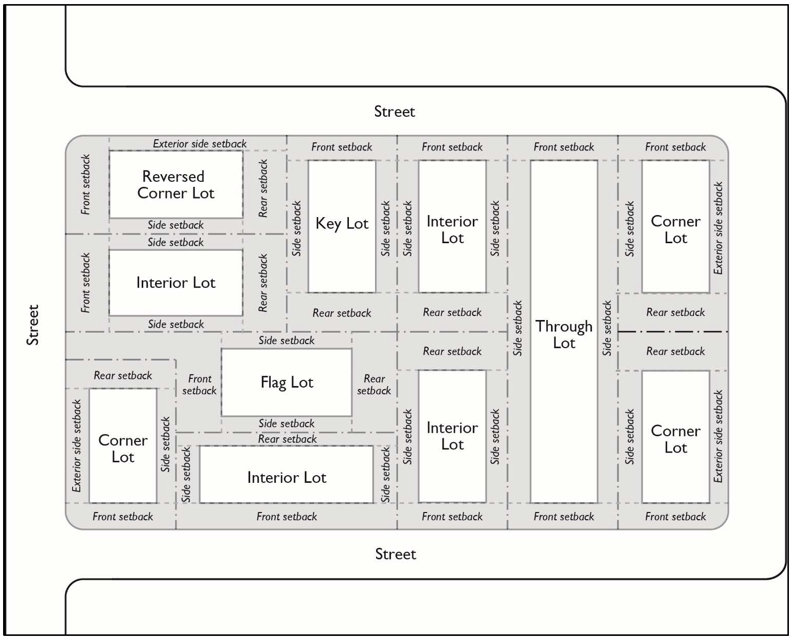
Lot area. The area of a lot measured on a horizontal plane between bounding lot lines.
Lot coverage. The horizontal area covered by enclosed structure(s) calculated as a percentage of the gross area of the site.
Lot line. The boundary between a lot and other property or the public right-of-way.
Lot line types.
(a)
Front lot line. On an interior lot, the line separating the lot from the street or lane. On a corner lot, the shorter lot line abutting a street or lane. On a through lot, the lot line abutting the street or lane providing the primary access to the lot. On a flag or panhandle lot, the interior lot line most parallel to and nearest the street or lane from which access is obtained.
(b)
Interior lot line. Any lot line that is not adjacent to a public or private right-of-way.
(c)
Rear lot line. The lot line that is opposite and most distant from the front lot line. Where no lot line is within forty-five (45) degrees of being parallel to the front lot line, a line ten (10) feet in length within the lot, parallel to and at the maximum possible distance from the front lot line, shall be deemed the rear lot line for the purpose of establishing the minimum rear setback.
(d)
Side lot line. Any lot line that is not a front or rear lot line.
(e)
Street side lot line. A side lot line of a corner lot that is adjacent to a public or private right-of-way. Main building(s). The building(s) containing the main or principal use(s) of the premises, or occupied for the purpose of operating or administering the main or principal use(s).
Maintenance and repair. The repair or replacement of nonbearing walls, fixtures, wiring, roof, or plumbing that restores the character, scope, size, or design of a structure to its previously permitted, and undamaged condition.
Major energy facility. Any energy facility as defined by Public Resources Code Section 30107 and California Code of Regulations Section 13012 as may be amended.
Major public works project. Any public works project as defined by California Code of Regulations Section 13012 as may be amended.
Mansard. A wall which has a slope equal to or greater than two (2) vertical feet for each horizontal foot and has been designed to look like a roof.
Marine preserve. Discrete geographic marine or estuarine area along the California coast designated by law or administrative action, and intended to protect, conserve, or otherwise manage a variety of resources and their uses.
Master Plan of Arterial Highways. Countywide transportation plan maintained by the Orange County Transportation Authority (OCTA) depicting adopted and proposed routes for all commuter, secondary, primary and major highways within the County of Orange.
Master Plan of Drainage. Refers to an official engineering report outlining the drainage facilities needed for the proper development of a specific increment of the unincorporated area.
Medical clinic. See "clinic, medical."
Microenterprise home kitchen operation. A food facility that is operated by a resident in a private home where food is stored, handled, prepared, and may be served to consumers, pursuant to applicable State law.
Mining. See "quarrying."
Ministerial permit. A permit for development approval involving little or no personal judgment by the public official as to the wisdom or manner of carrying out the project. The permit is approved if the proposed development meets all of the objective zoning or building standards in effect at the time the permit is submitted.
Mini-storage facility (self-storage facility). A building or buildings containing various size storage compartments not exceeding five-hundred (500) square feet each, and wherein each compartment is offered for rent or lease to the general public for the private storage of materials excluding materials sold at the facility or delivered directly to customers.
Mixed-use development. A development that combines both residential and non-residential uses on the same lot.
Mobilehome development. Any area or tract of land used to accommodate mobilehomes for human habitation typically in mobilehome parks or mobilehome subdivisions. The development may Include facilities and amenities used in common by occupants who rent, lease, or own spaces for mobilehomes through a subdivision, cooperative, condominium, or other form of resident ownership. See section 7-9-92, Mobilehome developments.
Motel. A building or group of buildings containing six (6) or more guest rooms rented on a weekly basis or less and which have cooking facilities in less than twenty-five (25) percent of the guest rooms.
Multi-service center for the homeless. See section 7-9-134.3.
Net Development Area. See "project net development area."
Noise-related definitions. See Codified Ordinances, Title 4, Division 6, Noise Control.
Noncommercial. An activity or entity that is not primarily intended or directed towards a commercial objective or monetary compensation.
Noncommercial coach. A vehicle, with or without motive power, designed and equipped for human occupancy for classrooms and other nonresidential and non-commercial uses. Also known as a mobile coach.
Noncommercial recreation. Any use or activity where the primary intent is to provide amusement, pleasure, or sport and that is not operated for financial gain. It includes establishments where food and beverages are sold as a secondary or ancillary use.
Nonconforming Use/Structure/Site, Legal: A use/structure/site that was lawfully established in compliance with the zoning regulations that were applicable to the property at the time the use/structure/site was established, but which does not presently comply with the existing regulations of the zoning district within which it is located. See section 7-9-115.
Nursery, plant (retail). A commercial agricultural establishment engaged in the on-site production and sale of horticultural products such as flowers, shrubs, and trees, intended for ornamental or landscaping purposes. A retail plant nursery raises horticultural products for sale to the general public.
Nursery, plant (wholesale). A wholesale plant nursery raises horticultural products for sale to retail nursery and garden centers, or other businesses.
Nursery, plant (garden center). Establishments primarily engaged in retailing nursery and garden products, such as trees, shrubs, plants, seeds, bulbs, and sod that are predominantly grown elsewhere. These establishments may sell a limited amount of a product they grow themselves. Fertilizer and soil products are stored and sold in package form only.
Nursing home. See "Convalescent care facility."
Off-site use. Use or structure that is related to a specific primary use, but is not located on the same lot, or non-residential project site, as the primary use.
On-site loading facilities. A site or portion of a site devoted to the loading or unloading of motor vehicles or trailers, including loading berths, aisles, access drives, and landscaped areas.
On-site use. Use or structure that is related to a specific primary use and that is located on the same lot, or non-residential project site, as the primary use.
Open Space. Any parcel or area of land or water, public or private, that is reserved for the purpose of preserving natural resources, for the protection of valuable environmental features, or for providing outdoor recreation or education. For purposes of measuring the amount of open space, it does not include public/private road right-of-way areas, driveway and parking areas not related to recreational uses, any buildings, building setback areas, or the required space between buildings, and surface utility facilities. "Open space" may include structures and impervious surfaces as identified in "Open space, usable."
Open Space Types.
(a)
Private open space. Open areas for outdoor living and recreation that are adjacent and directly accessible to a dwelling unit, reserved for the exclusive use of residents of the dwelling unit and their guests.
(b)
Common open space. Areas for outdoor living and recreation that are intended for the use of residents and guests of more than one (1) dwelling unit but not dedicated for general public use.
(c)
Usable open space. Open space without any slopes in excess of twenty percent (20%). Such open space may include structures and impervious surfaces such as tot lots, swimming pools, basketball courts, tennis courts, picnic facilities, and greenbelts with walkways or bicycle trails.
Operator. A company, business or individual who provides residential services, i.e., the placement of individuals in a residence, setting of house rules, and governing behavior of the residents. Operator does not include a property owner or property manager that exclusively handles real estate contracting, property management and leasing of the property, and that does not otherwise meet the definition of operator.
Outdoor sales, temporary outdoor sales of merchandise. See section 7-9- 117.10.
Outdoor storage. The keeping, in an unroofed area, of any goods, material, merchandise, or waste in the same place for more than twenty-four (24) hours, except for the keeping of building materials reasonably required for construction work on the premises pursuant to a valid and current building permit issued by the County. The outdoor storage of vehicles shall meet the requirements of Division 13, Article 1 of the Codified Ordinances.
Owner. A person or persons, settlor of a grantor trust, a general partner, firm, corporation, or other legal entity holding single or unified beneficial title to the property.
Paleontological site. A place, or group of sites, in which remains of ancient living forms such as fossils, plants, or animals is preserved.
Parapet. A wall or railing that extends above the roof line and along all or a portion of its perimeter.
Parcel map. A parcel map prepared pursuant to the State Subdivision Map Act and the County of Orange Subdivision Code.
Park. See section 7-9-134.3.
Parking accessway. A vehicular passageway that provides access and circulation from a street access point into and through a parking lot to parking aisles and between parking areas.
Parking area. An area designed for the temporary storage of operable motor vehicles.
Parking, bicycle. A covered or uncovered area equipped with a rack or racks designed and useable for the secure, temporary storage of bicycles.
(a)
Long-term. Bicycle parking that is designed to serve employees, students, residents, commuters, and others who generally stay at a site for four (4) hours or longer.
(b)
Short-term. Bicycle parking that is designed to serve shoppers, customers, messengers, guests, and other visitors to a site who generally stay for a period of less than four (4) hours.
Patio cover. Accessory structure that is unenclosed. Its roof can be either solid or lattice-like through which air and light can pass. Patio covers may be attached or detached from the principal or accessory structure, and are intended for recreational, outdoor living purposes.
Patio, enclosed. Accessory structure that has a roof and is enclosed. May be attached or detached from the principal or accessory structure, and are intended for recreational, outdoor living purposes.
Pavement. An artificially created hard, smooth surface that shall bear travel on public right-of-way or privately-owned property. Does not include turf block. May include waterproof coating.
Peak time. Period of time with the greatest amount of activity and vehicles on the site.
Permit, discretionary. Any Site Development Permit, Use Permit, Variance Permit, Coastal Development Permit, Area Plan, Changed Plan/Minor Modification, or other entitlement for development and/or use of property provided by the Zoning Code.
Permitted use. Any use or structure that is allowed in a zoning district, subject to compliance with all applicable provisions of this Code.
Person. Any individual, firm, association, organization, partnership, business trust, company, or corporation.
Person with disabilities. Under the Americans With Disabilities Act, an individual with a disability is a person who: (1) has a physical or mental impairment that substantially limits one (1) or more major life activities; or (2) has a record of such an impairment; or (3) is regarded as having such an impairment.
Pier or dock. A platform extending from the shoreline into a body of water for the purposes of mooring, loading, or unloading ships or boats.
Pipeline or transmission line. Transportation facilities for the conveyance of water or commodities. Also includes pipeline surface and terminal facilities, pump stations, bulk stations, surge and storage tanks, but does not include lateral extensions or service lines.
Planned (unit) development. A subdivision of separately owned lots, parcels, or areas, having either or both of the following features:
(a)
Lots, parcels, or areas owned in common by the owners of the separately owned lots, parcels, or areas.
(b)
Power to enforce any obligation in connection with membership in the owners association or any obligation pertaining to the beneficial use and enjoyment of any portion of, or any interest in, either the separately or commonly owned lots, parcels, or areas.
Planning commission. The Planning Commission of the County of Orange.
Plot plan. Detailed plan of development that depicts the location of all uses, including but not limited to, utilities, property lines, access, street rights-of-way, easements, building footprints and rooflines, parking areas, fences/walls, setbacks, and adjacent lots and uses. Typically on one (1) or more sheets contained within a set of architectural or construction plans. May also be referred to as a site plan.
Pool house. An enclosed accessory structure. See "guesthouse."
Precise Plan of Highway Alignment. A plan, supplementary to the Master Plan of Arterial Highways, (aka Circulation Plan), which establishes the highway centerline, the ultimate right-of-way lines and may establish building setback lines.
Pre-existing. In existence before the effective date of this Code.
Principal use. See "Use, Principal permitted use."
Project net development area. All of the land area included within a plan for a development project excepting those areas designated for public and private road rights-of-way, schools, parks, and other uses or easements which preclude the use of the land therein as part of the development project.
Property line. The recorded boundary of a lot or parcel of land.
Public agency. The United States, the State of California, the County of Orange, any city within said County, or any political subdivision or agency thereof.
Public land. Any government-owned or operated land, including, but not limited to, public parks, beaches, playgrounds, trails, paths, schools, public buildings, and other recreational areas or public open spaces.
Public safety area. A strip of land twenty (20) feet in width adjacent to and parallel with a street right-of-way.
Public resources code. The Public Resources Code of the State of California.
Quarrying. The process of removing or extracting stone, rock, aggregate, sand, gravel, earth, clay or similar materials from an open excavation but not including extraction by underground method. A.k.a. surface mining.
Rain barrel. A vessel that stores rainwater runoff, typically from rooftops via rain gutters.
Reasonable accommodation. Any modification or waiver requested and/or granted from the strict application of the County's zoning and land use regulations, rules, policies, practices and/or procedures under provisions of Federal or State law to make housing or other facilities readily accessible to and usable by persons with disabilities.
Recreational vehicles. A motor home, travel trailer, truck or van camper, tent trailer, camping trailer or trailer-borne recreation equipment with or without motive power, for recreational, travel or emergency purposes.
Recycling center. A facility that accepts delivery or transfer of ownership of source separated materials for the purpose of recycling or diversion from disposal. Included are "drop-off" recycling centers, where no fee is paid, such as churches or other charitable groups, or "buy-back" centers, like those at supermarkets, where a fee is usually paid to the generator for the materials. These facilities do not require a state permit. See also Transfer - Materials recovery facility.
Referral facility. A community care facility or a group home where one (1) or more person's residency in the facility is pursuant to a court order or directive from an agency in the criminal justice system.
Residential housing types.
(a)
Single-family dwelling, detached. See section 7-9-134.2.
(b)
Single-family dwelling, attached. See section 7-9-134.2.
(c)
Multifamily dwelling. See section 7-9-134.2.
(d)
Accessory dwelling unit. See section 7-9-134.2.
Rest home. See "Convalescent care facility."
Retail. The selling of goods, wares, or merchandise directly to the ultimate consumer.
Riding and hiking trails. A trail or way designed for and used by equestrians, pedestrians and cyclists using nonmotorized bicycles.
Right-of-way. An area or strip of land, either public or private, on which an irrevocable right of passage has been recorded for the use of vehicles or pedestrians or both.
Roadway. See "streets."
Sanitary landfill. A type of solid waste disposal facility where non-hazardous waste material is deposited and managed by spreading, compacting to the smallest practical volume, and applying soil and other cover material over all exposed wastes.
Scenic highway. Any highway designated a scenic highway by an agency of the county, state or federal government.
Seasonal product sales. Christmas tree, pumpkin, and other temporary sale activities that are typically conducted outdoors. See section 7-9-117.8.
Screening. Screening refers to a wall, fence, hedge, informal planting, or berm, provided for the purpose of buffering a building or activity from neighboring areas or from the street.
Self-storage facility. See "mini-storage facility".
Senior citizen. A person fifty-five (55) years or older in a senior citizen housing development pursuant to Civil Code Section 51.3, as may be amended.
Senior citizen housing development. A residential development consisting of at least thirty-five (35) dwelling units which is developed for, or substantially rehabilitated or renovated for, senior citizens pursuant to Civil Code Section 51.3, as may be amended.
Senior living facilities. Provide care and services on a monthly basis or longer to residents aged sixty (60) years of age or older, as provided in California Code of Regulations, Title 22, Division 6, Chapter 8, Article 1, Section 87101, as may be amended, and Health and Safety Code Division 2, Chapter 10, Article 1, Section 1771, as may be amended. Senior living facilities may include:
Independent living (IL) facilities. Intended for individuals who are presently able to manage an independent lifestyle, but foresee a future where more support will be necessary. IL residents are provided with assistance in the instrumental activities of daily living, such as: dining, housekeeping, security, transportation and recreation. IL dwelling units may have separate kitchens and garages.
(a)
Assisted living (AL) facilities intended for residents that require some assistance with the activities of daily living, but do not need the 24-hour care of a nursing home. AL services are regulated by California Code of Regulations, Title 22, Division 6, Chapter 8 and may be provided only by a facility licensed as a Residential Care Facility for the Elderly (RCFE). These services include assistance with dressing, bathing, walking, eating and toileting, in addition to dining, housekeeping, security, transportation and recreation.
(b)
Memory care (MC) living facilities intended for residents who require specialized care for dementia, Alzheimer's or other memory related illnesses. MC services may be provided by a stand-alone facility, or by a facility offering a broader range of services. MC services such as dining, housekeeping, security, transportation and recreation, may only be provided by a facility licensed as a Residential Care Facility for the Elderly (RCFE).
(c)
Skilled nursing (SN) facilities intended for residents who require nursing care or supervision, either on a short-term or long-term basis, as regulated by California Code of Regulations Title 22, Division 5, Chapter 3.
(d)
Continuing care retirement community (CCRC) facilities intended to serve the long-term residential, social, and health care needs of elderly residents by providing a continuum of care, minimizing transfer trauma and allowing the following services to be provided in an appropriately licensed setting: dining, housekeeping, security, transportation and recreation. CCRC facilities are regulated by California Code of Regulations Title 22, Division 6, Chapter 8 and Health and Safety Code Division 2, Chapter 10. CCRC facilities may include more than one (1), or all four (4), of the types of senior living facilities listed above as items (a) through (d).
Service. An act, or any result of useful labor, which does not in itself, produce a tangible commodity.
Setback area/distance: The area/distance between the building line and the property line or, when abutting a street, the ultimate right-of-way line.
Shopping/office center. A commercial area, or group of commercial establishments planned, developed, managed and maintained as a unit, with common off-street parking provided to serve all uses on the property.
Sidewalk. A paved, surfaced, or leveled area, paralleling and usually separated from the street, used as a pedestrian walkway.
Sign. Pursuant to section 7-1-94, "Orange County Sign Code," sign is defined as any structure, device or contrivance and all parts thereof which are erected or used for advertising purposes upon or within which any poster, bill, bulletin, printing, lettering, painting, device or other advertising of any kind whatsoever is used, placed, posted, tacked, nailed, pasted or otherwise fastened or affixed. This definition also includes electric signs. See section 7-9-114, "Signs."
This definition shall not be held to include, unless otherwise provided for in this article, any board, sign or surface used exclusively to display official notices issued by any court officer or public officer or a private person in giving legal notice; nor shall it be held to include a nonilluminated ground sign the advertising surface of which does not exceed six (6) square feet and which does not extend more than six (6) feet above grade; nor shall it be held to include a nonilluminated professional sign such as used by a doctor, dentist or similar professional person, provided the advertising surface of such nonilluminated sign does not exceed six (6) square feet and the sign extends not more than six (6) feet above grade.
Sign-related definitions.
(a)
Advertising device/display. Any contrivance, statue, or structure, other than a sign, used to attract attention or make anything known for the purpose of promoting (either directly or indirectly) the use of products or services of any person or business, including but not limited to a balloon, flag, pennant, propeller, or an oscillating, rotating, or pulsating light.
(b)
Area identification sign. A sign that identifies a residential area, neighborhood, shopping district industrial district, or any identifiable area.
(c)
Banner sign. A sign made of fabric or any non-rigid material with no enclosing framework on which a message or image is painted or otherwise affixed.
(d)
Billboard. A sign used for the purpose of general advertising for hire, that is, some or all of the display area is customarily used to display the messages of advertisers or sponsors other than the owner of the sign. See "off-site sign."
(e)
Building frontage. See "Frontage, building."
(f)
Civic activity sign. A bulletin board customarily incident to places of worship, libraries, museums, and other public institutions.
(g)
Commercial sign. A sign with wording, logo, or other representation that directly or indirectly identifies, advertises, or calls attention to a business, product, service, profession, commodity, event, or other commercial activity. These signs are typically located on the same property as the business or commercial activity.
(h)
Commercial speech or commercial message. A message proposing a commercial transaction or otherwise related to the economic interests of the message sponsor or the viewing audience, or both.
(i)
Construction sign. A temporary sign that identifies a future development or use and is erected on property prior to and during the construction period.
(j)
Copy. Also called "sign copy." The visually communicative elements mounted on a sign.
(k)
Directional or wayfinding sign. A sign that directs or guides pedestrian or vehicular traffic and which does not include general advertising for hire.
(l)
Electronic message center sign. A sign having the capability of presenting variable message displays by projecting an electronically controlled pattern, and which can be programmed to periodically change the message display. (m) Face. That portion of a sign upon which the copy is mounted or displayed.
(n)
Flag. An advertising device, not including national flags or flags of political subdivisions.(o) Freestanding sign. A sign supported by structures or supports that are placed on or anchored in the ground and that are structurally independent from any building. Freestanding signs include "monument signs," "pole signs," and "ground signs." (p) Ground sign. See "monument sign."
(q)
Identification Sign. A sign located on the property, limited to the identifying name and symbol/insignia of an existing or future community, building, business, facility, organization, person, etc.
(r)
Illuminated sign. A sign with an artificial source of light incorporated internally or externally for the purpose of illuminating the sign.
(s)
Inflatable sign. A sign that inflates used for advertising purposes.
(t)
Mobile billboard. An advertising display that is attached to a wheeled, mobile, non-motorized vehicle, which carries, pulls, or transports a sign or billboard, and is for the primary purpose of advertising, as defined by California Vehicle Code Section 395.5, as may be amended.
(u)
Monument sign. A low-profile freestanding sign mounted on or supported solely by a planter, pedestal, or similar solid, ground structure or base that is approximately the same width as the sign and which is designed to reflect the architectural theme of the building on the premises. Internal supports, poles or pylons, if any, are enclosed by decorative covers or otherwise not exposed to view.(v) Non-commercial message. A message or image on a sign that directs public attention to or advocates an idea or issue of public interest or concern that does not serve to advertise or promote any business, product, activity, service, interest, or entertainment.
(w)
On-site sign. Any sign or portion thereof that identifies, advertises, or attracts attention to a business, product, service, event or activity sold, existing or offered upon the same property or land use as the sign. The off-site/on-site distinction applies only to commercial messages.
(x)
Off-site sign. A sign, or the sign structure on which it is to be placed, the purpose of which is to advertise products or services that are not produced, stored, or sold on the property upon which the sign or structure is located. Does not include travel direction or bus bench/shelter signs. See "billboard."
(y)
Pole sign, temporary. A freestanding sign directly supported by a pole or poles that are attached directly into or upon the ground with air space between the grade level and the sign face.
(z)
Portable sign. A freestanding sign that is not permanently affixed, anchored, or secured to either the ground or a structure on the property it occupies including a sign upon a vehicle or trailer used as a stationary advertising display, the primary purpose of which is to serve as a base or platform for the sign.
(aa)
Projecting sign. A single or double-faced sign that is perpendicular to the wall upon which it is mounted and suspended from or supported by a building or structure and projects outward therefrom.
(bb)
Pylon sign. A freestanding sign that is supported by two (2) or more solid, monumental structures (pylons) and which has air space between the sign face and the ground level. Poles shall not be used as pylons.
(cc)
Real estate sign. A temporary sign posted on any property that is being actively marketed for sale or for lease but not including signs on establishments offering transient occupancy such as hotels and motels.
(dd)
Roof sign. A sign erected wholly upon or above the roof of a building or above canopies, marquees and similar overhangs. Signs on mansards shall be considered wall signs.
(ee)
Sign area. The area within the perimeter of not more than eight (8) straight lines of a size sufficient to enclose the outer limits of any writing, representation, emblem, logo or any figure of similar character. Sign area does not include supporting structures such as sign bases and columns unless they include visually communicative elements of such sign.
(ff)
Sign face. An exterior display surface of a sign, including non-structural trim, exclusive of the supporting structure. The area of a sign which is available for mounting and public display of the visually communicative image.
(gg)
Sign program. A coordinated sign plan that includes details of all signs (not including exempt or temporary signs) that are, or shall be placed on a site, including master identification, individual business and directory signs.
(hh)
Temporary sign. A structure or device used for the public display of visual messages or images, which is typically made of lightweight or flimsy materials and which is not intended for or suitable for long term or permanent display.
(ii)
Traffic sign. A sign for traffic direction, warning, and roadway identification.
(jj)
Wall sign (wall-mounted sign). A sign affixed to and wholly supported by a building in such a manner that its exposed face is approximately parallel to the plane of such building, and is not projecting more than eighteen (18) inches from the building face or from a permanent, roofed structure projecting therefrom.
(kk)
Window sign. A temporary or permanent sign with a single face of copy that is painted or installed on a glass window or door, or located within 12 inches from inside the window, in a manner that it can be viewed from the exterior of a structure.
Single housekeeping unit. Means that the occupants of a dwelling unit have established ties and familiarity with each other, jointly use common areas, interact with each other, share meals, household activities, and expenses and responsibilities; membership in the single housekeeping unit is fairly stable as opposed to transient, members have some control over who becomes a member of the household, and the residential activities of the household are conducted on a nonprofit basis. There is a rebuttable presumption that integral facilities do not constitute single housekeeping units. Additional indications that a household is not operating as a single housekeeping unit include but are not limited to: the occupants do not share a lease agreement or ownership of the property; members of the household have separate, private entrances from other members; members of the household have locks on their bedroom doors; members of the household have separate food storage facilities, such as separate refrigerators.
Single room occupancy (SRO). A building with a common entrance containing a cluster of at least five (5) rental units which provide sleeping and living facilities for one (1) or two (2) persons where kitchen and/or bathroom facilities may be shared. See section 7-9-88, "Single room occupancy."
Site. A lot, or group of contiguous lots, that is proposed for development in accordance with the provisions of this Code and is in a single ownership or under unified control. See "building site."
Site plan. See "plot plan."
Site coverage. See "building site coverage."
Site Development Permit. See section 7-9-126.
Site depth. See "building site depth."
Site width. See "building site width."
Sober living home. A type of group home operated as a cooperative living environment providing an alcohol and drug-free home for persons recovering from alcoholism and/or drug abuse, which are not required to be licensed by the State. Sober living homes for six (6) or fewer residents are allowed in residential districts, subject to a group home permit. Sober living homes of seven (7) or more residents shall be permitted in any district, planned community, or specific plan area zoned for multifamily residential uses subject to the issuance of a Use Permit by the Planning Commission per section 7-9-125 and compliance with certain conditions. Residents may actively participate in recovery programs outside of the home such as detoxification, educational counseling, individual or group counseling sessions, or treatment/recovery planning. A sober living home may provide services to the residents such as dining, housekeeping, security, medical, transportation, and recreation, but shall not dispense medications to the residents. Sober living homes shall not include the following: (1) community care facilities; (2) any sober living home that operates as a single housekeeping unit.
Soil. Naturally occurring superficial deposits overlying bedrock.
Soils engineer (geotechnical engineer). An engineer experienced and knowledgeable in the practice of soils (geotechnical) engineering.
Special gathering. See section 7-9-117.9, "Special gatherings."
Specific plan. A plan for a portion of the area covered by the General Plan that is consistent with, and shall implement, the General Plan pursuant to the provisions of Government Code Section 65450 et seq., as may be amended. See section 7-9-133, "Specific plans."
Stack parking. Cars parked closely behind and beside each other without regard to parking stalls in an effort to maximize space.
State. The State of California.
Stock cooperative. A corporation which is formed primarily for the purpose of holding title to, either in fee simple or for a term of years, improved real property, if all or substantially all of the shareholders of such corporation receive a right of exclusive occupancy in a portion of the real property, title to which is held by the corporation, which right of occupancy is transferable only concurrently with the transfer of the share or shares of stock or membership certificate in the corporation held by the person having such right of occupancy.
Stream. Watercourses, including streams, drainage ways, small lakes, ponds, and marshy areas through which streams pass. Coastal wetlands are not considered streams.
Street. A public or private vehicular right-of-way, other than an alley or driveway, including both local streets and arterial highways. Street, multifamily. A driveway, easement, accessway or other private vehicular right-of-way to serve a unified multi-lot/multifamily project for which a discretionary permit per section 7-9-125 has been approved and where residential setbacks, other than provided for in section 7-9-70.3 are not required.
Structure. Anything constructed or erected, the use of which requires location on the ground or attachment to something having location on the ground. That which is erected or constructed having a fixed location and is more than thirty (30) inches above the finished grade. An edifice or building of any kind, or any piece of work artificially built up or composed of parts joined together in some definite manner. A mobilehome, except when used as a temporary use with its weight resting at least partially upon its tires, is a structure for the purposes of this definition. (Note: For the coastal zone only, section 7-9- 40 defines structure differently.)
Supportive housing. See section 7-9-134.2.
Surface mining. See "quarrying."
Swimming pool. An artificial body of water having a depth in excess of eighteen (18) inches, designed, constructed and used for swimming, dipping or immersion purposes by men, women, or children.
Tandem parking. An arrangement of parking spaces such that one (1) or more spaces shall be driven across to access another space or spaces.
Temporary. A use established for a fixed period of time with the intent to discontinue such use upon the expiration of the time period.
Temporary use-related definitions.
(a)
Garage sales. The sale or offering for sale to the general public of personal property on a portion of a lot in a residentially zoned district, whether inside or outside any building.
(b)
Outdoor sales, temporary outdoor sales of merchandise. See section 7-9- 117.10.
(c)
Outdoor sales, seasonal product sales. See section 7-9-117.8.
Tenant. A person renting or leasing a housing unit or non-residential space.
Tract map. A subdivision map as defined by the State Subdivision Map Act and the County of Orange Subdivision Code.
Trailer. A vehicle, with or without motor power, that is designed or used for hauling materials or vehicles, or for human habitation, office, or storage. This does not include mobilehomes on a permanent foundation.
Transfer-materials recovery facility. A permitted nondisposal solid waste facility that accepts solid wastes, temporarily stores, separates, converts, or otherwise processes more than five percent (5%) of the solid wastes received, and transfers the residual materials to a solid waste disposal or transformation facility.
Transfer station. A permitted nondisposal solid waste facility that transfers solid waste directly from smaller to larger vehicles for transport to materials recovery facilities, land-fills, or transformation facilities.
Transformation facility. A permitted facility that performs incineration, pyrolysis, distillation, gasification or biological conversion, other than composting, for recovery of energy from solid waste.
Transitional housing. See section 7-9-134.2.
Ultimate right-of-way. The right-of-way shown as ultimate on an adopted precise plan of highway alignment, or the street rights-of-way shown within the boundary of a recorded tract map, a recorded parcel map or a recorded PC development plan. The latest adopted or recorded document in the above cases shall take precedence. If none of these exist, the ultimate right-of-way shall be considered the right-of-way required by the highway classification as shown on the Master Plan Arterial Highways. In all other instances, the ultimate right-of-way shall be considered to be the existing right-of-way, in the case of a private street, and the existing right-of-way, but not less than sixty (60) feet, in the case of the public street.
Use. The purpose for which land or the premises of a building, structure, or facility thereon is designed, arranged, or intended, or for which it is or may be occupied or maintained.
(a)
Accessory use. Uses and structures are permitted when associated and subordinate to a principal permitted use on the same building site.
(b)
Principal permitted use. Use or structure that is allowed in a zoning district but is subject to regulations applicable to that use or structure.
Use classification. A system of classifying uses into a limited number of use types on the basis of common functional, product, or compatibility characteristics.
Use Permit. Also known as a Conditional Use Permit. A discretionary permit which may be granted by the appropriate decision-making body to provide for the accommodation of land uses with special site or design requirements, operating characteristics, or potential adverse effects on surroundings, which are not permitted as of right, but which may be approved upon completion of a review process and, where necessary, the imposition of special conditions of approval by the decision-making body.
Utilities. Equipment and associated features related to the mechanical functions of a building(s) and services such as water, electrical, telecommunications, and waste.
Variance Permit. A discretionary grant of permission to depart from the specific requirements of this Code that is warranted when, due to special circumstances regarding the physical characteristics of the property, the strict application of standards would deprive the property of privileges available to other property in the same zoning classification.
Vehicle. Any vehicle, as vehicle is defined by the California Vehicle Code, including any automobile, recreational vehicle, camper, camp trailer, trailer, trailer coach, motorcycle, house car, boat, or similar conveyance.
Vehicular accessway. A private nonexclusive vehicular easement affording access to abutting properties.
Vibration. A periodic motion of the particles of an elastic body or medium in alternately opposite directions from the position of equilibrium.
Viewpoint. A place affording a view of something.
Visible. Capable of being seen (whether or not legible) by a person of normal height and visual acuity walking or driving on a public roadway or in a public place.
Wall. A vertical structure that encloses, retains, or divides an area of land.
Watershed. The geographic area draining into a river system, ocean, or other body of water through a single outlet and includes the receiving waters. Watersheds are usually bordered and separated from other watersheds, by mountain ridges or other naturally elevated areas.
Wildlife preserve or sanctuary. A protected area of importance for wildlife, flora, fauna, or features of geological or other special interest, which is reserved and managed for conservation and to provide special opportunities for study or research.
Wineries. A property where grapes are processed into wine, bottled, and may be sold on-site.
Wing wall. An architectural feature in excess of six (6) feet in height which is a continuation of a building wall projecting beyond the exterior walls of a building.
Zero lot line. The location of a building on a lot in such a manner that one (1) or more building sides rests directly on a lot line.
Zoning Administrator. The Zoning Administrator of the County of Orange.
Zoning Code. The Comprehensive Zoning Code of the County of Orange, including zoning district maps and planned community or specific plan development plan maps and texts adopted pursuant to or as an amendment to sections 7-9-25.1, 7-9-47, 7-9-132, and 7-9-133.
Zoning district. A specifically delineated area or district in the County, within which regulations and requirements uniformly govern the use, placement, spacing, and size of land and buildings.
(Ord. No. 20-006, § 1, 7-28-20; Ord. No. 24-004, § 37, 6-25-24)