
Orange County Unincorporated
City Zoning Code
City Zoning Code
ARTICLE 70
IV District Regulations
Division 70-IV-15 Floodplain Overlay Districts
Editor's Note: Chapter 34 (Flood Hazard Reduction) was repealed in its entirety and adopted as part of Chapter 70 (Zoning) in March, 2022.
251216 – PH2
240227 – PH1
220823 – PH3
180724 – 6A
190827 – PH1
230425 – PH2
230711 – 5B
Sec 70-276 Zoning Districts
- For the purpose of this chapter, the unincorporated areas of Orange County, Virginia are hereby divided into the following zoning districts.
Agricultural (A).
Limited Residential (R-1).
General Residential (R-2).
Planned Residential (R-3).
Multifamily Residential (R-4).
Limited Commercial (C-1).
General Commercial (C-2).
Limited Industrial (I-1).
General Industrial (I-2).
Barboursville Village Overlay District
Planned Development – Business (PDB).
Planned Development – Mixed Use (PDM).
Planned Development – Traditional Design (R-5).
Technology (T). - The location and boundaries of these districts are shown on the zoning maps of the county, incorporated in this section by reference and on file in the county offices.
(Ord. of 5-2-1996, § 101)
Sec 70-277 Unauthorized Uses Prohibited
Any use not expressly permitted or permitted by special use permit in a specific district is prohibited.
(Ord. of 5-2-1996, § 102)
Sec 70-301 Intent
The agricultural zoning district (A) comprises most of the land area of the county. It preserves the rural character of the county by protecting agriculture from conflicts with incompatible uses and discourages the random scattering of commercial and industrial uses and residential developments. In addition to agriculture, it permits the traditional rural pattern of homes and small businesses.
(Ord. of 5-2-1996, § 201)
Sec 70-302 Permitted Uses
In the agricultural district, land may be used for the following uses, and any accessory use that is customarily incidental to such uses, including home occupations and home enterprises:
- Agriculture.
- Agritourism.
- Bed and breakfast inn.
- Short-term lodging facility.
- Single-family dwelling.
- Two-family dwelling.
- Manufactured home.
- Place of worship.
- Cemetery or graveyard.
- Sign subject to sections 70-308 and 70-696 et seq.
- Farm enterprise, farm stand, wayside stand.
- Farmer’s market of up to 4,000 square feet gross floor area.
- Temporary uses, with a zoning permit pursuant to sections 70-309 and 70-122, limited to the following:
- Temporary or seasonal sales.
- Special events.
- Accessory Apartment.
- Commercial Kitchen or Smokehouse.
(Ord. of 5-2-1996, § 202; Ord. of 7-12-2011(2); Ord.11-13-2013; Ord. 03-11-2014; Ord. of 04-14-2015; Ord. of 06-14-2016)
Sec 70-303 Uses Permitted By Special Use Permit
In the Agricultural zoning district, the following uses may be permitted upon issuance of a Special Use Permit by the Board of Supervisors:
- Agricultural equipment sales or service, or both.
- Airport.
- Bed and breakfast inn with a restaurant open to non-guests.
- Boarding kennel or commercial breeding kennel.
- Camp, campground or recreational vehicle park.
- Fairground.
- Elder care center, child day care center, or nursery school.
- Livestock auction or farmer’s market of greater than 4,000 square feet gross floor area.
- Manufactured home park.
- Mine or quarry.
- Office not exceeding 4,000 square feet gross floor area, including professional or contracting office.
- Cultural use.
- Commercial recreational use.
- Institutional use.
- Public garage.
- Public use such as school, park, library, or fire and rescue station.
- Retail store not exceeding 4,000 square feet gross floor area, including, a farm stand greater than 1,000 square feet gross floor area, flea market, or retail nursery.
- Restaurant which is accessory to an agritourism use where said use has been in existence for at least five years.
- Sanitary landfill.
- Veterinary service, including animal hospital.
- Outdoor power equipment, motorcycle, all-terrain vehicle, watercraft repair and storage.
- Public utility facility.
- Pyrotechnics testing/manufacturing on a parcel 50 acres or greater in size.
- Rural retreat.
(Ord. of 8-11-1998, §§ 203, 203.18; Ord. of 5-8-2001; Ord. of 7-12-2011(2); Ord. 06-14-14 (20); Ord. of 04-14-2015; Ord. of 08-11-2015, Ord. of 07-12-16, Ord. 05/23/2017, Ord. of 03-13-2015)
Sec 70-304 Area Regulations
In the agricultural zoning district, the minimum lot area shall be two acres, except in cluster developments subject to article VI, or manufactured home parks subject to article VII.
(Ord. of 5-2-1996, § 204)
Sec 70-305 Frontage Regulations
In the agricultural zoning district, the minimum lot frontage shall be 200 feet, except in cluster developments subject to article VI, or manufactured home parks subject to article VII. Each lot shall meet the minimum requirement, either at the front lot line or at the required building setback.
(Ord. of 5-2-1996, § 205)
Sec 70-306 Setback And Yards
- In the agricultural zoning district, the regulations in this section shall apply to all buildings, all structures that require building permits, and all temporary or portable buildings greater than 150 square feet in floor area or greater than eight feet six inches in height.
- For setbacks from primary highways, see section 70-646 et seq.
- The setback from any VDOT secondary road, private street, or subdivision street with a right-of-way 50 feet or more in width shall be 35 feet from the right-of-way.
- The setback from any VDOT secondary road, private street, or subdivision street with a right-of-way less than 50 feet in width shall be 85 feet from the centerline of the road.
- The minimum side yard width for each main structure shall be 20 feet. A two-family dwelling, which shall be constructed in a side-by-side arrangement unless otherwise permitted via section 70-1, shall have no side yard requirement for the main structure at the property line which separates the units. The minimum side yard width for each accessory structure shall be ten feet.
- The minimum rear yard width for each main structure shall be 35 feet. The minimum rear yard width for each accessory structure shall be ten feet.
- For corner lots the side yard adjacent to the side street shall not be less than the minimum setback. For double-frontage lots the rear yard shall not be less than the minimum setback.
- The zoning administrator may authorize construction of an unenclosed porch no more than ten feet deep to be attached to a single-family dwelling, irrespective of setbacks or required yards, upon finding in writing that such porch will not be detrimental to adjoining property or the intent of this chapter.
- The setback for any new dwelling shall be a minimum of 50 feet from the shoreline of any body of water. Construction proposed to take place within any floodplain shall comply with those provisions as outlined in Division 15 of Article IV of Chapter 70 Zoning.
(Ord. of 5-2-1996, § 206; Ord. of 7-24-1998, § 206.08, Ord. of 06-12-2018, Ord of 02-09-2021)
Sec 70-307 Height Regulations
In the agricultural zoning district, structures other than public utility facilities and silos shall be 40 feet in height or less. The board of supervisors may grant a special exception to allow a structure taller than 40 feet.
(Ord. of 5-2-1996, § 207)
Sec 70-308 Signs
- In the agricultural district, signs are permitted within the guidelines as set forth in this section. In granting a special use permit, the board of supervisors may allow signs that exceed these guidelines. See also section 70-696 et seq.
- One permanent sign for every 200 feet of road frontage shall be permitted. The total area of permanent signs shall be 32 square feet or less.
- Monument signs and pylon signs shall be eight feet or less in height. Building signs shall not project above the top or sides of the building.
- Signs may be lighted so that they are illuminated from within or have one or more lights shining on them so that each face of the sign is illuminated. Lights used to internally and externally illuminate each face of a sign shall be directed so as to minimize glare to passing motorists and pedestrians.
(Ord. of 5-2-1996, § 208; Ord. of 7-26-2011)
Sec 70-309 Temporary Uses
In the agricultural district, temporary uses may be permitted upon the issuance of a temporary zoning permit granted by the zoning administrator.
- Reserved.
- Temporary or seasonal sales.
- Temporary sales of produce not otherwise permitted by right, meals, Christmas trees, fireworks, and other seasonal goods, are permitted upon approval of a temporary zoning permit. Such permit may impose conditions necessary to alleviate any adverse impacts such as provisions for adequate traffic control, on-site parking, public safety, fire safety, hours of operation, provision for sewage disposal, and other health and safety concerns.
- A temporary zoning permit for temporary sales of farm or food products shall be valid for a period not to exceed 90 days, and shall require that all structures and materials be removed within such time period.
- Structures for temporary sales shall meet the required setbacks set forth in section 70-306 (setbacks and yards).
- Entrances and exits must be clearly delineated and located to provide safe ingress and egress from roads.
- Outdoor on-site farm or food products sales shall be allowed daily.
- Flea markets shall be allowed one, three-weekend event every 30 days. Permitted hours are from 7:00 a.m. to 9:00 p.m.
- Special events.
- A temporary zoning permit shall be required for special events that are planned for or which reasonably may be expected to attract more than 100 persons a day. Examples of special events which require a temporary zoning permit are: Carnival, circus, equipment show and display, festival, fair, fireworks show, tent event or similar meetings or events. Each subsequent event shall require a new permit.
- Adequate provisions must be made for off-street parking, security, safe ingress and egress, refuse disposal, sanitary facilities as appropriate and approved by the zoning administrator.
- Special events are permitted only between the hours of 7:00 a.m. to 10:00 p.m., Sunday through Thursday; and 7:00 a.m. to 12:00 a.m., Friday and Saturday. The zoning administrator may require that no activity, including set-up or knockdown of any such use, be permitted between 11:00 p.m. to 7:00 a.m.
- Night operations shall be permitted only if the zoning administrator determines that the proposed lighting protects the public safety and will not cause excessive glare into residential areas or onto public streets.
- If a temporary use permit is obtained for an outside music/festival, an entertainment permit will not be required.
- Prior to issuance of a zoning permit, fireworks shows must also obtain a fireworks display permit, which sets forth the days and hours of the show, from the county administrator’s office.
- The following special events are exempt from the requirements of this section and may occur without a temporary zoning permit. Exempt special events, however, shall remain subject to all other applicable provisions of this section and the county laws and regulations, including obtaining any and all other permits necessary for said event.
- Special events planned or reasonably expected to attract less than 100 persons at any one time.
- Special events to include private parties and social events occurring within, or upon the grounds of, a private residence, where the property owner receives no compensation for hosting the event and guests/attendees are not charged an admission fee.
- Any event sponsored in whole or in part by the county or another political subdivision of the Commonwealth of Virginia.
- Any organized special events conducted at sites or facilities typically intended, used, and designed for such events. Examples of such exempt activities include: sporting events conducted on courses or fields, animal show events, equestrian events held at stables or riding facilities, events held on the property of historic home/site museums, wedding services, wine tasting and wine tasting dinners at wineries whose facilities are designed for such events, and conferences and similar events in facilities designed and which have a zoning permit for such use.
- Any established event/festival that has been in existence five or more years prior to the passing of this ordinance amendment will not be required to obtain a temporary use permit, provided that the use does not change.
- Yard sale events at a private residence or community yard sale, held by the occupant of the residence, that do not last more than three days at any given time.
(Ord. of 7-12-2011(2))
Sec 70-310 Use-Specific Regulations
Uses below shall adhere to the additional regulations set forth herein, in addition to all other regulations set forth in this Chapter. These regulations shall be considered a minimum standard which may be supplemented by special use permit conditions or proffers with a conditional zoning application.
- Rural retreat.
- As set forth in the use definition, a rural retreat may be permitted an additional guestroom for every two (2) full acres above thirty (30) acres, not to exceed a total of fifty (50) guestrooms. Guestrooms spread across multiple adjoining parcels under the same ownership are considered a single retreat. However, said guestrooms shall be arranged such that if the use were to discontinue in the future, structures on individual lots could be subdivided in accordance with Zoning Ordinance and Subdivision Ordinance requirements.
- Guestrooms may be provided in multiple structures, each of which is considered a principal structure. Each structure may have up to ten (10) guestrooms. Such structures must have permanent foundations, must be constructed in accordance with the Virginia Uniform Statewide Building Code, and must have means of water and wastewater services approved by the Virginia Department of Health or a public utility provider. Multiple guestroom structures may be provided at a ratio of one (1) per every fifteen (15) full acres, not to exceed the maximum of fifty (50) guestrooms in total as set forth above.
- All structures associated with the use are considered principal structures for determining setback and yard requirements.
- A retreat may serve meals, the specifics of which shall be determined with the Special Use Permit.
- Accessory uses to the retreat may be permitted, the specifics of which shall be determined with the Special Use Permit.
- For any retreat with ten (10) or more total guestrooms, the property must abut and have direct access from a public road, subject to all VDOT requirements.
- Each guestroom structure must be accessible by emergency services vehicles.
- Road standards contained elsewhere in the Zoning Ordinance or Subdivision Ordinance notwithstanding, a rural retreat may be permitted to utilize internal gravel roads provided they do not conflict with the intent and purpose of standard 7 above. Internal road specifications shall be set as part of the SUP application.
- Parking provided in accordance with Sec. 70-671 et seq. shall be provided for each individual building or use associated with the retreat, adjacent to said building or use.
- Any retreat within the Madison Barbour Rural Historic District, as listed in the National Register of Historic Places, shall not be permitted any digital sign(s), as defined.
Sec 70-331 Intent
The limited residential district comprises low-density residential areas. It protects such areas from the traffic, noise and other effects of commercial and industrial uses and medium- and high-density residential development, and avoids conflicts with agricultural uses. It also encourages use of community water and sewer systems.
(Ord. of 5-2-1996, § 301)
Sec 70-332 Permitted Uses
In the limited residential district, land may be used for the following uses, and any customarily incidental accessory use, including home occupations:
- Single-family dwelling.
- Two-family dwelling.
- Short-term lodging facility.
- Agriculture, except keeping of any animals other than those customarily kept as household pets.
- Agritourism.
- Place of worship.
- Public use such as school, park, library, fire and rescue station.
- Sign subject to sections 70-338 and 70-696 et seq.
- Accessory apartment.
- Farm stand, wayside stand.
(Ord. of 5-2-1996, § 302; Ord. of 11-13-2013; Ord. of 06-10-2014; Ord. of 04-14-2015; Ord. of 08-11-15)
Sec 70-333 Uses Permitted By Special Use Permit
In the limited residential district, the following uses may be permitted upon issuance of a special use permit by the board of supervisors:
- Elder care center, child day care center, or nursery school.
- Bed and breakfast inn.
- Keeping of animals other than those customarily kept as household pets.
- Office not exceeding 4,000 square feet gross floor area, including professional or contracting office.
- Cultural use.
- Institutional use.
- Farmer’s market.
- Public utility facility.
(Ord. of 5-2-1996, § 303; Ord. of 06-10-14; Ord. of 04/14/2015; Ord. of 08/11/15)
Sec 70-334 Area Regulations
- In the limited residential district, where a dwelling is served by neither a community water system nor a community sanitary sewer system, the minimum lot area shall be 40,000 square feet.
- Where a dwelling is served by either a community water system or a community sanitary sewer system, but not both, the minimum lot area shall be 30,000 square feet.
- Where a dwelling is served by both a community water system and a community sanitary sewer system, the minimum lot area shall be 20,000 square feet.
(Ord. of 5-2-1996, § 304)
Sec 70-335 Frontage Regulations
In the limited residential district, the minimum lot frontage shall be 100 feet. Each lot shall meet the minimum requirement either at the front lot line, or at the required building setback.
(Ord. of 5-2-1996, § 305)
Sec 70-336 Setback And Yards
- In the limited residential district, regulations in this section shall apply to all buildings, all structures that require building permits, and all temporary or portable buildings greater than 150 square feet in floor area or greater than eight feet six inches in height.
- For setbacks from primary highways, see section 70-646 et seq.
- The setback from any VDOT secondary road, private street, or subdivision street shall be 35 feet from the right-of-way.
- The minimum side yard width for each main structure shall be 20 feet. A two-family dwelling, which shall be constructed in a side-by-side arrangement unless otherwise permitted via section 70-1, shall have no side yard requirement for the main structure at the property line which separates the units. The minimum side yard width for each accessory structure shall be ten feet.
- The minimum rear yard width for each main structure shall be 35 feet. The minimum rear yard width for each accessory structure shall be ten feet.
- For corner lots, the minimum side yard width adjacent to the side street shall be 25 feet. For double-frontage lots, the minimum rear yard width shall be 35 feet.
- The zoning administrator may authorize construction of an unenclosed porch no more than ten feet deep to be attached to a single-family dwelling, irrespective of setbacks or required yards, upon finding in writing that such porch will not be detrimental to adjoining property or the intent of this chapter.
- The setback for any new dwelling shall be a minimum of 50 feet from the shoreline of any body of water. Construction proposed to take place within any floodplain shall comply with those provisions as outlined in Division 15 of Article IV of Chapter 70 Zoning.
(Ord. of 5-2-1996, § 306; Ord. of 8-11-1998, § 306.07, Ord. of 06-12-2018, Ord of 02-09-2021)
Sec 70-337 Height Regulations
In the limited residential district, structures other than public utility facilities shall be 40 feet or less in height. The board of zoning appeals may grant a special exception to allow a structure taller than 40 feet.
(Ord. of 5-2-1996, § 307)
Sec 70-338 Signs
- In the limited residential district, signs are permitted as set forth in this section. In granting a special use permit, the board of supervisors may allow signs that exceed these guidelines. See also section 70-696 et seq.
- The total area of permanent signs on any lot shall be six square feet or less.
- Monument signs and pylon signs shall be eight feet or less in height. Building signs shall not project above the top or sides of the building.
- Signs may be lighted so that they are illuminated from within or have one or more lights shining on them so that each face of the sign is illuminated. Lights used to internally and externally illuminate each face of a sign shall be directed so as to minimize glare to passing motorists and pedestrians.
(Ord. of 5-2-1996, § 308; Ord. of 7-26-2011)
Sec 70-361 Intent
The general residential district comprises low- and medium-density residential areas. It protects such areas from the traffic, noise, and other effects of commercial and industrial uses and high-density residential development, and avoids conflicts with agricultural uses. It also encourages use of community water and sewer systems.
(Ord. of 5-2-1996, § 401)
Sec 70-362 Permitted Uses
In the general residential district, land may be used for the following uses, and any customarily incidental accessory use, including home occupations:
- Single-family dwelling.
- Two-family dwelling
- Short-term lodging facility.
- Place of worship.
- Public use such as school, park, library, fire and rescue station.
- Signs subject to sections 70-368 and 70-696 et seq.
- Accessory Apartment
(Ord. of 5-2-1996, § 402; Ord. of 04/14/2015; 08/11/15)
Sec 70-363 Uses Permitted By Special Use Permit
In the general residential district, the following uses may be permitted upon issuance of a special use permit by the board of supervisors:
- Elder care center, day care center, or nursery school.
- Keeping of animals other than those customarily kept as household pets.
- Office not exceeding 4,000 square feet gross floor area, including professional or contracting office.
- Cultural use.
- Institutional use.
- Bed and breakfast inn.
- Public utility facility.
(Ord. of 5-2-1996, § 404; Ord. of 04/14/2015; 08/11/15)
Sec 70-364 Area Regulations
- In the general residential district, where a dwelling is served by neither a community water system nor a community sanitary sewer system, the minimum lot area shall be 40,000 square feet.
- Where a dwelling is served by either a community water system or a community sanitary sewer system, but not both, the minimum lot area shall be 30,000 square feet.
- Where a dwelling is served by both a community water system and a community sanitary sewer system, the minimum lot area shall be 10,000 square feet.
(Ord. of 5-2-1996, § 404)
Sec 70-365 Frontage Regulations
In the general residential district, the minimum lot frontage shall be 70 feet. Frontage shall be measured from one side lot line to the other, parallel to a segment connecting the endpoints of the front lot line. Each lot shall meet the minimum requirement either at the front lot line, or at the required building setback.
(Ord. of 5-2-1996, § 405)
Sec 70-366 Setback And Yards
In the general residential district, the following regulations shall apply to all buildings, all structures that require building permits, and all temporary or portable buildings greater than 150 square feet in floor area or greater than eight feet six inches in height:
- For setbacks from primary highways, see section 70-646 et seq.
- The setback from any VDOT secondary road, private street, or subdivision street shall be 35 feet from the right-of-way.
- The minimum side yard for each structure shall be ten feet. A two-family dwelling, which shall be constructed in a side-by-side arrangement unless otherwise permitted via section 70-1, shall have no side yard requirement for the main structure at the property line which separates the units.
- The minimum rear yard for each main structure shall be 25 feet. The minimum rear yard for each accessory structure shall be ten feet.
- For corner lots, the minimum side yard width adjacent to the side street shall be 25 feet. For double-frontage lots, the minimum rear yard width shall be 35 feet.
- The zoning administrator may authorize construction of an unenclosed porch no more than ten feet deep to be attached to a single-family dwelling, irrespective of setbacks or required yards, upon finding in writing that such porch will not be detrimental to adjoining property or the intent of this chapter.
- The setback for any new dwelling shall be a minimum of 50 feet from the shoreline of any body of water. Construction proposed to take place within any floodplain shall comply with those provisions as outlined in Division 15 of Article IV of Chapter 70 Zoning.
(Ord. of 5-2-1996, § 406; Ord. of 8-11-1998, § 406.07, Ord of 02-09-2021)
Sec 70-367 Height Regulations
In the general residential district, structures other than public utility facilities shall be 40 feet in height or less. The board of zoning appeals may grant a special exception to allow a structure taller than 40 feet.
(Ord. of 5-2-1996, § 407)
Sec 70-368 Signs
- In the general residential district, signs are permitted as set forth in this section. In granting a special use permit, the board of supervisors may allow signs that exceed these guidelines. See also section 70-696 et seq.
- The total area of permanent signs on any lot shall be six square feet or less.
- Monument signs and pylon signs shall be eight feet or less in height. Building signs shall not project above the top or sides of the building.
- Signs may be lighted so that they are illuminated from within or have one or more lights shining on them so that each face of the sign is illuminated. Lights used to internally and externally illuminate each face of a sign shall be directed so as to minimize glare to passing motorists and pedestrians.
- Signs with a digital display area of up to sixteen (16) square feet per side or less are allowed when used by a civic organization to replace an existing sign that is lit by conventional methods, provided the sign display is static with no changes more frequent than every 60 seconds, and that the replacement signs has no greater footprint. and contains no more square footage, than the sign that is being replaced.
(Ord. of 5-2-1996, § 408; Ord. of 7-26-2011; Ord. of 02-10-2015)
Sec 70-391 Intent
The planned residential district is intended for planned residential developments where a portion of the land area is permanently devoted to private recreational or conservation uses, such as lakes, parks, golf courses, or open space. Because of the permanent allocation of such areas, lot size and setback regulations may be less than in other residential districts. It also subjects the development of planned communities to more careful control than is the case for other residential developments.
(Ord. of 5-2-1996, § 501)
Sec 70-392A Permitted Uses
In the planned residential district land may be used for the following uses and any customarily incidental accessory use, including home occupations:
- Single-family dwelling.
- Two-family dwelling.
- Multifamily dwelling.
- Short-term lodging facility.
- Community services such as office, day care center, elder care center, or security facility.
- Place of worship.
- Public use such as school, park, library, fire/rescue station.
- Signs subject to sections 70-400 and 70-696 et seq.
- Accessory Apartment
(Ord. of 5-2-1996, § 502; Ord. of 04/14/2015; 08/11/15)
Sec 70-392B Uses Permitted By Special Use Permit
In the planned residential district, the following uses may be permitted upon issuance of a special use permit by the board of supervisors:
- Cultural use.
- Institutional use.
- Public utility facility.
(Ord. of 04/14/2015; 08/11/2015)
Sec 70-393 Community Water And Sewer Systems
In the planned residential district, community water and sewer systems, approved by the health department, shall be provided for all lots less than two acres in area. Individual wells and sewage disposal systems, approved by the health department, may be used on any lot of two acres or more.
(Ord. of 5-2-1996, § 503)
Sec 70-394 Streets And Roads
In the planned residential district, streets and roads shall be designed and constructed in accordance with the state department of transportation subdivision street standards. Streets and roads shall be maintained either by the state department of transportation or by a property owners’ association established pursuant to Code of Virginia, § 55-508 et seq.
(Ord. of 5-2-1996, § 504)
Sec 70-395 Site Standards
In the planned residential district, the minimum site area for a planned residential community pursuant to this division shall be 30 acres. At least one-third of the total area shall be owned by the property owners’ association and reserved for recreation and open space.
(Ord. of 5-2-1996, § 505)
Sec 70-396 Height Regulations
In the planned residential district, structures other than public utility facilities shall be 40 feet or less in height. The board of zoning appeals may grant a special exception to allow a structure taller than 40 feet.
(Ord. of 5-2-1996, § 506)
Sec 70-397 Plan Of Development May Be Proffered As Condition Of Rezoning
At the time of application for rezoning, the applicant may submit a complete plan of development, showing:
- The areas to be subdivided for dwelling units;
- The areas to be used for recreation and community facilities;
- Preliminary plans for community water and sanitary sewer systems;
- Preliminary plans of roads;
- Draft articles of incorporation of the property owners’ association;
- Draft conditions, covenants and restrictions for property owners; and
- Other information necessary for the county to determine whether the application serves the public health, safety and general welfare.
All information submitted by the applicant pursuant to this section shall be proffered as conditions for rezoning, pursuant to Code of Virginia, § 15.2-2297. Approval of the application for rezoning shall constitute acceptance of such proffered conditions, and the rezoning shall be conditioned upon the fulfillment of such proffers.
(Ord. of 5-2-1996, § 507)
Sec 70-398 Area And Frontage Regulations
An application for rezoning shall set forth the minimum area and frontage of lots. After approval by the board of supervisors, such requirements shall become part of the zoning regulations for the property. For any property zoned R-3 as of January 1, 1990, the minimum lot area shall be 10,000 square feet, and the minimum frontage shall be 60 feet.
(Ord. of 5-2-1996, § 508)
Sec 70-399 Setback And Yards
- In the planned residential district, the setback from primary highways shall be determined by section 70-646. The application for rezoning shall set forth requirements for setbacks from subdivision streets, and side and rear yards. After approval by the board of supervisors, the property owners’ association shall be responsible for administering the regulations for setbacks and yards. For any property zoned R-3 as of January 1, 1990, the setback shall be 35 feet from the right-of-way of the front street, the setback shall be 25 feet from the right-of-way of the side street for corner lots, the minimum side yard shall be eight feet, and the minimum rear yard shall be 25 feet.
- The setback for any new dwelling shall be a minimum of 50 feet from the shoreline of any body of water. For any property zoned R-3 as of January 1, 1990, the setback shall be 25 feet from the shoreline of any body of water. Construction proposed to take place within any floodplain shall comply with those provisions as outlined in Division 15 of Article IV of Chapter 70 Zoning.
(Ord. of 5-2-1996, § 509; Ord. of 8-11-1998, § 509.01; Ord. of 5-8-2001)
Sec 70-400 Signs
- In the planned residential district, signs are permitted as set forth in this section. In granting a special use permit, the board of supervisors may allow signs that exceed these guidelines. See also section 70-696 et seq.
- Multifamily dwellings shall be permitted one square foot of sign area for every two linear feet of building frontage. The total area in signs shall be distributed among building, pylon and monument signs such that pylon signs make up no more than half the total.
- Other uses and unimproved lots shall be limited to six square feet of permanent signs.
- Monument signs and pylon signs shall be eight feet or less in height. Building signs shall not project above the top or sides of the building.
- Signs may be lighted so that they are illuminated from within or have one or more lights shining on them so that each face of the sign is illuminated. Lights used to internally and externally illuminate each face of a sign shall be directed so as to minimize glare to passing motorists and pedestrians.
(Ord. of 5-2-1996, § 510; Ord. of 7-26-2011)
Sec 70-421 Intent
The multifamily residential district is composed of multifamily dwellings such as garden apartments, townhouses, housing for the elderly or disabled, and other uses of a similar intensity. It protects such areas from the traffic, noise, and other effects of commercial and industrial uses, and avoids conflicts with agricultural uses. The uses in this district require community water and sewer systems.
(Ord. of 5-2-1996, § 601)
Sec 70-422 Permitted Uses
In the multifamily residential district, land may be used for the following uses, and any customarily incidental accessory use, including home occupations:
- Single-family dwellings.
- Two-family dwellings.
- Multifamily dwellings.
- Elder care center, child day care center, or nursery school.
- Place of worship.
- Public uses such as school, park, library or fire/rescue station.
- Recreational, administrative and service facilities that are an integral part of a housing complex.
- Signs subject to sections 70-431 and 70-696 et seq.
- Accessory Apartment
(Ord. of 5-2-1996, § 602; Ord. 08/11/15)
Sec 70-423 Uses Permitted By Special Use Permit
In the multifamily residential district, the following uses may be permitted upon issuance of a special use permit by the board of supervisors:
- Housing for the elderly or disabled at a density of up to 25 dwelling units per acre, provided that commercial, recreational and religious uses are within one-fourth mile.
- Two or more new manufactured units that meet the HUD Manufactured Home Construction and Safety Standards or the CABO One and Two Family Dwelling Code, with site-built amenities such as a garage, porch or facade, incorporated into a single residential structure containing at least 1,400 square feet of living space, skirted on all sides with brick, with a roof pitch of at least 5:12.
- Nursing home.
- Professional office.
- Retail store not exceeding 4,000 square feet gross floor area.
- Public utility facility.
(Ord. of 5-2-1996, § 603; Ord. 08/11/15)
Sec 70-424 Community Water And Sewer Systems
In the multifamily residential district, community water and sewer systems, approved by the health department, shall be provided for all lots, buildings and structures.
(Ord. of 5-2-1996, § 604)
Sec 70-425 Area And Density
- In the multifamily residential district, the minimum area for a multifamily project shall be five acres.
- The maximum density shall be eight units per gross acre, except for housing for the elderly or disabled pursuant to section 70-423(1).
(Ord. of 5-2-1996, § 605)
Sec 70-426 Frontage Regulations
- In the multifamily residential district, each lot shall meet the minimum requirement either at the front lot line, or at the required building setback.
- For any use other than attached single-family dwellings, the minimum frontage shall be 70 feet.
- For attached single-family dwellings, the minimum frontage shall be 18 feet.
(Ord. of 5-2-1996, § 606)
Sec 70-427 Setback And Yards
- In the multifamily residential district, the regulations in this section shall apply to all buildings, all structures that require building permits, and all temporary or portable buildings greater than 150 square feet in floor area or greater than eight feet, six inches in height.
- For setbacks from primary highways, see section 70-646 et seq.
- The setback from any existing or proposed secondary road shall be 35 feet from the right-of-way. The setback from any street internal to the development shall be 20 feet from the right-of-way.
- The setback for any apartment building from a its parking lot shall be 20 feet.
- The minimum rear yard for attached or unattached single-family dwellings or accessory structures shall be 25 feet.
- The minimum side or rear yard for apartment buildings and commercial buildings shall be 50 feet.
- The space between buildings in an apartment complex shall not be less than 1.5 times the height of the taller of the buildings if windows exist in one or both facing walls. If facing walls have no windows, the distance between buildings shall not be less than the height of the taller of the buildings.
- The setback for any new dwelling shall be a minimum of 50 feet from the shoreline of any body of water. Construction proposed to take place within any floodplain shall comply with those provisions as outlined in Division 15 of Article IV of Chapter 70 Zoning.
(Ord. of 5-2-1996, § 607; Ord. of 8-11-1998, § 607.07; Ord. of 01-10-2017)
Sec 70-428 Height Regulation
In the multifamily residential district, structures other than public utility facilities shall be 50 feet or less in height. The board of zoning appeals may grant a special exception to allow a structure taller than 50 feet.
(Ord. of 5-2-1996, § 608)
Sec 70-429 Requirements For Common Areas
In the multifamily residential district, at least one-third of the gross land area of a multifamily project shall be set aside for recreation and open space. Such common areas shall be located on the same tract of land as the multifamily dwellings and shall be available for entry and use by the occupants. The owner shall designate an agent, satisfactory to the board of supervisors, to maintain such common areas without expense to the county. Such areas shall be used exclusively for recreation and shall not include parking lots, streets or other impervious surfaces. Each project shall provide at least two playgrounds, and no playground shall be less than 10,000 square feet in area. At least one shall be improved with equipment appropriate to preschool and elementary schoolchildren, and at least one shall be improved with equipment appropriate for secondary schoolchildren.
(Ord. of 5-2-1996, § 609)
Sec 70-430 Limitation On Number Of Units
In the multifamily residential district, no more than eight townhouses or other attached single-family dwelling units shall be included in one structure. The maximum length of any structure in this district shall not exceed 200 feet, except for nursing homes or housing for the elderly or disabled.
(Ord. of 5-2-1996, § 610)
Sec 70-431 Signs
- In the multifamily residential district, signs are permitted as set forth in this section. In granting a special use permit, the board of supervisors may allow signs that exceed these guidelines. See also section 70-696 et seq.
- The total area of permanent signs on any lot occupied by multifamily dwellings shall be one square foot of sign area for every two linear feet of building frontage. The total area shall be distributed among building, pylon and monument signs such that pylon signs make up no more than one-half of the total.
- The total area of permanent signs on any lot not occupied by multifamily dwellings shall be limited to ten square feet.
- Pylon signs shall be eight feet or less in height. Building signs shall not project above the top or sides of the building.
(Ord. of 5-2-1996, § 611; Ord. of 7-26-2011)
Sec 70-451 Intent
The limited commercial district provides for small businesses that will serve nearby residential districts. The character of development should be compatible with residential surroundings. Traffic and parking congestion should be held to a minimum to protect the public safety while preserving neighborhood character and property values in the surrounding residential districts. This district may serve as a buffer between more intensive commercial development and residential or agricultural uses.
(Ord. of 5-2-1996, § 701)
Sec 70-452 Permitted Uses
In the limited commercial district, land may be used for the following uses and any customarily incidental accessory use, provided that no merchandise, materials, tractor-trailers, or equipment are stored outdoors:
- Office not exceeding 4,000 square feet of gross floor area.
- Place of worship.
- Public use such as school, park, library, or fire/rescue station.
- Retail store not exceeding 4,000 square feet of gross floor area.
- Signs in accordance with sections 70-456 and 70-696 et seq.
- Up to four dwelling units attached to an office or a retail store.
- Temporary uses, with a zoning permit pursuant to section 70-940, limited to the following:
- Temporary or seasonal sales.
- Special events.
- Outdoor power equipment, motorcycle, all-terrain vehicle, watercraft repair and storage.
- Cultural use.
- Commercial indoor recreational use.
- Institutional use.
- Microbrewery/Microdistillery, provided that outdoor live music/entertainment is not permitted.
(Ord. of 5-2-1996, § 702; Ord. of 3-9-2010; Ord. of 06-10-14(8); Ord. of 04/14/2015; 08/11/15, Ord. 03-13-2018)
Sec 70-453 Uses Permitted By Special Use Permit
In the limited commercial district, the following uses may be permitted upon issuance of a special use permit by the board of supervisors:
- Any commercial use compatible with residential surroundings that is not permitted in any other district.
- Bed and breakfast inn with/without a restaurant open to non-guests.
- Commercial outdoor recreational use.
- Public utility facility
(Ord. of 5-2-1996, § 703; Ord. of 04/14/2015; 08/11/15)
Sec 70-454 Setback And Yards
- In the limited commercial district, the regulations in this section shall apply to all buildings, all structures that require building permits, and all temporary or portable buildings greater than 150 square feet in floor area or greater than eight feet, six inches in height.
- For setbacks from primary highways, see section 70-646 et seq.
- The setback from any VDOT secondary road, private street, or subdivision street shall be 35 feet from the right-of-way.
- The minimum side yard width shall be 20 feet.
- The minimum rear yard width shall be 35 feet.
- For corner lots, the minimum yard width adjacent to the side street shall be 35 feet. For double-frontage lots, the minimum rear yard width shall be 35 feet.
- No more than two-thirds of any lot shall be covered with impervious surfaces such as buildings and parking lots.
(Ord. of 5-2-1996, § 704)
Sec 70-455 Height Regulations
In the limited commercial district, structures other than public utility facilities shall be 40 feet or less in height. The board of zoning appeals may grant a special exception to allow a structure taller than 40 feet.
(Ord. of 5-2-1996, § 705)
Sec 70-456 Signs
- In the limited commercial district, signs are permitted as set forth in this section. In granting a special use permit, the board of supervisors may allow signs that exceed these guidelines.
- The total area of permanent signs on any improved lot shall not exceed two square feet of sign for each linear foot of building frontage. The total shall be distributed among building, pylon and monument signs such that pylon signs make up no more than half the total.
- The total area of permanent signs on any unimproved lot shall not exceed 32 square feet.
- The height of on-site pylon signs shall not exceed 18 feet. Building signs shall not project above the top of the building more than one-third of the total height of the building.
- The total area of off-site advertising signs on any lot shall not exceed 32 square feet. The height of off-site advertising signs shall not exceed eight feet.
- Signs may be lighted so that they are illuminated from within or have one or more lights shining on them so that each face of the sign is illuminated. Lights used to internally and externally illuminate each face of a sign shall be directed so as to minimize glare to passing motorists or pedestrians.
- Digital signs are permitted as set forth in section 70-701.
(Ord. of 5-2-1996, § 706; Ord. of 7-26-2011)
Sec 70-481 Intent
The general commercial district provides for commercial uses to which the public requires direct and frequent access. General commercial uses will normally be located on primary highways near population centers. Agricultural uses and residential developments are not permitted because they tend to conflict with commercial uses over traffic, noise, hours of operation, and other nuisance issues. Industrial uses, which tend to create less serious conflicts, are permitted by special use permit.
(Ord. of 5-2-1996, § 801)
Sec 70-482 Permitted Uses
In the general commercial district, land may be used for the following uses and any accessory use:
- Automobile sales, service, storage or rental.
- Commercial assembly plant, such as a printing or framing shop.
- Office / Office building.
- Place of worship.
- Cultural use.
- Commercial indoor or non-vehicular outdoor recreational use.
- Institutional use.
- Public use such as school, park, library, or fire/rescue station.
- Restaurant.
- Retail store.
- Signs in accordance with sections 70-486 and 70-696 et seq.
- Up to four dwelling units attached to any permitted commercial use.
- Temporary uses, with a zoning permit pursuant to section 70-940, limited to the following:
- Temporary or seasonal sales.
- Special events.
- Vocational training facility.
- Outdoor power equipment, motorcycle, all-terrain vehicle, watercraft repair and storage.
- Microbrewery / Microdistillery.
(Ord. of 5-2-1996, § 802; Ord. of 3-9-2010; Ord. of 11-13-2013; Ord. of 06-10-14 (13); Ord. of 04/14/2015; 08/11/15, Ord. 03-13-2018)
Sec 70-483 Uses Permitted By Special Use Permit
In the general commercial district, the following uses may be permitted upon issuance of a special use permit by the board of supervisors:
- Carnival, circus, noncommercial fairground or similar temporary activity.
- Bed and breakfast inn with/without a restaurant open to non-guests.
- Limited manufacturing and processing.
- Manufactured home sales and service.
- Theater, video game parlor, or other recreational use.
- Wholesale distribution or warehouse.
- Adult-oriented business.
- Commercial outdoor vehicular recreational use.
- Public utility facility
- Self-storage facility
- Any commercial use which is not expressly permitted in this district.
(Ord. of 5-2-1996, § 803; Ord. of 04/14/2015; 08/11/15; 01/10/17)
Sec 70-484 Setback And Yards
- In the general commercial district, the regulations of this section shall apply to all buildings, all structures that require building permits, and all temporary or portable buildings greater than 150 square feet in floor area or greater than eight feet, six inches in height.
- For setbacks from primary highways, see section 70-646 et seq.
- The setback from any VDOT secondary road, private street, or subdivision street shall be 35 feet from the right-of-way.
- The minimum side or rear yard width adjacent to a residential or agricultural district shall be 50 feet. The side or rear yard shall be suitably fenced and/or landscaped to screen the agricultural or residential use from any adverse impact. The suitability of the fencing or landscaping shall be reviewed and approved as part of the site plan review before a zoning permit is issued. (See section 70-117 et seq.)
- The minimum side yard width adjacent to a commercial or industrial district shall be ten feet. The minimum rear yard width adjacent to a commercial or industrial district shall be 20 feet.
- For corner lots, the minimum side yard width adjacent to the side street shall be 35 feet. For double-frontage lots, the minimum rear yard width shall be 35 feet.
(Ord. of 5-2-1996, § 804; Ord. of 8-11-1998, § 804.04)
Sec 70-485 Height Regulations
In the general commercial district, structures shall be 100 feet or less in height. The board of supervisors may grant a special exception to allow a structure taller than 100 feet. See section 70-67(a).
(Ord. of 5-2-1996, § 805)
Sec 70-486 Signs
- In the general commercial district, signs are permitted as set forth in this section. In granting a special use permit, the board of supervisors may allow signs that exceed these guidelines.
- The total area of permanent signs on any improved lot shall not exceed two square foot of sign for each linear foot of building frontage. The total shall be distributed among building, pylon and monument signs such that pylon signs make up no more than half the total.
- The total area of permanent signs on any unimproved lot shall not exceed 32 square feet.
- The height of on-site pylon signs shall not exceed 18 feet. Building signs shall not project above the top of the building more than one-third of the total height of the building.
- The total area of off-site signs on any lot shall not exceed 32 square feet. The height of off-site signs shall not exceed eight feet.
- Signs may be lighted so that they are illuminated from within or have one or more lights shining on them so that each face of the sign is illuminated. Lights used to internally and externally illuminate each face of a sign shall be directed so as to minimize glare to passing motorists or pedestrians.
- Digital signs are permitted as set forth in section 70-701.
(Ord. of 5-2-1996, § 806; Ord. of 7-26-2011)
Sec 70-511 Intent
The limited industrial district establishes an area for industrial uses which may create some nuisance, and which are not compatible with residential or neighborhood commercial service uses. It encourages research and development and other office industrial uses by separating them from both heavy industry and residential and neighborhood commercial uses.
(Ord. of 5-2-1996, § 901)
Sec 70-512 Permitted Uses
In the limited industrial district, land may be used for the following uses and any customarily incidental accessory use, provided that no merchandise, materials, or equipment are stored outdoors:
- Automobile and equipment sales, service, storage or rental.
- Laboratory.
- Limited manufacturing and processing.
- Office / Office Building.
- Public utility, fire or rescue station, or maintenance facility.
- Signs in accordance with sections 70-516 and 70-696 et seq.
- Wholesale distribution or warehouse.
- Vocational Training Facility
- Outdoor Power Equipment Motorcycle. All-Terrain Vehicle. Watercraft Repair and Storage
(Ord. of 5-2-1996, § 902; Ord. of 11-13-2013; Ord. of 06-10-14 (9))
Sec 70-513 Uses Permitted By Special Use Permit
In the limited industrial district, the following uses may be permitted upon issuance of a special use permit by the board of supervisors:
- Any commercial use.
- Any industrial use which is conducted outdoors.
(Ord. of 5-2-1996, § 903)
Sec 70-514 Setback And Yards
- In the limited industrial district, the regulations in this section shall apply to all buildings, all structures that require building permits, and all temporary or portable buildings greater than 150 square feet in floor area or greater than eight feet, six inches in height.
- For setbacks from primary highways, see section 70-646 et seq.
- The setback from any VDOT secondary road, private street, or subdivision street shall be 50 feet from the right-of-way.
- The minimum side or rear yard width adjacent to an agricultural or residential district shall be 100 feet. The side or rear yard shall be suitably fenced or landscaped, or both, to protect the adjacent property from any adverse impact. The suitability of the fencing or landscaping shall be reviewed and approved as part of the site plan review before a zoning permit is issued. See section 70-116 et seq.
- The minimum rear yard width adjacent to a commercial or industrial district shall be 50 feet.
- For corner lots, the minimum side yard width adjacent to the side street shall be 50 feet. For double-frontage lots, the minimum rear yard width shall be 50 feet.
(Ord. of 5-2-1996, § 904)
Sec 70-515 Height Regulations
In the limited industrial district, structures shall be 100 feet or less in height. The board of supervisors may grant a special exception to allow a structure taller than 100 feet. See section 70-67(a).
(Ord. of 5-2-1996, § 905)
Sec 70-516 Signs
- In the limited industrial district, signs are permitted as set forth in this section. In granting a special use permit, the board of supervisors may allow signs that exceed these guidelines.
- The total area of permanent signs on any improved lot shall not exceed one square foot of sign for each linear foot of building frontage. The total area of signs shall be distributed among building, pylon and monument signs such that pylon signs make up no more than half the total.
- The total area of permanent signs on any unimproved lot shall not exceed 32 square feet.
- The height of on-site pylon signs shall not exceed 18 feet. Building signs shall not project above the top of the building more than one-third of the total height of the building. The height of off-site signs shall not exceed eight feet.
- Signs may be lighted so that they are illuminated from within or have one or more lights shining on them so that each face of the sign is illuminated. Lights used to internally and externally illuminate each face of a sign shall be directed so as to minimize glare to passing motorists or pedestrians.
- Digital signs are permitted as set forth in section 70-701.
(Ord. of 5-2-1996, § 906; Ord. of 7-26-2011)
Sec 70-541 Intent
The intent of the general industrial district is to provide areas for manufacturing, processing and assembling of parts and products, distribution of products at wholesale, and a broad variety of specialized industrial operations, and areas which may be conducive to and appropriate for such activities. Because of their potential to generate nuisances, an emphasis is placed on adequate buffering and development standards to provide reasonable protections for neighboring properties. Industrial uses should be discouraged in situations where such uses would incur unmitigated audible or other impacts on neighboring properties, particularly those with considerable residential density.
Typically, general industrial districts should only be located in areas designated for such activities by the comprehensive plan. These districts are generally intended to be located in areas served by public water and sewer, in close proximity to rail lines and/or airports, and where there is quick and convenient access to primary roads.
(Ord. of 03-08-2016)
Sec 70-542 Permitted Uses
In the general industrial district, land may be used for the following uses and any customarily incidental accessory use:
- Accessory retail or office use, not exceeding twenty percent (20%) of the gross floor area of the principal use.
- Brewery.
- Building materials sales establishment.
- Contractor’s shop.
- Data center.
- Distillery.
- Feed, grain, and fertilizer sales.
- Greenhouse, commercial.
- Laboratory.
- Lumberyard or sawmill.
- Machine shop.
- Machinery and heavy equipment sales, rental, and service.
- Manufacturing, processing, assembly, and/or packaging of goods within the following categories:
- Apparel and other fabricated textile products (SIC Major Group 23*);
- Converted paper and paperboard products (SIC Industry Group 267*);
- Electronics and electrical components;
- Fabricated metal products and machinery, not to include the usage of on-site foundries and/or smelting;
- Food products (SIC Major Group 20*), not to include any on-site slaughtering;
- Furniture and fixtures (SIC Major Group 25*);
- Leather products (SIC Major Group 31*);
- Measuring, analyzing, and controlling instruments (SIC Major Group 38*);
- Motor vehicles, motorcycles, travel trailers/campers, and related transportation parts and equipment;
- Paperboard containers and boxes (SIC Industry Group 265*);
- Pharmaceuticals, cosmetics, and toiletries;
- Pottery, stone, and glass products;
- Rubber and plastic products (SIC Major Group 30*);
- Soaps, detergents, and specialty cleaners (SIC categories 2841 and 2842*);
- Textile mill products (SIC Major Group 22*); and
- Wood products, including prefabricated structures.
- Outdoor power equipment, motorcycle, all-terrain vehicle, and watercraft repair and storage.
- Printing and publishing facility.
- Publicly-owned recreational uses and facilities.
- Self-storage facility.
- Signs in accordance with sections 70-547 and 70-696 et seq.
- Temporary uses, with an approved zoning permit.
- Vehicular repair, storage, and service.
- Vocational training facility.
- Wholesale or distribution center.
* Includes the stated uses as well as the types of manufacturing categorized under the referenced Standard Industrial Classification (SIC) groupings.
(Ord. of 06-10-2014; Ord. of 03-08-2016)
Sec 70-543 Uses Permitted By Special Use Permit
In the general industrial district, the following uses may be permitted upon issuance of a special use permit by the board of supervisors:
- Accessory retail or office use exceeding twenty percent (20%) but not greater than fifty percent (50%) of the gross floor area of the principal use.
- Airport.
- Brewery or Distillery with on-site food preparation.
- Bulk fuel storage and distribution as a principal use.
- Commercial recreational use.
- Flea market.
- Junkyard or salvage operation.
- Landfill.
- Manufacturing, processing, assembly, and/or packaging of goods within the following categories:
- Any use involving the usage of an on-site foundry and/or smelting processes;
- Carbon fiber and fiberglass products;
- Concrete, gypsum, and plaster products (SIC Industry Group 327*);
- Explosives (SIC category 2892*);
- Fertilizer, herbicide, pesticide, and other agricultural chemicals (SIC Industry Group 287*);
- Organic and inorganic chemicals (SIC Industry Groups 286 and 281*);
- Paints, varnishes, lacquers, adhesives, sealants and other similar fluids/compounds;
- Refined petroleum products (SIC Major Group 29*); and
- Structural clay products (SIC Industry Group 325*);
- Materials recovery facility.
- Mining, including stone-crushing and immediate on-site processing of mined materials.
- Office/Office building as a principal use.
- Place of worship.
- Public utility facility.
- Rendering plant, tannery, or other similar use of an odorous nature involving the production or processing of animal products.
- Telecommunications tower.
- Vehicular sales and rental.
* Includes the stated uses as well as the types of manufacturing categorized under the referenced Standard Industrial Classification (SIC) groupings.
(Ord. of 03-08-2016)
Sec 70-544 Setback And Yards
- In the general industrial district, the regulations in this section shall apply to all buildings, all structures that require building permits, and all temporary or portable buildings greater than 150 square feet in floor area or greater than eight feet, six inches in height.
- For setbacks from primary highways, see section 70-646 et seq.
- The setback from any VDOT secondary road, private street, or subdivision street shall be 35 feet from the right-of-way.
- The minimum side or rear yard width adjacent to a residential or agricultural district shall be 100 feet, or 50 feet for lots within the Thomas E. Lee Industrial Park. The side or rear yard shall be suitably fenced or landscaped, or both, to protect the adjacent use from any adverse impact. Fencing shall be at least eight feet in height as measured from grade and shall consist of a solid material such that the industrial use is effectively screened from view. Landscaping shall at least consist of two rows of evergreen trees, at least eight feet in height and located 20 feet apart and staggered. The suitability of the fencing or landscaping shall be reviewed and approved as part of the site plan review before a zoning permit is issued. See section 70-116 et seq. The property owner shall be responsible for maintaining landscaping and fencing, including the replacement of dead trees and shrubs and the repair of any damaged or broken fencing, in a manner consistent with the provisions of this section.
- The minimum side or rear yard width adjacent to a commercial or industrial district shall be 50 feet.
- For corner lots, the minimum side yard width adjacent to the side street shall be 50 feet. For double-frontage lots, the minimum rear yard width shall be 50 feet.
- Setback and yard requirements for lots in the Thomas E. Lee Industrial Park:
- Front yard. Thirty-five (35) feet from any secondary road or fifty (50) feet when the opposing frontage is within an agricultural or residential district. For setbacks from primary road rights-of-way, see section 70-646 et seq.
- Side yard. Ten (10) feet when adjacent to an industrial or commercial district; fifty (50) feet when adjacent to an agricultural or residential district; zero (0) feet when adjacent to a railroad right-of-way.
- Rear yard. Ten (10) feet when adjacent to an industrial or commercial district; fifty (50) feet when adjacent to an agricultural or residential district; thirty-five (35) feet for double-frontage lots; zero (0) feet when adjacent to a railroad right-of-way.
- Corner lot yards. Thirty-five (35) feet adjacent to both frontages; fifty (50) feet when adjacent to or opposite from an agricultural or residential district.
(Ord. of 5-2-1996, § 1004; Ord. of 8-11-1998, § 1004.03; Ord of 03-08-2016)
Sec 70-545 Height Regulations
In the general industrial district, structures shall be 100 feet or less in height. The board of supervisors may grant a special exception to allow a structure taller than 100 feet. See section 70-67(a).
(Ord. of 5-2-1996, § 1005)
Sec 70-546 Signs
- In the general industrial district, signs are permitted as set forth in this section. In granting a special use permit, the board of supervisors may allow signs that exceed these guidelines.
- The total area of permanent signs on any improved lot shall not exceed one square foot of sign for each linear foot of building frontage. The total area of signs shall be distributed among building, pylon and monument signs such that pylon signs make up no more than half the total.
- The total area of signs on any unimproved lot shall not exceed 32 square feet.
- The height of on-site pylon signs shall not exceed 18 feet. Building signs shall not project above the top of the building more than one-third of the total height of the building. The height of off-site signs shall not exceed eight feet.
- Signs may be lighted so that they are illuminated from within or have one or more lights shining on them so that each face of the sign is illuminated. Lights used to internally and externally illuminate each face of a sign shall be directed so as to minimize glare to passing motorists or pedestrians.
- Digital signs are permitted as set forth in section 70-701.
(Ord. of 5-2-1996, § 1006; Ord. of 7-26-2011)
Sec 70-550 Purpose And Intent
- The Barboursville Village Overlay District (BVOD) implements the policies, objectives, and purposes of the Comprehensive Plan and the Code of Virginia § 15.2-2283 by providing standards to protect and enhance the character of the area which complement the requirements of the underlying zoning districts. These regulations are intended to foster a higher standard of commercial building design and site design which is respectful of the cultural and historic nature of Barboursville, and produces development that complements, rather than detracts, from the character of the area. This character is in large part due to the Federal, Georgian, Greek Revival, Vernacular Victorian, and post and beam/timber frame architectural stylistic elements that were common of buildings built in the area during the eighteenth, nineteenth, and early twentieth centuries. Accordingly, a major purpose of this overlay is to provide avenues for nonresidential development to be substantially reflective of these architectural styles, while allowing for modern building practices. These regulations are further intended to retain the small village and community identity through the use of setback reductions to encourage a slightly greater degree of density and a continuation of the unique development pattern, through the use of restrictions on certain incompatible uses, and through the utilization of the underlying traditional, Euclidian zoning districts. However, these goals are to be achieved while not inhibiting the functionality of the arterial highways traversing the area. Finally, the village boundaries are arranged such that development will generally be encouraged within them and generally be discouraged outside of them.
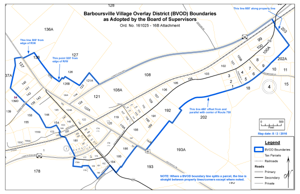
Sec 70-551 Establishment And Applicability
- Applicability. These overlay district regulations shall apply to the area designated as the Barboursville village on the Recommended Land Use Map of the adopted 2013 Comprehensive Plan, and more specifically as shown on the map adopted by the Board of Supervisors.
- Overlay concept. Unless otherwise stated herein, the permitted uses and other regulations of the underlying zoning districts and all other sections of this Zoning Ordinance shall continue to apply. All commercial development within the district shall conform to these provisions, unless specifically exempted.
- Zoning Map. The boundaries of this district shall be clearly delineated on the county’s zoning maps.
- A BVOD Advisory Committee (BVODAC) shall be appointed by the Board Of Supervisors for terms of two (2) years each. The BVODAC shall be comprised of five (5) persons, at least three (3) of whom must reside in, or own real estate in, the BVOD.
(Ord. of 01/28/2020)
Sec 70-552 Administration
- Review procedures. All commercial development within the BVOD shall conform to the zoning permit and site plan requirements set forth in Article II of this Chapter. The Zoning Administrator shall refer all submitted minor and major site plans or development proposals within the BVOD to the BVOD Advisory Committee for their review and comment. The Zoning Administrator may refer any submitted site plan or development proposal within the BVOD to the Planning Commission for their review and comment. If the Zoning Administrator denies any part of a site plan or development proposal that he/she finds is not consistent with these overlay regulations, the applicant may make a written request for the matter to be reviewed and determined by the Commission.
- Nonconformities. Unless otherwise stated or modified herein, nonconforming uses and structures shall be regulated by Article III of this Chapter.
- If a commercial structure is nonconforming due to encroaching on a setback area or required yard, it may be expanded or enlarged provided the new portion of the structure is no closer to the affected property line than the nonconforming portion.
- If a commercial structure is nonconforming due to encroaching on a setback area or required yard, it may be expanded or enlarged provided the new portion of the structure is no closer to the affected property line than the nonconforming portion.
Sec 70-553 Uses
- Except as provided in the following subsection, all by-right permitted uses and all special uses in the underlying zoning districts shall be permitted within the BVOD in accordance with individual district regulations.
- The following uses shall not be permitted within the BVOD.
- Adult-oriented business.
- Public utility facility.
- Self-storage facility.
- Wholesale or distribution center.
- Any use utilizing drive-through facilities.
- Any retail store in excess of five thousand square feet is allowed only by special use permit.
Sec 70-554 Area And Frontage Requirements
Minimum lot area and frontage requirements shall be regulated by the underlying zoning districts.
Sec 70-555 Minimum Setback Requirements
The specific requirements provided in this section shall supersede those found elsewhere in this Ordinance, but only within the boundaries of the BVOD. Setback distances not modified by this section shall be regulated by the underlying zoning district(s).
- Constitution Highway (Route 20) and Spotswood Trail (Route 33): minimum setback of seventy-five (75) feet from center-line of the road, which shall apply to all buildings and structures. Parking areas may encroach up to half this minimum distance. Freestanding signs shall have a minimum setback distance from the right of way which is equal to the height of the sign.
- Governor Barbour Street (Route 678): no minimum setback requirement for structures or signs.
- Old Barboursville Road (Route 738): minimum setback of twenty-five (25) feet from the centerline of the road for structures and signs.
- Adjacent to the railroad right-of-way: no minimum setback requirement.
Sec 70-556 Height Requirements
No commercial building or structure within the BVOD shall exceed forty (40) feet in height.
Sec 70-557 Commercial Building Standards
- Applicability. The standards set forth in this section shall apply to all new commercial development within the BVOD. For the purposes of this section, “new” shall refer to any commercial building or structure built after adoption of this overlay district.
- Building design. Commercial buildings shall incorporate the architectural treatments and design considerations established below.
- Any commercial building within the BVOD shall be constructed in any of the following architectural styles by making substantial use of the building elements identified below for the style. Style elements may be physically installed or simulated.
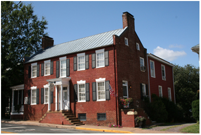
Federal/Georgian Example
Federal/Georgian
Brick or clapboard exterior
A square or rectangular building shape
Double-hung windows with divided lights and shutters
Gable windows
An embellished front entryway (e.g. elliptical fanlights, side lights, Palladian windows, columns, a porch, etc.)
A hip roof or side-gable roof
A symmetrical arrangement of doors and windows
Exterior cornice molding
Quoins
End-chimneys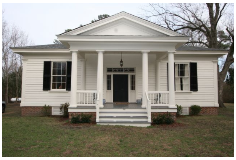
Greek Revival Example
Greek Revival
Brick, clapboard, stucco, or stone exterior
A square or rectangular building shape
A full-height front porch supported by stylized columns
A front gable with a pediment
Decorative pilasters
Double-hung windows with divided lights
Exterior cornice molding
An embellished front entryway (a horizontal transom, side lights, columns, etc.)
A hip roof or low-pitched gable roof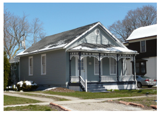
Folk Victorian Example
Vernacular (Folk) Victorian
A square, rectangular, or L-shaped building
A front-gable roof
Clapboard and/or decorative siding (i.e. “fishscale” siding) exterior
Bracketed eaves
A continuous or mostly-continuous front porch with decorative embellishments (e.g. spindlework, brackets, stylized columns, etc.)
Decorative front gable-end detailing
Double-hung windows with top pediments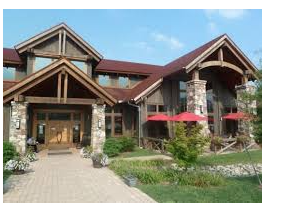
Post & Beam / Timber Frame Example
Post & Beam / Timber Frame
Exposed structural components (i.e. rafters, purlins, posts, girts, knee braces, brackets, etc.)
A square or rectangular building shape
A prominent, covered entryway
Vertical siding, clapboard, stone, stucco, or shake exterior
A gable roof or gambrel roof
Metal, shake, or slate roofing materials - Building and roofing colors shall be subtle, neutral and/or earth tones, and shall be of low-reflectance.
- Strip centers as a building design shall not be permitted within the BVOD. For the purposes of this section, a strip center shall mean any single-story building used for three (3) or more separate commercial uses which are contained within separate units that share a common frontage.
- Any commercial building within the BVOD shall be constructed in any of the following architectural styles by making substantial use of the building elements identified below for the style. Style elements may be physically installed or simulated.
- Mechanical equipment. Roof-mounted mechanical equipment shall be opaquely screened from view at grade by parapet walls or other similar structures that reflect the architecture of the building. Ground-mounted mechanical equipment shall not be located in any yard adjacent to a public road, and shall be opaquely screened from view by walls or structures that are a continuation of the principal structure’s architecture.
- Waste receptacles. Trash dumpsters and waste receptacles for commercial use shall not be located in any yard adjacent to a public road, and shall be opaquely screened from view by fencing and/or evergreen landscaping. This standard shall retroactively apply to any lot upon any new development or complete redevelopment.
- Lighting. All exterior lighting shall be of the full-cutoff variety that directs light downward and away from street or neighboring properties and shall have a historic and/or high-grade style of design reflective of the examples provided below.


- Fencing. Picket fences and split-rail fences are the permitted fence types. Chain-link fencing is expressly prohibited except for security and safety purposes to enclose trash containers, HVAC, electrical etc. In such case the chain-link fencing itself must be opaquely screened from public view by use of approved fencing or natural buffer such as bushes and trees.
Sec 70-558 Off-Street Parking And Landscaping
Off-street parking, loading, and landscaping shall be regulated by the Supplementary District Regulations section of this Chapter.
Sec 70-559 Outdoor Storage
Outdoor storage of goods and materials related to any commercial use shall not be located in any yard adjacent to a public road, and shall be opaquely screened by fencing and/or evergreen landscaping, or shall be within an approved accessory building.
Sec 70-560 Signage
- Area. Maximum allowable area of signage shall be regulated by the underlying zoning district.
- Height. Freestanding signs within the BVOD shall not exceed eight (8) feet in height. Building signs shall not extend above the highest point of the building to which they’re attached.
- Style. Monument signs are the only style of freestanding sign permitted in the BVOD.
- Digital signs. Digital signs shall have a static display (no strobes or star-bursts etc.) of a single color, and may feature a change of message no more frequent than once per sixty (60) seconds.
 (Adopted 10/25/2016)
Sec 70-565A Purpose And Intent
- The Planned Development – Business district implements the policies, objectives, and purposes of the Comprehensive Plan, the Germanna-Wilderness Area Plan, and the Code of Virginia § 15.2-2283 by allowing for flexibility, variety, and cohesiveness in commercial site design while avoiding the inefficient use of land, lack of connectivity, and lack of architectural continuity typically associated with traditional zoning methods.
- The intent of this district is to provide innovative avenues for various types of commercial development which:
- Balance the conventional priority for convenient motor vehicle access with the walkability and efficiency of pedestrian-oriented design;
- Implement design principles that produce functional, harmonious, and attractive buildings and site layouts;
- Take a creative approach in preserving and protecting natural site features through innovative site planning and the use of low impact development (LID) principles; and
- Are compatible with adjoining neighborhoods and adjacent areas with respect to scale, intensity, and design.
Sec 70-565B Applicability
Any property qualifying for a zoning map amendment to the PDB district shall be identified as being within the Germanna-Wilderness Area on the Future Land Use Map of the Comprehensive Plan.
Sec 70-565C Development Plans
- Form. Any PDB district shall be regulated by an overall development plan or master plan, as otherwise required as part of the zoning map amendment submittal requirements specified in Article II of this Chapter. Such plans shall be prepared by a licensed surveyor, engineer, or architect, and in addition to said submittal requirements shall also include:
- Design guidelines and generalized elevation drawings for the overall site;
- A circulation/transportation plan, including a transportation impact analysis (TIA);
- A master signage plan;
- A landscaping plan;
- A generalized land use plan and list of proposed uses; and
- A public utilities plan.
- Major Revisions. Requests for major revisions to a PDB development plan shall follow procedural requirements for zoning map amendments. A major revision shall be characterized by:
- Significant changes in density;
- Substantial changes in vehicular circulation or access;
- Substantial changes in the types of land uses proposed;
- Substantial changes in building design or site design; and
- Any other change the Zoning Administrator determines is a major divergence from the approved development plan.
- Minor revisions. All other changes to an approved PDB development plan shall be considered minor and may be administratively approved by the Zoning Administrator. Requests for minor revisions shall be in writing by the owner. If the Zoning Administrator denies such a request, the matter may be brought before the Board of Supervisors for a public hearing and decision to approve or deny.
- Implementation. All properties for which a PDB development plan is approved shall be under common ownership before construction may begin.
Sec 70-565D Site Development Standards
- Minimum area required to establish a district. Three (3) contiguous acres.
- Minimum lot size. Large enough to adequately accommodate all development requirements.
- Maximum lot coverage ratio. Seventy (70) percent. This may be increased to eighty (80) percent provided that the site design incorporates considerable usage of Low Impact Design (LID) elements and features, such as bioretention, rainwater harvesting, pervious pavement, engineered wetlands, etc.
- Minimum number of separate principal uses. Three (3).
- Principal structures and uses. Multiple principal uses and/or structures may be allowed on a lot.
- Connectivity. Lots within a PDB district shall be arranged such that inter-parcel vehicular travel is possible without the need to utilize the road serving the development.
- Parking criteria. See the Supplementary District Regulations section of this Chapter.
- Landscaping. Established as part of the development plan, which shall at least meet the intent of any landscaping requirements specified in Article V of this Chapter.
- Outdoor lighting criteria. See the Exterior Lighting section of the Supplementary District Regulations section of this Chapter.
- Perimeter buffer. A natural and/or landscaped buffer at least twenty-five (25) feet wide shall be maintained on any side of a PDB district which abuts a residential zoning district or residential use.
- Public utilities required. Public water and wastewater services shall be required for all development in a PDB district.
- Underground utilities. All utilities shall be placed underground.
- Transportation. Any road(s) built to serve a PDB district shall be constructed to meet VDOT Secondary Street Acceptance Requirements unless it is determined the public health, safety, and welfare would be better served otherwise.
- Signage. Established as part of the development plan. A contiguous PDB district shall generally be limited to one (1) permanent free-standing sign unless it is determined the public health, safety, and welfare would be better served otherwise.
Sec 70-565E Building Standards
- Maximum height. Forty (40) feet, unless otherwise permitted via Special Exception or via Special Use Permit for telecommunications facilities.
- Minimum setbacks and yards. Established as part of the development plan.
- Exterior mechanical equipment. All HVAC equipment and other mechanical devices shall be opaquely screened from view from all public rights-of-way.
- Refuse receptacles. Receptacles and enclosures for refuse shall be opaquely screened from view. Screening shall be complementary to building design and materials.
- Building materials. Metal siding and/or non-architectural concrete block shall not comprise any building façade visible from a public right-of-way. No building façade visible from a public right-of-way shall be comprised of more than fifty (50) percent of a single building material.
- Building façades. For building façades visible from a public right-of-way, horizontal wall expanses longer than forty (40) feet shall be interrupted by recesses, projections, overhangs, and other architectural treatments in order to reduce the physical monotony of the building.
- Outdoor storage. Outdoor storage of materials and supplies shall be opaquely screened with landscaping and/or fencing from adjacent properties and public rights-of-way. Chain-link fencing is not permitted as screening for outdoor storage.
Sec 70-567A Purpose And Intent
- The Planned Development – Mixed Use district implements the policies, objectives, and purposes of the Comprehensive Plan, the Germanna-Wilderness Area Plan, and the Code of Virginia § 15.2-2283 by allowing for interrelated and compatible commercial, institutional, residential, and recreational uses within an interconnected pedestrian-oriented neighborhood.
- The intent of this district is to permit flexibility and a focus on high-quality design for mixed-use developments which:
- Provide a level of density and intensity in order to promote a dynamic and convenient neighborhood;
- Exemplify traditional communities that are pedestrian-oriented and offer a variety of transportation, housing, commercial and recreational options;
- Take a creative approach in preserving and protecting natural site features through innovative site planning and the use of low impact development (LID) principles for stormwater management as may be permitted by the Virginia Department of Environmental Quality; and,
- Provide for the efficient use of land which preserves open space and limits impacts to surrounding properties.
Sec 70-567B Applicability
Any property qualifying for a zoning map amendment to the PDM district shall be identified as being within the Germanna-Wilderness Area on the Future Land Use Map of the Comprehensive Plan.
Sec 70-567C Development Plans
- Form. Any PDM district shall be regulated by an overall development plan or master plan, as otherwise required as part of the zoning map amendment submittal requirements specified in Article II of this Chapter. Such plans shall be prepared by a licensed surveyor, engineer, or architect, and in addition to said submittal requirements shall also include:
- Design guidelines and generalized elevation drawings for the overall site;
- A circulation/transportation plan, including a transportation impact analysis (TIA);
- An open space and recreational facilities plan;
- A master signage plan;
- A generalized land use plan and list of proposed uses;
- A landscaping plan; and,
- A public utilities plan.
- Major Revisions. Requests for major revisions to an approved PDM development plan shall follow procedural requirements for zoning map amendments. A major revision shall be characterized by all or any of the following:
- Significant changes in density;
- Substantial changes in vehicular circulation or access;
- Substantial changes in the types of land uses proposed;
- Substantial changes in building design or site design; and,
- Any other change the Zoning Administrator determines is a major divergence from the approved development plan.
- Minor revisions. All other changes to an approved PDM development plan shall be considered minor and may be administratively approved by the Zoning Administrator. Requests for minor revisions shall be in writing by the owner. If the Zoning Administrator denies such a request, the matter may be brought before the Board of Supervisors for a public hearing and decision to approve or deny.
- Implementation. All properties for which a PDM development plan is approved shall be under common ownership prior to the issuance of either a Land Disturbing Permit(s) or site plan approval.
- Alternative Form. Any overall development plan or master plan for a PDM district may integrate or consolidate, remove, or modify any guidance or requirement as set forth herein provided such alternative form supports and furthers the PDM district as set forth in Section 70-567A (Purpose and Intent) subject to the following:
- Such integration or consolidation, removal, or modification, along with information supporting the alternative form, shall be included as part of the zoning map amendment submittal requirements specified in Article II of this Ordinance.
- Sections 70-567D(a), 70-567E(e)(1), and 70-567F(a), (d) and (e) are not eligible for removal or modification.
Adopted by Ord. 180724 – 6A on 7/24/2018
Amended by Ord. 190827 – PH1 on 8/27/2019
Amended by Ord. 230425 – PH2 on 4/25/2023
Amended by Res. 230711 – 5B on 7/11/2023
Sec 70-567D Area Standards
- Minimum area required to establish a district: Twenty (20) contiguous acres.
- Minimum area devoted to nonresidential development: The site shall have a minimum area devoted to nonresidential development of between ten percent (10%) and thirty percent (30%) of the gross project area.
- Maximum gross residential density: Six (6) dwelling units per acre. A PDM district shall have at least two (2) different types of dwelling units, and no more than seventy (70) percent of the total number of units provided shall be any one type of dwelling unit.
- Minimum area devoted to common open space: Twenty percent (20%) of the gross acreage of the site.
- Open space criteria:
- Open space may be in the form of plazas, squares, commons, recreational areas such as playgrounds, ballfields, trails, and bike paths, picnic areas, and natural/wooded areas.
- A minimum of eighty-five percent (85%) percent of dwelling units shall be within one-thousand (1,000) feet of a usable, common open space area at least ten thousand (10,000) contiguous square feet in size.
- All common open space shall be protected by covenants and open space easements setting forth the provisions for its ownership and maintenance.
- Open space density bonuses: For each additional five percent (5%) of open space provided above the required minimum, the maximum gross residential density may be increased by two (2) dwelling units per acre. The maximum gross residential density shall not exceed twelve (12) dwelling units per acre.
Sec 70-567E General Site Layout Guidelines
- Neighborhood core. The site shall have a neighborhood core, of between ten percent (10%) and thirty percent (30%) of the gross project area, which includes a mix of commercial, residential, and open space uses.
- Mixing of uses. Residential and nonresidential land uses must be sufficiently mixed horizontally across the project and vertically within buildings to facilitate a truly pedestrian-oriented environment. Multi-family and single-family attached housing shall generally be located closest to the core of the community and/or central commercial area.
- Access. At least two access points to the project site will be provided. All lots shall front on a public or private street or on a square or plaza. No residential use shall have direct access to any road outside of the district.
- Alleys. Alleys may be utilized to provide access to lots and shall be the preferred means of access for lots in residential areas in order to facilitate a street-front orientation for the structures.
- Street criteria.
- Public and private streets may be provided, but all streets shall be designed in accordance with VDOT Secondary Street Acceptance Requirements unless it is determined by the Board of Supervisors at the time of zoning map amendment the public health, safety, and welfare would be better served otherwise.
- The transportation system will be generally in the form of a grid of interconnected streets, alleys and paths, modified as necessary to accommodate topography and the extent of the project site. Roundabouts are the preferred intersection design subject to VDOT regulations.
- Cul-de-sacs or dead-end roads will not be permitted unless warranted by topographical or site design constraints, as determined by the Zoning Administrator or designee.
- Streets within and adjacent to the neighborhood core will utilize well-delineated crosswalks and bulb-outs or other similar facilities to minimize pedestrian crossing distances.
- Motor vehicle circulation shall be designed to promote pedestrian and bicycle activity.
- Sidewalk criteria.
- Sidewalks shall be provided on both sides of all streets within the project area unless the Zoning Administrator determines that locating a sidewalk on only one (1) side of the street is reasonable for the specific development.
- Sidewalks in residential and non-residential areas shall be designed to ensure pedestrian safety.
- Connections will be made to existing sidewalks if such facilities exist on adjacent properties, unless otherwise prohibited by VDOT regulations.
- Landscaping. Established as part of the development plan, and will at least meet the intent of any landscaping requirements specified in Article V of this Chapter. Street trees will generally be planted throughout the neighborhood core and any other nonresidential or open space areas in order to form a canopy once the trees reach maturity. Tree species will be diversified and indigenous to the area.
- Outdoor lighting criteria. See the Exterior Lighting section of the Supplementary District Regulations section of this chapter.
- Parking criteria.
- See the Supplementary District Regulations section of this Chapter (Sec. 70-671 et. seq.).
- On-street parking may be used to satisfy residential and nonresidential parking requirements, and shall be provided on streets within and adjacent to the neighborhood core.
- Detached garages for single-family attached and detached dwellings shall be located only in the rear or side yard. Attached garages shall not extend beyond the front plane of the dwelling.
- Signage criteria. Established as part of the development plan.
Sec 70-567F Building Standards
- Maximum height. Forty-five (45) feet, unless otherwise permitted via a Special Exception or via Special Use Permit for telecommunications facilities.
- Minimum lot sizes and yards. Established as part of the development plan. Build-to lines shall be utilized instead of traditional minimum setback distances or yard widths. In establishing these standards, the following principles shall be used:
- Fire and rescue access to any property shall not be impaired;
- Adequacy of light, air, privacy, and access to open space is sufficient for residential uses; and,
- The safety and functionality of the transportation network is not hindered.
- Principal structures and uses. Multiple principal uses and/or structures may be allowed on a lot. Where residential uses and nonresidential uses are within a single structure, the residential use(s) shall be considered accessory to the nonresidential use(s).
- Public utilities required. Public water and wastewater services shall be required for all development in a PDM district.
- Underground utilities. All utilities shall be placed underground.
Adopted by Ord. 180724 – 6A on 7/24/2018
Amended by Ord. 230425 – PH2 on 4/25/2023
Amended by Res. 230711 – 5B on 7/11/2023
Sec 70-569A Purpose And Intent
- The Planned Residential – Traditional Design (R-5) district implements the policies, objectives, and purposes of the Comprehensive Plan, the Germanna-Wilderness Area Plan, and the Code of Virginia § 15.2-2283 by allowing for a traditional approach to residential development which provides for the sense of community, pedestrian orientation, sense of place, and connectivity that is commonly associated with neighborhoods prior to the suburbanization of residential development that occurred in the mid-twentieth century.
- The intent of this district is to provide for a manner of residential development which:
- Fosters a sense of community through the application of building placement and orientation standards and ample common spaces;
- Comports with many commonly-accepted principles of traditional neighborhood development while providing a range of housing types;
- Relies on a transportation network that is compact, well-connected, and conducive to all forms of mobility, including walking, biking, and motor vehicles;
- Takes a creative approach in preserving and protecting natural site features through innovative site planning and the use of low impact development (LID) principles; and
- Avoids typical aspects of suburbanization, including large lot sizes, large building setback requirements, a lack of community space and common open space, inefficient use of land, no proximity to commercial centers or civic uses, and a lack of pedestrian infrastructure.
Sec 70-569B Applicability
Any property qualifying for a zoning map amendment to the R-5 district shall be identified as being within the Germanna-Wilderness Area on the Future Land Use Map of the Comprehensive Plan.
Sec 70-569C Development Plans
- Form. Any R-5 district shall be regulated by an overall development plan or master plan submitted and approved as part of the zoning map amendment request. Such plans shall be prepared by a licensed surveyor, engineer, or architect, and in addition to said submittal requirements shall also include:
- Design guidelines for the overall site and generalized lot layout standards for each form of housing to be provided;
- A circulation/transportation plan, including a transportation impact analysis (TIA), hierarchy of streets, and general street cross sections;
- An open space, common areas, and recreational facilities plan;
- A landscaping plan;
- A generalized land use plan; and
- A public utilities plan.
- Major Revisions. Requests for major revisions to an R-5 development plan shall follow procedural requirements for zoning map amendments. A major revision shall be characterized by:
- Significant changes in density;
- Substantial changes in vehicular circulation or access;
- Substantial changes in the types of land uses proposed;
- Substantial changes in building design or site design; and
- Any other change the zoning administrator determines is a major divergence from the approved development plan.
- Minor revisions. All other changes to an approved R-5 development plan shall be considered minor and may be administratively approved by the Zoning Administrator. Requests for minor revisions shall be in writing by the owner. If the Zoning Administrator denies such a request, the matter may be brought before the Board of Supervisors for a decision to approve or deny.
- Implementation. All properties for which an R-5 development plan is approved shall be under common ownership before construction may begin.
Sec 70-569D General Site Development Standards
- Minimum area required to establish a district. Twenty (20) contiguous acres. If a proposed R-5 district is within 1/4 mile of an existing commercial area of considerable size, or is within 1/4 mile of any area specifically designated for commercial use within the adopted Comprehensive Plan, the minimum shall be fifteen (15) acres.
- Public utilities required. Public water and wastewater services shall be required for all development in an R-5 district.
- Underground utilities. All utilities shall be placed underground.
- Maximum height. Forty (40) feet, unless otherwise permitted via Special Exception or via Special Use Permit for telecommunications facilities.
- Landscaping. Established as part of the development plan, which shall at least meet the intent of any landscaping requirements specified in Article V of this Chapter. Street trees shall generally be planted throughout the development in order to form a canopy once the trees reach maturity. Tree species shall be diversified as a precaution against blight.
- Outdoor lighting criteria. See the Exterior Lighting section of the Supplementary District Regulations section of this chapter.
- Signage. If desired, established as part of the development plan.
Sec 70-569E Form-Based Development Design
- Housing forms. All housing provided within an R-5 development shall adhere to the forms provided below (examples shown).
F1: Single-family detached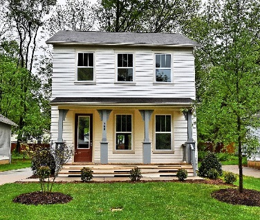
F2: Single-family detached w/ accessory apartment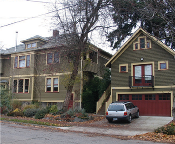
F3: Duplex (over-and-under)
F4: Duplex (side-by-side)
F5: Fourplex
F6: Townhouse
F7: Bungalow court
F8: Courtyard apartments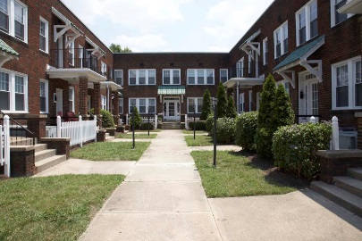
F9: Live/work unit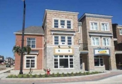
Figure 1: Permitted housing forms and example images- Definitions. For the purposes of these district regulations, the following definitions shall apply:
- F1: Single-family detached. A free-standing dwelling unit designed to provide housing for one (1) family and which is constructed in accordance with the Uniform Statewide Building Code.
- F2: Single-family detached w/ accessory apartment. See above and the definition for accessory apartment in Sec. 70-1.
- F3: Duplex (over-and-under). A structure that consists of two (2) dwelling units stacked one on top of the other with no openings between them, both of which face and are entered from the frontage street.
- F4: Duplex (side-by-side). A structure that consists of two (2) dwelling units connected by a common side wall with no openings between them, both of which face and are entered from the frontage street.
- F5: Fourplex. A structure that consists of four (4) dwelling units, typically two (2) on the ground floor and two (2) above, all of which share a common entry.
- F6: Townhouse. A structure that consists of up to five (5) single-family dwelling units each with separate entrances and connected by common side walls with no openings between them, all of which face and are entered from the frontage street.
- F7: Bungalow court. A site that consists of a series of small detached structures all constructed in a cohesive style, which may be single-family detached or duplex dwellings, arranged around and with entrances onto a common courtyard/shared yard that is typically parallel to the frontage street.
- F8: Courtyard apartments. An L or U-structure that consists of multiple side-by-side or stacked dwelling units accessed from a common courtyard or series of common courtyards, all of which utilize individual and/or shared entrances.
- F9: Live/work unit. A structure, which is typically owned by a single entity, that consists of up to two (2) dwelling units above or behind a nonresidential ground floor space.
- Multiple forms of housing required. At least three (3) forms of housing must be provided in any R-5 development; for the purposes of this section forms F3 and F4 shall be considered one form. No more than forty percent (40%) of the total number of units may be form F1. This may be increased to sixty percent (60%) provided forms F2, F3, and/or F4 are adequately dispersed throughout the areas in which form F1 is provided.
- Live/work units. If provided, all form F9 housing shall be located in the same area within the development.
- Distribution of housing. Higher-density forms of housing shall generally be located closest to any on-site or off-site nonresidential uses, including form F9 units.
- Build-to zones. All housing shall be oriented to the frontage road or for housing forms F7 and F8, to a central courtyard, shared yard, or plaza. Build-to zones shall be utilized for all housing forms instead of traditional building setbacks. No build-to zone shall extend further than twenty-five (25) feet into a lot.
Figure 2: Illustration of a build-to zone (required) and a traditional setback (not permitted) - Neighborhood form. An R-5 development shall be generally arranged in blocks, streets, alleys, building lots, and open space areas. A strict adherence to a right-angle grid pattern is discouraged in order to allow the development to fit within the topography rather than be superimposed upon it.
- Block layout. The perimeter of a given block shall not exceed thirteen-hundred and fifty (1,350) feet, unless it is predominantly for usable common open space. No block face shall have a length greater than five-hundred (500) feet without an alley providing through access. A continuous network of rear alleys is recommended for all lots, and is required for any lot sixty (60) feet or less in width, or for any lot which has frontage on a courtyard/plaza or other open space.
- Garages. If provided, garages shall not face the frontage road to which the lot is oriented unless they are located completely behind the dwelling.
- Open space criteria.
- A minimum of twenty percent (20%) of the gross acreage of an R-5 development shall be devoted to common open space and/or community recreational facilities. The required courtyards associated with housing forms F7 and F8 may be used to meet this requirement provided they are at least ten-thousand (10,000) contiguous square feet in size.
- All dwelling units shall be within at least one-thousand feet of a usable, common open space at least ten-thousand (10,000) contiguous square feet in size.
- All common open space shall be protected by covenants and open space easements setting forth the provisions for its ownership and maintenance.
- Density. An R-5 development shall not exceed a gross density of six (6) dwelling units per acre without density bonuses.
- Density bonuses. Density bonuses may be allowed under the following scenarios. The maximum gross density of any R-5 development shall not exceed twelve (12) dwelling units per acre with density bonuses.
- An additional one (1) dwelling unit per gross acre may be permitted for each additional five percent (5%) open space provided above the required minimum. The maximum bonus permitted via this provision shall be two (2) dwelling units per acre.
- An additional bonus of two (2) dwelling units per acre may be granted if the site abuts either an existing commercial area of considerable size or any area specifically designated for commercial use within the adopted Comprehensive Plan, and improved pedestrian connections are provided to said area.
- An additional bonus of two (2) dwelling units per acre may be granted if at least twenty percent (20%) of the total number of dwelling units is provided as forms F7, F8, and/or F9.
- Definitions. For the purposes of these district regulations, the following definitions shall apply:
Sec 70-569F Transportation Standards
- Streets. All roads shall be dedicated to public use and designed in accordance with VDOT Secondary Street Acceptance Requirements. The Board of Supervisors may allow low-volume roads, alleys, and non-integral roadways to be private and not built according to VDOT standards provided covenants for their maintenance are recorded in the Circuit Court. Streets and their encompassing rights-of-way shall generally be designed to accommodate cars, bicycles, parking, planting strips/islands, and pedestrians.
- Access. At least two access points to the project site shall be provided. All lots shall front on a public or private street or on a square or plaza. No residential use shall have direct access to any road outside of the district.
- Connectivity. Streets and alleys within a TND project shall be generally arranged such that they terminate at other streets and alleys rather than cul-de-sacs or other dead-ends. Where topography or site constraints necessitate the use of a cul-de-sac, the centerline of the cul-de-sac road shall not exceed two-hundred and fifty (250) feet in length. Additionally, access to such a road shall be provided by a road providing internal connectivity rather than by another dead-end road.
Figure 2: Examples of unacceptable (left) and acceptable (right) connectivity - Parking. Parking shall be in accordance with the Supplementary District Standards section of this Chapter. On-street parking shall be strongly encouraged throughout any R-5 development.
- Sidewalks. Sidewalks shall generally be provided on both sides of the roads within any R-5 development. The Board of Supervisors may allow the strategic location of shared-use pathways (e.g. greenways) in certain areas as an alternate means of meeting this requirement.
Sec 70-596A Purpose And Intent
The Technology (T) District is intended to accommodate data centers and other specialized and evolving supportive Artificial Intelligence (AI) and similar technology-based uses in a manner that minimizes impacts on surrounding residential, agricultural, and commercial communities. These uses often require substantial acreage and are typically developed in a campus-style setting that emphasizes functional separation from dense development. The district is intended to be located in proximity to adequate resources and infrastructure with a transportation network of sufficient capacity to support associated activity levels, diversify the tax base, and attract high wage employment. The district supports economic development diversification objectives and encourages investment in technology sectors while maintaining community values and preserves rural character and quality of life through targeted, context-sensitive development, that champions environmental sustainability and resource conservation.
Sec 70-596B Permitted Uses
In the technology district, land may be used for the following uses, and any accessory use that is customarily incidental to such uses:
- Technology college, university, or technical school.
- Technology research and development facility.
Sec 70-596C Uses Permitted By Special Use Permit
In the technology district, the following uses may be permitted upon issuance of a special use permit by the Board of Supervisors:
- Data center.
- On-site primary power generation for a data center.
- Public utility facility, not to include utility-scale solar.
- Telecommunications tower, pursuant to Article 70-IX.
Sec 70-596D Setbacks And Buffers
In the technology district, all required setbacks and buffers shall extend continuously around the entire perimeter of the T District property. For campus-style developments containing multiple data center buildings, the perimeter of the overall project site shall establish the buffer requirement boundaries.
The final buffer design, including plant species, spacing, and supplemental screening elements, shall be determined during the rezoning process and incorporated into the general concept plan.
Whether development occurs in a single phase or in multiple phases, the complete perimeter buffer must be installed following the installation of the erosion and sediment control measures for phase I construction and completed prior to installation of any utilities or building footers.
This ensures that adjacent properties receive immediate and continuous protection from visual and other impacts throughout the project's buildout period.
Performance security in the amount of 125% of the buffer installation cost shall be provided prior to site plan approval.
- Setbacks. All setbacks shall be measured from property lines to nearest point of any building or structure.
- Setbacks from primary highways shall be 500 feet. Section 70-646 (Primary Highways) shall not apply.
- The setback from any adjacent lot which is zoned technology shall be 25 feet.
- The setback from a commercial district property shall be 500 feet.
- The setback from an industrial district property shall be 100 feet.
- The setback from an agricultural district property shall be 500 feet.
- The setback from a residential district property shall be 500 feet.
- The setback minimum from the Rapidan River shall be 1,000 feet and the setback from a perennial stream shall be 500 feet as measured from the top of the bank to any building, structure, or use associated with development on the site. These setbacks may be reduced or increased through the special use permit based on site-specific conditions.
- The setback from a state or federally designated historic district shall be determined through the special use permit.
- No equipment yards shall be facing the public right-of-way or non-industrial use.
- Screen walls for equipment yards (side of equipment yards) shall be provided when visible from the public right-of-way or non-industrial use.
- The setback from any Orange County School Building with students shall be 1,000 feet.
- Buffers.
- Every setback area required by subsections (a)(1) (Primary Highways), (a)(3) (Commercial), (a)(4) (Industrial), (a)(5) (Agricultural), (a)(6) (Residential), and (a)(7) (Rapidan River or perennial stream) above shall contain a buffer which is a minimum of 50% of the depth of the required setback. Buffers shall be comprised of vegetation and may include berms as noted in section (b)(2) below with the intent to create a dense screen to screen the use from view from adjoining properties and public rights-of-way.
- Buffers may include a combination of earthwork features, such as berms, and a variety of plantings to meet the intent of the buffer requirements. To the maximum extent practical, existing woods and vegetation shall be retained to meet the buffer requirements and shall be supplemented with berms and/or native species plantings as necessary where existing woodlands and vegetation do not currently exist within the buffer zone.
- If additional plantings are required to achieve screening intent, the minimum planting rates shall be determined to create a dense screen for the buffer width established by section (b)(1) above.
- At a minimum, native evergreen trees shall be planted at a rate of one per 20 linear feet, three rows staggered, minimum 8-feet of height at time of planting, for the length of the buffer.
- Deciduous shade trees shall be planted at a rate of one per 25 linear feet, two rows staggered, minimum 2.5-inch caliper at time of planting, for the length of the buffer.
- Understory trees shall be planted at a rate of one per 15 linear feet, two rows staggered, for the length of the buffer.
- Deciduous and/or evergreen shrubs shall be planted at a rate of five shrubs every 15 feet on center for the length of the buffer.
- The rate of plantings is determined by the length of any area not adequately buffered by existing mature woodlands.
- The above native plant material may be distributed along berms and to infill areas within existing natural areas not reaching a dense screening effect.
- The adequacy of the buffers shall be determined by the Board of Supervisors with a zoning map amendment application, or in the case of existing zoning, by the Zoning Administrator prior to approval of the site plan for the use.
- At the request of a professional landscape architect, the plantings defined above may be redistributed and clustered (rather than installed in the soldiered pattern) should the alternative provide a more desirable and aesthetic buffer design while meeting the screening intent.
- The Zoning Administrator may approve minor modifications to buffer design (not exceeding 10% variation) for preservation of specimen trees or significant natural features, accommodation of existing utilities or easements, or technical/engineering constraints.
- The Board of Supervisors may approve more substantial modifications only upon finding that:
- The alternative design provides equal or better screening;
- Adjacent property owners have been notified and given opportunity to comment; and
- The modification is consistent with the purpose and intent of this district.
- Buffers may be located anywhere within the required setback areas provided that the buffers are installed in a manner to maximize the screening of the proposed use while ensuring the screening measures are done in a manner to ensure long-term survival of the buffer density and the viewshed is maintained.
- Stormwater facilities shall not be located within buffers unless they are dual-purpose and incorporate open space such as a wet retention pond designed as a site amenity with fountain, perimeter landscaping and shade trees to serve as natural passive open spaces and wildlife corridors.
- Such site amenities shall be incorporated into the overall landscape aesthetic and depicted on the landscape plan.
- In no instance shall the stormwater facility proposed within a required buffer or setback area detract from the natural aesthetic indented by the established setbacks and buffers from the adjacent land uses.
- This option shall be at the discretion of the Board of Supervisors with a zoning map amendment application.
- Permitted elements within buffers include guard houses/security facilities, signage (per Section 70-596F), drive aisles (perpendicular crossing only), underground utilities, and dual-purpose stormwater facilities (with Board approval), provided the intent of the buffer requirement is met.
- Prohibited elements within buffers include security fencing (must be behind buffers), parking areas, above-ground utilities (except perpendicular crossings), and buildings (except security facilities).
- Any security fencing, such as chain-link fencing or barbed wire fencing, shall be located behind buffers or at the setback line, whichever is further from the property line, with the exception of allowing the site security fence to tie into any site security booth/entrance. Decorative ornamental, wooden post, or similar fencing may be located between property lines and in front of buffers to enhance the rural aesthetic, though shall ensure the function of the buffer and setback area as a wildlife corridor are not impeded by such fencing.
- Parking lot landscaping required pursuant to Section 70-677 shall not count towards these buffer requirements.
- All buffers shall be maintained by the owner(s) in perpetuity for as long as the property remains improved.
- A tree preservation and buffer plan shall be an element of the required landscape plan to be prepared and sealed by a professional landscape architect and submitted with any zoning map amendment, or in the case of existing zoning, with the site plan prior to approval of the use. At a minimum, the landscape plan shall identify the location and extent of existing mature healthy trees (woodlands) to be preserved and maintained within the buffer area and the method for existing tree protection during and after construction.
- Additionally, the buffer plan element shall detail proposed berms and native plantings necessary to achieve opacity should existing woodlands need to be supplemented and/or should no existing woodlands be located on the site.
- Added plantings shall be identified by plant type, size, and location on the landscape plan with the requirement for full desired density to be reached within 10 years of planting.
- Plantings shall be designed to reflect and maintain the natural character of the rural area.
- Every effort shall be undertaken to utilize and preserve existing woodlands for the full width and length of the minimum required buffer.
- A surety agreement for landscape maintenance in a form approved by the County Attorney shall be submitted and approved prior to the issuance of any land disturbance permits.
- The amount of the surety shall be determined by an independent landscape architect selected and compensated by the applicant, but approved by the County Administrator or their designee.
- The amount of the surety shall be equal to a reasonable estimate of the amount needed to establish, and following establishment, to maintain the landscaping required by the approved landscape plan for five years after initial installation. Once the landscaping has been successfully established, the surety amount may be reduced to that amount needed for maintenance thereafter.
- The surety will be fully released after five years if successfully established.
- The County reserves the right to impose conditions on the site plan approval which specify species of landscaping, i.e. pollinator species.
- The use of herbicides and pesticides shall be limited.
- In granting a special use permit, the Board of Supervisors may permit modifications to these buffer requirements.
Sec 70-596E Height Regulations
In the technology district, structures shall be 85 feet or less in height. A height above 85 feet can be increased to a maximum height of 100 feet provided the building is setback an additional five feet for every foot in building height above 85 feet.
See Article 70-IX (Telecommunication Towers and Facilities) for height requirements and other regulations specific to telecommunications towers.
Sec 70-596F Signs
In the technology district, signs are permitted as set forth below.
- Each improved lot may be permitted one monument sign, not to exceed 8 feet in height or 32 square feet in area. A corner lot or double frontage lot may be permitted one additional such sign provided there is driveway access to the lot from the additional frontage.
- Each unimproved lot may be permitted one sign advertising the lot for sale, not to exceed 8 feet in height or 16 square feet in area.
- Building signs visible from a public right-of-way are not permitted.
- Signs on improved lots may be lighted such that they have one or more lights shining on them so that each face of the sign is illuminated. Lights used to externally illuminate each face of a sign shall be directed so as to minimize glare to adjacent properties, passing motorists, and pedestrians, as well as meet the exterior lighting requirements of Section 70-624.
Sec 70-596G Use-Specific Regulations
- All uses.
- Maximum impervious coverage: 70%.
- Exterior lighting shall comply with the requirements of Section 70-624.
- Adequate fire apparatus and emergency access roads shall be provided at the discretion of the Zoning Administrator, after consultation with the Fire Marshal.
- Roof-mounted equipment shall be screened from view with parapets or architectural screens.
- All onsite fuel tanks for generators shall be considered as a stormwater management (SWM) hotspot. A narrative shall be provided with the site plan to indicate how all SWM hotspots shall be addressed.
- An emergency action plan shall be submitted for all onsite generators to the Fire Marshal’s office with the first submission of the site plan.
- Data centers.
- All exterior façade and roof treatments and materials shall utilize muted earth color tones (such as soft forest-neutral-palette greens, browns, and grays) tuned to blend with the buffer and shall be non-reflective so as to avoid glare from adjoining properties and the air.
- Where a building is visible from an adjacent public right-of-way or adjacent properties, the building façade shall:
- Avoid the use of monotonous uniform surfaces and include differentiated design elements to reduce the appearance of flat blank walls.
- Include differentiated surfaces at horizontal linear intervals that may vary in frequency but must be no less frequent than 150 horizontal linear feet or no less frequent than 3 times the average height of the building and include a change in one of the following design elements:
- Building material;
- Pattern;
- Texture;
- Color;
- Accent material; or
- Building step-backs or recesses.
- Fenestration (which includes the arrangement of windows and doors on the building elevations) shall be determined through the special use permit.
- Fenestration coverage pattern (the placement pattern of individual or clustered bays of fenestration) must be distributed horizontally and vertically across the principal façade to create design interest.
- Fenestration must be compatible with the other design, materials, details, and treatments used on the same principal façade.
- Alternative design standards to the above may be considered at the request of the applicant as approved by the Board of Supervisors to ensure compatibility with the surrounding rural aesthetic.
- For any zoning map amendment and/or special use permit application, a viewshed analysis containing visual simulations of the proposed site, as if the proposed use(s) were constructed, shall be submitted with the application.
- The analysis shall include at least four vantage points from surrounding public roads and/or adjacent properties to adequately simulate the visual impact of the use in all districts, photo-simulations for all seasons, line of sight analysis, and mitigation measures for identified impacts.
- At a minimum, the analysis shall demonstrate adequacy of the proposed buffers at both the time of installation and at mature height (to be achieved within ten years of planting) considering both east to west and north to south elevations and account for all four seasons.
- Any water management system for industrial processes, to include cooling, shall utilize a closed loop or recycled water system. In no instance shall groundwater or raw water from the Rapidan River be used for industrial processes or data center cooling. Further, no potable water, whether from an aquifer via well or from any perennial stream including the Rapidan River via the Rapidan Service Authority (RSA) or other means, shall be used for industrial processes or data center cooling. The foregoing shall not apply to domestic water requirements (drinking water and sanitary facilities for employees and occupants) and fire suppression requirements.
- A water services plan (feasibility study) must be submitted with the zoning map amendment application or, for properties with existing zoning, before site plan approval. Data centers shall only be approved when they demonstrate sufficient water supply availability and verify no harmful effects on local groundwater and surface water systems.
- The applicant shall provide payment in full for third-party review of the proposed water services plan. The plan will be reviewed by a third-party as selected by the County during the review process.
- Such plan shall, at a minimum, identify the method for industrial equipment cooling, the water source, quantity of water required, water capture and storage, the term for use of such water, and contingency plan for alternative water sources. Additionally, the plan shall demonstrate that the cooling system utilized will not impact the underlying aquifer, yields from the Rapidan River, or the yield(s) of existing wells within 1,000 feet of the property boundary. The plan shall also indicate how any water will be recycled or released into surrounding water bodies (if applicable) and any environmental impact of the release. The plan shall also include how wastewater treatment will be addressed. The study shall be prepared by a licensed geologist, certified hydrologist, and/or other applicable design and engineering professionals, as required.
- When a reuse water system (“purple pipe system”) is required for data center cooling, a water services agreement (WSA) shall be required prior to the construction and development of said system, which WSA shall include, at a minimum, the following requirements:
- That the data center developer shall finance and construct all of the reuse water cooling system;
- Establishment of fees for availability and use of the reuse water cooling system;
- Confirm the available amounts of wastewater capacity to operate the reuse water cooling system and discharging requirements for the same;
- Term for the WSA;
- Periodic reporting of water usage; and
- Other terms and conditions mutually agreeable to the County, RSA, and the data center operator.
- Air quality. All federal and state laws with respect to air emissions shall be met.
- Fuel storage. All federal and state laws with respect to fuel storage shall be met and include a spill prevention plan.
- All emergency power generators shall be restricted to backup or emergency use only and shall be enclosed within Tier 4 sound attenuation enclosures. Generator testing shall only occur between the hours of 10:00 a.m. and 4:00 p.m. unless otherwise required by the Virginia Department of Environmental Quality.
- A sound study must be submitted with the zoning map amendment and/or special use permit application or, for properties with existing zoning, before site plan approval. The study shall be prepared by a licensed professional acoustic engineer or recognized acoustic consultant and shall demonstrate that sound emanating from or otherwise associated with the use, as measured at property lines, does not exceed a decibel level of 65 dB(A) during daytime hours and a decibel level of 60 dB(A) during nighttime hours. Such study shall be conducted using sound level meters described in ANSI SI.4-2104 and generally accepted methodology. The use shall adhere to these limits for as long as it is in operation.
- The study shall include, at a minimum, the measured pre-construction ambient sound levels, the amount of noise to be produced by normal operations and generator testing, and provide strategies to minimize noise and achieve the threshold levels described above.
- The study shall also include recommended sound reducing materials or systems needed to meet the aforesaid decibel limits and incorporated into the construction plans.
- In presence of a “prominent discrete tones,” as measured at a receiving property line, the decibel limits set forth above are decreased by 5 dB(A). A “prominent discrete tone” is defined as a sound that can be heard distinctly as a single pitch or a set of pitches. A "prominent discrete tone" exists if the one-third octave band sound pressure level in the band with the tone exceeds the arithmetic average of the sound pressure levels of the two contiguous one-third octave bands by:
- 5 dB for center frequencies of 500 Hz and above;
- 8 dB for center frequencies between 160 and 400 Hz; or
- 15 dB for center frequencies less than or equal to 125 Hz.
- Any sound-generating ground-mounted equipment shall be fully enclosed where technically feasible. Where enclosure is not technically feasible, both buffering and screening methods shall be provided to reduce noise output and, at a minimum, include screening walls, berms, and opaque evergreen buffers, depending on the design proposal.
- A post-occupancy sound study shall be required no sooner than 90 days and no later than 180 days after the full extent of the use approved by the site plan has been constructed and commenced operation. In the case of a phased site plan, such a study shall be required for each phase. The study shall demonstrate compliance with the decibel limits set forth above. In the event of non-compliance, a remediation plan shall be required to be submitted to the Zoning Administrator and necessary work to remediate the non-compliance shall be performed within a reasonable timeframe as determined by the Zoning Administrator.
- In addition to meeting the minimum lighting requirements of Section 70-624, outdoor lighting for buildings and parking areas shall comply with dark sky principles demonstrated through a comprehensive lighting plan for the project site. Where standards in this section conflict with dark sky principles, the more stringent shall take precedent. In general, dark sky principles include the following:
- Useful: All outdoor lighting should have a clear purpose. Before installing a light, consider if it is necessary for safety or security. In building and parking lot design, this means avoiding over-illumination and unnecessary cosmetic lighting.
- Targeted: Light should only be directed to where it is needed.
- Fully shielded fixtures: All fixtures on buildings and in parking areas must be "full cutoff," meaning they are fully shielded to emit no light above the horizontal plane. This prevents light from escaping upwards and creating "sky glow.”
- Proper aiming: Lights must be aimed downward to illuminate only the target area, such as a parking space or walkway, without spilling into neighboring properties or the night sky.
- Low-level: Lighting should be no brighter than necessary.
- Minimal illumination: Use the lowest possible light levels needed for safety and security.
- Reflective surfaces: Consider the reflectivity of surfaces like asphalt when calculating light levels. A reflective surface can increase the amount of light cast into the night sky.
- Controlled: Lights should only be used when they are useful.
- Timers and motion sensors: Employ controls like timers or motion sensors to automatically dim or turn off lights when they are not needed.
- Variable use: Reduce lighting levels during off-peak hours, such as late at night when a parking lot is mostly empty.
- Warm-colored: Use warm-colored lighting wherever possible.
- Color temperature (CCT): Use bulbs with a correlated color temperature (CCT) of 3000 Kelvin (K) or lower, as these produce a warmer, amber-toned light.
- Reduced blue light: Avoid cool, blue-white light, which is more disruptive to nocturnal wildlife and human circadian rhythms. Warmer light is less likely to be scattered by the atmosphere, reducing sky glow.
Sec 70-570 Statutory Authorization And Purpose
Virginia Code §15.2-2283 specifies that zoning ordinances shall be for the general purpose of promoting the health, safety, or general welfare of the public and of further accomplishing the objectives of §15.2-2200, which encourages localities to improve the public health, safety, convenience, and welfare of their citizens. To these ends, flood ordinances shall be designed to provide for safety from flood, to facilitate the provision of flood protection, and to protect against loss of life, health, or property from flood.
In accordance with these directed provisions, this division is specifically adopted pursuant to the authority granted to localities by Virginia Code §15.2-2280.
The purpose of these provisions is to prevent: the loss of life, health, or property; the creation of health and safety hazards; the disruption of commerce and governmental services; the extraordinary and unnecessary expenditure of public funds for flood protection and relief; and the impairment of the tax base by:
- Regulating uses, activities, and development which, alone or in combination with other existing or future uses, activities, and development, will cause unacceptable increases in flood heights, velocities, and frequencies;
- Restricting or prohibiting certain uses, activities, and development from locating within districts subject to flooding;
- Requiring all those uses, activities, and developments that do occur in flood-prone districts to be protected and/or floodproofed against flooding and flood damage; and
- Protecting individuals from buying land and structures which are unsuited for intended purposes because of flood hazards.
Sec 70-571 Applicability
These provisions shall apply to all privately and publicly owned lands within the jurisdiction of Orange County and identified as areas of special flood hazard by the County or as shown on the flood insurance rate map (FIRM) or as included in the flood insurance study (FIS) that are provided to the County of Orange by FEMA.
Sec 70-572 Compliance And Liability
- No land shall hereafter be developed and no structure shall be located, relocated, constructed, reconstructed, enlarged, or structurally altered except in full compliance with the terms and provisions of this division and any other applicable ordinances and regulations which apply to uses within the jurisdiction of this division.
- The degree of flood protection sought by the provisions of this division is considered reasonable for regulatory purposes and is based on acceptable engineering methods of study, but does not imply total flood protection. Larger floods may occur on rare occasions. Flood heights may be increased by man-made or natural causes, such as ice jams and bridge openings restricted by debris. This division does not imply that districts outside the floodplain district or land uses permitted within such district will be free from flooding or flood damages.
- This division shall not create liability on the part of Orange County or any officer or employee thereof for any flood damages that result from reliance on this division or any administrative decision lawfully made thereunder.
Sec 70-573 Records
Records of actions associated with administering this division shall be kept on file and maintained by or under the direction of the Floodplain Administrator in perpetuity.
Sec 70-574 Abrogation And Greater Restrictions
To the extent that the provisions are more restrictive, this division supersedes any ordinance currently in effect in flood-prone districts. To the extent that any other existing law or regulation is more restrictive or does not conflict, it shall remain in full force and effect.
These regulations are not intended to repeal or abrogate any existing ordinances, including subdivision regulations, zoning ordinances, or building codes. In the event of a conflict between these regulations and any other ordinance, the more restrictive shall govern.
Sec 70-575 Severability
If any section, subsection, paragraph, sentence, clause, or phrase of this division shall be declared invalid for any reason whatever, such decision shall not affect the remaining portions of this division. The remaining portions shall remain in full force and effect; and for this purpose, the provisions of this division are hereby declared to be severable.
Sec 70-576 Penalty For Violation
Any person who fails to comply with any of the requirements or provisions of this subdivision or directions of the Zoning Administrator or any authorized employee of the County of Orange shall be guilty of the appropriate violation and subject to the penalties thereof.
The Virginia Uniform Statewide Building Code addresses building code violations and the associated penalties in Section 104 and Section 115. Violations and associated penalties of the Orange County Zoning Ordinance are addressed in Section 70-38 of the ordinance.
In addition to the above penalties, all other actions are hereby reserved, including an action in equity for the proper enforcement of this subdivision. The imposition of a fine or penalty for any violation of, or noncompliance with, this subdivision shall not excuse the violation or noncompliance or permit it to continue; and all such persons shall be required to correct or remedy such violations within a reasonable time. Any structure constructed, reconstructed, enlarged, altered, or relocated in noncompliance with this subdivision may be declared by the County of Orange to be a public nuisance and abatable as such. Flood insurance may be withheld from structures constructed in violation of this subdivision.
Sec 70-577 Designation Of The Floodplain Administrator
The Floodplain Administrator is hereby appointed to administer and implement these regulations and is referred to herein as the Floodplain Administrator. The Floodplain Administrator may:
- Do the work himself. In the absence of a designated Floodplain Administrator, the duties are conducted by the Orange County Administrator.
- Delegate duties and responsibilities set forth in these regulations to qualified technical personnel, plan examiners, inspectors, and other employees.
- Enter into a written agreement or written contract with another community or private sector entity to administer specific provisions of these regulations. Administration of any part of these regulations by another entity shall not relieve the County of its responsibilities pursuant to the participation requirements of the National Flood Insurance Program as set forth in the Code of Federal Regulations at 44 C.F.R. Section 59.22.
Sec 70-578 Duties And Responsibilities Of The Floodplain Administrator
The duties and responsibilities of the Floodplain Administrator include but are not limited to:
- Review applications for permits to determine whether proposed activities will be located in the Special Flood Hazard Area (SFHA).
- Interpret floodplain boundaries and provide available base flood elevation and flood hazard information.
- Review applications to determine whether proposed activities will be reasonably safe from flooding and require new construction and substantial improvements to meet the requirements of these regulations.
- Review applications to determine whether all necessary permits have been obtained from the Federal, State, or local agencies from which prior or concurrent approval is required; in particular, permits from state agencies for any construction, reconstruction, repair, or alteration of a dam, reservoir, or waterway obstruction (including bridges, culverts, structures), any alteration of a watercourse, or any change of the course, current, or cross section of a stream or body of water, including any change to the 100-year frequency floodplain of free-flowing non-tidal waters of the State.
- Verify that applicants proposing an alteration of a watercourse have notified adjacent communities, the Department of Conservation and Recreation (Division of Dam Safety and Floodplain Management), and other appropriate agencies (VADEQ, USACE), and have submitted copies of such notifications to FEMA.
- Advise applicants for new construction or substantial improvement of structures that are located within an area of the Coastal Barrier Resources System established by the Coastal Barrier Resources Act that Federal flood insurance is not available on such structures; areas subject to this limitation are shown on Flood Insurance Rate Maps as Coastal Barrier Resource System Areas (CBRS) or Otherwise Protected Areas (OPA).
- Approve applications and issue permits to develop in flood hazard areas if the provisions of these regulations have been met, or disapprove applications if the provisions of these regulations have not been met.
- Inspect or cause to be inspected, buildings, structures, and other development for which permits have been issued to determine compliance with these regulations or to determine if non-compliance has occurred or violations have been committed.
- Review Elevation Certificates and require incomplete or deficient certificates to be corrected.
- Submit to FEMA, or require applicants to submit to FEMA, data and information necessary to maintain FIRMs, including hydrologic and hydraulic engineering analyses prepared by or for the County of Orange, within six months after such data and information becomes available if the analyses indicate changes in base flood elevations.
- Maintain and permanently keep records that are necessary for the administration of these regulations, including:
- Flood Insurance Studies, Flood Insurance Rate Maps (including historic studies and maps and current effective studies and maps), and Letters of Map Change; and
- Documentation supporting issuance and denial of permits, Elevation Certificates, documentation of the elevation (in relation to the datum on the FIRM) to which structures have been floodproofed, inspection records, other required design certifications, variances, and records of enforcement actions taken to correct violations of these regulations.
- Enforce the provisions of these regulations, investigate violations, issue notices of violations or stop work orders, and require permit holders to take corrective action.
- Advise the Board of Zoning Appeals regarding the intent of these regulations and, for each application for a variance, prepare a staff report and recommendation.
- Administer the requirements related to proposed work on existing buildings:
- Make determinations as to whether buildings and structures that are located in flood hazard areas and that are damaged by any cause have been substantially damaged.
- Make reasonable efforts to notify owners of substantially damaged structures of the need to obtain a permit to repair, rehabilitate, or reconstruct. Prohibit the non-compliant repair of substantially damaged buildings except for temporary emergency protective measures necessary to secure a property or stabilize a building or structure to prevent additional damage.
- Undertake, as determined appropriate by the Floodplain Administrator due to the circumstances, other actions which may include but are not limited to: issuing press releases, public service announcements, and other public information materials related to permit requests and repair of damaged structures; coordinating with other Federal, State, and local agencies to assist with substantial damage determinations; providing owners of damaged structures information related to the proper repair of damaged structures in special flood hazard areas; and assisting property owners with documentation necessary to file claims for Increased Cost of Compliance coverage under NFIP flood insurance policies.
- Notify the Federal Emergency Management Agency when the corporate boundaries of the County of Orange have been modified and:
- Provide a map that clearly delineates the new corporate boundaries or the new area for which the authority to regulate pursuant to these regulations has either been assumed or relinquished through annexation; and
- If the FIRM for any annexed area includes special flood hazard areas that have flood zones that have regulatory requirements that are not set forth in these regulations, prepare amendments to these regulations to adopt the FIRM and appropriate requirements, and submit the amendments to the governing body for adoption; such adoption shall take place at the same time as or prior to the date of annexation and a copy of the amended regulations shall be provided to Department of Conservation and Recreation (Division of Dam Safety and Floodplain Management) and FEMA.
- Upon the request of FEMA, complete and submit a report concerning participation in the NFIP which may request information regarding the number of buildings in the SFHA, number of permits issued for development in the SFHA, and number of variances issued for development in the SFHA.
- It is the duty of the County Floodplain Administrator to take into account flood, mudslide and flood-related erosion hazards, to the extent that they are known, in all official actions relating to land management and use throughout the entire jurisdictional area of the County, whether or not those hazards have been specifically delineated geographically (e.g., via mapping or surveying).
Sec 70-579 Use And Interpretation Of FIRMS
The Floodplain Administrator shall make interpretations, where needed, as to the exact location of special flood hazard areas, floodplain boundaries, and floodway boundaries. The following shall apply to the use and interpretation of FIRMs and data:
- Where field surveyed topography indicates that adjacent ground elevations:
- Are below the base flood elevation in riverine SFHAs, or below the 1% storm surge elevation in coastal SFHAs, even in areas not delineated as a special flood hazard area on a FIRM, the area shall be considered as special flood hazard area and subject to the requirements of these regulations;
- Are above the base flood elevation and the area is labelled as a SFHA on the FIRM, the area shall be regulated as special flood hazard area unless the applicant obtains a Letter of Map Change that removes the area from the SFHA.
- In FEMA-identified special flood hazard areas where base flood elevation and floodway data have not been identified and in areas where FEMA has not identified SFHAs, any other flood hazard data available from a Federal, State, or other source shall be reviewed and reasonably used.
- Base flood elevations and designated floodway boundaries on FIRMs and in FISs shall take precedence over base flood elevations and floodway boundaries by any other sources if such sources show reduced floodway widths and/or lower base flood elevations.
- Other sources of data shall be reasonably used if such sources show increased base flood elevations and/or larger floodway areas than are shown on FIRMs and in FISs.
- If a Preliminary Flood Insurance Rate Map and/or a Preliminary Flood Insurance Study has been provided by FEMA:
- Upon the issuance of a Letter of Final Determination by FEMA, the preliminary flood hazard data shall be used and shall replace the flood hazard data previously provided from FEMA for the purposes of administering these regulations.
- Prior to the issuance of a Letter of Final Determination by FEMA, the use of preliminary flood hazard data shall be deemed the best available data pursuant to Section 70-586(c) and used where no base flood elevations and/or floodway areas are provided on the effective FIRM.
- Prior to issuance of a Letter of Final Determination by FEMA, the use of preliminary flood hazard data is permitted where the preliminary base flood elevations or floodway areas exceed the base flood elevations and/or designated floodway widths in existing flood hazard data provided by FEMA. Such preliminary data may be subject to change and/or appeal to FEMA.
Sec 70-580 Jurisdictional Boundary Changes
This division, in effect on the date of annexation by a municipality, shall remain in effect and shall be enforced by the municipality for all annexed areas until the municipality adopts and enforces an ordinance which meets the requirements for participation in the National Flood Insurance Program. Municipalities with existing floodplain ordinances shall pass a resolution acknowledging and accepting responsibility for enforcing floodplain ordinance standards prior to annexation of any area containing identified flood hazards. If the FIRM for any annexed area includes special flood hazard areas that have flood zones that have regulatory requirements that are not set forth in these regulations, the governing body shall prepare amendments to these regulations to adopt the FIRM and appropriate requirements, and submit the amendments to the governing body for adoption; such adoption shall take place at the same time as or prior to the date of annexation and a copy of the amended regulations shall be provided to Department of Conservation and Recreation (Division of Dam Safety and Floodplain Management) and FEMA.
In accordance with the Code of Federal Regulations, Title 44 Subpart (B) Section 59.22(a)(9)(v) all NFIP participating communities must notify the Federal Insurance Administration and optionally the State Coordinating Office in writing whenever the boundaries of the County have been modified by annexation or the County has otherwise assumed or no longer has authority to adopt and enforce floodplain management regulations for a particular area.
In order that all Flood Insurance Rate Maps accurately represent the County’s boundaries, a copy of a map of the County suitable for reproduction, clearly delineating the new corporate limits or new area for which the County has assumed or relinquished floodplain management regulatory authority must be included with the notification.
Sec 70-581 District Boundary Changes
The delineation of any of the Floodplain Districts may be revised by the County of Orange where natural or man-made changes have occurred and/or where more detailed studies have been conducted or undertaken by the U. S. Army Corps of Engineers or other qualified agency, or an individual documents the need for such change. However, prior to any such change, approval must be obtained from the Federal Emergency Management Agency. A completed LOMR is a record of this approval.
Sec 70-582 Interpretation Of District Boundaries
Initial interpretations of the boundaries of the Floodplain Districts shall be made by the Zoning Administrator. Should a dispute arise concerning the boundaries of any of the Districts, the Board of Zoning Appeals shall make the necessary determination. The person questioning or contesting the location of the District boundary shall be given a reasonable opportunity to present his case to the Board and to submit his own technical evidence if he so desires.
Sec 70-583 Submitting Model Backed Technical Data
The County’s base flood elevations may increase or decrease resulting from physical changes affecting flooding conditions. As soon as practicable, but not later than six months after the date such information becomes available, the County shall notify the Federal Emergency Management Agency of the changes by submitting technical or scientific data. The County may submit data via a LOMR. Such a submission is necessary so that upon confirmation of those physical changes affecting flooding conditions, risk premium rates and floodplain management requirements will be based upon current data.
Sec 70-584 Letters Of Map Revision
When development in the floodplain will cause or causes a change in the base flood elevation, the applicant, including state agencies, must notify FEMA by applying for a Conditional Letter of Map Revision and then a Letter of Map Revision.
Sec 70-585 Appeal Of Decisions Of The Floodplain Administrator
Appeals of decisions of the Floodplain Administrator shall be to the Board of Zoning Appeals and shall follow the process established in Orange County Code Section 70-68 (Appeals from Decisions of the Zoning Administrator).
Sec 70-586 Description Of Special Flood Hazard Districts
The various special flood hazard districts shall include the SFHAs. The basis for the delineation of these districts shall be the FIS and the FIRM for Orange County prepared by the Federal Emergency Management Agency, Federal Insurance Administration, dated May 17, 2022, and any subsequent revisions or amendments thereto.
The County of Orange may identify and regulate local flood hazard or ponding areas that are not delineated on the FIRM. These areas may be delineated on a “Local Flood Hazard Map” using best available topographic data and locally derived information such as flood of record, historic high water marks, or approximate study methodologies.
The boundaries of the SFHA Districts are established as shown on the FIRM which is declared to be a part of this division and which shall be kept on file at the County of Orange offices.
- The Floodway District is in an AE Zone and is delineated, for purposes of this division, using the criterion that certain areas within the floodplain must be capable of carrying the waters of the one percent annual chance flood without increasing the water surface elevation of that flood more than one (1) foot at any point. The areas included in this District are specifically defined in Table 2 of the above-referenced FIS and shown on the accompanying FIRM.
The following provisions shall apply within the Floodway District of an AE zone [44 CFR 60.3(d)]:- Within any floodway area, no encroachments, including fill, new construction, substantial improvements, or other development shall be permitted unless it has been demonstrated through hydrologic and hydraulic analysis performed in accordance with standard engineering practice that the proposed encroachment will not result in any increase in flood levels within the County during the occurrence of the base flood discharge. Hydrologic and hydraulic analyses shall be undertaken only by professional engineers or others of demonstrated qualifications, who shall certify that the technical methods used correctly reflect currently-accepted technical concepts. Studies, analyses, computations, etc., shall be submitted in sufficient detail to allow a thorough review by the Floodplain Administrator.
Development activities which increase the water surface elevation of the base flood may be allowed, provided that the applicant first applies – with the County of Orange endorsement – for a Conditional Letter of Map Revision (CLOMR), and receives the approval of the Federal Emergency Management Agency.
If Section 70-586(a)(1) is satisfied, all new construction and substantial improvements shall comply with all applicable flood hazard reduction provisions of Subdivision 4. - The placement of manufactured homes (mobile homes) is prohibited, except in an existing manufactured home (mobile home) park or subdivision. A replacement manufactured home may be placed on a lot in an existing manufactured home park or subdivision provided the anchoring, elevation, and encroachment standards are met.
- Within any floodway area, no encroachments, including fill, new construction, substantial improvements, or other development shall be permitted unless it has been demonstrated through hydrologic and hydraulic analysis performed in accordance with standard engineering practice that the proposed encroachment will not result in any increase in flood levels within the County during the occurrence of the base flood discharge. Hydrologic and hydraulic analyses shall be undertaken only by professional engineers or others of demonstrated qualifications, who shall certify that the technical methods used correctly reflect currently-accepted technical concepts. Studies, analyses, computations, etc., shall be submitted in sufficient detail to allow a thorough review by the Floodplain Administrator.
- The AE on the FIRM accompanying the FIS shall be those areas for which one-percent annual chance flood elevations have been provided and the floodway has not been delineated. The following provisions shall apply within an AE zone [44 CFR 60.3(c)] where FEMA has provided base flood elevations:
- Until a regulatory floodway is designated, no new construction, substantial improvements, or other development (including fill) shall be permitted within the areas of special flood hazard, designated as Zones A1-30 or AE on the FIRM, unless it is demonstrated that the cumulative effect of the proposed development, when combined with all other existing and anticipated development, will not increase the water surface elevation of the base flood more than one foot at any point within the County of Orange.
Development activities in Zones A1-30 or AE on the Orange County FIRM which increase the water surface elevation of the base flood by more than one foot may be allowed, provided that the applicant first applies – with the County of Orange’s endorsement – for a Conditional Letter of Map Revision, and receives the approval of the Federal Emergency Management Agency.
- Until a regulatory floodway is designated, no new construction, substantial improvements, or other development (including fill) shall be permitted within the areas of special flood hazard, designated as Zones A1-30 or AE on the FIRM, unless it is demonstrated that the cumulative effect of the proposed development, when combined with all other existing and anticipated development, will not increase the water surface elevation of the base flood more than one foot at any point within the County of Orange.
- The A Zone on the FIRM accompanying the FIS shall be those areas for which no detailed flood profiles or elevations are provided, but the one percent annual chance floodplain boundary has been approximated. For these areas, the following provisions shall apply [44 CFR 60.3(b)]:
- The Approximated Floodplain District shall be that floodplain area for which no detailed flood profiles or elevations are provided, but where a one percent annual chance floodplain boundary has been approximated. Such areas are shown as Zone A on the maps accompanying the FIS. For these areas, the base flood elevations and floodway information from Federal, State, and other acceptable sources shall be used, when available. Where the specific one percent annual chance flood elevation cannot be determined for this area using other sources of data, such as the U. S. Army Corps of Engineers Floodplain Information Reports, U. S. Geological Survey Flood-Prone Quadrangles, etc., then the applicant for the proposed use, development and/or activity shall determine this base flood elevation. For development proposed in the approximate floodplain the applicant must use technical methods that correctly reflect currently accepted practices, such as point on boundary, high water marks, or detailed methodologies hydrologic and hydraulic analyses. Studies, analyses, computations, etc., shall be submitted in sufficient detail to allow a thorough review by the Floodplain Administrator.
The Floodplain Administrator reserves the right to require a hydrologic and hydraulic analysis for any development. When such base flood elevation data is utilized, the lowest floor shall be elevated to or above the base flood level plus eighteen (18) inches.
During the permitting process, the Floodplain Administrator shall obtain:
The elevation of the lowest floor (in relation to mean sea level), including the basement, of all new and substantially improved structures; and
If the structure has been floodproofed in accordance with the requirements of this subdivision, the elevation (in relation to mean sea level) to which the structure has been floodproofed.
Base flood elevation data shall be obtained from other sources or developed using detailed methodologies comparable to those contained in a FIS for subdivision proposals and other proposed development proposals (including manufactured home parks and subdivisions) that exceed fifty lots or five acres, whichever is the lesser.
- The mapped floodplain includes all of the above regions and also the regions designated as having a 0.2 percent annual chance of flooding on any flood map or flood insurance study. In this area no emergency service, medical service, or governmental records storage shall be allowed except by special exception using the variance process.
- The Approximated Floodplain District shall be that floodplain area for which no detailed flood profiles or elevations are provided, but where a one percent annual chance floodplain boundary has been approximated. Such areas are shown as Zone A on the maps accompanying the FIS. For these areas, the base flood elevations and floodway information from Federal, State, and other acceptable sources shall be used, when available. Where the specific one percent annual chance flood elevation cannot be determined for this area using other sources of data, such as the U. S. Army Corps of Engineers Floodplain Information Reports, U. S. Geological Survey Flood-Prone Quadrangles, etc., then the applicant for the proposed use, development and/or activity shall determine this base flood elevation. For development proposed in the approximate floodplain the applicant must use technical methods that correctly reflect currently accepted practices, such as point on boundary, high water marks, or detailed methodologies hydrologic and hydraulic analyses. Studies, analyses, computations, etc., shall be submitted in sufficient detail to allow a thorough review by the Floodplain Administrator.
Sec 70-587 Overlay Concept
The Floodplain Districts described above shall be overlays to the existing underlying districts as shown on the Official Zoning Ordinance Map, and as such, the provisions for the floodplain districts shall serve as a supplement to the underlying district provisions.
If there is any conflict between the provisions or requirements of the Floodplain Districts and those of any underlying district, the more restrictive provisions and/or those pertaining to the floodplain districts shall apply.
In the event any provision concerning a Floodplain District is declared inapplicable as a result of any legislative or administrative actions or judicial decision, the basic underlying provisions shall remain applicable.
Sec 70-588 Permit And Application Requirements
- Permit Requirement
All uses, activities, and development occurring within any floodplain district, including placement of manufactured homes, shall be undertaken only upon the issuance of a permit. Such development shall be undertaken only in strict compliance with the provisions of this division and with all other applicable codes and ordinances, as amended, such as the Virginia Uniform Statewide Building Code (VA USBC) and the Orange County Subdivision Ordinance. Prior to the issuance of any such permit, the Floodplain Administrator shall require all applications to include compliance with all applicable State and Federal laws and shall review all sites to assure they are reasonably safe from flooding. Under no circumstances shall any use, activity, and/or development adversely affect the capacity of the channels or floodways of any watercourse, drainage ditch, or any other drainage facility or system. - Site Plans and Permit Applications
All applications for development within any floodplain district and all permits issued for the floodplain shall incorporate the following information:- The elevation of the Base Flood at the site.
- For structures to be elevated, the elevation of the lowest floor (including basement).
- For structures to be floodproofed (non-residential only), the elevation to which the structure will be floodproofed.
- Topographic information showing existing and proposed ground elevations.
Sec 70-589 General Standards
The following provisions shall apply to all permits:
- New construction and substantial improvements shall be built according to this division and the Virginia Uniform Statewide Building Code, and anchored to prevent flotation, collapse, or lateral movement of the structure.
- Manufactured homes shall be anchored to prevent flotation, collapse, or lateral movement. Methods of anchoring may include, but are not limited to, use of over-the-top or frame ties to ground anchors. This standard shall be in addition to and consistent with applicable state anchoring requirements for resisting wind forces.
- New construction and substantial improvements shall be constructed with materials and utility equipment resistant to flood damage.
- New construction or substantial improvements shall be constructed by methods and practices that minimize flood damage.
- Electrical, heating, ventilation, plumbing, air conditioning equipment, and other service facilities, including duct work, shall be designed and/or located so as to prevent water from entering or accumulating within the components during conditions of flooding.
- New and replacement water supply systems shall be designed to minimize or eliminate infiltration of flood waters into the system.
- New and replacement sanitary sewage systems shall be designed to minimize or eliminate infiltration of flood waters into the systems and discharges from the systems into flood waters.
- On-site waste disposal systems shall be located and constructed to avoid impairment to them or contamination from them during flooding.
In addition to paragraphs A - H above, in all special flood hazard areas, the additional paragraphs shall apply:
Prior to any proposed alteration or relocation of any channels or of any watercourse, stream, etc., within this jurisdiction a permit shall be obtained from the U. S. Corps of Engineers, the Virginia Department of Environmental Quality, and the Virginia Marine Resources Commission (a joint permit application is available from any of these organizations). Furthermore, in riverine areas, notification of the proposal shall be given by the applicant to all affected adjacent jurisdictions, the Department of Conservation and Recreation (Division of Dam Safety and Floodplain Management), other required agencies, and the Federal Emergency Management Agency.
The flood carrying capacity within an altered or relocated portion of any watercourse shall be maintained.
Sec 70-590 Elevation And Construction Standards
In all identified flood hazard areas where base flood elevations have been provided in the FIS or generated by a certified professional in accordance with Section 70-586(c) the following provisions shall apply:
- Residential Construction
New construction or substantial improvement of any residential structure (including manufactured homes) in Zones AE and A with detailed base flood elevations shall have the lowest floor, including basement, elevated to or above the base flood level plus eighteen (18) inches. - Non-Residential Construction
- New construction or substantial improvement of any commercial, industrial, or non-residential building (or manufactured home) shall have the lowest floor, including basement, elevated to or above the base flood level plus eighteen (18) inches.
- Non-residential buildings located in all and AE zones may be floodproofed in lieu of being elevated provided that all areas of the building components below the elevation corresponding to the BFE plus two feet are water tight with walls substantially impermeable to the passage of water, and use structural components having the capability of resisting hydrostatic and hydrodynamic loads and the effect of buoyancy. A registered professional engineer or architect shall certify that the standards of this subsection are satisfied. Such certification, including the specific elevation (in relation to mean sea level) to which such structures are floodproofed, shall be maintained by the County Administrator.
- Space Below the Lowest Floor
In zones A and AE, fully enclosed areas of new construction or substantially improved structures, which are below the regulatory flood protection elevation, shall:- Not be designed or used for human habitation, but shall be used solely for parking of vehicles, building access, or limited storage of maintenance equipment used in connection with the premises. Access to the enclosed area shall be the minimum necessary to allow for parking of vehicles (garage door) or limited storage of maintenance equipment (standard exterior door), or entry to the living area (stairway or elevator).
- Be constructed entirely of flood resistant materials below the regulatory flood protection elevation.
- Include measures to automatically equalize hydrostatic flood forces on walls by allowing for the entry and exit of floodwaters. To meet this requirement, the openings must either be certified by a professional engineer or architect or meet the following minimum design criteria:
- Provide a minimum of two openings on different sides of each enclosed area subject to flooding.
- The total net area of all openings must be at least one (1) square inch for each square foot of enclosed area subject to flooding.
- If a building has more than one enclosed area, each area must have openings to allow floodwaters to automatically enter and exit.
- The bottom of all required openings shall be no higher than one (1) foot above the adjacent grade.
- Openings may be equipped with screens, louvers, or other opening coverings or devices, provided they permit the automatic flow of floodwaters in both directions.
- Foundation enclosures made of flexible skirting are not considered enclosures for regulatory purposes, and, therefore, do not require openings. Masonry or wood underpinning, regardless of structural status, is considered an enclosure and requires openings as outlined above.
- Accessory Structures
- Accessory structures in the SFHA shall comply with the elevation requirements and other requirements of Sec. 70-590(b), or, if not elevated or dry floodproofed, shall:
- Not be used for human habitation;
- Be limited to no more than 600 square feet in total floor area;
- Be useable only for parking of vehicles or limited storage;
- Be constructed with flood damage-resistant materials below the base flood elevation;
- Be constructed and placed to offer the minimum resistance to the flow of floodwaters;
- Be anchored to prevent flotation;
- Have electrical service and mechanical equipment elevated to or above the base flood elevation;
- Shall be provided with flood openings which shall meet the following criteria:
- There shall be a minimum of two flood openings on different sides of each enclosed area; if a building has more than one enclosure below the lowest floor, each such enclosure shall have flood openings on exterior walls.
- The total net area of all flood openings shall be at least 1 square inch for each square foot of enclosed area (non-engineered flood openings), or the flood openings shall be engineered flood openings that are designed and certified by a licensed professional engineer to automatically allow entry and exit of floodwaters; the certification requirement may be satisfied by an individual certification or an Evaluation Report issued by the ICC Evaluation Service, Inc.
- The bottom of each flood opening shall be 1 foot or less above the higher of the interior floor or grade, or the exterior grade, immediately below the opening.
- Any louvers, screens or other covers for the flood openings shall allow the automatic flow of floodwaters into and out of the enclosed area.
- Accessory structures in the SFHA shall comply with the elevation requirements and other requirements of Sec. 70-590(b), or, if not elevated or dry floodproofed, shall:
- Standards for Manufactured Homes and Recreational Vehicles
- In zones A and AE, all manufactured homes placed, or substantially improved, on individual lots or parcels, must meet all the requirements for new construction, including the elevation and anchoring requirements in Secs. 70-589 and 70-590.
- All recreational vehicles placed on sites must either:
- Be on the site for fewer than 180 consecutive days, be fully licensed and ready for highway use (a recreational vehicle is ready for highway use if it is on its wheels or jacking system, is attached to the site only by quick disconnect type utilities and security devices and has no permanently attached additions); or
- Meet all the requirements for manufactured homes in Section 70-590(e)(1).
Sec 70-591 Standards For Subdivision Proposals
- All subdivision proposals shall be consistent with the need to minimize flood damage;
- All subdivision proposals shall have public utilities and facilities such as sewer, gas, electrical and water systems located and constructed to minimize flood damage;
- All subdivision proposals shall have adequate drainage provided to reduce exposure to flood hazards, and
- Base flood elevation data shall be obtained from other sources or developed using detailed methodologies, hydraulic and hydrologic analysis, comparable to those contained in a Flood Insurance Study for subdivision proposals and other proposed development proposals (including manufactured home parks and subdivisions) that exceed fifty lots or five acres, whichever is the lesser.
Sec 70-592 Existing Structures In Floodplain Areas
Any structure or use of a structure or premises must be brought into conformity with these provisions when it is changed, repaired, or improved unless one of the following exceptions is established before the change is made:
- The Floodplain Administrator has determined that:
- Change is not a substantial repair or substantial improvement (for example: replacing roofing or siding is not a substantial repair); and
- Any new structure to be built in the floodplain is compliant; and
- No new structure is being built in the floodway; and
- The change complies with this division and the Virginia Uniform Statewide Building Code.
- The changes are required to comply with a citation for a health or safety violation.
- The structure is a historic structure and the change required would impair the historic nature of the structure.
Sec 70-593 Variances; Factors To Be Considered
Variances shall be issued only upon (i) a showing of good and sufficient cause, (ii) after the Board of Zoning Appeals has determined that failure to grant the variance would result in exceptional hardship to the applicant, and (iii) after the Board of Zoning Appeals has determined that the granting of such variance will not result in (a) unacceptable or prohibited increases in flood heights, (b) additional threats to public safety, (c) extraordinary public expense; and will not (d) create nuisances, (e) cause fraud or victimization of the public, or (f) conflict with local laws or ordinances.
While the granting of variances generally is limited to a lot size less than one-half acre, deviations from that limitation may occur. However, as the lot size increases beyond one-half acre, the technical justification required for issuing a variance increases. Variances may be issued by the Board of Zoning Appeals for new construction and substantial improvements to be erected on a lot of one-half acre or less in size contiguous to and surrounded by lots with existing structures constructed below the base flood level, in conformance with the provisions of this section.
Variances may be issued for new construction and substantial improvements and for other development necessary for the conduct of a functionally dependent use provided that the criteria of this section are met, and the structure or other development is protected by methods that minimize flood damages during the base flood and create no additional threats to public safety.
In passing upon applications for variances, the Board of Zoning Appeals shall satisfy all relevant factors and procedures specified in other sections of the Zoning Ordinance and consider the following additional factors:
- The danger to life and property due to increased flood heights or velocities caused by encroachments. No variance shall be granted for any proposed use, development, or activity within any Floodway District that will cause any increase in the one percent (1%) chance flood elevation.
- The danger that materials may be swept on to other lands or downstream to the injury of others.
- The proposed water supply and sanitation systems and the ability of these systems to prevent disease, contamination, and unsanitary conditions.
- The susceptibility of the proposed facility and its contents to flood damage and the effect of such damage on the individual owners.
- The importance of the services provided by the proposed facility to the community.
- The requirements of the facility for a waterfront location.
- The availability of alternative locations not subject to flooding for the proposed use.
- The compatibility of the proposed use with existing development and development anticipated in the foreseeable future.
- The relationship of the proposed use to the Comprehensive Plan and floodplain management program for the area.
- The safety of access by ordinary and emergency vehicles to the property in time of flood.
- The expected heights, velocity, duration, rate of rise, and sediment transport of the flood waters expected at the site.
- The historic nature of a structure. Variances for repair or rehabilitation of historic structures may be granted upon a determination that the proposed repair or rehabilitation will not preclude the structure's continued designation as a historic structure and the variance is the minimum necessary to preserve the historic character and design of the structure.
- No variance shall be granted for an accessory structure exceeding 600 square feet.
- Such other factors which are relevant to the purposes of this division.
The Board of Zoning Appeals may refer any application and accompanying documentation pertaining to any request for a variance to any engineer or other qualified person or agency for technical assistance in evaluating the proposed project in relation to flood heights and velocities, and the adequacy of the plans for flood protection and other related matters.
Variances shall be issued only after the Board of Zoning Appeals has determined that the granting of such will not result in (a) unacceptable or prohibited increases in flood heights, (b) additional threats to public safety, (c) extraordinary public expense; and will not (d) create nuisances, (e) cause fraud or victimization of the public, or (f) conflict with local laws or ordinances.
Variances shall be issued only after the Board of Zoning Appeals has determined that the variance will be the minimum required to provide relief.
The Board of Zoning Appeals shall notify the applicant for a variance, in writing that the issuance of a variance to construct a structure below the one percent (1%) chance flood elevation (a) increases the risks to life and property and (b) will result in increased premium rates for flood insurance.
A record shall be maintained of the above notification as well as all variance actions, including justification for the issuance of the variances. Any variances that are issued shall be noted in the annual or biennial report submitted to the Federal Insurance Administrator.
Sec 70-594 Definitions
The following words, terms and phrases, when used in this division, shall have the meanings ascribed to them in this section, except where the context clearly indicates a different meaning:
Appurtenant or accessory structure - A non-residential structure which is on the same parcel of property as the principal structure and the use of which is incidental to the use of the principal structure. Accessory structures are not to exceed 600 square feet.
Base flood - The flood having a one percent chance of being equaled or exceeded in any given year.
Base flood elevation - The water surface elevations of the base flood, that is, the flood level that has a one percent or greater chance of occurrence in any given year. The water surface elevation of the base flood in relation to the datum specified on the County’s Flood Insurance Rate Map. For the purposes of this division, the base flood is the 1% annual chance flood.
Basement - Any area of the building having its floor sub-grade (below ground level) on all sides.
Board of Zoning Appeals - The board appointed to review appeals made by individuals with regard to decisions of the Zoning Administrator in the interpretation of this division.
Development - Any man-made change to improved or unimproved real estate, including, but not limited to, buildings or other structures, temporary structures, mining, dredging, filling, grading, paving, excavation, drilling or other land-disturbing activities or permanent or temporary storage of equipment or materials.
Elevated building - A non-basement building built to have the lowest floor elevated above the ground level by means of solid foundation perimeter walls, pilings, or columns (posts and piers).
Encroachment - The advance or infringement of uses, plant growth, fill, excavation, buildings, permanent structures or development into a floodplain, which may impede or alter the flow capacity of a floodplain.
Existing construction - For the purposes of the insurance program, structures for which the “start of construction” commenced before the effective date of the FIRM or before January 1, 1975 for FIRMs effective before that date. “Existing construction” may also be referred to as “existing structures” and “pre-FIRM.”
Flood or flooding -
- A general or temporary condition of partial or complete inundation of normally dry land areas from:
- The overflow of inland or tidal waters; or,
- The unusual and rapid accumulation or runoff of surface waters from any source.
- Mudflows which are proximately caused by flooding as defined in paragraph (1)(b) of this definition and are akin to a river of liquid and flowing mud on the surfaces of normally dry land areas, as when earth is carried by a current of water and deposited along the path of the current.
- The collapse or subsidence of land along the shore of a lake or other body of water as a result of erosion or undermining caused by waves or currents of water exceeding anticipated cyclical levels or suddenly caused by an unusually high water level in a natural body of water, accompanied by a severe storm, or by an unanticipated force of nature such as flash flood or an abnormal tidal surge, or by some similarly unusual and unforeseeable event which results in flooding as defined in paragraph 1 (a) of this definition.
Flood Insurance Rate Map (FIRM) - an official map of the County, on which the Federal Emergency Management Agency has delineated both the special hazard areas and the risk premium zones applicable to the community. A FIRM that has been made available digitally is called a Digital Flood Insurance Rate Map (DFIRM).
Flood Insurance Study (FIS) - a report by FEMA that examines, evaluates and determines flood hazards and, if appropriate, corresponding water surface elevations, or an examination, evaluation and determination of mudflow and/or flood-related erosion hazards.
Floodplain or flood-prone area - Any land area susceptible to being inundated by water from any source.
Floodproofing - any combination of structural and non-structural additions, changes, or adjustments to structures which reduce or eliminate flood damage to real estate or improved real property, water and sanitary facilities, structures and their contents.
Floodway - The channel of a river or other watercourse and the adjacent land areas that must be reserved in order to discharge the base flood without cumulatively increasing the water surface elevation more than one foot at any point within the County.
Freeboard - A factor of safety usually expressed in feet above a flood level for purposes of floodplain management. “Freeboard” tends to compensate for the many unknown factors that could contribute to flood heights greater than the height calculated for a selected size flood and floodway conditions, such as wave action, bridge openings, and the hydrological effect of urbanization in the watershed.
Functionally dependent use - A use which cannot perform its intended purpose unless it is located or carried out in close proximity to water. This term includes only docking facilities, port facilities that are necessary for the loading and unloading of cargo or passengers, and shipbuilding and ship repair facilities, but does not include long-term storage or related manufacturing facilities.
Highest adjacent grade - the highest natural elevation of the ground surface prior to construction next to the proposed walls of a structure.
Historic structure - Any structure that is:
- Listed individually in the National Register of Historic Places (a listing maintained by the Department of Interior) or preliminarily determined by the Secretary of the Interior as meeting the requirements for individual listing on the National Register;
- Certified or preliminarily determined by the Secretary of the Interior as contributing to the historical significance of a registered historic district or a district preliminarily determined by the Secretary to qualify as a registered historic district;
- Individually listed on a state inventory of historic places in states with historic preservation programs which have been approved by the Secretary of the Interior; or,
- Individually listed on a local inventory of historic places in communities with historic preservation programs that have been certified either:
- By an approved state program as determined by the Secretary of the Interior; or,
- Directly by the Secretary of the Interior in states without approved programs.
Hydrologic and Hydraulic Engineering Analysis - Analyses performed by a licensed professional engineer, in accordance with standard engineering practices that are accepted by the Virginia Department of Conservation and Recreation and FEMA, used to determine the base flood, other frequency floods, flood elevations, floodway information and boundaries, and flood profiles.
Letters of Map Change (LOMC) - A Letter of Map Change is an official FEMA determination, by letter, that amends or revises an effective Flood Insurance Rate Map or Flood Insurance Study. Letters of Map Change include:
- Letter of Map Amendment (LOMA) - An amendment based on technical data showing that a property was incorrectly included in a designated special flood hazard area. A LOMA amends the current effective Flood Insurance Rate Map and establishes that a land as defined by meets and bounds or structure is not located in a special flood hazard area.
- Letter of Map Revision (LOMR) - A revision based on technical data that may show changes to flood zones, flood elevations, floodplain and floodway delineations, and planimetric features. A Letter of Map Revision Based on Fill (LOMR-F), is a determination that a structure or parcel of land has been elevated by fill above the base flood elevation and is, therefore, no longer exposed to flooding associated with the base flood. In order to qualify for this determination, the fill must have been permitted and placed in accordance with the County’s floodplain management regulations.
- Conditional Letter of Map Revision (CLOMR) - A formal review and comment as to whether a proposed flood protection project or other project complies with the minimum NFIP requirements for such projects with respect to delineation of special flood hazard areas. A CLOMR does not revise the effective Flood Insurance Rate Map or Flood Insurance Study.
Lowest adjacent grade - the lowest natural elevation of the ground surface next to the walls of a structure.
Lowest floor - The lowest floor of the lowest enclosed area (including basement). An unfinished or flood-resistant enclosure, usable solely for parking of vehicles, building access or storage in an area other than a basement area is not considered a building’s lowest floor; provided, that such enclosure is not built so as to render the structure in violation of the applicable non-elevation design requirements of Federal Code 44CFR §60.3.
Manufactured home - A structure, transportable in one or more sections, which is built on a permanent chassis and is designed for use with or without a permanent foundation when connected to the required utilities. For floodplain management purposes the term “manufactured home” also includes park trailers, travel trailers, and other similar vehicles placed on a site for greater than 180 consecutive days.
Manufactured home park or subdivision - a parcel (or contiguous parcels) of land divided into two or more manufactured home lots for rent or sale.
Mean Sea Level – for purposes of the National Flood Insurance Program, the National Geodetic Vertical Datum (NGVD) of 1929 or the North American Vertical Datum (NAVD) of 1988 to which base flood elevations shown on a community’s FIRM are referenced.
New construction - For the purposes of determining insurance rates, structures for which the “start of construction” commenced on or after October 12, 1997, and includes any subsequent improvements to such structures. For floodplain management purposes, new construction means structures for which the start of construction commenced on or after the effective date of a floodplain management regulation adopted by a community and includes any subsequent improvements to such structures.
Post-FIRM structures - A structure for which construction or substantial improvement occurred on or after October 12, 1997.
Pre-FIRM structures - A structure for which construction or substantial improvement occurred before October 12, 1997.
Recreational vehicle - A vehicle which is:
- Built on a single chassis;
- 400 square feet or less when measured at the largest horizontal projection;
- Designed to be self-propelled or permanently towable by a light duty truck; and,
- Designed primarily not for use as a permanent dwelling but as temporary living quarters for recreational camping, travel, or seasonal use.
Repetitive Loss Structure - A building covered by a contract for flood insurance that has incurred flood-related damages on two occasions in a 10-year period, in which the cost of the repair, on the average, equaled or exceeded 25 percent of the market value of the structure at the time of each such flood event; and at the time of the second incidence of flood-related damage, the contract for flood insurance contains increased cost of compliance coverage.
Severe repetitive loss structure - a structure that: (a) Is covered under a contract for flood insurance made available under the NFIP; and (b) Has incurred flood related damage - (i) For which 4 or more separate claims payments have been made under flood insurance coverage with the amount of each such claim exceeding $5,000, and with the cumulative amount of such claims payments exceeding $20,000; or (ii) For which at least 2 separate claims payments have been made under such coverage, with the cumulative amount of such claims exceeding the market value of the insured structure.
Shallow flooding area - A special flood hazard area with base flood depths from one to three feet where a clearly defined channel does not exist, where the path of flooding is unpredictable and indeterminate, and where velocity flow may be evident. Such flooding is characterized by ponding or sheet flow.
Special flood hazard area - The land in the floodplain subject to a one (1%) percent or greater chance of being flooded in any given year as determined in Section 70-586 of this division.
Start of construction - For other than new construction and substantial improvement, under the Coastal Barriers Resource Act (P.L. - 97-348), means the date the building permit was issued, provided the actual start of construction, repair, reconstruction, rehabilitation, addition, placement, substantial improvement or other improvement was within 180 days of the permit date. The actual start means either the first placement of permanent construction of a structure on a site, such as the pouring of slab or footings, the installation of piles, the construction of columns, or any work beyond the stage of excavation; or the placement of a manufactured home on a foundation. Permanent construction does not include land preparation, such as clearing, grading and filling; nor does it include the installation of streets and/or walkways; nor does it include excavation for a basement, footings, piers, or foundations or the erection of temporary forms; nor does it include the installation on the property of accessory buildings, such as garages or sheds not occupied as dwelling units or not part of the main structure. For a substantial improvement, the actual start of the construction means the first alteration of any wall, ceiling, floor, or other structural part of a building, whether or not that alteration affects the external dimensions of the building.
Structure - for floodplain management purposes, a walled and roofed building, including a gas or liquid storage tank, that is principally above ground, as well as a manufactured home.
Substantial damage - Damage of any origin sustained by a structure whereby the cost of restoring the structure to it’s before damaged condition would equal or exceed 50 percent of the market value of the structure before the damage occurred. Flood-related damages sustained by a structure on two occasions in a 10-year period, in which the cost of the repair, on the average, equals or exceeds 25 percent of the market value of the structure at the time of each such flood event.
Substantial improvement - Any reconstruction, rehabilitation, addition, or other improvement of a structure, the cost of which equals or exceeds 50 percent of the market value of the structure before the start of construction of the improvement. The term does not, however, include either:
- a. Any project for improvement of a structure to correct existing violations of state or local health, sanitary, or safety code specifications which have been identified by the local code enforcement official and which are the minimum necessary to assure safe living conditions, or
- Any alteration of a historic structure, provided that the alteration will not preclude the structure’s continued designation as a historic structure.
- Historic structures undergoing repair or rehabilitation that would constitute a substantial improvement as defined above, must comply with all ordinance requirements that do not preclude the structure’s continued designation as a historic structure. Documentation that a specific ordinance requirement will cause removal of the structure from the National Register of Historic Places or the State Inventory of Historic places must be obtained from the Secretary of the Interior or the State Historic Preservation Officer. Any exemption from ordinance requirements will be the minimum necessary to preserve the historic character and design of the structure.
Violation - the failure of a structure or other development to be fully compliant with the County’s floodplain management regulations. A structure or other development without the elevation certificate, other certifications, or other evidence of compliance required in this ordinance is presumed to be in violation until such time as that documentation is provided.
Watercourse - A lake, river, creek, stream, wash, channel or other topographic feature on or over which waters flow at least periodically. Watercourse includes specifically designated areas in which substantial flood damage may occur.
Sec 70-595 Enactment
Enacted and ordained on March 8, 2022. This ordinance shall become effective upon passage.