
Palestine City Zoning Code
ARTICLE III
DEVELOPMENT AND DESIGN REQUIREMENTS
Sec. 39.3.1-1. - Applicability.
Site design standards are established to promote development that is compatible with nearby properties, neighborhood character, and natural features to minimize pedestrian and vehicular conflict, to reinforce public spaces, to promote public safety, and to visually enhance development. These standards shall apply to the establishment or expansion of any new principal nonresidential or mixed-use building, any building or use that contains five or more new or additional dwelling units, and principal parking facilities.
(Ord. No. O-20-20, § 2(Exh. A), 9-14-2020; Ord. No. O-18-21, § 4(Att. A), 1-25-2021)
Sec. 39.3.1-2. - Private land design.
(1)
Pedestrian access. Clear and well-lighted walkways shall connect building entrances to the adjacent public sidewalk or pathway and to any parking facilities located on the site. Such walkways shall be a minimum of four feet in width.
(2)
Vehicular access.
(a)
In general. Vehicular access and circulation shall be designed to minimize conflicts with pedestrian traffic and with surrounding residential uses.
(b)
Parking and loading areas. Where practical, parking and loading areas shall be a reasonable distance from building (and other service) entrances to facilitate moving of household furnishings.
(3)
Landscaping and screening.
(a)
Required landscaping. Overall composition and location of landscaped areas shall complement the scale of the development and its surroundings. A reasonable attempt shall be made to preserve as many existing trees as is practical and to incorporate them into the site plan. In general, larger, well-placed contiguous planting areas shall be preferred to smaller, disconnected areas. Not less than 20 percent of the site not occupied by buildings including all required landscaped yards shall be landscaped with the following:
i.
One overstory tree per 3,000 square feet of open area.
ii.
One ornamental tree per 1,500 square feet of open area.
iii.
One evergreen tree per 3,000 square feet of open area.
iv.
One deciduous or evergreen shrub per 1,000 square feet of open area.
(b)
Parking lot screening. The following shall apply to all new development and redevelopment of parking lots for expansions creating 5,000 square feet or more of impervious surface or disturbance of one-half acre or more of land. The intent is to screen vehicles and headlights from adjacent areas.
i.
Parking lot screening must be provided within ten feet of the perimeter of the parking lot to be screened, except for parking lots adjacent to rain gardens/bioretention systems, other landscape features, or where the traffic sight visibility may be impacted.
ii.
Parking lot screening shall be a minimum of three feet and a maximum of four feet in height as measured from the adjacent finished surface of the parking area. When shrubs are used to provide the screen, such shrubs must be at least two feet tall at planting and anticipated to grow to at least three feet tall at maturity.
(c)
Parking lot islands. Off-street parking areas with at least 25 parking stalls shall contain interior landscaped islands. Such islands shall be bounded by a raised concrete curb or approved equivalent and shall contain mulch (wood, bark, or decorative rock) or turf grass to retain soil moisture. This provision shall not apply to parking structures. The standards for landscape islands are as follows:
i.
Landscape parking lot islands shall be required at the beginning and end of each parking row and shall contain a minimum of 180 square feet and a minimum width of nine feet.
ii.
A minimum of one overstory tree shall be provided for each island. This provision may be waived for islands utilized for stormwater management or other utility or safety issues as determined by the city engineer.
iii.
Shrubs, perennials or ornamental grass shall be incorporated in each landscaped island.
(d)
Walls and fences. All walls and fences erected within designated buffer yards shall meet the following conditions:
i.
A screening fence or wall shall be constructed of attractive, permanent finished materials compatible with those used in construction of the permanent structure. Such screens shall be at least six feet and 100 percent visual obstruction of the item(s) to be screened pursuant to requirements of this title.
ii.
Fences may be exposed no more than a maximum length of 20 feet between landscaping areas or clusters.
iii.
For interior lots, a gate constructed of the same material as the fence shall be provided in the wall or fence to allow for maintenance of the street side boulevard.
iv.
Fences and landscaping shall not be located within the traffic sight visibility triangle.
(e)
Trash receptacles and garbage. All trash receptacles must be screened on at least three sides and not visible from any public right-of-way.
(4)
Lighting.
(a)
In general. No lighting shall create light or glare in such an amount or to such a degree or intensity as to constitute a hazardous condition, or as to unreasonably interfere with the use and enjoyment of property by any person of normal sensitivities, or otherwise as to create a public nuisance.
(b)
Specific standards. Lighting shall comply with the following standards except as otherwise provided in this section:
i.
Lighting fixtures shall be effectively arranged so as not to directly or indirectly cause illumination or glare in excess of one-half foot-candle measured at the closest property line abutting a residential use or residential zoning district, and five foot-candles measured at the street curb line or nonresidential property line nearest the light source.
ii.
Lighting fixtures shall not exceed 2,000 lumens (equivalent to a 150-watt incandescent bulb) unless of a cutoff type that shields the light source from an observer at the closest property line of any permitted or conditional residential use.
iii.
Lighting shall not create a sensation of brightness that is substantially greater than ambient lighting conditions as to cause annoyance, discomfort or decreased visual performance or visibility to a person of normal sensitivities when viewed from any permitted or conditional residential use.
iv.
Lighting shall not create a hazard for vehicular or pedestrian traffic.
(5)
Crime prevention through environmental design.
(a)
In general. Site plans shall employ best practices to increase natural surveillance and visibility, to control and guide movement on the site, and to distinguish between public and non-public spaces.
(b)
Natural surveillance and visibility. Design the site, landscaping, and buildings to promote natural observation and maximize the opportunities for people to observe adjacent spaces and public sidewalks.
(c)
Lighting levels. Provide lighting on site, at all building entrances, and along walkways that maintains a minimum acceptable level of security while not creating glare or excessive lighting of the site.
(d)
Territorial reinforcement and space delineation. Locate landscaping, sidewalks, lighting, fencing, and building features to clearly guide pedestrian movements on or through the site and to control and restrict people to appropriate locations.
(e)
Natural access control. Locate entrances, exits, signs, fencing, landscaping, and lighting to distinguish between public and private areas, control access, and to guide people coming to and going from the site.
(Ord. No. O-20-20, § 2(Exh. A), 9-14-2020; Ord. No. O-18-21, § 4(Att. A), 1-25-2021)
Sec. 39.3.1-3. - Public land design.
Site design of publicly (government) owned land shall meet the intent and purpose of this chapter 39.
(Ord. No. O-20-20, § 2(Exh. A), 9-14-2020; Ord. No. O-18-21, § 4(Att. A), 1-25-2021)
Sec. 39.3.1-4. - Access and frontage.
(1)
In general. Vehicular access and circulation shall be designed to minimize conflicts with pedestrian traffic and with surrounding residential uses. Curb cuts for vehicles shall be consolidated wherever possible.
(2)
Service access. Access for service shall be provided which does not conflict with pedestrian traffic. Where practical, truck loading areas shall be located away from residential districts.
(3)
Concrete curbs and wheel stops. All parking lots and driveways shall be designed with wheel stops or discontinuous curbing to provide on-site retention and filtration of stormwater. Where on-site retention and filtration is not practical, the parking lot shall be defined by a six-inch by six-inch continuous concrete curb.
(Ord. No. O-20-20, § 2(Exh. A), 9-14-2020; Ord. No. O-18-21, § 4(Att. A), 1-25-2021)
Sec. 39.3.1-5. - Street connectivity.
(1)
Applicability. These requirements and standards apply to all streets, private or public, in subdivisions and site development projects.
(2)
Street connectivity. Street and block patterns should include a clear hierarchy of well-connected streets that distribute traffic over multiple streets and avoid traffic congestion on principal routes. Within each development, the access and circulation system should accommodate the safe, efficient, and convenient movement of vehicles, bicycles, and pedestrians through the development, and provide ample opportunities for linking adjacent neighborhoods, properties, and land uses. Local neighborhood street systems are intended to provide multiple direct connections to and between local destinations such as parks, schools, and shopping. These connections should knit separate developments together, rather than form barriers between them.
(3)
Internal street connectivity.
(a)
Connections to existing. New and infill development shall provide for multiple connections to the existing city street network wherever possible.
(b)
Through streets. The design of street systems shall use through streets. Permanent cul-de-sacs and dead-end streets shall only be used when topography, the presence of natural features, and/or vehicular safety factors make a vehicular connection impractical.
(c)
Dead-ends. All permanent dead-end streets shall be developed as cul-de-sacs and extend no further than 600 feet. The starting point for the measurement shall be at the intersection of the centerline of the proposed cul-de-sac with the projected edge of the right-of-way of the nearest intersecting through street, measured along the centerline of the cul-de-sac to the nearest point of curvature of the cul-de-sac bulb or the nearest angle of hammerhead turnaround.
(d)
Fire code. All cul-de-sacs shall conform to the requirements of the fire code.
(e)
Cul-de-sac path connection. Whenever cul-de-sac streets are created, at least one eight-foot-wide pedestrian access easement shall be provided, to the extent practicable, between each cul-de-sac head or street turnaround and the sidewalk system of the closest adjacent street or pedestrian pathway. This requirement shall not apply where it would result in damage to or intrusion into significant natural areas such as stream corridors, wetlands, and steep slope areas. The pedestrian access easement will be dedicated to the city and maintained as part of the sidewalk system.
(4)
External street connectivity. In addition to the internal street connectivity requirements, all new development shall maintain external street connectivity in accordance with the following standards:
(a)
Alignment. The arrangement of streets in a development shall provide for the alignment and continuation of existing or proposed streets into adjoining lands in those cases in which the adjoining lands are undeveloped and intended for future development or in which the adjoining lands are developed and include opportunities for such connections.
(b)
Traffic calming. Traffic calming measures shall be integrated into the development to mitigate the impact of potential future "cut-through" traffic.
(c)
Right-of-way. Street rights-of-way shall be extended to or along adjoining property boundaries such that a roadway connection or street stub shall be provided for development at least every 1,500 feet for each direction (north, south, east, and west) in cases where development abuts vacant lands. Such street stubs shall not be required to abut adjacent development lacking existing or planned street connections, floodplains, wetlands, riparian buffers, or other unique site conditions preventing a street connection in the opinion of the city manager or his/her designee. When connections to surrounding streets are proposed or required by the city, public right-of-way shall be dedicated, and streets developed to existing paved rights-of-way. The city may also require temporary turnarounds to be constructed for temporary cul-de-sacs between development phases.
(d)
Commercial connections. Street and sidewalk connections shall be made between neighborhood commercial centers in retail commercial (RC) zoning district and adjacent residential neighborhoods.
(e)
Platting stub streets. The final plat and the deeds for all residential dwellings shall identify all stub streets and include a notation that all street stubs are intended for connection with future streets on adjoining undeveloped property.
(5)
Residential streets.
(a)
Through traffic. Residential streets shall be designed so that use by through-traffic will be discouraged. Traffic-calming techniques are encouraged.
(b)
Mid-block feature and crossing. Should topography or other constraints require the use of streets that extend more than 600 feet without being punctuated by cross streets, an oblong median, traffic-calming device, or similar feature shall be used to slow traffic and break-up the "runway" appearance. Location, dimensions, and design of such features shall be coordinated with required mid- block pedestrian connections to maximize pedestrian safety.
(c)
Natural contours. To the maximum extent possible and practical, streets shall be arranged to follow the natural contours of the site.
(6)
Vehicular access to public streets and adjacent land. All development shall provide public street connections to all existing, proposed, or preliminary platted adjacent public streets. Corner lots are only required to have access to a single street.
(Ord. No. O-20-20, § 2(Exh. A), 9-14-2020; Ord. No. O-18-21, § 4(Att. A), 1-25-2021)
Sec. 39.3.1-6. - Traffic impact mitigation.
(1)
Applicability. The transportation system for new development shall be capable of supporting the proposed development in addition to the existing and future uses in the area. Evaluation of system capacity shall be undertaken through a Traffic Impact Analysis (TIA). A TIA shall be required with applications for development review and approval when:
(a)
Trips. If a proposed subdivision or any interim phase or combination of phases, or site development is expected to generate over 100 peak hour trips according to the latest edition of the Institute of Transportation Engineers' (ITE) Trip Generation Manual, a licensed engineer shall prepare a TIA and sign it to certify its completeness and accuracy. A TIA, including the initial scope, shall meet the minimum requirements of the city manager or his/her designee. The TIA shall be prepared by an engineer with experience in traffic flow analysis. The scope of the Traffic Impact Analysis shall be based on the peak hour trips projected to be generated by the proposed development, as set for in the following table.
(b)
Other factors. If any of the following occur:
i.
A TIA is required as a condition of any land use application approved pursuant to the requirements of this ordinance [chapter]; or
ii.
The city manager or his/her designee, at their discretion, may require a TIA for:
I.
Any application for a rezoning or specific plan review;
II.
Any case where the previous TIA for the property is more than two years old;
III.
Any case where increased land use intensity will result in increased traffic generation; or
IV.
Any case in which the city manager or his/her designee determines that a TIA should be required because of other traffic concerns that may be affected by the proposed development.
(2)
Considerations. The TIA in general should consider the following factors without limitation: street capacity and level of service; vehicle access and loading; on-street parking impacts; the availability of transit service and connections to transit; impacts on adjacent neighborhoods; and traffic safety including pedestrian safety.
(a)
The analysis should include the following conditions:
i.
Existing traffic volumes and roadway conditions.
ii.
Existing traffic volumes and roadway conditions plus projected site generated traffic.
iii.
Existing traffic volumes with improved roadway conditions plus projected site generated traffic.
(b)
The analysis should be performed for a typical weekday unless specified by city staff. The analysis shall include both the a.m. and p.m. peak hours, 24-hour generations, and special times or days of the week dependent of the land uses peak traffic generating time periods as determined from the ITE trip generation manual.
(3)
Traffic impact analysis and development review process.
(a)
Meeting. A scoping meeting between the developer and the city manager or his/her designee shall be required prior to the start of the TIA in order to determine the parameters of the study.
(b)
Scope. The city manager or his/her designee shall define the TIA study in as limited of a vicinity as is feasible to make adequate traffic determinations for the project.
(c)
Requirement. If required, the TIA shall be submitted with the applicable development application.
(4)
Traffic mitigation measures. The applicant shall, as supported by the TIA, propose measures to minimize and mitigate the anticipated impacts and determine the adequacy of the planned access points. Proposed mitigation measures shall be acceptable to the city manager or his/her designee, must be installed as a condition of development approval, and may include, but are not limited to:
(a)
Improvements. Street improvements on or off the site:
i.
Left turn bays;
ii.
Increased storage lanes;
iii.
Right turn declaration lanes;
iv.
Roadway expansion or extension; and/or
v.
Other capital improvement projects such as traffic calming infrastructure or capacity improvement.
(b)
Traffic control. Traffic control measures:
i.
Conversion of two-way stop control to all-way stop control, if warrants are met and city manager or his/her designee approves;
ii.
Conversion of all-way stop control to roundabout or traffic signal, if warrants are met and staff approves;
iii.
The installation of a traffic signal, if warrants are met and staff approves; and
iv.
Improved signal timing or phasing.
(c)
Access management plan. An access management plan and access management measures to improve overall circulation and/or safety.
(d)
Non-motorized facilities. Installation of pedestrian, bicycle, or transit facilities on or off the site.
Table 1 - TIA Scope Requirements
(Ord. No. O-20-20, § 2(Exh. A), 9-14-2020; Ord. No. O-18-21, § 4(Att. A), 1-25-2021)
Sec. 39.3.2-1. - Applicability.
These requirements apply to all new construction, or redevelopment projects equal to or exceeding 75 percent of the existing area of the structure, except when the building is located in a historic overlay, then article III, division 7 of this chapter 39 shall apply.
(Ord. No. O-20-20, § 2(Exh. A), 9-14-2020; Ord. No. O-18-21, § 4(Att. A), 1-25-2021)
Sec. 39.3.2-2. - Building design requirements in general.
(1)
Building orientation.
(a)
The placement of buildings shall be compatible with the area, maximize natural surveillance and visibility, and facilitate pedestrian access and circulation.
(b)
All building facades with public entrances shall be oriented to face the adjoining public street.
(2)
Building articulation.
(a)
Building walls. Building walls shall provide architectural detail and shall contain windows as required in this section in order to create visual interest and to increase the security of adjacent outdoor spaces by maximizing natural surveillance and visibility. In larger buildings, architectural elements, including recesses or projections, windows and entries, shall be emphasized to divide the building into smaller identifiable sections. Blank, uninterrupted walls that do not include windows, entries, recesses or projections, or other architectural elements, shall not exceed 25 feet in length.
(b)
Entrances and windows. Principal entrances shall be clearly defined and emphasized through the use of architectural features such as porches, roofs, overhangs, or other details that express the importance of the entrance. Multiple entrances shall be encouraged. Twenty percent of the wall area on the first floor and ten percent of the wall area on each floor above the first that face a public street, public sidewalk, public pathway, or on-site parking lot shall be windows as follows:
i.
Windows shall be vertical in proportion.
ii.
Windows shall be distributed in a more or less even manner.
iii.
Minimum window area at the first floor or ground level shall be measured between two and ten feet above the adjacent grade. Minimum window area on walls above the first floor shall be measured between the upper surface of a floor and the upper surface of the floor above.
Figure 1. Typical window placement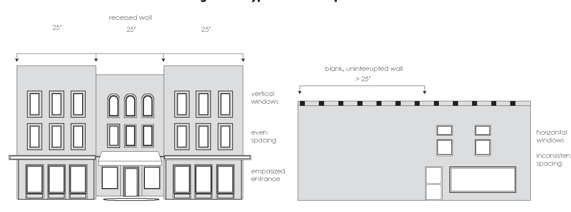
(3)
Building facade material.
(a)
Exterior materials shall be durable, including, but not limited to, masonry, brick, stone, stucco, wood, metal, and glass, as long as the masonry requirement below in subsection 39.3.2-4(6) and (7) are met.
(b)
The exterior materials and appearance of the rear and side walls of any building shall be similar to and compatible with the front of the building.
(c)
The use of plain face concrete block as an exterior material shall be prohibited where fronting along a public street, public sidewalk, public pathway.
(d)
The following materials shall be considered masonry for the purposes of facade material requirements of this ordinance [chapter]: glass, natural stone, face brick, face tile, concrete, split face concrete masonry units, decorative pattern concrete block, brick or stone veneer, cement stucco, and cementitious board.
(e)
In determining the percentage of masonry required, the surface of the exterior walls exclusive of the doors and windows shall be measured, up to the eave area or up to a maximum of 12 feet in height, whichever is more.
(f)
Residential districts. All building facades shall be 75 percent masonry, except when subsection 39.3.2-1(1) above applies.
(g)
Commercial districts. All building facades shall be 90 percent masonry, except when subsection 39.3.2-1(1) above applies.
(h)
If 75 percent or more of the buildings on the street on which the new construction, or redevelopment project is located are not consistent with the masonry requirements of this section, then the applicant may use materials similar to and compatible with the existing materials used on facades of those existing structures on the street, with administrative approval from the city manager or his/her designee, when the building is located outside the historic overlay.
(Ord. No. O-20-20, § 2(Exh. A), 9-14-2020; Ord. No. O-18-21, § 4(Att. A), 1-25-2021)
Sec. 39.3.3-1. - Applicability.
This division shall apply to all new developments and redevelopments in the City of Palestine. The purpose of these provisions is to secure safety from fire, panic, and other dangers, lessen congestion on public streets, facilitate adequate provision of transportation, conserve building values, encourage the most appropriate use of land, and to provide safe and adequate access into and out of commercial and residential developments.
(Ord. No. O-20-20, § 2(Exh. A), 9-14-2020; Ord. No. O-18-21, § 4(Att. A), 1-25-2021)
Sec. 39.3.3-2. - General parking requirements.
(1)
Residential.
(a)
Required off-street parking for residential uses shall be provided on the lot or tract occupied by the principal use.
(b)
No person shall park any vehicle or trailer in any front or side yard in any residential district except on an all-weather parking surface which is provided to accommodate off-street parking.
(2)
Nonresidential.
(a)
The developer shall provide off-street parking spaces in accordance with the standards in this chapter 39, article III and table 2 in section 39.3.3-3, off-street parking requirements, when a building or structure is erected or an existing building enlarged, or an old structure or foundation is converted to a new use; provided, however, that developers of properties located within the central business district as defined by the city's zoning regulations shall not be required to provide off-street parking spaces. If adherence to these standards is found to not be possible, the zoning board of adjustments and appeals may consider a variance to these standards.
(b)
Required off-street parking for non-residential uses shall be provided on the lot or tract occupied by the principal use; however, the city may permit either required or additional off-premises parking, as a special exception, under such regulations and conditions as the board of adjustment may deem advisable when the proposed parking facility is on a platted lot within 300 feet of the principal use property. In the case of churches, off-site parking may be permitted by the board of adjustment; provided, it is located within 1,000 feet of the church building.
(c)
No off-street parking facility shall be located, either in whole or in part, in a public street or sidewalk, parkway, alley, or other public right-of-way, except for on-street parking authorized in the central business district.
(d)
No off-street parking shall be located, either in whole or in part, within any fire lane required by the city or within aisles, driveways or maneuvering areas necessary to provide reasonable access to any parking space.
(e)
No required off-street parking facility shall be used for sales, non-vehicular storage, repair, or service activities.
(f)
For all multifamily and nonresidential uses, parking spaces shall be striped or otherwise clearly designated on the parking facility surface. Parking spaces shall be designed to not interfere with or encroach into fire lanes or other areas necessary for aisles or maneuvering of vehicles.
(3)
Commercial and large vehicle parking restrictions.
(a)
Parking of vehicles in right-of-way. It is unlawful for any person to park and/ or permit any other person to park a recreational vehicle, utility vehicle, commercial vehicle, boat, or trailer that intrudes into the public right-of-way or obstructs visibility from adjacent driveways or street corners.
(b)
Truck tractors, trailers, and large commercial vehicles. Parking of commercial vehicles over 10,000 pounds gross weight, exceeding 20 feet in length and/or seven and one-half feet in width, is prohibited in residential areas, except on a temporary and non-regular basis not exceeding six hours when sight visibility is not obstructed.
(c)
Extended parking. No motor home, travel trailer, or other recreational vehicle, and no 18-wheeler (including the tractor or the trailer, or both) may be parked in a public parking lot for more than five consecutive hours.
(Ord. No. O-20-20, § 2(Exh. A), 9-14-2020; Ord. No. O-18-21, § 4(Att. A), 1-25-2021)
Sec. 39.3.3-3. - Number of off-street parking spaces required.
The following rules shall be applied in computing the number of off-street parking spaces required:
(1)
Fractional spaces shall be rounded to the next higher whole space.
(2)
Buildings or structures containing mixed uses shall provide off-street parking spaces equal to the sum of the various uses computed separately.
(3)
The required off-street parking spaces shall be located on the same lot as the building or use served, except as follows:
(a)
When an increase in the number of off-street parking spaces is required by a change or enlargement of use, or where off-street parking spaces are provided collectively or used jointly by two or more buildings or establishments, the required off-street parking spaces may be located at a distance not to exceed 300 feet (within reason, as determined by the city manager or his/her designee) feet from an institutional building served or 500 feet from any other nonresidential building served; provided, however, that a written agreement is approved to the city manager or his/her designee.
(b)
When the required off-street parking spaces are not located on the same lot with the building or use served or when the required off-street parking spaces are provided collectively or used jointly by two or more establishments, a written agreement which ensures the retention of such spaces for this purpose shall be drawn and executed by the parties concerned, approved as to form by the city attorney, and filed for record in the office of the Anderson County Clerk. A copy of the recorded agreement shall be filed with the application for a building permit or certificate of occupancy if a change in use is involved.
(c)
Not more than 50 percent of the off-street parking spaces required for theaters, bowling alleys, dancehalls, nightclubs, restaurants or similar uses may be provided and used jointly by uses not normally open, used or operated during the same hours as those listed.
(d)
Not more than 60 percent of the off-street parking spaces required for a church, school auditorium or similar use may be provided and used jointly by uses not normally open, used or operated during the same hours as those listed.
(e)
All parking lots, aisles and spaces required shall conform to the standards in chapter 39, and this article. Refer to figure 2, typical parking lot layout.
(f)
The above parking requirements shall not prohibit the enlargement of a building or structure, provided that excess spaces exist and such enlargement does not create a deficiency in the total number of off-street parking spaces, based upon criteria listed in this section 39.3.3-3, table 2.
(g)
Any proposed land use, whether commercial, industrial or residential, not specifically designated in this section 39.3.3-3, table 2, which by its nature generates or attracts vehicular activity or traffic, must provide sufficient parking spaces on or near the site to accommodate the vehicular load for residents, customers, clients, suppliers, etc., which would normally be associated with the proposed land use, to the satisfaction and approval of the city.
(h)
No parking space, carport, or automobile storage space shall be used for the storage of any commercial truck, truck trailer, vans (except for panel or passenger vans), and trucks (exceeding one-ton capacity) in the residential zoning districts.
(i)
Motorhomes, travel trailers or other recreational vehicles shall not park in a public street.
_____
Table 2 - Off-street parking spaces required
(Ord. No. O-20-20, § 2(Exh. A), 9-14-2020; Ord. No. O-18-21, § 4(Att. A), 1-25-2021)
Sec. 39.3.3-4. - Design requirements for parking lots.
(1)
New, repair of existing and expansions.
(a)
New parking lots or driveways constructed on unimproved property that will serve a new commercial or industrial use where a new structure will be equal to or exceed 5,000 square feet of gross floor area shall be designed by a professional engineer licensed in the State of Texas. If the new structure will be less than 5,000 square feet of gross floor area then there are no design requirements.
(b)
The expansion or repair of existing parking lots are not subject to any professional design requirements provided that proposed expansion pavement sections match existing engineered pavement section.
(2)
Design standards.
(a)
Setbacks. Parking lots shall not be located closer than ten feet to a front lot line, ten feet to a side lot line or ten feet to a rear lot line unless an exception is allowed by the public works director. Refer to figure 2 for typical parking lot layout.
Figure 2. Typical Parking Layout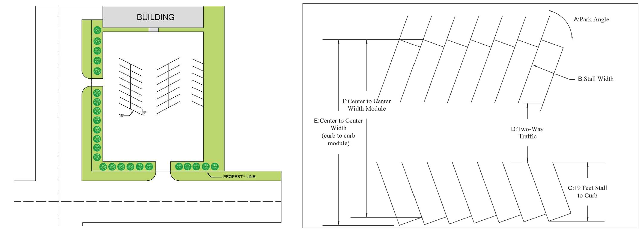
(b)
Materials. The design criteria for new parking lots and driveways which serve commercial and industrial uses depend upon the current conditions of the property where such improvements are proposed. Parking lots and driveways shall be paved per the following standards:
i.
All new parking lots and driveways shall be constructed of concrete, asphalt, permeable pavement, or concrete pavers, or any other approved material.
ii.
Fire lanes/heavy-duty vehicle routes within parking lots. New pavement located within a fire lane, maneuvering areas for trash services and those areas located in a street right-of-way shall be designed by a professional engineer or constructed to the following minimum standards:
I.
Portland cement concrete. Six inches thick, 3,000 psi and reinforced with #3 bars at 18 inches O.C.E.W, on six-inch compacted sub-grade.
II.
Asphalt. Two two-inch thick asphaltic concrete on an eight-inch compacted base of 95 percent density Standard Proctor on compacted six-inch sub-grade 95 percent density Standard Proctor. Parking lots with heavy truck traffic or excessive slopes shall be six inches' thick asphaltic concrete on six-inch compacted sub grade 95 percent density Standard Proctor. (ASTM D698).
III.
Concrete and asphalt minimum standards. Minimum standards for paved areas outside of fire lanes and routes for heavy-duty vehicles shall be determined by the engineer hired by the developer and must be based upon site-specific conditions.
IV.
An engineer may recommend less stringent standards than shown in the above items so long as the engineer's design computations based upon site-specific conditions guarantee that the pavement will support emergency vehicles and trash trucks.
(c)
Maneuvering. Parking lots and loading areas shall be designed to allow all vehicle maneuvers such as backing, parking and turning the vehicle, to take place on the lot. The city manager or his/her designee may allow an exception to this requirement based on the following site conditions:
i.
The size limitations prevent the construction of a parking lot with on-site maneuverability per the standards in subsection (2), design standards, (d) dimensions.
ii.
The location of the new parking lot will not be connected to an existing or proposed driveway onto any street maintained by the Texas Department of Transportation.
iii.
Any other criteria which would prevent the construction of a parking lot per the standards in subsection (2), design standards, (d) dimensions, as long as the exception does not create an unsafe situation for any oncoming traffic or traffic backing out into the public street.
Any applicant adversely affected by a decision of the city manager or his/her designee may appeal the decision to the City of Palestine Zoning Board of Adjustment.
(d)
Dimensions.
i.
Aisles and standard spaces—Refer to table 3 and figure 3, parking lot dimensions.
ii.
Compact spaces. If a development provides ten or more parking spaces, up to ten percent of those spaces may be designed for compact cars. Effective stall dimension shall be a minimum of seven and one-half feet wide by 15 feet long, and each space shall be marked "COMPACT CARS ONLY."
iii.
ADA spaces. Location, size, and number of accessible parking spaces shall conform to the latest building codes, and/or state and federal regulations (Americans with Disabilities Act).
iv.
All other parking spaces and lots shall meet the standards provided in table 2, parking lot dimensions unless otherwise permitted in this article.
(e)
Delineation. All parking spaces shall be clearly delineated and designated by means of painted stripes.
_____
Table 3 - Parking Lot Dimensions
Wheel stops, buttons, tiles, curbs, barriers signs, or other approved methods non-permanent type marking, such as paint, shall be regularly maintained to ensure continuous clear identification of the space.
i.
Wheel stops. Vehicle wheel stops shall be provided to prevent any part of a vehicle from overhanging onto the right-of-way of any public right-of-way or alley. Parking shall not be permitted to encroach upon the public right-of-way in any case.
ii.
Landscape. The developer shall landscape parking lots according to the standards contained in division 4 of this article III. Where more than one parking lot is required to satisfy the standards of this article, a landscape area of at least ten feet in width shall separate parking lots; provided, however, that sufficient aisle connections shall be provided to ensure adequate traffic flow.
iii.
Lighting. Parking lot lighting shall be designed and operated to avoid a spillover outside property lines. Parking lots lights shall have a maximum height of 25 feet and be glare shielded. Lights mounted on a building shall not extend above the building roofline. Lighting for ground-mounted signs shall be affixed to the signs. All parking lot lighting shall be directed downward so as not to reflect of shine on adjacent properties.
Figure 3. Parking lot dimensions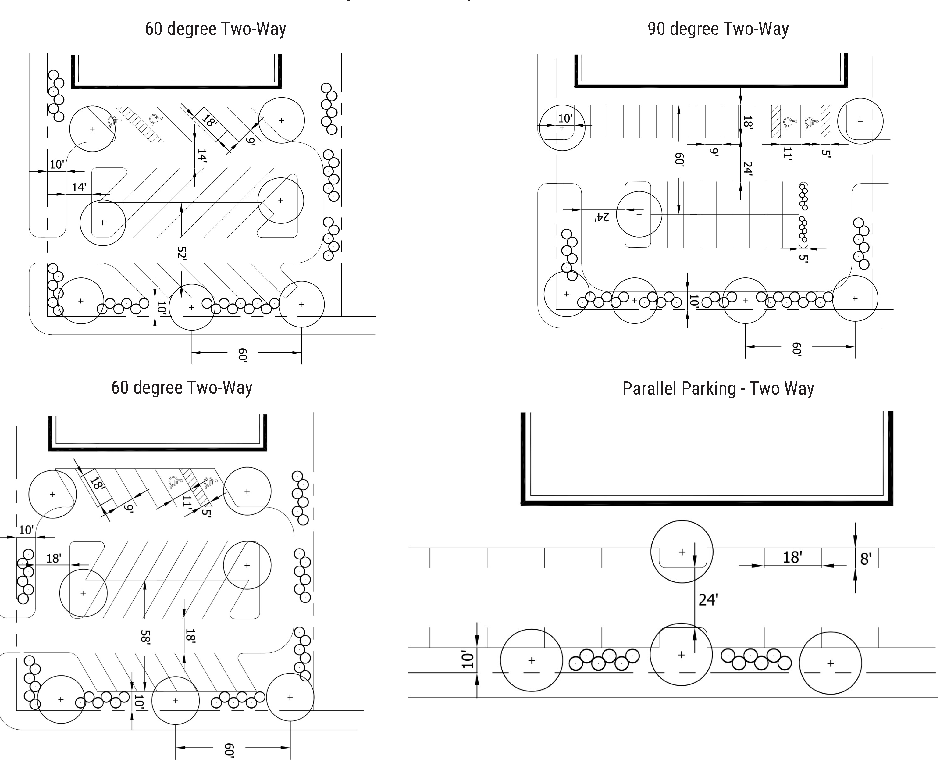
_____
(Ord. No. O-20-20, § 2(Exh. A), 9-14-2020; Ord. No. O-18-21, § 4(Att. A), 1-25-2021)
Sec. 39.3.3-5. - Design requirements for driveways.
(1)
The developer shall design, construct, upgrade, reconstruct, or repair driveway approaches (also referred to as driveways or curb cuts) for access to lots according to the standards of this section. Driveways shall be permitted only along streets where full street improvements exist and are maintained as a public street; provided, however, that residential driveways may be permitted on public alleys or other accepted public access facilities in existence prior to the adoption of this chapter. Prior to construction of a driveway, the developer shall obtain a driveway permit from the city. Driveways shall be paved according to the minimum standards provided in subsection 39.3.3-4(2)(b).
(2)
New driveways, repair of existing driveways, expansion of existing driveways on properties located within a historic district or those that have been designated as a Palestine Landmark shall adhere to the standards found in chapter 39, zoning, article III, division 7, historic preservation.
(3)
Driveway design. Driveway design will depend on the land use, the volume, the character of both through traffic and driveway traffic and the speed of traffic on the through street. Dependent upon these factors, the critical design elements include radii of curb returns, driveway throat width and the angle between the driveway centerline and the edge of the roadway. Driveway geometry shall adhere to standards and dimensions shown in the figures 4 through 8 and tables in the appendix of this section.
(a)
The developer shall design driveway entrances to be able to accommodate all vehicle types having occasion to enter the lot, including delivery vehicles.
(b)
The developer shall design driveways with minimum curb return radii according to the type of driveway and the classification of the street as provided in figure 4, high-volume driveway criteria, and/or based on the characteristics of certain design vehicles (AASHTO-based) which will regularly use the driveway.
(c)
Tapered or channelized deceleration lanes for vehicles turning right into high-volume or intersection- type driveways may be required on arterial streets. Where such lanes are necessary, acquisition of additional right-of-way may also be required. The design of such lanes shall adhere to the latest TxDOT standards and guidelines.
(d)
Figure 7 provides approved minimum design criteria for limited movement driveways. Deceleration lanes may also be required to be incorporated into the design. The design of such lanes shall adhere to the latest TxDOT standards and guidelines.
(e)
The developer shall design driveways so as not to interfere with, block, hinder or impede the flow of traffic on a public street. Where it is determined that a proposed driveway will block, hinder or impede the flow of traffic, the developer shall provide alternative means of ingress and egress to the lot or lots such that the negative effects of the proposed driveway are eliminated. These alternatives will be subject to review and approval.
(f)
Driveway design standards for sites that include fuel pumps parallel to the adjacent street are necessary due to the special access needs that characterize such developments. The developer shall design sites for fuel pumps according to the following standards:
i.
The minimum corner clearance shall be a distance of 35 feet measured from the point of intersecting right-of-way lines to the point of tangency of the curb return radii leading to the driveway approach. The point of tangency of the curb line corner radius and that of the curb return radius of the driveway approach shall not be compounded.
ii.
The minimum spacing between driveway approaches within the same property lines shall be 25 feet of tangent curb length.
iii.
A minimum distance between the fuel pump island and the right-of-way or property line shall be 25 feet.
(4)
Residential driveways.
(a)
The developer shall locate residential driveways entirely within the frontage of a lot and not less than one foot from any side property line as extended perpendicularly to intersect with the curb line. This applies to driveways within property boundaries; not driveway approaches.
(b)
The developer shall construct driveways so as not to interfere with pedestrian crosswalks.
(c)
Any new residential driveway which will cross an existing sidewalk, or which will be constructed in conjunction with a proposed sidewalk, shall ensure that the cross slope of the sidewalk as it crosses the driveway does not exceed two percent, in accordance with ADA requirements.
(d)
The developer shall construct driveways a minimum of three feet from any obstruction such as a streetlight or utility pole, fire hydrant, traffic signal controller, telephone junction box, etc.
(e)
The developer shall construct residential driveways to conform to the criteria shown in figure 5 for low volume driveway criteria.
(f)
The developer shall design residential driveways with curb return radii according to the classification (curbed or non-curbed) of the street as provided in figure 5, low volume driveway criteria.
(g)
All driveway approaches constructed within the rights-of-way of public streets shall conform to material standards found in subsection 39.3.3-4(2)(b). Refer to standard driveway approach detail.
(5)
High-volume driveways.
(a)
Location and construction of high-volume driveway approaches. The location of high-volume driveway approaches is based on a number of factors, including the location of individual property lines, available street frontage, requirements of internal site design, number of vehicles to be accommodated, and traffic safety. As a general rule, the farther from an intersection a driveway can be located, the less it will affect through traffic and the less delay it will cause to vehicles using the driveway.
i.
The developer shall locate high-volume driveway approaches entirely within the frontage of the lot and not less than ten feet, not including curb return radii, from any side property line; provided, however, that joint driveway approaches may be permitted where a permanent joint access is provided by the respective property owners either through platting or a mutual access easement.
ii.
The developer shall consider the location of other driveways on the opposite side of the street when locating a proposed driveway. Where possible, driveways on both sides of the street shall be aligned in order to minimize adverse effects on through traffic and to optimize efficiencies of the driveway. Driveways directly opposite each other shall be given preference over staggered driveways. Where it is not possible to place driveways directly opposite each other, a driveway shall be placed so that adequate left-turn storage capacity is provided in advance of each driveway in order to avoid the overlap of left-turn movements.
iii.
The developer shall construct high-volume driveway approaches so as not to interfere with pedestrian crosswalks.
iv.
Any new high-volume driveway which will cross an existing sidewalk, or which will be constructed in conjunction with a proposed sidewalk, shall ensure that the cross slope of the sidewalk as it crosses the driveway does not exceed two percent, in accordance with ADA requirements.
v.
The developer shall construct high-volume driveways a minimum of three feet from any obstruction such as a streetlight or utility pole, fire hydrant, traffic signal controller, telephone junction box, etc.
vi.
The developer shall construct high-volume driveways to conform to the criteria shown in for high-volume driveway criteria.
vii.
The maximum number of driveways per lot, based on the street classification and lot width, shall be as shown in figure 4, high-volume driveway criteria.
viii.
Driveways located on streets and highways controlled by the state shall be permitted by the Texas Department of Transportation (TxDOT).
ix.
Driveway spacing for high-volume driveways. The developer shall design and construct high-volume driveways according to the spacing standards shown in figure 4 for high-volume driveway criteria.
(6)
Restrictions. Access to public streets will not be provided where the conditions described in this section restrict or compromise the safety and efficiency of the access.
(a)
Backing maneuvers. Access points shall not be approved for parking or loading areas that require backing maneuvers in a public street right-of-way except for single-family residential uses on local streets or if authorized by the city manager or his/her designee per section 39.3.3-4(2)(c).
(b)
Sight distance requirements. The minimum sight distance shall be provided at all access points as shown in the figure 8 for sight distance at entrance.
(c)
Signalized intersections proposed. Access drives within the area of an intersection of public streets where traffic signals are installed, or are anticipated to be installed in the future, will not be permitted.
(d)
Provision of access. If a lot has frontage on more than one street, access will be permitted on each street, based upon whether or not the standards set forth in section 39.3.3-4 and section 39.3.3-5 can be met on each street frontage. If a lot cannot be served by any access point meeting these standards, access points shall be designated by the public works director based on traffic safety, operational needs and conformance to as much of the requirements of these guidelines as possible.
(e)
Driveway approaches. Driveway approaches shall not be constructed or used for the standing or parking of vehicles.
(7)
Abandoned driveway approaches. Driveway approaches that have been abandoned for a continuous period greater than 12 months shall be removed and the curb restored by the property owner adjoining the driveway according to the city's specifications.
Figure 4: High-volume Driveway Criteria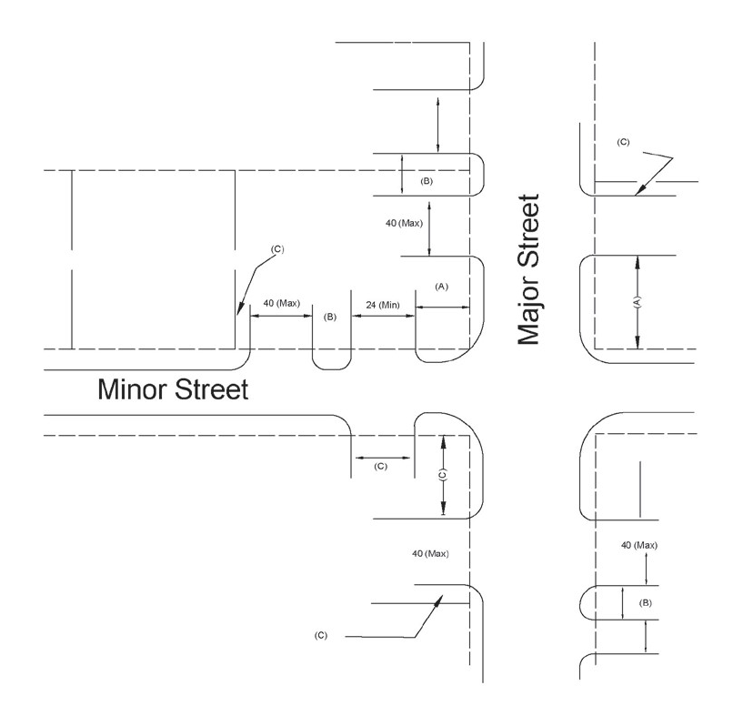
Table 4 - Minimum Separation
Figure 5: Low volume driveway criteria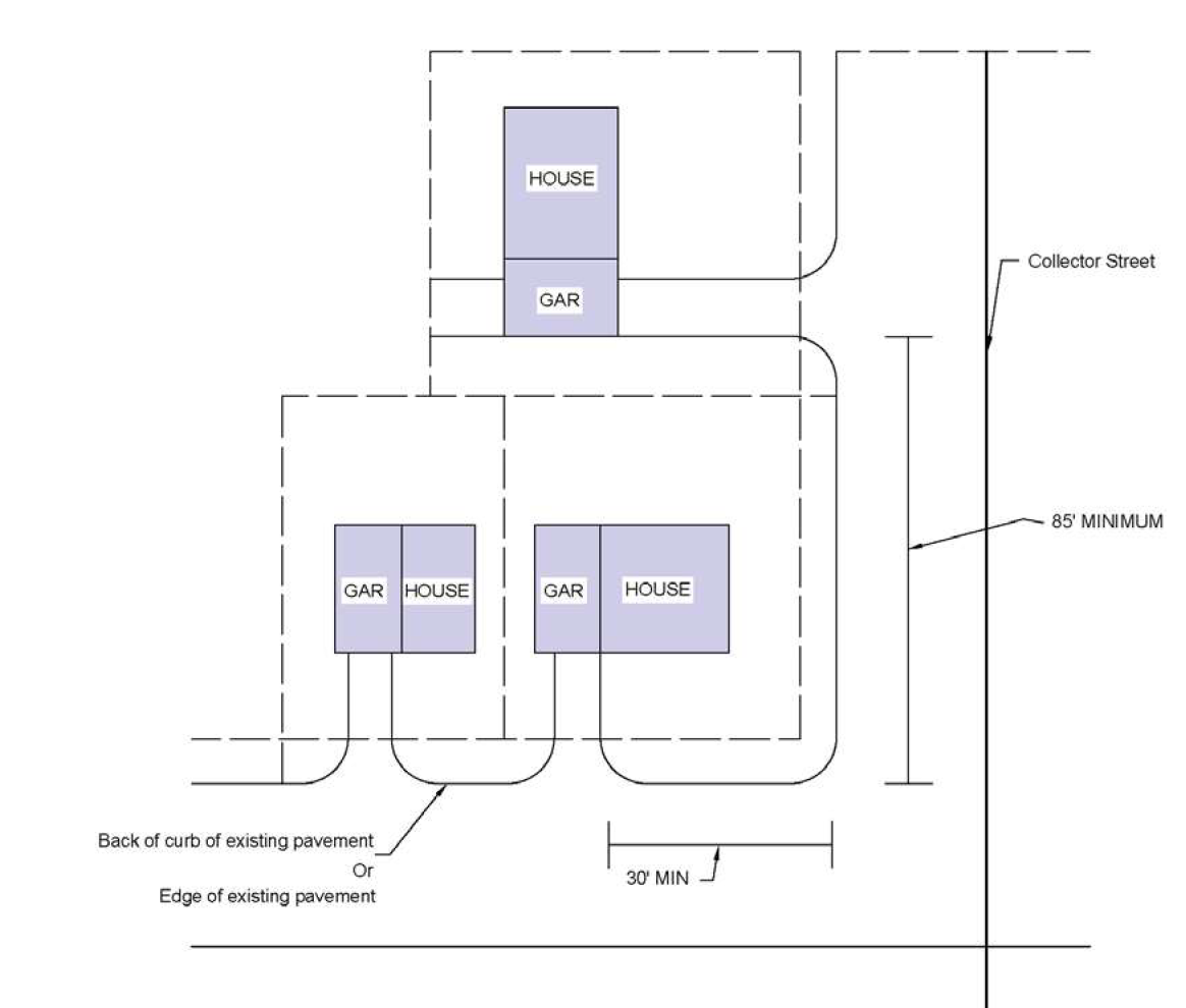
Figure 6: Standards driveway approach detail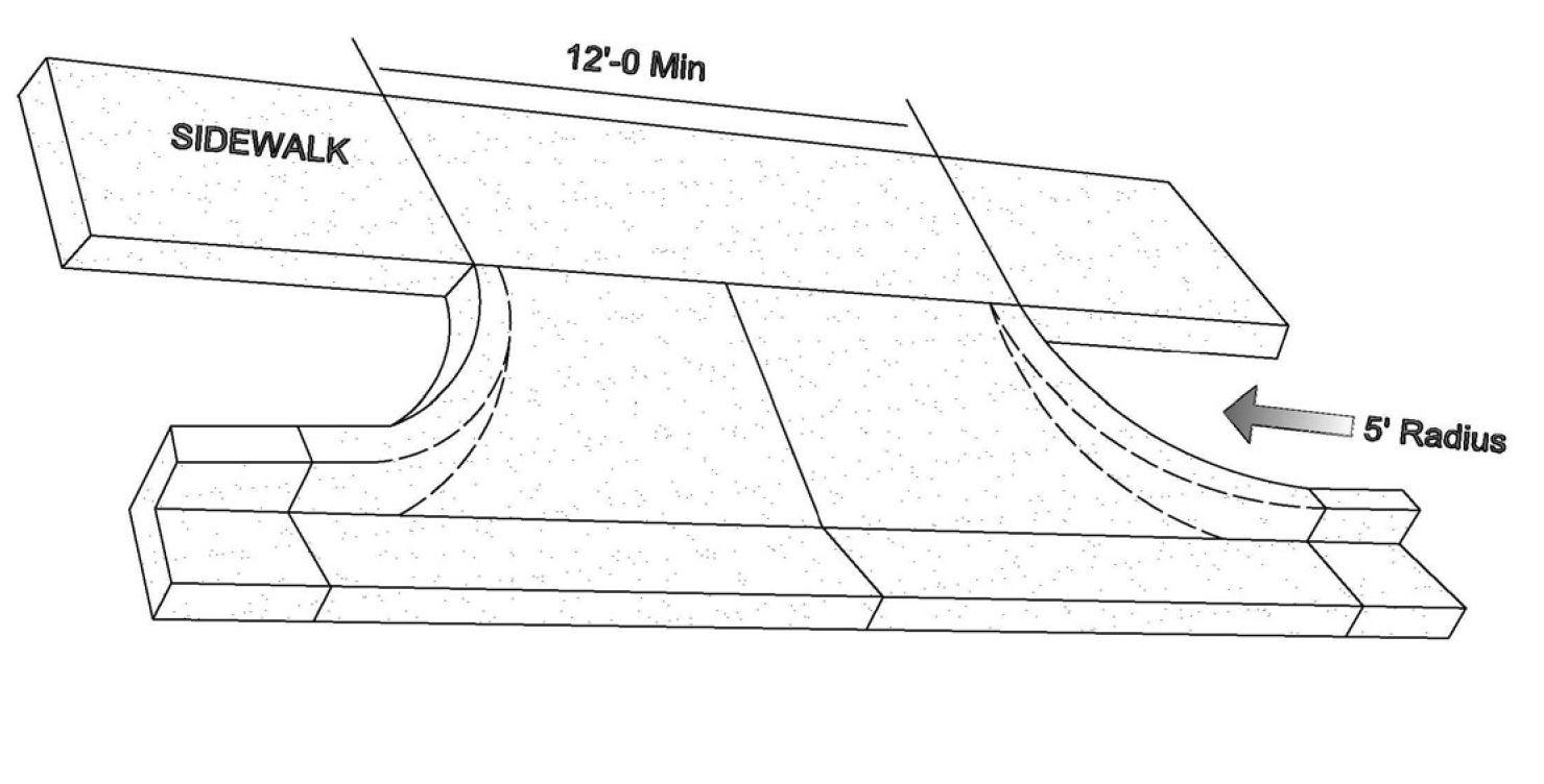
Figure 7: Limited movement driveways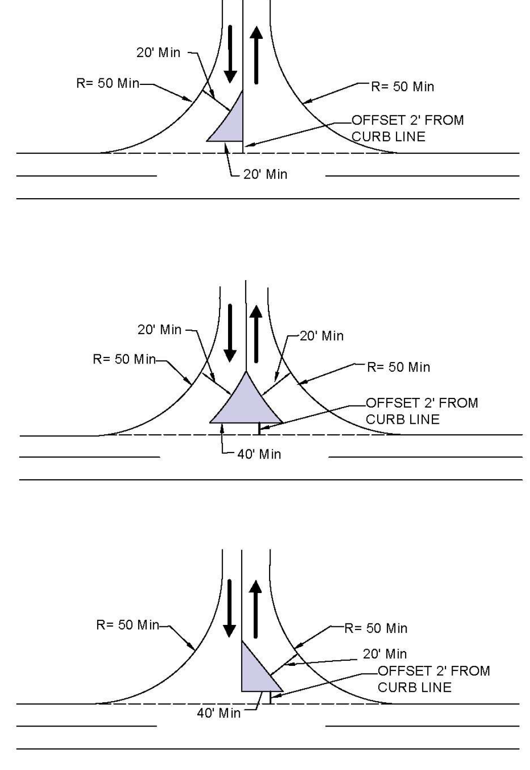
Figure 8: Sight distance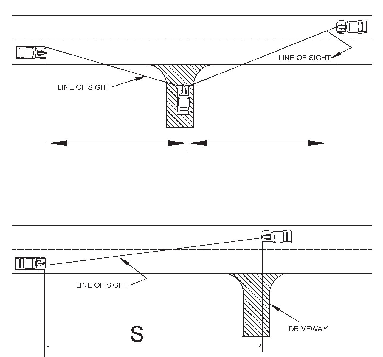
(Ord. No. O-20-20, § 2(Exh. A), 9-14-2020; Ord. No. O-18-21, § 4(Att. A), 1-25-2021)
Sec. 39.3.3-6. - Temporary parking lots.
(1)
The developer may provide temporary parking lots to meet unexpected or short-term needs. Where such temporary parking lots are constructed, the developer shall complete a signed agreement (approved by the city attorney), specifying the time period in which the temporary parking lot is to be used, with the length of time being no greater than 24 months from the date of the agreement. The developer shall also provide acceptable surety that the temporary parking lot shall either be constructed to meet permanent standards prescribed by a geotechnical engineer licensed in the State of Texas (contracted by the developer) or as approved by the city manager or his/her designee on a case-by-case basis in the absence of geotechnical recommendations or completely removed from the site within 60 days of the termination of the agreement
(2)
Temporary parking lots shall consist of eight inches of compacted flex base (conforming to TxDOT item 247) (95 percent Standard Proctor ASTM D698) on six inches of compacted sub-grade (95 percent Standard Proctor). Depending on the use of the temporary parking lot, location, and traffic volume, the city manager or his/her designee may allow on a case-by-case basis, alternative construction standards, however, all temporary parking lots shall be constructed in such a way as to ensure that no significant amounts of dust, dirt or other particulate is transported off-site by wind, stormwater, or vehicle tracking.
(Ord. No. O-20-20, § 2(Exh. A), 9-14-2020; Ord. No. O-18-21, § 4(Att. A), 1-25-2021)
Sec. 39.3.3-7. - Reduction of parking.
(1)
Permitted reductions. Parking minimums may be reduced when it is demonstrated to the approving authority that parking demand is expected to be lower than the requirements of this chapter and the following standards are met:
(a)
Single building or use.
i.
There is convenient municipal off-street parking or on-street spaces located within 500 feet of the subject property.
ii.
Walk-in trade is reasonable due to sidewalk connections to adjacent residential neighborhoods or employment centers. To allow for a parking space reduction, the site design shall incorporate pedestrian connections to the site and on-site pedestrian circulation, providing safe and convenient access to the building entrance.
iii.
The applicant has provided a parking study, conducted by a qualified traffic engineer or parking expert, demonstrating that another standard would be more appropriate based on actual number of employees, expected level of customer traffic, or actual counts at a similar establishment.
(b)
Mixed occupancy or multiple buildings. Parking may be reduced for shared/ common parking lots by multiple uses where:
i.
There will be a high proportion of multipurpose visits.
ii.
Uses have peak parking demands during differing times of the day or days of the week and meet the following requirements:
I.
Parking facilities at a church or place of worship may be used to meet up to 50 percent of the off-street parking required for theaters, stadiums, other places of public assembly, retail stores, personal services establishments, office buildings, and industrial facilities lying within 600 feet of the church or place of worship. Distance shall be measured from the nearest point of public entrance to the building to the nearest point of the parking lot.
II.
There is no conflict between times when the uses are in need of the parking facilities.
III.
The church or place of worship makes the spaces available and enters into a recordable agreement with the owners of the affected uses who will be sharing the parking.
(Ord. No. O-20-20, § 2(Exh. A), 9-14-2020; Ord. No. O-18-21, § 4(Att. A), 1-25-2021)
Sec. 39.3.3-8. - Off-street loading requirements.
(1)
Any use that receives or distributes materials or merchandise by vehicle shall provide off-street loading spaces to be determined by the developer, but a minimum of one loading space shall be required, except in central business district.
(2)
Such off-street loading space may be adjacent to a public street or alley, private service drive, or may consist of a truck berth within the structure.
(3)
No loading docks shall be constructed facing on any public street unless said loading dock is at least 75 feet from the right-of-way line of the public street on which said loading dock fronts. Such off-street loading space or truck berth shall consist of a minimum area of ten feet by 45 feet.
(4)
The existence of a 20-foot alley adjacent to the property shall be construed as equivalent to one berth. All off-street loading spaces shall have an all-weather surface of asphalt or concrete construction and shall be accessible by a street, driveway or alley.
(5)
Counting parking and loading space twice is prohibited. No part of any off-street parking or loading space required in connection with any building for the purpose of complying with these regulations shall be included as a part of any off-street parking or loading space similarly required for any other building.
(6)
No loading dock shall be permitted or approved unless it is shown that it is set back a sufficient distance from any public street and right-of-way so that all loading operations, parking, storage, and vehicular maneuvering into or out of loading dock spaces shall take place outside of any public street or right-of-way. The city manager or his/her designee shall determine whether the setback distance is sufficient.
(7)
Loading spaces shall be designed so that all truck maneuvers, loading and unloading shall take place on the lot.
(Ord. No. O-20-20, § 2(Exh. A), 9-14-2020; Ord. No. O-18-21, § 4(Att. A), 1-25-2021)
Sec. 39.3.4-1. - Applicability.
(1)
The building official shall not issue a building permit unless the applicant provides landscaped areas according to this chapter 39. The applicant shall provide and maintain landscaped areas within all developments according to the standards contained in this article; provided, however, that this section shall not apply to the following:
(a)
Building permits for new construction applied for prior to the adoption of these regulations.
(b)
Building permits for residential remodeling.
(c)
Building permits issued in the central business district and the Main Street Overlay, as defined in the city's zoning regulations.
(2)
When the requirements of this article conflict or are inconsistent with requirements of other provisions of this chapter, this article shall prevail.
(Ord. No. O-20-20, § 2(Exh. A), 9-14-2020; Ord. No. O-18-21, § 4(Att. A), 1-25-2021)
Sec. 39.3.4-2. - General landscaping requirements.
(1)
Any tree planted shall not at maturity interfere with the line of sight of vehicles (visibility triangle) or overhead utilities.
(2)
Native or naturalized plants and trees which are capable of vigorous and healthy growth in this area shall be used.
(3)
All trees shall be planted in a permeable area not less than three feet in width. Not more than 50 percent of the area within the dripline of any tree at the time of permit issuance shall be impervious cover. Permeable pavers may be considered as permeable cover.
(4)
Required landscape structures shall be maintained in a structurally sound condition.
(5)
Required screening or buffering shall be maintained and repaired or replaced where necessary.
(6)
Plant installation. All plant materials shall be installed according to planting details and specifications showing clearly how growing conditions adequate to sustain vigorous and healthy growth will be achieved including, but not limited to:
(a)
Protection and support of tree trunks.
(b)
Provision of adequate conditions for root growth.
(c)
Provision for retention of moisture.
(d)
Protection of plants from equipment or vehicular damage.
(7)
Tree replacements and new plantings. Invasive or prohibited plant species as defined by the Texas Parks and Wildlife Code shall not be allowed
(Ord. No. O-20-20, § 2(Exh. A), 9-14-2020; Ord. No. O-18-21, § 4(Att. A), 1-25-2021)
Sec. 39.3.4-3. - Landscape plan procedures.
(1)
Applications for residential building permits shall show the required landscaping by noting the square footage of the landscaped area and the location and diameter of the existing and proposed trees on the site plan.
(2)
Application for nonresidential building permits shall provide a landscaping plan with the following information:
(a)
The approximate location, size and type (tree, shrub, groundcover, grass) of proposed landscaping in proposed landscaped areas;
(b)
The approximate location and size of proposed landscaped areas;
(c)
The approximate location and species of existing trees eight and one-half inches or larger in diameter DBH and the approximate size of their crowns;
(d)
Information necessary for verifying whether the required minimum percent of landscaped area has been met;
(e)
An explanation of how the applicant plans to protect the existing trees, which are proposed to be retained on site from damage during construction;
(f)
The proposed irrigation system as required by subsection 39.3.4-4(6);
(g)
The certification of an engineer, surveyor, landscape architect or architect registered in the state, or professional building designer or landscaper that the plans satisfy the requirements of this section; provided, however, that for a development greater than two acres in size, such plans and certification shall only be made by landscape architect registered in the state.
(3)
The building official shall inspect each site not later than 12 months after issuance of the certificate of occupancy to ensure compliance with the requirements of this section.
(Ord. No. O-20-20, § 2(Exh. A), 9-14-2020; Ord. No. O-18-21, § 4(Att. A), 1-25-2021)
Sec. 39.3.4-4. - Development/subdivision landscaping.
(1)
Residential lots. The following requirements apply to all new residential construction other than multifamily construction:
(a)
Not less than 50 percent of the area contained within the front and side yard setback area on the lot shall be landscaped area.
(b)
A minimum of two large (25 feet or more) canopy trees (either existing or planted) measuring three inches or greater in diameter shall be within the landscaped area in the front yard. One or both required front yard trees shall be located within four feet from the front property line adjacent the street, placed such that the distance between trees on the same lot and adjacent lot allow each tree to grow to full canopy without interfering with each other. The intent is to create tree lined residential streets.
(c)
A minimum of one tree shall (either existing or planted) measuring three inches or greater in diameter shall be within the back/rear yard.
(2)
Nonresidential lots and multifamily developments:
(a)
Not less than ten percent of the lot shall be landscaped area; and
(b)
An area ten feet in width adjacent to each street right-of-way shall be landscaped area. Drives and sidewalks are not permitted in this landscaped area except to the extent to which they may be required to cross the landscaped area to provide access. This landscaped area shall contain one large (25 feet or more) canopy tree per 60 feet along all streets.
(c)
All open, unpaved space including, but not limited to, front, side and rear building setback areas, shall be landscaped area.
(d)
There shall be an average of at least ten feet, and a minimum of five feet of landscaped area and walkway between the building and parking areas.
(e)
Trees, (either existing or planted) measuring three inches or greater in diameter are required in landscaped areas in the following quantities:
i.
One tree for every 2,000 square feet of landscaped area.
ii.
A minimum of 25 percent of the trees will be single trunk trees that will obtain a minimum height of 30 feet when grown.
iii.
Each tree planted shall be not less than five feet from the edge of the landscaped area.
vi.
All tree plantings shall be encompassed with an approved curb barrier to prevent access by vehicular traffic.
(3)
Ground signs. There shall be a landscaped area not less than ten feet in width located around the supporting structure of each ground sign and extending not less than three feet beyond each end. A hedge or other durable planting, which is not less than one foot in height at the time of planting and which will attain an average height of at least three feet shall extend the entire length and width of the required landscaped area. Two flowering trees, not less than eight feet in height when grown, shall be located within the required landscape area. The remainder of the landscaped area may be in grass or a decorative groundcover
(Ord. No. O-20-20, § 2(Exh. A), 9-14-2020; Ord. No. O-18-21, § 4(Att. A), 1-25-2021)
Sec. 39.3.4-5. - Landscaping in parking lots.
(1)
Parking lots and other vehicular areas. Landscaped areas in a parking lot shall be in addition to all other landscape requirements of this division and shall be provided in any parking lot of five spaces or more in accordance with the following requirements:
(a)
There shall be a landscaped area as a buffer between the street view and vehicular use areas, parking areas, parking lots, and their parked vehicles.
(b)
One tree shall be provided for each 15 parking spaces in all developments, however, no car parking space shall be located greater than a 100 feet from the center of a tree.
(c)
Planting area width. Trees shall be planted within a planting island or peninsula shall be at least 50 square feet with a minimum dimension of five feet in width and the area must be further planted with a ground cover, grass, or shrubs and may be counted toward the total required square footage of required landscaping.
(d)
Minimum installation width. Trees shall be a minimum of three-inch caliper measured one foot from the ground.
(e)
One landscaped island shall be placed at the ends of all parking rows regardless of the spaces in that row. One landscaped island shall also be provided at the ends of every 15 spaces. Any parking row that terminates adjacent to a required landscaped area adjacent to each street right-of-way may count that landscaping as a landscaped island.
(f)
The city manager or his/her designee may make an adjustment to the distribution and location of landscaped islands, peninsulas, and medians to accommodate existing trees or other natural features so long as the total requirements for landscaped islands, peninsulas, and medians for the respective parking areas above is satisfied.
(Ord. No. O-20-20, § 2(Exh. A), 9-14-2020; Ord. No. O-18-21, § 4(Att. A), 1-25-2021)
Sec. 39.3.4-6. - Landscaping in street rights-of-way or public utility easements.
(1)
Maintenance of landscaping within street rights-of-way shall be the responsibility of the adjacent property owner. Trees, shrubs, bushes or other vegetation planted in the street right-of-way, and in existence prior to adoption of these standards, shall not interfere with the view of traffic along the street. No trees, bushes, shrubs or other vegetation greater than two feet at maturity in height shall be planted, grown or maintained within the sight/visibility triangle defined in the zoning ordinance.
(2)
Trees shall not be planted in a public right-of-way after the date of adoption of these standards other than shrubs that normally grow, at maturity, to a height of less than 15 feet. Trees shall not be located or seedlings allowed to grow within ten feet from a fire hydrant. Trees shall not be planted under or within 20 lateral feet of any overhead utility or within ten lateral feet of any underground water line, transmission line or other utility.
(3)
The city shall have the right to plant, prune, and maintain trees, street trees and park trees within the lines of all streets, avenues, lanes, squares, and public grounds, as may be necessary to insure public safety or to preserve or enhance the symmetry and beauty of such public grounds. The city may remove or cause or order to be removed, any tree or part thereof, which is in an unsafe condition or which by reason of its nature is injurious to sewers, electric power lines, gas lines, water lines, or other public improvements, or is affected with any injurious fungus, insect, or other pest.
(Ord. No. O-20-20, § 2(Exh. A), 9-14-2020; Ord. No. O-18-21, § 4(Att. A), 1-25-2021)
Sec. 39.3.4-7. - Tree preservation.
As an incentive to preserving existing large canopy trees (whether on the list of protected trees or not) the minimum required landscaping may be reduced by the square footage described below where such trees are already established and growing, as follows:
(1)
Twelve inches or greater diameter, 4,000 square feet;
(2)
Three to 12 inches, 2,000 square feet;
(3)
Less than three inches, no credit.
(Ord. No. O-20-20, § 2(Exh. A), 9-14-2020; Ord. No. O-18-21, § 4(Att. A), 1-25-2021)
Sec. 39.3.4-8. - Irrigation.
(1)
Irrigation shall be provided to landscaped areas. The irrigation method used shall provide a moisture level in an amount and frequency adequate to sustain growth of the plant materials on a permanent basis. Such irrigation method shall be in place and operational prior to issuance of the certificate of occupancy.
(a)
One of the following methods shall be used for landscape irrigation:
i.
An underground sprinkling system.
ii.
An automatic water-saving irrigation system.
iii.
A hose attachment with an anti-siphon device within 100 feet of all landscaped areas.
(b)
It is recommended that all underground sprinkling systems and automatic water-saving irrigation systems be on a separate water meter from other uses and equipment with approved backflow prevention devices shall be installed.
(2)
Irrigation requirement above may be excepted through administrative approval by city manager or his/her designee in cases where native plant materials that do not require constant irrigation are provided and the applicant provides a detailed written maintenance plan for the landscaped areas where such plant materials are used.
(Ord. No. O-20-20, § 2(Exh. A), 9-14-2020; Ord. No. O-18-21, § 4(Att. A), 1-25-2021)
Sec. 39.3.4-9. - Landscape maintenance.
Every property owner and any tenants shall keep their landscaping in a well maintained, safe, clean and attractive condition at all times.
(1)
Indiscriminate clearing or stripping of natural vegetation on a lot is not allowed. The landowner, or the landowner's representative, shall use reasonable good faith efforts to preserve existing trees and natural landscape character. In determining whether there is compliance with this subsection the city shall consider topographical constraints on design, drainage, access and egress, utilities and other factors reasonably related to the health, safety and welfare of the public which necessitate disturbance of the existing natural character, the nature and quality of the landscaping installed to replace it; and such other factors as may be relevant and proper.
(2)
When a driveway intersects a public right-of-way or when the subject property abuts the intersection of two or more public rights-of-way all landscaping within the sight/visibility triangle shall provide unobstructed cross visibility at a level between three feet and eight feet above the driving surface. Landscaping shall be maintained in such a manner, so it will not:
(a)
Obscure or otherwise interfere with the effectiveness of an official traffic sign, signal or device;
(b)
Obstruct or interfere with the view of the driver of an approaching, emerging, or intersecting vehicle; or
(c)
Prevent a traveler on any street from obtaining a clear view of approaching vehicles for a distance of 250 feet along the street.
(3)
The landowner shall perform necessary and appropriate maintenance including weeding, watering, fertilization, pruning, mowing, edging, and mulching. Vegetation shall not be permitted to intrude more than four inches onto any sidewalk, paved walkway, driveway or curb. Plant materials which are dead, diseased, or severely damaged shall be removed and replaced by the landowner.
(Ord. No. O-20-20, § 2(Exh. A), 9-14-2020; Ord. No. O-18-21, § 4(Att. A), 1-25-2021)
_____
Sec. 39.3.4-10. - Approved tree list.
* Not native to United States C = Copper
(Ord. No. O-20-20, § 2(Exh. A), 9-14-2020; Ord. No. O-18-21, § 4(Att. A), 1-25-2021)
Sec. 39.3.5-1. - Applicability.
Screening to create visual barriers using fencing or landscaping as specified in this chapter 39 shall be required:
(a)
When a nonresidential zoning district abuts a residential zoning district. Screening is not required if the qualifying adjacent zoning districts are separated by a public right-of-way;
(b)
Around parking lots visible from a public right-of-way;
(c)
Around outdoor storage, trash/dumpster storage, loading areas, and ground mounted communication or utility equipment, and heating/cooling units visible from the public right-of-way.
(Ord. No. O-20-20, § 2(Exh. A), 9-14-2020; Ord. No. O-18-21, § 4(Att. A), 1-25-2021)
Sec. 39.3.5-2. - General standards for screening.
(1)
Parks, open space, and amenity areas whether public and private shall only use wrought iron fencing and/or solid plant or hedge (which planting shall be maintained in a healthy growing condition and constituting a visual barrier) only.
(2)
The screening walls or visual barriers on nonresidential and multifamily uses shall be constructed of masonry or of a permanent and substantial type wall or fence material, supported by a frame or base constructed of concrete, metal or other substantial material, and not readily subject to damage by operations within the enclosure or by the effects of winds or other weather elements. In lieu of a screening wall or fence, a landscaped strip containing a solid plant or hedge not less than six feet in height [may be used], which planting shall be maintained in a healthy growing condition and constituting a visual barrier.
(3)
Barbed wire or chainlink material shall not be allowed as a screening material in the City of Palestine.
(4)
If a development (residential subdivision, nonresidential development or multifamily development) is screened from a public right-of-way then a masonry wall shall be used for such screening. This wall shall be equipped with gates at 600 feet intervals and such gates shall be compatible in height and screening characteristics to the wall.
(5)
Side or rear yard fencing on individual residential uses/lot that faces a public right-of-way shall use masonry walls, wrought-iron fencing, or solid plant or hedge (which planting shall be maintained in a healthy growing condition and constituting a visual barrier) only.
(6)
Side or rear yard fencing on residential uses/lot between the lot and a public park or open space shall be of wrought iron and/or a solid plant or hedge, which planting shall be maintained in a healthy growing condition and constituting a visual barrier.
(7)
Screening walls or fences where required shall not be less than six feet in height and all openings in such walls or fences shall be equipped with gates equal in height and screening characteristics to the wall or fence and shall be closed and securely latched at all times except during business hours.
(8)
All screening, regardless of material shall be maintained in good repair and shall not contain openings constituting more than 40 square inches in each one square foot of wall or fence surface, and the surface of such wall or fence shall constitute a visual barrier, except when gates are provided in the screening.
(9)
Screening and landscaping strips with adjacent vehicle parking shall be protected from vehicle wheels by a bumper rail or wheel barrier located at least three feet from such planting or fence/visual barrier.
(Ord. No. O-20-20, § 2(Exh. A), 9-14-2020; Ord. No. O-18-21, § 4(Att. A), 1-25-2021)
Sec. 39.3.5-3. - Parking lot screening.
(1)
All parking lots visible from the public right-of-way shall be screened. The screen shall be at a minimum of three feet in height and located within five feet of the edge of the parking surface. This screening shall and be achieved through one of the following methods:
(a)
A berm within a side slope no greater than 1:3;
(b)
A planting screen (hedge);
(c)
A wall, using masonry materials similar to those used in the main building facade;
(d)
A wrought-iron or metal fence, supported by masonry columns not greater than 25 feet apart and at least two feet by two feet in width; or
(e)
A combination of the above.
(2)
Screening shall confirm to the clear sight/visibility triangle provisions.
(3)
Landscaping areas and plant materials used for screening may also be counted towards the required landscaping requirement for that property.
(Ord. No. O-20-20, § 2(Exh. A), 9-14-2020; Ord. No. O-18-21, § 4(Att. A), 1-25-2021)
Sec. 39.3.5-4. - Outdoor storage screening.
Outdoor storage of materials or commodities shall be screened with either a solid fence or solid plant material/landscaping. The materials shall not be stacked so as to exceed the heights of the screening fence, wall or visual barrier and such materials or commodities shall not be placed outside the fence, wall or visual barrier.
(a)
Any equipment or material storage outside of a building shall be enclosed by a solid screen of not less than six feet in height without openings except for entrances and exits, which shall be equipped with comparable gates or other screening. However, when the equipment is totally enclosed within a building, no fence or other screening device shall be required.
(b)
Storage of vehicles or equipment used in the maintenance of any utility or such other equipment may be stored in residential districts provided it is enclosed within a building or properly screened outside as in accordance with this article III, division 5.
(Ord. No. O-20-20, § 2(Exh. A), 9-14-2020; Ord. No. O-18-21, § 4(Att. A), 1-25-2021)
Sec. 39.3.5-5. - Trash/dumpster screening.
(1)
Trash receptacles and/or trash compactors that are outside a building shall be screened from view with a four-sided masonry wall with an opening at one side with gates large enough to allow for a trash truck to back up to the trash receptacles.
(2)
The trash/dumpster screening shall not interfere with traffic circulation and shall be easily accessible from a public right-of-way.
(3)
Alternative screening methods may be requested as part of the site plan review process and may be approved by the city council.
(4)
Screening wall plans are required to be submitted to the city for review at time of building permit application and shall be signed and sealed by a structural or civil engineer licensed by the State of Texas.
(Ord. No. O-20-20, § 2(Exh. A), 9-14-2020; Ord. No. O-18-21, § 4(Att. A), 1-25-2021)
Sec. 39.3.5-6. - Utility equipment screening.
All around ground mounted communication or utility equipment, and heating/cooling units shall be screened from the public right-of-way with a solid fence or solid plant materials.
(Ord. No. O-20-20, § 2(Exh. A), 9-14-2020; Ord. No. O-18-21, § 4(Att. A), 1-25-2021)
Sec. 39.3.6-1. - Purpose.
It is the city's intent to provide uniform sign standards which:
(1)
Promote a positive city image reflecting order, harmony and pride and thereby strengthen the economic stability of its business, cultural and residential areas;
(2)
Provide for efficient transfer of information in sign messages; and
(3)
Protect the public welfare by enhancing the appearance and economic value of the landscape.
(Ord. No. O-20-20, § 2(Exh. A), 9-14-2020; Ord. No. O-18-21, § 4(Att. A), 1-25-2021)
Sec. 39.3.6-2. - General provisions.
The following provisions shall apply to all signage (signage example in figure 9):
(1)
All signs shall comply with the city's building codes and other ordinances, where applicable.
(2)
All signs shall be set a minimum of ten feet back from the street right-of-way. In the event that there is a public utility easement adjacent to the street right-of-way, the sign shall not encroach into said easement unless an agreement is established with the City of Palestine.
(3)
No sign of any kind shall obstruct the view of traffic.
(4)
Any sign advertising a business, lessor, owner, product, service or activity no longer located on the premises where the sign is displayed shall be removed within 90 days of the abandonment of the advertised function; provided that a property owner may remove the sign or cover the sign with a banner advertising that the property is vacant or available or for sale.
(5)
Off-premises signs as defined in this chapter 39 are permitted only with a specific use permit, through a city council approved license agreement with the city, an integrated business development sign plan, or those located within a business park.
(6)
Any person aggrieved by a decision of the building official under this division or any person seeking a variance from the requirements of this division may file an appeal with the zoning board of adjustment. The appeal shall be made in accordance with the guidelines set forth in section 22-284.
Figure 9: Illustration of various types of permitted signs and their typical locations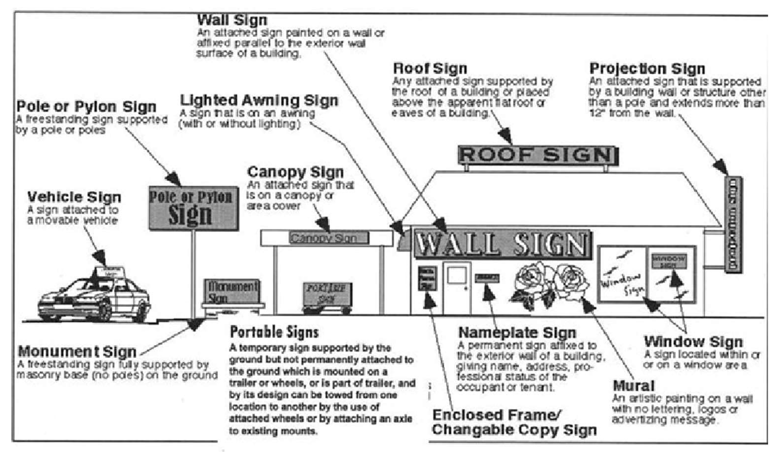
(Ord. No. O-20-20, § 2(Exh. A), 9-14-2020; Ord. No. O-18-21, § 4(Att. A), 1-25-2021)
Sec. 39.3.6-3. - Exempt signs.
The following signs are exempt from the provisions and regulations of this division:
(1)
Public signs. Signs specifically required by any law, statute or ordinance. Such public signs may be of any type, number, area, height, location or illumination as required by the law, statute or ordinance.
(2)
Signs on vehicles.
(a)
Signs placed on or affixed to vehicles or trailers where the sign is incidental to the primary use of the vehicle or trailer as transportation.
(b)
Signs attached or affixed to vehicles being displayed on vehicle sales or rental lots are deemed to be exempt from these regulations, if the purpose of the attached or affixed sign is to advertise the sale or rental of the vehicle upon which it is attached or affixed.
(c)
Temporary construction trailers and vehicles located on construction sites that bear the contractor advertising are exempt from these regulations.
(d)
Signs on vehicles passing through town for the purpose of advertising at a destination outside city limits are deemed to be exempt from these regulations.
(3)
Vehicle signs. Attached, affixed or painted on vehicles when primary use of the vehicle is for the daily transportation of products or the delivery of services in connection with the business.
(4)
Warning signs. Signs warning the public of the existence of danger but containing no advertising material; to be removed within three days upon the subsidence of danger. Such warning signs may be of any type, number, area, height, location, or illumination as deemed necessary to warn the public of the existence of danger.
(5)
Governmental signs. Signs of duly constituted governmental body, including traffic or similar regulatory devices, legal notices, warnings at railroad crossings, and other instructional or regulatory signs having to do with health, hazards, parking, swimming, dumping, etc.
(6)
Address numerals. Address numerals and other signs required to be maintained by and placed in accordance with law or governmental order, rule or regulation.
(7)
Athletic signs. Signs used as scoreboards in athletic stadiums.
(8)
Directional signs. Signs which direct vehicles and pedestrian traffic, which may display arrows, words, or other symbols to indicate direction of facilities.
(9)
Directory signs. Signs that are located in or adjacent to entrances or foyers.
(10)
Instructional signs. Signs, providing no advertising of any kind, which provide direction or instruction to guide persons to facilities intended to serve the public, including, but not specifically limited to, the signs identifying restrooms, public telephones, public walkways, parking areas and other similar facilities.
(11)
Decorations. Seasonal, holiday or festival decorations.
(12)
Flags. Flags of any state, nation, political subdivision or entity, any non-profit group, corporation or entity, or any flag displaying any other noncommercial message.
(Ord. No. O-20-20, § 2(Exh. A), 9-14-2020; Ord. No. O-18-21, § 4(Att. A), 1-25-2021)
Sec. 39.3.6-4. - Prohibited signs.
The following signs are prohibited from installation, construction, repair, alteration or relocation within the city as shown in figure 10, except as otherwise permitted in this division:
(1)
Any sign, which is not included under the types of signs, permitted in this division.
(2)
Signs or other advertising structures erected or maintained in violation of city building, electrical or sign codes, or other applicable local, state or federal regulations.
(3)
Inflatable signs, bandit signs, and portable signs shall be prohibited in the city.
(4)
Permanent off-premises signs (billboard). Permanent off-premises signs (billboards) are also prohibited in the city's extraterritorial jurisdiction.
(5)
Any search lights, bullhorns, spinners (rotating signs), streamers, string lights or strip lighting, pennant, hot air balloon or similar device that is intended to move freely in the wind. Examples of such signs are shown in figure 10 below.
(6)
Moving/whirling and flashing signs except for reader boards, which convey a message. Any light source that produces a revolving beam or beacons that resemble emergency vehicle lights shall be prohibited.
(7)
Any signs, advertisement, poster, placard or handbill upon any lamp post, electric light, railway, telephone or telegraph pole, fire hydrant, shade tree, stone cliff or other natural object, or boxing covering public utilities, or on any bridge, pavement, sidewalk or crosswalk.
(8)
Signs that resemble traffic control signs or emergency information signs.
(9)
Any sign or sign structure which constitutes a hazard to public safety or health.
(10)
Any sign that obstructs free ingress or egress from a fire escape, door, window or other required exit way.
(11)
Any sign that interferes with any opening required for ventilation, or that obstructs openings intended as a means of entrance or exit, or signs that obstruct light or air from any room or building, or block (physically/visually) any public governmental or warning signs.
(12)
Any sign which makes use of words such as stop, look, one way, danger, yield or any other similar words, phrases, symbols, lights or characters in such a manner as to interfere with, mislead or confuse the vehicular traffic.
(13)
Any structure or part thereof, or any device or representation attached to, painted on, or represented on a building, fence, pole or other structure, which is used as or in the nature of an announcement, direction, advertisement, or other attention-getting purposes, and which is not originally designed or intended to be a sign.
Figure 10: Examples of prohibited rotating, spinning and streamer signs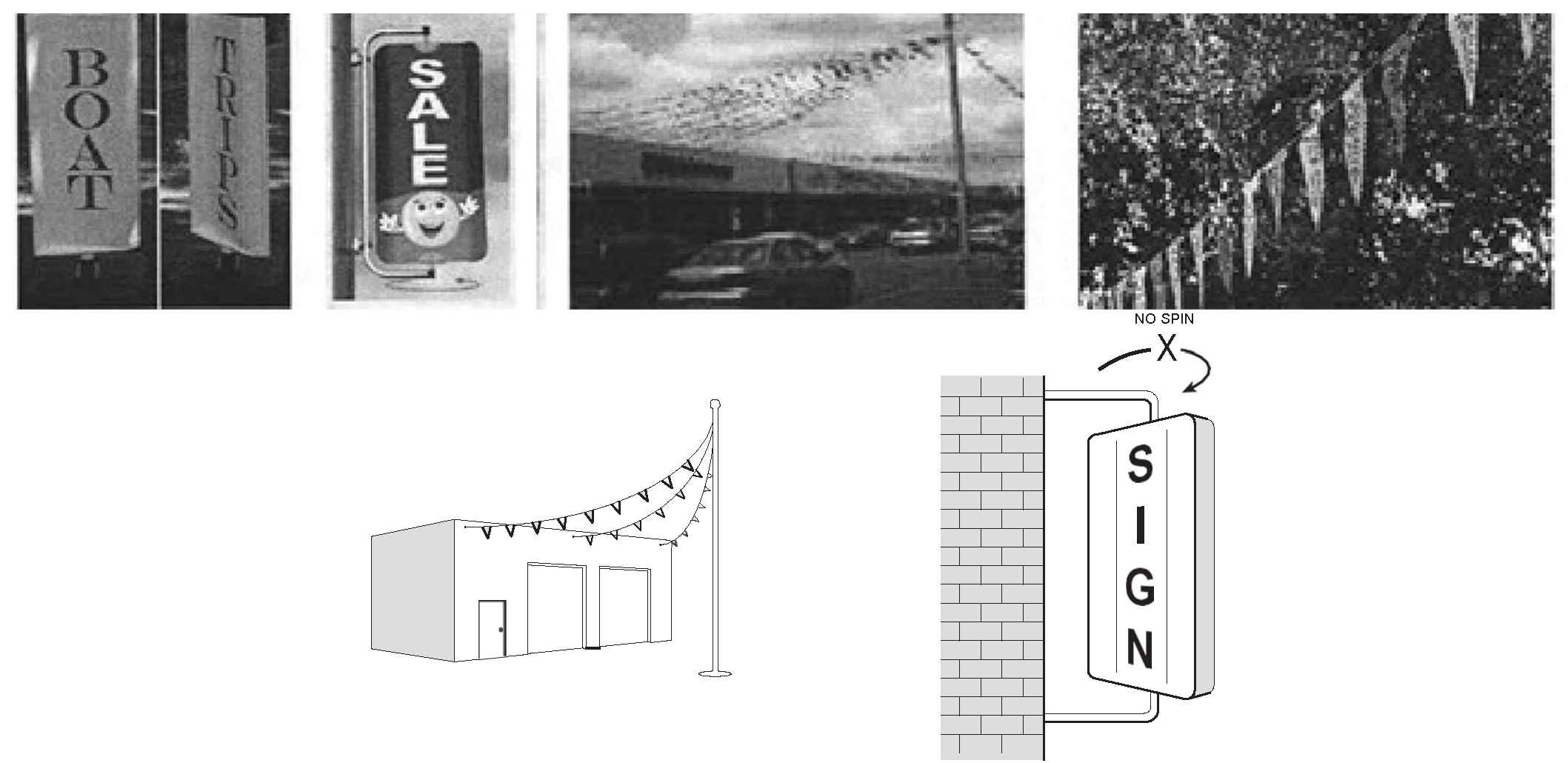
(14)
Home occupation signs that advertise for a business operated in the home.
(15)
Signs placed on property without permission of owner or agent.
(16)
Roof signs.
(17)
New off-premises signs except those permitted through the specific use permit process, through a city council approved license agreement with the city, an integrated business development sign plan, those located within a business park or temporary signs as permitted in this division.
(18)
Outdated signs that advertise a business or product which is no longer in existence.
(19)
Signs and supports, other than governmental signs and supports, which are located in, or extend over, a public right-of-way unless authorized by an approved encroachment agreement.
(20)
Reader panel signs must be totally encased to prevent tampering if the bottom of the sign is less than eight feet in height.
(21)
Signs emitting sound or odor.
(22)
Signs illuminated to such intensity or brilliance as to cause glare or impair vision. Lighting shall be shielded to prevent beams from being directed at any portion of a traveled roadway or an occupied residential area; provided, however, this requirement does not apply to internally lit signs with a lighting intensity of less than 150-foot lamberts.
(23)
Signs on vehicles or trailers that are parked or located for the primary purpose of displaying the sign. It shall be prima facie evidence that the primary purpose of a vehicle or trailer is to display a sign if the vehicle or trailer is parked on a site for a continuous period exceeding 72 hours.
(24)
Signs with the sign structure larger than is reasonably necessary to support the sign.
(25)
Signs that restrict the use of a parking space in a development (example shopping center) where parking is calculated as a total for all businesses located on the premises.
(Ord. No. O-20-20, § 2(Exh. A), 9-14-2020; Ord. No. O-18-21, § 4(Att. A), 1-25-2021)
Sec. 39.3.6-5. - Permits and fees.
(1)
Permit required. It shall be unlawful for any person to construct, reconstruct, alter, or use a sign, or for any owner or occupant of land to allow the construction, reconstruction, alteration, or use of a sign on land owned or occupied by such person, without first having secured a written permit from the city to do so, subject to the exceptions set forth in subsection 39.3.6-5(8) below.
(2)
No sign, unless excepted by this division, shall be located, constructed, altered attached, or painted until a building permit has been approved by the building official in accordance with the requirements of this division.
(3)
All signs shall be built in accordance with the drawings attached with the permit application and as approved by the building official.
(4)
Sign permit applications shall contain or be submitted with the following:
(a)
A completed application form;
(b)
The appropriate fees;
(c)
A dimensioned site plan showing:
i.
The location of the proposed sign in relation to all other structures on the property and the property line itself;
ii.
All adjacent properties and location of signs within 200 feet of the proposed sign;
iii.
An elevation of the sign showing industry specifications and construction details if necessary.
(5)
The city manager or his/her designee shall review a permit application and make a decision on whether to grant or deny the permit within 30 days of submittal of a fully completed application. If additional information is required of an applicant in order to complete an application, the applicant shall be notified of that fact within 30 days. Thereafter, the city manager or his/her designee shall make a decision on whether to grant or deny the permit within 30 days of receiving the additional information or a written certification from the applicant that the application is complete. Any application for which the city manager or his/her designee fails to grant a decision within the first 30-day period shall be deemed denied.
(6)
If the work authorized by a permit issued under this division has not been commenced within 180 days after the date of issuance, the permit shall become null and void.
(7)
Any decision rendered by the city manager or his/her designee under this division may be appealed to the zoning board of adjustment.
(8)
Exceptions. Permits shall not be required for:
(a)
The repainting, cleaning or maintenance of a sign;
(b)
Signs painted on glass surfaces which do not cover more than 50 percent of the total glass surface area;
(c)
Signs erected by governmental agencies and their lessees;
(d)
Railroad signs;
(e)
Legal notices;
(f)
Non-internally illuminated house numbers not more than six inches in height;
(g)
Temporary signs as follows:
i.
For sale or lease signs.
ii.
Contractor identification signs.
iii.
Under construction signs.
iv.
Grand opening signs.
(h)
Any sign:
i.
Erected or maintained pursuant to and in discharge of any governmental function;
ii.
Required by law, ordinance, or governmental regulation; or
iii.
Located on property owned, leased or under the control of a governmental entity.
(i)
Signs on private property not greater than four square feet in area and four feet in height that contain no advertising (except a logo) and that direct the movement of traffic, warn of obstacles or overhead clearances, or control parking, including entrance and exit signs.
(j)
Decorations clearly incidental, customary, and commonly associated with a national, local, ethnic, or religious holiday; provided, however, that such decorations are displayed for only the length of time that such holiday or event is normally and customarily celebrated by the public.
(k)
Nameplates, not exceeding two square feet in area, for residents or occupants of commercial, industrial and professional buildings, or dwellings, apartments, boardinghouses, rooming houses, or other similar facilities.
(l)
Political signs permitted by this division.
(m)
Protection or security signs, not exceeding four square feet in area, erected by the occupant of a premises denoting security devices or no trespassing.
(n)
Signs located in the interior of a building which are designed and located to be viewed by patrons within the building and not by persons outside the building.
(o)
Signs on vehicles required by any governmental agency.
(p)
Signs on licensed commercial vehicles, including trailers; provided, however, that such vehicles or trailers are not designed or constructed for the primary purpose of providing an advertising medium.
(q)
Direction signs, menu boards and the like, which are designed to be read from a distance no greater than ten feet.
(r)
All nonelectric exterior signs not visible from off the property.
(9)
It is an affirmative defense to prosecution under this section that a sign is excepted under this subsection from the requirement of a permit.
(10)
The permit application fee for a temporary event sign may be waived for an event deemed to be in the best interests of the City of Palestine.
(Ord. No. O-20-20, § 2(Exh. A), 9-14-2020; Ord. No. O-18-21, § 4(Att. A), 1-25-2021)
Sec. 39.3.6-6. - Nonconforming signs.
All nonconforming permanent signs, legally existing as of May 31, 2018, may continue to exist and shall be allowed the changing of advertising copy or message on theater marquee signs and similar signs specifically designed for the use of replaceable copy, change of face panel, or where the sign frame was designed for replaceable plates. In addition, all nonconforming signs shall be subject to the following:
(a)
Shall not be changed to another nonconforming sign.
(b)
Shall not be structurally altered so as to change the shape, size, type or design of the sign; except where alterations are necessary to abate a threat to public safety. This does not include a structural modification whereby an upgrade to a sign's existing electronic changeable message technology is made pursuant to subsection 39.3.6-9, detached signs, (6) billboards, (b) electronic billboards.
(c)
Shall not be re-established after damage or destruction if the estimated expense of reconstruction exceeds 50 percent of the reproduction cost.
(d)
Any structural change, alteration, modification, or change in the name, design, letters, message or other matter on the nonconforming sign, other than a face (copy) change, shall require the sign to be brought into conformity with the requirements of this division. This does not include a structural modification whereby an upgrade to a sign's existing electronic changeable message technology is made according to the following:
i.
Overall sign area and height do not increase;
ii.
Changeable message sign area does not increase;
iii.
Total number of changeable message signs do [not] exceed one per premises; and
iv.
Changeable message sign operates in conformance with section 63-70.
(Ord. No. O-20-20, § 2(Exh. A), 9-14-2020; Ord. No. O-18-21, § 4(Att. A), 1-25-2021)
Sec. 39.3.6-7. - Noncommercial signs.
Notwithstanding any provision in this division to the contrary, any sign authorized in this division is allowed to contain a noncommercial message in place of any commercial message.
(Ord. No. O-20-20, § 2(Exh. A), 9-14-2020; Ord. No. O-18-21, § 4(Att. A), 1-25-2021)
Sec. 39.3.6-8. - Attached signs.
(1)
Generally.
(a)
All attached signs on a building elevation shall not exceed 30 percent of the area of that elevation, except as allowed in this section.
(b)
Attached signs shall be allowed on all building elevations.
(c)
Attached signs shall not be allowed on accessory buildings.
(d)
Each elevation shall be allowed to cover a maximum of 30 percent of the area of the elevation with any combination of attached signs.
(2)
Awning sign.
(a)
Location.
i.
Signs must be premises signs.
ii.
Signs shall be attached to the elevation of the awning. If signs project above the structure of the awning they will be considered roof signs.
(b)
Area. Maximum 30 percent of the area of the awning elevation.
(c)
Number of signs. Shall not exceed the total area of all awning signs on each awning elevation does not exceed 30 percent of the area of that awning elevation.
Figure 11: Awning sign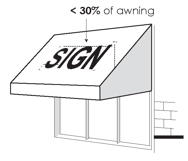
(3)
Canopy sign.
(a)
Location.
i.
Signs must be premises signs.
ii.
Signs shall be attached to the elevation of the canopy. If signs project above the structure of the canopy they will be considered roof signs.
(b)
Area. Maximum 30 percent of the area of the canopy elevation.
(c)
Number of signs. Unlimited as long as the total area of all canopy signs on each canopy elevation does not exceed 30 percent of the area of that canopy elevation.
Figure 12: Canopy sign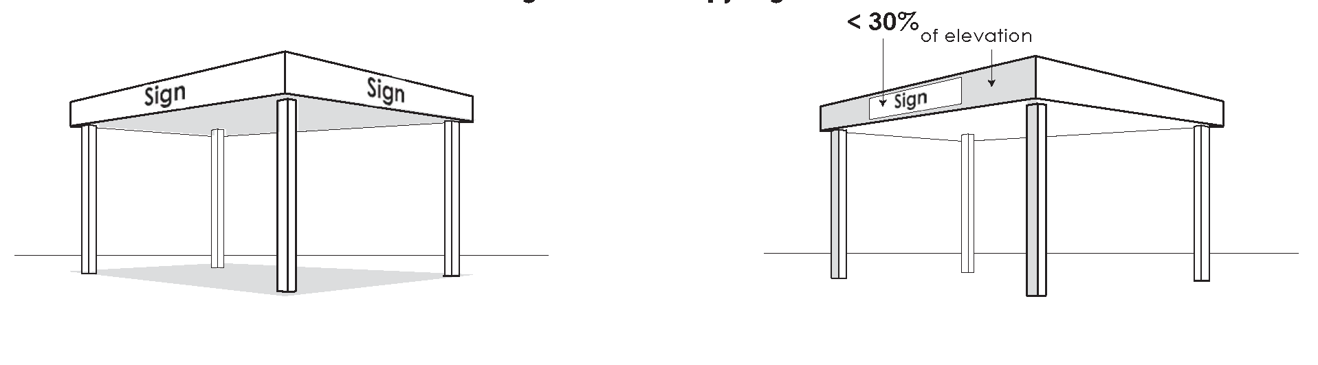
(4)
Channel letter sign.
(a)
Location.
i.
Signs must be premises signs.
ii.
Signs shall be attached to the elevation of the building.
(b)
Area. Maximum 30 percent of the area of the building elevation to which it is attached.
(c)
Number of signs. One per elevation per certificate of occupancy.
(5)
Marquee sign.
(a)
Location.
i.
Signs must be premises signs.
ii.
Signs shall be attached to a marquee on theaters, sports venues and other entertainment venues.
(b)
Area. Maximum 60 percent of the area of the marquee to which it is attached.
(c)
Number of signs. One per building elevation.
(6)
Mural sign.
(a)
Location.
i.
Signs must be premises signs.
ii.
Signs shall be painted directly on the surface of the building.
(b)
Area. Maximum 100 percent of the area of the building elevation on which it is painted. Words and/or symbols may only be ten percent of the size of the entire mural.
(c)
Number of signs. One per building structure.
Figure 13: Mural sign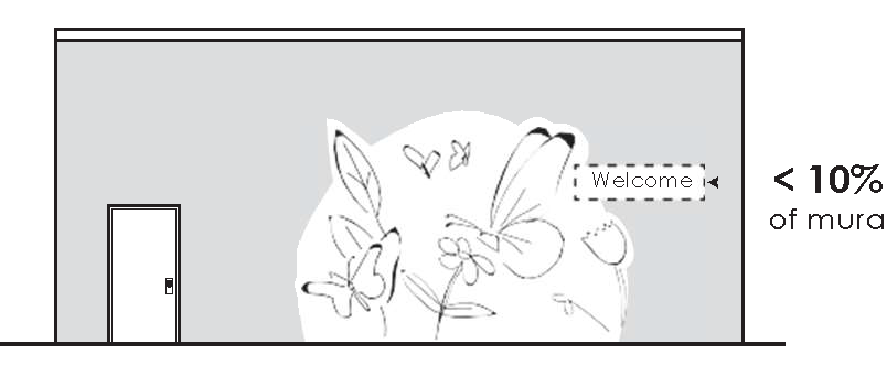
(7)
Poster sign.
(a)
Location.
i.
Signs must be premises signs.
ii.
Signs shall be attached directly to the surface of the building.
(b)
Area. Maximum 30 percent of the area of the building elevation to which it is attached.
(c)
Number of signs. One per elevation per certificate of occupancy.
(8)
Projection sign.
(a)
Location.
i.
Signs must be premises signs.
ii.
Signs shall be attached to the building such that they project maximum one foot from the surface of the building.
(b)
Area. The surface area of the sign where text and graphics are displayed shall not exceed a maximum of 30 percent of the area of the building elevation to which it is attached.
(c)
Number of signs. One per building elevation.
(9)
Sign cabinet.
(a)
Location.
i.
Signs must be premises signs.
ii.
Signs shall be attached directly to the surface of the building.
(b)
Area. Maximum 30 percent of the area of the building elevation to which it is attached.
(c)
Number of signs. One per elevation per certificate of occupancy.
(10)
Window sign.
(a)
Location. Signs must be premises signs.
(b)
Area. Maximum 30 percent of the area of the window.
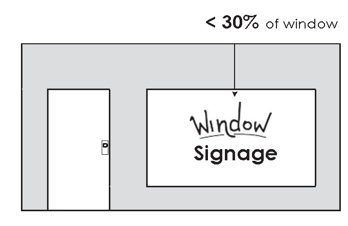
Figure 14: Window sign
(Ord. No. O-20-20, § 2(Exh. A), 9-14-2020; Ord. No. O-18-21, § 4(Att. A), 1-25-2021)
Sec. 39.3.6-9. - Detached signs.
(1)
Generally.
(a)
All detached signs shall be setback a minimum ten feet from the property line.
(b)
Combination of detached sign types allowed on a premise at any given time is as follows:
i.
A premises may either have a pole sign, or a pylon sign or a monument sign if permitted by this division;
ii.
A premises may combine architectural element sign or a vehicle sign with any other detached signs;
iii.
A premises may combine flag signs only with monument signs.
(2)
Architectural element sign.
(a)
Location.
i.
Signs must be premises signs.
ii.
Signs shall be attached to the surface of the architectural element.
(b)
Area. Maximum 200 square feet.
(c)
Height. May not extend beyond the surface of the architectural element to which it is attached.
(d)
Number of signs. One per elevation of the architectural element.
(3)
Flag sign.
(a)
Location.
i.
Signs must be premises signs.
ii.
Signs may only display logos, symbols, tag lines and name of business.
(b)
Area. Maximum 200 square feet.
(c)
Height.
i.
Maximum 30 feet; except:
I.
Maximum 50 feet along state highways and FM roads; or
II.
Maximum 70 feet in business park.
(d)
Number of signs. One per premises.
(4)
Kiosk signs.
(a)
Signs may be premises or non-premises signs.
(b)
The city council may, by duly executed license agreement, grant the exclusive right to design, erect and maintain non-premise kiosk signs within the city limits of the city.
(c)
Kiosk signs shall be designed and constructed in accordance to the specifications contained in the aforementioned license agreement and in this section.
(d)
Prior to erecting any kiosk sign, the licensee shall submit a sign location map to the director of community development for approval. The sign location map shall contain the location, orientation, and number of individual location signs available for each kiosk sign.
(e)
Kiosk sign installation shall include design features as required for traffic signs in the street right-of-way.
(f)
No additional or extraneous signs, pennants, flags or other devices for visual attention or other appurtenances shall be attached to kiosk signs.
(g)
Individual sign panels on kiosks shall have a uniform design and color.
(h)
Kiosk signs shall not:
i.
Interfere with the use of sidewalks, walkways, bike and hiking trails;
ii.
Obstruct the visibility of motorists, pedestrians or traffic control signs; and
iii.
Be installed in the immediate vicinity of street intersections.
(i)
Signs shall comply with the visibility triangle requirements contained in the subdivision regulations or other visibility easements provided by code or subdivision plat.
(j)
Kiosk sign plazas may be located on private premises along the state highways and farm-to-market corridors, or other state-maintained roadways, provided written permission is obtained from the premise owner.
(k)
In accordance to the specifications contained in the aforementioned license agreement a percentage of the kiosk sign panels shall be reserved for the city to use as directional signage to municipal or community facilities, or locations for community events.
(l)
The licensee shall be responsible for all construction, installation, maintenance and repair of the kiosk signs at no cost to the city.
(m)
Notwithstanding anything contained herein to the contrary, any sign authorized under this section to contain commercial copy may contain noncommercial copy in lieu of commercial copy.
(n)
The licensee shall administer the kiosk signs and shall fill the individual location sign spaces in accordance with the following criteria:
i.
The spaces shall be filled according to the date the requesting location submits an application or request is received by the licensee on a first-come, first-served basis.
ii.
The number of kiosk signs and spaces on each sign shall be set by the sign location map approved by the city manager or his/her designee. The licensee may request the placement of additional kiosk signs only if the number of unserved requests will fill an additional sign.
iii.
The licensee shall have no discretion to award or not award a space on a kiosk sign based on the type of organization or business that requests placement on a kiosk sign.
(5)
Monument sign.
(a)
Location. Signs must be premises signs.
(b)
Area.
i.
Maximum 300 square feet for single tenant sign constructed along state.
ii.
Maximum 400 square feet for multi-tenant sign constructed along TX 256 Loop, TX-155, TX-19, U.S. 287, 84, and 79 corridors.
iii.
Maximum 100 square feet for single tenant sign constructed along all other roadways.
iv.
Maximum 150 square feet for multi-tenant sign constructed along all other roadways.
(c)
Height.
i.
Sign base shall be between two feet and four feet.
ii.
Maximum 14 feet for multi-tenant sign constructed where the average grade of the lot on which a sign is placed is at or above the adjacent street grade, the sign shall be measured from the grade level adjacent to the sign. Where the average grade of the lot is below the adjacent street grade, the sign height shall be measured from the adjacent street grade.
iii.
Maximum ten feet for single tenant signs. Where the average grade of the lot on which a sign is placed is at or above the adjacent street grade, the sign shall be measured from the grade level adjacent to the sign. Where the average grade of the lot is below the adjacent street grade, the sign height shall be measured from the adjacent street grade.
(d)
Number of signs. One per street frontage, maximum two per premises.
(e)
[Landscaping bed.] A landscaping bed shall be required around the base of the monument sign and shall be equal in area to one-half the square footage of the sign area. The landscape bed shall be planted with seasonal material such as annuals or bulbs and will be maintained in a healthy and growing condition as is appropriate for the season of the year. Maintenance shall include mowing, watering, trimming, pruning, etc.
(f)
[Material to match.] Monument signs must be wrapped in masonry material to match or compliment building, exposed sign cabinets or poles are prohibited. The masonry material wrapping the advertising area shall not exceed 100 percent nor fall below 30 percent of the commercial advertising area.
(6)
Billboards.
(a)
Location. The construction of new billboard signs shall be prohibited in any zoning district. The construction of new billboard signs shall also be prohibited in the city's extraterritorial jurisdiction. The existing, nonconforming billboard signs in the city or its extraterritorial jurisdiction that are adjacent to interstate highways and federal-aid primary highways, as those terms are defined in the Highway Beautification Act, are subject to the regulations in this section. All Texas Department of Transportation regulations for billboards (permanent off-premises) signs shall apply in addition to the requirements of this division.
(b)
Electronic billboards.
i.
Converting an existing sign to digital sign shall be considered a face change and will be allowed but will not change the nonconforming status of the sign.
ii.
Message changes on digital signs shall be allowed at two-second transition with an eight-second hold time.
(c)
Area.
i.
Each panel or sign shall not exceed 300 square feet in total area.
ii.
No more than two panels or sign faces will be allowed for each sign.
iii.
No off-premises sign shall exceed 60 feet in length, inclusive of border and trim.
(d)
Height.
i.
Maximum 50 feet; except:
ii.
Signs must maintain a ten-foot clearance from ground to sign.
(e)
Illumination.
i.
Signs shall be shielded upward to prevent beams or rays from being directed at any portion of a traveled roadway or an occupied residential area and shall not be of such intensity or brilliance as to cause glare or impair vision.
ii.
Each display must have a light sensing device that will adjust the brightness as ambient light conditions change.
iii.
Digital billboards shall not operate at brightness levels of more than 0.3 foot-candles above ambient light, as measured using a foot-candle meter at a pre-set distance.
I.
Pre-set distances to measure the foot-candle's impact vary with the expected viewing distances of each size sign.
(7)
Pole/pylon sign.
(a)
Location.
i.
Signs must be premises signs.
ii.
Signs shall only be allowed on a premises with a commercial certificate of occupancy adjacent to TX 256 Loop, TX-19, TX-155, US 287, 84, and 79 corridors.
iii.
Signs shall maintain a 100-foot separation from an adjacent pole sign on each premises and minimum of 50 feet on adjacent premises on the same side of the street.
(b)
Area. Maximum 400 square feet.
(c)
Height.
i.
Maximum 50 feet.
ii.
Signs must maintain a ten-foot clearance from ground to sign.
(d)
Number of signs. One per street frontage per premises.
(8)
Directional sign.
(a)
Location. Must be premises signs.
(b)
Area. Maximum ten square feet.
(c)
Height. Maximum four feet.
(d)
Number of signs. One per driveway entrance.
(Ord. No. O-20-20, § 2(Exh. A), 9-14-2020; Ord. No. O-18-21, § 4(Att. A), 1-25-2021)
Sec. 39.3.6-10. - Other signs.
(1)
Changeable message signs.
(a)
These maybe premises signs or non-premises signs.
(b)
These may be manual or electronic.
(c)
Changeable message signs:
i.
Shall be allowed on all permitted signs.
ii.
May be a part of an attached sign or a detached sign.
I.
Shall not comprise an area greater than 50 percent of the allowed area of the monument or pylon sign.
II.
If constructed as part of a monument or pylon sign, the changeable message sign cabinet must be wrapped in material to match or compliment the building materials used on the premises.
iii.
Shall not be allowed on temporary signs.
(d)
Number of signs. Only one sign per premises shall be allowed as a changeable message sign.
(e)
[Illumination.] Illumination of changeable message signs shall not be of such intensity or brilliance as to cause glare or impair vision. The Spinks Airport Air Hazard Zoning Ordinance, as referred to by Resolution 503, shall govern all changeable message signs located within identified air hazard areas.
(f)
[Electronic changeable message.] All electronic changeable message signs shall have an auto dimmer photo eye installed in the sign.
i.
Maximum daytime (7:00 a.m. to 6:00 p.m.) brightness shall be 5,000 nits; and
ii.
Maximum nighttime (6:01 p.m. to 6:59 a.m.) brightness shall be 500/660 nits.
(g)
[Interval.] Message changes shall be allowed at two-second transition with an eight-second hold time.
(2)
Signs in public rights-of-way.
(a)
All signs in public right-of-way shall have a right-of-way agreement or a license agreement between the sign owner and the city council.
(b)
The application for a right-of-way agreement or license agreement shall include the types, locations, size, area, height, number, materials, design and construction of all proposed signs.
(c)
This data shall be a part of the agreement and will be attached to the agreement.
(d)
The process for right-of-way agreement or license agreement shall be as follows:
i.
The application will be submitted to the development services department and will be reviewed by the development review committee and shall be placed on a planning and zoning commission agenda.
ii.
The city manager will then place the item on a city council agenda.
iii.
The director of development services department shall put a notice in the newspaper 15 days before the day of the meeting for both the planning and zoning commission meeting and city council meetings (this notice may be sent at one time). The planning and zoning commission shall review the sign details and design and make a recommendation to the city council.
(e)
The sign placement agreement shall be approved if the following criteria are met:
i.
The sign will be placed in right-of-way adjacent to and in the frontage of the business location or other establishment referenced in the sign.
ii.
There would be an unnecessary hardship if the business location or establishment were not allowed to place the sign in the right-of-way due to lack of visibility from the right-of-way due to the placement of other existing structures.
(3)
Integrated business development sign plan.
(a)
An integrated business development sign plan application shall be a written and/or illustrated document to depict all temporary and permanent proposed signs on site which shall include:
i.
Proposed sign palette, which may include any combination of attached, detached, and temporary sign types that are allowed in this division;
ii.
Location of all proposed signs included in the sign palette;
iii.
Size and number of all proposed signs including maximum area, letter height, number, and height;
iv.
Materials proposed for all signs and sign structures;
v.
Color and style palette for all signs (letter colors, background colors, text fonts, etc.) including context of where signs are to be placed on any given facade;
vi.
Type of illumination proposed, and whether external or internal;
vii.
Landscaping or ornamental structures including fences, fountains, public art, ground cover, and other landscaping elements that are intended to complement the proposed sign palette and design; and
viii.
Any other information as required by the decision-making bodies.
(b)
Design guidelines.
i.
Compatibility with surroundings.
I.
Proportional size and scale. The scale of signs should be based on the building facade on which they are placed and the area in which they are located. The size and shape of a sign should be proportional with the scale of the structure. Large storefronts such as big boxes will be allowed to have proportionally larger signs than smaller storefronts. Signs should not overwhelm the section of the building facade on which it is placed upon.
II.
Integrate signs with the building. Signs should be designed so that they are integrated with the design of the building. A well-designed building facade or storefront is created by the careful coordination of sign and architectural design, and a coordinated color scheme. Signs in multiple-tenant buildings should be designed to complement or enhance the other signs in the building. Sign placement and design should be reviewed within the context of building design.
III.
Corporate franchise signage. Corporate franchise signage should conform to the community's visual desires while maintaining some elements of corporate identity. Corporate logos should fit the context, color, scale and building elements.
ii.
Location and mounting.
I.
Signs should be mounted in locations that respect the design of a building and site, including the arrangement of bays and openings. Signs should not obscure windows, (including second-story windows), window trim/molding, grillwork, piers, pilasters, and other ornamental features.
II.
Attached signs on fascias above storefront windows should be sized to fit within existing friezes, lintels, spandrels, and other such features and not extend above, below, or beyond them. Typically, attached signs should be centered on horizontal surfaces (e.g., over a storefront opening).
III.
When a large building contains several storefronts, signs for the individual businesses should relate well to each other in terms of locations, height, proportion, color, and illumination. Maintaining continuity will reinforce the building's facade composition while still retaining each business's identity.
iii.
Color.
I.
Avoid using too many colors. Colors or color combinations that interfere with legibility of the sign copy or that interfere with viewer identification of other signs should be avoided.
II.
Use contrasting colors. Contrast is an important influence on the legibility of signs. A substantial contrast should be provided between the color and material of the background and the letters or symbols to make the sign easier to read in both day and night. Light letters on a dark background or dark letters on a light background are most legible. Light letters on a dark background work best for both day and nighttime use.
iv.
Materials.
I.
Compatibility of materials. Sign materials should be compatible with the design of the facade on which they are placed. Consider the architectural design of the building's facade and select materials that complement the design. The selected materials should also contribute to the legibility of the sign. For example, glossy finishes are often difficult to read because of glare and reflections.
II.
Appropriate materials. Sign materials should be extremely durable. Paper and cloth signs are not suitable for exterior use (except on awnings) because they deteriorate quickly. If wood is used, it should be properly sealed to keep moisture from soaking into the wood and causing the sign's lettering to deteriorate.
v.
Sign legibility.
I.
Concise name identification. A concise name or limited lines of copy should be used whenever possible given the limited amount of time the vehicle traveling public has to identify and read the sign. The fewer number of words, the more effective the sign. A simple and succinct sign is easier to read and looks more attractive because it is less cluttered.
II.
Use symbols and logos. Symbols and logos can be used in place of words whenever appropriate. Pictographic images will usually register more quickly in the viewer's mind than a written message. And they can be an expression of the owner's creativity.
III.
Limit the number of letter styles. The number of lettering styles that are used on a sign should be limited in order to increase legibility. As a general rule, limit the number of different letter types to no more than two for small signs and three for larger signs. Intricate typefaces and symbols that are difficult to read reduce the sign's ability to communicate.
vi.
Sign illumination.
I.
Internal illumination. Individually illuminated letters, either internally illuminated or backlit solid letters (reverse channel) are a preferred alternative to internally illuminated plastic cabinet signs. Signs comprised of individual letters mounted directly on a structure can often use a distinctive element of the structure's facade as a backdrop, thereby providing a better integration of the sign with the structure.
II.
Use a projected light source. Signs along roadways with slower moving traffic or in pedestrian-oriented environment should consider illumination by a projected light source (e.g., spotlight). Projection lighting is usually a better alternative because the sign will appear to be integrated with the building's architecture. Light fixtures supported in front of the sign cast light on the sign and generally a portion of the building's face as well. Projected lighting emphasizes the continuity of the structure's surface and signs become an integral part of the facade. The use of small, unobtrusive fixtures for external (projection) lighting is encouraged. Avoid the use of oversized fixtures that are out of scale with the sign and structure. Whenever projection lighting is used (fluorescent or incandescent), care should be taken to properly shield the light source to prevent glare from spilling over into residential areas and any public right-of-way. Signs should be lighted only to the minimum level required for nighttime readability.
III.
Cabinet signs. The use of internally illuminated cabinet signs is discouraged. When such signs are proposed, the background field is required to be opaque so that only the lettering appears illuminated (e.g., routed or push-through lettering/graphics). When the background is not opaque, the entire sign face becomes bright and the sign becomes visually separated from the building. As a result, this type of sign can disrupt the continuity of the facade.
IV.
Electrical raceways and conduits. Electrical transformer boxes and raceways are required to be concealed from public view. If a raceway cannot be mounted internally behind the finished exterior wall, the exposed metal surfaces of the raceway should be finished to match the background wall or integrated into the overall design of the sign. If raceways are necessary, they should be as thin and narrow as possible and should never extend in width or height beyond the area of the sign's lettering or graphics. All exposed conduit and junction boxes should also be concealed from public view.
V.
Neon signs. Neon/L.E.D. or similar types of lighting are discouraged.
(Ord. No. O-20-20, § 2(Exh. A), 9-14-2020; Ord. No. O-18-21, § 4(Att. A), 1-25-2021)
Sec. 39.3.6-11. - Temporary signs.
(1)
Generally.
(a)
All temporary signs shall require a permit except as provided in section 39.3.6-5.
(b)
All temporary sign permits shall be displayed in the door or windows of the establishment during the time in which the sign is displayed on the premises.
(2)
Banner sign.
(a)
Location.
i.
Signs may be premises or non-premises signs.
ii.
Signs shall be attached to a main building or on light poles.
iii.
Signs may be allowed in the public right-of-way for large community events.
iv.
Banners shall not be allowed on accessory structures/buildings or fences.
(b)
Area.
i.
Maximum 80 square feet; except:
ii.
Maximum 35 square feet each when located on light poles, letters, symbols, logos, etc., shall be allowed to cover only 15 percent of the total area of each light pole banner.
(c)
Height.
i.
Minimum ten feet from the ground; and
ii.
Shall not obstruct pedestrian or vehicular traffic.
(d)
Number.
i.
Maximum four displays per year per certificate of occupancy; except
ii.
Two vertical banners per light pole.
(e)
Time limitations.
i.
Maximum 30 days with 60 days between displays for each separate certificate of occupancy;
ii.
Grand openings.
I.
Once for each separate certificate of occupancy;
II.
Within 30 days of the issuance of the certificate of occupancy;
III.
Maximum for 15 consecutive days.
iii.
Special events. Banner signs are allowed with a special event permit for 14 days prior to the event and two days after the event is over.
iv.
There is no time limitation for banners on light poles.
(3)
Construction sign.
(a)
Location. Signs must be premises signs.
(b)
Area.
i.
Maximum 50 square feet in residential districts.
ii.
Maximum 100 square feet in nonresidential districts.
(c)
Height. Fifteen feet as measured from the sign base.
(d)
Number of signs. One sign for each abutting street.
(e)
Time limitation. Maximum 60 days prior to construction up to 14 days after completion (issuance of certificate of occupancy).
(4)
Movable sign.
(a)
Location.
i.
Signs must be premises signs.
ii.
Except for "A"-frame or sandwich board signs, must be ten feet from curb or edge of paving and 15 feet from access drive.
iii.
Fifty feet from any other movable signs.
iv.
Movable signs are prohibited in the public right-of-way.
(b)
Area.
i.
Generally: Maximum eight square feet.
ii.
Bow banners or swooper flags: 15 square feet.
iii.
"A"-frame or sandwich board signs: 25 square feet.
(c)
Height.
i.
Generally: Maximum four feet from ground.
ii.
Bow banners or swooper flags: Maximum ten feet from the ground.
iii.
"A"-frame or sandwich board signs: Maximum five feet from the ground.
(d)
Number of signs. Each business may display one movable sign per street frontage, regardless of the size of the premises.
(e)
Time limitation. "A"-frame or sandwich board signs shall only be allowed during business hours.
(f)
Illumination. Movable signs shall not be illuminated.
(5)
Pennants.
(a)
Location.
i.
Signs must be premises signs.
ii.
Pennants are only allowed for grand openings and for holidays and festivals.
(b)
Time limitation.
i.
Grand openings.
I.
Once for each separate certificate of occupancy (CO).
II.
Within 30 days of the issuance of the CO.
III.
Maximum for 15 consecutive days.
ii.
Holiday and festivals. Forty days prior to the holiday event and up to two days after the holiday event for each premises.
(6)
Residential yard sign.
(a)
Location. Except for noncommercial signs, signs must be on premises signs.
(b)
Area. Maximum ten square feet.
(c)
Height. Maximum four feet.
(d)
Number of signs. One sign per premises.
(e)
Time limitation. For the duration of the activity but removed 30 days following completion.
(7)
Wind sign.
(a)
Location.
i.
Signs must be premises signs.
ii.
Wind signs are only allowed for grand openings and for holidays and festivals.
(b)
Time limitation.
i.
Grand openings.
I.
Once for each separate certificate of occupancy (CO).
II.
Within 30 days of the issuance of the CO.
III.
Maximum for 15 consecutive days.
ii.
Holiday and festivals. Forty days prior to the holiday event and up to two days after the holiday event for each premises.
(8)
Residential subdivision development sign.
(a)
Location.
i.
Sign may be non-premises or premises within 250 feet of the subdivision entrance and within the subdivision boundaries.
ii.
Sign shall be located:
I.
On property of the subdivision where the lots of the homebuilder are located or on property of an earlier phase of the subdivision where the lots of the homebuilder are located; or
II.
Within 250 feet of the entrance to the subdivision.
iii.
No signs shall be allowed in the public right-of-way.
(b)
Area. Maximum 32 square feet.
(c)
Height. Maximum 12 feet.
(d)
Number of signs. One sign per homebuilder per subdivision entrance.
(e)
Time limitation. After 100 percent of the home builder's sites are completed, and then they have 48 hours to remove the sign.
(9)
Political signs.
(a)
Political signs not exceeding 36 square feet may be erected on private real property only with the permission of the property owner. Private real property does not include real property subject to an easement or other encumbrance that allows a municipality to use the property for a public purpose.
(b)
Political signs shall be removed within ten days after completion of the election in question.
(c)
In the case of a run-off election, signs advertising those candidates who are in the run-off election may be continued to be displayed during the interim period but must be removed within ten days after the run-off election.
(d)
A political sign shall not require a sign permit and shall comply with the following requirements:
i.
The total signage area for political signs shall not exceed 36 square feet in area, shall not exceed eight feet in height, shall not be illuminated, nor have any moving elements.
ii.
Political signs shall not be located in the city rights-of-way or in roadway medians, nor be placed on city-owned property such as city parks, fire stations, police stations, libraries, city hall, and other city-owned buildings. However, such signs may be placed on public property designated as an official polling place on a designated election day, with such signs being located outside the specified distance from the polling place entrance as permitted by state election laws.
iii.
Political signs may not be placed in the state rights-of-way situated within the city.
iv.
Political signs shall not be installed in any manner that may result in a potential safety hazard of any type.
v.
Political signs shall not be placed in visibility triangles as defined in the subdivision ordinance of the city.
vi.
Political signs shall be kept in repair and a proper state of preservation.
vii.
Political signs may be erected no earlier than 90 days before the date of the election for which the sign is designated.
viii.
Notwithstanding any provision in this division to the contrary, if a political sign is authorized to be placed or erected under this section, a temporary sign with any other noncommercial message is allowed to be erected in its place provided it otherwise complies with the provisions of this section.
(10)
Human signs.
(a)
Location.
i.
Each sign shall be located on private property where a sale, event, promotion, or a similar limited-duration event is taking place.
ii.
Human signs shall not be permitted in residential districts.
iii.
Human signs are prohibited within any public right-of-way.
iv.
A person acting as a human sign is not permitted to hold or carry wind devices, flags or balloons. Podiums, risers, stilts, vehicles, roofs, or other structures or devices shall not support a human sign.
(b)
Area. Eight square feet.
(c)
Height. May not extend 12 feet above ground.
(d)
Number of signs.
i.
No more than one human sign per business location.
ii.
A human sign counts as a type of moveable sign for purposes of the number limitation set forth in subsection 39.3.6-11(4).
(e)
Time limitation. Human signs shall only be allowed during business hours.
(Ord. No. O-20-20, § 2(Exh. A), 9-14-2020; Ord. No. O-18-21, § 4(Att. A), 1-25-2021; Ord. No. O-01-26, § 2(Exh. A), 1-12-2026)
Sec. 39.3.6-12. - Measurement standards.
(1)
For an attached sign, which is framed, outlined, painted or otherwise prepared and intended to provide a background for a sign display, the area and dimensions, shall include the entire portion within such background or frame.
Figure 15: For an attached sign, which is framed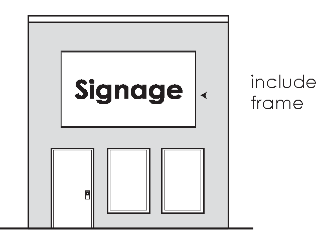
Figure 16: Examples of geometric area applied to sign area calculations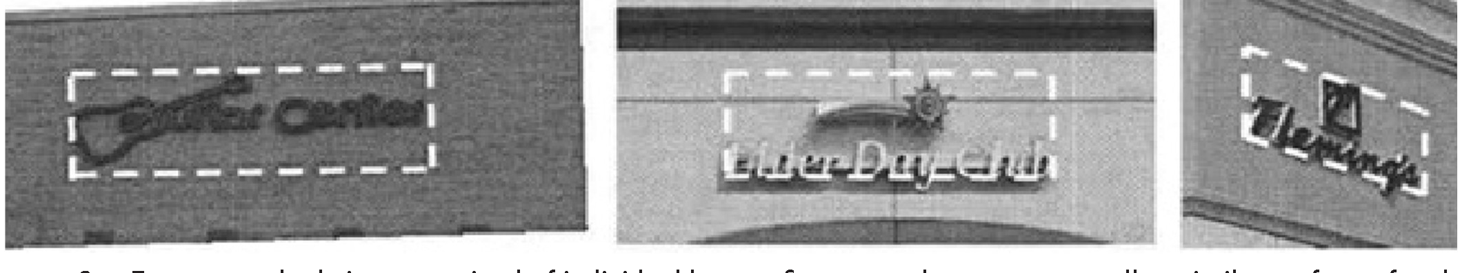
(2)
For an attached sign comprised of individual letters, figures or elements on a wall or similar surface of the building or structure, the area and dimensions of the sign shall encompass a regular geometric shape (rectangle, circle, trapezoid, triangle, etc.), or a combination of regular geometric shapes, which form, or approximate, the perimeter of all elements in the display, the frame, and any applied background that is not part of the architecture of the building. When separate elements are organized to form a single sign, but are separated by open space, the sign area and dimensions shall be calculated by determining the geometric form, or combination of forms, which comprises all of the display areas, including the space between different elements. (See figure 17.)
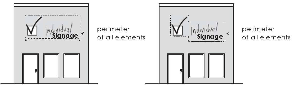
Figure 17: For an attached sign comprised of individual letters
(3)
For a detached sign, the sign area shall include the frame, if any, but shall not include:
(a)
A pole or other structural support unless such pole or structural support is internally illuminated or otherwise so designed to constitute a display device, or a part of a display device.
(b)
Architectural features that are either part of the building or part of a freestanding structure, and not an integral part of the sign, and which may consist of landscaping, building or structural forms complementing the site in general.
Figure 18: Examples of calculation for detached sign area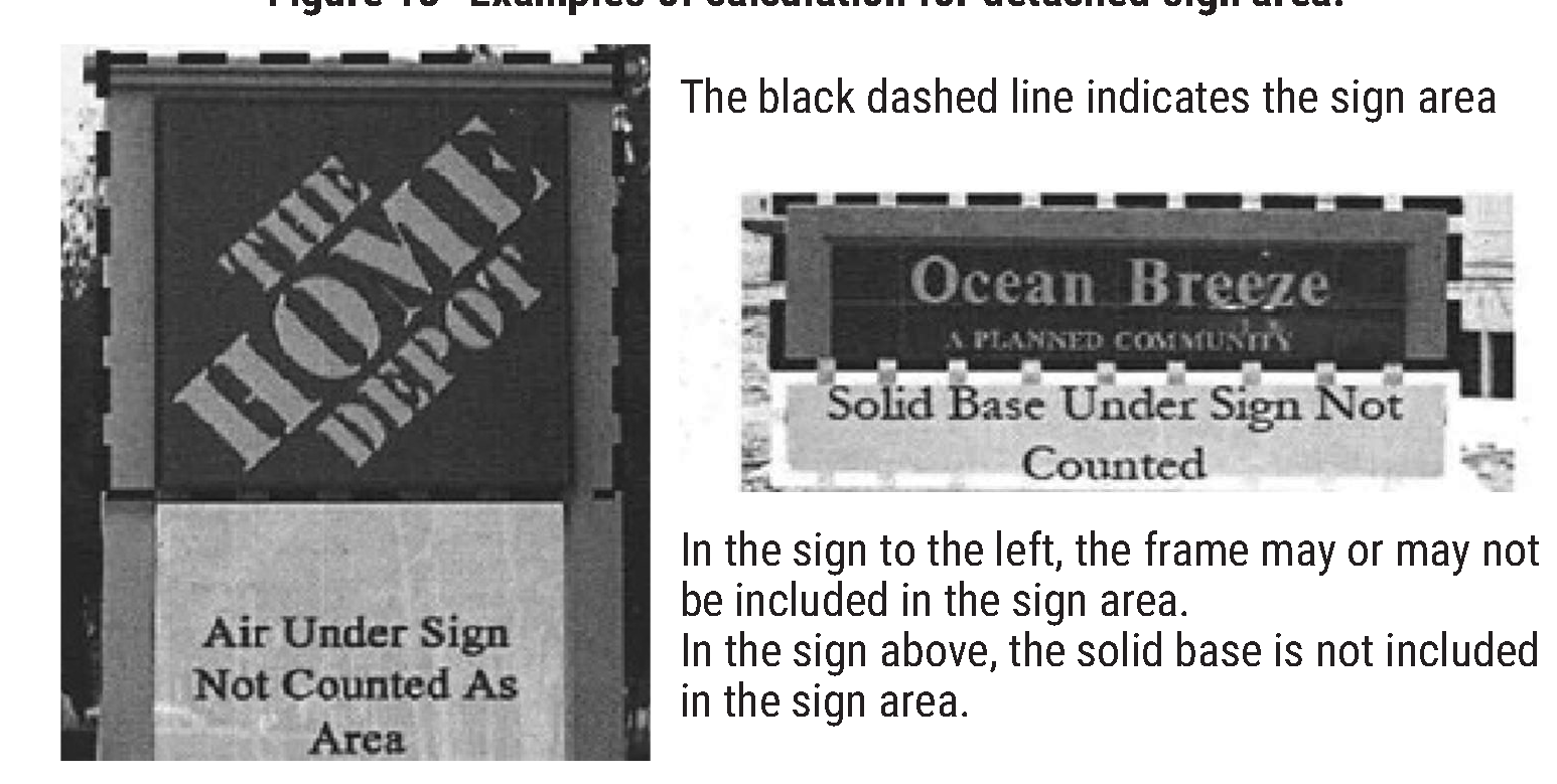
(4)
When two identical sign faces are placed back-to-back so that both faces cannot be viewed from any point at the same time, and are part of the same sign structure, the sign area shall be computed as the measurement of one of the two faces. When the sign has more than two display surfaces, the area of the sign shall be the area of largest display surfaces that are visible from any single direction. The area of a sign with more than two faces would be calculated as the area of the largest rectangular plane of the panels that are visible from any single location. (See figure 19 and 20 below).
Figure 19: Examplies of a sign area with multiple faces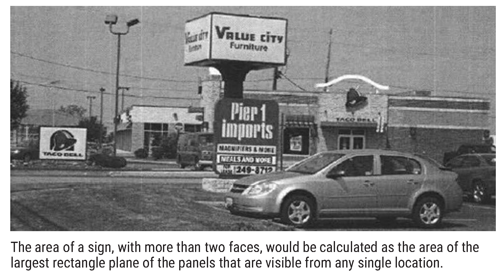
Figure 20: Sketch of a sign area with multiple faces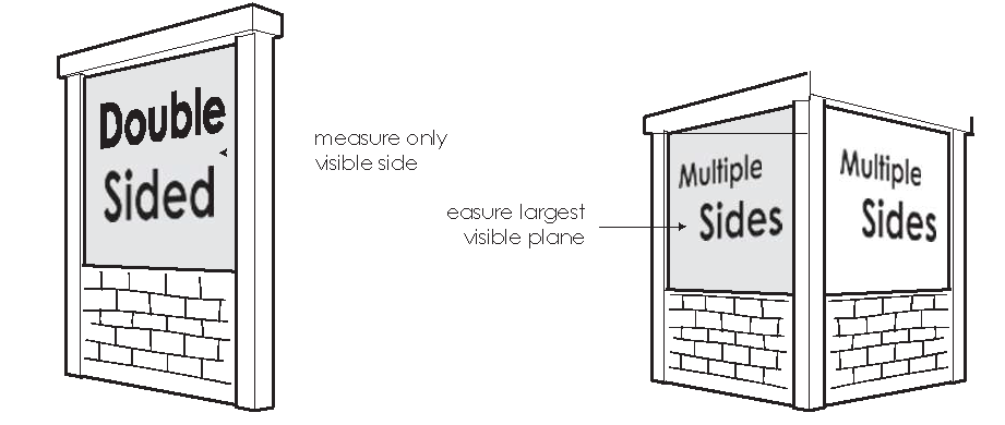
(5)
In the event of a dispute in determining the area or dimensions of any sign, the decision of the building official may be appealed by the applicant through the submittal of a formal application to the zoning board of adjustment in accordance with the variance process described in this division.
(6)
Determining sign height. The height of a detached sign shall be measured from the base of the sign or supportive structure at its point of attachment to the ground, to the highest point of the sign. A detached sign on a man-made base, including a graded earth mound, shall be measured from the grade of the nearest pavement or top of any pavement curb.
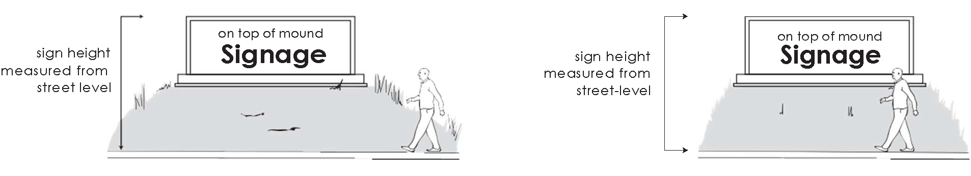
Figure 21: Sketch of sign height
Figure 22: Image of sign height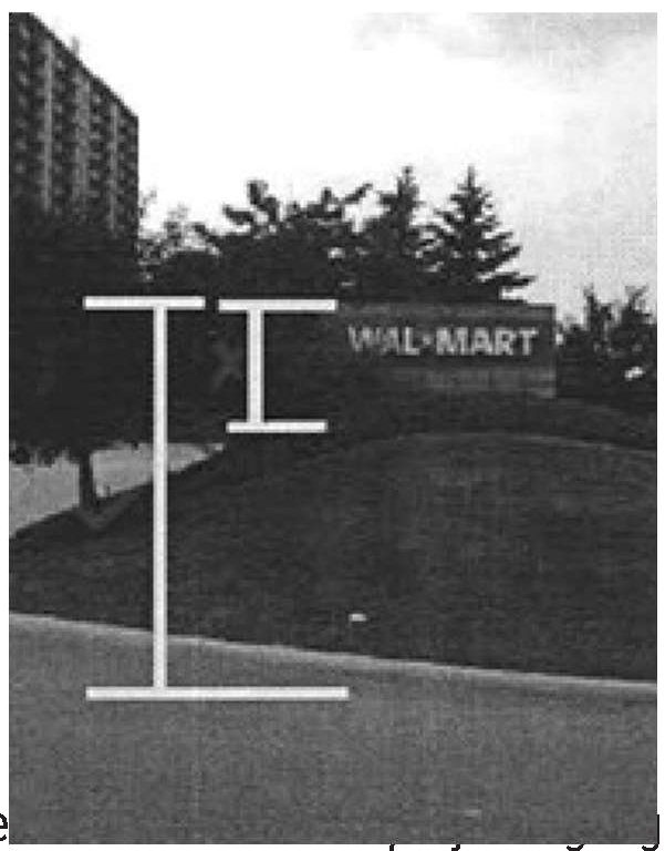
The height of a sign is measured from the grade of the street level where the sign is viewed: not from the top of the mound.
(7)
Clearance for detached and projecting signs shall be measured as the smallest vertical distance between finished grade and the lowest point of the sign, including any framework or other embellishments.
(Ord. No. O-20-20, § 2(Exh. A), 9-14-2020; Ord. No. O-18-21, § 4(Att. A), 1-25-2021)
Sec. 39.3.6-13. - Construction standards.
(1)
Design required. Before a sign permit shall be granted, the applicant shall submit to the city a design or plan containing information as to the type, size, shape, location, construction, lighting/illumination, and materials of the proposed sign.
(2)
The design and erection of all signs shall be constructed as specified in the latest adopted edition of the International Building Code:
(a)
Signs shall be structurally sound and located so as to pose no reasonable threat to pedestrian or vehicular traffic.
(b)
All permanent detached signs shall have self-supporting structures erected on, or permanently attached to, concrete foundations.
(c)
If possible, signs should not be in locations that obscure architectural features such as pilasters, arches, windows, cornices, etc.
(d)
The signs should not be in locations that interfere with safe vehicular and pedestrian circulation or public safety signals and signs.
(e)
No signs shall be erected, constructed or maintained so as to obstruct any fire escape, required exit, window, or door opening used as a means of egress.
(f)
Signs shall be structurally designed in compliance with ANSI and ASCI standards. All elective signs shall be constructed according to the technical standards of a certified testing laboratory.
(Ord. No. O-20-20, § 2(Exh. A), 9-14-2020; Ord. No. O-18-21, § 4(Att. A), 1-25-2021)
Sec. 39.3.6-14. - Lighting standards.
Signs may be illuminated—by external or internal means—and in addition to the requirements and regulations of the ordinance codified herein, provided that:
(a)
The brightness and intensity shall not be greater than necessary to meet reasonable needs of the business or use served;
(b)
Light sources shall be shielded from all adjacent buildings and streets; and
(c)
The lighting shall not create excessive glare to pedestrians and/or motorists and will not obstruct traffic control or any other public informational signs.
(Ord. No. O-20-20, § 2(Exh. A), 9-14-2020; Ord. No. O-18-21, § 4(Att. A), 1-25-2021)
Sec. 39.3.6-15. - Enforcement and maintenance.
All signs shall be maintained in accordance with the following:
(a)
The property owner shall maintain the sign; in a condition appropriate to the intended use; to all city standards; and has a continuing obligation to comply with all building code requirements.
(b)
If the sign is deemed by the code enforcement officer to be in an unsafe condition, the owner of the business shall be immediately notified in writing, and shall, within 48 hours of receipt of such notification, respond to the city with a plan to correct the unsafe condition, remove the unsafe sign, or cause it to be removed. If after 30 days the unsafe condition has not been corrected through repair or removal, the code enforcement officer may cause the repair or removal of such sign at the expense of the property owner or lessee. If the total costs are not paid in full within 30 days of the repairs or removal, the amount owned shall be certified as an assessment against the property of the sign owner, and lien upon that property, for collection as prescribed for unpaid real estate taxes.
(c)
In cases of emergency, the code enforcement officer may cause the immediate removal of a dangerous or defective sign without notice.
(d)
Whenever any sign, either conforming or nonconforming to these regulations, is required to be removed for the purpose of repair, re-lettering or repainting, the same may be done without a permit or without any payment of fees provided that all of the following conditions are met:
i.
There is no alteration or remodeling to the structure or the mounting of the sign itself;
ii.
There is no enlargement or increase in any of the dimensions of the sign or its structure;
iii.
The sign is accessory to a legally permitted, specific use, or nonconforming use.
(Ord. No. O-20-20, § 2(Exh. A), 9-14-2020; Ord. No. O-18-21, § 4(Att. A), 1-25-2021)
Sec. 39.3.6-16. - Signs in the Main Street overlay district.
(1)
General.
(a)
Purpose. The purpose of the Palestine Main Street District Sign Ordinance is to encourage the preservation of historic signs and development of new signs which are compatible with their surroundings and enhance the building while giving opportunities for individual expression. Main Street's purpose is based on the historic nature of the district for tourism and economic development enhancement. Signs should be of appropriate historical design when possible and do not visually obscure significant architectural features of the building.
(b)
Signs should be in balance with the overall character of the property. Signs may be expressed in a variety of styles. A sign should be in character with the material, color and detail of the building.
(c)
All current signs, as of August 15, 2011, will be considered exempt from this sign ordinance and will be "grandfathered" into the Main Street District. Such signs will be considered legal and nonconforming within the guidelines of this section. Any sign that is deemed "grandfathered" shall be considered no longer exempt if more than 50 percent is replaced due to age, damage or change of business, at such time the Main Street Sign Ordinance will be in effect.
(2)
Definitions and specifications.
(a)
Signboard.
i.
Definition. A signboard is any flat sign mounted or applied to a building facade.
ii.
Specifications.
I.
Number. Each building may have one signboard or projecting sign oriented to its primary or entrance frontage. A building located at a corner may also have one signboard oriented to its secondary or side street frontage. In the situation of multiple occupant/tenant sign special consideration shall be considered on a per application basis.
II.
Size. For every one linear foot of building primary or entrance footage, two square feet of sign area shall be allowed. Signboards on secondary or side-street frontage shall not exceed the size of signboards on the primary or entrance frontage.
III.
Location. Place signs on the building's sign frieze, which is the horizontal flat bank above the store windows. Original signs, either on flat signboards or made of individual letters attached to the sign frieze, were designed as an integral part of the building.
(b)
Window sign.
i.
Definition. Any permanent sign painted, applied to, or hung inside or outside a window glass.
ii.
Specifications.
I.
Size. Window signs shall cover no more than 30 percent of the total glass areas of the window on which they are placed. The sign coverage shall be determined by an imaginary square or rectangle that encompasses the window sign glass.
II.
Temporary decorative or seasonal window paintings do not require a permit as long as is it removed or replaced within 60 days.
(c)
Projecting sign.
i.
Definition. Any sign attached to and placed perpendicular to a building facade and can have print on both sides.
ii.
Specifications.
I.
Number. Each building may have one signboard or projecting sign oriented to its primary or entrance frontage.
II.
Size. Projecting signs for one story buildings shall be no more than 15 square feet in size, with a maximum sign height of three feet. Signs for multi-story buildings must be proportional in size to the building and are subject to approval by the Main Street Advisory Board.
III.
Location. Projecting signs shall have a minimum clearance from the side walk of ten feet to the bottom of the sign and shall not project more than half of the sidewalk width.
(d)
Hanging sign.
i.
Definition. Any sign suspended from an awning or canopy and can have print on both sides.
ii.
Specifications.
I.
Number. Each entrance that faces a street may have one hanging sign per building.
II.
Size. Each face of a hanging sign shall be no more than eight square feet in size.
III.
Location. Hanging signs shall be allowed when such signs have a minimum clearance of seven-foot height from the sidewalk and do not extend beyond the awning or canopy projection.
(e)
Awning sign.
i.
Definition. Any sign painted or applied to the valance or top panel of a fabric or rigid awning structure made of aluminum, iron or steel, wood or transparent material. Signs are not permitted on the side panels of an awning. Awnings that are used as signs are subject to the following regulations:
ii.
Specifications.
I.
Awning signs may not be back lit.
II.
Awnings attached to the same building must be the same shape, color and height, regardless of individual business ownership or tenancy in the building.
III.
Number. Awning signs may be used in addition to a signboard or projecting sign. Awning signs in addition to a sign board or projecting sign are restricted to the valance and may only include the business name and/or street address. If a sign is placed on the portion of the awning above the valance only the street address is permitted on the valance.
IV.
Size. Awning sign size shall not exceed the surface of the awning. Lettering shall be limited to 25 percent of the height of the awning, as measured from the point of attachment to the building to the bottom of the fully extended awning excluding the valance. Lettering shall also be limited to 50 percent of the width of the awning and shall be located within the center 75 percent of the frontage of the awning. A logo shall be limited to 50 percent of the height of the awning, as measured from the point of attachment to the building to the bottom of the fully extended awning excluding the valance.
V.
Location. Awning signs in addition to a sign board are restricted to the valance and may only include the business name and/or street address. In lieu of a wall sign, the name of the business (lettering only) or logo may be printed on the portion of the awning above the valance. If a sign is placed on the portion of the awning above the valance, only the street address is permitted on the valance. The awning sign shall be located within the center 75 percent of the frontage of the awning, the tenancy, or the building face, whichever is least. Awning signs must maintain a minimum border of one inch between the body of the letters or logo and the edge or a change of plane. Awnings shall be tailored to serve the opening into the building and positioned so that distinctive architectural features remain visible.
VI.
Reserved.
(f)
Freestanding hanging signs.
i.
Definition. Any sign that is a freestanding sign suspended from a bracket attached to pole or post located near the sidewalk in areas where the primary structure is set back from the street.
ii.
Specifications.
I.
Freestanding signs may not obstruct traffic or the right-of-way.
II.
Number. No more than one freestanding hanging sign per business.
III.
Size. Freestanding hanging signs should be no more than a maximum of 15 square feet.
IV.
Location. Freestanding hanging sign must have a minimum seven-foot clearance from the sidewalk or ground surface.
(g)
Directory sign.
i.
Specifications.
I.
On multi-tenant buildings where there are two or more tenants without direct outside access to a public street, a directory sign may be allowed.
II.
Number. One directory sign per street face is permitted.
III.
Size. All directory signs shall be a maximum of ten square feet.
IV.
Location. All directory signs must be in proximity to an entry door.
(h)
Temporary sign and banners.
i.
Definition. Any sign that is a banner or that is used for a special purpose, such as limited-time offers and sales.
ii.
Specifications.
I.
Number. Each business shall be allowed two banner permits per calendar year, and each permit shall be good for a maximum of 30 days. A minimum of 30 days shall be required between each banner permit.
II.
Banners shall be kept in good repair and remain firmly anchored or secured.
III.
Location. No more than one banner sign shall be permitted across the facade of a building or business or in any other location on a single property.
(i)
Sidewalk sign.
i.
Definition. A sandwich board, A-frame, or easel-mounted sign that is portable and intended for the pedestrian walking on the sidewalk.
ii.
Specifications.
I.
The sign shall be sufficiently weighted or anchored to prevent movement by wind or other elements.
II.
The display of a sidewalk sign is limited to operating business hours of the business.
III.
Number. No more than one A-frame or sandwich board sign per business shall be allowed.
IV.
Size. No A-frame or sandwich board shall exceed eight square feet per side. The measurement of the sign structure shall be calculated as the total of the flat surface of the sign area per side, and does not include framing, support or legs.
V.
Location. A minimum of three feet of clear sidewalk shall be maintained at all times. All sidewalk signs shall be limited to the street frontage of the business.
(j)
Ghost sign.
i.
Definition. A facade sign at least 50 years old on an exterior building wall. Such signs are unique due to their age, letter style, outdated trademark, defunct company, obsolete product, or clue as to the history of the building's occupancy.
(k)
Landmark sign.
i.
Definition. A sign at least 20 years old that is visible for one-half mile or more from a major thoroughfare or expressway and which, by reason of unique design, size, configuration, or its product's/company's long association with the city, is of extraordinary local significance.
ii.
Specifications. Review of this type of sign will be conducted by the Main Street Board on a case-by-case basis when permits are sought.
(l)
Historic sign.
i.
Definition. A sign that, by its construction materials, unusual age, prominent location, unique design, or craftsmanship from another period, makes a contribution to the cultural, historic, or aesthetic quality of the city's streetscape. Examples include: Historic signs, porcelain or neon signs, theater marquees, or signs made up of the three-dimensional stainless-steel letters, and should be of such an age that they are no longer economically viable to produce or manufacture.
ii.
Specifications. Review of this type of sign will be conducted by the Main Street Board on a case-by-case basis when permits are sought.
(m)
Spectacular.
i.
Definition. A large, lighted sign that is a landmark due to its extreme size, elaborate animation, variety of colors, and obvious expense. A sign must embody all of these characteristics to be considered as "spectacular."
ii.
Specifications. Review of this type of sign will be conducted by the Main Street Board on a case-by-case basis when permits are sought.
(3)
[Additional process.] Any sign design or variance not addressed within these confines shall be brought before the Main Street Advisory Board for approval. Pictures of historic signs may be used for the approval process.
(4)
Variance.
(a)
The Main Street Advisory Board may grant a variance permitting noncompliance with any provision of this section.
(b)
To request a variance decision from the Main Street Advisory Board, applicant should submit in writing a reason for the variance and proposed design rendering (if applicable) to the Main Street Advisory Board; and other than for safety or structural provisions, the Main Street Advisory Board may issue a variance decision to waive the provisions of the sign ordinance on a case-by-case basis.
(5)
Issuance of sign permits.
(a)
If applicant has a picture of a historic sign from the period of 1890 to 1950, and from a region comparable to the Palestine Main Street District, which can be adapted and replicated in period appropriate materials (as specified in the definition and specification section of Main Street Sign Ordinance), it is an allowed process for applicant to provide a copy of the picture and design specifications from the fabricator, architect, sign company or appropriate institution to the Main Street Board for approval, and such approval will be provided to development services for permit issuance.
(b)
If the design has never been attempted before in a comparable region or the appropriate time period, and there are no pictures for the correct historic time period or region, the applicant is required to meet the design criteria listed in the definition and specifications section of the Main Street Sign Ordinance.
(6)
Material, color, detail.
(a)
Interior illumination for signs shall not be allowed.
(b)
Plastic as a sign material is discouraged in the Palestine Main Street District. Internally illuminated plastic box signs are no longer allowed. There are some cases where the board will consider the use of plastic for a sign, however, such cases are rare, and the justification must be compelling. New techniques of working plastic may result in appropriate signage. Requests will be reviewed on a case-by-case basis, and money should not be invested prior to approval.
(c)
No fluorescent materials and/or paints shall be allowed.
(d)
Signs that are out of character with those seen historically and that would alter the historic character of the street are inappropriate. Any sign that visually overpowers the building or obscures significant architectural features is inappropriate. Animated and electronic digital or programmable signs are prohibited.
(e)
Sign materials should be compatible with that of building facade.
(f)
Colors for the sign are limited to colors compatible with the building front. Signs that are not from a four-color process shall be limited in number of colors, no more than three colors shall be used.
(7)
Maintenance of signs.
(a)
All signage is required to be maintained:
i.
Re-secure sign mounts to the building fronts.
ii.
Repaint faded graphics.
iii.
Repair worn wiring.
iv.
Replace burned out bulbs.
v.
Remove non-historic, obsolete signs.
I.
Except as provided in subsection d.2. [v.II] below, obsolete signs for a business no longer in operation for a period of six months or longer, as well as all sign-hanging materials, must be removed.
II.
Obsolete signs that may be considered under the ghost, historic or landmark sign section of the Main Street Sign Ordinance may be brought before the Main Street Board for review on a case-by-case basis.
vi.
Preserve historic painted signs in place as decorative features.
(8)
Procedure.
(a)
The Main Street Advisory Board has full authority over signs in the Main Street District. Any design or variance the requirements in subsection (g) must be approved by the board.
(b)
The applicant may, within ten days of the decision of the board to deny an application, file an appeal of that decision. The city council will consider the appeal. Such appeal is denied by operation of law, and the board's decision will stand, if the city council takes no action on the appeal within 60 days of the board's decision. The city council may affirm the board's decision, take the action it determines the board should have taken, or remand the application to the board for reconsideration with instructions.
(c)
The City of Palestine reserves the right for revocation of sign permit if the final sign is different from the design submitted to the Main Street Advisory Board.
(d)
Other than safety and structural requirements, any provision of this sign ordinance may be waived by the city council for historic or unique signs upon application for relief by the sign owner or by a city-initiated application.
i.
The Main Street Advisory Board will recommend to the city council whether to declare a sign or group of signs to be "historic" or "unique," and thereby grant a waiver to one or more requirements of this section.
ii.
Upon granting the waiver, the sign or group of signs shall be deemed to conform to this section.
(e)
Historic, ghost, landmarked, or spectacular sign guidelines. Signs may be so designated upon the finding that they exhibit unique characteristics that enhance the streetscape or the historic identity of the city or neighborhood. The sign shall be found to be a ghost sign or historic sign the continued existence of which is encouraged and is beneficial to the public good. Such a sign contributes to the historical or cultural character of the streetscape and community at large.
(Ord. No. O-18-21, § 5(Att. B), 1-25-2021)
Sec. 39.3.7-1. - Purpose.
The city council of Palestine hereby declares that as a matter of public policy the protection, enhancement, and perpetuation of landmarks and districts of historical and cultural importance and significance is necessary to promote the economic, cultural, educational, and general welfare of the public. It is recognized that the central business district, historic overlay district, Main Street district, Michaux Park historical district, north and south side historical districts, as well as all other districts and properties that appear on city zoning maps bearing the suffix "HD" or "HL" represents the unique confluence of time and place that shaped the identity of the city and produced significant historic, architectural, and cultural resources that constitute our heritage. This Act is intended to:
(1)
Protect and enhance the landmarks and districts which represent distinctive elements of Palestine's historic, architectural, and cultural heritage;
(2)
Foster civic pride in the accomplishments of the past;
(3)
Protect and enhance Palestine's attractiveness to visitors and the support and stimulus to the economy thereby provided;
(4)
Ensure a harmonious, orderly, and efficient growth and development of the city that is sensitive to its historic resources;
(5)
Promote economic prosperity and welfare of the community by encouraging the most appropriate use of historic properties within the city;
(6)
Encourage stabilization, restoration, and improvements of such properties and their values by offering incentives for rehabilitation.
(Ord. No. O-20-20, § 2(Exh. A), 9-14-2020; Ord. No. O-18-21, § 4(Att. A), 1-25-2021)
Sec. 39.3.7-2. - Definitions.
Alterations: Any act or process which changes one or more of the exterior architectural features of a structure designated for preservation or of any structure in a district designated for preservation.
Building: Resource created principally to shelter any form of human activity, such as large and small houses, barns, garages, sheds, commercial buildings, factories, warehouses, schools, hospitals, churches, and public buildings.
COA, certificate of appropriateness: Certificate from the historic landmarks commission authorizing plans for alteration, construction, removal, or demolition of a landmark or an improvement within a historic district. The term "certificate of appropriateness" shall be synonymous with "notice to proceed."
CLG, certified local government: Local government officially certified to carry out some of the purposes of the National Historic Preservation Act, as amended.
Construction: Creation of an addition to an existing structure or the erection of a new principal or accessory structure on a lot or property or the result of this process.
Contributing property/resource: Building, site, structure, or object adding to the historic significance of a property. For example, a building structure, site or object within a "historic district" that adds to the values or qualities of that district, was present during the period of significance and possesses historic integrity or is listed as one of the following: independently listed as a Palestine historic landmark; independently listed on the National Register of Historic Places; listed as a recorded Texas historic landmark; listed as a historic Texas cemetery; designated as a state archeological landmark.
Demolition by neglect: Demolition by neglect occurs when a party having ownership, custody, or control of a property allows or causes through a failure to perform routine or minimum maintenance gradual or accelerated deterioration of a designated landmark or significantly contributing property resource in a historical district.
Exterior architectural feature: The architectural style, design, general arrangement and components of all of the outer surfaces of an "improvement," as distinguished from the interior surfaces enclosed by said exterior surfaces, including, but not limited to, the kind, color, and texture of the building material and the type and style of all windows, doors, lights, signs, and other fixtures belonging to such "improvement."
HABS: Historic American Building Survey.
HD, historic district: Any area designated as a "Palestine Historic District" by ordinance of the city council and/ or any area listed on the National Register of Historic Places which may contain within definable geographic boundaries one or more landmarks and which may have within its boundaries other properties or features which have a special character or special historical interest or value, representing one or more periods or styles of architecture typical of one or more eras in the history of the city, and causes such area, by reason of such factors, to constitute a distinct section of the city. Such historic districts may also be comprised of archeological properties.
HL: Historic landmark.
HLC: Historic landmarks commission.
HPO: Historic preservation officer.
Historic property/resource: Building, structure, object or site that is at least 50 years old and that is associated with events of significance, or is strongly associated with persons of significance, or embodies the characteristics of an important architectural style, method of construction or plan type, or may yield cultural and/or archaeological information. It may be within a historic district or individually designated.
Historic zoning overlay: Set of zoning requirements described in the adopted or approved Palestine Residential Design Guidelines, the Palestine Commercial Design Guidelines or the Secretary of the Interior's Standards for Rehabilitation and Guidelines for Rehabilitating Historic Properties, as applicable to officially designated Palestine landmarks or Palestine historic districts, and as recorded by reference on the city zoning map and in the Palestine Register of Historic Places and imposed in addition to those of the underlying zoning district. Development within a historic zoning overlay must conform to the requirements of both the appropriate design guidelines and city zoning standards, and where conflict between the two arise the more restrictive standards apply.
Improvement: Any building, structure, place, parking facility, fence, gate, wall, work of art or other object constituting a physical improvement of real property, and any part of such improvement.
Integrity: A condition of a property occurring when such property is physically unaltered or retains a sufficient amount of its historic character defining elements, appearance or ambiance to be recognizable to the period when the property achieved significance.
Landmark: Any "improvement", including archeological property, which has a special character and/or special historical interest or value, a part of the development of the heritage or cultural characteristics of the city, county, state, or nation and which has been designated as a: Palestine landmark, recorded Texas historic landmark, historic Texas cemetery, Texas subject marker, or state archeological landmark.
Noncontributing property: A building, structure, site or object within a "historic district" that does not add to the values or qualities of that district, was not present during the period of significance, no longer possesses historic integrity due to alterations or is not independently listed as one of the following: a Palestine historic landmark, on the National Register of Historic Places, a recorded Texas historic landmark, a historic Texas cemetery, a Texas subject marker, or state archeological landmark.
Non-historic property: A building, structure, site or object that is less than 50 years old and is not associated with events, individuals, construction types or styles of historic significance or is not apt to yield cultural and/or archaeological information. It may be within a historic district or associated with a landmarked property.
NR: National Register of Historic Places.
Palestine Register of Historic Places: A comprehensive list, updated annually, of all historic properties and historic districts within the city limits of Palestine, Texas. The register contains identifying information on historic properties designated under local, state, and national programs, including the name of the property (original owners or business, or another long-time historic period owner), street address, type of property (house, commercial, cemetery, etc.), and date of listing.
Period of significance: The period of time in which a historic district or property attained historical significance. If the property is important for its architectural merits, the period is the date of construction or span of time when developed. If the property is important for association with an individual, the period typically includes the time span during which that individual was associated with the property. If the property is important for its association with a period in history, the period is the years during which the historical events occurred.
Principal improvement or building: The primary built improvement, which is the largest and most architecturally significant building to the site or on an individual parcel within the historic district, or other major structure designated as a historic landmark.
Property owner: Individuals or other entity listed on the title or with the appraisal district or the representative appointed by such.
Object: A construction primarily artistic in nature or relatively small in scale and simply constructed, such as a statue or milepost.
Rehabilitation: The process of returning a property to a state of utility through repair or alteration that makes possible a contemporary use while preserving those features of the property significant to its historical, architectural or cultural values.
Removal: Any relocation of a structure on its site or to another site.
Restoration: The process of accurately recovering the form and detail of a property and its setting as it appeared at a particular time by the removal of later work or the replacement of missing earlier work.
RTHL: Recorded Texas historic landmark.
SAL: State archeological landmark.
Secondary historic resources: Buildings and structures associated with principal improvements and/or buildings and structures within historic districts and individually designated properties that include, but are not limited to, garages, sheds, wells, barns, carriage houses, foot bridges and other similar auxiliary constructions.
Significant resource: Any designated property, district or landmark as defined in this section. This term may be used interchangeably with landmark or significant property.
Site: Any parcel of land located within the city limits of Palestine, Texas, which is considered to be historically significant.
Structure: Manmade object designed to enhance human life, but not designed for occupancy, such as fences, wall, bridges, grain elevators, electrical generating plants, sewage treatment plants.
(Ord. No. O-20-20, § 2(Exh. A), 9-14-2020; Ord. No. O-18-21, § 4(Att. A), 1-25-2021)
Sec. 39.3.7-3. - Appointment of historic preservation officer.
The city manager or his designee shall appoint, a qualified city official, or staff person to serve as historic preservation officer (HPO). The HPO should have an interest, knowledge and a demonstrated background in the disciplines of architecture, history, urban planning, real estate, legal, archeology, or other disciplines related to historic preservation. The HPO shall be empowered to:
(1)
Administer this ordinance [division] and advise the HLC on matters submitted to it.
(2)
Maintain and hold open for public inspection all documents and records pertaining to the provisions of this article [division].
(3)
Receive and review all applications pursuant to this article [division] to ensure their completeness.
(4)
Review and take action on all certificates of appropriateness applications subject to administrative review pursuant to this article [division].
(5)
Review and forward with any recommendations all applications for certificates of appropriateness subject to review by the HLC pursuant to this article [division].
(6)
Ensure proper posting and noticing of all HLC meetings, schedule applications for HLC review, provide packets to its members prior to the meetings, record meeting minutes and facilitate all HLC meetings.
(7)
Review and help coordinate the city's preservation and urban design activities with those of local, state and federal agencies and with local, state, and national preservation organizations in the private sector.
(Ord. No. O-20-20, § 2(Exh. A), 9-14-2020; Ord. No. O-18-21, § 4(Att. A), 1-25-2021)
Sec. 39.3.7-4. - Criteria for designation of local historic landmarks and districts.
(1)
Property register, listed as a recorded Texas historic landmark (RTHL), state archeological landmark (SAL) or listed on the National Register of Historic Places (NR) shall be considered as recognized local landmarks.
(2)
An individual landmark may be designated if it is at least 50 years old and it substantially complies with two or more of the following:
(a)
Possesses significance in history, architecture, archeology, and culture.
(b)
Associated with events that have made a significant contribution to the broad patterns of local, regional, state, or national history.
(c)
Associated with events that made a significant impact in our past.
(d)
Represents the work of a master designer, builder, or craftsman.
(e)
Embodies distinctive characteristics of a type, period, or method of construction.
(f)
Represents an established and familiar visual feature of the city.
(3)
A district may be designated if it substantially complies with both of the following:
(a)
Contains properties and an environmental setting which meet two or more of the criteria for designation of a landmark, and
(b)
Constitutes a distinct section of the city.
(Ord. No. O-20-20, § 2(Exh. A), 9-14-2020; Ord. No. O-18-21, § 4(Att. A), 1-25-2021)
Sec. 39.3.7-5. - Designation of local historic landmarks and districts.
(1)
These provisions pertaining to the designation of historic landmarks constitute a part of the comprehensive zoning plan of the City of Palestine.
(2)
The procedure for designating a historic landmark or to establish or amend a historic district may be initiated by the city, by the individual property owner, or by at least 20 percent of the property owners of a potential district. An application for determination of significance shall be made on forms as prescribed by the city and shall be filed with the HPO along with fees in accordance with the municipal fee schedule. Buildings, structures, sites or areas located within the city which substantially complies with the criteria found in section 40-105 may be recommended to planning and zoning and the city council as landmarks or districts by the HLC. The application shall contain:
(a)
Name, address, telephone number of applicant, and physical address of the individual property, or a petition signed by the owners of at least 20 percent of the properties within a proposed area which otherwise complies with subsection 39.3.7-13(3).
(b)
Site plan of the individual property or map indicating the geographic boundaries of the proposed area showing all affected buildings and/or structures.
(c)
Detailed historic description and background on the property or area.
(d)
Current photographs of the overall property or area along with any historical photographs, if available.
(e)
Any other information which the HPO or HLC may deem necessary.
(3)
Upon receipt of a completed application for determination of significance with the appropriate fees, the HPO shall schedule a hearing at the next available regularly scheduled HLC meeting. Notice of the application shall be mailed to the property owner. Notice for such hearing shall be in the same manner and the hearing held according to the same procedures as specifically provided in the general zoning ordinance of the City of Palestine.
(4)
An individual property or area under review by the city for a formal determination of significance is immediately protected by and subject to all of the provisions of this article [division] governing demolition, minimum maintenance standards and penalties until a decision by the city council becomes final under the development code.
(5)
In the case of an application for a landmark, at the hearing before the HLC, the applicant shall have an opportunity to present testimony and evidence to demonstrate the historical significance of the subject property or area. Other interested parties and technical experts may also present testimony or documentary evidence to support or oppose the application which will become part of a record. The burden of proof shall be upon the applicant. The HLC's final recommendation shall be forwarded to the city council within 30 days after taking action on the application.
(6)
In the case of an application for a district, petitioners shall be afforded an opportunity to present testimony and evidence to demonstrate the historical significance of the area in accordance with the requirements of this article [division]. Affected property owners, interested citizens, and technical experts may appear and present testimony or documentary evidence to support or oppose the application. All such testimony and evidence shall become part of the record of the HLC in the matter. The burden of proof shall be upon the applicant. After the hearing, notice of the proposal shall be sent to all property owners within the proposed district. The notice shall request each property owner either support or oppose the proposal. The HLC's final recommendation shall be forwarded to planning and zoning commission within 30 days after taking action on the application. The planning and zoning commission shall receive the recommendation, and the response of all property owners to the letter of notice. After a public hearing, the planning and zoning commission shall make its final recommendation for approval or disapproval to city council.
(7)
The HLC and the planning and zoning commission may hold a joint hearing. If both entities recommend approval of the application, that recommendation shall be immediately referred to the city council.
(8)
Upon receipt of the final recommendations on the application from the HLC and from the planning and zoning commission, the city council shall act on the application within 30 days. Notice for such hearing shall be in the same manner and the hearing held according to the same procedures as specifically provided in the general zoning ordinance of the City of Palestine.
(9)
Upon approval of a designation of a landmark or a district by the city council, the designation shall be recorded by legal description on the city's official zoning maps, in the records of real property of Anderson County, and with the tax appraisal office.
(10)
The applicant or any persons adversely affected by any denial of the HLC or the planning and zoning commission may appeal the decision to the city council. Appeal requests shall be on forms as prescribed by the city and shall be filed with the HPO within seven days of the decision and scheduled for the next available regularly scheduled city council meeting. Notice for such hearing shall be in the same manner and the hearing held according to the same procedures as specifically provided in the general zoning ordinance of Palestine. Appeals to the city council shall be limited to issues and arguments raised before the HLC although new evidence may be admitted supporting such issues and arguments subject to a finding of good cause by the city council for a party's failure to proffer such evidence before the HLC. Appeals may attack the decision of the HLC only on the grounds of arbitrariness, capriciousness, or illegality.
(11)
Historic landmarks owned by religious organizations.
(a)
If a building, structure, site, or object is owned by a religious organization, it may not be designated as a Palestine historic landmark if the religious organization shows that the designation will substantially burden the religious organization's exercise of its religious beliefs.
(b)
If a building, structure, site, or object is owned by a religious organization, it may not be included in a Palestine historic district if the religious organization shows that the designation will substantially burden the religious organization's exercise of its religious beliefs.
(c)
In order to qualify for the exception is this subsection, a religious organization must show that the substantial burden on the religious organization's exercise of its religious beliefs cannot be avoided by use of the exceptions of subsections 39.3.7-11(5) and 39.3.7-12(3).
(Ord. No. O-20-20, § 2(Exh. A), 9-14-2020; Ord. No. O-18-21, § 4(Att. A), 1-25-2021)
Sec. 39.3.7-6. - Minimum maintenance standards.
(1)
It is a violation under the development code that an owner or person with an interest in real property designated as a landmark or a property located within a district shall cause or allow the property to fall into a serious state of disrepair so as to result in the significant deterioration of any exterior architectural feature which in the judgment of the HLC would create a detrimental effect upon the historic character of the landmark or district.
(2)
Examples of serious disrepair or significant deterioration include, but are not limited to:
(a)
Deterioration of exterior walls, foundations, or other vertical support that causes leaning, sagging, splitting, listing, or buckling.
(b)
Deterioration of external chimneys that causes leaning, sagging, splitting, listing, or buckling.
(c)
Deterioration or crumbling of exterior plaster finishes, surfaces or mortars.
(d)
Ineffective waterproofing of exterior walls, roofs, and foundations, including broken windows or doors.
(e)
Defective protection or lack of weather protection for exterior wall and roof coverings, including lack of paint, or weathering due to lack of paint or other protective covering.
(f)
Rotting, holes, and other forms of material decay, including, but not limited to, damage by termites or other insects.
(g)
Deterioration of exterior stairs, porches, handrails, window and door frames, cornices, entablatures, wall facings, and architectural details that causes delaminating, instability, loss of shape and form, or crumbling.
(h)
Deterioration that has a detrimental effect upon the special character of the district as a whole or the unique attributes and character of the contributing structure.
(i)
Deterioration of any exterior feature so as to create or permit the creation of any hazardous or unsafe conditions to life, health, or other property.
(Ord. No. O-20-20, § 2(Exh. A), 9-14-2020; Ord. No. O-18-21, § 4(Att. A), 1-25-2021)
Sec. 39.3.7-7. - Procedure to mitigate demolition by neglect.
The HPO and the development services department staff shall work together in an effort to reduce demolition by neglect involving landmarks or properties located within historical districts in the city. If a property is determined by the HLC to be in a state of demolition by neglect, the HPO/HLC shall refer the property to the appropriate city authority.
(Ord. No. O-20-20, § 2(Exh. A), 9-14-2020; Ord. No. O-18-21, § 4(Att. A), 1-25-2021)
Sec. 39.3.7-8. - Ordinary maintenance.
Nothing in this article [division] shall be construed to prevent the ordinary maintenance and repair of any exterior architectural feature of a landmark or property within a historic district which does not involve a change in design, material, or outward appearance that require the issuance of a building permit. In-kind repair/replacement and repainting is included in this definition of ordinary maintenance unless painting involves an exterior masonry surface that was not previously painted.
The HPO may decide what changes constitutes "ordinary maintenance."
(Ord. No. O-20-20, § 2(Exh. A), 9-14-2020; Ord. No. O-18-21, § 4(Att. A), 1-25-2021)
Sec. 39.3.7-9. - Certificates of appropriateness for alterations or new construction affecting landmarks or historic districts.
No person shall carry out any construction, reconstruction, alteration, restoration, rehabilitation, or relocation of any landmark or any property within a district, nor shall any person make any material change in the light fixtures, signs, sidewalks, fences, steps, paving, or other exterior elements visible from any public right-of-way which affect the appearance and cohesiveness of any landmark or any property within a district without a certificate of appropriateness application. The application must be reviewed and approved by the HPO or the HLC prior to the issuance of any building permit involving any landmark or property located within a district. The application shall be required in addition to, and not in lieu of, any required building permit.
(Ord. No. O-20-20, § 2(Exh. A), 9-14-2020; Ord. No. O-18-21, § 4(Att. A), 1-25-2021)
Sec. 39.3.7-10. - Review criteria for certificates of appropriateness for alterations or new construction affecting landmarks or historic districts.
In considering an application for a certificate of appropriateness, the HPO and the HLC shall review it for compliance with the Secretary of the Interior's Standards for Rehabilitation and any applicable adopted design guidelines previously ratified by the city council. The standards and any applicable adopted design guidelines shall apply in all zones within the city bearing the suffix "HD" or individual properties bearing the suffix "HL."
All review criteria shall be made available to the applicant, property owners of landmarks and properties located within districts. The HLC shall promulgate and make recommendations to update the adopted design guidelines as necessary, provided that the changes do not pose a conflict with underlying land-use zoning and the changes do not take effect until ratified by the city council.
(Ord. No. O-20-20, § 2(Exh. A), 9-14-2020; Ord. No. O-18-21, § 4(Att. A), 1-25-2021)
Sec. 39.3.7-11. - Procedure for certificates of appropriateness for alterations or new construction affecting landmarks or historic districts.
(1)
The procedure for obtaining a certificate of appropriateness may be initiated by the city for all city-owned landmarks or proposed work within a district, or by the individual property owner of the subject landmark or for a property located within a district. The application must be submitted for review and approved by the HPO or the HLC prior to the commencement of any work. An application for certificate of appropriateness shall be made on forms as prescribed by the city and shall be filed with the HPO along with fees in accordance with the municipal fee schedule.
(2)
The application shall contain:
(a)
Name, address, telephone number of applicant, and physical address of the individual property.
(b)
Site plan of the individual property or map indicating the area of the proposed work showing all affected buildings and/or structures on the site.
(c)
Scaled elevation drawings of the proposed changes, when necessary.
(d)
Photographs of existing conditions as well as any historical photographs, if available.
(e)
Samples of proposed materials and/or products to be used.
(f)
If the proposal includes signs or lettering, a scale drawing showing the type of lettering to be used, all dimensions and colors, a description of materials to be used, method of illumination (if any), and a plan showing the sign's location on the property.
(g)
Any other information which the HLC may deem necessary in order to visualize the proposed work.
(3)
Administrative design review affecting landmarks and properties located in districts.
(a)
Upon receipt of a certificate of appropriateness application which is complete, the HPO shall review the application for a preliminary determination of compliance with the Secretary of the Interior's Standards for Rehabilitation and the adopted design guidelines.
(b)
The HPO may approve administratively the following certificates of appropriateness:
i.
Emergency repairs;
ii.
Repairs with like materials;
iii.
Any category of construction, reconstruction, alteration, restoration, rehabilitation, repair, or relocation that the HLC has determined, in advance, is appropriate for administrative approval.
(c)
All other requests [for] certificates of appropriateness will be presented for approval to the HLC. If approved, a COA shall be issued immediately.
(d)
If no action has been taken by the HPO within 60 days of the original receipt of the application, a certificate of appropriateness shall be deemed issued by the HPO.
(e)
The applicant or any persons adversely affected by the determination of the HPO may appeal the decision to the HLC. Appeal requests shall be filed in writing to the HPO within ten days of the HPO's decision. The HPO must schedule the appeal for a public hearing at the next available regularly scheduled HLC meeting. Appeals to the HLC shall be considered only on the record made before the HPO.
(4)
HLC design review affecting landmarks and properties located in districts.
(a)
The HPO shall schedule a public hearing at the next available regularly scheduled HLC meeting. The HPO will notify the owner of where and when their application will be reviewed at least 72 hours before such meeting. A published notice of the scheduled hearing shall also be made in accordance with the Texas Open Meeting Act.
(b)
The HLC may take action to approve, postpone requesting additional information for a period of up to 90 days or deny the application. If no hearing is conducted within 90 days of receipt of the complete application by the HPO, a certificate of appropriateness shall be deemed issued and the HPO shall so advise the applicant in writing.
(c)
If approved, the HPO shall issue a certificate of appropriateness to the applicant within five days. Any specific conditions of approval made by the HLC shall be attached to the construction documents prior to the issuance of any building permits. No subsequent changes shall be made to the approved design without the prior review and approval of the HPO or HLC. An applicant must obtain a building permit within one year from the date of issuance of a certificate of appropriateness, or the certificate of appropriateness shall lapse and no longer have any effect, except it may be submitted for reconsideration.
(d)
The applicant adversely affected by any denial of the HLC regarding a certificate of appropriateness may appeal the decision to the city council. All requests shall be filed in writing to the HPO within ten days of the HLC's decision. The HPO shall place the appeal request on the next available council meeting.
(5)
Special criteria for religious organizations under federal law.
(a)
In determining how to use its discretion in issuing certificates or appropriateness under this section 39.3.7-11, the historic landmarks commission, the planning and zoning commission, and the city council shall take into consideration whether its action will substantially burden a religious organization's exercise of its religious beliefs and shall avoid taking any action which imposes such a burden.
(b)
It shall be the burden of the religious organization to present evidence that the proposed action will impose a burden on the religious organization's exercise of its religious beliefs.
(Ord. No. O-20-20, § 2(Exh. A), 9-14-2020; Ord. No. O-18-21, § 4(Att. A), 1-25-2021)
Sec. 39.3.7-12. - Demolition of landmarks.
(1)
It is the intent of this and succeeding sections to preserve the historic and architectural resources of the city through limitations on demolition and removal of landmarks to the extent it is economically feasible, practical and necessary. The demolition or removal of historic buildings and structures diminish the character of the city and it is strongly discouraged. However, non-remediable structural deterioration, economic hardship and other factors not within the control of the property owner may necessitate demolition or removal of a historic building structure. Removal from a site is always preferable to demolition.
(2)
Removal or repair of hazardous or dangerous landmarks.
(a)
If the building official determines a landmark to be structurally unsound and a hazardous or dangerous building pursuant to the provisions found in the city's adopted building code, the building official shall be required to provide written notice to the HLC of the ordered removal or repair of the landmark prior to taking such action.
(b)
The provisions contained in V.T.C.A., Local Government Code § 214.00111, provides additional authority to the city to preserve substandard historic buildings and are effective immediately upon designation as a certified local government by the U.S. Department of the Interior, National Park Service and Texas State Historic Preservation Officer as provided by 16 U.S.C., Section 470 et seq.; and
(c)
The property owner of the demolished landmark removed under this procedure is subject to the penalties found in section 39.3.7-19. herein.
(Ord. No. O-20-20, § 2(Exh. A), 9-14-2020; Ord. No. O-18-21, § 4(Att. A), 1-25-2021)
Sec. 39.3.7-13. - Certificates of appropriateness for demolition affecting landmarks or historic districts.
(1)
No person shall carry out the demolition of a landmark or property within a district, including secondary buildings and landscape features that are not previously deemed a hazardous or dangerous building by the building official, without the review and approval of a certificate of appropriateness for demolition by the HLC. A COA shall be required in addition to, and not in lieu of, any building permits required.
(2)
In the absence of a determination by the building official of the subject property as a hazardous or dangerous building, the HLC may consider an application for a certificate of appropriateness for demolition or removal of a landmark located within a district, only in the event of one or more of the following:
(a)
The subject property of the application is not a recognized landmark.
(b)
The subject building, structure or object is an accessory building or landscape feature that is not integral to the historic interpretation or integrity of the landmark.
(c)
The applicant is requesting a certificate of appropriateness for demolition of a landmark on the basis of economic hardship pursuant to section 39.3.7-15.
(d)
The subject building, structure or object has lost its architectural significance and integrity over time for reasons not entirely within the control of the current or previous property owners.
(3)
Special criteria for religious organizations under federal law.
(a)
In determining how to use its discretion in issuing certificates or appropriateness under section 40-114, the historic landmarks commission, the planning and zoning commission, and the city council shall take into consideration whether its action will substantially burden a religious organization's exercise of its religious beliefs and shall avoid taking any action which imposes such a burden.
(b)
It shall be the burden of the religious organization to present evidence that the proposed action will impose a burden on the religious organization's exercise of its religious beliefs.
(Ord. No. O-20-20, § 2(Exh. A), 9-14-2020; Ord. No. O-18-21, § 4(Att. A), 1-25-2021)
Sec. 39.3.7-14. - Procedure for certificates of appropriateness for demolition affecting landmarks or historic districts.
(1)
The procedure for obtaining a certificate of appropriateness for demolition may be initiated by the city for all landmarks or properties within a district, or by the individual property owners of the subject landmark or property within a district. The complete application must be submitted to the HPO for review and approval by the HLC prior to the commencement of any work. An application for certificate of appropriateness for demolition or removal shall be made on forms as prescribed by the city and shall be filed with the HPO along with fees in accordance with the municipal fee schedule.
(2)
The application shall contain:
(a)
Name, address, telephone number of applicant, and physical address of the individual property.
(b)
Site plan of the individual property or map indicating the area of the proposed demolition showing all affected buildings and/or structures on the site.
(c)
Photographs of existing conditions as well as any historical photographs, if available.
(d)
All future development plans for the property, if available.
(e)
Any other information which the HLC may deem necessary pursuant to section 39.3.7-15 of this article [division].
(f)
In the event of a removal, the site to which the relocated structure shall be moved and finally re-erected.
(3)
An individual property under review by the city for a certificate of appropriateness for demolition or removal shall be protected by and subject to all of the provisions of this article [division] governing demolition, minimum maintenance standards and penalties until a final decision by the HLC becomes effective, and it shall be a violation under this article [division] to proceed with demolition or removal while a certificate of appropriateness for demolition or removal is pending approval or disapproval.
(4)
The procedure for a certificate of appropriateness for demolition application involving a claim of economic hardship shall be as follows:
(a)
Upon receipt of a completed certificate of appropriateness for demolition application, the HPO shall review the application for a preliminary determination of compliance with the standards for economic hardship and the criteria for review found in section 39.3.7-15 herein.
(b)
Upon receipt of a completed certificate of appropriateness involving a claim of economic hardship and a preliminary determination of compliance, the HPO shall schedule a public hearing at the next regular or special meeting of the HLC, provided that at least seven days' notice of the hearing is provided. The owner shall be required to stabilize and secure the property subject to the penalties of this article [division] until a final decision by the HLC.
(c)
The HLC shall conduct its initial review of the application at a regularly scheduled meeting. At that time, the applicant shall have an opportunity to be heard, present testimony and evidence to demonstrate that standards for economic hardship and the criteria for review have been met. The burden of proof shall be upon the applicant. If the HLC does not hold the initial review within 90 days of receipt of the application, a certificate of appropriateness for demolition may be granted.
(d)
In considering the application, the HLC may take action to postpone the application in order to establish a stay of demolition period, during which time the owner shall allow the city to post a sign stating that the property is subject to demolition. Said sign shall be a minimum of three feet wide by two feet tall, but must be readable by a person of ordinary visual acuity from a point of public access. The owner must seek in good faith with the city local preservation organizations and interested parties an alternative that will result in the rehabilitation of the landmark.
(e)
At the end of the 180 days, if prior negotiations are unsuccessful and the request for demolition stands, the HPO shall schedule a second public hearing on the application at the next available regularly scheduled HLC meeting pursuant to the same manner described above in subsection (b).
(f)
At the end of the second hearing, the HLC may take action to approve, postpone action pending receipt of requested additional information from the applicant or deny the application. If no hearing is scheduled within 60 days of the end of the stay period, a certificate of appropriateness shall be deemed issued and the HPO shall so advise the applicant in writing.
(g)
If approved, the HPO shall issue a certificate of appropriateness to the applicant with the written findings of fact, conclusions of law and any specific conditions of approval (if any) supporting the decision. The approval shall be valid for one year from the hearing date of the HLC's final decision. The historic property shall immediately be removed from the city's inventory of historic properties the official public records of real property of Anderson County and the official zoning maps of the city.
i.
Prior to demolition, the city may as a condition of approval require the owner to provide documentation of the demolished historic property at the owner's expense in accordance with the standards of the Historic American Building Survey (HABS). Such documentation may include photographs, floor plans, measured drawings, an archeological survey, or other information as specified.
ii.
Forward a recommendation to the planning and zoning commission to place limitations on future development on the subject property in regard to square footage, building footprint, scale mass, height, setbacks, etc. of the demolished landmark to help ensure infill that is architecturally compatible.
iii.
Approval for the demolition of a structure may be conditioned upon the construction of an acceptable replacement structure, or landscape or park plan. A bond or other financial guaranty in the amount of the cost of the replacement structure may be required in order to assure the construction of the replacement structure, or park, or landscape plan.
iv.
The city may also require the owner to incorporate an appropriate memorialization of the building, structure or site such as a photographic display or plaque into any proposed future development project on the property.
(h)
Denial of a certificate of appropriateness application for demolition involving economic hardship shall prevent the owner from demolishing the property or reapplying for another certificate of appropriateness application for demolition for a period of three years from the hearing date of the HLC's final decision, unless substantial changes in circumstances have occurred other than resale of the property or those caused by acts beyond the control of the owner. It shall be the responsibility of the owner to stabilize and maintain the minimum maintenance standards for the property so as not to create a hazardous or dangerous building as identified in subsection 39.3.7-12(2)(a) herein.
(i)
The city may continue to provide the owner with information regarding financial assistance for the necessary rehabilitation or repair work as it becomes available.
(j)
The owner may appeal the decision of the HLC to the city council. Appeal requests shall be filed in writing to the HPO within ten days of the HLC's decision. The city council shall give notice, follow publication procedure, hold hearings, and make its decision in the same manner as provided in the general zoning ordinance of the city. Appeals to the city council shall be considered only on the record made before the HLC, and may only allege that the HLC's decision was arbitrary, capricious, or illegal.
(Ord. No. O-20-20, § 2(Exh. A), 9-14-2020; Ord. No. O-18-21, § 4(Att. A), 1-25-2021)
Sec. 39.3.7-15. - Economic hardship involving certificates of appropriateness for demolition affecting landmarks.
(1)
No certificate of appropriateness for demolition involving a claim of economic hardship may be approved, nor shall a demolition permit be issued by the city unless the owner proves compliance with the following standards for economic hardship:
(a)
The property is incapable of earning a reasonable return in its current or rehabilitated state, regardless of whether that return represents the most profitable return possible.
(b)
The property cannot be adapted for any other use, whether by the current owner or by a purchaser, which would result in a reasonable return.
(c)
Earnest and reasonable efforts to find a purchaser interested in acquiring the property and preserving it have failed.
(d)
The property cannot be moved or relocated to another site similar site or within the district.
(2)
The city shall adopt by resolution separate criteria for review in considering claims of economic hardship for investment for income producing and non-income producing properties, as recommended by the HLC. Non-income properties shall consist of owner-occupied single-family dwellings and non-income-producing institutional properties. All standards for review shall be made available to the owner prior to the hearing. The information to be considered by the city may include, but not be limited to, the following:
(a)
Purchase date, price, and financing arrangements;
(b)
Current market value;
(c)
Form of ownership;
(d)
Type of occupancy;
(e)
Cost estimates of demolition and post demolition plans for development;
(f)
Maintenance and operating costs;
(g)
Inspection report by licensed architect, structural engineer, or contractor having experience working with historic properties;
(h)
Costs and engineering feasibility for rehabilitation;
(i)
Property tax information;
(j)
Rental rates and gross income from the property;
(k)
Other additional information as deemed appropriate.
(3)
Claims of economic hardship by the owner shall not be based on conditions resulting from:
(a)
Evidence of demolition by neglect or other willful and negligent acts by the owner;
(b)
Purchasing the property for substantially more than market value at the time of purchase;
(c)
Failure to perform normal maintenance and repairs;
(d)
Failure to diligently solicit and retain tenants;
(e)
Failure to provide normal tenant improvements.
(4)
Throughout the process, the applicant shall consult in good faith with the HPO, local preservation groups and interested parties in a diligent effort to seek an alternative that will result in preservation of the property. Such efforts must be demonstrated to the HLC at the hearing.
(Ord. No. O-20-20, § 2(Exh. A), 9-14-2020; Ord. No. O-18-21, § 4(Att. A), 1-25-2021)
Sec. 39.3.7-16. - Other regulations in historic districts.
To the extent provided for in the development code, the HLC may approve landscaping plans, off-site parking plans, and signage plans which are alternatives to strict compliance with the general provision for the City of Palestine, but which preserve and maintain the character of the historical district or the historical landmark. The HLC shall adopt rules, and guidelines, which shall become effective following review by the planning and zoning commission and ratified by the city council.
(Ord. No. O-20-20, § 2(Exh. A), 9-14-2020; Ord. No. O-18-21, § 4(Att. A), 1-25-2021)
Sec. 39.3.7-17. - Incentives.
The City of Palestine has determined that this historical district is in need of tax relief to encourage reinvestment, preservation and renovation of this area. In order to accomplish this goal, tax abatement on part of the assessed value of such structures once they have been restored or renovated, as well as other forms of incentives are necessary. In accordance with state law, the city council finds that any building, site, or structure which meets the definition of a landmark may be given tax relief for a period of five years to encourage preservation. Such properties which are substantially rehabilitated or restored as certified by the HLC and approved by the city tax assessor-collector, may have an assessed value for ad valorem taxation.
(Ord. No. O-20-20, § 2(Exh. A), 9-14-2020; Ord. No. O-18-21, § 4(Att. A), 1-25-2021)
Sec. 39.3.7-18. - Enforcement.
All work performed pursuant to a certificate of appropriateness issued under this article [division] shall conform to any requirements included therein. It shall be the duty of the building inspector to inspect periodically any such work to assure compliance. In the event work is not being performed in accordance with the certificate of appropriateness, or upon notification of such fact by the HLC and verification by the HPO, the building inspector shall issue a stop work order and all work shall immediately cease. The property owner shall then be required to appear at a hearing before the HLC at the next regularly scheduled meeting to explain the non-compliance. No further work shall be undertaken on the project as long as a stop work is in effect until a decision is rendered by the HLC on the application. Each day of work performed while a stop-work order is in effect is a separate violation under this Code.
(Ord. No. O-20-20, § 2(Exh. A), 9-14-2020; Ord. No. O-18-21, § 4(Att. A), 1-25-2021)
Sec. 39.3.7-19. - Penalties.
(1)
It shall be unlawful to construct, reconstruct, significantly alter, restore, or demolish any building or structure designated as a landmark or in a designated district in violation of the provisions of this article [division]. The city in addition to other remedies may institute any appropriate action or proceeding to prevent such unlawful construction, reconstruction, significant alteration or demolition to restrain, correct or abate such violation or to prevent any illegal act business or maintenance in and about such premises including acquisition of the property.
(2)
Any person firm or corporation violating any provision of this article [division] shall be guilty of a class C misdemeanor punishable by a fine of not less than $250.00 or more than $2,000.00. Each day the violation continues shall be considered a separate offence. Such remedy under this section is in addition to the abatement restitution.
(Ord. No. O-20-20, § 2(Exh. A), 9-14-2020; Ord. No. O-18-21, § 4(Att. A), 1-25-2021)