
Palm Coast City Zoning Code
Sec. 3.05
Interpretations.
3.05.01. Lot width and frontage. Lot frontage shall be measured along the front property line, while lot width shall be measured along the front setback line.
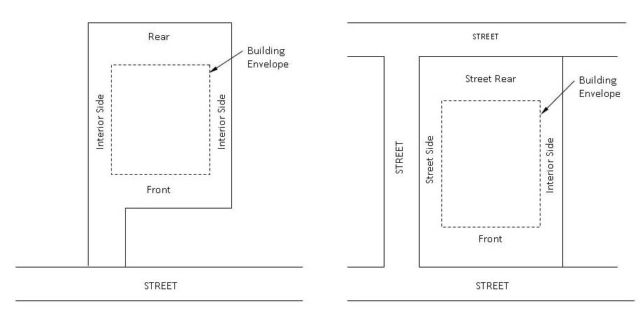
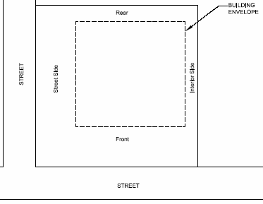
3.05.02. Building setbacks. Building setbacks shall be measured from the property line or, if applicable, from the edge of a private street or the boundary line of an access easement located on the subject property to the wall of the building. The required building setbacks determine the building envelope. In no event shall a structure encroach within an easement, inclusive of eaves, unless specifically approved by the Land Use Administrator.
A.
Determining building setbacks. Front, side, and rear yard setbacks shall be determined based on the following. In cases of uncertainty, the Land Use Administrator shall determine the setbacks based on the following guidelines:
1.
The front yard setback shall be considered that portion, typically along the lot's narrowest part, which abuts the street or roadway where access is provided. Consideration shall be given to a structure's orientation in making a front yard setback determination (i.e. the front of a building faces the front of the lot).
2.
The rear yard setback typically runs parallel to the front yard setback and does not connect to the front yard setback.
3.
The side yard setbacks connect the front and rear setbacks and are perpendicular to them on square or rectangular lots.
4.
Front setback on flag lots shall be measured at lot width and the lot frontage shall be determined on a case-by-case basis with consideration to surrounding property and dwelling unit orientation.

B.
Permitted improvements within the required building setbacks. The following improvements are permitted within the required setbacks (outside of the building envelope):
1.
Man-made landscape features not exceeding three feet in height, including related minor structures described in Section 11.03 of Chapter 11.
2.
Parking areas and associated driveways, provided they are not located within side yard setback areas for attached and detached single-family residential units, except when it provides access to a garage.
3.
Private sidewalks and walkways provided they do not exceed six feet in width for detached single-family residential units and duplex units.
4.
Concrete pads 50 square feet or less.
5.
Signs.
6.
Minor utility installations including, but not limited to, fire hydrants, electrical and telephone boxes, and backflow prevention mechanisms. Some of these features may require screening in accordance with Chapter 11.
7.
Aboveground mechanical equipment such as air conditioning units, permanently installed generators, and pool pumps; provided, however, that this equipment shall be prohibited in a front setback area, and shall be screened in accordance with the requirements of Chapter 11.
8.
Cantilevered patios, porches, and decks as well as sills, cornices, chimneys, flues, eaves, or other roof overhangs may extend a maximum of 30 inches into a setback area, but are prohibited within easements.
9.
Sheds per Section 4.01 in Chapter 4.
C.
Additional setbacks for multistory buildings. Additional setbacks for multistory buildings adjacent to a single-family residential zoning district shall be required for compatibility purposes. Any multistory building adjacent to a single-family zoning district shall provide an additional setback minimum of ten feet for each story above the first story.
D.
Waterline setbacks. Stormwater retention facilities, canals, or other water features may be located on the lot or parcel. In these circumstances, the Land Use Administrator may determine that it is applicable to measure the setback from the bulkhead, water line, or mean high water line rather than the lot or parcel line.
E.
Reduction for public purpose. When an existing setback on a developed lot or parcel is reduced due to the conveyance of land to a federal, state, or local government for a public purpose, the minimum setback requirement of the zoning district shall be reduced by the amount conveyed, up to a maximum of 50 percent of the setback requirement.
F.
Wireless communication facilities and equipment compounds. Wireless communication facilities and equipment compounds shall have the same setback requirements as the zoning district in which they are located but no less than ten feet; shall have a minimum distance of 150 feet from all off-site residential zoned property, residential dwelling unit and the rights-of-way of Palm Coast Parkway, Belle Terre Parkway, Belle Terre Boulevard, and Old Kings Road.
3.05.03. Calculating densities and intensities.
A.
Residential densities.
1.
The determination of the maximum number of residential dwelling units or lots permitted on a residentially zoned parcel shall be calculated based upon the gross upland acreage in the predevelopment condition (i.e. prior to the property being subdivided into lots).
2.
Twenty-five percent of wetland and/or imperiled upland habitat areas preserved from the predevelopment condition may be counted as "net upland acreage" in determining the maximum number of units as discussed in Paragraph A above. To be counted as preserved area, a wetland and/or imperiled upland habitat must be placed in a conservation easement, a separate conservation tract, or otherwise perpetually protected in the post development condition.
3.
Application of the density/intensity calculations provides only a theoretical maximum dwelling unit or lot yield. It does not guarantee that the development will be approved to attain the maximum lot yield. Application of other development standards may substantially decrease the lot yield.
B.
Nonresidential intensities; impervious surface ratios; floor area ratio.
1.
In calculating impervious surface ratios or floor area ratios an applicant may get credit for an off-site drainage facility site. The amount to be credited shall be proportional to the size of the site in relation to all the sites served by the same facility.
2.
Lots served by a master stormwater management system, where drainage facilities under common ownership are located off-site, may count a portion of the off-site drainage lot, tract, or parcel in calculating impervious surface ratios or floor area ratios. The portion of the off-site drainage property that is counted shall be in direct proportion to the size of the subject lot as compared to all of the lots being served.
C.
Densities and intensities in mixed use districts. In zoning districts that allow mixed uses, the same land area shall not be counted for the purpose of both residential density and nonresidential intensity. The calculation methodology used shall be as defined by administrative rule.
3.05.04. Recreation level of service. All residential projects of 25 units or more shall provide recreational land to meet the level of service standard adopted in the Recreation and Open Space Element of the City's Comprehensive Plan, except for nursing homes and assisted living facilities or other residential care facilities.
(Ord. No. 2009-26, § 13, 12-15-09; Ord. No. 2015-9, § 5, 8-4-15)