
Pelzer City Zoning Code
ARTICLE I
IN GENERAL
Sec. 26-1.
Fees, rates, and permits.
The attached schedule of fees, rates and permits described as Exhibit "A" and incorporated herein for all purposes is hereby adopted in its entirety and the amounts set forth for fees, rates and permits therein shall stand until changed by Ordinance of the Town Council of the Town of Pelzer, South Carolina. This ordinance shall supersede all sections of Town Ordinance, relative to fees for development services and permits, enacted prior to this ordinance.
This ordinance, together with its Exhibit "A", shall at all times be available for public viewing in the Town Hall.
Exhibit A Town of Pelzer Fee Schedule Planning and Development
Glossary of Terms:
(1)
Commercial/Industrial Land Use: Use of real property or a portion of a property for other than human habitation or a purpose with a similar potential for human exposure; "commercial or industrial land use" includes manufacturing; industrial research and development; utilities; dry cleaning facilities; commercial warehouse operations; lumber yards; retail gas stations; auto service stations; auto dealerships; equipment repair and service stations; professional offices, such as for lawyers, architects, or engineers; real estate or insurance offices; medical or dental offices and clinics; financial institutions; publicly-owned office buildings; a retail business where the principal activity is the sale of food or merchandise; personal service establishments, such as health clubs, barbershops, beauty salons, mortuaries, and photographic studios; churches; motels or hotels; and property restricted to commercial or industrial use by a legally enforceable zoning ordinance or specific deed restriction.
(2)
Land Development / Large Scale Project Application: Large scale land development projects for transformative change to real property for development. Engineers and construction crews can reshape the earth, demolish, or preserve existing structures, or provide engineered stormwater management waterways and other infrastructure.
(3)
Major Land Development Projects: Creation or development of one of the following components: Road construction Access roads, walkways, and parking lots Bridges, Landscaping Clearing, terracing, or land levelling Land preparation (development) for gardens, Setup of fences and, to a lesser degree, hedges, service connections to municipal services and public utilities, Drainage, canal systems, External lighting (street lamps, etc.).
(4)
Flood Plain Development Fee: Permit for Floodplain Development. A permit is required before construction or development begins within any Special Flood Hazard Area (SFHA). If FEMA has not defined the SFHA within a community, the community shall require permits for all proposed construction or other development in the community including the placement of manufactured homes, so that it may determine whether such construction or other development is proposed within flood-prone areas.
(5)
Site Plan Revision: Making changes to a proposed plans for potential development.
(6)
Residential Compliance Letter: A letter required for development of a potential construction that includes zoning, setbacks, utilities, total construction requirements to obtain a building permit.
(7)
Sign Permit/30-Day Temporary Sign/Off-Premises Sign Permit: Permit to place a sign on real or commercial property.
(8)
Seasonal Temporary Event Permit: Haunted House, Tent Revival, Snow Cone Stand, Fireworks Stand, Christmas Stand and Food Trucks: Permits for operation for seasonal/recurring events.
(9)
Up-Fits to Existing Building/Signage: Changes to buildings or signs that do not change the size, square footage, or use of the property.
(10)
Home Occupation: Operation of a home business that is allowed in a particular zoning district; certain conditions and requirements must be met.
(11)
Cell Tower/Broadband: To place any communication equipment on real or commercial property.
(12)
Special Exception Application: A Special Exception (SPE) is a use that requires special consideration of its location, design, and methods of operation before it can be deemed appropriate in the zone and compatible with its surroundings.
(13)
Variance Application: A variance is a relaxation of a standard in a land use ordinance. Variances are decided by the zoning board of adjustment/appeals.
(14)
Planning Commission Variance: A planning variance compares an original standard with a revised standard that should or would have been used if planners had known in advance what was going to happen. A planning variance is deemed not controllable by management. i.e., management may not be held responsible.
(15)
Commercial/Industrial Grading Permit Application:Grading permit means the formal approval required for any grading, filling, excavating, storage or disposal of soil or earth materials or any other excavation or land filling activity.
(16)
Summary Plat Approval: Plat Approval means that: (A) the subdivision plat submitted by the Developer for the applicable portion of redevelopment Area has been finally approved by the Town and County in accordance with the County's customary plat approval procedures to be recorded.
(17)
Revisions to Preliminary Plat: Changes required for summary plat to conform to existing requirements and standards.
(18)
Preliminary Plat Review: An initial review for the purpose of providing an Applicant formal feedback about potential issues that the proposal may face. The Preliminary Plat Review expressly does not grant approval and does not negate or minimize requirements that may arise during later reviews of final proposals.
(19)
Final Plat Review: The final plat review is an administrative review. Steps for review of final plats. Submit final plat application: An application for final plat review must be submitted to the Town.
(20)
Subdivision Road Profile: Subdivision Road means and refer to the road which is initially cleared, graded, and graveled by Declarant in connection with the subdivision of the Surveyed Property.
(21)
Residential/Multi-Family Subdivision Grading Permit:Grading permit means the formal approval required for any grading, filling, excavating, storage or disposal of soil or earth materials or any other excavation or land filling activity.
(22)
Zoning Letters: A document prepared by the director of the community development department, or the director's designee, and is a written response to a request for a written description of the zoning, land use, development, code enforcement, or entitlement history of a specific property.
(23)
Zoning Research Detailed Letter: A municipal zoning letter is a legal document which informs residential or commercial property owners, lenders and prospective buyers of zoning laws related to the particular property in question.
(24)
Land Disturbing Activity Form (Less than one acre): Construction Activities that are a part of a Larger Common Plan (LCP) for development or sale, regardless of the amount of disturbance, are required to submit the standard application for Stormwater NPDES Coverage, Notice of Intent (DHEC Form 2617). If the less than one acre project is to be constructed inside a MS4 or Urbanized Area, you must first contact the respective MS4 or UA to identify applicable project requirements and receive approval if the MS4 deems such approval appropriate.
(25)
Business License Fee: A licensing fee can be an amount of money paid by an individual or business to a government agency for the privilege of performing a certain service or engaging in a specific line of business. Licensing fees can be paid for trademarks, copyright, or patents, among others.
Editor's note— Ord. No. 23-002, § 26-1, adopted 2-14-2023, added provisions to the code, but did not specify manner of inclusion. At the request of the town, said provisions have been codified as Section 26-1, as set out herein.
(Ord. No. 23-002, 2-14-2023)
Sec. 26-2
Zoning map classification and definitions.
Historical District. The Historical District overlay cannot be established until and Architectural Review Board is established, and Historic District Ordinance is completed. However, the design guidelines and uniformity must be set prior to enactment. In other words, what is done in an overlay regarding R-1 can only be applied to R-1, a separate section in the ordinance for Industrial or IPU will need to be created. An overlay is an additional set of requirements imposed by the underlying zoning district in two zones simultaneously.
As it relates to the exterior only—Definition. The Historical District designated those properties located within the Town of Pelzer that are responsible for the protection of buildings, districts and sites that help improve and appreciate upon the rich history of Pelzer. To accomplish such goals, it is essential that there are elements in place to preserve and protect these structures in the historic styles of referenced time periods as to maintain structures of historic design. Form, Color, material, and proportion between those of historic design and those of modern design. These purposes are created through the protection of old historical and architecturally significant structure which impart a distinct aspect to the city and which serve as visible reminders of the historical and cultural heritage of the city. Setbacks will be balanced based off current existing land use but can changed based off of the Historic District Design Review Board.
AG: Agricultural. Land use activities that are currently and actively engaged as an agricultural operation, or other land use directly associated with the production, sales, shipping, storage, marketing, packaging, manufacturing, and/or distribution of commodities in conjunction with the active agricultural operation, are exempt—The purpose of this district is to protect and preserve areas under cultivation and prime agricultural soils for continued agricultural and agriculturally oriented uses and to protect the business of agriculture.
GC: General commercial. The purpose of the General Commercial District is to encourage high intensity office, commercial, retail, and service activities generally servicing a city-wide area. This district will be primarily located along major thoroughfares.
I-1: Industrial use. It is the intent and purpose of the Industrial Zoning District to provide for low intensity industrial uses which are not significantly objectionable in terms of noise, odor, fumes, smoke, gas, dust, fire hazard, dangerous radiation, or other obnoxious conditions, to surrounding properties. Additionally, these regulations are designed to encourage the formation and continuance of a compatible environment for uses generally classified to be limited industrial in nature; to protect and reserve suitable undeveloped areas; and to discourage encroachment of residential, office - commercial, or other incompatible uses.
IPU: Institutional and public use district. The IPU district is intended to recognize and permit the creation of defined areas for the unified and orderly development of major cultural, educational, medical, governmental, religious, athletic, and other in situations to support and enhance their benefit to the community in a manner which protects adjacent residential uses. Institutional/Public Service Use denotes Land, Facilities and public works related properties that are owned or in use by the state, local and federal government for public uses. These land uses are including, but not limited to and can be changed at any time by the Planning Commission. Government services, libraries and museums, Emergency Shelters, Cemeteries, Clubs/Lodges and Meeting Halls, Community Centers, Maintenance and Service Facilities (government serving or public service), cell towers, utilities major or minor, public safety facilities, recreational facilities, schools, transportation terminals, post offices, federal buildings, town halls, etc.
MH: Mobile home. Mobile Home activities, also defined as manufactured homes, are transportable dwellings intended for permanent residential occupancy that are built entirely in a factory under federal construction and safety standards administered by the U.S. Department of Housing and Urban Development (HUD). They may be single- or multi-section and are transported to the site and installed. This activity shall not include modular residential construction, as defined within the South Carolina Modular Buildings Construction Act. Modular residential construction shall be included in the Residential Detached or Residential Attached activity types, as appropriate. The setbacks for mobile homes must be in conformance with the Mobile Home Zoning Ordinance. All mobile homes must adhere to any applicable Federal, State or County regulations for building codes, assessor's office, and SCDHEC standards.
MHP: Mobile home park. Mobile Home Parks Three or more mobile homes or mobile home spaces that are located within 1,000 feet of one another and operated in any coordinated manner. The park may be located on a single parcel, or multiple parcels in the same or different ownership. For the purpose of this article, three mobile homes shall not be considered a mobile home park if one of the three mobile homes is occupied by the property owner and is their legal residence. Additional mobile homes may be allowed by the Zoning Administrator without creating a mobile home park, provided the mobile home is to be the primary residence for an immediate family member with special needs (i.e., disabled, handicapped, elderly, ill, or other special/dire circumstance) and other requirements of the Ordinance are met. Immediate family members may include grandparents, parents, spouses, siblings, children, grandchildren, and/or legal guardians. At such time the additional home is no longer utilized to house an immediate family member with special needs, the mobile home must either be removed from the site within 60 days or the property(s) shall conform to the current requirements for a mobile home park land use.
In regards to the mobile home park, if a nonconforming mobile home park consists of more than 50 percent of the mobiles homes are removed or become unoccupied or a listed as derelict properties, the mobile home park will be considered out of compliance and can only operate again through compliance standards of a new mobile home park.
MX: Mixed use. Mixed-use zoning allows for the horizontal and vertical combination of land uses in a given area. Commercial, residential, and even in some instances, light industrial are fit together to help create built environments where residents can live, work, and play. A development district outside the central employment core in which coordinated mixed use development will be permitted to encourage alternative development possibilities. The Mixed Use Development encourages mixed use development and its accompanying support, commercial and office uses while maintaining a strong emphasis on pedestrian scale, urban development, and amenities.
R-1: Residential/single-family. These residential districts are established as areas in which the principal use of land is for single-family dwellings and for related recreational, religious, and educational facilities normally required to provide an orderly and attractive residential area. The regulations for these districts are intended to discourage any use which, because of its characteristics, would interfere with the development of or be detrimental to the quiet residential nature of the area included in the districts.
R-2: Residential/duplex. This district is established to provide for one- and two-family dwellings, and the recreational, religious, and educational facilities which are normally found in residential areas. The district is primarily intended for areas which represent a transition between low-density, single-family development and high-density, multifamily development and for sites which are located in predominantly low-density areas but contain a mix of uses such as single-family manufactured, modular, and multifamily residential units.
R-1/PUD: Single family residential/planned urban development. The R-1/PUD district is established to allow flexibility in development that will result in improved design, character, and quality of new developments as well as preserve natural and scenic features of open spaces. The district regulations must encourage innovative site planning for residential, commercial, institutional, or industrial development within the district. The Planned Urban Development has been created to specify the needs of the community in synergy with the guidelines for subdivision creation to properly address and assess the highest and best use of a specific property to be used as a residential subdivision.
Pelzer Zoning Map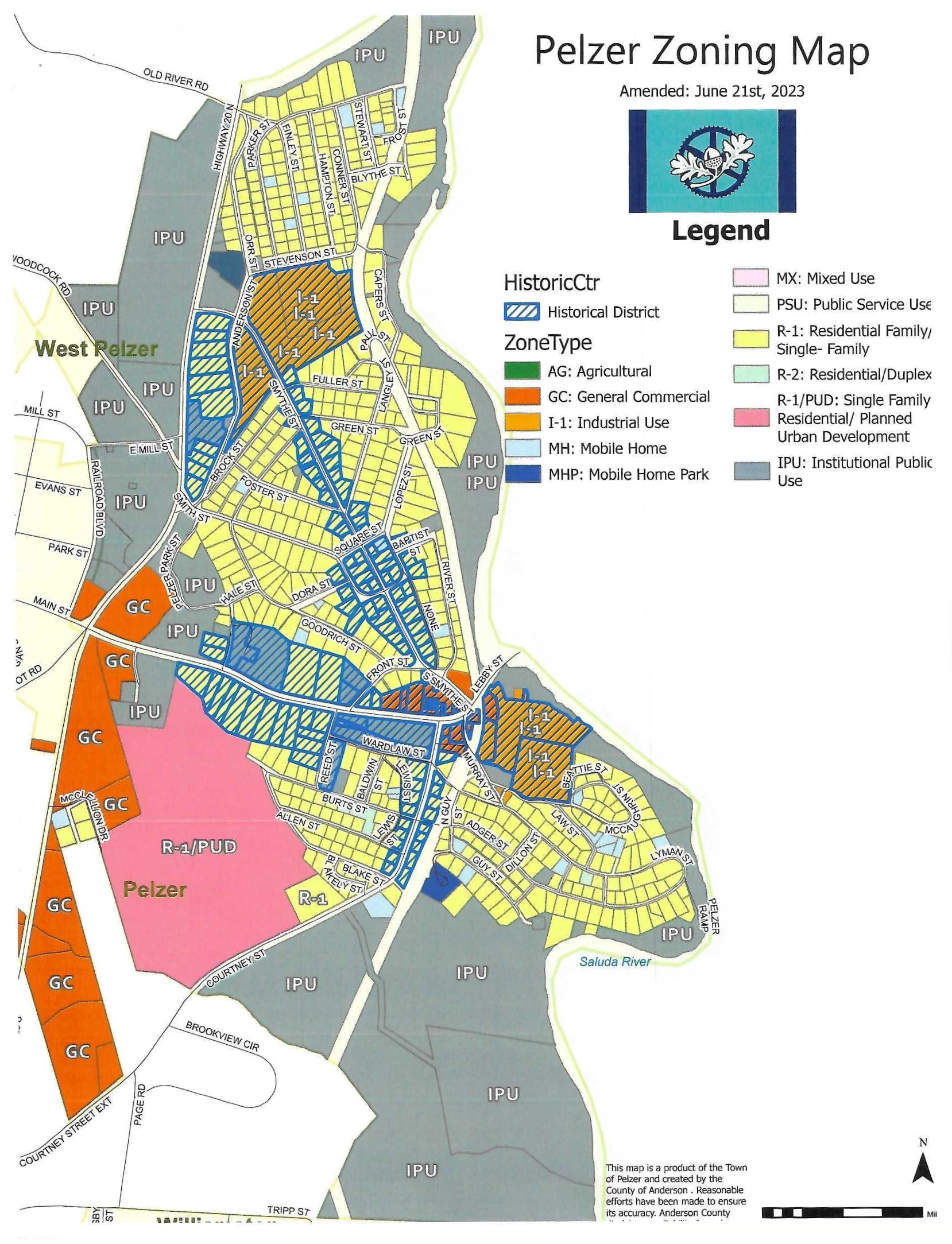
Editor's note— Ord. No. 23-006, § 26-2, adopted 6-20-2023, added provisions to the code, but did not specify manner of inclusion. At the request of the town, said provisions have been codified as Section 26-2, as set out herein.
(Ord. No. 23-006, 6-20-2023)
Sec. 26-3. - Building setback and lot area requirements.
Definition. A setback is a required distance between a building or building line and the nearest property line.
Standards. All buildings and structures, including the expansion of existing buildings and structures, shall meet or exceed the following minimum setback requirements. However, fences and walls shall be allowed along the property line.
• Exhibit A.
• Setback Precedents
• Preexisting Front Setbacks-
• The setbacks of this chapter shall not apply to any lot where the average setback on already built-upon lots, located wholly or in part within 100 feet of each such lot and within the block and zoning district fronting on the same street as such lot, is less than the minimum required setback. In such cases, the setback on such a lot may be less than the required setback but not less than the average of the existing setbacks on the developed lots. However, in no case shall setbacks be less than 15 feet.
• R-1: Single Family
• Minimum Lot Area: 7,000 square feet
• Minimum Building Setbacks
• Front: 15'
• Side: 10'
• Rear: 15'
• Maximum Building Height: 35'
• R-2/R-3 Single Family + Duplex
• Minimum Lot Area: 10,000 square feet
• -Manufactured Home: 10,0000 square feet
• -Duplex: 10,000 square feet
• -Townhouses: 5,000 square feet/unit
• Minimum Building Setbacks
• Front: 20'
• Side: 10'
• Rear: 15'
• Maximum Building Height: 35'
• General Commercial District
• Minimum Lot Area: None/or 10,000 sqft
• Minimum Building Setbacks
• Front: 15' (from road right of way)
• Side: No setback is required, unless the property is abutting a residential district. A side setback shall be provided on a lot where it abuts a residential district at least equal to the requirements of the abutting residential district. When a setback is not required but still provided, it shall be a minimum of 5 feet.
• Rear: 10' feet, the rear setback may be used for parking and service drives but must remain unobstructed by other structures or buildings.
• Accessory Structure setback: minimum 5 with an additional 10' on both sides.
• Residential Commercial District
• Minimum Lot Area: 7,000 square feet
• Minimum Building Setbacks
• Front: 25'
• Side: 10' or 30' - if abutting against a residential property
• Rear: 15' or 30' - if abutting a residential property
• Accessory Structure Setback: 5' Side or Rear
• Institutional District
• Commercial: No minimum commercial lot size
• If in residential area: Minimum 5,000 square feet
• Minimum Lot width if in Commercial area: 5,000 square feet
• Minimum Building Setbacks
• Front: 25', the front setback may be used for parking and service drives but must always remain unobstructed by structures or buildings.
• Side: 6'
• Rear: 10', the rear setback may be used for parking and service drives but must remain unobstructed by structures or buildings.
• Accessory Structure Setback: 5'
• Manufactured Homes Subdivision
• Minimum Lot area: 10,000 square feet (standard) for new manufactured homes
• Maximum Building Height: 35'
• Accessory Structure Setback: 5' (both side and rear)
• Minimum Building Setbacks
• Front: 25'
• Side: 15'
• Rear: 25'
• Corner Lot Setbacks: On lots that have frontage on more than one street at an intersection, the minimum street side setback requirement shall be equal to the minimum front yard setback.
• Double Frontage Lots: On lots having frontage on two street, but not located on a corner, the minimum front setback shall be provided on each street. On lots having frontage on more than two streets, the minimum front setback shall be provided.
• Accessory setbacks
• 3' side and 3' rear for existing lots of record
• 5' side and 5' rear for newly created lots in order to comply with the new International Residential Codes
Editor's note— Ord. No. 23-012, § 26-3, adopted 6-20-2023, added provisions to the code, but did not specify manner of inclusion. At the request of the town, said provisions have been codified as Section 26-3, as set out herein.
(Ord. No. 23-012, 6-20-2023)
Sec. 26-4. - Address numbers required on houses and buildings.
(a)
All building and properties located within the corporate limits shall display a number as assigned by Anderson County.
(b)
The owner, occupant or agent of each building and property shall place or cause to be placed upon each building and property owned or occupied by him the number assigned, as follows:
• Numbers shall be durable and clearly visible.
• Numbers shall be placed conspicuously immediately above or to the side of the door facing the street so that the number can be plainly seen from the street.
• It shall, as closely as possible, approximate the height of three inches, as space permits, provided it can be plainly seen from the street.
• It shall be the responsibility of the owner, occupant or agent of each existing or newly acquired or constructed building and property who does not know the assigned to his building or property to obtain the number.
• The responsibility for the displaying of the assigned number for each existing occupied or vacant house, or building in the Town, as of the effective date of this article, shall rest with the property owner, trustee, lessee, agent or occupant of each house or building.
Editor's note— Ord. No. 2019-009.10, § 26-4, adopted 10-8-2019, added provisions to the code, but did not specify manner of inclusion. At the request of the town, said provisions have been codified as Section 26-4, as set out herein.
(Ord. No. 2019-009.10, 10-8-2019)
Sec. 26-5. - Uniform Building Codes.
2018 International Building Code (IBC)
2019 International Energy Conservation Code (IECC)
2018 International Existing Building Code (IEBC)
2018 International Fire Code (IFC)
2018 International Fuel Gas Code (IFGC)
2018 International Mechanical Code (IMC)
2018 International Plumbing Code (IPC)
2018 International Property Maintenance Code (IMPC)
2018 International Residential Code (IRC)
2017 National Electric Code (NEC)
ANSI A117.1-2017 Edition — (Effective January 1, 2018 — The State of SC has adopted the 2017 Edition)
2018 International Swimming Pool & Spa Code (ISPSC)
The latest edition of the above codes shall continue in force until new or revised or successor building codes are subsequently made available for each, respectively, by the publisher and adopted by the South Carolina Building Codes Council. Once new or revised or successor building codes for each, respectively, are published and adopted by the South Carolina Building Code Council, such building codes shall be immediately adopted as part of the Town of Pelzer Code of Ordinances but shall not be implemented and enforced until one year from the date of adoption by the South Carolina Building Code.
Editor's note— Ord. No. 2021-003-001, § 26-5, adopted 4-31-2021, added provisions to the code, but did not specify manner of inclusion. At the request of the town, said provisions have been codified as Section 26-5, as set out herein.
(Ord. No. 2021-003.001, 4-13-2021)