
Powell City Zoning Code
TITLE FIVE
ZONING DISTRICTS AND REGULATIONS
CHAPTER 1141 - ESTABLISHMENT OF DISTRICTS[18]
Sections:
State Law reference— Basis of districts, O.R.C. § 713.10
CHAPTER 1143 - DISTRICT REGULATIONS[19]
Sections:
Cross reference— Supplementary district regulations, Ch. 1145; Special regulations, Ch. 1147
CHAPTER 1145 - SUPPLEMENTARY REGULATIONS[20]
Sections:
Cross reference— District regulations, Ch. 1143; Special regulations, Ch. 1147; Off-street parking and loading, Ch. 1149
CHAPTER 1147 - SPECIAL REGULATIONS[21]
Sections:
Cross reference— Supplementary district regulations, Ch. 1145; Signs, Ch. 1151
CHAPTER 1149 - OFF-STREET PARKING AND LOADING[22]
Sections:
Cross reference— Parking generally, Ch. 351
State Law reference— Off-street parking facilities, O.R.C. § 717.05 et seq.
CHAPTER 1151 - SIGNS[23]
Sections:
State Law reference— Power to regulate advertising, O.R.C. § 715.65; Advertising on State and interstate highways, O.R.C. Ch. 5516
CHAPTER 1155 - BED AND BREAKFAST INNS
Sections:
APPENDICES - ARCHITECTURAL GUIDELINES
Introduction
This compilation of Standards and Guidelines is for the use the Historic District Commission in approving or disapproving applications for Certificates of Appropriateness in the Historic District Overlay District, and for the use of residents and owners of property in the City of Powell who are contemplating exterior modifications to existing buildings or new construction within the Historic District Overlay District.
This work begins by outlining the boundaries of the Historic District Overlay Zone, as created in the City of Powell Zoning Ordinance. The first section describes the City of Powell, and those elements which create its unique character. A series of guidelines follow which illustrate appropriate materials and methods for the preservation of existing architecture, and new construction in the Historic District Overlay District. These guidelines are based on the existing character of Powell, and research into construction methods and materials typical of late 19th and early 20th century vernacular, Midwestern architecture.
These guidelines are not intended to substitute for expert advice from a qualified architect, engineer or contractor. The primary purpose of these Standards and Guidelines is to provide a basis on which to evaluate the appropriateness of proposed modifications or new construction within Powell's Historic District. A very important secondary purpose is to educate owners, residents, and government officials about the character of Powell and the means by which to preserve that character.
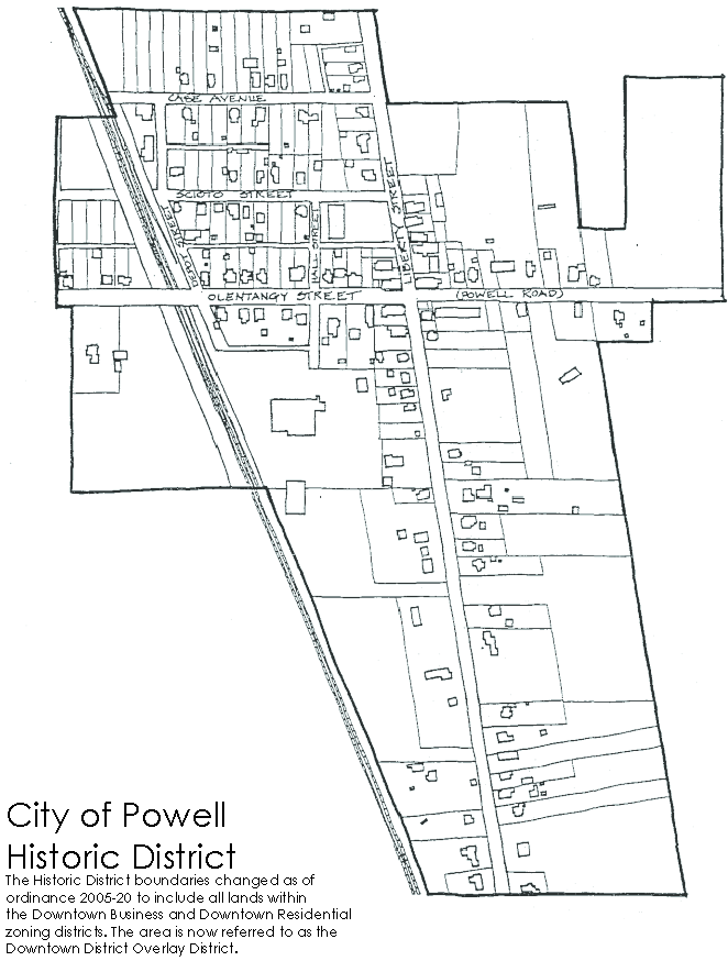
The Historic District
The boundaries of Powell's Historic District Overlay District correspond roughly to the original corporation limits of the City. The Historic District was originally established by Resolution Number 87-40 of the Powell City Council on November 10, 1987. The Powell Historic District Overlay District will be referred to as the "Historic District throughout this Guide.
History
The land upon which the City of Powell now stands was part of a 4000 acre land grant given to James Parker in 1800 to satisfy warrants for military service. The earliest settlers to the area came from Connecticut. They named the main north-south street through their community Middlebury Street, and the settlement came to be known as Middlebury.
In 1839, Thomas R. Hall purchased the land around the tiny City. Hall started a small store at the main crossroads in about 1850, and began calling the settlement "Hall Corners". At this time, residents received their mail by carrier, who delivered it on foot or by horseback to the general store for the residents to pick up themselves. After a few years of this crude system, the town decided to apply for its own post office. With the help of Judge Thomas W. Powell, of Delaware, Ohio, a post office was established in the community in 1857. In gratitude, Middlebury/Hall Corners was renamed Powell.
The Columbus and Toledo Railroad was incorporated in 1872, and a few years later, tracks were laid on the west side of the City. In 1876, the town of Powell was laid out, defined by the intersection of Olentangy Street (Powell Road) and Liberty Street, as it is to this day.
Why Preserve Powell?
The City of Powell retains much of its small crossroads town atmosphere today, but development is beginning to threaten this image. As the city of Columbus spreads to the north, land values in southern Delaware County are increasing, and the suburbs of Columbus are encroaching on the City. This growth will bring new business and more visitors to Powell. The expansion will strengthen the economy, but will threaten the very character which makes Powell an attractive place to visit and live.
In the recent past, small cities in similar circumstances have been swallowed by surrounding development because they were considered "too ordinary" or "not old enough" to be of interest. An important part of our history, that of "everyman", has been lost through failure to preserve these small towns.
Powell is one of these small towns which has not been lost! The City contains many excellent examples of vernacular Midwestern architecture of the late 19th and early 20th centuries. With its small town, rural atmosphere still very much intact, Powell provides an important look into the everyday lives of small town residents at the turn of the century.
Another of the charms of a City like Powell is the sense of growth over time which it displays. One can read history in these changes. Through careful planning and supervision of development Powell can continue to grow and change to meet the needs of modern living, while maintaining its basic character and integrity.
Architectural Character
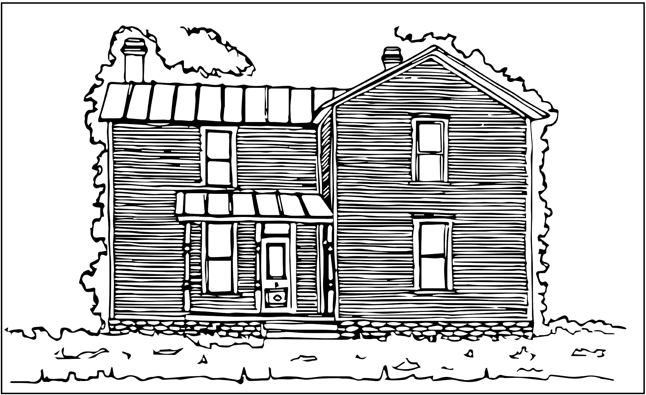
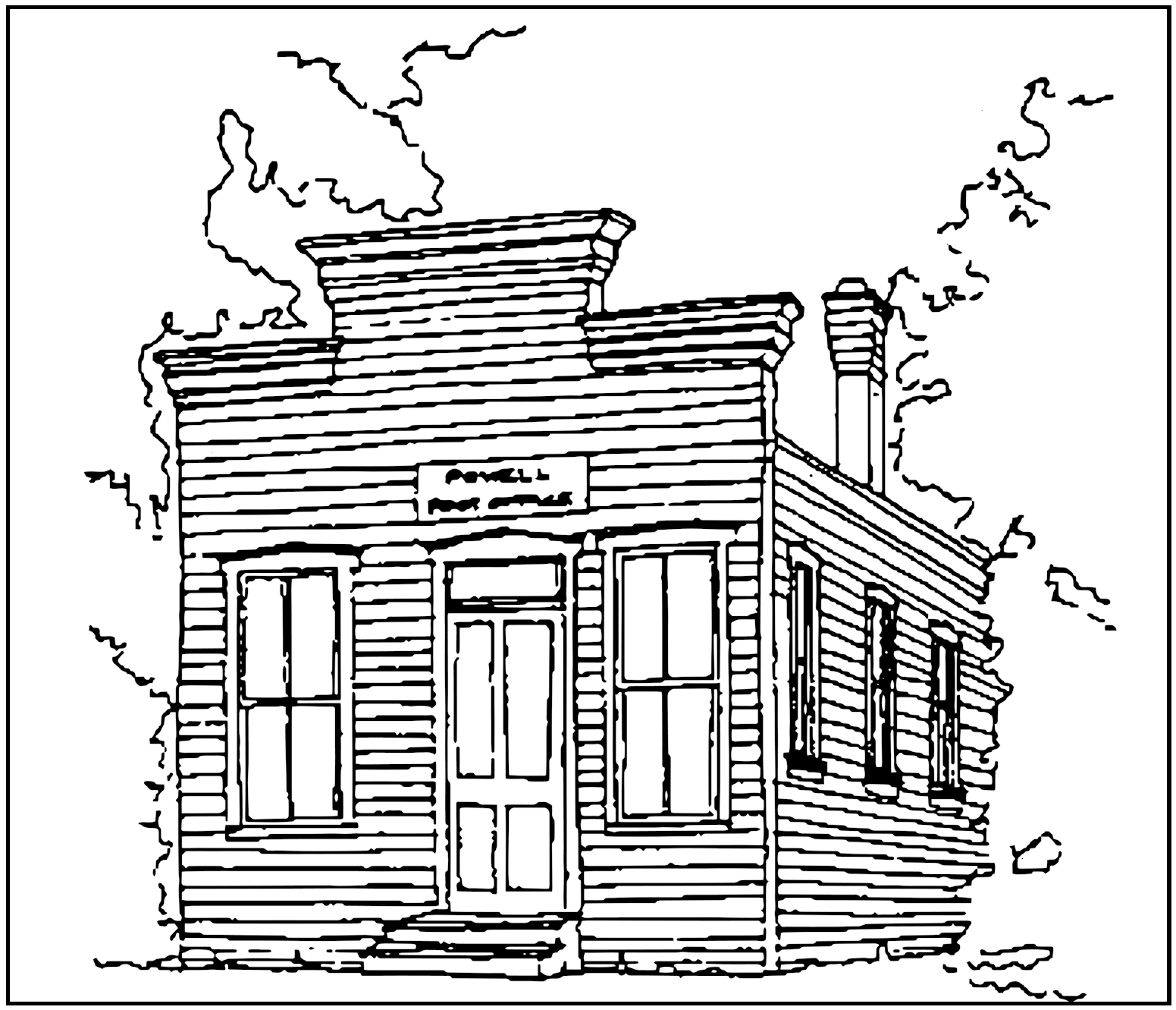
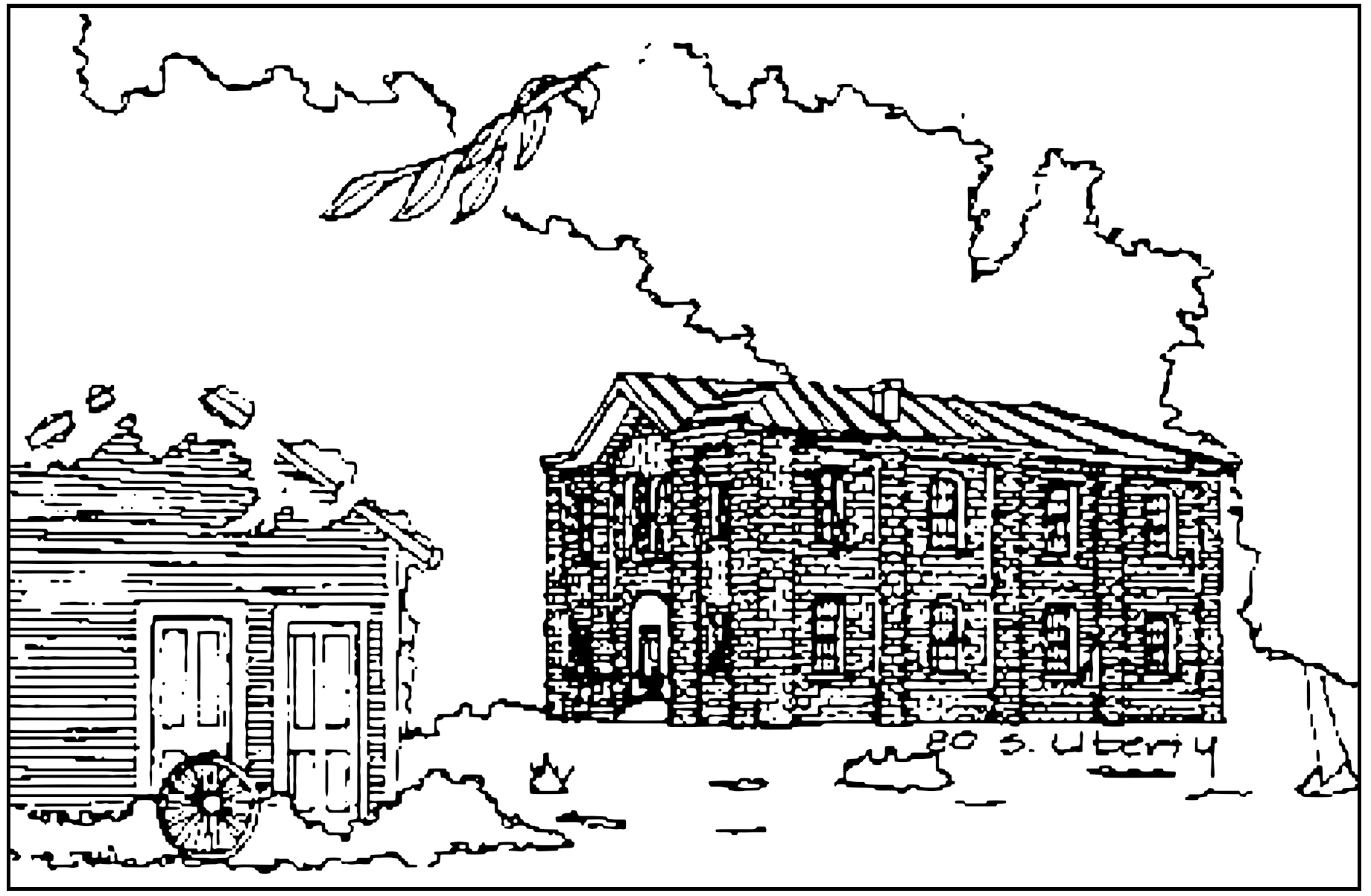
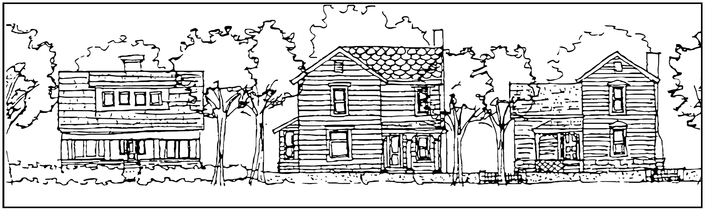
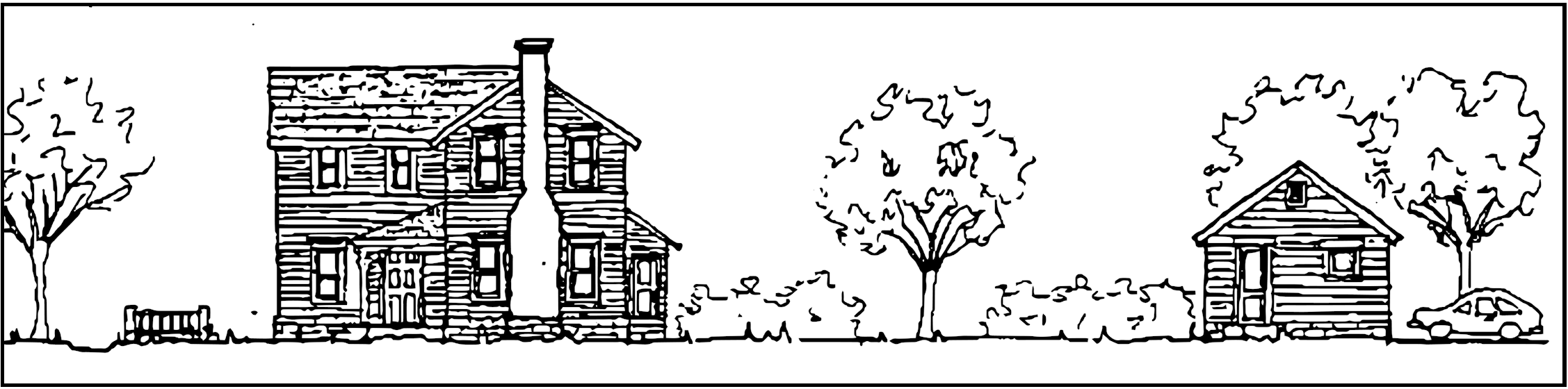
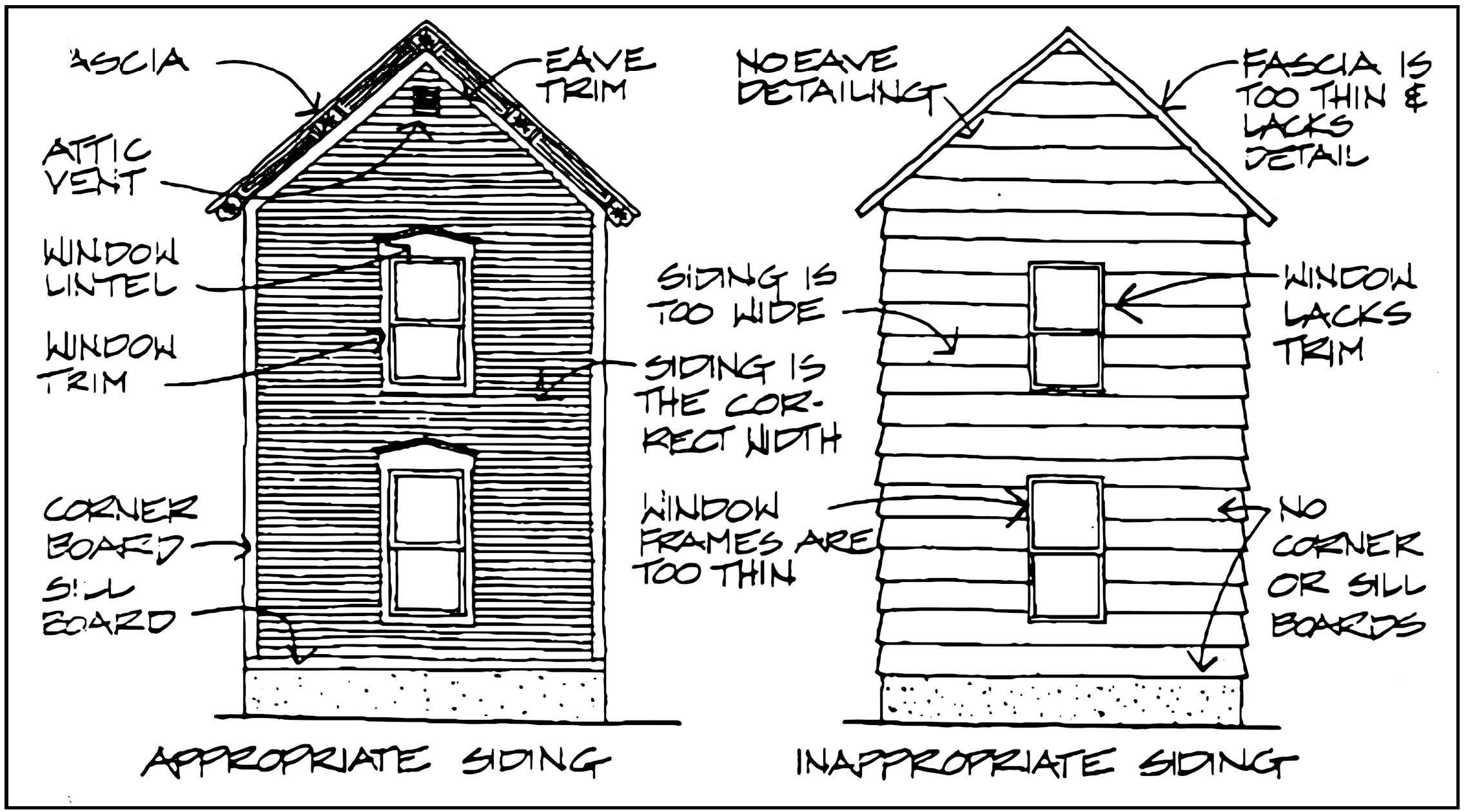
Powell, Ohio is a small, Midwestern town, rural in nature. Narrow streets, small, simple houses, and tree lined streets create the rural charm of Powell. The Historic District consists primarily of two main roads, Olentangy and Liberty streets, which intersect at the commercial center. A series of smaller residential streets and alleys complete the street pattern. Farms of varying sizes, along with new housing subdivisions, surround the Historic District. The historic building stock of Powell is primarily residential with some small commercial buildings clustered around the major intersection, and a few industrial buildings lining the railroad tracks. Existing significant public buildings include the two story brick schoolhouse at 80 South Liberty Street, the Odd Fellows Hall at 5 South Liberty Street, and the old Post Office at 14 West Olentangy Street.
Most of the buildings in the City are frame construction, finished in wood. Powell has a few masonry buildings. Most brick buildings are commercial or public in nature, except for a couple of unusual glazed block residences. "High style" buildings are designed according to the dictates of a specific, readily identifiable, national or international architectural style. Powell's buildings represent rural, vernacular versions of several late 19th and early 20th century high styles. Some City buildings are simple, common building forms decorated by elements from one or more historical styles. Others represent common building types with simple detailing, which do not reflect any particular architectural style. Although they are not ornate, high style structures, Powell's buildings exhibit fine craftsmanship and sound historical construction techniques.
Architectural Styles and Elements
Italianate
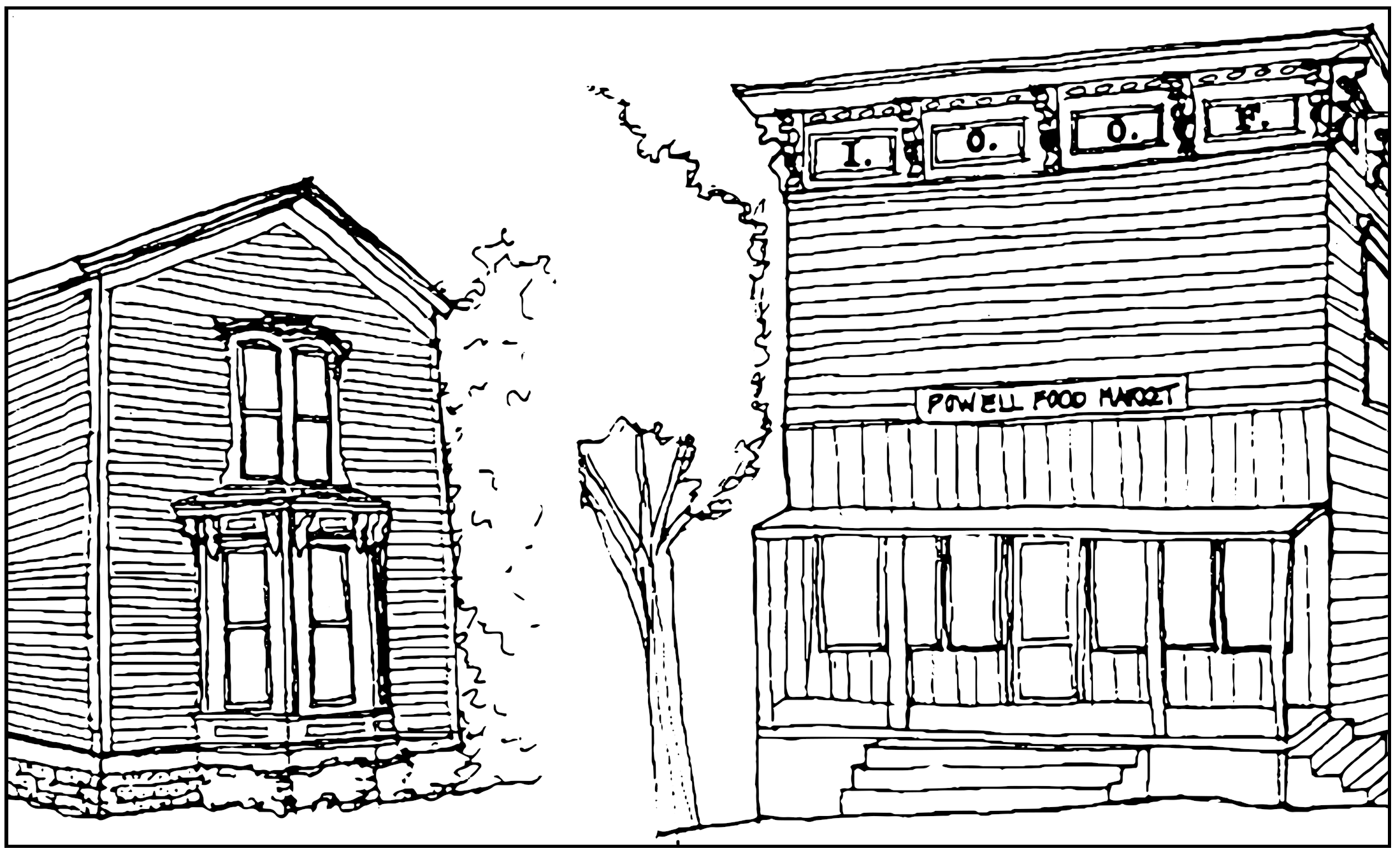
Characteristics of this style include asymmetrical plans, with octagonal bay windows or projections, shallow, hipped roofs, and carved porches Ornamentation includes curved, carved brackets under roof overhangs and cornices, and hood moldings over doors and windows. Windows are almost always tall and thin in proportion Examples of Italianate architecture in Powell include the Odd Fellow's Hall (5 South Liberty Street), with its prominent cornice supported by elaborate brackets; the brick schoolhouse (80 South Liberty Street), with its shallow hipped roof and segmental arched windows; and 38 West Olentangy Street, with its bay window, porch with carved brackets, and hood molding. All of these buildings exhibit the vertical window proportion typical of the Italianate style.
Queen Anne
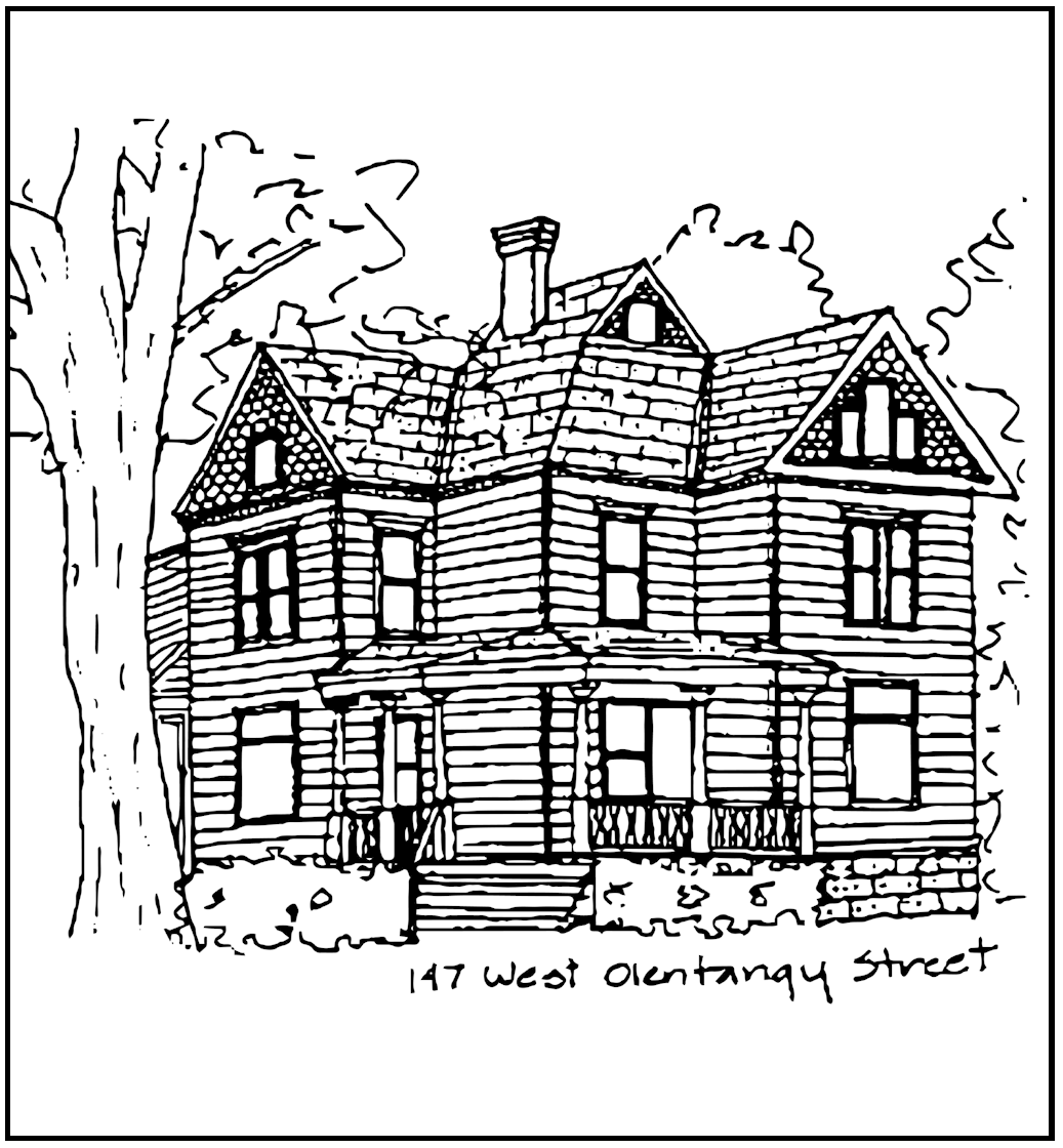
Irregular massing and complex rooflines are the primary characteristics of this style. Roofs give the overall impression of steepness, but often contain sections of varying pitches. Chimneys are of ten treated as prominent elements,and become part of the roof composition. Wall surfaces exhibit a variety of textures and colors, combining siding, patterned shingles and visible rough stone foundations. Porches, bay and oriel windows are used to further enliven the facades. Windows occur in a variety of shapes and proportions. A group of three windows, with the center one taller or arched, is a common detail. Other detailing is classical and small in scale. The best example of the Queen Anne Style in Powell is found at 147 West Olentangy street.
Stick style
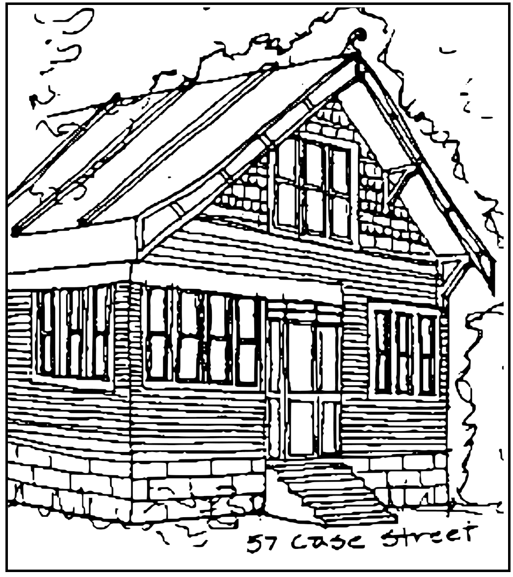
The primary aim of buildings of this style was to promote "truthfulness" in construction by exposing or representing the structural frame. Buildings of this style were always wood frame construction and were faced in wood siding or patterned shingles. Roof eaves project considerably, often supported by diagonal braces, and framing members are sometimes exposed in gable ends. The detailing on 57 Case Street suggests the roof framing members. The overhang is also supported by diagonal bracing and the gable is faced with patterned wood shingles. This gable sheltered a porch, which has been enclosed. The original house is faced in wood siding.
Eastlake
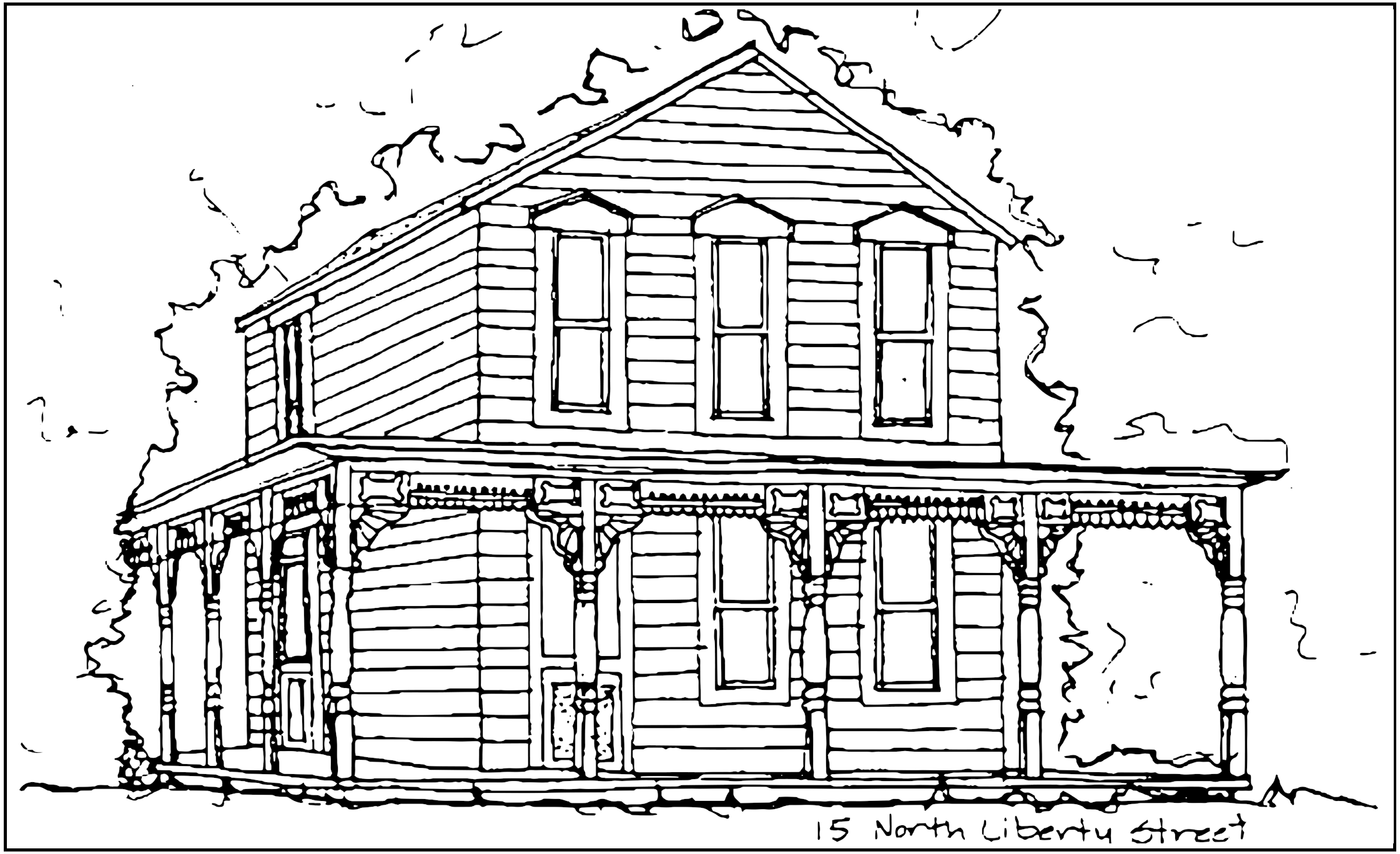
The Eastlake style is almost purely a style of ornamentation, which often appears on buildings otherwise classified as Queen Anne or Stick Style. Ornamentation is a product of the chisel, gouge and lathe, and has a robust, three dimensional character. Curved brackets are used profusely, and many elements bear a marked resemblance to furniture parts. Posts and balusters resemble table legs, while knobs and motifs of circular perforations borrow from the art of cabinetmaking. The porch at 15 North Liberty Street is Powell's most exhuberant example of Eastlake detailing.
Bungalow
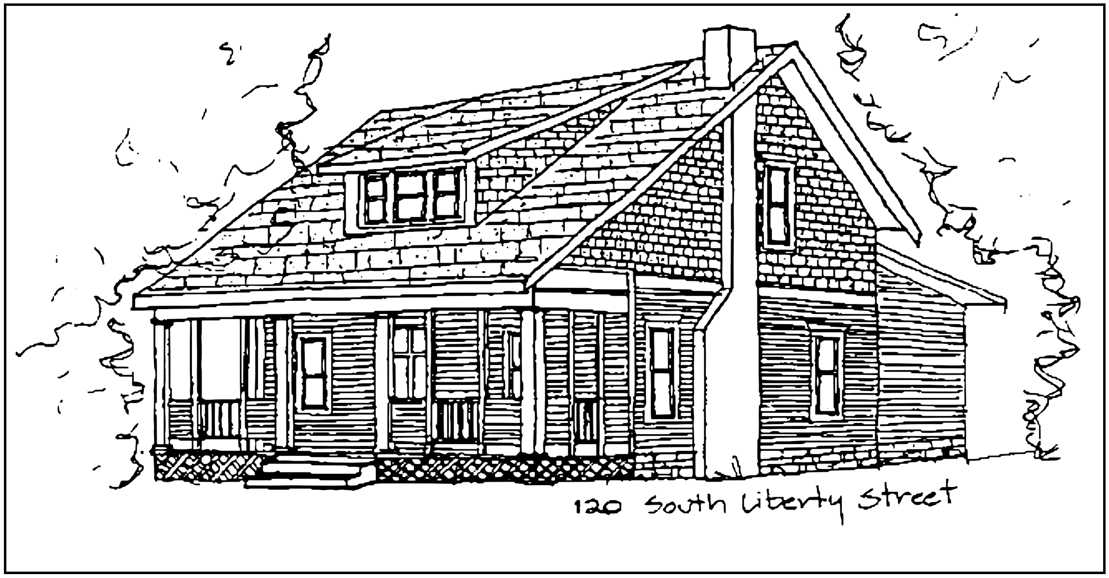
True bungalows are one story dwellings, with the roof space made habitable by dormers or gable windows. The term is also used to describe buildings which do their best to look like one story dwellings, while actually providing a full height second story. Host of Powell's bungalows are actually two story, simple in form and detailing, and would be considered "Dormer Front" types. These have a large, low, pitched roof, with the ridge parallel to the street. The roof often continues beyond the front wall to shelter a porch. In most cases, the front and back of the roof slope at different pitches and a dormer usually projects from the center of the front slope. Two of Powell's bungalows are located at 120 South Liberty Street and 71 West Olentangy Street.
Site Considerations
The atmosphere of Powell is that of a rural small town at the turn of the century. The City is not purely urban or suburban in nature, but, with increased development, some of the amenities of the city and its suburbs will become necessary. The site guidelines which follow share two primary goals:
1.
Maintain the rural City character of Powell's Historic District.
2.
The provision of necessary modern conveniences, which may not be characteristic of historic Powell, and use these contemporary improvements as opportunities to enhance and unify the character of the Historic District.
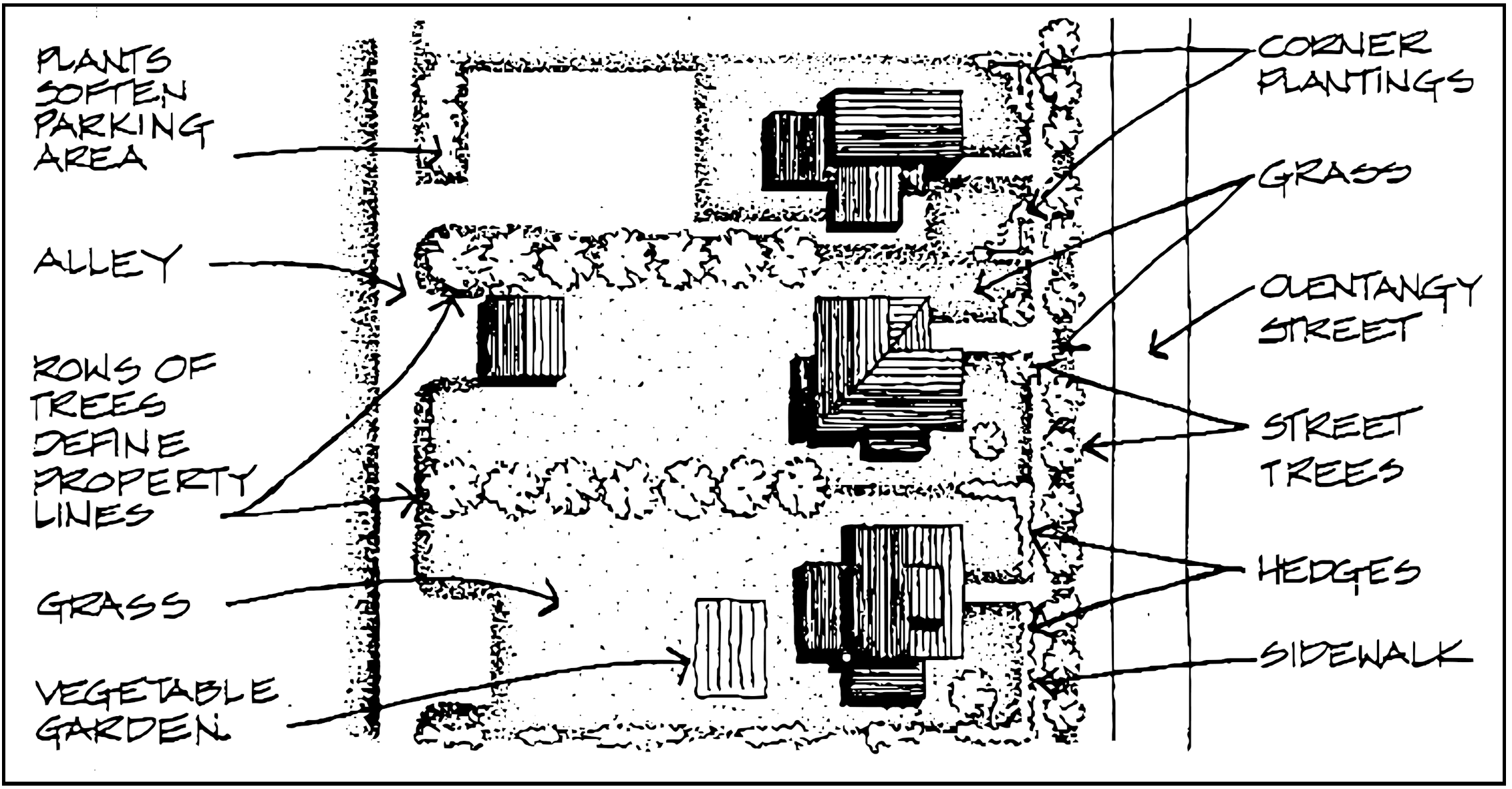
Roads And Drives
Access to rear yard parking lots and storage or garage buildings should be from alleys whenever possible. If no such access is possible, private parking and roads should be designed to require the least amount of surface. Drives should be the shortest length possible and the minimum width necessary. Access roads should be located as unobtrusively as possible, and landscaping should be planned to soften their impact. Commercial drives should be paved with asphalt, brick, concrete, or tar and chips, as required in the Powell Zoning Code. Gravel or brick is the preferred material for residential drives, but asphalt, concrete, or tar and chips may be acceptable.
Parking
Parking for residences turned into businesses or newly constructed businesses along Olentangy and Liberty Streets shall be provided at rear yard areas. Parking areas should be only as large as necessary to provide a reasonable number of parking spaces as determined by applicable code requirements. Commercial lots should be paved with asphalt, brick, concrete, or tar and chips as required in the Powell Zoning Code. Gravel or brick are preferred materials for residential parking areas, but asphalt, concrete, or tar and chips may be acceptable.
Sidewalks
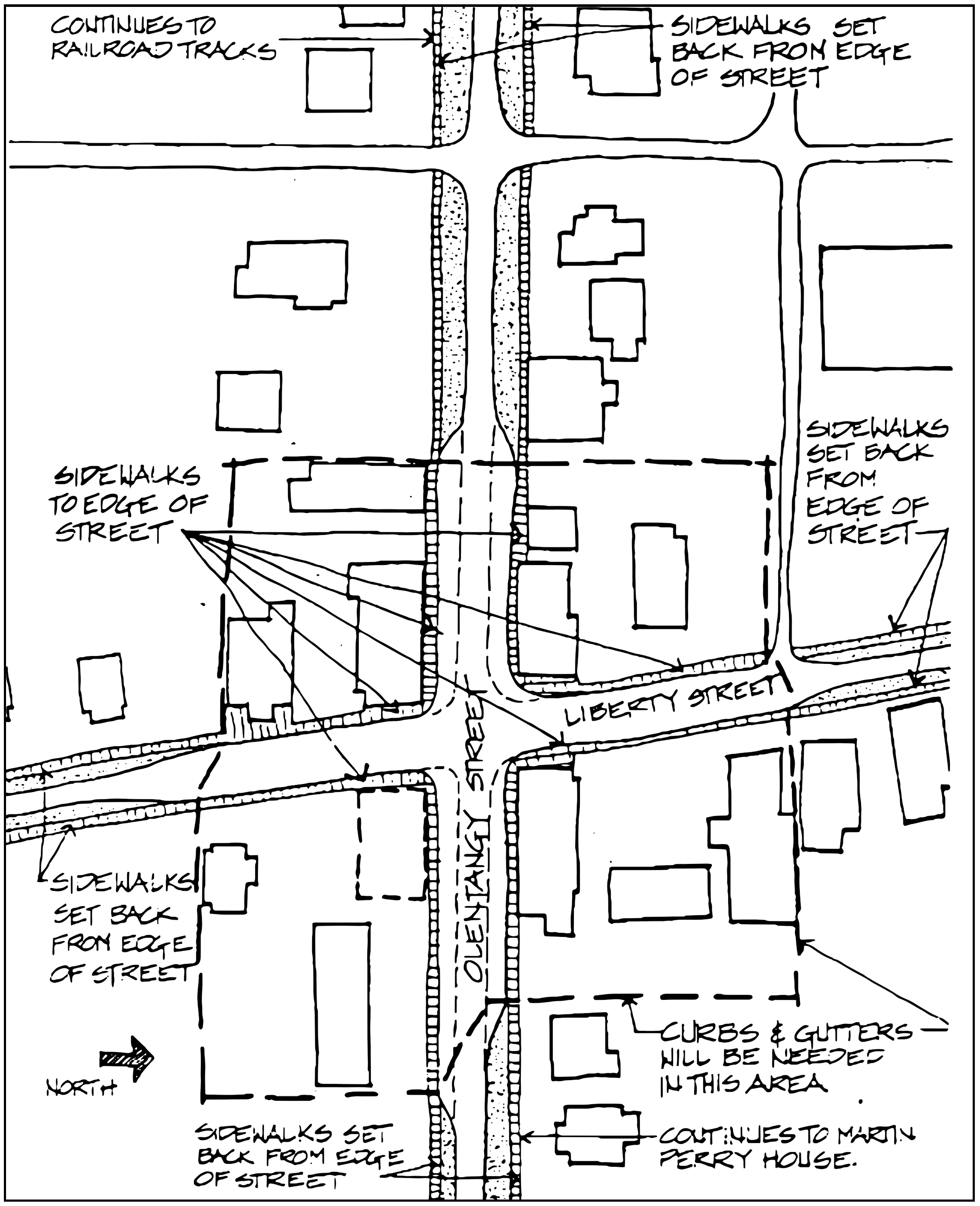
Most turn of the century rural towns, such as Powell would have had boardwalks in commercial areas, and gravel or dirt paths in residential areas. Some type of contemporary, all weather path must be provided to allow for increased pedestrian traffic along Olentangy Street and at the Center of the City. Sidewalks should be provided along Olentangy Street from the Martin Perry house on the east to the railroad tracks on the west. Sidewalks should also be provided in front of the commercial buildings along Liberty Street, near the intersection with Olentangy Street (see map next page for location).
In front of the commercial buildings at the center of town (see map) sidewalks should extend to the edge of the street. Sidewalks in these locations will require curbs and gutters. New or salvaged stone curbs or concrete curbs may be used. In residential areas of the City, sidewalks should be set back from the edge of the road by a strip of grass. Curbs and gutters may be provided in these areas if necessary to ensure safety or proper storm drainage. Sidewalks in all areas of the historic district should be concrete.
Curbs And Gutters
Paved roads with curbs and gutters are not historically accurate in cities such as Powell. With increased traffic in the City, asphalt surfaced roads have become necessary. Curbs and gutters may be required in some locations, such as areas where sidewalks extend to the edge of the street. Where curbs and gutters are necessary, curb cuts for handicapped access should be provided as required by state and local codes.
Setbacks
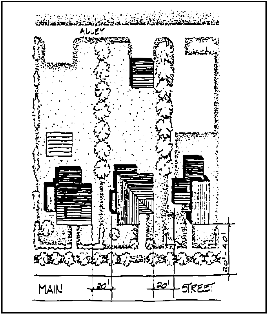
Most buildings in Powell are set back approximately 20 to 40 feet from the road with modest front lawns. The exceptions are the commercial buildings at the corner of Olentangy and Liberty Streets, which are built right up to 272 their property lines at the sidewalks. Rear yards are generally long and narrow. Residential buildings on adjacent lots throughout the City are set approximately 20 feet apart from each other at their sides. New construction should follow the setback lines appropriate to its location and purpose.
Lighting
One of the charms of rural areas is the complete darkness of nightfall away from the 24 hour light of the city. However, proper lighting fixtures can increase the safety of Powell, and may become more necessary as development continues.
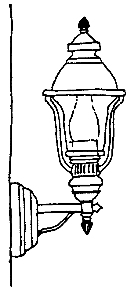
Exterior Historic lighting District in should the be incandescent, and low in wattage. Entrance lights and individual free standing path lights are acceptable. Lighting fixtures should be simple Victorian or turn of the century in design, with round or the commercial buildings along Liberty Street, near the intersection with Olentangy Street (see map next page for location) egg-shaped globes on metal posts with minimal detailing. Colonial style "coach lights" are not appropriate in the historic district. These types belong to an earlier historical period, and generally belong on coaches.
Free standing, pole mounted lamps may be used to light paths or drives. These lights should not be taller than the height of the first story of adjacent buildings. Metal posts should be painted in dark, muted colors such as black, brown, or dark green. The more elaborate the shape of the globe, the simpler the detailing of the post should be. Simple globes can be mounted on more detailed posts. All pole mounted lights should be individual. Clusters of lights are not acceptable in the historic district.
Contemporary lights which incorporate simple, round or oval globes and modest posts or brackets may be appropriate in the Historic District. Frosted globes should be used in all lights in the Historic District, as they will provide softer light than clear globes.
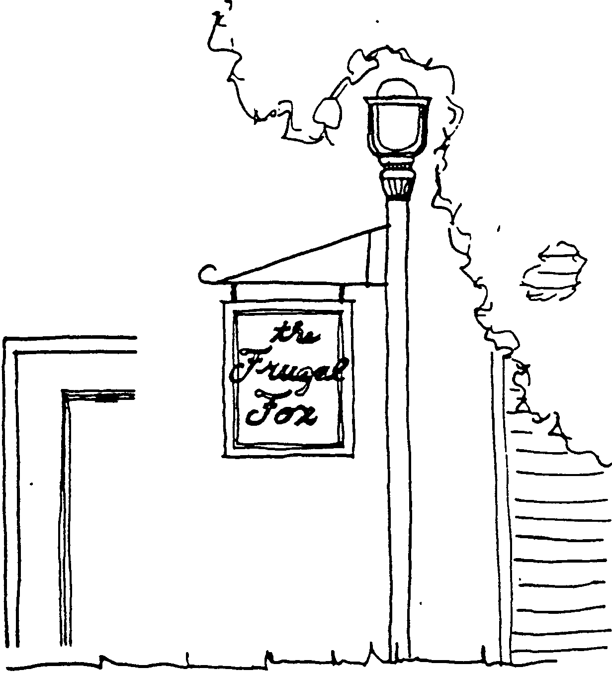
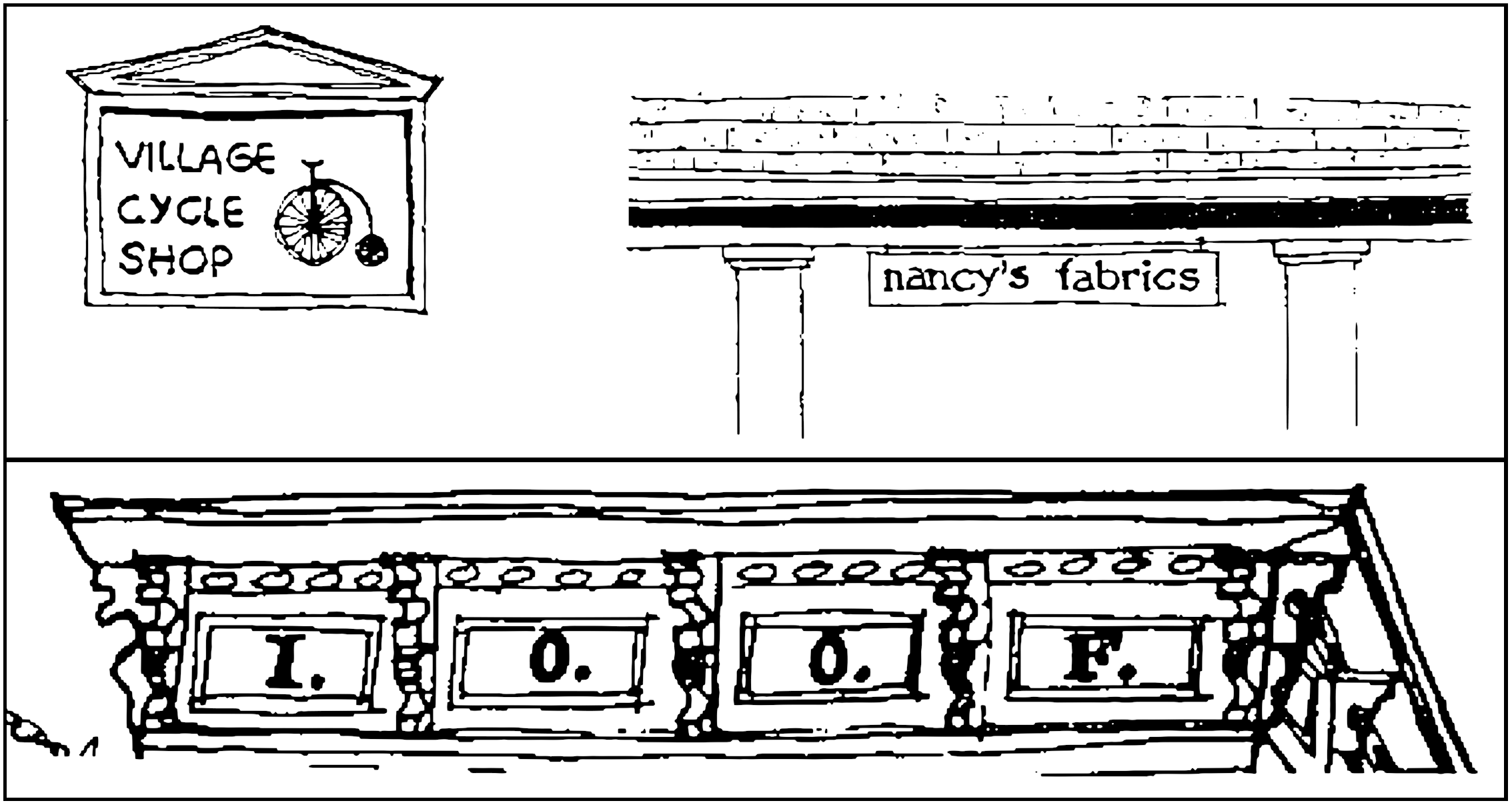
Signage and Graphics
Proposed signage should be in harmony with the building to which it is attached. Size, scale, material, texture, color, style and location should be appropriate to both the building itself and the purpose of the graphics. Appropriate signage should convey the name and purpose of the business in a direct manner, using small, simple letters. Logos and graphics should be small, straightforward, and kept to a minimum. The following themes are suggested for these elements:
-History
of the City of Powell.
-History
building graphics related to the specific to which the are attached
-The
traditions of a business represented by sign.
-Symbols
or images from turn of the century rural America.
Internally illuminated signs should not be used in the Historic District. Exterior illumination is discouraged unless it is incandescent, very low in wattage and designed as an integral part of the sign.
Wood is the preferred material for signs, and all graphics should employ subtle and natural colors, such as those outlined in the section on painting and colors.
Building Mounted Signs
Signs should not cover or obscure any doors, windows or other architectural features. On residential scale buildings, signs should not be placed higher than the tops of first story openings or the eave line of a one story wing or porch. On commercial scale buildings, signs may be placed within a sign band above the first floor, or at the cornice line if the graphics integrate carefully with the cornice detailing.
Projecting Signs
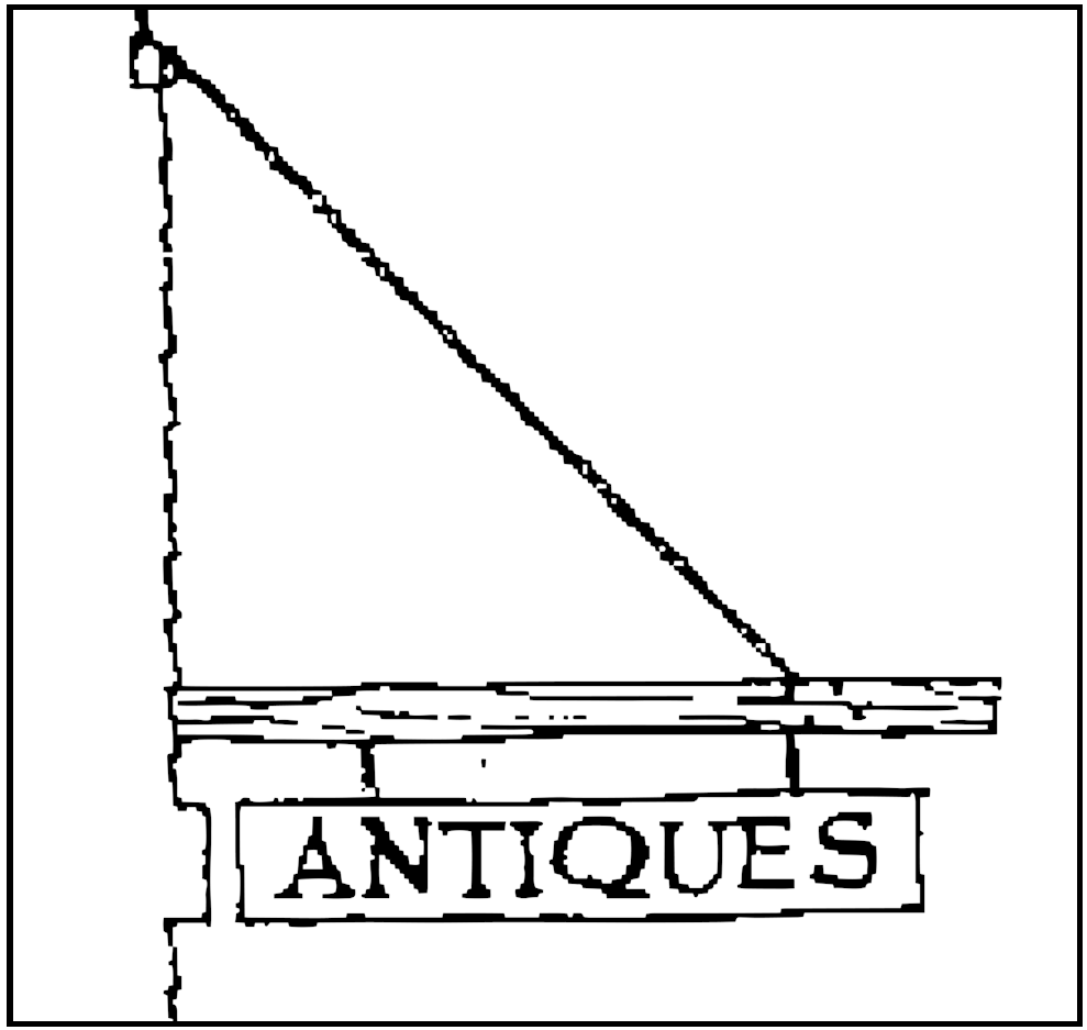
These signs may not project more than 2 feet from the face of a building to which they are mounted, or 3 feet from a free-standing support to which they are mounted. Projecting signs may not be more than 15 inches in height or 5 square feet in area. A minimum clearance of 8 feet must be maintained where signs project over a public walkway. Supporting structures for signs should be appropriate to the detailing of the buildings to which they are attached.
Flags and Banners
Permanent banners must follow the same guidelines as other signage and graphics. Temporary flags and banners, which are not specifically prohibited in the Powell Zoning code, or which do not require a zoning permit, are not subject to these restrictions. Proper display of the United States, State of Ohio, or other historical 'flag is encouraged. All flags and banners which project over a public walkway should maintain a minimum clearance of 8 feet.
Free Standing Signs
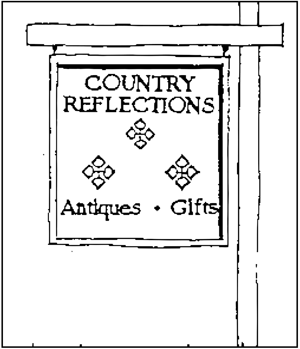
Height should not exceed the first story of adjacent buildings. Overall size should not exceed 12 square feet. Supporting structures should be simple in design and in character with the adjacent buildings. No more than three ground in the colors may be used in signs, as is stated zoning regulations.
Accessory Buildings
Automobile garages, storage sheds, and other dependent buildings must be located at the rear of the property, with entry facing away from major streets, although access from an "alley" is permissible. The accessory building should be compatible with the building it serves in massing, materials, and basic color scheme, but it should not be an exact copy of the main building. An accessory building should be obviously subservient to the building it is serving. This means that it should be smaller in scale and simpler in detail than the main building.
Roof type, roof pitch and rhythm of openings should harmonize with those elements of the main building. Materials should be similar in nature and scale, although not necessarily in refinement. For example, a house with special wood siding and shingles might have a garage with simpler wood siding. Special attention must be given to the relationship in scale and location between accessory buildings and the buildings they serve.
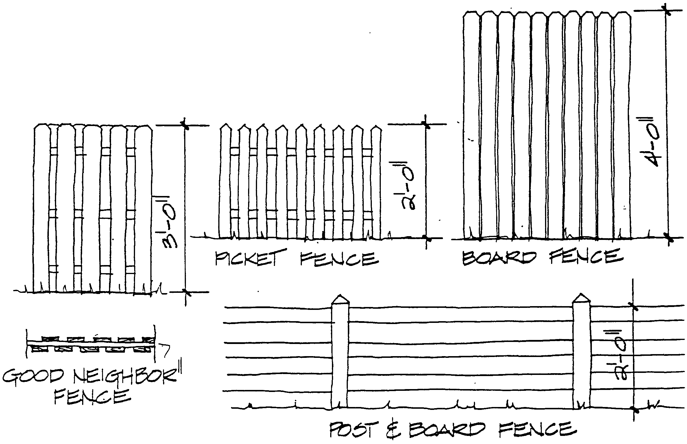
Fences
The preferred treatment for definition of property boundaries within Powell's Historic District is the use of landscape elements such as low hedges, corner or edge plantings, and lines of trees. Fencing of entire yards or portions of them is discouraged within the Historic District unless it is necessary for the safety of the owners and the community, or to meet applicable code requirements. These fences should be the minimum height necessary to serve their purpose.
Tall, privacy fences should be limited to rear yards. These should be constructed of wood, and stained in a natural wood color. Board or board-and board ("good neighbor") fence styles are appropriate where required for privacy or safety. Small pieces of fence which define corners, edges, entries, or paths are acceptable in front yards, especially if they are integrated parts of landscape features. Front yard fences may not be higher than 3 feet tall. front yards in the Historic District. These fences should be stained in a natural color or painted cream or white. All fences in Powell's Historic District should be built out of wood, and be simple in design. Very ornate fences, with intricate patterns, or overly rustic fences, built of hand hewn lumber, are not appropriate. Wire fences are not appropriate in the Historic District.
Landscaping
Street trees should be planted along Olentangy Street between th east and west boundaries of the City, and along Liberty Street, between the north and south boundaries of the City. The planting of street trees elsewhere is also encouraged. Street trees should be planted approximately 25 feet apart and 3 to 4 feet from the sidewalk. It is recommended that the trees be planted in the lawn panels between the buildings and the sidewalk. Trees in this location will be less likely to send roots under a sidewalk. A variety of street trees should be planted in order to ensure that the tree line will survive the failure of one species. The following species are recommended for their resistance to the stress of traffic:
Yards should be rural in character, and use native plantings. These should be primarily grass with trees and small beds of native cultivated or wild flowers. Ornate, formal, or exotic gardens are discouraged, but may be acceptable if they are not along main roads, are hidden from public views, or can be blended into a more native landscape. Utilitarian kitchen, vegetable, and herb gardens are encouraged, but should be located in a logical place, such as the rear or side of the house, near the kitchen or rear entry.
Foundation and wall climbing plants, such as ivy, can damage historic materials. Such plantings should be kept to a minimum and carefully controlled. On existing structures, foundation and wall plantings should not endanger or obscure significant architectural features, or historic fabric. On new construction, such plantings should not be used to hide inappropriate material or lack of proper detailing.
Building Materials
Building materials are very important in establishing the historic character of a structure. This is especially true in smaller towns such as Powell, where most buildings exhibit simple detailing and minimal decoration. Materials can contribute the qualities of texture, pattern, tone and color to the surfaces of a building. Texture refers to the tactile qualities of a material, such as its relative roughness or smoothness. Patterns are regularly repeated motifs, shapes, or forms, which often have the effect of texture. Host patterns and textures are formed by the traditional methods of laying units of construction material, such as bricks, siding, slate, or shingles. Tone refers to the relative darkness or lightness of a material or color, such as the varying grays of slate. Color can be inherent in the material, such as red brick, or can be applied, like paint to siding. More specific information on color, tone and historic painting schemes can be found in the section on Color and Painting. Building materials, with their qualities of texture, pattern, tone and color become character defining features on many of Powell's simpler buildings.
Foundations
The foundation of a building is the masonry substructure upon which a building rests. A sound foundation is vital to the structural integrity of a building. A foundation has two major enemies, settlement and moisture. Settlement refers to the movement of ground beneath the building. When this occurs, the foundation responds to the movement, and attempts to adjust to the new lay of the land. This change in position can cause cracks in the masonry units or mortar joints. Host buildings settle gradually over the years, or soon after they are constructed. Hairline cracks or cracks which appear old (filled with debris) are not generally a source of concern. New or newly patched cracks in the foundation, walls which bow inward, daylight between the base of the house and the foundation, and cracks around door or window frames are all signs of potential trouble. Excess water at the foundation can cause innumerable problems ranging from structural failure or flooding due to disintegration of mortar, to deterioration of. Exterior sheathing materials and interior finishes, due to "rising damp".
One of the major causes of excess moisture at the foundation is improper drainage of water at the roof. All roof surfaces, gutters, and downspouts should be inspected periodically to make sure that water is draining properly. Water runoff should not splash against the exterior wall of a building. Gutters and downspouts should be kept clear of debris and in good condition to avoid this problem. Inadequate ventilation of basements or crawl spaces, and improper grading at the foundation are other major causes of excess moisture. All underground spaces should be vented, or dehumidified. Ground should slope away from the foundation, to prevent water from pooling against the masonry.
Foundation plantings (trees and shrubs planted against a building) are not historically correct and can cause serious damage to historic masonry. These plants hold moisture in their root systems which can weaken mortar. They will rob clay soil of its moisture, opening cracks near the foundation, in which water may pool and, eventually freeze.
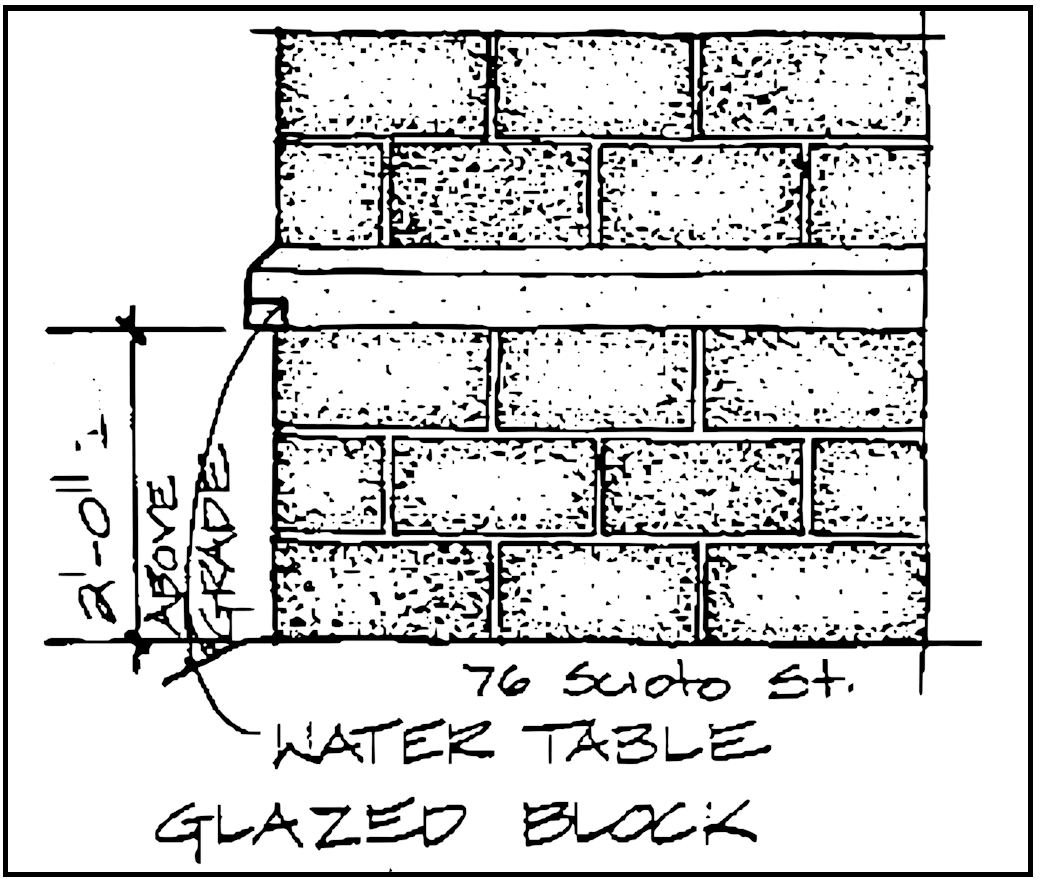
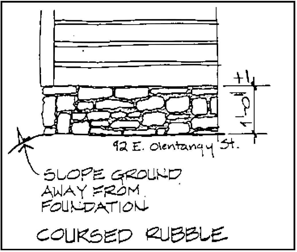
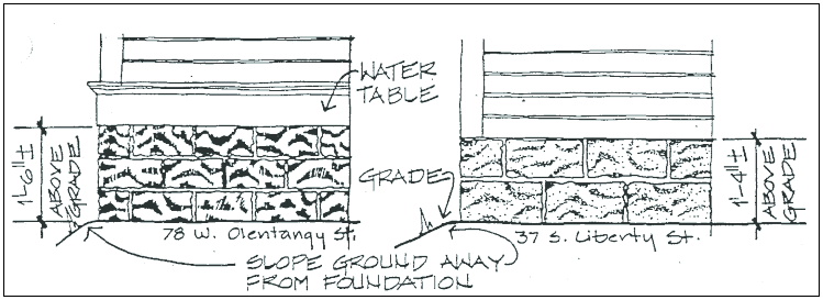
A weakened foundation can threaten the very structure of a building. Old foundations should be inspected periodically for signs of deterioration. Appropriate corrective 1995 Replacement 292 steps, such as repainting of mortar, regrading of soil to ensure drainage, and ventilation of underground spaces can solve many foundation problems, In the case of extreme structural or moisture concerns, consult an engineer or architect. The foundations of Powell's buildings are built out of limestone, concrete block, or glazed block, with about 1 to 2 feet exposed above grade. The oldest foundations are limestone laid in a random or coursed rubble pattern. Later, limestone was roughly shaped into rectangular blocks, but maintained its natural or rock face. Manufactured masonry units began to be used at the turn of the century. Glazed clay tile blocks and a "rock faced", cast concrete block became popular foundation materials then.
In situations where a foundation must be entirely rebuilt, or in cases of new construction, the new foundation should be compatible with City foundation construction techniques. In the case of additions, new foundations should be as compatible with the existing ones as possible. New foundations may be built entirely out of limestone in a random rubble or coursed pattern. Although cast, "rock faced" concrete block and glazed clay tile blocks are no longer available commercially, these materials may be used if they can be found. An acceptable alternative to Powell's traditional foundations uses regular concrete block, faced above grade with rubble or coursed limestone. Another alternative is to lay regular concrete block below ground and split face concrete block (which has a rough, rock-like surface) above grade.
In general, exposed regular concrete block is not an appropriate material for newly constructed foundations. In some cases, such as an addition to a building with a glazed block foundation, it may be the most compatible material available. In these special cases, regular concrete block may be an acceptable material for foundations in new construction.
Masonry
Brick
There are a few buildings in Powell which are built entirely out of masonry. Brick is used primarily for commercial and public buildings. Older, 19th century bricks are soft and porous, due to impurities in the clay from which they are made, and variations in firing temperatures. Later, turn of the century bricks are harder, more dense, and sometimes given special texture by wire cutting. Brick walls in Powell are simple in pattern, with the bricks laid either in common or running bonds.
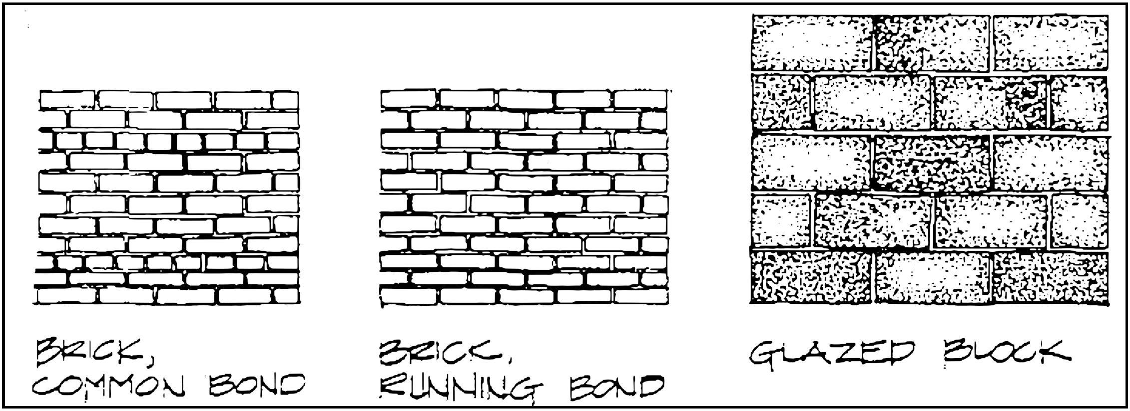
Glazed Block
Glazed block is another type of masonry used on the exterior walls of a few of Powell's residences, and the foundations of many others. Glazed block is a type of hollow clay tile which was produced in the Appalachian regions of southern Ohio and West Virginia. The blocks were manufactured out of the clay soil prevalent in those areas, and were mass produced from the 1870's to the 1930's. The blocks were fired with a salt glaze which made them durable, impervious to water, and suitable for exterior use. The finished blocks range in color from a dark red, through purple, to almost black.
Existing Masonry
Although masonry materials are durable and relatively maintenance free, they can be damaged by neglect or improper treatment. Existing masonry walls should be inspected periodically for structural problems or failure of mortar joints. Spalling, (splitting off of small fragments from the face of masonry units), efflorescence, (white powder stains resulting from salt deposits), broken lintels, and bulging or bowed walls can all indicate serious trouble. The advice of an expert should be sought if any of these problems are detected.
Repointing
Mortar is a cushion which gives a masonry wall the ability to expand or contract with temperature extremes or changing soil conditions. The mortar must be softer than the masonry units which it cushions, in order to perform properly. The oldest bricks are the softest bricks, and are laid in very soft mortar. Later, harder bricks are laid in harder mortar. Old mortar may have deteriorated over the years, from wall movement and Weather.
First, it should be determined if any mortar deterioration has been caused by factors other than time and weather, and .these problems should be corrected. In many cases, repointing of the mortar Will be sufficient restore the visual and physical integrity of the masonry wall.
Repainting should be done by a trained craftsman. New mortar should match the original in composition, color and detailing. Very old, very soft bricks should be repainted with a very soft mortar. Modern mortars, which are much too hard, will force the stress of wall movement into the masonry units instead of the mortar, causing the units to crack and crumble. Matching the composition of the original mortar will also help in matching the color. Many joints in 19th century brick walls were detailed with tools after the joints were laid. This "tooling" produced a variety of profiles in the joints. Repainted mortar joints should match the orig-
Replacement Masonry
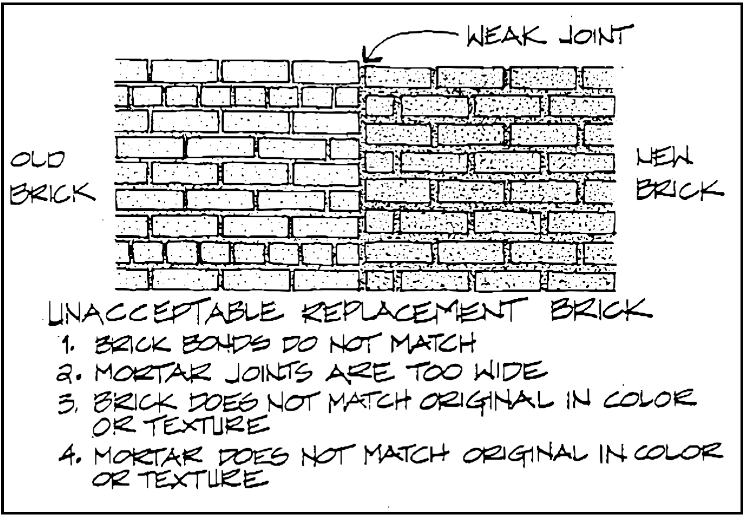
If a masonry wall requires patching, the replacement section should match the original as closely as possible. New or salvaged masonry units should match the existing ones in size, type and texture. Bricks or blocks should match the full range of tones in the original wall. Mortar should be of the same composition and color. The units should be laid in the same bond as the originals, and the width and profile of the mortar joints should match those of the original wall.
Cleaning
Before cleaning a masonry wall, consider that what often appears to be dirt is actually a patina of age and weathering which the brick has acquired over time. This patina gives the masonry an aged, historic character, which contemporary manufacturers try unsuccessfully to imitate. The patina also acts as a natural sealant and helps to protect the masonry units from weathering. Most cleaning methods will remove a thin layer of the masonry itself in the process of removing "dirt". Unless pollutants are actively damaging the masonry, it is often best not to clean the wall.
If masonry cleaning is required, the gentlest effective means should be used. In many cases, the water from a garden hose, a mild detergent, soft bristle brush, and a little "elbow grease" will vastly improve the appearance of a masonry wall. If a pressured water or steam system is considered, the lowest effective pressure should be used.
Chemical cleaners are not recommended, because of their uncertain results, which can include permanent stains and efflorescence. If chemical cleaners are being considered, the advice of a professional should be sought, and a test patch conducted on their instructions. This is not a job for homeowners or amateurs.
Do not sandblast masonry walls Sandblasting will literally remove the outer crust of the masonry and ruin its ability to withstand weather. Waterproof coatings are not recommended, as they interfere with masonry's natural ability to "breathe". Moisture from interior condensation can get trapped in a waterproofed wall and cause many problems. Masonry should not be painted within the Historic District. Powell's masonry walls were not traditionally painted, and paint is almost impossible to remove in the future without damaging the masonry.
New Construction
In the Historic District, brick should be used for commercial and public buildings only. Use sand mold red; bricks, in standard brick, sizes. These should be laid in simple bonds similar to the ones found in Powell. Very elaborate, "mosaic" brickwork is not appropriate in the Historic District.
Wood
Siding
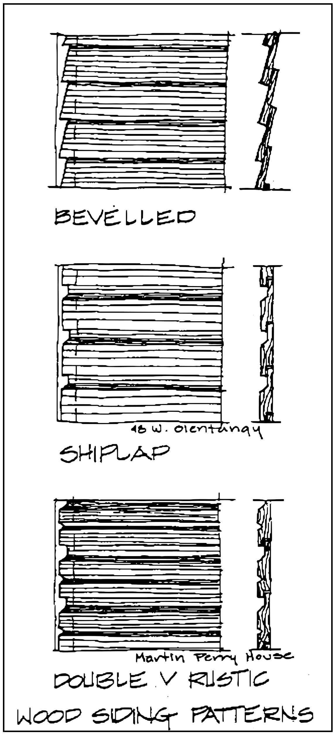
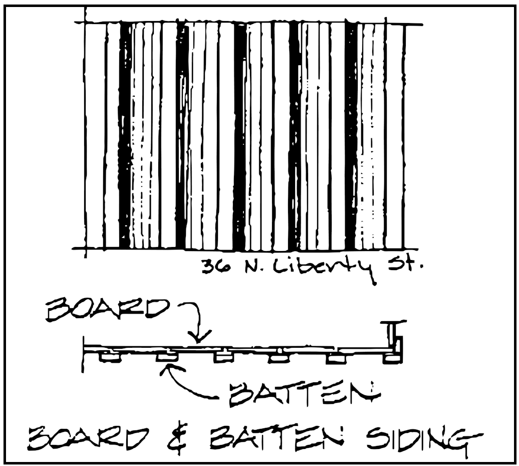
Most of the buildings in Powell are sheathed in some form of wood siding. Beveled, shiplap, and rustic sidings are used commonly. Board-and-batten siding is used occasionally for small areas of a building. Board and batten siding is more appropriate for accessory buildings or small, subordinate additions.
Every effort should be made to retain and repair wood siding within the Historic District. Deteriorated wood siding usually appears to be in worse condition than it actually is. Many problems with paint on wood siding are caused by excess moisture. Proper ventilation of the siding will often solve this problem. In most cases, a few minor repairs with glue, nails, putty, paint, and new sections of wood, are all that is required. Often sanding and a new coat of paint will be sufficient to vastly improve the appearance of wood siding.
Small cracks in individual boards can be repaired by filling the crack with glue or putty and nailing through the crack. Warped boards can be screwed flat, or shimmed from behind and nailed flat Deteriorated sections of siding can be cut out and replaced with a new section.
A general gapping or looseness of the siding may a be sign that new siding is required. If the boards are not badly warped, however, renailing can solve the problem. If complete residing is necessary, it should be done in a material which matches the original siding as closely as possible in texture and pattern. New wood siding, in the same pattern as the original, is the preferred replacement material for deteriorated wood siding.
Wood siding is a very appropriate material for new construction within the historic district. Most of the types commonly . used in the City are horizontal, with board widths of 4 to 5 inches. A few of the houses have double V rustic type siding, in which an extra groove is carved in the center of each board, giving the appearance of 2 inch board width. Wood siding used in new construction should resemble these typical siding types in profile and board width. Any wood siding used in the historic district should be painted (not stained) in colors appropriate to the district as outlined in the section on Painting and Colors.
Wall Shingles
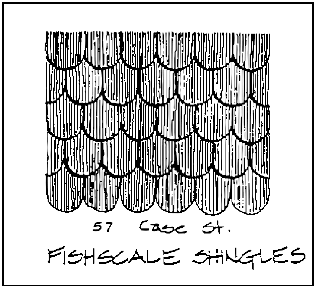
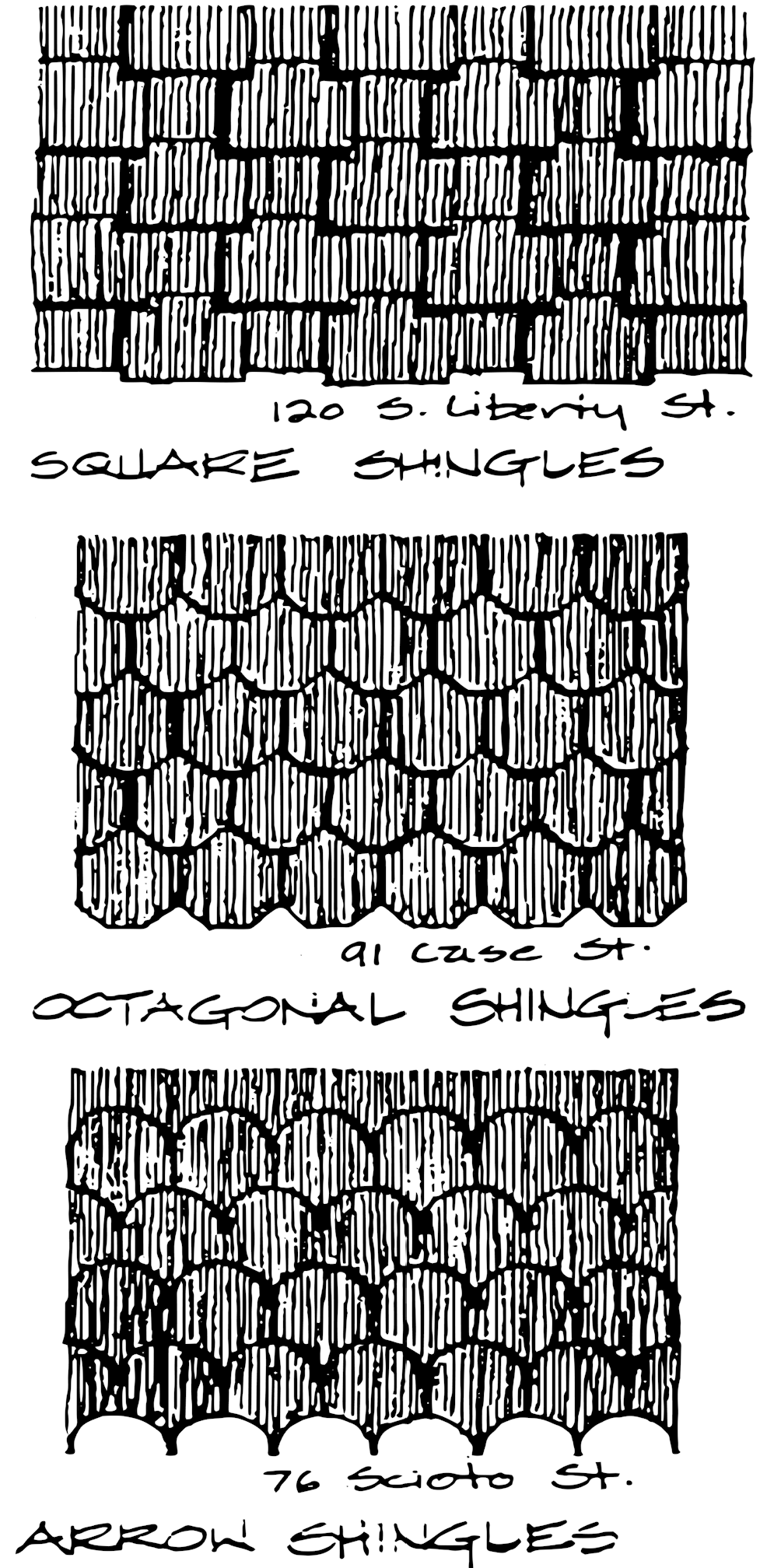
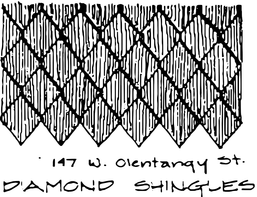
Wood shingles rarely cover an entire structure in Powell's Historic District. They are used primarily as decorative accents on Queen Anne, Stick and Bungalow style buildings, and in the gables of simpler buildings. Fishscale, square, octagonal, arrow, and diamond patterned shingles are found on structures throughout the City. Occasionally, two or more patterns are used together for a lively textural effect.
Existing wood shingles should be retained and repaired. Shingles in good condition appear as a perfect mosaic. Worn shingles appear ragged, with individual shingles broken, warped and upturned.
Individual shingles can be replaced, but if a large number of the shingles in a small area are damaged, it may be easier to reshingle the entire area. If replacement shingles are required, the preferred solution is to use individual wood shingles which match the original ones.
The use of wood shingles in new construction within the historic district is encouraged. Shingles should be limited to smaller areas of a structure, such as a gable or bay window. All shingles used within the district should be painted, not stained. Appropriate color schemes are outlined in the Painting and Colors section.
Manufactured Siding
Asbestos Shingles
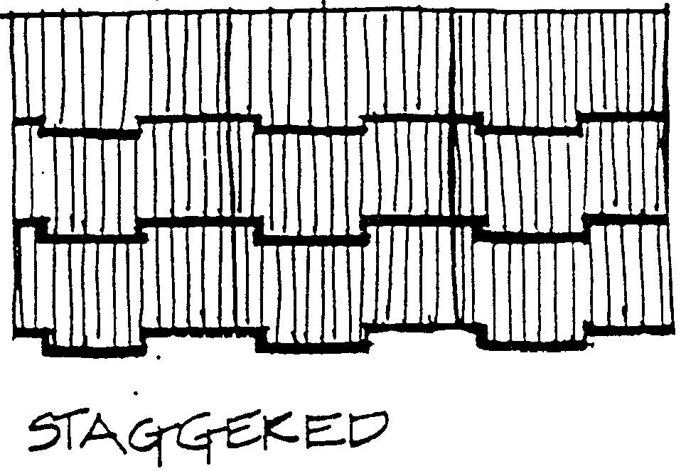
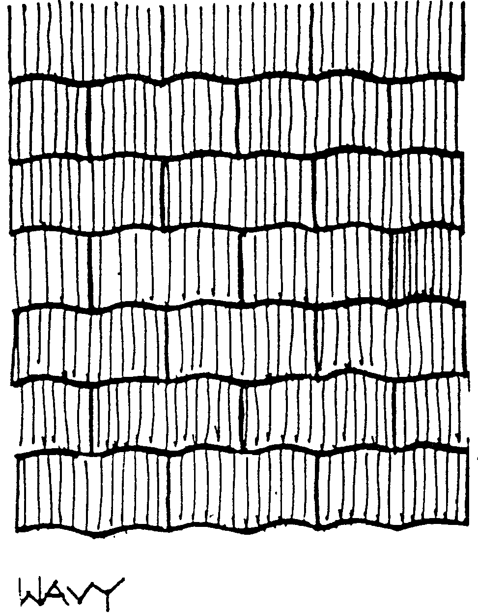
During the 1940's, many buildings in Powell were covered with asbestos shingles. These shingles were manufactured in one size, 12 inches tall by 24 inches wide, three "patterns", wavy, straight, and staggered, and a few stock colors. The thin, brittle slabs were often corrugated to resemble wood shingles. Asbestos shingles were extremely popular with homeowners of the time because they were impervious to rain and rot and highly fire resistant.
Asbestos shingles are no longer manufactured, since it has been discovered that the fiber and dust from asbestos are hazardous to human health. The shingles, as they exist on the exterior of a building, pose no threat to human health. The safest course of action is to leave the asbestos shingles alone.
Although these shingles may have changed the character of the buildings they cover, they are a part of the history of Powell. Their presence reflects one of the many changes the City has gone through, as well as the practicality and economy of its citizens. The removal of asbestos shingles is not encouraged, unless the condition of the original siding material has been investigated carefully.
Removal of asbestos shingles may be appropriate in certain situations. If the asbestos shingles are in poor condition, and it has been determined that the old siding underneath is in good condition, exhibits good design, or fine craftsmanship, removal may be desirable. Asbestos shingles should not be removed with the intention of replacing the covered material with an inappropriate contemporary substitute.
Certain precautions must be taken when working with asbestos shingles. In general, they should be kept as moist as possible to prevent particles from becoming airborne, and a respirator or mask should be worn at all times. Asbestos shingles should never be sanded, drilled or cut. Owners and contractors are Strongly encouraged to contact.
The Ohio Environmental Protection Agency in Columbus for additional information about asbestos hazards before beginning work.
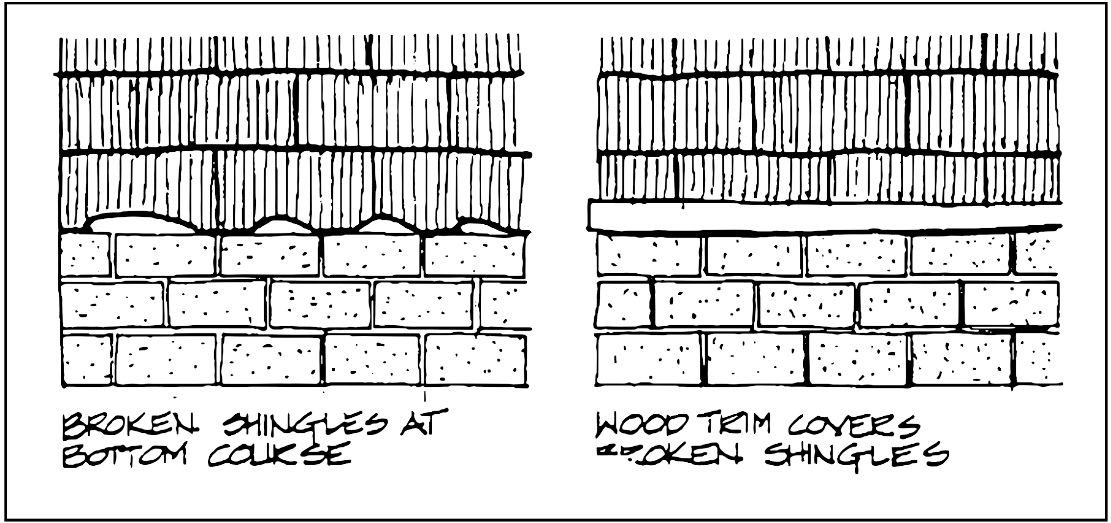
Since asbestos shingles are no longer manufactured, the best source for replacements is salvage from another building where they have been removed. Broken shingles can be turned upside down, and the broken edge hidden under an overlapping shingle. The shingles are most vulnerable along the bottom course and at the corners. Wood trim pieces can be installed to cover broken shingles and protect others. Another possible alternative is to cut an 1/8" thick piece of fiberglass or plastic to match existing shingles, and paint it to match the rest of the wall. In most cases, asbestos shingles will take multiple coats of paint quite easily.
Aluminum and Vinyl Siding
The use of aluminum and vinyl siding in new construction or to replace existing wood siding should not be considered unless all other possible courses of action have been explored. Neither type of artificial siding is truly maintenance free. Aluminum dents easily and must eventually be painted. Vinyl siding can warp, tear, and crack. Neither type of siding has the true character of aged wood siding. If aluminum or vinyl siding must be used, care MUST be taken to detail it in a manner which is compatible with the wood siding types which are prevalent in the City. The replacement siding should be two to five inches in width, with a profile similar to those typically found in Powell. The siding should resemble the material it is trying to imitate. Artificial graining should be avoided as it does not appear on good wood siding. Original detailing such as fascia and soffit trim, window and door frames lintels, and sills MUST be maintained. Corner and sill boards should be retained or replicated in the new material, in dimensions which match the originals.
Roofing
The roof of a building is important in establishing its character. The materials which cover a roof are an important aspect of this character. Common roofing materials used in Powell include slate, metal, and asphalt shingles.
Slate
With a life expectancy of 100 years, slate is one of the most durable roofing materials in Powell. Slate is a thin laminated rock, which is used as a roofing and siding material. Host slate roofs exhibit a range of iridescent tones from a rosy pink, through a range of grays, to a greenish tint.
Slate is used on both roofs and dormers in Powell's Historic District. Most of the slate used in Powell is octagonal shaped, but these octagonal slates are sometimes combined with rectangular ones to enliven the surface of a roof.
Existing slate roofs should be retained and repaired whenever possible. In most cases, a slate roof can be repaired. A roofer who has experience with slate should be consulted before a decision to replace the slate is made. Deteriorated slates can be removed by cutting the nails which hold it in place, and sliding in a replacement slate. Any replacement slates should match the patterning and color range of the roof in which they are being placed.
A number of artificial slate products have come on the market recently. Many of these imitation slates bear a remarkable resemblance to the genuine material. These products may be appropriate for replacement roofing or new construction, but they should be used with caution. Most of these artificial slates are new products, and their performance in field conditions has not yet been proven.
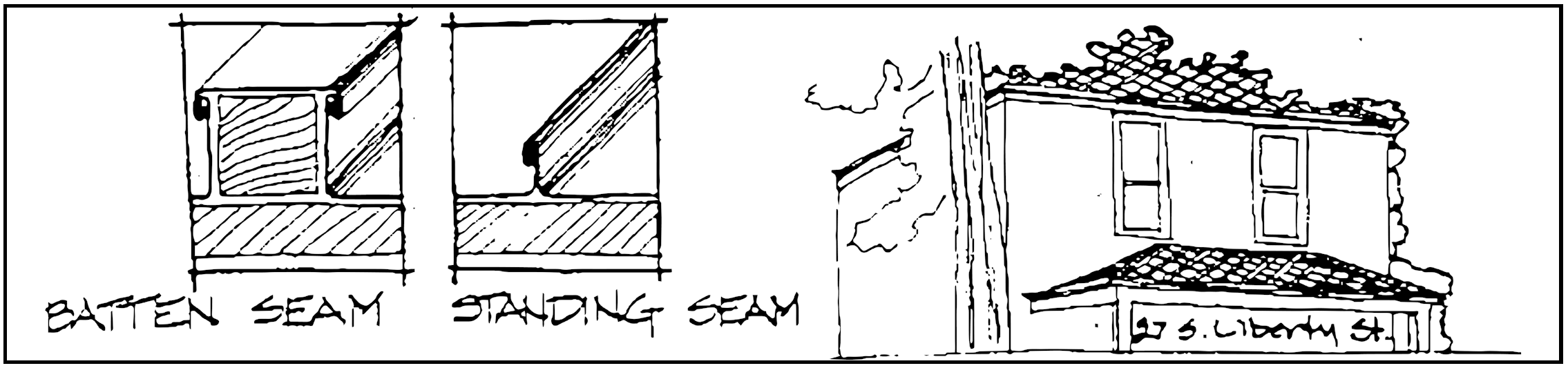
Metal
A few of the buildings in Powell's historic district have metal roofs. Most of these roofs are built of tin, and are either batten or standing seam types. These types of roofs were popular in rural areas in the 19th century. Every effort should be made to retain and repair existing tin roofs.
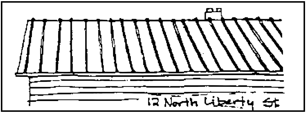
Tin or tin-like roofs may be used as replacements on structures which currently have such roofs. If evidence can be found that a building had a tin roof historically, then a similar metal replacement would also be appropriate. Replacement roofs should match the originals in color, profile, and spacing of seams.
Metal roofs which are similar to those typically found in Powell are appropriate for new construction. Modern metal roofing is available in a wide range of colors and profiles.
Only silver-gray "tin" colors Are appropriate for use in the Historic district. Metal roofs other than batten or standing seam types are not appropriate for use in the district.
Asphalt Shingles
Many houses in the historic district have already had their roofs replaced with asphalt shingles. In many cases, these types of shingles are appropriate as replacements for slate, or for use on new construction.
Asphalt shingles are now available in a variety of colors. Variated grays are the most appropriate for use in the historic district. The more tones of gray in the asphalt shingles, the more closely it will resemble slate's range of tones. White or very light colors should not be used.
Asphalt shingles laid in a diamond pattern with "rolled" or thickened seams can create a roof texture which is reminiscent of octagonal patterned slate. Asphalt shingles which attempt to replicate wood shingles are not appropriate in the Historic District and should not be used.
Massing
Mass describes the visual effect of a solid object as seen from the outside. Mass is a three dimensional property, which has dimensions of length, width, and height. Most buildings in Powell are created from a number of masses, for example a rectangular mass for the body of the house, and a triangular one for the roof. The term massing is used in this section to describe the form and shape of the overall structure, which has been composed from simple masses.
Building Types
Building type massing refers to the shape and form of the main block of a structure, and its roof. All obvious additions and subordinate projections are ignored when determining the building type massing.
Cottage
Dwellings, of a variety of plan shapes, which are characterized by a smallness of scale and a fineness of detail. Most of these buildings are one or one and a half stories in height. They tend to be asymmetrical in plan, and do not have the appearance of one single mass which bungalows exhibit. Powell's best example of a cottage is located at 111 North Liberty Street.
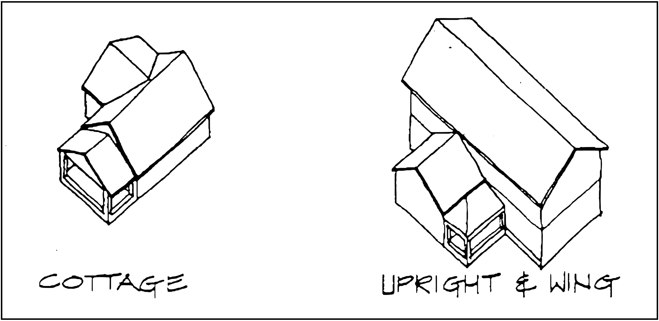
Upright and Wing
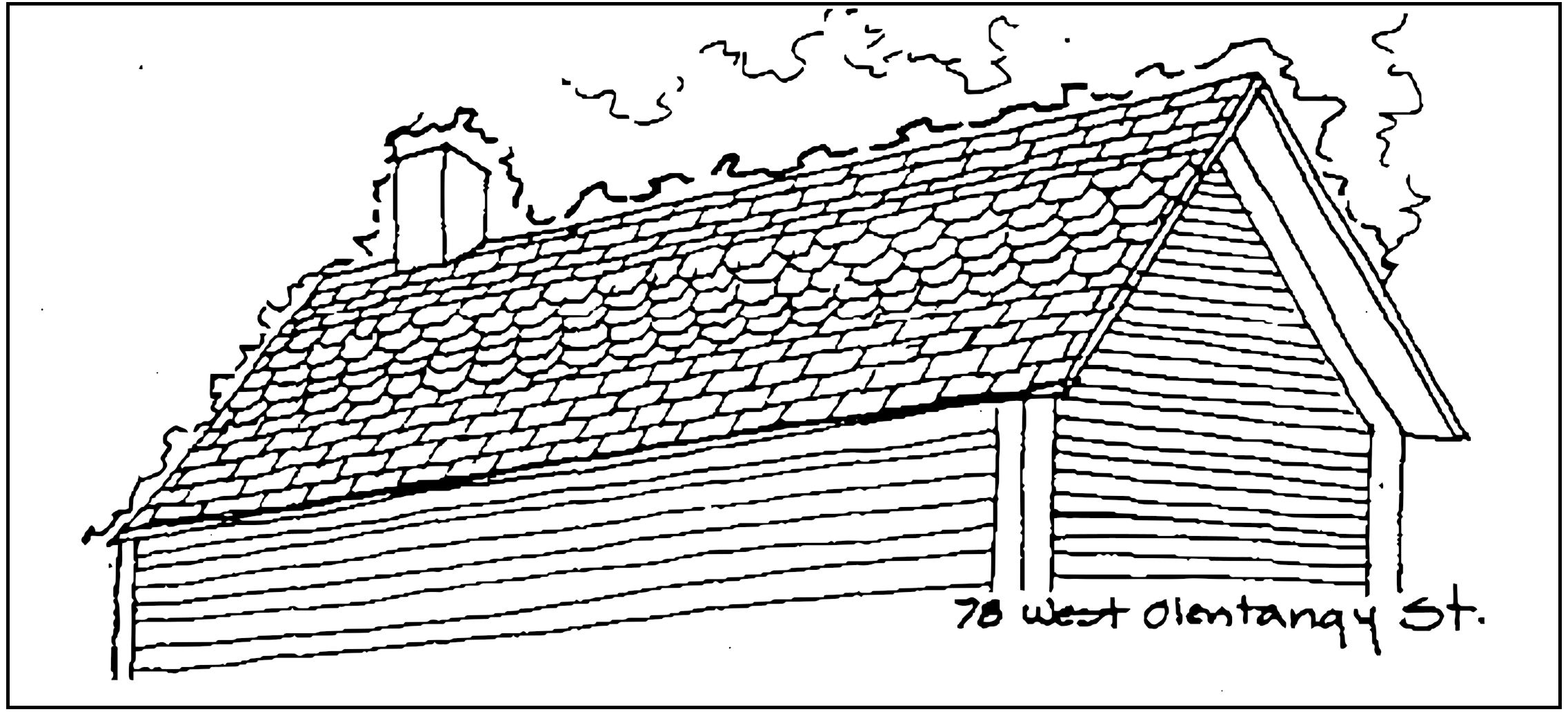
A Two story, front (street) facing gable, (Upright) is flanked by a recessed Wing of one or one and half stories, with its gable perpendicular to the upright. A partial or full length porch often runs along the front of the wing. Typical Upright and Wings can be found at 92 East and 77 and 78 West Olentangy Street.
Gabled Ell
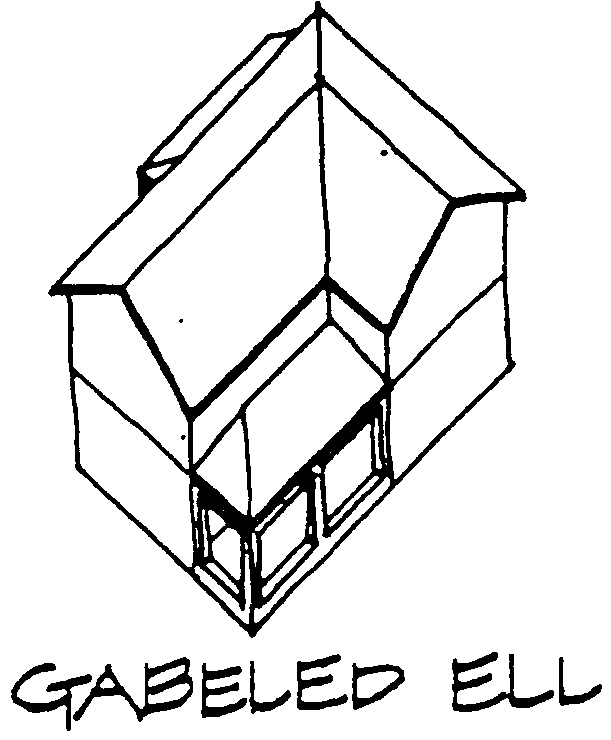
In its simplest terms, a two story house in the form of the letter "L". The ell is created by two sections with perpendicular gables which meet at a right angle. The block parallel to the street is usually wider than its perpendicular "wing", often by twice as many bays. A one story porch often runs along the block parallel to the street. Gabeled Ells are abundant in Powell. A few examples are the Martin Perry House, 57 West Olentangy Street, and 37 South Liberty Street.
Single Gable
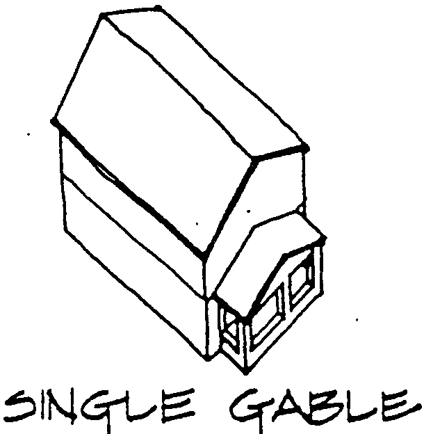
Buildings of this type have one recognizable main block, rectangular proportions, and are generally two stories in height. The entire main block is capped with a simple roof, with its single gable facing the street. Proportions may vary slightly from elongated, with a very narrow front, to almost square. A one story porch may run either along the entire width of the front, or surround three sides. These elements are always subordinate to the main rectangular mass. Two of Powell's Single Gables are 40 case street, and 57 Scioto Street.
American Four Square
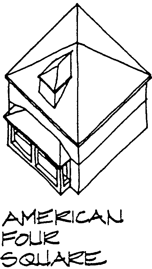
Houses of this type are square in plan, cubical in shape, and two stories in height. Four Squares are usually capped by a low, hipped roof. A dormer, also low and square in proportion, is usually centered in the front slope of the roof. Often, a low, stocky, porch extends across the front of the house. 119 North and 110 South Liberty Street are two of Powell's American Four Squares.
Bungalow
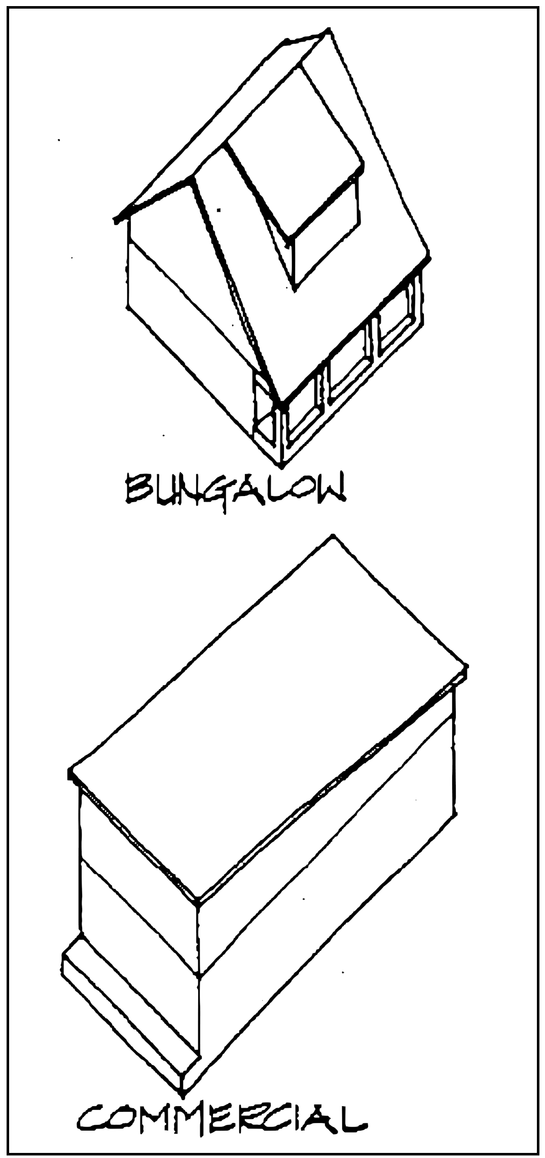
Bungalows are technically one story houses with dormers or gable windows to light the roof space. However, many one and a half and two story houses of the early twentieth century were designed to have a one story appearance. These "bungalows" have low, horizontal proportions. Most bungalows have the appearance of one single block, achieved through the use of a massive roof, which may extend beyond the outside walls of a house to shelter any porches. The only interruption to the mass may be a single dormer, often centered in the front. Two examples of Bungalows in Powell can be found at 236 South Liberty Street and 71 West Olentangy Street.
Commercial Building
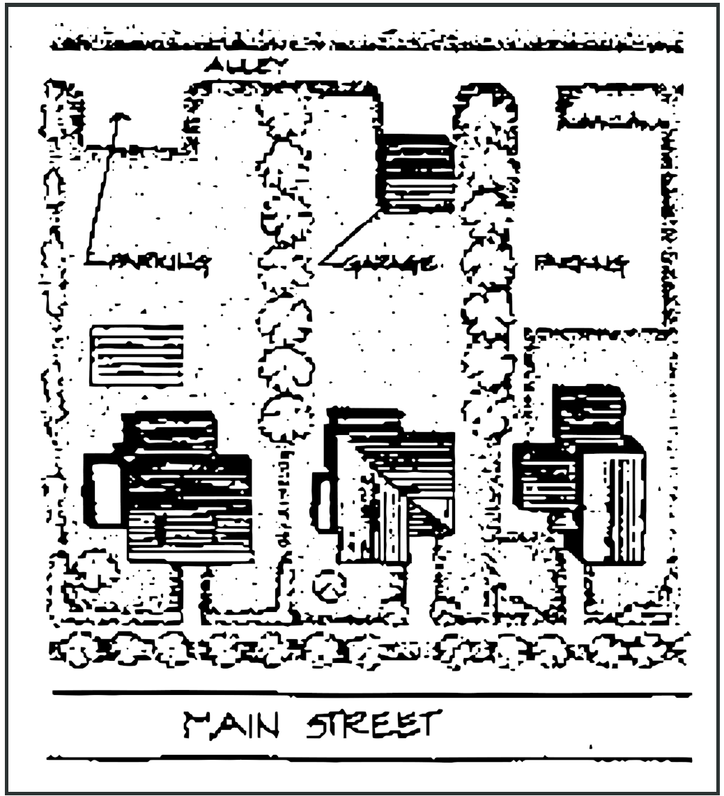
These buildings generally appear taller than the surrounding two story residences. Most are actually two stories tall, but each story is slightly taller than a standard residential story. Their flat or slightly sloped roofs and boxy massing also contribute to the sense of greater height. One story commercial buildings may achieve an appearance of extra height by the use of a taller front wall which projects above the roof line of the back and sides of the buildings. Most of Powell's commercial type buildings can be found near the corner of Olentangy and Liberty streets.
Irregular
Buildings whose main massing, discounting obvious additions, and subordinate projections, does not fall neatly into one of the above categories. Queen Anne style buildings, such as 147 West Olentangy Street, are almost always irregularly massed.
New Construction
New construction, which is in harmony with the existing character of Powell is encouraged within the Historical District. This does not mean that new buildings must be exact copies of older ones. Contemporary design which is compatible with existing structures in massing, materials and detailing is encouraged. In this manner, Powell will continue to experience the growth, change, and variety of architecture which has given the City much of its character and charm.
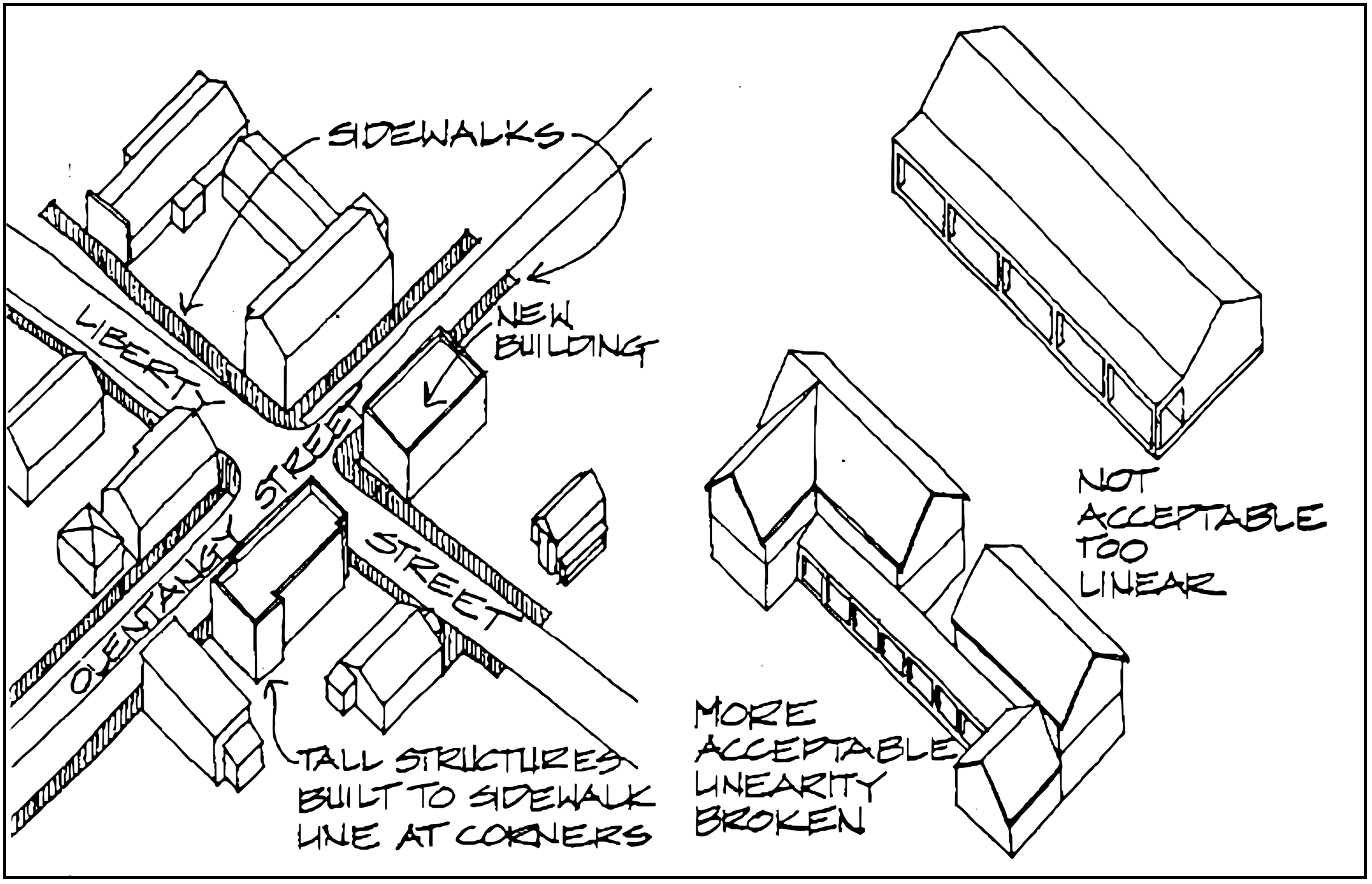
The buildings at the corner of Olentangy and Liberty Streets should be commercial types in a scale similar to existing commercial buildings. Similar buildings, slightly smaller in scale, may also be appropriate on lots immediately adjacent to the corner lots. These buildings should also be built right up to the sidewalk line, as are the existing ones. Tall, commercial building Types are appropriate only at The corner of Olentangy and Liberty streets.
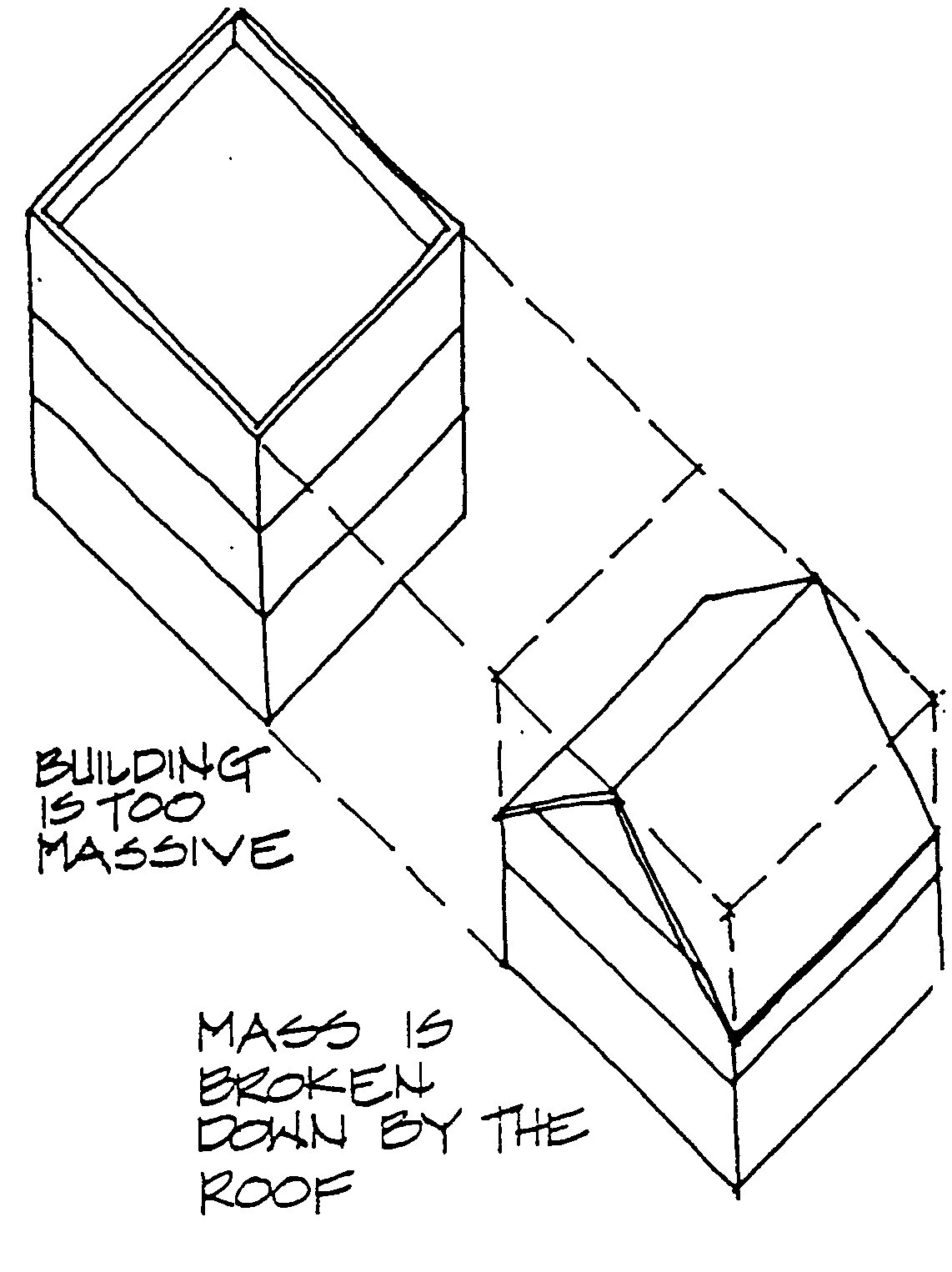
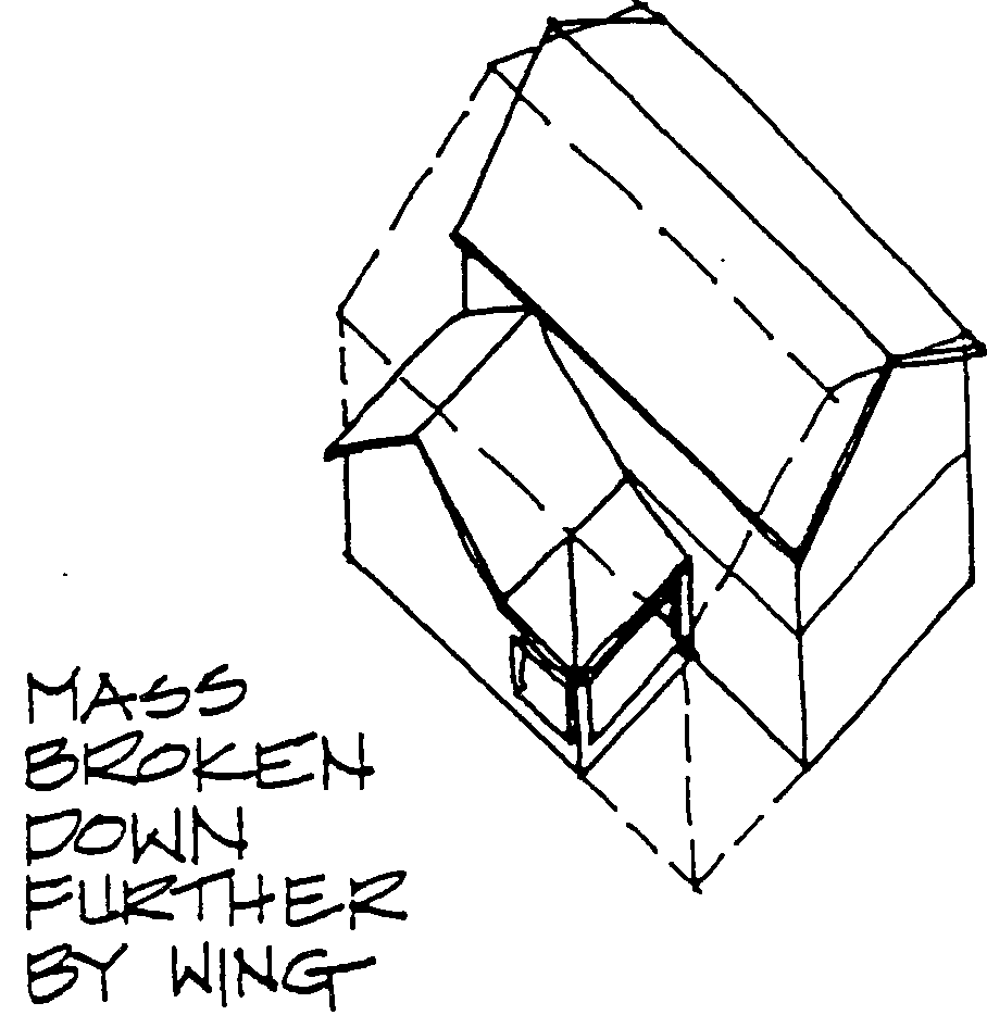
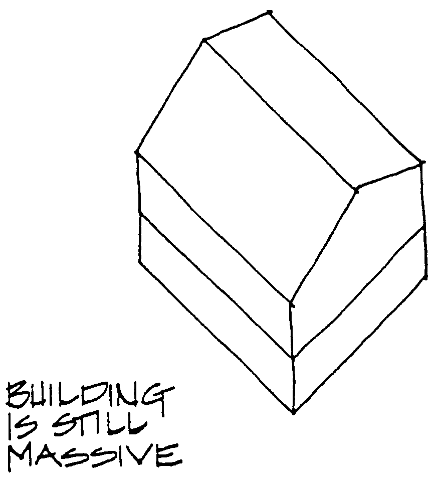
In other areas of the Historic District, the massing of new construction should reflect that of existing stuctures, other than commercial types. Every effort should be made to break up the massing of these buildings through the use of wings, projections, porches, roof slopes and dormers. The typical building types which have been discussed provide a variety of massing types which can be used as guidelines. Most of these examples are made up of two or more masses. Even those which strive for the appearance of one block (Single Gables, American Four Squares, and Bungalows) have their masses reduced by roof slopes, porches, and dormers. Massive, Blocky Buildings And Long, Linear Buildings Are Not Appropriate Anywhere In The Historic District.
Roofs
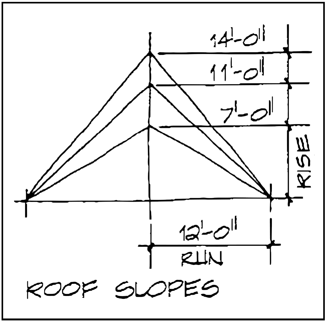
Roofs play a significant visual role in the massing of Powell's historic buildings. Roofs can take many forms; the illustrations below show several common roof shapes found in late 19th century and early 20th century architecture. Most buildings in Powell have traditional gable roofs. Slopes or pitches range from a rise of 7 feet in a run of 12 feet (about 30 degrees) to a rise of 14 feet in a run of 12 feet (about 50 degrees). The average pitch is a rise of 11 feet in a run of 12 feet (about 42 degrees).
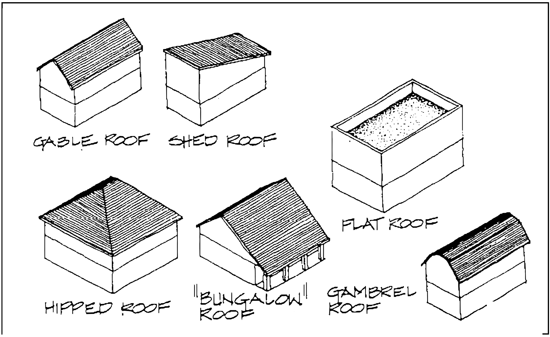
Gable roof shapes occur in all types of buildings, especially Upright and Wings, Gabeled Ells, and Single Gables. A variation on this type, which occurs frequently in the City, could be called the "bungalow" roof. In this variation, the front plane of the roof is longer than the rear plane, and the pitches of these planes may be the same or slightly different. Several buildings in Powell have hipped roofs. This type occurs primarily on American Four Squares. A few buildings in Powell have flat or shed roofs. These occur primarily on taller, commercial structures. Gambrel roofs are traditionally used on agricultural buildings. 36 North Liberty street is one of the very few buildings in Powell with this roof shape.
Most roofs in Powell are composed of one or two simple forms, such as intersecting gables forming an "L" or "T" shape. Some City roofs are a bit more elaborate, enlivened by dormers and gablets. Dormers occur most frequently on houses which do not have a full second story. They are used to light and ventilate the roof space, making it usable for living space. Gabled dormers occur primarily on Cottages, Single Gables, and some Bungalows. Hipped dormers often enliven the hipped roofs of American Four Squares. Shed dormers occur most frequently on Bungalows, although they are occasionally used on the upright of Upright and Wings. Most Upright and Wing, Gabeled Ell, and Commercial type buildings do not contain dormers of any type.
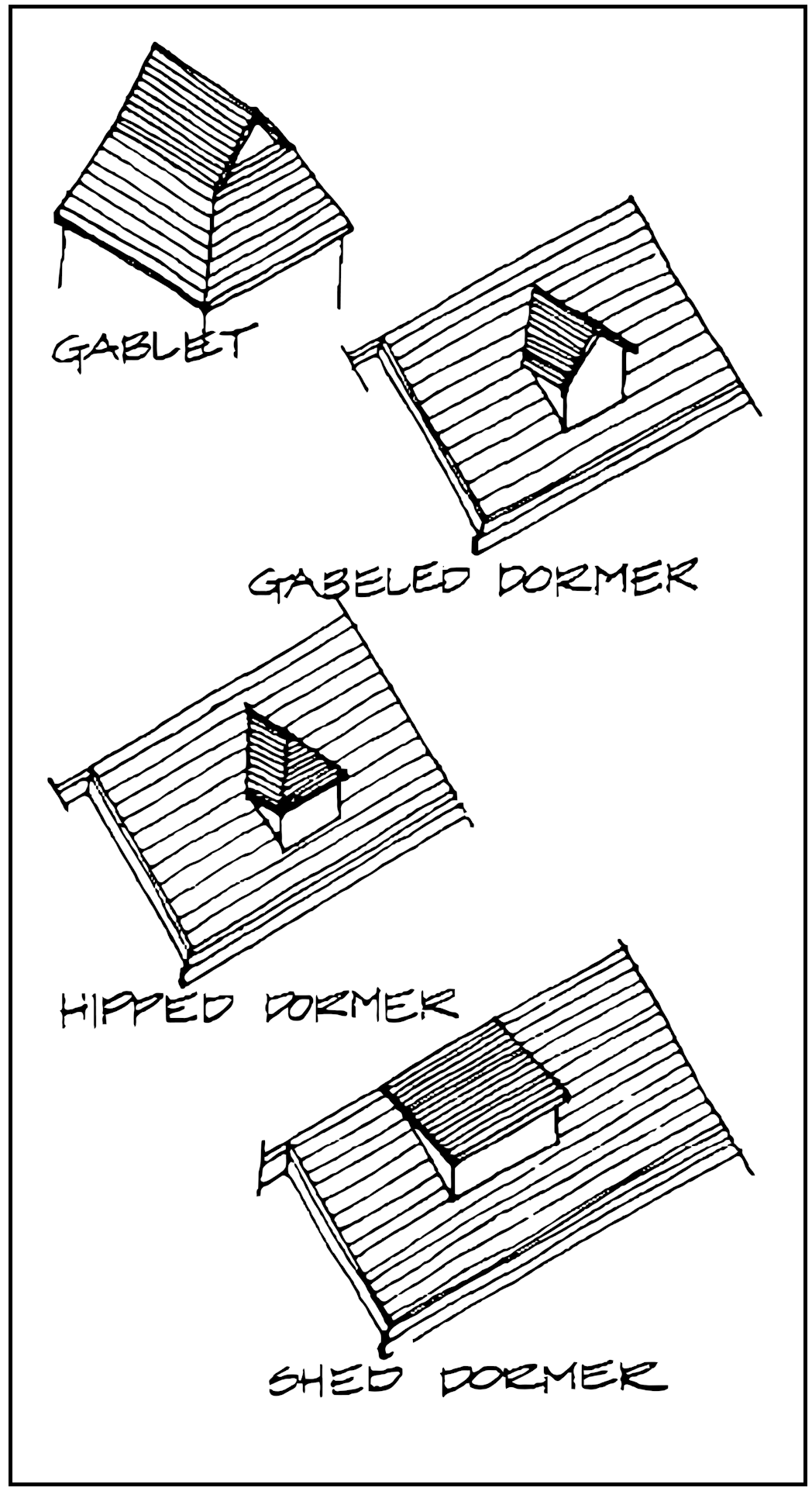
Gablets are miniature gables which often top hipped roofs. They are sometimes used to add complexity to the roofs of Queen Anne style buildings.
New Construction
New Construction in the Historical District should use the roof forms and slopes typical to the City. These roof types should be used in an appropriate manner and location. This does not mean that a roof type may only be used on the building type to which it is associated. Examining the ways in which certain roof forms were used can help to determine their appropriate use.
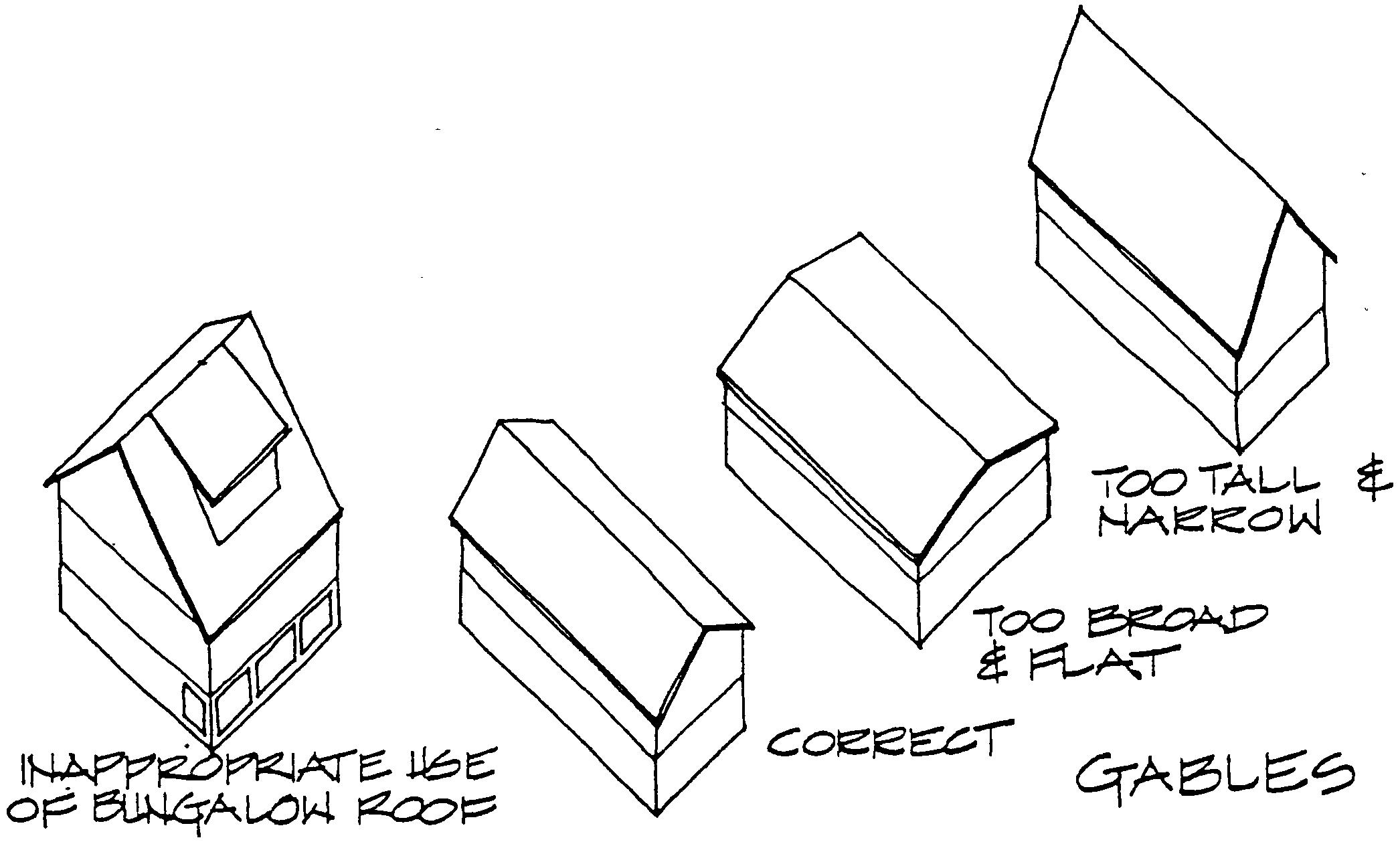
Gable roofs are most appropriate for new construction in the Historic District. Their breadth, length, and slope should be similar to those of existing gable roofs, as excessively wide, long or steeply pitched gables would not be appropriate. Bungalow roofs should be used only where a second story is being disguised, as their size would cause taller buildings to appear too massive.
Hipped roofs are very useful where a sloped roof is needed, but a small roof desired. Cubical, two story buildings, such as American Four Squares, can benefit from such a roof.
Flat roofs should be used only on commercial type buildings built at or near the corner of Olentangy and Liberty Streets (see Building Types - New Construction section). Shed roofs may be used for commercial buildings in the above location, for accessory buildings, and lean-to type projections. Gambrel roofs should be used with caution, as they belong primarily in the very rural areas outside the City limits.
Roof forms can be used to break up the overall mass of a building. In order to be effective, they must look and function like roofs. For example, if the intention is to render an upper story like a roof, simply siding the straight, full height walls in a roofing material will not be effective. The "roof" must slope, preferably within the range of pitches typical to the City, and be detailed like a roof, with eaves, gutters, and, typical roofing material. Natural light can be admitted through the use of dormers and gable windows.
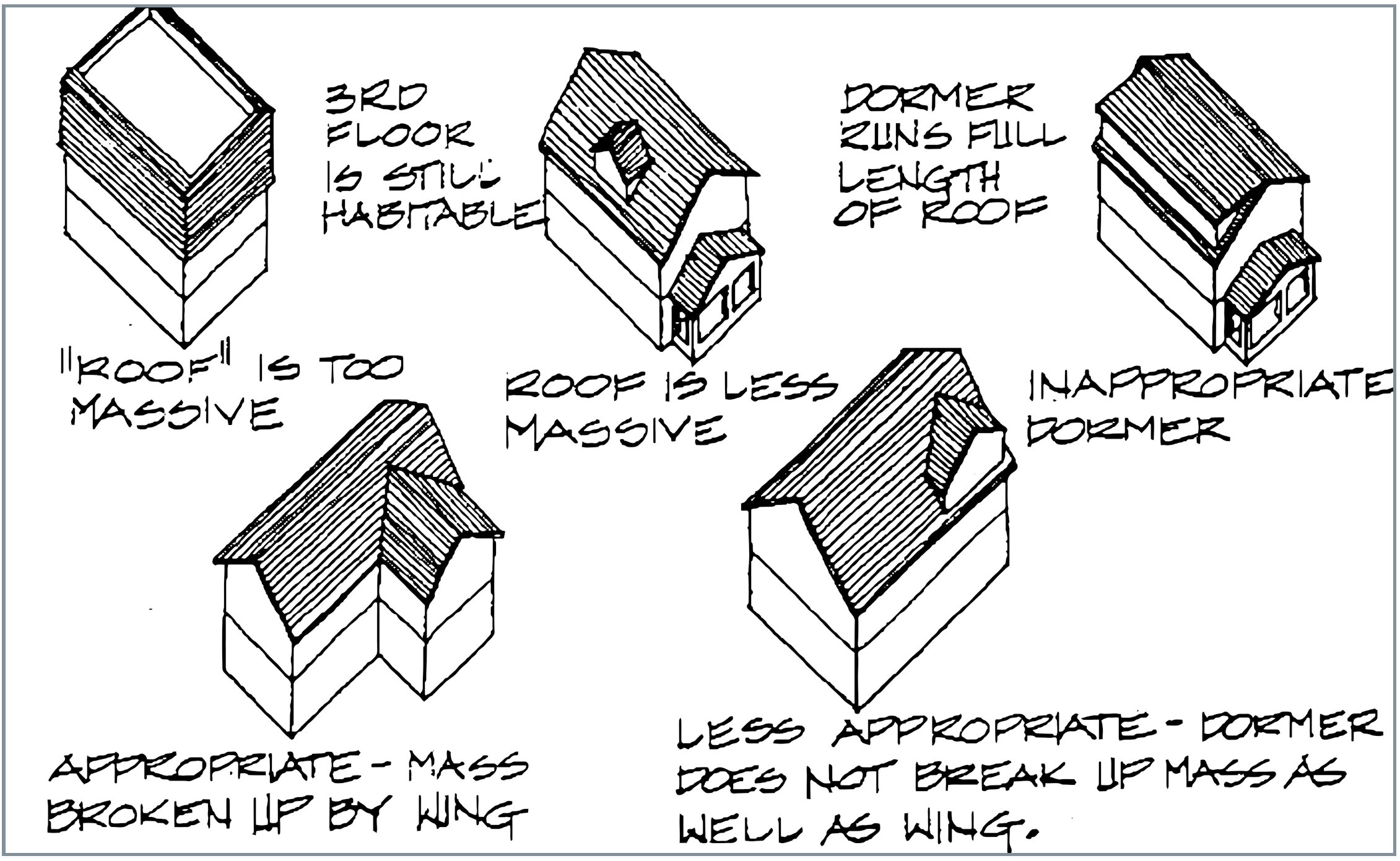
Dormers can be used to break up the mass of a roof, or make an upper story habitable. They can not take the place of projections and wings necessary to break up the mass of the building itself. Dormers should be scaled appropriately to their type and use. Gabled and hipped dormers should appear as small, individual elements on a roof slope. Shed dormers on a bungalow roof may be somewhat wider, running most of the length of a roof ridge. Dormers which run the entire length of a roof ridge are rarely appropriate, as they add too much mass to a building.
Additions
Much of the architecture of Powell has a definite additive quality. Many buildings contain projections and wings, subordinate to the main building mass. In some cases, these "additions" were actually constructed at the same time as the main structure, but were detailed to look "added on". In other cases, a building has collected extra rooms, lean to's, enclosed porches, and perhaps even a second story over its lifetime. These changes aver time are important to the history of a building and can add great charm to an otherwise simple mass.
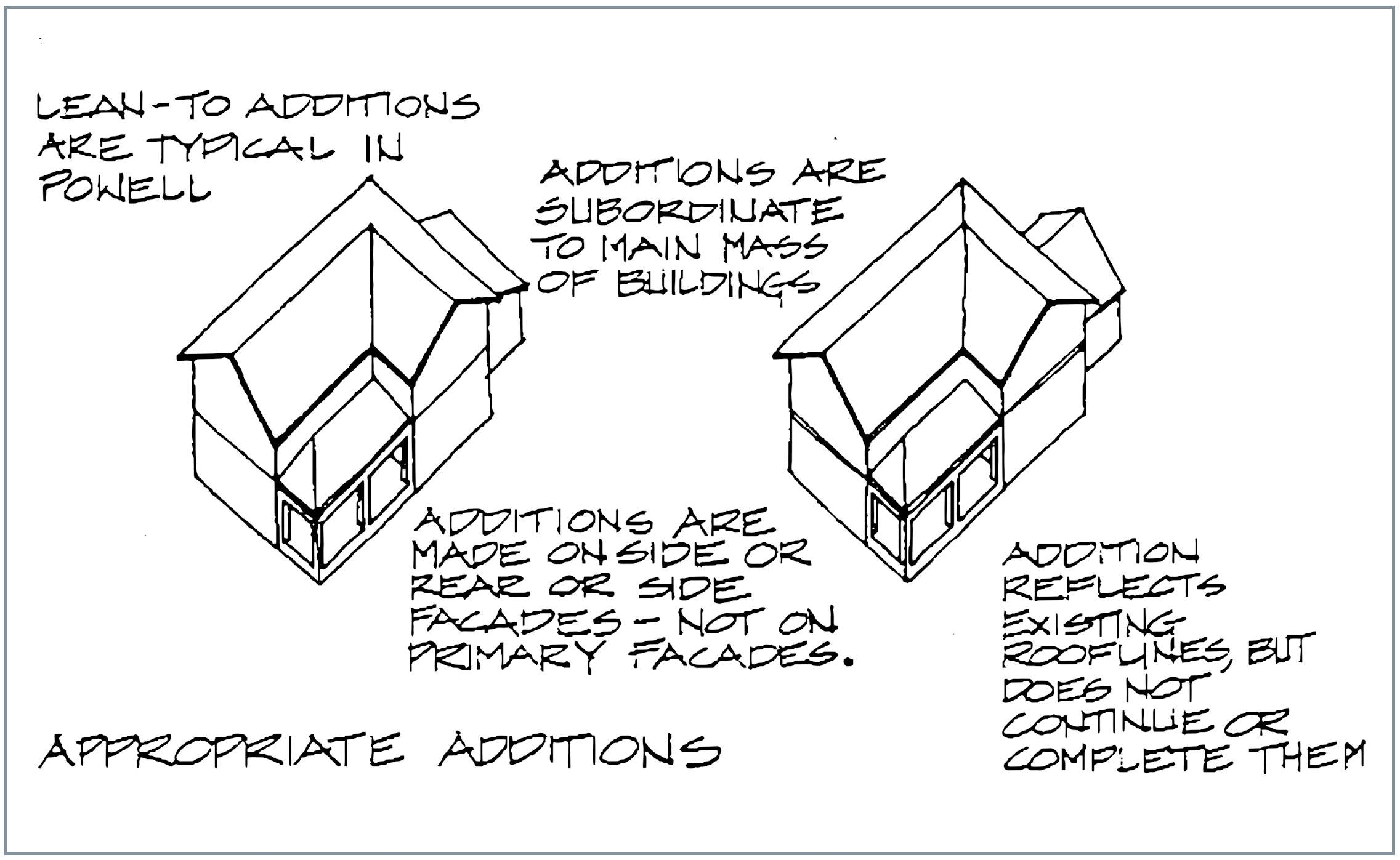
Appropriate additions to existing buildings in the Historical District are encouraged. A close look at additions made in the past can yield clues to sympathetic design of contemporary additions. In general, additions to an existing building should be compatible with that building in massing, materials and level of detail.
It is not necessary nor desirable that additions match the existing buildings exactly. Contemporary design is encouraged as long as it is in harmony with the character of the historic district. This will continue the tradition of growth and change in Powell, without completely altering the essential character of the City.
The mass of any addition should be kept subordinate to the mass of the main portion of the building. This means that the addition should be smaller and shorter than the main portion of the building. The roofline of an addition should not appear as a continuation of the main form or roof, nor should it mimic, or "complete" existing forms or rooflines.
If the proposed size of an addition threatens to compete with the main block of the building, breaking the required space into two or more smaller masses should be considered. Another alternative is to construct all or part of the required new space as a separate accessory building, following the guidelines for accessory buildings in the Site Considerations section.
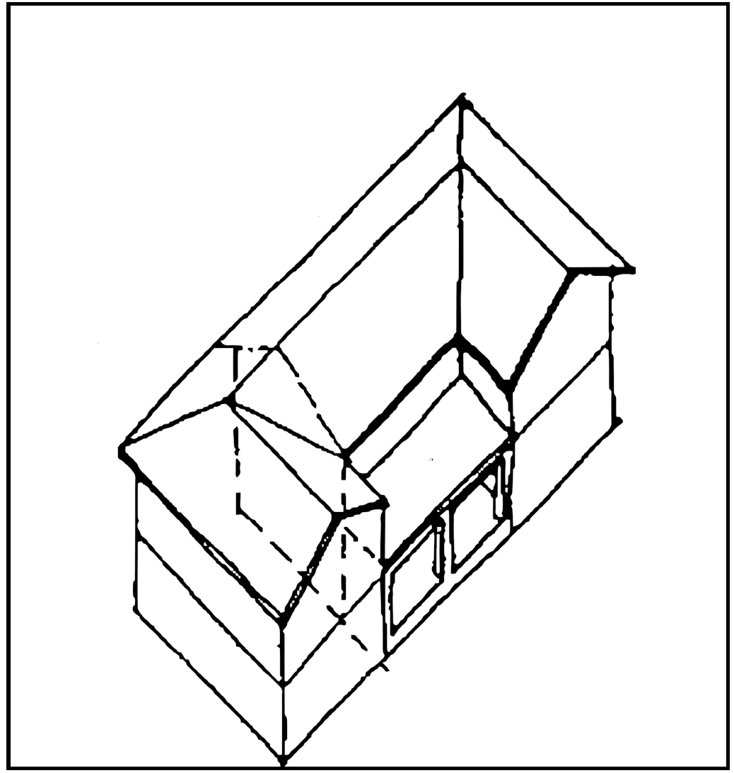
*Innapropriate Addition*
Addition duplicates existing forms and rooflines exactly. Addition completes existing roof. Addition is very difficult to distinguish from original building. Symmetrical result is not in character with Powell.
Architectural Elements
Architectural and decorative elements refer to the details of a building. Windows, doors, porches, and ornamentation add character and flavor to buildings. They give life to a facade by introducing light and shadow. Details can also help to identify the period and style of an historic building. Most of the detailing on Powell's buildings is simple in nature, but there are several examples of more elaborate decoration.
Even very simple detailing plays an important role in establishing the character of older buildings. Existing ornamentation within Powell's historic district should be retained and repaired whenever possible. It is especially important to protect and preserve examples of skilled craftsmanship in the Historic District.
If a major portion of the detailing. On one of Powell's buildings is missing or beyond repair, there are two appropriate solutions. One option is to reproduce as exactly as possible the missing or deteriorated element. This method requires thorough research, especially if no physical evidence is available (such as a deteriorated, but recognizable element), Physical, photographic, or other type of reliable historic evidence should be used when reproducing missing elements.
Another option is to design a simplified version of the missing or deteriorated element, which replicates the important visual characteristics of the original. These characteristics include composition, size, proportion, texture, and rhythm. This second option is often cheaper than exact reproduction, as it can use some standard, contemporary materials. Simplified replacement elements do require careful attention to detail, and design talent. In many cases, the services of an Architect will be necessary.
When new construction is being contemplated in the Historic District, careful attention to details can help create architecture which is contemporary, but compatible with the historic character of the City. Exact replication of typical architectural and decorative elements in the City is not necessary or desirable. A more appropriate approach is to design new elements to reflect the important visual characteristics of typical Powell elements.
Whether architectural and decorative elements are being repaired, replaced, or used in new construction, the effect of any one element on the whole composition of the building must be studied carefully. Although some elements, such as an elaborate porch, dominate visually, it is the effect of all the elements working together which truly defines the character of a building.
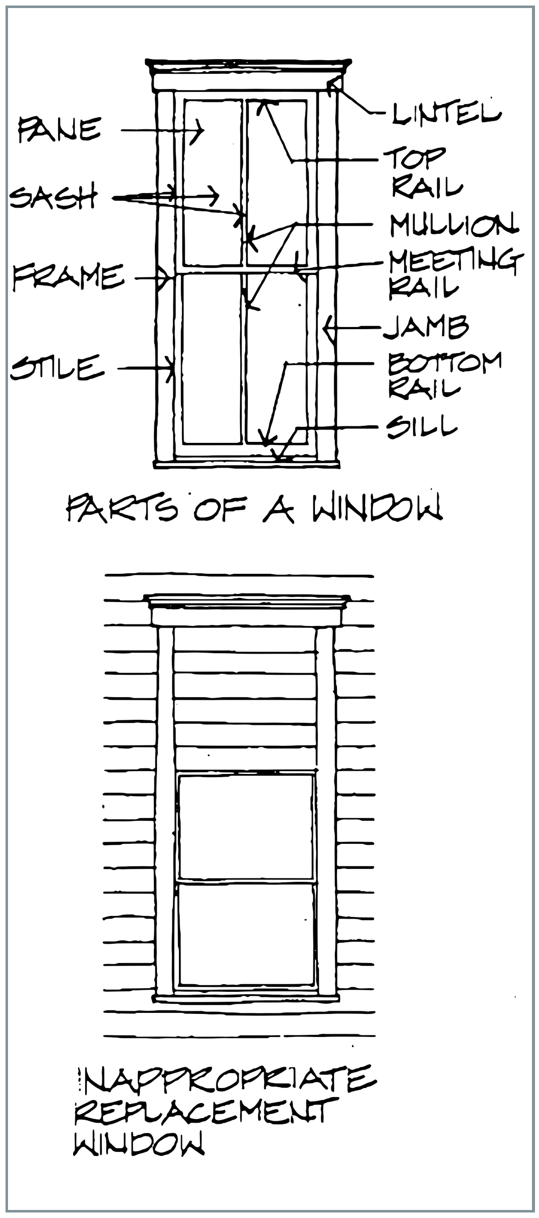
Windows
Windows are one of the most direct expressions of a building's character. Their proportions influence the overall proportions of the building, and their functional and decorative treatments are very important in the composition of a facade.
Many of the buildings in Powell have had their windows replaced over time. As a result, a wide variety of window types and proportions exists today. Although replacement windows are a part of the history of a building, many of the changes which have been made in Powell have radically altered the proportions and character of the buildings.
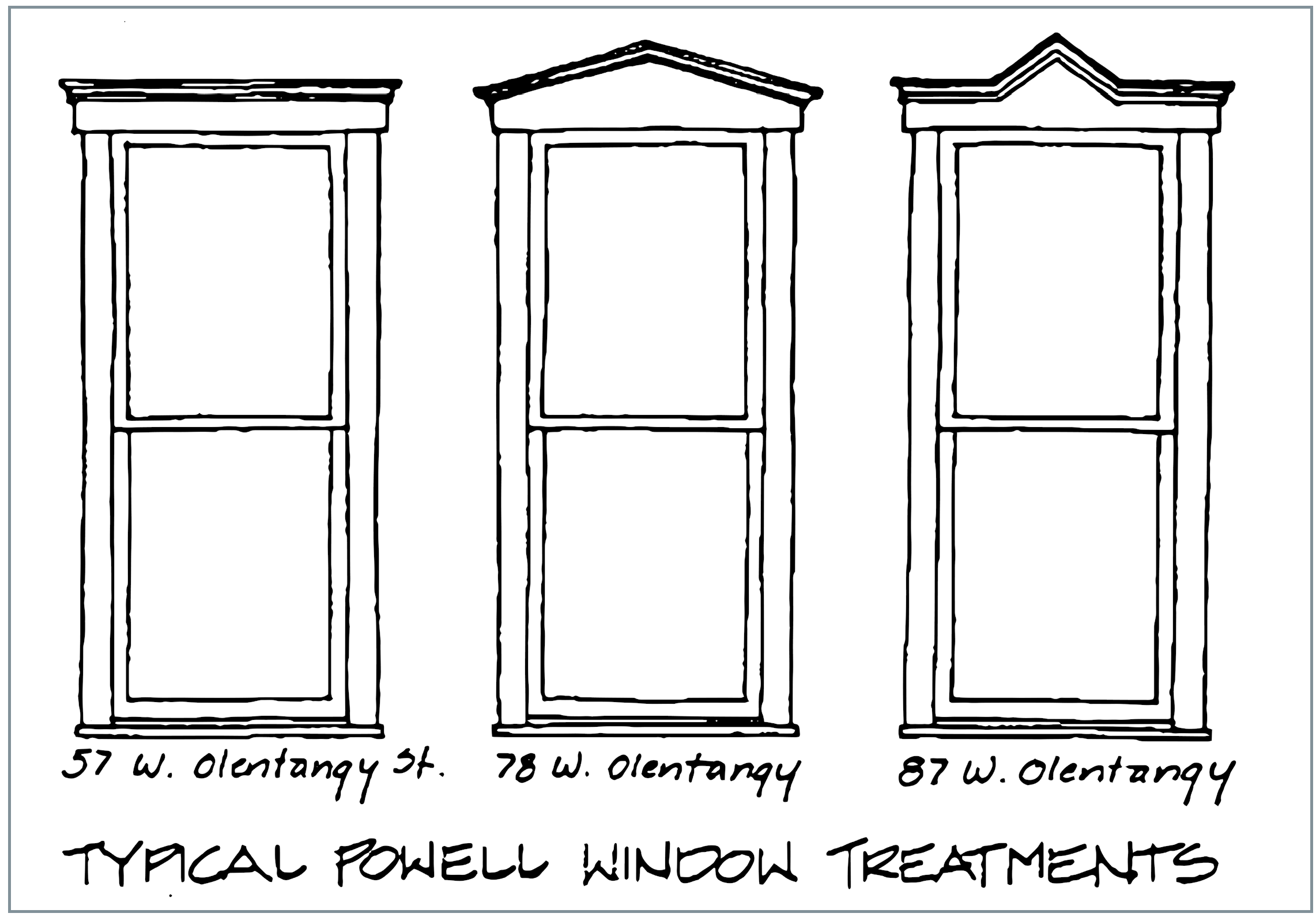
There are three basic types of windows which are historically correct within the Historic District, double-hung, "ribbon" and fixed sash. The most common type of window in the City is double-hung, straight-topped, and has tall, thin proportions. These windows range from two to three times as tall as they are wide. Two-over-two or one-over-one pane divisions are typical.
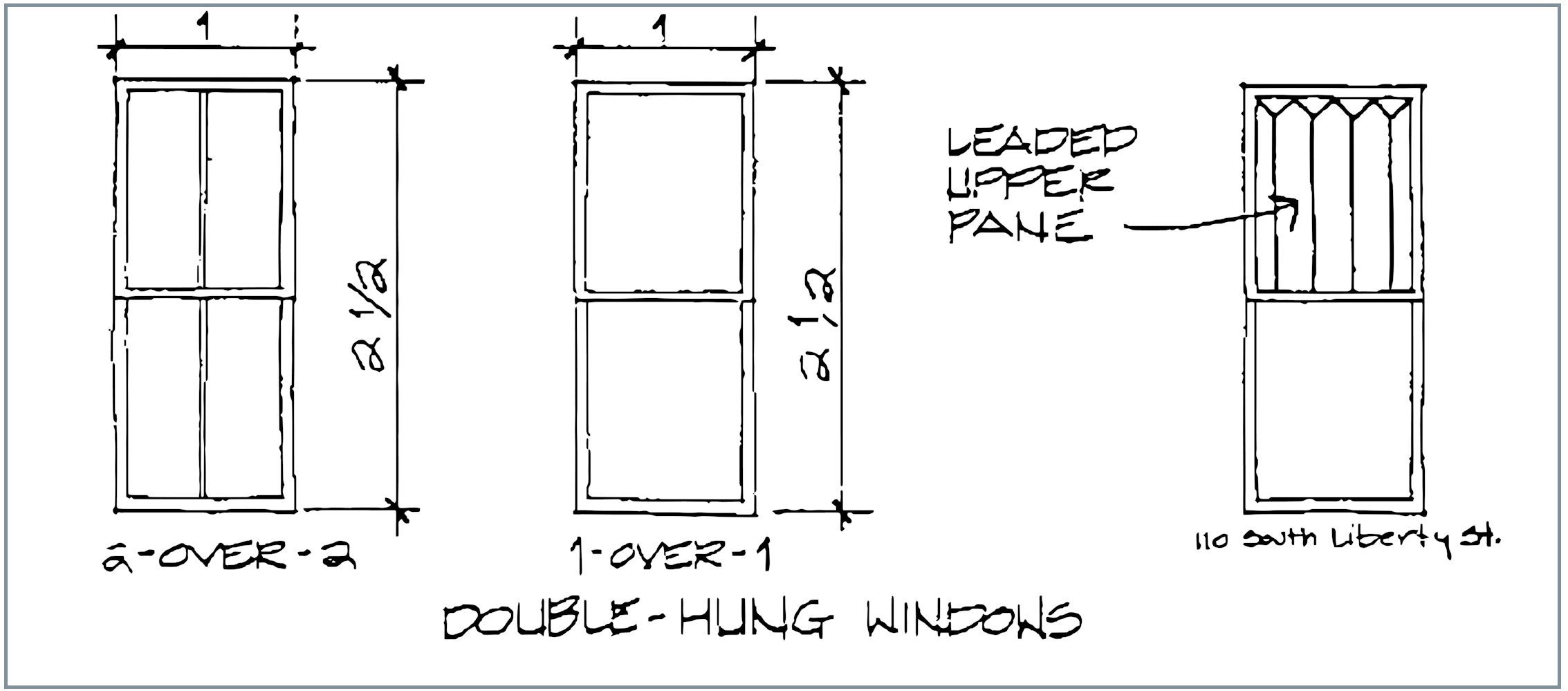
A few exceptions to the standard type of double-hung window can be found in Powell. Most of Powell's brick buildings, such as the schoolhouse at 80 S. Liberty Street have segmental arched windows. In some early 20th century houses, the upper sashes of double-hung windows are leaded, in a pattern of four or five vertical divisions.
Double-hung windows occur on all types of buildings in Powell. Generally, earlier types of buildings, such as Upright and Wings and Gabeled Ells, have taller and thinner windows in proportions approaching three times as high as their are wide. Later building types, such as Bungalows and American Four Squares have windows closer in proportion to twice as high as they are wide. First story windows are generally taller than second story windows in all types of buildings.
A less common type of window in Powell is a ribbon of three or four windows which occurs primarily in the dormers of bungalows. True ribbon windows are separated only by their frames. In some cases, Powell's ribbon windows are actually separated by very thin pieces of wall. Since the overall effect is that of glass and frame only, they can be considered ribbon windows. These windows tend to have shorter proportions, ranging from one and two thirds to two times as tall as they are wide.
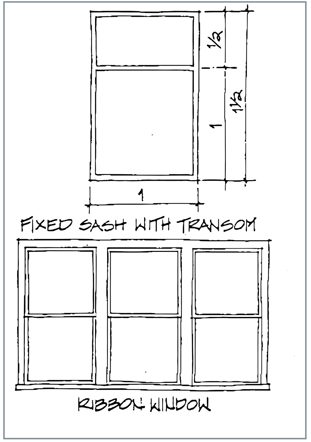
The least common type of window in Powell is the fixed sash. Fixed sash windows occur in various shapes, ranging from fairly tall and thin to almost square. The most common type is a single large pane, one and a half to two times as high as it is wide.
In some cases, fixed sash windows have an upper transom which is usually one third of the overall window height. Fixed sash windows are primarily used as an accent on a main facade. They frequently occur on the upright portion of an Upright and Wing or the front facing gable of a Gabeled Ell.
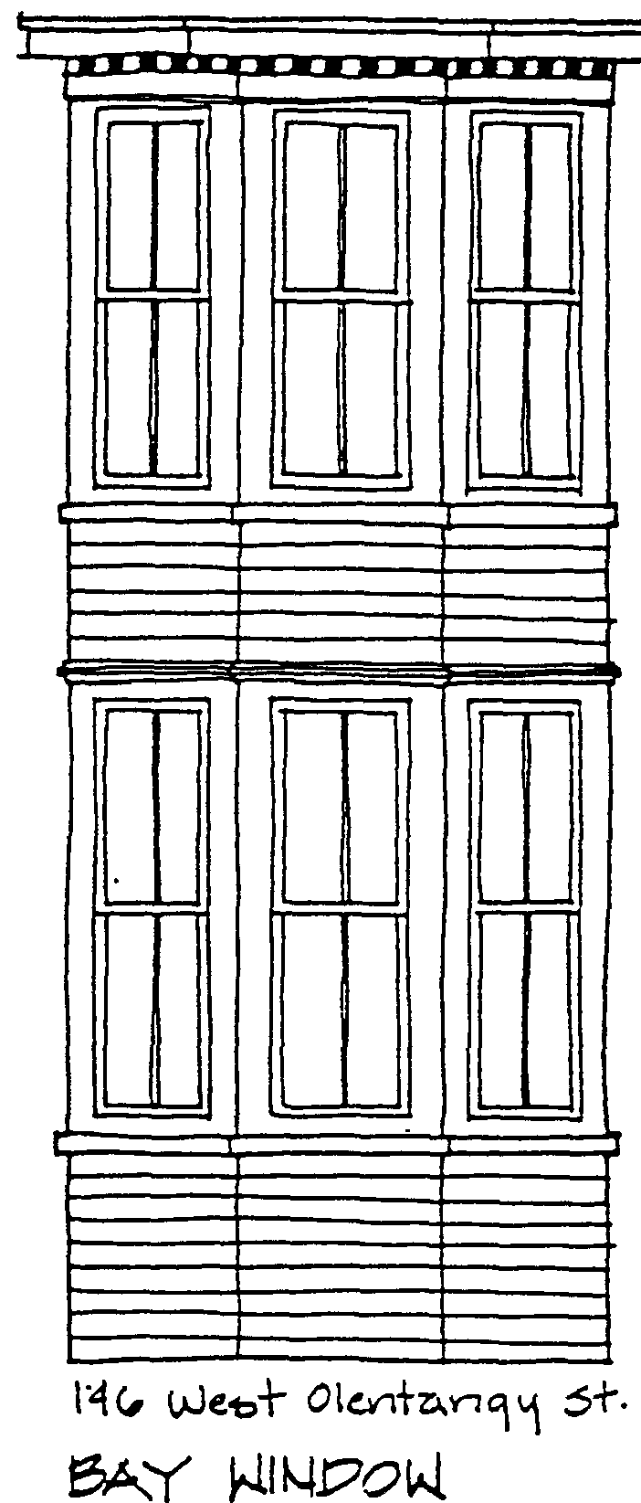
A bay window is a combination of angled walls and windows which projects from a building, and rests on a foundation. Some of Powell's Italianate and Queen Anne buildings have such windows. Powell's bay windows are composed of typical double hung windows surrounded by a variety of detailing.
Every attempt should be made to retain and repair existing wood double-hung windows. The double-hung system provides good ventilation by allowing the top and bottom of a window to be opened at the same time. In addition, wood windows provide better insulation than metal ones.
The major problems with old windows are broken glass, inoperable sashes, and decayed wood. Broken panes can be removed, replaced and reset in fresh putty. Loose panes may simply need fresh putty. Inoperable sashes may be caused by a broken sash cord, multiple layers of paint or a frame which is no longer square. Sash cords can be replaced easily. There is usually an access panel at the bottom inside of the frame. A window which has been painted shut can be freed gently with a dull knife and a little paint remover. Even window frames which are no longer square; due to settlement or weather, can be repaired by squaring the frame in the rough opening.
Deteriorated wood window parts can often be repaired by cutting out rotted portions and filling holes with putty, plastic wood, or a homemade paste of waterproof glue and sawdust. Severe deterioration or deterioration in structural members (lintels and sills) can sometimes be repaired with epoxy resins. A final coat of paint will protect repaired wood windows and restore their original appearance.
Parts of a window should be replaced only if they are deteriorated beyond repair or are missing. Replacement parts should match the originals in material and appearance.
Sometimes it is necessary to replace an entire window. Replacement windows should match the originals in material, size, number of panes and type of operation. In addition, rails, stiles, and mullions should match the originals in thickness and depth.
Under no circumstances should a significant window opening be made smaller to accommodate a stock window. Such a treatment will ruin not only the proportions of the window itself, but those of the entire building.
In addition to the window itself, the trim, sills, lintels, and hood molding which surround it adds to the character of a building. Window trim has aesthetic and practical purposes. First, the trim provides a visual transition from the sheathing material to the window. Window trim also protects the joint between the window and the wall from the elements.
Original window treatments should be maintained as much as possible. Deteriorated trim can usually be repaired, by filling holes with putty, plastic wood, or epoxy, and painting. In many cases, sanding and new coat of paint is all that is needed.
If window trim must be replaced, new trim should match the original in width and detailing as closely as possible. If replacement windows are installed, care must be taken to preserve and protect all original wood trim. If trim must be removed to install new windows, it should be treated with care until it is back in place.
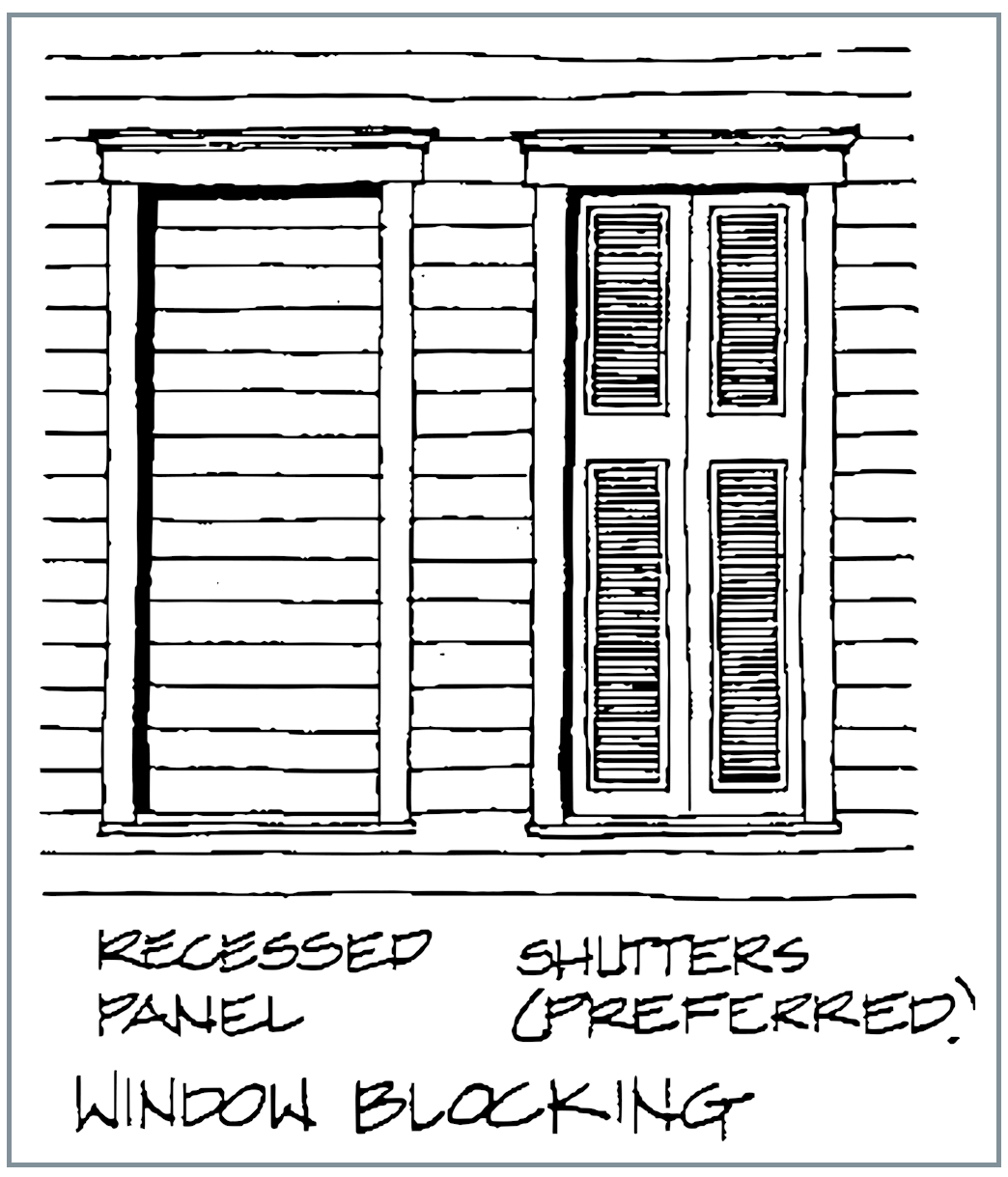
Blocking of existing windows Is not encouraged. Windows on major or highly visible facades should never be blocked. In some cases, it may be necessary to block a window on a secondary facade to accommodate changes in the interior arrangement of a building. This should be undertaken only after all other possible courses of action have been considered.
If blocking an opening is the only practical solution, it should be done in such a manner that the original opening and all trim will be preserved. The infill should also be removable in the future without damage to the original opening.
The preferred method of blocking an opening is to infill the opening with a stud wall, sheathing, and wood shutters. Another alternative is to infill the opening with a recessed panel of the exterior sheathing material. This panel should be recessed at least one inch, in order to maintain the original opening and trim.
New Construction
New construction within the historic district should use window types and proportions characteristic of Powell. Double-hung windows in tall, thin proportions are appropriate in almost all types of Powell buildings.
In general, the proportions of windows should reflect the proportions of the building. Taller, thinner buildings with more articulated masses should have taller, thinner windows. Buildings which have the appearance of one single main mass can take shorter, squarer windows.
Ribbon windows should be used on dormers or facades which are not highly visible, as they were not used extensively in the City, except in dormers. Larger fixed sash windows, with or without transoms, should be limited to one or two as accents on the main facade.
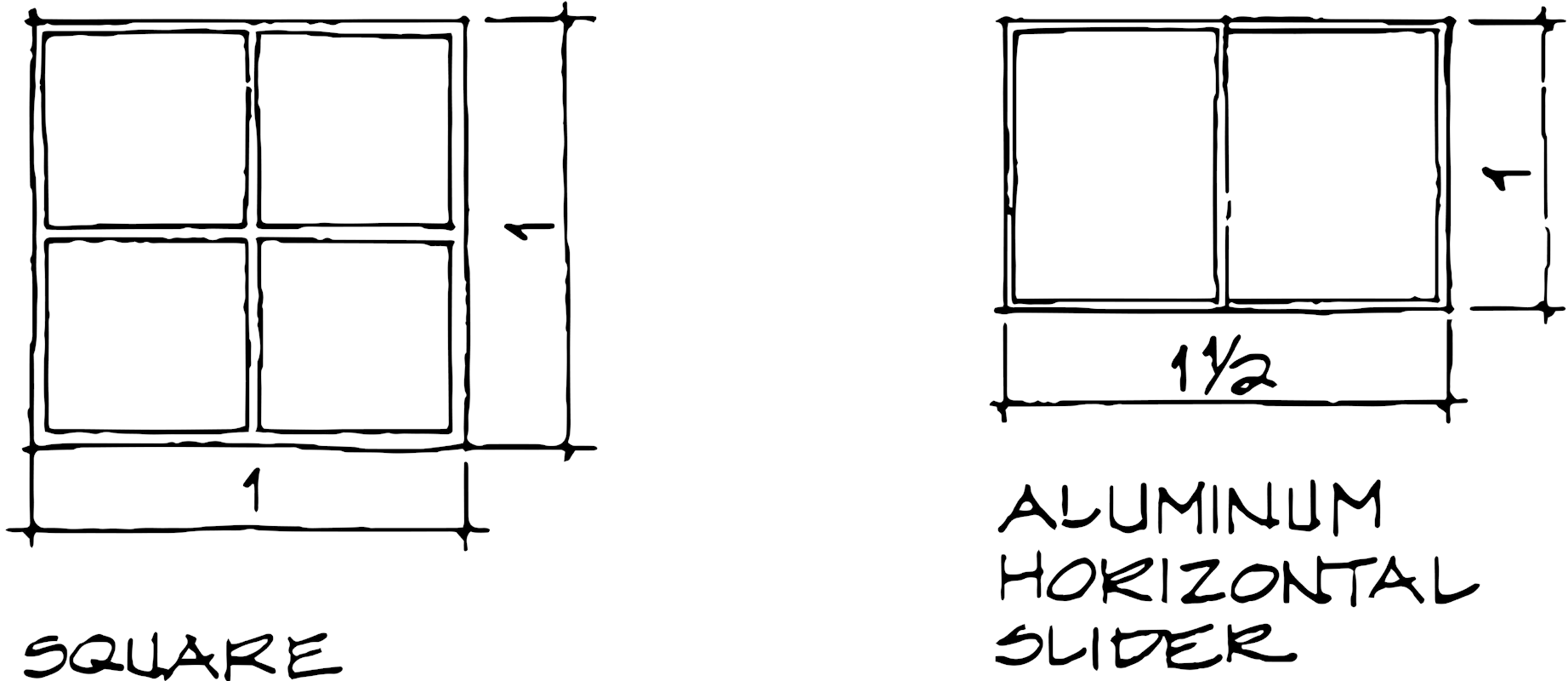
Square windows are appropriate only in limited situations, such as dormers which require square windows. Windows which are wider than they are tall are not appropriate and should not be used in the historic district.
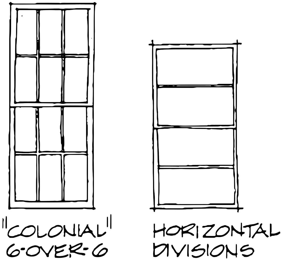
"Colonial type" sashes divided into more than two panes (six-over-six, eight-over-eight, etc.) are characteristic of 18th century architecture. Using these smaller paned windows will create a false, "earlier" appearance which is not appropriate in Powell's Historic District.
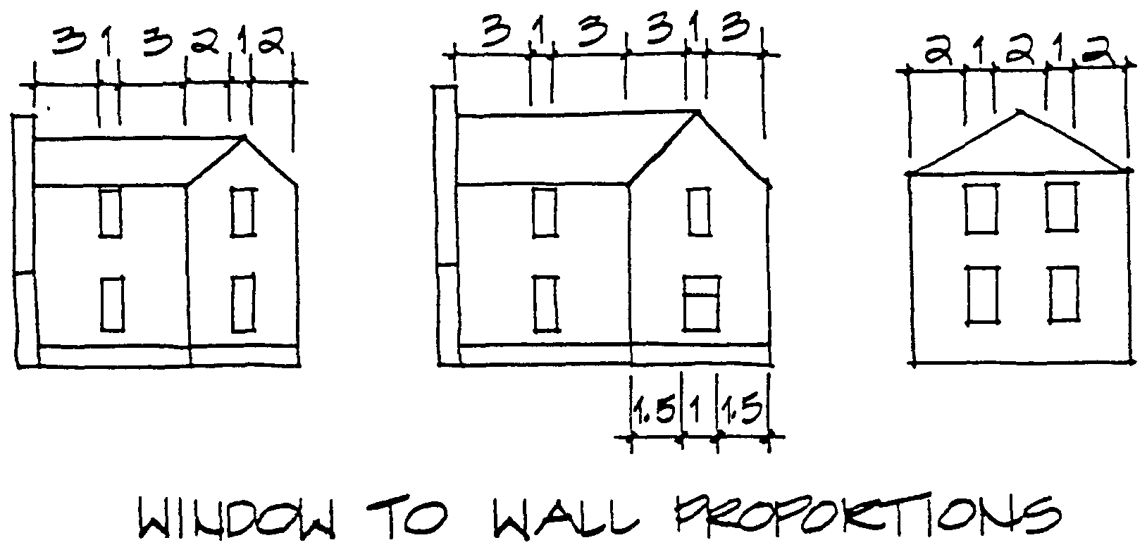
New construction should follow the proportions of window to wall found in typical Powell buildings. Buildings with more articulated masses should have less window and more wall. Single mass buildings should have more windows to enliven their facades. Typical window to wall proportions are illustrated below.
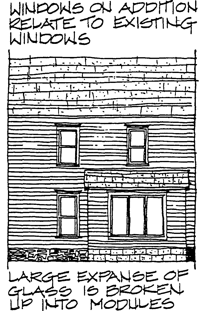
If large expanses of glass are desired, they should be limited to one area of a facade which is not highly visible. They should be designed with vertical divisions which will create a module reminiscent of typical City window proportions. These larger sections of glass should be integrated with other fenestration. For example, an odd number of units might have the middle piece centered on an existing upper story window.
Most of the windows in Powell are detailed with simple trim, and this simplicity should be reflected in new construction. It is not necessary for window surrounds in new construction to duplicate existing ones exactly. It is more important That the sense of a lintel, Frame and sill be conveyed. Window trim should be substantial enough to reflect the dimensions (width and thickness) of window treatments typically found in Powell.
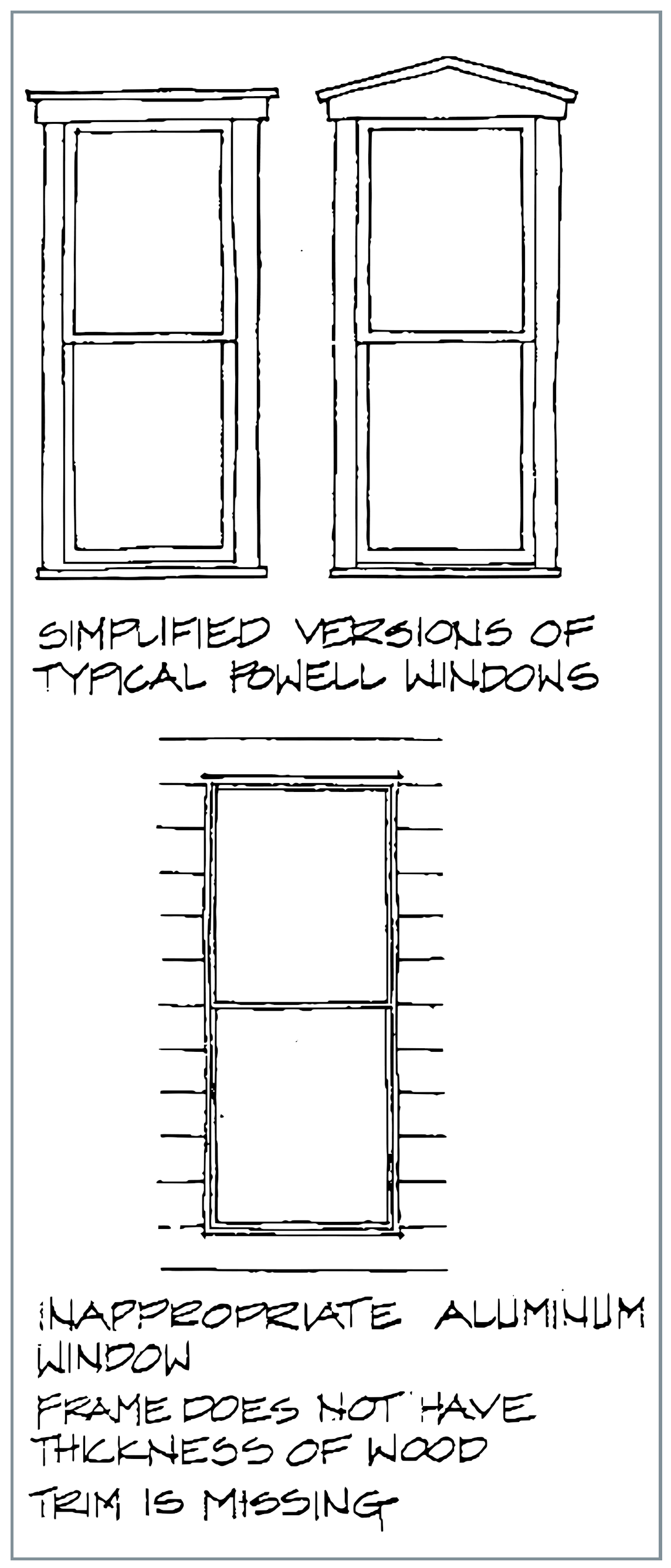
Aluminum Windows
Wood windows are preferred for Replacement or new construction In the historic district. If aluminum windows must be used, they must resemble, as closely as possible, typical wood window dimensions used in Powell. All of the guidelines discussed under replacement windows and new construction apply for aluminum as well as wood windows. Aluminum windows should have a permanent finish in white bronze, black, or a color which matches painted wood trim. Avoid "natural", silver colored aluminum finishes.
Combination wood and aluminum windows may be acceptable for replacement or new construction. These types of windows have wood rails, stiles, and mullions which are either clad or replicated in aluminum on the exterior. Often, the wood parts have dimensions similar to those found in traditional windows. Since the wood is either clad or matched on the exterior in metal, these windows can closely resemble traditional wood windows. The guidelines for both wood and aluminum windows apply to combination windows.
Storm and Screen Windows
Storm windows can help conserve energy in the winter and screen windows may be necessary for ventilation in the summer. Storm windows should be installed on the exterior of existing buildings to avoid condensation on original windows. In this location, they can also protect the historic windows from further weathering.
Storm and screen windows are appropriate in the Historic District if they are as unobtrusive as possible. Storm windows should be the same size and proportion as the windows being protected. Any rails should coincide with rails on the main windows. Aluminum or wood storm windows are acceptable. All frames should be painted to match the main window frame color.
Doors
The front door of a building performs many functions. It announces the entry visually and is often the first element which visitors encounter at a close range. In older buildings, the importance of the front door was recognized by the care given to its design.
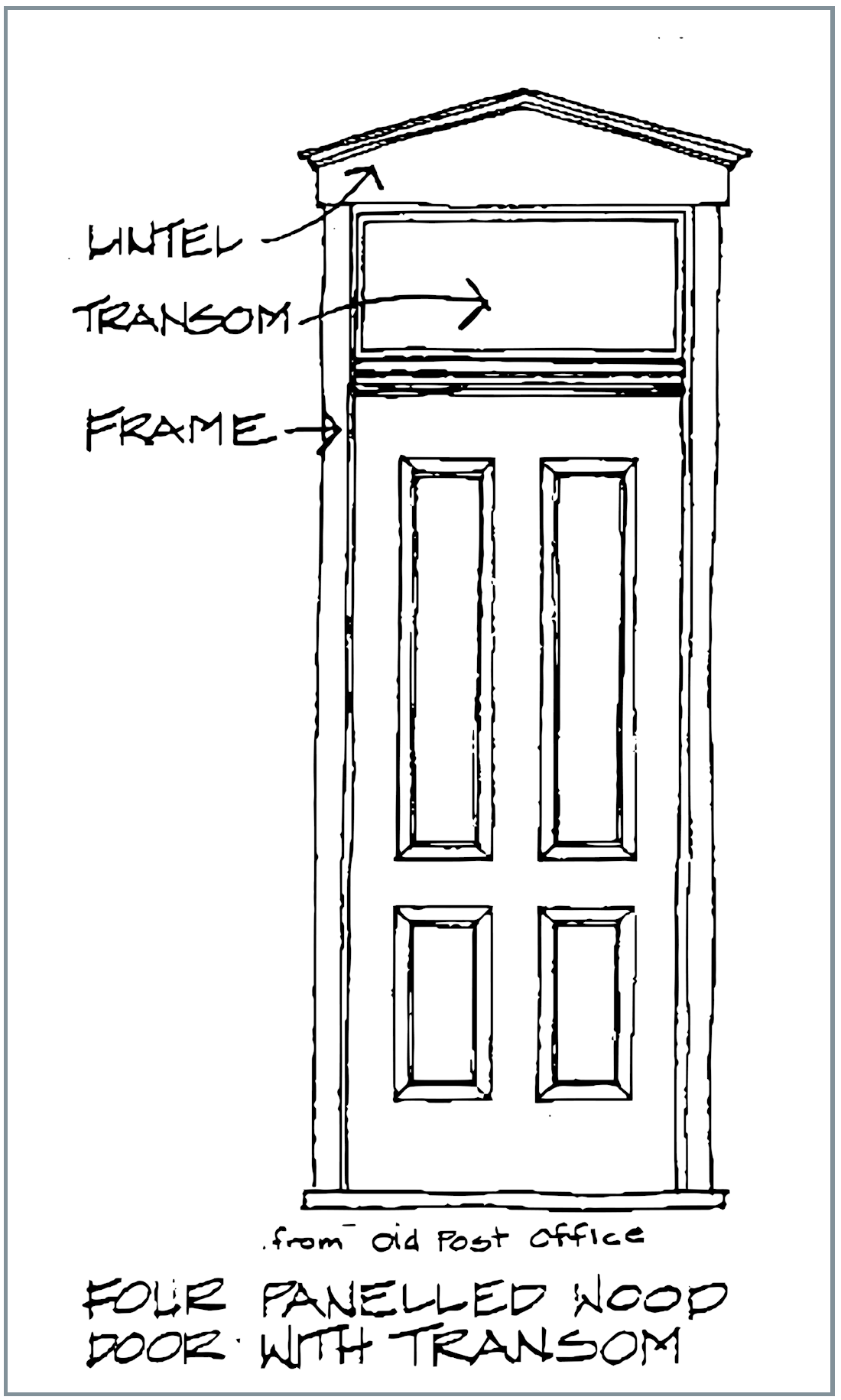
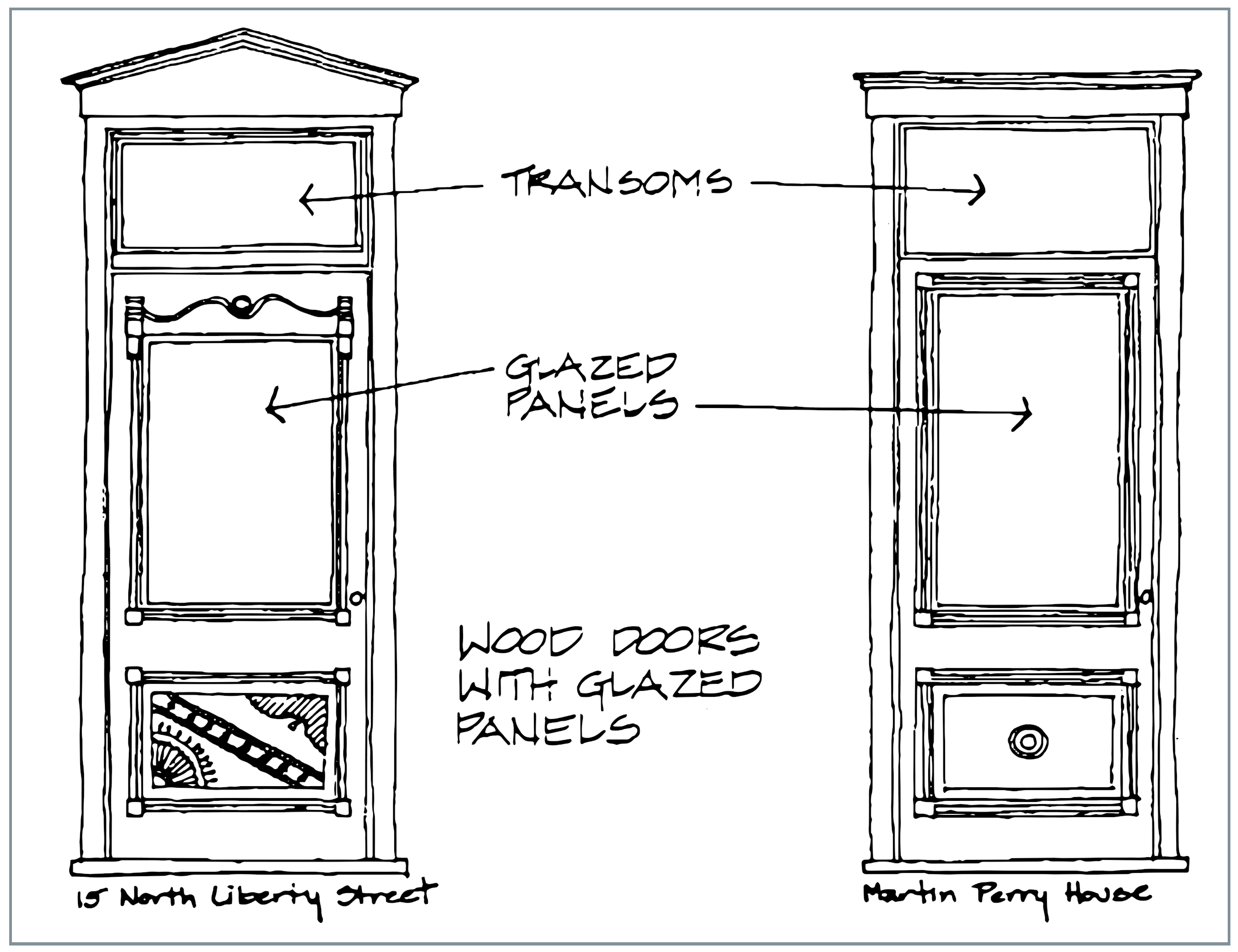
Most buildings in Powell have a single front door, with simple trim which matches the window trim on the building. Typical doors are simple in design, with either four wood panels or a single glazed panel above a wood one. Glazed doors generally have modest moldings around the glass pane and either simple molding or carving in the solid panel below. An elaborate version of this door can be found at 15 North Liberty Street, and a simpler version appears on the Martin Perry house.
Existing wood or glass paneled doors should be retained and repaired whenever possible. Many doors which appear badly deteriorated simply need to be sanded and painted.
Paneled doors are constructed of slender wood or glass panels enclosed in a heavy structural frame. The panels are the weakest part of an old door, and usually the first part which requires repair.
Wood panels generally stay intact, but if they have been damaged, they can be replaced with plywood, and the whole door repainted. Broken glass panels should be replaced with glass.
Ornamentation, such as molding or carving, should be preserved. Missing or badly deteriorated pieces should be replicated as closely as possible.
Original wood door frames lintels, and sills should be retained and repaired. Repair techniques for lintels, frames, and decorative molding will be similar to those outlined in the section on windows.
Door sills are one of the first parts of a door frame which will show wear. Deteriorated wood sills can be repaired in two ways. The rotted portions can be scraped out and filled with an epoxy stabilizer. In many cases, it will be easier to simply pry up the old sill and replace it with a new sill. The new sill should be made out of wood in the same thickness as the original. If the old sill can be removed in one piece, it can be used' as a pattern. Otherwise, careful measurements of the original should be taken before removal.
New Construction
Doors used in new construction within the Historic District should be similar to those typically found in Powell. These doors should be simple in design, and generally vertical in proportion. Three or Four paneled wood doors or doors with a glazed upper panel are appropriate. Doors with more than four wood panels or several small panes of glass are generally too elaborate for the simple buildings typical of Powell. Modern flush doors are too simple and are not appropriate in the Historic District.
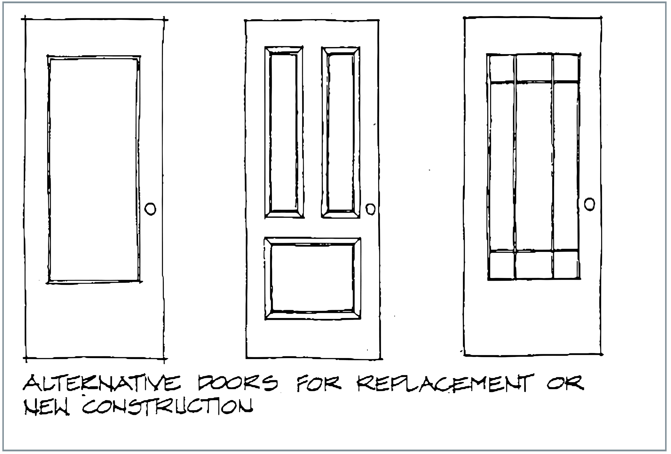
All exterior doors in the Historic District should be painted to match or coordinate with building trim. Color guidelines are given in the section on painting.
Door trim used in new construction should reflect the traditional trims, which are similar to those illustrated for windows. These trims need not be exact duplicates of existing Powell door treatments. It is more important that the scale and substance of the trim be similar to that of traditional door surrounds. The expression of lintel, frame, and sill should be inherent in contemporary door treatments.
Steel Doors
Although wood doors are preferred, steel doors may be appropriate for replacement or new construction. Wood doors provide better insulation, especially when fitted with weather stripping, but metal doors may desired for security or maintenance reasons. Steel doors used for replacement or new construction within the Historic District should have some type of paneled or paneled and glazed design which reflects traditional City doors. Steel doors should be painted to match other trim according to the paint color guidelines.
Storm and Screen Doors
Storm doors can be very useful in saving energy, and screen doors may be necessary for ventilation. In some of Powell's older homes which do not have air conditioning. These doors may be appropriate in the historic district , but they must be as unobtrusive as possible. This means that wood or metal storm doors should match the doors which they are protecting. Storm or screen door frames should coincide with framed areas on the main door. Areas of screen or glass should coincide with appropriate paneled or glazed areas on the door which they are protecting. Any solid portions of screen doors should be detailed to match the corresponding area of the main door. The screen or storm door should be painted the same color as the main door.
Porches
Almost every building in Powell has a porch. In many cases, the porch is the focal point of the facade, being the one element which exhibits any type of stylistic detailing. Powell's porches come in a variety of sizes, ranging from small, barely covering a door, to wrapping three sides of a house.
Porches in Powell fall into two basic categories. Simple porches have round or square columns and simple railings or no railings. More elaborate porches have Eastlake Italianate, or Queen Anne detailing, with curved brackets, turned posts, carved areas, and patterned shingles.
Most of Powell's original porches were constructed of wood. Their bases were either framed up in wood or constructed out of the foundation material used for the main portion of the building. Wood porches generally had a wood floor and a wood base molding. A very few porches in Powell have columns built out of rock face cast concrete block. Porch stairs were originally built out of wood or limestone, but most of these have been replaced with concrete stairs.
Every effort should be made to repair and retain existing wood porches in the Historic District. Repair techniques similar to those outlined for wood window trims can be used on porch detailing. If pieces of the porch are missing or deteriorated beyond repair, they should be replaced. Replacements should match the originals as closely as possible in material, scale, and detailing.
Under no circumstances should a porch in the historic district be removed and not replaced in kind. If an entire porch has deteriorated beyond repair, it should be replaced with one which matches it in material, scale and detailing.
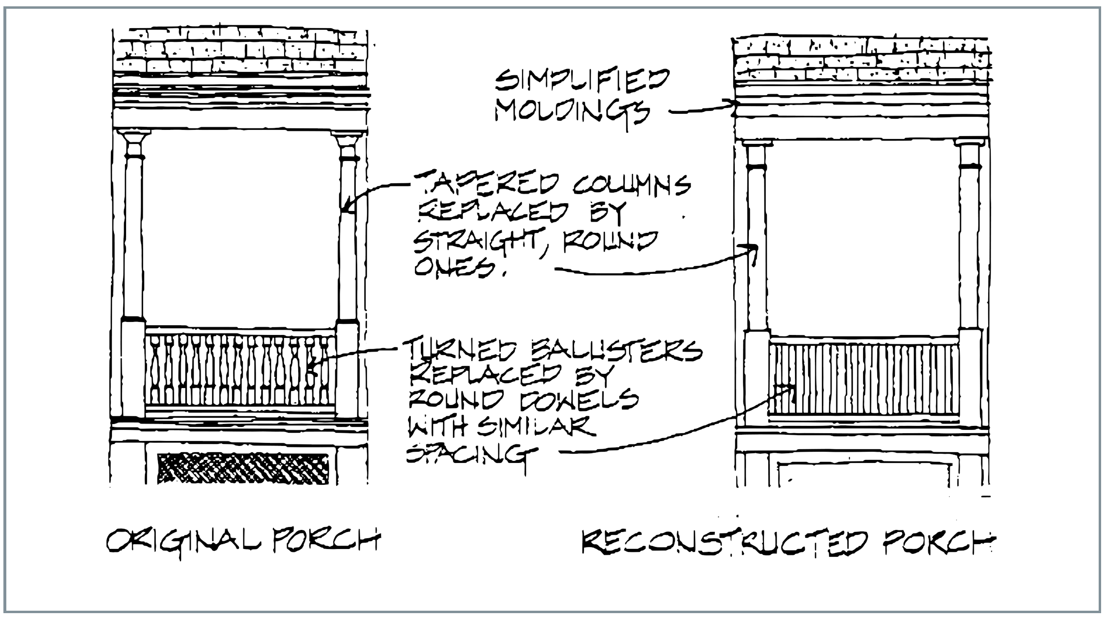
If it is impossible to match the porch exactly, it may be appropriate to construct a reasonable reproduction out of stock lumber. In this case the size, scale, and overall form of the original elements should be replicated.
Columns and entablatures should appear similar in strength to the original. Pediments should have the same pitch and should rest on an entablature of the same thickness as the original. These should also be faced with a similar material, such as patterned shingles. Railings should reflect the open or solidness of the original. Balusters should have the same form and spacing as the originals .
Moldings should reflect the replaced ones in scale and thickness, although they need not be as elaborate. Bases and steps should be reconstructed out of wood, or wood over masonry, as the originals were. Special attention should be given to details such as base moldings and stair nosings.
The closing in of existing porches is not encouraged.
New Construction
All new buildings constructed within the historic district should have some type of porch element. These porches should reflect the types and styles of porches which exist in Powell. Once again, exact duplication is not desirable. New or reconstructed porches should reflect the size, scale and level of detail of the buildings to which they are attached.
In general, buildings which exhibit vertical proportions and articulated massing, such as Gabled Ells, Upright and Wings, and buildings with irregular massing should have porches with vertical proportions. Columns should be taller and thinner, and railings, if used, should be open and delicate in scale.
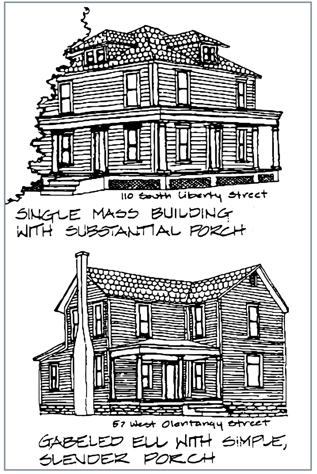
Buildings which tend to be more of a single mass such as American Four Squares, Single Gables, Bungalows or similar structures, should have heavier, more substantial porches. Columns should have thick and stocky proportions. Railings should be solid or made up of wider balusters, closely spaced.
Buildings with simple detailing and little or no stylistic ornamentation should have modest porches, with plain round or square columns. These simple porches may have a very simple railing or none at all.
Buildings which have more elaborate, stylistic ornamentation should have more elaborate porches. New construction with Italiante, Eastlake, or Queen Anne type detailing or new buildings which are enlivened by a variety of patterned shingles will require porches with similar ornamentation. These porches can have turned posts, curved brackets, patterned shingles, elaborate railings and carved details.
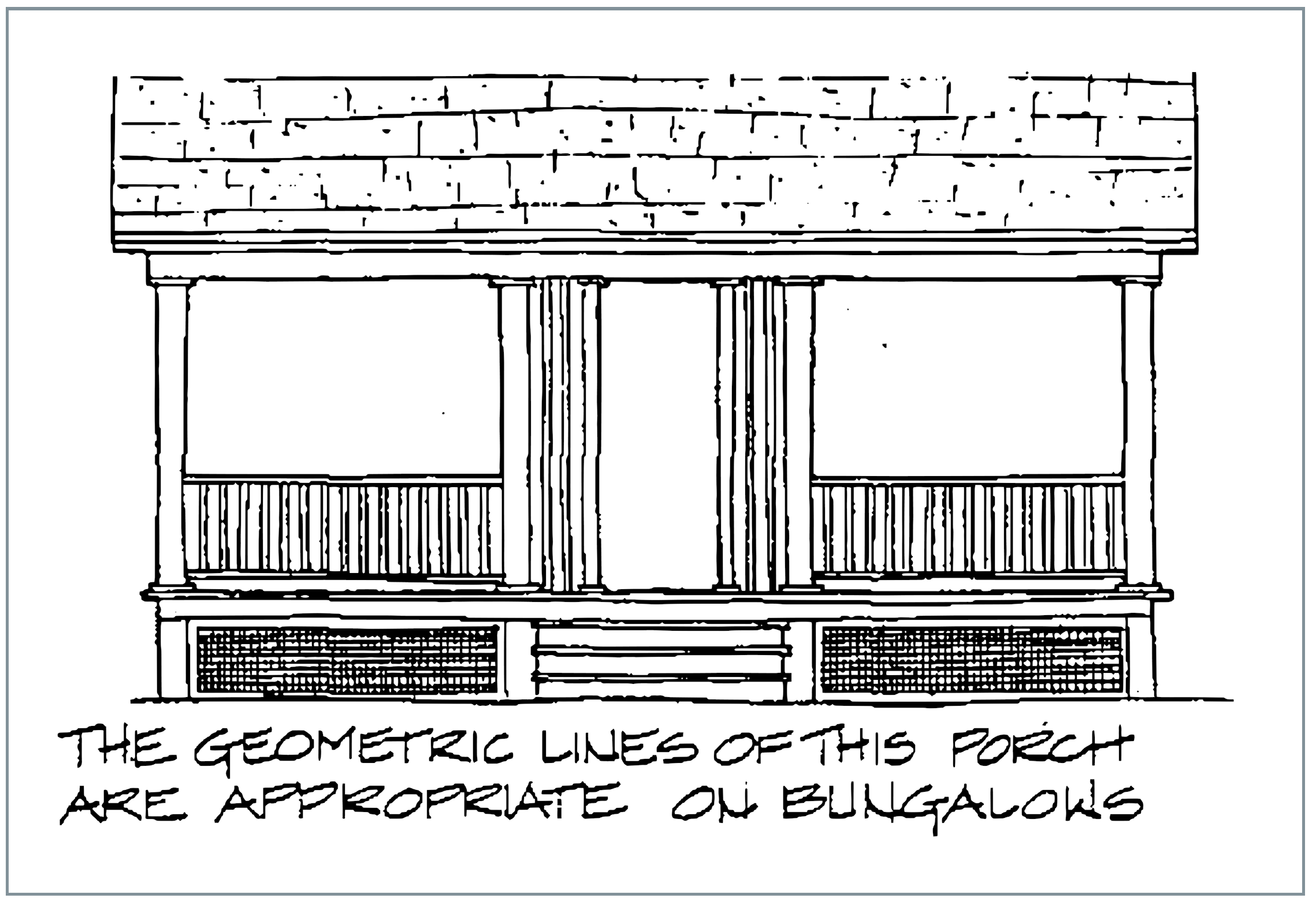
New buildings which reflect some of the later styles, such as Stick Style and Bungalow should have porches with geometric detailing. Simple, square posts and railings which are solid or made up of square balusters would be appropriate on these types of houses.
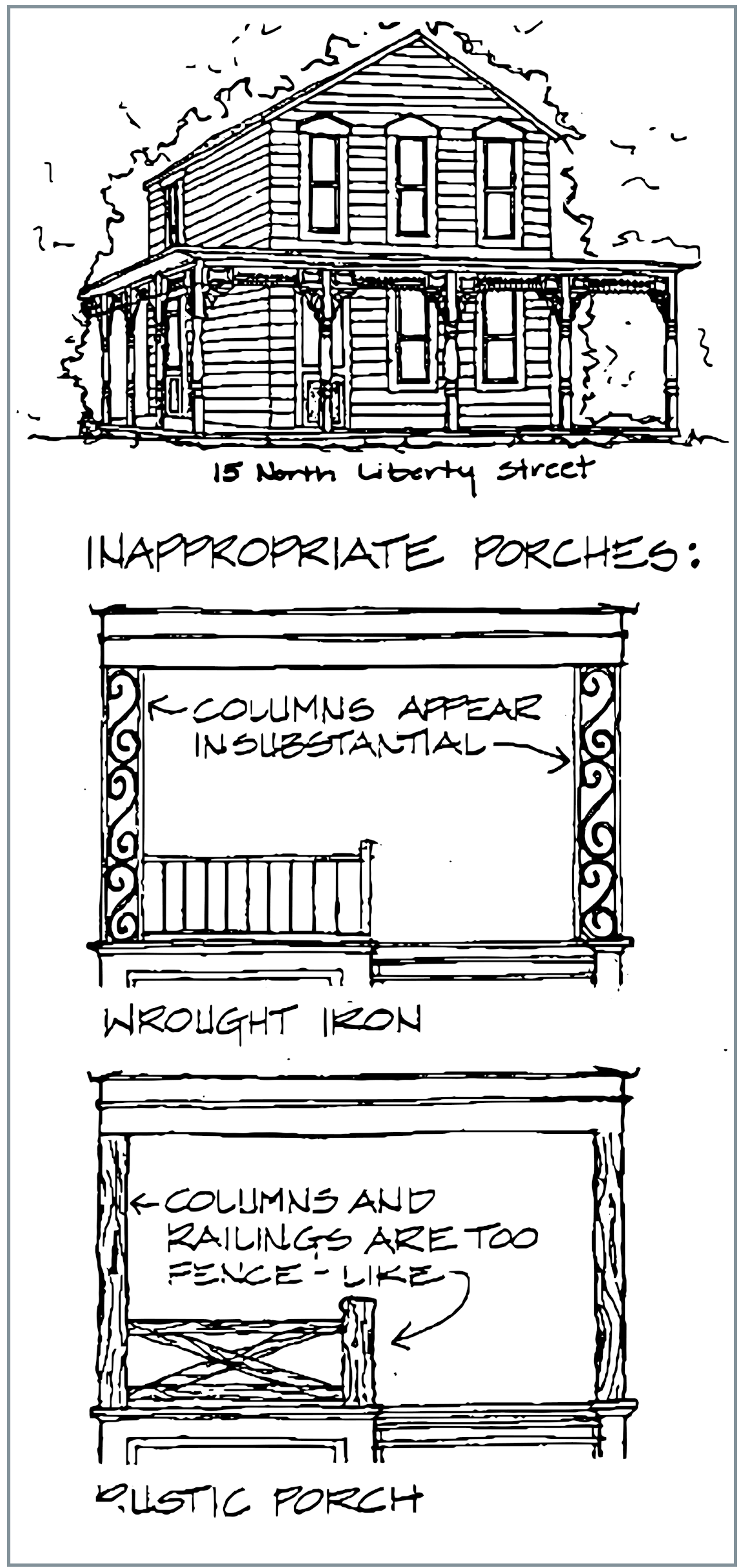
Another alternative is to contrast an elaborate porch against a building with simple massing or detailing. Care must be taken to balance the level of detail in the porch and house so that one does not overwhelm the other and the building and porch appear to belong together.
15 North Liberty Street is a successful example of contrasting a highly detailed porch against a simple mass. An elaborate Eastlake porch wraps a single gable building.
Newly constructed or reconstructed porches in the Historic District should be built primarily of wood. Porch bases may be constructed of wood or the foundation material used in the rest of the building. The porch floor should be wood, and should rest visually on a wood base molding stairs should be built out of wood.
In general, masonry (brick, stone, block, or concrete) porches are not appropriate in the historic district. Wrought iron columns and railings (or aluminum replicas) are inappropriate for replacement or new construction. Overly rustic wood porches, with rough, split or log posts, and railings which resemble fences should be avoided in the Historic District.
Cornices and Friezes
Cornice refers to the projecting piece of trim which terminates the upper part of a wall. The frieze is the trim on the upper portion of a wall which supports the cornice. In many cases, the term "cornice" is used to refer to the entire composition of cornice and frieze. This trim serves a practical purpose as well as providing an opportunity for stylistic embellishment. The cornice and frieze seal off the critical junction of the roof and wall structures, and help support the roof overhang.
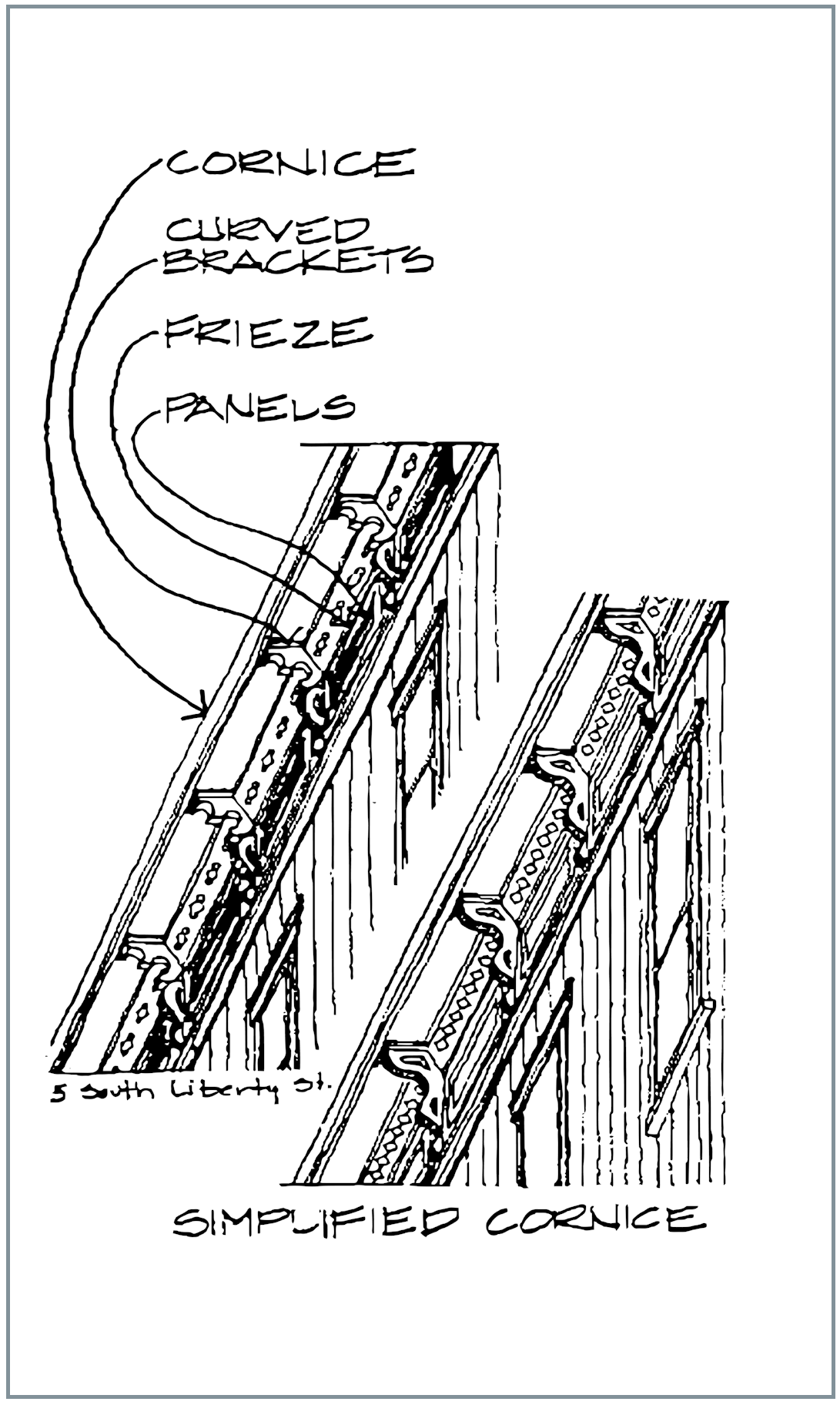
Elaborate cornices occur primarily on Powell's Italianate, Eastlake and commercial buildings. Sometimes these elements occur on a portion of a building, such as a bay window or porch. In general, Italianate friezes consist of curved brackets, separated by paneled areas. In some cases, the frieze is a simple, flat molding, such as a dentil molding.
Existing cornices and friezes should be preserved. If parts are deteriorated, they should be repaired by cutting out rotted parts and filling cracks with putty or epoxy. If elements are beyond repair or missing they should be replaced in kind. Cornices can often be duplicated using stock moldings. Brackets can be duplicated using thick boards and a jig saw. If the brackets are quite elaborate, it may be easier to make a mold of an existing one, which can be duplicated in plastic or sheet metal.
Under no circumstances should an entire cornice and frieze be removed if it is in repairable condition. If these elements are beyond repair, they should be replaced with trim which resembles the original. Since exact duplication of a very detailed frieze is difficult, it is appropriate to imitate the size, bulk, and rhythm of the original, with simplified detail.
New Construction
Cornices and friezes will be optional decorative elements in most new construction. The exception is on taller, commercial scale buildings constructed near the intersection of Olentangy and Liberty Streets. The larger scale of these buildings will require a terminating feature at the roofline.
Cornices used in new construction need not be exact duplicates of those existing in Powell. A simplified version which reflects the scale, substance and rhythm of typical City cornices will be appropriate.
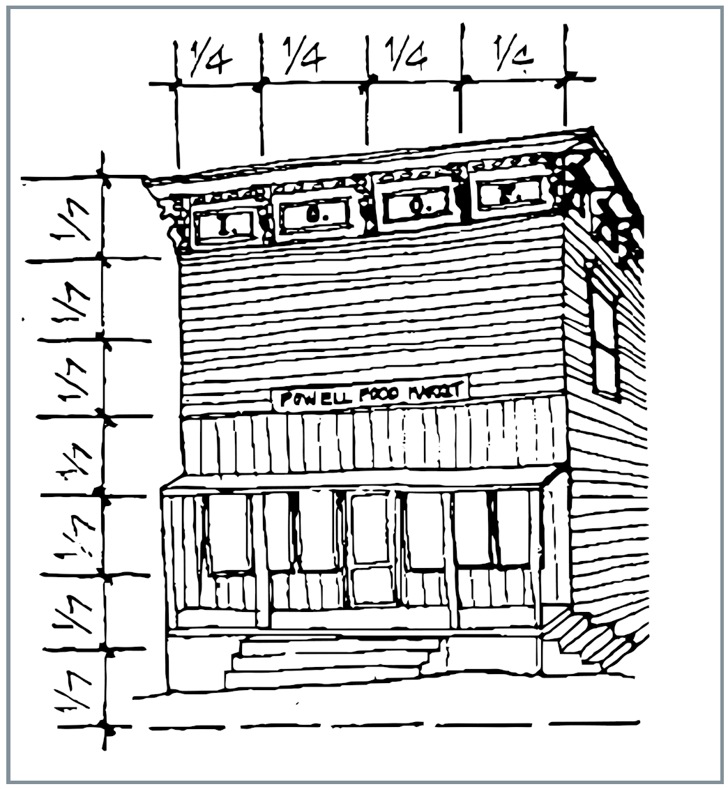
As with all decorative elements, cornices should match the scale and level of detail of the other elements of a building. Cornices used on commercial scale buildings should be fairly large (about one eighth to one sixth of the total height of the building) and should extend along all facades visible from main roads. cornices used on smaller scale buildings should be smaller in scale and less elaborate in detail.
Gutters and Downspouts
Most of the buildings in Powell's Historic District have simple, unobtrusive hung gutters. Hung gutters are steel troughs hung from the eaves of the roof. The primary visual contribution of this type of gutter is another shadow or "cornice" line at the edge of a roof.
Roof gutters in Powell serve an important practical purpose. They protect the roof, walls and structure of a building by ensuring proper drainage of water from the roof. Existing gutters should be inspected periodically and cleared of debris as necessary.
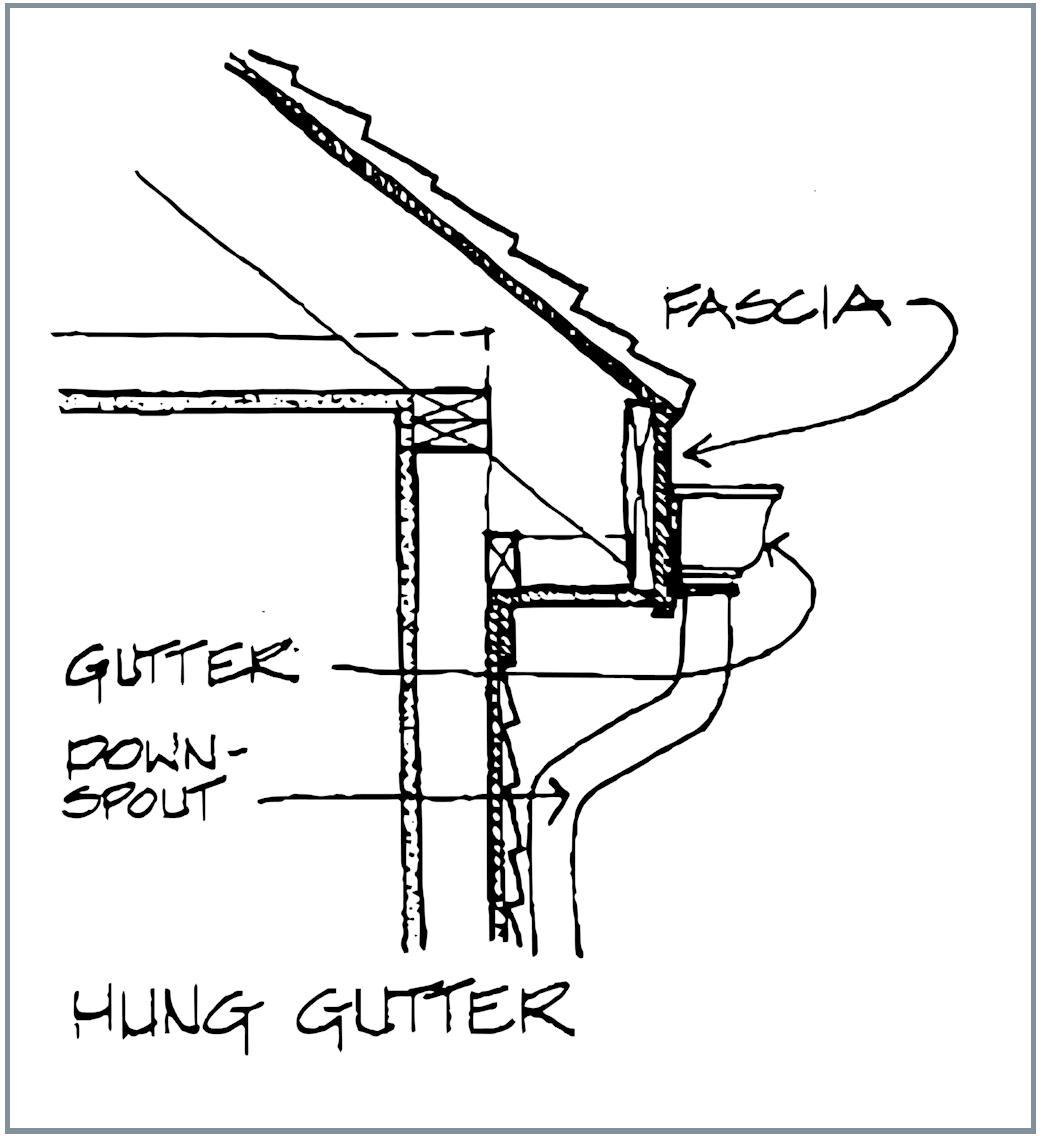
Original gutters in good condition should be retained and repaired as necessary. Deteriorated gutters may be replaced with aluminum gutters which approximate the size and profile of the original gutters.
Aluminum gutters are appropriate for new construction as long as they have a visual impact similar to typical hung gutters. All gutters used in replacement or new construction should be painted to match fascia trim. Color suggestions for trim can be found in the section on Painting and Colors.
Downspouts also serve an important practical purpose, but they are generally more visually obtrusive than roof gutters. Downspouts direct water away from the walls of a building, and protect the sheathing materials from water damage. Downspouts should also direct water away from the foundation by either directing it down sloped ground or into a splashblock.
Original downspouts should be retained and repaired, especially if they are an integral part of the design of the building. Periodic inspection and clearing out of debris will insure that downspouts continue to perform their vital drainage function.
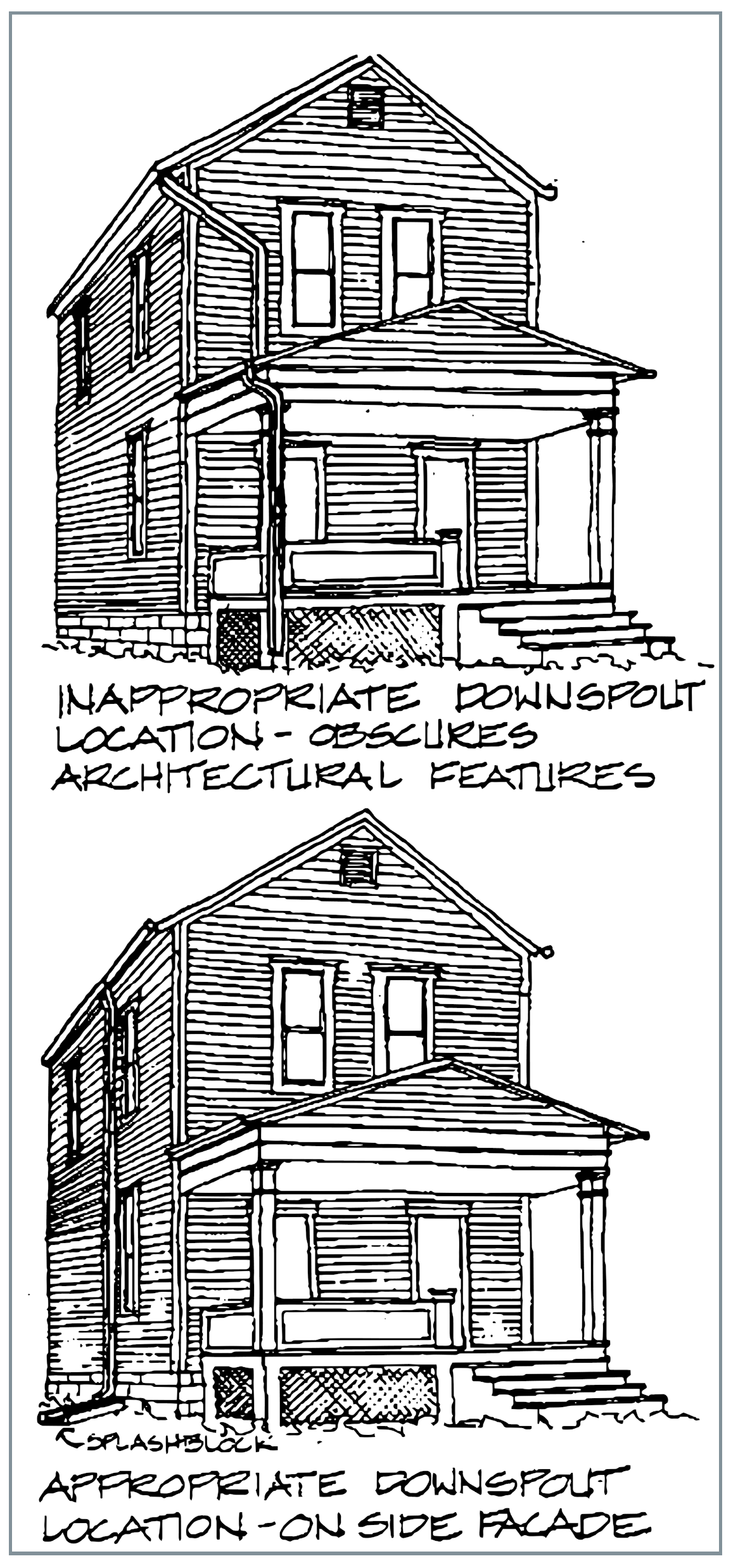
Deteriorated downspouts should be replaced in order to insure proper roof drainage. If the downspouts are an important visual element in the design of the building, they should be replaced with similar downspouts in the original locations.
Downspouts designed for replacement or new construction should
Painting and Colors
A good coat of paint is a building's best defense against the elements. Paint protects wood siding and trim from deterioration by shedding moisture. The exterior of a building will need a new coat of paint about every five to eight years. This routine maintenance job is especially important to protect historic materials.
Cracks, blistering, peeling or exposed bare wood are signs of paint failure. In many cases, this is due to normal weathering. Sometimes, moisture problems, such as improper roof drainage, cause paint failure. These problems should be solved before repainting, or the new coat will fail almost immediately. Other causes of paint failure could be mistakes in application of previous coats, inadequate surface preparation, or incompatibility between the paint and the surface being painted. In these cases, the improperly applied coats will have to be removed, and the exposed surface prepared for a new coat.
Most of the existing buildings in Powell have several layers of paint. Removing all of these layers is not necessary or desirable. Paint should be removed only to the next sound layer using the gentlest effective means. If an existing layer appears to be adhering well to previous coats, then it can be considered a layer, and new paint adhere to it well. When repainting an existing building, it is appropriate to use original colors. Original colors can sometimes be determined by doing paint scrapings or analysis. Although scraping can be done by amateurs, it is recommended that an expert be consulted. Colors may have changed due to chemical makeup of paint and weathering. It may be difficult to determine the exact sequence of paint, unless one has experience in paint analysis. If the original colors can not be determined, or are not desirable, the color guidelines which follow should be used to create a suitable color scheme.
Paint color is an important visual choice. The color guidelines which follow apply for existing buildings or new construction within the Historic District. In general, colors used in the Historic District should be muted, dark, and earth-toned. Livelier colors should be limited to trim, or one accent piece, such as a door. Avoid extremely bright, pure colors, or using two colors of the same intensity. DO NOT USE HIGH GLOSS PAINT. Semi-gloss may be acceptable for high maintenance areas, such as porch floors, stairs, and doors.
Relatively simple color schemes were the most popular during the 19th and early 20th centuries, and are the most appropriate for use in the Historic District. The simpler the building, the fever colors should be used. Since Powell architecture is relatively simple, color schemes should be kept to two or three colors. More elaborate buildings, with recognizable styles, such as Italianate, Queen Anne, and Eastlake, may be enlivened by the use of a variety of tints and shades of basic colors. A building can be divided into five basic parts for colors: the base; the body; the trim; doors, windows, and stairs; and the roof. The base, usually the foundation, will have the color inherent in the material out of which it is constructed. The body, or background color should be compatible with the foundation material, especially if the foundation has strong inherent color, such as the reds and purples of glazed block.
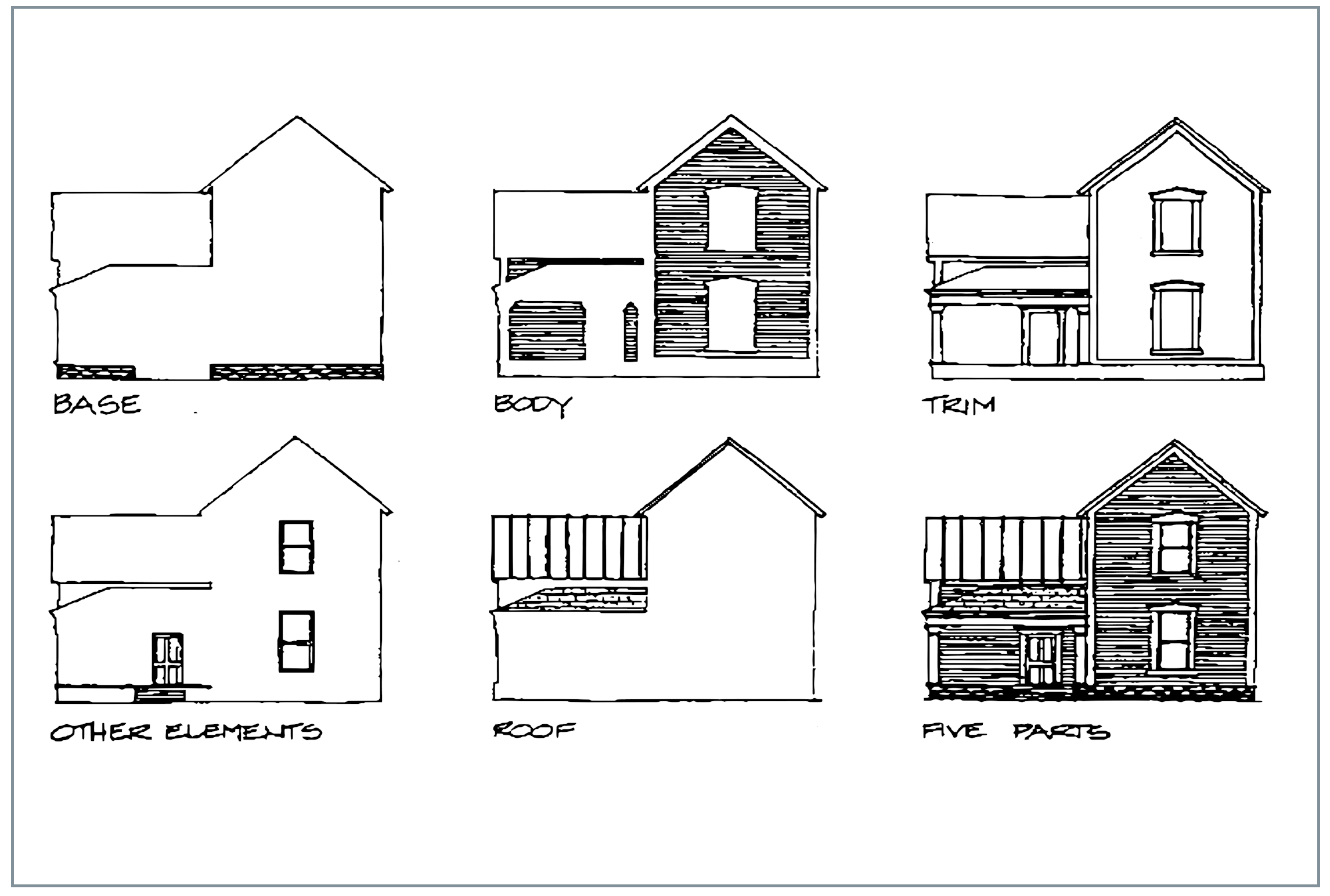
The trim includes corner boards, cornices, water tables, door and window trims, and porches. Windows, doors, and stairs provide other opportunities for color.
The moving parts of a window (sash) should be painted white, black, or another dark color. Contrasting window trim against a lighter or darker sash will retain the visual integrity of the window and its trim.
Doors can be an excellent opportunity for a splash of brighter color, however, this color should be carefully coordinated with the rest of the color scheme. Porch floors and stairs should be painted with heavy duty paint in a neutral gray or dark brown.
The fifth part of a color composition is the roof. In Powell, most roofs should be some shade of gray slate, asphalt or "tin". These colors will blend well with almost any paint scheme.
A successful color scheme will unify the five basic parts of a building into a single composition, without denying emphasis to distinctive features.
The color suggestions which follow are intended as guidelines for existing buildings and new construction. The type and style designations are based on existing buildings. New construction should follow the color groups for the building type and style closest to its form and stylistic detailing. New or existing buildings which combine more than one type and style, may be painted with colors from both groups. In general, body color should relate to the basic form of the building, and trim color to its stylistic embellishment. Careful attention must be paid to the overall effect of any paint scheme on the building itself and adjacent buildings.
Color Schemes
(Contact Development Department for approved color samples)
Group 1 - Cottages
A palette of delicate natural colors.
(Sand, Straw, Earth, and Clay)
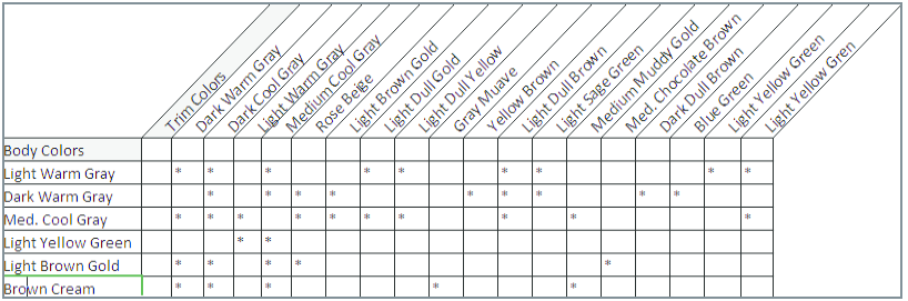
Group 2 - Italianate, Gabled Ell, Upright and Wing
A palette of generally darker colors with a few of the earlier, lighter colors persisting. More vivid contrast, and "picking out" of details is prevalent.
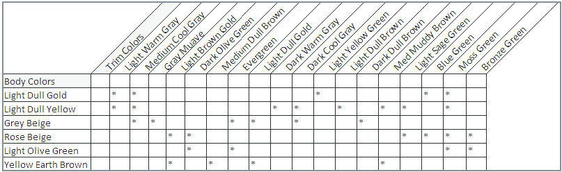
Group 3 - Queen Anne, Eastlake, Stick, Single Gable
A palette of darker colors, used as body colors to emphasize architectural mass, 1995 Replacement which were previously used as trim Olives, oranges, and reds used to materials, volumes, and structure.
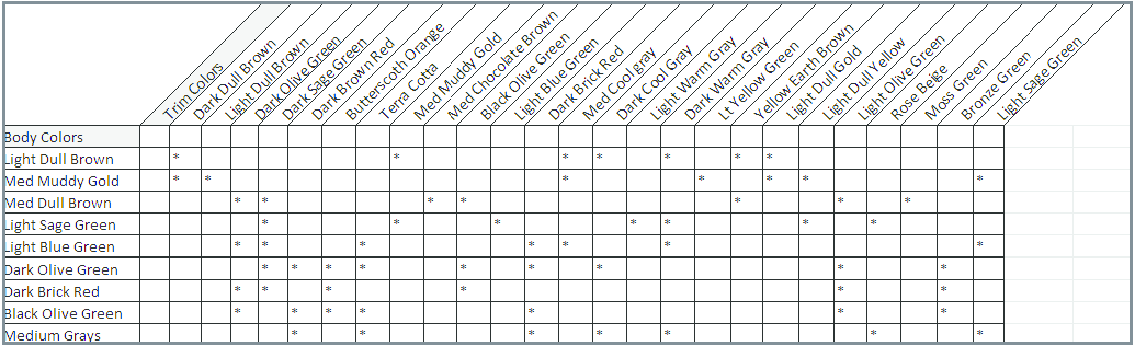
Group 4 - Bungalow, American Four Square, (later) Single Gable
A palette of slightly lighter, less aggressive colors on structure and materials continues.
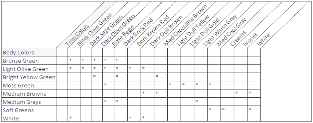
Glossary
ARTICULATED (MASSES): Masses which are distinct, and highly differentiated. A building composed of several distinct and readily identifiable masses.
ASYMMETRICAL: Not symmetrical, but perhaps achieving a balance of dissimilar forms, masses or elements on either side of a center line.
BALUSTER: A miniature column or other form of upright, which, in series, supports a handrail.
BAY: the portion of a building between two adjacent structural elements. Eg. a portion of a wall, containing windows, between two sections of solid wall which contain structure.
BAY WINDOW: A window which projects angularly from another wall and from the ground up.
BRACKET: A small supporting piece, often carved or molded, which carries a projecting weight.
BOND: The pattern created by the method of laying masonry units. In brickwork, bonds are created by alternating headers, bricks laid so that the short end appears on the face of the wall, and stretchers, bricks laid so that the long side appears on the face of the wall, in a regular pattern.
CORNICE: The projecting, ornamental molding at the top of a wall or building.
DENTIL, DENTIL MOULDING: Small square blocks used in a series, to form a molding pattern which resembles a set of very even teeth, hence the name.
DORMER, DORMER WINDOW: A window placed vertically in a sloping roof, and with a roof of its own.
DOUBLE-HUNG WINDOW: A window which has two balanced sashes, one sliding vertically over the other.
EAVE: The portion of a sloping roof which overhangs a wall.
EFFLORESCENCE: A white, powdery deposit of saline particles on the outside face of a masonry wall, resulting from the presence of salts in the clay or mortar.
FACADE: The outside face of a building.
FENESTRATION: The disposition of windows in a facade.
FIXED SASH WINDOW: A piece of glass in a frame which is permanently fixed in a wall.
FRIEZE: The trim on the upper portion of a wall which supports the cornice.
GLAZED: Fitted with glass, as in a door or building.
GLAZING: glass set or to be set in frames.
GLAZED BLOCK: A type of hollow clay tile manufactured in Appalachia, out of native clay. Produced from the 1870's to the 1930's, these blocks were fired with a salt glaze which made them durable and waterproof.
HISTORICAL (HIGH) STYLE ARCHITECTURE: Structures designed and built according to the dictates of a specific, readily identifiable, national or international architectural style. Show strong influence of contemporary architectural trends.
GABLE: The triangular, upper part of a wall at the end of a pitched roof. The term can also refer to the gabeled end or wing of a building.
HOOD MOLDING: Projecting molding over a window or door.
LEAN-TO: A subordinate building, the ridge of its single-slope roof supported by the major structure.
MASS: The three dimensional (length, width, and height) property of a solid object.
MASSING: Overall form and shape of a structure composed of simple masses.
ORIEL WINDOWS: A projecting window, supported by corbels or brackets. Unlike Bay Windows, oriels do not reach the ground.
RESPIRATOR: A mask of cloth worn over the mouth and nose to prevent inhalation of harmful substances.
RISING DAMP: Ground water rising in masonry walls by capillary action. Caused by improper drainage, a high water table or lack of waterproofing in the foundation.
SANDBLASTING: A masonry cleaning method in which sand is forced against the masonry under extremely high pressure. Sandblasting removes the outer, protective layer of the masonry, and much of the mortar along with dirt. DO NOT SANDBLAST MASONRY WALLS. THEY WILL BE RUINED FOREVER.
SAND MOLD RED BRICKS: Bricks which are molded, instead of extruded. Sand, which lines the wooden molds to facilitate removal, gives the bricks a soft texture.
SASH: A frame designed to hold window glass. The moving part of a window, glass and frame.
SASH CORD: A small piece of rope attaching one side of a window sash to its counterweight.
SEGMENTAL ARCH: A round arch whose top is flatter than a semicircle, but not completely flat.
SPALLING: Splitting off of small fragments of a masonry unit from its surface.
SPLASHBLOCK: A concrete pan which collects water from a downspout and drains it away from the foundation.
STORY: The space in a building between successive floor levels.
SYMMETRICAL: Having identical forms, masses or elements on either side of a center line.
TOOLING: Decorative profiles given to mortar joints, before the mortar is completely dry. These are usually produced with special tools.
TRANSOM: An opening over a door or window, and containing a hinged or pivoted, glazed or solid sash, usually for ventilation.
VERNACULAR ARCHITECTURE: Buildings constructed at a modest level of stylistic embellishment according to prevailing architectural modes and common building types. (Popular Architecture)
WATER TABLE: A base course projecting above a foundation to direct water away from it.
WEATHER STRIPPING: A strip or interlocking strips of material that help block the passage of air around a door, window or other opening.
WING: Secondary mass of a building.
1141.01 - PURPOSE.
The purpose of this chapter is to establish zoning districts in order to realize the general purposes set forth in the preamble of this Zoning Ordinance, to provide for orderly growth and development, and to protect the property rights of all individuals by assuring the compatibility of uses and practices within districts.
1141.02 - ESTABLISHMENT OF DISTRICTS.
The following ten zoning districts are hereby established for the Municipality of Powell, Ohio:
R - Residence District
DR - Downtown Residence District
DB - Downtown Business District
PR - Planned Residence District
PRC - Planned Residence Conservation District
PO - Planned Office District
PC - Planned Commercial District
PI - Planned Industrial District
DD- Downtown District Overlay District
OR - Olentangy River Environment Overlay District
AR - Architectural Review Overlay District
(Ord. No. 2005-20, 6-7-2005; Ord. No. 2017-60, § 1, 12-19-2017)
1141.03 - ZONING DISTRICT MAP.
The districts established in Section 1141.02, and as may be indicated on the Official Zoning Map, together with all data, references, explanatory material and notations thereon, are hereby officially adopted as part of this Zoning Ordinance and hereby incorporated by reference herein, thereby having the same force and effect as if herein fully described in writing.
1141.04 - ZONING MAP LEGEND.
There shall be provided on the Official Zoning Map a legend which shall list the name of each zoning district and indicate the symbol for that district. A color, combination of colors, or black and white patterns may be used in place of symbols to identify the respective zoning districts in such legend. In addition to such legend, the Official Zoning Map shall provide sufficient space for compliance with Section 1141.07.
1141.05 - IDENTIFICATION OF OFFICIAL ZONING MAP.
The Official Zoning Map shall be properly identified by the signature of the Mayor, as attested by the Clerk, and bearing the official seal. The Map shall be maintained by the Zoning Administrator, and shall remain on file in the office of the Clerk. A copy of the Map shall also be appended to each copy of the text of the Zoning Ordinance. The Official Zoning Map shall control whenever there is an apparent conflict between the district boundaries as shown on the Map and the description(s) as found in the text of this Ordinance or any other ordinance. The Official Zoning Map shall be a reproducible document, and individual copies shall be made available to the public upon request including attachment of all relevant amendments, and upon payment of a fee as established by ordinance. The Map shall be recertified by the Mayor and the Clerk at least every 24 months and each time it is amended.
1141.06 - INTERPRETATION OF DISTRICT BOUNDARIES.
(a)
The following rules shall be used to determine the precise location of any zoning district boundary unless such boundary is specifically indicated on the Official Zoning Map:
(1)
Where district boundaries are so indicated as approximately following the center lines of thoroughfares or highways, street lines, or highway right-of-way lines, such center lines, street lines, or highway right-of-way lines shall be construed to be said boundaries;
(2)
Where district boundaries are so indicated that they approximately follow lot lines, such lot lines shall be construed to be said boundaries;
(3)
Where district boundaries are so indicated that they are approximately parallel to the center lines or street lines of streets, or the center lines or right-of-way lines of highways, such district boundaries shall be construed as being parallel thereto and at such distance therefrom as indicated on the Official Zoning Map. If no distance is given, such dimensions shall be determined by the use of the scale shown on the Official Zoning Map and as determined by the Zoning Administrator.
(4)
Where the boundary of a district follows a railroad line, such boundary shall be deemed to be located in the middle of the main tracks of said railroad line;
(5)
Where the boundary of a district follows a stream or other body of water, said boundary line shall be deemed to be at the center line of the body of water unless otherwise indicated;
(6)
Where district boundaries are so indicated that they follow or approximately follow the boundary limits of any municipal corporation or other unit of government, such boundaries shall be construed as following such limits;
(7)
Where the boundary of a district follows a metes and bounds description approved as a part of a rezoning or annexation of any territory, said metes and bounds description shall control over all of the foregoing; and
(8)
Whenever any street, alley, or other public way is vacated by official Council action, the zoning district adjoining each side of such street, alley, or public way shall automatically be extended to the center of such vacation, and all areas within that vacation shall thenceforth be subject to all regulations appropriate to the respective extended districts.
(b)
All questions and disputes concerning the exact location of zoning district boundaries shall be resolved by the Zoning Administrator consistent with these guidelines for interpretation.
1141.07 - ZONING MAP AMENDMENTS.
Within 15 days of the effective date of any change of a zoning district classification or boundary, the Zoning Administrator shall amend the Official Zoning Map to reflect such change, and shall note the effective date of such change, together with appropriate reference to the ordinance authorizing such change.
1141.08 - RESERVED.
Editor's note— Ord. No. 2017-60, § 1, adopted December 19, 2017, deleted § 1141.08, which pertained to zoning upon annexation and derived from Ord. No. 91-40.
1143.01 - COMPLIANCE WITH REGULATIONS.
The regulations for each district set forth by this Zoning Ordinance shall be minimum regulations and shall apply uniformly to each class or kind of structure or land, except as hereinafter provided that:
(a)
No building, structure, or land shall be used or occupied and no building or structure or part thereof shall be erected, constructed, reconstructed, moved, or structurally altered except in conformity with all of the regulations herein specified for the district in which it is located.
(b)
No building or other structure shall be erected or altered:
(1)
To provide for greater height or bulk;
(2)
To accommodate or house a greater number of families;
(3)
To occupy a greater percentage of lot area; or
(4)
To have narrower or smaller rear yards, front yards, side yards, or other open spaces; than herein required, or in any other manner be contrary to the provisions of this Zoning Ordinance.
(c)
No yard or lot existing at the time of passage of this Zoning Ordinance shall be reduced in dimension or area below the minimum requirements set forth herein. Yards or lots created after the effective date of this Zoning Ordinance shall meet at least the minimum requirements set forth herein.
1143.02 - OFFICIAL SCHEDULE OF DISTRICT REGULATIONS ADOPTED.
District regulations shall be as set forth in the Official Schedule of District Regulations, which is hereby adopted and declared to be a part of this Zoning Ordinance and in Chapters 1145 and 1147.
1143.03 - RESERVED.
Editor's note— Ord. No. 2017-60, § 1, adopted December 19, 2017, deleted § 1143.03, which pertained to identification of the official schedule of district regulations.
1143.04 - R-RESIDENCE DISTRICT; PURPOSE.
There is hereby created an "R" ("Residence") District to protect and promote an appropriate low density village scale, and rural residential scale of development.
ZONING DISTRICT: R-RESIDENCE
Official Schedule of Permitted Uses and Dimensional Requirements
(Ord. No. 2017-60, § 1, 12-19-2017)
1143.08 - PLANNED DISTRICTS; GENERAL.
(a)
Established. The following seven districts:
PR - Planned Residence District;
PRC - Planned Residence Conservation District,
PO - Planned Office District;
PC - Planned Commercial District,
PI - Planned Industrial District,
DR - Downtown Residence District, and
DB - Downtown Business District,
are herein designated as "planned districts" in which development shall be regulated by the requirements and procedures as designated for planned districts in this chapter. Development in these planned districts shall meet all of the requirements established elsewhere in this Zoning Ordinance, including those in the Supplemental Regulations, Signs, Off-Street Parking and Loading Facilities. However, in these districts the permitted uses, their locations, and their intensity are not rigidly fixed. Rather a framework is provided, in furtherance of the purposes of these districts, for the arrival at a plan for the development of land in such districts involving the careful selection and integrated planning of land uses, utilities, parkland and environmental conservation areas, pedestrian/bicycle/jogging paths and equestrian paths, the service street system, and associated collector streets, major streets and parkways that is consistent with the content and emphasis established in the Comprehensive Plan.
(b)
Planned District Standards. Wherever development standards are specified herein or elsewhere in this Zoning Ordinance, as in the official schedules of permitted uses and dimensional requirements, these standards shall apply except where other such standards have previously been established and approved by the Planning and Zoning Commission for areas located in planned districts. The official schedules of dimensional requirements shall provide a guide for approval of Development Plans, but can be modified as approved by the Planning and Zoning Commission. Where standards are not specified, the Planning and Zoning Commission, in approving a planned district development plan, shall establish such requirements as it deems necessary to protect and promote the public health, safety, and/or welfare of the community.
(Ord. No. 2005-20, 6-7-2005; Ord. No. 2017-60, § 1, 12-19-2017)
1143.09 - PLANNED DISTRICTS; PURPOSE.
There are hereby created the following districts, designated as "planned districts." It is the purpose of these districts to promote the public health, safety, and welfare by providing for the regulation of planned developments. These districts are so created in order to permit the careful and coordinated physical planning and development of the land, to provide flexibility in the location of land uses, housing types, and their intensity, and to provide incentives for provision of public parkland and private environmental conservation easements, public access pedestrian/bicycle/jogging paths and equestrian paths, the private construction of public parkways, and the construction of high quality housing through provision of housing density bonuses for the provision of such amenities, while simultaneously protecting and preserving the natural environment, providing for surface drainage runoff control, limiting the buildup of residential and through traffic on already congested access points into the area between the two rivers and on existing and future major streets, encouraging inclusion of pedestrian scale design elements, and conserving and enhancing the community and regional character as a green, open, rural setting, permitting development yet constraining the tendency to overbuild the region. It is the intent of these regulations to provide maximum opportunity for orderly large-scale development that benefits the community as a whole by offering a greater choice in living environments and a wider range of development plans featuring a more complementary blending of land uses and community facilities, and a more unified approach with respect to the mixture of uses and their adaptation to topological and geological features, recreational and natural environment preservation opportunities, and transportation needs.
(a)
Interpretation. Whenever the requirements of Sections 1143.07—1143.16 on Planned Districts appears to be in conflict with other sections of this Zoning Ordinance, or with those of other existing codes, the provisions of these sections shall prevail, except where otherwise noted.
(b)
Planned District Location. The location and extent of Planned Districts shall be as described herein or as designated on the Official Zoning Map.
(c)
Conditions Applicable to all Planned Districts.
(1)
Required compliance with Comprehensive Plan. Each approved Planned District Development Plan must be consistent with the standards, goals and requirements of the Comprehensive Plan, as determined by the Planning and Zoning Commission [and City Council], including land uses, the general location of trafficways and their character, the provision of equestrian and/or pedestrian/jogging/bicycle pathways, etc., and any other feature or quality specifically noted in the Comprehensive Plan.
(2)
Uses. Uses in planned districts shall be as approved by the Planning and Zoning Commission as selected by the Commission from the specific lists of permitted uses and conditional permitted uses presented herein relative to the planned district category in question. Large non-residential establishments, as defined by Section 1147.15(b)(1), shall also be reviewed through the special use permit process established within Section 1147.15, and shall meet the requirements within that section or those of the planned district where the large non-residential establishment is located within, whichever requirement is more restrictive.
(3)
Religious, cultural and educational uses. Religious, cultural, and educational land uses and facilities are permitted uses in every Planned District, provided that:
A.
They are designed and intended to serve just the immediate and nearby residents of the district, or, if designed, intended, or projected to serve a larger area of the community or of the region as a whole, they must be located in such proximity to a major thoroughfare as to permit access without travel along streets that primarily provide a residential service function; and
B.
Each such use shall have a net site area of no less than three acres, plus one acre for each 100 permanent seats over 300 in the main assembly area.
(4)
Open space; recreational facilities. Common open space and recreational facilities: requirements and disposition:
A.
No less than 20 percent of the land in any approved Planned District Development Plan shall be designated common open space or permanently natural scenic preserves, arranged and restricted by easement, covenant, deed, or dedication to assure that such open spaces shall be permanently preserved and maintained. Such open spaces shall not include publicly dedicated streets, land in the right-of-ways of private streets, off-street parking areas, or loading areas;
B.
Planned residence developments may provide, as a part of the parkland dedication requirement of subsection (c)(4)A., at least one five acre relatively flat grassed common area for neighborhood field recreation, preferably integrated with a neighborhood pedestrian/jogging/bicycle path system, or system of common areas, tot lots, or other similar areas at least five acres total in area. The size, shape and amount of publicly dedicated park space shall be determined by the Planning and Zoning Commission and City Council as part of the development plan process. City Council may authorize a fee-in-lieu of dedication payment as determined by the Fee Schedule, as amended from time to time, and/or require parkland dedication.
C.
Where parkways are projected in or adjacent to the Planned District area, such required open spaces as in subsections (c)(4)A. and B., shall be located immediately adjacent to the parkway right-of-way to the degree and in the manner approved by the Planning and Zoning Commission.
D.
All natural drainage courses, flood plain areas, ravine-bottom areas, and lands with slopes in excess of six percent shall be retained, with their vegetation in its natural state, in natural scenic open space preserves.
E.
Required common open space areas reserved in a Planned District Development Plan shall either be held in corporate ownership by owners of the project area, for the use of each owner who buys property within the development, or shall be dedicated to a homeowner's association who shall have title to the land which shall be retained as common open space for parks, recreation, and related uses, or shall be dedicated to public ownership and use for such purposes. This will be determined by the Planning and Zoning Commission, and City Council during the development plan review process.
F.
Legal articles relating to the organization of a homeowners' association are subject to review and approval by the Planning and Zoning Commission and shall provide adequate provisions for the perpetual care and maintenance of all common areas and facilities. Covenants assuring perpetual maintenance of private properties as permanent natural preserves are equally subject to review and approval by the Planning and Zoning Commission.
G.
Public utility and similar easements and right-of-ways are not acceptable for common open space dedication in a Planned District Development Plan unless such land and right-of-ways are to be used for trail or other public purposes. Alternative systems of providing common open space must be specifically approved by the Planning and Zoning Commission.
H.
The ownership of, and responsibility for the maintenance of, all open spaces in a Planned District Development Plan shall be specified by the developer before approval of the final development plan by the Planning and Zoning Commission and City Council.
(5)
Maximum multi-family dwelling units.
A.
In any Planned District Development Plan the maximum number of multi-family dwelling units shall in no case exceed the number of units set forth in the development standards for the particular zoning district in which that property is proposed to be located.
B.
In any Planned District Development Plan the maximum number of multi-family dwelling units, on any single acre, shall not exceed 12 per acre.
(6)
Circulation system. The circulation system and parking facilities provided in a Planned District shall be designed to fully accommodate vehicular, pedestrian, bicycle, and, where applicable, equestrian movement with safety and efficiency; innovative roadway design is encouraged to insure the preservation of natural features, the creation of a variety of vistas and views, and retention/creation of a natural rural, green and open-space-focused environment. The circulation and parking systems shall show points of access and egress from properties, all public and private drives, parking areas, pedestrian/jogging/bicycle paths, and equestrian paths if applicable. Planned District Plans shall be designed to minimize circulation conflict points between vehicular, pedestrian, bicycle, and equestrian traffic.
(7)
Utilities. Underground utilities, including telephone, cable television, and electrical systems are required within the limits of all Planned District developments. Appurtenances to these systems which can be effectively screened may be exempted from this requirement if the Planning and Zoning Commission finds that such exemption will not violate the intent or character of the proposed Planned District development. Fiber, fiber conduit and/or another such other utility may be required at the discretion of the Planning and Zoning Commission or the City Engineer for the purposes of public service.
(8)
Special provisions for lower or moderately priced housing in Planned Districts. In order to provide for the availability of lower and moderately priced rental and sale residences within Planned Districts, the Planning and Zoning Commission may permit the following:
A.
A Planned District Development Plan proposing the inclusion of no less than ten percent lower or moderately priced rental or sale dwelling units may reduce the minimum lot, street frontage, distance between buildings, and yard requirements in the Plan area as specified for the Planned District within which it is located, provided that such reductions shall not exceed ten percent of the standards set for such conditions in the District and that buffering and screening devices are deemed by the Planning and Zoning Commission to be adequate.
B.
A Planned District Development Plan proposing the inclusion of no less than ten percent lower or moderately priced rental or sale dwelling units may entail a dwelling unit count ten percent in excess of the dwelling units otherwise permitted in the district, and/or ten percent in excess of the maximum number of dwelling units permitted on any one acre in subsection (c)(4), above.
C.
Where such reductions are provided for, each such lower to moderately priced dwelling unit in a Planned District shall abut common open space or similar areas, provided, however, that any such residential property not abutting such uses shall have well designed and convenient access to, and shall be located no more than 500 feet from, such uses.
D.
For the purposes of this Zoning Ordinance, "lower and moderately priced rental and sale residences" shall be interpreted as meaning:
New dwelling units priced for sale or rent that are no more than seven percent above the average price/rental for such new dwelling units in the Columbus metropolitan area as reported by the U.S. Department of Housing and Urban Development for the latest calendar year prior to the submission of the planned district proposal.
(9)
Arrangement of Commercial, Office, Industrial, and Warehouse/Wholesale Uses. Where planned districts include commercial, office, industrial, and/or warehouse/ wholesale uses, such buildings and establishments shall be planned as groups having common parking areas and common ingress and egress points in order to reduce the number of potential conflict points and accident locations at intersections with streets. Planting screens or fences shall be provided on the perimeter of the development areas consisting of these uses where they abut residential areas, church sites, or public lands. The plan of the project shall provide for the integrated and harmonious design of buildings, and for internal traffic circulation, landscaping, coordinated signage, and such other features and facilities as may be necessary to make the project attractive and efficient from the standpoint of the adjoining and surrounding noncommercial areas all as determined and designated by the Planning and Zoning Commission. All areas designed for future expansion or not intended for immediate improvements or development shall be landscaped or otherwise maintained in a neat and orderly manner as may be specified by the Planning and Zoning Commission.
(10)
Residential Subareas in Planned Office (PO), Planned Commercial (PC) and/or Planned Industrial Districts.
A.
Where new residential uses are to be provided for in a planned district plan of development other than for Planned Residence (PR) and such uses occupy more than one acre or total more than nine dwelling units, the subarea shall be designated as a PR-Planned Residence District in the development plan and shall therefore meet all of the requirements specified for the PR-Planned Residence District, including those regarding housing density and physical arrangements.
B.
Multifamily residential units located in planned districts other than PR-Planned Residence Districts shall be clustered around woodland, lake or stream bed features.
C.
The area for calculation of the permitted number of dwelling units in nonresidential planned districts shall include the area in the total planned development that is in dedicated parkland, scenic easements, setback open spaces in excess of 50 feet, runoff retention basins, other water areas, and the area designated specifically for residential use.
D.
Approval of development of such residential units shall be contingent upon or include completion of the associated parkway or bypass systems serving these sites.
(11)
Development Phasing. The first phase of development of a Planned District, according to an approved Planned District Development Plan and development timetable, shall in no case be less than five acres or the entire tract, whichever is smaller. The Planning and Zoning Commission may require larger first phase commitments where it deems this necessary. All sections of the planned development tract not planned for development in the phase submitted shall be clearly designated as to future intended sub-district use, area and density.
(12)
Additional Requirements. The Powell Planning and Zoning Commission and/or the Council may impose special additional conditions relating to the development of a Planned District Development with regard to the type and extent of public improvements to be installed; landscaping, development, improvement, and maintenance of common open spaces; and any other pertinent development characteristics.
(13)
Pedestrian Scale Design Guidelines Manuals. The Powell Planning and Zoning Commission and City Council find and determine that it is important to articulate pedestrian scale design principles for incorporation into Planned District Development Plans in order to meet the purposes of Planned Districts set forth above. Toward this end, a Pedestrian Scale Design Guidelines Manual dated November 4, 2009 (as amended from time to time with the approval of the Planning and Zoning Commission) is hereby adopted. Unless justification satisfactory to the Planning and Zoning Commission and City Council is provided, this Manual shall be utilized by a property owner in whole or in part as a guideline for developing proper Pedestrian Scale Design features within a Planned District Development Plan.
(14)
Required approval of Planned District Development Plan. No development shall be undertaken, no construction and/or earth moving of any kind shall be begun, and/or no new land uses shall be initiated in a Planned District unless consistent with an approved Planned District Development Plan.
(Ord. No. 2009-27, 11-4-2009; Ord. No. 2017-60, § 1, 12-19-2017)
1143.10 - CONDITIONAL USES IN PLANNED DISTRICTS.
Uses specified as conditional uses in planned districts shall be approved by the Planning and Zoning Commission, and in conjunction with development plan approval by the Planning and Zoning Commission and Council, following the same criteria and processes as in all other districts.
(Ord. No. 2017-60, § 1, 12-19-2017)
1143.11 - PROCEDURES FOR APPROVAL OF PLANNED DISTRICT DEVELOPMENT PLANS.
Planned District Development Plans shall be approved in accordance with the procedures established herein in this section.
(a)
Sketch Plan Application. The applicant shall file a sketch plan application in conformance with Section 1109.06 outlining their intent for developing a planned district for review by the Planning and Zoning Commission if one or more of the following conditions are met:
(1)
The proposal does not align with the future land use recommendations of the comprehensive plan;
(2)
Except for properties zoned DR, Downtown Residence District or DB, Downtown Business District, the proposal includes new development on five or more acres. For properties zoned DR, Downtown Residence District or DB, Downtown Business District, proposals for new development of one or more acres shall require a Sketch Plan application;
(3)
The proposal will be developed in three or more phases; or,
(4)
The proposal includes the creation of new public roadways or extension of existing public roadways.
The purpose of this application is to discuss early and informally the effect of this Zoning Ordinance and the criteria and standards contained herein, and to familiarize the applicant with zoning and other applicable regulations. The Planning and Zoning Commission shall schedule a public hearing on a complete sketch plan application based on the recommendation of the Zoning Administrator or their designee.
(b)
Filing of a Combined Preliminary and Final Development Plan. An applicant may file a combined preliminary and final development plan. Any combined application shall provide all application requirements as outlined in subsections (c) and (i) and shall follow the review procedures of a final development plan application.
(c)
Preliminary Development Plan Application Requirements. An application for preliminary Planned District Development Plan approval shall be filed with the Zoning Administrator or their designee by the owner of the property for which Planned District development is proposed. At a minimum, the application shall contain the following information. Where any of this information is missing or incomplete, the Zoning Administrator or their designee shall notify the applicant and no additional actions need be taken until such missing material is provided.
(1)
Name, address, and phone number of the applicant(s);
(2)
Name, address, and phone number of registered surveyor, registered engineer and/or urban planner assisting in the preparation of the preliminary development plan;
(3)
Legal description of the property;
(4)
A description of present land use(s);
(5)
A vicinity map showing all property lines, existing streets and alleys, approved future streets and land uses on adjacent Planned District areas, transportation and land use elements of the City's adopted Comprehensive Plan, current zoning classifications and boundaries, and current land uses on the site of the proposed Planned District development and in the surrounding areas, but no less than 250 feet beyond the limits of the proposed Planned District Development Plan.
(6)
A preliminary development plan illustrating:
A.
The property line definition and dimensions of the perimeter of the site;
B.
Rights-of-way and paving widths of all existing, currently platted, and previously approved Planned District streets and alleys adjacent to, on, or abutting the site;
C.
The area of the site and its subareas in acres;
D.
The topography of the site and abutting areas at no more than five-foot contour intervals;
E.
Existing surface drainageways and surface sheet flow patterns;
F.
Flood plain areas, ravine-bottom areas, and areas of ground slope in excess of six percent;
G.
Existing vegetation on the site with specific tree locations for all trees six inches or greater diameter at breast height (DBH);
H.
Existing easements on the site with notations as to their type, extent, and nature;
I.
The location and dimensions of existing utilities on and adjacent to the site, including the nearest sanitary sewer, with manhole invert elevations;
J.
Calculation of the maximum residential units permitted on the site under the terms of this Zoning Ordinance, including delineation of the subdistricts of the site upon which these calculations have been made;
K.
A preliminary plan and plat for the first, or next, phase of site development illustrating:
1.
New street centerlines, rights-of-way, and street classification types;
2.
Names of existing and proposed streets;
3.
Generalized lot and block layouts, indicating and illustrating property lines, minimum lot areas, minimum building setbacks and yards, location and extent of major off-street parking areas, etc.;
4.
Subareas of the site to be developed, by land use type, housing types, and housing densities, including subarea statistics;
5.
Location of proposed structures including approximate square footage, use types, primary entranceways, and associated service or loading areas;
6.
Common open areas, public lands, and natural scenic easements, including the area of each;
7.
Proposed landscape treatment of the site;
8.
Proposed utility patterns and provisions, including sanitary sewer, individual waste disposal systems, storm sewer, trash collection systems, outdoor lighting, and water supply, including relevant easements and engineering feasibility studies or other evidences of reasonableness;
9.
Provisions for accommodating surface drainage runoff;
10.
Proposed architectural design criteria, if applicable;
11.
Proposed pedestrian/bicycle pathways and equestrian paths, including locations, dimensions, landscape and construction, including relationships of such pathways to existing and proposed future pathways on surrounding property;
12.
Overall site development statistics comparing this plan for development with requirements of this Zoning Ordinance and with the comprehensive plan and indicating that all requirements of this Zoning Ordinance and the comprehensive plan have been met in this preliminary plan and will be met in final development, as well as any requested deviations from the Zoning Ordinance.
L.
Projected development schedule by subareas of the entire planned development site, and for the first, or next, phase of development, including land uses, public areas, natural and scenic reserves, streets, buildings, utilities, and other facilities, indicating the relationship of the proposed development to existing and probable uses of surrounding areas during the development timetable;
M.
An overall traffic scheme, illustrating points of access, parking areas, including the number of parking spaces and indicating visitor, employee and service traffic flow, illustrating calculated peak hour traffic use for residents and employees as well as deliveries and other transport and the impact of this traffic on the City's road network.
N.
If to be developed in phases, the entire site development shall be described in outline and diagrammatic plan form, and in a complementing detailed text in a manner calculated to assure City officials that Planned Development requirements and other requirements of this Zoning Ordinance shall be met in the detailed development of the phases to follow, and that the entire Planned Development area will meet all of the requirements of this Zoning Ordinance, such diagrams and descriptive texts being accepted with, and becoming a part of the extended zoning plan for the entire site;
(7)
Evidences, as determined by the Zoning Administrator or their designee, of the ability of the applicant to carry forth its plan by control of the land and the engineering feasibility of the plan, and that the applicant has sufficient control over the land and financing to initiate the proposed development plan phase within two years;
(8)
Evidence of the applicant's ability to post a bond if the plan is approved assuring completion of public service facilities to be constructed within the project area by the developer;
(9)
Verification by the owner of the property that all the information in the application is true and correct to the best of his knowledge.
(10)
A statement of the character and nature of the development including the cost range or rent levels for housing in residential development and the general types of business or industrial and commercial developments.
(11)
A statement of the general impact the development will have on the infrastructure, municipality and schools including projected demographics, a traffic impact study and a fiscal impact analysis may be required by the Planning and Zoning Commission.
(12)
A fee as established by ordinance.
(d)
Planning and Zoning Commission Public Hearing. The Planning and Zoning Commission shall schedule a public hearing on a complete preliminary development plan application based on the recommendation of the Zoning Administrator or their designee. The recommendation will include analysis of how the preliminary development plan meets the requirements of this Zoning Ordinance, the comprehensive plan, and other applicable City policies.
(e)
Notice of Public Hearing.
(1)
Before holding the public hearing, notice of such Commission hearing shall be given on the City's website at least ten days before the date of said hearing. The notice shall set forth the time and place of the public hearing, a general description of the planned district development, and a statement that, after the public hearing and after submission of a final development plan, the matter will be referred to the Council for further determination.
(2)
Written notice of such hearing shall be sent at least ten days before the hearing, to all owners of property within 250 feet of the property in question and to other interested parties identified by the Commission including homeowner's associations, if relevant. Notices to individual property owners shall contain the same information as required of notices published on the City's website.
(f)
Public Access to Proposed Planned District Plans. For a period of at least ten days prior to the public hearing by the Planning and Zoning Commission, all information relating to the planned district development plan shall be available for public inspection.
(g)
Action on a Preliminary Development Plan. The Planning and Zoning Commission shall review the preliminary development plan to determine if it is consistent with the intent of this Zoning Ordinance and other applicable City policies. If it does, the Commission shall approve the preliminary development plan. If it does not, the Commission shall either recommend supplementary conditions to address outstanding items or recommend changes and additions needed for approval and await a resubmission.
In reviewing a preliminary development plan, the Planning and Zoning Commission shall consider:
(1)
If the proposed development is consistent with the intent and requirements of this Zoning Ordinance;
(2)
The appropriateness of the proposed land uses with regard to their type, location, amount, and intensity, where not specifically specified in this Zoning Ordinance;
(3)
The relationships between uses, and between uses and public facilities, streets, and pathways;
(4)
Adequacy of provisions for traffic and circulation, and the geometry and characteristics of street and pathway systems;
(5)
Adequacy of yard spaces and uses at the periphery of the development;
(6)
Adequacy of open spaces and natural preserves and their relationships to land use areas and public accessways;
(7)
The order, or phases, in which the development will occur and the land uses and quantities to be developed at each phase;
(8)
Estimates of the time required to complete the development and its various phases;
(9)
Improvements to be made by the Municipality, if any, and their cost;
(10)
The community cost of providing public services to the development, and
(11)
Impacts of the development on surrounding or adjacent areas.
The Commission's approval of the preliminary development plan shall be necessary before an applicant may submit a final development plan. Approval shall not be construed to endorse a precise location of uses, configuration of parcels, or engineering feasibility.
(h)
Submission of Final Development Plan. After approval of the preliminary development plan, the applicant shall submit a final development plan for review. The final development plan shall be in general conformance with the preliminary development plan that was approved. The submission of a final development plan is a formal request for approval of a specific phase or phases of development that is consistent with the intent of this Zoning Ordinance, the comprehensive plan, and other applicable City policies.
(i)
Final Development Plan Application Contents. An application for a final development plan shall be filed with the Zoning Administrator or their designee by the owner of the property or their representative. Each application shall be signed by the owner, attesting to the truth and exactness of all information supplied on the application for the final development plan. At a minimum, the application shall contain:
(1)
All of the information required for submission of the preliminary planned district development plan application;
(2)
All plan materials rendered on an engineering survey of the proposed development site, showing the dimensions and bearings of property lines, property areas in acres, topography, existing features of the development site including major wooded areas, structures, easements, utility lines, land uses, and maximum building footprint areas for all non-residential uses and residential uses other than single-family detached and two-family dwellings;
(3)
Engineering feasibility studies and plans showing, as necessary, water, sewer, drainage, electricity, telephone, and natural gas installations; waste disposal facilities; street improvements; and the nature and extent of earthwork required for site preparation and development.
(4)
A detailed landscape plan showing existing and proposed future landscape materials, ground cover, paving patterns and materials.
(5)
A final development plan fee as established by ordinance.
(j)
Planning and Zoning Commission Public Hearing. The Planning and Zoning Commission shall schedule a public hearing on a complete final development plan application based on the recommendation of the Zoning Administrator or their designee. The recommendation will include analysis of how the final development plan adheres to the approved preliminary development plan and meets the requirements of this Zoning Ordinance, the comprehensive plan, and other applicable City policies. Notice and public inspection of the application shall be as specified in subsections (e) and (f).
(k)
Recommendation by the Planning and Zoning Commission. The Planning and Zoning Commission shall review a final development plan to determine if it is consistent with the intent of this Zoning Ordinance and other applicable City policies. The Planning and Zoning Commission shall make a recommendation to City Council that the final development plan be approved as presented, approved with supplementary conditions, or disapproved.
Before making its recommendation, the Planning and Zoning Commission shall consider:
(1)
The proposed development phase(s) can be initiated within two years of the date of approval and can be completed within five years;
(2)
The requirements of the Comprehensive Plan relative to the site at issue have been fulfilled;
(3)
The streets proposed are suitable and adequate to carry the anticipated traffic, and increased densities will not generate traffic in such amounts as to overload the street network outside the planned district plan area;
(4)
Proposed non-residential developments can be justified at the location and in the amounts proposed;
(5)
Housing densities are warranted by amenities and conditions incorporated in the final development plan and are in accordance with these planned district development requirements;
(6)
Lands to be dedicated to public use are of acceptable and usable size, shape, and location;
(7)
The area surrounding the development can be planned and zoned in coordination with and in substantial compatibility with the proposed development;
(8)
The existing and proposed utility services are adequate for the population densities and uses proposed, and
(9)
Adequate provision has been made for the detention and channelization of surface drainage runoff.
(l)
Public Hearing by Council. After receiving the recommendation from the Planning and Zoning Commission, City Council shall hold a public hearing on the final development plan within a reasonable time.
(m)
Notice of Public Hearing by Council.
(1)
Before holding its public hearing, notice of such hearing shall be given on the City's website at least ten days before the hearing. The notice shall set forth the time and place of the public hearing, the nature and general description and summary of the planned district development, and a statement that all papers relating to the planned district development are on file with the Clerk and are open for public inspection.
(2)
Written notice of the hearing shall be mailed, at least ten days before the date of the public hearing, to all owners of property within 250 feet of the proposed planned district development and to other interested parties as identified by Council. Notices to individual property owners should contain the same information as required of notices published on the City's website.
(n)
Action by Council. The Council shall review a final development plan based on the recommendation of the Planning and Zoning Commission to determine if it is consistent with the intent of this Zoning Ordinance and other applicable City policies. If it does, the Council shall approve the final development plan by ordinance. If it does not, the Council shall either recommend supplementary conditions to address outstanding items or recommend changes and additions needed for approval and await resubmission.
(o)
Supplementary Conditions and Safeguards. In approving any final development plan application, both the Planning and Zoning Commission and the Council may prescribe appropriate conditions and safeguards in conformity with this Zoning Ordinance. Any violation of such conditions or safeguards, which have been made a part of the terms under which the final development plan has been approved, shall constitute a violation of this Zoning Ordinance and shall be punishable as such.
(p)
Expiration of Approval Period. The approval of a final development plan be for a period not to exceed five years to allow for preparation and recording of the required subdivision plat and development of the project. Where a project is completed within five years, the approved final development plan shall remain as the effective zoning control over the area included in the plan, in addition to the requirements of this Zoning Ordinance. If required plats are not properly recorded and/or if no construction has begun on the site within two years of such approval, the approved final development plan shall be void unless an application for a time extension is submitted and approved.
(q)
Extension of Time Limit. An extension of the time limits set in subsection (p) hereof, as a modification of the approved final development plan, may be approved by Council upon the recommendation of the Planning and Zoning Commission. Such approval shall be granted only upon a finding of a valid purpose and necessity for such extension and evidences of reasonable and diligent efforts toward accomplishment of the original development plan within the originally established time limits, and upon finding that such extension is not in conflict with the general health, welfare and safety of the public or development standards of the district. No extension of time shall be granted except on application filed with the Zoning Administrator or their designee not later than 30 days before the expiration of the time limits set in subsection (p).
(r)
Amended Final Development Plans. Once a final development plan has been approved by Council, all subsequent substantial changes to that plan shall only be permitted by resubmission as an amended plan. "Substantial change" for the purposes of this section shall mean any modification of an approved final development plan, as determined by the Zoning Administrator or their designee, that results in:
(1)
Any increase in the number, or change in the type and/or mix of residences, and/or non-residential building area or land use;
(2)
Decrease in the approved minimum lot size, number of parking spaces to be provided, and/or trash storage areas;
(3)
Change in the approved location of land uses, land use subareas or sub-elements, streets, public or private parklands and other public facilities, and/or natural environmental preserves or scenic easements by more than 30 feet;
(4)
Reduction in area of public and/or private parklands or other public facilities and/or natural environmental preserves or scenic easements;
(5)
Alteration of the basic geometry and/or operational characteristics of any element of the approved street pattern, parking facilities, service access, trash storage facilities, and/or system of pedestrian and/or equestrian paths that results in a change in operating characteristics or character;
(6)
Any circumstance below the minimum requirements established in this Zoning Ordinance or as required in the approval of a conditionally permitted use in a planned district.
(s)
Zoning Amendments outside the Planned District Process. No zoning amendment passed during the time period granted for the initiation and completion of an approved final development plan shall in any way affect the terms under which the approval of the planned district development was granted.
(t)
Plat Required.
(1)
In a Planned District, no use shall be established or changed and no structure shall be constructed or altered until any required subdivision plat has been prepared and recorded in accordance with the Development Regulations.
(2)
In the event that any public service facilities not to be otherwise guaranteed by a public utility have not been constructed prior to the recording of the plat, the owner of the project shall post a performance bond, or other such alternative form of surety as approved by the City Law Director, in favor of the appropriate public officers in a satisfactory amount assuring the expeditious completion of said facilities within one year after the recording of said plat. In no event, however, shall any zoning certificate be issued for any building or use until such time as the facilities for the phase in which the building or use is located are completed.
(u)
Administrative Review Application. An application for an administrative review is a request for action by the Zoning Administrator or their designee on a proposal that is not considered a "substantial change" through an amended final development plan. The application may contain any of the information an applicant is seeking action on including site layout, intended land uses, landscape treatment, architectural character, or other similar items. The Zoning Administrator or their designee shall review the request to ensure it is in keeping with the intent of this Zoning Ordinance and all applicable approved development plans. The Planning and Zoning Commission may review an application based on the recommendation of the Zoning Administrator or their designee. Notice of Planning and Zoning Commission review of an application shall be as specified in subsection (e).
(v)
Informal Review Application. An application for informal review may be filed for review at any time during the planned district process. The informal review is a request for feedback by the Planning and Zoning Commission on a proposal for a future sketch plan, preliminary development plan, final development plan, or amended final development plan. The application may contain any of the information an applicant is seeking feedback on including site layout, intended land uses, landscape treatment, architectural character, or other similar items. The Planning and Zoning Commission shall review an application based on the recommendation of the Zoning Administrator or their designee. Notice of an application shall be as specified in subsection (e) and no action will be taken by the Planning and Zoning Commission at the public hearing.
(Ord. No. 91-01, 2-5-1991; Ord. No. 91-40; Ord. No. 98-42, 10-6-1998; Ord. No. 2005-11, 3-15-2005; Ord. No. 2017-60, § 1, 12-19-2017; Ord. No. 2024-38, § 1(Exh. A), 11-6-2024)
1143.12 - PLANNED DISTRICTS; TRANSFER OF DEVELOPMENT RIGHTS.
(a)
A property owner of a parcel of land designated in this Zoning Ordinance as being in a Planned Residence District and allowing a higher residential density than is desired to be utilized may sell this surplus dwelling unit assignment, once officially determined and recorded in the official adoption of an approved planned district development plan, to the next smallest whole number, at market-determined value to owners of property in other-than-single-family residential areas, other-than-single-family residential subareas of, or in planned districts also officially established in this zoning ordinance as additions to the maximum number of dwelling units normally permitted in that district, to a total or no more than 120 percent of the dwelling units otherwise permitted in that district. Sale and transfer of such residential development rights must be approved for both the "sending" and "receiving" areas by the Planning and Zoning Commission. Sale of such surplus dwelling unit rights, as verified by the Zoning Administrator, shall be recorded by the Clerk on the official zoning maps of both the "sending" and "receiving" areas. Such action shall also be recorded in the minutes of the Planning and Zoning Commission at which the transfer is approved. Upon consummation of the sale and approval of the reassignment "receiving" zone and the new total number of dwelling units permitted on the buyer's site in that zone by the Planning and Zoning Commission, the newly transferred development rights may be used by the owner of the "receiving" parcel.
(b)
The number of surplus dwellings units must be determined and approved by the Planning and Zoning Commission for the "sending" area prior to these dwelling units being included in any plans associated with the "receiving" area.
(Ord. No. 91-40; Ord. No. 92-01)
1143.13 - PR-PLANNED RESIDENCE DISTRICT.**
(a)
Official Schedule of Permitted Uses and Dimensional Requirements.
** Refer to Section 1143.08(b) for additional information
SINGLE FAMILY DETACHED OR TWO FAMILY ATTACHED HOUSING
* except where the design goal is to: 1. cluster homes to leave open space or; 2. to vary smaller and larger lots
1 Except for zero lot line development
OTHER THAN SINGLE-FAMILY OR TWO FAMILY HOUSING
(not to exceed 9 du/gross acre)
(b)
Formula for Determining the Number of Dwelling Units in a Planned Residence District Development Plan.
(1)
Subject to the other provisions of this subsection (b), the number of dwelling units in a Planned Residence District development plan should be determined by applying the following formula to the gross number of acres of the site to be developed as described in the development plan:
A.
Base Gross Density 0.70 du/gross acre
B.
A Density Bonus for provision of parkways as designated in the Comprehensive Plan may, in the discretion of the Planning and Zoning Commission, be granted within the following range:
Minimum Density Bonus 0.10 du/gross acre
Maximum Density Bonus 0.50 du/gross acre
C.
A Density Bonus for dedication or reservation of land to be used for Public uses may, in the discretion of the Planning and Zoning Commission, be granted within the following range:
Minimum Density Bonus 0.1 du/gross acre
Maximum Density Bonus 0.50 du/gross acre
For purposes of this subsection (b)(1)A., the term "Public Uses" shall include, without limitation, public parks, public schools, governmental administrative buildings, police stations, sheriff stations, fire stations, community swimming pools, public bike/walk/jog pathways, and such other facilities or uses as the Planning and Zoning Commission and/or Council may from time to time determine to be facilities and/or uses for Public Uses.
(2)
In order to assist the Planning and Zoning Commission in exercising its discretion to grant a Density Bonus under subsection (b)(1)B. and/or subsection (b)(1)C., the Planning and Zoning Commission may require the applicant to prepare and provide to the Planning and Zoning Commission a fiscal impact report containing information as may be required by the Planning and Zoning Commission. Alternatively, the Planning and Zoning Commission may require the applicant to pay for a fiscal impact report as may be prepared by the Zoning Administrator of the City or by a third party selected by the Zoning Administrator of the City.
(3)
If, in connection with any development plan for a Planned Residence District, the applicant includes a tract of land with one or more existing buildings located on such tract of land and the development plan does not contemplate the development of all or any portion of such tract of land by the applicant, then the number of gross acres associated with such tracts of land that is not to be developed by the applicant should not be included in the gross number of acres of the site described in the development plan for purposes of determining the number of dwelling units in the Planned Residence District in accordance with this subsection (b).
(c)
Redistribution of Dwelling Units on a Planned Residence District Plan. In any Planned Residence district plan, the total number of dwelling units generated by the application of the formula in subsection (b) hereof, may be redistributed within the tract as approved by the Planning and Zoning Commission.
(d)
Mobile Homes. Except as specifically permitted herein, no mobile home, or mobile office structure shall be placed or occupied in this district.
(Ord. No. 92-01; Ord. No. 94-28; Ord. No. 91-40; Ord. No. 98-42, 10-6-1998; Ord. No. 2005-11, 3-15-2005; Ord. No. 2017-60, § 1, 12-19-2017)
1143.14 - PO-PLANNED OFFICE DISTRICT.**
(a)
Official Schedule of Permitted Uses and Dimensional Requirements.
** Refer to Section 1143.08(b) for additional information
(b)
Supplemental Regulations for the Planned Office District.
(1)
No drive-in or drive-through facilities are permitted in this district. Offices of credit agencies, credit institutions, and loan offices shall not be permitted to have drive-in windows.
(2)
Veterinarian's offices shall only be permitted if practice is limited to small domestic animals, if no animals are boarded on the premises, and if no outside runs are provided.
(3)
All non-residential buildings in the planned office district shall follow the guidelines set forth within the City's Pedestrian Scale Design Guidelines, and shall be of natural materials: cement fiber, wood, brick, stone, or rough-split block, with natural slate, wood shingles, asphalt or fiberglass shingles, standing seam copper, or other metal, roofs.
(4)
All parking areas are to be interior to building groupings, or behind natural three-or-four rail split rail fences, or three-or-four rail white or black board fences, or otherwise hidden by earth mounding, screen walls, or dense shrubbery from sight from adjacent sites and from nearby public roads, and designed and located for minimum impact on adjacent residential areas.
(5)
All new apartment residence units in a planned office district shall be subservient to the office use of the district and shall be executed in a "village" setting, that is, each such unit shall be attached to, or above, such office uses, and not in independent isolated structures; approval shall be contingent upon adequacy of existing streets and/or completed bypass or parkway routes to accommodate the projected traffic generated by such uses.
(6)
Except as specifically permitted herein, no mobile home or mobile office structure shall be placed or occupied in this district.
(7)
All required setbacks facing on Liberty Street, Seldom Seen Road, or any parkway shall be lined as possible in three-or-four rail, white or black board fences, or three-or-four rail natural split-rail fences.
(Ord. No. 91-40, 2-5-1995; Ord. No. 91-40; Ord. No. 98-42, 10-6-1998; Ord. No. 2005-11, 3-15-2005; Ord. No. 2017-60, § 1, 12-19-2017)
1143.15 - PC-PLANNED COMMERCIAL DISTRICT.**
(a)
Official Schedule of Permitted Uses and Dimensional Requirements.
** Refer to Section 1143.08(b) for additional information
(b)
Supplemental Regulations for the Planned Commercial District.
(1)
All apartment uses in a planned commercial district shall be subservient to the commercial use of the district, and shall be executed in a "village" setting, that is, attached to, or above, such commercial uses, and not as independent isolated structures. Approval shall be contingent upon adequacy of existing streets and/or completed bypass or parkway routes to accommodate the projected traffic generated by such uses.
(2)
No commercial or business activity shall be conducted in a unit designed for residential use without the consent of the Planning and Zoning Commission.
(3)
Service areas, loading docks, and off-street parking/waiting stalls for all drive-in or drive-through businesses shall be located at the rear of the primary structure and shall be screened from view from surrounding streets and properties by walls, fences, or shrubbery.
(4)
Gasoline service stations shall located their service areas, including pumps, in the rear yard area of the site, unless such service areas are effectively screened from view from surrounding public streets and adjacent properties.
(5)
Outdoor storage and display of merchandise on public sidewalks shall be prohibited unless written application is made to and approval is granted by the Zoning Administrator.
(6)
Except as specifically permitted herein, no mobile home or mobile office structure shall be placed or occupied in this district.
(7)
Where non-residential building facades are visible from a residence, residential zone, residential area of a planned district, church site, public and/or private parkland, and/or public road, these facades shall be of natural materials: cement fiber, wood, brick, stone, or rough-split block.
(8)
All non-residential buildings in the planned commercial district shall follow the guidelines set forth within the City's Pedestrian Scale Design Guidelines, and shall have pitched, gabled, or hipped roofs of natural slate, wood shingles, asphalt or fiberglass shingles or standing seam copper or other metal.
(9)
All non-residential buildings in the planned commercial district on sites that abut Powell Road west of Sawmill Road and/or Sawmill Parkway, shall be no less than 100 feet apart and shall be setback no less than 200 feet from the centerlines of such roads. No less than 80 percent of the area between buildings along these roads, and between such buildings and these roads' right-of-ways shall be in green lawn, natural woodlands, lakes, farmland or pasture. These areas shall be enclosed in three-or-four rail, white or black board fences, or three-or-four rail natural split-rail fences.
(10)
All parking areas are to be interior to building groups, or behind three-or-four rail natural split-rail fences, or three-or-four rail, white or black board fences, or otherwise hidden by earth mounding, screen walls, or dense shrubbery from sight from adjacent sites and from nearby public roads, and designed and located for minimum impact on adjacent residential areas.
(Ord. No. 2003-02, 2-4-2003; Ord. No. 91-40; Ord. No. 98-42, 10-6-1998; Ord. No. 2005-11, 3-15-2005; Ord. No. 2017-60, § 1, 12-19-2017)
1143.16 - PI-PLANNED INDUSTRIAL DISTRICT.**
(a)
Official Schedule of Permitted Uses and Dimensional Requirements.
** Refer to Section 1143.08(b) for additional information
(b)
Supplementary Regulations for the Planned Industrial District.
(1)
Free-standing off-premises signs shall only be permitted in those sub-areas of planned industrial districts that have been designated for production industry.
(2)
No parking, delivery, trash storage, accessory building use, or outdoor storage shall encroach upon a required setback.
(3)
No circus, carnival or similar transient enterprise shall be permitted within 500 feet of a residence, residential district, or residential sub-area of a planned district.
(4)
All production, assembly, processing and storage shall occur within enclosed buildings.
(5)
Except as specifically permitted herein, no mobile home or mobile office structure shall be placed or occupied in this district.
(6)
Each planned industrial district shall be buffered at its perimeter from adjacent residences, residential zones, residential areas of planned districts, church sites, public and private parkland, and/or public roads with dense planting strips no less than 60 feet deep located on the planned industrial site.
(7)
Where non-residential building facades are visible from a residence, residential zone, residential area of a planned district, church site, public and/or private parkland, and/or public road, these facades shall be of natural materials: cement fiber, wood, brick, stone, or rough-split block.
(8)
Excepting via driveway accessways, no parking or delivery area shall be visible from a public street, or from a surrounding area that is not within a planned industrial district.
(Ord. No. 2003-02, 2-4-2003; Ord. No. 2017-60, § 1, 12-19-2017)
1143.16.1 - DR-DOWNTOWN RESIDENCE DISTRICT.
(a)
Purpose. There is hereby created an "DR" ("Downtown Residence") District to preserve, protect, and promote the village-scale residential environment through provision of village-scale housing opportunities on modest lots in the Downtown District. This district shall be reserved for property located within the downtown district overlay district.
(b)
Unless otherwise noted on the Official Zoning Map and associated materials, the following uses are permitted in the Downtown Residence District:
Dwelling, Single-Family Detached
Dwelling, Single-Family Attached**
Dwelling, Two-Family**
Dwelling, Multi-Family**
Zero Lot Line Development**
Elderly Households
Elderly Housing Units
Accessory Buildings and Uses
Public Use Facilities
Home Occupations
** These uses are not permitted uses for properties fronting Scioto Street and Case Avenue between Depot Street and North Liberty Street.
(c)
Unless otherwise noted on the Official Zoning Map and associated materials, the following uses are conditionally permitted in the Downtown Residence District:
Religious, education, and cultural uses
Bed and Breakfast Inns
Child-Day Care
Class I, Type B Group Residence Facilities (5 or less residents)
Life Care Facilities
Elderly Housing Facilities
Convalescent Home
Nursing Homes
Congregate Housing
Roadside Sale of Agricultural Products Produced on the Premises
Noncommercial Playgrounds, Playfields, and Picnic Areas
(d)
Dimensional requirements for single-family dwellings are as follows:
Minimum Lot Size: 5,000 square feet
Minimum Lot Width: 50 feet
Minimum Lot Depth: 100 feet
(e)
The maximum density is seven dwelling units per acre. The Planning and Zoning Commission can set density bonuses up to an additional two dwelling units per acre for development that includes the expansion and/or creation of public amenities such as streetscape improvements, public gathering spaces, park improvements, and other notable public amenities as determined by the Planning and Zoning Commission.
(f)
Principal building setbacks are as follows:
Front: Minimum 20 feet, maximum 25 feet
Side: 5 feet
Rear: 30 feet
(g)
Accessory building setbacks are as follows:
Front: 35 feet
Side: 5 feet
Rear: 5 feet
(h)
Additional Requirements.
(1)
Maximum lot coverage is 50 percent.
(2)
Minimum building separation is ten feet.
(3)
Maximum building height is 35 feet for principal buildings and 23 feet for accessory buildings.
(4)
Minimum floor area per single-family dwelling unit is 1,500 square feet.
(5)
Minimum floor area per attached dwelling unit is 600 square feet for a one bedroom unit and an additional 200 square feet for each additional bedroom.
(6)
Whenever possible, parking areas or garages shall enter from rear alleys or drive aisles leading from the principal street and shall lead to parking areas or garages that are placed to the rear of the principal structure.
(Ord. No. 2005-20, 6-7-2005)
1143.16.2 - DB-DOWNTOWN BUSINESS DISTRICT.
(a)
Purpose. There is hereby created an "DB" ("Downtown Business") District to preserve, protect, and promote the village-scale central commercial and office environment through promotion of mixed use pursuits developed in a manner that is pleasant, safe, and convenient, the promotion of adaptive reuse of older commercial and office structures, and those constructed originally as residences, for appropriate village-scale commercial and office purposes, retention of the village scale and character through the limitation of uses, the provision for the realization of a fine-grained intermixture of small-scale residential, office, and retail uses that was the hallmark of village life, and minimization of the impact of provisions for auto parking on loss of community character. This district shall be reserved for property located within the downtown district overlay district.
(b)
Unless otherwise noted on the Official Zoning Map and associated materials, the following uses are permitted in the Downtown Business District:
Retail Shops
Office Facilities
Consumer and Trade Service Facilities
Convenience Businesses
Personal Services
Commercial recreation and entertainment facilities, indoors
Museums and Galleries
Zero Lot Line Development
Accessory Buildings and Uses
Public Use Facilities
Religious, education, and cultural uses
Home Occupations
Dwelling, Single-Family Detached
Dwelling, Single-Family Attached
Dwelling, Two-Family
Dwelling, Multi-Family
Parking, standalone surface lot (see subsection (g)(9))
(c)
Unless otherwise noted on the Official Zoning Map and associated materials, the following uses are conditionally permitted in the Downtown Business District:
Drive-Through Facilities for Permitted Use
Bed and Breakfast Inns
Outside Display of Products for Sale in Yard or Parking Areas
Child-Day Care
Class I, Type B Group Residence Facilities (5 or less residents)
Life Care Facilities
Elderly Housing Facilities
Convalescent Home
Nursing Homes
Congregate Housing
Veterinarian Offices
Roadside Sale of Agricultural Products Produced on the Premises
Commercial and Noncommercial Playgrounds, Playfields, and Picnic Areas
(d)
Principal building setbacks are as follows:
Front: Minimum 20 feet, Maximum 25 feet
Side: 5 feet
Rear: 5 feet
(e)
Accessory building setbacks are as follows:
Front: 35 feet
Side: 5 feet
Rear: 5 feet
(f)
Additional Requirements.
(1)
Maximum lot coverage is 20 percent. The Planning and Zoning Commission can set density bonuses up to an additional five percent lot coverage for development that includes the expansion and/or creation of public amenities such as streetscape improvements, public gathering spaces, park improvements, and other notable public amenities as determined by the Planning and Zoning Commission.
(2)
Minimum building separation is ten feet.
(3)
Maximum building height is 35 feet for principal buildings and 23 feet for accessory buildings.
(4)
The first floor of all structures facing a public street must be occupied by a non-residential use, unless specifically authorized in an approved Final Development Plan.
(5)
Residential dwellings in this district shall meet the requirements of the DR-Downtown Residence District.
(6)
The setbacks required for any non-residential use adjacent to existing residential uses shall be a minimum of 25 feet.
(g)
Supplemental Regulations.
(1)
In determining the uses permitted in this district, the following retail uses primarily engaged in the selling of merchandise for personal or household consumption, or uses deemed to be substantially similar, shall be permitted in this district:
(2)
In determining the uses permitted in this district, the following office uses that provide personal services, or uses deemed to be substantially similar, shall be permitted in this district:
(3)
In determining the uses permitted in this district, the following consumer and trade service facilities that commonly provide home and office citizen services, or uses deemed to be substantially similar, shall be permitted "consumer and trade service" uses in this district:
(4)
Veterinarian's offices shall be conditionally permitted uses in this district provided that the practice is limited to small domestic animals, that no animals are boarded on the premises, and that no outside runs or exercise areas are provided.
(5)
Child day-care facilities must be architecturally compatible with the neighborhood, and provision must be made for adequate vehicular access and parking during peak pick-up and drop-off periods, and fences must be provided to control the access of children to adjoining hazardous conditions such as roads, streets, lakes, creeks, ponds, and to adjacent property. If the adjacent property is residential, the child care facility building must be no less than ten feet from the residential property line.
(6)
Where this district abuts a residential zone, side and rear yard spaces adjoining the residential zone shall be the same as for that residential zone.
(7)
The parking provisions set forth in Chapter 1149 shall be met; provided, however, the Planning and Zoning Commission, through an Administrative Review, can consider reductions to those requirements provided it is sufficiently demonstrated through data, applicable standards, and/or other materials and information that the minimum requirement is not necessary, in accordance with subsection (h) below and any other applicable provisions of Chapter 1149.
(8)
Parking areas, except standalone surface parking lots, shall be located behind principal buildings in manner to minimize the view of the parking area from any public right-of-way. If, in the opinion of the Planning and Zoning Commission, a parking area is not satisfactorily screened from view, additional landscape or other screening may be required.
(9)
Parking, standalone surface lots shall meet the following use specific standards:
A.
Standalone surface lots shall be for public use either through ownership by the City or established agreement between the property owner and City.
B.
Standalone surface lots shall provide appropriate pedestrian circulation within the parking area and connectivity to public sidewalks or bike paths to the satisfaction of the City Engineer or their designee.
C.
Standalone surface lots shall meet all applicable requirements of Section 1149.05.
(10)
Adequate provision for storm drainage and sanitary sewer shall be required for the approval of any development or the initiation of a new land use in this district.
(11)
Except as specifically provided for in this Zoning Ordinance, no mobile home or mobile structure shall be placed or occupied in this district.
(12)
It is preferred all services and delivery be made to the rear of the structure or use except under unusual conditions for which service can be made to the side or front of the structure.
(13)
There shall be no overnight display of items for sale that are not normally intended for permanent outdoor use (e.g. upholstered furniture).
(14)
No commercial or business activity, other than those activities permitted as home occupations, shall be conducted in a unit designed for residential use without consent of the Planning and Zoning Commission.
(h)
Parking Regulations. To preclude destruction of the unique village scale and character of the Downtown Business District by the provision of modern large-scale off-street parking facilities and loading spaces, the off-street parking and loading requirements of this Zoning Ordinance are hereby altered as set forth below as they apply to land uses and structures located in the Downtown Business District:
(1)
Useable on-street curbside parallel parking spaces on streets upon which the relevant property abuts may be counted toward meeting the parking needs of the abutting use.
(2)
The number of off-street parking spaces required to be provided may be reduced in the Downtown Business District at the discretion of the Planning and Zoning Commission to one-half that required in other districts for the same use. Notwithstanding this provision for uses within the Downtown Business District, those uses that generally require a larger amount of parking for higher capacity turnover business, such as but not limited to restaurants and bars, shall not be reduced in half, but can be planned for some reduction as approved by the Planning and Zoning Commission as an Administrative Review if allowances are made for parking spaces that can be utilized on adjacent or nearby properties (public or private) that is a reasonable plan for sharing parking spaces.
(3)
In the Downtown Business District and on properties immediately abutting that district that are separated from the district by an alley, back-out spaces from alleys will be permitted, as parking off of rear alleys in this district is preferable to the provision of parking in more visible locations.
(4)
No off-street loading spaces shall be required for any use in the Downtown Business District.
(Ord. No. 2005-20, 6-7-2005; Ord. No. 2017-60, § 1, 12-19-2017; Ord. No. 2023-22, § 1(Exh. A), 9-5-2023; Ord. No. 2024-40, § 1(Exh. A), 11-6-2024)
1143.17 - OVERLAY DISTRICTS.
(a)
General. The following three districts:
DD - Downtown District Overlay District
OR - Olentangy River Environmental Overlay District
AR - Architectural Review Overlay District
are herein designated as "overlay" districts. These districts are superimposed over other districts; their requirements are accumulative with those of the underlying district in an additive manner. In the event of conflict between the requirements of the overlay zone and those of the zone over which it is superimposed, as related to a location situated in both districts, the more stringent requirement of the two districts shall govern unless specified to the contrary.
(b)
Overlay Districts; Purpose. It is the purpose of overlay zones to protect and promote the public health, safety, and welfare through provision for community control of construction, land uses and/or development for a specific purpose that requires imposition of such controls on land areas situated in more than one district, or in specific areas that constitute a sub-area within a single district, where such controls are not generally applicable to the community as a whole or to the entire area in any one zone district.
(Ord. No. 2005-20, 6-7-2005)
1143.18 - DD-DOWNTOWN DISTRICT OVERLAY DISTRICT.
(a)
Purpose. It is the purpose of the Downtown District Overlay District (herein after referred to as the "Downtown District") to promote the public, health, safety, and welfare by providing for the regulation of the downtown area through a single, unified district. This district is created to permit the careful and coordinated physical planning, development, and redevelopment of the land, and to provide flexibility in the location of land uses, housing types, and intensity. This district shall preserve, protect, and promote the historical nature of downtown by pursing development that encourages a mix of uses in a manner that is safe, pleasant, convenient, and in context with the history of the area. It is also the purpose of the Downtown District to:
(1)
Safeguard the heritage of the City by preserving sites and structures within the historic central core of the City that reflect the City's history and its architectural history.
(2)
Stabilize and improve property values.
(3)
Strengthen the economy of the City by promoting business development through the allowance of buildings that provide flexible commercial opportunities yet in keeping with the village scale and character.
(4)
Protect and enhance the City's attractions to residents and visitors.
(5)
Enhance the visual and aesthetic character, diversity, and interest of the City's history.
(6)
Foster civic pride in the beauty, human scale, and human details of the City's history.
(7)
Promote excellence in small town design, incorporating elements that are consistent with the existing character of the area.
(8)
Promote the use and preservation of historic sites and structures for the education and general welfare of the people of the City.
(9)
Preserve sound existing housing stock in the historic central area of the City and safeguard the residential scale of the district and the character of sub-areas that are primarily residential in character.
(b)
Definitions. For the purpose of sections of this Zoning Ordinance specifically addressed to the Downtown District, certain terms and words are herewith defined as follows:
(1)
A.I.A. means the American Institute of Architects.
(2)
Alter or alteration means any change involving the exterior architectural features, including landscaping, of any property which lies within a Downtown District, not including demolition, removal or new construction.
(3)
Applicant means any person, persons, association, organization, partnership, units of government, public bodies and corporations who apply for a Certificate of Appropriateness in order to undertake an environmental change within the Downtown District.
(4)
Certificate of appropriateness means a certificate authorizing any environmental change within the Downtown District.
(5)
Council means the City Council of the City of Powell.
(6)
Demolition means the complete or substantial removal or destruction of any structure which is located within the Downtown District.
(7)
Environmental change means any exterior alteration, demolition, removal or new construction of any property resulting in a visual exterior change to the property subject to the provisions of these sections.
(8)
Exterior architectural feature means the architectural style, general design and arrangement of the exterior of a structure including, but not limited to, the type, color and texture of the building material, doors, windows, roof, porches and other appurtenant fixtures.
(9)
Downtown District means the district designated as such in this Zoning Ordinance.
(10)
Planning and zoning commission means the Planning and Zoning Commission of the City of Powell.
(11)
Preservation means the process, including maintenance, of treating an existing building to arrest or slow future deterioration, stabilize the structure and provide structural safety without changing or adversely affecting the character of appearance of the structure.
(12)
Property owner means the owner(s) of record.
(13)
Rehabilitation or renovation means the modification of or change to an existing building. Rehabilitation extends the useful life or utility of the building through repairs or alterations, sometimes major, while the features of the building that contributed to its architectural, cultural, or historical character are preserved and/or restored.
(14)
Standards and guidelines means the building construction and building rehabilitation criteria derived from historical and architectural information reflecting that particular Downtown District to be used in considering Certificate of Appropriateness applications. This refers to the "Downtown District Architectural Guidelines" found elsewhere in the Zoning Code.
(15)
Structure means any building including houses, stores, warehouses, churches, schools, garages, barns, carriage houses, tool sheds, or similar buildings, and also fences, walls, light fixtures, steps, signs, works of art, or other like fixtures or any appurtenances thereto, or any significant landscaping.
(16)
Zoning administrator means the Zoning Administrator of the City of Powell.
(c)
Conformance with Existing Laws. Where the existing laws and ordinances are not replaced or modified by these sections the existing laws and ordinances shall remain in effect. In the event of a conflict between these standards and any other standard prescribed in the Planning and Zoning Code, these standards shall apply.
(d)
Correlation with City Programs. The City shall consider its Capital Improvements Program, land purchases, and other plans in or proximate to the Downtown District, with respect to the purpose and requirements of these sections and shall, whenever feasible, support it and conform thereto.
(e)
Establishment as a Receiving Area for the Transfer of Development Rights. As authorized by Section 1143.12, the Downtown District is hereby established as a receiving area for the transfer of surplus development rights. The transfer of development rights shall meet any requirements and procedures set forth in Section 1143.12. In addition, the transfer of development rights to any property or properties in the downtown district shall only be allowed for those development plans that are considered exemplary plans by the Planning and Zoning Commission in advancing the purposes of the Downtown District, as stated in this section.
(f)
Downtown District Boundaries. The location and extent of the Downtown District Overlay District shall be as designated on the official Zoning Map of the Municipality of Powell and shall only include those properties zoned DR, Downtown Residence District and DB, Downtown Business District, both of which are planned districts.
(g)
Development Plan Required. Unless the provisions of this section state otherwise, a development plan shall be required in accordance with the procedures described in the planned district requirements of this zoning code.
(h)
Certificate of Appropriateness Required. No environmental changes shall be made to any property within the Downtown District unless a Certificate of Appropriateness has been previously issued by the Planning and Zoning Commission or the Zoning Administrator, when authorized.
(1)
Applications for a Building Permit, Zoning Certificate, Development Plan, Amendment to Development Plan, or Zoning Amendment, or applications for environmental changes within the Downtown District shall be deemed as applications for Certificates of Appropriateness provided any applicable submittal requirements are met.
(2)
Any change in the outward appearance of a property within the Downtown District shall require approval of Certificate of Appropriateness by the Planning and Zoning Commission if any change in the outward appearance of a property within the Downtown District results in one or more of the following:
A.
The plans call for a new non-residential structure or addition of occupiable space to an existing non-residential structure, whether principal or accessory; or
B.
The plans call for any new residential dwelling unit(s) or addition of occupiable space to an existing residential structure; or
C.
There will be a demolition of a structure larger than 75 square feet in ground floor area;
D.
There is a request for rezoning, zoning variance, or subdivision of land within the Downtown District;
E.
There will be any changes which affect the outward appearance of a structure, such as installation of different windows, or the construction or reconstruction, including replacement, of such architectural elements as, for example, porches or chimneys; or
F.
There will be repairs that might change the outside appearance of a building, such as foundations, walls, porches, roofs or chimneys where the original materials are not matched; or
G.
There will be any change in the outward appearance of a structure or property, not otherwise described in these sections, requiring a Zoning Certificate or Building Permit.
(3)
External color and/or material changes relative to any structure in the Downtown District shall require approval of a Certificate of Appropriateness by the Planning and Zoning Commission based on the following:
A.
If the proposed colors and/or materials are approved colors and/or materials included in the adopted standards and guidelines, the color and/or materials may be approved directly by the Zoning Administrator if this is the only change proposed.
B.
If the Zoning Administrator determines that the proposed colors and/or materials are not the existing colors and/or materials and do not match those of the approved standards and guidelines, the change must be submitted to the Planning and Zoning Commission for review.
(4)
Landscape changes, signs, lighting fixtures, etc. inconsistent with those indicated in the adopted standards and guidelines must be submitted for approval of a Certificate of Appropriateness by the Planning and Zoning Commission. Those that are so consistent, including landscape changes within rights-of-ways, may be approved directly by the Zoning Administrator.
(5)
Changes that do not require review and approval include:
A.
Changes that do not change the exterior appearance of a property, such as repainting a house in the exact same colors or replacing windows with exact duplicates, provided such changes are in conformance with the adopted standards and guidelines;
B.
Repairs that do not alter the outside appearance of a property such as repairing foundations, walls, porches, roofs, chimneys or downspouts with original materials in original colors;
C.
Interior changes to a structure, such as plumbing, or electrical repairs, or other interior remodeling as long as these changes do not affect the outside appearance of the structure;
D.
Flowers and annuals anywhere, and trees and shrubs beyond rights-of-way, do not need to be reviewed and do not need approvals.
(6)
Upon receipt of all pertinent documents, the Zoning Administrator:
A.
Shall inform the applicant of the review procedures and application requirements;
B.
Shall have the authority to request from the applicant additional pertinent information regarding the proposed environmental change, including architectural drawings and detailed drawings of significant architectural features and details at a proper and legible scale, as well as sample materials and color chips;
C.
Shall inform applicants having applications requiring Planning and Zoning Commission of the date(s) on which the application will be heard; and
D.
Shall inform the Planning and Zoning Commission of the Certificate of Appropriateness applications.
(i)
Certificate of Appropriateness Hearing Procedures.
(1)
A Development Plan, amendment to a Development Plan, or Zoning Amendment approval or denial by the Planning and Zoning Commission shall be considered the same for a Certificate of Appropriateness. Any Certificate of Appropriateness being reviewed by the Planning and Zoning Commission shall follow the requirements and procedures of a planned district.
(2)
A hearing on an application for a Certificate of Appropriateness, shall be conducted at the next regularly scheduled Planning and Zoning Commission meeting.
(3)
The chairperson shall conduct meetings of the Planning and Zoning Commission and a record of minutes shall be kept and maintained as a permanent record. The minutes of meetings shall be a public record.
(4)
The Planning and Zoning Commission shall post the agenda in a manner consistent with other city boards, commissions, and city council..
(5)
The majority of the Planning and Zoning Commission members shall constitute a quorum. For the taking of official action, a majority vote of the quorum shall be required.
(6)
In ruling upon an application for a Certificate of Appropriateness, the Planning and Zoning Commission shall consider the following:
A.
The adherence of the environmental change to the district's adopted standards and guidelines, as well as other requirements established in these sections, and
B.
The effect of the Planning and Zoning Commission's decision upon the applicant.
(7)
At the hearing, the Planning and Zoning Commission shall issue a decision, setting forth, with specificity, its findings and analysis.
(8)
Unless the work described in the Certificate of Appropriateness is commenced within one year and continued progress is made and is completed within two years from the date of issuance of the Certificate of Appropriateness, the Certificate of Appropriateness shall expire as a matter of law. The Planning and Zoning Commission may grant an extension of time for good cause shown.
(j)
Demolition Hearing Procedures.
(1)
A Certificate of Appropriateness is not required for the demolition of structures less than 75 square feet in area unless determined to be of historical value by the Zoning Administrator. A Certificate of Appropriateness is required for the demolition of any structure equal to or greater than 75 square feet in area.
(2)
In cases where an applicant applies for a Certificate of Appropriateness to demolish a structure within the Downtown District, the Planning and Zoning Commission shall approve the demolition and issue a Certificate of Appropriateness when one or both of the following conditions prevail:
A.
That the structure contains no features of architectural and/or historic significance; or
B.
That there exists no reasonable economic use for the structure as it exists or as it might be restored, and that there exists no feasible and prudent alternative to demolition, or that deterioration has progressed to the point where it is not economically feasible to restore the structure as demonstrated by the applicant through supporting documents such as cost analyses, structural reports, and/or other necessary documents.
(3)
Every effort shall be made to reuse existing structures through adaptive reuse and to restore their historic character. Under no condition shall a structure that is able to be rehabbed be demolished for an off-street parking facility or loading space.
(k)
Exclusions.
(1)
Nothing in these sections shall be construed to prevent the ordinary maintenance or repair of any exterior architectural feature of any property that does not involve a change in design, material, or other appearance thereof covered by the Planning and Zoning Commission's adopted standards and guidelines.
(2)
Nothing in these sections shall be construed to prevent authorized Municipal officers from abating public nuisances.
(l)
Downtown District General Requirements.
(1)
Standards for Rehabilitation. These "Standards for Rehabilitation" are adopted and shall be complied with within the Downtown District in addition to other standards and guidelines that may be adopted:
A.
A property shall be used for its historic purpose or be placed in a new use that requires minimal change to the defining characteristics of the building and its site and environment.
B.
The historic character of a property shall be retained and preserved. The removal of historic materials or alteration of features and spaces that characterize a property shall be avoided.
C.
Each property shall be recognized as a physical record of its time, place, and use. Changes that create a false sense of historical development, such as adding conjectural features or architectural elements from other buildings, shall not be undertaken.
D.
Most properties change over time; those changes that have acquired historic significance in their own right shall be retained and preserved.
E.
Distinctive features, finishes, and construction techniques or examples of craftsmanship that characterize a property shall be preserved.
F.
Distinctive historic features shall be repaired rather than replaced. Where the severity of deterioration requires replacement of a distinctive feature, the new feature shall match the old in design, color, texture, and other visual qualities and, where possible, materials. Replacement of missing features shall be substantiated by documentary, physical, or pictorial evidence.
G.
Chemical or physical treatments, such as sandblasting, that cause damage to historic materials shall not be used. The surface cleaning of structures, if appropriate, shall be undertaken using the gentlest means possible.
H.
Significant archaeological resources affected by a project shall be protected and preserved. If such resources must be disturbed, mitigation measures shall be undertaken.
I.
New additions, exterior alterations, or related new construction may not destroy historic materials that characterize the property. The new work shall be differentiated from the old and shall be compatible with the massing, size, scale, and architectural features to protect the historic integrity of the property and its environment.
J.
New additions and adjacent or related new construction shall be undertaken in such a manner that if removed in the future, the essential form and integrity of the historic property and its environment would be unimpaired.
(2)
A primary component of this district shall be landscaping features which minimize potential negative impact of this district's uses on abutting suburban style residential areas.
A.
A minimum 50 feet wide dedicated buffer zone should be provided within the Downtown District along the west boundary line of the Bartholomew Run residential subdivision. This buffer zone will be dedicated at the time of the construction of a building within this district or the change of use from a single-family dwelling to a different permitted use. This buffer zone should be subject to a tree planting program encouraging planting of a mixture of year-round vegetation, such as evergreens, and trees of an especially aesthetically pleasing nature in regard to autumn colors selected from the City's approved list of trees.
B.
This buffer zone shall be a part of a 75 feet "No Structure Zone" for new commercial and non-single-family structures and a 60 feet "No Structure Zone" for a single-family structure converted to a commercial structure with a 60 feet "No Parking Zone."
C.
Any new single-family dwelling proposed on a parcel affected by the buffer zone shall be exempt from the requirements of the buffer zone provided no more than one single-family dwelling is proposed on that parcel and no lot split is required. All structures shall meet the setback requirements of the principal structure.
(3)
When a non-residential use, including when an existing residential property is changed to a non-residential use is adjacent to any residential property, a 25 feet side yard (except in cases of zero lot line development) and rear yard buffer zone shall be incorporated which requires the planting of a mixture of year round vegetation, such as evergreens, and trees of an especially aesthetically pleasing nature in regard to autumn colors selected from the approved list of trees. Said plantings must have minimum year round opaqueness of 75 percent. This buffer zone is required only along the common property line of the other residential use and only as long as the adjacent lot is being used as a residential use.
(4)
A mix of non-residential and residential uses is encouraged where permissible by the underlying zoning district, including within the same building. First floor non-residential uses are highly encouraged for any structure fronting Olentangy and Liberty Streets.
(5)
Whenever possible, drive aisles from public streets shall be shared.
(Ord. No. 2005-20, 6-7-2005; Ord. No. 2017-60, § 1, 12-19-2017; Ord. No. 2025-33, § 1(Exh. A), 12-2-2025)
1143.29 - OR-OLENTANGY RIVER ENVIRONMENTAL OVERLAY DISTRICT.
There is hereby created in the Municipality of Powell an "OR" District ("Olentangy River Environmental Overlay District") to preserve, protect, and promote the natural qualities and characteristics of the land areas adjacent to the Olentangy River, to restrict development of the surrounding lands in recognition of both the vital role played by the riverside environment in the creation and preservation of area land values, and the limited traffic capacity of Route 315, a scenic roadway running at the west side of the river which cannot be substantially widened beyond its current pavement width without a negative effect on the environmental qualities of the river valley.
(a)
Delineation of the District.
(1)
The OR-Olentangy River Environmental Overlay District shall include all that land within the Municipality of Powell that is located south of Jewett Road and within one mile, horizontal measure, of the eastern boundary of Liberty Township, and all that land in the Municipality of Powell that is located to the north of Jewett Road and within one and one-half miles, horizontal measure, of the eastern boundary of Liberty Township.
(2)
The OR-Olentangy River Environmental Overlay District shall also include all property within the Municipality of Powell, no matter where it is located, wherein the only street access requires travel on Olentangy River Road (Route 315), and all property within the Municipality of Powell where the road-pattern travel distance from the property to the Powell Road/Olentangy River Bridge, the Orange Road/Olentangy River Bridge, the crossing of Route 315 at the Franklin County line, the crossing of South Liberty Street and the Franklin County line, or the crossing of Sawmill Road at the Franklin County line is shorter and more direct by using Route 315 as a part of the travel path than it is without travel on Route 315.
(b)
District Requirements. In addition to those requirements established in the base district or districts over which this zone is superimposed, the following restrictions shall apply to all land located in this overlay zone:
(1)
The maximum residential development permitted in the district shall be at a density of .85 dwelling units per gross site acre, and/or a minimum site area per residence of one acre.
(2)
The land uses permitted, conditional uses permitted, and dimensional requirements for development in this zone shall be the same as those established in Section 1143.04 for the R-Residence District unless more stringent requirements are established in this section or in the zone over which this zone is superimposed.
(3)
New properties plated or developed with access frontage onto Route 315 shall have a minimum property frontage on Route 315 of no less than 250 feet and shall have no more than one curb cut per property. When land is subdivided abutting Route 315, no more than one new curb cut or new access street shall be permitted on Route 315 per subdivision or development, and shall be located no less than 250 feet from another curb cut or street intersection on the same side of the street.
(4)
No construction of any kind and/or the removal of natural vegetation shall be permitted in the area abutting the Olentangy River within the Municipality of Powell that is located within 120 feet of a riverbank.
(5)
No construction of any kind and/or the removal of natural vegetation shall be permitted in the area abutting Route 315 within the Municipality of Powell that is located within 40 feet of the right-of-way of Route 315, at both sides of Route 315, excepting new driveways which shall be permitted in cleared zones no wider than 20 feet.
(6)
No construction of any kind and/or the removal of natural vegetation shall be permitted in the regional flood plain of the Olentangy River or any of its tributaries.
(7)
The wooded ravines and small valleys bordering the minor drainageways that flow into the Olentangy River shall be preserved in their natural state and shall be designated as natural environmental preserve easements on private land, or as wilderness or natural preserve districts if dedicated to public use, in all future developments. No natural vegetation shall be removed from such areas; they shall remain in their natural state, except for equestrian paths or pedestrian/jogging/bicycle paths of a public or public access nature passing through them or by them, when same are provided as a part of an approved Planned District plan for development and are carefully sited to permit maximum appreciation of the natural beauty of these areas while inflicting a minimum impact on them.
(Ord. No. 2017-60, § 1, 12-19-2017)
1143.30 - AR-ARCHITECTURAL REVIEW OVERLAY DISTRICT.
An Architectural Review Overlay District is hereby established to conserve the value of buildings in the district, assure architectural suitability, prevent depreciation or property values by discordant additions to the environment, and protect the economic and social welfare of the Municipality of Powell by requiring reasonable controls over the character, design, placement and relationship of the buildings, structures and spaces of commercial, office, industrial and warehouse areas, and of multifamily residential areas, while enhancing and protecting the residential land uses which abut such areas through their proper development and environmental character.
(a)
Delineation of the District. The AR-Architectural Review Overlay District shall include all that land within the Municipality of Powell that is located within any planned district, the Old Powell Commercial District, and it shall also include multifamily residential areas wherever they may be located.
(b)
Architectural Review Board. The Municipality of Powell Planning and Zoning Commission shall sit as the Powell Architectural Review Board, and for the purposes of this Section shall be referred to as the "Board". A registered architect and a registered landscape architect shall be selected by the Board by a majority vote to serve as advisors to the Board.
(c)
Architectural Review Board Authorities. No commercial, office, industrial, warehouse, or multifamily residential building, structure, or space within the Powell Architectural Review Overlay District shall be constructed, reconstructed, altered, moved, extended, demolished, raised, enlarged or changed in external appearance, unless and until the plans and specifications of such building or structure and the landscaping plan for the premises on which it is to be located have been approved by the Board. The Board, in reviewing such plans and specifications shall examine the architectural design, the exterior surface treatment, the arrangement of buildings and structures on the premises, the uses of signage, the means of integrating parking, the use of landscape materials and the impact of the proposed project on the surrounding properties to determine the effect the project will have upon the appearance and environment of the district. The Board shall endeavor to assure that the exterior appearance and environment of such buildings, structures and spaces will:
(1)
Enhance the attractiveness and desirability of the district in keeping with its purpose and intent.
(2)
Encourage the orderly and harmonious development of the district in keeping with the character of the district.
(3)
Improve residential amenities in any adjoining residential neighborhood.
(4)
Enhance and protect the public and private investment and the value of all lands and improvements within the district and adjoining districts.
(d)
Certificate of Appropriateness Required.
(1)
A Certificate of Appropriateness must be obtained prior to any new construction, restoration, addition, renovation, demolition and replacement as defined below or other change which would come within the provisions of this Zoning Ordinance.
A.
New construction. Construction of a new structure.
B.
Restoration. Major structural reconstruction to restore a building to its original state.
C.
Additions. Enlargement of an existing structure.
D.
Renovation. To restore a building to its original state and improve the structure (same as rehabilitate).
E.
Demolition. Removal of an existing structure.
F.
Replacement. Changes to an existing structure resulting in different materials and/or architectural styles.
G.
Reconstruction. Changes which restore an existing structure to its original state.
H.
Repairs. Minor reconstruction to restore a building to its original state.
(2)
The Architectural Review Board and its advisors shall, within 120 days after initiation of this role, and subject to Council approval, develop and adopt appropriate standards and guidelines reflecting the community character, similar to those included in the Historic District, in Section 1143.21(c)(1)—(11).
(3)
The responsibility of review and approval or denial of the application for a Certificate of Appropriateness based upon the standards and guidelines established by the Board and approved by Council shall rest with the Board.
(4)
Applications for Certificates of Appropriateness shall be made to the Zoning Administrator at least ten days before a regularly scheduled Board meeting. The applicant shall submit with the application drawings, materials, sketches, and other such items that indicate or identify the proposed exterior and environment of any new or existing building or structure within the Architectural Review Overlay District.
(5)
The Board shall review and approve, approve with modifications or conditions, or disapprove such applications within 45 days of the meeting. Upon approval by the Board, the Zoning Administrator shall issue a Certificate of Appropriateness to the applicant within 15 days thereafter. The Certificate of Appropriateness shall remain valid for the period of time designated in the Certificate. Upon disapproval by the Board, the Zoning Administrator shall not issue a Zoning Certificate for such project.
(6)
Any applicant may appeal the decision of the Board to the Council by filing a notice of appeal to the Clerk within 14 days after the decision of the Board is rendered. The decision of the Council shall be final.
(e)
Architectural Review in Areas within the Historic District Overlay District. The Architectural Review function in those areas located within the Historic District Overlay District shall be fulfilled by the Historic District Commission through the processes specified in Section 1143.18. A separate architectural review by the Architectural Review Board shall not be required.
(f)
Enforcement. In the event that any exterior change is made for any structure or building which is located within the Powell Architectural Review Overlay District, or in the event that any construction occurs within the district in violation of the provisions of this section, the City may institute appropriate proceedings to enjoin such unlawful change or construction.
(Ord. No. 92-01)
1143.31 - PLANNED RESIDENCE CONSERVATION DISTRICT (PRC).
(a)
Purpose. The intent of the Planned Residential Conservation District (PRC) is to offer an alternative land use type to residential sprawl. Conservation Development balances development pressures with goals of preserving open space and responding to market demands for alternative types of neighborhoods. Conservation Development is designed to work with the natural landscape, clustering homes together into neighborhoods and preserving large amounts of open space. At least half of the overall development should be preserved to create an interconnected greenway system.
Furthermore, the PRC is meant to promote and preserve rural character and the general public welfare, encourage the efficient use of land and resources, promote greater efficiency in public utility services, and encourage innovation in the planning and building of all types of development.
(b)
General Criteria for PRC District.
(1)
Conservation developments are master planned and designed to preserve significant amounts of open space.
(2)
These communities are likely to be entirely residential, but may incorporate mixed use and, where supported by the market, commercial development at major intersections.
(3)
Local streets should be designed to encourage interconnectivity to and through the neighborhood.
(4)
Cul-de-sacs should be discouraged unless necessary due to topographic or environmental constraints.
(5)
Multi-use paths should be provided throughout conservation communities.
(6)
Sites should incorporate large scenic landscape setbacks from existing rural roadways.
(7)
Residential buildings should be clustered together and oriented in a manner that encourages community interaction among residents.
(8)
At least 50 percent of the overall site area should be preserved.
(9)
A typical development of 50 acres or larger is required for development within the PRC district. Smaller lots will be reviewed on a case-by-case basis.
(10)
Open spaces within Conservation Developments should emphasize interconnected greenway systems and preservation of environmentally sensitive lands.
(11)
Residential buildings may take a variety of forms, but traditional Midwestern vernacular is encouraged.
(c)
Official Schedule of Permitted Uses:
* All open space lands shall be permanently owned by the Homeowners Association or Developer until a Homeowners Association is established. Otherwise, the City may, at its discretion, require dedication to the City if the plan meets its criteria for needed community land.
(d)
Official Schedule of Prohibited Uses.
PROHIBITED USES
Junkyards.
No trailer of any type, no boats, no campers, and no equipment of any type shall be parked in front of the front building line on any parcel within this district. If a dwelling is located on said lot, the building line shall be considered to be the front wall of the dwelling even if said dwelling is located behind the minimum building line established by this Resolution or the restrictions of the Plat or Subdivision.
No mobile home, motor home, camper, or manufactured home of any type shall be placed or occupied in the district.
Storage or accumulation of: inoperable, unused, or unlicensed vehicles; equipment or machinery of any type; and vehicle, equipment, or machinery parts and other similar debris - unless any of the previously mentioned items remain entirely enclosed within a permitted accessory building so as to not be visible from any adjoining property or road.
The storage or accumulation of trash, debris, graffiti, unused property or discarded materials (including, without limitation, discarded household goods, discarded commercial products, discarded building materials, discarded industrial by-products, and similar materials) shall be deemed a nuisance to the neighborhood and general public per se, and shall be prohibited on any parcel or lot or portion thereof, or on any public or private streets, or common access driveway (as defined by the Delaware County Subdivision Regulations). This excludes trash, garbage, refuse, and debris that is completely enclosed within an appropriate container and placed at an assigned location not more than 24 hours before its regularly scheduled pick-up.
Landing fields for aircraft, hot air balloons, ultra-light aircraft, and other mechanical flying equipment on any portion of the property.
Commercial Kennels and Catteries.
Harboring wild, dangerous, or undomesticated animals. For the purposes of this provision, a "wild, dangerous, or undomesticated animal" shall be defined as follows: An animal whose natural habitat is the wilderness and which, when maintained in human society, is usually confined to a zoological park or exotic animal farm; A poisonous or venomous animal, insect, or arachnid; An unrestrained animal (excluding farm animals) which, by reason of its size, strength, or appetite, could cause peril to children, adults, pets or domesticated animals, buildings, landscaping, or personal property; An animal which is defined as "vicious" or "dangerous" pursuant to the provisions of O.R.C. Chapter 955, as the same may be amended from time to time, or prohibited by any federal, state, or local law, regulation, or ordinance.
No land or building shall be occupied or used in any manner which creates or contributes to the existence of conditions which are dangerous, injurious, harmful, noxious, or objectionable, or which otherwise adversely affect surrounding areas or adjoining premises beyond what is considered an acceptable farm practice as determined by the Zoning Administrator.
(e)
Official Dimensional Requirements.
SINGLE FAMILY DETACHED OR TWO FAMILY ATTACHED HOUSING
* except where the design goal is to: 1) cluster homes to leave open space or;
2) to vary smaller and larger lots
1 Except for zero lot line development
OTHER THAN SINGLE-FAMILY OR TWO FAMILY HOUSING
NOTE: For all residential uses there shall be no more than four dwelling units attached side-by-side, and a total of no more than eight dwelling units in any one structure.
1 Except for zero lot line development.
(f)
Formula for Determining the Number of Dwelling Units in a Planned Residence District Development Plan.
(1)
Subject to the other provisions of this subsection (b), the number of dwelling units in a Planned Residence District development plan should be determined by applying the following formula to the gross number of acres of the site to be developed as described in the development plan:
A.
Base Gross Density: 0.70 du/gross acre
B.
Density Bonus:
Minimum Density Bonus: 0.1 du/gross acre
Maximum Density Bonus: 1.0 du/gross acre
For purposes of this subsection (b)(1)A., the term "Public Uses" shall include, without limitation, major roads & streets, public parks, public schools, governmental administrative buildings, police stations, sheriff stations, fire stations, community swimming pools, public bike/walk/jog pathways, and such other facilities or uses as the Planning and Zoning Commission and/or Council may from time to time determine to be facilities and/or uses for Public Uses.
(2)
In order to assist the Planning and Zoning Commission in exercising its discretion to grant a Density Bonus under subsection (b)(1)B., the Planning and Zoning Commission may require the applicant to prepare and provide to the Planning and Zoning Commission a fiscal impact report containing information as may be required by the Planning and Zoning Commission. Alternatively, the Planning and Zoning Commission may require the applicant to pay for a fiscal impact report as may be prepared by the Zoning Administrator of the City of Powell or by a third party selected by the Zoning Administrator of the City of Powell.
(3)
If, in connection with any development plan for a Planned Residence District, the applicant includes a tract of land with one or more existing buildings located on such tract of land and the development plan does not contemplate the development of all or any portion of such tract of land by the applicant, then the number of gross acres associated with such tracts of land that is not to be developed by the applicant should not be included in the gross number of acres of the site described in the development plan for purposes of determining the number of dwelling units in the Planned Residence District in accordance with this subsection (b).
(g)
Redistribution of Dwelling Units on a Planned Residence District Plan. In any Planned Residence district plan, the total number of dwelling units generated by the application of the formula in subsection (b) hereof, may be redistributed within the tract as approved by the Planning and Zoning Commission.
(h)
Design Standards. A Planned Residence Conservation District subdivision is a compact residential neighborhood with 50 percent or more Open Space developed and designed in accordance with the following:
(1)
Access: Frontage on and direct access to one or more dedicated or improved public roads is required. Provisions for future connections to other public roads may be required by the City, Delaware County Engineer, and/or the Delaware County Regional Planning Commission.
(2)
Density:
A.
Developments shall have minimum lot sizes, as specified in the City of Powell Comprehensive Plan, as of the date an Application is filed; however, to encourage the efficient use of land and resources, to promote greater efficiency in providing public and utility services, and to encourage innovation and preservation of natural resources and features in planning and building, the City may consider exceptions to the minimum lot sizes prescribed in the City of Powell Comprehensive Plan to allow clustering of dwelling units where appropriate.
(3)
Building Design: In order to reduce visual impact, builders shall avoid new construction on prominent hilltops or ridges. Front dwelling units shall be placed on internal roads only, not along external roads. Plan dwelling layouts should uphold the visual scenic view shed. Eighty-five percent or more of the total number of dwelling units are to have a direct view of common open space.
(4)
Building Height Limits: No building in this district shall exceed 40 feet in height. All other freestanding structures including, but not limited to, flagpoles shall not exceed 48 feet in height. All attached structures including, but not limited to, chimneys and church spires shall not top at a height that is eight feet greater than either the height of the building or other structure to which it is attached.
(5)
Open space: At least 50 percent of the total gross acreage of the Planned Residence Conservation District must be devoted to open space. Open Space shall be designated upon the Development Plan as "Common Open Space," "Open Space" and/or "Natural Green Space" upon the basis of the definitions, purposes, requirements and conditions set forth in Section 4.01 of this Zoning Resolution. Such open space shall be designed to provide active recreation, passive recreation, the preservation of natural site amenities, or any combination thereof. Any buildings, structures, and improvements to the open space must be appropriate to the uses which are authorized for the open space, with regard to its topography and unimproved condition. The open space shall be of a size, shape, and location which is conducive to use by all residents of property. Right-of-ways for water courses and other similar channels are not acceptable as open space dedication, unless such land(s) or Easement(s) is usable as a Trail or has been approved by the Zoning Commission. Storm water retention or detention facilities and land under high-voltage power line easements are acceptable as open space, provided such facilities do not exceed 15 percent of the total open space required.
The responsibility for the maintenance of all open spaces shall be specified by the developer in writing within the Development Plan. The required amount of common open space reserved in a Planned Residence Conservation District shall either be held in corporate ownership by owners of the project area, for the use of each person who buys or leases property within the development, or be dedicated to a homeowners' association that shall have title to the land. Such open space shall be used only for the purposes for which it is designated within the approved Development Plan, and in accordance with the approved Development Plan. The legal articles relating to the organization of the homeowners' association are subject to review and approval by the Zoning Commission. Such legal articles are required to be submitted as part of the Development Plan and shall provide adequate provisions for the perpetual care and maintenance of all common areas. Such legal articles shall be inserted into the chain of title of the land within the Planned Residence District.
(6)
Walkways: Walkways shall be required to connect all residential and non-residential areas and may be required to connect to and throughout the open space. Walkways shall be separated from the paved street surface by at least ten feet of landscaped or grassed areas.
(7)
Street trees are required and shall conform to adopted City standards.
(8)
Bikeways/Bike Paths: Bikeways shall be provided in accordance with the City's adopted Comprehensive Plan. In addition, bikeways within new developments shall be provided in order to connect with existing or planned bikeways external to the proposed new development.
(9)
Landscaping: Landscaping and/or vegetation shall be permitted in common areas with native trees and shrubs. Shade trees may be placed along internal roads.
(10)
Screening: All industrial areas adjacent to residential areas shall provide a screening of shrubbery and/or fencing so as to hide trash collection areas and service areas from the view of adjacent residential areas. All such shrubbery shall be properly trimmed and all screening shall be maintained in a neat and tidy manner.
(11)
Buffering: Natural foliage shall be retained where practicable. Where adequate foliage does not exist, the City may require establishment of such tree cover or other foliage as may be necessary to achieve the purpose of the open space and the buffer of adjacent uses.
(12)
Preservation Areas: Wetlands, steep (over 20 percent) inclined) slopes, and ravines shall be preserved to the greatest extent possible and shall be delineated on the Development Plan. Secondary conservation areas including historical, archaeological, and/or cultural features shall also be delineated on the plan and preserved as much as practicable. No building or structure shall be placed or constructed in any Preservation Area. Applicants are encouraged to retain or replant native vegetation adjacent to wetlands and surface waters, preserve scenic views and vistas, and preserve existing hedge and tree lines to the extent practicable.
Applicants are also encouraged to grant conservation easements to an outside party such as the Delaware County Soil and Water Conservancy District, the Nature Conservancy, Ohio Department of Natural Resources (ODNR) or other non-profit, conservation land trust or governmental agency, rather than to developer or a homeowners association, so that the easement(s) can be appropriately monitored and maintained.
(13)
Floodplain: No principal structures shall be constructed within the 100-year floodplain of any stream or river.
(14)
Power Lines: Land underneath overhead high-voltage electric transmission lines may be used for open space, landscaping, parking, driveways, and roads with the permission of the applicable utility company.
(15)
Utilities: All utilities constructed to service the proposed use shall be located underground. Centralized water supply and sanitary sewer disposal systems shall be provided subject to Delaware County Sanitary Engineer, Delaware General Health District, and Ohio Environmental Protection Agency approval.
(16)
Exterior Lighting: All exterior lighting shall conform with the lighting requirements of Zoning Ordinance.
(17)
Signs: See Section 1151 Sign Regulations.
(18)
Construction and Maintenance of Improvements Within Right-of-Way: The construction and maintenance of all improvements behind the curb line or the edge of pavement including, but not limited to, drainage improvements, landscaping improvements, sidewalks, and/or driveway approaches shall be the responsibility of the abutting property owner.
(19)
Supplemental Conditions and Safeguards: The Zoning Commission and/or Board of Trustees may impose additional conditions relating to the development with regard to the type and extent of the public improvements to be installed; landscaping; improvements and maintenance of open space areas; and other development characteristics.
(Ord. No. 2017-35, § 1, 8-15-2017)
1145.01 - GENERAL.
The purpose of supplementary district regulations is to set specific conditions for various uses, classifications of uses, or areas wherein problems may occur, in order to alleviate or preclude such problems, and to promote the harmonious exercise of property rights without conflict.
1145.02 - CONVERSIONS OF DWELLINGS TO MORE THAN ONE UNIT.
A residence may not be converted to accommodate an increased number of dwelling units unless all of the following conditions are met.
(a)
The conversion is in compliance with all other local codes and ordinances, and any applicable state or federal regulations.
(b)
The district within which the residence is located is so regulated as to allow such an increase in dwelling units.
(c)
The yard dimensions still meet the yard dimensions required by the zoning regulations for new structures in that district.
(d)
The lot area per family equals the lot area requirements for new structures in that district.
(e)
The floor area per dwelling unit is not reduced to less than that which is required for new construction in that district.
(f)
The conversion is in compliance with all other relevant codes and ordinances.
1145.03 - PRINCIPAL BUILDING PER LOT.
No more than one principal building or structure may be constructed upon any one lot for the purposes of this Zoning Ordinance, unless approved within a planned district development plan and text. Rear dwellings shall be prohibited and shall be considered nonconforming uses subject to the requirements of Chapter 1125.
(Ord. No. 2017-60, § 1, 12-19-2017)
1145.04 - REDUCTION OF AREA OR SPACE.
No lot, yard, parking area, or other space shall be reduced in area or dimension if such reduction has the effect of making the lot, yard, parking area, or other space less than the minimum required by this Zoning Ordinance. Furthermore, any lot, yard, parking area, or other space which is already less than the required minimum shall not be reduced further. However, nothing in this section shall be interpreted to limit the power of the Board of Zoning Appeals in the granting of variances under this Zoning Ordinance.
(Ord. No. 2022-35, § 1(Exh. A), 12-6-2022)
1145.05 - CONSTRUCTION IN EASEMENTS.
Easements for installation, operation and maintenance of utilities and drainage facilities are reserved as shown on each plat when recorded or otherwise established. Within these easements, no permanent building, structure, or landscape beds and mounding shall be placed or permitted which may damage or which may interfere with the installation, operation, and maintenance of such utilities or which may change the normal direction of flow of drainage channels within the easement. The easement area of each lot, and any improvements within it, shall be maintained continuously by the owner of the lot, except for those improvements for which a public authority or a utility is responsible.
(Ord. No. 2017-60, § 1, 12-19-2017)
1145.06 - PARKING AND STORAGE OF VEHICLES, MOTOR HOMES, CAMPERS, BOATS, RECREATIONAL VEHICLES, AND TRAILERS.
(a)
Parking of Disabled Vehicles. The parking of a disabled vehicle within any district for a period of more than one week, unless otherwise permitted in this Zoning Ordinance, shall be prohibited, except that such a vehicle may be stored in an enclosed garage or other accessory building, provided that no business shall be conducted in connection therewith while such vehicle is parked or stored unless permitted elsewhere in this Zoning Ordinance.
(b)
Outdoor Storage of Inoperable, Unlicensed or Unused Motor Vehicles. Outdoor storage of inoperable, unlicensed or unused motor vehicles for a period exceeding seven days is prohibited unless specifically authorized elsewhere in this Zoning Ordinance or specifically permitted as incident and necessary to a permitted or conditional use. Said vehicles, if stored on the premises for periods exceeding seven days, shall be enclosed within a building so as not to be visible from any adjoining property or public road.
(c)
Parking in Residential Areas.
(1)
No trailer of any type, no boats, no campers, no recreational vehicles, no motor homes, and no equipment of any type shall be parked in front of the front building line on any parcel for more than 48 consecutive hours in the same general location, as determined by the Zoning Inspector or their designee. If a building is located on said lot, the building line shall be considered the front wall of the building even if said building is located behind the minimum building line established by this Ordinance or the restrictions on the plat or subdivision.
(2)
No trailer of any type, no boats, no campers, no recreational vehicles, no motor homes, and no equipment of any kind shall be parked within 50 feet of a road right-of-way on any parcel in an "R-Residence" District.
(3)
No more than one vehicle for sale shall be parked on any residential lot at any one time. No vehicle for sale shall be parked on the lawn area of any lot.
(d)
Storage Outside of an Enclosed Structure. Storage of a camper, trailer, motor home, boat or recreational vehicle, in any residential district or residential area of a planned district outside of an enclosed structure for more than 48 consecutive hours in the same general location, as determined by the Zoning Inspector or their designee, shall be prohibited unless provided for elsewhere in this Ordinance. The trailer, camper, boat, recreational vehicle, or motor home shall be parked on a sealed surface such as concrete, asphalt, or other material as approved by the Zoning Administrator or their designee.
(e)
Occupancy by Guest of Resident Owner. A motor home, recreational vehicle, or camper of any type may be occupied by a guest or a resident owner in a residential district or residential area of a planned district, but such occupancy shall not exceed 14 days in any one calendar year.
(f)
Mobile Homes, Mobile Office Structures, and Portable Storage Units.
(1)
Except as provided for elsewhere in this Ordinance, no mobile home structure shall be placed or occupied in any district.
(2)
Temporary structures such as mobile office structures and temporary buildings of a non-residential character may be used incident to construction work on the premises or on adjacent public projects or during a period while the permanent structure is being constructed. The user of said structure shall obtain a permit for such temporary use, which permit shall be valid for six months and may be renewed not more than twice. Renewal of the permit shall be at the discretion of the Zoning Administrator or their designee on finding of reasonable progress toward completion of the permanent structure or project. The Zoning Administrator or their designee may require provisions for sanitary waste disposal, solid waste disposal, and water supply, as they deem necessary. The fees for such permit and renewals thereof shall be established by the Council. Said temporary structure shall be removed not later than ten days after expiration of said permit. No such unit shall be occupied as a residence.
(3)
Portable Storage Units.
A.
"Portable Storage Units" means any portable structure intended to be used on a temporary basis for the loading of materials out of a location within the City of Powell and then moved to another location by a contracted third party or the unloading of materials into a location within the City of Powell in which the portable structure was brought to the location by a third party.
B.
Portable Storage Units (PSU). The use of PSUs within the municipality, or other similar units, shall be permitted in any zoning district only for the purpose of loading or unloading in association with moving in or out of a building. PSUs shall be parked upon the receiving property for a period not to exceed 72 hours without a Zoning Certificate, and in no case shall a PSU remain on a property for more than seven days. PSUs shall be placed outside of the public right-of-way or private streets, and shall be located on a sealed surface such as asphalt or concrete. In the event that a PSU needs to be placed within the public right-of-way or on a private street, the Zoning Administrator or their designee shall issue a Zoning Certificate for the location of the PSU, with conditions taken into consideration regarding public health, safety, and welfare. Under no circumstances shall a PSU be located within the ROW of a cul-de-sac bulb.
(g)
Parking and Storage of Commercial Vehicles.
(1)
For purposes of this Section, "commercial vehicle" means any motor vehicle or trailer that is registered with the Ohio Bureau of Motor Vehicles as a commercial motor vehicle or a commercial trailer pursuant to Chapter 4503 of the Ohio Revised Code.
(2)
With the exception of the vehicles listed in subsection (b)(3) below, no commercial vehicle shall be parked in any residential district except for the purpose of delivery to or the receiving of goods or other articles, or in connection with the construction, repair or other services being performed, during the actual parking time.
(3)
The following commercial vehicles may be parked in a residential district. Such vehicles shall be parked in a garage or on a sealed surface such as concrete, asphalt, or other material as approved by the Zoning Administrator or their designee in a location least intrusive:
A.
Vehicles associated with legally established home occupations pursuant to Section 1147.08;
B.
Vehicles with a GVWR (Gross Vehicle Weight Rating) less than 10,000 pounds;
C.
Any vehicle required to respond on an emergency basis for the public health, safety and welfare, and has received a certificate of exemption from the Chief of Police or their designee.
(Ord. No. 2008-01, 1-15-2008; Ord. No. 2024-39, § 1(Exh. A), 11-6-2024)
1145.07 - REQUIRED REFUSE COLLECTION AREAS.
The refuse collection areas provided by all commercial, industrial, and multifamily residential uses for the collection of trash, garbage, and other refuse shall be adequately screened as defined in Section 1145.29, below, and provisions shall be made for regular and adequate vehicular access to such areas for collection purposes, as determined necessary by the Zoning Administrator. In addition, the following requirements shall be met:
(a)
The storage of hazardous or toxic materials or wastes shall not be permitted without documented approval of the Ohio Environmental Protection Agency.
(b)
Materials or wastes which might cause fumes or dust or otherwise constitute a fire hazard, or which may attract rodents or insects, shall be stored only in closed containers constructed of impervious materials.
1145.08 - JUNK.
In order to protect residents from conditions conducive to the deprivation of the neighborhood and the infestation and breeding of vermin, insects and rodents, the accumulation or storage for more than 48 hours of junk as defined in this Zoning Code, junk vehicles, disabled or inoperative machinery or equipment, vehicles or machine parts, rags, or any other discarded or stored material shall be prohibited.
(Ord. No. 98-25, 8-4-1998)
1145.09 - SUPPLEMENTAL YARD AND HEIGHT REGULATIONS.
In addition to the regulations specified in Chapter 1143 and in other sections of this Zoning Ordinance, Sections 1145.10—1145.15 inclusive shall be used for clarification and interpretation.
1145.10 - SETBACK REQUIREMENTS FOR BUILDINGS ON CORNER LOTS.
The principal building and its accessory structures located on any corner lot shall be required to have the same setback distance from all street right-of-way lines as required for the front yard in the district in which such structures are located.
1145.11 - FENCE AND WALL RESTRICTIONS IN FRONT YARDS.
In any required front yard, no fence or wall shall be permitted which materially impedes vision across such yard above the height of two and one-half feet.
1145.12 - YARD REQUIREMENTS FOR MULTIFAMILY DWELLINGS.
Multifamily buildings shall be separated as required by the appropriate building code provision regulating the particular setback.
(Ord. No. 2017-60, § 1, 12-19-2017)
1145.13 - SIDE AND REAR YARD REQUIREMENTS FOR NON-RESIDENTIAL USES ABUTTING RESIDENTIAL DISTRICTS.
Nonresidential buildings or uses shall not be located nor conducted closer than 40 feet to any lot line of a residential district, except that the minimum yard requirements may be reduced to 50 percent of the requirement if acceptable landscaping or screening approved by the Zoning Administrator is provided. Such screening shall be a masonry wall or solid fence between four and eight feet in height maintained in good condition and free of all advertising or other signs. Landscaping provided in lieu of such wall or fence shall consist of a strip of land not less than 20 feet in width planted with an evergreen hedge or dense planting or evergreen shrubs not less than four feet in height at the time of planting. Neither type of screening shall obscure traffic visibility as required by this Zoning Ordinance.
1145.14 - STRUCTURAL SEPARATION.
No principal structure shall be located closer than 20 feet to another principal structure unless one of said structures has, as its exterior facing wall, a two-hour fire rated wall.
1145.15 - EXCEPTION TO HEIGHT REGULATIONS.
The height limitations contained in the Official Schedule of District Regulations do not apply to church spires, belfries, cupolas, domes, antennas, water tanks, elevator shafts, ventilators, chimneys, flag poles, cooling towers, conveyors, stage towers, water towers, or other appurtenances usually required to be placed above the roof level and not intended for human occupancy. Barn silos, grain elevators, church spires, domes, and flag poles may be erected to any safe and lawful height. Windmills, aerials, antenna or towers if otherwise permitted may be constructed to a height no greater than the distance from the center of the base thereof to the nearest property line of the tract upon which it is located.
1145.16 - ARCHITECTURAL PROJECTIONS.
Open structures such as porches, canopies, balconies, platforms, carports, covered patios, bay windows and similar architectural projections shall be considered parts of the building to which attached and shall not project into the required minimum front, side, or rear yard. Decks with decking less than 30 inches off the ground may protrude into a rear yard setback not more than half of the distance of the applicable rear yard setback. Chimneys and escape windows for basements may project into sideyard setback areas.
(Ord. No. 2017-60, § 1, 12-19-2017)
1145.17 - VISIBILITY AT INTERSECTIONS.
On a corner lot at the intersection of two streets in any district, nothing shall be installed, erected, placed, planted, or allowed to grow in such manner as to impede vision materially between a height of two and one-half feet and ten feet above the center line grades of the intersecting streets in the area bounded by the right-of-way lines of such corner lot and a line joining points along said street lines 50 feet from the point of intersection. On a corner lot at the intersection of two alleys, or at the intersection of an alley and a street, within any district, nothing shall be installed, erected, placed, planted, or allowed to grow in such manner as to impede vision materially between a height of two and one-half feet and ten feet above the center line grades of the intersecting alleys, or of the intersecting alley and street, in the area bounded by the right-of-way lines of such corner lot and a line joining points along said alley lines, or alley and street lines, 25 feet from the point of intersection.
1145.18 - ACTIVITIES TO BE CONDUCTED IN ENCLOSED BUILDINGS.
In all districts, all activities and transactions, excepting agriculture, off-street parking, loading and unloading, and outdoor recreation, shall be conducted within an enclosed building unless otherwise specifically authorized by this Zoning Ordinance.
1145.19 - OBJECTIONABLE, NOXIOUS, OR DANGEROUS USES, PRACTICES, OR CONDITIONS.
No land or building in any district shall be occupied or used in any manner which creates or contributes to the existence of conditions which are dangerous, injurious, harmful, noxious, or objectionable, or which may otherwise adversely affect surrounding areas or adjoining premises, except that any use permitted by this Zoning Ordinance in a specific zone may be undertaken or maintained if acceptable measures and safeguards to reduce any dangerous or objectionable conditions to acceptable limits, as established in this section, are properly exercised. Specifically, the occupation or use of any land or building in any district shall be in violation of this Zoning Ordinance if one or more of the following conditions are not met:
(a)
Fire and Explosion Hazards.
(1)
All activities, including storage, involving flammable or explosive materials shall include the provision of adequate safety devices against the hazard of fire and explosion. All standards enforced by the Occupational Safety and Health Administration shall be adhered to. Burning of waste materials in open fire is prohibited, as enforced by the Ohio Environmental Protection Agency. The use or storage of flammable or explosive materials shall be adequately protected by fire-fighting and fire-protection equipment or be such safety devices as are normally required for such activities. Activities involving the use and storage of flammable and explosive materials shall be removed from adjacent facilities or activities to a distance compatible with the potential danger involved.
(2)
Indoor and outdoor firing ranges, storage, manufacture, and/or reloading of explosive ammunition, shall be permitted conditional uses in planned industrial districts providing special conditional safeguards and under no condition shall be permitted uses in residential or commercial zones.
(b)
Air Pollution and Radioactivity. No emission of air pollution or radioactivity shall be permitted which violate the Clean Air Act Amendments of 1977 or later amendments as enforced by the Ohio Environmental Protection Agency.
(c)
Liquid or Solid Wastes. No discharge at any point into any public sewer, private sewage disposal system, or stream, or into the ground, of any materials of such nature or temperature as can contaminate any water supply or interfere with bacterial processes in sewage treatment, shall be permitted. The standards of the Ohio Environmental Protection Agency shall apply and be met.
(d)
Hazardous Wastes. Hazardous waste conditions shall not be created or continued that are in violation of the regulations of the Ohio Environmental Protection Agency.
(e)
Vibrations and Noise. No uses shall be located and no equipment shall be installed in such a way as to produce vibrations which are discernable by the Zoning Administrator, without instruments, at or beyond the property line of the subject premises. Noise standards of the Environmental Protection Agency shall be adhered to. No objectionable noises, as determined to be such by the Zoning Administrator, shall be created due to volume, frequency, or beat.
(f)
Odors. No use shall be operated so as to produce the continuous, frequent, or repetitive emission of odors or odor-causing substances in such concentrations as to be readily perceptible at any point at or beyond the lot line of the property on which the use is located. Applicable standards of the Environmental Protection Agency shall be adhered to.
(g)
Glare, Heat, Exterior Light and Light Pollution. Any operation producing intense light or heat, such as high temperature processing, combustion, welding, or other shall be performed within an enclosed building and not be visible beyond any lot line bounding the property whereon the use is conducted. No condition of direct or reflected glare shall be created or continued that is visible from any street or from any adjacent property. Exterior lighting fixtures shall be so shaded, shielded, or directed that the light intensity or brightness shall not be objectionable to occupants or owners of surrounding areas. No more lighting than is necessary will be installed in order to reduce light pollution.
(h)
Dust, Silt and Erosion. No condition shall be created or continued in which dust, silt, or other objectionable substances are transferred by wind or water onto any adjacent lot or property in objectionable quantities as determined to be such by the Zoning Administrator.
(i)
Water Pollution or Contamination. No condition of water pollution or contamination shall be created or continued that is in violation of the regulations of the Ohio Environmental Protection Agency.
(j)
Residential Premises. The exterior of residential premises shall be kept free of all nuisance, and unpermitted improvements and shall reflect a level of maintenance in keeping with the standard of residential lots in the City and shall not constitute a blighting factor for adjoining property owners nor an element leading to the progressive deterioration and downgrading of the immediate neighborhood with the accompanying diminution of property values, including, but not limited to, the requirement to maintain the premises, including but not limited to lawns, hedges, and bushes from becoming overgrown and unsightly, and where same constitute a blighting factor depreciating adjoining property and impairing the good residential character of the immediate neighborhood.
(Ord. No. 2017-60, § 1, 12-19-2017; Ord. No. 2023-22, § 1(Exh. A), 9-5-2023)
1145.20 - ASSURANCE REQUIREMENTS AND PLANS.
Prior to the issuance of a zoning certificate, the Zoning Administrator may require the submission of written assurances and plans indicating the manner in which dangerous and objectionable aspects or elements of processes or operations entailed in certain uses or occupations are to be eliminated or reduced to acceptable limits and tolerances.
1145.21 - ENFORCEMENT PROVISIONS.
1145.22 - TEMPORARY USES.
(a)
The following regulations are necessary to govern certain uses which are of a non-permanent nature. For such uses requiring temporary zoning certificates, at least seven days before the instigation of such use, an application for a zoning certificate shall be made to the Zoning Administrator, which shall contain a graphic description of the property to be used, a description of the proposed use, and a site plan, with sufficient information to determine the yard, setback, parking, and sanitary facility requirements for the proposed temporary use.
(b)
The following uses are deemed to be temporary uses and shall be subject to the specified regulations and time limits which follow, as well as the regulations of any district in which they are located. Fees for such temporary zoning certificates shall be as established by Council.
(1)
Real estate sales offices, which shall contain no living accommodations, shall be permitted within any district for any new subdivision for a period of one year, except that two six-month extensions may be granted if conditions warrant. Such offices shall be removed upon the completion of the sales of the lots therein, or upon the expiration of the zoning certificate, whichever occurs first.
(2)
Temporary sales and services may be permitted within parking areas within any commercial district. A zoning certificate valid for a period not to exceed four consecutive days shall only be issued three times within any 12-month period to any individual or organization. The application for the temporary zoning certificate shall be accompanied by written permission of the property owners, and shall be prominently displayed at the site. The Zoning Administrator shall not issue a certificate for such temporary use if he determines that it encroaches upon more than 25 percent of the required parking area or if the Zoning Administrator determines that other significant temporary uses may be adversely affected by such proposed temporary use due to proximity, public safety and service requirements, or other relevant criteria.
(3)
Temporary retail sales and services, such as sales of plants, flowers, arts and crafts, farm produce, or similar items on lots other than parking lots, including any lot on which an existing business is operating or on which a business is vacated, may be permitted for any for-profit individuals or organizations in any commercial district. A zoning certificate valid for a period not to exceed two consecutive days shall only be issued three separate times for any particular lot within any 12-month period, and not more than one certificate may be issued at the same time for any lot. The applicant must submit a current vendor's license or transient vendor's license, and a written statement from the property owner giving his permission for such use. This section shall not be interpreted to prohibit any such use in any case where a valid covenant or deed restriction specifically authorizes such use. In any case, the zoning certificate shall be prominently displayed at the site. The Zoning administrator shall not issue a certificate for such temporary use if he determines that other significant temporary uses may be adversely affected by such proposed temporary use due to proximity, public safety and service requirements, or other relevant criteria.
(4)
A.
Mobile businesses conducted by a business with an occupancy permit for a permanent location in a non-residential district, conducted in the parking lot of the permanent location, and conducted as part of the business plan for such business, shall be permitted without a zoning certificate.
B.
Any other mobile business conducted on private property shall only be permitted only with a temporary zoning certificate, and such temporary zoning certificate shall be issued for no more than two consecutive days and for no more than eight days in any calendar month.
C.
Mobile businesses located on a public parking space on a public street or in a public parking lot require approval from the Parks and Public Service Director, which approval shall specify the approved location for the mobile business and the approved length of time. Such approval shall be for no more than two consecutive days and for no more than eight days in any calendar month. A fee may be required by the City for use of its property as set forth in the fee schedule approved by Council.
(5)
Garage sales, which for the purposes of this section shall include yard sales, barn sales, and similar activities, may be permitted within any district in which residences are permitted. Any individual or family may conduct such sales upon the property at which he or they reside without obtaining a temporary zoning certificate provided that such sales shall not be conducted on more than six days in any calendar year on more than three consecutive days, so long as the provisions of this Zoning Ordinance pertaining to signs and parking are observed. Garage sale temporary zoning certificates shall only be issued to groups of families, neighborhood organizations, and community organizations two times within any 12-month period and shall not exceed a period of three consecutive days, so long as the provisions of this Zoning Ordinance pertaining to signs and parking are observed.
(6)
Temporary construction access drives as needed to provide access to a development site on a temporary basis until such time the permanent access drive is installed. Such temporary access drive shall be reviewed by the City Engineer and the Zoning Administrator to be sure that the temporary access drive is located where it creates the least disturbance to existing surrounding development and scenic easement or natural areas.
(Ord. No. 2009-26, 10-20-2009; Ord. No. 2017-60, § 1, 12-19-2017)
1145.23 - SANITARY SEWER REQUIREMENTS AND POLLUTION CONTROL.
All uses shall be conducted in conformance with regulations promulgated by the Environmental Protection Agency and the Delaware County Department of Health. Prior to the issuance of any zoning certificate, evidence of compliance with said regulations shall be presented to the Zoning Administrator.
1145.24 - WATER IMPOUNDMENTS.
All water impoundments such as ponds and lakes shall be constructed and developed in compliance with the following standards:
(a)
Adjacent to State Route 750, Powell Road, Olentangy Street, Olentangy River Road, Sawmill Road and any road designated as a "parkway" in the Comprehensive Plan, no such pond or lake shall be located closer than 75 feet to the center line of the right-of-way or closer than 55 feet to the center line of any adjacent approved road.
(b)
No impoundment shall be located in a required front yard in any district except the R-Residence District, except upon issuance of a Conditional Use Permit pursuant to the provisions of this Zoning Ordinance or as approved in approved planned district development plans or approved subdivision plats.
(Ord. No. 2017-60, § 1, 12-19-2017)
1145.25 - DRAINAGE.
(a)
All construction within this municipality shall be accomplished in a manner consistent with maintenance of good surface drainage. In all improvements or uses where submittal of drainage plans is not specifically required, every reasonable effort shall be made to insure that proper drainage on the subject property and adjacent or servient properties is maintained or improved. Where applicable, the requirements of the City Engineer shall be complied with. In no event shall any person interdict or interfere with any existing tile or surface drain channel unless it is determined that such tile or channel can be removed or relocated without interfering with the drainage on adjacent properties.
(b)
No person shall place any dam or other flow restricting structure or device in any watercourse (Municipal Separate Storm Sewer System (MS4) or privately owned or operated) without first having obtained written approval from the City Engineer.
(c)
No person shall place or deposit or allow to accumulate into any watercourse (Municipal Separate Storm Sewer System (MS4) or privately owned or operated) within the City any garbage, trash, yard waste, soil, rock or similar material, or any other substance which obstructs flow in the system or damages the system or interferes with the proper operation of the system or which constitutes an illicit discharge pursuant to Section 521.12 or is a nuisance or a hazard to the public.
(d)
Persons shall maintain the privately owned or operated watercourse free of natural obstructions (trash, leaves, tree branches and similar obstructions) to the extent so as not to present a nuisance or a hazard to the public.
(Ord. No. 2004-49, 8-3-2004; Ord. No. 2017-60, § 1, 12-19-2017)
1145.26 - FLOOD PLAIN REGULATION.
Certain limited areas lie within a flood plain area. Inundation of those areas during periods of high water can impose great loss of property value unless controls are imposed to insure that land uses within those areas consider such risks and minimize the impact of such flooding. In an effort to control such uses, in the best interest of the municipality, the following regulations shall be imposed:
(a)
The Planning and Zoning Administrator shall maintain on file for public examination, current maps, delineating the boundaries within the municipality of all lands designated "flood plain." In the event a property owner contests the boundaries of such flood plain, he shall be given reasonable opportunity to present technical evidence to support his position.
(b)
Open space uses shall be permitted within the flood plain to the extent that they are permitted within the zoning district controlling use of said land and provided they do not require structures, fill, or storage of material or equipment.
(c)
No structure shall be permitted within the flood plain and no use shall be permitted within the flood plain which will adversely affect the efficiency or which will restrict the capacity of the channel or floodway of any tributary to the main stream, drainage ditch, or other drainage facility of system.
(d)
No fill shall be deposited within the flood plain without permission from the Planning and Zoning Commission. Showing must be made that such fill is for some beneficial purpose and will be protected against erosion by rip-rap, vegetation cover or bulkheading. No dredging shall be permitted of the channel or floodway unless the applicant provides evidence to the Planning and Zoning Commission that all State and Federal permits are issued as required by law.
(e)
See Chapter 1305 for other applicable Flood Hazard Regulations.
(Ord. No. 2017-60, § 1, 12-19-2017)
1145.27 - SPECIAL BUILDING SETBACK REGULATIONS.
No building or use shall be located closer to the centerline of adjoining existing or proposed roadways, streets, or highways than the distances set forth below unless deeper setbacks are provided for elsewhere herein, in the comprehensive plan, or in an approved planned district development plan.
(a)
Along the new Sawmill Parkway and along Powell Road west of existing Sawmill Road: 150 feet from centerline.
(b)
Liberty Street north of Grace Drive to Seldom Seen Road: 130 feet from centerline.
(c)
No less than 80 percent of these setback areas along Sawmill Parkway and North Liberty Street are to be in green lawn, natural woodlands, lakes, farm-land, or pasture. These setback areas at these locations are to be lined with white three or four rail board fences or natural three or four rail split rail fences.
(d)
Where a road meets a railroad track, the minimum building setback shall be no less than 250 feet measured from the centerline of the road along the railroad right-of-way, tapering back to 150 feet at a distance of no less than 400 feet from the railroad right-of-way measured along the centerline of the road.
(Ord. No. 98-25, 8-4-1998; Ord. No. 2017-60, § 1, 12-19-2017)
1145.28 - DRIVEWAY DESIGN.
The following design standards are established for driveways throughout the City:
(a)
All driveways (any use). In addition to the conditions or specifications imposed in subsections (b) or (c), the following specifications are recommended for all driveways, regardless of the use served:
(1)
All driveways, including approaches and aprons, shall be in accordance with the most current edition of the Ohio Department of Transportation Construction and Material Specifications (ODTS). Alternative specifications may be approved by the City Engineer or their designee.
(2)
The driveway shall provide an appropriate grade, up or down, from the public road pavement as determined by the City Engineer or their designee.
(3)
At the point where the driveway intersects the public road, the same shall have such radii and drain pipe as specified or required by the governmental agency (state, county, or town-ship) which controls the public roadway.
(4)
If the driveway leaves the public road on an upgrade, design and construction shall include a vertical curve or saddle to prevent the flow of surface drainage from said driveway onto the traveled portion of the public road.
(5)
If any driveway crosses a drainage swale, stream or ditch, the same shall be bridged by pipe or such structure as required to permit the unobstructed passage of all surface water generated by a five-year storm. Any pipe shall be of sufficient length to extend not less than three feet beyond the toe of the slope of the fill over said pipe unless a properly designed headwall is installed to protect the end of such pipe. Any bridge or structure spanning a stream or ditch shall be designed by a professional engineer with HS 15 loading. No bridge shall be less than 12 feet in width. If the driveway serves a commercial or industrial use, the bridge shall not be less than 18 feet in width.
(6)
If a fill is placed over any drainage structure or placed to alter the grade of any driveway, the vertical slopes on said fill shall be no steeper than a two-to-one slope. All fill areas shall be scalped of vegetation and excavated to load bearing soil before fill material is placed over it. Such fill shall be free of all humus and organic material and shall be compacted to a density of 95 percent proctor. The fill shall be of sufficient width to include a compacted berm beside the graveled or paved area of reasonable width to facilitate safe passage of vehicles. Guard rails or barriers shall be installed when deemed necessary by the City Engineer or their designee to create safe conditions.
(7)
Drainage ditches shall be constructed as necessary parallel to said driveway which ditch should be graded to a good and sufficient outlet. Siltation control shall be placed in any ditch and such siltation shall not flow to roadside ditches along public roads.
(8)
All curves in the driveway shall be of sufficient radius (not less than 50 feet) to permit unhindered passage of public safety vehicles, including fire vehicles and all other vehicles reasonably expected to utilize the same.
(9)
All trees, overhanging branches or other obstructions to the free passage of public safety vehicles shall be removed.
(10)
Obstructions on the prevailing wind-ward side of the driveway which contribute to drifting of snow shall, when possible, be removed.
(b)
Residential Driveways. In addition to the conditions imposed by subsection (a), the following standards are established for driveways serving residential structures or uses:
(1)
Driveways serving individual residential structures shall not be less than ten feet in width or greater than 20 feet in width at the property line and shall be constructed over an aggregate base of reasonable depth.
(2)
If the driveway serves two or more residences (not including multi-family structures), the driveway shall be at least 12 feet in width and shall be constructed over an aggregate base of reasonable depth.
(3)
If any residential driveway is over 500 feet in length, widened paved passing areas at least 15 feet in width shall be provided at frequent intervals, but not more than 300 feet distant from each other, to permit the free passage of traffic over said drive.
(4)
Dust control shall be provided on an "as needed" basis.
(c)
Commercial, Industrial, Public Facility and Multi-family Driveways. In addition to the conditions established by subsection (a), the following standards are established for driveways serving commercial and industrial uses and multi-family containing ten or more units served by a common parking area:
(1)
Driveways shall be at least 20 feet in width.
(2)
Driveway base and surface shall be designed by a professional engineer to sufficient depth for anticipated use and access by public safety vehicles.
(3)
The finished surface of the driveway shall be hard surfaced and may be of any Ohio Department of Transportation approved materials, such as concrete, asphalt or impervious pavers/pavement.
(Ord. No. 92-01; Ord. No. 97-29, 6-17-1997; Ord. No. 2017-60, § 1, 12-19-2017; Ord. No. 2024-39, § 1(Exh. A), 11-6-2024)
1145.29 - LANDSCAPING; PURPOSE.
The purpose of landscape regulation is to promote and protect the public health, safety, and welfare through preservation and protection of the environment in recognition of the vital importance of green plants and trees in the ecological system. It is further intended to specifically promote the orderly and attractive development of the public and private spaces between buildings that have a major impact on community values, to provide for the replacement of trees and major vegetations removed during the course of land development, and to promote utilization of landscape materials as buffers between certain land uses to minimize the possibility of nuisance and the elimination of distractions for traffic passing by or through a particular use area.
(a)
Landscape Plan Required. A landscape plan indicating present and proposed future topography, trees, shrubs, planting areas, walls, drives, parking areas, outdoor lighting and surface drainage facilities shall be submitted for approval with each request for a zoning variance, subdivision approval, conditional use permit, and planned district development plan approval, wherever a site plan is required to be filed, wherever a tree of six inches or greater in trunk diameter measured 24 inches from the ground level is to be removed or relocated, with each request for a zoning certificate for any use that abuts Powell Road, Olentangy Street, Liberty Street, Sawmill Road, Olentangy River Road, and any road designated as a "parkway" in the comprehensive plan, and for any other condition specified in this Zoning Ordinance where a landscape plan is required. The landscape plan shall illustrate the trunk diameter, type of tree, and location of every current tree of six inches in trunk diameter, and every proposed new tree planting.
(b)
Landscape Plan Conformance Required.
(1)
No certificate of zoning compliance, zoning certificate, or building permit shall be issued for any site development or for the construction or improvement of any building, structure, or ground area except in compliance with the requirements of this Zoning Ordinance through either direct construction/planting on the site or presentation of detailed signed contracts for the installation of plan mandated plant materials as soon as the weather permits.
(2)
The owner(s) of the premises effected by an approved landscape plan shall maintain such areas in a neat and clean condition, and shall maintain the landscape elements of the approved plan at all times, replacing dead or damaged materials as these needs arise.
(c)
Preservation of Trees and Woodlands.
(1)
All possible efforts shall be made to preserve natural vegetation areas. The laying out of streets, lots, utilities, structures, and parking areas shall avoid the unnecessary destruction of heavily wooded areas or outstanding tree specimens. It is further required that whenever possible heavily wooded areas shall be designated as parkland or as natural environmental preserves.
(2)
All trees having a trunk diameter of six inches or greater as measured 24 inches from the ground level shall be preserved in their current location and condition unless such trees are exempted as follows:
A.
Trees within public right-of-ways or utility easements;
B.
Trees within the ground coverage of proposed structures or within 12 feet from the perimeter of such structure(s);
C.
Trees within the driveway to service a permanent single-family home; and/or
D.
Trees that, in the judgement of the Zoning Administrator are damaged, diseased, which interfere with utility lines, or are an inappropriate or undesirable species for that specific location.
(3)
Wherever possible, exempted trees shall be relocated and replanted on the subject site as an alternative to destruction. Destruction of trees exempted under the terms of B. or C. above shall only be undertaken following the submission of documented evidence that relocation and replanting is impossible due to the size, characteristics, or location of the exempted tree at issue.
(d)
Replacement of Destroyed Trees.
(1)
For every tree having a trunk diameter of six inches or greater as measured 24 inches from the ground level that is destroyed in the course of development or construction, new trees shall be planted on the subject site having a total trunk diameter of no less than six inches as measured 24 inches from the ground level. No single replacement planting shall have a trunk diameter of less than one and one-half inches as measured 24 inches from the ground level.
(2)
For every tree having a trunk diameter of six inches or greater as measured 24 inches from the ground level that is destroyed in the course of development or construction for which a replacement as specified in (a), above, is not provided within one year of the date of destruction, the Planning and Zoning Commission may find the owner or applicant in violation of this Ordinance, and assess a fine of $300.00 per violation, such fines to be used by the City to plant trees on public property or right-of-ways.
(Ord. No. 99-46, 9-7-1999)
1145.30 - MINIMUM REQUIRED TREES.
(a)
For all new construction or land development for which a building permit and/or a zoning certificate is required there shall be trees provided for within the structure-related property lot lines equal to or in excess of the following total tree trunk diameters as measured 24 inches from the ground level for the specified building ground coverage square footage or land area square footage, by building and/or land use type, as follows: (The requirements for street trees and parking lot trees are in addition to the trees indicated on this table.)
(1)
All residences and residential land uses, per dwelling unit:
½″ in trunk diameter for every 150 square feet or fraction thereof of building ground coverage, with a minimum of 1½″ of total trunk diameter:
(2)
All commercial structures, including commercial-related parking, loading and trash storage areas, and all industrial, warehouse, and storage uses and their associated parking, loading, and trash storage areas:
A.
Up to 20,000 square feet: 2″ trunk diameter for every 2,000 square feet or fraction thereof, beginning with a minimum of 3″ of total trunk diameter:
B.
20,001 to 50,000 square feet: a total trunk diameter of 23″, plus 2″ of trunk diameter for every 2,000 square feet over 20,000 square feet or fraction thereof:
C.
Over 50,000 square feet: A total trunk diameter of 53″, plus 2″ of trunk diameter for every 4,000 square feet over 50,000 square feet or fraction thereof:
(3)
All office uses, institutional uses, convalescent and nursing homes and child day-care facilities, including related parking, loading and trash storage areas:
A.
Up to 19,500 square feet: 2″ in trunk diameter for every 1,500 square feet or fraction thereof, beginning with a minimum of 2″ of total trunk diameter:
B.
Over 19,501 square feet: a total trunk diameter beginning at 28″, plus 1″ of trunk diameter for every 2,000 square feet over 19,500 square feet or fraction thereof:
(4)
All natural environmental preserves, scenic easement areas, and areas to be dedicated to public or private parkland use:
1″ in trunk diameter for every 1,000 square feet of land area or portion thereof, with a minimum of 1½″ of total trunk diameter.
(b)
No new tree plantings shall be required if existing trees to remain on the site after development, and the aggregate trunk sizes of such trees, meet or exceed the requirements as set forth above. The minimum tree trunk diameter as measured 24 inches from the ground level for such existing trees remaining on the finished site shall be no less than one and one-half inches.
(c)
New tree plantings shall be no less than one and one-half inches in diameter as measured 24 inches from the ground level.
(d)
Any number of existing trees and new tree plantings, in combination, that are one and one-half inches or more in diameter, measured 24 inches from the ground level, may be used to meet the requirements of this Zoning Ordinance.
(e)
The Planning and Zoning Commission may determine that additional trees may be required in the event that existing trees used to meet the planting requirement do not adequately shield or landscape the building.
(f)
New tree plantings shall be selected from the following approved list of trees:
Large Trees, 45 feet and over
Black Maple, Acer nigrum
Freeman Maple, Acer x freemanii
Sugar Maple, Acer saccharum
Turkish Filbert, Corylus colurna
European Beech, Fagus sylvatica
Ginko (Male only), Ginko bilboa (male)
Honeylocust, Gledistia triacanthos inermis
Kentucky Coffeetree, Gymnocladus dioicus
Sweet Gum, Liquidambar styraciflua
Dawn Redwood, Metasequoia glyptostroboides
Black Tupelo, Nyssa sylvatica
London Planetree, Platanu x acerifolia
American Sycamore, Platanus occidentalis
White Oak, Quercus alba
Swamp White Oak, Quercus bicolor
Scarlet Oak, Quercus coccinea
Shingle Oak, Quercus imbricaria
Burr Oak, Quercus macrocarpa
Chinkapin Oak, Quercus muehlenbergii
Pin Oak, Quercus palustris
Chestnut Oak, Quercus prinus
English Oak, Quercus robur
Red Oak, Quercus rubra
Shumard Oak, Quercus shumardi
Black Oak, Quercus velutina
Japanese Pagoda Tree, Sophora japonica
Baldcypress, Taxodium distichum
American Linden (Basswood), Tilia americana
Littleleaf Linden, Tilia x euchlora
Silver Linden, Tilia tomentosa
Japanese Zelkova, Zelkova serrata
Medium Trees, Mostly 35—45 feet
River Birch, Betula nigra (tree form)
European Hornbeam, Carpinus betulus
American Hornbeam, Carpinus caroliniana
Katsura Tree, Cericidiphyllum japonicum
American Yellowwood, Cladrastis lutea
Hardy Rubber Tree, Eucommia ulmoides
Magnolia Hybrids, Magnolia sp. (tree form)
American Hophornbeam, Ostrya virginiana
Sargent Cherry, Prunus sargentii
Sawtooth Oak, Quercus acutissima
Lacebark Chinese Elm, Ulmus parvifolia
Columnar, Fastigiate or Narrow Pyramical Types
Turkish Hazel, Corylus colurna
Dawyck European Beech, Fagus sylvatica "Dawyck"
Ginkgo, Ginkgo biloba 'Princeton Sentry' (male only)
American Sweetgum, Liquidambar styraciflua 'Slender Silhouette'
Pyramidal English Oak, Quercus robus, "Fastigiata"
Small Trees, Mostly 10—25 feet
Trident Maple, Acer buergeranum
Canyon Maple, Acer grandidentatum
Paperbark Maple, Acer griseum
Tatarian Maple, Acer tataricum
Serviceberry, Amelanchier sp. (tree form)
Thornless Cockspur Hawthorn, Crataegus crusgalli
Lavelle Hawthorn, Crataegus x lavellei
Thornless Thicket Hawthorn, Crataegus punctata
Green Hawthorn, Crataegus viridis
Amur Maackia, Maackia amurensis
Crabapple, Malus sp. (oval, upright forms only)
Cherry, Prunus spp. (including weeping forms)
Japanese Tree Lilac, Syringa reticulata
Blackhaw Viburnum, Viburnmun prunifolium
Park Trees
Large Trees
White Fir, Abies concolor
Red Maple, Acer rubrum
Yellow Buckeye, Aesculus flava
Northern Catalpa, Catalpa speciosa
Hackberry, Celtis occidentalis
Persimmon, Diospyros virginiana
Pignut Hickory, Carya glabra
Shellbark Hickory, Carya laciniosa
Shagbark Hickory, Carya ovata
American Beech, Fagus grandifolia
Eastern Redcedar, Juniperus virginiana
Eastern Larch, Larix laricina
Tuliptree,Liriodendron tulipifera
Cucumbertree Magnolia, Magnolia acuminata
Norway Spruce, Picea abies
White Spruce, Picea glauca
Colorado Spruce, Picea pungens
Eastern White Pine, Pinus strobus
Black Cherry, Prunus serotina
Douglasfir, Pseudotsuga menziesii
Overcup Oak, Quercus lyrata
Willow Oak, Quercus phellos
Sassafras, Sassafras albidum
Eastern Hemlock, Tsuga canadensis
Medium Trees
Carolina Silverbell, Halesia carolina
White Cedar, Thuja occidentalis
Small Trees
Red Buckeye, Aesculus pavia
Pawpaw, Asimina triloba
Eastern Redbud, Cercis canadensis
Pagoda Dogwood (Alternate-leaf Dogwood), Cornus alternifolia
Flowering Dogwood, Cornus florida
Common Hoptree (Wafer Ash), Ptelea trifoliata
(g)
Trees not included above may be approved for utilization upon submission of a letter of recommendation of approval of this additional species from the Urban Forester of the Ohio Department of Natural Resources addressed to the Zoning Inspector. Upon receipt of such a letter, and an action of acceptance by the Planning and Zoning Commission, this additional approved tree shall be added to this listing. The Zoning Inspector shall keep a file of such approvals and shall add newly approved trees to this list in subsequent printings of this Zoning Ordinance.
(h)
Red Oak, Black Tupelo, Sassafras, and Magnolia trees planted to meet the requirements of this Zoning Ordinance shall only be planted in the spring.
(i)
New street tree plantings shall be required for all new commercial, industrial, office and institutional developments, as selected from the above listed approved trees and following the street tree planting guidelines as published by the City.
(Ord. No. 99-46, 9-7-1999; Ord. No. 2017-60, § 1, 12-19-2017)
1145.31 - REQUIRED LANDSCAPING OF PARKING AREAS.
In all parking areas in which more than ten parking spaces are required, there shall be one parking bay (space) left unpaved, but concrete curbed, filled with sodded grass, and containing no less than one deciduous tree of one and one-half inch trunk diameter or more, measured 24 inches from the ground, for every eight parking spaces, or portion thereof, provided. No more than eight parking spaces shall be provided side-by-side in any aisle without interjection of such a "planting bay". Every parking aisle that is bounded at an end by a traffic lane shall be terminated at such traffic lanes by such a "planting bay."
1145.32 - REQUIRED LANDSCAPING AROUND BUILDING FOUNDATIONS.
In all commercial, office and industrial zoning district, as well as nonresidential buildings in residential zoning districts, landscaping consisting of a variety of trees, shrubs, perennial and annual flowers, and other perennial or annual plants shall be planted as part of the overall landscaping plan for that property. At a minimum, at least 70 percent of the lineal footage around the perimeter of a structure shall be landscaped in this manner. Shrubs or hedges shall be grouped rather than spaced as single shrubs at regular distances. A minimum of five shrubs shall be planted in every 40 feet of lineal building perimeter. A minimum of ten perennial or annual plants and/or flowers shall be planted in every 40 feet of lineal building perimeter. All landscaping shall be done following the best professional standard practices.
(Ord. No. 99-46, 9-7-1999)
1145.33 - SCREENING.
Screening or buffering in compliance with the provisions of this section shall be provided:
(a)
For any permitted or conditionally permitted non-residential uses which abut any residential district, or current residence, in addition to setback and yard requirements provided elsewhere in the Ordinance. Applicants for a zoning certificate may request a variance from yard or setback requirements in conjunction with a plan for screening, which the Board of Zoning Appeals may consider by weighing the relationship of the proposed screening plan and the requested dimensional variance with respect to their joint impact upon neighboring properties. Such requested variance for a conditionally permitted use shall be incorporated in the conditional use procedure specified in Chapter 1129. The following provisions shall apply with respect to screening.
(1)
Screening shall be provided for one or more of the following purposes:
A.
A visual barrier to partially or completely obstruct the view of structures or activities.
B.
An acoustic screen to aid in absorbing or deflecting noise.
C.
A physical barrier to contain debris and litter.
(2)
Screening may consist of one of the following, or a combination of two or more, as determined by the Planning and Zoning Commission, Zoning Inspector or Board of Zoning Appeals, in the event of a development plan review, appeal, variance, or conditional use:
A.
A solid masonry wall;
B.
A solidly constructed decorative fence;
C.
A louvered fence;
D.
A dense vegetative planting;
E.
A landscaped mounding.
(3)
Height of screening shall be in accordance with the following:
A.
Visual screening walls, fences, plantings, mounds or a combination of these elements shall be a minimum or five and one-half feet high in order to accomplish the desired screening effect. Plantings shall be a minimum of four feet in height at the time of planting.
B.
A dense vegetative planting with a minimum height of four feet at planting and a mature height of at least five and one-half feet or greater, or a solidly constructed decorative fence, shall be permanently maintained along the mutual boundary of an accessory parking area and adjacent land zoned for or currently used for residential uses, except for the portion of such boundary located within a required front yard.
(4)
Screening for purposes of absorbing or deflecting noise shall have a depth of at least 15 feet of dense planting or a solid masonry wall in combination with decorative plantings. The height shall be adequate to absorb noise as determined by the Zoning Administrator in relation to the nature of the use.
(5)
Whenever required screening is adjacent to parking areas or driveways, such screening shall be protected by bumper blocks, posts, or curbing to avoid damage by vehicles.
(6)
All screening shall be trimmed, maintained in good condition, and free of advertising or other signs, except for directional signs and other signs for the efficient flow of vehicles as permitted by other elements of this Zoning Ordinance.
(b)
For service courts and loading dock areas in non-residential districts, both planned and standard, all areas used for service, loading and unloading activities shall be adequately screened from sight from adjacent or abutting residences, zoned residential areas, public ways, and public lands. Such screenings shall:
(1)
Consist of walls, fences, landscape materials, or an acceptable combination of these elements, provided that the height of any wall or fence structure is no less than seven feet and no more than 12 feet.
(2)
Cover a minimum of 75 percent of the area of the visual face of the adjacent or abutting residential or residentially zoned property, public way or public land extending to a height of nine feet from ground level. In addition, such screenings during minimum foliage shall have a minimum opaqueness of 75 percent. The use of year-round vegetation, such as pines or evergreens is encouraged.
(3)
Be no closer than three feet to any property line.
(c)
For trash containers and receptacles in commercial, office, and industrial districts for multi-family residential developments in any district, trash containers and refuse areas shall be adequately screened from sight by walls, fences, landscaping materials or an acceptable combination of these elements, provided that:
(1)
The height of such walls, fences or landscaping is no less than six feet and the height of walls and fences does not exceed ten feet, and
(2)
All screening during minimum foliage shall have a minimum opaqueness of 75 percent. The use of dense year-round vegetation, such as spruce, pines or evergreens is encouraged.
(d)
(1)
Where commercial and/or office uses abut an existing residential district, or residential area of a planned district, screening shall be provided between such uses on the commercial or office site. Such screening shall cover a minimum of 50 percent of the area of the visual face formed by the rear and side property lines extended vertically to a height of seven feet, and extended horizontally between the side lot lines for the rear property line and between the front building line and the rear property line for side lot lines. Where trees and/or shrubs are used for such screening purposes, such landscape materials shall be located no closer than three feet to any property line.
(2)
Such screening, during minimum foliage, shall have a minimum opaqueness of 75 percent; walls or fence structures constructed for this purpose shall have a minimum height of four feet. The use of dense year-round vegetation, such as pines or evergreens is encouraged.
(e)
(1)
Where industrial, warehouse, and/or storage uses abut an existing residence, residential district, or residential area of a planned district, screening shall be provided between such uses on the industrial, warehouse, and/or storage site. Such screening shall cover a minimum of 80 percent of the area of the visual face formed by the rear and side property lines extended vertically to a height of ten feet, and extended horizontally between the side lot lines for the rear property line, and between the front building line and the rear property line for side lot lines. When trees and/or shrubs are used for such screening purposes, such landscape materials shall be located no closer than three feet to any property line.
(2)
Such screening, during minimum foliage, shall have a minimum opaqueness of 80 percent; walls or fence structures constructed for this purpose shall have a minimum height of seven feet and maximum height of 12 feet. The use of dense year-round vegetation, such as pines or evergreens, is encouraged.
(Ord. No. 99-46, 9-7-1999)
1145.33.1 - HAZARD TREES.
The Zoning Administrator may identify hazard trees in the Municipality. Hazard trees are hereby defined as any tree within the Municipality that is dead, diseased or otherwise threatening to fall within public lands or public right of way or easements as determined by the Zoning Administrator. If a hazard tree is identified, the Zoning Administrator shall notify the owner of the hazard tree and require the owner to remove the hazard tree. The owner has the right to hire a Certified Arborist to determine if the tree is not hazardous. A copy of the report from the Certified Arborist shall be given to the Zoning Administrator if the owner wishes to have the tree remain. The Zoning Administrator has authority to enter onto any property within the Municipality to determine if a tree is a hazard to the public health, safety and welfare. If an owner does not remove a hazard tree within 30 days after being notified that the tree is a hazard, the Municipality may then go on to the property and cause the removal of the hazard tree. All expenses incurred by the Municipality in removing the hazard tree shall be borne upon the owner of the property.
(Ord. No. 99-46, 9-7-1999)
1145.33.2 - NATURAL LANDSCAPING.
(a)
Private Naturally Landscaped Lot Defined. A private naturally landscaped lot is a privately owned residential lot which is landscaped so as to exhibit the deliberate and conscious decision to plant, cultivate and maintain those native or naturally occurring species identified as wildflower and prairie grasses in commonly accepted publications on natural landscaping as recommended by the Ohio Department of Natural Resources, Ohio Environmental Protection Agency or other governmental agencies. These publications must be accepted by the Zoning Administrator. The lot must have coverage of more than 30 percent of the lot in front of the house or main building in order to be considered a naturally landscaped lot. Wooded front yards or wooded rear yards, 70 percent or greater coverage with trees shall not be subject to these natural landscaping requirements. Non-residential lots shall be allowed to landscape as a natural landscaped lot.
(b)
Zoning Certificate Not Required. A Zoning Certificate is not required in order to have a naturally landscaped lot. However, the following standards are required for individuals desiring a naturally landscaped lot:
(1)
Setback. Natural landscaping on private lots shall be located no closer than two feet from the public sidewalk or street right-of-way, or within four feet of any other property line; provided however, no rear or side yard setback shall be required where the natural landscaping material abuts permitted natural landscaping material on an adjacent lot. Natural landscaping shall not be allowed within the area between the sidewalk and curb, except for small areas around a mailbox.
(2)
Lot coverage. The maximum coverage of any naturally landscaped lot shall be 50 percent of the lot area in front of the house and 50 percent in back of the house, not otherwise covered by buildings, decks, driveways and other accessory uses.
(3)
Maintenance. A naturally landscaped lot shall be maintained using the best management practices as described in commonly accepted publications on natural landscaping as recommended by the Ohio Department of Natural Resources, Ohio Environmental Protection Agency or other governmental agencies. These publications must be accepted by the Zoning Administrator.
(c)
Compliance. Compliance with this section shall be required at the earliest time allowed by law. For existing properties that can be defined as a naturally landscaped lot, compliance with this section shall be accomplished within six months of the effective date of this section.
(d)
Enforcement and Penalties. Refer to Section 1135.20 and Section 1135.21 for Penalties and Fines and Additional Remedies.
(Ord. No. 01-26, 6-19-2001)
1145.34 - FENCES, WALLS, SHRUBBERY, AND HEDGES IN "RESIDENCE" (R), "OLD POWELL RESIDENCE" (OPR), AND "PLANNED RESIDENCE" (PR) DISTRICTS, AS WELL AS IN ALL RESIDENTIAL PORTIONS OF OTHER PLANNED DISTRICTS; PURPOSE.
It is the purpose of this section to promote and protect the public health, welfare and safety by establishing regulations controlling the use of fences, walls, shrubbery and hedges, assuring residents of residential areas privacy and personal preference in landscape design within their own properties subject to and with due consideration of the environment of neighbors, the appearance of the community as a whole, and the safety of the public and the individual.
(a)
Definitions.
(1)
Fence: Any structure regardless of its composition, including a wall that is erected in such a manner or position so as to enclose, partially enclose, or divide any property or part thereof from an adjoining premises. Trellises or other structures supporting vegetation, when erected in such a position as to enclose, partially enclose, or divide any premises from an adjoining premises, shall also be considered a fence.
(2)
Solid fence (wall): Those structures which have less than 50 percent free and open space. Gates and openings shall not be counted as free or open space when determining whether or not a fence is considered solid. Structures erected on other than on lot lines or in close proximity to lot lines or easement lines which have a solely ornamental purpose and which do not in fact serve the purpose of enclosing, or partially enclosing, or dividing a premises or any part thereof from an adjoining premises shall not be included within the definitions of the words "fence" or "wall."
(3)
Barbed wire fence: A wire fence with metal barbs or sharp points protruding at intervals.
(4)
Chain link fence: A fence made of metal consisting of loops of wire interconnected in a series of formed links.
(5)
Electrified fence: A fence or structure designed to carry an electric charge, impulse, or shock when same comes into contact with any other object, person, or thing, or which causes or may cause burns to any person or animal.
(6)
Open ornamental fence: Any structure composed of wood or metal constructed for beauty or decorative effect having not less than 50 percent free and open space. Such fences include "rail" or "split rail" fences, meaning fences constructed of narrow, whole or split wooden timbers placed horizontally between upright supporting poles, and "picket" fences, meaning a fence with an open face made of upright poles or slats.
(7)
Stockade/privacy fence: Any structure consisting of a row of large pointed or flat stakes, slats, or posts placed upright against each other or made of interwoven strips or slats of flexible or semi-flexible materials, or made of a series of slats placed at an angle or position so as to provide air but to deflect light perpendicular to its vertical plane, or similar structure.
(8)
Shrubbery of hedges: Natural growth without thorns placed in a series and intended to be utilized as a fence as otherwise provided herein.
(b)
Requirements.
(1)
No fence or wall located in a rear yard area shall exceed five feet in height above the finished grade. In any required front yard, no fence or wall shall be permitted which practically impedes vision across such yard above the height of two and one-half feet, and no hedge or other vegetation shall be permitted which materially impedes vision across such yard between the height of two and one-half and six and one-half feet.
(2)
Supporting members for wall and fences shall be installed so as not to be visible from any other property which adjoins or faces the fences or walls being installed. This requirement shall not apply to fences or walls which are designed so that supporting members are identical in appearance on both sides of the fence or wall.
(c)
Permit and Inspection. No fence or wall shall be erected or constructed until a fence permit has been issued by the Zoning Administrator who shall review each request to determine compliance with this Section. Application for such permit shall be made in writing by the property owner or individual in possession of such property and shall be accompanied by plans or drawings showing the actual shape and dimension of the lot on which the fence or wall is to be erected, the exact height, location, length, type of material, and type of construction of such proposed fence or wall and the location of all buildings on the lot and on adjoining lots. The fee for such fence or wall permit shall be established by Council. All fences which have been inspected and are in compliance with the provisions of this Zoning Ordinance shall receive a certificate of compliance.
(d)
Prohibited Fences or Walls. Prohibited fences or walls include any fence exceeding five feet in height, barbed wire fences, chain link fences, interwoven (plastic, metal, fiber glass or similar composition) fences, stockade type fences consisting of a row of large pointed or flat stakes, slats or poles placed upright against each other, and boundary line (including property and easement boundary lines) electrified fences.
(e)
Permitted Fences.
(1)
Open, ornamental fences, and shrubbery fences or hedges shall be permitted styles of fences within the municipality of Powell. Privacy fences will only be permitted in rear or side yards subject to the following:
(2)
Privacy fences of any material may be erected not more than five feet in height, measured from the grade, providing written consent is obtained from record owners of all adjacent lots and all lots within 200 feet. Written consent by the record owners of the aforementioned parcels, both affected and adjoining, must be filed with the Zoning Administrator.
(3)
Fences or walls of wood or masonry construction not more than six feet in height as measured from the floor grade of a patio or deck may be erected around the perimeter of said patio or deck as long as no portion of said patio or deck, fence or wall, is within a required setback, natural open space preserve, or easement.
(f)
Trees, Shrubbery, and Hedges. Trees, shrubbery, and/or hedges shall only be permitted in locations that are outside of established utility and drainage easements. Any tree, shrub, or hedge found to be located on public property or in an established utility or drainage easement may be removed by the Municipality at any time.
(g)
Location of Fences.
(1)
All fences or walls constructed in accordance with this Zoning Ordinance shall be erected in a manner consistent with the maintenance of good surface drainage. Any construction of fences will be made to insure the proper drainage on the subject property and adjacent or servient properties. In no event shall any person interdict or interfere with any existing tile or surface drain channels or areas which have either shown or have been designated as surface drainage channels unless it is fully determined beyond doubt that such tile or channel can be removed or relocated without interfering with the drainage of adjacent properties or parcels. No fence will be constructed or installed within the Municipality in the course of any easement for public utilities or drainage easement without the approval of the public utility and with concurrence of the City Engineer and Zoning Administrator. Any denial of concurrence by the City Engineer or Zoning Administrator shall be in writing and shall state the basis therefor. Fences shall not be located within a public right-of-way. All structural members used in the construction of fences shall be on the interior side of the fence. All permitted fences shall have no less than three inches of distance between the ground and the fence to promote good surface drainage.
(2)
On a corner lot, no fence or wall shall be erected, placed, planted, allowed to grow, or maintained within the triangular yard space formed by the intersecting street lines and a line joining points on such street lines 50 feet from the point of intersection of the street lines.
(h)
Maintenance. All permitted fences and walls shall be maintained in good condition, shall be structurally sound, and shall be attractively finished at all times. Any grounds between such structures or fences and property lines shall be maintained in a neat, clean, and well cared for condition at all times. The Zoning Administrator for the Municipality of Powell may issue citations for fences or walls which are in disrepair.
(i)
Penalty.
(1)
Any person, firm, corporation, partnership, or entity which constructs, erects, or places a fence in violation of this Zoning Ordinance or causes or permits a fence to be erected in violation of this Zoning Ordinance shall be fined not more than $25.00 per day. Each day that said violation continues shall be considered a separate offense. Any person, firm, corporation, partnership, or entity which fails to repair a fence after being notified that a repair is required shall be fined not more than $25.00 per day for violation of this Zoning Ordinance. Each day said fence continues in a state of disrepair shall be considered a separate offense.
(2)
In addition to all other penalties contained herein, the municipality of Powell may seek an order from a Court of competent jurisdiction for removal of any fence which violates the provisions of this Zoning Ordinance.
(j)
Variance. Variances from the above requirements, except for corner lots, may be permitted by the Board of Zoning Appeals without a public hearing if written consent is obtained by all record owners and affected properties. Additionally, the Planning and Zoning Commission or the Board of Zoning Appeals may, when acting within their review procedures, exempt a fence or wall from this Zoning Ordinance when it is determined that the health, safety, or general welfare would be best served by such an exemption.
(Ord. No. 91-40; Ord. No. 98-25, 8-4-1998; Ord. No. 2017-60, § 1, 12-19-2017)
1147.01 - GENERAL.
It is the purpose of these special regulations to promote the public health, safety, and welfare and to establish regulations affecting uses and practices which, were they to be established and maintained without any guidance or restriction or control, tend to result in dangerous situations threatening the safety of citizens, to contribute to circumstances undermining the morals of the youth of the community, or to generate conflicts in uses or practices upsetting the harmony of the community and impinging upon the property rights of others.
1147.03 - AMUSEMENT ARCADES.
The following regulations shall apply to amusement arcades as herein defined.
(a)
Purpose. The purpose of this section is to promote the public health, safety and welfare by regulating amusement arcades where mechanically or electronically operated amusement devices are kept, operated, or maintained. It is further the intent of these sections to coordinate the provisions of this Zoning Ordinance with the requirements of any other code governing the licensing and regulation of mechanical amusement devices in such a manner that, in the event of any conflict between the respective regulations, the more restrictive requirement or the more severe penalty shall prevail.
(b)
Definitions. The following definitions shall apply in interpretation of this section:
(1)
Amusement arcade means a place of business within a building or any part of a building having more than five mechanical or electronically operated amusement devices which are used for the purpose of public entertainment through the operation, use, or play of any table game or device commonly known as an electronic game which is operated by placing therein any coin, plate, disc, slug, key, or token of value by payment of a fee.
(2)
Mechanical or electronically operated amusement device means any machine, device or instrument which, by payment of a fee or other things of value, or by the insertion of a coin, plate, disc, slug, key or token, operates or may be operated as a game, contest or amusement, and which contains no automatic pay-off device for the return of money, coins, tokens or merchandise or check redeemable in money or anything of value. "Mechanical or electronically operated amusement device" includes, but is not limited to, devices such as mechanical baseball, mechanical football, pinball machines, any table game or device commonly known as an electronic game, and other similar types of devices; provided however, that this definition is not intended to, nor shall it be construed to, include merchandise vending machines or coin operated mechanical or electrical musical instruments or devices.
(3)
Exhibitor means any person owning and exhibiting or contracting or permitting any mechanical or electrically operated amusement device to be installed, used and exhibited in his own place of business, irrespective of the ownership of such device.
(c)
Conditional Use Permit Required. No amusement arcade shall be established, operated or maintained in any place of business or on any premises unless authorized by the issuance of a conditional use permit in accordance with the provisions of Chapter 1129. In addition to said provisions, amusement arcades shall comply with the following conditional use criteria:
(1)
Amusement arcades shall comply with the district regulations applicable to all properties in any zoning district in which they are located.
(2)
Amusement arcades shall have an adult who is 18 years of age or over on the premises and supervising the amusement arcade at all times during its hours of operation.
(3)
Amusement arcades shall have necessary security personnel as required by the appropriate law enforcement agency to police the interior and exterior of the premises.
(4)
The interior of the amusement arcades shall provide a minimum area per coin-operated amusement device equal to the size of the device plus two feet of area on either side plus an area of four feet in front of the device.
(5)
Prior to issuance of a conditional use permit the applicant shall provide evidence that the structure meets the minimum requirements of the appropriate electrical and fire codes.
(6)
If the place of business or premises for which an amusement arcade is proposed is a free standing building, the application for the conditional use permit shall include an approvable exterior lighting plan.
(7)
In establishments which serve alcoholic beverages, any area containing amusement devices shall be visually separated from that portion or portions of the establishment wherein alcoholic beverages are served or sold for carrying out of the premises.
(8)
No amusement arcade may be established, operated or maintained in any place of business or on any premises which is within 500 feet of any adult entertainment business.
(9)
The application for the conditional use permit shall be accompanied by a copy of the applicant's license to operate and exhibit amusement devices, and a notarized statement that the applicant shall not permit any person under 14 years of age or younger to operate any devices on the premises before 4:00 p.m. on days when school is in session.
(d)
Zoning of Amusement Arcades. Amusement arcades shall be conditionally permitted uses only in planned commercial districts.
(e)
Maintenance of a Nuisance Prohibited. It shall be the obligation of the exhibitor of an amusement arcade to maintain peace and quiet and order in and about the premises. Failure to do so shall constitute a nuisance, which shall be a minor misdemeanor.
(f)
Restricted Access to Certain Minors. No amusement arcade exhibitor shall permit, on days when school is in session, any person 14 years of age or younger to operate any mechanical or electrically operated amusement device or to be or remain in an amusement arcade before 4:00 p.m. This provision does not apply to juke boxes, mechanical musical instruments, or other mechanical amusement devices designed to be ridden, such as mechanical horses, automobiles, and carrousels. Violations of this provision shall be a minor misdemeanor.
(g)
Complaints Regarding Amusement Arcades.
(1)
Any resident of the Municipality may submit a written notice of complaint regarding the operation of any amusement arcade to the Zoning Administrator. The notice of complaint shall include the name and address of the complainant, the address of the location of the amusement arcade, and the specific reasons why the individual is complaining.
(2)
If the Zoning Administrator determines, after interviewing both the complainant and the amusement arcade exhibitor, that the specific reasons in the complaint appear to be proper grounds for suspension or revocation of the conditional use permit, he shall refer the matter to the Board of Zoning Appeals.
(h)
Revocation of Conditional Use Permit. The Zoning Administrator shall revoke the conditional use permit for any amusement arcade in the event that the license to operate such amusement arcade is revoked. In addition, the Zoning Administrator shall revoke the conditional use permit for any amusement arcade if so determined pursuant to the action of the Board of Zoning Appeals, or to the final decision from appeal to the Council, according to the provisions of subsection (i) hereof.
(i)
Procedure for Revocation. The Zoning Administrator shall notify in writing the Board of Zoning Appeals whenever the Zoning Administrator has reason to believe that the operation of an amusement arcade has resulted in a violation of any provision of this Zoning Ordinance. Within ten days from said notification the Board of Zoning Appeals shall hold a public hearing to determine whether the conditional use permit should be revoked. Notice of this hearing shall be served on the amusement arcade exhibitor and, if the Zoning Administrator referral to the Board of Zoning Appeals originated from a complainant, to the complainant, at least five days before the hearing. The Board of Zoning Appeals may also give such other notice as it deems appropriate, including notice to property owners and notice on the Municipality of Powell website. The Board of Zoning Appeals shall make a decision within five days after the hearing and shall notify the amusement arcade exhibitor and, if applicable, the complainant. The decision of the Board of Zoning Appeals may be appealed to Council within ten days of its issuance of said decision. The Council shall hold a public hearing within 20 days of its receipt of such appeal, after giving public notice of such hearing on the City website at least five days prior to the date of the hearing, and shall make a final determination on the revocation of the conditional use permit within a reasonable time.
(Ord. No. 2017-60, § 1, 12-19-2017; Ord. No. 2022-35, § 1(Exh. A), 12-6-2022)
1147.04 - ADULT ENTERTAINMENT BUSINESSES.
The following regulations shall apply to adult entertainment business as herein defined.
(a)
Purpose. The purpose of this section is to promote the public health, safety and welfare through the regulation of adult entertainment businesses. It is the intent of these sections to regulate such entertainment businesses, as defined herein, in such a manner as to prevent erosion of the character of the surrounding neighborhoods and to prohibit the establishment of such businesses within close proximity to existing adult entertainment businesses, residentially zoned areas, schools, churches, parks and playgrounds within the City. Except as provided for herein, adult entertainment businesses and/or adult entertainment facilities, as hereinafter defined, are not permitted in the Municipality of Powell.
(b)
Definitions. The following definitions shall apply in the interpretation of this Zoning Ordinance:
(1)
Adult entertainment business and/or adult entertainment facility includes, but is not limited to the following: adult book store, adult motion picture theater, adult drive-in motion picture theater, adult only entertainment establishment, adult arcade, adult dancing establishment, and massage establishments. Regardless of any other provision contained herein, any commercial establishment that profits from the exposition of specified anatomical areas or specified sexual activities shall be deemed to be an adult entertainment business or facility as defined herein.
(2)
Adult arcade means an establishment where for any form of consideration, one or more motion picture projectors, slide projectors, VCR's or similar machines for viewing by five of fewer persons, which are used to show films, motion pictures, slides, videotapes or other photographic reproductions which are characterized by emphasis upon the depiction or description of specified sexual activities or specified anatomical areas. For the purpose of this Zoning Ordinance, an adult arcade is included within the definition of an adult motion picture theater.
(3)
Adult book store means an establishment which utilizes ten percent or more of its retail selling are for the purpose of retail sale or rental, or offers of sale or rental, for any form of consideration, or for the purpose of display by coin or slug-operated, or electronically, electrically or mechanically controlled still or motion picture machines, projectors, or other image-producing devices, or both, books, magazines, other periodicals, novelties, devices, films, tapes and/or cassettes which are distinguished by their emphasis on adult materials as defined in this section. Establishments with less than ten percent of retail selling area dedicated to these purposes shall not be considered an "adult book store" if such material is kept in a location where it is not visible to customers of such place.
(4)
Adult dancing establishment means a commercial establishment that permits, suffers, or allows dancers to display or expose specified anatomical areas. Any establishment on whose premises an employee displays or exposes specified anatomical area or areas shall be deemed to be an adult dancing establishment and shall be subject to the provisions of this Zoning Ordinance.
(5)
Adult motion picture booth means an enclosed area designed or used for the viewing by one or two persons of motion pictures, films, video cassettes, slides or other photographic reproductions which have as their primary or dominant theme matters depicting, illustrating, or relating to specified sexual activities or specified anatomical areas. For the purposes of this Zoning Ordinance, an adult motion picture booth is included within the definition of an adult motion picture theater.
(6)
Adult motion picture theater means an enclosed motion picture theater which is regularly used or utilizes 15 percent or more of its total viewing time, for presenting material on a regular basis, for any form of consideration, distinguished or characterized by an emphasis on matter depicting, describing or related to adult material as defined in this section, and includes any facility such as a hotel or motel, which advertises the presentation of such material. For the purpose of this Zoning Ordinance, an adult motion picture theater includes both an adult arcade and an adult motion picture booth.
(7)
Adult motion picture drive-in theater means an open air drive-in theater which is regularly used or utilizes 15 percent or more of its total viewing time, for presenting material distinguished or characterized by an emphasis on matter depicting, describing or related to adult material as defined in this section.
(8)
Adult only entertainment establishment means an establishment where the patron directly or indirectly is charged a fee where the establishment features entertainment or services which constitute adult material as defined in this section, or which features exhibitions, dance routines, or gyrational choreography of persons totally nude, topless, bottomless, or strippers, male or female impersonators or similar entertainment or services which constitute adult material.
(9)
Adult material means any book, magazine, newspaper, pamphlet, poster, print, picture, slide, transparency, figure, image, description, motion picture film, phonographic record or tape, other tangible thing, or any service, capable of arousing interest through sight, sound, or touch, and:
A.
Which material is distinguished or characterized by an emphasis on matter displaying, describing, or representing sexual activity, masturbation, sexual excitement, nudity, bestiality, or human bodily functions of elimination; or
B.
Which service is distinguished or characterized by an emphasis on sexual activity masturbation, sexual excitement, nudity, bestiality, or human bodily functions of elimination.
(10)
Bottomless means less than full opaque covering of male or female genitals, pubic area or buttocks.
(11)
Commercial means operated for pecuniary gain; pecuniary gain shall not depend on actual profit or loss.
(12)
Consent means acquiescence to conduct an activity. The owner and/or manager of any establishment shall be presumed to have consented to activity conducted upon a premises within their control.
(13)
Establishment of an adult entertainment business or facility shall include the opening of such business as a new business, the relocation of such business, the conversion of an existing business location, or the addition or materials or facilities to an existing business qualifying the business as a use defined herein as constituting such an adult entertainment business or facility.
(14)
Massage establishment means a site or premises or portion thereof upon which any person who is an employee or who with the consent of the owner manipulates the superficial tissues of the body of another person with the head, hand, foot, leg, arm, torso or elbow, but not including the following: licensed health care facility, licensed physical therapists, licensed physicians or nurses engaged in the practice of their profession, educational athletic facilities, if the massage is a normal and usual practice in such facilities. "Owner" means the owner; in the case of a proprietorship shall be the proprietor; in the case of a partnership shall be all partners, either general or limited; in the case of a corporation shall be all of the officers of said corporation.
(15)
Religious institutions means buildings which are used primarily for religious worship and related religious activities.
(16)
School means an institution of learning for minors whether public or private which offers instruction in courses of study and which is maintained pursuant to standards set by the State Board of Education. This definition includes a nursery school, kindergarten, child day-care, elementary school, junior high school and senior high school.
(17)
Specified anatomical areas means human genitals, less than completely and opaquely covered, the pubic region, buttocks and female breast below a point immediately above the top of the areola (the colored ring around the nipple) and human male genitals in a discernibly turgid state, even if completely and opaquely covered.
(18)
Specified sexual activities means human genitals in the state of sexual stimulation or arousal; acts of human bestiality, buggery, flagellation, masochism, intercourse, sodomy or zooerasty; fondling or other erotic touching of human genitals, pubic region, buttocks, anus or female breast; and any excretory function as part of or in connection with any of the above activities.
(19)
Straddle dancing means the placing for any form of consideration of the buttock, pubic or genital area of an employee or an individual, not an employee, who performs the same with the consent of the owner, whether clothed or not, in contact with the pubic or genital area of a patron or spectator, whether clothed or not, or within one foot of the face of a spectator or patron.
(20)
Nude or nudity means the showing, representation, or depiction of human male or female genitals, pubic area, or buttocks with less than full, opaque covering of any portion thereof, or female breast(s) with less than a full, opaque covering of any portion thereof below the top of the nipple, or of covered male genitals in a discernibly turgid state.
(21)
Topless means the showing of a female breast with less than a full opaque covering of any portion thereof below the top of the nipple.
(22)
Sexual activity means sexual conduct or sexual contact, or both.
(23)
Sexual contact means any touching of an erogenous zone of another, including without limitation the thigh, genitals, buttock, pubic region, or, if the person is a female, a breast, for the purpose of sexually arousing or gratifying either person.
(24)
Sexual excitement means the condition of the human male or female genitals, when in a state of sexual stimulation or arousal.
(c)
Obscenity Not Permitted.
(1)
Nothing in this section shall be construed so as to condone or permit obscenity or pandering the same as presently defined in Ohio Revised Code Title 29, and as the same may be amended in the future.
(2)
Nothing in this section shall be construed to condone or permit offenses against morals as defined in Chapter 533 of the Codified Ordinances of the Municipality of Powell as the same now exist and as they may hereafter be amended.
(3)
Nothing in this section shall be construed to permit possession, distribution and transportation of obscene materials.
(4)
Nothing in this section shall be construed to authorize the exposing to minors of motion pictures, exhibitions, shows, representations and presentations of specified sexual activity or persons displaying or exhibiting specified anatomical areas.
(5)
No person shall violate the laws of the United States of America, State of Ohio or Municipality of Powell as they relate to obscenity.
(d)
Conditional Use Permit Required. No building shall be erected, constructed, or developed, and no building or premises shall be reconstructed, remodeled, arranged for use or used for any adult entertainment business unless authorized by the issuance of a conditional use permit in accordance with the provisions of Chapter 1129. In addition to said provisions, an adult entertainment business shall comply with the following conditional use criteria:
(1)
Adult entertainment businesses shall comply with the district regulations applicable to all properties in any district in which they are located.
(2)
In addition to all other requirements contained in this Zoning Ordinance, an applicant for a Conditional Use Permit for an adult entertainment facility or business shall submit with his application for said Conditional Use Permit the following information:
A.
If the applicant is an individual, his name and all aliases used by him; if the applicant is a partnership, the full name of the partnership and the names and addresses of all partners, whether general or limited, accompanied by a copy of the written partnership agreement; if the applicant is a corporation, the exact corporate name, a copy of the Articles of Incorporation, a certificate that the corporation is in good standing in the State of Ohio, the names and addresses of all officers, directors, and the names and addresses of all shareholders who own more than a five percent interest in said corporation.
B.
A statement as to whether the applicant, partners, officers, directors or shareholders have within the five year period immediately preceding the date of the application been convicted of a felony or misdemeanor and, if so, the particular criminal act involved and the place of conviction.
C.
The names and addresses of all employees.
(3)
No adult entertainment business shall be permitted in a location which is within 1,500 feet of another adult entertainment business;
(4)
No adult entertainment business shall be permitted in a location which is within 1,000 feet of any church, residence, any public or private school, any park, any playground, any social services facility or neighborhood center, or any area zoned for residential use.
(5)
No adult entertainment business shall be permitted in a location which is within 1,000 feet of any boundary of any residential district in a local unit or government abutting the City.
(e)
Zoning of Adult Entertainment Businesses. Adult entertainment businesses shall be conditionally permitted uses only in those portions of planned industrial districts designated in an adopted planned development district plan for production industry, and shall be prohibited uses in all other districts of the City.
1147.05 - REGULATION OF MANUFACTURED HOME PARKS.
This section, provide for the location and regulation of manufactured home parks in order to foster their development and maintenance as an integral and stable part of the community.
(a)
Definitions.
(1)
Manufactured home park means any tract of land upon which three or more manufactured homes used for habitation are parked, either free of charge or for revenue purposes, and include any roadway, building, structure, vehicle, or enclosure used or intended for use as a part of the facilities of such park. A tract of land which is subdivided and the individual lots are not for rent or rented, but are for sale or sold for the purpose of installation of manufactured homes on the lots is not a manufactured home park even though three or more manufactured homes are parked thereon, if the roadways are dedicated to the local government authority. "Manufactured Home Park" does not include any tract of land used solely for the storage or display for sale of manufactured homes.
(2)
Manufactured home for the purpose of this section means any nonself-propelled vehicle transportable in one or more sections which, in the traveling mode, is eight body feet or more in width or 40 body feet or more in length, and when erected in combinations on the site has a total residential floor area of no less than 800 square feet, and which is built on a permanent chassis and is designed to be used as a dwelling with or without permanent foundation when connected to the required utilities, and includes the plumbing, heating, air conditioning, and electrical systems contained therein.
(b)
Approval Procedures. Manufactured home parks shall be located only in a designated manufactured home park subarea of an approved planned industrial district development plan, and shall be developed according to the standards and regulations stated and referenced herein.
(c)
General Standards for Manufactured Home Parks. The Planning and Zoning Commission and the Council shall, in their review of manufactured home parks in planned industrial districts, shall review the particular facts and circumstances of the proposed manufactured home park development in terms of the following standards and shall find adequate evidence that each such development meets these standards:
(1)
The proposed park will be served adequately by essential public facilities and services such as highways, streets, drainage, refuse disposal, schools, police and fire protection, or that the persons or agencies proposing the establishment of the park shall be able to provide any such services adequately.
(2)
The vehicular approaches to the proposed park property will be so designed as not to create traffic interference or congestion on surrounding public streets or roads.
(3)
The establishment of the proposed park will not result in the damage, destruction, or loss of any natural, scenic, or historic feature of significance.
(4)
The establishment of the proposed park shall not be detrimental to the value of surrounding properties or to the character of the adjacent neighborhoods.
(5)
A 60 foot deep dense shrubbery and tree screen shall be provided at the perimeter of a manufactured home park where it abuts a residence, a residentially zoned district, or a residential area of a planned district.
1147.06 - SWIMMING POOLS.
(a)
Purpose. It is the purpose of this section, to promote the public health, safety, and welfare through the regulation of swimming pool facilities which are constructed, operated or maintained as an accessory use.
(b)
Private Swimming Pools. No private swimming pool, exclusive of portable swimming pools with a diameter of less than 12 feet or with an area of less than 100 square feet, or a farm pond, shall be allowed in any residential district or commercial district except as an accessory use, and shall comply with the following requirements:
(1)
The pool is intended to be used and is used solely for the enjoyment of the occupants of the property on which it is located and their guests.
(2)
The pool may be located anywhere on the premises except in required front yards, provided that it shall not be located closer than 12 feet to any property line or easement.
(3)
The swimming pool, or the entire property upon which it is located, shall be walled or fenced in such a manner as to prevent uncontrolled access by children from the street and from adjacent properties.
(c)
Community or Club Swimming Pools. A community or club swimming pool shall be any pool constructed by an association of property owners, or by a private club or association, for use and enjoyment by members and their families. Such swimming pools shall comply with the following requirements:
(1)
The pool is intended solely for and is used solely for the enjoyment of the members and families and guests of members of the association or club under whose ownership or jurisdiction the pool is operated.
(2)
The pool and accessory structures thereto shall not be located closer than 100 fee to any property line or easement.
(3)
The swimming pool, its accessory facilities, and all of the area used by the bathers shall be so walled or fenced as to prevent uncontrolled access by children from the street or adjacent properties. The said fence or wall shall not be less than six feet in height and maintained in good condition with a gate and lock. The area surrounding the enclosure, except for the parking spaces, shall be suitably landscaped with grass, hardy shrubs, and trees and maintained in good condition.
(4)
Such pool facilities shall not be operated prior to 9:00 a.m. in the morning or after 10:00 p.m. in the evening.
1147.07 - LONG-TERM PARKING FACILITIES AS ACCESSORY USES.
This section, shall apply to the location and operation of any long-term parking facility as an accessory use.
(a)
Purpose. It is the purpose of this section to regulate long-term parking facilities constructed, operated, or maintained as accessory uses in order to promote the public health, safety, and welfare.
(b)
Conditional Use Permit Required. No person shall establish, operate or maintain on any premises as an accessory use a parking facility where any vehicles, to include tractors, trailers, boats, campers, recreational vehicles, buses, trucks, or automobiles, are to be parked for a continuous period exceeding six days without obtaining a conditional use permit for such accessory use.
(c)
Permit Requirements. In addition to complying with all other provisions of this Zoning Ordinance, the applicant for the conditional use permit shall give evidence that the premises proposed for such use complies with the following conditions:
(1)
That no boundary of the proposed parking area is within 50 feet of a residence, a residential district boundary, or a residential area of a planned district.
(2)
That the proposed parking area will not prevent access to adjacent properties by fire safety equipment.
(3)
That the proposed parking area will be screened in such a manner that the vehicles thereon parked will not be visible from the ground level of any adjacent residential properties.
(4)
That fencing and lighting of the facility will be sufficient to provide for its reasonable security.
(5)
That no service work, maintenance work, repair work, painting work, or other vehicle work shall take place on the premises.
1147.08 - HOME OCCUPATIONS.
This section shall apply to the location, operation, and maintenance of home occupations.
(a)
Purpose. It is the purpose of this section to promote the public health, safety, and welfare through the regulation of home occupations. It is further the intent of these sections to allow limited non-residential uses in residential structures which are compatible with the residential character of their surroundings.
(b)
Definition.Home occupation means an accessory use which is an activity, profession, occupation, service, craft, or revenue-enhancing hobby which is clearly incidental and subordinate to the use of the premises as a dwelling, and is conducted entirely within the dwelling unit without any significant adverse effect upon the surrounding neighborhood. Activities such as teaching, tutoring, tax consulting and the like shall involve not more than three receivers of such services at any one time, with the exception of certified or uncertified Type B Family Day-Care Homes, which constitute a residential use and not an accessory use.
(c)
Home Occupation as a Permitted Use. Home occupations shall be considered a permitted use. A Zoning Certificate shall be required to be approved by the Zoning Administrator prior to establishment of the Home Occupation. Any Home Occupation established without a Zoning Certificate shall be brought into compliance within seven days of written notification by the Zoning Administrator to the property owner of the noncompliance. The criteria for the issuance of a Zoning Certificate for a home occupation are as follows:
(1)
Activities, materials and equipment associated with the occupation shall be totally maintained within a building. The external appearance of the structure in which the use is conducted shall not be altered.
(2)
No internal or external alterations, construction, or reconstruction of the premises to accommodate the use shall be permitted.
(3)
There shall be no outside storage of any kind related to the use, and only commodities produced on the premises may be sold on the premises; no display of products may be visible from the street.
(4)
Not more than 20 percent of the gross floor area of the dwelling shall be devoted to the use, or 50 percent of the combined floor space in any garage and/or accessory building.
(5)
No equipment, process, materials, chemicals, or storage shall create offensive noise, vibration, smoke, dust, odor, heat, glare, x-rays, radiation, electrical disturbances, electrical interference, fluctuation in voltage, or other nuisance detectable to normal senses off the lot or by off-site customary residential equipment.
(6)
No additional parking demand, beyond that created by the residence itself, shall be created.
(7)
No equipment, process or storage associated with the occupation shall create any fire or explosion hazard, or involve the storage or use of hazardous materials in any concentration greater than that which would normally be found in a dwelling containing no home occupation.
(8)
Not more than one person who is not a resident of the premises may participate in the home occupation as an employee or as a volunteer.
(9)
Waste materials, solid or liquid, shall not be created on the premises at a level greater than normal to a residential use, unless provisions for the disposition of said wastes are acceptable to the municipality and do not create a burden on adjoining property.
(10)
Home occupation services may be rendered on the premises or elsewhere.
(11)
No activity shall be conducted or permitted which creates a nuisance to neighboring properties or otherwise be illegal.
(d)
Invalidation of Home Occupation Zoning Certificate. For the purposes of this Ordinance, a Zoning Certificate issued for a home occupation shall cease to be valid at such time as the premises for which it was issued is no longer occupied by the holder of said permit. Such Zoning Certificate shall also be immediately invalidated upon the conduct of the home occupation in any manner not approved by the Zoning Administrator.
(e)
Home Occupation Fee. A fee for review and approval of a Home Occupation may be established by Council within the Official Fee Schedule as amended from time to time.
(Ord. No. 98-25, 8-4-1998)
1147.09 - GROUP RESIDENTIAL FACILITIES.
This section shall apply to the location, operation, and maintenance of group residential facilities.
(a)
Purpose. It is the purpose of this section to regulate the location, operation, and maintenance of group residential facilities in order to promote the public health, safety, and welfare. It is the intent of these sections to provide for the assimilation of these facilities in stable and suitable neighborhoods so that the living environments of their residents are conducive to their rehabilitation.
(b)
Definition. Group residential facility shall mean any community residential facility, licensed and/or approved and regulated by the State of Ohio, which provides rehabilitative or habilitative services. There are two classes of Group Residential Facilities:
(1)
Class I: Any state, federal, or locally approved dwelling or place used as a foster home for children or adults (not including nursing homes) or as a home for the care or rehabilitation of dependent or pre delinquent children, the physically handicapped or disabled, or those with development disabilities or mental illnesses. A Class I Type A group residential facility contains six or more residents, exclusive of staff. A Class I Type B group residential facility contains five or less residents, exclusive of staff.
(2)
Class II: Any state, federal, or locally approved dwelling or place used as a home for juvenile offenders; a halfway house providing residential care or rehabilitation for adult offenders in lieu of institutional sentencing; a halfway house providing residence for persons leaving correctional institutions; and residential rehabilitation centers for alcohol and drug users, provided detoxification is expressly prohibited on such premises. A Class II Type A group residential facility contains six or more residents, exclusive of staff. A Class II Type B group residential facility contains five or less residents, exclusive of staff.
(c)
Conditional Use Permit Required. A Class I Type B group residential facility is permitted by right in any district in which residence is a permitted use. No other group residential facility shall be established, operated or maintained on any premises unless authorized by the issuance of a conditional use permit in accordance with the provisions of Chapter 1129. In addition to said provisions, such group residential facilities shall comply with the following conditional use criteria:
(1)
Evidence is presented that the proposed facility meets the certification, licensing, or approval requirements of the appropriate state agency.
(2)
Evidence is presented that the proposed facility meets local fire safety requirements for the proposed use and level of occupancy.
(3)
Evidence is presented that the proposed facility will not generate an unreasonable increase in traffic volume or require special off-street parking.
(4)
Such facilities shall comply with the district regulations applicable to other properties in the zoning district in which they are located.
(5)
Exterior lighting shall be shaded to prevent casting direct light on adjoining residential property.
(6)
No such facility may be located within 600 feet of another such facility.
(7)
No signs shall be erected by such facility for purposes of identification except a permitted street address sign.
(8)
The exterior of all such facilities shall not be altered in character but shall be compatible with other residential dwellings. New structures shall be compatible in residential design with the surrounding neighborhood. However, any improvement required by code or necessitated by licensing requirements shall not be deemed incompatible.
(9)
Such facility shall be reasonable accessible, by virtue of its location or transportation provided by the applicant, to medical, recreational, and retail services required by its residents, and to employment opportunities, if applicable, and shall be in a relatively safe and stable neighborhood.
(10)
The applicant shall provide a plan indicating the manner in which the facility will maintain contact with neighborhood residents, to include a structured procedure whereby their grievances may be filed and resolved.
(11)
The applicant shall provide documentation indicating the need for the facility, the specific clientele it will serve, and the location and type of similar facilities operated by the applicant.
(d)
Zoning of Group Residential Facilities. Group residential facilities shall be conditionally permitted uses as follows:
(e)
Variance to Distancing Requirement. The Board of Zoning Appeals may grant a variance with respect to the distancing requirement contained in subsection (c)(6) hereof, if the applicant clearly demonstrates that the proposed location has unique advantages with respect to proximity to employment opportunities, social services, public transportation, or similar amenities.
(f)
Uniformity with Respect to Granting Conditional Use Permits. The granting of conditional use permits for the establishment of Group Residential Facilities shall be uniformly and equitable done, irrespective of considerations beyond the scope of these regulations.
(Ord. No. 2022-35, § 1(Exh. A), 12-6-2022)
1147.10 - FACTORY-BUILT HOUSING; DESIGN AND APPEARANCE STANDARDS.
This section shall apply to the location, construction, and maintenance of factory-built housing in all districts other than in manufactured home parks.
(a)
Purpose. It is the purpose of this section to promote the health, safety, and welfare of the community by establishing regulations governing the sitting, construction, and maintenance of factory-built housing. It is further the intent of these sections to permit a wider range of housing opportunities while assuring the compatibility of a variety of housing types within certain residential districts.
(b)
Definitions.Factory-built housing means a factory-built structure designed for long-term residential use, the components of which are essentially constructed or assembled prior to its delivery to and installation upon a site. For the purposes of this section, "factory-built housing" shall include the following:
(1)
Manufactured home. Any nonself-propelled vehicle transportable in one or more sections which, in the traveling mode, is eight body feet or more in width or 40 body feet or more in length, and, when erected on site in combination, is 800 or more square feet, and which is built on a permanent chassis and designed to be used as a permanent dwelling unit with or without a permanent foundation when connected to the required utilities, and includes plumbing, heating, air conditioning, and electrical systems contained therein, and which bears a label certifying that it is built in compliance with the Federal Manufactured Housing Construction and Safety Standards.
(2)
Modular Home. Factory-built housing certified as meeting the building code as applicable to modular housing. Once certified by the state, modular homes shall be subject to all of the same standards as site-built homes.
(3)
Mobile home. A transportable, factory-built home, designed to be used as a year-round residential dwelling and built prior to enactment of the Federal Manufactured Housing Construction and Safety Standards Act of 1974, which became effective June 15, 1976, or built subsequent to such Act but not certifiable to compliance with it.
(c)
Siting Requirements. Any factory-built housing proposed to be located in any district shall comply with the following requirements:
(1)
The structure shall be installed upon and properly attached to a foundation system that provides adequate support of the structure's vertical and horizontal loads and transfers these and other imposed forces, without failure, from the structure to the undisturbed ground below the frost line.
(2)
All hitches, axles, wheels, and conveyance mechanisms shall be removed from the structure.
(3)
The structure shall be so oriented on the site that its long axis is parallel with the street, and it shall have an entranceway facing the street, except where diagonal placement and the addition of a garage, carport, or other accessory structure may be permitted by subdivision regulation and yard requirement.
(4)
The site shall be suitably landscaped, with adequate screening devices as elsewhere required.
(5)
The sitting of the structure shall comply with all yard and setback requirements in effect for the district for which it is proposed.
(6)
The structure shall comply with all of the physical requirements of minimum floor area, building height, exterior materials, roof type and materials, etc., as established for residences in the district in which it is located.
(7)
The sitting of the structure shall comply with all parking requirements in effect for the district for which it is proposed.
(8)
The site shall be serviced by utilities in such manner as required by Ordinance.
(d)
Zoning of Factory-Built Housing.
(1)
Mobile homes shall be permitted only in approved mobile home parks, located as elements of an approved planned district development plan in a planned industrial district.
(2)
Manufactured homes and modular homes which meet the design and appearance standards contained in subsection (c) hereof, shall be permitted uses is all zoning districts in which residence is a permitted use and in which all district regulations have been met.
(e)
Uniformity with Respect to Granting of Variances. The granting of variances from the requirements of this Zoning Ordinance with respect to the sitting of single-family home structures, their design or appearance, shall be uniformly and equitably done, irrespective of the fact that the structure proposed for such sitting is a site-built structure, modular, or manufactured home, and shall be guided by the provisions of this Zoning Ordinance.
1147.11 - AGRICULTURAL-RELATED USES.
(a)
Animals. No animal, except household pets, shall be kept on any parcel of less than five acres. This subsection shall apply only to those parcels where the total land holdings of the using party, in one contiguous unit, is five acres or less and shall not be construed to apply to individual pens, pastures or fields of less than five acres if they are a part of a larger contiguous tract of land of five acres or more devoted to agricultural use.
(Ord. No. 01-60, 11-6-2001)
1147.12 - PRESERVATION AND ENHANCEMENT OF COMMUNITY RESIDENTIAL CHARACTER.
(a)
Purpose. It is the purpose of this section to protect and promote the residential and environmental character of the Municipality of Powell, and thus protect and promote the welfare of the residents and community property values.
(b)
Standards. All new or existing residences or all types of buildings in R-Residence Districts, DR-Downtown Residence District, DB-Downtown Business District, PR-Planned Residence Districts, PRC Planned Residential Conservation District, PC-Planned Commercial District, PO-Planned Office District, and all new multi-family residential units in P-I Planned Industrial Districts, shall have:
(1)
All exterior walls shall consist of natural wood lap siding, cement-fiber lap siding, brick, stone, artificial stone, or stucco. Cement fiber siding is hereby defined as not being a natural material.
(2)
The use of horizontal cement-fiber lap siding shall be limited to any type that closely resembles the grain and texture of real cedar wood horizontal lap siding or any other type approved by the Planning and Zoning Commission. Smooth textured siding shall be appropriate only within the Downtown District Overlay District.
(3)
The maximum exposure for horizontal lap siding shall be eight inches in width.
(4)
Pitched, gable, or hipped roofs;
(5)
A minimum 7:12 primary roof pitch shall be required for new residences to be constructed as a result of Planned District Development Plans approved under this ordinance, unless otherwise determined by the Planning and Zoning Commission.
(Ord. No. 2005-39, 8-16-2005; Ord. No. 2017-60, § 1, 12-19-2017)
1147.13 - SEASONAL SALES.
(a)
Purpose. It is the purpose of this section to promote the public health, safety, and welfare through the regulation of seasonal sales.
(b)
Seasonal Sales Defined. "Seasonal Sales" means any activity involving the sale of seasonal related products such as the sale of pumpkins, christmas trees, agricultural related products, and other seasonal goods or merchandise. The outdoor display of merchandise for sale by local businesses on their property is not regulated by this section.
(c)
Seasonal Sales as a Permitted Use. Seasonal sales conducted by those other than a not-for-profit religious, public institutional, or local civic group or organization are permitted in commercial and industrial districts. Seasonal sales conducted by a not-for-profit religious, public institutional, or local civic group or organization are permitted on property owned or leased by said group or organization in any district. A zoning certificate shall be required to be approved by the Zoning Administrator prior to establishment of any seasonal sales area. Any seasonal sales area established without a zoning certificate shall be brought into compliance within two days of written notification by the Zoning Administrator. The criteria for the issuance of a zoning certificate are as follows:
(1)
If seasonal sales are to be conducted in a parking lot, not more than 25 percent of the total parking spaces where the said seasonal sales area is to be located shall be devoted to the use otherwise not more than 50 percent of the total lot area shall be devoted to the use.
(2)
No portion of said seasonal sales area shall be placed on any sidewalk, street, alley, or other public way without approval from the Zoning Administrator.
(3)
The use does not create adverse effects on traffic movement and parking within the site location and the surrounding community.
(4)
No permanent buildings or structures will be erected.
(5)
Sufficient lighting shall be provided. If the site location does not already have sufficient lighting to be utilized, a lighting plan must be submitted and approved by the Zoning Administrator. Lighting shall not shine directly or indirectly over neighboring property lines.
(6)
The seasonal sales area does not utilize more than one sign. This sign must be portable and of the "A"-frame type. No sign shall exceed 16 square feet in surface area per side.
(7)
The zoning certificate is for a period not longer than 60 days. No more than three zoning certificates shall be granted for the same or substantially the same seasonal sales area in a calendar year. Further, no more than two of said zoning certificates shall be consecutive.
(8)
Upon the expiration of the zoning certificate, the premises shall be left in a clean and sanitary condition to the satisfaction of the Zoning Administrator within seven days following the date of expiration. A refundable deposit shall be submitted with the zoning certificate fee to ensure compliance with this clean up requirement.
(Ord. No. 01-59, 11-6-2001)
1147.14 - RECREATIONAL STRUCTURES.
(a)
Purpose. It is the purpose of this section to promote the public health, safety, and welfare through the regulation of recreational structures.
(b)
Recreational Structure Defined. A "recreational structure" means any structure used for recreational activity. Recreational structures include, but are not limited to, basketball goals, goal nets, backstops, trampolines, half-pipes, quarter pipes, ramps, and playground equipment. The Zoning Administrator may decide what will be determined to be a recreational structure. See Section 1147.06 for regulations on swimming pools.
(c)
Prohibited from Public Right of Way and Easements. Due to issues of public safety, both vehicular and pedestrian, created by the location of recreational structures in the public right of way and some easements, recreational structures are prohibited from being located in any public right of way and/or easement designated for the purpose of public access.
(d)
Basketball Goals. Basketball goals may be erected in the front yard. Basketball goals attached to poles are permitted alongside the driveway as long as the pole is set back at least two feet from the side property line and five feet from the front property line.
(e)
Recreational Structures Prohibited in Front Yard. Due to issues of blighting and reduction of property values created by the location of recreational structures in front yards, recreational structures, except basketball goals as stated in subsection (d) above, are prohibited from being located in the front yard.
(f)
Rear and Side Yard Setbacks Established. Due to issues of blighting, the reduction of property values and the possible destruction of property created by the location of recreational structures in the side and rear yard, no recreational structure may be located in any required side yard setback or closer than a distance of five feet from any rear property line.
(g)
Additional Requirements. The construction, erection, or placement of any recreational court or surface, such as but not limited to, a basketball court, tennis court or "sport court," shall require a zoning certificate and not be located in any front yard, or front or side yard setback or closer than 15 feet to any rear property line. No recreational structure shall impede proper drainage of any property.
(h)
Maintenance. All recreational structures shall be maintained in good repair and shall be structurally sound. Any grounds that surround any recreational structure shall be maintained in a neat, clean and well cared for condition at all times.
(i)
Deed Restrictions and Covenants. Be aware that private deed restriction and covenants may have additional requirements that need to be met and may be enforced by others such as individuals or homeowner associations.
(j)
Effective Date. Due to the public health, safety and welfare issued addressed in this section, the location of any recreational structure within the public right of way of any street or any other public access easement is strictly prohibited and the requirements of subsection (c) hereof shall be effective toward all existing and future recreational structures upon the effective date of this section. Any recreational structure otherwise installed at the effective date of this section is allowed to remain as installed. Any new recreational structure installed, or any existing recreational structure added on to or relocated after the effective date of this section, shall conform to the requirements of this section.
(Ord. No. 2002-63, 1-7-2003)
1147.15 - LARGE NON-RESIDENTIAL ESTABLISHMENTS.
(a)
Purpose. The purpose of this section is to promote the public health, safety, and welfare through the regulation of Large Non-Residential Establishments. It is the intent of this section to regulate Large Non-Residential Establishments so as to prevent the erosion of the residential character of the City of Powell and to promote the small, greenbelt community character of the City and its surroundings as described in the Comprehensive Plan. Large Non-Residential Establishments have been commonly accepted as having potential for creating negative impacts upon the City's existing economy, surrounding residential areas, traffic, public safety, and the efforts of the City to maintain the small, greenbelt community character in the face of development pressures being experienced by the City and the entire Southern Delaware County region. Because of the substantial adverse effects that Large Non-Residential Establishments can have based upon their size, bulk, scale, use, noise and traffic generation, among other effects, there is no general presumption that an application for such a use at a particular location is valid, is compatible with surrounding uses, inures to the general benefit of the City or is in compliance with the City's Comprehensive Plan. Instead, each application will be evaluated according to its specific development plan, particular location and the degree to which the developer is willing or able to ameliorate the adverse impacts of the proposed development and incorporate a mixed-use element (residential and non-residential) into the overall development plan for the property, where appropriate. Except as provided herein, Large Non-Residential Establishments are not permitted within the City.
(b)
Definitions. The following definitions shall apply in the interpretation of this Zoning Ordinance:
(1)
Large non-residential establishment includes any structure with more than 35,000 square feet in non-residential usable floor area. Religious, educational, and public uses shall be excluded from this definition and these requirements.
(2)
Liner building is a building located along a Large Non-Residential Establishment to mask blank or unadorned walls and may either be attached to the Large Non-Residential Establishment or placed a maximum of 25 feet from it.
(c)
Limitation. No single retail sales, general business, service business or wholesale business use within a Large Non-Residential Establishment shall exceed 65,000 square feet in usable floor area. No more than one user in any large non residential establishment shall exceed 35,000 square feet. Any Large Non-Residential Establishment shall be separated from another Large Non-Residential Establishment by the minimum amount of building separation required within that zoning district. The maximum size of any one structure within a development plan containing a Large Non-Residential Establishment is 120,000 square feet.
(d)
Special Use Permit Required. No Large Non-Residential Establishment shall be erected, constructed, or developed and no existing non-residential building shall be reconstructed, remodeled, arranged, or enlarged to become a Large Non-Residential Establishment unless a special use permit is approved as a part of a Planned District Development Plan as required by Section 1143.11, and in accordance with the following special use criteria:
(1)
If the Large Non-Residential Establishment is part of a larger development plan including out parcels or additional structures, these requirements shall apply to all buildings or structures within the development.
(2)
Large Non-Residential Establishments shall be located within a Planned District, and shall meet the requirements of this Section 1147.15 or those of the Planned District within which the Large Non-Residential Establishment is located, whichever requirement is more restrictive.
(3)
Within the Planned District Development Plan for the property on which a Large Non-Residential Establishment is proposed, the provision for residential uses shall be encouraged, and may be required, by the Planning and Zoning Commission in order to provide for a mixed-use development scheme. This may lessen the need for such intense commercial development and reduce the overall impact on the community.
(4)
Any Large Non-Residential Establishment shall have access to a major arterial roadway, as defined in the Delaware County Thoroughfare Plan, such as Home Road, Sawmill Parkway and State Route 750. This access can be direct or via internal streets connecting to the major arterial. Internal streets are those provided, public or private, within the confines of the development plan. External streets are those streets either adjacent to or away from the confines of the proposed development plan that are not major arterials. Whenever a large retail establishment has an additional access to a secondary or non-major arterial roadway, the main point of ingress and egress shall be at the intersection with the major arterial roadway. Landscaping, signage, internal circulation patterns and other measures shall be incorporated to direct vehicles to the main point of ingress and egress.
(5)
A Preliminary Community Impact Analysis is required to be submitted as part of the Planned District Preliminary Development Plan (the "Project"). Following input from the Planning and Zoning Commission and City Staff, a Final Community Impact Analysis shall be submitted with the Planned District Final Development Plan.
A.
The Preliminary Community Impact Analysis shall be based on the requirements of the Final Community Impact Analysis and include, in summary form:
1.
A description of the proposed Project and its design features, including existing conditions on the site and in the vicinity of the Project.
2.
Identification and assessment of the impacts of proposed Project, including positive, negative, and indirect impacts.
3.
An evaluation of how the Project will meet the design standards required in this Section 1147.15.
4.
Proposed measures to mitigate adverse impacts and/or maximize positive impact including design modifications and provision of infrastructure or public service improvements sufficient to support the Project. Any adverse impacts which cannot be mitigated shall be identified. Mitigation measures to be implemented by the applicant shall be identified.
B.
The Final Community Impact Analysis shall assess the following areas of potential impact.
1.
Existing Physical Conditions. Describe the existing physical and ecological characteristics of the site and how the project impacts the site and surrounding land. Include topography, slope, soils, wetlands, surface water, vernal pools, flood plains, depth to groundwater, drainage patterns, type and coverage of vegetation, wildlife and wildlife habitat, identification of known rare or endangered plant or animal species, relationships to public or private water supply wells and recharge areas or public water supply reservoirs.
2.
Existing Surrounding Conditions. Describe the surrounding neighborhood and any scenic, unique geological, historical, or archeological features and recreational areas on the site or in the vicinity of the site which could be affected by the Project. Identify the impacts to historic properties, districts, or areas, and any archaeological sites on the property or in the vicinity of the Project. Consultation with the Powell- Liberty Historical Society is required if structures pre-dating 1940 are evident.
3.
Project Description. Describe the layout of the proposed Project in detail (site plans may be used) including scale, placement, and design of buildings and structures; lighting; parking areas; open space; relationship to scenic views from the site; views of the Project from adjacent properties and public ways. Evaluate the proposed architectural design in relationship to surrounding land uses and prevailing architectural style including major design elements such as scale, materials, color, setbacks, and roof lines. Describe any recreational facilities proposed for the site and any provision for public recreational or open spaces. Describe any existing local plans and policies and how the proposed Project relates to those plans and policies.
4.
Market Analysis. Evaluate the market and financial feasibility of the Project. Include any market studies prepared for the Project and any plans for phased construction. Discuss the trade service area of the Project, the need for the Project at the proposed location, and the ability of the trade service area to support the Project.
5.
Traffic Analysis. This analysis shall include a review of existing traffic conditions including the following: average daily and peak hour volumes, sight distances, street capacity, level of service, physical characteristics of the streets, number and location of driveways and intersections, average and peak speeds, accident data, pedestrian movement, and traffic controls for streets and intersections adjacent to the Project; a review of impacts on streets and intersections which will experience an increase in peak hour traffic as a result of the Project or which will experience a reduction in the level of service as a result of the Project; a review of impacts on failing streets and intersections (as determined by the City Engineer and Zoning Administrator) which will experience an increase in traffic due to the impacts of this development. The traffic analysis shall also include a review of projected traffic conditions including the following; average daily and peak hour traffic projections and directional distribution of site generated traffic (background traffic conditions for the design year including any planned roadway/traffic improvements and other proposed projects in the vicinity of the site), sight distances at proposed driveway intersections with streets, on-site traffic circulation and parking layout, pedestrian movement, and projected traffic impact evaluating how the proposed Project will affect traffic conditions and streets and intersections adjacent to and those likely to be affected by the proposed Project including level of service, traffic flow, turning movements, sight distances, traffic controls, pedestrian movement, and public transportation.
6.
Water. Describe and submit to Del-Co Water Company the proposed water supply system. A letter from the Del-Co Water Company stating feasibility of service to the development is required.
7.
Sanitary Sewer. Describe and submit to the Delaware County Sanitary Engineer the proposed sewage disposal system. A letter from the Delaware County Sanitary Engineer stating feasibility of service is required.
8.
Storm Drainage. Describe the proposed surface drainage system including pre and post runoff calculations; the location, sizing, accessibility, and proposed discharges to the City storm system. Evaluate the capacity of the existing storm system to accommodate projected storm water runoff. Estimate the cost and discuss the responsibility for construction of storm drain improvements and on-going maintenance. Specifically evaluate the impact of storm water, runoff, flooding, erosion, sedimentation, grading changes, increased impervious surface, discharges to groundwater, pumping of groundwater, wetlands disruption, and changes to vegetative cover. Provide the location and results of any test pits, soil borings, and percolation tests performed on the site. Consultation with the City Engineer is required.
9.
Waste. Describe the quantity and composition of projected solid wastes to be generated by the Project including average weekly volume in cubic yards of refuse generated; recycling potential; method of on-site storage and collection. Describe the types, quantities, use and storage methods for hazardous materials and wastes to be used or generated by the Project. What measures will be taken to prevent a release into the environment? Describe impacts on nearby areas, especially residential areas, and include timing provisions for removal of solid and hazardous wastes to prevent overflow and nuisances created by wastes.
10.
Police and Fire and other City Services. Describe the anticipated fire and police protection needs; provision for alarms or warning devices and private security; on-site firefighting and security capabilities; need for increased municipal personnel or equipment. Consultation with the City of Powell Police Department and Liberty Township Fire Department is required.
11.
Quality of Life. Identify and evaluate the potential impacts of the Project on noise levels on-site and off-site which will be affected by the Project
12.
Employment. Estimate the number and types of jobs to be created by the Project, estimate the amount of local labor to be used
13.
Impact on Surrounding Communities. Estimate the amount, type, and location of spin-off development resulting from construction of the Project and its likely impact on the community including changing land use patterns, development pressure on surrounding neighborhoods, impact to the downtown business district. Identify and evaluate the potential impacts to neighboring communities resulting from the Project.
14.
Financial Impact. Evaluate the projected costs and benefits to the community resulting from the Project including:
a.
Projected short-term and long-term costs arising from increased demand for and required improvements to public services and infrastructure.
b.
Value of improvements to public services and infrastructure to be provided by the Project.
c.
Projected short-term and long-term tax revenues to be generated by the Project. This includes property tax, real property tax, and income tax based upon projected employment or known employment factors and business structure within the development.
15.
Mitigation and Enhancement. Describe proposed mitigation measures for negative impacts identified above and how positive impacts will be enhanced to better benefit the community.
C.
The following standards shall be applied by the Planning and Zoning Commission and Council when reviewing the Community Impact Analysis:
1.
Existing Physical and Surrounding Conditions. Provision shall be made for preserving historical features of the site. The Project shall be compatible with the character and scale of neighboring properties especially historic structures or areas.
2.
Proposed Project. Building materials, architecture, and building placement shall minimize the visibility of a Large Non-Residential Establishment, including architectural appurtenances (clock towers, etc.), in order to, minimize obstruction of scenic views visible from public ways, and ensure compatibility with neighboring properties. However, incorporation of outstanding building design and siting that creates the formation of a community landmark is encouraged. Project siting and design shall be consistent with the Planned Commercial Development Design Guide.
3.
Traffic Analysis. Level of Service shall be determined in accordance with the most recent standards adopted by the Ohio Department of Transportation. The design goal for all streets, signalized intersections, and turning movements at un-signalized intersections shall be LOS C or better. For streets and intersections currently functioning at LOS C or better, mitigation measures shall be provided to maintain or improve the existing LOS. Where the existing LOS is D or worse, mitigation measures shall, where feasible upgrade the LOS to C or better. Driveways shall be located to limit conflict points with existing driveways and intersections and shall meet intersection design standards as established by the City Engineer. Shared driveways and service roads shall be used to control access onto existing streets. The impact of increased turning movements shall be mitigated. The Project shall be sited and driveways located to discourage routing of non-residential traffic to and through residential streets. Where possible, pedestrian and bicycle circulation shall be separated from motor vehicle circulation and shall be an integral part of the overall plan.
4.
Water, Sanitary Sewer, and Storm Drainage and Waste. The public water, sewer, and drainage systems in the vicinity of the site shall be adequate to serve the proposed Project. If public utilities are not adequate to serve the Project, the reviewing authority may require, as a condition of approval, off-site improvements to increase the capacity of such utilities sufficient to serve the Project. All utilities shall be placed underground where physically feasible. All commercial and industrial discharges to the sewage treatment plant shall be pretreated if required by the Delaware County Sanitary Engineer to prevent overloading of the treatment plant. All discharges shall be in compliance with the Delaware County Sanitary Engineer. On-site storm water management measures shall be required to ensure that the rate of runoff from the site to the public storm sewer is not increased as determined by the City Engineer. Provision shall be made for on-going maintenance of on-site storm water management facilities connected to the public storm system. The development of on-site storm water retention ponds shall be done in a manner which adds to the overall design of the site and if possible be designed to be utilized within publicly accessed open spaces within the development plan. Waste storage, siting and removal shall be mitigated to minimize significant negative sensory input (odor, sound, etc.)
5.
Police and Fire and Other City Services. Services shall not be strained by the proposed Project. Adequate fire flows shall be available at the site. Improvements to the water system may be required. Alternatives owned, maintained or contracted by the landowner may be required.
6.
Quality of Life and Ecological. The Project shall not create any significant emission of noise, dust, fumes, noxious gases, radiation, water pollutants, or any similar significant adverse environmental impact. The Project shall not cause erosion, flooding, sedimentation, or increase the rate of runoff from the site. Provision shall be made for attenuation of runoff pollutants. Groundwater recharge shall be provided where the City deems it important. The Project shall be designed to minimize the destruction of wetlands, unique natural features, wildlife habitat, and known rare or endangered species. Special effort shall be made to maintain wetlands, wetland buffer zones and corridors between wetlands and wooded uplands; wildlife travel corridors; existing diversity of plant communities; and to avoid alteration of areas most difficult to replicate. The Project shall not result in a reduction of groundwater recharge, deteriorate surface or groundwater, or negatively impact any public water supply recharge area or watershed. Commercial and industrial discharges of process waste water to the ground shall not be permitted. Best available measures shall be used to prevent a discharge or spill of hazardous materials or wastes into the environment. Buffers, setbacks, landscaping, and traffic circulation patterns shall be used to mitigate noise, water, and air pollution impacts.
7.
Financial and Economic. Adverse impact to the downtown business district shall be minimized through the use of joint marketing or other measures by collaboration with the current downtown business association. The trade service area shall be able to support the proposed development. The proposed Project shall not have an adverse impact, and should ideally provide a positive impact, on the City in terms of balancing the projected cost of public services and public revenue provided through taxes and other income. The City may require phasing of the Project to minimize negative fiscal impacts to the City over the short term. The Project shall be designed to minimize any negative impacts to adjoining property values. The applicant shall demonstrate the financial ability to complete the Project and to achieve long-term financial stability. The applicant is encouraged, and the City supports, the exploration of financing alternatives such as Tax Increment Financing (TIF) or Business Improvement Districts (BID).
(6)
The number of parking spaces provided shall be kept to a minimum. Unless demonstrated by the applicant through studies, actual data, or other documentation, the maximum number of parking spaces provided shall not exceed the minimum of the required amount of parking as determined in Chapter 1149.
(7)
No more than 40 percent of the required off-street parking for the entire property may be placed between the front facade of the building and the primary abutting street unless the building and/or parking lots are screened from view by outlot development (such as restaurants, offices, or other non-residential uses), tree and shrub landscaping, and landscaped mounding. Parking shall be distributed around the Large Non-Residential Establishment with peak and employee parking located to the sides and rear. In the event out parcels are included in the development plan, a majority of the parking shall be located to the sides and rear of the out parcel structure.
(8)
Parking shall be divided into parking pods that do not exceed 80 parking spaces, have a maximum of four points of ingress and egress, and be interconnected whenever possible. Each parking pod shall be surrounded on all sides by a green space buffer no less than ten feet in width, excepting ingress and egress points. The green space buffer shall incorporate a hedge or other landscaping providing 80 percent year round opacity from ground level to three feet above ground level. Shade trees shall be provided every 40 feet on center or in groupings if found by the Planning and Zoning Commission to be more appropriate. This provision shall not inhibit sight lines necessary for safe vehicular and pedestrian movement. Requirements of this provision may be adjusted by the Planning and Zoning Commission if alternative designs are deemed superior. All other landscaping requirements found elsewhere in the Planning and Zoning Code shall be applicable.
(9)
Buildings shall have architectural features and patterns that provide visual interest at the scale of the pedestrian, reduce massive aesthetic effects, and recognize local character on all sides of a building. The following architectural design criteria must be met on all sides of any structure (Please reference the Planned Commercial Development Design Guide for layout and design recommendations that help to meet these criteria):
A.
Facades must include a repeating pattern that shall include no less than three of the elements listed below. At least one of these elements shall repeat horizontally. All elements shall repeat at intervals of no less than 60 feet horizontally or 14 feet vertically.
1.
Color change.
2.
Texture change.
3.
Material change.
4.
Expression of architectural or structural bay through a change in plane no less than 36 inches in width and depth, such as an offset, reveal, or projecting rib.
B.
Facades that are visible from a public right-of-way or parking area must incorporate windows, awnings, verandas, entry areas, or other such elements, individually or in combination, across the entire facade.
C.
Windows shall be recessed and include prominent sills, shutters, or other such forms of framing.
D.
The use of false facades, windows, doors, and other elements are encouraged where necessary to break massing and promote a pedestrian scale.
E.
Entryway design elements and variations shall give orientation, aesthetically pleasing character, and pedestrian scale to the building. Each building shall have a highly visible customer entrance featuring architectural elements, which may include any combination of the following; overhangs, recesses and projections, verandas, arches, landscaped areas with places for pedestrian seating, architectural details such as tile work and moldings which are integrated into the building structure and design, peaked roof form, tower elements, canopies or porticos, night lighting, and other similar features.
F.
Variations in roof lines shall be used to add interest to, and reduce the massive scale of large buildings. Roof features must compliment the character of adjoining neighborhoods. Roof lines shall be varied with a change in height every 100 linear feet in the building length. Parapets, mansard roofs, gable roofs, hip roofs, or dormers shall be used to conceal flat roofs and roof top equipment from public view.
G.
Building materials and colors must be aesthetically pleasing and similar to the surrounding community.
H.
Liner Buildings are encouraged and may be required by the Planning and Zoning Commission along a Large Non-Residential Structure. Liner Buildings are subject to the requirements of this section as well as the following:
1.
The Liner Building shall cover a minimum of 75 percent of the large non-residential façade the liner building is masking. Emphasis shall be placed on separating buildings and uses surrounding the entire Large Non-Residential Establishment. It is the intent to provide flexibility in layout and design rather than just blanket cover 75 percent of the Large Non-Residential Establishment façade.
2.
The street level façade of all Liner Buildings shall be no less than 70 percent transparent between the height of three feet and eight feet above the walkway grade.
3.
When feasible, the entrance to the Large Non-Residential Establishment shall be incorporated into the Liner Building design.
(10)
Pedestrian circulation and connectivity is required. To promote development at a pedestrian scale that is user-friendly and safe, the following requirements must be met:
A.
Bikepaths at least eight feet in width shall be provided along all sides of the lot that abut a public or private right-of-way.
B.
Internal pedestrian walkways, no less than five feet in width, shall be provided from the bikepath along all public and private rights-of-way to the entrance of all buildings on the site. At a minimum, walkways shall connect focal points of pedestrian activity such as, but not limited to, transit stops, street crossings, building and store entry points, and shall feature adjoining landscaped areas that include trees, shrubs, benches, flower beds, ground covers, or other such materials for no less than 50 percent of their length.
C.
Sidewalks, no less than five feet in width, shall be provided along the full length of the building along any facade featuring an entrance, and along any facade abutting public parking areas. Such sidewalks shall be located at least five feet from the facade of the building to provide planting beds for foundation landscaping, except where features such as arcades or entryways are part of the facade.
D.
Internal pedestrian walkways provided in conformance with subsection C. above, shall provide weather protection features such as awnings or arcades at all public entrances, constructed parallel to the facade of the building. This is not intended to extend into the driving aisles or parking areas.
E.
All internal pedestrian walkways shall be distinguished from driving surfaces through the use of durable, low maintenance surface materials such as pavers, bricks, or scored concrete to enhance pedestrian safety and comfort, as well as the attractiveness of the walkways. Signs shall be installed to designate pedestrian walkways.
F.
Pedestrian ways shall be anchored by special design features such as towers, arcades, porticos, pedestrian light fixtures, bollards, planter walls, and other architectural elements that define circulation ways and outdoor spaces. The features and spaces should enhance the building and the center as integral parts of the community.
G.
Bike racks shall be provided at various points within the proposed development where they are appropriate to public spaces and entrances to users.
(11)
Garbage collection areas, HVAC equipment, utility meters, loading areas and other such functions shall be incorporated into the overall design and screened from view from any public and private right-of-way. The location and screening of such areas shall minimize the visual and acoustic impacts of such functions. Such screening shall provide eighty (80) percent year round opacity. Where feasible, loading and service areas shall be screened with walls incorporated into the design of the building and located as far as possible from the nearest residential area.
(12)
Along all public rights-of-way a white three rail fence shall be provided with street tree plantings every 40 feet on center or in groupings of trees along the rights-of-way. The landscaping and buffering requirements found elsewhere in the Planning and Zoning Code shall apply.
(13)
Notwithstanding other requirements within other sections of this code, the total amount of open space or landscaped areas shall be 30 percent of the gross amount of land within the planned district development plan. That means no more than 70 percent of impervious surface is allowed on the site. The maximum total lot coverage by any building(s) is 20 percent of the lot after any required dedication of road rights-of-way.
(14)
Any open or public space shall contribute to the establishment or enhancement of community and public spaces by providing at least four of the following: patio/seating area, pedestrian plaza with benches, window shopping walkways, outdoor play area, kiosk area, water feature, clock tower, steeple, or other such deliberately shaped area and/or a focal feature or amenity that, in the judgment of the Planning and Zoning Commission, adequately enhances such community and public spaces. Any such areas shall have direct access to the public sidewalk network and such features shall not be constructed of materials that are inferior to the principal materials of the building and landscape. Additionally, any storm water detaining area not contained within a parking area shall be made to retain water and be incorporated into the overall design and use of the development.
(15)
All outdoor shopping cart collection areas shall be located next to required landscaped parking bays and positioned and landscaped in a manner to minimize the view from public and private rights-of-way.
(16)
Outdoor storage, except for the temporary storage of shopping carts in collection areas, is prohibited. Outdoor displays of merchandise shall be removed nightly.
(17)
Exterior lighting, both building lighting and site lighting, shall minimize the impact of ambient light on the surrounding community. A lighting plan is required showing the design and location of all fixtures. Included with the plan shall be a photometric drawing showing, in foot-candles, the light spread from each fixture. All fixtures shall be decorative and incorporated into the overall design of the development. Ambient light shall be minimized and all fixtures shall be equipped with a full cut-off shield and directed downward. No light shall be mounted higher than 18 feet above grade. Lighting is required at any intersection. Only at intersections with public streets is it permissible for any light to spill across the property line. In the event a business is to be opened between the hours of 11:00 p.m. and 6:00 a.m., a minimum amount of lighting necessary for security and safety, which shall be identified by the lighting plan, shall be permitted to remain on during those hours.
(18)
If a single user intends to occupy 35,000 or more square feet of the Large Non-Residential Establishment, an adaptive re-use concept must be submitted and approved by the owner and the City. It is intended here that the building be designed to allow for possible future users in space that is divided from the original size user space. Factors to include in the design shall be future window and door openings, multiple loading and service provisions, and future utilities. An adaptive re-use agreement shall be entered into by the owner and the City and provide, among other things, (a) an approved concept for how the Large Non-Residential Establishment can be re-used if the single user ceases normal operations at the Large Non-Residential Establishment. Such agreement shall be recorded in the public records with the Delaware County Recorder's office.
(19)
Deliveries and service functions shall only occur between the hours of 7:00 a.m. and 10:00 p.m.
(Ord. No. 2009-13, 4-7-2009; Ord. No. 2017-60, § 1, 12-19-2017)
1147.16 - PRESERVATION AND ENHANCEMENT OF COMMUNITY ENVIRONMENTAL CHARACTER.
The City of Powell has several provisions within its codified ordinances that help to preserve and protect its community environmental character, which provisions are set forth below to facilitate the identification and application of such provisions to all lands within the City of Powell that have these environmental characteristics.
(a)
Floodplain Regulations are found at Chapter 1305.
(b)
Tree Preservation and Replacement Policy is found at Section 1145.29(c) and (d).
(c)
Drainage regulations are found in Section 1145.25.
(d)
Ohio Environmental Protection Agency Olentangy River Watershed Permit Requirements:
(1)
Portions of the City of Powell that are within the Olentangy River Watershed are subject to the requirements of the Ohio Environmental Protection Agency Special Olentangy River Watershed Permit requirements. These requirements can be found at the following web site (current to 2017):
(e)
Areas of high slope greater than 12 percent are a special consideration for design and construction. New construction should avoid areas of high slope. Retaining walls of no greater than four feet shall be utilized as a way to overcoming slope considerations when designing structures, driveways, sidewalks or other site development related items. Slope preservation techniques, including but not limited to pier design or bridges, shall be utilized as alternatives to slope clearing, grading and retaining walls greater than four feet high in any location along a slope.
(f)
Wetlands are an important part of the local environmental condition. The requirements of the State of Ohio Environmental Protection Agency shall be complied with as part of any new development within the City of Powell.
(g)
Streams and riparian corridors shall be protected through the establishment of a Stream Corridor Protection Zone. The delineation, protection, and use of this zone shall be as described in the City of Columbus Storm Water Drainage Manual (current edition 2017), Section 1, from the beginning to Section 1.3, inclusive and as amended going forward. The City Engineer reserves the right to exempt some development areas from this regulation provided that best engineering judgement is used to protect property from flooding and/or erosion.
(Ord. No. 2017-60, § 1, 12-19-2017)
1149.01 - PURPOSE.
It is the purpose of this chapter to set forth rules to be adhered to in the provision of off-street parking spaces and loading facilities in order to assure orderly and uncongested development through which the general welfare of the citizens of the Municipality of Powell will be protected and enhanced. These development standards apply throughout the Municipality. In the event of conflict between these standards and any more restrictive standards prescribed in an individual Zoning District or in any approved planned development plan, the provisions of the more restrictive requirements shall prevail. The standards set forth herein are to be considered the minimum standards that are to be met in any zoning or rezoning action, and any subsequent approval of a planned development.
1149.02 - COMPLIANCE WITH PARKING REQUIREMENTS.
(a)
In all districts, including planned districts, at any time that any building, structure, or use of the land is erected, enlarged, increased in capacity, initially used, or changed in use, there shall be provided for every use those off-street parking spaces for automobiles and off-street loading facilities as required herein in accordance with the provisions of this chapter.
(b)
Whenever a building or use is constructed or established, or changed in any way, or enlarged in floor area, number of employees, number of dwelling units, seating capacity, or otherwise to create a need for an increase of ten percent or more in the number of existing parking spaces or those provided for in an approved planned development plan, or to require an off-street loading facility where such does not currently exist, such spaces and/or loading facilities shall be provided in accord with this chapter on the basis of the enlargement or change.
1149.03 - SUBMISSION OF A PARKING/LOADING FACILITIES PLAN.
A parking/loading facilities plan shall be required for all uses except for single-family and two-family detached residential uses. The parking/loading facility plan shall be submitted to the Zoning Administrator or their designee as a part of the application for a zoning permit. At a minimum, this plan shall show on a plan drawn to scale:
(a)
The general location of the property in relation to surrounding streets, properties, buildings and uses;
(b)
The boundaries of the property;
(c)
Existing and proposed buildings and uses on the site including their extent and nature relative to the specified conditions generative of facility needs;
(d)
Parking spaces, aisles, and loading facilities that are proposed to meet these needs;
(e)
Access driveways;
(f)
On-site and off-site circulation patterns;
(g)
Parking/loading area drainage;
(h)
Parking/loading facility construction plans and typical details;
(i)
Details of the location and nature of boundary walls, wheel blocks, stall and lane striping patterns, fences, landscaping, and screening;
(j)
Details of lighting facilities to be provided;
(k)
Expected pedestrian flow patterns from parking spaces to destinations with walk facilities to accommodate same, and
(l)
Enumeration data, each parking stall being numbered, with a total number of parking stalls provided on the site noted and parking row capacities noted at the end of each row of spaces.
(Ord. No. 2024-40, § 1(Exh. A), 11-6-2024)
1149.04 - QUALITATIVE ASPECTS OF PARKING FACILITY DESIGN.
(a)
It is expected that parking/loading facility plans shall exhibit best efforts toward the design of the total area for such facilities in such a manner as to create smaller, defined parking lot areas in lieu of a single, unbroken paved lot.
(b)
It is required that adequate landscaping be provided to delineate or accent parking, pedestrian, and bicycle areas. It is further required that earth mounding be used to integrate paved areas with the surrounding natural environment.
1149.05 - OFF-STREET PARKING DESIGN STANDARDS.
All off-street parking facilities, including entrances, exits, maneuvering areas, and parking spaces shall be provided in accord with the following standards and specifications.
(a)
Parking Space Dimensions: Each off-street parking space shall have dimensions and shall be served by aisle widths that are no less than the following dimensions, and shall all be of usable shape and condition:
(b)
Access: There shall be adequate provision for easy and safe ingress and access to all parking spaces. Where the lot or parking spaces do not provide direct access to a public street or alley, an access drive shall be provided, with a dedicated easement of access if necessary, as follows:
(1)
For one single-, two- or three-family residential structure, the access drive shall be a minimum of ten feet in width.
(2)
For a combined driveway serving two single-family residences, side-by-side, the access drive shall be a minimum of 16 feet in width.
(3)
For all other uses, the access drive shall be a minimum of 20 feet in width.
(4)
Additional access drive width may be required in planned districts where the nature of the uses served and their intensity are deemed to require additional lanes or lane widths for safe operation of the accessway.
(5)
All parking spaces, except those required single-family or two-family dwellings, shall have access to a public street or alley in such a manner that any vehicle leaving or entering the parking area from or into a public street or alley shall be traveling in a forward motion.
(c)
Setbacks:
(1)
Off-street parking facilities may be located in required side and rear yards as specified elsewhere in this Zoning Ordinance.
(2)
Except for standalone surface parking lots, single-family and two-family residences, no parking shall be permitted in a required front yard.
(3)
In no case, however, shall any part of a parking area be located closer than 15 feet to any public street or alley.
(4)
Nor shall any part of a parking facility for more than five vehicles be located closer than 15 feet to a residentially zoned property, and such a facility shall not be located closer than three feet to a nonresidential zoned property.
(5)
No part of a parking facility shall be located closer than 20 feet to any existing dwelling unit, school, hospital, or to any institution for human care, that is located on an adjacent lot.
(d)
Screening: In addition to the setback requirements specified in this Zoning Ordinance for off-street parking facilities for more than five vehicles, screening shall be provided on each side of the parking area that abuts any existing residence or any residential district. Such screening shall comply with the requirements of Section 1145.29.
(e)
Paving: All required parking spaces, together with their driveways, accessways, aisles, and other circulation areas, shall be hard-surfaced with an all-weather surfaced pavement having an asphalt or concrete binder, provided, however, that variances for parking related to school auditoria, assembly areas, sports fields and other such community meeting or recreation areas may be granted, provided that paved areas are provided for all daily use parking areas. Where paving is not required, proper dust control measures shall be undertaken and maintained.
(f)
Drainage: All parking spaces, together with driveways, aisles, and other circulation areas shall be graded and drained so as to dispose of surface water which might accumulate within or on such areas, and shall be designed to prevent the excess drainage of surface water onto adjacent properties, walkways, or onto the public streets. Adequate arrangements shall be made to assure acceptable diversion to an adequate storm water drainageway or system.
(g)
Wheel Blocks: Where the extension of a vehicle beyond the front line of a parking space would interfere with drive or aisle access, wheel blocks or other such devices shall be used to preclude such extension.
(h)
Visibility:
(1)
Access or driveways for parking areas and loading facilities shall be located in such a way that any vehicle entering or leaving shall be clearly visible for a reasonable distance by any pedestrian or motorist approaching the access or driveway from a public or private street or alley.
(2)
No driveway shall be located so that it enters a public road within 100 feet of the intersection of any two or more public roads unless there are two driveways serving the lot, one of which is more than 100 feet and the other not less than 40 feet from said intersection.
(3)
All driveways shall be located and the adjoining land graded so that vehicular traffic entering a public road has an unobstructed sight distance of no less than 300 feet.
(i)
Marking: All parking areas for 12 or more spaces shall be marked with double paint lines located parallel to each other and 24 inches apart, which sets of lines shall be centered on the lines designating the side boundaries of each parking space. These lines shall run continuously from the frontmost to the rearmost limit of each space, facilitating movement into and out of the parking stalls by both vehicles and their occupants.
(j)
Maintenance: Any owner of property used for parking areas or loading facilities shall maintain such areas in good condition without holes and free of dust, trash, and other debris.
(k)
Signs: Where deemed necessary due to multiple curb cuts or possibly confusing circulation patterns, the entrances, exits, and intended circulation paths of a parking area shall be clearly marked. Where a heavy night use is projected, such markings shall be illuminated.
(l)
Lighting:
(1)
All off-street parking areas for other than one-family and two-family residences shall be adequately lighted.
(2)
Lights used to illuminate a parking lot shall be so arranged as to direct the light away from adjoining property.
(Ord. No. 92-01; Ord. No. 2024-40, § 1(Exh. A), 11-6-2024)
1149.06 - DETERMINATION OF REQUIRED OFF-STREET PARKING SPACES.
In computing the minimum number of parking spaces required by this Zoning Ordinance to provide off-street parking for all employees, customers, visitors and invitees of a use, the following rules shall apply:
(a)
Where floor area is designated as the standard for determining parking space requirements, floor area shall be the sum of the gross horizontal area of all the floors of a nonresidential building, measured from the faces of the exterior walls, excluding any stairs, washrooms, elevator shafts, and similar nonusable areas.
(b)
Where seating capacity is the standard for determining parking space requirements, the capacity shall mean the number of seating units installed or indicated on each 18 lineal inches of benches, or pews, except where occupancy limits are set by the fire marshall, in which case such occupancy numbers shall apply.
(c)
Fractional numbers shall be increased to the next whole number.
(d)
The parking space requirements for a use not specified in this Zoning Ordinance shall be determined following the procedure for determining "substantially similar uses" as required by Sections 1129.13—1129.17.
1149.07 - PARKING SPACE REQUIREMENTS.
For the purposes of this Zoning Ordinance the following minimum parking space requirements shall apply:
(a)
Residential Uses.
(1)
Single-family dwelling: Four for each dwelling unit.
(2)
All other residential: Three for each dwelling unit.
(3)
Elderly housing parking: One space per dwelling unit, plus one space per regular shift employee. Elderly housing parking areas must be provided with aisles measuring no less than 21 feet in width regardless of the type of parking spaces used.
(b)
Business Related Uses.
(1)
Animal hospitals and kennels: One for each 400 square feet of floor area and one for each two employees.
(2)
Motor vehicle repair station: One for each 400 square feet of floor area and one for each employee.
(3)
Motor vehicle salesroom: One for each 400 square feet of floor area and one for each employee.
(4)
Motor vehicle service station: Two for each service bay and one for every two gasoline pumps.
(5)
Car washing facilities: One for each employee.
(6)
Banks, financial institutions, post offices, and similar uses: One for every 250 square feet of floor area and one for each employee.
(7)
Barber and beauty shops: Three for each barber or beauty operator station.
(8)
Eat-in restaurants: Twenty-five spaces, or one for each three seats, plus one for each two employees, whichever is the larger.
(9)
Carry-out restaurants: One for each 200 square feet of floor area and one for each two employees.
(10)
Drive-in restaurants: One for each 125 square feet of floor area and one for each two employees.
(11)
Hotels, motels, and lodges (without public meeting facilities): One for each sleeping room plus one space for each two employees, plus one space for each four seats in the dining room or restaurant area.
(12)
Hotels, motels, and lodges (with public meeting facilities): One for each sleeping room plus one space for each two employees, plus one space for each four seats in the dining room or restaurant area, plus one space for each 75 square feet of floor area used for exhibition, meeting, or assembly purposes.
(13)
Boarding, rooming, tourist or bed and breakfast home: One for each sleeping room.
(14)
Furniture, appliance, hardware, machinery or equipment sales and service, and wholesale establishments: Two plus one additional space for each 200 square feet of floor area over 1,000 square feet.
(15)
Consumer and trade service uses not otherwise specified, including quick-print shops: Two plus one for each employee.
(16)
Funeral homes, mortuaries and similar type uses: One for each 25 square feet of floor area in slumber rooms, parlors and service rooms.
(17)
Laundromats: One for each two washing machines.
(18)
Office uses, administrative, business and professional: One for each 200 square feet of floor area.
(19)
Taverns, night clubs, sports clubs serving food and drink, and similar uses: One space for each three persons of capacity.
(20)
Retail stores and all other types of business or commercial uses: Five spaces plus one for each 400 square feet of floor area.
(c)
Recreational and Entertainment Uses.
(1)
Bowling alleys: Four for each alley or lane, plus one for each three persons of capacity of areas used for restaurant, cocktail lounge, or similar use, plus one for each three employees.
(2)
Dance halls, skating rinks: One for each 100 square feet of floor area used for the activity, plus one for each three person capacity in an associated restaurant, snack bar or cocktail lounge, plus one for each three employees.
(3)
Swimming pools, public, community, or club: One for each ten persons of capacity, plus one for each three persons of capacity in an associated restaurant, snack bar, or cocktail lounge, plus one for each three employees.
(4)
Auditoria, sports arenas, theaters, and similar uses: One for each four seats.
(5)
Miniature golf courses: Two for each hole and one for each employee.
(6)
Private clubs and lodges: One for each ten members.
(7)
Tennis facilities, racquetball facilities, and similar uses: Two for each playing area, plus one for each employee, plus one for each 100 square feet of the activity area, plus one for each three persons of capacity in an associated restaurant, snack bar, or cocktail lounge.
(d)
Institutional Uses.
(1)
Churches and other places of religious assembly: One for each three seats in the main assembly room, one for each classroom, or one for each 45 square feet of assembly area, whichever is the greater.
(2)
Hospitals: One and one-half for each bed, plus one for each two employees.
(3)
Sanitaria, homes for the aged, nursing homes, rest homes, and similar uses: One for each two beds, plus one for each two employees.
(4)
Medical and dental clinics: One for every 100 square feet of floor area.
(5)
Libraries, museums, and art galleries: Ten plus one for each 300 square feet of floor area in excess of 2,000 square feet, plus one for each two employees.
(e)
Educational Institution (Public, Parochial, or Private) Uses.
(1)
Elementary schools and kindergartens: Four for each classroom, plus one for every four seats in an auditorium or assembly hall, plus one for each non-teaching employee.
(2)
High schools, middle schools, and colleges: One for every ten students and one for each teacher and employee, or one for every four seats in auditoria, assembly areas or sports fields, whichever is the greater.
(3)
Business, technical and trade schools: One for each two students.
(4)
Child care centers, nursery schools and similar uses: Four for each classroom.
(f)
Manufacturing and Warehouse Uses.
(1)
All types of manufacturing, storage, wholesale and warehouse uses: One for every employee on the largest shift for which the facility is designed, plus one for each motor vehicle used in the business.
(2)
Cartage, express, parcel delivery, and freight terminals: One and one-half for each employee on the largest shift for which the facility is designed, plus one for each motor vehicle maintained on the premises.
(g)
Additional Off-Street Auto Storage Areas for Drive-in Services. Establishments which by their nature create lines of customers waiting to be served within automobiles shall provide additional off-street auto storage areas, no less than nine feet wide and 18 feet long per area, in accordance with the following requirements:
(1)
Photo pickups, restaurants, drive-thru beverage docks, and other similar commercial establishments that can normally serve customers in three minutes or less shall provide no less than five storage areas per window. Drive-in restaurants or other similar uses which require an additional stopping point for order pickup shall provide a minimum of three additional storage areas at each such stopping point.
(2)
Other commercial establishments, such as banks, savings and loan offices, or similar facilities with service or money windows, shall provide no less than four storage areas per window.
(3)
Self-serve automobile washing facilities shall provide no less than three storage areas per stall. All other auto washing facilities, and similarly operated oil change emporia, shall provide a minimum of six storage areas per entrance.
(4)
Motor vehicle service stations shall provide no less than two storage areas at each accessible side of a gasoline pump island. Gasoline pumps shall be located no closer than 15 feet to a street right-of-way line.
1149.08 - HANDICAPPED PARKING.
Parking facilities serving buildings and facilities required to be accessible to the physically handicapped shall have conveniently located designated spaces provided nearby as follows:
1149.09 - LOCATION OF OFF-STREET PARKING FACILITIES.
(a)
All off-street parking facilities, except standalone surface parking lots, for all uses shall be located on the same lot as the uses they serve.
(b)
Required parking spaces for apartments, attached single-family condominiums, dormitories or similar residential uses shall be located no more than 150 feet from the main entry door of the dwelling unit they serve.
(c)
Parking of vehicles on lawn areas is prohibited for no more than 24 hours. Upon written application, a Zoning Certificate may be issued by the Zoning Administrator for parking on grass for special events.
(Ord. No. 98-25, 8-4-1998; Ord. No. 2017-60, § 1, 12-19-2017; Ord. No. 2024-40, § 1(Exh. A), 11-6-2024)
1149.10 - RESERVED.
Editor's note— Ord. No. 2017-60, § 1, adopted December 19, 2017, deleted § 1149.10, which pertained to Old Powell Commercial Downtown Business District. Regulations regarding Downtown Business Parking have been codified in § 1143.16.2(h).
1149.11 - OFF-STREET LOADING SPACE REQUIREMENTS.
In every district and in connection with every building or part thereof hereafter erected or expanded in such a manner as to have a gross floor area of 3,000 square feet or more, which is to be occupied by any use requiring the pickup or delivery of merchandise or supplies, there shall be provided and maintained, on the same site with the building, and not located in any public street or alley, at least one off-street loading space and one additional off-street loading space for each 10,000 square feet or fraction thereof of gross floor area so occupied in excess of 3,000 square feet.
(a)
Loading Space Dimensions: Each loading space shall have minimum dimensions not less than 12 feet in width, 65 feet in length, and a vertical clearance of not less than 14 feet.
(b)
Location: Notwithstanding other provisions of this Zoning Ordinance, required off-street loading spaces may be located in required side and rear yard areas, but shall not be located in front yards, provided that no more than 30 percent of such a required rear or side yard is so occupied, and no part of any loading space is located within 50 feet of the boundary of a residential district, closer than 70 feet to an existing residence, nor closer than 15 feet to any street or alley.
(c)
Screening: In addition to the setback requirements specified above, screening shall be provided on each side of an off-street loading space except where the space abuts the building served and at the entry point to the space. Additional screening shall be provided to assure that there is no direct vision into such a loading area from a public street, from an abutting residential area, from an existing residence, or from other districts. Screening shall comply with the requirements of Section 1145.29.
(d)
Access: All off-street loading spaces shall have access from a public street or alley in such a manner that any vehicle leaving the premises shall be traveling in a forward motion. Off-street loading spaces shall be provided with adequate maneuvering room and shall be designed to permit entry to such loading areas without interfering with traffic on adjacent streets or highways.
(e)
Paving: All required off-street loading spaces, together with driveways, aisles and other circulation areas shall have an all-weather surface with an asphaltic or portland cement binder pavement in order to provide a durable and dust free surface.
(f)
Drainage: All loading areas, together with driveways, aisles and other circulation areas shall be designed to prevent the excess drainage of surface water on to adjacent properties, walkways or onto the public streets. Arrangements shall be made to assure acceptable diversion to an adequate storm water channel or drainage system.
(g)
Lighting: Any lights used to illuminate a loading area shall be so arranged as to direct the light away from adjoining properties.
1151.01 - PURPOSE.
The purpose of this chapter is to provide standards for signs to safeguard life, health, property, safety, and public welfare, while encouraging creativity, variety and compatibility, and enhancement of the Municipality's image. The provisions of this chapter are intended to:
(a)
Encourage creative and well-designed signs that contribute in a positive way to the Municipality's visual environment, express local character, and help develop a distinctive image for the Municipality;
(b)
Encourage signs that are responsive to the aesthetics and character of their particular location, adjacent buildings and uses, and the surrounding neighborhood. Signs should be compatible and integrated with the building's architectural design and with other signs on the property;
(c)
Prevent signs from becoming a distraction or obstruction to the safe flow of pedestrian and vehicular traffic;
(d)
Encourage a healthful economic and business environment in the community;
(e)
Limit the height and size of signs to those that are appropriate in scale to the community;
(f)
Provide adequate way finding signage for motorists and pedestrians, and
(g)
Reduce visual clutter.
(Ord. No. 2015-29, 8-18-2015)
1151.02 - APPLICABILITY.
(a)
Generally. Except as otherwise provided in this section, all signs placed, erected, installed, painted, modified or altered in the Municipality of Powell shall conform to the standards set forth in this chapter and shall require Zoning Certificates in accordance with Section 1151.09 of this chapter. Erection, modification, alteration, placement, replacement or other action involving a sign that is in any way inconsistent with this chapter shall be a violation of the Zoning Code and subject to penalties and remedies set forth in Chapter 1135 of the Codified Ordinances.
(b)
Sign Standards. The sign standards provided in this Chapter are intended to apply to signs in each zoning district in the Municipality. Only signs authorized by this Chapter shall be allowed.
(c)
Existing Signs; Continuance. Except as otherwise specifically provided, nothing in this Chapter shall require removal or discontinuance of an existing on-premises or existing off-premises sign. No existing signs shall be enlarged or extended without a Zoning Certificate. Nonconforming signs shall not be enlarged or extended and these signs shall be deemed a nonconforming sign under the terms of the Zoning Code.
(d)
Nonconforming Signs.
(1)
Any legal nonconforming sign, as defined in Section 1151.02, may be continued in use if maintained in accordance with this subsection.
(2)
All pre-existing illegal nonconforming signs must be removed in accordance with this sub-section. The Zoning Inspector shall issue an order for the sign to be removed within 20 days. The cost of removal will be assessed to the property owner. If the property owner refuses to pay for removal of the sign, the cost of such removal shall be assessed to, and a lien placed upon, the property owner's tax records.
(3)
Any illegal nonconforming sign displayed on the premises shall be removed or brought into conformance with the provision of this Chapter before a Zoning Certificate for a new sign may be issued.
(4)
A legal nonconforming sign is allowed to remain. However, a legal nonconforming sign shall immediately lose its legal nonconforming designation and shall be immediately brought into compliance with this chapter (with the approval of a Zoning Certificate) or shall be removed when any of the following occurs:
A.
The nonconforming sign is structurally altered, enlarged, relocated, or replaced.
B.
The nonconforming sign is determined by the Zoning Inspector or the Chief Building Official to be in a dangerous or defective condition; to fail to conform to health and fire codes; a public nuisance; or abandoned, deteriorated; or in need of repair or replacement.
C.
The nonconforming sign face and/or supportive structure is destroyed or damaged in excess of 50 percent of the combined replacement value of the sign and supportive structure, by any cause.
D.
Upon the discontinuance of the present use of property for which the sign was intended for a period of more than six months.
(5)
A nonconforming sign shall not be moved in whole or in part to any other location unless such sign is made to conform to this chapter. If an owner is forced to move a nonconforming sign by Municipal, state, or federal officials for any reason other than enforcement, such sign shall maintain its nonconforming status, but must still adhere to the setback requirements.
(6)
Nothing in this section shall prevent the ordinary repair, maintenance, and non-structural alteration of nonconforming signs. Maintaining the nonconforming sign to the exact legal nonconforming design shall be allowed; however, any proposed changes to a nonconforming sign, except for re-facing an existing sign, shall require that the sign be made to conform to the requirements of this chapter. Re-facing an existing nonconforming sign shall not be considered an alteration as long as the re-facing constitutes an exact replica of the existing sign face. The design, color scheme, translucency, graphics and text must exactly match those existing. No structural alterations shall be made in, to, or upon such nonconforming sign, except those required by law to make the sign conform to the requirements of this chapter.
(7)
Nonconforming signs are also subject to the provisions of Chapter 1125 in addition to this chapter.
(Ord. No. 2015-29, 8-18-2015)
1151.03 - DEFINITIONS.
The following are definitions of specialized terms and phrases used in this chapter and not previously defined in Chapter 1123. The definitions are organized in alphabetical order.
Abandoned sign means any sign that advertises a business, leaser, owner, product, service or activity that is no longer located on the premises where the sign is displayed.
Alteration means any change of copy, sign face, color, size, shape, illumination, position, location, construction, or supporting structure of any sign.
Animated or moving sign means a sign that uses movement, lighting, or special materials to depict action or create a special effect to imitate movement.
Awnings and canopies means roof-like covers that project from the wall of a building for the purpose of shielding a doorway or window from the elements.
Awning sign means any sign copy or logo attached to or painted on an awning.
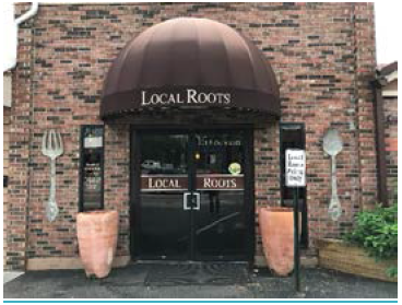
Banner or pennant means any non-rigid cloth, canvas, bunting, plastic, paper, or similar material that is mounted to any structure, staff, pole, line, or framing. Such signs are typically related to a public demonstration or for the promotion of civic, welfare or charitable enterprises. National, State or municipal flags shall not be considered a banner or pennant.
Blade sign means a small, pedestrian-oriented sign mounted so that the sign face is perpendicular to the face of the building. A blade sign may be hung beneath a canopy or awning.
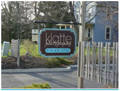
Building frontage, primary means that portion of the building frontage that faces the street. In cases where a building has more than one street frontage, the longest of the street frontages shall be considered the primary building frontage. In cases where a business has no building frontage facing a street, the building frontage with the primary business entrance shall be considered the primary building frontage. A single multi-tenant building has one primary frontage, the allowable sign area for which may be distributed at the discretion of the owner; however, in no event shall the combined sign area for all tenants exceed the allowable sign area for the building.
Changeable copy sign means a sign which displays words, lines, logos, or symbols that can change to provide different information. Changeable copy signs include computer signs, reader boards with changeable letters, and time and temperature signs.

Channel letters means three-dimensional individually cut letters or figures whether or not illuminated, affixed to a structure.

Copy means words, letters, numbers, figures, designs, or other symbolic representations incorporated into a sign.
Double-faced sign means a sign constructed to display its message on the outer surfaces of two identical and opposite parallel planes.
Edge of roof means on a pitched roof, the lowest portion of the fascia board covering the roof rafters, or if no fascia board exists, the lowest point of the roof rafters. On a flat roof, the top of the parapet wall or three feet above the roof deck, whichever is less.
Electronic reader board sign or electronic graphics sign means a sign with a fixed or changing display/message composed of a series of lights that may be changed through electronic means.
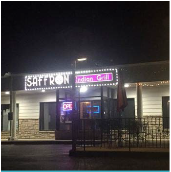
Electronic Sign means any sign that is externally powered to omit light and bring attention to the sign. This sign can utilize any form of technology to function, not including neon. This type of sign would be placed internal to a structure and would be viewable from the street, usually within a window.
External illumination means the lighting of an object from a light source located a distance from the object.
Flashing sign means a sign that contains an intermittent or sequential flashing light source.
Freestanding sign means any sign not affixed to a building. Freestanding signs may be permanent or temporary.
Inflatable device means an object that is blown up with air or gas.
Internally illuminated sign means a sign whose light source is located in the interior of the sign so that the rays go through the face of the sign, or light source which is attached to the face of the sign and is perceived as a design element of the sign.
Joint identification sign means a sign which serves as a common or collective identification for two or more uses located within the same building, or which share a common wall, or for two or more buildings located within a jointly used area, provided the buildings are in close proximity to one another.
Monument sign means a permanent, freestanding sign where the entire bottom of the sign is affixed to the ground, not to a building.
Multiple user building means a development consisting of four or more separate uses or tenancies that share either the same parcel or structure and use common access and parking facilities.
Neon sign means a glass tube lighting in which a gas and phosphors are used in combination to create a colored light.
Nonconforming sign means any sign lawfully erected and maintained prior to the effective date of this Chapter, constructed in conformance with the ordinances and other applicable laws in effect on the date of its construction, but by reason of its size, height, location, design, or construction is no longer in conformance with the regulations of this Chapter.
Nonresidential district means any of the following zoning districts: Planned Commercial District (PC), Planned Industrial District (PI), Planned Office District (PO), and the Downtown Business District (DB).
Off-premise sign means a sign which directs attention to a business, commodity, service, or entertainment conducted, sold, or offered at a location other than the lot or premises on which the sign is located.
On-premise sign means a sign which directs attention to a business, commodity, service, or entertainment conducted, sold, or offered on the lot or premises on which the sign is located.
Permanent sign means a sign constructed of durable materials and intended to exist for the duration of time that the use or occupant is located on the premises.
Pole sign means a sign mounted on a free-standing pole or other support so that the bottom edge of the sign face is ten feet or more above finished grade.
Portable sign means a sign that is not affixed to a structure or the ground (e.g., A-frame or sandwich board sign).

Projecting sign means a sign that protrudes in a V-shape from the top of the ground floor over the sidewalk, like a traditional theater marquee.
Residential district means any of the following zoning districts: Residence District (R), Planned Residence District (PR), and Downtown Residence District (DR).
Roof sign means a sign that is mounted on the roof of a building or which is wholly dependent upon a building for support and which projects above the highest point of building with a flat roof, the eave line of a building with gambrel, gable, or hip roof, or the deck line of a building with a mansard roof.
Sign means an object, device display or structure, or part thereof, situated outdoors or indoors, which is used to identify, display, or direct or attract attention to an object, person, institution, organization, business, product, service, event or location by any means, including words, letters, figures, design symbols, fixtures, colors, illumination, or projected image. Unless otherwise noted, the term "sign" includes both on-premises and off-premises signs.
Sign area means the entire area within a perimeter defined by a continuous line composed of right angles which enclose the extreme limits of lettering, logo, trademark, or other graphic representation, together with any frame or structural trim forming an integral part of the display used to differentiate the sign from the background against which it is placed.
Sign height means the vertical distance from the uppermost point of the sign to the finished grade immediately below the base of the sign, including all base and/or other mounting material.
Sign—sidewalk sign means a sign with two faces that are adjoined at the top and displayed at an angle, which is not permanently anchored or secured, or similar design. These are also known as "A-Frame" signs, and are intended to be seen by a pedestrian on a sidewalk rather than by a driver or passenger in a vehicle. Sidewalk Sign may also mean a sign with two faces that are adjoined at some point along the sign frame and the support legs are parallel to the sign (This looks like the letter "T", hence these are also known as "T-Frame" signs).
Stick sign means any type of temporary signs that are placed in the ground and consist of a paper or non-paper corrugated or similar temporary material placed over thin metal or wooden supports.
Temporary sign means any sign intended to be displayed for a limited period of time and capable of being viewed from any public right-of-way, parking area or neighboring property.
Three-dimensional signs means signs that have a depth or relief on their surface greater than six inches.
Vehicle sign means a sign that is attached to or painted on a vehicle that is parked on or adjacent to any property, the principal purpose of which is to attract attention to a product sold or business located on the property.
Wall sign means a sign that is attached to or painted on the exterior wall of a structure with the display surface of the sign approximately parallel to the building wall.
Window area means the area shall be computed by calculating each window pane or panel. The area shall be separate for each building face, and for each window. A group of window panes or panels may be considered one window if they are adjoining on the building face and are less than six inches apart.
Window sign means a sign (temporary or permanent), poster, symbol, numerals, or letters, posted, painted, placed, or affixed in or on a window exposed to public view. An interior sign that faces a window exposed to public view that is located within three feet of the window is considered a window sign for the purpose of calculating the total area of all window signs.
Electronic Sign Related Definitions
Candelas, cd: SI (System International) unit of luminous measurement when utilized per unit m2. Can also be utilized per unit area of ft2.
Center Beam Candlepower (CBCP): Center beam candlepower is the luminous intensity at the center of a beam, expressed in candelas (cd).
Direct lighting: Lighting by luminaires distributing 90 to 100 percent of the emitted light in the general direction of the surface to be illuminated. The term usually refers to light emitted in a downward direction.
Directional lighting: Illumination on the work-plane or on an object predominantly from a single direction, especially when direct lighting is incorporated into electronic signs. LED's are an example of directional lighting.
Foot-candle, fc: A unit of illuminance equal to 1 lumen per square foot. One foot-candle equals 10.76 lux.
General lighting: Lighting designed to provide a substantially uniform illuminance throughout an area, exclusive of any provision for special local requirements. This a "spherical" distribution of light.
Illuminance: Light arriving at a surface, expressed in lumens per unit area; 1 lumen per square foot equals 1 foot-candle, while 1 lumen per square meter equals 1 lux.
Luminance, L: light reflected in a particular direction; the photometric quantity most closely associated with brightness perception, measured in units of luminous intensity (candelas) per unit area (square feet or square meters).
Lumen, lm: a unit of luminous flux; the overall light output of a luminous source is measured in lumens. A unit measurement of the rate at which a lamp produces light. A lamp's light output rating expresses the total amount of light emitted in all directions per unit time.
Lux, lx: a unit of illuminance equal to 1 lumen per square meter. One lux equals 0.093 foot-candle.
NIT: Non-SI unit of luminous measurement per unit m2. Common application within the sign industry. One NIT is equivalent to one cd/m2.
Watt, W: a unit of electrical power (energy) equal to 1 joule per second. Volts times amps.
Work plane: the plane at which work usually is done, and on which the illuminance is specified and measured.
(Ord. No. 2015-29, 8-18-2015; Ord. No. 2017-60, § 1, 12-19-2017)
1151.04 - GENERAL REQUIREMENTS FOR ALL SIGNS AND DISTRICTS.
(a)
Signs in Public Rights-of-Way. Except as provided, no sign shall be placed or deposited within any public right-of-way or on any tree, pole, post, meter, or similar object located within the public right-of-way. Under no circumstance may any signs that are permitted in the right-of-way interfere with vehicular or pedestrian visibility. Signs interfering with visibility will be removed.
(1)
The following signs may be installed in the public rights-of-way without a Zoning Certificate:
A.
Signs conforming to the Manual of Uniform Traffic Control Devices;
B.
Signs installed by employees or officials of a municipal, state or federal agency in the course of their governmental duties;
C.
Signs required by a state or federal statute;
D.
Signs required by an order of a court of competent jurisdiction;
E.
Public directional and safety signs.
(2)
Blade signs attached to a building may project a maximum of 40 inches over a public right-of-way provided the lowest part of the sign is at least eight feet but no more than 15 feet above the pedestrian thoroughfare and provided said sign has received a Zoning Certificate from the Zoning Administrator. Blade signs shall not project over any curb line or street.
(b)
Colors. Not more than five colors may be used per sign. For purposes of this Section, black or white shall be considered a color. Neon and fluorescent colors are prohibited.
(c)
Lettering Styles and Sign Coverage. No more than two letter styles or more than three sizes of letters are permitted per sign. Letters may not occupy more than 75 percent of any sign panel.
(d)
Measurement of Sign Area.
(1)
The surface area of a sign shall be calculated by enclosing the extreme limits of all lettering, background, emblem, logo, representation, or other display within a single continuous perimeter composed of squares or rectangles with no more than eight lines drawn at right angles.
(2)
Supporting framework or bracing that is clearly incidental to the display itself shall not be computed as sign area.
(3)
Double-faced (back-to-back) signs shall be regarded as a single sign only if mounted on a single structure, and the distance between each sign face does not exceed two feet at any point. Only one face of an identical double-faced sign shall be measured when determining maximum allowable area.
(4)
Where a sign consists of one or more three-dimensional objects (i.e., balls, cubes, clusters of objects, sculpture, or statue-like trademarks), the sign area shall be measured as their maximum projection upon a vertical plane.
(5)
Regardless of their spacing, the letters forming a word or name shall be considered a single sign. The area of such a sign shall be measured as provided in this chapter.
(e)
Measurement of Sign Height. The height of a sign shall be computed as the distance from the base of the sign at a computed grade to the top of the highest attached component of the sign (including the sign face, sign structure, or any other appurtenance). The computed grade shall be the elevation of the nearest point to the proposed sign location of the crown of the nearest public street providing access; or the grade of the land at the principal entrance to the principal structure on the lot, whichever is higher.
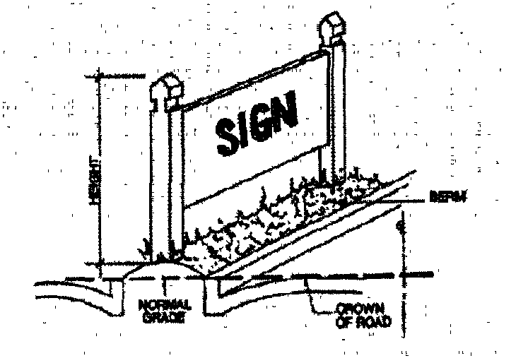
(f)
Alterations. No sign shall hereafter be altered, rebuilt, enlarged, extended or relocated except in conformity with the provisions of this chapter. The repainting of signs shall not be deemed to be an alteration within the meaning of this chapter.
(g)
Sign Maintenance. Signs and supporting hardware shall be structurally safe, clean, free of visible defects, and functioning properly at all times. Visible rot or rust, exposed lighting sources or wires, falling parts, or broken and missing parts are prima fascia evidence that a sign is in a state of disrepair. Repairs to signs shall be equal to or better in quality of materials and design than the original sign.
(h)
Notice to Repair. When the Zoning Administrator determines that such a sign exists in a state of disrepair, the Zoning Administrator shall issue to the owner of the sign and the owner of the real estate a notice of such disrepair and the need for corrective action. Any party receiving such notice may appeal the notice to the Board of Zoning Appeals in accordance with Section 1127.03. If such an appeal is not filed within 20 days of the date on which the notice is sent, persons receiving the notice shall be responsible for repairing the sign or otherwise bringing it into conformance with this chapter. The repair work shall be accomplished within 30 days of the date of the notice, unless the person undertaking the work files a request with the Zoning Administrator for an extension. If such request shows diligence and good faith such as ordering materials or signing a contract with a licensed contractor, the Zoning Administrator shall grant an extension of a maximum of 30 days for completion of the work. If an appeal is filed in accordance with Section 1127.03 the time for performance shall be delayed until resolution of the appeal. If the Zoning Administrator finds that the lack of repair constitutes a danger to persons or to property other than that of those persons receiving the notice, the Zoning Administrator shall so state in the notice and the Municipality may seek immediate relief under the Building Code or under the laws of public nuisance.
(i)
Sign Removal or Replacement. When a sign is removed or replaced, all brackets, poles, and other structural elements that supported the sign shall also be removed. Affected building surfaces shall be restored to match the adjacent portion of the structure.
(j)
Sign Attachment and Support. No sign shall be attached to or supported by a fence, tree, utility pole, light pole, trash receptacle, bench, vending machine, gasoline pump, or public shelter, nor shall such sign be painted or drawn upon rocks or other natural features.
(k)
Changeable Copy Signs. Manual or electronic changeable copy signs shall not be permitted on any sign within the municipality unless it is approved by the Planning and Zoning Commission as part of a comprehensive sign plan.
(Ord. No. 2015-29, 8-18-2015)
1151.05 - PERMANENT SIGNS.
(a)
Residential Districts. Permanent signs in residential districts shall conform to the following standards as well as the other applicable standards of the Codified Ordinances:
(1)
Number. No more than one such sign may be located on a lot.
(2)
Type. Unless otherwise stated, wall signs are the only types of signs permitted. Permanent subdivision identification signs within entrance features are permitted and shall be reviewed and approved by the Planning and Zoning Commission.
(3)
[Off-premises signs.]All off-premises signs are prohibited.
(4)
Maximum area and height. Signs may not exceed four square feet in area or be more than two feet in height.
(5)
Illumination. Signs shall not be separately illuminated. This standard is not intended to prohibit the installation of such a sign near a porch light or yard light, which may incidentally illuminate the sign. Permanent subdivision identification signs within entrance features may be lighted by an external source, but such illumination shall be in a manner which avoids glare or reflection which in any way interferes with traffic safety
(b)
Non-Residential Districts. Permanent signs in non-residential districts shall conform to the following standards and all other applicable standards of the Codified Ordinances:
(1)
Number.
A.
Wall signs. No more than one wall sign shall be permitted. A secondary wall sign no more than 75 percent of the size of the primary wall sign shall be permitted if the property fronts two or more public streets. No more than one secondary wall sign shall be permitted. Blade and awning and canopy signs shall be considered wall signs.
B.
Freestanding signs. No more than one sign shall be permitted per lot frontage.
C.
Joint identification signs. No more than one sign shall be permitted. A secondary joint identification sign shall be permitted if the property fronts two or more public streets and is located on a lot more than two acres. No more than one secondary joint identification sign shall be permitted per development.
(2)
Maximum area and height.
A.
Wall signs. The total area shall not exceed one square foot per one lineal foot of the length of the wall on which the sign is to be attached up to a maximum of 36 square feet. Within the Historic District, the maximum size shall be 18 square feet. The maximum height permitted shall be 15 feet in any district.
B.
Freestanding signs. The total area shall not exceed 48 square feet. Within the Historic District, the maximum size shall be 12 square feet. The maximum height shall be eight feet in any district.
C.
Joint identification signs. On lots less than ten acres, primary joint identification signs may not exceed 56 square feet in area or be more than eight feet in height. Secondary joint identification signs shall not exceed 36 square feet in area or be more than eight feet in height. On lots ten acres or greater primary joint identification signs may not exceed 72 square feet in area or be more than ten feet in height and secondary joint identification signs may not exceed 48 square feet or be more than eight feet in height. Within the Historic District, the maximum size shall be reduced by one-half the size stated above.
(3)
Illumination.
A.
Unless otherwise stated, signs may be illuminated from within or from an external source, but such illumination shall be in a manner which avoids glare or reflection which in any way interferes with traffic safety. Within the Historic District, illumination shall only be from an external source.
B.
Internally illuminated signs shall have an opaque background and translucent copy.
C.
External lighting fixtures shall be aimed and shielded so that direct illumination is focused exclusively on the sign.
D.
Fixtures can be mounted on the top of the sign or be ground mounted with up-lighting not exceeding 100 lamp watts per sign face.
E.
The maximum watts permitted to illuminate a sign shall be two watts per sign face square foot provided at no point on the face of the sign and at no time shall the illumination exceed 30 vertical foot-candles during hours of darkness.
F.
Rotating, traveling, pulsing, flashing, blinking, or oscillating light sources, lasers, beacons, search lights, or strobe lighting are prohibited.
G.
Colored lights shall not be used at a location or in a manner so as to be confused or construed as traffic control devices.
H.
Light sources shall utilize energy efficient fixtures to the greatest extent possible.
I.
Neon lighted signs, or signs resembling neon lighted signs, are prohibited if they can be seen and readable from the outside.
(c)
Zoning Certificate Required. Unless otherwise stated, all permanent signs in residential and nonresidential districts require a Zoning Certificate.
(Ord. No. 2015-29, 8-18-2015)
1151.06 - TEMPORARY SIGNS.
(a)
All Districts.
(1)
Non-Commercial Speech Temporary Signs: Temporary signs that portray a message which is not commercial in nature (that do not advertise a business, commodity, product or service) shall be allowed. No more than one sign per statement is permissible per lot per frontage. Any non-commercial sign may remain on a lot indefinitely, until such a time that the sign has not been maintained in an original or near-original condition.
(b)
Residential Districts. Temporary signs in residential districts shall conform to the following standards as well as the other applicable standards of the Codified Ordinances:
(1)
Number. No more than one sign per statement is permissible per lot per frontage.
(2)
Maximum area and height. Signs may not exceed six square feet in area or be more than four feet in height.
(3)
Display period. Each temporary sign may not be displayed for more than 45 consecutive days, unless said sign is maintained in good condition as determined by the Zoning Administrator.
(4)
Off-premises signs. Off-premises temporary signs are prohibited.
(5)
Illumination. Signs shall not be separately illuminated. This standard is not intended to prohibit the installation of such a sign near a porch light or yard light, which may incidentally illuminate the sign.
(6)
Zoning Certificate requirements. Temporary signs in residential districts do not require a Zoning Certificate.
(c)
Except as authorized above for non-commercial speech temporary signs, no other temporary or portable signs shall be allowed in the City.
(d)
Temporary New Development Construction Signs.
(1)
The owner or developer of a residential subdivision or a non-residential development may erect one sign not exceeding 32 square feet in area during the course of development. Once 80 percent of the development is complete as determined by the Zoning Administrator, these signs shall be removed by the Zoning Certificate holder.
(Ord. No. 2015-29, 8-18-2015)
1151.07 - STANDARDS FOR SPECIFIC SIGN TYPES.
(a)
Awning and Canopy Signs. Awning and canopy signs may be permitted only as an integral part of the awning or canopy to which they are attached or applied and shall meet the following conditions:
(1)
Location. Signs may be placed only on awnings that are located on first- and second-story building frontages, including those fronting a parking lot or pedestrian way.
(2)
Extension. Such signs shall not extend more than three feet from the face of the building to which they are attached.
(3)
Minimum clearance. A minimum clearance of ten feet shall be maintained above sidewalks.
(4)
Copy. The copy on an awning sign shall not exceed 50 percent of the sign's total area.
(5)
Illumination. Internal illumination of the awning is prohibited.
(b)
Blade signs.
(1)
Location. Blade signs shall be placed only on a ground floor facade, except for businesses located above the ground level with direct exterior pedestrian access.
(2)
Height above finished grade. The lowest point of a blade signs shall be at least eight feet but no more than 15 feet above finished grade. Blade signs shall not extend beyond the roof line in a vertical direction.
(3)
Sign structure. Sign supports and brackets shall be compatible with the design and scale of the sign. Brackets and/or hardware for the sign may not extend more than four inches from the outside face of the sign.
(4)
Square footage. A maximum of eight square feet will be allowed.
(5)
Illumination. Internal illumination is prohibited.
(c)
Freestanding Signs.
(1)
Posts. Signs mounted on single poles or posts shall be prohibited outside the Historic District Freestanding signs shall be designed utilizing two posts, one on either side of the sign, or be designed with a monument type base. No more than two posts may be used. The height of the posts will not be included in the maximum height permitted for the sign, however posts shall not protrude higher than one foot above the height of the sign. Minimum post size (this refers to the finished outside dimension) shall be a six inch by six inch shall be required.
(2)
Base material of monument signs. The base of monument signs shall be brick, stone, stucco, or other more permanent material not subject to water damage. The exposed base of a monument sign shall not exceed two feet in height. The height of the base will be included when calculating the height of the sign.
(3)
Cantilever signs. The post used to anchor cantilever signs shall be wood or another natural material such as brick or stone.
(4)
Landscaping. Landscaping shall be provided at the base of the supporting structure equal to twice the area of one face of the sign. Landscaping is not required on temporary, freestanding signs.
(5)
Location. The sign must be located along frontage adjoining a public street.
(6)
Setbacks. The front setback for freestanding signs shall be a minimum of 15 from the public right-of-way line unless otherwise stated. The sign must also meet the side yard setback for the applicable zoning district unless otherwise stated.
(d)
Joint Identification Signs.
(1)
Type. Primary and secondary freestanding joint identification signs must be monument signs.
(2)
Setbacks. The front setback for freestanding joint identification signs shall be 25 feet from the public right-of-way. The sign must also meet the side yard setback for the applicable zoning district unless otherwise stated.
(e)
Wall signs.
(1)
Location. All wall signs shall be mounted on the building which houses the establishment advertised by such signs, except as otherwise specifically authorized by this Zoning Code. Such signs shall be located on or along a wall of such a building which faces a street, parking lot, or service drive, and shall not project above the roof line or the cap of parapets of such building, whichever is higher.
(2)
Projection from wall. All wall signs shall be parallel to the wall on which they are installed. The sign shall not project from the surface upon which it is attached more than 12 inches in a non-residential district. In a residential district, a wall sign shall not project more than three inches.
(Ord. No. 2015-29, 8-18-2015)
1151.08 - PROHIBITED SIGNS.
(a)
Prohibited Signs. The following signs and types of signs are inconsistent with the purposes and standards of this chapter and are prohibited in all zoning districts:
(1)
Signs within any public right-of-way unless specifically authorized under Section 1151.04(a).
(2)
Flashing, moving, rotating, intermittently lighted signs or other mechanical devices which creates the appearance of movement.
(3)
Air actuated attraction devices.
(4)
Roof signs.
(5)
Pole signs.
(6)
Portable changeable copy signs.
(7)
Electronic variable message signs, reader boards, and changeable copy signs except as authorized under 1151.04(a)(1) or 1151.04(k).
(8)
Stick Signs or any type of portable or temporary sign portraying a commercial message.
(b)
Prohibited Sign Attachments. No temporary or permanent items shall be attached to any sign within the Municipality of Powell. This shall include, but not be limited to, balloons, streamers, arrows, or other such items that are not a part of the originally approved Zoning Certificate for such sign.
(Ord. No. 2015-29, 8-18-2015)
1151.09 - SIGN ZONING CERTIFICATES.
(a)
Zoning Certificates Required. To ensure compliance with the regulations of this chapter, a Zoning Certificate shall be required in order to apply, erect, move, alter, reconstruct, or repair any permanent or temporary sign, except signs that are do not require zoning certificates consistent with the requirements of Sections 1151.04(a)(1) and 1151.10. A Zoning Certificate is also required for the lighting of new or the relighting of existing signs. Granting of a Zoning Certificate from the Zoning Administrator does not constitute a building permit.
(b)
Review Authority. The Zoning Administrator will review all Zoning Certificate applications within the Municipality of Powell. The Zoning Administrator has 30 days from the date of submittal to review all Zoning Certificate applications and either grant, grant with conditions, or deny the Zoning Certificate application. If the Zoning Administrator grants a Zoning Certificate with conditions, the Zoning Administrator shall state the conditions in writing, with citations to relevant sections of this chapter. The applicant shall sign a statement acknowledging the conditions set forth by the Zoning Administrator. If the Zoning Administrator denies a Zoning Certificate application, the Zoning Administrator shall do so in writing and state in writing the reason for denial, with citations to relevant sections of this chapter or other provisions of the Codified Ordinances. The applicant may appeal the decision of the Zoning Administrator as outlined in Section 1151.15.
(c)
Preparation. Applicants for a sign Zoning Certificate must submit the following information. Incomplete applications will be denied.
(1)
Color sign rendering.
(2)
Site plan and elevation drawings.
(3)
Sign dimensions and dimensions of sign mounting material, where applicable.
(4)
Building façade dimensions, where applicable.
(5)
Distance of sign from all public rights-of-way.
(6)
Style, type, wattage, and location of all lighting.
(7)
Landscaping plan for freestanding signs.
(8)
List of construction materials, including sign mounting material, where applicable.
(d)
Criteria for Approval. The Zoning Inspector shall approve a Zoning Certificate if the proposed sign conforms to all applicable requirements of this chapter.
(Ord. No. 2015-29, 8-18-2015)
1151.10 - SIGNS NOT REQUIRING PERMITS.
(a)
Signs Exempt from Regulations. Any sign located entirely inside a building and not visible from the public right-of-way or from private property other than the property on which such sign is located shall be entirely exempt from regulation under this chapter.
(b)
Permanent Signs Allowed in Any District without a Zoning Certificate and Not Included in Dimensional Limitations. Zoning Certificates shall not be required for the signs listed herein. These signs shall not be included in the determination of the total allowable number of signs or total allowable sign area for a site.
(1)
Signs conforming to the Ohio Manual of Uniform Traffic Control Devices;
(2)
Signs installed by employees or officials of a state or federal agency or of the Municipality or Delaware County in the course of their governmental duties;
(3)
Signs required by a state or federal statute or agency;
(4)
Signs required by an order of a court of competent jurisdiction;
(5)
Signs installed by public utilities to demarcate their rights-of-way.
(6)
Signs installed by a transit company;
(7)
Signs not exceeding one square foot in area;
(8)
On-site traffic and other directional signs indicating points of entry or exit to off-street parking, identifying specific parking areas and directions to buildings and other services, provided that such signs are not larger than two square feet in area and bear no commercial message. Such signs shall not obstruct the view of motorists for the purposes of ingress and egress.
(c)
Temporary Signs Allowed without a Zoning Certificate.
(1)
Official and legal notices required by a court or governmental agency.
(2)
Temporary signs in residential areas.
(d)
Window Signs. Window signs are permitted in any zoning district and do not require a Zoning Certificate. However, all window signs shall meet the following conditions:
(1)
Number. No more than 20 percent of the windows in any structure may be covered with permanent or temporary window signs.
(2)
Surface coverage. Window signs may not be larger than 20 percent of the aggregate window area.
(3)
Neon Signs. Neon, or neon simulating, signs are prohibited.
(4)
Electronic Signs. All other electronic signs shall not exceed one foot by two foot area (two square feet) within any given window. Only one electronic sign per business per frontage is permitted. These signs shall not exceed 15 characters, including spaces and other special characters.
A.
General Lighting Standards.
1.
Light bulb illumination is measured in lumens. There is no conversion between lumens and nits, mainly because light bulbs are spherical (general) sources of light.
2.
In no case shall the lighting intensity of any sign exceed the limit of 75 foot candles measured with a standard light meter or equivalent perpendicular to the face of the sign at a distance equal to the narrowest dimension of the sign, whether it is height or width.
3.
In no case shall any exposed reflective-type bulbs, incandescent lamp, or any other type of bare bulb illumination exceed 20 watts.
B.
Directional Lighting Standards.
1.
Directional type signs are measured in nits (candles per square meter).
2.
The average number of "on" pixels in a message is 40 percent for the average measurement and 100 percent of the "on" pixels is for the maximum measurement. Most programming is assumed to be near the 40 percent number.
3.
For daytime programming, the average illumination is limited to 2,000 nits.
4.
For nighttime programming, the average illumination is limited to 500 nits.
5.
The maximum daytime illumination is 5,000 nits.
6.
The nighttime illumination is to be set to 25 percent of the daytime illumination but can be adjusted up or down, in one percent increments, with photocell software for incremental dimming.
(Ord. No. 2015-29, 8-18-2015)
1151.11 - COMPREHENSIVE SIGN PLAN.
(a)
Purpose. A Comprehensive Sign Plan is intended to integrate the design of the signs proposed for a new development project, or an existing commercial property, with the design of the structures, into a unified architectural statement. A Comprehensive Sign Plan provides a means for defining common sign regulations for multi-user projects, to encourage maximum incentive and latitude in the design and display of multiple signs and to achieve, not circumvent, the intent of this chapter.
(b)
Applicability. The approval of a Comprehensive Sign Plan shall be required when two or more signs requiring Zoning Certificates are proposed for a new development or existing site, or if a joint identification sign is proposed.
(c)
Approval Authority. The Planning and Zoning Commission, or in the case of a property within the Historic District, the Historic Downtown Advisory Committee, must approve a Comprehensive Sign Plan prior to issuance of a Sign Zoning Certificate by the Zoning Administrator, under the requirements of this chapter, and the design guidelines within the Historic District.
(d)
Application Requirements. An application for a Comprehensive Sign Plan shall include all information and materials required in Section 1151.09 and the filing fee set by City Council.
(e)
Standards. A Comprehensive Sign Plan shall comply with the following standards:
(1)
The plan shall comply with the purpose of this chapter and the overall intent of this section;
(2)
The signs shall enhance the overall development, be in harmony with, and relate visually to other signs included in the comprehensive sign plan, to the structures and/or developments they identify, and to surrounding development;
(3)
The Comprehensive Sign Plan shall accommodate future revisions that may be required because of changes in use or tenants; and
(4)
The Comprehensive Sign Plan shall comply with the standards of this chapter.
(f)
Revisions to Comprehensive Sign Plans. The Zoning Administrator may approve the substitution of signs provided these signs meet the all the requirements of Chapter 1151 and the adopted Comprehensive Sign Plan. If additional signage is proposed or if proposed signs are changed in any aspect to the intent of the original Comprehensive Sign Plan, approval from the Planning and Zoning Commission or Historic Downtown Advisory Committee is required.
(Ord. No. 2015-29, 8-18-2015)
1151.12 - ABANDONED SIGNS.
(a)
Abandonment Defined. If any sign shall become abandoned, in a manner defined herein, such sign is declared a public nuisance by reason that continued lack of use results in lack of reasonable and adequate maintenance, thereby causing deterioration and creating a blighting influence on nearby properties. An abandoned sign shall be any sign that meets any of the following conditions:
(1)
Any sign associated with the abandoned nonconforming use.
(2)
Any sign that remains after the termination of a business. A business shall be considered terminated if it has ceased operations for at least 60 consecutive days.
(3)
Any sign that is not maintained in accordance with Section 1151.04(g).
(b)
Determination of Abandonment. When the Zoning Administrator finds, upon investigation, that a sign has been abandoned, the Zoning Administrator shall notify the owner of said sign and the owner of the property upon which such sign is located, of any findings. Such notice shall advise the owner of the sign and the owner of the property that said sign has been declared abandoned and must be removed within 30 days from the date of mailing of said notice. The owner of the sign or the owner of the property may appeal such decision as provided in Section 1151.15.
(c)
Right to Remove. If the sign is not removed as ordered, the sign may be removed by the Municipality of Powell at the expense of the lessee or owner. If the Municipality is not reimbursed for the cost of removal within 30 days of such removal, the amount thereof shall be certified to the County Auditor for collection as a special assessment or lien against the property upon which such sign is located.
(Ord. No. 2015-29, 8-18-2015)
1151.13 - SUBSTITUTION OF MESSAGES.
Any sign allowed herein may contain, in lieu of any other message or copy, any lawful noncommercial message that does not direct attention to a business operated for profit, or to a product, commodity, or service for sale or lease, or to any other commercial interest or activity, so long as said sign complies with the size, height, area, and other requirements of this chapter.
(Ord. No. 2015-29, 8-18-2015)
1151.14 - SEVERABILITY.
(a)
Generally. If any part, section, subsection, paragraph, subparagraph, sentence, phrase, clause, term, or word of this chapter is declared unconstitutional by the valid judgment or decree of any court of competent jurisdiction, the declaration of such unconstitutionality shall not affect any other part, section, subsection, paragraph, subparagraph, sentence, phrase, clause, term or word of this chapter. It is intended that if any part, section, subsection, paragraph, subparagraph, sentence, phrase, clause, term or word of this chapter is severed, the remaining parts, sections, subsections, paragraphs, subparagraphs, sentences, phrases, clauses, terms or words shall be considered independent, valid, and enforceable.
(b)
Severability Where less Speech Results. Without diminishing or limiting in any way the declaration of severability set forth in Section 1151.14(a), or elsewhere in this chapter, if any part, section, subsection, paragraph, subparagraph, sentence, phrase, clause, term or word of this chapter is declared unconstitutional shall not affect any other part, section, subsection, paragraph, subparagraph, sentence, phrase, clause, term or word of this chapter, even if such severability would result in a situation where there would be less speech, whether by subjecting previously exempt signs to zoning certificates or otherwise. It is intended that if any part, section, subsection, paragraph, subparagraph, sentence, phrase, clause, term or word of this chapter is severed, the remaining parts, sections, subsections, paragraphs, subparagraphs, sentences, phrases, clauses, terms or words shall be considered independent, valid, and enforceable.
(c)
Severability of Provisions Pertaining to Prohibited Signs. Without diminishing or limiting in any way the declaration of severability set forth in Section 1151.14(a) and (b), or elsewhere in this chapter, if any part, section, subsection, paragraph, subparagraph, sentence, phrase, clause, term or word of this article or any other laws declared unconstitutional by valid judgment or decree of any court of competent jurisdiction, the declaration of such unconstitutionality shall not affect any other part, section, subsection, paragraph, subparagraph, sentence, phrase, clause, term or word of this chapter that pertains to prohibited signs, including specifically those signs and sign types prohibited and not allowed under Section 1151.08 of this chapter. Furthermore, if any part, section, subsection, paragraph, subparagraph, sentence, phrase, clause, term or word of Chapter 1151 is declared unconstitutional by the valid judgment or decree of any court of competent jurisdiction, the declaration of such unconstitutionality shall not affect any other part, section, subsection, paragraph, subparagraph, sentence, phrase, clause, term or word of Chapter 1151. It is intended that if any part, section, subsection, paragraph, subparagraph, sentence, phrase, clause, term or word of this chapter is severed, the remaining parts, sections, subsections, paragraphs, subparagraphs, sentences, phrases, clauses, terms or words shall be considered independent, valid, and enforceable.
(d)
Severability of Prohibition on Signs Bearing Off-premise Commercial Messages. If any part section, subsection, paragraph, subparagraph, sentence, phrase, clause, term or word of this chapter and/or any other provisions of the Zoning Code or the Codified Ordinances are declared invalid or unconstitutional by the valid judgment or decree of any court of competent jurisdiction, the declaration of such unconstitutionality shall not affect the prohibition on signs bearing off-premises commercial messages as contained herein. It is intended that if any part, section, subsection, paragraph, subparagraph, sentence, phrase, clause, term or word of this chapter is severed, the remaining parts, sections, subsections, paragraphs, subparagraphs, sentences, phrases, clauses, terms or words shall be considered independent, valid, and enforceable.
(Ord. No. 2015-29, 8-18-2015)
1151.15 - APPEALS.
The decision of the Zoning Administrator regarding issuance of a Zoning Certificate, notice to repair, or determination of abandonment may be appealed to the Board of Zoning Appeals subject to the requirements in Chapter 1127.
(Ord. No. 2015-29, 8-18-2015)
1151.99 - VIOLATIONS, PENALTIES, AND REMEDIES
Any person, firm or corporation violating any requirement or prohibition of this chapter shall be considered in violation of this Code, and shall be subject to enforcement under the requirements of Chapter 1135, including the penalties and other remedies allowed by that chapter.
(Ord. No. 2015-29, 8-18-2015)
1155.01 - PURPOSE.
Bed and breakfast inns are unique semi-commercial operations that adapt a residential environment into a lodging concept limited in scope and operation. The regulations presented here provide a systematic set of requirements to ensure that such operations, if appropriate for a residential or commercial area, shall not adversely impact adjacent uses as a result of the commercial aspects of the structure and property. Bed and breakfast inns shall be subordinate to the principal use of a single-family dwelling. The intent is not to provide an opportunity for the establishment of an intensive commercial lodging business that would be considered appropriate within an intensive commercial or planned commercial zoning district.
(Ord. No. 99-43, 9-30-1999)
1155.02 - DEFINITION.
For the purpose of the Zoning Code, a "bed and breakfast inn" means an owner-occupied residential single-family detached structure where lodging and meals are provided to transient guests for compensation in accordance with the development standards of this chapter. The provision of lodging and breakfast shall be subordinate to the principal use of the structure.
(Ord. No. 99-43, 9-30-1999)
1155.03 - CONDITIONAL USE PERMIT REQUIRED.
(a)
A Bed and breakfast inn is classified as a conditional use in the following zoning districts:
DR, Downtown Residence District
DB - Downtown Business District
PC - Planned Commercial
(b)
The corresponding standards and requirements of Chapter 1129 thereby apply. Such conditional use permits shall be voided upon the sale or transfer of the property ownership. In submitting an application for conditional use permit, the applicant shall provide to the Board of Zoning Appeals a floor plan illustrating the proposed operation, a site plan indicating all on-site improvements, and any additional information as required by the Zoning Administrator or Board.
(Ord. No. 99-43, 9-30-1999; Ord. No. 2017-60, § 1, 12-19-2017)
1155.04 - DEVELOPMENT STANDARDS FOR RESIDENTIAL DISTRICTS.
The following development standards apply to bed and breakfast inns that are conditional uses within single-family zoning districts.
(a)
Guest Rooms. There shall be no more than four guest rooms within a single-family dwelling that are utilized by bed and breakfast guests. A guest room shall contain no less than 100 square feet of living space, not including closets, for two guests and 30 square feet for additional guest up to a total of four guests.
(b)
Parking. One off-street parking space shall be provided for each guest room and one off-street parking space for the dwelling unit. Such off-street parking spaces may be provided in an existing driveway.
(c)
Signage. One on-premises sign shall be permitted for each bed and breakfast inn not to exceed six square feet in area. The sign shall not be internally illuminated. Such signs shall be limited to three colors. The applicable standards of Chapter 1151 shall apply unless otherwise superseded by this section.
(d)
Employees. Not more than one nonresident for every three guest rooms of the dwelling may be employed in the operation of a bed and breakfast Inn.
(Ord. No. 99-43, 9-30-1999)
1155.05 - GENERAL DEVELOPMENT STANDARDS.
(a)
Single-Family Detached Dwelling. Bed and breakfast inns shall only be permitted with a conditional use permit in single-family detached dwellings.
(b)
Owner/Operator. The owner/operator of the bed and breakfast inn shall live full-time on the inn's premises. Such owner/operator shall be the record owner of no less than 60 percent interest of the property in question.
(c)
Architectural Review. All new construction and exterior alterations associated with the bed and breakfast inn, including nonstructural improvements, shall be reviewed and approved by the Planning and Zoning Commission or inside the Historic District by the Historic District Commission. Such approval is required prior to review of the conditional use permit by the Board of Zoning Appeals. All such improvements shall be completed prior to issuance of an occupancy permit.
(d)
Certificate of Fire and Health Offices. Certificates from the Liberty Township Fire Department and the Delaware County Board of Health shall be required for each conditional use permit requesting approval for a bed and breakfast inn. Each guest room shall contain a separate installed smoke detector alarm approved by the Fire Officer. No premises shall be utilized for a bed and breakfast inn unless there are at least two separate exits to the outdoors.
(e)
Consecutive Nights. Each paying guest may stay at a bed and breakfast inn for not more than seven consecutive nights at any single visit nor more than a total of 45 in any given calendar year.
(f)
Kitchen Facilities. Only one kitchen facility shall be permitted per structure for which a conditional use permit is granted to operate a bed and breakfast inn. No cooking facilities shall be permitted in individual guest quarters.
(g)
Bathrooms. A minimum of one full bathroom, including shower, toilet, and sink, shall be required for every two guest rooms to be available for the exclusive use of bed and breakfast paying guests. Bed and breakfast inns shall be serviced by public sanitary sewer and water service.
(h)
Guest Register. A guest register listing the name, address and phone number of all paying guests shall be maintained by the owner/manager and shall be made available for inspection by City Officials.
(i)
Special Gatherings. Rental of the bed and breakfast inn to other than registered guests for special gatherings such as wedding receptions and parties shall require a special permit approved by the Planning and Zoning Commission.
(j)
Business License. A business license shall be required to be obtained from the Municipality of Powell prior to issuance of an occupancy permit.
(k)
Public Nuisance. Bed and breakfast inns shall not be permitted and a conditional use permit shall be revoked or suspended by the Board of Zoning Appeals if the use is found to constitute a nuisance.
(Ord. No. 99-43, 9-30-1999)