
Putnam County Unincorporated
City Zoning Code
City Zoning Code
ARTICLE IV
OVERLAY ZONES AND PLANNED UNIT DEVELOPMENT DISTRICTS
DIVISION 7. - RESERVED FOR REDEVELOPMENT DISTRICT[1]
Editor's note— Note: This division will be added if needed to effectively implement Policy A.1.2.1, art. VIII, Signs, and art. IX, Non-Conforming Uses, [which] contain provisions to implement this policy.
APPENDIX IV. FIGURES
Figure 4.1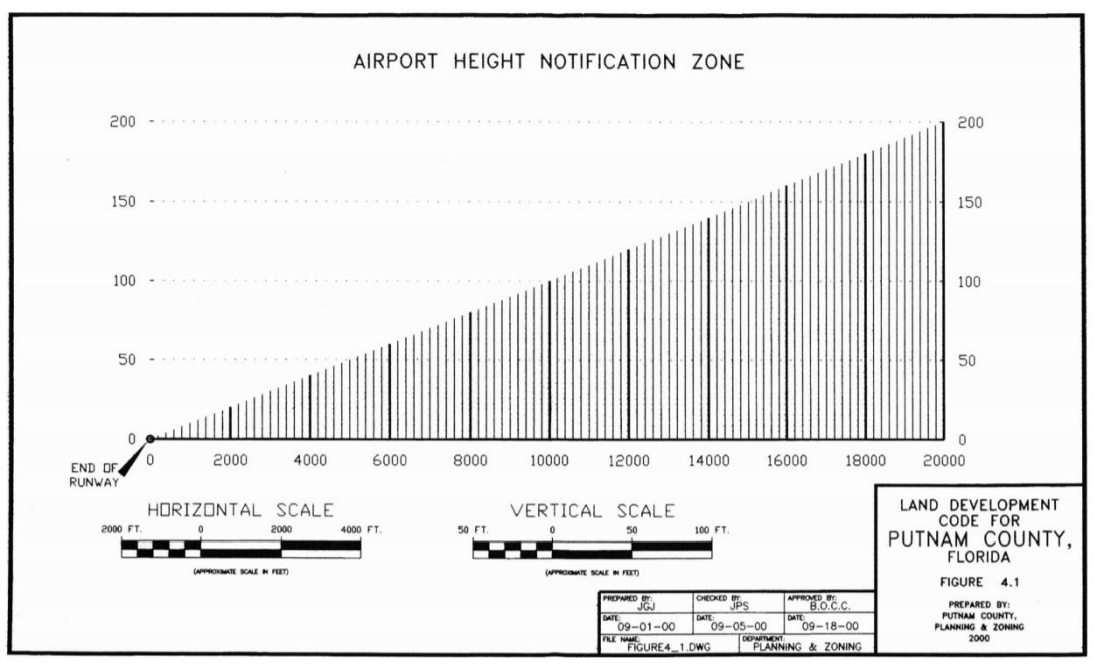
Map 4.1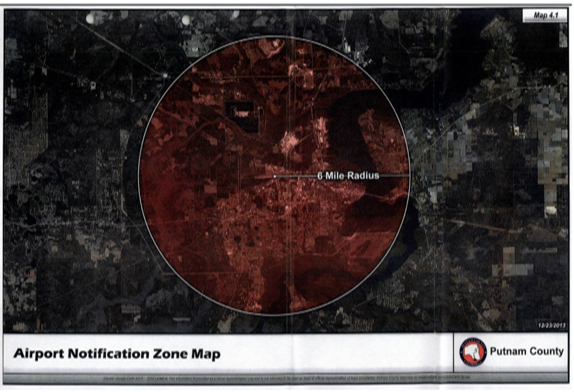
Map 4.2
Map 4.3
Airport Airspace Plan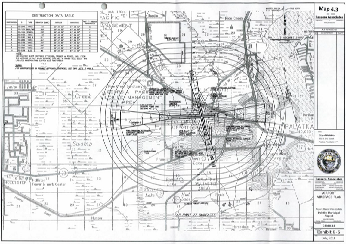
Map 4.4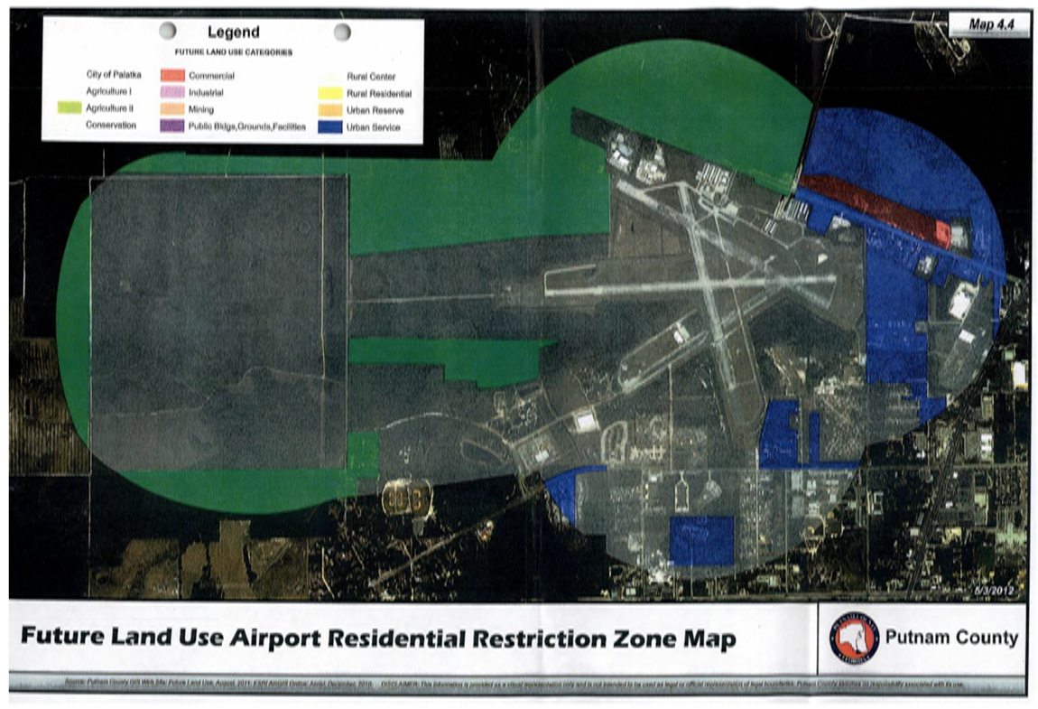
Map 4.5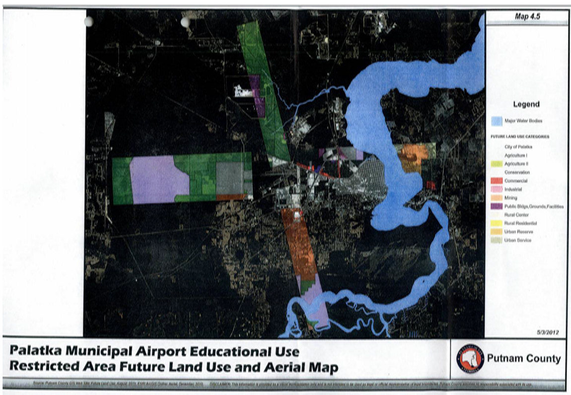
Map 4.6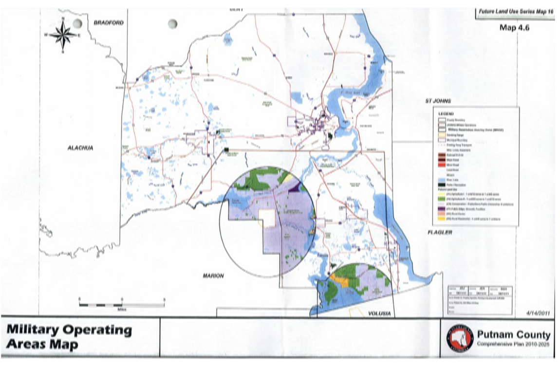
Sec. 45-211. - Purpose.
The purpose of this section is to describe overlay zones and planned unit development districts used to impose special development standards in certain areas. The location of overlay zones and planned unit development districts is established by the county based on the need for special development standards in specified areas. The overlay zones and planned unit development districts impose additional or different development standards than those that would otherwise apply in a conventional zoning district.
Sec. 45-212. - Definitions.
The following words, terms and phrases, when used in this article, shall have the meanings ascribed to them in this section, except where the context clearly indicates a different meaning:
Overlay zone means a district that encompasses one or more underlying zones and that imposes additional or alternative requirements above that stipulated for the underlying zones.
Planned unit development (PUD) means land under unified control, planned and constructed as a whole in a single unified development or in approved phases. PUD's many include a variety of land uses and types of dwelling units as well as related uses and facilities. There is no minimum acreage size required for a PUD.
Sec. 45-221. - Purpose and intent of the PUD zoning district.
(a)
The PUD zoning district is established by Policy A.1.9.3.C of the Putnam County Comprehensive Plan. It is the purpose of this district to provide a method for landowners or developers to submit unique proposals which may not be provided for or allowed in the other zoning districts otherwise established by this Code. The PUD zoning district allows a mix of residential and nonresidential uses and/or unique design features which might otherwise not be allowed in one of the other listed districts, but that otherwise conform to the Putnam County Comprehensive Plan.
(b)
These PUD provisions are intended to promote flexibility of design and integration of uses and structures, while at the same time retaining in the board of county commissioners (hereinafter "county commission") the absolute authority to establish limitations and regulations thereon for the benefit of the public health, welfare and safety. By encouraging flexibility while retaining control by the county commission, the PUD is designed to accomplish one or more of the following:
(1)
Permit innovative residential, nonresidential, and mixed-use developments provide for an integration of housing types and accommodation of changing lifestyles within neighborhoods; and provide for design that encourages internal and external convenient and comfortable travel by foot, bicycle, and transit through such strategies as various street widths compatible with the type of development project proposed, modest setbacks, front porches, connected streets, multiple connections to nearby land uses, and mixed uses.
(2)
Provide flexibility to meet changing needs, technologies, economics and consumer preferences.
(3)
Preserve to the greatest extent possible, and utilize in a harmonious fashion, existing and outstanding landscape features and scenic vistas.
(4)
Lower development and building costs by permitting smaller networks of utilities, and the use of more economical development patterns and shared facilities.
(5)
Achieve overall coordinated building and facility relationships and infill development, and eliminate the negative impacts of unplanned and piecemeal development.
(6)
Enhance the combination and coordination of architectural styles, building forms and building relationships within the development.
(7)
Promote the use of traditional, quality-of-life design features, such as pedestrian scale, parking located to the side or rear of buildings, connected streets, terminated vistas, front porches, recessed garages, alleys, aligned building facades that face the street, and formal landscaping along streets and sidewalks.
(8)
Provide an efficient public process for considering large scale, complex developments where the proposed development is of such size, scale, complexity, and/or unique design that it would be inconvenient and inefficient to process such a proposal outside the PUD process.
(c)
All building code, housing code and other land use regulations of this Code are applicable to a PUD; unless otherwise approved within the PUD ordinance.
Sec. 45-222. - Justification and minimum requirements for rezoning to planned unit development.
(a)
An applicant for a PUD rezoning must present evidence in the PUD narrative that the rezoning to PUD is justified by one or more of the following:
(1)
The proposed development is unique. Although it does not fit within an existing zoning district, it is consistent with the county comprehensive plan. The land use designation on the future land use map of the comprehensive plan shall be such that it allows the proposed activity of the PUD prior to any application for rezoning to this designation being accepted.
(2)
The proposed development is of such size, scale, complexity, and/or unique design that it would be inconvenient and inefficient to process such a proposal outside the PUD process.
(3)
The nature of the proposed use at a specific site requires specialized design characteristics to preserve and protect neighborhood character, environmental concerns and other concerns unique to the immediate area, consistent with comprehensive plan policies.
(b)
If a PUD proposal is found to be justified as required by subsection (a) above, the applicant for the PUD rezoning must further present evidence in the aforementioned PUD narrative that the rezoning to PUD meets the following standards:
(1)
The density and/or intensity, character and type of development proposed in the development plan is consistent with the comprehensive plan, future land use map and the concurrency management system, and the development plan meets one or more of the objectives set forth in section 45-221(b) above.
(2)
The land uses proposed within a PUD are compatible with the terrain and the existing and planned uses of properties surrounding the PUD. An evaluation of the external compatibility of a PUD should be based on the following factors: (1) adjacent existing and proposed uses, (2) design of the development to avoid undue noise, odor, traffic or other nuisances and other nuisances and dangers to abutting property owners; (3) traffic circulation to ensure the transportation system and streets are of sufficient width and capacity to serve the demands created by the development; and (4) density and/or intensity including type and size of structures and/or units and height shall be considered to address compatibility.
(3)
The residential density of the PUD must comply with the density limitations for each land use category.
(4)
Usable open spaces, plazas and recreation areas provided within a PUD must be consistent with the policies of the comprehensive plan and must be sufficient to provide appropriate recreational opportunities, protect sensitive environmental areas, conserve areas of unique beauty or historical significance, enhance neighborhood design, and encourage compatible and cooperative relationships between adjoining land uses.
(5)
The site of the PUD must be suitable for use in the manner proposed without hazards to persons either on or off the site from the likelihood of increased flooding, erosion or other dangers.
(6)
Every dwelling unit or other use permitted in the PUD shall have access to a public street either directly or by way of a private road, pedestrian way, court or other area which is either dedicated to public use or is a common area guaranteeing access. Permitted uses are not required to front on a dedicated public road, but at a minimum, private roads and other access ways shall be required to be constructed so as to ensure that they are safe and maintainable. To that end, all roads within any PUD, public and/or private, shall be constructed in accordance with article VII, division 10.A of this Code. Connection to existing or planned adjacent streets is required, where applicable and feasible to minimize adverse traffic impacts.
(7)
Sufficient off-street and on-street parking for bicycles, automobiles and other vehicles must be provided. Parking areas must be constructed in accordance with the standards outlined in article VII of this Code, and any deviations must be specifically identified and approved by the county commission to ensure that they are safe and maintainable and that they allow for sufficient privacy for adjoining uses. The design of a PUD should, whenever feasible, incorporate appropriate pedestrian and bicycle access ways so as to provide for a variety of mobility opportunities. Connection to all sidewalks, greenways, trails, bikeways, and transit stops along the perimeter of the PUD is required. Where existing perimeter sidewalks do not exist, sidewalks shall be provided by the development unless otherwise approved within the PUD ordinance.
(8)
Utilities and essential public services, including, but not limited to, sanitary sewer, potable water, fire abatement services or appurtenances, solid waste, and other services must be available and have capacity to serve the development.
Sec. 45-223. - Application requirements for rezoning to PUD.
(a)
The standard rezoning applications requirements of sections 45-1071 and 45-1072 shall apply to a request to rezone to PUD, except as follows:
(1)
In addition to the standard rezoning application and submittals, the applicant shall submit a PUD report describing the PUD and setting for the manner in which the proposed PUD complies with the requirements of section 45-222 of this Code.
(2)
Development review committee. Prior to any public hearings, the PUD application, including the development plan, shall be reviewed by the development review committee.
(b)
The PUD ordinance must include the following:
(1)
Written findings complying with subsection 45-223(c) below;
(2)
The PUD agreement;
(3)
The development plan for the PUD;
(4)
The schedule for development of the PUD;
(5)
The legal description of the area within the PUD; and
(6)
Language requiring:
a.
That the proposed development shall proceed in accordance with the PUD ordinance, the development plan for the PUD, the schedule for development of the PUD, and such conditions and safeguards as many be established by the board of county commissioners in such ordinance.
b.
That the proposed development will be completed according to plans approved by the PUD ordinance, and that there will be continuing operating and maintenance such areas, functions and facilities as are not to be provided, operated or maintained by the county pursuant to written agreement.
c.
That any commitments made in the application or approved PUD report shall be binding on the applicant's successors in title or interest.
(c)
The board's decision to adopt the ordinance must be based on the findings listed below.
(1)
The request for a rezoning to PUD is consistent with the comprehensive plan.
(2)
The PUD meets the general intent of the county's Land Development Code even though it differs in one or more respects from the usual application of the standards in the code.
(3)
The PUD accomplishes one or more of the purposes listed in section 45-221 of this Code and the applicable policies of the comprehensive plan.
(4)
The PUD complies with standards for applicability listed in subsection 45-222(a) of this Code.
(5)
The PUD complies with standards for development standards listed in subsection 45-222(b) of this Code.
(6)
The PUD is either not being placed in an area of agricultural land use, or if placed in an area of agricultural land use, the activity of the PUD will be consistent with policies of the comprehensive plan with regard to development in agriculture lands.
(d)
Specific development plans must be submitted according to the schedule adopted as part of the PUD ordinance. Such development plans shall be in the form of a subdivision plat or a site plan, as applicable.
(1)
In the case where a PUD involves one or more subdivision plats, final development plans must follow the general requirements for subdivision approval provided in article XII of this Code. The staff, committees and boards reviewing the subdivision plats must find the plats consistent with the PUD ordinance and all other applicable standards of this Code. In order to facilitate minor adjustments, changes which comply with the following criteria may be approved by the planning and development services director:
a.
The number of subdivision lots is the same or less and are located in the same general location.
b.
The open space is in the same general location and in the same amount, or greater amount.
c.
The streets follow approximately the same layout.
d.
There is no change in the use.
e.
Extension of time limits for development for periods not exceeding one year upon showing good cause, submission of a development status report and submission of a revised schedule of development.
(2)
For all mixed-use or non-residential PUD developments, the staff, committees and boards shall review the plans under either the Class I, II or III development review processes in article XII, divisions 3 and 4 of this Code and they must find the site plans consistent with the PUD ordinance. The department can allow for concurrent review under the PUD and development review processes where appropriate. In order to facilitate minor adjustments, changes which comply with the following criteria may be approved by the planning and development services director:
a.
The number of dwelling units is the same or less.
b.
The open space is in the same general location and in the same amount, or greater amount.
c.
The floor area of the buildings is the same or less.
d.
The streets follow approximately the same layout.
e.
Access points for the project site are the same or less in number and in the same general location.
f.
Extension of time limits for development for periods not exceeding one year upon showing good cause, submission of a development status report and submission of a revised schedule of development.
(e)
Time limits.
(1)
The development of the PUD must proceed according to the schedule for development included in the PUD ordinance. If the development does not commence within the time frame specified in the PUD ordinance, or in the case of a phased development, a phase of development does not commence within the time frame specified in the PUD ordinance, the ordinance shall become invalid and no further development shall be permitted. Where no time frames have been specified the expiration date shall be 48 months from the date of adoption of the PUD ordinance. If time limits contained in the approved PUD are not complied with and not extended for good cause, the county commission may initiate rezoning of the property or any part of it, and/or amend the approved PUD development plan, so as to best protect adjoining properties and the public health, safety or welfare. County staff shall initiate action to rezone the property to another appropriate zoning district by following the rezoning procedure described in article XII of this Code. No development shall be permitted under an expired PUD.
(2)
Extensions of time. Applicants may request extensions of time on PUD ordinances. Such extensions may be granted for a maximum of up to two years per extension request. Extensions may be granted only upon a showing by the applicant that reasonable efforts have been made towards securing the required permits and commencing work on the project, that any proposed amendment of the development plan will serve to the benefit of the county and the project, and the extension is based upon good cause, as determined by the board of county commissioners. Such requests shall be heard by the board of county commissioners pursuant to article XII of this Code unless otherwise administratively approved as an administrative deviation. Any such extension shall not automatically extend the normal expiration date of a certificate of concurrency, building permit, site plan approval, development agreement or other development order. Failure to complete phasing on schedule shall require a new concurrency review and obligation to obtain the appropriate certificate of concurrency reservation pursuant to article V of this Code, where applicable.
(f)
Permits. All construction in the development of a PUD shall proceed only under applicable permits issued by the county and any other regulatory department or agency. No building permit, certificate, or other document authorizing construction or occupancy within a PUD shall be issued except in accordance with the approved development plan.
Sec. 45-224. - Unified control.
(a)
All land included in any PUD shall be under the complete, unified, legal, otherwise-encumbered control of the applicant, whether the applicant be an individual, partnership, corporation, other entity, group or agency.
(b)
Upon request of the county administrator or designee, the applicant shall furnish the county sufficient evidence to the satisfaction of the county attorney that the applicant is in the complete, legal and unified control of the entire area of the proposed PUD.
(c)
Upon request of the county administrator or designee, the applicant shall provide the county, for approval by the county attorney, all agreements, contracts, guarantees and other necessary documents and information that may be required by the county attorney to assure the county that the development project may be lawfully completed according to the plans sought to be approved.
(d)
If any such documents are requested, the application shall not be considered by the county commission until the county attorney has certified in writing that the legal requirements of this section have been fully met. The county attorney may require the applicant to provide an opinion of its attorney to the same effect. The applicant shall acknowledge within the application that the applicant and any successors and assigns in title and/or interest shall be bound by any commitments made in the adopted PUD ordinance unless otherwise approved by the board of county commissioners.
Sec. 45-225. - Phasing.
(a)
The board of county commissioners may permit or require the phasing or staging of a PUD.
(b)
When provisions for phasing are included in the development plan, each phase must be so planned and so related to previous development, surrounding properties and the available Public Facilities and services that a failure to proceed with subsequent phases will have no adverse impact on the PUD or surrounding properties.
(c)
Concurrency certification is not reserved by PUD phasing. Article V of the Land Development Code establishes the process for obtaining a certificate of concurrency that is subject to the level of service requirements of the Putnam County Comprehensive Plan and Land Development Code.
Sec. 45-226. - Application for development review.
Applications for development review of a PUD shall be available from the planning and development services department (hereafter, the "department"). The completed application shall be signed by all owners of the property subject to the proposal, and, where applicable, their agent; all signatures shall be notarized. Signatures by other parties will be accepted only with notarized proof of legal authorization by the owners. In a case of corporate ownership, the authorized signature shall be accompanied by a notation of the signer's office in the corporation.
Sec. 45-241. - Purpose.
The purpose of this section is to establish height limitations and land use limitations in Putnam County around Palatka Municipal Airport in order to prevent the creation of obstructions or other land uses that may be hazardous to airport and aircraft operations. It is recognized that airports present an increased risk to the public's health, safety and well-being due to aviation noise and the potential for an aviation accident. As a result, this section identifies overlay zones that provide height restrictions based on obstruction standards established by Federal Aviation Administration (FAA) and Florida Department of Transportation (FDOT); and land use limitations based on sensitivity to aviation generated noise, the increased risk of injury to persons or property in the event of an aircraft accident and the increased risk to aviation due to certain uses:
(1)
Airport height notification zone (See Figure 4.1 and Map 4.2 in appendix IV);
(2)
Educational facility restriction zone (Map 4.4 and 4.5 in appendix IV);
(3)
Residential and educational restriction zone (Maps 4.4 in appendix IV); and
(4)
Runway protection zones;
(5)
use notification zone.
These overlay zones and the requirements for each apply only to that portion of a given parcel that falls within the zone, and only to proposed or existing structures or other objects within the zone. They do not apply to accessory open space, landscape and buffering, stormwater management, or driveway and parking uses provided these do not violate applicable height restrictions.
Sec. 45-242. - Airport height notification zone.
(a)
Establishment of zone. The airport height notification ("AHN") zone is hereby established as an overlay zone that regulates the height of structures and other objects in the vicinity of a public airport. The AHN zone extends outward 20,000 feet from the ends and each side of all active runways (See Map 4.2 and Figure 4.1). Any proposed structure that exceeds a height of 200 feet anywhere in the county shall be regulated as provided herein.
(b)
AHN requirements. Development or permit approvals for potential airport obstructions shall not be issued without a condition requiring FAA approval stating that the potential airport obstruction does not exceed the FAA obstruction standards of 14 CFR Part 77. Any such condition must be satisfied prior to final inspection or final approval, as applicable.
(1)
Potential airport obstruction. A permit application or proposed development represents a "potential airport obstruction" if the proposed project will result in an object or natural vegetation having a height greater than an imaginary surface that extends outward 20,000 feet from the ends and sides of an active, public runway at slope of one vertical foot for every 100 horizontal feet (100:1). For example, a proposed development that will be located 1,000 feet from the end of an active runway at Palatka Municipal Airport will be determined a potential airport obstruction by the county, if the height of the proposed structure exceeds ten feet. Figure 4.1 in appendix IV of this Code illustrates this overlay for Palatka Municipal Airport.
(2)
Notice and approval. If the planning and development services department determines that a proposed development is a potential airport obstruction, the department shall require the applicant to demonstrate that the proposed development is not airport obstruction prior the issuance of development approval or permit.
a.
The department may approve a proposed development, subject to all other applicable provisions of this Code, if the approval is conditioned upon receipt of a written determination from the FAA that the proposed development does not exceed the obstruction standards in 14 CFR Part 77 and the director determines that the proposed development does not constitute an immediate threat to aviation or public safety.
b.
If the applicant cannot provide a written determination in accordance with subsection (2)a. above or if the FAA finds that the proposed development exceeds the obstruction standards in 14 CFR Part 77, no final inspections shall be approved and the proposed development shall immediately cease until a favorable FAA determination can be obtained and the applicant can demonstrate compliance.
(3)
Appeal. With the exception of an adverse determination from the FAA, an applicant may appeal any adverse determination under subsection 45-242(b) to the zoning board of adjustment pursuant the provisions of article XI of this Code.
(c)
Variance. A request for a variance from the AHN zoning requirements may be submitted to the department and heard by the zoning board of adjustment. The zoning board of adjustment shall not consider an application for a variance to the requirements of AHN zoning unless it affirmatively appears that a copy of the application has been furnished to the Florida Department of Transportation, Division of Mass Transit Operations, Aviation Bureau ("FDOT") pursuant to F.S. § 333.07(2)(a). The FDOT shall be allowed 45 days to comment on the proposed variance and the zoning board shall not render a final decision until this 45-day time period expires. The applicant shall also submit a copy to the airport manager, Palatka Municipal Airport. A request for a variance shall otherwise be determined in accordance with article XI of this Code.
Sec. 45-243. - Land use restriction zones.
(a)
Runway protection zones (RPZ).
(1)
Identified:
a.
The RPZ for runway 9 is an area shaped as a trapezoid that is 500 feet wide at the end of the runway and centered on the end of the runway. The RPZ extends 1,700 feet outward from the end of the runway and is 1,010 feet wide at its outer edge.
b.
The RPZ for runway 27 is an area shaped as a trapezoid that is 500 feet at the end of the runway and centered on the end of the runway. The RPZ extends 1,000 feet outward from the end of the runway and is 700 feet wide at its outer edge.
c.
The RPZ for runways 17 and 35 are shaped as trapezoids that are 500 feet wide and centered on the ends of each runway. The RPZ extends 1,000 feet outward from the ends of these runways and are 700 feet wide at the outer edges.
(2)
No new development shall be allowed within the RPZ without:
a.
The express written determination of no hazard to air navigation from the FAA;
b.
Written authorization from FDOT; and
c.
Written authorization from the airport manager for the Palatka Municipal Airport.
(b)
Prohibition of sanitary landfills. Pursuant to F.S. § 333.03(2), new sanitary landfills shall not be located within 10,000 feet from any runway or within the lateral limits of any primary, approach, horizontal or conical surfaces of Palatka Municipal Airport. The aerial extent of airport surfaces is shown in Map 4.3 of appendix IV.
(c)
Prohibition of new residential uses and educational facilities. Pursuant to F.S. § 333.03(3), new residential uses and new educational facilities shall not be located within an area equal to one-half the length of the longest runway and extending from runway ends and centerlines as shown in Map 4.4 of appendix IV.
(d)
Additional prohibition of new educational facilities. Pursuant to F.S. § 333.03(3), new educational facilities shall not be located within an area equal to one-half the length of the runway and extending five miles outward from the end of each runway as shown in Map 4.5.
Sec. 45-244. - Other use restrictions.
(a)
Other use restrictions. Notwithstanding any other provision of this Code, no use may be made of land or water within the airspace of Palatka Municipal Airport as shown on Map 4.3 of appendix IV that would interfere with:
(1)
The safe operation, takeoff and landing of aircraft,
(2)
Communications between aircraft and airport, or
(3)
Visibility of aircraft within the airspace, unless otherwise approved by the director of planning and development services.
(b)
The department shall give notice to the airport manager of any proposed development or use occurring within six miles of the Palatka Municipal Airport that generates smoke, airborne particulates, electromagnetic interference or involving structures or equipment in excess of 60 feet in height.
Sec. 45-245. - Lighting.
Notwithstanding the other provisions of this article, the owner of any proposed or existing structure that obtains a permit or variance pursuant to this Code or that is over 200 feet above ground level shall comply with lighting requirements of the FAA and FDOT as applicable.
Sec. 45-251. - Purpose.
Putnam County hereby recognizes that, as a matter of public policy, the preservation, protection, enhancement, and perpetuation of property with historical, cultural and aesthetic merit is in the best interest of the public health, prosperity and general welfare. The purpose of this section is to effect the protection, enhancement and perpetuation of districts, structures, objects, and sites which represent distinctive elements of the county's (or a given community within the county) social, economic, political and architectural history.
Sec. 45-252. - Definitions.
Definitions applicable to this section are as follows:
Alteration means any act or process that changes one or more of the exterior architectural appearances of a structure, including, but not limited to, the erection, construction, reconstruction, remodeling, replacement or removal of any structure or part of any structure.
Major alteration means any alteration of a regulated work item that is not a minor alteration.
Minor alteration means any alteration of a regulated work item that involves minor changes to a structure by way of replacement of non-structural items, including the replacement of doorways, window frames or siding.
Certificate of appropriateness means a certificate issued by the zoning board of adjustment or a properly established historical district commission indicating its approval of plans for the alteration, construction, removal, or demolition of a structure listed in the local register of historic places or identified as contributing to a district listed on the local register of historic places.
Certificate of economic hardship means a certificate issued, based on a finding of economic hardship by the zoning board of adjustment or a properly established historical district commission, indicating approval of plans for alteration, construction, removal, or demolition of a structure listed in the local register of historic places or identified as contributing to a district listed on the local register of historic places, even though a certificate of appropriateness was previously denied.
Economic hardship means a condition resulting from a denial of a certificate of appropriateness inflicting an excessive economic burden upon the owner and/or amounting to a taking without just compensation.
Emergency repairs means repairs necessitated by unforeseen events such as storms, fires or civil disturbance that must be accomplished without delay.
Exterior architectural appearance means the architectural character and general composition of the exterior of a structure, including, but not limited to, the kind, color, and texture of the building material and the type, design and character of all windows, doors, light fixtures, signs and appurtenant elements.
Removal means any relocation of a structure or an exterior piece of a structure on its site or to another site.
Repair means any change to a structure that is not construction, removal or alteration.
Structure means anything constructed or erected, the use of which requires permanent or temporary location on or in the ground, including, but not limited to, buildings, fences (of any type),walls, gazebos, advertising signs, billboards, radio and television antennae or dishes, support towers and swimming pools.
Sec. 45-253. - Local register of historic places.
(a)
Established. A local register of historic places ("local register") is hereby established as a means of identifying and classifying various sites, buildings, structures, objects, and districts as historic and/or architecturally significant. The planning and development services department shall keep the local register, which shall be in written and graphical form, where possible, and be made available for the public to review and copy upon request in accordance with established public records request procedures.
(b)
Initiation of placement on the local register placement. Placement of sites, buildings, structures, objects or districts on the local register may be initiated by a nomination from the Putnam County Board of County Commissioners or the zoning board of adjustment. In addition, placement may be initiated by a nomination from the owner of the site, building, structure, object, or area; or, in the case of a district, by the owner of a site, building, structure, object, or area within the proposed district pursuant to the nomination procedures established herein. A district may also be nominated by a historic district committee created pursuant to these regulations.
(c)
Placement on the local register. The following procedure shall be followed for placement of sites, buildings, structures, objects, areas, and districts on the local register:
(1)
A nomination form, available from the department, shall be completed by the nominating party and returned to the department.
(2)
Upon receipt of a completed nomination form, including necessary documentation and information indicated on the nomination form, the department shall place the nomination on the agenda of the next regularly scheduled meeting of the zoning board of adjustment. If the next regularly scheduled meeting of the zoning board of adjustment is too close at hand to allow for the required notice to be given, the nomination shall be placed on the agenda of the succeeding regularly scheduled meeting.
(3)
Adequate notice of the zoning board of adjustment's consideration of the nomination shall be provided to the public at large through a newspaper of general publication, and through a direct mailing to the owner(s) of the nominated property(ies) and the owner(s) of the property(ies) within 300 feet of a nominated property(ies). Such notice shall be at least 15 days in advance of the meeting at which the nomination will be considered.
(4)
The zoning board of adjustment shall, within 30 days from the date of the meeting at which the nomination is first on the zoning board of adjustment agenda, review the nomination and write a recommendation to the planning commission thereon. The recommendation shall include specific findings and conclusions as to why the nomination does or does not meet the appropriate criteria for listing on the local register. The recommendation shall also include any owner's objection to the listing. If the nomination is of a district, the recommendation shall also clearly specify, through the use of maps, lists, or other means, those buildings, objects, or structures which are classified as contributing to the historical significance of the district. If the 30-day period runs and the zoning board of adjustment has not prepared and sent a recommendation, and the period has not been extended by mutual consent of the applicant and the zoning board of adjustment, the nomination may be submitted by the applicant directly to the planning commission.
(5)
The nomination form and the zoning board of adjustment's recommendation shall be sent to the planning commission. The nomination shall then be processed pursuant to the rezoning procedures in this Code.
(d)
Criteria for listing on the local register.
(1)
A district, site, building, structure or object must meet the following criteria before it may be listed on the local register:
a.
It must possess integrity of location, design setting, materials, workmanship, feeling and association, and
b.
It must be associated with events that have made a significant contribution to local, state, or national history; or
c.
It must be associated with the lives of persons significant in local, state or national history; or
d.
It must embody the distinctive characteristics of a type, period, or method of construction, or represent the work of a master, or possess high artistic values, or represent a significant and distinguishable entity whose components may lack individual distinction; or
e.
It must have yielded, or may be likely to yield, information important in prehistory or history.
(2)
Prior to listing a historical district, the zoning board of adjustment shall indicate each parcel that is contributing to the historical character of that district pursuant to the following criteria:
a.
The property is one which, by its location, design, setting, materials, workmanship, feeling and association adds to the district's sense of time, place and historical development.
b.
A property should not be considered contributing if the property's integrity of location, design, setting materials, workmanship, feeling and association has been so altered that the overall integrity of the property has been irretrievably lost.
c.
Structures that have been built within the past 50 years shall not be considered contributing to the significance of a district, unless a strong justification concerning their historical or architectural merit is given or the historical attributes of the district are considered to be less than 50 years old.
(3)
Vacant parcels within a district listed in the local register are presumed to be contributing to that district and any alteration or new construction thereon must obtain a certificate of appropriateness pursuant to section 45-254 below.
(e)
Buffer. Prior to issuing permits for the development of property adjacent to a structure or district listed on the local register, the planning and zoning department shall review the proposed development to determine whether it will adversely impact on the historical structure or district. Where there is a potential for an adverse impact, the planning and zoning department shall treat the proposed development as an incompatible use and require sufficient buffering or screening. Except that a barrier or screen composed of non-living material must be in keeping with the historical structure or district. Chain-link, barbed-wire, silt screen or any other cloth or metal material shall not be permitted to function as the required buffer.
(f)
Historical district committee option.
(1)
In the case of a district to be nominated or established pursuant to this section, the nominating parties or the residents of the district may choose to form a historical district committee. Once created pursuant to this part, a historical district committee shall perform, for the district covered by the committee, all historic preservation related duties otherwise performed by the zoning board of adjustment under this part; including submitting the nomination and the findings and recommendations for that particular district to the planning commission pursuant to subsection 45-253(a)—(e) above. It shall also conduct the initial review and findings for the certificates of appropriateness and economic hardship pursuant to sections 45-254 and 45-255 below. Any provisions in this part where the zoning board of adjustment is provided with certain powers or duties should be read to provide a properly formed historical district committee with the same powers and duties, except in the case of an appeal of a decision of the historical district committee. The county will not provide support staff and legal representation for the committee.
(2)
All actions of the historical district committee(s) shall be governed by the criteria and procedures established in this section and the Florida Statutes regarding open government.
(3)
A notice of intent to create a historical district committee must be submitted to the department with the necessary documentation described herein. The department shall set the notice of intent for a hearing before the planning commission in accordance with the timing and notice provisions of subsection 45-253(c) of this Code. The creation of the committee must be finally approved by a resolution of the board of county commissioners before the committee takes any action pursuant to this section.
(4)
The written notice of intent shall include at a minimum:
a.
A statement of the purpose for forming the committee.
b.
A list of the proposed initial members for the committee, which shall include the name of the primary contact person for the committee.
c.
Proposed articles and bylaws, which at a minimum shall indicate that actions taken by the committee shall be pursuant to the requirements of article IV, division 4 of this Code, and include any proposed additional procedures or requirements such as meeting schedule and background requirements for appointment to the committee.
d.
A list of names of all persons that own property within the district. This list shall include parcel numbers, the most current mailing address and indicate whether each person listed supports or opposes the creation of the committee, or whether the property owner's opinion is unknown.
e.
Proof of a properly noticed meeting to establish the initial committee.
(5)
Any committee proposed under this subsection must have a minimum of three and a maximum of nine members.
(6)
Members of the committee shall be appointed by the property owners in the proposed district at a properly noticed meeting.
(7)
The term of office of each member of the committee shall be no more than five years, and each member may serve only two consecutive terms.
(8)
A quorum shall consist of a majority of the members of the committee, and all decisions of the committee shall be by majority vote at a meeting where quorum is present.
(9)
No member of the committee shall vote on any matter that materially affects the property, business or income of that member.
(10)
All potentially impacted property owners shall have an opportunity to be heard prior to any action being taken by the committee that could deprive or restrict such property owners' use of his or her property, including his or her ability to modify, maintain, dispose or demolish such property.
(11)
Notice of the initial meeting where it is decided to establish a committee and members of the committee are to be appointed shall be provided in writing by mail to all property owners within the district no less than 15 and no more than 30 days prior to the scheduled date of the meeting. Meetings regarding applications for certificate of appropriateness shall be conducted as provided in section 45-254.
(12)
Any proposed action by the historical district committee to place structures or property on the local register shall be submitted directly to the planning commission and treated as a rezoning. Proposed action by the historical district committee pursuant to sections 45-254 and 45-255 shall be deemed final, and may be appealed to the zoning board of adjustment pursuant to the appeal procedure set forth in this Code.
(g)
Effect of listing on local register.
(1)
The department may issue an official certificate of historic significance to the owner of properties listed individually on the local register or judged as contributing to the character of a district listed on the local register. The department is authorized to issue and place official signs denoting the geographic boundaries of each district listed on the local register.
(2)
Structures and buildings listed individually on the local register or judged as contributing to the character of a district listed on the local register shall be deemed historic and entitled to modified code enforcement as provided in Florida Building Code.
a.
Modified code enforcement means that the provisions of the technical building codes relating to construction, alteration, repair, enlargement, restoration, relocation or moving of buildings or structures shall not be mandatory for existing buildings or structures listed in the local register individually or as contributing to the character of a district listed in the local register.
b.
This exemption is subject to the local building official's judgment concerning the safety of the structure and the public interest of health, safety and welfare regarding any proposed construction, alteration, repair, enlargement, restoration, relocation or moving of the building or structure.
(3)
No demolition, alteration, relocation or construction activities may take place on any buildings, structures or parcels listed in the local register or judged to be contributing to the character of a district listed in the local register, except as provided below in section 45-254.
Sec. 45-254. - Certificates of appropriateness.
(a)
When required.
(1)
A certificate of appropriateness must be obtained before making certain alterations, described below as regulated work items, to contributing structures and structures listed individually on the local register.
(2)
For each of the regulated work items listed below, the following applies:
a.
Ordinary maintenance. If the work constitutes "ordinary maintenance" as defined in this Code, the work may be done without a certificate of appropriateness. ordinary maintenance, which includes repairs, means work done to prevent the deterioration of a structure or to correct any minor deterioration or decay of a structure or any part thereof by restoring the structure as nearly as practicable to its condition prior to such deterioration or decay.
b.
Emergency repairs as defined in section 45-252 may commence without a certificate of appropriateness when replacement materials are not readily available or cost is considered excessive and could be considered for economic hardship if time were not of the essence. If the work normally requires a building permit, the permit must be obtained. When a building permit is not required, the department must be notified within three days of the repair. In either case an after the fact review regarding appropriateness will be conducted following the normal processes.
c.
Department approval. If the work is not "ordinary maintenance," but involves minor alterations, a certificate of appropriateness must be obtained from the department before the work may be done. The certificate of appropriateness shall be mailed to all persons within the district. Where a historical district committee is in place, the department shall provide a copy of the certificate of appropriateness to the designated contact person for the committee. If the department makes a written determination that the extent or cumulative effect of the minor alterations are such that they constitute major alterations, the certificate of appropriateness shall be reviewed in accord with paragraph d. below. The department decisions may be appealed to the zoning board of adjustment in accordance with the standard appeal provisions of this Code, or when established pursuant to this part, the historical district committee.
d.
Zoning board of adjustment approval. If the work is not "ordinary maintenance" and involves major alterations, a certificate of appropriateness must be obtained from zoning board of adjustment before the work may be done, or when established pursuant to this part, the historical district committee.
(3)
The following are regulated work items:
a.
Installation, alteration or removal of metal awnings or metal canopies.
b.
Installation or alteration of all decks above the first-floor level and/or on the front of the structure.
c.
Installation or alteration of an exterior door or door frame, or the infill of an existing exterior door opening.
d.
Installation, alteration or removal of any exterior wall, including the enclosure of any porch or other outdoor area with any material other than insect screening.
e.
Installation, alteration or relocation of wood, chain-link, masonry (garden walls) or wrought iron fencing, or the removal of masonry (garden walls) or wrought iron fencing.
f.
Installation, alteration or removal of all fire escapes, exterior stairs or ramps for the handicapped.
g.
Painting unpainted masonry including stone, brick, terra-cotta and concrete.
h.
Installation, alteration or removal of railings or other wood, wrought iron or masonry detailing.
i.
Abrasive cleaning of exterior walls.
j.
Installation of new roofing materials, or alteration or removal of existing roofing materials.
k.
Installation, alteration or removal of security grilles, except that in no case shall permission to install such grilles be completely denied.
l.
Installation, alteration or removal of existing exterior siding materials.
m.
Installation, alteration or removal of exterior skylights.
n.
Installation or alteration of exterior screen windows or exterior screen doors.
o.
Installation or alteration of an exterior window or window frame or the infill of an existing exterior window opening.
p.
Installation, alteration or removal of signs.
q.
Installation or alteration of exterior lighting.
(4)
A certificate of appropriateness must be obtained from the zoning board of adjustment to erect a new structure or parking lot within a district listed on the local register.
(5)
A certificate of appropriateness must be obtained from the zoning board of adjustment to demolish a building, structure, or object listed individually on the local register, or designated as contributing to a district listed on the local register.
(6)
A certificate of appropriateness must be obtained from the zoning board of adjustment to relocate a building, structure, or object listed individually on the local register, or designated as contributing to a district listed on the local register.
(b)
Criteria for issuing.
(1)
The decision on all certificates of appropriateness, except those for demolition, shall be guided by the secretary of the interior's standards for rehabilitation and guidelines for rehabilitating historic buildings and the following visual compatibility standards:
a.
Height. Height shall be visually compatible with adjacent structures.
b.
Proportion of building, structure or object's front facade. The width of building, structure or object to the height of the front elevation shall be visually compatible to structures and places to which it is visually related.
c.
Proportion of openings within the facility. The relationship of the width of the windows in a building, structure, or object to the height of the windows shall be visually compatible with structures and places to which the building, structure or object is visually related.
d.
Rhythm of solids to voids in front facades. The relationship of solids to voids in the front facade of a building, structure or object shall be visually compatible with structures and places to which it is visually related.
e.
Rhythm of buildings, structures, or objects on streets. The relationship of the buildings, structures, or objects to open space between it and adjoining structures and places shall be visually compatible to the structures and places to which it is visually related.
f.
Rhythm of entrance and/or porch projection. The relationship of entrances and projections to sidewalks of a building, structure, or object shall be visually compatible to the structures and places to which it is visually related.
g.
Relationship of materials, texture, and color. The relationship of materials, texture and color of the facade of a building, structure or object shall be visually compatible with the predominant materials used in the structures to which it is visually related.
h.
Roof shapes. The roof shape of the building, structure, or object shall be visually compatible with the structures to which it is visually related.
i.
Walls of continuity. Appurtenances of a building, structure, or object such as walls, fences, landscape masses shall, if necessary, form cohesive walls of enclosure along a street, to ensure visual compatibility of the building, structure, or object to the structure and places to which it is visually related.
j.
Scale of a structure. The size of the building, structure, or object, the building mass of the building, structure or object in relation to open space, the windows, door openings, porches, and balconies shall be visually compatible with the structures and places to which it is visually related.
k.
Directional expression of front elevation. A building, structure, or object shall be visually compatible with the structures and places to which it is visually related in its directional character.
l.
Signs. Proposed new or altered signs shall not materially impair the architectural or historical value of a district or structure listed in the local register.
(2)
In addition to the guidelines provided in paragraph (1) above, issuance of certificates of appropriateness for relocations of structures shall be guided by the following factors:
a.
The historic character and aesthetic interest the building, structure, or object contributes to its present setting;
b.
Whether there are definite plans for the area to be vacated and the effect of those plans on the character of the surrounding area;
c.
Whether the building, structure, or object can be moved without significant damage to its physical integrity; and
d.
Whether the proposed relocation area is compatible with the historical and architectural character of the building, structure or object.
(3)
Issuance of certificates of appropriateness for demolitions shall be guided by the following factors:
a.
The historic or architectural significance of the building, structure, or object;
b.
The importance of the building, structure, or object to the ambience of a district;
c.
The difficulty or the impossibility of reproducing such a building, structure or object because of its design, texture, material, detail, or unique location;
d.
Whether the building, structure, or object is one of the last remaining examples of its kind in the neighborhood, the county, or the region;
e.
Whether there are definite plans for reuse of the property if the proposed demolition is carried out, and the effect of those plans on the character of the surrounding properties with the district; and
f.
Whether reasonable measures can be taken to save the building, structure, or object from collapse.
(4)
If necessary to preserve the historic nature of a structure listed on the local register (or identified as contributing to a listed district) or prevent demolition of the historic structure, the zoning board of adjustment may allow a use of the structure by special exception that is otherwise not allowed under the applicable zoning. For example, the zoning board of adjustment could allow the use of a historic residential structure for professional office in a residential zone or the use of a historic commercial or public use structure for residential in a commercial zone, provided it meets the county's issuance criteria for granting special exceptions set forth in this Code. The zoning board of adjustment may also allow rehabilitation of an otherwise non-conforming historic structure in order to preserve the historic nature of the structure.
(c)
Procedure.
(1)
A person wishing to undertake any of the actions specified in subsection 45-254(a) shall file an application for a certificate of appropriateness, and supporting documents, with the department. In the case of individual historical district committees, the department shall immediately forward the application to the designated contact person(s) within the committee. The applicant may elect to submit a copy of the application directly to the committee.
(2)
The prospective applicant shall confer with the department, or where applicable the contact person for the historical district committee, concerning the nature of the proposed action and requirements related to it. The department or contact person shall advise the applicant of the nature and detail of the plans, designs, photographs, reports or other exhibits required to be submitted with the application. Such advice shall not preclude the zoning board of adjustment from requiring additional material prior to making its determination in the case. Following the conference with the department, a pre-application conference shall be held with the zoning board of adjustment, if requested by the applicant.
(3)
Upon receipt of a completed application and all required submittals and fees, the department or contact person shall place the application on the next regularly scheduled meeting of the zoning board of adjustment or historical district committee, allowing for notice as required herein. Applications for certificates of appropriateness may be heard at specially called meetings of the zoning board of adjustment provided all notice requirements are met. Upon mutual agreement between the applicant and the department or the contact person, the application may be set for hearing at a meeting later than the next regularly scheduled meeting.
(4)
At least 15 days, but not more than 30 days, prior to the meeting at which the application is to be heard, the department shall give the following notice:
a.
Written notice of the time and place of the meeting shall be sent to the applicant and all persons or organizations filing written requests with the department and all persons within 300 feet of the subject property(ies).
b.
One advertised notice in a newspaper of general circulation, with the cost of such advertisement to be borne by the applicant.
c.
Where there is a historic district committee in place, the contact person shall give the notice as required in paragraphs a. and b. above, and otherwise perform the duties of the department as enumerated in this part, once the matter is referred to the historic district committee.
(5)
The hearing shall be held at the time and place indicated in the notice. The decision of the zoning board of adjustment shall be made at the hearing.
(6)
The zoning board of adjustment shall use the criteria set forth in subsection 45-254(b) of this section to review the completed application and accompanying submittals. After completing the review of the application and fulfilling the public notice and hearing requirements set forth above, the zoning board of adjustment shall take one of the following actions:
a.
Grant the certificate of appropriateness with an immediate effective date;
b.
Grant the certificate of appropriateness with special modifications and conditions;
c.
Deny the certificate of appropriateness.
(7)
The zoning board of adjustment shall make specific findings and conclusions that indicate the criteria considered for granting certificates of appropriateness. All parties shall be given the opportunity to present evidence through documents, exhibits, testimony, or other means. All parties shall be given the opportunity to rebut evidence through cross-examination or other means.
(8)
The department, or where applicable, the historical district committee, shall record and keep records of all meetings. The records shall include the vote, absence, or abstention of each member upon each question, all official actions of the zoning board or the committee, and the findings and conclusions. All records shall be filed in the department.
(9)
Any person aggrieved by a decision reached by the zoning board of adjustment under this section may appeal the decision to a circuit court. In the case of a historical district committee, any aggrieved person may appeal the committee's decision to the zoning board of adjustment, and further appeal shall then be to the circuit court. Such an appeal from the committee to the zoning board shall be based solely on the record from the proceedings before the committee, and no new evidence shall be permitted.
(10)
No work that requires a certificate of appropriateness may be undertaken unless a certificate of appropriateness authorizing the work is conspicuously posted on the property where the work is to be performed.
Sec. 45-255. - Certificate of economic hardship.
(a)
Application for a certificate of economic hardship may be made on a form prepared by the department, and hearings on such applications shall be conducted in accordance with subsection 45-254(c) above.
(b)
The zoning board of adjustment, or historical district committee, shall require the applicant to submit the following information, where applicable, before it makes a determination:
(1)
Estimated cost of proposed construction, alteration, demolition or removal and an estimate of any additional costs that would be incurred to comply with the changes necessary to obtain a certificate of appropriateness.
(2)
A report from an engineer or architect with experience in rehabilitation as to the structural soundness of any structures on the property and their suitability for rehabilitation.
(3)
Estimated market value of property in its current condition, after completion of the proposed construction, alteration, demolition and removal and with the changes necessary to the proposed plans to receive a certificate of appropriateness.
(4)
In the case of proposed demolition, a report from a contractor or developer experienced in rehabilitation as to the economic feasibility of rehabilitation or reuse of the existing structure.
(5)
Amount paid for the property, terms of sale and financing, the date of purchase and party from whom it was purchased.
(6)
If the property is income producing, the annual gross income from the property for the previous two years; itemized operating expenses for previous two years; and depreciation deductions during the same period.
(7)
Remaining balance on the mortgage or other financing sources used to purchase the property.
(8)
All appraisals of the property in the past two years.
(9)
All listings of the property as being for sale or lease in the past two years, and/or any offers made to purchase or lease the property in the past two years.
(10)
Two most recent assessments of the value of the property.
(11)
Real estate taxes for the past two years.
(12)
List of all owners of record of subject property.
(13)
Any other reasonable information the zoning board of adjustment, or committee, believes is necessary to determine the whether there is an economic hardship.
(c)
The zoning board of adjustment, or historical district committee, shall review all evidence and information required of an applicant for a certificate of economic hardship and make a written determination within 45 days from the date of receipt of the application as to whether the denial of the certificate of appropriateness denied the applicant of the reasonable use of, or economic return on, the property.
Sec. 45-256. - Duty to maintain.
Neither the owner of, nor the person and entity in charge of, a structure listed on the local register or identified as contributing to a district listed on the local register shall permit the structure to fall into a state of disrepair which may result in the deterioration of the structure so as to produce a detrimental effect upon the character of the district as a whole or the life and character of the structure itself. Such structures shall, at minimum, be kept impervious to wind and rain and painted regularly to avoid deterioration.
Sec. 45-271. - Purpose and definition.
(a)
The purposes of this section are to:
(1)
Implement the comprehensive plan policies requiring the protection of the existing military facilities from encroachment by other uses that may affect the current and future viability of those facilities;
(2)
Preclude incompatible residential development in areas within a designated Military Restriction Overlay Zone (MROZ) including areas determined by the department to be "antiquated" subdivisions to promote compact, energy efficient land use;
(3)
Preserve private property rights.
(b)
Definition for the purposes of this section and code shall mean:
Antiquated subdivision means a subdivision that was recorded or is otherwise portrayed on the official map of the Putnam County Property Appraiser that has substantially failed to be built and the continued buildout of the subdivision in accordance with the subdivision's zoning and land use purposes would cause an imbalance of land uses and would be detrimental to the local and regional economies and environment, hinder current planning practices, and lead to inefficient and fiscally irresponsible development patterns.
Sec. 45-272. - Residential transfer zones.
(a)
Residential density may be transferred from one lot, parcel or tract of land to another upon approval by the board of county commissioners pursuant to the requirements of this section.
(b)
The "sending zones," or areas from which residential density may be transferred, shall be those areas within the military restriction overlay zone (MROZ) as shown on Map #16 of the Future Land Use Map series, Putnam County Comprehensive Plan.
(c)
The "receiving zones," or areas to which residential density may be transferred, shall be areas served by central water and/or sewer utility within the designated MROZ surrounding the Lake George Range and Rodman Range of the Pinecastle Military Range Complex. One type of central utility shall be required at a density of two units per acre and both shall be required at a density of three or more units per acre. In the event that clustering of units or multi-family development is proposed the density standards for provision of utilities shall remain the same.
Sec. 45-273. - General rules.
(a)
Transferable density units may not be derived from any of the following:
(1)
Density previously sold or transferred;
(2)
Property that is limited by easements, deed restrictions or other restrictive covenants;
(3)
Property that has conditions associated with approved special use permits (SUP), development approved conditions or existing development; or
(4)
Other limiting factors.
(b)
Density units shall only be transferred in whole units. A fractional unit shall not entitle the holder to an additional whole unit (a.k.a. shall not be rounded up).
(c)
The number of units that may be transferred from any lot, parcel or tract of land shall be determined by the department in accordance with its current future land use designation, current zoning designation and any legally non-conforming lots of record.
(d)
For the purposes of calculation of the area of the sending parcel, the area shall be determined by:
(1)
The official records of the Putnam County Property Appraiser's; or
(2)
A privately funded survey prepared and sealed by a Florida licensed surveyor.
(e)
Density units from one sending site may be allocated to more than one receiving site and one receiving site may accept density units from more than one sending site.
(f)
The applicant wishing to receive and utilize density units must demonstrate that necessary public facilities are included within the adopted five-year schedule of capital improvements, or are guaranteed in an enforceable, executed contract, development agreement, or development order that requires the applicant to construct the needed utilities to maintain the established LOS at the time of construction.
(g)
Density units may be held indefinitely without being used and may be assigned to third parties upon execution of an assignment of density units by holder and recording of same in the public record. Approval by the board of county commissioners shall be required prior to either the separation of density from a sending site or the transfer and use of density on a receiving site. Density units may be utilized only if current taxes have been paid and there are no encumbrances, liens or other such clouds of title.