
Ravenel City Zoning Code
CHAPTER 2
ZONING DISTRICTS AND ZONING MAP
Section 2.1 Establishment Of Districts
In order to accomplish the purposes set forth by growth control regulations, the municipality is divided into zoning classifications, known as districts described hereafter. The districts and their boundaries shall be as shown on the official zoning map (county tax assessment maps), identified by the signature of the Mayor, attested by the Zoning Administrator and bearing the seal of the town. The official zoning map, which shall be located in town hall, shall be the final authority as to the current zoning status of land, buildings, and other structures in the town.
(Ord., passed 8-17-87, amended 01-20-02)
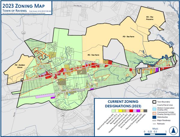
Section 2.2 Official Zoning Map
For the purpose of regulating and restricting the location of uses of land, the Town is hereby divided into zones or districts, as more fully described in Section 2.6 of this Ordinance and as shown on a map or maps entitled Official Zoning Map, which, together with all explanatory matter thereon, is hereby adopted by reference and declared to be a part of this Ordinance. The Official Zoning Map shall be identified by the signature of the Mayor, attested by the Zoning Administrator and bearing the seal of the Town under the following words: This is to certify that this is the Official Zoning Map of the Town of Ravenel, S.C., adopted on May 26, 2020.
- If, in accordance with the provisions of this Chapter, changes are made in district boundaries or other matter portrayed on the Official Zoning Map, such changes shall be made on the Official Zoning Map promptly after the amendment has been approved by Town Council, with an entry on the Official Map as follows: Map Amended by Action of Council on _______________ for the following purpose_______________, which entry shall be signed by the Mayor and shall be attested by the Zoning Administrator. No such change shall become effective until such entry has been made on the Official Zoning Map, and signed and attested.
- The Official Zoning Map shall remain in the custody of Town Hall and shall be the final authority as to the current zoning status of lands, buildings or other structures in the Town regardless of the existence of purported copies of the map. In the event that the Official Zoning Map becomes damaged, destroyed, lost, difficult to interpret, the Town Council may by resolution adopt a new Official Zoning Map which shall supersede the prior Official Zoning Map. The new Official Zoning Map may correct drafting and other errors or omissions, but no such correction shall have the effect of amending the original Official Zoning Map as amended. No building or parcel shall be erected or used except in conformity with the regulations prescribed in this Ordinance for the zoning district in which it is located as shown on the Official Zoning Map.
Section 2.3 (Reserved)
Section 2.4 (Reserved)
Section 2.5 Rules Of Determining Zoning
Where uncertainty exists with respect to the boundary of any zoning district shown on the zoning map, the following criteria shall apply:
- The district boundaries shall follow lot lines; center lines of streets, highways, alleys, or railroads; center lines of rivers, streams, or other bodies of water. District locations shall be determined by the use of the scale shown on the zoning map.
- Where any district boundary is indicated on the zoning map as following approximately the town boundary line, that boundary line shall be construed to be the district boundary.
- With the exception of lands within the ownership of national forests, swampland, wildlife refuge, and any other publicly designated conservation area, the Coastal Council critical line shall be the district boundary between marsh and other low lands abutting, surrounding, or surrounded by all waterways including ocean, rivers, lakes, canals, tidal streams or creeks.
(Ord., passed 8-17-87, amended 01-20-02)
Section 2.6 Zoning Districts
In order to provide for the development of specific uses and to carry out the goals of the Comprehensive Land Use Plan, the following use districts are hereby established:
| DISTRICT NAME: | |
| Agricultural Residential | AR |
| Residential One | R-1 |
| Residential One Restrictive | R-1R |
| Residential Two | R-2 |
| Residential Two Restrictive | R-2R |
| Residential Three | R-3 |
| Residential Three Restrictive | R-3R |
| Residential 4 | R-4 |
| Mobile Home Planned Development | MH-PD |
| Neighborhood Commercial | NC |
| General Business | GB |
| Service Warehouse | SW |
| Industrial | I |
| Planned Development | PD |
| Historic Conservation Overlay | HC |
| Commercial Corridor Overlay | CCOZ |
| Undevelopable | UND |
Section 2.6.1 Agricultural Residential District (AR)
The Agricultural Residential District is primarily designed to accommodate agriculturally-used properties and single-family residences which are situated on large parcels of land on, or in close proximity to, properties which are farmed or used for other agricultural purposes. This district is also intended to establish and protect large, undeveloped tracts and low-density uses on large sites for forestry management and to encourage preservation of natural resources.
- Permitted Uses. See Appendix B.
- Lot, Yard, Height, and Coverage Requirements.
Minimum Lot Requirements Measurement Lot area per dwelling unit 43,560 square feet - one acre Lot width (measured at building line) 150 feet Minimum Yard Requirements Measurement Front yard 30 feet Side yard 10 feet Rear yard 30 feet Maximum Height Permitted Measurement Vertical Measure 35 feet (2.5 stories) Maximum Lot Coverage No more than 35% of the lot may be covered by
principal residence and accessory buildings. - Development in the AR district shall comply with all other applicable regulations of this ordinance.
Section 2.6.2 Residential One District (R-1)
The purpose of the R-1 district is to provide for quiet, livable low-density residential neighborhoods, to encourage the formation and continuation of a stable, residential environment on lots having an area of one acre (43,560) or more, to discourage unwarranted and blighting encroachments by prohibiting commercial and industrial uses and to prohibit any other use which would subsequently interfere with the development or continuation of a single-family usage.
The intent of the district is to discourage any use which would generate traffic on minor streets other than that required to serve residences on those streets.
- Permitted Uses. See Appendix B.
- Lot, Yard, Height, and Coverage Requirements.
Minimum Lot Requirements Measurement Lot area per dwelling unit 43,560 square feet - one acre Lot width (measured at building line) 150 feet Minimum Yard Requirements Measurement Front yard 30 feet Side yard (width on one side) 10 feet Rear yard 30 feet Maximum Height Permitted Measurement Vertical measure 35 feet (2.5 stories) Maximum Lot Coverage No more than 35% of the lot may be covered by
principal residence and accessory buildings. - Development in the R-1 district shall comply with all other applicable regulations of this ordinance.
Section 2.6.3 Residential One Restrictive District (R-1R)
The intent of the R-1R district is to establish and preserve low density residential neighborhoods and to restrict the residential uses to constructed-on-site homes. The R-1R district provides for the creation of a stable, healthy, residential area on lots of one acre (43,560 square feet) or more and to discourage unwarranted and blighted encroachments of commercial, industrial or any other uses which would interfere with the development of single-family usage.
- Permitted Uses. See Appendix B. Table of Permitted Uses.
- Lot, Yard, Height, and Coverage Requirements. See requirements for Section 2.6.2.
- Development in the R-1R district shall comply with all other applicable regulations of this ordinance.
Section 2.6.4 Residential Two District (R-2)
The purpose of the Residential Two District (R-2) is to provide for quiet, livable, low-density residential neighborhoods, and to encourage the formation and continuance of a stable, residential environment on lots having an area of 30,000 square feet or more and to discourage unwarranted and blighting encroachments by prohibiting commercial and industrial uses and disallowing any other use which would substantially interfere with the development or continuation of single-family usage.
- Permitted Uses. See Appendix B.
- Lot, Yard, Height and Coverage Requirements.
Minimum Lot Requirements Measurement Lot area per dwelling unit 30,000 square feet Lot width (measured at building line) 70 feet Minimum Yard Requirements Measurement Front yard 30 feet Side yard (width on one side) 10 feet Rear yard 30 feet Maximum Height Permitted Measurement Vertical measure 35 feet (2.5 stories) Maximum Lot Coverage No more than 40% of the lot may be covered by
principal residence and accessory buildings. - Development in the R-2 district shall comply with all other applicable regulations of this ordinance.
Section 2.6.5 Residential Two Restricted District (R-2R)
The intent of the R-2R district is to establish and preserve lower density residential neighborhoods and to restrict the residential uses to constructed-on-site homes. The R-2R district provides for the creation of a stable residential area with lots of 30,000 square feet or more and to discourage unwarranted and blighted encroachments or commercial, industrial or any other uses which would interfere with the development of single-family usage.
- Permitted Uses. See Appendix B. Table of Permitted Uses.
- Lot, Yard, Height, and Coverage Requirements. See requirements for Section 2.6.4
- Development in the R-2R district shall comply with all other applicable regulations of this ordinance.
Section 2.6.6 Residential Three District (R-3)
The purpose of the R-3 Residential District is to provide medium density residential development in quiet, livable neighborhoods and to encourage the formation and continuation of a stable, residential environment for medium-density single-family and two-family dwellings situated on lots having an area of 12,500 square feet or more, to discourage unwarranted and blighting encroachments by prohibiting the commercial and industrial use of land and to disallow any other use which would subsequently interfere with the development or continuation of single-family and two-family dwelling usage and to discourage any use which would generate traffic on minor streets other than that required to serve residents on those streets.
- Permitted Uses. See Appendix B.
- Lot, Yard, Height and Coverage Requirements.
Minimum Lot Requirements Measurement Lot area per dwelling unit 12,500 square feet per unit Lot width (measured at building line) 70 feet Minimum Yard Requirements Measurement Front yard 25 feet Side yard 10 feet Rear yard 25 feet Maximum Height Single-Family Vertical Measure - 35' (2.5 stories)
Duplex
Vertical Measure - 35' (2.5 stories)Maximum Lot Coverage No more than 50% of the lot may be covered by
the principal residence and accessory buildings. - Development in the R-3 district shall comply with all other applicable regulations of this ordinance.
Section 2.6.7 Residential Three Restricted District (R-3R)
The intent of the R-3R Residential district is to establish medium density residential neighborhoods and to restrict the residential uses to constructed-on-site homes. The R-3R district provides for the creation of stable, healthy, residential areas of lots of 12,500 square feet or larger and to discourage unwarranted and blighted encroachments of commercial, industrial or any other uses which would interfere with the development of single-family and two-family usage.
- Permitted Uses. See Appendix B. Table of Permitted Uses
- Lot, Yard, Height, and Coverage Requirements. See requirements in Section 2.6.6.
- Development in the R-3R district shall comply with all other applicable regulations of this ordinance.
Section 2.6.8 Residential Four District (R-4)
The purpose of the Residential Four District (R-4) is to provide for quiet, livable, low-density Residential neighborhoods and to encourage the formation of a stable, healthy, residential environment on lots having an area of 22,000 square feet or more and to discourage unwarranted and blighted encroachments. This district prohibits commercial and industrial uses and any other use which would substantially interfere with the development and continuation of single family residential uses.
- Permitted Uses. See Appendix B.
- Lot, Yard, Height, and Coverage Requirements.
Minimum Lot Requirements Measurement Lot area per dwelling unit 22,000 square feet Lot width (measured at building line) 80 feet Minimum Yard Requirements Measurement Front yard 30 feet Side yard (width on one side) 10 feet Rear yard 25 feet Maximum Height Permitted Measurement Vertical measure 35 feet (2.5 stories) Maximum Lot Coverage No more than 40% of the lot may be covered by
principal residence and accessory buildings. - Development in the R-4 district shall comply with all other applicable regulations of this ordinance.
Section 2.6.9 Mobile Home Planned Development (MH-PD)
The purpose of the MH-PD district is to promote desirable living environments for a grouping of mobile homes with mobile home spaces for rental or leasing as well as mobile homes placed on single lots for rental or sale and to provide for accessory uses needed to serve the residents of the planned development. These developments shall comply with all applicable state and local regulations and are subject to the following standards:
- Town Council Approval Criteria. Conditional Uses for MH-PD district:
- Uses allowed in MH-PD district: Mobile home, modular home or trailer constructed for permanent living.
- Accessory structure and use customarily incidental to mobile homes, and which services only the residents of the mobile home park, specifically including self-service laundry, restrooms, park, leasing or managerial office, and similar service facility.
- Signage as permitted under Sign regulations for Residential Subdivisions, which allows for one free-standing sign per entrance not to exceed six feet in height and twenty-four (24) square feet in sign face, identifying the name of the development.
- Site Design and Development Criteria. All mobile home developments shall be planned, designed and developed to meet conditions and factors conducive to the creation and maintenance of a healthful and safe residential environment. Compliance with the conditional use authorization regulating the following criteria shall be observed:
- Tract Size and Density. Mobile home parks shall have a minimum tract size of five acres. The overall or average density of the mobile home development district shall not exceed three mobile homes or non-accessory structures per acre and shall be permitted only with Charleston County Department of Health approval.
- Grading. Mobile home sites shall be graded to create desirable and attractive site features, provide for adequate drainage of each lot and the entire park, and to provide safe and convenient access, circulation, recreation and ease of maintenance.
- Foundation (Mobile Home Stand).
- All mobile homes shall be situated upon a foundation (mobile home stand) of material which is of sufficient strength and durability to retain the size and weight of structure that will be placed upon it, in a stable and safe condition. The stand should be adequately crowned or graded to permit drainage. The foundation shall include tie-down fixtures and should not heave, shift or settle unevenly as a result of frost action, poor drainage, vibration or other forces. Mobile home stands shall not exceed a longitudinal grade of 5%.
- In addition, the stand shall be situated and designed in elevation, distance and angle in relation to the access street and lot accessway, so that placement, retention and removal of the mobile home shall be practicable and without hindrance or lack of safety. The size of the stand shall be equal in length and width to the size of the mobile home located upon it.
- Manufactured skirting or other material suitable for exterior use is required within six (6) months of placement.
- Setbacks.
- Front Setbacks and Distances between Mobile Homes. All mobile homes shall be a minimum of 50 feet from any road or highway right-of-way, property boundaries or other mobile home in the mobile home district. This does not include the distance of open space between a mobile home and the accessory structures which serve that mobile home.
- There shall also be a minimum distance of 20 feet between any mobile home and any fence, wall or planting serving as a wall or buffer for the site and any common parking, walkway, recreation area or other common space.
- Open Space and Recreation. Mobile home parks shall have a minimum of 10% of the total site area reserved and improved as common recreation space and shall be easily accessible by all lots.
- Parking. There shall be two parking spaces required for each mobile home unit.
- Buffer yards, as prescribed in Section 4.2 shall be provided by the property owner along the periphery of a mobile home park.
- A screened and maintained refuse area shall be located convenient to all trailer sites.
- Streets and Infrastructure. All mobile home districts shall provide streets and utilities conforming to the following requirements:
- Streets and Access. All mobile home districts having three or more mobile home lots shall have dedicated and paved public rights-of-way as per Charleston County Road Standards, unless otherwise granted by Town Council. If concrete is used, it should be a minimum of five inches thick and have expansion joints where it meets driveways, walkways or curbs.
- All mobile home parks shall have direct access to a public road, maintained by the state or county.
- Circulation for vehicles shall be provided by an integrated system of minor streets and collector streets linked to major entrance roads. Dead-end streets should not be longer than 1,000 feet and shall terminate in a 50-foot radius cull-de-sac, or other paved turnaround space adequate for a fire truck.
- All street intersections within the district shall be at right angles and a minimum of 150 feet apart and a maximum of 1,000 feet apart.
- Mobile home parks shall provide a common walkway system conveniently linked to all lots, common areas and facilities. The walkway shall be asphalt or concrete or material approved by Town Council, safe in all seasons, durable and convenient to maintain and shall be a minimum of 32 feet wide.
- Sewage Disposal and Treatment. Mobile home parks shall provide individual septic systems to each site as approved by the Health Department or public sewer whenever available.
- Water Supply. All mobile home districts shall connect to the public water supply system or shall have individual wells.
- Electrical Supply. All electrical connections, equipment, materials and installations in a mobile home park project, and each mobile home lot shall comply with Southern/Standard Building Codes and the National Electrical Code, specifically as practiced by the South Carolina Electric and Gas Company and Berkeley Electric Co-op and as described in Electrical Underground Distribution for Mobile Homes, by the South Carolina Electric and Gas Company© Distribution Engineering Department. Whereas the developer shall enter into service agreements with the South Carolina Electric and Gas Company or Berkeley Electric Co-op for provision of electrical service, the above referenced document shall be considered the minimum standards required by this chapter.
- Fuel Supply and Storage. All mobile home districts that provide fuel supply or storage shall use equipment, materials and installations per the County Code and all applicable federal safety codes.
- Telephone Lines. The distribution of telephone lines to all mobile home stands within mobile home districts shall be underground.
Section 2.6.10 Neighborhood Commercial
It is the intent of this section that the NC District be developed and reserved for certain service type businesses, offices and specified public purposes. The regulations which apply within this district are designed to encourage the formation and continuance of a quiet, compatible and un-congested environment for office and limited retail business; and to discourage any encroachment by unrestricted retail or wholesale business establishments, industrial concerns or other uses capable of adversely affecting the specialized commercial and housing character of the district.
- Permitted Uses. See Appendix B.
- Lot, Yard, Height, and Coverage Requirements.
Minimum lot requirements Measurement Lot area 12,500 square feet Lot width (measured at building line) 100 feet Minimum Yard Requirements Measurement There shall be a 50-foot building setback from the edge of any street. Front setback 50 feet Side setback 25 feet* Rear setback 25 feet** Maximum height Maximum height shall be 35 feet (2.5 stories) Maximum Lot Coverage No more than 35% of the lot area may be covered by
the principal use. - Buffer Yard Requirements. Minimum buffer yard requirements for and between permitted uses in this district and residential uses as provided in Section 4.2.
- Development in NC district shall comply with all applicable regulations of this ordinance.
* Minimum side yard setbacks for existing lots of record of two acres or less and that abut other commercial lots shall be 10 feet.
** Minimum rear yard setback for existing lots of record of two acres or less and that abut other commercial lots shall be 15 feet.
Section 2.6.11 General Business (GB)
The General Business District is intended for a broad range of commercial uses and activities which need a location adjacent to arterial roads. The regulations herein are designed to encourage an economically healthy environment, particularly for those businesses which have a market area beyond just one or a few neighborhoods. They are also designed to discourage the encroachment of other uses capable of adversely affecting the basic commercial character of the district.
- Permitted Uses. See Appendix B.
- Lot, Yard, Height, and Coverage Requirements.
Minimum Lot Requirements Measurement Lot area for principal use 12,500 feet Lot width (measured at building line) 100 feet Minimum Yard Requirements Measurement Front setback 50 feet Side setback 25 feet* Rear setback 25 feet** Maximum Height Maximum height shall be 35 feet (2.5 stories). Maximum Lot Coverage No more than 40% of the lot area may be covered by
the principal use. - Buffer Yard Requirements. Screening and buffering requirements must be provided between commercial and residential or agricultural zoning district as per Section 4.2.
- Development in the GB district shall comply with all other applicable regulations of this ordinance.
* Minimum side yard setbacks for existing lots of record of two acres or less and that abut other commercial lots shall be 10 feet.
** Minimum rear yard setbacks for existing lots of record of two acres or less and that abut other commercial lots shall be 15 feet.
Section 2.6.12 Industrial (I)
It is the intent of the Industrial (I) Zoning District to develop and reserve large parcels for a broad range of industrial uses including extensive manufacturing, processing, or assembly operations or which serve as large employment centers. The regulations which apply within this district are designed to (1) Encourage the formation and continuance of a compatible environment for industries; and (2) Protect and reserve undeveloped areas in the town which are suitable for such industries.
- Permitted Uses. See Appendix B.
- Lot, Yard, Height, and Coverage Requirements.
Minimum Lot Requirements Measurement Lot area for principal use 10 acres Lot width (measured at building line) 200 feet Minimum Yard Requirements Measurement Front setback 50 feet Side setback 50 feet Rear setback 50 feet Maximum Height Maximum height shall be 35 feet (2.5 stories). Maximum Lot Coverage No more than 40% of the lot area may be covered by
the principal use. - Buffer Yard Requirements. Screening and buffering requirements must be provided between commercial and residential or agricultural zoning district as per Section 4.2.
- Development in the GB district shall comply with all other applicable regulations of this ordinance.
Section 2.6.13 Service Warehouse (SW)
It is the intent of the Service Warehouse (SW) district to provide for low-impact general industrial uses which do not create excessive noise, odor, and dust, generate heavy truck or automobile traffic and are compatible with surrounding uses. These uses include business park and office warehousing.
- Permitted Uses. See Appendix B.
- Lot, Yard, Height, and Coverage Requirements:
Minimum Lot Requirements Measurement Lot area for principal use 2 acres Lot width (measured at building line) 100 feet Minimum Yard Requirements Measurement Front setback 50 feet Side setback 25 feet Rear setback 35 feet Maximum Height Maximum height shall be 35 feet (2.5 stories). Maximum Lot Coverage No more than 40% of the lot area may be covered by
the principal use. - Buffer Yard Requirements. Screening and buffering requirements must be provided between commercial and residential or agricultural zoning district as per Section 4.2.
- Development in the GB district shall comply with all other applicable regulations of this ordinance.
Section 2.6.14 Historic Conservation Overlay (HC)
The Historic Conservation Overlay District regulations apply in addition to the underlying zoning district. By establishing the Historic Conservation Overlay District, the Town intends to protect and preserve the historic character of the area so designated, including:
- To safeguard the heritage of the town by preserving the Historic District=s element of cultural, social, economic, political or architectural history;
- To ensure the preservation of significant historic sites against undesirable development;
- To stabilize and improve property values in the Historic Districts thereby ensuring its continued existence; and
- To promote the use and preservation of the Historic Districts for the education, welfare and pleasure of residents of the town, and of the state as a whole.
- Lot, Yard, Height and Coverage Requirements. The minimum requirements described in the use regulations for the underlying district shall apply generally.
- Additional Development Requirements.
- Exterior Architectural Features. Within the HC District, no exterior portion of any building or other structure (including stone walls, fences, light fixtures, steps and pavement or other appurtenant features) nor above ground utility structure nor any type of outdoor sign shall be erected, altered, restored or moved, and no building permit shall be issued within the Historic District until after an application for a Certificate of Appropriateness as to exterior architectural features of the structure has been submitted to and approved by Town Council.
- Construction on Public Property. The Town Council shall not approve any porches, steps, posts, fences, walks or other appurtenances extending over, on or within a public sidewalk, alleyway or street right-of-way unless the particular item is necessary for the authentic restoration or maintenance of the particular project, and unless such proposed items will not impede pedestrian or vehicular traffic or constitute a public safety hazard. Any of the aforesaid items restored or maintained on, over or within a public sidewalk or public alley area under the authority hereof shall be the responsibility of the owner, and the owner's restoration, reconstruction, or maintenance of any such item within such area shall constitute the owner's agreement to protect and hold the town harmless against any and all liability, cost, damage or expense suffered or sustained by the town as a result of or maintenance thereof.
- Maintenance and Repair. Nothing in this section shall be construed to prevent the ordinary maintenance or repair of any exterior architectural feature in the Historic District which does not involve a change in design, material, color or outer appearance thereof, nor to prevent the construction, reconstruction, alteration, restoration or demolition of any such feature which the Codes Inspector or similar official shall certify is required by the public safety because of an unsafe or dangerous condition.
- Demolition.
- No building or structure in the Historic Districts shall be demolished or otherwise removed until the owner thereof shall have given the Town Council ninety (90) days written notice of his proposed action. During such ninety (90) day period, the Town Council may negotiate with the owner and with any other parties in an effort to find a means of preserving the building involved. If it is determined the building has no particular historic significance or value toward maintaining the character of the district, it may waive all or part of such ninety (90) day period and authorize earlier demolition or removal.
- The Town Council shall also have authority to take such action as may be necessary or appropriate under the provisions of this section relating to delay in demolition of historic buildings. Further, the Town Council may, in its discretion, request the Zoning or Planning Board to take such action as may be appropriate to prevent the construction, reconstruction, alteration, restoration, or removal of buildings, structures, appurtenant fixtures, or outdoor signs in the Historic Districts in violation of the provisions of this section.
Section 2.6.15 Planned Development District (PD)
The purpose of the Planned Development District is to allow for flexibility in order to improve the design, character, and/or quality of new multiple-density or mixed-use developments, promote the orderly and efficient expansion and use of public utilities and infrastructure, and to preserve the natural and scenic features of open and undeveloped spaces.
An area may be accepted as a Planned Development District upon request by the property owner or organization having an interest in the subject property or properties required for the proposed project, the successful negotiation of a Planned Development Project Concept and Plan with Town Staff and the Planning and Zoning Commission, and approval by ordinance by the Town Council.
A Planned Development District is an amendment to the zoning ordinance and the initial approval shall follow all zoning amendment, administrative procedures, and public notice and input as required for an amendment to the zoning ordinance.
- Required conditions that must be presented in the application request for the advancement of a Planned Development District project and request are:
- A statement of intent from the developer regarding the maximum number and types of units to be developed, all property to be included, public services that will be required, and development phases and timelines, and;
- A statement from the developer that exceptions or variations to the design or dimensional requirements of the zoning ordinance are essential to the project, and;
- The site must contain not less than five acres, and;
- The minimum width between any two opposite boundary lines is 200 feet, and;
- The parcel is not a flag lot and no flag lots will be created in the Planned Development, and;
- The site must adjoin and have direct access to a publicly maintained roadway having a right-of-way width of 50 feet, and;
- More than one principal land use is proposed for the project or land uses are proposed which would not otherwise be permitted to located within the same zoning district.
- Additional Procedures and Information.
- The request for a Planned Development District must be submitted in a format as specified by the Planning and Zoning Administrator, and;
- A pre-application conference with the Planning and Zoning Administrator is required. A Planned Development Concept will be presented and reviewed at the pre-application conference. Information required in the Concept plan will include, but not be limited to:
- Proposed lot sizes and setbacks;
- Proposed peak housing density;
- Gross average housing density (incl. wetlands and unbuildable area);
- Net average housing density (only buildable area);
- Proposed land uses and general locations of land uses;
- Proposed infrastructure improvements including service connection locations and routes, impact mitigation efforts, roadways, and facilities;
- Proposed green and open space;
- Proposed development phasing and completion dates;
- Proposed Stormwater Pollution Prevention Plan (SWPPP);
- Other requirements of the zoning ordinance from which the proposed project may require some measure of flexibility.
- The Planning and Zoning Administrator will review the Concept Plan application for completeness and note any incompatibility with the Town’s Comprehensive Plan or other Town planning efforts regarding public services or infrastructure.
- As the project Concept Plan and Planned Development Amendment begins the zoning amendment process, the text of the Plan shall shift from conceptual to specific information regarding uses, densities, setbacks, and other requirements.
- The Plan presented at the required Public Hearing before the Planning and Zoning Commission shall be the Plan considered for approval by ordinance by the Town Council and shall include the results of a Traffic Impact Study. This Plan will also include a schedule for the payment of any currently imposed Traffic Impact Fees required to assist with the mitigation of traffic issues as determined by the Town of Ravenel.
- The Planning and Zoning Commission will consider the Planned Development District request and either recommend approval or denial of the project to the Town Council, based on the following standards:
- The project will be compatible with the Town’s Comprehensive Plan and with adjacent land uses and existing development.
- The impact of the development placed upon infrastructure and public services will be manageable and efficient.
- Overall site design shall be harmonious in terms of landscaping, enclosure of principal and accessory uses, sizes of structures, street patterns, and use relationships. Variety and compatibility in building types, heights, facades, setbacks and size of open spaces shall be encouraged.
- Consideration of the impact of the traffic generated by the project (as indicated in the required Traffic Impact Study) on the surrounding and nearby roadways and the road standards and improvements proposed to be undertaken by the developer (if any) to mitigate and manage the increased traffic.
- Consideration of housing densities. Generally, the gross average housing density for the project will be compared to the existing densities allowed in the Town’s residential zoning classifications. This comparison will weigh the amount of variance from the existing classifications against the innovative, unique, and attractive design elements proposed in the project.
Additionally, designs and programs that reduce storm, fire, and other natural hazard risk or increase residential resiliency to hazards can allow for consideration of greater housing densities.
The final negotiated Planned Development may result in areas of higher residential density than would otherwise be allowed in the traditional zoning classifications. - Consideration of the amount and dedication of open space, preserved wetlands and other areas, and common green space.
- Innovative design. Developments that demonstrate harmonious, attractive, and innovative design, both within the project and with the relationship to adjacent areas, are desired and these elements are required for full consideration of greater housing density and increased flexibility and variance from existing zoning code standards.
- Inclusion of adequate signage, parking and loading spaces, streets and street lighting, and driveways. Generally, sidewalks or paved trails are required in all residential areas. Decorative and interesting design elements are encouraged.
- Consideration of street standards being requested. Generally, all uses shall maintain safe distances from streets to maintain acceptable sight triangles and promote safe ingress/egress points.
- Screening and landscaping shall be required along the periphery of a Planned Development Project in an amount no less than that required of a General Business District abutting a residential district as found in the zoning ordinance.
- Generally, utilities, parking and loading spaces, and dumpsters shall be screened from view of any public right-of-way.
- Commercial, industrial, and multi-family uses shall have adequate, but not excessive, access points to a public street.
- A drainage plan must be prepared by a registered/professional engineer in order to ensure proper drainage flow that will not have a negative impact on neighboring properties.
- Upon approval by the Town Council by ordinance, any specific use proposed by the developer in the Planned Development Plan is permitted in the project. A listing of these specific uses will be adopted along with the plan text and other zoning requirements to become the regulations of the Planned Development project area. These are the only uses permitted in the Planned Development District.
- Minor Modifications. The Planning and Zoning Administrator may approve minor modifications to the Planned Development Plan. Minor modifications may not result in a greater housing density calculation of any kind, different uses than were specified in the Plan, or other changes that materially affect the concept of the Plan that was approved by Council. Minor modifications may include aspects such as a decrease in housing density, changes to the locations of uses, driveways, or streets, revised floorplans, and/or design modifications for landscaping, site amenities, common areas, and parks. If the Planning and Zoning Administrator determines that a change is not a minor modification, the Planned Development District Concept will need to be reconsidered fully as an amendment to the zoning ordinance.
Section 2.6.16 Commercial Corridor Overlay Zoning (CCOZ)
- Purpose of Zone. The purpose of the Commercial Corridor Overlay Zone is to address conditions unique to US Highway 17 (“US-17” or “Savannah Highway”) and Highway 165. The standards of this zone shall manage vehicular access to mitigate traffic congestion and improve driver safety, encourage pedestrian accessibility to and within the development site, improve the appearance of development from the perspective of the highways, protect property values, and generally improve the functionality and aesthetics of land and development throughout the highway corridors. The CCOZ district shall “overlay” existing and future zoning districts specified on the Ravenel Official Zoning Map. The standards set forth by this zone shall supersede those standards set forth by the underlying zoning district. Where the CCOZ is mute, the standards of the underlying zoning district shall prevail.
- Scope of Authority. The CCOZ district shall apply to the right-of-way of US Highway 17 through the Town limits of Ravenel, to the right-of-way of Highway 165 from the northern Town limit (approximately 10,675 feet north - westbound Highway 165, of the intersection with US-17) to the Charleston County St. Paul’s Service Center (approximately 1,300 feet south - eastbound Highway 165, of the intersection with US-17), and all properties which have a property line fronting on US-17 or Highway 165 in this area. For the purposes of this Section, the highways of US-17 and Highway 165 as described are collectively referred to as the “Highway”. The CCOZ regulations apply throughout the district with the terms and exceptions as found below:
- All non-residential, non-agricultural buildings or developments having more than 500 square feet of floor area and multi-family residential development shall follow the standards of development set forth herein and must be in accordance with a Planning & Zoning Commission approved site plan.
- Any refacing of an existing non-residential structure requires that the structure must meet the current standards of the CCOZ.
- All exterior alterations and/or additions to structures in existing non-residential developments in which the cost of the alteration and/or addition exceeds fifty percent (50%) of the value of the existing building or development shall require the entire building or development to follow the standards of development set forth herein. The “value of existing building or development” shall be the fair market value of the improvements as shown on the most recent assessment records, or, in the absence thereof, as verified by a real estate appraiser.
- These regulations shall not apply to:
- Temporary uses with approved site plans,
- Ordinary maintenance or repair which does not require a building permit,
- Demolition of any structure for which a demolition permit has been issued by the Town of Ravenel or the County of Charleston County,
- Public and private utility structures and telecommunication towers permitted by district regulations,
- Structures located on public streets or public property.
- Allowed Uses. Land uses in the CCOZ shall be those land uses as indicated in the underlying zoning district with the following exceptions:
- All non-retail, non-agricultural commercial or industrial uses are to be conducted entirely within a building or structure or in an outside area that is completely screened from visibility from the Highway by the screening requirements found herein,
- No outside storage or stockpiling of materials, parts, debris, or damaged vehicles is allowed,
- Truck trailers, storage units or “conex” containers, or other temporary and unattached structures must be completely screened from visibility from the Highway by the screening requirements found herein,
- Retail uses may have outdoor product yards, seating areas, and/or other customer areas. These areas may be located on any portion of the lot except for buffer yards and must be located within the lot setbacks.
- Minimum Lot Area. The CCOZ is mute regarding minimum lot area. The standards of the underlying district shall prevail.
- Minimum Side and Rear Setback and Side and Rear Buffer Yard Requirements. The CCOZ is mute regarding minimum side and rear setbacks. The standards of the underlying district shall prevail.
- Front Yard Requirements. For all commercial, institutional, industrial, mobile home park, and multi-family development, the front yard requirements of the underlying zoning district are superseded by the standards below. The standards of the underlying zoning district shall remain for agricultural, single and two-family residential development.
- Primary Building Setback. The minimum front building setback shall be twenty-five feet (25’).
- Parking. Parking is to be located to the side or rear of the building. Parking is not allowed in the front of a building (between the building and the Highway) in the CCOZ.
- Buffer Yard. A buffer yard of at least fifteen (15) feet is required within the front setback. No building elements, signs other than noted in this section, structures, or pavement is allowed in a buffer yard. Utility boxes, lighting, park furniture, and stormwater structures may be located in a buffer yard, provided the buffer yard contains adequate plant material for the required screening also. A driveway can only pass through a buffer yard perpendicular to the Highway.
There are two (2) types of acceptable buffer yards:- Natural Vegetation: For buffer yards that have not been previously cleared of natural screening. No trees below eight (8) inches in diameter at breast height (DBH) or natural shrubs are to be removed. The natural screening may be required to be supplemented to meet the required buffer width and to ensure at least three (3) canopy trees, three (3) understory trees, and twenty-five (25) three-gallon shrubs per one hundred (100) feet of Highway frontage. Non-grand trees may be removed from natural vegetation that are within ten (10) feet of an approved monument sign.
- Landscaped: For buffer yards that have been previously cleared or have no natural screening. This buffer yard will contain at least three (3) canopy trees, three (3) understory trees, and twenty-five (25) three-gallon shrubs per one hundred (100) feet of Highway frontage.
- Parallel Driveways. To prevent vehicles on private property from errantly interfering with Highway traffic and vice versa, a landscaped berm or garden wall or fence can be used in the buffer yard to provide a barrier between the front property boundary and any parallel driving surfaces that are located in the front setback.
Any berm installed must provide at least three (3) canopy trees, three (3) understory trees, and twenty-five (25) three-gallon shrubs per one hundred (100) feet of Highway frontage.
Any garden wall or fence must provide at least three (3) understory trees and twenty-five (25) three-gallon shrubs per one hundred (100) feet of Highway frontage.
- Signs. No signs are permitted in a buffer yard located in the CCOZ with the exception of the following:
- Signs that are exempt from permitting as found in Section 4.3.5 and temporary signs as found in Section 4.3.6.
- Externally lit monument signs must be no larger than fifty (50) square feet per sign face (maximum of two (2) sign faces) and no taller than eight (8) feet high in total. Only one (1) monument sign is allowed per lot with Highway frontage and may be placed in a buffer yard at least five (5) feet from the front property line. Monument signs must rest on an opaque base or foundation made of masonry or approved decorative material. A lot may not have both a monument sign and a freestanding sign.
- Freestanding or pylon signs must be less than thirty-two (32) square feet and no taller than twelve (12) feet high in total. Only one (1) such sign is allowed per lot with Highway frontage and must be located at least ten (10) feet from the front property line. A lot may not have both a monument sign and a freestanding sign.
- Wall or façade signs must be no more than fifteen (15) percent of the area of the entire building façade as determined by the Planning & Zoning Administrator. Only one (1) such sign is permitted per lot with Highway frontage.
- Shopping center signs, navigational signs, and other gateway-style signs may be allowed with site plan approved by the Planning & Zoning Commission.
- In all areas of the CCOZ, adverflags, pennants, flashing, or moving signs are not permitted.
- Sign color schemes shall coincide with the color schemes applied to building standards, except for the company name and logo.
- Maximum Building Height. The CCOZ is mute regarding maximum building height. The standards of the underlying district shall prevail.
- Building Design Standards.
- Intent of Design Standards. The intent of the design standards is to promote attractive well-designed development, to protect the appearance, character and economic value of new development and existing development, to encourage quality and creativity in new development and to foster attractive streetscapes and pedestrian environments while accommodating safe vehicular movement. Building materials and designs will meet the following standards:
- No building elevation facing the Highway may be constructed of unadorned concrete masonry units or corrugated and/or sheet metal. Side elevations may have no more than 85% of such materials and a rear elevation that is not seen from a public right-of-way may have 100%.
- Stainless steel, copper, galvanized metal, or mirrored glass with a reflectance of greater than forty percent (40%) may be used as trim and decorative elements, up to twenty-five percent (25%) of the exterior walls of any elevation.
- Single large building masses shall be avoided. Structures with exterior walls of more than one thousand (1,000) square feet will incorporate fascia, veneer, canopies, arcades, or other multidimensional design features to break up large wall surfaces on all elevations visible from the Highway. The side and rear elevations shall be as visually attractive as the front if visible from the Highway.
- No overhead garage doors shall be in the front façade elevation facing the Highway.
- All structures within a proposed development, including gasoline canopies, shall utilize a uniform architectural theme and be designed to create a harmonious whole through considerations of scale, proportion, detail, materials, color, site planning and landscaping.
- The scale of buildings and accessory structures shall be appropriate to the scale of structures in the surrounding area and cognizant of the rural character of the area.
- Shingles, metal standing seam, tile, or other appropriate roofing material will be used. Flat roofs without a parapet wall are not permitted.
- Color Schemes. The use of bold, garish or day glow colors is prohibited. Color combinations of the following colors shall be allowed:
- Natural materials. The natural colors of brick and stone finished wood (not uncut lumber), and hued wood stains are allowed. Exposed metal and concrete finishes, regardless of the actual building material, are not allowed.
- Shades. All shades and tints of brown, including warmer and cooler variations thereof, are allowed (e.g., sand, tan, beige, cream, umber, and sienna). Shades of primary colors are also considered (e.g., crimson, hunter green, navy blue, dark burnt orange).
- The use of bold primary colors (red, blue, yellow), secondary colors (orange, green, violet), and tertiary colors (e.g., turquoise, purple) and tints thereof are permitted for accent colors only, up to maximum twenty percent (20%) of the total exterior colors. These colors may be incorporated into signage as a logo but will still count toward the twenty percent (20%) limit.
- Black, gray, and white shall count neither toward nor against color scheme requirements.
- Foundation Plantings. All buildings located in the CCOZ and falling under these CCOZ requirements that are located within three hundred (300) feet of the Highway will provide a planting area of a minimum of fifty percent (50%) of the width of the facade, which may be interrupted by entrances, archways, porches, porticos, and piazzas. The planting area shall be adjacent to the facade and shall extend at least five (5) feet from the facade.
- Minimum Foundation Features. At least ten (10) shrubs and/or ornamental grasses, at least two feet (2’) in height and diameter at planting, shall be installed per one hundred square feet (100’) of planting area. Remaining exposed ground shall be covered with pine straw, mulch, wood chips, decorative rock or similar material to inhibit weed growth and erosion and may include a sidewalk, piazza, deck, or porch.
- Intent of Design Standards. The intent of the design standards is to promote attractive well-designed development, to protect the appearance, character and economic value of new development and existing development, to encourage quality and creativity in new development and to foster attractive streetscapes and pedestrian environments while accommodating safe vehicular movement. Building materials and designs will meet the following standards:
- Site Design Standards.
- Parking Lot Trees. One (1) understory tree per twelve (12) parking stalls shall be planted or retained within the parking area or within twenty feet (20’) of it. A parking island of a width to sustain the long-term growth of the tree shall separate the spaces.
- Tree Counting. Tree requirements may overlap. A tree planted to meet a side or rear buffer yard requirement may be counted toward side or rear parking lot tree-planting requirements.
- Fencing. Any fencing in the front setback of the CCOZ shall be no higher than four (4) feet and be decorative in nature. Chain-link, razor-wire, electric, and barbed-wire fencing is not allowed in the front setback.
- Surfacing. The intent of surfacing requirements in the CCOZ is to balance the need for an attractive, clean, and well-drained lot with a pervious surfacing requirement that will assist with stormwater runoff and flooding mitigation. Hard-surfacing may, or may not, be impervious surfacing.
Examples of hard-surfacing include concrete, asphalt, pavers, etc. Pervious surfacing may include slag, gravel, crushed shell/rock, sand, and specialty applications of concrete and pavers to obtain hard-surfacing. High dust producing material is not allowed as a surface in the CCOZ.
All off-street parking and other features of lots to which these CCOZ standards apply will meet the design regulations of Section 4.4 of the Ravenel Zoning Code, provide no more than sixty percent (60%) impervious surfacing, and meet the following minimum hard-surfacing requirements depending on the type of use:
Exclusively residential uses with less than ten (10) units on a lot: No parking hard-surfacing minimum. No apron required.
Exclusively residential uses with ten (10) or more units on a lot, Office, Retail, or Service uses without large equipment: Fifty percent (50%) hard-surfacing parking minimum required. Twenty foot (20’) hard-surfaced, paved apron required.
Institutional, recreational, or other large gathering places or clubs, agricultural, fishing, or hunting uses without large equipment: No parking hard-surfacing minimum. Twenty foot (20’) hard-surfaced, paved apron required.
Any use requiring large equipment, trucks, or machinery on a regular basis in the Neighborhood Commercial (NC) or General Business (GB) zoning districts: Seventy-Five percent (75%) hard-surfacing parking and loading minimum required. Fifty foot (50’) hard-surfaced, paved apron required.
Manufacturing, warehousing, forestry, or any non-retail use located in the Town’s industrially-zoned districts: No hard-surfacing parking minimum. Fifty foot (50’) hard-surfaced, paved apron required.
- Highway Features. The Town of Ravenel requires the following access standards and features to preserve the capacity of the Highways and the safety of motorists thereon. These standards and features do not replace South Carolina Department of Transportation (SCDOT) standards and, where Ravenel and SCDOT standards may differ, the more restrictive standard will be applied.
- Maximum Access. A maximum of one curb cut shall be allowed for parcels with two hundred and fifty feet (250’) or less of road frontage. One pair of one-way curb cuts shall count as one curb cut.
- Maximum Driveway Width. No driveway shall be wider than twenty-five feet (25’), except to provide for turning radii of twenty-five feet (25’), maximum.
- Exception. A three-lane driveway not wider than forty feet (40’) shall be allowed to access parking areas totaling more than one hundred (100) stalls. Turning radii shall be no more than twenty-five feet (25’).
- Exception. A two-lane driveway not wider than forty feet (40’) shall be allowed for wholesale commercial, warehousing, or industrial operations with more than one loading dock or truck bay intended to accommodate vehicles longer than forty feet (40’). Turning radii shall be no more than forty feet (40’).
- Existing Conditions. A driveway existing upon adoption of the CCOZ by ordinance shall not preclude the construction of a driveway based on spacing of points of access if no other means of accessing adjacent lots exists.
- Sidewalks. Generally, a hard-surfaced, five (5) foot sidewalk or multi-use pathway is required to be built along the Highway frontage for any new construction in the CCOZ and shall be constructed to SCDOT standards. This requirement may be waived during the Site Plan Review process if the Planning & Zoning Commission finds the installation to be infeasible.
- Administration of CCOZ Requirements. To facilitate the administration of the Commercial Corridor Overlay zoning district by the Town of Ravenel, the following documentation shall be required for development to which the CCOZ requirements apply. This documentation shall be submitted to the Zoning Administrator, in addition to that regularly required for a zoning permit.
- Traffic Impact Study. The developer of a building structure, or a grouping of multiple structures at once or in phases, of twenty-five thousand (25,000) square feet or greater or of five or more contiguous acres (5 acres) of land shall include the results of a Traffic Impact Study, including the number of trips expected to be generated to and from the project at each point of access to the parcel. The Site Plan for the development must address the impacts of the Traffic Impact Study and will include a schedule of the payment of any currently imposed Traffic Impact Fees required by the Town to assist with mitigation.
The developer will submit the Traffic Impact Study to the SC Department of Transportation, which will determine if the projected traffic load would necessitate improvements to the Highway (e.g., turn lanes and traffic signals) that may be required to maintain adequate Level of Service. Any improvements required by SCDOT shall be installed by the developer prior to receipt of a certificate of occupancy.
However, the Planning & Zoning Commission notes that “Level of Service” as required by SCDOT does not mean that a development or traffic structure provides acceptable safety levels. The safety impact of a development on the nearby traffic network will be considered during Site Plan review and may be a basis for denying a Site Plan. - Site Development Plan. Graphic illustration of intent and ability to meet the requirements of the CCOZ shall be required prior to approval for a zoning permit. A site development plan, submitted to the Zoning Administrator for review and approval, shall be drawn at a scale no smaller than one to fifty (1’ = 50’) shall contain the following information:
- Names, seals, and signatures of professionals involved in the preparation of the site development plan (e.g., registered surveyor, professional engineer, registered architect, registered landscape architect);
- Title block, to include project name, drawing preparation and revision dates, scale, and space for the signature of approval of the Zoning Administrator;
- North arrow and graphic scale;
- Existing features for purposes of orientation and project location; including US 17 and other existing roads; bridges; railroads; and water courses;
- Town boundaries, if adjacent;
- Parcel boundaries, described in metes and bounds, parcel area in square feet or acres, Charleston County parcel identification number(s), and parcel owner(s);
- Owners and parcel identification numbers of adjoining parcels;
- Rights-of-way and easements, existing and proposed, with widths and purposes stated;
- All proposed or existing building footprints, overall dimensions, and indication of vehicular or pedestrian entrances;
- All required setbacks, buffer yards, and planting areas;
- A landscaping plan indicating the location, species, and sizes of proposed plantings including canopy trees, understory trees, shrubs, grasses, and other landcover;
- Proposed temporary construction access;
- A parking plan depicting number of parking and loading spaces, locations of ADA accessible spaces, required landscaping, pedestrian and vehicular circulation, aisle sizes, surface materials, and traffic signage and signals;
- Existing and proposed street address numbers; and
- Any other information deemed necessary by the Zoning Administrator for review and approval.
- Facade Elevation. The developer shall include, with the required submittal for a CCOZ Site Plan, an elevation drawing of the facade(s) of the building(s). The elevation, drawn no smaller than sixteenth scale (1/16” = 1’-0”), shall depict the following information:
- Names, seals, and signatures of professionals who prepared the elevation (e.g., registered architect);
- Title block, to include project name, drawing preparation and revision dates, scale, and space for the signature of approval of the Zoning Administrator;
- Building profile, doors, windows, faux windows, archways, eaves, cornices, and other structural and ornamental facade features;
- Dimensions or callouts of building height, eave and cornice height(s), finish floor elevations above grade, window and door sizes, pier/post/column widths and on-center spacing;
- The colors intended to be used on the buildings, site, and signage; and
- Any other information deemed necessary for review and approval by the Zoning Administrator.
- Color Palette. Prior to receipt of a Zoning Permit, the developer shall provide the Zoning Administrator a color palette displaying samples of each of the colors and materials proposed for exterior use where subject to the standards of this ordinance. The developer shall submit the color palette for review and approval before construction.
- Traffic Impact Study. The developer of a building structure, or a grouping of multiple structures at once or in phases, of twenty-five thousand (25,000) square feet or greater or of five or more contiguous acres (5 acres) of land shall include the results of a Traffic Impact Study, including the number of trips expected to be generated to and from the project at each point of access to the parcel. The Site Plan for the development must address the impacts of the Traffic Impact Study and will include a schedule of the payment of any currently imposed Traffic Impact Fees required by the Town to assist with mitigation.