
Redding City Zoning Code
Division III
Base District Regulations
18.30.010 - Purpose.
The specific purposes of the "rural lands" district are to:
A.
Maintain and enhance the areas which have significant agricultural value;
B.
Protect areas from development that are constrained by relatively extreme topography or are in outlying rural areas as identified in the general plan;
C.
Implement and provide appropriate regulations for the "residential, one-dwelling-unit-per-five-acre" and larger (5 a/u) general plan classifications.
(Ord. 2343 § 2 (part), 2005: Ord. 2310 § 3 (part), 2003; Ord. 2301 § 3 (Att. A (part)), 2002)
18.30.020 - Land use regulations.
Schedule 18.30.020-A below prescribes the land use regulations for the "RL" Residential Districts. The regulations for the district are established by letter designations as follows:
"P" designates permitted use classifications.
"L" designates use classifications that are permitted, subject to certain limitations prescribed by the additional use regulations contained in this chapter.
"S" designates use classifications that are permitted after review and approval of a site development permit by the board of administrative review.
"Sd" designates use classifications that are permitted after review and approval of a site development permit by the director.
"U" designates use classifications that are permitted after review and approval of a use permit by the planning commission.
Use classifications are defined in Chapter 18.60, Use Classifications. In cases where a specific land use or activity is not defined, the director shall assign the land use or activity to a classification that is substantially similar in character. Use classifications not listed or not substantially similar to the uses in the schedule below are prohibited. The schedule also notes additional use regulations that apply to various uses.
Schedule 18.30.020-A: Use Regulations—"Rural Lands" District
(Ord. No. 2438, § 1, 9-1-2009; Ord. No. 2584, § 7, 3-20-2018; Ord. No. 2606, § 4, 6-18-2019)
18.30.030 - Site development regulations and performance standards.
Schedule 18.30.030-A of this section prescribes the development regulations for rural lands.
Schedule 18.30.030-A: Development Regulations for Rural Lands
(1)
Calculation of Allowable Units. The maximum number of dwelling units permitted on any single parcel shall be computed by deducting areas of slopes over twenty percent and any areas subject to flooding from a one-hundred-year-storm event and multiplying the remainder (gross developable acreage) by the density multiplier in Schedule 18.30.030-B. Increases over the base density in the "RL" district are allowed for cluster development that leaves a minimum percentage of the otherwise developable portion of the site as open-space per Schedule 18.30.030-C. The percent increase in base density is determined on the basis of the percentage of the total developable site area retained as open-space.
Schedule 18.30.030-B establishes the density regulations and Schedule 18.30.030-C addresses density increase.
Schedule 18.30.030-B: Density Regulations—
Residential Uses
Schedule 18.30.030-C: Density Increase
A.
Cluster Development Standards. Cluster development standards are established by Chapter 17.54 of the city's subdivision ordinance. Cluster development is also appropriate in the "PD" planned development overlay district.
(Ord. 2343 § 2 (part), 2005: Ord. 2310 § 3 (part), 2003; Ord. 2301 § 3 (Att. A (part)), 2002)
18.31.010 - Purpose.
The specific purposes of the "residential" districts are to:
A.
Maintain and enhance the city's primary neighborhood housing areas;
B.
Ensure the provision of services and facilities needed to accommodate planned population densities;
C.
Evaluate development proposals for appropriate densities within the given ranges;
D.
Implement and provide appropriate regulations for the general plan classifications of "Residential, one to five acres per unit" through "Residential, ten to twenty units per acre";
E.
Additional purposes of each "residential" district:
"RE" Residential Estate. Provide areas that accommodate a desire to live on large parcels surrounded by open-space. Maintain a transition between agricultural and other rural uses and urban uses. Encourage clustered development with smaller lots in order to maintain open-space and to provide recreational opportunities.
"RS" Residential Single-Family. Provide areas that accommodate a variety of housing types including attached or detached single-family or two-family dwellings.
"RM" Residential Multiple-Family. Provide areas for medium- to high-density multiple-family projects and other uses that are compatible with multiple-family development. Encourage housing that is located near downtown and has adequate access to public transportation and arterial streets.
(Ord. 2343 § 2 (part), 2005: Ord. 2310 § 3 (part), 2003; Ord. 2301 § 3 (Att. A (part)), 2002)
18.31.020 - Land use regulations.
Schedule 18.31.020-A below prescribes the land use regulations for the "RE," "RS," and "RM" Residential Districts. The regulations for each district are established by letter designations as follows:
"P" designates permitted use classifications.
"L" designates use classifications that are permitted, subject to certain limitations prescribed by the additional use regulations contained in this chapter.
"Sd" designates use classifications that are permitted after review and approval of a site development permit by the director.
"S" designates use classifications that are permitted after review and approval of a site development permit by the board of administrative review.
"U" designates use classifications that are permitted after review and approval of a use permit by the planning commission.
Use classifications are defined in Chapter 18.60, Use Classifications. In cases where a specific land use or activity is not defined, the director shall assign the land use or activity to a classification that is substantially similar in character. Use classifications not listed in the schedule or not substantially similar to the uses below are prohibited. The schedule also notes additional use regulations that apply to various uses.
Schedule 18.31.020-A: Use Regulations—Other "Residential" Districts
(1)
Residential Care Facilities in the "RE" and "RS" Districts shall not exceed the population density that would otherwise result from typical residential development based on the standard of 2.47 persons per household. For example, a two-acre parcel in a "RS-3" District would be limited to fifteen persons receiving care (2x3x2.47=15 persons).
(2)
In the "RE" and "RS" Districts, any facility over five-thousand square feet shall be developed in accordance with the "RM-10" District, except that building height shall not exceed thirty-five feet.
(3)
Site development permit issued by the director shall be required for development on all parcels within an "RM" District where said parcel was created by a subdivision of five or more parcels.
(4)
Single-family prohibited in "RM" District on lots created after adoption of this section except in a "PD" Planned Development District and for small-lot subdivisions.
(5)
The director may require buffer yards on side and rear property lines of the office development as specified in Section 18.40.020.
(6)
Site development permit issued by the director shall be required for construction of any units on a parcel without public-street access.
(7)
Size limit: five-thousand square feet. Limited to conversion of existing structures in "RM-12" through "RM-30" Districts; new construction is allowed in "RM-6" through "RM-10" Districts.
(8)
Permitted use subject to consistency with the definition of the use contained in Chapter 18.60. Proposed transitional and supportive facilities that are inconsistent with Chapter 18.60 may be allowed only in the "RM" District subject to first obtaining a site development permit approved by the Board of Administrative Review.
(9)
Permitted use subject to the requirements of Section 18.43.170 and the condominium subdivision requirements of Chapters 17.30 and 17.34; see Schedule 18.31.030-B for maximum allowable densities.
(Ord. 2381 § 5 (part), 2007; Ord. 2343 § 2 (part), 2005: Ord. 2310 § 3 (part), 2003; Ord. 2301 § 3 (Att. A (part)), 2002)
(Ord. No. 2428, § 4, 1-20-2009; Ord. No. 2438, § 2, 9-1-2009; Ord. No. 2469, § 20, 11-2-2010; Ord. No. 2572, § 2, 5-2-2017; Ord. No. 2584, § 8, 3-20-2018; Ord. No. 2590, § 4, 8-21-2018; Ord. No. 2606, § 5, 6-18-19; Ord. No. 2611, § 1, 9-17-2019; Ord. No. 2658, § 1, 4-4-2023)
18.31.030 - Site development regulations and performance standards.
Schedule 18.31.030-A: Lot Area and Width—Residential Uses; Schedule 18.31.030-B: Density Regulations—Residential Uses; and Schedule 18.31.030-C: Development Regulations—Residential Uses are included in this section. The numbers in the tables refer to standards immediately below the table.
Schedule 18.31.030-A: Lot Area and Width—Residential Uses
Notes:
1 Lot sizes may be reduced for small-lot subdivisions in accordance with Section 18.31.050.
2 Applies to street frontage; cul-de-sac lot width may be reduced to 35 feet; flag lots must have a minimum street frontage of 20 feet for a single flag lot; and 15 feet per lot for adjacent flag lots. Also, see Title 17, Subdivisions. See Section 18.46.080 (Nonconforming Parcels)
Schedule 18.31.030-B: Density Regulations—Residential Uses. The base number of dwelling units permitted on any "RE," "RS," or "RM" parcel shall be computed by deducting areas of slopes over twenty percent and any areas subject to flooding from a one hundred-year-storm event (as determined by FEMA or the Citywide Master Storm Study (Montgomery-Watson Report) or by other flood studies acceptable to the city) and multiplying the remainder (gross developable acreage) by the base density of the district as shown in Schedule 18.31.030-B.
Schedule 18.31.030-B depicts the lower and upper ends of the density range for each single-family residential district based on General Plan land use classifications. The schedule also establishes the maximum density permitted in each "RM" District. That density is expressed in the maximum number of dwelling units permitted based on the net area of the lot. This code specifically is structured to correct the density from gross to net for "RM" Districts. The schedule also provides for increases in density beyond those depicted on the zoning map under certain specified circumstances.
Schedule 18.31.030-B: Density Regulations—Residential Uses
Notes:
• Density credit shall not be given for lands encumbered by public or quasi-public agency utility easements for which compensation for said easement has been paid.
• Because development sites and types differ significantly, maximum residential density in the "RM" District may be based on either "gross developable acres" or "net developable acres," whichever provides the highest number of dwelling units.
Schedule 18.31.030-C: Development Regulations—"Residential" Districts
(1)
Front-Yard Setback. The required front-yard setback may be determined through averaging provided that when four or more parcels in a block have been improved with structures, the minimum front-yard setback shall be the average of the setbacks on the improved parcels if this average is less than the minimum setback required by this chapter. The maximum setback in the "RE" and "RS" Districts for lots less than forty-thousand square feet is fifty feet, or forty percent of the lot depth, whichever is greater unless a zoning exception is obtained.
(2)
Multi-story Limitations. In order to limit impacts to the rear-yard privacy of single-family developments and to ensure adequate building bulk and height transitions between single-family and multiple-family districts, the following "RM" multistory setback is established:
The minimum setback to a second or higher story, where an "RM" District abuts an "RE" or "RS" District shall be twenty-five feet. For discretionary permits, including subdivision of land, the approving body may require second-story setbacks up to fifty feet if, given the circumstances of the site and surrounding properties—such as building size and height, topography, and similar considerations—the additional setback is necessary to achieve the intent of this section.
(3)
Minimum Yards. Projections into yards are allowed for decks, porches, bay windows, roof eaves and similar features; see Section 18.40.030, Building Projections into Setback Areas.
(4)
Minimum Side Yard. The minimum side yard shall be increased two feet per story for each story over two in a multiple-family building, unless the upper story is set back ten feet from the building face. Where a dwelling fronts on a side yard, the side yard shall be a minimum of fifteen feet.
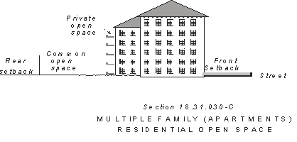
(5)
Private and Common Outdoor Living Area. Each multiple-family residential development (two or more dwelling units on a single lot) shall provide private and common areas for its tenants. Private areas typically consist of covered or uncovered balconies, decks, patios, porches, fenced yards, and similar areas outside the residence. A minimum of eighty square feet with a minimum depth of ten feet shall be provided with each dwelling unit. The minimum depth can be reduced to six feet for upper-story units.
Common outdoor-activity areas typically consist of landscape areas, walks, patios, swimming pools, barbeque areas, shade elements, playgrounds, turf, or other such improvements as are appropriate to enhance the outdoor environment of the development. All areas not improved with buildings, parking, vehicular access ways, trash enclosures, and similar items shall be developed as common areas with the type of attributes described above. Common areas in developments of twenty or more dwelling units must be of sufficient size and arrangement such that they allow adequate area for gathering, play, and other outdoor activities for their tenants and guests.
(6)
Garage Frontage Limitations. Where garage doors face a street, garage fronts (in linear feet) shall not exceed forty-five percent of the width of the lot as measured at the proposed building setback line. This limitation can be exceeded by an additional ten percent of the lot frontage where the garage extends beyond the front door of the residence and is separated by a depth of no more than six feet, measured from a line extended parallel to the plane of the front door. In the case of garages designed to accommodate three or more vehicles, at least one garage front must be offset from the remaining garage fronts by at least two feet.
(7)
Maximum Lot Coverage. Maximum lot coverage calculations in the "RM" Districts include buildings, driveways, parking areas, and trash-enclosure areas. Schedule 18.31.030-D indicates the maximum allowable lot coverage in each "RM" District.
Schedule 18.31.030-D: Maximum Lot Coverage
(8)
Recreational Vehicle Storage. Recreational vehicles, including, but not limited to, motor homes, travel trailers, detached campers/shells, boats, and trailers of all types shall not be stored within any front-yard or street side-yard setback unless a zoning exception is granted pursuant to Chapter 18.15. Such vehicles are permitted to be stored in interior side-yard or rear-yard setback areas. Items stored within the setback areas must be placed so as to prevent violations of the California Building Code with respect to egress, natural light, and ventilation and shall not contribute to or constitute blight, as defined by the Redding Municipal Code. The regulations of this section do not apply to: (1) Class B motor homes (commonly known as "van conversions") which otherwise comply with applicable parking standards and (2) temporary parking of recreational vehicles as necessary for customary active loading and unloading activities associated with the intended use of the vehicles for a period not to exceed seventy-two hours in a one-week period.
(9)
Storage Buildings. No storage buildings or similar structures shall be placed or erected in any front-yard or corner side-yard setback area regardless of size.
(10)
Corner Side Setback Exception. Corner side setbacks on lots created prior to adoption of this Code (October 1, 2002) may utilize the corner side setback required by the Zoning Code at the time of lot creation, but in no case shall it be less than ten feet.
(11)
With the exception of driveways, walkways, and porches, no portion of a single family lot between the front lot line and the dwelling shall be paved, with the following exceptions:
(a)
An area no greater than twenty feet in width adjacent to the side of a driveway that is nearest to an abutting lot may be paved and utilized for off-street parking (with the exception of recreational vehicles in accordance with Schedule 18.31.030-C).
(b)
At the discretion of the director additional paving for a driveway for access to the rear yard for additional parking of vehicles may be provided. Additional paving may be allowed only when it is proven that the additional paving will not be injurious to public safety or negatively impact the abutting lots.
(c)
Circular driveways constructed pursuant to an encroachment permit approved by the city engineer may be utilized for off-street parking.
(d)
Corner lots are permitted an additional driveway on the rear one-third of the lot.
Off-street parking on a single-family lot between the front lot line and the dwelling and in the case of corner lots the corner side lot line and the dwelling shall be limited to driveways and paved parking areas adjacent to driveways as described above.
(Ord. 2403 § 4, 2008; Ord. 2362 § 3, 2006; Ord. 2343 § 2 (part), 2005: Ord. 2310 § 3 (part), 2003; Ord. 2301 § 3 (Att. A (part)), 2002)
(Ord. No. 2443, § 2, 10-26-2009; Ord. No. 2461, § 2, 6-15-2010; Ord. No. 2590, § 5, 8-21-2018; Ord. No. 2631, § 1, 12-15-2020; Ord. No. 2649, § 2, 7-19-2022)
18.31.040 - Density increase.
The planning commission may grant an increase in density, not exceeding the general plan maximum within a given density range, for projects that demonstrate creativity and flexibility in design. The density increase can be obtained by single-family developments that incorporate a combination of site and building design components as described below. If the proposed density exceeds one hundred fifty percent of the base zoning district density and/or deviations from the base district regulations are required to facilitate the proposed development, an application to rezone the property to "Planned Development Overlay District" shall be required. All required materials must be provided in accordance with Chapter 18.53, "PD" Planned Development Overlay District.
A.
Density increases for single-family development are controlled by Schedule 18.31.040-E. To ensure maximum flexibility, the planning commission may consider alternative measures that will result in substantially the same result in meeting the intent of this section. To be eligible for a density increase, the development must include a combination of site and building design components as indicated in the schedule.
Schedule 18.31.040-E: Single Family Density
Increase Components
1.
Site Design Components.
a.
Minimized Grading. The development establishes "building envelopes" for each residential structure to reduce grading and retain existing trees. Grading is limited to the building envelope, utility alignments and driveway area of the lot. In areas in public view, natural contours altered by grading are shaped to simulate natural terrain. Grading follows the natural features of the site as much as possible to accommodate multiple-level foundations.
b.
Detached Sidewalks/Parkways. Sidewalks are separated from the curb by a landscaped parkway with a minimum average width of six feet. A meandering strip of variable width is permitted.
c.
Streetscape. The development includes streetscape improvements, such as landscaped roundabouts, neck downs, curb bulbs, or similar techniques. These areas shall be maintained through a landscape maintenance district or other means approved by the city.
d.
Parkland and Open-space. The development includes privately maintained park or common open-space or creek buffers at least thirty percent greater in width than the minimum required by Chapter 18.48 (River/Creek Corridor Development) of this title.
e.
Paving Material. Combined with streetscape enhancements, special paving material for pedestrian areas, street crossings and entries into the development are utilized.
f.
Variety of Lot Widths. Avoid a "monotonous" design by providing a variety of lot widths which can accommodate a variety of home styles, setbacks, and garage placement. At least thirty percent of the lots must vary from the "typical" (mode) lot width in the development by twenty percent, but shall not be less than ten feet. No street will have more than five consecutive lots of the same size.
g.
Street-Tree Planting. Provide a street-tree plan that includes: (1) sufficient trees to shade the sidewalks (approximately one tree per thirty feet of frontage); (2) requires the trees to be planted at the time public improvements are constructed, rather than with development of each lot; (3) ensures that the trees are protected within an easement or by other appropriate protection mechanism; and (4) requires that the trees be privately maintained.
h.
Variable Front Yard Setbacks. At least fifty percent of the homes will be set back at least ten feet farther than the minimum front yard setback. No more than three adjacent houses will have the same front yard setback. This component may be implemented by recording "build-to" lines on the final map.
i.
Other site design components as determined appropriate by the planning commission.
2.
Building Design Components.
a.
Garage Entries. The development plan includes provisions for variable location of garage entries. At least twenty-five percent of lots have side-load garages, garages set on the rear half of the lot, and/or garages that are set back at least ten feet behind the front yard setback of the remainder of the residence.
b.
Two-Story Design. At least twenty-five percent of the homes include second-floor windowed indoor living space or balcony space.
c.
Entries and Porches. At least thirty-five percent of the homes include covered entries and porches that are a minimum of six feet in depth and extend along a minimum of fifty percent of the home's facade, excluding the garage.
d.
Architectural Diversity. Facades, materials, and architectural details are varied to create an impression that the residential structures have been individually designed. There will be a significant difference in the massing and composition (not just materials) of each adjacent house. A variety of different floor plans and building elevations will be provided in accordance with Schedule 18.31.040-F:
Schedule 18.31.040-F: Floor Plan and Elevation Requirements
In order to be considered different, each elevation must have a minimum of three design features which substantially vary from the other elevations. Design features could include, but are not limited to, roof form, building materials, garage entry orientation, porches, and building height.
e.
All residences are constructed to meet the certification requirements of Earth Advantage, Leadership in Energy and Environmental Design (LEED), or similar energy-efficient building programs.
f.
Other building design elements can be used if determined appropriate by the planning commission.
(Ord. 2343 § 2 (part), 2005: Ord. 2310 § 3 (part), 2003; Ord. 2301 § 3 (Att. A (part)), 2002)
(Ord. No. 2428, § 4, 1-20-2009)
18.31.050 - Small-lot subdivisions.
A.
Purpose. The purpose of the small-lot subdivision regulations is to implement the general plan goal of allowing and encouraging infill development by providing for small-lot single-family housing.
B.
Applicability. Small-lot subdivisions may be proposed for subdivision of land (five or more lots) in the "RS-3.5," "RS-4," "RM-6" and "RM-9" districts.
C.
Application. An application for a subdivision as provided by Title 17 of this code.
D.
Standards. The following development standards shall apply to small-lot subdivisions. Refer also to the design criteria for small-lot subdivisions adopted by the city in accordance with Section 18.40.050 (Design criteria) of this title.
1.
Reduced Lot Area. The minimum lot area per dwelling unit shall be four thousand five hundred square feet for an interior lot and five thousand five hundred square feet for a corner lot.
2.
Reduced Setbacks. Schedule 18.31.050-A shall be used to determine structure setbacks instead of the normal setbacks required for the applicable zoning district.
Schedule 18.31.050-A: Minimum Structure Setbacks
Notes:
1 Garages in rear shall mean garages behind the primary residential unit.
2 Front porches shall have minimum dimensions of four feet by eight feet.
3 Garages with access perpendicular to the street shall be set back a minimum of twenty feet from the front property line. Garages with access parallel to the street (side entry) may be set back fifteen feet from the front property line.
3.
Site Coverage. Maximum site coverage shall be fifty percent of the lot area.
4.
Parking. Parking spaces shall be provided and parking areas shall be designed as follows:
a.
Two garage spaces shall be provided for each residential unit.
b.
For residential units with detached garages located behind the primary residential unit and taking access from the front, the minimum parking normally required shall be reduced to one enclosed (garage) space.
c.
Shared driveway access between two adjacent parcels is allowed when the garages are located within the rear half of the parcel or a minimum of ten feet behind the home's entry elevation.
(Ord. 2343 § 2 (part), 2005: Ord. 2310 § 3 (part), 2003; Ord. 2301 § 3 (Att. A (part)), 2002)
18.31.060 - Reserved.
Editor's note— Ord. No. 2423, § 2, adopted Dec. 2, 2008, repealed § 18.31.060 in its entirety. Former § 18.31.060 pertained to density bonus and derived from Ord. No. 2301, § 3 (Att. A(part)), adopted in 2002; Ord. No. 2310, § 3 (part), adopted in 2003; and Ord. No. 2343, § 2 (part), adopted in 2005.
18.32.010 - Purpose.
The specific purposes of the "office" districts are:
A.
Provide appropriately located areas for a full range of office uses needed by the city's businesses and workers;
B.
Minimize the impact of commercial development on adjacent residential districts.
The additional purposes of each "office" district are:
Limited Office. Provide sites for professional office space built at a residential scale that will serve as a transition between residential and commercial districts. To allow service businesses that are quiet and compatible with the residential uses and meet performance standards as outlined in the general plan.
General Office. Provide sites for professional, business, and personal-service businesses with appropriate and compatible accessory uses. Provide for other compatible uses including: rest homes, nursing homes, day-care facilities, hospitals; religious, educational, cultural and public utility uses; and financial institutions. Ancillary retail uses, such as pharmacy and sit-down restaurants, are also appropriate.
(Ord. 2343 § 2 (part), 2005: Ord. 2310 § 3 (part), 2003; Ord. 2301 § 3 (Att. A (part)), 2002)
18.32.020 - Land use regulations.
Schedule 18.32.020-A and Section 18.32.030 below prescribe the land use regulations and discretionary permit requirements for "Office" Districts. The regulations for each district are established by letter designations as follows:
"P" designates permitted use classifications subject to the provisions of Schedules 18.32.030-A and 18.32.030-B.
"L" designates use classifications that are permitted, subject to certain limitations prescribed by the additional use regulations or standards for specific uses in Chapter 18.43, Standards for Specific Land Uses.
"SD" designates use classifications that are permitted after review and approval of a site development permit by the director.
"S" designates use classifications that are permitted after review and approval of a site development permit by the board of administrative review.
"U" designates use classifications that are permitted after review and approval of a use permit by the planning commission.
Use classifications are defined in Chapter 18.60, Use Classifications. In cases where a specific land use or activity is not defined, the director shall assign the land use or activity to a classification that is substantially similar in character. Use classifications not listed or not substantially similar to the use in the schedule below are prohibited. The schedule also notes additional use regulations that apply to various uses.
Schedule 18.32.020-A: Use Regulations—"Limited Office" and "General Office"
(Ord. 2381 § 5 (part), 2007; Ord. 2343 § 2 (part), 2005: Ord. 2310 § 3 (part), 2003; Ord. 2301 § 3 (Att. A (part)), 2002)
(Ord. No. 2584, § 9, 3-20-2018; Ord. No. 2606, § 6, 6-18-2019)
18.32.030 - Permit requirements for new development.
In addition to the differentiation of uses found in Schedule 18.32.030-A, the size of a proposed building or development will determine whether uses that would otherwise be permitted will be required to obtain a site development permit or a use permit. Schedules 18.32.030-A and B describe the permit process that will be required for new development or additions to existing development based on certain size thresholds.
Schedule 18.32.030-A: Permit Requirements—"LO" District
1 If exempt from CEQA. If not, the permit shall be processed through the BAR.
Schedule 18.32.030-B: Permit Requirements—"GO" District
1 If exempt from CEQA. If not, the permit shall be processed through the BAR.
(Ord. 2343 § 2 (part), 2005: Ord. 2310 § 3 (part), 2003; Ord. 2301 § 3 (Att. A (part)), 2002)
18.32.040 - Site development regulations and performance standards.
Schedule 18.32.040-A below prescribes the development regulations for office districts. Section 18.33.050 of this chapter establishes standards for residential uses in office and commercial districts. Projects that require approval of a discretionary permit, such as a site development permit, use permit, or subdivision, must also demonstrate conformance with design criteria that are adopted pursuant to Section 18.40.050 (Design criteria) of this title.
Schedule 18.32.040-A: Development Regulations—"Office" Districts
(1)
Maximum Building Height. No building shall exceed two stories within fifty feet of an "RS" district unless a zoning exception is first approved in accordance with Chapter 18.15 (Zoning Exceptions) of this title. Projections above the maximum height limit are allowed for chimneys, towers, spires, and antennas and similar equipment in accordance with Section 18.40.080 (Exceptions to height limits) of this title.
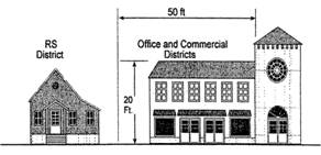
Figure 18.32.040
Transitional Height Limits:
C or O Districts Adjacent to RS
(2)
Sky Plane. Encroachments into the sky plane are permitted subject to specified standards as prescribed in Section 18.40.080 (Exceptions to height limits) of this title. Other encroachments may be allowed subject to approval of a zoning exception in accordance with Chapter 18.15 (Zoning Exceptions) of this title.
(3)
Minimum Yards. Except for driveway entrances, front, side yard, and corner side yard areas shall be landscaped in accordance with Chapter 18.47 (Landscape Standards) of this title. When not adjacent to an "R" district, parking spaces and drive aisles may encroach five feet into the side yard.
(4)
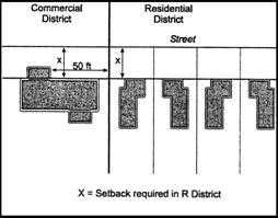
Front Yard. Where the prevailing setbacks of existing buildings on a block are less than required by Schedule 18.32.040-A, the minimum front yard shall be the average setback of immediately adjacent buildings on the same block. Further, within fifty feet of an "R" district, the setback shall be that required for the "residential" district.
(5)
Corner Side Yards. Where the prevailing setbacks of existing buildings on a block are less than required by Schedule 18.32.040-A, the minimum corner side yard shall be the average setback of immediately adjacent buildings on the same block. If the street frontage of the block also includes an "R" district, the street side yard shall be the same as required for that "R" district within fifty feet of that "R" district.
(6)
Rear Yard. When adjacent to an "R" district, rear yards shall be at least fifteen feet.
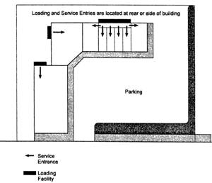
Section 18.32.040
Location of Parking, Loading and
Service Entries
(7)
Driveway Restrictions. Access from an arterial or collector street or alley wherever possible.
(8)
Loading and Service Areas. Loading and service areas shall be screened from public streets and residential districts.
(9)
Outdoor Facilities. All uses shall be conducted entirely within enclosed buildings, except sidewalk cafes and outdoor food service accessory to an eating and drinking establishment shall be permitted in the "GO" district with approval of a site development permit.
(10)
State Highway Setbacks. The following state highway segments within Redding are exempt from the state highway setback requirements; however, the remaining setback provisions of this code apply:
Downtown Specific Plan area: all highway segments;
Eureka Way: Buenaventura Boulevard to Union Pacific Railroad overcrossing;
North Market Street: North Market Street Bridge to Redwood Boulevard;
South Market Street: Cypress Avenue to Union Pacific Railroad undercrossing;
East Lake Boulevard: North Market Street to Interstate 5.
(Ord. 2381 § 5 (part), 2007; Ord. 2343 § 2 (part), 2005: Ord. 2310 § 3 (part), 2003; Ord. 2301 § 3 (Att. A (part)), 2002)
18.33.010 - Purpose.
The specific purposes of "commercial" districts are to:
A.
Provide for a full range of commercial uses;
B.
Strengthen the city's economic base and provide employment opportunities for residents of the city;
C.
Identify appropriate standards for reviewing proposals for new development and redevelopment, where appropriate in commercial areas;
D.
Ensure the provision of services and facilities needed to accommodate planned population densities;
E.
Encourage the creation of neighborhood activity centers as focal points along transportation corridors;
F.
Define the types of uses that are appropriate in each zoning district and, if applicable, zoning subdistrict.
The additional purposes of each "commercial" district are:
Neighborhood Commercial. To encourage convenience and neighborhood shopping areas providing day-to-day retail goods and services and to prohibit auto-oriented uses (other than service station mini-markets) in order to maintain a pedestrian environment.
Shopping Center. To encourage development that serves a market between a neighborhood store and a regional center. A typical center will have two or more anchor tenants, such as a supermarket and drug store, and one or more in-line stores and/or pads. Total floor area within shopping centers typically ranges from fifty thousand to two hundred thousand square feet.
Regional Commercial. To provide areas that accommodate a mix of regional-level retail uses and associated services, including malls; freestanding retail; power centers, and office and service establishments.
General Commercial. To maintain areas on arterial streets, near interchanges, and in existing commercial strips for commercial uses. Certain general commercial areas are identified for "visitor" and "retail" uses on the zoning map to assist in achieving the policies of the general plan.
Heavy Commercial. To provide sites for commercial businesses that are not permitted in other areas due to the types of buildings and the frequency of truck deliveries. These uses may include automobile services, building materials storage and sales, nurseries, equipment sales, wholesaling, storage, and similar uses.
(Ord. 2343 § 2 (part), 2005)
18.33.020 - Land use regulations.
Schedule 18.33.020-A and Section 18.33.030 below prescribe the land use regulations and discretionary permit requirements for "Commercial" Districts. The regulations for each district are established by letter designations as follows:
"P" designates permitted use classifications subject to the provisions of Schedules 18.33.030-A and 18.33.030-B.
"L" designates use classifications that are generally subject to certain limitations prescribed by the additional use regulations contained in this chapter subject to the provisions of Schedules 18.33.030-A and 18.33.030-B.
"SD" designates use classifications that are permitted after review and approval of a site development permit by the director.
"S" designates use classifications that are permitted after review and approval of a site development permit by the board of administrative review.
"U" designates use classifications that are permitted after review and approval of a use permit by the planning commission.
Use classifications are defined in Chapter 18.60, Use Classifications. In cases where a specific land use or activity is not defined, the director shall assign the land use or activity to a classification that is substantially similar in character. Use classifications not listed or not substantially similar to the uses in the schedule below are prohibited. The schedule also notes additional regulations that apply to various uses.
As described in Section 18.01.050(C), Establishment of Subdistricts, two subdesignations are depicted on the zoning map that refines the types of uses appropriate in certain geographic areas within a base district. Schedule 18.33.020-A provides regulations for base districts as well as those where visitor-serving and retail uses are encouraged ("VR" subdesignator).
Schedule 18.33.020-A: Use Regulations—"Commercial" Districts
(Ord. 2403 § 5, 2008; Ord. 2381 § 6 (part), 2007; Ord. 2343 § 2 (part), 2005)
(Ord. No. 2428, § 5; 1-20-2009; Ord. No. 2438, § 3, 9-1-2009; Ord. No. 2443, § 3, 10-26-2009; Ord. No. 2450, § 3, 1-19-2010; Ord. No. 2469, § 22, 11-2-2010; Ord. No. 2481, § 4, 11-15-2011; Ord. No. 2584, § 10, 3-20-2018; Ord. No. 2590, § 6, 8-21-2018; Ord. No. 2602, § 11, 3-19-19; Ord. No. 2606, § 7, 6-18-19; Ord. No. 2611, § 2, 9-17-2019)
18.33.030 - Permit requirements for new development.
In addition to the differentiation of uses found in Schedule 18.33.020-A, the size of a proposed building or development will determine whether permitted uses that would otherwise be permitted will be required to obtain a site development permit or a use permit. Schedules 18.33.030-A and B describe the permit process for new development or additions to existing developments that will be required based on certain size thresholds.
Schedule 18.33.030-A: Permit Requirements: "NC" District
1 If exempt from CEQA. If not, the permit shall be processed through the BAR.
Schedule 18.33.030-B: Permit Requirements: "SC," "RC," "GC," "HC" Districts
1 If exempt from CEQA. If not, the permit shall be processed through the BAR.
(Ord. 2343 § 2 (part), 2005)
18.33.040 - Site development regulations and performance standards.
Schedule 18.33.040-A below prescribes the development regulations for commercial districts. Section 18.33.050 establishes standards for residential uses in office and commercial districts. Projects that require discretionary approval, such as a site development permit, use permit, or subdivision, must also demonstrate conformance with the design guidelines that are adopted pursuant to Section 18.40.050 (Design criteria) of this title.
Schedule 18.33.040-A: Development Regulations—"Commercial" Districts
(1)
Minimum Lot Area. Except "pads" that are approved in conjunction with a comprehensive development plan for a shopping center, regional center, or similar scale development.
(2)
Maximum Building Size. This limit applies to the main tenant in a multi-tenant center or structure. A use permit may be approved to exceed this limit in the "NC" and "SC" districts upon finding that a larger building would be compatible in scale with adjacent uses or that adequate buffering and height transitions are provided. This limit does not apply in the "RC" district. In the "GC" and "HC" districts, this limit applies only to retail uses.
(3)
Transitional Building Height. No building shall exceed two stories in height within fifty feet of an "RS" district. Additional stories may be allowed with a site development permit. Projections above the maximum height limit are allowed for chimneys, towers, spires, and antennas as prescribed in Section 18.40.080 (Exceptions to height limits) of this title.
(4)
Sky Plane Encroachments. Encroachments into the sky plane are permitted subject to specified standards as prescribed in Section 18.40.080 (Exceptions to height limits) of this title.
(5)
Front Yards. Building walls facing a front property line that do not have parking between the wall and the street may encroach up to fifty percent of the required setback provided that the average setback of such building walls meets the minimum required setback for the district. If the street frontage of the block also includes an "R" district, the front yard shall be the same as required for that "R" district within fifty feet of that district.
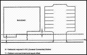
Setbacks 18-33
Front Yard Setbacks Averaging
Section 18.33.040
Front Setback on Adjacent
Different Zoning Districts
(6)
Corner Side Yards. If the street frontage of the block also includes an "R" district, the corner side yard shall be the same as required for that "P" district within fifty feet of that district.
(7)
Truck Docks; Loading and Service Areas. Loading and service areas shall be screened from public streets and residential areas.
(8)
Public Plazas. For developments of twenty-five thousand square feet and larger, provide areas equal to at least five percent of the building area (up to fifteen thousand square feet) that offer opportunities for public uses, such as outdoor seating, outdoor cafes, performance space, kiosk area, and similar activities. The area shall include amenities such as benches, water features, landscape, shade structures, or similar elements. Sidewalk areas providing access to the building entries or between building entries shall not satisfy this requirement.
(9)
State Highway Setbacks. The following state highway segments within Redding are exempt from the state highway setback requirements; however, the remaining setback provisions of this code apply:
Downtown Specific Plan area: all highway segments;
Eureka Way: Buenaventura Boulevard to Union Pacific Railroad overcrossing;
North Market Street: North Market Street Bridge to Redwood Boulevard;
South Market Street: Cypress Avenue to Union Pacific Railroad undercrossing;
East Lake Boulevard: North Market Street to Interstate 5.
(Ord. 2403 § 6, 2008; Ord. 2381 § 6 (part), 2007; Ord. 2343 § 2 (part), 2005)
18.33.050 - Residential uses in "office" and "commercial" districts.
This section establishes the standards under which residential uses may be conducted in office and commercial districts where allowed by this chapter.
A.
Except in the "general commercial" and "general office" districts, all residential uses shall be accessory to the intended use of the property as expressed in the general plan and this code and shall not occupy greater floor area than the principal use.
B.
Freestanding residential uses in the "general commercial" district shall be consistent with the density and development requirements of the "RM-15" district. Freestanding residential uses in the "general office" district shall be consistent with the density and development requirements of the "RM-10" district (see Chapter 18.31, Residential Districts).
C.
Separate dedicated parking facilities shall be provided for residential uses in mixed-use projects.
D.
Accessory dwelling units shall be located to minimize impacts from noise, on-site traffic circulation, outdoor activities, and other impacts that may result from the principal use of the property.
E.
Accessory dwelling units shall share the same architectural features, building materials, and landscape theme as the principal use.
F.
Buffer yards shall be provided for residential uses at the side and rear property lines of the residential development if required by the director.
(Ord. 2343 § 2 (part), 2005)
18.34.010 - Purpose.
The specific purposes of "industrial" districts are to:
A.
Promote and preserve the city's industrial areas as significant employment generators.
B.
Accommodate a variety of existing, traditional industries ranging from small, employee-intensive businesses to large, capital-intensive businesses, while anticipating new technologies and business-service uses.
C.
Preserve areas of the city for the appropriate location of businesses that may have the potential to generate off-site impacts, while providing compatibility in use and form.
D.
Identify appropriate standards for reviewing proposals for new development and redevelopment, where appropriate, in industrial areas.
E.
Ensure the provision of services and facilities needed to accommodate planned employment densities.
F.
Additional purposes of each "industrial" district:
"GI" General Industry. Provide areas for businesses that have limited potential to create significant adverse visual, noise, or other impacts to adjoining public and residential properties. Supporting retail and restaurant uses may be allowed subject to size limits and siting criteria. Uses characterized by substantial outdoor processing and/or storage are not allowed.
"HI" Heavy Industry. Provide areas for the broadest range of industrial uses, including those that are characterized by significant outdoor processing or storage. Supporting retail and restaurant uses may be allowed subject to size limits.
(Ord. 2403 § 7, 2008; Ord. 2343 § 2 (part), 2005: Ord. 2310 § 3 (part), 2003; Ord. 2301 § 3 (Att. A (part)), 2002)
18.34.020 - Land use regulations.
Schedule 18.34.020-A and Section 18.34.030, Permit Requirements for New Development, below prescribe the development regulations for "Industrial" districts.
"P" designates permitted use classifications subject to the provisions of Section 18.34.030.
"L" designates use classifications that are permitted subject to certain limitations prescribed by the additional use regulations contained in this chapter.
"Sd" designates use classifications that are permitted after review and approval of a site development permit by the director.
"S" designates use classifications that are permitted after review and approval of a site development permit by the board of administrative review.
"U" designates use classifications that are permitted after review and approval of a use permit by the planning commission.
Use classifications are defined in Chapter 18.60, Use Classifications. In cases where a specific land use or activity is not defined, the director shall assign the land use or activity to a classification that is substantially similar in character. Use classifications not listed or not substantially similar to the uses in the schedule below are prohibited. The schedule also notes additional regulations that apply to various uses.
18.34.020-A (Use Regulations - "Industrial Districts")
(Ord. 2343 § 2 (part), 2005: Ord. 2310 § 3 (part), 2003; Ord. 2301 § 3 (Att. A (part)), 2002)
(Ord. No. 2468, § 2, 10-19-2010; Ord. No. 2481, § 5, 11-15-2011; Ord. No. 2541, § 3, 2-16-2016; Ord. No. 2584, § 11, 3-20-2018; Ord. No. 2590, § 7, 8-21-2018; Ord. No. 2606, § 8, 6-18-19; Ord. No. 2611, § 3, 9-17-2019)
18.34.030 - Permit requirements for new development.
A site development permit approved by the BAR shall be required under any of the following circumstances unless otherwise noted:
A.
The proposed building(s) or building additions exceed the following:
1.
Ten thousand square feet (site development permit—Director);
2.
Twenty thousand square feet (site development permit—BAR).
B.
Industrial or manufacturing uses which, in the opinion of the director, may be objectionable by reason of producing offensive odor, dust, noise, bright lights, vibration, project scale, or traffic volumes or involving the storage or use of explosives or other dangerous materials.
C.
The property has direct access to or frontage on a designated arterial street or frontage road.
D.
The property is not located on an improved public street developed to serve industrial traffic.
E.
The property abuts a residential district.
(Ord. 2343 § 2 (part), 2005: Ord. 2310 § 3 (part), 2003; Ord. 2301 § 3 (Att. A (part)), 2002)
18.34.040 - Site development regulations and performance standards.
See Schedule 18.34.040-A below prescribes the development regulations for industrial districts.
Schedule 18.34.040-A: Development Regulations—"Industrial" Districts
(1)
Maximum Building Height. Building height may be increased by site development permit. Projections above the maximum height limit are allowed for chimneys, towers, spires, mechanical equipment, and antennas per Section 18.40.080 (Exceptions to height limits) of this title.
(2)
Sky Plane Encroachments. Encroachments permitted subject to specified standards as prescribed in Section 18.40.080 (Exceptions to height limits) of this title.
(3)
Front Yard Landscape. All unimproved areas within building and parking setbacks shall be landscaped.
(4)
Front Yard and Street Side Yard Setbacks. Twenty-five feet for arterial streets and frontage roads. All other street setbacks twenty feet minimum. Nonarterial and frontage road front yard setbacks may be reduced to fifteen feet for parcels less than forty-five thousand square feet.
(Ord. 2343 § 2 (part), 2005: Ord. 2310 § 3 (part), 2003; Ord. 2301 § 3 (Att. A (part)), 2002)
18.35.010 - Purpose.
The specific purposes of the "open-space" district are to:
A.
Identify and protect public lands, including those subject to public open-space easements;
B.
Identify and protect private lands that are subject to private open-space easements;
C.
Implement the goals and policies of the General Plan Natural Resources Element;
D.
Protect citizens from flood, erosion, and landslide hazards by classifying land prone to one-hundred-year floods and lands with slopes in excess of twenty percent as open-space;
E.
Establish specific uses and activities that are appropriate for open-space areas;
F.
Enhance the community character, maintain the scenic beauty, and increase recreational opportunities by preserving open-space.
(Ord. 2343 § 2 (part), 2005: Ord. 2310 § 3 (part), 2003; Ord. 2301 § 3 (Att. A (part)), 2002)
18.35.020 - Applicability.
The "open-space" district is applied principally to lands identified as: (1) having slopes in excess of twenty percent; and (2) being located within the one-hundred-year flood elevation of the Sacramento River or one of its local tributaries. The "open-space" district may also be applied to lands for the protection of plant and/or animal species that are rare, endangered, threatened, or otherwise identified as species of concern by federal or state agencies. The boundaries and uses of each open-space area shall be established at the time a development approval for property containing open-space resources is made by the city. Further, the city may initiate, or participate in, detailed topographic, flooding, biological, or similar studies that clearly define areas to be placed within an "open-space" district.
(Ord. 2343 § 2 (part), 2005: Ord. 2310 § 3 (part), 2003; Ord. 2301 § 3 (Att. A (part)), 2002)
18.35.030 - Land use regulations.
Unlike other districts contained in this title, the "OS" Open Space District is intended as a preservation tool, and as such, uses are limited to those which are consistent with the undeveloped nature of the lands. However, certain open space areas also provide corridors for trails, public utilities, streets, and other necessary public improvements. Schedule 18.35.030-A below prescribes the land use regulations for the "OS" District. The regulations for the district are established by letter designation as follows:
"P" designates permitted uses.
"L" designates uses that are permitted subject to certain limitations prescribed by the additional use regulations contained in this chapter.
"S" designates land uses or activities that are permitted after review and approval of a site development permit by the board of administrative review.
Uses or activities determined by the director to not be substantially similar to those listed in Schedule 18.35.030-A as permitted outright, by permit, or with limitations, are prohibited.
Schedule 18.35.030-A: Use Regulations—"Open Space" District
(Ord. 2381 § 7, 2007; Ord. 2343 § 2 (part), 2005: Ord. 2310 § 3 (part), 2003; Ord. 2301 § 3 (Att. A (part)), 2002)
(Ord. No. 2584, § 12, 3-20-2018; Ord. No. 2606, § 9, 6-18-2019)
18.35.040 - Zoning map indicator.
"Open-space" districts shall be designated on the zoning map as "OS" regardless of whether the open-space is private or public. The district may be applied to any underlying general plan classification. Private open-space easements are subject to recorded easement documents (typically a recorded parcel or subdivision map) which restricts use of the property consistent with this chapter. Public open-space may be dedicated for certain public uses in the form of an easement or through dedication "in fee" to the city. The city shall periodically amend the zoning map to reflect any new open-space easements and dedications that have been recorded.
(Ord. 2343 § 2 (part), 2005: Ord. 2310 § 3 (part), 2003; Ord. 2301 § 3 (Att. A (part)), 2002)
18.36.010 - Purpose.
The specific purposes of the "PF" public facilities district are to:
1.
Provide areas for public and quasipublic facilities that are appropriate for educational facilities, cultural and institutional uses, health services, specialized housing and care facilities, parks and recreation, general government operations, airports, utility and public service needs, and other similar and related supporting uses.
2.
Recognize the unique nature of public and quasipublic uses by requiring site development permits or use permits for most uses and activities within the "public facilities" district.
3.
Ensure the provision of services and facilities needed to accommodate planned population densities.
(Ord. 2343 § 2 (part), 2005: Ord. 2310 § 3 (part), 2003; Ord. 2301 § 3 (Att. A (part)), 2002)
(Ord. No. 2457, § 2, 5-18-2010)
18.36.020 - Applicability.
The "public facilities" district applies to a variety of public and semipublic properties including those owned by governmental agencies, philanthropic organizations, religious organizations, and nonprofit corporations. It is utilized where the use of the property is intended to provide a needed public purpose, to provide services to special population groups, or to identify properties that may be utilized for public or semipublic uses in the future.
(Ord. 2343 § 2 (part), 2005: Ord. 2310 § 3 (part), 2003; Ord. 2301 § 3 (Att. A (part)), 2002)
18.36.030 - Land use regulations.
Schedule 18.36.030-A below prescribes the land use regulations for the "Public Facilities" District. The regulations for this district are established by letter designation as follows:
"P" designates permitted use classifications.
"S" designates use classifications that are permitted after review and approval of a site development permit by the Board of Administrative Review.
"U" designates use classifications that are permitted after review and approval of a use permit by the Planning Commission.
Use classifications are defined in Chapter 18.60, Use Classifications. In cases where a specific land use or activity is not defined, the director shall assign the land use or activity to a classification that is substantially similar in character. Use classifications not listed or not substantially similar to the uses in the schedule below as determined by the director are prohibited.
Schedule 18.36.030-A Land Use Regulations
(Ord. 2343 § 2 (part), 2005: Ord. 2310 § 3 (part), 2003; Ord. 2301 § 3 (Att. A (part)), 2002)
(Ord. No. 2457, § 2, 5-18-2010; Ord. No. 2503, § 4, 2-4-2014; Ord. No. 2584, § 13, 3-20-2018; Ord. No. 2590, § 8, 8-21-2018; Ord. No. 2606, § 10, 6-18-2019; Ord. No. 2671, § 6, 11-5-2024)
18.36.040 - Site development regulations and performance standards.
Development standards shall be as specified by the site development permit or use permit.
(Ord. 2381 § 8, 2007: Ord. 2343 § 2 (part), 2005: Ord. 2310 § 3 (part), 2003; Ord. 2301 § 3 (Att. A (part)), 2002)
18.36.050 - Zoning map indicator.
Public facilities shall be designated on the zoning map as "PE." Such facilities less than two acres in size need not be so designated.
(Ord. 2343 § 2 (part), 2005: Ord. 2310 § 3 (part), 2003; Ord. 2301 § 3 (Att. A (part)), 2002)