
Saint Marys City Zoning Code
ARTICLE II
- LAND USE DISTRICTS
Sec. 110-51. - Establishment of land use districts.
For the purposes of these regulations, St. Marys, Georgia, is hereby divided into the following land use districts:
(Ord. of 9-12-94, § 501; Ord. No. 2019-10-21-002, 10-21-19; Ord. No. 2020-11-2-002, 11-2-20; Ord. of 3-21-22)
Sec. 110-52. - Interpretation of land use district boundaries.
Where uncertainty exists with respect to boundaries of any land use districts as shown on the official zoning map, the following shall apply.
(1)
Where district boundaries are indicated as approximately following street or highway centerlines, or street or highway right-of-way lines, said boundaries shall be construed as following such lines.
(2)
Where district boundaries are indicated as approximately following lot lines, said boundaries shall be construed as following such lines.
(3)
Where district boundaries are indicated as being approximately parallel to the centerlines or right-of-way lines of streets, or the centerlines or right-of-way lines of highways, such district boundaries shall be construed as being parallel thereto at the scaled distance indicated on the zoning map.
(4)
All streets, alleys, and railroad rights-of-way, if not otherwise specifically designated, shall be deemed to be in the same zone as the property immediately abutting upon such alleys, streets, or railroad right-of-way. Where the centerline of a street, alley or railroad right-of-way serves as a district boundary the zoning of such street, alley, or railroad right-of-way, unless otherwise specifically designated, shall be deemed to be the same as that of the abutting property up to such centerline.
(5)
Boundaries indicated as following railroad lines shall be construed to be midway between the main tracks.
(6)
Boundaries indicated as following salt water shorelines shall be construed to follow the mean low water mark of said shorelines, and in the event of change, the boundary line shall be construed as moving with the actual low water line; boundaries indicated as approximately following the centerline of fresh water rivers, creeks, canals, lakes, inlets or other bodies of water shall be construed to follow such centerlines.
(7)
Where physical or cultural features existing on the ground are at variance with those shown on the official zoning map, the planning commission shall interpret the district boundaries.
(8)
Where a district boundary line divides a lot which was in single ownership at the time of passage of this chapter, the planning commission may permit the extension of the regulations for either portion of the lot not to exceed 75 feet beyond the district line into the remaining portion of the lot.
(9)
It is the policy of the planning commission that all fresh and salt water marsh areas fall within the Conservation-Preservation Land Use District (CP). Where a boundary is indicated as following such fresh or salt marsh area the boundary line shall be construed as following the actual limits of said fresh or salt marsh.
(Ord. of 9-12-94, § 502)
Sec. 110-61. - Intent.
The regulations set by this division within each district shall be minimum regulations and shall apply uniformly, and to each class or kind of structure or land, except when modifications are provided.
(Ord. of 9-12-94, art. 6)
Sec. 110-62. - R-1, Single-Family Residential District.
District intent. This is the most restrictive residential district. The principal use of land is for single-family dwellings and related recreational, religious and educational facilities needed to provide the basic elements of a balanced and attractive residential area. These areas are intended to be defined and protected from the encroachment of uses not performing a function appropriate to the single-family residential environment. Internal stability, attractiveness, order and efficiency are encouraged by providing for adequate light, air and open space for dwellings and related facilities and through consideration of the proper functional relationship of each element.
(a)
Uses permitted. Property and buildings in an R-1, Single-Family Residential District shall be used for the following purposes:
(1)
Single-family residences (must meet the requirements in subsection (d) below);
(2)
Parks or playgrounds;
(3)
Country clubs, golf courses;
(4)
General purpose of gardening, but not the keeping of livestock, or nondomestic animals only laying hen chickens, but no roosters or other fowl, are permitted provided the following minimum requirements are met: A maximum of five laying hen chickens, and their enclosures, shall be 15 feet from property lines and not visible from the street. Laying hen chickens and their enclosures, must be kept in a neat, clean and sanitary condition and be well-maintained and free from offensive odors, excessive noise or any other condition that would constitute a nuisance. Enclosures must be attractive and well-maintained.
Any citizen proposing to have laying hen chickens under this section shall submit the following documents to the building department to indicate compliance with the minimum requirements as noted above:
a.
Sketch site plan showing location of the coop and enclosure. All distances between the proposed coop and/or enclosure and the adjacent property lines shall be clearly shown. These dimensions shall be field verified by the building department.
b.
Signature of the citizen indicating understanding and compliance with the minimum requirements noted above, or a form provided by the building department.
c.
A $10.00 administrative fee will be collected to offset the cost to process and verify that the applicant is in compliance with the minimum requirements as noted herein.
d.
Change of ownership of the property shall require a new application for approval.
(5)
Accessory buildings and structures.
(6)
Home business offices.
(7)
Accessory dwelling units.
(b)
Special permit uses. The following uses may be permitted in accordance with provisions contained in section 110-145, and if additional conditions which may be required are met.
(1)
Public and private schools;
(2)
Public buildings and utilities;
(3)
Churches;
(4)
Day care centers or kindergartens;
(5)
General purpose farm or garden that includes the keeping of livestock or nondomestic animals;
(6)
Home occupations provided that the conditions set forth in section 110-97 are met;
(7)
Fruit and vegetable sales with outdoor sales and caretakers residence.
a.
The establishment of fruit and vegetable sales with outdoor sales and caretakers residence shall be a special use, to include all of the application and documentation requirements noted under section 110-145. Special permit uses, as well as requirements noted under this subsection (7).
b.
The location of any proposed use under this section shall be limited to: the existing R-1 zoned parcels along Georgia 40 (Osborne Road) between Herb Bauer Drive (the library) and the Dark Entry Creek, and the existing R-1 zoned parcels along Georgia Spur 40 (Charlie Smith Sr. Highway) between Georgia 40 and Colerain Road.
c.
All outdoor sales as part of this special use shall not be located in present or future parking areas, and shall be set back a minimum of 40 feet as measured from the property line to provide for future parking requirements.
d.
Permanent signage shall be as per the sign ordinance, with the following new condition that no push in type signs, or sandwich type signs, or other "temporary" signage be located within the above setback or on any pole or on any fence.
e.
State and/or county health department and/or department of agriculture approval shall be obtained and prominently displayed on the premises and viewable by the general public.
f.
Valid and approved City of St. Marys occupational tax license.
g.
Fruit and vegetable sales facility shall be of coastal design and coloration.
h.
A caretaker residence shall be permitted behind or "above the shop" for only the business owner and his/her immediate family.
1.
If the caretaker residence is located "above the shop", the residence shall have:
i.
Code-approved fire separation between the residence and the shop below;
ii.
Be a minimum of 900 square feet;
iii.
Have a fully functioning sprinkler system to applicable code;
iv.
Have at least two exits as remote as possible from each other;
v.
Be in compliance with all applicable codes.
2.
If the residence is located behind and not physically connected to the shop (business use), the shop portion of the structure shall conform to the approved C-2 commercial portions of the St. Marys Building Code and Zoning Ordinance, as applicable; and the residential portion of the structure shall conform to the approved R-1 residential portions of the applicable St. Marys Building Code and Zoning Ordinance, as applicable.
(c)
Area regulations. Unless otherwise specified in this chapter, uses permitted in R-1, Single-Family Residential Districts shall conform to the following requirements:
(1)
Minimum lot area: 10,000 square feet;
(2)
Minimum lot width at building line: 75 feet;
(3)
Minimum front yard setback from street: 25 feet;
(4)
Minimum side yard, setback from street: 25 feet; setback from other property line: 15 feet;
(5)
Minimum rear yard, setback from street: 25 feet; setback from other property line: 15 feet;
(6)
Maximum percentage of lot coverage: 30 percent;
(7)
Maximum building height: 35 feet.
(d)
Single-family residential standards. All single-family residences, whether site built or modular houses, must meet the following standards in the R-1 District:
(1)
The roof shall be covered with asphalt composition shingles, 5-V metal roofing, tile materials or other suitable materials. Corrugated metal or plastic panels are prohibited.
(2)
The exterior wall materials may include clapboards, simulated clapboards such as conventional vinyl or metal siding, wood shingles, shakes, stucco, brick, brick veneer, concrete block, or similar materials, but shall not include smooth ribbed or corrugated metal or plastic panels.
(3)
The minimum horizontal dimension of the structure as installed on the site shall be 24 feet.
(4)
The minimum heated and cooled floor area shall be 900 square feet.
(5)
All principal structures shall be placed on a permanent foundation. For the purposes of this section, a permanent foundation shall mean a concrete slab, concrete footers, foundation wall, pilings or post construction which complies with the city building code.
(6)
No "manufactured housing" or "mobile homes", as those terms are defined in subsection 110-8(b), shall be permitted in this district.
(7)
All units must meet wind loading requirements of the Federal Emergency Management Administrator and the State of Georgia adopted building codes.
(Ord. of 9-12-94, § 601; Ord. of 1-31-05, § 2; Amend. of 5-16-11; Ord. No. 2014-040, 9-15-14; Ord. No. 2021-8-16-001, 8-16-21)
Sec. 110-63. - R-2, Single-Family Residential District.
District intent. This residential district is created to provide low density multifamily residential dwellings, primarily in the form of two and three dwelling unit structures. Single-family and other uses allowed in the R-1 District are also permitted. Persons residing in this district are entitled to protection from other types of uses which are detrimental to the residential characteristics of the district. The regulations which apply to this district are designed to encourage the formation and continuance of a stable, healthy living environment for its residents.
(a)
Uses permitted. Property and buildings in an R-2, Low Density Multifamily Residential District shall be used for the following purposes:
(1)
Any use permitted in the R-1, Single-Family Residential District (see subsection 110-62(a)) except that single-family residences are not required to meet the standard listed in subsection 110-62(d)(5);
(2)
Two-family dwellings (duplex);
(3)
Three-family dwellings (triplex);
(4)
Boardinghouses (not to exceed four units);
(5)
Accessory uses and structures.
(b)
Special permit uses. The following uses may be permitted in accordance with provisions contained in section 110-145, and if additional conditions which may be required are met:
(1)
Any special use permitted in the R-1, Single-Family Residential District (see subsection 110-62(b));
(2)
Nursing homes.
(c)
Area regulations. Unless otherwise specified in this chapter, uses permitted in R-2, Low Density Multifamily Residential Districts shall conform to the following requirements:
(1)
Minimum lot areas:
a.
Single-family dwellings: 10,000 square feet;
b.
Two- and three-family dwellings: 10,000 square feet for the first two units, 4,000 square feet for each additional unit;
c.
Boardinghouses: 10,000 square feet for the first three units plus 4,000 square feet for each additional unit.
(2)
Minimum lot width at building line: 70 feet;
(3)
Minimum front yard setback from street: 25 feet;
(4)
Minimum side yard, setback from street: 25 feet; setback from other property line: Ten feet;
(5)
Minimum rear yard, set back from street: 25 feet; setback from other property line: 15 feet;
(6)
Maximum percentage of lot coverage: 35 percent;
(7)
Maximum building height: 35 feet;
(8)
Minimum dwelling unit size (heated and cooled area):
a.
Single-family dwellings: 600 square feet;
b.
Two- and three-family dwellings: 600 square feet per unit;
c.
Boardinghouses: none.
(Ord. of 9-12-94, § 602)
Sec. 110-64. - R-3, Medium and High Density Multifamily Residential District.
District intent. To provide for development of condominium dwelling units and medium to high density residential development. This district's regulations are designed to encourage the formation and continuance of a stable and healthy residential environment while discouraging the encroachment of uses capable of adversely affecting the district's character.
(a)
Uses permitted. Property and buildings in R-3, Medium and High Density Multifamily Residential Districts shall be used for the following purposes:
(1)
All uses permitted in the R-1, Single-Family Residential and R-2, Low Density Multifamily Residential except that single-family residences are not required to meet the standard listed in subsection 110-62(d)(5);
(2)
Multiple-family dwellings and apartments;
(3)
Single-family condominium dwellings;
(4)
Accessory uses and structures.
(b)
Special permit uses. The following uses may be permitted in accordance with the provisions contained in section 110-145, and if additional conditions which may be required are met:
(1)
Any special use permitted in the R-1, Single-family Residential District or R-2, Low Density Multifamily Residential District.
(c)
Area regulations. Unless otherwise specified in this chapter, uses permitted in R-3, Medium and High Density Multifamily Residential Districts shall conform to the following requirements:
(1)
Minimum lot area:
a.
Single-family detached dwellings: 10,000 square feet;
b.
Two- and three-family dwellings: 10,000 square feet for the first two units and 4,000 square feet for each additional unit;
c.
Condominiums and multifamily dwellings of more than three units: 8,000 square feet for the first two units; plus 2,000 square feet for each additional unit;
(2)
Minimum lot width at building line: 16 feet for condominium dwellings; 70 feet for all other uses;
(3)
Minimum front yard setback from street: 25 feet;
(4)
Minimum side yard, setback from street: 25 feet; setback from other property line: Ten feet; provided, that condominium dwellings which are not end units may have 0 feet side yards on each side adjoining another unit.
(5)
Minimum rear yard, setback from street: 25 feet; setback from other property line: 15 feet;
(6)
Maximum percentage of lot coverage: 55 percent for condominiums; 35 percent for all other permitted uses;
(7)
Maximum building height: 45 feet;
(8)
Minimum dwelling unit size:
a.
Single-family dwellings, and condominium dwellings: (heated and cooled area) 800 square feet;
b.
Two- and three-family dwellings: 600 square feet per unit;
c.
Multifamily dwelling of more than three units: 600 square feet for the first six units; 500 square feet for the next six units; and 400 square feet per unit in addition to the first 12 units.
(Ord. of 9-12-94, § 603)
Sec. 110-65. - R-4, Single-Family Residential District.
District intent. The intent of this district is to provide distinct areas within the city where single-family dwellings are allowed by right and single-family manufactured housing is allowed on a special use permit basis. It is intended that R-4 land use districts be limited to those areas of the city where manufactured homes and single-family dwellings have historically existed together but where single-family dwellings are the dominant housing type.
(a)
Uses permitted. Property and buildings in the R-4, Single-Family Residential District shall be used for the following purposes:
(1)
Single-family dwellings; except that single-family residences are not required to meet the standard listed in subsection 110-62(d)(5);
(2)
Parks and playgrounds;
(3)
Country clubs and golf courses;
(4)
General purpose farm or garden, but not the keeping of livestock or non-domestic animals;
(5)
Accessory uses and structures;
(6)
Home business offices.
(b)
Special permit uses. The following uses may be permitted in accordance with the provisions contained in section 110-145, and if any additional conditions which may be required are met:
(1)
Manufactured houses on individual lots;
(2)
Public and private schools;
(3)
Public buildings and utilities;
(4)
Churches;
(5)
Day care centers and kindergartens;
(6)
Clubs, lodges, or fraternal organizations;
(7)
General purpose farm or garden that includes the keeping of livestock or non-domestic animals;
(8)
Home occupations.
(c)
Area regulations. Unless otherwise specified in this chapter, uses permitted in R-4, Single-family Residential Districts, shall conform to the following requirements:
(1)
Minimum lot area: 10,000 square feet;
(2)
Minimum lot width at the building line: 75 feet;
(3)
Minimum front yard setback from street: 25 feet;
(4)
Minimum side yard, setback from street: 25 feet, setback from other property line: Ten feet;
(5)
Minimum rear yard, setback from street: 25 feet; setback from other property line: 15 feet;
(6)
Maximum percentage of lot coverage: 30 percent;
(7)
Maximum building height: 35 feet.
(8)
Minimum dwelling unit size (heated and cooled) shall be 900 square feet.
(Ord. of 9-12-94, § 604)
Sec. 110-66. - R-5, Townhouse Dwelling District.
District intent. To provide for the development of townhouse dwelling units at a medium density so as to provide for the amenities of open space and recreational potentials essential to family living. This district provides a choice of housing types in the community where such dwellings would be compatible with existing development.
(a)
Uses permitted. Property and buildings in the R-5, Townhouse Dwelling District shall be used for the following purposes:
(1)
All uses permitted in the R-1 Single-family Residential District;
(2)
Townhouse dwelling;
(3)
Accessory uses and structures.
(b)
Special permit uses. The following uses may be permitted in accordance with the provisions contained in section 110-145, and if additional conditions which may be required are met:
(1)
Any special use permitted in the R-1, Single-family Residential District.
(c)
Area regulations. Unless otherwise specified in this chapter, uses permitted in R-5 Townhouse Dwelling Districts shall conform with the following requirements:
(1)
Minimum lot area:
a.
Single-family detached dwellings: 10,000 square feet;
b.
Single-family townhouses: Not more than 16 townhouses per acre of land, each townhouse development containing at least one acre of land;
(2)
Minimum lot width at building line: 16 feet for single-family townhouses; 70 feet for all other uses;
(3)
Minimum front yard setback from street: 25 feet;
(4)
Minimum side yard, setback from street: 25 feet; setback from other property line: Ten feet, provided, that townhouse dwellings which are not end units may have zero feet said yards on each side adjoining another unit;
(5)
Minimum rear yard, setback from street: 25 feet; setback from other property line: 15 feet;
(6)
Maximum percentage of lot coverage: 55 percent for single-family townhouses; 35 percent for all other permitted uses;
(7)
Maximum building height: 35 feet;
(8)
Minimum dwelling unit size: 800 square feet.
(Ord. of 9-12-94, § 605)
Sec. 110-67. - MH, Manufactured Housing District.
District intent. The intent of this district is to provide sound and healthy residential areas to meet the unique needs of manufactured housing residents; to encourage the consolidation of manufactured housing into parks; to protect manufactured housing residential areas from encroachment by incompatible uses; and to enhance property values in the community by providing distinctive areas for manufactured housing.
(a)
Uses permitted. Property and buildings in Manufactured Housing Districts shall be used for the following purposes:
(1)
Manufactured housing parks;
(2)
Single-family manufactured housing on individual lots;
(3)
Single-family residences;
(4)
Parks and playgrounds;
(5)
Laundromats;
(6)
Accessory uses and structures;
(7)
Home occupations.
(b)
Special permit uses. The following uses may be permitted in accordance with the provisions contained in section 110-145, and if additional conditions which may be required are met:
(1)
Any special use permitted in the R-1, Single-family Residential District.
(c)
Area regulations. Unless otherwise specified in this chapter, uses permitted in the Manufactured Housing District shall conform to the following requirements:
(1)
All manufactured housing shall be built in compliance with the National Manufactured Housing Construction and Safety Standards Act of 1974.
(2)
a.
Single-family residences and manufactured homes on individual lots must meet the lot
area regulation requirements of R-1, Single-family Residential District;
b.
All manufactured houses shall comply with the provisions of (3)j. below, Additional Requirements.
(3)
Manufactured Housing Parks shall conform to the following requirements:
a.
Minimum lot area: Four acres;
b.
Maximum density is seven mobile homes per acre;
c.
Each manufactured house shall be located on a lot or space having an area of at least 4,000 square feet.
d.
Each manufactured home lot shall be graded and drained so that rain water will not stand in pools or puddles.
e.
The minimum distance required for the separation of a manufactured house from any other mobile home shall be: 20 feet from side to side, 20 feet from side to rear, setback from interior driveways shall be at least 15 feet.
f.
No manufactured house shall be located closer than 30 feet from street right-of-way lines and not closer than 20 feet from property lines.
g.
Manufactured housing parks shall have a minimum of 400 square feet of common open space per manufactured house space; however, no manufactured house park shall have less than 6,000 square feet of total common open space.
h.
Manufactured housing parks shall have visual buffers such as shrubbery and/or fencing at least six feet in height between the park and adjacent non-manufactured home residential users. Buffer strips shall meet the requirements of section 110-92.
i.
All manufactured house spaces shall abut on interior drive of gravel or similar all-weather surface; interior drives shall be a minimum of 20 feet in width and shall have unobstructed access to a public street; and parking space of gravel or similar all- weather surface sufficient for automobiles shall be located on each manufactured house space.
j.
Additional requirements:
1.
Manufactured house placement. Manufactured house supports or pillars shall be provided not more than ten feet on center or less beginning from the front of the mobile home. Supports or pillars shall be placed upon concrete pads having minimum dimensions of 16" x 16" x 4".
2.
Anchoring. All manufactured houses shall be anchored prior to the unit being occupied or used in any other way. The anchoring system shall be designed to resist a minimum 28 wind velocity of 90 miles per hour.
3.
Stability. All manufactured houses shall, prior to occupancy or other use, be stabilized in such a way so as to prevent tilting of the unit. No manufactured house shall permanently rest on wheels used to transport it.
4.
Skirts. All manufactured houses shall, prior to occupancy or other use, have skirts installed that are designed to compliment the appearance of the manufactured house and are coordinated throughout the park.
(Ord. of 9-12-94, § 606)
Sec. 110-68. - Cumberland Inlet Planned Development District.
The Cumberland Inlet Planned Development Ordinance, which is attached [to Ord. No. 2020-8-3-002], is incorporated as Chapter 110.1—Cumberland Inlet Planned Development Ordinance.
(Ord. No. 2020-8-3-001, 8-3-20)
Editor's note— Ord. No. 2020-8-3-001, adopted Aug. 3, 2020, amended § 110-68 in its entirety to read as herein set out. Former § 110-68 waqs entitled "PSM Port of St. Marys planned development district," and derived from: Ord. of 9-12-94, § 607; Ord. of 11-10-03, § 3; Ord. of 5-9-16, Exhs. A, C, H; and Ord. No. 2020-3-2-003, §§ A—C, 3-2-20.
Sec. 110-69. - C-1, Central Business District.
District intent. The C-1, Central Business District is intended to protect and promote suitable areas for business and commercial uses which benefit from proximity to each other; to allow certain appropriate residential uses; to encourage the eventful elimination of uses inappropriate to the central business area, and to encourage the cohesive development of a town center for the city.
(a)
Uses permitted.
(1)
Generally recognized retail business which supply commodities on the premises and without outdoor storage of goods, such as but not limited to groceries, drugs, clothing, notions or hardware except small box discount stores are not permitted under this subsection.
(2)
Personal service establishments which perform services on the premises such as but not limited to repair shops (radios, television, shoes, upholstery, etc.), beauty parlors or barber shops, and dry cleaners.
(3)
Business establishments which perform services on the premises, such as but not limited to banks, loan companies, insurance offices and real estate offices.
(4)
Professional services including the following: medical offices, dentists, legal and similar or allied professions.
(5)
Public offices such as post offices, city administration, museums and similar governmental offices.
(6)
Private clubs, fraternal organizations and lodge halls.
(7)
Public and private schools and religious institutions.
(8)
Waterfront facilities pertaining to normal fishing, shrimping, and boating activities.
(9)
Restaurants, grills, delicatessens, and similar eating establishments, but not including "drive-in" types.
(10)
Brew pubs.
(11)
Hotels and boardinghouses.
(12)
Accessory uses and structures.
(13)
Single-family dwellings (must meet area regulations and dwelling standards for single-family dwelling in C-1 District).
(14)
Apartment(s), either as part of a commercial use (must meet commercial area regulations and commercial dwelling standards) or solely for residential use (must meet commercial area regulations and multi-family dwelling standards in C-1 District.)
(b)
Special permit uses. The following uses may be permitted in accordance with the provisions contained in section 110-145, and if additional conditions which may be required are met.
(1)
Laundromats.
(2)
Theaters.
(3)
Parking lots (private and public) not including those areas required by article IV, off-street parking and loading.
(4)
Public utility installations and buildings including water towers, electric transformer stations, and water and sewage pumping stations, provided that: no open storage is permitted at the site; the area is fenced in by a wall or fence at least six feet in height; and landscaped strip not less than five feet in width is planted and maintained.
(b.1)
Prohibited uses. The following use(s) are not permitted:
(1)
Small box discount stores.
(c)
Area regulations:
(1)
Commercial uses. Unless otherwise specified in this chapter, commercial uses permitted in the C-1, Central Business District shall conform to the following requirements:
a.
Minimum lot area: 3,000 square feet.
b.
Minimum lot width: 30 feet.
c.
Minimum front yard setback: None, however, pedestrian walkways shall be accessible.
d.
Minimum side yard: None, unless the parcel is adjacent to a residential district in which case the minimum side yard shall be five feet.
e.
Minimum rear yard: None, unless the parcel is adjacent to a residential district in which case the minimum rear yard shall be 15 feet.
f.
Maximum percentage of lot coverage: 100 percent.
g.
Maximum building height: 45 feet.
h.
Off-street parking and loading requirements as provided in article IV, except where the planning commission waives such requirements or portion thereof, where it finds that they are unnecessary, excessive, or impractical, given the size of the lot.
(2)
Single-family detached dwelling uses. Unless otherwise specified in this chapter, single-family detached dwellings permitted in the C-1, Central Business District shall conform to the following requirements:
a.
Minimum lot area: 5,000 square feet.
b.
Minimum lot width: 50 feet.
c.
Minimum front and rear yard setback: Ten feet.
d.
Minimum side yard setback: five feet for single story: Seven and one-half feet for multi-story or five feet if multi-story and sprinkled for fire suppression.
e.
Maximum percentage of lot coverage, remaining lot area after meeting required setbacks and parking requirements.
f.
Maximum building height: 45 feet.
g.
Minimum of two off-street parking spaces required per residence. No parking spaces permitted in front yard setback area.
h.
Only one driveway per residence. If an alley exists behind the lot, ingress and egress to the residential structure must be accessed from the alley and no curb cut will be permitted along the main roadway.
i.
A minimum roof pitch of five × 12 is required.
j.
Structures built within the Historic District must comply with the historic preservation ordinance.
k.
Single-family detached dwelling standards. All single-family dwellings, whether site built or modular houses, must meet the following standards in the C-1 District:
1.
The roof shall be covered with asphalt composition shingles, 5-V metal roofing, tile materials or other suitable materials. Corrugated metal or plastic panels are prohibited.
2.
The exterior wall materials may include clapboards, simulated clapboards such as concrete composite siding, wood shingles, shakes, stucco, tabby, brick, brick veneer, concrete block or similar materials, but shall not include smooth ribbed or corrugated metal or plastic panels.
3.
The minimum horizontal dimension of the structure as installed on the site shall be 24 feet.
4.
The minimum heated and cooled floor area shall be 900 square feet.
5.
All principal structures shall be placed on a permanent foundation.
6.
No "manufactured housing" or "mobile homes" as those terms are defined in subsection 110-8(b), shall be permitted in this district.
7.
All units must meet wind loading requirements of the Federal Emergency Management Administrator and the State of Georgia adopted building codes.
(3)
Commercial dwelling standards. Dwelling units are permitted in buildings utilizing all or part of the first occupied floor for permitted C-1 commercial uses. Such buildings may house one or more dwelling units, for rent or sale, provided that no such unit shall be less than 450 square feet of heated and cooled area exclusive of any hallways and stairs designed for access to the unit(s).
(4)
Multi-family dwelling standards. Such buildings used exclusively for residential purposes may house two or more dwelling units, for rent or sale, provided that no such unit shall be less than 450 square feet of heated and cooled area exclusive of any hallways and stairs designed for access to the unit(s).
1.
The exterior wall materials may include clapboards, simulated clapboards such as concrete composite siding, wood shingles, shakes, stucco, tabby, brick, brick veneer, concrete block or similar materials, but shall not include smooth ribbed or corrugated metal or plastic panels.
2.
All principal structures shall be placed on a permanent foundation.
3.
No "manufactured housing" or "mobile homes" as those terms are defined in subsection 110-8(b), shall be permitted in this district.
(Ord. of 9-12-94, § 608; Ord. of 11-10-03, §§ 1, 4; Ord. of 8-14-06, § 1; Ord of 11-13-06(2), §§ 2—6; Ord. No. 2015-042, 11-2-15; Ord. No. 2020-12-21-001, 12-21-20; Ord. No. 2021-5-3-004, 5-3-21; Ord. of 3-7-22)
Sec. 110-70. - C-2, Highway Commercial and Community District.
(a)
District intent. The intent of this district is to provide areas for commercial uses which primarily render a service to local residents or to other non-local individuals such as tourists, vacationers, truckers, workers, and commuters. The regulations applying to this district are designed to:
(1)
Encourage the location of high traffic volume uses in an attractive and well-designed manner;
(2)
Ensure adequate and properly designed means of ingress and egress while considering and providing for overall safe and adequate traffic flow on the highways to help avoid unsafe traffic congestion.
(3)
Discourage encroachment by industrial, residential or other uses which may be incompatible with the specialized character of this district.
(b)
Uses permitted. Property and buildings in the C-2, Highway Commercial District shall be used for the following purposes:
(1)
All uses permitted in the C-1, Central Business District, except residential.
(2)
Retail and wholesale business and service establishments, including shopping centers that conduct business entirely within an enclosed building except small box discount stores.
(3)
Animal care facilities, animal hospital and/or boarding facility, and veterinary offices.
(4)
Commercial recreation facilities including bowling alleys, roller or ice skating rinks, theaters (not including drive-ins), and the like.
(5)
Hotels, lodging and motels.
(7)
Microbreweries.
(8)
Public utility, installation or sub-installation, including water towers, but specifically excluding waste treatment processing or storage.
(9)
Churches.
(10)
Community facilities. Assembly halls, recreation centers, civic centers, local government public uses including schools, libraries, parks, playgrounds, and fire stations.
(11)
Medical health services. Clinics and pharmacies, hospitals, medical or dental labs, offices of health service practitioners and other health services not elsewhere classified.
(12)
Accessory uses and structures.
(c)
Special permit uses. The following uses may be permitted in accordance with the provisions contained in section 110-145, and if additional conditions which may be required are met:
(1)
Outdoor sales of new or second hand automobiles, manufactured or modular homes, boats, and other such items provided the lot is graded, surfaced and drained for disposal of all surface water; and provided that ingress and egress is provided to the outdoor sales area.
(2)
Drive-in restaurants provided that outside lighting and advertisement arrangements are directed away from adjoining residential districts (if any); and parking surface areas are separated from adjoining residential districts (if any) by a suitable planting screen, fence, or wall at least six feet in height as defined in section 110-92 and in the site development criteria listed within this section.
(3)
Gasoline service stations.
(4)
Cable television towers/satellite dishes and cell towers; All adjoining Residential Districts shall be separated from such towers/satellite dishes by a visual barrier, with a minimum height of six feet. Such barrier shall be opaque, and shall prevent the free passageway and obstruct the view between such towers/satellite dishes and all adjoining residential properties.
(5)
Day care centers, kindergartens or schools provided that a minimum of 100 square feet of outdoor play area be provided for each child. Such outdoor play area shall be enclosed by a fence not less than four feet in height. Such use shall comply with the Georgia Department of Human Resources Regulatory Services. Such use shall provide the number of off-street parking spaces required for schools as set forth in section 110-124, number of parking spaces required, and section 110-126, off-street loading and unloading requirements.
(6)
Electronic game promotions. Indoor facilities operated by a licensed permit holder for game promotions or sweepstakes utilizing electronic equipment, meeting the performance standards and development criteria set forth in chapter 22, article VII, electronic game promotions, and drawings by chance conducted in connection with the sale of a consumer product or service utilizing electronic equipment, meeting the performance standards and development criteria set forth under Code of Ordinances chapter 110, subsection 110-145(6), special permit uses.
(7)
Automotive-service or equipment-oriented repair garages provided that all business is conducted inside an enclosed building and/or inside an aesthetically pleasing barrier as prescribed by the planning commission and designed to be in keeping with section 110-92 and the site development criteria listed within this section. The barrier shall shield the business activity from view of passing motorists and surrounding property owners.
(8)
Mini-warehouse developments provided that the following conditions are met:
a.
No business activities other than the rental of storage units is conducted on the premises;
b.
The mini-warehouse development is located on a lot at least five acres in size;
c.
All storage on the property shall be kept within an enclosed building except that recreational vehicle (RV) and boat storage is allowed as an accessory use to the mini-warehouse development when the storage or RVs and boats is located at the rear of the mini-warehouse development, and any outdoor storage shall be screened with a suitable planting screen, fence or wall at least six feet in height and designed in accordance with the site development criteria listed in this section.
d.
If a mini-warehouse development abuts a Residential Zoning District, a buffer will be required as per section 110-92.
(9)
Small box discount stores as defined in section 110-8, Interpretation of terms; definitions.
(10)
Solar energy production facilities (solar farms as a primary use) provided the following conditions are met:
a.
Solar energy production is the principal use;
b.
The minimum lot size for a solar energy production facility as a principal use is 20 acres;
c.
The solar energy production facility shall be connected to the utility grid and shall provide evidence from the applicable electric utility acknowledging the solar energy production facility will be interconnected to the utility grid in order sell electricity to the utility;
d.
Solar energy production facilities including power inverters, transformers, and other equipment related to the inversion of power shall have a minimum setback of 50 feet from all property lines;
e.
The height of ground-mounted collectors and mounts shall not exceed 16 feet in height as measured from the point (on the ground) directly below the panel to the top of the panel, when tilted at the highest aspect. Components of solar energy production facilities are not exempt from district height requirements;
f.
On-site power lines and interconnections shall be placed underground, to the greatest extent possible;
g.
Decommissioning. The application to establish a solar energy production facility must include a decommissioning plan, containing the following:
1.
The name, address, telephone number, and e-mail address of the person(s) or entity(ies) responsible for implementing the decommissioning plan;
2.
A statement of conditions that require the decommissioning plan to be implemented;
3.
Identification of all components of the solar energy production facility;
4.
A plan with timeline for removing all components of the solar energy production facility from the property in the event of decommissioning;
5.
A plan for recycling or otherwise reusing all components to the greatest extent practicable.
(11)
Smoke, vape and/or tobacco product shops.
a.
For the purposes of this subsection, "smoke, vape and/or tobacco product shops" shall mean an establishment where at least 25 percent of the total retail floor area is used for the sale of smoking, vaping, or other tobacco products, including, but not limited to, cigarettes, cigars, pipe tobacco, snuff, chewing tobacco, electronic cigarettes, vaping devices, and vaping liquids.
b.
No special permit may be issued under this section for any smoke, vape and/or tobacco product shop (as defined above) located within 1,000 feet of the boundary of any parcel occupied by any of the following uses (as measured in a straight line from parcel boundary to parcel boundary):
1.
Public or private early childhood, elementary, middle or high school;
2.
Park or public playground;
3.
Recreation or athletic facility, indoor or outdoor;
4.
Community center, day care center or medical use facility.
c.
No special permit may be issued under this section for any smoke, vape and/or tobacco product shop located within 5,000 feet of a site occupied by another tobacco and/or vape shop, as measured in a straight line from parcel boundary to parcel boundary.
(12)
Residential uses, subject to the following conditions:
a.
Any development that combines residential and commercial uses must comply with all regulations and standards applicable to commercial uses within the C-2 zone.
b.
Developments that are solely residential must adhere to all regulations and standards applicable to commercial uses and multi-family dwellings, as specified in C-1 or C-3 zoning regulations.
(13)
Transportation terminals.
(d)
Prohibited uses. The following use(s) are not permitted:
(1)
Storage of shipping containers.
(2)
Travel trailer parks. This use, to include both recreational vehicles and travel trailers, is permitted in the Recreational Vehicle and Travel Trailer District (RVD). section 110-77.
(e)
Area regulations. Unless otherwise specified in this chapter, uses permitted in the C-2, Highway Commercial District shall conform to the following regulations:
(1)
Minimum lot area: 7,500 square feet.
(2)
Minimum lot width at building line: 75 feet.
(3)
Minimum front yard setbacks from State Route 40: 40 feet; minimum setback from other public rights-of-way: 25 feet.
(4)
Minimum side yard: A setback of at least seven feet from the property line is required. However, if the property is adjacent to a Residential District, a setback of 15 feet is mandatory. From street rights-of-way, a setback of 25 feet is required. Additionally, these specified setback distances may be increased if, in the judgement of the city engineer or other city official, additional space is necessary to ensure proper site drainage. This determination will be made based on an assessment of the specific site conditions and drainage requirements.
(5)
Minimum rear yard setback: Seven feet unless property is adjacent to a residential district where 15 feet is required.
(6)
Maximum building height: 45 feet.
(7)
Maximum percentage of lot coverage. The maximum allowable lot coverage by principal and accessory buildings, structures, and impervious surfaces is 70 percent of the total lot area. However, the permissible percentage of lot coverage may be increased up to 80 percent if pervious surfaces and other green infrastructure elements are implemented. Approval for such an increase must be obtained from the city engineer or another designated city official. The use of these sustainable practices must be demonstrated to effectively manage stormwater and enhance environmental quality.
(f)
Site development criteria. Any new construction or gross square foot expansion (representing 25 percent or more of the existing site or building footprint) shall meet the standards set forth in chapter 102, Vegetation as well as the following site development criteria:
(1)
Landscaping: In no case shall there be less than one tree for every 3,000 square feet of parking area, including drive aisles. The total area of all islands shall be at least five percent of the parking lot area.
a.
Interior island landscaping.
1.
A landscaped interior island shall be provided at every linear run of ten parking spaces. (See Figure 1 below.)
2.
Interior islands shall be distributed evenly throughout the parking area.
3.
Interior islands may be consolidated or intervals may be expanded to preserve existing trees upon review during site development plan approval.
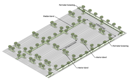
Figure 1
Parking Area Landscaping Illustration
4.
Interior islands spanning the depth of two parking rows shall be a minimum of 34 feet in length and five feet in width and planted with two overstory trees with the remainder planted in shrubs and groundcover.
5.
Interior islands spanning the depth of one parking row shall be a minimum of 14 feet in length and five feet in width and planted with one overstory tree with the remainder planted in shrubs and groundcover.
6.
Interior island parking areas shall be configured to allow rainwater runoff capture within the interior islands while providing curbing at key points to protect vegetation.
b.
Median island landscaping.
1.
A landscape median island shall be provided between every six parking rows (see illustration above).
2.
A landscape median island shall be a minimum of five feet wide and planted with one overstory tree every 30 feet on center, on average with the remainder planted in shrubs and groundcover.
3.
A median island may also serve as the location for a sidewalk. In such case, the sidewalk shall be a minimum of five feet wide and the remaining planting area shall be no less than four feet wide.
4.
Median islands may be consolidated or intervals may be expanded to preserve existing trees upon review during site development plan approval.
5.
Parking area design of median islands shall be configured to allow rainwater runoff capture within the median islands while providing wheel stops and curbing at key points to protect vegetation.
c.
Perimeter landscaping adjacent to rights-of-way and streets. A strip of pervious land adjacent and parallel to the right-of-way line having an average width of ten feet and a minimum width of five feet along the entire street frontage except for permitted driveways.
1.
This perimeter landscape strip shall contain a minimum of three canopy trees per 75 linear feet of property frontage and three understory trees per 75 linear feet of property frontage. Required screening of vehicle use areas are to be designed, through material selection and arrangement, in such a manner as to create depth in the planting area and increase visual interest through staggered heights.
2.
In addition to required street-frontage landscaping, perimeter landscaping shall be provided along the remaining property lines in which parking areas and/or other paved areas are within 25 feet of the property boundary in a manner as set forth below:
i.
A minimum ten-foot wide, landscaped area with a continuous row of shrubs and accompanying ground cover shall be provided between the property's non-street frontage lot line and the parking area.
ii.
Shrubs shall be a minimum of 18 inches in height when planted and shall reach a minimum size of 36 inches in height within three years of planting.
iii.
The required ten-foot wide landscaped area may be reduced to five feet when a three-foot high masonry wall is erected.
iv.
In addition to required shrubs, overstory trees shall be planted every 30 feet on center, on average.
v.
Where overhead utilities exist, one understory tree may be planted every 20 feet on center, on average, in substitution of required overstory trees.
d.
Landscape buffer. A buffer shall be required when a multi-family or non-residential use is developed or placed (e.g., outside storage container) abutting a single-family residential district or a single-family residential use.
1.
The required landscape buffer may be located wholly or partially within a required setback.
2.
Parking of vehicles and the placement of structures (other than fencing or landscape walls) shall not be allowed in a landscape buffer. All required setbacks apply.
3.
No structure (other than landscape fencing or walls) shall be located closer than ten feet to a landscape buffer.
4.
One of the following landscape buffer options (Figure 2) is required along a perimeter lot line that abuts a single-family residential district or a single-family residential use property line.
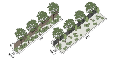
Figure 2
Landscape Buffer Options
(2)
Lighting.
a.
Purpose. The City of St. Marys recognizes the importance of the naturally lit night sky, and the natural dark as a resource which contributes significantly to quality of life for our residents and visitors alike. The purpose of this section is to regulate the placement, orientation distribution patterns and fixture types of outdoor site lighting.
b.
Applicability. No permit for the construction, reconstruction, extension or alteration of any building, structure or use of land and no building or land, or any part of any building or land, may be occupied or used until lighting has been provided in accordance with the requirements of this Zoning Ordinance. The installation of site lighting, replacement of site lighting and changes to existing light fixture mounting or fixture location shall be made in compliance with this Zoning Ordinance.
1.
Routine maintenance, including changing the lamp, ballast, starter, photo control, fixture housing, lens and other required components, are exempt from regulation and is allowed for all existing fixtures. This section does not apply to lighting installed in the public right-of-way. When a building or site is renovated, any new or replaced outdoor light or lighting fixture shall conform to the requirements of this Zoning Ordinance. When the gross floor area or improved site area is increased, the additional floor or site area shall conform to the lighting requirements of this Zoning Ordinance.
2.
When the gross floor area of any building or improved site area is increased by more than 25 percent cumulatively, both the existing use and the additional floor or site area shall conform to the lighting requirements of this Zoning Ordinance. A change in the principal use of the building or site does not trigger application of this section unless site lighting is replaced.
c.
Exemptions. Single-family residential homes and temporary seasonal lights shall be exempt from these requirements so long as any sight lighting does not create adverse light spill over.
d.
Prohibited lighting sources. The following light fixtures and sources are prohibited:
1.
Cobra head-type fixture having dished or drop lenses or refractors, which contain sources that are not incandescent.
2.
Temporary searchlights and other high-intensity narrow-beam fixtures; and light sources that lack color correction or do not allow for uniform site lighting.
3.
Sodium and mercury vapor light sources.
4.
Blinking, flashing, moving, revolving, flickering, changing color or intensity, and chase lighting.
5.
Promotional beacons, searchlights, strobe lights or any similar high intensity narrow beam fixtures except as permitted for temporary events.
e.
Lighting plan required. A lighting plan shall be submitted and shall demonstrate the following:
1.
Existing, if any, and proposed lighting fixture types and locations on the site;
2.
Manufacturer's specifications for each newly proposed outdoor light fixture;
3.
The proposed height of each outdoor light fixture;
4.
The calculated post-development foot-candles. Such measurement shall be taken at ground level, with the light measuring portion of the meter held parallel to the ground pointing up, and shall be measured at no more than a ten-square foot grid that covers the development site up to the property line; and
5.
The lighting plan shall meet IESNA (Illuminating Engineering Society of North America) standards.
f.
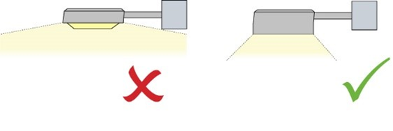
General lighting standards. Unless otherwise specified, all outdoor lighting shall be full cut-off luminaries whose source is completely concealed with an opaque housing capable of shielding the light source from direct view from any adjoining residential property or public right-of-way.
1.
All outdoor lighting, including building mounted lighting, shall be no greater than 15 feet above grade for non-cut off lights and 35 feet above grade for full cut off lights.
2.
All site lighting shall be designed so that the maximum levels of illumination as measured in foot-candles (f-c) at any one point meets the following criteria. If the use is not listed, the level of illumination at any one point within a site shall not exceed 15 foot-candles. Unique uses may propose alternative lighting plans with the planning commission's approval.
Illumination Levels
(in Foot-Candles)
3.
The maximum light level permitted at the property line shall be as follows:
i.
One-half foot-candle at any property line adjacent to a conservation or residential zoning district;
ii.
One foot-candle at any property abutting any mixed use or non-residential zoning district; or
iii.
Three foot-candles at any property line along any street rights-of-way.
g.
Lighting for parking and pedestrian areas. Light fixtures within parking and vehicular display may be no higher than 30 feet. Light fixtures within pedestrian walkway areas may be no higher than 15 feet.
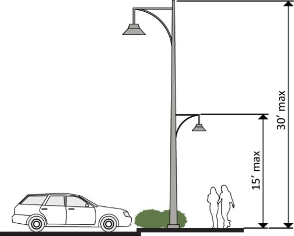
1.
Light fixtures located within 50 feet of the property line of a residential or historic district may be no higher than 15 feet.
2.
Light fixtures within 25 feet of a street right-of-way shall be forward throw fixtures that provide sharp house-side cut-off and can be used for perimeter lighting applications with minimal light trespass.
3.
Non-cutoff (unshielded) fixtures can be used when the maximum height is 15 feet, and the level of illumination at the site remains compliant. These generally feature globes or vertical glass planes and shall be coated with an internal white frosting to diffuse light.

h.
Lighting for vehicular canopies. Lighting under vehicular canopies shall be designed so that the light bulb is not visible from the street right-of-way and does not create glare off-site. Acceptable lighting designs include a recessed fixture with a lens cover that is recessed or flush with the bottom of the vehicular canopy.
i.
Exterior building lighting. Lighting fixtures shall be selected, located, aimed and shielded so that direct illumination is focused exclusively on the building facade, plantings and other intended site features and away from adjoining properties and the street right-of-way.
Only lighting used to accent architectural features, landscaping, art or U.S., Georgia or city flag may be directed upward, provided that the fixture is located, aimed or shielded to minimize light spill into the night sky.
(5)
Dumpster enclosures. All waste receptacles shall be enclosed with suitable material and elevated on a concrete pad.
(6)
Signs. Signage shall adhere to article VI. Sign regulations with the following exceptions: allowable sign types include ground-mounted/monument, wall and awning. Pylon signage will not be permitted in any new construction or exterior alteration of an existing site plan or new sign permits within the district. Ground-mounted/monument signs shall be no more than 50 square feet in area, as measured on one face of a dual-facing sign. Said sign shall be no more than ten feet in height, including any mounting hardware and foundation. Sign illumination shall be designed and installed so that it does not cast light directly on to any street or adjacent property. External illumination devices shall be a steady stationary light source, shielded and directed solely at the sign.
(g)
Other requirements.
(1)
Uses permitted in C-2 Districts shall meet the standards set forth in article IV pertaining to off-street parking, loading requirements.
(2)
Any type of business in a C-2 Zoning District must conduct all its business inside an enclosed building and/or inside an aesthetically pleasing barrier, as prescribed by the planning commission. All finished products of such businesses shall be kept inside an enclosed building or behind such barrier.
(3)
When reviewing applications for special permit uses, the commission must consider: the special permit use standards as detailed in section 110-145 as well as the existing concentration of such businesses within the community, whether similar goods or services are already available and compatibility of the proposed use with the character of the neighborhood.
The commission may also consider:
a.
Retail vacancy rates, and the balance of neighborhood-serving versus citywide or regional-serving businesses.
b.
Maintaining the unique character of the community and the appeal of its commercial district.
c.
Protecting the community's economic vitality by ensuring a diversity of businesses with sufficient opportunities for independent entrepreneurs.
(Ord. of 9-12-94, § 609; Ord. of 5-13-96; Ord. of 11-10-03, § 2; Ord. of 11-13-06(2), § 7; Ord. of 7-18-11(2); Ord. No. 2015-028, 8-3-15; Ord. No. 2015-042, 11-2-15; Ord. of 3-21-16; Ord. No. 2020-8-3-003, 8-3-20; Ord. of 2-2-23(1); Ord. of 6-3-24(1))
Sec. 110-71. - C-3, Office-Apartment District.
District intent. The purpose of this district is to provide and protect an environment suitable for a mixture of high-density residential uses in a variety of dwelling types, other than single-family and two-family dwellings; selected office, institutional and commercial uses; and such other uses as may be necessary to and compatible with apartment and office surroundings.
(a)
Uses permitted. Property and buildings in the C-3, Office-Apartment District shall be used for the following purposes:
(1)
Animal care facilities and veterinary offices.
(2)
Communications: Radio and TV broadcasting stations.
(3)
Commercial recreation and entertainment: Tennis centers, club facilities.
(4)
Community facilities: Assembly halls, recreation centers, civic centers, local government public uses including schools, libraries, parks, playgrounds, and fire stations.
(5)
Dwellings: Condominiums, townhouses, apartments.
(6)
Restaurants, excluding drive-in or drive-through fast-food facilities.
(7)
Lodging: Hotels, motels, boardinghouses.
(8)
Religious facilities: Churches and other places of public worship.
(9)
Retail trade facilities incidental and conducted totally within office buildings, institutional uses, motels, hotels, and apartments provided such incidental uses amount to less than ten percent of the buildings' net floor area and further provided that every public entrance to such incidental use shall be from a lobby, hallway or other interior portion of the primary structure excepting restaurants.
(10)
Personal services: Barber and beauty shops, funeral homes, laundry and dry cleaning, and photo studios.
(11)
Medical health services: Clinics and pharmacies, hospitals, medical or dental labs, offices of health service practitioners and other health services not elsewhere classified.
(12)
Law offices and legal services.
(13)
Other professional services: Engineering, finance, real estate, surveying, planning, accounting, office parks, other professional offices.
(14)
Accessory uses and structures.
(b)
Special permit uses. None.
(c)
Area regulations. Unless otherwise specified in this chapter, uses and buildings permitted in the C-3 district shall conform to the following regulations:
(1)
Minimum lot area: 7,500 square feet except that dwellings shall be subject to R-3 regulations for minimum lot area.
(2)
Minimum lot width at building line: 75 feet, except that dwellings shall be subject to the R-3 regulations for minimum lot width.
(3)
Minimum front yard setback: 40 feet form State Route 40; 25 feet from other streets.
(4)
Minimum side yard: Setback from property line: Seven feet; 25 feet from street; unless the property is adjacent to a residential district where 15 feet is required.
(5)
Minimum rear yard setback: Ten feet.
(6)
Maximum building height: 35 feet.
(7)
Maximum percentage of lot coverage by buildings: 35 percent except that dwelling shall be subject to the provisions of the R-3 district.
(Ord. of 9-12-94, § 610)
Sec. 110-72. - I-L, Light Industrial District.
District intent. This district is established to provide land for light industrial uses which are not significantly objectionable with regard to noise, odor, fumes, etc., to surrounding properties. This district's regulations are designed to provide a compatible environment for uses generally classified as light industrial in nature; to protect and reserve undeveloped areas within the city that are suitable for such light industries; and to discourage encroachment by residential, commercial, or other uses that may adversely affect the industrial character of the district. Lands within this district should be located in relation to the thoroughfare network of the city, as well as rail and air if required, and designed so that uses within the district do not disrupt normal traffic flow patterns within the city. Planned industrial parks are encouraged within this district.
(a)
Uses permitted. Property and buildings in an I-L, Light Industrial District shall be used for the following purposes, provided that such uses are conducted in such a manner that noxious odors, fumes, dust and similar particles, or noise are not emitted or detectable beyond the property lines of the lots on which the uses are located.
(1)
Building material sales yards and lumber yards, including the sales of rock, sand, gravel and the like.
(2)
Warehouse and wholesale establishments.
(3)
Public utilities, including buildings, necessary structures, storage yards, and other related uses, but specifically excluding waste processing, handling or storage facilities.
(4)
Research or experimental stations and laboratories.
(5)
Reserved.
(6)
Horticultural nurseries.
(7)
Office buildings for business, governmental, professional, or other general purposes.
(8)
Repair garages provided that all business is conducted inside an enclosed building and/or inside an aesthetically pleasing barrier which will shield the business activity from view of passing motorists and surrounding property owners.
(9)
Animal hospital and/or boarding facility.
(10)
Transportation terminals.
(11)
The assembly, disassembly, fabricating, finishing, manufacturing, packaging, and repairing or processing of materials and boats. Examples of such uses include, but are not limited to, printing, commercial laundry, photographic films processing, repair garages, building maintenance shops, metal work, millwork, and cabinetry work.
(12)
Accessory buildings, structures, and uses customarily incident to permitted uses.
(b)
Special permit uses. The following uses may be permitted in accordance with the provisions contained in section 110-145 and if additional conditions which may be required are met:
(1)
Retail businesses or services provided such businesses or services are; (1) incidental to a permitted light-industrial use; and (2) located on the same premises.
(2)
Watchman or caretaker's one- or two-family dwelling provided that; (1) such dwelling is located on the premises of the permitted light-industrial use; and (2) a member of the household is employed by the industry as a watchman or caretaker.
(3)
Open yard use for the sale, rental, dismantling and/or storage of new or used salvage and/or junk materials or equipment, provided that: (1) such uses are separated from adjoining properties by a suitable planting screen, fence, or wall at least eight feet in height; and (2) no burning of materials or products will be conducted on the premises.
(c)
Area regulations. Unless otherwise specified in this chapter, uses permitted in the I-L, Light Industrial District shall conform to the following regulations:
(1)
Minimum lot area: As required to meet district's area regulations and intent.
(2)
Minimum lot width at building line: 100 feet.
(3)
Minimum front yard setback from street: 30 feet.
(4)
Minimum side yard setback, from property line or street: 30 feet.
(5)
Minimum rear yard setback from property line: 20 feet; from street, 30 feet.
(6)
Maximum building height: 45 feet.
(Ord. of 9-12-94, § 611; Ord. of 5-12-08; Ord. No. 2020-11-2-002, 11-2-20)
Sec. 110-73. - I-G, General Industrial District.
District intent. It is the intent of this district to provide land for those heavy industrial uses that may create nuisances and therefore may not be compatible with uses of other zoning districts. Land within this district is intended for industrial operations which require buildings and open areas for the fabrication, processing, extraction or repair of raw materials or manufactured products. Uses in this district should be located so as to discourage the disruption and/or congestion of traffic in the city. Further, it is the intent of this district to discourage any encroachment by residential developments or other uses capable of adversely affecting the industrial character of this district.
(a)
Uses permitted. Property and buildings within the I-G, General Industrial District shall be used for the following purposes:
(1)
All uses permitted in the I-L, Light-Industrial District.
(2)
Industrial uses which involve manufacturing, fabrication, processing, assembly, packaging, treatment or storage of heavy materials, products or equipment; but not including junk or salvage operations or uses which may cause the conditions outlined below in subsection (b)(2), special permit uses, and specifically excluding waste handling, treatment or storage facilities. Waste handling, treatment or storage as part of an overall industrial process is permitted.
(3)
Accessory buildings, structures, and other uses customarily incidental to a permitted use.
(b)
Special permit uses. The following uses may be permitted in accordance with the provisions contained within article V, and if additional conditions which may be required are met:
(1)
Any special use allowed in the I-L, Light Industrial District.
(2)
Any industrial use that may produce injurious or noxious noise, vibration, smoke, gas, fumes, odor, dust, fire hazard or other objectionable conditions as a result of its operation. Such uses shall be located a minimum of 200 feet from adjoining property lines and must be in conformance with all applicable rules and regulations administered by the Environmental Protection Division of the Georgia Department of Natural Resources.
(c)
Area regulations. Unless otherwise specified in this chapter, uses permitted in the I-G, General Industrial District shall conform to the following regulations:
(1)
Minimum lot area: As required to meet district's area regulations and intent.
(2)
Minimum lot width at building line: 200 feet.
(3)
Minimum front yard setback from street: 50 feet.
(4)
Minimum side yard setback from property line: 40 feet; setback from street: 50 feet.
(5)
Minimum rear yard setback from property line: 30 feet; setback from street: 50 feet.
(6)
Maximum building height: 60 feet.
(Ord. of 9-12-94, § 612)
Sec. 110-74. - Reserved.
Editor's note— An ordinance adopted March 21, 2022 repealed § 110-74 which pertained to the I-A Airport-Industrial District and derived from § 613 of an ordinance adopted Sept. 12, 1994.
Sec. 110-75. - CP, Conservation-Preservation District.
District intent. This district is established to preserve and control development within certain land, marsh and water areas of this city. These areas serve as wildlife refuges, possess great natural beauty, are of ecological significance, are utilized for outdoor recreational purposes, or provide needed open space for the health and general welfare of the city's inhabitants. The regulations are designed to discourage encroachment of uses capable of destroying the undeveloped character of the district.
(a)
Permitted uses. The following uses shall be permitted in CP, Conservation-Preservation District.
(1)
Private dock or boathouse.
(2)
Bait house.
(3)
Public utility lines, fire or water tower, utility substations.
(4)
Publicly owned park, open space, or recreational facilities.
(5)
Farms for the growing of agricultural products, or timber with dwelling unit for owner or operator.
(6)
Wildlife refuges, including dwelling units of caretakers.
(7)
Museum or exhibit area on or near land of historic, aesthetic, or educational significance.
(b)
Special permit uses. The following uses may be permitted in accordance with the provisions contained in section 110-145 and if additional conditions which may be required are met.
(1)
Dredging, or land fill must comply with state and federal regulations. Furthermore, plans for the alteration of lands in a CP District must be submitted to the city planning commission and approved by the city council.
(c)
Area regulations. Unless otherwise specified in this chapter uses permitted in the CP, Conservation-Preservation District shall conform to the following regulations.
(1)
Minimum lot area: One-half acre.
(2)
Minimum lot width at building line: 100 feet.
(3)
Minimum front yard setback from street: 50 feet.
(4)
Minimum side yard setback from street: 30 feet; setback from property line: 20 feet.
(5)
Minimum rear yard setback from property line: 20 feet.
(6)
Maximum percentage of lot coverage: 30 percent.
(7)
Maximum building height: 35 feet.
(Ord. of 9-12-94, § 614)
Sec. 110-76. - WP, Waste Management District.
This district is established to provide land for waste treatment and disposal in locations which meet strict criteria for protection of other city land uses and the environment. The district's regulations are designed to provide a compatible environment for waste processing and treatment facilities so that they will not be encroached upon by other uses or be adversely effected by nearby conflicting land uses. Land designated for waste management should be located in relation to the transportation systems it will utilize so that it will not disrupt normal traffic flow patterns within the city. Due to the special nature of waste and the potential health and environmental risks involved, this district will be only designated on the zoning map in response to a specific rezoning request by an applicant.
(a)
Uses permitted. Medical waste treatment and incineration, hazardous waste processing and storage, sewerage treatment, solid waste processing and recycling services.
(b)
Area regulations.
(1)
Minimum lot area: 5 acres.
(2)
There shall be a minimum of a 100-foot wide thick, mature, natural or cultivate landscape buffer established and maintained along all property lines, excluding approved driveways, building sites and drainage facilities as shown on the approved development plan.
(3)
As conditions for approval, access to the site shall be controlled and monitored by a responsible agent of the operator.
(4)
The operator shall be responsible for the control and proper disposal of incidental litter by providing fencing or other physical barriers.
(5)
As a condition of approval, the applicant shall develop an emergency plan which will be used should there be an accident or other problem which threatens the health or environment. The applicant shall put in place the necessary equipment, hire the necessary personnel and other requirements of the emergency plan before operation can begin. This plan must be approved by the city council.
(6)
As a condition of approval, the applicant shall develop and have approved by the city council, a closure plan for the facility which will establish how the facility can be closed without remaining a danger to health, safety or the environment. The applicant shall post a bond or other acceptable (to the city) security with the city to finance implementation of the closure plan.
(7)
No waste disposal district shall be located within 1,000 feet of a residence.
(8)
No waste disposal districts shall be located within 1,000 feet of any body of water.
(9)
All waste disposal districts shall be located so that they directly access a state highway.
(10)
No waste disposal district shall contain wetland areas as determined by the Section 404 Army Corps Program.
(Ord. of 9-12-94, § 615)
Sec. 110-77. - Recreational Vehicle and Travel Trailer Parks District (RVD).
(a)
District intent. The intent of this RVD district is to provide an area, outside the normal use of the commercial district, on which to establish a planned, desirable living area with adequate open space and health considerations for the placement of recreational vehicles on a temporary basis.
(b)
Uses permitted. The following uses shall be permitted within the recreational vehicle park district:
(1)
Recreational vehicles and travel trailers.
(2)
Playground, parks and swimming pools.
(3)
Community buildings, intended for the use of park patrons, which may include: bathrooms, showers, kitchen, food and notion sales, meeting rooms, recreation rooms, park office, and a single-family residence for the park manager.
(c)
Travel trailer defined. Any single-family structure ordinarily non-motorized and towed by a motor vehicle and normally being less than 40 feet in length and intended for living for short periods.
(d)
Recreational vehicle defined. A self-contained, self-powered vehicle normally outfitted with a kitchen, bathroom (with holding tank) and sleeping space. This type of vehicle was built for the sole purpose of providing temporary living accommodations for short periods of time.
(e)
Special permit uses. There shall be no special permit uses permitted within the RVD district.
(f)
Temporary permits. There shall be no temporary permits issued within the RVD district.
(g)
Variance. There shall be no variances issued within the RVD district.
(h)
Home occupations. There shall be no home occupations permitted within the RVD district.
(i)
Area regulations. Unless otherwise specified in this section, uses permitted in the RVD district shall conform to the following requirements:
(1)
Only travel trailers or recreational vehicles shall be permitted to be placed within the RVD district.
(2)
Minimum lot area for a recreational vehicle park shall be four acres.
(3)
Maximum density shall not exceed 15 parking lots per acre with no more than one travel trailer per parking lot.
(4)
Each unit location shall be served by a community or public water system, sewer hookup to either a community engineered sewer (approved by the Camden County Health Department sized for the number of units it is intended to serve) or public sewer system (approved by the water department), and individual electrical hook-up connections. If water and sewer services are available as defined by the city the park shall be connected to the public services.
(5)
The park shall be graded and drained so that rainwater will not stand in pools or puddles. A master drainage plan shall be required as part of the development review of the park.
(6)
No unit parking space or community building shall be located closer than 30 feet to a right-of-way line or closer than 20 feet to a property line.
(7)
All parks shall have a minimum of 150 square feet of common open space for each unit, with a minimum of 10,000 square feet of common space regardless of the number of units.
(8)
Parks shall establish and maintain an aesthetically pleasing visual buffer such as a continuous planted buffer strip, consisting of shrubbery or a hedgerow, or a solid brick, concrete block or stone wall or a board fence that is at least six feet in height between the park and adjacent residential uses and property. Such buffer strip, if planted, shall be composed of healthy plants which possess growth characteristics of such a nature as to produce a dense, compact planting screen not less than six feet in height, or if wood, stone, block or brick shall not be less than six feet high.
(9)
All unit parking lot spaces shall be paved and abut on an interior paved drive; interior drives shall be a minimum of 20 feet in width and shall have unobstructed access to a public street. A parking space for additional vehicles shall be constructed of pavement or confined gravel area sufficient enough that automobiles may be located on each unit parking lot space. One space for additional vehicles shall be provided for each five-unit parking spaces.
(10)
All park accesses to the city's roadway shall meet the requirements for a commercial driveway.
(11)
All units staying in the park must be attached to a pull vehicle or be self-powered so they may be removed in the event of pending inclement weather.
(12)
All units staying in the park must be currently licensed in the state and county in which the unit is registered.
(13)
Stability. All units shall, prior to occupancy or other use, be stabilized in such a way as to prevent tilting of the unit.
(14)
Each park must make private arrangements for garbage collection.
(15)
All park plans shall be submitted for approval using the same guidelines as a final plat approval for a subdivision.
(16)
All parks must obtain an occupational license from the city to operate a business. In addition to the occupational tax, there shall be paid to the city an annual charge of $50.00 per parking lot per year paid by the park owner or operator at the time the annual occupational license is obtained or renewed.
(17)
No building permits are needed to place a travel trailer or recreational vehicle in the park. However, the park manager must keep a log of spaces rented, to whom, license plate number and for how long, recording arrival and departure date.
(18)
Ownership. The park owner shall be allowed to own and/or maintain no more than one unit in their park.
(19)
Registration. The travel trailer park shall maintain a registration as required by Georgia state law and shall not allow a unit to remain longer than 180 days without re-registering said unit.
(Ord of 9-9-02, § 2; Ord. of 3-10-03, § 1)
Sec. 110-78. - Maritime Heritage District (MHD).
(a)
General: The St. Marys waterfront, waterside and landside, is unique as it embodies the essence of St. Marys and is a major economic engine for the city. For the waterfront area to thrive, it needs flexibility to change, with a mixture of commercial, recreational, and educational facilities as well as accommodations to meet changing demands. At the same time, the waterside area is surrounded by a largely residential neighborhood and that the cars, buses and pedestrians it attracts can disrupt normal residential life for residents. To allow the waterfront area to thrive as an important institution in the city and also to assure residents that its existence and future plans will enhance and not disrupt the surrounding residential neighborhood, the city has created a Maritime Heritage District (MHD) overlay.
(b)
Statement of purpose: The MHD is intended to permit commercial, museum, tourism, historical, cultural and educational uses that preserve and enhance the city's historic character, both landside and waterside, while providing opportunities for exploring the maritime heritage of the city. This zone is intended to allow for the establishment, continuation and expansion of such uses and activities in ways that will maintain and enhance compatibility with surrounding neighborhoods and the Historic District.
(c)
Limits of Maritime Heritage District (MHD): The MHD shall include both landside and waterside areas as approved by the commissioner of DNR as per O.C.G.A. § 52-7-21.
(1)
Area of the landside portion of the MHD shall encompass the entire land on both sides of St. Marys Street and Stable Alley between Bartlett and Cole Street and on both sides of Osborne Street between St. Marys Street and the St. Marys Railroad crossing to the north. The MHD shall follow the limits of the C-1 zone as to the depth of the MHD. Any additions to this MHD must comply with the criteria included herein, and any such change shall be made in such a way as to not disrupt the surrounding residential neighborhood.
(2)
For the purpose of this article a 25-foot buffer shall be maintained between a new city determined marsh protection line (MPL) located 25 feet preceding the DNR determined:
a.
Upland/marsh boundary (UMB); or
b.
The upland water boundary (UWB); or
c.
The wrested vegetation jurisdictional line (WVJL), as applicable.
Within this buffer area all proposed docks, buoys, bulkheads, boat ramps, marinas, marsh walks and any manmade fixed constructs shall be strictly prohibited, unless permitted through state or federal agency. There shall be no removal of live and healthy trees and shrubs. Any dead vegetation shall be removed by hand level with the ground area. Stumps shall remain in the ground and not be removed. No mechanical tractors or other wheeled/tracked vehicles shall enter this buffer zone, unless permitted through state or federal agency.
The city shall determine the MPL. The location of the UMB or UWB or WVJL shall be as determined by DNR staff and shall remain valid for a maximum period of one year from the date of determination. After one year, a new determination shall be obtained. Access to properly permitted floating constructs shall be by approved DNR and city permit.
(d)
Landside portion of MHD: A feasibility report, dated December 16, 2013, outlining the conceptual goals of the MHD has been created that establishes the conceptual guideline of the MHD.
(1)
Applicant for any use in the MHD must submit to the planning commission a site plan for approval, following the provisions contained in this section and/or Zoning Ordinance No. 110. In the event of discrepancy between this overlay ordinance and any section of the Zoning Ordinance No. 110, this overlay ordinance has priority.
(2)
Site plan shall include information required in this section as well as the Zoning Ordinance No. 110. The planning commission may provide a variance to the required information if in the best interests of the city and in accordance with the goals of the MHD. Factors to be considered by the planning commission and city council in approving any project within the MHD, including both landside and waterside. In the event of discrepancy between this overlay ordinance and any section of the Zoning Ordinance No. 110, this overlay ordinance has priority.
(3)
General requirements for the Landside District of the MHD:
a.
The proposed uses and layout that are in conformity with the goals of the City of St. Marys Comprehensive Plan and the Zoning Ordinance No. 110.
b.
Activities and facilities as permitted herein shall be located on both sides of St. Marys Street and Stable Alley between Bartlett and Cole Street and on both sides of Osborne Street between St. Marys Street and the St. Marys Railroad crossing to the north. The depth of this overlay from these streets is the edge of the current C-1 zone.
c.
Building and building elements, possessing historic significance, shall be preserved, to the extent feasible. Modifications shall not compromise the historic aspect of the building. Any proposed buildings or modifications to existing buildings shall be harmoniously related to their surroundings, to the terrain, and to the use, scale and architecture of existing buildings in the vicinity. The design guidelines as approved by council shall provide guidance for any new or renovated structures. For structures within the limits of the HPC, any changes or revisions or new structures shall be reviewed and approved by the HPC following their criteria and procedures.
d.
All activities within the MHD shall be designed such that harmony and compatibility with surrounding residential neighborhoods and land uses, including adequate buffers, protection of pedestrian safety, provision for adequate parking, minimized impact of motor vehicles, and prevention of glare to adjacent properties from lighting on-site. Commercial and tourist traffic shall be directed to major arterials and away from residential streets.
e.
That the use of the water and water related elements (buoys, docks, piers, etc.) are in compliance with all state and federal rules, laws, and guidelines, including but not limited to the U.S. Coast Guard, DNR, U.S. Environmental Protection Administration (EPA), Federal Emergency Management Agency (FEMA), Georgia Environmental Protection Division (EPD), Department of Defense (DOD), U.S. Corp of Engineers (USCOE), the State of Florida, and City of St. Marys regulation.
f.
For the purposes of subdivision, the minimum lot size, and frontage bulk requirements of the underlying C-1 zoning district shall remain in effect.
(4)
Specific minimum design standards for the Landside District. The following minimum design standards shall apply to the MHD. Except as noted, these standards are the C-1 standards listed in Ordinance No. 110:
a.
Area and bulk requirements: Existing structures located within the MHD are deemed to be conforming in terms of any existing encroachments on front, side and rear yard setbacks, maximum height and floor area ratio. Existing buildings may be enlarged, provided such expansion is consistent with the structure's exterior historic architecture and approved as part of the MHD and/or the HPC process.
b.
Minimum front yard: Zero feet where adjacent structures are at zero feet. For other parcels, front yard setback shall be a minimum of ten feet.
c.
Minimum side yard: Five feet for maintenance of the structure(s) or access to exit doorways, or access to rear yard trash collection equipment.
d.
Minimum rear yard: Ten feet to provide for utility services, HVAC units, trash collection equipment, and other required building services in compliance with this section and Ordinance No. 110.
e.
Maximum building height: 45 feet from the base flood elevation to the top of the highest ridge.
f.
Maximum percentage floor area to site area at grade: 45 percent.
g.
Parking for ground floor commercial shall be on street, with minimum two per apartment for each upper floor apartment on-site.
h.
Delivery services shall be from the front (street) location.
i.
Trash collection equipment shall be located at the rear of the structure.
(5)
Permitted landside overlay uses:
a.
All permitted uses in the C-1 Zone, except marine related facilities, which will be defined herein; and single-family residences at grade (upper floor apartments are permitted).
b.
Boat docks in compliance with DNR and COE regulations.
c.
Nautical training school - on land and on sea or on river.
d.
Commercial aquariums.
e.
Museums with nautical themes.
f.
Shops with items for sale to residents and visitors alike that relate to the history of the city and maritime activities.
g.
Festivals of a maritime nature separate from existing festivals.
h.
Shops creating traditional or modem maritime articles on the premises and for sale, such as rope, knots, fishing gear, buoys, maps, etc.
i.
Shops catering to the boating public such as purser supplies, and general grocery items.
j.
Vendors for fresh seafood right off the ship.
k.
Restaurants with outdoor seating overlooking the marsh/water.
l.
Bait and fishing tackle sales and service shop.
m.
Fresh seafood processing and shipping.
n.
Parks and other recreational facilities - public and private.
o.
Convenience store for boating and general grocery supplies for boaters. No vehicle gas/diesel sales or vehicle service (boats or wheeled vehicles).
p.
Expanded restrooms to include pay showers, and pay laundry facilities.
(6)
Uses not permitted in the Landside Overlay Zone:
a.
Boat and boat trailer storage and RV storage with any portion of lot frontage facing Osborne Street or St. Marys Street.
b.
Habitation in any RV vehicle for any period of time.
c.
Amplified sound of any type except as approved by the city via its event approval process.
d.
Disposal of fishing waste in any private or public trash container or dumpster without the permission of the owner.
e.
Animals not on a leash. Animal wastes.
f.
Single-family residences at grade.
(7)
Special uses for the overlay zone shall follow procedures as outlined in other sections of Ordinance No. 110.
a.
Fenced, ground level boat storage with a landscaped buffer between the fence and the property line. Boat storage "stacks" limited to a maximum of two levels of boats, with roof and buffer.
b.
Horse drawn carriages for touring within the MHD-L District, which will include areas for overnight accommodation of horses, mules, and donkeys that pull the carriages.
(8)
Landside buffers: Both performance buffers and standard buffers may be required.
a.
Performance buffers: The planning commission will carefully analyze any buffers between the MHD and surrounding residential neighborhoods with particular regard to the objectives and requirements of this section. The commission may tailor buffers to include greater setbacks, landscaping, fences, walls, and berms, considering the relative heights of the uses on each side of the buffer. The commission may allow for buffering to be located on adjacent property with consent of the affected property owner (landscaping, fence, or wall, etc.).
b.
Standard buffers. Unless otherwise approved, buffers for nonresidential uses within the MHD shall be established and maintained as per Zoning Ordinance No. 110.
c.
Buffers may only be varied from those established in the event such variance is compatible with the objectives of this section and does not disrupt surrounding properties. Any variance shall follow the process outlined in Zoning Ordinance No. 110.
(e)
Waterside portion of MHD:
(1)
Waterside plan: Applicant for any use in the MHD must submit a plan to the planning commission for approval, following the provisions contained in these regulations and/or the Zoning Ordinance No. 110. In the event of discrepancy between this overlay ordinance and any section of the Zoning Ordinance No. 110, this overlay ordinance has priority.
(2)
The use of the waterside of the MHD is strictly controlled by various agencies of the local, state, and federal government and submission of any plan to the planning commission will be required to first have the appropriate governmental agency approval attached to the application.
(3)
For the purpose of this article, this section covers all docks, buoys, bulkheads, boat ramps, marinas, marsh walks and any manmade fixed constructs from the jurisdictional marsh line as determined in the field by DNR staff within one year of the date of determination, and extending through the water to the city limits. For the purpose of this section, these constructs shall be referred to by the term "fixed constructs".
(4)
The area of the waterside portion of the MHD is as defined above, and shall include all public and private property within the city limits of the City of St. Marys.
(5)
For the purpose of this article, this section covers all ships, boats, trawlers, dinghies, barges, and any manmade floating construct that floats on, is anchored through, or floats below, the water of the St. Marys River and its numerous tributaries, named or unnamed. For the purpose of this section, these constructs shall be referred to by the term "floating constructs".
(6)
This section has no jurisdiction over the waters of the St. Marys River that are outside of the city limits or state line except for the two present and two future floating buoys which are owned by the city and permitted through the Florida DEP. As owner of the buoys, the city retains the right to enforce their use as a property owner, rather than a government agency.
(7)
There are two major types of maritime constructs regulated by this section: floating constructs and fixed constructs.
a.
Floating constructs: All floating constructs shall be regulated by the City of St. Marys with staff as designated by the city manager. Floating constructs will either be docked at a fixed or floating dock to the limits of the approved DNR permit for the dock attached to; or at anchor anywhere within the jurisdictional limits of the City of St. Marys; or attached to the city-owned buoys located within, and permitted by, the State of Florida.
1.
All existing or new constructs shall submit to the Planning Department of the City of St. Marys the following data in order to use the waterside portion of the MHD. This data will be placed on a form provided by the city that will be used to issue a permit for use of the MHD.
i.
Name of vessel.
ii.
Length, beam, draft, and length and width of main deck, gross weight, amount of force that the ship will draw at anchor, whether at a dock or on the hook, and other data as appropriate.
iii.
Home port of vessel.
iv.
Name of owner of record for vessel with current land address and cell phone number.
v.
Radio call frequency and call name and number.
vi.
Insurance certificate valid in the state of floating construct registration or the State of Georgia or the State of Florida.
vii.
Copy of current Coast Guard certificate as appropriate for the size of ship. Valid registration of the floating construct from the home state/country will also be required.
viii.
Information as to most recent pump out of solid wastes, with a notation as to capacity of the on-board holding tank. This data shall be in the form of a pump out log showing where and when any wastes are discharged, either at a legally approved pump out facility, or at sea in a legal manner. This log shall be available to authorized city and state personnel at all times upon request. All pump out facilities shall have a locking Y valve and related certification that the floating construct will not discharge and treated or untreated wastes within the boundary of the MHD.
ix.
Information as to the water holding tank and need for city water.
2.
Based on the channel width, and the anticipated size of the vessels to be encouraged to visit the city, it is expected that only five to seven large floating constructs will be able to be permitted on the hook and in the channel.
These large floating vessels are identified as any ship with two or more masts of 64 feet in deck length from the bow to the stern with operable sails and identified as barque, galley, barquentine, brig, topsail schooner, fore and aft schooner, ketch, junk, frigate, as well as any ship that is square rigged, or combination of both types rigging. If there is confusion or doubt as to the type of rig that this section covers, the city manager or his designated staff member shall have the authority to designate the type of sailing rig.
Smaller floating constructs will be permitted with no minimum number as long as sufficient distance is maintained between vessels to allow for the changing of the tide.
All vessels desiring to anchor within the harbor shall respect the presence of any buoy identifying the presence of a crab trap, and moor at least 100 feet from the visible surface location of the buoy.
3.
Each floating construct shall register with the city upon docking at a city-owned or controlled dock or buoy or other docks. The city reserves the right to assess a fee for docking privileges.
4.
The following floating constructs are exempt from this section: the ferries used to transmit tourists to Cumberland Island; any city authorized water taxi service to/from Fernandina; any trawler owned by Lang's (and/or their successors and assigns), or other company owning a trawler as approved by the city; any vessel owned and operated by the national park service; any floating construct using the Wheeler Street or Meeting Street boat ramps to enter and leave the landside area; and any floating construct under contract with either marinas (presently known as Lang's (east and west), their successors and assigns) and the Gateway docks.
5.
Registration of all floating constructs shall be available at the office of the planning and building department (or other location as determined by the city council), located at 418 Osborne Street, St. Marys, GA. 31558 from 8:00 a.m. to 5:00 p.m., Monday through Friday, not including approved holidays. Ships that arrive after these hours shall immediately contact the city the next day the offices are open.
6.
The city will assist and support a ship that meets the criteria of this section that desires to seek an extension from the Coastal Marshlands Protection Act regarding live-aboard vessels. All documentation and related data shall be by the applicant for the extension.
7.
All crabbing and fishing activities are regulated by various departments of the State of Georgia. This section shall not permit any infringement of the permit rights of any crabber or fisherman.
b.
Fixed constructs: Each existing fixed construct shall have a valid DNR water bottom lease. Any future proposed fixed construct shall be in compliance with all lease documents, permits and approvals from the local, State of Georgia, or federal government.
1.
Existing fixed constructs currently in operation and/or permitted shall be exempt from this section.
2.
Each NEW and proposed fixed construct shall apply for and obtain a building permit with the fee calculated as per the currently approved city fee schedule. No city building permit will be issued without a valid and approved DNR permit attached to the application. The resident shall be solely responsible for obtaining any DNR and/or Corp of Engineers permits for any dock or bulkhead fixed construct, including floating docks. The city will provide any necessary plan approval for applicants use in obtaining these DNR and USCOE permits.
3.
For the purpose of this section, any floating dock attached to a fixed dock shall be treated as a fixed construct.
4.
In the event of a natural disaster or emergency, the city reserves the right to permit large vessels of any type to anchor in the MHD at no cost.
5.
All fees shall be waived for any officially sanctioned "Tall Ship" festival as approved by the city as an event.
(8)
Permitted uses Waterside MHD:
a.
Fixed and floating constructs as defined herein.
b.
Fishing/crabbing from designated docks, piers, boats in harbor, and shoreline.
c.
Diving activities with proper safety equipment.
d.
Ships/boats safely moored in the harbor either on the buoys or on the hook.
e.
Docking of dingys and john boats to designated locations on the docks.
f.
Sailing activities.
g.
City sponsored and owned marina/docks/wharfs/buoys for use by docking agreement.
h.
Mooring fields managed by the city and as permitted by the State of Georgia and the State of Florida.
i.
Live-a-boards as permitted by the State of Georgia and "tied" to an adjacent marina.
j.
Mooring locations including buoys with permit sought and issued by DNR on a case-by-case basis.
k.
Crabbing activities by DNR permit in all water areas outside of the defined navigable channel and in accordance with minimum separation distance of 100 feet from docks, anchored boats, and the navigable channel.
l.
City-owned pump out facilities.
(9)
Uses not permitted in the waterside overlay zone:
a.
The following uses within the CP zone of Ordinance No. 110 shall not be permitted within the MHD overlay zone. (NOTE: the CP zone is present in wetlands and other marsh areas outside the limits of the overlay district, and these exceptions will not apply to these portions of the CP zone.)
1.
Farms for the growing of agricultural products, or timber including dwelling unit for owner or operator of the farm on the parcel.
2.
While wildlife refuges will be permitted, however, the zone will not include dwelling units of caretakers.
3.
Any use that is not related to the adjacent landside zoning of any parcel. (Note: The zones that abut the MHD-W overlay are R-1, R-2, R-3, C-1, C-2. There are no I-G, I-A, or I-L zones adjacent to the MHD-W overlay.)
4.
Anchoring for any reason within the defined ship channel.
5.
Dumping of trash, human wastes, fish wastes and other debris.
6.
Abandoning of any boat/ship/barge in the waterside zoning overlay zone.
(10)
No wake zone: All areas of the waterside overlay zone shall be designated as a "NO WAKE ZONE" for the safety of all boaters in the area.
(11)
Enforcement:
a.
The waterside portion of the MHD ordinance shall be enforced by the Camden County Sheriff's Department or other agency having jurisdiction for any violation for floating constructs not attached to a fixed construct.
b.
For enforcement of any violation of fixed constructs or for floating constructs connected to fixed constructs, the City of St. Marys shall have enforcement powers that coordinate and compliment any enforcement activities of other authorities having jurisdiction.
(f)
Incentives: City council shall reserve the right to offer any legally permitted economic and/or physical enhancements to promote or further the purposes of this section. Enhancements shall be similar to, but not limited to:
(1)
Tax credits for landscaping;
(2)
Tax credits for participating in the creation of a street scape along St. Marys Street;
(3)
Tax credits on local taxes in addition to those provided by the military zone and enterprise zone programs;
(4)
Adjustments to lot coverage requirements not to exceed 80 percent of buildable area;
(5)
Adjustments to building height not to exceed one additional story not to exceed ten feet;
(6)
Other potential enhancements as presented by the applicant and approved by city council.
(Ord. No. 2014-003, 2-3-14; Ord. No. 2014-22, 6-2-14; Ord. of 7-18-16)
Sec. 110-79. - A-F General Agriculture-Forestry District.
(a)
District intent. To provide land for the production of agricultural products such as field crops, livestock, poultry and other conventional agricultural and forestry pursuits. This A-F District is also created to assist in the conservation of natural resources by encouraging practices which will conserve soil and water resources. Utilities shall be provided by the land user or owner. The city shall not be obligated to extend public water supply and sewage disposal facilities to serve properties.
(b)
Uses permitted. Property and buildings in an A-F General Agriculture-Forestry District shall be used for the following purposes, all as part of a PC approved site development plan:
(1)
Dwelling, single-family. Stick built structure for owner and family or employee.
a.
Minimum of one additional residence on first five acres. Residences must meet the minimum setback requirements of the A-F zoning district. Further residences limited to one per five acres. Site plan required.
(2)
All agricultural-forestry land uses, buildings and activities.
(3)
Tree farms.
(4)
Stables, institutional, including riding ring and trails for training.
(5)
Minor, major and rural home occupations.
(6)
Parks, playgrounds.
(7)
Country clubs, golf courses (public and/or private).
(8)
Hunting, fishing clubs or lodges.
(9)
Accessory buildings and structures (must conform to area requirements of section 110-91).
(10)
Nurseries.
(11)
Schools (including colleges and technical schools/colleges).
(12)
Fishing camps.
(13)
Religious worship facilities.
(14)
Privately owned cemeteries/mausoleums.
(15)
Installation of all infrastructure, utilities, roads, culverts, sidewalks etc., to access any multiple parcels of any permitted use or special permit uses created within and by this zone shall be the sole fiscal and physical responsibility of the subdivider and/or property owner(s). All infrastructure, utilities, roads, culverts, sidewalks etc., shall conform to City of St. Marys standards as defined by chapter 86 of the Code of Ordinances.
(16)
Logging of agricultural forestry products and their byproducts is a permitted use.
(c)
Special permit uses. The following uses may be permitted in the A-F District in accordance with provisions contained in section 110-145 as part of a PC approved site development plan:
(1)
Utilities.
(2)
Cellular, radio, TV, telephone or other electronic/microwave towers.
(3)
Fill dirt operations as part of an approved plan.
(d)
Specific uses not permitted. Without decreasing the binding effect of the prohibitions of section 110-3, the following uses are specifically prohibited in the A-F zone:
(1)
Billboards or other signage along any existing or newly established roadways within or adjacent to the A-F zone.
(2)
Race tracks, both animal related or vehicle related.
(3)
Junk yards, whether by intended purpose or unintended result.
(4)
Any industrial and commercial use, to include mulching and land fill (municipal waste) activities.
(5)
Recycling activities.
(6)
Parking lots for five or more vehicles, paved or unpaved, except as required for the permitted use.
(7)
Public amphitheater.
(8)
Solar farms or wind farms.
(9)
Any proposed use not specifically permitted by this zoning classification is prohibited.
(e)
Area regulations. Unless otherwise specified in this Code, uses permitted in the A-F General Agriculture-Forestry Districts shall conform to the following requirements:
(1)
Minimum lot area: Five acres total (upland minimum of 2.5 acres).
(2)
Minimum lot width, at building line: 150 feet.
(3)
Minimum front yard, setback from street: 75 feet.
(4)
Minimum side yard, setback from property line: 50 feet.
(5)
Minimum rear yard, setback from property line: 50 feet.
(6)
Maximum percentage of lot coverage: Ten percent.
(7)
Maximum building height: 35 feet above the 100-year flood zone.
(Ord. of 11-5-12, § 1; Ord. No. 2014-025, 6-2-14)
Sec. 110-80. - Planned Development District.
(a)
District purpose and intent.
(1)
The purpose of Planned Development Districts is to achieve a higher quality of project design than could be accomplished through the strict application of general zoning districts, for large-scale residential or mixed-use development.
(2)
It is the intent of Planned Development Districts to:
a.
Provide well-designed and sustainable development patterns; and
b.
Offer enhanced building design, layout, and amenities while conserving open spaces and the natural environment, in partnership with the city in delivery of public services and utilities.
(b)
Submission requirements.
(1)
Establishment of Planned Development District. Any request pertaining to the establishment of a Planned Development District shall be considered an application for map amendment and shall be processed in accordance with the regulations set forth in article VII, Amendments of this chapter. All further development shall conform to the standards adopted for the district, regardless of any changes in ownership. The violation of any provision of the site development plan or Planned Development District written report, as submitted and approved, shall constitute a violation of this chapter. An application for a Planned Development District shall contain the following to be considered complete:
a.
At least two acres of contiguous property;
b.
A signed and notarized application form. If the applicant is a corporation or partnership, an executed and notarized statement authorizing submission of the application;
c.
If he applicant is not the owner of the property, a notarized property owner's authorization for the applicant to act on behalf of the owner on the request (accompanied by an executed corporate resolution if the owner is a corporation);
d.
A statement for the reasons for application and a description of the intended development;
e.
Copy of the deed (with legal description) as proof of ownership;
f.
Copies of covenants, conditions, or other deed restrictions that may pertain to the land certified by the Clerk of Superior Court of Camden County, Georgia;
g.
A receipt verifying all required application fees and taxes have been paid;
h.
A site development plan prepared by a registered surveyor, professional engineer, architect or registered landscape architect containing information as set forth in section 110-184;
i.
A Planned Development District written report. A written report shall be submitted explaining the type, nature, intent and characteristics of the proposed development, and shall describe:
1.
Overall goals and objectives of the planned development;
2.
Percentage of land to be provided for various land uses including open space and conservation areas;
3.
Provision of utility services and management of stormwater;
4.
Development phasing plan;
5.
Documents related to property owners or homeowners association;
6.
Documents related to covenants, conditions and restrictions restrictive;
7.
Proposed reservations or dedications for streets, easements, parks and/or schools, etc.; and
8.
Any exceptions or variations to the zoning ordinance not identified above.
j.
Additional information requested by the community development director to effectively review the submitted application, included but not limited to, a traffic impact analysis.
(2)
Amendments to existing PD Districts. Any request to amend a Planned Development District shall be considered an amendment to the zoning ordinance and shall be processed as an application for the establishment of a Planned Development District.
(3)
Performance bond. Before approval of a Planned Development District or an amendment to a Planned Development District, the city council may require a contract with safeguards satisfactory to the city attorney guaranteeing completion of the development according to the criteria listed herein. Such guarantee may include the submission of a performance bond in an amount set by the city council.
(c)
Criteria for approval. The proposed Planned Development District, or an amendment to an existing Planned Development District, should be approved if the completed application meets the zoning amendment criteria set forth at subsection 110-185(d). A negative finding on one or more of these criteria does not necessarily preclude approval of the Planned Development District.
(d)
Condition of approval. Substantial construction must begin in an approved Planned Development District within five years of its approval. If substantial construction has not begun within that time period, the district shall be automatically abolished and revert to the zoning district that the land was zoned for at the time of application for the Planned Development District. In the event that abolishment of the Planned Development District occurs under this subsection and the original zoning district does not exist, then the land shall be zoned A-F. For the purpose of this subsection the term "substantial construction" shall mean that anyone of the following conditions has occurred:
(1)
There has been approval of engineering plans to provide for water and wastewater service within the Planned Development, or other forms of providing for domestic water and wastewater services have been approved if city utilities are not being utilized.
(2)
There has been installation/construction of at least ten percent of the proposed roadways within the Planned Development as measured by the centerline distanced as shown on the site development plan.
(3)
There is a preliminary plat or final plat that is valid and effective pursuant to the terms of the subdivision ordinance.
(4)
The owner of any property subject to the Planned Development has acquired a vested right in the Planned Development District zoning classification under Georgia law.
(Ord. No. 2019-6-3-005, § 1, 6-3-19; Ord. No. 2022-2-7-002, 2-7-22)
Sec. 110-81. - MILUN-1, Military Installation Land Use Notification Overlay, Type 1.
District intent. This district is created to provide clearly defined areas where it is necessary, in accordance with state law, proved the commanding officer of Naval Submarine Base Kings Bay (NSB Kings Bay) with an opportunity to comment on the compatibility of a proposed use/zoning decision.
(a)
District boundaries. The extent of this district shall be all land lying within 3,000 feet of Naval Submarine Base Kings Bay. Where the boundary of the district bisects a parcel, the entire parcel shall be considered to be in the district.
(b)
Zoning decisions proposed. Any zoning decision proposed within the MILUN District shall be submitted to the community development department at least 35 days before the date of the planning commission meeting where such matter will be considered. After a zoning decision is proposed within the MILUN-1 District, the community development director, at least 30 days before the meeting of the planning commission where the proposal will be considered, shall provide the commanding officer of NSB Kings Bay with a notice required under O.C.G.A. § 36-66-6(a). The community development director shall also prepare a report in accordance with O.C.G.A. § 36-66-6(b).
(c)
Zoning decisions considered. The planning commission, when making their recommendation on a zoning decision, shall consider the report prepared under O.C.G.A. § 36-66-6(b), along with information received from the commanding officer of NSB Kings Bay.
(Ord. No. 2020-11-2-002, 11-2-20)
Sec. 110-82. - MILUN-2, Military Installation Land Use Notification Overlay, Type 2.
District intent. This district is created to provide clearly defined areas where it is necessary, in accordance with best practices, provide the commanding officer of Naval Submarine Base Kings Bay (NSB Kings Bay) with an opportunity to comment on the compatibility of a proposed use/zoning decision.
(a)
District boundaries. The extent of this district shall be all land lying within 3,000 feet and 6,000 feet of Naval Submarine Base Kings Bay. Where the boundary of the district bisects a parcel, the entire parcel shall be considered to be in the district.
(b)
Zoning decisions proposed. After a zoning decision proposed within the MILUN-2 District, the community development community development department, at least 15 days before the meeting of the planning commission where the proposal will be considered, shall provide the commanding officer of NSB Kings Bay with a notice in the same manner as adjacent property owners are notified.
(Ord. No. 2020-11-2-002, 11-2-20)