
Salem City Zoning Code
ARTICLE IV
DEVELOPMENT STANDARDS
Sec. 106-400.- Site plan review.
(A)
A site plan shall be required and shall be submitted to the city for each of the following:
1.
All new development in every zoning district except for single family and two family dwellings.
2.
The conversion of any single family or two family dwelling to any other use or to a higher intensity residential use.
3.
Additions or modifications to buildings or sites, except single family and two-family dwellings, if said addition or modification results in a 5,000 square foot or greater increase in impervious surface area of the site. An agreement in lieu of plan may be approved by the city engineer for sites resulting in a 5,000—9,999 square foot increase.
4.
The conversion of any property from fee simple ownership to a condominium form of ownership.
5.
The conversion of any building or property to a different use category, e.g., commercial to industrial.
6.
Additions or modifications that may increase the requirements of any development standard including but not limited to parking, landscaping, and stormwater management.
(B)
All required site plans shall be prepared by a professional engineer, or land surveyor B, who is registered by the Commonwealth of Virginia. The city may waive this requirement if the type, scale or location of the proposed development does not necessitate such plans.
(C)
A plot plan, that meets the standards contained in section 106-406.3 shall be required for all uses or development not requiring a site plan.
(Ord. of 3-14-05(2); Ord. of 1-23-2017(2); Ord. of 3-28-2022(2))
Sec. 106-400.1. - Minor site plans.
(A)
Site plans as required by this section where the proposed use or development may not be of such scale and impact that the more detailed major site plan review requirements are necessary, the zoning administrator may allow the submission of a minor site plan. The requirements of the minor site plan will be determined based on the proposed development.
(B)
Every minor site plan submitted in accordance with the requirements of this chapter shall show the following information unless the administrator determines that such information is not necessary to insure conformance with city ordinances or standards:
1.
Location of the lot or parcel by vicinity map. Site plans shall also contain a north arrow, original date, revision dates and graphical scale.
2.
Property lines of the parcel(s) proposed for development, including the distances and bearings of these lines. If only a portion of a parcel is proposed for development, a limits of development line shall also be shown.
3.
The name and address of the property owner and or developer of the site, if different than the owner. The name and address of the person or firm preparing the plan.
4.
The tax parcel number(s) of parcels proposed for development and depicted on the site plan.
5.
The name of adjacent property owners and the owners of any property on which any utility or drainage easement may be required in conjunction with the development. Tax parcel numbers for each of these properties shall also be provided.
6.
The nature of the land use(s) proposed for the site.
7.
The zoning district designation of the parcel(s) proposed for development, and the zoning designation and current land use of adjacent parcels.
8.
The names, and locations of existing and proposed public or private streets, alleys and easements on or adjacent to the site. The center lines or boundary of adjacent rights-of-way shall also be shown.
9.
The location, type, and size of site access points such as driveways, curb openings, and crossovers. Sight distances at these access points shall be provided. If existing median cuts will serve the site, they shall be shown. If new median cuts are proposed, their location shall also be shown.
10.
All proffers accepted pursuant to section 106-522 shall be shown on the plan.
11.
Off-street parking areas and parking spaces including handicapped spaces, loading spaces, and walkways indicating type of surfacing, size, angle of stalls, width of aisles, and a specific schedule showing the number of spaces provided and the number required by this chapter.
12.
The exact location of buildings or structures existing on or proposed for the site, including their setbacks from property lines, and the distance between buildings or structures.
13.
The number of stories, floor area, and building height of each building proposed. If more than one land use is proposed, the floor area of each land use shall be provided. Floor area shall be calculated on the basis of parking required for the use(s).
14.
For residential developments, the type of dwelling unit shall be stated along with the number of units proposed. Where necessary for determining the number of required parking spaces, the number of bedrooms in each unit shall also be provided.
15.
The location of proposed or required fire lanes and signs.
16.
Detailed utility plans and calculations shall be submitted for sites for which public water or sewer will be provided or for sites on which existing utilities will be modified. The city engineer shall have the authority to set the standards for such plans.
17.
The location of existing and proposed freestanding signs on the parcel.
18.
The location and type of proposed exterior site lighting, including height of poles and type of fixtures.
19.
The location of any 100-year flood plain and floodway on the site, and the relationship of buildings and structures to this floodplain and floodway.
20.
The location of required proposed buffer yards, screening, fencing, and site landscaping and irrigation. The type and size of the plant materials and screening to be used shall be provided. In addition, the relationship of these materials to physical site improvement and easements shall be provided.
21.
Elevation drawings of, at minimum, the view from the public rights-of-way. Additional views may be required.
(Ord. of 3-28-2022(2))
Sec. 106-400.2. - Preliminary site plans.
(A)
Applicants for major site plan approval may submit a preliminary site plan to the city for review and approval prior to preparing a final site plan. The preliminary site plan shall show the general location of all existing and proposed land uses and site features. Specifically, it shall include the following information:
1.
The name and location of the proposed development.
2.
The boundary of the entire tract showing distances and bearings.
3.
The name and address of the property owner and or developer of the site, if different than the owner. The name and address of the person or firm preparing the plan.
4.
Area and present zoning of the site proposed for development.
5.
Adjacent and abutting properties with information on ownership, zoning and current use.
6.
Location of the lot or parcel by vicinity map. Site plans shall also contain a north arrow, original date, revision dates and graphical scale.
7.
The names, and locations of existing and proposed public or private streets, alleys and easements on or adjacent to the site. The center lines or boundary of adjacent rights-of-way shall also be shown.
8.
The exact location of buildings or structures existing on or proposed for the site, including their setbacks from property lines, and the distance between buildings or structures.
9.
The existing topography of the parcel prior to grading, and the proposed finished contours of the site with a maximum of two foot contour intervals.
(B)
The city shall review the preliminary site plan and shall advise the applicant whether or not the features and uses shown on the preliminary plan generally conform to the provisions of this chapter and any other applicable city ordinance and requirement. If the features and uses shown on the preliminary plan generally conform to the provisions of this chapter, the city shall advise the applicant of the approval of the preliminary plan and shall authorize the applicant to prepare and submit a final site plan. If the features and uses shown on the preliminary plan do not conform to the provisions of this chapter, the city shall advise the applicant in writing, and shall advise the applicant on what changes to the preliminary plan are necessary prior to approval.
(Ord. of 3-14-05(2); Ord. of 3-28-2022(2))
Editor's note— An ordinance adopted March 28, 2022(2) renumbered § 106-400.1 as § 106-400.2.
Sec. 106-400.3. - Final site plans.
(A)
Every final site plan submitted in accordance with the requirements of this chapter shall show the following information unless the administrator determines that such information is not necessary to insure conformance with city ordinances or standards:
1.
Location of the lot or parcel by vicinity map. Site plans shall also contain a north arrow, original date, revision dates and graphical scale.
2.
Property lines of the parcel(s) proposed for development, including the distances and bearings of these lines. If only a portion of a parcel is proposed for development, a limits of development line shall also be shown.
3.
The name and address of the property owner and or developer of the site, if different than the owner. The name and address of the person or firm preparing the plan.
4.
The tax parcel number(s) of parcels proposed for development and depicted on the site plan.
5.
The name of adjacent property owners and the owners of any property on which any utility or drainage easement may be required in conjunction with the development. Tax parcel numbers for each of these properties shall also be provided.
6.
The nature of the land use(s) proposed for the site.
7.
The zoning district designation of the parcel(s) proposed for development, and the zoning designation and current land use of adjacent parcels.
8.
The names, and locations of existing and proposed public or private streets, alleys and easements on or adjacent to the site. The center lines or boundary of adjacent rights-of-way shall also be shown.
9.
The location, type, and size of site access points such as driveways, curb openings, and crossovers. Sight distances at these access points shall be provided. If existing median cuts will serve the site they shall be shown. If new median cuts are proposed, their location shall also be shown.
10.
All proffers accepted pursuant to section 106-522 shall be shown on the plan.
11.
Off-street parking areas and parking spaces including handicapped spaces, loading spaces, and walkways indicating type of surfacing, size, angle of stalls, width of aisles, and a specific schedule showing the number of spaces provided and the number required by this chapter.
12.
The exact location of buildings or structures existing on or proposed for the site, including their setbacks from property lines, and the distance between buildings or structures.
13.
The number of stories, floor area, and building height of each building proposed. If more than one land use is proposed, the floor area of each land use shall be provided. Floor area shall be calculated on the basis of parking required for the use(s).
14.
For residential developments, the type of dwelling unit shall be stated along with the number of units proposed. Where necessary for determining the number of required parking spaces, the number of bedrooms in each unit shall also be provided.
15.
The location of proposed or required fire lanes and signs.
16.
The existing topography of the parcel prior to grading, and the proposed finished contours of the site with a maximum of two foot contour intervals.
17.
Detailed utility plans and calculations shall be submitted for sites for which public water or sewer will be provided or for sites on which existing utilities will be modified. The City Engineer shall have the authority to set the standards for such plans.
18.
An erosion and sedimentation control plan and detail sheet shall be submitted for site developments involving the grading disturbance of greater than 5,000 square feet of area, or 1,000 cubic yards of material.
19.
A detailed storm water management plan and calculations shall be submitted. The City Engineer shall determine the requirements for such plans.
20.
The location of existing and proposed freestanding signs on the parcel.
21.
The location and type of proposed exterior site lighting, including height of poles and type of fixtures.
22.
The location of any 100 year flood plain and floodway on the site, and the relationship of buildings and structures to this floodplain and floodway.
23.
The location of required or proposed buffer yards, screening, fencing, and site landscaping and irrigation. The type and size of the plant materials and screening to be used shall be provided. In addition, the relationship of these materials to physical site improvements and easements shall be provided.
24.
Elevation drawings of, at minimum, the view from the public rights-of-way. Additional views may be required.
(Ord. of 3-14-05(2); Ord. of 3-28-2022(2))
Sec. 106-400.5. - Format of plans.
(A)
Site plans shall be submitted in digital format in accordance with the following:
1.
The file format shall be PDF.
2.
Black and White or Grayscale unless color is a necessity.
3.
50mb file size limit.
4.
Sheet size ARCH D, 24 by 36 inches.
5.
Plans shall be designed using an engineering scale. Scale of the plans shall not be greater than one-inch equals ten feet (1" = 10'), or less than one-inch equals 50 feet (1" = 50'). The Zoning Administrator may approve a lesser scale such as 1" = 100' provided sufficient detail is provided to ensure compliance with all applicable requirements.
6.
All sheets shall be properly numbered, and match lines provided when appropriate.
7.
Prior to final approval by the city, site plans shall be signed by the owner or developer of the parcel(s) proposed for development. The signature shall certify that the owner/developer is aware of the site design requirements imposed by the site plan and other applicable city codes and shall further certify that the owner/developer agrees to comply with these requirements, unless modified in accordance with local law.
(Ord. of 3-14-05(2); Ord. of 3-28-2022(2))
Sec. 106-400.7. - Administrative procedures and requirements.
(A)
The Zoning Administrator shall have the administrative authority to establish city procedures for site plan review and approval. No procedure so established shall set a lesser standard than is legislated in this chapter.
(B)
The Zoning Administrator shall coordinate the city review of any site plan submitted in accordance with city administrative procedures and shall have the authority to request opinions or decisions from other city departments, agencies or authorities of the Commonwealth of Virginia, or from other persons as may from time to time be consulted.
(C)
A minimum of ten complete sets of site plans shall be submitted for review. A review fee shall be required for any site plan submitted. The city shall establish procedures for the collection of these fees.
(D)
The city shall review, and approve or disapprove any site plan submitted for its review within 45 days of the filing of the plan with the city. If an unapproved site plan is returned to the applicant or other agent of the property owner, due to lack of required information on the plan, or because the design or standards proposed on the site plan do not meet the provisions of this chapter or other applicable city standards, the 45-day time period shall begin again with the resubmittal of the plan to the city.
(E)
Approval of a final site plan pursuant to the provisions of this chapter shall expire five years from the date of approval in accordance with § 15.2-2261 of the Code of Virginia, as amended, unless building and/or zoning permits have been obtained for the development.
(F)
No building or zoning permit shall be issued by any city official for any building, structure or use depicted on a required site plan, until such time as the plan is approved by the city.
(G)
No change, revision, or erasure shall be made on any pending or approved site plan, nor on any accompanying data sheet where approval has been endorsed on the plan or sheets, unless authorization for such changes is granted in writing by the Zoning Administrator who shall consult with all applicable departments or agencies prior to approving the change.
(Ord. of 3-14-05(2); Ord. of 3-28-2022(2))
Sec. 106-400.9. - Minimum standards and improvements required.
(A)
Any improvement required by this chapter, or any other ordinance of the City of Salem shall be installed at the cost of the developer unless other agreements have been reached between the developer, the city, the Virginia Department of Transportation, and/or any other governmental agency.
(B)
Prior to the approval of a site plan the applicant shall execute an agreement to construct required or proposed improvements located within public rights-of-way or easements or any such improvement connected to any public facility. The applicant shall also file a performance guarantee with surety acceptable to the city in the amount of the estimated cost of the improvements plus ten percent contingency, as determined by the city e-gineer. The owner's performance guarantee shall not be released until the construction has been inspected and accepted by the city
(C)
Proposed lot sizes, buildings or uses shown on site plans shall conform to the provisions of this chapter. Nonconforming lots of record, buildings or uses may be developed in accordance with section 106-526 of this chapter.
(D)
Proposed parking areas, travel lanes and access drives shown on site plans shall be designed, located and constructed in accordance with section 106-404 of this chapter.
(E)
Utilities shown on site plans shall conform to applicable city standards, as determined by the city engineer.
(F)
Stormwater management facilities shown on site plans shall engineer be designed and implemented in accordance with the provisions of chapter 30, article IV, of the City Code.
(G)
Erosion and sedimentation control plans shall be designed and implemented in accordance with the provisions of chapter 30, article III, of the City Code.
(H)
Proposed exterior site lighting shall be in accordance with section 106-406.1 of this ordinance.
(I)
Required buffer yards, screening and/or landscaping shown on site plans shall be designed and located in accordance with section 106-402 of this ordinance.
(Ord. of 3-14-05(2); Ord. of 3-10-08(5))
Sec. 106-402. - Buffer yards, screening and landscaping.
(A)
It is the intent of these provisions to promote the public health, safety and welfare by reducing common conflicts associated with incompatible abutting land uses. It is also the intent of these provisions to promote the protection of the natural environment through plantings that absorb gaseous emissions and improve air and water quality. To the ends, these requirements seek to ease transition among different uses by reducing noise, glare, dust and overcrowding, redirecting emissions, confining litter, maintaining property values, protecting neighborhood character, promoting visual harmony, restricting passage, promoting peaceful enjoyment and privacy and enhancing the natural environment. Further, the requirements seek to encourage innovation in landscape and architectural design.
(Ord. of 3-14-05(2))
Sec. 106-402.1. - General requirements.
(A)
These provisions shall apply to all developments requiring a site plan as specified by this chapter. All required landscaped plans shall be prepared by a licensed professional knowledgeable of plant materials and landscape design.
(B)
All plantings required by this article shall be selected from section 106-402.29, approved planting list.
(Ord. of 3-14-05(2); Ord. of 8-14-2017(1))
Sec. 106-402.3. - Buffer yards.
(A)
Buffer yards containing specified screening and plantings shall be required between zoning districts of different intensities as shown in Table 1. For each required buffer type, the developer of the site shall choose which option to install. Buffer yards shall be installed in the higher intensity zoning district.
(B)
Required buffer yards shall be located such that they provide a visual and physical barrier between abutting zoning districts of different intensities and shall buffer and screen all exterior storage, service, refuse, maintenance, repair, processing, salvage, parking, and other similar areas. No use of the site may be extended beyond the required buffer yard.
(C)
Required buffer yards shall not be located on any portion of any existing or dedicated public or private street or right-of-way, shall not obstruct the visibility of traffic circulation, and shall not interfere with the use of adjoining properties.
(D)
Required buffer yards, including screening and plantings shall be in place at the time of any occupancy or use of the property. Required plantings may be installed at the beginning of the first opportune planting season after any occupancy or use of the property.
(E)
The buffer yard shall be reserved solely for screening and plantings, except for required pedestrian or vehicular access driveways to the property, passive recreation areas, or pedestrian or bicycle trails, which can be accommodated in a manner that preserve the intended screening function between abutting zoning districts of different intensities. In no case shall any portion of a required buffer yard be used for parking, service, refuse, storage, maintenance, or any other use that impairs the intended buffer function.
(F)
The property owner or lessee shall have the responsibility to continuously maintain the required buffer yards, screening and plantings such that they continue to meet the specified standards and intent of this section. All materials shall present an attractive appearance and be of durable construction.
(Ord. of 3-14-05(2); Ord. of 8-22-2016(5); Ord. of 1-23-2017(2))
Sec. 106-402.5. - Standards for buffer yard planting and screening.
(A)
Planting required by this section shall be provided in accordance with the following standards:
1.
Where required, all evergreen shrubs shall have a height of at least 24 inches at the time of planting and an ultimate height of six feet or more. One such shrub shall be planted for each three linear feet of buffer yard. Some evergreen shrubs that meet these standards are various types of hollies, yews, and junipers.
2.
Where required, each small evergreen tree shall have a height of at least four feet at time of planting and an ultimate height of 15 feet or greater. One such tree shall be planted for each five linear feet of buffer yard. Some small evergreen trees that meet these standards are various types of pines, hollies, upright arborvitae and junipers.
3.
Where required, each large evergreen tree shall have a height of at least six feet at the time of planting and an ultimate height of 50 feet or greater. One such tree shall be planted for each 15 linear feet of buffer yard. Some large evergreen trees that meet these standards are various types of pines, firs and hemlocks.
4.
Existing evergreen trees and shrubs which meet the requirements of this section may be counted as contributing to total planting requirements.
5.
All portions of buffer yard areas not containing plantings shall be seeded with lawn grass of other approved vegetative ground cover.
(B)
Screening required by this section shall be provided in accordance with the following standards:
1.
Screening shall be visually opaque and shall be constructed of a durable material. It shall be installed within the required buffer yard, and shall be continuously maintained.
2.
Acceptable screening materials shall include stockade fences, decorative masonry walls, brick walls, and earth berms. Alternate materials may be approved, if in the opinion of the administrator, their characteristic and design meet the intent and standards of this section.
(Ord. of 3-14-05(2))
Sec. 106-402.7. - Perimeter landscaping standards for parking lots.
(A)
When a new, expanded, or reconfigured parking area is required or proposed adjacent to a public street rights-of-way, a landscaped planting strip shall be established between the parking area and the adjacent street rights-of-way. This required landscaped planting strip shall have a minimum width of eight feet, if the depth of any portion of the parking area is 60 feet or less when measured at a right angle to the street rights-of-way. The width of the required landscaped planting strip shall be increased by one foot for each additional five foot depth of parking area provided. No required landscaped planting strip shall be required to exceed a width of 50 feet.
(B)
Within the required landscaped planting area, one deciduous tree shall be planted for each 320 square feet of landscaped area. All shade trees shall have a minimum caliper of two inches dbh at the time of planting and trained to a central leader. Lower limbs shall be removed to a clear trunk height of six foot as tree growth allows. Smaller ornamental/flowering trees may be used with the permission of the administrator. When used, these trees may retain their lower limbs, but must be planted with consideration of visibility and traffic flow.
(C)
When buffer yards as specified in this section are not required, an eight foot wide landscaped planting strip shall be provided between all parking areas and adjacent properties. Within the required landscaped planting area, one deciduous tree shall be planted for each 160 square feet of landscaped area. All shade trees shall have a minimum caliper of two inches dbh at the time of planting and trained to a central leader. Lower limbs shall be removed to a clear trunk height of six foot as tree growth allows. Smaller ornamental/flowering trees may be used with the permission of the administrator. When used, these trees may retain their lower limbs, but must be planted with consideration of visibility and traffic flow.
(D)
Standards in the DBD district.
1.
Any new parking area shall conform to 106-402.7(A)—(C).
2.
When a reconfigured parking area is required or proposed adjacent to a public street right-of-way, a landscaped planting strip shall be established between the parking area and the adjacent street right-of-way. This required landscaped planting strip shall have a minimum width of four feet.
3.
The required landscaped planting strip shall be planted with a combination of trees and shrubs. One tree shall be planted for every 25 linear feet of landscaped area.
4.
Landscaped endcaps shall be installed between rows of parking and adjacent street rights-of-way.
5.
Other types of screening may be allowed at the discretion of the administrator.
(E)
Standards in the TBD district.
1.
Any new parking area shall conform to 106-402.7(A)—(C).
2.
When a reconfigured parking area is required or proposed adjacent to a public street right-of-way, a landscaped planting strip shall be established between the parking area and the adjacent street right-of-way. This required landscaped planting strip shall have a minimum width of four feet.
3.
The required landscaped planting strip shall be planted with a combination of trees and shrubs. One tree shall be planted for every 25 linear feet of landscaped area.
4.
Landscaped endcaps shall be installed between rows of parking and adjacent street rights-of-way.
5.
Other types of screening may be allowed at the discretion of the administrator.
(Ord. of 3-14-05(2); Ord. of 2-13-2017(1))
Sec. 106-402.9. - Landscaping of front setback areas.
(A)
All front setback areas located between a building and a public street shall be professionally landscaped with a combination of trees, shrubs and groundcover.
(Ord. of 3-14-05(2))
Sec. 106-402.11. - Use of existing woodland areas.
(A)
In cases where quality woodland exists, preservation of existing trees between the parking lot and the adjoining right-of-way or property is encouraged and may be substituted for landscaping requirements at the discretion of the city horticulturist.
(Ord. of 3-14-05(2))
Sec. 106-402.13. - Interior landscaping standards for parking lots.
(A)
The following minimum standards for interior parking lot landscaping shall be met for all new, expanded or reconfigured parking areas containing 5,000 square feet or more of impervious area.
1.
At least one deciduous shade tree shall be installed for every ten parking spaces provided. All shade trees shall have a minimum caliper of two inches dbh at the time of planting and trained to a central leader. Lower limbs shall be removed to a clear trunk height of six foot as tree growth allows. Smaller ornamental/ flowering trees may be used with the permission of the administrator. When used, these trees may retain their lower limbs, but must be planted with consideration of visibility and traffic flow.
2.
A continuous landscape strip shall be installed between every four rows of parking. This strip shall be a minimum of eight feet in width to accommodate required trees and shrubs.
3.
Large planting islands (over 200 square feet) shall be located throughout the lot at the end of parking rows. These islands shall be planted with shade trees, low shrubs and/or ground cover.
4.
Planting islands, with a minimum width of nine feet shall be provided between every 15 parking spaces to avoid long rows of parked cars. One deciduous shade tree shall be provided within each of these planting islands.
5.
Within the interior of the parking lot, landscaping should be used to delineate vehicular and pedestrian circulation patterns, improve stormwater quality and to promote stormwater management objectives. Clear and legible signs and other techniques should be used to further direct the flow of both vehicular and pedestrian traffic within the lot.
(Ord. of 3-14-05(2); Ord. of 3-10-08(6))
Sec. 106-402.15. - Planting and design guidelines.
(A)
Use deciduous urban shade trees with ground cover or low shrubs as the primary landscape material. Avoid tall shrubs or low-branching trees that will restrict visibility.
(B)
For planting islands that are parallel to spaces, islands shall be a minimum of nine feet wide to allow doors to open.
(C)
For planting islands that are perpendicular to spaces, islands shall be a minimum of eight feet wide to allow for overhang of parked cars. If parking is only on one side of the island, an eight-foot width is still required.
(Ord. of 3-14-05(2))
Sec. 106-402.17. - Maintenance of landscaping.
(A)
The owner, tenant and their agents, if any, shall be jointly and severally responsible for the maintenance of all provided landscaping required by this chapter, or under the terms of any other development approvals, or shown on an approved site plan. All landscaped areas shall be kept free from refuse and debris and in good condition so as to present a healthy, neat and orderly appearance. Failure to maintain such landscaping shall be deemed a violation of this chapter.
(B)
All landscaped areas shall be provided with a readily available water supply with at least one outlet located within 150 feet of all planted areas. Drip-type or similar automatic irrigation systems are required for sites over one acre.
(C)
All required or provided trees, shrubs, ground covers and other plant materials must be replaced during the first opportune planting season if they die or become unhealthy because of accidents, drainage problems, disease or other causes.
(D)
In the event that any required landscaping material shown on the plan is subsequently replaced, the new material shall generally conform to the original approved landscape plan, or an approved amended plan, with respect to size and characteristics of the plantings. In applying this provision, the degree and manner in which the existing landscaping on the site has grown and matured shall be taken into consideration.
(E)
Trees shall not be trimmed or topped so that advertisement signs may be visible. Trees shall instead be allowed to grow and at the appropriate time, the crown may be lifted.
(Ord. of 3-14-05(2); Ord. of 8-22-2016(4))
Sec. 106-402.19. - Modifications.
(A)
The requirements of this section shall be applied equally to all similarly classified and situated properties but may be modified or waived by the administrator where the intent of this section is preserved and where the proposed developments of new use meets any of the following guidelines:
1.
Natural land characteristics and/or existing vegetation would achieve the same intent of this section, provided such natural features are maintained and not modified by the development or use of the site;
2.
Innovative landscape design, staggering of planting, screenings or architectural design would achieve the intent of this section;
3.
The amount of required buffer yard would occupy more than ten percent of the total lot, parcel of land or development site, and proportional increases of planting and screening are added which are determined by the administrator to offset any reductions of the required buffer yard; or
4.
The subject uses are separated by an alley, public utility right-of-way, water body or other physical separation. In such case, the width of the separating feature may replace the buffer yard requirements on a foot-for-foot basis, provided the intent of the applicable screening and planting requirements is met. Where such separating feature is wider than the applicable buffer year requirements, one row of the applicable planting requirements may be waived for every five feet of separation in excess of the required buffer yard; provided, however, that a minimum of one row of plantings or screening may be required.
5.
When property lines abut an adjacent jurisdiction, the administrator shall determine the specific screening and buffering requirements along the property lines after consideration of the zoning designation and or land use of the adjacent property. Requirements shall not exceed those that would be required for similarly situated property within the city.
6.
If site characteristics do not permit the compliance with these parking lot landscaping regulations and the requirements of section 106-404 (Off-Street Parking), then the administrator shall, after consultation with the city horticulturist, have the authority to determine which standards shall take precedent on the site.
7.
The location and design of any required landscaped area may be modified by the administrator to achieve local stormwater management water quality objectives.
(Ord. of 3-14-05(2))
Sec. 106-402.21. - Conflicting requirements.
(A)
When buffering, screening or planting requirements are required by a conditional rezoning, or a special exception permit approved after the effective date of this chapter, and said requirements are in conflict with the requirements contained herein, the more restrictive requirements shall apply.
(Ord. of 3-14-05(2))
Sec. 106-402.23. - Nonconforming uses and sites.
(A)
Any lot or parcel of land having a lawful use that does not conform with the buffering, screening and landscaping provisions for this section shall be required to comply with these provisions if:
1.
The lawful use is discontinued for more than two years; or
2.
The lawful use is replaced in whole or in part by a higher intensity use type, i.e., commercial to industrial;
3.
The associated building or structure containing the lawful use is removed; or
4.
The associated building or structure containing the lawful use is enlarged, extended, reconstructed or structurally altered to the extent that costs exceed 25 percent of the building's or structure's fair market value prior to any improvement. For purpose of this section, all costs incurred from enlargement, extension, reconstruction or structural alteration of such structure during a three-year period shall be included in determining whether the costs of such improvements exceed 25 percent of the fair market value.
(Ord. of 3-14-05(2))
Sec. 106-402.25. - Reserved.
Editor's note— Ord. of 4-19-2018(3) repealed § 106-402.25, which pertained to additional requirements for exterior storage, refuse disposal, etc. and derived from Ord. of 3-14-05(2). Subsequently, Ord. of 4-19-2018(3) laid out provisions concerning similar subject matter as § 106-406.27.
Sec. 106-402.27. - Additional requirements for outdoor recreation uses.
(A)
Where any area used for active outdoor recreation use, playground, tennis courts, swimming pool, or other similar use is located in a residential district, such use shall be screened from any adjoining residences with buffer yards, screening and plantings meetings Type B standards listed in this section.
(Ord. of 3-14-05(2))
Sec. 106-402.29. - Approved planting list.
Where landscaping is required by this section, the following standards shall apply:
(A)
Buffer yards as required by this section.
Approved trees: (Note: pH and soil samples are strongly recommended before selecting a particular species.)
(B)
Perimeter landscapes as required by this section.
Approved trees: (Note: pH and soil samples are strongly recommended before selecting a particular species.)
* Most oak tree species that are hardy to USDA Zone 7 are acceptable for canopy tree areas.
** Linden approval dependent upon site/location.
(C)
Substitution of species may be allowed at the discretion of the administrator in conjunction with the city horticulturist.
(Ord. of 8-14-2017(1))
Sec. 106-404. - Off-street parking requirements.
(A)
These provisions for off-street parking are intended to address the off-street parking demands created by various land uses within the City of Salem. The standards established in this section are designed to protect the health safety and welfare of the Salem community by accommodating parked vehicles in a safe and functional manner with consideration given to the stormwater quality and quantity impacts of impervious parking areas.
(Ord. of 3-14-05(2); Ord. of 6-14-2021(4); Ord. of 12-11-2023(2))
Sec. 106-404.1. - Applicability.
(A)
These provisions shall apply equally for all use types listed in this section, except for those use types located within the DBD Downtown Business District and the TBD Transitional Business District. No minimum parking shall be required for any use type within DBD and TBD. However, if parking is provided for any use type in the DBD and the TBD, it shall be constructed to the standards contained herein as well as applicable standards contained in section 106-402, buffer yards, screening and landscaping, except that parking areas designated for private use of residents may utilize compact size parking stalls.
(Ord. of 3-14-05(2); Ord. of 2-13-2017(1); Ord. of 12-11-2023(2))
Sec. 106-404.3. - General regulations.
(A)
No commercial vehicle with, or designed to have two or more rear axels shall be parked in any residential zoning district except while loading and unloading on such premises. No construction vehicle or machinery shall be parked overnight in a residential zoning district unless the machinery is incidental to the ongoing and active improvement of the property.
(B)
No recreational vehicle shall be used for living or businesses purposes, or otherwise connected to utility services unless located within an approved campground, as otherwise permitted by this chapter.
(C)
All required off-street parking shall be located on the same lot as the use requiring the parking, except under the following conditions:
1.
Required parking spaces are on a contiguous lot under the same ownership or in a permanent parking easement on contiguous property. Contiguous lots providing parking for more than one use shall provide sufficient spaces to comply with the parking requirements for all uses.
2.
For uses types other than residential, required parking spaces may be located up to 600 feet away from the use that requires the parking spaces.
(Ord. of 3-14-05(2))
Sec. 106-404.5. - Disabled parking.
(A)
Site plans, as required by section 106-400 shall provide for parking spaces reserved for the disabled. The number of spaces provided shall be as required by the Virginia Uniform Statewide Building Code.
(Ord. of 3-14-05(2))
Sec. 106-404.7. - Permitted locations.
(A)
Except as provided for in section 106-210.3, all required or provided off-street parking spaces located on the ground and not within a parking structure, may be located within any required yard unless the yard is required for screening, buffering, or landscaping as provided by this chapter.
(B)
All parking structures and carports shall comply with the minimum yard and setback requirements applicable in the zoning district where the structure is located.
(Ord. of 3-14-05(2))
Sec. 106-404.9. - Access.
(A)
All off-street parking spaces shall provide safe and convenient access to a street.
(B)
Aisles between rows of parking, and aisles providing access to parking lots shall comply with the design standards set forth in section 106-404.13.
(Ord. of 3-14-05(2); Ord. of 12-11-2023(2))
Sec. 106-404.11. - Construction standards.
(A)
All off-street parking areas shall be constructed of a hard surface consisting of bituminous concrete or concrete. Gravel parking areas shall not be permitted, unless the administrator determines that the use is of a temporary nature. Between the right-of-way and the rear building line, single-family and two-family dwellings must utilize bituminous concrete, concrete or chip seal type of hard surface. Once past the rear building line, single-family and two-family homes may utilize gravel. For corner lots between the right-of-way and the side building line, single-family and two-family dwellings must utilize bituminous concrete, concrete or chip seal type of hard surface. Once past the side building line, gravel may be used. For double frontage lots between the right-of way and the rear building setback line, single-family and two-family dwellings must utilize bituminous concrete, concrete or chip seal type of hard surface. Once past the rear building setback line, single-family and two-family homes may utilize gravel.
(B)
For sites or structures listed on the National Register of Historic Places, parking areas may be constructed using period correct materials as permitted by the administrator. Such development shall require a site plan.
(C)
The city engineer may require paving surfaces and/or construction techniques which minimize surface stormwater runoff in areas where it is deemed necessary. The developer may select precast interlocking blocks, porous-type asphalt paving, detention basins or other methods as approved by the city engineer.
(D)
In no case shall there be allowed excessive dust or debris to be transferred onto the roadway system or onto neighboring properties. Violators shall be guilty of a misdemeanor and subject to section 106-516, penalties.
(Ord. of 3-14-05(2); Ord. of 1-23-2017(2); Ord. of 6-14-2021(4); Ord. of 12-11-2023(2))
Sec. 106-404.13. - Parking lot standards.
All required or provided parking areas spaces shall comply with the following:
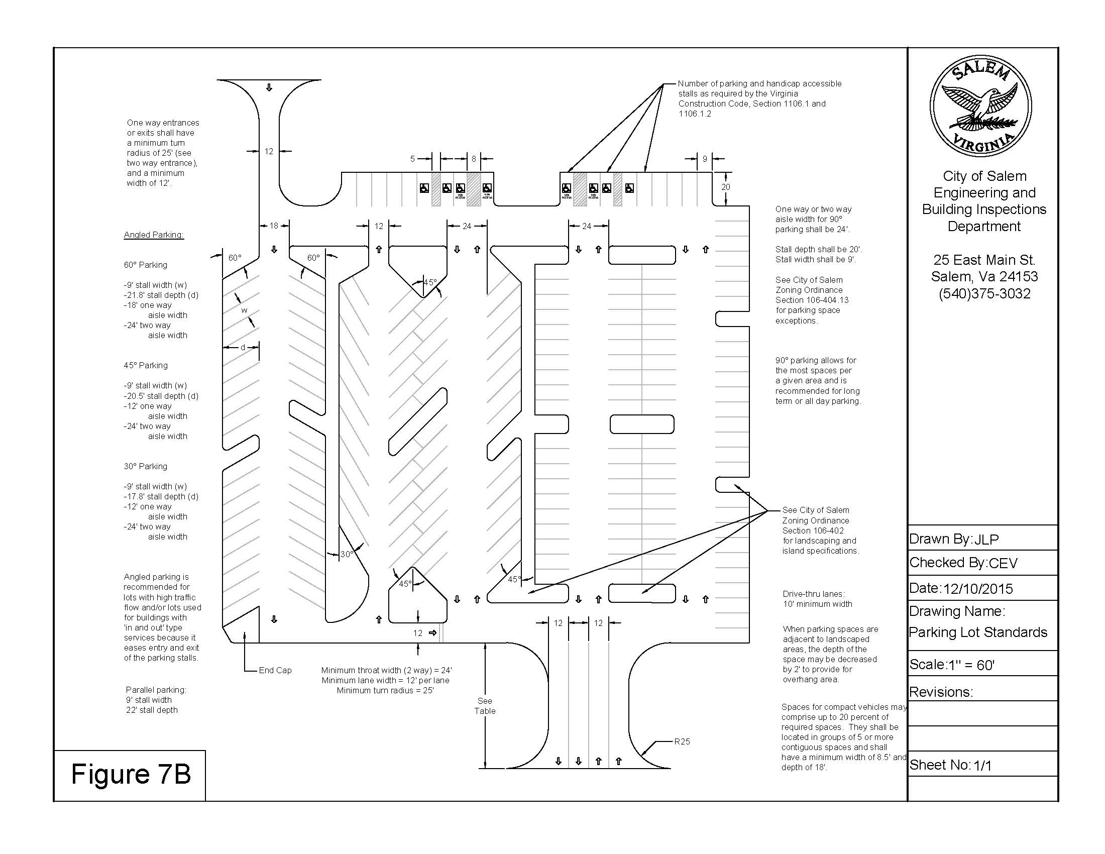
(Ord. of 3-14-05(2); Ord. of 12-11-2023(2))
Sec. 106-404.15. - Criteria for determining required parking.
(A)
When a building includes a combination of uses, the required parking will be the sum of the required parking for each use.
(B)
Where the parking requirement for a use is not defined in this section, and no similar use is listed, the administrator shall determine the number of spaces to be provided.
(C)
All references to square feet in the parking requirements below shall refer to net square feet. Net square feet is 75 percent of the gross floor area.
(D)
All references to maximum occupancy shall refer to maximum occupancy as defined by the Virginia Uniform Statewide Building Code.
(E)
The maximum allowed parking spaces shall be 140 percent of the minimums listed in 106-404.17. If there are no minimums listed, then the maximum parking shall be determined by the administrator.
(F)
Parking reductions:
1.
A reduction of 10 percent of the number of required parking spaces may be applied in the following conditions.
a.
A contained bicycle parking area is provided.
b.
A transit stop is located within 300 feet.
2.
A reduction of 20 percent of the number of required parking spaces may be applied in the following conditions.
a.
The parking area utilizes green infrastructure as approved by the City Engineer.
b.
Parking area is located in the rear yard only
3.
A total reduction of 30 percent may be applied.
(Ord. of 3-14-05(2); Ord. of 12-11-2023(2))
_____
Sec. 106-404.17. - Minimum parking required.
(A)
Agricultural Use Types.
(B)
Residential Use Types.
(C)
Civic Use Types.
(D)
Office Use Types.
(E)
Commercial Use Types.
(F)
Industrial Use Types.
(G)
Miscellaneous Use Types.
SCHEDULE A
The following table contains minimum parking requirements for uses with elements having different functions or operating characteristics. The administrator shall consider and decide the minimum parking required for uses containing a mixture of these elements.
SCHEDULE B
Specific minimum parking requirements shall be determined by the administrator, based on requirements for similar uses, location of the proposed use, expected demand and traffic generated by the proposed use.
(Ord. of 3-14-05(2); Ord. of 2-7-2013; Ord. of 1-25-2016(1); Ord. of 1-23-2017(2); Ord. of 12-11-2023(2))
_____
Sec. 106-404.19. - Stacking spaces and drive-through facilities.
(A)
Stacking spaces shall be provided for any use having a drive-through facility or areas having a drop-off and pick up areas. The following general standards shall apply:
1.
Stacking spaces shall not impede on and off-site traffic movements, shall not cross or pass through off street parking areas, and shall not create potentially unsafe conditions.
2.
Drive through lanes shall be separated from off-street parking areas. Individual lanes shall be striped, marked, or otherwise delineated.
3.
Each stacking space shall be a minimum of eight feet by 20 feet.
(B)
Stacking spaces shall be provided as follows:
1.
Financial institutions shall provide five stacking spaces for the first drive-through window, and two stacking spaces for each additional window.
2.
Car washes shall provide four stacking spaces per bay or stall.
3.
Restaurants shall provide six stacking spaces per drive-through window, measured from the order station.
4.
All other uses containing drive-through facilities shall provide a minimum of three stacking spaces for each window.
(Ord. of 3-14-05(2))
Sec. 106-406.1. - Site lighting.
(A)
All exterior site lighting fixtures shall be designed, located and arranged so as not to direct glare on adjoining streets or residential properties.
(Ord. of 3-14-05(2))
Sec. 106-406.3. - Plot plans.
(A)
A plot plan shall be submitted, prior to the approval of a zoning permit, for any new or expanded use or development not requiring a site plan or a concept plan. Plot plans shall be legibly drawn and shall clearly indicate the area, shape and dimensions of the property proposed for development. All existing easements, natural water courses, and existing and proposed improvements shall also be shown on the plan. The plan shall clearly indicate the minimum distances between existing and proposed uses and all property lines. Proposed access to the property shall also be shown.
(Ord. of 3-14-05(2))
Sec. 106-406.5. - Yard, height and setback requirements.
(A)
The lot area and yards required for any use or structure shall be permanently maintained, and shall not be counted as the required lot area or yards for any other use or structure.
(B)
Required yards shall remain free of all uses or structures except for the following:
1.
Fences, walls and landscaping shall be allowed in yards provided that sight triangles are maintained per section 106-406.17. Driveways and parking areas shall also be allowed.
2.
Patios and stoops shall be allowed within all required setback areas. Decks shall comply with all district setback requirements.
3.
Accessory structures shall be allowed in accordance with the regulations for such structures.
(C)
Height limitations contained in Article II of this chapter shall not apply to barns or silos associated with an agricultural use, church spires, belfries, residential chimneys, flag poles, or residential television antennae.
(Ord. of 3-14-05(2))
Sec. 106-406.7. - Frontage requirements on culs-de-sac.
(A)
The minimum lot frontage on the arc of a cul-de-sac shall be no less than 50 feet in all zoning districts.
(Ord. of 3-14-05(2))
Sec. 106-406.9. - Pipestem lots; prohibition of irregular lots.
(A)
On pipestem lots, as defined in section 106-600, the stem shall have a minimum width of 50 feet. No building or structure shall be permitted in the stem portion of the lot. In addition, the front lot line of such lots, for the purposes of the front yard setback requirement, shall be that line of the pipe portion of the lot closest to and parallel to the street right-of-way.
(B)
The creation of irregular lots, as defined in section 106-600 of this chapter, shall be prohibited. No lot shall be platted or modified pursuant to the provisions of the Salem Subdivision Ordinance, that due to its geometric characteristics, results in the creation of an irregular lot.
(Ord. of 3-14-05(2))
Sec. 106-406.11. - Single family detached dwellings; number permitted on a single lot.
(A)
Only one single family detached dwelling shall be permitted on any lot. Any existing lot that has two or more single family detached dwellings shall be subdivided in accordance with this chapter, and the subdivision ordinance.
(Ord. of 3-14-05(2))
Sec. 106-406.13. - Public utility lots.
(A)
Well lots, tank lots, stormwater detention area lots, utility pumping station lots, and similar types of public utility lots may be created in compliance with the terms of this chapter and the Salem Subdivision Ordinance, notwithstanding the frontage, width, area, and other design standards for lots found in Article II of this ordinance. Any such lot proposed for platting, shall be clearly designated on a subdivision plat reviewed and approved by the City of Salem. This plat shall contain notations and covenants that clearly restrict the use of the lot for the above-cited purposes. Further, the plat shall clearly indicate that no employment shall be allowed at these lots except for the routine and necessary maintenance of the public facilities.
(Ord. of 3-14-05(2))
Sec. 106-406.15. - Corner and double frontage lots, orientation of yards.
(A)
On corner and double frontage lots, the front shall be determined by the administrator. A rear yard shall always be opposite a front yard.
(B)
On corner lots, the setback on the side street shall be equal to the setback observed by the principal structure on an adjoining lot. If the side street does not have street facing lots, the side yard setback for corner lots shall be ten percent of the lot width.
(Ord. of 3-14-05(2); Ord. of 12-12-05(6))
Sec. 106-406.17. - Establishment of sight triangles.
(A)
To promote visibility for pedestrians and the operators of motor vehicles, a clear sight triangle shall be established at the intersecting right-of-ways of any two public streets. The legs of this sight triangle shall be 25 feet in length. They shall begin at the point of intersection of the two street right-of-ways, and shall extend 25 feet along each right-of-way line. The triangle shall be formed by connecting the endpoints of these two lines.
(B)
Within this sight triangle nothing in excess of three feet in height shall be constructed, placed, or permanently parked. In addition, no vegetative plantings within the triangle shall be allowed to grow to a height of greater than three feet.
(C)
Nothing in this section shall imply the necessity of removing obstructions within this sight triangle, provided that these obstructions were installed or planted prior to the effective date of this chapter. Routine trimming of shrubbery violating this height requirement shall be required, if the trimming will not endanger the health of the species.
(Ord. of 3-14-05(2))
Sec. 106-406.19. - Location and design of fences.
(A)
Except as provided for in sections 106-402 and 106-406.17, fences may be constructed in any location, on any lot.
(B)
In any residence district no fence or wall more than three and one-half feet high may be erected between the building setback line and the street on which the lot faces. No fence or wall more than eight feet high may be erected within any residence district.
(Ord. of 3-14-05(2); Ord. of 7-11-05(1))
Sec. 106-406.21. - Standards and procedures for review of condominiums.
(A)
A subdivision plat shall be submitted to the City of Salem for any new residential, commercial or industrial condominium development, including the conversion of any existing development to the condominium form of ownership. This plat shall meet all standards for subdivision plats. Plats shall be reviewed by the subdivision agent who shall approve the plat provided it meets the provisions of this chapter and the Salem Subdivision Ordinance.
(B)
An approved owners' association shall be established for all condominium projects having individually owned structures or units, and common areas and facilities. The purpose of this association is for the provision of upkeep and maintenance of the common areas and facilities. The subdivision agent shall review the provisions of the association to insure compliance with this section.
(Ord. of 3-14-05(2))
Sec. 106-406.23. - Maintenance of established building lines; establishment of setback lines for certain streets.
(A)
Notwithstanding the minimum front yard setback requirements contained in Article II District Regulations, the following minimum front yard setbacks are established for the following streets:
Apperson Drive, both sides, Colorado Street to the east corporate limits: The setback line shall be 55 feet, measured at right angles, from the established centerline of such street.
Boon Street, south side, Green Street east: The setback line shall be 60 feet, measured at right angles, from the south right-of-way line of such street.
Boulevard-Roanoke, both sides, Fourth Street to the east corporate limits: The setback line shall be 55 feet, measured at right angles, from the established centerline of such street.
North Broad Street, both sides, Main Street to Corbett Street: the setback line shall be 30 feet, measured at right angles, from the established centerline of such street.
Burwell Street, both sides: the setback line shall be 40 feet, measured at right angles, from the established centerline of such street.
Calhoun Street, both sides: The setback line shall be 25 feet, measured at right angles, from the established centerline of such street.
Clay Street, both sides: The setback line shall be 30 feet, measured at right angles, from the established centerline of such street.
Cleveland Avenue, both sides, Craig Avenue to High Street: The setback line shall be 30 feet, measured at right angles, from the established centerline of such street.
College Avenue, both sides, Burwell Street to Ninth Street: The setback line shall be 42½ feet from the established centerline of such street.
Colorado Street, both sides, Calhoun Street to Boulevard-Roanoke: The setback line shall be 25 feet, measured at right angles, from the established centerline of such street.
Colorado Street, both sides, Eight Street to Apperson Drive: The setback line shall be 55 feet, measured at right angles, from the established centerline of such street.
Dalewood Avenue, both sides, Main Street to Garst Street: The setback line shall be 30 feet, measured at right angles, from the established centerline of such street.
Eighth Street, both sides: The setback line shall be 40 feet, measured at right angles, from the established centerline of such street.
Electric Road, both sides, East Main Street to Apperson Drive: The setback line shall be 55 feet from the established centerline of such street.
Fourth Street, both sides, Boulevard-Roanoke to West Main Street: The setback line shall be 40 feet, measured at right angles, from the established centerline of such street.
Hawthorn Road, both sides, High street to North Broad Street: The setback line shall be 30 feet, measured at right angles, from the established centerline of such street.
Hemlock Road, both sides, between Boulevard-Roanoke and Lynchburg Turnpike: The setback line shall be 30 feet, measured at right angles, from the established centerline of such street.
High Street, both sides, Clay Street to North corporate limits: The setback line shall be 30 feet, measured at right angles, form the established centerline of such street.
Kesler Mill Road, west side, East Main Street to Norfolk and Western Railway Company Catawba Branch Line: The setback line shall be 60 feet from the western right-of-way line of the Catawba Branch Line.
Kesler Mill Road, east side, Norfolk and Western Railway Company Catawba Branch Line to the north corporate limits: The setback line shall be 60 feet from the eastern right-of-way line of the Catawba Branch Line.
Lynchburg Turnpike, both sides, East Main Street to east corporate limits: The setback line shall be 30 feet, measured at right angles, form the established centerline of such street.
Main Street, both sides, Academy Street and Union Street to Mill Lane: The setback line shall be 50 feet, measured at right angles, from the established centerline of such street.
Main Street, both sides, Mill Lane to West corporate limits: The setback line shall be 55 feet, measured at right angles to the established centerline of such street.
Main Street, both sides, Richfield Avenue to Lynchburg Turnpike: The setback line shall be 40 feet, measured at right angles, from the established centerline of such street.
Main Street, both sides, Lynchburg Turnpike to east corporate limits: The setback line shall be 55 feet, measured at right angles from the established centerline of such street.
Maple Street, both sides: The setback line shall be 25 feet, measured at right angles, from the established centerline of such street.
Midland Street, both sides, Electric Road to Norfolk and Western Railway Company right-of-way: The setback line shall be 30 feet, measured at right angles, to the established centerline of such street.
Mill Lane, both sides, Main Street to south corporate limits: The setback line shall be 30 feet, measured at right angles, from the established centerline of such street.
North Mill Road, both sides, Kesler Mill Road to north corporate limits: The setback line shall be 30 feet, measured at right angles from the established centerline of such street.
Red Lane, both sides, Hawthorn Road to north corporate limits: The setback line shall be 30 feet, measured at right angles, from the established centerline of such street.
Riverland Drive, both sides, Apperson Drive to Riverside Drive: The setback line shall be 25 feet, measured at right angles, from the established centerline of such street.
Riverland Drive, both sides, Colorado Street to Apperson Drive: The setback line shall be 30 feet, measured at right angles, from the established centerline of such street.
Shanks Street, both sides, Main Street to Carrollton Avenue: The setback line shall be 30 feet, measured at right angles, from the established centerline of such street.
Springfield Avenue, both sides, Electric Road to east corporate limits: The setback line shall be 30 feet, measured at right angles, from the established centerline of such street.
Texas Street, both sides, Boulevard-Roanoke to Electric Road: The setback line shall be 55 feet, measured at right angles, from the established centerline of such street.
Union Street, both sides, Main Street to Eddy Avenue: The setback line shall be 30 feet, measured at right angles, from the established centerline of such street.
White Oak Street, both sides, Burwell Street to Fourth Street: The setback line shall be 25 feet, measured at right angles, from the established centerline of such street.
(Ord. of 3-14-05(2))
Sec. 106-406.25. - On-site storage and temporary mobile storage containers.
(A)
No vehicle, truck body, detachable semi-trailer, manufactured home, mobile home, bus, trailer, recreational vehicle, or similar equipment shall be used as a storage container in any zoning district.
(B)
Temporary mobile storage containers such as portable storage units and moving pods, up to 20' in length that are designed for site delivery and pickup may be placed and used on any residentially zoned property, or on any property that is used residentially for a period not to exceed 30 days per calendar year. Such a container shall be placed in the driveway or rear yard of residentially zoned property. A zoning permit shall be obtained prior to the placement.
(C)
For containers on any nonresidential or agriculturally zoned property that will be utilized for 90 days or less, a zoning permit may be issued in lieu of these requirements.
(D)
Mobile storage containers that are temporarily located in the right of way require a Right of Way Permit issued by the Community Development Office and are not subject to the standards of this section.
(E)
Permanent storage containers that are used for occupancy as approved by the Uniform Statewide Building Code and possess a certificate of occupancy from the Building Official are not subject to the standards of this section.
(F)
Containers utilized in conjunction with construction that have an active building permit are exempt from the requirements of this section.
(G)
Storage containers and shipping containers may be placed and used on any nonresidential or agriculturally zoned property, provided that:
(1)
One shipping container shall be permitted on each lot, with one additional container permitted for each additional 100 feet of primary street frontage. Lot frontage shall be rounded down to the nearest hundred.
a.
There is no numerical storage container limitation on industrially zoned properties.
(2)
All containers are placed in a location that does not encroach upon required parking spaces, drive aisles, fire lanes, or landscaping/stormwater management areas. The placement of containers shall not inhibit adequate sight distance as prescribed by Section 106-406.17 and/or as determined by the Administrator.
(3)
Each container shall be reported to the Commissioner of the Revenue's Office.
(4)
Containers shall not display signage of any kind.
(5)
No container shall be allowed to obtain a public utility service connection.
(6)
No stacking of storage containers shall be allowed.
(7)
A landscape buffer shall be planted to screen any containers from adjacent residential properties.
(H)
Such containers that may be viewed from the public way of the following streets shall be required to conform to additional standards
(1)
Streets:
a.
Main Street
b.
Wildwood Road
c.
4 th Street
d.
Thompson Memorial Drive
e.
College Avenue
f.
Electric Road
g.
Texas Street
h.
Roanoke Boulevard
i.
Apperson Drive
j.
South Colorado Street
k.
Lynchburg Turnpike
(2)
Additional standards:
a.
All containers shall be placed on a surface in accordance with Section 106404.11 of the zoning ordinance.
b.
All containers are painted a singular neutral color (shades of gray, brown, cream, beige, and taupe) and maintained in a fashion free of rust, deterioration, graffiti, and other decomposition.
c.
Containers shall have a maximum length of twenty (20) feet.
d.
Containers on the same parcel shall be situated in a side-by-side fashion, with the longest dimensions of each container abutting.
Containers shall be placed behind the front building line of the principal structure.
(Ord. of 1-23-2017(2); Ord. of 12-09-2024(2))
Sec. 106-406.27. - Additional requirements for exterior storage, refuse disposal, etc.
(A)
Any exterior area used for storage, service, maintenance, repair, processing, manufacturing, fabrication, salvage, refuse disposal, or other similar use that is visible from a public street right-of-way, shall be screened with a buffer yard, screening and plantings meeting type A standards listed in section 106-402, and shall be provided in a manner which screens the use from view. Any area so used shall also be similarly screened from view of adjoining residences and business.
(Ord. of 4-9-2018(3))