
Sebastian City Zoning Code
CHAPTER II
DISTRICT AND GENERAL REGULATIONS
ARTICLE V. - ZONING DISTRICT REGULATIONS
This article describes the purposes and intent of each zoning district, identifies permitted and conditional uses by zoning district, and provides size and dimensional regulations for respective zoning districts. All proposed new development shall be required to comply with site plan review requirements of article XVIII and performance criteria of chapter III. All conditional uses must comply with procedures and criteria on article VI. The following sections present the basic purpose and intent of each zoning district and the uses permitted therein.
Sec. 54-2-3.1. - Procedures and criteria for review of special uses and special exceptions.
Special use. A use which is not specifically provided for in the zoning regulations. The planning and zoning commission and city council may permit such uses in such zoning districts or classifications as special uses only if the applicant meets specific provisions and conditions deemed appropriate.
Special exception. A use, which is provided for in the zoning regulations for a particular zoning district or classification and if controlled would not affect the public safety, health or general welfare by allowing the use in an additional zoning district or classification. The planning and zoning commission and city council may permit such uses in such zoning districts or classifications as special exceptions only if the applicant meets specific provisions and conditions deemed appropriate.
(a)
Uncertainty. Wherever uncertainty exists regarding whether a specific use is allowed as a permitted use, approved as a conditional use, or is prohibited in the zoning district regulations of article V, the planning and zoning commission and city council shall apply the following procedures and criteria for reviewing such uses.
(1)
Criteria for review. Notwithstanding any provisions of this article, the city council may, in its sole discretion, grant a special use permit in any district for a use, which is not provided for in the zoning regulations. All such uses shall not be otherwise illegal, shall not be specifically prohibited pursuant to the comprehensive plan or other applicable law or regulations, and shall satisfy the following findings of fact by the city council.
(2)
Procedures for review.
a.
Application. Application for approval of a special use or special exception shall be filed with the planning and growth management department on a form prescribed by the planning and growth management director. Seven copies of the application and all supporting information shall be included.
b.
Staff review. The planning and growth management director shall distribute the application and supporting information to the appropriate staff for review and comment. The staff can include outside agencies.
c.
Recommendation to planning and zoning commission. The planning and growth management director shall summarize the staff's comments and make a recommendation to the planning and zoning commission.
d.
Planning and zoning commission public hearing. The commission shall hold a public hearing pursuant to section 54-1-2.8 and shall indicate whether, in their opinion, the proposed special use or special exception meets the required findings of facts and review criteria established in section 54-2-6.2(d), including criteria of article VI. The planning and zoning commission shall make a recommendation to the city council to approve, approve with condition, or deny the application for the special use.
e.
City council public hearing. The city council shall hold a public hearing with notice pursuant to section 54-1-2.8. By resolution of the city council, the application for approval of a special use or special exception permit may be approved, upon a finding that the requirements of section 54-2-6.2(d), including criteria of article VI, are met. If the application is denied, the city council shall state the reasons for denial.
(3)
Required findings of fact. The city council shall not approve an application for a special use or special exception under this section unless it finds, based upon the evidence presented, that the following conditions are satisfied:
a.
The approval of the application for a special use or special exception will not be detrimental to the public safety, health or welfare, or be injurious to other properties or improvements within the immediate vicinity in which the property is located based on criteria established in article VI; and
b.
The use requested is consistent with the purpose and intent of the respective district, and can be demonstrated to be similar in nature and compatible with the uses allowed in such district; and
c.
The requested use is consistent with the comprehensive plan and the Code of Ordinances.
(4)
Conditions of approval. In approving an application for a special use under this section, the city council may require such conditions as will, in its judgment, substantially secure the objectives and intent of the zoning regulations.
Sec. 54-2-3.2. - Procedures and criteria for review of temporary uses.
A temporary use shall be allowed for transient merchants and special events as defined in section 54-5-22.2, and held on privately-owned property upon issuance of a temporary use permit by the city manager or his designee, based upon compliance with all applicable regulations of this chapter and other city regulations.
(a)
Illustrative enumeration. The following examples are intended to illustrate the types of temporary uses and special events held on privately-owned property that require the issuance of a temporary use permit; provided, however, this enumeration shall not be deemed or construed to be conclusive, limiting, or restrictive:
•
Outdoor special events and sales, including sidewalk and parking lot sales
•
Grand opening celebrations—Only one per business
•
Business milestone celebrations
•
Temporary parking lot sales
•
Consignment or vendor sales
•
Outdoor concerts, festivals and fairs, fundraisers, and events that include animals
•
Seasonal merchandise sales such as fireworks, Christmas tree lots, and pumpkin patches
•
Outdoor religious or ceremonial occasions
•
Transient services provided from a mobile vehicle, i.e. medical services or pet vaccinations, excluding mobile services provided by a non-profit organization
•
Races, fishing tournaments or other competitive events
(b)
A temporary use permit will be issued provided that all requirements and standards are met:
(1)
Maximum of six events per calendar year per host site. Permit applications may apply for one cumulative temporary use permit covering all similar events being held throughout a specific time period. However, the same limits on the number, type and duration of these events still apply.
(2)
Only temporary structures may be erected and utilized for the operation. All facilities used shall be self-contained and mobile or portable. No mobile homes or trailers that exceed 300 square feet in area may be utilized. Use of tents and canopies may be allowed. Shade canopies without sides smaller than 12 feet by 12 feet are approved for use. Larger tents or canopies must have a current flame retardant or resistant certificate (tag or paperwork). Cooking under temporary structures is prohibited unless approved by the city's fire marshal. The location and size of all tents and canopies must be approved by the fire marshal. Further, all tents and canopies should be located a minimum of four feet apart. All temporary facilities designed to be occupied by the public must be inspected by the fire marshal after installation, and prior to occupancy.
(3)
No utility connection shall be permitted except for temporary electrical power which must be approved by the building department.
(4)
The applicant must be the owner of the event location or provide written authorization from the property owner. Within seven days after a temporary use permit expiration, all items related to the operation or event shall be removed from the site.
(5)
Holders of temporary use permits for an activity shall not be required to obtain a business tax receipt for that activity provided that no permanent modifications are made to the site to accommodate re-occurring events. Permanent modifications will require a site plan application and business tax receipt.
(6)
No temporary use shall operate within a public right-of-way. Events requesting road closures will require a certified Maintenance Of Traffic (MOT) plan and approval by city council. No operation within an easement shall be permitted unless specifically allowed by all parties having interest in such easement.
(7)
Location of event shall be on an improved lot within a non-residential or public service district.
(8)
A maximum of 30% of the required on-site parking stalls of the host site may be utilized by the temporary use. This percentage may be increased based on satisfactory documentation indicating additional parking and/or transportation needs have been provided for the total impact of the proposed event.
(9)
Mobile food establishments, as accessory to the temporary use, must have a current state license from the appropriate regulatory agency displayed and be in compliance with all fire safety and health department regulations. In addition, alcohol sales accessory to the temporary use are prohibited unless the host site holds a current alcohol license.
(10)
Temporary toilet facilities may be required by the applicant depending on location and size of the event. Amount will be determined by the building official based on estimation of attendance of the event.
(11)
Applicant must provide, at his own expense, additional and/or special crowd control and security if determined necessary by the police chief based on the size of the event.
(12)
[Reserved.]
(13)
Prior to city manager review, approval must be obtained from the police chief, building director, and fire marshal. Approval or denial shall be based on items (1) through (11) above and consideration shall be reviewed on the total magnitude of impact that may be detrimental to the health, safety and general welfare of the community.
(Ord. No. O-14-06, § 1, 1-14-2015; Ord. No. O-15-03, § 1, 3-11-2015; Ord. No. O-21-03, § 3, 5-12-2021)
Sec. 54-2-3.3. - Time limits.
(a)
Transient merchants of any seasonal sales merchandise such as Christmas tree and firework sales or other similar use shall be in operation not more than 45 consecutive days per sale on any given site.
(b)
Transient merchants of any non-seasonal sales merchandise shall be in operation not more than ten consecutive days per sale on any given site.
(c)
Special events shall be in operation not more than seven consecutive days per event on any given site.
(Ord. No. O-14-06, § 1, 1-14-2015; Ord. No. O-15-03, § 1, 3-11-2015; Ord. No. O-21-03, § 3, 5-12-2021)
Sec. 54-2-3.4. - Application.
(a)
Temporary use permits shall be obtained by furnishing a completed application for such permit to the community development department and fire marshal. The following information as applicable shall be provided:
(1)
Application to be made by the owner or lessee of the host site.
(2)
Location of site and the specific location for the requested use.
(3)
Beginning and ending dates of the event.
(4)
Hours of operation of the event.
(5)
Name of individual in charge of the event.
(6)
After hours emergency phone number for person responsible for event.
(7)
A drawing showing dimensions of the site or an existing site plan for the host site including location and dimensions of all existing driveways, entrances, exits, and parking spaces.
(8)
A drawing depicting location and dimensions of all temporary pavilions, displays areas, sanitary facilities, and concessions for the temporary use.
(9)
Indicate how parking and traffic flow will be directed on to and within the event site.
(10)
Estimation of maximum peak hour attendance of the event to determine sanitary needs, parking and traffic impact.
(11)
If existing parking spaces of a permanent use (such as a shopping plaza) are to be utilized by patrons and employees of the temporary use event during normal operating hours, calculations shall be submitted demonstrating that the event will not utilize more than 30% of the required parking stalls of the existing host site. If usage does exceed 30%, documentation indicating additional parking and/or transportation arrangements must be provided for the total impact of the proposed event, along with submittal of a parking use agreement signed by the other tenants allowing for the temporary use of the shared parking for the specified event.
If the event is being held during non-operating hours for the host site, the 30% restriction may be lifted upon demonstration that there will still be sufficient parking available for patrons of the temporary event.
(12)
All temporary use permit applications must be accompanied by a site plan for the proposed use. This plan shall be drawn in a legible manner and to an accurate scale. The plan must include the location of adjacent streets, relevant buildings or structures, parking, and other details which may be necessary to evaluate the proposed request. The plan shall also clearly indicate the location of equipment, materials or structure to be used in association with the temporary use. Failure to submit a site plan may result in time delays or denial of the application.
(13)
All applications must be made on the form prescribed by the city and submitted no later than 21 days prior to the scheduled event. Fees for temporary uses shall be established by resolution of the city council. Applicants may include multiple similar events on one application. Applications submitted less than 21 days before the scheduled event will be assessed a fee as established in the resolution to be used for expedited processing. Fees may not be waived for any application. Requests for special causes or circumstances may be presented to the city manager for consideration.
(b)
A copy of the application and all supporting documents will be forwarded to the police chief, building official, and fire marshal for review and comments. All comments and recommendations will then be attached to the application and forwarded to the city manager or his designee for approval or denial.
(c)
The application, with all the supporting documents, will be reviewed by the city manager, or his designee. If denied, applicant will be notified, along with the reasons for denial. The police department and the fire marshal will be notified on all approved requests for temporary use permits.
(d)
Any decision of the city manager, or the city manager's designee, may be appealed to the city council. Any appeal shall be filed within five days of the decision, and shall be presented to the city council at its next available meeting.
(Ord. No. O-14-06, § 1, 1-14-2015; Ord. No. O-15-03, § 1, 3-11-2015; Ord. No. O-21-03, § 3, 5-12-2021)
Sec. 54-2-3.5. - Signs.
(a)
All signs being utilized on site must conform to the city sign regulations as outlined in the land development code and must be removed upon expiration of the temporary use permit or upon vacation of the site.
(b)
Signs used in conjunction with approved activities or special events for which a temporary use permit has been obtained shall not be calculated against the three banner signs permitted per site per year.
(Ord. No. O-15-03, § 1, 3-11-2015)
Sec. 54-2-3.6. - Procedures and criteria for mobile food establishments.
(a)
Classifications. Mobile food establishments involving the use of a mobile food dispensing vehicle shall be classified as follows:
(1)
Class I—Mobile kitchens. In addition to the vending of products allowed for Class II and Class III, these vehicles may cook, prepare and assemble food items in the unit and serve a full menu.
(2)
Class II—Canteen trucks. These vehicles vend fruits, vegetables, hot dogs, precooked foods, pre-packaged foods and pre-packaged drinks. No preparation or assembly of foods or beverages may take place on or in the vehicle, however, the heating of pre-cooked foods is allowed.
(3)
Class III—Ice cream trucks. These vehicles vend only pre-packaged frozen dairy or frozen water-based food products, soft serve or hand-dipped frozen dairy products or frozen water-based products and pre-packaged beverages.
(b)
Specific requirements. Mobile food establishments conducting business in conjunction with a city-sanctioned event or activity, or events held on city-owned public property shall comply with all standards and requirements as established by the event coordinator and/or the city's leisure services department, in addition to any applicable state regulatory agency's regulations. All other mobile food establishments, except those as a part of an approved temporary use permit on privately-owned property as regulated in section 54-2-3.2, shall comply with the following requirements:
(1)
Class I vehicles may operate in commercial, industrial, and public service zoning districts only. Class II and Class III vehicles may operate in any zoning district provided that they are not stationary for periods exceeding 60 minutes in any residential zoning district or any construction site, and must not constitute a hazard to vehicular or pedestrian traffic.
(2)
Class I mobile food establishments shall have the written consent of the owner(s) of the property on which it is located. Such written permission shall be available upon request by the representative of any regulating agency.
(3)
Any person engaged in selling, preparing, or dispensing food from a mobile food dispensing vehicle shall obtain the appropriate approvals and licenses from the State of Florida Department of Business and Professional Regulations, (DBPR), Florida Department of Health, and/or the Florida Department of Agriculture and Consumer Services before operating, and be able and willing to provide copies of all approvals and licenses upon request.
(4)
Mobile food establishments are not required to obtain any local licenses, registrations, permits or pay any operating fees. However, the business entity or owner operating the mobile food establishment(s) may need to obtain a local business tax receipt from the jurisdictional authority applicable to where the base of operations is located.
(5)
The mobile food establishment shall make the dispensing vehicle available for routine inspections by the City of Sebastian Fire Marshal, Building Inspector, or Code Enforcement Officer at any time requested and at any frequency deemed appropriate, while at location or in operation, to ensure compliance with all applicable federal, state, and local fire safety statutes, regulations and codes, and local regulations of this section.
(6)
Mobile food establishments shall comply with all requirements of the most current edition of the Florida Fire Prevention Code (FFPC) and the National Fire Protection Association (NFPA). Upon inspection, if the fire marshal or his designee determines any violations of the FFPC or NFPA exists, the mobile food establishment can be required to cease operations immediately.
(7)
The selling or distributing of alcoholic beverages from a mobile food establishment must be in accordance with section 10-1 (Sales of liquor near churches and schools restricted) and section 10-2 (Prohibited hours of sale) of the Code of Ordinances. The establishment must also have a valid state license to sell alcoholic beverages, and be able to provide a copy upon request.
(c)
Prohibitions. Mobile food establishments operating a mobile food dispensing vehicle are prohibited from the following:
(1)
Serving from a free-standing grill.
(2)
Operating in a driveway, driveway aisle, loading zone, no parking zone, fire lane, blocking fire hydrants or any other fire protection devices and equipment, or American with Disabilities Act (ADA) accessible parking spaces and/or accessible ramps. Class I establishments are prohibited from operating within a public right-of-way.
(3)
Operating in a location that impedes on-site circulation of motor vehicles, the ingress or egress of a building, or emergency exits.
(4)
Operating on unimproved surfaces, at abandoned or vacant business locations, and in any approved landscape buffer or stormwater retention area.
(5)
Use of sound amplification that meets the criteria of unnecessary and excessive as established in Chapter 67 of the Code of Ordinances.
(6)
Using balloons, banners, streamers, snipe signs, large flashing lights, flags, scantily cladded or costumed work staff, or other similar devices to attract customers.
(7)
Selling or dispensing food to customers in a moving vehicle or otherwise engaging in drive-up sales.
(d)
Operating requirements.
(1)
Mobile food dispensing vehicles shall be self-contained when operating, and provide their own required trash and/or recycling receptacles, and receptacles for public use. Mobile food establishments shall remove all waste and trash at the end of each day of operation, and prior to vacating their location, and fully comply with F.A.C. Rule 61C-4.0161.
(2)
Under no circumstances shall grease or any waste materials be released into any stormwater system, tree landscaping area, sidewalks, streets, parking lots, or private/public property. Mobile food establishments shall be responsible to properly discard any waste material in accordance with federal, state, county, municipal, or any laws, rules, regulations, orders, or permits.
(3)
No more than two mobile food establishments shall operate at the same location at any one time, except as may be permitted as part of an approved temporary use permit on privately-owned property as regulated in section 54-2-3.2.
(4)
Mobile food establishments are permitted on each property a maximum of no more than three days per calendar week.
(5)
Class I mobile food establishments operating at a site for a duration longer than four hours shall have an agreement which confirms that employees have access to a flushable restroom within 150 feet of the establishment's location during the hours of operation.
(6)
Mobile food establishments shall not require the use of more than 10% of existing parking spaces. In addition to the location of the mobile food dispensary vehicle, a 10-foot by 10-foot area, covered or uncovered, may be permitted to accommodate seating and tables, if approved by the property owner.
(e)
Penalties and other legal remedies. The city shall pursue any non-compliances and violations of this section or any misdemeanor and lawful civil action or proceeding as deemed necessary in compliance with section 1-10 (General penalty, continuing violations) and section 2-192 (Enforcement methods) of the Code of Ordinances.
(Ord. No. O-21-03, § 2, 5-12-2021; Ord. No. O-24-04, § 2, 4-24-2024)
Sec. 54-2-4.1. - Comprehensive plan implementation.
In order to implement the comprehensive plan in a manner consistent with section 163.3201, F.S., the city land development code is hereby established. The land development code is intended to assist in managing comprehensive planning issues surrounding the use and/or development of specific lots, parcels, and tracts of land or any combination thereof within the City of Sebastian.
State Law reference— Comprehensive plan, article III; planning, ch. 78, Code of Ordinances of the City of Sebastian, Florida.
Sec. 54-2-4.2. - Future land use map (FLUM) designations and zoning districts.
Table 54-2-4.2 "Future Land Use Map (FLUM) Designations and Compatible Zoning Districts" references adopted FLUM designations contained in the land use element of the City of Sebastian Comprehensive Plan and identifies corresponding zoning districts which are hereby established in order to implement the FLUM designations, respectively.
The official zoning map may correct drafting and clerical errors or omissions in the prior official zoning map, but no such corrections shall have the effect of amending the code or any subsequent amendment thereto without duly noticed public hearings as provided herein. When any official zoning map is replaced, the prior map or any significant parts thereof remaining shall be preserved together with all available records pertaining to its adoption and amendment.
(Ord. No. O-22-04, § 1, 5-25-2022)
Sec. 54-2-4.3. - Official zoning map and district boundaries.
(a)
Map adoption. The boundaries of each zoning district are on the official zoning map for the City of Sebastian, Florida. The boundaries of the districts, together with all explanatory statements thereon, are hereby adopted and incorporated as a part of this code.
(b)
Map amendment. No changes or amendments to the official zoning map shall be made except in compliance and conformity with all procedures set forth in this code. If changes or amendments are made to district boundaries or other subject matter portrayed on the official zoning map, such changes or amendments shall be made promptly after official adoption of the change or amendment as provided for herein. The city's planning and growth management director shall be responsible for assuring that the physical updating and amendment of the official zoning map is carried out in a timely manner.
Where a proposed rezoning affects a large portion of the land area of the City of Sebastian, it shall be considered to be legislative in nature and shall be enacted in accordance with legislative standards contained in the Florida Constitution, Florida Statutes, the city's comprehensive plan and the city land development code.
Where a proposed rezoning affects a limited number of persons or property owners, or is contingent on a fact or facts arrived at from distinct alternatives presented at a hearing, and where the decision can be functionally viewed as policy application rather than policy setting, it shall be considered to be quasi-judicial in nature and the rules contained in this paragraph shall apply. The property owner shall have the burden of proving that the rezoning proposal is consistent with the comprehensive plan and that it complies with all procedural requirements of the zoning ordinances. Should the property owner prove these elements, the burden shifts to the city council to show that maintenance of the existing zoning classification with respect to the property accomplishes a legitimate public purpose and to show that denial of rezoning approval is not arbitrary, discriminatory, or unreasonable. In rendering a decision, the city council shall not be required to make a finding of fact. City council action on a rezoning request for a limited number of persons or property owners shall be reviewable by petition for writ of certiorari in accordance with the Florida rules appellate procedure. The standard for review shall be "strict scrutiny," by which is meant the same standard as that used in the review of other quasi-judicial decisions and not constitutional cases. The city council's decision should be upheld if the city can show that there was competent substantial evidence presented to the city council to support its ruling.
Sec. 54-2-4.4. - Interpretation of district boundaries.
The following shall apply when there is uncertainty as to the district boundaries on the official zoning map:
(1)
Center lines. Boundaries indicated as approximately following the centerlines of streets, highways and alleys shall be construed as following such lines.
(2)
Lot, section and tract lines. Boundaries indicated as approximately following platted lot lines, section or tract lines shall be construed as following such lines.
(3)
Political boundaries. Boundaries indicated as approximately following political boundaries shall be construed as following such political boundaries.
(4)
Shorelines. Boundaries indicated as following shorelines shall be construed as following the mean high water line (MHW), and in the event of change in the MHW, the shoreline shall be construed as moving with the MHW. Boundaries indicated as approximately following the centerline of streams, rivers, canals, or other bodies of water shall be construed to follow such centerlines.
(5)
Parallel lines. Boundaries indicated as parallel to or extensions of features indicated in section 54-2-4.4(1) through (5) shall be so construed. Distances not specifically indicated on the official zoning map shall be determined by the scale of the map.
(6)
Bisecting lines. Where district boundary lines approximately bisect blocks, the boundaries are the median line of such blocks, between the center lines of boundary streets.
(7)
Uncertainties. Where physical or cultural features existing on the ground are at variance with those shown on the official zoning map or in case any other uncertainty exists, the city council shall interpret the intent of the official zoning map as to the location of district boundaries.
(8)
Street abandonment. Where a public road, street or alley is officially vacated or abandoned, the regulations applicable to the property to which it reverted shall apply to such vacated or abandoned road, street, or alley.
(9)
Excluded areas. Where parcels of land and water areas have been inadvertently excluded from a zoning district classification in any manner, said parcels shall be classified in conformance with the most restrictive zoning district which abuts the excluded area until or unless changed pursuant to amendment procedures contained herein.
(10)
Railroad lines. Boundaries indicated as following railroad lines shall be construed to be following the centerline of the railroad right-of-way.
Sec. 54-2-4.5. - Compliance with district regulations.
No building or structure shall be erected, reconstructed or structurally altered, nor shall any building, land or water be used for any purpose other than a use permitted in the district in which such building, land or water is located. No building or land shall be used so as to produce greater heights, smaller yards, less unoccupied area, or higher density or intensity than is prescribed for such building or land within the district regulations in which the building or land is located. No lot, which is now or which may be hereafter built upon shall be so reduced in area so that the yards and open spaces will be smaller than prescribed by this code.
Sec. 54-2-5.1. - Conservation District (C).
(a)
Intent. This district is intended to implement the comprehensive plan policies for preserving areas designated "Conservation" on the comprehensive plan future land use map (FLUM). These areas primarily consist of environmentally sensitive natural resources and systems including but not limited to the Sebastian River, the Indian River, other environmentally sensitive public lands, and mangrove fringe protected by Florida Statutes. The intent of this district is to provide for the long term preservation of environmentally sensitive natural resources systems designated "Conservation" on the comprehensive plan FLUM.
No development shall be permitted within the Conservation District unless the applicant for such development provides proof of permits or proof of exemptions from all applicable state or federal agencies having jurisdiction.
The developer/applicant of lands within the Conservation (C) District shall be required to provide a site engineered delineation of all environmentally sensitive lands, including, but not limited to, wetlands and uplands habitat and shall also indicate the location of lands or waters within the jurisdiction of the state and/or federal government. The applicant shall bear the burden of proof in determining that development plans required pursuant to article XVIII include appropriate mitigation techniques to prevent/minimize adverse impacts to wetlands, transitional wetlands, upland habitat, tidal waters and estuarine areas, including benthic communities, such as seagrass beds and other live bottom communities, or additional environmentally fragile natural systems. An on-site survey by environmental professionals shall be submitted by the applicant. Such determinations shall be based on physical and biological data obtained from specific site investigations and provided with the earliest application for city development approval. These determinations shall be predicated on findings rendered by professionals competent in producing data and analysis necessary to support impact assessments, including findings regarding the impacts of potential development on the physical and biological function and value of environmentally sensitive lands. Any development within the Conservation District shall be required to comply with all performance criteria of chapter III, especially article XI, Environmental Protection, as well as all other applicable land development regulations.
(b)
Uses permitted. All development within the Conservation District shall be by conditional use due to the environmental sensitivity of lands within the Conservation District.
(c)
Conditional uses. Prior to any development within a Conservation District all state or federal agencies having jurisdiction shall have granted requisite permits, including but not limited to, dredge and fill permits. As stated in article VI. Conditional Uses, applicants for a conditional use must demonstrate that the proposed uses and facilities identified below are compliant with all applicable criteria and relevant mitigation measures for conditional use approval, including but not limited to, wetland preservation, coastal resource impact analysis and shoreline protection, protection of marine life and fisheries, protection of flora and fauna, and flood plain protection. The design of proposed conditional use facilities shall be required to apply mitigation measures to prevent and/or minimize adverse impacts on natural systems, including but not limit to, habitats, water quality, and the physical and biological functions of wetlands. The size and scale of such development shall be restricted.
Waterward of mean/ordinary high water: only water dependent facilities, including:
(1)
Fishing piers, docks and related boardwalks, which satisfy state permitting standards.
(2)
Watercraft.
(3)
Boardwalks not exceeding a width of five feet, which shall be elevated in order to reduce adverse impacts on hydrologic functions of wetlands and which satisfy state permitting standards.
(4)
Water related facilities that satisfy state permitting standards.
Within areas above mean high water:
(1)
Hiking trails not exceeding a width of four feet to avoid adverse impacts on upland habitats and those portions traversing waterways shall be elevated in order to reduce adverse impacts on hydrologic functions.
(2)
Picnic areas.
(3)
Observation towers that shall be elevated in order to reduce adverse impacts on hydrologic functions of wetlands.
(4)
Public and private utilities where such facilities are essential to the public health, safety and welfare.
(5)
Fishing piers, docks and related boardwalks, which satisfy state permitting standards.
(d)
Dimensional regulations.
(1)
Maximum density: Not applicable.
(2)
Maximum FAR: 1%
(3)
Maximum height: 25 feet.
(4)
Maximum site alteration: 1%
(5)
Lot dimensions: Not applicable.
(6)
Minimum setbacks: All development, excepting permitted water dependent uses, must comply with requirements for setbacks from wetlands and open waters established in section 54-3-11.1(c) and section 54-2-5.10(a).
(e)
Commercial structures within waters of the state. The City of Sebastian shall regulate the location as well as the intensity and character of permanent and temporary water-dependent structures within the corporate limits of the City of Sebastian. This subsection does not apply to watercraft. Applicants desiring to develop, establish or expand temporary or permanent structures within waters of the state shall be required to file a major site plan pursuant to procedures set forth in article XVIII. The applicant shall be required to submit a plan compliant with applicable performance criteria set forth in chapter III, including but not limited to section 20-3-11.4, Coastal resource impact analysis.
Sec. 54-2-5.2. - Residential districts (subsections 54-2-5.2.1 through 54-2-5.2.7[5]).
The overall purpose and intent of the residential districts is to provide a management framework for implementing comprehensive plan residential development objectives and policies directed toward:
•
Protecting the quality and character of existing neighborhoods, including compatibility of land use and structures;
•
Preserving open space;
•
Maintaining densities which are compatible with existing and anticipated future developments based on the future land use element of the comprehensive plan;
•
Promoting compatibility with natural features of the land; and
•
Minimizing burden on supportive public services and facilities within the area.
All residential development shall comply with the comprehensive plan, performance criteria in chapter III, as well as all other applicable land development regulations. Following is a description of the intended purpose of each zoning district herein established, including reference to the comprehensive plan future land use map designations which shall be implemented through the land development regulations.
Sec. 54-2-5.2.1. - Residential Estate District (RE-40).
(a)
Intent: The RE-40 district is established to implement comprehensive plan policies for managing the lowest range of densities for land designated low density residential. Supportive public community facilities and accessory land uses also may be located within areas designated for use as residential estates.
(b)
Uses permitted:
Single-family dwellings
Foster care/group homes with ≤ 6 residents
Accessory residential uses
Home occupations
(c)
Conditional uses:
Foster care/group homes with > 6 residents
Child care services
Churches
Equestrian uses
Golf courses and support facilities
Model homes
Parks and recreation, public
Protective and emergency services, public
Schools, public or private
Utilities, public and private
Accessory uses to conditional uses
(d)
Dimensional regulations:
(1)
Maximum density: One dwelling unit per 40,000 square feet
(2)
Maximum height: 35 feet.
(3)
Lot coverage and open space:
Maximum building coverage: 25%
Maximum impervious surface: 55%
Minimum open space: 50%
(4)
Lot dimensions:
Minimum lot size: 40,000 square feet
Minimum lot width: 125 feet
Minimum lot depth: 150 feet
(5)
Minimum setbacks: All development must comply with setback requirements from wetlands and open waters established in section 54-3-11.1(c).
Front: 40 feet
Side: 20 feet
Rear: 25 feet
(6)
Minimum living area: The minimum floor area required, exclusive of porches, terraces, attached garages, carport or unroofed areas, shall be 1,600 square feet.
(7)
Required accessory structures: Every single-family dwelling unit shall be required to provide a garage or carport. If a carport or similar unenclosed vehicle storage structure is provided, then each unit within the principal structure shall contain a fully enclosed utility storage area of at least 60 square feet, which shall be designed as an integral part of the principal structure. If a fully enclosed garage is provided, then no utility structure shall be mandated. The garage or carport shall have a minimum interior clear dimension of ten feet by 20 feet.
(Ord. No. O-25-06, § 5, 4-9-2025)
Sec. 54-2-5.2.2. - Single-Family Residential District (RS-20).
(a)
Intent: The RS-20 district is established to implement comprehensive plan policies for low density residential development on lots of 20,000 square feet.
(b)
Uses permitted:
Single-family dwellings
Foster care/group homes with 6 ≤ residents
Accessory residential uses
Home occupations
(c)
Conditional uses:
Foster care/group homes with > 6 residents
Child care services
Churches
Golf courses and support facilities
Model homes
Parks and recreation, public
Protective and emergency services, public
Schools, public or private
Utilities, public and private
Accessory uses to conditional uses
(d)
Dimensional regulations:
(1)
Maximum density: One dwelling unit per 20,000 square feet
(2)
Maximum height: 35 feet.
(3)
Lot coverage and open space:
Maximum building coverage: 30%
Maximum impervious surface 60%
Minimum open space: 50%
(4)
Lot dimensions:
Minimum lot size: 20,000 square feet
Minimum lot width: 100 feet
Minimum lot depth: 150 feet
(5)
Minimum setbacks: All development must comply with requirements for setbacks from wetlands and open waters established in section 54-3-11.1(c).
Front: 30 feet
Side: 15 feet
Rear: 25 feet
(6)
Minimum living area: The minimum floor area required, exclusive of porches, terraces, attached garages, carport or unroofed areas, shall be 1,400 square feet.
(7)
Required accessory structures: Every single-family dwelling unit shall be required to provide a garage or carport. If a carport or similar unenclosed vehicle storage area is provided, then each unit within the principal structure shall contain a fully enclosed utility storage area of at least 60 square feet, which shall be designed as an integral part of the principal structure. If a fully enclosed garage is provided, then no utility structure shall be mandated. The garage or carport shall have a minimum interior clear dimension of ten feet by 20 feet.
(Ord. No. O-25-06, § 6, 4-9-2025)
Sec. 54-2-5.2.3. - Single-Family Residential District (RS-10).
(a)
Intent: The RS-10 District is established to implement comprehensive plan policies for low-density residential development on lots of 10,000 square feet.
(b)
Uses permitted:
Single-family dwellings
Foster care/group homes with 6 ≤ residents
Accessory residential uses
Home occupations
(c)
Conditional uses:
Foster care/group homes with > 6 residents
Child care services
Churches
Model homes
Parks and recreation, public
Protective and emergency services, public
Schools, public or private
Utilities, public and private
Accessory uses to conditional uses
(d)
Dimensional regulations:
(1)
Maximum density: One dwelling unit per 10,000 square feet
(2)
Maximum height: 25 feet
(3)
Lot coverage and open space:
Maximum building coverage: 30%
Maximum impervious surface: 55%
Minimum open space: 50%
(4)
Lot dimensions:
Minimum lot size: 9,500 square feet
Minimum lot width: 80 feet
Minimum lot depth: 100 feet
(5)
Minimum setbacks: All development must comply with requirements for setbacks from wetlands and open waters established in section 54-3-11.1(c).
Front setbacks 25 feet
Secondary front yard setbacks: 20 feet
Side setbacks: 10 feet
Rear setbacks: 20 feet
(6)
Minimum living area: The minimum floor area required, exclusive of porches, terraces, attached garages, carports or other unenclosed areas, shall be 1,200 square feet.
(7)
Required accessory structure: Every single-family dwelling unit shall be required to provide a garage or carport. If a carport or similar unenclosed vehicle storage structure is provided then each unit within the principal structure shall contain a fully enclosed utility storage area of at least 60 square feet which shall be designed as an integral part of the principal structure. If a fully enclosed garage is provided, then no utility structure shall be mandated. The garage or carport shall have a minimum interior clear dimension of ten feet by 20 feet.
(Ord. No. O-02-9, § 1, 7-24-2002)
Sec. 54-2-5.2.4. - Medium Density Multiple-Family Residential District (RM-8).
(a)
Intent: The RM-8 District is established to implement comprehensive plan policies for managing primarily duplex and multiple-family developments on land designated for medium density residential development.
(b)
Uses permitted:
Single-family dwellings
Duplex dwellings
Multifamily dwellings
Foster care/group homes with 6 ≤ residents
Home occupations
Townhouse development
Accessory residential uses
(c)
Conditional uses:
Foster care/group homes with > 6 residents
Child care services
Cultural or civic facilities
Schools, public or private
Golf courses and support facilities
Bed and breakfast
Nursing homes
Churches
Utilities, public and private
Parks and recreation, public
Protective and emergency services, public
Model homes
Accessory uses to conditional uses
(d)
Dimensional regulations (excluding townhouse development):
(1)
Maximum density: Shall not exceed eight units per acre.
(2)
Maximum height: 35 feet (25 feet for properties east of Indian River Drive).
(3)
Lot coverage and open space:
Maximum building coverage: 40%
Minimum open space: 40%
Maximum impervious surface: 60%
(4)
Lot dimensions:
Minimum lot size: 10,000 square feet
Minimum lot width: 80 feet
Minimum lot depth: 100 feet
(5)
Minimum setbacks: All development must comply with requirements for setbacks from wetlands and open waters established in section 54-3-11.1(c).
*Plus one (1) foot for each additional two (2) feet in height above twenty-five (25) feet
(6)
Minimum living area:
Single-family dwellings: The minimum floor area required for a single-family dwelling, exclusive of porches, terraces, attached garages, carports or other unenclosed areas, shall be 900 square feet.
Duplex dwellings: 750 square feet per unit.
Multiple-family dwellings:
(7)
Required accessory structures: Every single-family and duplex dwelling unit shall be required to provide a garage or carport. If a carport or similar unenclosed vehicle storage structure is provided then each unit within the principal structure shall contain a fully enclosed utility storage area of at least 60 square feet, which shall be designed as an integral part of the principal structure. If a fully enclosed garage is provided, then no utility structure shall be mandated. The garage or carport shall have a minimum interior clear dimension of ten feet by 20 feet.
(e)
Dimensional regulations (for townhouse development):
Maximum density: Shall not exceed eight units per acre on overall site. Individual lots (units) shall not exceed eight units per primary building or structure.*
*For sites of record containing a higher density, the designated comprehensive plan density shall apply.
(2)
Maximum height: 35 feet (25 feet for properties east of Indian River Drive).
(3)
Lot coverage and open space:
Maximum building coverage: 40%
Minimum open space: 40%
Maximum impervious surface: 60%
(4)
Lot dimensions:
Minimum lot size (prior to platting): 1 acre
Minimum interior lot size within a site: 1,800 square feet
Minimum interior lot width: 20 feet
Minimum interior lot depth: 90 feet
(5)
Minimum setbacks: All development must comply with requirements for setbacks from wetlands and open waters established in section 54-3-11.1(c).
(6)
Minimum living area: 900 square feet
(7)
Parking. Parking shall be provided consistent with article XV and may be provided via off-street parking, garage and or surface parking. If a garage or carport is proposed, it shall have a minimum interior clear dimension of 10 feet (wide) by 20 feet (depth). Rear loading garages with accessible alleyways are preferable in design.
(8)
Special regulations:
a.
Access. All dwelling units shall have access to a public street either directly or indirectly via an approach, private road, or other area dedicated to public or private use or common easement guaranteeing access. The city shall be allowed access on privately owned roads, easements, and common open space to ensure police and fire protection of the area meet emergency needs, conduct city services and generally ensure the health and safety of the residents of the development.
b.
Unified control. Title to all land within a proposed site shall be owned or controlled by the developer/owner submitting the applications for the development. For purposes of this section, the term "controlled by" shall mean that the developer shall have the written consent of all owners of the property within the proposed site not owned by the developer. The consent shall contain a notarized statement that the developer is authorized to represent the owners in the submission of an application under the provisions of this section and that the owners shall agree to be bound by the decision of the city council if the application is approved.
c.
Development standards. The minimum construction requirements for streets or roads, sidewalks, utilities, and drainage shall be in compliance with city standards.
d.
Common open space. All privately owned common open space shall conform to its intended use and remain as expressed in the final development plan through the inclusion in all deeds of appropriate restrictions to ensure that the common open space is permanently preserved according to the final development plan. Such deed restrictions shall run with the land and for the benefit of present as well as future property owners and shall contain a prohibition against partition. All common open space, as well as public and recreational facilities, shall be specifically included in the development schedule and be constructed and fully improved by the developer at an equivalent or grater rate than the construction of residential structures. The developer shall establish an association or nonprofit corporation of all individuals or corporations owning properties within the development to ensure maintenance of all common open space. The association or nonprofit corporation shall conform to the following requirements:
1.
The developer shall establish the association or nonprofit corporation prior to sale of any lots. Control of all common open space and recreation facilities shall be passed to the association upon sale or transfer of 90 percent or more of the residential units.
2.
Membership in the association or nonprofit corporation shall be mandatory for all residential property owners within the development, and such association or corporation shall not discriminate in its members or shareholders.
3.
The association or nonprofit corporation shall manage all common open space and recreational and cultural facilities, that are not dedicated to the public; shall provide for the maintenance, administration and operation of such land and any other land within the development not publicly or privately owned; and shall secure adequate liability insurance on the land. The title to all residential property owners shall include an undivided fee simple estate in all common open space or an unrestricted easement for the use and enjoyment of the common open space.
(Ord. No. O-01-24, § 1(Exh. A), 10-24-2001; Ord. No. O-25-12, § 1, 6-25-2025)
Sec. 54-2-5.2.4A. - Medium Density Multiple-Family Residential District (RM-10).
(a)
Intent: The RM-10 District is established to implement comprehensive plan policies for managing primarily duplex and multiple-family developments on land designated as medium density residential development. The intent of the standards within this section is to encourage diverse housing options and housing types.
(b)
Uses permitted:
Single-family dwellings
Duplex dwellings
Multifamily dwellings, including single attached and detached units for rent
Foster care/group homes with ≤ 6 residents
Home occupations
Townhouse development
Accessory residential uses including office or retail space
(c)
Conditional uses:
Foster care/group homes with > 6 residents
Child care services
Cultural or civic facilities
Schools, public or private
Golf courses and support facilities
Bed and breakfast
Nursing homes
Churches
Utilities, public and private
Parks and recreation, public
Protective and emergency services, public
Qualified affordable housing
Model homes
Accessory uses to conditional uses including office or retail space
(d)
Dimensional regulations:
Minimum living area:
Single-family dwellings: The minimum floor area required for a detached single-family dwelling, exclusive of porches, terraces, attached garages, carports or other unenclosed areas, shall be 900 square feet.
Duplex dwellings: 700 square feet per unit.
Multiple-family dwellings:
(e)
Density calculations.
Single-family dwellings: For the purpose of density calculations each single-family dwelling unit counts for one dwelling unit.
Multiple-family dwellings: For the purpose of density calculations dwelling units within a multiple-family development or a duplex that have a habitable space less than or equal to 600 square feet shall be calculated as 0.5 (half) dwelling unit.
(f)
Parking. Parking shall be provided consistent with article XV and may be provided via off-street parking, garage and or surface parking. If a garage or carport is proposed, it shall have a minimum interior clear dimension of 10 feet (wide) by 20 feet (depth). Rear loading garages with accessible alleyways are preferable in design.
(g)
Special regulations:
(1)
Access. All dwelling units shall have access to a public street either directly or indirectly via an approach, private road, or other area dedicated to public or private use or common easement guaranteeing access. The city shall be allowed access on privately owned roads, easements, and common open space to ensure police and fire protection of the area meet emergency needs, conduct city services and generally ensure the health and safety of the residents of the development.
(2)
Unified control. Title to all land within a proposed site shall be owned or controlled by the developer/owner submitting the applications for the development. For purposes of this section, the term "controlled by" shall mean that the developer shall have the written consent of all owners of the property within the proposed site not owned by the developer. The consent shall contain a notarized statement that the developer is authorized to represent the owners in the submission of an application under the provisions of this section and that the owners shall agree to be bound by the decision of the city council if the application is approved.
(3)
Development standards. The minimum construction requirements for streets or roads, sidewalks, utilities, and drainage shall be in compliance with city standards.
(4)
Common open space. All privately owned common open space shall conform to its intended use and remain as expressed in the final development plan through the inclusion in all deeds of appropriate restrictions to ensure that the common open space is permanently preserved according to the final development plan. Such deed restrictions shall run with the land and for the benefit of present as well as future property owners and shall contain a prohibition against partition. All common open space, as well as public and recreational facilities, shall be specifically included in the development schedule and be constructed and fully improved by the developer at an equivalent or greater rate than the construction of residential structures. The developer shall establish an association or nonprofit corporation of all individuals or corporations owning properties within the development to ensure maintenance of all common open space. The association or nonprofit corporation shall conform to the following requirements:
1.
The developer shall establish the association or nonprofit corporation prior to sale of any lots. Control of all common open space and recreation facilities shall be passed to the association upon sale or transfer of 90 percent or more of the residential units.
2.
Membership in the association or nonprofit corporation shall be mandatory for all residential property owners within the development, and such association or corporation shall not discriminate in its members or shareholders.
3.
The association or nonprofit corporation shall manage all common open space and recreational and cultural facilities, that are not dedicated to the public; shall provide for the maintenance, administration and operation of such land and any other land within the development not publicly or privately owned; and shall secure adequate liability insurance on the land. The title to all residential property owners shall include an undivided fee simple estate in all common open space or an unrestricted easement for the use and enjoyment of the common open space.
(Ord. No. O-22-06, § 1, 11-21-2022; Ord. No. O-25-12, § 1, 6-25-2025)
Sec. 54-2-5.2.5. - Mobile Home District (R-MH).
(a)
Intent. The R-MH District is established to implement comprehensive plan policies for managing mobile home and certain non-site building development on land designated for residential development satisfying the location requirements and criteria of this section.
(b)
Definitions. The following terms shall have the meanings stated below:
(1)
Mobile home shall mean a structure transportable in one or more sections, which in the traveling mode, is eight body feet or more in width or 40 body feet or more in length, or when erected on site, is 320 or more square feet, and which is built on a permanent chassis and designed to be used as a dwelling with or without a permanent foundation when connected to the required utilities, and including the plumbing, heating, air conditioning and electrical systems contained therein. Calculations to determine the number of square feet in a structure will be based upon HUD standards, and such structures are subject to the regulations set forth therein.
(2)
Manufactured residential building shall mean a closed structure, building assembly or system of subassemblies, which may include structural, electrical, plumbing, heating, ventilation or other service systems manufactured in manufacturing facilities for installation or erection, with or without other specified components, as a finished residential building or as part of a finished residential structure. This does not apply to mobile homes. Residential manufactured buildings may also mean, at the option of the manufacturer, any residential building of open construction made or assembled in manufacturing facilities away from the building site for installation, or assembly and installation, on the building site. All residential manufactured buildings shall be required to bear the insignia from the Department of Community Affairs, State of Florida (herein after DCA) or its successor agency, pursuant to DCA regulations.
(3)
Travel trailer shall mean a portable structure built on a chassis designed as a temporary dwelling for travel and vacation use and when not exceeding eight feet in width, or whose length does not exceed 40 feet and shall not be used as living quarters except in a recreational trailer park.
(c)
Uses permitted:
Mobile homes
Accessory residential uses
Manufactured residential buildings
Home occupations
(d)
Conditional uses:
Utilities, public and private
Model homes
Protective and emergency services, public
Parks and recreation, public
Vehicular storage areas, common
Accessory uses to conditional uses
(e)
Location requirements:
(1)
Mobile homes and manufactured residential buildings. Mobile homes and manufactured residential buildings are a permitted use within the R-MH Mobile Home District and the PUD (MH) Mobile Home Planned Unit Development District upon meeting applicable regulations of this Code.
(2)
Nonconforming mobile home uses. Any nonconforming mobile home use existing within the corporate limits on November 9, 1989 shall be allowed to remain, but shall not be allowed to expand their facilities beyond their current boundaries.
(f)
Construction standards: All residential manufactured buildings and mobile homes shall be constructed in compliance with the provisions of chapter 320, Florida Statutes and/or chapter 553, Florida Statutes. In addition, all residential manufactured buildings and mobile homes shall be constructed in compliance with specifications set forth by the National Fire Protection Association (NFPA) under the association's Code of Specifications for Mobile Homes and Travel Trailers as exists, or as may hereinafter be updated and amended by the NFPA. All construction shall meet the above specifications or equal, except to the extent same is inconsistent with the United States Department of Housing and Urban Development (HUD) regarding construction and safety standards of mobile homes and with the State of Florida Department of Community Affairs regarding construction and safety standards for residential manufactured buildings. The said NFPA specifications shall remain on file in the City Hall in the City of Sebastian, Florida, and shall be kept current with subsequent NFPA amendments.
All mobile homes and manufactured residential building shall be anchored in a manner prescribed by the Code of Ordinances consistent with the Federal Department of Housing and Urban Development standards. The minimum first floor elevation shall be at least 18 inches above the crown of the street. All awnings, carports, principal patios and accessories to the building or accessory buildings shall be constructed in compliance with the building code and the Land Development Code of the city. In addition, all mobile homes and manufactured residential buildings shall be required to have skirting. Such skirting shall be of concrete, masonry, stucco, wood or other suitable material, and such skirting may have allowable louvers for ventilation.
(g)
Size and dimension criteria:
(1)
Maximum density: Shall not exceed five units per acre.
(2)
Maximum height: 25 feet.
(3)
Lot coverage and open space:
Maximum building coverage: 40%
Maximum impervious surface: 50%
Minimum open space: 55%
(4)
Lot dimensions:
Minimum lot size: 7,500 square feet
Minimum lot depth: 100 feet
Minimum lot width: 70 feet
(5)
Minimum setbacks: All development must comply with requirements for setbacks from wetlands and open waters established in section 54-3-11.1(c).
Front: 20 feet
Side: 10 feet
Rear: 10 feet
(6)
Minimum living area: 900 square feet
(h)
Common vehicular storage areas: All developments having a R-MH zoning classification shall be permitted to provide common areas for the storage of recreational equipment including boats and recreational vehicles:
(1)
Surface. Storage areas shall have a surface meeting the provisions of section 54-3-10.9.
(2)
Screening. All storage areas shall be enclosed by a security fence and properly screened from neighboring residences with a Type "A" opaque screen. All storage areas shall be a minimum of 30 feet from the nearest home site.
(3)
Site plan review. Such storage areas shall undergo a site plan review in accordance with article XVIII of this Code.
Sec. 54-2-5.3. - Commercial districts (subsections 54-2-5.3.1 through 54-2-5.3.3).
General intent of commercial districts.
The overall purpose and intent of the commercial districts is to provide a management framework for implementing comprehensive plan commercial development objectives and policies. The location and distribution of specific types of commercial activities shall be determined based on the following considerations:
•
Trip generation characteristics, including impact on transportation facilities and off-street parking systems;
•
Location and site requirements based on specific needs of respective commercial activities, their market area, anticipated employment generation and floor area requirements;
•
Compatibility with and impact on nearby residential and other surrounding commercial activities;
•
Relationship to surrounding land uses and natural systems; and
•
Impact on existing and planned community services and utilities.
All commercial development shall comply with the comprehensive plan, performance criteria in chapter III, as well as all other applicable land development regulations. Following is a description of the purpose of each zoning district herein established, including reference to the comprehensive plan future land use map designation which shall be implemented through the land development regulations.
Sec. 54-2-5.3.1. - Commercial-512 District (C-512).
(a)
Intent. The C-512 District is established to implement comprehensive plan policies for managing land designated for commercial development along segments of C.R. 512.
(1)
Traffic impacts along C.R. 512 corridor. The purpose and intent of the C-512 District is to provide a well-planned and equitable growth management policy for directing future development within the C-512 District boundaries. The existing pattern of development without such regulation violates accepted principles and practices of traffic engineering, county road policies and standards, and adversely impacts the safety, welfare, and convenience of the motoring public. This statement acknowledges the fact that C.R. 512 is identified as an arterial highway on the major thoroughfare plans of both the City of Sebastian and Indian River County. Both acknowledge that C.R. 512 is a major regional transportation facility linking U.S. 1 and I-95, and also linking the cities of Sebastian and Fellsmere with Indian River County, and the City of Vero Beach urban areas to the south.
(2)
Plan for off-street parking and controlled curb cuts. The purpose and intent of the C-512 District is also to restrict the location of curb cuts within the district, require compliance with a master plan for parking and curb cut control, and regulate the timing and intensity of land development in order to alleviate potential traffic congestion along the C.R. 512 corridor. Although presently land within this district is relatively undeveloped, if the regulations prescribed herein were not duly adopted, future development within this district would generate unsafe and dangerous conflicts in traffic flow along C.R. 512.
(b)
Uses permitted:
Cultural or civic facilities
Churches
Administrative services, public and private
Clubs and lodges, public and private
Business and professional offices, excluding drive-through facilities
Medical services
Commercial retail ≤ 5,000 sq. ft.
Pharmacies
Medical marijuana dispensaries
Home occupations
Plant nurseries
Commercial amusements, enclosed
Restaurants, excluding drive-through facilities
Trade and skilled services
Residential uses accessory to permitted uses
Accessory uses to permitted uses
(c)
Conditional uses:
Child care services
Nursing homes
Protective and emergency services, public
Utilities, public and private
Parks and recreation, public
Gasoline sales, retail
Veterinary services
Commercial retail with > 5,000 sq. ft.
Accessory uses to conditional uses
(d)
Dimensional regulations:
(1)
Maximum FAR: 50%
(2)
Maximum height: 35 feet.
(3)
Lot coverage:
Maximum building coverage: 35%.
Minimum open space: 20%.
Maximum impervious surface: 80%.
(4)
Lot dimensions:
Minimum lot size: 20,000 square feet.
Minimum width: 125 feet.
Minimum depth: 160 feet.
(5)
Minimum setbacks:
Front yard: If abutting CR 512: 74 feet;
Otherwise, all other front yards: 10 feet.
Side yard: None if the building is built to the side property line(s); otherwise a minimum of 10 feet.
Rear yard: 10 feet.
(6)
Rear yard landscape requirements: a rear yard buffer strip shall be required pursuant to section 54-3-14.16 in order to provide satisfactory screening of the district from abutting residentially zoned property.
(7)
Separation requirements:
•
Pharmacies and medical marijuana treatment centers shall not be located closer than 500 feet from any public school, charter school, private school, daycare or childcare facility.
•
Pharmacies and medical marijuana treatment centers shall not be located closer than 500 feet from any church, playground, public recreational facility or community center.
•
Pharmacies and medical marijuana treatment centers shall not be located closer than 500 feet from another pharmacy or medical marijuana treatment center, and only one such business shall be located [in] any single shopping center.
(e)
Unified control of land. All development proposals having a C-512 designation must demonstrate that all land within the project is held under common ownership whether an individual, a partnership or corporation, submits the proposal.
(f)
Mandatory compliance with Master Parking and Curb Cut Control Plan (MPCCCP). The MPCCCP is hereby adopted by reference and shall apply to all developments within the C-512 District. The MPCCCP is on file in the planning and growth management department.
(g)
Expansion of uses to adjacent lot(s). An existing permitted land use within the C-512 District may be expanded to an adjacent lot or lots of less than 80 feet width providing the following conditions are met and the planning and zoning commission approves the site plan for the expansion:
(1)
The subject lot or lots shall be under unified control with the adjoining subject developed properties pursuant to section 54-2-5.3.1(e);
(2)
All such extensions must be constructed as a contiguous extension to an existing structure on the adjoining lot; and
(3)
The proposed development shall comply with all codes and ordinances of the City of Sebastian and reasonable conditions affixed to the site plan by the planning and zoning commission and/or the city council.
(h)
Compatibility of building lines. No structure within the C-512 District shall be set back more than 84 feet from the front property line in order to ensure a uniform pattern of development along the CR 512 corridor.
(Ord. No. O-18-01, § 3, 6-13-2018)
Sec. 54-2-5.3.2. - Commercial Limited District (CL).
(a)
Intent. The CL District is established to implement comprehensive plan policies for managing land designated for limited commercial development. Areas designated for limited commercial development shall not accommodate large-scale retail sales and trade activities generally serving regional markets. Such stores usually differ from limited commercial shops since the former generally require a larger floor area, carry a relatively larger inventory, and require a substantially greater off-street parking area.
Uses which are not accommodated within the limited commercial area include the following: large scale discount stores or supermarkets; department stores; wholesale and warehousing activities; sales, service or repair of motor vehicles, machine equipment or accessory parts, including tire and battery shops; automotive services centers; and fast food establishments with drive-in or drive-through facilities.
(b)
Permitted uses:
Business and professional offices, excluding drive-through facilities
Cultural or civic facilities
Medical services
Commercial retail ≤ 5,000 sq. ft.
Pharmacies
Medical marijuana dispensaries
Home occupations
Parking garages
Churches
Administrative services, public and private
Clubs and lodges, public and private
All uses permitted within the RM-8 Zoning District
Accessory uses to permitted uses
(c)
Conditional uses:
Child care services
Nursing homes
Commercial retail > 5,000 sq. ft.
Gasoline sales, retail
Parks and recreation areas, public
Utilities, public and private
Protective and emergency services, public
Business and professional offices with drive-through facilities
Qualified affordable housing
Restaurants, excluding drive-through facilities
Veterinary services
Funeral homes
Accessory uses to conditional uses
(d)
Dimensional regulations:
(1)
Maximum FAR: 60%.
(2)
Maximum height: 35 feet.
(3)
Lot coverage:
Maximum building coverage: 30%.
Maximum impervious surface: 80%.
Minimum open space: 20%.
(4)
Lot dimensions:
Minimum lot size: 10,000 square feet.
Minimum width: 75 feet.
Minimum depth: 125 feet.
(5)
Minimum setbacks:
Front yard: 10 feet.
Side yard: 5 feet minimum, except 30 feet when abutting a residential district.
Rear yard: 10 feet; except 30 feet when abutting a residential district.
(6)
Separation requirements:
•
Pharmacies and medical marijuana treatment centers shall not be located closer than 500 feet from any public school, charter school, private school, daycare or childcare facility.
•
Pharmacies and medical marijuana treatment centers shall not be located closer than 500 feet from any church, playground, public recreational facility or community center.
•
Pharmacies and medical marijuana treatment centers shall not be located closer than 500 feet from another pharmacy or medical marijuana treatment center, and only one such business shall be located [in] any single shopping center.
(Ord. No. O-01-07, § 1, 4-11-2001; Ord. No. O-12-10, § 1, 10-10-2012; Ord. No. O-18-01, § 3, 6-13-2018)
Sec. 54-2-5.3.3. - Commercial General District (CG).
(a)
Intent: The CG District is established to implement comprehensive plan policies for areas designated "CG" on the comprehensive plan future land use map.
(b)
Permitted uses:
Cultural or civic facilities
Churches
Parking garages
Clubs and lodges, public and private
Business and professional offices, excluding drive-through facilities
Medical services
Commercial retail ≤ 20,000 sq. ft.
Pharmacies
Medical marijuana dispensaries
Plant nurseries
Gasoline sales, retail
Restaurants, excluding drive-through facilities
Trade and skilled services
Hotels and motels
Vehicular sales and related services
Administrative services, public and private
Accessory uses to permitted uses
Home occupations
All uses permitted within the RM-8 Zoning District
(c)
Conditional uses:
Bars and lounges
Commercial retail > 20,000 sq. ft.
Business and professional offices with drive-through facilities
Farmer's market
Funeral homes
Pawn shops
Nursing homes
Child care services
Utilities, public and private
Parks and recreation, public
Protective and emergency services, public
Restaurants with drive-through facilities
Vehicular service and maintenance
Veterinary services
Wholesale trades and services
Commercial amusements, enclosed
Accessory uses to conditional uses
Mini-storage
(d)
Dimensional regulations:
(1)
Maximum FAR: 60%.
(2)
Maximum height: 35 feet.
(3)
Lot coverage:
Maximum building coverage: 30%.
Maximum impervious surface: 80%.
Minimum open space: 20%.
(4)
Lot dimension:
Minimum lot size: 10,000 square feet.
Minimum width: 75 feet.
Minimum depth: 125 feet.
(5)
Minimum setbacks:
Front yard with sidewalks, curb and gutters: None required.
Front yard without sidewalks, curb and gutters: 6 feet.
Side yard: 5 feet minimum, except 30 feet when abutting a residential district.
Rear yard: 10 feet; except 30 feet when abutting a residential district.
(6)
Separation requirements:
•
Pharmacies and medical marijuana treatment centers shall not be located closer than 500 feet from any public school, charter school, private school, daycare or childcare facility.
•
Pharmacies and medical marijuana treatment centers shall not be located closer than 500 feet from any church, playground, public recreational facility or community center.
•
Pharmacies and medical marijuana treatment centers shall not be located closer than 500 feet from another pharmacy or medical marijuana treatment center, and only one such business shall be located [in] any single shopping center.
(Ord. No. O-18-01, § 3, 6-13-2018)
Sec. 54-2-5.4. - Commercial Riverfront (CR).
(a)
Intent: The purpose and intent of the CR District is to provide a management framework for implementing comprehensive plan objectives and policies for the riverfront mixed use designation illustrated on the future land use map. All development in the Commercial Riverfront District shall comply with the comprehensive plan, performance criteria in chapter III, as well as other applicable land development regulations. The CR District is intended to preserve the existing character of the riverfront area. The existing assets, including historical structures, shall be protected, preserved and enhanced. The zoning district is intended to provide for a mixture of uses and a variety of opportunities for recreational and commercial uses while protecting the environment.
(b)
Permitted uses:
Cultural or civic facilities
Clubs and lodges, public and private
Medical services
Gasoline sales, retail
Wet or dry storage of boats
Trade and skilled services
Marine power sales and service
Hotels and motels
Bait and tackle shops
Accessory uses to permitted uses
Educational institutions, marine related
Administrative services, public and private
Business and professional offices, excluding drive-through facilities
Commercial retail ≤ 10,000 sq. ft.
Pharmacies
Medical marijuana dispensaries
Restaurants, excluding drive-through facilities
Bars and lounges
Home occupations
Marinas
Marine fuel sales
Boat sales and rentals
Fish markets and packing facilities
Yacht clubs
All uses permitted in the RM-8 Zoning District
(c)
Conditional uses:
Utilities, public and private
Protective and emergency services, public
Commercial retail > 10,000 sq. ft.
Child care services
Churches
Plant nurseries
Funeral homes
Accessory uses to conditional uses
Parks and recreation, public
Nursing homes
Commercial amusements, enclosed
Restaurants, with drive-through facilities
Farmer's markets
Parking lots without buildings on the lot
Veterinary services
Business and professional offices with drive-through facilities
Vehicular service and maintenance
(d)
Size and dimension regulations: The following are the minimum size and dimension criteria for lots within this district. For lots located in the Riverfront Performance Overlay District, the additional requirements of the overlay district shall be complied with:
(1)
Maximum FAR: 60%.
(2)
Maximum height: 35 feet (25 feet for properties located east of Indian River Drive).
(3)
Lot coverage:
Maximum building coverage: 30%.
Maximum impervious surface: 80%.
Minimum open space: 20%.
(4)
Lot dimensions:
Minimum lot size: 10,000 square feet.
Minimum width: 75 feet.
Minimum depth: 125 feet.
(5)
Minimum setbacks:
Front yard with sidewalks, curb and gutters: None.
Front yard without sidewalks, curb and gutters: 6 feet.
Side yard: 5 feet, except 10 feet when abutting a residential district or use.
Rear yard: 10 feet, except 30 feet when abutting a residential district or use.
(6)
Separation requirements:
•
Pharmacies and medical marijuana treatment centers shall not be located closer than 500 feet from any public school, charter school, private school, daycare or childcare facility.
•
Pharmacies and medical marijuana treatment centers shall not be located closer than 500 feet from any church, playground, public recreational facility or community center.
•
Pharmacies and medical marijuana treatment centers shall not be located closer than 500 feet from another pharmacy or medical marijuana treatment center, and only one such business shall be located [in] any single shopping center.
(e)
Riverfront design standards. Development shall comply with the design standards for the Riverfront Performance Overlay District, cited in article XXI.
(Ord. No. O-12-10, § 2, 10-10-2012; Ord. No. O-18-01, § 3, 6-13-2018)
Sec. 54-2-5.5. - Commercial Waterfront Residential District (CWR).
(a)
Intent. The purpose and intent of the CWR District is to provide a management framework for implementing comprehensive plan objectives and policies for the Riverfront Mixed Use designation illustrated on the future land use map. All development in the Commercial Waterfront Residential District shall comply with the comprehensive plan, performance criteria in chapter III, as well as other applicable land development regulations. The CWR District is intended to preserve the existing character of the Riverfront area. The existing assets, including historical structures shall be protected, preserved and enhanced. The zoning district is intended to provide for a mixture of uses and a variety of opportunities for recreational, residential and commercial uses while protecting the environment.
(b)
Permitted uses:
Single-family dwellings
Duplex dwellings
Multiple-family dwellings up to 8 units per acre
Timeshare facilities
Cultural or civic facilities
Clubs and lodges, public and private
Commercial retail ≤ 5,000 sq. ft.
Foster care/group homes with ≤ 6 residents
Boat sales or rental
Bait and tackle shops
Fish markets/packing facilities
Yacht clubs
Restaurants excluding drive-through facilities
Bars and lounges
Trade and skilled services, marine-related only
Marinas
Marina fuel sales
Marine power sales and service
Home occupations
Accessory uses to permitted uses
(c)
Conditional uses:
Model homes
Educational institutions, marine related
Commercial retail > 5,000 sq. ft.
Business & professional offices, excluding drive-through facilities
Utilities, public and private
Foster care/group homes with > 6 residents
Parks and recreation, public
Hotels and motels
Parking lots without a building on the lot
Protective and emergency services, public
Bed and breakfast
Wet or dry storage of boats
Accessory uses to conditional uses
(d)
Size and dimension criteria:
(1)
Maximum density: 8 units per acre.
(2)
Maximum FAR: 50%.
(3)
Maximum height:
West of Indian River Drive: 35 feet.
East of Indian River Drive: 25 feet.
(4)
Lot coverage:
Maximum building coverage: 30%.
Maximum impervious surface: 80%.
Minimum open space:
Nonresidential: 25%.
Residential: 50%.
(5)
Lot dimensions:
Minimum lot size: 10,000 square feet.
Minimum lot width: 80 feet.
Minimum lot depth: 125 feet.
(6)
Minimum setbacks:
Front yard:
Nonresidential, with sidewalk, curb and gutter: None required.
Nonresidential, without sidewalk, curb and gutter: 10 feet.
Residential: 25 feet.
Side yard:
Nonresidential: 5 feet, except 10 feet when abutting a residential district or use.
Residential: 15 feet plus one foot per each additional 2 feet in height above 25 feet.
Rear yard:
Nonresidential: 10 feet, except 30 feet when abutting a residential district or use.
Residential: 20 feet.
Minimum distance between residential structures on the same lot: 20 feet.
(7)
Minimum living area:
Single-family dwellings: The minimum floor area required, exclusive of porches, terraces, attached garages, carport or unroofed areas, shall be 1,200 square feet.
Duplex: 750 square feet per unit.
Multiple family dwellings:
(8)
Required accessory structures: Every single-family and duplex dwelling unit shall be required to provide a garage or carport. If a carport or similar unenclosed structure is provided then each unit within the principal structure shall contain a fully enclosed utility storage area of at least 60 square feet which shall be designed as an integral part of the principal structure. If a fully enclosed garage is provided, then no utility structure shall be mandated. The garage or carport shall have a minimum interior clear dimension of ten feet by 20 feet.
(e)
Regulation of sales promotional activity: Sales activities for commercial resort residential units shall comply with all of the following criteria:
(1)
The original sale of the vacation time sharing plans may be conducted on premises in a sales office and in up to a maximum of two model units;
(2)
The on-site sales activity shall be limited to original developer sales;
(3)
The sales activity shall be conducted inside the sales office and model units so as not to be noticeable from the outside, except for permitted graphics;
(4)
On-site sales activities shall be terminated upon completion of original sales; and
(5)
A minimum of one parking space for each two proposed units shall be provided on site for the sales staff and potential purchasers' use during the (marketing) sales promotional and construction phases.
(f)
Conversions to time-share units: No development involving the conversion of an existing dwelling unit to a time-share unit may take place unless the applicant attaches to his application for zoning or site plan approval either:
(1)
A copy of any information required by the state, including as may be appropriate, a condominium declaration, sales prospectus, and/or other documents required by the state in regulating the use. Such material shall include a statement in prominent type declaring that time-share units will or may be created with respect to units proposed; and/or
(2)
An amendment to a prior existing condominium declaration that permits time-share estates to be created, which amendment has been executed by each record owner of each unit of the condominium and each record owner of each lien on each unit of the condominium.
(g)
Other required information. Applicants for a time-share use shall file with the city all public documents required by the state in regulating such use. The purpose of this requirement is to provide assurance that the applicant has been found in compliance with all requisite state regulations governing the use, including method of sales, operations, and other issues of public health, safety and welfare.
(Ord. No. O-12-10, § 3, 10-10-2012)
Sec. 54-2-5.6. - Industrial District (IN).
(a)
Intent. The intent of the IN District is to provide a management framework for implementing comprehensive plan objectives and policies for limited industrial development on land designated IN on the future land use map. All development in the IN District shall comply with the comprehensive plan, performance criteria in chapter III, as well as other applicable land development regulations. Salvage yards and junkyards are deemed to generate highly extensive adverse impacts for the urban area and shall not be permitted uses in the city limits of Sebastian within the IN District. Such activities are more appropriately located within the HI district (section 54-2-5.7) and PUD(I) district (section 54-2-5.13).
(b)
Permitted uses:
Utilities, public and private
Business and professional offices with or without drive-through facilities
Gasoline sales
Crematory
Commercial retail with ≤ 5,000 sq. ft.
Pharmacies
Medical marijuana dispensaries
Commercial amusements, enclosed
Storage facilities
Plant nurseries
Restaurants with or without drive-through facilities
Trades and skilled services, including marine-related
Wholesale trades and services
Farmer's market
Fish markets and packing facilities
Veterinary services
Industrial activities
Parking garages
Parking lots without buildings on the lot
Clubs and lodges, public and private
Schools, public and private
Educational institutions, marine related
Administrative services, public and private
Vehicular sales and related services
Accessory watchman or custodian facilities
Medical services
Vehicular services and maintenance
Marine power sales and service
Wet/dry storage of boats
Accessory uses to permitted uses
(c)
Conditional uses:
Commercial retail with > 5,000 sq. ft.
Hotels and motels
Mini-storage
Protective and emergency services, public
Parks and recreation, public
Commercial amusements, unenclosed
Adult entertainment establishment
Flea markets
Accessory uses to conditional uses
(d)
Dimensional regulations:
(1)
Maximum FAR: 50%.
(2)
Maximum height: 35 feet.
No structure shall be erected within the approach zones of active runways on the Sebastian Municipal Airport at a height in excess of those permitted by the FAA or the city council. All structures shall comply with the City of Sebastian Airport Master Plan.
(3)
Lot coverage:
Maximum building coverage: 50%.
Maximum impervious surface: 80%.
Minimum open space: 20%.
(4)
Lot dimensions:
Minimum lot size: 15,000 square feet.
Minimum width: 100 feet.
Minimum depth: 125 feet.
(5)
Minimum setbacks:
Front yard: 20 feet.
Side interior yard: None.
Rear yard: 10 feet.
No building or structure in an IN District shall be located closer than 30 feet to a residential district.
(6)
Separation requirements:
•
Pharmacies and medical marijuana treatment centers shall not be located closer than 500 feet from any public school, charter school, private school, daycare or childcare facility.
•
Pharmacies and medical marijuana treatment centers shall not be located closer than 500 feet from any church, playground, public recreational facility or community center.
•
Pharmacies and medical marijuana treatment centers shall not be located closer than 500 feet from another pharmacy or medical marijuana treatment center, and only one such business shall be located any single shopping center.
(e)
Processing and storage within the Industrial District: In the Industrial District any use is permitted either indoors or outdoors, but in conformance with the applicable performance standards. In the Industrial District, all business, servicing, manufacturing or processing within 200 feet of a residential district boundary may be outdoors but shall be effectively screened by a solid wall, fence or natural landscaping providing a 90 percent opaque screen planting so that the materials shall not be visible from the residential district. The requirement shall not apply to airfields for the outside storage of aircraft.
(Ord. No. O-12-10, § 4, 10-10-2012; Ord. No. O-18-01, § 3, 6-13-2018; Ord. No. O-19-07, § 2, 1-8-2020; Ord. No. O-22-04, § 1, 5-25-2022)
Sec. 54-2-5.6A. - Heavy Industrial (HI).
(a)
Intent. The Heavy Industrial (HI) District also serves as the city's heavy industrial development area and is intended to permit industrial and manufacturing establishments of varying size, scale and types; limited commercial and office/medical uses necessary for the vitality of the district may also be provided.
(b)
Permitted uses. Shall be per the IN District, subsection 54-2-5.6.(b).
(c)
Conditional uses. Shall be per the IN District, subsection 54-2-5.6.(c) with the following additional uses:
Recycling and materials recovery facility
(d)
[Review procedures.] All heavy industrial uses shall be reviewed using the conditional use findings provided in section 54-2-6.2 at time of site plan review and planning and zoning commission hearing.
(e)
Dimensional regulations:
(1)
Maximum FAR: 50%.
(2)
Maximum height: 35 feet; see also additional limitations per section 54-2-7.12, airport height limitations.
(3)
Lot coverage:
Maximum building coverage: 60%.
Maximum impervious surface: 80%.
Minimum open space: 20%.
(4)
Lot dimensions:
Minimum lot size shall be 5 acres.
Minimum width: 200 feet.
(5)
Minimum setbacks:
Front yard: 50 feet.
Side interior yard: 25 feet.
Rear yard: 50 feet.
No building or structure shall be located within 100 feet of a residential district.
(f)
Outdoor storage, secondary containment, and open air storage.
(1)
All outdoor storage shall include secondary containment meeting minimum standards for open-air storage facilities and industry standards.
(2)
Screening and buffering to prevent any adverse impacts on adjacent lands and residential areas shall be in conformance with standards established in section 54-3-14.16(c)(1).
(3)
All outdoor business, servicing, manufacturing or processing, including the storage or parking of vehicles or vehicles for recycling or semi-trucks and trailers (for no longer than two business days) and shall be effectively screened by a solid wall, fence or natural landscaping providing a 90 percent opaque screen planting so that the materials shall not be visible from the residential district and shall be located at least 50 feet from a public or private right-of-way and at least 100 feet from any abutting residential use or residentially zoned district.
(4)
Any outdoor storage shall not be located within 100 feet of the boundaries of the property or within 200 feet of any watercourse, waterbody, or wetland.
(5)
In addition, outdoor storage is not permitted in any required street (front) or side yards (No outdoor storage shall be allowed in street yards or otherwise forward of the front building line).
(6)
All outdoor storage shall be screened from view from the public right-of-way, public parking areas, or adjacent residential development by an opaque wall or fence a minimum of eight feet in height.
(7)
All outdoor storage, secondary containment, or open air storage shall employ pollution prevention best management practices (BMPs) to minimize the risk of stormwater exposure and the potential for pollutant transport to any on-site stormwater management system, to the Municipal Separate Storm Sewer System (MS4), or to surface waters of the state. An annual MS4 small site industrial generator report is required to be submitted to the state. The industrial site's National Pollutant Discharge and Elimination System (NPDES) permit, as required and regulated by the Florida Department of Environmental Protection (FDEP), shall be established and maintained according to the requirements of FDEP. The site's most current FDEP approved post-development stormwater pollution prevention plan (SWPPP) or BMP Plan shall be submitted to the city planning department.
(8)
All outdoor storage, secondary containment, or open air storage shall employ pollution prevention best management practices (BMPs) in accordance with industry standards for managing emission of noise, air pollutants, odor, vibration, fire, or explosive hazard and glare.
(Ord. No. O-22-04, § 1, 5-25-2022)
Sec. 54-2-5.7. - Airport and Industrial Facilities District (AI).
(a)
Intent. The intent of the AI District is to provide a management framework for implementing comprehensive plan objectives and policies for airport facilities and supportive light industrial activities and related development within lands designated IN on the future land use map. In addition, the district shall implement the policies of the City of Sebastian Airport Master Plan. Performance criteria within the Land Development Code requires that land use and development within and adjacent to the Sebastian Airport avoid encroaching upon the airport hazard zone. Furthermore, land uses proposed within noise impact areas defined in the FAA noise control regulations shall comply with FAA guidelines for managing noise impacts through land use regulation. The airport district regulations establish the permitted uses and applicable restrictions within the air operations area. The Federal Aviation Administration (FAA) regulations shall govern the land use, specifications, and placement of structures within the airport operations area. All development in the AI District shall comply with the comprehensive plan, performance criteria in chapter III, section 54-2-7.12, Airport height limitations, article XVIII, Site Plan Review Procedures, as well as other applicable land development regulations.
(b)
Uses permitted:
Airports and related uses
Fixed base operators
Aircraft repair and service
Aeronautical schools
Aircraft storage hangars
Terminal facilities
Air freight terminals
Flying clubs
Airline operations
Sale or rental of aircraft
Air taxi and charter
Aerial survey
Aerial advertising
Aircraft manufacturing
Sales of aircraft parts and supplies
Aircraft modification
Airport maintenance
Airport administration
Airport security and emergency services
Aircraft component manufacturing when flight-testing is involved
Light industries that manufacture, assemble, process, package, store or distribute products that are dependent on component parts or raw materials manufactured elsewhere when runway is required
Skydiving services
Marine power sales and service
Wet/dry storage of boats
Wholesale trades and services
(c)
Conditional uses:
Hotels and motels
Restaurants, excluding drive-through facilities
The following conditional uses are permitted when combined with a permitted use:
Car rental
Fuel storage
Protective and emergency services, public
Parks and recreation, public
Utilities, public and private
(d)
Dimensional regulations:
(1)
Maximum FAR: 50%.
(2)
Maximum height: 35 feet.
(3)
Lot coverage:
Maximum building coverage: 50%.
Minimum open space: 20%.
Maximum impervious surface: 80%.
(4)
Lot dimensions:
Minimum lot size: 15,000 square feet.
Minimum width: 100 feet.
Minimum depth: 125 feet.
(5)
Minimum setbacks:
Front yard: 20 feet.
Side yard: None.
Rear yard: 10 feet.
No building or structure in an AI District shall be located closer than 30 feet to a residential district.
(f)
Airport height limitations. Reference section 54-2-7.12.
(Ord. No. O-12-10, § 5, 10-10-2012)
Sec. 54-2-5.8. - Public Service District (PS).
(a)
Intent. The PS District is established to implement comprehensive plan policies for managing land designated for institutional development. All development in the PS District shall comply with the comprehensive plan, performance criteria in chapter III, section 54-2-7.12, Airport height limitations, article XVIII, Site Plan Review Procedures, as well as other applicable land development regulations.
(b)
Permitted uses:
Parks and recreation areas, public
Accessory uses to permitted use
(c)
Conditional uses:
Schools
Golf course and support facilities
Churches
Parks and public recreation areas equipped with stadium type lighting
Protective and emergency services, public
Hospitals and intensive care facilities
Utilities, public and private
Cultural or civic activities
Child care services
Clubs and lodges, public and private
Administrative services, public and private
Accessory uses to conditional uses
(d)
Dimensional regulations:
(1)
Maximum FAR: 60%.
(2)
Maximum height: 35 feet (25 feet east of Indian River Drive).
(3)
Lot coverage:
Maximum building coverage: 40%.
Minimum open space: 45%.
Maximum impervious surface 60%.
(4)
Lot dimensions:
Minimum lot size: 15,000 square feet.
Minimum width: 100 feet.
Minimum depth: 125 feet.
(5)
Minimum setbacks:
Front yard: 30 feet.
Side yard: 10 feet.
Rear yard: 25 feet.
No building or structure in a PS District shall be located closer than 30 feet to a residential district.
Sec. 54-2-5.9. - Table of Land Use by Districts.
Table 54-2-5.9, Land Use by Districts, stipulates the permitted and conditional uses by district. Permitted uses are uses allowed by right, provided all applicable regulations within the Land Development Code are satisfied, as well as all other applicable laws and administration regulations. Conditional uses are allowable only if approved by the city pursuant to administrative procedures found in article VI. The applicant requesting a conditional use must demonstrate compliance with conditional use criteria set forth in article VI.
The applicant shall bear the burden of proof in demonstrating compliance with all applicable laws and ordinances during the site plan review process. The site plan review process is set forth in article XVIII.
Footnote: Adult life care and nursing homes shall include rest homes and convalescent homes, but no commercial offices or retail uses are allowed unless expressly restricted, designed and marketed only to serve residents of the facility and not the general public.
Footnote: In all zoning districts, accessory uses to permitted uses shall be considered permitted uses. In all zoning districts, accessory uses to conditional uses shall be considered conditional uses.
(Ord. No. O-12-10, § 6, 10-10-2012; Ord. No. O-18-01, § 3(Exh. A), 6-13-2018; Ord. No. O-25-06, § 7, 4-9-2025)
Sec. 54-2-5.10. - Size and dimension criteria.
(a)
Minimum lot or site requirements for all uses.
(1)
Table of size and dimensional regulations. Table 54-2-5.10 incorporates required size and dimension regulations, which shall be applicable within each respective zoning district, and these standards shall be maintained in perpetuity. All developments shall have a total land area sufficient to satisfy all standards stipulated within the Land Development Code.
(2)
Height regulations and exceptions thereto. The term "building height" as used in the land development regulations shall mean the vertical distance from the highest elevation of either:
a.
The minimum finished floor elevation as required in the Code of Ordinances section 26-1; or
b.
The average construction grade of a site where fill is required by another governmental agency; or
c.
The base flood elevation plus one foot as required by the Florida Building Code; or
d.
The base flood elevation plus 18 inches if located within a Coastal High Hazard Area (V Zone),
measured to the highest point of the building, not including those structures specifically permitted to the extend beyond the height of the building.
Chimneys and radio and television antennas may exceed height limitations upon the prior approval of the community development department staff and the city engineer based on the compliance with all other applicable technical codes. Steeples, silos, windmills, ventilators, water tanks, cupolas and other appurtenances usually required to be placed above the roof level and not intended for human occupancy or use may exceed height limitations for the respective zoning district by no more than 20% upon the prior approval of the city staff. All apparatus exceeding height limitations by more than 20% for the applicable zoning district height restrictions shall require variance approval by the board of adjustment. In no event, however, shall any permitted heights be in conflict with the height regulations established by flight angles of state-approved airports in the city. All permitted heights shall comply with all requirements of the Federal Aviation Authority and the Federal Communications Commission.
(3)
Lots of record less than minimum size (grandfather clause). Any legally platted lot of record (which conformed with the regulations and procedures governing subdivision of lots) at the time of the adoption of this ordinance which contains less lot area, width or depth than required in the district in which it is located may be used for a use permitted in such district. The provision shall not be construed to permit more than one dwelling unit on a lot with less area per family than required for the district in which such lot is located. However, if the substandard lot adjoins other land under the same ownership which if used could correct the nonconforming lot area or width, then:
a.
The substandard lot shall not be permitted a vested development right unless the nonconformity is remedied; and, furthermore,
b.
Any subsequent sale or ownership transfer of the substandard lot, adjoining lot, or portion thereof, shall not result in a vested development right in the subject substandard lot(s) unless the transaction corrects deficiencies in the substandard lot(s).
*This regulation shall not apply to lots of record within the C-512 District, where contiguous lots under the same ownership shall carry grandfather rights so long as the development lot width is a minimum of 80 feet.
(4)
Distance between principal buildings. More than one multiple-family dwelling may be located upon a lot, provided that the horizontal open space between such buildings measured at the closest point shall be as specified for the district in which it is located, and the distance shall be not less than twice the side yard required in the respective district. Such distance shall not be less than 20 feet.
(b)
Density and intensity of land use. The density and intensity shall be consistent with the comprehensive plan. Reference Table 54-2-5.10 for specific density and intensity maximums by type of land use. The density and intensity expressed in Table 54-2-5.10 is the maximum density/intensity, which can be achieved. However, the maximum density/intensity is not guaranteed by right and shall be subject to the performance criteria set forth herein. Maximum gross residential density shall be determined by dividing the "maximum allowable units" by the "gross acres of land" (i.e., dwelling units/gross land area). Land seaward of mean high water shall not be used in calculating density or intensity.
All residential densities stipulate the maximum gross densities. Gross land area shall be defined as those contiguous land areas under common ownership proposed for residential development. In cases where developable land abuts wetlands, waters of the state or other environmentally sensitive land, including but not limited to those lands within state and/or federal jurisdiction, the boundary shall be delineated as established in section 54-3-11.1(c) or as established by the state or federal government. The applicant shall bear the burden of proof in determining that development shall not adversely impact wetlands, waters of the state, and other environmentally fragile natural systems. Where the state and federal governments have jurisdiction, the applicant for development must obtain all necessary permits, including but not limited to a dredge and fill permit, prior to requesting a determination of development rights from the city. In addition, site alteration on areas zoned "Conservation" shall be limited to one percent of the entire site. Such determinations shall be based on physical and biological data obtained from specific site investigations. These determinations shall be predicated on findings rendered by professionals competent in producing data and analysis necessary to support impact assessments, including findings regarding the impacts of potential development on the physical and biological value and function of environmentally sensitive lands.
In reviewing applications/site plans for development of particular building sites, the specific residential density approved by the city shall meet all applicable performance criteria of chapter III, as well as other applicable land development regulations.
The maximum intensity stipulated for nonresidential activities is stated in terms of floor area ratio. Floor area ratio (FAR) refers to the total floor area of building(s) on any lot, parcel, or site divided by the area of the lot, parcel, or site. For purposes of calculating floor area, parking area located beneath the building shall be counted only if that first story is over seven feet above finished grade. FAR computations shall include all uses on the lot, parcel or site, including both residential and nonresidential floor area.
The city shall reserve the power to mandate changes in the site plan as well as mandate reductions in the density and/or intensity of development proposed by an applicant/developer if the city finds that the proposed site plan does not satisfy provisions of the comprehensive plan and/or the land development regulations. The maximum FARs are further restricted by quantitative and qualitative criteria included in the land development regulations, including but not limited to, such factors as minimum open space; concurrency management and level of service standards for traffic circulation; storm water management and other public facilities and services; off-street parking and internal circulation; height restrictions; landscaping; other required on-site improvements and design amenities required to achieve land use compatibility. Furthermore, the calculations of floor area ratios in mixed use developments shall be determined by applying the following procedures. The maximum number of residential units that may be allocated to the residential component of a mixed-use development shall be determined by following the procedures stated below:
The maximum square footage that may be allocated to the commercial component of a mixed use development shall be determined by following the procedures stated below:
(c)
Impervious surface and open space.
(1)
Definitions. As applied in the size and dimension requirement of this chapter, the following terms shall have the following meanings:
a.
Impervious surface. That portion of the land which is covered by buildings, pavement, non-porous fill, swimming pools, or other cover through which water cannot penetrate. The impervious surface ratio requirement controls the intensity of development, by restricting the amount of the land covered by any type of impervious surface.
b.
Open space. The term "open space" is defined as that portion of land which includes the gross area of the site less building coverage, impervious parking areas, vehicular access or egress ways, and other cover through which water cannot penetrate. City approved recreation and pedestrian site amenities shall be included as open space even if they restrict the penetration of water. Water bodies shall not constitute more than 30% of total open space area. Water bodies shall be measured from the ordinary water line. Dry retention ponds shall be considered open space.
(2)
Calculation of ISR. The impervious surface ratio (ISR) is calculated for the gross site by dividing the total impervious surface by the gross site area.
Cluster development or other site design alternatives may result in individual lots exceeding the ISR, while other lots may be devoted entirely to open space. The city may require, as a condition of approval, deed restrictions or covenants, which guarantee the maintenance of such open space in perpetuity. The ISR requirement shall not be bypassed or reduced. However, where cluster developments are planned, the intent is to allow maximum flexibility through calculating ISR on the gross site, and not on a lot-by-lot basis.
(3)
Use of porous material. Only commercially marketed paver blocks approved by the planning and growth management director and with the concurrence of the city engineer shall be used in satisfying requirements for open space, pedestrian ways and recreation amenities. The city shall be the sole judge in determining whether a porous material shall qualify as an alternative to conventional pavement and/or meet the city's specification for open space.
(4)
Compliance with ISR stipulated in Table 54-2-5.10. All proposed development shall comply with the standards given in the table of impervious surface ratios in Table 54-2-5.10.
(d)
Building setbacks. Table 54-2-5.10 provides minimum building setbacks for all zoning districts within the City of Sebastian. The minimum building setback shall be measured from the subject lot lines of the building site.
(e)
Regulations for required yards.
(1)
Purpose, use and maintenance of yards. The purpose of yards as required in this chapter is to provide open space around and between structures for health, safety and aesthetic purposes. The purpose is also to prevent the location of structures within dedicated easements. All required yards and landscaped areas shall be planted and maintained in lawn, sod, or landscaping including flower beds, shrubs, hedges or other generally accepted landscaping material approved by the city consistent with article XIV. Landscaping material, including trees, shall not obstruct the vision of the motoring public. The landscape requirements of article XIV shall further regulate development within all zoning districts, excepting single-family zoned districts.
(2)
Yards requirements. Table 54-2-5.10 provides the required yard setbacks. These setbacks shall be based on the following definitions of regulated yards.
a.
Yard defined. An open space at grade between a building setback and the adjoining lot lines, unoccupied and unobstructed by any portion of a structure from the ground upward, except as otherwise provided herein. In measuring a yard for the purpose of determining the width of a side yard, the depth of a front yard or the depth of a rear yard, the minimum horizontal distance between the lot line and the required building setback shall be used.
1.
Yard, front. A yard extending across the front of a lot between the side yard lines, and being the minimum horizontal distance between the street line and the structure or any projections thereof, other than the projections of uncovered steps and those allowed per section 54-2-5.10(e)(2)f. On corner lots and through lots all yards, which abut the street, are considered front yards for setback purposes.
2.
Yard, rear. A yard extending across the rear of a lot between the side lot lines and between the rear lot line and the nearest structure. On lots with one front line, the lot line opposite the front lot line shall be the rear lot line. On corner lots which abut two streets with front lot lines of unequal length, the rear yard line shall be opposite and parallel to the shortest front lot line. On a corner lot which abuts three streets, the remaining lot line shall be a side yard if it abuts a side yard and shall be a rear yard if it abuts a rear yard.
3.
Yard, side. A yard between any structure and the side line of the lot, and extending from the front lot line to the rear yard and being the minimum horizontal distance between a side lot line and the side of any structure. A yard which is not a front or rear yard.
b.
Yard and building site requirements. Yards or building sites created after the effective date of the land development regulations shall meet or exceed the minimum requirements established in the Schedule of District Regulations located herein. No yard or building site existing at the time of passage of this article shall be reduced in dimension or area below the minimum requirements set forth herein.
c.
Special front yard regulations.
1.
Lots with double frontage. The front yard regulations shall apply to both streets on through lots or double frontage lots.
2.
Corner lots. There shall be a front yard on each street side of a corner lot, provided, however, that the buildable width of such lot shall not be reduced to less than 30 feet; accessory buildings may be located forward of the front setback line along the boundary of the secondary front yard on an improved corner lot.
3.
Encroachment of porches or terraces. An open unenclosed and uncovered porch or paved terrace may project into the front yard for a distance of not more than ten feet.
4.
Encroachment of gasoline service facilities. Gasoline filling station pump islands may be located within a front yard, provided they are not less than 15 feet from any right-of-way line.
d.
Special regulation governing rear yards. Detached structures, such as utility sheds and other structures accessory to single-family homes within a single-family zoning district may encroach into a required rear yard, provided that any such structure maintain a minimum distance of ten feet from the rear property line and not be located within a dedicated easement. With the exception of structures that consist solely of screening and beams and supports for the screening material, no such structure shall exceed 400 square feet in lot coverage and shall not exceed 12 feet in height. Structures that consist solely of screening and beams and supports for the screening material, such as screen enclosures for swimming pool areas, shall not exceed 25 feet in height.
e.
Independent yard or open space. No part of a yard or other open space or off-street parking or loading space required in connection with any building or site for the purpose of complying with the land development regulations shall be included as part of a yard, open space or off-street parking or loading space similarly required for any other building or site.
f.
General encroachments into required yards. Every part of every required yard shall be open and unobstructed from its lowest point to the sky, except for ordinary projection of sill, cornices, buttresses, ornamental features and eaves; provided, however, that none of the before named projections shall project into a minimum front yard more than 18 inches nor into the minimum side yard more than 24 inches. In addition the following provisions shall govern other encroachments:
1.
Residential overhangs may extend 48 inches into required yard space.
2.
Commercial roof overhangs may extend 24 inches into required yard space having a required setback of less than ten feet and may extend 48 inches into a required yard space of more than ten feet.
3.
Horticultural growth poles, play equipment, wires, lights, mailboxes, fences, ornamental entry columns and gates not exceeding six feet in height are not considered as encroachments.
4.
Flag poles and outdoor furniture are not considered as encroachments.
5.
Chimneys, flues, and bay windows may not project more than two and one-half feet into a required yard.
6.
Waterfront structures such as docks and other permitted waterfront accessory structures are not considered yard encroachments.
7.
Mechanical equipment, including air conditioning units, swimming pool equipment and similar items of mechanical equipment that are functional and which serve the residence on the lot are permitted within the required side yard setback; provided, that no such equipment shall exceed a height of 36 inches above grade (except water conditioning equipment). No such equipment shall project into a minimum side yard more than 36 inches.
8.
Signs shall be regulated pursuant to article XVI.
9.
Driveways and pedestrian ways shall not be considered encroachments when the same are duly approved by the city.
(Ord. No. O-20-03, § 1, 1-13-2021)
*Plus one foot for each additional two feet in height above 25 feet.
Sec. 54-2-5.11. - Residential Planned Unit Development (PUD-R).
(a)
Intent. The PUD-R District is established to provide specific regulations governing the development of residential planned unit developments (PUD-R) in areas designated for residential development on the comprehensive plan future land use map. The district provisions establish a voluntary management framework for negotiating innovative development concepts, which protect natural features and provide abundant amenities designed to benefit the city as well as the specific development. All planned unit developments shall be designed and administered consistent with the criteria and administrative procedures in article XX, Planned Unit Development, and shall comply with all provisions of the Land Development Code, including but not limited to: article VII, General Regulations; chapter III, Performance Criteria; article XVIII, Site Plan Review; article XIX, Subdivision and section 54-2-5.10.
(b)
Compliance with comprehensive plan and future land use map. A residential PUD must comply with the provisions of the Sebastian Comprehensive Plan and satisfy the performance criteria set forth in this section.
(c)
Location and size. A residential PUD shall have a minimum of 25 contiguous acres under a common ownership or control.
(d)
Uses permitted. The following land uses are permitted within the PUD(R) District subject to compliance with provisions of this Code: Single-family attached or detached dwellings, duplex, and multifamily housing; and any other uses permitted by right in the underlying zoning district(s).
(e)
Conditional uses. In this district any uses permitted in an underlying district as a conditional use may be allowed upon compliance with applicable conditions stated herein and upon compliance with all other applicable provisions of this Code, including site plan review and performance criteria. The planning and zoning commission shall ascertain if such conditions and provisions are satisfied. Appeal of such decisions shall be heard by the city council. Appeal of such decisions shall be heard by the city council. In addition, limited commercial development may be allowed subject to the following conditions:
(1)
Limited commercial development standards:
a.
Design and market orientation. Any uses of a commercial nature shall be designated to primarily serve the needs of the residents of the planned development in which they are located, and such uses shall be designed so as to maintain and protect the residential character of the planned development and adjacent residential neighborhoods as well. In order to accomplish these purposes:
1.
Enclosure. Such commercial uses shall be conducted within a completely enclosed building with no outside display, except those uses which by their nature must be conducted outside a building. Any such outside storage use shall be reviewed by the planning and zoning commission and city council. If found acceptable, such use shall be screened by a masonry wall or fence or a combination berm and landscaping with a wall or fence and shall provide a 90% opaque screen.
2.
Land area. At the option of the developer, the maximum total land area, including all at-grade off-street parking and loading areas in connection therewith, devoted to said commercial uses shall be calculated using one of the following two methods:
(a)
The PUD(R) development may contain as much commercial land area as was permitted in any underlying commercial zoning district, although the location of the commercial activities need not be limited to the boundaries of the underlying commercial district; or
(b)
The PUD(R) development may contain commercial development based on the applicable ratio of:
i.
125 square feet of commercial land area per dwelling for PUD(R) with a density of five dwelling units per acre or less.
ii.
100 square feet of commercial land area per dwelling for PUD(R) with a density above five dwelling units per acre.
b.
Issuance of building permits. No building permit for any commercial establishment shall be issued nor may any building be used for a commercial establishment before building permits for at least 50 dwelling units in the PUD project have been issued.
(f)
Dimensional regulations. Reference section 54-4-20.1(b) for specific criteria to be applied in assessing density, intensity, and other size and dimension requirements for site specific development.
(1)
Maximum density. The comprehensive plan land use designation shall govern the maximum density permitted. No credit shall be given for land used for nonresidential purposes in calculating density.
(2)
Maximum FAR. Shall not exceed the FAR of the adjacent residential district. If more than one residential district abuts the proposed site, the least intensive development shall be required to be located adjacent to the dwelling units in the least intensive existing adjacent residential development.
(3)
Maximum height. Shall not exceed the maximum height established for the adjacent residential district.
(4)
Lot coverage and open space. A minimum of 50% of the PUD shall be maintained as open space; provided that a minimum of 30% of each residential lot must be maintained as open space.
(5)
Minimum lot size. The minimum lot size, lot width, and lot depth shall be negotiated. The average residential lot size for an attached or detached single-family unit shall not be reduced by less than 75% of the required minimum lot size in the adjacent single-family residential zoning district. There is no minimum lot size for multiple-family residential structures, excepting attached single-family units, townhouses, patio homes, and similar clustering of residential units which shall follow the guidelines as established above.
The city retains the authority to require lot sizes along the periphery of the project be designed in a manner that is similar in size to abutting lots within adjacent residential single-family zoning districts. The transition in lot size should be internalized in order to abate adverse impacts on adjacent single-family zoning districts. The city also retains the authority to require more open space and/or amenities which have a clearly significant public benefit in return for allowing substantial flexibility in the layout and design of the planned unit development.
(6)
Minimum setbacks. All development must comply with requirements for setbacks from wetlands and open waters established in section 54-3-11.1(c). In order to promote flexibility in the layout and design of a residential PUD, the city shall negotiate appropriate minimum setbacks which clearly conform to the land use compatibility and open space policies in the comprehensive plan and are consistent with the performance criteria in chapter III of the Land Development Code. Similarly, all setbacks shall be consistent with adopted fire code and standard building code.
(7)
Minimum living area. The minimum living area provided within each unit shall be negotiated; however, the minimum living area shall not be less than 900 square feet and generally shall be consistent with the living area provided in conventional zoning districts that most closely approximate the structure type and density proposed within the PUD.
(8)
Frontage and accessibility. Every dwelling unit or other use permitted in the PUD(R) District shall have access to a public street either directly or via an approved private driveway, pedestrian way, court, or other area dedicated to public use or private use or common element guaranteeing access.
(9)
Screening of mechanical equipment utility hardware and waste storage areas. In the PUD(R) District all central refuse, trash and garbage collection containers shall be screened from sight or located in such a manner that will comply with the provisions of subsection 54-3-10.2(b).
(10)
Signs. Signs in the PUD(R) District shall be permitted only in accordance with an approved sign plan. Such sign plan should provide for effective sign controls on the type, height, number, size and location of all signs in the development, and shall be designated to minimize sign proliferation and maximize the architectural integration of all signs into the development.
(g)
Perimeter transition area. All proposed development on land classified PUD(R) shall comply with perimeter transition regulations in section 54-4-20.1(c) and all other applicable provisions of article XX.
(h)
Screening and buffer yard requirements. Screening and buffer yard requirements shall comply with article XIII provisions regulating required screening of residential and nonresidential uses as well as all other applicable provisions of article XX.
(i)
Subdivision improvements and urban design amenities. In addition to requirements of article XIX of this Code, the open space systems and design amenities incorporated in the planned unit development shall reflect best management principles and practices of urban design, including streetscape amenities and recreation facilities which promote a harmonious and aesthetic environment for residents within the proposed development. This requirement shall be enforced in order to implement the purpose and intent of the PUD(R) and section 54-4-20.1(c).
Sec. 54-2-5.12. - Commercial Planned Unit Development (PUD-C).
(a)
Intent. The objective of this zoning district is to establish regulatory standards for controlling the location of comprehensively planned commercial centers accessible to arterial roadways. The PUD(C) is intended to incorporate a flexible management policy that incorporates urban design amenities, including streetscape improvements, and fosters innovative master planning in the design and development of commercial centers. The PUD(C) District provides a diversified mix of permitted and conditional land uses and higher standards of land planning and site design than are available under conventional zoning categories. All planned unit developments shall be designed and administered consistent with the criteria and administrative procedures in article XX, Planned Unit Development, and shall comply with all provisions of the Land Development Code, including but not limited to: article VII, General Regulations; chapter III, Performance Criteria; article XVIII, Site Plan Review; article XIX, Subdivision and section 54-2-5.10.
(b)
Compliance with comprehensive plan and future land use map. A commercial PUD must comply with the provisions of the Sebastian Comprehensive Plan. In addition to meeting the performance criteria set forth in this section, all land contained within a commercial PUD must have one of the following underlying comprehensive plan future land use map designations: 1) Commercial Limited (CL); 2) Commercial General (CG); or Riverfront Mixed Use (RMU).
(c)
Location and size. A commercial PUD shall have frontage on a primary arterial roadway, as designated on the City of Sebastian Major Thoroughfare Plan. At the time an application for the PUD(C) is submitted and approved by the city, the property included in the proposed PUD(C) shall have a minimum of 25 contiguous acres under unified control as required pursuant to section 54-4.20.1(b).
(d)
Land use mix. The specific land use mix within a PUD(C) District development shall be determined by the underlying comprehensive plan future land use map designations. The location of the various land uses shall be determined during the review of the preliminary development plan required pursuant to section 54-4-20.3.
(e)
Permitted uses. Permitted land uses shall include those land use activities cited below which are determined to be consistent with the underlying comprehensive plan future land use map designation and shall be permitted by right within an approved PUD(C) development plan.
(1)
Commercial limited land use designation. The following principal land uses, as well as all accessory uses thereto, are permitted uses within those areas, if any, of a commercial PUD having a Commercial Limited (CL) comprehensive plan future land use map designation:
a.
Community facilities. Limited to the following:
1.
Administrative services (public or private not for profit).
2.
Clubs (public or private not for profit).
3.
Cultural or civic activities.
4.
Protective services.
5.
Utilities, public and private.
b.
Business and professional offices.
c.
Commercial retail ≤ 5,000 sq. ft.
d.
Restaurants, excluding drive-through facilities and fast food service.
(2)
Commercial general land use designations. Those areas, if any, of commercial PUD(s) having an underlying comprehensive plan future land use map designation of Commercial General (CG) shall be permitted to have the same permitted and conditional uses as provided for in section 54-2-5.3.3 Commercial General (CG) District.
(3)
Riverfront mixed use designations: Those areas, if any, of commercial PUD(s) having an underlying comprehensive plan future land use map designation of Riverfront Mixed Use (RMU) shall be permitted to have the same permitted and conditional uses as provided for in section 54-2-5.4 Commercial Riverfront and section 54-2-5.5 Commercial Waterfront Residential.
(f)
Conditional uses. Conditional uses shall include those land use activities cited below which are: (1) consistent with the comprehensive plan future land use map designation; and (2) comply with all criteria and procedures of article VI, Conditional Uses, and all other applicable laws and ordinances. The planning and zoning commission shall determine if such conditions and provisions are satisfied. Appeal of such decisions shall be heard by the city council. All conditional uses allowed within a Commercial Limited (CL), Commercial General (CG) or Commercial Riverfront (CR) or Commercial Waterfront Residential (CWR) zoning district may be approved as conditional uses within the PUD (C) provided that the uses comply with the above cited regulations and conditional use approval procedures of article VI.
(1)
Residential development. Residential development may be approved as a conditional use in the PUD-C District if such residential development is permitted within the underlying comprehensive plan future land use map designation. In addition, the residential use must comply with the condition use criteria of article VI, the specific criteria below stated and all other applicable laws and ordinances:
a.
Residential development shall be allowed along the perimeter boundaries of the proposed development as a buffer from adjacent off-site residential developments as well as from undeveloped adjacent areas off site which are zoned for residential development.
b.
The total land area proposed for residential development shall not exceed 25% of the total land area of the proposed PUD(C) site.
c.
The maximum density shall not exceed eight dwelling units per acre. This density shall not be permitted as a matter of right but rather the actual density shall be as determined during review of the preliminary development plan pursuant to the provisions of section 54-4-20.3. No credit shall be given for land used for nonresidential purposes in calculating density.
d.
Residential structure types shall be compatible with surrounding residential development.
e.
A minimum of 50% of the total land area proposed for residential development shall be preserved as open space.
(2)
Light industrial development. Light industrial development may be allowed only in those areas, if any, of a commercial PUD zone having a future land use classification of Commercial General (CG). The total land area proposed for light industrial development shall not exceed 50% of the total developable land area with a general commercial land use designation.
a.
All such uses shall comply with all performance standards within this Code and shall take place within wholly enclosed buildings.
b.
Light industrial development within a commercial PUD(C) shall be limited to the following conditional uses:
1.
The manufacturing, compounding, processing, packing, or assembly of small electrical items, components, or circuitry, jewelry, musical instruments, toys, novelties, and other similar items that are dependent on component parts or raw materials manufactured elsewhere.
2.
Schools, offices, laboratories and other such facilities.
3.
Motion picture production studios; professional, scientific, photographic or optical instrumentation facilities.
4.
Printing, engraving, and related reproduction processes.
5.
Publishing or distribution of books, newspapers or other similar printing facilities.
6.
Mini-storage.
(g)
Perimeter transition area. All uses shall conform to the purposes of the Commercial Planned Unit Development District and shall be compatible with all uses, existing or proposed in the vicinity of the area covered by the proposed planned development. Where this section is found to be more restrictive than other provisions within the City Code of Ordinances, this section shall be the controlling regulation.
(1)
Compatibility with adjacent residential property. No structure proposed for commercial use shall be constructed within 100 feet of adjacent or abutting property zoned for residential development.
(2)
Compatibility with adjacent nonresidential property. In those cases where the property line does not abut and is not adjacent to residential development or residentially zoned land, the minimum setback shall be determined as part of the preliminary development plan review. No buildings shall be located within 40 feet of the outer boundary of the PUD districts excepting entryway security buildings and structures approved by the city council.
(h)
Size and dimension regulations. The intent of the PUD(C) is to offer greater flexibility in the design of innovative large scale commercial development and to accommodate amenities generally not found in conventional development. The location, size, dimensions and design of yards, building setbacks, points of vehicular access, parking areas, building characteristics, and all other site improvements shall provide for:
•
Safe and convenient internal vehicular circulation, including access and sufficient area for effective delivery of emergency services such as fire protection;
•
Buildings with safe entry and exit from the front and rear of respective buildings; and
•
Convenient, well landscaped and designed pedestrian ways and open space systems.
(1)
PUD Commercial size and dimension criteria.
a.
Minimum lot size. No individual minimum lot size shall be required within a Commercial Planned Unit Development.
b.
Floor area ratio(FAR). The FAR shall not exceed 60% west of Indian River Drive and shall not exceed 40% east of Indian River Drive. The FAR shall comply with section 54-2-5.10(b) provisions for mixed-use development.
c.
Frontage requirements. All land use activities within a PUD(C) shall have access to a public street.
d.
Setbacks. There are no required setbacks or yards within the Commercial Planned Unit Development except as otherwise provided for herein.
e.
Distance between buildings. There shall be a minimum of 20 feet separating structures, excepting buildings with immediately adjoining or common walls. However, the minimum distance separating any one building over 25 feet in height from an adjacent building shall be 20 feet plus one foot for each additional two feet in height above 25 feet.
f.
Height. The height of structures shall not exceed 35 feet.
g.
Open space. Commercial development shall maintain no less than 25% percent open space. Mixed use residential and commercial structures shall maintain no less than 30% open space.
(2)
Criteria for establishing site specific size and dimension requirements. See section 54-4-20.1(f) for specific criteria to be applied in assessing density, intensity, and other size and dimension requirements for site specific development proposals.
(i)
Screening and buffer yard requirements. See article XIII for specific criteria to be applied in assessing the required screening and buffer yard requirements density, intensity, and other size and dimension requirements for site specific development proposals.
(j)
Subdivision improvements and urban design amenities. In addition to requirements of article XIX of this Code as well as open space systems and street furniture, the PUD(C) shall reflect principles and practices of urban design, including streetscape amenities which promote a harmonious and aesthetic environment for pedestrians and other user groups within the proposed development. This requirement shall be enforced in order to implement the purpose and intent of the PUD(C). Reference section 54-4-20.1(j) for additional criteria.
Sec. 54-2-5.13. - Industrial Planned Unit Development (PUD-I).
(a)
Intent. The objective of this zoning district is to establish regulatory standards for controlling the location of comprehensively planned industrial development located in areas removed from residential areas and accessible to arterial roadways. The PUD(I) is intended to incorporate a flexible management policy, which fosters innovative master planning in the design and development of large scale industrial areas. The PUD(I) District provides for industrial land uses and accessory sales and service activities and promotes high standards of land planning and site design.
(b)
Compliance with comprehensive plan and future land use map. All industrial PUD's must comply with the provisions of the Sebastian Comprehensive Plan. In addition to meeting the performance criteria set forth in this section, all land contained within an industrial PUD must have an "Industrial" comprehensive land use map designation.
(c)
Location and size. An Industrial PUD shall have frontage on a primary arterial roadway, as designated on the City of Sebastian Major Thoroughfare Plan. At the time a PUD(I) application is submitted and approved by the city the land included in the PUD(I) application shall have a minimum of 25 contiguous acres and shall be under unified control as required pursuant to section 54-4-20.1(b).
(d)
Land use mix. The specific land use mix within a PUD(I) District development shall be determined by the underlying comprehensive plan future land use map designation. The location of the various land uses shall be determined during the review of the preliminary development plan required pursuant to section 54-4-20.3.
(e)
Permitted uses. Permitted uses shall include those land use activities cited below which are determined to be consistent with the underlying comprehensive plan future land use map designation and shall be permitted by right within an approved PUD(I) development plan.
(1)
Uses as permitted in section 54-2-5.6 or 54-2-5.6A.
(f)
Conditional uses. Conditional uses shall include those land use activities as defined in section 54-2-5.6 or 54-2-5.6A and are; (1) consistent with the comprehensive plan future land use map designation; and (2) comply with all requirements and conditional use criteria provided in this ordinance and in other applicable laws and ordinances. The planning and zoning commission shall determine if such conditions and provisions are satisfied. All conditional uses allowed within an industrial (IN) or heavy industrial (HI) zoning district may be permitted within the corresponding comprehensive plan land use map designation provided that all conditional use criteria of article VI are satisfied.
(g)
Perimeter transition area. All uses shall conform to the purposes of the Industrial Planned Unit Development District and shall be compatible with all uses, existing or proposed in the vicinity of the area covered by the proposed planned development.
(1)
Compatibility with adjacent residential property. No structure proposed for industrial use shall be constructed within 100 feet of that part of the perimeter property line adjacent to property zoned for residential development.
(2)
Compatibility with adjacent nonresidential property. In those cases where the perimeter line does not abut an existing residential development or residentially zoned land, the minimum setback shall be determined as part of the preliminary development plan review. No building shall be located within 40 feet of the outer boundary of the PUD district, excepting entryway security buildings and structures approved by the city council.
(h)
Size and dimension regulations. The intent of the PUD(I) is to offer greater flexibility in the design of innovative large scale development and to accommodate amenities generally not found in conventional development. The location, size, dimensions, and design of yards, building setbacks, points of vehicular access, parking areas, building characteristics, and all other planned site improvements shall provide for:
•
Safe and convenient internal vehicular circulation, including access and sufficient area for effective delivery of emergency services such as fire protection;
•
Buildings with safe entry and exit from the front and the rear of respective buildings; and
•
Convenient, well landscaped and designed pedestrian ways and open space systems.
All such planned site improvements shall be governed by the following:
(1)
Minimum size and dimension of industrial site improvements.
a.
Minimum lot size. No individual minimum lot size shall be required within an Industrial Planned Unit Development.
b.
Floor area ratio(FAR). The FAR shall not exceed 50% and shall comply with section 54-2-5.6(d) and section 54-2-5.7(e) provisions governing FAR in industrial districts.
c.
Frontage requirements. All land use activities within a PUD(I) shall have access to a public street.
d.
Setback and yard requirements. There are no required setbacks or yards within the Industrial Planned Unit Development except as otherwise provided for herein.
e.
Distance between buildings. There shall be a minimum of 20 feet separating buildings, excepting buildings with immediately adjoining or common walls. However, the minimum distance separating one building over 25 feet in height from an adjacent building shall be 20 feet plus one foot for each additional two feet in height above 25 feet.
f.
Height. The height of structures shall not exceed 35 feet.
g.
Open space. The development shall maintain no less than 25% percent open space. Higher standards may be required for conditional uses, which demonstrate consistency with standards for open space and green space for such uses within this Code.
(2)
General criteria for reviewing size and dimension standards. See section 54-4-20.1 for specific criteria to be applied in assessing density, intensity, and other size and dimension requirements for site specific development proposals.
(i)
Screening and buffer yard requirements. See article XIV for specific criteria to be applied in assessing the required screening and buffer yard requirements.
(j)
Subdivision improvements and urban design amenities. In addition to the requirements of article XIX of this Code as well as open space systems and street furniture, subdivision improvements and urban design amenities shall reflect principles and practices of urban design, including streetscape amenities which promote a harmonious and aesthetic environment for pedestrians and other user groups within the proposed development. This requirement shall be enforced in order to implement the purpose and intent of the PUD(I) and section 54-4-20.1.
(Ord. No. O-22-04, § 1, 5-25-2022)
Sec. 54-2-5.14. - Mobile Home Planned Unit Development (PUD-MH).
This section provides specific regulations for the development of Mobile Home Planned Unit Developments (PUD(MH) in areas designated for residential development on the comprehensive plan future land use map.
(a)
Permitted uses and structures. The following land uses and structures are permitted in the PUD(MH) district subject to compliance with the provisions of this Code:
(1)
Single-family detached mobile homes and residential manufactured homes as defined in section 54-2-5.2.7(b).
(2)
Parks, playgrounds, community facilities and noncommercial recreational facilities such as golf courses, game rooms, tennis courts, libraries, and similar uses.
(3)
Uses and structures which are customarily accessory and clearly incidental and subordinate to the above uses and structures, including approved storage facilities.
(4)
Public and private utilities.
(b)
Conditional uses and structures. In this district as a conditional use a building or premises may be used for only the following conditional uses upon compliance with applicable conditions stated herein and upon compliance with all other applicable provisions of this Code, including site plan review and performance criteria. the planning and zoning commission shall ascertain if such conditions and provisions are satisfied.
(1)
Recreational vehicle areas. Recreational vehicle areas may be allowed in a PUD(MH) district as a conditional use subject to compliance with the standards set forth below:
a.
Area requirements. The maximum area allowed for the establishment of a recreational vehicle area within a PUD(MH) District is ten acres or ten percent of the total land area within the PUD(MH) District, whichever is the lesser land area.
b.
Density. The maximum density permitted for recreational vehicles shall be 15 units per gross acre of land comprising the recreational vehicle area. The minimum size site for each recreational vehicle space shall be 1,500 square feet.
c.
Minimum dimensions of each recreational vehicle site. Minimum 30 feet width and 50 feet depth.
d.
Minimum yards for each recreational vehicle site. Minimum ten feet front yard and five feet rear and side yards.
e.
Required open area. Minimum 50%.
f.
Use limitations. No permanent structures such as carports, cabanas, screen rooms, or similar structures may be erected or constructed at any recreational vehicle site, and the removal of wheels or hitch and the placement of the unit on a foundation or piers is prohibited. Notwithstanding, pop-out units and similar equipment integral to the recreational vehicle as manufactured shall be permitted.
g.
Definitions. For the purposes of this section, the following definitions shall apply:
1.
Recreational vehicle. A vehicular type unit primarily designed as temporary living quarters for recreational, camping or travel use, which either has its own motive power or is mounted on or drawn by another vehicle. The basic entities are: travel trailer, camping trailer, truck camper and motor home.
2.
Recreational vehicle park. Land upon which two or more recreational vehicle sites are located, established or maintained for occupancy by recreational vehicles of the general public as temporary living quarters for recreation or vacation purposes.
3.
Recreational vehicle site. A plot of ground within a recreational vehicle park intended for the accommodation of either a recreational vehicle, tent, or other individual camping unit on a temporary basis.
h.
Required buffers. There shall be an open unobstructed landscaped buffer strip not less than 50 feet in depth along all major streets abutting a recreational vehicle park, and a landscaped buffer strip not less than 50 feet in depth along the other boundaries of the recreational vehicle park.
i.
Recreation area requirement. A minimum of ten percent of the gross site area for the recreational vehicle park shall be set aside as usable recreational open space or enclosed recreation facilities. The area shall be exclusive of recreational vehicle sites, buffer strips, street right-of-way, storage areas, or utility sites.
j.
Permanent occupancy prohibited. No recreational vehicle shall be used as a permanent place of abode, dwelling or business, or for indefinite periods of time. Any action toward removal of wheels of a recreational vehicle except for temporary purposes of repair or to attach the trailer to the grounds for stabilizing purposes is hereby prohibited.
k.
Required separation between recreational vehicles. Recreational vehicles shall be separated from each other and other structures by at least ten feet. Any temporary accessory structure such as attached awnings or temporary or individual storage facilities shall, for purposes of this separation requirement, be considered to be part of the recreational vehicle.
l.
Stabilization of site. Each recreational vehicle site shall contain a stabilized vehicular parking pad of shell, marl, paving or other suitable material approved by the city engineer and city council. No part of a travel trailer or other unit placed on a recreational vehicle park site shall be closer than five feet to the site line.
m.
Parking requirement. At least one and one-half parking spaces shall be provided in the park per recreational vehicle site. At least one parking space shall be provided at each such site.
n.
Accessory uses. Management headquarters, recreational facilities, toilets, dumping stations, showers, coin-operated laundry facilities, and other uses and structures customarily incidental to operation of a recreational vehicle park and campground are permitted as accessory uses to the park.
(2)
Conditional uses allowed if determined to be accessory to the principal use. Stores, restaurants, beauty parlors, barber shops, and other convenience establishments shall be permitted if found to comply with criteria in article VI and providing the following requirements are met:
a.
Such establishments shall be restricted in their use to occupants of the park.
b.
Such establishments shall present no visible evidence from any street outside the park of their commercial character, which would attract customers other than occupants of the park.
c.
The structures housing such facilities shall not be located closer than 100 feet to any public street outside of the PUD.
(c)
Size and dimension requirements.
(1)
Minimum area requirements for a PUD (MH) District. The minimum area allowed for the establishment of a PUD(MH) District shall be 25 acres which at the time of application submittal and approval are under unified control as required pursuant to section 54-4-20.1(b).
(2)
Minimum allowable density. Density of development within a PUD(MH) District shall be regulated by requirements for streets, common recreation areas, open space adjacent to units, yard sizes, etc.; however, the overall density shall not exceed five units per gross acre.
(3)
Minimum lot size requirements: 5,000 square feet.
(4)
Minimum lot width: 50 feet.
(5)
Minimum lot depth: 75 feet.
(6)
Maximum building height>: 25 feet.
(7)
Minimum living area: 900 square feet.
(8)
Minimum setbacks.
Front yard: 20 feet
Rear yard: 20 feet
Side yard between mobile home units: 10 feet
(9)
Maximum building coverage: 40%
(e)
Construction standards. All residential manufactured buildings, mobile homes, travel trailers, and similar portable living quarters shall be constructed in compliance with the provisions of chapter 320 and/or 553, Florida Statutes. Each mobile home, travel trailer, or other portable living quarters shall be anchored in a manner prescribed by the City Code of Ordinances and consistent with the Federal Department of Housing and Urban Standards. The minimum first floor elevation shall be at least 18 inches above the crown of the adjoining street. All awnings, carports, principal patios and accessories to the building and accessory buildings shall be constructed in compliance with the building code and Land Development Code. All mobile homes shall be required to have skirting which shall be of concrete, masonry, stucco, wood or other suitable material, and may have allowable louvers for ventilation.
(f)
Open space. Open space shall be comprised of permeable open surfaces, unroofed or screen roofed ornamental landscaped areas and recreational areas and facilities which are easily accessible and regularly available to occupants of all dwelling units on the lot wherein the open space is located. Rooftops, porches, raised decks, parking areas, driveways, utility and service areas are not calculated as open space. All PUD(MH) Districts must provide and maintain a minimum open space requirement of 55%. The maximum impervious surface shall not exceed 50%.
(g)
Frontage and accessibility. Every dwelling unit or other use permitted in the PUD(MH) shall have access to a public street either directly or via an approved private driveway, pedestrian way, court, or other area dedicated to public use or common element guaranteeing access.
(h)
Required screening and buffer yard. Screening of various uses and structures within the PUD(MH) District shall be required as provided in article XIII.
(i)
Mobile home undercarriage skirting. The frame, axles, wheels, crawl space storage area and utility connection of all mobile homes shall be concealed from view through the use of durable all-weather materials manufactured specifically for the purpose of covering the undercarriage area. Such skirting shall be fastened in accordance with manufacturer's instructions and provide for adequate ventilation.
(j)
Community building/shelter. Developments within the PUD(MH) District shall provide for a common structure which is easily accessible to all residents and which meets the following provisions:
(1)
Wind load. Storm shelters must be constructed to withstand a 120 mile per hour wind load utilizing chapter 16 of the Standard Building Code for engineering standards.
(2)
Minimum capacity of storm shelter. Storm shelters must be provided to 20% percent of the proposed total number of residents of the mobile home subdivision. The total proposed number of the residents shall be determined utilizing two residents per single-family lot.
(3)
Minimum floor area of mobile homes. Storm shelters must be designed to provide a minimum of 20 square feet of net floor area per resident. Floor areas shall not include bathrooms, corridors, or other areas that cannot be used for temporary lodging of a resident in case of an emergency. Storm shelters may be utilized as community buildings, but should be designed with minimal glass exposure.
(k)
Common vehicular storage areas. All developments having a PUD(MH) zoning classification shall provide for a common area for the storage of recreational equipment including boats and recreational vehicles:
(1)
Surface. Such storage areas shall have a surface meeting the specifications for design of off-street parking areas within article XV.
(2)
Screening. All storage areas shall be a minimum of 30 feet from any adjacent mobile home lot line, enclosed by a security fence, and shall be properly screened from neighboring residences.
(3)
Minimum area. All storage areas shall provide a minimum of one space for every 19 mobile homes. All stalls shall have a minimum width of 12 feet and a minimum depth of 30 feet, and all drives shall be a minimum of 25 feet wide.
(l)
Perimeter buffering. All proposed development on land classified PUD(MH) shall comply with perimeter transition regulations in section 54-4-20.1(g) and all other applicable provisions of article XX.
APPENDIX A
Master Plan for Parking and Curb Cut Controls Within the C-512 Zoning District City
of Sebastian Incorporated by Reference in the Land Development Code
Sec. 54-2-5.15. - Master plan for parking and curb cut controls.
(a)
Intent. The purpose of the master plan for parking and curb cut controls is to implement needed off-street parking and curb cut controls within the C-512 Zoning District. The nature of existing and projected traffic conditions is described within the Land Development Code, section 54-2-5.15.
The attached Map 1 "County Road 512 General Impact Area" delineates the County Road 512 corridor connecting U.S. 1 with I-95 to the southwest. As of February, 1984, Indian River County is undertaking a comprehensive study of traffic conditions within the County Road 512 General Impact Area. The intent of the city is to coordinate County Road 512 municipal development policies with the county's land use and transportation policies impacting this area. Therefore, the provisions of this plan should be reevaluated to reflect policy consistent with any changed or unanticipated conditions, needs or policies identified in the county's C.R. 512 traffic study.
Map 2 "County Road 512 Specific Impact Area" delineates the relationship of the C-512 zoning district to that portion of the County Road 512 corridor lying within the City of Sebastian. Based on conditions specified within section 20A-3.8A(A), "C-512 zoning district purpose and intent," together with the city's desire to be responsive to policies and concerns of Indian River County regarding control of curb cuts along County Road 512, the city herein establishes a master plan for parking and curb cut controls within the C-512 zoning district. This plan shall be cited as section 54-2-5.15 of the Land Development Code.
(b)
Location of curb cuts. Maps 3 through 12 "Curb Cut Designations" (by block) designate the location of planned curb cuts within the C-512 zoning district. The location of respective curb cuts is predicated on, but not limited to, the following considerations:
(1)
Street pattern. The existing major thoroughfare plans of Indian River County and the City of Sebastian were reviewed together with the characteristics of the street pattern within the C-512 zoning district. Particular consideration was given to the location and characteristics of major and minor intersections along County Road 512, existing and projected traffic flow, and comments of the city and county engineers.
(2)
Land use. Existing and projected land use within the general impact area was reviewed, with particular emphasis directed to existing and projected land use within the C-512 zoning district.
(3)
Subdivision layout. The existing layout of the Sebastian Highlands Subdivision units, particularly those within the C-512 zoning district, as well as those adjacent to the district, were reviewed. Special features such as block lengths and specific block characteristics, including block size and configuration, existing curb cuts, alley locations, number of lots within respective blocks, and ownership patterns were analyzed.
(4)
Potential for curb cut proliferation. The selection of planned future curb cut locations was undertaken with a view toward minimizing the proliferation of future curb cuts along County Road 512.
(5)
Standards for separation of curb cuts. Based on recommendations of the city engineer and county engineer, the guideline of 240 feet separation between curb cuts was used as a general standard in selecting curb cut locations; however, a general standard of 320 feet was used in establishing the separation between a curb cut and a major thoroughfare (i.e. Barber Street, Vocelle Avenue, the two intersections of South Wimbrow Drive with County Road 512, and Easy Street). These general standards were necessarily adjusted in order to minimize proliferation of curb cuts on blocks with differing characteristics.
Editor's note— The Maps 1 through 12 referenced above are set out following this section.
(c)
Compliance with off-street parking and landscaping controls. All subsequent development within the C-512 zoning district shall comply with off-street parking requirements of article VIII and landscape controls of article XIII. Required landscape strips shall be a minimum of ten feet along the entire frontage of the C-512 district. All off-street parking areas shall be designed in such a manner that will discourage through-traffic.
(d)
Review procedures. All regulations contained in the master plan for parking and curb cut controls within the C-512 zoning district shall be considered as part of the site plan review requirements stipulated in article X of the Land Development Code.
Review procedures for compliance with the Master Plan for Parking and Curb Cut Controls shall be the same as those cited for site plan review in article XVIII. The review processes shall run concurrently. All site plans for development within the C-512 zoning district shall comply with the following provisions in addition to those provisions contained in article XVIII.
(e)
Additional site plan review requirements for development within the C-512 zoning district. The following additional site plan review requirements shall be incorporated into any site plan submitted for review within the C-512 zoning district:
(1)
Dedication of easements. All site plans for development within the C-512 district shall include a dedicated easement for cross-access and utility purposes. The easement shall run the length of the site and include a depth of 74 feet adjacent to the frontage along County Road 512. The dedication shall be recorded on a standard form supplied by the city.
(2)
Legal assurances. All requisite legal assurances required to demonstrate compliance with provisions of the Land Development Code shall be filed as a part of the site plan. Such assurances shall be approved by the city attorney. Such legal assurances shall include any legal instruments required pursuant to a granting of a temporary curb cut, including a requisite performance bond assuring closure of the temporary curb cut, together with appropriate grading and landscaping and any other conditions underlying the granting of the temporary curb cut permit.
(f)
Provisions for temporary cuts. An applicant for site plan review may request a temporary curb cut as part of the site plan review procedure. The following provisions shall regulate considerations of such requests:
(1)
Conditions regulating the granting of a temporary curb cut. A temporary curb cut may be granted under the following conditions:
a.
No other access to County Road 512 is available from the subject property, from an adjacent side street or alley, or from adjacent properties via dedicated cross easements and existing curb cuts.
b.
The applicant agrees to post a performance bond assuring removal of the temporary curb cut pursuant to provisions cited below.
c.
The applicant agrees to submit legal assurances which shall be approved by the city attorney which assures that all conditions established by the city shall be carried out at the applicant's expense and that the city shall be held harmless from incurring any associated costs unless otherwise agreed to by the city.
(2)
Conditions for denying a temporary curb cut. Any denial of a temporary curb cut shall be predicated upon a finding that one or more of the following conditions are evidenced:
a.
An existing alternate access is available either on the subject site, on an adjacent side street, or is available via dedicated cross-easements to an existing curb cut(s).
b.
The city finds that the applicant has not demonstrated compliance with the city's Land Development Code or other applicable rules and regulations.
(3)
Removal of temporary curb cuts. Whenever a temporary curb cut is granted, the applicant shall be required to file legal assurances guaranteeing that the applicant and successors in ownership shall comply with the following conditions:
a.
A performance bond shall be required which stipulates that the applicant shall remove the temporary curb cut within 60 days after a certificate of occupancy is issued for the use of an abutting adjacent property which has constructed or has access to a permanent curb cut. The performance bond shall assure that the temporary curb cut shall be excavated, pavement removed, and requisite landscaping and parking improvements installed pursuant to requirements of the Land Development Code. Furthermore, the applicant's legal assurance shall include a statement that the temporary curb cut shall be blocked off as soon as the certificate of occupancy referred to above is issued.
b.
The application for site plan approval is found to comply with all provisions of the City of Sebastian Land Development Code and other applicable rules and regulations.
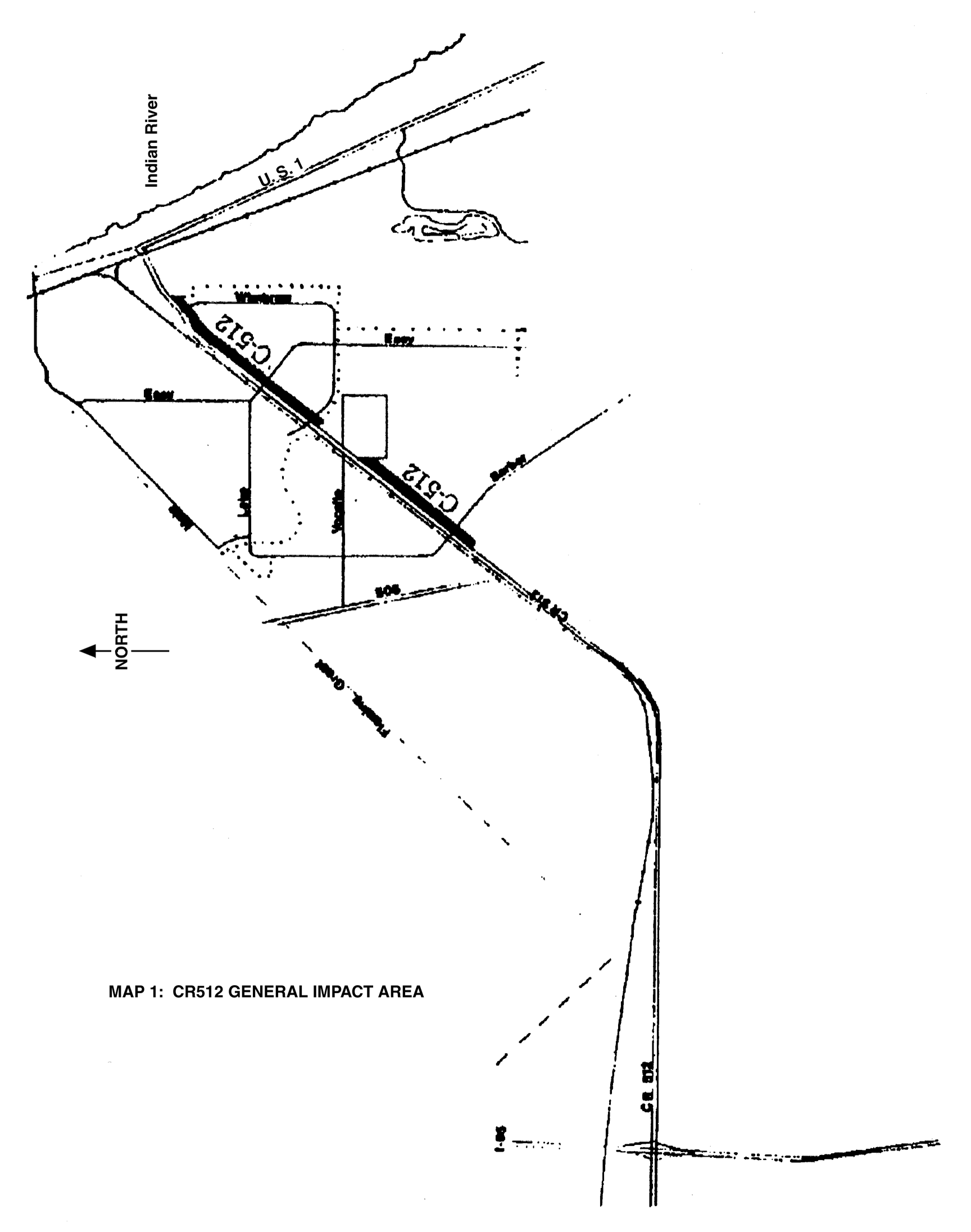
Map 1: CR512 GENERAL IMPACT AREA
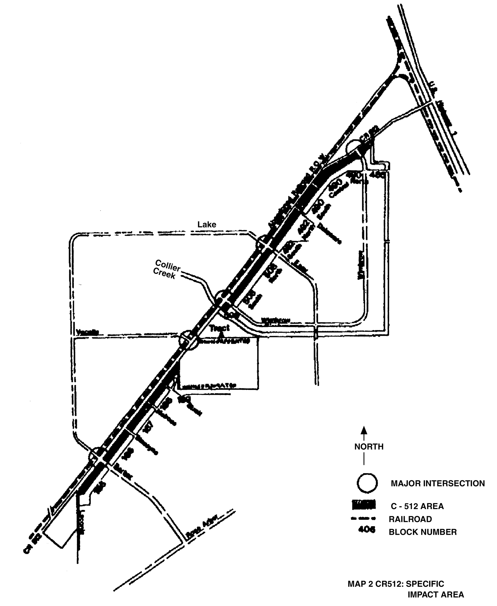
Map 2: CR512: SPECIFIC IMPACT AREA
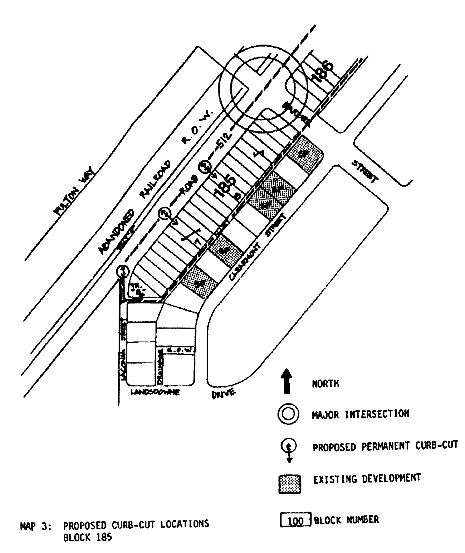
Map 3: Proposed Curb-Cut Locations, Block 185
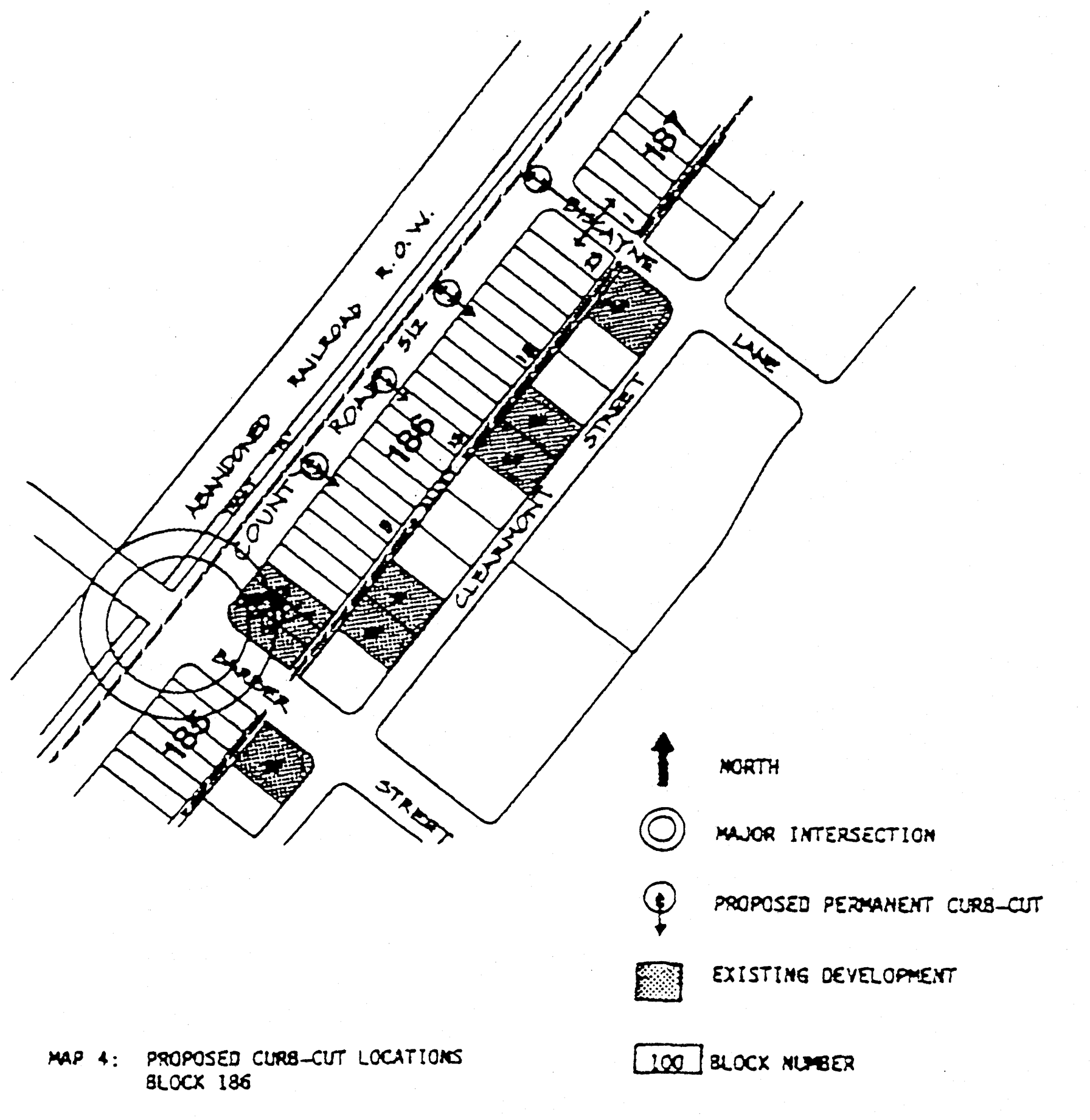
Map 4: Proposed Curb-Cut Locations, Block 186
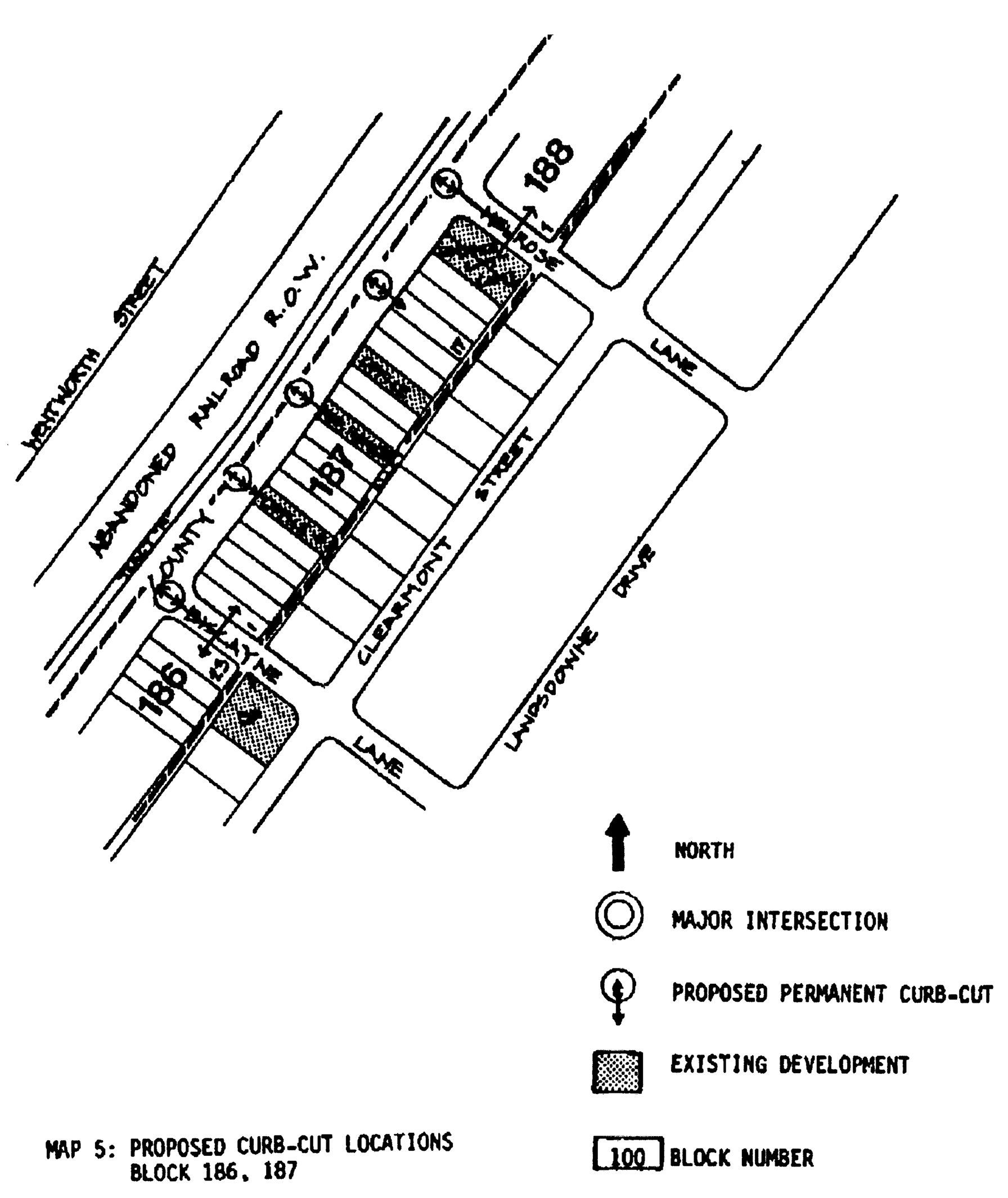
Map 5: Proposed Curb-Cut Locations, Block 186, 187
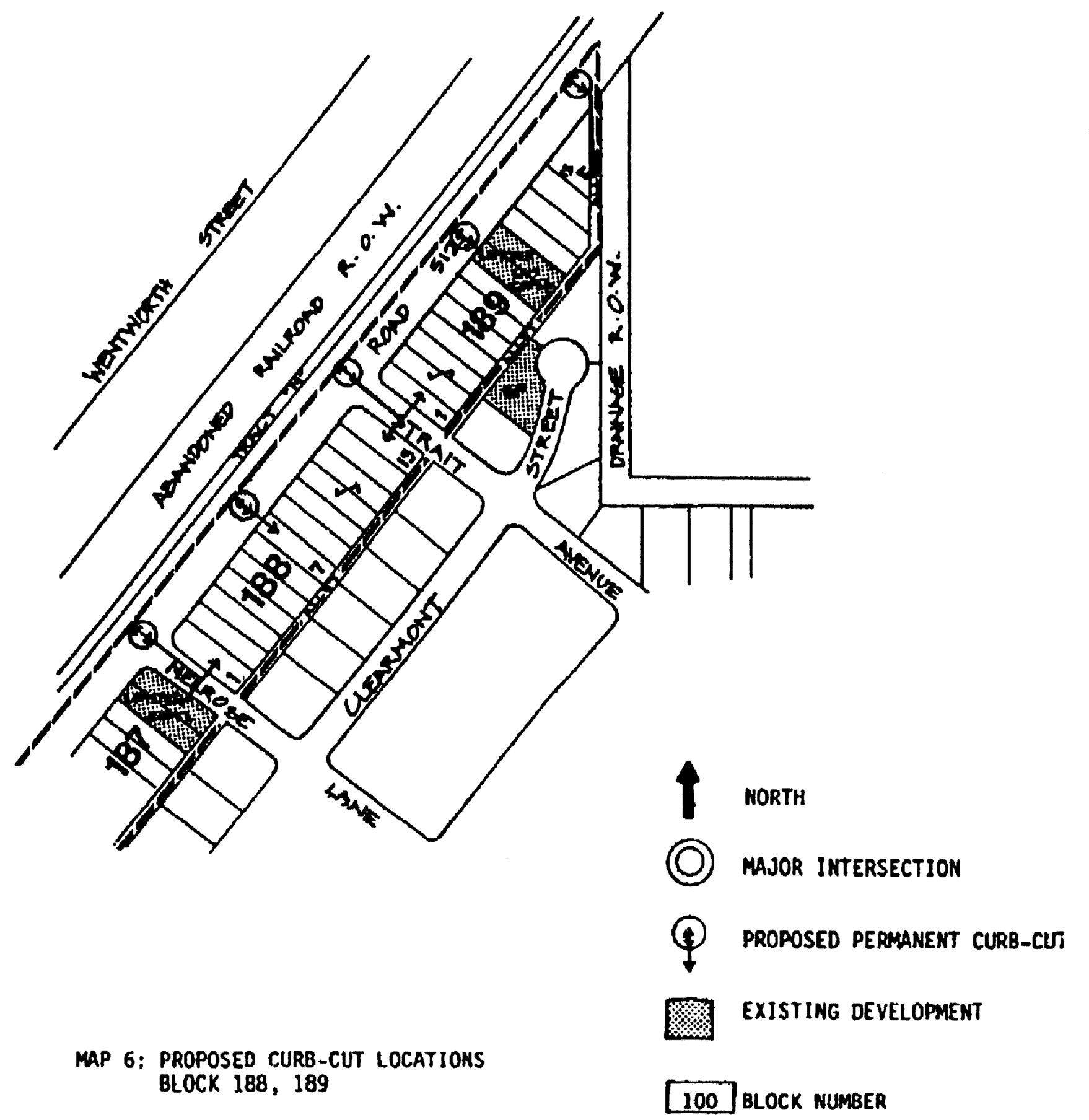
Map 6: Proposed Curb-Cut Locations, Block 188, 189
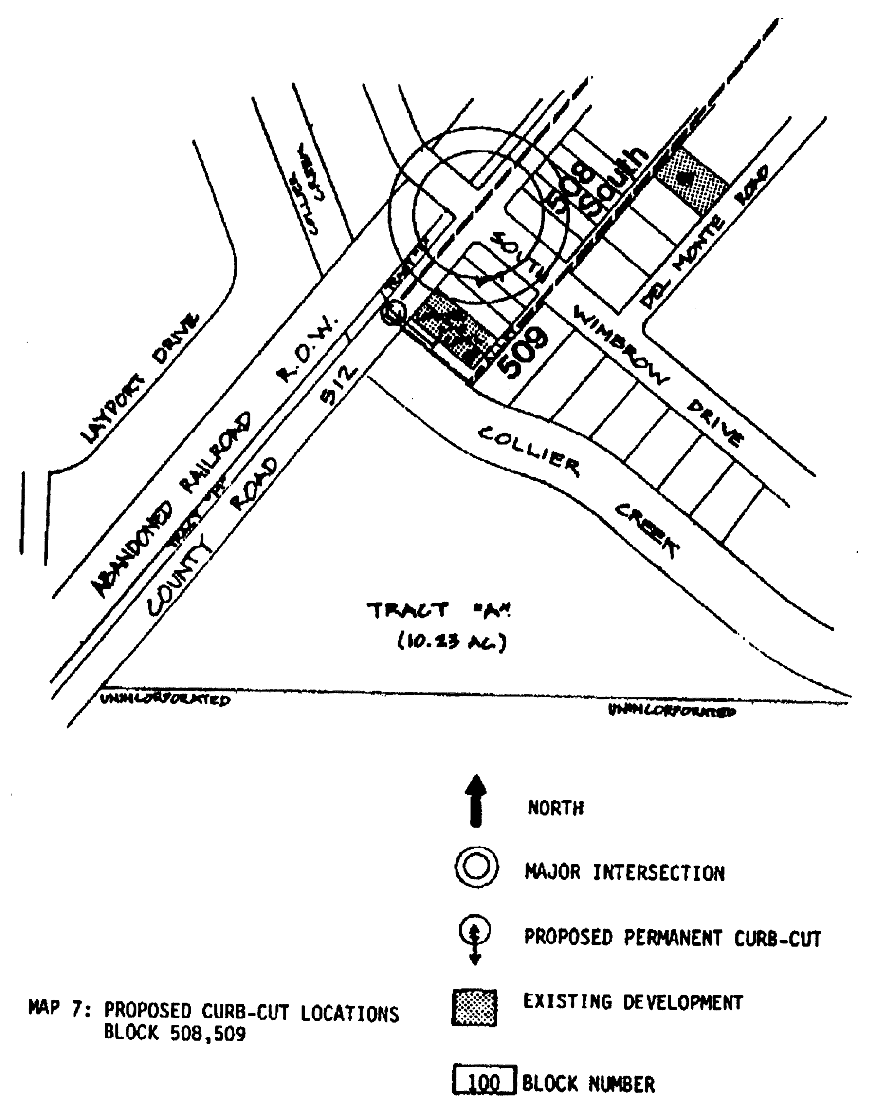
Map 7: Proposed Curb-Cut Locations, Block 508, 509
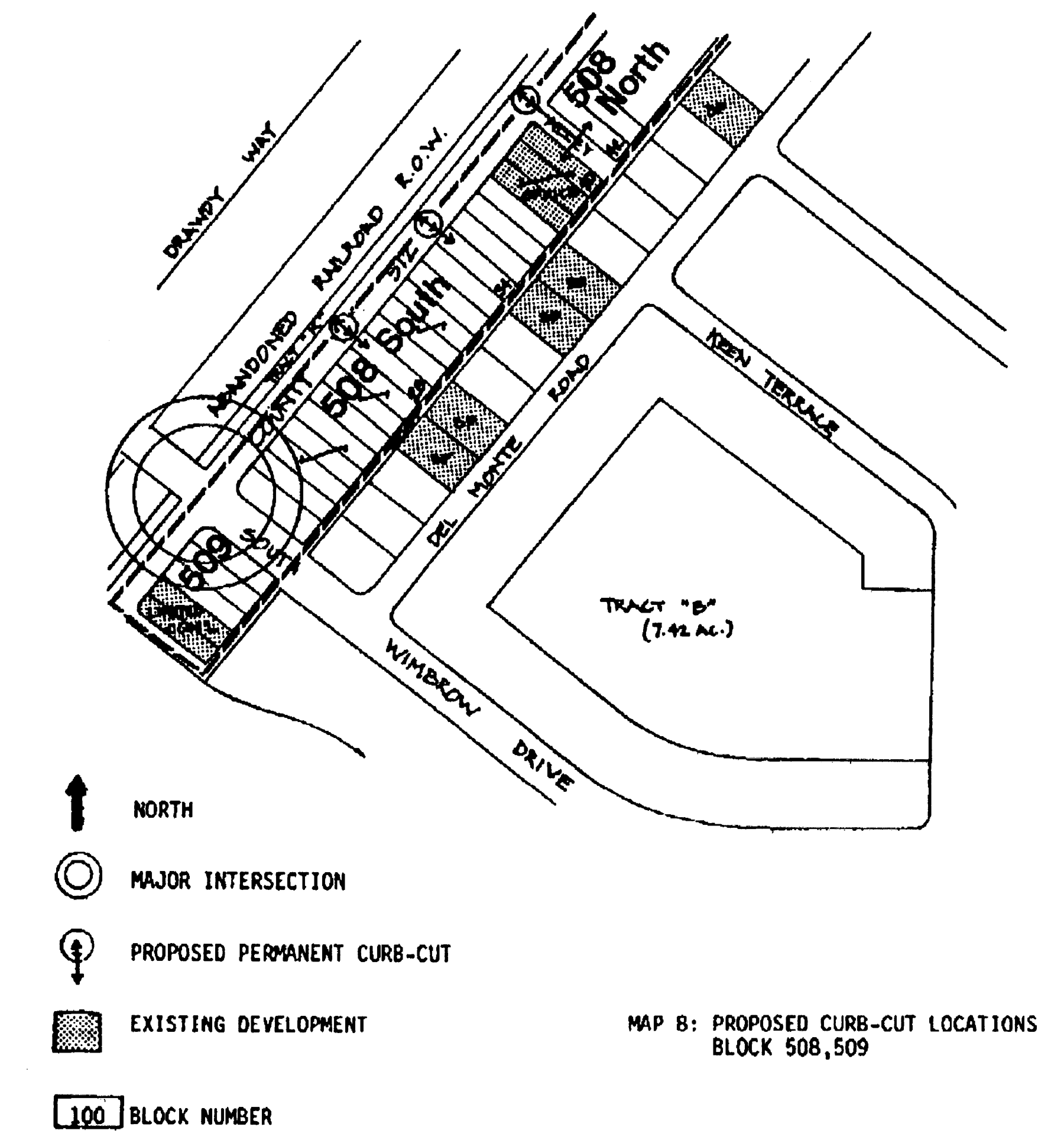
Map 8: Proposed Curb-Cut Locations, Block 508, 509
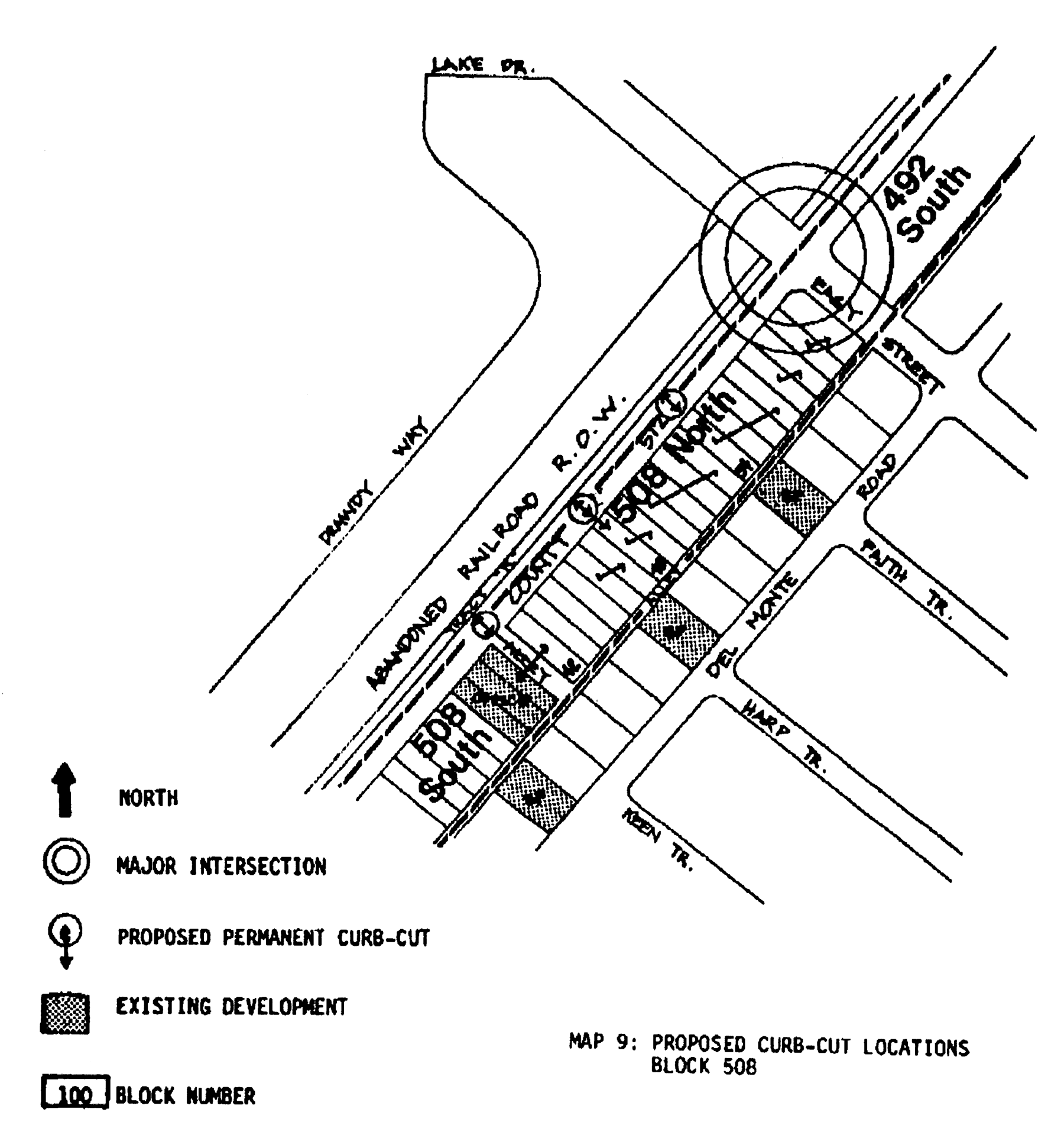
Map 9: Proposed Curb-Cut Locations, Block 508
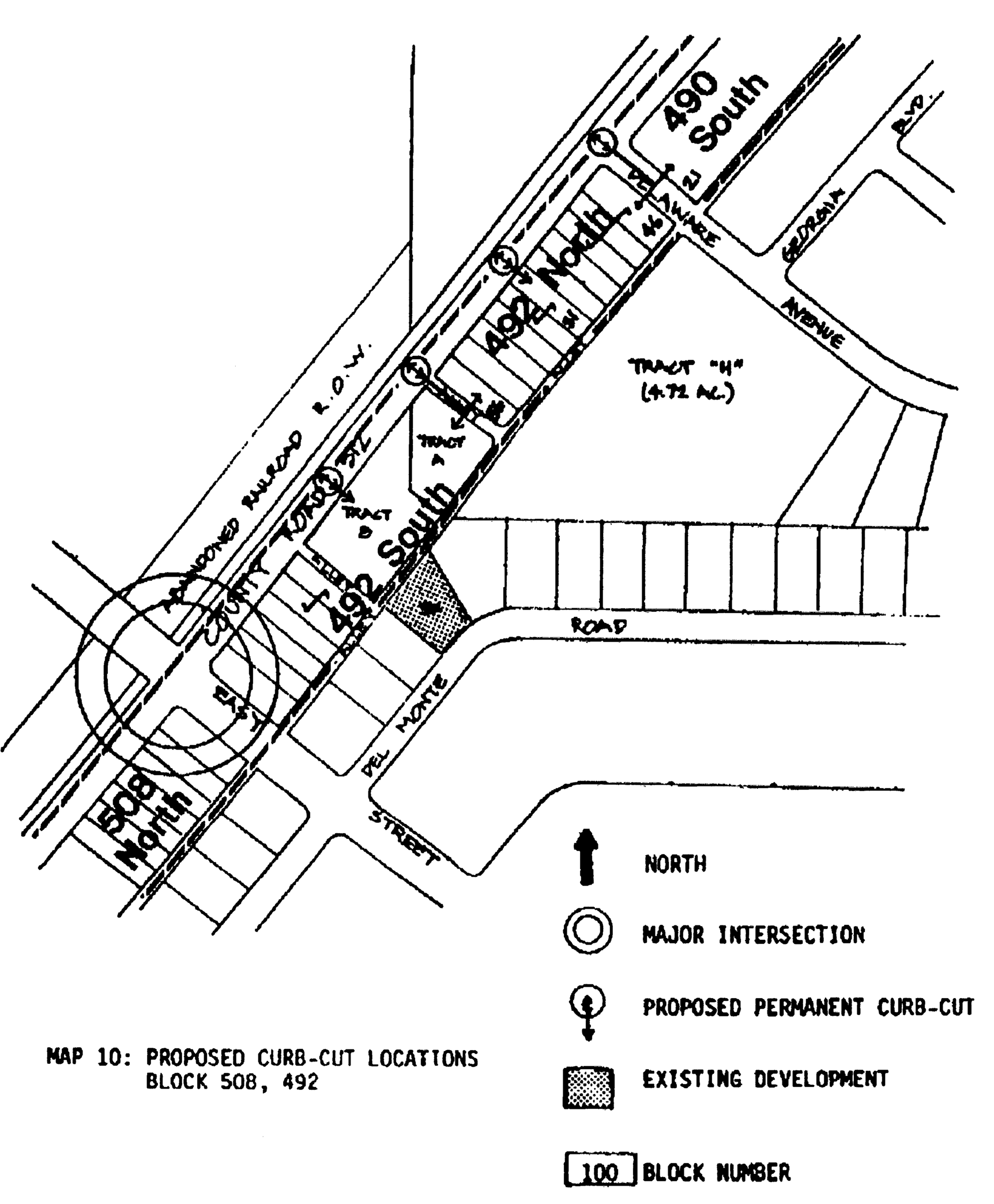
Map 10: Proposed Curb-Cut Locations, Block 508, 492
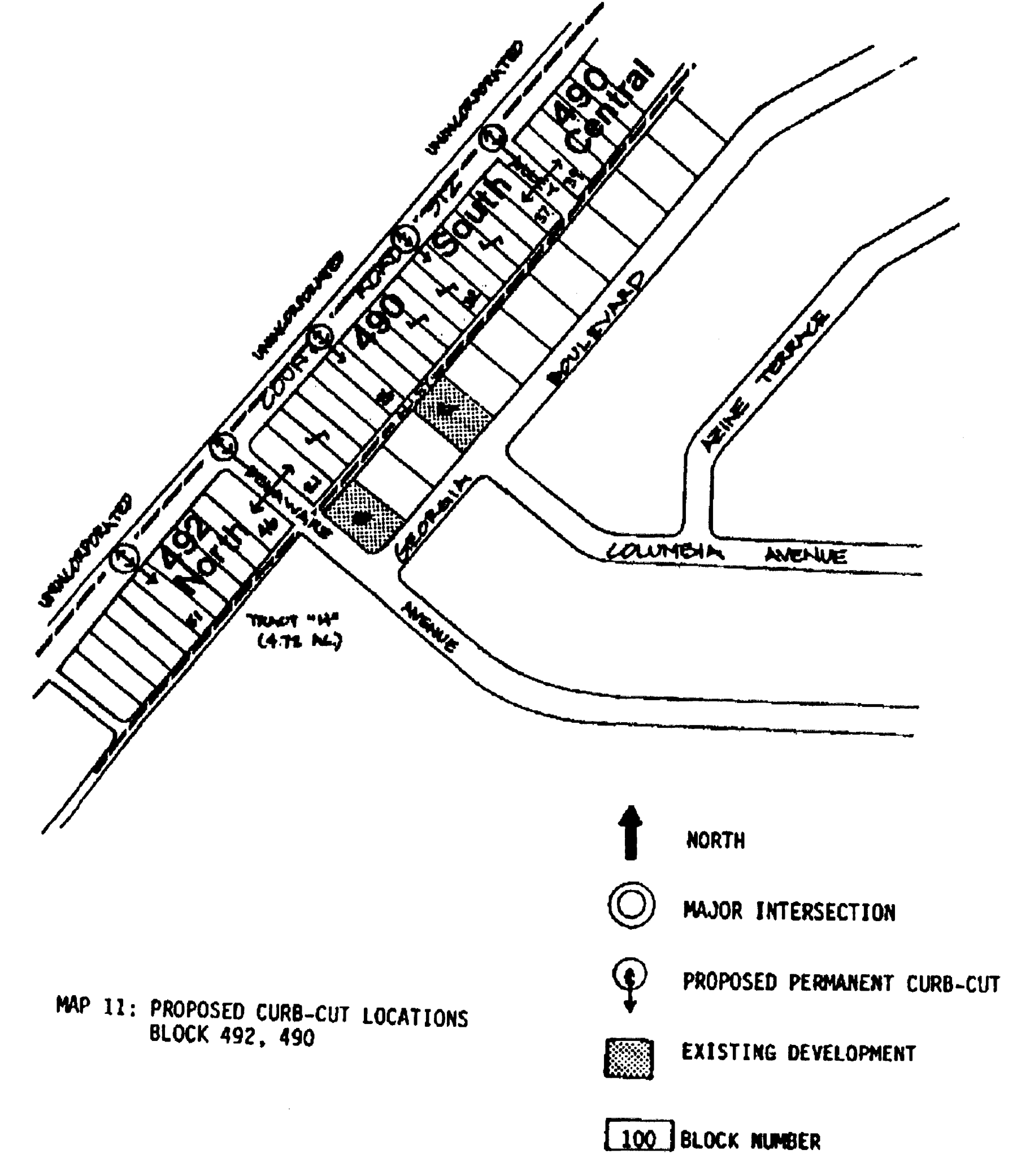
Map 11: Proposed Curb-Cut Locations, Block 492, 490
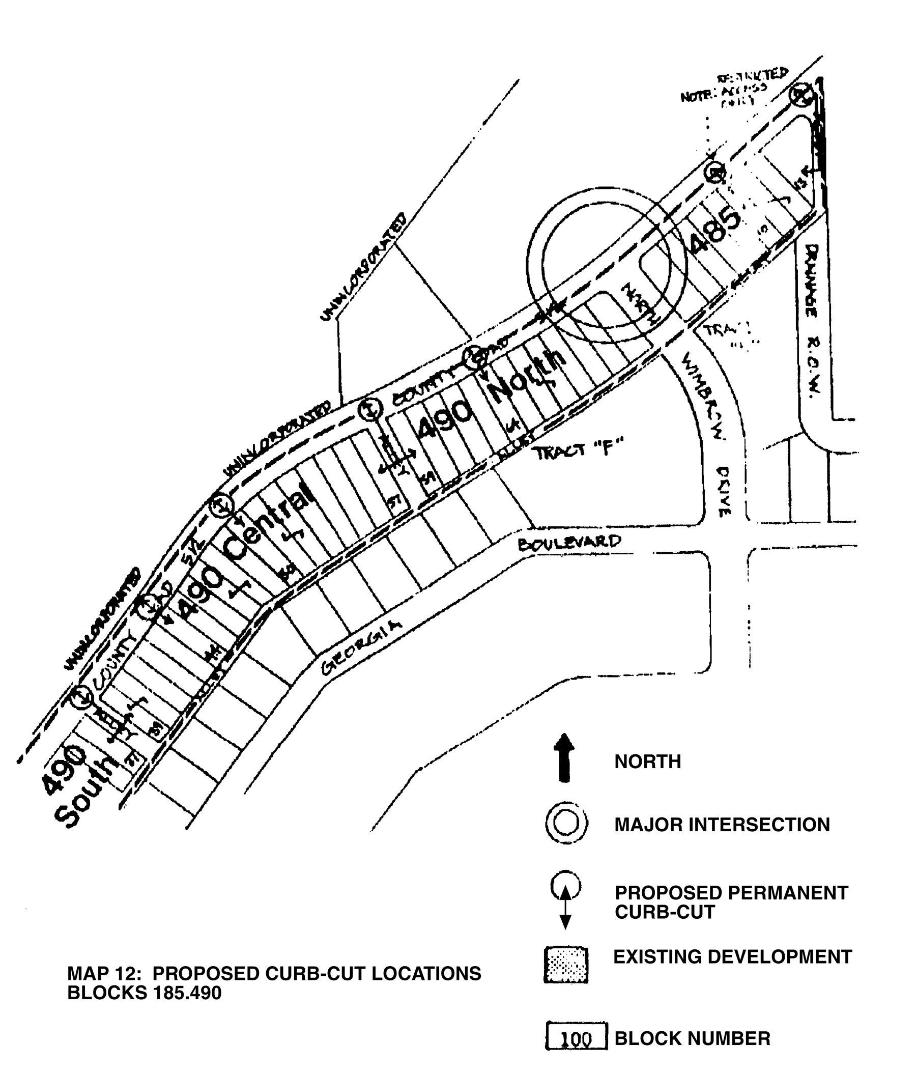
Map 12: Proposed Curb-Cut Locations, Blocks 185.490
Sec. 54-2-5.16. - Mixed-use zoning district.
The City of Sebastian recognizes the importance of compact, urban forms of development centered on a mix of uses, residential and nonresidential, with specific design and development related standards. The city's adopted comprehensive plan identifies recommended "mixed-use" neighborhoods, each with its own representative and unique standards. The provisions established within this section of the Code shall apply to all parcels designated on the zoning map as a mixed-use district.
Applicability. For the purpose of this section, nonresidential standards shall also include (apply to) multifamily developments. To ensure a mix of uses are developed, no more than 50 percent of the approved residential units may be constructed until at least 50 percent of the non-residential square footage is permitted through issuance of a building permit.
A.
Neighborhood Mixed-Use District (N-MU)
1)
Intent. The Mixed-Use District (MU) is intended to serve as the city's traditional town center that features areas of economic, entertainment and community activities that encourage pedestrian accessibility and activity. The district is intended to create a vibrant, active town center that features a mix of uses, residential and nonresidential while requiring specific design and development related standards.
Table 54-2-5.16.A: N-MU District Development Standards
2)
Compliance with the comprehensive plan and future land use map. The established district must comply with the provisions of the Sebastian Comprehensive Plan Policy 1-1.3.6.
3)
Location and size. The location and size vary on the use being developed. Residential uses shall have a minimum of 5 to 50 contiguous acres under a common ownership or lawfully documented control. Commercial and industrial uses shall have frontage or documented legal access on a primary arterial roadway, as designated on the City of Sebastian Major Thoroughfare Plan. At the time a commercial or industrial application is submitted and approved by the city the land included in the application shall have a minimum of 5 to 50 contiguous acres and shall be under unified control as required pursuant to section 54-4-20.1(b). Industrial uses shall meet the perimeter transition area provisions. The city may require additional buffer width, depending on placement and adjacent land uses.
4)
Permitted uses:
(a)
Residential:
Single-family dwellings
Duplex dwellings
Multifamily dwellings
Foster care/group homes with 6 or less residents
Home occupations
Townhouse development
Accessory residential uses
(b)
Commercial:
Business and professional offices, excluding drive-through facilities
Cultural or civic facilities
Medical services
Commercial retail ≤ 5,000 sq. ft.
Pharmacies
Medical marijuana dispensaries
Parking garages
Churches
Administrative services
Public and private plant nurseries
Commercial amusements, enclosed
Restaurants, excluding drive-through facilities
Trade and skilled services
(c)
Industrial:
Building materials, enclosed
Commercial amusements, enclosed.
Commercial wireless telecommunication facilities
Contractor trades
Equipment sales enclosed
Farmer's market
Fish markets and packing facilities
Industrial activities
Laboratories, research and development, and similar uses ≤ 5,000 sq. ft.
Marine supply and service
Parking garages
Plant nurseries
Sewage treatment plant
Trades and skilled services
Utilities, public and private
Vehicular sales enclosed
Warehousing, enclosed
Welding and machine shops
Wet/dry storage of boats
5)
Conditional uses permitted:
(a)
Residential:
Foster care/group homes with 6 or more residents
Child care services
Cultural or civic facilities
Schools, public or private
Golf courses and support facilities
Bed and breakfast
Nursing homes
Churches
Utilities, public and private
Parks and recreation, public
Protective and emergency services, public
Model homes
Accessory uses to conditional uses
(b)
Commercial.
Commercial retail > 5,000 sq. ft.
Gasoline sales, retail
Businesses and professional offices with drive-through facilities
Qualified affordable housing
Restaurants, with drive-through facilities
Veterinary services
Funeral homes
Accessory uses to conditional uses
(c)
Industrial.
Commercial amusements, unenclosed
Flea markets
Building materials, unenclosed
Equipment sales, unenclosed
B.
Community (C-MU) Mixed-Use District
1)
Intent. The Community Mixed-Use District (C-MU) allows for mixed-use developments featuring a mixture of residential and non-residential uses. C-MU's are intended to be larger in scale than other MU districts and focused on new development and the creation of new town centers in an integrated, master planned approach.
Table 54-2-5.16.B: C-MU District Development Standards
2)
Compliance with the comprehensive plan and future land use map. The established sub-district must comply with the provisions of the Sebastian Comprehensive Plan Policy 1-1.3.6.
3)
Location and size. The location and size vary on the use being developed. Residential uses shall have a minimum of 50 to 100 contiguous acres under a common ownership or otherwise lawfully designated control. Commercial and industrial uses shall have frontage or legal access to frontage on a primary arterial roadway. At the time a commercial or industrial application is submitted and approved by the city the land included in the application shall have a minimum of 50 to 100 contiguous acres and shall be under unified control as required pursuant to section 54-4-20.1(b). Industrial uses shall meet the perimeter transition area provisions. The city may require additional buffer width, depending on placement and adjacent land uses.
4)
Permitted uses:
(a)
Residential:
Single-family dwellings
Duplex dwellings
Multifamily dwellings
Foster care/group homes with 6 or less residents
Home occupations
Townhouse development
Accessory residential uses
(b)
Commercial:
Business and professional offices, excluding drive-through facilities
Cultural or civic facilities
Medical services
Commercial retail ≤ 5,000 sq. ft.
Pharmacies
Medical marijuana dispensaries
Parking garages
Churches
Administrative services
Public and private plant nurseries
Commercial amusements, enclosed
Restaurants, excluding drive-through facilities
Trade and skilled services
(c)
Industrial:
Bottling plants, dairy products plants, wholesale bakeries, fruit packing and similar uses
Building materials, unenclosed
Commercial amusements, enclosed
Commercial wireless telecommunication facilities
Contractor trades
Farmer's market
Fish markets and packing facilities
Gasoline and fuel stations
Industrial activities
Laboratory, research and development facilities, enclosed
Light manufacturing, processing and assembly
Marine power sales and service
Mini-storage facilities
Parking garages
Parking lots without building on the lot
Plant nurseries
Sewage treatment plant
Storage facilities
Trade and skilled services, including marine-related
Utilities, public and private
Vehicular sales and related services
Vehicular services and maintenance
Warehousing, enclosed
Welding and machine shop
Wet/dry storage of boats
Wholesale trade and services
5)
Conditional uses permitted:
(a)
Residential:
Foster care/group homes with 6 or more residents
Child care services
Cultural or civic facilities
Schools, public or private
Golf courses and support facilities
Bed and breakfast
Nursing homes
Churches
Utilities, public and private
Parks and recreation, public
Protective and emergency services, public
Model homes
Accessory uses to conditional uses
(b)
Commercial:
Commercial retail > 5,000 sq. ft.
Gasoline sales, retail
Businesses and professional offices with drive-through facilities
Qualified affordable housing
Restaurants with drive-through facilities
Veterinary services
Funeral homes
Accessory uses to conditional uses
(c)
Industrial:
Crematory
Equipment sales, unenclosed
Commercial amusements, unenclosed
Flea market
Protective and emergency services, public
C.
Regional Mixed-Use District
1)
Intent. The Regional Mixed-Use is intended to permit intense concentrations of retail, employment, and high-density residential uses through a mixed-use development which would allow for increased densities using mixed-use zoning district incentives and regulate development per the standards defined in the table below.
Table 54-2-5.16.C: R-MU District Development Standards
2)
Compliance with the comprehensive plan and future land use map. The established district must comply with the provisions of the Sebastian Comprehensive Plan Policy 1-1.3.6.
3)
Location and size. The location and size vary on the use being developed. Residential uses shall have a minimum of 100 contiguous acres under a common ownership or control. Commercial and industrial uses shall have frontage on a primary arterial roadway currently or as may be required. At the time a commercial or industrial application is submitted and approved by the city the land included in the application shall have a minimum of 100 contiguous acres and shall be under unified control as required pursuant to section 54-4-20.1(b). Industrial uses shall meet the perimeter transition area provisions. The city may require additional buffer width, depending on placement and adjacent land uses.
4)
Uses permitted:
(a)
Residential:
Single-family dwellings
Duplex dwellings
Multifamily dwellings
Foster care/group homes with 6 or less residents
Home occupations
Townhouse development
Accessory residential uses
(b)
Commercial:
Business and professional offices, excluding drive-through facilities
Cultural or civic facilities
Churches; places of worship
Medical services
Commercial retail > 5,000 sq. ft.
Pharmacies
Medical marijuana dispensaries
Parking garages
Administrative services, public and private
Plant nurseries
Commercial amusements, enclosed
Restaurants, excluding drive-through facilities
Trade and skilled services
(c)
Industrial:
Utilities, public and private
Gasoline and fuel stations
Crematory
Commercial amusements, enclosed & unenclosed
Storage facilities
Plant nurseries
Trade and skilled services, including marine-related
Wholesale trade and services
Farmer's market
Fish markets and packing facilities
Industrial activities
Parking garages
Parking lots without building on the lot
Vehicular services and maintenance
Marine power sales and service
Wet/dry storage of boats
Mini-storage facilities
Protective and emergency services, public
Bottling plants, dairy products plants, wholesale bakeries, fruit packing and similar uses
Building materials, unenclosed
Commercial wireless telecommunication facilities
Contractor trades
Laboratory, research and development facilities, enclosed
Light manufacturing, processing and assembly
Sewage treatment plant
Welding and machine shop
Recycling and materials recovery facilities
5)
Conditional uses permitted:
(a)
Residential:
Cultural or civic facilities
Schools, public or private
Golf courses and support facilities
Bed and breakfast
Churches
Utilities, public and private
Parks and recreation, public
Protective and emergency services, public
Model homes
Accessory uses to conditional uses
(b)
Commercial:
Businesses and professional offices with drive-through facilities
Gasoline sales, retail
Restaurants with drive-through facilities
Nursing homes
Veterinary services
Funeral homes
Accessory uses to conditional uses
Vehicular sales and related services
Flea market
Equipment sales, unenclosed
Warehousing, enclosed
(c)
Industrial:
Crematory
Equipment sales, unenclosed
Commercial amusements, unenclosed
Protective and emergency services, public
Flea market
D.
Requirements
1)
A Master Development Plan ("MDP") shall be provided that identifies the boundaries of the development. The MDP depicts the locations of the "Blocks" of development including the primary development focus for each block, proposed density(s) and intensity(s) for each use, internal roadways, external roadway connections and types, and generalized building types as identified in Table 54-2-5.16.D below. Additional information and or plans as may be required by the city include but not limited to Vehicular Circulation Plan (A), Pedestrian Connectivity Plan (B), Bicycle Connectivity Plan (C) and Multimodal Plan (D).
Table 54-2-5.16.D
E.
Additional compatibility mitigation; mixed-use districts
1)
Special considerations. This section provides a necessary tool and process to guide decision makers in review of compatibility for unique circumstances and development types and where there are requests to exceed or modify development standards. In these instances, the application of additional mitigation deemed necessary to ensure compatibility of the proposed development with surrounding properties may be required. Additional mitigation standards include, but are not limited to:
(a)
Lowering density and intensity.
(b)
Increasing building setbacks.
(c)
Adjusting building stepbacks (see section 54-2-5.16.F below).
(d)
Requiring tiered buildings.
(e)
Adjusting onsite improvements to mitigate lighting, noise, mechanical equipment, refuse and delivery and storage areas.
(f)
Adjusting road and driveway locations.
(g)
Increasing buffer types and/or elements of the buffer type.
F.
Building setback/stepback
1)
Where adjacent to a residentially zoned area and or buildings are taller than the by-right height a setback and or stepback shall be required. Applicants may request the use of either an additional setback or stepback, or both; however, approval shall be provided by the city council as part of the zoning request.
A building stepback is an architectural design element applied to the upper-story of a development and is required when a mixed-use district abuts a residential zoning district. Stepbacks are a step-like recession in a wall or façade which allows for more daylight to reach the street level and create a more open, inviting pedestrian environment. Stepbacks reduce the scale of a building, increasing views of surrounding areas and emphasizes the ground floor of a structure to allow increased emphasis on pedestrian considerations. Stepbacks may be required for stories or features above a certain permitted height within a zoning district, per that district's development standards table and may be used as an additional compatibility mitigation per this section. When one mixed-use district abuts another mixed-use district, no compatibility setback is required.
2)
Setback/stepback determination. If a stepback is not provided, the minimum setback from the property perimeter buffer shall be increased by adding one-half of the building height to the required buffer. Stepbacks shall be a minimum of 15' in width.
Figure 54-2-5.16.F: Stepback, Buffer, and Compatibility Setback
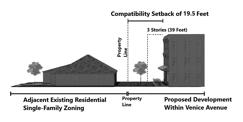
Figure 54-5-2.16.F.2: Stepback
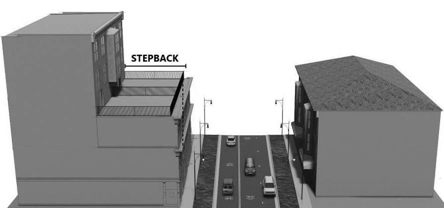
G.
Mixed-use zoning district incentive
1)
Generally. To promote development and redevelopment of mixed-use zoning districts, incentives may be applied to buildings and developments which qualify based upon the criteria of this section. To encourage certain public benefits and create a more dynamic public realm, density bonuses may be permitted for the items defined below. Providing 3 of 4 of the incentive categories listed in this section shall permit development at 50 percent of the maximum density bonus through incentives. Providing 4 of 6 of the incentive categories listed in this section shall permit development at 100 percent of the maximum density bonus through incentives.
Incentives defined:
(a)
Adaptive reuse of existing building(s).
(b)
15 percent affordable housing (at or below 100 percent Area Median Income—AMI).
(c)
25 percent of parking designated for as publicly accessible.
(d)
Increase of active use area/publicly accessible open space in the form of a public plaza or similar medium open space size type.
(e)
Streetscape enhancements along the length of the primary street including:
1.
Street trees based on 40 feet O.C.
2.
Increased width/landscape verge to a minimum eight feet.
3.
Shade structures.
4.
Street furnishings including but not limited to benches, decorative lighting or similar.
(f)
Providing three or more uses (i.e., commercial, office, residential, industrial, etc.). with no single use occupying less than 20 percent of the gross area of the project.
2)
Priority land use incentives. Priority land uses are recognized from the city's comprehensive plan and designated mixed-use land use designations and represent a community vision for a desired land use within a mixed-use zoning district. A mixed-use zoning district may recognize priority land uses and offer density incentives to implement priority land uses within a vertical or horizontal mixture of uses in a building or development. To qualify for this incentive, each building or development must include at least two priority land uses, each of which shall be at least 25 percent of the total.
H.
Mixed-use zoning open space
1)
Mixed-use zoning districts. All new development subject to this section within mixed-use districts as defined in section 5: Mixed-use zoning districts, shall require a minimum of 15 percent open space of the total development size. The required 15 percent open space shall also comply with the following additional standards:
(a)
Less than 25 acres. For mixed-use developments less than 25 acres, required open space shall include at least two small open space types, as defined in section 54-2-5.16.H.A.
(b)
25—50 acres. For mixed-use developments greater than 25 acres, but less than 50 acres in size, required open space shall include at least two small open space types and one medium open space type, as defined in section 54-2-5.16.H.A.
(c)
Greater than 50 acres. For mixed-use developments greater than 50 acres in size, required open space shall include at least three small open space types and two medium open space types, as defined in section 54-2-5.16.H.A. Alternatively, three small open space types may be substituted for one medium open space type, however all percentage requirements shall be met.
Table 54-2-5.16.H: Open Space Sizes
2)
Open space types. In addition to different sizes, open space may take different forms, dependent upon both the nature of the development and the land in which it is established. Because of their nature, open space types may be considered more than a single open space size (i.e., an open space type may be considered both a small and medium open space size). Open space includes the following open space types, as defined below:
(a)
Small open space
1.
Pocket park. Pocket parks are defined as a small open space. Pocket parks are primarily intended to provide small active or passive recreation opportunities and act as a gathering space for residents or customers. Features may include small shade structures, gazebos, seating areas, multi-purpose lawn space, playgrounds, community gardens, dog parks, trails, or natural elements such as a stream or pond.
(b)
Medium open space
1.
Amenity center. Amenity centers are defined as small or medium open spaces and include a combination of enclosed and open areas. Amenity centers provide recreational opportunities and are typically included in residential developments. Amenity centers may include features such as pools, splash pads, clubhouse, small scale recreational facilities such as pickleball, soccer, or shuffleboard, lawn games, and pavilions. Pavilions associated with an amenity center are open air structures that typically allow for shade, outdoor concerts, exhibits, and other activities commonly associated with neighborhood events. Designs of amenity centers and pavilions should be similar in architecture and material as the residential development.
2.
Green. Greens are defined as small or medium open spaces. Greens provides more informal, natural spaces supporting active or passive recreation opportunities. Greens are typically bounded by rights-of-ways and the fronts of buildings. Greens may provide features such as multi-purpose lawn space, lawn games, playgrounds or play spaces, and limited small scale recreational facilities such as pickleball or soccer.
3.
Plaza. Plazas are defined as small or medium open spaces. Plazas serve as a gathering place for civic, social, and commercial purposes. A plaza may contain a greater amount of impervious coverage than any other open space type. Plazas are typically located in the front or sides of a building or group of buildings and may not be located in the rear of the building or property. Pedestrian features such as shade structures, benches, tables, fountains, and public art are required.
4.
Square. Squares are defined as small or medium open spaces. Squares serve as a more formal open space type for gathering for civic, social, and commercial purposes. Squares are typically bordered on all sides by a vehicular right-of-way (public and private), which, together with building frontages, creates a definition and boundary. Features may include seating areas, pedestrian facilities, play areas, shade structures, gazebos, seating areas, playgrounds, public art, statues, and monuments.
(c)
Large open space
1.
Linear park. Linear parks are defined as medium or large open spaces. Linear parks may be formalized based on function (i.e., provide multimodal or connectivity opportunities). Linear parks typically take advantage of scenic environmental attributes and follow a natural feature including but not limited to a stream, wetland system, or man-made feature natural feature. Features may include natural environmental features such as streams, benches, picnic tables, lawn games, and shade structures.
2.
Neighborhood park. Neighborhood parks are defined as medium or large open spaces. Neighborhood parks are intended to be a substantial component of a development and provide formal or informal active and passive recreational activities opportunities. Neighborhood parks typically serve as a medium or large open space area for residential subdivisions, planned developments, and mixed-use centers.
(d)
Open space design standards. The design and incorporation of open space in a development shall comply with the following standards:
1.
Distribution. Open space shall be, to the maximum amount practicable with respect to environmental considerations and subdivision design, evenly distributed throughout the development.
2.
Distance. No two open space types shall be adjacent or within one-quarter-mile radius of another open space, where practical.
3.
Frontage. All open space shall have at least 50 feet of frontage on at least one public street within the development in which the open space resides.
4.
Consolidation. Required open space requirements shall not be consolidated to meet the standards of this section. It is the intent of this section to require multiple open space types of varying sizes in each development per section 54-2-5.16.H.1: Open Space Percentage Requirements.
5.
Active and passive features. A minimum of 25 percent of all required open space shall be dedicated and designed to allow for active recreation features. Active recreation and passive features are identified in Table 54-2-5.16.H.2 below. Table 54-2-5.16.H.2 includes, but is not be limited to, those features identified. The city may administratively approve similar features which keep with the intent of the listed active or passive recreation features.
a.
Active recreation is defined as recreational features, often requiring equipment and taking place at prescribed places, sites or fields, which allow for the active recreational needs of residents or users of the development which they serve.
b.
Passive recreation is defined as recreational features that do not require prepared facilities like sports fields or pavilions and require minimal disruption to a site. These include such activities as walking paths and other features defined in Table 54-2-5.16.H.2.
Table 54-2-5.16.H.2: Active and Passive Features
I.
Non-residential building design standards
1)
Intent and applicability. Non-residential design standards are additional standards intended to supplement the required zoning district development standards and specific use standards.
2)
Generally. Buildings are an integral component of the development for non-residential developments. Buildings set mass, scale, and help define patterns of development. Building designs within the city should complement one another through color, design and building materials. Buildings are not required to use the same components, but shall provide features that reflect their surroundings.
3)
Standards. Building design standards for non-residential buildings shall:
(a)
Promote and enhance pedestrian scale.
(b)
Feature appropriate levels of building articulation, transparency, and design elements.
(c)
Limit undesirable design elements and promote desirable design elements.
(d)
Screen loading and delivery areas and mechanical use areas, including those on roofs.
(e)
Position primary entrance of a building toward a street or civic space area.
4)
Prohibited design elements. The following design elements, which do not promote high quality development or redevelopment, are prohibited:
(a)
Large, monotonous, unarticulated blank wall surfaces.
(b)
Exposed and untreated block walls.
(c)
Chain link fences and barbed wires.
(d)
Mirror window glazing.
(e)
False fronts.
(f)
Loading bays or loading doors.
(g)
Lack of architectural features.
(h)
Lack of change in materials.
5)
Required design elements. The following design elements, which promote a high-quality development or redevelopment, are required for all buildings subject to this section 54-2-5.16.I:
(a)
Consistent architectural style, detail and trim.
(b)
Facades which break down large elements of mass and scale where appropriate.
(c)
Architectural details and articulation.
(d)
Material changes reflective of function and appropriately placed.
(e)
Canopies, porches, stoops, roof overhangs or other pedestrian friendly features.
(f)
Shade and weather protection for ground floor entrances.
(g)
Design elements such as cornice lines, columns, arches.
(h)
Various fenestration and transparency elements.
6)
Building form. Building form design shall take into account mass, scale, and articulation. Box-like building forms, with little to no variety in design, which do not take into account required design elements, are prohibited.
(a)
Required facade design requirements. Building facades shall be designed with a consistent architectural style, detail, and trim features. Figure 54-2-5.16.I.2 and 54-2-5.16.I.3. demonstrates illustrative examples of facades that feature various required design elements. Facades shall also conform to the following standards:
1.
Vertical mass. The vertical mass of multistory buildings shall be visually broken at each story with architectural detail and articulation of at least one foot in the vertical direction, which is illustrated as "A" in Figure 54-2-5.16.I.2 and 54-2-5.16.I.3.
2.
Roof lines. Multiple roof line heights are required per the standards of this Section. It is encouraged to utilize recesses and projections between 10-30 (10-30) feet to provide public gathering and open places, which is illustrated as "B" in 54-2-5.16.I.2 and 54-2-5.16.I.3.
3.
Horizontal mass. Building facades which face a street or public space shall not exceed a linear distance of 35 feet without the introduction of a physical articulation no less than one foot wide and extending in a horizontal direction along the facade, which is illustrated as "C" in Figure 54-2-5.16.I.2 and 54-2-5.16.I.3.
4.
Wall offsets. Facades of 60 or greater feet in width shall incorporate wall offsets of at least one foot of depth a minimum of every 40 feet, which is illustrated as "D" in Figure 54-2-5.16.I.2 and 54-2-5.16.I.3.
Figure 54-2-5.16.I.2: Required Facade Design Elements Example
(b)
Transparency. Building facades shall be designed to have a minimum transparency, through the use of windows and doors, on ground floor and upper floors as illustrated in Figure 54-2-5.16.H.2: Transparency. Transparency applies to all sides of a buildings facing a public or private street. Transparency shall not be required for service areas, loading/unloading areas, or those areas not visible from the public or private street.
1.
Ground floor transparency. Ground floor transparency shall be calculated based on the total facade area located between the finished ground floor level and beginning of the upper floor. All ground floor transparency shall be a minimum 35 percent, unless otherwise provided in this Code.
2.
Upper floor transparency. Upper floor transparency is calculated based on total facade area located between the surface of any floor to the surface of the floor above it. If there is no floor above, then the measurement shall be taken from the surface of the floor to the top of the wall plate. All upper floor transparency shall be a minimum 30 percent, unless otherwise provided in this Code.
Figure 54-2-5.16.I.3: Transparency
(c)
Blank wall area. Blank wall area is an undesirable design feature and shall be limited as follows. Blank wall area standards shall apply to the front and sides of buildings or any portion of a building fronting a residential area or public or private street, and shall comply with the standards below:
1.
Blank wall area refers to the portions of an exterior facade that do not include windows, doors, columns, pilasters, architectural features greater than one foot in depth, or a substantial material change. Blank wall area is illustrated in Figure 54-2-5.16.H.3: Blank Wall Area.
2.
Paint shall not be considered a substantial material change.
3.
Blank wall area applies in both a vertical and horizontal direction of the building facade and applies to ground floors and upper floors.
4.
The maximum continuous blank wall area shall be a maximum 35 square feet without a break by windows, doors, architectural features greater than one foot in depth, or a substantial material change.
5.
Except as otherwise regulated, the maximum permitted blank wall length for the rear of buildings shall be 100 feet, or 25 percent of the building length, whichever is less. Alternatively, where the facade faces adjacent residential uses or a major arterial and or I-95 an earthen berm shall be installed. The berm shall be no less than six feet in height, containing at a minimum a double row of evergreen or deciduous trees, planted at intervals of 15 feet on center. This alternative is not intended for installation along frontage roads.
Figure 54-2-5.16.I.4: Blank Wall Area
(d)
Outparcel buildings. Outparcel buildings, also referred to as liner buildings, are buildings located in front of other buildings along a street within the same development.
1.
Outparcel buildings may be permitted within mixed-use zoning districts.
2.
Outparcel buildings shall include a consistent level of architectural detail on all sides of the building and consist of similar exterior materials and compatible colors of the primary building in the development.
3.
Outparcel buildings, to the maximum extent practicable, shall be clustered along the street in order to define street edges, entry points and promote a pedestrian scale along the public street.
Figure 54-2-5.16.I.5: Outparcel Buildings
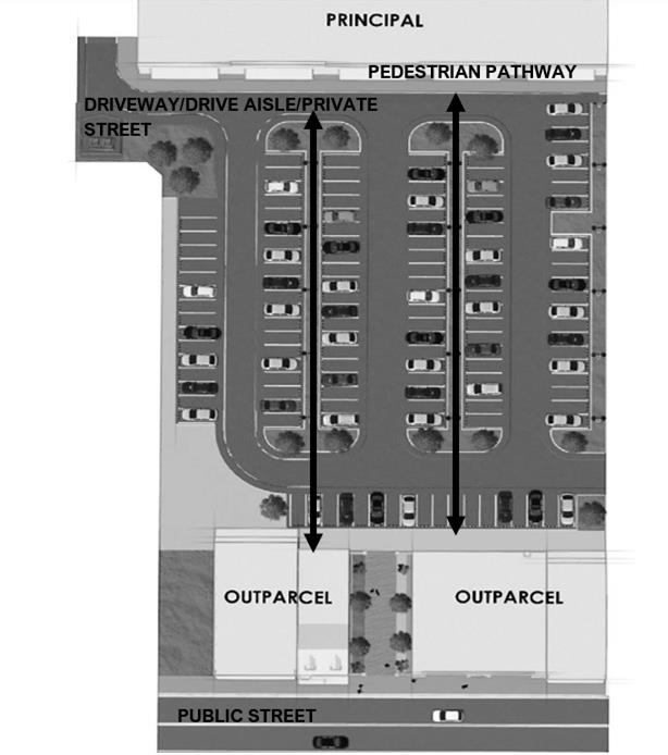
Figure 54-2-5.16.I.5.2: Outparcel Buildings
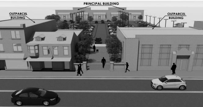
(e)
Minimum design items. A minimum of four design items shall be utilized in the development of building design; however, it is encouraged to use more. Figure 54-2-5.16.H.6: Minimum Design Items illustrates code compliant minimum design items. The following design items may be chosen to fulfill the minimum requirement:
1.
A change in plane, such as a projection or recess which shall be a minimum of 12 inches and include such features as columns, arches, planters, voids, etc.
2.
Architectural details including cornices or similar details with relief elements.
3.
Awnings, canopies, arcades, porches, stoops or balconies and similar weather/sun cover features over public entrances.
4.
Complementary change in materials or texture, which may include the use of a building "base" which is defined as an area extending along the bottom of the building to a height of between 30 inches and 48 inches; can include the use of stacked stone, brick, or similar materials.
5.
Complementary change in color.
6.
Doors and windows fronting the public street shall include visually prominent sills, shutters, or other such forms of framing.
7.
Ornamental and structural architectural details that are integrated into the overall design of the building, such as ironwork.
8.
Parapet height transitions, vertical pilasters, and other similar treatments to soften scale of a building.
9.
Differing building setbacks or projections to help vary the plane of a building.
10.
Active use areas.
11.
Other design items to be approved by the city.
Figure 54-2-5.16.H.6: Minimum Design Items
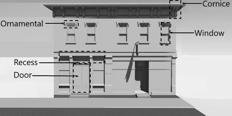
J.
Multifamily design standards
1)
Intent and applicability. Multifamily design standards are additional standards intended to supplement the required zoning district development standards and specific use standards provided in this code. These design standards shall be required for all new multifamily structures (including triplexes and quadplexes) and developments. Single family and duplex buildings and uses, including townhouse/attached single family, are exempt from these standards.
2)
Standards. Multifamily design standards are intended to:
(a)
Promote and enhance pedestrian scale.
(b)
Feature appropriate levels of building articulation, transparency, and design elements.
(c)
Limit undesirable design elements and promote desirable design elements.
(d)
Screen loading and delivery areas and mechanical use areas, including roof top equipment.
(e)
Position the primary entrance of a building toward a street.
3)
Prohibited design elements. The following design elements, which do not promote high quality development or redevelopment, are prohibited:
(a)
Large, monotonous, unarticulated blank wall surfaces.
(b)
Exposed and untreated block walls.
(c)
Lack of architectural features.
(d)
Lack of change in materials.
4)
Required design elements. The following design elements, which promote a high-quality development or redevelopment, are required for all multifamily buildings subject to this section:
(a)
Consistent architectural style, detail and trim.
(b)
Facades which break down large elements of mass and scale where appropriate.
(c)
Architectural details and articulation.
(d)
Material changes reflective of function and appropriately placed.
(e)
Canopies, porches, stoops, roof overhangs.
(f)
Shade and weather protection for ground floor entrances.
(g)
Design elements such as cornice lines, columns, arches.
(h)
Various fenestration and transparency elements.
5)
Building orientation and placement. The following building orientation and placement features are required for all multifamily buildings subject to this section.
(a)
Multifamily buildings which abut streets shall be required to be oriented parallel to the street.
(b)
Multifamily buildings shall not be oriented at an angle to the street.
(c)
Developments with several multifamily buildings shall cluster buildings along streets or internal rights-of-way to allow for enhanced open space and recreation areas within the area of the development.
(d)
Developments with several multifamily buildings shall ensure no more than 60 percent of the off-street parking area for the entire property is located between the front facade within the front yard of the principal building(s) and the primary abutting street unless the principal building(s) and parking lots are screened from view by outparcel development.
6)
Building facades. Building form design shall take into account mass, scale, and articulation. Building facades shall be designed with a consistent architectural style, detail, and trim features. Facades which face a street shall include at minimum four of the following elements.
(a)
A change in plane, such as an offset, reveal or projecting rib. Such plane projections or recesses shall have a width of no less than six inches (columns, planters, arches, voids, etc.).
(b)
Architectural details such as raised bands and cornices.
(c)
Integrated planters that utilize landscaped areas for decorative details.
(d)
Awnings or arcades.
(e)
Covered porches, terraces, lanais, or balconies intended for private use by residents of the multifamily structure.
(f)
Shutters.
(g)
Pillars or posts.
(h)
Bay windows.
(i)
Roof eaves of at least three inch wide trim.
(j)
Complementary change in color.
(k)
Complementary change in material/texture.
7)
Transparency. Building facades shall be designed to have a minimum transparency, through the use of windows and doors, on ground floor and upper floors. Transparency standards shall apply to all sides of a buildings facing any public or private street. Transparency shall not be required for service areas, loading/unloading areas, or those areas not visible from the public or private street. The minimum transparency for multifamily buildings is 30 percent unless otherwise provided in this LDR.
8)
Blank wall/articulation standards. Blank wall area is an undesirable design feature and shall be limited as set forth herein. Blank wall area standards shall apply to the front and sides of buildings or any portion of a building fronting a residential area or public or private street, and shall comply with the following standards:
(a)
Blank wall area shall be understood to refer to portions of an exterior facade that does not include windows, doors, columns, pilasters, architectural features greater than one foot in depth, or a substantial material change.
(b)
Paint shall not be considered a substantial material change.
(c)
Blank wall area applies in both a vertical and horizontal direction of the building facade and applies to ground floors and upper floors.
(d)
The maximum continuous blank wall area shall be a maximum 35 square feet without a break by windows, doors, architectural features greater than one foot in depth, or a substantial material change.
(e)
Except as otherwise provided in this LDR, the maximum permitted blank wall length for the rear of buildings shall be 100 feet, or 25 percent of the building length, whichever is less. Alternatively, where the facade faces adjacent residential uses, an earthen berm shall be installed. The berm shall be no less than six feet in height, containing at a minimum a double row of evergreen or deciduous trees, planted at intervals of 15 feet on center. This alternative is not intended for installation along frontage roads.
9)
Entrances. The entrances of a residence along the front facade of a multifamily building are the most highly designed side of a building. A primary facade and main building entry shall face the right-of-way, and additional entrances should face local streets, parking lots, plazas, and adjacent buildings to the extent possible. Buildings adjacent to public rights-of-way shall have at least one entrance providing access to the right-of-way. This entrance shall remain in operation and not be closed off to residents. Separate entrances to upper story units shall be prohibited from being visible street rights-of-way. All multifamily development and redevelopment shall provide no less than four of the following items for building entrances.
(a)
A change in plane indicating a building entrance.
(b)
Building wall projection.
(c)
Recess of entry at least three feet.
(d)
Architectural features and fenestration.
(e)
Variety in color, material, texture orienting pedestrians to the building entrance
(f)
Covered entries including awnings, arcade, or eave.
(g)
Windows.
(h)
Porches.
(i)
Arches, columns, stoops, cornices.
10)
Porches/balconies.
(a)
Porches, including covered porches, stoops, awnings, and bay windows and wings may only extend into the front yard up to five feet. Encroachments may be permitted up to 50 percent of the total length of the respective facade.
(b)
Balconies shall project or recess a minimum of two feet from the facade.
11)
Accessory structures. All accessory structures for multifamily buildings and developments shall comply with the following standards.
(a)
Garages, carports, or covered parking areas shall be provided from local streets or alleys. Entrances to parking garages are exempt from this standard and may be accessed from street rights-of-way, alleys or internal courtyards or accesses.
(b)
Accessory structures shall have similar exterior materials, colors, and roof forms as the principal structure.
12)
Miscellaneous requirements.
(a)
All utility equipment (including meters and conduits) attached to a building shall be painted to match the primary surface color of the wall on which it is attached, painted to match accent colors used on the facade, or be blocked from view (where practicable) through the use of landscaping or screens.
(b)
Refuse collection areas shall be distributed evenly throughout multiple building multifamily developments.
(c)
Roofing materials should complement the color and texture of the building facade.
K.
Industrial building design standards
Design standards. Due to the nature of industrial uses and their locations, limited design standards are required for buildings housing industrial uses. Only the following design standards are required for buildings used for industrial uses as defined in this Code
1)
Industrial building facades. Industrial building facades in any district shall include the following.
(a)
Include windows and pedestrian features such as roof overhangs over identifiable public entrances to the building. Public entrances should be well defined through the use of projections, recesses, roof structures (such as overhangs or canopies) and other similar design elements.
(b)
Be faced in a compatible and consistent manner for any elevations fronting on a public or private street or where visible from an existing right-of-way.
(c)
Blank wall length. Maximum permitted blank wall length for industrial buildings shall be 100 feet, or 25 percent of the building length, whichever is greater.
(d)
Lighting. Industrial use buildings and required parking areas shall not exceed a maximum 30 feet fixture height and one-half foot-candle intensity.
(e)
Equipment and loading areas. Equipment and loading areas shall comply with the following standards:
(f)
All building roofs are to be uncluttered; cooling towers, HVAC and ventilation fans, mechanical units, etc., should be either screened using a pitched roof facade or parapets, or constructed adjacent to the building and properly screened from view by either landscaping or the use of similar building materials.
(g)
Ground-mounted equipment and mechanical equipment visible from a public right-of-way shall be screened from view by an opaque wall, landscaping, or a combination thereof.
(h)
Except where regulated otherwise, walls and landscaping shall have a minimum opacity of 85 percent and shall be the height of the equipment or facility plus six inches.
(i)
Where the configuration of the building makes it impractical to locate the loading areas in the rear of the building, front or side loading areas may be proposed as a design alternative with additional screening or landscape requirements.
(j)
Areas used for the parking and or storage of vehicles, materials and or goods may utilize a chain-link fence/barbed wire or similar along the perimeter of those areas in addition to all required perimeter buffer/screening requirements set forth in Landscaping, Buffering, Fences and Walls. Chain-link may only be utilized in the front yard as part of a design alternative.
(k)
Parking. Parking for industrial use buildings shall comply with the following standards:
1.
Employee parking should be located on the sides or rear of buildings where practicable.
2.
A design alternative may be requested to allow for employee parking in front.
3.
If parking in the front is permitted, a buffer shall be required per section 54-3-14.16.
(l)
Foundation plantings. Foundation plantings shall be provided as follows:
1.
Required along a minimum of 50 percent of the building facing a public or private street.
2.
Service and loading areas shall be excluded from these calculations.
3.
The average width of the foundation planting bed must be a minimum of four feet.
4.
Plantings shall consist of evergreen and deciduous ornamental shrubs from the approved landscape materials list and must be planted at a minimum size of 24 inches at time of installation.
L.
Parking standards. Parking standards provided in section 54-3-15.2. An alternative may be provided through shared parking, or an alternative parking plan as provided below.
1)
Shared parking. Sharing of required off-street parking spaces is permitted in accordance with the Code, provided all parties seeking to share parking spaces have executed and recorded a shared parking have executed and recorded an agreement that specifies the rights and responsibilities of all parties involved in a form acceptable to the city attorney.
2)
Off-site parking. Off-site parking may be permitted with 500 linear feet of the use to be served, provided there is improved pedestrian access between the parking area and the use to be served, and provided the off-site parking area is located on a within the mixed-use district and provided all parties to the offsite parking have executed and recorded an agreement that specifies the rights and responsibilities of all parties involved in a form acceptable to the city attorney.
3)
Bicycle parking. Mixed-use, multifamily, and non-residential uses shall provide on-site bicycle parking facilities at a rate of one bicycle parking space for every 30 dwelling units or 5,000 square feet of non-residential floor area.
4)
Charging stations. Electric vehicle charging stations are encouraged in accordance with the Code and shall not count against the parking counts required by Code.
5)
Parking location. Except for single family detached dwellings, which are not subject to parking location requirements, buildings of two or more stories may have up to one bay of parking spaces and the associated access aisle between the building front and the street it faces. Off-street parking spaces shall not be located between a single-story building facade and the street it faces.
6)
Cross access. Off-street parking lots of 24 or more parking spaces shall be configured, to the maximum extent practicable, to connect to adjacent off-street parking lots in a manner that allows vehicles to move from one lot to an adjacent lot without use of a public street. Cross accessways shall maintain a minimum width of 12 feet for one-way drives and 24 feet for two-way drives.
7)
Parking may be reduced by 15 percent. This percentage may be modified through an alternative parking plan (APP) as identified below.
(a)
Alternative parking plan (APP). The parking requirements set forth in this section may be modified through an APP. The city may accept an APP in place of the parking requirement for a use if the below requirements are met.
1.
A parking study must be submitted that is prepared by a registered professional engineer or certified land use planner.
2.
The study must include the size, type, and use(s) of the development; anticipated peak parking; anticipated normal parking amounts; and a narrative and data as to why the parking requirements of the Code do not accurately reflect the needs of the proposed development.
3.
The APP may include provisions for satellite parking if the number of off-street parking spaces required cannot reasonably be provided on the same lot where the principal use is located.
4.
An APP may be requested concurrently with a site and development plan.
(Ord. No. O-25-08, § 2, 5-28-2025)
Sec. 54-2-6.1. - Purpose and intent.
The purpose of this article is to ensure that a conditional use shall only be permitted on specific sites where the proposed use may be adequately accommodated without generating adverse impacts on properties and land uses within the immediate vicinity. This section sets forth provisions and criteria for consideration of conditional uses on specific sites. Conditional uses shall be permitted only upon a finding that the proposed use satisfies the provisions of this article.
Sec. 54-2-6.2. - Review procedures.
(a)
Application. The application for a conditional use shall be filed with the department of planning and growth management and shall be submitted on a form provided by the department. Five copies of the application and supporting information shall be included. The required supporting information shall be submitted with the application.
(b)
Staff review. The planning and growth management director shall distribute the application and supporting information to the appropriate staff for review and comment. The planning and growth management director shall summarize the staff's comments and make a written recommendation to the planning and zoning commission concerning appropriate action together with any applicable conditions recommended by staff.
(c)
Planning and zoning commission public hearing. Upon receipt of the staff recommendations, the planning and zoning commission shall hold a public hearing pursuant to section 54-1-2.8, except that the newspaper notice is not required. The planning and zoning commission shall approve, approve with conditions or deny a proposed conditional use.
(d)
Planning and zoning commission findings. Any approval with or without conditions shall be rendered only after a finding by the planning and zoning commission that the proposed conditional use satisfies the criteria of this article and that the proposed conditional use:
(1)
Is so designed, located, and proposed to be operated so that the public health, safety and welfare will be protected.
(2)
Does not present an unduly adverse effect upon other properties in the impacted area in which it is located.
(3)
Based on the scale, intensity and operation of the use shall not generate unreasonable noise, traffic, congestion or other potential nuisances or hazards to contiguous residential properties.
(4)
Conforms to all applicable provisions of the district in which the use is to be located.
(5)
Satisfies specific criteria stipulated for the respective conditional use described in this article.
(6)
Is consistent with the Code of Ordinances and comprehensive plan.
Upon such finding, the planning and zoning commission shall approve the application for the conditional use permit.
On all development, the planning and zoning commission's decision shall be final unless that decision is appealed to the city council within ten days following the planning and zoning commission's action (reference section 54-2-6.3 below). A written record of findings by the board shall be maintained, including a written statement of all: 1) conditions of approval; and 2) findings supporting the approval or denial of a conditional use.
Revisions or additions to a conditional use shall be reviewed based on the criteria of section 54-2-6.2(a) and (b). A conditional use shall expire if construction has not commenced within 12 months of approval. A conditional use may be extended only one time for 12 months by a favorable vote of the planning and zoning commission if the applicant submits a petition for such extension at least 30 days prior to the development plan's expiration and demonstrated "reasonable cause" for the extension. The burden of proof in justifying "reasonable cause" shall rest with the applicant.
A conditional use approval, except for home occupation licenses, shall run with the land and is transferrable to successors in ownership. However, the use must remain compliant with all applicable rules and regulations, including any specific conditions duly mandated by the city as a condition of the original conditional use approval.
Sec. 54-2-6.3. - Appeals of conditional use action.
Any applicant for conditional use approval, or any other aggrieved person having an interest therein, may file an appeal to the city council to review the action of the planning and zoning commission in allowing or disallowing such application for a conditional use approval pursuant to procedures established in section 54-1-2.4(g), Appeals of planning and zoning commission decisions.
Sec. 54-2-6.4. - Specific criteria for approving a conditional use.
In addition to satisfaction of the general provisions cited above, a conditional use shall be permitted only upon a finding that the proposed conditional use complies with the requirements for the respective conditional use as specified below:
(1)
Administrative services, public or private not-for-profit:
a.
Applicable zoning districts. Public or private not-for-profit administrative services shall be permitted as a conditional use within the following zoning district: PS.
b.
Conditional use criteria. Public and private not-for-profit administrative services will be allowed provided the following conditions are met:
1.
No building shall be located closer than 100 feet to any lot line which abuts a residential district.
2.
No off-street parking or loading space shall be located closer than 15 feet to any property line abutting a residential district.
3.
Screening: All side and rear yards abutting residential districts or uses shall be screened in accordance with the standards established in section 54-3-10.2 of this chapter.
(2)
Adult entertainment establishments:
a.
Applicable zoning districts. Adult entertainment establishments shall be permitted as a conditional use within the following zoning districts: IN.
b.
Conditional use criteria:
1.
No site shall be located closer than 1,000 feet to any residential district, church or other place of worship, public or private school, or park.
2.
No site shall be located closer than 1,000 feet to any other adult entertainment establishment.
3.
No site shall be located closer than 200 feet to any bar or lounge.
4.
Outside advertising shall be limited to one identification sign, not to exceed 20 square feet. Advertisements, displays or other promotional materials shall not be shown or exhibited so as to be visible to the public from a pedestrian sidewalk or walkway or from other areas public or semi-public; and such displays shall be considered signs.
5.
Buildings shall not be painted in garish colors or such other fashion as will effectuate the same purpose as a sign(s). All windows, doors and other apertures shall be blacked or otherwise obstructed so as to prevent viewing of the interior of the establishment from without.
6.
The use shall comply with all applicable state and local codes and ordinances.
7.
Necessary measures shall be taken to ensure that the operation of the facility will not disturb adjacent property owners and the facility shall comply with the standards for nuisance abatement regarding noise as defined in section 54-3-17.4(e) of the Land Development Code.
(3)
Airport conditional uses:
a.
Applicable zoning districts. All uses identified in section 54-2-5.7 as a conditional use in the Airport Industrial District shall be permitted as a conditional use in the following zoning districts: AI.
b.
Conditional use criteria. All uses identified in section 54-2-5.7 as a conditional use in the Airport Industrial District will be allowed provided the following conditions are met:
1.
The conditional use criteria for airport industrial uses shall be reserved for determination at time of site plan review and planning and zoning commission hearing.
(4)
Bars and lounges:
a.
Applicable zoning districts: Bars and lounges shall be permitted as a conditional use within the following zoning districts: CG.
b.
Conditional use criteria:
1.
No site shall be located closer than 100 feet to any residential district, and 450 feet to any church or school.
2.
The use shall comply with all applicable state and local codes and ordinances.
3.
Necessary measures shall be taken to ensure that the operation of the facility will not disturb adjacent property owners and the facility shall comply with the standards for nuisance abatement regarding noise as defined in section 54-3-17.4(e) of the Land Development Code.
(5)
Bed and breakfast facilities:
a.
Applicable zoning districts: Bed and breakfast facilities shall be permitted as a conditional use within the following zoning districts: RM-8, RM-10 and CWR.
b.
Conditional use criteria:
1.
Bed and breakfast facilities shall only be located on property lying on or east of U.S. 1.
2.
No required parking facilities shall be located east of Indian River Drive.
3.
All side and rear yards abutting or adjacent to residential districts or uses shall be screened in accordance with the standards established in section 54-3-14.16.
(6)
Business and Professional Offices with drive-through facilities:
a.
Applicable zoning districts. Business and professional offices with drive-through facilities shall be permitted as a conditional use within the following zoning districts: CL, CG, and CR.
b.
Conditional use criteria. Drive-through facilities will be allowed provided the following criteria are met:
1.
Separate entrances and exits shall be provided and clearly identified and in conformance with the sign regulations of article XVI of this Code. Joint entrance/exit curb cuts may be allowed for the ingress and egress and for traffic not utilizing the drive-through facilities.
2.
No more than two curb cuts shall be permitted on any single street frontage. Curb cuts shall be limited to a maximum width of 25 feet, shall be located no closer than 35 feet to any intersection, and shall be at least ten feet removed from property lines.
3.
The site plan shall provide for efficient circulation of vehicles on-site and maintain an adequate separation of drive-through and non-drive-through traffic.
4.
In the CG and CR District, no business or professional office with drive-through facility shall be located within 100 feet of a residential district. In the CL District, no business or professional office with drive-through facility may abut a residential zoning district.
5.
All side and rear yards abutting or adjacent to residential districts or uses shall be screened in accordance with the standards established in section 54-3-14.16 of this chapter. In addition, walls or fences may be required by the planning and zoning commission for the sole purpose of screening light beams from motor vehicles utilizing drive-through facilities if such light beams will cause undue glare to surrounding properties, taking into account the use of the surrounding properties, the distance therefrom, and the existence of other obstructions to such light beams. Any such requirements imposed by the planning and zoning commission as to walls and fences shall be supported by stating the basis for such requirements. This requirement may be required by the planning and zoning commission after original site plan approval if the use of the adjacent land(s) on the side or rear of the property changes and becomes sensitive to glare.
(6A)
Business and Professional offices, excluding drive-through facilities:
a.
Applicable zoning districts. Business and professional offices excluding drive-through facilities shall be permitted as a conditional use within the following zoning districts: CWR.
b.
Conditional use criteria. Business and professional offices excluding drive-through facilities will be allowed provided the following criteria are met:
1.
All side and rear yards abutting or adjacent to residential districts or uses shall be screened in accordance with the standards established in section 54-3-14.16 of this chapter. In addition, walls or fences may be required by the planning and zoning commission for the sole purpose of screening light beams from motor vehicles utilizing drive-through facilities if such light beams will cause undue glare to surrounding properties, taking into account the use of the surrounding properties, the distance therefrom, and the existence of other obstructions to such light beams. Any such requirements imposed by the planning and zoning commission as to walls and fences shall be supported by stating the basis for such requirements. This requirement may be required by the planning and zoning commission after original site plan approval if the use of the adjacent land(s) on the side or rear of the property changes and becomes sensitive to glare.
(7)
Child care services:
a.
Applicable zoning districts: Child care services shall be permitted as a conditional use within the following zoning districts: RE-40, RS-20, RS-10, RM-8, RM-10, C-512, CL, CG, CR, and PS.
b.
Conditional use criteria. Child care services will be allowed provided the following conditions are met:
1.
The site shall be located on a paved public road with sufficient width to accommodate pedestrian and vehicular traffic generated by the use. A facility located within the RS-10 district shall be located on a major collector street or larger as designated on the city's adopted thoroughfare map. A facility located in any other zoning district shall be located near a major collector street so as to discourage traffic along residential streets in the immediate area.
2.
One accessory off-street parking space shall be provided for each five children accommodated in the child care facility.
3.
No such facility shall be permitted on a lot unless it contains a minimum of 10,000 square feet.
4.
Special passenger loading and unloading facilities shall be provided on the same lot for vehicles to pick up or deliver clientele. Such facilities shall include driveways that do not require any backup movements by vehicles to enter or exit the premises.
5.
All regulations of the State of Florida as amended hereafter that pertain to the use shall be satisfied.
6.
A fenced area of usable outdoor recreation area of not less than 45 square feet per child (based on the maximum capacity of the child care facility as determined by the applicable Florida laws) shall be provided and such area shall be delineated on the site plan submitted at the time the application is filed. For purposes of this provision, the term "usable outdoor recreation area" shall be limited to the following:
(a)
That area not covered by building or required off-street parking spaces, which is fenced and screened from adjacent property boundaries.
(b)
No portion of the front yard.
(c)
Only that area which can be developed for active outdoor recreational purposes.
(d)
An area which occupies no more than 80% of the combined total areas of the rear and side yards.
(e)
No usable outdoor recreational area shall be utilized within any dedicated easement.
7.
Screening: All side and rear yards shall be screened in accordance with the standards established in section 54-3-14.16 of this ordinance.
(8)
Churches:
a.
Applicable zoning districts. Churches, synagogues and other places of worship shall be permitted as a conditional use within the following zoning districts: RE-40, RS-20, RS-10, RM-8, RM-10, CR, and PS.
b.
Conditional use criteria. Churches, synagogues and other places of worship will be allowed provided the following conditions are met:
1.
A minimum lot area of 20,000 square feet shall be required.
2.
A minimum lot width of 100 feet shall be required.
3.
The maximum lot coverage by all impervious surfaces shall not exceed 60% of the lot area.
4.
No building or structure shall be located closer than 30 feet to any property line abutting a residential use or district.
5.
Access shall be from a major thoroughfare or as otherwise approved by the city engineer.
6.
Any accessory residential use or school upon the premises shall provide such additional lot area as required for such use by this section and shall further be subject to all conditions set forth for such uses by this section. Accessory residential uses may include convents, monasteries, rectories or parsonages.
7.
Screening: All side and rear yards abutting residential districts or uses shall be screened in accordance with the standards established in section 54-3-14.16 of this ordinance.
(9)
Clubs and lodges, public or private:
a.
Applicable zoning districts. Public and private clubs and lodges shall be permitted as a conditional use within the following zoning districts: PS.
b.
Conditional use criteria. Public and private clubs and lodges will be allowed provided the following conditions are met:
1.
No building shall be located closer than 100 feet to any lot line which abuts a residential district.
2.
No off-street parking or loading space shall be located closer than 15 feet to any property line abutting a residential district.
3.
Screening: All side and rear yards abutting residential districts or uses shall be screened in accordance with the standards established in section 54-3-14.16 of this chapter.
4.
Alcoholic beverages shall not be permitted if the site abuts a residential zoning district.
(10)
Commercial amusements, enclosed:
a.
Applicable zoning districts. Enclosed commercial amusements shall be permitted as a conditional use within the following zoning district: CG and CR.
b.
Conditional use criteria. Enclosed commercial amusements will be allowed in the CG and CR districts provided the following criteria are met:
1.
No structure shall be located within 100 feet of a residential district.
2.
No off-street parking or loading area shall be located within 50 feet of a residential district.
3.
The site plan shall provide for efficient circulation of vehicles on-site.
4.
The site shall have reasonable access to a major thoroughfare.
(11)
Commercial amusements, unenclosed:
a.
Applicable zoning districts. Commercial amusements, unenclosed, as defined in this Code, shall be permitted as a conditional use within the following zoning districts: IN.
b.
Conditional use criteria. Commercial amusements, unenclosed, will be allowed provided the following criteria are met:
1.
Approval of a plan of access to a major thoroughfare shall be obtained from the city engineer.
2.
There shall be no direct access to a major highway, as designated in the comprehensive plan, where there is the availability of access to a lesser road.
3.
All buildings and structures shall be at least 100 feet from any property line.
4.
Drives and parking areas shall be surfaces with a hard and durable material and properly drained.
5.
Appropriate measures to prevent traffic congestion on adjacent public ways shall be taken.
6.
Necessary measures shall be taken to subdue any excessive noise when the facility abuts a residential district.
7.
The entrances and exits shall be located so as to afford unobstructed sight distance for 300 feet in each direction.
8.
Such use shall not permit adult entertainment activities on the premises.
(12)
Commercial retail > 5,000 sq. ft.:
a.
Applicable zoning districts. Commercial retail > 5,000 sq. ft. shall be permitted as a conditional use in the following zoning districts: C-512, CL, CWR and IN.
b.
Conditional use criteria. Commercial retail > 5,000 sq. ft. will be allowed provided the following conditions are met:
1.
The conditional use criteria for Commercial retail > 5,000 sq. ft. shall be reserved for determination at time of site plan review and planning and zoning commission hearing.
(13)
Commercial retail > 10,000 sq. ft.:
a.
Applicable zoning districts. Commercial retail > 10,000. ft. shall be permitted as a conditional use in the following zoning districts: CR.
b.
Conditional use criteria. Commercial retail > 10,000 sq. ft. will be allowed provided the following conditions are met:
1.
The conditional use criteria for Commercial retail > 10,000 sq. ft. shall be reserved for determination at time of site plan review and planning and zoning commission hearing.
(14)
Commercial retail > 20,000 sq. ft.:
a.
Applicable zoning districts. Commercial retail > 20,000. ft. shall be permitted as a conditional use in the following zoning districts: CG.
b.
Conditional use criteria. Commercial retail > 20,000 sq. ft. will be allowed provided the following conditions are met:
1.
The conditional use criteria for Commercial retail > 20,000 sq. ft. shall be reserved for determination at time of site plan review and planning and zoning commission hearing.
(15)
Cultural or civic facilities:
a.
Applicable zoning districts. Cultural or civic facilities shall be permitted as a conditional use within the following zoning districts: RM-8, RM-10, and PS.
b.
Conditional use criteria. Cultural or civic facilities including public or private facilities, offices or services, and which may include civic or community centers, theaters predominantly used for live performances, libraries, museums and similar uses, will be allowed provided the following conditions are met:
1.
No building shall be located closer than 50 feet to any lot line which abuts a residential district.
2.
No off-street parking or loading space shall be located closer than 15 feet to any property line abutting a residential district.
3.
Screening: All side and rear yards abutting residential districts or uses shall be screened in accordance with the standards established in section 54-3-14.16 of this chapter.
4.
The proposed site shall be located on a major collector street or an arterial street, and shall have direct access from the site onto the collector street or the arterial street as designated on the city's thoroughfare map.
(16)
Educational institutions, marine related:
a.
Applicable zoning districts. Educational institutions, marine related shall be permitted as a conditional use in the following zoning districts: CWR.
b.
Conditional use criteria. Educational institutions, marine related will be allowed provided the following conditions are met:
1.
The applicant shall submit a description of anticipated service area and projected enrollment, by stages if appropriate, and related the same to a development plan explaining:
(a)
Area to be developed by construction phase.
(b)
Adequacy of site to accommodate anticipated facilities, enrollment, recreation area, off-street parking and pedestrian and vehicular circulation on-site.
(c)
Safety features of the development plan.
(17)
Equestrian facilities:
a.
Applicable zoning districts. Equestrian facilities shall be permitted as a conditional use in the following zoning districts: RE-40.
b.
Conditional use criteria. Equestrian facilities will be allowed provided the following conditions are met:
1.
Stables, noncommercial (administrative permit: no planning and zoning commission review or approval required if associated with a site plan reviewed as an administrative approval or minor site plan.
(a)
Additional information requirements: The applicant shall submit a site plan which shall show the location of all existing and proposed structures and the location of any fences, and all other information relevant required in article X.
(b)
Criteria for noncommercial stables:
(1)
Noncommercial stables shall be allowed in the RE-40 district only as an accessory use;
(2)
Such uses shall be located on lots having an area no less than five acres;
(3)
The number of horses shall not exceed one per acre;
(4)
Enclosed structures, such as barns, shall have a minimum setback of 50 feet from any property lines;
(5)
The applicant shall provide a fence which has a minimum height of four feet and totally encloses the property to be used in association with the equestrian use.
(18)
Farmers market:
a.
Applicable zoning districts. Farmers markets shall be permitted as a conditional use within the following zoning district: CG and CR.
b.
Conditional use criteria. Farmers markets will be allowed provided the following criteria are met:
1.
All sales activity and storage shall be in an enclosed structure.
2.
No structure shall be located within 50 feet to any lot line abutting a residential district.
3.
No off-street parking or loading area shall be located within 15 feet to any property line abutting a residential district.
(19)
Flea markets:
a.
Applicable zoning districts. Flea markets shall be permitted as a conditional use within the IN Zoning District.
b.
Conditional use criteria. Flea markets will be allowed provided the following criteria are met:
1.
All sales activity and storage shall be in an enclosed structure.
2.
No structure shall be located within 50 feet to any lot line abutting a residential district.
3.
No off-street parking or loading area shall be located closer than 15 feet to any property line abutting a residential district.
(20)
Foster care/group homes with > 6 residents:
a.
Applicable zoning districts. Foster care/group homes with > 6 residents shall be permitted as a conditional use in the following zoning districts: RE-40, RS-20, RS-10, RM-8, RM-10 and CWR.
b.
Conditional use criteria. Foster care/group homes with > 6 residents, including supportive staff as defined in section 419.001, F.S., will be allowed provided the following conditions are met:
1.
Does not otherwise conform to existing zoning regulations applicable to other multifamily uses in the city.
2.
Does not meet applicable licensing criteria established and determined by the State including requirements that the home be located and designed to ensure the safe care and supervision of all clients in the home.
3.
Would result in excessive concentration of community residential homes. A home that is located within a radius of 1,200 feet of another existing community residential home in a multifamily zone shall be an over concentration of such homes that substantially alters the nature and character of the area. A home that is located within a radius of 500 feet of an area of single-family zoning substantially alters the nature and character of the area.
4.
The sites shall also be free of safety hazards, and all structures shall comply with city ordinances and applicable state laws including applicable state licensing and program requirements.
(21)
Funeral homes:
a.
Applicable zoning districts. Funeral homes shall be permitted as a conditional use within the following zoning districts: CL, CG, and CR.
b.
Conditional use criteria. Funeral homes will be allowed provided the following conditions are met:
1.
Such uses shall be located adjacent to a major thoroughfare and a service drive and sufficient off-street parking area shall be provided in order that no public road shall be used for initiating a funeral procession.
2.
Screening: All side and rear yards abutting residential districts or uses shall be screened in accordance with the standards established in section 54-3-14.16 of this ordinance.
(22)
Gasoline sales, retail:
a.
Applicable zoning districts. Gasoline sales shall be permitted as a conditional use within the following zoning districts: C-512 and CL.
b.
Conditional use criteria. Gasoline sales will be allowed provided the following conditions are met:
1.
All automotive fuel sales shall be accessory to neighborhood convenience stores.
2.
The retail establishment shall be a minimum of 50 feet from all fuel pumping areas.
3.
No automotive repair or maintenance activities shall be permitted.
4.
The location of all gasoline storage tanks and facilities shall be subject to all applicable standards of the National Fire Protection Association (NFPA).
5.
No building or structure, gasoline pumps, tanks, vents, pump islands, canopies, excluding signs, shall be located within 25 feet of any street right-of-way.
6.
All receptacles, tanks or facilities for the storage of combustible products in excess of 200 gallon quantities shall be located underground and within all required setbacks. Flammable materials shall be stored within the building setback lines and in a manner satisfactory to the fire department chief and the city engineer.
7.
When a service station dispensing flammable liquids becomes vacant for a period exceeding 30 days, the property owner or lessor shall be required to remove from the site in a safe manner all flammable liquids and materials on the site. Notwithstanding, all underground storage tanks shall be secured in accordance with NFPA standards.
(23)
Golf courses and support facilities:
a.
Applicable zoning districts. Golf courses and support facilities shall be permitted as a conditional use within the following zoning districts: RE-40, RS-20, RM-8, RM-10 and PS.
b.
Conditional use criteria. Golf courses and support facilities will be allowed provided the following conditions are met:
1.
Golf courses and accessory facilities shall not include freestanding commercial miniature golf courses and/or driving ranges. The minimum site comprising the course shall be 110 acres of land.
2.
No major accessory use or principal building or structure shall be located closer than 300 feet to any lot line which abuts a residential district.
3.
Golf courses shall, to the most reasonable extent, retain and preserve native vegetation over at least 30% of the total upland area of the course due to their characteristically high water demand and heavy nutrient loads.
4.
The lighting of golf courses shall be designed so that lighting is shielded and directed away from residential areas.
5.
Screening: Accessory facilities adjacent to residential districts or uses shall meet the screening requirements established in section 54-3-14.16 of this ordinance.
(24)
Reserved.
(25)
Hospitals and intensive care facilities:
a.
Applicable zoning districts. Hospitals and extensive care facilities shall be permitted as a conditional use within the following zoning district: PS.
b.
Conditional use criteria. Hospitals and extensive care facilities will be allowed provided the following conditions are met:
1.
The proposed site shall be located on an arterial street and shall have direct access from such arterial street as designated on the city's thoroughfare map.
2.
The minimum lot size shall be five acres.
3.
Density: The number of beds shall be determined by the planning and zoning commission based upon recommendations from the city planner.
4.
Screening: All side and rear yards abutting residential districts or uses shall be screened in accordance with the standards established in section 54-3-14.16.
5.
Adequate provisions shall be made for service vehicles with access to the building at a side or rear entrance.
6.
Building design shall incorporate provisions for safety which mandate rear and front doors for emergency evacuation and require a safe and convenient design of internal systems for the transport of patients within these facilities. Sprinkler systems approved by the building official shall be required.
7.
No building or structure shall be located closer than 30 feet to any lot line which abuts a residential district.
8.
No off-street parking shall be located closer than 15 feet to any lot line which abuts a residential use or district.
(26)
Hotels and motels:
a.
Applicable zoning districts. Hotels and motels and transient quarters will be permitted conditional uses within the following zoning districts: CWR, IN, and AI.
b.
Conditional use criteria. Hotels, motels, transient quarters and similar uses for seasonable residents will be allowed provided the following conditions are met:
1.
The facilities shall comply with applicable regulations of the State Division of Hotels and Restaurants cited in the Florida Administrative Code.
2.
Screening: All side and rear yards abutting residential districts or uses shall be screened in accordance with standards established in section 54-3-14.16 of this ordinance.
(27)
Reserved.
(28)
Mini-storage:
a.
Applicable zoning districts. Mini-storage shall be permitted as a conditional use in the following zoning districts: CG and IN.
b.
Conditional use criteria. Mini-storage will be allowed provided the following conditions are met:
1.
All setbacks of the respective zoning district shall be used except in no case shall the setback be less than 20 [feet.]
2.
Screening: All side and rear yards shall be screened in accordance with the standards established in section 54-3-14.16 of this chapter.
3.
Automobiles, trucks and recreational vehicles may be stored in designated areas as shown on the approved site plan. All other proposed outside storage shall be reviewed and approved by the planning and zoning commission.
4.
One management office may be included provided it does not exceed 400 square feet.
5.
No occupational licenses other than for the main use (storage) shall be permitted.
6.
No sales, garage sales, manufacturing or repair is permitted. However, this does not preclude the use as a depot for such purposes as franchised distribution or temporary storage for contractor supplies.
7.
There shall not be any storage of flammable, toxic, highly combustible or other hazardous materials or substances.
(28A)
Outdoor storage facilities:
a.
Applicable zoning districts. Outdoor storage facilities shall be permitted as a conditional use in the following zoning districts only within the Sebastian Triangle Overlay District: CG and IN.
b.
Conditional use criteria. Outdoor storage facilities will be allowed provided the following conditions are met:
1.
All setbacks of the respective zoning district shall be used except in no case shall the setback be less than 20 feet.
2.
Screening:
(a)
All side and rear yards shall be screened in accordance with the standards established in section 54-3-14.16 of this chapter.
(b)
Increased landscape buffer. Except for driveways and signage, outdoor storage facilities shall have a minimum 20 foot-wide opaque vegetative buffer along all property lines, with additional plant materials if not naturally opaque.
3.
Automobiles, trucks and recreational vehicles may be stored in designated areas as shown on the approved site plan. All other proposed outside storage shall be reviewed and approved by the planning and zoning commission.
4.
One management office may be included provided it does not exceed 400 square feet.
5.
No business tax receipt other than for the main use (storage) shall be permitted.
6.
No sales, garage sales, manufacturing or repair is permitted.
7.
There shall not be any storage of flammable, toxic, highly combustible or other hazardous materials or substances.
(29)
Model homes:
a.
Applicable zoning districts. Model homes shall be permitted as a conditional use within the following zoning districts: RE-40, RS-20, RS-10, RM-8, RM-10, RMH, CWR, and approved residential uses in a PUD.
b.
Conditional use criteria. Model homes will be allowed providing the following conditions are met:
1.
Model homes shall be regulated through the issuance of a model home permit. The permit shall be issued for a period not to exceed one year. The planning and zoning commission may renew said permit upon application, provided that the model home has been constructed and operated in accordance with this Code.
2.
A permit holder may not use the model home as his or her principal place of business. The model home shall be used for display purposes only, and not as a contractor's office, real estate office, or annex thereof. However, price quotations may be given and binders may be executed on the premises.
3.
The model home shall meet all district requirements for lot and yard dimensions.
4.
No construction materials or construction equipment may be stored in the model, on the site, or on adjoining sites.
5.
Business activity may be conducted at the model home only between the hours of 9:00 a.m. and 6:00 p.m., seven days per week; and not more than two permanent employees (in addition to the owner thereof) shall be authorized to remain in the model during the business day.
6.
Model homes with a valid conditional use permit may have one sign not to exceed six square feet and shall not be higher than six feet. Such signs may be illuminated and shall conform with the city sign ordinance.
7.
Model homes may be illuminated, but only for security purposes and shall not cause a glare or infringe on neighboring properties or impede traffic.
8.
At least five parking spaces shall be provided on the same lot as the model, or on a contiguous lot, owned by the contractor or developer, or in the street right-of-way immediately in front of said model, and shall be maintained so long as the model home is used as such, as follows:
(a)
A plan for all parking facilities shall be submitted to the city engineer and approved by the city engineer prior to the issuance of a permit.
(b)
Any parking area which is located on a corner lot shall be designed so as not to obstruct the view of approaching traffic.
(c)
Ingress and egress to the parking area shall be a minimum of 30 feet distant from any corner and also a minimum distance often feet from an interior property line.
9.
Where a violation of these restrictions on the use of model homes is determined to exist by the code enforcement board pursuant to the procedures set forth in division 2 or article VI of chapter 2 of the Code of Ordinances, the certificate authorizing such model home use shall be revoked and no such certificate shall be reissued for a period of one year following the date of the entry of the order of the code enforcement board finding the existence of such violation.
10.
With respect to model homes in either the RMH or PUD (MH) zoning districts, conditions stated in subparagraphs (4) and (9), above, may be waived only for mobile home models (removable) when more than two such models are to be placed in a cluster as part of a sales center.
(30)
Nursing homes (including rest homes or convalescent homes):
a.
Applicable zoning districts. Nursing homes shall be permitted as a conditional use within the following zoning districts: RM-8, RM-10, C-512, CL, CG, and CR.
b.
Conditional use criteria. Nursing homes will be allowed provided the following conditions are met:
1.
No building or structure shall be located closer than 30 feet to any lot line which abuts a residential district.
2.
No off-street parking shall be located closer than 15 feet to any lot line which abuts a residential district.
3.
Adequate provisions shall be made for service vehicles with access to the building at a side or rear entrance.
4.
Screening: All side and rear yards shall be screened in accordance with the standards established in section 54-3-14.16 of this chapter.
5.
Building design shall incorporate provisions for safety which mandate rear and front doors for emergency evacuation and require a safe and convenient design of internal systems for the transport of patients within these facilities. Sprinkler systems approved by the building official shall be required.
(31)
Parking lots (without a building or structure on the lot):
a.
Applicable zoning districts. Parking lots without a building or structure on the lot or parcel shall be permitted as a conditional use within the following zoning districts: CR and CWR. A "structure" for the purpose of this section means an edifice or building of any kind.
b.
Conditional use criteria. Parking lots without a building or structure on the lot or parcel will be allowed provided the following conditions are met:
1.
A site plan must be submitted and approved by the planning and zoning commission in accordance with article XVIII of this Code.
2.
All parking lots must be landscaped in accordance with article XIV of this Code.
(32)
Parks and recreation, public:
a.
Applicable zoning districts. Public parks and recreation areas shall be permitted as a conditional use within all zoning districts: RE-40, RS-20, RS-10, RM-8, RM-10, R-MH, C-512, CL, CG, CR, CWR, IN, Al.
b.
Conditional use criteria. Public parks and recreation areas, including parks, playgrounds, piers, docks and boat launching areas that are publicly owned and used for recreational purposes by the general public, will be allowed provided the following conditions are met:
1.
No building or structure shall be located closer than 30 feet to any property line abutting a residential district.
2.
No off-street parking or loading areas shall be located closer than 15 feet to any property line abutting a residential district.
3.
Any recreational use equipped with lighting to allow the use of the facility after sunset or any facility such as a stadium which attracts large groups of users for specific events shall be allowed only as a special exception.
4.
Screening: All side and rear yards abutting residential districts or uses shall be screened in accordance with the standards established in section 54-3-14.16.
(33)
Parks and recreation, public with stadium lighting:
a.
Applicable zoning districts. Parks and recreation, public with stadium lighting shall be permitted as a conditional use in the following zoning districts: PS.
b.
Conditional use criteria. Parks and recreation, public with stadium lighting will be allowed provided the following conditions are met:
1.
No building or structure shall be located closer than 30 feet to any property line abutting a residential district.
2.
No off-street parking or loading areas shall be located closer than 15 feet to any property line abutting a residential district.
3.
Any recreational use equipped with lighting to allow the use of the facility after sunset or any facility such as a stadium which attracts large groups of users for specific events shall be allowed only as a special exception.
4.
Stadium lighting shall be so arranged as to shield or deflect the light from adjoining properties and public streets.
5.
Screening: All side and rear yards abutting residential districts or uses shall be screened in accordance with the standards established in section 54-3-14.16.
(34)
Pawn shops:
a.
Applicable zoning districts. Pawn shops shall be permitted as a conditional use within the CG zoning district.
b.
Conditional use criteria. Pawn shops will be allowed provided the following criteria are met:
1.
All sales activity and storage shall be in an enclosed structure.
2.
No structure shall be located within 50 feet to any lot line abutting a residential district.
3.
No off-street parking or loading area shall be located closer than 15 feet to any property line abutting a residential district.
(35)
Plant nurseries:
a.
Applicable zoning districts. Plant nurseries shall be permitted as a conditional use in the following zoning districts: CR.
b.
Conditional use criteria. Plant nurseries will be allowed provided the following conditions are met:
1.
Outside storage shall be approved by the planning and zoning commission provided sufficient land area is provided together with adequate screening and buffering to prevent any adverse impacts on adjacent lands.
2.
No building shall be located closer than 50 feet to any property line abutting a residential district.
3.
There shall be a minimum lot size of 20,000 sq. ft.
4.
Screening: All side and rear yards abutting residential districts or uses shall be screened in accordance with the standards established in section 54-3-14.16.
(36)
Protective and emergency services:
a.
Applicable zoning districts. Public protective services shall be permitted as a conditional use within all zoning districts.
b.
Conditional use criteria. Public protective services such as police, fire, rescue and ambulance facilities will be allowed provided the following conditions are met:
1.
All public protective services shall provide ingress and egress on to and off of a major thoroughfare.
2.
No building or structure shall be located closer than 30 feet from any side or rear property line abutting a residential district.
3.
No off-street parking or loading area shall be located closer than 30 feet from any side or rear property line abutting a residential district.
4.
Screening: All side and rear yards abutting residential districts or uses shall be screened in accordance with the standards established in section 54-3-14.16.
(36A)
Qualified affordable housing:
a.
Applicable zoning districts. Qualified affordable housing shall be permitted as a conditional use within the RM-10 and CL District.
b.
Conditional use criteria:
1.
To qualify for this conditional use, a project must participate in and comply with a state or federally sponsored affordable housing initiative.
2.
Maximum density shall be 12 residential units per acre.
3.
The minimum living area standards of the RM-10 zoning district shall apply.
(36B)
Recycling or materials recovery facilities:
a.
Applicable zoning districts. Recycling or materials recovery facilities shall be permitted as a conditional use within the following zoning districts: HI.
b.
Conditional use criteria. Recycling or materials recovery facilities will be allowed provided the following conditions are met:
1.
A site plan meeting all the requirements of article X and article XVIII. including an operational plan describing the type of materials accepted, the method of screening, handling, storing, disposing, marketing, and turnover of stored/stockpiled material, and means of complying with applicable environmental regulations.
2.
No materials shall be buried or burned on site, and no tires or hazardous materials shall be stockpiled on site.
3.
All operations shall be conducted entirely within an enclosed building and no portion of the site may be used for outside storage greater than two business days.
4.
Outside storage (no greater than two business days) may be approved by the planning and zoning commission if sufficient land area and secondary containment is provided together with screening and buffering to prevent any adverse impacts on adjacent lands and residential areas as noted in conditions 5, 6, and 7 below. Secondary containment must meet minimum standards for open-air storage facilities.
5.
No building shall be located closer than 100 feet to any property line abutting a residential district.
6.
There shall be a minimum lot size of five acres.
7.
Screening: All side and rear yards between the recycling facility and adjacent properties having a non-commercial use or non-commercial land use designation shall be screened in accordance with the standards established in section 54-3-14.16(c)(1).
(37)
Restaurants (excluding drive-through facilities):
a.
Applicable zoning districts. Restaurants (excluding drive-through facilities) shall be permitted as a conditional use within the following zoning districts: CL and AI.
b.
Conditional use criteria. Restaurants (excluding drive-through facilities) will be allowed provided the following criteria are met:
1.
No building shall be located within 50 feet to any lot line abutting a residential district.
2.
No off-street parking or loading area shall be located within 15 feet to any property line abutting a residential district.
3.
Screening: All side and rear yards abutting residential districts or uses shall be screened in accordance with the standards established in section 54-3-14.16.
(38)
Restaurants, with drive-through facilities:
a.
Applicable zoning districts. Restaurants with drive-through facilities shall be permitted as a conditional use within the following zoning districts: CG, and CR.
b.
Conditional use criteria. Restaurants with drive-through facilities will be allowed provided the following conditions are met:
1.
Separate entrances and exits shall be provided and clearly identified and in conformance with the sign regulations of article XVI of this Code. Joint entrance/exit curb cuts may be allowed for the ingress and egress and traffic not utilizing the drive-through facilities.
2.
No more than two curb cuts shall be permitted on any single street frontage. Curb cuts shall be limited to a maximum width of 50 feet and shall be located no closer than 35 feet removed from property lines. A 15-foot separation shall be maintained between curb cuts.
3.
No building, structure or off-street loading or parking area shall be located closer than 30 feet to any residential use or district.
4.
All travel lanes and driveways shall be interpreted as off-street parking, and as such shall conform to the landscape requirements of this chapter.
5.
Screening: All side and rear yards abutting residential districts or uses shall be screened in accordance with the standards established in section 54-3-14.16 of this ordinance.
(39)
Schools, public and private:
a.
Applicable zoning districts. Public and private schools shall be a conditional use within the following zoning districts: RE-40, RS-20, RS-10, RM-8, RM-10, PUD(C) and PS.
b.
Conditional use criteria. Public and private schools, excluding private business, technical and commercial schools, dancing and music academies, and public and private colleges and universities, will be allowed provided the following conditions are met:
1.
Sites shall have access to city collector streets so as to discourage traffic along local residential streets in residential subdivisions.
2.
Depending on the type of facility proposed, the minimal spatial requirements for the site shall be similar to standards utilized by the Indian River County School Board and the State of Florida.
3.
No main or accessory building should be located within 100 feet of any property line.
4.
The applicant shall demonstrate a program of systematic instruction reasonably conforming with customary standards for the respective forms of similar construction.
5.
The applicant shall submit a description of anticipated service area and projected enrollment, by stages if appropriate, and the same to a development plan explaining:
(a)
Area to be developed by construction phase:
(b)
Adequacy of site to accommodate anticipated facilities enrollment, recreation areas, off-street parking and pedestrian and vehicular circulation on-site including loading, unloading and queuing of school bus traffic; and
(c)
Screening: All side and rear yards shall be screened in accordance with the standards established in section 54-3-14.16.
(40)
Utilities, public and private:
a.
Applicable zoning districts. Public and private utilities shall be permitted as a conditional use within the following zoning districts: RE-40, RS-20, RS-10, RM-8, RM-10, R-MH, C-512, CL, CG, CR, CWR, Al, and PS.
b.
Conditional use criteria. Public and private utilities such as electrical substations and distribution facilities, sewage pumping facilities and water storage and pumping facilities will be allowed provided the following conditions are met:
1.
Site plan proposed by a Florida registered engineer shall show the proposed utility together with an existing system of which the proposed system will be an integral part. A statement shall be submitted which explains the function of the proposed improvement and its consistency with any overall utility system plan as well as the comprehensive plan.
2.
No portion of the site shall be used for outside storage of materials or equipment, or for repairing or servicing vehicles and equipment without sufficient land area and appropriate screening to buffer adverse impacts as approved by the planning and zoning commission.
3.
Screening: All front, rear and side yards shall be screened in accordance with the standards established in section 54-3-14.16.
(41)
Vehicular service and maintenance:
a.
Applicable zoning districts. Automotive service stations shall be permitted as a conditional use within the following zoning districts: CG and CR.
b.
Conditional use criteria. Automotive service facilities, including those that dispense retail automotive fuels and oils for the operation of motor vehicles either as a principal or accessory use on the premises, will be allowed provided the following conditions are met:
1.
The use shall satisfy all of the requirements of section 54-2-7.6.
2.
A minimum lot area of 10,000 square feet with a minimum lot width of 100 feet on a major thoroughfare and a minimum lot depth of 100 feet shall be required. No site may abut a residential district.
3.
No building or structure, gasoline pumps, tanks, vents, pump island, or canopies, excluding signs, shall be located within 25 feet of any street line.
4.
No more than two curb cuts shall be permitted to any one street frontage. Curb cuts shall be restricted to a maximum width of 30 feet, shall be located no closer than 30 feet to a right-of-way intersection, and shall be at least ten feet removed from property lines. A minimum fifteen-foot separation shall be maintained between curb cuts.
5.
The site plan shall provide for efficient internal circulation of vehicles on-site.
6.
In cases where a service station is located on-site in conjunction with a retail sales establishment such as a neighborhood convenience store, the retail establishment shall be adequately separated from the fuel pumps and service areas. The internal circulation system and parking areas shall provide for safe and efficient on-site maneuvering of all vehicles using the site.
7.
Special location requirements:
(a)
All receptacles, tanks or facilities for the storage of combustible products in excess of 200 gallon quantities shall be located underground and within all required setbacks. Flammable materials shall be stored within the building setback lines and in a manner satisfactory to the fire department chief and the city engineer.
(b)
When a service station dispensing flammable liquids becomes vacant for a period exceeding 30 days, the property owner or lessor shall be required to remove from the site in a safe manner all flammable liquids and materials on the site. Notwithstanding, all underground storage tanks shall be secured in accordance with NFPA standards.
(c)
All services and repairs not of an emergency or short term diagnostic nature shall be conducted entirely within a building. All merchandise and material for sale shall be displayed within an enclosed building except that oil for use in motor vehicles may be displayed or sold from an appropriate rack or compartment at the convenience of the customer and station attendant.
(d)
Storage of inoperative or unregistered motor vehicles generally shall not be permitted on the premises. However, motor vehicles which are being serviced may be stored in appropriate outside parking areas for a period not to exceed eight days.
8.
Landscaping. All vehicle storage areas, aisles, travel lanes, driveways, and other outdoor areas designed for the use of vehicles being serviced or maneuvered shall conform to landscape requirements for off-street parking areas (reference section 54-3-14.11(c)).
(42)
Vehicular storage area (common):
a.
Applicable zoning districts. Vehicular storage area (common) shall be permitted as a conditional use in the following zoning districts: R-MH.
b.
Conditional use criteria. Vehicular storage area (common) will be allowed provided the following conditions are met:
1.
Surface: Such storage areas shall have a surface meeting the provisions of section 54-3-15.9 of this Code.
2.
Screening: All storage areas shall be enclosed by a security fence and properly screened from neighboring residences in accordance with section 54-3-14.16. All storage areas shall be a minimum of 30 feet from the nearest home site.
3.
Site plan review: Such storage areas shall undergo a site plan review in accordance with article XVIII of this Code.
(43)
Veterinary services:
a.
Applicable zoning districts. Veterinary medical services shall be a permitted conditional use within the following zoning districts: C-512, CL, CG and CR.
b.
Conditional use criteria. Veterinary medical services will be allowed provided the following conditions are met:
1.
Such uses shall be within a completely enclosed building which shall be adequately soundproofed and constructed and utilized so that emission of odor or noise shall not detrimentally impact property in the immediate vicinity.
2.
There shall be no storage or boarding of animals outside of the fully enclosed and soundproofed building.
3.
Screening: All side and rear yards abutting residential districts or uses shall be screened in accordance with the standards established in section 54-3-14.16.
4.
No buildings or structures associated with these uses shall be located within 30 feet of any lot line abutting a residential use or district.
5.
No off-street parking shall be located within 15 feet of any lot line abutting a residential use or district.
(44)
Wet/dry storage of boats.
a.
Wet/dry storage of boats shall be conditional use within the CWR district.
b.
Conditional use criteria: Dry storage of boats will be allowed provided the following conditions are met:
1.
Surface: Such storage areas shall have a surface meeting the provisions of section 54-3-10.10 of this Code.
2.
Screening: All side and rear yards abutting residential districts or uses shall be screened in accordance with the standards established in section 54-3-14.16.
3.
Site plan review: Such storage areas shall undergo a site plan review in accordance with article XVIII of this Code.
c.
Conditional use criteria: Wet storage of boats will be allowed provided the following conditions are met:
1.
Storage areas shall be subject to all applicable regulations of Department of Environmental Protection, Army Corps of Engineers, Fish and Wildlife Service, submerged land leases, and/or any other applicable jurisdictional authorities.
(45)
Wholesale trades and services:
a.
Applicable zoning districts. Wholesale trades and services shall be permitted as a conditional use within the following zoning districts: CG.
b.
Conditional use criteria. Wholesale trades and services will be allowed provided the following conditions are met:
1.
All operations shall be conducted entirely within an enclosed building and no portion of the site may be used for outside storage.
2.
Outside storage may be approved by the planning and zoning commission if sufficient land area is provided together with adequate screening and buffering to prevent any adverse impacts on adjacent lands and residential areas.
3.
No building shall be located closer than 50 feet to any property line abutting a residential district.
4.
There shall be a minimum lot size of 20,000 square feet.
5.
Screening: All side and rear yards abutting residential districts or uses shall be screened in accordance with the standards established in section 54-3-14.16.
(Ord. No. O-01-07, § 2, 4-11-2001; Ord. No. O-12-10, §§ 7—18, 10-10-2012; Ord. No. O-19-07, § 2, 1-8-2020; Ord. No. O-22-04, § 1, 5-25-2022; Ord. No. O-22-06, § 1, 11-21-2022; Ord. No. O-24-17, § 2, 9-25-2024; Ord. No. O-25-06, § 4, 4-9-2025)
Sec. 54-2-7.1. - Applicability of provisions.
The city land development code shall apply uniformly to each district, class or kind of structure or land except as hereinafter provided. In interpreting and applying the land development code, all provisions shall be held to be the minimum requirements, adopted to protect the public health, safety, and welfare. Whenever the requirements of the land development code are in conflict with requirements of other lawfully adopted rules, regulations, or laws of other governments having jurisdiction in the subject issue, the most restrictive or that imposing the highest standard shall govern.
Sec. 54-2-7.2. - Conformance required.
No building, structure, or a portion thereof shall hereafter be used, occupied, erected, constructed, reconstructed, moved or structurally altered unless in conformity with all of the regulations herein specified, including but not limited to compliance with permitted and conditional use provisions by district, site plan review procedures and criteria, maximum height limitations, maximum density and/or intensity, maximum lot coverage, minimum open space requirements, minimum building setbacks, and minimum yard requirements.
Sec. 54-2-7.3. - Water facilities.
(a)
Potable water requirements. All new development shall be required to connect to the Indian River County Utilities water system except as herein provided.
(1)
Exceptions.
a.
Limited scale development. Residential projects with less than 25 lot/units greater than one-quarter mile from the Indian River County Utilities water system, but only if such exception is consistent with Indian River County policies and standards established to regulate infrastructure extensions and potable water service provided by the Indian River County Utilities water system. When such a project has any lot(s) less than one-half acre in size, an approved central water system is required.
b.
Large lot development. Residential projects with a minimum lot size of one-half acre, but only if such exception is consistent with Indian River County policies and standards established to regulate infrastructure extensions and potable water service provided by the Indian River County Utilities potable water system.
c.
Single-family or duplex dwelling unit. A single-family residential or duplex dwelling unit located on a lot in a subdivision approved prior to the effective date of this code but only if such exception is consistent with Indian River County policies and standards established to regulate infrastructure extensions and potable water service provided by the Indian River County Utilities water system.
d.
Nonresidential Projects. Nonresidential projects greater than one-quarter mile of the Indian River County Utilities water system, but only if such exception is consistent with Indian River County policies and standards established to regulate infrastructure extensions and potable water service provided by the Indian River County Utilities water system.
(b)
Private wells. Whenever a parcel is not served by a central water system, a private well shall be provided as required by the Indian River County Health Department; provided that all wells (irrigation and potable water) shall be located within either the portion of the side yard that is not forward of the front building line or within the rear yard.
The planning and growth management director may approve a variance to this section provided the following conditions exist:
(1)
Due to existing conditions, the Indian River County Health Department will not issue a permit for a well located in the side yard that is not forward of the front building line or within the rear yard.
(2)
The variance will not render another lot unbuildable.
The board of adjustment must review all variance requests, which do not meet the above requirements.
(c)
Testing of private wells. In addition, the city may undertake any necessary action to prevent or remedy water supply and water quality problems. To this the city may request analysis of water quality and supply of all permitted private wells based on evolving problems and issues associated with water resources. The private well owner may be assessed by the city after due public hearings for needed water quality, supply problems, requisite testing, laboratory analysis, and improvements deemed necessary and fiscally equitable.
Sec. 54-2-7.4. - Wastewater facilities.
(a)
Wastewater requirements. All new development shall be required to connect to the Indian River County Utilities wastewater system except as herein provided.
(1)
Exceptions.
a.
Limited scale development. Residential projects with less than 25 lot/units greater than one-quarter mile from the Indian River County Utilities wastewater system, but only if such exception is consistent with Indian River County policies and standards established to regulate infrastructure extensions and potable water service provided by the Indian River County Utilities water system. When such a project has any lot(s) less than one-half acre in size, an approved central wastewater system is required.
b.
Large lot development. Residential projects with a minimum lot size of one-half acre, but only if such exception is consistent with Indian River County policies and standards established to regulate infrastructure extensions and wastewater service provided by the Indian River County Utilities wastewater system.
c.
Single-family or duplex dwelling unit. A single-family residential or duplex dwelling unit located on a lot in a subdivision approved prior to the effective date of this code, but only if such exception is consistent with Indian River County policies and standards established to regulate infrastructure extensions and wastewater service provided by the Indian River County Utilities wastewater system.
d.
Nonresidential development. Nonresidential projects generating less than 2,000 gallons of domestic wastewater per day and greater than one-quarter mile from the Indian River County Utilities wastewater system but only if such exception is consistent with Indian River County policies and standards established to regulate infrastructure extensions and wastewater service provided by the Indian River County Utilities wastewater system.
(b)
Septic tanks. Whenever a lot is not served by an approved sanitary sewer, there shall be provided such open space as required by the Indian River County Health Department, for the septic tank and drainage field to serve the uses on such lot. Such sanitary installations shall be located in a front or side yard, but not closer than five feet to any lot line and not within any easements. No septic tank shall be located within 75 feet of mean high water (MHW) along the Indian River or Sebastian River.
The planning and growth management director may approve a variance to this section provided the following conditions exist:
(1)
Due to existing conditions, the Indian River County Health Department will not issue a permit for a septic tank located in the front or side yard.
(2)
The variance will not render another lot unbuildable.
The board of adjustment must review all variance requests, which do not meet the above requirements.
Sec. 54-2-7.5. - Accessory structures.
(a)
Presence of principal building required. No accessory structure shall be constructed or placed upon a lot until the construction of a principal structure has been started and no accessory structure shall be used unless the principal structure has received a certificate of occupancy.
(b)
Location:
(1)
General rule of location. No accessory structure shall be located in any required yard (setback), other than as outlined below. Furthermore, no detached accessory structure shall extend beyond the front building line of the principal structure that is located on the same real estate parcel or lot.
a.
Special regulations governing rear yards. Detached structures, such as utility sheds, accessory dwelling units, and other structures accessory to a primary dwelling within a residential zoning district may encroach into a required rear yard, provided that any such structure maintain a minimum distance of ten feet from the rear property line and not be located within a dedicated easement. With the exception of structures that consist solely of screening and beams and supports for the screening material, no such structure shall exceed 400 square feet in lot coverage and shall not exceed 12 feet in height. Structures that consist solely of screening and beams and supports for the screening material, such as screen enclosures for swimming pool areas, shall not exceed 25 feet in height.
(2)
Corner lots. Accessory structures may not be located in the secondary front yard of an improved corner lot unless the corner lot is joined in unity of title within an interior lot that contains the principal structure. However, said accessory structures shall not be located closer than 25 feet from the secondary front property line in the RS-10 zoning district, and in all other zoning districts shall meet required front yard setbacks.
(c)
General regulations of accessory buildings:
(1)
No mobile home, travel trailer, tent or similar structure, truck trailer or any portion thereof, or motor vehicle shall be permitted as an accessory structure.
(2)
No accessory structure shall be constructed or maintained without a building permit being issued by the city's building official expressly designating the type of the accessory structure (example: garage, shed, pump house).
(3)
The building official shall not issue a building permit if the accessory structure does not comply with all other provisions of the land development code, comprehensive plan or the Code of Ordinances of the City of Sebastian.
(4)
No accessory structure shall be constructed or maintained if the height thereof exceeds the height of the principal structure that is located on the same real estate parcel or lot.
(5)
Attached or detached quonset-type or style accessory structures, usually defined as any self-supporting structure, typically in an "arch" or curved shape with no interior posts, trusses or support beams of any kind and with the exterior sheeting forming the building, are prohibited.
(6)
A residential lot will be allowed five square feet of accessory building area (cumulative, excluding accessory dwelling units), for every 100 square feet of lot area, not to exceed 1,000 square feet total. Attached garages, which are part of the original principal building design, will not be included in the cumulative total of accessory building area. Accessory structures, which consist solely of screening and beams and supports for the screening material (such as screen enclosures for swimming pool areas) will not be included in the cumulative total of accessory building area.
(7)
Excluding accessory dwelling units, any attached or detached accessory building over 500 square feet in area, any attached or detached carport and/or breezeway over 500 square feet in area, must be reviewed and approved administratively by planning staff utilizing the following criteria:
a.
Accessory structures may not be constructed or maintained from corrugated metal or corrugated metal-looking products.
b.
The roof of the accessory building must have a minimum pitch of 3:12.
c.
Accessory structures 501 square feet to 750 square feet in size shall be compatible with the overall general architectural design of the primary residence, including facade and materials, colors and trim, roofing materials and pitch.
d.
Accessory structures 751 square feet to 1,000 square feet in size shall be of the same architectural design of the primary residence, including facade and materials, colors and trim, and roofing materials and pitch. Foundation plantings shall be required on all sides of the accessory structure excluding entranceways and doorways. Said requirements are as follows: One shrub for every three lineal feet, 24 inches in height at planting.
(Ord. No. O-02-19, § 1, 12-11-2002; Ord. No. O-25-06, § 3, 4-9-2025)
Sec. 54-2-7.6. - Aboveground storage of gasoline/other combustible fluids.
Any aboveground storage of gasoline and other combustible fluids shall be subject to compliance with all state and local laws pertaining to aboveground storage of gasoline and other combustible fluids.
Sec. 54-2-7.7. - Walls and fences.
(a)
General regulation of walls and fences.
(1)
Permit required. Except as provided in subsection (8), it shall be unlawful for any person, association, corporation or other entity to install, erect, alter, or located a fence or wall within the city without first obtaining a fence permit for such activity. Notwithstanding the foregoing, a fence permit shall not be required for the replacement or repair of an existing fence or wall unless the replacement or repair cost exceed 50% or more of the value of the fence or wall before its repair or replacement.
(2)
Application procedures. Application for a fence permit under this section shall be made to the building official and shall include the following:
a.
A survey prepared by a licensed surveyor of the State of Florida;
b.
The location, length and height of the proposed fence or wall;
c.
A description of the materials contained in the proposed fence or wall; and
d.
Location of any fire hydrant adjacent to the property.
(3)
Issuance of permits. The building official shall issue a fence permit to an applicant under this section upon his finding that the propose fence or wall is in compliance with the provisions of this article and all other pertinent state and local regulations, and upon payment of the appropriate fee. Fence permits issued under this section shall be subject to all other rules and regulations pertaining to fence permits in general.
(4)
Construction to withstand forces of nature. All fences and walls shall be constructed to withstand the force of wind and to allow, and not inhibit, divert or alter, the free flow of surface water from the natural course it followed prior to installation of the fence or wall.
(5)
Posts and supporting members. If the posts or supporting members of a fence or wall are placed in or upon the ground, the posts or supporting members shall be treated or composed of materials resistant to decay, corrosion and termites.
(6)
Maintenance. All fences and walls shall be maintained in good repair, in a non-hazardous condition, and shall not be allowed to become dilapidated.
(7)
Height. The height of a fence or wall shall be determined from the highest point of the ground in an eight-foot run lying directly beneath the fence or wall. Berms shall not be considered as part of the ground.
(8)
Temporary construction fences. The building official may require and approve temporary construction fences, including those installed as part of a Storm Water Pollution Prevention Plan (SWPPP), and which shall be removed no later than ten days after construction is completed. If the construction fence is in place for more than 180 days, the building official may re-review the necessity of the fence. Temporary construction fences are exempt from permitting and height regulations.
(b)
Types offences and walls permitted.
(1)
Fences and walls shall be constructed and/or composed of at least one of the following groups of materials:
a.
Termite-resistant species wood or wood which has been treated to resist rot and termites;
b.
Steel posts and wire fabric of a minimum 11½ -gauge galvanized or other non-corrodible metal;
c.
Ornamental iron;
d.
Concrete or masonry;
e.
Vinyl (PVC) or similar composite.
(2)
Any portion of a fence or wall that faces a dedicated street right-of-way shall direct the finished side of that portion of the fence or wall towards the street.
(c)
Fences and walls in residential areas.
(1)
Height of walls and fences. Fences and walls, not exceeding six feet in height, may be placed along the boundary of a lot on that portion of the lot lying behind the front setback line and behind the front of the main structure. Fences and walls placed in front of the main structure shall not exceed four feet in height.
The community development director may approve a variance to this section for a fence higher than six feet, but not higher than eight, and prescribe appropriate terms, provided the following conditions exist:
a.
The finished floor elevation (FFE) of the residence is a minimum 24 inches above the finished grade at the property line(s) where a higher fence is proposed, provided the line is not within a secondary front yard; or
b.
The FFE of the residence on the adjacent property(ies) is a minimum 24 inches higher than the FFE of the residence requesting a higher fence; and
c.
The higher fence will be placed on that portion of the line lying behind the front of the adjacent neighboring main structure on the side(s).
The board of adjustment must review all variance requests, which do not meet the above requirements.
(2)
Exception to height regulations for walls and fences. Notwithstanding the provisions of 54-2-7.7(c)(1) of the Sebastian Land Development Code, fences and walls, not exceeding eight feet in height, may be placed along the boundary of a lot on that portion of the lot lying behind the front setback line and behind the front of the main structure on any of the following residential lots adjacent to Fellsmere Road, also known as County Road 512, in the City of Sebastian:
Lots 1—8, Block 41, Sebastian Highlands Unit 1
Lots 2—19, Lot 28, Block 59, Sebastian Highlands Unit 2
Lot 16, Block 68, Sebastian Highlands, Unit 2
Lot 2, Block 72, Sebastian Highlands Unit 2
Lots 9—18, Block 72, Sebastian Highlands Unit 2
Lots 1-2, Block 42, Sebastian Highlands Unit 2
Lots 4—40, Block 42, Sebastian Highlands Unit 2
Lots 7—8, Block 57, Sebastian Highlands Unit 2
Lots 1—21, Block 149, Sebastian Highlands Unit 3
Lot 1, Block 169, Sebastian Highlands Unit 5
Lots 18—49, Block 169, Sebastian Highlands Unit 5
Lots 122—124, San Sebastian Springs
Lots 147—154, San Sebastian Springs
Lots 1—6, Roseland Acres
In addition, tennis court enclosures, not exceeding ten feet in height, may be placed along the perimeter of said tennis court(s). The fence enclosures(s) shall not be located closer than ten feet from the side and rear property lines and shall not be located in any easement(s).
(3)
Walls and fences on corner lots. Notwithstanding the provisions of 54-2-7.7(c)(1) or 54-2-7.7(c)(2), fences and walls six feet in height may be erected on a corner lot provided they do not extend into the required secondary front yard setback area. Fences and walls that extend into the secondary front yard setback area shall not exceed four feet in height and meet the provisions of section 54-2-7.10.
For purposes of this subsection, the term "secondary front yard" shall mean the yard of an improved corner lot located between the street and the wall of the main structure facing the street where the primary entrance to the main structure is not located.
(4)
Trellis structures. Trellis structures that do not form a barrier may be erected at any location on a lot except within visibility triangles or dedicated easements. Such trellis structures need not satisfy the height limitation and restrictions for residential fences and walls provided in this subsection.
(d)
Fences and walls in nonresidential districts.
(1)
All commercial and industrial zoned properties that are being utilized for residential purposes shall comply with the requirements set forth in section 54-2-7.7(c).
(2)
Fences and walls not exceeding eight feet in height may be permitted upon approval of the community development director. The planning and zoning commission must approve all fences and walls exceeding eight feet in height.
(3)
Required screens for garbage, refuse, and recycling dumpsters. Notwithstanding anything to the contrary contained in this section, all garbage, refuse, and recycling dumpsters, regardless of the siting on the property, shall be screened on all four sides by masonry wall, fencing, or other materials permitted hereunder, at least six feet in height, and rendering the view of said dumpster invisible from adjacent properties and public rights-of-way. All proposed refuse dumpster screens must be approved by the building official through the issuance of a fence permit in accordance with procedures set forth in section 54-2-7.7(a).
(e)
Fences within easements.
(1)
Fence permit required. It shall be unlawful for any person, association, corporation or other entity to erect a fence or wall within any easement unless a fence permit for the fence or wall is obtained pursuant to section 54-2-7.7(a) prior to the erection of the fence or wall, and the fence or wall is constructed of the materials listed in section 54-2-7.7(b)(1), (2) and (5). Prior to city approval of the permit, the property owner shall provide the city a recorded affidavit acknowledging that the fence or wall will be located in an easement, and that the city or utility company is not responsible for any damages to the fence or wall if they need to access the easement area.
(2)
Property owner responsible for removal cost. Any fence or wall proposed to be installed within a utility or drainage easement that accesses, abuts or provides the city or utility company with a maintenance area to lot line ditches, canals, drainage tracts, or rights-of-way, may be of a permanent or temporary nature. However, if the city or utility company should later determine that removal of the fence or wall is necessary for the installation, maintenance, repair or replacement of the drainage or utility facility, the property owner shall be required to remove the fence or wall within five days of the owner's receipt of written demand for removal from the city or utility company. All cost incurred in the removal and replacement of the fence or wall shall be the responsibility of the property owner. The city may remove any fence or wall within the easement, as needed, in cases of emergency.
(3)
Maintenance. With the exception of drainage ditches maintained by others, the property owner shall be responsible for the maintenance of all property within a utility or drainage easement regardless of the placement of the fence or wall.
(f)
Prohibited fences and walls.
(1)
Prohibited types of walls and fences. It shall be unlawful to erect, construct, install or maintain the following structures:
a.
A fence of wall within six feet of a fire hydrant;
b.
A fence or wall within any street right-of-way;
c.
An electricity charged fence or wall;
d.
A fence or wall in a dilapidated condition which appears to be neglected, unkempt, or in substantial disrepair, in whole or in part, and as a consequence thereof is either unsound, hazardous or ineffectual;
e.
Any fence or wall containing hazardous substances such as broken glass, barbed wire, (except as provided in paragraph (2) below), spikes, nails, wire, or similar materials designed to inflict pain or injury to any person or animal. Any fence constructed of such material shall be deemed to be a public nuisance.
(2)
Barbed wire fences. Barbed wire fences may be administratively approved by the community development director in commercial and industrial districts if the proposed fence is a minimum of six feet and a maximum of eight feet in height and topped with no more than three strands of barbed wire, and pursuant to section 54-2-7.7(a). No part of any such fence may extend beyond the boundaries of the property of which it is installed.
(g)
Appeals. Any actions of the community development director as allowed by section 54-2-7.7 may be appealed pursuant to section 54-1-2.2(d). Such appeal shall be filed with the community development department within ten working days after action of the community development director. The request for the appeal shall include information concerning the disputed issues in the community development director's actions.
(Ord. No. O-18-10, § 1, 1-23-2019)
Sec. 54-2-7.8. - Regulation of watercraft.
The following restrictions shall apply to regularly moored watercraft:
a.
Regularly moored watercraft shall not be permitted as business offices or other related commercial enterprises. This provision shall not preclude the regular mooring of watercraft for fishing operations, charters, pleasure and other water-dependent uses, provided said mooring is located at an approved private dock, commercial marina, or approved anchorage identified by the United States Coast Guard and depicted on nautical charts.
b.
Only minor repairs and/or maintenance of watercraft in residential areas is permitted and only when such repairs or maintenance is performed by the person who is both the owner (or tenant) of the real property and owner of the watercraft, or at his direction.
c.
Permanent live-aboards are not permitted in waterways within the jurisdiction of the City of Sebastian.
d.
Transient live-aboards are permitted within the City of Sebastian within any commercial marina within the city limits that maintains moorings and/or slips at docks for transient live-aboards, to encourage the use of the waterways of the city and to promote an increase in the economic base of the community provided the following conditions are met:
i.
All such facilities shall provide litter receptacles and marine sanitation pump-out facilities as required by the Federal Environmental Protection Agency and the Florida Department of Environmental Protection.
ii.
Such facilities may make available to users of offshore moorings a dock expressly for the purpose of accessing said moorings by dinghy or other small vessel; and may charge a reasonable price for the use of said dock.
iii.
Such facilities shall maintain records of all such moorings of transient live-aboards.
(Ord. No. O-01-13, § 1, 7-11-2001)
Note— Additional watercraft regulations are set out in the City's Code of Ordinances, § 110-35 et seq.
Sec. 54-2-7.9. - Street access and setbacks.
(a)
Structures to have access. Every building hereafter erected or moved shall be on a lot adjacent to a public street, or with access to an approved private street, and all structures shall be so located on lots as to provide safe and convenient access for servicing, fire protection, and required off-street parking.
(b)
Setbacks established from approved streets. In the event that streets or rights-of-way are approved by the city and filed with the clerk of the county court, or in the event of the designation or establishment by the city council of any proposed public street or road, to the extent lawful the same shall thereupon immediately be used as the reference point for the purpose of determining setbacks for new construction under the terms of this ordinance. This provision shall not prevent the reconstruction of a fully or partially damaged or destroyed legally nonconforming structure so long as the rebuilt structure is consistent with the city's land development code and building codes.
Sec. 54-2-7.10. - Regulation of obstructions to visibility.
(a)
Obstruction to traffic and traffic visibility. There shall be no structures or planting, which materially obstructs traffic, and traffic visibility.
(b)
Visibility triangles. Visibility triangles, within which nothing shall be erected, placed, parked, planted or allowed to grow in such a manner as to impede vision between a height of two feet and eight feet above the center lines of intersecting traffic ways, shall be provided as follows:
(1)
Vision clearance at street, alley and driveway intersections. A visibility triangle shall be required at all traffic intersections. No wall, fence, hedge, or structure within the visibility triangle shall exceed a height of two feet above the elevation of the abutting street measured at the centerline.
Dimensions of visibility triangle. The sides of the visibility triangle shall be 30 feet at street-to-street intersections and 15 feet at all other intersections. These distances shall be measured along the well-defined edge of pavement from their point of intersection. Where no well-defined edge of pavement exists, a probable edge of pavement shall be established from the existing centerline of the travelways, using 12-foot travel lane(s) for dedicated streets, eight-foot half width for all dedicated alleys and utility easements, and five-foot half width for single driveways. Visibility triangles shall be required at all traffic intersections, including driveways and alleys.
Sec. 54-2-7.11. - Moving of structures.
No structure larger than 500 square feet, excluding structures registered as a vehicle by the State of Florida, shall be moved into the city or from one place to another within the city unless such building or structure is made to conform to all of the requirements of the city's adopted building code in effect in this city at the time of the moving and the requirements of the zoning in which the building or structure is to be place.
The building director is authorized to require any person applying for a permit to move a building or structure to show proof of a property damage insurance policy in the amount of $500,000.00 as well as a liability insurance policy in the amount of $1,000,000.00 and may be required to post a bond or other security acceptable to the city in an amount up to but not exceeding $10,000.00 to be deposited with the city clerk, payable to the order of the City of Sebastian. The purpose of the bond or other security is to guarantee compliance in full within one year with the applicable requirement of the city's adopted building code and of this land development code and to restore any public or private property damaged while the building or structure is being moved. Failure to fully comply within one year as above stated will result in forfeiture of the bond to the building director of the City of Sebastian, Florida.
All applicants for a permit to move an existing structure, as above stated, are required to furnish the building director with a proposed route for moving the building through the city as well as five sets of drawings. Said drawings shall be prepared and sealed by an architect or engineer registered in the State of Florida certifying that the structure meets all requirements as above outlined, or five sets of drawings to be prepared and sealed by an architect or engineer registered in the State of Florida showing the proposed changes to the building or structure after it has been moved, that will bring it within all applicable requirements of the city's adopted building code as well as the city's land development code.
If drawings of the structure or building to be moved showing compliance as above stated are on record with the city already, the above requirement for drawings of the structure is waived. The building director shall distribute the application and supporting information to the appropriate staff for review and comment. The staff can include outside agencies. Upon approval of the city engineer, planning and growth management director, and police chief, the building director shall issue a permit.
Sec. 54-2-7.12. - Airport height limitations.
No structure shall be erected within the approach zones of an active runway on the City of Sebastian Municipal Airport with a height in excess of those permitted by the Federal Aviation Authority or by city council. All structures shall comply with the City of Sebastian Airport Master Plan and provisions below cited:
(a)
Airport zones and airport height limitations. In order to carry out the provisions of this section, the following height restriction zones are hereby created and established. An area located in more than one zone of the described zones is considered to be only in the zone with the more restrictive height limitation:
(1)
Primary zone. The area longitudinally centered on a runway, extending to the end of that runway with the width so specified for each runway for the most precise approach existing or planned for either end of the runway. No structure will be permitted within the primary zone that is not a part of the landing and take-off area or facilities and that has a greater height than the nearest point on the runway center line. The width of the primary zones shall be as follows:
a.
250 feet for utility runways having visual approaches only.
b.
50 feet for utility runways having nonprecision instrument approaches.
c.
For other than utility runways the width is:
500 feet for visual runways having only visual approaches.
500 feet for nonprecision instrument runways with visibility minimums greater than three-fourths statute mile.
1,000 feet for a nonprecision instrument approach with visibility minimums as low as three-fourths statute mile, and for precision instrument runways.
(2)
Horizontal zone. A horizontal plane 150 feet above the established airport elevation, encompassing the runway's primary zones and transitional zones, the perimeter of which is constructed by swinging arcs of specified radii from the center of each end of the primary surface of each runway of the airport and connecting the adjacent arcs by lines tangent to those arcs. The radius of each arc is:
a.
5,000 feet for all runways designated as utility or visual approaches only.
b.
10,000 feet for all other runways.
The radius of the arc specified for each end of the runway shall have the same arithmetical value. That value will be the highest determined for either end of the runway. When a 5,000 foot arc is encompassed by tangents connecting two adjacent 10,000 foot arcs, the 5,000 foot arc shall be disregarded. No structure will be permitted in the horizontal zone that is higher than 150 feet above the established airport elevation.
(3)
Conical zone. The area extending outward and upward from the periphery of the horizontal zone for a distance of 4,000 feet on slope of 20 to one. Height limitations for structures in the conical zone are 150 feet above airport elevation at the inner boundary of the zone with permitted height increasing one foot vertically for every 20 feet of horizontal distance outward from the inner boundary of the zone to a height of 350 feet above airport elevation at the outer boundary of the zone.
(4)
Approach zone. The area longitudinally centered on the extended runway center line and proceeding outward and upward from each end of the primary surface. The width of the approach zone is the same as the inner boundary of the primary surface it adjoins and expands uniformly to a width of:
a.
1,250 feet for that end of a utility runway with only visual approaches.
b.
1,500 feet for that end of a runway other than a utility runway with only visual approaches.
c.
2,000 feet for that end of a utility runway with a nonprecision instrument approach.
d.
3,500 feet for that end of a nonprecision instrument runway other than utility, having visibility minimums greater than three-fourths of a statute mile.
e.
4,000 feet for that end of a nonprecision instrument runway, other than utility, having a nonprecision instrument approach with visibility minimums as low a three-fourths statute mile.
f.
16,000 feet for precision instrument approach runways.
(5)
Approach surface. The approach surface is the same width and height at the inner boundary of the primary surface it adjoins and extends outward for a horizontal distance of:
a.
5,000 feet at a slope of 20 to one for all utility and visual approach runways.
b.
10,000 feet at a slope of 34 to one for all nonprecision instrument runways other than utility.
c.
10,000 feet at a slope of 50 to one with an additional 40,000 feet at a slope of 40 to one for all precision instrument runways.
Height limitations within the approach surface are the same as the height of the runway end at the inner boundary and increase at the rates as shown above and will control all future construction or natural growth. On existing runways where the thresholds have been displaced and the threshold lights moved along the runway from the runway end, if any of the area between the threshold lights and the red end lights is being used for either the landing or take-off of aircraft, then the approach surface would start at the end of the runway for control of future obstructions. At those airports having defined runways with specially prepared hard surfaces, the primary surface for such runway extends 200 feet beyond each end of the runway hard surface, and the approach surface begins at that point.
(6)
Transitional zone. An area extending outward from the sides of each primary zone and approach zone connecting them to the horizontal zone and an area outward 5,000 feet horizontally or until intersection with the conical zone from the side of that portion of the approach zone of a precision instrument runway extending through and beyond the conical zone. No structure or object will be permitted within the transitional zone greater in height than the primary or approach zone at their adjoining boundary lines increasing at a rate of one foot vertically for every seven feet horizontally, with the horizontal distance measured at right angles to the runway centerline and extended centerline, until the height matches the horizontal zone height, or the conical zone height for a horizontal distance of 5,000 feet from each side of that part of the approach zone for a precision instrument runway extending beyond the conical zone.
(7)
Other areas. In addition to the height limitations imposed within this section, no structure or obstruction shall be permitted within the City of Sebastian that would cause a minimum descent altitude, minimum obstruction clearance altitude, minimum vectoring altitude, or a decision height to be raised nor which would impose either the establishment of restricted minimum climb gradients or nonstandard take-off minimums for a runway at Sebastian Municipal Airport.
(b)
Airport land use restrictions.
(1)
General safety regulations. Notwithstanding any other provision of this section, no use may be made of land or water within any zones established by this section in such manner as to interfere with the operation of an airborne aircraft. The following special requirements shall apply to each permitted use:
a.
All lights or illumination used in conjunction with street, parking, signs or use of land and structures shall be arranged and operated in such manner that it is not misleading or dangerous to aircraft operating from a public airport or in vicinity thereof.
b.
No operations of any type shall produce smoke, glare or other visual hazards within three statute miles of any usable runway of a public airport. Control burns as required by a habitat conservation plan approved by the fish and wildlife service during periods when the wind will blow the smoke away from the airport and not across any approach surfaces are permitted.
c.
No operations of any type shall produce electronic interference with navigation signals or radio communication between aircraft, the airport or other air traffic control facility.
d.
Within any airport primary zone or within any runway approach zone area where the zone height is 50 feet or less above the end of the runway, no operations of any type shall involve the storage, distribution or manufacture of flammable, explosive, toxic or other hazardous materials. This restriction shall apply to those materials in a quantity or of a type which, if exposed to an aircraft accident, would further jeopardize the safety or health of the aircraft, occupants, occupants of facilities in the vicinity, by-standers and emergency personnel, or would prevent, delay, limit or otherwise curtail appropriate response actions by emergency personnel.
e.
Within any airport primary zone or within any runway approach zone area where the zone height is 50 feet or less above the end of the runway, no operations of any type shall involve the congregation of people for either short or long-term purposes. This restriction shall apply to any use involving individuals who by their numbers, condition, age or other factor, should they be exposed to an aircraft accident, might escalate the resultant effect to disaster of major proportions.
(2)
Restrictions on potential solid waste disposal. Solid waste disposal sites shall be considered as a nonconforming use if located within areas established for the airport and meeting the following criteria:
a.
Sites located within 10,000 feet of any runway used or planned to be used by turbojet or turbo prop aircraft.
b.
Sites located within 5,000 feet of any runway used only by piston type aircraft.
c.
Any site located so that it places the runways and/or approach and departure patterns of an airport between bird feeding, water or roosting areas.
d.
Sites outside the above perimeters but still within the lateral limits of the airport zones will be reviewed on a case-by-case basis by the board of adjustment.
(3)
Residential construction shall not be permitted within an area contiguous to any airport measuring one-half the length of the longest runway on either side of and at the end of each runway centerline of such airport. Notwithstanding the foregoing limitations, if the property owner provides the city with a perpetual avigation easement for the airspace above the ground level of the entire parcel of real property owned by the property owner upon which residential construction will be situate, in a form which reasonably precludes the property owner and his/her/their/its successors and assigns from commencing or maintaining a successful action for condemnation (inverse or otherwise) resulting from the aviation activities arising from the airport, as determined by the city council on the advice of the city attorney, then the area where residential construction would otherwise be precluded pursuant to this subsection (3) may be reduced to the extent that restrictions contained in this section and elsewhere in the land development code and the Code of Ordinances are not violated.
(c)
Variances to airport height limitations.
(1)
Any person desiring to erect any structure, increase the height of any structure, permit the growth of any tree, or otherwise use his property in violation of the airport zoning regulations prescribed in this section, or any land development regulation adopted pursuant to the provisions of chapter 163, Florida Statutes, pertaining to airport land use compatibility, may apply to the board of adjustment for a variance from the zoning regulations in question. At the time of filing, the applicant shall forward a copy of his application for variance by certified mail, return receipt requested, to the Florida Department of Transportation (the "department"), Aviation Office, M.S. 46, 605 Suwannee Street, Tallahassee, Florida 32399-450. The department shall have 45 days from receipt of the application, its right to comment is waived. The board of adjustment may proceed with its consideration of the application only upon the receipt of the department's comments or waiver of that right as demonstrated by the filing of a copy of the return receipt with the board showing that the 45 days have elapsed. Additionally, no application for a variance may be considered unless the applicant shows evidence that the requirement for notice of construction or alteration under Title 14, Code of Federal Regulations, Part 77, has been complied with.
(2)
A variance may only be allowed where a literal application or enforcement of the regulations provided in this section would result in practical difficulty or unnecessary hardship and where the relief granted would not be contrary to the public interest but would do substantial justice and be in accordance with the spirit of the regulations provided herein. Provided, however, a variance may be allowed subject to any reasonable conditions that the board of adjustment may deem necessary to effectuate the purposes of this section.
(3)
In granting a variance under this section, the board of adjustment shall, as a specific condition, require the owner to mark and light the structure or growth to indicate to aircraft pilots the presence of an obstruction. Such marking and lighting shall conform to the specific standards established by chapter 14-60, Rules of the Department of Transportation and Federal Aviation Administration Advisory Circular 70-7460-1H, as amended.
Sec. 54-2-7.13. - Mobile homes, travel trailers, campers, boats, trailers, and recreational vehicles.
(a)
Mobile homes prohibited. No mobile homes shall be permitted in any zoning district except the R-MH or PUD-MH Districts.
(b)
Parking and storage of recreational vehicles. Recreational vehicles as described herein may be parked, stored or placed on any improved lot in any residential district, provided that:
(1)
The recreational vehicle is owned, rented or leased by the person residing on the same improved lot on which the recreational vehicle is located.
(2)
Except as provided in section 54-2-7.13(d), the recreational vehicle is not used for residential, office or commercial purposes.
(3)
The recreational vehicle is not used for sleeping, housekeeping, or living quarters while parked on any improved lot.
(4)
The recreational vehicle is located to the rear of the front building line, and in no event less than 25 feet from the front lot line, or is located wholly within a carport or garage. Notwithstanding the foregoing sentence, with respect to locating recreational vehicles on an improved corner lot, the recreational vehicle need only be located behind the front yard setback for such improved corner lot and need not be located to the rear of the front building line for the secondary front yard.
(5)
The recreational vehicle is not located within any road, drainage or utility right-of-way.
(6)
In the event that the recreational vehicle is a collapsible camping trailer, the trailer must be stored in the collapsed state.
(7)
The recreational vehicle must bear a current and proper registration.
(8)
The recreational vehicle, other than a utility trailer or a cargo trailer, shall not exceed 40 feet in length. The recreational vehicle that is a utility trailer or a cargo trailer shall not exceed 24 feet in length.
(9)
No more than two recreational vehicles at the same time shall be permitted on any lot outside of an enclosed garage.
(c)
Commercial trailers and boats. Notwithstanding any prohibition inferred in any previous paragraphs of section 54-2-7.13(b), trailers and boats utilized for commercial purposes may be kept on real property located in a residentially zoned district owned by the person who also owns the trailer or boat if the following provisions are complied with:
(1)
One, but not more than one, commercial utility or cargo trailer, that does not exceed 24 feet in length and eight feet in height, may be parked on any lot located in any residential district if it is parked in accordance with the other provisions of section 54-2-7.13(b)(4) and it is substantially screened by either vegetation or a six-foot stockade type fence from the view of the adjacent property.
(2)
One, but not more than one, boat used for commercial purposes, not exceeding 40 feet in length, may be parked or stored on any lot located in any residential district, if there is no unloading or loading of any material, fish or shellfish when located in the residential district and the boat is substantially screened by either vegetation or a six-foot stockade type fence from the view of the adjacent property.
For the purposes of the restrictions set forth in section 54-2-7.13(b)(9), a commercial trailer or a commercial boat shall be counted as one recreational vehicle.
(d)
Temporary trailers. Trailers used temporarily in connection with construction as a dwelling, office, salesroom, or security headquarters may be located temporarily in all zoning districts only after a building permit has been issued and during the periods of construction activity, under a temporary zoning permit; provided that: All setbacks are complied with and all utilities, including water and sewer are provided; and Any such trailer must be removed within ten days after completion of construction or after the issuance of a certificate of occupancy, whichever first occurs.
Sec. 54-2-7.14. - Large trucks and heavy equipment.
(a)
Zoning districts where prohibited. It shall be unlawful for any person, either as owner, agent, occupant, lessee, tenant, landlord, or otherwise, to park, store, deposit, or to cause or allow any parking, storage, or deposit on any real property zoned as RE-40, RS-20, RS-10, RM-8, R-MH, PUD-R, or PUD-MH or any property then being used for residential use however zoned, any road tractor, semi-trailer, heavy equipment, or heavy truck.
(b)
Exceptions. The restrictions of this section shall not apply to:
(1)
All other zoning districts not actually being used as single-family use.
(2)
Real property where construction is underway pursuant to a valid building permit and the items otherwise prohibited are being utilized for such ongoing construction.
(3)
The item otherwise prohibited is being loaded or unloaded.
(4)
Vehicles such as a van, pickup truck or paneled truck, provided each such vehicle not exceed 23 feet in length and/or nine feet in height.
(5)
Emergency parking of such prohibited vehicles or items provided such they are removed within 24 hours of the start of the emergency.
(6)
Such items being utilized by any governmental entity for a legitimate purpose.
(7)
Vehicles exceeding 23 feet in length and/or nine feet in height which are parked within an enclosed garage.
Sec. 54-2-7.15. - Land excavation or fill.
(a)
Purpose and intent. The city finds that it is necessary to regulate excavation activities in order to prevent public nuisances, safety hazards, and damage to private and public property. Further, such regulations are necessary in order to protect the environment, including the quality and quantity of ground and surface waters. The plans for land excavation or fill shall demonstrate that the proposed site alterations include mitigation techniques designed to comply with performance criteria addressing the following:
(1)
Environmental protection (article XI);
(2)
Site reclamation, including restoration of vegetative cover within disturbed upland open space; planting and stabilizing banks of drainageways with vegetation which is tolerant to anticipated changes in water levels, including hydric conditions (article XI);
(3)
Sedimentation and soil erosion control (article XI);
(4)
Protection of groundwater aquifer recharge (article XI);
(5)
Flood damage prevention (article XIII); and
(6)
Tree and native vegetation protection (article XIV).
(b)
Prohibited activity. It shall be illegal for any person, association, corporation or other entity to fill or excavate any real property in the city, without first obtaining a permit for such activity, except as exempted in section 54-2-7.15(c). It shall be illegal for any person, association, corporation or other entity to engage in permitted activity in a manner contrary to the conditions set forth in such permit. Mining is prohibited.
(c)
Exceptions. The following activities shall be exempt from the fill and excavation permitting requirements of this land development code:
(1)
Earthmoving in conjunction with the installation of a utility, wherein the excavation is to be backfilled.
(2)
Construction of state, federal, or local public roads and public works within the limits of public property.
(3)
Any activity regulated by the Florida Electrical Power Plant Siting Act, codified as sections 403.501 through 403.517, Florida Statutes (1987), and the Transmission Line Siting Act, codified as sections 403.52 through 403.536 Florida Statutes (1987), to the extent that the provisions of this code are preempted by said acts.
(4)
Maintenance activities undertaken by a public utility, as defined in section 366.02, Florida Statutes (1987), with regard to existing electrical power plants, reservoirs and other related activities.
(5)
Any excavation incidental to any authorized city development order or permit, including approved site plans, subdivision plats, preliminary development plans and/or building permits.
(6)
Maintenance dredging of lakes or canals.
(7)
Incidental filling activity on developed single-family residential property such as the placement of topsoil for a garden, and marl, gravel, shell, or other similar material for a driveway, that will not include more than 50 cubic yards in any one calendar year.
(8)
A pond on a single-family or duplex residential lot.
(d)
Fill on single-family and duplex lots.
(1)
Prior city approval required. No filling of a lot shall be undertaken without the prior written approval of the city engineer pursuant to article XII.
(2)
Criteria for land fill and drainage. During the filling of lots where there is either one or more side drainage ditches or swales, or rear drainage ditch or swale, or any combination thereof on such lot, the fill on the lot shall be sloped and contoured to properly direct the surface water to the drainage ditches or swales. Swales in the front of the lot shall also be shaped to prevent standing of water therein. Where any culvert pipe is laid under a driveway or similar installation, the pipe shall be approved by the city engineer pursuant to section 54-3-10.5(f). When sod is used in the bottom of the swale, it shall be placed below the invert of the culvert pipe.
(3)
Maintenance of surface water management improvements. It shall be the continuous responsibility of any owner of a lot to maintain such swales, ditches, and pipes on the site to maintain the proper flow of surface water.
(e)
Excavation and fill on all lots other than single-family or duplex lots.
(1)
Prior city approval required. No excavation shall be undertaken without an approved city development order or permit.
(2)
Excavation Permits.
a.
Regulations. Any excavation not incidental to any authorized city development order or permit, including approved site plans, subdivision plats, preliminary development plans and/or building permits shall adhere to the following regulations:
b.
Application procedures. Excavation permit applications shall be made on forms provided by the city engineer. The application must demonstrate conformance with all city codes and include the following specific submittal requirements:
1.
Plan view and cross sections of the excavation areas and excavated materials stockpile areas.
2.
Amount of fill to be removed, expressed in cubic yards.
3.
Method of excavation and stockpiling of excavated materials.
4.
Safety and security plan.
5.
Copy of approved site plan, preliminary plat or preliminary development plan.
6.
Topographic and soil maps of the site.
(3)
Conditions of the excavation permit.
a.
Consistency. The excavation shall be consistent with the approved site plan, preliminary plat, or preliminary development plan for the site.
b.
Location of operations restricted. No stockpiling of excavated materials shall occur within 100 feet of a residence.
c.
Screening. If the project site is adjacent to a residentially zoned area, the perimeter of the site abutting such an area shall include a 50-foot wide buffer and Type "A" screening along said site boundary.
d.
Special safety measures. Any excavation activity that results in the creation or expansion of a water body (except those not incidental to any authorized city development order or permit, including approved site plans, subdivision plats, preliminary development plans and/or building permits) shall be subject to the provisions of section 54-2-7.15(g). Such projects creating water bodies must also provide a safety and security plan, which may include, but not limited to, fences, access control, and other security provisions.
e.
Aquifer recharge area. If the project site is located (in whole or part) on an aquifer recharge area, no excavation governed by an excavation permit shall result in an average elevation of less than 25 feet mean sea level (MSL) for that portion of the project site located on the aquifer recharge area. No excavation below the seasonal high water table is permitted.
f.
Prohibited activities. No processing of the excavated material shall occur on the site.
g.
Dust and erosion control. All excavation activities, including the stockpiling of excavated materials, shall ensure that erosion does not occur and must control dust or the blowing of excavated materials.
h.
Time limitations. Excavation shall be completed within one year and all stockpiled fill removed within six months of the completion of the excavation, except when otherwise authorized by a phasing schedule of an approved site plan, preliminary plat, or preliminary development plan. A permit may be renewed by paying a renewal fee and filing a report demonstrating that the permit criteria have been met.
i.
Operating conditions of excavation.
1.
Hours of operations. Excavation shall be permitted to operate between the hours of 7:00 a.m. to 5:00 p.m. on weekdays; operation on Saturday and Sunday, and/or operations other than between 7:00 a.m. to 5:00 p.m. may be permitted by the city engineer if the impact of the excavation operation on surrounding properties will not constitute a nuisance to the neighborhood.
2.
Permanent boundary markers. Permanent project boundary corners, with intermediate stakes at a minimum interval of 300 feet, and all limits of excavation shall be staked, marked and maintained with visible flags in the field, in accordance with approved plans for the permits.
j.
Completion report. Within 60 days of the removal of all excavated materials from the site, a record drawing by a surveyor or engineer registered in the State of Florida shall be provided to the city engineer at the completion of the permitted project. The record drawing shall contain sufficient information to indicate that all of the requirements of this code have been met, shall include cross-sections of the excavation and a plan drawing which locates the extent of the excavation with dimensions to all property lines, and shall certify that the excavation has been completed as permitted and is consistent with the approved plan.
k.
Requirement of bonds and forfeiture.
1.
Intent. Compliance and restoration bonds shall be posted to ensure that the site is developed, operated, and restored in conformance with the approved mining site plan. The compliance bond can be assessed as a penalty only to violations of site plan approval that are chargeable to the mining permit holder, and those under his supervision, direction, or control. The restoration bond is to provide funds to restore the site.
2.
Amount. The compliance bond shall be posted in the amount of $1,000.00 per acre of project site with a minimum of $5,000.00. The restoration bond shall be posted in the amount of $1,000.00 per acre of excavation with a minimum of $5,000.00.
3.
Phasing. When one phase of 20 acres or less is completed and in conformance with the submitted site plan for reclamation and rehabilitation, and in conformance with this code, the compliance and restoration bonds may be transferred to the next phase under the approved site plan. More than one phase at a time may be mined concurrently; however, each phase shall be fully bonded, as required by this code.
4.
Renewal. Within 30 days preceding bond expiration, a bond renewal or new bond, in form and amount approved by the city manager and city attorney, shall be filed in the city clerk's office. This process shall be continued through the completion of each mining operation.
5.
Forfeiture. Upon finding of noncompliance with the provisions of this code or the approved mining site plan or reclamation site plan, or failure to renew bonds within 30 days of expiration, the building official shall notify the permit holder in writing of the noncompliance and the pending forfeiture of the compliance and/or restoration bond. This notice shall also include notice of the appeal process as set forth in section 54-1-2.2(d).
(a)
The compliance bond shall be forfeited for violating the conditions of site plan approval including, but not limited to, unapproved off-site discharge of water, failure to confine hauling to approved hauling routes, operating in violation of the safety, and/or security plan, excavating within required setbacks, mining of additional phases prior to restoration of the previous phase, and activity not consistent with permits issued by the city and other jurisdictional agencies. Upon appeal by the applicant, the city council may, upon determining findings of fact, conclude that the violation did not occur or was insignificant and may return all or part of the compliance bond.
(b)
The restoration bond shall be forfeited for violating the conditions of the restoration plan including, but not limited to, mine abandonment prior to restoration, restoration not completed with the approved timeframe, restoration not consistent with water management standards, and restoration activities not consistent with permits issued by the city and other jurisdictional agencies. After a hearing by the city council, and the determination of findings of fact, the city may use the funds to restore the site in accordance with the approved site plan. Any funds remaining after the completion of the work shall be returned to the bond holder.
(f)
Water management standards.
(1)
Creation or expansion of a water body. Any excavation activity that results in the creation or expansion of a water body shall be subject to the following standards, except as specifically exempted in section 54-2-7.15(c).
a.
Slope of littoral zone. The slopes of the water body areas from the top of bank to the littoral zone area shall not exceed one foot vertical to three feet horizontal. The littoral zone slope shall not be steeper than an average slope of one foot vertical to six feet horizontal. Although no minimum slope below the littoral zone is required, the slope below the littoral zone shall be constructed so that natural soil movement will not reduce the littoral zone area.
b.
Regulation of environmental impacts. There will be no significant adverse off-site impact on ground water quality or ground water levels. In the event of temporary dewatering during excavation, the applicant shall present evidence that no saltwater intrusion and/or reduction in quality of well water available to properties within one-quarter mile of the permitted activity will occur.
c.
Design of water management system. The water management system, including swales, interconnected wetlands, and lakes, must be specifically designed to inhibit siltation and the eutrophication processes. To ensure this, the applicant must submit an environmental management and lake monitoring plan, which meets with the approval of the city engineer, specifying the method for monitoring the system and corrective action should eutrophication and/or siltation occur.
d.
Maintenance easement. A 20-foot wide access maintenance easement shall be provided for every 1,000 feet of shoreline. This easement shall extend from below control elevation of the lake to a public or private road right-of-way. There shall be a minimum 15-foot wide access around the water body. The city engineer may require that such access be located in a maintenance easement.
(g)
Use of public and private roads. Any excavation permit issued pursuant to this code shall be subject to the following provisions:
(1)
Hauling activities regulated. The applicant shall ensure that neither public nor private properties will be damaged by the hauling of excavated materials and that hazardous traffic conditions will not be created. All such applications shall identify and authorize the fill hauling route. If private roads or easements are intended to be used, written permission shall be submitted from the person or persons owning said road or easement as part of the application materials. No load limit shall be exceeded along the hauling route.
(2)
Protection of improvements. Where deemed necessary by the city engineer, mats, culverts, ramps, or paved drives shall be placed at entrances and/or exits of haul sites in such positions that pavement edges, shoulders, curbs, and sidewalks will be protected from damage.
(3)
Responsibility for damage. Where damage occurs at the access point to a city, county, or state road from a permitted project, the permittee shall be responsible for repairs, and no future development permits shall be issued for the site until the damage has been repaired to the satisfaction of the applicable governing body. To ensure compliance, security may be required by the city in an amount and form to be approved by the city engineer and the city attorney.
(4)
Cover required on hauling vehicles. Vehicles hauling materials via public roads shall be covered in a manner to prevent spillage, to the satisfaction of the city engineer.
(5)
Identification required on hauling vehicles. All hauling vehicles shall have the trucking company name, mailing address, and telephone number prominently displayed on both sides of the vehicle in letters at least three inches in height and in a color contrasting that of the truck.
(h)
Inspection and revocation of permits.
(1)
Right of entry. The city shall not be denied the right to enter the project site for inspection at any time during the permit period.
(2)
Finding and notice of noncompliance. Upon the finding of noncompliance with any provision of this land development code, the city engineer shall notify the permit holder in writing of the noncompliance. Unless an immediate safety hazard exists, the permittee shall be given five working days to correct the violation, after which time the permit shall be suspended if the violation is not corrected.
(3)
Action to prevent or minimize threat to life and property. In cases where a violation of a section of this land development code poses an immediate threat to life and property, as determined by the city engineer, the permit shall be suspended by the city engineer and the permittee shall be immediately notified of the suspension and of his duty to begin immediate mitigation and correction of the hazard. If such mitigation and correction does not progress to the satisfaction of the city engineer, the city shall have the right to make all necessary corrections at the applicant's expense.
(4)
Procedure for filing appeal. Any person receiving written notice of suspension of a permit may, within 15 days following the date of such notice, enter an appeal in writing to the city council. Such written appeal shall be deposited with the city clerk who shall stamp thereon the date and time received. Such written appeal must include a description of the property, the date of the notice of violations, and the number of such notice. The city council shall, within 14 days, hold a hearing on this appeal. At the conclusion of such hearing, the city council may continue the suspension, modify the suspension, revoke the excavation permit, or reverse the decision of the city engineer. The city council shall not act upon any appeal, which is filed later than the 15 days' notice set forth above.
Sec. 54-2-7.16. - Swimming pools.
Prior to commencing construction of swimming pools, a building permit must be obtained. The following provisions shall be enforced in regulating construction of swimming pools.
(a)
Application. The building department will receive and act on applications for a building permit. The application shall be accompanied by detailed pool plans, illustrating the location of mechanical equipment and also safety barriers, fences, screening, or other improvements to be constructed. The plans shall comply with the Standard Swimming Pool Code.
(b)
Required fencing. All swimming pools shall be completely enclosed with a fence or wall at least four feet high and so constructed as to not be readily accessible by small children.
(c)
Regulation of gates and doors to swimming pools. All gates or doors providing access to the pool area shall be equipped with a self-closing and self-latching device installed on the pool side at a minimum height of three and one-half feet, except that the door of any dwelling which forms a part of the enclosure need not be so equipped.
(d)
Regulation of lighting for swimming pools. Lighting for swimming pools shall be shielded in a manner that will confine illumination to the area of the pool.
(e)
Regulation of wastewater from swimming pools. Discharge of wastewater from such swimming pools shall be arranged in a manner, which will avoid septic tanks and/or drain fields, contamination or flooding of adjacent bodies of water or the flooding of adjacent properties.
Sec. 54-2-7.17. - Manufactured housing.
Manufactured housing may be permitted if the units comply with the following standards:
•
City's adopted building codes;
•
State of Florida building standards of chapters 320 and 553, F.S.;
•
U.S. Department of Housing and Urban Development Manufactured Home Construction and Safety Standards of 1974 (i.e., section 320.823, F.S.);
•
All applicable provisions of the comprehensive plan and land development code;
•
Adopted city fire codes; and
•
All manufactured housing shall be designed in a manner compatible with conventional housing including roof line, fenestration, foundation and similar features impacting compatibility. The finished floor elevation for manufactured housing shall be designed with site improvements necessary to preserve compatibility with surrounding structures.
Sec. 54-2-7.18. - Historic and/or archaeological sites.
(a)
Necessary precautions. Development activities shall include precautions necessary to prevent the following adverse impacts to historic or archaeological sites of significance:
(1)
Destruction or alteration of all or part of such site;
(2)
Isolation from or significant alteration to its surrounding environment;
(3)
Introduction of visible, audible, or atmospheric elements that are out of character with the property or significantly alter its setting;
(4)
Transfer or sale of a site of significance without adequate conditions or restrictions regarding preservation, maintenance, or use; and
(5)
Other forms of neglect resulting in its deterioration.
(b)
Required mitigation measures. Development that impacts a historic or archaeological site or structure identified in the adopted comprehensive plan shall include a site plan that mitigates any potential adverse impacts. This site plan shall address the following impacts:
(1)
Destruction or alteration of all or part of such site;
(2)
Isolation from, or alteration of the surrounding environment;
(3)
Introduction of visual, audible, or atmospheric elements out of character with a property or change its setting;
(4)
Transfer or sale of the site of significance without adequate conditions or restrictions regarding preservation, maintenance, use or re-use;
(5)
Vegetation removal shall not be permitted on a historic or archaeological site unless the vegetation to be removed is a part of a duly authorized scientific excavation, or is a part of an approved development plan; and
(6)
Other forms of neglect resulting in resource deterioration.
Sec. 54-2-7.19. - Affordable housing.
The City of Sebastian is committed to fair, open, and affordable housing and shall approve sites for affordable housing which are consistent with the comprehensive plan and land development plan. The city shall not approve affordable housing development proposals unless such proposed sites are:
(1)
Serviced by potable water and central wastewater systems;
(2)
Accessible to employment centers, including shopping centers which accommodate stores offering household goods and services needed on a frequent and recurring basis;
(3)
Located on a paved street accessible to a major street identified on the city's major thoroughfare plan map;
(4)
Accessible to public parks, recreation areas, and/or open space systems; and
(5)
Located on sites having adequate surface water management and solid waste collection and disposal.
Sec. 54-2-7.20. - Reserved.
Editor's note— Ord. No. O-03-03, § 1, adopted September 10, 2003, removed the provisions of former § 54-2-7.20, which pertained to display of building numbers, and redesignated them as a new § 26-7 in the Sebastian Code of Ordinances.
Sec. 54-2-7.21. - Home-based businesses.
(a)
Authorizations. Home-based businesses are permitted in any dwelling unit subject to the following provisions. The use of the premises, including the dwelling, for the home-based business shall be clearly incidental and subordinate to its use for residential purposes and shall not change the residential use thereof.
(b)
Provisional criteria. Home-based businesses shall be permitted uses, subject to the requirements of this section:
(1)
Home-based businesses may operate in any area zoned for residential use.
(2)
Parking related to the business activities of the home-based business must comply with local zoning requirements:
a.
Parking generated by the business may not be greater in volume than would normally be expected at a similar residence where no business is conducted; and
b.
Associated vehicles or trailers may be operated or parked at the home-based business so long as parked in legal parking spaces that are not: located within the right-of-way, on or over a sidewalk, or on any unimproved surfaces at the residence; and
c.
Heavy equipment at the business which is visible from the street or neighboring property may be operated or parked at the home-based business so long as parked in legal parking spaces that are not: located within the right-of-way, on or over a sidewalk, or on any unimproved surfaces at the residence. For purposes of this paragraph, the term "heavy equipment" means: commercial, industrial, or agricultural vehicles, equipment, or machinery.
(3)
There shall be no change in the outside appearance of any structure located on the premises to indicate a home-based business other than permissible signage as allowed by relevant local or state regulations.
(4)
There shall be no evidence of the conduct of the home-based business visible from the exterior of the dwelling or other structures located on the premises nor any display that will indicate, from the exterior of the dwelling or any other structure, that the premises are being utilized for any purpose other than as a residence except as provided for herein.
(5)
The home based business may not conduct retail transactions at a structure other than the residential dwelling other than incidental business uses and activities which may be conducted at the residential property.
(6)
All business activities must comply with any relevant local or state regulations with respect to signage and equipment or processes that create noise, vibration, heat, smoke, dust, glare, fumes, or noxious odors.
(7)
All business activities must comply with any relevant local, state, and federal regulations with respect to the use, storage, or disposal of any corrosive, combustible, or other hazardous or flammable materials or liquids.
(8)
A home-based business is subject to all applicable city business taxes as set forth in Code of Ordinances, Chapter 30 Businesses, of the City of Sebastian, except as specifically preempted by state or federal law.
(Ord. No. O-25-10, § 2, 5-28-2025)
Sec. 54-2-7.22. - Vacation rentals and registration forms.
(1)
Definitions:
(a)
Vacation rental definition: Any residential dwelling which is rented or leased more than three times in a calendar year to a tenant, individual, group of individuals, or party for a period of less than 30 days, or which is advertised or held out to the public as a dwelling which may be regularly rented or leased for a period of less than 30 days (F.S. § 509.013).
(b)
Peer-to-peer or platform entity definition: Any person, service, business, company, marketplace, or other entity that provides property owners, tenants and agents a platform or means to offer vacation rentals to occupants, whether through the internet or other means.
(2)
Vacation rental registration:
(a)
For purposes of vacation rental regulations, "bedroom" is defined as follows: any room used principally for sleeping purposes and meeting applicable building code requirements for a bedroom.
(b)
The owner of a vacation rental unit or the rental unit manager shall obtain a separate registration form required for each vacation rental unit. A registration may be transferred to a new owner upon submission of updated registration information and execution of, and assumption of, registration obligations and conditions on a form provided by the community development department.
1.
Registration shall be managed by the community development department in coordination with other city departments, local agencies, and state agencies.
2.
A vacation rental registration form, supplemental to the local business tax application, shall be submitted to the building department provided by the community development department.
3.
Prior to issuance of a business tax receipt, a life safety inspection of the vacation rental unit shall be conducted by a city building inspector for compliance with the requirements of this section.
(c)
Registration form submittal requirements are as follows:
1.
Rental unit owner and manager contact information (cell phone number, email address, mailing address).
2.
Documentation that the applicant has obtained the following:
a.
State DBPR license for vacation rental unit.
b.
Local business tax receipt from the City of Sebastian.
c.
Local tourist tax account from the clerk of the circuit court.
3.
Parking compliance information: number of garage and/or carport spaces, maximum number of bedrooms, maximum number of automobiles allowed and location of spaces on improved or stabilized driveway.
4.
Verification that carbon monoxide alarms, if required by code, and state license fire protection items have been provided in the vacation rental unit: smoke alarms, emergency lighting, and fire extinguisher.
5.
Unit interior under air information: square footage and number of bedrooms.
6.
Acknowledgment form executed and dated by the rental unit owner and/or manager. The acknowledgment form shall provide information regarding the following city requirements for vacation rentals.
a.
Special parking regulations.
b.
Noise regulations: No excessive noise that would cause annoyance to any reasonable person of normal sensitivity from 11:00 p.m. to 6:00 a.m.
c.
Fire safety requirements and maximum sleeping occupancy limitations.
d.
Fines and citation penalties for violations.
7.
Acknowledgment that the following information will be posted or displayed inside the vacation rental unit prior to inspection of the unit by the city staff and shall thereafter be continuously posted or displayed inside the vacation rental unit:
a.
Property address.
b.
Manager contact information.
c.
Maximum number of parked automobiles and boats, and approved parking locations.
d.
Trash and recycling pick-up days and protocol for placing and retrieving waste management containers.
e.
Noise regulations: No excessive noise that would cause annoyance to any reasonable person of normal sensitivity from 11:00 p.m. to 6:00 a.m.
f.
Location of smoke alarms, emergency lighting, and fire extinguisher.
g.
Emergency information.
h.
Maximum sleeping occupancy (number of persons).
8.
Acknowledgement that the applicant has contacted any applicable property owners association or homeowners/condo association and is aware of private restrictions, if any, that may affect operation of a vacation rental at the subject residence.
(3)
Vacation rental local regulations:
(a)
To the extent that there is no conflict with these vacation rental regulations, all city regulations applicable to a residential unit that is not operated or used as a vacation rental unit shall also apply to a vacation rental unit.
(b)
Parking and storage of boats and recreational vehicles shall conform to the requirements of zoning code section 54-2-7.13.
(c)
Vacation rental special parking regulations:
1.
For a vacation rental the number of automobiles that may be parked outside of a carport or garage shall be limited to one automobile per bedroom, plus one, not to exceed a total of five automobiles parked outside the carport or garage. Automobiles parked outside of a carport or garage shall be parked within a designated and improved or stabilized driveway that has been permitted and not within any required yard area.
2.
For all vacation rentals, all automobiles except for service and delivery vehicles shall be parked on-site and shall not be parked within a road right-of-way except within a designated and improved or stabilized driveway that has been permitted.
3.
Automobiles parked with a designated and improved or stabilized driveway shall not obstruct any sidewalks or pedestrian walkways.
(d)
The overnight maximum sleeping occupancy of a vacation rental unit shall not exceed two persons per bedroom plus two additional persons. Notwithstanding the above, a maximum (cap) of ten persons shall apply to each unit whether the unit is served by public sewer service or by an on-site sewage treatment and disposal system (septic/drain field system). The unit occupancy limit shall be stated on the local license.
(e)
Fire protection items required for the state vacation rental license shall be provided in the vacation rental unit. In addition, a carbon monoxide (CO) alarm, when required under Section R315, Carbon Monoxide Alarms of the Florida Building Code-Residential, shall be provided.
(f)
Changes in the vacation rental manager and/or changes in the manager contact information shall be provided to the building department within ten days of the change.
(g)
The local business tax receipt number, the occupancy limit, the maximum number of vehicles allowed to be parked on site outside any garage or carport, and the noise regulations statement contained in section (c)6.b. of these regulations, shall appear or be stated in any vacation rental unit advertisement or any rental offering associated with a vacation rental unit.
(h)
Each year, the applicant shall submit a copy of a valid current state license to the building department upon renewal of their business tax receipt.
(4)
Interim operation of vacation rental unit: Because of the length of time it may take to comply with all of the new requirements on this section, all short term vacation rental owners may lawfully operate up to three months from notification (i.e. local news ad/article and city website) but shall have until December 31, 2018 to obtain a local business tax receipt from the city and come into full compliance with the new standards and requirements imposed by this section. All short term vacation rental owners who do not comply with this ordinance within the aforementioned three months will receive a citation in accordance with section 54-1-2.2 of the City of Sebastian Code. Once cited, short term vacation rental property owners will have 30 days to come into compliance with the regulations or incur a fine set by the special magistrate.
(5)
Claim of contract impairment: It is not the intent of this ordinance to impair any existing contracts, leases, or reservations that are evidenced by writing. An owner who asserts the enacted ordinance amendment impairs a short term vacation rental contract in effect on or before September 12, 2018 shall submit the contract, lease or reservation, evidenced in writing, to the community development director for review and consideration. An owner shall have until December 31, 2018 to submit the claim of impairment to the community development director for determination. Appeal of the decision of the community development director shall follow the appeal procedure set forth in Land Development Code section 54-1-2.5(d).
(Ord. No. O-18-08, § 1, 9-12-2018)
Sec. 54-2-7.23. - Accessory dwelling units.
(a)
Purpose. It has been deemed to be in the public interest to permit accessory dwelling units ("ADUs") for existing single-family residences and in zoning districts where single-family residences are designated as a permitted use, so as to:
(1)
Maintain a diverse supply of housing options;
(2)
Provide flexible, adequate. and affordable living accommodations;
(3)
Support homeowners utilizing excess space to offset the cost of home ownership;
(4)
Foster the community's composition by establishing spaces for multigenerational living and aging in place;
(5)
Promote the conservation of natural resources and land and prevent proliferation of sprawl by the repurposing of existing structures and developed lots.
(b)
Prohibitions. The following uses directly associated with ADUs are prohibited:
(1)
The leasing of the ADU for transient short-term rentals as defined in section 54-2-7.22(1)(a). No accessory dwelling unit may be utilized for commercial purposes except for home businesses that have been permitted and are in compliance with regulations found in section 54-2-7.21.
(2)
The conversion of an ADU into a condominium or any other form of legal ownership distinct from the ownership of the single-family dwelling.
(3)
The conversion of an ADU into a primary dwelling unit, unless it were to become the only dwelling unit on the lot and conform with zoning district regulations for a primary dwelling unit.
(c)
Requirements.
(1)
Creation. An accessory dwelling unit may only be created through the following methods:
i.
Converting existing living area, attic, or garage;
ii.
Adding new floor area to the living area or garage of an existing single-family dwelling;
iii.
Constructing a detached accessory dwelling unit on a lot with an existing single-family dwelling; or
iv.
Constructing a new single-family dwelling with an internal or detached accessory dwelling unit.
(2)
Requirements of this section shall not supersede property owner or subdivision deed restrictions.
(3)
An accessory dwelling unit and principal dwelling unit shall be located on a single lot or parcel or on a combination of lots or parcels unified under a recorded unity of title document, and combined into one tax parcel. One accessory dwelling unit is allowed per tax parcel.
(4)
Density. A single-family lot proposing an ADU is exempt from the maximum gross residential density established by the city's Future Land Use Map for that parcel.
(5)
The accessory dwelling unit shall use the same address as the principal structure.
(6)
Accessory dwelling units shall be located only on lots which either satisfy the minimum lot size requirements of the applicable zoning district or are legally platted lots.
(7)
Any accessory dwelling unit shall be clearly incidental to the principal dwelling and shall be developed only in conjunction with or after development of the principal dwelling unit.
(8)
No accessory dwelling unit shall be established in conjunction with a multi-family dwelling unit.
(9)
An accessory dwelling unit shall be charged an impact fee based on the residential unit impact fee category as determined by Indian River County.
(10)
An application for a building permit to construct an accessory dwelling unit must include an affidavit from the applicant which attests that the unit will be rented at an affordable rate to an extremely-low-income, very-low-income, low-income, or moderate-income person or persons as defined by Florida Statute § 163.31771. as amended from time to time.
(d)
Design standards.
(1)
Purpose. Creating standards for accessory dwelling units address the following purposes:
i.
Ensure that accessory dwelling units are compatible with the desired character and livability of the city's residential neighborhoods;
ii.
Respect the general building scale and placement of structures to allow sharing of common space on the lot such as driveways and yards; and
iii.
Ensure that accessory dwelling units are smaller in size than single-family dwelling units.
(2)
The design, character, and treatment of a detached accessory dwelling unit should be as close as reasonably possible to those of the principal dwelling. The facade design and materials shall be similar and consistent with the principal dwelling and use conventional residential windows and doors.
(3)
Mobile homes or recreational vehicles shall not be used as accessory dwelling units. The ADU shall meet the minimum requirements for a dwelling unit in accordance with the Florida Building Code.
(4)
Size. The gross floor area of the accessory dwelling unit shall not exceed 50 percent of the gross floor area that is under air of the principal dwelling unit or 1,000 gross square feet, whichever is less. Any accessory dwelling unit shall be no smaller than 300 gross square feet.
(5)
Setbacks. An accessory dwelling unit must meet the applicable zoning district regulations in which the property lies pertaining to setbacks and lot coverage provisions.
(6)
Height. A detached accessory dwelling unit shall not exceed one story in height. The unit may be located on a second story if the first story is utilized as a garage or storage facility.
(7)
The accessory dwelling unit shall be serviced by centralized water and wastewater if those utilities are available, or meet the health department's well and septic requirements. Modification, expansion, or installation of well and/or septic tank facilities to serve the accessory dwelling unit shall be designed in a manner that does not render any adjacent vacant property unbuildable for future development when well and/or septic tank facilities would be required to service development on those adjacent properties.
(8)
Parking. Adequate on-site parking shall be provided to support the use of both the principal dwelling unit and ADU.
(Ord. No. O-25-06, § 2, 4-9-2025)
Sec. 54-2-8.1. - Definitions.
For purposes of this code the terms "nonconforming use" and "noncomplying building or structure" are defined as follows:
(a)
Nonconforming use. A use of a building or structure or a tract of land which does not, on the effective date of this ordinance or amendment thereto, conform to any one of the current permitted uses of the zoning district in which it is located, but which was legally established in accordance with the zoning in effect at the time of its inception, or which use pre-dates all zoning codes and which use has not changed or been abandoned during its existence. Herein such nonconforming use may be referred to as a nonconformity.
(b)
Noncomplying building or structure. Any building or other structure, for which the use is lawful (permitted or nonconforming), but the building or other structure does not comply with all applicable provisions of this code, including, but not limited to size and dimension regulations, off-street parking requirements, landscape requirements, performance standards, or height requirements, either on the effective date of this ordinance or as a result of any subsequent amendment. Herein such noncomplying building or structure may be referred to as a noncompliance.
Sec. 54-2-8.2. - Purpose and intent.
(a)
Purpose. The purpose of this article is to allow for, while not encouraging, the continuation of those lots, structures, uses, characteristics of use, or combinations thereof, which were lawful before the passage of this code, but which would be prohibited, regulated, or restricted under the terms of this code or future amendments thereto.
This article is designed to provide reasonable and equitable standards and guidelines for the control and management of nonconforming uses and noncomplying buildings and structures. The regulations are especially important in regulating changes in the use, building or structure. Characteristics regulated include: kind of quality, volume or intensity, location, ownership or tenancy, accessory or incidental uses thereto, extension, enlargement, replacement, or any other change in characteristics of uses, buildings, or structures.
(b)
Intent. It is the intent of this article to allow these nonconformities and noncompliances to continue until they are removed but not to encourage their survival. Such nonconformities and noncompliances are declared by this chapter to be incompatible with permitted uses in the districts involved. It is further the intent of this article that nonconformities and noncompliances shall not be enlarged upon, expanded or extended nor be used as grounds for adding other structures or uses prohibited elsewhere in the same district.
Sec. 54-2-8.3. - Continuance of lawful nonconformities or noncompliances.
(a)
Continuance of nonconformities. A nonconforming use lawfully existing at the time of the enactment of this ordinance may be continued subject to the provisions of this code.
(b)
Continuance of noncompliances. The lawful use of a noncomplying building or structure may be continued subject to provisions of this code.
(c)
Rules for interpretation. Nothing in this code shall be interpreted as authorization for, or approval of, continuation of any illegal use of a building, structure, premises or land, in violation of any ordinance. The casual, intermittent, temporary or illegal use of land, building or structure shall not be sufficient to establish the existence of a nonconforming use. Any building or structure for which a lawful building permit was issued prior to the enactment of this code, and construction of which is in conformity with approved site plans, if applicable, and building plans, shall not be affected by this code if the planned building or structure is built in full compliance with this code as it existed at the time of the issuance of the building permit. However, if such building or structure does not conform to the provisions of this code which cause such planned building, structure or use to be nonconforming or noncomplying, then it shall be nonconforming or noncomplying, or both, as the case may be, by applying this code to the building, structure or use.
Sec. 54-2-8.4. - Noncomplying lots of record.
Where a lot has an area and/or frontage less than the required minimum for the district in which it is located and was a lawful lot of record on the date such lot was zoned and rezoned to its current district classification, said lot may be used for any use permitted in the district in which it is located so long as the remaining provisions are complied with; provided, however, that in any residential district, the only use permitted on such nonconforming lot shall be one single-family dwelling. In all cases, any other zoning variances needed must be obtained from the board of adjustment, which may grant only the minimum variance necessary to the reasonable utilization of such lot. Such nonconforming lot must be in separate ownership and shall not share continuous frontage with other building sites in the same ownership.
If two or more contiguous lots under common ownership have continuous frontage and are legal lots of record at the time of passage or amendment of this article and if one or more of the lots do not meet the requirements for lot width and area as established by this article, no portion of said parcel shall be used which does not meet building site width and area requirements established by the land development code without bringing the lot(s) into compliance with the requirements of the land development code. No division of any lot or parcel shall be made which leaves any lot, parcel, or remnant with width or area below the requirements stated in the land development regulations.
Sec. 54-2-8.5. - Increase in nonconformities prohibited.
A nonconformity shall not be extended, expanded, enlarged, or increased in intensity, and such extension, expansion, enlargement, or increase shall include without being limited to:
(a)
Extension of a nonconforming use to any other building or other structure or the extension of a nonconforming use to any land area other than the specific land area that was actually and directly occupied by such use on the effective date of this code (or on the effective date of a subsequent amendment thereto that causes such use to become nonconforming).
(b)
Extension of a nonconforming use within a building or other structure to any portion of floor area on the same or another floor that was not actually and directly occupied by such use on the effective date of this code (or on the effective date of a subsequent amendment thereto that causes such use to become nonconforming). Notwithstanding, an existing nonconforming use may be extended within its existing structure if the extension does not require additional new floor area and such extension does not require additional parking spaces and the existing nonconforming use and the proposed extension comply with size and dimension regulations and other provisions of this code. Landscaping requirements shall be satisfied to the extent that sufficient area is available on-site.
(c)
Operation of a nonconforming use in such manner as to conflict with any performance standards established for the district in which the use is located.
(d)
Nothing contained in this article shall in any way prohibit a nonconforming use from acquiring additional off-street parking area, subject to applicable landscape requirements.
(e)
No additions which increase the area of a building or structure shall be made if the building or structure is occupied, in whole or in part, by a nonconforming use.
(f)
No structural alterations shall be made to any building or structure occupied by a nonconforming use except as permitted by this section.
Sec. 54-2-8.6. - Change in nonconforming uses without structural alteration.
If no structural alterations are made, a nonconforming use of a building or structure may be changed to another nonconforming use of a similar or higher (more restrictive) classification under the following conditions:
The burden of proof shall be the responsibility of the applicant in demonstrating the following:
(a)
The change in use shall not intensify or enlarge the basic use of the building or premises by increasing the need for parking facilities; by increasing vehicular or pedestrian traffic; by creating more noise, vibration, fire hazard, smoke, dust or fumes, by increasing hours of operation or number of employees; by increasing ground coverage or adversely impacting drainage; or otherwise result in a more intensive use of the building or premises; or change the basic character of the building or premises to more nearly conform to the character of the zoning of the district in which the building or structure is located.
(b)
When a nonconforming use of all or any part of a building, structure or premises is changed to another nonconforming use of a more restricted character, the new use may not thereafter be changed to any less restricted use.
(c)
When a nonconforming use of all or any part of a building, structure or premises has been changed to a conforming use, the new conforming use shall not thereafter be changed to any nonconforming use.
(d)
No structural alterations shall be made to any building or structure occupied by a nonconforming use except as permitted in this code.
(e)
The parking and landscape provisions of subsection 54-2-8.7(f) shall be met.
Sec. 54-2-8.7. - Structural alterations to nonconformities or noncompliances.
Where a lawful structure or use exists at the effective date of adoption or amendment of this code, and it could not be built or used under the terms of this code by reason of restrictions on area, lot coverage, height, yards, location on the lot, or other site development standards or requirements concerning the structure or use, it may be continued so long as it remains otherwise lawful, subject to the following provisions:
(a)
Alteration, extension, enlargement or expansion of nonconforming use or noncomplying building or structure. No such alteration, extension, enlargement or expansion of a nonconforming use or noncomplying building or structure shall be permitted in a way which increases its nonconformance or noncompliance with present site development and use standards of the zoning district in which it is located, but any such structure or use or portion thereof may be altered to decrease its nonconformance or noncompliance with present site development and use standards of the zoning district in which it is located. Nothing in this subsection shall prohibit the building official from ordering the compliance with all other provisions of this code and applicable building construction and safety related codes.
(b)
Replacement, restoration and reconstruction of nonconforming use or noncomplying building or structure. In the event that any existing nonconforming structure or use, as provided for in this section, is destroyed by any means, including fire, flood, wind, explosion, act of God or act of a public enemy, such structure or use shall be permitted to be replaced, restored, or reconstructed according to the site development in effect at the time of its original construction except that replacement, restoration and reconstruction can only occur in compliance with those building, plumbing, electrical, gas, fire and other construction and safety related regulations of the city in effect at the time of application for a permit to allow replacement, restoration or reconstruction. Reasonable effort shall be undertaken to remedy any prior nonconformity or noncompliance. However, in no event shall the destroyed nonconforming structure or use be replaced to a degree or level which increases the prior existing nonconformity or noncompliance.
(c)
Repairs and maintenance of nonconforming use or noncomplying building or structure. Routine repairs and maintenance of nonconforming structures or uses on fixtures, wiring or plumbing or on the repair or replacement of walls shall be permitted.
(d)
Change in location of nonconforming use or noncomplying building or structure. Should any nonconforming structure or use be moved for any reason to any distance whatever from its original permitted location, it shall thereafter conform to the regulations for the zoning district in which it is located after it is moved.
(e)
Accessory or incidental structures or uses. Structures or uses normally accessory to or incidental to a permitted structure or permitted use in the zoning district in which the nonconforming use or noncomplying building or structure is located may be permitted as accessory structures to the nonconforming or noncomplying building or structure so long as a nonconformance or noncomplying building or structure is not intensified.
(f)
Treatment of drainage, off-street parking and landscape requirements. All changes in nonconformities or noncompliances shall satisfy the appropriate drainage, parking and landscape provisions cited below and shall also comply with the drainage, off-street parking and landscape regulations of this code:
(1)
If drainage, parking and landscaping, or any combination thereof are deficient at the time of the proposed change under the provisions of this code and the change does not require any additional drainage, parking or landscaping which would increase the existing deficiency, the change is permitted only if the deficiencies are:
a.
Corrected to the extent sufficient land is available on the site. If sufficient land was not available on the site on the effective date of this code to allow correction of all of the drainage, parking and/or landscaping deficiencies and sufficient land is not then (at the time of the proposed change) available, priority for correcting the landscaping and parking deficiencies shall be determined on a case-by-case basis by the planning and growth management department.
(2)
If the drainage facilities and/or landscaping and/or parking are deficient at the time of the proposed change under the provisions of this code and the proposed change requires drainage facilities or parking spaces in addition to the existing deficiency, the change is prohibited unless the net additional drainage facilities and/or parking area and its attendant landscaping are provided and any deficiencies are corrected pursuant to the criteria of 54-2-8.7(f)(1) above.
Sec. 54-2-8.8. - Abandonment of a nonconformity or noncompliance.
If a nonconformity is removed, abandoned, or ceases, for a continuous period of not less than 180 days, every future use of the structure and/or premises shall be in conformity with the use provisions of the land development regulations. All material and equipment associated with the abandoned nonconformity shall be completely removed from the premises by its owner within one-year after the expiration of the 180-day period. If a noncomplying building or structure ceases to be used in a lawful manner (permitted or nonconforming) for a continuoius period of 180 days, further use will not be permitted until deficiencies regarding drainage, off-street parking ad landscaping requirements are corrected pursuant to section 54-2-8.7(f).
Where the cessation of the use is involuntary, the nonconforming use shall not be declared abandoned after the 180-day period. However, if the use is discontinued voluntarily or involuntarily for a period of one year or more, every future use of the premises shall be in conformance with the use provisions of this chapter and all material and equipment associated with the discontinued nonconforming use shall be completely removed from the premises by the owner within 60 days.
Voluntary abandonment shall be indicated by one or more of the following:
(1)
Allowing licenses to lapse;
(2)
Removing utility meters;
(3)
Not maintaining structure in a habitable condition;
(4)
Not making unit available for occupation (i.e., advertising or marketing through a realtor or other agent); and/or
(5)
Failure to perform actions pursuant to the terms of an active building permit.