
Skanawan Town City Zoning Code
DIVISION 17.1
INTRODUCTION AND DEFINITIONS
17.1.01 - TITLE.
This chapter shall be known, cited and referred to as the "Lincoln County Zoning Ordinance" except as referred to herein, where it shall be known as "this chapter".
17.1.02 - AUTHORITY.
This chapter is enacted pursuant to the authority granted by Wisconsin Statutes. Specific statutory references are provided within the body of this chapter solely as a means of assisting the reader. Such references are not to be considered as all inclusive and shall not be construed so as to limit the application or interpretation of this chapter. Applicable statutory references include §§59.69, 59.692, 59.694, 59.696, 59.697, 87.30, 281.31, and Chs. 236, 287, 289, and 823, Wis. Stats., as amended from time to time.
17.1.03 - LEGISLATIVE INTENT.
In enacting this chapter, special attention has been given to ensuring a relationship to the Lincoln County comprehensive plan. The general intent of this chapter is to implement goals and objectives of the comprehensive plan that are best addressed through zoning approaches, as enabled by Wisconsin Statutes.
17.1.04 - PURPOSE.
This chapter is adopted under the authority granted by §59.69(1), Wis. Stats., for the purpose of protecting the public health, safety, morals, comfort, convenience and general welfare of the residents of Lincoln County. More specifically, this chapter is designed to control and lessen congestion in the streets; to secure safety from fire, panic and other dangers; to promote adequate light and air; to encourage the protection of groundwater resources; to prevent the overcrowding of land; to preserve, protect and promote property values; to facilitate the adequate provision of transportation, water, sewerage, schools, parks, and other public facilities; and to preserve burial sites as defined in §157.70(1), Wis. Stats.
17.1.05 - SEPARABILITY AND NONLIABILITY.
It is hereby declared to be the intention of the County Board that the several provisions of this chapter are separable in accordance with the following:
(1)
If any court of competent jurisdiction shall adjudge invalid any provision of this chapter, such judgment shall not affect any other provisions of this chapter not specifically included in said judgment.
(2)
If any court of competent jurisdiction shall adjudge invalid the application of any portion of this chapter to a particular property, building, or structure, such judgment shall not affect the application of said provision to any other property, water, building, or structure not specifically included in said judgment.
(3)
If any requirement or limitation attached to an authorization given under this chapter is found invalid, it shall be presumed that the authorization would not have been granted without the requirement or limitation and, therefore, said authorization shall also be invalid.
(4)
The County does not guarantee, warrant or represent that only those areas designated as floodplains on the Official Zoning Map will be subject to periodic inundation and hereby asserts that there is no liability on the part of the County, its officers, employees, agents, or representatives for any flood damages, sanitation problems, or structural damages.
17.1.06 - ABROGATION AND GREATER RESTRICTIONS.
(1)
If any other legally adopted County or town ordinance is more restrictive than this chapter or any amendments thereto, such other County or town ordinance continues in all respects to the extent of the greater restrictions, but not otherwise.
(2)
It is not otherwise intended by this chapter to abrogate, repeal, annul, impair or interfere with any existing easements, covenants, deed restrictions, agreements, rules, regulations or permits previously adopted or issued pursuant to law. However, wherever this chapter imposes greater restrictions, the provisions of this chapter shall prevail.
17.1.07 - INTERPRETATION.
(1)
In their interpretation and application, the provisions of this chapter shall be held to be the minimum requirements for the promotion of the public health, safety, morals and welfare, and shall be liberally construed in favor of the County and shall not be construed to be a limitation or repeal of any other power now granted by Wisconsin Statutes and possessed by the County.
(2)
Where a provision of this chapter is required by a standard in NR 115, Wis. Adm. Code, and where the provision is unclear, the provision shall be interpreted in light of the NR 115 standards in effect on the date of the adoption of this chapter or in effect on the date of the most recent text amendment of this chapter.
(3)
Where property is affected by the regulations imposed by any provision of this chapter and by other governmental regulations, the regulations which are more restrictive or which impose higher standards or requirements shall prevail. Regardless of any other provision of this chapter, no land shall be developed or used, and no structure erected or maintained in violation of any State or Federal regulations.
17.1.08 - JURISDICTION.
This chapter is applicable to all territory located within those portions of the unincorporated areas of Lincoln County in which the associated town board has adopted this chapter pursuant to §59.69(5), Wis. Stats. Per Wisconsin Statutes, regulations associated with the FW Floodway Overlay, FF Floodfringe Overlay, GFP General Floodplain Overlay, S Shoreland Overlay, SW Shoreland-Wetland Overlay, and W Wetland Overlay zoning districts shall apply throughout the unincorporated areas.
17.1.09 - REENACTMENT AND REPEAL.
(1)
It is the intention of this chapter to continue in force such existing provisions of the previous code known as "Chapter 17, Zoning Code" so that all rights and liabilities that have accrued there under are preserved and may be enforced, unless explicitly surrendered by specific provisions of this chapter or altered by the Official Zoning Map.
(2)
All provisions of the Chapter 17 of the Lincoln County Code of Ordinances which existed prior to December 21, 2004, and which are not reenacted herein are hereby repealed.
(3)
The adoption of this chapter shall not adversely affect the County's right to prosecute any violation of the predecessor Chapter 17, provided that such violation occurred while that chapter was in effect.
17.1.10 - EFFECTIVE DATE AND REVIEW.
(1)
This chapter shall become effective upon passage, posting, and adoption by affected town boards according to §59.69, Wis. Stats.
(2)
Within one year following County Board adoption of this chapter, the Zoning Administrator shall invite representatives from the County Land Services Committee and from all Lincoln County towns to a meeting to consider amendments to this chapter to address previously unforeseen issues. All proposed amendments resulting from said meeting and any subsequent efforts shall proceed in accordance with Section 17.8.20. (Am. #2018-05-659)
17.1.11 - MUNICIPALITIES AND STATE AGENCIES REGULATED.
Unless specifically exempted by law, all cities, villages, towns and counties are required to comply with this chapter and obtain all necessary permits for projects occurring within this chapter's jurisdiction. State agencies are required to comply when §13.48(13), Wis. Stats., applies. The construction, reconstruction, maintenance and repair of State highways and bridges by the Wisconsin Department of Transportation are exempt when §30.12(4)(a), Wis. Stats., applies.
17.1.12 - LINCOLN COUNTY COMPREHENSIVE PLAN. (Am. #2012-01-581; #)
The County Board of Supervisors of the County of Lincoln, Wisconsin, does, by enactment of this ordinance, formally adopt the amended Lincoln County Comprehensive Plan 2022—2031, dated March 2022, pursuant to §66.1001(4)(c), Wis. Stats.
17.1.13 - WORD USAGE.
In the interpretation of words used in this chapter:
(1)
Words used or defined in one tense or form shall include other tenses and derivative forms.
(2)
Words in the singular number shall include the plural number, and words in the plural number shall include the single number.
(3)
The masculine gender shall include the feminine, and vice versa.
(4)
The words "shall", "must" and "will" are mandatory.
(5)
The words "may", "can", "should", and "might" are permissive.
(6)
The word "person" includes individuals, firms, corporations, partnerships, associations, trusts, and any other legal entity.
(7)
If there is any ambiguity between the text of this chapter and any caption, illustration, table, or appendix, then the text shall control.
17.1.14 - DEFINITIONS. (Am. #2006-11-491; Am. )
The following words, terms and phrases shall have the meanings ascribed to them by this section with the exception of certain livestock facilities covered under Wis. Adm. Code ATCP 51. See ATCP 51 for applicable definitions.
ACCESSORY NONRESIDENTIAL STRUCTURE (land use): See Section 17.3.09.
ACCESSORY RESIDENTIAL STRUCTURE (land use): See Section 17.3.09.
ACCESSORY STRUCTURE: A detached subordinate structure which is clearly incidental to and customarily found in connection with the principal structure to which it is related and which is located on the same lot as the principal structure, except as otherwise permitted in this chapter.
ACCESSORY USE: A use incidental to the principal use of a lot. Accessory uses include, but are not limited to:
(1)
Workshops in a residential zoning district not conducted for compensation.
(2)
Storage of merchandise normally in stock on the same lot or parcel with any business use.
(3)
Storage of goods used in or produced by manufacturing activities on the same lot or parcel.
(4)
Storage of materials for personal use on a residentially zoned property.
ACRE: 43,560 square feet.
ADDITION: An enlargement of an existing structure that is physically attached to the existing structure.
ADJACENT: Abutting, or located directly across a street or rail right-of-way or easement from, a separate lot.
ADULT BOOKSTORE: A type of adult use having as a substantial or significant portion of its stock in trade, for sale, rent, lease, inspection or viewing, books, films, video cassettes, magazines or other periodicals which are distinguished or characterized by their emphasis on matters depicting, describing or related to specific sexual activities or specified anatomical areas, or an establishment with a segment or section devoted to the sale, rent, or display of such material.
ADULT ENTERTAINMENT ESTABLISHMENT: A business having as its substantial or significant business purpose the offering to the public or its members of a produce or service, including, but not limited to, entertainment, intended to provide sexual stimulation or sexual gratification, and which product or service is distinguished or characterized by an emphasis on matter depicting, describing, or relating to specified sexual activities or specified anatomical areas.
ADULT USE (land use): See Section 17.3.04.
AGRICULTURAL COMMERCIAL USE (land use): See Section 17.3.02.
AGRICULTURAL RECREATION AND HOBBY USE (land use): See Section 17.3.02.
AIRPORT OR LANDING STRIP (land use): See Section 17.3.06.
AIRPORT, PUBLIC: Any airport which complies with the definition contained in §144.013(3), Wis. Stats., or any airport which serves or offers to serve common carriers engaged in air transport.
ALTERNATIVE SUPPORT STRUCTURE: A structure including but not limited to a clock tower, steeple, silo, light pole, water tower, freestanding chimney, utility pole, tower, building or similar structure that may also support telecommunications facilities.
ANIMAL, EXOTIC: An animal raised for commercial purposes that does not fall into traditional categories of livestock raised in Lincoln County, including but not limited to ostrich, emu, alpaca, and bison, but not including dangerous or predatory species.
ANIMAL HOSPITAL: A building or premises for the medical or surgical treatment of animals or pets, including dog, cat and veterinary hospitals.
ANIMAL UNIT: See definition in Section 17.5.09.
ANTENNA: Any system of wires, poles, rods, reflecting discs, or similar devices used for the transmission or reception of electromagnetic waves when such system is either external to or attached to the exterior of a structure. Antennas shall include devices having active elements extending in any direction, and directional beam type arrays having elements carried by and disposed from a generally horizontal boom that may be mounted upon and rotated through a vertical mast or tower interconnecting the boom and antenna support, all of which elements are deemed to be a part of the antenna.
ANTENNA, BUILDING MOUNTED: Any antenna, other than an antenna with its supports resting on the ground, directly attached or affixed to a building.
ANTENNA, GROUND MOUNTED: Any antenna with its base placed directly on the ground.
APPURTENANCE: An attachment or addition to the main volume of a building, such as a porch, deck, stoop, or balcony.
ARTISAN STUDIO: A building or portion thereof used for the preparation, display and sale of individually crafted artwork, jewelry, furniture, sculpture, pottery, leather craft, hand-woven articles, and related items.
AWNING: A roof-like cover that projects from a wall or building and overhangs the wall or building, primarily intended to provide shelter from sun or rain.
BASE ZONING DISTRICT: A zoning district that primarily regulates the use of land and intensity or density of such use.
BASELINE CONDITIONS REPORT: A report submitted with an application for a permit for a metallic mineral exploration, prospecting, and/or mining use, with said report describing and analyzing conditions of the proposed site, town, and County if the use were not to occur, including a projection of such baseline conditions over the proposed project life of the proposed use. Baseline conditions include geology, vegetation, groundwater, surface water, wetlands, shoreland areas, floodplains, wildlife habitat, air quality, noise, economic activity, land use patterns, visual appearance, community character, traffic, demographics, utilities, community facilities, and public services.
BASEMENT: An area of a building located wholly underground; or an area of a building located partly underground, and having a ceiling grade not more than 3 feet above the grade at the front elevation of the building. Basements that contain the appropriate number and dimension of exits under ILHR 21.03 (Wisconsin Uniform Dwelling Code) are considered livable areas to be included in gross floor area calculations.
BED AND BREAKFAST ESTABLISHMENT (land use): See Section 17.3.04.
BEST MANAGEMENT PRACTICES (BMPs): Practical and economically achievable practices for preventing or reducing nonpoint source pollution from land development or alteration activities. Forestry BMPs are included in Wisconsin's Forestry Best Management Practices for Water Quality Field Manual. Agricultural BMPs are included in the United States Department of Agriculture - Natural Resource Conservation Service (NRCS) Technical Guide. Development site stormwater management BMPs are included in the WisDNR Wisconsin Stormwater Manual. Development site erosion control BMPs are included in the WisDNR Wisconsin Construction Site Best Management Practice Handbook.
BOARDING HOUSE (land use): See Section 17.3.04.
BUFFERYARD: Any permitted combination of distance, vegetation, fencing and/or berming which results in a reduction of visual and other interaction with an adjoining property. Also referred to as "landscaped bufferyard."
BUILDABLE LOT: A lot on which a principal building may legally be constructed, not including outlots or lots dedicated for public park use.
BUILDING: A structure or part of a structure built, maintained, or intended for the shelter or enclosure of persons, animals, or property, excluding pet houses and children's playhouses.
BUILDING, ACCESSORY: A detached subordinate building which is clearly incidental to and customarily found in connection with the principal building to which it is related and which is located on the same lot as the principal building, except as otherwise permitted in this chapter.
BUILDING COVERAGE: The percentage of a lot covered by principal and accessory buildings, including all structures with a roof.
BUILDING ELEVATIONS: A graphic depiction of the exterior walls of a proposed building or expansion to an existing building, drawn to scale, which shows features such as wall materials, colors, windows, doors, and other features as may be specified in this chapter.
BUILDING FOOTPRINT: The land area covered by a building, frequently defined by the edges of the building foundation.
BUILDING HEIGHT: The vertical distance measured from the highest point of the roof (excluding chimneys, vents or antennae) to the finished lot grade along the street yard face of the structure.
BUILDING LINE: A line parallel to a lot line, road right-of-way line, or ordinary high water mark at a distance from it that complies with the various yard requirements established under this chapter.
BUILDING, PRINCIPAL: A building in which is conducted, or in which is intended to be conducted, the main or principal use of the lot on which it is located.
BUILDING SEPARATION: The narrowest distance between 2 buildings.
CAMOUFLAGED TOWER: Any telecommunications tower that due to design or appearance hides, obscures, or conceals the presence of the tower and antennas. Camouflaging may be accomplished by a suitable combination of the following examples: lack of lighting, low tower height, noncontrasting colors, screening and landscaping, and others.
CAMPING RESORT (land use): See Section 17.3.05.
CAMPING UNIT (land use): See Section 17.3.03.
CARPORT: A space for the housing or storage of motor vehicles and enclosed on not more than 2 sides by walls.
CARRIER: A company licensed by the Federal Communications Commission (FCC) to build personal wireless telecommunications facilities and operate personal wireless telecommunications services. Also referred to as a "provider."
CEMETERY: Land used for the burial of the dead and dedicated for cemetery purposes.
CLINIC: An establishment where patients are not lodged overnight, but are admitted for examination or treatment by a group of physicians, dentists, or other medical professionals practicing together.
CLUB: A building, facility, or site owned or operated or both for social, educational, recreational, or athletic purposes for members and their guests, but not primarily for profit and not primarily to render a service customarily carried on as a business activity.
CO-LOCATION: A telecommunications facility comprised of a single telecommunications tower or building supporting multiple antennas, dishes, or similar devices owned or used by more than one public or private entity.
COMMERCIAL ANIMAL SERVICES AND BOARDING (land use): See Section 17.3.04.
COMMERCIAL APARTMENT (land use): See Section 17.3.09.
COMMERCIAL INDOOR LODGING (land use): See Section 17.3.04.
COMMERCIAL LOGGING OPERATION: The cutting of forest products for the purpose of selling those products.
COMMERCIAL VEHICLE: Any motor vehicle used for business or institutional purposes or having painted thereon or affixed thereto a sign identifying a business or institution or a principal product or service of a business or institution. Agricultural equipment used as part of a permitted agricultural principal use shall not be considered a commercial vehicle.
COMMERCIAL WIND FARM: A commercial operation that includes machines to convert wind energy into electrical power for the primary purpose of sale for use off the premises.
COMMUNITY CHARACTER: The impression that an area makes on people with regard to the type, intensity, density, quality, appearance, placement, and age of development or open lands.
COMMUNITY LIVING ARRANGEMENT (land use): See Section 17.3.05.
COMPREHENSIVE PLAN: The Comprehensive Plan of Lincoln County, Wisconsin, from time to time amended, as prepared and defined under Wisconsin Statutes, and which is intended to guide the physical development of the County over a 20-year planning period.
CONDITIONAL USE: A land use that is of a special nature due to its unique impact on surrounding uses, utilities, community character, transportation, and/or the environment, and that as a result requires approval by the Lincoln County Land Services Committee of a Conditional Use Permit prior to commencement of the use. (Am. #2018-05-659)
CONDITIONAL USE PERMIT: A discretionary permit for a listed conditional use, granted by the Lincoln County Land Services Committee, under the notice and hearing procedures of Section 17.8.30 of this chapter, upon application by an owner, and to which various conditions of use may be attached and adhered to by the applicant.(Am. #2018-05-659)
CONDOMINIUM: The conveyance of real property through the use of individual units and common elements by means of a condominium instrument subject to Lincoln County Ordinances and Ch. 703, Wis. Stats. (Am. #2006-06-477)
CONSERVATION NEIGHBORHOOD DEVELOPMENT (land use): See Section 17.3.03.
CONTIGUOUS: Lots or parcels shall be considered contiguous if they share a common boundary. Parcels in single ownership which are directly across rail right-of-way, easements, or navigable rivers, streams or creeks, along with parcels that meet only at a corner, shall be considered contiguous. Parcels crossed by public roads shall not be considered contiguous.
CONVENTIONAL DEVELOPMENT: Any land development that does not meet all of the criteria and regulations for classification as a "conservation neighborhood development" under Section 17.3.03.
CORPORATE ENTITY: A corporation, partnership, limited liability company, or sole proprietorship licensed to conduct business in this state. (Am. #2019-08-677)
COUNTY: The County of Lincoln, Wisconsin, unless otherwise specifically indicated in this chapter.
COUNTY BOARD: The Lincoln County Board of Supervisors, the legislative body for Lincoln County. Also may be referred to as "Board," where not immediately preceded by a reference to the Zoning Board of Adjustment.
COUNTY PLANNING AGENCY: The Lincoln County Land Services Committee as authorized by §59.69, Wis. Stats. "Agency" and "Committee" are used interchangeably herein. (Am. #2018-05-659)
CROSSROAD HAMLET: A collection of mainly older, but possibly newer, buildings located at or near the crossroads of 2 highways outside of a city.
CULTURAL RESOURCE: A historic or archeological site depicted on maps or through text in the Lincoln County comprehensive plan, or though a more detailed inventory, which contributes to the community character of Lincoln County and the town in which it lies.
CURTILAGE: The area within the immediate surroundings of a structure.
DAY CARE CENTER (land use): See Section 17.3.04.
DECK: An outdoor platform adjoining a principal building, usually above ground grade, intended to support persons and outdoor furniture such as chairs and a picnic table.
DENSITY: A term used to describe the number of dwelling units per acre(s), but not necessarily the size of individual lots. For example, a zoning district that allows a density of "one new nonfarm dwelling for every 20 acres owned" may also permit a minimum lot size of 40,000 square feet without any inconsistency.
DENSITY-BASED ZONING: A zoning approach used in certain rural zoning districts that relies more on specifying the number of new dwelling units that can be built on or divided off from a parcel of land and less on large minimum lot sizes. This approach is described more fully in Section 17.8.70.
DEVELOPMENT: The division of a parcel of land into 2 or more parcels; the construction, reconstruction, conversion, structural alteration, relocation, or enlargement of any buildings; any use or change in use of any buildings or land; any extension of any use of land; or any clearing, grading, or other movement of land, for which permission may be required pursuant to this chapter.
DISTRIBUTION CENTER (land use): See Section 17.3.08.
DISTRICT: Any section of area covered by this chapter within which the zoning regulations are uniform. Also referred to as a "zoning district" or a "base zoning district."
DOG KENNEL: A facility for keeping or boarding of 6 or more dogs for a fee.
DOUBLE FRONTAGE LOT: A lot in which both the front yard and rear yard abut separate public streets.
DWELLING: A structure or portion thereof that is designed or arranged for human habitation, which may be a short-term rental, but does not include non-residential uses such as boarding houses, lodges, motels, hotels, camping units or commercial campgrounds. (Am. #2019-08-677)
DWELLING UNIT: A room or group of rooms, providing or intended to provide permanent living quarters for not more than one family.
EASEMENT: A nonpossessory interest in real property that entitles its holder to a specific limited use or enjoyment, such as for utilities or ingress and egress, as may be specified with the specific easement.
EASEMENT, CONSERVATION: A nonpossessory interest in real property imposing certain limitations, the purposes of which include retaining or protecting natural, scenic, or open space values of real property; assuring its availability for agricultural, forest, recreational, or open space use; protecting natural resources; or maintaining air or water quality.
ELDERLY AND CONGREGATE RESIDENTIAL FACILITY (land use): See Section 17.3.03.
EMPLOYEES ON THE LARGEST WORK SHIFT: The maximum number of employees working at the facility at any one time.
ENCROACHMENT: Any structure, building, use, or development within a yard or setback area.
EROSION CONTROL PLAN: A detailed plan developed to address pollution caused by soil erosion and sedimentation during land disturbing construction activity.
EXTRATERRITORIAL ZONING: A technique authorized under §62.23(7a), Wis. Stats., under which a city and adjoining town joint share the authority for general zoning of unincorporated lands.
FALLOW LAND: Land that was once used for agricultural purposes, but is no longer used for agricultural purposes and remains undeveloped.
FAMILY: An individual or 2 or more persons, each related by blood, marriage or adoption, living together as a single housekeeping unit; or a group of not more than 4 persons who need not be so related, maintaining a common household in which living quarters are shared. Where the family is related by blood, marriage, or adoption, said family may keep up to 4 foster children in their household and still be considered a single family.
FAMILY DAY CARE HOME (land use): See Section 17.3.09.
FARM: A parcel or parcels of land used for growing farm products, such as vegetables, trees (e.g., orchard), and grain, and/or the raising of the farm animals, from which $1,000 or more of agricultural products were produced and sold annually and typically operated as a single business venture distinct from other farms. Also referred to as a "farm operation."
FARM AND FORESTRY ACCESSORY STRUCTURE (land use): See Section 17.3.09.
FARM ANIMAL: See definition in Section 17.5.09. Also referred to as "livestock."
FARM DWELLING (land use): See Section 17.3.03.
FLAG LOT: A lot with its widest point set back from the road, and having a thin, long strip ("the flagpole") of land connected to the road to provide legal access and frontage.
FLOODPLAIN: The land which has been or may hereafter be covered by floodwater during the regional flood. The floodplain includes the floodway and flood fringe as those terms are defined in NR 116, Wis. Adm. Code.
FORESTRY COMMERICAL USE (land use): See Section 17.3.02.
FORTY ACRES: A ¼ of a ¼ section, or other standard metes and bounds or other legal description of land of similar acreage, which is commonly referred to as "40-acres," exclusive of right-of-way and regardless of actual net acreage.
FREIGHT TERMINAL (land use): See Section 17.3.08.
GARAGE, PRIVATE: An accessory building for the parking and storage of licensed motor vehicles and other materials and equipment associated with the principal use of the lot.
GARAGE, PUBLIC: Any building or premises other than a private or storage garage, where motor driven vehicles or equipment are repaired, serviced, hired, sold or stored.
GENERAL AGRICULTURAL USE (land use): See Section 17.3.02.
GOLF COURSE COMMUNITY (land use): See Section 17.3.03.
GRANDFATHERED: A status accorded certain properties, uses, and activities that are legally existing prior to the date of adoption of this chapter or applicable amendments to this chapter. Also referred to as "legal nonconforming uses or structures."
GROSS DENSITY: The result of dividing the number of dwelling units on a site by the gross site area.
GROSS FLOOR AREA:
(1)
For determining parking and loading requirements and allowable expansions to nonresidential uses: the total floor area, in square feet, on all levels of a building devoted to a use, including accessory storage areas within principal structures located within selling or working space, such as counters, racks, or closets, and any basement floor area devoted to retailing, the processing of goods, or offices.
(2)
For all other purposes: the total floor area, in square feet, on all levels of the building, including livable basement space if it contains the appropriate number and dimension of exits under ILHR 21.03 (Wisconsin Uniform Dwelling Code).
GROSS SITE AREA: The entire land area located within a lot, including land within all easements (including roadway easements but not dedicated road or rail rights-of-way) and environmentally constrained land, such as floodplains and wetlands, but not including land on the water side of the ordinary high water mark of navigable lakes, ponds, rivers and streams.
GUYED STRUCTURE: A telecommunications tower that is supported in whole or in part by guy wires and ground anchors or other means of support besides the superstructure of the tower itself.
HEAVY INDUSTRIAL USE (land use): See Section 17.3.08.
HEIGHT, BUILDING: See "Building Height."
HEIGHT, SIGN: The distance measured from the original grade at the base of the sign (or structure on which the sign is placed) to the highest point of the sign or structure designed to support the sign (not including any building).
HEIGHT, TELECOMMUNICATIONS TOWER: The distance measured from the original grade at the base of the tower to the highest point of the tower. This measurement excludes any attached antennas and lighting.
HOME OCCUPATION - MINOR (land use): See Section 17.3.09. (Am. # 2025-04-779)
HOME OCCUPATION - MAJOR (land use): See Section 17.3.09. (Am. # 2025-04-779)
HYDRIC SOIL: A soil type formed under conditions of saturation, flooding, or ponding long enough during the growing season to develop anaerobic conditions in the upper part. Within Lincoln County, hydric soils include Fordum Loam (Fh); Loxley and Dawson Peats (Lo); Lupton, Cathro, and Markey Mucks (Lu), and Minocqua and Capitola Mucks (Ms). These soils are frequently unstable for building construction.
IMPERVIOUS SURFACE: An area that releases as runoff all or a majority of precipitation that falls on it. Impervious surfaces include: roofs, decks and slotted decks, concrete, blacktop/asphalt, mill felt that is laid to impede ground cover, paver block or landscape rock patios and walkways, brick walkways, sidewalks and driveways (unless specifically designed, constructed, and maintained to be pervious), but excludes frozen soils. Roadways as defined in §340.01(54), Wis. Adm. Code, or sidewalks as defined in §340.01(58), Wis. Adm. Code, are not considered impervious surfaces. (Am. #2018-05-659)
INCOMPATIBLE USE: A land use, which by virtue of its scale, density, noise, odors, traffic, hours of operation, activity levels, lighting, or other impacts may not be desirable if located near less intensive or more sensitive land uses.
INDOOR SALES ACCESSORY TO INDUSTRIAL USE (land use): See Section 17.3.09.
INSTITUTIONAL USE: A facility that provides a public or community service, and is operated by a governmental, tax exempt, and/or not-for-profit entity.
INDOOR COMMERCIAL ENTERTAINMENT (land use): See Section 17.3.04.
INDOOR INSTITUTIONAL USE, MAJOR (land use): See Section 17.3.05.
INDOOR INSTITUTIONAL USE, MINOR (land use): See Section 17.3.05.
INDOOR SALES (land use): See Section 17.3.04.
INDOOR STORAGE AND WHOLESALING (land use): See Section 17.3.08.
INTENSITY: A term used to describe the amount developed versus undeveloped portion of a lot or site.
INTENSIVE AGRICULTURAL USE (land use): See Section 17.3.02.
INTERMEDIATE DAY CARE HOME (land use): See Section 17.3.09.
IN-VEHICLE SALES OR SERVICE (land use): See Section 17.3.04.
JUNKYARD OR SALVAGE YARD (land use): See Section 17.3.04.
LAND DISTURBING ACTIVITY: Any construction related activity that exposes soil to the erosive forces of wind, rain, and snow melt, including removal of vegetative cover, grading, excavating, and filling, but not including planting, growing, and harvesting agricultural crops or forestry products.
LANDSCAPED AREA: The area of a site which is planted and continually maintained in water or living vegetation, including grasses, flowers, herbs, garden plants, groundcovers, shrubs, bushes, trees, and planters. Does not include land area within public road or rail easements or rights-of-way. In certain zoning districts, this chapter includes a minimum landscaped area percentage for the lot.
LANDSCAPED BUFFERYARD: See definition for "bufferyard."
LATTICE STRUCTURE: For the purposes of this chapter, a telecommunications tower that consists of vertical and horizontal supports and crossed metal braces.
LIGHT AGRICULTURAL USE (land use): See Section 17.3.02.
LIGHT INDUSTRIAL USE (land use): See Section 17.3.08.
LIGHT INDUSTRIAL USE ACCESSORY TO INDOOR SALES USE (land use): See Section 17.3.09.
LIVABLE AREA: That portion of a dwelling unit contained under roof that is occupied either seasonally or throughout the year. Attached garages, open decks, floors with a wall height under 7 feet, and similar spaces are not considered livable area. Basements that contain the appropriate exits under ILHR 21.03 (Wisconsin Uniform Dwelling Code) are considered livable areas.
LIVESTOCK: See definition of "farm animal."
LOT: A parcel or tract of land defined by metes and bounds, certified survey, recorded subdivision plat, or other means of description recorded with the Register of Deeds and separated from other lots by such description. Also referred to as a "lot of record."
LOT AREA: The square footage of a lot, exclusive of any public or rail right-of-way, public roadway easement, the beds of navigable bodies of water, or portions of a lot narrower than 30 feet in width. Measurements are to be made using standard surveying methods. For purposes of determining lot area, the most recent certified survey map or plat recorded in the County Register of Deeds office, if any, shall take precedence over any other document.
LOT, CORNER: A lot situated at the junction of and abutting on 2 or more intersecting streets, or a lot at the point of deflection in alignment of a continuous street, the interior angle of which does not exceed 135 degrees.
LOT CREATION DATE: Lot creation date shall be determined based on the earliest evidence of title recorded in the County Register of Deeds office specifying area/size, shape, depth and width of a particular lot, which shall control for purposes of determining conformity with building site dimensional requirements.
LOT, DEPTH OF: The mean horizontal distance between the front and rear lot lines.
LOT FRONTAGE, STREET: Lot width as measured at the public street right-of-way or public road easement line.
LOT FRONTAGE, WATER: See definition for "shoreline frontage."
LOT LINES: The lines bounding a lot as defined herein.
LOT LINE, FRONT: A lot line which abuts a public or private street right-of-way. In the case of a lot which has 2 of more street frontages, the lot line along the street from which the building is addressed shall be the front lot line unless otherwise approved by the Zoning Administrator.
LOT LINE, INTERIOR SIDE: Any boundary of a lot which is not a front lot line, a street side lot line, or a rear lot line.
LOT LINE, REAR: In the case of rectangular or most trapezoidal shaped lots, that lot line which is parallel to and most distant from the front lot line of the lot. In the case of an irregular-shaped lot, a line 20 feet in length, entirely within the lot, parallel to and at the maximum possible distance from the front line shall be considered to be the rear lot line. In the case of lots which have frontage on more than one road or street, the rear lot line shall be selected by the property owner.
LOT LINE, STREET SIDE: Any lot line which abuts a public or private street right-of-way which is not the front lot line.
LOT WIDTH: The shortest horizontal straight line as measured between side lot lines of a lot. All portions of the lot between (a) the required building line setback from the front lot line, except for any land within the "flagpole" section of flag lots, and (b) the rear lot line or ordinary high water line will be used to determine whether the minimum lot width standards in this chapter and Chapter 18 have been met.
MANUFACTURED HOME (land use): See Section 17.3.03.
MANUFACTURED/MOBILE HOME PARK (land use): See Section 17.3.03.
METALLIC MINERAL EXTRACTION USE (land use): See Section 17.3.08.
MINI-WAREHOUSE: See definition for "personal storage facility."
MOBILE HOME (land use): See Section 17.3.03.
MONOPOLE STRUCTURE: A telecommunications tower of a single pole design.
MULTIPLE-FAMILY DWELLING (land use): See Section 17.3.03.
MUNICIPALITY: Includes any town or city.
NAVIGABLE WATERS: Means Lake Superior, Lake Michigan, all natural inland lakes within Wisconsin, and all streams, ponds, sloughs, flowages and other waters within the territorial limits of this State, including the Wisconsin portion of boundary waters, which are navigable under the laws of this State. Under Wisconsin Statutes Section 281.31(2m), notwithstanding any other provision of law or administrative rule promulgated there under, shoreland ordinances required under §59.69, Wis. Stats., and NR 115, Wis. Adm. Code, do not apply to lands adjacent to farm drainage ditches if:
(1)
Such lands are not adjacent to a natural navigable stream or river;
(2)
Those parts of such drainage ditches adjacent to such lands were not navigable streams before ditching; and
(3)
Such lands are maintained in nonstructural agricultural use.
NEIGHBORHOOD DEVELOPMENT PLAN: A community, developer, or property owner prepared plan for the future development of a part of the community, including the proposed land use pattern, zoning, street alignments, lot patterns, locations of any utilities or public buildings, parks or open spaces, environmentally sensitive lands, any trails, and a development phasing timetable.
NONCONFORMING SIGN: A sign that was legally established prior to the effective date of this chapter, or subsequent amendments thereto, which does not conform with one or more of the requirements of this chapter that are applicable to signs.
NONCONFORMING STRUCTURE: A structure, or portion thereof, that was legally established prior to the effective date of this chapter, or subsequent amendments thereto, which does not conform with one or more of the dimensional requirements applicable within the zoning district in which the structure is located.
NONCONFORMING USE: An active and actual use of land, structures, or both that was legally established prior to the effective date of this chapter, or subsequent amendments thereto, which has continued the same use to the present, and which does not conform to the use regulations applicable within the zoning district in which the use is located. Also referred to as "nonconforming land use."
NONMETALLIC MINERAL EXTRACTION USE (land use): See Section 17.3.08.
NONRESIDENTIAL USE: Any land use not occupied or intended for human habitation. Also referred to as "nonresidential land use."
OFFICE (land use): See Section 17.3.04.
OFFICIAL ZONING MAP: The map adopted and designated by the County as the "Official Zoning Map."
OFF-SITE PARKING LOT (land use): See Section 17.3.09.
ON-SITE: Located on the lot or parcel in question, except in the context of on-site stormwater detention or a group sign, when the term means within the boundaries of the development site as a whole (e.g., within the major subdivision). Also referred to as "on-premises."
OPERATION: In the context of a telecommunications facility, when a facility is used regularly as an integral part of an active system of telecommunications it shall be deemed in operation.
ORDINARY HIGH WATER MARK: The point on the bank or shore up to which the presence and action of surface water is so continuous as to leave a distinctive mark, such as by erosion, destruction or prevention of terrestrial vegetation, predominance of aquatic vegetation or other easily recognized characteristics.
OUTDOOR ASSEMBLY (land use): See Section 17.3.05.
OUTDOOR COMMERCIAL ENTERTAINMENT (land use): See Section 17.3.04.
OUTDOOR DISPLAY INCIDENTAL TO INDOOR SALES USE (land use): See Section 17.3.09.
OUTDOOR INSTITUTIONAL USE (land use): See Section 17.3.05.
OUTDOOR PUBLIC RECREATION (land use): See Section 17.3.05.
OUTDOOR SALES, DISPLAY, OR REPAIR (GENERAL) (land use): See Section 17.3.04.
OUTDOOR SALES, DISPLAY, OR REPAIR (RECREATIONAL) (land use): See Section 17.3.04.
OUTDOOR STORAGE OR WHOLESALING (land use): See Section 17.3.08.
OUTDOOR WOOD FURNACE (land use): See Section 17.3.09.
OVERLAY ZONING DISTRICT: A zoning district which imposes uniform restrictions on all properties within its area which are in addition to the restrictions specific to the base zoning district covering those same properties, as well as the general restrictions of this chapter.
OWNER: The person, persons, or entity having the right of legal title to a lot or parcel of land.
PARCEL: One piece of land owned by a single entity which may or may not coincide with a lot of record.
PERSONAL OR PROFESSIONAL SERVICE (land use): See Section 17.3.04.
PERSONAL STORAGE FACILITY (land use): See Section 17.3.08. Also referred to as "mini-warehouse."
PORCH: An impervious structure attached to a principal building with a roof partially supported by columns or wall sections, commonly open to the weather in part.
PRIME FARMLAND SOILS: Soil types defined as prime farmland by the U.S. Department of Agriculture, representing soils best suited for food, feed, forage, fiber, and oilseed crops. Does not include those soil types that are considered prime farmland only when drained, not flooded, or both.
PRINCIPAL USE: Any and all of the primary uses of a property, treated as a use permitted by right or as a conditional use, rather than as an accessory use or a temporary use.
PRIVATE CAMPGROUND/CAMPING RESORT (land use): See Section 17.3.05.
PRIVATE COVENANT: An agreement that binds and restricts the land in the hands of present owners and subsequent purchasers, such as a homeowner's association. Private covenants are enforced only by the land owners involved and not by County government, town government, or other public agencies. Sometimes referred to as a "deed restriction" or "declaration of restrictions."
PRIVATE GROUP WASTE TREATMENT SYSTEM: A sewage treatment and disposal system serving more than one principal building or a system located on a different lot than the principal building. A private group waste disposal system may be owned by the property owner or by a special purpose district or association. Private group waste treatment systems are regulated under SPS 83, Wis. Adm. Code, other State regulations, and Chapter 22 of the Lincoln County Code of Ordinances. (Am. #2018-05-659)
PRIVATE ON-SITE WASTE TREATMENT SYSTEM: A sewage treatment and disposal system serving a single principal building with a septic tank and soil absorption field, holding tank, or alternative private sewage system located on the same lot as the principal building. Private on-site waste treatment systems are regulated under SPS 383, Wis. Adm. Code, other State regulations, and Chapter 22 of the Lincoln County Code of Ordinances. (Am. #2018-05-659)
PROFESSIONAL SERVICES: Any occupation or vocation in which a professed knowledge is used by its practical application to the affairs of others, either advising, guiding or teaching them and in serving their interest or welfare. The work implies attainments in professional knowledge or knowledge of an advanced type as distinguished from mere skill.
PROVIDER: As related to telecommunication facilities, see definition of "carrier."
PUBLIC SANITARY SEWER SERVICE: All facilities of a public utility or sanitary district with taxing authority for collection, transporting, storing, pumping, treatment and final disposition of sewage. Also referred to as "municipal sewer service."
PUBLIC UTILITIES AND SERVICES (land use): See Section 17.3.06.
RECREATIONAL VEHICLE COURSE (land use): See Section 17.3.05.
REGIONAL FLOOD: A flood caused by a storm event that has a one percent chance of occurring in any year. Also referred to as the "100-year flood."
RESIDENT AGENT: An owner meeting the qualifications for a resident agent as set forth in Section 17.8.51(9) or a person appointed by the owner of short-term rental to act as agent on behalf of the owner. (Am. #2019-08-677)
RESIDENTIALLY ZONED PROPERTY: A lot or parcel located within one of the residential zoning districts as listed in Section 17.2.02 and described in Division 17.2.
RESTAURANT (land use): See Section 17.3.04.
ROOF: The overhead cover of any building or camping unit, including eaves and projections.
RUNOFF: Stormwater or precipitation including rain, snow or ice melt, or similar water that moves on the land surface via sheet or channelized flow.
SATELLITE DISH: A device incorporating a reflective surface that is solid, open mesh, or bar configured that is shallow dish, cone, horn, or cornucopia shaped and is used to transmit or receive electromagnetic signals. This definition is meant to include, but is not limited to, what are commonly referred to as satellite earth stations, TVROs and satellite microwave antennas.
SCREEN PORCH: A partially enclosed structure attached to a principal building with a roof and no solid material over 3 feet in height on any side not attached to the principal building.
SEASONAL DWELLING (land use): See Section 17.3.03.
SEASONAL OR EXTENDED STAY SITES: Permitted only in camping resorts. Areas where the camping unit space is rented by the season rather than the day or week, and because of this potential, extended occupancy is required, unless the unit is "independent" under Ch. ATCP 79, Wis. Adm. Code, to have such health and safety features as electric service and water and sewage disposal utilities to each site, and connected to each camping unit. (Am. #2018-05-659)
SEASONAL SALES OF FARM AND FORESTRY PRODUCTS (land use): See Section 17.3.09.
SEASONAL USE: A land use that is not occupied or in operation for an entire calendar year.
SETBACK: The shortest distance between a building's or structure's exterior (not including permitted encroachments) and the nearest point on the referenced lot line.
SETBACK, STREET YARD: The minimum horizontal distance from the centerline of a road or highway or its right-of-way line (depending on the type of road as defined in Section 17.4.10) to the nearest part of the building or structure, measured at right angles to the centerline or the right-of-way line.
SHED: An accessory building used primarily for storage purposes for a principal building(s) or use(s) on the same lot, and in no case suitable for habitation.
SHORELAND ZONE: All the lands in the unincorporated areas of Lincoln County, which are subject to the standards in Chapter 21, Shoreland Zoning Ordinance, and which are:
(1)
Within 1,000 feet of the ordinary high water mark of lakes, ponds, or flowages, and within 1,000 feet of the high water mark of glacial pothole lakes. Lakes, ponds, rivers, or flowages in Lincoln County shall be presumed to be navigable if they are listed in the Wisconsin Department of Natural Resources publication "Surface Water Resources of Lincoln County" or are shown on United States Geological Survey 7.5 minute series quadrangle maps or other zoning base maps; or
(2)
Within 300 feet of the ordinary high water mark of rivers and navigable streams, or to the landward side of the floodplain, whichever distance is greater. Streams in Lincoln County shall be presumed to be navigable if they are designated as continuous waterways or intermittent waterways on United States Geological Survey 7.5 minute series quadrangle maps. Flood hazard boundary maps, flood insurance rate maps, flood boundary-floodway maps, letters of map amendment (LOMAS), County soil survey maps or other existing County floodplain zoning maps shall be used to delineate floodplain areas.
SHORELINE FRONTAGE: The shortest straight line measurement between the 2 lot lines of a parcel, and drawn as a tangent to the ordinary high water mark. For peninsular or bowl-shaped parcels, it may be drawn as a tangent to the ordinary high water mark and parallel to the meander line.
SHORT-TERM RENTAL: A residential dwelling that is offered by rent for a fee and for 2 consecutive nights or more but fewer than 29 consecutive days as defined in §66.0615(1)(dk), Wis. Stats. See Section 17.8.51. (Am. #2019-08-677)
SIGN: Any object, device, display, structure, or part thereof, situated outdoors, which is used to advertise, identify, display, direct or attract attention to an object, person, institution, organization, business, product, service, event, or location by any means, including words, letters, figures, logos, symbols, fixtures, color, lighting, or projected images. Signs do not include the flag or emblem of any nation, organization of nations, State, city or village, religious, fraternal, or civic organization; merchandise and pictures or models of products or services incorporated in a window display; works of art which in no way identify a product; or scoreboards located on athletic fields. Building colors and outline lighting which do not convey a logo or message specific to the use (are not considered signs. Definitions of particular types of signs are included in Section 17.6.03.
SIGN AREA: The area (square footage) of a sign shall be measured in the following manner:
(1)
In the case of a sign placed within a frame, a marquee sign, or other structure, sign area consists of the entire surface area of the sign on which copy could be placed. The supporting structure or bracing of a sign, including the supports of freestanding signs not used for copy, shall not be counted as a part of the sign area unless such structure or bracing is made a part of the sign's message. Where a freestanding sign has 2 or more display faces, the total area of all of the display faces which can be viewed from any single location shall be considered the sign area.
(2)
In the case of a sign on which the message is fabricated together with the background which borders or frames that message, sign area shall be the total area of the entire background.
In the case of a sign on which a message is applied to a background which provides
no border or frame (such as individual letters mounted to a building face or awning),
sign area shall be the combined areas of the smallest rectangles which can encompass
each word, letter, figure, emblem, and other element of the sign message.
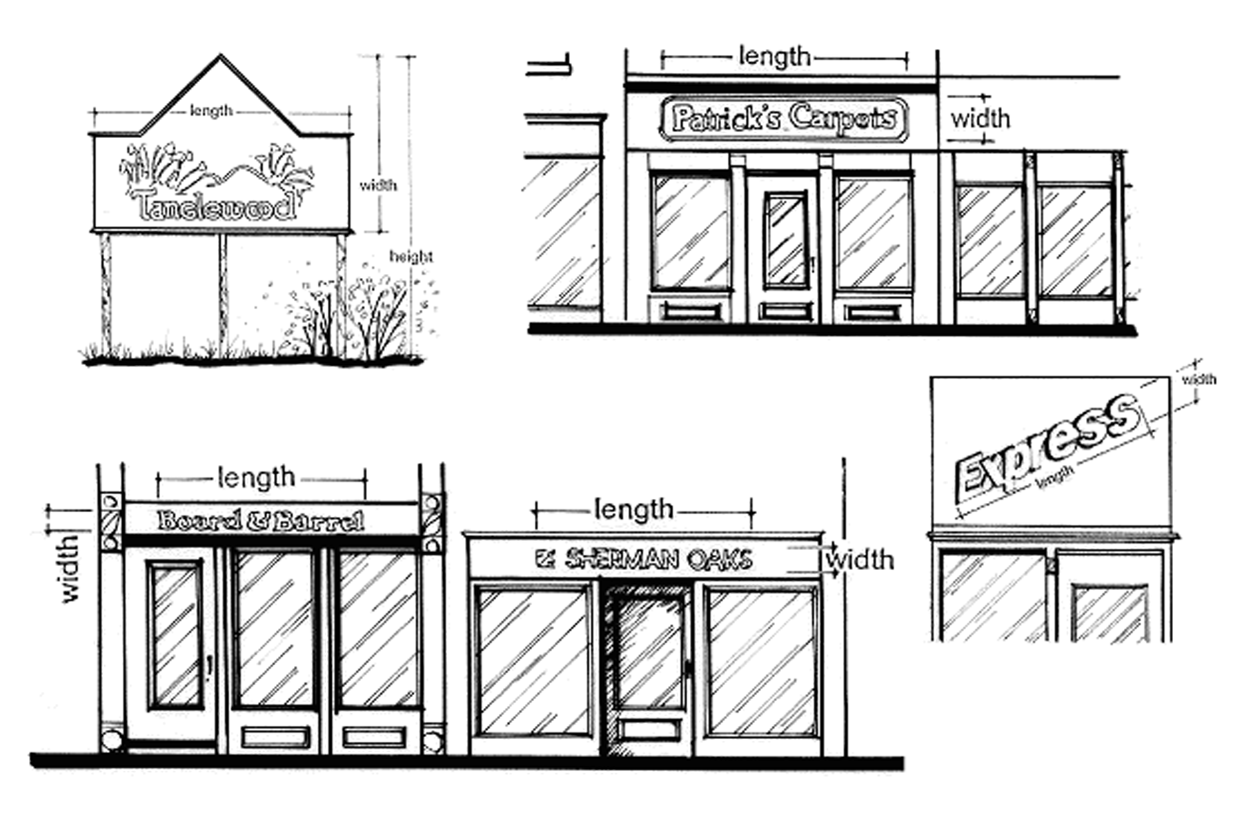
SIGN AREAS
SILVICULTURE USES (land use): See Section 17.3.02.
SINGLE-FAMILY DWELLING (land use): See Section 17.3.03.
SINGLE OWNERSHIP: Any combination of lands singly owned by one individual, jointly owned by a married couple including that individual, or owned by a partnership or corporation in which the individual is a member.
SITE PLAN: An overhead plan for a land or building development proposal, drawn to scale, that shows existing and proposed buildings, other structures, parking areas, and other existing and proposed features as may be specified in this chapter.
SITE UTILITIES (FOR APPLICATION IN CAMPGROUNDS/CAMPING RESORTS): Utilities such as electricity, communications lines, water lines and sewage waste lines including camping site above ground transfer containers (but not in-ground holding tanks at camp sites). Provision of electric, water, and sewage utility hook-ups are optional to campground sites, but mandatory to camping resort sites. Sewage disposal shall be only by licensed waste haulers.
SOLAR ENERGY SYSTEM: A complete design or assembly that may include a solar energy collector, an energy storage facility, and any other components needed to cool or heat an individual building or buildings on a single lot.
STATE: The State of Wisconsin.
STREET, PRIVATE: A street or driveway owned and maintained by a nonpublic entity and not placed within a public right-of-way or public road easement. Also referred to as a "private road" or "private driveway."
STREET, PUBLIC: A street located within a public right-of-way or a public road easement, owned and maintained, upon public dedication, or deeding by the government with jurisdiction. Also referred to as a "public road."
STORMWATER MANAGEMENT PLAN: A detailed plan designed to reduce the rate, quantity, and pollution associated with stormwater after a development site has undergone final stabilization following completion of construction activity.
STORY: That portion of a building included between the surface of any floor and the surface of the floor next above; or if there is no floor above, the space between the floor and the ceiling next above. Neither a basement nor a cellar shall be counted as a story, unless it is a livable basement containing the appropriate number and dimension of exits under ILHR 21.03 (Wisconsin Uniform Dwelling Code).
STRUCTURAL ALTERATIONS: Any change in the supporting members of a building or any substantial change in the roof structure or in exterior walls.
STRUCTURE: Anything constructed or erected, the use of which requires a more or less permanent location on the ground, or attached to something having a permanent location on the ground, excepting fences, public utility fixtures and their appurtenances, receive only antennas, amateur radio facilities, mobile services providing public information coverage of news events or of a temporary or emergency nature, paved surfaces outside of the shoreland zone, gardens, garden accessories, children's playhouses, fountains, sun dials, seasonal decorations, yard lights, flag poles, walkways, at-grade patios, play equipment, signs not requiring a zoning permit under Section 17.6.02(1), tree houses, basketball courts, tennis courts, pet houses or private kennels for 2 or fewer domestic animals, whirlpools, , agricultural drainage systems, piers, docks, and walkways built on pilings. (Am. #2018-05-659)
STRUCTURE HEIGHT: See definition of "building height" for measurement technique, except for telecommunications facilities.
SUBDIVISION: See definition of "subdivision, minor" or "subdivision, major".
SUBDIVISION, MAJOR: The division of a lot, parcel or tract by a subdivider for the purpose of transfer or development which results in the creation of more than 4 lots of less than 10 acres in lot area; or where the act of division creates more than 4 lots of less than 10 acres in lot area over a 5-year period from the same contiguous parcel held in single ownership as of the date of the first division.
SUBDIVISION, MINOR: The division of a lot, parcel or tract by the owner thereof or his agent for the purpose of transfer or development which results in the creation of one to 4 lots of less than 10 acres in lot area from the same contiguous parcel held in single ownership as of the date of the first division.
SUBSTANDARD LOT: A lot that does not conform to the dimensional requirements of this chapter.
SUBSTANTIAL EVIDENCE: Means facts and information, other than merely personal preferences or speculation, directly pertaining to the requirements and conditions an applicant must meet to obtain a conditional use permit and that reasonable persons would accept in support of a conclusion. (Cr. #2018-05-659)
TAX PARCEL: A parcel of land assigned a unique parcel identification number for property taxing purposes and generally not exceeding one quarter-quarter section of land area (a "40"). May or may not coincide with a "lot."
TELECOMMUNICATION FACILITY (land use): See Section 17.3.07.
TELECOMMUNICATIONS FACILITY STRUCTURE: A telecommunications tower or alternative support structure on which telecommunications antenna(s) may be mounted.
TELECOMMUNICATIONS TOWER: Any structure designed and constructed primarily for the purpose of supporting one or more antennas, including camouflaged towers, lattice towers, guy towers, or monopole towers. This includes radio and television transmission towers, microwave towers, and common-carrier towers. It shall exclude alternative support structures and those facilities exempted under Section 17.3.07.
TEMPORARY OUTDOOR SALES (land use): See Section 17.3.09.
TEMPORARY RELOCATABLE BUILDING (land use): See Section 17.3.09.
TEN ACRES: A ¼ of a ¼ of a ¼ section, or other standard metes and bounds or other legal description of land of similar acreage, which is commonly referred to as "10-acres," exclusive of right-of-way and regardless of actual net acreage.
TENT: A portable easily collapsible sleeping shelter made of canvas, plastic, or other woven or foldable materials and supported by poles or framework.
THROAT LENGTH: The distance measured along the center line of an access drive between the public street pavement edge and an off-street parking lot, loading area, or internal circulation drive within a lot.
TOWN LAND USE PLAN: A policy document adopted by the appropriate town board that provides future recommendations for land use within the community, generally over a 20-year planning period. May or may not be a "comprehensive plan," as defined in this section and in Wisconsin Statutes. Lincoln County generally incorporates town land use plans as components of the Lincoln County Comprehensive Plan.
TRANSIENT CAMPING SITES: Sites rented for overnight use, and extending to a maximum of 2 weeks by the same patron.
TWENTY ACRES: A ½ of a ¼ of a ¼ section, or other standard metes and bounds or other legal description of land of similar acreage, which is commonly referred to as "20-acres," exclusive of right-of-way and regardless of actual net acreage.
TWO-FAMILY DWELLING (land use): See Section 17.3.03.
UNINCORPORATED: Within the geographic area of a town government; outside of the corporate limits of an incorporated city or village.
USE: The purpose or activity for which land or any building thereon is designed, arranged, or intended, or for which it is occupied or maintained. Also referred to as "land use."
UTILITY POLE MOUNTED ANTENNA: An antenna attached to or upon an existing or replacement electric transmission or distribution pole, street light, traffic signal, athletic field light, or other approved similar structure.
VACANT: A parcel of land that does not contain any structures or a building that does not contain any use. For parcels, also referred to as "undeveloped."
VALUE ADDED AGRICULTURE: A small commercial, manufacturing, or service operation, which is accessory to a principal agricultural use on the same farm. Examples of value added agriculture include small scale food processing, handcrafting, product packaging and marketing, and agricultural tourism.
VEHICLE: Every device in, upon, or by which any person or property is or may be transported, and designed primarily for transportation of persons or goods along public streets or waterways. Includes boats, pontoons, and boat trailers; does not include nonlicensed personal recreational devices such as ATVs, snowmobiles, or personal watercraft, or personal lawn or garden equipment, except where specifically indicated in this chapter.
VEHICLE REPAIR OR MAINTENANCE SERVICE (land use): See Section 17.3.04.
VISUAL CLEARANCE TRIANGLE: All unoccupied triangular space at the street corner of a corner lot, which is bounded by the street centerlines and a third line that connects points along both streets specified by measurement from the intersection of the 2 street centerlines. See Section 17.5.02(3).
WASTE DISPOSAL/COMPOSTING OPERATION (land use): See Section 17.3.06.
WIND ENERGY SYSTEM: A complete design or assembly (commonly a wind turbine or windmill) that converts the kinetic energy in the wind into a form usable for energy for use in building or buildings on a single lot.
WIS. ADM. CODE: Abbreviation for Wisconsin Administrative Code, which are the rules of the administrative agencies having rule-making authority in Wisconsin, most recently published.
WISCONSIN STATUTES [WIS. STATS.]: The laws of the State of Wisconsin as adopted by the State legislature, most recently published.
WisDNR: The Wisconsin Department of Natural Resources, an administrative agency of the State of Wisconsin. Also referred to as "DNR."
WisDOT: The Wisconsin Department of Transportation, an administrative agency of the State of Wisconsin. Also referred to as "DOT."
YARD: An open space portion of a lot that is unoccupied by a structure and unobstructed from the ground upward, except as otherwise provided herein.
YARD, FRONT: A yard extending along the full width of the front lot line between side lot lines and extending from the abutting front street right-of-way or street easement line to a depth required in the yard regulations for the district in which such lot is located.
YARD, REAR: A yard extending along the full width of the rear lot line between the side lot lines and extending toward the front lot line for a depth as specified in the yard regulations for the district in which such lot is located.
YARD, SIDE: A yard extending along the side lot line between the front and rear yards, having a width as specified in the yard regulations for the district in which such lot is located.
YARD, STREET: A yard extending along the full width of a lot in those yards that abut a public street right-of-way or easement for a depth as specified in the yard regulations for the district in which such lot is located. Corner lots have 2 such yards.
ZONING ADMINISTRATOR: The person authorized and charged by Lincoln County with the administration of this chapter.
ZONING LOT: A parcel of land under single ownership occupied or intended to be occupied by one main building, and buildings and uses customarily accessory or incidental thereto, including such open spaces as are provided. A zoning lot may or may not coincide with a "lot of record," defined earlier in this section.
ZONING MAP: See definition of "official zoning map" above.