
Speedway City Zoning Code
CHAPTER 742
DISTRICTS1
Editor's note— Ord. No. 64, 2015, § 1(Exhibit), passed September 28, 2015, effective April 1, 2016, repealed the former Chs. 730—735, and enacted new Chs. 740—744 as set out herein. The former Chs. 730—735 pertained to Zoning—General Provisions, Dwelling Zoning Districts; Zoning—Commercial Districts, Zoning—Industrial Commercial Districts, Sign Regulations, Zoning—Other Districts. See Code Comparative Table for complete derivation.
Sec. 742-101. - Establishment of Primary Zoning Districts.
The Primary Zoning Districts listed in the following table are hereby established, with their associated symbol, and shall have the boundaries shown on the Official Zoning Map of the City of Indianapolis-Marion County.
Table 742-101-1: Primary Zoning Districts
(G.O. 64, 2015, § 2; G.O. 37, 2018, § 6)
Sec. 742-102. - Applicability.
A.
All properties shown within each Primary Zoning District on the Official Zoning Map are subject to the standards and provisions of this Article I, applicable to that Primary Zoning District.
In addition, property within each Primary Zoning District listed in this Article I, must comply with all other applicable provisions of the Zoning Ordinance, including without limitation the performance standards in Chapter 740, Article IV, the uses and use-specific standards in Chapter 743, and the development standards in Chapter 744, unless a specific exception is set forth in the Zoning Ordinance.
B.
In accordance with IC 36-7-4-701, this Section 742-102 confirms that compliance with the subdivision regulations in Chapter 741 is required for all properties in all Primary Zoning Districts in the Indianapolis-Marion County except all UQ-1, HD-1 and PK-1 Development Plan Districts.
(G.O. 64, 2015, § 2)
Sec. 742-103. - Dwelling Districts.
A.
General.
1.
One primary use per lot. Only one primary use shall be permitted per lot.
2.
Secondary means of escape. All secondary means of escape that includes, but is not limited to, fire escapes or similar emergency accesses, shall be located on the rear or side walls of the building or structure. In the case of a building or structure located on a corner lot, the secondary means of escape shall not be located on the side of any building or structure that has frontage along a public or private street.
3.
Parking of oversized and commercial vehicles. No commercial vehicle or vehicle having a gross vehicle weight rating (GVWR) exceeding 10,000 pounds may be parked between the façade of a single-family detached dwelling, single-family attached dwelling, manufactured home, mobile dwelling, two-family dwelling, triplex or fourplex, or live-work dwelling and the right-of-way line fronting that façade unless there is active, legal construction activity taking place on the site or commercial vehicles that are in the course of making normal and reasonable service calls.
4.
Public utilities. Attachment to public or semipublic water and sanitary sewer facilities shall be mandatory for development in any Dwelling District except for the D-A, D-S, and D-1 Districts.
5.
Accessory uses and structures. Accessory uses and structures are permitted in the Dwelling Districts in accordance with Table 743-1: Use Table. Unless specifically exempted, accessory uses and structures must meet all standards of the Zoning Ordinance, in particular use-specific standards in Section 743-306 (Accessory and Temporary Uses) and the development standards of Chapter 744.
B.
Dwelling Agricultural District (D-A).
1.
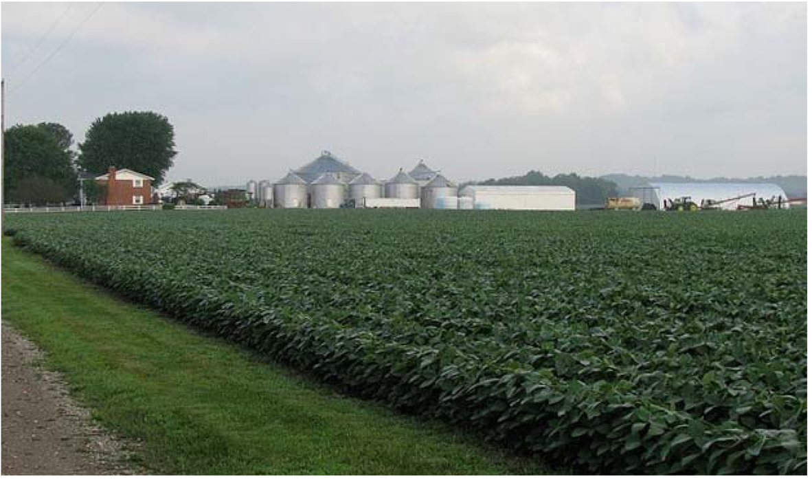
Purpose. The D-A District holds the agricultural lands of Marion County and provides for a variety of agricultural uses. It is intended to provide for animal and poultry husbandry, farming, cultivation of crops, dairying, pasturage, floriculture, horticulture, viticulture, apiaries, aquaculture, hydroponics, together with necessary, accompanying accessory uses, buildings, or structures for housing, packing, treating, or storing said products; or lands devoted to a soil conservation or forestry management program. A single-family dwelling is intended to be permitted as a part of such agricultural uses. A secondary provision of this District is large estate development of single-family dwellings. This District fulfills the very low density residential classification of the Comprehensive General Land Use Plan. This District does not require public water and sewer facilities.
2.
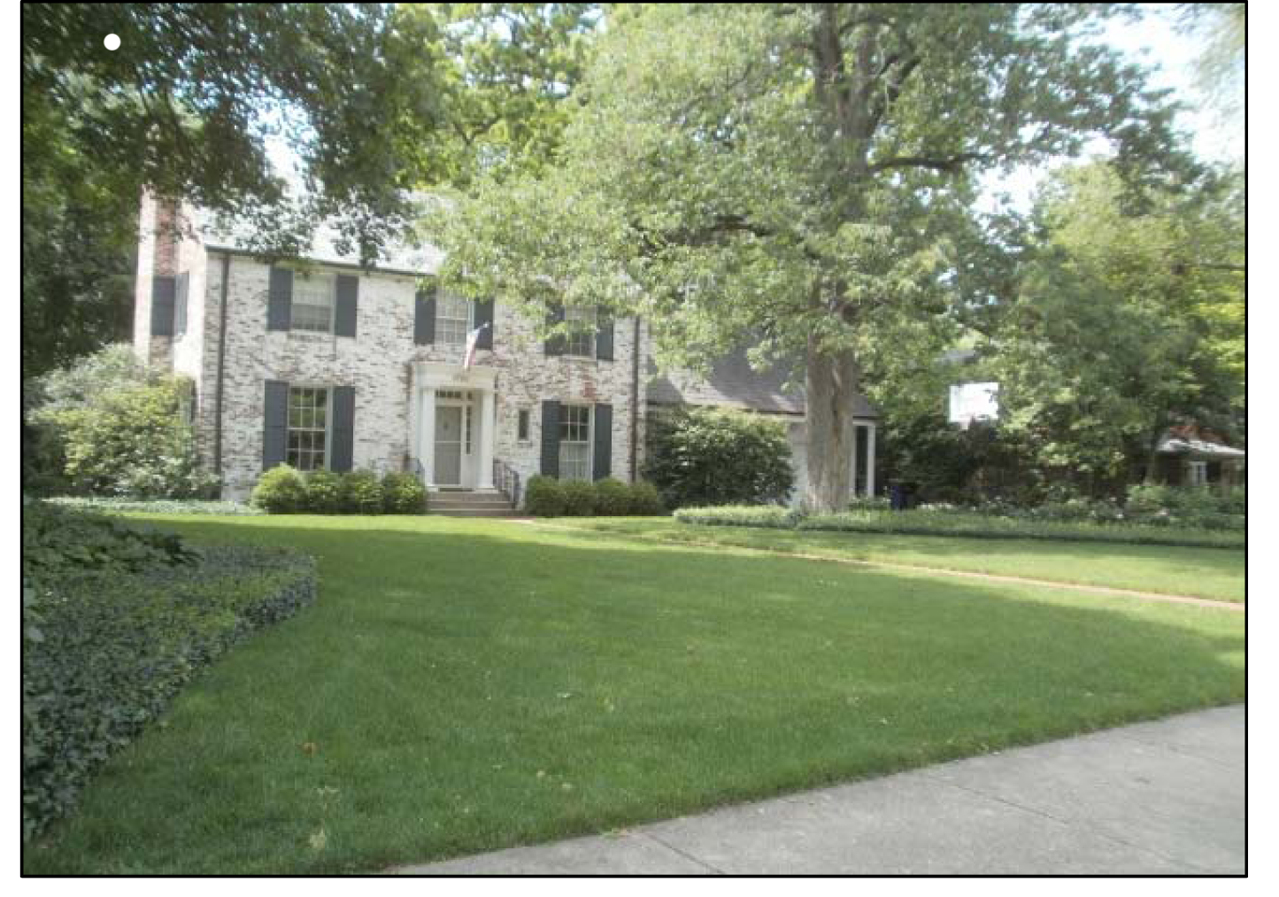
Example.
3.
Illustration.
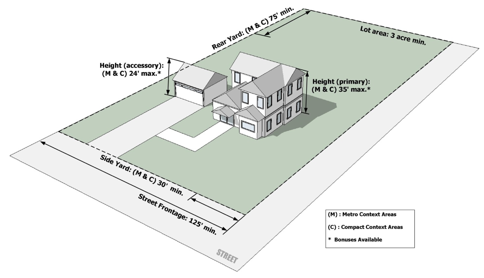
Diagram A Illustrative example of D-A District
4.
Other standards.
a.
Use.
1.
No operations or activities for pecuniary gain that package products for final market distribution or that mechanically, electrically or chemically transform raw materials into new products, other than cultivation, or animal husbandry, or bottling of dairy products, shall be permitted.
2.
The use of lakes and ponds shall not include commercial or recreational activities that are open to the general public for a fee.
b.
D-A District exceptions.
1.
Refer to Section 744-202 (New Construction for Nonconformities) for D-A district exceptions to dimensional standards.
2.
Refer to Section 743-306.A.3 (Accessory & Temporary Uses) for D-A district exceptions to Accessory Uses.
C.
Dwelling Suburban District (D-S).
1.
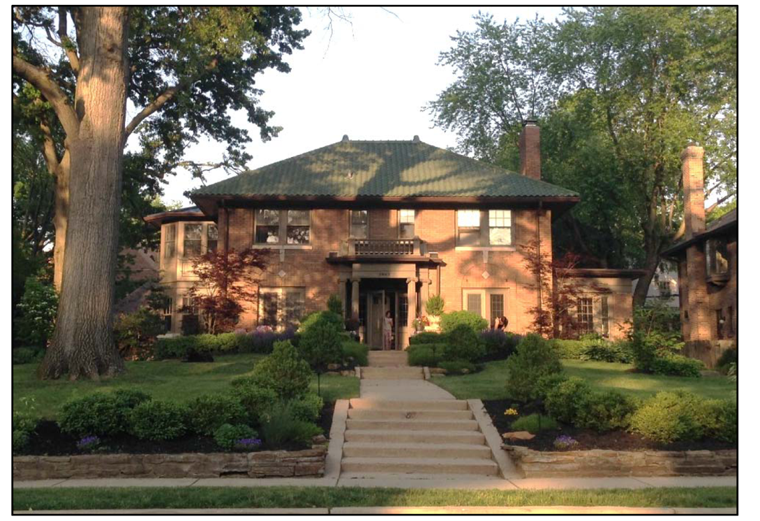
Purpose. The D-S District is intended for suburban areas of extreme topography, areas conducive to estate development, or areas where it is desirable to permit only low density development (such as adjacent to floodplains, aquifers, urban conservation areas, within the extended alignment of airport runways, etc.). Generous front yards with trees along roadways that follow the natural terrain of the land are envisioned for the D-S District. Estate development in a natural setting is the typical realization of the District. The D-S District provides for single-family residential lots consisting of at least one acre. A typical density for the D-S District is 0.4 units per gross acre. This District fulfills the lowest density residential classification of the Comprehensive General Land Use Plan. Development plans would likely use the cluster option when subdividing and should incorporate and promote environmental and aesthetic considerations, working within the constraints and advantages presented by existing site considerations, including vegetation, topography, drainage and wildlife.
2.
Examples.
3.
Illustration.
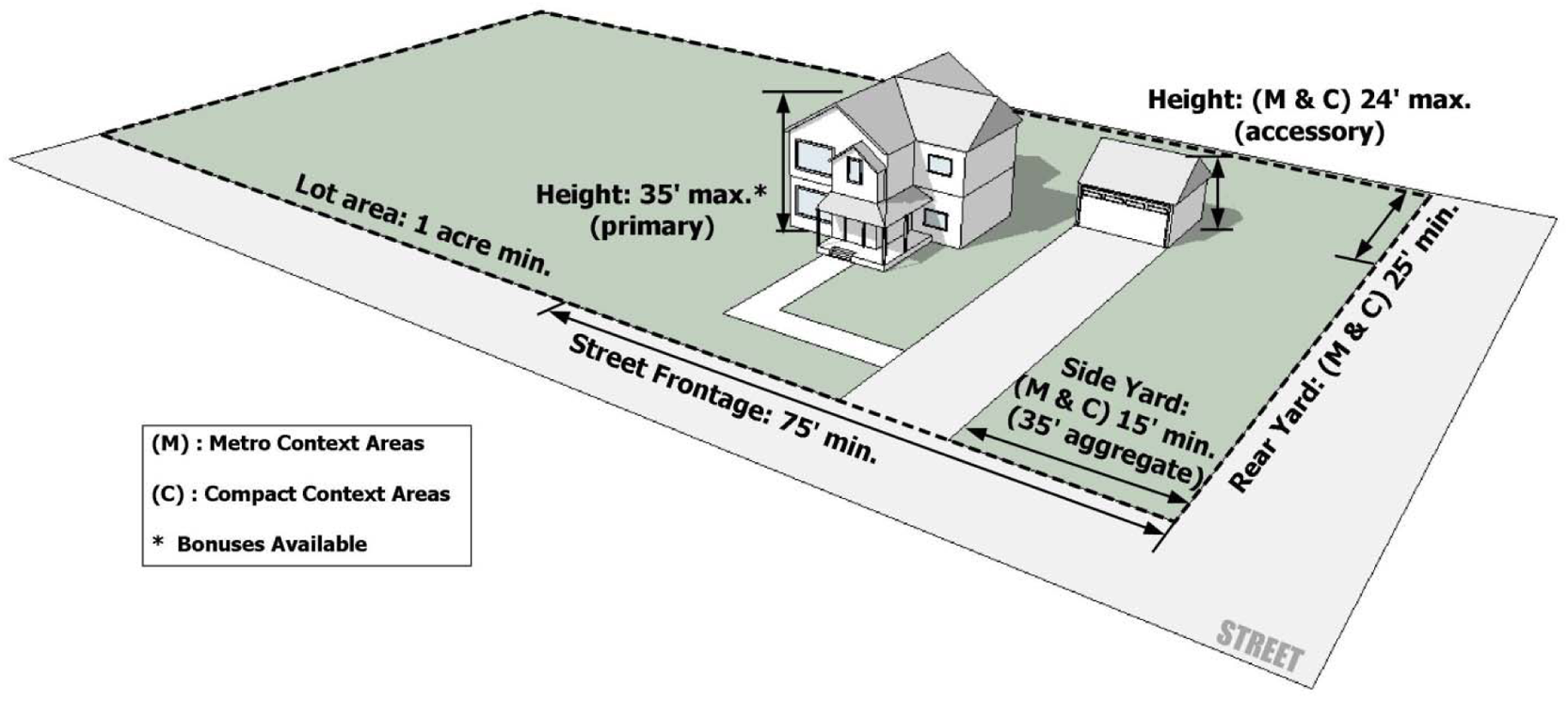
Diagram B Illustrative example of D-S District
4.
Other Standards. [Reserved]
D.
Dwelling District One (D-1).
1.
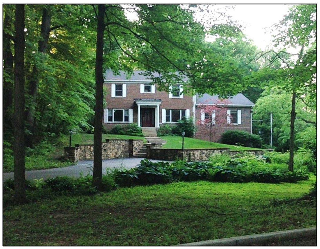
Purpose. The D-1 District is intended for use in suburban areas. The D-1 District has a typical density of 0.9 units per gross acre which fulfills the lowest density residential classification of the Comprehensive General Land Use Plan. The D-1 District provides for estate-style development characterized by generous front yards for trees and a bucolic atmosphere, appropriately served by gently curving roadways. Under most circumstances, public water and sewer facilities should be present but are not mandatory. Development plans should incorporate and promote environmental and aesthetic considerations, working within the constraints and advantages presented by existing site considerations, including vegetation, topography, drainage and wildlife. Use of the cluster option when subdividing would maximize site advantages.
2.
Examples.
3.
Illustration.
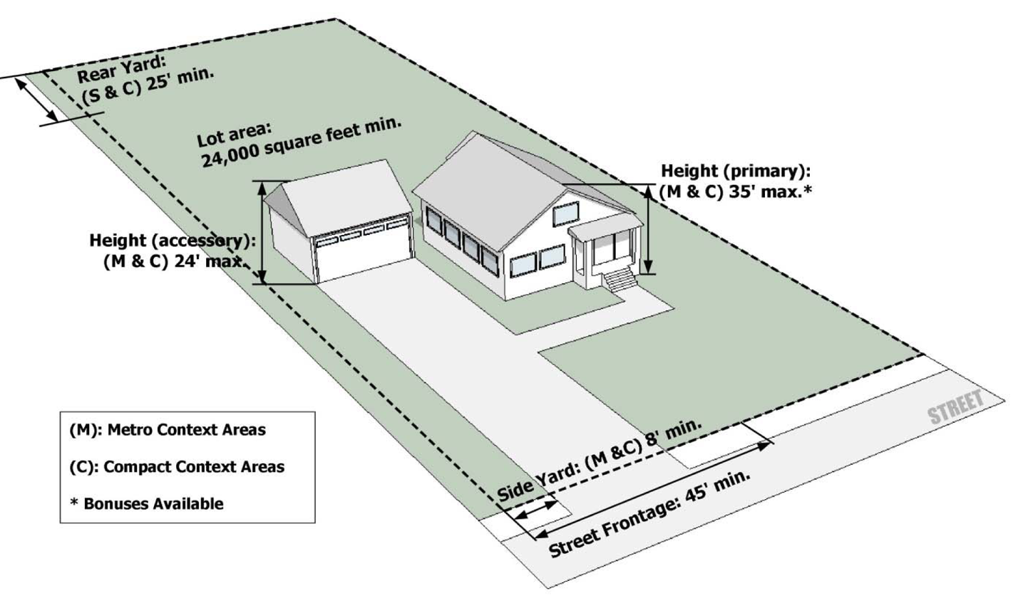
Diagram C Illustrative example of D-1 District
4.
Other Standards. Reserved]
E.
Dwelling District Two (D-2).
1.
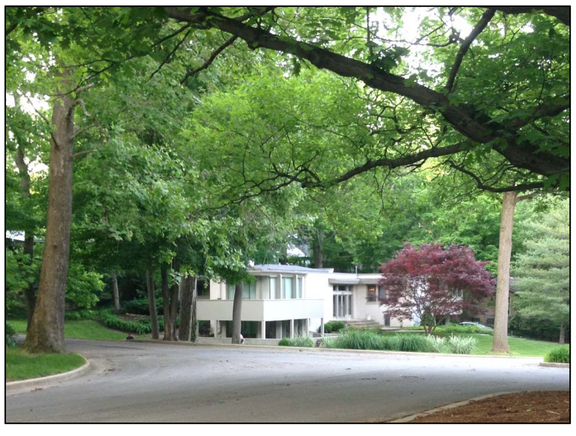
Purpose. The D-2 District is intended for use in suburban areas. Ample yards, trees and passive open spaces easily serving each individual lot are envisioned for this District. The D-2 District has a typical density of 1.9 units per gross acre. Two-family dwellings are permitted on corner lots in this District. This District fulfills the lowest density recommendation of the Comprehensive General Land Use Plan. Public water and sewer facilities must be present. Development plans, which may include the use of clustering, should incorporate and promote environmental and aesthetic considerations, working within the constraints and advantages presented by existing site conditions, including vegetation, topography, drainage and wildlife.
2.
Examples.

3.
Illustration.
Diagram D Illustrative example of D-2 District
4.
Other standards. [Reserved]
F.
Dwelling District Three (D-3).
1.
Purpose. The D-3 District provides for low or medium intensity residential development. Land in this District should have good thoroughfare access, be relatively flat in topography, and be afforded pedestrian linkages to community and neighborhood services and facilities (schools, parks, shopping areas, etc.). Recreational facilities developed for the neighborhood complement the treed yards on the individual lots. Predominantly single-family detached dwellings are envisioned with two-family dwellings on corner lots in this District. The D-3 District has a typical density of 2.6 units per gross acre. This District fulfills the low density residential classification of the Comprehensive General Land Use Plan. All public utilities and facilities must be present. Development plans, which may include the use of clustering, should incorporate and promote environmental and aesthetic considerations, working within the constraints and advantages presented by existing site considerations, including vegetation, topography, drainage and wildlife.
2.
Examples.
3.
Illustration.
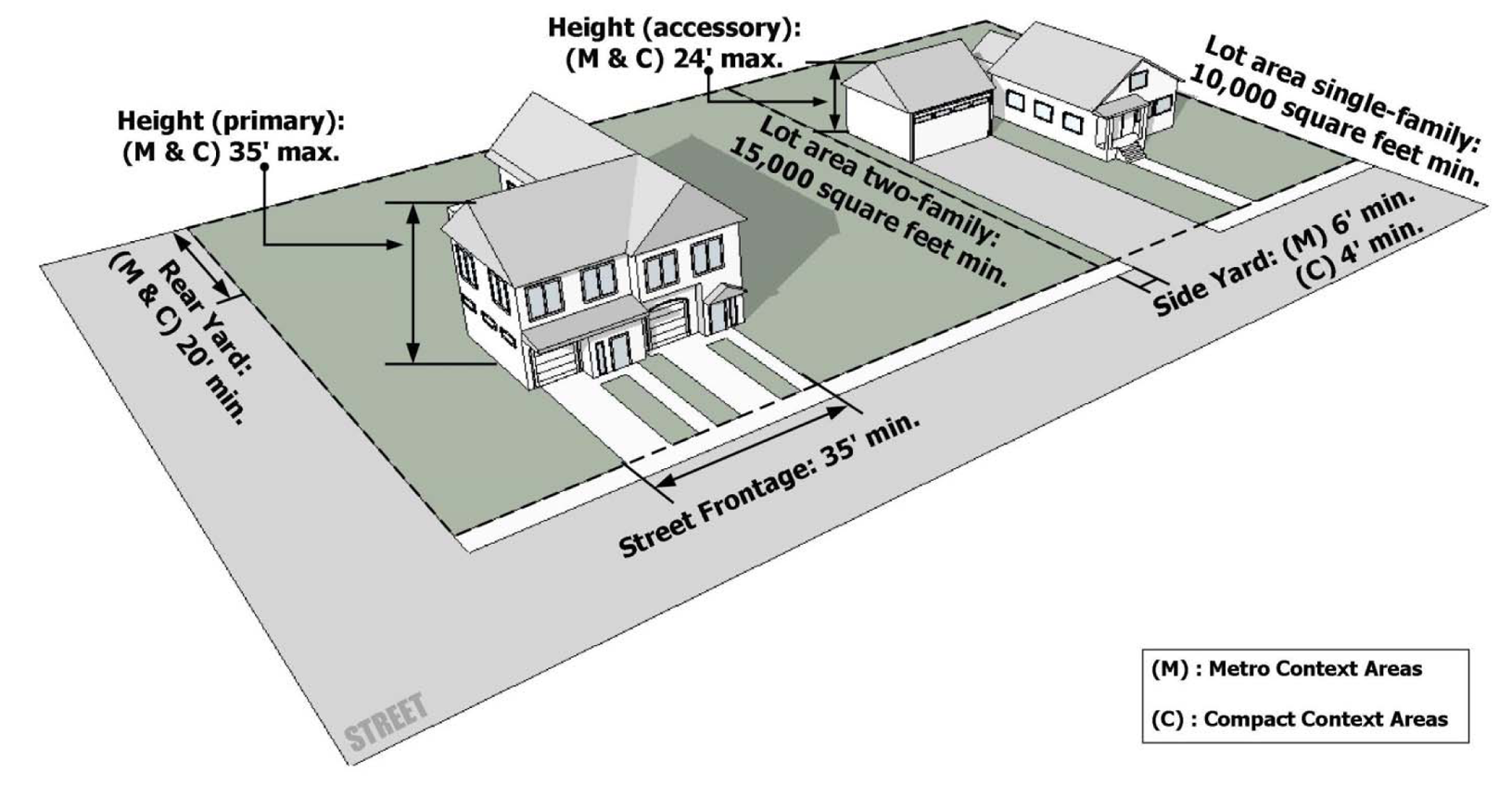
Diagram E Illustrative example of D-3 District
4.
Other standards. [Reserved]
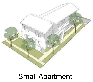
G.
Dwelling District Four (D-4).
1.
Purpose. The D-4 District is intended for low or medium intensity single-family and two-family residential development. Land in this District needs good thoroughfare access, relatively flat topography, and nearby community and neighborhood services and facilities with pedestrian linkages. Provisions for recreational facilities serving the neighborhood within walking distance are vitally important. Trees fulfill an important cooling and drainage role for the individual lots in this District. The D-4 District has a typical density of 4.2 units per gross acre. This District fulfills the low density residential classification of the Comprehensive General Land Use Plan. All public utilities and facilities must be present. Development plans, which may include the use of clustering, should incorporate and promote environmental and aesthetic considerations, working within the constraints and advantages presented by existing site conditions, including vegetation, topography, drainage and wildlife.
2.
Examples.
3.
Illustration.
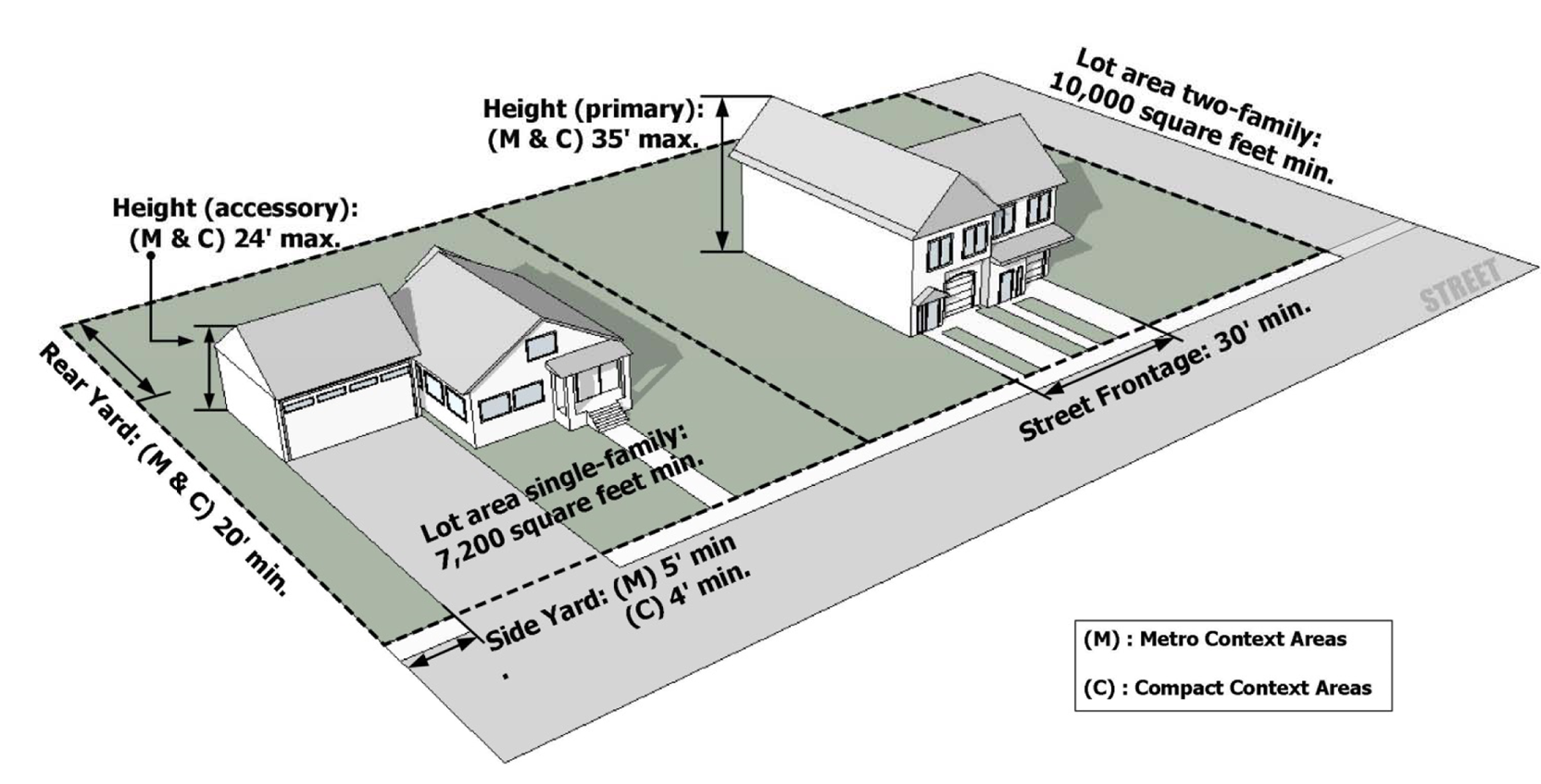
Diagram F Illustrative example of D-4 District
4.
Other standards. [Reserved]
H.
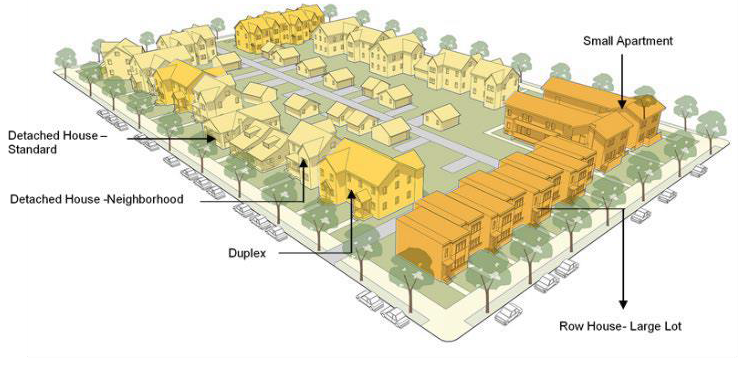
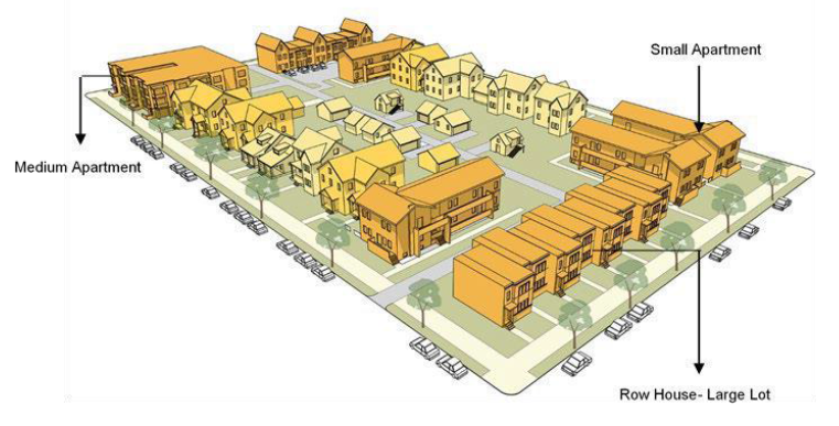
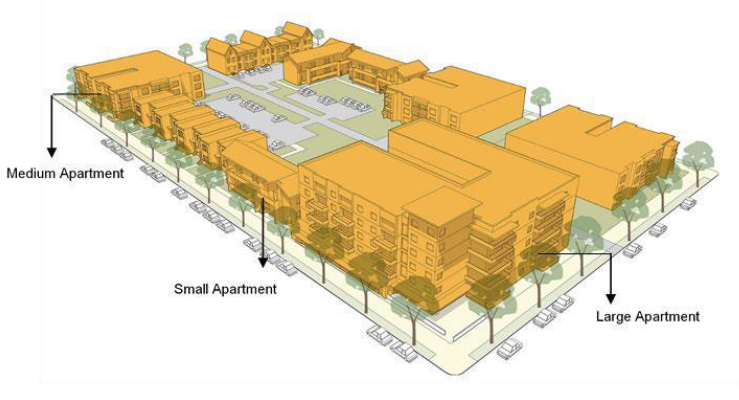
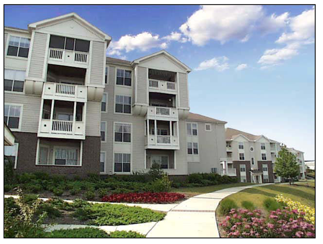
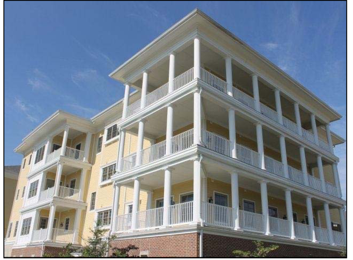
Walkable Neighborhood Dwelling Districts (D-5, D5II, D8, D9 and D10).
1.
Purpose. To advance the Livability Principles of this Code, the D-5, D-5II, D8, D9 and D-10 districts implement walkable, compact neighborhoods within a well-connected street network and block structure, using slow neighborhood streets, walkable connectors, and multi-mode thoroughfares. Access to parks and recreation, transit and neighborhood services within walking distance is important. Street trees, landscape and trees along private frontages, and an active amenity zone create comfortable walking environment and add appeal to neighborhoods. These districts require urban public and community facilities and services to be available. These districts may be used in combination to supply critical mass of residents to support nearby commercial and transit investments. Each district has the following specific purposes and applicability:
| TABLE 742-103-7 - Walkable Neighborhood District Purposes | |
|---|---|
| Dwelling District Five (D-5) | |
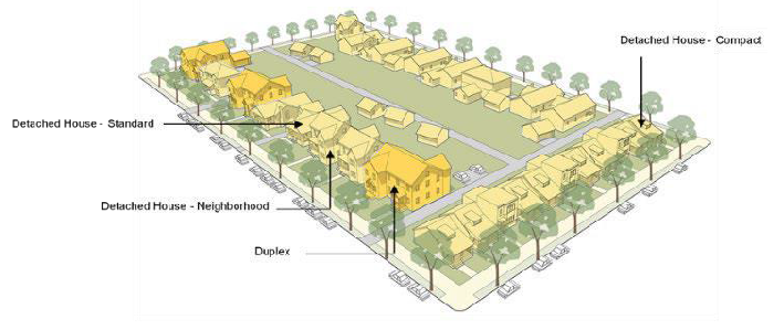 | The D-5 district is intended for medium and large- lot housing formats, primarily for detached houses, but may incorporate small- scale multi- unit building types in strategic locations. This district can be used for new, walkable suburban neighborhoods or for infill situation in established urban areas, including both low density and medium density residential recommendations of the Comprehensive Plan, and the Suburban Neighborhood and Traditional Neighborhood Typologies of the Land Use Pattern Book. |
| Dwelling District Five-two (D-5II) | |
 | The D-5II district is intended for small-lot housing formats, primarily for small, detached houses, but also including a mix of small-scale multi-unit building types. This district can be used for new, walkable suburban neighborhoods or for infill situations in established urban areas, including both low density and medium density residential recommendations of the Comprehensive Plan, and the Suburban Neighborhood or Traditional Neighborhood Typologies of the Land Use Pattern Book. |
| Dwelling District Eight (D-8) | |
 |
The D-8 district is intended for a variety of housing formats, with a mix of small-scale
multi-unit building types. This district can be used as a part of new mixed-use areas,
or for infill situations in established urban areas, including medium and high-density
residential recommendations of the Comprehensive Plan, and the Traditional Neighborhood,
City Neighborhood, and Village or Urban Mixed-Use Typologies of
the Land Use Pattern Book. |
| Dwelling District Nine (D-9) | |
 |
The D-9 district is intended for higher density housing formats, with a mix of small-
and moderate-scale multi-unit building types. This district can be used at transitions
to walkable, commercial areas, transit stations and urban and suburban corridors,
including the high-density residential recommendations of the Comprehensive Plan,
and the Traditional Neighborhood, City Neighborhood, or
Village or Urban Mixed-Use Typologies of the Land Use Pattern Book. |
| Dwelling District Ten (D-10) | |
 | The D-10 district is intended for high density housing formats, in moderate- or large-scale multi-unit building types. This district can be used at transitions and urban centers and corridors, including the high-density residential recommendations of the Comprehensive Plan, and the City Neighborhood and Urban Mixed-Use Typologies of the Land Use Pattern Book. |
2.
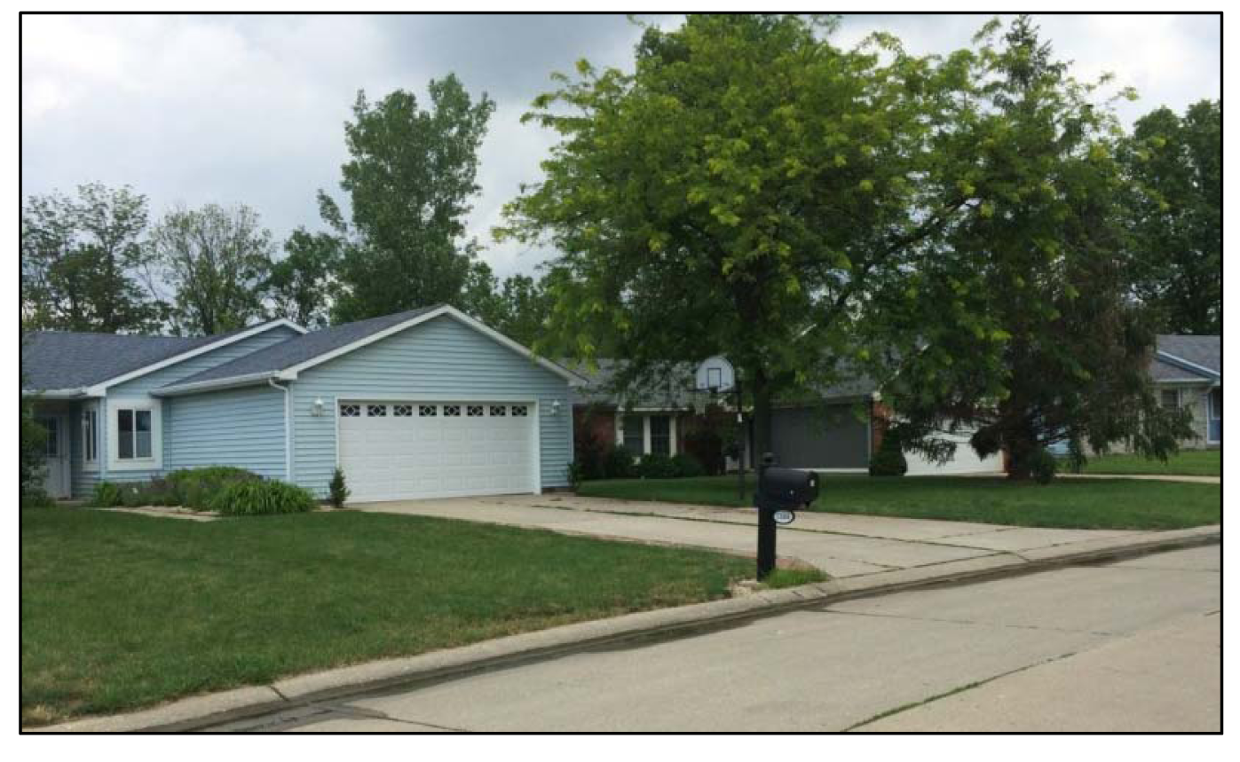
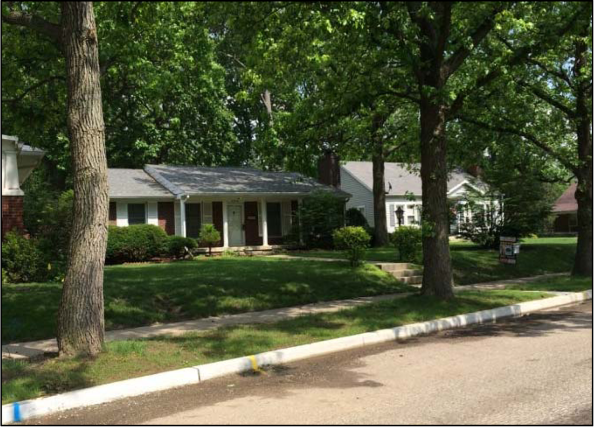
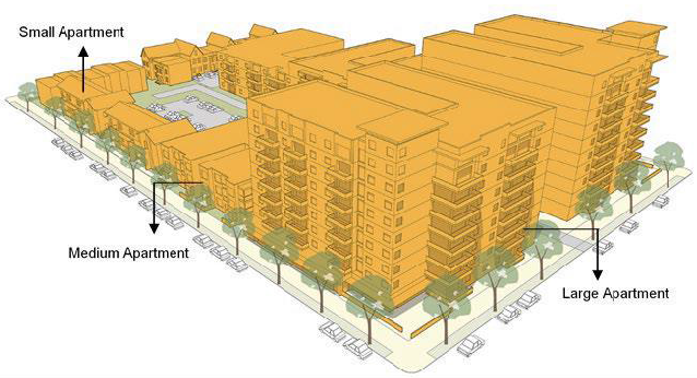
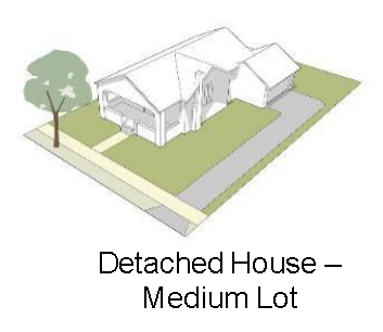
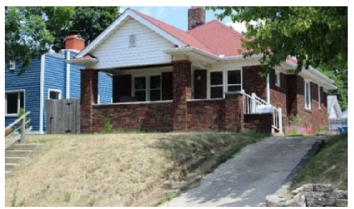
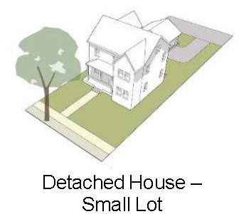
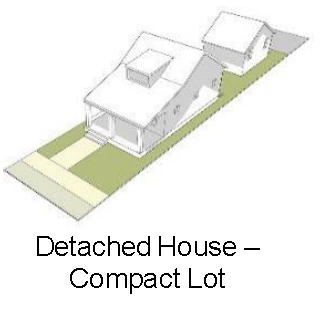
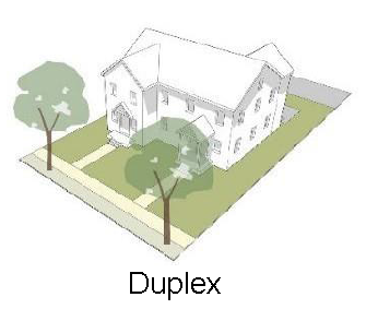
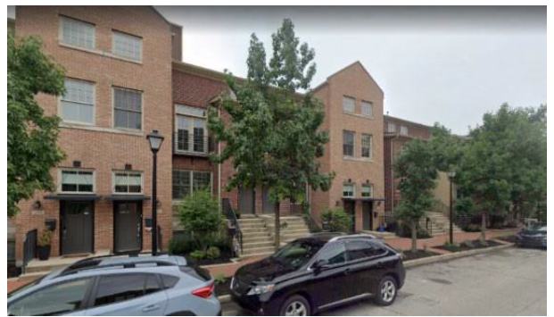
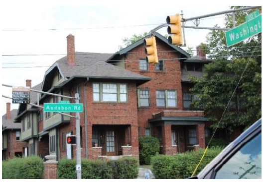
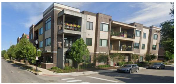
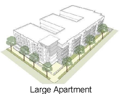
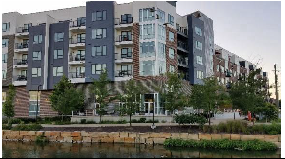
Examples. The D-5, D-5II, D8, D9 and D-10 districts regulate development by building type, with a range of building types permitted in each district and where each type has specific lot and building form standards. The following are examples of each type.
| TABLE 742-103-8 - Building Type Examples | |
|---|---|
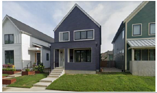
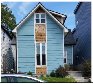
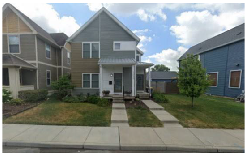
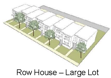
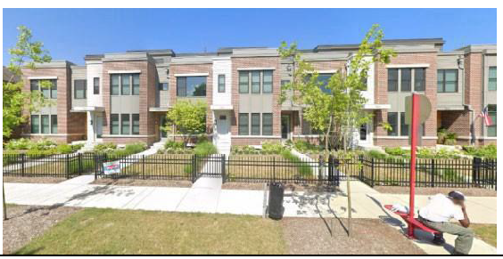
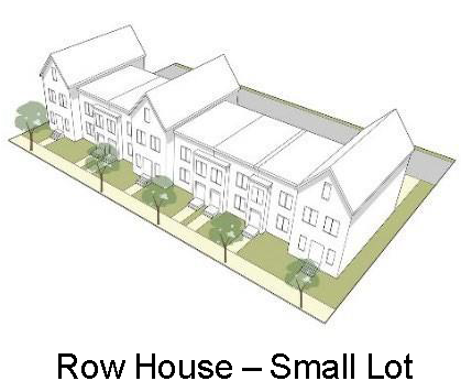
| Building Types | Photos |
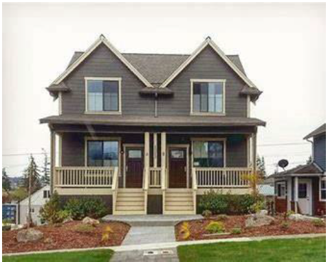
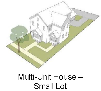
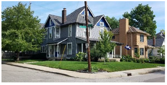
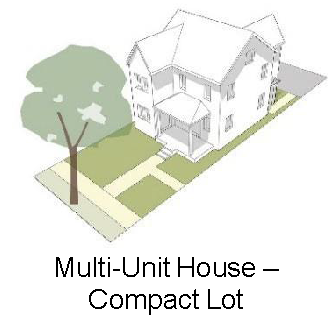
 |  |
 |  |
 |  |
 |  |
 |  |
 |  |
 |  |
 |  |
 |  |
 |  |
 |  |
3.
Building Type Standards. Table 742-103-11 provides development standards for each building type and the zoning district where each type is permitted.
[1] Lot width shall exclusively control the application of the residential building type standards (except for Apartment Types).
[2] The lesser of the two values shall be the maximum height.
[3] See Walkable Neighborhood Design Standards, Section 744. Article VII. Section 01.D. Block & Lot Open Space for eligible open space designs.
□ Permitted lot and building type in zoning district.
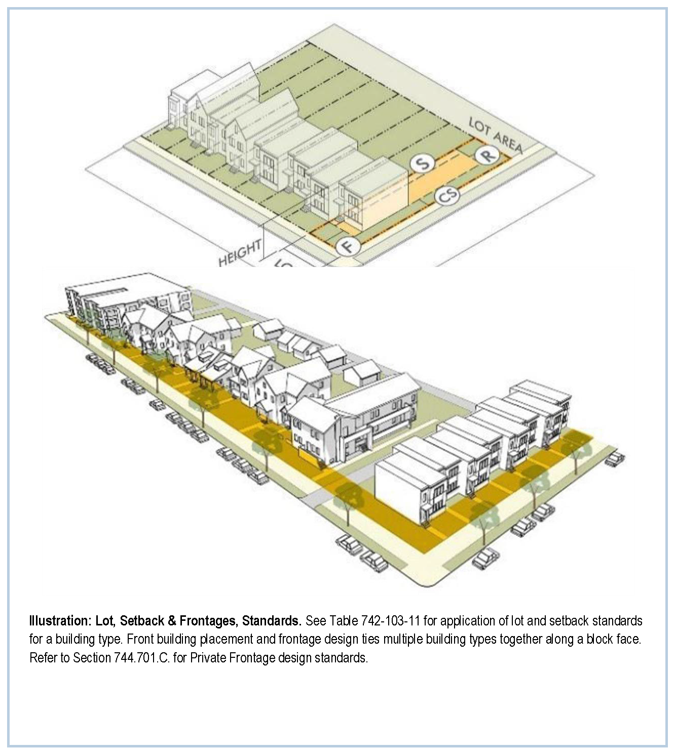
4.
Other. All lots and buildings in the D-5, D-5II, D8, D9 and D-10 districts shall conform to the Walkable Neighborhood Design Standards in Section 744-701.
I.
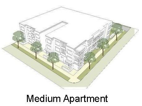
Dwelling District Six (D-6).
1.
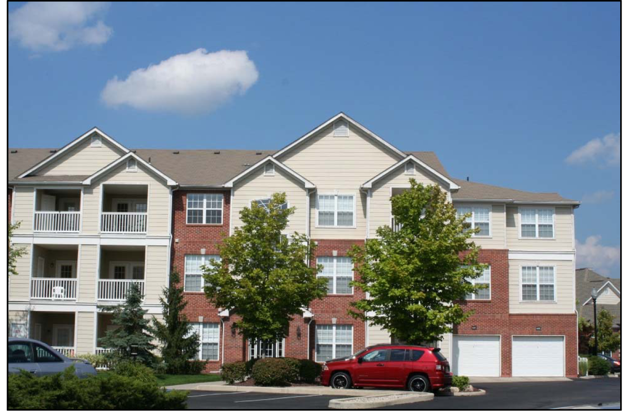
Purpose. The D-6 District provides for medium intensity residential development of a variety of housing types: multifamily dwellings, triplex, fourplex, two-family and single-family attached dwellings. The District is intended for developments in suburban areas well served by major thoroughfares, sanitary sewers, and school and park facilities. In its application, the District need not be directly associated with more intense land uses such as commercial or industrial areas. The development pattern envisioned is one of trees lining curving drives with the ample open space provided for in the District affording a wide variety of on-site recreational facilities. The D-6 District has a typical density of six to nine units per gross acre. This District fulfills the medium density residential recommendation of the Comprehensive General Land Use Plan. Development plans should incorporate and promote environmental and aesthetic considerations, working within the constraints and advantages presented by existing site conditions, including vegetation, topography, drainage and wildlife.
2.
Examples.
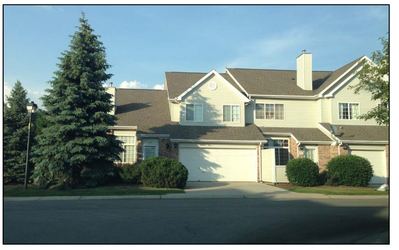
3.
Illustration.
4.
Other standards.
a.
Minimum project area. There shall be no required minimum project area other than the land area necessary to provide for the development requirements of Chapter 744, Article II (Lot & Building Dimensions) and this Section 742-103.J.4.
b.
Minimum distance between buildings. In projects containing two or more buildings, the minimum distance between all buildings shall be in accordance with Table 744-201-2.
1.
The minimum distance shall be measured perpendicular to the building wall at all points.
2.
Walls forming interior courts and serving only one building may reduce the yard to 10 feet in depth.
c.
Use of the yards required between buildings. All yards shall be landscaped and meet the requirements of Chapter 744, Article V (Landscaping and Screening). Yards between buildings shall only be used for open space with the exception of the following:
1.
Driveways, and,
2.
Interior access drives, open balconies, open porches, patios, or structures that qualify as Covered Open Space may project or be located no more than 10 feet into that yard, provided however, in no case, shall the permitted facilities be located closer than 10 feet to another structure.
3.
Parking areas may be located in the yards between buildings, provided no parking area shall be closer than 10 feet to any building.
J.
Dwelling District Six-Two (D-6II).
1.
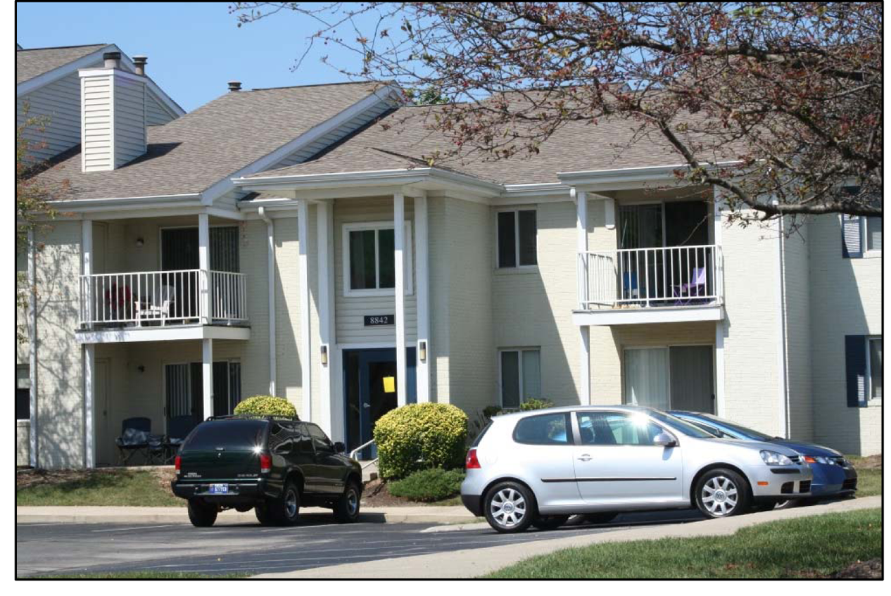
Purpose. The D-6II District is intended principally for medium intensity residential development as a transition between areas of high intensity uses and low intensity uses, or land areas characterized by more challenging terrain or unusual land configuration, such as remnant parcels of land resulting from public works improvements, exhausted mining operations, and changed intensity factors (such as between interstate highway locations, commercial development and lower-density residential areas). Consequently, the constraints and advantages presented by existing site conditions, including vegetation, topography, drainage, and wildlife, should be incorporated into the development plans and to promote the environmental aesthetic. Permitting a variety of housing types affords flexibility to and opportunity to fulfill the sites challenges. Selective on-site recreational facilities and open space activities must be provided to maximize efficiency, site opportunities, and residents' needs. The District should be in close proximity to major thoroughfares, sewers, school and park facilities. The D-6II District has a typical density of nine to 12 units per gross acre fulfilling the medium density residential recommendation of the Comprehensive General Land Use Plan.
2.
Examples.
3.
Illustration.
4.
Other standards.
a.
Minimum project area. There shall be no required minimum project area other than the land area necessary to provide for the development requirements of Chapter 744, Article II (Lot & Building Dimensions) and this Section 742-103.K.4.
b.
Minimum distance between buildings. In projects containing two or more buildings, the minimum distance between all buildings shall be in accordance with Table 744-201-2.
1.
The minimum distance shall be measured perpendicular to the building wall at all points.
2.
Walls forming interior courts and serving only one building may reduce the yard to 10 feet in depth.
c.
Use of the yards required between buildings. All yards shall be landscaped and meet the requirements of Chapter 744, Article V (Landscaping and Screening). Yards between buildings shall only be used for open space with the exception of the following:
1.
Driveways, and
2.
Interior access drives, open balconies, open porches, patios, or structures that qualify as Covered Open Space may project or be located no more than 10 feet into that yard, provided however, in no case, shall the permitted facilities be located closer than 10 feet to another structure.
3.
Parking areas may be located in the yards between buildings, provided no parking area shall be closer than 10 feet to any building.
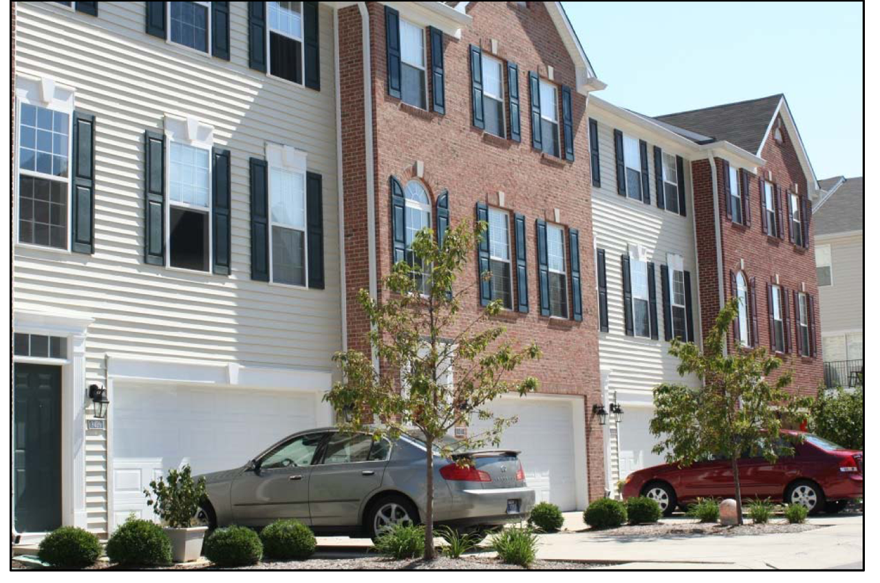
K.
Dwelling District Seven (D-7).
1.
Purpose. The D-7 District is intended for medium density residential development, accommodating multifamily dwellings, triplex, fourplex, two-family and single-family attached dwellings. The District may be applied anywhere within the metropolitan area, provided, however, it should be closely associated with the primary intensity generators, such as commercial shopping centers or industrial employment centers. The District requires superior street access and all public utilities and facilities. Provisions for various modes of travel and pedestrian linkages are critical. Well-planned, on-site recreational facilities, selected to fit the site and residents' needs, must be developed to answer the demands of the higher density of residents. The D-7 District has a typical density of 12 to 15 units per gross acre fulfilling the medium density residential recommendation of the Comprehensive General Land Use Plan. Development plans should incorporate and promote environmental and aesthetic considerations, working within the constraints and advantages presented by existing site conditions, including vegetation, topography, drainage and wildlife.
2.
Examples.
3.
Illustration.
4.
Other standards.
a.
Minimum project area. There shall be no required minimum project area other than the land area necessary to provide for the development requirements of Chapter 744, Article II (Lot and Building Dimensions) and this Section 742-103.L.4.
b.
Minimum distance between buildings. In projects containing two or more buildings, the minimum distance between all buildings shall be in accordance with Table 744-201-2.
1.
The minimum distance shall be measured perpendicular to the building wall at all points.
2.
Walls forming interior courts and serving only one building may reduce the yard to 10 feet in depth.
c.
Use of the yards required between buildings. All yards shall be landscaped and meet the requirements of Chapter 744, Article V (Landscaping and Screening). Yards between buildings shall only be used for open space with the exception of the following:
1.
Driveways, and
2.
Interior access drives, open balconies, open porches, patios, or structures that qualify as covered open space may project or be located no more than 10 feet into that yard, provided however, in no case, shall the permitted facilities be located closer than 10 feet to another structure.
3.
Parking areas may be located in the yards between buildings, provided no parking area shall be closer than six feet to any building.
L.
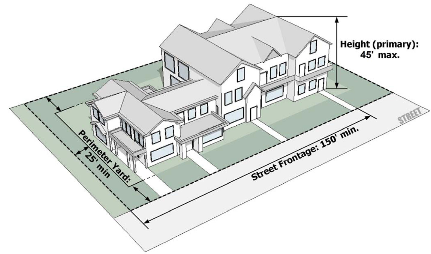
Dwelling District Eleven (D-11).
1.
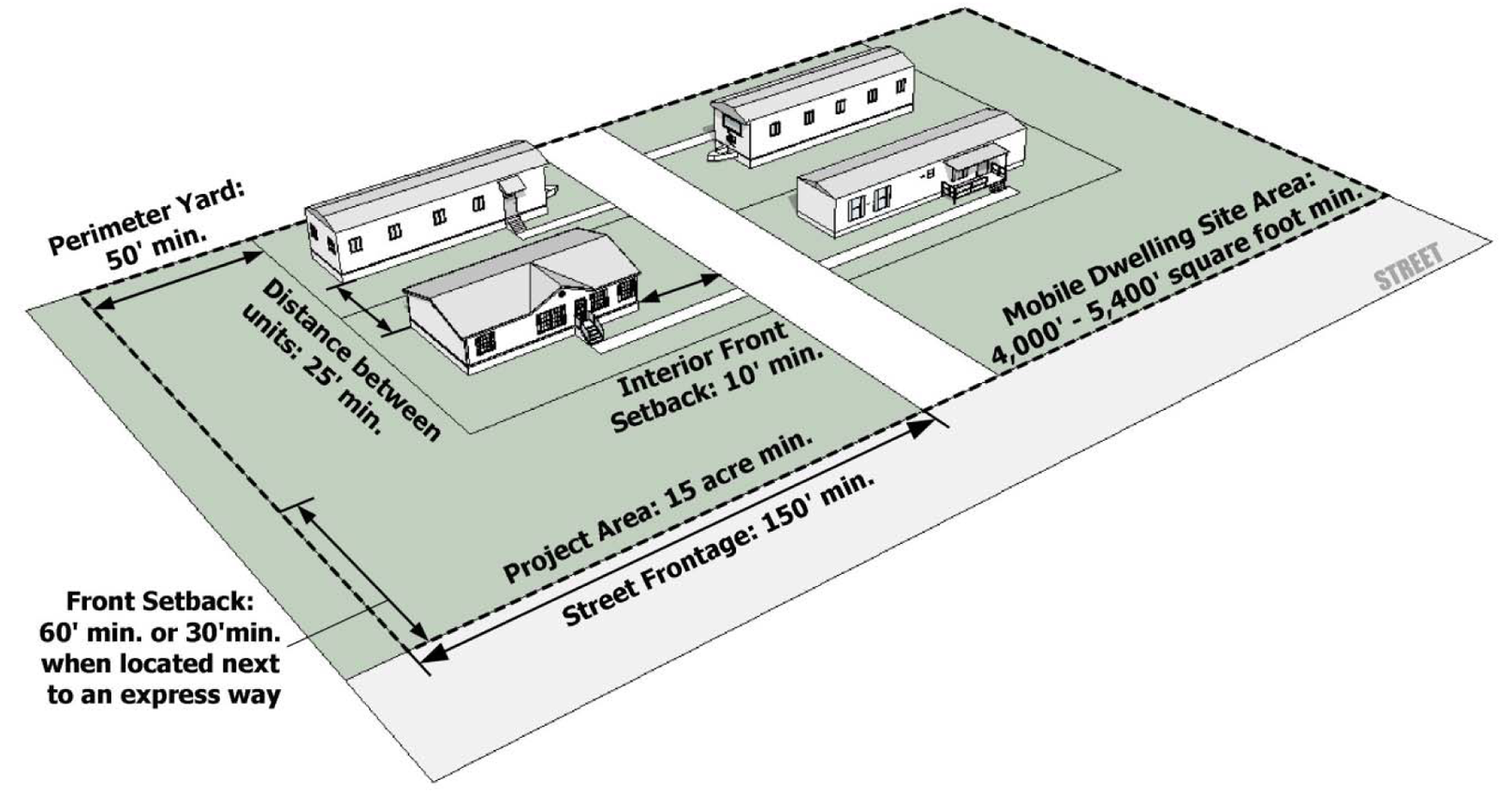
Purpose. The D-11 District allows for mobile dwelling project development. The special characteristics of mobile dwellings, as opposed to the characteristics of conventional housing (such as compactness of the mobile dwelling unit, site accommodation requirements, etc.), have been recognized as requiring special District considerations. The D-11 District is designed to permit mobile and manufactured dwellings in accordance with appropriate standards. This District fulfills a medium density classification according to the Comprehensive General Land Use Plan and should be applied accordingly. The typical density for a D-11 District is six units per gross acre. With the development standards included in this District, mobile dwelling projects are viable residential developments, similar to site-built residential neighborhoods. All public and community facilities are required. Proximity to major thoroughfares is necessary for the location of this District.
2.
Example.
3.
Illustration.
4.
Other standards.
a.
Perimeter yard.
1.
A perimeter yard is required for each mobile dwelling project. All parking, buildings, structures, and mobile dwelling sites shall be located so as to provide a setback of at least 50 feet from all perimeter lot lines. This 50-foot perimeter yard shall be landscaped and shall not be used for anything other than passive open space or a required roadway entrance into the mobile home park. Perimeter yards must be landscaped, screened and maintained according to Chapter 744, Article V (Landscaping and Screening), provided, however;
2.
Where the project abuts public perimeter streets, minimum perimeter front yards shall be 60 feet, measured from the street right-of-way line of a local or collector street, or from the proposed right-of-way line of any primary or secondary arterial as indicated by the Official Thoroughfare Plan.
b.
Mobile dwelling sites. Mobile dwelling sites within the project shall be provided for each mobile dwelling in accordance with the following standards:
1.
Each mobile dwelling project shall be divided into mobile dwelling sites.
2.
Each mobile dwelling site shall contain an area of no less than 4,000 square feet, provided, however;
3.
Each mobile dwelling site that requires a double- or triple-wide unit shall contain an area of no less than 5,400 square feet.
c.
Minimum interior yards. Minimum interior yards within the project shall be provided for all mobile dwelling sites in accordance with the following standards:
1.
A minimum required front building setback of 10 feet shall be provided, measured from the curb line of any interior street or interior access drive within the project. Parking spaces shall not be permitted within this required setback; however, driveways accessing parking areas on the site and other appurtenances are permitted.
2.
A minimum distance of 50 feet shall be provided between any recreational or other project common building and any dwelling unit within the project.
3.
A minimum distance of 25 feet shall be provided between dwelling units at their closest points to each other. Except, however, that any dwelling unit accessory structure, open on at least two sides, may project into such required interior yard provided that the distance between such accessory structure and any other dwelling unit, or between such accessory structures of two dwelling units, shall be at least 15 feet.
d.
Minimum recreational and open space areas. Developed recreational and common open space areas equal to, at a minimum, eight percent of the total area of the mobile dwelling project shall be required. Land used for the required perimeter yard, mobile dwelling sites, vehicular areas, access easements, and rights-of-way shall not be considered as part of this required eight percent open space. Common open storage areas developed as required in Section 742-103.P.4.e. shall not be included in the open space computation.
1.
These recreational and common open space areas shall be accessible to all project residents, appropriately located within the project with respect to the residents they are designed to serve and with regard to adjacent land uses. Accessibility to such areas shall not solely be gained by way of a mobile dwelling site or sites.
2.
Developed recreational areas may include, but shall not be limited to, such facilities as playgrounds, tot lots, swimming pools, game courts and common recreational buildings. An imaginative approach to the provision and design of such areas is encouraged. Project recreational needs will depend upon such factors as project site, size and the anticipated age characteristics of the residents. These areas shall provide for the use of all project residents and be appropriately located within the project with respect to the residents they are designed to serve and with regard to adjacent land uses.
3.
Common open space areas are those areas within the project set aside for the common use of all project residents. The general design of these areas should demonstrate an awareness of their intended use for passive enjoyment. Utilization of common open space areas may be enhanced by improvements such as walkways, meandering trails, benches, flowers, shrubs and tree plantings, while still maintaining their natural open character.
4.
Items such as drainage swales may be included as open space if, through proper design, they add favorably to the open space inventory and site development of the project and do not present a health or safety hazard to project residents.
5.
Off-street pedestrian ways and/or bike paths shall be constructed where necessary to provide safe access to recreational and other areas. Such off-street pathways shall have a minimum width of three feet and shall have at least a three-foot wide area of open space along the sides of the pathway. All such off-street pathways shall be hard-surfaced.
e.
Storage areas.
1.
Open storage area: An open storage area shall be provided within the project boundaries for the purpose of storing travel trailers, campers, boats and other recreational vehicles owned by project residents. The open storage area required for the project shall be computed on the basis of 120 square feet of space per mobile dwelling site. Such open storage areas shall be screened so as not to be directly visible from any perimeter boundary of the project and shall further be accessible to all project residents.
2.
Travel trailers, campers, boats and other recreational vehicles shall be permitted to be stored only in such storage areas, whether temporarily or permanently.
3.
General storage space: In order to provide adequate storage facilities on or conveniently near each mobile dwelling site for the storage of outdoor equipment, furniture, tools, and other materials used only seasonally or infrequently, or incapable of convenient storage within the mobile dwellings, a minimum of 150 cubic feet of general storage space within a structure per dwelling unit shall be provided on the mobile dwelling site, or in compounds located not more than 100 feet from each dwelling unit. Each such storage space shall be constructed and located in conformity with the approved site plan required by Section 742-103.P.4.k. Provided, however, all or a portion of such storage space for any fully skirted mobile dwelling unit may be provided under such unit, in lieu of separate storage facilities.
f.
Patios and paved stands. All mobile dwelling sites shall be improved as follows:
1.
Each mobile dwelling site shall contain a patio or deck with an area of no less than 200 square feet. Such patio or deck shall be constructed of concrete, brick, tile, treated wood or similar material, so as to result in a dust-free and well-drained surface.
2.
Concrete runners, concrete pillars or a paved stand shall be provided to accommodate each mobile dwelling.
3.
An anchoring system (tie downs) shall be provided, installed and attached to the dwelling upon its placement on the mobile dwelling site to withstand the specified horizontal, uplift, overturning wind forces on a mobile dwelling based upon accepted engineering design standards as required by Regulation HSE 21 of the Indiana State Board of Health.
g.
Skirting. No later than 30 days after a mobile dwelling has been placed upon a mobile dwelling site, the area between the bottom of the sides and ends of the mobile dwelling and the surface upon which it is located shall be enclosed by walls made of a visibly opaque skirting material. Mobile dwellings shall have skirting or other design attachments installed by the mobile dwelling owner that shall harmonize with the architectural style of the mobile dwelling. Access doors shall be permitted under the mobile dwelling.
h.
Utilities.
1.
All utility lines, including but not limited to electric, telephone, water, gas, and cable television lines, shall comply with Chapter 744, Article VIII Underground Utilities.
2.
Individual radio and television antennas, not exceeding four feet in height above the roof, shall be permitted; or a central system utilizing underground wiring to individual dwelling units and accessory buildings may be installed.
i.
Streets, sidewalks and walkways.
1.
Public streets, interior access drives, driveways, and off-street parking areas shall be provided in accordance with Chapter 744 (Development Standards).
2.
Private interior streets, interior access drives and driveways shall be constructed with curbs and gutters and shall otherwise be provided in accordance with Chapter 744, Article III (Access and Connectivity).
3.
Provided, however, that private interior streets, private interior access drives that have two-way traffic with no parking shall have a minimum pavement width of 24 feet, exclusive of curbs or gutters.
4.
Walkways shall be installed within each mobile dwelling project in accordance with the following:
i.
Walkways are required to be installed on one side of interior streets and interior access drives with an improved width of 20 feet or less and on both sides of a roadway with an improved width of greater than 20 feet.
ii.
All walkways shall be hard-surfaced and shall have a thickness of no less than four inches.
iii.
Common walkways, with a minimum width of three feet, intended to provide pedestrian circulation from one mobile dwelling to another or to various locations throughout the mobile dwelling project shall serve all mobile dwellings and common use areas that front upon or have access from a street improved with curbs and gutters. Such walkways shall be located parallel to a street.
iv.
A hard-surfaced walkway having a minimum width of three feet connecting the mobile dwelling with its off-street parking area shall be provided.
v.
In addition to those sidewalks required by this section, sidewalks may be placed so that they bisect a block of mobile dwelling sites in order to provide an interior type of common sidewalk circulation system. Such sidewalks shall not be located on any mobile dwelling site. Such sidewalks shall have a minimum width of three feet and shall have at least a three-foot wide area of open space along the sides of the sidewalk. This sidewalk and open space area may be figured into the required minimum recreational and open space area.
vi.
A sidewalk with a minimum width of three feet may be provided for access from each mobile dwelling to a street or to a common walkway system.
vii.
No portion of any parking space shall encroach upon any portion of a sidewalk.
5.
Sidewalks shall be provided along all eligible public streets, excepting freeway, or expressway, as indicated in the current Official Thoroughfare Plan for Marion County, Indiana, and other limited access frontages as determined by the Administrator. Sidewalks shall consist of the walkway and any curb ramps or blended transitions. Sidewalks constructed pursuant to this section shall comply with Section 744-304 (Sidewalk Standards for Other Development).
j.
Underground safe room. After the first day of the month that is six months after the date of adoption, all new developments shall include an underground safe room with at least 20 square feet of space for each mobile home site in the development, for protection from tornados.
M.
Planned Unit Development District (D-P).
1.
Purpose.
a.
The Planned Unit Development District (D-P) is established for the following purposes:
1.
To encourage a more creative approach in land and building site planning.
2.
To encourage efficient, aesthetic and desirable use of open space.
3.
To encourage variety in physical development pattern.
4.
To promote street layout and design that increases connectivity in a neighborhood and improves the directness of routes for vehicles, bicycles, pedestrians, and transit on an open street and multi-modal network providing multiple routes to and from destinations.
5.
To achieve flexibility and incentives for residential, non-residential and mixed-use developments which will create a wider range of housing types as well as amenities to meet the ever changing needs of the community.
6.
To encourage renewal of older areas in the metropolitan region where new development and restoration are needed to revitalize areas.
7.
To permit special consideration of property with outstanding features, including but not limited to historical significance, unusual topography, environmentally sensitive areas and landscape amenities.
8.
To provide for a comprehensive review and processing of development proposals for developers and the Metropolitan Development Commission by providing for concurrent review of land use, subdivision, public improvements and siting considerations.
9.
To accommodate new site treatments not contemplated in other kinds of Districts.
b.
Development plans should incorporate and promote environmental and aesthetic considerations, working within the constraints and advantages presented by existing site conditions, including vegetation, topography, drainage and wildlife.
c.
Densities and development of a D-P are regulated and reviewed by the Metropolitan Development Commission. Creative site planning, variety in physical development, and imaginative uses of open space are objectives to be achieved in a D-P District. The D-P District is envisioned as a predominantly residential District, but it may include supportive commercial and/or industrial development.
2.
Authority. The applicable Indiana Planning and Zoning Laws pertaining to this District is IC 36-7-4-1500. 1500 Series - Planned Unit Development.
3.
Other standards.
a.
Filing procedure.
1.
The authorization of a planned unit development shall be subject to the procedures expressed herein.
2.
A petition for a planned unit development may be initiated by the owners of property of 50 percent or more of the area involved in the petition, or may be initiated by the Commission.
3.
The petition, which shall include a preliminary plan for any area proposed for development as a planned unit development, shall be filed with the Department. The preliminary plan shall include:
i.
Proposed layout of streets, open space, and other basic elements of the plan.
ii.
Identification of location and types of uses within the area, including proposed densities of said uses.
iii.
Proposals for handling traffic, parking, sewage disposal, drainage, tree preservation and removal and other pertinent development features.
iv.
The plan shall show the boundary lines of adjacent land and the existing zoning of the area proposed to be developed as well as the land adjacent thereto. All land within the area to be zoned that is now owned by the petitioners shall be so identified.
v.
A general statement of any covenants or commitments to be made a part of the planned unit development as well as the order and estimated time of development.
vi.
A statement of the order of development of the major elements of the project, including whether the development will be in phases, and, if so, the order and content of each phase.
vii.
Proposed perimeter treatment including details of building locations, parking, and landscaping. The proposed perimeter treatment shall include all areas within the project within 100 feet of the boundary of the project unless a larger area is requested by the Administrator.
4.
The preliminary plan shall be presented in triplicate and to a scale not to exceed one inch equals 100 feet. The preliminary plan may be a freehand drawing and may include any graphics that will explain the features of the development.
5.
Within 25 days after filing, the Administrator, or designated representative, shall consult with the petitioner regarding the petition. After such consultation, the petitioner may make modifications to the petition.
6.
After consultation with the Administrator and after making any modifications to the proposed preliminary plans, the petitioner shall file in triplicate a "final proposed preliminary plan" that shall:
i.
Include all documents included in the preliminary plan;
ii.
Include an index identifying all documents included in the preliminary plan;
iii.
Include a cover sheet indicating that it is the final proposed preliminary plan and indicating the date and case number; and
iv.
Be bound or stapled together and all included documents reduced to a size no larger than eight and one-half by 14 inches.
b.
Preliminary plan hearing.
1.
The petition, if and so modified, shall then be heard by the Commission as a petition for Code amendment and subject to the procedures applicable thereto. The Commission may approve, amend, or disapprove the plan and may impose any reasonable condition upon its approval. If approved, the preliminary plan shall be stamped "Approved Preliminary Planned Unit Development" and be signed by the President or Vice-President of the Commission and one copy shall be permanently retained in the offices of the Division of Development Services.
2.
The approved preliminary planned unit development shall then be certified to the City-County Council for adoption as a D-P District pursuant to the laws governing adoption of Codes. Upon adoption by the City-County Council, the planned development shall be returned to the Department of Metropolitan Development, Division of Development Services, which shall thereafter exercise continuing jurisdiction. In the exercise of continuing jurisdiction, the Commission may from time to time approve modifications of the approved preliminary planned unit development in a manner consistent with the approved development concept.
c.
Detailed plan approval.
1.
Before any development takes place, the Administrator shall approve a detailed plan specifying the location, composition, and general engineering features of all lots, drainage, sewage, water supply facilities, recreational facilities, site perimeter treatment and other pertinent site development features including general locations and architectural features of proposed buildings. Such approval shall be conditioned upon a finding by the Administrator that the detailed plan is consistent with the approved preliminary planned unit development.
2.
The approved detailed plan shall be stamped "Approved Detailed Planned Unit Development" and be signed by the Administrator and one copy shall be permanently retained in the offices of the Department.
3.
Approval of the first phase of the detailed plan shall be obtained within two years and approval of the balance of the detailed plan shall be obtained within five years after adoption of the D-P District by the City-County Council.
4.
If all or a part of the planned unit development requires platting, only a preliminary plat shall be required within the said two-year period and final platting may be undertaken in sections or phases at a later time. In cases of platting, plat approval shall be conditioned, in part, upon a finding that the plat is consistent with the approved preliminary planned unit development.
5.
In the exercise of continuing jurisdiction, the Administrator may from time to time approve modifications of the approved detailed planned unit development in a manner consistent with the approved preliminary planned unit development.
6.
A refusal by the Administrator to approve a detailed plan shall not be construed as a denial, and any such refusal shall not operate as a limitation on the right of the petitioner to seek approval at a later date nor shall it impair the right of the petitioner to obtain an extension of time for approval. Petitioner may, however, appeal to the Commission from the Administrator's refusal to approve a detailed plan.
7.
In the event that the approval of a detailed plan is not timely obtained, the Commission may initiate an amendment of the zoning map relating to said land.
8.
The approved preliminary plan may provide for development of the property involved in phases. If such phasing is permitted, the petitioner may submit partial detailed plans that correspond to the phases involved. Such partial detailed plans, when approved, shall be treated in the same manner as approved detailed plans for an entire planned unit development.
9.
Approval shall expire after a period of five years from the approval of a detailed plan unless the development is 50 percent completed in terms of public improvements, including streets, parks, walkways, utility installations and sanitary sewers.
d.
Platting and vacation. Where a platting, replatting or vacation of streets within all or a portion of the land involved is contemplated, the Plat Committee of the Commission shall handle such matters in accordance with its regular procedures, but it is not required to adhere to the qualitative and quantitative requirements of Chapter 741 Subdivision Regulations, where such requirements are not in keeping with an approved planned unit development and are not necessary to safeguard the public health, safety, morals, or welfare.
e.
Covenants and maintenance.
1.
Covenants, when required by the Commission, shall be set forth in detail and shall provide for an automatic termination date, or, in the alternative, a provision for the release of such restriction by execution of a document so stating and suitable for recording, signed by the Administrator upon authorization by the Commission and all of the owners of property in the area involved in the petition for whose benefit the covenant was created. Such covenants shall provide that their benefits run to the Commission as well as other parties designated by the Commission, and shall be specifically enforceable by the Commission.
2.
The Commission may require the recording of covenants for any reasonable public or semipublic purpose, including, but not limited to, the allocation of land by the petitioner for public thoroughfares, parks, schools, recreational facilities, and other public and semipublic purposes. Such covenants shall provide that if a governmental unit or agency thereof does not proceed with acquisition of the allocated land within a specified period of time, the covenants shall automatically terminate. If such termination occurs, the petitioners shall then submit for approval by the Commission a modified detailed plan for such land, otherwise consistent with the approved preliminary planned unit development.
3.
The Commission may require the recording of covenants for any other reasonable purpose, including but not limited to imposing standards for development of property in a planned unit development. Such development standards may include, but are not limited to, requirements as to the following:
i.
Lot area;
ii.
Floor area;
iii.
Ratios of floor space to land area;
iv.
Area in which structures may be built ("buildable area");
v.
Open space;
vi.
Setback lines and minimum yards;
vii.
Building separations;
viii.
Height of structures;
ix.
Signs;
x.
Off-street parking and loading space;
xi.
Design standards;
xii.
Phasing of development;
xiii.
Bikeways and walkways; and
xiv.
Landscaping.
4.
The petitioner may be required to provide financial assurance for the satisfactory installation of all public facilities in the form of bonds or such other assurances as are required in the normal procedures of platting pursuant to the provisions of Chapter 741 Subdivision Regulations.
5.
Adequate provision shall be made for a private organization with direct responsibility to, and control by, the property owners involved to provide for the operation and maintenance of all common facilities, including private streets jointly shared by such property owners if such facilities are a part of the planned unit development, and, in such instance, legal assurances shall be provided that show that the private organization is self-perpetuating and adequately funded to accomplish its purposes.
6.
Common facilities that are not dedicated to the public shall be maintained to standards assuring continuous and adequate maintenance at a reasonable and non-discriminatory rate of charge to the beneficiaries thereof. Common facilities not dedicated to the public shall be operated and maintained at no expense to any governmental unit.
7.
All private streets shall be maintained by the aforesaid private organization in such a manner that adequate access is provided at all times to vehicular traffic so that fire, police, health, sanitation, and public utility vehicles can serve the properties contiguous or adjacent thereto, and so that said vehicles will have adequate turning area.
f.
Recording. All approved detailed planned unit developments and modifications thereof shall be recorded in the Office of the Marion County Recorder within two years after approval.
g.
Permit. No Improvement Location Permit shall be issued for a D-P District unless all recording required by Section 742-103.Q.3.f. has been completed. No Improvement Location Permit shall be issued for a D-P District that fails to adhere to the approved detailed planned unit development.
h.
Construction.
1.
No construction or installation work shall be done on any public improvements until satisfactory plans and specifications therefor (as required by Chapter 741 Subdivision Regulations) have been submitted to the Administrator and the petitioner has, at least 24 hours in advance, notified the Administrator of his intention to begin such work, in order that inspections may be made as the work progresses.
2.
All development shall be in conformity with the approved detailed planned unit development and any material deviations from the approved detailed planned unit development shall be subject to appropriate enforcement action.
i.
Extensions, abandonment, expiration.
1.
Extensions of the time for accomplishing any matters set forth herein may be granted by the Administrator for good cause shown. In the event the Administrator disallows a requested extension, the petitioner may appeal said determination to the Commission.
2.
Upon the abandonment of a development authorized under this section (abandonment shall be deemed to have occurred when no improvements have been made pursuant to the approved detailed planned unit development for 24 consecutive months), or upon the expiration of five years from the expiration of a detailed planned unit development for a development that has not been completed (or the expiration of an extension granted by the Commission pursuant to subsection 1. above), the Commission may initiate an amendment to the zoning map so that the land will be zoned into a category or categories that most nearly approximate its then existing use or such other zoning category or categories that it deems appropriate.
j.
Limitation on rezoning. The Commission shall not initiate any amendments to the zoning map concerning the property involved in a planned unit development before completion of the development as long as development is in conformity with the approved detailed planned unit development and is proceeding in accordance with the time requirements imposed in the Zoning Ordinance.
(G.O. 64, 2015, § 2; G.O. 53, 2017, § 4; G.O. 37, 2018, § 6; G.O. 26, 2021, §§ 2, 3; G.O. 23, 2023, § 3)
Sec. 742-104. - Commercial Districts.
A.
General Commercial District provisions.
1.
Integrated center. Land uses permitted in a commercial District established by this chapter may be grouped together to create an Integrated Center in that District.
2.
Building or structural height exception. Refer to Section 744-204 for height exceptions and yard encroachment.
3.
Outdoor retail sales of beverages, flowers and food from carts on sidewalks and public areas. The outdoor retail sales of beverages, flowers and food from carts on sidewalks and public areas shall be subject to the provisions of, and approved by the City Controller in accordance with Chapter 961 of the Revised Code of the Consolidated City and County, and shall not be subject to the provisions of the Zoning Ordinance.
4.
Compliance with Chapter 741. In compliance with IC-36-7-4-701, all property in the Commercial Zoning Districts shall be subject to and comply with Chapter 741 Subdivision Regulations. Condominium development shall not be regulated by Chapter 741, but shall be regulated per IC 32-1-6.
5.
Accessory uses and structures. Accessory uses and structures are permitted in the commercial Districts in accordance with Table 743-1: Use Table. Unless specifically exempted, accessory uses and structures must meet all standards of the Zoning Ordinance, in particular use-specific standards in Section 743-306 (Accessory and Temporary Uses) and the development standards of Chapter 744.
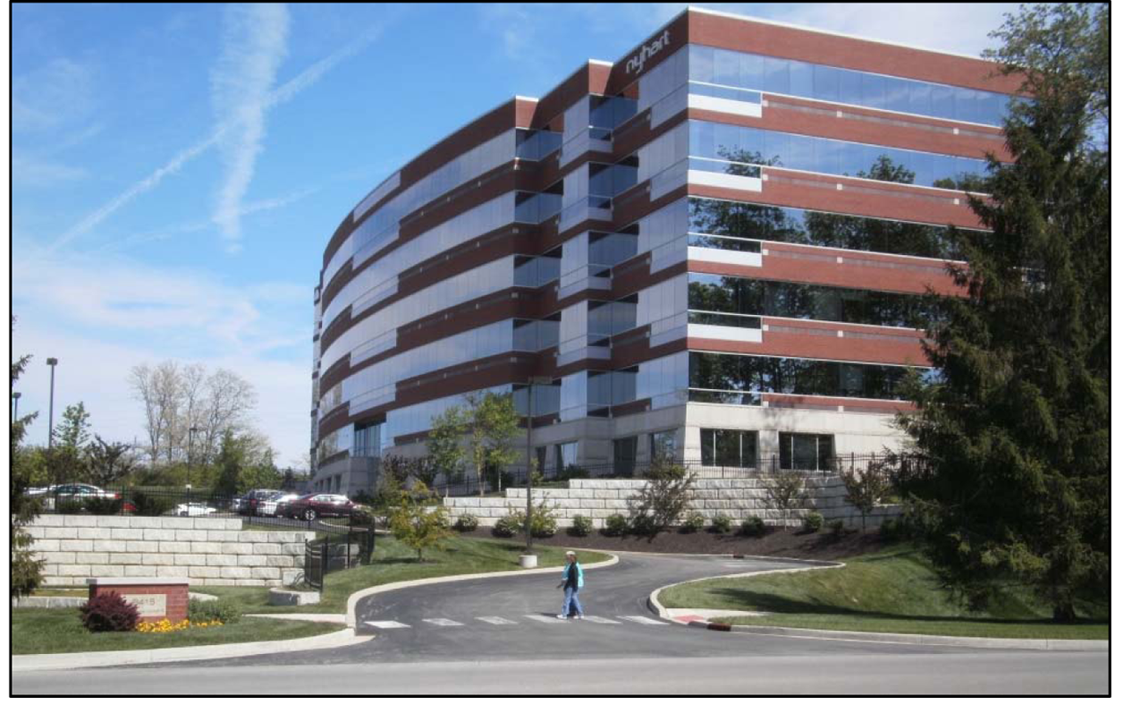
B.
Office-Buffer District (C-1).
1.
Purpose. The C-1 District is designed to perform two functions: act as a buffer between uses, and provide for a freestanding area that office uses, compatible office-type uses, such as medical and dental facilities, education services, and certain public and semipublic uses may be developed with the assurance that retail and other heavier commercial uses with incompatible characteristics will not impede or disrupt. Since the buildings for office, office-type and public and semipublic uses are typically much less commercial in appearance, landscaped more fully and architecturally more harmonious with residential structures, this District can serve as a buffer between protected Districts and more intense commercial or industrial areas/Districts - if designed accordingly. This District, with its offices and other buffer type uses, may also be used along certain thoroughfares where a gradual and reasonable transition from existing residential use should occur.
2.
Examples.
3.
Illustration.
4.
Other standards.
a.
Windows/doors/transparency.
1.
On the side of each primary building that has a public pedestrian entrance, at least 40 percent of the wall surface area between three feet and eight feet above grade level and within 50 feet of each side of the entrance shall be of glass or other transparent materials. On any facade or side of a primary building that is located within 50 feet of a local, collector or arterial street, at least 40 percent of the wall surface area between three feet and eight feet above grade level shall be of glass or other transparent materials.
2.
Required ground floor glass or other transparent materials shall allow two-way visibility between three feet and eight feet above grade level.
3.
No glass or other transparent materials shall reflect more than 30% of visible light.
4.
Replacing windows in an existing building is permitted; however, the replacing window must match the building's original window opening within a tolerance of two inches of each opening side.
b.
Roof. All roof-mounted mechanical equipment shall be completely and effectively screened from view on all sides of the building with a parapet consistent with the building's design and materials.
C.
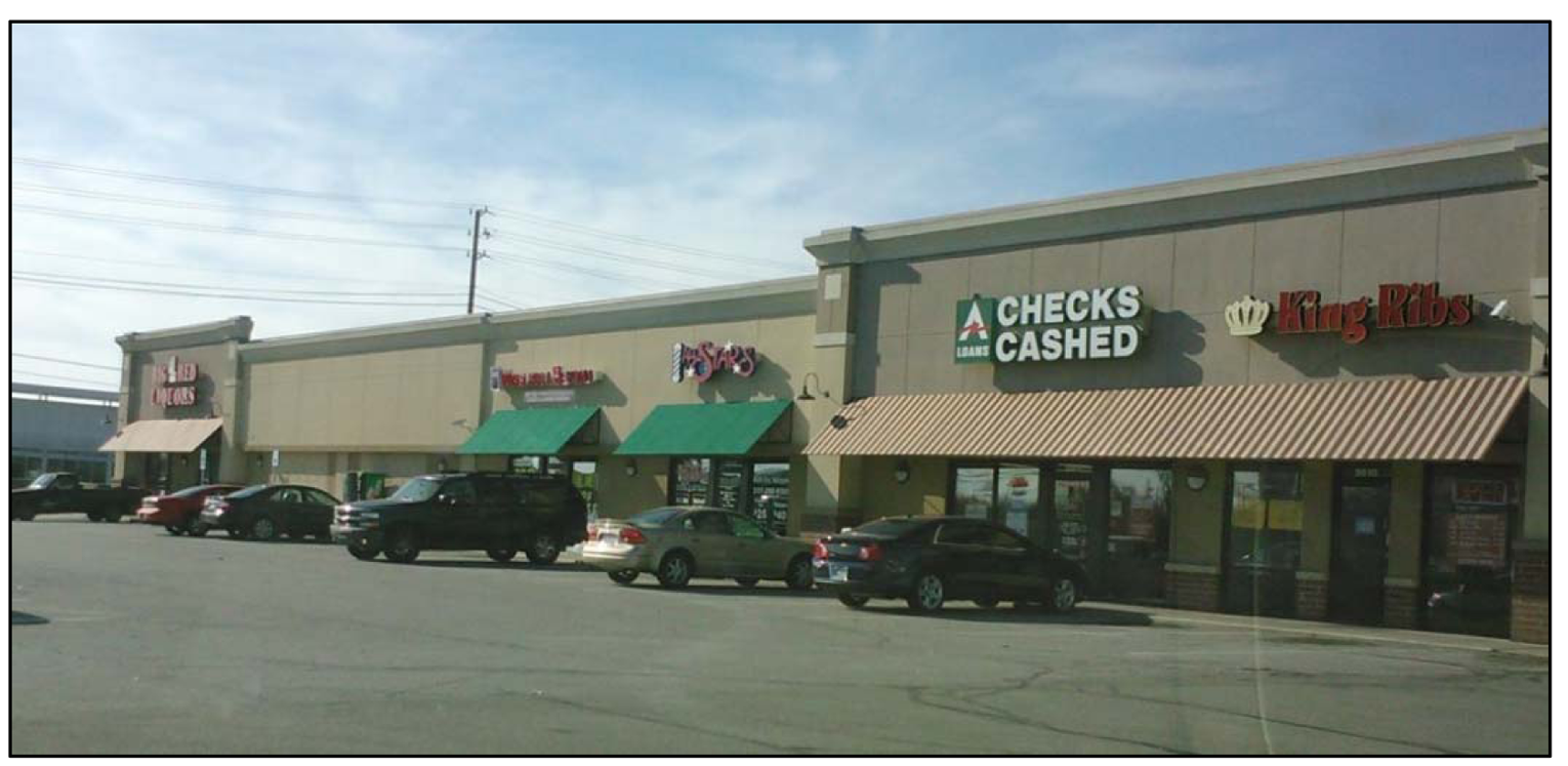
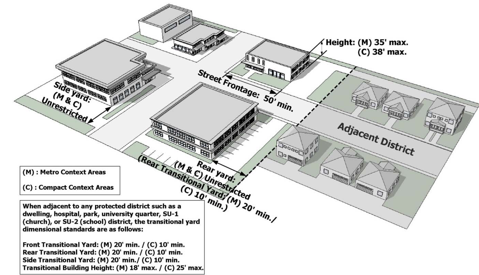
Neighborhood Commercial District (C-3).
1.
Purpose. The C-3 District is for the development of an extensive range of retail sales and personal, professional and business services required to meet the demands of a fully developed residential neighborhood, regardless of its size. Examples of such types of uses include neighborhood shopping centers, sales of retail convenience or durable goods, shopping establishments, retail and personal and professional service establishments. At this neighborhood scale of retail, a fine-grain of accessibility requisite for all modes of travel must be provided and maintained. It does not make provision, however, for those businesses that draw customers in significant numbers from well beyond a neighborhood boundary and are, therefore, unusually heavy traffic generators, such as theaters. It does not allow those businesses that require the outdoor display, sale or storage of merchandise; or require outdoor operations. In general, to achieve maximum flexibility of permitted land use, the C-3 District makes possible a highly varied grouping of indoor retail and business functions.
2.
Examples.
3.
Illustration.
4.
Other standards.
a.
Windows/doors/transparency.
1.
On the side of each primary building that has a public pedestrian entrance, at least 40 percent of the wall surface area between three feet and eight feet above grade level and within 50 feet of each side of the entrance shall be of glass or other transparent materials. On any facade or side of a primary building that is located within 50 feet of a local, collector or arterial street, at least 40 percent of the wall surface area between three feet and eight feet above grade level shall be of glass or other transparent materials.
2.
Required ground floor glass or other transparent materials shall allow two-way visibility between three feet and eight feet above grade level.
3.
No glass or other transparent materials shall reflect more than 30% of visible light.
4.
Replacing windows in an existing building is permitted; however, the replacing window must match the building's original window opening within a tolerance of two inches of each opening side.
b.
Roof. All roof-mounted mechanical equipment shall be completely and effectively screened from view on all sides of the building with a parapet consistent with the building's design and materials.
D.
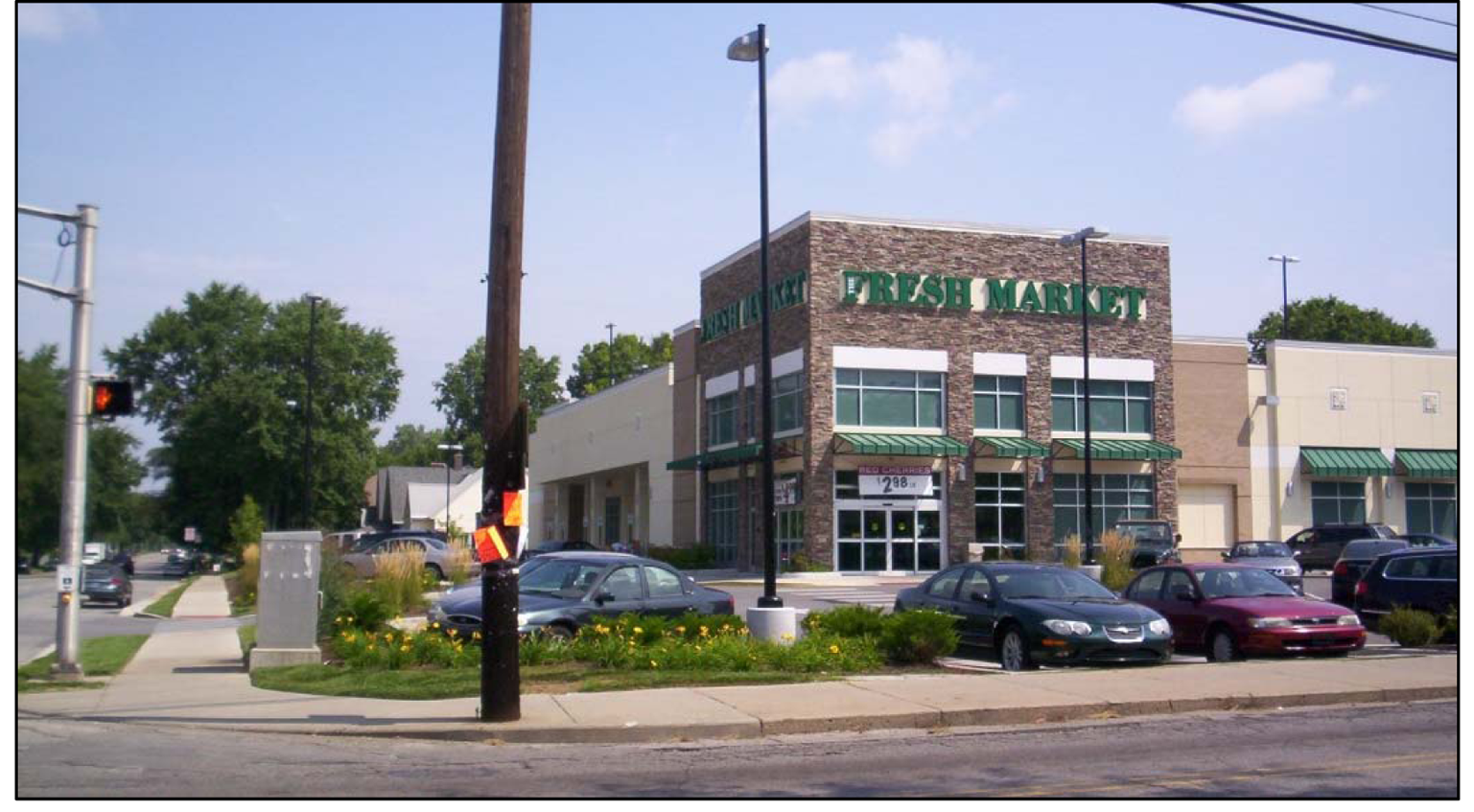
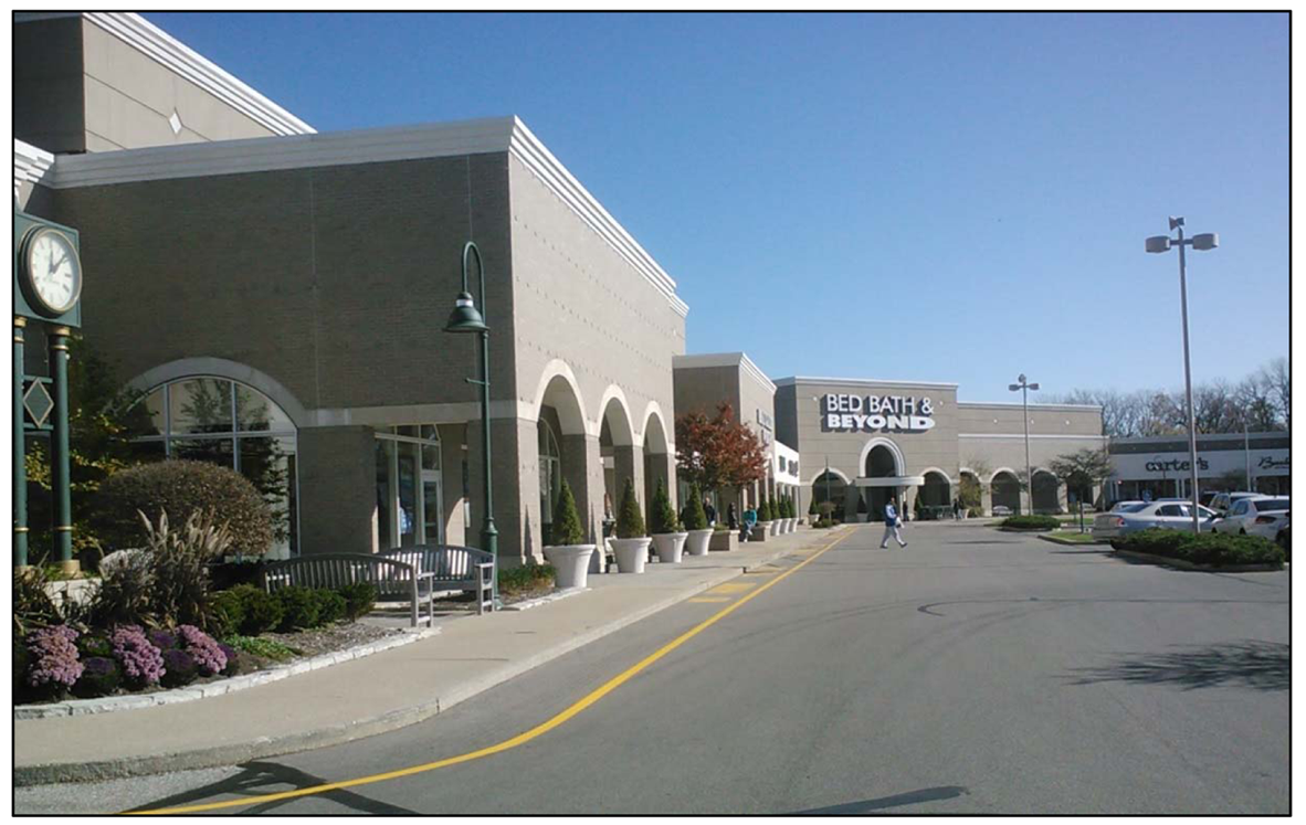
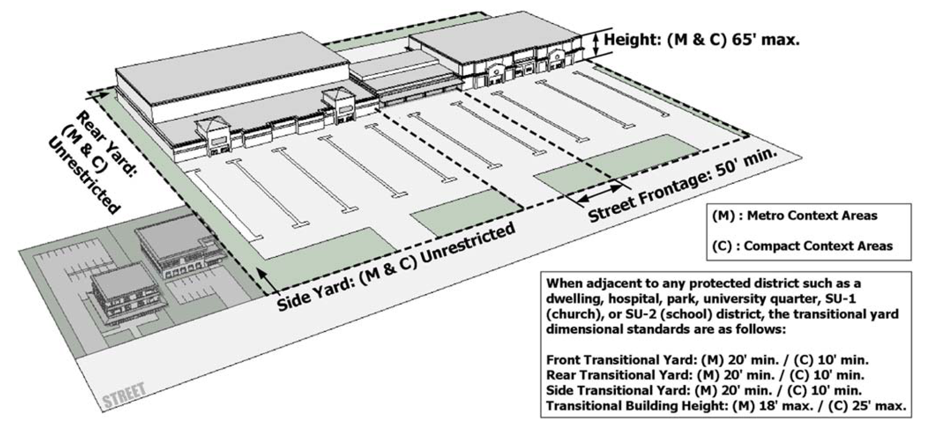
Community-Regional District (C-4).
1.
Purpose. The C-4 District is designed to provide for the development of major business groupings and regional-size shopping centers to serve a population ranging from a community or neighborhoods to a major segment of the total metropolitan area. These centers may feature a number of large traffic generators such as home improvement stores, department stores, and theatres. Even the smallest of such freestanding uses in this District, as well as commercial centers, require excellent access from major thoroughfares. While these centers are usually characterized by indoor operations, certain permitted uses may have limited outdoor activities, as specified.
2.
Examples.
3.
Illustration.
4.
Other standards.
a.
Windows/doors/transparency.
1.
On the side of each primary building that has a public pedestrian entrance, at least 40% of the wall surface area between three feet and eight feet above grade level and within 50 feet of each side of the entrance shall be of glass or other transparent materials. On any facade or side of a primary building that is located within 50 feet of a local, collector or arterial street, at least 40% of the wall surface area between three feet and eight feet above grade level shall be of glass or other transparent materials.
2.
Required ground floor glass or other transparent materials shall allow two-way visibility between three feet and eight feet above grade level.
3.
No glass or other transparent materials shall reflect more than 30% of visible light.
4.
Replacing windows in an existing building is permitted; however, the replacing window must match the building's original window opening within a tolerance of two inches of each opening side.
b.
Roof.
1.
All roof-mounted mechanical equipment shall be completely and effectively screened from view on all sides of the building with a parapet consistent with the building's design and materials.
E.
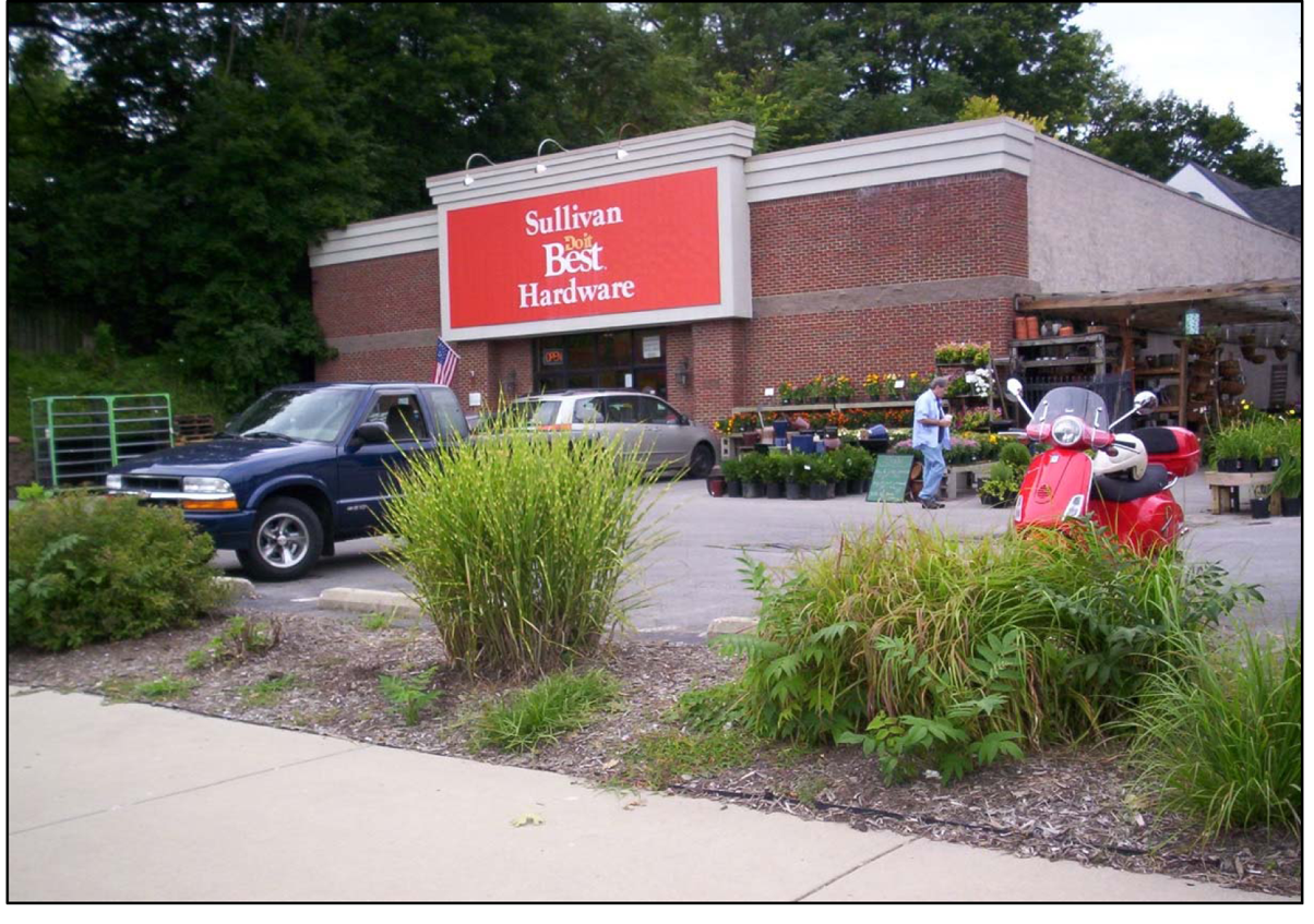
General Commercial District (C-5).
1.
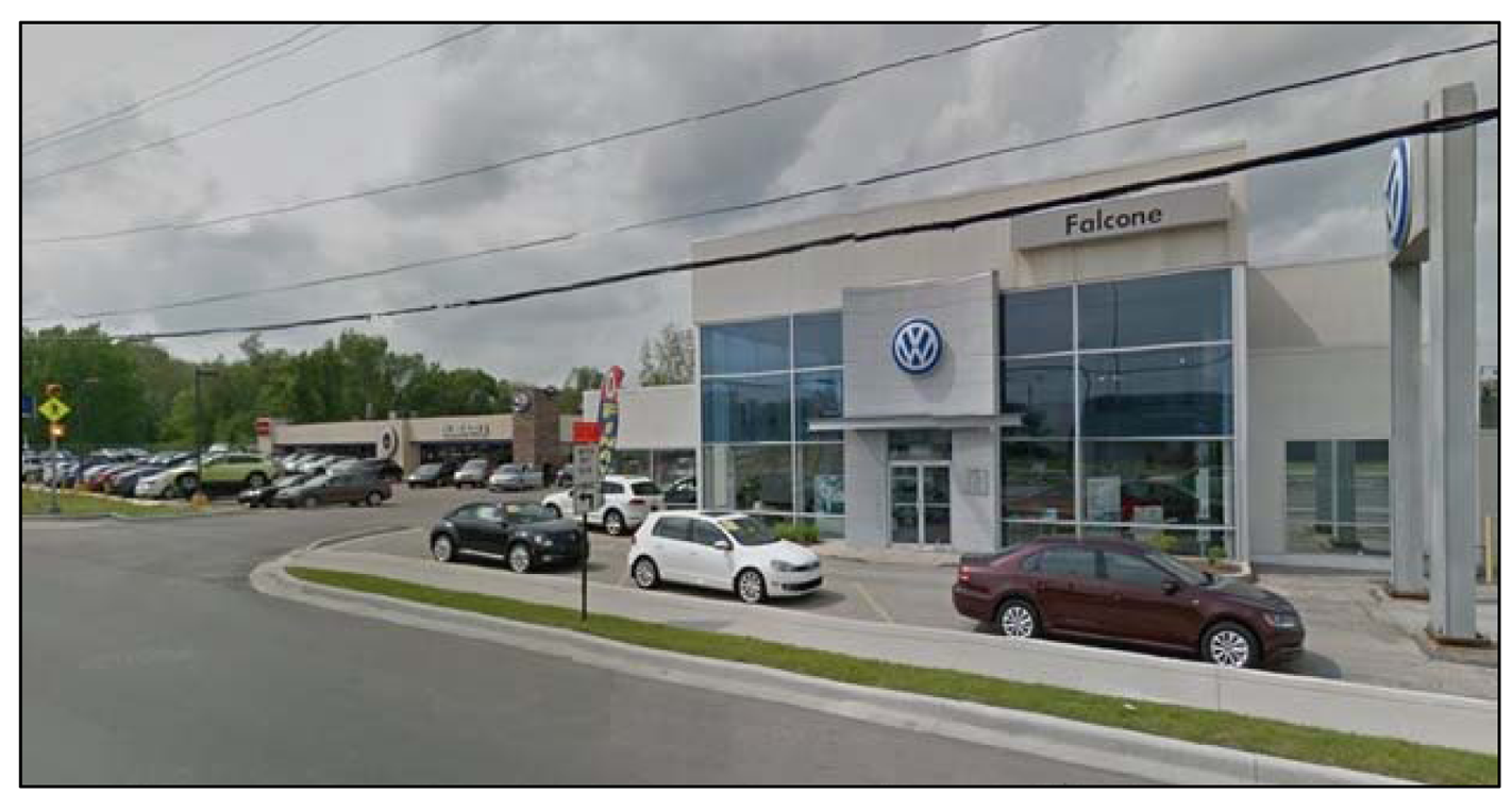
Purpose. The C-5 District is designed to provide areas for those retail sales and service functions whose operations are typically characterized by automobiles, outdoor display, or sales of merchandise; by major repair of motor vehicles; by outdoor commercial amusement and recreational activities; or by activities or operations conducted in buildings or structures not completely enclosed. The types of uses found in this District tend to be outdoor functions, brightly lit, noisy, etc. Therefore, to provide a location where such uses can operate in harmony with the vicinity, the C-5 District should be located on select heavy commercial thoroughfares and should avoid locating adjacent to protected Districts.
2.
Examples.
3.
Illustration.
4.
Other standards.
a.
Windows/doors/transparency.
1.
On the side of each primary building that has a public pedestrian entrance, at least 40% of the wall surface area between three feet and eight feet above grade level and within 50 feet of each side of the entrance shall be of glass or other transparent materials. On any facade or side of a primary building that is located within 50 feet of a local, collector or arterial street, at least 40% of the wall surface area between three feet and eight feet above grade level shall be of glass or other transparent materials.
2.
Required ground floor glass or other transparent materials shall allow two-way visibility between three feet and eight feet above grade level.
3.
No glass or other transparent materials shall reflect more than 30% of visible light.
4.
Replacing windows in an existing building is permitted; however, the replacing window must match the building's original window opening within a tolerance of two inches of each opening side.
b.
Roof.
1.
All roof-mounted mechanical equipment shall be completely and effectively screened from view on all sides of the building with a parapet consistent with the building's design and materials.
F.
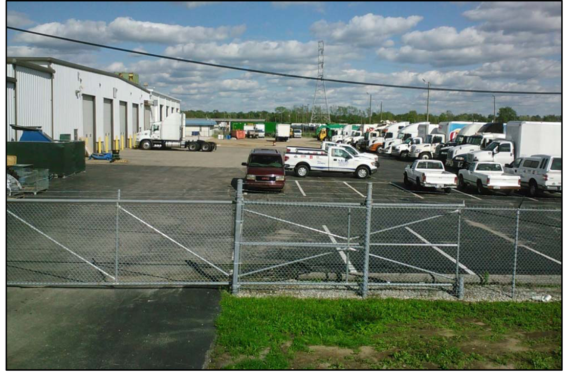
High-Intensity Commercial District (C-7).
1.
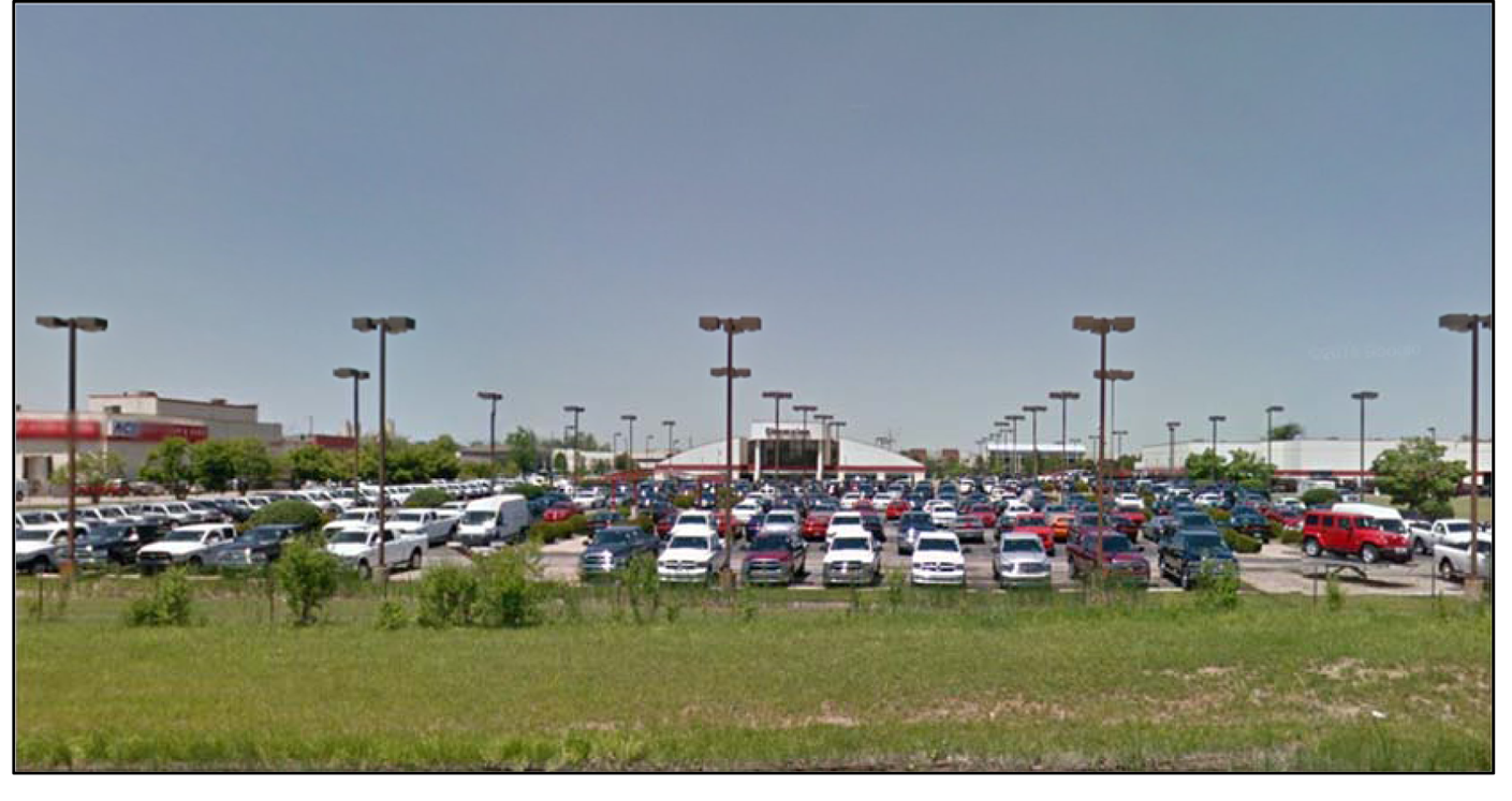
Purpose. The C-7 District is designed to provide specific areas for commercial uses which have unusually incompatible features relative to other commercial uses, such as major outdoor storage or display of sizeable merchandise and the outdoor parking and storage of trucks, materials or equipment essential to the operation of these uses. Many of these uses generally are not visited by customers, but rather involve service operations from headquarters with some on-site fabrication of parts. The nature of operation or appearance are more compatible with industrial than retail commercial activities. Because of the character and intensity of these uses, this District should be appropriately located on major commercial arterial thoroughfares and near interstate freeways, but not in close association with those commercial activities involving shopping goods, professional services, restaurants, food merchandising, and the like. Due to the intensity of uses, location of this District should never be adjacent to Protected Districts.
2.
Examples.

3.
Illustration.
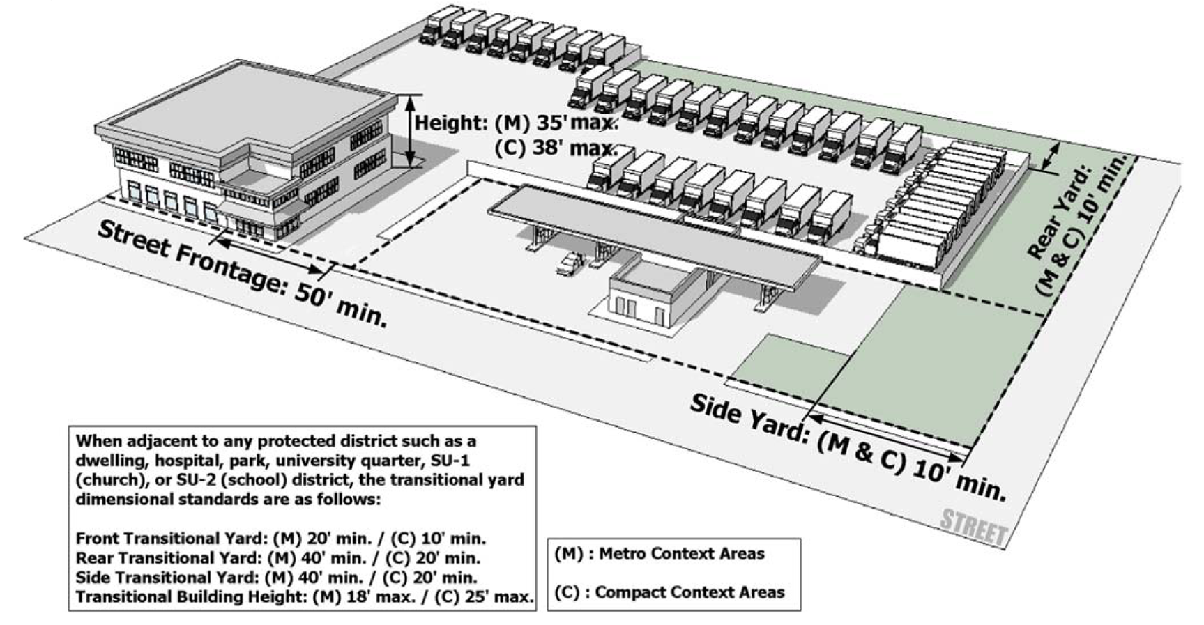
4.
Other standards.
a.
Windows/doors/transparency.
1.
On the side of each primary building that has a public pedestrian entrance, at least 30% of the wall surface area between three feet and eight feet above grade level and within 50 feet of each side of the entrance shall be of glass or other transparent materials. On any facade or side of a primary building that is located within 50 feet of a local, collector or arterial street, at least 30% of the wall surface area between three feet and eight feet above grade level shall be of glass or other transparent materials.
2.
Required ground floor glass or other transparent materials shall allow two-way visibility between three feet and eight feet above grade level.
3.
No glass or other transparent materials shall reflect more than 30% of visible light.
G.
Special Commercial District (C-S).
1.
General.
a.
The Special Commercial District (C-S) is established for the following purposes:
1.
To encourage:
i.
A more creative approach in land planning.
ii.
Superior site and structural design and development.
iii.
An efficient and desirable use of open space.
2.
To provide for a use of land with high functional value.
3.
To assure compatibility of land uses, both within the C-S District and with adjacent areas.
4.
To permit special consideration of property with outstanding features, including, but not limited to, historical, architectural or social significance, unusual topography, landscape amenities, and other special land characteristics.
5.
To provide maximum adaptability and flexibility in zoning and development controls to meet the changing and diverse needs of the metropolitan area.
b.
The C-S District is designed to permit, within a single Zoning District, multi-use commercial complexes or land use combinations of commercial and noncommercial uses, or single-use commercial projects. The primary objective of this District is to encourage development which achieves a high degree of excellence in planning, design or function, and can be intermixed, grouped or otherwise uniquely located with maximum cohesiveness and compatibility. The District provides flexibility and procedural economy by permitting the broadest range of land use choices within a single District, while maintaining adequate land use controls. The C-S District can include high-rise or low-rise developments, can be applied to large or small land areas appropriately located throughout the metropolitan area, and can be useful in areas of urban renewal or redevelopment.
c.
Development site plans should incorporate and promote environmental considerations, working within the constraints and advantages presented by existing site considerations, including vegetation, topography, drainage and wildlife.
2.
Permitted uses.
a.
All land uses within the C-S Districts shall be limited to the use or uses specified in the applicable rezoning petition or ordinance redistricting and zoning the particular land to the C-S District. A site and development plan for a proposed C-S District shall be filed with the zoning petition and approved by the Metropolitan Development Commission. The Commission may approve, amend or disapprove the plan and may impose any reasonable conditions upon its approval. If such plan submitted is a preliminary rather than final plan, the Commission's approval shall be conditioned upon the approval, by the Administrator, of a final site and development plan, in total or in phases. Such final plan approval by the Administrator shall be conditioned upon the Administrator's findings that the final plan is consistent and in substantial conformity with the preliminary plan, as approved by the Metropolitan Development Commission. All development within the C-S Districts shall be subject to any further standards, restrictions or requirements specified in such rezoning petition or ordinance and commitments filed, made or presented in support of such rezoning petition.
b.
All C-S District uses shall:
1.
Be so planned, designed, constructed and maintained as to create a superior land development, in conformity with the Comprehensive Plan of Marion County, Indiana; and
2.
Create and maintain a desirable, efficient and economical use of land with high functional value and compatibility of land uses, within the C-S District and with adjacent uses; and
3.
Provide sufficient and well-designed access, parking and loading areas; and
4.
Provide traffic control and street plan integration with existing and planned public streets and interior access roads; and
5.
Provide adequately for sanitation, drainage and public utilities; and
6.
Allocate adequate sites for all uses proposed - the design, character, grade, location and orientation thereof to be appropriate for the uses proposed, logically related to existing and proposed topographical and other conditions, and consistent with the Comprehensive Plan for Marion County, Indiana.
3.
Other standards.
a.
Windows/doors/transparency.
1.
On the side of each primary building that has a public pedestrian entrance, at least 40% of the wall surface area between three feet and eight feet above grade level and within 50 feet of each side of the entrance shall be of glass or other transparent materials. On any facade or side of a primary building that is located within 50 feet of a local, collector or arterial street, at least 40% of the wall surface area between three feet and eight feet above grade level shall be of glass or other transparent materials.
2.
Required ground floor glass or other transparent materials shall allow two-way visibility between three feet and eight feet above grade level.
3.
No glass or other transparent materials shall reflect more than 30% of visible light.
4.
Replacing windows in an existing building is permitted; however, the replacing window must match the building's original window opening within a tolerance of two inches of each opening side.
b.
Roof.
1.
All roof-mounted mechanical equipment shall be completely and effectively screened from view on all sides of the building with a parapet consistent with the building's design and materials.
(G.O. 64, 2015, § 2; G.O. 37, 2018, § 6)
Sec. 742-105. - Mixed-use Districts.
A.
General Mixed-Use District provisions.
1.
Compliance with Chapter 741. In compliance with IC 36-7-4-701, the Commission and City-County Council have required that all property in the Mixed-Use Primary Zoning Districts comply with of Chapter 741 Subdivision Regulations. Condominium development shall not be regulated by Chapter 741, but shall be regulated per IC 32-1-6.
2.
Outdoor retail sales of beverages, flowers and food from carts on sidewalks and public areas. The outdoor retail sales of beverages, flowers and food from carts on sidewalks and public areas shall be subject to the provisions of, and approved by the City Controller in accordance with Chapter 961 of the Revised Code of the Consolidated City and County, and shall not be subject to the provisions of the Zoning Ordinance.
3.
Accessory uses and structures. Accessory uses and structures are permitted in the Mixed-Use Districts in accordance with Table 743-1: Use Table. Unless specifically exempted, accessory uses and structures must meet all standards of the Zoning Ordinance, in particular use-specific standards in Section 743-306 (Accessory and Temporary Uses) and the development standards of Chapter 744.
B.
Mixed-Use One District (MU-1).
1.
Purpose. The MU-1 District is intended for the development of high-rise office uses and apartments intermixed, grouped in varying combinations or provided in the same building. MU-1 is designed for use along arterials with both high-traffic counts and positive pedestrian experience or demand. Appropriate settings for the MU-1 District include the midtown and uptown areas of the city, very near rapid transit stops, or in the midst of high intensity regional commercial complexes.
2.
Examples.

3.
Application and general provisions. The standards contained in this subsection Section 742-105.B. are in addition to the standards in Chapter 743, Uses and Use-Specific Standards, and Chapter 744, Development Standards.
4.
Form standards.
a.
Building mass and placement. No surface parking area shall be located within 20 feet of the primary street frontage.
b.
Entry orientation.
1.
Each primary building shall have at least one operable pedestrian entrance on the primary street façade. For primary buildings located on corner lots, the required pedestrian entrance may be located on the primary street façade or at the corner where the two streets intersect.
2.
The required pedestrian entrance shall open directly to the outside without requiring pedestrians to pass through a parking garage, parking lot, or other non-pedestrian area located between the entrance and the frontage. Each ground floor single-family attached dwelling facing a local or collector street shall have a separate pedestrian entry leading from the primary façade directly to the frontage.
3.
Each required pedestrian entrance shall be clearly defined and emphasized using changes in plane, changes in material, elements such as lintels, pediments, pilasters, awnings, canopies, or other additional architectural detail.
4.
Each pedestrian entrance shall have a light feature with a dusk-to-dawn light sensor.
5.
Each pedestrian entrance shall include a window in the door or immediately adjacent to the door between three feet and six feet above floor level. A door viewer in the door may be substituted on entrances that are not on a façade.
c.
Windows/doors/transparency.
1.
On the façade of each primary building except single-family attached dwellings, at least 40% of the wall surface area between three feet and eight feet above grade level shall be of glass or other transparent materials.
2.
For nonresidential uses, required ground floor glass or other transparent materials shall allow two-way visibility between three feet and eight feet above grade level. For residential and live-work uses, required ground floor shall be transparent to allow views into common hallways, foyers, or entryways, but may be translucent or opaque when on individual dwelling units.
3.
No glass or other transparent materials shall reflect more than 30 percent of visible light.
4.
Replacing windows in an existing building is permitted; however, the replacing window must match the building's original window opening within a tolerance of two inches of each opening side.
d.
Roof. All roof-mounted mechanical equipment shall be completely and effectively screened from view on all sides of the building with a parapet consistent with the building's design and materials.
e.
Administrative adjustments. Upon petition of the applicant, adjustments to any of the Form Standards in this Section 742-105.B.4. except the requirements and standards for perimeter sidewalks may be approved by the Administrator if compliance would result in reduced pedestrian access to the property, or damage to or removal of mature and healthy trees, provided that any adjustment of a dimensional standard shall not exceed 5%, and the Administrator determines that any adverse impacts on the surrounding area have been mitigated to the extent reasonably practicable.
5.
Illustration.
6.
Other standards.
a.
For each dwelling unit, at least 55 square feet of usable outdoor space shall be provided. The outdoor space may be in the form of balconies, porches, or patios for exclusive use by the individual unit, or the outdoor space may be provided in common for use by all of the residents. Common outdoor space may be on the ground, on a roof, or on a balcony. Common outdoor space shall be improved with elements for active use by the residents, such as benches, game courts, pool, playground equipment, gardens, picnic areas, lighting, landscaping.
b.
Outdoor seating or patio uses may be located in the front yard.
c.
Game courts shall not be located in a front yard.
d.
Drive-Through facilities, including customer windows, stacking spaces, or service units, shall not be located in a front yard, and are subject to the standards in Chapter 744, Article IV Parking, Loading, and Drive-through.
e.
Accessory retail or service commercial uses shall not exceed 10% of the gross floor area of the primary building in which the accessory use is located, and no single accessory use shall exceed 5,000 square feet in gross floor area.
f.
Vehicle access.
1.
Curb cuts shall only be permitted if access cannot be provided from an alley.
2.
No curb cut shall exceed 24 feet in width.
C.
Mixed Use Two (MU-2), Mixed Use Three (MU-3), and Mixed Use Four (MU-4) Districts.
1.
Purpose. The MU-2, MU-3, and MU-4 Districts are intended to create compact, walkable places at a variety of scales and intensity, appropriate to their contexts. These districts advance their Livability Principles of this code, further the mixed-use intent of the Comp Planand rely on a connected network of slow or multi-modal streets, and a fine grain of human- scale buildings that line and activate the streetscapes. Each district has the following specific purposes and applicability:
| TABLE 742-105-2 - Walkable Neighborhood District Purposes | |
|---|---|
| Mixed Use Two (MU-2) | |
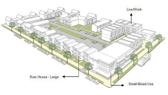 | The MU-2 District is intended to meet the daily needs for surrounding neighborhoods, and include, small social spaces that serve as neighborhood gathering places. The district includes primarily neighborhood-serving businesses and institutions, including a wide range of small-scale retail and service uses that typically do not draw customers from beyond the adjacent neighborhoods, and employment, institutional and residential uses that complement the compact, walkable development pattern. The MU-2 District is implemented as a small node or on busy corridors in the Traditional Neighborhood or City Neighborhood Typologies of the Land Use Pattern Book, or as a Village Mixed Use Typology. The typical size of a district is from 2 to 20 acres (1 to 4 blocks) but depends on the context and what integrates best into surrounding neighborhoods and complimentary zoning districts. |
| Mixed Use Three (MU-3) [1] | |
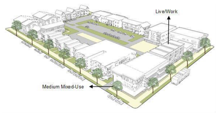 | The MU-3 District is intended to serve broader communities and are accessible by transit, and include social spaces that serve as civic gathering places. The district includes a wide range of community-serving businesses and institutions, including retail and services, employment, institutional and residential uses that complement the compact, walkable development pattern. District- wide parking strategies allow this district to serve as a community destination yet maintain the pedestrian focus and transit accessibility. The MU-3 District is implemented along major corridors in the Traditional Neighborhood or City Neighborhood Typologies of the Land Use Pattern Book, or as a Village Mixed Use or Urban Mixed-Use Typology. This district should be located ½ mile or more from other similar destinations. The typical size of a district is from 6 to 30 acres (2 to 8 blocks), but depends on the context and what integrates best into surrounding neighborhoods and complimentary zoning districts. |
| Mixed Use Four (MU-4) [1] | |
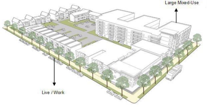 | The MU-4 District is intended to create urban centers that serve as regional destinations and are accessible by transit, and include social spaces that serve as civic gathering places. The district includes a concentration of retails and services, employment, institutions and residential uses in a compact, walkable development pattern. District-wide parking strategies allow this district to serve as a regional destination yet maintain the pedestrian focus and transit accessibility. The MU-4 District implements the Urban Mixed-Use Typology of the Land Use Pattern Book. This district should be located ½ mile or more from other similar community or regional destinations. The typical size of a district is from 8 to 40 acres (4 to 12 blocks) but depends on the context and what integrates best into surrounding neighborhoods and complimentary zoning districts. |
| [1] A request for rezoning to the MU-3 or MU-4 District shall first require the adoption of a Village Land Use Plan for the area by the Commission. | |
2.
Examples. The MU-2, MU-3 and MU-4 Districts regulate development by building type, with a range of building types permitted in each district and where each type has specific lot and building form standards. The following are examples of each type.
3.
| Building Types | Photos |
|---|---|
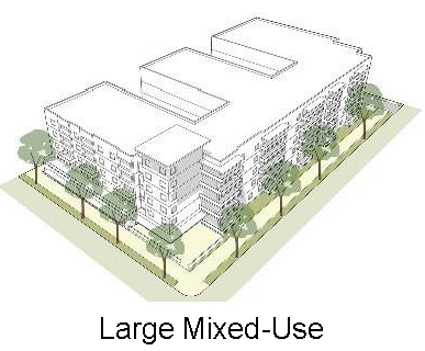 | 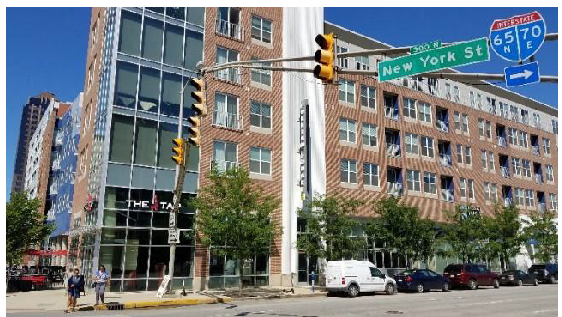 |
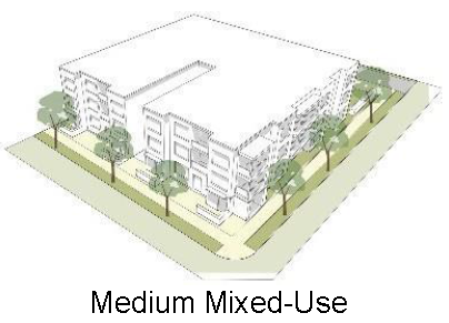 | 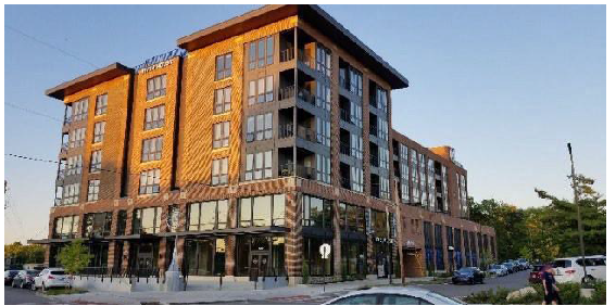 |
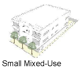 | 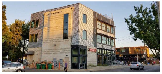 |
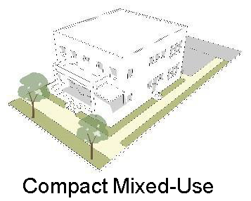 | 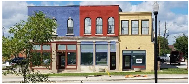 |
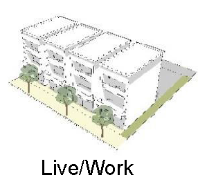 | 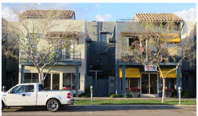 |
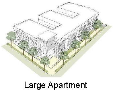 | 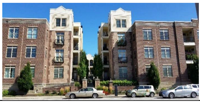 |
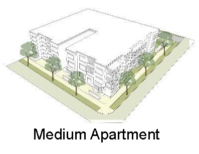 | 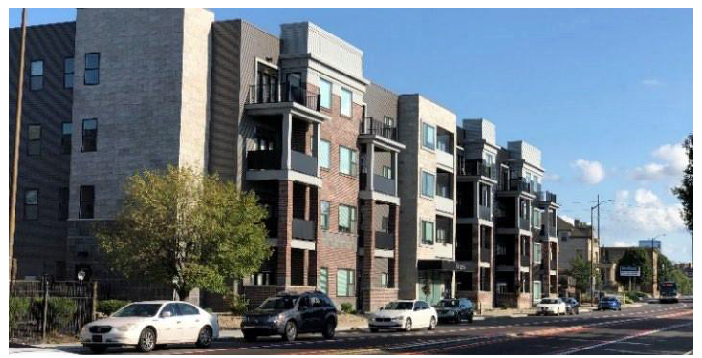 |
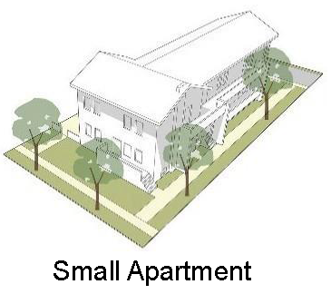 | 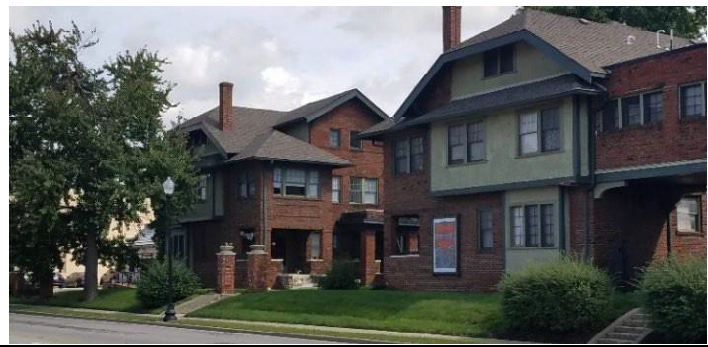 |
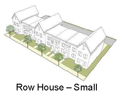 | 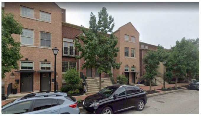 |
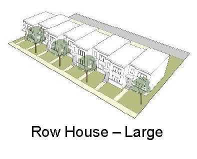 | 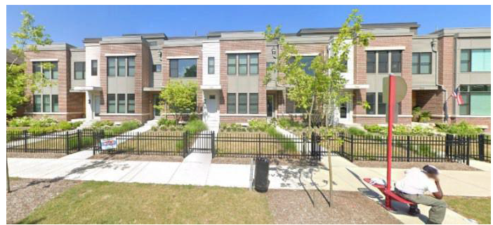 |
4.
Building type standards. Table 742-105-3 provides development standards for each building type and the zoning district where each type is permitted.
■ = Permitted by right
□ = Limited to blocks not designated as a Pedestrian Frontage type according to Section 744-702.C.
* Open Space expressed as a % shall be measured as a % of the total building footprint. Mixed-use buildings with residential uses shall also provide the additional per-unit open space. See Mixed Use and Commercial Design Standards, Section 744. Article VII. Section 744-02.F. Block and Lot Open Space.
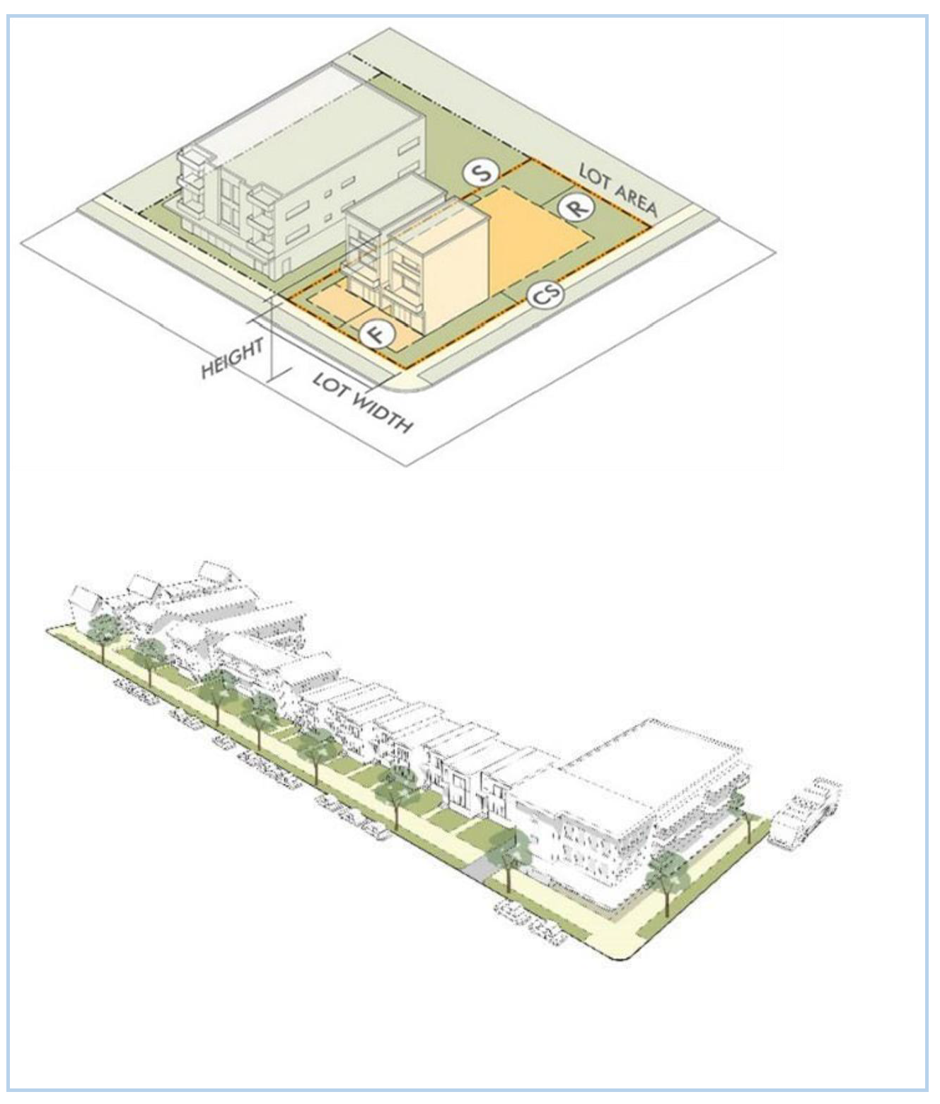
5.
Other standards. All lots and buildings in the MU-2, MU-3 and MU-4 Districts shall conform to the Mixed-use and Commercial Design Standards in Section 744-702.
(G.O. 64, 2015, § 2; G.O. 26, 2021, § 4; G.O. 23, 2023, § 4)
Sec. 742-106. - Central Business Districts.
A.
General provisions.
1.
Compliance with Chapter 741. In compliance with IC 36-7-4-701, the Commission and City-County Council require all properties in these Zoning Districts to comply with the provisions of Chapter 741 Subdivision Regulations. Condominium development shall not be regulated by Chapter 741, but shall be regulated per IC 32-1-6.
2.
Outdoor retail sales of beverages, flowers and food from carts on sidewalks and public areas. The outdoor retail sales of beverages, flowers and food from carts on sidewalks and public areas shall be subject to the provisions of, and approved by, the City Controller in accordance with Chapter 961 of the Revised Code of the Consolidated City and County, and shall not be subject to the provisions of the Zoning Ordinance.
3.
Accessory uses and structures. Accessory uses and structures are permitted in the Central Business Districts in accordance with Table 743-1: Use Table. Unless specifically exempted, accessory uses and structures must meet all standards of the Zoning Ordinance, in particular use-specific standards in Section 743-306 (Accessory and Temporary Uses) and the development standards of Chapter 744.
B.
Central Business District One (CBD-1).
1.
Purpose. The CBD-1 District is for the area containing the Soldiers and Sailors Monument and the blocks surrounding the monument. Designed to protect the ambience and spectacular view of the monument, the District also provides for a robust and diverse accumulation of business in the city's highest-density development pattern. It is a pedestrian oriented environment and establishes much of the image of Indianapolis. To foster the highly pedestrian environment and maximize land efficiency, off-street parking is not required, vehicle accommodations are strictly limited, and surface parking is prohibited.
2.
Example.

3.
Illustration.
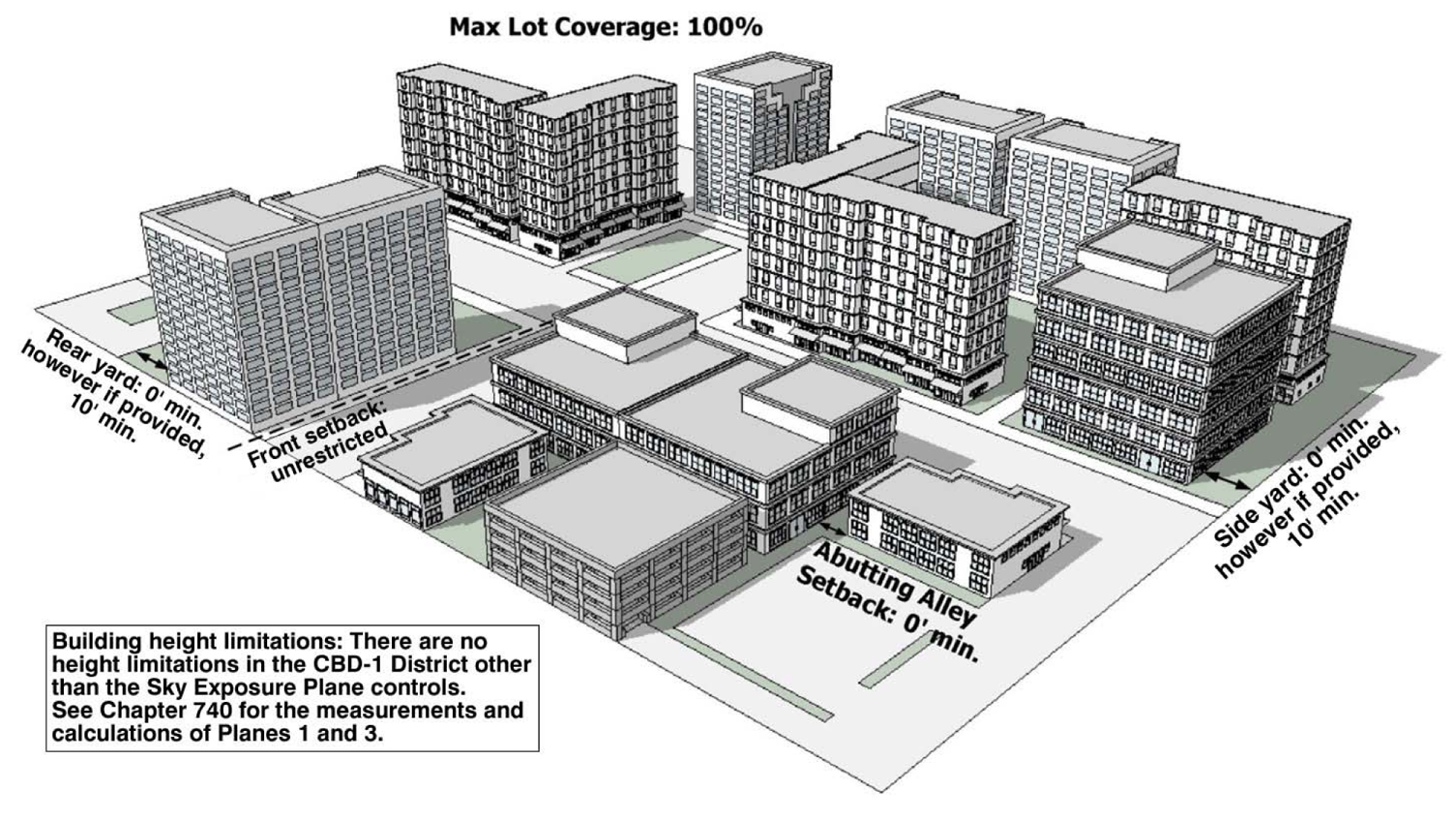
4.
Other standards.
Sky Exposure Plane
a.
Sky Exposure Plane One shall be applied to all lots within the CBD-1 District abutting:
1.
New York Street.
2.
Ohio Street.
3.
Market Street.
4.
Washington Street.
5.
Maryland Street.
6.
Capitol Avenue.
7.
Illinois Street.
8.
Meridian Street.
9.
Pennsylvania Street.
10.
Delaware Street.
11.
Indiana Street.
12.
Massachusetts Avenue.
13.
Kentucky Avenue.
14.
Virginia Avenue.
15.
Monument Circle.
b.
Provided, however, the Sky Exposure Plane Three shall be applied to all lots abutting Monument Circle.
c.
No part of any building or other structure on any lot shall penetrate the applicable sky exposure plane except as follows: A building or other structure may penetrate the Sky Exposure Plane One provided that the area of all architectural elevation facing the street, of all buildings and other structures on the lot (including those portions thereof violating the sky exposure plane) when projected back to the base of the sky exposure plane, establishes an area at the lot line not in excess of the total area of the lot frontage plane (an imaginary vertical plane, having a base coextensive with the front line and extending vertically to its termination at the intersection of the applicable sky exposure plane).
C.
Central Business District Two (CBD-2).
1.
Purpose. The CBD-2 District is for the general downtown area of Indianapolis, surrounding the CBD-1 and CBD-3 Districts. The District represents the typical urban core of Indianapolis to be developed at very high density. It is a pedestrian oriented environment that is also the focus of the City's transit system providing excellent accessibility. The grid pattern of streets are mostly high volume arterials which function efficiently due to the service areas being accessed by a thorough network of alleys. The CBD-2 District accommodates a diverse mixture of uses including residential, retail, restaurants, entertainment, major public facilities, major convention facilities, sports venues, hotels and memorials.
2.
Examples.
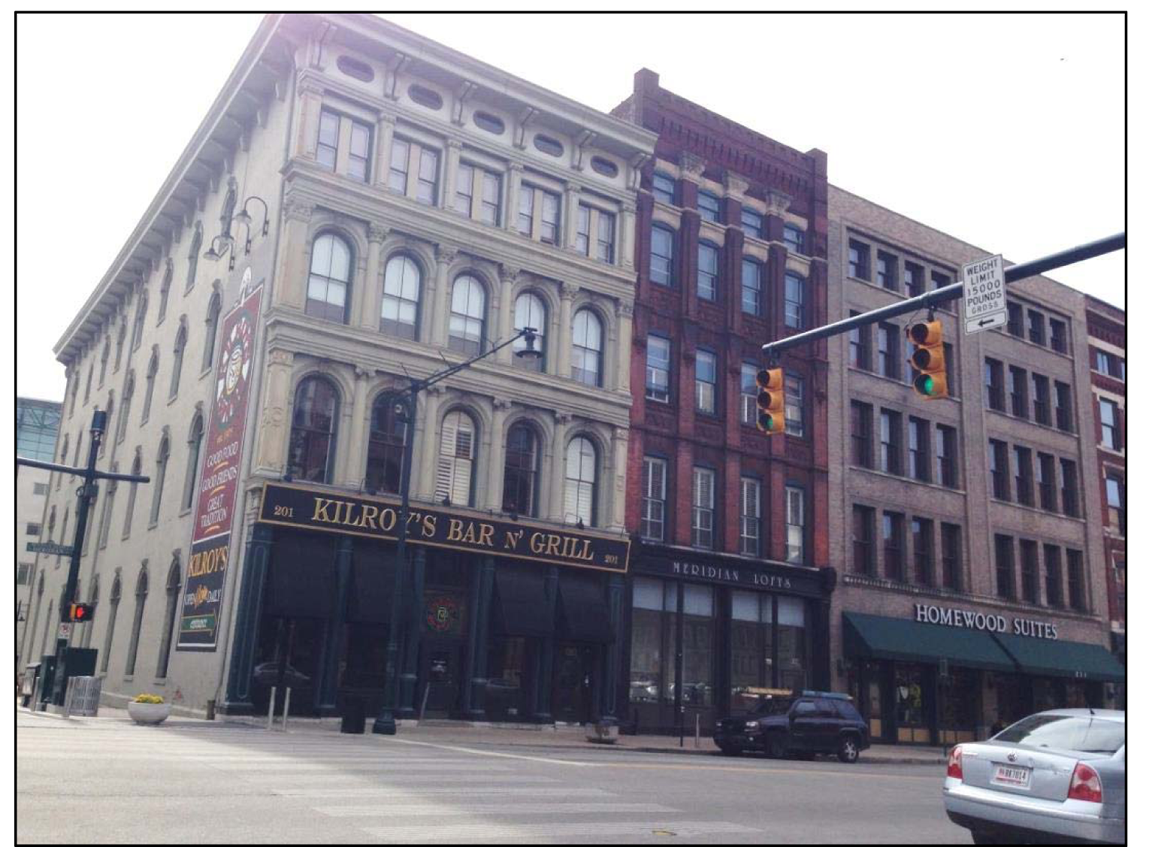
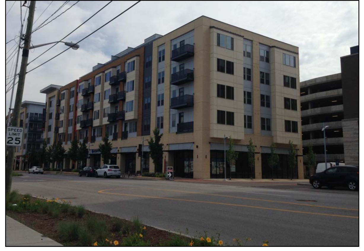
3.
Illustration.
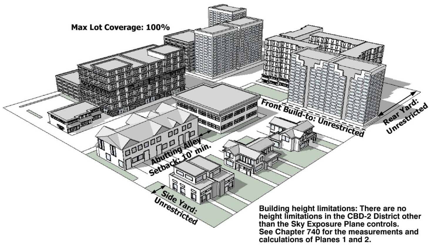
4.
Other standards.
Sky Exposure Plane
a.
The Sky Exposure Plane Two shall be applied to all lots within the CBD-2 District, except as noted in subsection b. below.
b.
Sky Exposure Plane One shall be applied to all lots within the CBD-2 District abutting:
1.
The north side of New York Street between Illinois Street and Capitol Avenue.
2.
The east side of Delaware Street between New York Street and Maryland Street.
3.
The south side of Maryland Street between Delaware Street and Capitol Avenue.
4.
The west side of Capitol Avenue between New York Street and Maryland Street.
c.
No part of any building or other structure on any lot shall penetrate the applicable sky exposure plane, except the following: A building or other structure may penetrate the Sky Exposure Plane One or Two provided that the area of all architectural elevation facing the street, of all buildings and other structures on the lot (including those portions thereof violating the sky exposure plane), when projected back to the base of the sky exposure plane establishes an area at the lot line not in excess of the total area of the lot frontage plane (an imaginary vertical plane, having a base coextensive with the front lot line and extending vertically to its termination at the intersection of the applicable sky exposure plane).
D.
Central Business District Three (CBD-3).
1.
Purpose. The CBD-3 District is for the area surrounding the American Legion Mall extending down to the CBD-1 District. To foster the highly pedestrian environment and maximize land efficiency, vehicle accommodations are strictly limited, and surface parking is prohibited. The District is designed to protect the views of landmarks, monuments and plazas that are public assets, specifically views of the Soldiers and Sailors Monument, the Capitol Building, the World War Memorial plaza, the public library, and Meridian Street. Pedestrian activity is encouraged both by the presence of pedestrian facilities like sidewalks as well as by the environment through which the pedestrian passes, such as an active grade level street front, trees and landscaping, maintaining a sense of defined urban space that is safe and highly legible.
2.
Examples.
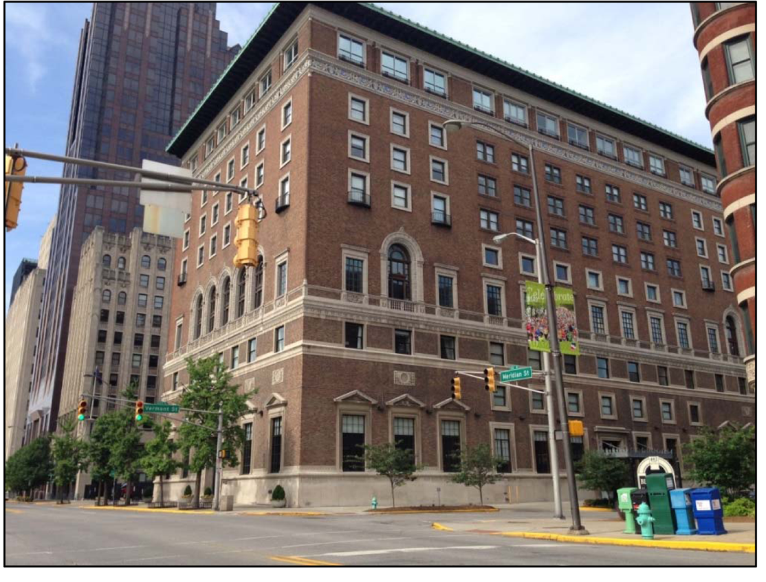
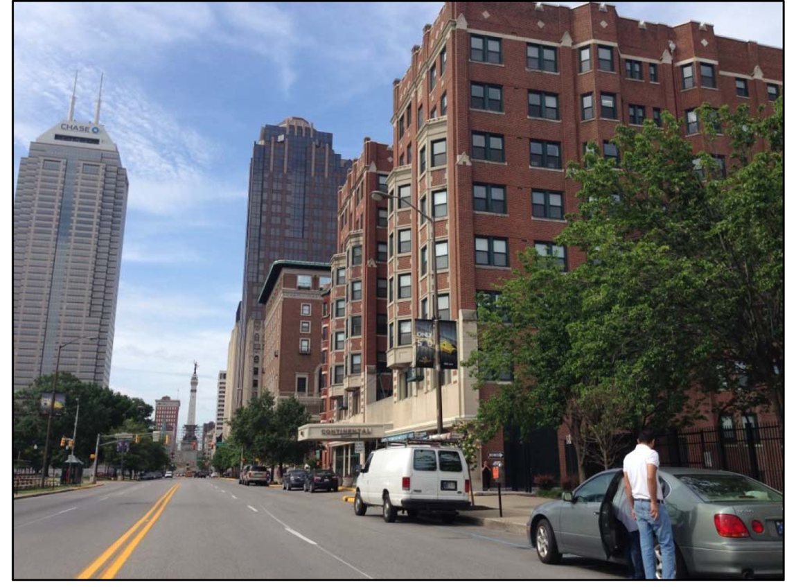
3.
Illustration.
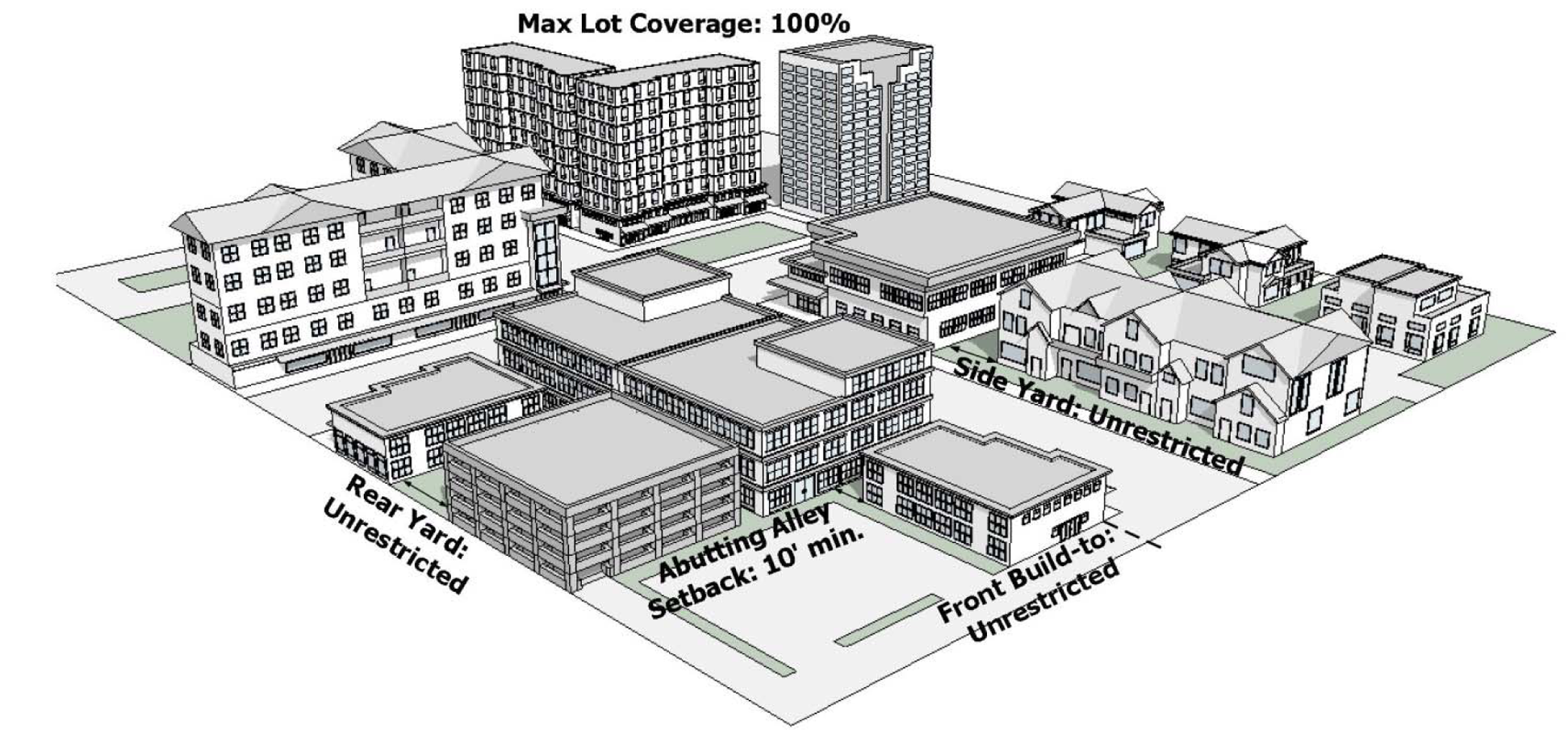
4.
Other standards.
a.
All business and retail enterprise shall be conducted within completely enclosed buildings.
b.
Drive-in establishments offering goods, food or services to customers waiting in cars shall not be permitted.
c.
No side or rear setback is required, but if a side or rear setback is provided it shall be not less than 10 feet in width.
E.
Central Business District - Special Development (CBD-S).
1.
General requirements. The following regulations shall apply to all land within the CBD-S District: All District uses shall:
a.
Be so planned, designed, constructed and maintained as to create a superior land development, in conformity with the Comprehensive Plan;
b.
Create and maintain a desirable, efficient and economical use of land with high functional and aesthetic value, attractiveness and compatibility of land uses, within the District and with adjacent uses;
c.
Provide sufficient and well-designed access, parking and loading areas;
d.
Provide traffic control and street plan integration with existing and planned public streets and interior access roads;
e.
Provide adequately for sanitation, drainage and public utilities; and
f.
Allocate adequate area for all uses proposed, the design, character, grade, location and orientation thereof to be appropriate for the uses proposed, logically related to existing and proposed topographical and other conditions, and consistent with the Comprehensive Plan for Marion County, Indiana.
2.
Permitted uses.
a.
All land use within the CBD-S District shall be limited to the use or uses specified in the applicable rezoning petition or ordinance redistricting and zoning the particular land to the CBD-S District.
b.
Site and development plan. A site and development plan for a proposed District shall be filed with the zoning petition and approved by the Metropolitan Development Commission. The Commission may approve, amend or disapprove the plan or any amended plan and may impose any reasonable conditions upon its approval. If such plan submitted is a preliminary rather than final plan, the Commission's approval shall be conditioned upon the approval, by the Administrator, Department of Metropolitan Development, of a final site and development plan, in total or in phases. Such final plan approval by the Administrator shall be conditioned upon the Administrator's finding that the final plan is consistent and in substantial conformity with the preliminary plan, as approved by the Metropolitan Development Commission. If the Administrator does not so find, the applicant may appeal the Administrator's decision to the Metropolitan Development Commission, and the Commission shall determine, after hearing in accordance with their Rules of Procedure, whether the Administrator's decision should be sustained.
3.
Development standards.
a.
Permitted uses and development in the CBD-S District shall conform to the regulations of Chapter 743, the development standards of Chapter 744, and the performance standards of Chapter 740, Article IV Performance Standards, as well as the regulations of this Section 742-106.E.
(G.O. 64, 2015, § 2)
Sec. 742-107. - Industrial Districts.
A.
General provisions.
1.
Industrial park. Land uses permitted in an Industrial District established by this chapter may be grouped together to create an industrial park, subject to all requirements of the District.
2.
Accessory uses and structures. Accessory uses and structures are permitted in the industrial Districts in accordance with Table 743-1: Use Table. Unless specifically exempted, accessory uses and structures must meet all standards of the Zoning Ordinance, in particular the use-specific standards in Section 743-306 (Accessory and Temporary Uses) and the development standards of Chapter 744.
B.
Restricted Industrial District (I-1).
1.
Purpose. The I-1 District is designed for those industries that present the least risk to the public. In the I-1 District, uses carry on their entire operation within a completely enclosed building in such a manner that no nuisance factor is created or emitted outside the enclosed building. No storage of raw materials, manufactured products, or any other materials is permitted in the open space around the buildings. Loading and unloading berths are completely enclosed or shielded by solid screening. This District has strict controls on the intensity of land use providing protection of each industry from the encroachment of other industries. It is usually located adjacent to protected Districts and may serve as a buffer between heavier industrial Districts and business or protected Districts.
2.
Examples.
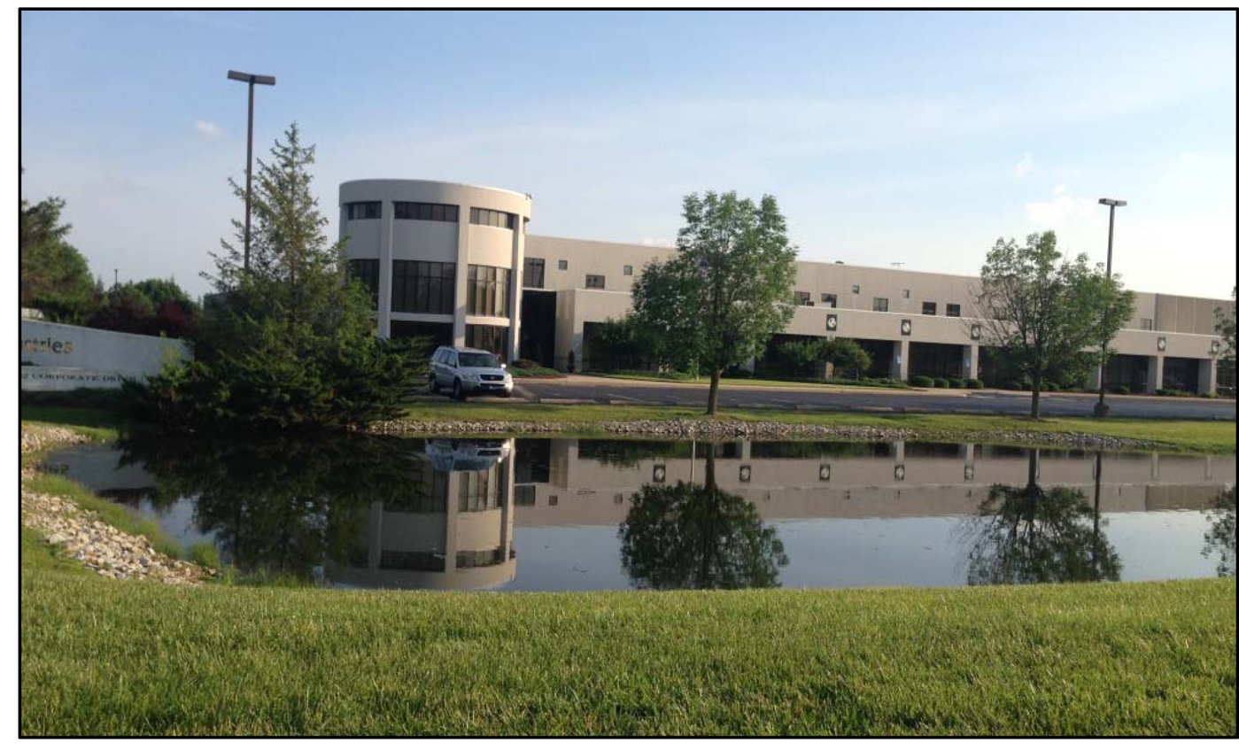
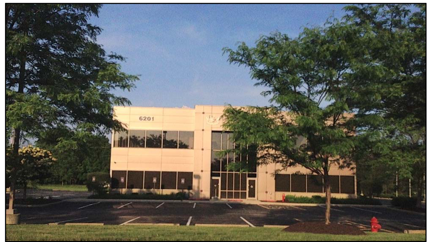
3.
Illustration - Metro Context Area.
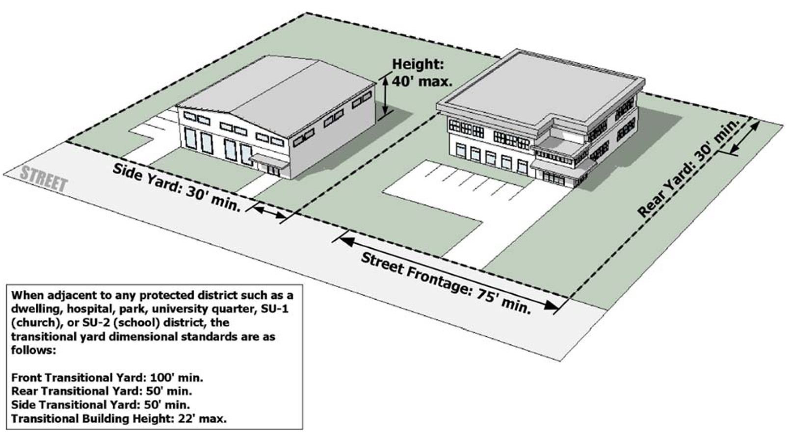
4.
Illustration - Compact Context Area.
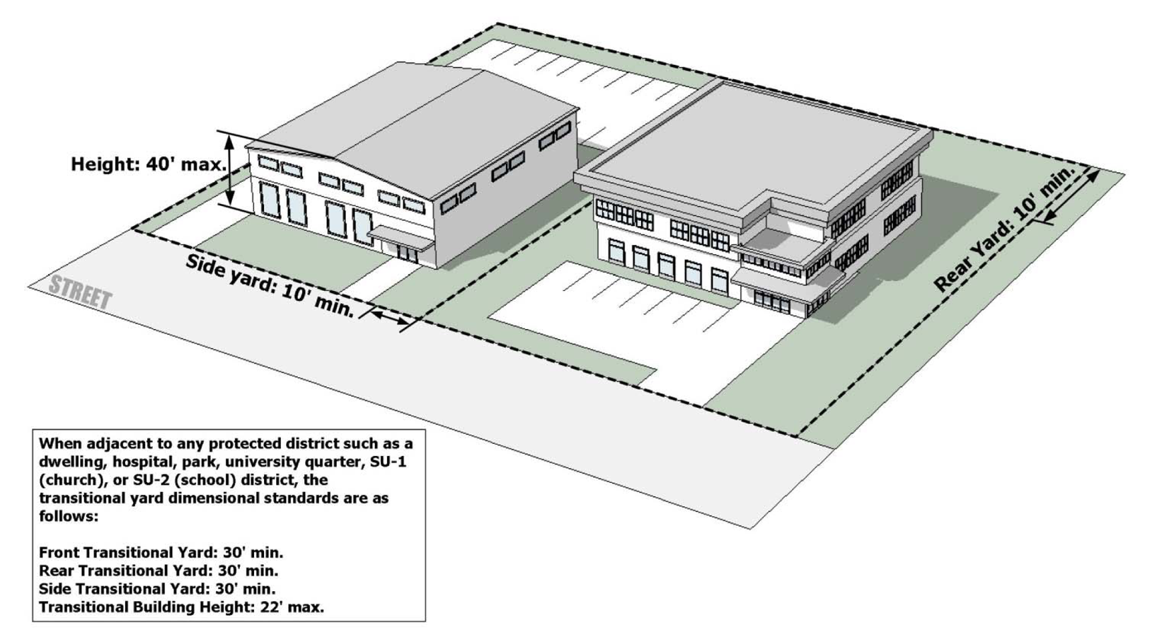
5.
Other standards. [Reserved]
C.
Light Industrial District (I-2).
1.
Purpose. The I-2 District is for those industries that present minimal risk and typically do not create objectionable characteristics (such as dirt, noise, glare, heat, odor, etc.) that extend beyond the lot lines. Outdoor operations and storage are completely screened if adjacent to protected Districts, and are limited throughout the District to a percentage of the total operation. Wherever possible, this District is located between a protected District and a heavier industrial area to serve as a buffer. For application to the older industrial Districts within the central city, standards specifically accommodate the use of shallow industrial lots.
2.
Examples.
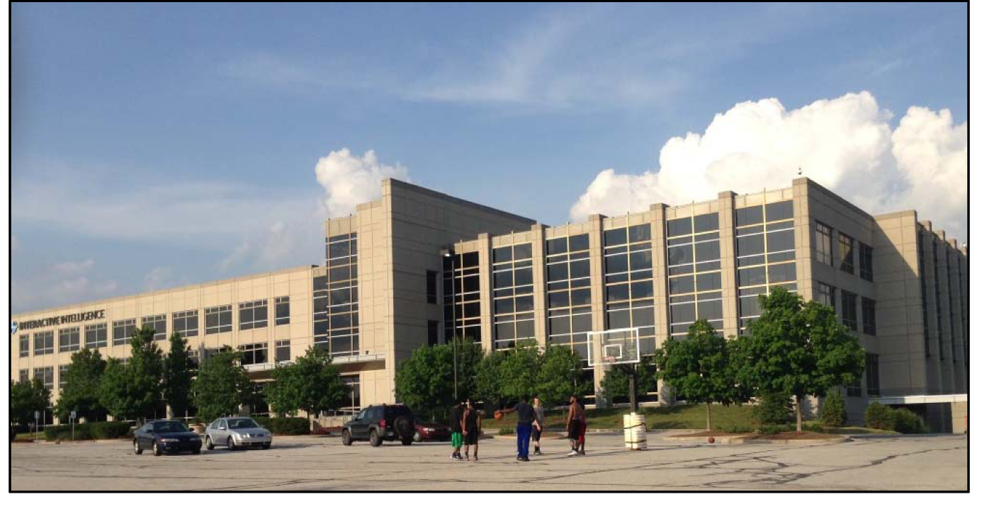
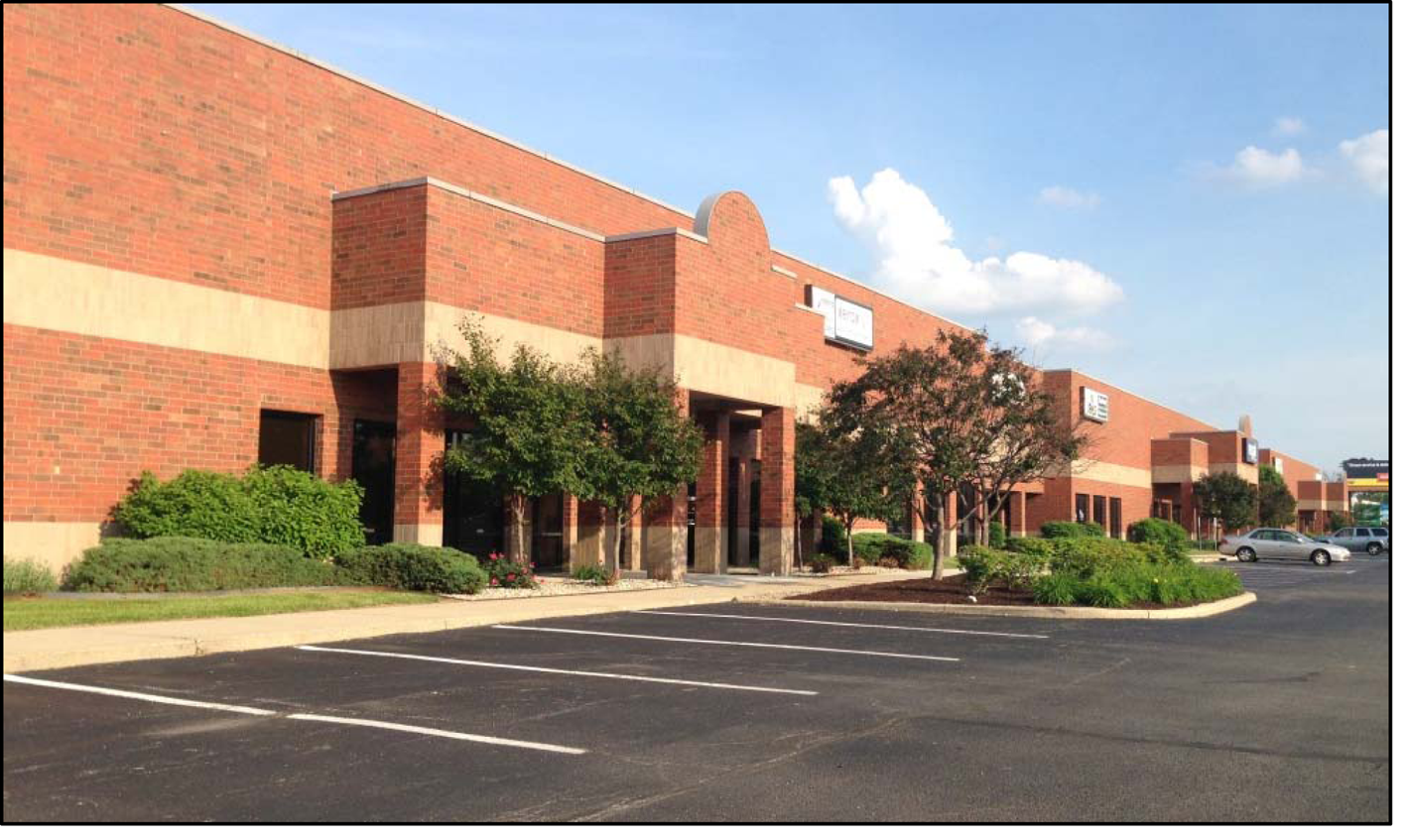
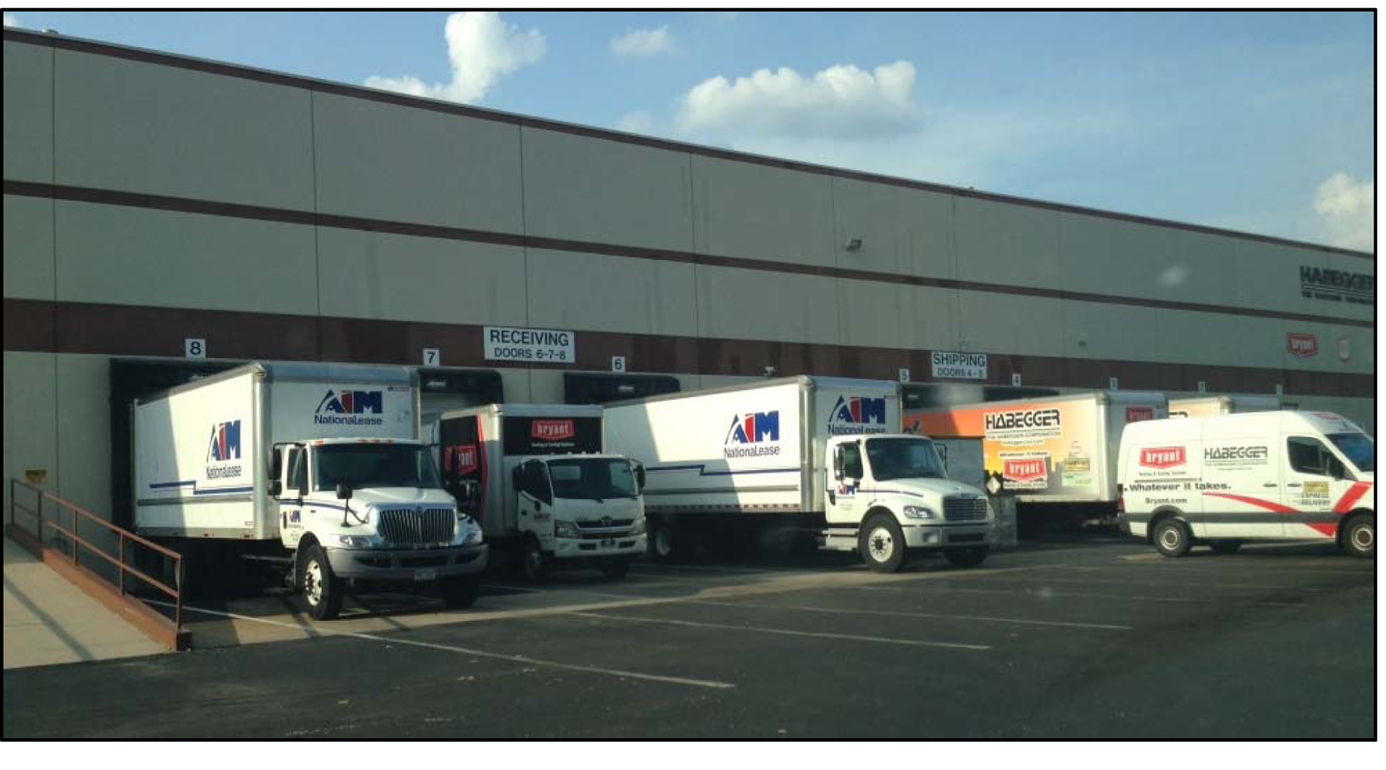
3.
Illustration - Metro Context Area.
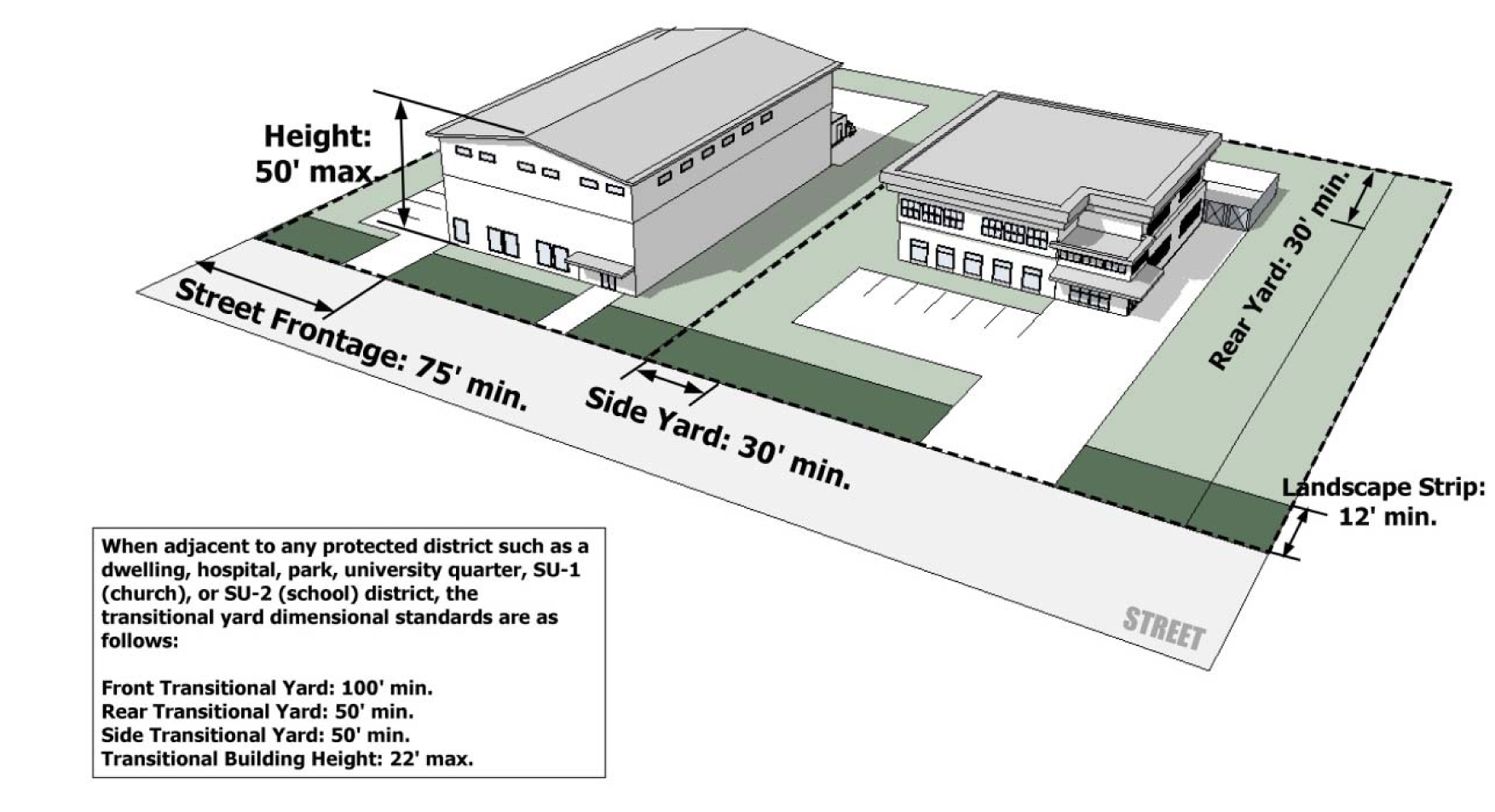
4.
Illustration - Compact Context Area.
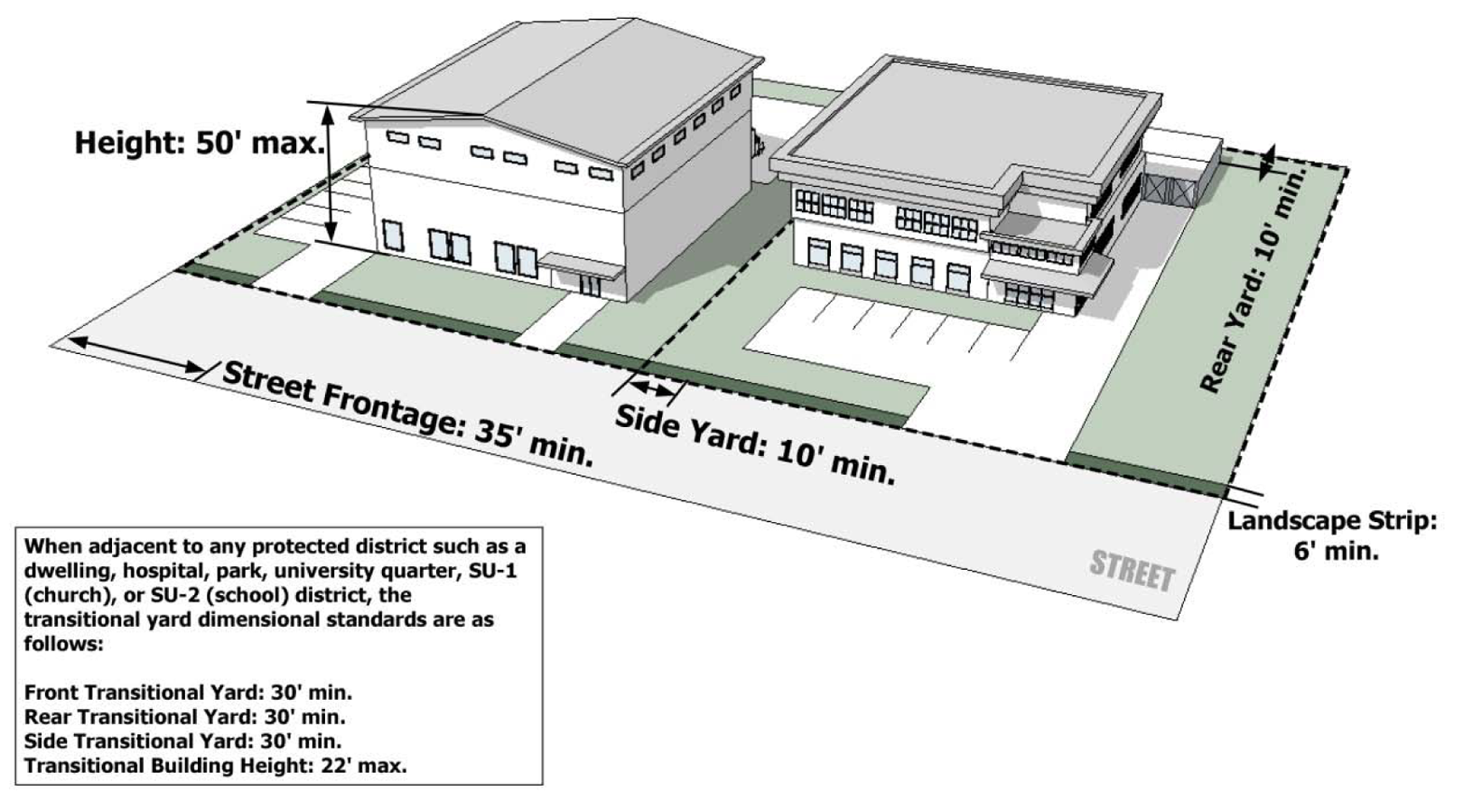
5.
Other standards. [Reserved]
D.
Medium Industrial District (I-3).
1.
Purpose. The I-3 District is an intermediate District for industries that present moderate risks to the general public. Wherever practical, this District should be away from Protected Districts and buffered by intervening lighter Industrial Districts. Where this District abuts Protected Districts, setbacks are large and enclosure of activities and storage is required.
2.
Examples.
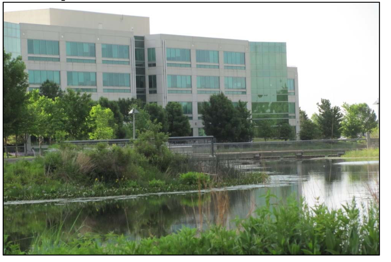
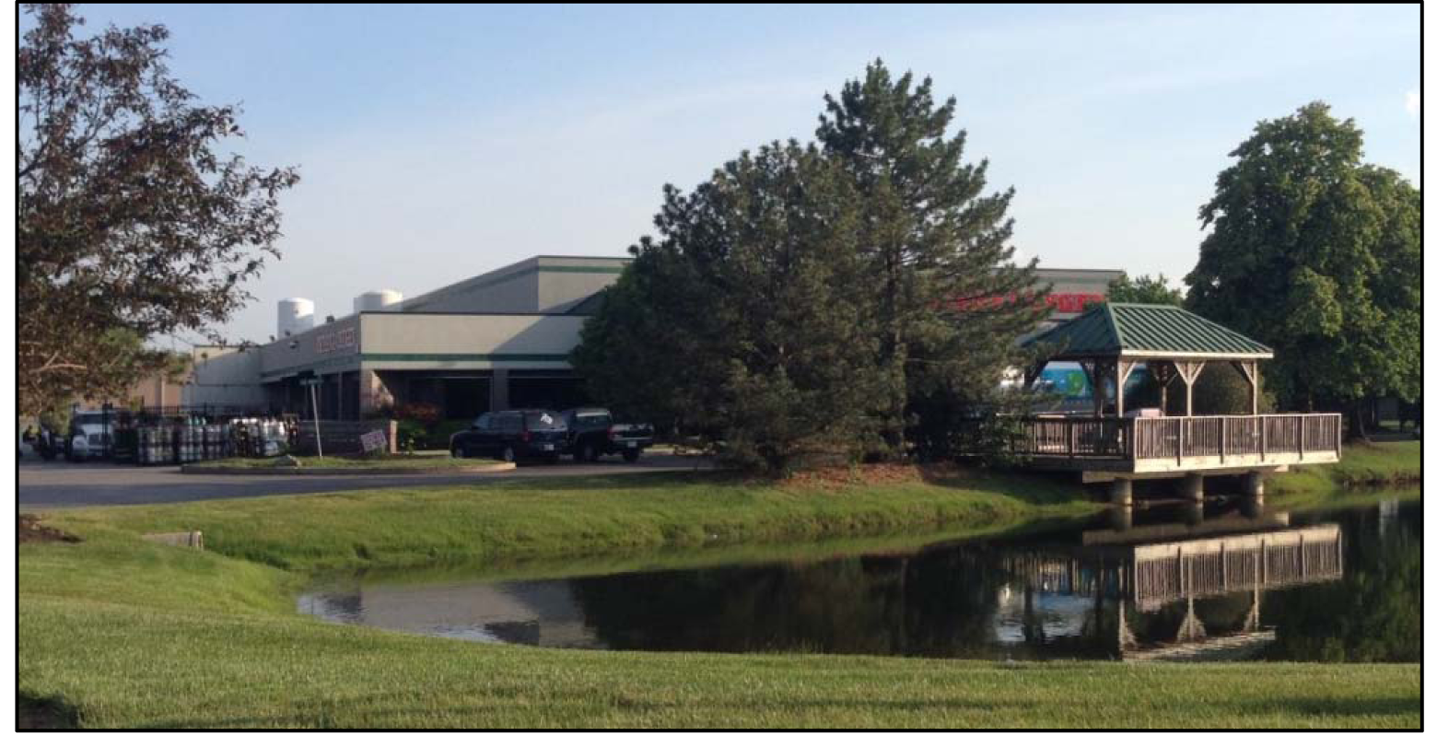
3.
Illustration - Metro Context Area.
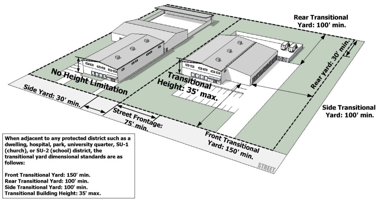
4.
Illustration - Compact Context Area.
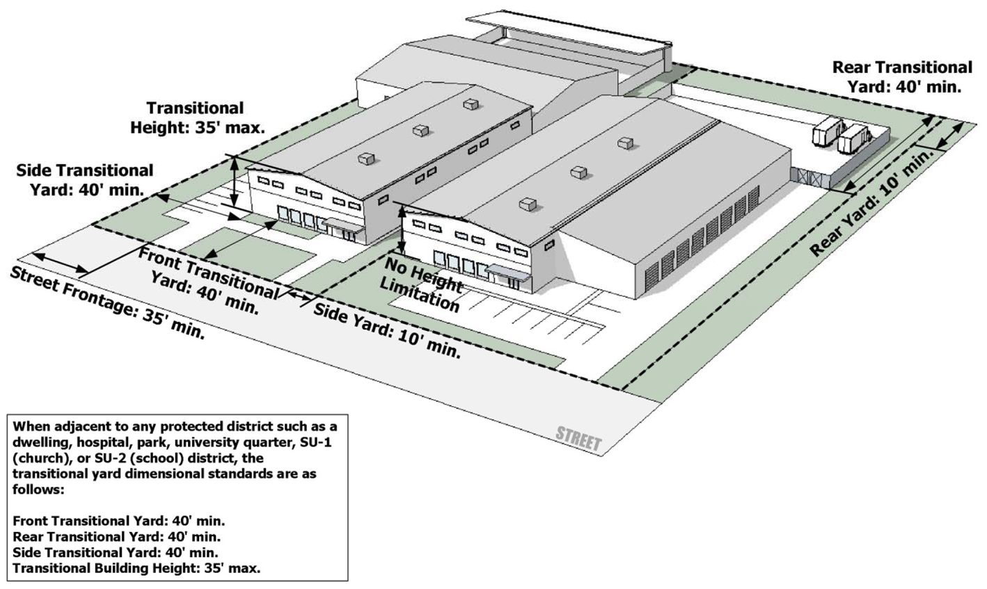
5.
Other standards. [Reserved]
E.
Heavy Industrial District (I-4).
1.
Purpose. The I-4 District is for those heavy industrial uses which present an elevated risk to the general public and are typically characterized by factors that would be exceedingly difficult, expensive or impossible to eliminate. These industries are therefore buffered by a sizeable area to minimize any detrimental aspects. The development standards and performance standards reflect the recognition of these problems. Location of this District should be as far as possible from Protected Districts and environmentally sensitive areas as practical and never be adjacent to Protected Districts.
2.
Examples.
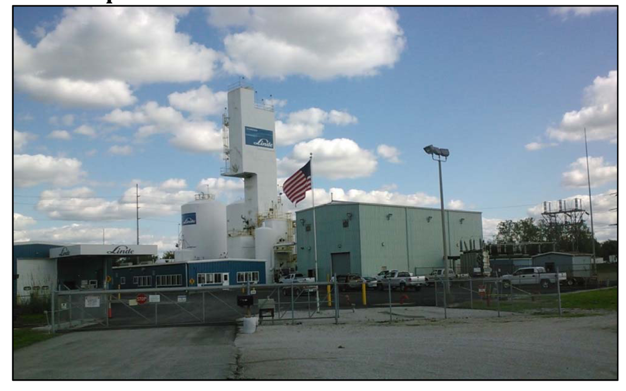
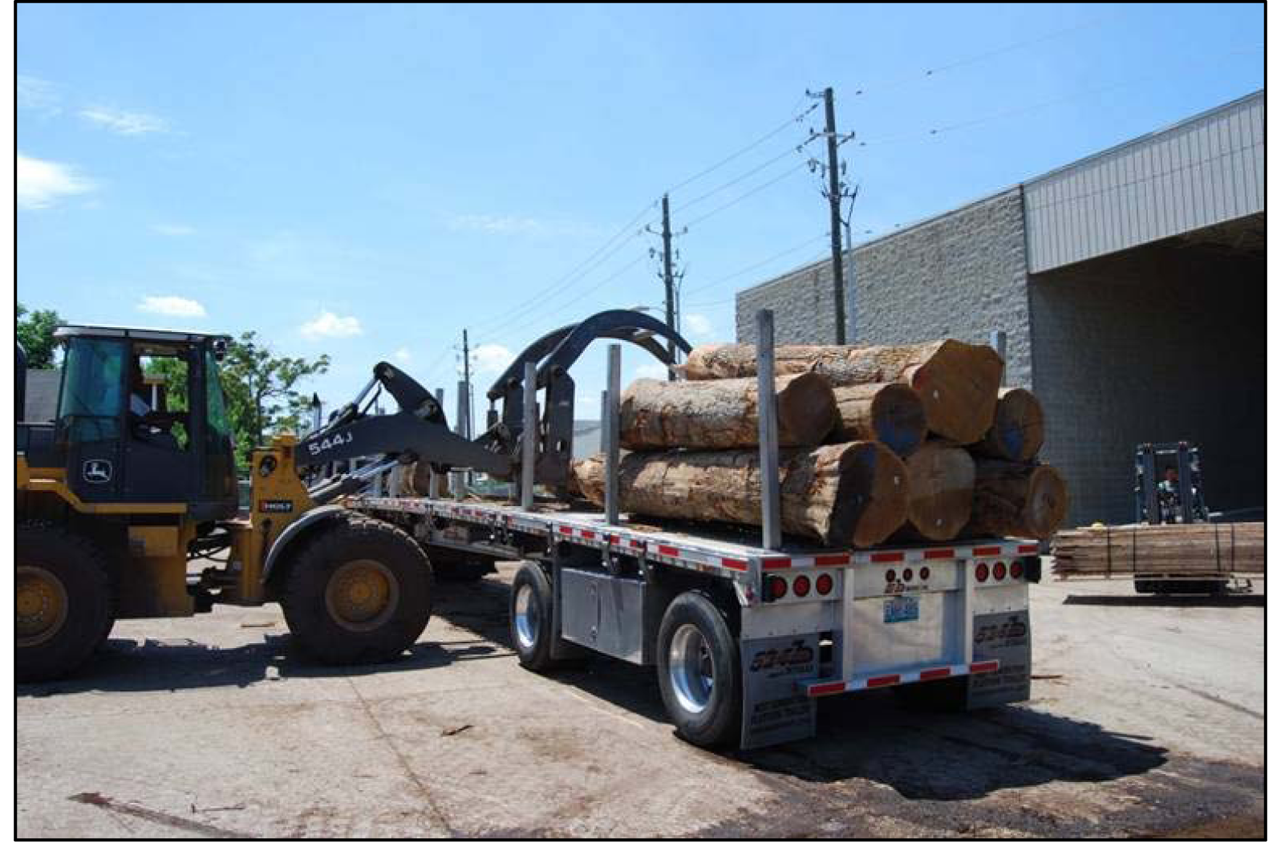
3.
Illustration - Metro Context Area.
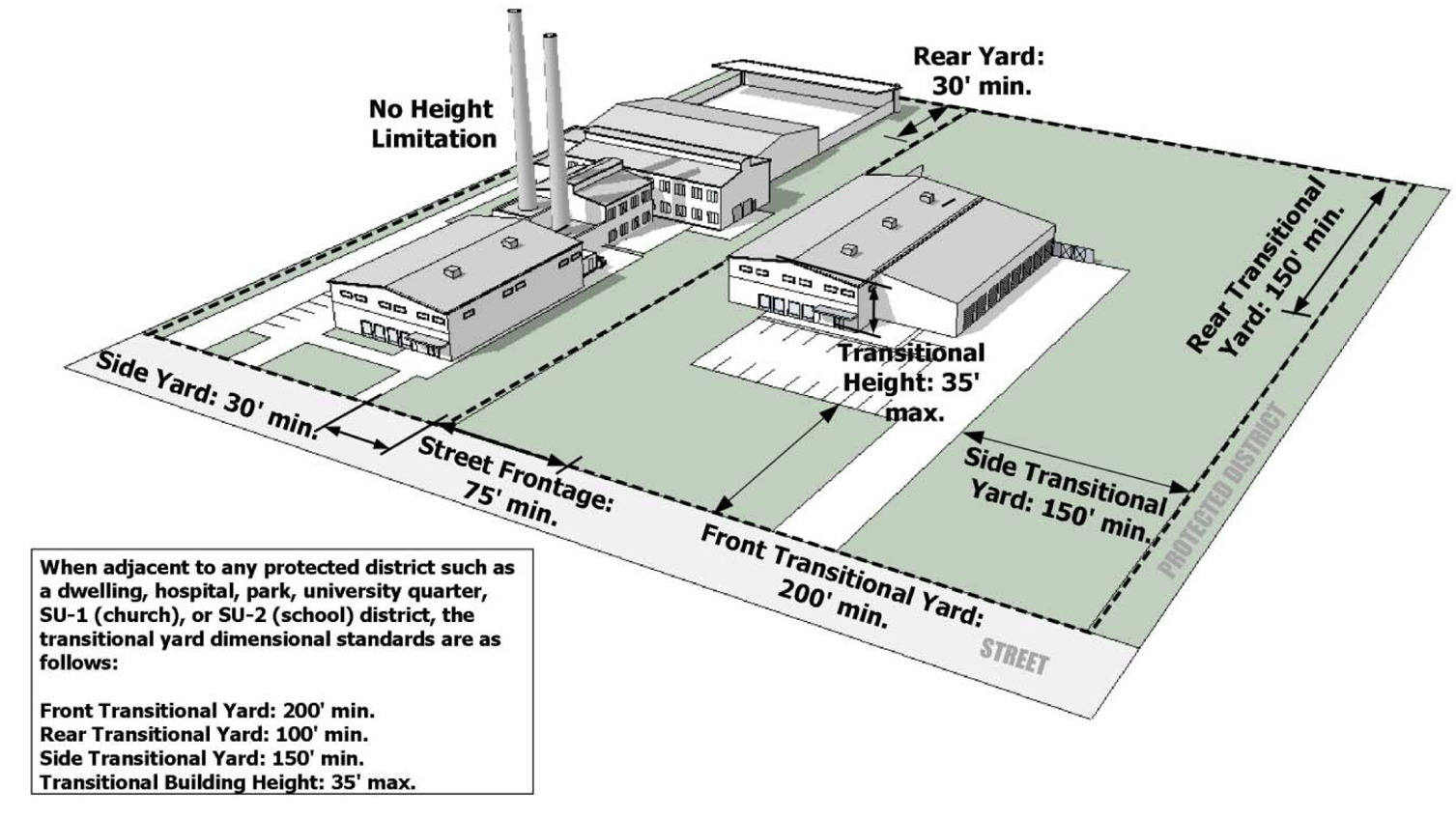
4.
Illustration - Compact Context Area.
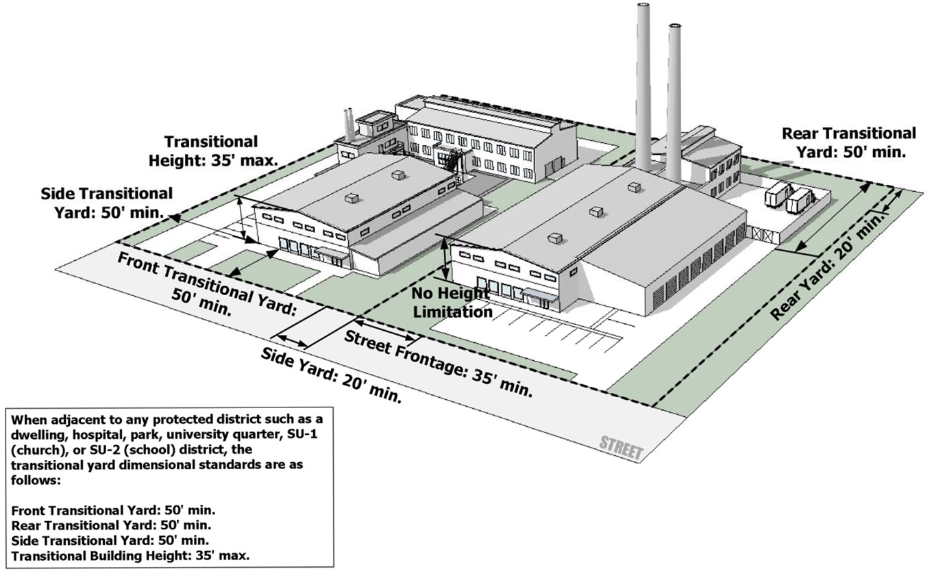
5.
Other standards. [Reserved]
(G.O. 64, 2015, § 2)
Sec. 742-108. - Development Plan Districts.
A.
Generally.
1.
Site and development plan consideration.
a.
No use, building or structure shall hereafter be established, constructed or used on any land in a Development Plan District for any purpose other than lawfully existed on or prior to the date listed in Table 742-108-1, until a site and development plan for such land, including the proposed use or uses, has been filed with and approved by the Commission in accordance with this zoning ordinance.
b.
The Commission may consider and act upon any such proposed use and site and development plan, approve the same in whole or in part, and impose additional development standards, requirements, conditions, or commitments thereon at any public hearing of the Commission. The Commission must prescribe in its Rules of Procedure the requirements for an approval petition for site and development plan consideration that must be filed. In addition, the Rules of Procedure set forth the fees, hearing process, notice, and amendment procedures relative to any petition.
c.
The Commission must make written findings concerning any decision to approve or disapprove a site and development plan filed under this section. The written findings must be based upon the requirements of Section 742-108. The president or secretary of the Commission must be responsible for signing the written findings.
2.
Plan documentation and supporting information. The site and development plan must include layout and elevation plans for all proposed buildings and structures, and must indicate:
a.
Proposed uses, buildings and structures.
b.
All existing uses, buildings and structures, in addition to any proposed to be demolished.
c.
Proposed buildings and structures and the use of each.
d.
Elevations of all sides of each building.
e.
Zoning and existing land uses of adjacent properties.
f.
Off-street vehicle and bicycle parking layouts with summary table of the number of required off-street parking, loading, and stacking spaces.
g.
Circulation plan for vehicles and pedestrians, in addition to vehicular entrances and exits and turnoff lanes.
h.
Setbacks.
i.
Landscaping, screens, walls, fences.
j.
Outdoor activity areas.
k.
Lighting plan.
l.
Signs, indicating location, size, design, and illumination.
m.
Sewage disposal facilities.
n.
Storm drainage facilities.
o.
Other utilities and underground facilities.
p.
Sample color and materials palette for all proposed structures, as well as fences.
q.
Information related to the development's environmental impact, such as application for LEED certification, paving permeability, and other sustainable techniques.
3.
Site and development requirements. Land in the Development Plan Districts is subject to the following site and development requirements. In review of the proposed site and development plan, the Commission must assess whether the site and development plan, proposed use, buildings and structures must:
a.
Be so designed as to create a superior land development plan, in conformity with the Comprehensive Plan;
b.
Create and maintain a desirable, efficient and economical use of land with high functional and aesthetic value, attractiveness and compatibility of land uses, within the Development Plan District and with adjacent uses;
c.
Provide sufficient and adequate multi-modal access, such as parking and loading areas, transit provisions, and bicycle facilities;
d.
Integrate a multi-modal transportation network using active and passive traffic control with the existing and planned public streets and interior roads;
e.
Provide adequately for sanitation, drainage and public utilities in a sustainable, low-impact manner;
f.
Allocate adequate sites for all uses proposed - the design, character, grade, location and orientation thereof to be appropriate for the uses proposed, logically related to existing and proposed topographical and other conditions, and consistent with the Comprehensive Plan; and
g.
Provide pedestrian accessibility and connectivity, which may be paths, trails, sidewalks, or combination thereof. Pedestrian accessibility to available public transit must be provided. Sidewalks along eligible public streets consisting of the walkway and any curb ramps or blended transitions must be provided. If sidewalks are required to be installed, the Administrator or the Commission must be guided by the provisions of Section 744-304 for the installation of sidewalks.
4.
Public notice. Public notice of any hearing regarding a petition pertaining to land in a Development Plan District must be required in accordance with the Commission's Rules of Procedure.
5.
Appeal of Administrator's decision Where the Administrator is given the authority of discretionary approval of plans and specifications, or the method or manner of qualification, or any other similar authority, any party of interest must have the right to appeal such action by the Administrator before the Metropolitan Development Commission for its review and approval or disapproval as an appeal in the form of an approval petition. Such appeal must be filed within 10 business days of approval or denial of the approval as specified in, and following, the Rules of Procedure of the Metropolitan Development Commission. In any appeal, the Commission must make written findings of its decision as required in this Section 742-108.
6.
Improvement Location Permit requirements. No building or structure shall be established, constructed, altered, converted, expanded, enlarged, modified, reconstructed, relocated, or used in Development Plan District without an Improvement Location Permit. Such permit shall not be issued until the site and development plan, including the proposed use or uses and plans for such building or structure, shall have been approved by the Commission.
B.
Park District regulations.
1.
Permitted Park District uses.
a.
Permitted uses in the PK-1 and PK-2 Districts are listed in the following Table 742-108-2, and are subject to the conditions in that table.
2.
Specific exemptions - Administrator's approval. The filing of an approval petition and subsequent Commission approval shall not be required for the creation or alteration of the following structures or for accomplishing the following types of improvements in the PK-1 and PK-2 Districts. Such structures and improvements, however, shall be required to obtain Administrator's approval prior to the issuance of an Improvement Location Permit. All provisions and regulations of the Zoning Ordinance applicable in the particular situation, or commitments related to prior Commission approval, shall continue to apply. The Administrator shall be required to use the standards of Section 742-108.A.3. in the review and disposition of such structures and improvements.
a.
Improvements to existing structures that do not increase the usable floor area of that structure (for example: canopies, awnings, vestibules, roof line changes, or similar features).
b.
Additions to existing structures that are less than:
1.
1,000 square feet in the PK-1 District;
2.
1,000 square feet for residential uses within the PK-2 District; and
3.
2,500 square feet for all other uses within the PK-2 District.
c.
In the PK-1 District, any new structure that is less than 2,500 square feet, provided the structure:
1.
Is in substantial conformance with the applicable adopted park master plan; or
2.
Is an accessory support structure that may not be delineated on the adopted park master plan, the location of which, however, will not affect the implementation of the plan (examples of such structures are golf cart buildings, picnic shelters, maintenance sheds, and rest rooms).
d.
All new residential structures in projects or subdivisions previously approved by the Commission. In instances of an approved subdivision, a plat shall have been recorded.
e.
Accessory structures permitted in connection with residential development.
f.
Landscaping.
g.
All incidental signs (as defined by Chapter 744, Article IX Sign Regulations).
3.
Park District development standards.
a.
Park District One (PK-1) development standards. The following development standards shall apply to all land within Park District One:
1.
Location. Public parks larger than 10 acres shall be located with direct access to and frontage on a collector street, or a street designated on the Official Thoroughfare Plan as a primary or secondary thoroughfare, parkway, expressway or freeway.
2.
Minimum lot area. There shall be no minimum lot area.
3.
Setback lines and minimum front yards.
i.
Front yards, having a minimum depth in accordance with the following setback requirements, shall be provided along all street right-of-way lines:
a.
Expressway, parkway or primary thoroughfare (as designated on the Official Thoroughfare Plan). No part of any structure shall be built closer than 60 feet to any right-of-way line of an expressway, parkway or primary thoroughfare.
b.
Secondary thoroughfare (as designated on the Official Thoroughfare Plan). No part of any structure shall be built closer than 40 feet to any right-of-way line of a secondary thoroughfare.
c.
Collector street. No part of any structure shall be built closer than 30 feet to any right-of-way line of a collector street.
d.
Local street, marginal access street or cul-de-sac. No part of any structure shall be built closer than 25 feet to any right-of-way line of a local street, marginal access street, or cul-de-sac, with the exception of the vehicular turnaround thereof. No part of any structure shall be built closer than 20 feet to any right-of-way line of the vehicular turnaround of a cul-de-sac.
e.
Provided, however, that along the right-of-way line of any street, highway, or thoroughfare where access rights thereto have been purchased or otherwise acquired by the governmental agency having jurisdiction thereof, yards having a minimum depth of 30 feet shall be provided.
f.
Exception: Eaves, cornices or other laterally supported extensions may extend into the front yard setback a maximum of four feet.
4.
Maximum height. 35 feet.
5.
Off-street parking.
i.
Adequate off-street parking spaces shall be provided for the various PK-1 District park activities and uses.
ii.
Off-street parking area for all uses in the PK-1 District shall be developed and maintained in accordance with the following requirements:
a.
Off-street parking entrances and exits shall be located a minimum distance of 25 feet from the nearest point of two intersecting street right-of-way lines. Such curb cuts from a public street shall further conform to all requirements of the traffic engineering department having jurisdiction thereof.
b.
The surface of parking areas shall be graded and drained in such a manner that there will be no free flow of water onto either adjacent properties or sidewalks.
c.
Lighting facilities used to illuminate parking areas shall be so located, shielded and directed upon the parking area that they do not glare onto or interfere with street traffic, adjacent buildings, or adjacent users.
iii.
The distance of driveways and parking areas from any adjacent property line shall be at least 20 feet.
6.
Signs. Signs and sign structures shall comply with Chapter 744, Article IX Sign Regulations.
b.
Park District Two (PK-2) development standards. All development within the Park District Two (PK-2) District shall be in accordance with the Site and Development Plan, as approved by the Commission in accordance with this section.
C.
Hospital District regulations.
1.
Statements of purpose.
a.
Hospital District One (HD-1). The HD-1 zoning category is designed to permit and facilitate the development, expansion, and modernization of a major hospital complex or campus, in which a diversity of uses, functions, and facilities is necessary to best perform the hospital's various services to the public; and further to permit appropriate land use modifications as necessary to facilitate the highest level of such service.
b.
Hospital District Two (HD-2). The HD-2 zoning category is designed to: (1) permit and facilitate the logical association of a diversity of land uses in close proximity to a major hospital complex; (2) to provide adequate land area for such hospital-related uses; and (3) to assure a quality and character of site development that will create the environment of safety, quietness, attractiveness and convenience compatible with such hospital complex.
2.
Permitted Hospital District uses. Permitted uses in the HD-1 and HD-2 Districts are listed in Table 742-108-3, and are subject to the conditions in that table.
3.
Specific exemptions - Administrator's approval. The filing of an approval petition and subsequent Commission approval shall not be required for the creation or alteration of the following structures or for accomplishing the following types of improvements in the HD-1 and HD-2 Districts. Such structures and improvements, however, shall be required to obtain Administrator's approval prior to the issuance of an Improvement Location Permit. All provisions and regulations of the Zoning Ordinance applicable in the particular situation, or commitments related to prior Commission approval, shall continue to apply. The Administrator shall be required to use the standards of Section 742-108.A.3. in the review and disposition of such structures and improvements.
a.
Improvements to existing structures that do not increase the usable floor area of that structure (for example: canopies, awnings, vestibules, roof line changes, or similar features);
b.
Additions to existing structures which are less than 2,500 square feet in area;
c.
Accessory structures permitted in connection with residential development;
d.
Landscaping; or
e.
All incidental signs.
4.
Hospital District development standards. All development within the Hospital Districts shall be in accordance with the site and development plan, as approved by the Commission in accordance with this section.
D.
University Quarter District regulations.
1.
Permitted University Quarter District uses. Permitted uses in the UQ-1 and UQ-2 Districts are listed in the following Table 742-108-4, and are subject to the conditions in that table.
2.
Specific exemptions - Administrator's approval. The filing of an approval petition and subsequent Commission approval shall not be required for the creation or alteration of the following structures or for accomplishing the following types of improvements in the UQ-1 and university-related group dwelling uses (university dormitory or fraternal organization), permitted in the UQ-2 Districts. Such structures and improvements, however, shall be required to obtain Administrator's approval prior to the issuance of an Improvement Location Permit. All provisions and regulations of the Zoning Ordinance applicable in the particular situation, or commitments related to prior Commission approval, shall continue to apply. The Administrator shall be required to use the standards of Section 742-108.A.3. in the review and disposition of such structures and improvements.
a.
Improvements to existing structures that do not increase the usable floor area of that structure (for example: canopies, awnings, vestibules, roof line changes, or similar features);
b.
Additions to existing structures that are less than 2,500 square feet in area (UQ-1 District only);
c.
Landscaping; or
d.
All incidental signs.
3.
University Quarter District development standards.
a.
Development standards for UQ-1 District.
1.
Setback lines and minimum yards.
i.
Setback line and minimum front yard: Yards, having a minimum depth in accordance with the setback requirements of Chapter 744, Article II Lot and Building Dimensions, shall be provided along all street right-of-way lines.
ii.
Minimum side and rear yards: 15 feet or one foot for each foot of building height, whichever is greater.
2.
Maximum building area. Building area shall not exceed 40% of the lot area.
b.
Development standards for UQ-2 District, university-related group dwelling uses.
1.
Setback lines and minimum yards.
i.
Setback line and minimum front yard: Yards, having a minimum depth in accordance with the setback requirements of Chapter 744, Article II Lot and Building Dimensions, shall be provided along all street right-of-way lines.
ii.
Minimum side and rear yards: 15 feet or one foot for each foot of building height, whichever is greater.
2.
Maximum building area. Building area shall not exceed 40% of the lot area.
3.
Maximum height. 35 feet.
E.
Speedway District regulations.
1.
Statement of purpose. The purpose and intent of these Districts is to ensure that all development of land in the Speedway Redevelopment Area 1 takes place in accordance with the principles set forth in the Comprehensive Plan and the Speed Zone Master Plan. The Commission shall prescribe in its rules of procedure the requirements for an approval petition for Site and Development Plan consideration that shall be filed. Where the Special Districts regulations directly conflicts with other portions of the Zoning Ordinance, the Zoning Ordinance shall prevail; however, no development may be approved that conflicts with the Comprehensive Plan.
a.
The Speedway Main Street District (SZ-1) is intended to serve as the primary identity for the Town of Speedway.
1.
The SZ-1 District is designed to permit and facilitate street-level activities focusing on restaurants, personal services, and shopping while the upper stories provide a diverse range of office space and urban-style housing. Due to the intensity, traffic generation, nature of operation, or aesthetics of these uses, industrial uses, automobile service facilities, outdoor storage, and other similar uses are prohibited.
2.
The SZ-1 District is designed to permit and facilitate a healthy social and economic environment for residents and visitors of all ages that is a pedestrian-oriented place with active street life, healthy retail, as well as common space for community gatherings and racing-season activities. All buildings within the SZ-1 District shall contribute to creating a relatively continuous street wall and create a pedestrian oriented sense of enclosure and place. Building heights and signs may vary from one property to the next; however a general consistency shall be retained in order to create a continuous sense of character within the District. Sidewalks, pedestrian pathways, and parking areas shall give particular attention to streetscape, landscape continuity, and lighting.
b.
Speedway Industrial District (SZ-2) is designed to permit and facilitate uses that are significant employment generators.
1.
The SZ-2 District is designed to permit and facilitate a diverse mix of light and moderate industrial uses, some automobile-related commercial activities, and commercial entertainment. For illustrative purposes, such uses include wholesale activities, warehouses, manufacturing, compounding, processing, packaging, assembly, or treatment of finished or semi-finished products from previously-prepared material, as well as racing, sports and entertainment operations. Due to the inherent risk, intensity, traffic generation, nature of operation or aesthetics of these uses, residential uses, and commercial retail and service uses are prohibited.
2.
The SZ-2 District is designed to permit and facilitate development that is entirely enclosed; strictly adheres to the performance standards; provides sufficient space for current or future needs for manufacturing and wholesaling or related uses while preserving the aesthetics of the community; and utilizes sustainable development techniques to both reduce the environmental impact and increase the intensity of development. In addition to the economic benefits of green roof construction and the utilization of permeable pavement materials, structures utilizing these design techniques realize ecological benefits by reducing the impervious surface area on a site. The SZ-2 District development standards encourage these and other sustainable construction and development practices.
2.
Permitted uses in the Speedway Districts. Permitted uses in the SZ-1 and SZ-2 Districts are listed in the following Table 742-108-5, and are subject to the conditions in that table.
3.
Specific exemptions - Administrator's approval. The filing of an approval petition and subsequent Commission approval shall not be required for the creation or alteration of the following structures or for accomplishing the following types of improvements in the SZ-1 and SZ-2 Districts. Such structure and improvements; however, shall be required to obtain Administrator's approval prior to the issuance of an Improvement Location Permit. All provisions and regulations of the zoning ordinance applicable in the particular situation, or commitments related to prior Commission approval shall continue to apply. The Administrator shall be required to use the standards of subsection 4. and 5. below in the review and disposition of such structures and improvements.
a.
Improvements to existing structures that do not increase the usable floor area of a structure including but not limited to:
1.
Canopies;
2.
Awnings;
3.
Vestibules;
4.
Alterations to the roof line;
5.
Changes to façade materials;
6.
Changes to doors and windows.
b.
Additions to existing structures that are less than 100 square feet in total floor area.
c.
Change of use from one permitted use to another permitted use within the District.
d.
Accessory structures.
e.
Landscaping improvements.
f.
Any changes to the face of a sign and any incidental sign.
g.
Public park and recreation improvements, specifically including:
1.
Paved trails included in an adopted Park Master Plan, Redevelopment Plan, Transportation Plan, or Comprehensive Plan;
2.
Support structures and equipment not specifically listed in the Parks Master Plan or Transportation Plan, the location of which, however, will not hinder the implementation of said plans. Examples include but are not limited to benches, tables, drinking fountains, and trailheads.
4.
Design consideration.
a.
Evaluation of a project shall be based on the quality of its design and relationship to surroundings. Factors to be considered include, but are not limited to:
1.
In reviewing the architectural design of buildings proposed to be built in the SZ-1 or SZ-2 Districts, architectural style is not restricted. Aesthetics of the proposed building or other proposed structures, including:
i.
Color and materials;
ii.
Scale and proportion;
iii.
Suitability of building materials;
iv.
Design in relation to surrounding buildings;
v.
Design in relation to proposed landscaping;
vi.
Use and materials for fencing.
2.
Buildings shall be harmonious with permanent, neighboring development.
3.
Materials shall have architectural character and shall be selected for harmony with adjacent buildings.
4.
Materials shall be suitable to the type of buildings and the design in which they are used. Buildings shall have the same materials, or those that are architecturally harmonious, used for all building walls and other exterior building components wholly or partly visible from public rights-of-way.
5.
Materials shall be of durable quality.
6.
Building components, such as windows, doors, eaves, and parapets, shall have good proportions and relationships to one another.
7.
Colors shall be harmonious with existing development and only the use of complementing accents shall be permitted.
8.
Exterior lighting shall be part of the architectural design. Fixtures, standards, and all exposed accessories shall be harmonious with building design.
9.
Monotony of design in single or multiple building projects shall be avoided. Variation of detail and form shall be used to provide visual interest. In multiple building projects, variable siting or individual buildings may be used to prevent a monotonous appearance.
10.
Signs shall be designed as an integral part of the architectural and landscaping plans. The colors, materials, and style of signs shall be architecturally compatible and accentuate the buildings and landscaping on the site. The colors, materials, and lighting of every sign shall be restrained and harmonious with the building and site to which it principally relates.
b.
The Commission may consider and act upon any such proposed use and site and development plan, approve the same in whole or in part, and impose additional development standards, requirements, conditions, or commitments thereon at any public hearing of the Commission.
c.
The Commission shall make written findings concerning any decision to approve or disapprove a site and development plan filed under this section. The written findings shall be based upon the requirements of Section 742-108.E.4. The president or secretary of the Commission shall be responsible for signing the written findings.
5.
Speedway District development standards. Development shall be in accordance with the following development standards for the SZ-1 and SZ-2 Districts. The illustrations used in this section are only conceptual representations of the desired type of development and are not to be construed as a development standard.
a.
Speedway Main Street District SZ-1 development standards.
1.
Lot area. There shall be no minimum or maximum lot area.
2.
Lot width. Lot width shall be measured along the frontage of the lot. Minimum lot width shall be 20 feet. There shall be no maximum lot width.
3.
Front building setback and yard.
i.
No part of any building shall be located closer to the right-of-way line of any street than zero feet. The maximum distance between any right-of-way line of any street and any building located on the lot shall be five feet. A front yard of no less than zero feet in depth and no more than five feet in depth, measured from and parallel to the lot line, shall be provided along the entire lot width.
ii.
The composition of the surface area of the front yard shall be developed and maintained in a pedestrian-friendly manner.
4.
Side building setback and yard. A side setback and side yard of no less than zero feet in depth, measured from and parallel to all side lot lines, shall be provided along all side lot lines.
5.
Rear building setback and yard. A rear setback and rear yard of no less than three feet in depth, measured from and parallel to all side lot lines, shall be provided along all rear lot lines unless subject to the following transitional yard requirements:
i.
Where a rear lot line abuts a lot line in an adjacent Protected District, a required rear transitional yard and building setback of not less than 20 feet in width, measured from and parallel to the lot line, shall be provided along such rear lot line.
ii.
Exceptions to the above Section 742-108.E.6.a.5.i. shall apply:
a.
Where a dedicated alley separates such rear lot line from the Protected District, such required rear transitional yard and building setback shall be not less than 10 feet in width.
b.
Where the ground area required for required transitional yards exceeds 20% of the lot area, the width of the rear transitional yards may be reduced to 10 feet and shall provide planting areas, being six-foot in width minimally, and provide a six-foot tall opaque wooden fence or solid wall.
c.
Transitional yard requirements shall not apply in those instances where commercial or industrial use, legally established by permanent variance or lawful nonconforming use, exists upon such property or abutting frontage property, although zoned as a Protected District.
6.
Building height.
i.
The minimum building height shall be 24 feet or two stories, whichever is less.
ii.
The maximum building height shall be 52 feet or four stories, whichever is greater.
iii.
Maximum building height exceptions.
a.
HVAC, mechanical equipment, stairwell enclosure, elevator equipment, and any required screening may extend above the maximum building height, but shall not be greater than 10 feet above the maximum building height. The structures shall be completely screened from view at any right-of-way and from any Protected District.
b.
Where a rear lot line abuts a lot line in an adjacent Protected District, the building height of any structure within 30 feet of the rear lot line shall not be greater than 35 feet or three stories, whichever is the lesser.
7.
Building use and form.
i.
The total floor area of any dwelling unit shall not be less than 600 square feet.
ii.
Drive-through service unit shall be permitted only if all of the following requirements are satisfied:
a.
The lot on which the drive-through service unit is located is a corner lot;
b.
The location of the building with the drive-through service unit is at the corner with the intersecting public rights-of-ways and behind the front building line;
c.
Vehicular access from Main Street is prohibited; and,
d.
Adequate stacking for the drive-through service unit is provided.
8.
Roof line, form and cornice shall be articulated with a treatment in scale with the building and shall be designed integral with the building. Mechanical equipment shall be placed to complement the building or screened with materials consistent with the building's design. Roofs shall not be pitched unless a parapet is provided that completely and effectively screens the pitch from view from any right-of-way. Alternative roof design may be approved at the discretion of the Commission.
9.
Transparency of the building façade between three feet and eight feet above grade level.
i.
Minimum transparency of the ground floor shall be 40%.
ii.
Maximum transparency of the ground floor shall be 85%.
iii.
Minimum transparency of the floors above the ground floor shall be 25%.
iv.
Maximum transparency of the floors above the ground floor shall be 60%.
10.
Building materials. The following standards apply to all buildings except public parking structures.
i.
Walls on all sides of any building, exclusive of windows and doors, shall be a minimum 80% brick, stone, pre-cast concrete panels, tile, decorative block, wood or hardi-plank lap siding, or ceramic. Materials shall be durable enough to last 50 years with low maintenance. Other materials may be approved if determined by the Commission that the materials meet the intent and purpose of the District.
ii.
All sides of the building shall be of a similar design and complement each other.
iii.
Trim and ornamentation shall be provided on all sides of any building and shall be metal, concrete, brick, stone, wood, or decorative concrete block.
11.
Architectural features and façade requirements. (See Diagram G Building Elements)
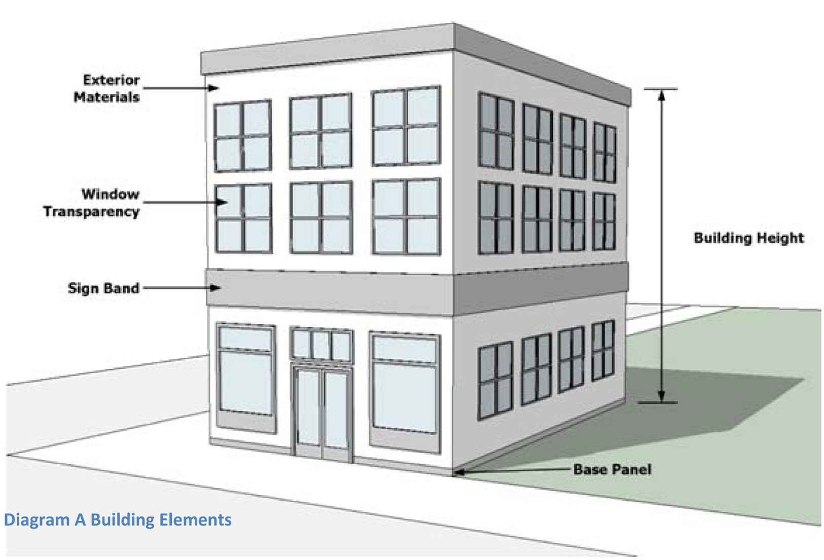
Diagram G Building Elements
i.
Base panel shall be provided. Base panel shall be between 18 and 30 inches tall.
ii.
Sign band. A sign band, being between 12 and 24 inches tall, is recommended to accommodate wall signage.
iii.
Walls without windows shall not be permitted along or when facing a public right-of-way, public parking area, or park.
iv.
Articulation for walls located within 10 feet of a public right-of-way shall be, at a minimum, every 10 feet and shall wrap around the sides of the building, at a minimum, three feet.
v.
Proportion. If the building facades along a right-of-way comprise at least 50% of the frontage of a block, new construction or façade rehabilitation shall create or maintain horizontal and vertical spacing of façade elements of surrounding buildings such as windows, entries and roof lines as well as the rhythm of the bays, windows, and openings of the facades.
vi.
Windows.
a.
Ground floor window openings. The height of ground floor window openings shall be equal to or greater than the width of the opening.
b.
Upper floor window openings shall be rectangular. The vertical dimension of a window size shall be, at a minimum, two times the horizontal dimension.
12.
Parking. Off-street parking within 50 feet of the right-of-way of Main Street or West 16th Street is prohibited. Off-street parking is discouraged; any off-street parking shall be designed to be unobtrusive to the pedestrian environment. Provisions for bicycle, scooter and motorcycle parking shall be provided in proximity to the primary entrance.
13.
Signs. Except as modified by this division, the regulations of the Chapter 744, Article IX shall apply.
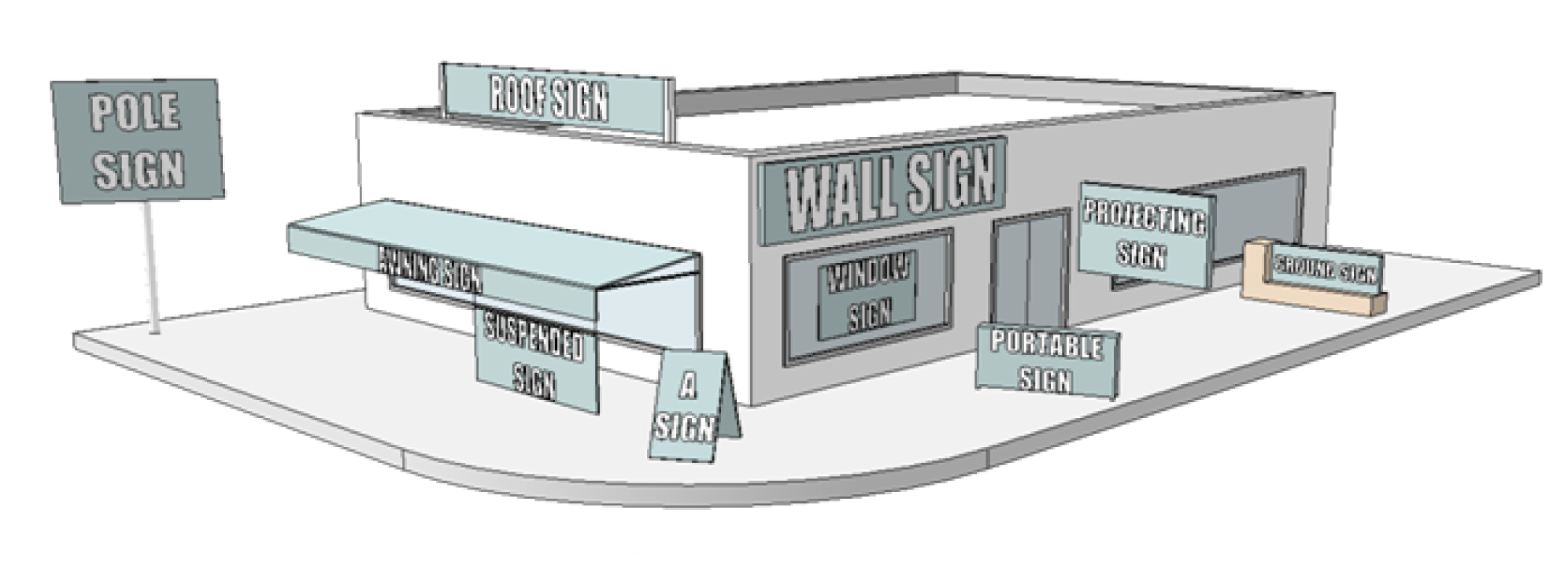
Diagram H Sign Types in Speedway Zoning Districts
i.
Permitted sign types and size. Permitted and prohibited sign types are identified in Diagram MM "Sign Types in Speedway Zoning Districts". The following sign types may be permitted:
a.
Canopy and awning signs. The recommended maximum of sign surface area of a canopy or awning sign shall be 20 square feet with a maximum vertical dimension of two feet.
b.
A-frame sign. The maximum of sign surface area per side of an A-frame sign shall be 12 square feet with a maximum horizontal dimension of three feet. A-frame signs are prohibited between the hours of 10:00 p.m. and 7:00 a.m. EST. A-frame signs shall be designed and placed in a secure manner in all weather conditions and shall not obstruct accessibility or visibility of pedestrians or vehicular movement.
c.
Projecting sign. The recommended maximum of sign surface area of a projecting sign is eight square feet. In addition, it is recommended that horizontally oriented signs have a maximum vertical dimension of two feet and vertically oriented signs have a maximum horizontal dimension of two feet.
d.
Suspended sign. Suspended signs shall maintain a clearance of eight and one-half feet.
e.
Wall sign. The recommended placement of a wall sign is to be contained entirely within the sign band.
f.
Window sign. Window signs shall be permitted on the ground floor only and the maximum sign surface area shall not exceed 50% of the sign surface area of all ground-floor windows on that side of the building.
g.
Sign affixed to the barrier of an approved outdoor seating area associated with a restaurant. Said sign shall be a maximum of six square feet in sign surface area with a maximum height of four feet. Such outdoor signs may remain in place from 7:00 a.m. to 10:00 p.m. EST.
h.
Exempt signs as listed and authorized in Chapter 744, Article IX.
ii.
Prohibited sign types. Off-premises (outdoor advertising) signs, ground signs, pole signs, pylon signs are prohibited. Portable signs, except for A-frame signs specifically described above, are prohibited.
iii.
Sign types eligible for special consideration. Animated signs, roof signs, inflatable signs, marquee signs, message centers, and electronic variable message signs may be permitted after special consideration and the adoption of specific findings by the Commission that unique circumstances exist and that the specific design characteristics are appropriate for the District. Findings of fact shall be adopted.
iv.
Number of signs.
a.
Sign affixed to the barrier of an approved outdoor seating area associated with a restaurant. Two one-sided signs shall be permitted if the signs face different directions; or one two-sided sign shall be permitted.
b.
Wall signs. One wall sign shall be permitted for each ground-floor entrance to the building.
c.
One of the following sign types shall be permitted for each ground-floor entrance to the building: One awning sign or one projecting sign or one canopy sign.
d.
Suspended sign. If attached to an awning sign or canopy sign, one suspended sign shall be permitted for each ground-floor entrance to the building.
e.
A-frame sign. One A-frame sign shall be permitted for each ground-floor entrance to the building.
f.
Window sign. Two window signs shall be permitted for each ground-floor entrance to the building.
v.
Sign location. Sign shall be designed and placed in a secure manner for all weather conditions and shall not obstruct accessibility or visibility of pedestrians or vehicular movement. In accordance with Chapter 744, Article IX, no sign or sign structure may be placed on or in the right-of-way of an alley or a street, except for the following sign types upon obtaining encroachment authorization from the appropriate governmental agency:
a.
Sign affixed to the barrier of an approved outdoor seating area associated with a restaurant.
b.
A-frame sign.
c.
Projecting signs.
d.
Awning or canopy sign.
e.
Suspended sign.
f.
Wall sign.
vi.
Character. The colors, materials, and style of signs shall be architecturally compatible and accentuate the buildings and the District. Signs should be designed to reflect the small-town atmosphere of Main Street while fostering an exciting and festive atmosphere, enhancing a sporting event experience, or demonstrating a unique approach to advertising. Box signs typically do not meet the desired character.
vii.
Sign illumination. The Commission may authorize the internal or external illumination of signs.
14.
Screening of trash receptacles and refuse areas. No outside, unenclosed storage of recyclables or refuse containers exceeding 16 cubic feet in size shall be permitted on any lot. All refuse or recyclable containers, dumpsters, or compactors exceeding four and one-half cubic meters in size shall be located within an area enclosed on all sides by a fence, wall, or similar means of enclosure. The enclosure does not require a roof. The height of the sides of the enclosure shall be the greater of six feet or two feet taller than the container, dumpster, or compactor that is being enclosed. All sides of the enclosure, including doors or gates, shall be opaque.
15.
Lighting. Lighting shall be designed to minimize overflow light into the night sky, shield the light filaments from any right-of-way or Protected District, prohibit hazardous glare perceptible from any point beyond the lot lines, and provide adequate light for safety.
16.
Fencing. Except for use as described under subsection 10. above, fences shall be constructed of materials that complement the design of the primary building. Chain-link fencing shall not be permitted. Barbed wire and razor wire are prohibited.
17.
Pedestrian accessibility.
i.
Development shall provide sidewalks along eligible public streets, excepting freeways or expressways, as indicated in the current Official Thoroughfare Plan for Marion County, Indiana, and other full control of access frontages as determined by the Administrator; and, pedestrian accessibility to available public transit. Sidewalks shall consist of the walkway and any curb ramps or blended transitions. If required to be installed, the Administrator or the Commission shall be guided by the provisions of Section 744-304 for the installation of sidewalks.
ii.
Internal accessibility. Within a lot or integrated center, walkways shall be provided in accordance with a pedestrian plan that shall include a walkway system that functionally connects all of the building's main front entrances with the sidewalk located in the public right-of-way of each of the lot or integrated center's eligible public streets. The walkways may be constructed of asphalt, concrete, pavers, or other materials meeting ADA standards. Such private walkways shall provide for identifiable pedestrian crossing treatments along functional pedestrian routes wherever the private walkways cross an interior access drive.
18.
Streetscape.
i.
In order to create cohesiveness within the SZ-1 District, site furnishing elements have been delineated for public spaces along the Main Street Corridor in the Design Manual for Speedway. For each of the site furnishings, substitutions that provide a similar style may be approved by the Commission. The site furnishings may include items appropriate to the site, such as, benches, trash receptacles, transit shelter, bollards, newspaper racks, trees, tree gates, bike lockers, bike racks, and art.
b.
Speedway Industrial District SZ-2 development standards.
1.
Lot coverage, building setbacks, and yards.
i.
No more than 60% of the lot area may be covered by impervious surfaces, including structures, parking, and other hard surfaces. This maximum lot coverage may be increased to 80% impervious surface coverage if appropriate methods for sustainability indicated in subsection j. below are utilized.
ii.
No part of any building shall be located closer to the right-of-way line of any street than 50 feet. A front yard of no less than 50 feet in depth, measured from and parallel to the lot line, shall be provided along the entire lot width.
iii.
A side setback and side yard of no less than 25 feet in depth, measured from and parallel to all side lot lines, shall be provided along all side lot lines.
iv.
A rear setback and rear yard of no less than 25 feet in depth, measured from and parallel to all side lot lines, shall be provided along all rear lot lines.
2.
Building height.
i.
The building height shall not be greater than 60 feet.
ii.
Building height exceptions.
a.
HVAC, mechanical equipment, stairwell enclosure, elevator equipment, and any required screening may extend above the maximum building height, but shall not be greater than ten feet above the maximum building height. The structures shall be completely screened from view at any right-of-way and from any Protected District.
b.
Where a lot line abuts a lot line in a Protected District, the building height of any structure within 100 feet of the lot line shall not be greater than 35 feet.
3.
Exterior building materials, architectural features and façade requirements.
i.
Walls on all sides of any building, exclusive of windows, shall be a minimum of 50% brick, stone, pre-cast concrete panels, tile, decorative block, wood or hardi-plank lap siding, ceramic or glass. Other materials may be approved if determined that the materials meet the intent and purpose of the Districts.
ii.
Walls without windows shall not be permitted when facing or along a public right-of-way, public parking area, or park.
iii.
Articulation on all walls shall not be less than every 75 feet.
4.
Parking. The design, circulation, and amount of parking shall be in accordance with the standards in Chapter 744, Article IV Parking, Loading and Drive-Through. In addition, the following standards shall apply:
i.
Provisions for adequate bicycle, scooter and motorcycle parking shall be provided in proximity to the primary entrance in accordance with the Design Manual for Speedway.
ii.
Placement. No more than one single bay of parking shall be permitted between a public right-of-way and a building.
iii.
Interior landscaping. All parking lots, regardless of size, shall provide interior landscaping. Landscaping shall be provided in accordance with the standards in Section 744-505.
5.
Signs. Except as modified by this division, the regulations of Chapter 744, Article IX shall apply.
i.
Permitted sign types. Ground sign, awning sign, wall sign, projecting sign, suspended sign, and window sign.
ii.
Prohibited sign types. Off-premises (outdoor advertising) signs, pole signs, pylon signs, and portable signs are prohibited.
iii.
Sign types eligible for special consideration. Animated sign, roof sign, marquee sign, message center, and electronic variable message sign may be permitted after special consideration and the adoption of specific findings by the Commission that unique circumstances exist and that the specific design characteristics are appropriate for the District.
iv.
Number and size of signs by type.
a.
Ground signs. One sign per building may be permitted in accordance with the following standards. The integration of signs, particularly the sharing of signs for multiple businesses, is encouraged.
1.
Maximum height of a ground sign shall be 10 feet.
2.
Maximum sign area of a ground sign shall be 200 square feet.
3.
Setback of a ground sign. Ground sign shall be located at least 10 feet from any right-of-way or property line.
4.
Separation. Ground sign shall be no closer than 300 feet to another ground sign.
5.
Ground sign shall not be located in any designated greenbelt or perimeter planting area.
v.
Awning signs, wall signs, projecting signs, suspended signs, and window signs may be located on any of the walls of a building. The total sign surface area of all signs shall not exceed 10% of the area of all sides of the building.
vi.
Coordinated sign plan. A coordinated sign plan for projects that contain five or more permitted signs may be submitted at the time of development plan submittal and approved by the Commission shall be eligible for a 95% increase in permitted sign surface area per permitted sign. Said plan shall indicate the size, design, illumination, and placement of all signs on the site.
vii.
Sign illumination. The Commission may authorize the internal or external illumination of signs.
viii.
Character. The colors, materials, and style of signs shall be architecturally compatible and accentuate the buildings and landscaping on the site. Signs are recommended to be designed to reflect the small-town atmosphere of Speedway while professionally promoting the businesses that they represent. Box signs typically do not meet the desired character.
6.
Landscaping.
i.
Landscaping shall be provided in accordance with the plan approved by the Commission in accordance with the guidance provided by the Design Manual for Speedway.
ii.
All required landscaping in accordance with the approved plan shall be installed within one year of the date of issuance of an Improvement Location Permit.
iii.
The landscaping shall be properly maintained at all times, upon installation and thereafter. Proper maintenance includes, but is not limited to, replacing dead plantings with identical varieties or a professionally acceptable substitute, proper pruning, provision of adequate water, and keeping the area free of refuse and debris.
iv.
An approved landscaping plan may not be altered, eliminated, or modified, without first obtaining approval by the Commission or their designee.
7.
Greenbelt. Landscaping along street frontage. A greenbelt shall be provided along each frontage. Greenbelts shall be landscaped and shall be otherwise unoccupied except for steps, walks, driveways, lighting, and similar structures. Parking areas shall not be permitted in a greenbelt.
i.
Greenbelt along a Corridor Street.
a.
Minimum width shall be 20 feet.
b.
Plantings in the greenbelt along a Corridor Street shall be in accordance with the Design Manual for Speedway.
ii.
Greenbelt along an Interior Street.
a.
Minimum width shall be 10 feet.
b.
Plantings in the greenbelt along an Interior Street shall be in accordance with the Design Manual for Speedway.
8.
Building perimeter plantings. A minimum planting area equal to an area measuring an average of 10 feet in depth and extending along the entirety of each wall of the building shall be landscaped adjacent to that wall of the building. Sidewalks may be permitted in these areas, but shall not occupy more than 50% of the area on any side of the building. If an approach driveway or loading area cuts into a planting area adjacent to the building, additional planting area equal to the area displaced by the driveway shall be added to the building perimeter planting. These perimeter planting areas need not be rectangular in shape as long as the required total area is landscaped and dispersed on at least three different sides of the building.
9.
Property perimeter plantings. A minimum property perimeter planting area shall be provided along the perimeter of the property except for frontage areas and shall be in accordance with the Design Manual for Speedway.
10.
Screening of trash receptacles, recyclable receptacles, refuse areas, and outside material/equipment storage.
i.
No outside, unenclosed storage or display of materials or equipment shall be permitted on any lot. All materials and equipment shall be contained within an area enclosed in proximity on all sides by a solid fence, wall, mound, or similar means of enclosure. The enclosure is not required to have a roof. The sides of the enclosure shall be the greater of six feet or two feet taller than the assemblage of material or equipment that is being enclosed. All sides of the enclosure structure, including doors or gates, shall be opaque.
ii.
No outside, unenclosed storage of recyclables or refuse containers exceeding 16 cubic feet in size shall be permitted on any lot. All refuse or recyclable containers, dumpsters, or compactors exceeding 16 cubic feet in size shall be located within an area enclosed on all sides by a fence, wall, or similar means of enclosure. The enclosure does not require a roof. The height of the sides of the enclosure shall be the greater of six feet or two feet taller than the container, dumpster, or compactor that is being enclosed. All sides of the enclosure, including doors or gates, shall be opaque.
11.
Lighting. Lighting shall be designed to minimize overflow light into the night sky, shield the light filaments from any right-of-way or Protected District, prohibit hazardous glare perceptible from any point beyond the lot lines, and provide adequate light for safety.
12.
Fencing. Except for use as described under subsection g., fences shall be constructed of materials that complement the design of the primary building. Chain-link fencing is strongly discouraged. Barbed wire and razor wire are prohibited.
13.
Sustainability. The purpose of this section is to promote health, safety, and welfare within the SZ-2 District and its environment by minimizing the harms and maximizing the benefits, through provisions designed to allow alternatives to the traditional building design and stormwater management. It is the intent of this section to encourage the use of Best Management Practices (BMPs) which are structural, vegetative, or managerial practices designed to treat, prevent, or reduce degradation of water quality due to stormwater runoff as well as the environmental impacts of building construction. All development projects subject to review under the requirements of the Zoning Ordinance shall be designed, constructed, and maintained using BMPs to minimize environmental impacts while maintaining and contributing to the aesthetic values of the project.
i.
Green roof construction. None of the building surface area under green roof construction shall be counted towards the impervious surface cover calculations.
ii.
Parking lot and other surfaced elements. In order to break up or disconnect the flow of runoff over impervious surfaces, the use of permeable pavement materials is encouraged and includes, but is not limited to, pervious asphalt, pervious concrete, grid systems, or block pavers. Surface areas constructed with permeable techniques and materials shall not be counted towards the impervious surface cover calculations.
iii.
The Commission may grant an increase in allowable impervious surface coverage for projects utilizing some or all of the following types of elements of sustainability:
a.
Sustainable architecture. Sustainable architecture design practice emphasizes efficiency of heating and cooling systems, alternative energy sources such as passive solar, appropriate building siting, reused or recycled building materials, on-site power generation (solar technology, ground source heat pumps, wind power), rainwater harvesting for gardening and washing, and on-site waste management such as green roofs that filter and control stormwater runoff.
b.
Nonstructural stormwater management strategies. To the maximum extent practicable, the stormwater drainage standards adopted by the Town of Speedway shall be met by incorporating nonstructural stormwater management strategies into the site design. The nonstructural stormwater management strategies incorporated into the site design shall:
1.
Protect areas that provide water quality benefits or areas particularly susceptible to erosion and sediment loss;
2.
Maximize the protection of natural drainage features and vegetation;
3.
Minimize the decrease in the "time of concentration" from preconstruction to post construction. "Time of concentration" is defined as the time it takes for runoff to travel from the hydraulically most distant point of the watershed to the point of interest within a watershed;
4.
Minimize land disturbance including clearing and grading;
5.
Minimize soil compaction;
6.
Provide low-maintenance landscaping that encourages retention and planting of native vegetation and minimizes the use of lawns, fertilizers and pesticides;
7.
Provide vegetated open-channel conveyance systems discharging into and through stable vegetated areas.
8.
Other sustainable strategies or practices that achieve the same intent outlined above.
(G.O. 64, 2015, § 2)
Sec. 742-109. - Special Use Districts.
A.
Applicability. The following regulations shall apply to all land within the Special Use Zoning Districts.
1.
No building, structure, premises or part thereof shall be constructed, erected, converted, enlarged, extended, reconstructed or relocated except in conformity with these regulations and for uses permitted by this article and until the proposed site and development plan and landscape plan have been filed with and approved on behalf of the Commission by the Administrator or approved by the Commission, as hereinafter provided. Such request shall be in the form of an application for an Improvement Location Permit, following all requirements for plan submission and documentation of Chapter 740, Article VIII (Improvement Location Permits), and shall contain the information specified in Section 742-109.C. below.
2.
All land use within the Special Use Districts shall be limited to the use or uses existing on July 6, 1966 or specified in the applicable rezoning petition or ordinance redistricting and zoning the particular land to that District.
B.
Permitted uses and development standards.
1.
No use shall be permitted in any Special Use Zoning District other than the following permitted use or uses specified for each such District in the following Table 742-109-1. In addition, each zone designated in the first column of the following table shall be subject to the development standards applicable in the second column of that table unless an exception to those development standards is provided elsewhere in the Zoning Ordinance:
2.
Within each SU District the following are also permitted:
a.
Accessory uses and structures, subordinate, appropriate and incidental to the above permitted primary uses.
b.
Wireless communication facility, as defined in, and subject to the additional regulations of Section 743-305.OO.
C.
Site and development plan consideration. Upon the application for such permit, the Administrator on behalf of the Commission, shall consider and either approve, disapprove, or approve subject to any conditions, amendments or commitments agreed to by the applicant, the proposed site and development plan and landscape plan.
1.
Plan documentation and supporting information. The site and development plan shall include layout and elevation plans for all proposed buildings and structures, and shall indicate:
a.
Proposed Special Use District uses;
b.
All existing uses, buildings, and structures;
c.
Proposed buildings and structures;
d.
Off-street parking layout;
e.
Vehicular entrances and exits and turnoff lanes;
f.
Setbacks;
g.
Landscaping, screens, walls, fences;
h.
Signs, including location, size and design thereof;
i.
Sewage disposal facilities;
j.
Storm drainage facilities; and
k.
Other utilities if aboveground facilities are needed.
2.
Site and development requirements. Land in the SU Districts is subject to the following site and development requirements. In review of the proposed site and development plan, the Commission shall assess whether the site and development plan, proposed uses, buildings and structures must:
a.
Be so designed as to create a superior land development plan, in conformity with the Comprehensive Plan, including the applicable university quarter plan;
b.
Create and maintain a desirable, efficient and economical use of land with high functional and aesthetic value, attractiveness and compatibility of land uses, within the Special Use District and with adjacent uses;
c.
Provide sufficient and adequate access, parking and loading areas;
d.
Provide traffic control and street plan integration with existing and planned public streets and interior access roads;
e.
Provide adequately for sanitation, drainage and public utilities; and
f.
Allocate adequate sites for all uses proposed - the design, character, grade, location and orientation thereof to be appropriate for the uses proposed, logically related to existing and proposed topographical and other conditions, and consistent with the Comprehensive Plan;
g.
Provide sidewalks along eligible public streets, excepting freeway, or expressway, as indicated in the current Official Thoroughfare Plan and other full control of access frontages as determined by the Administrator; and, pedestrian accessibility to available public transit. Sidewalks must consist of the walkway and any curb ramps or blended transitions. If required to be installed, the Administrator or the Commission shall be guided by the provisions of Section 744-304 for the installation of sidewalks.
h.
Exception: Golf courses that exist prior to July 1, 2008, in the SU3, SU10 and SU34 Districts, are not required to provide sidewalks or pedestrian accessibility. For golf courses that are established after July 1, 2008, in the SU3, SU10 and SU34 Districts, the Commission must assess the provision of sidewalks along eligible public streets, excepting freeway or expressway as indicated in the current Official Thoroughfare Plan, and other full control of access frontages as determined by the Administrator; and, pedestrian accessibility to available public transit. If required to be installed, the Administrator or the Commission shall be guided by the provisions of Section 744-304 for the installation of sidewalks.
D.
Public notice. Public notice of the filing of an application under this section and public notice of the decision by the Administrator relative to such application is not required.
E.
Administrator's approval.
1.
The Administrator shall be required to use the standards of Section 742-109.C.2. and those Districts noted in Table 742-109-1 applicable to the SU District in question in the review and disposition of such structures and improvements.
2.
Appeal of Administrator's decision. Where the Administrator is given the authority of discretionary approval of plans and specifications, or the method or manner of qualification, or any other similar authority, any party of interest has the right to appeal such action by the Administrator before the Commission for its review and approval or disapproval as an appeal in the form of an approval petition. Such appeal must be filed within 10 business days of approval or denial of the approval as specified in, and following, the rules of procedure of the Commission. In any appeal decision, the Commission must make written findings of its decision as required in Section 742-109.C.2.
F.
Improvement Location Permit requirements. No building or structure shall be constructed, erected, converted, enlarged, extended, reconstructed or relocated in the Special Use Districts without an Improvement Location Permit, and such permit shall not be issued until the proposed site and development plan has been approved in accordance with this Section 742-109.
G.
Development standards. In addition to the site and development requirements of Section 742-109.C.2., all uses permitted within the Special Use Districts shall be administratively reviewed, using as an administrative guide, the development standards applicable to the specified District as follows:
The Administrator, in reviewing Special Use District development, shall consider the standards noted above, and may approve alternatives for those requirements so long as the alternative standards are appropriate for the site and its surroundings, and the site development is compatible and consistent with the intent of the stated standards. Such modifications shall be noted on the site and development plan, stamped approved by the Administrator and become a part of the file and requirements for the Improvement Location Permit.
H.
Additional standards for SU-13 District (Sanitary Landfill). In addition to the regulations of subsections B. through G. above, the following regulations apply to the SU-13 District:
1.
Land use restriction. Land use permitted in the SU-13 District is limited to "sanitary landfill" operations. Whenever the applicable standards or requirements of any other ordinance, or governmental unit or agency thereof are higher or more restrictive, the latter shall control land use permitted in the SU-13 District. "Open dumping" is not permitted in the SU-13 District. No use in the SU-13 District shall be maintained or operated in a manner constituting a hazard to health, safety or the public welfare.
2.
Minimum lot area. 10 acres.
3.
Minimum frontage. 300 feet.
4.
Minimum yards. Minimum required depth of front, rear and side yards, surrounding the landfill operation: 100 feet. No landfill operation, or portion thereof, is permitted within 100 feet of any lot line.
5.
Fencing. The entire landfill operation must be enclosed with a substantial wall, fence at least five feet in height, or other adequate barrier.
6.
Buffer strip. A buffer strip, provided with trees, shrubs and woody vegetation, at least 30 feet in depth, must be provided and maintained between the lot lines and the above required fencing or other enclosure.
7.
Driveway. Distance of driveway entrance or exit from any adjacent lot line must be at least 125 feet. All portions of such driveway within a distance of 150 feet of the public street must be paved or treated so as to be dust free.
8.
Required permit, site and operational plan; bond.
a.
No sanitary landfill operation (or phase thereof) is permitted in the SU-13 District until a permit has been issued by the Bureau of License and Permit Services of the department of code enforcement and a bond filed therefor, as required by subparagraph b. hereof.
b.
Applications for the permit required by subparagraph a. above must be made in writing and must be accompanied by a corporate surety bond for the faithful performance of all applicable requirements of this article, including the operation and the completion of the sanitary landfill in accordance with the approved site and operational plan, as required by subparagraph c. hereof. (Such permit may be issued and bond filed for the total operation or for one or more phases thereof, as shown on the site and operational plan.) Such bond must run jointly and severally to the Metropolitan Development Commission of Marion County, Indiana, and any other governmental agency requiring a similar bond, and must be in the amount of $100,000.00 per operation, with approved surety. Such bond must specify the time for completion of all applicable requirements of this article and must specify the total operational area, or phase thereof, covered by the bond.
c.
Applications for the permit required by subparagraph a. above must be accompanied by the following:
1.
Proposed site and operational plan, including topographic maps (at a scale of not 100 feet to the inch) with contour intervals that clearly show the character of the land and geological characteristics of the site as determined by on-site testing or from earlier reliable survey data, indicating soil conditions, water tables and subsurface characteristics. The plan must indicate: the proposed fill area; any borrow area; access roads; on-site drives; grades for proper drainage of each lift required and a typical cross-section of a lift; special drainage devices if necessary; location and type of fencing; structures existing or to be located on the site; existing wooded areas, trees, ponds or other natural features to be preserved; existing and proposed utilities; phasing of landfill operations on the site; a plan and schedule for site restoration and completion; a plan for the ultimate land use of the site; and all other pertinent information to indicate clearly the orderly development, operation and completion of the sanitary landfill. Approval of the site and operational plan by the Administrator is required prior to the issuance of the permit.
2.
An area map.
9.
Operation.
a.
Supervision of operation. A landfill operation must be under the direction of a responsible individual at all times. Access to a sanitary landfill is limited to those times when an attendant is on duty and only to those authorized to use the site for the disposal of refuse. Access to the site must be controlled by a suitable barrier.
b.
Unloading of refuse. Unloading of refuse must be continuously supervised.
c.
Site maintenance. Measures must be provided to control dust and blowing paper. The entire area must be kept clean and orderly.
d.
Spreading and compacting of refuse. Refuse must be spread so that it can be compacted in layers not exceeding a depth of two feet of compacted material. Large and bulky items, when not excluded from the site, must be disposed of in a manner approved by the health and hospital corporation.
e.
Daily cover. A compacted layer of at least six inches of suitable cover material must be placed on all exposed refuse by the end of each working day.
f.
Final cover. A layer of suitable cover material compacted to a minimum thickness of two feet must be placed over the entire surface of each portion of the final lift not later than one week following the placement of refuse within that portion.
g.
Maintenance of cover. All daily cover depths must be continually maintained and final cover depths must be maintained for a period of two years.
h.
Hazardous materials, including liquids and sewage. Hazardous materials, including liquids and sewage, must not be disposed of in a sanitary landfill unless special provisions are made for such disposal through the health department having jurisdiction. This provision in no way precludes the right of a landfill operator to exclude any materials as a part of his or her operational standards.
i.
Burning. No refuse shall be burned on the premises.
j.
Salvage. Salvaging (the controlled removal of reusable materials), if permitted, must be organized so that it will not interfere with prompt sanitary disposal of refuse or create unsightliness or health hazards. Scavenging (the uncontrolled removal of materials) is not permitted.
k.
Insect and rodent control. Conditions unfavorable for the production of insects and rodents must be maintained by carrying out routine landfill operations promptly in a systematic manner. Supplemental insect and rodent control measures must be instituted whenever necessary.
l.
Drainage of surface water. The entire site, including the fill surface, must be graded and provided with drainage facilities to minimize runoff onto and into the fill, to prevent erosion or washing of the fill, to drain off rainwater falling on the fill, and to prevent the collection of standing water.
m.
Characteristics of cover material. Cover material must be of such character that it can be compacted to provide a tight seal and must be free of putrescible materials and large objects.
n.
Water pollution and nuisance control. Sanitary landfill operations must be so designed and operated that conditions of unlawful pollution will not be created and injury to ground and surface waters avoided that might interfere with legitimate water uses. Water-filled areas not directly connected to natural lakes, rivers or streams may be filled with specific inert material not detrimental to legitimate water uses and that will not create a nuisance or hazard to health. Special approval of the inert material to be used in this manner must be required in writing from the health and hospital corporation. Inert material shall not include residue from refuse incinerators.
o.
Equipment. Adequate numbers, types and sizes of properly maintained equipment must be used in operating the landfill in accordance with good engineering practice and with these rules. Emergency equipment must be available on the site or suitable arrangements made for such equipment from other sources during equipment breakdown or during peak loads.
10.
Completion of landfill. Upon completion of the landfill operation, or any phase thereof as indicated on the approved site and operational plan, the land must be graded, backfilled and finished to a surface that will:
a.
Result in a level, sloping or gently rolling topography in substantial conformity or desirable relationship to the original site, and land area immediately surrounding; and
b.
Minimize erosion due to rainfall. Such graded or backfilled area must be sodded or surfaced with soil of a quality at least equal to the topsoil of vegetation producing land areas immediately surrounding, and to a depth of at least six inches. The topsoil must be planted with trees, shrubs, legumes or grasses, as indicated on the approved site and operational plan.
I.
Additional standards for the SU-42 District (Gas Utility). In addition to the regulations of subsections B. through G. of this section, the following regulations apply to all gas conditioning and control facilities, including odorizing, mixing, metering and high pressure regulating substations permitted under SU-42, and where the word "lot" is used in this subsection I., it includes, but not be limited to, any area of land designated as a lot on a platted subdivision or described on a duly recorded deed or area or parcel of land or site:
1.
The storage, utilization or manufacture of all products or materials must conform to the standards prescribed by the National Fire Protection Association. The requirements pertaining to the storage, utilization or manufacture of all products or materials contained in the standards prescribed by the National Fire Protection Association are hereby incorporated into this article by reference and made a part hereof. Such storage, utilization or manufacture must not produce a hazard or endanger the public health, safety and welfare.
2.
All uses must conform to the Atomic Energy Commission's standards for protection against radiation. The Atomic Energy Commission's standards for protection against radiation are hereby incorporated into this article by reference and made a part hereof.
3.
All uses must conform to the Federal Communications Commission's standards governing electromagnetic radiation. The Federal Communications Commission's standards governing electromagnetic radiation are hereby incorporated into this article by reference and made a part hereof.
4.
No building or structure for uses permitted in the SU-42 District shall be constructed and no premises shall be used for such purposes on any lot that does not have direct frontage on one permanently surfaced public street.
5.
All permitted uses must provide hard-surfaced, off-street parking areas, including as a minimum requirement one space (containing 330 square feet in addition to the necessary ingress and egress lanes) for each two employees, computed on the basis of the greatest number of persons employed at any one period during the day or night. Such parking areas must not extend within 20 feet of any lot boundary except where the lot boundary abuts an active railroad line. Such parking areas must not be leased or rented for hire, but provided for the sole use of the occupants and visitors of the premises.
6.
The total floor area of all structures on the lot must not exceed one-half the area of the lot on which the structures are located.
7.
A front yard must be not less than the established front setback line for abutting land; provided, however, in the event such established front setback lines of abutting land are not be of equal depth, the front yard must be not less than the depth of the greater, and in the event the abutting land is in an Industrial or Commercial District, the front yard must be not less than 60 feet in depth. Provided further that in the event the lot adjoins a Dwelling District, the fence and hedge referred to in Section 742-109.I.11. below must not be located closer to any street right-of-way than the established setback line of the Dwelling District, such fence to be not less than 15 additional feet from the outside of the building or structure as provided in Section 742-109.I.11. below. Except for necessary walks, drives and parking areas not exceeding 10% of the front yard area, a front yard must be planted in grass or other suitable ground cover.
8.
A side yard must be at least 50 feet in depth (except where it abuts a main line railroad) plus one foot for each foot of height by which the building or structure exceeds 20 feet.
9.
A rear yard must be at least 50 feet in depth (except where it abuts an active main line railroad) plus one foot for each foot of height by which the building or structure exceeds 20 feet.
10.
All permitted gas conditioning and control facilities and equipment relating thereto must be housed in buildings or structures of masonry construction, unless otherwise prescribed by law or by the standards of the National Fire Protection Association that are incorporated herein by reference and made a part hereof.
11.
Each building or structure housing such facilities and equipment must be enclosed by a six-foot chain link fence, with locked gate, not less than 15 feet from the outside of such building or structure and a compact hedge not less than six feet in height between such fence and the property line. Such hedge must not be located closer than 25 feet to any street right-of-way. In the event the lot adjoins a Dwelling District, the fence and hedge must not be located closer to any street right-of-way than the established setback line of the Dwelling District.
J.
Additional standards for the SU-44 District. In addition to the regulations of subsections B. through G., of this section, the following regulations apply to the SU-44 District:
1.
Permitted uses. The only commercial activities permitted in this District are: pari-mutuel wagering on horse races, providing full service dining facilities by the holder of a satellite facilities license issued under IC 4-31-5.5.
2.
Development standards.
a.
All wagering and food and beverage service must be conducted entirely inside the facility that is designed so that none of the wagering activities, including bet-taking, video monitors, and odds and contest-result displays, are visible to any person at any location outside the facility.
b.
No drive-through service or outside sales are permitted.
c.
No outside speakers or video monitors are to be used to advertise or display the contests, odds or other information about the wagering activities conducted within the facility.
d.
Minimum parking of one parking space per employee per largest work shift plus one parking space for each 75 square feet of gross area of the facility.
e.
No accessory structures are permitted.
f.
Lighting of parking area:
1.
The requirements of Chapter 744, Article VI (Street and Exterior Lighting) shall be met.
2.
It is prohibited to light an area by the use of stringers or unshielded incandescent lamps in which the entire lamp envelope is designed to function as a light emitter; and
3.
It is prohibited to make use of attention attracting lighting from any apparatus of any type similar to that used by emergency vehicles.
g.
Signs. All signs must meet the requirements of Chapter 744, Article IX.
3.
No use permitted near specified Districts and areas.
a.
No use of any land, structure or premises shall be permitted if any portion of the perimeter of the subject lot is located within 500 feet of the following Zoning Districts:
1.
Dwelling Districts;
2.
Historic Preservation Districts;
3.
Park Districts;
4.
University Quarter Districts;
5.
SU-1 District (Religious Uses);
6.
SU-2 District (School);
7.
SU-37 District (Library); and
8.
SU-38 District (Community Center).
b.
In addition to the Zoning Districts noted above, this regulation also applies to any portion of the perimeter of a lot containing a religious use, elementary school, junior high school, high school, as defined in IC 20-10.1-1, college or university regardless of zoning classification. If such use is a part of or included within an integrated center, the perimeter of the portion thereof or leased space occupied by such use is deemed the perimeter of the lot for purposes of the above distance computation.
K.
Additional regulations for SU-46 District (Airport).
1.
Permitted uses. Public airports municipally owned or operated, including all necessary navigation and flight operation facilities, and accessory uses including, but not limited to, terminal, storage and servicing facilities for airplanes or other aircraft, air research laboratories and other accessory uses directly related to the operation of such airport and an integral part thereof, including but not limited to, transportation, restaurant, hotel or motel facilities and similar related services for the comfort and accommodation of air passengers and the public, subject to the requirements of Section 742-109.K.2. below.
2.
Regulations.
a.
No use permitted in the SU-46 District shall cause injury or damage to adjacent land uses, property or the public health, safety or welfare. Provided, however, that compliance by such public airport with all applicable safety and operational standards and regulations of the Federal Aviation Agency and other applicable federal aviation regulatory authorities are deemed to be in compliance with this subsection's requirements, as applied to navigation and flight operational uses.
b.
For each use permitted within the SU-46 District, adequate off-street parking area with concrete or bituminous paved surface must be provided. Such parking area must not be located within 100 feet of any boundary of the Airport Special Use District, unless a compact hedge or row of shrubbery of at least four feet in height is provided between such parking area and district boundary. In no case is such parking area to be located closer to a district boundary than 10 feet.
c.
No building or structure, or part thereof, is to be located within 100 feet of any boundary of the SU-46 District, and such 100-foot buffer area must be maintained in turf, plant material or as off-street parking area, as provided in Section 742-109.K.2.b. above.
d.
Prior to Improvement Location Permit issuance for any building or structure within the SU-46 District, the plat or site plan for such building or structure, in conformity with all applicable zoning requirements, must be filed with the Department of Metropolitan Development of Marion County, Indiana.
(G.O. 64, 2015, § 2)
Sec. 742-110. - Historic Preservation Districts.
A.
Generally.
1.
Statement of purpose. The purpose of these Districts is to ensure that all use and development of land in the District takes place in accordance with the principles set forth in the adopted historic preservation plan. The District is designed to provide the ability to tailor the land uses in a specific historic area with the unique types of historic and non-historic buildings that make up its character. It recognizes that appropriate development in historically sensitive areas may require limits to the use of some buildings and flexibility in the adaptive reuse of others.
2.
Site and development plan consideration. The Indianapolis Historic Preservation Commission (IHPC) may consider and act upon any proposed use and Site and Development Plan, approve the same in whole or in part, and impose additional development standards, requirements or conditions thereon at any public meeting of the IHPC. The IHPC shall prescribe in its rules of procedure the requirements for applying for a certificate of appropriateness (COA) for site and development plan approval. In addition, the rules of procedure shall set forth the fees, hearing process, notice and amendment procedures.
a.
Plan documentation and supporting information. The site and development plan shall include layout and elevation plans for all buildings and structures, if any are proposed, and must indicate the following, if relevant to the request:
1.
Proposed uses, buildings and structures;
2.
Any existing uses, buildings and structures, indicating any structure proposed for demolition;
3.
Elevations of all sides of each building;
4.
Off-street parking layout;
5.
Circulation plan for vehicles and pedestrians, in addition to vehicular entrances and exits and turnoff lanes;
6.
Setbacks;
7.
Landscaping, screens, walls, fences;
8.
Lighting plan;
9.
Signs, including location, size, design, and illumination;
10.
Outdoor storage, trash collection and above-ground utility facilities, if needed.
11.
Other documentation as may be required by the IHPC.
b.
Site and development plan requirements. Land in any HP District is subject to the following site and development requirements. In review of the proposed site and development plan, the IHPC shall assess whether such site and development plan, proposed uses, buildings and structures will:
1.
Be in conformity with the adopted historic area preservation plan for the area within which the property is located;
2.
Be appropriate to the preservation of the area and to the furtherance and development of historic preservation.
3.
Historic Preservation District development standards. All development standards in Chapter 744 shall be established by the IHPC when reviewing and approving a site and development plan for HP Districts. In making such decisions, the IHPC shall be guided by the "Recommendations" section and the "Design Standards" section in the applicable historic preservation plan. Development standards determined in this manner include, but are not limited to:
a.
Setback lines and minimum yards: front, side and rear;
b.
Maximum height;
c.
Lot coverage and open space;
d.
Off-street parking;
e.
Signs.
4.
Commitments. The IHPC may permit or require reasonable conditions, commitments or recorded covenants prior to issuance of a COA.
5.
State statute citation. The applicable Indiana Law pertaining to this article is IC 36-7-11.1 Historic Preservation in Marion County. Regulations contained in, and revisions to, this article reflect the provisions of IC 36-7-11.1.
6.
Public notice. Public notice of any hearing regarding such petition must be provided in accordance with the Indianapolis Historic Preservation Commission's Rules of Procedure.
7.
Specific exemptions - Hearing Officer and Staff approval. The IHPC may adopt policies and rules that exempt specific actions from needing a COA, or may delegate the granting of a COA to the IHPC Hearing Officer or the IHPC staff.
8.
Creation of Historic Preservation Districts. HP Districts may be created by amending the zoning ordinance to add HP Districts in this section. An HP District is a Zoning District that may be a single property or multiple properties. Before amending the zoning ordinance to add an HP District, the properties must first be designated as a "historic area" by a historic preservation plan adopted in accordance with IC 36-7-11.1. Each HP District shall also have its own "Permitted Use" table specifying permitted uses that are based on the land use recommendation in its adopted historic preservation plan. Each HP District shall be separately identified in numerical sequence beginning with HP-1.
B.
HP-1 Lockerbie Square District.
1.
Permitted HP-1 Lockerbie Square uses. Permitted uses in the HP-1 Lockerbie Square District are listed in "Table 742-110 Permitted Uses in HP-1 Lockerbie Square" and are subject to the conditions in that table.
2.
No use, building or structure shall hereafter be established or constructed on any land in the HP-1 Lockerbie Square District until such proposed use and a Site and Development Plan shall have been filed with and approved by the IHPC unless enumerated in Section 742-110.A.7. Specific Exemptions - Hearing Officer and Staff Approval.
(G.O. 64, 2015, § 2)
Sec. 742-201. - General.
A.
Purpose.
1.
This article presents a set of Zoning Districts that may be applied to lots in addition to the Primary Zoning District. These Secondary Zoning Districts are also known as Overlay Districts. Generally, these Secondary Zoning Districts cover a specific, limited geography in Indianapolis/Marion County.
2.
These Secondary Zoning Districts regulate the development in certain geographies and are intended to protect a natural resource (Wellfield and Gravel-Sand-Borrow), to enhance the value of existing development (Regional Center), or to assure the public safety (Flood Control and Airspace).
3.
The Regional Center Secondary District is designed to regulate development in the downtown area in which a diverse blend of uses, functions and facilities must coexist.
4.
The Flood Control Secondary Districts are designed to regulate and restrict development in floodway and the floodplain areas. It is meant to prevent property losses from flooding, prevent the loss of life from flooding, minimize water quality degradation, and protect significant environmental corridors.
5.
The Wellfield Protection Secondary Districts are designed to limit certain types of uses, processes and development in areas adjacent to a water wellfield. This is intended to protect significant groundwater and aquifer resources.
6.
The Airspace Secondary District is designed to provide for the safety of people by regulating building heights and public assembly locations in areas adjacent to airport runways.
7.
The Gravel-Sand-Borrow Secondary District is designed to permit the removal earthen materials in a manner that protects the public interest and also protects adjacent land uses.
B.
Establishment. The Secondary Zoning Districts listed in the following Table 742-201-1 are hereby established, and shall have the boundaries shown on the Official Zoning Map of the City of Indianapolis described in Section 740-103.
C.
Applicability.
1.
All properties shown within each Secondary Zoning District on the official zoning map are subject to the standards and provisions of this Chapter 742, Article II, applicable to that Secondary Zoning District, and are also subject to standards and provisions applicable to the Primary Zoning District listed in Chapter 742, Article I, within which that property is located.
2.
In the event of a direct conflict between the standards and provisions of a Primary Zoning District and a Secondary Zoning District applicable to the same property, the provisions of the Secondary Zoning District shall apply.
3.
In addition, property within each of Secondary Zoning Districts listed in this Chapter 742, Article II, must comply with all other applicable provisions of the Zoning Ordinance, including without limitation the performance standards in Chapter 740, Article IV, the uses and use-specific standards in Chapter 743, and the development standards in Chapter 744, unless a specific exception is set forth in the Zoning Ordinance.
(G.O. 64, 2015, § 2)
Sec. 742-202. - Regional Center Secondary Zoning District.
A.
Applicability. With the exception of legally established nonconforming uses, no land, building, structure, premises or part thereof shall be used or occupied except in conformity with these regulations and for uses permitted by this section. In the case of any difference of regulations between this Section 742-202 and the regulations of the Primary Zoning District, the provisions of this section shall control. Except as modified by this Section 742-202, all development standards as required by the Primary Zoning District shall apply.
B.
Commission approval required. All development of land and demolition of structures located within the Regional Center and the North Meridian Street Corridor District shall be subject to the Commission's approval as included within a required site and development plan approved as hereinafter provided. Provided, however:
1.
The outdoor retail sales of beverages, flowers and food from carts on sidewalks and public areas shall be subject to the provisions of, and approved by the City Controller in accordance with, Chapter 961 of the Revised Code of the Consolidated City and County and shall not be subject to the provisions of this Section 742-202.
2.
All lots located within any locally designated historic preservation areas as established by, and under the jurisdiction of, the Indianapolis Historic Preservation Commission (IHPC), shall not be subject to the provisions of this Section 742-202.
C.
Requirements for Commission approval.
1.
Filing the site and development plan.
a.
All alteration, construction, conversion, demolition, development, enlargement, improvement, and modification on any lot shall file a petition for approval of the proposed changes.
b.
Upon the filing of such a petition, the Administrator of the Division of Planning of the Department of Metropolitan Development, on behalf of the Commission, shall consider and either approve, disprove, or approve subject to any conditions, amendments, commitments or covenants by the petitioner, or refer to the Regional Center Hearing Examiner, the proposed site and development plan.
c.
Petitions for high impact projects shall be automatically referred to the Regional Center Hearing Examiner. Petitions for high impact projects shall be required to provide public and individual notice of such filing and referral by the Administrator in accordance with the Rules of Procedure of the Commission.
d.
The action upon such a petition by the Administrator or Regional Center Hearing Examiner upon such approval request shall be subject to the filing of an appeal, within 10 calendar days, by any aggrieved person to the Commission. Such an appeal shall otherwise be in accordance with Article VII of the Rules of Procedure of the Commission.
e.
The Commission may consider and act upon such appeal of the action of the Administrator or Regional Center Hearing Examiner at any public meeting of the Commission and shall either approve, disapprove, or approve the site and development plan subject to any conditions, amendments, commitments, or covenants by the petitioner in accordance with the Rules of Procedure of the Commission.
2.
Standards and requirements for site and development plan, uses and structures.
a.
The required site and development plan, drawn to scale and dimensioned, and building and structural plans, shall indicate, where applicable:
1.
Existing uses, buildings and structures, noting those to remain and a description of materials and exterior colors;
2.
Proposed buildings and structures, and the materials and exterior colors thereof;
3.
Floor plans indicating floor area by activity types, vertical circulation, exits, service access;
4.
Elevation drawings of proposed buildings and structures, and the color, materials, window glazing material reflectance and transmissivity thereof;
5.
Off-street parking design and internal traffic pattern;
6.
Vehicular entrances, exits, and turnoff lanes;
7.
Rights-of-way, easements and building setbacks;
8.
Landscaping plan showing names, sizes at planting, spacing, and quantity of materials;
9.
Site improvements, such as site lighting, paving materials, furnishings, and the materials and colors thereof;
10.
Screens, walls, fences, and the materials and colors thereof;
11.
Signs, and the location, size, elevation, color, materials, and design thereof;
12.
Utilities, if aboveground facilities are needed;
13.
Pedestrian ways below, at, or above grade level;
14.
Information related to the development's environmental impact (such as application for LEED certification, paving permeability, and other sustainable techniques) and shadow casting;
15.
For high impact projects, a written statement of design intent; and
16.
Documentation demonstrating compliance with all other requirements of this Section 742-202.
b.
Details of such a development, including signage, building facade treatment, street furnishings and landscaping within the right-of-way, landscape treatment on the site, development intensity and massing of structure shall be so designed to:
1.
Be in conformity with the Regional Center Plan and the Regional Center Design Guidelines, adopted by the Commission's Resolution 2008-CPS-R-003, June 18, 2008; and any subsequently adopted plan;
2.
Create a superior land development plan, in conformity with the Comprehensive Plan;
3.
Create and maintain a desirable, efficient and economical use of land with high functional and aesthetic value, attractiveness and compatibility of land uses, within the Regional Center, the North Meridian Corridor, applicable Zoning District and within adjacent uses;
4.
Provide adequate access, parking and loading areas;
5.
Provide adequate on-site vehicular circulation integrated with traffic control and existing and planned public streets in the vicinity;
6.
Provide adequately for sanitation, drainage and public utilities;
7.
Allocate adequate sites for all uses proposed - the design, character, grade, location, and orientation thereof to be appropriate for the uses proposed, logically related to existing and proposed topographical and other conditions;
8.
Create and maintain clear sight lines which enhance the views of parks and landmarks in the Regional Center and North Meridian Street Corridor for pedestrians and motorists;
9.
Create and enhance defensible, safe spaces and discourage crime through appropriate design, passive, natural surveillance and activated pedestrian areas;
10.
Provide for accessibility and mass transit opportunities; and
11.
Be compatible in construction material, scale, color and pattern with the existing environment.
D.
Prohibited uses. The following uses shall not be permitted within the Regional Center or within the North Meridian Street Corridor. All of the following uses lawfully in existence on January 31, 1983 shall be permitted to remain.
1.
Adult entertainment businesses or uses;
2.
Automobile fueling stations on any lot with frontage on Meridian Street, Market Street, Pennsylvania Street, Washington Street, or on any lot located within the Mile Square;
3.
Billiard parlor, or roller or ice skating rink on any lot with frontage on Meridian Street;
4.
Facilities with a drive-in, drive-through, drive-up, or customer service window on any lot with frontage on Meridian Street, Pennsylvania Street, Washington Street, Market Street, or on any lot located within the Mile Square;
5.
Night club, private club, or lounge on any lot with frontage on Meridian Street within the North Meridian Street Corridor;
6.
Outdoor storage of equipment or materials that is not associated with any sidewalk cafe, outdoor dining, or food or flower cart;
7.
Outside display of merchandise that is not associated with any sidewalk cafe, outdoor dining, or food or flower cart on any lot with frontage on Meridian Street, Pennsylvania Street, Washington Street, Market Street, or on any lot located within the Mile Square;
8.
Liquor stores and check cashing or validation services, except as a part of an integrated commercial center that exceeds a gross floor area of 10,000 square feet;
9.
Pawnshops or loan shops;
10.
Surface parking lot on any lot with frontage on Meridian Street, Pennsylvania Street, Washington Street, Market Street, or on any lot located within the Mile Square;
11.
Vehicle sales (new or used) or vehicle service or repair on any lot with frontage on Meridian Street, Pennsylvania Street, Washington Street, Market Street, or on any lot located within the Mile Square. And further, used vehicle sales are prohibited except as an accessory use to new automobile sales; and
12.
Vehicle wash (any type, such as, completely indoors wash, self-service wash, automatic or semi-automatic wash) on any lot with frontage on Meridian Street, Washington Street, Market Street, or on any lot located within the Mile Square.
E.
Additional development standards. All development standards as required by the Primary Zoning District shall be applicable in the Regional Center and the North Meridian Street Corridor except as modified by this Section 742-202.E.
1.
Required front yard, setback.
a.
Buildings and structures shall be located in accordance with the Commission's approval.
b.
Vehicle areas shall be located with a minimum setback of eight feet and the maximum setback shall be the established front setback line.
2.
Use of required yards. Off-street parking shall not be permitted in any front yard required by ordinance.
3.
Landscaping within the right-of-way. At least one overstory tree with associated grating or protection system shall be provided and maintained in the right-of-way for each 40 feet of linear frontage along the following streets within the Mile Square:
a.
Capitol Avenue;
b.
Illinois Street;
c.
Meridian Street;
d.
Pennsylvania Street;
e.
Delaware Street;
f.
Ohio Street;
g.
Market Street;
h.
Washington Street;
i.
Maryland Street;
j.
Georgia Street.
4.
Drive-in, drive-up, drive-through and customer service unit facilities. No customer service Unit shall be located on a façade that is adjacent to or faces a public right-of-way that exceeds 30 feet in width. No off-street stacking space shall be located in a front yard that is along a public right-of-way that exceeds 30 feet in width. In all instances, customer service units shall be screened from all public rights-of-way that exceed 30 feet in width regardless of proximity.
5.
Alley. An alley may be used for maneuvering for parking of automobiles.
6.
Exteriors. Building exteriors, awnings, porches, signs, landscaping, hardware and windows shall be properly maintained, kept clean, painted and in good repair.
7.
Signs.
a.
Business signs: Business signs shall comply with the sign regulations of Chapter 744, Article IX and the following:
1.
Building identification signs and freestanding identification signs within the North Meridian Street Corridor shall be limited to wall signs, ground signs, awning signs, marquee signs, suspended signs, pylon signs and projecting signs. Signs shall be further limited by the following:
i.
Pylon signs shall not exceed 36 square feet per sign face and shall not exceed 14 feet in height.
ii.
Ground signs shall not exceed 36 square feet per sign face and may be up to six feet in height.
iii.
Projecting signs shall not exceed 18 square feet per sign face.
2.
Building identification signs and freestanding identification signs within the Regional Center but not within the North Meridian Street Corridor shall be limited to wall signs, pylon signs, awning signs, marquee signs, suspended signs, and projecting signs. Signs shall be further limited by the following:
i.
Pylon signs shall not exceed 36 square feet per sign face and shall not exceed eight feet in height.
ii.
Projecting signs shall not exceed 36 square feet per sign face.
3.
Building identification signs and freestanding identification signs within the Mile Square shall be limited to wall signs, awning signs, marquee signs, suspended signs, and projecting signs. Signs shall be further limited by the following:
i.
Projecting signs shall not exceed 54 square feet per sign face.
ii.
Projecting signs, awning signs, and marquee signs along Meridian Street and Market Street shall not project more than three feet into the right-of-way.
b.
Advertising signs (also known as billboards or off-premise signs): Advertising signs shall not be permitted.
(G.O. 64, 2015, § 2)
Sec. 742-203. - Flood Control Secondary Zoning Districts.
A.
Purpose and objectives. It is the purpose of this ordinance to promote the public health, safety, and general welfare and to minimize public and private losses due to flood conditions in specific areas by provisions designed to:
1.
Restrict or prohibit uses which are dangerous to health, safety, and property due to water or erosion hazards, which result in damaging increases in erosion or in flood heights or velocities.
2.
Require that uses vulnerable to floods, including facilities which serve such uses, be protected against flood damage at the time of initial construction.
3.
Control the alteration of natural floodplains, stream channels, and natural protective barriers which are involved in the accommodation of flood waters.
4.
Control filling, grading, dredging, and other development which may increase erosion or flood damage.
5.
Prevent or regulate the construction of flood barriers which will unnaturally divert floodwaters or which may increase flood hazards to other lands.
6.
Make federal flood insurance available for structures and their contents in the city by fulfilling the requirements of the National Flood Insurance Program.
The objectives of this ordinance are:
1.
To protect human life and health.
2.
To minimize expenditure of public money for costly flood control projects.
3.
To minimize the need for rescue and relief efforts associated with flooding and generally undertaken at the expense of the general public.
4.
To minimize prolonged business interruptions.
5.
To minimize damage to public facilities and utilities such as water and gas mains, electric, telephone, and sewer lines, streets, and bridges located in floodplains.
6.
To help maintain a stable tax base by providing for the sound use and development of flood prone areas in such a manner as to minimize flood blight areas.
B.
District and zone boundaries. The district boundaries have been established from hydrological data delineated on flood insurance rate maps provided by the Federal Emergency Management Agency (FEMA) in a scientific and engineering report entitled "The Flood Insurance Study for Marion County, Indiana (All Jurisdictions)," dated April 19, 2016. Topographic-based floodplain maps that may be developed by the city and approved for use by FEMA may be used as best available data to supplement FEMA's flood insurance rate maps, in accordance with FEMA and IDNR procedures and regulations. These maps contain zone AE floodplain areas for which floodway district boundaries and base flood elevations are provided, zone AH floodplain areas for which base flood elevations are provided, zone AO floodplain areas for which base flood elevations are not provided, and zone A floodplain areas for which floodway district boundaries and base flood elevations are not provided. Each of those maps also contain shaded zone X floodplain areas that depict areas subject to flooding in the headwaters of a stream, the 500-year frequency floodplain collar outside of the 100-year frequency zone AE area, and land subject to shallow flood depths of less than one foot. The district boundaries and base flood elevations for mapped areas shall be determined as follows:
1.
Zone AE: The floodway fringe (FF) zoning district boundary is determined by applying the base flood elevations from the flood insurance study base flood profiles to the specific topography of a site/parcel/property. The floodway (FW) district boundary is determined from the flood insurance rate map. The base flood elevation shall be determined from the flood insurance study base flood profile, and is rounded up to the nearest one-half-foot elevation.
2.
Zone AH and zone AO: In zone AH floodplain areas, the base flood elevation shown on the flood insurance rate map shall be used. In zone AO areas, the base flood elevation shall be determined by adding the depth number specified in feet on the flood insurance rate map (two feet, if no depth number is specified) to the highest ground elevation at the site.
3.
Zone A: Because this mapped area depicts only the approximate base flood boundary, the floodway (FW) district boundary, floodway fringe (FF) district boundary, and base flood elevation must be established through a site-specific engineering analysis using a method acceptable to the Bureau of License and Permit Services of the department of code enforcement or a floodplain recommendation letter issued by IDNR containing specific reference to the site in question. It is the responsibility of the applicant applying for a floodplain development permit to provide the requisite engineering analysis to the Bureau of License and Permit Services or to obtain a floodplain recommendation letter from IDNR.
4.
Zone X: Zone X areas (shaded or unshaded) are not designated by FEMA as special flood hazard areas and are not regulated by this article.
Diagram NN Example of a FIRM map illustrating zones
5.
Detailed hydrological data may not be available on the aforementioned maps for certain portions of the floodway and floodway fringe districts. In such cases, an owner of land or applicant for a floodplain development permit shall be required to request a determination of district boundaries and appropriate flood protection grade from the IDNR and the appropriate district regulations shall apply. In the event IDNR lacks sufficient data, the Bureau of License and Permit Services of the department of code enforcement shall determine which type of flood control zoning district the site is located in and the appropriate flood protection grade and limitations applicable to that district. If the Bureau of License and Permit Services lack sufficient data to make this determination, the applicant for the floodplain development permit shall be required to submit a zoning district boundary determination completed by a registered professional engineer. The procedures by which specific determinations of district boundaries are to be made and incorporated into revisions of the flood insurance rate maps are set forth in Section 742-203.C. below.
6.
Upon issuance of a letter of final determination (LFD), the floodplain administrator may use more restrictive data in the new mapping and study for permitting and construction purposes, replacing less restrictive flood hazard data provided by FEMA.
7.
In cases where there is a discrepancy between the mapped floodplain (SFHA) on the FIRM and the actual ground elevations, the elevation shown on the flood insurance study (FIS) base flood profiles shall govern. If the elevation of the site in question is below the base flood elevation, that site shall be considered inside the SFHA and regulated accordingly. If the elevation of the site's natural grade is above the base flood elevation and not located within the floodway, that site shall be considered outside the SFHA and the floodplain regulations shall not be applied.
C.
Changes to district boundaries.
1.
Procedures to change the floodway and floodway fringe district boundaries, with or without an accompanying base flood elevation change, may be initiated in certain circumstances, including but not limited to: Determination of original mapping error; physical change to the landscape such as filling, excavating or grading; modification of a channel or bridge that changes the hydraulic or hydrologic characteristics of the watercourse; availability of better topographic base mapping that more accurately depicts the floodplain limits; and development of detailed hydrological data for previously unstudied zone A areas. In addition, an owner or lessee of property who believes his or her property has been wrongly designated in a particular flood control zoning district may apply for a district boundary change in accordance with this Section 742-203.
2.
Changes to the Floodway (FW) District Boundary, Floodway Fringe (FF) District Boundary, and the accompanying base flood elevations must be approved by FEMA through a letter of map revision (LOMR) or letter of map amendment (LOMA) in accordance with procedures established by FEMA, before the revised maps and data shall be used under this article. Detailed study data, developed for sites located in zone A areas pursuant to Section 742-203.A. as best available data, will generally not be acknowledged by FEMA for flood insurance determinations or result in district boundary revisions unless an official LOMR or LOMA is issued by FEMA that specifies such changes.
3.
The Bureau of License and Permit Services of the Department of Code Enforcement shall review all LOMR and LOMA applications for completeness pursuant to FEMA regulations and procedures and verify that the subject project has satisfied the regulatory requirements of this article. Upon verification, the Bureau of License and Permit Services shall issue a signed community acknowledgement to the applicant as required by FEMA. If the LOMR or LOMA application is based on a channel improvement or other physical change to the floodplain that requires continual operation and maintenance as a condition of the issuance of the LOMR or LOMA by FEMA, the Bureau of License and Permit Services may require the applicant to enter into an agreement with the Bureau of License and Permit Services to provide such operation and maintenance.
4.
All changes in the Floodway district boundary must be reported to FEMA by the applicant within six months of construction with a copy forwarded to the Bureau of License and Permit Services. The Bureau of License and Permit Services shall be responsible for maintaining up-to-date floodplain maps including any amending LOMRs and LOMAs and shall coordinate efforts with IDNR, FEMA and applicants to solve mapping conflicts using the best available hydrologic, hydraulic and topographic data.
5.
All letters of map amendment (LOMA) and letters of map revisions (LOMR) approved and issued by the Federal Emergency Management Agency (FEMA) shall be incorporated as map amendments to the applicable flood control zoning district boundaries and are incorporated by reference and made a part of the Zoning Ordinance.
D.
General regulations applicable to all flood control zoning districts. The following regulations shall apply to all land within any flood control zoning district:
1.
From and after October 4, 1971:
a.
No land, watercourse, building, structure, premises or part thereof shall be used or occupied except in conformity with these regulations and for uses permitted by this article.
b.
No land, watercourse, building, structure, premises, use or part thereof shall be constructed, erected, converted, enlarged, extended, reconstructed, relocated, altered, improved, or repaired except in conformity with these regulations and for uses permitted by this Section 742-203.
2.
No land alteration, watercourse alteration, open land use, legally established nonconforming use, or structure as defined in this article shall be constructed, erected, placed, converted, enlarged, extended, reconstructed, improved, repaired, restored, or relocated until a floodplain development permit is issued for the proposed activity as required by this Section 742-203.
E.
Floodplain development permits.
1.
A floodplain development permit shall be required in conformance with the provisions of this ordinance prior to the commencement of any development activities in areas of special flood hazard. Ordinary maintenance and repair conducted under Department of Public Works maintenance programs is excluded, such as mowing and activities required as part of necessary maintenance of drainage or flood control facilities so that the facilities will perform the function for which it was designed and constructed, provided that the maintenance of drainage or flood control facilities does not include any activities identified in subparagraphs 1. through 8. of the definition of "development" in Section 740-202.
2.
The Commission hereby delegates authority to the Bureau of License and Permit Services to perform all functions relating to the review of applications for issuance of floodplain development permits, in accordance with this article.
3.
A floodplain development permit shall not be issued for proposed activity in zone A or zone AH or zone AO until the floodway and floodway fringe district boundaries and base flood elevation are established in accordance with this article.
4.
Application for a floodplain development permit shall be made on a form provided by the Bureau of License and Permit Services. The application shall be accompanied by drawings of the site drawn to scale that depict the proposed activity in a manner adequate for the Bureau of License and Permit Services to determine compliance with this article. At a minimum, the site plan shall show: All existing and proposed structures; existing and proposed contours (if the proposed activity includes land alteration or watercourse alteration), the governing base flood elevation for the site (including the source of the base flood elevation value); all floor elevations and the proposed flood protection grade (if the proposed activity requires a specified flood protection grade under this article).
a.
Site plans for all platted subdivisions shall also include a delineation of the existing and proposed floodway and floodway fringe boundaries; a flood protection grade denoted for each building pad and floor; volumetric calculations demonstrating compensatory storage; and, for each lot located in a flood control zoning district, a plan note identifying the flood control zoning district in which it is located and the requirements and limitations imposed under this Section 742-203 for construction on the floodplain lot.
b.
Plans for proposed activities requiring a specified flood protection grade under this Section 742-203, which involve land or watercourse alterations, or involve flood-proofing of a structure, shall be certified by a professional engineer, professional surveyor, or professional architect as defined by this Section 742-203.
5.
An application fee shall be charged for the processing of a floodplain development permit application. A fee schedule shall be developed by the Bureau of License and Permit Services for categories of proposed activities sufficient to recover the cost of processing applications.
6.
A floodplain development permit shall not be issued for any proposed activity until all necessary permits have been received from those governmental agencies from which approval is required by federal or state law, including but not limited to Section 404 of the Federal Water Pollution Control Act Amendments of 1972, 33 USC 1334.
7.
The Bureau of License and Permit Services shall require two NFIP elevation certificates be completed accurately and without errors by a professional engineer, professional architect or professional surveyor for each new structure, substantial addition, substantial improvement, or restoration of substantial damage located in a flood control zoning district, as required by FEMA. Performance surety shall be provided by applicant in accordance with Section 742-203.H. below. The Bureau of License and Permit Services shall supply each applicant for a floodplain development permit with a blank NFIP elevation certificate during the Bureau of License and Permit Services' floodplain development permit review process. The applicant shall have a professional engineer, professional architect or professional surveyor completes the NFIP elevation certificate, showing the as-built floor elevation at flood protection grade and lowest adjacent grade to the structure, and other information required in the form. The applicant shall deliver a signed and completed NFIP elevation certificate to the Bureau of License and Permit Services within ten calendar days after completion of construction of the lowest floor grade, and a second elevation certificate of the finished construction.
8.
The Bureau of License and Permit Services shall require that a flood-proofing certificate, if required by Section 742-203.D.2., be completed by a professional engineer or professional architect for each new structure, substantial addition, substantial improvement or restoration of substantial damage located in a flood control zoning district, as required by FEMA. Performance surety shall be provided by applicant in accordance with Section 742-203.H. below. The bureau shall supply each applicant for a floodplain development permit with a blank flood-proofing certificate during the bureau's floodplain development permit review process. The applicant shall have a professional engineer or architect complete the flood-proofing certificate showing the as-built floor elevation at flood protection grade as provided by the flood-proofing measures constructed, and other required information on the form. The applicant shall deliver a signed and completed flood-proofing certificate to the bureau within ten calendar days after completion of construction of the structural flood-proofing and before the bureau completes the final site inspection.
9.
The division of inspections shall not perform the final inspection of construction involving a new building or addition to a building requiring an elevation certificate or flood-proofing certificate until it has received notification that a properly completed elevation certificate or flood-proofing certificate has been submitted to the Bureau of License and Permit Services. Failure to submit a properly completed elevation certificate, or flood-proofing certificate if applicable, shall result in the issuance of a stop work order on the project by the bureau, revocation of the floodplain development permit by the bureau, or both.
10.
The Bureau of License and Permit Services shall make all determinations and obtain all data in accordance with FEMA standards at 44 CFR 60.3. The permit applicant is responsible for supplying data to the bureau that is required by FEMA.
F.
Floodplain development permit validity, transfer, expiration.
1.
The approval of a floodplain development plan by the Bureau of License and Permit Services shall be valid for a period of one year from the date such approval was granted, or until the floodplain development permit for which the plan was submitted was issued, whichever occurs first. However, prior to the issuance of the permit, if there are any material changes to an approved floodplain development plan or circumstances that cause the floodplain development plan to be inaccurate or incomplete, then a new or corrected floodplain development plan shall be submitted to the department as a precondition for obtaining a floodplain development permit.
2.
Transferring a permit.
a.
A floodplain development permit may be transferred with the approval of the Bureau of License and Permit Services to a person, partnership or corporation that would be eligible to obtain such floodplain development permit in the first instance ("transferee"), after both the payment of a fee specified in the rules and procedures of the Commission and the execution and filing of a form furnished by the bureau. Such transfer form shall contain, in substance, the following certifications, release and agreement:
1.
The person who obtained the original floodplain development permit or a person who is employed by and authorized to act for the obtainer ("transferor") shall:
i.
Certify under penalties for perjury that such person is familiar with construction activity accomplished pursuant to the floodplain development permit; such person is familiar with the floodplain development standards and procedures applicable to the construction activity; and to the best of such person's knowledge, information and belief the construction activity, to the extent performed, is in conformity with all floodplain development standards and procedures; and,
ii.
Sign a statement releasing all rights and privileges secured under the floodplain development permit to the transferee.
2.
The transferee shall:
i.
Certify that the transferee is familiar with the information contained in the original floodplain development permit application, the detailed plans and specifications, the plot plan and any other documents filed in support of the application for the original floodplain development permit;
ii.
Certify that the transferee is familiar with the present condition of the premises on which construction activity is to be accomplished pursuant to the floodplain development permit; and,
iii.
Agree to adopt and be bound by the information contained in the original application for the floodplain development permit, the detailed plans and specifications, the plot plan and other documents supporting the original floodplain development permit application; or in the alternative, agree to be bound by such application plans and documents modified by plan amendments submitted to the Bureau of License and Permit Services for approval.
b.
The transferee shall assume the responsibilities and obligations of and shall comply with the same procedures required of the transferor and shall be subject to any written orders issued by the Bureau of License and Permit Services.
c.
A permit or design approval may not be transferred from the specified location to another location.
3.
Expiration of floodplain development permits by operation of law.
a.
If construction activity, other than activity involving the removal of all or part of a structure, has not been commenced within 180 days from the date of issuance of the floodplain development permit, the permit shall expire by operation of law and shall no longer be of any force or effect; provided, however, the Bureau of License and Permit Services may, for good cause shown in writing, extend the validity of any such permit for an additional period that is reasonable under the circumstances, but in no event shall the continuance exceed a period of 60 days. Such extension shall be confirmed in writing.
b.
If the construction activity has been commenced but only partially completed, and thereafter substantially no construction activity occurs on the construction site over a period of 180 days, the permit shall expire by operation of law and no longer be of any force or effect; provided, however, the Bureau of License and Permit Services may, for good cause shown in writing, extend the validity of any such permit for an additional period that is reasonable under the circumstances to allow construction activity to resume.
G.
Construction in the flood control zoning districts. All new construction and substantial improvements shall:
1.
Be designed (or modified) and adequately anchored to prevent flotation, collapse, or lateral movement of the structure resulting from hydrodynamic and hydrostatic loads, including the effects of buoyancy;
2.
Be constructed with materials and utility equipment resistant to flood damage below the flood protection grade;
3.
Be constructed by methods and practices that minimize flood damages;
4.
Be constructed with electrical, heating, ventilation, plumbing and air conditioning equipment and other service facilities that are designed or located so as to prevent water from entering or accumulating within the components during conditions of flooding; and
5.
Be designed with the lowest floor elevation including any basement provided and maintained at or above flood protection grade of at least two feet above the base flood elevation.
H.
Floodplain performance surety. The following standards shall apply to all floodplain performance surety.
1.
The surety must be either a performance bond or letter of credit on the approved Department of Code Enforcement forms.
2.
The amount of the surety must equal one percent of the total cost of all proposed improvements but in no case be less than $2,000.00 per building on the site.
3.
The surety must continue to run until released by the Floodplain Administrator.
4.
To obtain the release of the floodplain performance surety, the Floodplain Administrator shall determine if the required certificates are completed accurately and without errors.
I.
Floodway (FW) District regulations.
1.
Purpose. The purpose of the floodway district is to guide development in areas identified as a floodway. IDNR, under the authority of the INRC, exercises primary jurisdiction in the floodway district under the authority of IC 14-28-1; however, the city may impose terms and conditions on any floodplain development permit it issues in a floodway district that are more restrictive than those imposed by IDNR regulations.
2.
Applicability. The following regulations, in addition to those in Section 742-203.C. through H., shall apply to all land within the floodway district. These regulations shall be in addition to all other primary and secondary zoning district regulations applicable to such land, and in case of conflict, the more restrictive regulations shall apply.
3.
Permitted uses. The following uses shall be permitted in the Floodway district subject to the development standards of this Section 742-203.
a.
Open land uses;
b.
Land alterations and watercourse alterations;
c.
Nonbuilding structures;
d.
Minor residential structures; and
e.
Improvements, additions, and restoration of damage to legally established nonconforming uses.
4.
Development standards in the FW District.
a.
Open land use. An open land use shall be allowed without a floodplain development permit provided that the open land use does not constitute or involve any structure, obstruction, deposit, construction, excavation, or filling in a floodway in accordance with IDNR regulations. Otherwise, proposed open land uses shall require a floodplain development permit in accordance with this Section 742-203.
b.
Land and watercourse alterations. Land alterations and watercourse alterations as defined in this article shall not result in any new or additional public or private expense for flood protection; shall assure that the flood carrying capacity is maintained and shall not increase flood elevations, velocities, or erosion upstream, downstream or across the stream from the proposed site; and shall not result in unreasonable degradation of water quality or the floodplain environment. In addition, no floodplain development permit shall be issued for land alterations or watercourse alterations in a floodway unless a certificate of approval for construction in a floodway is first issued by IDNR for the proposed activity, if required pursuant to IC 14-28-1.
c.
Prohibition of garbage, trash, and junk. No use shall involve the storage, accumulation, spreading, dismantling or processing of garbage, trash, junk, or any other similar discarded or waste material.
d.
Nonbuilding structures. Nonbuilding structures shall be permitted in a Floodway only under the following conditions:
1.
The nonbuilding structure is designed, located, and constructed such that it is protected from potential damage resulting from flooding up to and including the flood protection grade;
2.
The nonbuilding structure is designed to resist displacement resulting from hydrostatic, hydrodynamic, buoyant, or debris loading forces associated with flooding up to and including the flood protection grade;
3.
The nonbuilding structure is designed to minimize potential contamination or infiltration of floodwaters or other potential environmental health or safety hazards associated with flooding up to and including the flood protection grade;
4.
The nonbuilding structure is designed to minimize the obstruction of floodwaters by such measures as providing flow-through rather than solid fencing, reduction of structure cross-section area perpendicular to the flow path, and placement of the nonbuilding structure away from areas of greater depth or velocities;
5.
The IDNR has first issued a certificate of approval of construction in a floodway, if applicable pursuant of IC 14-28-1; and
6.
The nonbuilding structure must meet the applicable flood protection grade required by IDNR and FEMA rules.
e.
Minor residential detached structure, the total square footage being equal to or less than 400 square feet, may be erected in a floodway with or without the lowest floor elevation at flood protection grade only if the following conditions are met.
1.
The detached structure is constructed or placed on the same lot as an existing primary residential structure and is operated and maintained under the same ownership;
2.
The detached structure is customarily incidental, accessory and subordinate to, and commonly associated with, the operation of the primary use of the lot;
3.
The detached structure is no larger than 75 percent of the size of the existing primary residential structure;
4.
The detached structure shall never be used in total, or in part, for habitable space;
5.
All electrical wiring and any heating, cooling or other major appliances in the detached structure shall be floodproofed or elevated to or above the flood protection grade;
6.
The detached structure is not used for the storage of any substance or chemical that is dangerous or would become dangerous if mixed with water;
7.
The detached structure shall be firmly anchored to prevent flotation;
8.
The exterior walls of the attached nonhabitable accessory enclosure shall be constructed with a material that will maintain its structural integrity during and after exposure to floodwaters and be designed to automatically equalize hydrostatic flood forces by allowing for the entry and exit of floodwaters. Designs for meeting this requirement must meet the following minimum criteria:
i.
A minimum of one square inch of net open area for each one square foot of enclosed area for non-engineered openings or a minimum of one engineered inch for each one square foot of enclosed area for an engineered opening;
ii.
The bottom of all openings shall be no more than one foot above the exterior grade or the interior grade immediately beneath each opening, whichever is higher; and
iii.
Openings may be equipped with screens, louvers, valves or other coverings or devices provided that they permit the automatic entry and exit of floodwaters without reliance on human or electrical activation.
9.
The IDNR has first issued a certificate of approval of construction in a floodway; and
10.
As a condition to allowing construction of a detached residential accessory structure, the Bureau of License and Permit Services may first require the owner to record a statement, in a form approved by the bureau, indicating that the detached residential accessory structure shall not, in the future, be used in total, or in part, as habitable space. This shall be a covenant that shall be recorded in the office of the Recorder, Marion County, Indiana, with the property deed and shall be binding on all subsequent owners.
5.
Legally established nonconforming uses in the FW District. Nothing stated in this Section 742-203.I. shall prevent ordinary maintenance and repair of legally established nonconforming uses. The cost of ordinary maintenance and repair of building or structures is not counted toward the 50 percent limit for determining substantial improvement, restoration of substantial damage or substantial addition.
a.
Restoration of damage in the FW District.
1.
Nonsubstantial damage: A legally established nonconforming use that has been damaged by flood, fire, explosion, act of God, or the public enemy, may be restored to its original dimension and condition provided that the damage is nonsubstantial damage and does not increase the degree of nonconformity as it pertains to flood control regulation.
2.
Substantial damage: A legally established nonconforming use that is substantially damaged may only be restored if the following conditions are satisfied:
i.
The legally established nonconforming use is not a primary residential structure;
ii.
If required, the applicant for the proposed restored use must first obtain a certificate of approval for construction in a floodway from IDNR;
iii.
A restored structure must be provided with the lowest floor elevation including any basement at or above flood protection grade;
iv.
The design of the foundation of a restored structure must be certified by a professional engineer or professional architect registered in the state of Indiana as being adequate to withstand the flood depths, pressures, velocities, impact and uplift forces and other factors associated with the base flood, and constructed with a material that will maintain its structural integrity during and after exposure to floodwaters;
v.
If the damage to a structure is such that the structure including the foundation is destroyed, the structure must be rebuilt upon the same area of the original foundation and have substantially the same configuration as the destroyed structure, unless the rebuilt structure is proposed to be placed on a site less vulnerable to flood hazards as determined by the Bureau of License and Permit Services;
vi.
The restored or rebuilt structure does not restrict or obstruct the floodway more than the damaged structure;
vii.
The damage was not intentionally caused by the owner or occupant; and
viii.
The restoration of the structure is begun within one year and completed within two years following the date that the damage occurred.
b.
Improvements in the FW District.
1.
Nonsubstantial improvements: A legally established nonconforming use in a floodway (FW) district may undergo a one-time only nonsubstantial improvement. Such improvement shall not increase the degree of nonconformity as it pertains to flood control regulation. Subsequent improvements shall be subject to the requirements and limitations of this article applicable to substantial improvements.
2.
Substantial improvements: A substantial improvement to a legally established nonconforming use in a Floodway (FW) District is prohibited.
c.
Additions in the FW District.
1.
Nonsubstantial additions: A legally established nonconforming use may undergo a one-time only nonsubstantial addition provided that:
i.
The applicant has provided development plans and any other supporting data, as required by the Bureau of License and Permit Services, certifying that the proposed addition will not cause any increase in the base flood elevation;
ii.
The proposed addition will not increase the degree of nonconformity as it pertains to flood control regulation; and
iii.
A covenant indicating that "a one-time non-substantial addition to the structure has taken place and that no further additions will be allowed" shall be recorded in the office of the recorder, Marion County, Indiana, with the property deed and shall be binding on all subsequent owners.
Subsequent additions shall be subject to the requirements and limitations of this article applicable to substantial additions.
2.
Substantial addition: A substantial addition to a legally established nonconforming use is prohibited.
J.
Floodway Fringe (FF) District regulations.
1.
Purpose. The purpose of the Floodway Fringe District is to guide development in areas subject to potential flood damage, but outside a floodway district.
2.
Applicability. The following regulations, in addition to those in Section 742-203.C. through H., shall apply to all land within the Floodway Fringe District. These regulations shall be in addition to all other primary and secondary zoning district regulations applicable to such land, and in case of conflict, the more restrictive regulations shall apply.
3.
Permitted uses. All uses permitted in the applicable primary zoning district shall be those uses permitted in the Floodway Fringe Zoning District, unless otherwise prohibited by Section 742-203.J.4. (prohibited uses), and provided no other secondary zoning district prohibits the use
4.
Prohibited uses. The following critical facilities are prohibited from locating in the Floodway Fringe Zoning District.
a.
Jails;
b.
Hospitals;
c.
Assisted living facilities;
d.
Nursing homes;
e.
Laboratories;
f.
Elementary, Middle or High Schools;
g.
Daycare facilities;
h.
Fire stations;
i.
Emergency operation centers;
j.
Police facilities;
k.
Truck, train, or bus terminal, storage or maintenance facility;
l.
Wrecking or salvage facility;
m.
Gas, oil or propane storage facility;
n.
Industrial laundry;
o.
Hazardous waste handling or storage facility; and
p.
Other public equipment storage facilities.
5.
Development standards in the FF District.
a.
Flood protection grade required. Except as specifically provided in this Section 742-203, no building shall be erected, reconstructed, expanded, structurally altered, converted, used, relocated, restored, or improved unless the lowest floor elevation including any basement is provided and maintained at a flood protection grade of at least two feet above the base flood elevation.
b.
Flood-proofing. This flood protection grade may be achieved for nonresidential structures by structural flood-proofing. The design and construction shall be certified on a flood-proofing certificate by a professional engineer or professional architect registered in the state of Indiana as being adequate to withstand the flood depths, pressures, velocities, impact and uplift forces and other factors associated with the base flood.
c.
Open land use. All open land uses as defined in this article shall be allowed in a Floodway Fringe District without a floodplain development permit.
d.
Land and watercourse alterations. Land alterations and watercourse alterations in a Floodway Fringe District shall not result in any new or additional public or private expense for flood protection; shall not increase flood elevations or reduce flood carrying capacity; shall not increase velocities or erosion upstream, downstream, or across the stream from the proposed site; and shall not result in unreasonable degradation of water quality or the floodplain environment.
e.
Compensatory storage required.
1.
Whenever any portion of the SFHA is authorized for use, the volume of space which will be occupied by the authorized fill or structure below the base flood elevation shall be compensated for and balanced by an equivalent volume of excavation taken below the base flood elevation. The excavation volume shall be at least equal to the volume of storage lost (replacement ratio of 1 to 1) due to the fill or structure.
i.
The excavation shall take place in the floodplain and in the same property in which the authorized fill or structure is located.
ii.
Under certain circumstances, the excavation may be allowed to take place outside of but adjacent to the floodplain provided that the excavated volume will be below the base flood elevation, will be in the same property in which the authorized fill or structure is located, will be accessible to the base flood water, will not be subject to ponding when not inundated by flood water, and that it shall not be refilled.
iii.
The excavation shall provide for true storage of floodwater but shall not be subject to ponding when not inundated by flood water.
iv.
The fill or structure shall not obstruct a drainage way leading to the floodplain.
v.
The grading around the excavation shall be such that the excavated area is accessible to the base flood water.
vi.
The fill or structure shall be of a material deemed stable enough to remain firm and in place during periods of flooding and shall include provisions to protect adjacent property owners against any increased runoff or drainage resulting from its placement.
vii.
The compensatory storage area shall be outside the stream protection corridor (Section 744-205).
viii.
The compensatory storage requirement excludes interior drainage behind accredited floodplain protection structures.
ix.
Plans depicting the areas to be excavated and filled shall be submitted prior to the actual start of construction or any site work; once site work is complete, but before the actual start of construction, the applicant shall provide to the Floodplain Administrator a certified survey of the excavation and fill sites demonstrating the fill and excavation comply with this article.
2.
For floodplain development at sites that are elevated with fill, lowest floor levels, including basement floors, shall be at flood protection grade. Non-living spaces, such as crawl spaces that are below grade on all sides, shall be provided with a lowest floor level at least equal to the base flood elevation. The flood protection grade as well as all other requirements of this Section 742-203 shall not be applicable to property that has been removed from a flood control zoning district through the issuance of a final LOMR or LOMA by FEMA. Floodway Fringe fill on which a building is to be placed shall be compacted to 95 percent of maximum density using the Standard Proctor Test method. The surface of the fill shall extend at least ten feet horizontally from the perimeter of the building before sloping below the base flood elevation. This is a minimum distance that may need to be increased by the designer based on- site conditions. Fill slopes shall be adequately protected from erosion using a method approved by the Bureau of License and Permit Services of the Department of Code Enforcement.
f.
Nonbuilding structures. Nonbuilding structures shall be allowed in a floodway fringe district only if constructed in a manner that will not impede the flow of floodwater and debris carried by floodwater, and the following conditions are met:
1.
The nonbuilding structure is designed, located and constructed such that it is protected from potential damage resulting from flooding up to and including the flood protection grade;
2.
The nonbuilding structure is designed and constructed to resist displacement resulting from hydrostatic, hydrodynamic, buoyant, or debris loading forces associated with flooding up to and including the flood protection grade;
3.
The nonbuilding structure is designed and constructed to minimize potential contamination or infiltration of floodwaters or other potential environmental or safety hazards associated with flooding up to and including the flood protection grade;
4.
The nonbuilding structure is designed and constructed to minimize the obstruction of floodwaters by such measures as providing flow-through rather than solid fencing, reduction of structure cross-section perpendicular to the flow path, and placement of the nonbuilding structure away from areas of greater depth or velocities; and
5.
The nonbuilding structure shall meet the applicable flood protection grade required by IDNR and FEMA rules.
g.
Detached residential accessory structures. Detached residential accessory structures larger than 400 square feet in a floodway fringe district must be provided with a lowest floor elevation at flood protection grade of at least two feet above the base flood elevation. Detached residential accessory structures, the total square footage being equal to or smaller than 400 square feet may be erected in a floodway fringe district with the lowest floor elevation above or below the flood protection grade only if the following conditions are met:
1.
The detached structure is constructed or placed on the same lot as an existing primary residential structure and is operated and maintained under the same ownership;
2.
The detached structure is customarily incidental, accessory and subordinate to, and commonly associated with, the operation of the primary use of the lot;
3.
The detached structure is no larger than 75 percent of the size of the existing primary residential structure;
4.
The detached structure shall never be used in total, or in part, for habitable space;
5.
All electrical wiring and any heating, cooling or other major appliances in the detached structure are located above the flood protection grade and the detached structure is not used for the storage of any substance or chemical that is dangerous or would become dangerous if mixed with water;
6.
The detached structure shall be firmly anchored to prevent flotation;
7.
The exterior walls of the attached nonhabitable accessory enclosure shall be constructed with a material that will maintain its structural integrity during and after exposure to floodwaters and be designed to automatically equalize hydrostatic flood forces by allowing for the entry and exit of floodwaters. Designs for meeting this requirement must meet the following minimum criteria:
i.
A minimum of one square inch of net open area for each one square foot of enclosed area for non-engineered openings or a minimum of one engineered inch for each one square foot of enclosed area for an engineered opening;
ii.
The bottom of all openings shall be no more than one foot above the exterior grade or the interior grade immediately beneath each opening, whichever is higher; and
iii.
Openings may be equipped with screens, louvers, valves or other coverings or devices provided that they permit the automatic entry and exit of floodwaters without reliance on human or electrical activation.
8.
As a condition to allowing a detached residential accessory structure, the Bureau of License and Permit Services may require the owner to record a statement, in a form approved by the bureau, indicating that the detached residential accessory structure shall not, in the future, be used in total, or in part, as habitable space. This shall be a covenant that shall be recorded in the Office of the Recorder, Marion County, Indiana, with the property deed and shall be binding on all subsequent owners.
h.
Attached nonhabitable accessory enclosures. Attached nonhabitable accessory enclosures may be constructed in a Floodway Fringe district as a part of one-family, two-family, or multifamily dwelling structures only under the following conditions:
1.
All parts of the building or structure other than the attached nonhabitable accessory enclosure shall be erected, constructed, reconstructed, expanded, structurally altered, converted, used or relocated in compliance with this Section 742-203.J.5.;
2.
The attached nonhabitable accessory enclosure is attached to or part of the primary residential structure and is operated and maintained under the same ownership;
3.
The attached nonhabitable accessory enclosure is customarily incidental, accessory and subordinate to, and commonly associated with the use of the primary residential structure;
4.
The attached nonhabitable accessory enclosure is not used in total or in part as habitable space, but is solely for parking vehicles, building access or storage of materials not covered under standard flood insurance policy;
5.
As a condition to allowing an attached nonhabitable accessory enclosure, the Bureau of License and Permit Services shall require the owner to record a statement, in a form approved by the bureau, indicating that the attached nonhabitable accessory enclosure shall not, in the future, be used in total, or in part, as habitable space. This shall be a covenant that shall be recorded in the Office of the Recorder, Marion County, Indiana, with the deed and shall be binding on all subsequent owners;
6.
All electrical wiring and any heating, cooling or other major appliances or equipment in the attached nonhabitable accessory enclosure are located above the flood protection grade and the attached nonhabitable accessory enclosure is not used for the storage of any substance or chemical that is dangerous or would become dangerous if mixed with water; and
7.
The exterior walls of the attached nonhabitable accessory enclosure shall be constructed with a material that will maintain its structural integrity during and after exposure to floodwaters and be designed to automatically equalize hydrostatic flood forces by allowing for the entry and exit of floodwaters. Designs for meeting this requirement must meet the following minimum criteria:
i.
A minimum of one square inch of net open area for each one square foot of enclosed area for non-engineered openings or a minimum of one engineered inch for each one square foot of enclosed area for an engineered opening;
ii.
The bottoms of all openings shall be no more than one foot above the exterior grade or the interior grade immediately beneath each opening, whichever is higher; and
iii.
Openings may be equipped with screens, louvers, valves or other coverings or devices provided that they permit the automatic entry and exit of floodwaters without reliance on human or electrical activation.
8.
Attached nonhabitable accessory enclosures that are also legally established nonconforming uses pursuant to Section 742-203.J.6. shall not be subject to the requirements of Section 742-203.J.5.h.
i.
Manufactured homes, mobile dwellings and recreational vehicles:
1.
Manufactured homes and mobile dwellings that are placed or undergo substantial improvements or substantial additions on sites outside of a mobile dwelling project, in a new mobile dwelling project or subdivision, in an expansion to an existing mobile dwelling project or subdivision, or in an existing mobile dwelling project or subdivision on which a manufactured home or mobile dwelling has incurred substantial damage as the result of a flood, shall be elevated on a permanent foundation such that the lowest floor of the manufactured home or mobile dwelling is elevated with a flood protection grade at least two feet above the base flood and be securely anchored to an adequately anchored foundation system to resist flotation, collapse and lateral movement.
2.
Manufactured homes and mobile dwellings that are placed or undergo substantial improvements or substantial additions on sites in an existing mobile dwelling project or subdivision on which a manufactured home or mobile dwelling has not incurred substantial damage as the result of a flood, shall be elevated so that either the lowest floor of the manufactured home or mobile dwelling is elevated to flood protection grade or the manufactured home or mobile dwelling chassis is supported by reinforced piers or other foundation elements of at least equivalent strength that are no less than 36 inches in height above grade level and be securely anchored to a foundation system to resist flotation, collapse and lateral movement.
3.
Recreational vehicles placed on sites in the Floodway Fringe for 180 consecutive days or more shall be subject to the requirements for manufactured homes and mobile dwellings contained in this Section 742-203. Recreational vehicles placed on sites in the Floodway Fringe shall not be subject to requirements for manufactured homes and mobile dwellings contained in this Section 742-203 and shall not require a Floodplain Development Permit if the recreational vehicle is either placed on the site for fewer than 180 consecutive days or is fully licensed and ready for highway use. A recreational vehicle is ready for highway use if it is on its wheels or jacking system, is attached to the site only by quick disconnect type utilities and security devices, and has no permanently attached additions.
j.
Draining of land; altering of watercourses; construction of ponds, lakes, levee, dams. No draining or reclamation of land; altering, widening, deepening or filling of watercourses or drainage channels or ways; construction of ponds, lakes, levees, or dams; or any other changes or improvements of watercourses or drainage channels or ways shall be undertaken in the Floodway Fringe district unless first approved by the IDNR, if applicable, and any other local, state or federal agencies having jurisdiction over such activity.
k.
Construction of new access roads. If the proposed activity includes the construction of a new access road between proposed buildings to be located in the Floodway Fringe District and a public road, and the public road at the intersection with the proposed access road is at or above the base flood elevation, then the proposed access road must also be at or above the base flood elevation along the entire length between any proposed building and the public road. If there is more than one access road between the public road and any proposed building, only one must provide access at or above the base flood elevation.
6.
Legally established nonconforming uses. Nothing stated in this Section 742-203.J. shall prevent ordinary maintenance and repair of legally established nonconforming uses. The cost of ordinary maintenance and repair of buildings or structures is not counted toward the 50 percent limit for determining a substantial improvement, restoration of substantial damage or substantial addition. Improvements, additions and restoration of damage to legally established nonconforming uses authorized under this subsection shall not be subject to Section 742-203.J.5.h. The aggregation of additions, damages, or improvements, whether presented as substantial or nonsubstantial, exceeding the 50 percent of market value limit shall be treated as substantial.
a.
Repetitive loss damage in the FF District. Repetitive loss damage: A legally established nonconforming use that has sustained flood-related damages on two or more separate occasions during a ten-year period for which the cost of repairs at the time of each such flood even, on average, equaled or exceeded 25 percent of the market value of the structure before the damage occurred, may only be restored if the lowest floor elevation including any basement of the restored structure is at flood protection grade.
b.
Restoration of damage in the FF District.
1.
Nonsubstantial damage: A legally established nonconforming use in a Floodway Fringe district damaged by flood, fire, explosion, act of God or the public enemy may be restored to its original dimensions and condition provided that the damage is a nonsubstantial damage as defined by this article and does not increase the degree of nonconformity as it pertains to flood control regulation.
2.
Substantial damage: A legally established nonconforming use that is substantially damaged may only be restored if the restored structure is at flood protection grade.
c.
Improvements in the FF District.
1.
Nonsubstantial improvements: A legally established nonconforming use in a Floodway Fringe District may undergo a one-time only nonsubstantial improvement. Such improvement shall not increase the degree of nonconformity as it pertains to flood control regulation. Subsequent improvements shall be subject to the requirements and limitations of this Section 742-203 applicable to substantial improvements.
2.
Substantial improvements: A legally established nonconforming use may undergo a substantial addition if the lowest floor elevation including any basement of the improvement is at flood protection grade.
d.
Additions in the FF District.
1.
Nonsubstantial addition: A legally established nonconforming use in a Floodway Fringe District may undergo a one-time only nonsubstantial addition provided that the degree of nonconformity as it pertains to flood control regulation shall not be increased and that a covenant indicating that "a one-time non-substantial addition to the structure has taken place and that any subsequent improvements or additions shall be subject to the requirements and limitations of this article applicable to substantial additions" shall be recorded in the Office of the Recorder, Marion County, Indiana, with the property deed and shall be binding on all subsequent owners.
2.
Substantial addition: A legally established nonconforming use may only undergo a substantial addition if the lowest floor elevation including any basement of the addition is at flood protection grade.
K.
Variances.
1.
The Board of Zoning Appeals may only issue a variance to the permitted uses or development standards of the Floodway (FW) or Floodway Fringe (FF) Districts, provided no other zoning district prohibits the land use, and if the applicant submits evidence that:
a.
There exists a good and sufficient cause for the requested variance;
b.
The strict application of the terms of this article will constitute an exceptional hardship to the applicant; and
c.
The grant of the requested variance will not increase flood heights, create additional threats to public safety, cause additional public expense, create nuisances, cause fraud or victimization of the public, or conflict with other applicable law or ordinances.
2.
The Board of Zoning Appeals may only issue a variance to the permitted uses or development standards of the Floodway (FW) or Floodway Fringe (FF) Districts, provided no other secondary zoning district imposes stricter development standards, and if the following conditions are met:
a.
No variance for the construction of a new residential structure in a Floodway (FW) District may be granted;
b.
All variances granted for an associated use in a Floodway (FW) District shall first require a permit from IDNR, if such permit is required by IDNR rules and procedures;
c.
Variances may be granted for the reconstruction or restoration of any structure individually listed on the National Register of Historic Places or the Indiana State Register of Historic Sites and Structures;
d.
All variances shall give the minimum relief necessary and be such that the maximum practical flood protection will be given to the proposed construction; and
e.
The Department of Metropolitan Development shall issue a written notice to the recipient of a variance that the proposed construction will be subject to increased risks of life and property and could require payment of increased flood insurance premiums.
L.
National Flood Insurance Program regulation. The Bureau of License and Permit Services, during the review of floodplain development permit applications located in identified flood control zoning districts, shall ensure that:
a.
All national flood insurance program regulations (codified at 44 CFR, Part 60.3) pertaining to state and federal permits, subdivision review, building permit review, floodproofing nonresidential structures, mobile home tie-down standards, utility construction, recordkeeping (including lowest floor elevations), and watercourse alteration and maintenance have been met.
b.
Ensure that all necessary federal or state permits have been received prior to issuance of the local floodplain development permit. Copies of such permits/authorizations are to be maintained on file with the floodplain development permit.
c.
Notify adjacent communities and the State Floodplain Coordinator prior to any alteration or relocation of a watercourse, and submit copies of such notifications to FEMA.
d.
Assure that maintenance is provided within the altered or relocated portion of said watercourse so that the flood-carrying capacity is not diminished.
e.
Verify and record the actual elevation of the lowest floor (including the basement) of all new or substantially improved structures, in accordance with Section E.
(G.O. 64, 2015, § 2; G.O. 11, 2016, § 1(Exh. A); G.O. 15, 2016, §§ 1—7)
Sec. 742-204. - Wellfield Protection Secondary Zoning Districts.
A.
Purpose. Because of the risk that hazardous materials or objectionable substances pose to groundwater quality, it is recognized that the further regulation of the manufacturing of, handling, transfer, disposal, use or storage of hazardous materials or objectionable substances related to nonresidential use activities is essential in order to preserve public health and economic vitality within Marion County.
B.
Applicability. No building, structure, premises or part thereof shall be altered, constructed, converted, erected, enlarged, extended, modified, or relocated except in conformity with this section, and not until the proposed site and development plan has been filed with and approved on behalf of the Commission by the Technically Qualified Person (TQP). The following regulations shall apply to all land within the Wellfield Protection Zoning Districts. The entire site shall be subject to review by the TQP. These regulations shall be in addition to all other primary and Secondary Zoning District regulations applicable to such land, and in case of conflict, the more restrictive regulations shall apply.
C.
Commission approval required. All development within the W-1 and W-5 Districts shall be subject to Commission approval.
1.
Site and development plans required. Unless exempted by Section 742-204.D. Technically Qualified Person review requirement, a site and development plan shall be filed with and be subject to approval on behalf of the Commission by the Technically Qualified Person (TQP). The site and development plan shall describe improvements, existing and proposed, to the entire site. All hazardous materials or objectionable substances to be manufactured, used, stored, transferred, or handled on-site shall be disclosed and calculated in determining threshold amounts. Copies of the site and development plan shall be provided to the TQP, the Marion County Public Health Department, and the water utility having wells in the wellfield protection area.
2.
Technically Qualified Person authorization. The Technically Qualified Person authorized by the Commission shall have the authority to:
a.
Require revised site or development plans demonstrating compliance with the agreed upon commitments to be submitted before final approval is granted.
b.
Substitute an equivalent requirement for one or more of the requirements in Section 742-204.F. Development Standards. Notice of the approval of any such substitute shall be provided to the Marion County Public Health Department and the applicable water utility prior to the Technically Qualified Persons decision to approve a substitution. In determining whether to substitute an equivalent commitment, the Technically Qualified Person shall make written findings supporting the substitution.
c.
Waive one or more of the requirements in Section 742-204.F., Development Standards. Notice of the issuance or granting of any such waiver shall be provided to the Marion County Public Health Department and the applicable water utility prior to the Technically Qualified Persons decision to issue or grant a waiver. In determining whether to waive one or more of the requirements of Section 742-204.F., the Technically Qualified Person shall make written findings supporting the waiver.
3.
Plan documentation and supporting information. The site and development plan shall include:
a.
Uses, existing and proposed;
b.
Setbacks, existing and proposed;
c.
Description of slopes near containment vessels and waste storage areas, in the form of topographic maps;
d.
Landscaping, screens, walls, fences;
e.
Interior plumbing and floor plans;
f.
Sewage disposal facilities;
g.
Vicinity map;
h.
Brief history of the site and of the new building or addition (usage, historical environmental concerns, abandoned wells, underground storage tanks, septic tanks, etc.);
i.
A site map, drawn to scale and including:
1.
All existing and proposed structures;
2.
Paved and unpaved areas;
3.
Existing and proposed utility lines (inside and outside structures) including sanitary sewers, storm sewers, storm retention ditches, basins, French drains, dry wells, etc.;
i.
Floor drain locations and outlets;
ii.
Product storage locations;
iii.
Waste storage locations;
iv.
Liquid transfer areas;
v.
Site surface water bodies (streams, rivers, ponds);
vi.
Existing underground storage tanks; and
vii.
Aboveground storage tanks;
j.
Detailed drawing of any existing or proposed containment areas (area, height, materials, specifications, etc.);
k.
Description of proposed operations such as hazardous materials or objectionable substances used or generated, product storage area descriptions, waster generation quantities, equipment cleaning processes, maintenance procedures, heating source (oil, gas, electric), liquid transfer or loading areas;
l.
Methods and locations of receiving, handling, storing, and shipping hazardous materials or objectionable substances; and
m.
Response measures and reporting procedures in the event of a release or spill of a hazardous material or objectionable substance.
4.
Site and development plan approval process.
a.
Technically Qualified Person decision. The Technically Qualified Person, on behalf of the Commission, shall consider and either approve, disapprove, or approve subject to any commitments, the proposed site and development plan. Comments from the Marion County Public Health Department and appropriate water utility shall be solicited by the Technically Qualified Person prior to approval of a site and development plan, and if such comments are provided timely by the Marion County Public Health Department or appropriate water utility, the Technically Qualified Person shall consider them and may give them such weight as he or she shall determine to be appropriate. The decision of the Technically Qualified Person to approve or disapprove a site and development plan and the file on which the decision is based shall be public records and shall be available for examination by any person.
b.
Appeal of Technically Qualified Person decision. All parties of interest or aggrieved persons shall have the right to appeal action by the Technically Qualified Person to approve or disapprove a site and development plan before the Commission. Such appeal shall be filed as an appeal petition within 10 calendar days from the decision of the Technically Qualified Person, to the Commission. Such an appeal shall otherwise be in accordance with the Commission's Rules of Procedure. The Commission may consider and act upon such appeal at a public meeting of the Commission and shall either approve, disapprove, or approve the site and development plan subject to any commitments, by the petitioner in accordance with the Commission's Rules of Procedure.
c.
Commission findings. The Commission may permit or require commitments. All commitments shall be recorded with the property deed in accordance with the Commission's Rules of Procedure. The Commission may require revised site or development plans demonstrating compliance with the agreed upon commitments to be submitted before final approval is granted.
D.
Technically Qualified Person review requirement.
1.
Type of use. Development activities associated with the following nonresidential uses, whether permanent or temporary, shall submit a site and development plan to be reviewed for conformity with the standards of this Section 742-204 by the Technically Qualified Person.
Table 742-204-1: Activities requiring TQP Review
a.
Agricultural chemical storage.
b.
Machine tool or die shop.
c.
Animal feedlots or stockyards.
d.
Manufacturing, medium or heavy.
e.
Asphalt or tar production.
f.
Manufacturing, hazardous materials or objectionable substances.
g.
Automotive supplies distribution.
h.
Metal mining.
i.
Blast furnaces, steel works, rolling or finishing mills.
j.
Mortuary or other embalming services.
k.
Building cleaning or maintenance services.
l.
Motor or body repair for auto, truck, lawnmower, airplane, boat, or motorcycle.
m.
Building materials production.
n.
Municipal waste landfill or transfer station.
o.
Vehicle wash.
p.
Oil or gas production wells.
q.
Chemical or petroleum storage or sales.
r.
Oil or liquid materials pipeline.
s.
Chemical blending or distribution.
t.
Painting or coating shops using liquids or water soluble solids.
u.
Clay, ceramic or refractory minerals mining or quarrying.
v.
Pesticide or fertilizer application services.
w.
Construction contractors' equipment or materials storage.
x.
Petroleum refining.
y.
Creosote manufacturing and treatment.
z.
Photographic processing facility.
aa.
Dry cleaning or industrial laundering.
bb.
Printing industry using hazardous materials or objectionable substances.
cc.
Education, engineering or vocational shops or laboratories.
dd.
Radioactive waste handling or storage.
ee.
Electroplating operations or metal finishers.
ff.
Recycling or electronic-recycling.
gg.
Equipment repair.
hh.
Road salt storage.
ii.
Fat rendering.
jj.
Rubber or plastics processing or production.
kk.
Food or beverage production (excluding restaurants, commercial kitchens, catering establishments and other retail food establishments).
ll.
Textile production.
mm.
Fuel dispensing locations.
nn.
Truck terminal or other materials transport or transfer operation.
oo.
Furniture or wood strippers or refinishers.
pp.
Scrap or junk yard, Wrecking or Salvage Facility.
qq.
Golf course or driving range.
rr.
Slaughterhouse or meat packing.
ss.
Hazardous waste treatment storage or disposal.
tt.
Sludge treatment or disposal.
uu.
Hospitals.
vv.
Solid waste treatment, storage or disposal.
ww.
Institutional uses such as convalescent or nursing homes, correctional or penal institutions, schools, colleges or universities.
xx.
Stamping or fabrication metal shop.
yy.
Laboratories, medical, biological, bacteriological or chemical.
zz.
Warehousing.
aaa.
Landscape or lawn installation or maintenance service, commercial.
bbb.
Wastewater treatment.
ccc.
Leather tanning or finishing.
ddd.
Wood preservation or treatment.
eee.
Limestone, sand or gravel mining or quarrying.
2.
Type of facility. Development activities associated with facilities that include the following, whether permanent or temporary, must submit a Site and Development Plan to be reviewed for conformity with the standards of this Section 742-204 by the Technically Qualified Person.
a.
Elevators using hydraulics;
b.
Generators; and
c.
Storage tank, above ground or below ground.
3.
Chemical quantities on-site. Development activities that, in their ordinary course of business, store or maintain on-site any liquids or water-soluble solids must submit a site and development plan to be reviewed for conformity with the standards of this Section 742-204 by the Technically Qualified Person, with the exception of the following:
a.
Reasonable quantities of substances use for the routine maintenance of the building or premises upon which the substances are located;
b.
Substances contained within a vehicle that are required for normal operation of any motor vehicle in use on-site;
c.
Substances contained within vehicles making bulk deliveries to the subject site;
d.
Beverages at restaurants, supermarkets, convenience stores, and other retail food establishments, for use on-site or off-site; or
e.
Uses that have on-site liquids of water soluble solids less than the threshold amounts established in the following table:
E.
Activities in the Wellfield Protection Zoning District.
1.
Permitted uses. All uses permitted in the applicable Primary Zoning District shall be those uses permitted in the W-1 and W-5 Zoning Districts, unless otherwise prohibited by Section 742-204.E.2. Prohibited uses, and provided no other Secondary Zoning District prohibits the use.
2.
Prohibited uses.
a.
Above ground, outdoor liquid storage tanks greater than 1,000 gallons are prohibited from locating in the W-1 Wellfield Protection Zoning District.
b.
The above ground, outdoor storage of water soluble solids greater than 6,000 pounds per container in any one containment area are prohibited from locating in the W-1 Wellfield Protection Zoning District.
c.
Underground storage tank. No new underground storage tank shall be permitted in the W-1 or W-5 Wellfield Protection Zoning District. An existing underground storage tank located in the W-1 or W-5 Wellfield Protection Zoning District may be replaced or upgraded in accordance with Section 742-204.F.1.a., Replacement or upgrading of an existing underground storage tank.
d.
Dewatering. Dewatering of sites is prohibited, with the exception of dewatering for the following purposes:
1.
To prevent water damage to structures;
2.
To protect groundwater quality;
3.
To temporarily remove water from solid material or soil for the construction of sewers and other underground facilities, including foundation structures; or
4.
To temporarily remove water from aggregate mining operations to prevent or relieve flooding.
e.
Class V injection wells, as defined in 40 CFR 146, are prohibited, with the exception of the following:
1.
Air conditioning return flow wells used to return to the supply the aquifer the water used for heating or cooling in a heat pump, if noncontact;
2.
Cooling water return flow wells used to inject water previously used for cooling, if noncontact;
3.
Barrier recharge wells used to replenish the water in an aquifer or to improve groundwater quality provided the injected fluid does not contain hazardous materials or objectionable substances; or
4.
Pumping limestone fines into an underground mine.
f.
Hydraulic fracking. Hydraulic fracking is prohibited in the W-1 or W-5 Wellfield Protection Zoning District.
g.
Septic systems. No new nonresidential septic system shall be located in the W-1 or W-5 Wellfield Protection Zoning District pursuant to Section 742-204.F., Development Standards. Existing septic systems located in the W-1 or W-5 Wellfield Protection Zoning District are prohibited from expanding.
h.
Mobile vehicle wash, service or repair uses are not permitted in any Wellfield or Flood Protection District.
i.
Salvage yards and bulk chemical storage facilities. New salvage yards or bulk chemical storage facilities are prohibited from locating in the W-1 or W-5 Wellfield Protection Zoning District. Existing salvage yards or bulk chemical storage facilities are prohibited from expanding in the W-1 Wellfield Protection Zoning District. Existing salvage yards or bulk chemical storage facilities may be permitted to expand in the W-5 Wellfield Protection Zoning District, provided the proposed use or activity complies with all applicable provisions of this Section 742-204.
j.
Geothermal energy systems. New geothermal energy systems or components are prohibited from locating in the W-1 or W-5 Wellfield Protection Zoning Districts. Existing geothermal energy systems or components are prohibited from expanding in the W-1 Wellfield Protection Zoning District. Existing geothermal energy systems or components may be permitted to expand in the W-5 Wellfield Protection Zoning District, provided the proposed use or activity complies with all applicable provisions of this Section 742-204.
F.
Development standards.
1.
General requirements. All land located in the W-1 and W-5 Wellfield Protection Zoning Districts shall comply with the following development standards, as determined by the Technically Qualified Person.
a.
Replacement or upgrading of an existing underground storage tank. Replacement or upgrading of an existing underground storage tank, as referenced in Section 742-204.E.2. Prohibited uses, shall comply with the following requirements:
1.
In no instance shall the replacement or upgrade of an existing underground storage tank result in a net increase in the total volume or storage on-site.
2.
All replacement or upgraded underground storage tanks shall require secondary containment.
3.
All replacement or upgraded underground storage tanks shall be in full compliance with all applicable state and federal regulations.
4.
Annual tightness testing shall be required for all underground storage tanks and piping.
b.
All known abandoned wells shall be identified and sealed within 30 days of being identified in accordance with applicable law.
c.
No surface impoundments, ponds, or lagoons shall be established except for:
1.
Stormwater detention and retention ponds, provided they are constructed in a manner that provides an effective barrier to prevent migration to groundwater; or
2.
Aggregate mining pits.
d.
Development shall be connected to municipal sanitary sewer or combined sewers. Floor drains, if present, shall be connected to sanitary sewers or combined sewers or routed to a temporary holding area for removal.
e.
All trash dumpsters shall be located on an impervious surface that drains to storm sewers or combined sewers.
f.
All areas designated for the storage of hazardous materials or objectionable substances shall be constructed in a manner to prevent a release from the storage area.
g.
All vehicle or equipment repair or shop areas shall be located within an enclosed building that includes a floor constructed of impervious material that forms an effective barrier to prevent the migration of fluids or water soluble materials.
h.
While being stored, water soluble solids shall be kept dry at all times.
i.
The following requirements shall apply to all excavation activities associated with the removal of sand and gravel materials:
1.
No form of solid waste, sludge, or any other form of waste material of any kind, including, but not limited to, construction or demolition debris, shall be used on the site.
2.
Clean natural earth fill materials may be used without restriction as to origin or placement on site.
j.
Sludge that could release liquids or water soluble solids shall be held in a containment area. The containment area shall comply with the requirements of Section 742-204.F.2., Containment Area provisions.
k.
The area used for the bulk delivery or transfer of liquids shall be within a containment area. The containment area shall comply with the requirements of Section 742-204.F.2., Containment Area provisions.
2.
Containment area provisions. All containment areas required by this Section 742-204 shall comply with the following requirements:
a.
Capable of containing 110% of the volume of the largest volume held, stored, loaded or unloaded;
b.
Constructed in a manner to prevent a release from reaching the groundwater;
c.
Constructed of hard-surface, impervious material, free of vegetation, cracks, open seams, open drains, siphons, or other openings that jeopardize the integrity of the area.
3.
Secondary containment requirement. Secondary containment shall be required for any single container holding 40 gallons or more of liquid for more than 24 hours. Secondary containment shall be required for containers holding 40 or more gallons of liquid in the aggregate for more than 24 hours. All secondary containment areas shall comply with the following requirements:
a.
If unenclosed or located outside, the secondary containment shall be:
1.
Covered;
2.
Located on an impervious surface that is properly drained; and
3.
Constructed to prevent intrusion of precipitation.
b.
All secondary containment areas shall be constructed to meet at least one of the following requirements:
1.
A containment area capable of containing 110% of the largest container and preventing any release from the container; or
2.
A storage tank designed and built with an outer shell and a space between the tank wall and the outer shell that allows for and includes interstitial monitoring.
G.
Reporting requirement. Every water utility having a wellfield within a W-1 or W-5 Wellfield Protection Zoning District shall on or before January 15 of each year prepare and file with the chairman of the Metropolitan and Economic Development Committee of the City-County Council, the Board of Public Works, the Commission and the Marion County Public Health Department the water utility's water quality monitoring plan for that year, including a description of the program designed to alert the water utility of any potential contamination of the groundwater underlying each of the water utility's wellfields. All amendments to such plan by a water utility shall be filed within 30 days of that amendment with the chairman of the Metropolitan Development Committee of the City-County Council, the Board of Public Works, the Commission, and the Marion County Public Health Department.
H.
Groundwater protection.
1.
Groundwater protection fund. There is created a groundwater protection fund, funds from which shall be used only for those specific activities identified in Section 742-204.H.3., Groundwater Protection Costs.
2.
Groundwater protection fee.
a.
Each public water supply system that pumps groundwater from one or more wells located within a W-1 or W-5 Wellfield Protection District shall pay into the groundwater protection fund a percentage of the annual fee assessed by the Commission, such percentage to be determined by dividing the number of customers served by the water supply system at the end of the calendar year by the total number of customers served at the end of the calendar year by all public water supply systems that pump from one or more wells within a W-1 or W-5 Wellfield Protection District.
b.
The annual fee assessed by the Commission for any calendar year shall be based on the Commission's approved budget for the specific activities identified in Section 742-204.H.3., Groundwater Protection Costs, but shall not exceed $275,000.00.
c.
Within 30 days following the approval of the Commission's budget for the specific activities described in Section 742-204.H.3. Groundwater Protection Costs, during the following year, the Commission shall notify the public water supply systems that pump groundwater from one or more wells located within a W-1 or W-5 Wellfield Protection District as to the amount of the annual fee to be assessed all such systems for the following year.
d.
Each public water supply system subject to this article that pumps groundwater from one or more wells within a W-1 or W-5 Wellfield Protection District shall report, in writing, to the Commission on or before January 31 of each year, the number of customers served at the end of the prior calendar year.
e.
On or before March 1 of each year, the Commission shall determine the amount of the annual fee to be assessed and notify each of the water supply systems that pumps groundwater from one or more wells within a W-1 or W-5 Wellfield Protection District as to the portion of such annual fee to be paid by such public water supply system.
f.
The public water supply system shall pay the full amount of its portion of the annual fee assessed by the Commission on or before March 15 of each year.
3.
Groundwater protection costs. The funds in the groundwater protection fund shall be used solely to pay for:
a.
Administrative or enforcement costs incurred in the implementation of groundwater protection;
b.
Study costs incurred in accordance with the reporting provisions of Section 742-204.G., Reporting Requirement.
c.
Costs incurred in establishing and maintaining a wellfield education or registration program.
(G.O. 64, 2015, § 2)
Sec. 742-205. - Airspace Secondary Zoning District.
A.
Use regulations. The following regulations shall apply to all land within the Airspace District. These regulations shall be in addition to all other primary or Secondary Zoning District regulations applicable to such land; in case of conflict, the more restrictive regulations shall control.
1.
Prohibited uses for airport. Within that part of the airport instrument and airport noninstrument approach surface areas and airport transitional surface areas of the official zoning map, which extend within 10,000 feet from each end of a runway measured horizontally along the extended centerline of such runway, no building, structure or premises shall be erected, relocated or converted for use as a school, church, child caring institution, hospital, stadium, sports arena, public swimming pool, picnic grounds, public auditorium, theatre, assembly hall, carnival, amusement park, correctional or penal institution or any other public assembly use.
2.
Prohibited uses for heliport. Within that part of the heliport surface areas and heliport transitional surface areas of the Airspace District and designated on the official zoning map, which extend 4,000 feet from the designated landing and takeoff area of the heliport, no building, structure or premises shall be erected, relocated or converted for use as a school, church, child caring institution, hospital, stadium, sports arena, public swimming pool, picnic grounds, public auditorium, assembly hall, carnival, amusement park, correctional or penal institution or any other public assembly use.
B.
Height limits.
1.
Airports. Except as otherwise provided herein, no structure or tree shall be erected, altered, allowed to grow or maintain within the Airspace District to a height in excess of the following height limits herein established for the applicable airport instrument approach surface area, airport noninstrument approach surface area, airport transitional surface area, airport horizontal surface area and airport conical surface area and designated on the official zoning map. (Such height limits shall be computed from the applicable runway elevation or airport elevation as designated on the official zoning map).
a.
Height limits for the airport instrument approach surface area shall be: One foot in height for each 100 feet in horizontal distance beginning at a point 200 feet from the end of the instrument runway and extending to a distance of 10,200 feet from the end of the runway; thence one foot in height for each 50 feet in horizontal distance to a point 50,200 feet from the end of the runway.
b.
Height limits for the airport noninstrument approach surface area shall be: One foot in height for each 50 feet in horizontal distance beginning at a point 200 feet from the end of the noninstrument runway and extending to a point 5,200 feet from the end of the runway; thence one foot in height for each 16 feet in horizontal distance to a horizontal distance of 10,200 feet from the end of the runway.
c.
Height limits for the airport transitional surface area shall be: One foot in height for each seven feet in horizontal distance beginning at a point 250 feet from the centerline of noninstrument runways, measured at right angles to the longitudinal centerline of the runway, extending upward to a maximum height of 150 feet above the established airport elevation as indicated on the official zoning map; one foot vertical height for each seven feet of horizontal distance measured from the outer lines of all instrument and noninstrument approach surface areas for the entire length of such approach surface areas, extending to their intersection with the outer line of the conical surface area; and, beyond such points of intersection, beginning at the outer lines of all instrument approach surface areas and extending a horizontal distance to 5,000 feet therefrom, measured at right angles to the continuation of the runway centerline, one foot vertical height for each seven feet of horizontal distance.
d.
Height limit for the airport horizontal surface area shall be: 150 feet above the established airport elevation as indicated on the official zoning map.
e.
Height limit for the airport conical surface area shall be: One foot in height for each 20 feet of horizontal distance beginning at the periphery of the horizontal surface area and measured perpendicularly to the periphery of the horizontal surface area to a height of 350 feet above the airport elevation. Provided, however, if any area is subject to more than one of the above height limitations, the more restrictive limitation shall control. Provided, further, however, nothing in this article shall be construed as prohibiting the erection, construction, growth or maintenance of any structure or tree to a height of 50 feet or less above the surface of the land.
2.
Heliports. Except as otherwise provided herein, no structure or tree shall be erected, altered, allowed to grow or maintained within the Airspace District to a height in excess of the following height limits herein established for the applicable heliport approach surface area and heliport transitional surface area and designated on the official zoning map. (Such height limits shall be computed from the applicable heliport landing and takeoff area elevation as designated on the official zoning map).
a.
Height limit for the heliport approach surface area shall be: One foot in height for each eight feet in horizontal distance beginning at the end of the heliport primary surface area (such primary surface coinciding in size and shape with the designated takeoff and landing area of the heliport) with the same width as the primary surface area and extending outward and upward from a horizontal distance of 4,000 feet where its width is 500 feet.
b.
Height limit for the heliport transitional surface area shall be: One foot in height for each two feet in horizontal distance extending outward and upward from the lateral boundaries of the heliport primary surface area and from the approach surface area for a distance of 250 feet measured horizontally from the centerline of the primary and approach surface areas. Provided, however, if any area is subject to more than one of the above height limitations, the more restrictive limitation shall control. Provided further, however, nothing in this article shall be construed as prohibiting the erection, construction, growth or maintenance of any structure or tree to a height of 50 feet or less above the surface of the land.
C.
Performance standards. The following performance standards shall apply to all land within the perimeter of the airport conical surface area and heliport transitional surface area and indicated on the official zoning map.
1.
Interface with communications. No use shall create interface with any form of communication, the primary purpose of which is for air navigation.
2.
Glare; marking and lighting of airspace hazards.
a.
All lights shall be located or shielded in such a manner that they do not interfere with runway, taxi, tower or any other airport and heliport lights or result in glare that may interfere with the use of the airport and heliport in landing, taking-off or maneuvering of aircraft.
b.
Such markers and lights as may be required by the Indianapolis Airport Authority to indicate to air crews the presence of structures or trees constituting airspace hazards shall be permitted.
3.
Smoke, dust, particulate matter.
a.
The emission of smoke, dust, particulate matter and any other airborne material shall be subject to the standards of Chapter 511 of the Revised Code of the Consolidated City and County and regulations adopted pursuant thereto and which standards and regulations are hereby incorporated by reference and made a part hereof.
b.
No use shall cause smoke, dust, particulate matter or airborne material of any kind to escape beyond the lot lines in a manner detrimental to or endangering the visibility of air crews using the airport and heliport in landing, taking-off or maneuvering of aircraft.
(G.O. 64, 2015, § 2)
Sec. 742-206. - Gravel, Sand, and Borrow Secondary Zoning District.
A.
Purpose. The purpose of this Section 742-206 is to:
1.
Provide for the greatest practical balance between the protection of the usefulness, productivity, and scenic value of all land, air, and water resources within Marion County, and the need to maintain an efficient and productive mining industry;
2.
Prevent soil erosion and sedimentation as a result of any earth changing activity associated with a mining operation;
3.
Prevent contaminants that may cause or tend to cause health-related problems from entering the atmosphere, soil, surface water, or groundwater;
4.
Establish an effective local role in the regulation and redress of blasting, operational, and monitoring activities of mining operations to protect adjacent landowners and the general public;
5.
Set forth procedures for the submission of a plan documenting the proposed reclamation of the land or portions of the land when mining operations have ceased, and financial guarantees ensuring implementation of the approved reclamation plan;
6.
Ensure an adequate review of mining operations when mining uses are proposed on land designated as "Environmentally Sensitive" by the Comprehensive Plan; and
7.
Ensure a desirable and successful reclamation and reuse of land when mining operations have ceased, in fulfillment of Comprehensive Plan objectives.
B.
Applicability.
1.
No gravel, sand, or other mineral or earthen materials shall hereafter be mined or processed in any part of Marion County, except in conformity with these regulations.
2.
These regulations shall be in addition to all other applicable primary and Secondary Zoning District regulations, and in case of conflict, the more restrictive regulations shall apply.
3.
A separate Improvement Location Permit shall be required for each mining operation.
4.
Existing mining operations that have a permit shall be considered legally established non-conforming uses that may conduct mining operations on the land included with the applicable permit.
5.
Nothing in this Section 742-206 is intended to supersede any requirement of state or federal law, except that this section may impose stricter requirements, in whole or in part, than may be imposed by any county, state, or federal authority.
6.
Nothing in this Section 742-206 shall prevent the Department of Code Enforcement from enforcing the environmental public nuisance ordinance.
C.
Additional permitting requirements.
1.
Required submittal material. An application for an Improvement Location Permit pursuant to Section 740-800 Improvement Location Permits shall include the following additional permitting requirements:
a.
A completed application in the form specified by the Administrator.
b.
The requisite application fee, according to the fee schedule adopted by the Commission.
c.
Financial guarantee pursuant to Section 742-206.K.;
d.
A legal description and stated acreage of the proposed affected land.
e.
A vicinity map of the area, in a scale sufficient to show the proposed affected land, any dedicated right-of-way or easement, and the boundaries of all parcels lying within 660 feet of the affected land and mining operation, or a depth of two property ownerships, whichever is less.
f.
The name and addresses of the following shall be provided:
1.
The mine operator if the operator is someone other than the applicant;
2.
Every legal owner of the affected land;
3.
Every legal owner of the mining operation (surface and mineral);
4.
Every owner of any leasehold interest in the affected land;
5.
Every owner of any leasehold interest in the mining operation;
6.
All purchasers of record of the affected land under a real estate contract;
7.
All purchasers of record of the mining operation under a real estate contract;
8.
The single proprietor, if the applicant is a single proprietor;
9.
All registered agents required by the Secretary of State; and
10.
The highest ranking officer, member or partner that resides in the State of Indiana, if the applicant is a partnership, corporation, association or other business entity other than a single proprietor.
g.
A spill prevention control and countermeasure plan, in accordance with applicable regulations of the United States Environmental Protection Agency and Indiana Department of Environmental Management.
h.
The names and addresses of the owners of property lying within 660 feet of the affected land and mining operation, or a depth of two property ownerships, whichever is less, as shown by records of the Marion County Assessor and dated not more than 45 days prior to the date of application.
i.
A copy of all applications, approvals, or permits required from other city, county, state, or federal agencies for the proposed mining operation.
j.
If the applicant is a partnership, corporation, association, or other business entity other than a single proprietor a list of names under which the applicant, partner, or principal shareholder previously operated a mine within the State of Indiana within five years preceding the date of application shall be provided.
k.
An operations plan, pursuant to Section 742-206.H.
l.
A reclamation plan, pursuant to Section 742-206.I.
2.
Review procedure. The following describes the general procedure for the processing of an Improvement Location Permit application for a mining operation:
a.
Before an application is submitted, the applicant shall request a pre-application meeting with the Administrator to discuss the proposed operation and to clarify application requirements.
b.
At any time during the review of an Improvement Location Permit application, the Administrator may request, in writing, additional information that is reasonably necessary to make any findings, determinations, or decisions on an application. A request for additional information shall specify a date by which the Administrator is to receive the additional information. Failure to provide information in a timely manner may be grounds for denial of the application.
c.
The Administrator shall review the Improvement Location Permit application and make a determination of completeness within 30 days of receipt of the application. In determining whether or not the application is complete or incomplete, the Administrator shall communicate this determination in writing to the applicant. In the event that the Administrator determines that the application is incomplete, a new completeness review period of 30 days shall commence from the date of receipt of the missing or inadequate information. If the Administrator fails to make a determination of a complete application within the time frames specified above, the application will be deemed complete.
d.
Once an Improvement Location Permit application has been determined to be complete, the applicant shall be required to submit a full and complete copy of the application to the Marion County Soil and Water Conservation District, Marion County Surveyor, Marion County Public Health Department, the appropriate water utility, and Indianapolis Department of Public Works, or their successors.
e.
The Administrator shall render a decision on the Improvement Location Permit application within 90 days from the acceptance of a complete application, or the latest request for information, whichever occurs last. If the Administrator does not approve or deny the application within 90 days of the determination of a complete application, the application shall be deemed to be approved.
D.
Permitted uses. On any parcel in a gravel-sand-borrow Zoning District, no structure or land associated with a mining operation shall be used and no building, structure, or equipment shall hereafter be located, constructed, erected, placed, converted, enlarged, extended, reconstructed, improved, repaired, restored, or relocated except in establishing one of the following uses:
1.
All uses permitted in the Primary Zoning District in which the Gravel-Sand-Borrow District is located, provided no other Secondary Zoning District prohibits the land use.
2.
Mining or excavating of sand, gravel, or other mineral or earthen materials.
3.
Temporary facilities that process or stockpile sand, gravel, or other mineral or earthen materials, mined on the premises, for a period not to exceed five years from the commencement of operation or issuance of the Improvement Location Permit, whichever occurs first.
4.
Permanent facilities that process or stockpile gravel, sand, or other mineral or earthen materials, mined on the premises or elsewhere, shall only be permitted in a gravel-sand-borrow Secondary Zoning District carrying a SU-23 primary zoning classification.
5.
Legally established non-conformities.
a.
Nothing in the Zoning Ordinance shall prevent an existing mining operation from enlarging, constructing, converting, extending, reconstructing, repairing, restoring or relocating buildings, structures, or equipment, provided the buildings, structures or equipment meet the required setbacks and height limitations prescribed by the primary and secondary zoning classifications, and provided the degree of nonconformity is not increased.
b.
Nothing in the Zoning Ordinance shall prevent a legally established mining operation from extending or enlarging a mining pit in accordance with the applicable, previously issued permit.
c.
The installation of or replacement with new equipment shall require compliance with the secondary containment requirements of Section 742-206.F.
E.
General regulations.
1.
Minimum setbacks, yards, and buffer strips.
a.
The minimum front setback shall be 150 feet measured from the lot line. The minimum side yard and rear yard setback shall be 175 feet measured from the lot line. Permanent construction within the front, side or rear setback shall be limited to landscaping, buffering, berms, entrance roads, transportation facilities, fencing, signs and utilities.
b.
A buffer strip of at least 100 feet in width shall be maintained between any mining operation and the normal high water line of any river, stream, or water body, not associated with the mining operation.
c.
A buffer strip of at least 100 feet in width shall be maintained between the mining operation and any wetlands or wildlife habitat for threatened or endangered species, as defined by Indiana Department of Natural Resources or US Fish and Wildlife Service.
2.
Landscaping and buffer strip requirements. Within the minimum setback distance, a landscaped yard and buffer strip shall be provided. All plantings shall be installed by the next planting season. The landscaped yard shall be a minimum width of 50 feet measured from the lot line or right-of-way. Minimum landscaping for the landscaped yard shall include one deciduous overstory tree, two and one-half-inch caliper at time of planning, planted every 30 feet on center for the linear distance along the lot line or right-of-way line. A buffer strip shall be provided using one of the following two methods:
a.
Earthen berm. An undulating earthen berm shall be constructed to provide a continuous buffer strip along a lot line or right-of-way. In no instance shall an earthen berm be constructed closer than 50 feet to a lot line or a right-of-way. An earthen berm shall be built to a maximum height of 12 feet above the natural surface of the ground. In no instance shall the peak height of an earthen berm be less than three feet measured from the established street grade. The berm shall be planted and maintained with native grasses or native wildflowers and registered with the City of Indianapolis native wildlife planting registry and agreement program.
b.
Vegetated buffer strip. A vegetated buffer strip shall be planted and maintained consisting of two staggered rows of evergreen trees, each row planted 15 feet on center, with a height of five feet at time of planting.
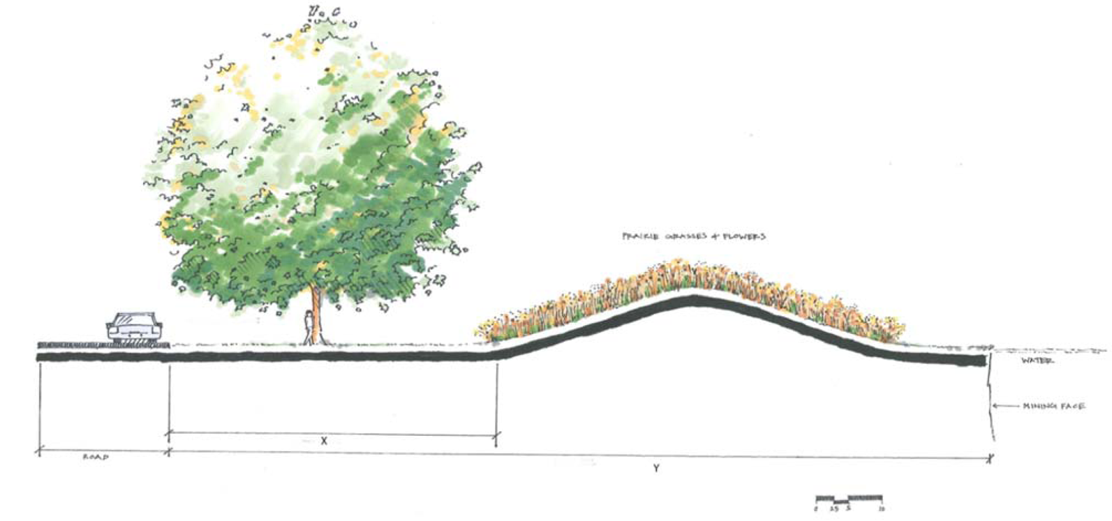
Diagram J Earthen berm buffer strip cross-section
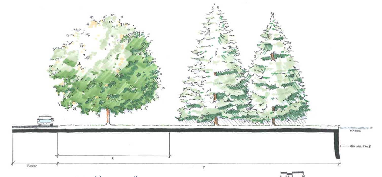
Diagram K Vegetative buffer strip cross-section
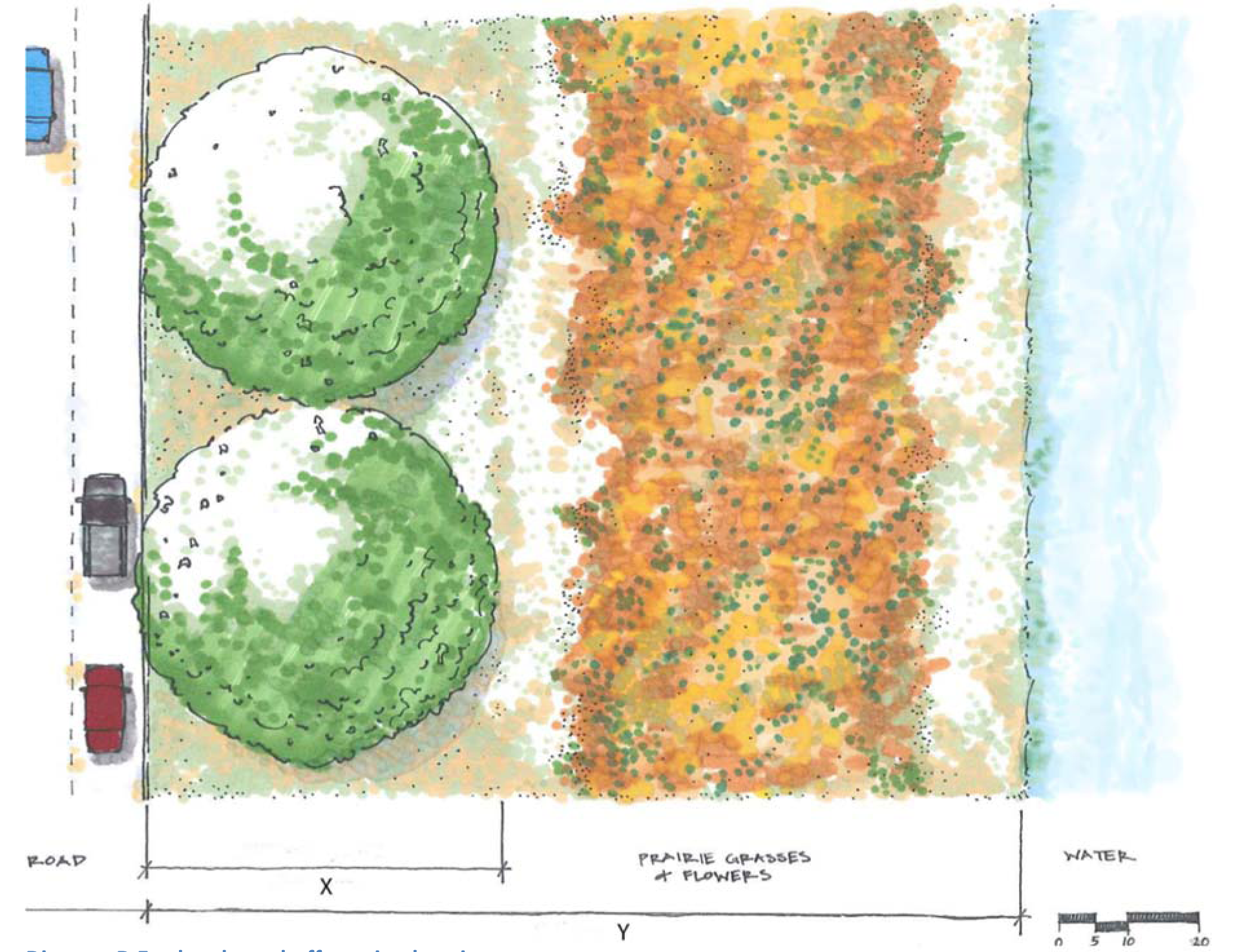
Diagram L Earthen berm buffer strip plan view
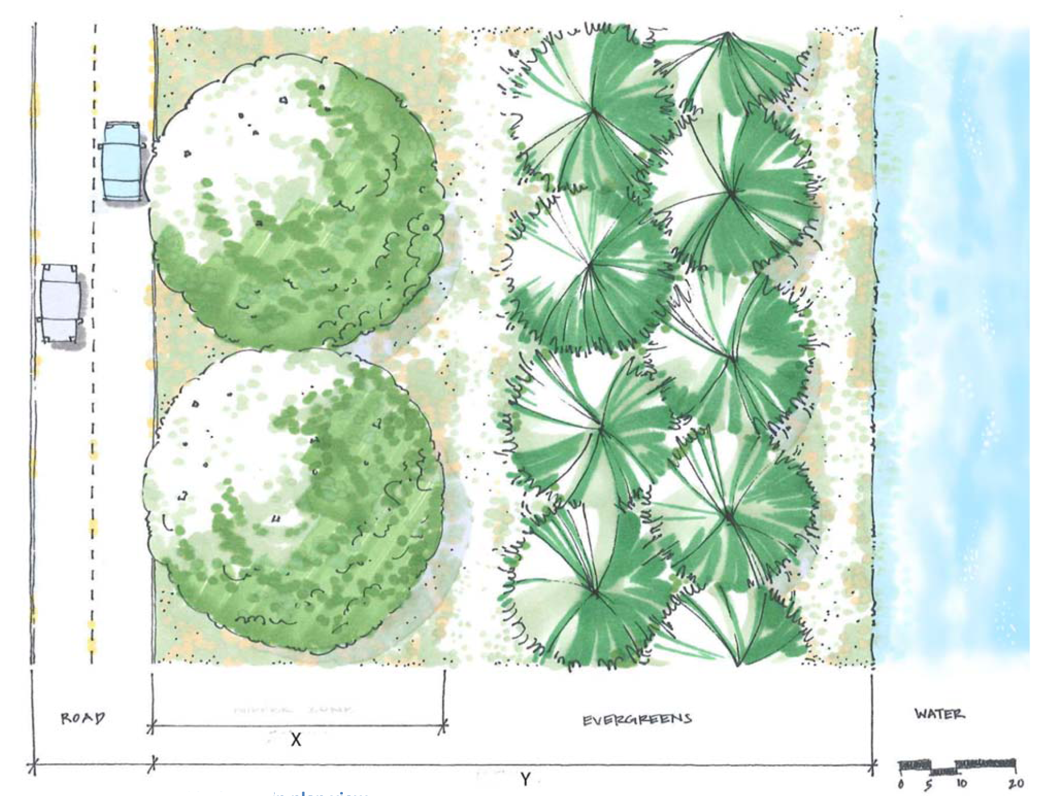
Diagram M Vegetated buffer strip plan view
3.
Fencing, gates and signage. A security fence measuring at least six feet in height shall be required at the perimeter of the affected land as shown on the approved site and development plans. All fences shall extend to the ground to preclude openings of more than four inches between the ground and the fence. All gates shall be installed to fence height at all entrances. All unattended gates shall be self-closing, self-latching, and locked when not in use. Fences and gates shall be maintained in good repair, and shall exhibit signs, at intervals of not more than 200 feet warning against trespass. Signs warning against trespassing shall be between one square foot and three square feet. Refer to Section 744-510 for additional regulations governing fences. Refer to Chapter 744, Article IX for additional sign regulations.
4.
Topsoil management. Once removed, topsoil shall either be used in contemporaneous reclamation or stored in an environmentally acceptable manner, including seeding, mulching, or otherwise temporarily stabilizing the stockpile. In no instance shall topsoil be stockpiled under three feet or more in depth for longer than two months. Stormwater runoff shall be diverted around all locations in which topsoil is stockpiled. Stockpiles within 500 feet of any residence shall not exceed 50 feet in height. No portion of a stockpile shall be located closer than 200 feet to the centerline of any public right-of-way. Topsoil that has been removed may be sold; however, in no instance shall the sale of removed topsoil relieve or reduce any of the requirements of the reclamation plan.
F.
Operating regulations.
1.
Hours of operation. With the exception of blasting and scale house operations, the hours of operation for all activities in the mining pit shall be from 6:00 a.m. until 6:00 p.m. or sunset, whichever is later, on weekdays and Saturdays. The hours of operation for all scale house activities occurring on weekdays and Saturdays shall not be limited by the Zoning Ordinance. All mining operations are prohibited on Sunday and holidays recognized by the State of Indiana. Refer to Section 742-206.G.1.a. for regulations that govern the hours of operation for blasting.
2.
State and federal permits. A copy of all permits required for the mine operation pursuant to State and Federal pollution control laws and regulations shall be maintained on-site and available upon request.
3.
Erosion control.
a.
The Administrator shall be provided a copy of the approved erosion control plan required to be obtained pursuant to applicable state and federal law.
b.
Surface water shall not be allowed to leave the site in a manner that causes flooding, erosion, or alteration of natural drainage patterns. Surface water originating outside and passing through the affected land shall, at its point of departure from the affected land, be of equal quality to the water at the point where it enters the affected land.
c.
Overburden removal shall be limited to the area of the operation expected to be mined during a two-year period. Overburden removal areas that are not actively being mined shall be seeded and maintained with a permanent cover crop to prevent wind and water erosion.
d.
Soil restoration and seeding shall occur within each phase as soon as final grade levels, or interim grade levels identified in the reclamation plan, have been reached. Exceptions to seeding and mulching include the processing, storage, and staging areas within each phase.
e.
Final reclaimed slopes shall be treated to prevent erosion. Topsoil of at least four inches in depth shall be placed on the final slopes to support vegetation. Ground cover shall be planted by the next planting season after a slope is excavated to its final position. Ground cover shall be maintained thereafter to prevent erosion.
4.
Dust control.
a.
Fugitive dust from the mining operation shall be suppressed. In no instance shall petroleum-based products be used for fugitive dust suppression for mining operations located in a Wellfield Protection District.
b.
Wet suppression control system equipment shall be used when processing dry materials outdoors. When processing dry materials outdoors, wet suppression control system equipment shall be installed and maintained at all crushing and sorting and sizing equipment and conveyor transfer points.
c.
Unpaved areas travelled by vehicles shall be sprayed with water on an as-needed basis to minimize the generation of dust.
d.
Driveways or haulageways within 100 feet of a right-of-way shall be paved.
e.
Before entering a right-of-way, all loads of aggregate shall be leveled maintaining at least six inches between the materials and the top of the container, and either stabilized with dust suppressant, or completely covered. If dust suppressants are used, records documenting this activity shall be kept on-site for a period of two years.
5.
Groundwater protection. To ensure adequate protection of groundwater, the following shall be required:
a.
In the W-1 and W-5 Districts, no surface impoundments, ponds, or lagoons shall be established except for stormwater retention/detention ponds.
b.
In the W-1 and W-5 Districts, there shall be no dewatering of sites. Incidental use or pumping of water shall be allowed.
c.
A minimum separation of 200 feet shall be maintained between any excavation and any drinking water supply that is a point-driven or dug well and that was in existence prior to the excavation.
d.
A minimum separation of 100 feet shall be maintained between any excavation and any drinking water supply that is drilled into saturated bedrock and that was in existence prior to the excavation.
e.
A minimum separation of 1,000 feet shall be maintained between any excavation and a public drinking water source.
f.
No substance or item harmful to groundwater quality, such as, salt, creosoted timber, tree stumps, petroleum products, metal products, or rubbish shall be dumped or stored in a mining pit. No form of solid waste, sludge, or any other form of waste material of any kind, such as, construction or demolition debris, shall be placed, kept or stored on the site, with the exception of salt sand piles kept in accordance with state law or local regulations.
g.
If any petroleum products or other materials with potential to contaminate groundwater are to be stored on the site, the storage shall follow the specifications of the submitted spill prevention control and countermeasure plan. The spill prevention control and countermeasure plan shall be in accordance with applicable regulations of the United States Environmental Protection Agency and Indiana Department of Environmental Management. All petroleum products or highly flammable or explosive liquids, solids, or gasses to be stored on-site shall be located in bulk, above-ground, anchored tanks or containers having a roofed, secondary containment system adequate to contain 110 percent of the full contents of the container, and shall be located at least 75 feet from any lot line or right-of-way. The use of underground tanks shall be strictly prohibited.
h.
Refueling operations, oil changes, and other maintenance activities requiring the handling of fuels, petroleum products, and hydraulic fluids, and other on-site activity involving the use of products that, if spilled, may contaminate groundwater, shall be equipped with a secondary containment system installed in accordance with the Zoning Ordinance and the approved spill prevention control and countermeasure plan.
i.
A copy of the spill prevention control and countermeasure plan shall be kept on-site and available upon request at all times.
j.
Materials safety data sheets shall be maintained on-site for all hazardous materials in a conspicuous location. A map showing the location of hazardous materials storage areas shall also be posted and maintained on-site in a conspicuous location. A copy of this information shall be submitted to the Administrator and the local fire department.
k.
Absorbent materials and appropriate spill kits for cleanup of hazardous materials shall be maintained on-site at all times. The location of these materials shall be identified on the hazardous materials storage map.
l.
All spillage of hazardous materials including fuels, lubricants, solvents, etc. shall be immediately contained. Cleaning materials and contaminated materials shall be disposed of according to state regulations.
6.
Access and haulageway requirements.
a.
An application for a permit referred to in Section 742-206.C. or M. shall be subject to the provisions of the "Applicant's Guide, Transportation Impact Studies for Proposed Development," dated June 29, 1990.
b.
Access to a right-of-way shall meet the following standards:
1.
The angle of intersection of the driveway or haulageway shall be between 60 and 90 degrees from parallel.
2.
No obstructions shall be erected, placed, planted or allowed to grow in such a manner as to materially impede visibility between the heights of two and one-half feet and eight feet above grade level of the adjoining right-of-way within the clear sight triangular area.
3.
Driveways shall be at least 200 feet from any street intersection.
c.
With the exception of driveways intended for emergency use only, no more than two driveways shall be provided for the mining operation. The grade level of the driveway extending for at least eight feet shall be the same as the abutting established street grade.
d.
A sign shall be posted in a conspicuous manner indicating that loads must be secure and covered per Section 361-201 Vehicles Dropping Contents on Streets of the Revised Code of the Consolidated City and County.
e.
All vehicle ingress or egress points shall be locked except during hours of operation.
f.
Driveways connecting to a public street shall be kept clean of dirt, mud, stone, and sand to prevent tracking onto the public street.
g.
Affected land in excess of 25 acres shall install and utilize a wheel washer in accordance with the following:
1.
The wheel washer shall be located no closer than the allowed minimum setback distances to each exit onto a paved public road that is used by aggregate or mixer trucks and that accesses a paved public street.
2.
A sign shall be posted in a conspicuous location indicating that all aggregate or mixer trucks leaving the facility must go through the wheel washer.
3.
A sign shall be posted by the wheel washer rumble grate to designate the speed limit of five miles per hour for traveling over the wheel washer.
4.
The internal road from the wheel washer to the point where the facility exits to the street shall be paved.
5.
A sign shall be posted in a conspicuous location indicating that all aggregate and mixer trucks stay on the internal paved road from the wheel washer to the point where the facility exits to paved public roads.
7.
Noise. With the exception of blasting, the level of noise associated with any continuous, regular, or frequent source of sound on the property shall be muffled so as not to be objectionable due to intermittence, beat, frequency, shrillness, or volume outside of the boundaries of the affected land. The sound level created by any source shall not exceed 70 dB(C) and 60 dB(A), measured at the lot line except along a lot line contiguous to another property owned by the same property owner and approved for mining operations. Sound pressures shall be measured with a sound level meter meeting the standards of the American National Standards Institute's "American Standard Specification for General Purpose Sound Level Meters." The instrument shall be set to the appropriate weight response scales and the meter to the slow response. Measurements shall be conducted at a height of at least four feet above the ground surface at the lot line, and in accordance with ANSI S1.2-1962, "American Standard Method for the Physical Measurement of Sound." Both dB(A) and dB(C) scales shall be used, and a violation of either standard shall be deemed a violation of the Zoning Ordinance. The following uses and activities shall be exempt from noise level regulation: noises of safety signals, warning devices, emergency pressure relief valves, and other emergency activity.
G.
Blasting.
1.
General requirement. The following regulations are in addition to all applicable state and federal blasting regulations. In the event of a conflict between local, state or federal regulations, the more restrictive regulation shall apply.
a.
All surface blasting shall be limited to the period between 10:00 a.m. and 3:00 p.m., Monday through Saturday, with the exception of holidays. No blasting shall occur on holidays recognized by the State of Indiana. Subsurface blasting shall be limited to the period between 1:00 p.m. and 6:00 p.m., Monday through Saturday. Every effort shall be made to schedule blasts at the same time of day. Explosives used in connection with mining shall not be detonated at other times except when necessary to alleviate a hazardous condition or as required to comply with applicable governmental regulations.
b.
Surface or subsurface blasting shall be conducted no closer than 250 feet of the lot line of any property improved with a protected structure. Blasting shall be conducted no closer than 100 feet of any underground pipeline, unless the pipeline company authorizes or confirms, in writing to the Administrator, a lesser distance.
c.
The maximum air blast limits shall be governed by the following Table 742-206-2, based on the former U.S. Bureau of Mines RI 8485, Structure Response and Damage Produced by Airblast from Surface Mining (Siskind 1980). Air blast shall be controlled so that the maximum decibel limits are not exceeded at the lot line of the affected land on which the blast occurred.
2.
Monitoring guidelines.
a.
All blasts shall be monitored by properly calibrated seismographs at any monitoring station for both horizontal and vertical ground vibrations and for air blast. The locations of the monitoring stations shall be determined utilizing recommendations from isoseismic studies, if conducted, and shall include locations at the closest protected structures. The Administrator may require that additional monitoring stations be established or re-established based upon the analysis of blast data.
b.
Records from each blast, both surface and subsurface, shall be kept on-site and provided to the Administrator upon request. Blast records shall be maintained for a period of not less than three years. Blasting records shall include, but not be limited to, the following:
1.
The date, time, and specific location of the blast;
2.
The type of blast, either surface or subsurface;
3.
If surface blast, the weather conditions, including air temperature, wind speed and direction, and cloud cover;
4.
Identification of the closest protected structure, and its distance from the blast;
5.
The name and license number of the person conducting the blast; and
6.
The number of holes, diameter and depth of holes, delay pattern and design, and number of detonators used.
H.
Operations plan. The operations plan shall consist of maps and written descriptions of the proposed mining operation. All operations plan maps shall be prepared, at a horizontal scale to show sufficient detail, provided the documents produced are eight and one-half inches by 11 inches, eight and one-half inches by 14 inches, 11 inches by 17 inches, or 24 inches by 36 inches. All maps shall be prepared by a Professional Engineer, Professional Land Surveyor, licensed Professional Geologist, or other individual trained in such preparation, and stamped by a professional licensed in Indiana. The operations plan shall include, but shall not be limited to, the following:
1.
An accurate site plan in accordance with Section 740-802 Application for Permit, as amended from time to time.
2.
Title block and legend containing the name and address of the mining operation; property owner and mine operator name and contact information; name of the individual responsible for preparation of maps or aerial photographs; date of preparation and record of work/revisions; and scale, north arrow, and reference datum.
3.
The boundary outline and legal description of the affected land for the life of the mine.
4.
A map of the location of the proposed mine, including boundaries of all contiguous land controlled by the applicant.
5.
A map of the structures and land uses on the affected land.
6.
Within a one-quarter mile radius of the boundary line of the affected land, the following information shall be provided:
a.
Names and addresses of adjacent landowners;
b.
Structures and land uses on all properties, in sufficient detail to distinguish designated protected structures from non-protected structures;
c.
A map identifying existing surface waters drainage patterns;
d.
A description of the potable status of the groundwater, with the source noted;
e.
Existing private wells and municipal wellheads;
f.
All existing wellfields;
g.
All existing retention ponds or lakes; and
h.
Surface water drainage capacity.
7.
Topographic contours at two-foot intervals within the site and extending beyond the boundaries of the site for 200 feet in all directions.
8.
Pipelines, power lines, and other utilities.
9.
Easements.
10.
Site vegetation, landscaping, and berming.
11.
The general direction of mining during the next five-year period, including the sequence of cuts and excavations, plans for concurrent excavation and reclamation, if applicable, and overall development of the mine by phases, if applicable.
12.
Areas of excavation and the depth of excavation.
13.
Areas of topsoil and mineral stockpiles, and tailings and spoil storage, and the anticipated height of the stockpiles.
14.
Processing plant areas, if applicable.
15.
Equipment and vehicle maintenance areas, equipment and vehicle storage areas, fueling areas, fuel storage areas, and parking areas.
16.
Driveways and haulageways with estimated average daily and peak daily levels of truck traffic.
17.
Drainage features, water courses, water discharge points, water impoundments, and groundwater monitoring locations.
18.
Erosion and sedimentation control measures to be employed during each phase of mineral excavation and extraction activities intended to minimize erosion and the pollution of surface water and groundwater.
19.
Site screening, fencing, berming, and landscaping.
20.
Lighting and signs.
21.
A description of the general geographic location of the affected land.
22.
A description of topographic and land use features within and adjacent to the affected land.
23.
A description of the proposed method of mining, including the method of extraction; sequence of cuts and excavations; method, types, and location of blasting, if applicable; disposition of materials on the affected property, and use of haulageways and ingress and egress from any street.
24.
Soil boring results sufficient to approximate the number of cubic yards of material to be extracted.
25.
For subsurface mining, subsidence investigations or studies shall be completed to ensure the integrity of any subsurface mining. Subsidence investigations or studies may not be necessary for future phases of an existing mining operation when geological conditions are the same and the proposed mining operation for the new phase is consistent with prior mining operations.
26.
A description of anticipated washing operations and groundwater extraction and use.
27.
A description of the heavy equipment used.
28.
A description of noise impacts and mitigation plan to minimize impacts of noise, providing:
a.
An existing conditions analysis, including measurements at adjacent property and nearby protected structures;
b.
A list of equipment and operations that may contribute to noise pollution;
c.
Projections of sound decibel levels, due to blasting or mining operations, at lot lines, and adjacent protected structures;
d.
Methods to be used to protect nearby private and public property from damages, and the adverse effects of blasting;
29.
A description of dust control and air quality maintenance efforts.
30.
If the affected land is located within a Wellfield Protection Secondary Zoning District, a hydrogeological study of the potential impact to the public water supply and a description of any mitigation proposed. The study shall indicate the following information:
a.
Full geologic and hydrogeological evaluation, including all soil and bedrock boring logs, field aquifer testing, and photographic documentation of rock cores and rock quality;
b.
Geologic cross-sections through existing and proposed mining operations;
c.
Historical groundwater level measurements of all monitoring wells, piezometers, and surface water bodies, including geographic location, reference surface elevation, depth to groundwater, date of measurement, survey reference location, and elevation;
d.
Potentiometric (water level) maps for each date of measurement of the group of monitoring wells and piezometers;
e.
Historical pumping rate records for any existing mine, including date of measurement, flow rate (in gpd), discharge rate (in gpd), and pumping locations; and
f.
Summary of historical high-capacity pumping records within one quarter-mile of the affected land.
31.
Groundwater modeling analysis shall be prepared for any new mining operation to determine the hydrogeological effects of the mining on the area and the groundwater availability and groundwater elevation under the current, proposed, drought, and flood conditions. The analysis shall consider:
a.
Area geology and hydrogeology;
b.
Existing and proposed mining pumping rates;
c.
Historical high capacity pumping rates within one quarter-mile of the affected land;
d.
Hydraulic parameters of all hydrographic units;
e.
Area recharge;
f.
The presence of, and leakage from, area surface water bodies (including lakes and rivers);
g.
Pumping water discharge areas; and
h.
Surface water and groundwater interactions.
32.
A list of the following:
a.
Chemicals, in quantities and storage locations, used or stored on-site;
b.
Floor drain locations and outlets;
c.
Waste storage locations;
d.
Liquid transfer areas;
e.
Site surface water bodies (streams, rivers, ponds);
f.
Underground storage tanks; and
g.
Aboveground storage tanks.
33.
A complete spill prevention control and countermeasure plan to ensure adequate response to potential fuel spills and releases from mining equipment, and developed in accordance with local, state, and federal regulations.
34.
Emergency response measures in the event of a release of a hazardous material or objectionable substance that could impact water quality.
35.
Proposed hours of operation.
36.
Security plans for the site.
I.
Reclamation plan. A reclamation plan shall be submitted for review and subject to Administrator's approval. The following shall be included in the reclamation plan.
1.
Reuse of the affected lands after cessation of all mining operations, or if mined in phases, after each phase of mining operations that is compatible with the Comprehensive Plan.
2.
Schedule and sequence for the completion of reclamation activities that shall be completed upon the conclusion of mining operations.
3.
Description of the earthwork and grading specifications, including final slope angles, high wall reduction, benching, terracing and other structural slope stabilization measures and, if necessary, a site-constructed engineering analysis performed by a Professional Engineer licensed by the State of Indiana.
4.
Methods of topsoil removal, storage, re-application, stabilization and conservation that will be used during reclamation.
5.
Topographic contours of the reclaimed site prior to excavation, after completion of excavation, and after completion of reclamation, in two-foot intervals, and any water impoundments or artificial lakes needed to support the anticipated future use of the site.
6.
Landscape plan indicating scheduling, quantities and methods of seedbed preparation, soil amendments, seed and planting lists, mulching, netting, and soil and slope stabilization.
7.
Erosion and sedimentation control measures to be employed during reclamation activities to minimize erosion and the pollution of surface water and groundwater.
8.
A description of how the reclamation plan addresses the long-term safety of the reclaimed mining site. The description may include a discussion of site-specific safety measures to be implemented at the site and include measures that address public safety with regard to adjacent uses.
9.
Phasing schedule for any areas reclaimed on an interim basis and prior to final reclamation.
10.
The estimated cost of reclamation, if phased, the cost of reclamation for each phase.
11.
Depth and slope of any water bodies.
J.
Reclamation standards.
1.
Commencement and completion. Reclamation, in accordance with the approved reclamation plan, shall begin within six months of the completion of any phase of mining, or within six months of the completion of all mining in a project that is not phased, and shall be completed within two years after cessation of the mining operation.
2.
Developable land. There shall be a minimum of 150 feet of land around a water-filled pit, unless the land is accessible by a local street. If a local road is present, there shall be a minimum of 100 feet of land around a water-filled pit.
3.
Safety ledge. A safety ledge shall be required around the perimeter of all water bodies. Safety ledge width shall be a minimum of 10 feet; and the maximum depth shall be 25 inches to 30 inches below the normal pool water level. Maximum ground slope above the safety ledge for a distance of 10 feet shall be 6:1 horizontal to vertical incline.
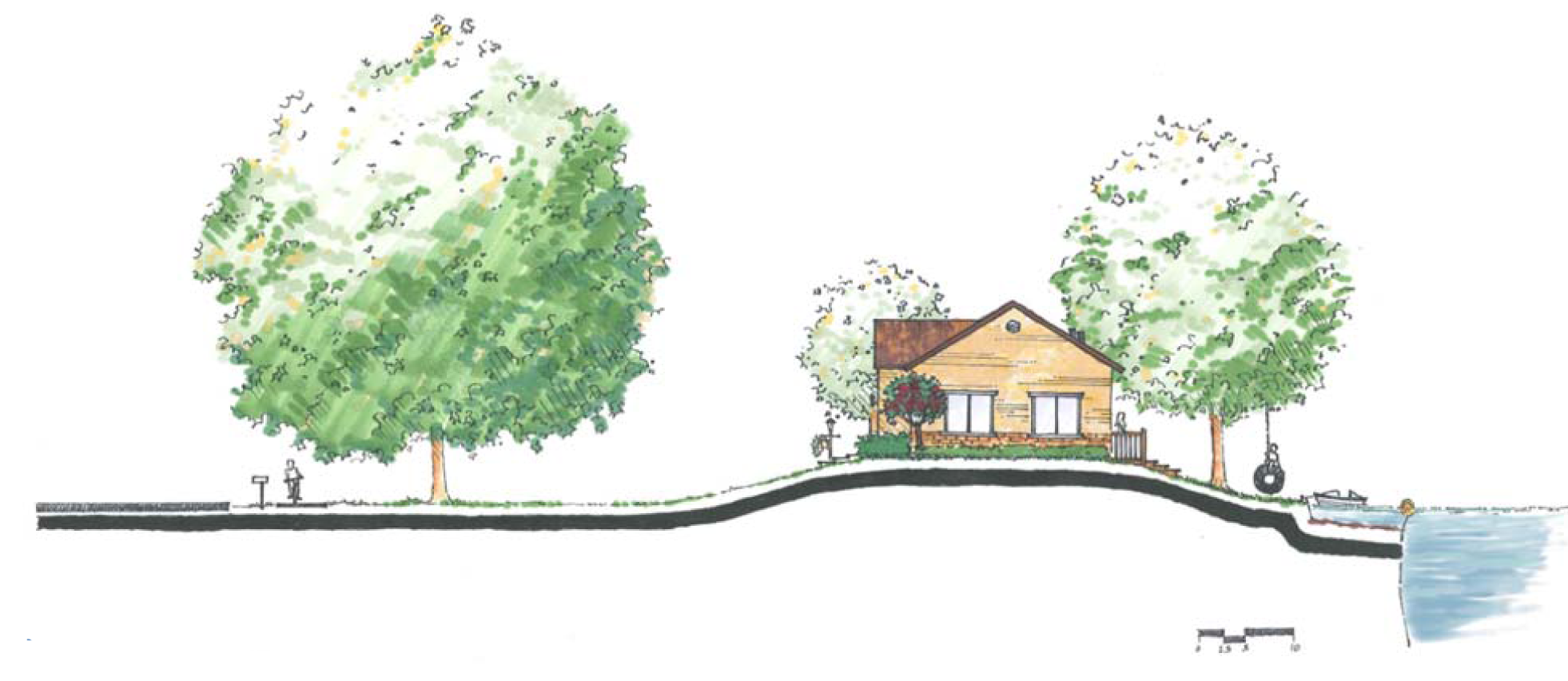
Diagram N Reclaimed site
4.
Final grading and slopes. Final reclaimed slopes shall not be steeper than a 3:1 horizontal to vertical incline. The top of slope shall be no closer than 125 feet from adjacent lot lines or rights-of-way. For slopes designated as stable under this Section 742-206, the Administrator may require a site-specific engineering analysis be performed by a Professional Engineer to demonstrate that an acceptable slope stability factor is attainable at a steeper slope in order to demonstrate that future uses, as specified in the reclamation plan, would not be adversely affected.
5.
Support roads. All driveways and haulageways shall be reclaimed, unless reserved for the future productive use of the land, as described in the reclamation plan.
6.
Equipment removal. Within six months after completion of reclamation activities, all equipment, vehicles, machinery, materials, and debris shall be removed from the site.
7.
Topsoil re-application and vegetative cover. A minimum of four inches of clean topsoil shall be re-applied, and vegetative cover established, on all affected land during reclamation activity. Topsoil shall be placed and seeded within 30 days of final grading if within a current growing season or within 30 days after the start of the next growing season. A minimum of one overstory trees shall be planted for every 35 linear feet of each lot line. Vegetative material used in reclamation shall consist of native grasses or native wildflowers and registered with the City of Indianapolis native wildlife planting registry and agreement program. Establishment of vegetation shall be performed after the mining operation has permanently ceased in any phase of the mining operation, with the herbaceous or woody plants being planted during the first growing season following the reclamation phase, as determined by the approved reclamation plan.
8.
Compliance with applicable regulations. Reclamation of mining operations shall comply with any applicable federal, state, or local laws.
K.
Assurance of completion, reclamation and maintenance.
1.
Before the Administrator may issue a new, renewal, or modification permit for mining operations, the applicant shall furnish financial guarantee, naming the City of Indianapolis as beneficiary, to ensure installation of improvements required by this article or necessary due to the impact of the mining operation, along with reclamation of the mining operation in accordance with the approved reclamation plan. Financial guarantee shall be in the form of a bond from a corporate surety licensed to do business in the State of Indiana, or an irrevocable letter of credit. All interest accruing as a result of the surety shall be the exclusive property of the operator. The amount of financial guarantee shall be one and one-half times the cost of completing the necessary or required improvements and either final reclamation or phased reclamation in compliance with the approved reclamation plan, as determined by the Administrator. The Administrator may accept a lesser initial amount of financial guarantee in the case of phased reclamation, the amount to be increased periodically to ensure reclamation of new land disturbed by mining operations. The amount of financial guarantee shall be reviewed periodically by the Administrator to ensure that it equals anticipated or outstanding costs, including a reduction in the amount of the guarantee, where applicable.
2.
The holding of financial guarantee may extend beyond the time that reclamation is completed to ensure that reclamation of the mining operation will succeed. However, the operator, in the case of phased reclamation, may request partial release of the financial guarantee reflective of the amount of the completed work of any affected land on which final reclamation has been completed and approved by the Administrator. The operator may also request, for the entire mining operation or for any phase of the mining operation, release of a surety amount applicable to the completed and approved reclamation effort, pending completion of the reestablishment of vegetation. The remaining guarantee amount may be held by the Administrator. To request release of funds, the operator shall notify the Administrator at the time that the operator determines that reclamation of any portion of the mining operation or the entire site is complete. The Administrator shall inspect the mining operation or portion thereof to determine if reclamation has been carried out in accordance with the approved reclamation plan and release funds if it determines that all or a portion of the reclamation effort has been successfully completed and that adequate funds remain to cover the reclamation work yet to be completed.
3.
If the required financial guarantee is cancelled for any reason, the operator shall provide a valid replacement under the same conditions described in this Section 742-206 within 30 days after receiving notice of the need for replacement. Failure to provide replacement financial guarantee within the 30-day period, or failure to provide additional surety within a like 30-day period due to start-up of new phases of the mining operation shall result in the automatic and immediate suspension of the applicable Improvement Location Permit or license, such suspension shall continue until the operator provides the Administrator with a valid replacement or additional financial guarantee. The Administrator may elect to redeem the financial guarantee.
4.
If the operator fails to install improvements as required or fails to commence or complete reclamation as required, the Administrator may utilize the financial guarantee furnished by the operator to effect the installation or reclamation.
L.
Annual reports. An annual report shall be submitted within 60 days of the anniversary date of the applicable Improvement Location Permit or license. The operator may submit its first annual report within 60 days of the end of the calendar year; provided, however that the operator shall continue to submit an annual report within 60 days of the end of the calendar year every year thereafter. The annual report shall contain the following information:
1.
The name, business address, and telephone number of the owner of the mining operation and of a designated agent residing within Indiana for the receipt of all orders and notices.
2.
The location of the mining operation, its name, its mine number as issued by the Bureau of Mines or the State Geologist, its section, township, range, tax parcel numbers, and boundaries as marked on a United States Geological Survey 7½-minute quadrangle map.
3.
A written description of activities detailing the mining and reclamation accomplished during the past year.
4.
An updated mining plan depicting the current extent of mining, including current mining faces as surveyed by a registered land surveyor or as depicted on a current aerial photo, the proposed advancement of the working faces for the next three years, and current or immediately impending reclamation efforts.
5.
A map showing the acreage total of land newly disturbed by the operation during the previous year and the acreage total of disturbed land reclaimed during the previous year.
6.
A map showing the total remaining disturbed acreage as of the end of the previous year that is not reclaimed.
7.
Results of studies or monitoring required under this Section 742-206.
8.
A statement of certification by the operator that all mining, processing, or reclamation conducted during the reporting year has been in conformance with the permit and the approved operations and reclamation plans, and that the operator is in compliance with this Section 742-206.
9.
A statement of whether or not the Indiana Department of Environmental Management has conducted an on-site inspection since submission of the previous report, and a description of their findings if applicable.
10.
Copies of correspondence with city, county, state and federal agencies with regard to permitting, complaints, and enforcement matters.
11.
A log of all complaints from all persons and a description of efforts to resolve the complaints.
12.
A groundwater report that provides information regarding water flows, water quality, and operational activities to ensure protection of groundwater, to include:
a.
All groundwater level and surface water level measurements taken during the reporting year (minimum monthly basis);
b.
All pumping rates (minimum monthly basis) and total discharge (minimum monthly basis) from the mine;
c.
All discharge rates (minimum monthly basis) into nearby surface water bodies;
d.
All relevant stream discharge flow measurements (minimum monthly basis);
e.
All changes in the location and number of pumping and discharge points;
f.
Groundwater and surface water analytical testing during the reporting year (minimum monthly basis);
g.
All chemical spills and releases during the reporting year;
h.
Observed variations between subsurface soil/bedrock conditions at boring locations and actual mining operations (e.g., variations from expected conditions, areas of increased discharge of groundwater, zones of greater hydraulic conductivity within soil and bedrock); and
i.
Results of measurement of vertical separation between the excavation limits and the average seasonally high water table. If the groundwater level is found to be within 15 feet of the bottom of the pit, a piezometer shall be installed in order to provide continuous monitoring of the groundwater level.
13.
A blasting report, recording:
a.
The location, date, and time of each surface blast and underground blast;
b.
The weather conditions for each blast, wind direction and speed, and cloud cover;
c.
The name and license number of the person conducting the blast;
d.
The identification of the closest protected structure and its distance from the blast;
e.
A summary of methods used to protect nearby public and private property from damage by air blast and ground vibration;
f.
A complaint log, listing blasting complaints and claims for damages; and
g.
All other related information required by the Administrator consistent with the purposes of this article.
M.
Licensing permit.
1.
Licensing requirement. It shall be unlawful for a person to operate, or cause to be operated, a mining operation in the city, unless the mining operation first is registered with the License Administrator as provided in this Section 742-206.M.
2.
Licensing fee. The annual fee for licensing of a mining operation shall be provided in Section 131-501 of the Revised Code of the Consolidated City and County.
3.
License renewal or transfer. Licenses issued pursuant to this Section 742-206 may be renewed or transferred, provided the original license holder is carrying out the requirements of the license and there exist no judicial determinations to the contrary at the time of renewal or transfer request. Renewal approval, if issued, shall be for a period of not more than five years. Transfer approval, if issued, shall be for the remainder of the original license period or for not more than five years if transfer is proposed at the end of the original license period. Application for renewal or transfer shall be made 60 days prior to the expiration date of the original license period. If application is not made within the 60-day period, the renewal or transfer application shall be treated as a new application and all requirements of this Section 742-206 shall apply. In the event that the renewal or transfer application is treated as a new application, the original license conditions shall remain in effect until a decision has been made on the new application. An application for renewal or transfer shall include the following:
a.
Completed application form and licensing fee consistent with all requirements of this Section 742-206 and the Zoning Ordinance.
b.
Proof of financial guarantee, covering the requested renewal period, to ensure compliance with the regulations of this Section 742-206 and the Zoning Ordinance.
c.
Changes to the operations plan map, if any.
d.
Changes to the operations plan written description, if any.
e.
Identification of reclamation accomplished during the existing license term.
f.
Copies of all approvals or permits, or licenses needed from other municipality, state, or federal agencies.
g.
Other related information that may be required by the Administrator consistent with the requirements of this Section 742-206 and the Zoning Ordinance.
4.
License modifications. In the event that the operator requests a modification to an existing license because of, for example, a change in the method, depth or the expansion of the mining operation onto adjacent land, that modification shall be treated as a new application, and all requirements of this Section 742-206 and the Zoning Ordinance shall apply. The original license conditions shall remain in effect until a decision has been made on the modification application.
5.
License suspension or revocation. The Administrator may suspend, revoke, or refuse to renew a license for violation of any of the terms of the license or the provisions of this Section 742-206 and the Zoning Ordinance, or if the Administrator determines that serious hazard is posed to the health, safety, or general welfare of the public through violation of the terms of the permit or the provisions of this Section 742-206 and the Zoning Ordinance. If a license is suspended, revoked, or not renewed, the Administrator may require the operator to commence reclamation upon 30-day notice. Any persons aggrieved by an action or determination made by the Administrator may appeal the Administrator's decision, within 30 days of the date rendered, to the Metropolitan Development Commission.
(G.O. 64, 2015, § 2)
Sec. 742-207. - Transit Oriented Development Secondary Zoning District (TOD).
A.
Applicability. With the exception of legally established nonconforming uses, no land, building, structure, premises or part thereof shall be used or occupied except in conformity with these regulations and for uses permitted by this section. In the case of any difference of regulations between this Section 742-207 and the regulations of the Primary Zoning District, the provisions of this section shall control. Except as modified by this Section 742-207, all development standards as required by the Primary Zoning District shall apply.
The Transit Oriented Development Secondary District is established on all lots, wholly or partially, within 1,000' from centerline of a BRT Line established on the effective date of this section as depicted on the map contained in the 2015 IndyGo Comprehensive Operational Analysis (COA) except the following property in this area are not subject to the standards in Section 742-207:
1.
Any property with D- district zoning;
2.
Any property with CBD- district zoning;
3.
Any property with I- district zoning;
4.
All lots located within any locally designated historic preservation areas as established by, and under the jurisdiction of, the Indianapolis Historic Preservation Commission (IHPC).
B.
Intent and design objectives. The intent of the Transit Oriented Development (TOD) Secondary District is to coordinate more compact, walkable and urban development patterns with public investment in the transit system. These development patterns ensure that walking and biking are viable options for short trips and transit is a priority for longer trips. Development patterns and site designs that prioritize automobile travel undermine these public and private investments. This district follows the policies and principles of the Comprehensive Plan, the transit-oriented development strategic plans, and the Livability Principles in this code, and has the following specific design objectives:
1.
Place a wide range of housing types within walking distance of commercial centers and transit stops or stations, and at a critical mass that supports these places.
2.
Create connections through many different modes of transportation between neighborhoods and places for commercial services and employment.
3.
Provide a concentration of many different and small-scale uses with a fine-grained pattern that integrates and transitions well with the neighborhoods they support.
4.
Ensure human-scale design that prioritizes relationships of sites and buildings to the streetscapes.
C.
Approvals. Development in the TOD Secondary District may be approved in the following manner:
1.
Projects that meet all development and design standards may apply for permits unless Administrative Approval is required by this code.
2.
Projects requesting relief from the use or development standards require approval by the Board of Zoning Appeals, in addition to all other approvals that may otherwise apply, including but not limited to approval by the Indianapolis Historic Preservation Commission or Regional Center Hearing Examiner.
D.
Use limitation. In addition to any use allowances, limitations or prohibitions in the base zoning districts, uses in the TOD Secondary District shall be further limited as specified in this section.
1.
Commercial and industrial uses, generally. Commercial and industrial uses permitted in any primary district shall be limited by scale of the use in the TOD Secondary District as follows. Retail sales/services shall apply to any commercial and/or industrial use enabled in the primary district, unless it is more specifically described in the table below:
P = Permitted
S = Special Exception
2.
Location and limitation of specific uses. The following uses in their typical form or format, and when concentrated in areas have a detrimental effect on the intent and design objectives of the Transit Oriented Development Secondary District. Where these uses are enabled by the primary zoning district, they shall be further limited in the TOD Secondary District as stated in Table 742-707-2. Each use remains subject to all other form, format and design standards found in Section 744.702 Commercial and Mixed-Use Design Standards.
*The 600' shall be taken from the lot line of the parcel containing the use to the leading edge of the Transit Station.
Any use otherwise permitted by these standards shall be required to meet all applicable form and design standards of the zoning ordinance.
E.
Additional development standards.
1.
Mixed-Use Districts. All MU-Districts in the TOD Secondary District shall meet the Mixed-Use and Commercial Design Standards in Section 744.702.
2.
Commercial Districts. All C-Districts in the TOD Secondary District shall meet the Mixed-Use and Commercial Design Standards in Section 744.702.
3.
Regional Center. All lots in the RC Secondary District governed by Section 742.202 are subject to the Regional Center Design Guidelines.
(G.O. 26, 2021, § 5)