
St Anthony City Zoning Code
CHAPTER 17
06 Establishment Of Zoning Districts-Adoption And Amendment Of Zoning Map
17.06.010 Establishment Of Zoning Districts
For the purpose of this title and in accordance with the comprehensive plan, all land within the city's zoning jurisdiction is divided into the zones set forth herein and shall be applied as depicted upon the adopted official zoning map of the city, which map and all information shown thereon may from time to time be modified, and are by reference thereto made a part of this title.
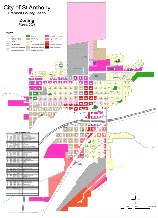
Click to view larger Zoning Map
 (Ord. No. 2015-01, § 2, 2-26-2015)
Amended by Ord. 2016-04 on 5/12/2016
Amended by Ord. 2016-08 on 10/13/2016
Amended by Ord. 2017-03 on 3/23/2017
Amended by Ord. 2018-04 on 10/11/2018
Amended by Ord. 2018-05 on 12/27/2018
Amended by Ord. 2019-08 on 7/11/2019
Amended by Ord. 2019-14 on 12/12/2019
Amended by Ord. 2020-01 on 2/13/2020
Amended by Ord. 2020-02 on 3/12/2020
Amended by Ord. 2021-02 on 3/11/2021
Amended by Ord. 2022-05 on 9/8/2022
17.06.020 Effect Of Zoning
Zoning district standards and dimensional limitations are established in order to achieve the following:
Desired Community Character. Ensure the protection of the desired community character of each zoning district.
Housing and Business Opportunities. Promote adequate housing and business activities with the city.
Stability. Promote the stability of existing land uses and protect them from inharmonious influences and harmful intrusions.
Compatible Development. Ensure that uses and structures enhance their sites and are compatible with the natural beauty of the city's setting and its natural resources.
Mitigation of Negative Impacts. Mitigate negative impacts of certain uses within the zoning districts.
(Ord. No. 2015-01, § 2, 2-26-2015)
17.06.030 General Standards Applicable To All Zones
The following standards shall apply to each of the zones established herein unless otherwise stated.
- Project Plan Approval. All projects constructed within the zones established herein, must submit, prior to beginning construction, a site drawing for review and approval by City of St. Anthony staff. All structures must comply with adopted building ordinance requirements.
- Prior Created Lots. Lots or parcels of land which were legally and lawfully created prior to the application of the zone shall not be denied a building permit solely for reason of nonconformance with the parcel requirements of this chapter.
- Parking, Loading, and Access. All parking, loading and access within each of the zones established in the title shall be subject to the requirements and restrictions of the parking and loading requirements of Title 10 SAMC of this code as well as Chapter 9 SAMC of this title.
- Signs. The placement of signs in all of the zones established herein are subject to the restrictions and requirements of Chapter 15.20 SAMC of this code.
- Exceptions. The following structures may be erected on or projected into any required setback or right-of-way:
- Screening and fencing within each of the zones established herein shall be constructed and maintained in conformance with the standards established in Chapter 9 SAMC of this title and other city codes or ordinances.
- Landscape elements including trees, shrubs, agricultural crops and other plants.
- Necessary appurtenances for utility service.
- In all zones, the area between the curb and gutter, and the sidewalk, is to be landscaped and maintained by the adjacent property owner. For the purpose of insuring visibility and safety in residential zones and other zones which require buildings to be set back from the property line, the triangle of land formed on any corner lot by drawing a line between points on the lot lines, which are forty feet from the intersection of such lot lines, shall be free from any sight obscuring structure or obstruction except as permitted. Trees in such triangles shall be trimmed to at least twelve feet above the centerline grades of the intersecting streets. Shrubs, fences, and walls shall not be higher than three feet above the centerline grades of the intersecting streets.
- Screening and fencing within each of the zones established herein shall be constructed and maintained in conformance with the standards established in Chapter 9 SAMC of this title and other city codes or ordinances.
- See also Chapter 9 SAMC for additional standards.
(Ord. No. 2015-01, § 2, 2-26-2015)
17.06.040 Residential Zones
(Ord. No. 2015-01, § 2, 2-26-2015)
17.06.050 General Standards Applicable To Residential Zones
The following standards shall apply to each of the residential zones established herein unless otherwise stated.
- Accessory Building Setbacks. Accessory buildings must meet all setback requirements established by any applicable building code, and shall have a building footprint and height less than the main dwelling. Accessory buildings larger than two hundred square feet shall meet the same side yard requirements as principal buildings.
- Comply with all lot coverage requirements. An accessory building or group of accessory buildings in any residential zone shall not cover more than thirty percent of the rear yard.
- Only be used for those accessory uses allowed in the respective zone.
- Accessory buildings shall not be placed in the front yard.
- Accessory buildings may be placed in any location in the rear yard not otherwise in conflict with this title, unless the accessory building is a garage with doors opening into the alley. Such garages shall be located at least fifteen feet from the alley.
- Comply with all lot coverage requirements. An accessory building or group of accessory buildings in any residential zone shall not cover more than thirty percent of the rear yard.
- Additional Exception. When fifty percent or more of the lots on the same side of the street have been built, all buildings erected, established, or rebuilt shall be in conformity with the average setback of such buildings. In all residential zones, all buildings erected, established, or rebuilt shall be required to construct sidewalks. For new construction these should be a minimum of seven feet behind the curb and gutter, however where sidewalks already exist, the placement of new sidewalks shall align with existing sidewalks.
- Distance Between Buildings. The distance between any accessory building and a dwelling shall not be less than six feet. The distance between buildings containing dwellings on the same lot shall not be less than ten feet or as per the building code, whichever is greater.
(Ord. No. 2015-01, § 2, 2-26-2015)
17.06.060 Rural Cluster Residential Zone (RC1)
- Purpose. This zone is established in order to preserve the rural character and natural resources in the impact area around the city, and maintaining large open spaces in view areas are essential to ensure this openness is preserved. To achieve this, this zone permits residential development at an overall base density of housing clustered onto smaller lot sizes of one-half to one acre, while maintaining large contiguous tracts of open land. This zone is intended for use only in the impact area.
- Permitted Uses. Permitted and special uses for this zone are established in the Land Use Matrix, Table 6.1.
- Area Requirements and Standards.
- Lot Area. The minimum area of any lot or parcel of land in the RC1 zone is one-half acre (approximately twenty-one thousand seven hundred eighty square feet) or more up to one acre. Such lots shall be clustered together in order to maintain larger contiguous tracts of open land with value for conservation. The overall density of development shall not exceed one unit per two to two and one-half acres depending on the sites constraints. (See open space subdivision design requirements in the subdivision ordinance, Title 16 SAMC of this code.)
- Lot Width. The minimum lot width in the RC1 zone is one hundred and twenty feet.
- Lot Depth. The minimum lot depth in the RC1 zone is one hundred and forty feet.
- Lot Frontage. Each lot or parcel of land in the RC1 zone shall abut a public street for a minimum distance of thirty feet, on a line parallel to the center line of the street.
- Lot Configuration and Density. One single-family dwelling may be placed on a lot or parcel of land in the RC1 zone as a matter of right.
- Yard Requirements. The following minimum yard requirements shall apply in the RC1 zone:
- Front/Rear Yard. Each lot or parcel in the RC1 zone shall have a minimum front yard of at least twenty-five feet. The minimum depth of a rear yard shall be twenty feet.
- Side Yard. Each lot or parcel of land in the RC1 zone shall have a side yard of at least six feet or six inches of setback for every foot of building height, whichever is greater.
- Front/Rear Yard. Each lot or parcel in the RC1 zone shall have a minimum front yard of at least twenty-five feet. The minimum depth of a rear yard shall be twenty feet.
- Building Height. No lot or parcel of land in the RC1 zone shall have a building or structure which exceeds a maximum height of thirty feet to eave height, measured from natural grade at the building site. In no case shall the height of an accessory structure exceed the height of any main structure on the same lot.
- Permissible Lot Coverage.
- Building Coverage. In an RC1 zone, all buildings, including accessory buildings and structures (including impervious surfaces, e.g., driveways), shall not cover more than fifty percent of the area of the lot or parcel of land.
- Landscaping. At least thirty percent of the area of any lot shall be maintained in landscaping. On any lot, concrete or asphaltic cement shall not cover more than forty percent of a front yard, fifty percent of a rear yard, and one hundred percent of one side yard.
- Building Coverage. In an RC1 zone, all buildings, including accessory buildings and structures (including impervious surfaces, e.g., driveways), shall not cover more than fifty percent of the area of the lot or parcel of land.
- Lot Area. The minimum area of any lot or parcel of land in the RC1 zone is one-half acre (approximately twenty-one thousand seven hundred eighty square feet) or more up to one acre. Such lots shall be clustered together in order to maintain larger contiguous tracts of open land with value for conservation. The overall density of development shall not exceed one unit per two to two and one-half acres depending on the sites constraints. (See open space subdivision design requirements in the subdivision ordinance, Title 16 SAMC of this code.)
- Other Requirements—Standards for Open Space Subdivision Design. See Chapter 16.17 SAMC of this code.
(Ord. No. 2015-01, § 2, 2-26-2015)
17.06.070 Lower Density Residential Zone (LDR1)
- Purpose. This zone is established to maintain the character of residential areas of low-density, detached, single-family homes and establish new areas with similar character. These areas provide the opportunity for quiet residential neighborhoods within a short drive away from neighborhood service centers. This zone also includes residential areas of medium-density, attached or detached single-family homes; and small-scale, multiple-family homes. These areas transition between rural cluster and higher-density areas.
- Permitted Uses. Permitted and special uses for this zone are established in the Land Use Matrix, Table 6.1.
- Density, Area Requirements, and Standards.
- Lot Area. The minimum area of any lot or parcel of land in the LDR1 zone is eleven thousand square feet, approximately one-quarter acre.
- Lot Width. Each lot or parcel of land in the LDR1 zone, except corner lots, shall have a width of not less than eighty feet.
- Lot Depth. No restrictions.
- Lot Frontage. Each lot or parcel of land in the LDR1 zone shall abut a public street for a minimum distance of thirty-five feet, on a line parallel to the centerline of the street.
- Yard Requirements. The following minimum yard requirements shall apply in the LDR1 zone:
- Front/Rear Yard. Each lot or parcel in the LDR1 zone shall have a minimum front yard of at least twenty feet. The minimum depth of a rear yard shall be twenty-five feet.
- Side Yard. Each lot or parcel of land in the LDR1 zone shall have a side yard of at least six and one-half feet or six inches of setback for every foot of building height, whichever is greater.
- Front/Rear Yard. Each lot or parcel in the LDR1 zone shall have a minimum front yard of at least twenty feet. The minimum depth of a rear yard shall be twenty-five feet.
- Building Height. No lot or parcel of land in the LDR1 zone shall have a building or structure which exceeds a maximum height of thirty feet, measured at the top of building's horizontal wall. In no case shall the height of an accessory structure exceed the height of any main structure on the same lot.
- Permissible Lot Coverage.
- Building Coverage. In an LDR1 zone, all buildings, including accessory buildings and structures (including impervious surfaces, e.g., driveways), shall not cover more than seventy percent of the area of the lot or parcel of land.
- Landscaping. At least thirty percent of the area of any lot shall be maintained in landscaping. On any lot, concrete or asphaltic cement shall not cover more than forty percent of a front yard, fifty percent of a rear yard, and one hundred percent of one side yard.
- Building Coverage. In an LDR1 zone, all buildings, including accessory buildings and structures (including impervious surfaces, e.g., driveways), shall not cover more than seventy percent of the area of the lot or parcel of land.
- Lot Area. The minimum area of any lot or parcel of land in the LDR1 zone is eleven thousand square feet, approximately one-quarter acre.
- Exception to the Requirements of 17.06.070 C: In the event there is a lot or parcel of property consisting of more than one lot or of a meets and bounds description all under the same ownership, that aggregates less square footage, width, depth or frontage than is required by said subsection C.1. but at least 5,000 square feet, the following Density, Area Requirements and Standards shall apply.
- There shall be no minimum lot width or depth.
- Lot Frontage. Each lot or parcel of land in the LDRl zone shall abut a public street for a minimum distance of twenty-five feet, on a line parallel to the centerline of the street.
- The square footage of the footprint of a single family dwelling and its accessory buildings shall not exceed 70 percent of the total square feet of the lot on which it is constructed.
- All other requirements of 17.06.070 C, not modified by this subsection shall apply to properties falling under this subsection.
(Ord. No. 2015-01, § 2, 2-26-2015)
17.06.080 Higher Density Residential Zone (HDR1)
- Purpose. This zone is established to provide residential areas of higher-density, attached or detached single-family homes; and small-scale, multiple-family homes. This zone also includes residential areas of higher-density, multiple-family development.
- Permitted Uses. Permitted and special uses for this zone are established in the Land Use Matrix, Table 6.1.
- Area Requirements and Standards.
- Lot Area. The minimum lot area on any parcel of land in the HDR1 zone is six thousand square feet for single-family dwellings. An additional one thousand square feet per unit is required up to a four-plex which shall require nine thousand square feet. If more than a four-plex is proposed, two thousand two hundred fifty square feet shall be required for each additional unit.
- Lot Width. Each lot or parcel of land in the HDR1 zone, except corner lots, shall have a width of not less than sixty feet. A twin home minimum width is forty feet (a combined eighty feet for both lots).
- Lot Depth. Each lot or parcel of land in the HDR1 zone, except corner lots, shall have a depth of not less than sixty feet.
- Lot Frontage. Each lot or parcel of land in the HDR1 zone shall abut a public street for a minimum distance of twenty-two feet, on a line parallel to the center line of the street.
- Lot Configuration and Density. One single-family dwelling or two-family dwelling will be permitted in the HDR1 zones where all setback and area requirements are met.
- Yard Requirements. The following minimum yard requirements shall apply in the HDR1 zone:
- Front/Rear Yard. Each lot or parcel in the HDR1 zone shall have a minimum front yard of at least twenty-five feet.
Exception. On a side street where a maximum of two lots face the street, a setback of not less than fifteen feet is permitted on the side street, unless there is a garage facing that street. In such case the garage setback shall be thirty feet. The minimum depth of a rear yard shall be twenty feet. - Side Yard. Each lot or parcel of land in the HDR1 zone shall have a side yard of at least six feet or six inches of setback for every foot of building height, whichever is greater.
- Front/Rear Yard. Each lot or parcel in the HDR1 zone shall have a minimum front yard of at least twenty-five feet.
- Building Height. No building shall be erected to a height of greater than two and one-half stories (forty-five feet). Roofs above the square of the building, chimneys, flagpoles, television antennas, church towers, and similar structures not used for human occupancy, are excluded in determining the height.
- Permissible Lot Coverage.
- Building Coverage. In an HDR1 zone, all buildings, including accessory buildings and structures (including impervious surfaces, e.g., driveways), shall not cover more than seventy percent of the area of the lot or parcel of land.
- Landscaping. At least twenty percent of the area of any lot shall be maintained in landscaping. On any lot, concrete or asphaltic cement shall not cover more than forty percent of a front yard, fifty percent of a rear yard, and one hundred percent of one side yard.
- Building Coverage. In an HDR1 zone, all buildings, including accessory buildings and structures (including impervious surfaces, e.g., driveways), shall not cover more than seventy percent of the area of the lot or parcel of land.
- Lot Area. The minimum lot area on any parcel of land in the HDR1 zone is six thousand square feet for single-family dwellings. An additional one thousand square feet per unit is required up to a four-plex which shall require nine thousand square feet. If more than a four-plex is proposed, two thousand two hundred fifty square feet shall be required for each additional unit.
- Other Requirements. When a single-family home is converted to a triplex or greater, or is converted to dormitory (non-family) housing, no parking spaces are permitted within the required front yard. However, an existing driveway (no greater than twenty feet in width, and no greater than twenty-two feet in depth) and two-car garage, when combined, may provide up to four parking spaces per building. If no garage is present then all parking spaces must be located outside of the front yard setback. All other parking areas that may be located within the front yard shall be removed and restored to landscaping prior to the occupancy of the building. Driveway aisle widths shall be no wider than the city's minimum aisle width for two-way access when accessing rear or side yard parking lots.
- Design Standards.
- Purpose. The architectural standards are intended to provide detailed, human-scale design, while affording flexibility to use a variety of building styles.
- Applicability. This section applies to all of the following types of buildings, and shall be applied during the project application process.
- Multi-Family Dwelling.
- Multi-Family Dwelling.
- Standards. All buildings which are subject to this section shall comply with all of the following standards. Other building styles and designs can be used to comply, so long as they are consistent with the text of this section. An architectural feature may be used to comply with more than one standard.
- Building Form. The continuous horizontal distance (i.e., as measured from end-wall to end-wall) of individual buildings shall not exceed one hundred and sixty feet. All buildings shall incorporate design features such as offsets, balconies, projections, window reveals, or similar elements to preclude large expanses of uninterrupted building surfaces. Along the vertical face of a structure, such features shall occur at a minimum of every forty feet, and on each floor shall contain at least two of the following features:
- Recess (e.g., deck, patio, courtyard, entrance or similar feature) that has a minimum depth of four feet;
- Extension (e.g., floor area, deck, patio, entrance, or similar feature) that projects a minimum of two feet and runs horizontally for a minimum length of four feet; and/or
- Offsets or breaks in roof elevation of two feet or greater in height.
- Recess (e.g., deck, patio, courtyard, entrance or similar feature) that has a minimum depth of four feet;
- Eyes on Street. All building elevations visible from a street right-of-way shall provide doors, porches, balconies, and/or windows. A minimum of forty percent of front (i.e., street-facing) elevations, and a minimum of twenty percent of side and rear building elevations, as applicable, shall meet this standard. "Percent of elevation" is measured as the horizontal plane (lineal feet) containing doors, porches, balconies, terraces and/or windows. Trim, shutters, and other feature that are part of the items making up the requirement shall be included in the measurement. The standard applies to each full and partial building story.
- Detailed Design. All buildings shall provide detailed design along all elevations (i.e., front, rear and sides). Detailed design shall be provided by using at least two of the following architectural features on all elevations, as appropriate for the proposed building type and style (features may vary on rear/side/front elevations):
- Dormers;
- Gables;
- Recessed entries;
- Covered porch entries;
- Cupolas or towers;
- Pillars or posts;
- Off-sets in building face or roof (minimum sixteen inches);
- Bay windows, box windows and window trim (minimum four inches wide);
- Balconies;
- Decorative patterns on exterior finish;
- Decorative cornices and roof lines;
- Changes in exterior texture or color.
An alternative feature providing visual relief, similar to previous options.
- Dormers;
- Purpose. The architectural standards are intended to provide detailed, human-scale design, while affording flexibility to use a variety of building styles.
(Ord. No. 2015-01, § 2, 2-26-2015)
17.06.090 Mixed Use Zones
(Ord. No. 2015-01, § 2, 2-26-2015)
17.06.100 General Standards Applicable To Mixed Use Zones
The following standards shall apply to the mixed use zones established herein unless otherwise stated.
- Accessory Building Setbacks. Accessory buildings must meet all setback requirements established by any applicable building code, and shall:
- Have a building footprint and height less than the main dwelling. Accessory buildings larger than two hundred square feet shall meet the same side yard requirements as principal buildings.
- Comply with all lot coverage requirements.
- Comply with the city's current building code.
- Only be used for those accessory uses allowed in the respective zone.
- Maintain architecturally similar material and colors with main building.
- Accessory building shall not be placed in the front yard.
- Accessory buildings may be placed in any location in the rear yard not otherwise in conflict with this title, unless the accessory building is a garage with doors opening into the alley. Such garages shall be located at least fifteen feet from the alley.
- Have a building footprint and height less than the main dwelling. Accessory buildings larger than two hundred square feet shall meet the same side yard requirements as principal buildings.
- Building Height—Permitted Heights. The allowed height is thirty feet, for all buildings. Building height for all uses shall be measured from adjacent grade level to the top of the highest horizontal wall top plate. An unroofed and unenclosed rooftop terrace, and the enclosed stairwell or elevator providing access to the terrace, shall not be included in the measurement of total building height.
(Ord. No. 2015-01, § 2, 2-26-2015)
17.06.110 Mixed Use Zone (MU1) Residential Emphasis
- Purpose. It is the purpose and intent of the low intensity mixed use (MU1) district to provide areas in which a variety of housing types may exist among neighborhood-serving commercial and institutional uses. The MU1 zone shall differ from the MU2 zone by allowing less residential dwelling unit density and by having a more residential style rather than a commercial style. The MU1 zone is intended and therefore shall only be applied to areas that are designated neighborhood commercial/mixed use on the city's preferred land use map in its comprehensive plan. This zone is applicable only if city services are available due to the residential density involved.
- Permitted Uses. Permitted and special uses for this zone are established in the Land Use Matrix, Table 6.2.
- Area Requirements and Standards.
- Lot Area. The minimum area of any lot or parcel of land in the MU1 zone is eight thousand square feet.
- Lot Width. The minimum lot width in the MU1 zone is eighty feet.
- Lot Depth. The minimum lot depth in the MU1 zone is one hundred feet.
- Lot Frontage. Each lot or parcel of land in the MU1 zone shall abut a public street for a minimum distance of twenty-four feet, on a line parallel to the center line of the street.
- Lot Configuration and Density. Housing unit density of up to eight units per acre is permitted.
- Yard Requirement. The following minimum yard requirements shall apply in the MU1 zone:
- Front Yard. The following are the minimum depth of front yards:
- Minimum twenty feet; or
- Twenty feet for areas of parking lots, if a seven-foot landscape strip is located between street curb and sidewalk.
- Fifteen feet only for principal buildings, if a seven-foot landscape strip is located between the street curb and the sidewalk. Parking and maneuvering areas are not included in this reduction, nor are accessory buildings.
- Twenty-five foot maximum setback, with the following provisions:
Corner lots have two front yards along public streets.
- Minimum twenty feet; or
- Rear Yard. The following are the minimum depth of rear yards:
- Twenty feet when adjacent to an area designated as residential on the comprehensive plan's preferred land use map. Of that required yard, the ten feet adjacent to the residentially designated area must be landscaped and include trees and shrubs.
- Five feet when adjacent to any area of land that is designated for a nonresidential land use on the comprehensive plan. For the purposes of administering this section, "neighborhood commercial/mixed-use" designation on the comprehensive plan shall not be considered a residential zone.
- Twenty feet when adjacent to an area designated as residential on the comprehensive plan's preferred land use map. Of that required yard, the ten feet adjacent to the residentially designated area must be landscaped and include trees and shrubs.
- Side Yard. The side yard setback is zero except as described by the following:
- Minimum side yard when adjacent to a residential zone or area designated for residential use on the city's preferred land use map shall be at least six feet or six inches of setback for every foot of building height, whichever is greater.
- Minimum side yard of at least ten feet shall be required when an abutting property with an existing building that has windows facing to that side.
- Minimum side yard when adjacent to a residential zone or area designated for residential use on the city's preferred land use map shall be at least six feet or six inches of setback for every foot of building height, whichever is greater.
- Distance Between Buildings. No requirement except as regulated by the provisions of the latest edition of the Fire Code or Building Code of the City of St. Anthony as adopted by the action of the council.
- Permissible Lot Coverage.
- Lot Coverage. Maximum lot coverage is ninety percent. Lot coverage includes all buildings and structures including areas of hard surface such as sidewalks and driveways. No requirement except as may be dictated by the necessary provision of off-street parking and other applicable requirements.
- Landscaping. Areas not included in lot coverage calculation shall be maintained in landscaping.
- Lot Coverage. Maximum lot coverage is ninety percent. Lot coverage includes all buildings and structures including areas of hard surface such as sidewalks and driveways. No requirement except as may be dictated by the necessary provision of off-street parking and other applicable requirements.
- Parking, Loading and Access. Each lot or parcel in the MU1 zone shall have, on the same lot or parcel, automobile parking sufficient to meet the requirements as set forth in this code unless otherwise specified below. The following parking guidelines shall apply to the MU1 zone:
- Parking Lot Construction.
- All parking spaces shall be provided with paved access from a public street. Parking spaces and maneuvering areas shall not be provided within a required front yard.
- All parking spaces shall be provided with paved access from a public street. Parking spaces and maneuvering areas shall not be provided within a required front yard.
- Parking Lot Construction.
- Lot Area. The minimum area of any lot or parcel of land in the MU1 zone is eight thousand square feet.
- Other Development Standards.
- Outdoor Storage or Display. Outdoor storage or display requires a special use permit.
- Entrances. In order to create a pedestrian-oriented environment in which buildings are oriented toward publicly accessible streets and sidewalks, a principal building must have its main entrance from a public sidewalk or plaza or from a private sidewalk or plaza that is publicly accessible through a public use easement.
- Walls, Fences, and Gates.
- In order to promote pedestrian-oriented developments, exterior security fences and gates that are located along public streets, or walkways that are publicly accessible through a public use easement, or along publicly accessible open spaces shall not extend beyond the building facades; i.e., these fences shall not be located in the area between building facades and the property line.
- Fences not exceeding thirty-six inches in height, however, may extend beyond the building facade of attached or detached one- and two-family residential dwellings in mixed-use zoning districts.
- A privacy fence of at least six feet in height shall be erected along all property lines which lie adjacent to a residential zone, except front yards, where the height of the fence shall not exceed thirty-six inches. In the case where there is mutual agreement between the property owners of the commercial zone and the adjacent residential zone, the planning and zoning commission shall give considerable weight to the wishes of the parties involved. A signed agreement must be submitted to the planning and zoning commission or its designee, indicating the desires of the property owners. In the case where there no agreement can be reached, preference will be given to a privacy fence.
- In order to promote pedestrian-oriented developments, exterior security fences and gates that are located along public streets, or walkways that are publicly accessible through a public use easement, or along publicly accessible open spaces shall not extend beyond the building facades; i.e., these fences shall not be located in the area between building facades and the property line.
- Outdoor Storage or Display. Outdoor storage or display requires a special use permit.
(Ord. No. 2015-01, § 2, 2-26-2015)
17.06.120 Mixed Use Zone (MU2)
- Purpose. This zone is established to provide areas in which a variety of housing types may exist among neighborhood-serving commercial and institutional uses. It is the purpose and intent of the moderate intensity mixed use (MU2) district to provide areas in which a variety of housing types may exist among neighborhood-serving commercial and institutional uses. The MU2 zone shall differ from the MU1 zone by allowing higher residential dwelling unit density and by having a more commercial style rather than a residential style. The MU2 zone is intended and therefore shall only be applied to areas that are designated neighborhood commercial/mixed use on the city's comprehensive plan preferred land use map. This zone is only appropriate where there are city services available due the residential density allowed.
- Permitted Uses. Permitted and special uses for this zone are established in the Land Use Matrix, Table 6.2.
- Area Requirements and Standards.
- Lot Area. The minimum area of any lot or parcel of land in the MU2 zone is twelve thousand square feet.
- Lot Width. The minimum lot width in the MU2 zone is sixty feet.
- Lot Depth. The minimum lot depth in the MU2 zone is sixty feet.
- Lot Frontage. Each lot or parcel of land in the MU2 zone shall abut a public street for a minimum distance of twenty-four feet, on a line parallel to the center line of the street.
- Lot Configuration and Density. Housing unit density of up to sixteen units per acre is permitted with a special use permit.
- Yard Requirement. The following minimum yard requirements shall apply in the MU2 zone:
- Front Yard. The minimum front yard setback shall be zero feet. The maximum front yard setback shall be ten feet. No part of any building shall overhang the public right-of-way and no drainage shall be diverted into said public right-of-way. Parking spaces, drive aisles, and all maneuvering areas shall not be located within the first ten feet of a front yard. This area shall be used for landscaping that will adequately screen parking areas from adjacent right-of-way.
- Rear Yard. No requirement. When a building is adjacent to a residential zone or use the building shall match the rear yard requirements of the adjacent residential zone or use.
- Side Yard. There shall be no side yard requirements. When a building is adjacent to a residential zone or use the building shall match the side yard requirements of the adjacent residential zone or use.
- Front Yard. The minimum front yard setback shall be zero feet. The maximum front yard setback shall be ten feet. No part of any building shall overhang the public right-of-way and no drainage shall be diverted into said public right-of-way. Parking spaces, drive aisles, and all maneuvering areas shall not be located within the first ten feet of a front yard. This area shall be used for landscaping that will adequately screen parking areas from adjacent right-of-way.
- Accessory Buildings. Accessory buildings must meet all fire separation requirements established by any applicable building code, and shall:
- Have a building footprint and height less than the main dwelling. Accessory buildings larger than two hundred square feet require a building permit.
- Comply with all lot coverage requirements and may not be in the front yard.
- Only be used for those accessory uses allowed in the respective zone.
- Maintain architecturally similar material and colors with main building.
- Have a building footprint and height less than the main dwelling. Accessory buildings larger than two hundred square feet require a building permit.
- Distance Between Buildings. No requirement except as regulated by the provisions of the latest edition of the Building Code of the City of St. Anthony as adopted by the council.
- Permissible Lot Coverage.
- Lot Coverage. Maximum lot coverage is ninety percent. Lot coverage includes all buildings and structures including areas of hard surface such as sidewalks and driveways. No requirement except as may be dictated by the necessary provision of off-street parking and other applicable requirements.
- Landscaping. Areas not included in lot coverage calculation shall be maintained in landscaping.
- Lot Coverage. Maximum lot coverage is ninety percent. Lot coverage includes all buildings and structures including areas of hard surface such as sidewalks and driveways. No requirement except as may be dictated by the necessary provision of off-street parking and other applicable requirements.
- Parking, Loading and Access. Each lot or parcel in the MU2 zone shall have, on the same lot or parcel, automobile parking sufficient to meet the requirements as set forth in Chapter 17.09 SAMC.
- Parking Lot Construction. All parking spaces shall be provided with paved access from a public street. Parking spaces and maneuvering areas shall not be provided within a required front yard.
- Lot Area. The minimum area of any lot or parcel of land in the MU2 zone is twelve thousand square feet.
- Other Development Standards.
- Outdoor Storage or Display. Outdoor storage or display requires a special use permit.
- Entrances. In order to create a pedestrian-oriented environment in which buildings are oriented toward publicly accessible streets and sidewalks, a principal building must have its main entrance from a public sidewalk or plaza or from a private sidewalk or plaza that is publicly accessible through a public use easement.
- Walls, Fences, and Gates.
- In order to promote pedestrian-oriented developments, exterior security fences and gates that are located along public streets, or walkways that are publicly accessible through a public use easement, or along publicly accessible open spaces shall not extend beyond the building facades; i.e., these fences shall not be located in the area between building facades and the property line.
- Fences not exceeding thirty-six inches in height, however, may extend beyond the building facade of attached or detached one- and two-family residential dwellings in mixed-use zoning districts.
- A privacy fence of at least six feet in height shall be erected along all property lines which lie adjacent to a residential zone, except front yards, where the height of the fence shall not exceed thirty-six inches. In the case where there is mutual agreement between the property owners of the commercial zone and the adjacent residential zone, the planning and zoning commission shall give considerable weight to the wishes of the parties involved. A signed agreement must be submitted to the planning and zoning commission or its designee, indicating the desires of the property owners. In the case where there no agreement can be reached, preference will be given to the privacy fence.
- In order to promote pedestrian-oriented developments, exterior security fences and gates that are located along public streets, or walkways that are publicly accessible through a public use easement, or along publicly accessible open spaces shall not extend beyond the building facades; i.e., these fences shall not be located in the area between building facades and the property line.
- Outdoor Storage or Display. Outdoor storage or display requires a special use permit.
(Ord. No. 2015-01, § 2, 2-26-2015)
17.06.130 Commercial Zones
(Ord. No. 2015-01, § 2, 2-26-2015)
17.06.140 General Standards Applicable To Commercial Zones
The following standards shall apply to each of the commercial zones established herein unless otherwise stated.
- Walls and Fences.
- No wall, fence, or opaque hedge or screening material shall be placed or erected within an area which would restrict the sight distance for vehicular traffic in the public right-of-way. The clear-vision area as defined in the code shall be maintained for clear visibility as required by the section.
- A privacy fence, at least six feet in height, shall be erected along all property lines which lie adjacent to a residential zone or use. In the case where there is mutual agreement between the property owners of the commercial zone and the adjacent residential zone, the fence requirement may be modified to allow other suitable screening. A signed agreement must be submitted to the planning and zoning commission or its designee, indicating this agreement. In the case where there is not mutual agreement, the fence will be required.
- No wall, fence, or opaque hedge or screening material shall be placed or erected within an area which would restrict the sight distance for vehicular traffic in the public right-of-way. The clear-vision area as defined in the code shall be maintained for clear visibility as required by the section.
- Trash Storage.
- Areas for outdoor storage, truck parking, trash collection or compaction, loading, or other such uses shall not be visible from public or private rights-of-way.
- No areas for outdoor storage, trash collection or compaction, loading, or other such uses shall be located within twenty feet of any public or private right-of-way, sidewalks, or internal pedestrian way.
- Areas for outdoor storage, truck parking, trash collection or compaction, loading, or other such uses shall not be visible from public or private rights-of-way.
(Ord. No. 2015-01, § 2, 2-26-2015)
17.06.150 Downtown Commercial (DC1)
- Purpose. This zone is established to include land uses traditionally found in the cultural, civic, and commercial heart of a community. These include retail shops, professional offices, restaurants, and mixed use buildings (buildings with office or residential above retail, or any other combination of those uses). This area should foster a high level of activity, and building heights should accommodate higher density residential and commercial development. This zone is only appropriate within city limits as its expressed purpose is to allow only uses associated with the center of town.
- Permitted Uses. Permitted and special uses for this zone are established in the Land Use Matrix, Table 6.2.
- Area Requirements and Standards.
- Lot Area. The minimum area of any lot or parcel of land in the DC1 zone shall be five thousand square feet. Residential dwelling density shall not exceed twenty dwelling units per acre.
- Lot Width. Each lot or parcel of land in the DC1 zone shall have an average width of not less than fifty feet.
- Lot Frontage. Each lot or parcel of land in the DC1 zone shall abut on a public street for a minimum distance of fifty feet on a line parallel to the center of said street.
- Area of Zone. No requirement, except that the DC1 zone shall be expanded contiguously from the DC1 zoning established in the center core area of the city. Said expansion shall be accomplished in an orderly manner.
- Yard Requirements. The following minimum yard requirements shall apply in the DC1 zone:
- Front Yard. The minimum front yard setback shall be zero feet. The maximum front yard setback shall be ten feet. No part of any building shall overhang the public right-of-way and no drainage shall be diverted into said public right-of-way. Parking spaces, drive aisles, and all maneuvering areas shall not be located within the first ten feet of a front yard. This area shall be used for landscaping that will adequately screen parking areas from adjacent right-of-way.
- Side Yard. Except as provided in subsections (4) and (5) of this section, there shall be no side yard requirements. When a building is adjacent to a residential zone or use the building shall match the side yard requirements of the adjacent residential zone or use.
- Rear Yard. No requirement. When a building is adjacent to a residential zone or use the building shall match the rear yard requirements of the adjacent residential zone or use.
- Building Height. Buildings within fifty feet of a residential zone shall be limited to thirty-five feet in height, measured at the top of building's horizontal wall, or maximum height of the affected residential zone. However, all other buildings and portions of buildings within the DC1 shall not exceed forty-five feet in height.
- Front Yard. The minimum front yard setback shall be zero feet. The maximum front yard setback shall be ten feet. No part of any building shall overhang the public right-of-way and no drainage shall be diverted into said public right-of-way. Parking spaces, drive aisles, and all maneuvering areas shall not be located within the first ten feet of a front yard. This area shall be used for landscaping that will adequately screen parking areas from adjacent right-of-way.
- Distance Between Buildings. No requirement except as regulated by the provisions of the latest edition of the building code of the city as adopted by the action of council.
- Permissible Lot Coverage. No requirement except as may be dictated by the necessary provision of off-street parking and other applicable requirements.
- Lot Area. The minimum area of any lot or parcel of land in the DC1 zone shall be five thousand square feet. Residential dwelling density shall not exceed twenty dwelling units per acre.
- Other Requirements.
- Uses Within Buildings. All uses established in the DC1 zone shall be conducted entirely within a fully-enclosed building except those uses deemed by the planning and zoning commission to be customarily and appropriately conducted in the open, and other uses which are allowed by the planning and zoning commission to be conducted in the open through the granting of a special use permit. Uses customarily deemed to be conducted in the open may include, but would not be limited to, ice skating, miniature golf, etc.
- Landscaping. A minimum of ten percent landscaping shall be provided for all parking lots which may also be used for snow storage. In addition, parking areas shall be adequately screened from adjacent rights-of-way.
- Uses Within Buildings. All uses established in the DC1 zone shall be conducted entirely within a fully-enclosed building except those uses deemed by the planning and zoning commission to be customarily and appropriately conducted in the open, and other uses which are allowed by the planning and zoning commission to be conducted in the open through the granting of a special use permit. Uses customarily deemed to be conducted in the open may include, but would not be limited to, ice skating, miniature golf, etc.
- Residential Standards. The following standards shall apply to all residential development in the DC1 zone. Said standards shall replace and/or supplement other provisions of this zone as applied to residential land uses. In case of conflicting provisions, the most restrictive shall apply to residential uses. Mixed-use projects, where the ground floor use is nonresidential (i.e., retail shops on the main floor with apartments over the top), shall be built to the commercial development standards above. Parking shall be calculated for each use individually, based on its own standard.
- Lot Area Per Dwelling. The minimum lot areas required in this zone are as follows: eight thousand five hundred square feet for the first three units.
- Yard Requirements.
- Front Yard. Each residential lot or parcel in the DC1 zone shall have a front yard of at least twenty feet.
- Side Yards. Each residential lot or parcel of land in the DC1 zone shall have a side yard of at least six and one-half feet on each side. Buildings exceeding twenty-eight feet shall have side yards of ten feet per side plus an additional one foot of setback for each two feet of building height over twenty-eight feet, to a maximum setback of fifteen feet.
- Front Yard. Each residential lot or parcel in the DC1 zone shall have a front yard of at least twenty feet.
- Driveway. When used for access to a garage, carport, or parking area having less than five parking spaces, a side yard shall be wide enough to accommodate an unobstructed twelve-foot paved driveway for one-way traffic, or a sixteen-foot unobstructed paved driveway for two-way traffic.
- Accessory Building. An accessory building may be located on a side property line subject to compliance with all of the following conditions:
- The accessory building must be located at least fifteen feet or more to the rear of the front setback line, and is at least ten feet from the closest part of any main building.
- The accessory building must have facilities for the discharge of all roof drainage onto the lot or parcel on which it is erected. An accessory building which is more than ten feet to the rear of a main building, but which does not conform to all of the above conditions, shall have a side yard of at least five feet.
- All other accessory buildings shall maintain the same side yard as a main building.
- The accessory building must be located at least fifteen feet or more to the rear of the front setback line, and is at least ten feet from the closest part of any main building.
- Distance Between Buildings. The minimum distance between any accessory building and a main building on a residential lot in the DC1 zone shall not be less than ten feet. The minimum distance between all other buildings shall be governed by the latest edition of the building code as adopted by the St. Anthony City Council.
- Landscaping. A minimum of ten percent of the site shall be landscaped. Mixed-use projects shall provide a minimum of twenty percent landscaping with at least one-half of this space used for active recreation including: playgrounds, picnic areas, sports fields or other areas as approved by the planning and zoning commission.
- Lot Area Per Dwelling. The minimum lot areas required in this zone are as follows: eight thousand five hundred square feet for the first three units.
(Ord. No. 2015-01, § 2, 2-26-2015)
17.06.160 High Impact Commercial (HIC1)
- Purpose. This zone is established to accommodate general commercial land uses with a community-wide and regional focus. These include large-scale commercial buildings and land uses appropriate for highway frontage areas. These areas complement downtown or neighborhood commercial areas, and focus on a more regional market and businesses that the downtown cannot accommodate. This zone also provides for light industry expansion when adhering to appropriate business park design standards.
- Permitted Uses. Permitted and special uses for this zone are established in the Land Use Matrix, Table 6.2.
- Area Requirements and Standards.
- Lot Area. There shall be no minimum lot area requirements in the HIC1 zone except as may be dictated by off-street parking requirements, adequate circulation, and property site utilization.
- Lot Width. No requirement.
- Lot Frontage. Each lot or parcel of land in the HIC1 zone shall have frontage on a public street for a minimum distance of thirty-five feet.
- Area of Zone. Each single HIC1 zone zoning district shall contain a minimum of two acres except those existing, previously developed commercial facilities and areas to which the HIC1 zone is applied.
- Yard Requirements. The following maximum yard requirements shall apply in the HIC1 zone:
- Front Yard. Each lot or parcel of land in the HIC1 zone shall have a front yard of not less than ten feet, except that in areas developed prior to the establishment of this zone, the front yard shall be equal to the average of existing front yards on all parcels of property along the block face in which a building or structure is to be located.
- Side Yard. Except as provided in subsections of this section, each lot or parcel of land in the HIC1 zone shall have a side yard of at least ten feet or match the setbacks of the adjacent residential zone or use whichever is greater. There shall be no requirements in those instances where the side property line abuts a commercial or industrial zone.
- Side Yard—Accessory Building. An accessory building may be located on a side property line if the following conditions are met:
- An accessory building has no openings on the side which is contiguous to the property line, and the wall of said building adjacent to the property line has a fire rated wall as required by the building code.
- The accessory building has facilities for the discharge of all roof drainage onto the lot or parcel on which it is erected.
- An accessory building has no openings on the side which is contiguous to the property line, and the wall of said building adjacent to the property line has a fire rated wall as required by the building code.
- Rear Yard. There shall be no rear yard requirements except as may be dictated by provisions of the building code, unless adjacent to a residential zones or use, in which case the rear yard setback shall match the setback requirement of the adjacent residential zone.
- Rear Yard—Accessory Building. An accessory building shall be setback a minimum of ten feet from any residential zone or use.
- Front Yard. Each lot or parcel of land in the HIC1 zone shall have a front yard of not less than ten feet, except that in areas developed prior to the establishment of this zone, the front yard shall be equal to the average of existing front yards on all parcels of property along the block face in which a building or structure is to be located.
- Building Height. In the HIC1 zone, the height of every building or structure hereinafter designed, erected, or structurally altered or enlarged shall be regulated by conformance to the requirements of the most recent edition of the building code as adopted by the council. However, the maximum building height shall be forty-five feet, measured at the top of building's horizontal wall.
- Distance Between Buildings. As required by the building code.
- Permissible Lot Coverage. No requirements except as may be dictated by yard requirements, landscape requirements, and compliance with off-street parking provisions.
- Lot Area. There shall be no minimum lot area requirements in the HIC1 zone except as may be dictated by off-street parking requirements, adequate circulation, and property site utilization.
- Other Requirements.
- Uses Within Buildings. All uses established in the HIC1 zone shall be conducted entirely within a fully-enclosed building except those uses deemed by the planning and zoning commission to be customarily and appropriately conducted in the open. Such uses may include, but would not be limited to, service stations, ice skating, miniature golf, plant nurseries, etc.
- Landscaping. A minimum of ten percent of the site shall be landscaped.
- Uses Within Buildings. All uses established in the HIC1 zone shall be conducted entirely within a fully-enclosed building except those uses deemed by the planning and zoning commission to be customarily and appropriately conducted in the open. Such uses may include, but would not be limited to, service stations, ice skating, miniature golf, plant nurseries, etc.
(Ord. No. 2015-01, § 2, 2-26-2015)
17.06.170 Higher Impact Commercial (HIC2)
- Purpose. This zone is established to accommodate similar uses as those in the HIC1 zone but also include more intense commercial and industrial operations, such as grain or agricultural product storage and transportation, mechanic or other repair shops, construction, and uses that require some storage facilities. This zone may include uses that may not be compatible with residential or other commercial uses and special attention shall be given to buffering or other provisions to mitigate potential incompatibility with adjacent uses.
- Permitted Uses. Permitted and special uses for this zone are established in the Land Use Matrix, Table 6.2.
- Area Requirements and Standards.
- The minimum area of any lot or parcel of land in the HIC2 zone shall be one-half acre.
- Lot Width. Each lot or parcel of land in the HIC2 zone shall have an average width of not less than fifty feet.
- Lot Frontage. Each lot or parcel of land in the HIC2 zone shall abut a public street for a minimum distance of thirty-five feet on a line parallel to the centerline of said street.
- Yard Requirements. The following minimum yard requirements shall apply in the HIC2 zone:
- Front Yard. Each lot or parcel in the HIC2 zone shall have a front yard of not less than ten feet, unless used for parking, in which case it shall be not less than thirty feet, of which the first ten feet shall be landscaped.
- Side and Rear Yard. No requirement, except as provided in subsections of this section, and except where adjoining a residential zone, school, or park, in which case a side and/or read yard of not less than twenty feet shall be required.
- Accessory Building. An accessory building may be located on a side or rear property line if the following conditions are met:
- The accessory building has no openings on the side which is contiguous to the property line, and the wall of said building adjacent to the property line has a two-hour fire retardant rating.
- The accessory building has facilities for the discharge of all roof drainage onto the lot or parcel on which it is erected.
- The accessory building, if adjacent to a residential use or zone, shall not exceed ten feet in height, nor one hundred twenty square feet. Larger accessory buildings shall meet the standard side yard setback for principle buildings in the HIC2 zone.
- The accessory building has no openings on the side which is contiguous to the property line, and the wall of said building adjacent to the property line has a two-hour fire retardant rating.
- Front Yard. Each lot or parcel in the HIC2 zone shall have a front yard of not less than ten feet, unless used for parking, in which case it shall be not less than thirty feet, of which the first ten feet shall be landscaped.
- Building Height. The height of every building or structure hereafter designed, erected, or structurally altered or enlarged, shall conform to the requirements of the most recent edition of the St. Anthony Building Code as adopted by St. Anthony City, and shall not exceed forty-five feet in height, measured at the top of building's horizontal wall.
- Distance Between Buildings. No requirement except as may be dictated by the latest edition of the building code as adopted by St. Anthony City.
- Permissible Lot Coverage. No requirement, except as may be dictated by off-street parking requirements and landscaping.
Loading spaces shall be provided as required by the planning and zoning commission, using as a guide a standard of one such space per ten thousand square feet of gross floor area.
- The minimum area of any lot or parcel of land in the HIC2 zone shall be one-half acre.
- Project Plan Approval. All project plans for projects in the HIC2 zone must be prepared and engineered by A/E professionals and be submitted for review and approval from conception on by the commission, followed by professional engineered plans and specifications for review by city and other permitting authorities.
- Other Requirements.
- Uses Within Buildings. All uses established in the HIC2 zone shall be conducted entirely within fully-enclosed buildings, except those uses deemed by the planning and zoning commission to be customarily and appropriately allowed in the zone by a special use permit with appropriate screening.
- Uses Within Buildings. All uses established in the HIC2 zone shall be conducted entirely within fully-enclosed buildings, except those uses deemed by the planning and zoning commission to be customarily and appropriately allowed in the zone by a special use permit with appropriate screening.
(Ord. No. 2015-01, § 2, 2-26-2015)
17.06.180 Public Uses
(Ord. No. 2015-01, § 2, 2-26-2015)
17.06.190 Public Lands (PL1)
- Purpose. This zone is established to include civic, public, and governmental facilities. These include churches, schools, governmental services, community recreation facilities, etc. Public facilities areas without a fixed location are identified in the preferred land use map of the comprehensive plan to identify the need for these uses in new residential zones of the community as they develop. These public facilities should be co-located with other uses to establish central areas of neighborhood activity as the new residential areas develop.
- Permitted Uses. Permitted and special uses for this zone are established in the Land Use Matrix, Table 6.3.
- Area Requirements and Standards.
- Area, Width, Location, Height and Size. There shall be no area, width, location, height and size requirements for commercial buildings and structures constructed in accordance with the Building Code of St. Anthony, except that setbacks from public streets shall be set back from major arterials at least seventy-five feet from the centerline, or at least fifty feet from the right-of-way of such roads, whichever is greater; except major arterials or adjacent to platted areas shall be set back thirty feet. Side yards are not required unless a lot adjoins any residential district in which case a minimum of ten feet of side yard shall be required. No rear yards are required except where vehicular access to or from an alley or required loading space requires the same, in which case there shall be determined a necessary setback. Minimum open space shall be ten percent which will be landscaped. All utility connections shall be made in accordance with city standards and policies.
- Area, Width, Location, Height and Size. There shall be no area, width, location, height and size requirements for commercial buildings and structures constructed in accordance with the Building Code of St. Anthony, except that setbacks from public streets shall be set back from major arterials at least seventy-five feet from the centerline, or at least fifty feet from the right-of-way of such roads, whichever is greater; except major arterials or adjacent to platted areas shall be set back thirty feet. Side yards are not required unless a lot adjoins any residential district in which case a minimum of ten feet of side yard shall be required. No rear yards are required except where vehicular access to or from an alley or required loading space requires the same, in which case there shall be determined a necessary setback. Minimum open space shall be ten percent which will be landscaped. All utility connections shall be made in accordance with city standards and policies.
- Other Standards.
- Building Construction Requirements. All new construction or remodeling within a public service district shall conform to the following:
- All building permits for new construction shall include completion of all public utilities and streets as may be specified by the public works superintendent or designated engineer representing the city.
- Signs shall comply with the standards as set forth in Chapter 15.20 SAMC of this code.
- There shall be adequate safeguards incorporated in the design to assure public safety, health and welfare concerns are met.
- All building permits for new construction shall include completion of all public utilities and streets as may be specified by the public works superintendent or designated engineer representing the city.
- Building Construction Requirements. All new construction or remodeling within a public service district shall conform to the following:
- Special Provisions.
- Limitations. Because of the potentially large size and unique operational characteristics of certain uses or facilities and their potential impact on other property and the natural environment, all development proposals shall require design plan review and approval from the city building inspector and review and approval by the planning and zoning commission. The planning and zoning commission may impose additional requirements to the building permit necessary to satisfy this title. All uses within this district shall be designed and built in a manner so as to minimize any dangerous, injurious, noxious or otherwise objectionable fire, explosive, radioactive or other hazardous condition; noise or vibration, smoke, dust, odor or other form of air pollution; electrical or other disturbance; glare; liquid or solid waste refuse or wastes; or other substance, condition, or elements in a manner or amount as to adversely affect the surrounding areas.
- Limitations. Because of the potentially large size and unique operational characteristics of certain uses or facilities and their potential impact on other property and the natural environment, all development proposals shall require design plan review and approval from the city building inspector and review and approval by the planning and zoning commission. The planning and zoning commission may impose additional requirements to the building permit necessary to satisfy this title. All uses within this district shall be designed and built in a manner so as to minimize any dangerous, injurious, noxious or otherwise objectionable fire, explosive, radioactive or other hazardous condition; noise or vibration, smoke, dust, odor or other form of air pollution; electrical or other disturbance; glare; liquid or solid waste refuse or wastes; or other substance, condition, or elements in a manner or amount as to adversely affect the surrounding areas.
(Ord. No. 2015-01, § 2, 2-26-2015)
17.06.210 State Lands (PL2)
- Purpose. St. Anthony's area of city impact includes lands owned by the Idaho Department of Lands. These lands are managed to provide revenues to a number of endowment beneficiaries. The department's mission is to manage Idaho's endowment assets to maximize long-term financial returns to public schools and other trust beneficiaries as well as to assist Idaho residents in regard to natural resource management. State lands differ form other public lands, managed by the forest service and BLM for example, in that they are not usually open to the public for recreational or other uses. Areas surrounding St. Anthony are currently leased for agricultural use but could be disposed of by the state for development or other use.
- Permitted Uses. The City of St. Anthony will cooperate with the Idaho Department of Lands for land uses the department desires to permit on this property in the future. If the property becomes private in the future the city will rezone the property at that time for appropriate uses based on surrounding land uses and available city services.
- Area Requirements and Standards. To be identified on a case by case basis through coordination with Idaho Department of Lands.
(Ord. No. 2015-01, § 2, 2-26-2015)
17.06.220 Open Space
(Ord. No. 2015-01, § 2, 2-26-2015)
17.06.230 Open Space Zone (OS)
- Purpose. The open space zone is established to recognize areas of recreational and public uses and to protect floodplains, slopes, and natural drainage ways from development that may cause or contribute to flooding, slope failures, excessive soil erosion, and sediment and water pollution of the Henry's Fork River. The floodplain is defined by the FEMA developed FIRM maps for the City of St. Anthony and development in the floodplain is regulated by Chapter 15.24 SAMC of this code.
- Permitted Uses. Permitted and special uses for this zone are established in the Land Use Matrix, Table 6.3.
- Area Requirements and Standards.
- Project Requirements. Any construction projects taking place in this zone that are not listed as "permitted uses" shall obtain a special use permit. Details shall be presented to the planning and zoning commission for approval.
- Project Requirements. Any construction projects taking place in this zone that are not listed as "permitted uses" shall obtain a special use permit. Details shall be presented to the planning and zoning commission for approval.
(Ord. No. 2015-01, § 2, 2-26-2015)
17.06.240 Land Use Tables
- Adoption of Land Use Tables—Purpose. The purpose of this section is to identify permitted and specially permitted land uses within the City of St. Anthony in order to foster compatibility with uses in the same land use designations and to promote a measure of protection against the intrusion of the effects of incompatible land uses. The use of land is characterized by the activity for which the building, improvements or lot is designed, configured, conducted, occupied, or maintained.
- Interpretation of Land Use Tables. Matrix-style land use tables that address allowable uses and standards are made part of this title and shall be interpreted consistent with the principles and rules set forth in this section.
- The land use tables in this section indicate whether a specific use is allowed in a zone classification. Specific uses are divided among multiple tables, each of which represents a broad category of land uses.
- If the letter "P," for "Permitted," appears in the box at the intersection of a column and a row, the use is allowed in that classification, subject to the development and operational requirements of this and other applicable ordinance provisions.
- If the letter "C," for "Specially Permitted," appears in the box at the intersection of a column and a row, the use is specially allowed in that classification, subject to obtaining a special use permit and subject to the development and operational requirements of this and other applicable ordinance provisions. The responsibility of demonstrating that a special use permit request is appropriate rests with the applicant.
- Uses not designated as permitted (P) or specially permitted (C) are prohibited. If neither a "P" or "C" appears in the box at the intersection of a column and a row, the use is prohibited in the zoning classification.
- Any proposed use not listed in the table may be classified by the commission as a permitted use (P), special use (C), or prohibited, based on the listed use(s) to which the proposed use is most similar. If the commission determines that the proposed use is not similar to any use in the table, the proposed use shall not be permitted, however these uses may be considered using the amendment process described in Chapter 17.07 . The commission may use the standard industrial classifications (SIC) as a basis for comparing the nature of a proposed or identified use. The determination of the commission may be appealed to the city council as provided herein.
- The land use tables in this section indicate whether a specific use is allowed in a zone classification. Specific uses are divided among multiple tables, each of which represents a broad category of land uses.
Land Use Matrix.
Table 6.1. Residential Land Uses
| Residential Zone Uses | Lower Density (LDR1) | Higher Density (HDR1) | Rural Cluster (RC1) |
| Single-family dwelling | P | P | P |
| Two-family dwellings | C (if area requirements are met, see 17.06.070(C) SAMC) | P (if area requirements are met, see 17.06.070(C) SAMC) | C (if area requirements are met, see 17.06.060(C) SAMC) |
| Multi-family dwelling and apartments; | C (if area requirements are met, see 17.06.070(C—E) SAMC) | ||
| Necessary accessory buildings and structures (≤ 200 ft.2) such as private greenhouses, private swimming pools, arbors and other garden structures | P | P | P |
| Fences, walls, and hedges | P (subject to height and setback requirements, see 17.09.010 SAMC and Title 15 SAMC) | P (subject to height and setback requirements, see 17.09.010 SAMC and Title 15 SAMC) | P (subject to height and setback requirements, see 17.09.010 SAMC and Title 15 SAMC) |
| Public schools, public libraries, public recreation buildings and similar public buildings and grounds; | C | C | C |
| Churches | C | C | C |
| Public utility buildings and structures; | C | C | C |
| A temporary building or yard storage of construction material and equipment incidental and necessary to construction of housing developments, utilities or other community facilities, see 17.09.010(O) SAMC | P | P | P |
| A temporary office or dwelling used temporarily as an office when used in connection with the sale of property within a subdivision under construction 17.09.010(O) SAMC | P | P | P |
| Customary household pets, such as dogs, cats, and canaries, but not including the breeding of any animals for sale | P | P | P |
| Private schools | C | C | C |
| Bed and breakfast | C | C | C |
| Home occupations, subject to restrictions. See 17.08.050 SAMC | P | P | P |
| Professional offices | C | C | |
| Child care nursery for temporary child care, (with any required state licensing) | C | C | C |
| Manufactured/sectional homes. See 17.09.030 SAMC | P | P | P |
| Land reclamation projects including reuse of spent gravel mines or substantial excavation, fill, or grading work | C | C | C |
| Commercial recreation uses (e.g., golf, mini golf, dry camp, boat put-in for drift boats) | C | C | C |
| Crematories | C | C | C |
| Horses permitted as special use | P | ||
| Gardening for personal use | P | P | P |
| Crop production and management | P | ||
| Plant nursery or greenhouse | C | ||
| Poultry keeping personal use. See Section 6.12.050 SAMC for standards within city limits | P | P | P |
| Produce sales/stand | C | ||
| Range and pasture management | P | ||
| Tree farm and forest management | P | ||
| Wind generators, residential scale (see Chapter 9.V. for standards) | C | ||
| Solar panels integrated into building | P | P | P |
| Conservation easements and nature preserves | P | ||
| Domestic game farm | C | ||
| Equestrian facility | C | ||
| Outfitter guide business, with no permanent lodging facilities | C | ||
| Public parks | P | P | P |
| Residential facility for elderly persons | P | P | P |
Permitted Use = P
Special Use = C
Not Permitted = _____
Table 6.2 Commercial Land Uses
| Commercial Zone Uses | Downtown Commercial (DC) | High Impact Commercial (HIC1) | Higher Impact Comm 2 (HIC2) | Mixed Use (MU1) | Mixed Use (MU2) |
| Apartments | P | C | C | P | |
| Trailer courts/mobile home parks. See Chapters 15.32 SAMC, 15.36 SAMC | C | C | C | ||
| Agriculture implement sales and services | P | P | C | ||
| Auto and truck sales and service | C | P | P | C | |
| Gas stations Convenience store | P | P | P | ||
| Banks | P | P | P | ||
| Bakeries; wholesale | P | P | |||
| Barber shops and beauty parlors; spas, tanning beds | P | P | P | ||
| Book or stationery stores and gift shops | P | P | P | ||
| Dry cleaners | P | P | P | ||
| Drug stores | P | P | P | ||
| Electrical appliance shops and repair | P | P | C | P | |
| Florist shops for retail trade only | P | P | P | ||
| Greenhouses and garden supply store | P | C | P | ||
| Grocery, fruit or vegetable store | P | P | C | P | |
| Hardware store | P | P | C | P | |
| Hotel/motel | P | P | C | C | P |
| Launderettes and laundromats | P | P | P | P | |
| Meat market or poultry store, if no slaughter or stripping is involved | P | C | C | P | |
| Pet shop or animal hospitals when conducted wholly within the enclosed building | C | P | C | P | |
| Photographer's or artist's studio | P | P | P | ||
| Professional or service offices | P | P | P | P | |
| Radio and television sales and service | P | P | P | P | |
| Restaurant | P | P | P | P | |
| Shoe repair shops | P | P | P | P | |
| Tailor and dressmaking shops | P | P | P | P | |
| Cell towers | C | C | C | C | C |
| Undertaking establishments | P | P | C | P | |
| Air conditioning and heating sales and service; plumbing | P | P | C | C | |
| Convention center | C | C | C | C | |
| Beverage distributors, but not including bottling plants | P | C | |||
| Bowling alleys | P | P | C | ||
| Dance studio | P | P | C | P | |
| Department, furniture and home appliance stores | P | P | P | ||
| Transfer delivery service | C | C | |||
| Solid waste transfer | C | ||||
| Recycling center | C | C | |||
| Ship and copy center | P | P | P | ||
| Painting and decorating shops | P | P | P | ||
| Printing, publishing and issuing of newspapers, periodicals, books and other reading matter | C | P | P | ||
| Radio broadcasting station | C | C | C | C | |
| Taverns, or retail sale of alcoholic liquors, subject to the regulations of other adopted ordinances of the city | C | C | C | C | |
| Theaters, indoor | C | ||||
| Trailer sales | P | ||||
| Wholesale establishments, the principal use of which is for a storage warehouse | C | C | |||
| Self Storage Units and Self Storage Facilities | C | C | C | ||
| Manufacturing or processing which is clearly incidental to retail use. Such manufacturing or processing is limited to that which is limited to that which employs not more than ten persons in the manufacturing or processing | C | P | P | ||
| Small animal hospitals (household pets and similar animals, fully contained inside building) | C | P | C | ||
| Large animal hospitals (e.g., horses, livestock) | P | C | |||
| Concrete plants | C | ||||
| Foods processing (odorless and dustless e.g., canneries) | C | P | |||
| Grain elevators | C | ||||
| Machine shops | C | P | |||
| Truck or bus or heavy equipment storage and parking | C | C | |||
| Creameries; retail only | C | C | C | ||
| Creameries; wholesale | P | P | |||
| Greenhouses—Wholesale growers | P | P | |||
| Public utility—Electric substations, distribution centers, gas regulation centers and underground gas holder stations | C | ||||
| Any other manufacturing or processing establishment that can be operated without creating objectionable noise, odor, dust, smoke, gas or vapor | C | P | |||
| Building and roofing equipment, building materials, lumber, coal, sand and gravel yards, and yards for contracting equipment | C | P | |||
| Aboveground storage of flammables | C | ||||
| Any processing, manufacturing, or business causing obnoxious odors, gas, dust, smoke, etc. | C | ||||
| Research laboratories | C | C | |||
| Private schools | C | C | C | ||
| Bed and breakfast | C | P | P | ||
| Confectionery stores | P | P | P | ||
| Camera and photo supply shops | P | P | |||
| Clothing stores | P | P | P | ||
| Child care nurseries for temporary child care | C | P | P | ||
| Multi-family dwellings; four-plex | P | P | |||
| Commercial recreation uses | C | C | C | C | |
| Other uses approved by the planning and zoning commission which are similar to the above listed uses and in harmony with the objective and characteristics of this zone | C | C | C | C | C |
Permitted Use = P
Special Use = C
Not Permitted = _____
Table 6.3 Open Space and Public Lands Uses
| Public Land and Open Space uses | Open Space Zone (OS1) | Public Facilities (PL1) | State Lands |
| Cell towers | C | ||
| Public service uses and institutions such as hospitals, educational facilities, government office complexes, jails, correctional and/or detention centers, armories, governmental shops and garages, libraries, museums, airports, fairgrounds, etc. | P | ||
| Public recreation buildings | P | ||
| Public schools, public libraries, and similar public buildings and grounds | P | ||
| Churches | P | ||
| Public utility buildings and structures | P | ||
| Land reclamation projects | C | C | |
| Commercial recreation uses without buildings and structures | C | C | |
| Parks | P | C | |
| Recycling collection | C | ||
| Farming, fibers, grains, fruits, vegetables | P | ||
| Livestock, pasture and range land only in the impact area | P | ||
| Gardening for personal use | P | C | |
| Right-of-way | P | P | P |
| Electric generation plants—Utility substations | C | ||
| Other uses approved by the planning and zoning commission which are similar to the above-listed uses and in harmony with the objectives and characteristics of this zone | C | C | C |
| Conservation easements and nature preserves | P | P | P |
| Equestrian facility | C | ||
| Outfitter guide business, with no permanent housing facilities | C | ||
| Public parks | P | P | P |
(Ord. No. 2015-01, § 2, 2-26-2015)