
Stinnett Town City Zoning Code
DIVISION 27
SHORELAND PROTECTION
Sec. 38-738.- Statutory authorization; findings of fact; statement of purpose.
(a)
Statutory authorization. This division is adopted pursuant to the authorization in Wis. Stats. § 59.692, to implement Wis. Stats. §§ 59.692 and 281.31.
(b)
Findings of fact. Uncontrolled use of the shorelands and pollution of the navigable waters of the county will adversely affect the public health, safety, convenience, and general welfare and impair the tax base. The legislature of the state has delegated responsibility to the counties to further the maintenance of safe and healthful conditions; prevent and control water pollution; protect spawning grounds, fish and aquatic life; control building sites, placement of structures and land uses; and preserve shore cover and natural beauty. This responsibility is hereby recognized by the county.
(c)
Purpose and intent. (NR 115.01) For the purpose of promoting the public health, safety, convenience and welfare, and promote and protect the public trust in navigable waters, this division has been established to:
(1)
Further the maintenance of safe and healthful conditions and prevent and control water pollution through:
a.
Limiting structures to those areas where soil and geological conditions will provide a safe foundation.
b.
Establishing minimum lot sizes to provide adequate area for private on-site waste treatment systems.
c.
Controlling filling and grading to prevent soil erosion problems.
d.
Limiting impervious surfaces to control runoff which carries pollutants.
(2)
Protect spawning grounds, fish and aquatic life through:
a.
Preserving wetlands and other fish and aquatic habitat.
b.
Regulating pollution sources.
c.
Controlling shoreline alterations, dredging and lagooning.
(3)
Control building sites, placement of structures and land uses through:
a.
Prohibiting certain uses detrimental to the shoreland-wetlands.
b.
Setting minimum lot sizes and widths.
c.
Setting minimum building setbacks from waterways.
d.
Setting the maximum height of near shore structures.
(4)
Preserve and restore shoreland vegetation and natural scenic beauty through:
a.
Restricting the removal of natural shoreland cover.
b.
Preventing shoreline encroachment by structures.
c.
Controlling shoreland excavation and other earth moving activities.
d.
Regulating the use and placement of boathouses and other structures.
(Code 2000, § 38-590; Res. No. 72-16, 9-20-2016)
Sec. 38-739. - General provisions.
(a)
Areas to be regulated. Areas regulated by this division include all the lands (referred to herein as shorelands) in the unincorporated areas of the county which are:
(1)
Within 1,000 feet of the ordinary highwater mark of navigable lakes, ponds or flowages (Wis. Admin. Code § NR 115.03(8)). Lakes, ponds or flowages in the county shall be presumed to be navigable if they are listed in the state department of natural resources publication FH-800 2009 "Wisconsin Lakes" book available electronically at the following website: http://dnr.wi.gov/lakes/lakebook/wilakes2009bma.pdf or are shown on United States Geological Survey quadrangle maps (1:24,000 scale), or other zoning base maps.
(2)
Within 300 feet of the ordinary highwater mark of navigable rivers or streams, or to the landward side of the floodplain, whichever distance is greater (Wis. Admin. Code § NR 115.03(8)). Rivers and streams in the county shall be presumed to be navigable if they are designated as perennial waterways or intermittent waterways on United States Geological Survey quadrangle maps (1:24,000). Flood hazard boundary maps, flood insurance rate maps, flood boundary-floodway maps, county soil survey maps or other existing county floodplain zoning maps shall be used to delineate floodplain areas.
(3)
The provisions of this article apply to regulation of the use and development of unincorporated shoreland areas. Unless specifically exempted by law, all cities, villages, towns, counties and, when Wis. Stats. § 13.48(13) applies, state agencies are required to comply with, and obtain all necessary permits under, local shoreland ordinances. The construction, reconstruction, maintenance or repair of state highways and bridges carried out under the direction and supervision of the state department of transportation is not subject to local shoreland zoning ordinances if Wis. Stats. § 30.2022(1) applies (Wis. Admin. Code § NR 115.02). Shoreland zoning requirements in annexed or incorporated areas are provided in Wis. Stats. §§ 61.353 and 62.233.
(4)
Determinations of navigability and ordinary highwater mark location shall initially be made by the zoning administrator. When questions arise, the zoning administrator shall contact the appropriate office of the department for a final determination of navigability or ordinary highwater mark. The county may work with surveyors with regard to Wis. Stats. § 59.692(1h).
(5)
Under Wis. Stats. § 281.31(2m), notwithstanding any other provision of law or administrative rule promulgated thereunder, this shoreland zoning ordinance does not apply to:
a.
Lands adjacent to farm drainage ditches if:
1.
Such lands are not adjacent to a natural navigable stream or river;
2.
Those parts of such drainage ditches adjacent to such lands were not navigable streams before ditching; and
b.
Lands adjacent to artificially constructed drainage ditches, ponds or stormwater retention basins that are not hydrologically connected to a natural navigable water body.
(b)
Shoreland-wetland maps. The most recent version of the state wetland inventory as depicted on the department of natural resources surface water data viewer is made part of this division. The maps can be viewed at http://dnrmaps.wi.gov/SL/Viewer.html Viewer=SWDV&runWorkflow=Wetland.
(c)
Compliance. The use of any land; the size, shape and placement of lots; the use, size, type and location of structures on lots; the installation and maintenance of water supply and waste disposal facilities; the filling, grading, lagooning, and dredging of any lands; the cutting of shoreland vegetation; and the subdivision of lots shall be in full compliance with the terms of this division and other applicable local, state or federal regulations. Buildings and other structures shall require a permit unless otherwise expressly excluded by a provision of this division. Property owners, builders and contractors are responsible for compliance with the terms of this division.
(d)
Municipalities and state agencies regulated. Unless specifically exempted by law, all cities, villages, towns, and counties are required to comply with this division and obtain all necessary permits. State agencies are required to comply when Wis. Stats. § 13.48(13) applies. The construction, reconstruction, maintenance and repair of state highways and bridges by the state department of transportation are exempt when Wis. Stats. § 30.2022 applies.
(e)
Abrogation and greater restrictions. (Wis. Stats. § 59.692(5).) The provisions of this division supersede provisions in other articles of this chapter that solely relate to shorelands. In other words, if a zoning standard only applies to lands that lie within the shoreland and applies because the lands are in shoreland, then this division supersedes those provisions. However, where an ordinance adopted under a statute other than Wis. Stats. § 59.692 does not solely relate to shorelands and is more restrictive than this division (e.g., a floodplain ordinance), that ordinance shall continue in full force and effect to the extent of the greater restrictions.
(1)
This division shall not require approval or be subject to disapproval by any town or town board (Wis. Stats. § 59.692(2)(a)).
(2)
If an existing town ordinance relating to shorelands is more restrictive than this division or any amendments thereto, the town ordinance continues in all respects to the extent of the greater restrictions but not otherwise (Wis. Stats. § 59.692(2)(b)).
(3)
This division is not intended to repeal, abrogate or impair any existing deed restrictions, covenants or easements. However, where this division imposes greater restrictions, the provisions of this division shall prevail.
(4)
These provisions shall only apply to the shoreland area when they impose greater restrictions than this division otherwise imposes.
(5)
This division may establish standards to regulate matters that are not regulated in Wis. Admin. Code ch. NR 115, but that further the purposes of shoreland zoning as described in section 38-738(c) (Wis. Stats. § 59.692(1d)(b)).
(6)
Counties may not establish shoreland zoning standards in a shoreland zoning ordinance that requires any of the following:
a.
Approval to install or maintain outdoor lighting in shorelands, impose any fee or mitigation requirement to install or maintain outdoor lighting in shorelands, or otherwise prohibits or regulates outdoor lighting in shorelands if the lighting is designed or intended for residential use.
b.
Requires any inspection or upgrade of a structure before the sale or other transfer of the structure may be made.
(See Wis. Stats. § 59.692(1k)(a)1.)
(7)
The construction and maintenance of a facility is considered to satisfy the requirements of a shoreland zoning ordinance if the department has issued all required permits or approvals authorizing the construction or maintenance under Wis. Stats. chs. 30, 31, 281, or 283. The term "facility" means any property or equipment of a public utility, as defined in Wis. Stats. § 196.01(5), or a cooperative association organized under Wis. Stats. ch. 185 for the purpose of producing or furnishing heat, light, or power to its members only, that is used for the transmission, delivery, or furnishing of natural gas, heat, light, or power. (Wis. Stats. § 59.692(7).)
(f)
Interpretation. In their interpretation and application, the provisions of this division shall be liberally construed in favor of the county and shall not be deemed a limitation or repeal of any other powers granted by state statutes. Where a provision of this division is required by statute and a standard in Wis. Admin. Code ch. NR 115, and where the ordinance provision is unclear, the provision shall be interpreted in light of the statute and Wis. Admin. Code ch. NR 115 standards in effect on the date of the adoption of this division or in effect on the date of the most recent text amendment to this division (Wis. Stats. § 59.69(13)).
(Code 2000, § 38-591; Res. No. 72-16, 9-20-2016)
Sec. 38-740. - Shoreland-wetland district.
(a)
Designation. This district includes all shorelands within the jurisdiction of this division which are designated as wetlands on the most recent version of the state wetland inventory as depicted on the department of natural resources surface water data viewer. Where an apparent discrepancy exists between the shoreland-wetland district boundary shown on the state wetland inventory and actual field conditions, the county shall contact the department to determine if the map is in error. If the department determines that a particular area was incorrectly mapped as wetland or meets the wetland definition but was not shown as wetland on the map, the county shall have the authority to immediately grant or deny a shoreland zoning permit in accordance with the applicable regulations based on the department determination as to whether the area is wetland. In order to correct wetland mapping errors on the official zoning map, an official zoning map amendment must be initiated within a reasonable period of time.
(b)
Purpose. This district is created to maintain safe and healthful conditions, to prevent water pollution, to protect fish spawning grounds and wildlife habitat, to preserve shore cover and natural beauty, and to control building and development in wetlands whenever possible. When development is permitted in a wetland, the development should occur in a manner that minimizes adverse impacts upon the wetland.
(c)
Permitted uses. The following uses shall be allowed, subject to general shoreland zoning regulations contained in this division, the provisions of Wis. Stats. chs. 30 and 31, and Wis. Stats. § 281.36, and the provisions of other applicable local, state and federal laws:
(1)
Activities and uses which do not require the issuance of a zoning permit, but which must be carried out without any filling, flooding, draining, dredging, ditching, tiling or excavating:
a.
Hiking, fishing, trapping, hunting, swimming, and boating;
b.
The harvesting of wild crops, such as marsh hay, ferns, moss, wild rice, berries, tree fruits, and tree seeds, in a manner that is not injurious to the natural reproduction of such crops;
c.
The pasturing of livestock;
d.
The cultivation of agricultural crops;
e.
The practice of silviculture, including the planting, thinning, and harvesting of timber; and
f.
The construction or maintenance of duck blinds.
(2)
Uses which do not require the issuance of a zoning permit and which may include limited filling, flooding, draining, dredging, ditching, tiling, or excavating but only to the extent specifically provided in the following:
a.
Temporary water level stabilization measures necessary to alleviate abnormally wet or dry conditions that would have an adverse impact on silvicultural activities if not corrected;
b.
The cultivation of cranberries including flooding, dike and dam construction or ditching necessary for the growing and harvesting of cranberries;
c.
The maintenance and repair of existing agricultural drainage systems including ditching, tiling, dredging, excavating and filling necessary to maintain the level of drainage required to continue the existing agricultural use. This includes the minimum filling necessary for disposal of dredged spoil adjacent to the drainage system provided that dredged spoil is placed on existing spoil banks where possible;
d.
The construction or maintenance of fences for the pasturing of livestock, including limited excavating and filling necessary for such construction or maintenance;
e.
The construction or maintenance of piers, docks or walkways built on pilings, including limited excavating and filling necessary for such construction and maintenance; and
f.
The maintenance, repair, replacement or reconstruction of existing town and county highways and bridges, including limited excavating and filling necessary for such maintenance, repair, replacement or reconstruction.
(3)
Uses which require the issuance of a zoning permit and which may include limited filling, flooding, draining, dredging, ditching, tiling or excavating, but only to the extent specifically provided in the following:
a.
The construction and maintenance of roads which are necessary to conduct silvicultural activities or agricultural cultivation, provided that:
1.
The road cannot as a practical matter be located outside the wetland;
2.
The road is designed and constructed to minimize adverse impact upon the natural functions of the wetland enumerated in subsection (e) of this section;
3.
The road is designed and constructed with the minimum cross sectional area practical to serve the intended use; and
4.
Road construction activities are carried out in the immediate area of the roadbed only.
b.
The construction or maintenance of nonresidential buildings, provided that:
1.
The building is essential for and used solely in conjunction with the raising of waterfowl, minnows or other wetland or aquatic animals; or some other use permitted in the shoreland-wetland district;
2.
The building cannot, as a practical matter, be located outside the wetland;
3.
Such building is not designed for human habitation and does not exceed 500 square feet in floor area; and
4.
Only limited filling or excavating necessary to provide structural support for the building is authorized.
c.
The establishment of public and private parks and recreation areas, natural and outdoor education areas, historic and scientific areas, wildlife refuges, game bird and animal farms, fur animal farms, fish hatcheries, and public boat launching ramps and attendant access roads, provided that:
1.
Any private development is used exclusively for the permitted use and the applicant has received a permit or license under Wis. Stats. ch. 29, where applicable;
2.
Filling or excavating necessary for the construction or maintenance of public boat launching ramps or attendant access roads is allowed only where such construction or maintenance meets the criteria in subsection (c)(3)a of this section; and
3.
Ditching, excavating, dredging, or dike and dam construction in public and private parks and recreation areas, natural and outdoor education areas, historic and scientific areas, wildlife refuges, game bird and animal farms, fur animal farms, and fish hatcheries is allowed only for the purpose of improving wildlife habitat and to otherwise enhance wetland values.
d.
The construction or maintenance of electric, gas, telephone, water and sewer transmission and distribution facilities, by public utilities and cooperative associations organized for the purpose of producing or furnishing heat, light, power or water to their members and the construction or maintenance of railroad lines, provided that:
1.
The transmission and distribution facilities and railroad lines cannot, as a practical matter, be located outside the wetland;
2.
Such construction or maintenance is done in a manner designed to minimize adverse impact upon the natural functions of the wetland enumerated in subsection (e)(2) of this section.
(d)
Prohibited uses. Any use not listed in subsection (c)(1), (2) or (3) of this section is prohibited, unless the wetland or portion of the wetland has been rezoned by amendment of this division in accordance with subsection (e) of this section and Wis. Stats. § 59.69(5)(e).
(e)
Rezoning of lands in the shoreland-wetland district.
(1)
For all proposed text and map amendments to the shoreland-wetland provisions of this division, the appropriate office with the department shall be provided with the following:
a.
A copy of every petition for a text or map amendment to the shoreland-wetland provisions of this division, within five days of the filing of such petition with the county clerk. Such petition includes a copy of the state wetland inventory map adopted as part of this division describing any proposed rezoning of a shoreland-wetland;
b.
Written notice of the public hearing to be held on a proposed amendment at least ten days prior to such hearing;
c.
A copy of the county zoning agency's findings and recommendations on each proposed amendment within ten days after the submission of those findings and recommendations to the county board; and
d.
Written notice of the county board's decision on the proposed amendment within ten days after it is issued.
(2)
A wetland, or a portion thereof, in the shoreland-wetland district shall not be rezoned if the proposed rezoning may result in a significant adverse impact upon any of the following:
a.
Storm and floodwater storage capacity;
b.
Maintenance of dry season stream flow, the discharge of groundwater to a wetland, the recharge of groundwater from a wetland to another area, or the flow of groundwater through a wetland;
c.
Filtering or storage of sediments, nutrients, heavy metals or organic compounds that would otherwise drain into navigable waters;
d.
Shoreline protection against soil erosion;
e.
Fish spawning, breeding, nursery or feeding grounds;
f.
Wildlife habitat; or
g.
Wetlands both within the boundary of designated areas of special natural resource interest and those wetlands which are in proximity to or have a direct hydrologic connection to such designated areas as defined in Wis. Admin. Code § NR 103.04, which can be accessed at the following website: http://www.legis.state.wi.us/rsb/code/nr/nr103.pdf.
(3)
If the department notifies the county zoning agency that a proposed text or map amendment to the shoreland-wetland provisions of this division may have a significant adverse impact upon any of the criteria listed in subsection (e)(2) of this section, that amendment, if approved by the county board, shall contain the following provision:
"This amendment shall not take effect until more than 30 days have elapsed after written notice of the county board's approval of this amendment is mailed to the department of natural resources. During that 30-day period, the department of natural resources may notify the county board that it will adopt a superseding shoreland ordinance for the county under Wis. Stats. § 59.692(6). If the department does so notify the county board, the effect of this amendment shall be stayed until the Wis. Stats. § 59.692(6), adoption procedure is completed or otherwise terminated."
(Code 2000, § 38-592; Res. No. 72-16, 9-20-2016)
Sec. 38-741. - Land division review and sanitary regulations.
(a)
Land division review. The county shall review, pursuant to Wis. Stats. § 236.45, all land divisions in shoreland areas which create three or more parcels or building sites of five acres each or less within a five-year period. In such review all of the following factors shall be considered:
(1)
Hazards to the health, safety or welfare of future residents.
(2)
Proper relationship to adjoining areas.
(3)
Public access to navigable waters, as required by law.
(4)
Adequate stormwater drainage facilities.
(5)
Conformity to state law and administrative code provisions.
(b)
Sanitary regulations. The county shall adopt sanitary regulations for the protection of health and the preservation and enhancement of water quality.
(1)
Where public water supply systems are not available, private well construction shall be required to conform to Wis. Admin. Code ch. NR 812.
(2)
Where a public sewage collection and treatment system is not available, design and construction of private on-site waste treatment system shall, prior to July 1, 1980, be required to comply with Wis. Admin. Code ch. SPS 383 and, after June 30, 1980, be governed by a private sewage system ordinance adopted by the county under Wis. Stats. § 59.70(5).
(c)
Development of islands. Standards for the development of these natural features are hereby established to preserve and protect the characteristics of the island and the adjacent body of water.
(1)
Islands with sufficient area to meet setbacks in section 38-743(1) may be developed, subject to the following standards:
a.
The proposed use shall be a permitted or conditional use for the underlying zoning district.
b.
A developed island shall be provided with at least one mainland access lot, on that same waterbody, for ingress, egress, and parking areas and sanitary maintenance on the island. The construction or placement of any structure on an access lot is prohibited with the exception of piers, docks, wharfs, boat hoists and boat shelters in conformance with Wis. Admin. Code chs. NR 115 and 326, and Wis. Stats. ch. 30.
c.
The total number of principal structures on an island shall be based on the surface area, minimum average lot width and setbacks as prescribed by the applicable zoning district and/or minimum requirements in sections 38-742 and 38-743 for one principal structure.
d.
A structure with plumbing shall only be allowed on an island with an approved sanitary permit including a viable maintenance agreement and contingency plan, including a suitable maintenance contract signed by a licensed service provider. A holding tank septic system shall not be allowed as an acceptable waste disposal system due to the frequent service interval requirements. If a road access to the island is authorized by permit and constructed, a holding tank may be considered for waste treatment at that time.
e.
Cutting of vegetation within the required shoreland buffer shall be consistent with section 38-744.
(2)
Islands shall not be developed if any of the following exist:
a.
Insufficient upland area.
b.
Insufficient areas that meet setbacks.
c.
The island is subject to flooding.
d.
There is no viable access lot.
e.
Other significant environmental limitations exist, including steep slopes or inadequate soil.
f.
There is documented cultural, historic or ecological value on the island.
(d)
Back lot access to waters. The use of waterfront lots to provide deeded access to back lots is specifically prohibited in all districts that allow single-family residential use. No land division shall be recorded and no zoning permit shall be issued for a waterfront parcel unless the minimum lot area, width and water frontage are provided for each dwelling unit which is or proposed to be located on the waterfront property or located on a back lot where the owner has a deeded interest in the waterfront property.
(Code 2000, § 38-593; Res. No. 72-16, 9-20-2016)
Sec. 38-742. - Minimum lot size.
(a)
Purpose. Minimum lot sizes in the shoreland area shall be established to afford protection against danger to health, safety and welfare, and protection against pollution of the adjacent body of water. In calculating the minimum area or width of a lot, the beds of navigable waters shall not be included.
(b)
Sewered lots.
(1)
The minimum lot area shall be 10,000 square feet and the minimum average lot width shall be 65 feet.
(2)
The width shall be calculated by averaging the measurements at the following locations:
a.
The ordinary highwater mark.
b.
The building setback line.
c.
The rear lot line.
(c)
Unsewered lots.
(1)
The minimum lot area shall be 20,000 square feet and the minimum average lot width shall be 100 feet with at least 100 feet of frontage at the ordinary highwater mark.
(2)
The width shall be calculated by averaging the measurements at the following locations:
a.
The ordinary highwater mark.
b.
The building setback line.
c.
The rear lot line.
(d)
Substandard lots. A legally created lot or parcel that met minimum area and minimum average width requirements when created, but does not meet current lot size requirements, may be used as a building site if all of the following apply:
(1)
The substandard lot or parcel was never reconfigured or combined with another lot or parcel by plat, survey, or consolidation by the owner into one property tax parcel.
(2)
The substandard lot or parcel has never been developed with one or more of its structures placed partly upon an adjacent lot or parcel.
(3)
The substandard lot or parcel is developed to comply with all other ordinance requirements.
(e)
Other substandard lots. Except for lots which meet the requirements of subsection (d) of this section, a building permit for the improvement of a lot having lesser dimensions than those stated in subsections (b) and (c) of this section shall be issued only if a variance is granted by the board of adjustments.
(Code 2000, § 38-594; Res. No. 72-16, 9-20-2016)
Sec. 38-743. - Shoreland setbacks.
Permitted building setbacks shall be established to conform to health, safety and welfare requirements, preserve natural beauty, reduce flood hazards and avoid water pollution.
(1)
Shoreland setbacks. Unless exempt under subsection (1)a of this section, reduced under subsection (2) of this section, or increased under subsection (3) of this section, a setback of 75 feet from the ordinary highwater mark of any navigable water to the nearest part of a building or structure shall be required for all buildings and structures.
a.
Exempt structures. All of the following structures are exempt from the shoreland setback standards in this subsection (1):
1.
Boathouses may be constructed according to the following provisions:
(i)
The entire boathouse must be located above the ordinary highwater mark and entirely within the viewing and access corridor.
(ii)
Boathouses shall be designed and constructed solely for the storage of boats and related equipment.
(iii)
Boathouses shall not contain plumbing components or be used for human habitation.
(iv)
One boathouse is permitted per lot. Lots in contiguous ownership shall be considered one lot for purposes of this exemption.
(v)
Boathouses shall be constructed in conformity with local floodplain zoning standards.
(vi)
Boathouses shall not exceed one story and 300 square feet in size (outside dimensions).
(vii)
The roof of a boathouse may be used as a deck provided that:
A.
The boathouse has a flat roof.
B.
The roof has no side walls or screens.
C.
The roof may have a railing that meets the department of safety and professional services standards.
(viii)
Boathouses constructed after the effective date of the ordinance from which this article is derived shall have a pitched roof that is no flatter than 4/12 pitch, and shall not be designed or used as deck, observation platform or for other similar uses.
(ix)
Earth toned non-reflective color shall be required for all exterior surfaces of a boathouse.
(x)
The main door shall face the water.
(xi)
Patios, patio doors, decks, fireplaces and other features inconsistent with the use of the structure exclusively as a boathouse are not permitted.
(xii)
The boathouse shall be of wood construction. Concrete footings are allowed provided that they do not extend more than six inches above grade.
2.
(i)
Open sided and screened structures, such as gazebos, decks, patios and screen houses in the shoreland setback area, that satisfy the requirements in Wis. Stats. § 59.692(1v).
(ii)
Exempt open sided and screened structures may be constructed with an approved permit at less than minimum setback required in subsection (1) above, pursuant to Wis. Stats. § 59.692(1v), subject to the following standards:
A.
The part of the structure that is nearest to the water is located at least 35 feet landward from the ordinary-highwater mark.
B.
The floor area of all the structures in the shoreland setback area will not exceed 200 square feet, excluding those exempt under subsections (1)a.1(iii), (iv), and (vi) of this section.
C.
The structure that is the subject of the request for special zoning permission has no sides or has open or screened sides.
D.
The county must approve a plan, consistent with section 38-744(c) that will be implemented by the owner of the property to preserve or establish a vegetative buffer zone that covers at least 70 percent of the half of the shoreland setback area that is nearest to the water.
E.
The structure, if freestanding, may not have a wall height exceeding ten feet.
F.
An affidavit shall be signed by the owner requesting the section 59.692 permit which acknowledges the shoreland buffer requirements. Said affidavit will also be recorded in the county register of deeds and serve as official notice of this requirement to future property owners.
3.
Broadcast signal receivers, including satellite dishes or antennas that are one meter or less in diameter and satellite earth station antennas that are two meters or less in diameter.
4.
Utility transmission and distribution lines, poles, towers, water towers, pumping stations, well pump house covers, private on-site wastewater treatment systems that comply with Wis. Admin. Code ch. SPS 383, and other utility structures that have no feasible alternative location outside of the minimum setback and that employ best management practices to infiltrate or otherwise control stormwater runoff from the structure.
5.
Walkways, stairways or rail systems that are necessary to provide pedestrian access to the shoreline and are a maximum of 60 inches in width.
(i)
Pedestrian access to the shoreline. A stairway, walkway or lift is allowed in the shoreland setback area only when it is necessary to provide pedestrian access to the shoreline because of steep slopes or unstable soils. The construction is subject to the following standards:
A.
Canopies, roofs, and sides are prohibited. Open railings may be provided.
B.
A maximum width of five feet (outside dimensions) is allowed for a stairway, walkway, or lift.
C.
Landings are allowed where required for safety purposes and shall not exceed a cumulative total of 40 square feet. The stairway shall not terminate with a landing unless it is necessary for access or connection to a dock.
D.
A stairway, walkway, or lift shall be constructed and surfaced to effectively control erosion and minimize stormwater runoff directly into a waterway.
E.
Walkways, stairways or lifts shall be located within the allowable viewing and access corridor to the extent practicable.
F.
Any filling, grading or excavation that is proposed must meet the requirements of section 38-745.
(ii)
Accommodations for disabled or elderly persons. Where access to the water would not otherwise be possible, a power lift may be installed in addition to a walkway and/or a stairway provided that both structures are located in the viewing and access corridor to the extent practicable.
6.
Devices or systems used to treat runoff from impervious surfaces.
b.
Existing exempt structures. Existing exempt structures may be maintained, repaired, replaced, restored, rebuilt and remodeled provided the activity does not expand the footprint and does not go beyond the three-dimensional building envelope of the existing structure. Expansion of a structure beyond the existing footprint is allowable if the expansion is necessary to comply with applicable state or federal requirements (Wis. Stats. § 59.692(1k)(a)2m).
(2)
Reduced principal structure setback. A setback less than the 75-foot required setback from the ordinary highwater mark shall be permitted for a proposed principal structure and shall be determined as follows (Wis. Stats. § 59.692(1n)): Where there are existing principal structures in both directions, the setback shall equal the average of the distances the two existing principal structures are set back from the ordinary highwater mark provided all of the following are met:
a.
Both of the existing principal structures are located on adjacent lot to the proposed principal structure.
b.
Both of the existing principal structures are located within 250 feet of the proposed principal structure and are the closest structure.
c.
Both of the existing principal structures are located less than 75 feet from the ordinary highwater mark.
d.
The average setback shall not be reduced to less than 35 feet from the ordinary highwater mark of any navigable water.
(3)
Increased principal structure setback. A setback greater than the required 75 feet from the ordinary highwater mark may be required for a proposed principal structure and determined as follows (Wis. Stats. § 59.692(1n)(c)): Where there are existing principal structures in both directions, the setback shall equal the average of the distances the two existing principal structures are set back from the ordinary highwater mark provided all of the following are met:
a.
Both of the existing principal structures are located on adjacent lot to the proposed principal structure.
b.
Both of the existing principal structures are located within 200 feet of the proposed principal structure.
c.
Both of the existing principal structures are located greater than 75 feet from the ordinary highwater mark.
d.
Both of the existing principal structures were required to be located at a setback greater than 75 feet from the ordinary highwater mark.
e.
The increased setback does not apply if the resulting setback limits the placement to an area on which the structure cannot be built.
(4)
Other setbacks.
a.
In areas classified as shoreland, the side property-line setback (both sides) on riparian lots shall be a minimum of ten feet for all structures.
b.
All buildings and structures shall be set back at least ten feet from the highwater mark of non-navigable streams and drainageways. The highwater mark is that point up to which the presence and action of surface water is so continuous as to leave a distinctive mark by erosion, destruction or prevention of terrestrial vegetation, predominance of aquatic vegetation, or other easily recognized characteristics. Roadways, recreational trails and pedestrian walkways shall be permitted to cross non-navigable streams and drainageways provided such construction allows for the free passage of waters and that runoff is controlled so as to prevent erosion and transport of sediment and pollutants to nearby waters.
c.
All buildings and structures except for those permitted to be located within shoreland wetlands (see section 38-740) regarding wetland protection standards shall be set back at least 25 feet landward from the boundary of wetlands. This setback area is subject to the provisions of section 38-740.
(5)
Floodplain structures. Buildings and structures to be constructed or placed in a floodplain shall be required to comply with any applicable floodplain zoning ordinance.
(Code 2000, § 38-595; Res. No. 72-16, 9-20-2016; Res. No. 1-19, 2-19-2019)
Sec. 38-744. - Vegetation.
(a)
Purpose. To protect natural scenic beauty, fish and wildlife habitat, and water quality, the county shall regulate removal of vegetation in shoreland areas with standards that consider sound forestry and soil conservation practices, the effect of vegetation removal on water quality including soil erosion and the flow of effluents, sediments and nutrients.
(b)
Shoreland buffer standards. To protect water quality, fish and wildlife habitat and natural scenic beauty, and to promote preservation and restoration of native vegetation, this division shall designate all land that extends from the ordinary highwater mark to a minimum of 35 feet inland as a shoreland buffer and prohibit removal of vegetation in the shoreland buffer. A compliant shoreland buffer shall contain three distinct layers including a native tree canopy, shrub layer, and groundcover layer, except for closed canopy forest types such as pine and hemlock. The following activities are allowed within the shoreland buffer, subject to the following standards:
(1)
The removal of trees and shrubs in the shoreland buffer to create a viewing and access corridor per Wis. Stats. § 59.692(1f)(b).
a.
The viewing and access corridor may be up to 35 feet wide for every 100 feet of shoreline frontage.
b.
The viewing and access corridor may run contiguously for the entire maximum allowed width per shoreline frontage owned.
c.
The allowable viewing and access corridor shall be determined by the amount of shoreline frontage listed on a certified survey map, the county GIS parcel map, or other reasonably accurate assessment tool in use in the zoning, surveying or land records departments.
d.
The viewing and access corridor must be maintained with some form of vegetation that prevents bank erosion and sedimentation of the waterway. Sand, gravel, rock or other similar materials shall be prohibited as an alternative to vegetation unless otherwise allowed by this division.
(2)
The removal of damaged, dead, diseased or dying trees and tree branches provided they present a safety hazard to structures or persons, and provided they are replaced with native vegetation or approved cultivars of native stock that is equally effective in fulfilling the purposes of the shoreland buffer.
(3)
The removal of trees and shrubs in the shoreland buffer on a parcel with ten or more acres of forested land consistent with "generally accepted forestry management practices" as defined in Wis. Admin. Code § NR 1.25(2)(b), and described in the state department of natural resources publication "Wisconsin Forest Management Guidelines," provided that vegetation removal be consistent with these practices.
(4)
The removal of vegetation within the shoreland buffer to manage exotic or invasive species, provided that any vegetation removed be replaced with native vegetation or approved cultivars of native stock that is equally effective in fulfilling the purposes of the shoreland buffer.
(5)
Any path, road or passage within the required shoreland buffer, including the allowable viewing and access corridor, shall be constructed and surfaced so as to effectively control erosion and minimize stormwater runoff directly into a waterway.
(6)
Protection of shoreland buffer vegetation during times of construction. Except where construction within the shoreland buffer is authorized, all vegetation within the required shoreland buffer shall be protected by fencing to exclude construction activities. Such vegetation shall be maintained so as to maximize the soil stabilization and filtering functions of the shoreland buffer.
(c)
Shoreland buffer restoration standards. Where shoreland buffer restoration is required in section 38-743(1)a.2 or proposed under section 38-749, the restoration shall meet the following criteria:
(1)
Passive restoration (natural recovery). When all mowing, pruning, and vegetation cutting ceases within the shoreland buffer, with the exception of activities allowed by subsection (b) of this of this section, and existing vegetation is then allowed to grow naturally, this shall be known as a passive shoreland buffer restoration. A passive shoreland buffer may only serve as the restoration if tree, shrub and ground cover layers are already present in acceptable densities, as outlined in subsections (b)(2) and (3) of this section, and the site is suited for natural regeneration.
(2)
Active restoration (accelerated recovery). When all mowing, pruning, and vegetation cutting ceases, with exception of activities allowed by subsection (b) of this section, and native species or approved cultivars of native stock are planted at required densities within the shoreland buffer this shall be known as an active shoreland buffer restoration. All active shoreland buffer restorations shall meet the following standards:
a.
Planting shall be species native to the state and approved by the county land and water conservation department (LWCD). Cultivars of these native species may be used if approved by the LWCD.
b.
Trees shall be planted to restore a density of at least one stem per 100 square feet of shoreland buffer area.
c.
Shrubs shall be planted to restore a density of at least two stems per 100 square feet of shoreland buffer area, except for closed canopy forest types.
d.
Ground cover shall be restored to the extent practicable.
(3)
Shoreland buffer restoration plan requirements. A plan for the restoration of an active shoreland buffer includes:
a.
An inventory of plant species currently present and an indication of their density within the required shoreland buffer.
b.
A list of desired native, site-adapted species (or approved cultivars of native species), size or age of species and a schedule for their planting. A minimum size or age of species may be required depending on site conditions.
c.
A sketch showing no mow areas and/or the placement and densities of each species planned for the restored shoreland buffer.
d.
A description of how the applicant intends to carry out the project including a watering plan and the erosion control measures that will be used during restoration.
e.
A description of the proposed method for removal of existing turf grass or other non-native species. Landscape cloth, plastic, mill felt or other barriers similar in nature may only be used on a temporary basis to facilitate the removal of non-native species.
f.
A replacement schedule for restoration plantings. Any vegetation required as mitigation but subsequently dies due to neglect, lack of watering, planting errors, deer browse, etc., shall be replaced and maintained.
g.
All buffer restoration plans shall be approved by the LWCD.
(Code 2000, § 38-596; Res. No. 72-16, 9-20-2016)
Sec. 38-745. - Filling, grading, lagooning, dredging, ditching and excavating.
(a)
General standards. Filling, grading, lagooning, dredging, ditching or excavating which does not require a permit under subsection (b) of this section may be permitted in the shoreland area, provided that:
(1)
It is not done within the vegetative buffer zone unless necessary for establishing or expanding the vegetative buffer.
(2)
It is done in a manner designed to minimize erosion, sedimentation and impairment of fish and wildlife habitat.
(3)
Filling, grading, lagooning, dredging, ditching or excavating in a shoreland wetland district meets the requirements of section 38-740(c).
(4)
All applicable federal, state and local authority is obtained in addition to a permit under this division.
(5)
Any fill placed in the shoreland area is protected against erosion by the use of riprap, vegetative cover or a bulkhead.
(b)
Permit required. Except as provided in subsection (a) of this section, a permit is required:
(1)
For any filling or grading of any area which is within 300 feet landward of the ordinary highwater mark of navigable water and which has surface drainage toward the water and on which there is either:
a.
Any filling or grading on slopes of more than 20 percent.
b.
Filling or grading of more than 1,000 square feet on slopes of 12 percent, 20 percent.
c.
Filling or grading of more than 2,000 square feet but less than one acre on slopes less than 12.
(2)
For any construction or dredging commenced on any artificial waterway, canal, ditch, lagoon, pond, lake or similar waterway which is within 300 feet landward of the ordinary highwater mark of a navigable body of water or where the purpose is the ultimate connection with a navigable body of water.
(c)
Permit conditions. In granting a permit under subsection (b) of this section, the county shall attach the following conditions, where appropriate.
(1)
The smallest amount of bare ground shall be exposed for as short a time as feasible.
(2)
Temporary ground cover (such as mulch or jute netting) shall be used and permanent vegetative cover shall be established.
(3)
Diversion berms or bales, silting basins, terraces, filter fabric fencing, and other methods shall be used to prevent erosion.
(4)
Lagoons shall be constructed to avoid fish trap conditions.
(5)
Fill shall be stabilized according to accepted engineering standards.
(6)
Filling shall comply with any local floodplain zoning ordinance and shall not restrict a floodway or destroy the flood storage capacity of a floodplain.
(7)
Channels or artificial watercourses shall be constructed with side slopes of two units horizontal distance to one unit vertical or flatter which shall be promptly vegetated, unless bulkheads or riprap are provided.
(Code 2000, § 38-597; Res. No. 72-16, 9-20-2016)
Sec. 38-746. - Impervious surface standards.
(a)
Purpose. To establish impervious surface standards to protect water quality, fish and wildlife habitat and to protect against pollution of navigable waters. The county impervious surface standards shall apply to the construction, reconstruction, expansion, replacement or relocation of any impervious surface on a riparian lot or parcel and any non-riparian lot or parcel that is located entirely within 300 feet of the ordinary highwater mark of any navigable waterway.
(b)
Calculation of percentage of impervious surface. Percentage of impervious surface shall be calculated by dividing the surface area of the existing and proposed impervious surfaces on the portion of a lot or parcel that is within 300 feet of the ordinary highwater mark by the total surface area of that lot or parcel, and multiplied by 100. Impervious surfaces described in subsection (e) of this section shall be excluded from the calculation of impervious surface on the lot or parcel.
(1)
If an outlot lies between the ordinary highwater mark and the developable lot or parcel and both are in common ownership, the lot or parcel and the outlot shall be considered one lot or parcel for the purposes of calculating the percentage of impervious surface.
(2)
For properties under alternative forms of ownership such as condominiums, cooperatives and associations, the limits to expansion on structures and caps on impervious surfaces shall be attributable to the total number of units within the development. For example, if owners within a three-unit condominium development have 1,500 square feet of expansion opportunity available to the units under the impervious surface limitations and they want to expand their structures, then the expansion opportunity for principal or accessory structures shall be split equally amongst the three units so that no more than 500 feet of expansion to impervious surfaces is afforded to each unit.
(c)
General impervious surface standard. Except as authorized in subsections (d) and (e) of this section, up to 15 percent impervious surfaces are allowed on the portion of a lot or parcel that is within 300 feet of the ordinary highwater mark.
(d)
Maximum impervious surface. A property may exceed the impervious surface standard under subsection (c) of this section, provided the following standards are met:
(1)
A property owner may have more than 15 percent impervious surface but not more than 30 percent impervious surface on the portion of a lot or parcel that is within 300 feet of the ordinary highwater mark.
(2)
For properties that exceed the standard under subsection (c) of this section, but do not exceed the maximum standard under subsection (d)(1) of this section, a permit can be issued for development with a mitigation plan that meets the standards found in section 38-749.
(e)
Treated impervious surfaces. Impervious surfaces that can be documented to show they meet either of the standards in subsection (d) of this section shall be excluded from the impervious surface calculations under subsection (b) of this section.
(1)
The impervious surface is treated by devices such as stormwater ponds, constructed wetlands, infiltration basins, rain gardens, bio-swales or other engineered systems.
(2)
The runoff from the impervious surface discharges to an internally drained pervious area that retains the runoff on or off the parcel and allows infiltration into the soil.
(3)
To qualify for the statutory exemption, property owners shall submit a complete permit application that is reviewed and approved by the county. The application includes the following:
a.
Calculations showing how much runoff is coming from the impervious surface area.
b.
Documentation that the runoff from the impervious surface is being treated by a proposed treatment system, treatment device or internally drained area.
c.
An implementation schedule and enforceable obligation on the property owner to establish and maintain the treatment system, treatment devices or internally drained area. The enforceable obligations shall be evidenced by an instrument recorded in the office of the register of deeds prior to the issuance of the permit.
(f)
Existing impervious surfaces. For existing impervious surfaces that were lawfully placed when constructed but that do not comply with the impervious surface standard in subsection (c) of this section, or the maximum impervious surface standard in subsection (d) of this section, the property owner may do any of the following:
(1)
Maintain and repair the existing impervious surfaces;
(2)
Replace existing impervious surfaces with similar surfaces within the existing building envelope;
(3)
Relocate or modify an existing impervious surface with similar or different impervious surface, provided that the relocation or modification does not result in an increase in the percentage of impervious surface that existed on the effective date of the county shoreland ordinance, and the impervious surface meets the applicable setback requirements in section 38-743(1) and (2).
(Code 2000, § 38-598; Res. No. 72-16, 9-20-2016)
Sec. 38-747. - Height.
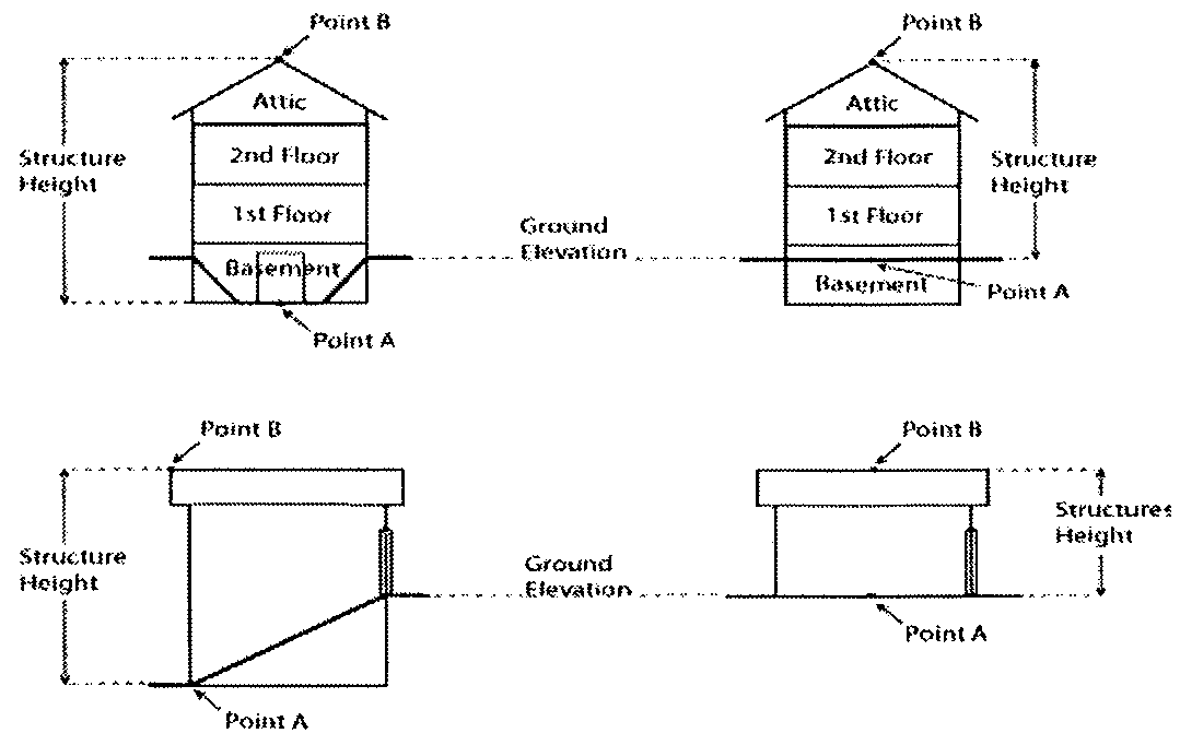
In order to protect and preserve wildlife habitat and natural scenic beauty, on or after February 1, 2010, the county shall not permit any construction that result in a structure taller than 35 feet within 75 feet of the ordinary highwater mark of any navigable waters. The structure height is the measurement of the vertical line segment starting at the lowest point of any exposed wall and its intersect with the ground (Point A in the following diagram) to a line horizontal to the highest point of a structure (Point B in the following diagram), unless specified under other sections of this Code.
(Code 2000, § 38-599; Res. No. 72-16, 9-20-2016)
Sec. 38-748. - Nonconforming uses and structures.
(a)
Discontinued nonconforming use. If a nonconforming use is discontinued for a period of 12 months, any future use of the building, structure or property shall conform to the ordinance.
(b)
Maintenance, repair, replacement or vertical expansion of nonconforming structures. An existing structure that was lawfully placed when constructed but that does not comply with the required shoreland setback, or that is otherwise in violation of this chapter, that under Wis. Stats. § 59.692(1t), may not be enforced, may be maintained, repaired, replaced, restored, rebuilt or remodeled if the activity does not expand the footprint of the nonconforming structure. Further, an existing structure that was lawfully placed when constructed but that does not comply with the required shoreland setback may be vertically expanded unless the vertical expansion would extend more than 35 feet above grade level. Counties may allow expansion of a structure beyond the existing footprint if the expansion is necessary to comply with applicable state or federal requirements (Wis. Stats. § 59.692(1k)(a)2, 4 and (b)).
(c)
Lateral expansion of nonconforming principal structures within the setback. An existing principal structure that was lawfully placed when constructed but that does not comply with the required building setback per section 38-743(1) may be expanded laterally, provided that all of the following requirements are met:
(1)
The use of the structure has not been discontinued for a period of 12 months or more if a nonconforming use.
(2)
The existing principal structure is at least 35 feet from the ordinary highwater mark.
(3)
Lateral expansions are limited to a maximum of 200 square feet over the life of the structure. No portion of the expansion may be any closer to the ordinary highwater mark than the closest point of the existing principal structure.
(4)
The county shall issue a permit that requires a mitigation plan that shall be approved by the county and implemented by the property owner by the date specified in the permit. The mitigation plan shall meet the standards found in section 38-750.
(5)
All other provisions of the shoreland ordinance shall be met.
(d)
Expansion of a nonconforming principal structures beyond setback. An existing principal structure that was lawfully placed when constructed but that does not comply with the required building setback under section 38-743(1) may be expanded horizontally, landward, or vertically, provided that the expanded area meets the building setback requirements per section 38-743(1), and that all other provisions of the shoreland ordinance are met. A mitigation plan is not required solely for expansion under this subsection, but may be required per section 38-746.
(e)
Relocation of nonconforming principal structures. An existing principal structure that was lawfully placed when constructed but that does not comply with the required building setback per section 38-743(1) may be relocated on the property provided all of the following requirements are met:
(1)
The use of the structure has not been discontinued for a period of 12 months or more if a nonconforming use.
(2)
The existing principal structure is at least 35 feet from the ordinary highwater mark.
(3)
No portion of the relocated structure is located any closer to the ordinary highwater mark than the closest point of the existing principal structure.
(4)
The county determines that no other location is available on the property to build a principal structure of a comparable size to the structure proposed for relocation that will result in compliance with the shoreland setback requirement per section 38-743(1).
(5)
The county shall issue a permit that requires a mitigation plan that shall be approved by the county and implemented by the property owner by the date specified in the permit. The mitigation plan shall meet the standards found in section 38-746, and include enforceable obligations of the property owner to establish or maintain measures that the county determines are adequate to offset the impacts of the permitted expansion on water quality, near-shore aquatic habitat, upland wildlife habitat and natural scenic beauty. The mitigation measures shall be proportional to the amount and impacts of the replaced or relocated structure being permitted. The obligations of the property owner under the mitigation plan shall be evidenced by an instrument recorded in the office of the county register of deeds.
(6)
All other provisions of the shoreland ordinance shall be met.
(Code 2000, § 38-600; Res. No. 72-16, 9-20-2016; Res. No. 1-19, 2-19-2019)
Sec. 38-749. - Authorized maintenance, repair, replacement or vertical expansion of structures.
A structure of which any part has been authorized to be located within the shoreland setback area by a variance granted before July 13, 2015, may be maintained, repaired, replaced, restored, rebuilt or remodeled. Additionally, the structure may be vertically expanded unless the vertical expansion would extend more than 35 feet above grade level. Counties may allow expansion of a structure beyond the existing footprint if the expansion is necessary to comply with applicable state or federal requirements.
(Code 2000, § 38-601; Res. No. 72-16, 9-20-2016; Res. No. 1-19, 2-19-2019)
Sec. 38-750. - Mitigation.
(a)
For purposes of this division, mitigation means balancing measures that are designed, implemented and function to restore natural functions and values that are otherwise lost through development and human activities. When the county issues a permit requiring mitigation under sections 38-746(d)(2) or 38-748(c) and (e), the property owner must submit a complete plan that is reviewed and approved by the county. The plan includes the following:
(1)
A description of the measures that will be implemented to restore natural functions lost through development of the permitted project. The mitigation measures must be selected from the choices in subsection (b) of this section, and shall be proportional in scope to the projected impacts on water quality, near-shore aquatic habitat, upland wildlife habitat and natural scenic beauty.
(2)
An affidavit to be recorded with the register of deeds which will serve as an enforceable obligation on the property owner to establish and maintain the mitigation measures. The affidavit must be recorded prior to issuance of the permit authorizing construction. This form may be provided by the zoning department.
(3)
An implementation schedule outlining the phases of installation or implementation. Mitigation projects involving actual construction of a device (e.g., rain garden) shall be completed within two years of permit issuance.
(b)
Mitigation requirements and measures.
(1)
Mitigation points are required for developing property under the following conditions:
a.
Impervious surface coverage is greater than 15 percent but less than 20 percent, two points.
b.
Impervious surface coverage is from 20 percent to 30 percent, three points.
c.
Lateral expansion of nonconforming principal structure within the shoreland setback section 38-748(c), three points.
d.
Relocation of nonconforming principal structure within the shoreland setback section 38-748(e), one point.
(2)
The following mitigation measures are available to satisfy the point requirements noted above. Point requirements are cumulative (a project may require mitigation due to more than one circumstance in subsection (b)(1) of this section), in which case the points should be combined.
a.
Removal of a structure within the shoreland setback, up to three points.
b.
Installation of a rain garden sized to properly treat runoff created by the project (see notes below), up to three points.
c.
Installation of a stormwater infiltration system sized to properly treat runoff created by the project (see notes below), three points.
d.
Recording an affidavit that ensures the preservation of an existing compliant shoreland buffer, two points.
e.
Active restoration (accelerated recovery) of a compliant shoreland buffer, four points, section 38-744(c)(2).
f.
Passive restoration (natural recovery) of a compliant shoreland buffer, one point, section 38-744(c)(1).
g.
Increasing depth of an existing compliant shoreland buffer, two points for every 15 feet of depth.
h.
Reducing width of allowable viewing and access corridors, one point for every 15-foot reduction.
i.
Sea wall removal and natural bank stabilization, three points.
j.
Increasing shoreland setback, one point for every 15-foot increase beyond required (maximum of three points).
k.
Installation of a new private onside wastewater treatment system, three points, bringing an existing operating system to code, two points.
Notes: Plans that involve the active restoration/creation of a shoreland buffer must be approved by the LWCD. The LWCD is also available to create or design buffer restoration plans. There will be a fee charged by LWCD for these services. The fees are set and periodically adjusted by the zoning and agriculture and land conservation committees. Subsections (b)(2)b and c of this section may also require plans to be prepared and certified by a professional engineer.
(Code 2000, § 38-602; Res. No. 72-16, 9-20-2016)
Sec. 38-751. - Administrative provisions.
This division shall require all of the following:
(1)
The appointment of an administrator and such additional staff as the workload may require.
(2)
The creation of a zoning agency as authorized by Wis. Stats. § 59.69, a board of adjustments as authorized by Wis. Stats. § 59.694, and a county planning agency as defined in Wis. Stats. § 236.02(3), and required by Wis. Stats. § 59.692(3).
(3)
A system of permits in accordance with a fee schedule approved by the zoning committee, for all new construction, development, reconstruction, structural alteration or moving of buildings and structures. A copy of applications shall be required to be filed in the office of the county zoning administrator, unless prohibited by Wis. Stats. § 59.692(1k).
(4)
Regular inspection of permitted work in progress to ensure conformity of the finished structures with the terms of the county shoreland regulations.
(5)
A variance procedure which authorizes the board of adjustments to grant such variance from the terms of the ordinance as will not be contrary to the public interest where, owing to special conditions and the adoption of the shoreland zoning ordinance, a literal enforcement of the provisions of the ordinance will result in unnecessary hardship as long as the granting of a variance does not have the effect of granting or increasing any use of property which is prohibited in that zoning district by the county shoreland regulations.
(6)
A special exception (conditional use) procedure for uses presenting special problems.
(7)
The county shall keep a complete record of all proceedings before the board of adjustments, zoning agency and planning agency.
(8)
Written notice to the appropriate office of the department at least ten days prior to any hearing on a proposed variance, special exception or conditional use permit, appeal for a map or text interpretation, map or text amendment, and copies of all proposed land divisions submitted to the county for review under section 38-1005(c).
(9)
Submission to the appropriate office of the department, within ten days after grant or denial, copies of any decision on a variance, special exception or conditional use permit, or appeal for a map or text interpretation, and any decision to amend a map or text of an ordinance.
(10)
Development and maintenance of an official map of all mapped zoning district boundaries, amendments, and recordings.
(11)
The establishment of appropriate penalties for violations of various provisions of the ordinance, including forfeitures. Compliance with the ordinance shall be enforceable by the use of injunctions to prevent or abate a violation, as provided in Wis. Stats. § 59.69(11).
(12)
Pursuing the prosecution of violations of the county shoreland regulations.
(13)
Shoreland wetland map amendments according to Wis. Admin. Code § NR 115.04. Every petition for a shoreland-wetland map amendment filed with the county clerk shall be referred to the county zoning agency. A copy of each petition shall be provided to the appropriate office of the department within five days of the filing of the petition with the county clerk. Written notice of the public hearing to be held on a proposed amendment shall be provided to the appropriate office of the department at least ten days prior to the hearing. A copy of the county board's decision on each proposed amendment shall be forwarded to the appropriate office of the department within ten days after the decision is issued.
(Code 2000, § 38-603; Res. No. 72-16, 9-20-2016; Res. No. 1-19, 2-19-2019)
Sec. 38-752. - Definitions.
(a)
Several of the terms of subsection (c) of this section are also defined in section 38-6. Where terms are duplicated, the definitions in subsection (c) of this section are more applicable to this division and shall prevail.
(b)
For the purpose of administering and enforcing this division, all distances unless otherwise specified shall be measured horizontally.
(c)
The following words, terms and phrases, when used in this division, shall have the meanings ascribed to them in this subsection, except where the context clearly indicates a different meaning:
Access and viewing corridor means a strip of vegetated land that allows safe pedestrian access to the shore through the vegetative buffer zone.
Accessory structure means a subordinate structure on the same property as the principal structure which is devoted to a use incidental to the principal use of the property. Accessory structures include, but are not limited to, detached garages, sheds, barns, gazebos, patios, decks, swimming pools, hot tubs, fences, retaining walls, driveways, parking lots, sidewalks, detached stairways and lifts.
Boathouse means a permanent structure used for the storage of watercraft and associated materials and includes all structures which are totally enclosed, have roofs or walls or any combination of these structural parts.
Building envelope means the three-dimensional space within which a structure is built (still used in section 38-746).
County zoning agency means that committee or commission created or designated by the county board under Wis. Stats. § 59.69(2)(a), to act in all matters pertaining to county planning and zoning.
Department means the department of natural resources.
Drainage system means one or more artificial ditches, tile drains or similar devices which collect surface runoff or groundwater and convey it to a point of discharge.
Existing development pattern means that principal structures exist within 250 feet of a proposed principal structure in both directions along the shoreline.
Fire pit means a structure that is constructed of metal, brick and/or stone, held together with mortar, and is considered to be permanently placed and not portable. Such structures may have fire boxes and ovens. For purposes of this division, fire pits must meet setbacks as described in section 38-743(1).
Fire ring means a temporary portable structure made of metal, bricks or rocks that are not held together with mortar, or by any other method to cause it to be unmovable. Fire rings are generally recognized as a "circle of rocks" or may be a decorative metal ring that is purchased for the purpose of containing a campfire.
Floodplain (Wis. Admin. Code § NR 115.03(4)) means the land which has been or may be hereafter covered by floodwater during the regional flood. The floodplain includes the floodway and the flood fringe as those terms are defined in Wis. Admin. Code ch. NR 116.
Footprint means the land area covered by a structure at ground level measured on a horizontal plane. The footprint of a residence or building includes the horizontal plane bounded by the furthest exterior wall and eave if present, projected to natural grade. For structures without walls (decks, stairways, patios, carports), a single horizontal plane bounded by the furthest portion of the structure projected to natural grade. Note: For the purposes of replacing or reconstructing a nonconforming building with walls, the footprint shall not be expanded by enclosing the area that is located within the horizontal plane from the exterior wall to the eaves projected to natural grade. This constitutes a lateral expansion under Wis. Admin. Code ch. NR 115 and would need to follow Wis. Admin. Code § NR 115.05(1)(g)5.
Generally accepted forestry management practices means forestry management practices that promote sound management of a forest. Generally accepted forestry management practices include those practices contained in the most recent version of the department publication known as the state forest management guidelines and identified as PUB FR-226.
Impervious surface means an area that releases as runoff all or a majority of the precipitation that falls on it. The term "impervious surface" excludes frozen soil but includes rooftops, sidewalks, driveways, parking lots, and streets unless specifically designed, constructed, and maintained to be pervious. Roadways as defined in Wis. Stats. § 340.01(54) or sidewalks as defined in Wis. Stats. § 340.01(58) are not considered impervious surfaces.
Lot means a continuous parcel of land, not divided by a public right-of-way, and sufficient in size to meet the lot width and lot area provisions of this division.
Lot area means the area of a horizontal plane bounded by the front, side, and rear lot lines of a lot, but not including the area of any land below the ordinary highwater mark of navigable waters.
Lot of record means any lot, the description of which is properly recorded with the register of deeds, which at the time of its recordation complied with all applicable laws, ordinances, and regulations.
Mitigation means balancing measures that are designed, implemented and function to restore natural functions and values that are otherwise lost through development and human activities.
Navigable waters means Lake Superior, Lake Michigan, all natural inland lakes within the state and all streams, ponds, sloughs, flowages and other waters within the territorial limits of this state, including the state portion of boundary waters, which are navigable under the laws of this state. Under Wis. Stats. § 281.31(2)(d), notwithstanding any other provision of law or administrative rule promulgated thereunder, shoreland ordinances required under Wis. Stats. § 59.692, and Wis. Admin. Code ch. NR 115 do not apply to lands adjacent to:
(1)
Farm drainage ditches where such lands are not adjacent to a natural navigable stream or river and such lands were not navigable streams before ditching; and
(2)
Artificially constructed drainage ditches, ponds or stormwater retention basins that are not hydrologically connected to a natural navigable water body.
Ordinary highwater mark means the point on the bank or shore up to which the presence and action of surface water is so continuous as to leave a distinctive mark such as by erosion, destruction or prevention of terrestrial vegetation, predominance of aquatic vegetation, or other easily recognized characteristics.
Previously developed means a lot or parcel that was developed with a structure legally placed upon it.
Regional flood means a flood determined to be representative of large floods known to have generally occurred in the state and which may be expected to occur on a particular stream because of like physical characteristics, once in every 100 years.
Routine maintenance of vegetation means normally accepted horticultural practices that do not result in the loss of any layer of existing vegetation and do not require earth disturbance.
Shoreland means lands within the following distances from the ordinary highwater mark of navigable waters: 1,000 feet from a lake, pond or flowage; and 300 feet from a river or stream or to the landward side of the floodplain, whichever distance is greater.
Shoreland setback, also known as the "shoreland setback area" in Wis. Stats. § 59.692(1)(bn), means an area in a shoreland that is within a certain distance of the ordinary highwater mark in which the construction or placement of structures has been limited or prohibited under an ordinance enacted under Wis. Stats. § 59.692.
Shoreland-wetland district means a zoning district, created as a part of the county zoning regulations, comprised of shorelands that are designated as wetlands on the state wetland inventory maps prepared by the department.
Special exception (conditional use) means a use which is permitted by this division provided that certain conditions specified in this article are met and that a permit is granted by the board of adjustments or, where appropriate, the planning and zoning committee or county board.
Structure means a principal structure or any accessory structure including a garage, shed, boathouse, sidewalk, walkway, patio, deck, retaining wall, porch or fire pit.
Substandard lots means a legally created lot or parcel that met minimum area and minimum average width requirements when created, but does not meet current requirements for a new lot.
Unnecessary hardship means that circumstance where special conditions, which were not self-created, affect a particular property and make strict conformity with restrictions governing area, setbacks, frontage, height or density unnecessarily burdensome or unreasonable in light of the purposes of this division.
Wetlands means those areas where water is at, near or above the land surface long enough to be capable of supporting aquatic or hydrophytic vegetation and which have soils indicative of wet condition.
(Code 2000, § 38-604; Res. No. 72-16, 9-20-2016)

