
Summit Village City Zoning Code
CHAPTER 111
ZONING AND SHORELAND PROTECTION
ARTICLE VII.- RESERVED[2]
Editor's note—Ord. No. 80-2020, § 1, adopted March 12, 2020, repealed Art. VII, §§ 111-191—111-200, which pertained to signage regulations and derived from Ord. No. 24-2014, §§ 1, 2, adopted Oct. 26, 2015; Ord. No. 31-2015, §§ 7.1—7.9, adopted Oct. 1, 2015.
Sec. 111-1.- Authority.
The Village of Summit Village Board hereby adopts the following regulations under the authority granted by Wis. Stats. §§ 61.35, 62.23, 61.351, 61.353, 87.30 and 281.31, and NR 117, Wis. Admin. Code.
(Ord. No. 31-2015, § 1.1, 10-1-2015)
Sec. 111-2. - Purpose.
(a)
In consonance with the purposes as set forth in the state enabling statutes, this chapter provides a regulatory framework for land use within the Village of Summit. This chapter aids in achieving a harmonious and compatible relationship between various uses consistent with the rights of property ownership, the general public welfare and the established goals for community development and character. To this intent, this chapter's design relates realistically to those physical, economic and environmental factors that significantly influence the appropriate development and use of land. Further, this chapter provides maximum flexibility, adaptability and responsiveness to changing physical and economic conditions and societal concerns.
(b)
Additionally, as required by Wis. Stats. § 281.31, this chapter provides regulations to: "further the maintenance of safe and healthful conditions; prevent and control water pollution; protect spawning grounds, fish and aquatic life; control building sites, placement of structure and land uses and reserve shore cover and natural beauty." Also, as required by Wis. Stats. § 59.692, this chapter requires the village to effect the purposes of Wis. Stats. § 281.31, and to promote the public health, safety and general welfare by adopting zoning regulations for the protection of all shorelands in areas that meet shoreland zoning standards promulgated by the department of natural resources. This zoning and shoreland protection ordinance establishes minimum shoreland zoning standards for a code enacted under Wis. Stats. § 59.692, for the purposes specified in Wis. Stats. § 281.31(1), and limits the direct and cumulative impacts of shoreland development on water quality; near shore aquatic, wetland and upland wildlife habitat; and natural scenic beauty.
(Ord. No. 31-2015, § 1.2, 10-1-2015)
Sec. 111-3. - Intent.
This chapter intends to regulate and restrict the use of all structures, lands and waters; regulate and restrict lot coverage, population distribution and density, and the size and location of all structures so as to lessen congestion and promote the safety and efficiency of the streets and highways; secure safety from fire, flooding, panic, and other dangers; provide adequate light, air, sanitation and drainage; prevent overcrowding; avoid undue population concentration; facilitate the adequate provision of public facilities and utilities; stabilize and protect property values; prevent and control water, air, light, and noise pollution; protect spawning grounds, fish and aquatic life; protect against flood hazards, and preserve shore cover and natural beauty; further the appropriate use of land and conservation of natural resources, preserve and promote the beauty of the community; and implement the community's comprehensive plan or plan components. The chapter further intends to provide for the administration and enforcement of this chapter and to provide penalties for violation.
(Ord. No. 31-2015, § 1.3, 10-1-2015)
Sec. 111-4. - Abrogation and greater restrictions.
This chapter does not intend to repeal, abrogate, annul, impair or interfere with any existing easements, covenants, deed restrictions, agreements, ordinances, rules, regulations or permits previously adopted or issued pursuant to laws, except as specifically set forth herein; however, wherever this chapter in any way imposes greater restrictions, the provisions of this chapter shall govern.
(Ord. No. 31-2015, § 1.4, 10-1-2015)
Sec. 111-5. - Development goals.
The plan commission and village board shall use the following goals in all development reviews in order to implement the stated intent of the village residents and elected officials, especially in residential developments, as outlined in article V:
(1)
Preservation of rural character. Contribute to the preservation of the rural character of the village by encouraging the retention of farm fields, pastures, orchards and natural open spaces either as common preserved lands or as farm operations under the preserved lands category. Future projects accomplish this goal by leaving vistas of farming activity along the main village roads, by grouping home sites in farm-like clusters surrounded by fields and pasture or by preserving complete farm operations and transferring the development potential to another area.
(2)
Preservation of agricultural lands. Contribute to the preservation of the rural character of the village by shaping and arranging preserved lands designated for agricultural use consistent with practical requirements for carrying on such activity and of justifiable value for agricultural use or as a contribution to the goal of preserving a rural environmental character.
(3)
Preservation of natural ecologic features. Contribute to the preservation of the rural character of the village by preserving natural features such as water bodies, marshes and woods for their contribution to the maintenance of ecologic balance. The plan commission shall determine the ecologic value.
(4)
Preservation of primary environmental corridors. Contribute to the preservation of the rural character of the village by attempting to preserve the environmental corridor in its natural state. Development should occur outside the primary environmental corridor and, to the greatest extent possible, protected in preserved lands.
(5)
Appropriate relationship of development to the physical character of the site and the surrounding area. Contribute to the preservation of the rural character of the village by considering whether the development plan for roads, building sites and preserved areas maintain appropriate relationships to existing terrain conditions, preservation of natural vegetation, suitable capacity for on-site sewage disposal, provision for storm water drainage and retention and to the potential impact upon the surrounding area.
(6)
Limit direct access to main village and county roads. Contribute to the preservation of the rural character of the village as well as the efficiency and safety of the existing main through roads by reducing the development of lots strung out along such roads with individual driveway access from each lot. Encourage the grouping of lots on interior streets and courts with the road frontage kept in the preserved lands category.
(Ord. No. 31-2015, § 1.5, 10-1-2015)
Sec. 111-6. - Interpretation.
In their interpretation and application, the provisions of this chapter shall be held to be the minimum requirements and shall be liberally construed in favor of the village and shall not be deemed a limitation or repeal of any other power granted by the Wisconsin statutes.
(Ord. No. 31-2015, § 1.6, 10-1-2015)
Sec. 111-7. - Severability.
The several sections of this chapter are declared to be severable. If any section or portion thereof shall be declared by a court of competent jurisdiction to be invalid, unlawful or unenforceable, such decision shall apply only to the specific section or portion thereof directly specified in the decision, and shall not affect the validity of any other provisions, sections or portions thereof of the chapter. The remainder of the chapter shall remain in full force and effect. If any application of this chapter to a particular structure, land, or water is adjudged unconstitutional or invalid by a court of competent jurisdiction, such judgment shall not be applicable to any other structure, land, or water not specifically included in said judgment.
(Ord. No. 31-2015, § 1.7, 10-1-2015)
Sec. 111-8. - Repeal.
All other ordinances or parts of ordinances of the village inconsistent or conflicting with this chapter, to the extent of the inconsistency only, are hereby repealed.
(Ord. No. 31-2015, § 1.8, 10-1-2015)
Sec. 111-9. - Warning and disclaimer of liability.
The degree of flood protection provided by this chapter is considered reasonable for regulatory purposes and is based on engineering experience and scientific methods of study. On rare occasions larger floods may occur or the flood height may be increased by man-made or natural causes such as ice jams or bridge openings restricted by debris. Therefore, this chapter does not imply that areas outside of the delineated floodplain or land uses permitted within the floodplain will be totally free from flooding and associated flood damage. Nor shall this chapter create a liability on the part of or a cause of action against the Village of Summit or any officer or employee thereof for any flood damages that may result from reliance on this chapter. For specific floodplain regulations, refer to the Village of Summit Floodplain Ordinance.
(Ord. No. 31-2015, § 1.9, 10-1-2015)
Sec. 111-37.- Districts.
This article divides the Village of Summit into the following 14 basic use districts and two overlay districts:
(Ord. No. 31-2015, § 2.1, 10-1-2015)
Sec. 111-38. - Mapping.
(a)
District boundaries. The map entitled "Official Zoning Map, Village of Summit, Wisconsin," which accompanies and becomes a part of this chapter, establishes the boundaries of the districts. Unless otherwise noted on the map the district boundaries follow corporate limits, US public land survey lines, lot or property lines, and center lines of streets, highways, easements or such lines extended. District boundaries shall be determined by measurement from and as shown on the official zoning maps and in case of any questions as to the interpretation of such boundary lines, the zoning administrator shall interpret the map according to the reasonable intent of this chapter.
(b)
Boundaries mapped.
(1)
All land area within the village is hereby divided according to those districts as shown upon the map entitled "Official Zoning Map, Village of Summit, Wisconsin," dated May 2, 2013 divides up all land area within the village into those districts and serves as a graphic part of this chapter; and all the notations, references, amendments and other information shown thereon shall be as much a part of this chapter as if the matters and information set forth by said map were all fully described herein. This map shall be kept on file in the offices of the village and any other copies thereof shall be purely informational and shall not have the status of law.
(2)
The boundary of the shoreland jurisdictional limits shall be those lands lying under, abutting and close to navigable water within the following area: 1,000 feet from the ordinary high water mark of navigable lakes, ponds or flowages; 300 feet from the ordinary high water mark of navigable rivers or streams, or to the landward side of the floodplain, whichever is greater. Where a stream is subsequently identified or determined to be navigable, and was not previously subject to the shoreland provisions of this chapter, said navigable stream and the lands bordering it shall immediately be subject to the jurisdiction of the shoreland provisions.
(3)
The boundaries of the WC Wetland Conservancy District and FO Floodplain Overlay District as drawn are intended to represent the edge of marshlands, swamps, floodlands, wetlands or the ordinary high water mark along streams or other watercourses. Where a question arises as to the exact location of those boundaries, they shall be determined by the zoning administrator through the utilization of the best available information such as topographic maps, soil maps, aerial photographs, infield botanical inventories, floodplain studies or other sources of information available which would lend assistance to such a determination and may be finally determined by actual conditions in each specific situation.
(4)
The boundaries of the EC Environmental Corridor Overlay District as drawn are intended include the primary or secondary environmental corridors or isolated natural areas as defined herein, and is intended to be used to preserve, protect, enhance, and restore significant woodlands, upland wildlife habitat areas, scenic overlooks, slopes exceeding 12 percent, and upland wooded areas in concert with the goal and intent of the regional land use plan. Where questions arise as to the exact location or boundary of an environmental corridor, the extent and location of such corridors shall be finally determined by infield investigation by the zoning administrator.
(c)
Map amendments.
(1)
Amendments of the official zoning map shall be made by detailed map of the area rezoned (to be part of the amendatory ordinance by reference). Such map and ordinance shall be kept in a supplementary file made a part of the official zoning ordinance. The official zoning map shall be corrected to show such change within 30 days after the effective date of the amendatory ordinance.
(2)
Changes thereafter to the general zoning districts shall not be effective until approved by the Village Board of the Village of Summit and the date of such approval entered in the approved minutes of the village board. Changes in the floodplain overlay boundary shall not become effective until approved by the Village Board of the Village of Summit, the Wisconsin Department of Natural Resources (WDNR) and the Federal Emergency Management Agency (FEMA).
(Ord. No. 31-2015, § 2.2, 10-1-2015)
Sec. 111-39. - Compliance.
(a)
No building, structure, or land shall hereafter be used or occupied, and no building, structure, or part thereof, shall hereafter be erected, constructed, reconstructed, moved, or structurally altered, and no land or water areas shall be hereafter altered except in conformity with the provisions of this chapter and other local, state, and federal regulations.
(b)
Zoning, building and occupancy permits. Except where another section of this chapter specifically exempts certain improvements; no structure, land or water or part thereof shall hereafter be located, erected, moved, reconstructed, extended, enlarged, converted or structurally altered until a zoning permit has been issued by the zoning administrator and a building permit issued by the building inspector certifying that such activity complies with the provisions of this chapter.
(1)
Application. Persons shall apply to the zoning administrator for a zoning permit upon forms furnished by the village before or at the same time as applying for a building permit. This application shall include the following information:
a.
A statement by the applicant as to the intended use of the premises and structures thereon.
b.
Name and address of applicant and property owner.
c.
Legal description of the property and type of proposed use.
d.
A scaled drawing of the dimensions of the lot and location of all existing and proposed structures and impervious surfaces relative to the lot lines, proposed floor elevations of any structure; center line of abutting highways and the ordinary high water mark of any abutting waterways.
e.
Location and description of any existing private water supply or sewage system or notification of plans for any such installation.
f.
Payment of the appropriate fee.
g.
Additional information required by the zoning administrator.
(2)
Issuance. The zoning administrator and building inspector shall issue zoning, building and occupancy permits after adequate investigation as to compliance.
a.
Zoning permit: If completed in order and if the proposed structure or building, occupancy, or use complies with the provisions of this chapter, the zoning administrator shall issue a zoning permit upon such application. The applicant shall post the permit in a prominent place on the premises during the period of any construction or other activity involved in readying the land or structures for use or occupancy.
b.
Occupancy and use permit: Within ten days after the notification of the completion of the erection, alteration or relocation of a structure or building, or of intent to commence a use, the zoning administrator or building inspector shall inspect the premises and any structures or buildings thereon; and, if such structure or building, intended use, or proposed occupancy complies with the requirements of this chapter, they shall issue an occupancy permit.
c.
After a permit has been issued by the zoning administrator and building inspector, the applicant must comply with all terms of the permit. If the applicant changes or deviates from the approved application, the application must obtain a new permit. Failure to comply with the terms of the permit as issued violates this chapter and may result in the issuance of a cease and desist order, penalties, injunctions or other enforcement actions.
(3)
Expiration. The zoning permit expires if one of the three following events occur:
a.
The proposed construction or preparation of land for use has not commenced within six months of issuance, or
b.
The building inspector has not issued an occupancy and use permit, if required by the village, or
c.
The building inspector confirms incomplete construction.
The zoning administrator may grant up to one extension of such permit upon showing of a valid cause. Any extension cannot exceed six months from the date of the original permit expiration date.
(4)
Temporary occupancy and use permit. Pending the issuance of a regular permit, the building inspector may issue a temporary permit for a period not to exceed six months during the completion of alterations or during partial occupancy of a structure pending its permanent occupation. The building inspector shall not issue such temporary permit except under such restrictions and provisions that adequately insure the safety of the occupants. The building inspector shall void a temporary permit if the structure fails to conform to the provisions of this chapter to such a degree as to render it unsafe for the occupancy proposed.
(5)
Exemptions. The village does not require permits for the following fixtures related to residential uses, consistent with the standards as set out in section 111-100(a):
a.
Fences, trellises and other architectural screening devices not in excess of six feet in height;
b.
Boat piers;
c.
Decorative pools or fountains;
d.
Playground and playground equipment may be permitted anywhere on the lot.
(6)
All the components of wind energy conversion systems, solar energy systems, radio and television transmitting or receiving systems or similar installations shall be considered structures requiring a permit from the zoning administrator. The zoning administrator may refer these systems to the plan commission for determination that said systems meet the spirit and intent of this chapter. The plan commission may immediately make a determination as to the reasonableness of the system or may require a public hearing in conformance with the applicable provisions of section 111-387 before making its determination.
(c)
Proposed development sites shall be reasonably safe from flooding. This means that any subsurface waters related to the base flood will not damage existing or proposed structures and base flood waters will not inundate the land or damage structures.
(d)
Exemption for farm drainage ditches. Based on Wis. Stats. § 281.31(2m), the shoreland regulations of this chapter do not apply to non-structural uses of lands (i.e., pasture, cultivation) adjacent to farm drainage ditches if all of the following situations exist:
(1)
Such lands do not lie within the floodplain of a natural stream or river.
(2)
Those parts of the drainage ditches adjacent to these lands were non-navigable streams before ditching.
(3)
The property owner maintains these lands exclusively in non-structural uses.
Should a question arise as to the applicability of this section, the zoning administrator may interpret the item as provided for under section 111-6 of this chapter or by contacting the WDNR. The owner or applicant shall submit plans and supporting documentation to enable the zoning administrator or the WDNR to make a finding to support the claim of exemption. Where farm drainage ditches exist and the owner has terminated agricultural uses, and the owner has changed the lands to urban uses, this exception expires and the subject stream and shoreland areas shall fall under all provisions and the jurisdiction of this chapter. However, regardless of the agricultural use of the land, the provisions of this chapter apply to the size, location or other matters of any building and structures.
(e)
Exemption for Wisconsin Department of Transportation Projects. If the construction, reconstruction, maintenance or repair of state highways and bridges carried out under the direction and supervision of the Wisconsin department of transportation falls under section 30.2022(1) of Wisconsin Statutes, then the restrictions of this chapter shall not apply.
(Ord. No. 31-2015, § 2.3, 10-1-2015)
Sec. 111-67.- Principal structure.
Each lot shall contain only one principal structure, except as permitted in a "planned development" as provided elsewhere in these regulations. The village board may, upon plan commission recommendation, permit more than one principal structure on a lot within the agricultural and business districts where such grant would not be contrary to the spirit or intent of this chapter or to the regulations applicable to the specific district.
(Ord. No. 27-2015, § 1, 4-2-2015; Ord. No. 31-2015, § 3.1, 10-1-2015)
Sec. 111-68. - Public street regulations.
Street access required. No principal structure shall hereafter be erected or moved to a lot which does not abut a public street or an approved private street; however, the plan commission may permit the erection or relocation of a structure on a lot which has assured access to a public street or approved private street by an adequate easement so as to provide safe and convenient access for utility services and police and fire protection.
(Ord. No. 31-2015, § 3.2, 10-1-2015)
Sec. 111-69. - Yards and open space.
(a)
Outside storage: Abandoned or junked motor vehicles. The provisions of Summit Village Code Section 18-58, Part I, Storage of Vehicles, shall control.
(b)
Off-Street Parking. A person shall not use any part of a yard, open space, off-street parking, or loading space required in connection with any structure for the purpose of complying with this chapter to fulfill the requirements for part of a yard, open space, off-street parking, or loading space for any other structure.
(Ord. No. 31-2015, § 3.3, 10-1-2015)
Sec. 111-70. - Establishment of grades.
A person shall not erect, structurally alter or relocate any structure without the zoning administrator's approval relative to satisfactory relationship of structure's grade with the established street grades, or with the existing street grade where one is established, based upon proper drainage, safe vehicular access, and flood hazards.
(Ord. No. 31-2015, § 3.4, 10-1-2015)
Sec. 111-71. - Drainage/groundwater separation.
(a)
A person shall not construct a structure where the lowest floor, including any basement floor, lies less than one foot above the highest seasonal ground water level, as defined herein. The zoning administrator shall determine the seasonal ground water elevation by use of U.S.D.A. soil survey, an onsite soil investigation by a certified soil tester or other qualified engineer or soil scientist. The zoning administrator may request, at the owner's expense, the advice and assistance of a licensed professional engineer specializing in soils engineering or other qualified person in fulfilling their duties pursuant to this provision.
(b)
A person shall not erect or move a structure onto land subject to periodic flooding of the proposed structure location, nor to land not adequately drained at all times, nor to land where the first floor level of any opening to a principal structure remains less than two feet above the established 100-year-flood elevation or the ordinary high water line.
(c)
A person shall not allow damming, filling, relocating or otherwise interfering with the natural flow of surface water along any surface water drainage channel or natural watercourse except with plan commission approval and subject to WDNR and FEMA regulations.
(Ord. No. 31-2015, § 3.5, 10-1-2015)
Sec. 111-72. - Sanitation and water supply.
(a)
The Village of Summit shall not permit a structure involving human occupancy unless the property owner provides safe and adequate facilities for water supply and disposal of sewage. The property owner or their representative shall submit satisfactory evidence to this effect to the zoning administrator who shall verify that such facilities satisfy and conform to all applicable ordinances thereto.
(b)
If a structure does not connect to a municipal or other approved communal sewage disposal system, the property owner or their representative shall submit a sanitary permit or approval of the county environmental health division to ensure safe sewage disposal based on the proposed use, the type of disposal system, the permeability of the soil, and the size of the parcel.
(Ord. No. 31-2015, § 3.6, 10-1-2015)
Sec. 111-73. - Preservation of topography.
(a)
The zoning administrator shall not allow any change in existing topography or drainage courses on any land which will adversely alter the drainage and/or affect surrounding land.
(b)
The zoning administrator may permit fill or grading considered necessary backfill and/or excavation for an otherwise permitted structure as long as said fill or grading meets all of the following requirements:
(1)
Fill or grading relates to said construction;
(2)
Fill or grading does not create slopes greater than three feet horizontal to one foot vertical; and
(3)
Fill or grading does not extend to a distance greater than 30 feet from the foundation; and
(4)
Fill or grading does not divert runoff directly onto adjacent property; and
(5)
Fill or grading does not adversely affect adjoining property or road side drainage.
In order to make such a determination, the property owner shall submit a grading plan showing existing and proposed grades on the subject lot. If grading or filling occurs within 20 feet of a property line, the grading plan shall show existing and proposed grades on the subject property and onto adjacent lands.
(c)
Retaining walls.
(1)
The village shall not allow construction of retaining wall, as defined in article XV, unless the construction meets the following requirements:
a.
The zoning administrator may issue a permit for a retaining wall greater than five feet from the property line.
b.
The plan commission may direct the zoning administrator to issue a permit for a retaining wall located five feet or less from a property line, following a public hearing as described in section 111-387.
(2)
Property owners shall set all retaining walls, as defined in article XV, at least 75 feet from the ordinary high water mark of a navigable body of water unless the zoning administrator determines that the retaining wall abates a known and identified soil erosion and sedimentation problem.
(d)
The zoning administrator shall allow filling, grading or altering of existing topography that does not alter the topography in a way that adversely affects the surrounding land. In making such a determination, the zoning administrator shall have the authority to determine the effect of the construction, fill or grading on surrounding property and shall require improvements and/or facilities that best preserve the topography and drainage system which has the effect of lessening the impact on upstream, downstream or adjacent properties. The zoning administrator may issue a written permit to allow the requested filling, grading or altering of the existing topography, subject to any conditions including installation of adequate erosion control measures in accordance with latest edition of the Wisconsin Construction Site Best Management Practices.
(e)
Any filling, grading or altering of existing topography, not authorized by a separate permit, shall receive an erosion control permit from the zoning administrator in accordance with the Village of Summit Erosion Control Ordinance. For activities less than 3,000 square feet of area or 400 cubic yards of material, the zoning administrator may permit the activity through the issuance of a minor grading permit. The zoning administrator may request review and approval by the village engineer where the activities may cause an adverse impact on surrounding lands, environmentally sensitive areas, or navigable waterways. These activities do not require a minor grading permit:
(1)
Normal driveway construction.
(2)
Septic system installation.
(f)
The zoning administrator may permit streambank and shoreline stabilization structures and minor grading, filling and land altering activities as long as the activity occurs outside the wetland conservancy district and does not impede drainage, reduce the floodwater storage capacity of the floodland, obstruct flows, or increase the regional flood elevation as described herein and within the Village of Summit Floodplain Ordinance. If the activity is located within the wetland conservancy district, the zoning administrator may permit the activity if the owner receives a permit from the Wisconsin DNR for the proposed project.
(g)
Any proposed grading, filling and land altering activities within the floodplain shall comply with the Village of Summit Floodplain Ordinance.
(h)
In the case of a disputed question, the plan commission shall resolve the following issues:
(1)
The adversity or effect of the project on either the property owner, adjacent owners, or the general public; or
(2)
The denial of permission by the zoning administrator; or
(3)
A dispute or question arising out of any condition imposed by the zoning administrator on any permission.
(i)
Any person or parties requesting a permit shall pay all fees associated with plan review and all inspections during and following construction. Said party/parties shall also obtain all applicable State of Wisconsin and federal permits.
(j)
The Zoning Administrator may permit filling, grading, lagooning, dredging, ditching and excavating only in accordance with the provisions of the Village of Summit Erosion Control and Storm Water Management Ordinances, the requirements of Wis. Stats. ch. 30, and other state and federal laws where applicable, and only if done in a manner designed to minimize erosion, sedimentation and impairment of fish and wildlife habitat and natural scenic beauty.
(Ord. No. 31-2015, § 3.7, 10-1-2015)
Sec. 111-74. - Site protection.
The Village of Summit shall require any property disturbed with land altering activities to conform to the provisions of the Village of Summit Erosion Control Ordinance. The zoning administrator may require a letter of credit or other forms of financial guarantee to ensure performance.
(Ord. No. 31-2015, § 3.8, 10-1-2015)
Sec. 111-75. - Vegetation protection—Shoreland.
(a)
Purpose. To protect natural scenic beauty, fish and wildlife habitat, and water quality, the village shall regulate removal of vegetation in shoreland areas, consistent with sound forestry and soil conservation practices and the effect of vegetation removal on water quality, including soil erosion, and the flow of effluents, sediments and nutrients.
(b)
Establishment of a vegetative buffer zone. To protect water quality, fish and wildlife habitat and natural scenic beauty, and to promote preservation and restoration of native vegetation, the village shall designate land that extends from the ordinary high water mark to a minimum of 35 feet inland as a vegetative buffer zone and prohibit removal of vegetation in the vegetative buffer zone except as follows:
(1)
Routine maintenance of vegetation.
(2)
Removal of trees and shrubs in the vegetative buffer zone to create access and viewing corridors, provided that the combined width of all access and viewing corridors on a riparian lot or parcel may not exceed the lesser of 30 percent of the shoreline frontage or 200 feet.
(3)
Removal of trees and shrubs in the vegetative buffer zone on a parcel with ten or more acres of forested land consistent with "generally accepted forestry management practices" as defined in Wisconsin Administrative Code NR 1.25(2)(b), and consistent with the practices described in Department publication "Wisconsin Forest Management Guidelines" (publication FR-226).
(4)
Removal of vegetation within the vegetative buffer zone to manage exotic or invasive species, to remove damaged vegetation, to control disease, or to remove vegetation creating an imminent safety hazard. The permit shall require replacement of any vegetation removed under the permit by replanting in the same area as soon as practicable.
(c)
The plan commission may permit additional vegetation management activities in the vegetative buffer zone. The permit shall require that all management activities comply with detailed plans approved by the zoning administrator and designed to control erosion by limiting sedimentation into the waterbody, to improve the plant community by replanting in the same area, and to maintain and monitor the newly restored area. The permit also shall require an enforceable restriction to preserve the newly restored area.
(d)
From the inland edge of the 35-foot area to 75 feet from the ordinary high water mark, the zoning administrator shall allow cutting of vegetation when accomplished using accepted forest management and soil conservation practices which protect water quality.
(Ord. No. 31-2015, § 3.9, 10-1-2015)
Sec. 111-94.- Use regulations.
(a)
Conformance to use regulations. A person shall not allow the use or occupancy of any building, structure, or land, and shall not allow the erection, construction, reconstruction, relocation or structural alteration of any building, structure, or part thereof, except in conformity with all the regulations herein specified for the district in which the property lies.
(b)
Uses classified. This chapter classifies all uses according to the following categories:
(1)
Permitted uses by right. Principal uses, allowed as a predetermined right anywhere in the district in which located, subject to the regulations established governing such use.
(2)
Permitted accessory uses. Uses incidental to, customary to, and commonly associated with a permitted principal use.
(3)
Permitted uses by conditional grant. Uses so unique or dependent on the specific contemporary conditions, whose nature, character, or circumstances make it impractical to predetermine the conditions necessary or appropriate to allow by right. The plan commission may permit such uses subject to certain conditions and requirements as hereinafter specified.
(4)
Unclassified uses. Any use not specifically listed as a permitted use shall be considered to be prohibited except as otherwise specifically provided hereinafter. In case of questions as to the classification of a use, the zoning administrator shall submit the question to the plan commission for determination.
(5)
Additional requirements. The zoning administrator may direct or require property owners to correct, improve or abate any use, in any district, which becomes hazardous, harmful, noxious, offensive or a nuisance to the surrounding neighborhood consistent with reasonable technology and economic practicality and in conformance with reasonable standards contained within this chapter. In the case of a dispute, the zoning administrator shall refer the matter to the plan commission for final determination.
The village may remove any structure determined unfit for human habitation or which may endanger the health, safety and welfare of the public as determined by the village board after recommendation by the plan commission or zoning administrator pursuant to the procedures outlined by the Wisconsin Statutes.
(c)
Lake access restrictions. The village shall not allow lake access to more than one lot or dwelling unit for each 150 feet of lake frontage, except for existing substandard lots that have less than 150 feet of lake frontage or for lake access specifically granted as part of a planned development district ordinance under section 111-359 of this chapter. The village does not allow pyramiding. This restriction does not apply to public access points.
(Ord. No. 31-2015, § 4.1, 10-1-2015)
Sec. 111-95. - Lot regulations.
(a)
Reduction of required lots and yards prohibited. This chapter establishes minimum lot sizes to afford protection against danger to health, safety and welfare, and protection against pollution of groundwater and waterways within the village. The village shall not allow reconfiguration or reduction in any yard or lot existing on the effective date of this chapter unless the application meets the following regulations:
(1)
The dimension and area of the lot shall not fall below the minimum requirements set forth herein. Yards or lots created after the effective date hereof shall meet at least the minimum requirements established by this chapter.
(2)
The village shall not approve reductions in lot area by any means where the existing setbacks, open space, or lot area reduce below that required by the district regulations applied to that property.
(b)
Lots abutting a lake or navigable waters of the State. The village shall not approve creation of any lot which has less than:
(1)
Twenty thousand square feet and a minimum average width of 100 feet if unsewered.
(2)
Ten thousand square feet and a minimum average width of 65 feet if sewered.
(c)
Substandard lots. The village may approve use of land as a building site where a legally created lot or parcel met minimum area and minimum average width requirements when created, but does not meet current lot size requirements, if all of the following apply:
(1)
The substandard lot or parcel was never reconfigured or combined with another lot or parcel by plat, survey, or consolidation into one property tax parcel.
(2)
The substandard lot or parcel owner has never developed the land with one or more of its structures placed partly upon an adjacent lot or parcel.
(3)
The substandard lot or parcel developed in compliance with all other ordinance requirements.
(d)
Where a lot in a R-1, R-2, R-3, or R-4 Residential District has less area or width than required for the district wherein it lies, the owner may use such lot for any purpose permitted in any such district provided, however, that the structure location, height, and area regulations shall, at a minimum, comply with the R-4 Residential District standard development requirements.
(Ord. No. 31-2015, § 4.2, 10-1-2015)
Sec. 111-96. - Structure location regulations.
(a)
Setbacks. The village has established structure setbacks to conform to health, safety and welfare requirements, preserve natural beauty, reduce flood hazards and avoid water pollution. This chapter regulates proximity of any portion of a structure to a public street or way by setback provisions as follows:
(1)
Location restricted. No owner shall erect, structurally alter, or relocate any structure on a lot except in conformity with the following locational regulations as specified for the district where the property lies, excluding a roof overhang measuring 24 inches or less. Setback regulations fall into three groups: street setbacks (subsection (A)(2) through (A)(8) below), shore setbacks (subsection (A)(9) below), or wetland setbacks (subsection (a)(10) below).
(2)
Base setback lines. This chapter establishes base setback lines parallel to the center line of all public streets and ways. On all streets or highways for which the village has established the ultimate width by the Village of Summit Highway Map, the base setback line lies at a distance from the centerline equal to one-half such established width as designated on the "Established Street and Highway Width Map of the Village of Summit."
(3)
Vision setback lines. This chapter establishes vision setback lines at the intersections of public streets, and of a street with a railroad without grade separation, as follows:
a.
Across each sector between the intersections of a street with a railroad, a vision setback line shall connect points on the base setback line and the railroad right-of-way along a straight line, locating the points 120 feet from the intersection of the base setback line and the railroad right-of-way line.
b.
Across each sector between intersecting streets, one or more of which has a designated width of 100 feet or greater, a vision setback line shall connect two points on the intersecting base setback lines along a straight line, locating the points 60 feet distant from the intersection of said base setback lines.
c.
Across each sector between any other intersecting streets, a vision setback line shall connect two points on the intersecting base setback lines along a straight line, locating the points 30 feet distant from the intersection of said base setback lines.
(4)
The village shall not allow a structure of any kind which exceeds a height of three feet above the elevation of the center of the intersection in the vision setback area, except for necessary highway signs, traffic signs and public utility lines, nor shall the village permit any plant material or natural growth in this area which obscures safe vision of the approaches to the intersection.
(5)
No person shall erect, structurally alter or relocate any structure closer to the base setback line specified by the regulations for the district in which such structure lies except as specified here-in-after:
a.
Where the nearest existing structure with a similar use as the proposed structure on one side of said structure is within 500 feet and has less than the required setback, the average between such existing setback and the required setback shall apply.
b.
Where the nearest structures with a similar use as the proposed structure on both sides of said structure within 500 feet of said structure but not closer than 300 feet to each other and have less than the required setback, the average of such existing setbacks and the required setback shall apply.
c.
Where the nearest structure with a similar use as the proposed structure on both sides of said structure are within 300 feet of each other and have less than the required setback, the average between such existing setbacks shall apply.
d.
In the case of a proposed addition to an existing structure which has less than the required setback, the zoning administrator may consider such existing structure the "nearest existing structure" in order to apply the aforesaid exceptions in determining required setback for the proposed addition.
e.
In the case of an extension or addition to a structure which lies closer than the minimum required road setback requirement, and where such extension or addition would not extend closer to the established setback than the existing structure to which it is attached, using the averaging formula as set forth above, the plan commission may approve a special exception for such an extension or addition.
(6)
The zoning administrator shall not allow permanent structures within the base setback area except as specified hereinafter:
a.
Necessary highway and traffic signs;
b.
Open stairs in combination with stoops and/or porches which are unenclosed and provide no more than 20 square feet in area and extend no more than six feet from the enclosed portion of the structure;
c.
Public utility lines;
d.
Fences;
e.
Rural mailboxes;
f.
Those signs permitted per article VII of this chapter.
(7)
The zoning administrator may allow monuments, entrance gates and other similar features within the base setback area if located outside of the established road right of way, or within the road right of way with approval of the village board. The monuments, gates, and other similar features shall not restrict safe access and visibility of the intersecting drive.
(8)
On corner lots of record as of the date of this chapter, the effect of the setback regulations enacted by this chapter shall not reduce the buildable width of such corner lot to less than 30 feet. Where such reduction would result in an area narrower than 30 feet after applying the setback and offset regulations, the zoning administrator shall have the authority to modify the setback and/or offset provision to the extent necessary to minimize the encroachment on both the offset and setback standard while maintaining the 30 feet area required herein.
(9)
Shoreland setback. All buildings and structures shall have a setback of 75 feet from the ordinary high water mark of any navigable waters to the nearest part of a structure, except:
a.
Boathouses permitted in accordance with section 111-100(d) of this chapter.
b.
Under the authority of Wis. Stats. § 59.692(1v), the zoning administrator may grant a special zoning permit for a structure that extends closer than 75 feet to the ordinary high water mark of a navigable body of water if the proposed structure meets all of the following requirements:
1.
The part of the structure nearest to the water lies at least 35 feet landward from the ordinary high water mark.
2.
The total floor area of all structures in the shore setback area of the property shall not exceed 200 square feet. This square foot calculation excludes the area of boathouses.
3.
The structure subject to the request for special zoning permission has no sides or has open or screened sides.
4.
A person shall submit a plan to the zoning administrator, and subject to the zoning adminstrator's approval, to preserve or establish a vegetative buffer zone that covers at least 70 percent of half of the shore setback area nearest to the water. The zoning administrator shall require the owner of the property to implement any approved plan. The zoning administrator may require implementation of the vegetative buffer plan prior to issuance of the zoning permit for the structure.
c.
Broadcast signal receivers, including satellite dishes or antennas one meter or less in diameter and satellite earth station antennas two meters or less in diameter.
d.
Utility transmission and distribution lines, poles, towers, water towers, pumping stations, well pump house covers, private onsite wastewater treatment systems that comply with Wisconsin Administrative Code SPS383, and other utility structures that have no feasible alternative location outside of the minimum setback and that employ best management practices to infiltrate or otherwise control storm water runoff from the structure.
e.
A single walkway, stairway or rail system necessary to provide pedestrian access to the shoreline with a maximum width of 60 inches.
f.
A retaining wall, subject to determination by the zoning administrator that the retaining wall abates a known and identified soil erosion and sedimentation problem, and complies with section 111-73(c).
g.
Where a development pattern already exists, the zoning administrator may reduce the shoreland setback for a proposed principal structure, or structures immediately adjacent thereto (such as decks or patios), to the average shoreland setback of the principal structures and appurtenances on each adjacent lot within 250 feet of the proposed principle structure and appurtenances in accordance with the following regulations and formulas:
1.
General. The zoning administrator may not reduce the shoreland setback for a proposed structure to less than 35 feet from the ordinary high water mark of any navigable waters.
2.
If there are two structures, that are non-conforming with respect to shore setback, and located on adjacent parcels on each side of the proposed structure, the average of the shore setbacks of the two existing structures shall apply.
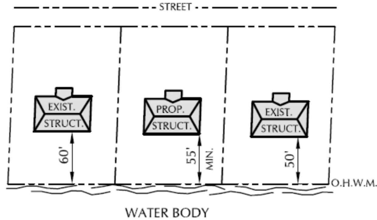
3.
If there is an existing structure on an adjacent lot in only one direction, the setback shall equal an average of the shore setback for the existing structure and the required 75' setback.
4.
In applying these shore setback averaging formulas to a proposed principal structure or addition to a principal structure, the zoning administrator shall apply shore setback measurements taken from other principal structures on adjacent lots only, but not from any immediately adjacent structures, such as decks, patios, retaining walls, swimming pools or sports courts.
5.
The zoning administrator may only use shore setback averaging as described within subsection (g) above. The zoning administrator may not use shore setback averaging in any other circumstance of this chapter.
h.
The zoning administrator may grant a zoning permit for a structure that lies closer than 75 feet to the ordinary high water mark of a navigable body of water if the proposed structure meets all of the following requirements:
1.
The part of the structure nearest to the water lies at least 50 feet landward from the ordinary high water mark.
2.
The structure has no sides or has only railings for sides.
(10)
Wetland setback. No person shall structurally alter any structure on a lot closer than 25 feet to a wetland, except:
a.
Boathouses as permitted in accordance with section 111-100(d) of this chapter;
b.
A walkway, stairway or rail system necessary to provide pedestrian access to wetlands and have a maximum width of 60 inches.
(b)
Offsets. No person shall hereafter erect, structurally alter, or relocate a structure so that any roofed or enclosed portion thereof, excluding a roof overhang measuring 24 inches or less, lies closer to any lot line than the offset distance specified by the applicable district regulations, except as follows:
(1)
In the case of any lot of record which has a minimum width less than that required by the applicable district, the zoning administrator may reduce the side lot line offset proportionately to the ratio between the actual average width and the required minimum width to not less than ten feet. Example:
(2)
In the case of multiple-family, commercial or business park use structures, the zoning administrator may modify the offsets as follows:
a.
A person may erect two or more structures on adjoining lots with common or directly adjoining walls provided the project complies with requirements of the state building code relative to such construction and provided that applicable offset requirements comply at both ends of such row-type buildings.
b.
The zoning administrator may reduce the required offset on one side of a structure provided the owner offsets the other side of the structure by an equivalent amount and provided the owners of any property adjoining the area of reduced offset shall file with the village a copy of a recorded deed restriction limiting the erection of any structure on said property so as to reduce the combined offset in such case to a distance less than that resulting from the normal application of the minimum offset requirements to both properties except as permitted under subsection (b)(2)a above.
(3)
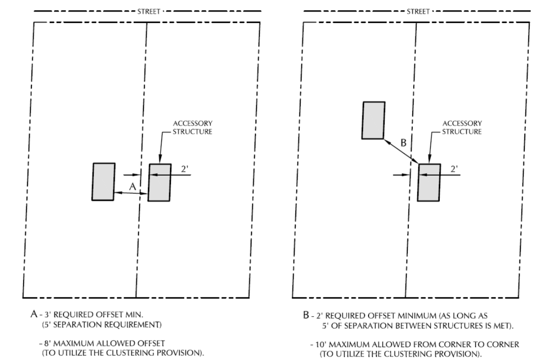
The zoning administrator may permit one detached accessory structure less than 200 square feet in area, located five feet from the side and rear lot lines.
(4)
When a legal nonconforming detached accessory structure lies on an adjacent lot and closer than five feet of the common lot line, the zoning administrator may allow a new detached accessory structure up to the same distance from the common lot line as the existing detached structure on the adjacent lot, as long as they lie:
a.
Within ten feet of each other; and
b.
Have sidewalls no closer than five feet to each other.
(5)
Any structure housing livestock shall be located a minimum of 50 feet from an adjacent property line. This does not include doghouses.
(6)
In the case of an extension or addition of a structure into the minimum offset distance, and where such extension would not extend closer to the lot line than the existing structure to which it is attached, the plan commission may approve a special exception to allow such an extension or addition as long as said extension or addition does not encroach closer to the side lot line than an existing structure to which it is attached.
(7)
Offsets on decks and patios may be reduced to 60 percent of the distance between the principal structure and the lot line, otherwise required for the principal structure, but shall in no case be located closer than five feet from a lot line.
(8)
Retaining walls shall meet the offset provisions of section 111-73(c) of this chapter.
(9)
Offsets for permanently installed generators shall be a minimum of 20 feet from an adjacent property line.
(c)
Maintenance and use of setback and offset areas. Owners shall landscape any such required setback or offset area and keep it clean and free from the accumulation of debris or refuse, and shall not use it for the storage or display of equipment, products, vehicles or any other material.
(d)
Accessory structure location. A property owner shall not erect, structurally alter, or relocate any accessory structure so that any roofed or enclosed portion thereof lays closer than ten feet to the principal structure on the lot unless it complies with the state building code.
(Ord. No. 31-2015, § 4.3, 10-1-2015)
Sec. 111-97. - Structure size regulations.
(a)
Minimum required. Any structure intended in whole or part for residential purposes shall provide a minimum floor area as specified by applicable district. The chapter states such minimums in terms of the minimum total floor area required for a structure and that portion of the total provided on the first floor level, excluding garage area.
(b)
Calculating minimum floor area. This chapter measures residential structure floor area at each level on the exterior wall to exterior wall, including finished interior balconies and mezzanines, finished basements, elevator shafts, stairwells at each story, floor space used for mechanical equipment with structural headroom of seven and one-half feet or more, penthouses, and usable attic space providing structural headroom of seven and one-half feet or more. In a split level structure this chapter measures the first floor level, including all area not over another living area of the structure. This chapter does not include garages in calculating minimum floor area.
(c)
Exceptions. The plan commission may grant a special exception to permit a structure of less than the required minimum floor area when such grant does not contradict the spirit or intent of this chapter, and provided the proposed structure will have compatible character and quality to the general neighborhood, and further provided the plan commission finds no significant adverse impact upon neighboring properties and provided further that in no case shall they permit a reduction greater than 25 percent.
(Ord. No. 31-2015, § 4.4, 10-1-2015)
Sec. 111-98. - Structure height regulations.
(a)
Maximum height restricted. No owner shall erect or structurally alter any building or structure in any district to a height in excess of that hereinafter specified by the applicable district regulations. In addition to the above restriction, to protect and preserve wildlife habitat and natural scenic beauty, the zoning administrator may not permit any construction within 75 feet of the ordinary high water mark of any navigable waters that results in the height of a structure, as defined herein, exceeding 35 feet.
(b)
Exceptions.
(1)
The following uses may exceed the applicable district height regulations without plan commission approval: Chimneys and flues, accessory farm structures up to, but not exceeding 60 feet in height on lots of three acres or more in area, electrical transmission and distribution facilities, roof-mounted television and radio receiving antennas up to, but not exceeding ten feet in height from the roof and roof-mounted licensed amateur radio operator antennas up to, but not exceeding ten feet in height from the roof.
(2)
The following uses may exceed the applicable district height regulations only upon approval of the plan commission: Cooling towers, elevator bulkheads, fire towers, monuments, stacks, scenery lofts, tanks, water towers, ornamental towers, spires, masts, freestanding towers, roof-mounted licensed amateur radio operator antennas exceeding ten feet in height from the roof, and necessary mechanical appurtenances.
(Ord. No. 31-2015, § 4.5, 10-1-2015)
Sec. 111-99. - Impervious surface regulations.
(a)
Purpose. To promote the infiltration of water to recharge the water table and replenish aquifers; to protect water quality, fish and wildlife habitat, and protect against pollution of navigable waters; the village has established maximum impervious surface regulations.
(b)
Maximum lot coverage. The maximum total impervious area of all structures on a lot shall not exceed that permitted under the amount specified by the applicable district regulations. The zoning administrator shall calculate impervious surfaces by dividing the surface area of the existing and proposed impervious surface in the lot area by the total lot area, and multiply by 100.
(1)
Exceptions.
a.
Existing impervious surfaces. For existing impervious surfaces, lawfully placed when constructed, but not in compliance with the maximum total impervious area, a person may do the following:
1.
Maintain and repair all impervious surfaces. (For example: Applying sealant or repairing a section of asphalt / concrete drive.)
2.
Replace existing impervious surfaces with same or similar surfaces within the existing impervious surface area, if this activity complies with all other provisions of this chapter. (For example: The entire removal of an asphalt driveway and replacement with an asphalt or concrete driveway.)
3.
Relocate or modify existing impervious surfaces with similar or different impervious surfaces, provided that the relocation or modification does not result in an increase in the percentage of impervious surface that existed on the effective date of the village ordinance, meets the applicable setback requirements in section 111-96(a), and complies with all other provisions of this chapter.
b.
Treated impervious surfaces that comply with section (d) are excluded from this calculation.
(c)
Maximum shoreland coverage. The zoning administrator shall not allow more than 30 percent impervious surface on the portion of lot area located entirely within 300 feet of the ordinary high water mark, except as set forth below. This standard shall apply to the construction, reconstruction, expansion, replacement or relocation of any impervious surface within 300 feet of the ordinary high water mark of any navigable waterway. The zoning administrator shall calculate the percentage of impervious surface, for this subsection, by dividing the surface area of existing and proposed impervious surfaces on that portion of the lot area within 300 feet of the ordinary high water mark by the total lot area within 300 feet of the ordinary high water mark, and multiplied by 100.
(1)
Exceptions.
a.
Maximum impervious surface. The zoning administrator shall not allow over 30 percent impervious surface within 300 feet of the ordinary high water mark unless it complies with subsection b or c below.
b.
Existing impervious surfaces. For existing impervious surfaces lawfully placed when constructed but that do not comply with the standards listed above, the property owner may do any of the following:
1.
Maintain and repair all impervious surfaces;
2.
Replace existing impervious surfaces with same or similar surfaces within the existing impervious surface area, subject to compliance with all other provisions of this chapter;
3.
Relocate or modify existing impervious surfaces with similar or different impervious surfaces, provided that the relocation or modification does not result in an increase in the percentage of impervious surface that existed on the effective date of the village ordinance, meets the applicable setback requirements in section 111-96(a)(8), and complies with all other provisions of this chapter.
c.
Treated impervious surfaces that comply with subsection (d) below are excluded from this calculation.
(d)
Treated impervious surface.
(1)
Exclusion standards: Impervious surfaces that meet either of the following standards shall be excluded from the impervious surface calculations under this section, provided the treated impervious surface performance standard of subsection (2) below is met:
a.
The first one-half inch of runoff from the impervious surface is treated by a stormwater BMP, as defined in the Village of Summit Stormwater Management and Erosion Control Ordinance, or
b.
The first one-half inch of runoff from the impervious surface discharges to an internally drained pervious area that retains the runoff on or off the parcel and allows infiltration into the soil.
(2)
Performance standard: The first one-half inch of runoff from the area of impervious surface to be excluded from the calculation must either infiltrate or be treated according to the exclusion standards contained in subsection (1) above. The stormwater infiltration or treatment system shall comply with an adopted village, county or state post-construction stormwater management technical standard or guidance document. The calculation of the runoff volume to be treated is the area of the impervious surface to be excluded multiplied by the runoff depth (½ inch or 0.04 feet).
For example: 1,000 square feet x 0.04 feet = 40 cubic feet.
(3)
Permitting requirements: A stormwater permit must be obtained from the village of summit for an impervious surface to be considered a treated impervious surface which is excluded from the impervious surface calculation. The following requirements apply:
a.
The exclusion and performance standards of subsections (1) and (2) above shall be met
b.
All technical standards of the Village of Summit Stormwater Management and Erosion Control Ordinance shall be met. Depending on the type of Stormwater BMP proposed, a qualified professional may be required to prepare any necessary plans.
c.
A financial guarantee in accordance with the requirements of the Village of Summit Stormwater Management and Erosion Control Ordinance may be required to ensure that the stormwater BMP is installed correctly.
d.
The obligations and long-term maintenance requirements of the current and future property owners shall be evidenced by an instrument that is reviewed and approved by the Village of Summit and recorded in the Office of the Register of Deeds.
e.
The treated impervious surface complies with the shoreland setback requirements under section 111-96(a)(9).
(Ord. No. 31-2015, § 4.6, 10-1-2015)
Sec. 111-100. - Accessory use and structures.
(a)
General.
(1)
The chapter shall not allow any accessory use or structure that by any reason of noise, dust, odor, appearance, or other objectionable factor creates a nuisance or a substantial adverse effect on the property value or reasonable enjoyment of the surrounding properties.
(b)
Permanent structures.
(1)
The chapter considers any permanent roofed structure serving an accessory use if structurally attached to the principal structure as part of such principal structure for all regulatory purposes.
(2)
Any permanent accessory structure classified as a structure shall conform to the structure location and height requirements of the applicable district except as specifically otherwise provided.
(3)
Accessory structures in a residential district or on a lot with the principal use as residential shall conform to the following:
a.
Shall have no storage of any commercial vehicle, truck, tractor, farm machinery or equipment or for the carrying on of any metal working, woodworking, masonry, carpentry, contracting or repair business except as a permitted use, permitted accessory use, approved conditional use, or a home occupation as allowed by subsection (f) of this section.
b.
Shall have no floor area greater than 60 percent of the structure finished floor area of the principal structure on the lot; and floor area no more than five percent of the total area of the lot. The plan commission may permit larger accessory structures and a greater percentage of accessory structure coverage upon submittal of structural, site and operational plans, where in the commission's opinion no adverse effect results to surrounding properties. In granting permission, the plan commission may require such architectural treatment, screening by landscape or architectural means, regulation of lighting, deed restrictions, or other measures, as it deems necessary. The plan commission may immediately make a determination as to the reasonableness of the request or may require public hearing in conformance with the applicable provisions of section 111-387 before making its determination.
c.
No individual structure shall have a floor area in excess of 50 percent of the allowable maximum impervious coverage of the applicable district.
d.
The zoning administrator, plan commission, or village board may require, prior to the issuance of the building permit for an accessory structure, that the property owners file a deed restriction with the Waukesha County Register of Deeds giving notice as to the allowable uses of the accessory structure.
e.
Where a property owner proposes more than two accessory structures for a lot, the plan commission shall review said structures to ensure they do not adversely affect nearby properties or the general desirability of the neighborhood, and render a finding to approve or deny said structures.
(4)
No person shall construct an accessory structure until after the start of construction on or completion of the principal structure.
a.
The principal structure shall be defined as the residence in the R-1, R-2, R-3, R-4, MF-1 or MF-2 Districts, the primary commercial structure in the NC, BP Districts, the primary institutional structure in the IN Institutional District, and the primary agricultural structure in the A-1 or A-2 Districts, except as where the zoning administrator has determined that a waterway or periodic flooding inhibits rescue and relief efforts to a residential lot by local police, fire or emergency services, then the principal structure may be a structure other than a residence.
b.
The planned development overlay district regulations shall identify the principal structure(s) as part of the approving ordinance.
(c)
Temporary structures. Any temporary structure serving an accessory use shall be permitted consistent with the standards as set out in subsection (b). The zoning administrator must approve the size and location of the structure prior to erection of the structure. The zoning administrator may permit said temporary structure for any period of time, but in no case for greater than four months in any consecutive 12-month period.
(d)
Boathouse regulations.
(1)
Use permitted. As defined by this chapter, the village permits boathouses in any district abutting a public or private body of water when the chapter also permits a residence by right, subject to the terms and the conditions set forth herein. Said boathouse shall contain at least 50 square feet of floor area, but no more than 750 square feet of floor area.
(2)
Habitation prohibited. The village does not allow human habitation or plumbing in any boathouse.
(3)
Boathouse location.
a.
No closer than five feet to the ordinary high water mark or further than 50 feet from the ordinary high water mark.
b.
Not within the floodplain and/or wetland.
c.
Entirely within the access and viewing corridor of the lot.
d.
Relative to offsets, shall comply with the provisions of section 111-96(b) of this chapter.
(4)
Owners may use the flat roofed surfaces of boathouses as open recreational living areas but shall not permanently enclose this portion of the structure. The village considers canopies, railings, and access stairs as ordinary appurtenances.
(5)
The zoning administrator shall permit only one boathouse per lot within 75 feet of the ordinary high water mark, and no other accessory structures within 75 feet of the ordinary high water mark.
(6)
The zoning administrator shall require any maintenance and repair of nonconforming boathouses that extend beyond the ordinary high water mark of any navigable water to comply with Wis. Stats. § 30.121. The zoning administrator shall require written certification from the Wisconsin DNR to repair a "wet" boathouse or to qualify for a statutory exception.
(7)
Height. A boathouse shall not exceed 15 feet in total height, as defined in this chapter.
(8)
Width. The width of a boathouse shall not exceed 20 percent of the shoreline frontage and in no case exceed 30 feet in width.
(9)
Depth. The ratio of boathouse depth to width shall not exceed 2:1.
(e)
Swimming pools. The village has the following regulations for outdoor swimming pools in addition to ordinary setback requirements:
(1)
Pumps and filter equipment shall lay no closer than 20 feet to a property line and have adequate screening and mufflers.
(2)
The zoning administrator considers surfaced terraces, sun decks and walks as paved surfaces and regulates these areas for side and rear yard setback as listed in the applicable district.
(3)
Before filling the pool, whether heretofore or hereafter erected, the owner shall completely enclose the pool by a secure fence or wall not less than four feet above ground elevation. Such fence or wall shall have a self-closing and self-latching gate or door with the latch located at the top of the gate or made inaccessible to small children in any other manner approved by the zoning administrator. The owner shall provide for an unobstructed area of not less than four feet between the pool and such fence. The zoning administrator shall not require such fence or wall for aboveground pools with walls perpendicular to the ground and walls not less than four feet high, provided that the ladder or steps leading up to the pool have hinges at the top and a capability of being raised out of the reach of small children.
(4)
The zoning administrator allows pools erected on top of the surface of the ground. These pools shall have the pool construction completely and adequately screened from the view of the abutting properties by means of a combined fence and landscape screen. If applicable, these pools shall conform with the Waukesha County Code of Ordinances regarding regulation of private sewage systems.
(5)
All electrical connections to any swimming pool shall be connected to a ground fault interrupter (GFI) so that no electrical current can be discharged into any part of such pool or surrounding fences. No electric wires or other electrical conductor shall be strung over any swimming pool.
(6)
No swimming pool shall be constructed unless a permit is first secured from the zoning administrator.
(7)
Permanent structures with rooflines shall be a minimum of ten feet from a swimming pool.
(f)
Home occupation. A property owner may conduct any home occupation as defined herein, including a professional office or studio, as an accessory use of residential premises provided they comply with the following regulations:
(1)
Such use remains clearly incidental and secondary to the principal use as a residence.
(2)
Such use shall not constitute more than 25 percent of the floor area of the structures on the premises.
(3)
The owner maintains the residential character of the structures and premises in a manner compatible with the residential neighborhood so as not to adversely affect neighboring properties.
(4)
Such use shall not include the operation of any machinery, tools, or other appliances in a manner that would create noise or other nuisance factors in excess of those typical to residential usage.
(5)
Such use shall not have any identification, other than the property or owner, and limit signage to a non-illuminated sign not in excess of three-square feet in area.
(6)
Such use shall not require outside storage of materials to a degree considered by the zoning administrator incompatible to the residential character of the premises.
(7)
Such use shall not include the removal of sand, gravel, stone, topsoil or peat moss for commercial purposes or the sale of trees, plants or nursery stock.
(8)
Such use shall provide off-street parking area compatible with the residential character.
(Ord. No. 31-2015, § 4.7, 10-1-2015)
Sec. 111-129.- Purpose and use.
Two controls affect the intensity of residential uses in the various residential zoning districts: a "density factor" and a "minimum lot area."
(1)
Residential density. The "density factor" includes the amount of land area required on a private lot or a combination of a private lot and preserved land for each dwelling unit.
a.
Concept description. The village bases the concept of "density" regulations upon the premises of controlling the intensity of use in terms of the relationship of the number of units to the gross area of land granted by such a use within a defined area. The village has designed these "density" regulations to control the intensity of use of lands in relationship to the natural, physical and ecological characteristics of the area; to implement established comprehensive local, county or regional plans; to respond to the capability for adequate sewage disposal; to address the village's ability to provide appropriate municipal services; to respond to basic economic factors; and to achieve the desired residential environmental character, while still permitting reasonable flexibility in terms of lot shape, size and arrangement. Consistent with the goals of achieving the optimum residential environment and a "rural" character of the community, the village designed the "density" technique to permit variable lots sizes and the use of the most suitable terrain for housing sites while encouraging the preservation of agricultural lands and natural features as preserved lands for the aesthetic, environmental or recreational benefit of the area.
b.
Concept application. No owner shall erect or relocate a structure intended in whole or in part for residential use unless the lot on which it is located:
1.
Meets the standard development requirements for the applicable zoning district; or
2.
Meets the conservation development requirements for the applicable zoning district; or
3.
Meets a planned development overlay district density factor as authorized under the specific adopting ordinance of section 111-359(c)(5); or
4.
Meets the required density factor by having allocated to it sufficient additional "preserved land" to meet the required density factor for the applicable zoning district by allocation of a fractional amount of preserved land to each residential lot.
c.
Where an individual lot area includes more than one zoning district that permits residential use, the proportionate average of the district density factors shall apply.
d.
Density calculations shall exclude wetland-floodplain lands and areas of existing roads and proposed public roads.
e.
The plan commission shall approve the establishment of "preserved lands" pursuant to the criteria and development goals set forth in subsection (2)c of this section.
(2)
Preserved lands. "Preserved lands" includes portions of the property permanently restricted from any development or use except as consistent with its preservation as agricultural land or as a form of common "preserved lands" for the environmental or recreational benefit of the area.
a.
Permanent status. Any land area claimed in addition to the actual described individual residential lots for credit toward meeting the density factor requirement shall have its status permanently established and guaranteed either by dedication to the public with appropriate covenants running with the land or in private ownership in any form acceptable to and approved by the plan commission by appropriate covenants running with the land including, but not limited to, ownership by developer or ownership by an undivided interest of all lot owners in the development by appropriate covenants running with the land, which covenants shall permanently restrict the property against any development or use except as is consistent with its preservation as agricultural land or as a form of common "preserved lands" for the environmental or recreational benefit of the area. The official village zoning map shall indicate the "preserved lands" status of any parcel.
b.
Location. Any land area claimed in addition to the actual described residential lot for credit toward meeting the density factor requirement shall lie directly contiguous to such lot or part of the contiguous ownership processed for development approval and platting. Developers may not include the surface area of a navigable water body in the area of computation for such credit. For purposes of this section, "contiguous" may encompass lands lying on the opposite side of public rights-of-way, stream channels or water bodies subject to acceptability under the criteria hereinafter set forth and provided that the plan commission shall determine whether a project meets the intent of the contiguous requirement in a given situation.
c.
Criteria. In order to qualify as "preserved lands," any such land must fall in one or more of the following categories of use along with customary and reasonable accessory uses thereto and meet the designated criteria as set forth below:
1.
Natural areas such as woods, meadows, marshes, lakes, streams and ponds providing either an environmental amenity or serving a useful ecologic purposes.
2.
Agricultural areas, including crop land, pasture, orchards, and tree nurseries contributing to the preservation of the agricultural land resource or contributing to the rural environmental character of the area.
3.
Recreational areas such as parks, parkways, green belts, playfields and golf courses provided such use also contributes to the environmental desirability of the area.
(3)
Development goals. In order to implement the stated intent of "density" regulation where "preserved lands" will be established, the following goals shall guide the plan commission in granting its approval:
a.
Preservation of rural character. Contribute to the preservation of the rural character of the village by encouraging retention of farm fields, pastures, orchards and natural open spaces either as common preserved lands or as farm operations under the preserved lands category. Owners can accomplish this goal by leaving vistas of farming activity along the main village roads, by grouping home sites in farm-like clusters surrounded by fields and pasture or by preserving complete farm operations and transferring the development potential to another area.
b.
Preservation of agricultural lands. Developers should shape and arrange preserved lands designated for agricultural use consistent with practical requirements for carrying on such activity and of justifiable value for agricultural use or as a contribution to the goal of preserving a rural environmental character.
c.
Preservation of natural ecologic features. The village desires to preserve natural features such as water bodies, marshes and woods for their contribution to the maintenance of ecologic balance and as a goal of density regulation. The plan commission should consider this on the basis of the legitimacy of their ecologic value.
d.
Preservation of primary environmental corridors. The developer should attempt to preserve the environmental corridor in its natural state; no development should occur within the primary environmental corridor and, to the greatest extent possible, protected preserved lands should include the environmental corridor.
e.
Appropriate relationship of development to the physical character of the site and the surrounding area. The plan commission should consider whether the development plan for roads, building sites and preserved areas comes from the careful consideration of a most appropriate relationship to existing terrain conditions, preservation of natural vegetation, suitable capacity for on-site sewage disposal, provision for storm water drainage and retention and the potential impact upon the surrounding area.
f.
Limit access to main village and county roads. In order to preserve the rural character as well as the efficiency and safety of the existing main through roads, the village desires to minimize the development of lots strung out along such roads with individual driveway access from each lot. Instead, the village encourages the grouping of lots on interior streets and courts with the road frontage kept in the preserved lands category.
(4)
Reduction of density factor and minimum lot size requirements. Where the "ratio of preserved lands," as defined, includes at least 40 percent of the project area, the conservation development requirements of the specific zoning district shall apply.
(5)
Examples for computing residential density in a proposed development.
General Data for this Example
Assumptions for this example: No primary environmental corridor on site. Roads cannot be used in density or lot area calculations. Round down for allowable lots.
a.
Standard residential development example. Note: In this example, the density factor is based on the R-1 district (section 111-347(e)(1)).
b.
Conservation residential development example. Note: In this example, the density factor is based on the R-1 district (section 111-347(e)(3)).
1.
Determine developable area.
2.
Determine preserved lands (minimum 40 percent of developable area).
3.
Determine developable lands.
4.
Determine allowable number of units on-site.
5.
Determine average lot size.
c.
Planned development example.
Note: In this example, the density is increased as authorized under section 111-359(c)(5).
1.
Determine developable area.
2.
Determine preserved lands (minimum 50 percent of developable area).
3.
Determine developable lands.
4.
Determine allowable number of units on site.
(i)
The maximum increase in number of units is 50 percent as noted in section 111-359(c)(5)a.
(ii)
Permitted number of dwelling units 23 x 1.5 = 34 (units are rounded down).
5.
Determine average lot size.
(6)
Minimum lot area. The "minimum lot area" identifies a minimum area and width requirement for each individual residential lot, based solely upon the dimensions of such lot.
a.
No owner shall erect or relocate any residential structure on a lot of less area or width than hereinafter specified by the regulations of the applicable district, except as specifically authorized and approved within a planned development under section 111-359. The chapter excludes wetland-floodplain lands within privately owned individual residential lots for purposes of meeting the minimum area for a lot, but these lands can remain as part of a private lot and used to meet average width requirements. The non-wetland-floodplain portion of the lot shall measure at least as wide as the specified minimum average width for a distance of at least one-half the length of the lot.
b.
For the purpose of this chapter, the village measures lot area from the base setback line as defined in section 111-431, definition of "setback, base," and as established by section 111-96(a)(2) of this chapter and shall exclude the area between the base setback line and the existing property line ultimately to be included in street.
c.
In determining the minimum average width of a lot, such measurement shall be made by a line perpendicular to the line establishing the average depth of the lot, at any point where one-half the required minimum lot area would fall on each side of such line establishing the minimum average width.
d.
No existing individual residential lot area shall be reduced by any means so as to create a lot of less than the required size or so that the existing offsets, setbacks or lot area would be reduced below that required by the regulations for that district in which such lot is located, except as may be specifically authorized and approved under section 111-359(c)(5).
e.
Where an individual residential lot has less land area or width than required for the applicable district and was of record at the time of the passage of this chapter, or was subsequently legally established under Article IV, such lot may be used for any purpose permitted in such district; providing, however, that in no case shall the setback, or offset requirements, be reduced except by order of the zoning board of appeals after due hearing, or as otherwise herein provided.
(Ord. No. 31-2015, § 5.1, 10-1-2015)
Sec. 111-157.- Parking requirements.
(a)
Intent. In all districts and in connection with every use, at the time a person erects, enlarges, extends or increases any use or structure, the owner shall provide off-street parking stalls for vehicles in accordance with the following subsections:
(1)
Each parking space shall include a minimum of 162 square feet exclusive of the space required for ingress and egress.
(2)
All parking spaces shall lay on the same lot as the principal use and no parking stall or driveway, except in residential districts, shall be closer than 20 feet to a residential district.
(3)
All open off-street parking areas, except parking spaces accessory to single-family or two-family dwellings, shall have a bituminous or concrete pavement surface within 15 months from the date of occupancy of the structure or premises. Property owners or developers shall grade such parking areas so as to dispose of all surface waters and so that no significant surface waters drain across sidewalks. The owner or developer shall arrange and mark such parking areas to provide for orderly and safe parking and storage of vehicles.
(4)
Parking areas regulated under subsection (3) shall be improved by wheel stops or curbing to prevent encroachment into pedestrian ways, such as sidewalks, adjacent lots, landscape islands, or public road right-of-ways, and to properly manage stormwater and erosion provided, however, that the plan commission may, after considering any recommendation by the village engineer, waive the requirement for wheel stops or curbing upon its finding that, due to geographic and/or landscaping features, use of wheel stops or curbing is not reasonably necessary to prevent encroachments or that the absence of wheel stops or curbing would benefit stormwater management.
(5)
All public off-street parking areas created or redesigned and rebuilt subsequent to the adoption of this chapter shall provide accessory landscaped areas totaling not less than five percent of the surfaced parking area. Landscaped areas shall occur for every 15 spaces, and shall divide areas with more than two aisles of parking (see section 111-161). Each landscape area shall measure not less than 75 square feet. Unless further restricted, a greenbelt of at least ten feet in width between the parking area and all property boundaries shall surround each such parking area. The plan commission shall approve the location of landscape areas and plant materials and the protection afforded the plantings, including curbing and provision for maintenance.
(6)
All plans for such proposed parking areas shall include a topographic survey showing the grade and location of improvements. The minimum landscape area may include existing trees, shrubs and other natural vegetation in the parking area.
(b)
Site plan required. The village requires a site plan approval by the plan commission for the construction or creation of any parking lot or the expansion of any existing parking lot in accordance with the site plan provisions of article X.
(c)
A person shall use the following chart in the provision of parking spaces. The plan commission may reduce initial installation area where a site plan indicates future area available for parking spaces and the owner sets this land aside via deed restrictions for use if needed.
(d)
Loading requirements.
(1)
In any mixed use, neighborhood commercial, business park or institutional district, the development shall include off-street loading and unloading space in addition to the required off-street parking area for every structure in excess of 10,000 square feet in area exclusive of storage areas.
(2)
An individual loading space shall measure at least 12 feet wide and 45 feet long and have a minimum height clearance of 14 feet.
(3)
The chapter bases the number of such spaces provided using the operating characteristics of the individual use, subject to approval by the plan commission upon submittal of the site and operational plans as outlined in article X.
(4)
No owner or developer shall hereafter erect or place a structure for commercial or industrial purposes on a lot in a manner requiring servicing directly from any abutting public street, unless specifically waived by the plan commission during site plan review.
(Ord. No. 31-2015, § 6.1, 10-1-2015; Ord. No. 103-2022, § 1, 3-10-2022)
Sec. 111-158. - Traffic visibility.
(a)
The provisions of section 111-96(a)(3), vision setback lines, of this chapter shall control regarding traffic visibility requirements in the town.
(b)
Driveways. All driveways installed, altered, changed, replaced or extended after the effective date of this chapter shall meet the following requirements:
(1)
Owners or developers shall provide islands between driveway openings with a minimum of 20 feet between all driveways on the same property, at least six feet from property lines as extended into the right-of-way, and as identified in the specific district bulk regulations for pavement setback.
(2)
Openings for vehicular ingress and egress shall meet Waukesha County or Wisconsin DOT requirements where applicable, but in no case shall this opening exceed 20 feet at the right-of-way line and 26 feet at the roadway in residential districts or 30 feet at the right-of-way line and 38 feet at the roadway in all other districts.
(3)
Vehicular entrances and exits to drive-in facilities, hotels, funeral homes or public park-and-ride lots shall lie more than 200 feet from any pedestrian entrance to a school, college, university, church, hospital, park playground, library or public emergency shelter.
(Ord. No. 31-2015, § 6.2, 10-1-2015)
Sec. 111-159. - Highway access.
The chapter does not permit direct private access to the existing or proposed rights-of-way of freeways, expressways, and other controlled-access arterial street, without permission of the agency having access control jurisdiction. In addition:
(1)
The village shall not permit direct public or private access to the existing or proposed rights-of-way of freeways, interstate highways, and their interchanges or turning lanes, nor to intersections or interchanging streets within 1,500 feet of the most remote end of the taper of the turning lanes.
(2)
The village shall not permit direct public or private access to existing or proposed rights-of-way within 150 feet of the intersection of the right-of-way lines of arterial streets intersecting another arterial street.
(3)
The plan commission may require access barriers such as curbing, fencing, ditching, landscaping, or other topographic barriers to prevent unauthorized vehicular ingress or egress to the above-specified streets or highways.
(4)
The village board may grant temporary access to the above rights-of-way after review and recommendation by the highway agencies having jurisdiction. Such access permit shall be temporary, revocable, and subject to any conditions required, and cannot exceed 12 months.
(Ord. No. 31-2015, § 6.3, 10-1-2015)
Sec. 111-160. - Special provisions for off-street parking and storage of vehicles in residential districts.
(a)
Residential parking. The village limits parking of cars accessory to a residential use to those actually used by the residents, or for temporary parking of guests.
(b)
Parking of trucks, trailers and equipment. The village does not allow regular parking of a truck, commercial trailer, house or camping trailer or other vehicular equipment of a commercial or industrial nature on a lot in any residential, agricultural, or mixed-use district except as noted in subsection (c) below:
(1)
The village permits parking of agricultural equipment without limitation in an agricultural district.
(2)
The village permits parking of one panel truck or pickup truck in any district.
(3)
The village permits parking of a camper or house trailer provided the property owner keeps it enclosed in a structure or effectively screened from general view.
(c)
Storage in required parking spaces for multiple-family dwellings prohibited.
(1)
Contrary provisions of this chapter notwithstanding, the village does not permit vehicle storage in required parking spaces for a multiple-family dwelling. Owners and developers may provide off-street storage space for a multiple-family dwelling, provided that a site plan includes such space and has approval in accordance with section 111-278 of this chapter.
(2)
A person may not rent more than one vehicle storage space to persons who do not reside on the lot, and, moreover, any such space shall not exceed 300 square feet. This regulation does not apply to storage or parking allowed as a permitted use, permitted accessory use, approved conditional use under section 111-311, or a home occupation as allowed by section 111-100(f).
(Ord. No. 31-2015, § 6.4, 10-1-2015)
Sec. 111-161. - Parking lot design standards.
(a)
60-degree parking dimensions.
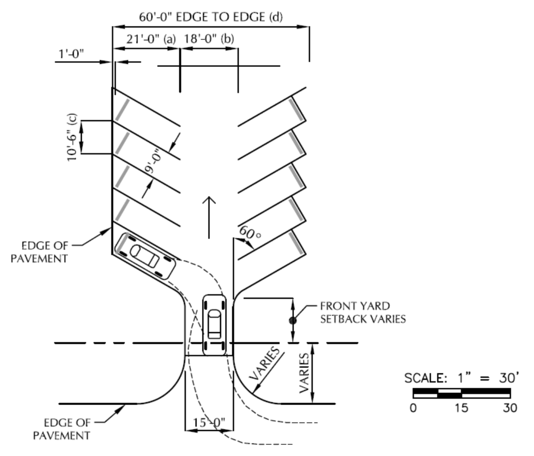
60-Degree Parking Lot Design Standards
(b)
45-degree parking dimensions.
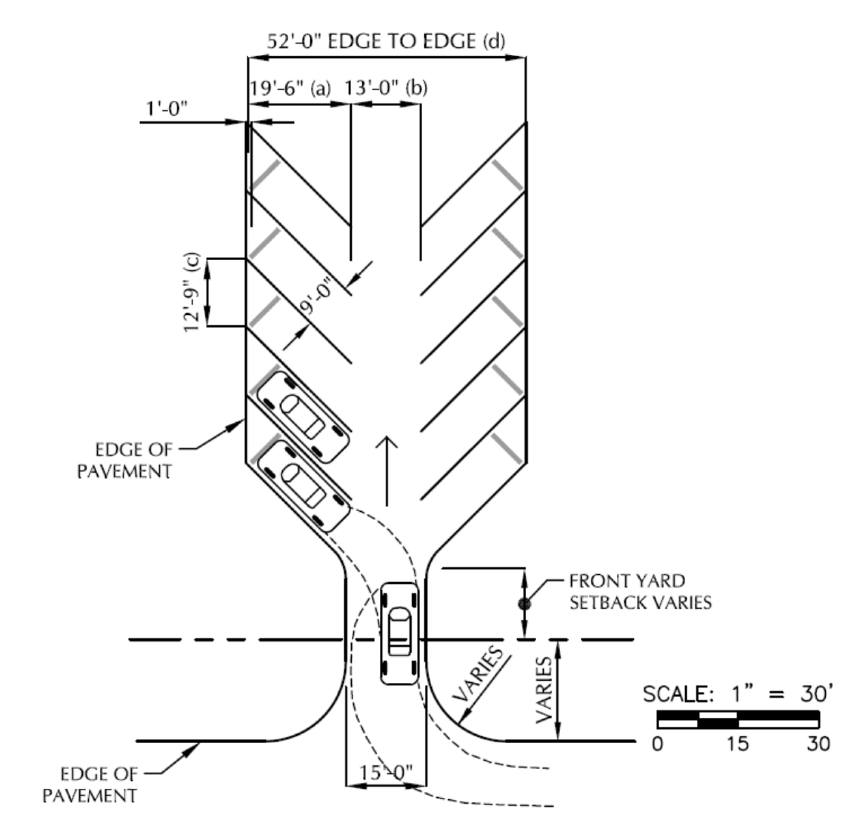
45-Degree Parking Lot Design Standards
(c)
90-degree parking dimensions.
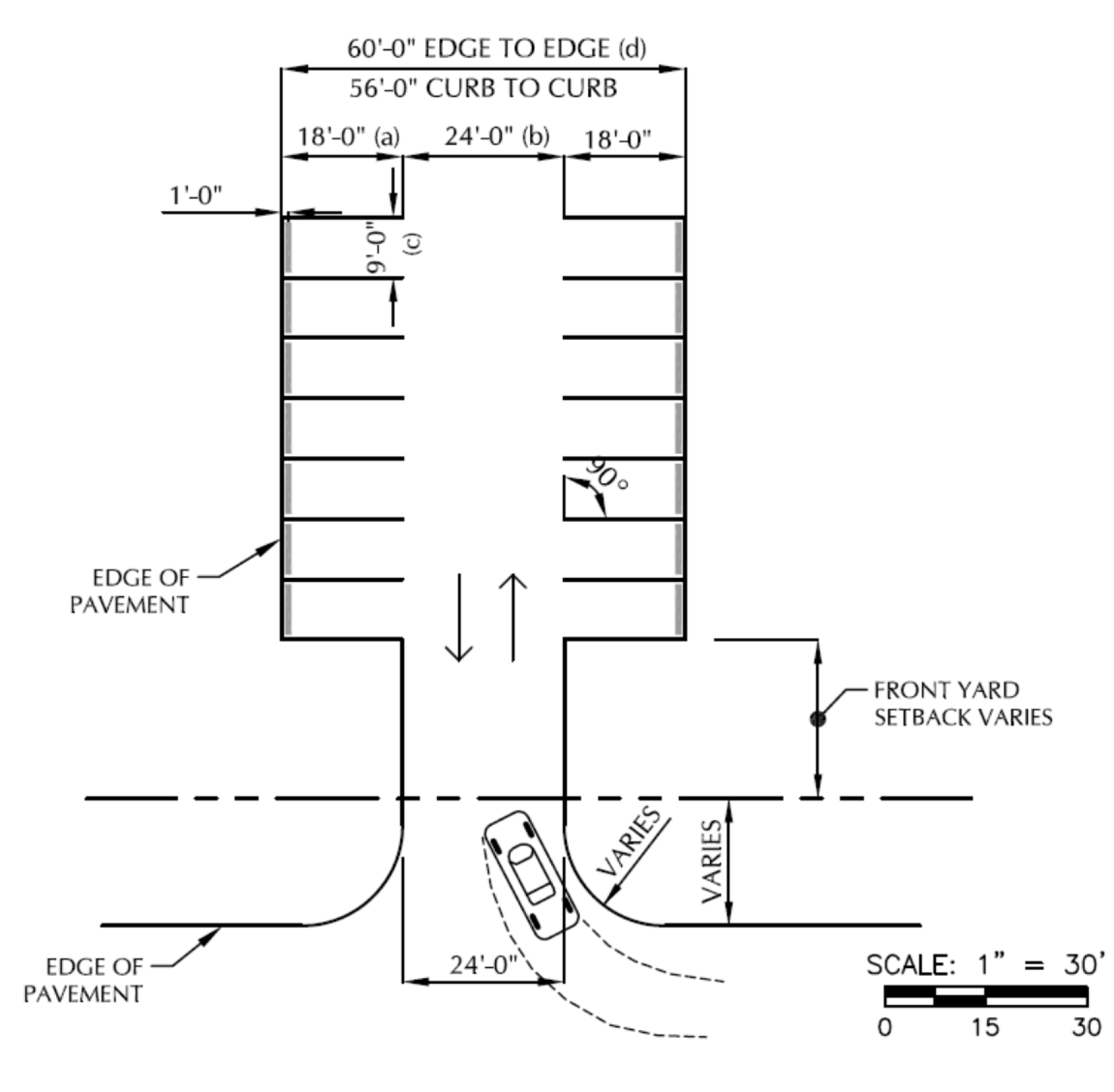
(Ord. No. 31-2015, § 6.5, 10-1-2015)
Sec. 111-224.- Existing use permitted.
This chapter allows for the continued use of an existing lawful use of a property at the time of the enactment of this chapter or any amendment applicable thereto which is not in conformity with the provisions established by this chapter in the manner and for the purposes then existent, subject to the conditions hereinafter stated.
(Ord. No. 31-2015, § 8.1, 10-1-2015)
Sec. 111-225. - Classification and regulation.
For the purpose of administration, the village has classified and regulated non-conformities as follows:
(1)
Legal nonconforming structures which contain a permitted use.
a.
No person shall expand or enlarge such structure except in conformity with the regulations of this chapter or as allowed by state law.
b.
Damaged or destroyed nonconforming structures which contain a permitted use.
1.
Pursuant to Wis. Stats. § 62.23(7)(hc), the zoning administrator shall allow restoration of damaged or destroyed nonconforming structures which contain a permitted use if the structure will be restored to the size, subject to subsection (1)b.2, location, and use that it had immediately before the damage or destruction occurred if all of the following apply and the zoning administrator shall not impose any limits on the costs of the repair, reconstruction, or improvement if all of the following apply:
(i)
The nonconforming structure was damaged or destroyed on or after March 2, 2006.
(ii)
The damage or destruction was caused by violent wind, vandalism, fire, flood, ice, snow, mold, or infestation.
except if the nonconforming structure is located within the floodplain, it shall comply with the Village of Summit Floodplain Ordinance.
2.
The zoning administrator shall permit a structure of a larger size than it was immediately before the damage or destruction of a nonconforming structure containing a permitted use if necessary for the proposed structure to comply with applicable state or federal requirements.
c.
Pursuant to Wis. Stats. § 62.23(7)(hb), the zoning administrator shall allow the repair, maintenance, renovation or remodeling of a nonconforming structure, containing a permitted use, in existence on the effective date of this chapter provided such work meets all requirements of the Village of Summit Floodplain Ordinance and subject to the shoreland provisions of this chapter. This includes such activities as interior remodeling, painting, decorating, paneling, plumbing, insulation, and replacement of windows, doors, wiring, siding, roof and other nonstructural components; and the repair of cracks in foundations, sidewalks, walkways and the application of waterproof coatings to foundations.
d.
Expansion beyond the shoreland setback within shoreland jurisdiction. A person may expand an existing principal structure, lawfully placed when constructed but not in compliance with the required structure setback under section 111-96(a)(9), horizontally, landward or vertically provided that the expanded area meets the structure setback requirements per section 111-96(a)(9) and also meets all other provisions of this chapter.
e.
Replacement or vertical expansion of a nonconforming structure within shoreland jurisdiction. A person may replace or vertically expand on the same property an existing principal structure, lawfully placed when constructed but not in compliance with the required structure setback per section 111-96(a)(9), or any structure that received a variance prior to the effective date of this chapter to construct within the shoreland setback, may do all of the following:
1.
Maintain, repair, replace, restore, rebuild or remodel if the activity does not expand the footprint of the structure.
2.
Any other expansion, beyond what is allowed under subsection 1 above, is prohibited unless the village determines the expansion is necessary to comply with applicable state or federal requirements, such as building codes.
f.
Replacement of a nonconforming structure to the wetland setback standard. The wetland provisions of 111-96(a)(10) of this chapter do not limit the repair, reconstruction, renovation, remodeling, or expansion of structures or environmental control facilities in existence on the effective date of this chapter.
g.
Structures nonconforming to the front/street setback are subject to the following standards:
1.
Nonconforming structures between the base setback line and 20 feet of a base setback line
(i)
An existing principal or accessory structure may be replaced, restored, rebuilt, remodeled, maintained and repaired provided the existing footprint and three dimensional building envelope of the nonconforming structure are not expanded, unless the expansion is necessary to comply with applicable state and federal requirements.
(ii)
The plan commission may approve a modification to allow a vertical or lateral expansion, provided no portion of the lateral expansion is located any closer to the base setback line than the closest point of the existing structure.
(iii)
All other provisions of this chapter shall be met.
2.
Nonconforming structures 20 feet to within 35 feet of a base setback line
(i)
In addition to the improvements permitted by the above subsection, a structure may be expanded vertically, provided the height requirements of this chapter are met.
(ii)
A structure may be expanded laterally, provided the lateral expansion does not exceed 200 square feet over the lifetime of the structure and provided no portion of the lateral expansion is located any closer to the base setback line than the closest point of the existing structure.
(iii)
The plan commission may approve a modification to allow a lateral expansion that exceeds 200 square feet if the expansion does not extend closer to the established setback than the existing structure to which it is attached.
(iv)
All other provisions of this chapter shall be met.
3.
Nonconforming structures 35 feet or greater from a base setback line
(i)
A structure may be expanded vertically or laterally, regardless of size, provided no portion of the expansion is located any closer to the base setback line than the closest point of the existing structure.
(ii)
All other provisions of this chapter shall be met.
4.
Criteria for approval. If the plan commission approves a modification and determines the expansion will not impact traffic safety and will be compatible with the surrounding neighborhood, the plan commission may require architectural treatment, screening by landscape or architectural means, deed restrictions, or require other measures be taken, as deemed necessary.
(2)
Legal nonconforming use of structures.
a.
No person shall expand or enlarge such legal nonconforming use.
b.
Upon petition to and approval of the plan commission, a person may change such use to another use provided that:
1.
The plan commission determines that the new use would result in greater, or no less, degree of conformity; and
2.
Such new use shall thereafter determine the degree of legal nonconformity.
c.
Where a property owner discontinues any such use for a period of 12 consecutive or 36 cumulative months, any future use of the structure shall conform to the regulations of the applicable district.
(3)
Legal nonconforming lots.
a.
In the case of a lot of record at the time of the passage of this chapter and which adjoins along a side lot line property held in the same ownership, no such lot shall be conveyed to another owner nor shall building permit be issued for a structure on such lot except in conformity with chapter 109, Subdivision of Land, of the Code of the Village of Summit.
b.
The village shall not issue a building or zoning permit except in conformity with of this chapter.
c.
A property owner may alter the size and shape of such lot so as to increase the degree of nonconformity only with the approval of the plan commission as outlined in chapter 109, Subdivision of Land, of the Code of the Village of Summit.
d.
A legally created lot or parcel that met minimum area and minimum average width requirements when created, but does not meet current lot size requirements, may be used as a building site if all of the following apply:
1.
The substandard lot or parcel was never reconfigured or combined with another lot or parcel by plat, survey, or consolidation by the owner, county, or assessor into one property tax parcel.
2.
The substandard lot or parcel has never been developed with one or more of its structures placed partly upon an adjacent lot or parcel.
3.
The substandard lot or parcel is developed to comply with all other chapter requirements.
(4)
Legal nonconforming use of land.
a.
No person shall expand or enlarge such legal nonconforming use.
b.
The use may change to another use upon petition to and approval of the plan commission provided that:
1.
The plan commission determines that the new use would result no greater, or no less, degree of conformity; and
2.
Such new use shall thereafter determine the degree of legal nonconformity.
c.
Where any such use ceases for a period of 12 consecutive or 36 cumulative months, any future use of the land shall conform to the regulations of the applicable district.
(Ord. No. 31-2015, § 8.2, 10-1-2015; Ord. No. 110-2022, § 1, 10-13-2022)
Sec. 111-226. - Conditional use status.
Subject to the provisions of article XI of this chapter, the Village of Summit may reclassify any such legal nonconforming use as a conditional use.
(Ord. No. 31-2015, § 8.3, 10-1-2015)
Sec. 111-227. - Removal of hazards.
Where, upon complaint of the zoning administrator, the plan commission finds any nonconforming structure or use as a matter of fact to be a detriment to the public health, safety, or general welfare, the village board shall direct the removal of such structure or such use within such time as the village board may deem reasonable. Failure to carry out such order may result in the village taking such steps as necessary to remove such structure or discontinue such use and assess the cost thereof against the property owner.
(Ord. No. 31-2015, § 8.4, 10-1-2015)
Sec. 111-275.- Purpose.
The provisions of this article set forth the procedures and regulations under which the village may permit specific site development. The village establishes these regulations to promote compatible development, ensure adequate public facilities, maintain stability of property values, and prevent impairment or depreciation of property values. The chapter limits such required approval solely to reasonable compliance with design, location and operational requirements and shall not involve the basic permissibility of the use where such use is a permitted use under the district regulations.
(Ord. No. 31-2015, § 10.1, 10-1-2015)
Sec. 111-276. - General standards.
The plan commission shall base approval of the building, site or operational plans upon reasonable application of the following general standards to the specific conditions of each case, giving consideration to the environmental goals of the village, the character of the surrounding area and the functional requirements of the proposed use:
(1)
While the village encourages creative and innovative building design, the village discourages building design or exterior appearance so unorthodox or abnormal of character in relation to the surroundings as to be considered unsightly or offensive to generally accepted taste and community standards.
(2)
Buildings should have a variety of design or exterior appearance to limit structures identical with those adjoining this site or to create excessive monotony or drabness.
(3)
The exposed facade of a building should use a finishing material that is aesthetically compatible with other facades in the surrounding development.
(4)
The exposed facade of a building should use a finishing material that presents an attractive appearance to the public and to surrounding properties.
(5)
Persons should locate structures on a property in a manner that would limit unnecessary destruction or substantial damage to the natural beauty and aesthetics of the area, particularly as it adversely affects values of land in that area; or would unnecessarily have an adverse effect on the beauty and general enjoyment of existing structures on adjoining properties.
(6)
The treatment of the site shall give appropriate consideration to maximum preservation of natural vegetation, to provision for appropriate storm water drainage and possible retention, and to the provision for safe ingress, egress and accessibility for normal and emergency services.
(7)
Operational plans shall give appropriate consideration to minimize the potential adverse effect of noise, dust or odor resulting from such operation as well as the impact upon the existing character of the neighborhood resulting from patterns of traffic flow, hours of operation, lighting, shift changes and similar factors.
(8)
Large structures in the IN Institutional, BP Business Park, NC Neighborhood Commercial, and Multifamily residential districts will require a heightened level of site design, including attractive architectural features. Long, monotonous facades or roof designs shall not be permitted. HVAC units and other rooftop mechanicals/utilities are required to be screened from view.
(Ord. No. 31-2015, § 10.2, 10-1-2015; Ord. No. 112-2022, § 1, 10-13-2022)
Sec. 111-277. - Preliminary consultation.
Prior to the preparation and official submittal of the site plan and supporting data, the applicant shall meet with the village plan staff for a preliminary consultation. This preliminary consultation allows for an informal discussion of the proposed project, a review of the regulations and policies applicable to the project, and a discussion of the land use implications of the project.
(Ord. No. 31-2015, § 10.3, 10-1-2015)
Sec. 111-278. - Required plan information.
(a)
Applicants shall submit a site plan to a scale not smaller than 30 feet to the inch, certified by a registered land surveyor, professional engineer, planner, architect or landscape architect. The site plan shall show the following information:
(1)
Name of project, along with the name, address and telephone number of the property owner, project developer, architect and engineer.
(2)
Date of plan submittal.
(3)
Existing and proposed grades based on USGS datum, at intervals not to exceed two feet.
(4)
Characteristics of soils related to the contemplated uses.
(5)
Location, size and capacity of proposed storm water systems, structures, detention and retention areas, storm water treatment and erosion control.
(6)
The shape, size, location, height, floor area and the finished ground and basement floor grades of all proposed buildings and structures, including fences and walls.
(7)
The location and size of existing and proposed sanitary sewers, septic tanks and disposal fields, holding tanks, private and public wells, and water mains.
(8)
Natural features such as wooded areas, streams and lakes or ponds, and man-made features such as existing roads and structures, with indication as to which are to be retained and which are to be removed or altered.
(9)
Location of proposed refuse storage area.
(10)
Location of proposed and existing sidewalks, paths, streets, driveways, parking spaces and loading spaces showing direction of travel for one-way drives. The width of streets, driveways and sidewalks and total number of parking spaces shall also be shown.
(11)
Architectural renderings and general floor plans shall be provided for all new buildings. These drawings and plans should show sufficient detail to indicate the architectural design of the proposed building.
(12)
A lighting plan describing fixtures and designating placement.
(13)
A landscape plan showing existing and proposed planting areas, type of planting and amenities proposed for the site.
(14)
A vicinity sketch showing the location of the site in relation to the surrounding street system.
(15)
Parking, loading and vehicle storage areas.
(16)
Other information necessary to establish compliance with this chapter, or as identified in the development guidelines adopted by the plan commission and village board.
(b)
In addition, operational plan data shall include at least the following:
(1)
Specific use of the site and building(s).
(2)
Proposed hours of operation.
(3)
The anticipated resident population contained within the project or the anticipated number of employees.
(4)
Estimated daily truck and auto trips to the site; the plan commission may require a traffic study.
(5)
Type of materials and equipment proposed for storage on the site.
(6)
Method of handling solid and liquid waste disposal.
(7)
Method of exterior maintenance (site and buildings).
(8)
Copies of all permits issued by state or county agencies.
(9)
A description of internal and external utility service capabilities.
(c)
Official submittals required. Applicants shall submit 14 copies of the site plan, accompanied by a dated letter of submittal requesting action and a completed site plan review application form, to the zoning administrator for review by the plan commission staff and action by the plan commission. These plans shall be five full-size sheets and nine sheets 11 inches by 17 inches. The applicant shall submit the site plan and support materials to the zoning administrator at least 20 calendar days prior to the scheduled plan commission meeting date at which the site plan may be considered for approval, unless an extension of time is mutually agreed upon at the consultation.
(d)
Review procedure. Upon receipt of the site plan materials identified in subsection (c) above, the zoning administrator shall review it to determine whether it has the proper form, contains all of the required information, shows compliance with this chapter and other ordinances and plans of the village, and demonstrates the adequacy of utility services. The plan commission shall, within 60 calendar days of its initial submittal, approve, conditionally approve, or deny the site plan. Denial of approval shall be limited to any defect in form or required information, or any violation of any provision of this chapter or any ordinance, or the inadequacy of any utility. The plan commission's action shall be issued in writing by the zoning administrator stating, in detail, the reasons for the plan commission's action.
(e)
Appeal. The applicant may appeal any denial or decision of the plan commission to the circuit court. The circuit court's jurisdiction shall be limited to determining whether there was error in the determination, and shall not have authority to approve a site plan. If the circuit court determines that the plan commission erred, it shall remand the matter back to the plan commission for further consideration in light of the circuit court decision. Such appeals shall be filed with the village clerk within 30 calendar days after filing of the decision with the zoning administrator. The decision of the plan commission shall be deemed filed upon approval of the minutes if prior filing has not occurred.
(Ord. No. 31-2015, § 10.4, 10-1-2015)
Sec. 111-279. - Site plan revisions.
The plan commission shall review and approve any revisions to the building plans, site plan, or plan of operations after initial approval and prior to the issuance of a building permit.
(Ord. No. 31-2015, § 10.5, 10-1-2015)
Sec. 111-280. - Lapse of site plan approval.
In the event the project for which the site plan approval was granted is not started within one year of such approval, the site plan approval shall lapse and there shall be no further development or construction. Upon written application, the plan commission may renew the site plan as originally granted or require changes as deemed appropriate.
(Ord. No. 31-2015, § 10.6, 10-1-2015)
Sec. 111-281. - Occupancy permit.
(a)
Required. The building inspector shall not issue an occupancy permit until all improvements shown on an approved site plan have been completed in accordance with this section and plan commission action and the zoning administrator completes a right-of-way inspection for damage to roadway or curbing/ditches.
(b)
Exceptions. If the zoning administrator finds that certain improvements cannot be completed due to the seasonal or other factors beyond the control of the developer and that temporary occupancy prior to the completion will involve no health or safety hazard, the zoning administrator may issue a temporary occupancy permit bearing an expiration date, that allows reasonable time for completion of all the required improvements prior to the date of expiration of the temporary occupancy and zoning use permit. No temporary occupancy permit shall be granted for a period longer than one year (365 days). No permanent occupancy permit or final inspection approval shall be issued by the zoning administrator until all required improvements are completed.
(Ord. No. 31-2015, § 10.7, 10-1-2015)
Sec. 111-311.- General standards.
(a)
Approval required. The village may permit uses listed as conditional uses in various zoning districts in the district in which listed upon petition for such permit to the plan commission and subject to the approval of the plan commission and to such other conditions as hereinafter designated.
(b)
Basis of approval. The plan commission shall base its determination on general consideration as to the effect of such grant on the health, general welfare, safety and economic prosperity of the village and specifically of the immediate neighborhood surrounding the proposed location, including such considerations as the following:
(1)
The effect on the established character and quality of the area;
(2)
The effect on the area's physical attractiveness;
(3)
The movement of traffic;
(4)
The demand for related services;
(5)
The possible hazardous, harmful, noxious, offensive, or nuisance effect as a result of noise, dust, smoke or odor; and
(6)
Such other factors appropriate to carrying out the intent of conditional use permits as expressed in section 111-94(b)(3).
(Ord. No. 31-2015, § 11.1, 10-1-2015)
Sec. 111-312. - Procedure for approval.
(a)
Petition. Applicants shall submit a conditional use permit application to the zoning administrator. Upon receipt of the application materials, the zoning administrator shall review it to determine whether it is in proper form, contains all of the required information, and shows substantial compliance with this chapter and other ordinances and plans of the village.
(b)
Hearing. Upon receipt of a complete application, the zoning administrator shall schedule a public hearing in accordance with section 111-387.
(c)
Determination. Following public hearing and necessary study and investigation, the plan commission shall render its decision in writing within 60 calendar days upon conclusion of the public hearing and necessary study and investigation, unless the applicant and plan commission mutually agree upon an extension of time at the public hearing. The zoning administrator shall transmit a copy of this decision in writing to the applicant and also make the decision a permanent part of the plan commission's records. Such decision shall include an accurate description of the use permitted, the property on which permitted and any and all conditions made applicable thereto, or if disapproved, shall indicate the reasons for disapproval.
(d)
Compliance with other permits. When the village approves a conditional use permit, any necessary building or occupancy permits shall include reference to such conditional use permit. The conditional use permit shall apply solely to the structures, use and property described on the permit.
(Ord. No. 31-2015, § 11.2, 10-1-2015)
Sec. 111-313. - Requirements.
(a)
Standard requirements.
(1)
Any such use shall conform to the building location, height, density and lot size regulations of the applicable district, unless the permit specifically provides for additional regulations.
(2)
Applicants shall submit building, site and operation plans of the proposed use for plan commission approval pursuant to the provisions of article X relative to building, site and operational plan approval. Such plans shall include sufficient detail to enable the plan commission to consider the following:
a.
The suitability of architectural and landscape treatment;
b.
The proper location of the building or buildings on the lot;
c.
The satisfactory provision for parking and circulation needs;
d.
The satisfactory provision for drainage and sewage disposal;
e.
The satisfactory provision of adequate planting screen where necessary;
f.
The satisfactory provision of operational control devices where necessary to eliminate noise, dust, odor, smoke, or other objectionable operating condition; and
g.
The general compatibility of the proposed use with the area in which it is located.
(b)
Special requirements. In addition to the general standards and requirements as stated in subsection (a) above, the plan commission may subject the conditional use to more specific standards and requirements appropriate to the particular use and circumstances.
(Ord. No. 31-2015, § 11.3, 10-1-2015)
Sec. 111-314. - Modification of regulations.
The plan commission may modify or waive the requirements applicable to uses permitted by right or as accessory uses in any district by the regulations of this chapter in its approval of a conditional use permit, if, in the plan commission's opinion, they are not appropriate or necessary to the proper regulation of the conditional use, and where such modification or waiver would not result in adverse effect upon the surrounding properties.
(Ord. No. 31-2015, § 11.4, 10-1-2015)
Sec. 111-315. - Accessory uses and structures.
The village shall apply appropriate regulations to uses and structures accessory to a principal conditional use in the same manner as set forth for the principal conditional use.
(Ord. No. 31-2015, § 11.5, 10-1-2015)
Sec. 111-316. - Termination.
(a)
The plan commission may terminate a conditional use permit, without the necessity of a public hearing, when the applicant or holder of the conditional use and the property owner make a request in writing to the plan commission to terminate the conditional use. If the plan commission agrees to terminate said conditional use permit under this section, the zoning administrator shall record notice of said termination of the conditional use permit in the Waukesha County Register of Deeds office.
(b)
The village board may terminate a conditional use permit following referral to the plan commission for a public hearing and recommendation, based on the following considerations:
(1)
Where an approved conditional use does not continue in conformity with the conditions of the original approval or any amendment thereto.
(2)
Where a change in the character of the surrounding area or of the use itself make it no longer compatible with surrounding areas.
(3)
For similar cause based upon consideration for the public welfare.
(c)
If the village board terminates a conditional use permit, the village shall thereafter classify such use as a legal nonconforming use, except that where the termination occurs due to failure to comply with the conditions of the conditional use permit, the village board shall require complete termination of such use.
(Ord. No. 31-2015, § 11.6, 10-1-2015)
Sec. 111-317. - Application to existing uses.
(a)
The village shall automatically grant conditional use status to a use which existed lawfully on a parcel at the time said parcel was placed in a district where such use would be permitted only as a conditional use.
(b)
In cases identified in (a) above, the village shall base such granting of a conditional use upon the existing conditions and use at the time similar to a legal nonconforming conditional use. Any expansion or change in the use shall require the applicant or holder of the conditional use permit and the property owner to apply for and receive approval of a new conditional use permit.
(Ord. No. 31-2015, § 11.7, 10-1-2015)
Sec. 111-318. - Expansion or changes.
Permit holders may petition for expansion or other change of the conditional use permit at any time. Such petition shall not prejudice the existing permit as herein authorized. The village shall use the same procedure for expansion or changes as for an initial petition except that, at the discretion of the plan commission, the plan commission may permit minor changes without a public hearing where such change does not significantly affect the character or intensity of the use.
(Ord. No. 31-2015, § 11.8, 10-1-2015)
Sec. 111-319. - Violations.
Violations of the terms of a conditional use permit are subject to the penalties as provided in section 111-408 of this chapter.
(Ord. No. 31-2015, § 11.9, 10-1-2015)
Sec. 111-320. - Registration.
The zoning administrator shall keep a copy of all approved and signed conditional use permits, amendments, and terminations. In the case of conditional use permits for lawful nonconformities, the information shall include the date of the commencement of the conditional use, a complete description of the use of said property or structure and copies of any correspondence relative to that conditional use permit. The permit holder shall submit annual updates of the operation to the plan commission in January of each year. The permit holder shall pay the costs of any necessary follow-up or investigation.
(Ord. No. 31-2015, § 11.10, 10-1-2015)
Sec. 111-321. - Conditional uses permitted.
Subject to the foregoing, in addition to such uses enumerated in the district regulations, the village may permit the following general conditional uses in the districts specified, provided further that the plan commission shall hold a public hearing and approve the location, building and site plans and plan of operation for any such conditional use:
(1)
Continuation of existing conditional use permits. Any conditional use permit granted pursuant to conditional use authority that has since been repealed and that was in effect, and the use was in operation on the date of such repeal, that is no longer an allowed use of the property, shall be allowed to continue as a conditional use subject to all conditions stated in the conditional use order. Any such conditional use permit that requires compliance with a section of the Village of Summit Zoning and Shoreland Protection Ordinance that has since been repealed, shall continue to require compliance with the referenced section as it existed immediately prior to such repeal and the repeal of such provision is stayed solely for such existing conditional use permit(s). These continuation provisions are intended to preserve the status quo for all rights and responsibilities incurred or accrued prior to the adoption of any ordinance that changes a conditional use to a prohibited use. Nothing herein shall be interpreted to prevent existing conditional use permit holders from applying to amend their conditional use pursuant to all laws in effect at the time of the application, or as set forth in the conditional use permit including those amendments requiring a public hearing.
(2)
Reserved.
(3)
Regulated household animals. Regulated household animals shall be subject to the following conditions, limitations, procedures, and exceptions.
a.
Number of dogs limited. The keeping of dogs by regulated household animal conditional use is limited to the number of dogs described below. Note that "net parcel area" is described in subsection (3)c below.
1.
Three acres or less. On parcels three acres or less in net area, no more than three dogs required to be licensed by state statute shall be kept on the parcel.
2.
Three to ten acres. On parcels larger than three acres but less than 10 acres in net area, no more than seven dogs required to be licensed by state statute shall be kept on the parcel.
3.
Ten acres or larger. On parcels ten acres or larger in net area, no more than 15 dogs required to be licensed by state statute shall be kept on the parcel.
b.
Number of confined hobby animals (as defined herein) limited. The keeping of confined hobby animals (as defined herein) by regulated household animal conditional use is limited to the numbers described below. Note that "net parcel area" is described in subsection (3)c below.
1.
Less than four acres. On parcels less than four acres in net parcel area, no confined hobby animals other than horses shall be kept on the parcel. Horses may be permitted at a level of one horse for each two acres of net area.
2.
Four acres or larger. One confined hobby animal, including horses may be permitted for each two acres of net parcel area.
c.
Regulated household animal regulations. The keeping of regulated household animals by conditional use permit is subject to the following regulations, in addition to any specific conditions that may be imposed by the plan commission:
1.
No commercial activities. Commercial activities such as sale or breeding of regulated household animals are prohibited unless specifically recognized and defined in the adopted plan of operations and exempted under section 111-321(C)(7).
2.
[Intentionally omitted].
3.
Vaccinated. All regulated household animals must be vaccinated not less than annually by a veterinarian who is licensed in the State of Wisconsin.
4.
Dropping disposal. The keeper of any regulated household animals shall cause droppings to be collected in a container or receptacle that when enclosed shall be vermin-proof and fly-tight. Every such keeper shall cause all droppings so collected to be disposed of in such a manner as to not permit the presence of a nuisance to the surrounding neighborhood.
5.
Net parcel area. For purposes of this subsection (3), "net parcel area" does not include land located within wetlands, land within the wetland conservancy or floodplain overlay district; land within a primary environmental corridor; and land with slopes exceeding 20 percent.
6.
Setbacks. Structures which enclose regulated household animals shall maintain the following minimum setbacks:
(i)
From the front property line: 50 feet.
(ii)
From the side and rear property lines: 50 feet.
(iii)
From a dwelling unit on the same parcel: 50 feet.
(iv)
From the nearest setback line required for a dwelling unit on an adjacent parcel: 50 feet.
(v)
From a domestic well: 30 feet for up to ten animals; 50 feet for more than ten animals.
d.
Regulated household animal conditional use permit procedures. All regulated household animal conditional use permits are subject to the following applications procedures and requirements, which shall be in addition to the ordinary conditional use procedures described in article XI of this chapter:
1.
Building, site and operational plans must be submitted and shall be subject to the review described in article X of this chapter.
2.
The regulated household animal use must be accessory to an otherwise permitted use.
3.
The application fee for a regulated household animal conditional use permit shall be set by separate resolution of the village board.
4.
Written notice of the public hearing shall be sent by regular mail to the last known address of all landowners within 300 feet of the subject property.
5.
The issuance of the conditional use permit is subject to the plan commission finding that such regulated household animal will not adversely affect the use of adjacent land and is compatible with surrounding and nearby land uses.
6.
The plan commission may require such measures or provisions by the applicant as may be deemed necessary to provide adequate protection of surrounding property.
7.
The plan commission may deny the request for a regulated household animal conditional use permit on the basis of the finding that such use would be incompatible with surrounding and nearby land uses, a possible nuisance, and/or not in the public interest.
e.
One regulated household animal conditional use permit per parcel. There shall be no more than one regulated household animal conditional use permit allowed on any one parcel in the Village of Summit.
f.
Nuisances. In all cases, regardless of the number of dogs or confined hobby animals on a parcel, if the keeping of any number of dogs or confined hobby animals accessory to the principal use becomes a nuisance to the neighborhood as may be determined by the plan commission or the village board, such use shall be terminated or the nuisance abated. The keeping of confined hobby animals without a regulated household animal conditional use permit, and the keeping of more dogs than are permitted by right on a property without a regulated household animal conditional use permit, unless such uses are otherwise expressly permitted by this chapter, is declared to be a public nuisance. Where necessary, the plan commission or village board may take appropriate steps to abate such nuisance.
g.
[Intentionally omitted.]
h.
Exception for permitted uses. This subsection (3) shall not be interpreted to require a conditional use permit for uses that are expressly permitted by right or by conditional use permit by other sections of this chapter.
i.
Duration and assignment. Regulated household animal conditional use permits shall have limited duration, with a term specifically prescribed by the plan commission, which shall not be longer than five years. The conditional use permit may be renewed thereafter for such additional terms as the plan commission deems appropriate, in the event that the use of the property is compatible with the surrounding areas and is in substantial compliance with the terms of the preceding conditional use order. Regulated household animal conditional use permits shall not be transferable either as to different owners or as to different property.
(4)
Commercial vehicle parking. The parking and storage of commercial vehicles shall be permitted as a conditional use upon compliance with all of the following requirements:
a.
The minimum lot area of the parcel utilized for commercial vehicle parking shall be at least 15 acres.
b.
All commercial vehicles shall be owned, or leased and operated by, the owner or occupant of the property.
c.
No more than six commercial vehicles may be stored on the property. If four or more commercial vehicles are proposed, then two commercial vehicles shall not exceed two axles. Trailers, grading equipment, and other equipment related to the conditional use are not included for purposes of determining the number of commercial vehicles.
d.
The boundary of any parcel utilized for commercial vehicle parking shall be within 200 feet of a county highway or state trunk highway.
e.
All commercial vehicles shall be parked or stored in an enclosed structure having flooring that consists of concrete or other impervious surface.
f.
No commercial activity involving a commercial vehicle shall occur on the property in which commercial vehicle are parked or stored.
g.
Parking on the property for up to four employees who operate the commercial vehicles may occur if such parking is screened from view from any public right-of-way or adjacent property by landscaping or architectural means. For purposes of this subsection, an employee is a person who has no familial relationship with the applicable person that: (i) owns the parcel utilized for commercial vehicle parking; (ii) operates commercial vehicle parking on the subject parcel; or (iii) owns the entity that operates the commercial vehicle parking on the subject parcel.
h.
The conditional use permit shall terminate upon the transfer of ownership of the property utilized for commercial vehicle parking, except that the conditional use permit shall remain in effect upon the transfer involving the owner of the subject parcel, an entity owned by the subject parcel owner, or a trust of the subject parcel owner.
(5)
Legal non-conforming uses. In all district subject to the provisions of article VIII.
(6)
Quarries. Quarrying operations as defined in this chapter, shall be permitted as a conditional use and where so permitted shall be subject to the general regulations applicable to such grant as set out in section 111-311(b) of this chapter, and to the specific regulations as hereinafter set forth.
a.
Permits. No quarrying operation shall take place in any district until a quarrying permit has been secured from the village board. Such permit shall be for an initial period as is deemed appropriate to the specific situation but not to exceed five years and may be renewed thereafter for periods not to exceed three years provided application shall be made at least 60 days or not more than 120 days before expiration of the original permit. Application after such date shall be treated as an original application.
b.
Application procedures.
1.
Application format. Application for a quarrying permit shall be made on forms supplied by the zoning administrator and shall be accompanied by:
(i)
A fee as established by the village board in a fee schedule that may from time to time be modified by village board resolution, to defray the cost of notification, holding a public hearing, and administrative processing.
(ii)
A full and adequate description of all phases of the contemplated operation and the specific mention of type of machinery and equipment that will be or might be necessary to carry on the operation. Where the operation is to include the washing of sand and gravel, the estimated daily quantity of water required, its source and its disposition shall be made a part of this description.
(iii)
A legal description of the proposed site with a map showing its location with indications of private access roads, existing or proposed, and of public highways adjacent to the site which will be affected by the operation.
(iv)
A topographic map of the area at a minimum contour interval of five feet extending beyond the site to the nearest public street or highway or to a minimum distance of 300 feet on all sides.
(v)
A restoration plan as hereinafter required.
2.
Referral to plan commission. Where the application is for a use permitted as a conditional grant, the application and all data and information pertaining thereto shall be referred to the plan commission for public hearing and report and recommendation back to the village board within 30 calendar days after the public hearing. In addition to the normal posting and publishing, notices also shall be sent through the mail or otherwise placed in the hands of all owners within a half-mile radius of the approximate center of the proposed quarrying operation. These notices shall be mailed or delivered at least ten days prior to the date of hearing. Substantial compliance with the notice requirements of this section shall be deemed sufficient.
3.
Action by village board. The village board shall, within ten days after receipt of the recommendation of the plan commission, grant or deny a permit for the proposed quarrying operation. Such determination shall be based upon the standards set out in section 111-311 of this chapter and with particular consideration of the following factors:
(i)
The effect of the proposed operation on existing roads and traffic movement in terms of adequacy, safety and efficiency.
(ii)
The effect of the proposed operation on drainage and water supply.
(iii)
The possibility of soil erosion as a result of the proposed operation.
(iv)
The degree and effect of dust and noise as a result of the proposed operation.
(v)
The practical possibility of restoration of the site.
(vi)
The effect of the proposed operation on the natural beauty, character, tax base, land value and land uses in the area.
(vii)
The most suitable land use for the area with particular consideration for future residential use.
4.
Additional conditions. Any conditions accessory to the granting of a permit shall be in writing and copies made a part of the permit and a part of the records of the town.
5.
Renewals. The procedure as designated in subsections (6)b.1, 2 and 3 above shall apply to applications for renewal of a permit. Determination in regard to renewal shall be based particularly on an evaluation of the effect of the continuance of the use with relation to changing conditions in the area. Where renewal is not granted, the reasons for refusal shall be presented to the applicant in writing and made a part of the records of the town.
c.
Site requirements.
1.
General.
(i)
No part of the quarrying operation shall be permitted closer than 1,000 feet nor shall any accessory access road, parking area or office building be permitted closer than 500 feet to a residential district at the time of the grant of permit except with the written consent of the owners of all residentially zoned properties within 1,000 feet, but in no case shall such operation be permitted closer than 200 feet to a residential district.
(ii)
No quarrying operation shall be permitted as conditional use if 30 or more families reside within a half-mile radius of the center of the proposed site.
2.
Setback requirements. No part of the quarrying operation, other than access roads, shall be located closer than 200 feet to the base setback line along any street or highway. No accessory parking area, stock pile, or office building shall be located closer than 100 feet to the base setback line along any street or highway.
3.
Offset requirements. No part of the quarrying operation shall be permitted closer than 200 feet, nor shall any accessory access road, parking area, or office building be permitted closer than 50 feet to any property line except with the written consent of the owner of the adjoining property, or where said line is abutting a business park district, or abutting an existing quarrying operation but in no case shall such operation be closer than 20 feet to any property line except by agreement between abutting quarrying operations, or be in conflict with the provisions of this section.
4.
Operational requirements.
(i)
Fencing or other suitable barrier shall be erected and maintained around the site or around portions of the site where in the determination of the village board such fencing or barrier is necessary for the protection of the public, and shall be of a type approved by the plan commission.
(ii)
All machinery and equipment used in the quarrying operation shall be constructed, maintained and operated in such a manner as to minimize dust, noise and vibration. Access and haulage roads on the site shall be maintained in a dust-free condition by surfacing or treatment as directed by the town.
(iii)
The crushing, washing, refining or other processing other than the initial removal of material, may be permitted as an accessory use only as specifically authorized under the terms of the grant of permit or as otherwise provided in an business park district.
(iv)
In stone quarries the production or manufacturing of veneer stone, sills, lintels, cut flagstone, hearthstones, paving stone and similar architectural or structural stone and the storing or stockpiling of such products on the site shall be considered a permissible part of the operation provided such production does not require the use of crushing or other heavy machinery except as may be otherwise specifically authorized under the terms of the grant of permit or as otherwise provided in an business park district.
(v)
The manufacturer of concrete building blocks or other similar blocks, the production or manufacturing processes that might be related to the quarrying operation shall not be permitted.
(vi)
The washing of sand and gravel shall be prohibited in any operation where the source of water is of doubtful capacity or where the quantity of water required will seriously affect the supply for other uses in the area, or where disposal of water will result in contamination or pollution or excessive silting.
(vii)
The planting of trees and shrubs and other appropriate landscaping shall be provided where deemed necessary by the plan commission to screen the operation so far as practical from normal view, to enhance the general appearance from the public right-of-way, and generally to minimize the damaging effect of the operation on the beauty and character of the surrounding countryside. Such planting shall be started as soon as practicable, but no later than one year after quarrying operations have begun and shall be done according to the recommendations of the plan commission.
(viii)
Quarrying operations shall not begin before the hour of 7:00 a.m. and shall not continue after the hour of 6:00 p.m. and no operation shall take place on Sundays or legal holidays. During periods of national or unusual emergency, time and hours of operation may be altered at the discretion of the village board and through the issuance of a special permit that shall be renewable at 30-day intervals.
5.
Restoration requirements.
(i)
In order to insure that the area of quarrying operation shall be restored to a condition of practical usefulness and reasonable physical attractiveness, the owner or operator shall, prior to the issuance of a permit, submit to the plan commission a plan for such restoration in the form of the following:
A.
An agreement with the village whereby the applicant contracts to restore the premises to a condition and within a time satisfactory to the town.
B.
A physical restoration plan showing the proposed contours after restoration, plantings and other special features of restoration, and the method by which such restoration is to be accomplished.
C.
A bond, written by a licensed surety company, a certified check, or other financial guarantee satisfactory to the village in an amount sufficient in the opinion of the plan commission to secure the performance of the restoration agreement.
D.
Such agreement and financial guarantee shall be in a form approved by the village attorney.
(ii)
In the event of the applicant's failure to fulfill this agreement, such bond, check or other financial guarantee shall be deemed forfeit for the purpose of enabling the village to perform the restoration.
(iii)
Restoration shall proceed as soon as practical and at the order and direction of the plan commission. However, the owner or operator may, at his option, submit a plan for progressive restoration as the quarrying operation is being carried on. The required financial guarantee in such case may cover progressive stages of the restoration for periods of not less than two years.
(iv)
At any stage during the restoration the plan may be modified by mutual agreement between the plan commission and the owner or the operator.
(v)
Where there is any backfilling, the material used or the method of fill shall not be such as to create a health hazard nor which would be objectionable because of odor, combustibility, or unsightliness. In any case the finished grade of the restored area except for rock faces, outcroppings, water bodies, or areas of proposed building or paving construction, shall be of sufficient depth of earth to support plant growth.
(vi)
Within one year after the cessation of the operation, all temporary structures (excepting fences), equipment, stock piles, rubble heaps, or other debris shall be removed or backfilled into the excavation so as to leave the premises in a neat and orderly condition.
(vii)
In any restoration procedure which takes place in sand or gravel pits or on other sites where the material is of a loose or friable nature, no slope shall be left which is steeper than a ratio of one and one-half horizontal to one vertical. In no case shall any slope exceed the normal angle of slippage of the materials involved.
6.
Exceptions.
(i)
Incidental use. The provisions of section 111-321(5) shall not apply to an operation which is incidental to another permitted use of the premises; provided such operation does not involve the commercial disposal of the material removed.
(ii)
Permitted modification or waiver. The plan commission may, consistent with the intent of these regulations, modify or waive any or all of the provisions of section 111-321(5) of this chapter for subsection (6)c.6(ii)A through D below. This modification or waiver, except as allowed under subsection (6)c.6(i) above, must be provided as a properly recorded conditional use permit.
A.
Operations incidental to another permitted use of the premises where the material removed is sold or otherwise disposed of commercially.
B.
Sod removal provided no such operation shall be permitted which adversely affects the drainage of the area and provided adequate provision is made to prevent erosion.
C.
Topsoil removal, except that no such operation shall be permitted except as incidental to another permitted use of the premises, and provided such operation will not adversely affect the drainage of the area, or exceed 18 inches in depth and provided adequate provision is made to prevent erosion.
D.
Where the character of terrain, of surrounding development, or other special conditions would justify such modification, permit a reduction in the required setback or offset provided however that in no case shall the setback be less than 100 feet, or the offset be less than 100 feet for quarrying operations or 20 feet for any accessory access road, parking area or office building except as may be otherwise provided by subsection (6)c.3.
(Ord. No. 31-2015, § 11.11, 10-1-2015; Ord. No. 48-2017, § 1, 7-11-2017; Ord. No. 59-2018, § 1, 6-12-2018; Ord. No. 63-2018, §§ 2—4, 8-20-2018; Ord. No. 82-2020, § 1, 6-11-2020; Ord. No. 96-2021, § 2, 5-13-2021; Ord. No. 131-2024, § 2, 3-14-2024; Ord. No. 134-2024, § 1, 8-8-2024)
Sec. 111-346.- Purpose.
Subject to the general provisions as set forth in article II of this chapter, this section sets forth the specific use and bulk regulations for each district individually.
(Ord. No. 31-2015, § 12.1, 10-1-2015)
Sec. 111-347. - Estate Residential District (R-1).
(a)
Intent. The Estate Residential District includes areas designated for single-family residential development of a predominantly rural character. The village applies this zoning classification to preserve a rural setting with development at a very low density. The high quality, "estate"-type development occurs in areas appropriate to such use based on the physical and environmental characteristics of the land and of existing development.
(b)
Principal permitted uses.
(1)
Single-family residential dwelling.
(2)
Private outdoor recreation facilities as part of a subdivision development plan.
(3)
Community living arrangement (up to eight persons).
(4)
Family day-care home (up to eight persons).
(c)
Accessory uses.
(1)
Attached or detached private garages.
(2)
Fences.
(3)
Home occupation.
(4)
Not more than one horse more than six months of age per each two acres of land.
(5)
Not more than three dogs or three cats, or a combination thereof, which are over the age of 12 months.
(6)
Private greenhouses.
(7)
Private boathouses.
(8)
Private residential play equipment.
(9)
Private residential stables.
(10)
Solar energy conversion systems.
(11)
Swimming pools.
(12)
Accessory dwellings. A person may create an accessory dwelling in a single-family detached dwelling for use by family members, provided that:
a.
The accessory dwelling design has a separate and complete housekeeping unit with living, sleeping, cooking and bathroom areas that can be isolated from the remaining original dwelling unit.
b.
Only one accessory dwelling may be created within a single-family detached dwelling unit.
c.
The original single-family detached dwelling unit or the accessory dwelling shall serve as the owner's principal place of residence, except for bona fide temporary absences.
d.
The accessory dwelling structure design appears, to the degree feasible, as that of a single-family detached dwelling unit, and locates any new entrances to the sides and/or rear of the structure. The proposed additions and alterations to the existing structure shall conform to all applicable state, county and village codes.
e.
A deed restriction, in a form acceptable to the village zoning administrator, shall be filed with the Waukesha County Register of Deeds, giving notice that the accessory dwelling unit does not create a duplex, and does not allow any commercial uses.
(13)
Guest houses. A person may create a guest house separate from a single-family detached dwelling provided that:
a.
Such structure shall not be rented, leased or used continually for permanent habitation.
b.
Such structure shall meet all building setback requirements.
c.
Only one guest house may be allowed on each parcel.
d.
A deed restriction, in a form acceptable to the village zoning administrator, shall be filed with the Waukesha County Register of Deeds, giving notice that the accessory dwelling unit does not create a duplex, and does not allow any commercial uses.
(14)
Wind energy conversion systems.
(d)
Conditional uses.
(1)
Hobby kennel, by regulated household animal conditional use permit as described in section 111-321(3).
(e)
Bulk regulations (R-1).
(1)
Standard development requirements.
a.
Density factor/area per dwelling unit: 130,000 square feet.
b.
Minimum lot area: 87,120 square feet (two acres).
1.
Lands zoned Wetland Conservancy or in a floodplain within a privately owned individual residential lot are excluded for purposes of meeting the minimum area for a lot. This land area can remain as part of a private lot and could be used to meet the average width requirement.
c.
Minimum lot width: 220 feet.
d.
Maximum impervious surface: 9,800 square feet or seven and one-half percent of lot area, whichever is greater, except the following.
e.
Minimum front/street setback: 50 feet from base setback line. Where an existing pattern of development exists less than the requirement listed above, refer to section 111-96(a)(5).
f.
Minimum side yard setback: 30 feet.
g.
Minimum rear yard setback: 30 feet.
h.
Minimum wetland setback: 25 feet.
i.
Minimum pavement setback: 15 feet.
j.
Accessory structure minimum front/street setback: 50 feet from base setback line. Where an existing pattern of development exists less than the requirement listed above, refer to section 111-96(a)(5).
k.
Accessory structure minimum side yard setback: Ten feet. Where an existing pattern of development exists less than the requirement listed above, refer to section 111-96(b).
l.
Accessory structure minimum rear yard setback: Ten feet. Where an existing pattern of development exists less than the requirement listed above, refer to section 111-96(b).
m.
Maximum structure height.
1.
Principal structure: 35 feet.
2.
Accessory structure(s): 15 feet.
n.
Minimum first floor area: 1,200 square feet.
o.
Minimum total floor area: 1,800 square feet.
(2)
Shoreland development requirements. In addition to compliance with the aforementioned standard district requirements, all properties within shoreland areas as defined herein are also subject to the following additional requirements:
a.
The maximum impervious surface within 300 feet of the ordinary high water mark of any navigable waterway shall be as follows:
1.
Impervious surfaces may not exceed 30 percent of the lot or parcel within 300 feet of the ordinary high water mark, in accordance with section 111-99(c).
2.
Existing impervious surfaces that were lawfully placed when constructed but do not comply with the standards in subsection 1 above, are subject to section 111-99(c)(1)b.
3.
Treated impervious surfaces that comply with section 111-99(d) are excluded from this calculation but still must comply with the shore setback standards in section 111-347(e)(2)b.
b.
Minimum shore setback:
1.
Seventy-five feet from the ordinary high water mark. Where an existing pattern of development exists less than the requirement listed above, refer to section 111-96(a)(9)g.
2.
Fifty feet for a structure that has no sides or has only railings for sides, subject to section 111-96(a)(9)h.
(3)
Conservation development requirements. The aforementioned standard development regulations may be modified in a conservation development as follows:
a.
Density factor/area per dwelling unit: 100,000 square feet.
b.
Minimum lot area: 43,560 square feet (one acre).
c.
Minimum lot width: 180 feet.
d.
Maximum impervious surface: 9,800 square feet or seven and one-half percent of lot area, whichever is greater.
e.
Minimum front/street setback: 50 feet from base setback line.
f.
Minimum side yard setback: 20 feet.
g.
Minimum rear yard setback: 20 feet.
h.
Minimum pavement setback: Ten feet.
i.
Accessory structure minimum front/street setback: 50 feet from base setback line.
j.
Accessory structure minimum side yard setback: Ten feet.
k.
Accessory structure minimum rear yard setback: Ten feet.
l.
Minimum total open space: 40 percent of project area.
(f)
Signage. As described in article VII of this chapter.
Example: Single-Family Detached House
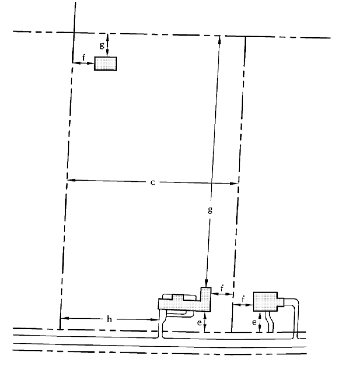
(Ord. No. 31-2015, § 12.2, 10-1-2015; Ord. No. 63-2018, §§ 5, 6, 8-20-2018; Ord. No. 119-2023, § 1, 10-12-2023; Ord. No. 133-2024, § 1, 7-11-2024)
Sec. 111-348. - Country Residential District (R-2).
(a)
Intent. The Country Residential District includes areas designated for single-family residential development with substantial open space characteristics. The village applies this zoning classification to preserve a countryside setting with development at a low density. The high quality, open space areas of this district preserve and protect the countryside community character designation. R-2 zones occur in areas appropriate to such use based on the physical and environmental character of the land and the existing transportation linkages.
(b)
Principal permitted uses.
(1)
Single-family residential dwelling.
(2)
Private outdoor recreation facilities as part of a subdivision development plan.
(3)
Community living arrangement (up to eight persons).
(4)
Family day-care home (up to eight persons).
(c)
Accessory uses.
(1)
Attached or detached private garages.
(2)
Fences.
(3)
Home occupation.
(4)
Not more than one horse more than six months of age per each two acres of land.
(5)
Not more than three dogs or three cats, or a combination thereof, which are over the age of 12 months.
(6)
Private greenhouses.
(7)
Private boathouses.
(8)
Private residential play equipment.
(9)
Private residential stables.
(10)
Solar energy conversion systems.
(11)
Swimming pools.
(12)
Accessory dwellings. A person may create an accessory dwelling in a single-family detached dwelling for use by family members, provided that:
a.
The accessory dwelling design has a separate and complete housekeeping unit with living, sleeping, cooking and bathroom areas that can be isolated from the remaining original dwelling unit.
b.
Only one accessory dwelling may be created within a single-family detached dwelling unit.
c.
The original single-family detached dwelling unit or the accessory dwelling shall serve as the owner's principal place of residence, except for bona fide temporary absences.
d.
The accessory dwelling structure design appears, to the degree feasible, as that of a single-family detached dwelling unit, and locates any new entrances to the sides and/or rear of the structure. The proposed additions and alterations to the existing structure shall conform to all applicable state, county and village codes.
e.
A deed restriction, in a form acceptable to the village zoning administrator, shall be filed with the Waukesha County Register of Deeds, giving notice that the accessory dwelling unit does not create a duplex, and does not allow any commercial uses.
(13)
Guest houses. A person may create a guest house separate from a single-family detached dwelling provided that:
a.
Such structure shall not be rented, leased or used continually for permanent habitation.
b.
Such structure shall meet all building setback requirements.
c.
Only one guest house may be allowed on each parcel.
d.
A deed restriction, in a form acceptable to the village zoning administrator, shall be filed with the Waukesha County Register of Deeds, giving notice that the accessory dwelling unit does not create a duplex, and does not allow any commercial uses.
(14)
Wind energy conversion systems.
(d)
Conditional uses.
(1)
Hobby kennels, by regulated household animal conditional use permit as described in section 111-321(3).
(e)
Bulk regulations (R-2).
(1)
Standard development requirements.
a.
Density factor/area per dwelling unit: 90,000 square feet.
b.
Minimum lot area: 65,340 square feet (1.5 acres).
1.
Lands zoned Wetland Conservancy or in a floodplain within a privately owned individual residential lot are excluded for purposes of meeting the minimum area for a lot. This land area can remain as part of a private lot and could be used to meet the average width requirement.
c.
Minimum lot width: 180 feet.
d.
Maximum impervious surface: 12,000 square feet or ten percent of lot area, whichever is greater, except the following.
1.
Existing impervious surfaces that were lawfully placed when constructed but do not comply with this standard are subject to the standards within section 111-99(b).
2.
Treated impervious surfaces that comply with section 111-99(d) are excluded from this calculation.
e.
Minimum front/street setback: 50 feet from base setback line. Where an existing pattern of development exists less than the requirement listed above, refer to section 111-96(a)(5).
f.
Minimum side yard setback: 30 feet.
g.
Minimum rear yard setback: 30 feet.
h.
Minimum wetland setback: 25 feet.
i.
Minimum pavement setback: 15 feet.
j.
Accessory structure minimum front/street setback: 50 feet from base setback line. Where an existing pattern of development exists less than the requirement listed above, refer to section 111-96(a)(5).
k.
Accessory structure minimum side yard setback: ten feet. Where an existing pattern of development exists less than the requirement listed above, refer to section 111-96(b).
l.
Accessory structure minimum rear yard setback: ten feet. Where an existing pattern of development exists less than the requirement listed above, refer to section 111-96(b).
m.
Maximum structure height.
1.
Principal structure: 35 feet.
2.
Accessory structure(s): 15 feet.
n.
Minimum first floor area: 1,200 square feet.
o.
Minimum total floor area: 1,600 square feet.
(2)
Shoreland development requirements. In addition to compliance with the aforementioned standard development requirements, all properties within shoreland areas as defined herein are also subject to the following additional requirements:
a.
The maximum impervious surface within 300 feet of the ordinary high water mark of any navigable waterway shall be as follows:
1.
Impervious surfaces may not exceed 30 percent of the lot or parcel within 300 feet of the ordinary high water mark, in accordance with section 111-99(c).
2.
Existing impervious surfaces that were lawfully placed when constructed but do not comply with the standards in subsection 1 above, are subject to section 111-99(c)(1)b.
3.
Treated impervious surfaces that comply with section 111-99(d) are excluded from this calculation but must still comply with the minimum shore setback standards in section 111-347(e)(2)b.
b.
Minimum shore setback:
1.
Seventy-five feet from the ordinary high water mark. Where an existing pattern of development exists less than the requirement listed above, refer to section 111-96(a)(9)(g).
2.
Fifty feet for a structure that has no sides or has only railings for sides, subject to section 111-96(a)(9)(h).
(3)
Conservation development requirements. The aforementioned standard development regulations may be modified in a conservation development as follows:
a.
Density factor/area per dwelling unit: 70,000 square feet.
b.
Minimum lot area: 43,560 square feet (one acre).
c.
Minimum lot width: 150 feet.
d.
Maximum impervious surface: 12,000 square feet or ten percent of lot area, whichever is greater.
e.
Minimum front/street setback: 50 feet from base setback line.
f.
Minimum side yard setback: 20 feet.
g.
Minimum rear yard setback: 20 feet.
h.
Minimum pavement setback: ten feet.
i.
Accessory structure minimum front/street setback: 50 feet from base setback line.
j.
Accessory structure minimum side yard setback: ten feet.
k.
Accessory structure minimum rear yard setback: ten feet.
l.
Minimum total open space: 40 percent of project area.
(f)
Signage. As described in aritcle VII of this chapter.
Example: Single-Family Detached House
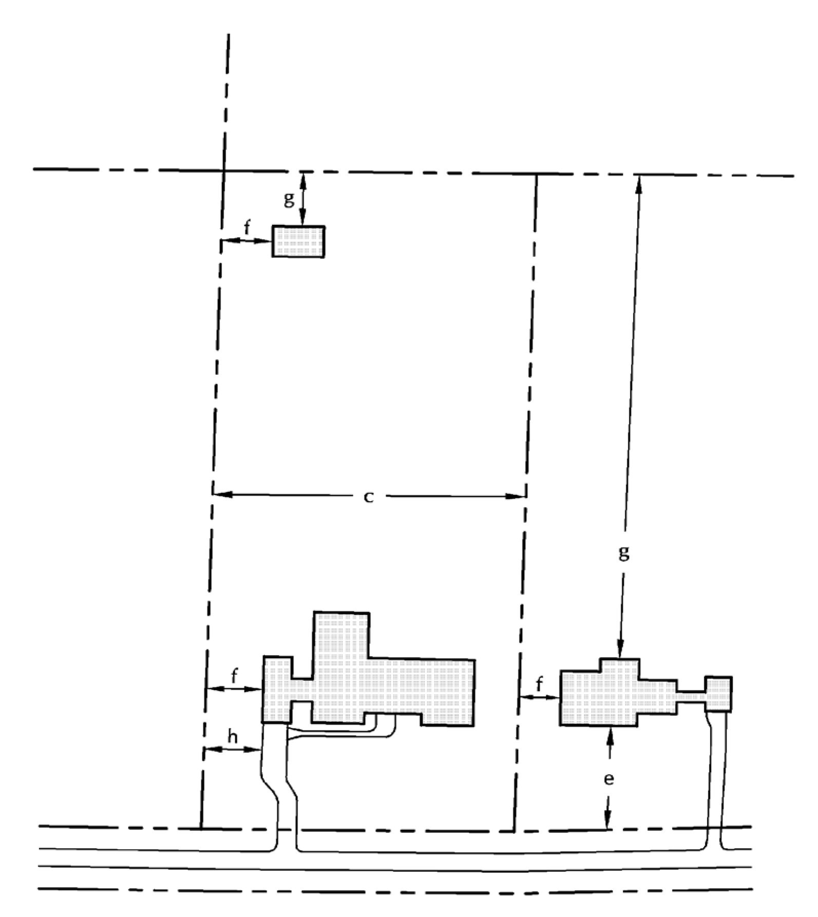
(Ord. No. 31-2015, § 12.3, 10-1-2015; Ord. No. 63-2018, §§ 7, 8, 8-20-2018)
Sec. 111-349. - Village Residential District (R-3).
(a)
Intent. The Village Residential District includes areas designated for single-family residential development with suburban characteristics. The village applies this zoning classification to preserve the village's residential setting with development at a moderate density. R-3 zones serve as a transition area from the larger rural areas to the more developed adjacent municipalities.
(b)
Principal permitted uses.
(1)
Single-family residential dwelling.
(2)
Private outdoor recreation facilities as part of a subdivision development plan.
(3)
Community living arrangement (up to eight persons).
(4)
Family day-care home (up to eight persons).
(c)
Accessory uses.
(1)
Home occupation.
(2)
Not more than three dogs or three cats, or a combination thereof, which are over the age of 12 months.
(3)
Attached or detached private garages.
(4)
Private greenhouses.
(5)
Private boathouses.
(6)
Private residential play equipment.
(7)
Solar energy conversion systems.
(8)
Swimming pools.
(9)
Accessory dwellings. A person may create an accessory dwelling in a single-family detached dwelling for use by family members, provided that:
a.
The accessory dwelling design has a separate and complete housekeeping unit with living, sleeping, cooking and bathroom areas that can be isolated from the remaining original dwelling unit.
b.
Only one accessory dwelling may be created within a single-family detached dwelling unit.
c.
The original single-family detached dwelling unit or the accessory dwelling shall serve as the owner's principal place of residence, except for bona fide temporary absences.
d.
The accessory dwelling structure design appears, to the degree feasible, as that of a single-family detached dwelling unit, and locates any new entrances to the sides and/or rear of the structure. The proposed additions and alterations to the existing structure shall conform to all applicable state, county and village codes.
e.
A deed restriction, in a form acceptable to the village zoning administrator, shall be filed with the Waukesha County Register of Deeds, giving notice that the accessory dwelling unit does not create a duplex, and does not allow any commercial uses.
(10)
Wind energy conversion systems.
(d)
Conditional uses.
(1)
Hobby kennels, by regulated household animal conditional use permit as described in section 111-321(3).
(e)
Bulk regulations (R-3).
(1)
Standard development requirements.
a.
Density factor/area per dwelling unit: 43,560 square feet.
b.
Minimum lot area: 35,000 square feet.
1.
Lands zoned Wetland Conservancy or in a floodplain within a privately owned individual residential lot are excluded for purposes of meeting the minimum area for a lot. This land area can remain as part of a private lot and could be used to meet the average width requirement.
c.
Minimum lot width: 150 feet.
d.
Maximum impervious surface: 10,500 square feet or 15 percent of lot area, whichever is greater, except the following.
1.
Existing impervious surfaces that were lawfully placed when constructed but do not comply with this standard are subject to the standards within section 111-99(b).
2.
Treated impervious surfaces that comply with section 111-99(d) are excluded from this calculation.
e.
Minimum front/street setback.
1.
Arterial street: 40 feet from base setback line.
2.
Local street: 30 feet from base setback line.
3.
Where an existing pattern of development exists less than the requirement listed above, refer to section 111-96(a)(5).
f.
Minimum side yard setback: ten feet.
g.
Minimum rear yard setback: 25 feet.
h.
Minimum wetland setback: 25 feet.
i.
Minimum pavement setback: Ten feet from any side property line, except as follows. If the residence has a side entry garage, the setback from the side property line which the garage doors face shall be ten feet for the first 30 feet from the front property line and thereafter shall be three feet.
j.
Accessory structure minimum front/street setback.
1.
Arterial street: 40 feet from base setback line.
2.
Local street: 30 feet from base setback line.
3.
Where an existing pattern of development exists less than the requirement listed above, refer to section 111-96(a)(5).
k.
Accessory structure minimum side yard setback: ten feet. Where an existing pattern of development exists less than the requirement listed above, refer to section 111-96(b).
l.
Accessory structure minimum rear yard setback: ten feet. Where an existing pattern of development exists less than the requirement listed above, refer to section 111-96(b).
m.
Maximum structure height.
1.
Principal structure: 35 feet.
2.
Accessory structure(s): 15 feet.
n.
Minimum first floor area: 1,200 square feet.
o.
Minimum total floor area: 1,400 square feet.
(2)
Shoreland development requirements. In addition to compliance with the aforementioned standard development requirements, all properties within shoreland areas as defined herein are also subject to the following additional requirements:
a.
The maximum impervious surface within 300 feet of the ordinary high water mark of any navigable waterway shall be as follows:
1.
Impervious surfaces may not exceed 30 percent of the lot or parcel within 300 feet of the ordinary high water mark, in accordance with section 111-99(c).
2.
Existing impervious surfaces that were lawfully placed when constructed but do not comply with the standards in subsection 1 and 2 above, are subject to section 111-99(c)(1)b.
3.
Treated impervious surfaces that comply with section 111-99(d) are excluded from this calculation but still must comply with the minimum shore setback standards in section 111-347(e)(2)b.
b.
Minimum shore setback:
1.
Seventy-five feet from the ordinary high water mark. Where an existing pattern of development exists less than the requirement listed above, refer to section 111-96(a)(9)g.
2.
Fifty feet for a structure that has no sides or has only railings for sides, subject to section 111-96(a)(9)h.
(3)
Conservation development requirements. The aforementioned standard development regulations may be modified in a conservation development as follows:
a.
Density factor/area per dwelling unit: 28,000 square feet.
1.
Minimum total open space: 40 percent of project area.
b.
Minimum lot area: 20,000 square feet.
c.
Minimum lot width: 120 feet
d.
Maximum impervious surface: 10,500 square feet or 15 percent of lot area, whichever is greater
e.
Minimum front/street setback.
1.
Arterial street: 40 feet from base setback line.
2.
Local street: 20 feet from base setback line.
f.
Minimum side yard setback: 20 feet
g.
Minimum rear yard setback: 25 feet.
h.
Minimum pavement setback: Ten feet from any side property line, except as follows. If the residence has a side entry garage, the setback from the side property line which the garage doors face shall be ten feet for the first 30 feet from the front property line and thereafter shall be three feet.
i.
Accessory structure minimum front/street setback.
1.
Arterial street: 40 feet from base setback line.
2.
Local street: 20 feet from base setback line.
j.
Accessory structure minimum side yard setback: ten feet
k.
Accessory structure minimum rear yard setback: Ten feet.
l.
Minimum total open space: 40 percent of project area.
(f)
Signage. As described in article VII of this chapter.
Example: Single-Family Detached House
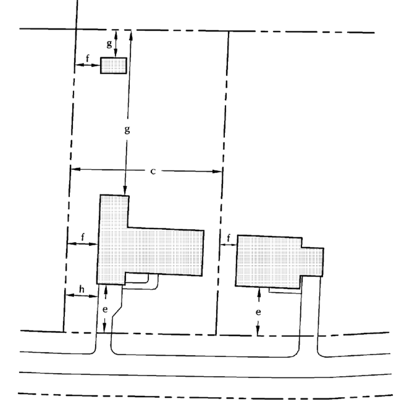
(Ord. No. 31-2015, § 12.4, 10-1-2015; Ord. No. 63-2018, §§ 9, 10, 8-20-2018)
Sec. 111-350. - Cottage Residential District (R-4).
(a)
Intent. The village applies a Cottage Residential District classification to areas to preserve the village's lakefront setting with development at a moderately high density. R-4 zones serve as protection for existing platted lands.
(b)
Principal permitted uses.
(1)
Single-family residential dwelling.
(2)
Private outdoor recreation facilities as part of a subdivision development plan.
(3)
Community living arrangement (up to eight persons).
(4)
Family day-care home (up to eight persons).
(c)
Accessory uses.
(1)
Attached or detached private garages.
(2)
Home occupation.
(3)
Not more than three dogs or three cats, or a combination thereof, which are over the age of 12 months.
(4)
Private greenhouses.
(5)
Private boathouses.
(6)
Private residential play equipment.
(7)
Solar energy conversion systems.
(8)
Swimming pools.
(9)
Accessory dwellings. A person may create an accessory dwelling in a single-family detached dwelling for use by family members, provided that:
a.
The accessory dwelling design has a separate and complete housekeeping unit with living, sleeping, cooking and bathroom areas that can be isolated from the remaining original dwelling unit.
b.
Only one accessory dwelling may be created within a single-family detached dwelling unit.
c.
The original single-family detached dwelling unit or the accessory dwelling shall serve as the owner's principal place of residence, except for bona fide temporary absences.
d.
The accessory dwelling structure design appears, to the degree feasible, as that of a single-family detached dwelling unit, and locates any new entrances to the sides and/or rear of the structure. The proposed additions and alterations to the existing structure shall conform to all applicable state, county and village codes.
e.
A deed restriction, in a form acceptable to the village zoning administrator, shall be filed with the Waukesha County Register of Deeds, giving notice that the accessory dwelling unit does not create a duplex, and does not allow any commercial uses.
(10)
Wind energy conversion systems.
(d)
Conditional uses.
(1)
Hobby kennels, by regulated household animal conditional use permit as described in section 111-321(3).
(e)
Bulk regulations (R-4).
(1)
Standard development requirements.
a.
Density factor/area per dwelling unit: 26,000 square feet.
b.
Minimum lot area: 20,000 square feet.
1.
Lands zoned Wetland Conservancy or in a floodplain within a privately owned individual residential lot are excluded for purposes of meeting the minimum area for a lot. This land area can remain as part of a private lot and could be used to meet the average width requirement.
c.
Minimum lot width: 120 feet.
d.
Maximum impervious surface: 7,000 square feet or 30 percent of lot area, whichever is greater, except the following.
1.
Existing impervious surfaces that were lawfully placed when constructed but do not comply with this standard are subject to the standards within section 111-99(B).
2.
Treated impervious surfaces that comply with section 111-99(D) are excluded from this calculation.
e.
Minimum front/street setback: 25 feet from base setback line. Where an existing pattern of development exists less than the requirement listed above, refer to section 111-96(a)(5).
f.
Minimum side yard setback: ten feet.
g.
Minimum rear yard setback: 25 feet.
h.
Minimum wetland setback: 25 feet.
i.
Minimum pavement setback: five feet.
j.
Accessory structure minimum front/street setback: 25 feet from base setback line. Where an existing pattern of development exists less than the requirement listed above, refer to section 111-96(a)(5).
k.
Accessory structure minimum side yard setback: ten feet. Where an existing pattern of development exists less than the requirement listed above, refer to section 111-96(B).
l.
Accessory structure minimum rear yard setback: ten feet. Where an existing pattern of development exists less than the requirement listed above, refer to section 111-96(B).
m.
Maximum structure height.
1.
Principal structure: 35 feet.
2.
Accessory structure(s): 15 feet.
n.
Minimum first floor area: 1,000 square feet.
o.
Minimum total floor area: 1,400 square feet.
(2)
Shoreland development requirements. In addition to compliance with the aforementioned standard development requirements, all properties within shoreland areas as defined herein are also subject to the following additional requirements:
a.
The maximum impervious surface within 300 feet of the ordinary high water mark of any navigable waterway shall be as follows:
1.
Impervious surfaces may not exceed 30 percent of the lot or parcel within 300 feet of the ordinary high water mark, in accordance with section 111-99(C).
2.
Existing impervious surfaces that were lawfully placed when constructed but do not comply with the standards in subsection 1 above, are subject to section 111-99(C)(1)b.
3.
Treated impervious surfaces that comply with section 111.99(D) are excluded from this calculation but still must comply with the minimum shore setback standards in section 111-347(E)(2)b.
b.
Minimum shore setback:
1.
Seventy-five feet from the ordinary high water mark. Where an existing pattern of development exists less than the requirement listed above, refer to section 111-96(a)(9)g.
2.
Fifty feet for a structure that has no sides or has only railings for sides, subject to section 111-96(a)(9)h.
(3)
Conservation development requirements. The aforementioned standard development regulations may be modified in a conservation development as follows:
a.
Density factor/area per dwelling unit: 20,000 square feet.
b.
Minimum lot area: 15,000 square feet.
c.
Minimum lot width: 100 feet.
d.
Maximum impervious surface: 7,000 square feet or 30 percent of lot area, whichever is greater.
e.
Minimum front/street setback: 25 feet from base setback line.
f.
Minimum side yard setback: ten feet.
g.
Minimum rear yard setback: 25 feet.
h.
Minimum pavement setback: five feet.
i.
Accessory structure minimum front/street setback: 25 feet from base setback line.
j.
Accessory structure minimum side yard setback: ten feet.
k.
Accessory structure minimum rear yard setback: ten feet.
(f)
Signage. As described in article VII of this chapter.
Example: Single-Family Detached House
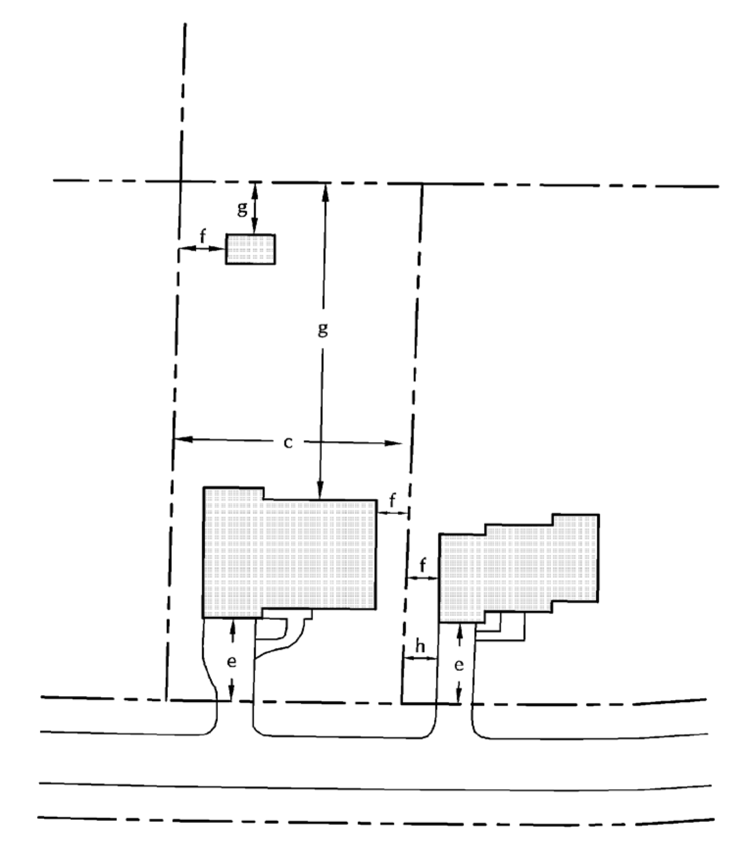
(Ord. No. 31-2015, § 12.5, 10-1-2015; Ord. No. 63-2018, §§ 11, 12, 8-20-2018)
Sec. 111-351. - Duplex Residential District (MF-1).
(a)
Intent. The Duplex Residential District includes areas designated for single- or two-family residential development with suburban characteristics. The village applies this zoning classification to serve as an alternative development type along or within higher-intensity developments, with development at a moderate density.
(b)
Principal permitted uses.
(1)
Single-family residential dwelling.
(2)
Two-family residential structures.
(3)
Private outdoor recreation facilities as part of a subdivision development plan.
(4)
Community living arrangement (up to eight persons).
(5)
Family day-care home (up to eight persons).
(c)
Accessory uses.
(1)
Attached private garages.
(2)
Not more than three dogs or three cats, or a combination thereof, per dwelling unit, which are over the age of 12 months.
(3)
Home occupation.
(4)
Off-street parking and loading areas.
(5)
Private greenhouses.
(6)
Private residential play equipment.
(7)
Solar energy conversion systems.
(8)
Swimming pools.
(9)
Accessory dwellings. A person may create an accessory dwelling in a single-family detached dwelling for use by family members, provided that:
a.
The accessory dwelling design has a separate and complete housekeeping unit with living, sleeping, cooking and bathroom areas that can be isolated from the remaining original dwelling unit.
b.
Only one accessory dwelling may be created within a single-family detached dwelling unit.
c.
The original single-family detached dwelling unit or the accessory dwelling shall serve as the owner's principal place of residence, except for bona fide temporary absences.
d.
The accessory dwelling structure design appears, to the degree feasible, as that of a single-family detached dwelling unit, and locates any new entrances to the sides and/or rear of the structure. The proposed additions and alterations to the existing structure shall conform to all applicable state, county and village codes.
e.
A deed restriction, in a form acceptable to the village zoning administrator, shall be filed with the Waukesha County Register of Deeds, giving notice that the accessory dwelling unit does not create a duplex, and does not allow any commercial uses.
(10)
Wind energy conversion systems.
(11)
Detached private garages.
(d)
Conditional uses.
(e)
Bulk regulations (MF-1).
(1)
Standard development requirements.
a.
Area per structure: 35,000 square feet.
b.
Minimum lot area: 35,000 square feet.
1.
Lands zoned Wetland Conservancy or in a floodplain within a privately owned lot are excluded for purposes of meeting the minimum area for a lot. This land area can remain as part of a private lot and could be used to meet the average width requirement.
c.
Minimum lot width: 150 feet.
d.
Maximum impervious surface: 10,500 square feet, except the following.
1.
Existing impervious surfaces that were lawfully placed when constructed but do not comply with this standard are subject to the standards within section 111-99(B).
2.
Treated impervious surfaces that comply with section 111.99(D) are excluded from this calculation.
e.
Minimum front/street setback.
1.
Arterial street: 40 feet from base setback line.
2.
Local street: 30 feet from base setback line.
f.
Minimum side yard setback: ten feet.
g.
Minimum rear yard setback: 25 feet.
h.
Minimum wetland setback: 25 feet.
i
Minimum pavement setback: ten feet.
j.
Accessory structure minimum front/street setback.
1.
Arterial street: 40 feet from base setback line.
2.
Local street: 30 feet from base setback line.
k.
Accessory structure minimum side yard setback: ten feet.
l.
Accessory structure minimum rear yard setback: ten feet.
m.
Maximum structure height.
1.
Principal structure: 35 feet.
2.
Accessory structure(s): 15 feet.
n.
Minimum first floor area per unit: 1,200 square feet.
o.
Minimum total floor area per unit: 1,400 square feet.
(2)
Shoreland development requirements. In addition to compliance with the aforementioned standard development regulations, all properties within shoreland areas as defined herein are also subject to the following additional requirements:
a.
The maximum impervious surface within 300 feet of the ordinary high water mark of any navigable waterway shall be as follows:
1.
Impervious surfaces may not exceed 30 percent of the lot or parcel within 300 feet of the ordinary high water mark, in accordance with section 111-99(c).
2.
Existing impervious surfaces that were lawfully placed when constructed but do not comply with the standards in subsection 1 above, are subject to section 111-99(c)(1)b.
3.
Treated impervious surfaces that comply with section 111-99(d) are excluded from this calculation but still must comply with the minimum shore setback standards in section 111-347(E)(2)b.
b.
Minimum shore setback:
1.
Seventy-five feet from the ordinary high water mark. Where an existing pattern of development exists less than the requirement listed above, refer to section 111-96(a)(9)g.
2.
Fifty feet for a structure that has no sides or has only railings for sides, subject to section 111-96(a)(9)h.
(3)
Conservation development requirements. The aforementioned standard development regulations may be modified in a conservation development as follows:
a.
Area per structure: 28,000 square feet.
1.
Minimum total open space: 40 percent of project area.
b.
Minimum lot area: 20,000 square feet.
c.
Minimum lot width: 100 feet.
d.
Maximum impervious surface: 10,500 square feet.
e.
Minimum front/street setback.
1.
Arterial street: 40 feet from base setback line.
2.
Local street: 20 feet from base setback line.
f.
Minimum side yard setback: ten feet.
g.
Minimum rear yard setback: 25 feet.
h.
Minimum pavement setback: ten feet.
i.
Accessory structure minimum front/street setback.
1.
Arterial street: 40 feet from base setback line.
2.
Local street: 20 feet from base setback line.
j.
Accessory structure minimum side yard setback: ten feet.
k.
Accessory structure minimum rear yard setback: ten feet.
(f)
Signage. As described in article VII of this chapter.
Example: Two-Family Attached Dwelling
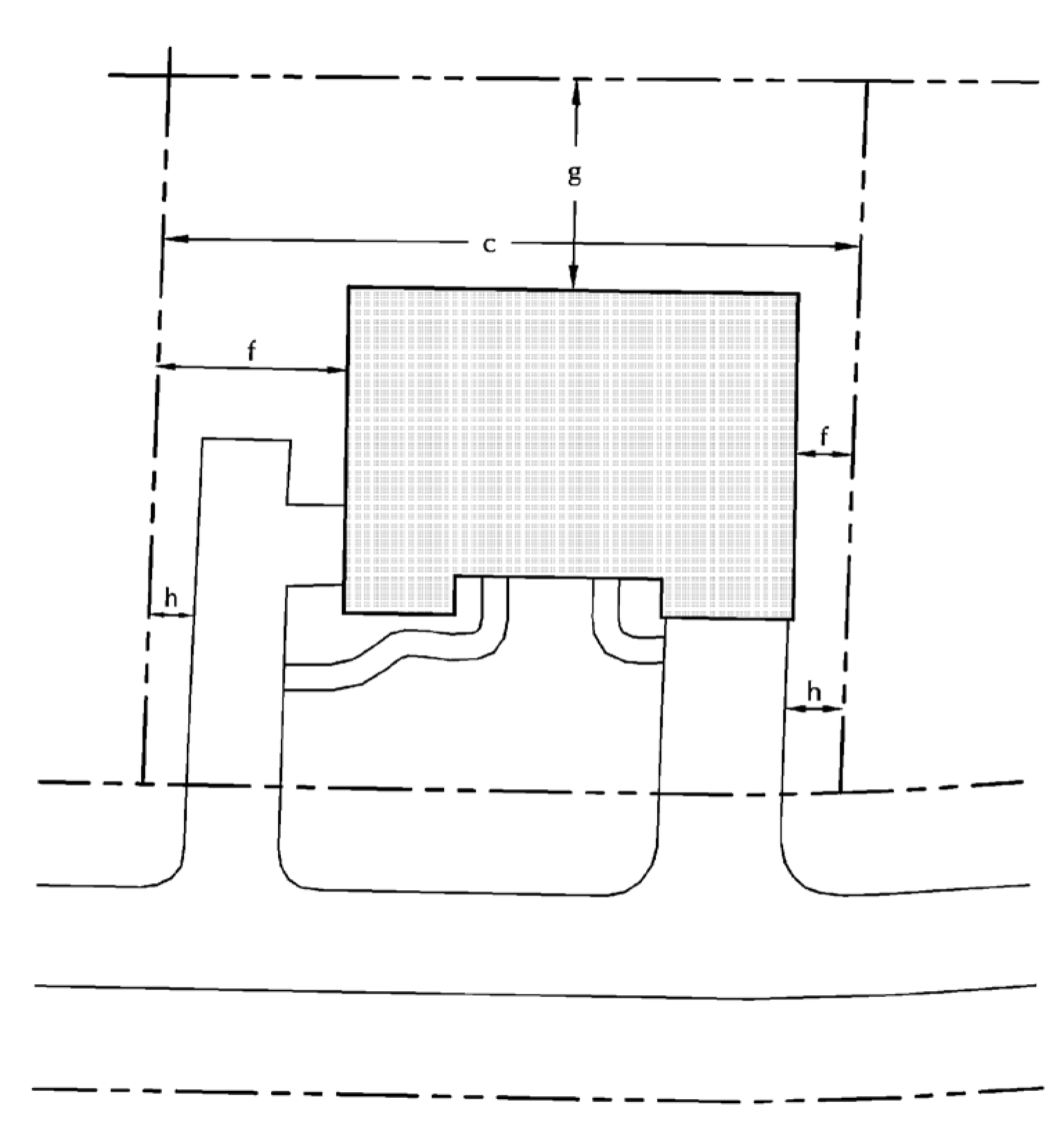
(Ord. No. 31-2015, § 12.6, 10-1-2015; Ord. No. 63-2018, §§ 13, 14, 8-20-2018)
Sec. 111-352. - Multifamily Residential District (MF-2).
(a)
Intent. The Multifamily Residential District includes areas designated for multiple-family residential development with urban characteristics of off-street parking areas, higher building facades, smaller setback requirements and shared yards. The village applies this zoning classification to serve for all multifamily uses except duplexes, and provides the village's highest density of ten dwelling units per net acre.
(b)
Principal permitted uses.
(1)
Two-family residential structures.
(2)
Multiple-family residential structures.
(c)
Accessory uses.
(1)
Attached private garages.
(2)
Not more than three dogs or three cats, or a combination thereof, per dwelling unit, which are over the age of 12 months.
(3)
Home occupation.
(4)
Off-street parking and loading areas.
(5)
Private greenhouses.
(6)
Private outdoor play equipment.
(7)
Solar energy conversion systems.
(8)
Swimming pools.
(9)
Accessory dwellings. A person may create an accessory dwelling in a single-family detached dwelling for use by family members, provided that:
a.
The accessory dwelling design has a separate and complete housekeeping unit with living, sleeping, cooking and bathroom areas that can be isolated from the remaining original dwelling unit.
b.
Only one accessory dwelling may be created within a single-family detached dwelling unit.
c.
The original single-family detached dwelling unit or the accessory dwelling shall serve as the owner's principal place of residence, except for bona fide temporary absences.
d.
The accessory dwelling structure design appears, to the degree feasible, as that of a single-family detached dwelling unit, and locates any new entrances to the sides and/or rear of the structure. The proposed additions and alterations to the existing structure shall conform to all applicable state, county and village codes.
e.
A deed restriction, in a form acceptable to the village zoning administrator, shall be filed with the Waukesha County Register of Deeds, giving notice that the accessory dwelling unit does not create a duplex, and does not allow any commercial uses.
(10)
Detached private garages.
(d)
Conditional uses.
(1)
Reserved.
(e)
Bulk regulations (MF-2).
(1)
Standard development requirements.
a.
Minimum lot area: 87,120 square feet (two acres).
1.
Lands zoned Wetland Conservancy or in a floodplain within a privately owned lot are excluded for purposes of meeting the minimum area for a lot. This land area can remain as part of a private lot and could be used to meet the average width requirement.
b.
Density factor/area per dwelling unit: 4,356 square feet.
c.
Minimum lot width: 200 feet.
d.
Maximum impervious surface: 40 percent of lot area, except the following.
1.
Existing impervious surfaces that were lawfully placed when constructed but do not comply with this standard are subject to the standards within section 111-99(b).
2.
Treated impervious surfaces that comply with section 111-99(d) are excluded from this calculation.
e.
Minimum front/street setback.
1.
Arterial street: 50 feet from base setback line.
2.
Local street: 35 feet from base setback line.
f.
Minimum side yard setback: 30 feet.
g.
Minimum rear yard setback: 25 feet.
h.
Minimum wetland setback: 25 feet.
i.
Minimum pavement setback: 15 feet. (The plan commission may allow shared driveways to encroach on the fifteen-foot setback.)
j.
Maximum structure height.
1.
Principal structure: 35 feet.
2.
Accessory structure(s): 25 feet.
k.
Minimum floor area per dwelling unit.
1.
Efficiency apartment: 400 square feet.
2.
One-bedroom: 650 square feet.
3.
Two-bedroom: 800 square feet.
4.
Three-bedroom: 1,000 square feet.
(2)
Shoreland development requirements. In addition to compliance with the aforementioned standard development requirements, all properties within shoreland areas as defined herein are also subject to the following additional requirements:
a.
The maximum impervious surface within 300 feet of the ordinary high water mark of any navigable waterway shall be as follows:
1.
Impervious surfaces may not exceed 30 percent of the lot or parcel within 300 feet of the ordinary high water mark, in accordance with section 111-99(c).
2.
Existing impervious surfaces that were lawfully placed when constructed but do not comply with the standards in subsections (1) and (2) above, are subject to section 111-99(c)(1)b.
3.
Treated impervious surfaces that comply with section 111-99(d) are excluded from this calculation but must still comply with the minimum shore setback standards in section 111-347(E)(2)b.
b.
Minimum shore setback:
1.
Seventy-five feet from the ordinary high water mark. Where an existing pattern of development exists less than the requirement listed above, refer to section 111-96(a)(9)g.
2.
Fifty feet for a structure that has no sides or has only railings for sides, subject to section 111-96(a)(9)h.
(3)
Conservation development requirements. The aforementioned standard development regulations may be modified in a conservation development as follows:
a.
Minimum lot area: 43,560 square feet (one acre).
b.
Density factor/area per dwelling unit: 4,356 square feet.
c.
Minimum lot width: 180 feet.
d.
Maximum impervious surface: 50 percent of lot area.
e.
Minimum front/street setback.
1.
Arterial street: 50 feet from base setback line.
2.
Local street: 20 feet from base setback line.
f.
Minimum side yard setback: 20 feet.
g.
Minimum rear yard setback: 25 feet.
h.
Minimum pavement setback: 15 feet. (The plan commission may allow shared driveways to encroach on the fifteen-foot setback.)
1.
Minimum total open space: 75 percent of project area.
(f)
Signage. As described in article VII of this chapter.
(g)
Erosion control. As described in the Village of Summit Erosion Control Ordinance when applicable.
(h)
Plans and specifications to be submitted to the plan commission in accordance with Article X of this Chapter.
(1)
To encourage an environment that is compatible with the rural residential and open space character of the village, and that will maintain a campus-like setting, building permits for permitted uses in the MF-2 District shall not be issued without review and approval of the plan commission.
(2)
This review and approval shall be concerned with general layout, building plans, ingress and egress, loading and unloading, landscaping and open space use. The process used to review development in the MF-2 District is set forth in article X of this chapter.
Example: Multifamily Building
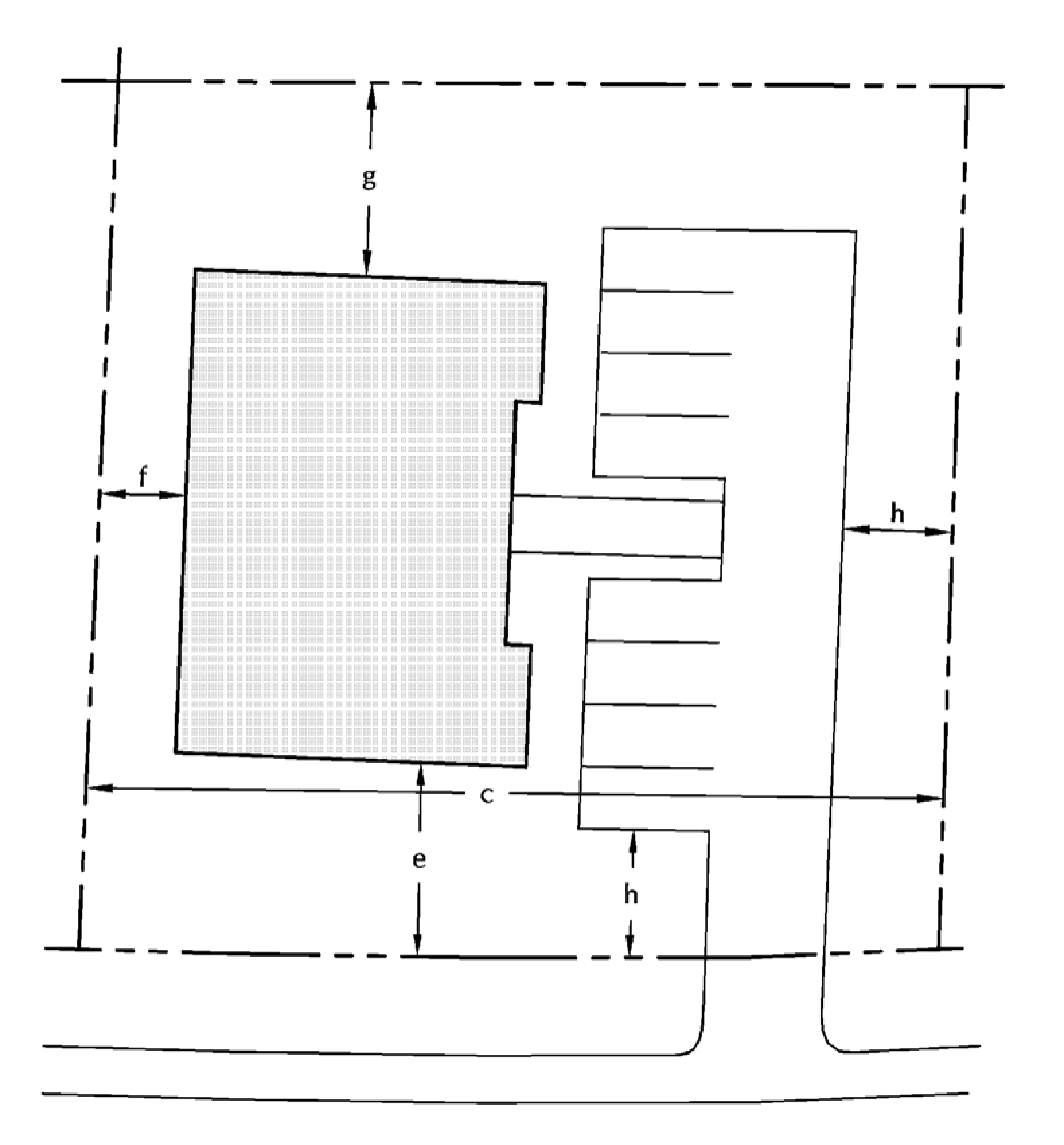
(Ord. No. 31-2015, § 12.7, 10-1-2015; Ord. No. 63-2018, §§ 15, 16, 8-20-2018)
Sec. 111-353. - Reserved.
Editor's note— Ord. No. 63-2018, § 17, adopted Aug. 20, 2018, repealed § 111-353, which pertained to Mixed Use District (MU) and derived from Ord. No. 31-2015, § 12.8, 10-1-2015.
Sec. 111-354. - Neighborhood Commercial District (NC).
(a)
Intent. The Neighborhood Commercial District includes areas available for limited retail uses and administrative/office uses. The village will allow development in this classification only upon connection to public sewer systems.
(b)
Principal permitted uses.
(1)
Grocery store.
(2)
Coffee shop.
(3)
Book/stationary store.
(4)
Restaurant.
(5)
Art studio.
(6)
Office.
(7)
Florist.
(8)
Sporting goods sales.
(9)
Bakery (retail only).
(10)
Private lodges and clubs.
(11)
Public utility installations.
(12)
Day-care facility.
(13)
Bank or financial institution.
(14)
Catering establishment for off-site food service.
(c)
Accessory uses.
(1)
Off-street parking and loading areas.
(2)
Roof-mounted satellite fixtures.
(3)
Automated teller machine.
(4)
Single-family and multifamily residential, subject to the following conditions:
a.
The residential use must be incidental to a commercial use. Prior to the issuance of an occupancy permit for a newly constructed residential dwelling unit, village staff shall verify that there is an active and operational commercial use within the principal structure on the property.
b.
The density of dwelling units shall not exceed four units per acre. Detached single-family residential is limited to one unit per lot. Multifamily residential shall be part of the principal structure that accommodates a commercial use. Multifamily residential is not permitted as or within an accessory structure.
c.
The minimum floor area per dwelling unit shall comply with the following:
1.
Efficiency apartment: 400 square feet.
2.
One-bedroom: 650 square feet.
3.
Two-bedroom: 800 square feet.
4.
Three-bedroom or greater: 1,000 square feet.
d.
There shall be at least one parking stall per residential dwelling unit.
e.
As part of a site, building, and operational plan of approval, the plan commission may be more restrictive than subsections a through d above and any other provisions of the village code as to the location, number, size, and design of the dwelling units to ensure the use is compatible with and complementary to the commercial uses on the property and surrounding neighborhood. The housing type, such as single-family and, or, multifamily shall remain consistent with the housing type of the surrounding neighborhood.
(d)
Conditional uses.
(e)
Bulk regulations.
(1)
Minimum lot area: 40,000 square feet.
(2)
Minimum lot width: 200 feet.
(3)
Maximum structure coverage.
a.
Office uses: 30 percent of lot area.
b.
Commercial/retail uses: 45 percent of lot area.
(4)
Maximum impervious coverage.
a.
Office uses: 70 percent of lot area.
b.
Commercial/retail uses: 75 percent of lot area.
(5)
Minimum front/street setback: 50 feet from base setback line.
(6)
Minimum side yard setback: 25 feet.
(7)
Minimum rear yard setback: 25 feet.
(8)
Minimum wetland setback: 25 feet.
(9)
Minimum pavement setback: 20 feet.
(10)
Maximum structure height.
a.
Principal structure: 30 feet.
b.
Accessory structure(s): 15 feet.
(11)
Shoreland development requirements. In addition to compliance with the aforementioned regulations, all properties within shoreland areas as defined herein are also subject to the following additional requirements:
a.
Minimum shore setback:
1.
Seventy-five feet from the ordinary high water mark. Where an existing pattern of development exists less than the requirement listed above, refer to section 111-96(A)(9)(g).
2.
Fifty feet for a structure that has no sides or has only railings for sides, subject to section 111-96(A)(9)(h).
(f)
Signage. As described in article VII of this chapter.
(g)
Erosion control. As described in the Village of Summit Erosion Control Ordinance when applicable.
(h)
Plans and specifications to be submitted to the plan commission in accordance with article X of this chapter.
(1)
To encourage a commercial environment that is compatible with the rural residential and open space character of the village, and that will maintain a campus-like setting, building permits for permitted uses in the NC District shall not be issued without review and approval of the plan commission.
(2)
This review and approval shall be concerned with general layout, building plans, ingress and egress, loading and unloading, landscaping and open space use. The process used to review a development in the NC District is set forth in article X of this chapter.
(Ord. No. 31-2015, § 12.9, 10-1-2015; Ord. No. 63-2018, §§ 18, 19, 8-20-2018; Ord. No. 119-2023, § 2, 10-12-2023; Ord. No. 135-2024, § 1, 12-12-2024)
Sec. 111-355. - Business Park District (BP).
(a)
Intent. The Business Park District includes areas designated for light to medium intensity business uses such as corporate office facilities, light manufacturing and warehousing with no outdoor storage permitted. The village will allow development in this classification only upon connection to public sewer systems. If municipal water is available within 1,000 linear feet, then this must also be extended and included in the development.
(b)
Principal permitted uses.
(1)
Offices.
(2)
Medical office or clinic.
(3)
Dental office or clinic.
(4)
Bank or financial institution.
(5)
Assembly operations.
(6)
Personal and professional services.
(7)
Light manufacturing facilities.
(8)
Indoor storage and warehousing facilities.
(9)
Conference center.
(10)
Day-care facility.
(11)
Health clubs.
(12)
Hotel.
(13)
Indoor recreation facilities.
(14)
Movie theater.
(15)
Outdoor storage/retailing (i.e., garden center).
(16)
Public and quasi-public utility substations, radio and television transmitting and receiving towers, microwave relay stations, or water towers.
(17)
Restaurant.
(18)
Public administrative offices and public service buildings, including fire and police stations.
(c)
Accessory uses.
(1)
Private outdoor recreational facilities.
(2)
Off-street parking and loading areas.
(3)
Automated teller machine.
(d)
Conditional uses.
(1)
Reserved.
(e)
Bulk regulations (BP).
(1)
Minimum lot area: 80,000 square feet.
(2)
Minimum lot width: 200 feet.
(3)
Maximum structure coverage.
a.
Office uses: 30 percent of lot area.
b.
Light industrial uses: 45 percent of lot area.
(4)
Maximum impervious coverage.
a.
Office uses: 70 percent of lot area.
b.
Light industrial uses: 75 percent of lot area.
(5)
Minimum front/street setback: 50 feet from base setback line.
(6)
Minimum side yard setback: 25 feet.
(7)
Minimum rear yard setback: 25 feet.
(8)
Minimum wetland setback: 25 feet.
(9)
Minimum pavement setback: 20 feet.
(10)
Maximum structure height.
a.
Principal structure: 50 feet.
b.
Accessory structure(s): 15 feet.
(11)
Shoreland development requirements. In addition to compliance with the aforementioned standard development requirements, all properties within shoreland areas as defined herein are also subject to the following additional requirements:
a.
Minimum shore setback:
1.
Seventy-five feet from the ordinary high water mark. Where an existing pattern of development exists less than the requirement listed above, refer to section 111-96(A)(9)(g).
2.
Fifty feet for a structure that has no sides or has only railings for sides, subject to section 111-96(A)(9)(h).
(f)
Signage. As described in article VII of this chapter.
(g)
Erosion control. As described in the Village of Summit Erosion Control Ordinance when applicable.
(h)
Plans and specifications to be submitted to the plan commission in accordance with article X of this chapter.
(1)
To encourage a business park environment that is compatible with the rural residential and open space character of the village, and that will maintain a campus-like setting, building permits for permitted uses in the BP District shall not be issued without review and approval of the plan commission.
(2)
This review and approval shall be concerned with general layout, building plans, ingress and egress, loading and unloading, landscaping and open space use. The process used to review a development in the BP District is set forth in article X of this chapter.
(Ord. No. 31-2015, § 12.10, 10-1-2015; Ord. No. 63-2018, §§ 20, 21, 8-20-2018; Ord. No. 112-2022, § 2, 10-13-2022; Ord. No. 119-2023, § 3, 10-12-2023)
Sec. 111-356. - Institutional District (IN).
(a)
Intent. The Institutional Use District includes areas of governmental, educational, religious, or medical property uses. Other quasi-public uses and major public utility facilities are included in this category. The village applies the institutional classification to address the particular characteristics of the Village of Summit's many institutional facilities. This district does not distinguish private or public agency projects or facilities.
(b)
Principal permitted uses.
(1)
Public administrative offices and public service buildings, including fire and police stations.
(2)
Cemeteries and mausoleums.
(3)
Churches and synagogues.
(4)
Medical clinics.
(5)
Libraries, museums, and art galleries.
(6)
Public, private commercial and noncommercial outdoor recreational facilities.
(7)
Day schools, if the following conditions are met:
a.
The parcel shall include at least eight acres of land under one ownership as a single legal lot of record.
b.
The parcel shall adjoin directly upon a County Trunk Highway or State Trunk Highway.
c.
All structures and outdoor recreational facilities shall be located at least 100 feet from a contiguous residentially-zoned lot line.
d.
A day school may serve students in grades K through 12 th grade.
e.
A day school may be operated by the property owner or leased to a public or private entity. Any outdoor athletic fields, playgrounds and instruction areas shall be identified on the site plan and plan of operations, and they shall be used only by the day school or as authorized specifically by the plan commission as part of a site plan and plan of operation approval.
f.
A traffic impact analysis shall be submitted for review and approval by the plan commission, and shall include provisions for traffic control during the beginning and end of the school day, such that stacking of vehicles will occur on private property and not on public roads, with off-street parking provisions for students between 9 th and 12 th grade.
g.
Indoor and outdoor operations, including exterior lighting, shall be limited to Monday through Thursday and Saturday from 7:00 a.m. to 9:00 p.m. and Friday from 7:00 a.m. to 10:00 p.m. No operations are permitted on Sundays unless authorized specifically by the plan commission as part of a site plan and plan of operation approval.
h.
A public safety plan dealing with emergency, police, and fire shall be submitted for review and approval by the Plan Commission.
(c)
Accessory uses.
(1)
Off-street parking and loading areas.
(2)
Service buildings and facilities normally accessory to the permitted use.
(d)
Conditional uses.
(1)
Reserved.
(e)
Bulk regulations (IN).
(1)
Minimum lot area: 65,000 square feet.
(2)
Minimum lot width: 200 feet.
(3)
Maximum structure coverage: 30 percent of lot area.
(4)
Maximum impervious coverage: 50 percent of lot area.
(5)
Minimum front/street setback: 50 feet from base setback line.
(6)
Minimum side yard setback: 25 feet.
(7)
Minimum rear yard setback: 25 feet.
(8)
Minimum wetland setback: 25 feet.
(9)
Minimum pavement setback: 20 feet.
(10)
Maximum structure height.
a.
Principal structure: 50 feet / 35 feet when located within 75 feet of the ordinary high water mark.
b.
Accessory structure(s): 15 feet.
(11)
Shoreland development requirements. In addition to compliance with the aforementioned regulations, all properties within shoreland areas as defined herein are also subject to the following additional requirements:
a.
Minimum shore setback:
1.
Seventy-five feet from the ordinary high water mark. Where an existing pattern of development exists less than the requirement listed above, refer to section 111-96(a)(9)g.
2.
Fifty feet for a structure that has no sides or has only railings for sides, subject to section 111-96(a)(9)h.
(f)
Signage. As described in article VII of this chapter.
(g)
Erosion control. As described in the Village of Summit Erosion Control Ordinance when applicable.
(h)
Plans and specifications to be submitted to the plan commission in accordance with article X of this chapter.
(1)
To encourage an institutional environment that is compatible with the rural residential and open space character of the village, and that will maintain a campus-like setting, building permits for permitted uses in the institutional district shall not be issued without review and approval of the plan commission.
(2)
This review and approval shall be concerned with general layout, building plans, ingress and egress, loading and unloading, landscaping and open space use. The process used to review a development in the institutional district is set forth in article X of this chapter.
(Ord. No. 31-2015, § 12.11, 10-1-2015; Ord. No. 63-2018, §§ 22, 23, 8-20-2018; Ord. No. 96-2021, § 1, 5-13-2021; Ord. No. 112-2022, § 3, 10-13-2022; Ord. No. 119-2023, § 4, 10-12-2023; Ord. No. 134-2024, §§ 2, 3, 8-8-2024
Sec. 111-357. - Agricultural District (A-1).
(a)
Intent. The village applies the A-1 Agricultural District classification to areas in order to conserve land for ongoing agricultural purposes, to provide for the continuation of general farming and related uses in those areas of the village, and to protect agricultural lands from extensive development pressures. The village also uses the A-1 District to provide protection for agricultural activities and to provide a very low density residential area for those who want to live in a rural environment and who retain enough land with their residence to ensure maintenance of the rural environment.
(b)
Principal permitted uses.
(1)
Apiculture (beekeeping).
(2)
Dairy farming.
(3)
Forestry.
(4)
Grazing or pasturing of agricultural animals for the commercial purpose of food or fiber production.
(5)
Orchards.
(6)
Plant nurseries.
(7)
Raising of field crops.
(8)
Raising of livestock, except commercial feed lots and fur farms, for the commercial purposes of food or fiber production.
(9)
Single-family residential dwelling.
(10)
Sod farming.
(11)
Animal hospitals.
(12)
Commercial stable facility.
(13)
Sales of nursery products raised or transported onto the site.
(c)
Accessory uses.
(1)
Barns, sheds and similar structures customarily accessory to a permitted agricultural use.
(2)
Guest houses provided such structure shall not be rented, leased or used continually for permanent habitation.
(3)
Quarters for household or farm employees, provided that these quarters shall be occupied only by individuals employed full-time on the premises and their families.
(4)
Conversion or construction of single-family residence to accommodate an additional dwelling unit as described in section 111-321(1).
(5)
Not more than three dogs or three cats, or a combination thereof, which are over the age of 12 months.
(6)
Home occupation.
(7)
One nonilluminated sign not larger than six square feet in area for use in advertising of products produced on the property.
(8)
One roadside stand for the sale of selected farm products that are produced on the premises and not exceeding 150 square feet in floor area, the location of which shall be approved by the plan commission.
(9)
Attached or detached private garages.
(10)
Private greenhouses.
(11)
Private boathouses.
(12)
Private residential outdoor recreational facilities.
(13)
Private residential stables.
(14)
Any other use normally accessory to a permitted use.
(d)
Conditional uses.
(1)
Hobby kennels, by regulated household animal conditional use permit as described in section 111-321(3).
(2)
Quarrying
(e)
Bulk regulations (A-1).
(1)
Density factor/area per dwelling unit: 1,500,000 square feet.
(2)
Minimum lot area: 130,000 square feet.
(3)
Minimum lot width: 300 feet.
(4)
Maximum structure coverage: Three percent of lot area.
(5)
Maximum impervious coverage: Five percent of lot area.
(6)
Minimum front/street setback: 50 feet from base setback line.
(7)
Minimum side yard setback: 50 feet.
(8)
Minimum rear yard setback: 50 feet.
(9)
Minimum pavement setback: 15 feet.
(10)
Maximum structure height.
a.
Principal structure: 35 feet.
b.
Accessory structure(s): 45 feet / 35 feet when located within 75 feet of the ordinary high water mark.
(11)
Minimum residential first floor area: 1,200 square feet.
(12)
Minimum total residential floor area: 1,800 square feet.
(13)
Shoreland development requirements. In addition to compliance with the aforementioned regulations, all properties within shoreland areas as defined herein are also subject to the following additional requirements:
a.
The maximum impervious surface within 300 feet of the ordinary high water mark of any navigable waterway shall be as follows:
1.
Impervious surfaces may not exceed 30 percent of the lot or parcel within 300 feet of the ordinary high water mark, in accordance with section 111-99(c).
2.
Existing impervious surfaces that were lawfully placed when constructed but do not comply with the standards in subsection 1 above, are subject to section 111-99(c)(1)b.
3.
Treated impervious surfaces that comply with section 111-99(d) are excluded from this calculation but still must comply with the minimum shore setback standards in section 111-347(E)(2)b.
b.
Minimum shore setback:
1.
Seventy-five feet from the ordinary high water mark. Where an existing pattern of development exists less than the requirement listed above, refer to section 111-96(a)(9)g.
2.
Fifty feet for a structure that has no sides or has only railings for sides, subject to section 111-96(a)(9)h.
(f)
Signage. As described in article VII of this chapter.
(Ord. No. 31-2015, § 12.12, 10-1-2015; Ord. No. 63-2018, §§ 24, 25, 8-20-2018; Ord. No. 112-2022, §§ 4—7, 10-13-2022)
Sec. 111-358. - Agricultural District (A-2).
(a)
Intent. The village applies the A-2 Agricultural District classification to areas in order to provide for, maintain, preserve and enhance lands historically used for agricultural production but which do not meet the size requirements of the A-1 Agricultural District and which are generally best suited for smaller farm units, including truck farming, horse farming, orchards and other similar agricultural-related farming activities.
(b)
Principal permitted uses.
(1)
Apiculture (beekeeping).
(2)
Dairy farming.
(3)
Forestry.
(4)
Grazing or pasturing of agricultural animals for the commercial purpose of food or fiber production.
(5)
Home occupation.
(6)
Orchards.
(7)
Plant nurseries.
(8)
Raising of field crops.
(9)
Raising of livestock, except commercial feed lots and fur farms, for the commercial purposes of food or fiber production.
(10)
Single-family residential dwelling.
(11)
Animal hospitals.
(12)
Commercial stable facility.
(13)
Sales of nursery products raised or transported onto the site.
(c)
Accessory uses.
(1)
Barns, sheds and similar structures customarily accessory to a permitted agricultural use.
(2)
Guest houses, provided such structure shall not be rented, leased or used continually for permanent habitation.
(3)
Quarters for household or farm employees, provided that these quarters shall be occupied only by individuals employed full time on the premises and their families.
(4)
Conversion or construction of single-family residence to accommodate an additional dwelling unit as described in section 111-321(1).
(5)
Not more than three dogs or three cats, or a combination thereof, which are over the age of 12 months.
(6)
Home occupation.
(7)
One nonilluminated sign not larger than six square feet in area for use in advertising of products produced on the property.
(8)
One roadside stand for the sale of selected farm products that are produced on the premises and not exceeding 150 square feet in floor area, the location of which shall be approved by the plan commission.
(9)
Attached or detached private garages.
(10)
Private greenhouses.
(11)
Private boathouses.
(12)
Private residential outdoor recreational facilities.
(13)
Private residential stable.
(14)
Any other use normally accessory to a permitted use.
(d)
Conditional uses.
(1)
Hobby kennels, by regulated household animal conditional use permit as described in section 111-321(3).
(2)
Commercial vehicle parking.
(e)
Bulk regulations (A-2).
(1)
Density factor/area per dwelling unit: 435,000 square feet.
(2)
Minimum lot area: 130,000 square feet.
(3)
Minimum lot width: 300 feet.
(4)
Maximum structure coverage: Three percent of lot area.
(5)
Maximum impervious coverage: Five percent of lot area.
(6)
Minimum front/street setback: 50 feet from base setback line.
(7)
Minimum side yard setback: 50 feet.
(8)
Minimum rear yard setback: 50 feet.
(9)
Minimum pavement setback: 15 feet.
(10)
Maximum structure height.
a.
Principal structure: 35 feet.
b.
Accessory structure(s): 45 feet / 35 feet when located within 75 feet of the ordinary high water mark.
(11)
Minimum residential first floor area: 1,200 square feet.
(12)
Minimum total residential floor area: 1,800 square feet.
(13)
Shoreland development requirements. In addition to compliance with the aforementioned regulations, all properties within shoreland areas as defined herein are also subject to the following additional requirements:
a.
The maximum impervious surface within 300 feet of the ordinary high water mark of any navigable waterway shall be as follows:
1.
Impervious surfaces may not exceed 30 percent of the lot or parcel within 300 feet of the ordinary high water mark, in accordance with section 111-99(c).
2.
Existing impervious surfaces that were lawfully placed when constructed but do not comply with the standards in subsections (1) and (2) above, are subject to section 111-99(C)(1)b.
3.
Treated impervious surfaces that comply with section 111-99(d) are excluded from this calculation but still must comply with the minimum shore setback standards in section 111-347(E)(2)b.
b.
Minimum shore setback:
1.
Seventy-five feet from the ordinary high water mark. Where an existing pattern of development exists less than the requirement listed above, refer to section 111-96(a)(9)g.
2.
Fifty feet for a structure that has no sides or has only railings for sides, subject to section 111-96(a)(9)h.
(f)
Signage. As described in article VII of this chapter.
(Ord. No. 31-2015, § 12.13, 10-1-2015; Ord. No. 63-2018, §§ 26, 27, 8-20-2018; Ord. No. 112-2022, §§ 8—12, 10-13-2022; Ord. No. 131-2024, § 3, 3-14-2024)
Sec. 111-359. - Planned Development Overlay District (PDO).
(a)
Intent.
(1)
Planned Development Overlay District (PDO) regulations are intended to permit greater flexibility and, consequently, more creative and imaginative design for the development of a site than is possible under conventional zoning regulations. It is further intended to promote more economical and efficient use of the land while providing a harmonious variety of housing choices, a higher level of amenities, and preservation of the natural qualities of open spaces.
(2)
The planned development procedure requires a high degree of cooperation between the developer and the village. Because of this coordination, property within a proposed planned development overlay district must be single ownership or control at the time of application for rezoning. The procedure described herein is designed to give the developer general development plan approval before completing all the detailed design work while providing the village with assurances that the project will retain the character envisioned at the time of approval.
(b)
Criteria for approval. The approval of a planned development proposal shall be based upon determination as to compliance with the criteria listed below.
(1)
The proposed development is consistent with the spirit and intent of these regulations and with the development goals set forth in section 111-129(3), has been prepared with competent professional advice and guidance, and produces significant benefits to the village in terms of improved environmental design and in contributing to the aforesaid development goals to justify the application of the planned development concept.
(2)
The site development plan reflects sensitive consideration of the physical nature of the site with particular concern for conservation of natural features, preservation of open space, and careful shaping of terrain to minimize scarring, insure proper drainage and preservation of natural terrain wherever appropriate.
(3)
The general character and intensity of use of the development produces an attractive environment appropriate to the uses proposed and which is compatible with existing development in the surrounding area and with the adopted village plan and village policies.
(4)
The development can be provided with appropriate municipal services and would not conflict with or cause overload on such facilities as schools, highway, police, fire or utility services.
(5)
Proposed design standards provide adequately for practical functioning and maintenance, based on actual functional need, in terms of circulation, parking, emergency services, delivery services, and snow plowing.
(6)
Adequate provision has been made to ensure proper maintenance and preservation of any preserved lands as described and regulated under section 111-129(2), provided for the recreational and aesthetic enhancement of the development, for the preservation of the rural environmental character or the area, for preservation of agricultural lands, or for the preservation or protection of natural ecological resources. Such provisions may be made by dedication to the public or by retention in private ownership with appropriate covenants.
(c)
General provisions. The plan commission may recommend and the village board may, upon the request of the owners, establish planned development overlay districts which will, over a period of time tend to promote the maximum benefit from coordinated area site planning by permitting the diversified location of structures and mixed dwelling types and mixed compatible uses.
(1)
Permitted and accessory uses. Permitted and accessory uses in the planned development overlay district shall be the same as those permitted in the underlying existing zoning district in which the PDO is located. If a developer desires uses different than those permitted by the existing zoning, the developer must simultaneously petition for rezoning of the underlying existing zoning to a zoning district that allows the desired uses.
(2)
Mixed uses. A mix of different uses within a planned development overlay district may be permitted if the plan commission and village board determine that the mix of uses is compatible and necessary to achieve the objectives of the PDO.
(3)
Temporary uses. The planned development district may allow real estate field offices or shelters for materials and equipment being used in the construction of a permanent structure as temporary uses.
(4)
Number of principal buildings on a lot. The planned development district may allow more than one principal building on a lot.
(5)
Density. The allowable residential density for a planned development overlay district shall be established by using the underlying existing zoning district or districts, subject to the following:
a.
For exclusively residential development, where the ratio of preserved lands (as defined in section 111-431) is at least 50 percent, the density factor may be reduced at the sole discretion of the plan commission, provided that the resultant density factor for the developable area (as defined in section 111-431) is not greater than 1.5 times the underlying standard subdivision density.
b.
For development in the mixed use district, density may be transferred from one portion of the subject site to another and permits the clustering of dwelling units in one or more locations within the total site. However, the overall density shall not exceed the density permitted in the underlying existing zoning district.
(6)
Minimum area for a planned development overlay district. Planned development overlay districts are intended to provide flexibility to encourage more creative design for all sizes of sites than would be allowed under conventional zoning. To achieve this goal, there is no minimum area for a PDO.
(d)
Application procedure and required information. The procedure for zoning to a planned development district shall be as required for any other zoning amendment, except that a petition for zoning to a planned development overlay district may be considered only in conjunction with a general development plan as described in subsection (D)(2) of this section, and shall be subject to the following additional requirements.
(1)
Preliminary consultation. An applicant shall meet with the plan commission and appropriate village staff members for a preliminary consultation prior to formally submitting a rezoning petition for a planned development overlay district. The purpose of this preliminary consultation is to discuss the proposed request and review the local regulations and policies applicable to the project, to discuss the land use implications of the proposal and to insure proper compliance with the requirements for processing.
(2)
Rezoning petition and general development plain. The applicant shall submit a rezoning petition in accordance with the application procedure described in section 111-386. In addition to the required information noted in section 111-386, a general development plan shall be submitted to the plan commission 30 business days prior to any rezoning hearing. The general development plan shall provide the following information in sufficient detail to make possible the evaluation of the criteria for approval.
a.
The pattern of proposed land uses including general size, shape, and arrangement of lots and specific use areas; proposed density of residential development; proposed building square footage for commercial or industrial development; general environmental character common open spaces, parking and drive areas, recreation facilities, principal landscaping features, floodplain and/or wetlands and other major components of the proposed project.
b.
The basic street pattern.
c.
The basic storm drainage pattern.
d.
The general location, size and character of recreational and open space areas, including the designation of any such areas to be classified as preserved lands.
e.
Documents or related information or plans showing the architectural designs of buildings.
f.
Appropriate statistical data relative to the development.
g.
General outline of intended organizational structure related to property owner's association, deed restrictions, etc.
h.
Any other information deemed appropriate and necessary by the plan commission.
(3)
Public inspection. The conceptual development plan and related information shall be available for public inspection prior to any rezoning hearing on the proposed project.
(4)
Referral and hearing. As set forth in section 111-387.
(e)
Conditions and restrictions.
(1)
The plan commission may recommend, and the village board may adopt, by ordinance, conditions and restrictions for planned developments that specify permitted use, set bulk regulations and standards for lot coverage and dwelling unit size and distribution and yard setbacks.
(2)
Conditions and restrictions adopted to govern any planned development may include nonstandard or non-uniform requirements, regulations and provisions recommended by the plan commission and approved by the village board. Such nonstandard requirements, regulations and provisions shall be designed to insure proper development and appropriate operation and maintenance of specific developments on specific sites.
(3)
Developers shall agree, by a developer's agreement, with the village to comply with all applicable laws and regulations, including any conditions and restrictions adopted to regulate a specific planned development.
(f)
Precise implementation plan. After planned development overlay district zoning has been granted and the general development plan, together with conditions imposed, has been approved, detailed site plans and information covering that portion of the total project that is intended for construction shall be submitted to the plan commission for approval prior to the issuance of building permits. The detailed plans and information shall conform substantially to the general development plan and to the resolution of conditions and restrictions that were approved at the time of rezoning. Precise implementation plans shall include the following information:
(1)
An accurate identification of the area of the precise implementation plan as it relates to the general development plan.
(2)
The specific designation of proposed land use including the pattern of public and private roads, driveways, walkways and parking facilities; detailed lot layout and the arrangement of building groups, including single-family homes if applicable; and the specific treatment of any preserved lands to be kept as common open space or amenities.
(3)
Specific landscape plans for all common open space, amenities, or housing groups including private single-family homes.
(4)
Detailed storm drainage, sanitary sewage disposal and water system plans.
(5)
Proposed engineering standards for all roads, parking areas and walkways.
(6)
Agreements, bylaws, covenants and other documents providing for permanent preservation and maintenance of any preserved lands, common open areas and amenities.
(g)
Architectural plan review. Building plans shall also be submitted to the plan commission for its review and approval prior to the issuance of any building permits.
(h)
Commencement of the project.
(1)
After the plan commission has approved the detailed site plans, construction of private and public improvements may commence in accordance with section 111-278(d).
(2)
No building permit shall be issued until all applicable fees and assessments have been paid and either:
a.
All public and private improvements have been completed and approved; or
b.
A developer's agreement and letter of credit has been approved and signed by the village board. For phased development such developer's agreements shall provide for the construction of improvements and the maintenance and use of common areas outside of the subject phase.
(3)
After the plan commission has approved the plans, the project shall be commenced within one year unless the time is extended in writing by the plan commission. In the event the project is not so timely commenced, the approval of the plan commission shall be deemed to be automatically revoked.
(i)
Maintenance of project.
(1)
Should the owner of a planned development fail to properly operate or maintain the business or premises to the extent that a nuisance is caused to occupants or neighbors, or constitutes a nuisance to nearby properties, the plan commission may refuse to approve subsequent stages of development until such time as they determine that the situation and/or method of operation has been corrected.
(2)
Should the owner of a planned development fail to adequately perform maintenance functions such as snow and ice removal, weed cutting or trash disposal, the village shall have the right to perform such functions or to contract for their accomplishment at the property owner's expense.
(j)
Changes or revisions.
(1)
All proposed changes, revisions and additions to any aspect of an approved planned development project shall be submitted to the plan commission for its review. The plan commission shall determine if the change, revision or addition is minor or if it materially affects the intended design of the project and the impact of the project on neighboring uses.
(2)
If the change is determined to be minor, plan commission shall review the request and forward its findings to the village board, which may approve the change without a public hearing. The plan commission's decision on minor changes shall be rendered at a meeting subsequent to the meeting at which the requested change was initially presented to the plan commission.
(3)
If the requested change is determined by the plan commission to be substantial because of its effect on the intended design of the project or on neighboring uses, a public hearing shall be held by the plan commission to review and forward its findings to the village board for final approval.
(k)
Application of this chapter on division and platting of lands. To the extent applicable, any planned development shall be subject to the procedures and regulations of this chapter on division and platting of lands. However, the design standards and required improvements established in that ordinance may be modified or waived upon recommendation of the village engineer and plan commission and approval by the village board where strict compliance would result in not achieving the design flexibility necessary to achieve the objectives of the planned development.
(Ord. No. 31-2015, § 12.14, 10-1-2015)
Sec. 111-360. - Wetland Conservancy District (WC).
(a)
Intent. The intent of the Wetland Conservancy District (WC) is to maintain safe and healthful conditions, to prevent water pollution, to protect fishing spawning grounds and aquatic life and to preserve shore cover and natural beauty. Development in wetlands should be limited. When development is permitted in a wetland, it should occur in a manner that minimizes the adverse impacts upon the wetland.
(b)
Designation. This district shall include all wetlands which are shown on the Wisconsin Wetland Inventory maps, that are adopted and made part of this chapter, and any other wetlands subsequently identified by SEWRPC, the Wisconsin DNR, Army Corp of Engineers, and any other wetland report that has been reviewed and approved by the Wisconsin DNR or their designee.
(c)
Locating wetland conservancy district boundaries. Where an apparent discrepancy exists between the wetland conservancy boundary shown on the Wisconsin Wetland Inventory maps and actual field conditions, the zoning administrator shall contact the WDNR to determine if the map is in error. If the WDNR determines that a particular area was incorrectly mapped as wetland or meets the wetland definition but was not shown as wetland on the map, the zoning administrator shall have the authority to immediately grant or deny a zoning permit in accordance with the applicable regulations based on the WDNR determination as to whether the area is wetland. In order to correct wetland mapping errors on the official zoning map, an official zoning map amendment must be initiated within a reasonable period of time, not to exceed one year following the determination.
(d)
Permitted uses. The following uses shall be allowed, subject to general zoning and shoreland zoning regulations contained in this chapter, the provisions of Wis. Stats. chs. 30 and 31, and Wis. Stats. §§ 281.36 and 281.37, and the provisions of other applicable local, state and federal laws:
(1)
Activities and uses which do not require the issuance of a zoning permit, but which must be carried out without any filling, flooding, draining, dredging, ditching, tiling or excavating.
a.
Hiking, fishing, trapping, hunting, swimming, and boating;
b.
The harvesting of wild crops, such as marsh hay, ferns, moss, wild rice, berries, tree fruits, and tree seeds, in a manner that is not injurious to the natural reproduction of such crops;
c.
The pasturing of livestock;
d.
The cultivation of agricultural crops;
e.
The practice of silviculture, including the planting, thinning, and harvesting of timber; and
f.
The construction or maintenance of duck blinds.
(2)
Uses which do not require the issuance of a zoning permit and which may include limited filling, flooding, draining, dredging, ditching, tiling, or excavating but only to the extent specifically provided below:
a.
Temporary water level stabilization measures necessary to alleviate abnormally wet or dry conditions that would have an adverse impact on silvicultural activities if not corrected;
b.
The cultivation of cranberries including flooding, dike and dam construction or ditching necessary for the growing and harvesting of cranberries;
c.
The maintenance and repair of existing agricultural drainage systems including ditching, tiling, dredging, excavating and filling necessary to maintain the level of drainage required to continue the existing agricultural use. This includes the minimum filling necessary for disposal of dredged spoil adjacent to the drainage system provided that dredged spoil is placed on existing spoil banks where possible;
d.
The construction or maintenance of fences for the pasturing of livestock, including limited excavating and filling necessary for such construction or maintenance;
e.
The construction or maintenance of piers, docks or walkways built on pilings, including limited excavating and filling necessary for such construction and maintenance; and
f.
The maintenance, repair, replacement or reconstruction of existing town and county highways and bridges, including limited excavating and filling necessary for such maintenance, repair, replacement or reconstruction.
(3)
Uses which require the issuance of a zoning permit and which may include limited filling, flooding, draining, dredging, ditching, tiling or excavating, but only to the extent specifically provided below:
a.
The construction and maintenance of roads which are necessary to conduct silvicultural activities or agricultural cultivation, provided that:
1.
The road cannot as a practical matter be located outside the wetland;
2.
The road is designed and constructed to minimize adverse impact upon the natural functions of the wetland enumerated in section 111-386(c)(2);
3.
The road is designed and constructed with the minimum cross-sectional area practical to serve the intended use;
4.
Road construction activities are carried out in the immediate area of the roadbed only.
b.
The construction or maintenance of nonresidential structures, provided that:
1.
The structure is essential for and used solely in conjunction with the raising of waterfowl, minnows or other wetland or aquatic animals; or some other use permitted in the shoreland-wetland district;
2.
The structure cannot, as a practical matter, be located outside the wetland;
3.
Such structure is not designed for human habitation and does not exceed 500 square feet in floor area; and
4.
Only limited filling or excavating necessary to provide structural support for the structure is authorized.
c.
The establishment of public and private parks and recreation areas, natural and outdoor education areas, historic and scientific areas, wildlife refuges, game bird and animal farms, fur animal farms, fish hatcheries, and public boat launching ramps and attendant access roads, provided that:
1.
Any private development is used exclusively for the permitted use and the applicant has received a permit or license under Wis. Stats. ch. 29, where applicable;
2.
Filling or excavating necessary for the construction or maintenance of public boat launching ramps or attendant access roads is allowed only where such construction or maintenance meets the criteria in subsection (d)(3)a of this section; and
3.
Ditching, excavating, dredging, or dike and dam construction in public and private parks and recreation areas, natural and outdoor education areas, historic and scientific areas, wildlife refuges, game bird and animal farms, fur animal farms, and fish hatcheries is allowed only for the purpose of improving wildlife habitat and to otherwise enhance wetland values.
d.
The construction or maintenance of electric, gas, telephone, water and sewer transmission and distribution facilities, by public utilities and cooperative associations organized for the purpose of producing or furnishing heat, light, power or water to their members and the construction or maintenance of railroad lines provided that:
1.
The transmission and distribution facilities and railroad lines cannot, as a practical matter, be located outside the wetland;
2.
Such construction or maintenance is done in a manner designed to minimize adverse impact upon the natural functions of the wetland enumerated in section 111-386(c)(2).
(e)
Prohibited uses. Any use not listed in subsection (d) of this section is prohibited, unless the wetland or portion of the wetland has been rezoned by amendment of this chapter in accordance with section 111-386(c) and Wis. Stats. § 59.69(5)(e).
(Ord. No. 31-2015, § 12.15, 10-1-2015)
Sec. 111-361. - Floodplain Overlay District (FO).
(a)
Intent. This district is intended to prevent, in those areas which are not adequately drained or which are subject to periodic or potential flooding, such development as would result in a hazard to health or safety; or be otherwise incompatible with the public welfare. Further, it is the intent of this district to preserve and protect environmentally sensitive lands by limiting the uses and intensity of uses that may be placed upon them, to maintain safe and healthful conditions, to prevent water pollution, to protect fish spawning grounds and wildlife habitat, to preserve shore cover and natural beauty and to control building and development in floodplains whenever possible.
(b)
Boundary determination.
(1)
The boundaries of Floodplain Overlay District (FO) as drawn are intended to represent floodlands or the high watermark along streams or other watercourses. Where a question arises as to the exact location of those boundaries, they shall be determined by the zoning administrator through the utilization of the best available information such as topographic maps, aerial photographs, floodplain studies or other sources of available information that would lend assistance to such a determination. The exact location may be finally determined by actual conditions in each specific situation. An appeal to this determination may be made in conformance with section 111-388.
(2)
It is generally the intent of this chapter to place all lands subject to inundation by the 100-year-flood event in the FO district. There may be areas where floodplains have not been indicated or mapped and may not have been otherwise indicated as being located within a floodplain. Where such situations exist and the land may be subject to inundation by the 100-year flood-event and a hydraulic study has not been prepared, the maximum flood of record or other data which may be acceptable to the department of natural resources shall be used in applying the floodland standards of this chapter until such time as a detailed hydrological study, is prepared and reviewed and found to be adequate by the department of natural resources or its designated agency, in which case the new floodland data will be used in the administration of this chapter. In addition, the village shall map these floodplain areas in appropriate zoning overlay district within six months of the time the department of natural resources has determined the acceptability of the data. This mapping shall be done pursuant to section 111-38(C).
(3)
Any changes or amendments in the mapped floodlands and made a part of this chapter shall be approved by the state department of natural resources in accordance with the village floodplain ordinance. If an area is found that has not been previously identified or mapped as a floodplain and not within the FO district or a determination of navigability is made and a stream is subsequently found to be navigable, said stream and any shoreland or floodplains as defined herein, shall immediately become subject to the provisions of this chapter. If the 100-year floodplain has not been determined, said area of approximate 100-year floodplain shall be considered to be subject to the FO regulations of this chapter.
(4)
Appropriate procedures to establish floodplain overlay districts beyond that which is considered FO shall be initiated under the mapping amendment procedure pursuant to section 111-386 and as set forth above.
(5)
If an area that was mapped as floodplain is later determined through an analysis and approval of the state department of natural resources to be out of the floodplain, the requirements of the underlying zoning district shall apply.
(c)
Mapping. The boundaries of the floodplain overlay district shall represent FEMA mapping and flood studies adopted by the village and made a part of the village floodplain ordinance.
(d)
Permitted, accessory and prohibited uses. In addition to the general zoning and shoreland zoning regulations contained in this chapter, all permitted and accessory uses shall be in compliance with the uses identified within the village floodplain ordinance.
(e)
Area regulations. There are no specific minimum lot size requirements although FO-zoned lands that lie within a larger parcel or tract of land, the remainder of which is zoned in any other district, shall have a minimum area requirement of that non-FO district.
(Ord. No. 31-2015, § 12.16, 10-1-2015)
Sec. 111-362. - Environmental Corridor Overlay District (EC).
(a)
Intent. Environmental Corridor District (EC), as mapped or intended to be mapped, includes non-wetland/floodplain primary or secondary environmental corridors as defined herein, and is intended to be used to preserve, protect, enhance, and restore significant woodlands, upland wildlife habitat areas, scenic overlooks, slopes exceeding 12 percent, and upland wooded areas, while also affording an opportunity to use the site for the limited residential purposes, in concert with the goal and intent of the SEWRPC Regional Land Use Plan or locally adopted plan, which suggests that residential densities in such areas not exceed one unit per five acres for all parcels which lie entirely within the Environmental Corridor. Where questions arise as to the exact location or boundary of an environmental corridor, the extent and location of such corridors shall be finally determined by infield investigation by the zoning administrator or his designee.
(b)
Permitted, accessory and conditional uses. All permitted, accessory and conditional uses shall be in compliance with the uses identified within the underlying zoning district.
(c)
Bulk regulations (EC).
(1)
Density factor/area per dwelling unit. The overall density of parcels lying entirely within the Environmental Corridor shall be not more than one dwelling unit per five acres of corridor area.
(2)
Preservation of Environmental Corridor.
a.
For parcels lying entirely within an environmental corridor zoning district, the area of disturbance in the environmental corridor for all land altering activities and vegetative removal, including building sites and drive areas, shall be no more than 32,670 square feet or 15 percent of the lot area, whichever is greater.
b.
For parcels which lie partially within and partially outside of the environmental corridor, the area of disturbance shall be limited to that area outside of the environmental corridor whenever practicable unless otherwise permitted by a building envelope on the certified survey map, subdivision plat or other document. In no case shall the area of disturbance within the environmental corridor exceed the provisions spelled in subsection (c)(2)a of this section.
(Ord. No. 31-2015, § 12.17, 10-1-2015)
Sec. 111-383.- Zoning agency.
(a)
Plan commission designated. The plan commission is hereby designated as the zoning agency pursuant to Wis. Stats. § 59.69(2)(a).
(b)
Responsibilities. The zoning agency shall oversee the administration of this chapter, hold the necessary public hearings, and make recommendations to the village board, when required, relative to all zoning matters.
(c)
Appeal. Any person or persons, jointly or severally, aggrieved by any decision of the zoning agency, or any taxpayer, or any officer, department, board or bureau of the municipality, may appeal from a decision of the zoning agency within 30 days after the filing of the decision in the office of the zoning agency by seeking the remedy available by writ of certiorari to the circuit court. The decision of the zoning agency shall be deemed filed upon approval of the minutes if prior filing has not occurred. No appeal shall be taken from a decision of the zoning agency to the zoning board of appeals.
(Ord. No. 31-2015, § 13.1, 10-1-2015)
Sec. 111-384. - Zoning administrator.
(a)
Designation. The village planner is designated as zoning administrator for the administration and enforcement of the provisions of this chapter and the zoning administrator has the authority to designate staff under his or her direction or the local building inspector to perform delegated tasks and duties.
(b)
Duties. The zoning administrator shall have the following duties and powers:
(1)
Develop a system of applications and procedures for the review and issuance of permits for new construction, development, reconstruction, structural alteration or moving of buildings and structures and administer the same. A copy of applications shall be required to be filed in the office of the zoning administrator.
(2)
Develop a regular procedure for the inspection of permitted work in progress to ensure conformity of the finished structures with the terms of this chapter.
(3)
Develop an application and procedure for the consideration of variances which authorizes the board of adjustment to grant such variance from the terms of this chapter as will not be contrary to the public interest where, owing to special conditions and the adoption of the zoning ordinance, a literal enforcement of the provisions of this chapter will result in unnecessary hardship.
(4)
Develop an application and procedure for the consideration of conditional use permits.
(5)
Keep a complete record of all proceedings before the board of adjustment, zoning agency and planning agency.
(6)
Provide written notice to the appropriate office of the Wisconsin DNR at least ten days prior to any hearing on a proposed variance, special exception or conditional use permit, appeal for a map or text interpretation, map or text amendment, and copies of all proposed land divisions submitted to the village for review under section 111-385 for any lands that are subject to the shoreland jurisdiction. Additionally, upon the written request of the Wisconsin DNR, the zoning administrator shall provide to the appropriate office of the Wisconsin DNR a copy of any permit issued under section 111-39(B).
(7)
Submit to the appropriate office of the Wisconsin DNR within ten days after grant or denial, of copies of any permit, any decision on a variance, special exception or conditional use permit, or appeal for a map or text interpretation, and any decision to amend a map or text of an ordinance for any lands that are subject to the shoreland jurisdiction.
(8)
Maintain a document setting forth the mapped zoning districts and the recording, on an official copy of such document, of all district boundary amendments.
(9)
Maintain a listing of appropriate penalties for violations of various provisions of this chapter, including forfeitures. Compliance with this chapter from which this chapter is derived shall be enforceable by the use of injunctions to prevent or abate a violation.
(10)
Prosecute violations of this chapter.
(Ord. No. 31-2015, § 13.2, 10-1-2015)
Sec. 111-385. - Land division review.
The village shall review all land divisions in accordance with the village land division ordinance. In addition to the aforementioned regulations, the village shall also review all land divisions proposed in shoreland areas, which create three or more parcels or building sites of five acres each or less within a five-year period. In such review, all of the following factors should be considered:
(1)
Hazards to the health, safety or welfare of future residents.
(2)
Proper relationship to adjoining areas.
(3)
Public access to navigable waters, as required by law.
(4)
Adequate storm water drainage facilities.
(5)
Conformity to state law and administrative code provisions.
(Ord. No. 31-2015, § 13.3, 10-1-2015)
Sec. 111-386. - Changes and amendments.
(a)
Authority. Pursuant to the provisions of Wis. Stats. § 62.23(7), the village board may amend the regulations of this chapter or change district boundaries. A proposal to amend the regulations of this chapter or change the district boundaries must first be submitted to the plan commission for report and recommendation and comply with notice and public hearing requirements as hereinafter provided.
(b)
Procedure.
(1)
Initiation. A proposal to amend the regulations of this chapter or change the district boundaries of this chapter may be initiated by the village board on its own motion, by recommendation of plan commission or the zoning administrator, or by petition of one or more property owners.
(2)
Filing of petition. A petition to amend the regulations of this chapter or change the district boundaries of this chapter submitted by a private property owner shall be prepared in triplicate on forms provided for the purpose and filed with the village clerk and shall be accompanied by a fee as established by the village board in a fee schedule which may from time to time be modified by village board resolution to defray the cost of giving notice, investigation and other administrative processing.
(3)
Information required. In addition to all information required on the petition form, the petitioner shall supply the following:
a.
Three copies of a plot map drawn to a scale of not less than 100 feet to the inch showing the land in question, its location, the length and direction of each boundary thereof, the location and existing use of all structures on such land and the principal use of all properties within 300 feet of such land.
b.
The names and addresses of the owners of all properties within 300 feet of any part of the land included in the proposed change.
c.
Any further information that may be required by the plan commission to facilitate the recommendation to the village board.
(4)
Hearing. Upon receipt of the proposal, the plan commission shall conduct the necessary investigation, public hearing and report its recommendation to the village board within 90 days of the receipt of such proposal.
(5)
Action.
a.
As soon as possible after receiving the plan commission's recommendation, the village board shall act to approve, modify and approve or disapprove the proposed change or amendment.
b.
Approval shall be by appropriate ordinance. Necessary changes in the official zoning map or text shall occur promptly upon approval.
(6)
Protest. In the event of a protest against such district change or amendment to the regulations of this chapter, duly signed and acknowledged either by the owners of 20 percent or more either of the areas of land included in such proposed change, or by the owners of 20 percent or more of the land immediately adjacent and extending 100 feet there from, or by the owners of 20 percent or more of the land directly opposite thereto extending 100 feet from the street frontage of such opposite land, such a change or amendment shall require a favorable vote of ¾ of the members of the village board present and voting on the proposed change for passage.
(c)
Rezoning of wetlands within the Shoreland Zone.
(1)
In addition to the amendment procedures listed in this section, the zoning administrator shall be required to provide the appropriate district office of the Wisconsin DNR the following:
a.
A copy of every proposal for all proposed text amendments affecting wetland regulations within the shoreland zone as defined in section 111-431 and map amendments to wetlands within the shoreland zone as defined in section 111-431 within five days of the filing of such petition with the village clerk or initiation of the proposal by the village.
b.
Written notice of the public hearing to be held on every proposal for all proposed text amendments affecting wetland regulations within the shoreland zone as defined in section 111-431 and map amendments to wetlands within the shoreland zone as defined in section 111-431 at least ten days prior to such hearing.
c.
A copy of the plan commission's findings and recommendations on every proposal for all proposed text amendments affecting wetland regulations within the shoreland zone as defined in section 111-431 and map amendments to wetlands within the shoreland zone as defined in section 111-431 within ten days after the submission of those findings and recommendations to the village board.
d.
Written notice of the village board's decision on every proposal for all proposed text amendments affecting wetland regulations within the shoreland zone as defined in section 111-431 and map amendments to wetlands within the shoreland zone as defined in section 111-431 within ten days after it is issued.
(2)
A wetland, or a portion thereof, in the wetland conservancy district shall not be rezoned if the proposed rezoning may result in a significant adverse impact upon any of the following:
a.
Stormwater and floodwater storage capacity;
b.
Maintenance of dry season streamflow, the discharge of groundwater to a wetland, the recharge of groundwater from a wetland to another area, or the flow of groundwater through a wetland;
c.
Filtering or storage of sediments, nutrients, heavy metals or organic compounds that would otherwise drain into navigable waters;
d.
Shoreline protection against soil erosion;
e.
Fish spawning, breeding, nursery or feeding grounds;
f.
Wildlife habitat; or
g.
Areas of special recreational, scenic or scientific interest, including scarce wetland types.
(3)
If the Wisconsin DNR has notified the village that a proposed amendment to the shoreland-wetland zone may have a significant adverse impact upon any of the criteria listed in this division, that amendment, if approved by the village board , shall contain the following provision: "This amendment shall not take effect until more than 30 days have elapsed since written notice of the village board's approval of this amendment was mailed to the Wisconsin DNR. During that 30-day period, the Wisconsin DNR may notify the village board that it will adopt a superseding shoreland ordinance for the village under Wis. Stats. § 59.692. If the Wisconsin DNR does so notify the village board, the effect of this amendment shall be stayed until the adoption procedure under Wis. Stats. § 59.692(6) is completed or otherwise terminated."
(Ord. No. 31-2015, § 13.4, 10-1-2015)
Sec. 111-387. - Public hearings.
(a)
Purpose. Notice shall be given of any public hearing required by the provisions of this chapter in order that the owners of property involved and other legitimately interested parties may have fair opportunity to be heard. This notice shall be given in the manner hereinafter defined or as may be otherwise specifically designated elsewhere in this chapter.
(b)
Procedure.
(1)
Posting and publishing.
a.
Such notice shall be given by publication of a Class 2 notice as provided under Wis. Stats. ch. 985.
b.
When the hearing involves a proposed change in the zoning district classification of any property, an appeal to the zoning board of appeals, the granting of a special exception or the granting of a conditional use, the village clerk shall mail notice of the public hearing to the owners of all lands within 300 feet of any part of the land included in such proposed change in the zoning district classification of any property, an appeal to the zoning board of appeals, the granting of a special exception or the granting of a conditional use and to the Wisconsin DNR if required under section 111-386(c) at least ten days before such public hearing. The failure of such notice to reach any property owner, provided such failure is not intentional, shall not invalidate any proposed change in the zoning district classification of any property, an appeal to the shall state the time and place of such public hearing and the purpose for which the hearing is held.
(Ord. of 10-16-2014, § 13.5; Ord. No. 31-2015, § 13.5, 10-1-2015)
Sec. 111-388. - Appeal provisions.
(a)
Appeal rights. Any person aggrieved, or any officer, department, board or bureau of the village affected by a decision of the zoning administrator or the building inspector may appeal such decision to a zoning board of appeals as hereinafter established, provided such appeal be taken within a reasonable time, as provided by the rules of said zoning board of appeals.
(b)
Zoning board of appeals.
(1)
Establishment. The zoning board of appeals shall consist of five members appointed by the village president subject to confirmation of the village board for terms of three years, except that of those first appointed one shall serve for one year, two for two years and two for three years. Vacancies shall be filled for the unexpired terms of members whose terms become vacant. The village president shall appoint, for staggered terms of three years, two alternate members of such board, in addition to the five members above provided for. Annually, the village president shall designate one of the alternate members as first alternate and the other as second alternate. The first alternate shall act, with full power, only when a member of the board refuses to vote because of interest or when a member is absent. The second alternate shall so act only when the first alternate so refuses or is absent or when more than one member of the board so refuses or is absent. The following provisions, with regard to removal and the filling of vacancies, shall apply to such alternates.
(2)
General rules.
a.
The members of the zoning board of appeals shall serve at such compensation as is fixed by ordinance.
b.
Members shall be removable by the village president for cause upon written charges and after public hearing.
c.
The village president shall designate one of the members chairman and the zoning board of appeals may designate such other officers and employ such employees as it feels necessary.
d.
The zoning board of appeals shall adopt rules governing its procedure consistent with the terms of this chapter.
(3)
Meetings. Meetings of the zoning board of appeals shall be held at the call of the zoning board of appeals chairman and at such other times as the zoning board of appeals may determine. such chairman, or in his absence the acting chairman, may administer oaths and compel the attendance of witnesses. The zoning board of appeals shall keep minutes of its proceedings, showing the vote of each member upon each question, or, if absent or failing to vote, indicating such fact and shall keep records of its examinations and other official action, all of which shall be filed in the office of the village clerk and shall be a public record.
(4)
Powers. The zoning board of appeals shall have the following powers as defined by Wisconsin statutes:
a.
To hear and decide appeals from any person aggrieved, or any officer, department, board or bureau of the village affected by a decision of the zoning administrator or building inspector, provided such appeal be taken within 30 days of said decision.
b.
To authorize upon appeal in specific cases such variances from the terms of this chapter as will not be contrary to the public interest, where owing to special conditions a literal enforcement of the provisions of this chapter will result in practical difficulty or unnecessary hardship, so that the spirit of this chapter shall be observed, public safety and welfare secured and substantial justice done.
(5)
Additional requirements. In making its determination, the board shall consider whether the proposed variance would be hazardous, harmful, noxious, offensive or a nuisance to the surrounding neighborhood by reason of physical, social or economic effects; and may impose such requirements and conditions with respect to location, construction, maintenance and operation in addition to any which may be stipulated in this chapter as the board may deem necessary for the protection of adjacent properties and the public interest and welfare.
(6)
Performance standards. In order to reach a fair and objective decision, the board may utilize and give recognition to appropriate performance standards which are available in model codes or ordinances, or which have been developed by planning, manufacturing, health, architectural and engineering research organizations.
(7)
Enforcement of decision. In exercising the above-mentioned powers, the zoning board of appeals may, in conformity with the provisions of this chapter, reverse or affirm, wholly or partly, or may modify the order, requirements, decision or determination appealed from and may make such order, requirement, decision or determination as ought to be made. To that end, the zoning board of appeals shall have all the powers of the officer from whom the appeal is taken, and may issue or direct the issue of a permit; provided that no such action shall have the effect of:
a.
Permitting in any district a use prohibited in that district;
b.
Rezoning; or
c.
Permitting, without the approval of the plan commission, any structure within the base setback area as established by section 111-96(a).
(8)
Required vote. The concurring vote of three members of the zoning board of appeals shall be necessary to reverse any order, requirement, decision or determination of any such administrative official or to decide in favor of the applicant on any matter upon which it is required to pass under this chapter, or to effect any variation there from. The grounds of every such determination shall be stated.
(9)
Further appeal. Any person or persons aggrieved by any decision of the zoning board of appeals or any taxpayer or any officer, department, board or bureau of the village of summit may appeal from a decision of the zoning board of appeals within 30 days after the filing of the decision in the office of the zoning board of appeals in the manner provided in Wis. Stats. § 62.23(7)(e). The decision of the zoning board of appeals shall be deemed filed upon approval of the minutes if prior filing has not occurred.
(c)
Procedure.
(1)
Filing. A notice of appeal shall be filed with the officer from whom the appeal is taken and with the zoning board of appeals. This notice shall specify the grounds of the appeal. The officer from whom the appeal is taken shall forthwith transmit to the zoning board of appeals all the papers constituting the record upon which the action appealed from was taken.
(2)
Stay. An appeal shall stay all legal proceedings in furtherance of the action appealed from, unless the officer from whom the appeal is taken certifies to the zoning board of appeals after the notice of appeal shall have been filed with him, that by reason of facts stated in the certificate a stay would, in his opinion, cause imminent peril to life or property. In such cases, proceedings shall not be stayed otherwise than by a restraining order which may be granted by the zoning board of appeals or by a court of record on application, on notice to the officer from whom the appeal is taken and on due cause shown.
(3)
Hearing. Each appeal shall be heard within a reasonable time, not to exceed 60 days from the time of filing, and public notice of such hearing shall be given as provided by section 111-387 as well as to the parties in interest.
(4)
Decision. The zoning board of appeals shall render its decision in writing within 30 days after completion of the hearing thereon.
(5)
Recording of variance required. Any such variance granted shall be recorded with the title to the property with the county register of deeds.
(d)
Status of conformity. The granting of a variance shall not thereby subject the property to the limitation applicable to a legal nonconforming status with respect to the specified variance.
(Ord. No. 31-2015, § 13.7, 10-1-2015)
Sec. 111-389. - Special exceptions.
(a)
Purpose. Special exceptions are requests for minor adjustments to the requirements of the zoning ordinance only where specifically authorized by this chapter, owing to special conditions of the property. The special exception must be desirable to the village and must not adversely affect adjacent property owners. In the granting of a special exception, the approving body must still consider whether the proposed special exception would be hazardous, harmful, noxious, offensive or a nuisance to the surrounding neighborhood by reason of physical, social or economic effects and may impose such restrictions or conditions they deem necessary for the protection of adjacent properties and the public interest and welfare. A "modification" as described in section 111-225(1)g is subject to the same standards as a special exception as described herein.
(b)
Procedure.
(1)
Filing of application. An application for a special exception shall be prepared in triplicate on forms provided for the purpose and filed with the village clerk and shall be accompanied by a fee as established by the village board in a fee schedule which may from time to time be modified by village board resolution to defray the cost of giving notice, investigation and other administrative processing.
(2)
Information required. In addition to all information required on the application form, the petitioner shall supply the following:
a.
Three copies of a plot map drawn to a scale of not less than 100 feet to the inch showing the land in question, its location, the length and direction of each boundary thereof, the location and existing use of all structures on such land and the principal use of all properties within 300 feet of such land.
b.
The names and addresses of the owners of all properties within 300 feet of any part of the land included in the proposed change.
c.
Any further information that may be required by the plan commission to facilitate the recommendation to the village board.
(3)
Hearing. Upon receipt of the petition, the plan commission shall conduct the necessary investigation, provide public notice in accordance with section 111-387 and conduct a public hearing.
(4)
Decision. The plan commission shall render its decision within 60 days after completion of the hearing thereon.
(Ord. No. 31-2015, § 13.7, 10-1-2015; Ord. No. 110-2022, § 2, 10-13-2022)
Sec. 111-407.- Administrative and enforcement officers.
(a)
Officers designated. The village planner is hereby designated as the zoning administrator and administrative officer for the provisions of this chapter and maintenance of conditional use permit files. The zoning administrator has the authority to designate staff under his direction to perform delegated tasks and duties. The building inspector and the chief of police or their designees are designated as the enforcement officers for the provisions of this chapter.
(b)
Duties. In the enforcement of this chapter the building inspector shall perform the following duties:
(1)
Issue the necessary building permits, occupancy and zoning use permits, provided the provisions of this chapter and the building code have been met.
(2)
Keep an accurate record of all permits, numbered in the order of issuance, in a record book for this purpose.
(c)
Authority. In the enforcement of this chapter, the building inspector and the chief of police or their designees shall have the power and authority for the following:
(1)
At any reasonable time, and for any proper purpose to enter upon any public or private premises and make inspection thereof.
(2)
Upon reasonable cause or question as to proper compliance, to revoke any building or occupancy permit and issue cease and desist orders requiring the cessation of any building, moving, alteration or use which is in violation of the provisions of this chapter, such revocation to be in effect until reinstated by the building inspector or the zoning board of appeals.
(3)
In the name of the village, and with authorization of the village board, commence any legal proceedings necessary to enforce the provisions of this chapter or the building code, including the collection of forfeitures provided for herein.
(Ord. No. 31-2015, § 14.1, 10-1-2015)
Sec. 111-408. - Violations and penalties.
(a)
Penalties. Any person, firm, company or corporation who violates, disobeys, omits, neglects or refuses to comply with or who resists the enforcement of any of the provisions of this chapter shall, upon conviction, be subject to the penalties set forth in section 1-7 of Part I to this Code. Each day that a violation is permitted to exist shall constitute a separate violation and be punished as such.
(b)
Enforcement by injunction. Compliance with the provisions of this chapter may also be enforced by injunction order at the suit of the village or one or more owners of real estate situated within an area affected by the regulations of this chapter.
(c)
Declared nuisances. Any structure erected, structurally altered or placed on a lot, or any use carried on in violation of the provisions of this chapter is hereby declared to be a nuisance per se, and the village may apply to any court of competent jurisdiction to restrain or abate such nuisance.
(Ord. No. 31-2015, § 14.2, 10-1-2015)
Sec. 111-430.- General interpretation; word usage.
For the purposes of this chapter, certain words or phrases shall have meanings that either vary somewhat from their customary dictionary meanings or are intended to be interpreted to have a specific meaning. Words used in the present tense in this chapter include the future; words in the singular number include the plural; and words in the plural number include the singular. The term "person" includes a firm, association, partnership, trust, company or corporation as well as an individual. The term "structure" includes buildings. The term "occupied" includes designed or intended to be occupied. The term "used" includes designed or intended to be used. The term "shall" is always mandatory, the term "should" is advisory, and the term "may" is permissive.
(Ord. No. 31-2015, § 15.1, 10-1-2015)
Sec. 111-431. - Definitions.
The following words, terms and phrases, when used in this chapter, shall have the meanings ascribed to them in this section, except where the context clearly indicates a different meaning:
Access and viewing corridor means a strip of vegetated land that allows safe pedestrian access to the shore through the vegetative buffer zone.
Apartment means a portion of a residential or commercial building used as a separate housing unit. (See Dwelling, multiple-family.)
Automated teller machine (ATM) means a machine or device for the dispensing and collecting of cash and conducting of other banking activities by the customer without an attendant.
Basement means that portion of any structure located wholly or partly below the average adjoining lot grade.
Bed-and-breakfast establishment means any place of lodging that provides six or fewer rooms for rent to guests, is the owner's personal residence, is occupied by the owner at the time of rental, and in which the only meal served to guests is breakfast.
Boardinghouse means a building or premises where meals or meals and lodgings are offered for compensation for five or more persons, but not more than 12 persons, and having no more than five sleeping rooms for this purpose. An establishment where meals are served for compensation for more than 12 persons shall be deemed a restaurant. An establishment with more than five sleeping rooms shall be deemed a hotel or motel.
Boathouse means a permanent structure used for the storage of watercraft and/or associated materials and includes all structures which are totally enclosed, have roofs or walls or any combination of these structural parts.
Breakfast means a meal served between 6:00 a.m. and 11:00 a.m.
Buildable area means that area of a lot or parcel not included within required yard or setback areas.
Building means any roofed permanent structure used or intended for protection or shelter of persons, animals or property.
Building, accessory means a building or portion of a building used for a purpose customarily incident to the permitted principal use of the lot and located on the same lots as the permitted principal use.
Building, alterations of means any change or rearrangement of the supporting members, such as bearing walls, beams, columns or girders of a building, an addition to a building, or movement of a building from one location to another.
Building complex means two or more buildings on the same lot or premises sharing common access and parking facilities.
Building envelope means the three-dimensional space within which a structure is built.
Building floor area means the sum of the horizontal areas of the floors of all buildings on a lot, measured from the interior faces of the exterior walls. The term "floor area" includes all levels of both principal and accessory buildings, including finished interior balconies and mezzanines, finished basements, garages, elevator shafts, stairwells at each story, floor space used for mechanical equipment with structural headroom of seven and one-half feet or more, penthouses, and usable attic space providing structural headroom of seven and one-half feet or more.
Building floor area, commercial means in commercial properties, unfinished basement and attic areas not used or intended for future product storage, warehousing, or for operations of the business may be excluded from the floor area calculations.
Building floor area, residential means in residential properties, exterior porches, decks, unenclosed breezeways, balconies, unfinished basements and attics, unenclosed carports, and parking areas are not considered part of the gross floor area.
Building height means the vertical distance from the lowest exposed point to the highest eave.
Building, principal means the building on a lot in which is conducted the principal use as permitted on such lot by the regulations of the district in which it is located.
Carport means an open-sided, roofed automobile shelter, usually formed by extension of the roof from the side of a building.
Clinic means a building used by a group of doctors for the medical examination or treatment of persons on an outpatient or nonboarding basis only.
Commercial vehicle parking means parking and storage of commercial or industrial vehicles, such as trucks, construction vehicles, grading equipment, semi-trailers, tractors, and similar vehicles and related equipment. All such vehicles and equipment shall be fully operative and in active use.
Communication tower means all freestanding broadcasting, receiving, or relay structures, and similar principal land uses; and any maintenance facility located on the same parcel.
Community living arrangement means that as defined in Wis. Stats. § 62.23(7)(i).
Confined hobby animal means any animal, including horses, goats, mules, donkeys, llamas, deer, elk, buffalo (American bison) or sheep, that is generally kept for pleasure, companionship, or traditional transport, and where all of the following criteria apply:
(1)
The animal is generally not used for agriculture, i.e., the production of food, fiber, or flowers.
(2)
The animal is regularly kept in a confined animal structure, i.e., not solely in a pasture or range area.
Contractor's yard means the premises on which construction and maintenance materials (i.e., slat, sand, cement, decorative block, stone, etc.) or landscaping materials (i.e., bulldozers, front-end loaders, back-hoes, trucks, trailers, etc.) are stored to be utilized for off-site construction, maintenance, or landscaping purposes. Where landscape materials are stored or sold for retail or wholesale markets and accessory to an otherwise permitted use by right, such uses shall not be considered a contractor's yard. Limited business operations may be conducted as part of a contractor's yard which relate to the off-site construction, maintenance or landscaping purposes, such as office facilities.
Density factor means the amount of land area required on a private lot or a combination of a private lot and preserved land for each dwelling unit.
Developable area means the total lands within the development area excluding areas of existing right-of-way, the additional right-of-way required within proposed public roads, delineated wetland and mapped floodplain.
Dog means a domestic mammal (Canis familiaris) closely related to the common wolf, but not including wolves, coyotes, or mixes or hybrids of wolves or coyotes.
Dwelling, accessory, means a portion of a detached single-family building, designed as a separate and complete housekeeping unit with living, sleeping, cooking and bathroom areas that can be isolated from the remaining original dwelling unit.
Dwelling, multiple-family, means a building or portion thereof used or designated as a residence for three or more families as separate housekeeping units, including apartments, attached townhouses and condominiums.
Dwelling, single-family, means a detached building designed for and occupied exclusively by one family.
Dwelling, two-family, means a detached or semi-detached building designed for and occupied exclusively by two families living independently of each other.
Dwelling unit means a housekeeping unit designed and used for occupancy by a single family.
Environmental control facility means any facility, temporary or permanent, which is reasonably expected to abate, reduce or aid in the prevention, measurement, control or monitoring of noise, air or water pollutants, solid waste and thermal pollution, radiation or other pollutants, including facilities installed principally to supplement or to replace existing property or equipment not meeting or allegedly not meeting acceptable pollution control standards or which are to be supplemented or replaced by other pollution control facilities.
Environmental corridors means the composite of the best individual elements of the natural resource base, including surface water, streams, and rivers and their associated floodlands and shorelands; woodlands, wetlands and wildlife habitat; areas of ground water discharge and recharge; organic soils, rugged terrain and high relief topography; and significant geological formations and physiographic features. A description of the process, the defining and the delineation of environmental corridors is set forth in the Southeastern Wisconsin Regional Planning Commission's Technical Record, Volume 4, No. 2, and is incorporated herein by reference.
Facade means the entire building front, including any parapets.
Family means one or more persons occupying a single dwelling unit as a single, nonprofit housekeeping unit, who are living together as a bona fide stable and committed living unit, being a traditional family or the functional equivalent thereof, exhibiting the generic character of a traditional family.
Floodplain means the land which has been or may be hereafter covered by flood water during the regional flood. The floodplain includes the floodway and the flood fringe as those terms are defined in Wis. Admin. Code ch. NR 116.
Frontage means the smallest dimension of a lot abutting a public street measured along the street right-of-way line. For lots within a planned unit development, the smallest dimension of a lot abutting the internal private roadway parcel.
Frontage, shoreline, means, for lots abutting a lake, river or stream, the smallest dimension measured along the shoreline.
Garage, residential, means a detached accessory building or portion of the principal building, including a carport, which is used primarily for storing passenger vehicles, trailers or other vehicles.
Generally accepted forestry management practices means forestry management practices that promote sound management of a forest. Generally accepted forestry management practices include those practices contained in the most recent version of the department publication known as Wisconsin Forest Management Guidelines and identified as PUB FR-226.
Highest seasonal groundwater level means the upper limit of the zone of soil saturation caused by underlying ground water at its highest level.
Home occupation means an occupation conducted for financial gain within a private dwelling unit, where such occupation is clearly incidental and subordinate to the residential use.
Hospital means an institution intended primarily for the medical diagnosis, treatment, and care of patients being given medical treatment. A hospital shall be distinguished from a clinic by virtue of providing for inpatient care.
Hospital, animal, means an establishment providing for medical and treatment of animals, but distinguished from a kennel in that it does not provide for boarding of animals except incident to their hospitalization.
Hotel means a building in which lodging, with or without meals, is offered for compensation and has more than five rooms for this purpose.
Impervious surface means an area that releases as runoff all or a majority of the precipitation that falls on it. Impervious surfaces include areas covered by buildings, porches, sealed decks, patios, terraces swimming pools, driveways and parking lots. If surfaces are specifically designed, built and maintained to encourage infiltration or storage of runoff, they may meet the exclusion standards of section 111-99(d) of this chapter.
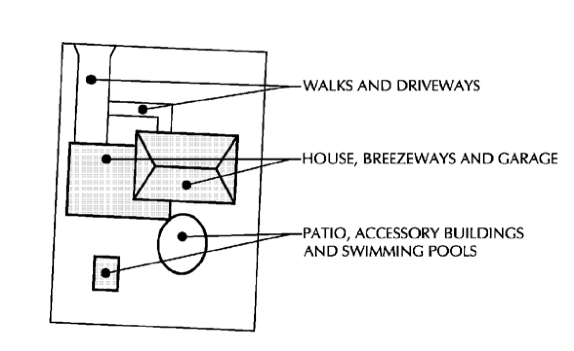
Indoor recreational facilities means facilities for relaxation, diversion, amusement, exercise or entertainment in which participants or customers are charged for use of the facilities, devices or equipment. All such activity shall occur within the building or structure.
Kennel, commercial, means an establishment where dogs or other animal pets (not part of the actual household on the lot on which the facility is located) are raised, bred, or boarded.
Kennel, hobby, means a noncommercial establishment, structure or premises, accessory to the principal use of the property where more than the number of regulated household animals (as defined herein) as are permitted by right are kept for purposes of pleasure, companionship, or traditional transport.
Legal nonconformity means the status applied to a lot, structure, or the use thereof which was lawful at the time of passage of this chapter from which this chapter is derived but does not currently conform to the regulations of the district in which it is located, which nonconformity is further defined as follows:
Nonconforming building or structure means any building or structure that does not comply with all the regulations of this chapter or of any amendment hereto regulating any building or structure for the zoning district in which such building or structure is located.
Nonconforming lot means a lot that does not conform to the lot size regulations of the district in which it is located.
Nonconforming sign means a sign that met the village sign code regulations when it was originally erected, either by adherence to a previous sign ordinance or by a variance granted to that ordinance, but which does not comply with all the present regulations of this chapter.
Nonconforming uses means any use of land, buildings or structures that does not comply with all the regulations of this chapter or of any amendment hereto governing use for the zoning district in which such use is located.
Lot means a parcel of contiguous land, with described boundaries and abutting, or having access by an approved easement to a public street or approved private street, excluding any land lying in public rights-of-way, public streams, or public water bodies. Where a public right-of-way, public stream or public water body divides a single described parcel into two or more parts, such several parts shall be considered separate individual lots, except that where such severed parcels do not individually meet the lot size regulations of this chapter and have been described as a single lot of record in order to permit building development, they shall continue to be treated as a single lot for regulatory purposes under this chapter.
Lot area means the area of land within the boundaries of the described lot exclusive of public streams, public water bodies or land provided for thoroughfares dedicated to the public, to be dedicated to the public, or as a recorded easement as the means of access to a street.
Lot width means the width of a parcel of land measured at the setback line.
Master sign program means an identification program for any multitenant operation, including, but not limited to, office parks, industrial parks, business parks, and multi-tenant office and retail buildings. The intent of a master sign program is to give a uniform theme of size, color and style to signs in such development. Each sign covered by a master sign program must still be permitted separately.
Navigable waters means Lake Superior, Lake Michigan, all natural inland lakes within Wisconsin, and all streams, ponds, sloughs, flowages and other waters within the territorial limits of this state, including the Wisconsin portion of boundary waters, which are navigable under the laws of this state.
"Wisconsin's Supreme Court has declared navigable bodies of water that have a bed differentiated from adjacent uplands and levels or flow sufficient to support navigation by a recreational craft of the shallowest draft on an annually recurring basis [Muench v. Public Service Commission, 261 Wis. 492 (1952) and DeGaynor and Co., Inc., v. Department of Natural Resources, 70 Wis. 2d 936 (1975)]. For example, a stream which is navigable by skiff or canoe during normal spring high water is navigable, in fact, under the laws of this state though it may be dry during other seasons."
Ordinary high water mark means the point on the bank or shore up to which the presence and action of surface water is so continuous as to leave a distinctive mark such as by erosion, destruction or prevention of terrestrial vegetation, predominance of aquatic vegetation, or other easily recognized characteristics.
Outdoor recreational facilities means land and structures, along with accessory equipment, designed and utilized for leisure time activities of a predominantly "outdoor" nature, such as beaches, swimming pools, tennis courts, riding paddocks, golf courses, or athletic fields, and of more specific purpose than passive park-like open areas.
Private commercial means facilities owned and operated by an individual or group for profit as a business whether or not open to general public use.
Private noncommercial group means facilities owned and operated by a group for the exclusive use of the members of such group and their guests and not for profit as a business.
Private residential means facilities owned by an individual, located on the same or adjoining lot to his residence, and intended solely for the use of his family and guests.
Public means facilities owned and operated by a governmental agency for limited or general public use.
Patio means a flat, open, horizontal surface or platform usually constructed of concrete, brick or wood and located on the surface of the ground or at the average grade of the ground surface at the patio site and not extending more than six inches above the grade. Where its surface lies more than six inches above the grade or average grade it shall be considered a deck and regulated as a structure.
Plan commission means the village plan commission established under village powers pursuant to Wis. Stats. ch. 62.
Quarrying means the removal of rock, slate, gravel, sand, topsoil or other natural material from the earth by excavating, stripping, leveling or any other process.
Ratio of preserved lands means the area of non-wetland-floodplain preserved lands divided by the sum of the areas of non-wetland-floodplain lands contained within individual residential parcels and the non-wetland-floodplain lands contained within preserved lands.
Regional flood means a flood determined to be representative of large floods known to have generally occurred in the state and which may be expected to occur on a particular stream because of like physical characteristics, once in every 100 years. (Wis. Admin. Code § NR 115.03(7).)
Regulated household animals means all dogs and all confined hobby animals (as defined herein).
Restaurant means an establishment where meals are served to the public.
Retaining wall means a structure more than 24 inches in height from grade or a combination or series of multiple structures more than 24 inches in height from grade, constructed of manmade or natural materials for the purpose of retaining land or stone and resisting the lateral pressure of the land or stone.
Roadside stand means a farm building used or intended to be used solely by the owner or tenant of the farm on which such building is located for the sale of the farm products raised on said farm.
Roof line means the top edge of the roof or building parapet, whichever is higher, excluding any cupolas, pylons, chimneys or roof-mounted equipment.
Routine maintenance of vegetation means normally accepted horticultural practices that do not result in the loss of any layer of existing vegetation and do not require earth disturbance. (Wis. Admin. Code § NR 115.03(7m))
Sand and gravel pits. See Quarrying.
Setback means the minimum horizontal distance between a property line and the nearest portion of a structure to such property line.
Setback, base, means the ultimate front property line, as established by section 111-96(a)(2), from which all required front yard setbacks shall be computed.
Setback, shore, means the horizontal distance between the closest point of a structure or building and the ordinary high water mark of navigable waters.
SEWRPC means the Southeastern Wisconsin Regional Planning Commission.
Shore setback means the horizontal distance between the ordinary high water mark of navigable waters and the closest point of a principal or accessory structure as defined herein.
Shoreland means lands within the following distances from the ordinary high water mark of navigable waters: 1,000 feet from a lake, pond or flowage and 300 feet from a river or stream or to the landward side of the floodplain, whichever distance is greater.
Shoreland, wetlands, means those wetland areas that lie within the zone that have been designated on the Final Wisconsin Wetlands Inventory Maps for Waukesha County prepared by the state department of natural resources.
Shoreline frontage means the distance of a straight line measured from where lot lines intersect with the ordinary high water mark.
Sign means any device for visual communications and the structure which supports it, which is used or is intended to attract the attention of the public. The term "sign" shall not include any flag, badge or insignia of the United States, State of Wisconsin, Waukesha County, Village of Summit or foreign countries or official historic plaques.
Sign, abandoned, means any sign located on a property which becomes vacant and is unoccupied for a period of 60 days or more; any sign that pertains to a time, event or purpose which no longer applies; or a sign that no longer directs attention to a business, activity or service offered or product sold on the premises.
Sign area. See section 111-198(a).
Sign, awning, means any fireproof space frame structure with translucent flexible reinforced vinyl or similar covering designed in awning form, but whose principal purpose and use is signage. Such signs may be internally illuminated by fluorescent or other light sources in fixtures approved under national and local electrical codes.
Sign, banner, means any sign made of fabric or any non-rigid material with no enclosing framework. National flags, flags of political subdivisions and symbolic flags of any institution or business shall not be regulated as banner signs.
Sign, building, means any sign affixed to and wholly supported by an exterior wall of a building or structure.
Sign, business identification, means any sign that identifies a business, office or organization located or housed at the premises and the services and products offered at the premises.
Sign, canopy or arcade, means any wall-mounted sign attached to or constructed on the face of a permanent roofed structure covering an area customarily used for pedestrian circulation.
Sign, changeable copy, means any sign that is designed so that characters, letters or illustrations can be changed or rearranged without altering the face or the surface of the sign.
Sign, construction, means a temporary sign identifying an architect, contractor, material supplier or other participants in the construction on the property on which the sign is located.
Sign, directional or informational, means any sign identifying a premise, or an activity conducted upon such premises, and providing direction for the safe and efficient flow of vehicular or pedestrian traffic to such activity or premises. Directional signs shall include signs marking entrances, exits, parking areas, loading areas, or other operational features of the premises.
Sign, directory, means any sign identifying an activity, operational feature, or business name upon such premises. Directory signs shall include building names, offices, or activities in same size letters, colors and general design and shall be limited to one per street entrance.
Sign, double-faced, means any sign with two faces or panels, neither of which are visible at the same time, and which are directly back-to-back as opposed to a v-shaped sign.
Sign, electronic message display means a sign that is designed to and is capable of displaying symbols, pictures, letters, words, figures, images or illustrations which can be changed or rearranged electronically or mechanically by remote or automatic means without altering the face or the surface of the sign. Such signs are also referred to as "time and temperature devices". Such signs can be building signs, projecting signs, or free-standing signs.
Sign, externally illuminated, means any sign whose illumination is derived entirely from an external artificial source.
Sign, flashing, means any directly or indirectly illuminated sign that is illuminated by an intermittent flashing light source.
Sign, ground or monument, means a structure built on grade that forms an integral part of the sign or its background.
Sign height, means the vertical distance measured from the highest point of the sign to the average ground grade beneath the sign.
Sign, inflatable, means any sign designed or constructed with the ability to be mechanically filled with air or gas.
Sign maintenance means the cleaning, painting, repair or replacement of defective parts of a sign in a manner that does not alter the basic copy, design, or structure of the sign.
Sign, multiple-faced, means signs containing more than two faces or panels. (See diagram in section 111-198(f))
Sign, nonconforming, means any sign that was erected legally but does not comply with subsequently enacted sign restrictions and regulations.
Sign, painted wall, means a sign that is applied with paint or similar substances on the face of a structure and is considered to be a wall-mounted sign for calculation purposes.
Sign, political, means a temporary sign used in connection with a local, state or national election or referendum.
Sign, portable, means any sign designed to be moved easily and not permanently affixed to the ground or to a structure or building.
Sign, real estate, means a temporary sign advertising real estate upon which the sign is located as being for rent, lease or sale.
Sign, special event, means a temporary sign advertising or pertaining to any civic, patriotic or special event of general public interest.
Sign, temporary, means any sign not constructed or intended for long-term use.
Sign, v-shaped, means any sign with two faces or panels not supported by one common structural member and whose faces are not back-to-back such as a double-faced sign.
Sign, wall, means a sign attached parallel to and extending not more than 18 inches from the wall of a building. This definition includes painted, individual lettered, cabinet signs and signs on a mansard.
Sign, window, means any sign installed inside a window and intended to be viewed from the outside, behind the glass or other transparent material.
Subdivision identification sign means a freestanding or wall sign identifying a recognized subdivision, condominium complex, or residential development.
Stable.
Commercial stable facility means a tract of land on which horses or other livestock is kept for hire, board, training, sale, or any other commercial use.
Private residential stable means a tract of land on which horses or other livestock is kept for noncommercial use of the person residing on the tract of land.
Street means a public right-of-way providing primary or principal access to abutting properties.
Street, arterial, means a street used, or intended to be used, primarily for fast or heavy through traffic. Arterial streets include freeways, state trunk highways and county trunk highways.
Street, local, means a street used, or intended to be used, primarily for access to abutting properties.
Structural alteration means any change in the supporting members of a structure, such as foundations, bearing walls, columns, beams or girders.
Structure means anything other than natural terrain or plant growth constructed or erected to form a shelter, enclosure, retainer, container, support or base.
Structure, accessory, means a structure or portion of a structure used for a purpose customarily incident to the permitted principal use of the lot and located on the same lot as the principal use.
Structure, principal, means the structure on a lot in which is conducted the principal use as permitted on such a lot by the regulations of the district in which it is located.
Structure, permanent, means a structure placed on or in the ground or attached to another structure in a fixed and determined position, and intended to remain in place for a period of more than six months.
Structure, temporary, means any structure other than a permanent structure.
Unnecessary hardship means a circumstance where special conditions, which were not self-created, affect a particular property and make strict conformity with restrictions governing area, setbacks, frontage, height or density unnecessarily burdensome or unreasonable in light of the purposes of this chapter.
Use, accessory, means a use subordinate to and customarily incidental to the permitted principal use of the property or structures and located upon the same lot as the principal use.
Use, conditional, means a use, the nature, character, or circumstances of which are so unique, or so dependent upon the specific contemporary conditions, that predetermination of permissibility by right, or the detailing in the chapter of the specific standards, regulations, or conditions necessary or appropriate to such permissibility are not practical; but which may be permitted in the districts where listed subject to certain conditions and requirements as hereinafter specified.
Use, permitted, means that utilization of land by occupancy, activity, building or other structure which is permissible under the regulations of the zoning district in which said land is located.
Use, principal, means the main or primary use of property or structures as permitted on such lot by the regulations of the district in which it is located.
Variance means a limited exception from the strict application of the bulk regulations of this chapter that may be granted by the zoning board of appeals according to the standards of section 111-388(b)(4)b.
Village means the Village of Summit.
Village board means the Village of Summit Village Board, established under village powers pursuant to Wis. Stats. ch. 62.
Vision setback means an unoccupied triangular space, at the street corner of a corner lot, as established by section 111-96(a)(3).
Wisconsin DNR means the department of natural resources for the state.
Wetlands means those areas where water is at, near or above the land surface long enough to be capable of supporting aquatic or hydrophytic vegetation and which have soils indicative of wet conditions.
Yard means an open space on the same lot with a structure, unoccupied and unobstructed from the ground upward except for vegetation. The front and rear yards extend the full width of the lot. Location of Yards on typical interior, corner, and double frontage lots:
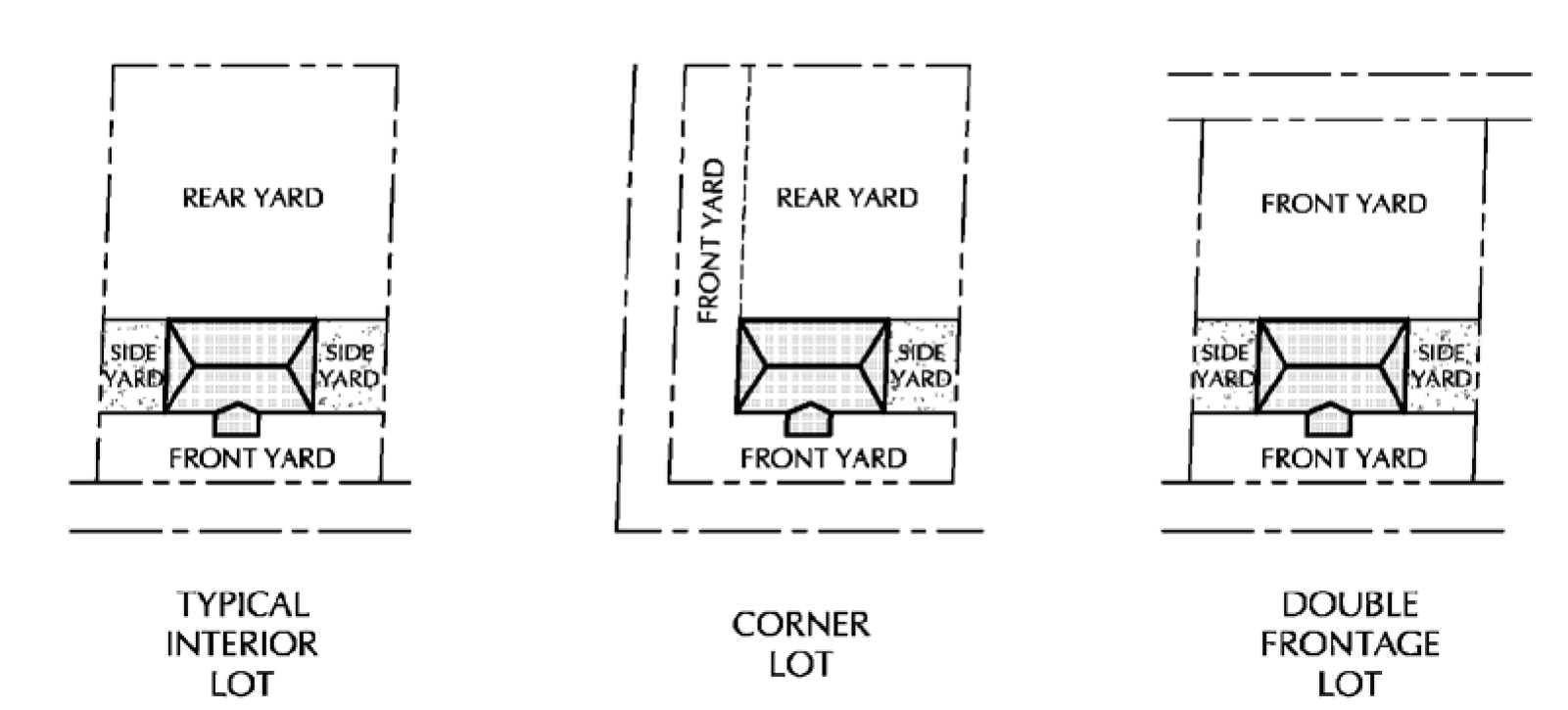
Zoning board of appeals means the village zoning board of appeals, established under village powers pursuant to Wis. Stats. ch. 62.
(Ord. No. 31-2015, § 15.2, 10-1-2015; Ord. No. 24-2014, § 3, 10-26-2015; Ord. No. 131-2024, § 1, 3-14-2024)
SIGN SCHEDULE
AGRICULTURAL AND RESIDENTIAL DISTRICTS
SIGN SCHEDULE
NEIGHBORHOOD COMMERCIAL AND INSTITUTIONAL DISTRICTS
SIGN SCHEDULE
BUSINESS PARK DISTRICT