
Sunny Isles Beach City Zoning Code
ARTICLE VII
Zoning Districts
§ 265-25.- Zoning districts and boundaries.
A.
Purpose. In order to effectively protect and promote the general welfare and to accomplish the purposes of the City's Comprehensive Plan, the City is divided into districts of such number, shape and area, and of such common unity of purpose, adaptability and use that are deemed most suitable for the health, safety and welfare of the community.
B.
Zoning districts.
(1)
For the purpose of regulating the use of land, water, building, form, population density, the intensity of use and provision of open space, the incorporated territory of the City of Sunny Isles Beach shall be divided into the classes of zoning districts as presented in this chapter, §§ 265-27 through 265-37, which may be referenced as the "Schedule of District Regulations."
(2)
The zoning districts contained herein generally correspond by name and purpose to the categories of the adopted Future Land Use Plan of the City's Comprehensive Plan, however, some districts may be applied to more than one Future Land Use Map category.
C.
Districts listed. Zoning districts, or classifications, as shown on the official schedule of district regulations and as delineated on the Official Zoning Map are as follows, with titles and abbreviations for symbol purposes as indicated:
D.
Zoning Map. The location and boundaries of the zoning districts established by this chapter are as indicated on the map entitled "Official Zoning Map, City of Sunny Isles Beach," a copy of which shall be on file in the Development Services Department. This map shall be presented on section sheets and each sheet properly identified and dated, is hereby adopted as a part of this chapter insofar as it indicates such designations, locations and boundaries of zoning districts, and the same shall be deemed to be as much a part of this chapter as if the same were fully set forth herein.
E.
Zoning of entire jurisdictional area. It is the intent of this chapter that the entire incorporated area of the City including all land, water areas, and waterways are included in the zoning districts established by this chapter. All water areas, waterways, alleys, roads, streets, highways, and other rights-of-way, if not otherwise specifically designated, shall be deemed to be in the same zoning district as the property immediately abutting upon same.
F.
Zoning district boundaries. In the event that uncertainties exist with respect to the intended boundaries of the various zoning districts as shown on the Official Zoning Map, the following rules shall apply:
(1)
Where such boundaries are indicated as approximately following the centerlines of streets, alleys, or waterways, such lines shall be construed to be such boundaries. In the event of vacation, the boundary shall be construed as remaining in such central location, except where ownership of vacated property is divided other than at its center, in which case the boundary shall be construed as moving with its ownership.
(2)
When such boundaries are indicated as approximately following the lines of lots or other parcels of record, and scale to be not more than ten feet distant there from, such lot or parcel lines shall be deemed to be such boundaries.
(3)
Where a zoning district boundary divides a parcel of land, the location of such boundary, unless dimensions shown on the map indicate the same, shall be determined by use of the scale appearing thereon, and scaled to the nearest foot.
(4)
Any zoning district boundary shown extended to or into any body of water bounding the City shall be deemed to extend straight to the City boundary.
(5)
Boundaries indicated, as approximately following mean high water lines or centerlines of canals, bays, or other bodies of water shall be construed as following such mean high water lines or centerlines. In the case of a change in mean high water line, the boundary shall be construed as moving with the change, except where such moving would change the zoning status of a lot or parcel, in which case the boundary shall be interpreted in such manner to avoid such change.
(6)
Where uncertainties continue to exist and/or further interpretation is required beyond that presented in the above paragraphs, the question shall be presented to the Development Services Director. Any person aggrieved by such decision made by the Development Services Director may appeal that decision to the City Commission.
G.
Bonus unit deposit required. An applicant shall be required to pay a ten percent nonrefundable deposit for any bonus units purchased at the time of approval of site plan. The deposit shall be paid within three working days of the date of City Commission approval of the site plan application. Failure to make such deposit within the prescribed time frame shall result in an automatic voiding of the City Commission approval. The requirements of this section shall apply to any zoning district in the City that provides monetary bonuses to increase the floor area ratio of a development project.
H.
Extension of bonus payments. The City Commission may extend payments due for purchase of bonus units upon recommendation of the City's Finance Director; provided, that the payment extension does not negatively impact the financial standing of the City and such extension is beneficial to the City. Any payment extension shall be subject to approval by the City Commission. The term of an extension and interest rate shall be recommended to the City Commission by the Finance Director or designee.
(Ord. No. 2012-385, § 2, 5-10-2012; Ord. No. 2012-389, § 3, 7-19-2012; Ord. No. 2021-562, § 34, 3-18-2021)
§ 265-26. - Interpretations of district regulations.
The sections that follow present a brief statement of interpretation of the district regulations set forth [in] §§ 265-27 through 265-37, regarding the Schedule of District Regulations.
A.
Statements of purpose and intent. The purpose and intent statement presented for each zoning district sets forth the underlying and primary purpose and intent of a given district.
B.
Permitted uses.
(1)
It is the intent of this chapter to permit any use, not otherwise prohibited by law, to locate in a specified zoning district(s), either as a permitted use, a conditional use or a temporary use. In the event there is not a particular use listed in the chapter that corresponds with the use in question as determined by the Development Services Director then it shall be interpreted that the use in the chapter having the most similar characteristics as the use in question shall govern except in the event the use is expressly prohibited.
(2)
The term "permitted uses" represents only those uses that are permitted by right in a given district and does not apply to uses otherwise allowed by conditional use approval.
(3)
No structure shall hereafter be built or moved, and no structure or land shall hereafter be used or occupied, except for a use that is permitted in the zoning district in which the structure or land is located.
(4)
No use shall be allowed in any district that is not permitted by the regulations for the district.
(Ord. No. 2021-562, § 34, 3-18-2021)
§ 265-27. - Schedule of district regulations.
The following sections comprise the Schedule of District Regulations.
§ 265-28. - Conservation District (CNS).
A.
Purpose. The Conservation (CNS) District is intended to protect and conserve environmentally sensitive areas that are to be left in an essentially natural state. Only those activities and uses that reinforce this character and are compatible with the continuing conservation of the natural resources located within this district are permitted.
B.
Permitted uses. No building or structure, or part thereof, within the district shall be erected, altered or used, or land used in whole or in part for other than one or more of the following specific uses subject to all other applicable standards and requirements contained in this chapter:
(1)
Passive outdoor recreational uses such as wildlife sanctuaries and feeding stations, nature centers and trails, outdoor research stations and walkways.
(2)
Fishing, boating and camping facilities by conditional use approval.
(3)
Structures used for flood control, drainage and water storage.
(4)
Wetlands and wildlife habitat reconstruction.
(5)
Uses which do not impair the natural environment or disturb the natural ecosystem of the area and which are not in conflict with applicable water management and wildlife protection policies of local, state and federal agencies.
(6)
Waterways.
§ 265-29. - Community Facilities (CF).
A.
Purpose. The Community Facilities (CF) District is intended for federal, state and local government activities, public health, recreational, cultural, religious or educational activities, transportation facilities, public facilities and utilities and other similar facilities that generally serve and benefit the community. To assure compatibility with adjacent residential areas, for any particular location of a mapped CF district, residential/care uses are permitted to a maximum density equal to that of the lowest permitted residential density of all adjoining districts. CF Districts may be applied to all lands except those designated Conservation (CNS) on the Future Land Use Map of the Comprehensive Plan.
B.
Permitted uses. No building or structure, or part thereof, within the district shall be erected, altered or used, or land used in whole or in part for other than one or more of the following specific uses, subject to all other applicable standards and requirements contained in this chapter:
(1)
Auditoriums, libraries, cultural centers, museums and galleries related to the fine arts; neighborhood or community centers.
(2)
Schools, primary and secondary public or private educational facilities, colleges and universities, public and private, including business colleges, and trade schools.
(3)
Religious facilities, churches, synagogues, temples or other places of worship and religious assembly.
(4)
Government owned facilities.
(5)
Structures and uses relating to the general operation of municipal facilities and public utilities requiring locations within the City, provided the facility housing the utilities incorporates, at the utility company's expense, a municipal sign or structure.
(6)
Uses that are customarily incidental and accessory to the above principal uses.
C.
Conditional uses.
(1)
Governmentally sponsored or subsidized residential/care facilities for the aged and/or handicapped, nursing homes, convalescent homes, congregate living facilities, foster care homes and orphanages.
D.
Site development standards.
(1)
Minimum lot size: 10,000 square feet.
(2)
Minimum lot width: 75 feet.
(3)
Maximum height: 120 feet.
(4)
Maximum intensity/density:
(a)
For residential/care uses: 25 dwelling units per acre.
(b)
For all other uses the maximum floor area ratio shall be 2.0 for all uses.
(5)
Minimum setbacks.
(a)
Front: 20 feet plus one foot for each three feet of building height over 35 feet up to a maximum of 50. Along Sunny Isles Boulevard, the front setback shall be ten feet.
(b)
Side: Ten feet plus one foot for each two feet of building height over 35 feet up to a maximum of 50 feet.
(c)
Side street: 15 feet plus one foot for each two feet of building height over 35 feet up to a maximum of 50 feet.
(d)
Rear: 15 feet plus one foot for each three feet of building height over 35 feet up to a maximum of 50.
E.
Exemptions. Permitted uses set forth in Subsections B(4), (5) and (6) are exempt from the site development standards set forth in Subsection D hereinabove.
(Amended 11-20-2003 by Ord. No. 2003-186)
§ 265-30. - Recreations and Open Space (ROS).
A.
Purpose. The Recreation and Open Space District is intended to provide for the open space, recreation and cultural needs of the City. The uses within this district shall be consistent with the Comprehensive Plan Recreation and Open Space Element and Future Land Use Map category.
B.
Uses permitted. No building or structure, or part thereof, within the district shall be erected, altered or used, or land used in whole or in part for other than one or more of the following specific uses, subject to all other applicable standards and requirements contained in this chapter:
(1)
Open space and recreational areas.
(2)
Boat ramps and docks.
(3)
Outdoor cultural, educational and civic facilities.
(4)
Parks, public and private.
(5)
Waterways.
(6)
Uses that is customarily incidental and accessory to the above principal uses when located on the same plot.
C.
Site development standards.
(1)
Minimum lot size: 10,000 square feet.
(2)
Minimum lot width: 75 feet.
(3)
Maximum height: 120 feet.
(4)
Maximum intensity/density: The maximum floor area ratio shall be 2.0.
(5)
Minimum setbacks.
(a)
Front: 20 feet plus one foot for each three feet of building height over 35 feet up to a maximum of 50. Along Sunny Isles Boulevard, the front setback shall be ten feet.
(b)
Side: Ten feet plus one foot for each two feet of building height over 35 feet up to a maximum of 50 feet.
(c)
Side street: 15 feet plus one foot for each two feet of building height over 35 feet up to a maximum of 50 feet.
(d)
Rear: 15 feet plus one foot for each three feet of building height over 35 feet up to a maximum of 50.
§ 265-31. - Single-Family Residential (R-1).
A.
Purpose. The Single-family Residential (R-1) District provides for low-density residential development of one-family detached dwellings of up to one unit per lot at a maximum density of six units per net acre consistent with the City's Comprehensive Plan Land Use Element and the corresponding Low Density Residential land use category. The uses within this district shall be consistent with, but may be more restrictive than, the Low Density Residential Land Use category permitted uses.
B.
Uses permitted. No building or structure, or part thereof, within the district shall be erected, altered or used, or land used in whole or in part for other than one or more of the following specific uses, subject to all other applicable standards and requirements contained in this chapter:
(1)
One-family detached dwelling per lot of record.
(2)
Publicly owned recreation buildings and facilities, playgrounds, playfields and parks scaled to the needs of the surrounding neighborhood.
(3)
Adult day-care centers and group homes licensed by the State of Florida Department of Health and Rehabilitative Services and provided that the total number of resident clients on the premises not exceed six in number. The single-family dwelling unit used for a group home shall be located at least 1,000 feet, as measured in a straight line, from another existing unabandoned legally established day-care center or group home.
C.
Reserved.
D.
Site development standards.
(1)
Minimum lot area: 7,500 square feet. A documented lot of record may be reduced to a minimum lot area of 5,000 square feet.
(2)
Minimum lot width: 75 feet. Minimum lot width on a documented lot of record may be reduced to 50 feet for a minimum lot area of 5,000 square feet and 60 feet for a minimum lot area of 6,000 square feet.
(3)
Maximum height: 35 feet. Protective structures such as balconies, railings or banisters may be increased by 40 inches.
(4)
Setbacks:
(a)
Front yard: Minimum of 25 feet. This setback may be reduced to 20 feet for a documented lot of record with a minimum lot area of 5,000 square feet.
(b)
Interior side yard: Minimum of 7.5 feet. For documented lot of record, this setback may be reduced to six feet for a minimum lot area of 6,000 square feet and reduced to five feet for a minimum lot area of 5,000 square feet.
(c)
Corner side yard: Minimum of 15 feet.
(d)
Rear yard: Minimum of 15 feet for principle use structures.
(5)
Lot coverage. The combined lot area covered by all principal and accessory buildings shall not exceed 42%. Landscaping and green area must account for at least 25% of the total lot area.
(6)
Floor area ratio. The maximum floor area ratio shall be 0.60.
(7)
Building spacing. Minimum of five feet separation between structures.
(Ord. No. 2020-554, § 4-16-2020)
§ 265-32. - Moderate Density Townhouse Residential (R-TH).
A.
Purpose. The Moderate Density Townhouse Residential (R-TH) District provides for low-density residential development of one-family detached and duplex dwellings up to 10 units per net acre and townhouse dwellings of up to 13 units per net acre consistent with the City's Comprehensive Plan Land Use Element and the corresponding Low to Medium Density Residential land use category. The uses within this district shall be consistent with, but may be more restrictive than, the Low Density Residential Land Use category permitted uses. The intent of the district is to provide increased variety in housing types with increased opportunities for affordable housing and home ownership while maintaining the residential neighborhood character of existing districts consistent with the Comprehensive Plan policy of promoting and sustaining the formation of "urban villages."
B.
Uses permitted. No building or structure, or part thereof, within the district shall be erected, altered or used, or land used in whole or in part for other than one or more of the following specific uses, subject to all other applicable standards and requirements contained in this chapter:
(1)
All uses permitted in the R-1 District.
(2)
One-family attached (two dwellings, separate ownerships, with a common wall - zero lot line interior side setback).
(3)
Two-family or duplex dwellings (on one lot under single ownership).
(4)
Townhouse Dwellings (three or more attached dwellings - multiple ownerships).
(5)
Uses customarily incidental and accessory to the any of the above uses when located on the same plot.
(6)
Adult day-care centers and group homes licensed by the State of Florida Department of Health and Rehabilitative Services and provided that the total number of resident clients on the premises not exceed six in number. The single-family dwelling unit used for a group home shall be located at least 1,000 feet, as measured in a straight line, from another single family dwelling unit used for a group home.
C.
Conditional uses. All conditional uses permitted in the R-1 District.
D.
Site Development Standards.
(1)
Minimum lot area: 4,000 square feet for single-family and duplex dwellings, and 3,000 square feet for townhouse units.
(2)
Minimum lot width: 40 feet for single family, and duplex dwellings. No minimum lot width for townhouse dwellings in contiguous blocks of three or more dwellings.
(3)
Maximum height: 45 feet.
(4)
Setbacks.
(a)
Front yard: Minimum of 20 feet.
(b)
Interior side yard: Minimum of five feet or combined side yard of 10 feet for single-family detached units. For duplex and townhouse units, zero feet for the side of common or abutting walls of attached units. A maximum of eight dwellings may be constructed in a contiguous series of attached dwellings or townhouses. The minimum side separation between contiguous groupings of dwellings shall be 20 feet.
(c)
Corner side yard: Minimum of 10 feet.
(d)
Rear yard: Minimum of 15 feet for principle use structures.
(5)
Lot coverage. The combined lot area covered by all principal and accessory buildings shall not exceed 50%. A minimum of 30% of the lot area shall be maintained in landscaped open space and recreation space (pools, courtyards, and patios).
(6)
Floor area ratio. The maximum floor area ratio shall be 0.80.
(7)
General design standards for attached and townhouse structures:
(a)
Sidewalks shall connect each attached dwelling and townhouse to the public street and parking serving the dwelling unit.
(b)
Shared driveways are permitted, with the recordation of perpetual easements to provide for the use and maintenance of the shared driveway. Courtyard style parking is permitted. Only one yard area, either the front or rear, or in the case of a corner unit the side yard shall be improved with a driveway or parking spaces.
(c)
All accessory structures shall be located behind the rear of the townhouse or attached dwelling.
§ 265-33. - Medium Density Multifamily Residential (RMF-1).
A.
Purpose. The Medium Density Multifamily Residential (RMF-1) District provides for single family, duplex, townhouse and medium density residential development of multifamily dwellings at a maximum density of 25 dwelling units per net acre consistent with the City's Comprehensive Plan Land Use Element and the corresponding Medium Density Residential land use category. The uses within this district shall be consistent with, but may be more restrictive than the Medium Density Residential Land Use category permitted uses.
B.
Permitted uses. No building or structure, or part thereof, within the district shall be erected, altered or used, or land used in whole or in part for other than one or more of the following specific uses, subject to all other applicable standards and requirements contained in this chapter:
(1)
Multifamily apartments.
(2)
All uses permitted in the R-TH district.
(3)
Uses customarily incidental and accessory to any of the above uses when located on the same plot.
(4)
Wet dockage or moorage of private, noncommercial, pleasure craft in connection with any residential use permitted.
C.
Conditional uses:
(1)
All conditional uses permitted in the R-1 District.
D.
Site development standards.
(1)
Minimum lot area and width:
(a)
Single-family and duplex: 4,000 square feet lot not less than 40 in width.
(b)
Townhouses: As required in the R-TH District.
(c)
Apartments: 10,000 square foot lot not less than 100 feet in width.
(2)
Maximum dwelling unit density. The maximum dwelling unit density shall be 25 dwelling units per acre.
(3)
Maximum height.
(a)
For single-family, duplex and townhouses: As in the R-1 and R-TH Districts respectively.
(b)
For apartment structures, the maximum height shall be 50 feet.
(4)
Lot coverage. The combined lot area covered by all principal and accessory buildings shall not exceed 60% of the area of the lot.
(5)
Minimum setbacks.
(a)
Apartments.
[1]
Front: 20 feet plus one foot for each three feet of building height over 35 feet up to a maximum of 50.
[2]
Side: 10 feet plus one foot for each two feet of building height over 35 feet up to a maximum of 50 feet.
[3]
Side street: 15 feet plus one foot for each feet of building height over 35 feet up to a maximum of 50 feet.
[4]
Rear: 25 feet plus one foot for each three feet of building height over 35 feet up to a maximum of 50.
[5]
Building spacing: 25 feet.
(b)
Single-family, duplex and townhouses: As required in the R-1 and R-TH Districts respectively.
(6)
Minimum open space: 35% of the total lot area. Said open space shall be unencumbered with any structure, parking or loading space and shall be landscaped and improved for passive and active recreation including waterfront walkways, plazas, terraces, pools and game courts.
(7)
Floor area ratio. The floor area ratio shall not exceed 1.00.
E.
Minimum floor areas. The minimum per unit floor area for a multiple-family dwelling unit not including garage or unair-conditioned areas shall be as follows:
(1)
Efficiency unit: 550 square feet.
(2)
One-bedroom unit: 750 square feet.
(3)
Two-bedroom unit: 900 square feet.
§ 265-34. - Medium - High Density Multifamily Residential (RMF-2).
A.
Purpose. The Medium - High Density Multifamily Residential (RMF-2) District provides for single-family, duplex, townhouse, medium-density and high-density residential development of multifamily dwellings at a maximum density of 60 dwelling units per net acre consistent with the City's Comprehensive Plan Land Use Element and the corresponding Medium - High Density Residential land use category. The uses within this district shall be consistent with, but may be more restrictive than the Medium - High Density Residential Land Use category permitted uses.
B.
Uses permitted. No building or structure, or part thereof, within the district shall be erected, altered or used, or land used in whole or in part for other than one or more of the following specific uses, subject to all other applicable standards and requirements contained in this chapter:
(1)
All uses permitted in RMF-1 district.
(2)
Uses customarily incidental and accessory to any of the above uses when located on the same plot.
(3)
Wet dockage or moorage of private, noncommercial, pleasure craft in connection with any residential use permitted.
(4)
Convenience retail and office uses in condominium commercial units, provided that such uses primarily serve the residents and guests of the condominium, no signage is visible from the public right-of-way except for signage approved under this chapter, consent of the condominium association is required where the commercial unit is within a condominium, the uses create no negative parking impacts on the required parking of the condominium, and any services provided to by such uses to the public must be incidental.
[Added 6-20-2013 by Ord. No. 2013-407]
C.
Conditional uses.
(1)
All conditional uses permitted in the RMF-1 District.
(2)
Apartment hotels.
(3)
Convenience retail and office as an accessory use as part of a site plan approved prior to the adoption of these LDRs.
(4)
Commercial jet skis and personal watercraft launching facilities. For the purpose of this Section, a personal watercraft is defined as a small, jet-powered craft, resembling a snowmobile in appearance and ridden like a motorcycle for individual use in water.
(5)
Commercial marinas or boat storage.
(6)
Non-motorized or motorized watercraft leasing or launching facilities.
(Ord. No. 2012-393, § 2, 10-18-2012)
D.
Site development standards.
[Amended 1-15-2004 by Ord. No. 2004-192; 4-11-2006 by Ord. No. 2006-257; 12-14-2006 by Ord. No. 2006-271]
(1)
Minimum lot area and width:
(a)
Single-family and two-family dwellings: 4,000 square foot not less than 40 feet in width.
(b)
Townhouses: as required in the R-TH District.
(c)
Apartments: 10,000 square foot lot not less than 100 feet in width.
(2)
Maximum height:
(a)
Buildings abutting Collins Avenue. Except as provided below, the maximum height of a building shall be:
[1]
Parcels over 250 feet in depth: The maximum height of the building shall be 50 feet (four stories) for the first 130 feet set back from the property line, 100 feet (eight stories) for the next 100 feet, then 190 feet for a maximum overall height (19 stories).
[2]
Parcels between 150 feet and 250 feet in depth: The maximum height of the building shall be 50 feet (four stories) for the first 100 feet set back from the property line, then 190 feet (19 stories).
[3]
Parcels with less than 150 feet of depth: The maximum height for the building shall be 50 feet (four stories) for the first 50 feet set back from the property line, then 190 feet (19 stories).
(b)
For single-family, duplex and townhouses: as in the R-1 and R-TH Districts, respectively.
(c)
For apartment structures not abutting Collins Avenue. The maximum height shall be 190 feet, including all rooftop equipment and further controlled by the minimum setbacks.
(3)
Lot coverage. The combined lot area covered by all principal and necessary buildings shall not exceed 60% of the area of the lot. Structures whose rooftop level is connected by walkways directly at the rooftop level to a multifamily structure, and that have a flat roof structure that is fully improved with landscaping, usable plazas, terraces, active unenclosed recreation facilities and the like, shall have a lot coverage, including the abovedescribed improved rooftop structures, not exceeding 80% of the lot area.
(4)
Minimum setbacks for apartment structures not abutting Collins Avenue.
(a)
Apartments:
[1]
Front: 20 feet plus one foot for each three feet of building height over 35 feet up to a maximum of 50 feet.
[2]
Side: Ten feet plus one foot for each two feet of building height over 35 feet, up to a maximum of 50 feet.
[3]
Side street: 15 feet plus one foot for each foot of building height over 35 feet, up to a maximum of 50 feet.
[4]
Rear: 15 feet plus one foot for each three feet of building height over 35 feet, up to a maximum of 50 feet.
[5]
Building spacing: the greater of 25 feet or 40% of the height of the tallest building, not to exceed 60 feet.
(b)
Single-family, duplex and townhouses: as required in the R-1 and R-TH Districts, respectively.
(c)
Minimum setbacks for properties abutting Collins Avenue.
[1]
Front:
[a]
Minimum of 25 feet for properties providing 15 feet of colonnade.
[b]
Minimum of 40 feet for properties not providing 15 feet of colonnade.
[2]
Rear: A minimum of 25 feet shall be required between openings (storefront, windows, sliding glass doors in buildings, except for enclosed garage). Balconies may encroach a maximum of four feet into the setback area.
[3]
Side: A minimum of 25 feet shall be required between openings (store front, windows, sliding glass doors in buildings, except for enclosed garage). Balconies may encroach a maximum of four feet into the setback area.
(5)
Minimum open space: 35% of the total lot area.
(a)
Required open space shall be unencumbered with any structure, parking or loading space and shall be landscaped and improved for passive and active recreation, including waterfront walkways, plazas, terraces, pools and game courts.
(b)
All properties abutting Collins Avenue shall provide a ten-foot easement within the required front setback. The easement shall be dedicated to the City for the implementation of the Collins Avenue Streetscape Plan. The City shall use the easement to increase the pedestrian walk paths, landscaping purposes, placement of utility wires and any other municipal purposes.
(6)
Building separation on separate parcels abutting Collins Avenue. When there are two towers located on different properties, a minimum separation of 50 feet shall be maintained between pedestals (50 feet or less in height) and a minimum separation of 50 feet shall be maintained between towers (above 50 feet in height).
(a)
When there are two or more towers on the same property, the building separation shall be a minimum of 50 feet between towers.
(b)
The maximum tower width shall be 200 feet.
(7)
Maximum floor area ratio. The floor area ratio shall not exceed 2.0. Additional bonus floor area ratio up to 2.5 may be allowed for waterfront developments that comply with Community Design Element Policy 1E, Recreation and Open Space Element Policy 1C and Coastal Management Element Policies 3A and 3D of the City's Comprehensive Plan.
(8)
Allowable increases in floor area ration. The floor area ratio for developments that provide certain features shall be increased to a floor area ratio not to exceed 2.5 in conformance with the following provisions and limitations:
(a)
Public streetscape bonus. The floor area ratio shall be increased for developments that participate in the City's Streetscape Trust Fund as established and administered by the City of Sunny Isles Beach for the purposes of implementing capital improvements, public streetscape improvements and pedestrian system design and safety enhancements for public streets, including local, collector, secondary and primary arterial roadways, and public shorelines in the City, which are policy objectives of the adopted City of Sunny Isles Beach Comprehensive Plan. A bonus of 0.05 increase in F.A.R. shall be granted for each participation unit contributed to the capital improvement fund for roadway enhancements, up to a maximum additional 0.50 F.A.R. bonus. Additional bonus floor area ratio up to 2.5 may be allowed for properties without water frontage. A participation unit, for the purpose of the public streetscape enhancement bonus, shall be equal to $200,000.00 and may be adjusted from time to time by the City Commission pursuant to a recommendation by the City Manager. The cost of a participation unit shall be determined by the amount of participation units purchased at the unit price multiplied by the total number of acres contained in the subject parcel. Additionally, the City Manager and/or his designee shall review the bonus participation unit price set forth herein every two years.
(9)
Maximum dwelling unit density. The maximum dwelling unit density shall be as set forth below:
(a)
Except as modified in Subsection D(9)(b)[1] below, the maximum number of residential dwelling units shall not exceed a density of 50 dwelling units per acre.
(b)
Density bonuses:
[1]
Residential dwelling units. The maximum residential dwelling unit density may be increased up to a maximum of 60 per acre for waterfront developments that comply with Community Design Element Policy 1E, Recreation and Open Space Element Policy 1C and Coastal Management Element Policies 3A and 3D of the City's Comprehensive Plan.
[2]
Affordable housing density bonus. The maximum residential dwelling unit density may be increased by eight units per acre up to a maximum of 68 units per acre, provided the dwelling units achieved through this bonus comply with the affordable workforce housing provisions of the Housing Element of the adopted Sunny Isles Beach Comprehensive Plan and the provisions of Section 265-39 of the City Code.
(10)
Minimum floor areas. The minimum floor area for a multiple-family dwelling unit not including garage or unair-conditioned areas shall be as follows:
(a)
Efficiency unit: 550 square feet.
(b)
One-bedroom unit: 750 square feet.
(c)
Two-bedroom unit: 900 square feet.
(11)
Convenience retail. Apartment developments having a minimum of 300 residential units may have convenience retail not exceeding 1,000 square feet as an accessory use, provided that:
(a)
Such services relate to the needs of the residents of the proposed development.
(b)
Such services are located wholly within the primary use structure or community center structure.
(c)
Signage on any structure is prohibited as are window displays or displays of merchandise visible from a public roadway except for outdoor dining tables, sidewalk cafes and the like.
(Amended 12-13-2007 by Ord. No. 2007-292; Ord. No. 2012-381, § 1, 2-16-2012; Ord. No. 2015-470, § 1, 12-17-2015; Ord. No. 2016-489, § 2, 10-20-2016; Ord. No. 2017-493, § 2, 2-16-2017; Ord. No. 2018-521, § 1, 5-17-2018)
§ 265-35. - Mixed Use - Resort District (MU-R).
A.
Purpose. The Mixed Use Resort (MU-R) District provides for high density residential development of multifamily dwellings at a maximum density of 80 dwelling units per acre, hotels, apartment hotels at 125 units per acre, retail goods and services, conference facilities, and entertainment activities consistent with the City's Comprehensive Plan Land Use Element and the corresponding Mixed Use - High Density/Resort land use category. The uses within this district shall be consistent with, but may be more restrictive than the Mixed Use - High Density/Resort category permitted uses.
B.
Uses permitted. No building or structure, or part thereof, within the district shall be occupied, erected, constructed, moved, reconstructed, structurally altered maintained or used, or land or body of water used in whole or in part for other than one or more of the following specific uses, subject to all other applicable standards and requirements contained in this chapter:
(1)
Multifamily apartments.
(2)
Hotels, motels, and apartment-hotels.
(3)
Commercial services and retail goods including spas and health clubs, beauty salons, clothing, florists, gift shops, banking services, pharmacy, newsstands, and restaurants only within buildings with a minimum of 100 apartment, hotel or apartment-hotel units.
(4)
Conferencing facilities and meeting rooms.
(5)
Parking lots and garages.
(6)
Public parks and recreation facilities.
(7)
All uses permitted in RMF-2 District.
(8)
Uses customarily incidental and accessory to any of the above uses when located on the same plot.
C.
Conditional uses.
(1)
Time-share apartments.
(2)
Eleemosynary, charitable, religious and philanthropic institutions.
(3)
Nightclubs, private clubs, lodges, fraternities and sororities.
(4)
Commercial jet skis and personal watercraft launching facilities. For the purpose of this Section, a personal watercraft is defined as a small, jet-powered craft, resembling a snowmobile in appearance and ridden like a motorcycle for individual use in water.
(5)
Commercial marinas or boat storage.
(6)
Non-motorized or motorized watercraft leasing or launching facilities.
D.
Site development standards.
(1)
Minimum lot area and width. The minimum lot width as measured along the front property line shall be 200 feet and the minimum lot area shall be 20,000 square feet for lots platted after the date of adoption of these LDRs.
(2)
Maximum height.
(a)
For single-family and duplex, as in the R-1 and R-TH Districts respectively.
(b)
For all other structures, the maximum height shall be controlled by the minimum setbacks and the Federal Aviation Administration height restrictions.
(3)
Lot coverage. The combined plot area covered by all principal and accessory buildings shall not exceed 60% of the area of the lot. Structures whose rooftop level is connected by walkways directly at the rooftop level to a multifamily structure, and that have a flat roof structure that is fully improved with landscaping, usable plazas, terraces, active unenclosed recreation facilities and the like shall have a combined plot coverage of all structures, including the above described improved rooftop structures not to exceed 80% of the plot area.
(4)
Minimum setbacks.
(a)
Front setback.
[1]
The minimum front setback shall be 75 feet, provided that a porte-cochere and/or guardhouse shall be permitted to be setback not less than 50 feet. If a new structure is part of an existing development, which will remain, the front setback may be equal to the setback of the existing structure provided that the minimum setback of a porte-cochere and/or guardhouse shall be no less than 50 feet. Parking structures may encroach on the front setback area not closer than ten feet to the Collins Avenue right-of-way provided that no portion of the garage structure shall extend above a slope beginning at the elevation of the public sidewalk and rising east from the ten-foot setback line one foot vertically for each four feet horizontally.
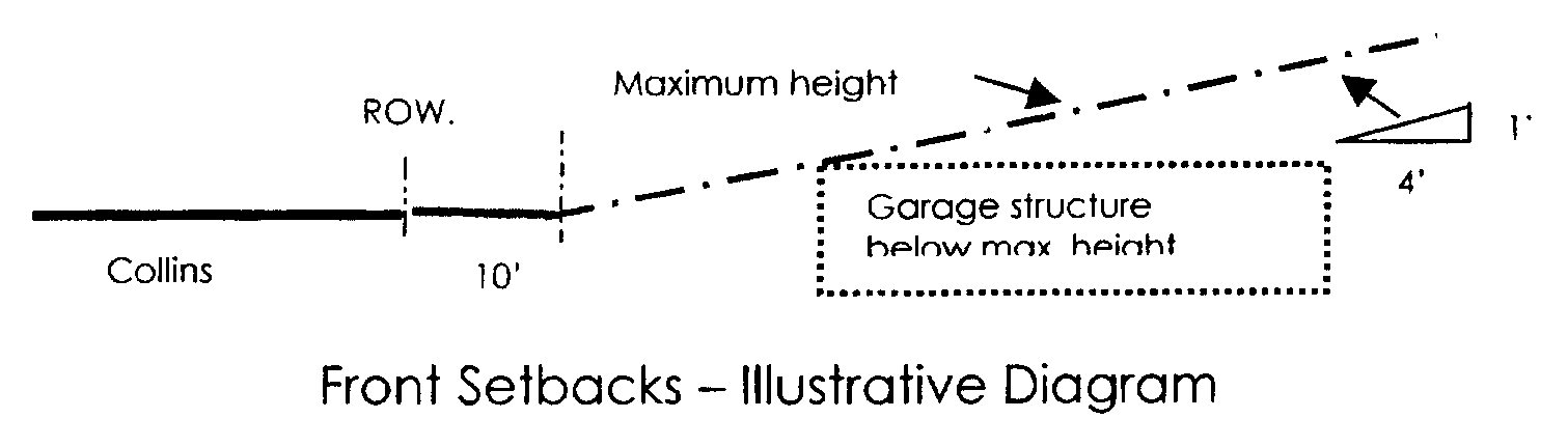
[2]
Berms and landscaping shall be provided such that no portion of a garage structure located within a front setback shall be visible from the public right-of-way with the exception that privacy walls and retaining walls for driveways may be visible.
(b)
Rear setback.
[1]
For all buildings the rear setback shall be the bulkhead line or 20 feet from the rear property line whichever is closer to Collins Avenue.
(c)
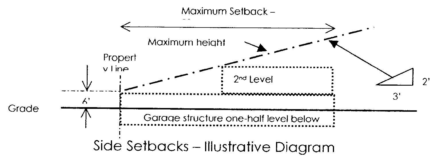
Interior side setbacks/view corridors.
[1]
For parcels 200 feet or more in width:
[a]
Primary structures. The minimum side setbacks for primary use structures exceeding 20 feet in height above grade shall be 50 feet. If side setbacks of different width are provided, the larger setback shall be provided on the side adjacent to the public beach access walkway or to provide for the greatest separation from buildings on adjacent sites. Where a parcel is no more than five percent greater than 200 feet in width, the minimum side setback shall be 20 feet.
[b]
Pedestal structures, parking garages and accessory use structures. There shall be no required setback for structures below six feet above grade. To preserve ocean view corridors for sites west of Collins Avenue, for structures higher than six feet above grade, there shall be a three-foot setback for each two feet of building height up to a maximum setback of 50 feet.
[c]
For parcels adjacent to public parks, excluding easements used exclusively for access, the minimum side setback shall be five feet.
[d]
Optional design flexibility side setback for parcels 200 feet or more in width:
At the option of the landowner, minimum setbacks may be provided as follows for primary use structures exceeding 20 feet in height above grade on existing lots for purposes of design flexibility, and where the landowner provides to the City the designated fee payment for the City's maintenance of adjacent public beach access, streetscape and park improvements. The City Commission reserves the right to revise the designated fee payment.
[i]
Minimum setback of 25 feet requires a fee payment of $1,000,000.00, per eligible parcel. A nonrefundable deposit payment of ten percent of the required fee, which shall be paid within three working days of the date of City Commission approval of a site plan approved under this section for optional design flexibility setback. Failure to make such deposit within the prescribed time frame shall result in zoning approval being declared null and void.
[ii]
Minimum setback of 30 feet requires a fee payment of $500,000.00, per eligible parcel. A nonrefundable deposit payment of ten percent of the required fee, which shall be paid within three working days of the date of City Commission approval of the site plan approved under this section for optional design flexibility setback. Failure to make such deposit within the prescribed time frame shall result in zoning approval being declared null and void.
[2]
For parcels under 200 feet in width.
[a]
Primary structures. The minimum side setbacks for primary use structures shall be 20 feet. If side setbacks of different width are provided, the larger setback shall be provided on the side adjacent to the public beach access walkway or to provide for the greatest separation from buildings on adjacent sites.
[b]
Pedestal structures, parking garages and accessory use structures. There shall be no required setback for structures below six feet above grade. To preserve ocean view corridors for sites west of Collins Avenue, for structures higher than six feet above grade, there shall be a three-foot setback for each two feet of building height up to a maximum setback of 20 feet.
[c]
For parcels adjacent to public parks, excluding easements used exclusively for access, the minimum side setback shall be five feet.
[3]
Notwithstanding side setback restrictions of this paragraph D(4)(c), buildings on adjacent lots may be connected by an elevated pedestrian bridge in order to increase pedestrian accessibility to recreational or tourism facilities that are shared between the owners of the adjacent lots, where the City Commission has determined that ocean views are sufficiently preserved, the bridge does not interfere with a beach access walkway, the bridge functions as part of an integrated design with the buildings on the adjacent lots, and the use and maintenance of the bridge is adequately provided for between the owners of the adjacent lots.
(5)
Minimum separation between buildings. To preserve ocean views for properties west of Collins Avenue, primary use buildings exceeding 20 feet in height above grade on the same site shall be separated by a minimum of 100 feet as measured parallel to Collins Avenue. Cantilevers and open porches may project from the building wall into the required building separation not more than six feet, and unenclosed stairways may project from the building wall into the required building separation not more than ten feet. Stairways, when located in the required open space (court), shall be supported by the necessary columns only; support by a wall is strictly prohibited unless the wall is of the primary structure is cantilevered. For the purposes of this section, separate buildings or towers located on top of the same parking structure shall be considered separate buildings and shall have the required building separations. The minimum separation may be reduced by the City Manager not more than 25% upon a written finding by Development Services Director that opposing building walls of the adjacent buildings are offset, angled or have minimal window openings such that residential views from within the towers are not adversely impacted by proximate and direct facing relationships of the buildings. Notwithstanding the foregoing, an elevated bridge is permitted within the building separation as set forth in Subsection D(4)(c)[3].
(6)
Maximum building width. In order to preserve views of the ocean for properties west of Collins Avenue:
(a)
For parcels 200 feet or more in width, the maximum building width, as measured parallel to Collins Avenue, of any single structure or exceeding 20 feet in height above grade shall be 250 feet. The elevated bridge permitted under Subsection D(4)(c)[3] shall not be counted for the calculation of building width for parcels described herein.
(b)
For parcels under 200 feet in width, existing as of the date of the passage of this chapter, the maximum building width, as measured parallel to Collins Avenue, of any single structure or exceeding 20 feet in height above grade shall be 60% of the lot width provided, in no event shall the balconies encroach into the setback of the side yard. The elevated bridge permitted under Subsection D(4)(c)[3] shall not be counted for the calculation of building width for parcels described herein.
(c)
When there are two or more buildings on the same property, two feet of building width may be added for each one foot of building separation exceeding 100 feet.
(7)
Maximum building height. Maximum building height shall be controlled by § 265-35.D(2) regarding maximum height, § 265-35.D(4), regarding setbacks and view corridors, and § 265-35.D(9), regarding floor area ratio.
(8)
Required beach access easement. There shall be required for all properties, except as provided hereinbelow, a nonexclusive publicly accessible beach access easement linking Collins Avenue to the oceanfront beach. Such easement shall be a minimum width of not less than 20 feet and located within a required side setback area and on the side of the property closest to a signalized public crosswalk on Collins Avenue and, where applicable, on the side adjacent to an existing each access easement provided by an abutting property, and such easement shall be over, across, under and through said property. Abutting beach access easements shall be designed and improved to function as an integrated design with a single pedestrian walkway of an expanded width to fully utilize the greater effective easement width afforded by the abutting easements. However, the City Commission may waive the beach access easement requirement where it is determined by the Development Services Director in a written finding that, in the interest of protecting the public safety and welfare, provision of a beach accessway at a midblock location constitutes a potential safety hazard as an inducement to illegal pedestrian crossing of Collins Avenue, or it may be waived if the proposed beach access is adjacent to a public park.
(9)
Floor area ratio.
(a)
Floor area calculation. For purposes of this section, notwithstanding the definition of "floor area ratio" set forth in § 265-5, floor area shall be calculated as follows:
[1]
Floor area includes but is not limited to:
[a]
Exterior corridor space from which access is gained to dwelling units or hotel rooms.
[b]
Floor space of balconies, which encroaches on a setback or building separation.
[c]
Floor space for accessory uses.
[d]
Floor space in interior balconies or mezzanines.
[e]
Only that portion of covered or enclosed parking structures, which exceed 20 feet above grade and exceed the required parking, unless the entire structure is contained within the primary use structure tower.
[2]
Floor area does not include:
[a]
Interior storage areas - one per residential unit - solely for the use of residents, not exceeding ten percent of the average dwelling unit interior floor area and is not appurtenant or attached to the living space of the dwelling unit.
(b)
Maximum floor area ratio. Except as modified in Subsection D(9)(a)[2](c) below, the maximum floor area ratio shall not exceed 2.50.
(c)
Floor area ratio bonuses. The maximum floor area ratio permitted may be increased only in accordance with the following provisions and limitations and in conformance with the allowable limits set under the adopted Sunny Isles Beach Comprehensive Master Plan.
[1]
Beach access bonus. Subsection D(9)(c)[1][a], Access easement, set forth herein below, as specifically defined in § 265-35.D(8) hereinabove, must be attained to qualify for any additional floor area ratio bonuses as provided in this section.
[a]
Access easement. The floor area ratio shall be increased for developments where an easement extending from the Collins Avenue right-of-way to the oceanfront public beach and not less than 20 feet in average width is dedicated or granted and accepted by the City Commission for public access. For the purposes of this section, "improved" means landscaped, lighted and irrigated in a manner consistent with the adjoining development and including a paved access which may include pavers way and pedestrian amenities in accordance with adopted municipal design standards for public beach access walkways. For the purposes of this section, "public access" means nonexclusive unencumbered and unrestricted access to the public; except, however, that upon request of the grantor or property owner, the City Commission may accept a restriction upon the grant or dedication limiting the hours of general public access to daylight hours, provided that the City shall have unrestricted access for fire and police protection and provided that the grantor or property owner shall bear the full expense of installing a gate always accessible to police and fire protection personnel and equipment. The beach access easement may be located over parking structures provided that the highest elevation of the underlying structure supporting the beach accessway may not exceed six feet above grade. The F.A.R. may be increased by a maximum of 0.10 for the dedication, improvement and maintenance of the minimum beach access described above. As provided in § 265-35D(8) above, where it is determined by the City Commission, that in the interests of protecting the public safety and welfare, provision of a beach accessway at a midblock location constitutes a potential safety hazard as an inducement to illegal pedestrian crossings of Collins Avenue, in lieu of the dedication and improvement of a beach accessway, the bonus increase in F.A.R. of 0.10 may be achieved in accordance with the following Subsection D(9)(c)[1][b].
[b]
Beach access trust fund contribution. Unless waived by the City Commission per Subsection D (9)(c)[1][a] herein above and provided that the beach access easement has been proffered as set forth in Subsection D (9)(c)[1][a], an additional increase in F.A.R. of 0.05 shall be granted for each participation unit contributed to a beach trust fund established and administered by the City of Sunny Isles Beach up to a maximum additional 0.20 F.A.R. bonus. A system of pedestrian walkways and shuttle bus facilities to provide oceanfront open space is a public policy objective of the adopted City of Sunny Isles Comprehensive Plan. A participation unit, for the purpose of beach access enhancement bonus, shall be equal to $200,000.00 and may be adjusted from time to time by the City Commission pursuant to a recommendation by the City Manager. The cost of a participation unit shall be determined by the amount of participation units purchased at the unit price multiplied by the total number of acres contained in the subject parcel. Additionally, the City Manager and/or his designee shall review the bonus participation unit price set forth herein every two years. If City Commission waives the provision of an access easement for safety reasons as provided in Subsection D(9)(c)[1][a] above, the total beach access bonus achieved through trust fund contributions shall not exceed 0.30.
[2]
Public beach recreational enhancement bonus. The floor area ratio shall be increased for developments that participate in the City's Beach Recreational Enhancements Trust Fund as established and administered by the City for the purposes of implementing oceanfront capital improvements. A bonus of 0.05 increase in the F.A.R. shall be granted for each participation unit contributed to the capital improvement fund designated for beach enhancements up to a maximum additional 0.60 F.A.R. bonus. A participation unit, for the purpose of the beach recreational enhancement bonus, shall be equal to $200,000.00 and may be adjusted from time to time by the City Commission pursuant to a recommendation by the City Manager. The cost of a participation unit shall be determined by the amount of participation units purchased at the unit price multiplied by the total number of acres contained in the subject parcel. Additionally, the City Manager and/or his designee shall review the bonus participation unit price set forth herein every two years.
[3]
Collins Avenue public streetscape enhancements bonus. The floor area ratio shall be increased for developments that participate in the City's Collins Avenue Streetscape Enhancements Trust Fund as established and administered by the City for the purposes of implementing capital improvements. Public streetscape improvements and pedestrian system design and safety enhancements for Collins Avenue are policy objectives of the adopted City of Sunny Isles Beach Comprehensive Plan. A bonus of 0.05 increase in the F.A.R. shall be granted for each participation unit contributed to the capital improvement fund designated for beach enhancements up to a maximum additional 0.60 F.A.R. bonus. A participation unit, for the purpose of the Collins Avenue streetscape enhancement bonus, shall be equal to $200,000.00 and may be adjusted from time to time by the City Commission pursuant to a recommendation by the City Manager. The cost of a participation unit shall be determined by the amount of participation units purchased at the unit price multiplied by the total number of acres contained in the subject parcel. Additionally, the City Manager and/or his designee shall review the bonus participation unit price set forth herein every two years.
[4]
Sunny Isles Beach public parking bonus. The floor area ratio shall be increased for developments that participate in the City's Beach Public Parking Trust Fund as established and administered by the City for the purposes of implementing capital improvements for public parking. Public parking resources, in particular, west of Collins Avenue, as a component of infrastructure improvements to facilitate public access to the oceanfront, is a policy objective of the adopted City of Sunny Isles Beach Comprehensive Plan. A bonus of 0.05 increase in the F.A.R. shall be granted for each participation unit contributed to the capital improvement fund designated for beach enhancements up to a maximum additional 0.20 F.A.R. bonus. A participation unit, for the purpose of the public parking trust fund bonus, shall be equal to $200,000.00 and may be adjusted from time to time by the City Commission pursuant to a recommendation by the City Manager. The cost of a participation unit shall be determined by the amount of participation units purchased at the unit price multiplied by the total number of acres contained in the subject parcel. Additionally, the City Manager and/or his designee shall review the bonus participation unit price set forth herein every two years.
[5]
Public oceanfront park and open space enhancements bonus. The floor area ratio shall be increased by 0.20 additional floor area ratio for developments that provide within the development site receiving the F.A.R. bonus publicly accessible open space, park and recreational facilities adjacent to and directly accessible from the public beach during daylight hours and constructed and maintained by the developer. The open space shall be designed, and improved to promote passive recreation (no active sports, cooking, music, or similar activities that may create noise or odor impacts external to the site) and children's play areas within generously landscaped park-like space not less than 10,000 square feet in area with a minimum dimension in depth measured perpendicular to Collins Avenue of 75 feet. The park area provided may be utilized exclusively by the development and on-site residents and visitors after daylight hours.
[6]
Educational and cultural infrastructure bonus. The floor area ratio shall be increased for developments that participate in the City's Educational and Cultural Infrastructure Trust Fund as established and administered by the City for the purposes of implementing public educational and infrastructure capital improvements. A bonus of 0.05 increase in the F.A.R. shall be granted for each participation unit contributed to the capital improvement fund designated for public educational and cultural capital improvements up to a maximum additional 0.20 F.A.R. bonus. A participation unit, for the purpose of the educational and cultural infrastructure bonus, shall be equal to $200,000.00 and may be adjusted from time to time by the City Commission pursuant to a recommendation by the City Manager. Additionally, the City Manager and/or his designee shall review the bonus participation unit price set forth herein every two years.
(10)
Maximum dwelling unit density. The maximum dwelling unit density shall be as set forth below:
(a)
Apartments. Except as modified in Subsection D(10)(e) below, the maximum number of residential dwelling units shall not exceed a density of 50 dwelling per acre. Residential dwelling units shall not be permitted a room or rooms, termed "lockouts," that have a separate common area keyed entry that can be segregated as to access (locked out) from the primary living unit for purposes of rental occupancy by other than the primary tenants.
(b)
Apartment-hotels. Except as modified in Subsection D(10)(e) below, apartment-hotels and which are intended to be subdivided as to ownership shall not exceed a maximum density of 100 dwelling units per acre. Apartment-hotels shall be permitted to have "lockout" rooms that may be rented separately from the remainder of the unit provided that each lockout shall be counted as a separate unit for parking calculations as provided in Article VIII, Off-Street Parking Loading and Driveway Standards. Lockout rooms shall not count as separate units for density calculations. Lockout units shall not be subdivided and sold separately from the main unit provided, however, that should any apartment hotel with a lockout unit be converted to a condominium building or strict residential dwelling apartment house, then, each such lockout shall become part and parcel of the original apartment hotel unit and no lockout room shall be deemed to exist independently upon such conversion. This provision shall apply from the effective date of this chapter regardless of the date of the original approval or issuance of a building permit.
(c)
Hotels. Hotel rooms are not deemed to be residential dwelling units and therefore are not regulated as to density limitations on number of rooms per acre.
(d)
Mixed uses. In computing the allowable density for a mixed-use development combining apartment and apartment-hotel uses, the number of units proposed for each use shall be divided by the number of units per acre permitted by the Code for that use. The sum of the acreage needed for the different uses being proposed shall equal the total acreage of the property. The total amount of units shall not exceed the amount allowable under the Comprehensive Master Plan. Density bonuses are not included in the calculations.
(e)
Density bonuses. The maximum dwelling unit density may be increased only in accordance with the following provisions and limitations:
[1]
For each floor area ratio increase of 0.02 achieved through the bonus provisions of § 265-35D(9)(c). Floor area ratio bonuses, an increase of one residential dwelling unit per acre shall be granted to a maximum of 80 units per acre.
[2]
For each floor area ratio increase of 0.03 achieved through the bonus provisions of § 265-35D(9)(c), Floor area ratio bonuses, an increase of one apartment/hotel unit per acre shall be granted to a maximum of 125 units per acre.
(11)
Minimum unit size.
(a)
For the MU-R District:
[1]
The minimum gross floor area of a residential dwelling unit shall be 550 square feet.
[2]
The minimum gross square footage for an apartment-hotel unit without a lockout room shall be 550 square feet and with a lockout room(s) shall be 750 square feet. Only one full kitchen facility is permitted per apartment/hotel unit, including the lockout, if any.
[3]
The minimum gross floor area for a lockout unit (room) shall be 350 square feet.
[4]
The minimum gross floor area for hotel unit shall be 250 square feet.
(b)
For purposes of calculating the minimum required floor area of a unit, balconies may be calculated in the gross unit floor area, not to exceed 15% percent of the total floor area of the unit.
(12)
Subdivision of hotels and motels.
(a)
Definitions.
[1]
For the purposes of this section the term "subdivision of a hotel or motel" shall mean the sale, conveyance, or long-term lease or sublease (for more than six months) of five% or more of the units in a hotel or motel by the same seller, lessor or sublessor. This definition is not applicable to the transfer of an entire hotel or motel to the same transferee.
[2]
For purposes of this section the term "subdivided property" shall mean all hotel or motel units and all other components of any subdivided hotel or motel.
(b)
The subdivision of a hotel or motel may be permitted for only those properties constructed prior to 1984; and provided, however, should the property be converted to an apartment hotel and/or apartment (multifamily residential unit) the minimum and average unit size shall be in accordance with § 265-35D(11) and parking, density and all other zoning requirements shall be met. Any person or entity who intends to subdivide a hotel or motel shall deliver written notice of said intended subdivision to the City on or before the earlier of either offering to enter into or entering into any agreement or contract for sale, conveyance, lease, or sublease which would result in a subdivision.
[1]
If there shall be a subdivision of any hotel or, no permit, certificate of use and occupancy or any other governmental approval shall be issued or granted except in emergencies for any subdivided property, unless and until the owner shall demonstrate to the City that the subdivided property shall continue to comply with all the provisions and regulations of this chapter and any resolutions adopted pursuant hereto. The procedure for demonstrating such compliance shall be established by submission of documentation pursuant to regulations to be promulgated by the City Commission.
[2]
It shall be presumed that the subdivision of a hotel or motel results in a change of use to nonhotel or nonmotel use. This presumption may be rebutted administratively at a public hearing. An application to rebut shall be filed for public hearing before the City Commission. The presumption shall be rebutted whenever such an applicant shall establish at public hearing that the property will continue to be utilized as a hotel or motel. In civil proceedings the presumption of change of use shall shift the burden of proof on this issue to the party against whom it operates; and in criminal proceedings the presumption shall constitute prima facie evidence of a change in use.
[3]
The presumption established by this subsection shall not go into effect for a hotel or motel if: prior to June 6, 1984, units in the hotel or motel have been offered to the public for sale, conveyance, lease, or sublease which would result in a subdivision; an application to rebut is filed pursuant to this subsection within 60 days after June 15, 1984; and said application is approved. For a hotel or motel which may qualify pursuant to this subsection, no presumption shall go into effect until the later of the expiration of said 60-day period without the filing of an application to rebut, or a final determination that the applicant has failed to rebut the presumption. This section will not apply to any development or application for development order issued by the City Commission after the enactment of this chapter.
[4]
This section shall not apply to any units or other components of a subdivided property which were sold, conveyed, leased, or sublease to the public in bona fide transactions by the subdivider prior to June 15, 1984, nor to any units or components so transferred after June 15, 1984, pursuant to a bona fide contract with the transferee entered into before June 15, 1984. The term "bona fide" shall mean for a valid business purpose other than avoiding the applicability of this section. Except as otherwise specifically provided herein all provisions of this section shall be applicable to all hotel or motel property undergoing subdivision after June 15, 1984, regardless of whether there was any prior subdivision thereof. Nothing contained in this section shall prevent the City from taking any and all enforcement actions authorized by the City's Building and Zoning Regulations, independent of this section.
[5]
This section shall not apply to applications for development, public hearings or properties that have not received certificates of occupancy after the enactment of this chapter.
(13)
Parking garage/rooftop open space. The roof of every parking garage shall be landscaped or improved for active or passive recreational and open space use in accordance with design standards of Article X, Landscaping Requirements. A maximum of five% of the total required on-site parking spaces will be permitted to be located on open rooftops provided such parking shall be screened from upper level views through the use of canopies or landscaped trellis structures.
(14)
Loading.
(a)
Size. In conformance with the provisions of § 265-46D(1), however, for the purposes of this district, one of the required loading space(s) shall have a minimum dimension of 11 feet in width and 35 feet in length.
(b)
Location. Loading spaces shall not be located within the front setback area except within 15 feet of a side property line, and all off-loading activity shall occur east of the front setback area. Loading facilities must be designed so that vehicles access and exit the site at Collins Avenue in a forward motion. Not more than one loading space may utilize a public beach access easement provided that such easement is not within 100 feet of a signalized crosswalk on Collins Avenue and further provided that paving materials of the space and access lane meet the City's beach access walkway design standards and criteria. At such times as a beach access easement is utilized for loading activity, signage alerting the public of a temporary closure of the walkway shall be posted at the Collins Avenue and beach access ends of the easement.
(15)
Open space. Landscaped open space not less than 40% of the total lot area shall be provided. Required open space may be located at grade or on flat structure rooftops. Pools and pool decks, unenclosed recreational facilities and play areas, and landscaped plazas may be counted towards the open space requirement provided that not more than 50% of the required open space shall be in hard surfaced areas and all such paved areas be landscaped with shade trees and palms consistent with the recreational use of the space. Publicly accessible open space provided in accordance with § 265-35D(9)(c)[5], Public oceanfront park and open space enhancements bonus, may be counted towards meeting the open space requirement.
(16)
Accessory use design standards.
(a)
Business or commercial establishments permitted as conditional uses in § 265-34C(3) shall be located within the principal use building, provided the exterior of any such principal use building shall not have store fronts or give the appearance of commercial or mercantile activity as viewed from Collins Avenue. In the event the use contains windows, which may be seen from the street or highway, said windows shall be of fixed, opaque glass. Such business or commercial establishments and bars in this district shall be entered only through the lobby and no additional entrances shall be permitted, except when the same opens into a courtyard or patio (away from the street side) which is enclosed and which is not visible from the street and except that a fire door or emergency exit shall be permitted. Poolside concessions not exceeding 1,500 square feet of roofed area serving nonalcoholic and alcoholic beverages and food principally as a service to users of recreational and landscaped on-site open space are excluded from this accessory use standard. Hotels, motels and apartment hotels which extend from Collins Avenue to the ocean, and which have the required number of guest rooms or apartment units may have the permitted business or commercial establishment on the beach end of the site with a direct opening to the public beachfront.
(b)
Hotels which contain a night club, and/or bar on the premises, shall not have exterior store fronts or give the appearance of commercial or mercantile activity as viewed from adjoining public street right-of-way. In the event the use contains windows, which may be seen from Collins Avenue, said windows should be of fixed opaque glass. Such night club shall be entered only through the lobby, and no additional entrance shall be permitted, except when the same opens into a courtyard or patio (away from street side) which is enclosed and which is not visible from the street and, except that a fire door or exit shall be permitted.
(c)
Cabanas built after the adoption of these LDRs provided they are strictly incidental to apartment use, apartment hotel, motel or hotel shall not be used nor rented or leased to any person other than a guest of the apartment house, apartment hotel, motel or hotel. Cabanas shall not be sold to other than an owner or owners of a unit within the same development and shall not be used as a dwelling unit.
(Amended 6-19-2003 by Ord. No. 2003-171; 10-23-2003 by Ord. No. 2003-183; 1-15-2004 by Ord. No. 2004-192; 4-11-2006 by Ord. No. 2006-257; 11-15-2007 by Ord. No. 2007-291; 12-13-2007 by Ord. No. 2007-292; Ord. No. 2011-377, § 3, 11-17-2011; Ord. No. 2012-381, § 2, 2-16-2012; Ord. No. 2012-393, § 2, 10-18-2012; Ord. No. 2014-419, 1-16-2014; Ord. No. 442, § 2, 1-15-2015; Ord. No. 2015-449, § 2, 3-19-2015; Ord. No. 2015-464, § 2, 10-15-2015; Ord. No. 2015-470, § 2, 12-17-2015; Ord. No. 2018-521, § 2, 5-17-2018; Ord. No. 2021-562, § 34, 3-18-2021)
§ 265-36. - Neighborhood Business (B-1).
A.
Purpose. The Neighborhood Business District (B-1) is established to provide locations for convenience shopping facilities in which those retail commercial uses shall predominate that have a neighborhood-oriented market and which supply necessities that usually require frequent purchasing and with a minimum of consumer travel. Typical uses to be found in the Neighborhood Business District include a food supermarket, drugstore, personal service establishments, small specialty shops, and a limited number of small professional offices. Mixed-use developments that integrate residential over retail or office use are encouraged, especially to promote live/shop/work associations within the same site. They should be designed to be an integral, homogeneous component of the neighborhoods they serve, oriented to pedestrian traffic as well as vehicular. Because of the nature and location of the Neighborhood Business District, they should be encouraged to develop in compact centers under a unified design that is architecturally compatible with the neighborhood which they are located adjacent to. Further, such districts should not be so large or broad in scope of services as to attract substantial trade from outside the neighborhood. Lot assembly, however, shall be encouraged to promote enhanced at-grade pedestrian and bicycle circulation systems, greater site design efficiency, especially for parking, and reduced vehicular circulation drive impacts.
B.
Uses permitted. No building or structure, or part thereof, within the district shall be erected, altered or used, or land used in whole or in part for other than one or more of the following specific uses, subject to all other applicable standards and requirements contained in this chapter:
(1)
All uses permitted in the RMF-1 District.
(2)
Retail uses.
(3)
Banks and financial institutions.
(4)
Conservatories and music and dance schools.
(5)
Health spas and studios.
(6)
Hotels.
(7)
Offices: business, medical and professional.
(8)
Pet grooming and supplies with no kennels or overnight animal boarding.
(9)
Restaurants and coffee houses or dining rooms with incidental sales of alcoholic beverages.
(10)
Religious facilities.
(11)
Schools.
(12)
Post office and self-service postal stores for walk-up trade.
(13)
Telecommunications facilities.
C.
Conditional uses.
(1)
Open, unenclosed display and sales of flowers, fruits and vegetables as an accessory use to an adjacent established business housed in a permanent structure.
(2)
Open, unenclosed display and sales of retail merchandise from pushcarts and kiosks.
(3)
Temporary public markets, festivals and special events limited to three consecutive day periods.
(4)
Bars, taverns, lounges, provided that individual establishments shall not exceed 3,000 square feet in gross floor area. There shall be a 300-foot distance separation between any two such establishments. Bars, taverns, and lounges located within a hotel and without direct grade-level exposure and access to the building front setback area shall not be subject to the distance separation requirement.
(5)
Veterinarians and ancillary kennels fully enclosed.
(6)
Commercial jet skis and personal watercraft launching facilities. For the purpose of this Section, a personal watercraft is defined as a small, jet-powered craft, resembling a snowmobile in appearance and ridden like a motorcycle for individual use in water.
(7)
Commercial marinas or boat storage.
(8)
Non-motorized or motorized watercraft leasing or launching facilities.
(9)
Storage facilities.
D.
Uses prohibited. The permitted uses listed in this district shall not be construed to include, either as a principal or accessory use, any of the following:
(1)
Adult entertainment as defined in Article II.
(2)
Pawnshops.
(3)
Apartment-hotels.
E.
Site development standards.
(1)
Floor area ratio. Except as provided hereinbelow, the maximum floor area ratio shall be 2.0 for all uses. The floor area ratio may be increased only in accordance with the following bonus provisions and limitations and in accordance with the adopted Sunny Isles Beach Comprehensive Plan.
(a)
Enclosed parking bonus. The floor area ratios shall be increased by 0.40 for developments that provide 75% or more of the required on-site parking in enclosed structures that fully screen vehicles from exterior views.
(b)
Sunny Isles Beach public parking bonus. The floor area ratios shall be increased for developments that participate in the City's Beach Public Parking Trust Fund, as established and administered by the City for the purposes of implementing capital improvements for public parking. Public parking resources, in particular west of Collins Avenue, as a component of infrastructure improvements to facilitate public access to the oceanfront, are a policy objective of the adopted City of Sunny Isles Beach Comprehensive Plan. A bonus of 0.05 increase in the F.A.R. shall be granted for each participation unit contributed to the capital improvement fund designated for beach enhancements up to a maximum additional 0.25 F.A.R. bonus. A participation unit, for the purpose of the public parking trust fund bonus, shall be equal to $200,000.00 and may be adjusted from time to time by the City Commission pursuant to a recommendation by the City Manager. The cost of a participation unit shall be determined by the amount of participation units purchased at the unit price multiplied by the total number of acres contained in the subject parcel. Additionally, the City Manager and/or his designee shall review the bonus participation unit price set forth herein every two years.
(c)
Collins Avenue/Sunny Isles Boulevard public streetscape enhancement bonus. The floor area ratio shall be increased for developments that participate in the City's Public Streetscape Enhancement Trust Fund, as established and administered by the City for the purposes of implementing capital improvements. A bonus of 0.05 increase in the F.A.R. shall be granted for each participation unit contributed to the capital improvement trust fund designated for beach enhancements, up to a maximum additional 0.30 F.A.R. bonus. A participation unit, for the purpose of the streetscape enhancement bonus, shall be equal to $200,000.00 and may be adjusted from time to time by the City Commission pursuant to a recommendation by the City Manager. The cost of a participation unit shall be determined by the amount of participation units purchased at the unit price multiplied by the total number of acres contained in the subject parcel. Additionally, the City Manager and/or his designee shall review the bonus participation unit price set forth herein every two years.
(d)
Site assembly bonus. For parcels over 20,000 square feet in area, the floor area ratio shall be increased by 0.05 for each additional 10,000 square feet of lot area, up to a maximum additional 0.50 FAR bonus.
(2)
Maximum dwelling unit density. The maximum dwelling unit density shall be as follows:
(a)
Apartments. Except as modified in Subsection E(3) below, the maximum number of residential dwelling units shall not exceed a density of 25 dwelling units per acre.
(3)
The maximum dwelling unit density shall be increased only in accordance with the following dwelling unit density bonus. provisions and limitations:
(a)
Dwelling unit density bonus. The maximum dwelling unit density may be increased by one dwelling unit per acre for each 0.02 increase in FAR granted in accordance with § 265-36E(1) of the City Code, up to a maximum density of 80 dwelling units per acre.
(b)
Affordable housing density bonus. The maximum dwelling unit density with bonuses as provided in Subsection E(3)(a) above may be increased by five units per acre to a maximum of 85 units per acre, provided the dwelling units achieved through this bonus comply with the affordable workforce housing provisions of the Housing Element of the adopted Sunny Isles Beach Comprehensive Plan and the provisions of Section 265-39 of the City Code.
(4)
Maximum height of buildings abutting Atlantic Boulevard.
(a)
The maximum height of a building shall be 55 feet above the centerline of the street for the sites that have a property line contiguous with an R-1 or R-TH District. That portion of a building within 100 feet of an RMF-zoned property shall be limited to three feet of building height over 35 feet above grade for every one foot of distance from the RMF District. The maximum height shall not exceed 190 feet.
(b)
Buildings abutting Collins Avenue. The maximum height shall not exceed 190 feet. The height of a building shall be as follows:
[1]
For parcels with over 250 feet of depth, the maximum height for the building shall be 50 feet (four stories) for the first 130 feet set back from the front property line, 100 feet (eight stories) for the next 100 feet, then 190 feet (19 stories).
[2]
For parcels between 150 feet and 250 feet of depth, the maximum height for the building shall be 50 feet (four stories) for the first 100 feet set back from the front property line, then 190 feet (19 stories).
[3]
For parcels with less than 150 feet depth the maximum height for the building shall be 50 feet (four stories) for the first 50 feet set back from the front property line, then 190 feet (19 stories).
(5)
Lot coverage. The total lot coverage permitted for all buildings, including parking on the site, shall be 80%.
(6)
Minimum setbacks.
(a)
Front:
[1]
Minimum of 25 feet for properties abutting Atlantic Boulevard.
[2]
Minimum of 25 feet for properties abutting Collins Avenue and which provide 15 feet of colonnade.
[3]
Minimum of 40 feet for properties abutting Collins Avenue and which do not provide 15 feet of colonnade.
(b)
Rear: minimum of five feet, except where the building abuts a residential district and Atlantic Boulevard, the setback shall be 15 feet. The setback shall be 25 feet where the building abuts Atlantic Boulevard. A minimum of 25 feet shall be required between openings (store front, windows, sliding glass doors in buildings, except for enclosed garage). Balconies may encroach a maximum of four feet into the setback.
(c)
Side: minimum of ten feet, except that where the building abuts a residential district, the setback shall be 15 feet. A minimum of 25 feet shall be required between openings (store front, windows, sliding glass doors in buildings, except for enclosed garage). Balconies may encroach a maximum of four feet into the setback.
(7)
Minimum lot width: 100 feet.
(8)
Landscaped open space.
(a)
A minimum of 20% of the lot area shall be landscaped and improved with pedestrian walkways, courtyards, street furniture, lighting and plantings.
(b)
All properties abutting Collins Avenue shall provide a ten-foot easement within the required front setback. The easement shall be dedicated to the City for the implementation of the Collins Avenue Streetscape Plan. The City shall use the easement to increase the pedestrian walk paths, landscaping purposes, placement of utility wires and any other municipal purposes.
(9)
Minimum lot area: 10,000 square feet.
(10)
Building separation on separate parcels abutting Collins Avenue. When there are two towers located on different property, a minimum separation of 50 feet shall be maintained between pedestals (50 feet or less in height) and a minimum separation of 100 feet shall be maintained between towers (above 50 feet in height).
(a)
When there are two or more towers on the same property, the building separation shall be a minimum of 50 feet between towers.
(b)
The maximum tower width shall be 200 feet.
(11)
Minimum unit size for hotel.
(a)
The minimum gross floor area for a hotel unit without a lockout room shall be 550 square feet and with a lockout room(s) shall be 750 square feet. Only one full kitchen facility is permitted per hotel unit, including the lockout, if any.
(b)
The minimum gross floor area for a lockout unit (room) shall be 350 square feet.
(c)
The minimum gross floor area for a hotel unit shall be 250 square feet.
(d)
For purposes of calculating the minimum required gross floor area of a unit, balconies may be included in such calculation but it shall not to exceed 15% percent of the total gross floor area of the unit.
(Amended 11-20-2003 by Ord. No. 2003-184; 1-15-2004 by Ord. No. 200-192; 4-11-2006 by Ord. No. 257; 4-11-2006 by Ord. No. 257; 12-14-2006 by Ord. No. 2006-272; 12-13-2007 by Ord. No. 2007-292; Ord. No. 2012-381, § 3, 2-16-2012; Ord. No. 2012-393, § 2, 10-18-2012; 6-20-2013 by Ord. No. 2013-408; 9-19-2013 by Ord. No. 2013-411; Ord. No. 2014-422, 3-20-2014; Ord. No. 2015-470, § 3, 12-17-2015; Ord. No. 2016-489, § 2, 10-20-2016; Ord. No. 2018-521, § 3, 5-17-2018)
§ 265-37. - Town Center Zoning District.
[Added 5-6-2004 by Ord. No. 2004-201 [99]]
A.
Purpose. The purpose of the Town Center District (TCD) is to provide for the use and development of properties within the area designated in the Sunny Isles Beach Comprehensive Plan as the Town Center in a manner consistent with the Community Vision Statement and the policies and objectives of the Future Land Use Element of the Comprehensive Plan. The intent is to foster land assemblage into development sites of greater than three acres in size to promote integrated mixed-use development; improved site and architectural design that promotes safe and active pedestrian environments; interrelated and compatible land uses that encourage regionally oriented business and activities serving the City of Sunny Isles Beach, tourist populations and surrounding communities; and the restriction of those uses and development patterns that are in conflict with these policies and objectives.
B.
District location standards. The District may be applied only to those properties or portions of those properties within the boundaries of the Town Center as designated on the Future Land Use Map in the Comprehensive Plan. (A Boundary Plan Map is included at the end of this chapter.)
C.
Permitted uses.
(1)
No building or structure, or part thereof, within the District shall be erected, altered or used, or land used in whole or in part for other than one or more of the following specific uses, subject to all other applicable standards and requirements contained in this chapter:
(a)
Multifamily apartments.
(b)
Hotels and motels.
(c)
Commercial services and retail goods, including spas and health clubs, beauty salons, clothing, florists, gift shops, banking services, pharmacy, newsstands, and restaurants.
(d)
Conferencing facilities and meeting rooms.
(e)
Offices, business, medical and professional.
(f)
Public and private educational facilities.
(g)
Parking lots and garages.
(h)
Public parks and recreation facilities.
(i)
Government uses.
(j)
Adult entertainment uses, subject to the following restrictions:
[1]
The adult entertainment use must be more than 500 feet from any school, child-care center or another adult entertainment use, and the adult entertainment use must be more than 250 feet from a public park; and
[2]
The adult entertainment use must not abut any religious facility; and
[3]
The parcel or lot where the adult entertainment use is located must have direct frontage on Collins Avenue; and
[4]
The establishment of a new school, religious facility or child-care center subsequent to the establishment of an adult entertainment use shall not disqualify the established adult entertainment use that is within the distance limitations; and
[5]
An adult entertainment use shall not be subject to the distance separation requirements for bars, taverns or lounges set forth in Subsection D below.
[6]
Any adult entertainment use lawfully operating as of the date of this subsection which becomes nonconforming by virtue of this section shall be permitted to continue for a period not to exceed five years from the date of adoption of this subsection, unless terminated earlier for any reason or discontinued for a period of 90 days or more.
(2)
All uses, if not prohibited below or specifically permitted above but which can he construed to be allowed under these permitted uses, shall be deemed permitted.
D.
Conditional uses.
(1)
Bars, taverns and lounges, provided that individual establishments shall not exceed 3,000 square feet in gross floor area. There shall be a 300-foot distance separation between any two such establishments. Bars, taverns and lounges located within a hotel and without direct grade level exposure and access to the building front setback area shall not be subject to the distance separation requirement.
(2)
Commercial jet skis and personal watercraft launching facilities. For the purpose of this Section, a personal watercraft is defined as a small, jet-powered craft, resembling a snowmobile in appearance and ridden like a motorcycle for individual use in water.
(3)
Commercial marinas or boat storage.
(4)
Non-motorized or motorized watercraft leasing or launching facilities.
E.
Prohibited uses. The permitted uses listed in this district shall not be construed to include, either as a principal or accessory use, any of the following:
(1)
Pawnshops.
(2)
Automobile and light truck new sales agency or rental.
(3)
Automobile service stations.
(4)
Automobile self-service gas stations.
(5)
Automobile storage within a building.
(6)
Installation of automobile tires, batteries and accessories.
(7)
Automobile washing.
(8)
Apartment hotels.
[Amended 12-18-2008 by Ord. No. 2008-316 [100]]
F.
Site development standards.
(1)
Floor area ratio.
(a)
Base floor area ratio: The base floor area ratio (F.A.R.) for all uses shall be 2.50 for all property within the boundaries of Town Center. Properties along the Sunny Isles Beach Boulevard south edges shall have a base floor area ratio as provided for in Summary Chart E. [101] At least 70% of ground-floor uses for multifamily structures shall be restricted to commercial services and retail goods, including spas and health clubs, beauty salons, clothing, florists, gift shops, banking services, pharmacies, newsstands, and restaurants. Such ground-floor retail uses shall not be counted towards the base floor area ratio. The floor area ratio shall be increased by 0.50 for developments that provide 100% of the required on-site parking in enclosed structures that fully screen vehicles from exterior views in an approved architectural design which incorporates the garage into the facade of the principal use.
(b)
Public plaza bonus. The floor area ratio shall be increased for developments that provide additional public plaza and courtyard space in excess of the minimum landscape open space required by these Land Development Regulations. The minimum size for a public plaza shall be 2,500 square feet. For each one square foot of additional public plaza space provided in conformance with this section, the floor area may be increased by an additional two square feet up to a maximum additional 0.25 F.A.R. bonus.
[1]
To qualify for a public plaza floor area bonus density, the following criteria must be met:
[a]
All public plazas shall be accessible directly from an adjoining public sidewalk or public baywalk along at least 50% of the total frontage. Driveways or vehicular accessways may not be counted as providing access.
[b]
All public plazas shall be accessible to the public at all times.
[c]
All public plazas shall provide a minimum of one linear foot of seating for each 30 square feet of public plaza. Moveable seating shall not exceed 50% of the total required. Steps shall not count towards the seating requirements.
[d]
All public plazas shall provide a minimum of one tree per 600 square feet (or part thereof) of public plaza area.
[e]
All public plazas shall provide bicycle parking facilities.
[f]
All public plazas shall provide at least one drinking fountain.
[2]
In addition to the mandatory amenities required above, all public plazas shall provide at least two of the amenities listed in this section.
[a]
Artwork, such as sculpture. Artwork shall be subject to approval by the City Commission.
[b]
Fountains and pools. An ornamental fountain or reflecting pool occupying an area not less than 300 square feet.
[c]
Play equipment.
[3]
Optional amenities. The public plaza may also include additional numbers of the amenities mentioned above and other amenities, such as arbors, trellises, litter receptacles, outdoor furniture, light stands, flagpoles, public telephones, awnings, canopies, bollards, kiosks and open air cafes.
(c)
Public baywalk enhancement bonus. For properties that provide for the full width of the site a publicly accessible waterfront pedestrian walkway (Baywalk) not less than 30 feet in width, as measured perpendicular to the face of the sea wall, the floor area ratio shall be increased by 0.25.
(d)
Site assembly bonus. For parcels over three acres in area, excluding Sunny Isles Beach South Edge and Center Subdistrict, the floor area ratio shall be increased by 0.50 for each additional one acre of lot area up to a maximum additional 1.50 F.A.R. bonus.
(e)
Public land enhancement bonus. In eases where land is offered to the City, including park and recreation facility improvements, where the improvements will be consistent with the goals of the comprehensive plan, Town Center and compatible with the surrounding area and approved by the City Commission, the City may provide to the owner a maximum density of 80 units per acre and a maximum floor area ratio of 3.75 for the land being offered, provided that the property owner shall provide public improvements in accordance with a design approved by the City Commission, or, shall fund such improvements as a condition of the use of this bonus. However, the application of this bonus shall be in lieu of any other bonus and shall apply only to entire properties being dedicated to the City and improved for park and recreation purposes.
(f)
Mixed use bonus. Wherever possible, ground-floor retail or office uses shall be encouraged and shall be located fronting a street, colonnade or public plaza in order to encourage pedestrian corridors or centers. If the bonus is utilized, the only subsequently permitted revision to the site plan on these uses would be to utilize the ground floor as lobby space. The floor area ratio may be increased by 0.50 for those properties where the ground floor uses in a multifamily building that provide commercial services and retail goods, including spas and health clubs, beauty salons, clothing, florists, gift shops, banking services, pharmacies, newsstands, and restaurants. This bonus shall not apply to the Sunny Isles Beach Boulevard south edge.
(g)
Public parking bonus. Notwithstanding any other provision in this Code, a development within the Town Center District may provide a minimum of 75% of the required on-site parking within the site or within an enclosed parking garage on the site if the remaining required on-site parking is provided at a public garage located not more than 300 feet from the site. A maximum contribution of $14,000.00 per parking space is required for each required on-site parking space that will be allocated to the public facility. The contribution may be reduced or increased based on construction pricing for parking facilities. The contribution shall be placed in a designated account for maintaining or building public parking facilities. If a public parking facility is located more than 300 feet from the site, the development is required to provide all required parking on site.
(h)
Height bonus. Land within the Sunny Isles Center Subdistrict may exceed the maximum height of 50 feet if the proposed development on the land contains more than 50% of commercial office space. The maximum height may be exceeded up to 20 feet and shall not exceed an overall height of 70 feet.
(2)
Maximum dwelling unit density. The maximum dwelling unit density shall be set forth below:
(a)
Apartments. The maximum number of residential dwelling units shall not exceed a density of 60 dwelling units per acre for all property within the boundaries of Town Center except for properties along the Sunny Isles Beach Boulevard south edge where the maximum number of residential units shall not exceed a density of 75 dwelling units per acre.
(b)
Hotels. Hotel moms are not deemed to be residential dwelling units and therefore arc not regulated as to density limitations on number of rooms per acre.
(3)
Minimum unit size.
(a)
Minimum unit size shall be as follows:
[1]
The minimum gross floor area of a residential dwelling unit shall be 550 square feet.
[2]
The minimum gross floor area for hotel unit shall be 250 square feet.
(b)
For the purposes of calculating the minimum required floor area unit, balconies may be calculated in the gross unit floor area, not to exceed 15% of the total floor area of the unit.
(4)
Building parameters. The controlling factor is the Street Frontage Plan, which establishes 11 street frontage types and a number of designated open spaces and corridors. The controlling street type criteria shall extend 100 feet from the property line. In those cases where there is more than 200 feet within property lines, the higher order street typology shall prevail.
(a)
The Street Frontage Plan establishes a hierarchy of street types existing and future locations which shall be provided and shown in all future development. The 11 street types are named by their character and each promotes, in varying degrees, pedestrian and sidewalk culture. Refer to Diagrams 1 through 21. [102]
[1]
Sunny Isles Beach Boulevard South Edge: the south side of the eastbound lanes of Sunny Isles Beach Boulevard.
[2]
Sunny Isles Beach Boulevard North Edge: the north side of the westbound lanes of Sunny Isles Beach Boulevard.
[3]
Collins Core Edge: the east side of Collins Avenue within the Town Center boundaries.
[4]
Esplanade: characterized by four traffic lanes, each 12 feet wide and two parking lanes, each 11 feet wide.
[5]
Plaza: characterized by two traffic lanes, each 12 feet wide and two parking lanes, each 11 feet wide and opposite a plaza area.
[6]
Main Street: characterized by four traffic lanes, each 11 feet wide and two parking lanes, each 11 feet wide.
[7]
Neighborhood Street: characterized by two traffic lanes, each 12 feet wide and two parking lanes, each 11 feet wide.
[8]
Neighborhood Park Street: characterized by two traffic lanes, each 12 feet wide and two parking lanes, each 11 feet wide.
[9]
Side Street: characterized by two traffic lanes, each 11 feet wide and two parking lanes, each 11 feet wide.
[10]
Alley Street: characterized by two traffic lanes, each 15 feet wide with no on-street parking.
[11]
Paseo: characterized by one pedestrian walkway 12 feet wide with no vehicular traffic.
[12]
Bayfront: characterized by one pedestrian walkway five feet wide with no vehicular traffic.
(b)
Refer to Summary Charts B, C and D for specific requirements. [103]
(c)
The exterior expression (facade) of heights shall comply with the following:
[1]
The exterior expression of the height of the first floor shall not be less than 14 feet six inches nor shall it exceed 25 feet.
[2]
The exterior expression of the height of each floor above the ground level shall not be less than eight feet and shall not exceed 14 feet.
(5)
Lot coverage. The maximum lot coverage permitted for all buildings, including parking on the site, shall be 80% except for properties along the Sunny Isles Beach Boulevard South Edge where the maximum lot coverage shall be 90%.
(6)
Minimum setbacks.
(a)
The minimum setbacks shall be based on street type as follows:
[1]
Sunny Isles Beach Boulevard South Edge:
[a]
Front: 15 feet.
[b]
Side/rear: zero feet.
[2]
Sunny Isles Beach Boulevard North Edge:
[a]
Front: 30 feet.
[b]
Side/rear: 10 feet.
[3]
Collins Core Edge:
[a]
Front: 25 feet.
[b]
Side/rear: 10 feet.
[4]
Esplanade:
[a]
Front: 10 feet.
[b]
Side/rear: 10 feet.
[5]
Plaza:
[a]
Front: eight feet.
[b]
Side/rear: 10 feet.
[6]
Main Street:
[a]
Front: 10 feet.
[b]
Side/rear: 10 feet.
[7]
Neighborhood Street:
[a]
Front: 15 feet.
[b]
Side/rear: 10 feet.
[8]
Neighborhood Park Street:
[a]
Front: 15 feet.
[b]
Side/rear: 10 feet.
[9]
Side Street:
[a]
Front: 10 feet.
[b]
Side/rear: 10 feet.
[10]
Alley Street:
[a]
Front: eight feet.
[b]
Side/rear: 10 feet.
[11]
Paseo:
[a]
Front: five feet.
[b]
Side/rear: 10 feet.
[12]
Bayfront:
[a]
Front: five feet.
[b]
Side/rear: 10 feet.
(b)
Refer to Summary Charts A and C for specific requirements, as revised. [104]
(c)
Notwithstanding any other provisions in this chapter, properties along the north side of Sunny Isles Boulevard shall not violate any setback requirements discussed above where such properties are used by the City for an easement for an elevated pedestrian bridge.
(7)
Minimum lot size: 10,000 square feet.
(8)
Minimum lot width: 100 feet. Refer to Summary Chart E for specific requirements. [105]
(9)
Maximum height:
(a)
The maximum height shall be based on street type as follows:
[1]
Sunny Isles Beach Boulevard South Edge: 190 feet. Maximum height may be increased by ten feet, provided that the width of the building is decreased by two feet for every one foot of additional height up to a maximum height of 200 feet. Building heights may be transferred among two or more buildings approved under a single unified site plan to allow height up to a maximum of 290 feet, provided that the average building height of all buildings does not exceed 200 feet, that the height of any building adjacent to Collins Avenue shall not exceed 140 feet, that allowable floor area ratio and density under this section is not exceeded, and that the Commission finds that the resulting site plan is aesthetically compatible with properties within the Town Center Zoning District. The buildings may be approved in phases.
[2]
Sunny Isles Beach Boulevard North Edge: 65 feet (4—6 stories) for the first 50 feet setback from property line, then 170 feet (15 stories).
[3]
Collins Core Edge: 50 feet (four stories) for the first 130 feet setback from property line, 100 feet (eight stories) for next 100 feet, then 170 feet (15 stories).
[4]
Esplanade: 160 feet.
[5]
Plaza: 160 feet.
[6]
Main Street: 140 feet.
[7]
Neighborhood Street: 100 feet.
[8]
Neighborhood Park: 120 feet.
[9]
Side Street: 75 feet.
[10]
Alley Street: 75 feet.
[11]
Paseo: 75 feet.
[12]
Bayfront: 190 feet.
(b)
Refer to Summary Charts B and D for specific requirements, as revised. [106]
(c)
In the event that properties are assembled between street types, the maximum height of each property shall be the maximum height established under its original street type designation in accordance with § F(9) above.
(10)
Landscaped open space.
(a)
A minimum of ten percent of the lot area shall be landscaped and improved with ground-level pedestrian walkways, courtyards, street furniture, lighting and landscape planting in the case of 90% lot coverage, and a minimum of 20% of the lot area shall be landscaped and improved with ground-level pedestrian walkways, courtyards, street furniture, lighting and landscape planting in the case of 80% lot coverage.
(b)
All properties abutting Collins Avenue shall provide a ten-foot easement within the required front setback. The easement shall be dedicated to the City for the implementation of the Collins Avenue Streetscape Plan. The City shall use the easement to increase the pedestrian walk paths, landscaping purposes, placement of utility wires and any other municipal purposes.
(11)
Tower separation and tower width. In order to preserve view corridors the following standards shall apply:
(a)
Building separation on separate parcels abutting Collins Avenue. When there are two towers located on different property, a minimum separation of 50 feet shall be maintained between pedestals (50 feet or less in height) and a minimum separation of 100 feet shall be maintained between towers (above 50 feet in height).
(b)
When there are two or more towers on the same property, the building separation shall be a minimum of 50 feet between towers.
(c)
The maximum tower width shall be 200 feet.
G.
Architectural design minimum standards.
(1)
All architectural design standards shall be reviewed in accordance with § 265-18 of the Land Development Regulations. Additionally, in the Town Center, three-dimensional scale models shall be provided by the applicants, reflecting, among other things, setback of building from the property line.
(a)
The first floor shall be separated from the upper floors by an architectural feature. Such architectural features may be placed at the top of the second floor when the first and second floors have the visual appearance of a separate exterior expression.
(b)
The height of the first floor shall not be less than the exterior visual expression of the height of any single floor above the first floor.
(c)
The exterior visual expression of each building element (pedestal, tower, and penthouse) shall be distinctive from both other elements within the same building.
(d)
Retail storefront area glazing shall not be less than 50%. Such glazing shall be transparent. Storefront glazing shall extend from the sill or from an 18- to 24-inch base of contrasting material, to the lintel.
(e)
Entrances shall be recessed and centered a minimum of 36 inches within the storefront.
(f)
Outside entrances to upper floors shall align with one of the upper windows farthest from the center of the buildings' facade, or shall be located on an abutting side street elevation, where possible.
(g)
Required parking shall not be located abutting the front setback except in enclosed structures that fully screen vehicles from exterior views and are above the ground level.
(h)
Floors above ground level shall provide not less than 30% glazing.
(i)
No single wall plane shall exceed 60 feet in width on any facade.
(2)
Colonnades:
(a)
All colonnades shall be covered.
(b)
The exterior expression of the height of the colonnade or any part thereof shall not be less than 12 feet nor shall it exceed 14 feet six inches.
(c)
Columns in a colonnade shall be repetitive at intervals no greater than 20 feet.
(d)
All openings in a colonnade between repetitive columns shall be equal and consistent throughout all frontages of a building where a colonnade is required, as shown in Summary Chart A, [107] except where the main entrance of the building is located.
(3)
Entrances. Buildings shall have entrances at intervals not to exceed 60 feet; provided, however, that for a corner entrance, the interval to the next entrance may be increased to 80 feet.
H.
General design standards.
(1)
Roofs.
(a)
Roofs shall not be flat except for when rooftop gardens are provided. In such cases, architecturally decorative parapets must be provided with a height not to exceed 42 inches.
(b)
Flat roofs are highly encouraged to promote rooftop uses in the forms of gardens and terraces. Where flat roofs are not provided, they shall comply with the following:
[1]
All roofs shall be of a gable style.
[2]
All roof pitches shall be between 4:12 and 8:12.
(c)
All rooftop mechanical equipment shall be concealed in a decorative manner, subject to site plan approval.
(2)
Entrances.
(a)
There shall be a minimum of two entrances to a building on each facade fronting a street, except for Side, Alley, or Paseo streets.
(b)
Entrances to differing uses shall be as follows:
[1]
For residential uses:
[a]
Entrances must be kept separate from entrances to other uses in the building.
[b]
Residential entrances shall be setback a minimum of 15 feet and shall not exceed 20 feet from either the street elevation of the ground level nor the street elevation of the commercial storefronts, whichever is farthest from the street.
[c]
Residential entrances shall provide a minimum of 80 square feet and shall not exceed 120 square feet of landscaped areas between the residential entrance and the street elevation of the building.
[2]
For commercial uses. Entrances shall be provided on the ground level for each establishment accessible from the street or sidewalk.
(3)
Windows. Windows shall comply with the following:
(a)
Divided light window mullions, where provided, shall be through the pane (i.e., true divided).
(b)
The center line of window and door openings shall align vertically.
(c)
Exterior burglar bars, fixed riot shutters, or similar security devices shall not be installed in any commercial storefront.
(4)
Balconies, stairs, stoops, porticos and side porches. Balconies, stairs, stoops, porticos and side porches shall comply with the following:
(a)
Residential balconies shall not extend more than eight feet in depth from the face of a building or shall not be less than five feet.
(b)
Railings shall be placed between upper and lower rails and the distance between railings shall not exceed 3½ inches.
(c)
Balconies may encroach a maximum of four feet into the setback areas but the floor area of such balconies shall be included in the Calculation of the Floor Area Ratio (FAR) for the project.
I.
Landscape and open space.
(1)
Grass and sodded areas. Sodded areas within the Town Center District shall be limited to a maximum of 20% of the required open space.
(2)
Trees.
(a)
All trees shall be Florida Number 1 quality and shall be selected from the list of permitted tree species as determined by the Department of Environmental Resources Management.
(b)
Tree size.
[1]
All site trees, except street trees and trees located beneath power lines, shall be a minimum of 12 feet high and have a minimum caliper of 2½ inches at the tune of planting, except 30% of the tree requirement that may be met by native species with a minimum height of ten feet and a minimum caliper of 2½ inches at the time of planting. There shall be one tree for every 1,000 square feet of provided open space.
[2]
Street tree size and spacing. Street trees shall have a clear trunk of six feet, an overall height of 14 feet, a minimum caliper of three inches at time of planting, and shall be provided along all roadways at a maximum average spacing of 25 feet on center. Street trees planted along private roadways shall be placed within seven feet of the edge of roadway pavement and/or where present within seven feet of the sidewalk. All street trees shall be protected by tree grates of a minimum dimension of four feet in any direction and shall cover a minimum of 16 square feet. Street trees shall be provided in addition to site trees and shall not be counted toward the required amount of site trees.
[3]
When trees are planted within the right-of-way, the owners of land adjacent to the areas where street trees are planted must maintain those areas including trees, plants and sod, using proper pruning methods as recommended by the ANSI. Where the state, county or City determines that the planting of trees and other landscape material is not appropriate in the public right-of-way, they may require that said trees and landscape material be placed elsewhere on private property.
[4]
Powerlines. Where the height and location of overhead powerlines require the planting of low-growing trees, street trees shall have a minimum height of nine feet, a minimum caliper of two inches at the time of planting, and shall meet the following requirements:
[a]
Single-trunk trees clear of lateral branches to six feet and/or multi-trunk trees or tree/shrubs, cleared of foliage to a height of six feet.
[b]
A maximum avenge spacing of 20 feet on center.
[c]
Maturing to a height and spread not encroaching within five feet of overhead power distribution lines.
[5]
Trees shall be planted to provide shade to residential structures of a height of 35 feet or less.
[6]
All exterior air-conditioning units, except for air-conditioning units placed on the roof, shall be shaded by trees and/or shrubs.
[7]
Fruit trees, Simarouba glauea (Gumbo Limbo), Bucida buceras and all Ficus varieties shall not be allowed as street trees.
(3)
Palms:
(a)
Palms which meet all of the following requirements shall count as a required street tree on the basis of two palms per tree.
[1]
All palms installed in public rights-of-way or visible from the public right-of-way shall be Florida fancy quality.
[2]
Minimum canopy of 15 feet at maturity.
[3]
Provide at an average maximum spacing of 15 feet on center.
[4]
Eight-foot minimum clear wood.
[5]
Sabal palms (Sabal Palmetto), Queen palms (Syagrus romanzoffiana), and Coconut palms (Cocos nucifera) shall not be allowed as street trees.
(b)
Palms of a ten-foot minimum clear wood and a minimum caliper of four inches at the time of planting shall count as a required tree on the basis of three palms per tree, except as provided herein:
[1]
For palms used as street trees. No more than 30% of the minimum tree requirements may be met by palms.
(c)
Forty percent of the required trees and/or palms shall be native species.
(4)
Shrubs.
(a)
All shrubs shall be a minimum of 18 inches in height when measured immediately after planting. Shrubs shall be provided at a ratio of 12 per required tree. Thirty percent of the shrubs shall be native species.
(b)
When used as a visual screen, buffer, or hedge, shrubs shall be planted at a maximum average spacing of 24 inches on center or if planted at a minimum height of 30 inches, shall have a maximum average spacing of 36 inches on center and shall be maintained so as to form a continuous, unbroken and solid visual screen within one year after time of planting. Shrubs used as a buffer, visual screen, or hedge need not be of the same species.
(Amended 12-14-2006 by Ord. No. 2006-273; 12-18-2008 by Ord. No. 2008-316; 10-15-2009 by Ord. No. 2009-334; 10-15-2009 by Ord. No. 2009-335; Ord. No. 2011-377, § 2, 11-17-2011; Ord. No. 2012-388, § 2, 6-21-2012; Ord. No. 2012-393, § 2, 10-18-2012; Ord. No. 2015-469, § 2, 12-17-2015; Ord. No. 2017-496, § 2, 3-16-2017)
12. Editor's Note: This ordinance also superseded Ord. No. 2001-144, which created a Town Center Overlay District on Sunny Isles Beach Boulevard.
--- (100) ---
14. Editor's Note: This ordinance also repealed former Subsection E(8), Adult entertainment as defined in Article II. See now § 265-37C(1)(j).
--- (101) ---
15. Editor's Note: Summary Chart E is included at the end of this chapter.
--- (102) ---
16. Editor's Note: Diagrams 1 through 21 are included at the end of this chapter.
--- (103) ---
17. Editor's Note: Summary Charts B, C and D are included at the end of this chapter.
--- (104) ---
18. Editor's Note: Summary Charts A and C are included at the end of this chapter.
--- (105) ---
19. Editor's Note: Summary Chart E is included at the end of this chapter.
--- (106) ---
20. Editor's Note: Summary Charts B and D are included at the end of this chapter.
--- (107) ---
20. Editor's Note: Summary Chart A is included at the end of this chapter.
§ 265-38. - Business Overlay District.
A.
Purpose and intent.
(1)
The Business Overlay District is established to encourage and provide locations for cultural and educational uses and facilities within the City of Sunny Isles Beach. The Business Overlay District is intended to be applied to and overlay the Mixed Use-Business Land Use category, outside of the Town Center District (TCD). This land use category is intended to provide services primarily for surrounding residential areas, neighboring communities and visitor populations in an environment oriented to the pedestrian and adjacent street frontages. The Business Overlay District is designed to supplement and complement the existing Neighborhood Business District (B-1) zoning category. If the Business Overlay District imposes a greater restriction than the underlying district regulations, the Business Overlay District shall control.
(2)
The additional purposes of the Business Overlay District established in this section are:
(a)
To provide incentives for the granting of right-of-way easements or dedications for public vehicular use and public pedestrian paths;
(b)
To encourage a convenient, balanced multi-modal transportation system;
(c)
To enhance continuous pedestrian paths and pedestrian mobility;
(d)
To promote transit usage and public access to parks and open space;
(e)
To promote the extension of North Bay Road to facilitate pedestrian and vehicular access from 183rd Street to 185th Street.
B.
Permitted uses. No building or structure, or part thereof, within the Business Overlay District shall be erected, altered or used, or land used in whole or in part for other than one or more of the following specific uses, subject to all other applicable standards and requirements contained in this section:
(1)
All uses permitted in RMF-1 District.
(2)
Retail uses.
(3)
Banks and financial institutions.
(4)
Conservatories and music and dance schools.
(5)
Art school.
(6)
Performing arts center; live theater.
(7)
Art gallery.
(8)
Health spas and studios.
(9)
Hotels.
(10)
Offices: Business, medical and professional.
(11)
Pet grooming and supplies with no kennels or overnight animal boarding.
(12)
Restaurants and coffee houses or dining rooms with incidental sales of alcoholic beverages.
(13)
Religious facilities.
(14)
Schools.
(15)
Post office and self-service postal stores for walk-up trade.
(16)
Telecommunications facilities.
(17)
Education learning centers.
C.
Conditional uses.
(1)
All conditional uses provided for in the RMF-1 and B-1 zoning districts.
(2)
Commercial jet skis and personal watercraft launching facilities. For the purpose of this Section, a personal watercraft is defined as a small, jet-powered craft, resembling a snowmobile in appearance and ridden like a motorcycle for individual use in water.
(3)
Commercial marinas or boat storage.
(4)
Non-motorized or motorized watercraft leasing or launching facilities.
(5)
Gaming facilities and bingo halls.
D.
Prohibited uses. The permitted uses listed in this Business Overlay District shall not be construed to include, either as a principal or accessory use, any of the following:
(1)
Adult entertainment as defined in Article II.
(2)
Pawnshops.
(3)
Auto repair, gas stations, service stations, car washes.
(4)
Manufacturing facilities.
(5)
Wholesale, warehouse and distribution facilities.
(6)
Storage facilities.
(7)
Apartment hotels.
E.
Site development standards.
(1)
Floor area ratio. Except as provided hereinbelow, the maximum floor area ratio (FAR) shall be 2.0 for all uses. The FAR may be increased only in accordance with the following bonus provisions and limitations and in accordance with the adopted Sunny Isles Beach Comprehensive Plan.
(a)
Enclosed parking bonus. The FAR shall be increased by 0.40 for developments that provide 75% or more of the required on-site parking in enclosed structures fully screening vehicles from exterior views.
(b)
Sunny Isles Beach public parking bonus. The floor area ratio shall be increased for developments that participate in the City's Beach Public Parking Trust Fund, as established and administered by the City for the purposes of implementing capital improvements for public parking. Public parking resources, in particular west of Collins Avenue, as a component of infrastructure improvements to facilitate public access to the oceanfront, is a policy objective of the adopted City of Sunny Isles Beach Comprehensive Plan. A bonus of 0.05 increase in the FAR shall be granted for each "participation unit" contributed to the capital improvement fund designated for beach enhancements up to a maximum additional 0.25 FAR bonus. A "participation unit," for the purpose of the public parking trust fund bonus, shall be equal to $200,000.00 and may be adjusted from time to time by the City Commission pursuant to a recommendation by the City Manager. The cost of a participation unit shall be determined by the amount of participation units purchased at the unit price multiplied by the total number of acres contained in the subject parcel. Additionally, the City Manager and/or his designee shall review the bonus participation unit price set forth herein every two years.
(c)
Collins Avenue/Sunny Isles Boulevard public streetscape enhancement bonus. The FAR shall be increased for developments that participate in the City's Public Streetscape Enhancement Trust Fund, as established and administered by the City for the purposes of implementing capital improvements. A bonus of 0.05 increase in the FAR shall be granted for each "participation unit" contributed to the capital improvements trust fund designated for beach enhancements up to a maximum additional 0.30 FAR bonus. A "participation unit," for the purpose of the streetscape enhancement bonus, shall be equal to $200,000.00 and may be adjusted from time to time by the City Commission pursuant to a recommendation by the City Manager. The cost of a participation unit shall be determined by the amount of participation units purchased at the unit price multiplied by the total number of acres contained in the subject parcel. Additionally, the City Manager and/or his designee shall review the bonus participation unit price set forth herein every two years.
(d)
Site assembly bonus. For parcels over 20,000 square feet in area, the FAR shall be increased by 0.05 for each additional 10,000 square feet of lot area up to a maximum additional 0.50 FAR bonus.
(2)
Maximum dwelling unit density. The maximum dwelling unit density shall be as follows:
(a)
Apartments. Except as modified in Subsection E(3) below, the maximum number of residential dwelling units shall not exceed a density of 25 dwelling units per acre.
(3)
Dwelling unit density bonus. The maximum dwelling unit density shall be increased only in accordance with the following provisions and limitations:
(a)
Dwelling unit density bonus. The maximum dwelling unit density may be increased by one dwelling unit per acre for each 0.02 increase in FAR granted in accordance with § 265-36E(1) of the City Code up to a maximum density of 80 dwelling units per acre.
(b)
Affordable housing density bonus. The maximum dwelling unit density with bonuses as provided in Subsection E(3)(a) above may be increased by ten units per acre to a maximum of 85 units per acre, provided the dwelling units achieved through this bonus comply with the affordable workforce housing provisions of the housing element of the adopted Sunny Isles Beach Comprehensive Plan and the provisions of Section 265-39 of the City Code.
(4)
Buildings abutting 185th Street. Except as provided below in Subsection E(4)(a), the maximum height of a building shall be 55 feet above the center line of the street for the sites that have a property line contiguous with an R-1 or R-TH District. That portion of a building within 100 feet of an R-1 or R-TH District-zoned property shall be limited to three feet of building height over 35 feet above grade for every one foot of distance from the R-1 or R-TH District. The maximum height shall not exceed 190 feet.
(a)
Land dedication height bonus. Owners of land parcels within the Business Overlay District may dedicate land by easement to the City for use as a right-of-way in return for an increase in the overall permitted height in the Business Overlay District. Permitted height may be increased at the rate of 1.5 feet of height for each foot of width of public right-of-way that is dedicated to the City. The maximum width of the right-of-way shall not exceed 50 feet. Such easements shall be recorded in the public records and maintained as easements in perpetuity. The City Commission shall have the discretion to accept or reject the dedication depending on whether it will enhance pedestrian mobility and vehicular access, ease traffic congestion, and is otherwise in the best interest of the City. The maximum height shall not exceed 265 feet. Notwithstanding the foregoing, sites that have a property line contiguous with an R-1 or R-TH District-zoned property shall comply with the following: that portion of a building within 100 feet of an R-1 or R-TH District-zoned property shall be limited to three feet of building height over 35 feet above grade for every one foot of distance from the R-1 or R-TH District.
(b)
Street-level pedestrian promenade bonus. An owner of land adjacent to an R1, R-TH or RMF-1 zoned property may dedicate a public pedestrianway easement of not less than 20 feet in width to the City. Dedication of this easement, after approval by the City Commission, shall entitle the property owner to a 0.10 FAR bonus in accordance with § 265-36E(1) of the City Code.
(c)
Dedicated land. Land dedicated pursuant to Subsections E(4)(a) and (b) shall be calculated as part of the lot's area for purposes of determining permitted density and floor area as well as compliance with all zoning requirements.
(d)
Building abutting Collins Avenue. Except as provided in Subsection E(4)(a) above, the maximum height shall not exceed 190 feet. The maximum height of a building shall be as follows:
[1]
For parcels with over 250 feet of depth, the maximum height for the building shall be 50 feet (four stories) for the first 130 feet set back from the front property line, 100 feet (eight stories) for the next 100 feet, then 190 feet (19 stories).
[2]
For parcels between 150 feet and 250 feet of depth, the maximum height for the building shall be 50 feet (four stories) for the first 100 feet set back from the front property line; for the remaining dept of the parcel the building height permitted is 190 feet for a maximum overall height of 19 stories.
[3]
For parcels with less than 150 feet of depth, the maximum height for the building shall be 50 feet (four stories) for the first 50 feet set back from front property line, then 190 feet (19 stories).
(5)
Minimum setbacks.
(a)
Front:
[1]
Minimum of 25 feet for properties abutting Atlantic Boulevard.
[2]
Minimum of 25 feet for properties abutting Collins Avenue and which provide 15 feet of colonnade.
[3]
Minimum of 40 feet for properties abutting Collins Avenue and which do not provide 15 feet of colonnade.
(b)
Rear: Minimum of five feet, except where the building abuts a residential district and Atlantic Boulevard, the setback shall be 15 feet. The setback shall be 25 feet where the building abuts Atlantic Boulevard. A minimum of 25 feet shall be required between openings (store front, windows, sliding glass doors in buildings, except for enclosed garage). Balconies may encroach a maximum of four feet into the setback.
(c)
Side: Minimum of ten feet, except that where the building abuts a residential district, the setback shall be 15 feet. A minimum of 25 feet shall be required between openings (store front, windows, sliding glass doors in buildings, except for enclosed garage). Balconies may encroach a maximum of four feet into the setback.
(6)
Minimum lot width: 100 feet.
(7)
Landscaped open space.
(a)
A minimum of 20% of the lot area shall be landscaped and improved with pedestrian walkways, courtyards, street furniture, lighting and plantings.
(b)
All properties abutting Collins Avenue shall provide a ten-foot easement within the required front setback. The easement shall be dedicated to the City for the implementation of the Collins Avenue Streetscape Plan. The City shall use the easement to increase the pedestrian walk paths, landscaping purposes, placement of utility wires and any other municipal purposes.
(8)
Lot coverage. The total lot coverage permitted for all buildings, including parking on the site, shall be 80%.
(9)
Minimum lot area: 10,000 square feet.
(10)
Building separation on separate parcels abutting Collins Avenue. When there are two towers located on different property, a minimum separation of 50 feet shall be maintained between pedestals (50 feet or less in height) and a minimum separation of 100 feet shall be maintained between towers (above 50 feet in height).
(a)
When there are two or more towers on the same property, the building separation shall be a minimum of 50 feet between towers.
(b)
The maximum tower width shall be 200 feet.
F.
Boundaries of district. The boundaries of the Business Overlay District shall be 185th Street on the north and 178th Street on the south. Collins Avenue on the east, Atlantic Boulevard and the Intracoastal Waterway on the west.
G.
Amendment of Zoning Map. The City's Zoning Map shall be amended to reflect the Business Overlay Zoning District.
(Ord. No. 2006-245, 2-16-2006; Ord. No. 2006-272, 12-14-2006; Ord. No. 2009-320, 4-16-2009; Ord. No. 2012-381, § 4, 2-16-2012; Ord. No. 2012-393, § 2, 10-18-2012; Ord. No. 2013-411, 9-19-2013; Ord. No. 2013-416, 11-21-2013; Ord. No. 2014-439, § 2, 11-20-2014; Ord. No. 2015-470, § 4, 12-17-2015; Ord. No. 2016-489, § 3, 10-20-2016; Ord. No. 2018-521, § 4, 5-17-2018)
§ 265-39. - Workforce housing density bonus and incentives program.
A.
Legislative findings.
(1)
Upon the adoption of the Comprehensive Plan of the City of Sunny Isles Beach, the City Commission determined that there was a need for affordable workforce housing to be included in the housing stock of the City.
(2)
The City Commission in the housing element in its comprehensive plan made a commitment to provide affordable workforce housing units in sufficient numbers to satisfy anticipated future needs.
(3)
The City Commission through its land use regulations encouraged the development of workforce housing units for households with an income at 120 percent and less of the median family income in Miami-Dade County, Florida in housing development projects.
(4)
The City Commission through its comprehensive plan and land use regulations encouraged the development of affordable workforce housing units by providing workforce housing density bonus.
(5)
The City Commission, with the knowledge that there is a limited supply of land in Sunny Isles Beach, has provided workforce housing density bonuses in certain zoning districts to encourage the development of workforce housing units.
B.
Purpose. The purpose of this section is to establish guidelines and criteria for the workforce/affordable housing density bonuses described in § 265-34(D)(9)(b)(2), § 265-36(E)(3)(b), and § 265-38(E)(3)(b), as applicable to properties located within the RMF-2, B-1, and the Business Overlay Districts, respectively. It is further the purpose of this section to encourage future housing developments to contribute to the attainment of workforce housing units within the City of Sunny Isles Beach.
C.
Definitions.
(1)
The following words, terms and phrases when used in this section shall have the meanings ascribed to them as set forth below except where the context clearly indicates a different meaning.
(a)
DENSITY BONUS UNIT. A unit as a result of an increase in density permitted above the basic per acre density established by the City's comprehensive plan, including the future land use map.
(b)
DEVELOPER. Any person, firm, partnership, association, joint venture, corporation or any combination of said entities.
(c)
DEVELOPMENT. A housing development, including any mixed use residential development at one location, which may include one or more structures, including existing buildings, which are unified via a unity of title or a covenant in lieu of unity of title.
(d)
MARKET RATE UNIT. A unit in a residential development other than those designated as an affordable/workforce housing unit.
(e)
PRIMARY RESIDENCE. The legal residence of the household or person and qualifies for homestead exemption, if an owner occupied unit.
(f)
WORKFORCE HOUSING DENSITY BONUSES. Density bonuses as defined in § 265-34(D)(9)(b)(2), § 265-36(E)(3)(b), and § 265-38(E)(3)(b), as applicable to properties located within the RMF-2, B-1, and the Business Overlay Districts, respectively, which may be achieved by meeting the criteria in this section.
(g)
WORKFORCE HOUSING. Affordable housing which is available for citizens with income less than 120 percent of the median income of Miami-Dade County, Florida, and adjusted for household size. The term workforce housing means affordable housing for purposes of density bonus described in land development regulations.
(h)
WORKFORCE HOUSING UNIT. A housing unit offered to eligible households that meet the affordable/workforce income standards as defined in this section. A workforce housing unit may be an owner occupied unit or a renter occupied unit. The rental price of such unit shall not exceed 30 percent of the gross income of the households that meet the income criteria set forth in this section. The sale price of each unit shall be submitted for review and approval to the City Manager or designee to ensure affordability.
(i)
WORKFORCE INCOME. Household income less than 120 percent of the median income of Miami-Dade County, Florida, and adjusted for household size.
D.
Density bonuses and site plan.
(1)
To the maximum extent feasible pursuant to this chapter, the City shall allow developments in the B-1, RMF-2, and Business Overlay Districts, to achieve applicable the workforce housing density bonuses as follows:
(a)
For every one workforce housing unit provided, the developer may qualify for one market rate unit within the development.
(2)
Upon the submittal of a site plan for a development project, the developer shall include the following in the site plan:
(a)
The number, location, structure, and size of the proposed market rate and workforce housing units and the basis for calculating the number of workforce housing units;
(b)
The income levels to which each workforce housing unit will be made affordable;
(c)
The methods to be used to advertise the availability of the workforce housing units;
(d)
Any additional information requested by the City Manager or designee to assist with evaluation of the workforce housing unit proposal.
(3)
The workforce density bonuses provided under the land development regulations and this section shall be approved as part of the site plan review process.
E.
Applicability.
(1)
This section shall apply to all new residential developments of 100 units or more located in the RMF-2, B-1, and the Business Overlay Zoning Districts.
(2)
This section shall apply to any expansion of existing residential development consisting of 100 units or more located in the RMF-2, B-1, and the Business Overlay Zoning Districts.
(3)
This section shall not apply to any residential developments in the Mixed Used Resort (MUR) and Single-Family (R-1) zoning districts.
F.
Qualifications for eligible household.
(1)
The eligible household must be a first time homebuyer if purchasing a unit.
(2)
The household income must not exceed the workforce income, which is 120 percent or less of the median income of Miami-Dade County, Florida, and adjusted for household size.
G.
Priority for participation.
(1)
Police Officers of the City of Sunny Isles Beach and general employees of the City of Sunny Isles Beach.
(2)
Miami-Dade County public school employees working at a school in the City of Sunny Isles Beach.
(3)
Employees working for licensed businesses in the City of Sunny Isles Beach.
(4)
Any other eligible households.
H.
Restrictive covenant, annual report and penalties.
(1)
In order to be eligible for density bonuses under this section and the land development regulations, the developer shall guarantee the availability of applicable workforce housing units as either rental or owner-occupied housing for a period of at least 30 years via a restrictive covenant in a form acceptable to the City Attorney for the City of Sunny Isles Beach.
(2)
The owner of rental workforce housing unit(s) shall provide an annual report to the City Manager or designee to demonstrate that the unit rental price has remained a workforce housing unit under this section. The annual report is due on October 1 of each year. The owner of an owner occupied unit shall obtain the consent of the City Manager or designee prior to any sale of the unit to ensure that the unit is affordable in accordance with guidelines established by Miami-Dade County.
(3)
This section shall be enforceable in accordance with Chapter 14 of the City Code. Violations of this section shall be punishable by a fine not to exceed $500.00 dollars per day. Any continuing violation of the provisions of this section may be enjoined in a court of law.
(Ord. No. 2016-488, § 2, 10-20-2016)
§ 265-44. - Specific use regulations.
The specific conditions set out below shall be applied to each proposed use.
A.
Automobile rental. An automobile rental agency shall be permitted only upon approval after public hearing and subject to the following conditions:
(1)
That a continuous, densely planted greenbelt of not less than 15 feet in width, penetrated only at points approved for ingress or egress to the property, shall be provided along all property lines abutting public rights-of-way or properties zoned residential. Said greenbelt shall have shade trees planted at a maximum spacing of 30 feet on center. The shade trees shall have a minimum caliper of 2½ inches at time of planting.
(2)
That a decorative masonry wall at least five feet in height shall enclose the vehicle storage area and repair area. The placement of said wall, and openings through it shall comply with the requirements contained elsewhere in this chapter.
(3)
That all outdoor paging or speaker systems are expressly prohibited.
(4)
That no repair work of any type is permitted on-premises.
(5)
All outdoor display areas and visitor parking areas shall be clearly designated on an approved site plan. All parking and display areas shall be paved and striped. Required yards, buffer yards, landscaping and open space shall be protected by nonmountable curbing. Merchandise shall not be displayed within any required yard or buffer yard.
B.
Automotive service stations. The following standards, limitations and requirements shall apply to automotive service stations as principle uses:
(1)
Minimum lot area, dimensions, street frontage. The minimum lot area for an automotive service station (or minimum site area reserved for use by an automotive service station where established in combination with other uses) shall be 15,000 square feet. Minimum lot or site depth shall be 100 feet and the minimum street frontage for one street shall be 150 feet.
(2)
Limitations on outdoor storage, display, activities. Storage and display of products sold or equipment used incidental to normal refueling shall be entirely within an enclosed structure. There shall be no outdoor product display racks, commercial product signage, storage of tires, or other merchandise. Activities incidental to normal refueling may be conducted outdoors while vehicles are at pump islands. Other permitted activities such as repairs, change of tires, greasing and lubrication and the like shall be conducted within enclosed buildings. All vending machines for the sale of food, drinks and sundries shall be located within an enclosed building.
(3)
Truck, automobile and trailer rentals. The rental of trucks, automobiles, trailers and towing equipment as an accessory use is prohibited.
(4)
Limitations on parking of vehicles. Only vehicles awaiting service, vehicles used in road service and vehicles of employees or customers of accessory commercial services shall be stored or parked on the premises. Service stations shall not be used for performance of major repairs and shall not include the outdoor storage of disabled or inoperable vehicles.
(5)
Limitations within the town center. Within the area designated on the Future Land Use Map of the Comprehensive Plan as the "Town Center," automotive service stations are prohibited as primary uses with frontage on public arterial and collector roadways consistent with Comprehensive Plan land use and urban design policies. Automotive service stations may be located within parking garages and primary use commercial and office structures as accessory uses with access from internal site circulation drive.
C.
Bottle club. Any bottle club as defined by F.S. Ch. 561, shall be required to obtain conditional use approval.
D.
Child- or adult-care centers.
(1)
Child- or adult-care centers shall be required to provide a designated dropoff and pickup area, which is not part of the permanent parking for the site. All required play areas should be grassed or mulched. Paved areas shall not be considered as play areas. Outdoor play areas shall be fenced and screened from roadways and adjacent properties.
(2)
Child day-care centers shall be permitted in R-1 District for less than six children and shall be established only on lots with a minimum size of 7,500 square feet.
(3)
Child day-care centers shall provide a minimum of 20 square feet of usable floor space per child. Usable floor space refers to that space available for indoor play, classroom, work area or nap space. Child-care centers shall provide securely fenced outdoor play area consisting of at least 400 square feet or 45 square feet per child in any group using the play area at one time, whichever is greater. A minimum play area shall be provided for one-half the permitted capacity, but in no case less than 400 square feet. No outdoor play area shall be located in any required front yard. Where the edge of any such outdoor play area is closer than 30 feet to any side or rear lot line, an intervening masonry wall not less than five feet in height shall be maintained along such edge.
(4)
Child-care centers established as accessory uses in retail centers or other commercial establishments for short-term care of children of shoppers need not provide outdoor play area.
(5)
All outdoor play activities on the premises shall be conducted within the fenced play area, limited to the hours of 8:00 a.m. to 6:00 p.m.
E.
Drive-through windows. All uses which provide drive-through service shall meet the design requirements contained in the parking and loading requirements.
F.
Drive-through facilities. Such uses shall be permitted only when located within a building that contains at least six other uses, which do not have drive-through facilities, and is a part of a unified site. The drive-through window shall not be adjacent to or facing a primary pedestrian pathway, and vehicular access to the drive-through shall be provided only via the internal circulation system of the development site.
G.
Group homes. The establishment of group homes shall be as regulated in F.S. ch. 419. A proposed group home of six or fewer residents within 1,000 feet of an existing group home shall be required to obtain conditional use approval.
H.
Home occupations.
(1)
Authorization. Home occupations are permitted in any dwelling unit subject to the approval by the Development Services Director and the following provisions.
(2)
Use limitations. In addition to the use limitations applicable in the zoning district in which located, all home occupations shall be subject to the following use limitations:
(a)
A home occupation must be conducted by the home occupation permit applicant within the dwelling which is the primary residence of the applicant or in an accessory building thereto which is normally associated with a residential use and shall be clearly subordinate to the principal use of the lot as a dwelling and shall not exceed 25% of the floor area of the residence.
(b)
Except for articles produced on the premises, no stock in trade shall be stored, displayed or sold on the premises.
(c)
There shall be no exterior evidence that the property is used in any way other than for a dwelling.
(d)
No mechanical or electrical equipment shall be employed other than machinery or equipment customarily found in the home, associated with a hobby or avocation not conducted for gain or profit, or customary for a small office.
(e)
No outside display or storage of goods, equipment or materials used in connection with the home occupation shall be permitted.
(f)
The dwelling in which the home occupation is being conducted shall be open for inspection to City personnel during reasonable hours.
(g)
A permit for a home occupation is valid for only the original applicant and is not transferable to any resident, address or any other occupation. Upon termination of the applicant's residency, the home occupation permit shall become null and void.
(h)
No sign shall be permitted.
(i)
There shall be no customers or clients on-site.
I.
Outdoor storage. All businesses, which store materials, work in progress, finished products, machinery or equipment outside of an enclosed building, shall be required to obtain conditional use approval unless otherwise specified in these regulations. This regulation shall not apply to cars or trucks used in the normal course of business parked overnight in designated parking areas. All outdoor storage shall be indicated on a site plan and buffered from adjacent properties by the required buffer yard of this chapter with the addition of a finished concrete wall.
J.
Rehabilitation centers. No rehabilitation center shall be established within 1,500 feet of an existing rehabilitation center, as measured from the edge of the parcel containing the existing facility.
K.
Veterinary clinics and ancillary kennels. These facilities shall be located within completely enclosed structures that are adequately soundproofed and constructed such that there is no emission of noise or odor detrimental to the surrounding area.
L.
Warehouse, self-storage. A self-storage warehouse facility shall not be permitted to contain businesses, which require an occupational license for the premises. No wholesale or retail sales are permitted. "Self-service storage facility" shall be defined as a fully enclosed space used for warehousing which contains individual storage units with floor area no greater than 400 square feet and an interior height not to exceed 12 feet. Loading docks shall not be permitted. There shall be no incidental parking or storage of trucks and/or moving vans except for purposes of loading and unloading. Truck rental establishments are prohibited.
M.
Wetland mitigation banks. Wetland mitigation banks shall be a permitted use in land designated water or parks and recreation on the Future Land Use Map. On-site mitigation for a development project is a permitted use.
N.
Occupancy restrictions in single-family neighborhoods. Homes in single-family districts (R-1) are designated for occupancy by a single family.
(1)
Definitions. As used in Subsection N, the following definitions apply:
FAMILY — One or more persons occupying a single residential unit when all members are related by blood, marriage, or adoption and three or fewer persons unrelated to any other occupant (excluding servants); not construed to mean fraternity, sorority, club, institutional group, student housing or more than three unrelated persons as defined herein. This definition shall be construed to include those individuals protected as a family unit by the Fair Housing Act.
MINOR CHILD — A person under the age of 19 living with a parent or other legal guardian or in foster care.
OCCUPANCY or OCCUPY — The use of a dwelling unit or portion thereof for living, sleeping, and cooking or eating purposes.
(2)
Unrelated occupants prohibited. It shall be unlawful for the occupants residing in, or for the owner of, any single-family dwelling unit located in the R-1 Zoning District to have more than three unrelated individuals residing therein, nor shall any family as defined in Subsection N(1) have, additionally, more than two unrelated individuals residing with such family. For purposes of Subsection N, one unrelated individual residing with a family shall include the minor child or children of such unrelated individual residing with him or her.
(3)
Penalty. It shall be a violation of this Subsection N for any owner, occupant, or lessee of any single-family dwelling unit to permit or fail to prohibit the occupancy of such dwelling unit by more than three unrelated persons. Each owner, occupant or lessee of a single-family dwelling shall be subject to a fine not to exceed $200 for each violation. Each day during which any violation of this Subsection N shall continue shall constitute a separate offense.
(4)
Proof of violation. Prima facie proof of occupancy of a single family dwelling unit by more than three unrelated persons is established in any prosecution for violation of this Subsection N if it is shown that the same four or more vehicles with registration to persons having different surnames and addresses were parked overnight at the dwelling unit a majority of nights in any 21-day period. This establishment of a prima facie level of proof in this subsection does not preclude a showing of occupancy of a dwelling unit by a person in any other manner.
(Ord. No. 2010-341, 1-21-2010; Ord. No. 2021-562, § 34, 3-18-2021)
§ 265-45. - Accessory uses.
A.
General. No accessory uses shall be permitted in a required yard or buffer yard area, except as set forth below. In no event shall an accessory use be construed to authorize a use not otherwise permitted in the district in which the principal use is located and in no event shall an accessory use be established prior to the principal use to which it is accessory. No permanent structures shall be permitted in utility easements without the prior written approval of the appropriate utilities, and the concurrence of the City.
B.
Awnings and canopies. The definition of an awning or canopy shall be as provided for in the South Florida Building Code. Any advertising shall conform to the sign regulations contained in this Code.
(1)
Awnings. An awning may be located at any window, walkway, or seating area, provided it is architecturally integrated into the building's, design and color. The minimum clearance height and width of an awning shall be limited to the minimum area required to cover a building's window, walkway, or seating area. Awnings shall not be illuminated.
(2)
Canopies. A canopy may be located over any walkway, seating area, or any other pedestrian area which is adjacent to a building or over a building's entrance. The minimum clearance height of the canopy structure shall be eight feet. The maximum width of a canopy shall be limited to the width of the sidewalk, entryway, or seating area that it is covering. Illumination of a canopy shall be limited to the minimum illumination required for safe pedestrian passage under the canopy.
C.
Carports. Carports shall comply with the structural setbacks of the zoning district in which they are proposed to be located. The use of polyvinyl chloride (PVC) pipe is expressly prohibited. Any carport lawfully established prior to the adoption of this chapter, which does not comply, with the structural setbacks of the zoning district may remain as a nonconforming use subject to the provisions of the nonconforming article of this chapter.
D.
Domestic pet shelters. One pet shelter or pen for domestic household animals shall be permitted per lot in any residential district, subject to the following:
(1)
No pet shelter or pen shall be permitted within the required front yard area, or within utility, drainage or access easements.
(2)
The structure must be set back at least six feet from the side and rear lot lines.
(3)
Domestic pet shelters and pens shall be maintained in a clean and neat manner free of offensive odors.
E.
Fences and walls.
(1)
Defined. A fence or wall is a barrier constructed of man-made or natural materials. A wall is a concrete or block structure.
(2)
Fences on residential lots. Fences on a residential lot shall be limited to six feet in height except fences or walls constructed by the City for public purposes may exceed six feet in height to a maximum of eight feet in height. Barbed wire and other similar material shall not be permitted on a fence or wall within a residential district. Fences and walls shall be limited to four feet in height within a required front yard, except that fences with decorative railings shall be limited to six feet in height. Such railings shall be a minimum of six inches apart and shall not obstruct the view from the rights-of-way. Fences and walls within the back yard shall be limited to six feet in height from the grade of the property. In all zoning districts, only pressure-treated pine, redwood and cedar wood shall be acceptable for wood fence construction. All wood fencing shall have a nominal thickness of one inch. Each side of a concrete block or masonry wall shall be completely finished with stucco and/or paint.
(3)
Residential parcel perimeter and entry walls. Uniform walls may be erected within a required buffer yard and at the access driveway entrances to residential development parcels. The wall shall be located at the interior edge of a buffer yard. Typical elevations, materials and the location of the wall shall be shown on a final site plan. Barbed wire and other similar material shall not be permitted. Walls shall be designed to discourage graffiti.
(4)
Walls and fences on nonresidential parcels. Walls shall be permitted within a required buffer yard at the perimeter of nonresidential parcels; they shall not be permitted within a required front yard. Fences within nonresidential zoning districts adjacent to residential property shall not exceed eight feet in height. Fences and walls within nonresidential property shall not exceed eight feet in height. Fences and walls within nonresidential property adjacent to nonresidential property shall not exceed eight feet in height. Typical elevations, materials and the location of the fence shall be shown on the final site plan. Fences and walls are prohibited within any required front setback area except within the front setback of a temporary structure or vacant lot.
(5)
Fences within easements. Fences, walls and landscaping shall not be permitted within a utility easement prior to the issuance of a permit. To locate a fence or wall in any easement, an encroachment agreement shall be required. If a permit is issued, access to any easements shall be granted when required by any utility. A utility company or franchise shall not be responsible for damage to a fence, wall or landscaping within an easement.
(6)
Chain link fences prohibited. Chain link fences shall be prohibited in all districts except as a temporary enclosure or fencing for tennis courts or athletic activities. Chain link fences created prior to the effective date of the Land Development Regulations shall be considered nonconforming structures subject to the provisions of § 265-79 of the Land Development Regulations.
(7)
Maintenance. A fence or wall shall be finished and maintained in good condition and appearance. The finished side of all stockade fences shall face outward to the abutting property or right-of-way.
F.
Gazebos. Gazebos shall be permitted in all residential districts, subject to the following:
(1)
No gazebos shall be permitted within the required front yard area, or within utility, drainage or access easements;
(2)
Gazebos must be set back at least six feet from the side and rear lot lines;
(3)
No gazebo shall have an area (footprint) larger than 100 square feet per 5,000 square feet of lot area; and
(4)
No gazebo shall have a height larger than 35 feet.
G.
Play equipment. Play equipment shall be permitted in any residential district, subject to the following:
(1)
No permanently installed play equipment, except basketball hoops, shall be permitted within the front setback, within ten feet of a right-of-way, or within utility, drainage or access easements;
(2)
No play equipment shall use be installed within any part of a street right-of-way as part of the playing area;
(3)
Permanently installed play equipment shall be of a common playground type designed for children; and
(4)
Basketball hoops and backboards in front yard areas shall be permitted on the front of the building or on a pole in the driveway only. Basketball poles shall be located no closer then ten feet to any property line.
H.
Screen enclosures. Screen enclosures shall be permitted in all residential zoning districts, subject to the following:
(1)
No screen enclosure shall be permitted in the required front yard or within utility, drainage or access easements;
(2)
No screen enclosure may be converted to an enclosed structure unless the converted structure would comply with all standards of the applicable zoning district; and unless all required approvals and permits are obtained.
(3)
Screen enclosures with a screen roof shall meet the following setback requirements:
(a)
The side yard or side street setback shall be the same as the structural setback requirement of the zoning district; and
(b)
The rear yard setback shall be a minimum six feet from the rear lot line; and
(4)
Screen enclosures with a solid roof shall meet the following setback requirements:
(a)
The side yard or side street setback shall be the same as the structural setback requirement of the zoning district; and
(b)
The rear yard setback shall be 15 feet or the same as the structural setback, whichever is less.
I.
Swimming pools and spas.
(1)
General requirements. Swimming pools and spas shall be permitted in all residential zoning districts, subject to the following:
(a)
No swimming pools or spas shall be permitted within the required front yard area, or within utility, drainage or access easements. Swimming pools shall be required to have a safety barrier.
(b)
Above ground pools and spas, which exceed 48 inches in height, must meet all structural setback requirements.
(c)
The following setback requirements shall apply to swimming pools and spas:
[1]
The side yard or side street setbacks to the water's edge shall be two feet plus the required side yard or side street structure setback.
[2]
The rear yard setback shall be seven feet from the water's edge to rear lot line.
[3]
The setback from any building foundation shall be five feet unless both the design and construction as approved by the Development Services Director is safe and will not possibly result in a weakening of or damage to the building foundation. In no event shall said pool or spa be closer than 18 inches to any wall or any enclosure.
(d)
Any pool for a nonresidential development shall meet the structural setbacks for the district in which it is located and all required governmental agency standards.
(2)
Safety barrier required; specifications.
(a)
Specifications. No swimming pool final inspection and approval shall be given by the City, unless there has been erected a safety barrier. The safety barrier shall take the form of a screened-in patio, a wooden fence, a rock wall, a concrete block wall, or other materials so as to enable the owner to blend the same with the style of architecture planned or in existence on the property. The minimum height of the safety barrier shall be not less than four feet. The safety barrier shall be erected either around the swimming pool or around the premises on which the swimming pool is erected. In either event, it shall enclose the area entirely, prohibiting unrestrained admittance to the enclosed area. Gates shall be of the spring lock type, so that they shall automatically return to a closed position at all times. Gates shall also be equipped with a safe lock and shall be locked when the swimming pool is not in use.
(b)
Permits required. Before any work is commenced, permits shall be secured for all swimming pools and for the safety barriers. Plans shall contain all details necessary to show compliance with the terms and conditions of these regulations. No swimming pool permit shall be issued unless simultaneously therewith a permit is secured for the erection of the required safety barrier; if the premises are already enclosed, as herein before provided, a permit for the safety barrier shall not be required, if, upon inspection of the premises, the existing barrier is proven to be satisfactory.
(c)
Construction specifications of walls and fences. For a wooden type fence, the boards, pickets, louvers, or other such members, shall be spaced, constructed, and erected, so as to make the fence nonclimbable and impenetrable. Walls, whether of the rock or block type, shall be so erected to make them nonclimbable.
(d)
Authority to disapprove barriers. It shall be within the discretion of the building inspector to refuse approval of any barrier which, in his opinion, does not meet the safety requirements of this regulation, i.e., that it is high enough at least four feet high and so constructed, to keep the children of preschool age from getting over or through it.
(e)
Maintenance of safety barrier; duty of owner, occupant. It shall be the responsibility of the owner and/or occupant of the premises containing the swimming pool to maintain and keep in proper and safe condition at all times the safety barrier required and erected in accordance with this section.
(f)
Maintenance of pool; duty of owner, occupant. It shall be the responsibility of the owner and/or occupant of the premises containing a swimming pool to keep such pool from becoming a health hazard to the community. In the event any person owning or occupying the premises containing a swimming pool permits the safety barrier to become in an improper and unsafe condition, or permits the swimming pool to become a health hazard to the community, the City may direct a letter by certified mail to the owner or occupant of such premises, advising such owner or occupant that the City will have such safety barrier put in a proper and safe condition or correct the health hazard of the swimming pool within a period of ten days from receipt of such letter. The City shall be authorized to place a lien on the property not in compliance with this section in order to recover the costs associated with enforcement of this section.
(g)
Temporary fence to enclose swimming pools while under construction. No person shall construct or cause to be constructed any swimming pool unless such swimming pool is completely enclosed by a fence with a minimum height of not less than four feet. Such fence may be of a temporary nature but must be erected either around the swimming pool or around the premises on which the swimming pool is under construction; in either event, it shall enclose the area entirely, prohibiting unrestricted admittance to the enclosed area. However, the swimming pool need not be completely enclosed during those periods when an adult person is present on the site and actual construction is in process. This section shall only affect those pools under construction within 140 feet of any residence upon which a certificate of occupancy has been issued. The 140 feet shall be measured from the edge of the swimming pool to the closest property line containing such residence by straight-line measure.
J.
Utility sheds. Utility sheds shall be permitted in all residential districts, subject to the following:
(1)
No more than one utility shed shall be permitted for each parcel or lot;
(2)
No utility shed shall be permitted in any required front or side yard area or within utility, drainage or access easements;
(3)
The maximum dimensions of a utility shed shall be no more than 100 square feet in footprint and eight feet in height; and
(4)
Rear and side setbacks for utility sheds on single-family and duplex lots shall be a minimum of three feet from the lot lines. Rear and side setbacks for utility sheds on all other property shall be equal to the height of the structure.
K.
Utility/mechanical equipment. Utility and mechanical equipment used for a building's operation which is located outside the building shall only be located in a rear or side yard. The equipment shall not be located within a utility easement unless it is equipment serving that specific easement. The minimum distance from a property line to the structure shall be no less than the structure's height. All equipment shall be screened from view by landscape materials as provided for in this Code. These requirements shall not apply to municipal or franchise utilities such as power, phone, cable, communication or drainage equipment, which is located within a public utility easement.
L.
Waterfront lands. A rear yard setback of 20 feet from the rear or waterfront line measured landward therefrom shall be provided and no building construction, to include principal and accessory buildings shall be permitted in this setback.
M.
Docks; construction requirements.
(1)
Prior to the construction of a dock within the City, the owner shall obtain approval of the proposed construction from the Development Services Department, Miami-Dade County Environmental Resources Management and appropriate drainage district. In areas where the zoning is residential and/or commercial, piers and docks are to be located within the middle one-half of the water frontage and shall have a minimum setback of ten feet at each side of property line. Piers and docks protrusion onto the public waterway shall not exceed 20% of the width canal or half of their rear property line length, whichever is less. Pier and docks shall not exceed five feet in width and shall not extend beyond the triangle area as shown in Attachment 6:12 unless the pier and docks have been approved by the Miami-Dade County Environmental Resource Manager or designee under the Code of Miami-Dade County. For properties of residential and/or commercial use which protrudes into any part of the Intercoastal or other waterway in excess of 1,000 feet in width, a distance no greater than 100 feet protrusion shall be approved as indicated in Attachment 6:13. Protrusions, including navigational vessel into the waterways, shall not obstruct navigation or encroach upon the rights of adjacent property owners. The owner shall keep docks in constant state of repair. Any dock not properly constructed or maintained must be removed at the direction of the Development Services Department within 15 days receipt of notice.
(2)
No dock shall be approved except in compliance with the requirements of this Code, Miami-Dade County Environmental Resources Management and approval of the U.S. Corps of Engineers must be secure. If such approvals are granted, by Miami-Dade County and other regulatory agencies, the City shall approve the permit application for the dock(s) and piers. This section shall apply to residential and commercial districts. For the purposes of this section, pier and docks consist of a fixed platform extending from shore or bulkhead over the water. Protrusion is defined as a formation which extends beyond the bulkhead line into the water.
(Amended 1-17-2008 by Ord. No. 2008-297; 10-16-2008 by Ord. No. 2008-312; Ord. No. 2010-355, § 1, 10-14-2010; Ord. No. 2013-406, 6-20-2013; Ord. No. 2015-463, § 2, 10-15-2015; Ord. No. 2017-503, § 2, 7-20-2017; Ord. No. 2019-546, § 2, 10-17-2019; Ord. No. 2021-562, § 34, 3-18-2021)