
Tiverton City Zoning Code
ARTICLE V
- DISTRICT DIMENSIONAL REGULATIONS
Section 1. - Dimensional regulations table.
The following table contains minimum lot areas, lot widths and front, rear and side yards, maximum lot coverage and height of structures for each zoning district:
1
For residences in a GC, W or I District, the dimensional regulations of the nearest residential district shall apply.
2
Minimum set back alongside street is 0 feet; minimum setback where side yard abuts a residential zone is 20 feet; minimum setback between commercial lots must meet all applicable building codes as well as the Uniform Fire Code of RI.
3
The dimensional standards applied to any particular development within the Waterfront District are also subject to the requirements of the Coastal Resources Management Council (CRMC) as appropriate.
4
For residences in a NB, PFD and TMS District, the dimensional regulations of the nearest residential district shall apply.
5
Setback required for improved pedestrian circulation on the ground level; overhanging and cantilevered upper stores are allowed to the edge of the lot line to form covered walkways. In all cases, 3' minimum planted buffer.
6
When adjacent to another commercial property, setback can be zero to allow party walls; when adjacent to residential, the setback minimums are required.
(Ord. of 5-13-96; Ord. of 4-23-01(1); Ord. of 11-23-09; Ord. of 7-9-18; Ord. No. 2024-0008, 6-24-24; Ord. No. 2025-0001, § 5, 2-24-25)
Section 2. - General requirements.
a.
The requirements and regulations in section 1 of this article are presented only as minimum standards for the protection of the public health, safety and welfare. The owner of any tract or parcel of land may exceed the minimum requirements if he or she so desires. However, in the general commercial zone, a recommended "build-to" line will be established through development plan review based on context and/or future plans for the area.
b.
In any district, not more than one structure housing a permitted use, or principal use allowed by special use permit, may be erected on a single lot, except however, more than one principal building and/or principal use, may be allowed on a lot within a commercial, waterfront or industrial district provided the project undergoes review, including design review, as a land development project in accordance with Appendix B, Land Development and Subdivision Regulations. Where more than one principal structure is allowed, the maximum building coverage and all other dimensional standards shall otherwise be complied with.
c.
If 25 percent or more of the buildings fronting on a street do not have the minimum front yard depth, then the required front yard for a building hereafter erected shall be the average of the front yards of the lots having buildings thereon, except that all subsequent front yards shall not be less than 25 feet.
d.
Lot frontage shall not be less than 120 feet in all zoning districts, except as follows or otherwise permitted:
i.
General Commercial Zone: no less than 100 feet;
ii.
Traditional Main Street Zone: no less than 40 feet;
iii.
Pedestrian Friendly Destination zone: no less than 75 feet;
iv.
Neighborhood Business Zone: no less than 75 feet.
v.
Where a lot fronts on a cul-de-sac, with no defeasible easement for future street extension, the frontage shall not be less than 75 feet, provided however that the lot width at the front yard depth be a minimum of 120 feet. The cul-de-sac shall conform to the standards in the Tiverton land development and subdivision regulations.
e.
The front lot line on lots fronting on more than one street, such as through lots and corner lots, shall be that along the street line which is the greater of the two, and shall conform with the front yard requirements as provided in section 1. In the general commercial zone, the front yard will be considered to be that of the primary street (that street of higher traffic volume or intensity of classification).
f.
Where a rear yard, as defined, is not possible for a given lot, one side yard as designated may be considered to be a rear yard, and shall conform with the rear yard requirements as provided in section 1.
g.
Where the location of a lot width or lot depth line, or a front, side or rear yard, is otherwise uncertain, the zoning officer shall determine their position in a manner complying as closely as possible with the requirements of this ordinance.
(Ord. of 4-23-01(2); Ord. of 6-4-01(4); Ord. of 11-23-09; Ord. No. 2024-0008, 6-24-24; Ord. No. 2025-0001, § 5, 2-24-25)
Section 3. - Density and lot area calculations.
a.
When calculating lot coverage for any given lot, unsuitable land shall be excluded from the total lot area prior to multiplying by the allowable lot coverage for the zoning district in which the lot is located. The calculation shall be as follows:
b.
When calculating density, or the total number of units allowed for any given parcel, unsuitable land shall be excluded from the total land area prior to dividing by the minimum required lot size for the zoning district in which the parcel is located. The calculation shall be as follows:
c.
The density calculation provided for in section b. hereof shall not apply to a parcel of land put to use as a site for a retirement residence/assisted living facility/and continuing care facility when such facility or facilities are contemplated to consist of a primary structure, in a centralized location thereon, and shall not consist of scattered, independent living facilities. In the event that a retirement residence/assisted living facility were to consist of several free-standing buildings for the living accommodations of its residents, then the density calculations of sections 3 a. and b. of article V shall apply, insofar as determining usable area.
d.
When designing and calculating lot size so as to contain the minimum land area required for the zoning district in which the parcel is located, unsuitable land shall be excluded.
e.
Density calculations for conservation developments shall adhere to the requirements of article XXVI.
(Ord. of 5-13-96; Ord. of 11-24-97; Ord. No. 2024-0008, 6-24-24)
Section 4. - Building height and limitation on fill and cut.
(a)
Building height.
1.
For a proposed new building on a vacant parcel of land, building height shall be measured from the average existing grade elevation where the foundation of the structure is proposed. See Figure 1-1.
2.
For an existing structure, building height shall be measured from the average existing grade taken from the outermost four corners of the existing foundation.
3.
The permitted finished grade shall be in accordance with article V, section 4(b).
4.
In all cases, building height is measured to the top of the highest point of the existing/proposed roof or structure.
a.
This calculation does not include architectural features, church spires, chimneys, flagpoles, antennas, and weathervanes. Also, this calculation does not include roof-mounted solar energy systems, plumbing, electrical, heating, ventilating and air-conditioning mechanical equipment, provided it does not exceed four feet from the highest point of the roof where it is located. Finally, this calculation does not include that portion of a building necessary to accommodate an elevator overrun, provided it does not exceed four feet from the highest point of the roof where it is located.
5.
For any property or structure located in a special flood hazard area, as shown on the official FEMA Flood Insurance Rate Maps (FIRMs), or depicted on the Rhode Island Coastal Resources Management Council (CRMC) suggested design elevation three foot sea level rise (CRMC SDE 3 SLR) map as being inundated during a 100-year storm, the greater of the following amounts, expressed in feet, shall be excluded from the building height calculation:
a.
The base flood elevation ("BFE") on the FEMA FIRM plus up to five feet of any utilized or proposed freeboard, less the average existing grade elevation (see Figure 1-2), or
b.
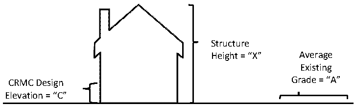
The suggested design elevation as depicted on the CRMC SDE 3 SLR map during a 100-year storm, less the average existing grade elevation. CRMC shall reevaluate the appropriate suggested design elevation map for the exclusion every ten years, or as otherwise necessary (see Figure 1-3).
In no case shall any designated freeboard or any area beneath either the BFE or design elevation in a flood zone be used as habitable space or for any use other than storage, parking of vehicles or means of egress.
c.
Maximum building height.
i.
No structure in a special flood hazard area shall exceed the following height measurements:
1.
Structures that are elevated to a distance above grade of less than or equal to five feet shall be limited to 35 feet of building height;
2.
Structures that are elevated to a distance above grade of greater than five feet but less than or equal to ten feet shall be limited to 30 feet of building height;
3.
Structures that are elevated to a distance above grade of greater than ten feet but less than or equal to 15 feet shall be limited to 25 feet of building height;
4.
Structures that are elevated to a distance above grade of greater than 15 feet shall be limited to 20 feet of building height.
6.
If a structure is built in an area with a grade cut, the building height shall be measured from the finished grade after the grade cut.
Figure 1-1
Building Height (not in a special flood hazard area)
Building Height = X
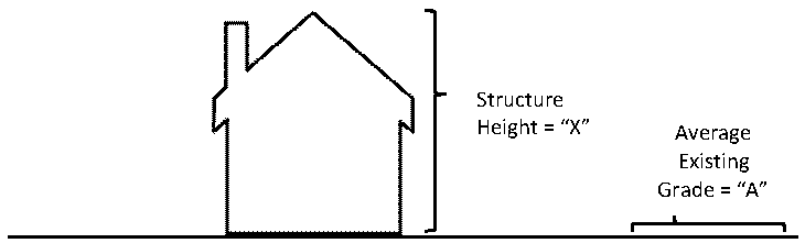
Figure 1-2
Building Height (in a special flood hazard area using the FEMA FIRM Map exclusion)
Building Height = X − ((Z + Y) − A)
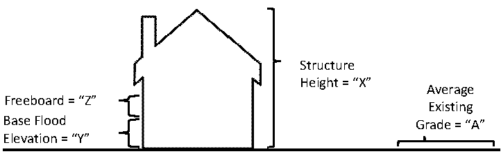
Figure 1-3
Building Height (in a special flood hazard area using the CRMC exclusion) Building Height = X − (C − A)
(b)
Limitation on fill and cut.
1.
The finished grade surrounding a building may be adjusted to a level not to exceed four feet above or below the average of the existing elevation of the existing grade at the proposed four corners of the building.
2.
For any property located in a Coastal A or VE Flood Zone, the finished grade may be adjusted to a level not to exceed two feet above or below existing grade throughout the property.
3.
The adjustment of grade on a vacant or undeveloped portion of a lot may be cut or filled by right up to four feet. The adjustment of grade cut or fill, on any lot which exceeds four feet shall require a land disturbance permit including plans stamped by a registered professional engineer in the State of Rhode Island and be approved by the town engineer.
In all cases, fill above existing grade shall be deducted from building height.
(Ord. No. 2025-0001, § 5, 2-24-25)