
Union County Unincorporated
City Zoning Code
City Zoning Code
ARTICLE 25
00 - LAND DIVISION REGULATIONS
25.01 - PURPOSE
The purpose of the land division regulations is to provide for the orderly development of land and promote the public health, safety and general welfare of the unincorporated portion of Union County. [ORS 92.046(1)]
25.02 - APPLICATION REGULATIONS
1.
No person shall partition or subdivide land in the unincorporated portion of Union County except as provided in this Ordinance and the Transportation System Plan. All partition and subdivision plats, all changes in property boundary lines and all streets and ways utilized for the purpose of creating lots or parcels are required to be approved in accordance with these regulations prior to the sale of any such lot or parcel.
2.
A person desiring to partition or subdivide land within the unincorporated area of the County shall submit tentative plans and final documents for approval as provided in this Ordinance and ORS Chapter 92 and 215.
3.
Land in the unincorporated area of the County and in an A-1, A-2, A-3 or A-4 Zones (EFU Zones) identified in the Union County Zoning, Partition and Subdivision Ordinance shall not be subdivided into four or more lots from a single parcel or lot within one calendar year. [ORS 215.263(2)]
25.03 - ENFORCEMENT
1.
Recording a Lot or Parcel.
No parcel or lot created by partition or subdivision shall be submitted for recording unless it has been approved as required by this Ordinance and the Transportation System Plan.
2.
Sale of Lots and Parcels Within Subdivisions and Partitions.
A.
No person shall dispose of, transfer or sell any lot in any subdivision until the subdivision plat is recorded.
B.
No person shall negotiate to sell any lot in any subdivision until a tentative plan of that subdivision has been approved. [ORS 92.016(1)]
C.
A person may offer or negotiate to sell any parcel in any partition with respect to which approval of a tentative plan is required by this Ordinance, prior to the approval of the tentative plan for the partition; however, no person may dispose of, transfer, or sell any parcel in any partition for which approval of a tentative plan is required by this Ordinance prior to final approval.
D.
Notwithstanding subparts A, B and C, parcels created in excess of 80 acres need not be shown on partition plats. [ORS 92.025(3)]
3.
Permits.
No Building Permit or Land Use Compatibility Statement for a subsurface sewage disposal system shall be issued for any structure in a partition or subdivision for which a plat has not been approved or recorded in the manner prescribed herein.
4.
The County may withhold all public improvements, including maintenance of streets and roads, from a partition or subdivision which has not been approved and recorded in the manner prescribed herein. Approval of a partition or subdivision does not imply that any road maintenance or improvement will be performed by the County.
25.04 - PARTITION OR SUBDIVISION PROCEDURE
1.
Pre-Application Conference.
Prior to submitting a tentative plan for a partition, subdivision, boundary line adjustment or re-plat, the applicant shall discuss his intent with the Planning Department Staff and obtain application materials. It may be desirable to prepare sketch maps, and assemble other information as needed to discuss the proposal.
2.
Tentative Plan Application and Review.
The landowner or authorized agent proposing the partition or subdivision tentative plan shall submit an application in writing on forms provided by the Department accompanied by the appropriate filing fee, tentative plan maps and any written accessory information per Section 25.05.
A.
Minor partition tentative plan applications shall be reviewed as set forth in Sections 24.06—24.08 (Planning Director land use decision).
B.
Major partition and subdivision tentative plan applications shall be reviewed as set forth in Sections 24.09—24.12 (Quasi-judicial land use decision).
3.
Effect of Approval.
Approval by the county of a tentative plan shall be binding on the owner and the county for the purpose of preparing the final plat, and the county may only require changes in the final plat that are necessary for compliance with the terms of its approval of the tentative plan.
4.
Final Plat Procedure.
A.
A complete final plat for a partition, subdivision or re-plat shall be submitted for a Ministerial Decision per Section 24.01 to determine compliance with the tentative plan and Section 25.06. An incomplete final plat shall be returned to the applicant.
B.
When the final plat is determined complete the Director shall sign the final plat and its exact copy(ies).
C.
A Director approved and signed final plat shall be returned to the applicant for circulation, approval and signatures by the following officials:
(1)
County Surveyor who shall review the final plat for conformance with the provisions in ORS 92.050 through 92.100 and ORS 209.250;
(2)
County Assessor who shall ensure that taxes, special assessments, fees, or other charges required by law to be placed on the tax roll are calculated in accordance with ORS 92.095;
(3)
County Treasurer who shall certify that all ad valorem taxes on the property have been paid per ORS 92.095;
(4)
For subdivision final plats, the chairperson or vice chairperson of the Board of Commissioners who shall certify that the final plat is approved by the Board; and
(5)
For road dedications on final partition plats, the chairperson or vice chairperson of the Board of Commissioners shall certify that the final plat is approved by the Board; and
(6)
Upon signing by the required county officials, the final plat shall be delivered to the County Clerk along with applicable fees for signature and recording per ORS 92.120.
D.
The signature of the Director on a final plat shall be valid for one year. If the final plat is not recorded with the clerk within one year the Director's approval shall expire and a new request for final approval shall be necessary.
25.05 - TENTATIVE PLAN REQUIREMENTS
1.
A tentative plan map shall be prepared by a registered professional land surveyor for all partitions and subdivisions creating parcels and lots. The boundaries of parcels in partitions greater than 80 acres in size shall be described by a registered professional land surveyor but are not required to be drawn on the tentative plan. [ORS 92.025(3)]
2.
A tentative plan map shall include or be accompanied by a vicinity map drawn at a small scale, e.g., one inch equals 2,000 feet, and shall show:
A.
All existing parcel or lot lines and street rights-of-way immediately adjoining the proposed partition or subdivision and the location of the nearest existing public road(s).
B.
The manner in which streets and alleys in the proposed partition or subdivision may connect with existing or proposed streets and alleys in neighboring property to produce the most advantageous development of the entire area.
3.
A tentative plan map shall be prepared at a scale acceptable to the County Surveyor Map of Survey Checklist and drawn on material 18 inches by 24 inches in size, unless otherwise approved by the Planning Department Staff. The tentative plan map shall include the following information:
A.
Identification clearly stating the map is a tentative plan.
B.
If the tentative plan is for a subdivision the map shall include the proposed subdivision name.
C.
The date, north point and scale of the map.
D.
The location of the proposed development including section, township, range and legal description sufficient to define the location and boundaries of the proposed partition or subdivision.
E.
The names and addresses of the owner, sub-divider, engineer, surveyor, and land planner as applicable.
F.
The acreage of the proposed development.
G.
The boundary of all proposed parcels and lots 80 acres or less in size.
H.
A reference to all parcels and lots greater than 80 acres noting their number and size.
I.
The location, widths and names of all existing or proposed streets or other public ways, pathways or bike trails within or adjacent to the proposed development; grades of all proposed streets; railroad rights-of-way and other features such as section lines and corners; political subdivisions or corporate lines.
J.
The location in the adjoining streets or property of existing or proposed sewers and water mains, culverts and drain pipes, electrical conduits or lines proposed to be used or connected to the property to be partitioned or subdivided.
K.
Contour lines may have the following minimum intervals: two-foot contour intervals for ground slopes of less than 10-percent, 10-foot contour lines for slopes up to 50-percent or greater. Contour lines shall be provided where roads are being created. The elevations of all control points or bench marks to determine the contours shall be on or near the subject property and shall be indicated or described and shall be stated, except where a floodplain is involved the United States Geologic Survey datum shall be used or datum shall be approved by the County Surveyor.
L.
The approximate location of areas subject to inundation or storm water overflow and elevation of the highest flood of record.
M.
Location, type and direction of flow of all surface water courses.
N.
Natural features, such as rock outcroppings, marshes, wooded areas, historic or other unique features.
O.
Existing use or uses of the property and adjacent property, including approximate location of all existing structures.
P.
The Land Use Plan and Zoning classifications on land adjacent to the tract.
Q.
Explanation which contains identification of symbols used on the tentative plan map.
R.
Explanatory Information.
The following information shall be included as part of the tentative plan, but may be submitted in the form of statements in lieu of being drawn or included as part of the detailed map:
(1)
Certification of title showing ownership of the land within the subdivision.
(2)
Typical cross-sections and typical profiles of all streets within a major partition or subdivision, or sufficient topographical information to establish approximate grades and drainage methods.
(3)
Proposed locations, typical cross-sections, typical profiles and proposed improvements as required in the General Design and Improvement Standards of this Ordinance (Section 25.09).
(4)
Proposed deed restrictions in outline form.
(5)
Proposed classification of each street, e.g., arterial, collector, local or private easement.
(6)
Proposed source of domestic water supply.
(7)
Provisions to be made for sewage disposal, storm water drainage, and flood control.
(8)
Fire protection protective agency.
(9)
School district.
(10)
Traffic analysis procedures. If it is determined that a proposed project may impose an undue burden on the public transportation system, then traffic analysis and mitigation must be undertaken. Proposals generating up to 100 vehicle trips per day will be reviewed locally by ODOT, Region 5. Proposals generating between 100 and 400 vehicle trips per day will be reviewed by an ODOT Traffic Engineer. Proposals generating over 400 vehicle trips per day will be required to submit a traffic impact study.
(a)
For developments that are likely to generate more than 400 average daily motor vehicle trips (ADTs), the applicant shall provide adequate information, such as a traffic impact study or traffic counts, to demonstrate the level of impact to the surrounding street system.
(b)
Standards by which to gauge average daily vehicle trips include: 10 trips per day per single family household; 5 trips per day per apartment; and 30 trips per day per 1,000 square feet of gross floor area which would equal a new supermarket or other retail development. The developer shall be required to mitigate adverse impacts attributable to the project. The determination of impact or effect, and the scope of the impact study, should be coordinated with the provider of the affected transportation facility.
(c)
Undue burden on the public transportation system includes any one of the following: 1) changes to the functional classification of an existing or planned transportation facility; 2) changes to standards implementing a functional classification system; 3) allowance of land uses that would result in levels of travel or access that are inconsistent with the functional classification of a transportation facility; or 4) reduction in facility level of service below the minimum acceptable level identified in the Transportation System Plan.
4.
Partial Development.
Where the partition or subdivision includes only a portion of the contiguous land owned by the developer, a sketch of a tentative layout of streets in the remainder of the ownership may be required to be provided.
25.06 - FINAL PLAT REQUIREMENTS
1.
Surveys and final plats of all partitions, subdivisions, property line adjustments and re-plats shall be prepared by a registered professional land surveyor and shall conform to requirements in ORS Chapter 92 (ORS 92.050—92.100) and ORS 209.250 and the plat standards of the Union County Surveyor.
A.
All subdivision lots shall be surveyed.
B.
Parcels created through platting 10 acres and less in size shall be surveyed. [ORS 92.060(6)]
C.
Parcels created through platting greater than 10 acres shall be clearly marked "unsurveyed" adjacent to the parcel number, and identified with the approximate acreage. [ORS 92.055]
2.
A final plat for a partition, subdivision or re-plat shall be accompanied by the following where applicable:
A.
A copy of all covenants and restrictions.
B.
Copies of legal documents required for dedication of public facilities or for the creation of a homeowner's association.
C.
The certification, performance agreement or statement regarding the provision for domestic water and sewage disposal services. All proposed subdivision lots have been approved for sewage disposal in accordance with standards and specifications as prescribed by the Oregon Department of Environmental Quality. [ORS 92.090(4) & (5)].
D.
Certification from an irrigation district, drainage district, water control district, water improvement district or district improvement company that the partition or subdivision is either entirely excluded from the district or company or is included within the district or company for purposes of receiving services. [ORS 92.090(6)]
E.
A preliminary title report, lot book report, subdivision guaranty report or equivalent documentation of the ownership of the subject property, issued not more than 30 days prior to the date the final plat is submitted for Clerk recording. Such a report shall also identify all easements of record.
F.
A copy of new deeds and reference to existing deeds, conveyances or other recorded documents pertaining to any easements which the platted property is subject to.
G.
Such other information as is deemed necessary by the Director to verify conformance with the conditions of the tentative plan approval.
25.07 - PROPERTY LINE ADJUSTMENT PROCEDURES AND STANDARDS
1.
Except as provided for in subsection (2) of this section, all property line adjustments within recorded plats shall be accomplished by re-platting in accordance with Section 25.08 and ORS 92.180 through 92.190.
2.
Property lines between legally created parcels, lots and tracts may be adjusted other than re-platting where the property line adjustment meets the standards and procedures in subsections (3) and (4) and does not act to reconfigure an existing subdivision or partition plat or to increase or decrease the number of parcel or lots.
3.
The procedure for review and approval of property line adjustments other than re-platting shall be as set forth in Section 24.01 (Ministerial Decisions).
4.
Property line adjustments other than re-platting shall be approved where they can satisfy the following:
A.
No additional parcel or lot is created.
B.
One or both of the abutting properties are smaller than the minimum lot or parcel size for the applicable zone before the property line adjustment and, after the adjustment, one is as large as or larger than the minimum lot or parcel size for the applicable zone.
C.
Both abutting properties are smaller than the minimum lot or parcel size for the applicable zone before and after the property line adjustment.
(1)
On land zoned for exclusive farm use, forest use or mixed farm and forest use, a property line adjustment under (b) or (c) above may not be used to:
(a)
Decrease the size of a lot or parcel that, before the relocation or elimination of the common property line, is smaller than the minimum lot or parcel size for the applicable zone and contains an existing dwelling or is approved for the construction of a dwelling, if the abutting vacant tract would be increased to a size as large as or larger than the minimum tract size required to qualify the vacant tract for a dwelling; or
(b)
Decrease the size of a lot or parcel that contains an existing dwelling or is approved for construction of a dwelling to a size smaller than the minimum lot or parcel size, if the abutting vacant tract would be increased to a size as large as or larger than the minimum tract size required to qualify the vacant tract for a dwelling; or
(c)
Allow an area of land used to qualify a tract for a dwelling based on an acreage standard to be used to qualify another tract for a dwelling if the land use approval would be based on an acreage standard.
D.
The proposed parcels, lots or tracts of land as adjusted will comply with other area dimension requirements such as width and depth and setbacks as prescribed by the applicable use zone. Where the original parcels, lots or tracts do not conform to area dimension requirements in the applicable zone, any proposed property line adjustment shall not increase the degree of nonconformity.
E.
The proposed property line adjustment shall not act to grant a use otherwise requiring review and approval under the applicable use zone.
F.
A property line adjustment shall be surveyed in compliance with ORS 92.060(7), except that a survey is not required under the following:
(1)
Where both parcels affected are greater than 10 acres; or
G.
A property line adjustment shall be recorded with the Clerk and shall contain the names of the parties, the description of the adjusted line, references to original recorded documents and signatures of all parties with property acknowledgement. [ORS 92.190 (3) & (4)].
H.
One copy of the recorded documents for a property line adjustment shall be provided by the applicant to the Planning Department at the time of recording.
25.08 - REPLATTING PROCEDURES AND STANDARDS
1.
The procedures for re-platting filed and recorded partition and subdivision plats shall be as set forth in Sections 24.05 through 24.08 (Planning Director land use decision).
2.
Existing filed and recorded partition and subdivision plats may be re-platted where the proposed re-plat can satisfy the requirements in ORS 92.185 through 92.190.*
Note— *The following design standards are authorized by statute, but not specifically prescribed except where noted. These suggested standards are a combination of the existing ordinance language and staff recommendations.
25.09 - GENERAL DESIGN AND IMPROVEMENT STANDARDS
1.
Road Design Conformity.
The arrangement, character, extent, width, grade and location of all roads shall be designed to coordinate with existing and planned roads, topographical conditions, construction and maintenance costs, public conveniences and safety, and in their appropriate relation to the proposed uses of the land to be served by such road.
Where not shown on an area plan, the arrangement and other design standards of roads shall conform to the provisions found in the Transportation System Plan and herein.
2.
Relation to Adjoining Road System.
The arrangement of roads in partitions and subdivisions shall be designed to coordinate with existing or desired roads in adjoining areas.
3.
Projection of Roads.
Where adjoining areas are not partitioned or subdivided to the maximum density allowed by the applicable zone(s), the arrangement of roads in new subdivisions shall make provisions for the proper projection of roads.
4.
Dead-End Road, Cul-de-Sac or Hammerhead Turn Around.
No dead-end roads shall be constructed without a turn-around or cul-de-sac. A turn-around or cul-de-sac shall have an outside roadway radius of at least 45 feet and a road right-of-way radius of at least 60 feet. A hammerhead turn around shall at a minimum meet the dimensional standards as identified in Figure 4-1 below. Future extension of the road into adjoining properties will result in vacating the unused portion of the cul-de-sac turn-around or hammerhead turn-around to adjacent properties. A cul-de-sac turn-around or hammerhead turn around shall not be used as a parking area. Individual parcels and lots shall have access driveways extending into them where necessary. A Hammerhead shall have five (5) No Parking signs permanently installed at each terminus corner and midway along the back right-of-way.
FIGURE 4-1
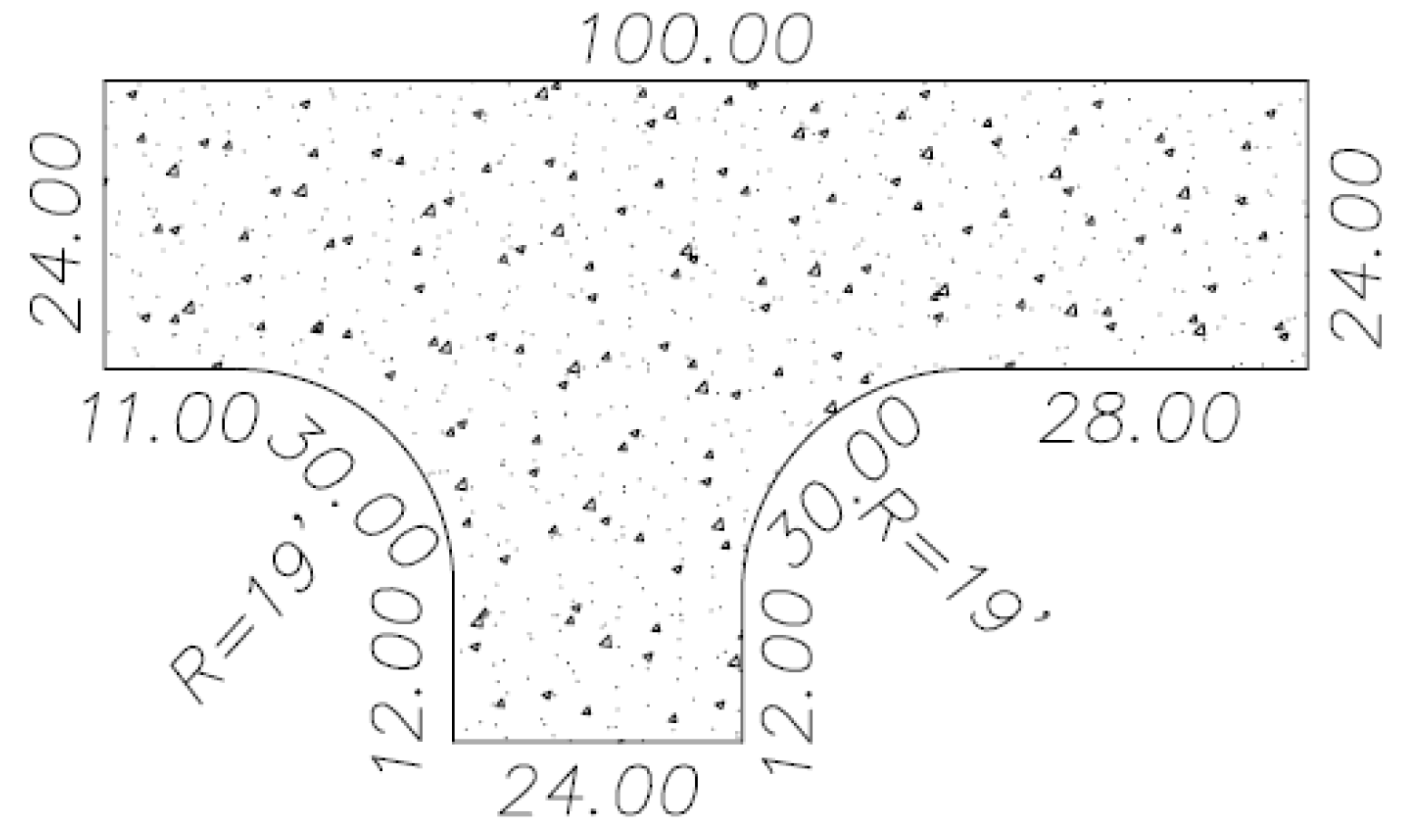
Hammerhead Detail
Union County
5.
Roads to Be Carried to Property Lines.
When a proposed partition or subdivision joins land capable of further division, road rights-of-way shall be carried to the boundaries of the tract to be partitioned or subdivided.
6.
Frontage Roads.
Where a partition or subdivision abuts or contains an existing arterial road, the Commission may require frontage roads or other such treatment as may be necessary for adequate protection of abutting properties and to afford separation of through and local traffic in order to preserve mobility on the arterial.
7.
Local Roads.
Local roads shall be so laid out that their use by through traffic will be discouraged.
8.
Road Widths and Improvements.
A.
Road standards shall not be less than those set forth in Table 7-2 in the Transportation System Plan, except where it can be shown that probable future traffic development or physical characteristics are such as to unquestionably justify modification of the standards.
B.
In areas designed and zoned for commercial use, road widths may be increased by such amount as may be deemed necessary by the Commission to provide for the free flow of through traffic without interference by parked or parking vehicles, and to provide safe parking space for such commercial or business districts.
C.
Road and related improvements shall be completed or bonded for completion prior to final plat consideration and shall be constructed under the direction of the County Planning Department, according to the minimum Road Standard Table 7-2.
Table 7-2
Road Development Standards for Union County
*Geotech fabric shall be required between base and subgrade where paved for arterials and collectors.
**Private driveways in excess of 200 feet shall require 20 × 40 turnouts at a maximum spacing of ½ the driveway length or 400 feet, whichever is less.
***Crushed gravel for the combined leveling course and overlay material shall be non-alluvial in origin.
9.
Intersections.
Ingress and/or egress to property near the intersection of two or more streets or roads shall be set back from the corner intersection of the street lot lines for a distance of 100 feet. Access for ingress and/or egress to property at an intersection with a state highway shall observe the minimum spacing requirements for state highways identified in Table 7-3. The intersections of more than two roads at one point shall be avoided except where it is impractical to secure a proper road system otherwise. Roads shall intersect one another at an angle as near to a right angle as possible, and no road shall intersect at an angle of less than 75 degrees.
Road intersections shall be rounded at the outside lane edge and engineered to meet the intersection angle.
Table 7-3
Oregon State Highway Access Management Standards
Source: Table 1 — Access Management Classification System, Appendix B, 1991 Oregon Highway Plan.
10.
Reverse Curve.
A tangent at least 100 feet long shall be introduced between reverse curves on arterial roads.
11.
Large Parcel Partitions and Large Lot Subdivisions.
Where a tract is partitioned or subdivided into larger parcels or lots than permitted by the applicable zone, such parcels or lots shall be arranged so as to allow the opening of future roads and logical further partitioning or subdividing.
12.
Reserve Strips.
Reserve strips controlling access to roads shall be prohibited except under conditions approved by the Planning Commission.
13.
Road Grades.
No road grade shall be less than 3/10 of one-percent, and shall not exceed the following, with due allowance for reasonable vertical curves:
14.
Railroad or Limited Access Highway on or Abutting a Partition or Subdivision.
Where a partition or subdivision is bordered on or contains a railroad right-of-way or limited access highway right-of-way, the Planning Commission may require a road approximately parallel to and on each side of such right-of-way at a distance suitable for the requirements of approach grades and future grade separations.
15.
Half Road Prohibited.
Half roads shall be prohibited except where essential to the reasonable development of the partition or subdivision in conformity with the other requirements of these regulations. Where the Commission finds it will be practicable to require the dedication of the other half when adjoining property is partitioned or subdivided, such right-of-way may be required as part of the initial plat.
16.
Road Names and Numbers.
Road names and numbers shall be assigned and conform to the Union County Road Naming and Rural Address Ordinance No. 1988-3.
17.
Access to Roads Across Ditches.
The developer shall provide access to all proposed lots or parcels, across all ditches and streams to accommodate a gross vehicle weight of 50,000 pounds and by a standard method approved by the County Planning Department.
18.
Dedication.
Streets and roads for public use are dedicated without any reservation or restriction other than reversionary rights upon vacation of any street or road and easements for public utilities [ORS 92.090(3)]. Union County shall preserve right-of-way for planned transportation facilities through exactions, voluntary dedications, or setbacks.
19.
Private Road Easements.
Proposed private road easements shall be designated on the tentative plan and may be approved by the Planning Commission if they meet the following conditions:
A.
Private road easements shall provide access to no more than two proposed or potential parcels. No road easement providing access between public roads or other private road easements shall be approved as a private road easement.
B.
No private road easement shall be approved unless the Planning Commission is satisfied that such right-of-way is not presently needed, nor will ever be needed to be extended through to adjacent property, or to be utilized for public road purposes in the normal growth of the area.
C.
No private road easement shall be less than 30 feet wide, except that a modification may be approved to allow a driveway easement of 20 feet to one parcel or lot.
D.
Surface improvements on private road easements shall be as prescribed in Table 7-2, Road Development Standards.
E.
Maintenance responsibility for private road easements shall be predetermined before final plat approval according to ORS Chapter 660 through one of the following options:
(1)
A maintenance agreement established by the developer with the legal mechanism for the agreement to be presented prior to approval of the final plat.
(2)
Any other method of providing perpetual financing for maintenance services and improvements.
20.
Alleys.
A.
Commercial and Industrial Districts.
Alleys shall be required in commercial and industrial districts, except that the Commission may waive this requirement where other definite and assured provisions are made for service access, such as off-road loading, or unloading and parking consistent with and adequate for the uses proposed.
B.
Width.
The right-of-way width of an alley shall be that width determined necessary by the Planning Commission.
C.
Dead-end.
Dead-end alleys shall not be permitted, except that the Commission may waive this requirement where such dead-end alley is unavoidable, and where adequate turn-around facilities have been provided.
21.
Easements.
A.
Provided for Utilities.
Easements with a sufficient right-of-way for utility maintenance may be required by the Planning Commission where necessary for utilities.
B.
Providing for Drainage.
Where a partition or subdivision is traversed by a water course, drainage way, channel, or stream, there shall be provided a storm water easement or drainage right-of-way conforming substantially with the lines of such water course, and such further width of construction, or both, as will be adequate for the purpose.
22.
Blocks.
A.
All subdivision plats shall continue the lot numbers and, if used, the block numbers of the subdivision plat of the same name last filed. New subdivisions shall not use block numbers or letters unless such subdivision is a continued phase of a previously recorded subdivision, bearing the same name, that previously used block numbers or letters [ORS 92.090(1)].
B.
Factors Governing Dimensions.
Block length and width or acreage within boundary roads shall be such as to accommodate the size of lots required in the area by the zoning ordinance of the County, and to provide for convenient access, circulation control and safety of road traffic.
C.
Arrangement.
A block shall generally be so designed as to provide two rows of lots.
23.
Parcels and Lots.
A.
Every parcel and lot shall abut and have adequate access to an approved public or private road and shall have a road frontage of not less than 100 feet, except a parcel or lot on the radius of a curved street or facing the circular end of a cul-de-sac shall have frontage of not less than 30 feet upon a street, measured on the arc of the right-of-way.
B.
Flag parcels and lots with less than 100-foot frontage shall not be permitted.
C.
In creating parcels and lots of two acres or less, their minimum area calculation shall not include the following:
(1)
The land area located below the mean high water elevation of a lake, river, stream or other water body.
(2)
The land area included within a public or private road right-of-way.
D.
A lot or parcel lawfully created through a platting process shall remain a discrete lot or parcel, unless the lot or parcel lines are vacated or the lot or parcel is further divided, as provided by law. Parcels not created through a platting process but legally created shall be comprised of contiguous ownership which joins by more than a point.
24.
Subdivided Lots in a Forested Area.
A.
Fuel Breaks.
A buffer area shall be at least 200 feet wide in a forested area around an entire subdivision where all dead and down material is removed and remaining vegetation is thinned to reduce fire spreading. On slopes greater than 30-percent the fuel break shall be widened to 300 feet or as advised by the State Forester.
B.
Internal Fuel Breaks.
Each residential dwelling shall maintain a fuel break of not less than 30 feet from dense vegetation. Dead and down material shall be removed and no natural or ornamental shrubbery within the fuel break shall provide a means for rapid transmission of fire from outside natural areas. Wider breaks may be required on slopes exceeding 30 % on advise of a State Forester.
25.
Water Distribution System.
No subdivision shall receive final approval unless the county has received and accepted:
A.
A certification by the owner or superintendent of a publicly or privately owned domestic water supply system, that water is available to the boundary line of each and every lot depicted in the proposed subdivision;
B.
A performance agreement, bond, contract or other assurance that a domestic water supply system will be installed to the boundary line of each and every lot or parcel depicted in the proposed subdivision; or
C.
Where a community or public water supply system is not available, a statement signed by the applicant that water service will not be provided to any lot or parcel depicted in the subdivision.
26.
Sewage Distribution System.
No subdivision shall receive final approval unless the county has received and accepted:
A.
A certification by the owner or superintendent of a publicly or privately owned sewage disposal system that sewerage service is available to the boundary line of each and every lot depicted in the proposed subdivision;
B.
A performance agreement, bond, contract or other assurance that a sewage disposal system will be installed by or on behalf of the developer to the boundary line of each and every lot depicted in the proposed subdivision; or
C.
Where no community sewerage service is available, the Department of Environmental Quality shall approve the proposed methods of sewage disposal.
27.
Storm and Water Runoff and Flood Control.
Prior to considering final approval of a partition or subdivision, the developer shall make or be bonded to make drainage improvements as needed to accommodate storm water runoff and to minimize the potential for flood damage.
28.
Sidewalk and Bicycle Trail Improvements.
Sidewalk and bicycle improvements shall conform to the Union County Bicycle-Pedestrian Plan.
29.
Monuments.
Monuments shall be placed by a professional land surveyor in all locations as required by ORS Chapter 92. Any monument which might be disturbed during construction, shall be properly replaced when such construction has been completed.
30.
Map of Improvements as Constructed.
A map showing all public improvements as built shall be filed in the Planning Department upon completion of said improvements.
31.
Uninhabitable Lots.
Lots or parcels subject to natural hazards deemed by the Commission to be undesirable for habitation shall not be plotted for residential occupancy, nor for such other uses as may increase danger to health, life or property, or aggravate the natural hazard. Such land within a plat shall be combined with lots suitable for development, or shall be set aside for such uses as will not be endangered by periodic or occasional natural hazards or will not produce unsatisfactory living conditions.
32.
Lot Remnants.
All remnants of lots below minimum size left over after subdivision of a larger tract must be added to adjacent lots, rather than be allowed to remain as unused lots.
33.
Access.
For joint and cross access, adjacent commercial and industrial developments classified as major traffic generators shall provide a cross access drive and pedestrian access to allow circulation between sites. Shared parking areas shall be permitted a reduction in required parking spaces if peak demands do not occur at the same time periods.
34.
Access Connection and Driveway Design.
Driveway width shall meet the following guidelines: a) if the driveway is a one way in or one way out, then the driveway shall be a minimum width of 10 feet and shall have appropriate signage designating the driveway as a one way connection; b) for two-way access, each lane shall have a minimum width of 10 feet and a maximum of four lanes shall be allowed. Whenever more than two lanes are proposed, a median should be considered to divide the entrance and exit lanes. Driveway approaches must be designed and located to provide an exiting vehicle with an unobstructed view. Construction of driveways along acceleration or deceleration lanes and tapers shall be avoided due to the potential for vehicular weaving conflicts. The length of driveways shall be designed in accordance with the anticipated storage length for entering and exiting vehicles to prevent vehicles from backing into the flow of traffic on the public street or causing unsafe conflicts with on-site circulation.
35.
Existing Access Features.
Legal driveway connections on the state highway system in place as of adoption of the TSP shall be designated as conforming features and will be reconsidered only if safety concerns develop, if changes in use occur producing an additional 100 vehicle trips per day or more, or if zone changes/plan amendments are proposed accessing the state highway system.
There are several alternatives for access point consideration—the access onto the state highway is closed and moved to a side road, the access is combined with other access points, the access is moved according to the spacing standards set forth in Table 7-3 of the Transportation System Plan in order not to conflict with intersection traffic, the access conforms to "Access Management Techniques" listed in the TSP, or nothing is done and the access is left alone.
36.
New Access Features.
For proposed development of properties abutting the state highway system, new public roads shall be based on the existing spacing standards set forth in Table 7-3 of the Transportation System Plan. For proposed new development of properties adjacent to the state highway system, the developer/owner shall, prior to making application, notify and coordinate with Union County and the ODOT District Manager (ODOT, Region 5) to ensure access safety and pursue access alternatives if safety is compromised. The highest priority shall be placed on providing access to property abutting the state highway system from local roads or combining driveways. Land development affecting the state highway system will address safety, capacity, functional classification, and level of service. Access management policies for Union County set forth in the Transportation System Plan will be observed.
37.
Shared Access.
Proposed subdivisions with frontage on the state highway system shall be designed to share access points from the highway. If access from a local road is possible, then access shall not be allowed onto the state highway. If access from a local road becomes available, then conversion to that access is encouraged, along with closing the state highway access. A maximum of 2 accesses may be allowed regardless of the number of lots or businesses served.

