
Union Town City Zoning Code
ARTICLE II
ZONING DISTRICTS
DIVISION 4. - RESERVED[2]
Editor's note— Res. No. 2023-12, adopted July 20, 2023, repealed div. 4, §§ 30-141—30-146, which pertained to A-1 Agricultural-Transition District and derived from Res. No. 2018-16, adopted June 5, 2018.
DIVISION 15. - RR-RC RESIDENTIAL RECREATION-RECREATIONAL COMMERCIAL DISTRICT[3]
Editor's note— Res. No. 2021-32, adopted October 21, 2021, amended the Code by the addition of Div. 15, §§ 30-409—30-411; subsequently renumbering former Div. 15, §§ 30-413, Zoning Schedule, and Div. 16, §§ 30-420—30-428, "PRD Planned Residential Development' as Div. 16 and Div. 17, respectively.
Sec. 30-27. - Establishment of districts.
For the purposes of this article, the unincorporated areas of the county are hereby divided into the following types of districts:
(Res. No. 2018-16, 6-5-2018; Res. No. 2021-32, 10-21-2021; Res. No. 2023-12, 7-20-2023)
Sec. 30-28. - Zoning map and district boundaries.
For purpose of this chapter, the county, outside the incorporated villages and cities, is hereby divided into the zoning districts identified and described in section 30-27. The boundaries of districts are established as shown upon the maps designated as the "Zoning Map of Burnett County, Wisconsin," and the "Wisconsin Wetlands Inventory Maps" for the county as depicted on the Department of Natural Resources Surface Water Data Viewer. The wetland maps can be viewed at http://dnrmaps.wi.gov/SL/Viewer.html?Viewer=SWDV&runWorkflow=Wetland. These maps are hereby adopted and made a part of this chapter. All notations, references and other information shown upon the zoning and wetland maps shall be as much a part of this chapter as if the matter and things set forth by said maps were fully described herein. The zoning maps are on display in the office of the zoning administrator.
(Res. No. 2018-16, 6-5-2018)
Sec. 30-83. - Purpose.
(a)
The RR-1 district is intended to provide for year around residential development and essential recreation-oriented services in areas of high recreational value where soil conditions and other physical features will support such development without depleting or destroying natural resources. The minimum average lot width is 150 feet with a 30,000 square foot minimum area.
(b)
The RR-2 district is intended to provide medium size lots for residential-recreational development as a means of preserving estate living and allowing lot size sufficient enough for recreational value. The minimum average lot width is 200 feet with a minimum lot area of 1½ acres.
(c)
The RR-3 district is intended to provide for large size lots for residential-recreational development as a means to preserve the space characteristics of country living. The minimum average lot width is 300 feet with a minimum lot area of five acres.
(Res. No. 2018-16, 6-5-2018)
Sec. 30-84. - Permitted uses.
The following are the permitted uses in the RR-1, RR-2 and RR-3 Residential-Recreation Districts:
(1)
One single-family dwelling.
(2)
Private garages and carports.
(3)
Horticulture and gardening.
(4)
Essential services and utilities to serve the principal permitted use.
(5)
Customary accessory uses provided such uses are clearly incidental to the principal permitted use.
(6)
Forest management programs.
(7)
Private residence for recreational rentals requiring state licensing under Wis. Admin. Code ch. ATCP 72, subject to county licensing requirements as listed in 30-455.
(Res. No. 2018-16, 6-5-2018)
Sec. 30-85. - Conditional permit.
The following are the uses authorized by conditional permit in RR-1, RR-2 and RR-3 Residential-Recreation Districts:
(1)
Manufactured home parks subject to the provisions of article V of this chapter.
(2)
Telephone and power transmission towers, poles and lines, substations, relay and repeater stations, equipment housing and other necessary appurtenant equipment and structures. (See article VI of this chapter for tower communication facilities.)
(3)
Recreational service oriented uses such as resorts and motels, restaurants and cocktail lounges, marinas, sport shops and bait sales, and other recreational services, which in the opinion of the land use and information committee are of the same general character or clearly incidental to a permitted use, or use authorized by conditional permit.
(4)
Livestock or other agricultural practices, subject to conditions set by the land use and information committee.
(5)
Mini-storage rental buildings or storage rental buildings for storage of personal property. Allowed by conditional permit in the RR-2 and RR-3 districts only. Such buildings are considered accessory structures.
(6)
Two-family dwelling units also known as duplexes. A two-family dwelling unit cannot be separate structures and must share a common wall and roof.
(7)
Home occupations or professional offices provided no such use occupies more than 25 percent of the total floor area of the dwelling, not more than one nonresident person is employed on the premises, and such use will not include an operational activity that would create a nuisance to be otherwise incompatible with the surrounding land uses. Expanded home occupations which may be carried on other than within the confines of the home and which may involve persons other than the resident family may be authorized where such activity will not be incompatible to the surrounding uses.
(8)
Public and semi-public uses including but not limited to the following: public and private schools, churches, public parks and recreational areas, hospitals, rest homes and homes for the aged, fire and police stations, historic sites, except that sewage treatment and solid waste disposal facilities shall not be allowed.
(9)
Operate an animal control facility, animal shelter, animal boarding facility, domesticated animal breeding facility or have more than 15 domesticated animals.
(Res. No. 2018-16, 6-5-2018; Res. No. 2021-32, 10-21-2021; Res. No. 2022-12, 4-19-2022)
Sec. 30-114. - Purpose.
This district is intended to preserve productive agricultural land for food and fiber production, preserve productive farms by preventing land use conflicts between incompatible uses and controlling public service costs, maintain a viable agricultural base to support agricultural processing and service industries, prevent conflicts between incompatible uses, reduce costs of providing services to scattered nonfarm uses, space and shape urban growth, implement the provisions of the county agricultural plan when adopted and periodically revised, to permit eligible landowners to receive tax credits under Wis. Stats. § 71.09(11).
(Res. No. 2018-16, 6-5-2018)
Sec. 30-115. - Lands included within this district.
This district is generally intended to apply to lands which are limited to exclusive agricultural use including: lands historically exhibiting good crop yields, land capable of such yields, lands which have been demonstrated to be productive for dairying, livestock raising and grazing, other lands which are integral parts of such farm operations, land used for the production of specialty crops such as cranberries, ginseng, mint, sod, fruits and vegetables, and lands which are capable of productive use through economically feasible improvements such as irrigation or drainage.
(Res. No. 2018-16, 6-5-2018)
Sec. 30-116. - Permitted uses.
The following are the permitted uses in the A Exclusive Agricultural District:
(1)
One single-family dwelling. These must meet the definition of farm residence or have existed prior to January 1, 2014.
(2)
Manufactured homes:
a.
One manufactured home used for habitation that is not the primary place of residence shall be permitted as an accessory building on an operating farm, providing:
1.
A determination is made in writing by the land use and information committee, that one or more of the occupants of the manufactured home derives a substantial portion of their livelihood from the farm operation and/or substantially participates in the operations of the farm, and provided with proper skirting or a foundation.
2.
More than one manufactured home on the property may be permitted if needed for help in conjunction with the farm operation with a conditional use permit from the land use and information committee.
b.
The temporary use of a manufactured home, not to exceed one year unless an extension is authorized in writing by the land use and information committee shall be permitted while a permanent dwelling is under construction, providing the manufactured home and the permanent dwelling are located on the same lot or parcel of land and providing a county sanitary permit has been obtained for the permanent dwelling and that an approved private sewage system (POWTS) is utilized by the temporary manufactured home.
(3)
Pole buildings, garages, and any other buildings necessary to the farm operation or permitted residential uses.
(4)
General farming, including dairying, livestock and poultry raising, nurseries, greenhouses, beekeeping, vegetable warehouses, seasonal sale of seed and fertilizer and other similar enterprises or uses, except fur farms and farms operated for the disposal or reduction of garbage, sewage, rubbish or offal; provided that no greenhouse or building for the housing of livestock or poultry shall be located within 100 feet of any boundary of a residential lot other than that of the owner or lessee of such greenhouse or building containing such livestock or poultry. Buildings housing animals, facilities, barnyards, or feedlots for up to 250 animals shall be at least 100 feet from any navigable waterbody and shall be so located that manure will not drain into any navigable waterbody. (Farms with more than 250 animal units will require a conditional use permit from the land use and information committee.)
(5)
One roadside stand per farm, of not more than 300 square feet, used solely for the sale of products more than 50 percent of which were produced on the premises provided sufficient off-street parking space for customers is furnished and all setbacks are met.
(6)
Forest management.
(7)
Hunting, fishing and trapping.
(8)
Maple syrup processing plant.
(9)
Signs. Signs not to exceed 32 square feet used exclusively to advertise sale of agricultural products produced on the premises, signs giving the name of the farm owner, and rural directory signs.
(10)
A transportation, utility, communication or other use that is required under state or federal law to be located in a specific place or that is authorized to be located in a specific place under state or federal law that preempts the requirement of a conditional use permit for that use may be a permitted use. All other transportation, utility, or communication uses must meet Wis. Stats. § 91.46(4). (See article VI of this chapter for tower communication facilities.)
(11)
Logging shelters used for the purpose of temporarily storing logging equipment at the logging site or for the production of maple syrup.
(12)
For purposes of farm consolidation, farm residences or structures that existed prior to December 31, 2013, may be separated from a larger farm parcel.
(13)
And all other uses as allowed under Wis. Stats. §§ 91.01(2) and (19).
(Res. No. 2018-16, 6-5-2018; Res. No. 2023-12, 7-20-2023)
Sec. 30-117. - Conditional uses.
Such approval shall be consistent with the general purposes and intent of this chapter and shall be based upon such evidence as may be presented at such public hearing. The land use and information committee, in passing upon applications for these conditional use permits, shall consider the following factors:
(1)
The statement of purposes of this chapter and the A Exclusive Agricultural District.
(2)
The need of the proposed use for a location in an agricultural area.
(3)
The availability of alternative locations.
(4)
Compatibility with existing or permitted uses on adjacent lands.
(5)
The productivity of the lands involved.
(6)
The location of the proposed use so as to reduce to a minimum the amount of productive agricultural land converted.
(7)
The need for public services created by the proposed use.
(8)
The availability of adequate public services and the ability of affected local units of government to provide them without an unreasonable burden.
(9)
The effect of the proposed use on water or air pollution, soil erosion and rare or irreplaceable natural resources.
(10)
For farms with more than 250 animal units, setbacks shall meet or exceed the minimum standards established in Wis. Admin. Code ch. DATCP 151.
(11)
For farms with more than 250 animal units, must meet any other applicable standards in chapter 18.
(Res. No. 2018-16, 6-5-2018; Res. No. 2023-12, 7-20-2023)
Sec. 30-118. - Conditional use permits.
The following are the uses authorized by conditional use permit in the A Exclusive Agricultural District:
(1)
Single-family dwellings, in addition to permitted residences in subsection 30-116(1), providing one or more of the occupants is a parent or child of the operator of the farm, or when the dwelling is to be the retirement home of the present farm operator.
(2)
Canneries.
(3)
Cheese factories.
(4)
Condenseries.
(5)
Farms with more than 250 animals units.
(6)
Creameries.
(7)
Facilities used for the centralized bulk collection, storage and distribution of agricultural products to wholesale and retail markets.
(8)
Facilities used to provide veterinarian services for livestock.
(9)
Facilities used in processing of agricultural products.
(10)
Fur farms when located not less than 1,000 feet from any residential building other than that of the owner of the premises, his agent or employee.
(11)
Public utility substations, power plants, relay stations and microwave receivers and transmitters, semi-public and private utility towers, receivers, transmitters and other similar necessary appurtenant facilities (see article VI of this chapter for tower communication facilities) as per Wis. Stats. § 91.46(4).
(12)
Airstrips when they are agriculture-related or governmental as per Wis. Stats. § 91.46(5).
(13)
Sawmills, when located 500 feet minimum distance from any residence other than that of the owner.
(14)
Mineral extraction for governmental and agricultural use only with an approved reclamation plan as per Wis. Stats. § 91.46(6).
(15)
Home occupations. When established in the agricultural zone district, the home occupation office shall be incidental to the primary use as an agricultural or residential use. No more than 25 percent of the floor area of a dwelling unit shall be occupied by such a use. The home occupation may be in the home or an outbuilding. There shall be no outside storage of goods, nor any additions exclusively for this use. Only one lighted nameplate not exceeding two square feet in area is allowed.
(Res. No. 2018-16, 6-5-2018; Res. No. 2023-12, 7-20-2023)
Sec. 30-119. - Conditions attached to conditional use permits.
Upon a consideration of information supplied at the public hearing and a review of the standards contained in section 30-117, the following conditions may be attached to the granting of a conditional use permit.
(1)
Increased setbacks.
(2)
Specifications for water supply.
(3)
Specifications for liquid waste, including land application rates and land application locations.
(4)
Specifications for solid waste, including land application rates and land application locations.
(5)
Landscaping and planting screening.
(6)
Sureties.
(7)
Operational controls and time of operation.
(8)
Air pollution controls.
(9)
Erosion prevention measures.
(10)
Location of the use.
(11)
Similar requirements found necessary to fulfill the purpose and intent of this division; and to protect the public health, safety and welfare.
Violations of these conditions shall constitute a violation of this chapter as provided in section 30-659.
(Res. No. 2018-16, 6-5-2018; Res. No. 2023-12, 7-20-2023)
Sec. 30-120. - Height, yards, area and access requirements.
(a)
Lot area.
(1)
The minimum lot size to establish a residence farm operation is 35 contiguous acres, except as provided in subsections (a)(2) and (a)(3) of this section.
(2)
The minimum lot size shall be one acre and the maximum shall be five acres to establish a separate parcel for an additional residence for parents or children of the farm operator, or for persons earning a substantial part of their livelihood from the farm operation.
(3)
Where an additional residence for persons specified in subsection (a)(2) of this section is located on a farm without creating a separate parcel, the residence shall be at least 100 feet from other residences.
a.
For purposes of farm consolidation, farm residences or structures that existed prior to December 31, 2013, may be separated from a larger farm parcel.
b.
Lots or parcels having less than 35 acres but not less than one acre, that legally existed prior to December 31, 2013, that are not a part of and contiguous to a larger farm unit, or which have been granted a variance pursuant to section 30-698 et seq. by the board of adjustment, may be utilized as residential sites and structures may be rebuilt in the event of damage or destruction without the need for a variance provided that a building permit is obtained, and all minimum setback requirements and the terms of the county private sewage system ordinance codified in chapter 70, article II, are met. These would also need to comply with Wis. Stats. § 91.46(2)(c).
(b)
Front yards. There shall be a front yard provided between each building and front property lines as required in article III, division 2 of this chapter.
(c)
Side yards. There shall be a side yard provided each building and the property line of no less than ten feet.
(d)
Rear yard. The minimum depth of any rear yard shall be 40 feet.
(e)
Floor area. Buildings used in whole or in part for residential purposes which are hereafter erected, moved or structurally altered shall have a minimum floor area of 500 square feet.
(f)
Access. Access shall be provided as required in article III, division 3 of this chapter.
(Res. No. 2018-16, 6-5-2018)
Sec. 30-121. - Standards for rezoning.
(a)
The state department of agriculture, trade and consumer protection shall be mailed a copy of the notice of a public hearing on a petition for a rezone and following the hearing a copy of the findings upon which the decision to deny or grant the petition was based.
(b)
Decision on petitions for rezoning areas zoned for exclusive agricultural use shall be based on findings that consider the following:
(1)
Adequate public facilities to serve the development are present or will be provided.
(2)
Provisions of these facilities will not be an unreasonable burden to local government.
(3)
The land is suitable for development.
(4)
Development will not cause unreasonable air or water pollution, soil erosion or adverse effects on rare or irreplaceable natural areas.
(5)
The potential for conflict with remaining agricultural uses in the area.
(6)
The need of the proposed development location in an agricultural area.
(7)
The availability of alternative locations.
(8)
The productivity of the agricultural lands involved.
(9)
The location of the proposed development to minimize the amount of agricultural land converted.
(10)
And all other considerations as per Wis. Stats. §§ 91.48(1), (2) and (3).
(Res. No. 2018-16, 6-5-2018)
Sec. 30-170. - Purpose.
This district is intended to primarily provide for the continuation of general farming and related activities in areas currently being used for such development and to additionally provide for limited residential development.
(Res. No. 2018-16, 6-5-2018)
Sec. 30-171. - Permitted uses.
The following are the permitted uses in the A-2 Agricultural-Residential District:
(1)
A one-family dwelling.
(2)
All agricultural land uses, buildings and activities, including the growing of field crops, dairying, livestock-raising, poultry farming, hog-raising, and so on as permitted under section 30-116, up to a maximum of 250 animal units. Farms with more than 250 animal units, to a maximum of up to 500 animal units shall require approval by conditional use permit from the land use and information committee.
(3)
One roadside stand per farm, of not more than 300 square feet, used solely for the sale of products more than 50 percent of which were produced on the premises provided sufficient off-street parking space for customers is furnished and all setbacks are met.
(4)
Cemeteries and mausoleums.
(5)
Essential services and utilities intended to serve a permitted principal use on the premises.
(6)
Customary accessory uses provided such uses are clearly incidental to a principal permitted use.
(7)
A two-family dwelling provided the lot area and setback requirements of this district are met.
(8)
Forest management programs.
(9)
Private residence for recreational rentals requiring state licensing under Wis. Admin. Code ch. ATCP 72, subject to county licensing requirements as listed in 30-455.
(10)
Any use permitted under section 30-116 A Exclusive Agricultural District, except as follows:
a.
A farm with up to 250 animal units is a permitted use.
b.
A farm with more than 250 animal units, to a maximum of up to 500 animal units shall require approval by conditional use permit from the land use and information committee.
(Res. No. 2018-16, 6-5-2018; Res. No. 2023-12, 7-20-2023)
Sec. 30-172. - Conditional uses.
Such approval shall be consistent with the general purposes and intent of this chapter and shall be based upon such evidence as may be presented at such public hearing. The land use and information committee, in passing upon applications for these conditional use permits, shall consider the following factors:
(1)
The statement of purposes of this chapter and the A-2 Agricultural-Residential District.
(2)
The need of the proposed use for a location in an agricultural area.
(3)
The availability of alternative locations.
(4)
Compatibility with existing or permitted uses on adjacent lands.
(5)
The productivity of the lands involved.
(6)
The location of the proposed use so as to reduce to a minimum the amount of productive agricultural land converted.
(7)
The need for public services created by the proposed use.
(8)
The availability of adequate public services and the ability of affected local units of government to provide them without an unreasonable burden.
(9)
The effect of the proposed use on water or air pollution, soil erosion and rare or irreplaceable natural resources.
(10)
For farms with more than 250 animal units, setbacks shall meet or exceed the minimum standards established in Wis. Admin. Code ch. DATCP 151.
(11)
For farms with more than 250 animal units, must meet any other applicable standards in chapter 18.
(Res. No. 2023-12, 7-20-2023)
Editor's note— Res. No. 2023-12, adopted July 20, 2023, renumbered the former § 30-172 as § 30-173 and enacted a new § 30-172 as set out herein. The historical notation has been retained with the amended provisions for reference purposes.
Sec. 30-173. - Conditional use permits.
The following are the uses authorized by conditional use permit in the A-2 Agricultural-Residential District:
(1)
Manufactured home parks and campgrounds subject to the provisions of article V of this chapter. Campgrounds in this district are limited to 25 sites, with one camping unit per site, and with only temporary camping units and/or rustic/primitive sites. Campgrounds in this district are to be in conjunction with, or accessory to, other permitted or conditionally permitted uses.
(2)
Vacation farms and other farm-oriented recreational uses such as riding stables, game farms and fishing ponds intended and used for commercial use.
(3)
Agricultural processing industries, warehouses, slaughterhouses, rendering and fertilizer plants.
(4)
Public and semi-public uses including but not limited to the following: Public and private schools, churches, public parks and recreation areas, hospitals, rest homes and homes for the aged, fire and police stations, historic sites, except that sewage disposal plants and garbage incinerators shall not be permitted.
(5)
Telephone and power transmission towers, poles and lines, substations, relay and repeater stations, equipment housing and other necessary appurtenant equipment and structures. (See article VI of this chapter for tower communication facilities.)
(6)
Quarrying, mining, and processing of products from these activities, subject to the provisions of article V of this chapter.
(7)
Airports.
(8)
Home occupations or professional offices provided no such uses occupies more than 25 percent of the total floor area of the dwelling, not more than one nonresident person is employed on the premises, and such use will not include an operational activity that would create a nuisance or be otherwise incompatible with the surrounding land uses. Expanded home occupations which may be carried on other than within the confines of the home and which may involve persons other than the resident family may be authorized where such activity will not be incompatible with the surrounding land uses.
(9)
Mini-storage rental buildings or storage rental buildings for storage of personal property. Such buildings are considered accessory structures.
(10)
Recreational/tourism-oriented uses such as resorts, sport shops, bait sales, gift/novelty shops, agricultural production, retail and other recreational/tourism services/activities, which in the opinion of the land use and information committee are of the same general character or clearly incidental to a permitted use, or use authorized by a conditional use permit.
(11)
Winery for manufacturing and warehousing of wine and spirits with associated retail and wholesale sales. Wine theme-related retail shops, restaurant, lounge, and event facilities as approved by conditional use permit.
(12)
Operate an animal control facility, animal shelter, animal boarding facility, domesticated animal breeding facility or have more than 15 dogs.
(13)
Farms with more than 250 animal units, to a maximum of up to 500 animal units.
(Res. No. 2018-16, 6-5-2018; Res. No. 2021-32, 10-21-2021; Res. No. 2023-12, 7-20-2023)
Editor's note— Res. No. 2023-12, adopted July 20, 2023, renumbered the former § 30-172 as § 30-173 as set out herein. The historical notation has been retained with the amended provisions for reference purposes.
Sec. 30-174. - Conditions attached to conditional use permits.
Upon a consideration of information supplied at the public hearing and a review of the standards contained in section 30-172, the following conditions may be attached to the granting of a conditional use permit:
(1)
Increased setbacks.
(2)
Specifications for water supply.
(3)
Specifications for liquid waste, including land application rates and land application locations.
(4)
Specifications for solid waste, including land application rates and land application locations.
(5)
Landscaping and planting screening.
(6)
Sureties.
(7)
Operational controls and time of operation.
(8)
Air pollution controls.
(9)
Erosion prevention measures.
(10)
Location of the use.
(11)
Similar requirements found necessary to fulfill the purpose and intent of this division; and to protect the public health, safety and welfare.
Violations of these conditions shall constitute a violation of this chapter as provided in section 30-659.
(Res. No. 2023-12, 7-20-2023)
Sec. 30-198. - Purpose.
The purpose of the A-4 district is to allow limited rural residential development on lands in predominantly agriculture or forestry. Residential lots are limited to minimize impacts associated with agricultural, forestry and open space development. Residents of this district may experience conditions associated with farming or forestry that are not necessarily compatible with residential use.
(Res. No. 2018-16, 6-5-2018)
Sec. 30-199. - Permitted uses.
The following are the permitted uses in the A-4 AG/Forestry/Residential District:
(1)
One single-family dwelling, as defined in Wis. Stats. § 91.01(19).
(2)
All agricultural land uses, buildings and activities, including the growing of field crops, truck crops, dairying, livestock raising, poultry farming, as defined in Wis. Stats. § 91.01(2), and as permitted under section 30-116, up to a maximum of 250 animal units. Farms with more than 250 animal units, to a maximum of up to 500 animal units shall require approval by conditional use permit from the land use and information committee.
(3)
One roadside stand per farm, of not more than 300 square feet, used solely for the sale of products more than 50 percent of which were produced on the premises provided sufficient off-street parking space for customers is furnished and all setbacks are met.
(4)
Cemeteries limited to family plots only.
(5)
Essential services and utilities intended to serve a permitted principal use on the premises.
(6)
Customary accessory uses provided such uses are clearly incidental to a principal permitted use.
(7)
Forest management programs.
(8)
Any use permitted under section 30-116 A Exclusive Agricultural District, except as follows:
a.
A farm with up to 250 animal units is a permitted use.
b.
A farm with more than 250 animal units, to a maximum of up to 500 animal units shall require approval by conditional use permit from the land use and information committee.
(Res. No. 2018-16, 6-5-2018; Res. No. 2023-12, 7-20-2023)
Sec. 30-200. - Conditional uses.
Such approval shall be consistent with the general purposes and intent of this chapter and shall be based upon such evidence as may be presented at such public hearing. The land use and information committee, in passing upon applications for these conditional use permits, shall consider the following factors:
(1)
The statement of purposes of this chapter and the A-4 AG/Forestry/Residential District.
(2)
The need of the proposed use for a location in an agricultural area.
(3)
The availability of alternative locations.
(4)
Compatibility with existing or permitted uses on adjacent lands.
(5)
The productivity of the lands involved.
(6)
The location of the proposed use so as to reduce to a minimum the amount of productive agricultural land converted.
(7)
The need for public services created by the proposed use.
(8)
The availability of adequate public services and the ability of affected local units of government to provide them without an unreasonable burden.
(9)
The effect of the proposed use on water or air pollution, soil erosion and rare or irreplaceable natural resources.
(10)
For farms with more than 250 animal units, setbacks shall meet or exceed the minimum standards established in Wis. Admin. Code ch. DATCP 151.
(11)
For farms with more than 250 animal units, must meet any other applicable standards in chapter 18.
(Res. No. 2023-12, 7-20-2023)
Editor's note— Res. No. 2023-12, adopted July 20, 2023, renumbered the former § 30-200 as § 30-201 and enacted a new § 30-200 as set out herein. The historical notation has been retained with the amended provisions for reference purposes.
Sec. 30-201. - Conditional use permits.
The following are the uses authorized by conditional permit in the A-4 AG/Forestry/Residential District:
(1)
Vacation farms and other farm-oriented recreational uses such as riding stables, game farms and fishing ponds intended and used for commercial or private residential use, as defined in Wis. Stats. § 91.01(1).
(2)
Slaughterhouses, rendering and fertilizer plants.
(3)
Public and semi-public uses, as defined in Wis. Stats. § 91.46(5), including, but not limited to, the following: Public and private schools, churches, public parks and recreation areas, hospitals, rest homes and homes for the aged, fire and police stations, historic sites, except that sewage disposal plants and garbage incinerators shall not be permitted, as defined in Wis. Stats. § 91.46(5).
(4)
Telephone and power transmission towers, poles and lines, substations, relay and repeater stations, equipment housing and other necessary appurtenant equipment and structures (see article VI of this chapter for tower communication facilities) as defined in Wis. Stats. § 91.46(4).
(5)
Quarrying, mining, and processing of products from these activities, subject to the provisions of article V of this chapter as defined in Wis. Stats. § 91.46(6).
(6)
Airports, as defined in Wis. Stats. §§ 91.46(4), (5) and 91.01(1).
(7)
Home occupations or professional offices provided no such use occupies more than 25 percent of the total floor area of the dwelling, not more than one nonresident person is employed on the premises, and such use will not include an operational activity that would create a nuisance to be otherwise incompatible with the surrounding land uses. Expanded home occupations which may be carried on other than within the confines of the home and which may involve persons other than the resident family may be authorized where such activity will not be incompatible to the surrounding land uses, as defined in Wis. Stats. §§ 91.01(b) and (d).
(8)
Farms with more than 250 animal units, to a maximum of up to 500 animal units.
(Res. No. 2018-16, 6-5-2018; Res. No. 2023-12, 7-20-2023)
Editor's note— Res. No. 2023-12, adopted July 20, 2023, renumbered the former § 30-200 as § 30-201 as set out herein. The historical notation has been retained with the amended provisions for reference purposes.
Sec. 30-202. - Conditions attached to conditional use permits.
Upon a consideration of information supplied at the public hearing and a review of the standards contained in section 30-200, the following conditions may be attached to the granting of a conditional use permit:
(1)
Increased setbacks.
(2)
Specifications for water supply.
(3)
Specifications for liquid waste, including land application rates and land application locations.
(4)
Specifications for solid waste, including land application rates and land application locations.
(5)
Landscaping and planting screening.
(6)
Sureties.
(7)
Operational controls and time of operation.
(8)
Air pollution controls.
(9)
Erosion prevention measures.
(10)
Location of the use.
(11)
Similar requirements found necessary to fulfill the purpose and intent of this division; and to protect the public health, safety and welfare.
Violations of these conditions shall constitute a violation of this chapter as provided in section 30-659.
(Res. No. 2018-16, 6-5-2018; Res. No. 2023-12, 7-20-2023)
Editor's note— Res. No. 2023-12, adopted July 20-2023, renumbered and amended the former § 30-201 as § 30-202 as set out herein. The historical notation has been retained with the amended provisions for reference purposes.
Sec. 30-203. - Height, yards, area and access requirements.
(a)
Lot area.
(1)
The minimum lot size to establish a residence farm operation is 35 contiguous acres, except as provided in subsections (a)(2) and (a)(3) of this section.
(2)
The minimum lot size shall be one acre and the maximum shall be five acres to establish a separate parcel for an additional residence for parents or children of the farm operator, or for persons earning a substantial part of their livelihood from the farm operation.
(3)
Where an additional residence for persons specified in subsection (a)(2) of this section is located on a farm without creating a separate parcel, the residence shall be at least 100 feet from other residences.
a.
For purposes of farm consolidation, farm residences or structures that existed prior to December 31, 2013, may be separated from a larger farm parcel.
b.
Lots of parcels having less than 35 acres but not less than one acre, that legally existed prior to December 31, 2013, that are not a part of and contiguous to a larger farm unit, or which have been granted a variance pursuant to section 30-698 et seq. by the board of adjustment, may be utilized as residential sites and structures may be rebuilt in the event of damage or destruction without the need for a variance provided that a building permit is obtained, and all minimum setback requirements and the terms of the county private sewage system ordinance codified in chapter 70, article II, are met.
(b)
Front yards. There shall be a front yard provided between each building and front property lines as required in article III, division 2 of this chapter.
(c)
Side yards. There shall be a side yard provided [between] each building and the property line of no less than ten feet.
(d)
Rear yard. The minimum depth of any rear yard shall be 40 feet.
(e)
Floor area. Buildings used in whole or in part for residential purposes which are hereafter erected, moved or structurally altered shall have a minimum floor area of 500 square feet.
(f)
Access. Access shall be provided as required in article III, division 3 of this chapter.
(Res. No. 2018-16, 6-5-2018; Res. No. 2023-12, 7-20-2023)
Editor's note— Res. No. 2023-12, adopted July 20-2023, renumbered the former § 30-202 as § 30-203 as set out herein. The historical notation has been retained with the amended provisions for reference purposes.
Sec. 30-204. - Standards for rezoning.
(a)
The state department of agriculture, trade and consumer protection shall be mailed a copy of the notice of a public hearing on a petition for a rezone and following the hearing a copy of the findings upon which the decision to deny or grant the petition was based.
(b)
Decision on petitions for rezoning areas zoned for exclusive agricultural use shall be based on findings that consider the following:
(1)
Adequate public facilities to serve the development are present or will be provided.
(2)
Provisions of these facilities will not be an unreasonable burden to local government.
(3)
The land is suitable for development.
(4)
Development will not cause unreasonable air or water pollution, soil erosion or adverse effects on rare or irreplaceable natural areas.
(5)
The potential for conflict with remaining agricultural uses in the area.
(6)
The need of the proposed development location in an agricultural area.
(7)
The availability of alternative locations.
(8)
The productivity of the agricultural lands involved.
(9)
The location of the proposed development to minimize the amount of agricultural land converted.
(10)
And all other considerations as per Wis. Stats. §§ 91.48(1), (2) and (3).
(Res. No. 2018-16, 6-5-2018; Res. No. 2023-12, 7-20-2023)
Editor's note— Res. No. 2023-12, adopted July 20-2023, renumbered and amended the former § 30-203 as § 30-204 as set out herein. The historical notation has been retained with the amended provisions for reference purposes.
Sec. 30-224. - Purpose.
This district is intended to provide for the orderly and attractive grouping, at appropriate locations, of retail stores, shops, offices and similar commercial establishments.
(Res. No. 2018-16, 6-5-2018)
Sec. 30-225. - Permitted uses.
The following are the permitted uses in the C-1 Commercial District; facilities such as, but not limited to, the following:
(1)
Retail stores and shops offering convenience goods and services.
(2)
Business and professional offices and studios.
(3)
Banks and savings and loan offices.
(4)
Public and semi-public buildings and institutions.
(5)
Commercial entertainment facilities; such as a dance hall, wedding venue or convention center.
(6)
Laundromats.
(7)
Restaurants.
(8)
Taverns.
(9)
Medical and dental clinics.
(10)
Auto service stations and maintenance facilities.
(11)
Public and private marinas.
(12)
Recreation service oriented facilities as stated in the RR-1, RR-2 and RR-3 districts.
(13)
Motels and tourist homes.
(14)
Roominghouses and boardinghouses.
(15)
Farm implement sales firms.
(16)
Dwelling of owner or employee of a commercial establishment on the same parcel which is physically attached to a commercial establishment; or if not physically attached then it must be on one parcel that is at least 60,000 square feet and 150 feet in average lot width.
(17)
Essential services and utilities intended to serve a permitted principal use on the premises.
(18)
Adult themed stores/premises; however these must be located at least 1,320 feet from any residential zoning district (RR-1, RR-2, RR-3, A-2, A-3 and A-4), at least 1,320 feet from any single family, duplex, or multi-family dwelling, and at least 1,320 feet from any church, park, licensed daycare or school.
(19)
Adult entertainment facility; however these must be located at least 1,320 feet from any residential zoning district (RR-1, RR-2, RR-3, A-2, A-3 and A-4), at least 1,320 feet from any single family, duplex, or multi-family dwelling, and at least 1,320 feet from any church, park, licensed daycare or school.
(20)
Gas stations, convenience stores, truck stops and car washes.
(21)
Drive-in establishments offering in-car service to customers.
(22)
Licensed daycare facility.
(Res. No. 2018-16, 6-5-2018)
Sec. 30-226. - Conditional uses.
The following are the uses authorized by conditional permit in the C-1 commercial district:
(1)
Public and semi-public conditional uses as stated in the RR-1, RR-2 and RR-3 districts.
(2)
New and used car sales establishments.
(3)
Wholesaling establishments.
(4)
Transportation terminals.
(5)
Outdoor theaters.
(6)
Miniature golf, go-karts and amusement parks.
(7)
Telephone and power transmission towers, poles and lines, substations, relay and repeater equipment and structures. (See article VI of this chapter for tower communication facilities.)
(8)
Manufactured home and camper sales establishments.
(9)
Mini-storage rental buildings or storage rental buildings for storage of personal property. Such buildings are considered accessory structures.
(10)
Any outdoor retail or commercial activity that is not listed under permitted or conditional uses and which in the opinion of the land use and information committee is of the same general character of said permitted or conditional uses or clearly incidental to the districts uses (e.g., flea markets, outdoor retail, curio or souvenir business). Outdoor retail activities in conjunction with an existing commercial business operated less than seven calendar days per year are exempt.
(11)
Light manufacturing/industrial (see article VII of this chapter).
(12)
Operate an animal control facility, animal shelter, animal boarding facility, domesticated animal breeding facility or have more than 15 dogs.
(Res. No. 2018-16, 6-5-2018)
Sec. 30-246. - Purpose.
This district is intended to provide for manufacturing and industrial operations which on the basis of actual physical and operational characteristics would not be detrimental to surrounding areas by reason of smoke, noise, dust, odor, traffic, physical appearance or similar factors relating to public health, welfare and safety. Those industries requiring outdoor storage for raw materials and/or finished products may be required to provide fence or screen in accordance with the provisions of article VII of this chapter.
(Res. No. 2018-16, 6-5-2018)
Sec. 30-247. - Permitted uses.
The following are the permitted uses in the I-1 Industrial District:
(1)
Manufacturing, assembly, fabricating and processing plants and similar type industrial operations consistent with the purposes of this district.
(2)
General warehousing.
(3)
Accessory uses clearly incidental to a permitted use.
(4)
Essential services and utilities intended to serve a permitted principal use on the premises.
(Res. No. 2018-16, 6-5-2018)
Editor's note— Any use determined to be objectionable by the land use and information committee on the basis of pollution, noise, dust, smoke, vibration, odor, flashing lights, or danger of explosion may be permitted only upon the issuance of a conditional use permit setting forth dimensional and site requirements, performance standards, aesthetic controls, and pollution standards for that particular use. See article VII of this chapter.
Sec. 30-248. - Conditional uses.
The following are the uses authorized by conditional permit in the I-1 Industrial District:
(1)
Salvage yards subject to the provisions of article V of this chapter.
(2)
Quarrying, mining and processing of products from these activities subject to the provisions of article V of this chapter.
(3)
Telephone, telegraph and power transmission towers, poles and lines including transformers, substations, relay and repeater stations, equipment housing and other necessary appurtenant equipment and structures. (See article VI of this chapter for telecommunication facilities.)
(4)
Transfer stations used for garbage, recycling, rubbish or offal, subject to the applicable provisions of the Wisconsin Administrative Code and the provisions of article VIII of this chapter.
(Res. No. 2018-16, 6-5-2018)
Sec. 30-275. - Purpose.
This district provides for the continuation of forest programs and related uses in those areas best suited for such activities. It is intended to encourage forest management programs and also to recognize the value of the forest as a recreational resource by permitting as a conditional use certain recreational activities which when adequately developed, are not incompatible to the forest.
(Res. No. 2018-16, 6-5-2018)
Sec. 30-276. - Permitted uses.
The following are the permitted uses in the F-1 Forestry District:
(1)
Forest management programs.
(2)
Harvesting of wild crops such as marsh hay, ferns, moss, berries, tree fruits and tree seeds.
(3)
Multiple use recreational trails and wildlife refuges.
(4)
One single-family dwelling.
(5)
Horticulture and gardening.
(6)
Essential services and utilities intended to serve a permitted principal use on the premises.
(7)
Accessory uses clearly incidental to a permitted use.
(8)
Private residence for recreational rentals requiring state licensing under Wis. Admin. Code ch. ATCP 72, subject to county licensing requirements as listed in 30-455.
(Res. No. 2018-16, 6-5-2018; Res. No. 2023-12, 7-20-2023)
Sec. 30-277. - Conditional uses.
The following are the uses authorized by conditional permit in the F-1 Forestry District:
(1)
Public and private parks, playgrounds and winter sports area.
(2)
Dams, plants for production of electric power and flowage areas.
(3)
Campgrounds subject to the provisions of article V of this chapter. Campgrounds with only temporary camping units, with one camping unit per site. Campgrounds in this district are to be in conjunction with, or accessory to, other permitted or conditionally permitted uses.
(4)
Forest-connected industries such as sawmills, debarking operations, chipping facilities and similar operations.
(5)
Recreation and youth camps.
(6)
Riding stables.
(7)
Shooting ranges.
(8)
Quarrying and mining operations subject to the provisions of article V of this chapter.
(9)
Year around residences for caretakers of recreational areas and caretakers of plants used for production of electric power.
(10)
Telephone and power transmission towers, poles and lines, substations, relay and repeater stations, equipment housing and other necessary appurtenant equipment and structures, radio and television stations and transmission towers, fire towers and microwave radio relay towers. (See article VI of this chapter for tower communication facilities.)
(11)
Airports.
(12)
Operate an animal control facility, animal shelter, animal boarding facility, domesticated animal breeding facility or have more than 15 dogs.
(13)
Farms (up to 10 animal units) or other agricultural practices, subject to conditions set by the land use and information committee.
(Res. No. 2018-16, 6-5-2018; Res. No. 2021-32, 10-21-2021; Res. No. 2023-12, 7-20-2023)
Sec. 30-303. - Purpose.
This district is intended to be used to prevent the destruction of natural or manmade resources and to protect watercourses including the shorelands of navigable waters, and areas which are not adequately drained, or which are subject to periodic flooding, where developments would result in hazards to health or safety; would deplete or destroy resources; or be otherwise incompatible with the public welfare.
(Res. No. 2018-16, 6-5-2018)
Sec. 30-304. - Permitted uses.
The following are the permitted uses in the W-1 Resource Conservation District:
(1)
Fish hatcheries and fish and wildlife ponds.
(2)
Soil and water conservation programs.
(3)
Forest management programs.
(4)
Wildlife preserves.
(Res. No. 2018-16, 6-5-2018)
Sec. 30-305. - Conditional uses.
(a)
The following are the uses authorized by conditional permit in the W-1 Resource Conservation District:
(1)
Drainage where such activity will not be in conflict with the stated purpose of this district.
(2)
Public and private parks.
(3)
Dams, plants for the production of electric power and flowage areas.
(4)
Grazing where such activities will not be in conflict with the stated purposes of this district.
(5)
Orchards.
(6)
Telephone and power transmission towers, poles and lines, substations, relay and repeater stations, equipment housing and other necessary appurtenant equipment and structures, radio and television stations and transmission towers, fire towers, and microwave radio relay towers. (See article VI of this chapter for tower communication facilities.)
(7)
Quarrying and mining operations subject to the provisions of article V of this chapter and when not in conflict with the stated purposes of this district.
(b)
No use shall involve dumping or filling, or mineral, soil or peat removal or any other use that would disturb the natural fauna, flora, watercourses, water regimen, or topography.
(Res. No. 2018-16, 6-5-2018; Res. No. 2021-32, 10-21-2021; Res. No. 2023-12, 7-20-2023)
Sec. 30-351. - Purpose.
(a)
The PUD District is intended to provide for large scale residential or residential-recreation development. This district shall have no definite boundaries until such are approved by the county board on the recommendation of the land use and information committee in accordance with procedures prescribed for zoning amendments by Wis. Stats. § 59.69. Plans for the proposed development shall be submitted in duplicate, and shall show the location, size and proposed use of all structures and land included in the areas involved.
(b)
The plans may provide for a combination of single-family and multi-family development as well as related commercial uses, provided that the plans conform to section 30-352.
(c)
The Planned Unit Development is intended to permit smaller non-riparian lots where the physical layout of the lots is so arranged as to better assure the control of pollution and preservation of ground cover than would be expected if the lots were developed with the normal lot sizes and setbacks and without special conditions placed upon the Planned Unit Development at the time of its approval. A condition of all Planned Residential Unit Development is the preservation of certain open space, preferably on the shoreland, in perpetuity.
(Res. No. 2018-16, 6-5-2018)
Sec. 30-352. - Minimum requirements.
The following are the minimum requirements in the PUD Planned Unit Development District:
(1)
A single area of at least five acres is involved.
(2)
Each residential building and lot in the district will conform to the RR-1 district requirements, and each commercial building and lot will conform to the C-1 district requirements.
(3)
Adequate streets and sidewalks as determined to serve the needs of the area involved will be provided.
(4)
Adequate access to public streets and proper internal circulation will be provided.
(5)
Adequate sewer and water facilities are possible and will be provided if deemed necessary by the land use and information committee. Each commercial or residential lot must include such physical features necessary as to provide for sewage and water facilities in accordance with the county sanitary code and SPS 383, Wis. Admin. Code.
(6)
The development will constitute a reasonable extension of the living areas in the county and will be compatible with surrounding land uses.
(7)
Erosion control shall be designed/planned to minimize pollution and to follow the standards outlined in article XII of chapter 45.
(8)
The area proposed for home sites is located in a district that permits residential use.
(9)
The project area may include lands in more than one zoning district.
(10)
All structures must have minimum setbacks of ten feet to side lot lines, 30 feet to front lot lines, 40 feet to rear lot lines and 40 feet to wetlands.
(11)
Open space. At least 50 percent of the project area shall be undivided and restricted in perpetuity from further development. Open space shall be deed and plat restricted to nonstructural agricultural, forestry, recreational or environmental protection uses except that accessory structures essential to the open space uses may be approved. A private on-site wastewater treatment system may be located in such an area provided no suitable site is available on the lot served by the system. Open space shall be contiguous. In this section contiguous shall mean at least 33 feet in width. Any restriction placed on use of lands, which is required by this chapter, or which was placed as a condition of approval of a planned residential development shall vest in the county the right to enforce the restriction against anyone who has or acquires an interest in the land subject to the restriction. If the open space is to be held in common by owners of lots in the development, a homeowner's association or similar legally constituted body shall be created to maintain it. Open space may be:
A.
Dedicated to the public. Land dedicated to the public must be accepted by action of the governing body of the accepting unit of government.
B.
Retained by the former owner, or held in individual ownership, while a nonprofit conservation organization or other qualified organization holds a conservation easement prescribing the acceptable uses for the common open space.
C.
Held in common by the residents of the planned residential development.
D.
Held as individual outlots by owners of the planned residential development.
E.
Held by a nonprofit conservation organization acceptable to the county. The conveyance to the nonprofit conservation organization must contain appropriate provisions for reversion in the event that the organization becomes unwilling or unable to uphold the terms of the conveyance.
(12)
Density. The number of platted home sites shall not exceed 125 percent of those which would have been possible if the same land were platted in accordance with the minimum lot sizes, setbacks, widths and water frontage provided by the applicable provisions of this chapter, chapter 10, chapter 22, chapter 45, chapter 58 and chapter 70 of the Burnett County Ordinances. This figure shall be determined by use of the development yield analysis provided in the application and approval process of the applicable chapters.
(13)
Design guidelines for approval.
A.
Roadways, lots and building envelopes shall be located in areas where they will have the least effect on forests, environmentally sensitive areas, crop land, pasture, meadow, farm buildings and historic structures, and where they will retain or enhance the visual character of the rural landscape. However, in resolving conflicts between these interests, priority shall be given to protection of waterways and their buffers, steep slopes, regulated floodplains and avoidance of a fragmented landscape.
B.
All residential lots and dwellings 1 shall be encouraged into clusters. Residential clusters shall be located to minimize negative impacts on the natural, scenic and cultural resources of the site, and conflicts between incompatible uses.
(14)
Site development and land disturbing.
A.
Existing natural drainage ways shall be retained to the greatest extent possible.
B.
Existing natural vegetation shall be preserved in areas where disturbance outside the building envelope is not essential.
(Res. No. 2018-16, 6-5-2018)
Sec. 30-392. - Purpose.
(a)
The UVOD Unincorporated Village Overlay District is created to accommodate the land use patterns of those established unincorporated villages where, in order to ensure development consistent with the intent of this chapter, special provisions shall be applied.
(b)
The UVOD Unincorporated Village Overlay District shall include all the area indicated on the official county land use/zoning maps designated as UVOD Unincorporated Village Overlay District.
(Res. No. 2018-16, 6-5-2018)
Sec. 30-393. - Permitted uses.
The following are the permitted uses in the UVOD unincorporated village overlay district: Any use permitted in the underlying district.
(Res. No. 2018-16, 6-5-2018)
Sec. 30-394. - Conditional uses.
The following are the uses authorized by conditional permit in the UVOD Unincorporated Village Overlay District: Any conditional use authorized in the underlying districts.
(Res. No. 2018-16, 6-5-2018)
Sec. 30-395. - Purpose.
The FPOD Farm Preservation Overly District provides for the conservation and protection of lands planned for farmland preservation in the Burnett County Farmland Preservation Plan. This district is an overlay district applying the provisions of the Exclusive Agricultural District (A District) in addition to the underlying district requirements. This overlay will only be applied within areas planned for farmland preservation in the Burnett County Farmland Preservation Plan and zoned Exclusive Agriculture (A), Agricultural-Residential (A-2), AG/Forestry/Residential (A-4), Forestry (F-1), and Resource Conservation (W-1).
(Res. No. 2018-16, 6-5-2018; Res. No. 2023-12, 7-20-2023)
Sec. 30-396. - Permitted uses.
The following are the permitted uses in the FPOD Farm Preservation Overlay District:
(1)
Any permitted use authorized in the Exclusive Agriculture District (A).
(Res. No. 2018-16, 6-5-2018)
Sec. 30-397. - Conditional uses.
The following are the uses authorized by conditional permit in the FPOD Farm Preservation Overlay District:
(1)
Any conditional use authorized in the Exclusive Agriculture District (A).
(Res. No. 2018-16, 6-5-2018)
Sec. 30-398. - Conditions attached to conditional permits.
Upon a consideration of information supplied at the public hearing and a review of the standards contained in section 30-117, the following conditions may be attached to the granting of a conditional use permit:
(1)
Increased setbacks.
(2)
Specifications for water supply.
(3)
Specifications for liquid waste, including land application rates and land application locations.
(4)
Specifications for solid waste, including land application rates and land application locations.
(5)
Landscaping and planting screening.
(6)
Sureties.
(7)
Operational controls and time of operation.
(8)
Air pollution controls.
(9)
Erosion prevention measures.
(10)
Location of the use.
(11)
Similar requirements found necessary to fulfill the purpose and intent of this division; and to protect the public health, safety and welfare.
Violations of these conditions shall constitute a violation of this chapter as provided in section 30-659.
(Res. No. 2018-16, 6-5-2018; Res. No. 2023-12, 7-20-2023)
Sec. 30-399. - Height, yards, area and access requirements.
(1)
Same as those listed in the Exclusive Agricultural District (A).
(Res. No. 2018-16, 6-5-2018)
Sec. 30-400. - Standards for rezoning.
(1)
Same as those listed in the Exclusive Agricultural District (A).
(Res. No. 2018-16, 6-5-2018)
Sec. 30-406. - Purpose.
The AP Airport District is intended for municipal and private airports, providing service for passengers and/or cargo.
(Res. No. 2018-16, 6-5-2018)
Sec. 30-407. - Permitted uses.
The following are the permitted uses in the AP Airport District:
(1)
Municipal or private airports.
(2)
Public or private hangar.
(3)
Terminals.
(4)
Facilities for passengers, cargo, and supply or repair of airplanes and aviation related businesses.
(Res. No. 2018-16, 6-5-2018)
Sec. 30-408. - Conditional uses.
The following are the uses authorized by conditional permit in the AP airport district:
(1)
Commercial and light industrial uses compatible with the airport facility plan and permitted uses.
(2)
Government facilities, structures, or buildings. All uses are subject to the county airport ordinance and any/all federal and state regulations.
(3)
Campgrounds with only temporary camping units, with one camping unit per site. Campgrounds in this district are to be in conjunction with, or accessory to, other permitted or conditionally permitted uses.
(Res. No. 2018-16, 6-5-2018; Res. No. 2021-32, 10-21-2021)
Sec. 30-409. - Purpose.
The RR-RC Residential Recreation-Recreational Commercial District is intended to provide for a mixed use of seasonal and year round residential development in close proximity to essential recreation-oriented services in areas of high recreational value. Residential users should expect relatively high intensity recreation-oriented commercial uses to be ongoing within this district. Recreational Commercial uses should be directly supporting the recreational uses of the immediate area and district. This "floating" district is available to rezone to for uses appropriate within it, subject to consistency and compatibility with the Town and County's Comprehensive Land Use Plans, and approval by the Town Board (where applicable). The minimum parcel size for rezoning to this district is 10 acres. Minimum lot size within the district is an average of 150 feet in width, and with a 30,000 square foot minimum area.
(Res. No. 2021-32, 10-21-2021)
Sec. 30-410. - Permitted uses.
The following are the permitted uses in the RR-RC Residential Recreation-Recreational Commercial district:
(1)
One single family dwelling.
(2)
Private garages and carports.
(3)
Horticulture and gardening.
(4)
Essential services and utilities to serve the permitted uses.
(5)
Customary accessory uses provided such uses are clearly incidental to the principal permitted use.
(6)
Private residence for recreational rentals requiring state licensing under Wis. Admin. Code ch. ATCP 72, subject to county licensing requirements as listed in 30-455.
(7)
Home occupations or professional offices provided no such uses occupies more than 25 percent of the total floor area of the dwelling, not more than one nonresident person is employed on the premises, and such use will not include an operational activity that would create a nuisance or be otherwise incompatible with the surrounding land uses.
(8)
Convenience stores.
(9)
Licensed daycare facility.
(Res. No. 2021-32, 10-21-2021)
Sec. 30-411. - Conditional uses.
The following are the uses authorized by conditional use permit in the RR-RC Residential Recreation- Recreational Commercial district:
(1)
Campgrounds with up to with 150 units, with one camping unit per site, subject to the provisions of article V of this chapter.
(2)
Recreational service oriented uses such as resorts and motels, restaurants and cocktail lounges, marinas, sport shops and bait sales, and other recreational services, which in the opinion of the land use and information committee are of the same general character or clearly incidental to a permitted use, or use authorized by conditional permit.
(3)
Two-family dwelling units also known as duplexes. A two-family dwelling unit cannot be separate structures and must share a common wall and roof.
(4)
Mini-storage rental buildings or storage rental buildings for storage of personal property when in conjunction with, and accessory to, a campground approved by a conditional use permit.
(5)
Expanded home occupations or professional offices, provided such use will not include an operational activity that would create a nuisance and/or be determined incompatible or inconsistent with the existing or historical uses of the parcel by the land use and information committee. Expanded home occupations may be carried on other than within the confines of the home and may involve persons other than the resident family.
(6)
Drive-in establishments offering in-car service to customers.
(7)
Telephone and power transmission towers, poles and lines, substations, relay and repeater stations, equipment housing and other necessary appurtenant equipment and structures. (See article VI of this chapter for tower communication facilities.)
(8)
Public and semi-public uses including but not limited to the following: public and private schools, churches, public parks and recreational areas, hospitals, rest homes and homes for the aged, fire and police stations, historic sites, except that sewage treatment and solid waste disposal facilities shall not be allowed.
(Res. No. 2021-32, 10-21-2021; Res. No. 2022-12, 4-19-2022)
Sec. 30-413. - Dimensional requirements.
SCHEDULE OF MINIMAL DIMENSIONAL REQUIREMENTS (1), (3)
Notes:
(1) Unless specified elsewhere in this chapter or on the official zoning map the dimensional requirements of this schedule shall apply to the respective listed districts. A planned residential development may be approved by the land use and information committee as a conditional use in any zoning district that permits residential use, but not the A zoning district. Requirements for the W-1 resource conservation and PUD planned unit development are contained on the official zoning maps.
(2) Minimum for one-family dwellings: Add 5,000 for each additional unit over one.
(3) Plus any additional area required by Wisconsin Administrative Code.
(4) Farm buildings are exempt from building height limit unless restricted in other sections or chapters. See section 30-658(d)(1) for the definition of farm buildings.
(5) See section 30-443 et seq. for additional setback requirements.
(6) Minimum lot size 40 acres (nominal ¼, ¼ section) with one-time additional split of a one to five acre parcel per 40 acres.
(7) Shoreland areas and Airport District may have different height restrictions.
(8) Density development allows for flexibility in the size and number of parcels to be created within a nominal ¼, ¼ of a section (40 acres), based on zoning district. The maximum development density credits shall be calculated by using the density development formula and rounding down to the nearest whole number. Development credits represent the total parcels into which the original zoned parcel may be divided, provided they meet all other applicable zoning and subdivision ordinances. Development credits are assigned to the existing parcel and parcels created based on the density development formula. These credits will determine whether created parcels can be further divided under the density standard. Persons purchasing or proposing to develop parcels should contact the Burnett County Land Services Department to determine if development credits are available for the parcel. Density development is only allowed in the following districts; RR-3, A-2 and F-1.
Condominium-type development, per WI § 703, may be permitted by conditional permit using density development standards. The maximum density will be determined with the method used for standard development. Condominium development in the RR-1 zoning district may also be permitted using minimum standards of 30,000 feet 2 area; 150 foot average lot width.
Density Development Formula
Number of acres divided by density standard for district equals number of total development credits (rounded to nearest whole number).
For example: Forty acres divided by five acres (Density Standard for RR-3) equals eight maximum development credits * for original parcel.
* (Preliminary survey required to demonstrate developable parcels exist.)
SCHEDULE OF DENSITY AND MINIMUM LOT SIZE (1), (7)
* Riparian parcels must meet minimum average lot width per zoning district.
Below is an example of how density development would be applied.
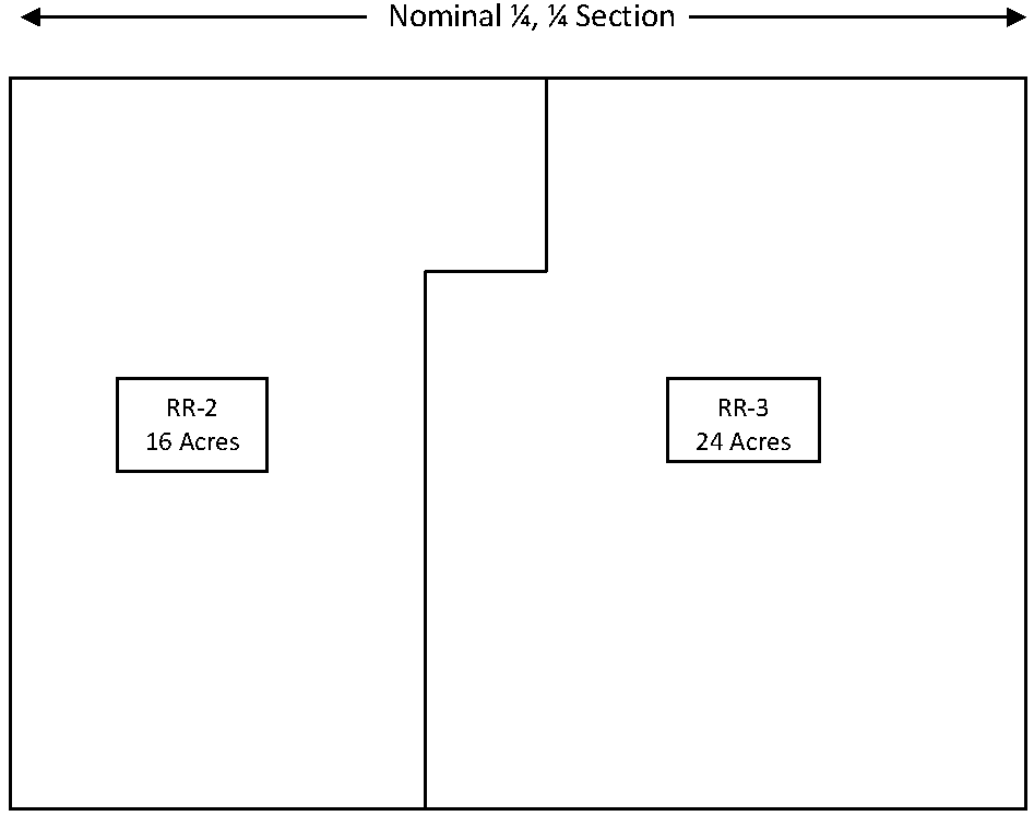
A 24 acre parcel zoned RR-3
Step 1: The maximum development density shall be calculated by dividing the acres of a zoned parcel by the zoning district density standard and rounding down to the nearest whole number to determine the total development credits.
RR-3: 24 acres divided by 5 density standard = 4.8 or 4 development credits.
Step 2: Development credits represent the total parcels upon which the original zoned parcel may be divided and meeting all other applicable zoning requirements.
A total of four development credits are available for the 24 acre lot. As a result, one development credit is applied to the existing lot and three other lots could be created. All lots must be a minimum of one acre and at least 150 feet in width.
Step 3: The land owner of the 24 acre parcel could create one lot at time or all three new lots at one time. Development credits will be tracked within the land services department.
(Res. No. 2018-16, 6-5-2018; Res. No. 2021-32, 10-21-2021; Res. No. 2023-12, 7-20-2023)
Sec. 30-420. - Purpose.
A PRD Planned Residential Development is intended to permit smaller lots where the physical layout of the lots is so arranged as to better control pollution, preserve ground cover and promote the objectives of this chapter than would be possible if normal development standards were applied. This may be accomplished by increasing shoreline setbacks and by clustering structures on one or more portions of the parcel. A condition of all planned residential developments is the preservation of open space in perpetuity, preferably along the shoreline, and, in nonshoreland areas, the maintenance of the natural features of the land to the greatest extent possible.
(Res. No. 2018-16, 6-5-2018)
Sec. 30-421. - Requirements.
The land use and information committee may at its discretion, upon its own motion or upon petition, authorize a planned residential development as a conditional use application as provided under article VIII of this chapter. The committee may authorize a specific project upon finding after a public hearing that the following facts exist:
(1)
Location and area. The area proposed for home sites is located in a district that permits residential use. Gross project area shall include total project area less any areas below the ordinary high-water mark of navigable waters and may include lands in more than one zoning district.
(2)
Pollution and erosion control. The location and nature of the private on-site wastewater treatment systems, which will serve the home sites individually or collectively, is in compliance with the county sanitary code and Wis. Admin. Code ch. SPS 383.
(3)
Open space. At least 50 percent of the project area shall be undivided and restricted in perpetuity from further development. Open space may be:
a.
Dedicated to the public.
b.
Retained by the former owner, or held in individual ownership, while a nonprofit conservation organization or other qualified organization holds a conservation easement prescribing the acceptable uses for the common open space.
c.
Held in common by the residents of the planned residential development.
d.
Held as individual outlots by owners of the planned residential development.
e.
Held by a nonprofit conservation organization acceptable to the county. The conveyance to the nonprofit conservation organization must contain appropriate provisions for reversion in the event that the organization becomes unwilling or unable to uphold the terms of the conveyance.
(Res. No. 2018-16, 6-5-2018)
Sec. 30-422. - Dedication.
Land dedicated to the public must be accepted by action of the governing body of the accepting unit of government. If the open space is to be held in common by owners of lots in the development, a homeowner's association or similar legally constituted body shall be created to maintain it. Any restriction placed on use of lands, which is required by this article, or which was placed as a condition of approval of a planned residential development shall vest in the county the right to enforce the restriction against anyone who has or acquires an interest in the land subject to the restriction.
(Res. No. 2018-16, 6-5-2018)
Sec. 30-423. - Open space.
Open space shall be deed- and plat-restricted to nonstructural agricultural, forestry, recreational or environmental protection uses except that accessory structures essential to the open space uses may be approved. A private on-site wastewater treatment system may be located in such an area provided no suitable site is available on the lot served by the system. Open space shall be contiguous.
(Res. No. 2018-16, 6-5-2018)
Sec. 30-424. - Density.
The number of platted home sites shall not exceed 125 percent of those which would have been possible if the same land were platted in accordance with the minimum lot sizes, setbacks and widths provided by the applicable provisions of this chapter and chapter 58, pertaining to subdivisions. This figure shall be determined by use of the development yield analysis provided in the application and approval process of this section.
(Res. No. 2018-16, 6-5-2018)
Sec. 30-425. - Lot sizes, widths, setbacks, and vegetation protection.
The minimum lot size for such development shall be 30,000 square feet with a 150-foot minimum average lot width and side yard setbacks of ten feet minimum, and 40 feet in total. Front yard setback shall be 30 feet, and rear yard setback shall be 40 feet.
(Res. No. 2018-16, 6-5-2018)
Sec. 30-426. - Design guidelines for approval.
(a)
Roadways, lots and building envelopes shall be located in areas where they will have the least effect on forests, environmentally sensitive areas, crop land, pasture, meadow, farm buildings and historic structures, and where they will retain or enhance the visual character of the rural landscape. However, in resolving conflicts between these interests, priority shall be given to protection of waterways and their buffers, steep slopes, regulated floodplains and avoidance of a fragmented landscape.
(b)
All residential lots and dwellings shall be encouraged into clusters. Residential clusters shall be located to minimize negative impacts on the natural, scenic and cultural resources of the site, and conflicts between incompatible uses.
(Res. No. 2018-16, 6-5-2018)
Sec. 30-427. - Site development and land disturbing guidelines.
(a)
Existing natural drainageways shall be retained to the greatest extent possible.
(b)
Existing natural vegetation shall be preserved in areas where disturbance outside the building envelope is not essential.
(Res. No. 2018-16, 6-5-2018)
Sec. 30-428. - Application procedure and approval process for a planned residential development.
(a)
Initial conference. Before submitting a conditional use application for a planned residential development, the subdivider shall schedule an appointment with the land services department staff to discuss the procedure for approval of a planned residential development, including submittal requirements and design standards.
(b)
Initial application. After the initial conference, the subdivider shall submit a conditional use application and a series of maps and descriptive information to the land services department according to the following. Mapping for the initial application can be done in any combination of features as long as individual map components can be distinguished and the relationship between map components can be determined.
(1)
Inventory and mapping of existing resources including the following mapped at a scale of no less than one inch equals 50 feet.
a.
Land contours based at a minimum upon the most recent Burnett County Lidar data.
b.
United States Department of Agriculture Natural Resource Conservation Service soil type locations and characteristics. Location of bedrock and areas of high potential for groundwater contamination should also be noted.
c.
Hydrological characteristics, including surface water bodies, floodplains, wetlands, groundwater recharge and discharge areas, natural swales, drainageways and steep slopes.
d.
Land cover on the site, according to general cover type, including comments on the health and condition of trees and other vegetation.
e.
Current and past land use, all buildings and structures on the land, cultivated areas, paved areas, and all encumbrances, such as easements and covenants. Any waste sites, brownfields or waste disposal practices should also be disclosed.
f.
Known critical habitats for rare, threatened or endangered species.
g.
Views of the site from surrounding roads, and/or nearby elevated areas, indicating on the map where photographs were taken.
h.
Unique geological resources, such as rock outcrops or glacial features.
i.
Cultural resources, if applicable, such as historic buildings, archaeological sites, and burial sites.
(2)
Development yield analysis. The subdivider shall submit a table showing the maximum number of dwelling units that would be permitted under this chapter, consistent with the minimum lot size, lot widths, setbacks and other provisions of this chapter and compare it to the number of dwellings proposed. Land that is undevelopable because of other laws and ordinances that prohibit development in certain areas (e.g., floodways) shall be excluded from the development yield analysis.
(3)
Site analysis and concept plan. Using the inventory provided in subsection (b)(1) of this section, the development yield analysis provided in subsection (b)(2) of this section, and the design standards in sections 30-425 through 30-427, the subdivider shall submit a concept plan including at least the following information at a scale of no less than one inch equals 50 feet:
a.
Open space areas indicating which area is to remain undeveloped.
b.
Boundaries of areas to be developed and proposed general roadway and lot layout.
c.
Number and type of housing units proposed.
d.
Proposed methods for and location of water supply, stormwater management and sewage treatment.
e.
Inventory of preserved and disturbed natural features and prominent views.
f.
Preliminary development envelopes showing areas for lawns, pavement, buildings and grading.
g.
Proposed methods of ownership and management of open space.
(4)
General location map. The subdivider shall submit a map showing the general outlines of existing buildings, land use, and natural features such as water bodies, wetlands or wooded areas within 500 feet of the tract. This information may be presented on an aerial photograph at a scale of no less than one inch equals 400 feet.
(c)
Review of initial application. Within 30 days following the filing of a complete application for conditional use, the land services department shall meet with the subdivider to review the application. Staff from appropriate state agencies may also be requested by the county to review the conditional use application. The land services department shall make the determination of whether the application is complete. (For the purpose of this chapter, a complete application accepted by the land use and information committee may include a preliminary plat as provided for in the subdivision control ordinance codified in chapter 58, which may be subject to modification through the public hearing process.) Upon determination that the application is complete, the application will be scheduled for a public hearing for a conditional use permit as provided under article VIII of this chapter. (This public hearing may include review of the preliminary plat.)
(d)
Review of conditional use. The conditional use application for a planned residential development shall be reviewed in accordance with the provisions of article VIII of this chapter, and the requirements of this section. Approval of the conditional use application is required prior to the filing of the preliminary plat as required under the subdivision control ordinance codified in chapter 58.
(Res. No. 2018-16, 6-5-2018)