
Walkertown City Zoning Code
ARTICLE III
Other Development Standards
3-1 - DIMENSIONAL REQUIREMENTS
3-1.1 GENERAL REQUIREMENTS
(A)
Applicability .....In all zoning districts, every use of a building, structure, or piece of land hereafter erected, modified, enlarged, or increased in capacity shall comply with the dimensional requirements as set forth in this section.
(B)
Nonconforming Situations and Variances .....There shall be no variations from the dimensional requirements of this section except in nonconforming situations (Section B.5) or where the Board of Adjustment may waive the dimensional requirements (Section B.6-1.4(B)).
(C)
Dimensional Requirements .....The dimensional requirements which specify minimum lot area, minimum lot width, minimum setbacks, maximum impervious surface cover, maximum height, and minimum contiguous area, where applicable, are set forth in Table B.3.1, Table B.3.2, Table B.3.3, and Table B.3.4. Dimensional and other requirements of zoning districts are set forth in Section B.2-1.
(D)
Subdivided Zoning Lots With Written Agreements .....When a zoning lot existing as of the effective date of this Ordinance is proposed to be subdivided into two or more zoning lots, the other requirements of the Unified Development Ordinances shall be applied to each of the subdivided lots, provided, however, that the residential density requirements of this Ordinance and the limits of floodway fringe encroachment provisions of Section C.2-3.2(A) may be applied, in whole or in part, to any one or more of the subdivided lots and not to the other lot(s) when such original zoning lot is subdivided under the following conditions:
(1)
Floodplain. .....The original zoning lot encompasses property with designated floodplain area per Section C.2.
(2)
GMAs. .....The original zoning lot lies partially or completely within GMAs 1, 2, 3 or 4, as designated in Legacy.
(3)
Allocation of Development Rights Between Seller and Purchaser. .....The owner of the original zoning lot and the purchaser(s) of a subdivided part have in writing allocated development rights between or among themselves concerning the development of the original zoning lot whereby a right, or any portion thereof, to develop all, or any portion of, a subdivided part of the original zoning lot as permitted in this Ordinance is transferred to, or is retained by, the remaining portion of the original zoning lot. Development of each subdivided part pursuant to the terms of the writing shall meet or exceed the requirements of this Ordinance. The writing shall further provide that the allocation of development rights shall be appurtenant to and run with the land so benefitted and have the effect of imposing a negative easement or restriction upon the servient land.
(4)
Zoning Officer Approval of Plat. .....The writing constituting the reallocation of development rights must include, or be represented by, a plat illustrating the reallocation. To be effective, the writing and plat shall be reviewed for compliance with this Ordinance by the Zoning Officer, and if the writing and plat complies with this Ordinance, the Zoning Officer shall stamp his approval upon its face, and the writing and plat must then be recorded at the Forsyth County Register of Deeds. A violation of these requirements shall be a violation of this Ordinance and unlawful.
Table B.3.1
Residential Districts General Dimensional Requirements
1,2,3
1.
These dimensional requirements are subject to additional provisions in Section B.3-1.2; Section B.2-5; Section B.2-1.6(C); Section B.3-4; Section B.3-5; and Section B.3-8.
2.
Larger lot width, depth, or area may be required by the Public Health Department for the installation of septic systems.
3.
Additional dimensional requirements for residential uses in other districts are listed in Tables B.3.3 and B.3.4.
4.
No setback is required for twinhomes; all other uses must be set back a minimum of five (5) feet.
5.
Ranges of requirements for RSQ and RM-5 are listed; dimensional requirements are based on use in the district. Please refer to Section B.2-1.2(J)(2) and Section 2-1.2(K)(2) for RM-5.
6.
Nonconforming lots in the YR and AG Districts meeting the provisions of Section B.5-3.2(C) must meet the minimum setback requirements of the RS-20 zoning district.
7.
Three story structures in RM-8 must be setback a minimum of fifty (50) feet from adjacent properties zoned for single family residential development.
8.
Where the main entrance to a single family residence is located on a side yard, the setback for the portion of the wall on which the door is located shall be equal to the front yard setback.
Table B.3.2
Nonresidential Districts General Dimensional Requirements
1,2
1.
These dimensional requirements are subject to additional provisions in Section B.3-1.2; Section B.2-5; Section B.2-1; Section B.3-4; Section B.3-5; and Section B.3-8.
2.
Larger lot width, depth, or area may be required by the Public Health Department for the installation of septic systems.
3.
Certain districts have an option for height (e.g., 60/unlimited). The first number indicates the maximum height allowed at the minimum setback required adjacent to property zoned RS, RM (except RM-U), YR, AG, or H. Heights may be increased according to the provisions of Sections B.3-1.2(D) and (E). Height limits for the C District vary per GMAs (see Section B.2-1.5(B)(2)).
4.
Minimum area and width requirements may be reduced for the CPO, NSB, and CPI Districts under the respective subsections of Section B.2-1.5(B)(2).
5.
The eighty percent (80%) limit applies only in Suburban Neighborhoods, per Section B.2-1.3(D).
6.
Side yards are not required, however any side yard provided adjacent to an interior lot line shall be not less than twelve (12) feet in width. A space less than six (6) inches in width between an interior lot line and a building wall shall not be regarded as a side yard.
7.
The seventy percent (70%) limit does not apply to City/Town Centers and Urban Neighborhoods, per Section B.2-1.5(B)(2).
8.
Whenever a lot in a nonresidential district other than the NB or NO Districts shares a common boundary line with a lot in a residential district (except RM-U), YR, AG, or H District with no intervening street or highway, the lot in the nonresidential district shall have a required setback along the shared boundary line of not less than forty (40) feet or shall have the required setback for the nonresidential district, whichever is greater.
9.
Whenever a residential use in the PB Zoning District shares a side yard boundary line with a lot in a residential district, the requirements of Section B.3-1.2(J)(2) shall apply.
Table B.3.3
Minimum Lot Sizes (Square Feet) for Permitted Single Family,
Two-Family, and Multifamily Residential Buildings
on Small Lots in RM Districts
1.
Permitted densities for other multifamily developments not shown in this table are calculated based upon the suffix number of the RM District (e.g., RM-5 allows five (5) units per acre).
Table B.3.4
Other Dimensional Requirements
1
1.
These dimensional requirements are subject to additional provisions in Section B.3-1.2; Section B.2-5; Section B.2-1; Section B.3-4; Section B.3-5; and Section B.3-8.
2.
Whenever a residential use in the PB Zoning District shares a side yard boundary line with a lot in a residential district, the requirements of Section B.3-1.2(J)(2) shall apply.
(WA-UDO-11, § 3, 12-18-08; WA-UDO-13, §§ 11, 15, 2-26-09; WA-UDO-14, § 4, 3-25-10)
3-1.2 SUPPLEMENTARY DIMENSIONAL REQUIREMENTS
The following supplementary dimensional regulations shall apply to all buildings and structures not subject to the general dimensional requirements of Section B.3-1.1.
(A)
Structures Permitted Above Height Limits .....The height limitations of Section B.3-1.1 shall not apply to the following structures.
(1)
Buildings used in support of agricultural operations;
(2)
Chimneys, unoccupiable steeples, spires, flagpoles, cupolas, roofventing pipes, and freestanding rooftop mechanical equipment (including unenclosed screening);
(3)
Transmission towers;
(4)
Water towers, observation towers, silos, and power transmission towers;
(5)
Mixing plants, and screening or loading towers for sand or rock; and,
(6)
Derricks and conveyors.
(B)
Structures Which may Encroach into Required Yards .....The following structures may encroach into required yards as follows:
(1)
Open Porches and Above Grade Decks in Front and Rear Yards. .....An open porch or unenclosed above grade deck at or below the main living level of a single family dwelling may project into a required front or rear yard not more than ten (10) feet, provided that such projection does not reduce the remaining open portion of the yard to a depth of less than fifteen (15) feet.
(2)
Above Grade Decks. .....Unenclosed above grade decks at the main living level of a single family residence may encroach into a required side yard, but may not extend closer than seven (7) feet to the property line and ten (10) feet to the nearest building.
(3)
Bay Window. .....A bay window may project into any required front or rear yard not more than three (3) feet. A bay window may project into a required side yard for three (3) and four (4) unit Residential Building: Multifamily; Townhouse; and Urban no more than three (3) feet.
(4)
Architectural Features. .....Architectural features, such as sills, belt courses, and cornices, may project into any required yard not more than one foot.
(5)
Roof, Eave, Chimney, or Awning. .....A roof, eave, chimney, or awning may project into any required yard not more than three (3) feet.
(6)
Canopy. .....Canopies, either attached or detached, used in conjunction with retail uses in business, office, or industrial districts, may project into a required front yard, provided that such projection does not reduce the remaining open portion of such yard to a depth of less than ten (10) feet.
(7)
Open Stairs. .....Open stairs to a second story of a residence may project into any required side or rear yard but shall not encroach into the required front yard.
(8)
Satellite Dishes. .....Satellite dishes greater than one meter in diameter for residential use and two (2) meters in diameter for commercial/industrial use shall meet the requirements of accessory structures in required yards in Section B.3-1.2(F).
(C)
Improvements Permitted in Required Yards .....The following improvements are permitted in required yards provided there is no interference with any recorded sight easement:
(1)
Landscape Features. .....Landscape features, including, but not limited to, ornamental pools, planting boxes, sculpture, birdbaths, open terraces, at-grade slab patios, driveways, walkways, handicapped ramps, walls, or fences; and,
(2)
Other Improvements. .....Other constructed improvements specifically exempted in the definition of Structure, including, but not limited to, at-grade bridges, open stairs, recreational equipment, privies, burial vaults, cemetery markers or monuments, gate houses or bus shelters, mailboxes, pump houses or wells, shelter for pets, playhouses, outdoor fireplaces, flagpoles, underground fallout shelters not extending more than four (4) feet above grade, and wharves unless otherwise regulated under Section B.3-11.2. Air conditioning compressors are exempted, subject to the provisions of Section B.3-11.2.
(D)
Setbacks for Taller Structures in GO, CPO, GB, GI and MU-S Districts
(1)
Purpose. .....The purpose of setback standards for taller structures in these districts is to give flexibility to nonresidential development while preventing structures significantly taller than single family dwellings from being constructed in close proximity to such homes; thereby maintaining the privacy and outdoor enjoyment typically provided in single family districts and neighborhoods.
(2)
Setback and Measurement. .....The height of any building may be increased above the normal maximum by one foot for each foot of additional setback beyond the minimum setback required if adjacent to property zoned RS, RM (except RM-U), or H. If adjacent to other zoning districts, there is no height limit. Please refer to appropriate subsections in Section B.2-1.
(3)
Exceptions. .....Buildings above the normal height maximums are not allowed in the following situations:
(a)
Where the proposed development is for single family detached, duplex, or twin home uses; or,
(b)
Where the proposed development involves redevelopment or change of use of an existing site and does not increase the height or reduce the setback of the existing primary structure closest to the single family use or district.
(E)
Setbacks for Taller Structures in the C District
(1)
Purpose. .....The purpose of special setbacks for taller structures in the C District is to give flexibility in designing and developing structures for these districts while at the same time protecting residential development adjacent to the C District from the impacts on privacy and outdoor enjoyment that structures built above the standard height limits might have.
(2)
Exception From Height Limits. .....Existing buildings or buildings under construction on or before April 15, 1991 shall be exempt from the height requirement.
(3)
Setback and Measurement. .....No new building, or an addition to an existing building which is exempt from the height requirement, shall exceed the normal maximum height of sixty (60) feet allowed in the C District unless the building is set back at least forty (40) feet from any property zoned RS, RM (except RM-U), or H. For each foot of setback from property zoned RS, RM (except RM-U), or H beyond forty (40) feet, the maximum permitted height of a building may be increased by one foot. If the building is set back at least one hundred twenty (120) feet from all property zoned RS, RM (except RM-U), or H, or is adjacent to other zoning districts, there is no height limit. Please refer to Section B.2-1.5(B).
(F)
Accessory Structures Permitted in Required Yards
(1)
Interior Lots. .....An accessory structure seventeen (17) feet or less in height and structurally detached from the principal structure on the zoning lot may be erected on any interior lot in either the required side or rear yards, if no part of said structure is less than seventy-five (75) feet from the front lot line nor less than three (3) feet from a side or rear lot line.
(2)
Corner Lot. .....An accessory structure less than seventeen (17) feet in height and structurally detached from the principal structure on the zoning lot may be erected on a corner lot, provided that:
(a)
Said structure shall be erected in the required side yard not abutting the street, and no part of said structure is less than seventy-five (75) feet from the front line nor less than three (3) feet from a side or rear lot line; or,
(b)
Said structure shall be erected in the required rear yard and shall not project beyond, or nearer to, the street than the front setback line of the district, as extended, of the adjacent lot whose front yard abuts the corner lot in question.
(3)
Height. .....For purposes of this section, the height shall be measured from the average grade of the midpoint of the front wall to the ridge of the roof of the accessory building.
(G)
Size Limits for Accessory Structures.
(1)
Maximum Area. .....Accessory structure may not exceed five percent (5%) of the actual size of the zoning lot or the minimum permitted lot size of the zoning district, whichever is larger. However, an accessory structure up to five hundred seventy-six (576) square feet in area shall be permitted in all districts.
(2)
Board of Adjustment. .....Requests for structures containing greater area than prescribed in Section B.3-1.2(G)(1) may be considered under the special use permit process through the Board of Adjustment.
(3)
Required Yard. .....Accessory structures may not occupy more than twenty-five percent (25%) of the area of the required yard.
(H)
Accessory Structures Prohibited in Required Yards .....An accessory structure any part of which is within three (3) feet of the principal building or which is more than seventeen (17) feet in height shall comply with all the zoning regulations applicable to the principal building.
(I)
Special Yard Requirements for Older Neighborhoods .....Alternative dimensional requirements are available for neighborhoods which were originally platted or developed prior to March 3, 1948, and where at least fifty percent (50%) of the other lots on the block in question are developed. See Section B.3-8.
(J)
Special Yard Requirements Where Nonresidential Districts Adjoin Residential Districts
(1)
Nonresidential Districts other than NB or NO. .....Where a lot in a commercial, industrial, institutional or mixed use zoning district except the NB or NO Zoning District shares a common boundary line with a lot in a RS or RM Zoning District (except RM-U), YR, AG, or H District with no intervening street or highway, the lot shall have a required setback along the shared boundary line of not less than forty (40) feet or shall have the required setback for the zoning district in which it is located, whichever is greater.
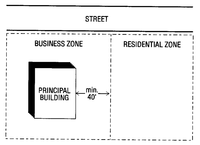
Business/Residential Zone Illustration
(2)
Side Yard Requirements Where PB Adjoins Residential Districts.
(a)
PB Zoning District Adjacent to RM Zoning Districts. Wherever a Residential Use as shown in Table B.2.6, exclusive of Combined Use, within the PB Zoning District is directly adjacent to a RM Zoning District, a minimum seven (7) foot side yard setback shall be required with no accompanying bufferyard. Such reduced side yard setback shall apply only in situations where said residential uses within the PB Zoning District are oriented with their primary entrances facing the street. In no instance shall the height of a residential building be greater than the maximum height allowed in the adjoining residential district.
(b)
PB Zoning District Adjacent to RS or RSQ Zoning Districts. Wherever a Residential Use as shown in Table B.2.6, exclusive of combined use, within the PB Zoning District is directly adjacent to a RS or RSQ Zoning District, a minimum fifteen (15) foot side yard setback shall be required with a corresponding Type II Bufferyard. In no instance shall the height of a residential building be greater than the maximum height allowed in the adjoining residential district.
(K)
Building Spacing Requirements for Multifamily, Townhouse or Twin Home Residential Buildings .....If a zoning lot is developed for multifamily, townhouse or twin home residential buildings, the following method shall be used to determine the minimum spacing of buildings. The spacing of buildings shall be shown on a site plan prepared according to the provisions of Section B.7.
(1)
Calculation of Triangle. .....For yards exclusive of those on the project perimeter, each wall of every dwelling shall have a minimum yard space in the shape of an imaginary isosceles triangle. The base of said triangle shall be a line connecting the extreme ends of the wall of the building and whose altitude shall be the length of the base line multiplied by a factor related to the height of the dwelling as provided in Table B.3.5 and illustrated in the accompanying figure. There shall be a minimum distance of fifteen (15) feet between any walls of one-story buildings and twenty (20) feet between two-story buildings. Any wall over ten (10) feet long shall be treated as a separate wall.
Table B.3.5
Altitude Factors Used to Determine Building Height
(2)
Overlapping Triangles Prohibited. .....The yard spaces thus established by the isosceles triangles shall not overlap the yard space for any other wall of the same or any other dwelling.
(3)
Other Spacing Requirements. .....Building spacing for twin home and three (3) and four (4) unit multifamily and townhouse residential buildings may be reduced to a minimum of twenty (20) feet.
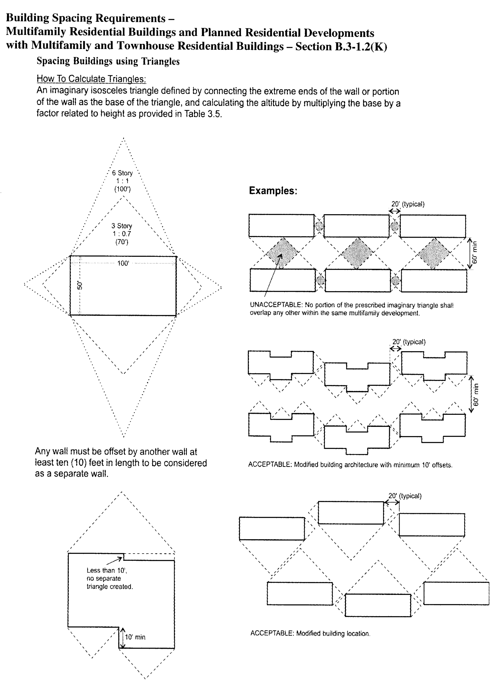
Building Spacing Requirements
(4)
Alternative Compliance. .....A developer may propose spacing for buildings that varies from the strict application of the provisions of the section in order to accommodate the unique character of the site or to utilize innovative design. Application for alternative compliance shall include a site plan following the requirements of Section B.7 and any additional architectural plans, elevations, or perspective drawings to illustrate the proposed building design and/or placement alternative. Alternative compliance shall be approved by the Planning Board only upon a finding that the building architecture and site plan fulfills the following criteria as well or better than would strict conformance with the requirements of this Ordinance:
(a)
The project provides adequate air and light to the development and surrounding properties.
(b)
Through the use of a variety of fenestration patterns, building facade offsets, roof line treatments, and other architectural features, the perceived bulk, scale, and length and width of the building is congruous with surrounding buildings.
(c)
The development provides for orderly and easy movement of traffic and pedestrians.
(d)
The project will not be injurious to property or improvements in the affected area.
(e)
The project is in accordance with all development criteria established by the Elected Bodies' adopted plans and policies including Legacy, area plans, and development guides.
(L)
Double Frontage Lots .....Double frontage lots shall provide a front yard abutting each fronting street, in the depth as required in the applicable district, except where the second frontage is on a street without any access such as an interstate, expressway, or other controlled access highway or roadway, or any road that will not be issued a driveway permit by local or state officials.
(M)
Double Counting of Yard, Lot Area, Loading Area or Parking Area .....No space which has been counted as part of a yard, lot area, parking area or loading area required under this Ordinance for one building or use shall be counted to satisfy or comply with a yard, lot area, loading area or parking area requirements for any other building or use, except where shared parking is permitted in Section B.3-3.5(B). The minimum required yards, lot area, parking area or loading area for any building or use existing or under construction at the time of the passage of this Ordinance shall not be encroached upon or counted to satisfy such requirements for any other building or use, except as permitted in Section B.3-3.5(B).
(N)
Width of Private Access Easements and Private Streets .....An access easement, or private street, connecting a public street or highway to principal uses which depend upon such easement for access, shall be not less than twenty-five (25) feet in width and shall be recorded in the office of the Register of Deeds.
In lieu of the twenty-five (25) foot access easement for two-way access, nonresidential developments that are approved through a Special Use zoning process or Planning Board Review process may elect to provide separate one-way ingress and egress access easements each not less than twenty (20) feet in width.
Any use abutting such easement shall be located on a zoning lot and shall comply with all dimensional requirements of the applicable district. No zoning permit shall be issued for a principal use not abutting upon a public street or a private street which complies with this provision. This width requirement does not apply to any driveway located on a zoning lot or to any alley.
(O)
Utility Easements .....No part of any building shall be constructed within the boundaries of a utility easement unless specifically granted and authorized by the grantor of such easement in a written and properly recorded easement.
(P)
Minimum Lot Size
(1)
RS and RM Zoning Districts. .....In all RS and RM zoning districts, the minimum area of a zoning lot to be used for a single family dwelling where public or community water supply and sewage disposal systems are not available for connection shall be as determined by the Public Health Department, but in no case shall the area of such lot be less than the greater of twenty thousand (20,000) square feet or the minimum lot size required in the zoning district.
(2)
MH Zoning District. .....In the MH zoning district, the minimum area of a zoning lot to be used for a manufactured home park where public or community water supply and sewage disposal systems are not available for connection shall be as determined by the Public Health Department, but in no case shall the area of such lot be less than four (4) acres. The minimum area of a zoning lot to be used for a single family dwelling where public or community water supply and sewage disposal facilities are not available and used shall be determined by the Public Health Department, but in no case shall the area of such lot be less than twenty thousand (20,000) square feet.
(Q)
Flag Lots
(1)
Frontage and Width. .....Flag lots must have at least twenty-five (25) feet of frontage on a street or private access easement. The "pole" of the flag lot from the frontage of the lot to the buildable area of the lot must be a minimum of twenty-five (25) feet in width along its entire length;
(2)
Lot Area and Yard Calculation. .....The pole may not be used for the front setback, lot area or yard calculation of the flag lot or any other lot;
(3)
Multiple Flag Lots. .....If more than one flag lot is proposed to the rear of another lot or stacked off the street, a minor subdivision exception is required per Section D.3.(E); and,
(4)
Setback, Front. .....The front setback for a flag lot shall be measured from the line closest to the buildable area and running most parallel with the street. The area of the pole may not be used to measure the front setback.
(R)
Lot Area in Right-of-Way .....No land area of the lot which lies within the public street right-of-way may be used for the purposes of lot area or any other lot dimensional requirements. If a portion of the lot is dedicated as public right-of-way as a condition of site plan approval, that area may be used for lot area and dimensional requirements but not for building setback requirements.
(S)
Setback Exemption from Private Access Easements .....A private access easement to one single family lot shall not be considered a street requiring an additional setback as a side against a street or as a corner lot.
(T)
Minimum Frontage of Zoning Lots .....All zoning lots must have a minimum frontage of twenty-five (25) feet on the street that provides access to the zoning lot.
(U)
Minimum Lot Frontage .....The minimum frontage of a zoning lot on a street or private access easement shall be twenty-five (25) feet.
(V)
Utilities and Transmission Towers .....Any zoning lots leased or purchased and used solely for a utility or transmission tower use are exempt from the minimum lot size requirements of the zoning district in which it is located. All other requirements for these uses shall be met.
(W)
Irregular Lots
(1)
Lot Area and Yard Calculation. .....The appendages or extensions which do not independently meet the dimensional requirements of the district may be used for no more than twenty percent (20%) of the lot area or yard calculation of the lot.
(WA-UDO-13, § 8, 2-26-09; WA-UDO-15, § 8, 2-24-11)
3-2 - SIGN REGULATIONS
3-2.1 SIGN REGULATIONS
(A)
Purpose .....Signs are a necessary and beneficial use of property that contributes to our community's economic vitality and appearance. Reasonable sign regulations are necessary to protect public property and community aesthetics. The intent of this Ordinance is to regulate the type, number, physical dimensions, erection, placement and maintenance of signs in the Town of Walkertown. The purpose is to:
(1)
Promote the public health, safety, and welfare of residents and visitors;
(2)
Provide an environment which fosters growth and development of business;
(3)
Protect commercial districts from visual clutter;
(4)
Protect property values;
(5)
Eliminate distractions which are hazardous to motorists and pedestrians;
(6)
Protect and enhance the natural beauty, cultural attributes, distinctive character and visual environment of Walkertown;
(7)
Protect the public's ability to identify establishments and premises in an orderly, readable and safe manner;
(8)
Protect the public's investment in public buildings, streets, roads, highways and open spaces; and
(9)
Balance the individual rights of property owners to communicate their message with the public's right to be free of unreasonable distractions and aesthetic intrusions.
(B)
Effect .....The effect of this section is:
(1)
To establish a permit system that allows a variety of signs on business premises and a limited variety of signs on other premises, subject to this Ordinance and its permit procedures.
(2)
To allow certain small, unobtrusive signs incidental to the principal use of a site without a permit if such signs meet the substantive requirements of this Ordinance.
(3)
To prohibit off-premises advertising signs, except where regulation is controlled by State or Federal law.
(4)
To allow a variety of types of noncommercial signs subject to the same substantive and permit requirements that control on-premises signs.
(5)
To allow certain types of signs to make minor encroachments of the public right-of-way, if specially permitted.
(6)
To prohibit all signs not expressly permitted by this Ordinance.
(C)
General Requirements
(1)
Applicability. .....The provisions of this Section are applicable to all signs, both off-premises and on-premises, unless otherwise provided for in this Ordinance. Any sign, in the districts where it is permitted, shall hereafter be in compliance with the provisions of this Section and shall meet all other regulations applicable to signs, including any reference made within the Walkertown Town Code, and in the North Carolina Building Code and National Electric Code.
(2)
Required Permits and Approvals.
(a)
Zoning Permit. .....A zoning permit shall be secured from the Zoning Officer prior to the construction, reconstruction, erection, enlargement, relocation, structural alteration, repair or removal to a sign, except as otherwise provided for in Section B.3-2.1(E) of this Ordinance.
(b)
H and HO Districts. .....Prior to issuance of a zoning permit, a sign within the H and HO zoning districts requires the issuance of a Certificate of Appropriateness from the Forsyth County Historic Resources Commission.
(c)
Overlay District Approval. .....Prior to issuance of a zoning permit, a sign within the NCO, TO, or AO zoning districts may be subject to additional approvals and requirements as provided for in the applicable overlay district section of this Ordinance.
(d)
Historic Sign Approval. .....Prior to issuance of a zoning permit, a Historic Sign must meet the additional provisions Section B.3-2.1(F)(5) of this Ordinance and be classified as a Historic Sign by the Forsyth County Historic Resources Commission.
(3)
Illumination. .....Any externally illuminated sign shall be shielded so as not to cast direct light onto any residential district and as not to create a safety hazard.
(4)
Location.
(a)
Public R.O.W. .....No portion of a sign shall be located within the public right-of-way or sight distance triangles except as permitted by this Ordinance, and with approval by the Town of Walkertown or the NC Department of Transportation, as applicable. This includes all above ground and below ground supports, frames, and embellishments or any portion of a sign attached to, affixed to, or painted on any utility pole, light standard, utility box or pedestal, tree, rock, or other natural object located within the public right-of-way or sight-distance triangles.
(b)
Traffic Hazard. .....No sign shall be located in a manner which creates a traffic hazard.
(c)
Ingress and egress. .....No sign shall be located in a manner that impairs ingress and egress through windows, doors, or other means of entering or exiting from a structure or building.
(5)
Maintenance. .....Signs shall be maintained in sound and safe condition. Any sign or supporting structure declared to be unsafe by the Director of Inspections shall be repaired or removed by the owner immediately after notice by the Director of Inspections.
(6)
On-Premises Sign Area Measurement Provisions.
(a)
Measurement of Internally Illuminated Signs and Signs Consisting of a Permanent Structure with Removable Panels. .....The area of internally illuminated signs and signs consisting of a permanent structure with panels designed to be removed and/or replaced for periodic maintenance or change of tenant(s) shall be computed as the smallest rectangle that will encompass the extreme limits of the illuminated or changeable panels and structure less than three (3) inches wide, regardless of sign shape and whether or not open spaces exist. Any cutouts or extensions shall be included in the area of the sign. In the case of separate signs sharing a common structure, the open spaces between the panels shall not count as sign area.
(b)
Measurement of All Other Signs. .....Sign area for all other signs shall consist of the smallest rectangle or sum of contiguous rectangles which completely encompasses the sign message, including letters, words, and graphic elements. This method of measurement shall also apply to words and graphic elements painted onto windows, awnings and canopies.
(c)
Area of a Multi-Faced Sign. .....Each face of a sign that contains two (2) faces may contain up to the maximum permitted sign area. Where two sign faces are not attached back to back, they must be joined at an angle of no more than ninety (90) degrees. Each face of a sign with three (3) or more faces shall contain a minimum of fifty percent (50%) less sign area per face than the maximum permitted sign area.
(d)
Area of a Multi-Tenant Sign, Changeable Copy Sign, or Electronic Message Board. .....The face and frame of a portion of a sign that includes the names of individual tenants or an area for changeable or electronic copy shall count toward the total area of the sign.
(7)
Nonconforming Signs Existing Prior to February 28, 2008. .....All nonconforming signs shall be brought into compliance with the requirements of the Ordinance if the sign structure is removed, renovated, or altered. Replacing the panel of an existing sign does not require such sign to be brought into compliance.
(8)
Prohibited Signs or Objects. .....The following signs or uses of signs are prohibited, unless otherwise provided for in this Ordinance:
(a)
Abandoned Sign. .....A freestanding sign relating to or identifying an activity or establishment that is no longer conducted on the premises. Such signs include the sign's structure if the structure cannot be used for a legal use or does not comply with the height, area, or other physical requirements of this Ordinance. Such sign shall be in violation of the Zoning Ordinance if not brought into conformance or removed within three hundred sixty-five (365) days after notification of the property and sign owner(s) by the Zoning Officer. A sign which meets the height and area requirements of this Ordinance shall not be removed from its supporting cabinet structure unless a new sign will replace that sign in the aforementioned structure. An abandoned sign not replaced shall be left in its cabinet structure and shall be painted or otherwise masked using a solid, uniform color covering the sign.
(b)
Roof Sign. .....A sign that extends higher than the roof of a building or is attached to or painted on a roof structure, panels or walls constructed to screen rooftop mechanical equipment or a roof top penthouse. See Section B.3-2.1(I)(7).
(c)
Temporary and Portable Sign. .....Any sign not permanently attached to the ground or other permanent structure, unless otherwise provided for in this Ordinance. Such signs include, but are not limited to, signs with attached wheels and signs attached or painted on vehicles parked and visible from the right-of-way, unless said vehicle is used as a vehicle in the normal day-to-day operations of the business it advertises and is parked on the same zoning lot as the business. This provision shall not apply to sandwich board signs as set forth in Section B.3-2.1(E)(11).
(d)
Sign with Moving and Flashing Lights or Parts. .....A sign with building, chasing, flashing or moving effects; or a sign displaying intermittent or flashing lights similar to those used in governmental traffic signals or used by police, fire, ambulance, or other emergency vehicles. Such signs include beacons, spotlights, searchlights, or reflectors and signs which revolve, rotate or swing by mechanical means.
(e)
Windblown Sign. .....A fluttering, spinning, windblown or inflatable device, including pennants, streamers and propeller discs, except as set forth in Sections B.3-2.1(E)(1), B.3-2.1(E)(2), and B.3-2.1(F)(4).
(f)
Use of Warning Words or Symbols. .....A sign using the words stop, danger, or any other word, phrase, symbol, or character similar to terms used in a public safety warning or traffic sign.
(g)
Sexually Oriented Signs. .....A sign which exhibits matter depicting, describing, or relating to (i) "specified anatomical areas," as defined in G.S. 14-202.10(10), or "specified sexual activities," as defined in G.S. 14-202.10(11); and/or (ii) "sexually oriented devices," as defined in G.S. 14-202.10(9).
(h)
Ground Surface Sign. .....A sign composed of manmade or organic materials displayed upon the surface of the ground.
(D)
Signs Allowed in Any District Without a Zoning Permit .....The following signs or uses of signs which meet the additional provisions of this Section are permitted in any zoning district, unless otherwise specified, with no zoning permit required:
(1)
Local, State, National, Corporate, and Organizational Flags. .....Local, state, and national flags shall have no size limitations. Additionally, one corporate logo flag or organizational flag may exist on premises where an American Flag is flown. A corporate logo or organizational flag shall be no larger than the American Flag with which it is flown.
(2)
Government Approved Signs. .....A sign required by law; emergency, safety, warning, or traffic sign; or a sign installed by, at the direction of or with the approval of a governmental authority shall have no size requirements. Such signs include signs approved by a governmental authority which promote special points of interest and events, including but not limited to decorative banners in conformance with Section 70-14 of the City of Winston-Salem Code.
(3)
Historical Marker. .....A historic marker erected or placed by a historical nonprofit corporation, the Forsyth County Historic Resources Commission or other governmental authority with a maximum area of twelve (12) square feet.
(4)
Church Directional Signs. .....A sign in conformance with Article IV, Section 70-101 of the Code of Ordinances for the City of Winston-Salem.
(5)
Gasoline Pump, Automatic Teller, and Vending Machine Sign. .....A sign that displays prices or the name, trademark or logo of the company or brand it advertises provided the sign is an integral part of the permitted gasoline pump, automatic teller or vending machine.
(6)
Menu Board at Fast Food Restaurant. .....A menu board for a permitted restaurant with drive-through service shall be located in such a way as to be viewed from a designated drive-through lane and not located within the required front, side, or rear yard. In no case shall a menu board exceed thirty-two (32) square feet in area.
(7)
Vehicular Entrance and Exit Signs. .....One vehicular entrance and one vehicular exit sign containing a maximum of six (6) square feet each and a maximum height of three (3) feet shall be permitted per driveway. Vehicular entrance and exit signs shall contain no commercial content other than a symbol, name or logo of the establishment it serves.
(8)
Incidental Sign. .....Such on-premises signs include, but are not limited to, pedestrian entrance and exit signs, building numbers and addresses, private parking signs, no trespassing signs or dangerous animal signs. An incidental sign shall contain a maximum of twelve (12) square feet, be a maximum of six (6) feet in height, and shall contain no commercial content other than a symbol, name or logo of the establishment it serves.
(9)
Information, Direction, and Identification Signs. .....Information, direction, and identification signs installed by or at the direction of a governmental authority or with its approval shall be allowed. Such sign shall have a maximum area of thirty-six (36) square feet and a maximum height of six (6) feet except where health, safety and welfare issues require increased sign height, and shall contain no commercial content other than a symbol, name or logo of the establishment it serves. Any symbol, name, or logo shall not comprise more than twenty percent (20%) of the sign area of the Information, Direction, and Identification Sign it is associated with.
(10)
Home Occupation Sign. .....An on-premises home occupation sign shall be limited to one sign per dwelling unit or principal use, and shall not exceed one square foot in area. Additionally, the use of neon or illuminated signs which are visible from the exterior of buildings containing home occupations, including signs inside buildings, shall be prohibited.
(11)
Sandwich Board Sign. .....A sandwich board sign shall meet the following provisions:
(a)
The sign shall be used in conjunction with a nonresidential use within the CB, PB, NB, and MU-S Districts where the sidewalk is wide enough to allow for at least five (5) feet of width for unrestricted pedestrian movement with the sandwich board sign in place and as per city code requirements.
(b)
One sandwich board sign per principal use shall be permitted. A sandwich board sign shall not exceed eight (8) square feet in area and four (4) feet in height.
(c)
The sign shall be moveable and shall not be illuminated or permanently attached to the building, sidewalk, street furniture, other signs, street trees, landscaping, utility poles or other appurtenances.
(12)
Construction, Development, and Lender Sign. .....Construction, Development, and Lender Signs will be permitted one temporary on-premises sign per development under construction, not to exceed thirty-two (32) square feet in area and ten (10) feet in height for developments of five (5) acres or less and sixty-four (64) square feet for developments of more than five (5) acres. Developments of five (5) acres or more with five hundred (500) feet or more of linear frontage shall be permitted an additional on-premises sign of the same dimensions. Construction and Development signs shall not be illuminated.
(13)
Real Estate Sign. .....An on-premises real estate sign for properties smaller than two (2) acres in the YR, AG, MH, RS and RM Districts shall have a maximum area of six (6) square feet. A sign in the YR, AG, MH, RS, and RM Districts for properties two (2) acres or more in size shall have a maximum area of thirty-two (32) square feet in area and ten (10) feet in height. In all other districts, on-premises real estate signs shall not exceed thirty-two (32) square feet in area and ten (10) feet in height. Lead-in (directional) off-premises real estate signs are permitted from Friday noon to Monday noon. Real Estate signs shall not be illuminated.
(14)
Builder Signs.
(a)
An on-premises sign indicating the builder(s) of individual residential units, either within the context of a larger development project or as an individually constructed unit, shall be permitted. A Builder Sign shall have a maximum area of six (6) square feet and a maximum height of six (6) feet in all zoning districts. A Builder Sign shall be removed upon sale of the property it is associated with.
(b)
Fence wraps displaying the name(s) and logo(s) of the companies involved in the construction project affixed to the perimeter fencing at a construction site until the certificate of occupancy is issued for the final portion of any construction at that site.
(15)
Agricultural Sign. .....A maximum of two (2) off-premises directional signs are permitted for agricultural produce grown and sold on the premises.
(16)
Political Sign. .....A political sign shall not exceed two (2) square feet in size. Within the City of Winston-Salem, additional provisions of Section 38-25 of the Code of Ordinances of the City of Winston-Salem shall apply.
(17)
Yard Sale Sign. .....An on-premises sign advertising a yard or garage sale shall not exceed two (2) square feet in size and shall be limited to one sign per lot. Such signs may be erected seven (7) days prior to the event and shall be removed within two (2) days after the event. Lead-in (directional) off-premises yard sale signs are permitted from Friday noon to Monday noon.
(18)
On-Premises Temporary Special Event Signs or Banners for Religious, Charitable, Civic, Educational, Fraternal, Government, or Similar Non-Profit Organizations. .....Temporary signage for the previously stated groups is allowed provided:
(a)
No more than one sign per street frontage shall be permitted per event.
(b)
The sign/banner shall be located on the property on which the event will occur.
(c)
The sign/banner shall be erected no sooner than fourteen (14) days before and removed three (3) days after the event.
(d)
A period of no fewer than seven (7) days shall exist between the removal of one sign/banner and the installation of another.
(e)
The specific date or time period of the event being advertised shall be present on the sign/banner.
(19)
Signs Inside Buildings. .....Signs, including Electronic Message Board Signs, located inside buildings which are visible through doors or windows shall not be regulated by this Ordinance, except for signs prohibited by Section B.3-2.1(D).
(E)
Signs Allowed With a Zoning Permit .....The following signs are allowed with a zoning permit in any zoning district where the specified uses are permitted:
(1)
Electronic Time, Date, Temperature Sign. .....An electronic time, date and temperature sign may be applied to a freestanding or attached sign of any permitted nonresidential use. An electronic time, date, and temperature sign shall be included in the calculation of total sign area permitted freestanding and attached signs. Electronic time, date and temperature signs shall not display any image, text or graphic other than the time, date and temperature if separate from an Electronic Message Board sign.
(2)
Electronic Message Sign. .....Electronic Message signs shall be allowed in all nonresidential zoning districts. A development may have either attached or freestanding Electronic Message signage. The following conditions shall apply to Electronic Message Signs:
(a)
Calculation of Area. .....An Electronic Message Sign which is included within a larger sign shall be included in the calculation of the total permitted sign area.
(b)
Changes Per Day. .....An Electronic Message Sign shall change no more than once per five (5) minutes. Changes shall be complete and shall not contain any scrolling, flashing, or similar transitional effects between static messages.
(3)
Changeable Copy Sign. .....A changeable copy sign may be applied to a freestanding sign for any permitted nonresidential use. Attached changeable copy signs are prohibited unless otherwise provided for in this Ordinance. A changeable copy sign shall be included in the calculation of permitted sign area.
(4)
Special Event Banner. .....A temporary on-premises banner for uses not addressed in Section B.3-2.1(E)(18) shall be allowed in any zoning district, excluding AG, YR, RS, and RM Districts, subject to the following requirements:
(a)
Number. .....Three (3) special event signs shall be permitted per establishment, per twelve (12) month period. Each twelve (12) month period shall begin with the issuance of the first permit and shall expire twelve (12) months from that date.
(b)
Display Period. .....The sign shall not be displayed for more than thirty (30) consecutive days.
(c)
Location. .....A Special Event Banner shall be attached to a building wall or canopy.
(5)
Historic Sign. .....A Historic Sign shall be approved by the Forsyth County Historic Resources Commission prior to issuance of a zoning permit, and is subject to the following additional provisions:
(a)
Criteria for Classification. .....To be classified as a Historic Sign, an application for classification shall be filed with the Historic Resources Commission staff, and the commission must find that the sign bears a close resemblance to its appearance when originally installed, that the original sign was erected twenty-five (25) years prior to application for classification, and that the sign meets at least three (3) of the following criteria:
(i)
Bears a national or local emblem, logo, or other graphic that is unique to the property or the establishment, or that it is a remnant of an advertising program that is no longer used by the parent company;
(ii)
Is significant as reflecting the history of the building, structure, object, property or the development of the area, or recognized as important to the culture or history of Walkertown and Forsyth County;
(iii)
Possesses unique characteristics or incorporates materials, design or craftsmanship not commonly found in newer signs;
(iv)
Is unique, notably aesthetic or creative, so as to make a significant contribution as a work of art;
(v)
Is recognized as a popular focal point within the community;
(vi)
Is associated with historical individuals, events or places;
(vii)
Is characteristic of a specific historic period;
(viii)
Exhibits unique or rare characteristics that enhance the streetscape or the community at large.
(b)
Privileges. .....A sign classified as a Historic Sign is exempt from the following provisions of this Ordinance:
(i)
Roof Signs. .....A historic sign may remain as a roof sign.
(ii)
Dimensional Requirements. .....A Historic Sign may exceed dimensional requirements found elsewhere in this Ordinance.
(iii)
Obsolete Sign. .....A Historic Sign may refer to an establishment or product which is not related to the existing establishment or products sold on the premises.
(iv)
Illumination and Materials. .....A Historic Sign may retain its original lighting patterns and materials.
(v)
Removal. .....The voluntary removal of a Historic Sign by an owner shall be permitted without Forsyth County Historic Resources Commission review.
(vi)
Maintenance. .....Reasonable maintenance, repair, and restoration of a Historic Sign are permitted without Forsyth County Historic Resources Commission review.
(c)
Alterations. .....Alterations to a Historic Sign shall not be allowed without prior approval by the Forsyth County Historic Resources Commission staff.
(F)
On-Premises Signs Advertising a Nonconforming Use .....A nonconforming use shall be permitted on-premises freestanding and attached signs, provided the following additional provisions are met:
(1)
Freestanding Signs.
(a)
Existing Signs. .....An existing on-premises freestanding sign which advertises a nonconforming use may be replaced or may be replaced and increased in area by a maximum of twenty-five percent (25%) provided that such increase will not result in a sign area greater than thirty-six (36) square feet and a sign height of greater than six (6) feet. There shall be only one such expansion permitted, regardless of the size of the expansion.
(b)
New Signs. .....A nonconforming use which does not have an existing on-premises freestanding sign shall be allowed one on-premises freestanding sign which shall not exceed thirty-six (36) square feet in area and six (6) feet in height.
(2)
Attached Signs.
(a)
Existing Signs. .....Existing on-premises attached signage which advertises a nonconforming use may be replaced or may be replaced and increased in area by a maximum of twenty-five percent (25%) provided that such increase would not result in a sign area greater than fifteen percent (15%) of the building wall area per wall. There shall be only one such expansion permitted, regardless of the size of the expansion.
(b)
New Signs. .....A nonconforming use which does not have existing on-premises attached signage shall be allowed a maximum attached sign area of fifteen percent (15%) per building wall.
(G)
On-Premises Freestanding Signs .....Unless otherwise provided for in this Ordinance, an on-premises freestanding sign shall meet the following additional provisions:
(1)
Zoning Districts and Uses. .....On-premises, freestanding signs shall be permitted in the zoning districts for the permitted uses as shown in Table B.3.6 On-Premises Freestanding Sign Provisions. Number, height and area provisions are also indicated in Table B.3.6, unless otherwise provided for in this Ordinance.
(2)
Setback. .....All parts of an on-premises freestanding sign shall be set back at least one and one-half (1½) feet from a street right-of-way.
(3)
Sign Height. .....The height of an on-premises freestanding sign shall be measured from the road to which the sign is oriented or average grade of the site where the sign is located; whichever is higher, to the top of the highest attached component of the sign, including the sign face, sign structure and any other appurtenance, excluding religious icons. Any change in a site's grades specifically designed to increase a sign's height shall be included as part of the sign's height.
(4)
Irregular shapes. .....A sign consisting of irregular, non-rectangular shapes shall be allowed to exceed its respective area requirements by thirty percent (30%) in situations where thirty percent (30%) or more of a sign's area consists of open space and/or cutouts. Irregular sign height shall be calculated using the method described in Section B.3-2.1(H)(3), and irregular sign area shall be calculated using the methods described in Sections B.3-2.1(C)(6)(a) and B.3-2.1(C)(6)(b).
Table B.3.6
On-Premises Freestanding Sign Provisions
X
An attached freestanding sign not permitted, unless provided for elsewhere in the Ordinance.
(a)
See Section B.3-2.1(H)(6) Exceptions.
(b)
Provisions for the MU-S District will be determined on an individual project basis.
(c)
Additional provisions may apply in the NCO, H, HO, TO and AO zoning districts. See applicable district provisions.
(d)
An on-premises freestanding sign is permitted only at a primary entrance, with a minimum separation of two hundred (200) feet between any two (2) permitted on-premises freestanding signs on the lot.
(e)
No Internal Illumination, except for Church or Religious Institution, Community or Neighborhood.
(f)
In situations where two (2) signs are used, each sign shall have a single face.
(5)
Multi-Tenant Building. .....Tenants in a multi-tenant development shall not be permitted to have individual freestanding signs, unless otherwise provided for in this Ordinance. See Section B.3-2.1(H)(6) Shopping Center.
(6)
Exceptions to On-Premises Freestanding Sign Provisions.
(a)
Shopping Center. .....Freestanding signs shall be permitted for any shopping center in accordance with the maximum number provisions found in Table B.3.6 and with provisions for height, area and number of signs as shown in Table B.3.6a Shopping Center—On-premises Freestanding Sign Provisions. An individual tenant in a shopping center shall not be permitted an individual freestanding sign, with the exception of outparcel sites.
Table B.3.6a
Shopping Center
On-Permises Freestanding Sign Provisions
(a)(c)
(a)
An on-premises freestanding sign is permitted only at a primary entrance, with a minimum separation of two hundred (200) feet between any two (2) permitted on-premises freestanding signs on the lot.
(b)
Provisions for the MU-S District will be determined on an individual project basis.
(c)
Where two (2) signs are permitted, one sign shall be a maximum of six (6) feet high and have a maximum area of thirty-six (36) square feet.
(b)
Indoor or Drive-in Theater; and Stadium, Coliseum, or Exhibition Building. .....All provisions of Table B.3.6 shall apply except as follows: One freestanding sign shall be permitted per theater establishment. When a freestanding sign is utilized, the maximum permitted freestanding sign area shall be one hundred (100) square feet, with a maximum height of fifteen (15) feet.
(H)
On-Premises Attached Signs .....Unless otherwise provided for in this Ordinance, an on-premises attached sign shall meet the following additional provisions:
(1)
Zoning Districts. .....On-premises attached signs shall be permitted in the zoning districts and in conformance with the provisions as shown in Table B.3.6b.
(2)
Permitted Sign Area. .....Any type or combination of types of attached sign(s) may be used to meet the permitted area for attached signs, unless otherwise provided for in this Ordinance. The maximum total attached sign area permitted per establishment shall be the area calculation shown in Table B.3.6b.
(a)
Total Sign Area. .....The maximum wall area that may be covered with attached signage shall be calculated by multiplying the vertical dimension of a building wall by the length of its frontage in linear feet, then by the appropriate percentage from Table B.3.6b. The standard vertical measurement of a building shall be fourteen (14) feet per story for the purposes of calculating attached signage. Where multiple establishments share one building, each establishment's portion of building frontage shall be calculated separately. Sign area shall be calculated separately for each building wall.
(3)
Joint identification Sign. .....A multiple tenant building or development may erect an attached development identification or joint identification sign. No additional sign area beyond the maximum permitted is provided for a development or joint identification sign.
(4)
Location. .....An attached sign may be located on any wall of a building, including those walls that do not have street frontage.
(5)
Clearance. .....An attached sign, with the exception of wall and window signs, shall maintain a clearance of nine (9) feet above a sidewalk and thirteen and one-half (13.5) feet above a street, alley or driveway.
(6)
Projection and Setback. .....An attached sign may project into the right-of-way, as long as the sign is setback at least two (2) feet from the curb line of any street and an encroachment agreement has been approved by the Town of Walkertown or NCDOT.
(7)
Height. .....An attached sign shall not extend above the roofline of a building or structure, except where a wall sign is attached to a parapet wall which extends above a flat roof. In which case, the wall sign may extend to the top of the parapet wall or a maximum of two (2) feet above the roof line, whichever is less.
Table B.3.6b
On-Premises Attached Sign Provisions
X
An attached sign is not permitted, unless provided for elsewhere in the Ordinance.
(a)
Total square footage for all attached signs, unless otherwise noted in chart.
(b)
Multiple Tenant Buildings. The total permitted attached sign area shall be allocated to tenants based on the building frontage of each individual tenant. See Section B.3-2.1(I)(2).
(c)
For the purpose of calculating the percentage of a building wall that may be covered with attached signage, fourteen (14) feet per story shall be the standard measurement used to calculate the vertical surface of a building wall. See Section B.3-2.1(I)(2).
(d)
See Section B.3-2.1(I)(8) Additional Requirements for Specific Types of Attached Signs.
(e)
Maximum sign area per building wall shall be calculated according to the standards above for buildings of three (3) stories or less. Buildings of four (4) or more stories shall follow the requirements of Section B.3-2.1(I)(9)(a) below.
(8)
Additional Requirements for Specific Types of Attached Signs.
(a)
Awning, Canopy, and Permanent Window Signs.
(i)
Area. .....The copy area of an awning, canopy, or permanent window sign shall not exceed thirty percent (30%) of the awning; canopy; or window pane, section, door or grouping of such.
(ii)
Illumination. .....No internal illumination of an awning sign shall be permitted.
(b)
Projecting Sign.
(i)
Number. .....Only one projecting sign shall be permitted per building frontage.
(ii)
Projection. .....A projecting sign shall not extend horizontally more than three (3) feet beyond the surface to which the sign is attached and no more than one and one-half (½) feet into a public right-of-way.
(iii)
Height. .....A building shall not be permitted to have the top of a projecting sign located higher than the second story, or twenty-eight (28) feet.
(c)
Suspended Sign. .....One suspended sign shall be permitted per primary public entrance.
(d)
Wall Sign.
(i)
Attachment. .....A wall sign shall be attached to a rigid backing of no less than one-quarter (¼) inch in thickness. The sign shall be permanently attached to a solid surface such as a building wall.
(ii)
Projection. .....A wall sign shall not extend horizontally more than fifteen (15) inches beyond the surface to which it is attached.
(9)
Exceptions.
(a)
Wall Signs for Tall Buildings. .....The maximum sign area per wall for the first three (3) stories of a building which is four (4) stories or greater in height shall be calculated using the standards of Table B.3.6b above. In addition, five percent (5%) of the wall area for each additional story above the first three (3) stories may be added to the total permitted sign area of the first three (3) stories.
(b)
Theater, Recreational Services, Indoor, Limited to SIC 792 (Theatrical Producers), Stadium, Coliseum, or Exhibition Building Sign. .....See Table B.3.6b.
(J)
Off-Premises Freestanding Signs
(1)
Zoning Districts. .....Freestanding signs (off-premises) are permitted only in the HB, LI, GI, and CI zoning districts and only along designated roads which are not identified as view corridors listed in Section B.3-2.1(J)(2) and exist along designated roads as per Section B.3-2.1(J)(3).
(2)
View Corridors. .....No off-premises sign shall be permitted in any view corridor as described in Table B.3.7 and shown on the View Corridor Map located in the office of the Planning Board.
Table B.3.7
View Corridors
(3)
Designated Roads.
(a)
Permitted Areas. .....Freestanding signs (off-premises) are permitted only along roads in the Interstate System or the National Highway System.
(4)
Location and Setbacks.
(a)
Distance From the Centerline. .....Freestanding signs (off-premises) shall be located within six hundred sixty (660) feet of the centerline of the roadway to which they are oriented.
(b)
Spacing. .....Freestanding signs (off-premises) shall be located no closer than one thousand (1,000) feet from other off-premises signs on the same side of the road.
(c)
Setback. .....Freestanding signs (off-premises) shall be set back from each property line a minimum of one-half the distance required for principal structures as defined in Section B.2-1 and Table B.3.1 and Table B.3.2.
(d)
Distance from Residential Zones. .....Freestanding signs (off-premises) shall be located no closer than the following distances from residentially zoned property:
(i)
Freeways/Expressways in the Interstate System. .....On freeways/expressways in the Interstate System:
[A]
Twenty-five (25) feet from any residence;
[B]
Fifty (50) feet from any residential zone abutting the permitted zone away from the roadway; and,
[C]
One hundred (100) feet from any residential zone abutting the permitted zone parallel to the roadway.
(ii)
Other Roads in the National Highway System. .....On other roads in the National Highway System:
[A]
Twenty-five (25) feet from any residence;
[B]
Fifty (50) feet from any residential zone abutting the permitted zone away from the roadway; and,
[C]
One hundred (100) feet from any residential zone abutting the permitted zone parallel to the roadway.
(5)
Size Measurement.
(a)
Area Calculation. .....The sign area for freestanding signs (off-premises) shall be computed by means of the smallest square, circle, rectangle, triangle, or combination thereof, which will encompass the entire sign designated to attract attention, including any molding, trim, border, or frame. Any such measurements shall be taken on only one face of the sign; however, informational or advertising matter may be displayed on both sides of any permitted sign.
(b)
Maximum Sign Area. .....The maximum sign area of an off-premises freestanding sign shall be limited, depending on location, as follows:
(i)
On freeways/expressways in the Interstate System outside the Center City Area, maximum sign size shall be six hundred seventy-two (672) square feet plus one hundred (100) square feet for extensions.
(ii)
On freeways/expressways in the Interstate System inside the Center City Area maximum sign size shall be four hundred fifty (450) square feet.
(iii)
On other roads in the National Highway System outside the Center City Area maximum sign size shall be three hundred (300) square feet.
(c)
Height. .....Off-premises freestanding signs shall be limited to a maximum height of thirty-five (35) feet above the roadway to which it is oriented or grade of the site on which the sign is located, whichever is higher. Sign height shall be measured to the highest portion of the sign, including any molding, trim, border, or frame designed to attract attention, excluding any extensions.
(6)
Number of Faces. .....Off-premises freestanding signs shall be permitted to have a maximum of two (2) faces, provided, however, that stacked and/or rooftop locations of off-premises signs shall not be permitted.
(K)
Amortization of Nonconforming Off-Premises Signs
(1)
Off-Premises Signs.
(a)
Nonconforming Signs. .....All nonconforming off-premises signs shall be removed or brought into compliance with all requirements except Section B.3-2.1(J)(4)(c), if applicable, within seven (7) years of the date of April 15, 1985.
(L)
Other Sign Regulations
(1)
Removal of Nonconforming Temporary Sign. .....Town employees and their designees may remove nonconforming temporary signs in the Town's right-of-way. Whenever a noncompliance sign on private property is found to exist within the Town, the Town Manager or his assigns shall give written notice to the owner or occupant of the property upon which sign exists or upon the person causing or maintaining the sign. The issued notice to remove a sign shall contain:
(a)
An order to remove the sign or to request, in writing, a hearing within a stated time which shall be reasonable under the circumstances;
(b)
The location of the sign;
(c)
A description of the sign;
(d)
A statement of acts necessary to abate the situation;
(e)
A statement that if the sign is not removed or the situation abated as directed and no request for hearing is made within the prescribed time, the Town will remove such sign and assess the cost thereof against such person.
(WA-UDO-7, § 3, 2-28-08; WA-UDO-10, § 1, 7-24-08; WA-UDO-13, §§ 9, 14, 2-26-09; Ord. of 6-24-21)
3-3 - PARKING, STACKING, AND LOADING AREAS
3-3.1 GENERAL REQUIREMENTS
(A)
Parking, Stacking, and Loading Areas Required .....In all districts except the CB and CI Districts, every use of a building, structure, or piece of land hereafter erected, modified, enlarged, or increased in capacity, shall provide off-street parking, stacking, and loading in compliance with this section, unless otherwise provided in this Ordinance.
(B)
Change in Size .....Only those portions of existing buildings or structures enlarged after the adoption of this Ordinance shall comply with the requirements of this section.
(C)
Changes in Use .....If a change in principal use causes an increase in the required number of off-street parking, stacking, or loading spaces, such additional spaces shall be provided in accordance with the requirements of this section. However, if the change in use requires an increase of less than five percent (5%) in the required number of spaces, no additional off-street parking, stacking, or loading spaces shall be required.
Section B.5-4.3(E) allows parking exceptions for changes of use in older nonresidential structures that are nonconforming as to off-street parking requirements in GMA 1 and GMA 2
(D)
Use for No Other Purpose .....Land used to provide required parking, stacking, and loading shall not be used for any other purposes except for temporary events.
(E)
Separation of Parking and Loading Areas .....No loading area or access drive to serve such loading area shall be considered as required parking area. No parking area or access drive to serve such parking area shall be considered as required loading area.
(F)
Maintenance and Operation
(1)
Maintenance. .....All parking, stacking, and loading areas shall be permanently maintained by the owners or occupants for as long as the principal use exists.
(2)
Operation. .....All required parking areas shall be used exclusively for the parking of vehicles. Parking areas shall not be used for the storage of merchandise, location of dumpsters, or for the storage or repair of vehicles or equipment. Parking areas shall not be used for the sale of merchandise except on a temporary basis for special events.
(G)
Access .....The principal access to all parking, stacking, and loading areas shall have vehicular access to a publicly dedicated street, road or highway maintained by either the North Carolina Department of Transportation or the responsible municipality. Alleyways may be used for secondary access and maneuvering areas.
(H)
Prohibited Locations .....No parking, stacking, or loading area, access drive or driveway shall be located over a sand filter or nitrification field.
3-3.2 OFF-STREET PARKING REQUIREMENTS
(A)
Number of Spaces .....Table B.3.8 contains the off-street parking requirements for motor vehicles. Special requirements, including maximum allowed spaces applicable to new uses constructed after the effective date of this Ordinance, are provided under the Notes column where appropriate.
* SF GFA* equals Square Feet of Gross Floor Area - see Section B.3-3.2(B)(5)
** Off-street parking for other accessory uses meeting the requirements of Section B.2-6 shall be provided at the rate for the principal uses specified in this Table B.3.8.
(B)
Computing Parking Requirements
(1)
Multiple Use. .....In cases of mixed use or where a combination of uses are developed on a site, the minimum number of off-street parking spaces shall be the cumulative total of each of the uses on the site according to the requirements of this Ordinance unless a reduction is granted pursuant to Section B.3-3.5.
(2)
Fractional Space Computations. .....When the computation of the number of off-street parking spaces required by this section results in a fractional parking space requirement, any fraction less than one-half may be disregarded, and any fraction equaling or exceeding one-half shall be construed as requiring one full parking space.
(3)
Seating Computations. .....Where parking is based on seating which consists of benches or pews, each eighteen (18) inches of a bench or pew shall be considered as one seat.
(4)
Number of Employees Computations. .....For the purpose of computing parking requirements based on the number of employees, the owners or managers of the establishment shall be considered employees. Where more than one work shift is employed for any operation, the number of employees shall be calculated as the largest number of persons on any single shift.
(5)
Square feet of Gross Floor Area (SF GFA) .....For the purpose of calculating requirements based on square feet of gross floor area (SF GFA), rooms used solely for mechanical equipment and/or rooms in excess of fifty (50) square feet used solely for storage may be subtracted from SF GFA.
(C)
Unlisted Uses .....The Zoning Officer shall establish the minimum number of parking spaces required and may establish the maximum number of parking spaces permitted for any use not specifically listed in Table B.3.8. The Zoning Officer may consider, but is not limited to, the following in establishing parking requirements for an unlisted use:
(1)
Documentation. .....Documentation supplied by the applicant regarding actual parking demand for the proposed use;
(2)
Evidence. .....Evidence in available planning and technical studies relating to the proposed use;
(3)
Other jurisdictions. .....Required parking for the proposed use as determined by other comparable jurisdictions; or,
(4)
Examination of similar uses. .....Examination of the parking requirements for uses most similar to the proposed use.
(D)
Authority to Approve Parking Exceeding the Maximum Permitted .....Except within the CB and CI Districts, the Zoning Officer may approve the installation of more than the maximum number of parking spaces if the property owner demonstrates each of the following:
(1)
Such additional parking is necessary to meet the parking demand for a specified use;
(2)
Cooperative use of parking is not available or adequate to meet demand; and,
(3)
The maximum number of compact size automobile, motorcycle and bicycle spaces has been used.
(E)
Location of Parking Areas
(1)
Same Zoning Lot. .....All parking areas required in this section shall be located on the same zoning lot as the principal use, except as authorized in the off-site parking provisions in Section B.3-3.4.
(2)
Unoccupied Recreational Vehicles. .....In residential districts, an unoccupied recreational vehicle or travel trailer may be stored on a privately owned lot, provided that it is not located within any required front or side yard nor nearer than six (6) feet to a rear property line, except that it may be stored in an accessory structure, provided that such structure is enclosed and meets the setback requirements for either a principal or accessory structure.
(3)
Parking for Multifamily Dwellings. .....A minimum three (3) foot wide landscaped area shall be provided between any parking area and building wall providing access into the unit(s).
(WA-UDO-14, §§ 3, 4, 3-25-10; WA-UDO-15, § 1, 2-24-11; WA-UDO-17, § 3, 7-26-12; Ord. of 6-24-21)
3-3.3 DESIGN STANDARDS FOR PARKING AREAS
(A)
General Requirements .....All parking areas shall meet the following design standards:
(1)
Unobstructed Movement. .....Parking areas shall be designed to allow unobstructed movement into and out of each parking space without interfering with fixed objects such as lighting fixtures, dumpsters, signage, or vehicles.
(2)
Access. .....Parking spaces shall be designed to have access from parking aisles and not directly from public streets except as provided for in Section B.3-3.5. In multifamily, commercial or industrial developments that utilize private streets for access to parking areas, parking may be provided along those private streets or private access easements unless otherwise restricted by the Public Works Department or the North Carolina Department of Transportation (NCDOT).
(3)
Maneuvering Area. .....Except for the following types of development, all maneuvers associated with parking and loading must occur in the off street parking area or structure:
(a)
Single family dwellings;
(b)
Twin homes;
(c)
Duplexes; and
(d)
Multifamily developments of six (6) units or less located on a street that is not classified by the UDO as a collector, minor thoroughfare, or major thoroughfare. For multifamily developments of six (6) dwelling units or less, there shall be no more than two (2) contiguous parking spaces in a row. Townhouse or multifamily units with four bedrooms may have no more than three (3) contiguous parking spaces in a row with approval of the Director of Inspections in consultation with the Director of Planning. Each set of two (2) parking spaces shall be separated by a minimum two (2) foot wide grass strip as shown below.
Private alleys may be used to conduct parking maneuvers.
(4)
Internal Circulation. .....All parking areas shall be designed to provide for internal circulation such that each parking space is accessible to all other parking spaces without necessitating the use of a public street or alley.
(B)
Dimensional Requirements .....All parking areas shall be designed and constructed to meet minimum parking space dimensions, aisle dimensions, and other standards shown in Table B.3.9. Aisle widths for aisles composed of combinations of different angles of parking shall be the widest aisle width required for any angle of parking found on the entire aisle.
Sized Vehicle Spaces
(1)
Medium and Large-Size Motor Vehicle Spaces. .....Each medium or large-size motor vehicle parking space shall be an unobstructed rectangle of not less than eight and one-half (8.5) feet in width by seventeen and one-half (17.5) feet in length. Medium and large-size motor vehicles are those with an overall length of fifteen (15) feet or greater.
(2)
Compact-Size Motor Vehicle Spaces. .....Each compact parking space shall be an unobstructed rectangle of not less than seven and one-half (7.5) feet in width by fifteen (15) feet in length. Compact-size motor vehicle spaces are those with an overall length of fifteen (15) feet or less.
(3)
Motorcycle Spaces. .....A motorcycle parking space shall be a minimum of four and one-half (4.5) feet in width by seven (7) feet in length.
(4)
Bicycle Spaces. .....A bicycle parking space (accommodation for a minimum of two (2) bicycles) shall be a minimum of five (5) feet in width by six (6) feet in length. Bicycle racks (accommodating a minimum of two (2) bicycles) shall be installed with adequate space ( two and one-half (2.5) foot minimum) beside the parked bicycle allowing a bicyclist to reach and operate a locking mechanism. There shall be at least two (2) feet of clearance beside each parked bicycle when multiple racks are installed.
A bicycle parking space shall be located a minimum of two and one-half (2.5) feet from any permanent object or curb to allow for adequate maneuvering space for the bicyclist and for motorists accessing parked vehicles. Additionally, there shall be a minimum five (5) foot clear pedestrian zone adjacent to the bicycle parking space.
(5)
Recreational Vehicle Spaces. .....A recreational vehicle parking space shall be a minimum of ten (10) feet in width by twenty-five (25) feet in length.
(6)
Parking Structures. .....In parking structures, aisle and stall dimensions may be reduced in accordance with the Recommended Guidelines for Parking Geometrics, published by the National Parking Association (August 1989) or as subsequently amended.
(7)
Disabled Parking. .....Please see Volume 1C of the North Carolina Building Code.
Table B.3.9
PARKING DIMENSIONS
• 7.5 feet = Compact size motor vehicles only
• 8.5 and 9.0 feet — Medium or large size motor vehicles
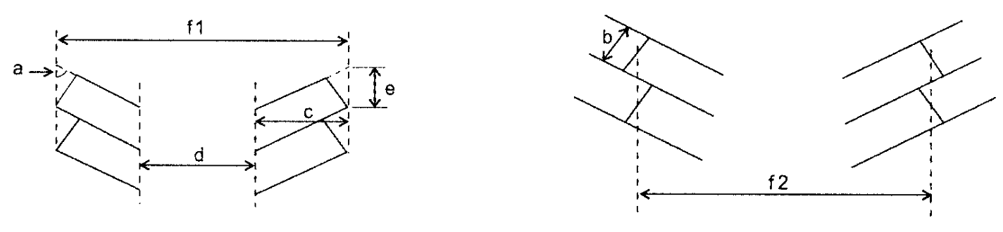
Parking Dimensions
(C)
Parking Surfaces
(1)
Paving. .....In City/Town Centers, any required parking, stacking, and loading area, and all access drives and maneuvering areas shall be paved and permanently maintained with asphalt, concrete, or similar material of sufficient thickness and consistency to support anticipated traffic volumes and weights, except as noted in Section B.3-3.3(C)(3).
(2)
Gravel. .....All other parking areas shall be improved with a minimum of four (4) inches of crushed rock, except as noted in Section B.3-3.3(C)(3).
(3)
Exceptions. .....Paving or graveling shall not be required for the following:
(a)
Temporary Parking or Parking for Construction Purposes. Parking areas used on an irregular or temporary basis for churches, clubs or lodges, other similar nonprofit organizations, or structures under construction.
(b)
Agricultural Uses. Parking areas for agricultural uses.
(c)
Parking for Construction Equipment. Parking areas for tracked heavy construction equipment, skid-mounted equipment, and similar equipment, are exempt from the paving requirements provided these parking areas are constructed with an all-weather surface.
(d)
Overflow Parking. Parking areas identified specifically as overflow parking or parking exceeding the minimum number of spaces required.
(e)
Neighborhood Shopping Center Business District (NSB). In the NSB District, up to ten percent (10%) of the required parking spaces may be unpaved and used for open space purposes during off peak hours, under the provisions of Section B.2-1.3(H)(3)(f).
(D)
Markings and Traffic Control Devices
(1)
Delineation. .....The property owner shall delineate all required parking and loading spaces, stacking lanes, disabled parking spaces, directional arrows, crosswalks, and maneuvering areas within parking areas using paint or other methods approved by the Zoning Officer.
(2)
Signage. .....The Zoning Officer may require a developer to install signage in addition to directional arrows to ensure the safe and efficient flow of vehicles in a parking area or structure.
(E)
Driveways
(1)
Approvals. .....Except for individual single family dwellings, the design and location of all entrance or exit driveways to parking or loading areas of any use from a public street or highway shall be approved by the appropriate jurisdiction as provided herein. Within the zoning jurisdiction of the City of Winston-Salem the Director of Public Works shall approve all driveways prior to the issuance of a zoning or building permit. For all driveways outside the zoning jurisdiction of the City of Winston-Salem, the District Engineer for the North Carolina Department of Transportation shall approve all driveway designs and locations prior to the issuance of a zoning or building permit.
(2)
Combined Driveways and Access. .....The owners of adjoining properties are encouraged to provide combined driveways and connections whenever practical. Please refer to Section B.3-3.5(L) for the incentive to provide combined driveways and connections. Any cross-parcel access shall be formalized through the recordation of an easement.
Combined Driveways
(3)
Dimensional Requirements for Access Drives. .....Internal circulation driveways and access drives that do not provide direct access to parking spaces shall be a minimum of twenty (20) feet in width for two-way traffic and twelve (12) feet in width for one-way traffic unless otherwise specified by the Director of Inspections. Residential uses containing six (6) or fewer dwelling units or having parking areas designed and clearly marked for one-way traffic shall have access drives a minimum of twelve (12) feet in width.
(4)
Driveways for Large Parking Areas (One Hundred (100) or More Spaces). .....For each zoning lot containing parking areas with one hundred (100) or more required spaces, a minimum forty (40) foot deep unobstructed driveway shall be provided from the right-of-way line to a traffic aisle or access to a parking space to accommodate the ingress and egress of at least two (2) vehicles without interference to parking maneuvers or access drives, unless:
(a)
Frontage Road Access. Internal access to the parking area is provided by a private frontage road which parallels the public street, provided no parking is provided along the access drive or frontage road and a minimum forty (40) foot distance without left turn movements is provided along the access drive;
(b)
Spaces per Driveway Ratio. The ratio of parking spaces to driveway access points does not exceed 100:1, where multiple driveways provide access to the zoning lot; or,
(c)
Other Stacking Area. Adequate unobstructed off-street stacking area to accommodate two (2) vehicles is otherwise provided.
Large Parking Area Driveways
(F)
Drive-Through Facility Stacking Lanes
(1)
Number. .....Drive-through facilities requiring stacking lanes shall be provided as follows:
(2)
Width. .....Each lane of stacking space shall be a minimum of nine (9) feet in width and must be delineated with pavement markings.
(3)
Length. .....Each stacking space shall be a minimum of sixteen (16) feet in length, however, individual spaces within the lane shall not be delineated with pavement markings.
(4)
No Conflict of Use. .....Stacking lanes shall not interfere with access to required parking or ingress or egress from a public street.
(5)
Automatic Teller Machines. .....Automatic teller machines located in parking areas of shopping centers or on internally oriented out lots are not required to provide stacking spaces.
(6)
Relationship to Required Parking. .....Drive-Through stacking lanes shall be counted towards the minimum number of required parking spaces for all uses.
(G)
Wheel Stops or Curbs .....Where concrete curbs are not installed adjacent to public sidewalks, public rights-of-way, landscaped areas, or internal roadways, anchored wheel stops shall be installed to prevent vehicles from encroaching into these areas. All wheel stops shall be two (2) feet from the front end of the parking space for front-end parking and four (4) feet from the front of the parking space for rear-end parking.
(H)
Parking in Required Yards .....A parking area may be located in a required yard provided that wheel stops are installed and maintained to protect required screening.
(I)
Landscaping and Screening .....All motor vehicle surface areas shall be landscaped as required in Section B.3-4 and bufferyards shall be provided as required in Section B.3-5.
(J)
Lighting .....Any lighting in parking, stacking, and loading areas shall be so shielded as to cast no direct light upon adjacent properties or structures.
(K)
Drainage .....All parking, stacking, and loading areas shall be designed to meet the requirements of Section C.4.
(WA-UDO-14, §§ 3, 4, 3-25-10; WA-UDO-15, § 7, 2-24-11)
3-3.4 OFF-SITE PARKING
(A)
Off-Site Parking Accessory to Multifamily or Institutional Uses .....Surface parking in a RS or RM District to serve either multifamily residential or institutional must be approved by the Elected Body and meet the following additional requirements:
(1)
Multifamily Parking. .....Multifamily parking in a residential district shall be allowed only if said lot abuts for a distance of not less than twenty-five (25) feet upon the zoning lot to which such parking would be accessory.
(2)
Institutional Parking. .....Institutional parking in a residential district shall be allowed only if the lot used for institutional parking abuts for a distance not less than twenty-five (25) feet upon the zoning lot to which such parking would be accessory, or if said lot is adjacent for twenty-five (25) feet to, but separated by a public street from, the zoning lot to which such parking would be accessory.
(3)
Ingress or egress shall be as follows:
(a)
Multifamily Parking. Ingress or egress for multifamily parking shall be only through the multifamily site.
(b)
Institutional Parking. Ingress or egress for institutional parking shall be only through the institutional site or from a public street.
(4)
Setback. .....Where any such parking area abuts residentially zoned land or a residential use, said parking shall be set back from the property line a distance of not less than fifteen (15) feet.
(B)
Other Off-Site Parking. .....For all uses except multifamily or institutional uses described in Section B.3-3.4(A), the Zoning Officer may authorize a portion of the required parking for a use to be located on a site other than the principal use under certain circumstances. Off-site parking facilities shall meet the following requirements:
(1)
Ownership. .....The off-site parking shall be located on a separate zoning lot from the principal use where both lots are owned by the same person or the off-site parking shall be leased by the owner of the principal use.
(2)
Zoning District. .....The secondary parking lot shall be in a zoning district in which the principal use it supports is a permitted use, with the exception that a secondary parking lot supporting any twin home, duplex, townhouse, multifamily, or institutional use may be located in any nonresidential zoning district.
(3)
Visitor Parking. .....Adequate visitor parking shall exist at the principal use location.
(4)
Pedestrian Access. .....Adequate pedestrian, van, or shuttle connection between the sites shall exist.
(5)
Certain Retail Uses. .....Off-site parking for retail uses requiring off-street parking at a rate of one space per two hundred (200) square feet gross floor area or greater, per Table B.3.8, shall not be permitted, except where such parking is located on a contiguous zoning lot within a zoning district which permits the principal use and is located within two hundred fifty (250) feet of the zoning lot containing the principal use.
(6)
Contract for Parking. .....Where established by lease, the lease shall make the secondary parking lot or lots available for a minimum term of ten (10) years and grant subsequent options for two (2) additional five (5) year lease periods. A copy of the contract, properly executed, shall be filed with the Zoning Officer prior to the issuance of a zoning permit for the secondary parking lot.
(7)
Other Uses. .....Where parking is established on a secondary lot or lots owned by the owner of the lot on which the principal use is located, the secondary lot or lots may not be used for any purpose other than parking required for the principal use unless there is sufficient room for: shared parking; any use which may be placed on the secondary lot or lots; and any parking required for the use placed on the secondary lot or lots.
(8)
Continuance of Use. .....The continuance of the principal use shall be contingent upon the continuance of the off-site parking or the substitution of other parking consistent with the terms of this Ordinance. A parking covenant shall be drawn to the satisfaction of either the City or County Attorney, executed by all parties concerned, and recorded. The contract shall assure the continued availability of the off-site parking facilities for the life of the use that the parking is intended to serve.
3-3.5 ALTERNATIVES AND INCENTIVES
(A)
Purpose .....The purpose of this section is to encourage the property owner to reduce the amount of impervious surface cover needed for parking by providing a variety of alternatives and incentives. Any parking alternative proposed or incentive utilized by the property owner must be approved by the Zoning Officer and shall accomplish the following:
(1)
Intent. .....The intent of the parking requirements is preserved;
(2)
Sufficient Parking. .....The parking provided will be sufficient to serve the use for which it is intended; and,
(3)
Impact. .....The modification will not be detrimental to the public health, safety, or welfare.
(B)
Shared Parking
(1)
Reduction of Parking Requirements. .....The Zoning Officer may authorize a reduction of the parking requirements or parking spaces for any mixed use project or nearby uses where peak parking demand characteristics or hours of operation are distinctly different in accordance with this section. All reductions of parking requirements authorized by the Zoning Officer within the corporate limits of any municipality must also receive approval from the Director of Public Works or Town Manager, whichever is applicable.
(2)
Requirements. .....A request for approval of shared parking shall be accompanied by such information determined by the Zoning Officer as necessary to evaluate the relevant factors listed in the section below, including, but not limited to, a description of the uses, a site plan, and a transportation engineering report. Calculations shall be based on the Shared Parking Standards developed by the Urban Land Institute, as amended.
(3)
Accessibility. .....All shared parking spaces shall be located in a parking facility providing reasonably equivalent accessibility and usability to all uses which the parking is intended to serve.
(4)
Ownership. .....In cases where the uses for which shared parking is requested are located on lots under different ownership, a contract pursuant to Section B.3-3.4(B)(6) shall be provided.
(5)
Conditions. .....In determining whether to approve a reduction for shared parking, the Zoning Officer shall consider all relevant factors, including the following:
(a)
Peak Parking Demand. The characteristics of each use and the differences in projected peak parking demand, including days or hours of operation;
(b)
Reduction in Vehicle Movements. Potential reduction in vehicle movements afforded by multi-purpose use of the parking facility by employees, customers, or residents of the uses served; and,
(c)
Potential Improvements. Potential improvements in parking facility design, circulation, and access afforded by a shared parking facility.
(C)
Park and Shuttle Lots in Business and Industrial Zoning Districts
(1)
Conditions. .....The Zoning Officer may authorize any business use(s), industrial use(s), or zoning lot which has a minimum of one hundred seventy-five (175) contiguous parking spaces to establish a park and shuttle lot provided that:
(a)
Maximum. Not more than ten percent (10%) of the required parking spaces for the use(s) or for the zoning lot may be designated as a park and shuttle lot.
(b)
Location. All designated park and shuttle spaces shall be located in outlying areas of the parking lot so as not to interfere with customer or employee parking needs.
(2)
Short-term Parking. .....All designated park and shuttle areas shall be for short-term (less than twenty-four (24) hours) parking for commuters of any public carpooling, vanpooling, or transit program.
(D)
Reductions in the NB, NO and PB Districts
(1)
In the NB, NO and PB Districts:
(a)
Amount Required. For any permitted use in the NB District, the required amount of parking may be reduced by thirty percent (30%). This reduction shall not affect the required disabled parking or loading spaces for that use.
(b)
Off-Street Parking. Off-Street parking in the NB, NO and PB Districts shall meet the following location requirements:
(i)
Single Street Frontage. A zoning lot which only has frontage on one street shall have a maximum of two (2) surface off-street parking and unloading spaces located between the building wall and the street or an extension of that building wall through the entire street frontage. Any additional surface off-street parking and unloading spaces shall be located to the sides or rear of that building wall as extended through the street frontage. The provisions of this Section shall not apply to zoning lots that do not have street frontage provided the zoning lot is located at least one hundred (100) feet from the street. Also exempt from these provisions are "flag" shaped zoning lots with fifty (50) feet or less of street frontage as long as the "pole" of the flag lot from the street is only used for access without parking and the remainder of the zoning lot to be used for building and parking purposes is located at least one hundred (100) feet from the street.
(ii)
Multiple Street Frontages. A zoning lot which has frontage on two (2) or more streets shall have at least one building wall located not more than fifteen (15) feet from one of those street frontages. There shall be no surface off-street parking or unloading spaces located between that building wall and the street or an extension of that building wall through the entire street frontage. This condition shall apply to all buildings on the aforementioned zoning lot.
(c)
On-Street Parking. On-street parking may be permitted in accordance with Section B.3-3.5(M).
(d)
PB Districts Within GMA 1. Parking may be allowed in front of the principal building provided that no parking area shall extend into the site from the provided streetyard more than sixty-one (61) feet.
(E)
Compact Parking
(1)
Maximum Amount. .....For all uses, the property owner may design and construct up to a maximum of twenty-five percent (25%) of the required parking spaces for compact stalls in accordance with the dimensions provided in Section B.3-3.3(B)(2).
(2)
Identification.
(a)
Markings. The property owner shall identify all compact parking stalls within the parking area with pavement markings. Each compact parking space shall be individually designated as a compact space in letters not less than twelve (12) inches high and seven (7) inches wide in size, which state: COMPACT.
(b)
Symbols. A symbol may be used in lieu of letters if approved by the Zoning Officer.
Compact Parking Dimensions
(3)
Signs. .....Signs shall be provided to indicate the location of the compact parking.
(4)
Location. .....All compact parking spaces shall be conveniently located and dispersed throughout the required parking area.
(F)
Motorcycle Parking
(1)
Maximum Amount. .....For all uses, the property owner may design and construct up to a maximum of two percent (2%) of the required number of parking spaces as motorcycle stalls in accordance with the dimensions provided in Section B.3-3.3(B)(3).
(2)
Identification.
(a)
Markings. The property owner shall identify any motorcycle parking stalls within the parking area with pavement markings. Each motorcycle parking space shall be individually designated as a motorcycle space in letters not less than twelve (12) inches high and seven (7) inches wide in size, which state: MOTORCYCLE.
(b)
Symbols. A symbol may be used in lieu of letters if approved by the Zoning Officer.
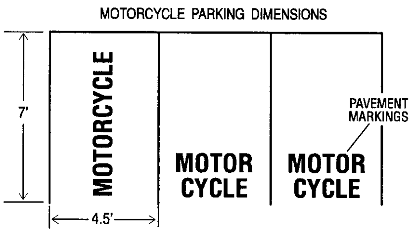
Motorcycle Parking Dimensions
(3)
Fulfilling Requirements. .....Motorcycle parking spaces allowed by this section shall count toward fulfilling the total motor vehicle parking requirements.
(G)
Bicycle Parking
(1)
Maximum Amount. .....For all uses, the property owner may design and construct up to a maximum of five percent (5%) of the required number of parking spaces as bicycle stalls in accordance with the dimensions provided in Section B.3-3.3(B)(4). Accommodation for two bicycles shall be provided for each parking space being replaced.
(2)
Location. .....Bicycle parking stalls and racks shall be located to be highly visible from the street or building entrance from where bicyclists approach. Bicycle racks shall not be installed in isolated locations but shall be located within fifty (50) feet of the main entrance(s) of the building for which they are intended or in a comparably convenient location where there is constant pedestrian traffic, except up to one-third (⅓) of the bicycle parking provided may be placed at convenient locations for employees and residents. Bicycle racks may be installed on public rights-of-way with prior approval from the Walkertown Town Manager.
(3)
Use. .....Bicycle racks shall be for use by the general public as well as employees and residents.
(4)
Separation from Motor Vehicle Parking. .....Bicycle parking areas shall be separated from motor vehicle parking areas (automobiles, trucks, motorcycles, etc.) by at least a curb barrier which would prevent vehicles from damaging bicycles.
(5)
Bicycle Rack Design. .....Bicycle racks shall be designed to be capable of supporting the bicycle in an upright position. Bicycle racks shall be securely anchored to the supporting surface(s). Bicycle racks shall be at least three (3) feet in height unless the bicycle parking area is surrounded by a railing, hedge, or wall three (3) feet in height which is readily visible to pedestrians.
(H)
Parking Reduction for Required Landscaping in Motor Vehicle Use Areas .....For all uses, the property owner may reduce the number of required parking spaces for the installation of required interior planting areas up to a maximum of ten percent (10%). Up to an additional five percent (5%) reduction is permitted where an area which would otherwise be devoted to parking cannot be used in order to preserve an existing tree with a diameter of six (6) inches or greater.
(I)
Parking Reduction on Winston-Salem Transit Authority Regular-Route Transit Line or Adjacent to Piedmont Authority for Regional Transportation (PART) Transit Stop .....For all uses located within seven hundred fifty (750) feet of a Winston-Salem Transit Authority regular-route transit line, or within seven hundred fifty (750) feet of a PART transit stop, the property owner may reduce the amount of required parking up to a maximum of five percent (5%). This reduction shall not affect the required disabled parking or loading spaces for that use.
(J)
Parking Reduction for Public Greenways and Sidewalks .....For all uses abutting an existing or publicly adopted planned public greenway or sidewalk, the property owner may reduce the amount of required parking up to a maximum of three percent (3%). This reduction shall not affect the required disabled parking or loading spaces for that use.
(K)
Alternative Parking Allowance in NSB District .....In the NSB District, up to ten percent (10%) of the required parking spaces may be unpaved or unimproved with gravel, and used for open space under the provisions of Section B.2-1.3(H)(3)(f).
(L)
Combined Driveways and Access .....For all uses providing a combined driveway with or a private access connection to adjoining properties, the property owner may reduce the amount of required parking up to a maximum of five percent (5%).
(M)
On-street Parking Supplements for Pedestrian Oriented Developments .....The pedestrian nature of a site can be enhanced by permitting on-street parking connected to exterior and interior sidewalks.
(1)
On-street parking satisfying the off-street parking requirements of Table B.3.8 may be permitted for sites in the GB, PB and LB Special Use District Zoning Districts or GB, PB and LB General Use Zoning Districts with approval by the Director of Public Works for the City of Winston-Salem or North Carolina Department of Transportation, whichever is applicable, MU-S zoning district, all Multifamily Residential Districts and Planned Residential Developments, if the following requirements are met:
(a)
Sites eligible for the credit shall not generally be located on streets classified as collectors or thoroughfares see Section B.3-3.5(M)(1)(d). However, the City of Winston-Salem, North Carolina Department of Transportation (NCDOT), or other applicable agency may consider locations on collectors or thoroughfares on a case by case basis;
(b)
Parking shall be located on road frontage contiguous to the site;
(c)
All parking shall be angled or parallel meeting the requirements of Table B.3.9, and must be approved by the Public Works Department of the City of Winston-Salem, the NCDOT, or other agency, whichever is applicable;
(d)
Credit for on-street parking shall not exceed thirty-five percent (35%) of the total off-street parking requirements of the site;
(e)
Sidewalks meeting the requirements in this section shall be constructed immediately adjacent to, or on the opposite side of a planting strip, on-street parking spaces and connected to a well defined interior pedestrian system;
(f)
No off-street parking shall be located between a building and any on-street parking except as approved for temporary parking for an earlier phase of a multi-phase development;
(g)
Developer shall dedicate public right-of-way or public road maintenance easements necessary to meet the requirements of Table B.3.9 and must be approved either by the Public Works Department of the City of Winston-Salem or the North Carolina Department of Transportation, whichever is applicable;
(h)
Owner shall construct all required improvements within public rights-of-way to applicable public design standards;
(i)
All buildings shall face the street and provide the principal entrance to the structure from the front or side of the structure; and,
(j)
All buildings shall front on at least one side preferably the entrance side of the building, on a street with no intervening parking area.
(WA-UDO-14, § 1, 3-25-10; WA-UDO-15, § 2, 2-24-11)
3-3.6 OFF-STREET LOADING AND UNLOADING AREAS
(A)
Requirements .....In all districts except the CB and CI Districts, any building or land used for commercial, industrial, or institutional purposes, shall be designed to provide adequate space for off-street parking to accommodate the loading and unloading of goods and materials consistent with the size and proposed use of the building or land. Such space, whether inside or outside a building, shall be in addition to the parking requirements in Table B.3.8 and shall be designed so as not to impede normal vehicular and pedestrian circulation.
(B)
Location .....Off-street loading and unloading areas shall be located on the same lot or adjoining lots as the use for which they are provided.
(C)
Design Standards
(1)
Dimensional Requirements. .....Each loading area shall be at least twelve (12) feet wide, sixty-five (65) feet long, and shall have a minimum height clearance of fifteen (15) feet.
(2)
Reduction. .....The Zoning Officer may reduce the required stall length and maneuvering length if the property owner demonstrates that known delivery vehicles can park and maneuver within the proposed loading and maneuvering spaces such that no part of the vehicle projects into a public right-of-way, access easement, private road, or required landscaping. The reduction shall be based on the nature of the use, or combination of uses, as well as the specific design characteristics of the project.
(3)
Maneuvering Area. .....Loading areas shall be designed and located such that commercial vehicles shall not back into a public street or alley.
(4)
Alley Access. .....When the lot upon which loading areas are located abuts upon an alley, such loading areas may have access from the alley. Where such loading area is parallel with the alley and the lot is sixty (60) feet or less in width, the loading area shall extend across the full width of the lot.
(5)
Industrial Developments. .....Industrial developments shall be designed with the following loading area design standards:
(a)
Location. Loading facilities shall be located either to the rear or side of the industrial structure(s) to alleviate unsightly appearances often created by loading facilities. Where such location is not feasible, a streetyard according to the standards of Section B.3-4.3(B) shall be installed along the entire length of road which the loading docks face.
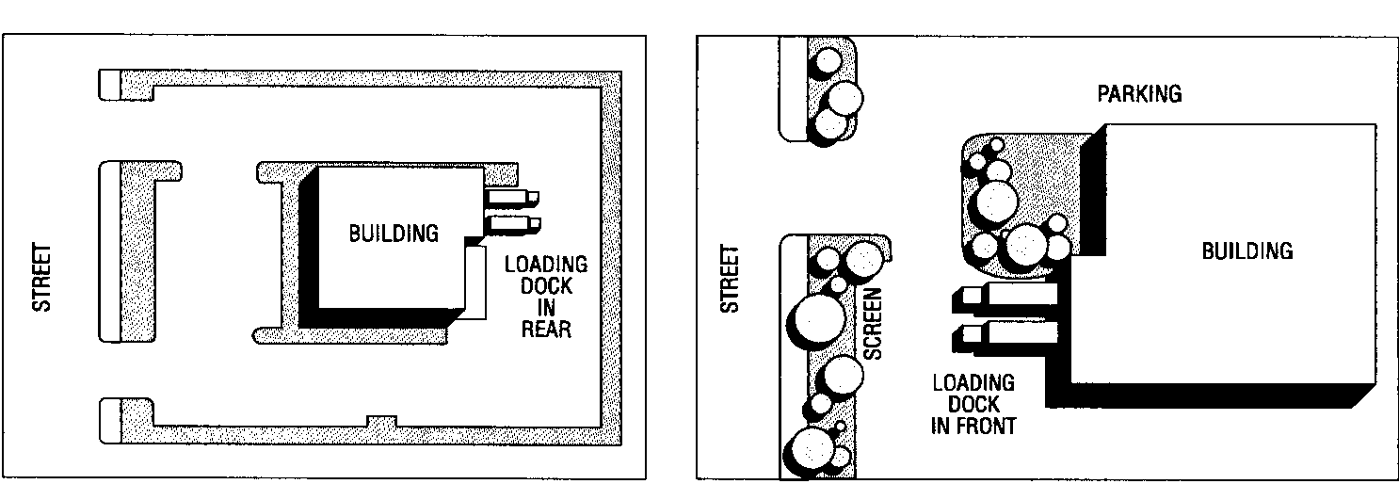
Loading Facilities
(b)
Maneuvering. Each industrial site shall be self contained and capable of handling its own truck maneuvering and docking requirements. The use of public streets for commercial vehicles staging and/or maneuvering is prohibited.
(c)
Depth. Minimum depth of eighty-five (85) feet is required for commercial vehicle docking and maneuvering.
(d)
Turning Radius. At least one driveway approach capable of accommodating a forty-eight (48) foot wheel track turning radius and at least one on-site maneuvering area which provides a forty-eight (48) foot wheel track turning radius through the parking area shall be provided for each industrial site.
(D)
Number of Loading Spaces Required
(1)
Uses Handling Goods in Quantity. .....Uses which normally handle large quantities of goods, including, but not limited to manufacturing plants, wholesale establishments, warehouses, freight terminals, hospitals, and shopping centers, shall provide off-street loading facilities as shown in Table B.3.10.
Table B.3.10
Loading Space Requirements for Uses Handling Goods in Quantity
(2)
Uses Not Handling Goods in Quantity. .....Commercial establishments which do not handle large quantities of goods, including, but not limited to, office buildings, restaurants, auditoriums, convention halls, stadiums, exhibition halls, funeral homes, hotels, and motels shall provide off-street loading as shown in Table B.3.11.
Table B.3.11
Loading Space Requirements for Uses Not Handling Goods in Quantity
(E)
Shared Loading
(1)
Reduction of Loading Requirements. .....The Director of Inspections may authorize a reduction of the loading requirements or loading spaces for any mixed use project or nearby uses where peak loading demand characteristics or hours of operation are distinctly different in accordance with this section. All reductions of loading requirements authorized by the Director of Inspections within the corporate limits of any municipality must also receive approval from the Director of Public Works or North Carolina Department of Transportation, whichever is applicable.
(2)
Requirements. .....A request for approval of shared loading shall be accompanied by such information determined by the Director of Inspections as necessary to evaluate the relevant factors listed in Sections B.3-3.6(E)(3)—(5), including, but not limited to, a description of the uses, a site plan, and a transportation engineering report.
(3)
Accessibility. .....All shared loading spaces shall be located in a loading facility providing reasonably equivalent accessibility and usability to all uses which the loading is intended to serve.
(4)
Ownership. .....In cases where the uses for which shared loading is requested are located on lots under different ownership, a contract pursuant to Section B.3-3.4(B)(6) shall be provided.
(5)
Conditions. .....In determining whether to approve a reduction for shared loading, the Director of Inspections shall consider all relevant factors, including the following:
(a)
Peak Loading Demand. The characteristics of each use and the differences in projected peak loading demand, including days or hours of operation;
(b)
Reduction in Vehicle Movements. Potential reduction in vehicle movements afforded by multi-purpose use of the loading facility by employees, customers, or residents of the uses served; and,
(c)
Potential Improvements. Potential improvements in loading facility design, circulation, and access afforded by a shared loading facility.
3-4 - LANDSCAPING STANDARDS
3-4.1 GENERAL REQUIREMENTS
(A)
Purpose .....It is the intent of this section to modify and enhance the character of motor vehicle use areas, outdoor storage areas, utility service areas, and other public or institutional areas, through the introduction of natural vegetation and landscaping, without unduly burdening property owners, in order to:
(1)
Appearance of Areas Near Rights-of-Way. .....Improve the appearance of motor vehicle use areas within close proximity of vehicular rights-of-way;
(2)
Appearance of Large Areas. .....Break the visual blight created by large expanses of motor vehicle use areas;
(3)
Property Value and Investments. .....Enhance property values and protect public and private investments;
(4)
Water and Erosion Control. .....Increase site stormwater infiltration capacity, improve groundwater recharge, and reduce erosion and urban runoff pollution hazards;
(5)
Comfort. .....Improve human comfort during the use of motor vehicle use areas by providing shade, reducing solar heat absorption, and reducing noise levels;
(6)
Environmental Sensitivity. .....Encourage environmental sensitivity to natural features during the design and construction of motor vehicle use areas;
(7)
Glare. .....Filter and reduce reflected sunlight and headlight glare from parked vehicles onto street rights-of-way; and,
(8)
Air. .....Filter and reduce motor vehicle fumes and dust.
(9)
Public Properties. .....Improve the appearance of public properties from vehicular rights-of-way and adjacent properties, as well as for users on the properties.
(B)
Applicability .....This section shall apply to all land located in the zoning jurisdiction. Unless otherwise provided in this section, an occupancy permit shall not be issued until all required planting and landscaping materials are installed. The following motor vehicle use areas are required to be landscaped:
(1)
Motor Vehicle Surface Areas;
(2)
Motor Vehicle Display Areas;
(3)
Outdoor Storage Areas;
(4)
Utility Service Areas;
(5)
Parking Buildings or Structures; and,
(6)
Public or Private Schools.
(C)
Exclusions .....The following uses shall be exempt from the requirements of this section:
(1)
A single family detached dwelling on its own lot;
(2)
An attached dwelling unit which possesses an individually separated driveway and/or garage; and,
(3)
Fire hydrants and other utility devices whose visibility is vital to public safety.
3-4.2 APPLICATION PROCEDURES AND GENERAL REQUIREMENTS.
(A)
Application .....When an application is made for a building permit on any land where the landscaping requirements of this section are applicable, such building permit application shall be accompanied by the information listed in Section B.3-4.2(A)(1)—(4). Submittal of said information may occur up to ninety (90) days after the issuance of a building permit, provided, however, the developer or landowner submits with the building permit application a letter certified by a registered landscape architect, architect, surveyor, or engineer, stating sufficient land has been reserved for required plantings, and also files an improvement security as specified in Section B.3-4.2(B)(2). Additional information to be submitted with the application for a building permit includes:
(1)
Storage, Surface, and Service Areas. .....A site plan indicating the location, dimensions, and square footage of motor vehicle surface areas, motor vehicle display areas, outdoor storage areas, private utility service areas, proposed parking space striping, and overhead utility lines;
(2)
Landscaping. .....A site plan indicating existing and proposed landscaping used to satisfy the requirements of this section, including the number, species, location, and heights of trees, shrubs, and groundcover; the location and dimensions of planting areas and streetyards; the location and size of earthen berms; and, the location, size, and construction material of fences, walls, and wall planters;
(3)
Existing Trees to be Preserved. .....The number, location, species, height, and diameter at six (6) inches above ground level of existing trees to be preserved for credit as per Section B.3-4.2(H); and,
(4)
Barriers. .....The location and description of any barriers to be erected to protect any existing vegetation from damage during construction.
(B)
Delay of Landscaping .....If the required landscaping has not been installed at the time of a request for an occupancy permit, and the Zoning Officer determines that the unavailability of plant materials or adverse weather conditions prohibit the timely completion of planting, an occupancy permit may be issued prior to installation of required landscaping, subject to the following:
(1)
Completion Schedule. .....The applicant shall sign a contract specifying that the work shall be completed within the six (6) months immediately following the date of application for an occupancy permit; and,
(2)
Security. .....If the Zoning Officer determines that the applicant has not shown good faith in the past in completing required improvements, an improvement security in the form of an escrow account or other instrument shall be required prior to issuance of an occupancy permit. The improvement security shall be in an amount deemed sufficient by the Zoning Officer to cover all costs of required landscaping or screening which has not been installed. Such security shall be valid until the work is completed in accordance with the permit. The security shall be forfeited upon violation of this section and shall be used toward completion of all planned improvements. Any moneys in excess of the cost of installing required landscaping shall be refunded to the applicant. The security shall be released when the Zoning Officer certifies that all requirements of this section have been met.
(C)
Compliance with Sight Easement Requirements .....Landscaping required by this section shall comply with the minimum State or local sight easement requirements for street intersections and driveways.
(D)
Obstruction of Pedestrian Routes .....Required landscaping shall not obstruct or impede public pedestrian routes including sidewalks and greenway trails.
(E)
Protection of Planting Areas .....Whenever any planting areas required by this section are adjacent to motor vehicle surface areas, motor vehicle display areas, or outdoor storage areas, the planting areas shall be protected from motor vehicle intrusion or damage from excessive motor vehicle lubricants or fuels.
(F)
Stabilization of Soil Surface .....The soil surface of all planting areas required by this section shall be stabilized to prevent erosion. In addition to required interior trees and shrubs, the soil surfaces of planting areas shall contain live groundcover, mulch, live shrubs, permeable pedestrian paver blocks, or a combination thereof.
(G)
Maintenance of Plantings .....The landowner is responsible for maintaining all required plant materials in good health. Any dead or missing plants must be replaced with new planting which meets the minimum installation dimension standards of this section. Plant replacement shall take place within one month of written notification by the Zoning Officer. In the event that plant material is severely damaged due to an unusual weather occurrence or other act of nature, or if replacement plantings are unavailable within one month of written notification, the land owner will have six (6) months from the date of written notification to replace plantings.
(H)
Use of Existing Trees for Credit .....Existing trees may be preserved and used for credit in satisfying the requirements of this section, according to the conditions that follow:
(1)
Maximum Credits for Tree Preservation. .....Maximum credits for tree preservation shall be determined by Table B.3.12.
;il=1.5i>Table B.3.12 Use of Existing Trees for Credit
(2)
Minimum Planting Area. .....Each tree to be preserved for credit shall be provided with a minimum planting area which coincides with the tree's dripline. The tree's dripline is defined as the area underneath a tree which would be encompassed by perpendicular lines dropped from the outermost edges of the crown of the tree.
(3)
Protection from Encroachment. .....Tree preservation planting areas shall be cordoned off during construction and protected from encroachment. The minimum area to be cordoned off shall consist of the critical root zone of the tree or an area ten (10) feet from the tree's trunk in all directions, whichever is the greater area. The protection measures shall be properly maintained during site development and shall not be removed prior to final landscaping. For the purposes of this section, encroachment is defined as the ground surface disturbance caused by grading; impervious surface cover; equipment, material, or earth storage; or by temporary or permanent construction vehicle access or circulation.
(4)
Minimum Streetyard Requirement. .....Tree preservation credits may be used to reduce the number of trees required in this section; however, in no instance shall a required streetyard contain less than one tree, nor shall any required streetyard contain no trees for seventy-five (75) continuous feet; nor shall any parking space be more than fifty (50) feet from the trunk of a tree, unless otherwise authorized in Section B.3-4.3(C)(8).
(5)
Planting Area Used for Streetyard or Interior Plantings. .....Planting areas required for tree preservation credit may be used to install streetyard or interior shrubs as required in this section.
(6)
Loss of Tree Credits. .....Removal or death of any preserved tree shall result in the loss of all associated tree credits for that particular tree. Replacement of trees shall be subject to the planting requirements of Section B.3-4. Developers and landowners are urged to seek professional expertise to preserve properly existing trees for credit.
(I)
Combining Planting Area and Bufferyard Requirements .....Where motor vehicle use area plant materials and bufferyard plant materials are required on the same property, trees may be located in such a manner as to simultaneously satisfy both requirements. Required planting areas shall not be cumulative; however, the greater of the planting areas specified in Section B.3-5 or this section shall be the required planting area.
(J)
Overhead Utility Lines .....The location of overhead utility lines shall be considered during the placement of required trees. The maximum mature height of required trees shall be determined as follows: (Suggested plant materials are listed in Section B.3-4.10.)
(1)
Small Varieties: .....Small variety trees shall be used when located within twenty-five (25) feet, measured horizontally, from the nearest overhead utility lines(s).
(2)
Small or Medium Varieties: .....Small or medium variety trees shall be used when located within twenty-five (25) to thirty-five (35) feet, measured horizontally, from the nearest overhead utility line(s).
(3)
Small, Medium, or Large Varieties: .....Small, medium, or large variety trees may be used when located more than thirty-five (35) feet, measured horizontally, from the nearest overhead utility line(s).
(K)
Safety and Security .....Safety and security concerns should receive prominent consideration during the selection and placement of landscape materials.
(L)
Fire Protection Equipment .....A minimum five (5) foot radius containing no plant materials or structural elements other than groundcover plants shall be maintained around all fire protection equipment, including fire hydrants, post indicator valves, and siamese connectors. Obvious sight lines to the fire protection equipment shall be maintained at all times.
(M)
Off-Street Parking Reduction .....A reduction in the amount of required off-street parking is permitted in accordance with the alternatives and incentives provisions of the parking requirements Section B.3-3.5(H) for the installation of landscaping required by the motor vehicle surface area landscaping standards.
3-4.3 MOTOR VEHICLE SURFACE AREA LANDSCAPING STANDARDS
(A)
General Requirements
(1)
Exemption. .....This section shall not apply to single family residential buildings.
(2)
Applicability. .....This section shall apply to any motor vehicle surface area or portions thereof built after March 7, 1988.
(3)
Expansion of Preexisting Motor Vehicle Surface Areas. .....When preexisting motor vehicle surface areas are expanded:
(a)
Required Interior Plantings. Required interior plantings may be dispersed throughout the entire motor vehicle surface area in accordance with Section B.3-4.3(C)(9).
(b)
Streetyard Width. Streetyard width may be reduced to a minimum of fifty percent (50%) of the required width, provided the minimum required streetyard area and plant quantities for the expansion are installed; and provided such streetyard trees shall be provided a planting area with a minimum radius of seven (7) feet.
(B)
Streetyards .....A landscaped streetyard shall be required for all motor vehicle surface areas located within one hundred (100) feet of a street right-of-way or vehicular right-of-way, including controlled access highways, whether or not it may provide access to the site, unless separated by an intervening building.
(1)
Width. .....Minimum streetyard width is ten (10) feet, and shall be measured perpendicular to the street right-of-way. The streetyard shall be positioned between the motor vehicle surface area and street right-of-way.
(2)
Impervious Surface Cover. .....A maximum of fifteen percent (15%) of the required streetyard may be covered with impervious surface cover which may be used for walkways, fountains, walls, or wall planters, but may not be used for motor vehicle surface or display, outdoor storage, private utility service, or service areas.
(3)
Number and Spacing of Trees. .....Each streetyard shall contain a minimum of two (2) deciduous or evergreen trees per one hundred (100) linear feet, excluding points of motor vehicle ingress or egress. In no case shall any streetyard contain less than one tree. Required trees must be a minimum of eight (8) feet in height at installation and shall be at least two (2) inches in diameter measured six (6) inches above ground level. Where two (2) or more streetyard trees are required, all trees shall be planted with the center of the main trunks twenty (20) to seventy-five (75) feet apart. Existing deciduous trees located in the abutting street right-of-way may be used to satisfy the distribution requirements above.
(4)
Other Streetyard Components. .....In addition to required trees, the landowner or developer shall use one of the following to satisfy streetyard requirements: natural shrubs, closed fences, walls, wall planters, earthen berms, or a combination thereof, as follows:
(a)
Natural Shrubs. Streetyard shrubs must be a minimum of eighteen (18) inches in height at installation, with a minimum height of thirty-six (36) inches within three (3) years after installation. Shrubs must be a locally adapted species which retain foliage to within six (6) inches above ground level. Said shrubs shall be spaced no more than eighteen (18) inches, edge to edge. No more than thirty percent (30%) of streetyard shrubs shall be deciduous.
(b)
Fences and Walls. A streetyard fence or wall shall be a minimum of thirty-six (36) inches in height, opaque, and shall be constructed of masonry, stone, or wooden material, or of the same material as that of the principal building.
(c)
Wall Planters. A streetyard wall planter shall be constructed of masonry, stone, or other permanent material. At installation, the minimum combined height of wall planters and shrubs shall be twenty-four (24) inches. Within three (3) years after installation, the combined height of wall planters and shrubs shall be no less than thirty-six (36) inches. The effective planting width of a streetyard wall planter shall be no less than thirty-six (36) inches; however, where required streetyard trees are installed in wall planters, the effective planting width of the wall planters shall be no less than seven (7) feet. A minimum of one shrub shall be required for every five (5) square feet of wall planter area.
(d)
Earthen Berms. At installation, streetyard berms shall have a minimum height of eighteen (18) inches, a minimum crown width of two (2) feet, and a side slope with a width to height ratio of no greater than two (2) to one (2:1). The entire berm shall be planted and covered with live vegetation. Berm shrubs shall be a minimum of one foot in height at installation and shall be spaced no greater than eighteen (18) inches, edge to edge. Within three (3) years after installation, the combined height of berm and shrubs must be at least thirty-six (36) inches. Streetyard berms which are thirty-six (36) inches or greater in height at installation shall not be required to contain shrubs; however, streetyard trees shall still be required as specified in this section.
(5)
CB District. .....In the CB District, a minimum two (2) foot wide strip planted with trees and shrubs in accordance with this section or a three (3) foot high masonry wall shall be provided.
(6)
PB District. .....In the PB District within GMA 1, a minimum two (2) foot wide strip planted with trees and shrubs in accordance with this section shall be provided. Any required or provided trees within the streetyard shall be located within a minimum seven (7) foot wide, fifty (50) square foot planting area.
(C)
Interior Motor Vehicle Surface Area Plantings .....In addition to the required streetyard, all motor vehicle surface areas shall contain landscaped planting areas, as follows:
(1)
Location of Plantings. .....Interior planting areas shall be located adjacent to motor vehicle surface area edges or within the interior as islands or medians, and may contain berms of the minimum dimensions specified in Section B.3-4.3(B)(4)(d).
(2)
Size. .....Each planting area shall contain a minimum of one hundred fifty (150) square feet, with a minimum radius of seven (7) feet.
(3)
Required Trees in Planting Area. .....Each planting area shall contain at least one deciduous or evergreen tree with a minimum height of eight (8) feet at the time of installation, and a minimum diameter of two (2) inches measured six (6) inches above ground level.
(4)
Ratio. .....One deciduous or evergreen tree shall be required for every two thousand five hundred (2,500) square feet of motor vehicle surface area.
(5)
Distance of Parking Spaces to Trees. .....No parking space shall be located more than fifty (50) feet from the trunk of a required tree, unless otherwise authorized in this section.
(6)
Loading/Maneuvering Areas. .....For loading docks or other maneuvering areas where placement of trees in the interior of the site is impractical, the required number of trees may be clustered around the edge of such areas, with the approval of the Zoning Officer.
(7)
Credit for Streetyard or Bufferyard Trees. .....Deciduous or broadleaf evergreen trees used as streetyard or bufferyard plantings may be used as credit toward interior planting area requirements, provided that no parking space shall be located more than fifty (50) feet from the trunk of a required tree.
(8)
Credit for Bufferyard Area. .....The landscaped bufferyard area provided to meet the requirements of Section B.3-5 and located adjacent to a motor vehicle use area may be counted toward the interior planting requirement.
(9)
Expansion of Preexisting Areas. .....When preexisting motor vehicle surface areas are expanded, required interior plantings may be dispersed throughout the entire motor vehicle surface area if the landowner so desires, subject to the following conditions:
(a)
The required plant material will be calculated with reference to the expansion area only;
(b)
Such planting may be dispersed throughout the entire, combined, existing, and new motor vehicle surface area; and,
(c)
The provisions of this section shall preempt the fifty (50) foot spacing requirement contained in Section B.3-4.2(H)(4) and Section B.3-4.3(C)(5).
(10)
Alternative Compliance. .....An applicant whose contiguous parking area exceeds five hundred (500) spaces may propose a landscaping plan which varies from the strict application of the provisions of this section in order to accommodate unique characteristics of the site or to utilize innovative design. Application for alternative compliance shall include a site plan following the requirements specified in Section B.7 and shall be approved by the Planning Board only upon a finding that the proposed landscaping plan fulfills the intent and purposes of this section as well as or better than would strict conformance with the requirements of this section.
3-4.4 MOTOR VEHICLE DISPLAY AREA LANDSCAPING STANDARDS
(A)
General Requirements
(1)
Applicability. .....This section shall apply to any motor vehicle display area, or portions thereof, built after December 31, 1994.
(2)
Expansion of Preexisting Motor Vehicle Surface Areas. .....When preexisting motor vehicle display areas are expanded, streetyard width may be reduced to a minimum of five (5) feet, provided the minimum required streetyard area and plant quantities for the expansion are installed, and provided each streetyard tree shall be provided a planting area with a minimum radius of seven (7) feet.
(3)
Landscaping Requirements. .....Motor vehicle display areas shall comply with the general landscaping requirements of Section B.3-4.3.
(B)
Streetyards .....A landscaped streetyard shall be required as specified in Section B.3-4.3(B) except:
(1)
Natural Shrubs. .....Any streetyard shrubs, wall planters, earthen berms, or combinations thereof, shall be installed at a minimum height of eighteen (18) inches, and shall reach a minimum height of thirty (30) inches within three (3) years after installation.
(2)
Fences and Walls. .....Closed fences or walls shall be installed at a minimum height of thirty (30) inches.
3-4.5 OUTDOOR STORAGE AREA SCREENING STANDARDS
(A)
Applicability .....Any outdoor storage area not screened from any public or private street by an intervening building built after the adoption of this Ordinance with a linear dimension of fifteen (15) feet or greater, or any dumpster with a linear dimension of five (5) feet or greater and not screened by an intervening building shall be screened from view from any street right-of-way or vehicular right-of-way including controlled access highways, whether or not it may provide access to the site, for its entire length except for necessary access.
(B)
Screening .....Outdoor storage area screening shall be provided as specified in either of the conditions below or as a combination of the two (2) conditions:
(1)
Fencing. .....A fence or wall may be used to screen an outdoor storage area. The fence or wall shall be at least six (6) feet in height, opaque and of masonry, stone or wooden material, or of the same material as that of the principal building.
(2)
Plantings. .....Natural evergreen plant materials may also be used to screen an outdoor storage area as follows: (Suggested plant materials are listed in Section B.3-4.10.)
(a)
Minimum Height. The minimum height of the plant material shall be six (6) feet at installation; and,
(b)
Spacing. The spacing of the planting shall be in a double-row configuration, staggered, with five (5) foot spacing between the centers of the main trunks.
3-4.6 UTILITY SERVICE AREA SCREENING STANDARDS
(A)
Applicability .....Utility service area structures built after the adoption of this Ordinance are required to be screened from street rights-of-way or vehicular rights-of-way, whether or not it may provide access to the site, provided that said structures have vertical dimensions exceeding five (5) feet or horizontal dimensions in excess of five (5) feet, and are located less than one hundred (100) feet from the nearest street right-of-way.
(B)
Screening .....Where screening for utility service areas is not provided by an intervening building, said screening may be accomplished by locally adapted evergreen or deciduous plantings or an opaque fence or wall.
(1)
Installation Height. .....Plantings shall have a minimum installation height of eighteen (18) inches, be spaced no more than eighteen (18) inches, edge to edge, and be expected to reach a height and width equal to or greater than the utility service structures that are being screened.
(2)
Fences or Walls. .....Fences or walls shall be opaque, of masonry, stone, or wooden material, or of the same material as that of the principal building, if applicable, and of a height and width equal to or greater than the utility service structures that are being screened.
(C)
Responsible Party .....Screening for utility service areas in a street right-of-way is to be installed by the utility or party who installed the service; in all other instances the property owners shall install required screening. Where screening for public utility service areas is to be provided by private property owners, such screening shall be installed only after consultation with the utility who owns the device to be concealed. No screening shall be installed that would impair the safe operations, maintenance, or function of the utility equipment.
3-4.7 PARKING STRUCTURES OR BUILDINGS
Any parking structure or building, or expansion thereof, built after the adoption of this Ordinance that exceeds two thousand five hundred (2,500) square feet in gross floor area shall be provided with a landscaped streetyard as specified in Section B.3-4.3(B). This provision shall apply only to structures whose principal use is parking, and shall not apply to vertical expansion of preexisting parking structures.
3-4.8 PUBLIC OR PRIVATE SCHOOLS
(A)
Applicability .....A landscape plan for the school campus shall be prepared and installed prior to occupancy for any new school or any improvement to an existing school which results in an increase in building area or footprint.
(B)
Standards .....Landscaping plans shall meet the following standards:
(1)
Number of Trees. .....A minimum of one tree of either large or medium variety as described in Section B.3-4.10 shall be provided per thirty-five (35) linear feet of public road frontage. In any event, a minimum of fifteen (15) trees shall be planned for and provided on each campus.
(2)
Existing Trees. .....Existing trees to be incorporated into the design of the school or currently on the campus may be preserved and used for credit in meeting the site plan requirements, per Section B.3-4.2(H)(1). Existing trees may be used in lieu of not more than eighty percent (80%) of the required new plantings; except that where property or site constraints prohibit the placement of additional trees, additional credit for existing trees up to one hundred percent (100%) may be given.
(3)
Height at Installation. .....New plantings shall meet the requirements of Section B.3-5.3(B).
(4)
Variety of Trees. .....Notwithstanding Section B.3-4.8(B)(2), at least one-half (½) of the trees on the campus shall be large variety as described in Section B.3-4.10.
(5)
Other Plant Material. .....Other plant material described in Section B.3-4.10 may be installed and may be used for credit in meeting the requirements of Section B.3-4.8(B)(1) with approval of Planning Board staff.
(6)
Location. .....Trees and other plant material may be located in any required yards or in the interior of the campus, and may function as a bufferyard to screen or soften uses, structures, or activities which may be incompatible. Landscaping should be placed to enhance entryways into campuses and upgrade previously disturbed areas. On existing campuses built prior to the landscaping requirements for motor vehicle surface areas, trees and other plant materials may also be located in parking areas or other motor vehicle surface areas.
3-4.9 VARIANCE
Applications for variances from the requirements of the landscaping and screening standards may be approved by the Board of Adjustment after such Board of Adjustment holds a duly advertised public hearing in each case. Said application for a variance will be governed by the procedures set forth in Section B.6-1.4. Approval of a variance shall include the determination that there are practical difficulties or unnecessary hardships in the way of carrying out the strict letter of the Ordinance because of one or more of the following conditions:
(A)
Narrow .....Unusually narrow (less than ten (10) feet) sections of land available for planting because of existing permanent structures, existing paving, or natural features such as rock outcroppings.
(B)
Elevation Change .....Elevation change of more than twelve (12) feet within the area where the screening would be located.
(C)
Public Safety .....Specialized land uses such as public utilities, airports, etc. where strict adherence to the screening standard would significantly interfere with the function of that use and would create a public safety problem.
(D)
Public Agency .....Actions of a public agency.
(E)
Platting or Deeding .....Difficulties arising from the recording platting or deeding of land prior to the adoption of this Ordinance.
3-4.10 SUGGESTED PLANT MATERIALS LIST
The suggested plant materials list includes common trees and shrubs suitable for use in the Forsyth County area. Due to individual site soil, moisture, and microclimate conditions, professional expertise should be sought to determine the appropriate plant materials for any particular development project.
(A)
Large Variety Trees (mature height: thirty-five (35) feet or greater):
(B)
Medium Variety Trees (mature height: twenty-five (25) to thirty-five (35) feet):
(C)
Small Variety Trees (mature height: less than twenty-five (25) feet):
(D)
Streetyard and Interior Shrubs (mature height: approximately thirty-six (36) inches):
(1)
Evergreen.
(2)
Deciduous.
(E)
Outdoor Storage Area Screening Plants (installation height: six (6) feet):
(F)
Groundcovers (planting areas, berms, wall planters):
3-5 - BUFFERYARD STANDARDS
3-5.1 GENERAL REQUIREMENTS
(A)
Purpose .....Bufferyard standards are designed to provide visual and functional separation between different land uses to:
(1)
Reduce potential nuisances, such as glare, dirt, noise, unsightly views, and other adverse impacts;
(2)
Safeguard property values and preserve the character and integrity of the community; and,
(3)
Protect the health, safety, and welfare of the public.
(B)
Applicability .....Every use, change of use, construction of a new structure, or expansion of a structure or land hereafter established shall meet the bufferyard requirements of this section, except for the following:
(1)
Single family, duplex, or twin home uses;
(2)
Development or redevelopment in the CB or CI Districts;
(3)
Between component parts of a planned residential development or MU-S District; or,
(4)
Where no bufferyard requirement is shown in Table B.3.13.
(WA-UDO-14, § 4, 3-25-10)
3-5.2 DETERMINATION OF BUFFERYARD
(A)
Procedure .....The type of bufferyard required shall be determined as follows:
(1)
Identify the Zoning Type for the Proposed Project .....and all adjacent properties, excluding properties across a public right-of-way. The zoning types are defined below for the purposes of this section only.
(a)
Single Family Residential (SFR) Zoning Types. Single family residential zoning types include the H, YR, AG, all RS Districts (including RSQ).
(b)
Multifamily Residential (MFR) Zoning Types. Multifamily residential zoning types include all RM Districts and the MH District where a manufactured housing development is involved.
(c)
Low Intensity Commercial (LIC) Zoning Types. Low intensity commercial zoning types include the LO, PB, LB, IP, and C Districts.
(d)
High Intensity Commercial (HIC) Zoning Types. High intensity commercial zoning types include the CPO, GO, NSB, HB, GB, CB, and MU-S Districts.
(e)
Industrial (IND) Zoning Types. Industrial zoning types include the LI, CPI, GI, and CI Districts and certain uses which require outdoor storage, have high trip generation rates, or have the potential for nuisance to adjacent properties due to noise, light and glare, or typical hours of operations. The following list of specific uses identified in Table B.2.6 shall be classified as industrial zoning types for bufferyard purposes.
(i)
Banking and Financial Services, with Drive-Through Facilities;
(ii)
Car Wash;
(iii)
Convenience Store with Gasoline Sales;
(iv)
Implement Sales and Service;
(v)
Kennels; Outdoor (See Section B.2-5.37.1(B));
(vi)
Outdoor Display Retail;
(vii)
Motor Vehicle Repair and Maintenance;
(viii)
Motor Vehicle Storage Yard;
(ix)
Reserved;
(x)
Recreational Vehicle Park;
(xi)
Recreation Services, Outdoor;
(xii)
Restaurants (With Drive-Through Service);
(xiii)
Storage and Salvage Yard; and,
(xiv)
Dirt Storage Sites (See Section B.2-5.25(E).
(2)
Determine the Bufferyard Type .....(I, II, III, or IV) required for each adjacent zoning type from Table B.3.13.
TABLE B.3.13
Bufferyard Requirements
* = No bufferyard requirement
;adv=-6q; + = Type I bufferyard required if no bufferyard is provided on developed adjacent property designated as high intensity commercial (HIC) or industrial (IND) zoning types.
;adv=-6q; ++ = Whenever a residential use in the PB Zoning District shares a side yard boundary line with a lot in a residential district, the requirements of Section B.3-1.2(J)(2) shall apply.
(3)
Select the Desired Bufferyard Option .....for the required bufferyard type from those described below.
(a)
Type I Bufferyard. A type I bufferyard is a low density screen designed to partially block visual contact and create spatial separation between adjacent uses. The four (4) design options that may be used to satisfy this bufferyard requirement are identified in Table B.3.14.
Table B.3.14
Type I Bufferyard Design Options
(b)
Type II Bufferyard. A type II bufferyard is a medium density screen designed to block visual contact and create spatial separation between adjacent uses. The four (4) design options that may be used to satisfy this bufferyard requirement are identified in Table B.3.15.
TABLE B.3.15
Type II Bufferyard Design Options
(c)
Type III Bufferyard. A type III bufferyard is a high density screen designed to eliminate visual contact and create spatial separation between adjacent uses. The five (5) design options that may be used to satisfy this bufferyard requirement are identified in Table B.3.16
TABLE B.3.16
Type III Bufferyard Design Options
(d)
Type IV Bufferyard. A type IV bufferyard is a high density screen designed to eliminate visual contact and create spatial separation between adjacent uses. The six (6) design options that may be used to satisfy this bufferyard requirement are identified in Table B.3.17.
Table B.3.17
Type IV Bufferyard Design Options
(B)
Additional Requirements
(1)
Fractional Calculations. .....Fractional planting requirement calculations shall be rounded to the next higher whole number.
(2)
Existing Plant Material. .....Existing plant material within the required bufferyard may be included in the computation of the required plantings with approval of the Zoning Officer.
(3)
Fence or Wall Option. .....An opaque fence or wall may be used in lieu of not more than fifty percent (50%) of the required evergreen bufferyard plantings with the approval of the Zoning Officer and providing the following conditions are met, where applicable:
(a)
Fence Height for Industrial Zoning Type. The minimum required fence height shall be eight (8) feet above ground level when the proposed project zoning type is classified as an industrial zoning type.
(b)
Fence Height for Zoning Types Except Industrial. The minimum required fence height shall be six (6) feet above ground level when the proposed project zoning type is classified as any zoning type except those classified as industrial.
(c)
Vegetation Planted on Exterior Sides. Where a fence or wall is used as part of the required screening, all required vegetation shall be planted on the exterior side of the fence or wall.
(d)
Screening Multifamily Residential Zoning Type. Where the fence option is used to screen multifamily residential zoning types from more intense zoning types, the required vegetation may be planted on the interior side of the fence or wall.
(e)
Remaining Vegetation Distribution. Where a fence is used in lieu of not more than fifty percent (50%) of the required vegetation, the remaining percentage of vegetation to be used in conjunction with the fence or wall shall be evenly distributed in the bufferyard.
(4)
Earthen Berms .....Earthen berms six (6) feet high or greater, or earthen berms with combined evergreen shrub plantings reaching a minimum height of six (6) feet, may be used in lieu of not more than fifty percent (50%) of the evergreen bufferyard plantings providing the following conditions are met:
(a)
Live Vegetation. The entire berm shall be planted and covered with live vegetation.
(b)
Evergreen Shrubs. On berms less than six (6) feet in height, evergreen shrubs, if used, shall be a minimum of one foot in height at installation and shall be placed no greater than eighteen (18) inches edge to edge.
(c)
Shape. Berms shall be naturally shaped, shall have a minimum crown width of two (2) feet, and shall have side slopes stabilized to sedimentation and erosion control standards.
(C)
Alternative Compliance for NO, NB, and MU-S Districts .....In the NO, NB and MU-S Districts, a developer may propose a bufferyard plan that varies from the strict application of the provisions of this section in order to accommodate unique characteristics of the site, utilize innovative design, or provide an appropriate degree of buffering for separate phases and types of development. Application for alternative compliance shall include a site plan following the requirements specified in Section B.7, and shall be approved by the Planning Board only upon a finding that the proposed bufferyard plan fulfills the intent and purposes of this section better than would strict conformance with the requirements of this section.
(D)
Alternative Compliance for Schools .....The bufferyard requirements of this section otherwise required for development of public or private schools in certain zones may be met by the submittal and approval of a landscaping plan according to the provisions of Section B.3-4.8.
(E)
Conflicting Bufferyard Requirements .....If any conflict exists between the bufferyard requirements as identified in this section and any use conditions or zoning district regulations contained in other sections of this Ordinance, the bufferyard requirements in the other section shall apply.
(WA-UDO-13, § 12, 2-26-09; WA-UDO-14, § 4, 3-25-10)
3-5.3 BUFFERYARD LOCATION AND DESIGN REQUIREMENTS
(A)
Location of Bufferyards
(1)
Location. .....Bufferyards shall be located on the outer perimeter of a lot or parcel, extending to the lot or parcel boundary line, with the following exceptions:
(a)
On Adjacent Property. All or part of the bufferyard may be located on adjacent property within a permanent easement dedicated for such purpose with approval of the Director of Inspections.
(b)
Portion of Site Proposed for Development. If only a portion of a site is proposed for development, the required bufferyard may be located at the limit of construction perimeter with approval of the Director of Inspections.
(c)
Topographic Irregularities. Where topographic irregularities require a different location to meet the intent of this section, the location of the bufferyard may be varied with approval of the Director of Inspections.
(d)
Slope Ratios. Required bufferyard plantings shall not be installed on cut or fill slopes with slope ratios greater than two (2) to one (2:1).
(e)
Intent. Where the intent of the bufferyard section is met by locating the bufferyard in a location other than the outer perimeter of a lot or parcel, upon approval of the Director of Inspections.
(2)
Cut Slope. .....Where bufferyards include any part of a cut slope greater than ten (10) feet in height, grading for such cut slope shall not encroach closer than ten (10) feet to the property line.
(3)
Rights-of-Way and Streets. .....Bufferyards shall not be located on any portion of an existing, dedicated, or proposed right-of-way, or a private street.
(4)
Existing Easement Within Bufferyard. .....Where an existing easement that prohibits bufferyard-type plantings is partially or wholly within a required bufferyard, the developer shall design the bufferyard to meet the planting limitation of the easement and/or site. Such design may necessitate choosing a bufferyard with more land area and fewer required plantings (or a different species) or locating the bufferyard in a manner that satisfies the intent of the bufferyard requirements as determined by the Director of Inspections.
(B)
Design Requirements
(1)
Size of Plant Material.
(a)
Deciduous trees in bufferyards thirty (30) feet in width or less may be either medium or large varieties as described in Section B.3-4.10, provided, however, at least one-half of the required trees shall be large variety. Deciduous trees in bufferyards of greater than thirty (30) feet in width shall be large variety trees. Suggested plant materials are listed in Section B.3-4.10.
(b)
All deciduous trees used for bufferyard screening must be a minimum of eight (8) feet in height at installation and shall be at least two (2) inches in diameter measured six (6) inches above ground level.
(c)
All primary evergreen plants shall be a minimum of six (6) feet in height at time of installation unless combined with an approved earthen berm, and shall be not less than ten (10) feet in height at maturity.
(d)
All supplemental evergreen shrubs shall be a minimum of eighteen (18) inches in height at installation, and shall attain a minimum height of thirty-six (36) inches three (3) years after installation.
(2)
Spacing of Plant Material.
(a)
All deciduous trees shall be installed with tree trunks spaced a minimum distance of thirty (30) feet apart and a maximum distance of sixty (60) feet apart.
(b)
All primary evergreen plants shall be distributed evenly along the length of the bufferyard and shall be staggered where quantities permit. Primary evergreen plants shall be installed with tree trunks spaced a minimum of seven (7) feet apart and a maximum of fifteen (15) feet from other primary evergreen plants and from any required deciduous tree.
(c)
All supplemental evergreen shrubs shall be distributed evenly along the length of the bufferyard and shall be staggered where quantities permit.
(3)
Maintenance. .....Any fence, earthen berm, or plant material used for screening shall be maintained in sound condition by the bufferyard provider. Maintenance includes replacement of any required bufferyard materials which are damaged and/or dying.
(C)
Application to Nonconforming Situations .....The bufferyard standards shall apply to the entire zoning lot in nonconforming situations per the requirements of Section B.5-4.3(C)(2).
(WA-UDO-14, § 4, 3-25-10)
3-5.4 MULTIPLE USE OF BUFFERYARDS
(A)
To Satisfy Other Requirements .....Areas set aside as required bufferyards may also be used to satisfy the following:
(1)
Minimum setback requirements;
(2)
Minimum open space requirements; and,
(3)
Minimum landscaping requirements.
(B)
For Other Purposes .....Required bufferyards may also be used for the following additional purposes:
(1)
Bufferyards may contain stormwater retention or detention areas, provided:
(a)
The required bufferyard plantings shall be provided and the design and landscaping of the bufferyard do not interfere with the proper functioning of the drainage system; and,
(b)
The designed water depth shall not harm the viability of the plantings.
(2)
Bufferyards may be used for passive recreation, such as pedestrian, bicycle, or equestrian trails, subject to the following limitations:
(a)
No plant material shall be eliminated;
(b)
The total width of the bufferyard shall be maintained; and,
(c)
All other requirements of this Ordinance shall be met.
(3)
Bufferyards may be used for the installation of underground utilities, provided the location and use of the utility lines do not interfere with the required bufferyard plantings.
(C)
Reduction for Driveway to Rear Parking Areas .....A side or rear bufferyard may be reduced to five (5) feet if the Planning Board determines that such reduction is necessary, due to lot size, shape, or topographic features, to allow a driveway which accesses off-street parking to the rear of the property.
(D)
Prohibited Uses .....The following uses shall be prohibited in a required bufferyard: playfields, stables, swimming pools, tennis courts, or similar active recreation uses, and storage or parking facilities.
3-5.5 BUFFERYARD VARIANCE
Application for variances from the requirements of the bufferyard standards may be approved by the Board of Adjustment in accordance with the procedures in Section B.6-1.4(B). Approval of a variance shall include the determination that there are practical difficulties or unnecessary hardships in the way of carrying out the strict letter of the ordinance because of one or more of the following conditions:
(A)
Narrow .....Unusually narrow (less than ten (10) feet) sections of land available for planting within the back and/or side yards because of existing permanent structures, existing paving, or natural features such as rock outcroppings.
(B)
Steep Slopes/Elevation Change .....Existing slopes in excess of two (2) to one (2:1) in locations where a bufferyard is required.
(C)
Public Safety .....Specialized land uses such as public utilities, airports, etc. where strict adherence to the screening standard would significantly interfere with the function of that use and would create a public safety problem.
(D)
Public Agency .....Actions of a public agency.
(E)
Platting or Deeding .....Difficulties arising from the recorded platting or deeding of land prior to the adoption of this Ordinance.
3-6 - COMMON RECREATION AREAS
3-6.1 APPLICABILITY
All multifamily developments containing forty (40) or more units, and all manufactured home developments, shall provide on site common recreation area as required below. Elderly housing, life care communities, and other developments occupied exclusively by persons who are at least fifty-five (55) years old or disabled are exempt from the requirements of this section.
3-6.2 MINIMUM SIZE
A minimum of one hundred (100) square feet per unit shall be devoted to common recreation areas.
3-6.3 COMBINING AREAS
The total common recreation area may be divided into areas not less than four thousand (4,000) square feet each where the average length of the space does not exceed twice the average width.
3-6.4 ACCESS
Common recreation areas shall be easily accessible by pedestrian walkways so they can be conveniently and safely reached and used.
3-6.5 FINISHED GRADE
Common recreation areas shall be constructed on land where the average finished grade of the slope does not exceed five percent (5%), is well drained, and is otherwise capable of serving the purposes intended.
3-6.6 LANDSCAPING
Common recreation areas shall be attractively landscaped and provided with sufficient natural or constructed screening to minimize any negative impacts upon adjacent residences within the development.
3-6.7 EXCLUSIONS
Common recreation areas shall not include streets, access easements, rights-of-way, parking areas, required perimeter bufferyards or streetyards or required building setbacks; shall be closed to motor vehicle traffic except for maintenance and service vehicles; and, shall not be located over a septic system drainage field.
3-6.8 MAINTENANCE
Common recreation areas shall be improved and maintained for the purposes intended.
3-7 - PROTECTION OF PUBLIC RIGHTS-OF-WAY AND GREENWAYS
3-7.1 PUBLIC RIGHTS-OF-WAY
(A)
Dedication of Right-of-Way with Density Transfer
(1)
Dedication. .....Whenever a tract of land is proposed for subdivision or for use pursuant to a zoning or building permit, and a portion of it is located within a corridor for a street or highway on a plan established and adopted pursuant to State law for a street or highway that is included in the Department of Transportation's Transportation Improvement Program, the right-of-way within that corridor shall be dedicated to the appropriate agency.
(2)
Required Findings. .....No dedication of right-of-way shall be required pursuant to this section unless the Planning Board or Elected Body granting final subdivision plat approval, the special use permit, or other approval or permission finds prior to the grant that the dedication does not result in the deprivation of a reasonable use of the original tract and that the dedication is either reasonably related to the traffic generated by the proposed subdivision or use of the remaining land or the impact of the dedication is mitigated by measures provided in this Ordinance.
(3)
Transfer of Density Credits. .....The applicant may transfer density credits attributable to the dedicated right-of-way to contiguous land owned by the applicant. If the dedication of right-of-way is not required, an applicant for subdivision plat approval on a zoning or building permit, or any other permission pursuant to this Ordinance elects to dedicate the right-of-way, the applicant may transfer density credits attributable to the dedicated right-of-way to contiguous land that is part of a common development plan.
(4)
Definition of Density Credit. .....As used in Section B.3-7.1(A)(3), the term density credit means the potential for the improvement or subdivision of part or all of a parcel of real property, as permitted by this Ordinance or the Subdivision Ordinances, as set forth in Section D.3-7.1(A)(5).
(5)
Transferable Percentage. .....One hundred percent (100%) of the density credit or development potential of the property dedicated pursuant to Section 3-7.1(A)(4) may be transferred to contiguous land that is part of a common development plan as identified in Section B.3-7.1(A)(3).
(B)
Transportation PlanCorridors
(1)
Limits on Approvals. .....Whenever a tract of land is proposed for subdivision or for use pursuant to a zoning or building permit, and a portion of it is located within a corridor for a thoroughfare identified on the Transportation Plan, no building permit shall be issued for any building or structure or part thereof located within the roadway corridor, nor shall approval of a subdivision be granted with respect to property within the roadway corridor. The City Traffic Engineer and/or the North Carolina Department of Transportation district engineer shall be notified within ten (10) days of all such requests for building permits or subdivision approvals within the roadway corridor.
(2)
Exemptions. .....The provisions of this section shall not apply to valid building permits issued prior to the effective date of this Ordinance, or to building permits for buildings and structures which existed prior to the filing of the roadway corridor, provided the size of the building or structure is not increased and the type of building code occupancy as set forth in the North Carolina Building Code is not changed. If, within one year following the establishment of a roadway corridor official map or amendment, work shall not have begun on an environmental impact statement or preliminary engineering, the corridor shall be deemed abandoned, and the provisions of this section shall no longer apply to properties or portions of properties located within the roadway corridor.
(3)
Time Limits. .....No application for building permit issuance or subdivision plat approval shall be delayed by the provisions of this section for more than three (3) years from the date of the original building permit or subdivision plat submittal.
(4)
Waiver of Requirements. .....The Board of Adjustment shall hear and decide requests to waive the requirements of this section. A variance may be granted by the Board of Adjustment upon a showing that:
(a)
Even with the tax benefits provided as authorized by State Law, no reasonable return may be earned from the land; and
(b)
The requirements of this section result in practical difficulties or unnecessary hardships.
3-7.2 GREENWAYS
Before any zoning permit is approved for a lot which lies within fifty (50) feet of a stream identified for a greenway in the adopted Greenway Plan, the Zoning Officer shall notify the County Manager/City Manager/Town Manager. The adopting jurisdiction will assess the potential impact of the development on future greenway construction and may then offer to purchase or undertake other action to protect the potential greenway corridor. The Zoning Officer shall not approve any permit which would authorize disturbance of the potential greenway corridor, nor shall the property owner or his/her agent disturb the potential greenway corridor, until the County Manager/City Manager/Town Manager formally responds to the Zoning Officer regarding the intent of the adopting jurisdiction. If no response is received within fifteen (15) days, the Zoning Officer may issue the requested permit.
3-8 - SUPPLEMENTARY STANDARDS FOR OLDER NEIGHBORHOODS
3-8.1 APPLICABILITY
These supplementary standards for older neighborhoods apply to development on blocks which:
(A)
Date Platted or Developed .....Were originally platted or developed prior to March 3, 1948;
(B)
Percentage of Lots Developed .....Have at least fifty percent (50%) of the lots developed; and,
(C)
Permitted in Certain Zoning Districts .....Are zoned in whole or in part, RS, RM, NO or NB.
3-8.2 ALTERNATIVE SETBACKS AND STANDARDS
(A)
Alternative Setbacks .....In older neighborhoods the required setbacks for the underlying zoning district may be replaced by the following alternative method of compliance. No building or part of a building, other than steps, open porches, overhanging eaves and cornices, shall extend nearer to the front, side or rear property lines than the average distance of the respective setbacks of the principal buildings on the same block and on the same side of the street within one hundred (100) feet from the zoning lot in either direction. Any fractional amounts calculated shall be rounded up. However, in no case shall the front setback be less than eight (8) feet nor more than forty (40) feet.
(B)
Development Standards .....If the alternative method of compliance is used, the following development standards apply:
(1)
Impervious Surface Cover. .....For new construction on vacant lots, impervious surface cover is limited to a maximum of sixty percent (60%). Impervious surface cover is otherwise limited to seventy percent (70%).
(2)
Building Height. .....No building shall exceed a height of forty (40) feet.
(3)
Bufferyard. .....Bufferyard requirements of Section B.3-5 must be met for multifamily developments containing more than four (4) units, or for nonresidential uses.
(4)
Off-Street Parking.
(a)
Number of Spaces. Off-street parking for multifamily uses shall meet the standards for Efficiency units, if applicable, or Urban Residential Building in Table B.3.8.
(b)
Parking in Rear. All off-street parking shall be provided to the rear of the principal building(s) unless the Planning Board determines that, due to lot size, shape or topographic features, some or all parking cannot be placed to the rear.
(c)
Reduction in Bufferyard. A side or rear bufferyard width may be reduced to allow a driveway to the rear of the property which accesses the off-street parking if the provisions of Section B.3-5.4(C) are met.
(d)
Landscaped Separation From Building. A minimum three (3) foot wide landscaped area shall be provided between any parking area and building wall providing access into the unit(s).
(5)
Vehicular Use Landscaping Requirements. .....Vehicular use landscaping requirements of Section B.3-4 must be met for multifamily developments containing more than four (4) units or nonresidential uses.
(6)
Building Size. .....For projects located on two (2) acres or less, multifamily buildings shall contain no more than six (6) units.
(7)
Roofs. .....A roof having a pitch with a minimum vertical rise of four (4) feet for each twelve (12) feet of horizontal run is required on all buildings.
3-8.3 ALTERATION OR EXPANSION NOT AFFECTING OCCUPANCY OR INTENSITY
For any existing residential building containing four (4) units or less, any expansion or alteration of the principal building which meets the dimensional requirements of Section B.3-8.2(A) and which does not increase the occupancy capacity of the building, including expansion or alteration of kitchen, bathroom, closet, or patio areas, shall not be subject to the provisions of Section B.5-4.3.
3-8.4 SUBMITTAL OF INFORMATION
The applicant or property owner shall be responsible for submitting all information relative to the setbacks and buildings of the relevant nearby properties in support of the permit request.
3-9 - BONUS DENSITY FOR AFFORDABLE HOUSING
3-9.1 DENSITY INCREASE PERMITTED
An increase in the density otherwise permitted in the zoning district may be permitted for developments which provide on-site or off-site housing opportunities for low- or moderate-income households. A contract shall be approved by the County Attorney or City Attorney and the Forsyth County Department of Housing (FCDH) or the Winston-Salem Housing and Neighborhood Development Department (HND) as a condition of special use district zoning, preliminary subdivision approval, or other site plan review guaranteeing that the reserved units will be purchased by or rented to qualifying households, and shall be binding for a period of not less than fifteen (15) years from the date on which the unit is first occupied. The reserved lots or rental units shall be indicated on the site plan submitted.
3-9.2 APPLICABILITY
(A)
Duplex or Multifamily Units .....A twenty-five percent (25%) density bonus for duplex or multifamily units may be approved if:
(1)
A minimum of forty percent (40%) of the units are to be rented to families earning less than sixty percent (60%) of Forsyth County median income, adjusted for family size, as determined by the United States Department of Housing and Urban Development (HUD). (Hereinafter, median income); or
(2)
A minimum of twenty percent (20%) of the units are to be rented to families earning less than fifty percent (50%) of median income.
(B)
Single Family Detached Units .....A twenty-five percent (25%) density bonus for single family residential development may be approved if twenty-five percent (25%) of all units, or a minimum two units, are to be sold to families earning less than eighty percent (80%) of median income.
(C)
Donation of Land .....A twenty-five percent (25%) density bonus for single family residential development may be approved if land with suitable soils or access to public water and sewer is donated to Forsyth County or the City of Winston-Salem Housing Authority for the purpose of the development of affordable housing within the same census tract or adjoining tracts. The donated land shall contain at a minimum the land area needed to develop the total number of the bonus units, in accordance with the zoning requirements of the district in which the donated land is located.
3-9.3 CONTRACT FOR SALE OF SINGLE FAMILY RESIDENCES
Approval of the special use district zoning, preliminary subdivision, or other site plan review shall not occur until there is a contract between the property owner and Forsyth County or the City of Winston-Salem, which shall also be binding on future owners of the reserved lots. The contract shall be administered by FCDH, and shall include the following provisions:
(A)
Approval of Sales and Resales .....All sales and resales shall be approved by FCDH or the HND to assure ownership by qualifying buyers in accordance with the following eligibility criteria.
(1)
Income. .....Family income at the time of purchase shall not exceed the limits set forth in Section B.3-9.2.
(2)
Residency. .....At least one member of a qualifying household must have lived or worked in Forsyth County for the past twelve (12) months.
(B)
Duration of Contract .....The contract shall apply to each of the reserved lots, and shall continue to affect a particular lot for a minimum period of fifteen (15) years after the initial sale of that lot.
(C)
Occupancy .....There shall be no occupancy of the unit prior to its sale to a qualifying buyer.
(D)
Schedule .....The contract shall include a schedule by which construction and sale of the reserved units will be accomplished.
(E)
Resale Price .....The resale price of any reserved housing unit shall not, at any time during the life of the contract, exceed the maximum amount affordable to the purchasing low or moderate income household. The maximum sale or resale price shall be determined by FCDH or HND (depending on jurisdiction), calculated by using HUD modeling for housing affordability. HUD modeling takes into consideration assumptions such as interest rates, percentage of annual income allowed for housing, and amount of down payment.
(F)
Violation of Contract .....Violation of any of the terms of the contract required by this section may constitute grounds for revocation of the special use district zoning, preliminary subdivision, or other site plan review.
3-9.4 CONTRACT FOR RENTAL OF DUPLEX OR MULTIFAMILY UNITS
Approval of the special use district zoning, preliminary subdivision, or other site plan review shall not occur until there is a contract between the property owner or developer and Forsyth County or the City of Winston-Salem, which shall also be binding on future owners of the development. The contract shall be administered by the County, the City, or the Housing Authority, and shall include the following provisions:
(A)
Approval of Rentals .....All rentals shall be approved by FCDH, HND, or the Housing Authority to assure occupancy by qualifying households in accordance with the following eligibility criteria:
(1)
Income. .....Family income at the time of purchase shall not exceed the limits set forth by FCDH or HND. Families whose income increases above the eligibility requirements may continue to occupy the rental unit, unless otherwise required through terms of the rental agreement between the lessor and lessee.
(2)
Residency. .....At least one member of a qualifying household must have lived or worked in Forsyth County for the past twelve (12) months.
(B)
Change in Occupancy .....Every change in occupancy during the fifteen (15) year term of the contract shall be approved by FCDH or HND to assure continued compliance with eligibility criteria.
(C)
Maximum Rent .....The maximum rent allowed shall be computed by multiplying the applicable percentage of median income by the value of median income at the time of the transaction, then multiplying the resulting value by the maximum percentage of income spent for housing, as recommended by the mortgage banking industry. The value for median income used in calculating maximum allowable rent shall be adjusted to reflect the maximum family size appropriate for the number of bedrooms, as determined by FCDH or HND.
3-9.5 DISCLOSURE OF CONTRACT TERMS TO POTENTIAL HOME-BUYERS
(A)
Explanation to Prospective Buyer .....Staff from the FCDH or HND shall meet with the prospective buyer prior to the purchase to assure that all terms of the contract are fully understood. Such explanation shall communicate that although building permits for the improvements to the structure may be obtained if the owner wishes to remodel or construct an addition or accessory structures, there is no assurance that the investment will be regained if the unit is sold prior to the expiration of the contract due to the requirement that it be purchased by a moderate income household.
(B)
Home Ownership Counseling .....Home ownership counseling shall be made available to first-time buyers to provide information on such topics as insurance and maintenance. The counseling shall be provided by FCDH or HND.
3-9.6 CONVEYANCE OF PROPERTY TO FORSYTH COUNTY, CITY OF WINSTON-SALEM OR THE HOUSING AUTHORITY
Land donated to Forsyth County or Winston-Salem pursuant to Section B.3-9.2(C) to enable a developer to obtain a density bonus shall be donated in trust for the purpose of the development of affordable housing. An agreement between the developer and Forsyth County or Winston-Salem and the instruments of conveyance shall insure this trust as determined by the County or City Attorney.
3-10 - WATER SUPPLY AND SEWAGE DISPOSAL
3-10.1 APPROVAL
Wherever the water supply and sewage disposal facilities of the City of Winston-Salem or of Forsyth County or of a sanitary district are not available, application for a zoning permit or a special use permit shall not be deemed acceptable unless the proposed methods of water supply and sewage disposal have been specifically approved in writing by an authorized officer of the appropriate agency indicated in Section B.3-10.3. Written approval shall be provided along with three (3) schematic drawings showing the proposed development and the proposed water and sewerage connections or facilities. One copy shall be retained by the Public Health Department, one copy by the Zoning Officer, and one by the applicant. No excavation or construction for any building or use of land shall be commenced until such approval is noted on the plan of proposed development and a zoning permit is issued.
3-10.2 METHOD TO BE SPECIFIED
Any such approval shall specify the method or methods approved and shall describe any special conditions to be met. Such methods, and the approvals required, may include the following:
(A)
Public Sewer .....Connection to community sewerage and water systems operated by a responsible person, firm or corporation other than a governmental agency, where the proposed connection is approved by an authorized officer of each system.
(B)
Private Sewer .....Installation of facilities other than public or community sewerage systems, for which design approval by the Public Health Department has been obtained.
3-10.3 SYSTEM APPROVAL
The sewerage and water systems to which connections are to be made shall be only those systems approved as follows:
(A)
Water Supply
(1)
For ten (10) to twenty-five (25) dwelling units, approval by the State Board of Health.
(2)
For twenty-five (25) or more dwelling units, approval by the State Board of Health and the State Utilities Commission.
(B)
Sewage Collection and Treatment
(1)
For a septic tank, approval by the Public Health Department.
(2)
For a sewerage system serving facilities regulated by the State Board of Health, i.e., institutions, restaurants, motels, etc., approval by the Public Health Department.
(3)
For a sewerage system serving all other uses, i.e., industry, commerce, communities, etc., approval by the North Carolina Department of Water and Air Resources when applicable.
3-10.4 COMMUNITY WATER SYSTEM
The person, firm, or corporation operating a community water system for twenty-five (25) or more customers or a sewerage system for which a rate is charged shall hold a certificate of public convenience and necessity from the State Utilities Commission, and there shall be recorded with a plat of the property the written affidavit of a registered engineer, engaged in the independent practice of civil engineering, that water and sewer mains and laterals comply with pertinent standards of the city, as existing on the date of the affidavit, and that such mains and laterals are installed in accordance with plans and specification which have been submitted to and approved in writing by the Director of Public Works of the City of Winston-Salem; and a bond or bonds, or other form of written assurance, satisfactory to the Planning Board, assuring the continuous proper maintenance and operation of such sewerage and water systems.
3-11 - OTHER STANDARDS
3-11.1 LIGHTING
An engineered lighting plan shall be submitted to the Inspections Division for proposed lighting demonstrating the use of full-cut off fixtures, light height of twenty-five (25) feet or less, and no more than one-half (½) foot-candle as measured at the property line.
Applicability. The standards of this section shall apply to the following situations:
(a)
New construction of principal buildings which are either adjacent to a public street or to residential zoning.
(b)
Additions, reconstruction or renovation of principal buildings which are either adjacent to a public street or residential zoning and where such additions are equal to or greater than seventy-five percent (¾) of tax value of the existing structure.
(c)
This Section shall not apply to the uses: Residential Building, Single Family; Residential Building, Duplex; Residential Building, Twin Home; and Residential Building, Townhouse.
(WA UDO-19, § 1, 2-27-14)
3-11.2 NOISE
All air handling machinery, dumpsters, compressors or water coolers for nonresidential uses shall be set back a minimum distance of fifty (50) feet from any property line adjacent to residential uses or residentially zoned land.
3-11.3 SIDEWALKS ON COMMERCIAL AND RESIDENTIAL PROJECTS WITHIN THE TOWN CORE AREA (see "Town Core Sidewalk Plan" map approved by the Town Council on October 28, 2004)
New commercial projects within the town core area requiring zoning permits or building permits for any structural improvement to the property which has an estimated cost greater than fifty percent (50%) of the tax valuation of all its buildings including the subject property must build sidewalks along the street frontage to connect adjoining parcels. Sidewalk location will be coordinated with the Town of Walkertown and may include the North Carolina Department of Transportation (NCDOT) if they maintain the right-of-way.
If there are multiple commercial buildings within the project, the site must have internal sidewalks. If the project includes interior streets, sidewalks must be built on at least one side along these streets to connect the use to street frontages. Then sidewalks must also be built along the main street frontage to connect adjoining parcels.
New residential construction within the town core area requiring zoning permits or building permits for any structural improvement to the property which has an estimated cost greater than fifty percent (50%) of the tax valuation of all its buildings including the subject property shall either build sidewalks along the street frontage or deed a minimum five (5) foot sidewalk easement as needed for future sidewalk construction.
Sidewalks must be built to North Carolina Department of Transportation Subdivision Roads, Minimum Construction Standards, the Americans with Disabilities Act, and G.S. 136-44.14. Sidewalk maintenance shall be the sole responsibility of the property owner. No certificate of occupancy shall be granted until sidewalk construction or easement dedication has been completed.
3-12 - STREET STANDARDS GOVERNING VEHICLE AND PEDESTRIAN CIRCULATION
(A)
Pedestrian Transit and Bicycle Mobility
(1)
General.
(a)
Sidewalk, walkway, on-road improvements, greenway easements, and trail systems sufficient to serve both existing and projected pedestrian, transit, and cyclist needs shall be indicated on all site and subdivision plans approved by the Planning Board or Elected Body. Such systems may include sidewalks along public or private streets, wide outside travel lanes, bike lanes on roadways, and walkways and trails in alternative locations as appropriate. Design, location, dimensions, dedications, easements, and reservations shall conform to applicable jurisdictional policies and adopted plans for sidewalks, bicycle routes, greenways and trails. Such plans include the Winston-Salem Urban Area Sidewalk and Pedestrian Facilities Plan; the Winston-Salem Urban Area Comprehensive Bicycle Master Plan; the Greenway Plan, Winston-Salem and Forsyth County; and the Winston-Salem Urban Area Thoroughfare Plan.
(b)
Walkways and trails shall be designed to maximize the safety of users and the security of adjoining properties with respect to location, visibility, and landscaping.
(2)
Sidewalk Requirement for Planning Board or Elected Body Approvals.
(a)
Single family residential and nonresidential subdivisions, Planning Board Review items, and special use district zoning items in Walkertown identified as outside Legacy Rural Growth Management Area.
(i)
Unless the Planning Board or Elected Body approves an alternate walkway location, a conventional sidewalk shall be provided within the right-of-way along all new public streets with required curb and gutter as shown in the table below in accordance with the Town of Walkertown or NCDOT standards as applicable.
(ii)
Sidewalks shall also be required along existing streets where subdivisions, Planning Board Review items, or special use district zoning items abut streets proposed for sidewalks as identified in the adopted Winston-Salem Urban Area Sidewalk and Pedestrian Facilities Plan.
(iii)
Except for sidewalks as required on approved site plans, additional sidewalks in accordance with this section shall not be required for properties with vested site plans in accordance with Chapter B, Article I, Section 1-5.2 Vested Rights.
(iv)
Exemptions. .....Sidewalks are not required in locations where curb and gutter is not required for new public streets.
(b)
Alternate Requirement.
(i)
A pedestrian walkway may be provided outside the right-of-way within a public access easement when the Planning Board or Elected Body determines the walkway will have the same functionality as a conventional sidewalk required in Section 3-12(A)(2) above.
(ii)
A pedestrian walkway may be provided outside the right-of-way within a public access easement when the Planning Board or Elected Body determines that the construction of a conventional sidewalk within the right-of-way is impractical due to impending road widening or other physical limitations.
(iii)
A developer may propose a sidewalk layout which varies from the strict application of the provisions of Section 3-12(A)(2) above in order to accommodate the unique character of the site or to utilize innovative design. Alternative compliance may be granted by the Planning Board or Elected Body only upon a finding that the proposed alternative fulfills the intent of sidewalks to provide a logical and functional pedestrian network as well as or better than would strict compliance with the requirements of this Ordinance.
(3)
Sidewalk Requirements for Nonresidential Developments and Other Multifamily Developments Not Requiring Approval by the Planning Board or Elected Body.
(a)
Sidewalks shall be required for all nonresidential developments and multifamily developments not subject to approval by the Planning Board or Elected Body and where located along streets identified on the adopted Winston-Salem Urban Area Sidewalk and Pedestrian Facilities Plan, subject to the following criteria or exceptions:
(i)
Sidewalks shall be required along the entire frontage of the property under the following circumstances:
[A]
New construction sites.
[B]
On existing developed zoning lots, construction of ten thousand (10,000) square feet or more gross square feet in new buildings or additions of ten thousand (10,000) square feet or more gross square feet to existing buildings on existing developed zoning lots.
[C]
In all situations where sidewalks are required the developer shall be obligated to build no more than one linear foot of sidewalk per ten (10) square feet of gross building area. The location of sidewalks shall be determined through the construction permitting process in accordance with the adopted Winston-Salem Urban Area Sidewalk and Pedestrian Facilities Plan.
(ii)
Sidewalks shall only be required on streets which have existing curb and gutter paving or where the subject street is being widened with curb and gutter as required by the approval of a driveway permit. Construction of the sidewalk shall be approved by the Town of Walkertown prior to the issuance of occupancy permits.
(iii)
Exceptions and exemptions:
[A]
Sidewalk requirements maybe located either totally or partially within a public easement outside the right-of-way, or may be waived altogether, if the Town of Walkertown determines that sidewalk construction either within or outside the right-of-way is impractical due to physical limitations if the site.
[B]
Sidewalks shall not be required for any interior up-fit of existing buildings that does not involve any new outside construction meeting the requirements in this section.
[C]
Phased projects not covering the entire zoning lot shall only be required to construct sidewalks through the frontage of the site development or construction on the zoning lot provided phasing is logical with respect the viability of future development as determined by the City-County Inspections Division.
[D]
Sidewalk construction shall not be required if the street meets the provisions of Section 3-12(A)(6), Payment In-Lieu, as determined by the Town of Walkertown. This determination shall be made prior to the issuance of building permits. If a payment in-lieu determination is made, the payment shall be made to the Town of Walkertown prior to the issuance of occupancy permits. If other construction in the vicinity or a combination of sidewalk and alternative walkway is approved, the construction shall be completed and approved by the Town of Walkertown prior to the issuance of occupancy permits.
(4)
Standards for Bicycle and Pedestrian Facilities for Planning Board or Elected Body Approvals.
(a)
Any required bicycle and pedestrian facilities in accordance with the adopted Winston-Salem Urban Area Sidewalk and Pedestrian Facilities Plan and/or the Winston-Salem Urban Area Comprehensive Bicycle master Plan shall be clearly marked using NCDOT standard markings, or shall be based on the Manual on Uniform Traffic Control Devices.
(b)
Adjacent existing public greenways shall be connected to bicycle and pedestrian facilities on the site.
(c)
Bicycle and pedestrian connections shall be made to any existing or proposed off-site bicycle or pedestrian facilities contiguous to the site.
(5)
Dimensions and Locations.
(a)
Sidewalks.
(i)
In general, sidewalks shall be a minimum of five (5) feet in width and shall be constructed of concrete as per the NCDOT construction standards unless another material is approved by the Town of Walkertown.
(ii)
For conventional sidewalks approved by the Planning Board or other approving authority, sufficient right-of-way shall be dedicated to ensure that on roads with curb and gutter, a planting strip can be constructed in accordance with NCDOT standards. If a sidewalk must be placed adjacent to the back of curb due topographic constraints or other hardships as approved by the Town of Walkertown, the width of the sidewalk may be increased to six (6) feet in width.
(iii)
Sidewalks on nonresidential developments and other multifamily developments not subject to approval by the Planning Board or other approving authority may be installed directly behind the curb if sufficient right-of-way does not exist in accordance with (ii) above.
(b)
Bicycle Facilities Approved by the Planning Board. .....Either wide outside travel lanes or bicycle lanes, as determined by the Town of Walkertown, or NCDOT, shall be part of any road improvement made on roadways which are indicated as bicycle routes on the approved Winston-Salem Urban Area Comprehensive Bicycle Master Plan.
(6)
Payment In-Lieu. .....When the Town of Walkertown determines that the construction of a required conventional sidewalk or alternative walkway is unfeasible due to special circumstances, including but not limited to: existing ribbon pavement, impending road widening, significant street trees, utility problems, grade problems or other construction difficulties, the Town of Walkertown shall require either, (1) a payment in-lieu of sidewalk construction; (2) construction of sidewalks in the general vicinity of the project site; or (3) a combination of a conventional sidewalk, alternative walkway, or payment of a fee in-lieu. Payment in-lieu shall only be required in cases where a sidewalk is likely to be built within five (5) years from the date of plan approval. For payment in-lieu, the cost of the sidewalk construction shall be approved by the Town of Walkertown and the payment for the sidewalk construction shall be made to the Town of Walkertown prior to the issuance of occupancy permits or recording of final plats whichever is applicable. If the sidewalk is not built within five (5) years, the Town of Walkertown shall determine whether to construct the sidewalk without the planned street improvement, delay installation further to coincide with a scheduled street improvement which has been delayed, or construct the sidewalk in the vicinity of the site where it can be feasibly constructed.
(B)
Ingress and Egress Requirements
(1)
General. .....Upon completion, all public and private streets, utilities, and drainage infrastructure shall be certified and the record construction drawings and certifications shall be submitted and accepted by NCDOT, City-County Utilities, or the Town of Walkertown, as applicable.
(2)
Dedicated and Publicly Maintained Streets. .....Dedicated and publicly maintained streets shall be required for developments in all zoning districts except as described in Section 3-12(B)(2). An unlimited number of building permits may be conditionally issued for land parcels adjacent to a public street that is not maintained by either the Town of Walkertown or NCDOT. However no occupancy permits shall be issued unless the street has been completed or substantially constructed in accordance with Section 4(H), "Platting Requirements" including posting of an appropriate surety to the satisfaction of the Town of Walkertown, NCDOT, or appropriate designees.
(3)
Other forms of Access. .....No building shall be erected or enlarged on a parcel in any zoning district unless such parcel abuts upon or has access to a publicly-accepted and maintained street, except in the following circumstances:
(a)
Private Streets or Roads. .....Such streets shall be designed and constructed according to NCDOT roadway construction standards.
(i)
Residential.
[A]
For single family residences in accordance with subdivisions approved as a Minor Subdivision.
[B]
For an approved multifamily development not requiring publicly maintained streets.
[C]
For an approved Planned Residential Development (PRD) not requiring publicly maintained streets as deemed appropriate by the Planning Board and Town Council.
(ii)
Nonresidential. .....For any nonresidential development in a nonresidential zoning district.
(4)
Acceptance by the Town of Walkertown of Private Streets. .....Prior to the acceptance by the Town of Walkertown, any private street not constructed and maintained to public standards shall be improved to Town of Walkertown standards by the petitioner to the satisfaction of the Town.
(C)
Streets
(1)
Street Design. .....Within any proposed subdivision, the proposed street design (layout) shall be coordinated with the existing and planned street system of the surrounding area with respect to location, alignment, and cross-section. Street design shall satisfy the minimum requirements of the Town of Walkertown or NCDOT. The following street standards may be modified or varied by the approving authority in order to accommodate unique conditions.
(a)
Right-of-Way.
(i)
A proposed right-of-way shall be of sufficient width to accommodate the required cross section of the roadway. In no case shall the proposed right-of-way be less than the currently adopted standards unless the approving authority determines that special circumstances exists which make the dedication or reservation of the full right-of-way unnecessary or impractical.
(ii)
Right-of-way shall be dedicated and/or reserved and improvements installed to Town of Walkertown or NCDOT standards for each class of street as follows:
[A]
Proposed freeways with defined rights-of-way approved by the NCDOT and the Federal Highway Administration shall have the entire right-of-way reserved for future acquisition and improvement by the public.
[B]
All Other Public Streets.
[1]
New streets. .....The right-of-way required to accommodate the proposed development shall be dedicated, with the remainder reserved. The applicant shall be required to install improvements sufficient to service traffic demands of the proposed development.
[2]
Existing Streets. .....The applicant shall dedicate or reserve additional right-of-way and install improvements as required to serve the proposed development. Other improvements shall be installed according to Town of Walkertown or NCDOT standards as applicable.
(b)
Street Widths. .....Proposed street widths and other design elements shall be in accordance with the Town of Walkertown or NCDOT standards as applicable.
(c)
Grades and Curves. .....Proposed streets shall be designed in accordance with Town of Walkertown or NCDOT standards as applicable.
(d)
Curb and Gutter.
(i)
Single family residential subdivisions located within the Town of Walkertown shall be constructed with thirty (30) inch wide standard or valley curb and gutter in accordance with Town of Walkertown or NCDOT standards as applicable.
(ii)
Exceptions.
[A]
Single family residential subdivisions located within the Town of Walkertown may use conventional ribbon pavement, according to NCDOT standards, provided no single lot in the subdivision is less than one acre in size, with approval by the Town of Walkertown.
[B]
Single family residential subdivisions located within the Town of Walkertown, where a pattern of existing ribbon streets makes new curb and gutter streets impracticable with the approval of the Town of Walkertown, or NCDOT.
(e)
Intersections.
(i)
Street intersections shall be as nearly at right angles as possible with no intersection angle less than the minimum established by the Town of Walkertown, or NCDOT, as applicable.
(ii)
Offset intersections shall be avoided. Intersections on residential streets which cannot be aligned shall be separated by a minimum distance determined by the Town of Walkertown, or NCDOT, as applicable. For higher level streets, this distance shall be determined after considering possible signalization, necessary storage, and sight distance, as well as other design constraints.
(iii)
Adequate sight distances shall be provided at all intersections between streets and at driveway intersections with streets in accordance with Town of Walkertown or NCDOT standards as applicable.
(iv)
Property lines at corners of all intersecting streets shall be platted in accordance with Town of Walkertown or NCDOT standards as applicable.
(f)
Sight Triangles. .....Sight triangles for corner lots and driveways shall be shown on recorded plats in accordance with Town of Walkertown or NCDOT standards as applicable.
(g)
Cul-de-Sac Streets. .....Except in unusual circumstances such as terrain constrains or other hardships, cul-de-sac streets shall not be longer than eight hundred (800) feet and shall be terminated by a circular right-of-way or an approved alternative turnaround in accordance with Town of Walkertown or NCDOT standards as applicable.
(i)
The length of cul-de-sac streets shall be measured from the centerline of the bulb to the edge of pavement of the nearest through street intersection.
(ii)
Cul-de-sac may be longer than eight hundred (800) feet where the number of lots served by a cul-de-sac is fifteen (15) lots or fewer.
(h)
Unless exempted below, stub streets shall be required on each side of a development to allow for future interconnectivity to adjacent tracts of land when they develop. Depending on the length of a side, more than one stub street may be required. Stub streets shall be located in places where topography and other features on and off the site will be conducive to future street extension. Stub streets shall not be required on sides where terrain features or existing development would make a future connection prohibitive.
(i)
Alleys. .....Alleys may be required along the rear lot line of commercial or industrial property, along the rear lot line of lots fronting on thoroughfares, or where the lots are less than fifty (50) feet wide. Alley widths shall be established by their proposed use.
(j)
Prohibition of Reserve Strips Controlling Access. .....The reservation of private property strips of too narrow a depth to permit development as a means of prohibiting access to public ways shall not be permitted. However, for public streets which stub into property that is currently not within the corporate limits of the Town of Walkertown, the Town Council may require a five-foot wide reserve strip of land at the terminus of said streets. No access shall be made across the reserve strip unless the adjacent unincorporated property is annexed into the Town of Walkertown or the Town Council approves the removal of the reserve strip.
(k)
Frontage Roads and Marginal Access Streets. .....Where a subdivision abuts or contains a controlled or limited access street or thoroughfare, whether existing or proposed, a marginal access street or frontage road may be required.
(2)
Street Connectivity Requirements. .....An interconnected street system is necessary in order to promote orderly and safe development, ensure that streets function in an interdependent manner, provide adequate access for emergency and service vehicles, allow for alternate transportation routes, disperse traffic and thereby lessen traffic congestion, and provide continuous and comprehensible traffic routes.
(a)
Connectivity Defined. .....Connectivity shall be defined by the ratio of links to nodes in any subdivision.
(i)
The connectivity ratio shall be the number of street lengths divided by the number of nodes or end links, including cul-de-sac heads.
(ii)
A link shall be any portion of a street, other than an alley, defined by a node at either end. Stub-outs to adjacent property shall be considered links. For the purpose of determining the number of links in a development, boulevards, median-divided roadways, and divided entrances shall be treated the same as conventional two-way roadways.
(iii)
A node shall be the terminus of a street or the intersection of two or more streets.
[A]
Any location where a street name changes (as reviewed and approved by the Director of Planning) shall be considered a node.
[B]
A divided entrance shall only count as a single node.
(b)
Required Ratio.
(i)
The street network for any subdivision with internal roads or access to any public road shall achieve a connectivity index of not less than 1.2, measured within the subdivision.
(ii)
Street links and nodes along a minor thoroughfare or higher classification street providing access to a proposed subdivision shall not be considered in computing the connectivity ratio.
(iii)
The Connectivity Index requirement of 1.2 may be waived by the approving authority upon a finding that there is no practical alternative due to significant topographic constraints, existing development patterns, or other substantial physical limitation.
(c)
Street Names. .....Street names shall not duplicate nor closely approximate existing street names within the Town of Walkertown or Forsyth County. Extensions of existing, named streets shall bear the existing street name. A complete list of previously used names shall be maintained by planning staff. Street names shall be approved by the planning staff and shall be shown on the preliminary subdivision plat. To change the street names after preliminary or construction plan approval, a request must be submitted to the planning staff. Application requirements include a fee established by the Planning Board.
(d)
Street Sign[s] and Markers.
(i)
Standard street name signs shall be installed at the corner of all streets intersections, including private streets. The size, design, materials, location, and installation of the signs shall be in accordance with Town of Walkertown or NCDOT standards, as applicable.
(ii)
Signs denoting the beginning and ending of public maintenance shall also be erected and maintained on private streets.
(e)
Street Lights. .....Street lighting, as required for traffic safety and property security, may be required to be installed in conformance with Town of Walkertown or NCDOT policies, as applicable. The design, materials, location, and installation shall conform to all applicable Town of Walkertown or NCDOT standards, and applicable public utility standards, including appropriate separation from street trees.
(f)
Street Trees For New Residential Subdivisions Approved Under Chapter D, Section 4, MAJOR SUBDIVISIONS of the UDO. .....A minimum of one deciduous, Large Variety Tree as specified under Chapter B, Section 3-4, LANDSCAPE STANDARDS, or as otherwise permitted or restricted by the Town of Walkertown, shall be planted per lot prior to the issuance of a certificate of occupancy. For cul-de-sac, local residential, and collector streets having sidewalks, trees may be planted between the curb edge and the sidewalk a minimum distance of four (4) feet away from the back of curb. In all instances required street trees shall be planted in a manner not to conflict with safety or functional operations of the street. Required street trees shall be a minimum of ten (10) feet high at installation and shall have a caliper of at least two (2) inches measured six (6) inches above ground. The variety of the street trees shall be specified on the site plan and shall be subject to review and approval by the Planning Board and Town Council. The variety of the street trees shall be specified on the proposed site plan.
(WA-UDO No. 8, § 1, 11-29-07; WA-UDO-25, § 1, 7-26-18; WA-UDO-26, § 2, 8-22-19)