
Waverly Hall City Zoning Code
ARTICLE 9
- PROJECT DESIGN AND CONSTRUCTION STANDARDS
This Article sets out the minimum requirements and standards for construction of subdivisions and other land development projects, including general principals of design and layout and requirements for such public facilities as streets and utilities.
Sec. 910. - Overview: Project construction.
All improvements shall conform to standard specifications as set forth in this Development Code and in the applicable regulations of the County, and/or other state and federal regulations. In case of conflict, the more stringent standards shall apply.
Sec. 911. - Site clearing and grading.
Grading and land disturbance operations shall not begin until approval of the preliminary plat or site plan (as applicable), subdivision construction plans and soil erosion and sediment control plans and until a pre-construction conference has been conducted with County officials, the developer, developer's consultant, contractors and subcontractors.
901.01 - Standard design specifications.
Standard design specifications of Harris County, as such are adopted by the Board of Commissioners and as may be amended from time to time, are incorporated into this Development Code as though set forth within the body of this Development Code. In the case of a conflict between the Standard Design Specifications and the text of this Development Code, the text of this Development Code shall control.
901.02 - GDOT standard specifications.
Unless otherwise specially set forth in this Development Code or the Standard Design Specifications of Harris County, all of the materials, methods of construction, and workmanship for the work covered in reference to street construction and storm drainage construction shall conform to the latest standard specifications of the Georgia Department of Transportation (GDOT).
901.03 - AASHTO design standards.
Design criteria and standards not specifically set forth herein shall conform to the latest edition of the AASHTO Policy on Geometric Design of Highways and Streets.
901.04 - Stormwater management.
The design, construction, operation and maintenance of the stormwater system, including stormwater detention facilities and all conveyances whether piped or open, shall conform to the provisions of the latest edition of the Georgia Stormwater Management Manual, Volume 2, published August 2001 and as amended, and to the standards of Article 10 of this Development Code.
901.05 - Traffic signs and street striping.
For GDOT highways, the installation of all traffic control signage and street striping shall be governed by the standards of the GDOT and those contained in the Manual on Uniform Traffic Control Devices, latest edition, published by the Federal Highway Administration of the U.S. Department of Transportation. For County roads, Harris County standards may be used for signs. Where no Harris County standards are specified, GDOT standards shall apply.
902.01 - Suitability of the land.
Land subject to flooding, improper drainage, or erosion or land that is for topographical or other reasons unsuitable for residential use shall not be platted in such a way that locates residential building construction, or any other construction or use, in a manner that will increase danger to health, safety, or property destruction, unless the hazards can be and are demonstrated to be corrected prior to final plat approval. No land shall be platted for use which would be in conflict with the identifiable floodplains or other provisions of this Development Code.
902.02 - Conformance to the comprehensive plan and other regulations.
(a)
Approval of proposed subdivisions and development projects shall be considered in the context of conformity with the Comprehensive Plan, this Development Code, and other development policies in effect at the time of submission for review.
(b)
Where State and/or Federal roads or rights-of-way controlled by State and Federal agencies are affected, the review and approval of the GDOT may be required by Harris County.
902.03 - Preparation of plans and documents.
(a)
All designs of streets/roads, drains, ditches, slopes and structures shall be prepared by an engineer licensed by the State of Georgia and shall be approved by the Public Works Director before installation is begun.
(b)
All compaction tests shall be accomplished by an engineer licensed by the State of Georgia and certified results shall be furnished to the Public Works Director.
903.01 - Zoning requirements.
(a)
Whenever there is a discrepancy between minimum standards or dimensions required herein and those contained in Article 4 of this Development Code, building codes, or other official regulations, the most restrictive shall apply.
(b)
In those instances where the required right-of-way width or roadway improvements have been established as a condition of zoning approval, the requirements of the zoning condition shall control whether more or less restrictive than the requirements of this Article.
(c)
Building setback lines shall at least conform to the minimum yard requirements of Article 4. Building setback lines along all public streets shall be no less than as required in Article 4 for the applicable zoning district.
903.02 - Required public improvements.
(a)
Every developer of lands within the jurisdiction of this Article shall provide the public improvements as per the requirements of this Article, and as shall be appropriate to serve the project, in accordance with this Article and other pertinent codes, ordinances, and regulations of Harris County.
(b)
Said improvements and associated land shall be provided at no cost to Harris County, and shall be dedicated or otherwise transferred, as required, to the public in perpetuity and without covenant or reservation, except as otherwise provided herein.
903.03 - Large scale developments.
The requirements of these regulations may be modified in the case of a large-scale community or planned unit development, such as a housing development or shopping center which is not subdivided into customary lots.
903.04 - Survey monuments.
(a)
All corners shall be marked with an iron rebar or pin, at least ½ inch in diameter and 18 inches long and driven into the ground so as to extend no less than one inch above the finished grade.
(b)
On subdivisions containing floodplains, flood elevation references shall be set in accordance with the requirements of the "Flood Damage Prevention" Division of Article 8 (Environmental Protection) of this Development Code.
903.05 - Standard drawings and specifications.
(a)
The Community Development Department shall maintain on file, for consultation and distribution, a set of Standard Drawings and Specifications illustrating details of construction and design of streets, storm water drainage facilities, site improvements and other elements related to the development of land in accordance with these Regulations and under the jurisdiction of the Department.
(b)
The Standard Drawings and Specifications shall illustrate minimum acceptable standards for land development activities authorized under this Development Code but shall not supersede more restrictive prudent design requirements or good engineering practice as applied to specific situations on a case-by-case basis.
(c)
The Standard Drawings and Specifications shall be treated as though a part of this Development Code for application to the minimum standards for design and construction of improvements required herein and subject to modification and appeal provisions of this Development Code.
904.01 - Name of subdivision or development project.
(a)
The name of the subdivision or development must have the approval of the Planning Commission or its agent.
(b)
The name shall not duplicate nor closely approximate the name of an existing subdivision in Harris County.
904.02 - Street names.
(a)
Street names shall require the approval of the Planning Commission or its agent.
(b)
Names of new streets shall not duplicate nor closely approximate those of existing streets within Harris County.
904.03 - Street addresses.
(a)
All developments, commercial or residential, must be assigned a street address by the Community Development Department after the issuing of a building permit. This gives confirmation that the lot is buildable.
(b)
When a building or structure is erected on any land covered by this Development Code, the street address assigned shall conform to the existing house numbering system adopted by the Board of Commissioners, and as most recently amended.
(c)
Minimum Requirements: In the interest of public safety for fire protection, a public or private drive/street must meet all minimum requirements of Harris County public safety officials.
904.04 - Street address identifier in residential subdivisions.
Where cluster mailboxes are required in residential subdivisions by the US Postal Service, a property owner shall provide one or more of the following to identify the house number in a visible location:
(a)
Attach numbering to the structure. Numbers shall be at least three inches in height or of adequate size to be visible from the street, as determined by the Community Development Director.
(b)
Paint numbering on curb. If curbing exists, the house number may be painted on the curb.
(c)
Provide identifier post along front property line, near right-of-way. Numbering shall consist of reflective lettering; three inches in height, on 3-inch by 3-inch posts, or as approved by the Community Development Director.
(d)
The street address identifier shall be installed prior to obtaining the Certificate of Occupancy.
905.01 - Conformance to local plans.
(a)
The arrangement, character, extent, width, grade, and location of all streets shall conform at a minimum to the Comprehensive Plan and this Article.
(b)
When features of other plans adopted by the Planning Commission or Board of Commissioners (such as schools or other public building sites, parks, or other land for public uses) are located in whole or in part in a land subdivision, such features shall be either dedicated or reserved by the subdivider for acquisition within a reasonable time by the appropriate public agency.
905.02 - Blocks.
Block lengths and widths shall be as follows:
(a)
Blocks shall be not greater than 1,800 feet nor less than 400 feet in length, except in unusual circumstances.
(b)
Blocks shall be wide enough to provide two tiers of lots of minimum depth except where abutting upon major streets, limited-access highways, or railroads or where other situations make this requirement impracticable.
905.03 - Lots.
(a)
Lot size.
(1)
The size of lots shall conform to the minimum area, width, frontage and other requirements of Article 4 of this Development Code, and the minimum setback or building lines shall conform to the minimum requirements of this Development Code.
(2)
Residential lots shall meet the area requirements necessary for adequate wastewater treatment and water availability and for compliance with this Development Code.
(b)
Lot lines. All lot lines shall be perpendicular or radial to street lines, unless not practical because of natural features, as set forth in Article 4 of this Development Code.
905.04 - Local streets and minor collectors.
(a)
Local streets shall be so laid out that their use by through-traffic will be discouraged.
(b)
Minor collectors shall be provided to channel through-traffic movements within a development, where appropriate to the design and where a major thoroughfare is not proposed by the Comprehensive Plan.
(c)
Minor collectors also may be provided as central routes within large residential subdivisions, where appropriate to the design, based on project traffic demands exceeding 2,000 trips per day (ADT).
905.05 - Corner visibility.
(a)
Lines of sight shall be provided along street roadways, at street intersections and at driveway intersections in accordance with AASHTO Design Standards, latest edition.
(b)
The sight line shall be clear along its entire minimum length and unimpaired by intervening changes in street grade, horizontal alignment or obstructions. Examples of obstructions are vegetation, ground cover, signs, and existing topography.
(c)
Visibility triangle.
(1)
On a corner lot in any zoning district, except the C-l Central Commercial District, nothing shall be erected, placed, planted, or allowed to grow in such a manner as materially to impede vision between a height of 2½ and ten feet above the centerline grades of the intersecting streets in the area bounded by the street lines of such corner lots and a line joining points along said street lines 50 feet from the point of the intersection.
(2)
In the C-1 Central Commercial District, and in all circumstances, sight distance at street intersections shall not be less than that required by the geometric design standards of the Georgia DOT.
905.06 - Culs-de-sac.
(a)
Maximum length. Culs-de-sac or dead-end streets shall not be greater in length than 2,000 feet.
(b)
Turnaround radius.
(1)
A cul-de-sac shall be provided at the closed end of a dead-end street with a turnaround having a property line radius of at least 65 feet with an outside pavement radius of at least 45 feet.
(c)
Temporary turnarounds shall be provided for dead-end streets which are scheduled to be extended at a later date; however, only that portion of the street to be required as right-of-way when the street is continued shall be dedicated and made a public street.
905.07 - Alleys.
(a)
Alleys may be required at the rear of all lots used for multifamily, commercial, or industrial developments.
(b)
Alleys in residential subdivisions shall not be permitted, unless one of the following criteria is applicable:
(1)
The proposed development containing alleys is in the R-2 or R-3 zoning district; or
(2)
The subdivider provides evidence satisfactory to the Planning Commission of the need for alleys; or
(3)
The alley is approved in association with a planned unit development.
905.08 - Masonry mailboxes and headwalls.
(a)
No headwalls or masonry mailboxes shall be erected within the right-of-way. New mailboxes shall be compliant with applicable regulations for Placement of Mailboxes, etc. in Right-of-Way in Chapter 4 of the Code of Ordinances.
905.09 - Speed tables.
(a)
Speed tables may be proposed by the applicant or required as a condition of approval by the Planning Commission or Board of Commissioners upon review and consideration of an application where new roads are proposed.
(b)
When included on new streets to be dedicated to Harris County, speed tables shall be constructed in accordance with the following standards.
(1)
Speed tables shall be no less than three and no greater than four inches in height.
(2)
Speed table ramp slopes shall not exceed 1:10 or be less steep than 1:25.
(3)
Speed tables shall have total horizontal length of 22 feet and shall consist of a ten-foot flat top and two six-foot ramps on either side; design shall maintain positive stormwater drainage paths for roads with and without curb and gutter.
(4)
Speed tables should be located 200 to 500 feet apart to keep vehicle operating speed between 25 and 30 mph.
(5)
If used in a series, the first speed table should be installed 200 feet or less from a street corner, or stop controlled intersection, to discourage vehicles from approaching the first speed table at a high speed.
(6)
Vertical speed control elements should be located where there is sufficient visibility and available lighting.
(7)
Speed tables shall not be installed on hills with a grade greater than eight percent or in road curves with sight distance issues, on primary emergency vehicle routes, on primary routes to industrial sites with heavy truck traffic, or on roads more than 50 feet wide.
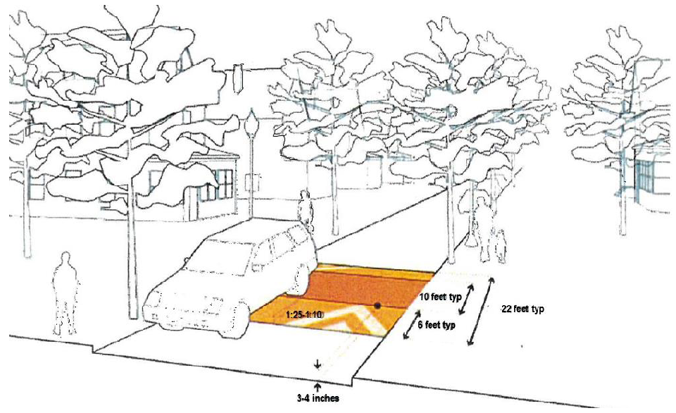
Figure 9-1. Speed Table Dimensions.
905.10 - Reserve strips.
Reserve strips which control access to streets, alleys, and public lands shall not be permitted unless their control is given to the County under ownership, dedication, or easement conditions approved by the County Attorney. No development shall be designed so as to deny access to abutting properties.
905.11 - Streets across dams.
(a)
No portion of a road proposed for dedication to Harris County shall be designed or accepted which utilizes a roadway over a dam as any portion of said public road right-of-way.
(b)
Minimum requirements.
(1)
Proposed roadways over a dam shall be constructed to county right-of-way standards but shall remain privately owned and maintained.
(2)
All provisions of Article 10, Division 3 of this Development Code shall apply.
(c)
Ownership and maintenance of private bridges and roadways over dams.
(1)
Form of ownership. Any private bridge or roadway over a private dam utilized by more than one individual shall be owned and maintained through a single legal entity such as a tenancy in common or a non-profit association of homeowners (homeowners' association) organized pursuant to a declaration of restrictions or protective covenants for a subdivision.
(2)
Documentation of ownership. This documentation and disclosure shall be recorded in the property deed and a copy of this documentation shall be provided at time of Final Plat approval.
906.01 - Access requirements for major and minor subdivisions.
(a)
All property subdivided after the effective date of this Development Code, whether a major or minor subdivision as defined in this Article, shall front on a public road or street, unless specified otherwise herein.
(b)
No property which fronts on a private easement road shall hereafter be subdivided or approved for subdivision and development, unless specified otherwise herein.
(c)
It is the intent, that after the effective date hereof no new private easement roads shall be created and no property will be subdivided to exist on private easement roads.
(d)
Exceptions.
(1)
Property may be subdivided, either major or minor, which does not front on a public road in Harris County if the property meets one of the following requirements:
a.
Is in conformance with the provisions in Section 501.03 (Dividing Property Among Immediate Family and Heirs).
b.
Is used solely for a communications tower or approved public utilities.
c.
Is 50 acres or greater in lot size, located in an A-1 district, and has access to a public road with minimum 60-foot width. A maximum of two lots, each sized 50 acres or greater, may share a single 60-foot wide or greater access from public road if a permanent easement is established to assure the right of access for the parcel that does not include the public road access and frontage.
d.
Is accessible only from an existing public road or private permanent/legal easement in an adjoining county.
e.
Is contiguous with an adjoining county line and public road frontage is in the adjoining county.
(2)
Such property shall not be further subdivided at any time unless the property fronts on a public road as required this section.
906.02 - Required ingress/egress for subdivisions.
(a)
Subdivisions containing 50 or more lots shall require more than one means of access from a public street. An exception may be provided by the Planning Commission when determined that a second entrance for regular traffic use is not feasible; in such cases, emergency secondary access shall be provided.
(b)
Streets converging upon any one point which would tend to promote congestion are prohibited.
906.03 - Access to adjacent properties.
(a)
Proposed streets shall be extended by dedication to the boundary of adjacent property where the subdivision is platted with only one access to a public street or where the adjacent property has no access to a public street.
(b)
Such extension may be required in other instances where, in the opinion of the Planning Commission, it is desirable to provide street access.
906.04 - Access to streets.
The following regulations shall govern ingress and egress to all lots in all zoning districts:
(a)
A point of access (i.e., driveway, curb cut, entrance or exit point) shall not exceed 25 feet in width on lots for residential uses and 35 feet in width on lots for uses other than residential provided the point of access does not exceed 50 percent of the frontage on the street.
(b)
Unless noted otherwise, the allowable number of access points for each lot shall be governed by the width of lot frontage as follows:
* Exception: A single residential parcel is only required to have one access point.
(c)
No two access points on the same lot frontage shall be closer than 25 feet from their nearest edges.
(d)
No access point shall be located closer to any street intersection than 20 feet measured from its nearest edge to the curb radius tangent point or property line radius point
(e)
On lots other than residential, no access point shall be located closer to any side lot line than 20 feet.
(f)
Where access to a state or federal highway is controlled by regulations other than those stated herein, those rules and regulations shall prevail, whichever is more restrictive.
(g)
Permit required.
(1)
Prior to any curb cut or driveway cut, a permit must be obtained from the Public Works Department or designee.
(2)
If a driveway pipe is required, the applicant must bear the cost of the pipe and its installation, which shall meet all County standards.
(3)
For Driveway Permits, see under the "Other Permits" Division of Article 11 (Procedures and Permits) of this Development Code.
907.01 - General.
All easements shall run with the land, be perpetual, and shall ensure to the benefit of the grantee in the easement, his/her heirs, administrators, executors and assigns. All provisions of Article 11 applicable to easements shall apply.
907.02 - Minimum requirements.
(a)
Minimum width for any easement that provides access to property in accordance with the provisions of this Development Code shall be 60 feet.
(b)
Any easement allowable in accordance with the provisions of this Development Code shall connect to a public road or street the parcel of land to which it furnishes access.
(c)
All such easements shall be surveyed with the plat thereof showing at least the center line, the bearings and distances of the entire easement, and the plat thereof recorded in the office of the clerk of the superior court in Harris County, Georgia.
(d)
Each plat of such easement shall be certified by the surveyor that the easement meets the requirements of the Harris County Development Code and other ordinances.
(e)
All cost of construction and maintenance of the easement shall be the responsibility of the grantee in the instrument granting such easement, and the County will not do any work upon such easements.
(f)
No easement shall be accepted for any parcel of land aside from the specific circumstances allowed per this Development Code.
(g)
Easements having a minimum width of ten feet and located along the appropriate lot lines shall be provided for utility lines and underground mains and cables.
(h)
Where a subdivision is traversed by a watercourse, drainage way, channel or stream, there shall be provided a stormwater or drainage system (closed or open) of adequate width and capacity. The Planning Commission may require a watercourse easement, the width of which may vary according to the localized conditions.
(i)
Subdivision plats served by a private road to be recorded with the Office of the Superior Court Clerk of Harris County shall contain the notes as follows:
(1)
All private road(s) is/are privately maintained.
(2)
All private road(s) has/have met current county private road(s) specifications.
(3)
The Harris County Board of Commissioners is not responsible for any maintenance of easement road(s) shown on this plat.
908.01 - Dedication of street right-of-way.
In order for the Board of Commissioners to accept any streets/roads within Harris County, the procedures of Section 1117 in Article 11 (Procedures and Permits) shall be met.
908.02 - Street improvements.
(a)
Conformance. Streets, whether existing or new, shall be constructed or improved under those circumstances and to the standards as established in this Article. Roadway improvements shall be in accordance with the street classifications as determined by the Community Development Department, the Department of Public Works, or this Development Code, as applicable, or as otherwise required by the Board of Commissioners.
(b)
Responsibility for building streets.
(1)
It is the responsibility of the subdivider to construct access streets from existing streets/roads to connect with a proposed subdivision.
(2)
Access streets/roads shall meet the requirements of this Development Code and other applicable regulations in the Harris County Code of Ordinances prior to approval of a subdivision plat.
(3)
In the instance where a proposed subdivision is fronting on an existing unpaved County or State road, the developer shall be responsible for road improvements from the subdivision entrance to the nearest paved County or State road in order to bring the road up to county standards.
(c)
Major residential subdivisions. In every major subdivision, street improvements shall be planned for and provided by the subdivider, by installation and/or payment, prior to the approval of the final plat.
(1)
Street grading and street base and paving shall be in accordance with County requirements and GDOT requirements, where applicable.
(d)
Continuation of existing streets. Existing streets adjacent to the subdivision shall be continued at the same or greater width, but in no case shall be less than the required width.
(e)
Improvements along state highways.
(1)
For any development which abuts a state highway or other right-of-way controlled by the State of Georgia, improvements to the roadway and the location and design of any street or driveway providing access from the state highway shall comply with the standards and requirements of the GDOT only when more restrictive than the requirements of this Development Code.
(2)
A permit for the proposed access or improvements shall be required to have been approved by the GDOT. and incorporated into the construction drawings for the project prior to issuance of a development permit by the County.
908.03 - Project access improvements.
(a)
Single family detached, single family attached, and duplex residential subdivisions.
(1)
When property fronting on an existing or proposed County or State roadway, is to be developed or redeveloped as a single family or duplex subdivision, and the County or State road will provide access to the property, access improvements to the road (deceleration lanes, turn lanes, etc.) shall be provided by the developer as required herein.
(2)
A deceleration lane shall be required, to be provided by the applicant/developer, at each subdivision street entrance that is provided street access to a major thoroughfare or State road, unless determined unnecessary by the County.
(3)
Other Project Access Improvements may be required by the County upon the recommendation of the GDOT in order to ensure adequate site access, pedestrian access, convenience and safety to the motoring public.
(4)
The developer shall be responsible for the relocation of public or private utilities and drainage structures as may be occasioned by the required roadway improvements.
(b)
Multi-family and nonresidential developments.
(1)
When property fronting on an existing or proposed County or State roadway is to be developed or redeveloped for multi-family or nonresidential uses and the County or State roadway will provide access to the property, access improvements to the County road (deceleration lanes, turn lanes, etc.) shall be provided by the developer as required herein.
(2)
A deceleration lane shall be required to be provided at each subdivision street entrance that is provided street access to a major thoroughfare or State road, unless determined unnecessary by the County.
(3)
Other Project Access Improvements may be required by the County upon the recommendation of the GDOT in order to ensure adequate site access, pedestrian access, convenience and safety to the motoring public.
(4)
The Developer shall be responsible for the relocation of public or private utilities and drainage structures as may be occasioned by the required roadway improvements.
(c)
Development along major street, limited-access highway or railroad right-of-way. Where a subdivision abuts or contains a major street, a limited-access highway or a railroad right-of-way, the Planning Commission shall require the following:
(1)
A street approximately parallel to and on each side of such right-of-way either as a marginal-access street, or at a distance suitable for an appropriate use of the intervening land, with a non-access reservation.
(2)
Due regard should be given to requirements for approach grades and future grade separations in determining distances.
(3)
Such lots shall not have access to a major street (or limited-access highway), but only to the access street.
908.04 - General street design standards.
(a)
Street right-of-way widths.
(1)
The right-of-way width shall be the distance across a street from property line to property line.
(2)
Minimum street right-of-way widths shall be as follows:
a.
Major street widths: 100 feet.
b.
Collector streets: 80 feet.
c.
Minor streets: 80 feet.
d.
Culs-de-sac: 65-foot radius.
e.
Minor streets with curb and gutter: 60 feet.
(b)
Street pavement widths. Street pavement widths shall be as follows:
(1)
Major street widths: as required by the GDOT or Harris County.
(2)
Collector street widths: as required by the GDOT or Harris County.
(3)
Minor streets and Culs-de-sac: as required by the GDOT or Harris County.
(c)
Street grades. Maximum and minimum street grades shall be as follows:
(1)
Major streets: Seven percent maximum.
(2)
Collector streets: Ten percent maximum
(3)
Minor streets and culs-de-sac: 12 percent maximum.
(4)
Minimum street grade: 0.5 percent.
(5)
Maximum street grade: 12 percent, unless individual site characteristics and design needs justify.
(d)
Street jogs. Street jogs with centerline offsets of less than 125 feet shall not be permitted.
(e)
Horizontal curvature. The minimum radii of centerline curvature shall be as follows:
(1)
Major streets: 800 feet.
(2)
Collector streets: 200 feet.
(3)
Minor streets and culs-de-sac: 100 feet.
(f)
Tangents. Between reverse curves, there shall be tangents having the following minimum lengths:
(1)
Major streets shall have a sight distance of at least 500 feet at six feet above ground level.
(2)
Collector streets shall have a sight distance of at least 200 feet at 6 feet above ground level.
(g)
Vertical alignment. Vertical alignment shall meet the following requirements:
(1)
Major streets shall have a sight distance of at least 500 feet at six feet above ground level.
(2)
Collector streets shall have a sight distance of at least 200 feet at 6 feet above ground level.
(h)
Street intersections.
(1)
Street intersections shall be as nearly at right angles as possible.
(2)
Minimum angle at street intersection: 60 degrees.
(3)
Site distance at street intersections shall not be less than that required by the geometric design standards of the GDOT.
(i)
Curb-line radius.
(1)
The curb-line radius at street intersections shall be at least 15 feet.
(2)
Where the angle of street intersection is less than 90 degrees, a longer radius may be required.
(j)
Driveways.
(1)
All driveways shall slope away from streets or roads at a rate of ¼ inch to ½ inch per foot for a distance of ten feet.
(2)
All driveways require permits in accordance with Section 1126 of Article 11 (Procedures and Permits) of this Development Code.
908.05 - Local and minor collector streets within residential subdivisions.
(a)
Curb and gutter requirements for local streets.
(1)
For subdivisions located in the A-1 or R-R zoning districts, local streets within the subdivision do not require curb and gutter.
(2)
For subdivisions located in R-1, R-2 or R-3 zoning districts, curb and gutter shall be required unless an exception is granted by the Planning Commission upon review of the preliminary plat and/or final plat.
(3)
Curb and gutter shall be required in a conservation subdivision when net density is greater than one housing unit per two acres unless the approved conservation subdivision Concept Master Plan provides for stormwater conveyance and management not including curb and gutter.
(4)
For roads not required to include curb and gutter, the road base shall be extended one foot beyond the edge of pavement, and the shoulders shall extend five feet from the edge of pavement to the standard ditch section on each side (see Standard Drawings).
(5)
For all roads including curb and gutter, the roadway shall comply with the standards for new residential subdivision streets with curb and gutter as per the following section.
908.06 - Curb and gutter.
All new streets and improvements to applicable developments shall be provided with curb and gutter, except in subdivisions identified above in Section 908.05, where swale ditches may be provided in lieu of curb and gutter. All gutters shall drain smoothly with no areas of ponding.
(a)
Street pavement widths. Pavement widths for streets with curb and gutter shall be at least 24 feet.
(b)
Residential curbing. Residential curbing shall meet the following requirements:
(1)
Concrete shall be Class "A" (as defined by GDOT) and have a minimum strength of 3,000 PSI at 28 days.
(2)
Typical minimum section shall be 6″ × 24″ × 12″.
(3)
Vertical curbing shall be used unless, upon request of the applicant during the application review process, an exception is granted by the Planning Commission for the use of ribbon or valley curbing. Such curbing shall meet County design specifications.
(c)
Industrial or commercial curbing.
(1)
Industrial or commercial curbing shall meet the following requirements:
(2)
Concrete shall be Class "A" (as defined by GDOT.) and have a minimum strength of 3,000 PSI at 28 days.
(3)
Typical minimum section shall be 8″ × 24″ × 14″.
(4)
Vertical curbing shall be used.
(d)
Principal and major arterials curbing.
(1)
Concrete shall be Class "A" (as defined by GDOT.) and have a minimum strength of 3,000 PSI at 28 days.
(2)
Typical minimum section shall be 8″ × 30″ × 14″.
(3)
Vertical curbing shall be used.
(e)
Traffic islands. New traffic islands shall be provided with curb and gutter.
908.07 - Storm drainage.
(a)
Storm sewers and drains shall meet the following requirements:
(1)
Shall be provided in each subdivision.
(2)
Shall be designed to carry not less than the stormwater from a rainfall expected to occur once in ten years, with a runoff of 90 percent for pavements and buildings and a variable runoff factor depending upon topography or ground for other purposes.
(3)
Storm drain pipes shall consist of reinforced concrete.
(4)
The storm sewer system shall be designed and sized to accommodate and provide for future extensions.
(5)
The entire storm sewer system shall be approved by the County engineer or duly appointed agent of the Board of Commissioners prior its installation.
(b)
Drainage swales and ditches. All drainage swales and ditches shall meet the following requirements:
(1)
Shall be a minimum of six feet wide with a 3:1 slope on each side.
(2)
Shall be constructed asphalt or concrete or planted with sod sufficient to prevent erosion.
(c)
Stormwater detention facilities. Detention facilities shall be planned, designed and provided in accordance with Article 10, Division 2 of this Development Code.
908.08 - Public roads and streets.
All public roads or streets shall meet the following minimum requirements:
(a)
With curb and gutter: Minimum right-of-way of 60 feet.
(b)
Without curb and gutter: Minimum right-of-way of 80 feet.
(c)
A minimum roadway of 20 feet, placed on a 22-foot-wide base.
(d)
Roadbeds shall be at least 30 feet wide, including shoulders of five-foot widths.
(e)
Station numbers shall be placed at 100-foot intervals and located in areas where they will not be destroyed.
(f)
Street sub-grade.
(1)
Prior to placing base, subgrade shall be tested by an engineer licensed by the State of Georgia and proof rolled with a tandem dump truck with minimum 18 tons, monitored by Public Works Department representative.
(2)
Subgrade shall be set up at depth of eight inches and width of 22 feet.
(3)
Additional requirements in Section 913 shall be met.
(g)
Street Base.
(1)
A minimum eight-inch base shall be provided, constructed of graded aggregate base (GAB).
(2)
Additional requirements in Section 913 shall be met.
(h)
Drainage.
(1)
Drainage ditches.
a.
Drainage ditches shall be formed with the top of the slope commencing at the outside of the above-described roadway shoulder and sloping at a 3-to-1 grade to the drainage ditch or swale, and the swale shall be sufficiently wide and of such a profile to carry the calculated stormwater at a velocity consistent with erosion control maintenance standards of the County.
b.
Back slopes shall be commenced outside of the bottom of the ditch or swale and also slope upward and outward at a 3-to-1 grade to a point upon or without the easement so as to permit machine maintenance and grass cutting.
(2)
Cross drains.
a.
Cross drains, with a minimum of 18-inch reinforced concrete pipe (RCP), and driveway pipe, with a minimum of 15-inch pipe, shall be provided together with related structures sufficient to control the stormwater and preserve the right-of-way.
b.
Driveway pipe can be purchased from the Public Works Department when available.
c.
Cross drains must be compacted to a minimum of 95 percent compaction.
d.
Any open cuts of existing roads shall be monitored by Public Works Department staff.
(i)
All shoulders and slopes shall be covered with established bermuda or other approved grasses to prevent erosion and to allow mechanical mowing and maintenance.
(j)
Utilities.
(1)
Water lines and other utility lines to be buried shall be placed prior to laying the base on the road at a minimum depth of 48 inches from surface of road.
(2)
If a utility line is to be placed after the road has been constructed, the subject utility line should be placed under the road by boring. (Any water pipe placed in this manner shall be placed in a steel casing.)
(3)
If a connection to the water system requires a road crossing, see Section 909.02(c).
908.09 - Private roads and streets.
In cases where allowable as an exception, per Section 501.03 this Development Code, all private easement roads (i.e., private roads) must meet the following minimum requirements:
(a)
A minimum easement 60 feet.
(b)
A minimum roadway of 20 feet, placed on a 22-foot-wide base.
(c)
Roadbeds shall be at least 30 feet wide, including shoulders of five-foot widths.
(d)
Street sub-grade.
(1)
Prior to placing base, subgrade shall be tested by a registered soils/geotechnical engineer; and
(2)
Subgrade shall be set up at depth of eight inches and width of 22 feet; and
(3)
Additional requirements in Section 913 shall be met.
(e)
Street base.
(1)
A minimum eight-inch base shall be provided, constructed of graded aggregate base (GAB); and
(2)
Additional requirements in Section 913 shall be met.
(f)
Drainage.
(1)
Drainage ditches.
a.
Drainage ditches shall be formed with the top of the slope commencing at the outside of the above-described roadway shoulder and sloping at a 2-to-1 grade to the drainage ditch or swale, and the swale shall be sufficiently wide and of such a profile to carry the calculated stormwater at a velocity consistent with erosion control maintenance standards of the County.
b.
Back slopes shall be commenced outside of the bottom of the ditch or swale and also slope upward and outward at a 2-to-1 grade to a point upon or without the easement so as to permit machine maintenance and grass cutting.
(2)
Cross drains.
a.
Cross drains, with a minimum of 18-inch reinforced concrete pipe (RCP), and driveway pipe, with a minimum of 15-inch pipe, shall be provided together with related structures sufficient to control the stormwater and preserve the right-of-way.
b.
Driveway pipe can be purchased from the Public Works Department when available.
c.
Cross drains must be compacted to a minimum of 95 percent compaction.
(g)
All shoulders and slopes shall be covered with established bermuda or other approved grasses to prevent erosion and to allow mechanical mowing and maintenance.
(h)
Utilities.
(1)
Water lines and other utility lines to be buried shall be placed prior to laying the base on the private road at a minimum depth of 48 inches from surface of private road.
(2)
If a utility line is to be placed after the private road has been constructed, the subject utility line should be placed under the private road by boring. Any water pipe placed in this manner shall be placed in a steel casing.
(i)
The developer of a private road shall pave to the County/state road from edge of public paved road to right-of-way and shall install all required "stop" signs and stripe center lines; said paving shall be as required by this Development Code.
(j)
Cul-de-sac: A private easement road must end in the form of a cul-de-sac with minimum dimensions specified in Section 905.06(b). All private road construction shall be subject to inspections prior to approval of final plat.
(k)
Street names.
(1)
All names of easement roads shall in no way conflict with existing names or names similar to existing roads, streets, or drives in Harris County.
(2)
The developer/owner of a private easement road shall install all easement road name signs to match the design, color, materials and size currently in use by Harris County for public roads and streets.
(l)
Required signage.
(1)
The developer/owner shall place and maintain, at the entrance of each private road, a metal sign stating: "Private Road—Not County Maintained."
(2)
Sign shall be placed on a metal sign post compatible with the signpost standard in current use by Harris County.
(3)
Size.
a.
Sign shall be at least 24 inches by 24 inches in size with three-inch by two-inch letters.
b.
Center sign height shall be at least five feet from road grade and not more than six feet from road grade.
(4)
Location.
a.
Sign shall be placed six feet from edge of the roadway facing the flow of traffic.
b.
Sign shall be placed not more than 100 feet from entrance of easement road and not less than 25 feet from entrance of private road.
(5)
Color. Sign is to be blue in color with white letters.
(6)
Stop signs. The developer/owner shall install "Stop" sign(s) at all entrances to public roads. Said "Stop" sign(s) shall conform to the current printed edition of "The Manual on Uniform Traffic Control Devices."
908.10 - Private streets in restricted access developments.
(a)
Restricted access developments. Notwithstanding the requirements of this Article, the development of a subdivision on private streets shall be permitted subject to the provisions of this section. Such developments shall be designated as "Restricted Access Developments" and shall be allowed only in an R-R or R-1 Zoning District.
(b)
Private streets. Private streets shall be authorized only in subdivisions which restrict access thereto to residents of the subdivision and their guests, invitees, assigns or agents. Such subdivisions must erect and maintain a gatehouse and/or a security gate at the entrance of the subdivision. The gatehouse or security gate must be, at all times, manned and/or operational and equipped with a key-pass system or other electronic activation to allow residential access only. An emergency activated gate must be provided and operational to provide for access for emergency vehicles, to include ambulance, county fire and sheriff's department.
(c)
Street design and construction. The private streets within such restricted access developments shall be designed, constructed and maintained to comply with all Harris County and GDOT standards for public streets and otherwise comply with all street design requirements as provided for in this Development Code. The private streets or roads shall be designed so as to prohibit through traffic. All streets in restricted access developments shall have curbs and gutters. All utilities shall be underground. All storm water drainage shall be the responsibility of the developer and the property owners and Harris County shall have no responsibility for such stormwater drainage infrastructure.
(d)
Entry lanes. Acceleration and deceleration lanes for entry to and exit from the restricted access development shall be installed. The gate house or electronic gate into the development shall be set back from the public street so as to prevent traffic backup on the public street.
(e)
Public vehicles. School buses and county garbage collection vehicles shall not enter the restricted access development. A school bus stop with an appropriate shelter shall be constructed and maintained at the entrance to the restricted access development. A garbage collection site shall also be constructed and maintained at the entrance.
(f)
Ownership of streets. Title and ownership of the streets in a restricted access development shall be placed in the name of the homeowners' association for the restricted access development and title to such streets shall be at all times maintained in the name of the homeowners' association.
(g)
Maintenance bond. The developer of the restricted access development shall provide a maintenance bond to the homeowners' association holding title to the streets on the same terms and conditions as may exist from time to time for maintenance bonds required by Harris County ordinance for developers for public subdivisions, roads or streets.
(h)
Evidence of ownership. Prior to issuance of any building permits for lots within a restricted access development, the developer shall file for review, approval and acceptance by the Board of Commissioners a certification or evidence that the title and ownership to the private roads in the restricted access development are vested in the homeowners' association, that a maintenance bond has been posted, that a policy of title insurance has been or will be issued to insure clear title to the roads in the restricted access development is vested in the homeowners' association.
(i)
Future street maintenance. Harris County shall have no responsibility for present or future maintenance of the private streets within a restricted access development. The subdivision plat, as well as any covenants and restrictions for said subdivisions shall contain provisions that the streets are private, and that Harris County shall have no responsibility for present or future maintenance of the private streets.
(j)
Maintenance covenant. A covenant recorded in the deed records in the office of the clerk of the superior court shall be required for any private street within a restricted access development. The covenant shall specifically include the following terms:
(1)
The covenant shall establish minimum annual assessments in an amount adequate to defray costs of ordinary maintenance and procedures for approval of additional needed assessments. The covenant shall also specify that the funds from such assessments will be held by a homeowners or property owners association in cases of a subdivision fronting on a private street.
(2)
The covenant shall include a periodic maintenance schedule.
(3)
The covenant for maintenance shall be enforceable by any property owner served by the private street.
(4)
The covenant shall establish a formula for assessing maintenance and repair costs equitably to property owners served by the private street.
(5)
The covenant shall run with the land.
(k)
Acknowledgment of private streets. Prior to the sale and as a condition of the closing of a real estate transaction involving any lot served by a private street in a restricted access development in Harris County, the subdivider or seller of said lot shall execute a notarized purchaser's acknowledgment of private street construction and drainage maintenance responsibilities set forth below. A copy of the purchaser's acknowledgment shall be retained by the purchaser and shall be required to be submitted as a condition of a building permit for a principal building on said lot:
Purchaser's Acknowledgment of Private Street and Drainage Maintenance Responsibility.
(I)(We) have read the Declaration of Covenant which pertains to the lot that is the subject of this real estate transaction _______ (insert address or attach legal description).
(I)(We) understand that the Declaration of Covenant applies to the lot that (I am) (we are) purchasing and requires (me)(us) to provide a specified percentage or amount of the financing for the repair and maintenance for any private street and drainage facilities serving the lot which (I am)(we are) purchasing. (I)(We) further understand that the County has no obligation to assist with the maintenance and improvement of the private street, drainage facilities, and other appurtenances within the restricted access development for the private road serving the lot levy purchased. (I)(We) understand that a copy of this purchaser's acknowledgment shall be required as a condition of the issuance of a building permit for a principal building on the lot (I am)/(we are) purchasing.
(l)
Annual street assessment. The homeowners association for each restricted access development shall levy and assess each lot owner a sufficient sum of money annually to provide for maintenance and repair of the private streets within the subdivision. Annually, the homeowners association shall provide a certification to the Board of Commissioners of the status of the account to include the amount levied and collected, the amount held in the account, and the amounts expended for street repair and maintenance. Board of Commissioners shall have the right to conduct periodic inspections of the streets within the restricted access development.
(m)
Abandonment. In the event that the gatehouse, security gate or electronic entry system is abandoned or ceases to function or to be maintained restricting entry for a period of six consecutive months, or the homeowners association fails to assess or maintain a street repair fund, the roads in the restricted access development shall, upon notice from the Board of Commissioners, cease to be utilized as private roads and shall be open for public use. Upon demand from the Board of Commissioners, the homeowners association shall convey fee simple title to the private streets to Harris County free and clear of all liens, debts or encumbrances along with all street maintenance funds held by the homeowners association.
(n)
Special tax district. For each restricted access subdivision approved under this ordinance there shall be created at the time of approval a special tax district. The special tax district shall encompass and be coterminous with the boundary line of the approved restricted access subdivision. The purpose of the special tax district for the restricted access subdivision is to authorize the Harris County Board of Commissioners to levy a tax upon the property and lots within the subdivision for the repair and improvements of the roads within the restricted access subdivision if the title to the streets become vested in Harris County and are in need of repair. No tax shall be levied unless the owners of the property within the restricted access subdivision or the homeowners association do not comply with the obligation to maintain and repair the private roads and streets within the restricted access development, the development abandons or ceases to function as or be maintained as a restricted access development or fails to assess and maintain an escrow account for future road repair and maintenance and the road becomes a public road as provided for hereunder.
(o)
Board of Commissioners' approval. Prior to issuance of any building permits for the lots within a restricted access development, the restricted access development must be approved by the Board of Commissioners in compliance with all matters set forth herein.
909.01 - Utility facilities and equipment near County roads.
(a)
In order to more efficiently provide for the safety of persons and vehicles traveling on the County roads, and the maintenance of roads in the County, the Board of Commissioners does ordain and enact into law the provisions of this section, as allowed under O.C.G.A. § 32-4-42(6).
(b)
Encroachment permit; required.
(1)
When a utility company, private company, or an individual plans to place any type utility wire, line, cable, conduit, pipe or any other object underground along the rights-of-way of the County's roads, streets or easements, they must first secure a written permit from the Public Works Department.
(2)
Prior to securing an Encroachment Permit, all utility companies proposing to install any type pf new utility lines within County right-of-way must have a utility locate called in before applying for an Encroachment Permit. The utility provider shall not begin any work until the Encroachment Permit has been signed by the Public Works Director and said permit is posted on site along with a copy of Harris County Department of Public Works Regulations and Special Provisions for Utility Installation, Restoration and Cleanup document.
(3)
Application and review procedures. Application for a permit for utility facility encroachment shall be presented to the Public Works Department with a sketch or plan attached indicating the exact location of subject line, conduit, etc. The application form can be secured from the Public Works Department.
(4)
Location requirements.
a.
All utilities, including any type of utility wire, line, cable, conduit, pipe or any other object to be laid underground shall be placed a minimum of three feet deep and placed as close as possible along the back side of the right-of-way; and
b.
Unless otherwise approved or directed by the Public Works Director, all water pipes, sewer pipes, etc., shall be placed on the right side of the road (as one drives north to south or east to west); and
c.
All telephone, electrical and other cables, etc., shall be placed on the left side of the road (as one drives north to south or east to west) unless otherwise approved or directed by the Public Works Director.
d.
Any variance to this directive must be approved by the Public Works Director prior to construction.
(5)
Procedures for required removal or relocation of utility facilities.
a.
When the Board of Commissioners shall reasonably determine that any pipe, main, conduit, cable, wire, pole, tower or other signal, and other equipment, facilities or appliances of any utility in, on, along, over or under the public roads of the County should be removed or relocated, because it has become an obstruction or interference with the use and safe operation of a county road, or will become an obstruction or interference with the use and safe operation of a contemplated county road, a written notice shall be directed to the utility company giving at least 60 days' notice in which to make such change as is necessary for removal or relocation as may be necessary.
b.
If the utility does not thereafter begin removal procedures within a reasonable time sufficient to allow for engineering and other activities necessary to the removal and relocation of the utility facility, the commissioners may give the utility a final notice directing that such removal shall commence not later than ten days from receipt of such final notice.
c.
If such removal has not begun, or if such removal has begun and the relocation has not been completed within a reasonable time, the Board of Commissioners may remove or relocate the same with its own employees, or by contracted labor, tools, equipment, supervision, or other necessary services or materials and whatever else is necessary to accomplish the removal or relocation, and the expense thereof shall be charged to the utility.
d.
The expense shall be certified to the County attorney, who shall have the authority to proceed with suit against the utility for same if payment or arrangements to make payment are not made within 60 days.
(6)
Nothing in this section shall be construed so as to deprive any utility, relocated from a location in which it owned a property interest, of compensation for such property interest.
909.02 - Water systems.
(a)
Water supply and/or distribution system requirements shall be in accordance with Chapter 7 of the Harris County Code of Ordinances (Water, Sewage and Utilities requirements), other rules, specifications and details administered by the Harris County Water Works Department, and other such requirements as adopted by the Board of Commissioners.
(b)
All potable water systems shall be subject to the current applicable "Rules for Safe Drinking Water: Chapter 391-3-5, Revised June 1989, Georgia Environmental Protection Division" or the most recent version of the same, and applicable County regulations, policies and construction standards.
(c)
Public water service shall be provided to every lot in every subdivision and to every development for both domestic use and fire protection if public water is available or under bid or contract to be available within 1,500 feet of the subdivision or development.
(1)
The subdivider shall be responsible for the cost of all taps, fire plugs, and extension to existing public facilities in accordance with applicable county standards.
(2)
If a connection to the water system requires a road crossing, (e.g., connecting to a water line located outside of the subdivided property), the following standards shall be met:
a.
The contractor shall jack and bore whenever possible; however, if a bore is not feasible and the County approves it, a road cut is allowed and shall meet the requirements below in subsection (c)(2)(b).
b.
Any road cuts, whether for water system purpose or any other purpose, must be compacted to 95 percent with stone up to the top of pipe, 6" concrete, and 2" asphalt paving.
(d)
Water line design considerations and requirements.
(1)
If it is possible to loop the water lines for a new development, upon determination by the Water Works Director or Engineer, it shall be required.
(2)
For Subdivisions with a second entrance, water lines shall be provided on both entrance roads, if feasible, upon determination of the Water Works Director or Engineer and depending on availability of County water in that location.
(3)
Upon review of an application, the Water Works Director may require a water utility access easement for certain lots.
(e)
Where a public water main is not reasonably accessible as determined by the Planning Commission, the subdivider shall provide a water supply as follows:
(1)
A water source approved by the Harris County Health Department shall be required for a subdivision of 1 to five acre lots.
(2)
Each lot within a subdivision, regardless of lot size, shall be served by its own independent water source (well); such water source (well) may serve only one residence.
(3)
For purposes of this paragraph, a public water main or source shall be any service provided by any public water provider, regardless of political boundaries.
(f)
Fire hydrants.
(1)
Fire hydrants are required in all subdivisions and development projects served by a public water system.
(2)
Fire hydrant spacing shall be in accordance with the water system specifications of Harris County. Placement of fire hydrants is subject to approval by the Water Works Department and Fire Department officials.
(3)
Fire hydrants as specified by the Water Works Department officials shall be located every 500 feet or at every intersection, whichever is closer.
909.03 - Sewer systems.
(a)
Developer responsibilities. In every minor and major subdivision, the following utilities shall be planned for and provided by the subdivider, by installation and/or payment, prior to the approval of the final plat:
(1)
Where a public sanitary sewer is within 500 feet of the subdivision at its nearest point and connection by gravity flow is feasible, the subdivider shall connect with such sanitary sewer and provide a connection for each lot.
a.
The subdivider shall be responsible for the cost of all taps, lift stations, manholes, and extension to existing public facilities.
(b)
Private sewage disposal systems.
(1)
Where sanitary sewers are not available, as determined by the Planning Commission, the subdivider shall provide a private sewage disposal system as follows:
a.
An oxidation pond, septic tank, or other disposal device designed according to the County environmental health specialist or the department of natural resources, environmental protection division (DNR EPD) shall be installed and operable.
b.
For the purposes of this paragraph, a public sanitary sewer shall be any service provided by any public sewage provider, regardless of political boundaries.
910.01 - Responsibility during construction.
(a)
The developer and his/her Design Professional of Record have full responsibility for quality control and inspection during construction to ensure substantial conformance with the approved construction plans, County standards, County regulations, and generally accepted construction practices. County personnel only provide construction observation to intermittently check the adequacy of the developer's quality control and inspection.
(b)
Any construction issues requiring an interpretation and/or change in the plans, standards, and/or regulations are to be resolved by the Design Professional of Record and presented to the County for written concurrence or approval. Any design changes must be revised on the construction plans and issued as a change to the approved construction plans.
(c)
Failure of the developer to provide adequate quality control and inspection which results in a substantial nonconformance with the plans, standards, regulations or generally accepted construction practice or endanger the public health, safety, and welfare shall be cause for the County to issue a Stop Work Order for any or all portion(s) of the construction in accordance with County procedures and ordinances. The order will remain in effect until the developer or his/her Design Professional of Record can demonstrate to the County that adequate quality control and inspection will be provided to address and correct the nonconformance and minimize the potential for further non-conformance issues or endangerment issues.
(d)
Each day of continued construction on the scope of work covered by the Stop Work Order under this Development Code shall be considered a separate violation.
(e)
The developer controls the means, sequence, and methods of construction. As such, the developer has full responsibility for safety on the project site and compliance with all federal, state, and local regulations pertaining to safety and environmental requirements.
(f)
Preconstruction activity.
(1)
Following the issuance of any permit authorizing clearing and grading of a site, areas required to be undisturbed, such as natural landscape buffers or stream buffers, must be designated by survey stakes, flags, ribbon, or other appropriate markings and shall be inspected and approved by the County Inspector prior to the commencement of any clearing or grading activities.
(g)
Grading.
(1)
Grading shall be done in accordance with the lines and grades drawn on the approved grading plan.
(2)
Required erosion and sedimentation control measures and stormwater drainage facilities are to be installed in accordance with the approved plans as development progresses.
910.02 - Development phase inspections.
Requests for inspections shall be made by the owner or contractor to the Community Development, Public Works or Water Works Department in accordance with the listing of inspection responsibilities established by Harris County. Such requests shall be made at least 24 hours prior to when the inspection is needed. Inspections shall be made and passed prior to continuation of further activity or proceeding into new phases of development. Inspections are required of each of the following phases, as applicable to the actual work to be performed under the development permit:
(a)
Prior to clearing or clearing and grubbing of the property or any portion included under the development permit, inspection of erosion and sedimentation control measures and protective devices for undisturbed areas. Inspection of erosion and sedimentation control measures will be conducted on a continuing basis.
(b)
Upon completion of street grading, inspection and approval shall be required prior to trenching or continuation with subgrade preparation.
(c)
Upon installation of storm drainage pipe, detention, or other storm water facilities.
(d)
Of street curbing and gutter (if provided).
(1)
Inspection shall be requested after the forms or string line have been set.
(2)
Street width and vertical and horizontal alignment may be spot-checked.
(e)
Of sub-grade of streets. The sub-grade may be roll tested in accordance with Section 913.
(f)
Of street base.
(1)
The base may be string-lined for depth and crown.
(2)
The street base will be tested for depth and compaction in accordance with Section 913 and may be roll-tested in accordance with Section 913 at the discretion of the County Inspector.
(g)
Of paving.
(1)
A County Inspector may be on site during the paving process to check consistency, depth, and workmanship, as applicable.
(2)
For asphalt paving, the temperature of the material will be monitored, the asphalt will be tested for depth and compaction in accordance with Section 913 and may be roll-tested in accordance with Section 913, at the discretion of the County Inspector.
910.03 - As-built data.
(a)
Upon completion of the development activity as authorized by the development permit and prior to final development inspection of public and private improvements, the owner shall submit to the Community Development Department, Public Works Department and the Water Works Department, as appropriate, for review and approval, a complete set of record drawings showing "as-built" conditions prepared by the design professional of record who prepared the original plans, or a professional land surveyor, engineer or landscape architect licensed in the State of Georgia. These drawings shall show the location of:
(1)
Street centerlines and rights-of-way lines.
(2)
Drainage system pipes, manholes and channels, including finished elevations.
(3)
Storm water detention facilities including finished elevations.
(4)
Sanitary sewer system (if any) including finished elevations.
(5)
Water system (if any) and reuse water system (if any) including finished elevations.
(b)
The as-built data shall be certified and sealed by the design professional of record or other professional preparer, subject to the tolerances of accuracy indicated in the certification.
910.04 - Final development inspection.
(a)
Following submission and review of the as-built data, the Community Development Director, Public Works Director or designee shall conduct a final development inspection of the project.
(b)
The owner shall be responsible for correcting any deficiencies identified in the final development inspection prior to approval of a final subdivision plat.
911.01 - Initiation of clearing and grading activities.
(a)
Clearing and grading shall not proceed until issuance of an approved development permit authorizing such activities. No development permit authorizing clearing or grading shall be issued prior to review and approval by the County of construction plans as applicable to the property. See Article 11: Procedures and Permits of this Development Code for details.
(b)
Grading shall be done in accordance with the lines and grades drawn on the approved grading plan. Protective devices for undisturbed areas, if any are required, must be installed, inspected and approved in accordance with the approved construction plans prior to the initiation of clearing and grading activities.
(c)
Erosion and sedimentation control measures.
(1)
Required erosion and sedimentation control measures must be installed, inspected and approved in accordance with the approved soil erosion and sedimentation control plan prior to any major development activity, and shall be maintained or supplemented as development progresses.
(d)
Stormwater drainage facilities.
(1)
Required stormwater drainage facilities are to be installed in accordance with the approved stormwater management plan as development progresses.
911.02 - Slopes.
(a)
Cut or fill slopes in the public right-of-way and/or slope easements shall not exceed three horizontal units to one vertical unit, unless otherwise approved by the County based on topographic conditions. This is the maximum allowable slope and should not be considered the norm. If grading plans indicate cut or fill slopes outside of the right-of-way then the construction plans and final plat shall indicate slope easements for the required grading.
(b)
No cut or fill slopes or existing unadjusted slope shall encroach closer than eight feet from the back of curb in curbed sections, or 15 feet to the edge of pavement for un-curbed sections on any street right-of-way within the subdivision. A cut or fill slope between lots should be confined to the lower lot whenever possible so as to avoid erosion from the higher lot to the lower lot.
(c)
All fill slopes created for the purpose of street or home construction shall have a compaction of not less than 95 percent as determined by the established engineering practices.
(d)
All slopes created or existing within the subdivision or as a result of the subdivision development shall be planted or otherwise protected from erosion and failure.
912.01 - Definitions.
The following words, terms and phrases, when used in this Article, shall have the meanings ascribed to them in this Section, except where the context clearly indicates a different meaning:
(a)
Excavation:
(1)
The mechanical removal of earth material.
(2)
Any manmade cavity or depression in the earth's surface, including its sides, wall, or faces, formed by earth removal and producing unsupported earth conditions by reasons of the excavation. If installed forms or similar structures reduce the depth-to-width relationship, an excavation may become a trench.
(b)
Excavation and trenching certificate: The certificate issued upon satisfactory completion of a mandatory training/educational program regarding excavation and trenching safety practices.
(c)
Excavation and trenching certificate holder: The holder of the "excavation and trenching certificate" identified above.
(d)
OSHA: The U.S. Department of Labor, Occupational Safety and Health Administration, or successor agency.
(e)
Trench: A narrow excavation made below the surface of the ground. In general, the depth is greater than the width, but the width of a trench is not greater than 15 feet.
912.02 - Unauthorized excavation and trenching.
No individual, partnership, corporation, or other entity of any kind whatsoever shall engage in any excavation or trenching except in compliance with the provisions of this Section and in compliance with any applicable laws of the State of Georgia or of the United States or the Occupational Safety and Health Administration (OSHA), or any other state or federal governmental entity or department rules and regulations applicable to excavating and trenching.
912.03 - OSHA Safety and Health Regulations.
All safety and health regulations adopted by OSHA with regard to excavating and trenching operations, particularly part 1926, Subpart P: Excavations, Trenching, and Shoring (Section 1926.650, 1926.651, 1926.652, 1926.653 of the Code of Federal Regulations), as the same now exist or may be hereafter amended, are adopted as a part of this Development Code as if quoted verbatim herein.
912.04 - Excavation and trenching certificate required.
Harris County will honor excavation and trenching certificates issued by agencies that can satisfactorily show proof that their training/educational program meets or exceeds accepted standards for excavation and trenching safety practices training/education.
912.05 - Permit required.
(a)
No excavating or trenching shall be performed until a permit for same has been obtained from the appropriate County department (see Article 11: Procedures and Permits of this Development Code). All applicants shall be required to acknowledge receipt and understanding of safety requirements before a permit will be issued. All such permits shall be conspicuously posted upon the job site.
(b)
No permit shall be issued unless an authorized agent of the applicant holds an excavation and trenching certificate.
912.06 - Enforcement of excavation and trenching requirements.
(a)
The Community Development Director, the Public Works Director, or designated representative shall have the authority to cause any trenching or excavation work in progress to be halted upon a finding that these certificate requirements are not being met on the particular job site. The said County Official may issue a verbal warning or a written citation in his discretion.
912.07 - Inspection by Harris County.
The Community Development Director, the Public Works Director, or the designated representative of either shall periodically inspect trench/excavation sites. Such inspectors shall, among other things, verify the presence of the required permits, the existence of required excavation and trenching certificates and compliance with OSHA safety standards hereinabove adopted.
912.08 - Violations.
In addition to the provisions of Article 12: Administration and Enforcement of this Development Code, the following shall apply to violations under this Section:
(a)
Violations of this Section may result in revocation or suspension of any excavation and trenching certificate issued hereunder as set out above.
(b)
Violations of this Section may result in revocation or suspension of excavating/trenching permits issued hereunder as set above.
(c)
When oral notice is not deemed sufficient, a written notice of violation may be issued for any deficiency. Upon receipt of such notice, the deficiency shall be corrected immediately.
(d)
Excavation and trenching work upon any job site shall be required to cease immediately upon discovery that there is trenching activity by any person not an excavation and trenching certificate holder, when there is a refusal or failure to correct deficiencies immediately or when such work is being done without a permit.
(e)
If deficiencies identified in a notice or violation are not timely corrected, the building permit, land disturbance permit or any other permit issued by Harris County may be suspended or revoked for due cause upon the conditions herein identified for revocation of authorization.
(f)
Flagrant or repeated violations shall be reported by Harris County to OSHA for action by that agency.
913.01 - Permits
(a)
Clearing, grading or other land disturbing activities associated with subdivision construction shall not commence until the preliminary plat, engineered construction plans and soil erosion/sediment control plans have all been approved by Harris County. This shall not be construed to prohibit necessary logging or survey operations prior to approval of such plans.
(b)
Permits shall be required for utility installation.
(1)
The Water Works Department and all other utility companies (telephone, electric, pipelines, etc.) shall be contacted by the contractor prior to the beginning of any type street/road construction within Harris County. (See also County Code of Ordinances Chapter 7, Water, Sewage and Utilities.)
913.02 - Additional design and construction considerations.
More stringent design and construction standards may be required by the County where streets cross 100-year flood plain(s), serve as the only means of public ingress and egress to one or more lots, cross flowing streams, cross poor soils or encounter other similar conditions. See Article 8 of this Development Code for additional requirements regarding flood zones.
913.03 - Installation of utilities, general.
(a)
General. All streets, roads, and alleys shall be constructed to provide the necessary paving, roadway, drainage, and safety requirements as provided herein and by other specifications of Harris County.
(b)
Clearing and grubbing. All streets, roads and alleys shall be graded to their full width so that pavement, shoulders and sidewalks, where required or proposed for future installation, can be constructed on a uniform plane. The right-of-way shall be cleared of all trees. Additional trees shall be removed outside of the right-of-way if the area under the dripline of the tree in the right-of-way is disturbed, or as directed by the Community Development Director, Public Works Director or designee.
(c)
Placement of utilities.
(1)
All authorized public underground utilities shall be located within the right-of-way of a public street or within an easement designated for such use. Within public street rights-of- way, placement of the various authorized utilities (power, gas, cable TV, water and sewer) shall conform to the specific locations designated for such use by Harris County, as determined by the Public Works Department.
(2)
No other underground utilities, such as private lawn sprinkler systems, yard lighting, etc., shall be installed within a public right-of-way or easement except by authorization of the Public Works Department. Such authorization, if issued, shall require the applicant to assume all repair costs of the applicant's facilities should they be damaged during the course of installation, maintenance or repair of any of the public utilities authorized to occupy said right-of-way or easement
(3)
Placement of utilities shall be in conformance with this Development Code and Chapter 7, Water, Sewage, and Utilities, of the Harris County Code of Ordinances.
(d)
Underground utilities construction.
(1)
All water and sanitary sewer utilities and storm drain facilities within the curbs shall be installed and the ditches backfilled and thoroughly compacted before any pavement or base is installed.
(2)
Once the base has been placed, all further installation of utilities under the roadway shall be bored or otherwise comply with all County and Public Works Department requirements for street cuts.
(3)
All utility manholes and valve boxes shall be brought flush to the finished grade within the roadway section.
(4)
All utility locations shall adhere to the details found in the Standard Details and Specifications.
913.04 - Slopes and shoulder improvements.
(a)
Drainage ditches shall be formed with the top of the slope commencing at the outside of the above-described roadway shoulder and sloping at a 3:1 grade to the drainage ditch or swale, and the swale shall be sufficiently wide and of such a profile to carry the calculated stormwater at a velocity consistent with erosion control maintenance standards of Harris County. Back slopes shall be commenced outside of the bottom of the ditch or swale and also slope upward and outward at a 3:1 grade to a point on or outside the right-of-way so as to permit machine maintenance and grass cutting, unless topography necessitates a steeper slope to stay within the right-of-way as determined and approved by the public works director or his designee.
(b)
All shoulders and slopes shall be covered with established Bermuda, centipede, or other approved grasses to prevent erosion and to permit mechanical mowing and maintenance.
913.05 - Construction methods, roadways.
(a)
New major thoroughfares. Major thoroughfares abutting residential or non-residential development projects shall be constructed in accordance with designs prepared by Harris County or GDOT, or, if no design has been prepared, in accordance with the following standards and standard details of the Public Works Department.
(b)
Station numbers are to be placed at 100-foot intervals and located in areas where they will not be destroyed.
(c)
Roadway grading and embankments.
(1)
All streets and roads shall be graded to their full width by the subdivider so that pavements and sidewalks, where required or proposed for future installation, can be constructed on a level plane as shown in the cross-sections on the approved plans.
(2)
The entire area within the typical grading section shall be cleared and grubbed of all trees, bushes, stumps and debris. Such debris shall be disposed of in a lawful manner and shall not be buried in the right-of-way or within the project limits.
(3)
Road fill of suitable material free of organic matter shall be placed in uniform eight-inch layers compacted to at least 95 percent of maximum density throughout as specified for construction and testing in the GDOT standards for embankments. Embankment compaction test shall be taken at an interval not exceeding 2,500 cubic yards. All storm drainage and other underground utilities installed under the roadbed and the backfill in all ditches shall be compacted to at least 95 percent maximum density. Compaction testing of backfill for said structures shall be taken at a minimum interval not less than one between any two structures. Compaction test results shall be reported to the County immediately after results are obtained.
(4)
Cut and fill slope ratios shall start at the edge of the right-of-way and shall not exceed 3:1 in the right-of-way and 2:1 outside of the right-of-way. In lieu of a cut or fill slope, a retaining wall may be utilized where necessary with the approval of the County.
(5)
Cut or fill slopes shall be uniform for each section of cut or fill. The depth of cut or fill shall be constructed to the maximum cut or fill occurring in any one section. When a cut made in rock requires blasting, the slope may be changed to an alternative slope grade upon written approval of the County.
(6)
If paving is to be delayed, provisions shall be made to drain low points in the roadway. If curbing has not been installed, a break in the berm section may be provided. If curbing is in place, four-inch pipe sections shall be used to provide drainage under the curb to side slopes.
(7)
All work must be approved by the County prior to preparation of the subgrade. It is the duty of the design professional to inspect and confirm that road grading specifications have been met. The developer will provide to the County a statement of inspection completed by a registered professional engineer, licensed by the State of Georgia, that all construction requirements have been met for roadway grading. The developer shall also provide certification to the County, by a professional land surveyor or engineer licensed in the State of Georgia, that grading has been completed to the lines and grades to a tolerance of +/- 6 inches. The developer will also provide staking of the roadway centerline in conjunction with said certification for verification by the Public Works Director or designee. Upon approval of such certification documentation by the County, road construction may continue.
(d)
Preparation of subgrade for all streets shall include the following.
(1)
Sub-grade preparation shall be in accordance with GDOT specifications and this Article.
(2)
Prior to placing base, the entire surface of in-place subgrade shall be processed (plowed and harrowed).
(3)
After material has been thoroughly mixed, the subgrade shall be brought to a final grade and compacted to 100 percent.
(4)
Subgrade shall be tested by a registered soils/geotechnical engineer and/or by proof-rolling the entire road with a loaded truck (18-ton minimum).
(5)
Compaction tests shall be taken every 500 feet or at intervals specified by the Public Works Director or his designee, and the results of said tests shall be provided to the Public Works Director or his designee.
(6)
Prior to placing any subsequent layer of base materials, the subgrade shall have sufficient stability to support construction equipment without excessive movement regardless of compaction.
(7)
Areas of subgrade that are unstable shall be remixed to a moisture content that will provide stability and compaction to the satisfaction of the Public Works Director or designee.
(8)
It is the duty of the design professional to inspect and confirm that subgrade preparation specifications have been met. The Developer will provide to the Public Works Director a statement of inspection completed by a registered professional engineer, licensed by the State of Georgia, that all construction requirements have been met for roadway subgrade preparation. Upon presentation and approval of such documentation by the Public Works Director, roadway construction may continue.
(e)
Preparation of street aggregate base course.
(1)
A minimum of eight-inch base, 22 feet wide, constructed of GDOT-approved graded aggregate base (GAB) compacted 100 percent shall be installed.
(2)
All base course material shall be deposited and spread by means of spreader boxes, or approved mechanical equipment, or from moving vehicles equipped to distribute the material in a uniform layer.
(3)
Immediately following the spreading of the coarse aggregate, all material placed shall be compacted to the full width by rolling with a smooth wheel power roller of adequate size and weight to achieve compaction.
(4)
Any irregularities, areas of segregation, or depressions that develop under such rolling shall be corrected by loosening the material at these places and adding or removing material until the surface is smooth and uniform. The application of water, applied uniformly over the base course, may be required to achieve adequate compaction. Shaping and rolling shall be performed alternately as required to maintain a uniform compacted base until a surface or treatment has been applied to the base. Along curbs, headers and walls and at all places not accessible to the roller, the base course material shall be tamped thoroughly with mechanical tampers or approved hand tampers.
(5)
Compaction tests shall be taken every 500 feet or at intervals specified by the Public Works Director or designee, and the results of said tests shall be provided to the Public Works Director or designee.
a.
No graded aggregated base shall be placed on muddy or frozen subgrade. The moisture content of the graded aggregate base shall be uniformly distributed and shall be adequate to allow compaction to the specified density. After the material placed has been shaped to line, grade and cross section, it shall be rolled until the course has been uniformly compacted to at least 100 percent of the maximum dry density when Group 2 aggregate is used, or to at least 98 percent of maximum dry density when Group 1 aggregate is used. The theoretical maximum dry density shall be established using the appropriate test methods of the GDOT Sampling, Testing and Inspection Manual. Moisture content shall be within ± three percent of the optimum content. Compaction test results shall be reported to the Public Works Director immediately after results are obtained.
(6)
After the base course has been installed and inspected, and before any surface is applied, all residential streets shall be primed with suitable asphaltic materials as per GDOT Specification 412.
a.
Prime may be omitted if paving can be done within 24 hours and the base is moist.
(7)
A good grade of material which will meet Class B specifications shall be placed on the shoulder. Public Works Director shall confirm and provide Class B specifications upon request.
(8)
It is the duty of the design professional to inspect and confirm that graded aggregate base course preparation specifications have been met. The developer will provide to the County a statement of inspection completed by a registered professional engineer, licensed by the State of Georgia, that all construction requirements have been met for roadway graded aggregate base course preparation. Upon presentation and approval of such documentation by the County, roadway construction may continue.
(f)
Curb and gutter.
(1)
Curb and gutter shall be set true to line and grade, horizontal be field staked, and finished to the section shown on the plans. Along the Project Access Improvements of a road for which the GDOT of or the Public Works Department resurfacing has been scheduled within one year of the new construction, the grade of the new gutter shall be placed one inch above the Project Access Improvement pavement grade in areas where drainage will not be adversely affected.
(2)
Line and grade shall be set by developer's engineer or surveyor on grade less than two percent and greater than 12 percent, and within 100 feet in both directions from all low points.
(3)
One-half inch expansion joints or pre-molded bituminous expansion joint material shall be provided at all structures and radius points and at intervals not to exceed 250 feet in the remaining sections of the curb and gutter.
(4)
Inferior workmanship or unprofessional construction methods resulting in unacceptable curb and gutter will be cause for rejection of the finished work.
(5)
Disturbed areas along all curbing shall be backfilled, stabilized, and grassed.
(g)
Asphaltic concrete construction.
(1)
The paved roadway:
a.
Shall be a 2.5-inch binder (i.e., asphalt concrete), either 12.5 MM level A or 9.5 MM level A with a one-inch topping, which shall meet GDOT specifications. The topping shall be applied in accordance with (7) below.
b.
Shall be placed by a qualified person/company with a Barber Green or equivalent asphalt paver and shall be smoothed and compacted to meet Harris County specifications.
(2)
Corings to verify thickness shall be taken every 1,000 feet or at intervals specified by the Public Works Director or designee, and the results of said corings shall be provided to the Public Works Director or designee.
(3)
Material, equipment, seasonal and weather limitations, preparation of road surface, material application and construction methods shall be the same as set out in the GDOT's Standard Specifications for Road and Bridges, latest edition, and any amendments thereto.
(4)
Mix design(s) shall be provided to the County for approval at least a minimum of two weeks prior to paving operations.
(5)
Where a binder course is provided on streets, a tack coat shall be applied to all prepared road surfaces as provided in GDOT Specifications.
(6)
On streets where a binder course is provided, the final layer of asphalt shall be placed no later than one year after the binder course is laid or when 80 percent of the project is built-out whichever comes first. Any broken or cracked asphalt shall be removed and patched, and paved roadway shall be tacked and overlaid with a one-inch thick layer of type 12.5 MM level A or 9.5 MM level A.
(7)
The Public Works Director shall require that all work meet or exceed the above requirements.
(8)
It is the duty of the design professional to inspect and confirm that the roadway asphaltic concrete construction specifications have been met. The developer will provide to the County a statement of inspection completed by a registered professional engineer, licensed by the State of Georgia, that all construction requirements have been met for roadway asphaltic concrete construction. Upon presentation and approval of such documentation by the County, roadway construction will be considered as complete for the purpose of final plat.
914.01 - Building permit required.
(a)
No construction activity of any kind including grading, installation of improvements, and building shall begin on any subdivision lot or site development project without the prior approval and issuance of a building permit by the Community Development Department.
(b)
The Community Development Department shall not issue any permit for the erection of any building or structure to be located in any subdivision, wherein a plat is required to be recorded pursuant to the provisions of this Development Code, until such plat shall have been admitted to record as provided for in this Development Code.
914.02 - Building site development.
Development and building construction on an individual subdivision lot (such as a single-family detached home) or development project site (such as a nonresidential building or multi-family project) shall be in accordance with the Grading and Draining of Individual Building Sites Section of Article 10 (Erosion Control and Stormwater Management) of this Development Code.
914.03 - Certificate of occupancy required.
(a)
No dwelling within the County may be occupied for dwelling purposes until all required utility installations, including the water supply and sanitary sewer systems, have been completed to the satisfaction of the Health Department and the Community Development Department.
(b)
No principal building of any kind shall be occupied or used for any purpose until a Certificate of Occupancy has been issued, as authorized by the Community Development Director, or designee.