
Wayne Township Hamilton County
City Zoning Code
City Zoning Code
ARTICLE 02
DEFINITIONS
Unless otherwise expressly stated, or unless the context clearly indicates a different meaning, the words, and phrases in the following list of definitions shall, for the purposes of this development ordinance, have the meanings indicated. All words and phrases not defined shall have their common meaning.
Accessory structure. A non-barn structure with a floor area of 5000 square feet or less that is on the same parcel of property as a principal structure and the use of which is incidental to the use of the principal structure; an accessory structure specifically excludes structures used for human habitation. (1) Accessory structures are considered walled and roofed where the structure includes at least two outside rigid walls and a fully secured roof. (2) Examples of accessory structures include but are not necessarily limited to two-car detached garages (or smaller), carports, storage, and tool sheds. Storage/Shipping containers are not permitted accessory structures.
Accessory structure (floodplain). A structure with a floor area of 400 square feet or less that is on the same parcel of property as a principal structure and the use of which is incidental to the use of the primary structure; an accessory structure specifically excludes structures used for human habitation.
A.
Accessory structures are considered walled and roofed where the structure includes at least two outside rigid walls and a fully secured roof.
B.
Examples of accessory structures include but are not necessarily limited to two-car detached garages (or smaller), carports, storage and tool sheds, and small boathouses.
C.
The following may have uses that are incidental or accessory to the primary structure on a parcel but are generally not considered to be accessory structures by the NFIP.
i.
Structures in which any portion is used for human habitation, whether as a permanent residence or as temporary or seasonal living quarters, such as a detached garage or carriage house that includes an apartment or guest quarters, or a detached guest house on the same parcel as a primary residence.
ii.
Structures used by the public, such as a place of employment or entertainment; and,
iii.
Development that does not meet the NFIP definition of a structure for floodplain management purposes. Examples includes, but are not necessarily limited to, a gazebo, pavilion, picnic shelter, or carport that is open on all sides (roofed but not walled).
Accessory use. A use customarily incidental and subordinate to the primary use or building and located on the same lot therewith. A use which dominates the primary use or building in area, extent, or purpose shall not be considered an accessory use.
Adaptive reuses of institutional or public buildings. The reuse of any building or structure originally constructed for educational, religious, or public purposes that involves uses not permitted in the primary zoning district.
Addition. (To an existing structure) any walled and roofed expansion to the perimeter of a structure in which the addition is connected by a common load-bearing wall other than a firewall. Any walled and roofed addition, which is connected by a firewall or is separated by independent perimeter load-bearing walls, is new construction.
Adjacent. Lying near, close; contiguous; adjoining; neighboring.
Adjoining. Being in contact at some point or line; contiguous; bordering.
Agricultural use. The use of land where such land is devoted to the production of plants, animals, or horticultural products, including but not limited to forages, grains, and feed crops; dairy animals and dairy products; poultry and poultry products; beef cattle, sheep, swine, and horses; bees and apiary products; trees and forest products; fruits, nuts, and berries; vegetables; or nursery, floral, ornamental, and greenhouse products. Agricultural use shall not include use of land for recreational purposes, suburban residential acreages, rural home sites, or farm home sites and yard plots whose primary function is for residential or recreational purposes even though such properties may produce or maintain some of those plants or animals listed in the foregoing definition.
Agritourism activities. Refer to IC-34-31-9-2. "(1) an activity at an agricultural, horticultural, or agribusiness operation where the general public is allowed or invited to participate in, view, or enjoy the activities for recreational, entertainment, or educational purposes, including farming, ranching, historic and cultural agricultural activities, self-pick farms, or farmers' markets; (2) an activity involving an animal exhibition at an agricultural fair; or (3) natural resource based activities and attractions, including hunting, fishing, hiking, and trail riding."
Aisle. A driveway that provides access for vehicles entering and departing parking spaces.
Alley. A service roadway with a right-of-way providing a secondary means of motor vehicle access to abutting property and not intended for general traffic circulation.
Alteration of a watercourse. A dam, impoundment, channel relocation, change in channel alignment, channelization, or change in cross-sectional area of the channel or the channel capacity, or any other modification which may alter, impede, retard, or change the direction and/or velocity of the flow of water during conditions of the base flood.
Anaerobic digester. See Biodigester.
Annexation. The incorporation of a land area into a city with a resulting change to the corporate limits of the city.
Antenna. A device used for transmitting or receiving electromagnetic waves, including but not limited to, television or video, AM/FM radio, analog or digital, microwave, cellular or Personal Communications Service (PCS), telephone or data, or similar signals.
Antenna. A structure or device that is used for the purpose of receiving and or transmitting signals, images, sounds, or information of any nature by radio, visual, or electromagnetic waves, including but not limited to directional or omni-directional antennas, panels, and microwave or satellite dishes.
Appeal. A request for a review of the executive director's interpretation of any provision of this ordinance, a request for a variance, or a challenge of a board decision.
Appeal (floodplain). A request for a review of the floodplain administrator's interpretation of any provision of this ordinance, a request for a variance, or a challenge of a board decision.
Applicant. The entity or person who submits to the county, any application for the siting or construction of any WECS or substation or thereafter operates or owns a WECS.
Area of shallow flooding. A designated AO, or AH zone on the community's Flood Insurance Rate Map (FIRM) with base flood depths from one to three feet where a clearly defined channel does not exist, where the path of flooding is unpredictable and indeterminate, and where velocity flow may be evident. Such flooding is characterized by ponding or sheet flow.
Area of special flood hazard. The land within a community subject to a one (1) percent or greater chance of being flooded in any given year.
Automobile convenience facility. An establishment where the principal use is the sale of gasoline or any other automobile engine fuel (stored only in underground tanks), kerosene, motor oil, lubricants, grease, or minor accessories, directly to the public on the premises. In addition, household and convenience items, food or other miscellaneous retail goods commonly associated with the same also may be sold.
Automobile repair, major. An establishment engaged in performing major repairs to, and the servicing of, passenger automobiles, where gasoline or other automobile engine fuel (stored only in underground tanks), kerosene, motor oil, lubricants, grease, or minor accessories may be sold. Major repairs may include engine rebuilding, rebuilding, or re-conditioning of passenger automobiles, body, frame, or fender straightening and repair, painting, rustproofing, engine overhaul or replacement, and transmission overhaul. Such work excludes commercial wrecking, dismantling, junkyard, tire recapping and truck-tractor repair. In addition, household and convenience items, food or other miscellaneous retail goods commonly associated with the same also may be sold.
Automobile repair, minor. An establishment engaged in performing minor repairs to, and the servicing of, passenger automobiles, where gasoline or other automobile engine fuel (stored only in underground tanks), kerosene, motor oil, lubricants, grease, or minor accessories may be sold. Minor repair may include muffler replacement, oil changing and lubrication, tire repair and replacement except tire recapping, wheel alignment, brake repair, engine tune-up, flushing of radiators, servicing of air conditioners, and other activities of minor repair or servicing of automobiles. In addition, household and convenience items, food or other miscellaneous retail goods commonly associated with the same also may be sold.
Awning. A roof-like cover, often constructed of fabric, plastic, vinyl, metal, or glass, designed, and intended for protection from the elements or as a decorative embellishment, and which projects from a wall of a structure.
Banner. A piece of fabric or similar lightweight material, generally with no enclosing framework, which is designed either for decoration or to provide signage, and which may be mounted to a building at one or more edges.
Barn. A large building used primarily for the storage of farm products or feed and/or for the housing of farm animals or farm equipment.
Barndominium. A building with the primary use of a traditional barn for animals and/or storage, and accessory spaces within the structure for office and a non-rental residential.
Base flood. The flood having a one percent chance of being equaled or exceeded in any given year. The base flood may also be referred to as the 1% annual chance flood or one hundred (100) year flood.
Base Flood Elevation (BFE). The water surface elevation of the base flood in relation to a specified datum, usually the North American Vertical Datum of 1988.
Basement. That portion of a structure having its floor sub-grade (below ground level) on all sides. Also, that portion of a building located partially, up to fifty (50) percent, underground or below grade.
Battery back-up. A battery system that stores electrical energy from a solar PV system, making the electricity available for future use. Battery back-up systems are common in off-grid systems and hybrid systems.
Bed and breakfast. An owner-occupied single-family dwelling in which a room or group of rooms forming a single habitable unit and one (1) meal are provided for a fee to the traveling public for the purpose of living and sleeping, but not for cooking.
Best Available Flood Layer (BAFL). Floodplain studies and any corresponding floodplain maps prepared and/or approved by the Indiana Department of Natural Resources which provide base flood elevation information floodplain limits, and/or floodway delineations for flood hazards identified by approximate studies on the currently effective FIRM (zone A) and/or for waterways where the flood hazard is not identified on available floodplain mapping.
Biodigester. A device, structure, or system in which anaerobic digestion occurs. Anaerobic digestion is a collection of processes by which microorganisms break down biodegradable material in the absence of oxygen. A biodigester is typically used to manage biodegradable waste and/or to produce fuels and/or biosolids, such as fertilizer.
Board of Zoning Appeals (BZA). Refer to IC 36-7-1-4 "unless preceded by a qualifying adjective, refers to a board of zoning appeals under either the advisory planning law, the area planning law, or the metropolitan development law."
Breakaway wall. A wall that is not part of the structural support of the building and is intended through its design and construction to collapse under specific lateral loading forces, without causing damage to the elevated portion of the structure.
Buffer area. An area including plant materials, fencing, landforms, or a combination thereof, between two or more land uses, buildings, lots or parcels of land, or adjacent rights-of-way, which is intended to eliminate or minimize negative impacts between the adjoining land uses lots or parcels and/or rights-of-way.
Buildable area. The area of a lot remaining after the minimum yard or setback requirements of this ordinance have been provided.
Building. See Structure.
Building, accessory. A building detached from a primary building, incidental and subordinate to the primary building or use, including, but not limited to, garages, sheds, pergolas, and barns.
Building integrated photovoltaic system. A combination of photovoltaic building components integrated into any building envelope system such as vertical façades including glass and other façades material, semitransparent skylight systems, roofing materials, and shading over windows.
Building line. A line parallel to the front lot line at a distance equal to the minimum depth of the front setback required for the zoning district in which the zoning lot is located.
Building official. The building official of Hamilton County or his or her authorized representative.
Building, primary. The building on a zoning lot in which the primary use of the lot is conducted.
Bulk regulations. Standards and controls that establish the maximum size of structures and the buildable area within which the structure can be located, including height, gross floor area, lot area, lot coverage, impervious surface coverage and yard requirements, but excluding residential density regulations.
Business. Any occupation, employment, or enterprise wherein merchandise is exhibited, rented, or sold, or which occupies time, attention, labor and/or materials or where services or goods are offered for compensation.
Campground. See 410 IAC 6-71 Campgrounds (or current Indiana Code).
Canopy. A structure often constructed of fabric, plastic, vinyl, metal, or glass, with supports attached to the ground, sheltering an area, or forming a sheltered walk to the entrance of a building.
Carriage house. A detached garage with a living space above.
Certificate of occupancy. A document issued by the building official allowing for the occupancy or use of a building and certifying that the structure or use has been constructed or will be used in compliance with all the applicable codes and ordinances.
Childcare center. A commercial establishment providing, for a fee, the care, protection, and supervision of children on a regular basis.
Clear sight visibility area. Area between 2.5 feet and nine (9) feet above the driving surface of the adjacent roadway within an area formed by measuring 25 feet along both curb lines where they intersect and connecting the two points to form a triangle.
Clinic. An establishment where patients are admitted for medical and dental exams and treatment on an outpatient basis only.
Club or lodge. An establishment in which a limited group of people are organized to pursue common social or fraternal goals, interests, or activities, and usually characterized by certain membership restrictions, payment of fees or dues, regular meetings, and a constitution of bylaws.
Co-location. A number of different telecommunications providers or different use antennas by the same provider or several providers locate their transmitting facilities on a single tower to allow the use of a number of different kinds of public and private telecommunications services including police, fire, emergency management, storm warning etc.
Commercial use. The principal use of land or buildings for the sale, lease, rental, or trade of products, goods, and services.
Community. A political entity that has the authority to adopt and enforce floodplain ordinances for the areas within its jurisdiction.
Community center. An establishment operated by a non-profit organization or government agency, which includes recreational facilities, meeting rooms, social service facilities, and public health facilities, or any combination thereof.
Community water system. A public water system that pipes water for human consumption to at least 15 service connections used by year-round residents, or one that regularly serves at least 25 year-round residents (e.g., municipalities, subdivisions, mobile home parks).
Concentrated Solar Thermal Power (CST) (aka Concentrated Solar Power (CSP)). Solar energy systems that use lenses or mirrors, and often tracking systems, to focus or reflect a large area of sunlight into a small area. The concentrated energy is absorbed by a transfer fluid or gas and used as a heat source for either a conventional power plant, such as a steam power plant, or a power conversion unit, such as a sterling engine. Although several concentrating solar thermal technologies exist, the most developed types are the solar trough, parabolic dish, and solar power tower.
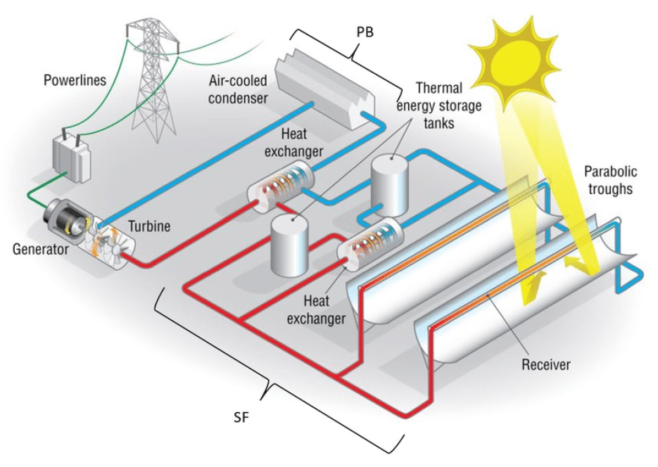
Figure 1 Concentrated Solar Power System, Source "Modeling and Hourly Time-Scale Characterization
of the Main Energy Parameters of Parabolic-Trough Solar Thermal Power Plants Using
a Simplified Quasi-Dynamic Model"
Concrete, asphalt, and rock crushing facility. A use in which the principal activity is performed in an open area where concrete, asphalt, rock, brick, cement, or other similar paving or building materials are crushed, ground, pulverized, bought, sold, exchanged, stored, mixed, packed, disassembled, or handled. Such facility does not include the use, on a public roadway construction or repair project approved by the county engineer, of equipment which directly moves along the roadway surface and grinds, reconstitutes, or resurfaces the roadway, or the temporary on-site crushing, grinding, or pulverizing of a razed building, parking area, or structural materials.
Condominium. A form of individual ownership within a multi-family building which entails joint responsibility for maintenance and repairs, and in which each apartment or townhouse is owned outright by its occupant.
Confined (animal) feeding operation. As defined by Indiana Department of Environmental Management and IC-13-18-10.
Contractor yard. An establishment providing general contracting or building construction service, and which involves outdoor storage of machinery or equipment.
Convalescent home. A facility for aged, chronically ill, or incurable persons licensed by the Indiana Department of Health providing nursing care and related medical services.
County. Hamilton County, Indiana.
County assessor. The county assessor of Hamilton County or his or her authorized representative.
County commissioners. Hamilton County commissioners.
County engineer. The Hamilton County engineer or his or her authorized representative.
Critical facility. A facility for which even a slight chance of flooding might be too great. Critical facilities include, but are not limited to, schools, nursing homes, hospitals, police, fire, and emergency response installations, and installations which produce, use, or store hazardous materials or hazardous waste.
Curb. A stone, asphalt, or concrete boundary marking the edge of a roadway or paved area.
Curb level. The level of the established curb in front of a building or structure measured at the center of such frontage. Where no curb elevation has been established, the county engineer shall establish such curb elevation.
dba. Weighted decibel of sound pressure level.
Deck. An unroofed structure which is attached to or abuts the wall of a dwelling, and which is afforded access to the interior of the dwelling through one or more doors.
Detached accessory dwelling unit. An additional, detached, self-contained dwelling unit that is incidental and subordinate in area to the principal residential use on the lot.
Development. The division of a parcel of land into two or more parcels; the construction, reconstruction, conversion, structural alteration, relocation, or enlargement of any structure; any mining, excavation, landfill, or land disturbance; and any use or extension of the use of land.
Development means, for floodplain management purposes. Any man-made change to improved or unimproved real estate including but not limited to: (1) construction, reconstruction, or placement of a structure or any addition to a structure; (2) installing a manufactured home on a site, preparing a site for a manufactured home or installing a recreational vehicle on a site for more than 180 days; (3) installing utilities, erection of walls and fences, construction of roads, or similar projects; (4) construction of flood control structures such as levees, dikes, dams, channel improvements, etc.; (5) mining, dredging, filling, grading, excavation, or drilling operations; (6) construction and/or reconstruction of boat lifts, docks, piers and seawalls; (7) construction and/or reconstruction of, bridges or culverts; (8) storage of materials; or (9) any other activity that might change the direction, height, or velocity of flood or surface waters. "Development" does not include activities such as the maintenance of existing structures and facilities such as painting; re-roofing; resurfacing roads; or, gardening, plowing, and similar agricultural practices that do not involve filling, grading, excavation, or the construction of permanent structures.
Display frame. The display screen on an electronic message board, which includes the message and background, including, but not limited to, words, letters, numbers, characters, symbols, or other graphics displayed thereon.
Disturbed area. An area that includes grading, soil disposal and stockpiling, installation of infrastructure (i.e., roads, driveways, septic systems, utilities) and building sites.
Drive-through facility. A facility which accommodates automobiles and from which the occupants of the automobiles may make purchases or transact business, including the stacking spaces in which automobiles wait. Examples include, but are not limited to, drive-up windows, menu boards, order boards or boxes, drive-in restaurants, and drive-up banks. Drive-through facilities shall not include the direct refueling or motor vehicles.
Driveway. The area used for vehicular access to a parking area from a street or alley. Driveway shall also include the area used for vehicular access to areas of the zoning lot other than a parking area.
Dry hydrant. A structure that does both of the following: (1) Extends lakeward of the legally established or average normal waterline or shoreline. (2) Provides a means of suction water supply without direct drafting for fire protection.
Duplex. A building on a single lot that contains two dwelling units.
Dust-free. A minimum treatment of the native soil with a covering of asphalt, concrete, wood, masonry, granite, gravel, oil penetration or soil-cement.
Dwelling. A building, or portion thereof, designed exclusively for residential occupancy, but not including hotels, motels, and similar short-term lodging establishments.
Dwelling, multiple family. A building containing three (3) or more dwelling units, all of which are located on a single lot.
Dwelling, single-family attached. A building containing one dwelling unit attached to another building containing only one (1) dwelling unit, each of which is located on a separate lot.
Dwelling, single-family detached. A residential building containing not more than one (1) dwelling unit and entirely surrounded by open space and yards located on the same lot.
Dwelling site. A designated location for residential use by one or more persons using temporary or movable shelter, including camping and recreational vehicle sites.
Dwelling unit. One (1) or more rooms, designed, occupied, or intended for occupancy as a separate living quarter, with a single complete kitchen facility, sleeping room, and bathroom provided within the unit for the exclusive use of a single household.
Easement. The grant of one (1) or more of the property rights by the property owner to and for use by the public, a corporation, or another individual or entity.
Electrical equipment. Any device associated with a solar energy system, such as an outdoor electrical unit/control box, which transfers the energy from the solar energy system to the intended on-site structure.
Electricity generation (aka production, output). The amount of electric energy produced by transforming other forms of energy, commonly expressed in Kilowatt-Hours (kWh) or Megawatt-Hours (MWh).
Elevation certificate. A FEMA form that is routinely reviewed and approved by the White House Office of Management and Budget under the Paperwork Reduction Act, that is encouraged to be used to collect certified elevation information.
Enclosed area. (enclosure) An area of a structure enclosed by walls on all sides.
Enclosure below the lowest floor. See "Lowest floor" and "Enclosed area."
Entertainment, general. Entertainment that does not meet one or more of the definition requirements of limited entertainment.
Entertainment, limited. Entertainment limited to literary readings, story-telling, or live music by not more than three (3) persons, using non-amplified musical instruments, with no patron dancing.
Equal degree of encroachment. A method of determining the location of flood way boundaries so that flood plain lands on both sides of a stream can convey a proportionate share of flood flows.
Essential services. The erection, construction, alteration, or maintenance of underground or overhead gas, electrical, steam, or water transmission or distribution systems, collection, communication, supply, or disposal systems by public utilities, municipal or other governmental agencies, but not including buildings.
Existing manufactured home park or subdivision. A manufactured home park or subdivision for which the construction of facilities for servicing the lots on which the manufactured homes are to be affixed (including, at a minimum, the installation of utilities, the construction of streets, and either final site grading or the pouring of concrete pads) is completed before the effective date of the community's first floodplain ordinance.
Expansion to an existing manufactured home park or subdivision. The preparation of additional sites by the construction of facilities for servicing the lots on which the manufactured homes are to be affixed (including the installation of utilities, the construction of streets, and either final site grading or the pouring of concrete pads).
Extractive use. The use of land for surface or subsurface removal of sand, gravel, rock, manufacturing minerals, and other nonmetallic minerals, and peat, not regulated under Indiana Statutes.
Façade Any side of a structure that faces a street or open space (such as a park).
Fade mode. A mode of message transition on an electronic message board accomplished by varying the light intensity, where the display frame gradually reduces intensity to the point of not being legible and the subsequent display frame gradually increases intensity to the point of legibility.
Family. One (1) or more individuals related by blood, marriage, or adoption, including foster children, or a group of not more than five (5) persons, some, or all of whom are not related by blood, marriage, or adoption, occupying a single dwelling unit.
FEMA. Federal Emergency Management Agency.
Fence. An artificially constructed barrier of any material or combination of materials erected to enclose or screen areas of land.
Fill for floodplain management purposes. Any material deposited or placed which has the effect of raising the level of the ground surface above the natural grade elevation. Fill material includes but is not limited to consolidated material such as concrete and brick and unconsolidated material such as soil, sand, gravel, and stone.
Financial assurance. The reasonable assurance from a credit-worthy party, examples of which include a surety bond, trust instrument, cash escrow, or irrevocable letter of credit or combinations thereof.
Firearm. Any device, designed to be used as a weapon, which will or is designed to or may readily be converted to expel a projectile by the action of an explosive or other form of combustion, but excluding antique firearm, "BB" gun, scuba gun, stud or nail gun used in the construction industry, or toy gun.
Flood or flooding. A general and temporary condition of partial or complete inundation of normally dry land areas from: (1) The overflow of inland or tidal waters. (2) The unusual and rapid accumulation or runoff of surface waters from any source. (3) Mudslides (i.e., mudflows) which are proximately caused by flooding and are akin to a river of liquid and flowing mud on the surfaces of normally dry land areas, as when earth is carried by a current of water and deposited along the path of the current. Flood or flooding also includes the collapse or subsidence of land along the shore of a lake or similar body of water as a result of erosion or undermining caused by waves or current of water exceeding anticipated cyclical levels that result in a flood as defined above.
Flood hazard area. Areas subject to the one percent annual chance flood. (See "Special flood hazard area")
Flood Insurance Rate Map (FIRM). An official map of a community, on which FEMA has delineated both the areas of special flood hazard and the risk premium zones applicable to the community. A FIRM that has been made available digitally is called a Digital Flood Insurance Rate Map (DFIRM).
Flood Insurance Study (FIS). The official hydraulic and hydrologic report provided by FEMA. The report contains flood profiles, as well as the FIRM and the water surface elevation of the base flood.
Flood prone area. Any land area acknowledged by a community as being susceptible to inundation by water from any source. (See "Floodplain")
Flood Protection Grade (FPG). The BFE plus two (2) feet at any given location in the SFHA. For sites within a SFHA designated as "Zone AO," the BFE is equivalent to the flood depth specified on the flood insurance rate map, measured from the highest adjacent grade. If no flood depth is specified, two feet is used as the minimum depth. (See "Freeboard")
Flood, regional. A flood which is representative of large floods known to have occurred generally in Indiana and reasonably characteristic of what can be expected to occur on an average frequency in the magnitude of the 100-year recurrence interval. Regional flood is synonymous with the term "base flood" used in the flood insurance study.
Flood, regulatory. A flood having a one percent (1%) chance of being equaled or exceeded in any given year, as calculated by a method and procedure that is acceptable to and approved by the Indiana Department of Natural Resources and the Federal Emergency Management Agency. The "regulatory flood" is also known by the term "base flood," "one-percent annual chance flood," and "100-year flood".
Floodplain or flood prone area. Any land area susceptible to being inundated by water from any source. (See "Flood")
Floodplain management. The operation of an overall program of corrective and preventive measures for reducing flood damage and preserving and enhancing, where possible, natural resources in the floodplain, including but not limited to emergency preparedness plans, flood control works, floodplain management regulations, and open space plans.
Floodplain management regulations. Zoning ordinances, subdivision regulations, building codes, health regulations, special purpose ordinances (such as a floodplain ordinance, grading ordinance and erosion control ordinance), and other applications of police power which control development in flood-prone areas. The term describes such state or local regulations in any combination thereof, which provide standards for the purpose of flood damage prevention and reduction.
Floodproofing (dry floodproofing). A method of protecting a structure that ensures that the structure, together with attendant utilities and sanitary facilities, is watertight to the floodproofed design elevation with walls that are substantially impermeable to the passage of water. All structural components of these walls are capable of resisting hydrostatic and hydrodynamic flood forces, including the effects of buoyancy, and anticipated debris impact forces.
Floodproofing certificate. A form used to certify compliance for non-residential structures as an alternative to elevating structures to or above the FPG.
Flood-related erosion. The collapse or subsidence of land along the shore of a lake or other body of water as a result of undermining caused by waves or currents of water exceeding anticipated cyclical levels or suddenly caused by an unusually high-water level in a natural body of water, accompanied by a severe storm, or by an unanticipated force of nature, such as a flash flood or an abnormal tidal surge or by some similarly unusual and unforeseeable event which results in flooding.
Floodway. The channel of a river or other watercourse and the adjacent land areas that must be reserved in order to discharge the base flood without cumulative increasing the water surface elevation more than a designated height.
Forest land conversion. The clear cutting of forested lands to prepare for a new land use other than reestablishment of a subsequent forest stand.
Freeboard. A factor of safety, usually expressed in feet above the BFE, which is applied for the purposes of floodplain management. It is used to compensate for the many unknown factors that could contribute to flood heights greater than those calculated for the base flood.
Fringe or flood fringe. The portion of the floodplain lying outside the floodway.
Frontage. The distance for which a lot line coincides with the right-of-way line of a public street or the boundary of a private street.
Functionally dependent use. A use which cannot perform its intended purpose unless it is located or carried out in close proximity to water. The term includes only docking facilities, port facilities that are necessary for the loading and unloading of cargo or passengers, and ship building and ship repair facilities, but does not include long-term storage or related manufacturing facilities.
Garage. A detached accessory building or a portion of the principal building used for the parking and storage of vehicles, merchandise, or equipment, and which is not a separate commercial establishment open to the general public. When associated with a residential use, it shall be limited to use for parking and storage of vehicles, noncommercial trailers, and household equipment.
Garage sale. Garage sale shall include rummage sales, basement sales, yard sales, porch sales, and all other periodic sales at a residential location intended for the limited purpose of isolated or occasional sales as defined by Indiana statutes 297A.25 for the selling of used goods or home-crafted items by the residents thereof.
Grade. The lowest point of elevation of the finished surface of the ground, paving, or sidewalk with the area between the building and the property line, or between the building and a stabilization structure such as a retaining wall, or, where the property line or structure is more than five (5) feet from the building, between the building and a line five (5) feet from the building.
Gross floor area. The sum of the gross horizontal area of the several floors of a building measured from the outside faces of walls or from the centerline of party walls separating two (2) buildings, but not including any interior parking spaces, loading spaces, any space where the floor to ceiling height is less than six (6) feet, any space devoted to mechanical equipment, terraces, breezeways, or screened porches, or basement or other subterranean area not intended for human habitation or service to the public. The floor area for enclosed space having a floor to ceiling height in excess of twenty (20) feet shall be computed on the basis that each fifteen (15) feet of height shall be equal to one floor.
Ground-mounted system. A solar energy system that is directly installed on specialized solar racking systems, which are attached to an anchor in the ground and wired to connect to an adjacent home, building or utility. Ground-mount systems may be applicable when insufficient space, structural and shading issues or other restrictions prohibit rooftop solar.
Guest room. A room occupied by one (1) or more guests for compensation and in which no provision is made for cooking, but not including rooms in a dormitory for sleeping purposes primarily.
Hardship (as related to variances of the floodplain ordinance). The exceptional hardship that would result from a failure to grant the requested variance. The variance must be exceptional, unusual, and peculiar to the property involved. Mere economic or financial hardship alone is NOT exceptional. Inconvenience, aesthetic considerations, physical handicaps, personal preferences, or the disapproval of one's neighbors likewise cannot, as a rule, qualify as an exceptional hardship. All of these problems can be resolved through other means without granting a variance, even if the alternative is more expensive, or requires the property owner to build elsewhere or put the parcel to a different use than originally intended.
Height of building. The vertical distance from the natural grade measured either at the curb level or at a point ten (10) feet away from the front center of the structure or building, whichever is closer to the top of the highest point of the roof.
Height, wall. Wall height shall be the vertical distance from the floor to the top plate of the adjacent wall.
Highest adjacent grade. The highest natural elevation of the ground surface, prior to the start of construction, next to the proposed walls of a structure.
Historic site. Any archaeological site, standing structure, or other property that meets the criteria for eligibility to the National Register of Historic Places or is listed in the state register of historic sites, or is determined to be an unplatted cemetery. A historic site meets these criteria if it is presently listed on either register or if it is determined to meet the qualifications for listings after review by the Indiana state archaeologist or the director of the Indiana Historical Society. All unplatted cemeteries are automatically considered to be significant historic sites.
Historic structure. Any structure that is: (1) listed individually in the National Register of Historic Places (a listing maintained by the Department of the Interior) or preliminarily determined by the secretary of the interior as meeting the requirements for individual listing on the national register; (2) certified or preliminarily determined by the secretary of the interior as contributing to the historical significance of a registered historic district or a district preliminarily determined by the secretary to qualify as a registered historic district; (3) individually listed on a state inventory of historic places in states with historic preservation programs which have been approved by the secretary of the interior; or (4) individually listed on a local inventory of historic places in communities with historic preservation programs that have been certified by (a) an approved state program as determined by the secretary of interior, or (b) directly by the secretary of interior in states without approved programs.
Hobby farm. A use of the land that is primarily residential in nature but may include the raising of livestock primarily for recreational purposes.
Home day care facility. A licensed facility operated within, and by the residents of, a private residence, which for gain or otherwise, provides one or more dependents with care, training, supervision, rehabilitation, or developmental guidance on a regular basis, for periods of less than twenty-four (24) hours a day, in a place other than the dependent's home.
Home occupation. An occupation or profession carried on by a member of the household residing on the premises, conducted as a customary, incidental, and accessory use of a dwelling and does not change the residential character of the structure or area. For the purposes of this ordinance, a home day care facility shall not be considered a home occupation.
Hotel. An establishment offering transient lodging accommodations to the general public, and which may provide additional services such as restaurants, meeting rooms, entertainment, and recreational facilities.
Hybrid solar photovoltaic systems (aka grid-tied PV with battery back-up). Solar photovoltaic electricity generation systems designed to serve the electricity needs of the building to which it is connected, thus offsetting a home or business's electricity usage, while also utilizing a battery back-up in the event of a power outage. This is the only system that provides the ability to have power when the utility grid is down. Typical system components include PV panels, inverter(s) and required electrical safety gear, battery bank, and a charge controller.
Hydrologic and hydraulic engineering analysis. Analyses performed by a professional engineer licensed by the state of Indiana, in accordance with standard engineering practices that are accepted by the Indiana Department of Natural Resources and FEMA, used to determine the base flood, other frequency floods, flood elevations, floodway information and boundaries, and flood profiles.
Illumination (pertaining to sign and billboard regulation). The lighting of a sign with an artificial light source incorporated internally or externally to emanate light from, or direct light to a sign's surface, whole or in part, or that is created by the projection of light onto a surface such as a building wall.
Illumination, digital display. Any portion of a sign, such as an electrically or electronically controlled message center, where the characters, letters, or illustrations can be changed or rearranged either non- manually in the field, or from a remote location, without physically altering the face or the surface of the sign. This may include an electronic variable message sign or projected image onto a building. This shall not be construed as a prohibition on the use of LED technology.
Illumination, dissolve mode. A mode of message transition on an electronic message board accomplished by varying the light intensity or pattern, where the display frame gradually appears to dissipate and lose legibility simultaneously with the gradual appearance and legibility of the next display frame.
Illumination, external. A lighting method provided by an external light source.
Illumination, halo. A lighting method provided by concealing the light source behind three-dimensional opaque letters, numbers, or other characters of a sign, resulting in the nighttime perception of a halo around the silhouette of each sign character. This is also referred to as "reverse channel" or "reverse lit" illumination. A sign with halo illumination is not considered an internally illuminated sign for the purpose of this ordinance.
Illumination, internal. Illumination created by a light source internal to the sign, transparent or translucent material from a light source within the sign structure or panel, or exposed lighting on the sign face.
Illumination, scroll mode. A mode of transition on an electronic message board where the display frame or message moves or appears to move vertically on the board.
Illumination, travel mode. A mode of message transition on an electronic message board where the message moves or appears to move horizontally on the board.
Impervious surface. Any material that substantially reduces or prevents the natural absorption of stormwater into the soil and causes water to run off the surface in greater quantities and at an increased rate of flow. Impervious surfaces include, but are not limited to, buildings or other structures with roofs, sidewalks, and all stone, brick, concrete, or asphalt surfaces.
Integrated center (pertaining to signs). An area of development (commercial, manufacturing or any combination of commercial, manufacturing, and residential uses) that includes multiple businesses or uses in one or more buildings that share common-site facilities.
Intensive vegetative clearing. The complete removal of trees or shrubs in a contiguous patch, strip, row, or block.
International Code Council-Evaluation Service (ICC-ES) report. A document that presents the findings, conclusions, and recommendations from a particular evaluation. ICC-ES reports provide information about what code requirements or acceptance criteria were used to evaluate a product, and how the product should be identified, installed.
International Residential Code (IRC). Part of the International Building Code (IBC), the IRC sets building standards for residential structures.
Inverter. A device that converts the Direct Current (DC) electricity produced by a solar photovoltaic system to usable Alternating Current (AC).
Kennel. An establishment licensed to operate a facility housing dogs, cats, or other household pets and where grooming, breeding, boarding, training, or selling of animals is conducted as a business.
Laboratory, medical or dental. An establishment primarily engaged in providing professional analytic or diagnostic services to the medical profession, or to the patient, on direction of a physician; or an establishment primarily engaged in making dentures, artificial teeth, and orthodontic appliances to order for the dental profession.
Large-scale solar energy system. A commercial solar energy system that converts sunlight into electricity for the primary purpose of wholesale sales of generated electricity. A large-scale solar energy system will have a project size greater than 20 acres and is the principal land use for the parcel(s) on which it is located.
Legal nonconforming lot of record. Any legally established and recorded lot prior to the date specified in the ordinance, or its subsequent amendments, that no longer meet the lot-specific development standards.
Legal nonconforming sign. Any sign lawfully existing on the effective date of the zoning ordinance that does not conform to all the standards and regulations of the zoning ordinance.
Legal nonconforming use. Any continuous, lawful use of structures, land, or structures and land in combination established prior to the effective date of the ordinance that is no longer a permitted use in the district where it is located.
Letter of Final Determination (LFD). A letter issued by FEMA during the mapping update process which establishes final elevations and provides the new flood map and flood study to the community. The LFD initiates a six-month adoption period. The community must adopt or amend its floodplain management regulations during this six-month period unless the community has previously incorporated an automatic adoption clause.
Letter of Map Change (LOMC). A general term used to refer to the several types of revisions and amendments to FEMA maps that can be accomplished by letter. They are broken down into the following categories:
(A)
Conditional Letter of Map Revision (CLOMR). FEMA's comment on a proposed project that would, upon construction, result in modification of the SFHA through the placement of fill outside the existing regulatory floodway.
(B)
Conditional Letter of Map Revision Based on Fill (CLOMR-F). A letter from FEMA stating that a proposed structure that will be elevated by fill would not be inundated by the base flood.
(C)
Letter of Map Amendment (LOMA). An amendment by letter to the currently effective FEMA map that establishes that a building or of land is not located in a SFHA through the submittal of property specific elevation data. A LOMA is only issued by FEMA.
(D)
Letter of Map Amendment Out As Shown (LOMA-OAS). An official determination by FEMA that states the property or building is correctly shown outside the SFHA as shown on an effective NFIP map. Therefore, the mandatory flood insurance requirement does not apply. An out-as-shown determination does not require elevations.
(E)
Letter of Map Revision (LOMR). An official revision to the currently effective FEMA map. It is issued by FEMA and changes flood zones, delineations, and elevations.
(F)
Letter of Map Revision Based on Fill (LOMR-F). FEMA's modification of the SFHA shown on the FIRM based on the placement of fill outside the existing regulatory floodway.
Livestock facility. A barn, building or permanent structure where livestock and/or poultry are intended to be housed, including feedlots, anaerobic digesters, and the associated manure or material storage facilities. Excluding "hobby farm".
Loading space. A space or berth used for the temporary parking of a vehicle while loading or unloading cargo, products, or materials from such vehicle.
Lot. A parcel of land occupied, or to be occupied, by one (1) main building or unit group of buildings, and the accessory buildings or uses customarily incident thereto, including such open spaces as are required under these regulations, and having its principal frontage upon a public street.
Lot area. The area bounded by the front, side, and rear lot lines, but not including any area occupied by the waters of a duly recorded lake, river, street or alley right-of-way, or any other public space.
Lot, corner. A lot with frontage on two (2) or more streets at their intersection.
Lot coverage. That portion of a lot that is covered by the ground floor of any structure, parking lots, and private streets and drives. Also, pools, tennis courts, sidewalks and plazas are counted toward lot coverage.
Lot depth. The average distance between the front lot line and rear lot line of a lot.
Lot line. A line of record bounding a lot that divides one lot from another lot or from a public or private street, alley, or any other public space.
Lot line, front. A boundary of a lot which runs along an existing or dedicated public street, but not an alley.
Lot line, rear. The lot line opposite and most distant from the front lot line. In the case of a triangular or otherwise irregularly shaped lot, a line ten (10) feet in length entirely within the lot, parallel to and at a maximum distance from the front lot line.
Lot line, side. Any boundary of a lot that is not a front lot line or rear lot line.
Lot of record. Any validly recorded lot which, at the time of recording, complied with all applicable laws, ordinances, and regulations.
Lot, through. A lot which fronts upon two (2) parallel or that fronts upon two (2) streets that do not intersect at the boundaries of the lot.
Lot width. The distance between the side lot lines of a lot measured along a straight line parallel to the front lot line immediately in back of the required front setback.
Lowest adjacent grade. The lowest elevation, after completion of construction, of the ground, sidewalk, patio, deck support, or basement entryway immediately next to the structure.
Lowest floor. The lowest floor of the lowest enclosed area (including basement). An unfinished or flood resistant enclosure, used solely for parking of vehicles, building access, or storage in an area other than a basement area, is not considered a building's lowest floor.
Lowest floor (for floodplain management purposes). The lowest elevation described among the following:
A.
The lowest floor of a building.
B.
The basement floor.
C.
The garage floor if the garage is connected to the building.
D.
The first floor of a structure elevated on pilings or pillars.
E.
The floor level of any enclosure, other than a basement, below an elevated structure where the walls of the enclosure provide any resistance to the flow of floodwaters. Designs for meeting the flood opening requirement must either be certified by a registered professional engineer or architect or meet or exceed the following criteria: a. The walls are designed to automatically equalize the hydrostatic flood forces on the walls by allowing for the entry and exit of floodwaters. b. At least two (2) openings are designed and maintained for the entry and exit of floodwater; and these openings provide a total net area of at least one (1) square inch for every one (1) square foot of enclosed area. The bottom of all such openings shall be no higher than one (1) foot above the exterior grade or the interior grade immediately beneath each opening, whichever is higher. Doorways and windows do not qualify as openings.
F.
The first floor of a building elevated on pilings or columns in a coastal high hazard area (as that term is defined in 44 CFR 59.1), as long as it meets the requirements of 44 CFR 60.3.
Maintenance. The process of keeping a structure or sign in good repair. Maintenance includes cleaning, painting, and repair or replacement of damaged or defective parts with like materials in a manner that does not alter the basic design or structure of the sign.
Manufactured home. A structure, transportable in one or more sections, which is built on a permanent chassis and is designed for use with or without a permanent foundation when attached to the required utilities. The term "manufactured home" does not include a "recreational vehicle."
Manufactured home park or subdivision. A parcel (or contiguous parcels) of land divided into two or more manufactured home lots for rent or sale.
Manufacturing facility - major community impact. Area intended for industrial uses that, for reasons of health, safety, or general welfare are not permitted in the M-1 district. M-2 lands should also be separated from commercial or residential development and M-2 uses should not create hazardous conditions. This zone does not allow residential uses.
Manufacturing facility - moderate community impact. Area intended for industrial uses that may be appropriate near commercial or residential development. This zone does not allow residential uses.
Manufacturing use. The use of land or buildings for the production, manufacture, warehousing, storage, or transfer of goods, products, commodities, or other wholesale items.
Mechanical equipment. Air conditioning, heating, ventilation, or other equipment that are reasonably necessary to the operation of a building or use within a building.
Megawatt (MW). Equal to 1000 kilowatts; a measure of the use of electrical power.
Megawatt-Hour (MWh). A unit of energy equivalent to one megawatt (1 MW) of power expended for one hour of time.
Mitigation. Sustained actions taken to reduce or eliminate long-term risk to people and property from hazards and their effects. The purpose of mitigation is twofold: to protect people and structures, and to minimize the cost of disaster response and recovery.
Modular home. A structure, transportable in one or more sections, which is built on a permanent foundation and connected to permanent utilities, per Indiana Code. The term "modular home" does not include the term "recreational vehicle".
Moral turpitude. An act or behavior that gravely violates the sentiment or accepted standard of the community.
National Electric Code (NEC). Sets standards and best practices for wiring and electrical systems.
Natural grade for floodplain management purposes. The elevation of the undisturbed natural surface of the ground. Fill placed prior to the date of the initial identification of the flood hazard on a FEMA map is also considered natural grade.
Net metering. A billing arrangement that allows customers with grid-connected solar electricity systems to receive credit for any excess electricity generated on-site and provided to the utility grid.
New construction for floodplain management purposes. Any structure for which the "start of construction" commenced on or after the effective date of a floodplain management regulations adopted by a community and includes any subsequent improvements to such structures.
New manufactured home park or subdivision. A manufactured home park or subdivision for which the construction of facilities for servicing the lots on which the manufactured homes are to be affixed (including at a minimum, the installation of utilities, the construction of streets, and either final site grading or the pouring of concrete pads) is completed on or after the effective date of the community's first floodplain ordinance.
Noncommunity water system. A public water system that pipes water for human consumption to at least 15 service connections used by individuals other than year-round residents for at least 60 days a year or serves 25 or more people at least 60 days a year (e.g., schools, factories, rest stops, interstate carrier conveyances).
Non-transient, noncommunity water system. A noncommunity water system that serves at least 25 of the same persons over six months per year (e.g., schools, factories, manufacturing parks, office buildings). Examples of noncommunity water systems. Nonresidential schools and institutions, public buildings, office buildings, industries, day care centers, manufacturing parks, anyone that employs at least 25 people like; churches, restaurants, motels/hotels, campgrounds, rest areas (highway), parks, service and gasoline stations, shopping centers, airports, recreation areas, marinas, camps/clubs.
North American Vertical Datum of 1988 (NAVD 88). As adopted in 1993 is a vertical control datum used as a reference for establishing varying elevations within the floodplain.
Nuisance glare. A continuous source of excessive brightness. It could be experienced by a stationary observer located in the path of reflected sunlight from the face of the panel.
Nursing home. See "Convalescent home."
Obstruction. Includes, but is not limited to, any dam, wall, wharf, embankment, levee, dike, pile, abutment, protection, excavation, canalization, bridge, conduit, culvert, building, wire, fence, rock, gravel, refuse, fill, structure, vegetation, or other material in, along, across or projecting into any watercourse which may alter, impede, retard or change the direction and/or velocity of the flow of water; or due to its location, its propensity to snare or collect debris carried by the flow of water, or its likelihood of being carried downstream.
Off-grid solar photovoltaic systems with battery back-up. Solar photovoltaic electricity systems designed to operate independently from the local utility grid and provide electricity to a home, building, boat, RV (or remote agricultural pumps, gates, traffic signs, etc.). These systems typically require a battery bank to store the solar electricity for use during nighttime or cloudy weather (and/or other back-up generation). Typical system components include PV panels, battery bank, a charge controller, inverter(s), required disconnects, and associated electrical safety gear.
Office. A room or group of rooms utilized for the management of the affairs of an establishment or for the non-retail, non-production conduct of affairs of a service, professional, institutional, or business nature.
One-percent annual chance flood. Is the flood that has a one percent (1%) chance of being equaled or exceeded in any given year. See "Regulatory flood."
Opacity. The state or quality of being opaque; the degree to which something is opaque.
Opaque. Not transparent or translucent; impenetrable to light; not allowing light to pass through. As applied to this article, it refers to completely excluding visual contact (100% opacity) with solar panels and equipment.
Operator. The entity responsible for the day-to-day operation and maintenance of the WECS, including any third-party subcontractors.
Ordinary high-water level. The boundary of public waters and wetlands and an elevation delineating the highest water level which has been maintained for a sufficient period of time to leave evidence upon the landscape, commonly that point where the natural vegetation changes from predominantly aquatic to predominantly terrestrial. For watercourses, the ordinary high-water level is the elevation of the top of the bank of the channel. For reservoirs and flowages, the ordinary high-water level is the operating elevation of the normal summer pool.
Outdoor sales and display. The outdoor placement or presentation of goods, materials, or merchandise for sale on the premises.
Outdoor storage. The outdoor placement or depositing of goods, materials, equipment, stock, or supplies.
Overlay district. A zoning district that encompasses one or more primary zoning districts, or portions thereof, and that imposes additional requirements, or relaxes one or more standards required by the primary zoning district.
Owner. The entity or entities with an equity interest in the WECS(s), including their respective successors and assigns. Owner does not mean (i) the property owner from whom land is leased for locating the WECS (unless the property owner has an equity interest in the WECS); or (ii) any person holding a security interest in the WECS(s) solely to secure an extension of credit, or (iii) a person foreclosing on such security interest provided that after foreclosure, such person seeks to sell the WECS(s) within one year of such event.
Owner occupancy. A property owner, as reflected in title records, who makes his or her legal residence at the given lot, as evidenced by voter registration, vehicle registration, or similar means and resides at the given lot more than six (6) months out of any given year.
Parking, off-street. An area, either a parking lot or a garage, which provides parking for motor vehicles.
Parking space. A space of definite length and width designed for parking of motor vehicles within a parking area that is directly accessible to a parking aisle or driveway. Said space shall be exclusive of such drives, aisles, or entrances giving access thereto.
Passive solar. Techniques, design, and materials designed to take advantage of the sun's position throughout the year (and the local climate) to heat, cool, and light a building with the sun. Passive solar incorporates the following elements strategically to maximize the solar potential of any home or building (namely, maximizing solar heat gain in winter months and minimizing solar heat gain in summer months to reduce heating/cooling demand and maximizing the use of daylighting to reduce demand for electricity for lighting): strategic design and architecture, building materials, east west and building lot orientation, windows, landscaping, awnings, and ventilation.
Person. Any person, partnership, firm, company, corporation, tenant, owner, lessee or licensee, agent, heir, or assign.
Photovoltaic (PV) system. A solar energy system that produces electricity using semiconductor devices, called photovoltaic cells, which generate electricity when exposed to sunlight. A PV system may be roof-mounted, ground-mounted, or pole-mounted.
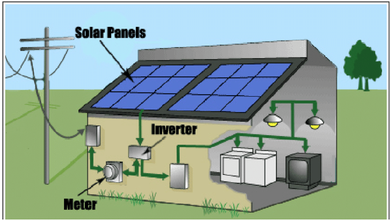
Figure 2 PV System, Source "An Approach Towards Sustainable Building"
Physical Map Revision (PMR). An official republication of a community's FEMA map to effect changes to base (1-percent annual chance) flood elevations, floodplain boundary delineations, regulatory floodways, and planimetric features. These changes typically occur as a result of structural works or improvements, annexations resulting in additional flood hazard areas, or correction to base flood elevations or SFHAs.
Place of assembly. A church, synagogue, temple, mosque, or other facility that is used for prayer by persons of similar beliefs, or a special purpose building that is designed or particularly adapted for the primary use of conducting, on a regular basis, religious services and associated accessory uses by a religious congregation.
Planned unit development. A type of development characterized by a unified site design for a number of dwelling units or dwelling sites on a parcel, whether for sale, rent, or lease, and usually involving clustering of these units or sites to provide areas of common open space, density increases, and a mix of structure types and land uses. These developments may be organized and operated as condominiums, time-share condominiums, cooperatives, full fee ownership, commercial enterprises, or any combination of these, or cluster subdivisions of dwelling units, residential condominiums, townhouses, apartment buildings, campgrounds, recreational vehicle parks, resorts, hotels, motels, and conversions of structures and land uses to these uses.
Planning administrator. The planning administrator/executive director of Hamilton County or his or her authorized representative.
Plat. A drawing or map of a subdivision prepared for filing of record and containing all elements required under this ordinance.
Plat, primary. A drawing showing the proposed general patterns of streets, lots, and land uses within a tract to be subdivided.
Plat, secondary. A drawing of a permanent nature showing the precise location and dimension of such features as streets, lots, easements, and other elements pertinent to transfer of ownership and prepared for permanent record.
Practical difficulty. The plight of the landowner is due to circumstances unique to the property not created by the landowner; and the variance, if granted, will not alter the essential character of the area.
Prefabricated building. A building that is manufactured and constructed using prefabrication. It consists of factory-made components or units that are transported and assembled on-site to form the complete building. For the purposes of this ordinance a modular home is not considered a prefabricated building.
Preferred co-location site. An existing or approved tower, structure, or building which may accommodate planned equipment for a proposed new tower within a one-half (½) mile search radius of the proposed tower location.
Prescribed grazing. The application of goats as a landscape management technique to control noxious, invasive, or other undesirable vegetation at a specific location and for a defined length of time. For purpose of this definition, goats used for prescribed grazing purposes are not considered pets or livestock.
Prime farmland. As defined by the U.S. Department of Agriculture, is land that has the best combination of physical and chemical characteristics for producing food, feed, forage, fiber, and oilseed crops and is available for these uses. It could be cultivated land, pastureland, forestland, or other land, but it is not urban or built-up land or water areas. The soil quality, growing season, and moisture supply are those needed for the soil to economically produce sustained high yields of crops when proper management, including water management, and acceptable farming methods are applied. In general, prime farmland has an adequate and dependable supply of moisture from precipitation or irrigation, a favorable temperature and growing season, acceptable acidity or alkalinity, an acceptable salt and sodium content, and few or no rocks. The water supply is dependable and of adequate quality. Prime farmland is permeable to water and air. It is not excessively erodible or saturated with water for extended periods, and it either is not frequently flooded during the growing season or is protected from flooding.
Principally above ground. At least 51 percent of the actual cash value of the structure, less land value, is above ground.
Production or processing. The assembly, disassembly, fabrication, manufacture, transformation, packaging, sorting, or other handling of goods or materials, either as an intermediate input for further production and processing, or for final sale, use, or consumption.
Professional engineer. A qualified individual who is licensed as a professional engineer in the State of Indiana.
Protective covenants. Any contract made between private parties as to the manner in which land may be used.
Public freshwater lake. A naturally formed lake (not man made) that has been used by the public with the acquiescence of a riparian owner. The term does not include the following: (1) A lake lying wholly or in part within the corporate boundaries of any of the three (3) cities having the largest population in a county having a population of more than four hundred thousand (400,000) but less than seven hundred thousand (700,000). (2) A privately owned body of water: a) used for the purpose of surface coal mining; or b) created as a result of surface coal mining.
Public use. A use of land owned or operated by a municipality, school district, county or state agency, or other governmental entity.
Public utility tower. A permanent steel tower structure which is owned by the county or a public utility corporation or cooperative and is designed and constructed to carry high voltage transmission lines and will bear the additional weight of an antenna as defined herein.
Public water system. A system which has 15 or more service connections, or regularly serves at least 25 people 60 or more days a year. A system that serves water 60 or more days a year is considered to "regularly serve" water. Public Water Supply Systems (PWSSs) can be publicly or privately owned.
Public waters. Any waters as defined in Indiana statutes, section 103G.
Pump island canopy. A roof-like horizontal structure that extends over or covers the fuel dispenser(s), may be a lighting source for the dispensing area and may display signage.
PV-direct systems. The simplest of solar photovoltaic electric systems with the fewest components (no battery back-up and not interconnected with the utility) designed to only provide electricity when the sun is shining. Typical system components include PV panels, required electrical safety gear, and wiring.
PWSSs. Are further subdivided by regulations into two major categories: community and noncommunity water systems. This division is based on the type of consumer served and the frequency the consumer uses the water. In general, a community system serves water to a residential population, whereas a noncommunity system serves water to a nonresidential population. The noncommunity category is further broken down into two categories: non-transient, noncommunity water systems and transient noncommunity water systems. The following definitions and examples further clarify the system designations:
Racking. Solar energy systems are attached securely and anchored to structural sections of the roof-mounted or pole-mounted systems. Specially designed metal plates called flashings prevent leaks and are placed under shingles and over bolts to create a water-tight seal.
Recreational vehicle. A vehicle that is built on a single chassis, is four hundred (400) square feet or less when measured at the largest horizontal projection, is designed to be self-propelled or permanently towable by a light duty truck and is designed primarily not for use a as permanent dwelling but as temporary living quarters for recreational, camping, travel, or seasonal use. The term "recreational vehicle" shall be synonymous with the term "travel trailer".
Recreational vehicle park. A development providing individual spaces for the parking of a recreational vehicle for temporary portable housing and sleeping purposes, whether a charge is made for such accommodation.
Recreational vehicle space. An area of land within a recreational vehicle park designed and intended for the accommodation of one (1) recreation vehicle.
Regulatory flood. A flood having a one percent (1%) chance of being equaled or exceeded in any given year, as calculated by a method and procedure that is acceptable to and approved by the Indiana Department of Natural Resources and the Federal Emergency Management Agency. The regulatory flood elevation at any location is as defined in Article 09 (6). The "regulatory flood" is also known by the term "base flood", "one-percent annual chance flood", and "100-year flood".
Regulatory flood protection elevation. An elevation no lower than one (1) foot above the elevation of the regional flood plus any increases in flood elevation caused by encroachments on the floodplain that result from designation of a floodway.
Repetitive loss. Flood-related damages sustained by a structure on two separate occasions during a 10- year period for which the cost of repairs at the time of each such flood event, on the average, equaled or exceeded 25% of the market value of the structure before the damage occurred.
Residential care facility. A licensed public or private facility, which, for gain or otherwise, regularly provides one or more dependents with a twenty-four (24) hour a day substitute for the care, food, lodging, training, supervision, rehabilitation, and treatment they need, but which for any reason cannot be furnished in the dependent's own home. The term includes, but is not limited to, residential programs that are licensed by the Indiana Department of Health, adult foster care homes, board and lodge serving developmentally disabled, mentally retarded, mentally ill, and/or frail elderly, residential treatment centers, maternity shelter, schools for handicapped children, and homes for battered children or spouses. Such term shall not include any facility eligible for licensure by the Indiana Department of Corrections.
Restaurant. An establishment that sells unpackaged food to the customer in a ready-to-consume state, in individual servings, and where the customer consumes these foods in the building, picks up the food from the building to consume elsewhere, or the food is delivered to the customer by employees of the restaurant or other food delivery service.
Restaurant, drive-through. A restaurant providing a drive-through facility as defined elsewhere in this chapter.
Right-of-way. A strip of land occupied or intended to be occupied by a road, crosswalk, utility line, railroad, electric transmission line, or other similar use.
Riverine. Relating to, formed by, or resembling a river (including tributaries), stream, brook, etc.
Road. See Street.
Roof-mount system (aka rooftop mounted, building mounted). A solar energy system consisting of solar panels are installed directly on the roof of a home, commercial building, and/or an accessory structure, such as a garage, pergola, and/or shed. Solar panels are mounted and secured using racking systems specifically designed to minimize the impact on the roof and prevent any leaks or structural damage. Roof-mount systems can be mounted flush with the roof or tilted toward the sun at an angle.
Roof-mounted antenna. Any device attached to a building, or structure that is used for wireless telecommunications service.
Rooming unit. One or more rooms, designed, occupied, or intended for occupancy as a separate living quarter that is not a dwelling unit.
Salvage yard. A lot, parcel of land or structure, or part thereof, used primarily for the collecting, storage, and sale of wastepaper, rags, scrap metal, discarded materials, or similar materials; or for the collection, dismantling, storage and salvaging of machinery or vehicles not in running condition; or the sale of part thereof.
Satellite dish. An antenna device used for transmitting or receiving electromagnetic waves, but which incorporates a reflective surface that is solid, open mesh, or bar figured and is in the shape of a shallow dish, cone, horn, or cornucopia. For purposes of this chapter only, a satellite dish, which technologically constitutes an antenna as defined herein, shall be deemed as a separate and distinct antenna, and shall be specifically regulated as such in this chapter.
Scrapyard. Any situation where inoperable motor vehicles, or parts thereof, are stored in the open and are not being restored to operation, or any land, building, or structure used for wrecking or storing of such motor vehicles or parts thereof; and including any commercial salvaging and scavenging of any other goods, articles, or merchandise.
Screening. The method by which a view of one site from another adjacent site is shielded, concealed, or hidden. Screening techniques include fences, wall, hedges, berms, or other features.
Self-service storage facility. An establishment designed and utilized for the purpose of renting or leasing individual storage spaces to tenants who have sole access to such space for the storage of private property.
Semi-public use. The use of land by a private, nonprofit organization to provide a public service that is ordinarily open to some persons outside the regular constituency of the organization.
Sensitive resource management. The preservation and management of areas unsuitable for development in their natural state due to constraints such as shallow soils over groundwater or bedrock, highly erosive or expansive soils, steep slopes, susceptibility to flooding, or occurrence of flora or fauna in need of special protection.
Setback. The minimum separation in linear feet, measured on a horizontal plane, required between the wall of a building or structure and each of the lot lines or between the walls of buildings located on the same zoning lot.
Setback, front. A line parallel to the front lot line and extending from side lot line to side lot line.
Setback, rear. A line parallel to all rear lot lines and extending from side lot line to side lot line.
Setback, side. A line parallel to any side lot line and extending from the front setback line to the rear setback line.
Sewage treatment system. A septic tank and soil absorption system or other individual or cluster type sewage treatment system.
Sexually oriented business. Any use, including, but not limited to, adult movie theaters, adult mini-movie theaters, adult motion picture arcades, adult novelty businesses, and adult cabarets, which is conducted exclusively for the patronage of adults and from which minors are excluded by law or by the owners, or which offer patrons services or entertainment characterized by an emphasis on the presentation, display, depiction, or description of specified anatomical areas or specified sexual activities. Adult entertainment uses do not include uses offering goods displaying or describing specified anatomical areas or specified sexual activities for sale or rent for use off the premises where such transactions constitute less than ten (10) percent of the gross sales of the business and the physical display of such goods occupies less than five (5) percent of the display area, up to a maximum of five thousand (5,000) square feet.
Shopping center. A group of commercial establishments planned, developed, owned, or managed as a unit, related in size (gross floor area) and type of shops to the trade area that the unit serves, and with parking provided on the property.
Sight distance triangle. A triangular shaped portion of land established at street or driveway intersections in which nothing is erected, placed, planted, or allowed to grow in such a manner as to limit or obstruct the sight distance of motorists entering or leaving an intersection. Such triangle shall be defined beginning at the intersection of the projected curb lines of two (2) intersecting streets or at the intersection of projected curb lines where a driveway intersects a street, measured twenty-five (25) feet along each curb line and connected by a diagonal line.
Sign. Any framed, bracketed, free-formed, or engraved surface, which is fabricated to create words, numerals, figures, devices, designs, trademarks, or logos, which is mounted on or affixed to a building or the ground, and which is sufficiently visible to persons not located on the lot where such device is located to attract the attention of such persons or to communicate information to them. Sign includes sign supports.
Sign element. That portion of a sign that includes graphics, illustrations or text which provides a message to the public. The sign element is also considered the sign face. The sign element shall not include poles, mounting brackets, hinges or other material that supports the sign element.
Sign face. The entire surface area of the sign within a single continuous rectangular shape upon, against, or through which all elements that form the display, including any background, is exhibited.
Sign height. The distance from the ground level to the highest point on the sign structure.
Sign structure. Any structure except a building, including the supports, uprights, bracing and framework that supports or is capable of supporting any sign.
Sign type. Itemized categories of freestanding or building signs.
Sign, abandoned. Any sign or its supporting sign structure that conforms to this ordinance where the primary use, which has ceased activity for a period of one (1) year or more, is considered abandoned. Any sign or its supporting sign structure that does not conform to this ordinance and which has ceased activity for a period of 60 days, or more is considered abandoned. Any sign deemed abandoned will also lose legally non-conforming status. For purposes of this definition, 'the primary use' refers to the activity occurring on the property and not to the mere generation of income for the property owner, or the intentions of the property owner or any tenant or sub-tenant.
Sign, A-Frame. A pedestrian sign containing two sign faces and whose framing is hinged at the apex at an angle less than 60 degrees.
Sign, animated. Any sign that utilizes movement, change of lighting, or electronic lettering to depict action, create messages, or special effects.
Sign, awning. A sign which is integrated into a roof-like cover, often constructed of fabric, plastic, vinyl, metal, or glass, designed, and intended for protection from the elements or as decorative embellishment and which projects from a wall of a structure. An awning sign will have lettering and/or graphics painted, or screen printed on its exterior surface.
Sign, billboard. A sign which directs attention to a business, product, service, or activity not conducted, sold, or offered upon the premises where such sign is located.
Sign, building. A sign accessory to the primary use of land that is attached to any part of a building including, but not limited to projecting signs, projecting-blade signs, canopy signs, marquee signs, pedestrian-oriented projecting and suspended signs, skyline signs and wall signs.
Sign, business. A sign that identifies the business, product, service, or activity that is sold or offered upon the premises where such sign is located.
Sign, canopy. Any building sign that is part of or attached to a canopy as an accessory to the primary use of the land, made of fabric, plastic, or structural protective cover over a door, entrance, or window. A canopy/awning sign is not a marquee and is different from pump island canopy signs.
Sign, changeable copy. A sign, or portion thereof, with characters, letters, or illustrations that can be changed or rearranged without altering the face or the surface of the sign. Such sign shall not include any sign considered to be an animated sign. A reader board sign is to be considered a changeable copy sign.
Sign, digital billboard. A billboard sign structure displaying static images controlled by electronic communication.
Sign, drive-thru. A sign on a lot that includes a drive-through service window and at least one stacking lane that is devoted exclusively to customers of a drive-through service, which is located at the entrance of or along or over one or more such stacking lanes.
Sign, electronic message board. Any sign that displays a message electronically.
Sign, flashing. A sign, the illumination of which is not always kept constant in intensity when in use.
Sign, freestanding sign. Any sign, accessory to the primary use of land, whose primary support is placed on, or anchored in, the ground and is independent from any building or other structure and may include monument signs, pole signs and pylon signs.
Sign, gateway. A sign indicating entry into a neighborhood or special district.
Sign, hanging/suspended. A double-faced sign which hangs from a bracket or support and projects from any horizontal surface.
Sign, heritage. An existing sign having historical significance, and which advertises an establishment or product no longer in existence or a product no longer being offered on the site, may be designated a heritage sign. An exact replica of an original sign attached to a building that would have been at least 50 years old may be designated a heritage sign.
Sign, illuminated. A sign having characters, letters, figures, designs, or outlines illuminated by electric lighting or luminous tubes as a part of the sign.
Sign, incidental. A permanent sign which has a purpose that is secondary and incidental to the use of the lot on which it is located, such as "hours of operation", "loading zone only," "air," "building directory, "and "visitor parking," and which carries no commercial message that is legible beyond the lot on which the sign is located, except for a registered logo on a premises with two or more separately-operating businesses.
Sign, inflatable. Lighter-than-air or gas-filled balloons or other similar devices used to advertise or define a fixed location are prohibited, except in compliance with the sign article.
Sign, joint identification. A sign which serves as a common or collective identification for a group of businesses or occupations operating on the same zoning lot and not including any other advertising.
Sign, marquee. A building sign painted, mounted, constructed, or attached in any manner on a marquee and may accommodate changeable copy signs or digital displays.
Sign, monument. A freestanding sign, accessory to the primary use of land, whose sign face is attached to a proportionate sign base or structural frame that maintains a minimum width, without opening, greater than 80% of the width of the widest part of the sign face a constant width, without opening.
Sign, multi-tenant. A single sign structure accommodating multiple sign faces dedicated to individual tenants.
Sign, nameplate. A sign which states the name or address, or both, of the occupant of the lot where the sign is located.
Sign, off-premises. A sign that directs attention to a business, profession, commodity, or service offered on the property other than that on which the sign is located. This limitation does not apply to the content of noncommercial messages.
Sign, on-premises. A sign that directs attention to a business, profession, commodity, or service offered on the property on which the sign is located. This limitation does not apply to the content of noncommercial messages.
Sign, outdoor advertising. See "Sign, off-premises".
Sign, pavement. A sign built into or affixed to the sidewalk or pavement, typically at the entrance of a building.
Sign, pole. A freestanding sign, accessory to the primary use of land, which has as its support structure one or more poles anchored in the ground as it extends upward from grade level.
Sign, portable. A sign without a sign structure or building, or with a sign structure lacking a permanent foundation or that is otherwise not permanently attached to a fixed location, which can be carried, towed, hauled, or driven, and is primarily designed to be moved rather than be limited to a fixed location regardless of modifications that limit its movability, including but not limited to signs on trailer frames, whether or not the trailer wheels have been removed. This definition does not include pedestrian signs.
Sign, primary building. A wall sign, canopy sign, marquee sign, skyline sign, roof-integral sign, projecting blade sign, projecting sign or a sign that is not pedestrian-oriented, or other permanent sign, accessory to the primary use of land, that is attached or affixed to a building, and that is not one of the types specified as a secondary building sign.
Sign, primary freestanding. A monument, pylon or pole sign or other freestanding permanent sign, accessory to the primary use of land, and that is not one of the types specified as a secondary freestanding sign.
Sign, projecting. A building sign that is affixed to a building or wall at an angle in such a manner that its leading edge extends more than 18 inches beyond the surface of such building or wall face.
Sign, projecting - blade. A building sign that is a type of projecting sign mounted on a building façade or storefront pole or attached to a surface perpendicular to the normal flow of traffic.
Sign, public. A sign that is constructed, placed or maintained by the federal, state or local government for the purpose of carrying out an official duty or responsibility or a sign that is required to be constructed, placed or maintained by a federal, state or local government either directly or to enforce a property, including but not limited to signs which promote safety, no trespassing, or traffic signs; memorial plaques; signs of historical interest; notices of pending governmental action and signs directing people to public and semi-public facilities; public transit service signs, utility information signs, public restroom or telephone signs, trespassing signs, legal notices; signs of public service companies indicating danger and aids for service or safety.
Sign, pump island canopy. Any sign that is part of or attached to the pump island canopy.
Sign, pylon. A freestanding sign, accessory to the primary use of land, with its sign face attached to a sign base consisting of one or more supports that, from grade level to the sign face, maintains a minimum width extending upward from grade level of 20% up to 100% of the width of the widest part of the sign face.
Sign, roof-integral. Any building sign erected or constructed as an integral or essentially integral part of a normal roof structure of any design, so that no part of the sign extends vertically above the roof.
Sign, rotating. Any sign or portion of a sign designed to revolve or move in an equivalent manner by means of electrical or wind power.
Sign, secondary building. A window sign, a pedestrian-oriented projecting sign, suspended sign, or incidental sign, which is a permanent building sign, accessory to the primary use of land, and that is not one of the types specified as a primary building sign.
Sign, secondary freestanding. A vehicle entry point sign, incidental signs, drive-thru sign, auto and bike sharing sign or other permanent sign accessory to the primary use of land and that is not one of the types specified as a primary freestanding sign.
Sign, skyline. A sign attached to the topmost band or bands of the building façade.
Sign, temporary. A sign that is authorized for a period, not to exceed 10 days. One-time event temporary signs may be a freestanding or building sign. One-time event temporary signs may be made of nondurable materials, such as pennants, banner, flags (unofficial or official), air-filled, as well as more durable materials such as wood, metal, plastic.
Sign, T-Frame. A pedestrian sign containing two sign faces and whose framing consists of a base perpendicular to the sign face.
Sign, wall. A sign which is attached to the wall of a building, with the sign face in a plane parallel to such wall, not extending more than eighteen (18) inches from the face of such wall.
Sign, window. Any sign, lettering, pictures, symbols, or combination thereof, designed to communicate information about a business, product, service, or activity that is placed upon a window and meant to be visible from the exterior of the building.
Sign, yard. Freestanding sign, accessory to the primary use of land that is located in the yard of a lot, for temporary purposes only. Examples include signs posted by a real estate professional, land developer, builder, home improvement company, garage sale advertising, and signs expressing an opinion. A yard sign may be a maximum of six (6) square feet in size.
Significant historic site. Any archaeological site, standing structure, or other property that meets the criteria for eligibility to the National Register of Historic Places or is listed in the State Register of Historic Sites, or is determined to be an unplatted cemetery that falls under the provisions of Indiana Statutes. A historic site meets these criteria if it is presently listed on either register or if it is determined to meet the qualifications for listing after review by the Indiana state archaeologist or the director of the Indiana Historical Society. All unplatted cemeteries are automatically considered to be significant historic sites.
Site. Any lot or parcel or combination of lots or parcels assembled for the purpose of development.
Site plan. An integral set of documents which may consist of both drawn and written materials whose purpose is to provide the necessary information for an approving authority to decide whether the proposed development will comply with the standards and regulations of this ordinance.
Solar access. The ability of one property to continue to receive sunlight across property lines without obstruction from another's property that contains buildings, foliage, or another impediment.
Solar array. Multiple solar panels combined to create one system.
Solar carport. A solar energy system of any size that is installed on a carport structure that is accessory to a parking area, and which may include electric vehicle supply equipment or energy storage facilities.
Solar collector. A solar PV cell, panel, or array, or solar thermal collector device, which relies upon solar radiation as an energy source for the generation of electricity or for the transfer of stored heat.
Solar easement. An easement recorded pursuant to IC 32-23-4, obtained for the purpose of insuring exposure of a solar energy device or a passive solar energy system to the direct rays of the sun. Solar easements are to follow the state requirements of recording (IC 32-23-2-5).
Solar Energy System (SES). The components and subsystems required to convert solar energy into electric or thermal energy suitable for use. The area of the system includes all the land inside the perimeter of the system, which extends to any fencing, buffer yard, and landscaping. The term applies, but is not limited to, solar photovoltaic (PV) systems, solar thermal systems, and solar hot water systems.
Regulated systems fit into one of three (3) system types:
A.
Commercial - Small Scale (CS-SES). A utility-scale commercial facility that converts sunlight into electricity with the primary purpose of wholesale or retail sales of generated electricity. Concentrated Solar Thermal (CST) is not permitted or considered a CS-SES for the purpose of this article. A CS-SES is typically established by a public utility and produces between 1MW and 15MW.
B.
Commercial - Large Scale (CL-SES). A utility-scale commercial facility that converts sunlight into electricity with the primary purpose of wholesale or retail sales of generated electricity. Concentrated Solar Thermal (CST) is not permitted or considered a C-SES for the purpose of this article. A CL-SES will produce 15MW or greater.
C.
Noncommercial (NC-SES). Includes any photovoltaic, solar thermal, or solar hot water devices that are accessory to, and incorporated into, the development of an authorized use of the property, and which are designed for the purpose of reducing or meeting on-site energy needs. An NC-SES will produce 1MW or less.
D.
As applicable to this ordinance a SES does not include concentrated solar thermal systems and such systems are not permitted.
Solar glare. The potential for solar panels to reflect sunlight, with intensity sufficient to cause annoyance, discomfort, or loss in visual performance and visibility.
Solar hot air system. (Also referred to as solar air heat or solar furnace) A solar energy system that includes a solar collector to provide direct supplemental space heating by heating and re-circulating conditioned building air. The most efficient performance includes a solar collector to preheat air or supplement building space heating, typically using a vertically mounted collector on a south-facing wall.
Solar panel (or module). A device for the direct conversion of sunlight into usable solar energy (including electricity or heat).
Solar photovoltaic (solar PV) system. Solar systems consisting of photovoltaic cells, made with semiconducting materials, which produce electricity (in the form of Direct Current (DC) when they are exposed to sunlight. A typical PV system consists of PV panels (or modules) that combine to form an array. Other system components may include racks and hardware, wiring for electrical connections, power conditioning equipment, such as an inverter and/or batteries.
Solar-ready design. The design and construction of a building that facilitates and makes feasible the installation of rooftop solar.
Solar thermal system (aka solar hot water or solar heating systems). A solar energy system that directly heats water or other liquid using sunlight. Consists of a series of tubes that concentrate light to heat either water or a heat-transfer fluid (such as food-grade propylene glycol, a non-toxic substance) in one of two types of collectors (flat-plate collectors and evacuated tube collectors). The heated liquid is used for such purposes as space heating and cooling, domestic hot water, and heating pool water.
Solid waste disposal facility. Any facility involved in the storage or disposal of non-liquid, non-soluble materials ranging from municipal garbage to manufacturing wastes that contain complex and sometimes hazardous substances. Solid waste also includes sewage sludge, agricultural refuse, demolition wastes, mining wastes, and liquids and gases stored in containers.
Special Flood Hazard Area (SFHA). Synonymous with "areas of special flood hazard" and floodplain, means those lands within the jurisdiction of the county subject to a one percent or greater chance of flooding in any given year. Special flood hazard areas are designated by the Federal Emergency Management Agency on flood insurance rate maps, flood insurance studies, as zones A, AE, A99, or VE. The SFHA includes areas that are flood prone and designated from other federal, state, or local sources of data including but not limited to best available flood layer maps provided by or approved by the Indiana Department of Natural Resources, historical flood information reflecting high water marks, previous flood inundation areas, and flood prone soils associated with a watercourse.
Special use. Uses publicly or municipally operated and those uses traditionally affected with a public interest and those uses entirely private in character but of such an unusual nature that their operation may give rise to unique problems with respect to their impact upon neighboring property and public facilities. Upon receipt of an application for special use, the plan director shall refer the application to the BZA for public hearing.
Sports and health facility. A facility, for profit or nonprofit, where members or nonmembers pay a fee to use equipment or space for the purpose of physical exercise, including but not limited to swimming, court games, aerobics, jogging, and muscular exercise programs. Such facility may include as an accessory use personal services to patrons, including but not limited to therapeutic massage, tanning, saunas, whirlpools, and locker rooms.
Start of construction. Includes substantial improvement, and means the date the building permit was issued, provided the actual start of construction, repair, reconstruction, or improvement was within 180 days of the permit date. The actual start means either the first placement of permanent construction of a structure on a site, such as the pouring of a slab or footings, the installation of piles, the construction of columns, or any work beyond the stage of excavation; or the placement of a manufactured home on a foundation. Permanent construction does not include land preparation, such as clearing, grading, and filling; nor does it include the installation of streets and/or walkways; nor does it include excavation for a basement, footings, piers, foundations, or the erection of temporary forms; nor does it include the installation on the property of accessory buildings, such as garages or sheds not occupied as dwelling units or not part of the main structure. For a substantial improvement, the actual start of construction means the first alteration of any wall, ceiling, floor, or other structural part of a building, whether or not that alteration affects the external dimensions of the building.
Steep slope. Land where agricultural activity or development is either not recommended or described as poorly suited due to slope steepness and the site's soil characteristics, as mapped, and described in available county soil surveys or other technical reports, unless appropriate design and construction techniques and farming practices are used in accordance with the provisions of this ordinance. Where specific information is not available, steep slopes are lands having average slopes over fifteen (15) percent over horizontal distances of fifty (50) feet or more and that are not bluffs.
Story. That portion of a building included beneath the upper surface of a floor and upper surface of the floor next above, or fourteen (14) feet, whichever is less, except that the topmost story shall be that portion of a building included between the upper surface of the topmost floor and the ceiling or roof above. If the finished floor level directly above a basement or cellar, or unused underfloor space is more than six (6) feet above grade, more than fifty percent (50) percent of the total perimeter or is more than twelve (12) feet above grade at any point, such basement, cellar, or unused under floor space shall be considered a story.
Street. A right-of-way that affords a primary means of motor vehicle access to abutting property.
Street, arterial. A street or highway that provides for rapid and efficient movement of large volumes of through traffic between sections of the county and across the urbanized area. It is not primarily intended to provide land access service.
Street, banner. A message applied to cloth, paper, fabric, or flexible plastic, with any such non-rigid material for background suspended across a street for a temporary period.
Street, collector. A street that provides for traffic circulation within residential areas. Land access is a secondary function of the collector. The collector distributes trips from the arterial streets to the local street network.
Street, cul-de-sac. A street with only one (1) outlet and having an appropriate turnaround for the safe and convenient reversal of traffic movement.
Street, local. A street that provides direct traffic access to abutting land in residential areas.
Street, private. An easement that affords principal access to property abutting thereon, which easement is owned, controlled, and maintained by persons other than the public.
Street, public. A right-of-way that affords the principal means of vehicular access to property abutting thereon which right-of-way has been dedicated to the public for such use.
Structural alteration. Any change in the supporting members of a building, such as bearing walls, beams, or girders, or any change in the dimension or configuration of the roof or exterior walls.
Structure. A walled and roofed building, including a gas or liquid storage tank, which is principally above ground. The term includes a manufactured home, as well as a prefabricated building. It also includes recreational vehicles installed on a site for more than 180 consecutive days.
Structure, accessory. See Building, accessory.
Structure, primary. See Building, primary.
Subdivision. The separation of an area, parcel, or tract of land under single ownership into two (2) or more parcels, tracts, lots, or long-term leasehold interests, and may include planned unit developments.
Substantial damage. Damage of any origin sustained by a structure whereby the cost of restoring the structure to its before damaged condition would equal or exceed 50 percent of the market value of the structure before the damage occurred.
Substantial improvement. Any reconstruction, rehabilitation, addition, or other improvement of a structure, the cost of which equals or exceeds 50 percent of the market value of the structure before the "start of construction" of the improvement. This term includes structures that have incurred "repetitive loss" or "substantial damage" regardless of the actual repair work performed. The term does not include improvements of structures to correct existing violations of state or local health, sanitary, or safety code requirements.
Substation. Apparatus that connects the electrical collection system of the WECS(s) and increases the voltage for connection with the utility's transmission lines.
Surface water-oriented commercial use. The use of land for commercial purposes, where access to and use of a surface water feature is an integral part of the normal conduct of business. Marinas, resorts, and restaurants with transient docking facilities are examples of such use.
Switching station. An apparatus/structure in the system similar to a substation but not necessarily increasing into the grid.
Taproom. A licensed premises up to twenty-five (25) percent of the gross floor area within a brewery that offers on-sale and/or off-sale purchases and consumption of the malt liquor manufactured at the adjoining brewery and retail sales of related merchandise.
Temporary structure.(Not to exceed 6 months). Any constructed or erected structure, including (but not limited to) a shed, building, vehicle, trailer, tent, or enclosure of any kind used for personal, commercial, or business purposes and which any person or business intends to place on the same lot with or on any lot adjacent to, any permanent structure used for personal, business, or commercial purposes.
Tower. A ground pole, spire, structure, or combination thereof including supporting lines, cables, wires, braces, and masts intended primarily for the purpose of mounting an antenna, a meteorological device, or other similar apparatus aboveground for use as a wireless telecommunications facility. Also known as any freestanding structure designed specifically to elevate an antenna, satellite dish or similar apparatus.
Townhouse. Single-family attached units in structures housing three (3) or more dwelling units, contiguous to each other, only by the share of common walls, and each dwelling unit shall have separate and individual front and rear entrances. Such structures to be of the row or group house type as contrasted to multiple dwelling apartment-type structures. No single structure shall contain in excess of eight (8) dwelling units.
Transient noncommunity water system. A noncommunity water system that does not meet the definition of a non-transient, noncommunity water system (e.g., highway rest stops, restaurants, motels, golf courses, parks).
Transition. The means by which an electronic message board changes from one (1) message to another; or from one (1) message segment to the next in cases where the message is conveyed by using more than one (1) consecutive display frame.
Travel trailer. A vehicle or portable unit that is mounted on its own chassis and wheels and drawn by a motor vehicle to provide temporary living quarters for recreational, camping, or travel use. Park trailers shall be considered a travel trailer for the purposes of this ordinance. This term shall be considered synonymous with the term "recreational vehicle" for floodplain purposes.
Truck camper. A portable unit consisting of a roof, floor, and sides, designed to be loaded onto and unloaded from the bed of a pickup truck, to provide temporary living quarters for recreational, camping or travel use.
Unified Development Ordinance. Land use and subdivision control ordinance for Hamilton County, Indiana.
Unnecessary hardship. The land in question cannot reasonably be put to a conforming use. The applicant cannot realize a reasonable return, provided that lack of return is substantial as demonstrated by competent financial evidence; that the alleged hardship relating to the property in question is unique and does not apply to a substantial portion of the district or neighborhood; that the requested use variance, if granted, will not alter the essential character of the neighborhood; and that the alleged hardship has not been self-created.
Use. The purpose or activity for which the land or buildings thereon are designated, arranged, intended, occupied, or maintained.
Use, accessory. A use of land or of a building or portion thereof, incidental and subordinate to a principal use.
Use, conditional. A use which, because of its unique characteristics, cannot be properly classified as a permitted use in a district but which may be allowed in such zoning district upon demonstrating that such use will comply with all of the conditions and standards of this development ordinance.
Use, permitted. A use which may be lawfully established in a particular district or district, provided it conforms to all requirements, regulations, and performance standards of such districts.
Use, principal. The main use of land as distinguished from subordinate or accessory uses. The principal use may be either permitted or conditional.
Use, temporary. Any use designed, built, erected, or occupied for short and/or intermittent periods of time and shall include tents, lunch wagons, dining cars, trailers, and other roofed structures on wheels or other supports used for business, storage, manufacturing, institutional, assembly, educational or recreational purposes.
Variance (floodplain). A grant of relief from the requirements of the floodplain ordinance consistent with the variance conditions herein.
Variance- development standards. The departure from the literal requirements in instances where strict adherence to this ordinance would cause practical difficulties due to unique circumstances related to the property.
Variance- use. The departure from the literal requirements in instances where strict adherence to this ordinance would cause unnecessary hardship due to unique circumstances related to the property.
Vehicle, commercial. A motor vehicle designed and registered as a truck and licensed under motor carrier laws of the state of Indiana for the transportation of property but not persons, or a motor vehicle designed primarily for the movement of property or special purpose equipment, or a motor vehicle that is designed to carry ten (10) or more persons or any number of persons for a fee. Commercial vehicle includes vehicles commonly called trucks, delivery vans, buses, taxicabs, limousines, and other similar vehicles.
Vehicle entry point sign. A secondary, freestanding, permanent on-premises sign, accessory to the primary use of land, located within 10 feet of the right-of-way and the pavement of a driveway.
Vehicle, inoperable. A vehicle that is abandoned or lacking vital component parts essential to its mechanical functioning, including, but not limited to, the engine, drive train, and wheels; or a vehicle that is so mechanically defective as to be unsafe for operation; or a vehicle that does not display a current license plate, current license tab, or current registration, or which does not meet all vehicle requirements for operation on public rights-of-way.
Vehicle, motor. A vehicle that has its own motive power and that is used for the transportation of people or goods on streets. Motor vehicles include passenger automobiles, trucks and commercial vehicles, and recreational vehicles with motive power.
Vehicle, passenger. A motor vehicle designed to carry less than ten (10) persons, including the driver. Passenger automobiles include vehicles commonly called cars, minivans, passenger vans, sport utilities, motorcycles, and pickups.
Village. A group of houses and associated buildings, larger than a hamlet and smaller than a town, situated in a rural area.
Violation. The failure of a structure or other development to be fully compliant with this ordinance.
Visibly obstructed. The view of an object that is blocked by a building or other manufactured structure so as to be incapable of being seen from that line of sight.
Waiver agreement. An agreement to modify a standard required in this article which is entered into by and between the landowner burdened by lessening the standard required by this article and the landowner requesting the modification of the standard required by this article. An agreement to modify a standard required by this article, or a "waiver agreement," is permissible only when a waiver of such standard is specifically authorized by this article. In order to be valid, a "waiver agreement" must: (1) Be in writing; (2) Specifically state that the document is a waiver agreement; (3) Briefly describe the standard or requirement which is being modified; (4) Briefly describe the standard agreed upon by the parties to the waiver agreement; (5) Be executed in a manner free from coercion or duress; (6) Be executed by both parties to the waiver agreement; (7) Be subject to the approval of the executive director; and (8) Filed with the planning department.
Walled and roofed. A building that has two or more exterior rigid walls and a fully secured roof and is affixed to a permanent site.
Watercourse. A lake, river, creek, stream, wash, channel, or other topographic feature on or over which waters flow at least periodically. Watercourse includes specifically designated areas in which substantial flood damage may occur.
Water-oriented accessory structure or facility. A small aboveground building or other improvement, except stairways, fences, docks, and retaining walls, which, because of the relationship of its use to a surface water feature, reasonably needs to be located closer to public waters than the normal structure setback. Examples of such structures and facilities include boathouses, gazebos, screen houses, fish houses, pump houses, and detached decks.
Watts (W). A measure of the use of electrical power; [power (Watts) = voltage (volts) x current (Amps) or by the formula W=VA].
WECS project. The collection of WECS(s), and substations as specified in the siting approval application pursuant to this ordinance.
WECS tower. The support structure to which the nacelle and rotors are attached, free standing monopole structure that supports a wind turbine generator.
WECS tower height. The distance from the rotor blade at its highest point to the top surface of the WECS foundation.
Wetland. A surface water feature classified as a wetland in the United States Fish and Wildlife Service circular No. 39 (current edition).
Wholesale establishment. A business establishment engaged primarily in selling to retailers for resale.
Wind Energy Conversion System (WECS). All necessary devices that together convert wind energy into electricity and deliver the electricity to a utility's transmission lines, if applicable, including but not limited to the rotor, nacelle, generator, WECS tower, electrical components, WECS foundation, transformer, and electrical cabling from the WECS tower to the substation(s), switching stations, meteorological towers, communications facilities, and other required facilities and equipment, as related to the WECS project.
Wind Energy Conversion System (WECS). An aggregation of parts including the base, tower, generator, rotor, blades, supports, and accessory facilities, including, but not limited to power lines, transformers, substations, and meteorological towers, which operate by converting the kinetic energy of wind into electrical energy. The energy may be used on-site or distributed into the electrical grid.
Wind turbine. Any piece of electrical generating equipment that converts the kinetic energy of blowing wind into electrical energy, including the tower, hub, and rotor blades.
Window sign. Any sign, accessory to the primary use of land, placed, attached, or painted on a window surface.
Wireless telecommunications facility. A wireless telecommunications facility consists of the equipment and structures utilized to transmit and or receive telecommunication signals to and from any communications source which may also be connected to a mobile and or stationary unit with land-based facilities including but not limited to all antennas, towers, and accessory structures.
Wireless telecommunications service. Licensed public commercial wireless telecommunications services, including but not limited to cellular, digital, Personal Communication Services (PCS), Specialized Mobilized Radio (SMR), Enhanced Specialized Mobilized Radio (ESMR), paging, and other similar services that are marketed to the general public.
Yard. An open space that lies between the principal building or buildings and the nearest lot line.
Yard, corner side. A space extending from the front yard to the rear yard between the principal building and a side lot line which runs along a private or public street, measured perpendicular to the building at the closest point to the side lot line.
Yard, front. A space extending across the full width of the lot between any building and the front lot line and measured perpendicular to the building at the closest point to the front lot line.
Yard, rear. A space extending across the full width of the lot between any building and the rear lot line and measured perpendicular to the building at the closest point to the rear lot line.
Yard, side. A space extending from the front yard to the rear yard between the principal building and the side lot line and measured perpendicular to the building at the closest point to the side lot line.
Zero lot line. The location of a building on a lot in such a manner that one or more of the building's sides rest directly on a lot line.
Zoning certificate. A certificate issued by the county planner, certifying that any proposed use, building, or structure to be located on a lot is in compliance with all of the regulations of this ordinance.
Zoning district. An area or areas within the limits of the county's planning department jurisdiction within which there are uniform regulations and requirements governing the use, placement, spacing, and size of land and buildings.
Zoning map. The map or maps, referenced by this ordinance, which delineate the boundaries of the zoning districts within the county.