
Woodside City Zoning Code
CHAPTER 153
ZONING
Sec. 153.001 - Adoption; short title.
There are hereby adopted zoning provisions for the Town. This chapter shall be known and cited as the "Zoning Law of the Town of Woodside."
(1975 Code, § 9-2.101) (Ord. 1980-291, effective 9-11-80; Am. Ord. 1999-494, effective 3-25-99)
Sec. 153.002 - Purposes.
This chapter is adopted to promote and protect the public health, safety, peace, comfort, convenience, and general welfare. Specifically, this chapter is adopted in order to accomplish the following purposes:
(A)
To guide and regulate current and future growth and development and to protect the established rural and suburban character of the Town in a manner consistent with the General Plan;
(B)
To preserve the Town's primarily single-family character by prohibiting inharmonious influences and intrusions;
(C)
To promote a safe and effective circulation system, including roads and trails, consistent with the Town's residential quality;
(D)
To provide adequate light, air, privacy, and access to property;
(E)
To control and minimize stormwater runoff, soil erosion, and stream and drainage channel siltation;
(F)
To secure safety from fire, earth movement, and other natural and artificial hazards;
(G)
To preserve the rural character of the Town by ensuring adequate open space to prevent excessive population concentrations and congestion;
(H)
To preserve the beauty of the Town's setting and ensure the conservation of its scenic and natural resources; and
(I)
To comply with California Government Code, § 65910 which requires every city and county to adopt an open space zoning ordinance consistent with the open space element of the General Plan.
(1975 Code, § 9-2.102) (Ord. 1980-291, effective 9-11-80; Am. Ord. 1999-494, effective 3-25-99; Am. Ord. 2017-589, effective 8-24-17)
Sec. 153.003 - Contents.
This chapter consists of a zoning map designating certain districts and a set of standards regulating the uses of land, the density of population, the height, bulk, locations, and uses of structures, open spaces and natural resources, the area and dimensions of building sites, and the appearance of certain uses, structures and signs.
(1975 Code, § 9-2.103) (Ord. 1980-291, effective 9-11-80; Am. Ord. 1999-494, effective 3-25-99; Am. Ord. 2017-589, effective 8-24-17)
Sec. 153.004 - Application and interpretation.
(A)
The provisions of this chapter in their interpretation and application shall be held to be minimum requirements, except where such provisions are expressly stated to be maximum requirements. The provisions of this chapter are not intended to impair or interfere with any private lawful restriction placed upon property by contract, covenant, or deed. Where this chapter imposes a greater restriction upon a use than imposed or required by such private restriction, the provisions of this chapter shall control.
(B)
No building, structure, or land, including life estates, shall be used, maintained, or occupied, nor shall any building or structure be constructed, maintained, modified, moved, or structurally altered, except in conformity with the provisions of this chapter.
(1975 Code, § 9-2.104) (Ord. 1980-291, effective 9-11-80; Am. Ord. 1999-494, effective 3-25-99; Am. Ord. 2017-589, effective 8-24-17)
Sec. 153.005 - Definitions.
For the purpose of this chapter, the following definitions shall apply unless the context clearly indicates or requires a different meaning.
ACCESSORY DWELLING UNIT (ADU). An attached or a detached residential dwelling unit which provides complete independent living facilities for one or more persons. It shall include a kitchen and permanent provisions for living, sleeping, and sanitation on the same parcel as the single-family dwelling is situated. An accessory dwelling unit also includes the following:
(1)
An efficiency unit, as defined in Cal. Health and Safety Code § 17958.1.
(2)
A manufactured home, as defined in Cal. Health and Safety Code § 18007.
ACCESSORY STRUCTURE OR BUILDING. A detached structure or building, the use of which is subordinate and incidental to the main structure, building, or use on the same parcel.
ACCESS WAY. The portion of a panhandle lot providing access from a street or access route.
ADDITION. An increase in the size, bulk, mass or height of an existing structure or building.
ALTERATION. Any change or addition to a structure or building for which a building permit is required.
ATTIC. The space enclosed within the roof structure of a building. Spaces or rooms on the same floor as living areas are not included in the definition of attic.
BARN. A building used for the housing and care of horses and/or other permitted livestock, and for the storage of feed, hay, other crops and farm or equine equipment, accessory dwelling units in accordance with regulations in Section 153.211, and other uses ancillary to the housing and care of horses and/or other permitted livestock.
BASE FLOOD. A flood having a one percent chance of being equaled or exceeded in any given year.
BASEMENT. The improved or unimproved portions of the building which are fully or partially below grade so that the vertical distance from the ceiling to the grade of the adjoining ground is no more than two feet above grade. Grade shall mean the finished or existing grade, whichever results in the lowest building profile.
BAY WINDOW. Any window projecting from the principal exterior wall surface of a building that is raised at least 12 inches above the finished floor of the story where it is located.
BUILDABLE AREA. The space remaining within a building site after the minimum setback requirements (coverage limitations, setbacks, and the like) and site development and performance standards have been met.
BUILDING. A structure built, designed, or used for the support, shelter, or enclosure of persons, animals, or personal property.
BUILDING COVERAGE. The percentage of the total lot area covered or to be covered by buildings. Building coverage shall be measured on a horizontal plane.
BUILDING FAÇADE. The exterior face of a building.
BUILDING FOR HUMAN OCCUPANCY. An enclosed structure which is designed for and regularly, habitually, or primarily occupied by humans.
BUILDING PERMIT. A permit issued by the Town for the construction, erection, or alteration of a structure or building.
BUILDING SITE. An area capable of supporting a permitted principal use and meeting the required conditions prescribed in the zoning district in which the lot is situated.
CAMPER. Any enclosure designed or used for human occupancy which is or can be placed upon the bed of a truck or the chassis of a similar vehicle.
CARETAKER. Any person who resides on the property and who performs maintenance or repair services on a regular basis.
CARPORT. An accessory structure or portion of a main structure open on two or more sides and designed for the storage of motor vehicles.
CONSTRUCTED EQUESTRIAN RIDING ARENA. An area on a parcel that requires grading for placement of a subsurface or surface material that is included in the definition of paved area and surface coverage that is constructed and used primarily for equestrian riding.
CORRAL. A fenced enclosure used for the regular confinement of livestock.
COVERED DECK, COVERED PATIO, COVERED BALCONY, and COVERED PORCH. An area of exterior space which is connected to a building that has a floor, is usable space, and which is partially enclosed or covered.
DECK. A flat, floored, roofless structure adjoining any main building or accessory building.
DOMESTIC ANIMAL. An animal commonly kept as a household pet.
DORMER. An architectural element that projects from a sloping roof; is recessed at least 12 inches from the exterior wall below; and, does not rise above the overall roof ridge.
DRIP LINE. A line on the surface of the ground occurring directly below the greatest horizontal limit of a tree's canopy of leaves and branches.
DRIVEWAY. A way or route for use by vehicular traffic leading from a parking area or from a house, garage, or other structure to a road.
DWELLING. A structure or building designed, built, or used for human habitation.
DWELLING, MAIN. The principal dwelling located on a lot or parcel when used as the permitted use.
DWELLING, SINGLE-FAMILY. A building designed, built, or used as a dwelling by one family.
EAVES. The unsupported portion of a roof that extends beyond the exterior walls of a building.
EFFICIENCY KITCHEN. A kitchen with a cooking facility with appliances, and a food preparation counter and storage cabinets that are of reasonable size in relation to the size of the junior accessory dwelling unit.
EMERGENCY SHELTER. Housing with minimal supportive services for homeless persons that is limited to occupancy of six months or less by a homeless person. No individual or household may be denied emergency shelter because of an inability to pay. (California Health and Safety Code §§ 50801 and 124250). Emergency shelters may also include other interim interventions, including, but not limited to, navigation centers, bridge housing, and respite or recuperative care.
ENTRY FEATURE.Structures within 50 feet (30 feet in R-1 zoning) of the front property line, such as vehicular gates, pedestrian gates, pylons, lighting, wingwalls, mechanical equipment, entry key pads, and call boxes.
EXISTING STRUCTURE.Existing structure for the purposes of defining an allowable space that can be converted to an accessory dwelling unit means within the walls and roofline of any legal structure existing on or after January 1, 2017 that can be made safely habitable under local building codes at the determination of the Building Official, regardless of any noncompliance with zoning standards.
EXOTIC ANIMAL. An animal customarily referred to as "wild" and kept in a public or private zoo, including, but not limited to, tigers, lions, leopards, panthers, bears, pachyderms, rhinoceros, and poisonous reptiles.
EXTERIOR WALL HEIGHT. The measurement from the existing or finish grade, whichever is lower, to the top exterior wall plate.
FAMILY. An individual, or group of two or more persons occupying a dwelling and living together as a single housekeeping unit in which each adult resident has access to all parts of the dwelling.
FAULT. A fracture along which the blocks of earth's crust on either side have moved relative to one another parallel to the fracture. A fault is considered active if it has had surface displacement within Holocene time (about the last 11,000 years). A fault is considered inactive if it has not had surface displacement within Holocene time (about the last 11,000 years).
FAULT INVESTIGATION REPORT. A report authored by a Professional Geologist and/or Certified Engineering Geologist that presents the results of a surficial and/or subsurface geologic investigation intended to locate existing fault traces and evaluate the recency of their activity or intended to satisfactorily establish the absence of faulting at a site. The report shall provide recommendations for appropriate setbacks from fault traces or fault related features. The report shall comply, at minimum, with ordinances and guidelines established by the Town and the state, and be in general conformance with the prevailing standards of professional practice.
FAULT TRACE. The line formed by the intersection between a fault plane and the ground surface; it is graphically portrayed as a line plotted on geological maps.
FAULT TRACE, INFERRED. A fault trace per the adopted Town General Plan, and as identified on the Town Geologic Map, deemed Holocene-active or capable of primary fault rupture, whose existence is probable but not yet proven through field investigation.
FAULT TRACE, KNOWN. A fault trace per the adopted General Plan, deemed Holocene-active or capable of primary fault rupture, specifically located on a site by geologic investigation or as identified on the Official Town Fault Map.
FAULT, UNDETERMINED ACTIVITY. Per the adopted General Plan, a fault that does not have sufficient evidence to determine if it is active or inactive. Faults of undetermined activity should be considered Holocene-active fault traces unless adequately demonstrated otherwise.
FAULT ZONE. Per the adopted General Plan, an area of faulting or an area of related faults that may have some width. For example, the active zone of faulting during the Holocene for the Peninsular San Andreas fault ranges up to ten feet wide, while the San Andreas Rift Zone in Woodside, which includes the active fault zone and inactive faults, is up to about 1,000 feet wide.
FENCE. A structure constructed of posts, rails, wire, and, in some cases, barrier panels, used to define a boundary or as a means of protection, confinement, or visual obstruction.
(1)
OPEN FENCE. A fence constructed in such a way that no more than 20 percent of the surface area of the fence obstructs a view through the fence from a position perpendicular to the fence.
(2)
SOLID FENCE. A fence constructed in such a way so that more than 20 percent of the surface area of the fence obstructs a view through the fence from a position perpendicular to the fence.
FINAL MAP. A map prepared in accordance with the subdivision procedures of the subdivision provisions and the Subdivision Map Act of the state, which map is designed to be placed on record with the County Recorder. FINAL MAP shall not include a record of survey or parcel map.
FLOOD INSURANCE RATE MAP (FIRM). The official map on which the Federal Insurance Administration has delineated both the areas of special flood hazards and the risk premium zones applicable to the Town.
FLOODPLAIN AREA. An area subject to flooding as identified in the Town's Flood Boundary and Floodway Maps and any area subsequently identified to supplement or supersede such maps.
FLOODPROOFED. Watertight construction with walls substantially impermeable and with structural components having the capability of resisting hydrostatic and hydrodynamic loads and the effects of buoyancy.
FLOOR AREA. The calculated size of a structure as stated in Section 153.206.
FOOTPRINT. The two-dimensional configuration of an existing building's perimeter boundaries as measured on a horizontal plane at ground level.
GARAGE, COMMERCIAL. A building or part thereof, used for the repair, storage, parking, or servicing of motor vehicles on a commercial basis or as a part of a business enterprise.
GARAGE, PRIVATE. An accessory building or portion of a main building, enclosed on three or more sides, designed for the shelter or storage of motor vehicles.
GATE. A movable frame or solid structure which swings, slides, or rolls controlling ingress and egress through an opening in a fence, wall, or vegetation.
(1)
OPEN GATE. A gate constructed of such materials as wood, wrought iron, extruded metal, or other materials where no more than 60 percent of the surface area of the face of the gate when in a closed position obstructs a view through the gate from a position perpendicular to the gate.
(2)
SOLID GATE. A gate constructed entirely of solid opaque material or such material as wood, wrought iron, extruded metal, or other materials where more than 60 percent of the surface area of the face of the gate when in a closed position obstructs a view through the gate from a position perpendicular to the gate.
GEOLOGICALLY HAZARDOUS.
(1)
Land located within the special studies zone established by the Alquist-Priolo Geologic Hazards Act;
(2)
Land within 125 feet of an Inferred and 50 feet of Known active Fault Traces identified on the Official Town Fault Map;
(3)
A portion of certain problem areas identified in the General Plan, Natural Hazards and Safety Element;
(4)
Land identified as having a moderate to high susceptibility to landslides, Basic Data Contribution No. 43, USGS; or
(5)
Land identified as landslide on the official Town Geologic and Geologic Hazards Map.
GIRDLING. A horizontal cut around a tree trunk to a depth of one to four inches that severs a tree's vascular cambium layer.
GLENS, WOODSIDE. Properties within the boundaries shown on Map WG1 of the Woodside Glens Specific Plan Adopted by Town of Woodside June 1, 1993 (Resolution 1993-4895), amended January 26, 1999 (Resolution 1999-6129), within an R-1 Zoning District.
GRADE.
(1)
FINISHED. The final elevation of the ground surface after building construction and grading.
(2)
EXISTING. The elevation of the existing ground surface prior to proposed building construction and grading.
GREEN ENERGY. Energy that is derived from resources which are naturally replenished on a human timescale, such as: sunlight, wind, water, and geothermal temperature variations, or represent a reduction on the dependency and use of fossil fuels.
GUEST. Any person, other than a member of a resident family, who occupies quarters for sleeping purposes and who is not required to pay rent of any kind for such occupancy.
HABITABLE SPACE. An area in a structure, with a ceiling of seven feet or more in height, and designed, built or used for human habitation.
HEIGHT, BUILDING or STRUCTURE. The vertical dimension of a building or any type of structure measured as set forth in Section 153.208(B).
HEIGHT, FENCE and WALL. The vertical distance measured from the surface of the adjoining ground to the top of the fence. For the purpose of applying the fence and wall height regulations, the average height of the fence along any unbroken run, at the option of the landowner, may be used for fence height calculation purposes provided the height at any point along such run is not more than ten percent greater than permitted without calculating such average height.
HOME OCCUPATION.
(1)
The conduct of an art, profession, or business as a gainful occupation entirely within a dwelling which use is clearly incidental to the use of the structure as a residence and which use does not alter the residential character of the dwelling and does not change or adversely affect the residential character of the surrounding neighborhood.
(2)
Typical home occupations include dressmakers, architects, engineers, accountants, attorneys, writers, manufacturers' representatives, artists and artisans, instructors when limited to one pupil at a time, and other occupations when found by the Planning Director to be similar to the occupations listed in this subsection. All home occupations shall be in accordance with the provisions of Section 153.111. HOME OCCUPATION shall not include commercial service enterprises, such as barber shop and beauty shops and massage studios.
HOUSE TRAILER. A portable enclosure, designed, built, or used for human habitation or sleeping on a permanent or temporary basis and capable of being moved or towed upon the highways of the state with or without a special permit.
HUMAN HABITATION. The provision of facilities for living, sleeping, eating, food preparation and storage, bathing and sanitation.
INDEPENDENT LIVING FACILITIES. Any dwelling that has dedicated exterior access. Interior access and light wells accessed by ladder, only, shall not be considered dedicated exterior access.
JUNIOR ACCESSORY DWELLING UNIT. An accessory dwelling unit that is no more than 500 feet in size, is contained entirely within an existing or proposed main dwelling, includes an efficiency kitchen, has a separate exterior entry from the main dwelling, and maintains an interior connection to the main living area of the main dwelling.
KITCHEN. A portion of a dwelling designed and used for food preparation and food storage, and equipped with a sink, a permanent stove/conventional oven that complies with applicable Building Codes, and other appliances such as a refrigerator.
LANDMARK. A site or feature that is so designated by the Woodside Town Council due to the historic value pursuant to a historic preservation ordinance.
LANDSCAPED AREA. The portion of a site containing planting areas, including trees, shrubs, lawns, flower beds, and ground cover, suitable for ornamenting or screening the site or a use on the site.
LANDSCAPE SCREENING. The introduction of plant materials which may be accompanied by features such as walls, fences, or berms and which mitigate the visual impact of large structures from public and private road rights-of-way and if possible from neighboring residents. Landscape screening may provide substantial mitigation of a building but need not constitute complete obstruction.
LATTICEWORK. A construction where less than 50 percent of the surface plane of the structure remains open to the outside.
LIVESTOCK. Any breed of mammal, other than hogs and bulls, which is customarily raised on a ranch or farm.
LOT. An area of land, other than a road, shown as a unit on a recorded subdivision or land division or otherwise legally subdivided.
LOT AREA. The total area measured in a horizontal plane within the lot lines bounding the lot, excluding the following:
(1)
Easements for road rights-of-way which are not for the exclusive use of the lot on which located;
(2)
Any portion of an individual access strip in excess of five percent of the lot area required in the district; and
(3)
Public utility or drainage easements when not located adjacent to property lines.
LOT AREA, NET. The lot area, as defined in WMC Section 153.005, excluding all areas with slopes in excess of 35 percent.
LOT, CORNER. A lot bounded on two or more adjacent sides by roads or other thoroughfares where the angle of intersection or the sum of the angles of intersection does not exceed 135 degrees.
LOT DEPTH. The distance measured in a horizontal plane between the center point of the front lot line and the center point of the rear lot line.
LOT LINE, FRONT. The line separating the lot from the edge of the right-of-way of the adjacent road. The front lot line of an interior lot or a corner lot shall be determined by the Planning Director.
LOT LINE, REAR. The line opposite the front lot line.
LOT LINE, SIDE. Any lot boundary which is not a front or rear lot line. A side lot line separating a lot from another lot or lots shall be an interior side lot line; a side lot line separating a lot from a road shall be an exterior side lot line.
LOT WIDTH. The average horizontal distance between the side lot lines measured at right angles to the line followed to the established lot depth.
MAINTENANCE. Repair work or general upkeep on a structure, including painting, carpentry, glazing, and the reinforcement or replacement of defective parts, including roofs, foundations, structural members, and plant material irrigation and replacement, but shall not include an addition to or the enlargement of the structure.
MANUFACTURED HOUSING (MOBILE HOME). A structure, transportable in one or more sections, built on a permanent foundation, designed to be used as a dwelling, and certified under the provisions of § 18551 of the California Health and Safety Code.
MAXIMUM SIZE OF A MAIN RESIDENCE. The maximum allowable floor area square footage of the main residence on a lot including the floor area of any detached structure within 15 feet of the main residence in all zoning districts, except the R-1 District which shall include any detached structure within eight feet of the main residence. Maximum size of main residence is measured as set forth in Section 153.206(B).
MEMORIAL CEMETERY. A place for the burial of human remains.
MOTOR HOME. A self-propelled vehicle, other than a pickup or similar utility vehicle, upon which is permanently assembled or mounted an enclosure for temporary or permanent human habitation.
NATURAL STATE. Designated portion(s) of a lot that shall remain, with no grading, terrain alternation, keeping of livestock (see WMC Section 115.12, Private Stable Regulations, for further details on keeping of horses), or tilling of natural vegetation (except as may be required for public safety, fire safety, or the development of Town designated trails), pursuant to WMC Section 153.415(B). Previously disturbed areas may be reclaimed through grading and/or native planting, pursuant to WMC Section 153.416.
NATURAL STATE RESTORATION AREA. Previously disturbed portion(s) of a lot, where grading and restoration are allowed as part of the site development permit, to restore a lot or portion thereof, to its natural, pre-development era condition, or to restore a lot following land movement or other disturbance and/or climate related phenomena. Natural state restoration areas may be reclaimed as natural state, pursuant to WMC Section 153.416.
NONCONFORMING LOT. A lot of legal record which does not meet the current requirements of the zoning district in which the lot is located.
NONCONFORMING STRUCTURE OR BUILDING. A structure or building which was lawfully established and maintained, but which does not conform to the current regulations for the zoning district in which such structure or building is located.
NONCONFORMING USE. The use of land, a building or structure which was lawfully established, but which does not conform with the current use regulations for the zoning district in which it is located.
NON-RESIDENTIAL DEVELOPMENT. Property development for uses other than residential, such as commercial and institutional uses.
OFFICIAL TOWN FAULT MAP. The map entitled Fault Zones Map officially accepted by the Town in the natural hazards and safety element of the General Plan.
ONE OWNERSHIP. The ownership of a lot or parcel in any manner whereby such parcel is under single or unified control.
OPEN SPACE LAND. Any lot or area of land or water essentially unimproved and designated in the General Plan for any of the open space uses:
(1)
Open space for public health and safety, including, but not limited to, areas which require special management or regulation because of hazardous or special conditions such as earthquake fault zones, unstable soil areas, flood plains, watersheds, areas presenting high fire risks, areas required for the protection of water quality and water reservoirs and areas required for the protection and enhancement of air quality;
(2)
Open space for outdoor recreation, including but not limited to, areas of outstanding scenic, historical and cultural value; areas particularly suited for park and recreation purposes, including access to lakeshores, beaches, rivers and streams; and areas which serve as links between major recreation and open-space reservations, including utility easements, banks of rivers and streams, trails, and scenic highway corridors;
(3)
Open space for the preservation of natural resources including, but not limited to, areas required for the preservation of plant and animal life, including habitat for fish and wildlife species; areas required for ecologic and other scientific purposes; rivers, streams, bays and estuaries: and coastal beaches, lakeshores, banks of rivers and streams, and watershed lands;
(4)
Open space used for the managed production of resources, including but not limited to, forest lands, rangeland, agricultural lands and areas of economic importance for the production of food or fiber; areas required for recharge of ground water basins; bays, estuaries, marshes, rivers and streams which are important for the management of commercial fisheries; and areas containing major mineral deposits, including those in short supply.
OPEN SPACE ZONE—OS ZONE. Each and every Open Space Zone, namely:
OSH
Open space for Health and Safety;
OSRL
Open space for Low Intensity Outdoor Recreation;
OSRM
Open space for Medium Intensity Outdoor Recreation;
OSN
Open space for Preservation of Natural Resources; and,
OSM
Open space for Managed Production of Resources.
OUTDOOR DISPLAY. An outdoor arrangement of objects, items, products, or other materials, typically not in a fixed position and capable of rearrangement, designed and used for the purpose of advertising or identifying a business, product, or service.
PANHANDLE LOT. A site with access to a road by means of an access way having not less than 30 feet of frontage and a width of not less than 30 feet. The length of the panhandle shall be measured from the frontage line to the nearest point of intersection with the nearest property line parallel or most nearly parallel to the frontage line.
PARCEL. All contiguous land held in one ownership.
PARKING AREA. A site, or portion of a site, devoted to the off-road parking of motor vehicles, including parking spaces, aisles, access drives, and related landscaped areas.
PASTURE. An area seasonally used for grazing animals.
PAVED AREA AND SURFACE COVERAGE.
(1)
Materials including but not limited to, asphalt, bricks, concrete, decomposed granite, gravel, pavers, plastic, rubber, sand, or similar materials applied to the surface of the ground that alter the natural appearance of a site.
(2)
Features including but not limited to, artificial grass, stairs, decks three feet or less in height, driveways, on grade or below grade equipment pads without a cover/roof, parking areas, patios, spas/hot tubs, swimming pools, tennis courts with any type of surface material, walkways, manmade water features such as decorative pools, fountains, and manmade ponds.
PERFORMANCE STANDARD. A minimum requirement of a use of land needed or required for the protection of the physical environment and social and economic values as expressed in the General Plan. Performance standards shall be based on the measurable effects of an activity.
PLANNING DIRECTOR. The Director of the Planning Department of the Town of Woodside, California, or the designee of the Director.
PLATE. The point at which the exterior wall surface and lower surface of the roof meet.
PRINCIPAL ACCESS DRIVEWAY. A driveway leading to either the structure in which the permitted principal use occurs, or the detached garage that serves the structure in which the permitted principal use occurs, up to the maximum width permitted by Section 151.44. Portions of second driveways with separate access to a public or private road, or additional driveways that split from the principal access driveway, shall not be considered a principal access driveway. If there is more than one driveway approach to the structure in which the permitted principal use occurs, the shortest distance to either the structure in which the permitted principal use occurs, or the detached garage that serves the structure in which the permitted principal use occurs, shall be considered the principal access driveway.
PRIVATE NONCOMMERCIAL CLUBS. A club or organization having nonprofit status and providing services and facilities for members and guests only.
PUBLIC BUILDING. A building such as a school, Town Hall, fire station, museum, library, post office, or police station.
PYLON. A vertical structure, pier, or post flanking an entrance way.
RENT. Any payment in whole or part cash made in exchange for the human habitation or occupation of a building or dwelling unit.
RENTAL UNIT. An accessory detached, attached, or internal accessory living quarters, for rental purposes only, which contains provisions for living, sleeping, eating, cooking and sanitation, located on the same lot or parcel as the principal dwelling unit. Accessory living quarters used to house guests, family members or caretakers are not considered rental units.
RESERVOIR. A pond, lake, basin, or other space, either natural or created in whole or in part by engineered walls or structures, which is used for storage, regulation and control of water for recreation, power, flood control or drinking. Sometimes called impoundment.
RESIDENTIAL CARE HOME. A dwelling unit, or portion thereof, used and licensed by the State of California or the County of San Mateo, for the care of up to six persons, including overnight occupancy or care for extended time periods, and including all uses defined in §§ 5115 and 5116 of the California Welfare and Institutions Code, or successor legislation.
ROAD. Any public or private thoroughfare which affords the principal means of access to abutting properties and shall include all of the following categories of roads:
(1)
ARTERIAL. A road designed for the safe movement of through traffic with intersections at grade but with limited direct access.
(2)
COLLECTOR. A road usually with no limitations placed on access to abutting properties. A collector may function as a feeder and/or connector between arterialroads.
(3)
CUL-DE-SAC. A road designed primarily for access to abutting properties and not for general traffic use, having one outlet for vehicles and not designed for extension at a later date.
(4)
DEAD-END ROAD. Any road having one outlet for vehicular traffic but which may be designed to permit its extension at a later date.
(5)
MINOR RURAL ROAD. A road designed to carry a minimum amount of traffic and utilizing a narrow right-of-way and pavement width for the purpose of retaining to the greatest extent possible the natural terrain and vegetation and to protect the privacy of the abutting properties. MINOR RURAL ROAD may also include culs-de-sac and dead-end roads.
(6)
EXPRESSWAY. A road of general Town or county importance which is a limited access road carrying major traffic through several areas.
(7)
FREEWAY. A divided arterial highway for through traffic, with direct access to abutting property prohibited, and with fully controlled access at connecting streets.
(8)
PRIVATE ROAD RIGHT-OF-WAY. A road, not dedicated to and accepted by the Town as part of its public road system, which is privately owned, and which serves three or more residential parcels for purposes of ingress and egress.
ROAD OF VISIBILITY. The road, whether public or private, from which a proposed structure is most visible or has the greatest visual impact as determined by the Planning Director.
SERVICE STATION. An establishment offering the sale of gasoline, oil, diesel, ethanol, or other fuels, and minor accessories, and minor repair services for the operation of motor vehicles, but not including painting, body work, steam cleaning, or major repairs.
SETBACK. An open space on the same lot as a main structure, unoccupied and unobstructed from the natural ground upward, except as otherwise provided in this title, including a Front setback, sidesetback, rearsetback, or space between structures.
SETBACK, FRONT. An open space extending across the full width of a lot, the depth of which is the horizontal distance between the front property line to the nearest wall of any main building or structure on the lot.
SETBACK, REAR. An open space extending across the full Width of a lot, the depth of which is the horizontal distance between the most rear main building on the lot and the rear lot line.
SETBACK, SIDE. An open space between the side lot line and the nearest building line, extending from the front setback to the rear setback.
SHED ROOF. A single pitch building roof that slopes downward in a single direction with a minimum pitch of 2:12.
SIGN. Any writing, pictorial representation, symbol, trademark, flag, display, or other device and/or structure which is used to advertise, communicate, announce, identify, or direct attention and which is visible from outside a building.
SIGN AREA. The area of a sign which is an integral part of a building, wall, awning, canopy, marquee, or other part of a structure, measured on the shortest line drawn to encompass components of the sign, including all intervening and enclosed open spaces. The area of all other signs shall be the largest area measured by a line encompassing all portions of the sign, including the background and tubing, but excluding the supporting posts and attached lighting. In computing the area of a double-faced freestanding sign, only one face of the sign shall be included provided the two faces are parallel and not more than 18 inches apart at any one point.
SIGNIFICANT TREE. Any living tree that has a trunk circumference, measured 48 inches above mean naturalgrade, greater than the size in inches in the table below. (For Madrone, Blue Oaks, and Buckeye trees only, if multiple trunks have developed by 48 inches above grade, the measure of circumference shall be the sum of the circumferences of all of the trunks. For California Bay Laurel trees, the measurement pertains only to the largest of multiple trunks.)
SLOPE. The steepness of terrain defined as the ratio between the horizontal and vertical distances and expressed in percent, degrees, or a numerical ratio.
SLOPE, GROSS AVERAGE. The average ground slope of the entire lot, as expressed by the formula:
S = (0.00229*I*L)/A
where,
S = Gross average slope in percent
I = Contour interval in feet
L = Combined length of the contour lines in feet; and
A = The gross area in acres of the parcel or lot.
Measurements along contours shall be made at contour intervals not to exceed ten feet, and a horizontal map scale of one inch equals 200 feet or larger.
SLOPE, NET AVERAGE. The average ground slope of the net lot area when all areas with slopes in excess of 35 percent are removed, as expressed by the formula:
S[N] = (0.00229*I*L)/N
where,
S[N] = Net average slope in percent
I = Contour interval in feet
L = Combined length of the contour lines in feet; and
N = The net area in acres of the parcel or lot when all areas with slopes in excess of 35 percent are removed
Measurements along contours shall be made at contour intervals not to exceed ten feet, and a horizontal map scale of one inch equals 200 feet or larger.
STABLE, PRIVATE. A building, or portion thereof, designed or used for the housing or feeding of livestock for private use and accessory to the principal use allowed on the parcel, subject to all the provisions of Chapter 115 of this Code.
STABLE, PROFESSIONAL. Any establishment regularly providing services or facilities for the keeping or use of horses, other than for private use, as regulated and defined by Sections 115.15 through 115.17 of this Code.
STANDING SPACE. An area of 3½ square feet of floor area used by standing patrons of establishments which sell alcoholic beverages or food.
STORY. The vertical space within a building between the surface of a floor and the surface of the floor next above or, if there is no floor above, the roof, but not including attic or underfloor space.
STREAM CORRIDOR. A horizontal distance of 50 feet, measured from each side of the center line of the stream, or a horizontal distance of 25 feet, measured from the top of the stream or creek bank, whichever is greater. The Planning Commission may establish greater horizontal measurements for specific stream corridors.
STREAM OR CREEK BANK. The point at which the break in slope occurs.
STRUCTURAL ALTERATION. Any change in supporting members of a building, including, but not limited to, bearing walls, columns, beams, girders, floor or ceiling joists, roof rafters, foundations, piles, retaining walls, or similar building components, and shall also include any change in the roof or exterior lines.
STRUCTURE. Anything which is built or constructed and requires a location on the ground, including a building or edifice of any kind and any piece of work artificially built up or composed of parts, including swimming pools, fences, and walls.
STRUCTURE, MAIN. A building or structure housing the principal use of a site or functioning as the principal use.
STUBBING. Removal of the top of the tree or trimming of its branches to a point that the life of the tree is threatened.
SUBDIVIDER. The individual or legal entity which causes land to be subdivided for himself, itself, or others.
SUBDIVISION. The division of any unit of land, or portion thereof, into two or more lots or building sites for the purpose of sale, lease, or financing.
SUPPORTIVE HOUSING. Housing with no limit on length of stay, that is occupied by the target population, and that is linked to onsite or offsite service that assists the supportive housing resident in retaining the housing, improving his or her health status, and maximizing his or her ability to live and when possible, work in the community (Government Code § 65582(g)).
SWIMMING POOL, PRIVATE. Any constructed or prefabricated structure for the containment of water used for swimming or bathing that is 24 inches or more in depth with a filtration system and a control drain and is located on the site of a private residence for the exclusive use of residents of the site and their guests.
TARGET POPULATION.Persons with low incomes who have one or more disabilities, including mental illness, HIV or AIDS, substance abuse, or other chronic health condition, or individuals eligible for services provided pursuant to the Lanterman Developmental Disabilities Services Act Division 4.5 (commencing with Section 4500) of the Welfare and Institutions Code) and may include, among other populations, adults, emancipated minors, families with children, elderly persons, young adults aging out of the foster care system, individuals exiting from institutional settings, veterans, and homeless people (Government Code § 65582(i)).
TOTAL FLOOR AREA (TFA). The combined floor area of a building or buildings on a lot or building site in square feet. Each residential zoning classification contains a maximum TFA limit. The maximum total floor area limits are defined in Section 153.206(A) and floor area is measured as described in Section 153.206(B). Lot area is defined in Section 153.205(A).
TOWN. The Town of Woodside, California.
TOWN CENTER. The area designated as Town Center in the General Plan.
TRANSITIONAL HOUSING.Buildings configured as rental housing developments, but operated under program requirements that require the termination of assistance and recirculating of the assisted unit to another eligible program recipient at a predetermined future point in time that shall be no less than six months from the beginning of the assistance (Government Code § 65582(j)).
TREE DESTRUCTION. The cutting of significant trees to the ground or to stumps, complete extraction, killing by chemical application, stubbing, girdling, placing fill within the drip line, other actions which threaten the life of the tree, or other willful actions that result in the premature death of the tree.
TRELLIS. A construction of where 50 percent or more of the surface plane of the structure remains open to the outside and over which plants may be trained.
TURNOUT. A fenced area for the confinement of horses.
USE. The purpose for which a site or structure is arranged, designed, intended, constructed, erected, moved, altered, or enlarged or for which either a site or structure is or may be occupied or maintained.
USE, ACCESSORY. The use of a building, or site, or a portion of a building or site, which is incidental to the principal use conducted on or occupying a site.
USE, COMMERCIAL. Businesses that primarily serve the day-to-day needs of the local community. Secondarily, low-intensity, small scale office use is acceptable.
USE, CONDITIONAL. A use of land or structure which is permitted under this chapter only after the applicant secures a use permit.
USE, INSTITUTIONAL, PUBLIC and QUASI-PUBLIC. Educational, governmental, and institutional uses, such as schools, libraries, places of worship, meeting halls, and public parks.
USE, PERMITTED or PRINCIPAL. A primary use of land or structure permitted without the need to secure additional zoning permits.
WALL. An upright structure of wood, stone, brick, or other substance or combination of substances serving to enclose, divide, or support and usually having greater mass than a fence. Wall shall include wing wall which shall mean a wall extending from a pylon to form an entrance way.
WATER SUPPLY LAND. Land devoted to the protection of the water quality as an adjunct to a water supply system.
WET BAR. A countertop equipped with running water and a sink that does not include a permanent stove/conventional oven, but may include appliances such as a refrigerator or a dishwasher.
WINERY. An agricultural processing facility used for:
(1)
The fermenting and processing of fruit juice into wine; or
(2)
The refermenting of still wine into sparkling wine.
WOODSIDE HILLS HOMES ASSOCIATION. Properties within the boundaries shown on Map "Woodside Hills Homes Association" supported by the Woodside Hills Homes Association Articles of Incorporation, originally published in 1951 and amended in 1992.
(1975 Code, § 9-2.105) (Ord. 1980-291, effective 9-11-80; Am. Ord. 1990-430, effective 5-10-90; Am. Ord. 1991-441, effective 3-12-91; Am. Ord. 1991-451, effective 1-9-92; Am. Ord. 1997-486, effective 6-26-97; Am. Ord. 1999-494, effective 3-25-99; Am. Ord. 2005-525, effective 5-12-05; Am. Ord. 2006-534, effective 1-11-07; Am. Ord. 2007-535, effective 3-29-07; Am. Ord. 2012-553, effective 8-23-12; Am. Ord. 2012-554, effective 8-23-12; Am. Ord. 2012-557, effective 12-27-12; Am. Ord. 2012-558, effective 1-10-13; Am. Ord. 2013-559, effective 3-14-13; Am. Ord. 2014-563, effective 2-13-14; Am. Ord. 2015-566, effective 6-11-15; Am. Ord. 2017-582, effective 2-23-17; Am. Ord. 2017-584, effective 4-13-17; Am. Ord. 2017-585, effective 4-27-17; Am. Ord. 2017-589, effective 8-24-17; Am. Ord. 2018-596, § 2(Exh. A, §§ I, III), effective 10-26-18; Am. Ord. 2020-604, § 2(Exh. A), effective 2-27-20; Am. Ord. 2020-608, § 2(Exh. A), effective 4-23-20; Am. Ord. 2020-610, § 3, effective 8-13-20; Am. Ord. 2020-612, § 2(Exh. A), effective 10-22-20; Am. Ord. 2021-616, § 2(Exh. A, § I), effective 3-11-21; Am. Ord. 2022-623, § 2(Exh. A), effective 2-10-22; Ord. No. 2024-639, § 2 (Exh. A), effective 10-24-24; Ord. No. 2025-643, § 2 (Exh. A), effective 2-13-25; Ord. No. 2025-647, § 2 (Exh. A), effective 5-8-25)
Sec. 153.101 - Establishment of Zoning Districts.
The following zoning districts into which the Town is divided are established in order to provide a range of adequate housing opportunities, and commercial services to meet day-to-day needs, and a high degree of environmental quality for all economic segments of the community and are designated as follows:
(1975 Code, § 9-2.106) (Ord. 1980-291, effective 9-11-80; Am. Ord. 1988-376, effective 12-8-88; Am. Ord. 1989-394, effective 10-12-89; Am. Ord. 1999-494, effective 3-25-99; Am. Ord. 2015-565, effective 2-26-15; Ord. No. 2024-639, § 2 (Exh. A), 10-24-24; Ord. No. 2024-640, § 2 (Exh. A), effective 10-24-24; 2025-646, § 2 (Exh. A), effective 3-27-25)
Sec. 153.102 - Classification of zoning districts.
(A)
The SCP District applies to certain lands designated in the General Plan diagram and text as "problem areas" and other land with similar characteristics as designated by the Planning Commission where more than one significant problem exists. The Special Conservation Planning (SCP) Districts are special rural residential classifications where the minimum lot size is either five acres, 7½ acres, or ten acres, and where minimum lot size for newly created lots shall increase as the average slope of the lot increases for lots over 15 percent average slope where the provisions of Section 153.414 of this chapter apply. The purpose of the SCP District is to provide for reduced human densities for lands containing characteristics such as, but not limited to, steep hillsides, geological hazards, difficult road access, or soil or water problems, and to implement the policies of the General Plan. Below are guidelines for SCP District classification.
(1)
Findings.
(a)
In 1988, the Town Council adopted a revised Woodside General Plan. Said General Plan set forth certain policies for evaluating lot densities, goals for development, defining environmentally sensitive areas and the constraints found therein.
(b)
Also in 1988 and 1989, the Town staff did a detailed study of the various constraints as identified in General Plan Policy 2111. A constraints map of the Town was prepared (herein the "Map"). The most constrained areas were compared with other zoning districts to determine whether their zoning designation reflected the level of constraints shown for the property. It was determined that areas with greater constraints were zoned with a similar density to areas less constrained.
(c)
A broader range of districts for environmentally sensitive areas were created for the SCP Zoning District as set forth in division (A)(1) above, which districts were created to allow residential density to be varied in the SCP District according to environmental constraints.
(d)
In order to provide greater consistency with the General Plan, and to provide guidelines for application of the SCP Zoning classifications the following regulations shall apply:
(2)
Constraints/definitions. Environmental constraints have been identified in the Town. The Town's Constraints Map, dated April, 1988, on file with the Town Clerk, is incorporated herein by reference. The constraints which have been identified are relevant to the public health, safety and welfare of the residents of the Town. The constraints and their definitions are as follows:
(3)
Application of constraints. In order to control the density of development on more constrained property, and protect the health, safety and welfare of persons and property, the following zoning classifications shall be applied in the SCP District consistent with the greater number of identified constraints:
(4)
Further reduction of lot density. In addition to the minimum lot sizes in the SCP Zoning District, lot density may be further reduced at the time of any subdivision of such property pursuant to the applicable rules and regulations of the Town in effect at the time of subdivision.
(5)
Identification of constraints. Identification of constraints affecting a parcel shall be determined by the Planning Director, with the assistance of Town staff. The Planning Director shall make such determination in accordance with the following procedure:
(a)
Ascertain the constraints affecting the parcel;
(b)
Ascertain the percentage of the parcel subject to one constraint, then two constraints, and then to each respective multiple of constraints thereafter, up to a maximum of six constraints.
(c)
A parcel shall be identified as having a total number of constraints, for classification purposes, equal to the number of constraints shown for 50 percent or more of the parcel's area, counting backwards from the areas subject to the greatest number of constraints.
For example: A parcel of 600 acres is identified as having 15 percent (90 acres) with constraints, 20 percent (120 acres) with constraints, 60 percent (360 acres) with constraints, five percent (30 acres) with constraints and zero percent with (five or six) constraints. Counting backwards from the higher number of constraints 50 percent of the property is reached with three constraints. This property would be assigned to the SCP 7.5 District Classification.
(d)
In addition, a parcel shall be classified as if 50 percent of its property were subject to one additional constraint where the total parcel is subject to four or more constraints.
For example: In the 600-acre parcel above, there are constraints applicable to the property. Instead of being classified with constraints, as are applicable to 50 percent of its area, it would be classified with constituents due to the greater number (four or more) of constraints that apply overall to the property. It would be classified therefore in the SCP-10 District Classification.
(B)
The RR District is a rural residential classification where the minimum three-acre lot size requirement, for newly created lots, shall increase as the average slope of the ground increases where the provisions of Section 153.414 apply. The purpose of the RR District is to preserve the Town's primarily rural single-family character.
(C)
The SR District is a suburban residential classification where the minimum one-acre lot size requirement, for newly created lots, shall increase as the average slope of a lot increases where the provisions of Section 153.414 of this chapter apply. The purpose of the SR District is to provide suburban residential opportunities within the Town's predominately rural setting.
(D)
The R-1 District is a residential classification where the minimum 20,000 square feet lot size requirements, for newly created lots, shall increase as the average slope of a lot increases where the provisions of Section 153.414 of this chapter apply. Note: Newly created lots in the R-1 District shall comply with the slope density requirements for the SR District in Section 153.414.
(E)
The MF District is a multi-family residential classification that, pursuant to Government Code Sections 65583.2(h) and (i), permits development without discretionary action and requires a minimum of 20 residential units per acre and a maximum of 25 units per acre when at least 20 percent of the units are affordable to lower income households. Developments of up to 20 units per acre will also be allowed if at least 60 percent of units are affordable to lower income households and the remaining units are affordable for moderate income households and at least 16 units total are provided.
(F)
The MF-20 District is a multi-family residential classification intended to accommodate residential housing and allows up to 20 residential units per acre.
(G)
The MFRZ District is a multi-family residential classification that allows development of up to 20 residential units per acre on portions of the San Mateo Community College-Cañada College Campus identified on the Town zoning map.
(H)
The Multi-Family Residential Development Overlay Zone (MFOZ) is an overlay district applied to the San Mateo Community College-Cañada College Campus parcels. The overlay zone allows multi-family residential development of up to 20 units per acre on portions of the Cañada College campus parcel zoned as MFRZ. Multi-family housing may only be proposed on any portion of the campus with a zoning amendment to establish an MFRZ on the specific area zoned for MFRZ. Any portion of the campus with an MFRZ designation shall be subject to the objective design standards established for the Cañada College Campus.
(I)
The CC District is a commercial classification designating uses which have the probability of primarily serving the frequent recurring day-to-day needs of the local community.
(J)
The Open Space Zone Districts, OSH, OSN, OSRL, OSRM and OSM, have no minimum lot size. The purpose of the OSH, OSN, OSRL, OSRM and OSM Districts are to implement the polices of the open space element of the General Plan, principally to conserve open space for the preservation of natural resources, outdoor recreation and the public health and safety. The provisions of Section 153.414 of this chapter shall not apply to lots in the OSH, OSN, OSRL, OSRM and OSM Districts.
(K)
(1)
Definition of Planned Community Commercial District. A Planned Community Commercial District is intended to govern and accommodate various types of commercial development, as may be allowed in a Community Commercial District ("CCD"), while allowing greater flexibility in design and planning consistent with the General Plan. Any commercial development that is a subject of an application for enactment of a PCCD under the ordinance codified in this section is hereinafter referred to as a "Project." A PCCD is further intended to obtain substantial public benefit and to provide for maximum review of any proposed project by the Town Council and the agencies of the Town.
(2)
Relationship of Planned Community Commercial District to Community Commercial District. All or any part of a CCD may be designated under the provisions of this chapter as a PCCD. One or more PCCDs may exist within a CCD.
(3)
Alternative rules for governing a PCCD. A PCCD may be governed solely under existing zoning ordinances, applicable to a CCD ("CCD Rules") or under rules that may be established specifically for the purposes of the PCCD as provided in this chapter ("PCCD Rules"). The PCCD Rules may incorporate all or part of the CCD Rules under the terms and conditions established in division (G)(2) above.
(1975 Code, § 9-2.107) (Ord. 1980-291, effective 9-11-80; Am. Ord. 1989-385, effective 4-13-89; Am. Ord. 1989-389, effective 9-1-89; Am. Ord. 1989-393, effective 10-12-89; Am. Ord. 1999-494, effective 3-25-99; Am. Ord. 2012-553, effective 8-23-12; Am. Ord. 2015-565, effective 2-26-15; Am. Ord. 2017-589, effective 8-24-17; Ord. No. 2024-639, § 2 (Exh. A), effective 10-24-24; Ord. No. 2024-640, § 2 (Exh. A), effective 10-24-24; 2025-644, § 2, effective 1-14-25; 2025-646, § 3 (Exh. A), effective 3-27-25)
Sec. 153.103 - Zoning Map.
A map entitled "Zoning Map, Town of Woodside" is incorporated by reference, made a part of this chapter, and designated as Section 153.103. The zoning map shall be available for public inspections at the Town Hall under the same terms and conditions as other public documents.
(1975 Code, § 9-2.108) (Ord. 1980-291, effective 9-11-80; Am. Ord. 1999-494, effective 3-25-99; Am. Ord. 2017-589, effective 8-24-17; Ord. No. 2024-639, § 3 (Exh. B), effective 10-24-24; Ord. No. 2024-640, § 3 (Exh. B), effective 10-24-24)
Sec. 153.104 - Zoning district boundaries.
The boundaries of the zoning districts shall be shown on the zoning map maintained in the office of the Planning Department. Where any uncertainty exists as to the boundary of a district as shown on the zoning map, the following regulations shall apply:
(A)
Where a boundary line is indicated as following a road, the boundary line shall be construed as following the roadright-of-way center line.
(B)
Where a boundary line appears to follow or coincides approximately with a lot line or property ownership line, the boundary line shall be construed as following the line or property ownership line.
(C)
Where a boundary line is not indicated as following a road and does not follow or coincide approximately with a lot line or property ownership line, the boundary line shall be determined by scaled measurement of the zoning map.
(D)
Where further uncertainty exists, the Planning Commission, upon a written application or on its own motion, shall determine the location of the boundary line in question, giving due consideration to the location indicated on the zoning map, the objectives of the General Plan, and the purposes set forth in the zoning district regulations.
(1975 Code, § 9-2.109) (Ord. 1980-291, effective 9-11-80; Am. Ord. 1999-494, effective 3-25-99; Am. Ord. 2017-589, effective 8-24-17)
Sec. 153.105 - Prezoning of adjoining unincorporated territory.
(A)
Where adjoining unincorporated land has been prezoned in accordance with the procedures prescribed in the California Government Code, the zoning district applied by the prezoning action shall become effective when such lands are annexed to the Town.
(B)
Where a prezoning action has not been taken, all land or territory annexed to the Town, simultaneously with such action, shall be classified in the SCP District and shall be so shown on the zoning map until such time as the property is rezoned to a district consistent with its use and with the General Plan.
(1975 Code, § 9-2.110) (Ord. 1980-291, effective 9-11-80; Am. Ord. 1999-494, effective 3-25-99)
Sec. 153.106 - Conformity required.
Except as otherwise provided in this chapter:
(A)
No structure shall be erected, reconstructed, relocated, or structurally altered to have a greater height or bulk or to cover a greater proportion of the lot upon which it is situated under the limitations set forth in this chapter for the district in which such structure is located. If such structure, on or before August 12, 1980, is larger than the maximum otherwise permitted under the provisions of this chapter, the structure shall not be further increased in such height, bulk, or parcel coverage, except as provided in Section 153.236(B).
(B)
No structure shall be erected, reconstructed, relocated, or structurally altered which would result in smaller yards than permissible under the limitations set forth for the district in which such structure is located, except as provided in Sections 153.236(C) and 153.237.
(C)
No setback, off-road parking space, or loading space for any structure or upon any lot shall be reduced below the minimum requirements set forth for such setback, parking space, or loading space. If already less than the minimum required for the district in which each is located, there shall be no further intrusion into the required setback area.
(D)
No lot shall be used for a principal use, conditional use, or accessory use, except:
(1)
Lots shown on a land division or subdivision map approved by the Town; and
(2)
Lots which are excepted from the area requirements of this chapter by Section 153.205(C).
(1975 Code, § 9-2.111) (Ord. 1980-291, effective 9-11-80; Am. Ord. 1999-494, effective 3-25-99; Am. Ord. 2017-589, effective 8-24-17)
Sec. 153.107 - Residential and commercial zoning districts: permitted, conditional, and accessory uses.
The table set forth in this section indicates by the symbol "X" the permitted, conditional and accessory uses allowed in each district. Uses not listed in the table under any case category, shall not be permitted under this chapter unless the Planning Commission determines that the use is similar to the uses listed in the table.
(1975 Code, § 9-2.112) (Ord. 1980-291, effective 9-11-80; Am. Ord. 1989-399, effective 10-12-89; Am. Ord. 1991-451, effective 1-9-92; Am. Ord. 1995-478, effective 4-23-95; Am. Ord. 1999-494, effective 3-25-99; Am. Ord. 2001-510, effective 6-7-01; Am. Ord. 2003-518, effective 7-24-03; Am. Ord. 2005-525, effective 5-12-05; Am. Ord. 2012-554, effective 8-23-12; Am. Ord. 2012-557, effective 12-27-12; Am. Ord. 2012-558, effective 1-10-13; Am. Ord. 2013-559, effective 3-14-13; Am. Ord. 2015-565, effective 2-26-15; Am. Ord. 2015-566, effective 6-11-15; Am. Ord. 2015-567, effective 7-9-15; Am. Ord. 2015-569, effective 1-7-16; Am. Ord. 2017-582, effective 2-23-17; Am. Ord. 2017-585, effective 4-27-17; Am. Ord. 2017-589, effective 8-24-17; Am. Ord. 2018-594, § 2, effective 5-24-18; Ord. No. 2024-639, § 2 (Exh. A), effective 10-24-24; Ord. No. 2024-640, § 2 (Exh. A), effective 10-24-24; 2025-646, § 3 (Exh. A), effective 3-27-25)
Sec. 153.108 - Open space zoning districts: Permitted, conditional, and accessory uses.
The table set forth in this section indicates by the symbol "X" the permitted, conditional and accessory uses allowed in each district. Uses not listed in the table under any case category, shall not be permitted under this chapter unless the Planning Commission determines that the use is similar to the uses listed in the table.
(Ord. 2017-589, effective 8-24-17; Am. Ord. 2017-591, effective 12-14-17)
Sec. 153.109 - Planned Community Commercial District.
(A)
Imitation of a PCCD: Application for creation. A PCCD may be established as an overlay zoning district for property which is within a CCD in accordance with the procedures set forth in this chapter for amendments of the Town zoning ordinance. Application for a PCCD may be made at any time by any one of the following parties:
(1)
The Town Council;
(2)
The Planning Commission; or
(3)
Any holder of a fee or possessory interest in any of the real property located in a CCD.
(B)
Establishment and scope of PCCD rules. Any applicant for the establishment of a PCCD may seek approval for the imposition of PCCD rules on that PCCD from the Town Council and the Planning Commission (the "reviewing bodies") pursuant to division (D) below. Notwithstanding any other provision of this section, however, no PCCD rule shall change or deviate from the applicable height and parking standards of the CCD rules, and, without limiting the foregoing, no PCCD rule shall deviate from any other quantified CCD rule by more than 25 percent. Upon such approval of the proposed PCCD by the reviewing bodies, the PCCD rules shall become a part of the zoning ordinances of the Town.
(C)
Conceptual plan. Each application for the establishment of a PCCD shall be accompanied by a conceptual plan in written and graphic form (a "conceptual plan"). Upon approval of the proposed PCCD by the reviewing bodies pursuant to division (D) below, the conceptual plan shall become a part of the zoning map of the Town.
(1)
Elements of a conceptual plan. Each conceptual plan shall show the following information in respect of any project in graphic or schematic form in a scale reasonably satisfactory to the Planning Director:
(a)
Land uses;
(b)
Location of new and existing buildings, structures and building groups;
(c)
Architectural plans, elevations and cross sections in standard schematic format;
(d)
Floor area ratios and maximum heights of proposed new buildings and structures;
(e)
Vehicular, equestrian, bicycle and pedestrian circulation systems, including preliminary street cross-sections;
(f)
Location and type of existing and proposed landscaping, including identification of any trees to be removed;
(g)
Narrative and graphic depiction of the relation to and impact on present and future (u contemplated by the General Plan) land use in surrounding area;
(h)
Narrative and graphic depiction of proposed off-street parking, including the location and number of parking spaces and the proposed ratio of parking spaces to number of persons using project facilities;
(i)
Any additional data as may be reasonably required by the Planning Director to analyze the application for the PCCD in respect of the requirements and goals of this section.
(2)
Submission of conceptual plan to Architectural and Site Review Board. The conceptual plan (together with any proposed PCCD rules) shall be submitted by the applicant to the Architectural and Site Review Board ("ASRB") for its review and report of its recommendations to the Planning Director.
(3)
Requirements for additional information to be submitted with proposed PCCD rules or conceptual plan. The Town Council, the Planning Commission or the Planning Director may, at any time before any proposed PCCD rules or conceptual plan are finally approved, require an applicant to submit information, in addition to that required to be submitted as part of the conceptual plan or otherwise required by this section, which will reasonably assist the reviewing bodies to determine the substantial conformity of the proposed project with the General Plan and to make or fail to make the findings required under division (H) below. Such additional information may include without limitation data concerning whether the project is economically feasible or any information suggested by the ASRB in its report to the Planning Director.
(D)
Approval of PCCD rules and conceptual plan. Each conceptual plan and, if applicable, any proposed PCCD rules shall be required to be approved by the Planning Commission and, thereafter, by the Town Council.
(E)
Conditional use permit and specific development plan. A conditional use permit shall be required for any and all uses in a PCCD.
(1)
Conditions to development. An application for a conditional use permit under this section shall include a specific development plan covering the entire PCCD and all projects proposed to be located therein (the "specific development plan"). No construction or other development shall commence within the proposed PCCD until the Planning Commission and then the Town Council shall approve the specific development plan. The specific development plan, upon approval by the reviewing bodies, shall become a part of the subject conditional use permit.
(2)
Time for submission of specific development plan. The applicant shall submit the application for approval of a specific development plan within one year following the adoption of the conceptual plan for the proposed PCCD.
(3)
Elements of specific development plan. The specific development plan shall include the following elements:
(a)
A map showing the existing topography and the proposed topography of the project at one-foot contour intervals, or as otherwise approved by the Town Planning Director's staff;
(b)
A site plan for the entire area of the proposed PCCD showing:
1.
Vehicular, pedestrian, bicycle and equestrian, if applicable, circulation;
2.
Parking areas and the proposed ratio of parking spaces (off-street/on-street) to the number of persons using project facilities, all parking aisles, stall and curve radii dimensions and landscaped areas;
3.
Areas proposed for dedication for parks, parkways, playgrounds or public buildings;
4.
Landscaped public open space;
5.
Landscaped private open space;
6.
Placement of all proposed buildings and structures and property lines,
7.
A detailed tabulation of the densities;
8.
Any or all additional plans, diagrams and information, when deemed reasonably appropriate by the Planning Director, of the following types:
a.
An off-street parking and loading plan;
b.
A circulation diagram showing proposed movement of vehicles, pedestrians, bicycles, equines and goods within the proposed PCCD and to and from adjacent public thoroughfares;
c.
Information and diagrams showing special engineering features and traffic regulation devices needed to facilitate or [ensure] the safety of movement of vehicles, pedestrians, bicycles, equines and goods;
d.
A landscaping and tree planting plan showing, inter alia, the approximate location, type and size of tree and plant materials to be retained or installed;
e.
An engineering site grading plan showing proposed finished grades, public improvements and site drainage;
f.
A detailed engineering improvement plan showing public utilities within the proposed PCCD, including provisions for off-site connections and facilities necessary to serve the project;
g.
A written statement describing proposed recreation and open space areas, including proposals for ownership, development and maintenance thereof;
(c)
Complete preliminary architectural plans, elevations and cross sections;
(d)
A development schedule providing the following:
1.
The approximate date on which construction of any proposed project within the PCCD can be expected to begin.
2.
The anticipated rate of development.
3.
The anticipated completion date.
Such schedule, if approved by the reviewing bodies in the course of approval of the conditional use permit, shall be known as the development schedule.
(F)
Applications by Town Council or Planning Commission. Notwithstanding the requirements of divisions (B), (C) and (E) above, a PCCD initiated by the Planning Commission or the Town Council shall require only a graphic conceptual plan containing, at the discretion of the Town Council, all or part of the information required under division (C) above.
(G)
General development standards and requirements. Notwithstanding any other provisions of this section, all projects shall be subject to the goals, policies, standards and requirements, taken from and referring to paragraphs of the General Plan, that are set forth in Exhibit A that is appended to the ordinance codified in this section and hereby incorporated herein.
(H)
Findings.
(1)
Conformity to General Plan. As a condition to approval of a conceptual plan, any PCCD rules or a conditional use permit under the provisions of this section, the Planning Commission or the Town Council, as the case may be, shall make all of the following findings with respect to the matter under consideration:
(a)
The conceptual plan, PCCD rules or conditional use permit, as the case may be, and any proposed project will conform to the General Plan, including without limitation all of the goals, policies, standards and requirements set forth in division (G) above;
(b)
The uses proposed for the PCCD will not be detrimental to present and planned uses of surrounding property, as the latter are described in the General Plan;
(c)
The PCCD and any projects proposed therefor will be consistent with the applicable provisions of Section 153.927;
(d)
The PCCD and any projects proposed therefor will not have a materially adverse and unmitigatable impact on finances of the Town.
(2)
Special findings regarding PCCD rules. If any PCCD rules are to be adopted, then in addition to the findings required under division (H)(1) above, the Planning Commission or the Town Council, as the case may be, shall make all of the following findings with respect to the matter under consideration: The proposed PCCD rules will result in or permit a public benefit exceeding the public benefit that would result if the PCCD were governed solely under the CCD rules. For the purposes of this section, examples of such benefits may include but not be limited to the providing of:
(a)
Landscaping or open space;
(b)
On-site or off-site public improvements such as trails, pathways, off-road parking or retail services for local residents; or
(c)
Off-site public improvements not normally required as part of a commercial development.
(3)
Special findings regarding Conditional Use permits. If an application for a conditional use permit is to be approved, then in addition to the findings required under division (H)(1) above, the Planning Commission or the Town Council, as the case may be, shall also find with respect to the matter under consideration that the specific development plan conforms to the conceptual plan approved in respect of the proposed PCCD.
(I)
Amendment of elements of PCCD.
(1)
Changes in conceptual plan. Changes in the conceptual plan shall be considered the same as changes in a zoning ordinance and shall be made in accordance with the procedures set forth in Sections 153.961 through 153.965.
(2)
Changes in specific development plan. Changes in the specific development plan shall be considered the same as changes in a use permit and shall be made in accordance with the procedures set forth in Sections 153.921 through 153.930.
(J)
Forfeiture of conditional use permit. A conditional use permit granted under this section shall become null and void unless the development schedule is met in all respects. For good cause shown by the person to whom the conditional use permit has been issued in a writing delivered to the Town Clerk prior to the expiration of the development schedule, the Town Council may extend the limits imposed by the development schedule in accordance with Sections 153.961 through 153.965. Extensions of the conditional use permit may be granted for up to one year at the discretion of the Town Council, provided that such extensions shall not exceed two years cumulatively.
(K)
Rezoning. If, in the opinion of the Planning Commission or the Town Council, a private applicant shall at any time fail to meet any requirement of the applicable conditional use permit other than the requirements of the development schedule, then, notwithstanding the granting of any extensions pursuant to division (G) above, upon a written recommendation by the Planning Commission to the Town Council, or upon motion of the Town Council, as the case may be, the Town Council may initiate proceedings under Sections 153.961 through 153.965 to rezone the property to another zoning district which shall conform to the General Plan.
(L)
Relationship of PCCD ordinance to other ordinances. Unless expressly provided otherwise in this chapter, the general provisions of the Town zoning ordinance which apply to all zones shall also apply to PCCDs.
(M)
Application and fees. Applications for establishment of a PCCD in accordance with the provisions of this chapter shall be made by the applicant or any duly authorized agent thereof on forms to be prescribed by the Town and shall be accompanied by fees to be established by resolution adopted by the Town Council.
(1975 Code, § 9-2.112.1) (Ord. 1988-376, effective 12-8-88; Am. Ord. 1999-494, effective 3-25-99; Am. Ord. 2017-589, effective 8-24-17)
Sec. 153.110 - Multi-Family Residential Zoning District Development Standards.
(A)
Development within multi-family residential zoning districts, (MF, MF-20, and MFRZ), are subject to the development standards and requirements of this section.
(B)
Development standards and requirements.
(1)
The following standards shall be met by any proposed MF or MFRZ development:
(a)
Density. The allowable density shall be defined pursuant to Section 153.102 of this Code.
(b)
Site grading. Site grading may exceed 1,500 cubic yards without Planning Commission approval of an exception as outlined in Chapter 151.
(c)
Landscape screening buffer. For lots that share a property line with a single-family residential zoning district (R-1, SR, RR, or SCP), a ten-foot-deep landscape screening buffer shall be provided along the full length of the shared property line(s).
(d)
Garbage enclosures. All garbage storage areas shall be enclosed with a solid fence or wall that is six feet in height and 20 feet away from an adjacent single-family residential zoning district.
(e)
Lighting. No exterior lighting element shall be placed above the height of the ground-floor plate line, except when necessary to illuminate upper floor outdoor spaces, such as balconies or decks. All exterior lighting shall be directed downward and fully shielded. Lighting shall be placed so that the light will not shine directly on lands of adjacent properties.
(f)
Utility screening. Street-level views of ground-mounted utility cabinets and mechanical equipment shall be screened with landscape screening and/or a solid fence or wall that is at least the height of the item being screened, but in no case taller than six feet. Built screening shall be constructed with natural wood, or one or more of the materials used on the project building(s) façade.
(g)
Number of driveways. A site may have up to two driveways without Planning Commission approval of a second driveway exception outlined in Chapter 151. Additional driveways may be approved by the Town Engineer if required for emergency vehicle access.
(h)
Lot yield; slope density standards. Lot yield; slope density standards outlined in Section 153.414 do not apply to portions of land being subdivided for MF or MFRZ zoned properties identified on the Town zoning map.
(i)
Slopes in excess of 35 percent. Multi-family residential development may occur on slopes in excess of 35 percent without approval of a variance.
(j)
Fire safety and building regulations. All multi-family residential development shall be in compliance with the building and fire safety regulations contained in Chapter 150. An Emergency Evacuation Plan shall be required with a proposed development.
(2)
Objective design standards for Cañada College Campus Property. MFRZ development shall comply with objective design standards adopted by the Town Council for portions of the Cañada College property identified as MFRZ on the Town zoning map.
(3)
Objective design standards for 773 Cañada Road. MF development shall comply with objective design standards for portions of 773 Cañada Road identified on the Town zoning map.
(4)
Objective design standards for the Raymundo Drive Parcel. MF development shall comply with objective design standards for the Town-owned Raymundo Drive parcel (Assessor Parcel Number 072-041-040) identified on the Town zoning map.
(5)
Objective design standards for the High Road Parcel. MF development shall comply with objective design standards for the High Road parcel (Assessor Parcel Number 069-170-450) identified on the Town zoning map.
(C)
Evaluation criteria. The evaluation criteria for MF and MFRZ projects are the development standards and requirements provided in division (B)(1) of this section and objective design standards identified for specific MF and MFRZ sites, as provided in division (B)(2) through division (B)(5) of this section.
(D)
Amendment of an approved multi-family project. Any change to an approved multi-family project, shall be processed and reviewed following the same evaluation criteria and process described for MFRD review and approval in division (D) of this section, except for the conversion of existing space for an accessory dwelling unit, and/or construction of a new addition or structure for an accessory dwelling unit, which shall be by the Planning Director.
(E)
Lapse of permits. Lapse and extensions of permits issued under Section 153.110 shall be governed by Section 153.917, except that the Planning Director may issue up to two extensions of the formal design review permit for up to two years each, for a maximum extension of no more than four years.
(F)
Relationship of MF ordinance to other ordinances. Unless expressly provided otherwise in this section, the general provisions of the Town zoning ordinance which apply to all zones shall also apply to MF and MFRZ zones.
(G)
Application and fees. Applications for rezoning to MF or MFRZ shall be made by the applicant or any duly authorized agent thereof on forms to be prescribed by the Town and shall be accompanied by fees to be established by resolution adopted by the Town Council.
(Ord. 2015-565, effective 2-26-15; Am. Ord. 2017-585, effective 4-27-17; Am. Ord. 2017-589, effective 8-24-17; Am. Ord. 2018-593, effective 4-26-18; Ord. No. 2024-639, § 2 (Exh. A), effective 10-24-24; Ord. No. 2024-640, § 2 (Exh. A), effective 10-24-24; 2025-644, § 3, effective 1-14-25; 2025-646, § 3 (Exh. A), effective 3-27-25)
Sec. 153.111 - Home occupations: Special requirements.
Home Occupations shall comply with the following regulations:
(A)
Such occupations shall be conducted by no more than two resident occupants entirely within either the main dwelling unit or accessory dwelling unit.
(B)
The total floor area used for home occupations shall not exceed one-fourth of the total floor area of the main residence or 400 square feet, whichever is less, regardless of where on the parcel such occupation is carried on.
(C)
No products shall be sold or stocked for sale other than those produced on the premises. No outdoor storage of material shall be permitted. No vehicle related to the home occupation larger than a three-fourths ton truck nor more than two vehicles related to the home occupation shall be parked on the premises.
(D)
There shall be no show window, window display, or sign to attract customers or clients.
(E)
Home occupations shall not require internal or external structural alterations, nor shall construction features or mechanical equipment not customary in dwellings be permitted.
(F)
Home occupations shall not result in a change of the character of the dwelling or adversely affect the uses permitted in the residential district.
(G)
No equipment or process shall be used in a home occupation which equipment or process creates noise, vibration, glare, fumes, odors, or electrical interference detectable to the normal senses off the premises. In the case of electrical interference, no equipment or process shall be used which creates visual or audible interference in any radio or television receiver or causes fluctuations in line voltages off the premises.
(H)
A home occupation shall not cause an increase in parking demand or a significant increase in pedestrian or vehicular traffic in the vicinity.
(I)
A home occupation shall not be conducted on any site unless a permit authorizing the use has been issued by the Town. An application for a home occupation permit shall be filed with the Town. No public hearing shall be required, but the public notice shall be the same as that for public hearings as set forth in Section 153.963 of this chapter. A home occupation permit shall be valid for a period of one year and shall be renewed annually. The provisions of Chapter 110 shall apply to all home occupations and the renewal of the home occupation permit shall be concurrent with the business license renewal.
(1975 Code, § 9-2.113) (Ord. 1980-291, effective 9-11-80; Am. Ord. 1987-350, effective 10-8-87; Am. Ord. 1999-494, effective 3-25-99; Am. Ord. 2003-519, effective 7-24-03; Am. Ord. 2017-589, effective 8-24-17)
Sec. 153.112 - Wineries: Special requirements.
Wineries established and bonded prior to June 1, 1991 shall be deemed legal nonconforming uses. All such pre-existing wineries shall register with the Planning Department of the Town within 90 days of the effective date of this section on a form prepared by the Planning Director. Wineries, which are bonded after June 1, 1991 shall comply with the following regulations:
(A)
Two acres shall be the minimum lot size of a property proposed for a winery; a minimum of one-half acre of the winery property must be planted in grapes; if contiguously owned parcels are required to satisfy this requirement, then the conditional use permit is effective only as long as the owner owns those lots which satisfy the acreage requirement;
(B)
Production shall be limited to 1,000 gallons of wine annually, sales are limited to 2,000 gallons annually, and on-site storage is limited to no more than 4,000 gallons;
(C)
The network of roads serving the area shall be adequate to accommodate trucks related to a winery operation. The property shall have access to and be within 2,000 feet of an arterial or collectorroad as defined in Sections 2410 and 2411 of the General Plan (Exhibit 8). The impact of traffic added to an area, over and above what currently exists, or is anticipated, shall be considered in the review of each application or renewal.
(D)
The requirements of the San Mateo County Health Officer and Town ordinances regarding disposal and treatment of winery wastes and washdown water shall be complied with. No waste water or washdown water from the winery operations shall be connected or disposed of into a domestic septic tank.
(E)
The conditional use permit shall be reviewed annually for the first three years, and once every three years thereafter, and will be subject to cancellation if it is determined by the Planning Commission that the conditions contained herein or any other conditions that may be attached to the permit have not been followed;
(F)
The setback requirements for winery operations shall be as follows:
(1)
Interior winery operations shall be 50 feet from a property line shared with a different owner, and 100 feet from a residence on an adjacent property not under the same ownership as that of the winery;
(2)
Seasonal exterior winery operations, such as bottling and crushing, shall be at least 50 feet from a property line shared with a different property owner, and 100 feet from a residence on an adjacent property not under the same ownership as that of the winery;
(G)
Crushing shall be limited to a maximum of seven days of activity per year;
(H)
The premises shall be kept in a clean, sanitary condition at all times, and maintained and operated in accordance with all federal, state and local laws and ordinances;
(I)
The applicant shall obtain a manufacturer's, type 02, license from the California Alcohol Beverage Commission (ABC), and a bonded winery permit, from the US Bureau of Alcohol, Tobacco and Firearms;
(J)
Sales shall be by off-site delivery only, except at events held under division (N) below. On-site pick-up and delivery shall be limited to routine parcel service pickup and delivery;
(K)
No trucking of fermented or refermented wine juice, or fruit juice shall be permitted to the site;
(L)
The winery shall be accessory to the principal residential use;
(M)
Equipment shall be stored when not in use so it is not visible from adjacent public or private roads or properties;
(N)
Wine tasting and tours shall be by invitation only; and
(O)
A bottling truck shall be allowed to park on a driveway and bottle the wine/fruit juice for a maximum of ten business days per year.
(Ord. 1991-451, effective 1-9-92; Am. Ord. 1999-494, effective 3-25-99; Am. Ord. 2017-589, effective 8-24-17)
Sec. 153.113 - Use of residential parcels for commercial purposes in the Town Center.
Parcels zoned residential in or adjoining the Town Center may not be used to facilitate or support commercial use of other parcels, including parking or access,
(1)
Except where a permit was granted by the Town for the use of the residential parcel and improvements were constructed prior to June 1, 1988, and
(2)
Except residentially zoned parcels within the Woodside Road-Whiskey Hill Road Parking Assessment District, as established November 2, 1988, which may be improved only as shown on the Town Center Site Plan, dated March 8, 1989 with at least (50 percent) percent of each residential parcel remaining undeveloped or landscaped.
(1975 Code, § 9-2.114) (Ord. 1988-375, effective 11-6-88 [repeal by vote of people]; Am. Res. 1989-4590, effective - -; Am. Ord. 1999-494, effective 3-25-99; Am. Ord. 2017-589, effective 8-24-17)
Sec. 153.201 - Purpose.
The purpose of this subchapter is to set forth the general requirements applicable to the development and occupancy of all sites and buildings within each of the zoning districts and to establish the nature of the limitations which modify the provisions of this chapter.
(1975 Code, § 9-2.201) (Ord. 1980-291, effective 9-11-80; Am. Ord. 1999-494, effective 3-25-99; Am. Ord. 2017-589, effective 8-24-17)
Sec. 153.202 - General conformity required.
Except as otherwise provided in this chapter:
(A)
No parcel shall be used for a principal use, conditional use, or accessory use, and no building permit shall be issued, except as follows:
(1)
For lots shown on a land division or subdivision map approved by the Town; and
(2)
For parcels which are excepted from the area requirements of this chapter by subsections 153.205(C) through 153.205(D) of this subchapter.
(B)
No lot or structure shall be used or designated for use for any purpose or in any manner other than in conformity with the regulations for the district in which the lot or structure is located.
(C)
No accessory use shall be permitted in a district where such use is not provided for in this chapter or which accessory use effectively converts a principal use to a use not permitted in the district.
(D)
No accessory building or structure shall be used for human habitation, except in accordance with regulations set forth in this chapter for accessory dwelling units.
(E)
No structure shall be erected, and no existing structure or use shall be moved, altered, or enlarged, except in conformity with the regulations for the district in which the structure or use is located.
(F)
No required setback or open space area related to any structure or use shall be used, encroached upon, or reduced in any manner, except in conformity with the regulations for the district in which the setback or open space is located.
(G)
A lot having a width or frontage less than the minimum prescribed for the district in which the lot is located, which lot is shown on a duly approved and recorded subdivision map, or for which a certificate of compliance has been filed, and which had a legal area, width, and frontage at the time the subdivision map was recorded or the lot was otherwise legally created, may be used as set forth in Section 153.205.
(H)
No setback, off-road parking space, garage space, or loading space provided for a structure, building, or use shall be considered as providing all or part of the setback, off-road parking space, garage space, or loading space required for any other building or use on any other parcel, except as permitted by Section 153.224 for the joint or collective use of parking space.
(I)
The building limitations respecting the OSH, OSRL, OSRM, OSN, and OSM Districts shall be applied, and all uses therein be limited, in a manner that will reasonably restrict structures to those presently existing or to replacements thereof and will limit the number, size, and dispersion of all structures with the goal of optimum preservation of the open space and enhancement of the rural characteristics of the open space.
(1975 Code, § 9-2.202) (Ord. 1980-291, effective 9-11-80; Am. Ord. 1999-494, effective 3-25-99; Am. Ord. 2017-589, effective 8-24-17)
Cross reference— Penalty, see § 153.999.
Sec. 153.203 - Required conditions in all zoning districts.
The following conditions shall be required in all zoning districts:
(A)
No building or other improvement shall be constructed or enlarged so as to create a change in the physical configuration of a lot by means of cuts or fills, unless a grading permit is issued pursuant to the requirements of the site development provisions.
(B)
Prior to the establishment of a principal use or conditional use on any lot, existing vegetation shall not be removed, nor shall any grading by power equipment be undertaken, except as follows:
(1)
As may be required for construction authorized by a valid building permit;
(2)
As may be authorized by the terms of any conditional use permit authorized by the Planning Commission pursuant to Sections 153.921 through 153.930;
(3)
As may be required or authorized by any Town official for the purpose of preventing or correcting any hazardous condition;
(4)
As may be authorized by the Town Engineer to permit necessary surveys, soil tests, or geological explorations to provide a basis for decisions regarding building construction or land division projects;
(5)
As may be required in conjunction with the development of a subdivision or land division which has been approved and authorized by the Town;
(6)
As may be permitted by Sections 153.411 through 153.415;
(7)
As may be required for the construction of trails as authorized by the Town.
(C)
Where the natural runoff of stormwaters is changed by grading, structures, buildings, driveways, or paved areas, the landowner shall prevent the unnatural diversion of surface waters to downslope lots.
(D)
Grazing shall be limited in duration and intensity to that which will not induce damages to ground cover resulting in erosion or the rapid runoff of stormwaters.
(E)
All residents shall maintain the vegetation adjacent to public and private roads in such a manner as not to obstruct necessary and adequate sight distances as determined by the Town Engineer. New plantings adjacent to public and private roads shall not be of the variety which will grow to a size which will obstruct sight distances.
(F)
All subdivisions and land divisions shall include specific provisions for erosion control by the planting of bare earth surfaces. The landowner shall be responsible for the replacement or restoration of trees, ground cover, and natural vegetative character lost as a result of such construction. Site improvement plans shall be prepared by a professional landscape architect or other professionally qualified person. The site improvement plan shall be formulated to provide grading, drainage, and planting consonant with the best practical and aesthetic results. The planting program shall be part of the construction contract, and such plantings shall be maintained by the landowner until self-sufficient.
(1975 Code, § 9-2.218) (Ord. 1980-291, effective 9-11-80; Am. Ord. 1988-362, effective 4-29-88, Am. Ord. 1989-383, effective 4-13-89; Am. Ord. 1999-494, effective 3-25-99; Am. Ord. 2012-554, effective 8-23-12; Am. Ord. 2017-589, effective 8-24-17)
Sec. 153.204 - Exceptions for minor improvements for disabled access.
(A)
Purpose. To allow the Planning Director to grant limited exceptions to development standards for minor improvements to existing residences to accommodate access needs for persons with disabilities of all types, including developmental disabilities and/or physical disabilities.
(B)
Procedure. Exceptions to existing development standards may be granted by the Planning Director, upon making all of the findings outlined under division (C) below.
(1)
The applicant shall submit an application, together with a site plan, elevations and additional supporting information required by the Director to provide sufficient understanding of the request and compliance with development standards.
(2)
No public notice or hearing is required.
(3)
Exceptions shall be granted subject to the following restrictions:
(a)
The improvements may be made to any existing main residence or accessory living quarters.
(b)
Exceptions are not permitted for a proposed new residence or proposed new accessory living quarters.
(c)
Improvements shall be restricted to those necessary for enhanced access for disabled persons of all types including persons with developmental disabilities and/or physical disabilities, including but not limited to, access ramps, widening of hallways, or expansion of bathrooms or closets.
(d)
Exceptions to development regulations shall be limited to any, or all, of the following, over the life of each structure:
1.
Paved area coverage not greater than 250 square feet in excess of allowable limits for the site; and/or
2.
Floor area not greater than 150 square feet in excess of allowable limits for the site; and/or
3.
Encroachment into setbacks not greater than ten percent of the allowable setback width; and/or
4.
Increased maximum house size for a main residence not to exceed 150 square feet in excess of the allowable maximum for the site; and/or
5.
Exceptions to zoning regulations for fencing or other item to secure facilities to provide a safe environment.
(C)
Findings. The Planning Director shall make all of the following findings in order to grant an exception for minor improvements for disabled access:
(1)
The request for reasonable accommodation will be used by an individual with a disability protected under fair housing laws.
(2)
The proposed improvements are necessary to provide for housing access for disabled persons of all types, including persons with developmental disabilities and/or physical disabilities.
(3)
The proposed exception(s) will cause no significant negative environmental impacts to the applicant's property, adjacent properties, or to the surrounding neighborhood and Town.
(4)
The proposed exception(s) will cause no significant negative impacts on the privacy of the applicant or adjacent neighbors.
(5)
The requested accommodation is consistent with the Town's General Plan, Woodside Municipal Code, and Residential Design Guidelines.
(Ord. 2005-525, effective 5-12-05; Am. Ord. 2017-582, effective 2-23-17; Am. Ord. 2017-589, effective 8-24-17)
(A) - Lot area requirements.
(1)
Every building in which a principal use is conducted shall be located upon a legal lot of record.
(2)
No lot shall be reduced in any manner below the minimum area required for subdivision prescribed for the district in which the lot is located, unless a lot area variance is granted in accordance with Section 153.940 of this chapter or the Planning Commission waives the lot size requirement, pursuant to division (D)(1) of this section.
(3)
Table D sets forth the basic lot area and width requirements required for subdivision which apply to all zoning districts. Such basic regulations are further defined and supplemented by the additional requirements and exceptions set forth in this section.
(B) - Measurement of lot area.
(1)
Pursuant to the definition of lot area in Section 153.005, for the purposes of this chapter, "lot area" shall mean the total area measured in a horizontal plane within the lot lines bounding the lot, excluding the following:
(a)
Easements for road rights-of-way which are not for the exclusive use of the lot on which located;
(b)
Any portion of an individual access strip in excess of five percent of the lot area required in the district; and
(c)
Public utility or drainage easements when not located adjacent to property lines.
(C) - Exceptions to lot area requirements: Ministerial.
(1)
If a particular lot, regardless of the lot area, falls within the following exemptions, the owner of the lot or the owner's successor in title or interest may use the lot as a building site for a use permitted in the zoning district in which such lot is located provided all other applicable regulations for the zoning district and all other local regulations are complied with:
(a)
Any lot or parcel which was created and was established in full compliance with the zoning and subdivision regulations in force at the time such lot or parcel was created, except those nonconforming lots which are subject to the merger provisions of Section 152.130 et seq.; and
(b)
Any lot specifically excepted by the subdivision provisions.
(D) - Exceptions to lot area requirements for subdivisions: Discretionary.
(1)
The Planning Commission, upon reaching a finding that land under consideration for division contains unique visual, biological, cultural, or other physical characteristics, may waive the lot size required for subdivision or locational requirements in order to preserve one or more of such amenities. In no case shall the Planning Commission approve more building sites or lots than the applicant would be entitled to under the strict application of all of the applicable zoning and subdivision requirements, and in no case shall the Planning Commission approve individual lot sizes smaller than 50 percent but not less than three-fourths of an acre of the required minimum lot area required for subdivision (excluding the slope-density requirements) within the zone district. The Planning Commission may require that such preserved-environmental features be placed within protective open space or conservation easements or other ownership arrangements. The lot area may be modified by the slope-density standards pursuant to Section 153.414 of this chapter. The number of permitted buildinglots may also be modified by the findings of the environmental review process and the requirements of the subdivision provisions.
(Ord. 2017-589, effective 8-24-17; Am. Ord. 2020-604, § 2(Exh. A), effective 2-27-20)
(A) - Floor area requirements.
(1)
Table E sets forth the basic floor area requirements which apply to all zoning districts. Such basic regulations are further defined and supplemented by the additional requirements and exceptions set forth in this section.
(a)
The following tables modify the maximum permissible total floor area limits for legal nonconforming lots in the SCP and RR zones:
(2)
The gross floor area of any accessory building shall not exceed 1,500 square feet, except barns and stables, which shall not exceed 2,500 square feet unless the barn or stable is located in the OS or SCP Districts, where barns and stables may not exceed 3,000 square feet.
(3)
The gross floor area of a covered constructed equestrian riding arena shall not exceed the size permitted for an accessory use or permitted conditional use as outlined in Sections 153.107 Table A-2 and 153.107 Table A-3, subject to the total floor area limit for a property.
(B) - Measurement of floor area.
(1)
The floor area of structures as set forth in division (A) of this section on a site shall be measured as related to exterior wall height as explained in Table F.
(2)
Measurements of floor area shall be from the outside surfaces of the exterior wall.
(3)
Plate height is measured from existing grade at time of application, or from finished grade, whichever is lower.
(4)
Table F applies to all structures except stables, barns, and covered equestrian arenas, whose floor areas equal their footprint areas.
(5)
The Community Commercial District utilizes building coverage, in place of floor area. See Section 153.210, for building coverage requirements, measurement, and exceptions.
TABLE F — Floor Area Calculation Method
STEP 1:
Divide the floor plan of the building into non-overlapping rectangular, triangular and circular sections, each with the following characteristics:
a. The slope of the grade under each section remains the same over the entire section (±5%). If the slope changes by more than 5%, break the section into multiple sections at the point that the slope changes.
b. If the roof line changes (e.g., a second story), start a new section at that point.
NOTE: Floor area is counted to the outside of the exterior stud wall. Thick finishes and veneers, or unused spaces such as decorative pilasters, are also included in floor area.
STEP 2:
Add up the plate heights at each corner of the section and divide the total by four if the section is a rectangle, and divide by three if the section is a triangle. If the section is a circle, measure the plate height at the center. This gives the average plate height (APH) for each section.
The plate height is the distance from the existing grade at the time of application or finished grade (whichever is lower) to the intersection of the exterior wall plane with the underside of the roof plane. Flat soffits do not lower the plate height.
Clarification 1: Plates DO NOT run up the ends of gable roofs, but are assumed to run in a straight line from the plate height at one corner of the building to the plate height at the other corner.
Clarification 2: Plates DO run along the roof line of shed roofs, which are defined as a roof which terminates at its high point with a wall which has more than four feet exposed.
Clarification 3: Plates DO run along roofs that have a pitch greater than 12:12, which are considered a wall.
Clarification 4: Gambrel roofs and parapets are a judgment call by the Planning Director based on the pitch of the gambrel and the appearance of the roof.
STEP 3:
If the average plate height for a section is 11 feet or less, the floor area for that section is equal to its footprint area. If the average plate height of a section is over 11 feet, multiply the footprint area of that section by an additional 0.1 for each foot the average plate height (APH) is over 11 feet. (Example: If a section's APH is 13 feet, multiply the corresponding footprint area by 1.2 to get that section's floor area.)
STEP 4:
Add up the floor areas for each section to determine the total floor area for the building.
Apply floor area credits or exclusions, as specified in the following Table F-1.
(6)
Measurement of size of main residence. The size of a main residence shall include the total gross floor area of a main residence using the rules for calculating floor area stated in division (B) above with the following exceptions:
(a)
Detached structures shall be excluded unless they are attached to the main residence by an aboveground structural element, or they are separated from the main residence by less than eight feet in the R-1 Districts or less than 15 feet in all other zoning districts. Structures are not considered attached if they are only connected via a covered walkway that is 100 percent open on one of the long sides, 50 percent open on the other long side, less than eight feet wide, have a plate height under 11 feet and do not have a wall higher than four feet on one long side.
(b)
Floor area utilized exclusively for attached garages and carports, including those existing at the time of the adoption of the amendment codified in this division shall be excluded as follows:
1.
In the R-1 and SR Zoning Districts, the maximum amount of area excluded shall be 440 square feet or the actual size of the garage or carport, whichever is less. If a maximum residence size exception has been approved for a property in the SR Zoning District, the maximum garage or carport exclusion shall be 550 square feet.
2.
In the RR and SCP Zoning Districts, the maximum amount of area excluded shall be 660 square feet or the actual size of the garage or carport, whichever is less.
(C) - Exceptions to floor area requirements: Maximum residence size exceptions.
(1)
In the SR, RR and SCP Residential Zoning Districts. An exception shall be granted to the maximum size of the main residence, pursuant to the formulas in Table G of this section, by the body and evaluation criteria designated in Sections 153.912 through 153.918 for lots in the SR, RR and SCP Residential Zoning Districts. For purposes of such exceptions, conforming parcels shall consist of no more than one lot. In order for the approving body to grant an exception in the SR, RR and SCP Residential Zoning Districts, all of the following conditions must be satisfied:
(a)
The maximum size of a main residence, with an exception granted, may not exceed the following limits:
SR: 5,500 square feet
RR and SCP districts: 8,800 square feet
(b)
The property shall not be subdivided to create a lot smaller than the minimum acreage required for the exception; and
(c)
The front, rear and side setbacks shall be increased from 50 feet to 100 feet for ten to 15 acre parcels, to 150 feet for 20 acre parcels to 200 feet for 25 acre parcels and to 250 feet for 30+ acre parcels (allowing for interpolation between steps at the rate of ten feet for every acre of lot size increase).
(2)
In the R-1 Residential Zoning District. An exception shall be granted to the maximum size of main residence, pursuant to the formulas in Table G of this section, by the body and evaluation criteria designated in Sections 153.912 through 153.918, in the R-1 Residential Zoning District, provided the following condition is satisfied:
(a)
The maximum size of a main residence, with an exception granted, may not exceed the following limits:
R-1 District:
For lots < 20,000 sq. ft.: TFA limit, up to 3,000 sq. ft.
For lots > 20,000 sq. ft.: 4,200 sq. ft.
(D) - Exceptions to floor area requirements: Accessory Dwelling Units.
(1)
Up to the first 800 square feet of one accessory dwelling unit or, up to 800 square feet of the combined square footage of two accessory dwelling units, shall not count toward the maximum size of the main residence and/or total floor area permitted on a property.
(E) - Exceptions to floor area requirements: Junior Accessory Dwelling Units.
(1)
An expansion of no more than 150 square feet to the size and physical dimensions of an existing main residence, which retains sufficient setback for fire and safety access, shall be allowed to provide separate exterior access for the junior accessory dwelling unit.
(Ord. 2017-589, effective 8-24-17; Am. Ord. 2018-593, effective 4-26-18; Am. Ord. 2018-596, § 2(Exh. A, § II), effective 10-26-18; Am. Ord. 2020-604, § 2(Exh. A), effective 2-27-20; Am. Ord. 2020-610, § 4, effective 8-13-20; Am. Ord. 2021-616, § 2(Exh. A, § III), effective 3-11-21; Ord. No. 2025-647, § 2 (Exh. A), effective 5-8-25)
(A) - Setback requirements.
(1)
Table H sets forth the basic setback requirements which apply to all zoning districts. Setback exceptions for accessory dwelling units within Residential Zoning Districts are set forth in Section 153.211. Such basic regulations are further defined and supplemented by the additional requirements and exceptions set forth in this section.
(2)
No setback space provided for any structure in compliance with the regulations for the district in which the setback space is located shall be deemed to provide a setback space for any other structure, and no setback on one lot shall be deemed to provide a setback space for a structure on any other lot.
(3)
Accessory buildings and structures used for sheltering livestock shall conform to the following requirements in addition to conforming with all other applicable code provisions:
(a)
Pasture or corralfences for maintaining or concentrating livestock shall conform with the location requirements of Chapter 115 of this Code.
(b)
Structures, other than fences for housing, maintaining or concentrating livestock, fowl and small animals, shall be located as follows:
1.
Not less than 80 feet from any main dwelling existing on an adjoining lot in an SR and R-1 District, and 100 feet from any main dwelling, on an adjoining lot, in an OS, SCP and RR District at the time such structure is erected;
2.
Not less than 50 feet from any neighboring property line, when either the parcel upon which the structure is located or the adjoining parcel is in the OS, SCP or RR District; and not less than 40 feet from any neighboring property line, when either the parcel upon which the structure is located or the adjoining parcel is in the SR or R-1 District; and
3.
Not less than 50 feet from any front property line or a property line adjoining a street.
(c)
Fenced enclosures, other than those included in division (a) of this division (3), for the concentration of fowl and other small animals shall not be less than 25 feet from any property line.
(4)
Structures housing fowl, rabbits, or other small animals shall be kept a minimum of 50 feet from dwellings on neighboring properties, and all required setbacks shall apply.
(5)
No part of a constructed equestrian riding arena shall be located within ten feet of any property line or ingress/egress easement pursuant to Section 153.207(B)(1).
(6)
Tennis courts, including fences, shall be set back at least 15 feet from the side and rear property lines. Front setbacks shall conform to those required for the zone district.
(7)
Swimming pools shall conform to the same setback requirements as the principal structure within each zoning district.
(8)
The following setback requirements shall apply to parcels in the CC District:
(a)
No side setback shall be required for a parcel in the CC District, except where the side parcel line of the property in the CC District abuts directly on property in any residential district or on a public street, in which case the minimum width of the side setback for such parcel shall be 15 feet.
(b)
No rear setback shall be required in the CC District for structures on parcels located entirely within the boundaries of the Town Center Parking Assessment District where a portion of the original parcel has been acquired by the Town for use in the same Town Center Parking Assessment District, consistent with the Town Center Site Plan, dated March 8, 1989, and with the engineer's report for the Woodside Road - Whiskey Hill Road Parking Assessment District, adopted October 5, 1989 by the Town.
(9)
Notwithstanding the other requirements of this chapter, the following special setback lines shall prevail where applicable for parcels located on Moore Road, Valley Road, Valley Court, Lawler Ranch Road, and Cañada College: no building or structure shall be constructed closer than 200 feet from the right-of-way of I-280.
(B) - Measurement of setbacks.
(1)
Required setbacks shall be measured horizontally from the front, side, or rear property line and from the interior boundaries of easements for ingress and egress, as appropriate to the measurement, to a line parallel thereto at the nearest point of a structure on the lot.
(2)
Where a lot abuts on a road having only a portion of its required width dedicated or reserved for road purposes, the required setback shall be measured from the line establishing the additional width required for road purposes abutting the lot.
(3)
On a lot which is not rectangular or approximately rectangular in shape, required setbacks shall be measured in the manner prescribed by the Planning Director.
(4)
For lots with frontage on more than one roadway, the Planning Director shall determine the road from which the building site would be most visible and apply front setback regulations to that roadway frontage of the lot.
(C) - Exceptions to setback requirements: Ministerial.
(1)
Chimneys; fire escapes; bay windows; eaves; cornices; canopies; stairway landings; uncovered balconies; decks; porches; stairs from the ground to an uncovered balcony; deck; or, accessible ramp or lift on buildings that are not open to the general public that comply with all applicable requirements in the Federal Americans with Disabilities Act or equivalent requirements in the California Code, whichever are applicable, may extend into a required side setback a distance of not more than three feet and into a required front or rear setback a distance of not more than six feet.
(2)
Walls; hedges; walks; driveways; garage aprons; uncovered decks three feet or less above the ground; landscape features, such as patios, and water features, other than swimming pools; or, accessible ramp or lift on buildings that are open to the general public that comply with all applicable requirements in the Federal Americans with Disabilities Act or equivalent requirements in the California Code, whichever are applicable, may be located in any required setback.
(3)
Utility meters may be located in any required setback, at the discretion of the Planning Director.
(4)
Electrical vehicle charging stations and natural gas fueling dispensers may be located in any required setback if it is determined that the proposed installation will not have a specific, adverse impact upon the public health or safety.
(5)
Waterline backflow preventer devices.
(a)
Waterline backflow preventer devices may encroach into any required setback if all of the following criteria are met:
1.
Devices for waterlines that are two inches in diameter or smaller shall be located at least ten feet from the edge of the driving surface of adjacent roads, and from the edge of the trail tread, defined as the travel surface of any trail. Devices for waterlines that are over two inches in diameter shall be located at least 25 feet from the edge of the driving surface of adjacent roads, and from the edge of the trail tread, defined as the travel surface of any trail.
2.
The bottom of the horizontal portion of the device, or the point where two angled pipes intersect on the device, must not be more than 12 inches above grade as measured from the grade to the lowest part of the device, and not more than 30 inches above grade as measured from the grade to the tallest part of the device, unless an exception is obtained pursuant to division (C)(5)(b) below. The intent is to install the device as low as possible.
3.
Devices on residential properties shall be painted to blend into the surrounding area. Devices on commercial properties shall be painted to blend into the surrounding area, unless painting the device is prohibited by the most recently adopted fire protection regulations. Bronze, brass, copper, and stainless steel devices may be left unpainted.
4.
The devices shall be screened by planting, and/or fencing approved by Town staff, so that they are not visible from the road or adjacent properties, unless prohibited by the most recently adopted fire protection regulations. All approved screening shall remain in place as long as the devices are located within any required setbacks.
5.
The location of the devices shall not create a health and safety hazard.
(b)
The Planning Director may allow an exception to the requirements in divisions (C)(5)(a)1. through (C)(5)(a)3. if there are natural or manmade physical limitations existing on the site that prohibit meeting one or more of the requirements in divisions (C)(5)(a)1. through (C)(5)(a)3. of this section.
(6)
Where a buildingwall is not parallel to a parcel line, a portion of the building may project into the required setback provided:
(a)
The average depth or width of the setback is at least equal to the required least depth or width otherwise required; and
(b)
The setback is not less in depth or width at any point than 90 percent of the least width or depth otherwise required in the zoning district in which the lot is located.
(7)
Setback encroachments for nonconforming main residences and additions to nonconforming building features, listed in division (C)(1), are permitted, pursuant to Subsections 153.236(B)(2) and 153.236(B)(3).
(8)
Where a lot is situated between two lots, each of which has a main building located within 25 feet of the side lines of the lot in question, and such buildings are located nearer the street line than the depth of the front setback required for the district in which they are situated, the least depth of the front setback required for such parcel shall be equal to the greater depth of the front setbacks of such existing buildings.
(D) - Exceptions to setback requirements: Discretionary.
(1)
Setback exceptions for residential zones
(a)
Purpose.
1.
To allow for the granting of exceptions to the setback regulations in the Town's four residential zones, the Town has determined that in certain lot, site, and neighborhood situations, in the R-1, SR, RR, and SCP Districts, exceptions to setback regulations shall be considered;
2.
To establish a procedure allowing for flexible design of all residential zoned properties, in hillside areas or elsewhere, so that development may be concentrated in those areas with the greatest environmental carrying capacity and limited in areas with low environmental carrying capacity;
3.
To establish a procedure or eliminate the rigidity, delays, and inequities that otherwise would result from the application of conventional residential setback regulations designed primarily for larger parcels or more level sites;
4.
To establish a procedure whereby the Town may authorize desirable residential developments consistent with the spirit and intent of the General Plan and the zoning ordinance without requiring numerous and difficult variance applications;
5.
To encourage variety, avoid monotony, and maintain natural features of residential areas by allowing property owners greater freedom in selecting the means to provide access, light, open space and amenities.
(b)
Exception procedures. Residential setback exception may be granted by the Planning Commission. An application and a brief but adequate site plan and elevations are required, as prescribed by the Planning Director. The Planning Director shall provide public notice of the exception as prescribed in Section 153.963(B)(2). A public hearing shall be held before any exception shall be granted. Exceptions may be granted subject to the following restrictions:
1.
Setback exceptions may be granted for the main residence, and, except in the R-1 zone, for accessory structures;
2.
Except where the findings under division (D)(1)(c) can be made, an exception to a setback may only be allowed if the setback on the opposite side of the property is increased by a like amount, e.g., side to side, front to rear, and the like. Prior to issuance of any building permit, a restrictive covenant running with the property shall be recorded reflecting the revised setbacks, and shall be accompanied by a site map reflecting the same;
3.
The Planning Commission may grant exceptions subject to conditions in order to assure privacy of the applicant or adjacent neighbors. Measures required to protect privacy, may include, but are not limited to, additional second storysetbacks, deletion of windows on certain walls or revising their location or size or design to minimize viewing opportunities, landscaping, fencing, or other appropriate screening, restricting outdoor living space and activities or equipment which generates excessive noise in the reduced setback, and other measures deemed necessary to prevent visual intrusion, noise impacts, or obstruction of view corridors or light.
4.
Exceptions shall not be granted to permit encroachment greater than the limits prescribed in Table H, in Section 153.207.
(c)
Findings. The Planning Commission shall make all of the following findings as a condition to granting a setback exception:
1.
a.
There are no alternatives available to the owner which would conform with zoning regulations; or
b.
The available conforming alternatives would cause greater adverse impact on natural features or adjacent residents than the proposed exception; or
c.
The applicant demonstrates that the proposed exception will conform to the setback pattern of development in the surrounding area (if finding (C)(1) shall be made pursuant to division (c), the applicable setback provided in the table may be reduced accordingly provided that no setback be reduced to less than that allowed by Section 153.207, Table H); and
2.
The proposed exception will cause no significant negative environmental impacts to the applicant's property, adjacent properties, or to the surrounding neighborhood and Town;
3.
The proposed exception will cause no significant adverse impact on the privacy of the applicants or the adjacent neighbors;
4.
The proposed exception is consistent in spirit and intent with residential zoning district purposes, including the purposes for granting setback exceptions, and regulations as adopted in this title; and
5.
The proposed exception is consistent in spirit and intent with the goals and objectives of the Town's General Plan.
(2)
Setback exceptions for the Glens—Ministerial and Discretionary
(a)
Purpose.
1.
To allow for the granting of exceptions to the setback regulations, in addition to the ministerial and discretionary exceptions in Sections 153.207(C) and (D), in the Glens residential neighborhood, the Town has determined that in certain lot, site, and neighborhood pattern situations, in this R-1 District, exceptions to setback regulations shall be granted;
2.
To establish a procedure allowing for flexible design of the Glens properties, affected by hillside and other constraints, so that development may be concentrated in those areas with the greatest environmental carrying capacity and limited in areas with low environmental carrying capacity;
3.
To establish a procedure or eliminate the rigidity, delays, and inequities that otherwise would result from the application of conventional residential setback regulations designed primarily for larger parcels or more level sites;
4.
To establish a procedure whereby the Town may authorize desirable residential developments consistent with the spirit and intent of the General Plan and the zoning ordinance without requiring numerous and difficult variance applications; and
5.
To encourage variety, avoid monotony, and maintain neighborhood pattern and natural features of the Glens by allowing property owners greater freedom in selecting the means to provide access, light, open space and amenities.
(b)
Exception procedures. A residential setback exception shall be reviewed by the Planning Director. Exceptions shall be granted, subject to the following restrictions and conditions:
1.
Ministerial.Setback exceptions shall not reduce any setback below five feet; with the exception of: one non-habitable shed not to exceed 120 square feet, with a maximum plate height of eight feet and maximum ridge height of ten feet, which may be placed within three feet of a side or rear property line and which shall only have windows on an elevation located five feet or more from the property line; and a parking garage, carport or parking platform, which may be placed within zero feet of a front yard setback. All structures shall also abide by any other required setbacks required in this Chapter or by an outside agency, including, but not limited to a riparian setback; and
2.
Discretionary. The Planning Director may grant exceptions for parcels > 20,000 square feet as listed in Table H, subject to conditions in order to assure privacy of the applicant or adjacent neighbors. Measures required to protect privacy, may include, but are not limited to, continuation of a nonconforming setback only along one yard with an existing nonconforming setback to maintain neighborhood pattern, additional second storysetbacks, deletion of windows on certain walls or revising their location or size or design to minimize viewing opportunities, landscaping, fencing, or other appropriate screening, restricting outdoor living space and activities or equipment which generates excessive noise in the reduced setback, and other measures deemed necessary to prevent visual intrusion, noise impacts, or obstruction of view corridors or light.
(c)
Findings. The Planning Director shall make all of the following findings as a condition to granting a setback exception:
1.
a.
There are no alternatives available to the owner which would conform with zoning regulations; or
b.
The available conforming alternatives would cause greater adverse impact on natural features or adjacent residents than the proposed exception; or
c.
The applicant demonstrates that the proposed exception will conform to the setback pattern of development of the adjacent properties;
2.
The proposed exception will cause no significant negative environmental impacts to the applicant's property, adjacent properties, or to the surrounding neighborhood and Town;
3.
The proposed exception has considered and mitigated any significant adverse impact on the privacy of the applicants or the adjacent neighbors;
4.
The proposed exception is consistent in spirit and intent with residential zoning district purposes, including the purposes for granting setback exceptions, and regulations as adopted in this title; and
5.
The proposed exception is consistent in spirit and intent with the goals and objectives of the Town's General Plan.
(3)
Setback exceptions for generators and other alternative power sources for emergency or medical purposes.
(a)
Findings. An exception may be granted by the Planning Director to the minimum setback requirements for generators and other alternative power sources for emergency or medical purposes, pursuant to the following findings:
1.
The setback encroachment shall not exceed the minimum setback prescribed by the setback exceptions for each zoning district as listed in WMC Section 153.207(A)(1)(Table H);
2.
There are no alternatives available to the property owner which would conform with zoning regulations;
3.
The proposed setback encroachment minimizes impacts on natural features and adjacent residents;
4.
The proposed exception is necessary to accommodate generators and other alternative power sources, for emergency purposes or medical purposes, where power outages due to both natural occurrences, as well as PG&E Public Safety Power Shutoffs (PSPSs), have become increasingly frequent;
5.
The proposed exception is consistent in spirit and intent with residential zoning district purposes, including the purposes for granting setback exceptions, and regulations as adopted in this title; and
6.
The proposed exception is consistent in spirit and intent with the goals and objectives of the Town's General Plan.
(b)
Operational conditions.
1.
The sound output of the emergency generator(s) and/or other alternative power source(s) shall not exceed 70 dB(A) at 23 feet per the manufacturer's specifications; and
2.
Periodic equipment testing for emergency generator(s) and/or other alternative power source(s) shall be performed only during the hours of operation listed in Section 151.55(B).
(c)
Noticing. The Planning Director shall notice the owner(s) of the property(ies) adjacent to the property line for which the exception is being sought for the proposed emergency generators and/or other alternative power sources at least ten days prior to the decision.
(Ord. 2017-589, effective 8-24-17; Am. Ord. 2019-602, § 2(Exh. A), effective 12-12-19; Am. Ord. 2020-604, § 2(Exh. A), effective 2-27-20; Am. Ord. 2021-618, § 2(Exh. A), effective 3-25-21; Am. Ord. 2022-623, § 2(Exh. A), effective 2-10-22)
(A) - Height requirements.
(1)
Table I-1 through I-3 set forth the basic height requirements which apply to all zoning districts. Such basic regulations are further defined and supplemented by the additional requirements and exceptions set forth in this section.
(2)
In the Community Commercial District:
(a)
The map attached to the ordinance codified in this division and found on file in the office of the Clerk entitled "Community Commercial District Building Height Map" (hereinafter CCD Map) shall be referred to for identifying building locations in the Community Commercial District.
(b)
For all buildings located all or in part within 100 feet of Woodside Road, and located in area A on the CCD Map, no building may exceed a height of 17 feet above the edge of the paved right-of-way of Woodside Road, as measured from the elevation of the building nearest to Woodside Road.
(c)
For all buildings located all or in part within 100 feet of Woodside Road, and located in area B on the CCD map, no building may exceed 21 feet in height above the edge of the paved right-of-way of Woodside Road as measured from the elevation of the building nearest to Woodside Road, and may not exceed one story.
(d)
For all buildings located all or in part within 200 feet of the right-of-way of Highway 35, no building may exceed a height of 17 feet above the edge of the paved right-of-way of Highway 35 as measured from the elevation of the building nearest to Highway 35.
(e)
Any building existing as of the effective date of the ordinance codified in this division that is rendered nonconforming by the ordinance codified in this division may, in the event of destruction of more than 50 percent of the building by reason of fire or natural disaster, replace the same building without provision for the height limitations of the ordinance codified in this division, provided it is rebuilt in an identical architectural style, buildingfootprint and building volume.
(3)
In the Town Center Area:
(a)
Buildings on commercially zoned parcels immediately adjacent to Woodside Road in the Town Center may not be constructed or altered or exceed one story facing Woodside Road, notwithstanding division (A)(2). These buildings may include a basement, as defined in Section 153.005, on June 1, 1988, and the exceptions in division (C)(1) and (D)(2), or successor sections, for structures or mechanical equipment covering not more than 150 square feet shall apply.
(b)
If a building existing on June 1, 1988, has more than one story, it shall be subject to the then current provisions of this Code governing nonconforming uses and buildings.
(B) - Measurement of height.
(1)
The overall height and plate height of an existing building or structure shall be measured vertically from the finished grade to the uppermost point on the roof, wall, or parapet above the finished grade.
(2)
The maximum allowable height of a building and plate shall be determined by establishing a hypothetical line at the maximum building height parallel to the existing grade, or finished grade, whichever is lower.
(C) - Exceptions to height requirements: Ministerial.
(1)
Towers, spires, cupolas, chimneys, flagpoles, radio and television antennas, and similar structures and necessary mechanical equipment covering not more than 150 square feet may be erected to a height not more than 20 feet above the height limit prescribed by the regulations for the district in which the site is located. In no case shall such structures exceed a height of 50 feet.
(2)
In the Woodside Glens, detached garages, carports, and parking platforms, are not subject to the 11-foot plate height and 17-foot building height limit listed in 153.208(A)(1)(Table I-1). Plate heights may be as tall as necessary to construct the detached garages, carports, and parking platforms, to accommodate the driving elevation of the adjacent road, but the overall structure height may not exceed 28 feet; and may not exceed the 11-foot plate height and the 17-foot building height as measured from the driving elevation of the road.
(D) - Exceptions to height requirements: Discretionary.
(1)
The Planning Commission may approve a 35-foot height limit for the main residence, as an exception to the provisions of this section, provided all the following findings are made:
(a)
The lot size is 150 percent or more of the minimum lot size required in the applicable zoning district;
(b)
The buildingsetbacks are a minimum of 100 feet or more from all property lines; and
(c)
The additional height will not obstruct the view from public or private roads or neighboring properties.
(2)
In any district a use permit secured in the manner set forth in Sections 153.921 through 153.930 shall be required for a tower, spire, water tank, flagpole, commercial radio or television transmission antenna, transmission tower, or fire tower which exceeds the height set forth in division (C)(1).
(Ord. 2017-589, effective 8-24-17; Am. Ord. 2018-596, § 2(Exh. A, § IV), effective 10-26-18; Am. Ord. 2020-604, § 2(Exh. A), effective 2-27-20; Am. Ord. 2020-610, § 5, effective 8-13-20; Am. Ord. 2021-616, § 2(Exh. A, §§ II, III), effective 3-11-21; Ord. No. 2025-647, § 2 (Exh. A), effective 5-8-25)
(A) - Paved area and surface coverage requirements.
(1)
Residential and Special Conservation Planning Zoning Districts.Paved area and surface coverage limits in the R-1, SR, RR, SCP-5, SCP-7.5, and SCP-10 Zoning Districts shall be subject to Tables J-1 through J-6:
(2)
Open Space Zoning Districts.Paved area and surface coverage limits in the OSH, OSRL, OSRM, OSN, and OSM Zoning Districts shall be subject to the following table:
(3)
Community Commercial Zoning District.Paved area and surface coverage limits in the CC Zoning District, and for any site designated for institutional use in the Town's General Plan and used for such use, may be regulated under the terms of a conditional use permit or by the Architectural and Site Review Board. In no event shall the paved area and surface coverage allowed under this chapter for any site designated for institutional use in the Town's General Plan exceed 25 percent of the total lot area.
(B) - Measurement of paved area and surface coverage.
(1)
The materials and features listed in the definition of paved area and surface coverage in Section 153.005 shall count towards the maximum permitted paved area and surface coverage for each zoning district.
(2)
The following features or designated portions thereof shall not count towards the maximum permitted paved area and surface coverage for each zoning district:
(a)
Constructed equestrian riding arenas so long as there is no change in use. If a change in use occurs all or a portion of the materials that are defined as paved area and surface coverage shall be removed so the remaining paved area and surface coverage on the property do not exceed the maximum permitted paved area and surface coverage.
(b)
Portions of principal access driveways that are beyond 50 feet from either the structure in which the permitted principal use occurs, or the detached garage that serves the structure in which the permitted principal use occurs.
(c)
Up to 2,500 square feet for each required fire truck turnaround or required fire truck driveway turnout, or the size of the required fire turnaround or turnout, whichever is less.
(d)
Portions of informal water features, such as ponds, or other water features without formal linear or uniform circular/oval shapes if the paved material does not project above the grade so long as the portions of such informal water features cover less than 2.5 percent of the lot area or 10,000 square feet, whichever is less.
(e)
Required drainage facilities.
(f)
Retaining walls and landscape walls of any material.
(g)
Up to 500 square feet total of decomposed granite, gravel, sand, or similar material that is not used for driveways or parking areas.
(h)
Up to 3,000 square feet of turnout area, or up to 1,000 square feet of turnout area per horse allowed on the property without an exception granted pursuant to Section 115.14 of the Municipal Code, whichever is greater.
(i)
Up to a maximum of 140 square feet per parcel for installation of a mechanical equipment/utility pad(s).
(j)
Ramps used as an accessible route that comply with all applicable requirements in the Federal Americans with Disabilities Act or equivalent requirements in the California Code, whichever requirements are applicable.
(C) - Exceptions to paved area and surface coverage requirements.
(1)
An exception may be granted to the maximum paved area and surface coverage in the SCP-5 Zoning District by the Planning Director:
(a)
Where the gross average slope of the entire parcel is less than ten percent;
(b)
If a recreational court is proposed, the average slope of the area beneath the proposed recreational court before grading must be less than five percent;
(c)
If a septic system is the method of waste disposal, a proven area for a 100 percent expansion of a septic leachfield must exist;
(d)
The maximum paved area and surface coverage if it does not exceed:
1.
15,000 square feet on lots three acres or larger;
2.
12,000 square feet on lots two to 2.99 acres.
(2)
An exception may be granted to the maximum paved area and surface coverage for equestrian uses, pursuant to the following review criteria and findings:
(a)
Findings. The Architectural and Site Review Administrator may grant an exception to the maximum allowable paved area and surface coverage for equestrian uses providing that all the findings are met:
1.
The property is planned for the legal number of horses permitted;
2.
The facilities are designed to provide adequate care, including shelter and exercise;
3.
The facilities incorporate the required areas for safety and service equipment accessibility; and,
4.
The property complies with Section 115.12.
(b)
Change of use. If any of the findings in (a)(1—4) can no longer be made, the paved area and surface coverage permitted by this exception shall be removed.
(Ord. 2017-589, effective 8-24-17; Am. Ord. 2018-596, § 2(Exh. A, § II), effective 10-26-18; Am. Ord. 2020-615, § 2(Exh. A), effective 11-26-20)
(A) - Building coverage requirements.
(1)
Table K sets forth the building coverage limit which only applies to the Community Commercial Zoning District. Such basic regulations are further defined and supplemented by the additional requirements and exceptions set forth in this section.
(B) - Measurement of building coverage.
(1)
The percentage of the site area covered by structures shall be measured by dividing the total number of square feet of horizontal grounds area covered by structures, open or enclosed, by the total horizontal area of the site. The area of uncovered and unenclosed off-road parking spaces, walks, patios, in-ground swimming pools or pools which do not project more than three feet above the ground, uncovered decks or garage aprons three feet or less above the ground, and eaves projecting three feet or less shall not be counted, and only one-half of the area of uncovered and unenclosed decks 15 feet or less above the ground shall be counted. Any portion of a lot that has been acquired by the Town for use in a Parking Assessment District shall be added back to the total square footage of that lot for purposes of computing allowable building coverage on the lot.
(2)
The area of all accessory buildings shall be considered in calculating building coverage.
(C) - Exceptions to building coverage requirements.
(1)
The Planning Commission may however, allow greater lot coverage, without limitation, for such lots in the Town Center Parking Assessment District, upon approval of a conditional use permit after finding that the proposed development would be consistent with the policies regarding use, intensity, design, and circulation in the Woodside General Plan, with the Town Center Site Plan, dated March 8, 1989, and with the October 5, 1989 engineer's report for the Woodside Road - Whiskey Hill Road Parking Assessment District (the engineer's report). The Commission shall condition the use permit requiring participation in the District to the full extent outlined in the engineer's report prior to the use permit becoming effective.
(Ord. 2017-589, effective 8-24-17)
(A) - Requirements applicable to all accessory dwelling units.
All accessory dwelling units whether internal, attached to, or detached from the main dwelling unit, shall conform to the following requirements:
(1)
Building and fire safety, and septic. Conformance with all applicable building, housing, zoning, and site development laws, codes, and regulations shall be required, as applicable to accessory dwelling units. Accessory dwelling units shall not be required to provide fire sprinklers if they are not required for the primary residence and may employ alternative methods for fire protection. The construction of an accessory dwelling unit shall not require installation of fire sprinklers in an existing primary residence structure, subject to state regulations. Subject to the requirements of article III, chapter 51, title V of this Code, an accessory dwelling unit may be served by a dedicated private wastewater disposal system or a private wastewater disposal system that is shared with the primary residence and/or other accessory dwelling unit(s) located on the same parcel.
(2)
Parking and driveway access. Off-road parking spaces shall be provided in accordance with the requirements of Sections 153.221 through 153.225, as applicable to accessory dwelling units; and specifically as follows:
(a)
Parking requirements. Parking requirements for accessory dwelling units shall be one parking space per accessory dwelling unit that has one or more bedrooms. No parking spaces shall be required for units that do not have a separate bedroom, such as a studio accessory dwelling unit. Off-street parking shall be permitted in setback areas in locations determined by the Town, or through tandem parking, unless specific findings are made that parking in setback areas or tandem parking is not feasible based upon specific site or regional topographic or fire and life safety conditions.
(b)
Parking waiver. Parking requirements for accessory dwelling units are not required in the following instances:
1.
The accessory dwelling unit is located within one-half mile walking distance of public transit, including transit stations and bus stops;
2.
The accessory dwelling unit is located within an architecturally and historically significant historic district;
3.
The accessory dwelling unit is part of the existing primary residence or an existing accessory structure;
4.
The accessory dwelling unit is located in an area where parking permits are required, but are not offered to the occupant of the accessory dwelling unit; or
5.
The accessory dwelling unit is located within one block of a car share vehicle.
6.
The accessory dwelling unit is included in an application to create a new single-family or multifamily dwelling on the same lot and the proposed accessory dwelling unit meets one or more of the criteria for a parking waiver listed above.
(c)
Driveway access. The principal access driveway shall be used as the primary access for any proposed accessory dwelling unit, unless, pursuant to Municipal Code Section 151.44, a second driveway exception is approved.
(3)
Application review. All plans for accessory dwelling units shall be subject to ministerial review and approval or denial by the Planning Director within 60 days of receiving a complete application. However, if an accessory dwelling unit is proposed in conjunction with the construction of a new main dwelling, the Planning Director need not act on the accessory dwelling unit prior to the issuance of the permit for the main dwelling.
(4)
General accessory dwelling unit regulations. All requirements related to accessory buildings contained in the Municipal Code, including, but not limited to: height, setbacks, floor area, lot coverage, natural state, environmentally sensitive areas, second driveways, grading, and landscaping shall apply. The following ministerial exceptions shall apply to accessory dwelling units:
(a)
Exceptions to setbacks.
1.
Detached accessory dwelling units. New detached accessory dwelling units may have a side and/or rear setback of no less than four feet from the side and rear property lines.
2.
Attached accessory dwelling units. New accessory dwelling units attached to the main residence may have a side and rear setback of four feet from the side and rear property lines, but no portion of the main residence may be located within the required setbacks outlined in Municipal Code Section 153.207(A)(Table H). Portions of attached accessory dwelling units located within the required setbacks outlined in Section 153.207(A)(Table H) shall have an 11-foot maximum plate height and a 17-foot maximum building height, except as permitted by Sections 153.211(A)(4)(b) and 153.211(A)(10) and (11).
3.
Multiple accessory dwelling units. Properties with multiple accessory dwelling units, attached or detached, may only have one unit with a side and/or rear setback of four feet. Additional new accessory dwelling units that are not created by the conversion of spaces within existing structures shall comply with the required setbacks outlined in Municipal Code Section 153.207(A)(Table H).
4.
Size limitation. Notwithstanding Section 153.211(A)(6) and (7) below, an accessory dwelling unit that does not comply with basic setback requirements outlined in Section 153.207(A) shall be limited to 800 square feet of floor area within the required basic setbacks.
(b)
Exceptions to height and plate height regulations.
1.
Detached accessory dwelling units. New detached accessory dwelling units may be up to 18 feet in height if the existing or proposed primary structure is a multistory multifamily dwelling. New detached accessory dwelling units may also be up to 18 feet in height, or up to 20 feet in height to match the roof pitch of the primary residence structure, if located within one-half-mile walking distance of a major transit stop or high-quality transit corridor, as defined in Section 21155 of the Public Resources Code.
2.
Plate height and building height for detached accessory dwelling units on downward sloped lots. New detached accessory dwelling units located on lots with a downward slope from an adjacent public or private road right-of-way may have plate heights that exceed 11 feet, and the overall height on the downslope side of the building that does not exceed 28 feet if all the following standards are satisfied:
(i)
Average slope of the existing grade below the footprint of the proposed accessory dwelling unit is 15 percent or greater;
(ii)
Plate height(s) on the upslope side of the accessory dwelling unit do not exceed 11 feet, and the overall height on the upslope side does not exceed 17 feet;
(iii)
The accessory dwelling unit complies with the basic setbacks listed in Section 153.207(A)(1)(Table H); and
(iv)
The footprint of the accessory dwelling unit does not exceed 1,500 square feet.
(v)
Notwithstanding Section 153.206(B)(4), accessory dwelling units subject to this plate height and building height exception that include only one-story of habitable space shall only apply the footprint area toward the maximum total floor area permitted for the lot.
3.
Plate heights for detached accessory dwelling units with shed roofs. A detached accessory dwelling unit with a single shed roof and no other roof type, may include plate heights up to 14 feet on the taller side of the building, while maintaining plate heights of no more than 11 feet on the shorter side of the building if the building complies with the required basic setbacks listed in Section 153.207(A)(1)(Table H).
4.
Height and plate heights for new detached accessory dwelling units 800 square feet or less. One detached accessory dwelling unit per lot that is 800 square feet or less and complies with Government Code Section 66323 is not subject to plate height requirements if the building height is 16 feet or less.
5.
New detached accessory dwelling units above garages. New accessory dwelling units located above detached garages may have plate heights up to 12 feet and building heights up to 18 feet pursuant to Section 153.208(A)(1)(Table I-1 and I-2). Notwithstanding the foregoing, an accessory dwelling unit above a detached garage with a plate height up to 18 feet and a building height up to 24 feet shall be allowed when all of the following standards are satisfied:
i.
The lot is 100 percent or more of the minimum lot size required for subdivision in the applicable zoning district; and
ii.
Any portion of the structure having a plate height exceeding 12 feet or a building height exceeding 18 feet shall be set back from the base setbacks listed below an additional two feet from the property line for each foot of plate height or building height increase.
6.
Attached accessory dwelling units. An attached accessory dwelling unit may be up to the height allowed for a two-story primary residence structure in the Zone District if the structure meets the basic setbacks.
(c)
Exceptions to WMC Regulations. If it is not feasible to comply with all regulations of the Municipal Code to construct one 800 square foot accessory dwelling unit on a property, the applicant shall provide all necessary information requested by the Town (e.g., a topographic survey, septic feasibility study, etc.) to demonstrate that it is infeasible to construct one 800 square foot accessory dwelling unit while complying with all applicable regulations for review by the Town. Once the complete feasibility study is reviewed by the Town, the Planning Director shall determine which Municipal Code regulations may be reduced and/or waived by evaluating feasible locations for the accessory dwelling unit that create the fewest impacts to environmentally sensitive areas such as stream corridors, wetlands, and steep slopes.
(d)
Exceptions for any Accessory Dwelling Units within slopes in excess of 35 percent. Notwithstanding the standard provisions of this Code related to slope and natural state,accessory dwelling units or a septic system in compliance with San Mateo County standards, and/or utilities serving one or more accessory dwelling units may be located within areas of a parcel having a ground slope greater than 35 percent but less than 50 percent when it is infeasible to locate the accessory dwelling unit or septic system of the same size, or the utilities serving one or more accessory dwelling units, on an area of the parcel having a slope 35 percent or less. In such instances, the accessory dwelling unit may not include an attached garage, new portions of a main residence or other use not associated with the accessory dwelling unit. This exception includes grading necessary to construct the accessory dwelling unit and driveways, if required by the Fire District, to the minimum Fire District driveway standard. This exception includes minimum walkways, building egress patios, and retaining walls necessary to serve the accessory dwelling unit. This exception shall not apply to any grading, installation of utilities, paving, or additions for existing or proposed main residences, and shall only apply to development necessary for detached or attached accessory dwelling units.
(e)
Exceptions for dormers. An accessory dwelling unit above a detached garage that complies with the basic setbacks in 153.207(A)(Table H), may include dormer(s) up to 65 percent of the horizontal length of each side of the roof to provide for increased interior head height.
(f)
Noticing requirements for exceptions.Accessory dwelling units which utilize any of the ministerial exceptions in Section 153.211(A)(4)(a) or Section 153.211(A)(4)(c) shall be noticed to any property owner of property adjacent to the proposed accessory dwelling unit, including lots located across an abutting public or private road. The notice shall be sent within five business days of receipt of a complete application and shall clearly state that an accessory dwelling unit application is ministerial and therefore there are no appeal rights.
(5)
Number of accessory dwelling units allowed. The maximum number of accessory dwelling units, including accessory dwelling units in barns and junior accessory dwelling units, permitted on a parcel are determined by parcel size and zoning pursuant to Table L-1.
(6)
Attached accessory dwelling units. The floor area of an attached accessory dwelling unit shall not exceed 50 percent of the size of the main residence, including the accessory dwelling unit, or 1,500 square feet, whichever is less.
(7)
Detached accessory dwelling units. The floor area of a detached accessory dwelling unit, including the floor area of any attached garage, shall not exceed 1,500 square feet.
(8)
Basement accessory dwelling units. Basement area used for an accessory dwelling unit, or a portion thereof, shall be limited to the unit sizes prescribed in divisions (A)(6) and (A)(7) of this section.
(9)
Rental accessory dwelling units.Accessory dwelling units which are rented shall not be rented for less than 30 consecutive days.
(10)
Existing detached garages and other existing accessory structures converted to accessory dwelling units. No new setback shall be required for an existing detached garage or other existing accessory structure that is converted to an accessory dwelling unit and a setback of no more than four feet or the setback of the existing detached garage, whichever is greater, from the side and rear lot lines shall be required for an accessory dwelling unit that is constructed above an existing detached garage, as long as access and egress requirements, as prescribed by the Building Code and Municipal Code height requirements, are met.
(11)
Existing attached garages converted to accessory dwelling units. No new setback shall be required for an existing attached garage, storage area, or similar attached and enclosed area, that is converted to an accessory dwelling unit and a setback of no more than four feet or the setback of the existing attached garage, whichever is greater, from the side and rear lot lines shall be required for an accessory dwelling unit that is constructed above an existing attached garage, as long as access and egress requirements, as prescribed by the Building Code and Municipal Code height requirements, are met.
(12)
Processing requirements.
(a)
Accessory dwelling units within an existing structure. An accessory dwelling unit within an existing structure (including the primary residence structure, attached or detached garage, or other accessory structure) shall be permitted ministerially with a building permit, and a demolition permit, if applicable, within 60 days of the submittal of a complete application, in compliance with other standards within the chapter, if complying with the following codes and requirements:
1.
Building and safety codes;
2.
Independent exterior access from the existing residence;
3.
Sufficient side and rear setbacks for fire safety, as set forth in the Building Code; and,
4.
A minimum four-foot setback for a second-story accessory dwelling unit above an existing nonconforming garage.
5.
Construction of a new access stair located a minimum of five feet from the side or rear property line, or the existing setback of the building, whichever is greater, to access a new accessory dwelling unit built above an existing, legal nonconforming garage is allowed. An existing garage located at the required setback shall be allowed an access stair which may encroach a maximum of five feet into the required setback.
(b)
Denial. In order to deny an accessory dwelling unit, the Planning Director shall find that the accessory dwelling unit would be detrimental to the public health and safety and shall transmit in writing to the applicant a full set of comments explaining the reasons for the denial within 60 days of the submittal of a complete application.
(c)
Nonconforming conditions. The Town shall not deny an application to create an accessory dwelling unit due to the existence of, or failure of the property owner to correct, nonconforming zoning conditions, building code violations, or unpermitted structures that do not present a threat to public health and safety and would not be affected by the construction of the accessory dwelling unit. The Planning Director shall not condition the approval of a permit to create an accessory dwelling unit on the correction of existing nonconforming zoning conditions.
(B) - Requirements applicable to conversions of existing barns and stables to accessory dwelling units, and accessory dwelling units within barns and stables.
(1)
Existing barns and stables converted to accessory dwelling units. One or more of the accessory dwelling units allowed pursuant to Section 153.211(A)(5) may be constructed from the conversion of one existing barn or stable per lot, that exceeds 1,500 square feet, 11-foot plate height, and/or 17-foot building height provided that the following standards are satisfied:
(a)
The building location shall not be altered, and the footprint, plate heights, building heights, and overhangs/eaves shall not be expanded.
(b)
All existing exterior materials of the structure shall be maintained/replaced in kind or updated with materials that replicate existing materials using fire resistant products, such as Cementous siding. Any exterior building material changes shall be limited to vertical, horizontal, shingle, or board/batten Cementous siding; and brown, black, or gray roofing, using composition shingles, standing seam metal, or natural slate tiles.
(c)
Newly converted accessory dwelling units shall not be converted into any other use in the future, other than to barn(s) or stable(s).
(d)
Buildings that have plate heights exceeding 11 feet will be subject to the floor area multiplier calculation method required in Section 153.206(B)(4) as it applies to the maximum total floor area permitted for future development. Exceeding total floor area shall not be a ground for denial of the conversion from barn or stable to accessory dwelling unit(s).
(e)
A covenant is recorded on the lot restricting additional conversions of barns that exceed 1,500 square feet, 11-foot plate heights, and/or 17-foot building height.
(2)
Accessory dwelling units within barns. An accessory dwelling unit may be located within a barn provided that the following standards are satisfied:
(a)
The floor area of an accessory dwelling unit within a barn shall be no greater than 50 percent of the footprint area of the barn, but in no instance will such an accessory dwelling unit be limited to less than 850 square feet or 1,000 square feet for accessory dwelling units that include more than one bedroom.
(b)
The accessory dwelling unit and the barn shall contain an automatic fire sprinkler system and shall be separated with firewall separation, in accordance with the Town's Building Code.
(c)
An accessory dwelling unit in a barn may be located on the first floor, second floor, or basement in compliance with all health and safety regulations.
(C) - Requirements applicable to junior accessory dwelling units.
A junior accessory dwelling unit is a unit that is no more than 500 square feet in size, is contained entirely within an existing or proposed main dwelling structure, includes an efficiency kitchen, has a separate exterior entry from the main dwelling, and maintains an interior connection to the main living area of the main dwelling. Junior accessory dwelling units shall conform to the following requirements:
(1)
Only one junior accessory dwelling unit is allowed per lot.
(2)
Owner-occupancy is required in any residence that contains a junior accessory dwelling unit. The owner may reside in either the remaining portion of the structure or in the newly created junior accessory dwelling unit. Owner-occupancy shall not be required if the owner is a governmental agency, land trust, or housing organization.
(3)
A junior accessory dwelling unit shall be constructed within the existing walls of the structure, including attached garages, attached storage areas, and other similar attached and enclosed areas.
(4)
A junior accessory dwelling unit may include separate sanitation facilities, or may share sanitation facilities with the existing structure.
(5)
A junior accessory dwelling unit shall include a separate entrance from the main entrance to the structure, with an interior entry to the main living area. A junior accessory dwelling unit may include a second interior doorway for sound attenuation.
(6)
A junior accessory dwelling unit shall have an efficiency kitchen, which shall include all of the following:
(a)
A cooking facility with appliances; and,
(b)
A food preparation counter and storage cabinets that are of reasonable size in relation to the size of the junior accessory dwelling unit.
(7)
A junior accessory dwelling unit does not require additional parking.
(8)
This subdivision shall not be interpreted to prohibit the requirement of an inspection, including the imposition of a fee for that inspection, to determine whether the junior accessory dwelling unit is in compliance with applicable building standards.
(9)
An application for a permit pursuant to this section shall, notwithstanding Section 65901 or 65906 or any local ordinance regulating the issuance of variances or special use permits, be considered ministerially, without discretionary review or a hearing. The Planning Director shall approve or deny any application and the Town shall issue a building permit within 60 days of submission of a complete application for a permit pursuant to this section. The Town may charge a fee as reimbursement for costs incurred in connection with the issuance of a permit pursuant to this section.
(10)
For the purposes of any fire or life protection ordinance or regulation, a junior accessory dwelling unit shall not be considered a separate or new dwelling unit. This section shall not be construed to prohibit the Town from adopting ordinances or regulations relating to fire and life protection requirements within single-family residences and uniformly applying those ordinances and regulations to all single-family residences within the zone regardless of whether the single-family residence includes a junior accessory dwelling unit or not.
(11)
For the purposes of providing service for water, sewer, or power, including a connection fee, a junior accessory dwelling unit shall not be considered a separate or new dwelling unit.
(12)
This section shall not be construed to prohibit the Town from adopting ordinances or regulations related to parking or a service fee or a connection fee for water, sewer, or power, that applies to single-family residences and uniformly applying those ordinances and regulations to all single-family residences regardless of whether the single-family residence includes a junior accessory dwelling unit.
(D) - Plan preapproval program.
Pursuant to California Government Code Section 65852.27, or future subsequent Government Codes, the Planning Director or their designee shall maintain an application and process for the preapproval of detached accessory dwelling unit plans for accessory dwelling unit vendors. Access to preapproved plans shall be provided to the public and subject to streamlined review as required by the Government Code.
(Ord. 2017-589, effective 8-24-17; Am. Ord. 2018-593, effective 4-26-18; Am. Ord. 2018-597, § 2(Exh. A), effective 10-26-18; Am. Ord. 2020-610, § 6, effective 8-13-20; Am. Ord. 2021-616, § 2(Exh. A, § III), effective 3-11-21; Ord. No. 2024-634, § 2(Exh. A), effective 3-14-24; 2025-643, § 3 (Exh. A), effective 2-13-25; Ord. No. 2025-647, § 2 (Exh. A), effective 5-8-25)
(A) - Permits required.
(1)
No fence or wall shall be erected without the prior issuance of a permit from the Town.
(1975 Code, § 9-2.207)
(2)
A building permit and/or a fence permit shall be required for all fences, walls, gates, pylons, and berms.
(B) - Residential Zoning Districts.
The following regulations and design guidelines were created to preserve the beauty and rural quality of the Town and ensure the safety of all residents. Open fencing and gates are strongly encouraged to maintain the rural atmosphere of the Town. In all residential and open space zones the following regulations and design standards shall apply to all fences, walls, gates, pylons, and berms.
(1)
Fences, walls, gates, pylons, and berms which meet all of the provisions of divisions (4) through (12) below, may be approved by the Planning Director.
(2)
Exceptions to the standards set forth in this section may be granted by the Architectural and Site Review Administrator upon a finding that such fence, wall, gate, pylon, or berm would be consistent with the rural character of Woodside and with the existing fencing of the subject lot and neighboring properties. No exception may be granted, however, which allows a fence, wall, or berm to exceed six feet in height.
(3)
The design of all fences, walls, gates, pylons, and berms shall be rural in character and shall emphasize the use of natural materials and colors. Open fencing is highly preferred. Open gates are required. Unpainted or stained white, brown or gray wood; welded or woven wire and wood posts; natural stone and/or brick construction are preferred. Chain link fencing, except for athletic sport fencing, is not permitted within 50 feet of the right-of-way of an adjacent roadway, unless an exception is granted pursuant to division (2) above by the Architectural and Site Review Administrator.
(4)
(a)
All fences, walls, gates, and pylons shall meet the standards in the following chart. The maximum overall height limit for fencing and gates is six feet, except athletic court fencing, which may be 12 feet in height. Fences, walls, gates, and pylons may not be located in the public or private right-of-way or within any trail easement or other easement precluding their construction.
*See editor's note to Table L-1 in Section 153.211(A).
(b)
Berms. Berms shall vary in height and width to create a natural appearance, consistent with surrounding natural contours, and must be planted with native drought tolerant plants. The top of the berm shall slope gradually to approximate natural slopes and to accommodate planting of vegetation. The slope of the berm must not exceed two feet horizontal to one foot vertical and fills in excess of three feet require certification of design by a civil engineer.
(5)
Notwithstanding the standard set forth above, all fences, walls, gates, pylons or berms shall be located to accommodate existing equestrian trail usage such that a minimum of 15 feet of usable trail width remains, unless the Trails Committee concurs that a lesser width is adequate for safe equestrian movement.
(6)
The vertical dimension of any fence or wall shall be measured from the average elevation of the finished grade on both sides of any such fence or wall. The maximum height at any point on a stepped fence shall not exceed the limitations contained in this section.
(7)
Landscape screening required as a condition of approval for any fence or wall shall be maintained by the property owner in good condition.
(8)
Corral and pasture fences shall not be less than four feet in height, unless other requirements are prescribed by Chapter 115 of this Code, relating to stables, or any other Town law applicable to the keeping of livestock, in which case such other height requirements shall prevail.
(9)
No fence, wall, gate, pylon or berm shall be permitted where, in the opinion of the Town Engineer, the additional height would obstruct the sight distance or create a potential public safety hazard. Additionally, the Town Engineer may require that fences, walls, gates, pylons, or berms erected or planted prior to the effective date of this chapter be reduced in height or removed where the Town Engineer determines that a public safety hazard exists.
(10)
No fence, wall, gate, pylon, or berm shall be constructed within a stream corridor, as defined in Section 153.442, unless the Town Engineer finds that such fencing will not impede drainage flow and the Planning Director finds that adequate provision is made for the passage of wildlife.
(11)
(a)
Fences, gates, pylons, and berms shall not be constructed within any public right-of-way. Retaining walls may be constructed in a public right-of-way only if each of the following three conditions are met:
1.
The wall is necessary for the construction and maintenance of the road, trails, paths, drainage, or public utilities, or the entire wall will be located below the driving surface of the adjacent road, or the wall is necessary for slope stability or to access a property; and
2.
The Town Engineer finds that the wall will not negatively impact the safety and functionality of the right-of-way, recognizing that the purpose of the public right-of-way is for both travel and for utilities; and
3.
Prior to issuance of a permit for the requested improvement, an encroachment agreement shall be recorded. The agreement shall contain language requiring the property owner benefiting from the improvement to indemnify and defend the Town from any claim that may arise in connection with the encroachment. The agreement shall also include language that authorizes the Town to require removal of the improvement at the benefiting property owner's sole cost and expense.
(b)
Fences, walls and berms shall not be constructed within any private road right-of-way. Gates, pylons, and appurtenances, that run from such gates and pylons to the edge of private right-of-way, may be constructed in a Private right-of-way provided a use permit is granted by the Planning Commission according to Sections 153.921 through 153.930, and provided the following findings are made (in addition to the findings required by Section 153.927):
1.
The private road right-of-way is not a through road;
2.
The private road right-of-way does not serve more than ten residential lots;
3.
An adequate turnaround will be provided;
4.
The gate and/or gate appurtenances will not constitute a traffic safety hazard;
5.
The private road right-of-way is privately owned by property owners adjacent to it;
6.
All property owners who have the right to use the private road right-of-way have given their written consent to the use permit application;
7.
Access will be provided for emergency vehicles;
8.
The proposed gate and its appurtenances conform to applicable Town codes;
9.
Maintenance of the gate and its appurtenances is provided for in a road maintenance agreement executed and recorded by all property owners who have joined in the use permit application; and
10.
The gate apparatus will be operable from vehicles by handicapped persons.
(12)
Notwithstanding other provisions of this chapter, replacement of existing fences or walls shall be permitted if the replacement is of a like material, no greater in height, and no closer to adjacent property lines than the existing fence or wall, or if replaced by an open fence meeting all of the provisions of this section, except that replacement with chain link fencing is subject to all provisions of this section. Repair of short sections (less than 100 feet, not to exceed 50 percent of that segment of fencing over a 12-month period) of existing fences and walls does not require a permit. Replacement of existing gates, pylons, and berms shall require a fence and/or building permit and are subject to all review provisions of this section, as are fences and walls which are replaced other than as specified above. Replacement of any of the above, however, shall be prohibited if the Town Engineer determines that a public safety hazard exists.
(1975 Code, § 9-2.208)
(C) - Community Commercial District.
In the CC District fences and walls exceeding six feet in height shall be regarded as structures and shall not be erected without first obtaining the approval of the Planning Director and the issuance of a building permit from the Town.
(1975 Code, § 9-2.209) (Ord. 1980-291, effective 9-11-80; Am. Ord. 1986-334, effective 5-8-86; Am. Ord. 1989-391, effective 9-14-89; Am. Ord. 1992-454, effective 3-13-92; Am. Ord. 1999-494, effective 3-25-99; Am. Ord. 2006-530, effective 6-8-06; Am. Ord. 2012-554, effective 8-23-12; Am. Ord. 2015-569, effective 1-7-16; Am. Ord. 2017-589, effective 8-24-17; Am. Ord. 2019-602, § 2(Exh. A), effective 12-12-19)
Sec. 153.214 - [Regulations.]
All outdoor lighting shall conform to the following regulations:
(A)
All outdoor lighting fixtures shall be shielded or hooded and shall not shine or glare on adjacent public or private roads or properties.
(B)
All outdoor lighting fixtures shall be the sharp cut-off type in order to minimize potential glare.
(C)
No outdoor lighting lamps which produce impacts such as those produced by high pressure sodium or mercury vapor shall be permitted.
(D)
Lighting patterns or illuminated areas shall be entirely contained within the boundaries of the property on which the outdoor lighting is located.
(E)
Outdoor lighting for commercial and institutional building and parking areas; commercial, institutional, or residential athletic or sport courts; and recreational facilities, including equestrian facilities, shall also conform to the following additional regulations:
(1)
The maximum height of any outdoor fixture for outdoor, accessory recreation facilities and commercial and institutional parking areas shall be 14 feet.
(2)
All such outdoor lighting shall be subject to review according to Section 153.912. The final review body may impose reasonable conditions on such approval, such as the installation of plant materials or the construction of screen walls or fences as may be necessary to mitigate the impact of such lighting on adjacent roads, properties, and significant vistas.
(3)
As a condition precedent to recommending the approval of an outdoor lighting plan, the final review body shall make the following findings:
(a)
That the outdoor lighting will not result in a hazard or public nuisance by directly shining or glaring on adjacent public or private roads or properties;
(b)
That the resulting illuminated areas serve only minimum requirements for the intended use;
(c)
That the resulting illuminated areas have minimal impact on views from neighboring properties and from distant vistas; and
(d)
That the outdoor lighting is in conformity with all other provisions of this section.
(Ord. 2017-589, effective 8-24-17)
Sec. 153.221 - Purpose.
The purpose of this subchapter is to reduce road congestion and traffic hazards and promote general convenience for the Town residents by:
(A)
Ensuring that off-road parking and loading facilities are provided incidental to new land uses and enlargements or alterations of existing land uses in proportion to the need for such facilities created by new or modified uses; and
(B)
Ensuring that off-road parking and loading facilities are designed and constructed in a manner which will ensure maximum efficiency, protect the public safety, and minimize the impact on surrounding land uses.
(1975 Code, § 9-2.401) (Ord. 1980-291, effective 9-11-80; Am. Ord. 1999-494, effective 3-25-99; Am. Ord. 2017-589, effective 8-24-17)
Sec. 153.222 - General application.
In all zoning districts there shall be provided at the time of the occupancy of any building or structure, or at the time any building or structure is enlarged or increased in capacity, or at the time the use of any building or structure is increased or changed off-road parking spaces for automobiles in accordance with the schedule set forth in Section 153.223 of this subchapter.
(1975 Code, § 9-2.402) (Ord. 1980-291, effective 9-11-80; Am. Ord. 1999-494, effective 3-25-99; Am. Ord. 2017-589, effective 8-24-17)
Sec. 153.223 - Minimum number of required automobile parking spaces.
(A)
The number of off-road parking spaces required shall be as set forth in the following table, except that additional parking spaces may be required as a condition of any conditional use permit when the Planning Commission finds that the characteristics of the particular use require additional parking:
(B)
For any use not specified in this section, the same number of off-road parking spaces shall be provided as are required for the most similar specified use as determined by the Planning Director. Where the computation of required parking spaces produces a fractional result, fractions of one-half or greater shall require the provision of one full parking space.
(1975 Code, § 9-2.403) (Ord. 1980-291, effective 9-11-80; Am. Ord. 1984-321, effective 1-11-85; Am. Ord. 1999-494, effective 3-25-99; Am. Ord. 2017-585, effective 4-27-17; Am. Ord. 2017-589, effective 8-24-17; Am. Ord. 2020-610, § 6, effective 8-13-20)
Cross reference— Penalty, see § 153.999.
Sec. 153.224 - General provisions for off-road parking facilities.
(A)
Except as otherwise provided in this chapter, parking spaces required in connection with the uses permitted in the residential districts shall be provided in private garages, carports, or spaces located on the same parcel as the main building. Parking spaces required for uses permitted in the CC District or for conditional uses permitted in the residential districts shall be provided in off-road parking areas located within 500 feet of the building such spaces are to serve. When the required off-road parking facilities are not situated on the same parcel as the use they are to serve, there shall be executed an appropriate legal instrument as approved by the Town Attorney to ensure the permanent use of such spaces.
(B)
For the purposes of Section 153.223, "floor area," in the case of places of assembly, offices, merchandising, or service types of uses shall mean the gross floor area used, or intended to be used, for service to the public as customers, patrons, clients, patients, or tenants and shall include the area occupied by fixtures and equipment used for the display or sale of merchandise. "Floor area" shall not include areas used principally for nonpublic purposes, such as storage, incidental repairs, processing, and packaging of merchandise, for show windows, for offices incidental to the management or maintenance of stores or buildings, for toilets or rest rooms, for utilities, or for dressing, fitting, or alteration rooms.
(C)
Where more than one use is included in one building or on a single parcel, the parking requirements shall be the aggregate of the requirements for all such uses, except as specified for joint uses.
(D)
The parking space requirements prescribed in this subchapter may be satisfied by the permanent allocation of the required area or number of spaces for each permitted use in a common parking facility, cooperatively established and operated, either under private auspices or a public assessment district, provided the total of such off-road parking spaces allocated shall be not less than the aggregate of the individual requirements after allowing reductions for joint uses as set forth in division (E) below of this section. An appropriate legal instrument as approved by the Town Attorney shall be executed to ensure the permanent use of such spaces.
(E)
The Planning Commission may authorize the joint use of parking facilities as follows:
(1)
Up to 50 percent of the parking facilities required by this subchapter for a primarily daytime use may be provided by the parking facilities of a church or other house of worship, or any auditorium incidental to a public or parochial school, or the parking facilities of a primarily nighttime use; and up to 50 percent of the parking facilities required by Section 153.223 for a primarily nighttime use may be provided by the parking facilities of a primarily daytime use; provided, however, such reciprocal parking areas shall be subject to the conditions set forth in division (3) below of this section.
(2)
Up to 100 percent of the parking facilities required by Section 153.223 for a church or for an auditorium incidental to a public or parochial school may be supplied by the parking facilities of a use not normally open, used, or operated during the principal operating hours of such church or school, subject to the conditions set forth in division (3) below.
(3)
The following conditions shall be required for the joint use of parking facilities:
(a)
The structure or use for which the application is made shall be located within 500 feet of such parking facility.
(b)
There shall be no substantial conflict in the principal operating hours of buildings or uses for which the joint use of off-road parking facilities is proposed.
(c)
If the building, structure, or improvement requiring parking space is in one ownership, and the required parking space provided is in another ownership, partially or wholly, a legal instrument shall be executed by the persons concerned for the joint use. Such instrument shall be approved as to form and manner of execution by the Town Attorney and filed with the Town. Such instrument shall warrant that the parking area under joint use, as approved by the Town, shall not be made subject to any other contract for use without the prior consent of the Planning Commission.
(1975 Code, § 9-2.404) (Ord. 1980-291, effective 9-11-80; Am. Ord. 1999-494, effective 3-25-99; Am. Ord. 2017-589, effective 8-24-17)
Sec. 153.225 - Development and maintenance of parking areas.
For all uses and parcels, parking area shall be developed and maintained as follows:
(A)
Each off-road parking space shall be of rectangular shape at least nine feet by 20 feet for standard size cars and nine feet by 16 feet for compact cars. All parking spaces shall be clearly marked and delineated for all nonresidential uses.
(B)
Each parking area shall be directly accessible from a public or private road.
(C)
The location of entrances and exits to all parking areas shall be approved by the Town Engineer and Planning Director.
(D)
If the parking area is illuminated, such illumination shall conform to the provisions of Section 153.213(A)—(D).
(E)
Every nonresidential parking facility adjacent to residential property shall be screened from such property by a solid wall, planting structure, fence, raised landscaped mound, or plant materials or any combination of such treatments. All screening devices shall be a minimum of four feet in height for the first 25 feet of the required front setback, except where such devices occur within 20 feet of the edge of a road driving surface, in which case they shall be four feet in height.
(F)
In the CC District, where a parking area adjoins a street or another site, a landscaped strip not less than five feet in depth shall be provided with permanently maintained plant materials the mature height of which shall not be less than five feet, except that within 50 feet of a street intersection, the height of the plant materials other than trees, shall not exceed three and one-half feet.
(G)
In the Glens, driveway parking within the right-of-way and off the driving surface of the adjacent roadway shall count toward the required onsite parking, if these parking spaces meet the minimum parking space dimensions required.
(H)
Bicycle and horse hitching racks shall be provided in any parking area in the CC District. The design, capacity, and location shall be approved by the Town.
(I)
In addition to any other landscaping requirements prescribed by this chapter, each off-road parking area containing ten or more spaces shall contain permanently maintained landscaped areas equivalent to at least ten percent of the parking area, including the circulation aisles. The location and design of all landscaped areas shall be subject to the approval of the Architectural and Site Review Board.
(J)
Not more than 25 percent of the total number of required parking spaces for any use may be compact car spaces.
(K)
Off-road parking facilities, excluding single-family residential facilities, shall be surfaced with a minimum of five inches of concrete or one and one-half inches of asphalt overlying four inches of base rock. Additional structural requirements may be imposed by the Town Engineer.
(L)
Off-road parking facilities shall be so graded and drained as to dispose of all surface water. In no case shall such drainage crosswalk ways or trails or empty directly into streams or creeks. The maximum grade for parking areas shall not exceed five percent.
(M)
The plan of any proposed parking area shall be submitted with the application for the building permit, conditional use permit, or zoning permit for the structure, building, or use to which the parking area is accessory. The plan shall clearly indicate the proposed development, including the location, size, shape, design, curbs, cuts, lighting, landscaping, off-road loading facilities, and other features and appurtenances of the proposed parking lot. All plans shall be reviewed by the Planning Director and Town Engineer prior to approval.
(N)
All off-road parking spaces and areas required by this chapter shall be maintained for the duration of the use requiring such facilities and except for residential uses, no vehicle repair or servicing work shall be permitted within required parking areas, except for emergency service for stalled vehicles.
(1975 Code, § 9-2.405) (Ord. 1980-291, effective 9-11-80; Am. Ord. 1985-324, effective 5-9-85; Am. Ord. 1999-494, effective 3-25-99; Am. Ord. 2017-589, effective 8-24-17; Am. Ord. 2020-604, § 2(Exh. A), effective 2-27-20)
Cross reference— Penalty, see § 153.999.
Sec. 153.226 - Off-road loading facilities.
(A)
For every building, other than residential structures requiring the receipt or distribution by vehicles of material and merchandise, off-road loading areas shall be provided in accordance with the requirements of this section.
(B)
Off-road loading spaces shall be required in accordance with the following table:
(C)
Each loading space shall be not less than ten feet in width and 30 feet in length, with an overhead clearance of 14 feet.
(D)
Loading spaces may occupy all or any part of a required setback, except the Front and exterior side setbacks, and shall not be located closer than 50 feet to any lot in a residential district.
(E)
All off-road loading areas shall be screened from view from the adjacent property.
(1975 Code, § 9-2.406) (Ord. 1980-291, effective 9-11-80; Am. Ord. 1999-494, effective 3-25-99; Am. Ord. 2017-589, effective 8-24-17)
Cross reference— Penalty, see § 153.999.
Sec. 153.231 - Purpose and applicability.
The provisions of this subchapter are intended to implement the provisions of the General Plan by limiting the number of nonconforming structures, building, uses and lots and the extent of nonconformity thereof. Accordingly, the Town intends to:
(A)
Regulate the enlargement;
(B)
Regulate the reconstruction after destruction or abandonment; and
(C)
Regulate the alteration, maintenance and repair of nonconforming structure, buildings, uses and lots.
The provisions of this subchapter apply to all nonconforming uses, lots, structures, and buildings within the Town, with the exception of nonconforming structures and buildings that are located in a fault setback zone. Structures and buildings located in an earthquake fault setback zone are regulated separately in subchapter 153.420, Geologically Hazardous Areas, Section 153.427, Nonconforming Structures and Buildings in Earthquake Fault Setback Zones.
(1975 Code, § 9-2.1201) (Ord. 1991-441, effective 8-9-91; Am. Ord. 1999-494, effective 3-25-99; Am. Ord. 2012-558, effective 1-10-13; Am. Ord. 2017-589, effective 8-24-17; Am. Ord. 2020-608, § 2, effective 4-23-20)
Sec. 153.232 - Continuation of nonconforming uses, lots, structures and buildings.
A nonconforming use, nonconforming lot, nonconforming structure or nonconforming building may be continued in existence, except as otherwise provided in this subchapter.
(1975 Code, § 9-2.1203) (Ord. 1991-441, effective 8-9-91; Am. Ord. 1999-494, effective 3-25-99; Am. Ord. 2012-558, effective 1-10-13; Am. Ord. 2017-589, effective 8-24-17)
Sec. 153.233 - Required conditional use permit.
Any use, which was authorized at the time it was established, but which is no longer authorized, other than transmission poles and lines existing on September 11, 1980, which is listed as a conditional use in the district where located, for which a conditional use permit has not been granted by the Town, shall be and remain a nonconforming use until a use permit is obtained.
(1975 Code, § 9-2.1204) (Ord. 1980-291, effective 9-11-80; Am. Ord. 1999-494, effective 3-25-99; Am. Ord. 2012-558, effective 1-10-13; Am. Ord. 2017-589, effective 8-24-17)
Sec. 153.234 - Maintenance.
Maintenance may be performed on a nonconforming structure or building.
(1975 Code, § 9-2.1205) (Ord. 1980-291, effective 9-11-80; Am. Ord. 1991-441, effective 8-9-91; Am. Ord. 1999-494, effective 3-25-99; Am. Ord. 2012-558, effective 1-10-13; Am. Ord. 2017-589, effective 8-24-17)
Sec. 153.235 - Limitations on modifications.
(A)
Nonconforming uses. Notwithstanding any other provision of this subchapter, no nonconforming use shall be altered, increased, enlarged, or established.
(1975 Code, § 9-2.1206)
(B)
Nonconforming lots.
(1)
The boundaries of a nonconforming lot shall not be modified in any way that increases the nonconformity of such lot except as otherwise provided herein.
(2)
Notwithstanding the provisions of division (B)(1) above, the nonconformity of a nonconforming lot may be increased by a lot line adjustment if the Planning Commission finds that:
(a)
No additional lots or building sites would be created;
(b)
The adjustment is consistent with the General Plan;
(c)
The adjustment does not create nonconforming setbacks; and
(d)
No existing conforming lot shall be made nonconforming.
(1975 Code, § 9-2.1207)
(C)
Nonconforming structures or buildings.
(1)
Nonconforming structures or buildings shall not be altered in any way that would increase or create an additional nonconforming attribute, except as allowed by Section 153.236.
(2)
In CC Zoning Districts nonconforming structures or buildings may be altered as provided in this subchapter to accommodate any permitted use, or conditional use allowed in that district.
(3)
In R-1, SR, RR, all SCP and all OS Districts nonconforming structures or buildings may be altered as provided in this subchapter only if such alteration does not result in a change of use, other than ministerial conversion of nonconforming structures or buildings to accessory dwelling units and conversion between single-family residential and habitable accessory uses, of the nonconforming portion of the building or structure, unless it is determined by the Planning Commission that:
(a)
The proposed new use will conform to the General Plan and Zoning Ordinance;
(b)
The proposed new use will not create adverse impacts on adjacent properties or properties across a public or private roadway, including but not limited to, impacts related to privacy, noise, odors, parking and traffic;
(c)
The proposed new use will not negatively impact development potential on adjacent properties by, including, but not limited to, encroaching into the required separation of structures; or impacting the ability to house or maintain livestock, fowl and small animals; and,
(d)
The Planning Director shall notify, by first class mail, all property owners within 300 feet of the subject property of the exception request, at least ten days prior to the Planning Commission meeting.
(1975 Code, § 9-2.1208) (Ord. 1991-441, effective 8-9-91; Am. Ord. 1999-494, effective 3-25-99; Am. Ord. 2012-558, effective 1-10-13; Am. Ord. 2017-585, effective 4-27-17; Am. Ord. 2017-589, effective 8-24-17; Am. Ord. 2018-594, § 2, effective 5-24-18)
Sec. 153.236 - Limitations applicable to alterations, additions, replacement, or paved area and surface coverage.
(A)
Alterations.Alterations to a nonconforming structure, including the complete rebuilding of such structures are allowed, provided they do not increase or create additional nonconforming attributes and all of the following conditions are met:
(1)
A building permit for the proposed alterations shall be obtained;
(a)
Where alterations significantly modify the exterior of the structure, the architectural style and all other aspects of the structure shall be reviewed pursuant to Sections 153.911 through 153.918 and shall be approved in accordance with ordinances that would be applicable if the structure were to be constructed new or if the structure were conforming;
(2)
The footprint and plate heights of the nonconforming portions of the structure shall not be increased; with the exception that the plate height of an accessory dwelling unit constructed above an existing, nonconforming garage, may be increased to a maximum of 11 feet. Additionally, the overall height of the nonconforming portions shall not be increased above a maximum height of 17 feet;
(3)
An encroachment permit has been granted for any structure or building located within the Town'sroadright-of-way; and
(4)
If the structure is for human habitation, the structure shall not be located in:
(a)
A flood hazard zone, or
(b)
A landslide as defined on the Town's geologic map or an otherwise identified landslide, unless the location of such structures shall be permitted by the Town Engineer in his/her sole discretion.
(5)
Notwithstanding the above, if the alteration involves the relocation of a building that is deemed to qualify for the California Register of Historical Resources, and the purpose of the relocation is for restoration consistent with the Secretary of the Interior Standards, the qualifying building may be placed on any lot despite exceeding the maximum size limitations, provided all other provisions of this chapter are met, and the building was originally built in and is currently located in Woodside.
(B)
Additions.
(1)
Additions to a nonconforming structure or building are prohibited unless such additions shall conform to the provisions of all applicable ordinances, including, but not limited to, those ordinances prescribing setbacks and height limits.
(2)
Notwithstanding the provisions of division (B)(1) above, an exception to permit an addition to a nonconforming main residence to encroach into a setback may be granted by the Planning Director, provided all of the following are satisfied:
(a)
The total floor area of the encroaching portion of the addition to the nonconforming main residence shall not exceed 10% of the maximum house size allowed for the lot on which the nonconforming main residence is located;
(b)
The total area of the nonconforming main residence after the addition is made shall not exceed 95% of the maximum house size allowed for the lot on which the nonconforming main residence is located;
(c)
No part of the proposed additions(s) shall encroach into the setback to a greater extent than the furthest encroachment of the nonconforming main residence prior to the addition, or so as to create a side setback of less than ten feet or a rear setback of less than 17 feet.
(d)
The addition that extends into the setback shall not exceed a 17-foot overall height maximum as measured from natural or finished grade, whichever is lower;
(e)
The addition shall conform to all applicable ordinances and regulations except those relating to setback;
(f)
The existing setback encroachment was not created through a variance granted by the Town;
(g)
In the R-1 zoning district, the new encroachments of the addition are limited to the front setback area; and
(3)
Setback encroachments for additions to nonconforming building features listed in Municipal Code Section 153.207(C)(1) within residential zoning districts. Notwithstanding the provisions of division (B)(1) above, an exception to permit an addition to an existing nonconforming building feature listed in Section 153.207(C)(1) to encroach into a setback may be granted by the Planning Director, provided all of the following are satisfied:
(a)
The existing building feature shall be attached to an existing building which currently exceeds the permitted setback encroachment in Section 153.207(C)(1);
(b)
The addition(s) shall comply with any applicable ordinances and regulations, such as the maximum requirements for floor area, height, or paved area and surface coverage;
(c)
The addition(s) shall meet the minimum setbacks in the table below:
(d)
The addition(s) that extends into the setback shall not exceed a 17-foot overall height maximum as measured from natural or finished grade, whichever is lower. For chimneys, the overall height measurement shall be to the adjacent building plateheight. For decks, balconies, and stairways, the overall height shall be measured to the top of the walking surface, and;
(e)
The addition(s) shall not exceed 250 square feet in a 12-month period starting at the date of passing a final inspection for an addition previously permitted by this subsection.
(4)
Floor area relocation. Notwithstanding the provisions of division (B)(1) above, an exception to permit a relocation of portions of the footprint of a nonconforming main residence, which exceeds the maximum floor area, may be granted by the Planning Director provided all of the following are satisfied:
(a)
The relocated portion shall not encroach into the setback to a greater extent than exists and shall meet all required height restrictions;
(b)
A portion of the residence equal to or greater than the relocated portion beyond the current footprint shall be removed;
(c)
The average exterior wall height of the relocated portion of the residence shall be equal to or lower than the average plate height of the portion to be removed;
(d)
The building height of the relocated portion of the residence shall be equal to or lower than the building height of the portion to be removed; and
(e)
The relocated portion shall be limited to ten percent of the maximum allowable main residence size for the zoning district without an exception.
(5)
The following shall be considered/performed when processing exceptions pursuant to divisions (B)(2) and (B)(4):
(a)
The exception shall not cause significant adverse impacts on neighboring property owners.
(b)
The Planning Director shall notify, by first class mail, all property owners within 300 feet of the subject property of the exception request, of any Planning Director approval.
(c)
Decisions of the Planning Director concerning exceptions granted pursuant to divisions (B)(2) and (B)(4) may be appealed to the Planning Commission pursuant to Sections 153.971 through 153.973.
(1975 Code, § 9-2.1210)
(C)
Paved area and surface coverage. Properties that exceed the maximum permitted paved area and surface coverage for the zoning district shall be subject to the following:
(1)
Paved area and surface coverage may be repaired or replaced in the same location.
(2)
Paved area and surface coverage totaling no more than 250 square feet may be relocated within a 12 consecutive month period. The 12 consecutive month period shall begin on the date of receiving a final inspection of the relocated materials.
(3)
Paved area and surface coverage totaling more than 250 square feet may be relocated if:
(a)
The relocation will result in elimination of the nonconformity, or
(b)
The relocation will result in a reduction of 25 percent or more of the paved area and surface coverage which exceeds the maximum permitted paved area and surface coverage.
(c)
Exceptions. Paved area and surface coverage totaling more than 250 square feet may not be relocated if:
1.
The Town has a survey on file that was associated with a permit issued after January 1, 2000, showing less paved area and surface coverage than is shown on the current application; and
2.
The Town does not have any additional evidence that the paved and surface coverage areas presented as existing at the time of application were permitted by the Town after the survey was prepared.
3.
If the records above do not exist, it shall be presumed that the paved area and surface coverage presented as existing at the time of application were installed in accordance with the Town's regulations.
(Ord. 1991-444, effective 8-9-91; Am. Ord. 1999-494, effective 3-25-99; Am. Ord. 2005-526, effective 5-12-05; Am. Ord. 2012-558, effective 1-10-13; Am. Ord. 2013-559, effective 3-14-13; Am. Ord. 2014-563, effective 2-13-14; Am. Ord. 2017-385, effective 4-27-17; Am. Ord. 2017-586, effective 6-8-17; Am. Ord. 2018-593, effective 4-26-18; Am. Ord. 2020-608, § 2, effective 4-23-20; Am. Ord. 2021-616, § 2(Exh. A, § II), effective 3-11-21)
Sec. 153.237 - Discontinuance due to cessation of use.
(A)
Nonconforming use of buildings and structures. A nonconforming use shall be deemed to have ceased and shall not therefore be reestablished when it has been discontinued or abandoned, either temporarily or permanently, for a period of 24 consecutive months or more with or without the intention to abandon such use.
(1975 Code, § 9-2.1215)
(B)
Exceptions to Division (A). Where the nonconforming use of a structure or building which is presently nonconforming has been abandoned or discontinued for a period of 24 consecutive months or more, the nonconforming use of such structure or building shall not be reestablished, except for the following uses:
(1)
Agricultural uses;
(2)
Barns;
(3)
Churches;
(4)
Manufactured homes;
(5)
open space and conservation uses;
(6)
Residential care homes;
(7)
Single-family dwellings; and
(8)
All accessory uses listed in Section 153.107 Table A-3.
(1975 Code, § 9-2.1213)
(C)
Nonconforming uses of land. Where the nonconforming use of land which involves no structures or buildings other than minor structures, such as the use of land for keeping of livestock, fences, signs, or buildings less than 400 square feet in floor area has been abandoned or discontinued for a period of 24 consecutive months or more with or without the intention to abandon such use, the nonconforming use of such land and structures shall not be reestablished.
(Ord. 1980-291, effective 9-11-80; Am. Ord. 1999-94, effective 3-25-99; Am. Ord. 212-558, effective 1-10-13; Am. Ord. 2017-589, effective 8-24-17)
Sec. 153.238 - Termination of nonconforming uses.
After a public hearing as provided for below in this section, the Planning Commission may terminate any nonconforming use which is determined to be detrimental to the public health or safety or has been determined to be a public nuisance.
(1975 Code, § 9-2.1216)
(A)
Procedures. Any person or the Town may file a written request with the Planning Director for the termination of a nonconforming use on the grounds set forth above in this section. Upon the filing of any such request, the Planning Director shall investigate the facts set forth in such request and thereafter shall prepare a written report and submit it to the secretary of the Planning Commission. The secretary of the Planning Commission shall thereafter cause such matter to be set for a public hearing before the Planning Commission at its next available meeting. Notice of the time, place and purpose of such hearing shall be given by the secretary of the Planning Commission in the manner and form set forth in Section 153.963 of this chapter.
(1975 Code, § 9-2.1217)
(B)
Hearings. At the public hearing, the Planning Commission shall receive all relevant evidence and hear all testimony concerning the establishment, operation, and maintenance of the nonconforming use. If, after the public hearing has been conducted, the Planning Commission finds that the nonconforming use is exercised, operated, or maintained in such a manner so as to be detrimental to the public health or safety, or so as to be a public nuisance, the Planning Commission may terminate the nonconforming use. The procedure set forth in this section is required to protect the public from nonconforming uses which are or have become hazards and/or nuisances and is separate and distinct from the procedure for the abatement of public nuisances which may be provided for by other Town ordinances.
(1975 Code, § 9-2.1218) (Ord. 1981-302, effective 1-7-82; Am. Ord. 1999-494, effective 3-25-99; Am. Ord. 2012-558, effective 1-10-13; Am. Ord. 2017-589, effective 8-24-17)
Sec. 153.239 - Nonconforming uses of land and structures.
Nonconforming signs advertising any product, service, or enterprise shall be removed not later than 25 years after the adoption of Ordinance No. 1959-80 (November 8, 1959).
(1975 Code, § 9-2.1219) (Ord. 1980-291, effective 9-11-80; Am. Ord. 1999-494, effective 3-24-99; Am. Ord. 2017-589, effective 8-24-17)
Sec. 153.411 - Purpose.
The purposes of this subchapter are:
(A)
To preserve and enhance the scenic quality and resources of the Town's hillside areas;
(B)
To provide for high quality site development and promote imaginative design solutions for all future hillside developments by requiring the maximum retention of natural features such as drainage swales, streams, slopes, ridgelines, rock outcrops, vistas, trees and plant communities;
(C)
To restrict the overall density and intensity of development in hillside areas, recognizing that as the overall slope of a hillside increases, the density of development should correspondingly decrease in order to provide for the maximum in public safety and enjoyment;
(D)
To provide a safe means of ingress and egress for vehicular circulation to and within hillside areas while at the same time minimizing the scarring effects of hillside road and driveway construction;
(E)
To prevent unnecessary grading and the scarring of hillside areas and building sites;
(F)
To reduce the potential for hillside erosion; and
(G)
To limit the location of buildings, paved areas, circulation facilities, and septic tank drainfields to areas which are safe and consistent with the purposes set forth in this section.
(1975 Code, § 9-2.501) (Ord. 1980-291, effective 9-11-80; Am. Ord. 1999-494, effective 3-25-99; Am. Ord. 2017-589, effective 8-24-17)
Sec. 153.412 - Applicability.
The regulations set forth in this subchapter shall apply:
(A)
For the purpose of determining the minimum percent of each lot to remain in a natural state for all developed lots with a net average slope of more than 12½ percent and which exceed one acre in size; and
(B)
For the purpose of determining the maximum number of lots and lot size pursuant to the slope-density requirements for all undeveloped parcels and lots where the gross average slope of the lot or parcel exceeds 15 percent.
(1975 Code, § 9-2.502) (Ord. 1980-291, effective 9-11-80; Am. Ord. 1999-494, effective 3-25-99; Am. Ord. 2012-553, effective 8-23-12; Am. Ord. 2017-589, effective 8-24-17; Am. Ord. 2020-612, § 2(Exh. A), effective 10-22-20)
Sec. 153.413 - Average ground slope.
(A)
The average ground slope shall be determined according to the formula:
S = 0.00229 I L
A
Where,
S = Average ground slope in percent
I = Contour level in feet
L = Combined length of the contour lines in feet; and
A = The gross area in acres of the parcel or lot
(B)
Measurements along contours shall be made at contour intervals not to exceed ten feet and a horizontal map scale not smaller than one inch equals 200 feet.
(1975 Code, § 9-2.503) (Ord. 1980-291, effective 9-11-80; Am. Ord. 1999-494, effective 3-25-99; Am. Ord. 2017-589, effective 8-24-17)
Sec. 153.414 - Lot yield; slope-density standards.
Lot yield for all parcels, with the exception of those occurring in the OS District, and land divisions shall be determined by applying the slope-density standards to all parcels with a gross average slope in excess of 15 percent as follows:
(A)
Where the parcel is to be subdivided, lot yield is represented by the formula below, and is always rounded down to the nearest whole number:
LY = N*y
Where,
LY = Lot yield in acres
N = Net acreage of site when all areas with slopes in excess of 35% are removed
y = Lot yield multiplier
(B)
To calculate the lot yield multiplier (y), use the lot yield multiplier formula below for the parcel's zoning district:
R-1 (20,000 sq. ft. min.)
SR (1-acre min.)*
When S 15%,
Y = 1.0
When S >15%,
Y = (-.026)*S + 1.39
RR (3-acre min.)
When S 15%,
y = 0.33
When S > 15%,
y = (-.0066)*S+0.43
SCP-5 (5-acre min.)
When S 15%,
y = 0.2
When S >15%,
y = (-.0029)*S+0.24
SCP-7.5 (7.5-acre min.)
When S 15%,
y = 0.13
When S >15%,
y = (-.004)*S+0.19
SCP-10 (10-acre min.)
When S 15%,
y = 0.1
When S >15%,
y = (-.003)*S+0.15
Subdivision is not allowed on sites with average slopes exceeding 35%.
Where:
y = Yield Factor
S = Gross average slope in percent (calculated by previous formula)
Exhibit A below illustrates the lot yield multiplier formulas above.

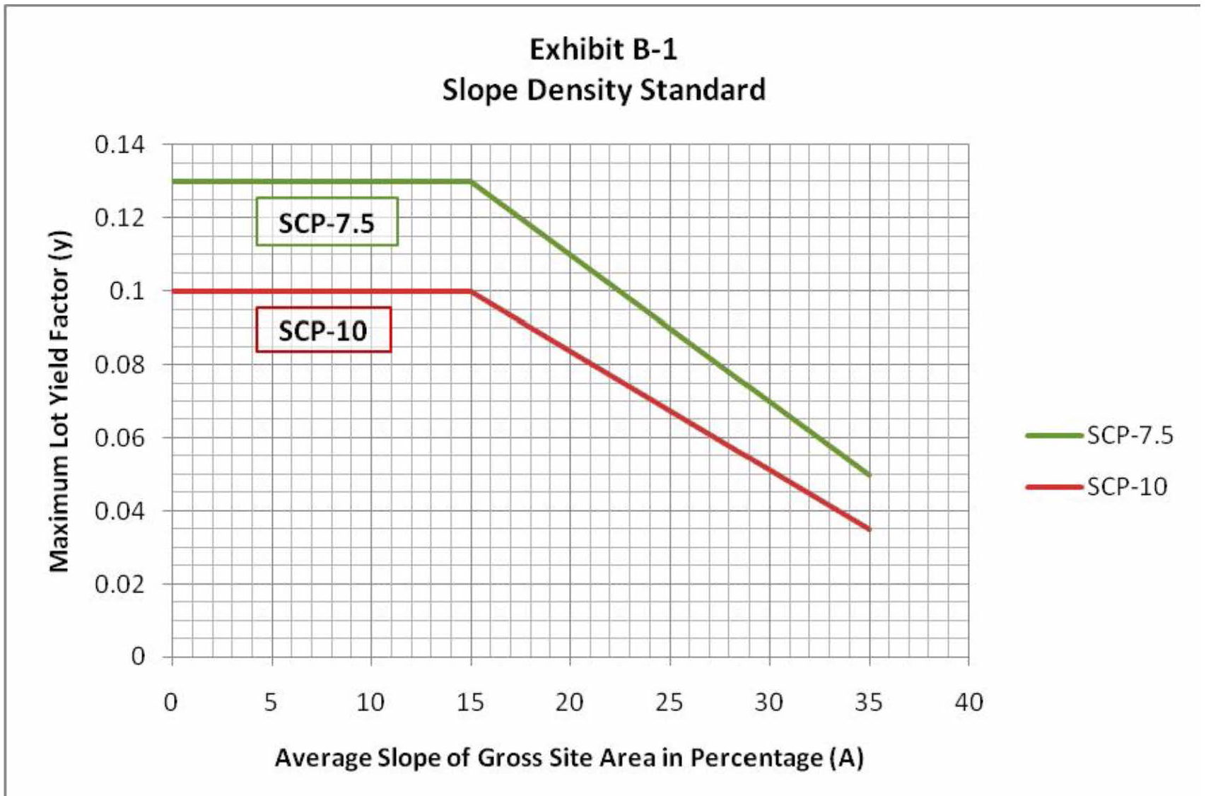
(1975 Code, § 9-2.504) (Ord. 1980-291, effective 9-11-80; Am. Ord. 1999-494, effective 3-25-99; Am. Ord. 2012-553, effective 8-23-12; Am. Ord. 2017-589, effective 8-24-17)
Sec. 153.415 - Development standards.
(A)
That portion of a lot or parcel which has a ground slope in excess of 35 percent shall not be altered in any way by grading, the removal or alteration of natural features, such as streams, rock outcrops, ridgelines, drainage swales, the removal of natural vegetation, or any activity related to the preparation of the site for development purposes, except:
(1)
As may be required in the interests of public safety, such as the provision of fire trails, the removal of poisonous or noxious plants, the controlled removal or thinning of vegetation as a part of a fire protection program approved by the Town Fire Marshal, the correction or stabilization of a geologic or seismic hazard, or for other public safety purposes as approved by the Planning Commission;
(2)
The provision of trails or a portion of a trail comprising a component of the Town's trail system designated by the General Plan; and
(3)
Within the Glens, a tiered approach shall be implemented to allow for the consideration of improvements consistent with the Architectural and Site Review Evaluation Criteria contained in Section 153.911, on a ground slope in excess of 35 percent on parcels constrained by slope and/or lot size, as follows:
(a)
Minor landscape improvements and infrastructure (e.g., walking steps (up to four-feet in width), non-load bearing retaining walls, and utility pipes) shall be reviewed by the Planning Director;
(b)
Minor improvements (i.e., a new garage less than or equal to 440 square feet) shall be reviewed by the Planning Director;
(c)
Minor improvements (i.e. new building, other than a garage, ≤ 400 square feet) shall be reviewed by the Planning Director, with notification of all adjacent neighbors;
(d)
Major improvements (i.e., new building greater than 440 square feet and less than 2,000 square feet) shall be reviewed by the ASRB; and,
(e)
Major development (i.e., new building equal to or exceeding 2,000 square feet) shall be required by the Planning Commission as a Variance pursuant to Section 153.940.
(f)
The reviewing body for new work not specifically covered in (a)—(d) above, or serial work, shall be at the discretion of the Planning Director.
(B)
Sites with at least 12.5 percent net average slope are required to maintain a portion of the lot in natural state. This calculation uses the net site acreage when all areas with slopes in excess of 35 percent are removed, defined below by the variable (N). Net average slope for this calculation is defined by the formula:
S [N] = (0.00229*I*L)/N
Where,
S [N] = net average slope in percent
I = Contour interval in feet
L = Combined length of the contour lines in feet; and
N = The net area in acres of the parcel or lot when all areas with slopes in excess of 35 percent are removed. The following table indicates the minimum percent of the ground surface which shall remain in a natural state with no grading, terrain alteration, keeping of livestock, or removal of natural vegetation, dependent on the net average slope of the property:
(C)
New or replacement vegetation in areas exceeding 35 percent, including planting for erosion control or land stabilization, shall be native to the surrounding area.
(D)
No building or structure, other than a fence, may be located on a natural ground slope exceeding 35 percent.
(E)
No septic tank drainfield may be located on a natural ground slope exceeding 35 percent.
(F)
If no portion of a lot or parcel contains slopes of less than 35 percent, and the site consists of a lot of record legally created in accordance with applicable regulations of the Town at the time of the creation of the lot, one dwelling unit and those accessory uses permitted in the zoning district may be permitted on such site provided the proposed method of building and site preparation conforms with recommendations acceptable to the Town contained in a geologic and/or soil investigation report by a qualified engineering geologist, and provided the other requirements of this chapter are met.
(G)
No building shall be located on a ridge visible from a scenic highway or road where the building will be silhouetted against the sky, unless there is no other location on the site which can accommodate a building consistent with all other regulations and constraints applicable to the district in which the site is located, and a determination of such fact is made by the Architectural and Site Review Board. The Architectural and Site Review Board shall review the design of all buildings and structures on any ridge visible from a scenic highway or road.
(1975 Code, § 9-2.505) (Ord. 1980-291, effective 9-11-80; Am. Ord. 1999-494, effective 3-25-99; Am. Ord. 2012-553, effective 8-23-12; Am. Ord. 2017-589, effective 8-24-17; Am. Ord. 2020-604, § 2(Exh. A), effective 2-27-20)
Sec. 153.416 - Natural state reclamation.
Previously disturbed areas may be returned to natural state through restorative grading and native planting, as recommended by a qualified biological consultant or landscape architect or Town biologist, and at the discretion of the Planning Director—with a focus including comparative habitat quality and diminishment of habitat fragmentation. Reclaimed natural state areas shall not contain permanent irrigation. Any temporary irrigations, required for the establishment of native plantings, must be installed above ground and removed immediately after establishment is complete. Upon completion, the biological consultant or landscape architect shall certify, in writing, that the natural state reclamation was performed in accordance with his or her recommendations.
(Ord. 2020-612, § 2(Exh. A), effective 10-22-20)
Sec. 153.421 - Purposes.
The purposes of this subchapter are:
(A)
To establish detailed requirements and procedures for evaluating and reviewing building construction, site development, land divisions, and subdivisions to assure that geologic hazards are considered as a part of the approval of each building site in order that potential loss of life and property is minimized; and
(B)
To comply with state statutes which require the Town to review and approve certain real estate developments, buildings, and structures within special seismic study zones established by the state.
(C)
To establish regulations for maintenance, alteration, or repair of nonconforming structures in geologic hazard areas which are nonconforming because of their location within earthquake fault setback zones, to assure that potential impacts to public health, safety, and welfare are addressed; and
(D)
To provide safeguards to prevent undue hazards to property, the environment, and public health, welfare, and safety in connection with use of lands within geologic hazard areas; and
(E)
To mitigate risk associated with geologic hazard areas, not to act as a guarantee that the hazard risk will be eliminated, nor as a guarantee that there is a higher hazard risk at any location. Unless otherwise provided, the geologic hazards regulations are in addition to generally applicable standards provided elsewhere in the Woodside Municipal Code.
(1975 Code, § 9-2.601) (Ord. 1980-291, effective 9-11-80; Am. Ord. 1999-494, effective 3-25-99; Am. Ord. 2017-589, effective 8-24-17; Am. Ord. 2020-608, § 2, effective 4-23-20)
Sec. 153.422 - Required approval.
The Planning Director and the Town Engineer, or their designated representatives, shall review all applications in geologically hazardous areas for planning permits, subdivisions, land divisions, and building permits and all data submitted to determine that all applicable provisions of this subchapter are complied with. Such applications shall be referred to the Town Geologist for review and recommendation.
(1975 Code, § 9-2.602) (Ord. 1980-291, effective 9-11-80; Am. Ord. 1999-494, effective 3-25-99; Am. Ord. 2017-589, effective 8-24-17)
Sec. 153.423 - Building site review.
(A)
Applications shall be reviewed by the Town Geologist to determine if the lot may be developed with reasonable safety from geologic hazards. The review shall include the evaluation of possible effects on the site and on nearby roads and properties. The Town Geologist, within 14 days after his/her receipt of the application, shall notify the applicant through the Planning Director of the results of his/her review and suggest areas of concern to be included in the forthcoming geologic reports to the applicant's geologist.
(B)
Where geologic hazards are identified on or near the site, special measures shall be recommended by the landowner or applicant's soils engineer and geologist to mitigate the hazards. Such measures shall be approved by the Town Engineer and Town Geologist.
(C)
Appeals of administrative decisions shall be filed in accordance with the procedures set forth in Section 153.970 of this chapter.
(1975 Code, § 9-2.603) (Ord. 1980-291, effective 9-11-80; Am. Ord. 1999-494, effective 3-25-99; Am. Ord. 2017-589, effective 8-24-17)
Sec. 153.424 - Seismic safety.
(A)
Special building setback lines. Special buildingsetback lines are established along fault traces to minimize the potential loss of life and property resulting from movement along fault traces. See Section 153.005 for definitions of known or inferred fault traces.
(B)
Setback and building requirements.
(1)
No building for human occupancy shall be constructed within 50 feet of a fault trace identified as a known fault trace.
(2)
No building for human occupancy shall be constructed within 125 feet of an inferred fault trace. If a site specific Fault Investigation Report demonstrates that no known fault trace exists within 50 feet of the building site, the Town Geologist may waive or modify the setback requirements.
(3)
The setback from a fault trace shall be measured at right angles from all points along the trace to the closest part of the building or structure to the trace.
(4)
Additional or reduced setbacks may be required or allowed from secondary fault zone features by the Town Geologist based on the results of a site specific Fault Investigation Report.
(1975 Code, § 9-2.604) (Ord. 1980-291, effective 9-11-80; Am. Ord. 1999-494, effective 3-25-99; Am. Ord. 2017-584, effective 4-13-17; Am. Ord. 2017-589, effective 8-24-17; Am. Ord. 2020-608, § 2, effective 4-23-20)
Sec. 153.425 - Procedures and permit issuance.
The following procedures shall be followed by the Town staff in processing applications for development under this subchapter:
(A)
The Town staff shall initially review all applications in relation to specific requirements and problems related to geologic hazards.
(B)
If the lot meets acceptable standards and the Town requirements and poses no geologic hazard to development and use in accordance with applicable laws, ordinances, and policies the lot may be approved as having a building site, subject to all other applicable provisions of this chapter and code.
(C)
If the lot does not meet applicable standards and requirements, and the Town Geologist finds that geologic hazards pose a problem to development, and if, in the opinion of the Town Engineer and Town Geologist, the corrective measures are not sufficient as recommended by the applicant's soils engineer and geologist, the staff shall not approve the development.
(1975 Code, § 9-2.605) (Ord. 1980-291, effective 9-11-80; Am. Ord. 1999-494, effective 3-25-99; Am. Ord. 2017-584, effective 4-13-17; Am. Ord. 2017-589, effective 8-24-17)
Sec. 153.426 - Plans and reports.
(A)
All geologic reports required under this chapter shall be prepared by a geologist and/or engineering geologist certified and/or registered in the state. All geotechnical engineering reports shall be prepared by a qualified geotechnical engineer registered as a civil engineer in the state.
(B)
The geologist and/or engineering geologist who compiled the report shall certify on the final plans that the structure conforms with the recommendations made in the report.
(C)
Geologic and soils reports shall include all calculations, data, and material supporting the recommendations in the report.
(D)
Reports on geologic hazards shall be prepared in accordance with guidelines established by the Town.
(1975 Code, § 9-2.606) (Ord. 1980-291, effective 9-11-80; Am. Ord. 1999-494, effective 3-25-99; Am. Ord. 2017-589, effective 8-24-17; Am. Ord. 2020-608, § 2, effective 4-23-20)
Sec. 153.427 - Nonconforming structures and buildings in fault setback zones.
This Section applies to structures and buildings for human occupancy. Structures or buildings that are nonconforming because they are located within fault setback zones shall not be altered in any way that would increase or create an additional nonconforming attribute, except as authorized in this section.
(A)
Structures and buildings within fault setbacks that cross a fault trace may not be enlarged, but may be maintained or altered provided:
(1)
Any work performed does not create any additional habitable space within the structure, including reconfiguring existing space, including attics, to add additional bedrooms; and
(2)
That the construction work incorporate seismic strengthening to increase structural safety as recommended by the Building Official and Town Geologist as being reasonably commensurate with the work subject to the building permit; and
(3)
That the amount of proposed work does not exceed the 50 percent threshold as set forth in Section 150.01(J). In the event the proposed work does exceed the 50 percent threshold, then the applicant shall follow the procedures for new building development in geologic hazard areas, as set forth above in this subchapter.
(B)
Structures and buildings located within fault setbacks, whether partially or completely, that do not cross a fault trace may be maintained, altered, remodeled, and may be enlarged once by up to 500 square feet so long as such increase in floor area shall not cause the structure or building to exceed the floor area limits of the zoning ordinance in effect at the time of the application, and further provided:
(1)
That the construction work incorporate seismic strengthening as recommended by the Building Official and Town Geologist as being reasonably commensurate with the work subject to the building permit; and
(2)
Any enlargement shall be located on the side of the structure or building that is furthest from the fault trace; and
(3)
Any enlargement shall be single story constructed at grade level; basement and second story enlargements are prohibited.
(C)
The process for approving any allowable alterations as set forth in subsections (A) and (B), above, is as follows:
(1)
A building permit for the proposed alterations shall be obtained. A site specific Fault Investigation Report, consistent with the requirements of Section 153.426, must be submitted as part of the building permit application.
(2)
The Planning Director and the Building Official, or their designated representatives, shall review all applications for alterations to structures or buildings, and all data submitted to determine compliance with all applicable provisions of this section. Such applications shall be referred to the Town Geologist for review and recommendation.
(3)
The permit shall be reviewed and approved in accordance with current codes and ordinances that would be applicable if the structure were conforming. Recommendations in the Fault Investigation Report and those made by the Town Geologist must be incorporated into any building permit approval.
(4)
A development entitlement requiring a public hearing (e.g., Design Review, Variance, Exception) shall be obtained if required for the specific project. A site-specific Fault Investigation Report must be submitted as part of the entitlement application for preliminary review by the Building Official and Town Geologist.
(Ord. 2020-608, § 2(Exh. A), effective 4-23-20)
Sec. 153.428 - Liability.
Approval of an application for a building permit or other development on land subject to this subchapter shall not imply any liability on the part of the Town for any subsequent damage due to earthquakes and faulting. Prior to the issuance of a building permit or other approval, a waiver of damages and an indemnity and hold harmless agreement shall be required which releases the Town from all liability for any damages resulting from the development approved by the Town's decision. The form of the agreement shall be approved by the Town and executed prior to commencement of construction or site alteration.
(Ord. 2020-608, § 2(Exh. A), effective 4-23-20)
Sec. 153.431 - Purpose.
(A)
This subchapter is adopted to promote and enhance a superior community environment, to maintain the rural character, to maintain air quality and ecologic balance, to maintain property values, and to ensure the maximum preservation of the valuable natural features and scenic character as stated in the General Plan of the Town by establishing minimum standards and requirements relating to the protection of trees.
(B)
It is intended that this subchapter be administered with the foregoing purposes in mind and specifically so as to:
(1)
Ensure, insofar as practical in permitting development of land and minimizing fire hazard, the maximum retention of natural vegetation to aid in protection against erosion of top soil, preservation of natural scenic qualities and healthy ecosystems of the Town through good conservation practices, protection from flooding or landslides, noise absorption, and in providing habitat, shade and color; and
(2)
Protect mature trees and significant stands of trees in order to retain as many as possible consistent with the purposes set forth herein and also consistent with reasonable economic enjoyment of private property. In this context, privately owned trees have an impact on the quality of life for the entire community.
(Ord. 2006-534, effective 1-11-07)
Sec. 153.432 - Applicability.
The provisions of this section apply to those activities set forth in Section 153.434.
(Ord. 2006-534, effective 1-11-07; Am. Ord. 2017-589, effective 8-24-17)
Sec. 153.433 - Emergencies.
In case of emergency, when a significant tree is hazardous or dangerous to life or property, it may be trimmed or removed by order of the Town Manager or his/her designee.
(Ord. 2006-534, effective 1-11-07; Am. Ord. 2017-589, effective 8-24-17)
Sec. 153.434 - Permit—Required.
No person shall engage in tree destruction without first obtaining a permit.
(Ord. 2006-534, effective 1-11-07; Am. Ord. 2017-589, effective 8-24-17)
Sec. 153.435 - Permit—Application.
(A)
Each application for a tree destruction permit shall be made by the owner of the property or by the owner's authorized agent to the Town's Planning and Building Department on the form furnished for that purpose. Such application shall be accompanied by the following items:
(1)
A sketch of the site depicting the location of the significant trees included in the permit application, including relative proximity to structures, property lines, easements, other trees and other relevant features;
(2)
Description of the significant trees, including species, size, health, and general condition; and
(3)
Photograph of existing site with the significant trees clearly marked with orange ribbon that will remain on the tree throughout the permitting process.
(B)
The Planning Director may require an arborist report to be submitted if the information submitted by the applicant is insufficient to determine the health of the significant trees or any danger the significant trees may pose. In such cases, the Planning Director shall, within ten days, send a letter to the applicant listing the specific application deficiencies that led to the requirement of an arborist report.
(Ord. 2006-534, effective 1-11-07; Am. Ord. 2017-589, effective 8-24-17)
Sec. 153.436 - Permit—Application review.
(A)
The Planning Director shall review the application according to the following criteria and grant the permit if any of these following criteria apply to the significant trees.
(1)
They are significantly diseased and at risk of dying, transmitting disease to other trees, or falling down;
(2)
They are a potential hazard to people or structures for other reasons, including but not limited to weak root structure, leaning, and decay;
(3)
Significant trees may be removed as may be required to permit construction authorized by a valid building or grading permit which specifies such removal;
(4)
Thinning (removal of select significant trees) is recommended by a certified arborist for the health of the remaining trees or by the Woodside Fire Protection District for fire protection; or
(5)
They are Eucalyptus, Acacia or Monterey Pine, and are not designated as a landmark.
(B)
Factors in addition to the above that may be considered in support of a denial include, but are not limited to, size of the significant trees, number of trees remaining on the lot, number of same species trees in close proximity whose removal would significantly impact the surrounding ecosystem, timing of the cut, and potential for excessive and unnecessary scarring of the natural landscape through removal of vegetation. The Planning Director may issue a permit but require that the removal be delayed for reasons including, but not limited to, habitat preservation and avoiding damage to other trees. The Planning Director may also require tree replacement, as provided in Section 153.438.
(C)
The Planning Director may refer the matter to the Town's Conservation and Environmental Health Committee or the Town's Architectural and Site Review Board (ASRB) for a recommendation. In such cases, the Planning Director shall, within ten days, send a letter to the applicant listing the circumstances that led to the referral. If the Planning Director refers the matter to the ASRB, all neighbors with properties adjacent to the property on which the significant trees are located shall be notified in writing in advance of the meeting.
(Ord. 2006-534, effective 1-11-07; Am. Ord. 2017-589, effective 8-24-17)
Sec. 153.437 - Protection of significant trees during site development and construction.
(A)
The following provisions shall be adhered to during site development and construction.
(1)
Precautions during site development and construction, including at least the following:
(a)
A fence shall be placed around the drip line of the significant trees insofar as is practical prior to any work, and no construction activities shall be carried out within the drip line except as allowed by the permit;
(b)
Permits for construction within a drip line of any significant trees shall include: provisions for hand trenching within the drip line; construction of approved tree wells to protect against fill; prohibition of grading, cuts, and fills within four feet of a tree base; review of any cutting or trimming, or those provisions recommended by a certified arborist; and
(c)
Appropriate signage must be posted on the fence protecting the significant trees during construction. The sign shall clearly state the purpose of the fence and that machinery and materials are not to be stored within the fenced areas, and work is to occur in the fenced areas only under the supervision of a certified arborist.
(2)
Measures to effect erosion control, soil and water retention and limitation of adverse environmental effects.
(B)
The above protective measures are minimum requirements, and the Planning Director may require additional protection measures if the conditions of the site, development, or construction so dictate to protect significant trees.
(Ord. 2006-534, effective 1-11-07; Am. Ord. 2017-589, effective 8-24-17)
Sec. 153.438 - Replacement of significant trees.
When tree replacement is required by the Planning Director, the replacement trees shall be a California native tree species and be planted as near as possible to the original location, unless practical reasons preclude this option. Replacement trees will be of at least a 36-inch box or other minimum size as specified by the Planning Director. Replacement trees shall be planted within one year of removal or, in the case of removal to accommodate construction, prior to final inspection.
(Ord. 2006-534, effective 1-11-07)
Sec. 153.439 - Violations—Penalty.
(A)
Any person or property owner violating provisions of this subchapter with respect to the protection of significant trees that is not fully cured within 20 days shall be required to:
(1)
Replace all affected significant trees in accordance with the provisions of Section 153.438.
(2)
Pay the following fines:
(a)
$5,000.00 for the first significant tree;
(b)
$7,500.00 for the second significant tree; and
(c)
$10,000.00 for each additional significant tree.
(B)
The amounts and conditions for these fines may be changed from time to time by the Town Council by resolution.
(C)
The penalties identified in this subsection are in addition to those identified in Chapter 10 of the Woodside Municipal Code.
(Ord. 2006-534, effective 1-11-07; Am. Ord. 2017-589, effective 8-24-17)
Sec. 153.441 - Purposes.
The purposes of this subchapter are:
(A)
To retain major stream corridors in their natural state consistent with the objectives of the General Plan;
(B)
To retain the scenic aspects of the corridor from streamside and adjacent properties;
(C)
To protect fish, riparian vegetation, and wildlife habitat;
(D)
To minimize landslides, erosion, siltation, and sedimentation;
(E)
To provide for natural drainage;
(F)
To protect water quality and stream ecosystems; and
(G)
To eliminate or minimize potential flood damages.
(1975 Code, § 9-2.801) (Ord. 1980-291, effective 9-11-80; Am. Ord. 1999-494, effective 3-25-99; Am. Ord. 2017-589, effective 8-24-17)
Sec. 153.442 - Application.
The provisions of this subchapter are intended to apply to those areas designated as stream corridors on the General Plan diagram and other streams, creeks, and waterways as may be designated from time to time by the Planning Commission. For the purposes of this chapter, a stream or creek bank is defined as the point at which the break in slope occurs, and a stream corridor is defined as a horizontal distance of 50 feet, measured from each side of the center line of the stream, or a horizontal distance of 25 feet, measured from the top of the stream or creek bank, whichever is greater. The Planning Commission may establish greater horizontal measurements for specific stream corridors.
(1975 Code, § 9-2.802) (Ord. 1980-291, effective 9-11-80; Am. Ord. 1999-494, effective 3-25-99; Am. Ord. 2017-589, effective 8-24-17)
Sec. 153.443 - Uses permitted.
The following uses shall be permitted in the stream corridors designated on the General Plan and other streams, creeks, and waterways as may be designated by the Planning Commission:
(A)
Trails; and
(B)
Emergency flood control measures, subject to the approval of the Town Engineer.
(1975 Code, § 9-2.803) (Ord. 1980-291, effective 9-11-80; Am. Ord. 1999-494, effective 3-25-99; Am. Ord. 2017-589, effective 8-24-17)
Sec. 153.444 - Conditional uses.
The following uses shall be permitted if consistent with the stated purposes of this chapter and subject to the approval of a use permit by the Planning Commission:
(A)
Crop and tree farming;
(B)
Nurseries;
(C)
Bridges and roads;
(D)
Utility transmission lines;
(E)
Pastures; and
(F)
Other uses as determined by the Planning Commission to be of the same general character as those set forth in this section and which will not alter the natural upstream or downstream regimen or impair the current or potential uses of adjacent properties.
(1975 Code, § 9-2.804) (Ord. 1980-291, effective 9-11-80; Am. Ord. 1999-494, effective 3-25-99; Am. Ord. 2017-589, effective 8-24-17)
Sec. 153.445 - General limitations.
The following limitations shall apply to all uses in stream corridors:
(A)
No removal of riparian vegetation shall be permitted under this chapter within the stream corridor, except that required for the Permitted and conditional uses.
(B)
No filling of the natural stream corridors or dumping of slash, debris, residue from parking or recreation areas, fertilizers, pesticides, herbicides, or liquid or solid waste shall be permitted.
(C)
All agricultural wastes, including manure, shall be kept out of the stream corridor and disposed of in a manner which will prevent drainage from such wastes into the stream corridor.
(D)
No channelization or damming of streams or creeks shall be permitted, unless required or allowed by the Planning Commission.
(E)
Any alteration of, or work in, the stream corridor shall be subject to the approval of the Planning Commission except the work set forth in division (A) of this section or the removal of material which obstructs the normal flow of water within the stream channel.
(F)
No structure, including a fence, shall be permitted within the stream corridor. The cross fencing of the stream corridor shall be permitted subject to the issuance of a permit from the Town Engineer.
(1975 Code, § 9-2.805) (Ord. 1980-291, effective 9-11-80; Am. Ord. 1999-494, effective 3-25-99; Am. Ord. 2017-589, effective 8-24-17)
Sec. 153.501 - Purpose.
It is the purpose of this subchapter to protect each person's right to freedom of speech and expression while reasonably regulating the display of identification, directional, advertising, and temporary signs to assure the following objectives:
(A)
To protect the public health, safety and welfare;
(B)
To preserve the natural beauty and resources of the Town and to maintain its essentially rural residential character;
(C)
To maintain the attractive aesthetic quality of the Town by encouraging signs which are:
(1)
Well designed, clearly legible, and visually pleasing; and
(2)
Adequate but not excessive in size or design for their intended purpose;
(D)
To protect the scenic amenities and corridors adjacent to the Town's roads by prohibiting the erection or construction of outdoor advertising signs or displays on either public or private property, except as provided for in this chapter;
(E)
To protect office and commercial uses from the loss of visual identity resulting from poorly designed or excessive signs on nearby sites; and
(F)
To identify businesses in a manner which is harmonious with an aesthetic and functional Town commercial center.
(1975 Code, § 9-2.301) (Ord. 1980-291, effective 9-11-80; Am. Ord. 1999-494, effective 3-25-99; Am. Ord. 2017-589, effective 8-24-17; Ord. No. 2024-638, effective 7-25-24)
Sec. 153.502 - Signs permitted in all districts.
The following signs shall be permitted in all zoning districts:
(A)
Personal nameplates not exceeding one and one-half square feet in area;
(B)
Announcement signs or bulletin boards for public, charitable, or religious institutions provided such signs or bulletin boards shall be located on the premises of such institution and shall not exceed 12 square feet in area;
(C)
Signs advertising nonconforming businesses and industries provided such signs do not exceed 12 square feet in area; are attached flat against the wall of the building in which such nonconforming business or industry is located; and have been approved by the Architectural and Site Review Board as being in conformance with the goals of the General Plan and within the other applicable limitations of this chapter;
(D)
Warning signs and signals. Such signs may be illuminated by other than reflected light when required for the public safety or convenience, subject to the approval of the Planning Director,
(E)
Highway and traffic markers, road name signs, and such signs and markers as public utility companies by law may be required to display;
(F)
Commemorative symbols, memorial plaques, and historical tablets when placed by organizations or historical societies and when approved by the Planning Director;
(G)
Signs designating entrances, trespass, exits, or conditions of use of parking areas; providing, however, no single sign shall exceed eight square feet in area, and its location shall have been approved by the Planning Director;
(H)
Directional signs for public or quasi-public uses, such as those indicating the location of rest rooms, telephones, and underground utilities; provided, however, no individual sign shall exceed two square feet in area;
(I)
Signs indicating business hours, emergency telephone numbers, and credit cards and service station signs indicating gas prices; provided, however, no individual sign shall exceed one and one-half feet in area, and the total area of all such signs, at any single establishment, shall not exceed four square feet in area;
(J)
Bulletin or announcement boards attached to commercial and institutional buildings for posting personal or public notices not exceeding the size limitations established for the CC District; and
(K)
Flags of the United States and the State of California.
(1975 Code, § 9-2.302) (Ord. 1980-291, effective 9-11-80; Am. Ord. 1999-494, effective 3-25-99; Am. Ord. 2017-589, effective 8-24-17; Ord. No. 2024-638, effective 7-25-24)
Sec. 153.503 - Temporary signs.
(A)
Definitions.
COMMERCIAL SIGN. A sign advertising a business, service, or goods for sale, or that encourages commercial activity.
ELECTION SIGN. A sign that advocates for or against a particular candidate or item appearing on a ballot, a sign that encourages votes in a particular election, or a sign that otherwise references the date or occurrence of an election.
TEMPORARY SIGN. A sign which is not permanently affixed to the ground or structure and intended to be displayed for a temporary period, including but not limited to, signs related to events and political causes.
(B)
To maintain public safety, minimize debris from displacement of temporary signs by wind or other action, and to maintain the rural character and high aesthetic standards of the Town, temporary signs shall be permitted in all zoning districts subject to the following requirements:
(1)
Temporary signs shall not exceed 24 square feet in area per printed side.
(2)
Temporary signs may be freestanding or temporarily affixed to a building, structure, fence, or tree on private property. Freestanding temporary signs shall not be erected to exceed an overall height of eight feet from finished grade. A temporary sign affixed to building, structure, or fence shall not project above the height of the building, structure, or fence. Temporary signs affixed to trees on private property shall not exceed eight feet from grade.
(3)
Temporary commercial signs shall not be displayed in any zoning district other than the Community Commercial (CC) or Planned Community Commercial Districts (PCCD), except as otherwise provided in this section.
(4)
No temporary sign shall be placed or affixed on, or extend over public property, or be affixed to any traffic signal, street light, utility pole, utility pole guide-wire, mail box or traffic sign.
(5)
No temporary sign shall be placed within the public right-of-way, except that the owner or leaseholder of any parcel adjacent to public right-of-way may display temporary signs no closer than two feet from the paved driving surface of a roadway or sidewalk within the public right-of-way along their adjoining property line. Notwithstanding the foregoing, any temporary sign within the public right-of-way that blocks normal paths of travel or constitutes a hazard in the discretion of the Town Manager may be immediately moved or removed by the Town.
(6)
Temporary signs shall not block access to, or hinder use of, areas designated for public parking.
(7)
Temporary signs shall not be lighted directly and shall not be indirectly illuminated unless placed on or near a structure already providing said illumination.
(8)
No temporary sign shall be placed where it will obstruct or impede traffic visibility.
(9)
Temporary signs shall not be affixed to trees on public property or in the public right-of-way.
(10)
Temporary signs placed on private property must have the express consent of the property owner.
(11)
Election signs may not be displayed more than 90 calendar days prior to the election date or more than ten calendar days after the election date.
(12)
The Town Manager or designee shall have the right to immediately remove any temporary sign posted in violation of this section on public property or in the public right-of-way.
(C)
Signs advertising the sale or lease of property may be displayed only on the property for sale or lease and shall not exceed six square feet in area for each lot or parcel advertised. Signs advertising the sale or lease of more than one lot or parcel shall not exceed an aggregate of 50 square feet in area. However, no individual sign shall be larger than 12 square feet. A renewable permit valid for six months, with a maximum of a six-month extension, shall be secured from the Planning Director prior to placement; and
(D)
One sign not exceeding six square feet in area may be placed on each commercial, institutional, or residential construction project authorized by a valid building permit. Such signs shall be removed upon the completion of the project, and responsibility for the maintenance and removal thereof shall be that of the property owner.
(1975 Code, § 9-2.303) (Ord. 1980-291, effective 9-11-80; Am. Ord. 1999-494, effective 3-25-99; Am. Ord. 2017-589, effective 8-24-17; Ord. No. 2024-638, effective 7-25-24)
Sec. 153.504 - Sign permits and design review.
Except as otherwise specified, all non-temporary signs in the CC District shall require the issuance of a sign permit. The design and placement of signs permitted in the CC District, and signs advertising permitted nonconforming uses in the residential districts, shall be reviewed in accordance with Sections 153.911 through 153.918 of this chapter prior to the issuance of a permit for the installation, construction, or erection of any such sign. A separate sign permit is not required for signs installed, constructed, or erected pursuant to a sign program included within an approved use permit.
(1975 Code, § 9-2.304) (Ord. 1980-291, effective 9-11-80; Am. Ord. 1999-494, effective 3-25-99; Am. Ord. 2015-569, effective 1-7-16; Am. Ord. 2017-589, effective 8-24-17; Ord. No. 2024-638, effective 7-25-24)
Sec. 153.505 - Signs permitted in the community commercial district.
The following signs shall be permitted in the Community Commercial District:
(A)
A maximum of two permanent identification signs pertaining to a use conducted on the site. The total aggregate sign area permitted for any individual site shall be calculated as follows:
(1)
One and one-half square feet of sign area for each linear foot of building frontage, not to exceed a maximum area of 32 square feet; or
(2)
A maximum of 13 percent of the total area of the front building elevation, not to exceed 32 square feet in area; and
(B)
Any sign permitted by Section 153.502.
(1975 Code, § 9-2.305) (Ord. 1980-291, effective 9-11-80; Am. Ord. 1999-494, effective 3-25-99; Am. Ord. 2017-589, effective 8-24-17; Ord. No. 2024-638, effective 7-25-24)
Sec. 153.506 - General requirements.
The following regulations shall apply to all signs :
(A)
Signs, except personal nameplates, house numbers, and all signs permitted under Section 153.502, shall be attached to a building wall suspended from the eaves or soffit or from the ceiling of a covered walkway. Such signs shall not project more than three feet from the face of the building and shall not be less than seven feet above the ground level.
(B)
Signs shall not extend laterally beyond the building wall to which they are mounted, except when the Planning Commission determines that the sign is an integral part or feature of the building structure or design.
(C)
Signs shall not project beyond any property line.
(D)
Floodlights, flags, banners, and objects which rotate or move by wind action shall not be permitted, except for national or state flags flown with the flag of the United States of America.
(E)
No sign, with the exception of barber poles, shall contain visibly moving parts or simulate movement by means of fluttering, spinning, or reflecting devices.
(F)
No sign shall have blinking or flashing lights or any other illuminating device which has a changing or alternating light intensity, brightness, or color.
(G)
signs may be illuminated only by a light source reflecting off the sign. The intensity of the light source shall be approved by the Planning Director.
(H)
No sign shall be erected or maintained which is designed or illuminated so that it resembles or may be mistaken for a traffic light or signal.
(I)
Freestanding facility identification signs outside of the Community Commercial District for open space, institutional, and quasi-public uses shall not exceed 12 square feet, and no more than two signs are permitted.
(1975 Code, § 9-2.306) (Ord. 1980-291, effective 9-11-80; Am. Ord. 1999-494, effective 3-25-99; Am. Ord. 2017-589, effective 8-24-17; Am. Ord. 2017-591, effective 12-14-17; Ord. No. 2024-638, effective 7-25-24)
Sec. 153.507 - Holiday displays.
Holiday lighting and holiday displays, which do not advertise any product or sale, may be displayed on private property in any zoning district, provided they are erected no earlier than 31 days prior to the holiday and are removed no later than 14 days after the holiday.
(Ord. 2002-516, effective 12-26-02; Am. Ord. 2017-589, effective 8-24-17; Ord. No. 2024-638, effective 7-25-24)
Cross reference— Penalty, § 153.999.
Sec. 153.601 - Purpose.
(A)
The purpose of this section is to reasonably regulate, to the extent permitted under California and federal law, the installations, operations, collocations, modifications, replacements and removals of various wireless communications facilities ("WCFs") in the Town recognizing the benefits of wireless communications while reasonably respecting other important Town needs, including the protection of public health, safety, and welfare, aesthetics and local values.
(B)
The overarching intent of this section is to make wireless communications reasonably available while preserving the essential rural character of the Town. This will be realized by minimizing the visual and physical effects of WCFs through appropriate design, siting, screening techniques and location standards.
(C)
It is not the purpose or intent of this section to:
(1)
Prohibit or to have the effect of prohibiting wireless communications services; or
(2)
Unreasonably discriminate among providers of functionally equivalent wireless communications services; or
(3)
Regulate the placement, construction or modification of WCFs on the basis of the environmental effects of RFemissions where it is demonstrated that the WCF does or will comply with the applicable FCC regulations; or
(4)
Prohibit or effectively prohibit collocations or modifications that the Town must approve under state or federal law.
(D)
The provisions in this section shall apply to all permit applications to install, operate or change, including, without limitation, to collocate, modify, replace or remove, any new or existing wireless tower or base station within the Town. This section does not apply to WCFs owned by or exclusively operated for government agencies, amateur radio stations, satellite dish or other television antennas or other OTARD antennas, or towers as defined and governed by Chapter 153, except to the extent that such towers may be used to support WCFs.
(E)
Nothing in this section is intended to allow the Town to preempt any state or federal law or regulation applicable to a WCF.
(F)
The provisions of this section are in addition to, and do not replace, any obligations a WCF permit holder may have under any franchises, licenses, or other permits issued by the Town.
(Ord. 2001-510, effective 6-7-01; Am. Ord. 2017-589, effective 8-24-17; Am. Ord. 2020-607, § 2(Exh. A), effective 3-26-20)
Sec. 153.602 - Definitions and acronyms.
For the purposes of this section, certain terms shall have meanings as follows:
ANTENNA. A device used to transmit and/or receive radio or electromagnetic waves such as but not limited to panel antennas, reflecting discs, panels, microwave dishes, whip antennas, directional and non-directional antennas consisting of one or more elements, multiple antenna configurations, or other similar devices and configurations.
ANTENNA ARRAY. Two or more antennas having elements extending in one or more directions, and directional antennas mounted upon and rotated through a vertical mast or tower interconnecting the beam and antenna support, all of which are elements deemed to be part of the antenna.
APPLICANT. The owner(s) or the owner's agent of property upon which wireless communications facilities are proposed to be located. In instances where wireless communication facilities are proposed to be located on public right-of-way, the applicant is the carrier or entity which will operate the facility or the newly added components of the Facility upon its completion.
BASE STATION. The transmission equipment and non-tower support structure at a fixed location that enable FCC-licensed or authorized wireless communications between user equipment and a communications network. A "non-tower support structure" means any structure (whether built for wireless purposes or not) that supports wirelesstransmission equipment under a valid permit at the time the applicant submits its application.
CAMOUFLAGED or CONCEALED WCF. A wireless communications facility that (i) is integrated as an architectural feature of an existing structure such as (but not limited to) a cupola, or (ii) is integrated in an outdoor fixture such as (but not limited to) a flagpole; or (iii) uses a design and paint which mimics and is con-sistent with nearby natural, or architectural features, or is incorporated into or replaces existing permitted facilities (including but not limited to stop signs or other traffic signs or freestanding light standards) so that the presence of the WCF is not readily apparent due to its design and/or color.
CARRIER. A wireless communications service provider licensed by the FCC and/or by the California Public Utilities Commission.
CODE. The Woodside Municipal Code.
COLLOCATION. The placement or installation of transmission equipment on an existing wireless tower or base station for the purpose of transmitting or receiving radio frequency signals for communications purposes.
CPUC. The California Public Utilities Commission.
DISTRIBUTED ANTENNA SYSTEM or DAS. A network of one or more antennas and related fiber optic nodes typically mounted to streetlight poles, or utility poles, which provide access and signal transfer for wireless service providers. A DAS also includes the equipment location, sometimes called a "hub" or "hotel" where the DAS network is interconnected with one or more wireless service provider's facilities to provide the signal transfer services.
FCC. The Federal Communications Commission.
OTARD ANTENNAS.Antennas covered by the "over-the-air reception devices" rule in 47 C.F.R., sections 1.4000 et seq., as may be amended or replaced from time to time.
OUTDOOR FIXTURE. Any wall (Excluding any retaining wall 18 inches or less in height), utility box, fence, gate, column, pillar, post, flag pole, light post or similar lighting fixture (excluding any standard mail box), either freestanding or incorporated into a fence or wall.
PLANNING DIRECTOR. The Director of the Planning Department of the Town of Woodside, California, or the designee of the Director.
PUBLIC PROPERTY. Property owned or under the control of the Town and specifically excludes the Town'srights-of-way. By way of example and not limitation, public property includes structures and outdoor fixtures owned by the Town, including those structures and fixtures in rights-of-way.
PUBLIC WORKS DIRECTOR. The Director of Public Works of the Town of Woodside, California, or his or her designee.
RF or RF EMISSIONS. Radio frequency emissions.
RIGHT(S)-OF-WAY. The public streets and rights-of-way.
SECTION 6409(A).Section 6409(a) of the Middle Class Tax Relief and Job Creation Act of 2012, codified as 47 U.S.C. section 1455(a), as may be amended or interpreted in judicial or administrative decisions.
SECTION 6409(A) MODIFICATION. A collocation or modification of transmission equipment at an existing wireless tower or base station that does not result in a substantial change in the physical dimensions of the existing wireless tower or base station. For the purposes of a Section 6409(a) Modification, the term "substantial change" means:
(1)
For wireless towers outside the public right-of-way:
(a)
The proposed collocation or modification increases the overall height more than ten percent or the height of one additional antenna array more than 20 feet (whichever is greater);
(b)
The proposed collocation or modification increases the width more than 20 feet from the edge of the wireless tower or the width of the wireless tower at the level of the appurtenance (whichever is greater); or
(c)
The proposed collocation or modification involves excavation outside the current boundaries of the leased or owned property surrounding the wireless tower, including any access or utility easements currently related to the site.
(2)
For wireless towers within the public right-of-way and for all base stations:
(a)
The proposed collocation or modification increases the overall height more than ten percent or ten feet (whichever is greater);
(b)
The proposed collocation or modification increases the width more than six feet from the edge of the wireless tower or base station; or
(c)
The proposed collocation or modification involves excavation outside the area in proximity to the structure and other transmission equipment already deployed on the ground.
(3)
For all proposed collocations and modifications:
(a)
The proposed collocation or modification involves more than the standard number of new equipment cabinets for the technology involved, but not to exceed four equipment cabinets;
(b)
The proposed collocation or modification would defeat the concealment elements of the support structure; or
(c)
The proposed collocation or modification violates a prior condition of approval, provided however that the collocation need not comply with any prior condition of approval that is inconsistent with the thresholds for a substantial change described in this section.
(d)
The proposed collocation or modification involves excavation outside of the existing leased or licensed area upon which the existing WCF sits, and/or excavation outside of the existing pad upon which ground mounted equipment is affixed. The thresholds and conditions for a "substantial change" described in this section are disjunctive—the violation of any individual threshold or condition results in a substantial change. The height and width thresholds for a substantial change described in this section are cumulative for each individual wireless tower or base station. The cumulative limit is measured from the physical dimensions of the original structure for base stations and all sites in the public rights-of-way, and from the smallest physical dimensions that existed on or after February 22, 2012, for wireless towers on private property.
SMALL CELL. A WCF which meets each of the following conditions:
(1)
The support structure or wireless tower on which the facility's antennas are mounted is:
(a)
Fifty feet or less in height;
(b)
No more than ten percent taller than adjacent structures; or
(c)
In the case of collocation, not extended to a height or more than ten percent above its height prior to the collocation; and
(2)
Each antenna is no more than three cubic feet in volume; and
(3)
All antenna equipment associated with the facility is cumulatively no more than 28 cubic feet in volume.
STRUCTURE. Anything constructed or erected that requires location on the ground or attached to something having location on the ground, but not including outdoor fixtures or hardscape. Examples of a structure include, but are not necessarily limited to, any dwelling, building, accessory dwelling unit, garage, carport, tool house, green house, pool house, satellite dish antenna, solar collector panel, tree house or other play structure, swimming pool, tennis court, play court, and deck. For purposes of this section, the definition of "structure" does not include utility poles or any other pole or structure otherwise defined within this Section 153.602.
SUPPORT EQUIPMENT. The physical, electrical and/or electronic equipment included within a wireless communications facility used to house, power, and/or process signals from or to the antenna or antennas but specifically excluding the base station.
SUPPORT STRUCTURE(S). A structure, outdoor fixture, tower, or utility pole capable of safely supporting a WCF, but does not necessarily include a wireless tower or base station.
TOLLING AGREEMENT. An agreement between the Town and an applicant proposing a new or modified WCF, which postpones the deadline to make a final determination on the permit application(s).
TOWN. The Town of Woodside, California.
TOWN COUNCIL. The Town Council of the Town of Woodside, California.
TRANSMISSION EQUIPMENT. Any equipment that facilitates transmission for any FCC-licensed or authorized wireless communication service, including, but not limited to, radio transceivers, antennas and other relevant equipment associated with and necessary to their operation, including coaxial or fiber-optic cable and associated conduit housing, and regular and backup power supply.
UTILITY BOX. Any transformer, switch box, telephone, cable television box, service panel, meter or similar device, either ground-mounted or mounted to a support structure.
UTILITY POLE. A steel or wood pole or structure located in the rights-of-way and dedicated to use by one or more utility providers.
WHIP ANTENNA. An omni-directional antenna.
WIRELESS. Any FCC licensed or authorized communication service transmitted over frequencies in the electromagnetic spectrum.
WIRELESS COMMUNICATIONS FACILITY or WCF. A facility used to "provide personal wireless services" as defined at 47 U.S.C. section 332(c)(7)(C); or wireless information services provided to the public or to such classes of users as to be effectively available directly to the public via licensed or unlicensed frequencies; or wireless utility monitoring and control services; or any other FCC licensed or authorized service. A WCF does not include a facility entirely enclosed within a permitted building outside of the rights-of-way where the installation does not require a modification of the exterior of the building; nor does it include a device attached to a building, used for serving that building only and that is otherwise permitted under other provisions of the code. A WCF consists of an antenna or antennas, including, but not limited to, directional, omni-directional and parabolic antennas, base station, support equipment, and (if applicable) a wireless tower. It does not include the support structure to which the WCF or its components is attached. The term does not include mobile transmitting devices used by wireless service subscribers, such as vehicle or hand held radios/telephones and their associated transmitting antennas, nor does it include other facilities specifically excluded from the coverage of this section.
WCF PERMIT. A Planning Department issued permit for a Wireless Communications Facility.
WIRELESS TOWER. Any structure built for the sole or primary purpose of supporting FCC-licensed antennas and their associated facilities. This does not include structures that were installed to replace or collocate upon existing power poles, light poles, energy transmission towers, or buildings. A support structure, which is modified or replaced to allow for the installation of transmission equipment, retains its prior use as its primary use, and the wireless use is only a secondary use thereof, even if the transmission equipment is the only attachment to the support structure.
(Ord. 2001-510, effective 6-7-01; Am. Ord. 2017-589, effective 8-24-17; Am. Ord. 2018-596, § 2(Exh. A, § I), effective 10-26-18; Am. Ord. 2020-607, § 2(Exh. A), effective 3-26-20)
Sec. 153.603 - Permitted use.
Subject to compliance with this section and other applicable provisions of this Code and other law, WCFs are a permitted use in all zoning districts, as defined in Section 153.101 of this Code.
(Ord. 2001-510, effective 6-7-01; Am. Ord. 2017-589, effective 8-24-17)
Sec. 153.604 - Permit required; permitting fees.
(A)
A WCF may not be installed, collocated or modified without a WCF permit, except as provided herein. Complete removal of a WCF does not require a permit under this section, but removal must be performed in strict compliance with this section and shall be subject to permit requirements from any applicable Building Code.
(B)
A WCF permit shall not be issued:
(1)
Unless the applicant shows that it has the necessary permission to place the WCF as proposed on private property or public property that it proposes to occupy (including the authority to make modifications to any support structure or wireless tower associated with the installation or modification); and
(2)
In the case of a WCF proposed to be located in whole or in part in the rights-of-way unless the applicant holds a franchise, license or similar authorization from the Town or the state that entitles it to occupy the rights-of-way to install or modify a WCF.
(C)
A WCF permit shall not be effective and shall not authorize installation, collocation or modification of any WCF or installation or modification of a support structure or wireless tower unless the conditions of this paragraph are satisfied. A WCF permit may be revoked prior to its effective date.
(1)
Applicant must obtain all other required permits, authorizations, approvals or declarations that may be required for installation or modification of the WCF or for installation or modification of the support structure under federal, state or local law, including but not limited to building permits, CEQA declarations, or FCC approvals. A WCF permit is not in lieu of any other permit required under the Code, except as specifically provided herein, nor is it a franchise, license or other authorization to occupy the rights-of-way, or a license, lease or agreement authorizing occupancy of any other private or public property. It does not create a vested right in occupying any particular location, and a WCF permit holder may be required to move and remove facilities at its expense consistent with other provisions of applicable law.
(2)
Applicant must provide proof to the Town that it has obtained all insurance and/or security required by the Code, and must pay any fees owed to the Town.
(D)
A WCF permit issued in error, based on incomplete or false information submitted by an applicant or that conflicts with the provisions of this section is not valid.
(E)
The applicant shall pay all applicable fees required herein or as enacted by the Town Council prior to the issuance of a WCF permit.
(F)
An existing WCF that did not previously receive approval of a WCF permit, but received a Conditional Use Permit (CUP), the CUP shall be considered the WCF permit and any imposed expiration date on the CUP shall be replaced with any expiration dates outlined in this chapter for WCF permit.
(Ord. 2001-510, effective 6-7-01; Am. Ord. 2014-564, effective 12-1-14; Ord. 2017-589, effective 8-24-17; Am. Ord. 2020-607, § 2(Exh. A), effective 3-26-20)
Sec. 153.605 - Application required; contents of WCF permit application.
(A)
In all cases an applicant for a WCF permit shall utilize the form of application required by the Town. The Planning Director is authorized to prepare application forms and submittal checklists, and may develop application forms that distinguish between different types of installations and modifications in order to streamline processing of applications, and to comply with legal requirements. These generally applicable requirements shall be available for review in the Town's Planning Department during normal business hours and shall be provided to an applicant upon request. The Planning Director may also from time to time require additional application materials and/or information in any publicly-stated format. An application will not be considered complete until the applicant has submitted all forms and supporting documents or items as required by the Planning Director.
(B)
Where a WCF is part of a network of WCFs that will be installed contemporaneously or sequentially, such as a distributed antenna system or DAS, the applications for each of the facilities in the proposed network shall be submitted simultaneously.
(C)
Applicants shall designate a representative, and provide contact information for that representative, which shall be included in the notice provided by the Town to adjacent property owners pursuant to Section 153.606(F), below.
(D)
Applicants shall include, as part of the application for a WCF permit, documentation which demonstrates that the proposed WCF and the equipment to be installed at the site shall comply with applicable FCCRF emissions regulations.
(Ord. 2001-510, effective 6-7-01; Am. Ord. 2017-589, passed 8-24-17; Am. Ord. 2020-607, § 2(Exh. A), effective 3-26-20)
Sec. 153.606 - Review of WCF permit application.
(A)
An applicant for a WCF permit shall also submit an application for a building permit at the time that the WCF permit application is submitted. If the WCF is proposed to be located in the right-of-way the applicant must also submit an application for an encroachment permit at the time of the application. The WCF permit application shall be deemed incomplete if not accompanied by a building permit application, and/or an encroachment permit when required. All persons wishing to apply for a WCF permit shall schedule an appointment with the Planning Department to submit the application and perform an initial check to determine whether the application appears to meet all required application submittal requirements as set forth by this chapter and the Planning Director. Applications shall only be accepted at a scheduled meeting.
(B)
Unless the application is deemed incomplete at the initial check pursuant to Paragraph (A), above, the Planning Director shall review all WCF permit applications for completeness and compliance with the provisions of this section and other applicable laws and regulations.
(C)
If the application submitted by the applicant is incomplete, the Planning Director or shall notify the applicant in writing within ten days for WCF permit applications proposing to install a small cell and within 30 days for all other WCF permit applications and include a list of items missing from the application and the Municipal Code section(s) which require the items in order to deem an application complete.
(D)
When an application is deemed incomplete, the applicant may submit additional materials to complete the application. An applicant may only submit a revised application or supplemental materials to a previously deemed incomplete application by appointment. The Planning Director shall schedule an applicant's appointment for resubmission within five business days of the applicant's request.
(E)
When an applicant resubmits an application with the additional required materials, the Planning Director will determine whether the resubmitted application is complete within ten days of submission. If the resubmitted application is not complete, the Planning Director will provide notice to the applicant within ten days and include a list of items missing from the application and the Municipal Code section(s) which require the items in order to deem an application complete.
(F)
Immediately after an application is received, the Planning Director shall cause notice of the application to be sent to all property owners within 500 feet of the proposed WCF site. Such notice shall include the name and contact information of the applicant's representative designated pursuant to Section 153.605(C) and shall indicate whether the application will be considered by the Planning Commission, Architectural and Site Review Administrator, or Planning Director. The notice shall also indicate where the recipient can obtain additional information about the application.
(Ord. 2017-589, effective 8-24-17; Am. Ord. 2020-607, § 2(Exh. A), effective 3-26-20)
Sec. 153.607 - Design standards.
(A)
The purpose of this section is to identify preferences and requirements for the location and design of WCFs, to provide guidance to prospective applicants as they seek appropriate WCF locations within the Town, and to provide guidance to the Planning Commission or Architectural and Site Review Administrator in determining whether to grant, grant with conditions, or to deny a WCF application.
(B)
This section applies to all new WCFs and to all collocations and modifications to existing WCFs, except collocations and modifications to existing WCFs that qualify as a Section 6409(a) modification.
(C)
Siting preferences. The location for a WCF should take into consideration the following preferred sites:
(1)
Town owned properties;
(2)
Cañada College;
(3)
Other public or quasi-public facilities, such as fire stations, schools or churches;
(4)
Poles in the public right-of-way; and
(5)
Commercially zoned properties.
(D)
Siting on residential parcels.WCFs shall not be permitted on properties zoned and used for residential purposes or undeveloped parcels intended for residential use, unless the residential property owner provides written consent and:
(1)
The applicant demonstrates that all alternative non-residential sites (including collocation) have been explored and the proposed site is the least intrusive of the feasible alternative sites;
(2)
Design measures have been taken to mitigate visual impacts would result from the proposed facility; and
(3)
The proposed WCF complies with the setback requirements applicable to the property.
(E)
Visual impact and collocation.WCFs should be collocated with existing WCFs, if within 1,500 feet of an existing visible WCF, unless the Town determines that the particular design proposed would not create excessive visual clutter or otherwise create harms the Town may ameliorate. However, small cells and other WCFs located on streetlight poles or utility poles shall be limited to two collocated facilities per pole. All equipment shall be painted to match the color of the structure/pole in which it is attached or if on the ground to blend into the surrounding area, unless specific equipment cannot be painted for safety of functional reasons.
(F)
A WCF located in the rights-of-way:
(1)
Shall, with respect to its pole-mounted components, be located on an existing utility pole serving another utility;
(2)
Shall be located in a concealed WCF and/or shall be painted to be consistent with other existing natural or manmade features in the rights-of-way near the location where the WCF is to be located; or
(3)
Shall, with respect to its pole-mounted components, be located on a new utility pole where other telephone distribution lines are aerial, if there are no reasonable alternatives, and the applicant is authorized to construct new utility poles.
(4)
Shall place underground all equipment to the extent that site conditions permit to minimize aesthetic impact and to maximize use of poles for other carriers and utilities. Equipment that cannot be installed underground due to site conditions shall either be mounted to the pole or structure on which its antenna is located or ground-mounted, whichever is less intrusive, in the opinion of the Planning Director, to the use and visual aesthetic of the site.
(G)
Pole-mounted components. The pole-mounted components of a WCF on a streetlight pole or utility pole shall:
(1)
Comply with CPUC General Order 95 and General Order 128 as they may be amended or replaced;
(2)
Be consistent with or smaller than the size and shape of pole-mounted equipment installed by communications companies on streetlight poles and utility poles near the WCF.
(H)
Ground-mounted components. The ground-mounted components of a WCF, including but not limited to utility boxes, whether in or outside of the rights-of-way:
(1)
Shall be located flush to grade where necessary to avoid incommoding the public, or creating a hazard; and
(2)
To the extent permitted aboveground, shall otherwise be appropriately screened by fencing and/or landscaping and camouflaged to blend in with the surroundings, and non-reflective paints shall be used.
(I)
Height restrictions. All WCFs and their support structures shall comply with the applicable height restrictions under this Chapter except in the following cases:
(1)
The proposed WCF will attach to an existing structure which exceeds the applicable maximum height and will not increase the height of the existing structure; or
(2)
The applicant demonstrates that it must exceed the applicable height restriction to ensure the functionality of the WCF and that it has limited the proposed height to the greatest extent possible without sacrificing the required functionality of the WCF.
(J)
Extensions from support structures. Unless it is determined by the Town that there is no reasonably feasible design alternative that would protrude less from the support structure; or it is determined that the Town is legally required to approve an application, an application shall not be approved if it proposes extensions or protrusions from the support structure which are inconsistent in size with the extensions otherwise permitted under the Code.
(K)
Maintenance of Town character. A WCF shall be designed and located to minimize the impact on the surrounding neighborhood, and to maintain the character and appearance of the Town, consistent with other provisions of the Code. To that end, WCFs should:
(1)
Employ the least intrusive design for the proposed location in terms of size, mass, visual and physical impact, and effects on properties from which the WCF is visible;
(2)
Accommodate collocation consistent with the other design requirements of this section; and
(3)
Be consistent with the General Plan.
(L)
Camouflage of a WCF. Without limiting the foregoing, all portions of a WCF affixed to a support structure shall be designed to blend in or be screened from view in a manner consistent with the support structure's architectural style, color and materials, when viewed from any part of the Town. WCFs shall be painted and textured or otherwise camouflaged to match the color and texture of the support structure on which they are mounted. Where the support structure is a building, the WCF, including without limitation base station cabinets, remote transmitters and receivers, and antenna amplifiers, shall be placed within the building or mounted behind a parapet screened from public view unless that is not feasible. If the Planning Director determines that such in-building placement is not feasible, the equipment shall be roof-mounted in an enclosure or otherwise screened from public view as approved by the Planning Commission, Architectural and Site Review Administrator, or Planning Director.
(M)
Lighting.WCFs shall not be lighted except in one of the following instances and when the lowest feasible intensity lighting is used:
(1)
For timer-controlled security lighting;
(2)
Where such lighting is required by the Planning Director to protect public health or welfare, or as part of the camouflage for a particular design.
(N)
Signage. No advertising signage shall be displayed on any WCF except for government required signs shown in the WCF permit application. Additionally site identification, address, warning and similar information plates may be permitted where approved by the Planning Commission, Architectural and Site Review Administrator, or Planning Director.
(O)
Americans With Disabilities Act. The WCF shall comply with all requirements of the Americans With Disabilities Act of 1990 ("ADA") as may be amended or replaced.
(P)
Obstructions. The WCF shall not incommode the public (including without limitation, persons with disabilities) in its use of any structure, or any portion of the rights-of-way.
(Q)
Camouflage of wireless towers and base stations. All wireless towers and base stations shall be camouflaged or concealed. The installation of an uncamouflaged wireless tower or base station is prohibited.
(Ord. 2017-589, effective 8-24-17; Am. Ord. 2020-607, § 2(Exh. A), effective 3-26-20)
Sec. 153.608 - Required findings for approval.
(A)
It is the applicant's burden to show that a WCF permit should be granted. All WCF permit applications shall be reviewed and approved, approved with conditions, or denied by the Planning Commission, except those applications to be reviewed and acted upon by the Architectural and Site Review Administrator, or Planning Director, pursuant to Sections 153.609 and 153.610, below. In reviewing an application, the Planning Commission, Architectural and Site Review Administrator, or Planning Director may consider the WCF as proposed, and as it may be modified as a matter of right should the application be granted. When considering an application, the Planning Commission, Architectural and Site Review Administrator, or Planning Director may consider any matter it is entitled to or required to consider as a matter of law. To approve an application, the Planning Commission or Architectural and Site Review Administrator must make the following findings:
(1)
The application was deemed complete by the Planning Director;
(2)
The application is consistent with the design standards set forth in Section 153.607, above;
(3)
The WCF and support structure additions and modifications proposed are consistent with the General Plan and will not adversely affect the policies and goals set forth therein or alter the rural character of the community;
(4)
The WCF and support structure modifications and additions proposed, comply with the design standards herein, and other applicable provisions of the Code;
(5)
The WCF and support structure modifications and additions proposed comply with applicable safety codes and laws (including without limitation the ADA);
(6)
The WCF and support structure modifications and additions do not interfere with the public's use of rights-of-way, or create undue risks to persons or property;
(7)
The applicant has made the required affirmation regarding compliance with the FCC'sRF regulations, as the same may be amended;
(8)
The applicant was authorized to file the application;
(9)
The applicant has or will have necessary local, state or federal regulatory approvals required in connection with the WCF (including but not limited to necessary CEQA approvals, if any; and approvals for structures on private property); and
(10)
Alternative designs or locations were considered and the proposed design is more consistent with the General Plan and otherwise minimizes the impact of the WCF and support structure modifications and additions to the greatest extent possible.
(B)
Notwithstanding any other provision of this section, if in the opinion of the Planning Director, in consultation with the Town Attorney, any of the provisions of this section are preempted or prohibited by state or federal law, the Planning Commission or Architectural and Site Review Administrator may approve an application despite any inconsistencies with this Code.
(C)
A WCF located on private property shall also be subject to any design review provisions of this Code to the extent that it involves a modification to a support structure which is subject to separate review under this Code.
(Ord. 2017-589, effective 8-24-17; Am. Ord. 2020-607, § 2(Exh. A), effective 3-26-20)
Sec. 153.609 - Section 6409(a) modification applications.
(A)
An application designated by the applicant as a Section 6409(a) modification, or determined by the Planning Director to be a Section 6409(a) modification, shall be reviewed and approved, approved with conditions, or denied by the Planning Director.
(B)
Pursuant to 47 U.S.C. section 1455(a), the Planning Director shall approve a Section 6409(a) modification except when:
(1)
The collocation or modification would result in a substantial change (as defined in Section 153.602 above) to the exiting wireless tower or base station;
(2)
The collocation or modification would violate any applicable building code, electrical code, structural code, fire code or any other law, regulation, rule or prior condition of approval based on objective factors and reasonably related to public health and safety;
(3)
The collocation or modification involves the replacement of the wireless tower or other support structure; or
(4)
47 U.S.C. Section 1455(a) does not apply to the collocation or modification for any lawful reason.
(C)
Any denial of a Section 6409(a) modification shall be without prejudice. Subject to Section 153.608(D), the applicant may submit the same or substantially the same WCF permit application, together with all required fees and deposits, for either a WCF permit or a Section 6409(a) Modification permit.
(D)
The Town shall be entitled to recover the reasonable costs for its review of any Section 6409(a) modification permit application, whether approved, deemed-granted or denied without prejudice. In the event that the Planning Director denies a Section 6409(a) modification permit, the Town shall return any unused deposit fees within 60 days after a written request from the applicant. If the funds in the deposit account do not cover the reasonable cost for the Town's review, an applicant shall not be allowed to submit an application for the same or substantially the same change unless all fees/deposits for the prior-denied WCF permit application are paid in full.
(Ord. 2017-589, effective 8-24-17; Am. Ord. 2020-607, § 2(Exh. A), effective 3-26-20)
Sec. 153.610 - Small cell applications.
(A)
A WCF permit application which proposes a new or modified small cell facility shall be reviewed and approved, approved with conditions, or denied by the Architectural and Site Review Administrator. Applicants may include multiple proposed small cells in one application. An application that proposes both small cell and non-small cell installations shall be handled as separate applications, and all proposed non-small cell facilities shall be subject to individual requirements, review criteria, and fees, as their own applications.
(B)
If a small cell is installed on or affixed to a Town-owned support structure, the owner of the small cell/WCF permit-holder shall obtain a license for use of the structure from the Town prior to or in conjunction with the permitting process, shall pay an additional processing fee for the license, and shall pay an annual fee for such use.
(Ord. 2020-607, § 2(Exh. A), effective 3-26-20)
Editor's note— Ord. 2020-607, § 2(Exh. A), adopted Feb. 25, 2020, repealed the former § 153-610, and enacted a new § 153-610 as set out herein. The former § 153-610 pertained to an appeal to Town Council and derived from Ord. 2017-589, effective 8-24-17.
Sec. 153.611 - Time to act on applications.
(A)
Standard times to act. Except in instances where the Town has entered into a tolling agreement with the applicant, the Planning Commission, Architectural and Site Review Administrator, or Planning Director shall act to approve, approve with conditions, or deny all applications within the following periods.
(1)
Within 60 days for:
(a)
Section 6409(a) modification applications; and
(b)
Small cell facilities proposed to be collocated or attached to existing support structures.
(2)
Within 90 days for:
(a)
Collocations of non-small cell WCFs;
(b)
Installations of non-small cell WCFs onto existing support structures; and
(c)
New small cell facilities (including new support structure).
(3)
Within 150 days for new non-small cell WCFs (including new support structure).
(B)
Tolling periods. If the applicant is timely notified that its application is incomplete pursuant to Section 153.606, the time to act on the application as defined by this section shall toll from the day after such notice is given to the applicant in writing to the day that the applicant submits additional documents to render the application complete. Should those additional documents fail to render the application complete, the time to act on the application shall again toll on the day after written notice to the applicant that the supplemental submission was insufficient until the day that the applicant submits additional documents to render the application complete.
(C)
Small cell time reset. Notwithstanding the above, if the applicant submits an incomplete application that proposes to install a small cell and is timely notified that the application is incomplete, the period in which the application must be acted upon shall not run until the applicant makes a supplemental submission to complete the application. Should the subsequent submittal fail to complete the application and the applicant is notified timely, the tolling periods provisions above shall apply.
(Ord. 2020-607, § 2(Exh. A), effective 3-26-20)
Editor's note— Ord. 2020-607, § 2(Exh. A), adopted Feb. 25, 2020, repealed the former § 153-611, and enacted a new § 153-611 as set out herein. The former § 153-611 pertained to the compliance report and derived from Ord. 2017-589, effective 8-24-17.
Sec. 153.612 - Appeal to Town Council.
Appeals of decisions made under this Section 153.600 et seq. shall be made pursuant to Section 153.970 et seq. of this Code.
(Ord. 2020-607, § 2(Exh. A), effective 3-26-20)
Editor's note— Ord. 2020-607, § 2(Exh. A), adopted Feb. 25, 2020, added new provisions designated as § 153.612 and renumbered §§ 153.612—153.620 as 153.613—153.621. Historical notation has been retained with the amended provisions for reference purposes.
Sec. 153.613 - Standard conditions.
The following standard conditions are made conditions of every WCF permit, authorization, or approval granted by the Town under this Section 153.600 et seq.:
(A)
The Town may establish a reasonable construction build-out period for WCFs and issued WCF permits may expire due to inactivity as provided for in this Code.
(B)
The WCF permit holder shall also comply with all other applicable requirements of this Code, including but not limited to building codes and provisions related to work in rights-of-way.
(C)
The WCF permit holder shall obtain and maintain all other applicable permits, approvals, and agreements necessary to install and operate the WCF in conformance with federal, state, and local laws, rules and regulations.
(D)
The Town may inspect permitted facilities and property and may enter onto a site to inspect facilities upon reasonable notice to the WCF permit holder. In case of an emergency or risk of imminent harm to persons or property within the vicinity of permitted facilities, the Town reserves the right to enter upon the site of the WCF and to support, disable, or remove those elements of the WCF posing an immediate threat to public health and safety.
(E)
The WCF permit holder shall maintain on file with the Town and onsite at the WCF contact information of all parties responsible for maintenance of the WCF, including without limitation contact information for a representative of the facility operator, representatives of all wireless carriers utilizing the WCF, and representatives of all contractors and subcontractors responsible for maintaining the WCF.
(F)
The WCF permit holder and, if applicable, the private property owner shall defend, indemnify and hold harmless the Town of Woodside, its agents, officers, officials, and employees (i) from any and all damages, liabilities, injuries, losses, costs and expenses and from any and all claims, demands, lawsuits, writs of mandamus, and other actions or proceedings brought against the Town or its agents, officers, officials, or employees to challenge, attack, seek to modify, set aside, void or annul the Town's approval of the WCF permit, and (ii) from any and all damages, liabilities, injuries, losses, costs and expenses and any and all claims, demands, law suits, or causes of action and other actions or proceedings of any kind or form, whether for personal injury, death or property damage, arising out of or in connection with the activities or performance of the WCF permit holder or, if applicable, the private property owner or any of each one's agents, employees, licensees, contractors, subcontractors, or independent contractors ((i) and (ii) collectively are "actions"). Further, WCF permit holders shall be strictly liable for interference caused by their WCFs with the Town's communications systems. The WCF permit holder shall be responsible for costs of determining the source of the interference, all costs associated with eliminating the interference, and all costs arising from third party claims against the Town attributable to the interference ("claims"). In the event the Town becomes aware of any such actions or claims the Town shall promptly notify the WCF permit holder and the private property owner and shall reasonably cooperate in the defense. It is expressly agreed that the Town shall have the right to approve, which approval shall not be unreasonably withheld, the legal counsel providing the Town's defense, and the property owner and/or WCF permit holder (as applicable) shall reimburse Town for any costs and expenses directly and necessarily incurred by the Town in the course of the defense.
(G)
A WCF permit may be terminated if the Town determines that the permit was granted based on false, misleading or incomplete information; if a material provision of the permit is no longer enforceable; or if the permit holder violates a condition of the permit, or modifies the WCF or support structures without permission.
(H)
The WCF permit holder shall make a good faith effort to minimize project-related disruptions to adjacent properties. Site improvement and construction work, including set-up, loading or unloading of materials or equipment, performed as part of this project is subject to the provisions of Section 151.55. Emergency maintenance and repairs are exempt from the restricted hours. Violation of this condition may result in issuance of a stop work order or administrative citations.
(I)
In addition to all other standard conditions of approval required under this Section 153.613, and to all conditions of approval permitted under state and federal law that the Planning Director may deem appropriate for a specific WCF, all Section 6409(a) modifications, whether granted by the Planning Director under the federal directive in 47 U.S.C. section 1455(a) or deemed granted by the operation of law, shall automatically include all the conditions of approval as follows:
(1)
In the event that a court of competent jurisdiction invalidates or limits, in part or in whole, 47 U.S.C. section 1455(a), such that such statute would not mandate approval for the collocation or modification granted or deemed granted under a Section 6409(a) modification, such permit shall automatically expire 12 months from the date of that opinion;
(2)
A Section 6409(a) modification granted or deemed-granted shall not waive and shall not be construed or deemed to waive the Town's standing in a court of competent jurisdiction to challenge 47 U.S.C. section 1455(a) or any Section 6409(a) modification permit issued pursuant to 47 U.S.C. section 1455(a) or this Code.
(Ord. 2017-589, effective 8-24-17; Ord. 2020-607, § 2(Exh. A), effective 3-26-20)
Editor's note— See editor's note to § 153.612.
Sec. 153.614 - Operational regulations.
(A)
All WCFs within the Town shall be designed, maintained, and operated at all times to comply with the provisions of this section and the following other requirements:
(1)
Conditions in any permit or license issued by a local, state, or federal agency, which has jurisdiction over the WCF;
(2)
Rules, regulations, and standards of the state and federal governments and the Town, including without limitation the FCC, the CPUC, and this Code;
(3)
Easements, covenants, conditions, and/or restrictions on or applicable to the underlying real property;
(4)
Rules, regulations, and standards of the Town governing underground utilities;
(5)
All other laws, codes, and regulations applicable to a WCF, including the California Environmental Quality Act (CEQA).
(B)
Without limiting the foregoing, all WCFs shall be maintained by the WCF permit holder in good working condition and to the visual standards established at the time of approval over the life of the WCF permit. The WCF and surrounding area shall remain free from trash, debris, litter, graffiti, and other forms of vandalism. Any damage shall be repaired by the WCF permit holder as soon as is practicable, and in no instance more than ten calendar days from the time of notification by the Town or after discovery by the WCF permit holder. If landscaping was required, the landscaping must be maintained by the WCF permit holder.
(Ord. 2017-589, effective 8-24-17; Ord. 2020-607, § 2(Exh. A), effective 3-26-20)
Editor's note— See editor's note to § 153.612.
Sec. 153.615 - Modification of a WCF permit.
(A)
The Town may modify a WCF permit when and as necessary to protect public health and safety, or where the WCF permit as issued is no longer enforceable in accordance with its terms.
(B)
A WCF permit holder may modify the permit by seeking either a Section 6409(a) modification or other modification. Modifications other than Section 6409(a) modifications shall be treated the same as new WCF permit applications.
(C)
Applications for modifications shall be reviewed in accordance with the provisions of the Code at the time modification is sought, and not at the time the WCF permit initially issued.
(Ord. 2017-589, effective 8-24-17; Ord. 2020-607, § 2(Exh. A), effective 3-26-20)
Editor's note— See editor's note to § 153.612.
Sec. 153.616 - Revocation of a WCF permit.
(A)
A WCF permit may be revoked if the permit holder is not in compliance with one or more of the permit conditions, if one or more of the permit conditions are not enforceable, or for a failure to comply with any provision of the Code relating to the permit, or relating to the WCF associated with the permit ("default event"). By way of example and not limitation, a refusal to timely remove facilities located in the rights-of-way where required in connection with a public works project would be a default event.
(B)
The Town may revoke a WCF permit only after:
(1)
Written notice of the default event has been provided to the WCF permit holder; and,
(2)
The WCF permit holder has been afforded at least 30 days to cure and comply with its permit, or demonstrate that no default event occurred.
(C)
If the WCF permit holder fails to cure, the Town Council or the Town Council through a designee shall conduct a noticed public hearing where the WCF permit holder shall be afforded an opportunity to speak and be heard and to provide written material prior to the hearing. If the Town Council, after the public hearing, finds that the WCF or the WCF permit holder has violated any law regulating the WCF or has failed to comply with the requirements of this section, the WCF permit, any applicable agreement or any condition of approval the Town Council may revoke the WCF permit.
(D)
Upon revocation, the Town Council may require the removal of the WCF or take any other legally permissible action or combination of actions necessary to protect the health and welfare of the Town.
(Ord. 2017-589, effective 8-24-17; Ord. 2020-607, § 2(Exh. A), effective 3-26-20)
Editor's note— See editor's note to § 153.612.
Sec. 153.617 - Abandonment, removal or relocation of facilities.
(A)
Any WCF permit holder who abandons or discontinues use of a WCF for a continuous period of 90 days shall so notify the Town by certified mail within 30 days after the 90-day period.
(B)
If the Town believes a WCF has been abandoned or discontinued for a continuous period of 90 days, the Town shall send a notice of abandonment or discontinuation to the WCF permit holder stating why the Town believes the WCF to be abandoned or discontinued. Failure of the WCF permit holder to reply to the Town in writing within 30 days after receiving, rejecting, or returning the Town's certified letter shall entitle the Town to make a determination that the WCF is, in fact, abandoned or discontinued.
(C)
Upon declaration of the Town that a WCF located on public property or in the public right-of-way is abandoned or discontinued, the Town may remove the WCF and any supporting structures installed solely in connection with the WCF, and restore the site to be consistent with the then-existing surrounding area. The Town shall not be required to, but may at its discretion store any removed equipment. The cost of this removal and restoration work and storage, if applicable, shall be paid by the WCF permit holder, who shall be provided with an invoice by the Town. Until the cost of removal, repair, restoration and storage is paid in full, a lien shall be placed on any related real or personal property owned by the permit holder, including but not limited to the removed equipment. The Town Clerk shall cause the lien to be recorded with the San Mateo County recorder. No person or entity may apply for a new or renewed permit under this chapter if he/she/it owes any amounts invoiced by the Town under this section.
(D)
Upon declaration of the Town that a WCF located on private property is abandoned or discontinued, the WCF permit holder or owner of the affected real property shall have 90 days from the date of the declaration or a further reasonable time as may be approved by the Planning Director, within which to complete one of the following actions:
(1)
Reactivate use of the WCF, subject to the terms and conditions of the applicable WCF permit;
(2)
Transfer the rights to use the WCF to another entity (who shall be subject to all the provisions of this section) and the entity immediately commences use of the WCF; or
(3)
Remove the WCF and any supporting structures installed solely in connection with the WCF, and restore the site to be consistent with the then-existing surrounding area.
(E)
If after the 90-day time period none of the required actions in Sections 153.617(D)(1)—(3) has occurred, the Town Council at a noticed public hearing may declare that the WCF is deemed abandoned. The Town shall provide notice of such finding to the WCF permit holder and to the telecom carrier last known to use the WCF and, if applicable, to the owner of the affected private real property, providing 30 days from the date of the notice within which to complete one of the following actions:
(1)
Reactivate use of the WCF, subject to the terms and conditions of the applicable WCF permit;
(2)
Transfer the rights to use the WCF to another operator (who shall be subject to all the provisions of this section); or
(3)
Remove the WCF and any supporting structures installed solely in connection with the WCF, and restore the site to be consistent with the then-existing surrounding area.
(F)
Until the cost of removal, repair, restoration and storage is paid in full, a lien shall be placed on the WCF and any related personal property and any private real property on which the WCF was located for the full amount of the cost of removal, repair, restoration and storage. The Town Clerk shall cause the lien to be recorded with the San Mateo County recorder.
(G)
After adequate written notice to the WCF permit holder, the Town Council may require the relocation, at the WCF permit holder's expense and according to the then-existing standards for WCFs, of any WCF located in the rights-of-way, as necessary for maintenance or reconfiguration of the Town'srights-of-way or for other public projects, or take any other action or combination of actions necessary to protect the health and welfare of the Town.
(H)
If an existing utility pole that hosts a WCF must be replaced, the WCF permit holder shall within 30 days after the installation of the replacement pole either relocate its WCF in the same configuration on the replacement pole, or remove the prior-existing WCF rather than relocate it, and notify the Town of the removal, and surrender its WCF permit for cancellation by the Town.
(I)
If the WCF permit holder fails to relocate or remove the WCF as required by this subsection, the Town may elect to treat the WCF as a nuisance to be abated.
(Ord. 2017-589, effective 8-24-17; Ord. 2020-607, § 2(Exh. A), effective 3-26-20)
Editor's note— See editor's note to § 153.612.
Sec. 153.618 - Transfer of an interest.
A WCF permit holder shall not assign or transfer any interest in its WCF permits without advance written notice to the Town. The notice shall specify the identity of the assignee or transferee of the permit, as well as the assignee or transferee's address, telephone number, name of primary contact person(s), and other applicable contact information, such as an e-mail address or facsimile number. The new assignee or transferee shall comply with all of the WCF's terms and conditions of approval, and shall submit to the Town a written acceptance of the WCF permit's terms and conditions and a written assumption of the obligations thereafter accruing under such permit prior to the date that such assignment or transfer is intended to take effect.
(Ord. 2017-589, effective 8-24-17; Ord. 2020-607, § 2(Exh. A), effective 3-26-20)
Editor's note— See editor's note to § 153.612.
Sec. 153.619 - Exemption for municipal facilities.
WCFs installed or operated at the direction of the Town for the sole use of the Town, regardless of where located in the Town, shall be exempt from this section, but as a matter of policy, shall be designed and located consistent with the design requirements of this section.
(Ord. 2017-589, effective 8-24-17; Ord. 2020-607, § 2(Exh. A), effective 3-26-20)
Editor's note— See editor's note to § 153.612.
Sec. 153.620 - Violations are infractions.
It is unlawful for any person to violate any provision or to fail to comply with any of the requirements of this Chapter 153, Section 153.600 et seq. Any person, firm, partnership, or corporation violating any provision herein or failing to comply with any of these requirements will be deemed guilty of an infraction and upon conviction thereof will be punished by fine not exceeding $1,000.00. Each such person, firm, partnership, or corporation will be deemed guilty of a separate offense for each and every day or any portion thereof during which any violation of any of the provisions of this section is committed, continued or permitted by such person, firm, partnership, or corporation, and will be deemed punishable therefore as provided in this Chapter 153, Section 153.600 et seq.
(Ord. 2017-589, effective 8-24-17; Ord. 2020-607, § 2(Exh. A), effective 3-26-20)
Editor's note— See editor's note to § 153.612.
Sec. 153.621 - Controlling provisions.
In the event of any inconsistency between the provisions of this Chapter 153, Section 153.600 et seq., and any other provision of the Code, the more specific provision shall control. Without limiting the generality of the foregoing, WCFs shall be governed by the procedures set forth herein and not by the procedures set forth in Chapter 151, except as provided herein.
(Ord. 2017-589, effective 8-24-17; Ord. 2020-607, § 2(Exh. A), effective 3-26-20)
Editor's note— See editor's note to § 153.612.
Sec. 153.701 - Purpose.
The purposes of this subchapter are as follows:
(A)
Regulate the installation of satellite antennas through the Planning Department and building permit process;
(B)
Protect the environment and the health, safety and welfare of the public;
(C)
Protect the public's right to receive information.
(1975 Code, § 9-2.1601) (Ord. 1990-438, effective 10-11-90; Am. Ord. 1999-494, effective 3-25-99; Am. Ord. 2017-589, effective 8-24-17)
Sec. 153.702 - Findings.
The regulation of the installation of satellite antennas in the Town is necessary aesthetically to protect views, and to preserve the natural rural setting, consistent with the Woodside General Plan. Further, such regulation contributes to promoting the public health and safety by setting standards and procedures to assure safe installation given the potential for high winds and earthquakes in the Town.
(1975 Code, § 9-2.1602) (Ord. 1987-342, effective 2-12-87; Am. Ord. 1999-494, effective 3-25-99; Am. Ord. 2017-589, effective 8-24-17)
Sec. 153.703 - Definitions.
For the purpose of this subchapter, the following definitions shall apply unless the context clearly indicates or requires a different meaning.
ANTENNA. A structure which, together with its support, is constructed for the purpose of receiving television and/or radio signals.
SATELLITE ANTENNA. A signal receiving "dish-shaped" antenna, together with its support, the purpose of which is to receive television communications and related signals directly from satellites. Satellite antennas with a diameter of less than one meter or 39 inches are exempt from these regulations.
(1975 Code, § 9-2.1603) (Ord. 1987-342, effective 2-12-87; Am. Ord. 1999-494, effective 3-25-99; Am. Ord. 2017-589, effective 8-24-17)
Sec. 153.704 - Compliance required.
No satellite antenna or support thereof shall be erected, installed, or placed upon real property or any structure thereon unless in accordance with the rules and regulations of this subchapter.
(1975 Code, § 9-2.1604) (Ord. 1987-342, effective 2-12-87; Am. Ord. 1999-494, effective 3-25-99; Am. Ord. 2017-589, effective 8-24-17)
Sec. 153.705 - Architectural and Site Review Board reviews.
(A)
The installation of all satellite dishes and antennas shall require the submittal of an application for review and approval by the Planning Director before issuance of a building permit.
(B)
If the application does not comply with all of the standards listed in Section 153.706, or the applicant seeks an exception as described in Section 153.707, then the application shall be submitted to the Architectural and Site Review Board for review and recommendations to the Planning Director.
(C)
The fee for processing an application shall be set by Council resolution. The application shall be in a form required by the Planning Director.
(1975 Code, § 9-2.1605) (Ord. 1990-438, effective 10-11-90; Am. Ord. 1999-494, effective 3-25-99; Am. Ord. 2017-589, effective 8-24-17)
Sec. 153.706 - Design standards.
Satellite antennas shall be installed so as to minimize their visual impact on surrounding properties and public streets, and all public rights-of-way, and shall be screened through the use of architectural features and landscaping to harmonize with the characteristics of their property location. The antenna materials used shall not produce a reflective glare. The following criteria shall apply:
(A)
Rooftops.Satellite antennas on rooftops shall be specifically prohibited.
(B)
Visual screening. All satellite antennas shall be reasonably screened from the public view and surrounding property.
(C)
Height. A satellite antenna shall not exceed 11 feet in height from the grade.
(D)
Size.Satellite antennas shall not exceed ten feet in diameter.
(E)
Location.Satellite antennas shall be located only in the rear or side setbacks of a property and within the required setback standards for buildings and structures. The actual placement shall be in the location which best serves the purposes of this chapter.
(F)
Safety.Satellite antennas shall be constructed and installed in a secure and safe manner to promote the health and safety of the public and property.
(G)
Color.Satellite antennas shall be colored earthen tones or black, and no white or metallic antennas will be allowed.
(1975 Code, § 9-2.1606) (Ord. 1987-342, effective 2-12-87; Am. Ord. 1999-494, effective 3-25-99; Am. Ord. 2017-589, effective 8-24-17)
Cross reference— Penalty, see § 153.999.
Sec. 153.707 - Exceptions.
An exception shall be granted by the Town Planner where the strict adherence to the standards of this subchapter would either:
(A)
Substantially impair or prevent the reception of television signals by satellite antenna from satellites; or
(B)
Unreasonably interfere with the use and enjoyment of property.
(1975 Code, § 9-2.1607) (Ord. 1987-342, effective 2-12-87; Am. Ord. 1999-494, effective 3-25-99; Am. Ord. 2017-589, effective 8-24-17)
Sec. 153.909 - Story poles.
Upon the determination that an application requiring a public hearing is complete, the applicant shall install story poles that reasonably indicate the buildingfootprint, plate heights, roof ridges, and setbacks of each proposed structure or addition. Story poles are not required for Architectural and Site Review Board Conceptual Design Review hearings, pursuant to Section 153.913(A).
(A)
Construction. Story poles shall be constructed using poles or wood and brightly colored ribbon, netting, or flags that are at least six inches wide. All story poles shall be erected to withstand weather and remain standing through the scheduled meeting date, any subsequent public hearings, and the associated appeal period.
(B)
Applicability. Story poles shall be installed for all proposed structures and additions. Pools, vehicle gates, new driveway cuts, and minor structures, such as a freestanding trellis, shall be represented using stakes and brightly colored ribbons. Story poles shall not be required for wireless communication facilities, described in Section 153.600.
(C)
Timing. All story poles and staking shall be installed ten days prior to the public hearing in which the application is reviewed. Story poles shall be maintained through the scheduled meeting date, any subsequent public hearings, and the associated appeal period. Story poles shall be removed no later than 14 days after the appeal period ends.
(D)
Exceptions. Exceptions to this section may be granted by the Planning Director, when he or she determines that story poles would pose a potentially pervasive safety risk to the general public (e.g., story poles at an active fire station).
(Am. Ord. 2018-596, § 2(Exh. A, III), effective 10-26-18)
Sec. 153.911 - Evaluation criteria.
The evaluation criteria for design review of proposed development, plans for buildings and other structures, and landscape plans are as follows:
SECTION 1: COMMUNITY CHARACTER.
1.
Rural Character and Community Aesthetics. Whether the property is developed in a manner that is in keeping with the rural character and aesthetics of the Town.
2.
Scenic Corridors and Vistas. Whether the property is developed in a manner which respects the character of scenic corridors and vistas.
3.
Natural Environment. Whether the property is developed in a manner that preserves natural features.
4.
Equestrian Lifestyle. Whether the property is developed in a manner which preserves and supports equestrian facilities and the Woodside trails network.
SECTION 2: SITE PLANNING.
1.
Site Constraints and Features. Whether the building location and site improvements are based on a clear understanding of the property's natural features, regulatory constraints, and relationships to adjacent properties.
2.
Natural Feature Conservation. Whether the site development conserves the property's open space, natural features, vegetation, and wildlife by subordinating development to the site's natural conditions.
3.
Site Usage andBuildingSiting. Whether the residential and accessory uses are located to respect and preserve Woodside's rural residential character, and maintain the visual continuity of natural landforms.
4.
Site Circulation. Whether the driveways, garages, parking areas, trails, and pathways are located and designed to be safe, minimally visible from the roadway, and subordinate to the site's natural features.
5.
Neighborhood and Community Compatibility. Whether the location, scale, and orientation of site improvements complement and are consistent with neighborhood and community development patterns.
6.
Fire SafeDesign. Whether the site planning considers the relationship between buildings and high fuel load vegetation.
7.
Sustainability. Whether the site planning incorporates sustainable strategies to conserve and minimize energy consumption in the construction and use of structures.
SECTION 3: BUILDING DESIGN.
1.
Setting and Architectural Style. Whether the architectural design is tailored to lot size, terrain, vegetation, and other natural and neighborhood conditions.
2.
Building Form. Whether the building form is architecturally cohesive and understated.
3.
Materials, Color, and Details. Whether the materials, color, and details enhance the architectural style in a well-composed, understated manner.
4.
Fire Safety. Whether the project adheres to fire safety regulations, while maintaining the rural character of Woodside.
5.
Sustainability. Whether sustainable building practices are considered in project design.
SECTION 4: LANDSCAPE ELEMENTS.
1.
Grading, Drainage, and Hardscape. Whether the landscape design minimizes grading, allows for appropriate drainage, minimizes paving, and preserves the natural and scenic character of Woodside.
2.
Planting Design. Whether the planting design respects and maintains existing native and mature vegetation, is informal in design, and is in keeping with the rural character of Woodside.
3.
Fences. Whether the fencing is open in design and compatible with the rural character of Woodside.
4.
Entry Features. Whether the design of entry features is simple, modest, and understated.
5.
Lighting. Whether the lighting on private property, especially if visible offsite, is minimized to maintain the rural experience.
6.
Fire SafeDesign. Whether the landscape design includes fire resistant plantings and the development of a defensible space around structures by elimination of overgrown plant materials with high fuel content while preserving the natural environment.
7.
Sustainability. Whether the landscape design incorporates sustainable strategies to maximize water efficiency and preserve open space.
SECTION 5: NON-RESIDENTIAL DEVELOPMENT.
1.
In addition to Sections 1-4 above, non-residential development shall be further reviewed, to determine:
a.
Whether the design promotes harmonious transition in scale and character in areas between different designated land uses;
b.
Whether the project expresses an appropriate sense of identity with its function; and,
c.
Whether the design and placement of sign(s) and/or graphics are consistent with Sections 153.501 through 153.506.
(1975 Code, § 9-2.901) (Ord. 1980-291, effective 9-11-80; Am. Ord. 1999-494, effective 3-25-99; Am. Ord. 2012-554, effective 8-23-12; Am. Ord. 2017-589, effective 8-24-17; Am. Ord. 2018-596, § 2(Exh. A, § II), effective 10-26-18)
Sec. 153.912 - Required review.
(A)
Definitions.
(1)
SCENIC CORRIDORS. Scenic corridors in Woodside include:
(a)
Lands visible (if currently visible, or if visible if existing vegetation was removed) from the driving surface of the following state-designated scenic highways:
•
Skyline Boulevard (Hwy. 35); and,
•
Interstate 280.
(b)
Lands visible (if currently visible, or if visible if existing vegetation was removed) from the driving surface of the following locally-designated scenic roads:
•
Kings Mountain Road;
•
Mountain Home Road;
•
Woodside Road (Hwy. 84);
•
Whiskey Hill Road;
•
La Honda Road;
•
Portola Road;
•
Cañada Road; and,
•
Sand Hill Road.
(2)
WESTERN HILLS. All lands west of Kings Mountain Road, Woodside Road (Highway 84), and Portola Road.
(3)
All buildings located on ridge lines visible from the scenic highways and roads set forth in this section.
(B)
No building or other permit shall be issued by the Town for buildings, structures, or uses until approval from the required reviewing bodies is obtained in accordance with Sections 153.911 and 153.915(C) pursuant to the table below.
(C)
When a project includes multiple components and levels of review, the highest review required shall be the final decision-making body for the project.
(D)
Project size and scope shall be considered cumulatively for architectural and site review when building permits are open, except for accessory dwelling units.
(E)
The square footage of proposed accessory dwelling units shall not be included in the square footage review threshold in the table below.
(1975 Code, § 9-2.902) (Ord. 1980-291, effective 9-11-80; Am. Ord. 1999-494, effective 3-25-99; Am. Ord. 2012-554, effective 8-23-12; Am. Ord. 2015-565, effective 2-26-15; Am. Ord. 2015-569, effective 1-7-16; Am. Ord. 2017-585, effective 4-27-17; Am. Ord. 2017-589, effective 8-24-17; Am. Ord. 2017-591, effective 12-14-17; Am. Ord. 2018-596, § 2(Exh. A, § II), effective 10-26-18; Am. Ord. 2019-601, § 2(Exh. A), effective 9-12-2019; Am. Ord. 2019-602, § 2(Exh. A), effective 12-12-19; Am. Ord. 2020-606, § 2(Exh. A), effective 3-26-20)
Sec. 153.913 - Design review.
(A)
Conceptual Design Review. For the purpose of securing the early evaluation by the Architectural and Site Review Board prior to making applications for formal action or permit issuance, an application shall be made for a Conceptual Design Review. Most projects requiring Architectural and Site Review Board and/or Planning Commission review require Conceptual Design Review. Plans or drawings submitted for Conceptual Design Review shall be sufficiently definitive to adequately describe the proposed architectural character and concept. The submittals should include conceptual information, such as a site plan including the existing and proposed grades, building outlines, adjacent property improvements, exterior elevations, circulation, parking, and major landscaping features. Additionally, during Conceptual Design Review, the Architectural and Site Review Board may recommend that the Planning Director or Planning Commission complete Formal Design Review approval, with recommended Conditions of Approval, for any project that the Board deems to be in significant compliance with the review criteria contained in Woodside Municipal Code Section 153.911. The Architectural and Site Review Board shall not refer a project from Conceptual Review to staff without story poles being erected unless the project is exempt from Formal Review pursuant to Section 153.912(B).
(B)
Formal Design Review. After Conceptual Design Review approval, an application shall be made for Formal Design Review by the Architectural and Site Review Board, and the Planning Commission, if required.
(C)
Architectural and Site Review Administrator Review. All projects requiring Architectural and Site Review Administrator review shall follow the submittal requirements on file with Planning Department.
(D)
Staff Review. All projects requiring design review by staff, only, shall follow the submittal requirements on file with Planning Department.
(1975 Code, § 9-2.906) (Ord. 1980-291, effective 9-11-80; Am. Ord. 1981-300, effective 10-8-81; Am. Ord. 1999-494, effective 3-25-99; Am. Ord. 2012-554, effective 8-23-12; Am. Ord. 2015-569, effective 1-7-16; Am. Ord. 2017-589, effective 8-24-17; Am. Ord. 2018-596, § 2(Exh. A, § II), effective 10-26-18)
Sec. 153.914 - Applications and fees.
(A)
Applications and the accompanying fee(s) for Conceptual Design Review and/or Formal Design Review shall be filed with the Planning Director who, after checking the application for clarity and completeness, shall certify the application complete and place it on the agenda of the Architectural and Site Review Board.
(B)
The application shall consist of documents, plans, and fees specified by the Town's Conceptual Design Review Submittal Requirements and Formal Design Review Submittal Requirements on file with the Planning Department.
(1975 Code, § 9-2.907) (Ord. 1980-291, effective 9-11-80; Am. Ord. 1988-362, effective 4-29-88; Am. Ord. 1999-494, effective 3-25-99; Am. Ord. 2012-554, effective 8-23-12; Am. Ord. 2017-589, effective 8-24-17)
Sec. 153.915 - Actions on design review.
(A)
Conceptual Design Review. The Architectural and Site Review Board shall review projects during conceptual design review, and may make recommendations on, or suggest modifications to, the design proposal. If after receipt of a recommendation from the Architectural and Site Review Board, the Planning Director cannot recommend that the project as it stands or as modified proceed to formal design review, the applicant shall return to staff to work further on the proposal.
(B)
Formal Design Review. The Architectural and Site Review Board, staff or Planning Commission, if applicable, shall review projects for formal design review. The Architectural and Site Review Board or staff shall recommend the approval or disapproval of a design proposal to the Planning Director, or the Planning Commission, if applicable. The decision making authority shall approve or deny a design proposal, as submitted or suggest modifications or impose conditions, all in accordance with the standards contained in this subchapter and such additional standards as may be adopted from time to time. If after receipt of a recommendation from the Architectural and Site Review Board or staff, the Planning Director or Planning Commission, if applicable, can find significant conformance with the evaluation criteria in division (D) of this section, the project can be approved with conditions of approval.
(C)
Architectural and Site Review Administrator Review. The Architectural and Site Administrator shall review projects, pursuant to WMC Section 153.912, Table Q. The Architectural and Site Review Administrator shall approve or deny a design proposal, as submitted or suggest modifications or impose conditions, all in accordance with the standards contained in this subchapter and such additional standards as may be adopted from time to time.
(D)
Evaluation Criteria.
(1)
Community character. That the project is designed in a manner that is in keeping with and contributes to the rural character and aesthetics of the Town, respects the character of scenic corridors and vistas, and supports equestrian facilities where applicable.
(2)
Site planning. That the site plan is designed in a manner which preserves natural features, respects and preserves the Town's rural residential character, considers safe circulation, neighborhood compatibility, fire safety, and sustainability.
(3)
Building design. That the architectural design is consistent with the Town's rural character and development patterns; is architecturally cohesive and understated; that the materials, color, and details are well-composed and understated; and that the architectural design is fire safe and sustainable.
(4)
Landscape elements. That the landscape design minimizes grading, preserves natural and scenic features; that the planting design respects existing native and mature vegetation and is informal in design; that the fencing and entry features are open and rural in design; that exterior lighting is minimized; and that the landscape design is fire safe and sustainable.
(5)
Non-residential development. That, in addition to Subsections (D)(1)—(4) of this section, the non-residential development promotes harmonious transition in scale and character in areas between different designated land uses; expresses an appropriate sense of identity with its function; and, that the design and placement of signs and/or graphics are consistent with Sections 153.501 through 153.506.
(E)
Timing. The Board shall act upon each application within three meetings or 60 days from the initial date of consideration, whichever occurs first, unless the applicant consents to a further continuance. Failure of the Board to act within such period will be deemed a design approval of the application.
(1975 Code, § 9-2.908) (Ord. 1980-291, effective 9-11-80; Am. Ord. 1999-494, effective 3-25-99; Am. Ord. 2012-554, effective 8-23-12; Am. Ord. 2017-589, effective 8-24-17; Am. Ord. 2018-596, § 2(Exh. A, § II), effective 10-26-18)
Sec. 153.916 - Inactive planning applications.
Any planning application which has been incomplete for six or more months, or a completed Conceptual Design Review application for which a Formal Design Review application is required and has not been received for six months or more, shall be considered inactive. The six month clock for existing incomplete planning application shall start on the day this section is effective. The Planning Director shall notify applicants of such status by letter and provide 60 days to bring the application to complete status. If the application has not achieved complete status to the satisfaction of the Planning Director within this 60 day period, the applicant shall be refunded fees as specified by the Town's fee schedule and the application shall be closed.
(Ord. 2014-564, effective 12-1-14; Am. Ord. 2015-569, effective 1-7-16; Am. Ord. 2017-589, effective 8-24-17)
Sec. 153.917 - Lapse of approvals.
(A)
Any approval by the Planning Director, Architectural and Site Review Administrator, or Planning Commission, given pursuant to the provisions of this Chapter 153 shall lapse and shall become null and void two years following the date on which the approval became effective, unless, prior to the expiration of two years, the approval has been acted upon (i.e., a building permit has been issued or the use has commenced). Approvals may be extended for an additional period of one year provided that, prior to the expiration of the initial two year approval period, an application for the renewal of the approval is filed with the Planning Director. The Planning Director may grant an extension for a period not exceeding one year where no change in conditions or requirements has occurred, but an application involving a change deemed to be significant by the Planning Director shall be treated as a new application, subject to all the provisions of this chapter.
(B)
Exception. A use permit (excluding those issued under Section 153.444) shall lapse and become null and void one year following the date on which the use permit became effective, unless, prior to the expiration of one year, the use has commenced; a building permit has been issued; a certificate of occupancy has been issued; or the use permit has been renewed for as additional period not to exceed one year by the Planning Commission upon the filing of a written request by the applicant.
(1975 Code, § 9-2.916; Ord. 1980-291, effective 9-11-80; Am. Ord. 1981-300, effective 10-8-81; Am. Ord. 1999-494, effective 3-25-99; Am. Ord. 2012-554, effective 8-23-12; Am. Ord. 2014-564, effective 12-1-14; Am. Ord. 2015-569, effective 1-7-16; Am. Ord. 2017-589, effective 8-24-17)
Sec. 153.918 - New applications.
Following the denial or revocation of a design review, site plan, or sign application, no application for the same or substantially the same design, site plan, or sign shall be filed within one year after the date of the denial, unless the denial is made without prejudice.
(1975 Code, § 9-2.910; Ord. 1980-291, effective 9-11-80; Am. Ord. 1999-494, effective 3-25-99; Am. Ord. 2017-589, effective 8-24-17)
Sec. 153.921 - Purposes and authorization.
In order to give the use regulations the flexibility necessary to achieve the objectives of this title, and to account for the widely varying needs of some uses, in each district certain conditional uses are permitted subject to the granting of a use permit. Conditional uses include various types of community facilities and institutions, public buildings and grounds, public utility structures and installations, and other uses which do not precisely fit into the zoning district classifications. Because of their unusual characteristics, conditional uses require special consideration so that they may be located with respect to the objectives of this chapter and the General Plan and with respect to their effects on surrounding properties. In order to achieve such objectives, the Planning Commission is empowered to grant or to deny applications for use permits for such conditional uses and to impose reasonable conditions upon the granting of use permits.
(1975 Code, § 9-2.1001) (Ord. 1980-291, effective 9-11-80; Am. Ord. 1999-494, effective 3-25-99; Am. Ord. 2017-589, effective 8-24-17)
Sec. 153.922 - Applications and fees.
(A)
Applications for use permits shall be filed with the Planning Director on the prescribed form and shall include the following:
(1)
The name and address of the applicant;
(2)
A statement that the applicant is the owner or the authorized agent of the owner of the property on which the use is proposed to be located, except that a public utility subject to regulation by the Public Utilities Commission of the state need not comply with this requirement;
(3)
The address or description of the property;
(4)
A statement indicating the precise manner of compliance with each of the applicable provisions of this chapter, together with any other data pertinent to the findings prerequisite to the granting of a use permit;
(5)
An accurate site plan, at an appropriate scale to the site, including any affected property within 300 feet of the property which is the subject of the application, indicating the following: contours at intervals not to exceed five feet; station elevations or the source of information; existing and proposed buildings and structures, walks, trails, roads, driveways, parking, loading facilities and other paved areas, existing and proposed easements, sign locations, landscaping, trees, streams and other natural features, drainage, and sewage facilities;
(6)
Accurate floor plans and exterior elevations of buildings and structures which are the subject of the application at a scale of not less than ⅛-inch equals one foot; and
(7)
Any other data the Planning Director may require for a complete and adequate review by the Planning Commission. The Planning Director may waive any of the requirements set forth in this section when, in his/her opinion, they would not assist the staff or Planning Commission in evaluating the application.
(B)
The application shall be accompanied by the required fee.
(1975 Code, § 9-2.1002) (Ord. 1980-291, effective 9-11-80; Am. Ord. 1999-494, effective 3-25-99; Am. Ord. 2017-589, effective 8-24-17)
Sec. 153.923 - Action of the planning director.
The Planning Director, after determining that the application is complete, shall make an investigation of the application and shall prepare a written report which shall be submitted to the Planning Commission and made available to the applicant prior to the public hearing.
(1975 Code, § 9-2.1003) (Ord. 1980-291, effective 9-11-80; Am. Ord. 1999-494, effective 3-25-99; Am. Ord. 2017-589, effective 8-24-17)
Sec. 153.924 - Referrals.
The Planning Director may refer the application to the Architectural and Site Review Board or other boards, committees, or Town officers for review and comment.
(1975 Code, § 9-2.1004) (Ord. 1980-291, effective 9-11-80; Am. Ord. 1999-494, effective 3-25-99; Am. Ord. 2017-589, effective 8-24-17)
Sec. 153.925 - Public hearings.
The Planning Commission shall hold at least one public hearing on each application for the approval, revocation, or modification for a use permit. The hearing shall be set and notice given as prescribed in Section 153.963 of this chapter. At the public hearing the Planning Commission shall review the application and the drawings and other documents submitted and shall receive pertinent evidence concerning the proposed use and the proposed conditions under which it would be operated or maintained, particularly with respect to the findings prescribed in Section 153.927 of this subchapter.
(1975 Code, § 9-2.1005) (Ord. 1980-291, effective 9-11-80; Am. Ord. 1999-494, effective 3-25-99; Am. Ord. 2017-589, effective 8-24-17)
Sec. 153.926 - Planning Commission action.
The Planning Commission may approve an application for a use permit as it was applied for or may approve the application with modifications if, on the basis of the application and evidence submitted, the Planning Commission makes all of the findings prescribed in Section 153.927 of this subchapter.
(1975 Code, § 9-2.1006) (Ord. 1980-291, effective 9-11-80; Am. Ord. 1999-494, effective 3-25-99; Am. Ord. 2017-589, effective 8-24-17)
Sec. 153.927 - Findings for use permits.
(A)
After a public hearing, the Planning Commission may authorize a conditional use in any zoning district in which such use is permitted by the provisions of this chapter provided the facts presented at the public hearing allow the Planning Commission to make all of the following findings:
(1)
That the proposed use at such location is necessary or desirable to provide a facility or service which will contribute to the general well-being of the neighborhood or community or which needs to be located where proposed due to the operating requirements of a public utility or service;
(2)
That the proposed use at the particular location will be consistent with the intent, purpose, and objectives of this chapter and the General Plan;
(3)
That the proposed use in such location will not be detrimental to the health, safety, or general welfare of persons residing or working in the vicinity of such use or be injurious to property or improvements in the vicinity;
(4)
That the site for the proposed use is adequate in size, shape, and topography to accommodate the proposed use;
(5)
That the site for the proposed use can be served by roads of adequate width and design to accommodate the quantity and type of traffic generated by such use; and
(6)
That adequate utilities and other services required for such use exist or can be provided.
(B)
If the facts do not establish that the proposed use meets the findings and qualifications set forth in this section, the Planning Commission shall deny the application for a conditional use.
(1975 Code, § 9-2.1007) (Ord. 1980-291, effective 9-11-80; Am. Ord. 1999-494, effective 3-25-99; Am. Ord. 2017-589, effective 8-24-17)
Sec. 153.928 - Conditions required.
(A)
When authorizing any use permit, the Planning Commission shall prescribe such conditions, in addition to those specifically required by this chapter, as are, in the opinion of the Planning Commission, necessary to secure the objectives of this chapter and the General Plan. Special conditions which may be required shall include, but not be limited to, the provision of special setbacks and open spaces, the provision of landscaping and fencing, the surfacing of parking areas, the dedication of easements, and the regulation of signs, noise, odors, hours of operation, and other appropriate elements.
(B)
The Planning Commission may also require the applicant or the property owner to provide such guarantees as the Planning Commission deems necessary to ensure compliance with the conditions imposed.
(C)
The Planning Commission may also impose a time limitation and/or periodic review requirement for any use permit.
(1975 Code, § 9-2.1008) (Ord. 1980-291, effective 9-11-80; Am. Ord. 1999-494, effective 3-25-99; Am. Ord. 2017-589, effective 8-24-17)
Sec. 153.929 - Revocation of use permits.
The Planning Commission, after giving notice in the same manner and to the same persons as required by Section 153.963 of this chapter, on its own initiative or upon the request of the Planning Director, may conduct a public hearing in which the Planning Commission may revoke a use permit for any of the following reasons:
(A)
That the approval of the permit was based on false information submitted by the applicant; or
(B)
That the permit is being exercised contrary to the terms or conditions of approval or in violation of the provisions of this chapter and/or the policies of the General Plan.
(1975 Code, § 9-2.1010) (Ord. 1980-291, effective 9-11-80; Am. Ord. 1999-494, effective 3-25-99; Am. Ord. 2017-589, effective 8-24-17)
Sec. 153.930 - New applications.
Following the denial of a use permit application or the revocation of a use permit, no application for a use permit for the same or substantially the same conditional use on the same or substantially the same site shall be filed within one year after the date of the denial or revocation of the use permit, unless the denial or revocation is made without prejudice.
(1975 Code, § 9-2.1011) (Ord. 1980-291, effective 9-11-80; Am. Ord. 1999-494, effective 3-25-99; Am. Ord. 2017-589, effective 8-24-17)
Sec. 153.941 - Purposes.
(A)
In order to prevent or lessen such practical difficulties or unnecessary physical hardships which would result from the strict interpretation and enforcement of this chapter, the Planning Commission is empowered to grant relief in the form of variances. Such procedure is intended to resolve practical difficulties and unnecessary physical hardships which may result from the exceptional size, shape, topography, location of existing structures or other physical site conditions, or the use or development of property in the immediate vicinity.
(B)
The mere existence of a unique or peculiar situation which will result in a hardship to an applicant shall not require the Planning Commission to grant a variance. Economic hardships or costs to the applicant resulting from the literal interpretation of this chapter may be given consideration but shall not be either a primary or sole reason for granting a variance.
(1975 Code, § 9-2.1101) (Ord. 1980-291, effective 9-11-80; Am. Ord. 1999-494, effective 3-25-99; Am. Ord. 2017-589, effective 8-24-17)
Sec. 153.942 - General provisions.
In no case shall a variance be granted to permit a use other than a use permitted in the district in which the subject property is situated.
(1975 Code, § 9-2.1102)
(Ord. 1980-291, effective 9-11-80; Am. Ord. 1999-494, effective 3-25-99; Am. Ord. 2017-589, effective 8-24-17)
Sec. 153.943 - Applications and fees.
(A)
Applications for variances shall be filed with the Planning Director on the prescribed form and shall include the following:
(1)
The name and address of the applicant;
(2)
A statement that the applicant is the owner of the property or is the authorized agent of the owner, except that a public utility subject to regulation by the Public Utilities Commission of the state need not comply with this requirement;
(3)
The address or description of the property;
(4)
A statement of the precise nature of the variance requested and the practical difficulty or unnecessary physical hardship which would result from a strict or literal interpretation and enforcement of a specified regulation, together with any other data pertinent to the findings prerequisite to the granting of a variance prescribed in Section 153.949 of this subchapter; and
(5)
An accurate drawing at an appropriate scale of the lot and any adjacent property affected showing, when pertinent, the contours at intervals of not more than five feet and all existing and proposed locations of roads, property lines, uses, structures, driveways, pedestrian walks, trails, off-road parking and paved areas, off-road loading facilities, sewage facilities, sign locations, trees, streams, and other pertinent natural features, existing easements, and buildings on neighboring parcels within 100 feet of the boundaries of the subject parcel. The Planning Director may require additional information, plans, drawings, or other documents if they are needed to enable a determination as to whether the circumstances prescribed for the granting of a variance exist or to assist in making the findings prescribed in Section 153.949 of this subchapter. The Planning Director may authorize the omission of any of the plans, drawings, or other documents required by this chapter if they are determined not to be necessary.
(B)
The application shall be accompanied by the required fee.
(1975 Code, § 9-2.1101) (Ord. 1980-291, effective 9-11-80; Am. Ord. 1999-494, effective 3-25-99; Am. Ord. 2017-589, effective 8-24-17)
Sec. 153.944 - Action of the Planning Director.
The Planning Director, after determining that the application is complete, shall make an investigation of the application and shall prepare a written report which shall be submitted to the Planning Commission and made available to the applicant prior to the public hearing.
(1975 Code, § 9-2.1104) (Ord. 1980-291, effective 9-11-80; Am. Ord. 1999-494, effective 3-25-99; Am. Ord. 2017-589, effective 8-24-17)
Sec. 153.945 - Referrals.
The Planning Director, when required, or at his/her discretion, shall refer the application to the Architectural and Site Review Board or other boards, committees, or Town officers for review and comment prior to the preparation of his/her written report.
(1975 Code, § 9-2.1105) (Ord. 1980-291, effective 9-11-80; Am. Ord. 1999-494, effective 3-25-99; Am. Ord. 2017-589, effective 8-24-17)
Sec. 153.946 - Public hearings.
(A)
The Planning Commission shall conduct a public hearing on each application for a variance or for the revocation of a variance granted subject to a condition or conditions. The hearing shall be set and notice given as prescribed in Section 153.963 of this chapter.
(B)
At the public hearing, the Planning Commission shall review the application and the drawings and other documents submitted and shall receive pertinent evidence concerning the variance, particularly with respect to the findings prescribed in Section 153.948 of this subchapter.
(1975 Code, § 9-2.1106) (Ord. 1980-291, effective 9-11-80; Am. Ord. 1999-494, effective 3-25-99; Am. Ord. 2017-589, effective 8-24-17)
Sec. 153.947 - Planning Commission action.
The Planning Commission may grant a variance as it was applied for or may modify the request if, on the basis of the application and the evidence submitted, the Planning Commission makes all of the findings prescribed in Section 153.948 of this subchapter.
(1975 Code, § 9-2.1107) (Ord. 1980-291, effective 9-11-80; Am. Ord. 1999-494, effective 3-25-99; Am. Ord. 2017-589, effective 8-24-17)
Sec. 153.948 - Findings for variances.
(A)
The Planning Commission shall make the following findings when granting variances:
(1)
That because of special circumstances applicable to the property, including size, shape, topography, location, or surroundings, the strict application of this chapter will deprive the applicant of privileges enjoyed by other properties in the vicinity and under the identical district classification;
(2)
That the variance or adjustment will not constitute a grant of special privilege, is consistent with the limitations upon other properties in the vicinity and under the identical district classification, and is consistent with the objectives of this chapter:
(3)
That the strict application of this chapter would result in practical difficulty or unnecessary physical hardship which is not of the applicant's own making;
(4)
That the granting of the variance or adjustment will not be detrimental to the public welfare or injurious to other property in the vicinity in which the property is situated; and
(5)
That the granting of the variance will be consistent with the general purposes and objectives of this chapter and of the General Plan.
(B)
The Planning Commission shall deny a variance application if any one of such findings is negative. The Planning Commission may grant a modified variance if necessary to make all of such findings.
(1975 Code, § 9-2.1108) (Ord. 1980-291, effective 9-11-80; Am. Ord. 1999-494, effective 3-25-99; Am. Ord. 2017-589, effective 8-24-17)
Sec. 153.949 - Decisions of the Planning Commission.
(A)
The Planning Commission shall make its findings and determination within 50 days after the date of the acceptance of the application as complete for filing, unless the Planning Commission and the applicant mutually agree to extend such time limit. If, for any reason, the public hearing is continued, the presiding officer shall publicly announce the time and place to which the hearing will be continued, and no further notice shall be required.
(B)
The action of the Planning Commission shall be by majority vote. The decision of the Planning Commission in granting or denying a variance shall be final upon the twenty-first day following its rendering. In granting a variance, the Planning Commission shall specify its findings and any terms and conditions upon which the granting of such variance is conditioned.
(1975 Code, § 9-2.1109) (Ord. 1980-291, effective 9-11-80; Am. Ord. 1999-494, effective 3-25-99; Am. Ord. 2017-589, effective 8-24-17)
Sec. 153.950 - Conditions of variances.
In granting any variance, the Planning Commission may prescribe such reasonable conditions and safeguards as are, in its opinion, necessary to secure the objectives of this chapter and the General Plan. Once any privilege is exercised in accordance with the variance, any and all other provisions shall become immediately operative and shall be complied with.
(1975 Code, § 9-2.1110) (Ord. 1980-291, effective 9-11-80; Am. Ord. 1999-494, effective 3-25-99; Am. Ord. 2017-589, effective 8-24-17)
Sec. 153.951 - Revocation of variances.
The Planning Commission, after giving notice in the same manner and to the same persons as required by Section 153.963 of this chapter, on its own initiative or upon the request of the Planning Director, may hold a public hearing in which the Planning Commission may revoke or modify any variance issued for any one of the following reasons:
(A)
That the original approval was based on false information submitted by the applicant; or
(B)
That the terms, conditions, and safeguards prescribed by the Planning Commission in granting the variance are not being fulfilled by the responsible party.
(1975 Code, § 9-2.1111) (Ord. 1980-291, effective 9-11-80; Am. Ord. 1999-494, effective 3-25-99; Am. Ord. 2017-589, effective 8-24-17)
Sec. 153.952 - Violations of conditions.
The violation of any of the conditions imposed by the Planning Commission in granting any variance in whole or in part shall constitute a violation of this chapter and shall be subject to the same penalties as any other violation of this chapter.
(1975 Code, § 9-2.1112) (Ord. 1980-291, effective 9-11-80; Am. Ord. 1999-494, effective 3-25-99; Am. Ord. 2017-589, effective 8-24-17)
Sec. 153.953 - New applications.
Following the denial or revocation of a variance, no application for a similar variance on the same site shall be filed within one year after the date of the denial or revocation of the variance, unless the denial or revocation is made without prejudice.
(1975 Code, § 9-2.1113) (Ord. 1980-291, effective 9-11-80; Am. Ord. 1999-494, effective 3-25-99; Am. Ord. 2017-589, effective 8-24-17)
Sec. 153.961 - General provisions.
Whenever the public convenience or general welfare require, the Council, by ordinance, after considering a report by the Planning Commission and subject to the procedures provided in this subchapter, may amend, supplement, or change the regulations, district boundaries, or classifications of property now or hereafter established. An amendment, supplement, reclassification, or change may be initiated by a resolution of intention by the Planning Commission, the Council, or interested property owners or their agents.
(1975 Code, § 9-2.1301) (Ord. 1980-291, effective 9-11-80; Am. Ord. 1999-494, effective 3-25-99; Am. Ord. 2017-589, effective 8-24-17)
Sec. 153.962 - Applications and fees.
(A)
Applications for changes in zoning district boundaries or for reclassifications of property, as shown on the zoning map, shall be filed with the Planning Director upon forms prescribed for such purpose.
(B)
Such applications for amendments shall be accompanied by the maps, drawings, and data necessary to demonstrate that the proposed amendment is in general conformance with the General Plan and that the public necessity, convenience and general welfare require the adoption of the proposed amendment. An accurate legal description and map of the land, specifying structures and buildings, shall be submitted with the application. The maps shall include the following information:
(1)
Each lot or parcel of land, any part of which is closer than 300 feet from any part of the property proposed to be rezoned;
(2)
The full names and addresses of the record owners of each parcel described in division (B)(1) of this section;
(3)
The existing roads shown on an officially adopted plan of the Town;
(4)
The existing zoning of all land within 1,000 feet of the property proposed to be rezoned; and,
(5)
Contours in the range of a ten-foot interval to a one foot interval to produce a contour at least every 50 feet.
(C)
Each application shall be verified by at least one of the interested property owners or such owner's authorized agent. Such verification shall attest to the truth and correctness of all the facts and information presented with the application. The application shall be accompanied by the required fee.
(1975 Code, § 9-2.1302) (Ord. 1980-291, effective 9-11-80; Am. Ord. 1999-494, effective 3-25-99; Am. Ord. 2017-589, effective 8-24-17)
Sec. 153.963 - Public hearings.
Upon filing an application for an amendment, or the adoption of a resolution of intention to amend initiated by the Planning Commission or Council, the matter shall be set for a hearing by the Planning Commission. Notice of the time, place, and purpose of such hearing shall be given by the secretary of the Planning Commission as follows:
(A)
When the hearing involves amending, supplementing, or changing the text of this chapter, by publication pursuant to the provisions of the Cal. Gov't Code not less than ten days prior to the date of the hearing; and
(B)
When the hearing involves a proposed change of a zoning district boundary or a proposed reclassification of property, the notice shall be given as follows:
(1)
By publication of the notice as provided in division (A) of this section; and
(2)
By mailing the notice to the owners of all property within the area proposed for reclassification and to the owners of all property within 300 feet of such area not less than ten days prior to the date of the public hearing. For this purpose notice shall be given to the last-known names of such owners as shown upon the records of the County Assessor. Where all property within the 300 foot radius is under the same ownership as the property proposed for reclassification, the owners of all property facing directly across a road or adjoining that property which is owned by the applicant shall also be notified in the same manner. Failure to send notice by mail to any property owner where the address of the owner is not a matter of public record shall not invalidate any proceeding in connection with any amendment.
(1975 Code, § 9-2.1303) (Ord. 1980-291, effective 9-11-80; Am. Ord. 1999-494, effective 3-25-99; Am. Ord. 2017-589, effective 8-24-17)
Sec. 153.964 - Planning Commission and Council Action.
If, from the facts presented, the Planning Commission finds at the hearing that the public convenience or general welfare require the proposed amendment or reclassification, the Planning Commission, by a vote of two-thirds of its total voting members, shall so resolve and thereby recommend the amendment. Otherwise the Planning Commission shall disapprove the application for the amendment or reclassification. The Planning Commission shall make its findings and determination within 90 days after the date of the filing and certification of the completeness of any application and shall transmit a copy of its decision to the applicant. If approved, the application, together with the resolution and findings of the Planning Commission, shall be presented to the Council which shall hold a public hearing and may approve the change by a majority vote of all members present if there is a quorum. If disapproved, the action of the Planning Commission shall be final, and no hearing before the Council shall be required, unless an appeal shall be taken to the Council.
(1975 Code, § 9-2.1304) (Ord. 1980-291, effective 9-11-80; Am. Ord. 1999-494, effective 3-25-99; Am. Ord. 2017-589, effective 8-24-17)
Sec. 153.965 - New applications.
Following the denial of an application for a change of zone or an amendment to district boundaries, no application for the same or substantially similar change shall be filed within one year after the date of denial, unless the denial is made without prejudice.
(1975 Code, § 9-2.1305) (Ord. 1980-291, effective 9-11-80; Am. Ord. 1999-494, effective 3-25-99; Am. Ord. 2017-589, effective 8-24-17)
Sec. 153.971 - Appeals on decisions.
(A)
An appeal may be made to the Planning Commission by the applicant or any other interested person on any administrative determination or interpretation made by the Planning Director or any Town officer under this chapter.
(1975 Code, § 9-2.1401)
(B)
An appeal may be made to the Council by the applicant or any other interested party on any decision of the Planning Commission under this chapter.
(1975 Code, § 9-2.1402) (Ord. 1980-291, effective 9-11-80; Am. Ord. 1999-494, effective 3-25-99; Am. Ord. 2017-589, effective 8-24-17)
Sec. 153.972 - Filing appeals.
(A)
Appeals on the decision of the Planning Director or any Town officer or official who renders a decision or interpretation on the provisions of this chapter shall be made to the Planning Commission through the Planning Director.
(B)
Appeals on the decision of the Planning Commission in taking any action authorized by this chapter shall be made to the Council through the Town Clerk.
(C)
All applications for appeals shall be accompanied by the required fee.
(1975 Code, § 9-2.1403) (Ord. 1980-291, effective 9-11-80; Am. Ord. 1999-494, effective 3-25-99; Am. Ord. 2017-589, effective 8-24-17)
Sec. 153.973 - Procedure for appeals.
(A)
All appeals shall be made in writing and shall state the nature of the application and the basis upon which the decision of the official or body is considered to be in error.
(B)
All applications for appeals shall be received by the Planning Director or Town Clerk pursuant to Section 153.972 of this subchapter not later than ten calendar days following the date of the action on which such appeal is being taken.
(C)
During the time within which an appeal may be filed and during the pendency of an appeal from a decision of the Planning Director, or the Planning Commission, under this chapter, no building permit shall be issued for construction on the real property that is the subject of the appeal.
(1975 Code, § 9-2.1404) (Ord. 1980-291, effective 9-11-80; Am. Ord. 1999-494, effective 3-25-99; Am. Ord. 2017-589, effective 8-24-17)
Sec. 153.974 - Town Council hearing of an appeal.
(A)
The Planning Director shall transmit all documents, including minutes, that constitute the record of the action taken by the Planning Commission to the Town Council.
(B)
The Town Council shall hear the matter "de novo" at a public hearing noticed in accordance with California Government Code requirements for the matter being heard.
(C)
The applicant and appellant shall be entitled to make a full presentation. New evidence, including new public testimony, shall be allowed.
(D)
The Town Council shall make appropriate findings, if required, and shall either approve or disapprove the application. The Town Council's decision shall be final and conclusive of the matter.
(1975 Code, § 9-2.1406) (Ord. 1980-291, effective 9-11-80; Am. Ord. 1987-343, effective 2-12-87; Am. Ord. 1990-434, effective 6-8-90; Am. Ord. 1999-494, effective 3-25-99; Am. Ord. 2003-520, effective 10-23-03; Am. Ord. 2017-589, effective 8-24-17)
Sec. 153.981 - Purpose.
(A)
The purpose of this section ("section" includes Municipal Code Sections 153.980—153.989) is to reasonably regulate, to the extent permitted under California law, SB9 Housing Projects authorized by state law known as Senate Bill 9 (hereinafter "SB9"). SB9 amends California Government Code Section 66452.6 and adds Sections 65852.21 and 66411.7 to the California Government Code. SB9 applies to lots located within single-family residential zoning, except lots excluded under Section 153.983.
(B)
SB9 housing projects can result in no more than two residential units per parcel, would not require the demolition or alteration of housing that is subject to a recorded covenant, ordinance, or law that restricts rents to levels affordable to persons and families of moderate, low, or very low income; does not propose the demolition of more than 25 percent of existing exterior structural walls of residential units if the site has been occupied by a tenant in the previous three years from the date of the SB9 housing project application filed with the Town and complies with the requirements in this section; and, will not occur on any parcel included on the State Historic Resources Inventory, or within a site that is legally designated or listed as a Town historic property.
(C)
This section sets forth the Town's objective development standards required for SB9 housing projects which will apply, so long as those standards would not have the effect of physically precluding the construction of two residential units on a single-family residential lot from being up to 800 square feet in floor area.
(Ord. 2022-624, § 4(Exh. B), effective 2-10-22)
Sec. 153.982 - Definitions and acronyms.
(A)
For the purposes of this section, all definitions included in Section 153.005 shall apply, in addition to the definitions listed below that shall have meanings as follows:
OBJECTIVE DESIGN STANDARDS. Most current objective design standards adopted by the Town Council.
SENATE BILL 9, ATKINS, (SB9). An act to amend Section 66452.6 of, and to add Sections 65852.21 and 66411.7 to, the California Government Code, relating to land use, that was signed into law by the Governor on September 16, 2021, and filed with Secretary of State on September 16, 2021. Referred to as SB9 in this chapter.
SB9 HOUSING PROJECT. Development that includes up to two residential units that use the SB9 development standards outlined in this section.
SB9 LOT. Single-family residential lots that are created from an SB9 lot split or a lot upon which one or more SB9 units are constructed.
SB9 LOT SPLIT. Division of a single-family residential lot from one lot to two lots that comply with the requirements of Article XIV of Chapter 152.
SB9 UNIT. Existing residential unit(s) on a lot(s) created from an SB9 lot split, or a new residential unit(s) constructed as an SB9 housing project.
(Ord. 2022-624, § 4(Exh. B), effective 2-10-22)
Sec. 153.983 - Applicability and review process.
(A)
This section shall apply when:
(1)
The proposed SB9 housing project is located within a single-family residential zone and contains no more than two residential units on the SB9 lot.
(2)
The SB9 housing project is not located on prime farmland or farmland of statewide importance, as defined pursuant to United States Department of Agriculture land inventory and monitoring criteria, as modified for California, and designated on the maps prepared by the Farmland Mapping and Monitoring Program of the Department of Conservation, or land zoned or designated for agricultural protection or preservation by a local ballot measure that was approved by the Town's voters.
(3)
The SB9 housing project is not located in wetlands, as defined in the United States Fish and Wildlife Service Manual, Part 660 FW 2 (June 21, 1993).
(4)
The SB9 housing project is not located on lands identified for conservation in an adopted natural community conservation plan pursuant to the Natural Community Conservation Planning Act (Chapter 10 (commencing with Section 2800) of Division 3 of the Fish and Game Code), habitat conservation plan pursuant to the federal Endangered Species Act of 1973 (16 U.S.C. Sec. 1531 et seq.), or other adopted natural resource protection plan.
(5)
The project is not located on a site that is habitat for protected species identified as candidate, sensitive, or species of special status by state or federal agencies, fully protected species, or species protected by the federal Endangered Species Act of 1973 (16 U.S.C. Sec. 1531 et seq.), the California Endangered Species Act (Chapter 1.5 (commencing with Section 2050) of Division 3 of the Fish and Game Code), or the Native Plant Protection Act (Chapter 10 (commencing with Section 1900) of Division 2 of the Fish and Game Code).
(6)
The SB9 housing project is not located on lands under conservation easement.
(7)
The SB9 housing project is not located on a hazardous waste site that is listed pursuant to [California Government Code] Section 65962.5 or a hazardous waste site designated by the Department of Toxic Substances Control pursuant to Section 25356 of the Health and Safety Code, unless the State Department of Public Health, State Water Resources Control Board, or Department of Toxic Substances Control has cleared the site for residential use or residential mixed uses.
(8)
The project is not located within a very high fire hazard severity zone, as determined by the Department of Forestry and Fire Protection pursuant to California Government Code Section 51178, or within a high or very high fire hazard severity zone as indicated on maps adopted by the Department of Forestry and Fire Protection pursuant to California Public Resources Code Section 4202. However, the project may be located in a very high fire hazard severity zone when the site has adopted fire hazard mitigation measures pursuant to existing building standards or state fire mitigation measures applicable to the development.
(9)
A SB9 housing project may be located within a delineated earthquake fault zone as determined by the State Geologist in any official maps published by the State Geologist, provided the project complies with applicable seismic protection building code standards adopted by the California Building Standards Commission under the California Building Standards Law (Part 2.5 (commencing with Section 18901) of Division 13 of the Health and Safety Code), and by any local building department under Chapter 12.2 (commencing with Section 8875) of Division 1 of Title 2.
(10)
The SB9 housing project may be located within a special flood hazard area subject to inundation by the one percent annual chance flood (100-year flood) as determined by the Federal Emergency Management Agency in any official maps published by the Federal Emergency Management Agency provided:
(a)
The site has been subject to a Letter of Map Revision prepared by the Federal Emergency Management Agency and issued to the local jurisdiction.
(b)
The site meets Federal Emergency Management Agency requirements necessary to meet minimum flood plain management criteria of the National Flood Insurance Program pursuant to Part 59 (commencing with Section 59.1) and Part 60 (commencing with Section 60.1) of Subchapter B of Chapter I of Title 44 of the Code of Federal Regulations.
(11)
The SB9 housing project may be located within a regulatory floodway as determined by the Federal Emergency Management Agency in any official maps published by the Federal Emergency Management Agency, provided the project has received a no-rise certification in accordance with Section 60.3(d)(3) of Title 44 of the Code of Federal Regulations.
(12)
The SB9 housing project would not include demolition or alteration of any of the following types of housing:
(a)
Housing that is subject to a recorded covenant, ordinance, or law that restricts rents to levels affordable to persons and families of moderate, low, or very low income.
(b)
Housing that is subject to any form of rent or price control through a public entity's valid exercise of its police power.
(c)
Housing that has been occupied by a tenant in the last three years prior to the date of application.
(13)
The SB9 housing project is not located on a parcel which an owner of residential real property has exercised the owner's rights under California Government Code Chapter 12.75 (commencing with Section 7060) of Division 7 of Title 1 to withdraw accommodations from rent or lease within 15 years before the date that the development proponent submits an application.
(14)
The SB9 housing project does not allow the demolition of more than 25 percent of the existing exterior structural walls of residential units if the site has been occupied by a tenant in the last three years and complies with the requirements of this section.
(15)
The SB9 housing project is not located on property included on the State Historic Resources Inventory, as defined in Section 5020.1 of the Public Resources Code, or within a site that is designated or listed as a Town historic property.
(16)
Each SB9 lot contains no more than two existing or proposed residential units, which include existing main residences, accessory dwelling units (ADUs) and junior accessory dwelling units (JADUs). Any existing main residences, ADUs, and JADUs on a lot which are proposed to remain as part of an SB9 housing project are reclassified asSB9 units and shall comply with the SB9 development standards for any proposed improvements.
(17)
The SB9 housing project complies with the adopted objective design standards set forth by the Town and the objective requirements by other applicable public agencies, such as San Mateo County Department of Environmental Health and Woodside Fire Protection District.
(B)
Ministerial review of an SB9 housing project, shall occur after the owner files an SB9 housing project building permit application in which the property owner declares that the project shall be subject to all SB9 lot regulations and objective design standards.
(Ord. 2022-624, § 4(Exh. B), effective 2-10-22; Ord. 2022-625, § 3, effective 4-7-22)
Sec. 153.984 - Applications and additional materials required/noticing.
(A)
Prior to filing an SB9 housing projectbuilding permit application, the owner, or his/her representative shall consult with the Planning Department to determine the requirements necessary for an adequate review of the proposed SB9 housing project. Following the consultation, the owner shall file a formal application with the Planning Department on a Town approved form prescribed for such purpose. The application shall be accompanied by items included in the SB9 housing project checklist on file with the Planning Department in addition to the following:
(1)
Completed deed restriction pursuant to the requirements outlined in Section 153.988;
(2)
Completed property owner affidavit stating that all existing residential units on the lot for which demolition of more than 25 percent of the existing exterior structural walls have not been occupied by a tenant within the previous three years from the date of application;
(3)
The required fee and/or deposit outlined in the adopted Town Council Fee Schedule.
(B)
SB9 units encroaching into the required basic setbacks outlined in Table H of this chapter shall be noticed to any property owner of property adjacent to the proposed SB9 unit, including lots located across an abutting public or private road. The notice shall be sent within five business days of receipt of the application and shall clearly state that an SB9 unit application is reviewed and acted on ministerially and not subject to appeal.
(Ord. 2022-624, § 4(Exh. B), effective 2-10-22)
Sec. 153.985 - Allowable land uses for SB9 lots.
(A)
SB9 lots shall only contain uses listed below in Tables R-1 and R-2. The tables set forth in this section indicate, by the symbol "X", the permitted and accessory uses allowed in each district. Uses not listed in the table under any case category, shall not be permitted under this section unless the Planning Director determines that the use is similar to the uses listed in the Tables R-1 and R-2. Any uses not listed in the tables below and determined by the Planning Director not to be a similar use to those listed, shall not be permitted on SB9 lots. In no case shall accessory dwelling units (ADUs) or junior accessory dwelling units (JADUs) be permitted on an SB9 lot. Existing main residences, ADUs, and JADUs that remain on an SB9 lot as part of an SB9 lot split or SB9 housing project are reclassified as SB9 units. Any existing nonconforming uses, including nonconforming uses created by a SB9 housing project, are subject to the SB9 nonconforming standards in Section 153.987.
(B)
Existing permitted and accessory uses, and structures, that occur onsite and are not listed in Tables R-1 and R-2 prior to becoming an SB9 lot, may remain if they continue to comply with Chapter 150 (Building Regulations). Such uses and structures shall be deemed nonconforming and are subject to the nonconforming standards in this section.
(C)
Existing animal accessory uses not listed in Tables R-2 that occur onsite prior to becoming an SB9 lot, may remain subject to the following requirements:
(1)
The number of any type of animals currently living on a property in compliance with Table A-3 (Accessory Uses in Residential Zoning Districts) of this chapter that no longer comply with the property size requirements for animals listed in Table A-3 after an SB9 lot split shall be subject to review and approval per Sections 115.14(A)(1) and (2) and (B)—(E) (Stable permit exceptions) of the Code to remain on the SB9 lot.
(2)
Unoccupied nonconforming barns may be used to house domestic animals permitted in Table R-2, or may be used to house horses, subject to all requirements in Chapter 115 (Stables). No new animal shelters shall be permitted except small structures for domestic animals that comply with the requirements in Table R-2.
(D)
Rental of all units shall be for a term of more than 30 days. Rentals of 30 days or less are prohibited.
(Ord. 2022-624, § 4(Exh. B), effective 2-10-22)
Sec. 153.986 - Objective development standards for SB9 housing projects.
(A)
SB9 units shall comply with all development regulations in Chapters 151 (Site Development) and 153 (Zoning) unless such regulation is modified by this section. In the event there is a conflict between this section and other parts of the Municipal Code, the requirements in this section shall apply. Table S-1 below provides development standards for SB9 units that are up to 800 square feet in floor area on any parcel greater than 1,200 square feet in a single-family residential zone.
(B)
Exceptions to standards in Chapters 151 and 153 for SB9 Housing Projects. If it is not feasible to comply with all applicable standards for SB9 housing projects when constructing up to two 800-square-foot residential units on a property, the applicant shall provide all necessary information requested by the Town (e.g., a topographic survey, septic feasibility study, etc.) to demonstrate that it is infeasible to construct one or both of the proposed 800-square-foot residential units while complying with all applicable development standards for review by the Town. Once the complete feasibility study is reviewed by the Town, the Planning Director, and Town Engineer if the exception is subject to Section 151.60, shall determine which of the development standards in Chapters 151 (Site Development) and 153 (Zoning) may be modified to allow for up to two residential units that are no more than 800 square feet and evaluate feasible locations for the residential unit(s) to find the location(s) that create the fewest impacts to environmentally sensitive areas such as stream corridors, wetlands, and steep slopes.
(Ord. 2022-624, § 4(Exh. B), effective 2-10-22)
Sec. 153.987 - Nonconforming structures, uses, and paved area and surface coverage.
(A)
Any existing structures, site improvements, and uses on an SB9 lot that do not conform to the land use and development regulations in this section shall become nonconforming once the lot is converted to an SB9 lot from completion of an SB9 lot split or SB9 housing project. Any nonconforming uses or structures on an SB9 lot are not subject to the regulations in Sections 153.230—153.239 and shall be subject to the regulations within this section.
(B)
A nonconforming use or structure may be continued, except as otherwise provided in this section.
(C)
Maintenance may be performed on a nonconforming structure.
(D)
Nonconforming uses shall not be altered, increased, enlarged, or established.
(E)
Nonconforming structures may be altered if such alteration does not result in a change of use, other than a conversion to an SB9 unit if such conversion complies with the minimum development standards in this section, and complies with the following:
(1)
Demolition or structural alterations of more than 25 percent of the existing structural walls shall not occur unless materials submitted with the permit application include the following:
(a)
An notarized affidavit from the property owner that a residential unit subject to complete or partial demolition or structural alteration has not been occupied by a tenant in the previous three years from the date of application;
(b)
Removal of the nonconforming accessory structure, without replacement;
(c)
Details including modifications to an existing residential unit to comply with the minimum development standards for SB9 units in this section, and all Chapter 150 (Building Regulations); or,
(d)
Details that demonstrate that: any proposed reconstruction of such demolition replaces all exterior structure features (e.g., walls; window and door sizes and locations; roofs, etc.), as it currently exists unless modifications are required by Chapter 150 (Building Regulations) and consistent with this section; the modifications reduce the nonconformity removing, not altering, existing structure features, or the modifications comply with the objective design standards as noted in subsection (2).
(2)
Modifications to the exterior of the structure shall comply with the objective design standards, such as, exterior materials windows, doors, lighting location/fixture types, and, roofing;
(3)
Increases to the existing, or the creation of new, nonconforming attributes are prohibited.
(4)
Increases/expansion to the existing footprint, plate heights, and overall structure height are prohibited.
(5)
Mitigation required for structures in areas listed in Section 153.983, shall not conflict with the other requirements of Section 153.986;
(G)
Nonconforming paved area and surface coverage shall be subject to the following:
(1)
Paved area and surface coverage may be repaired or replaced in the same location.
(2)
Paved area and surface coverage totaling no more than 250 square feet may be relocated within a 12 consecutive month period. The 12 consecutive month period shall begin on the date of receiving a final inspection of the relocated materials.
(3)
Paved area and surface coverage totaling more than 250 square feet may be relocated if: the relocation will result in elimination of the nonconformity; or, the relocation will result in a reduction of 25 percent or more of the paved area and surface coverage which exceeds the maximum permitted paved area and surface coverage for the SB9 lot.
(Ord. 2022-624, § 4(Exh. B), effective 2-10-22)
Sec. 153.988 - Deed restriction requirements.
(A)
Along with the approval of a SB9 housing project, a deed restriction that includes notarized signatures of all property owners shall be recorded on the SB9 lot including the following restrictions:
(1)
The lot shall be subject to SB9 allowable land uses and development standards outlined in the Woodside Municipal Code;
(2)
Rental of all units shall be for a term of more than 30 days. Rentals of 30 days or less are prohibited; and,
(3)
All existing site improvements that become nonconforming to general or SB9 Municipal Code regulations from the SB9 housing project may only be modified subject to SB9 objective development standards outlined in Municipal Code Section 153.980.
(B)
No removal or modification of the recorded deed restriction shall occur without Town approval, or state laws that supersede current deed restriction requirements. Alternatively, SB9 housing projects that were not part of an SB9 lot split could remove the SB9 housing project improvements, remove the deed restriction, and revert back to general site development and zoning development standards.
(Ord. 2022-624, § 4(Exh. B), effective 2-10-22)
Sec. 153.989 - Denial of applications.
(A)
An application for an SB9 housing project shall be ministerially reviewed and approved subject to the requirements in this section unless:
(1)
The Woodside Building Official makes written findings, based upon a preponderance of the evidence, that the proposed SB9 housing project would have a specific, adverse impact, as defined in California Government Code Section 65589.5(d)(2), upon public health and safety or the physical environment and for which there is no feasible method to satisfactorily mitigate or avoid the specific, adverse impact;
(2)
The SB9 housing project does not comply with any objective standards outlined in this section; or,
(3)
The SB9 housing project does not comply with objective requirements set forth by other regulatory agencies, such as the Woodside Fire Protection District and San Mateo County Environmental Health.
(Ord. 2022-624, § 4(Exh. B), effective 2-10-22)
Sec. 153.991 - Authority and enforcement.
All officials and public employees of the Town vested with the duty or authority to issue permits shall conform to the provisions of this chapter, and shall issue no permit, certificate, or license for structures, buildings, or uses in conflict with the provisions of this chapter. Any such permit, certificate, or license issued in conflict with the provisions of this chapter, intentionally or otherwise, shall be null and void. It shall be the duty of the Planning Director to enforce the provisions of this chapter pertaining to the erection, construction, reconstruction, moving, conversion, alteration, or addition to any structure or building or the use of any land, structure, building or premises.
(1975 Code, § 9-2.1501) (Ord. 1980-291, effective 9-11-80; Am. Ord. 1999-494, effective 3-25-99; Am. Ord. 2017-589, effective 8-24-17)
Sec. 153.992 - Violations a public nuisance.
Any use, structure, or building set up, erected, constructed, altered, enlarged, converted, moved, or maintained contrary to the provisions of this chapter shall be declared to be unlawful and a public nuisance. The Town Attorney, upon an order of the Council, shall immediately commence an action or proceedings for the abatement, removal, and enjoinment of such use, structure, or building in the manner provided by law. The remedies provided for in this chapter shall be cumulative and not exclusive.
(1975 Code, § 9-2.1502) (Ord. 1980-291, effective 9-11-80; Am. Ord. 1999-494, effective 3-25-99; Am. Ord. 2017-589, effective 8-24-17)
Sec. 153.993 - Reserved.
Editor's note— Ord. No. 2018-595, § 1, adopted June 26, 2018, repealed § 153.993, which pertained to nonmedical marijuana: regulating cultivation; prohibiting manufacture, processing, laboratory testing, labeling, storing, wholesale, and retail distribution and derived from Ord. 2016-578, adopted Oct. 25, 2016; Am. Ord. 2017-589, adopted Aug. 24, 2017; Am. Ord. 2017-590, adopted Sept. 12, 2017.
Sec. 153.999 - Penalty.
Any person, firm, or corporation, whether as principal, agent, employee, or otherwise, violating or causing the violation of any of the provisions of this chapter shall be guilty of a misdemeanor and, upon conviction, shall be punishable by a fine of not more than $1,000.00 or by imprisonment for a term not exceeding six months, or by both such fine and imprisonment. Such person, firm, or corporation shall be deemed guilty of a separate offense for each and every day during and portion of which any violation of any provision of this chapter is committed or continued by such person, firm, or corporation and shall be punishable as prescribed by this chapter.
(1975 Code, § 9-2.1503) (Ord. 1980-291, effective 9-11-80; Am. Ord. 1984-321, effective 1-11-85; Am. Ord. 1999-494, effective 3-25-99)