
Yankeetown City Zoning Code
ARTICLE XVI
- SUPPLEMENTARY REGULATIONS
Sec. 18-354. - Fences.
(a)
Plans, permit, fee.
(1)
A town permit is required for any new fence or wall.
(2)
An additional permit may be required for certain types of fences and walls from the county building official, county building department under the applicable technical building codes and/or the county code. (e.g., block and structural walls).
(3)
Fences or walls less than three feet in height do not require a town permit but must conform to allowable types.
(4)
A permit is required to repair or replace any fence or wall anywhere on property, when more than 50 percent of the area of the fence or wall is repaired or 50 percent or more of the fence or wall is damaged.
(5)
Application for a permit shall be submitted on forms provided by the town.
(6)
A town fence/wall permit application form can be obtained from the zoning official, town hall, or town website, prior to start of construction.
(7)
Applicants shall submit information describing the location and materials of any proposed fence, wall, gate, or enclosure.
(8)
Any fence that provides structural support to a building is part of the building and shall meet the building setback and engineering standards.
(9)
A fence may tie-in to a structure, where such fence does not provide support as set forth in subsection (a)(8) of this section.
(10)
All fences in residential districts shall be constructed with a finished side facing the adjoining property or the right-of-way.
(11)
The property owner or agent must give a written statement, after construction, that the fence or wall is located on property owner's property.
(12)
Fence/wall permit fees shall be established by town resolution.
(13)
Payment of applicable fence/wall permit fees in full is required before any action on any application is taken.
(14)
If construction begins before permit approval, or a permit is issued after the fact, a fine shall be assessed per town code.
(15)
Any newly constructed fence or wall that violates permit requirements or was constructed without a permit shall be removed or corrected by the owner within 30 days of notification.
(16)
Transparent or screen pool enclosures are not considered a fence. Greater than 50 percent opaque pool enclosures are considered a fence. Pool enclosures require additional permits from other jurisdictions or regulatory agencies.
(17)
Enclosure of space beneath an elevated structure is covered by chapter 12.
(b)
Allowable types of fences/walls. Fences and walls constructed within the town shall conform to one or any combination of the following:
(1)
Type A. Wood fences with posts constructed of rot and termite-resistant types of wood or pressure-treated wood.
(2)
Type B. Posts of rot and termite-resistant wood or corrosion-resistant composite material, or plastic or vinyl or metal and welded wire fabric of galvanized or other corrosion resistant metal. Posts must be interior to the wire fabric.
a.
This type of fence is not allowed in RHD-1 and RHD-2 districts for yard fencing.
b.
This type of fence may be used to enclose a small garden area in RHD-1 and RHD-2 Zones if the fence is less than three feet tall and:
1.
The fence is not located in the front yard; or
2.
The fence is not located in the front or street-facing side yard for a corner parcel.
(3)
Type C. Ornamental metal and chainlink or open weave.
(4)
Type D. Concrete, stone, or masonry. Note: an additional permit may be required from the county.
(5)
Type E. Plastic, vinyl, or synthetic composite material intended for use in fencing.
(6)
Nonconforming fences in place on the date of the passage of the ordinance from which this section is derived are permitted to remain until the limitations of subsection (a)(9) of this section are exceeded.
(7)
Those uses authorized or permitted by state laws pertaining to the use of agriculture fencing to restrain/retain livestock and for other authorized or permitted agricultural purposes are allowed in agricultural zoned districts. Livestock crossing-fences or gates in the agriculture land use district do not require a permit.
(8)
Low voltage, ground level, pet containment systems.
(9)
Security fences shall only be allowed in light industrial, commercial neighborhood, and public use districts.
a.
The security fence must be of chainlink or open weave construction.
b.
Barbed wire may be placed on the top of the fence or wall, but if used, barbed wire shall only be placed above a minimum six-foot vertical height fence to prevent injury to children.
c.
Security fences may be a conditional use in other districts with BOA approval.
(10)
Open weave garden enclosures that are located outside of town right-of-way, utility, and drainage easements are exempt from this LDC and require no permit.
(c)
Prohibited fences.
(1)
Barbed wire fence in any residential zoning district.
(2)
Electrical fence, in any form, in any zoning district, except to contain livestock where clearly marked and identified as electric fencing with appropriate universal visually understood markers or signage (for example, the electricity lightning bolt sign) at each gate and every 50 feet along fence.
(3)
Security fences are not allowed in residential districts.
(d)
Gates.
(1)
Must be of materials allowed for fencing.
(2)
Archways over gates are allowable.
(3)
May be powered.
(e)
Limitations and restrictions on height.
(1)
The height of any fence or wall shall be measured from the ground below the fence plus six inches.
(2)
In residential districts fences and walls may be located in any front yard, side yard, and/or rear yard, including setback areas subject to the following height limitations:
a.
No fence or wall shall exceed four feet in height when located in the front yard. For corner lots, all street facing lot sides shall be subject to the four-foot height requirement.
b.
No fence or wall shall exceed six feet in height when located in the side and rear yard.
(3)
In areas where the property faces two roadways or is located in any area construed to be a corner lot, no fence or wall of greater than four feet in height, unless it is of open weave construction, shall be located in the clear visibility triangle in the urban service area.
(4)
A security fence may only be constructed in the PU and LI districts and shall not exceed a total height of ten feet. Barbed wire, if used, shall not exceed two-foot vertical height and shall not be placed lower than six feet to prevent injury to children.
(5)
Archways in place over vehicular driveways must have a minimum vertical clearance of 12 feet to allow passage of emergency equipment.
(f)
Town right-of-way.
(1)
It shall be unlawful for any person to place a fence, wall, gate, or hedge in, on, or over, any town right-of-way, utility, or drainage easement.
(2)
Agricultural uses in agricultural districts may apply for and obtain a permit with conditions established by the zoning official to ensure minimal agricultural fence crossings of town right-of-way, utility, or drainage easements for the agricultural use.
(3)
If the removal of an existing fence, wall, gate, or vegetation by the town or utility is required in an emergency for the installation, repair, or replacement of any item within the right-of-way, utility or drainage easement, the obstruction shall be removed at the owner's expense. The town or utility shall not be liable for removal of the obstruction. Costs for removal shall be the property owner's responsibility. The property owner may be billed and if not paid a lien may be placed upon the property to cover the costs of removal.
(4)
The property owner is responsible for maintenance of the area clear and free from obstructions within a utility or drainage easement, regardless of the placement of the fence.
(g)
Drainage, rights-of-way.
(1)
No fence, wall, hedge, or other vegetation shall prevent or impede drainage or hamper access to drainage or street right-of-way.
(2)
No fence, wall, hedge, or vegetation shall be constructed, planted or installed in such a manner as to interfere with stormwater management or to impede drainage on the site.
(h)
Fence, wall and gate maintenance.
(1)
Fences, walls and gates shall be properly maintained within ten degrees of vertical.
(2)
Fences, walls and gates shall be kept in good condition and shall not remain in an unsafe or deteriorated condition. Any missing boards, ironwork, wire fabric, or posts shall be replaced with material of the same type and quality.
(3)
The code enforcement official may direct the property owner of fences, walls, or gates that are severely dilapidated, deteriorated, and unsafe or present a safety hazard, to repair or remove the structure to correct the problem. The owner shall have 90 days to repair or remove the structure.
a.
Upon showing good progress towards remediation, the official may grant three additional 30-day extensions.
b.
After this time, the town may remove the structure.
c.
The property owner may be billed and a lien may be placed upon the property to recover removal costs.
(i)
Nonconforming fences, walls, and gates.
(1)
Any fence, wall, or gate made nonconforming by this LDC shall be removed or brought into compliance whenever the property owner replaces 50 percent or more of the fence or wall or 50 percent or more of the fence or wall is destroyed or damaged.
(2)
Any fence, wall, or gate, which intrudes into the clear visibility triangle, shall be moved, relocated, or otherwise brought into compliance within 90 days of the enactment of the ordinance from which this LDC is derived.
(j)
Appeals. Any decision of the zoning official may be appealed to the board of adjustment within 30 days of the date the signed, written decision.
(k)
Variance or special exception. A variance or special exception may be requested from the board of adjustment pursuant to the procedure and standards set forth for variances and special exceptions in this Code.
(l)
Enforcement.
(1)
This section may be enforced as provided by F.S. ch. 162, this Code or in a court of competent jurisdiction.
(2)
Any fence, wall, hedge, or vegetation located on town property or town right-of-way, utility or drainage easement shall be removed within 30 calendar days of notice to the adjoining property owner.
(3)
If no appeal or variance is filed then the fence or wall on town property or town right-of-way, utility or drainage easement must be removed.
(4)
If all appeals are denied and the fence, wall, hedge, or vegetation on town property or right-of-way is not removed or relocated, the town may remove the structure from town property or town right-of-way, utility or drainage easement.
(5)
If the town removes the fence, wall, hedge or vegetation, the property owner may be billed for the actual cost including legal expenses and hourly labor required for removal, and a lien may be placed upon the property to recover costs.
(Code 2015, ch. 21, § 21.14.1)
Sec. 18-355. - Docks.
(a)
Jurisdiction. All structures addressed in this LDC must also comply with any and all applicable county, state or federal permitting requirements and standards.
(b)
The county.
(1)
Docks on the Withlacoochee River up to the mean high water line of the historic natural shore are under the jurisdiction of the county.
(2)
If part of the construction is inland from the historic natural, mean high water line, a town permit is required for that phase of construction.
(3)
The county will not approve a dock permit on the Withlacoochee River unless it complies with this LDC.
(4)
The town zoning and code enforcement official must approve the application for dock construction to certify compliance prior to submission to the county.
(c)
Yankeetown.
(1)
The town's jurisdiction is inland of the historic natural mean high water line of the Withlacoochee River.
(2)
The town also has jurisdiction over lakes, creeks, and manmade features inland from the historic natural river shoreline such as the basin between Nancy Parkway and 50th Street, applicable areas of marinas, inlets, basins and canals.
(3)
This jurisdiction applies to both commercial and residential properties.
(4)
Those areas falling solely within the jurisdiction of the town require a town dock permit.
(d)
Documentation for issuance of a town permit. Documentation, as follows, must be submitted to the town zoning official before the permit application will be considered.
(1)
Construction of a new dock or expansion of an existing dock.
a.
Proof of property ownership.
b.
Legal property description.
c.
Site plan that shows water depth at mean high water and mean low water.
d.
Set of construction plans approved by a state-licensed marine contractor and material list showing the height, width, and length of all proposed structures to include, but not limited to, pilings, boatlifts, platforms, pavilions, seawalls, detailed construction specifications, and all other information deemed necessary by the town zoning official to evaluate the plan.
e.
A dock permit, submerged land lease or exemption letter shall be obtained for all proposed construction of docks from the Southwest Florida Water Management District, Army Corps of Engineers, and the state department of environmental protection as necessary.
f.
For a joint dock, a copy of the owners' agreement and a record of the filing of the owners' agreement in the county public records with the permit application for a joint dock.
(2)
Construction or repair of a boat ramp.
a.
Proof of property ownership.
b.
Legal property description.
c.
Site plan that shows water depth at mean high water and mean low water.
d.
Set of construction plans approved by a state-licensed marine contractor and material list showing the height, width, and length of all proposed structures to include, but not limited to, pilings, boatlifts, platforms, pavilions, seawalls, detailed construction specifications, and all other information deemed necessary by the town zoning official to evaluate the plan.
e.
A dock permit, submerged land lease or exemption letter shall be obtained for all proposed construction of ramps from the Southwest Florida Water Management District, Army Corps of Engineers, and the state department of environmental protection as necessary.
(3)
Modification to an existing dock that changes the original footprint of the dock.
a.
Proof of property ownership.
b.
Legal property description.
c.
Site plan that shows water depth at mean high water and mean low water.
d.
Set of construction plans approved by a state-licensed marine contractor and material list showing the height, width, and length of all proposed structures to include, but not limited to, pilings, boatlifts, platforms, pavilions, seawalls, detailed construction specifications, and all other information deemed necessary by the town zoning official to evaluate the plan.
e.
A dock permit, submerged land lease or exemption letter shall be obtained for all proposed construction of docks from the Southwest Florida Water Management District, Army Corps of Engineers, and the state department of environmental protection as necessary.
f.
For a joint dock, a copy of the owners' agreement and a record of the filing of the owners' agreement in the county public records with the permit application for a joint dock.
(4)
Repair to an existing dock that changes any structure (e.g., gazebo, fish-cleaning station, and davit) on, or off the dock.
a.
A detailed sketch showing existing structure.
b.
A detailed sketch showing changes to the existing structure.
c.
A material list for the changes.
d.
For a joint dock, a copy of the owners' agreement and a record of the filing of the owners' agreement in the county public records with the permit application for a joint dock.
e.
Any other information deemed necessary by the town zoning official to evaluate the project.
(5)
Adding electrical or water service.
a.
A detailed sketch showing existing structure.
b.
A detailed sketch showing changes to the existing structure.
c.
A material list for the changes.
d.
For a joint dock, a copy of the owners' agreement and a record of the filing of the owners' agreement in the county public records with the permit application for a joint dock
e.
Any other information deemed necessary by the town zoning official to evaluate the project.
f.
County permit may be required for this change.
(6)
Repair to an existing dock when replacement is required to more than 50 percent of the materials of the dock's structure. If a nonconforming structure is voluntarily demolished or allowed to deteriorate through lack of maintenance, the structure shall be brought into compliance and shall be fully consistent with this Code. Structures that are involuntarily destroyed may be replaced in the existing footprint.
a.
Proof of property ownership.
b.
Legal property description.
c.
Site Plan that shows water depth at mean high water and mean low water.
d.
Set of construction plans approved by a state-licensed marine contractor and material list showing the height, width, and length of all proposed structures to include, but not limited to, pilings, boatlifts, platforms, pavilions, seawalls, detailed construction specifications, and all other information deemed necessary by the town zoning official to evaluate the plan.
e.
A dock permit, submerged land lease or exemption letter shall be obtained for all proposed construction of docks from the Southwest Florida Water Management District, Army Corps of Engineers, and the state department of environmental protection as necessary.
f.
For a joint dock, a copy of the owners' agreement and a record of the filing of the owners' agreement in the county public records with the permit application for a joint dock.
(e)
Dock sizing.
(1)
Construction of new docks in residential zones shall be limited to one dock per 100 linear feet or portion thereof, of owned shoreline.
(2)
If more than one dock already exists on a residential property, the owner can maintain said docks.
(3)
If more than one dock already exists on a residential property, the owner must apply to the board of adjustment (BOA) for a variance if the owner is seeking to replace or enhance the dock and change the size, footprint, or structure.
(4)
The dock footprint, including any terminal platform will be no more than 250 square feet for the first 50 linear feet of shoreline. For each additional linear foot of shoreline, the owner may add five square feet of dock footprint, up to a maximum of 500 square feet, which will include piles and platforms.
(5)
Previously platted lots with less than 100 feet of shoreline may have one boat dock per main residence.
(6)
Any noncommercial dock walk-on surface shall be a minimum of 2½ feet in width.
(7)
If DEP requires specific mean low water line water depth at the terminal platform, the 500-square-foot limitation may be exceeded as necessary to allow a 300-square-foot terminal platform. This provision applies only to the RES and RP districts.
(f)
Height.
(1)
No pier or dock deck shall be higher than four feet above the mean or ordinary high water line, unless specifically required by DEP.
(2)
Piles and pilings may extend up to 12 feet above the mean or ordinary high water line.
(3)
The maximum height of a boat davit, boatlift, boat cover, or boathouse is 17 feet over the mean high water line to the highest point of the structure.
(g)
Guardrails. A guardrail, if installed, may be no more than 25 percent opaque.
(h)
Lighting. All lighting of any pier, dock, or boathouse shall be shielded, shaded, or directed in such a manner that the light source does not shine into adjacent homes, adjacent docks, across the waterway, or interfere with navigation.
(i)
Completion. Upon completion of a commercial dock or pier, the owner or agent shall submit to the zoning official for final approval a certification of the as-built location documenting compliance with the setback requirements.
(j)
Maintenance.
(1)
No owner, lessee, or other person otherwise occupying any lot shall permit any piers, docks, or boathouses under said person's control or ownership, located on or adjacent to said lot, under said owner's, lessees or other persons control to become dilapidated, deteriorated, and structurally unsound or a safety hazard.
(2)
Piers, docks, and boathouses shall be kept free of conditions that cause an unsightly appearance.
(k)
Marking. All pilings, docks, and other mooring devices located in a waterway shall be marked with;
(1)
Red or yellow reflectors; or
(2)
Other acceptable reflectorized markings on each side.
(l)
Dock location.
(1)
One dock, conforming to this article, is permitted on any residential parcel before construction of the primary structure.
(2)
Dock location must meet appropriate side yard setback requirements from the riparian lines. Docked vessels shall not intrude into the side yard setback without written permission from the adjacent property owners.
(3)
The dock shall not infringe on the right to navigate.
a.
Piers, docks alone or together in combination to include the boat, boat mooring spaces and pilings, shall not project into the waterway more than 25 percent of the width of the waterway at that particular location measured from the mean high water line.
b.
The limitations of this subsection shall not apply to docks or lots having frontage at the inland end of a canal, as long as such docks do not extend into any applicable side yard setback as applied to side lot riparian lines.
(4)
Docks, piers, and other shoreline structures must be designed and built to avoid or protect sea grass beds.
(m)
Boat storage. All boat docks, boat davits, boatlifts, boathouses, and boat covers shall comply with the following requirements, conditions, and limitations:
(1)
Such structures are not required to meet rear yard or waterfront setback requirements, but, except as provided hereinafter for joint docks, shall comply with any applicable side yard setback as applied to riparian lines.
(2)
Joint docks and boat slips, including boatlifts and davits.
(3)
If serving more than one adjacent lot or parcel are permissible:
a.
Provided the owners of such lots or parcels record an executed and effective agreement providing for the dock's location and joint use, access to the dock for all users, and enforceable joint maintenance obligations.
b.
A joint dock or boat slip may be located on a property line or within a side yard setback, as long as it serves the owners of both affected lots and parcels.
c.
Joint docks have a 1,000-square-foot maximum size limit based upon the total property shoreline length.
(4)
Enclosure of covered docks, boathouses, boat covers and other structures constructed over the water is prohibited.
(5)
Boat covers and boathouse roofs will not be used as a deck, patio, dive platform, or elevated viewing area.
a.
No use is allowed that would permit the occupation of the roof area.
b.
No railings around the cover or roof area or devices for access to the cover or roof area are allowed.
(6)
No dock or other structure constructed over water shall include flotation devices that contain non-encapsulated Styrofoam-type materials.
a.
Any dock or other structure constructed over water with flotation devices that contain non-encapsulated Styrofoam-type materials will be a nonconforming structure upon the adoption of this regulation.
b.
If a structure with non-encapsulated Styrofoam-type, material deteriorates to the extent that particles are released into the waterway, such structure shall be made to conform to this section within 90 days after notice by the town.
(7)
Boat davits and boatlifts are permissible on seawalls and on permitted boat docks.
a.
Such structures shall be constructed pursuant to sound engineering practices sufficient to protect the structural integrity of seawalls.
b.
Boats stored on such structures shall not protrude into the side yard setback or the setback as applied to riparian lines.
(8)
No permit issued according to this section for a dock authorizes dredge or fill activity or any other structure.
(n)
Marinas and commercial dockage. Siting of marinas and commercial dockage shall prevent the need to alter the existing shoreline, dredge, fill, or excavate uplands, which shall be prohibited.
(1)
Further, marinas and commercial dockage shall be located to ensure compatibility with adjacent land uses.
(2)
Construction and expansion of multi-slip docking facilities and boat ramps shall be allowed in locations where:
a.
There is quick access to deep, open water;
b.
The associated increase in boat traffic and construction will not disturb wetlands supporting manatee habitat;
c.
There is no alteration of existing shoreline, dredge, fill, or excavation of uplands.
(3)
Marinas and commercial dockage are intended for the use of recreational and commercial boats.
(4)
Conversion, change of use, or division of land or submerged lands from marina and commercial dockage to the private individual ownership of individual slips or any type of dockominium private ownership shall be prohibited.
(5)
New marinas, existing marinas, and commercial dockage that redevelop shall designate at least ten percent of the wet slips, appropriately sized and located, and make them available as demand warrants for rent by vessels with saltwater products licenses for the purpose of commercial fishing. This requirement does not apply to repair of existing facilities.
(6)
Any marina or commercial dockage desiring certification as a working waterfront is required to set aside ten percent of wet slips, appropriately sized and located, and make them available as demand warrants for rent by vessels with saltwater products licenses for the purpose of commercial fishing.
(7)
Pump-out facilities. All marina dock construction and commercial dockage or reconstruction shall require a wastewater pump-out facility be available for each boat slip.
(8)
Repair to an existing dock when more than 50 percent of the materials of the dock's structure is replaced requires a permit. Repair percentage shall refer to total dock square footage of the facility.
(9)
If a nonconforming structure is voluntarily demolished or allowed to deteriorate through lack of maintenance, the structure shall be brought into compliance and shall be fully consistent with this Code.
(10)
Structures that are involuntarily destroyed may be replaced in the same footprint.
(o)
Residential docks.
(1)
Docks or moorings constructed in any residential zoning district may not be used for conducting a commercial enterprise operation.
(2)
Mooring of a commercial boat is allowed where the property owner and the boat owner are the same person or enterprise.
(p)
Safety.
(1)
When a structure is found by the code enforcement official to be severely dilapidated or deteriorated, or presents a navigational or safety hazard, the official may direct the property owner to sufficiently repair the structure to remove the hazard or to remove the structure.
(2)
The owner shall have 90 days to repair or remove the structure, which 90 days may be extended for additional 30-day periods by the code enforcement official.
(3)
After this time, the town may remove the structure and shall charge the costs of such removal to the owner.
(4)
The town may place a lien upon the property.
(q)
Nonconforming.
(1)
Any structure made nonconforming by this LDC shall be brought into compliance when replacement is required to more than 50 percent of the materials of the structure, except that involuntarily destroyed structures may be replaced in the existing footprint.
(2)
If a nonconforming structure is voluntarily demolished or allowed to deteriorate through lack of maintenance, the structure shall be brought into compliance and shall be fully consistent with this Code. Structures that are involuntarily destroyed may be replaced in the existing footprint.
(3)
Repair to an existing dock that has an existing dimension or location not in compliance with the provisions herein is nonconforming and a variance may be required.
(r)
Appeal. Any decision of the zoning or code enforcement official may be appealed to the board of adjustment.
(s)
Prohibited. Live aboard for a period of more than three days is prohibited if a pump out facility or portable sanitary treatment facility is not available on the premises.
(Code 2015, ch. 21, § 21.14.2)
Sec. 18-356. - Architectural standards.
(a)
Purpose.
(1)
The town is made up largely of historic structures, many of which are older than 50 years and others which exhibit important architectural styles that provide mutual benefits to all structures in the town.
(2)
The town desires to preserve that the sense of place, scenic vistas, aesthetics, and uniquely diverse but complementary architectural design from which the town and all structures in the town benefit is maintained and enhanced.
(3)
The remaining sections of this article apply to new buildings and structures in all commercial zoning districts, except light industrial.
(4)
The objective standards and criteria listed below in subsection (b) of this section shall be applicable to:
a.
All new commercial construction in any district;
b.
Additions or external renovations to or redevelopment of an existing commercial building or project, where the cost of such addition, renovation or redevelopment exceeds 50 percent of the structure the county tax appraiser total building value, or exceeds 50 percent of the square footage of the existing structure.
(b)
Objective standards and criteria. Design principles.
(1)
Plans for all structures to be located in commercial zones shall be reviewed by the planning and zoning commission to determine whether the structures which by their design, location, and appearance will contribute to a commercial district having a character consistent with the historic streets of the town, as specified below.
(2)
The architectural style of new construction shall be restricted to those that replicate major design elements of the Southern Vernacular Cracker-style, 1900—1940 Craftsman, and Bungalow architectural style that predominate the original town site.
(3)
For more detailed criteria refer to information contained on the architectural standards application form and the following references available for review at the zoning office:
a.
"Classic Cracker," by Ronald Haase, Pineapple Press (1992);
b.
"The American Collection: Craftsman style," Simon Hyoun, Home Planners (2006);
c.
"American Bungalow Style," Robert Winter, Simon, & Schuster (1996);
d.
Prohibited architectural styles. Structures located in commercial zones that do not incorporate the objective listed standards and criteria for design elements set forth below.
(c)
Design requirements. Objective standards and criteria.
(1)
The Florida Southern Vernacular (Cracker-style), 1900—1940 Craftsman, or Bungalow architectural style for each structure shall include the following architectural elements:
a.
A metal panel, five-V-crimp silver, or a contemporary variation thereof is the preferred roofing material.
1.
A five-tab, 25 year or longer dimensional shingle roof or manufactured equivalent of a wood shake roof is acceptable.
2.
Three-tab shingles, barrel vaulted tiles, or corrugated roof systems are prohibited.
b.
Roof pitch.
1.
Pitch of the main roof, hipped or gable, shall be no less than 5:12 and no greater than 12:12;
2.
A mansard roof pitch shall be between 24:12 and 48:12;
3.
A porch roof shall be a lower pitch than the main roof: and all structures must have a minimum 4:12 roof pitch;
4.
Multiple roof systems with matching roof pitches are encouraged.
c.
Low slope, equal or less than 3:12, ("flat") roof systems are prohibited. However, renovation of existing commercial structures with low slope ("flat") roof systems is allowed when screened by a mansard roof meeting the design requirements.
d.
Roof overhang at the eaves and gables must be at least 12 inches as measured along the underside of the slant of the roof.
e.
Open beam roof overhang design is preferred to an enclosed soffit.
(2)
The predominant exterior color shall be a monochromatic color scheme that conforms to the Munsell Color System having a value greater than 6 and a chroma less than 7.
a.
Iridescent and fluorescent colors are prohibited.
b.
The predominant exterior color shall be applied to all sides of the structure.
c.
Trim shall include railings, columns, door and window surrounds, soffits, shutters, gingerbread, and other decorative elements.
d.
Trim finishes shall be of a contrasting color than that of the primary building color.
(3)
Allowed finishes.
a.
At least 50 percent of the non-glass face of all new commercial buildings shall consist of lime rock type stone, wood, or synthetic materials, which have the appearance of wood siding or stone.
b.
Siding shall be ship-lap, bevel or other narrow course horizontal material;
1.
Clapboard 3½ inches to six inches to the weather;
2.
Drop siding less than 10 inches to the weather.
c.
Manufactured brick and stone, or facing materials that have the appearance of brick or lime rock stone are acceptable.
d.
Horizontally struck stucco.
e.
Horizontally struck exterior finish system panels which give the appearance of lap siding, or board and batten.
f.
Wood appearance vinyl or aluminum siding.
(4)
Prohibited finishes.
a.
Plain concrete block whether painted or unpainted;
b.
Unfinished concrete, except that decorative units resembling allowed finishes shall be allowed;
c.
Plywood panels whether plain or decorated;
d.
Vertical or diagonal application of siding, except that board and batten siding may be applied vertically;
e.
Oriented strand board siding.
(5)
A porch is required on a street-facing facade.
a.
The porch must be longer than 50 percent of the street-facing facade.
b.
The porch must be a minimum of 60 inches in depth.
(6)
Gingerbread trim and/or porch railings, columns or posts shall have the appearance of light frame wood construction.
(7)
There shall exist no area greater than 400 square feet or 50 lineal feet on any level of the structure with a contiguous blank wall area on any facade that remains unadorned by architectural features that include, but are not limited to, windows, doors, banding trim, or porch elements.
(8)
There shall not exist any singular facade that has greater than 50 lineal feet of run without a minimum 16-inch break, by using a directional or material change.
(9)
Metal-sided structures are permissible.
a.
The provisions of subsection (b) of this section shall apply to the roof and all facades of the structure.
b.
All design requirements must be met for metal-clad structures as for any other new structure including exterior siding treatments.
c.
Internal bracing must be certified to accept additional finishes or structures applied to the exterior metal panels.
d.
No external "X" bracing is to be visible on any facade.
e.
Finish panels must be able to accept a painted finish.
f.
The use of exposed corrugated, or fiberglass panels is prohibited on any exterior wall or any roof surface.
(d)
Accessory structures. The design requirements listed in subsection (b) of this section shall be applicable to all accessory structures, unless they are screened so as not to be visible from the public rights-of-way, waterways, or pedestrian walkways.
(e)
Approval process.
(1)
Conceptual drawings of all building elevations and color and material samples shall be submitted to the planning and zoning commission before the detailed site plan review for non-binding conceptual comments and to preliminarily identify any concerns or deficiencies.
(2)
As part of the detailed site plan approval process, the architectural design on the application for the detailed site plan approval shall not vary significantly from approved conceptual drawings.
a.
After receipt of the detailed site plan, the zoning official will make a recommendation to the planning and zoning commission regarding the architectural design.
b.
The planning and zoning commission must review this final architectural design to determine if it is compliant with conceptual design.
c.
All submittals shall be set for a public hearing before the planning and zoning commission for their final determination within 45 days of the zoning official receiving a complete application.
d.
The planning and zoning commission approval must occur before final approval of the detailed site plan application by the zoning official.
(f)
Signs. In addition to meeting all requirements of the town sign code, permanent signs in commercial zoning districts shall also comply with the following:
(1)
Materials. The color, construction, and material of each sign shall be compatible with the architecture on the site.
(2)
Design. Signs shall be designed using colors, materials, and architectural themes compatible with the building to which they are related.
(3)
Freestanding signs. Freestanding signs shall have landscaping at the base per the sign ordinance.
(g)
Adoption. The town council may, by resolution, adopt such administrative policies, manuals, and/or fees as necessary to implement the design requirements identified above.
(h)
Appeal. Any decision of the zoning official, code enforcement official, or the planning and zoning commission may be appealed to the board of adjustment.
(Code 2015, ch. 21, § 21.14.3)
Sec. 18-357. - Off-street parking.
(a)
General.
(1)
Off-street parking spaces are required in all districts for vehicles and trailers in accordance with the tables and diagram below for new construction.
(2)
Any modification to the existing parking area design of an existing use or structure requires that the parking be brought into compliance with the tables and diagram below.
(3)
For any structure or use not specifically mentioned, the requirements of the most similar use, in the opinion of the planning and zoning commission, shall apply.
(4)
If calculated results for parking spaces result in a fraction, the result must be rounded up to the next integer.
(5)
The minimum number of required off-street parking spaces shall be three for commercial and industrial districts.
(6)
The calculation requiring the greatest number of parking spaces shall apply if two possibilities exist.
(7)
Parking facilities shall be landscaped and screened from public view pursuant to subsection (d) of this section to the extent necessary to eliminate unsightliness and monotony of parked cars in commercial and light industrial districts.
(8)
Pedestrian connections between parking areas and buildings shall be via pedestrian walkways.
(9)
Parking facilities shall be developed as an integral part of an overall site design. The planning and zoning commission may modify the parking layout, if the layout illustrates a poor design according to recognized parking engineering principles, or is unsafe but complies with required parking guidelines.
(b)
Size.
(1)
Automobiles. Parking space design shall conform to the table and diagram below.
(2)
Trailers. Minimum width to be 12 feet and minimum length to be 25 feet.
(3)
Handicapped accessible. Design must meet the requirements of the Americans with Disabilities Act.
(c)
Access.
(1)
Nonresidential entrance/exit.
a.
Minimum width is 24 feet if sharing a common entrance/exit.
b.
Minimum width is 16 feet if separate entrance/exit.
c.
No more than one entrance/exit per 100 feet of road frontage.
d.
Entrance/exit to be centered on property, if possible, or no closer than 100 feet to property line.
e.
Adjacent property owners are encouraged to share access.
(2)
Residential entrance/exit.
a.
Minimum width to be 14 feet for entrance/exit.
b.
Entrance/exit may not be in setback areas.
c.
Adjacent property owners are encouraged to share access.
(3)
Interior roadways nonresidential.
a.
Back out distances shall be maintained where parking areas exist.
b.
Interior bi-direction roadways shall be a minimum 24 feet wide where commercial traffic exists.
c.
Interior bi-direction roadways shall be a minimum of 16 feet wide where no commercial traffic is allowed.
d.
Interior bi-direction roadways shall be 20 feet for private vehicular traffic if pedestrian or bicycle use is necessary.
(d)
Landscaping requirements; nonresidential.
(1)
Landscaping requirements adjacent to right-of-way.
a.
A 15-foot wide strip of land shall be located between the abutting right-of-way and the off-street parking area.
b.
This buffer shall include one two-inch DBH tree for each 30 linear feet of abutting right-of-way or major fraction thereof.
1.
A hedge or other durable barrier fence shall be placed along the interior perimeter of the landscaped strip.
(i)
If the barrier is of non-living material, for each ten feet, or major fraction thereof, one shrub or vine shall be planted abutting the barrier.
(ii)
The shrubs or vines shall be planted along the street side of the barrier, unless they are of sufficient height at the time of planting to be readily visible over the top of the barrier.
(iii)
The barrier shall not interfere with the visibility triangle.
c.
All property lying between the right-of-way and off-street parking area, including the required landscaped strip, shall be landscaped with grass or other ground cover.
d.
Necessary pedestrian access ways from the public right-of-way are permitted to service parking or other vehicular use areas and the nonresidential structures.
e.
Landscaped earthen berms may be used in conjunction with the planting of a continuous hedge if the intent of the visual barrier created by the hedge is maintained.
1.
Maximum slope ratios for all earthen berms shall be no greater than 3:1.
2.
The berm and landscaping shall not interfere with the visibility triangle.
(2)
Landscaping requirements adjacent to abutting property.
a.
A ten-foot buffer shall be located between the abutting property owner and the off-street parking area;
b.
Upon agreement of adjacent property owners, this buffer may be reduced to ten feet total. Such agreement must be filed with the county clerk of the court.
1.
This buffer shall be planted with a hedge or other durable landscape barrier not less than six feet in height and form a continuous screen between the off-street parking area or other vehicular use area and such abutting property.
2.
A six-foot-high barrier fence set in the buffer area may be substituted for the planted buffer.
3.
One two-inch DBH tree shall be provided for each 30 linear feet or major fraction thereof of such landscape barrier within the landscape buffer.
4.
Each buffer shall be landscaped with grass, ground cover, or other permeable material in addition to the required tree.
5.
When a proposed parking area abuts an existing hedge, wall or other durable landscape barrier on abutting property, said existing barrier may be used to satisfy the landscape barrier requirements of this subsection, provided that said existing barrier meets all applicable standards of the code and protection against vehicular encroachment is provided.
c.
Landscaped earthen berms may be used in conjunction with the planting of a continuous hedge if the intent of the visual barrier created by the hedge is maintained. Maximum slope ratios for all earthen berms shall be no greater than 3:1.
d.
The barrier shall not interfere with the visibility triangle.
(3)
Interior landscaping requirements.
a.
General.
1.
Vehicular off-street parking areas shall have interior landscaped islands in accordance with subsections (d)(3)c and d of this section.
2.
Each separate landscaped area shall include at least one tree with the remaining area adequately landscaped with shrubs, ground cover, or other authorized landscaping material not to exceed three feet in height.
3.
Properties that are designated public use will be exempt from any parking area interior landscaping requirements.
b.
Vehicular encroachment into landscaped areas.
1.
The front of a vehicle may not encroach upon any landscaped area.
2.
Two feet of the required depth of each parking space abutting a landscaped area may be planted in grass or ground cover if a suitable motor vehicle stop is provided.
c.
Terminal landscape islands.
1.
Each row of parking stalls shall be required to end in a landscaped island.
2.
Landscape island shall be no less than nine feet in width.
3.
Landscape island shall be the length of the parking space.
4.
At least one tree shall be provided for each terminal island.
5.
Landscape island shall have a parallel face to the roadway.
d.
Interior landscape islands.
1.
No more than 15 parking spaces shall be permitted in a continuous row without being interrupted by a landscape island.
2.
Landscape island shall have a minimum width of nine feet.
3.
At least one tree shall be provided for each terminal island.
4.
Landscape island shall be the length and shape of the parking spaces.
5.
Landscape island shall have a parallel face to the roadway.
e.
Bicycle parking. For every 50 spaces of vehicle parking required, a bicycle rack serving at least two bicycles shall be provided.
f.
Off-street parking schedule.
Vehicle
g.
Off-street parking schedule.
Trailers
h.
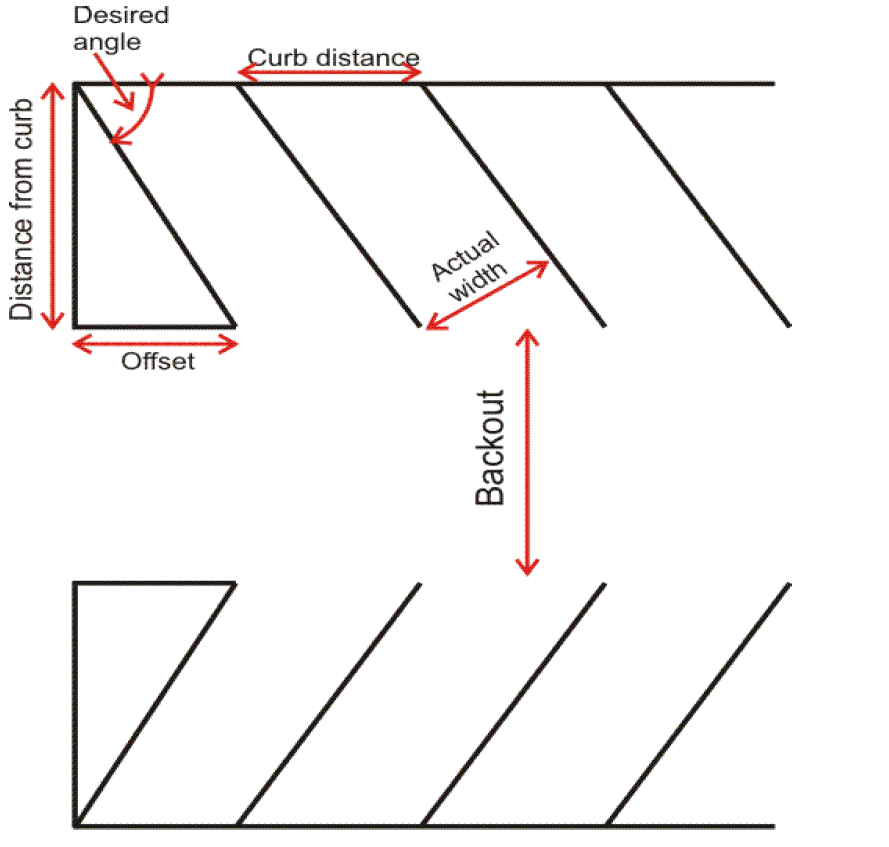
Off-street parking diagram.
Sec. 18-358. - Pedestrian access standards.
(a)
Where a proposed development includes improvements or new construction of collector or arterial facilities, facility designs shall include provision for bikeways and/or sidewalks within the right-of-way.
(b)
Residential projects adjacent to or in the immediate vicinity of an activity center comprised of commercial, office, service or recreation activities may provide pedestrian and bicycle access from the development to the activity center.
(c)
Design and construction of sidewalks, bikeways or other footpaths shall conform to the requirements of this Code, including provisions for access by physically handicapped persons.
Sec. 18-359. - Handicapped access.
(a)
Level parking spaces shall be reserved for physically handicapped persons according to the following requirements:
(b)
Parking spaces reserved for physically handicapped persons shall meet the following design and location requirements:
(1)
All spaces shall be accessible to curbramp or curbcut, when necessary to allow access to building, structure or use served, and shall be so located that users are not compelled to wheel behind parked vehicles.
(2)
Diagonal or perpendicular parking spaces shall be a minimum of 12 feet wide with a five-foot isle. If two handicapped spaces are adjacent, one five-foot isle can be shared between them.
(3)
Parallel parking spaces shall be located either at the beginning or end of a block or adjacent to an alley entrance. Curbs adjacent to such premises shall be of a height which will not interfere with the opening and closing of motor vehicle doors.
(4)
Each such parking space shall be prominently outlined with blue paint and posed with a nonmovable, fixed sign of a color and design approved by the state department of transportation, bearing the internationally accepted wheelchair symbol and the caption "PARKING BY DISABLED PERMIT ONLY."
(Code 2015, ch. 21, § 21.14.4; Code 2015, ch. 6, art. X, §§ 6-39—6-41)
Sec. 18-360. - Signs.
(a)
General regulations. If any particular section or subsection or definition in the town sign regulation conflicts with a state statute, or the Constitution of the United States, or the State of Florida, the state statute or Constitution will prevail.
(1)
Signs must be constructed of durable materials, maintained in good condition, and not allowed to become dilapidated.
(2)
Signs, other than an official traffic sign, quasi-public sign for governmental agencies, civic clubs, or for sale signs, shall not be erected within the right-of-way lines of any street.
(3)
Signs shall not project beyond property lines or over public sidewalk areas.
(4)
A permit shall not be required for the erection, alteration, or maintenance of any signs permitted in a residential district.
(5)
A permit shall be required for the erection, alteration, or reconstruction of any business or advertising sign.
(6)
All temporary signs erected for a special event, which shall include campaign signs, shall be removed by the person causing the sign to be erected no later than seven days after a special event or election date.
(b)
Residential signs.
(1)
Signs indicating only the name or address of the occupant, except in the case of corner lots where two such signs (one facing each street) shall be permitted for each dwelling unit.
(2)
For multiple-family dwellings, hotels and for buildings other than dwellings, a single identification sign not exceeding 12 square feet in area and indicating only the name and address of the building and the name of management may be displayed, provided that, on a corner lot, two such signs (one facing each street) shall be permitted.
(3)
Signs advertising the sale or rental of the premises upon which they are erected by the owner or broker or any other person interested in the sale or rental of such premises and signs bearing the word "sold" or "rented" with the name of the persons affecting the sale or rental may be erected or maintained, provided:
a.
The size of any such sign is not in excess of four square feet; and
b.
Not more than one sign is placed upon any property unless such property fronts upon more than one street, in which event, one such sign may be erected on each frontage.
(c)
Signs designating entrances or exits to or from a parking area are limited to the following:
(1)
One sign for each such exit or entrance;
(2)
A maximum size of two square feet each shall be permitted;
(3)
One sign per parking area shall be permitted;
a.
Designating the conditions of use or identity of such parking area; and
b.
Limited to a maximum size of nine square feet if on a corner lot two such signs shall be permitted, one facing each street.
(d)
Business and advertising signs are permitted in commercial and manufacturing districts in accordance with the following regulations:
(1)
The gross surface area of all freestanding signs on a parcel under one ownership shall not exceed 60 square feet.
(2)
No sign in a nonresidential district shall project more than three feet from the main wall of a building.
(3)
One free standing business sign shall be allowed for service stations.
(4)
No sign shall project into a public way.
(5)
No signs shall be higher than the height limit in the district where such sign is located.
(6)
No sign shall be located upon the roof of any building.
(7)
Advertising signs shall not be permitted in R districts.
(e)
Signs of schools, colleges, churches, hospitals, sanatoria, or other institutions of similar public or semi-public nature may be erected and maintained, provided:
(1)
The size of any such sign is not in excess of 20 square feet; and
(2)
Not more than one such sign is placed on a property, unless such property fronts upon more than one street, in which event two such signs may be erected, one on each frontage.
(Code 2015, ch. 21, § 21.14.5)
Sec. 18-361. - Minor/major development projects and land subdivision plats.
(a)
Determination of minor and major development.
(1)
Generally. For purposes of these review procedures, all development or redevelopment activity shall be determined to be either a minor development or a major development.
(2)
Major development project.
a.
Any commercial development or redevelopment.
b.
Any residential development except for one single-family dwelling or one duplex dwelling on one parcel.
c.
Subdivision of land into three or more parcels.
(3)
Minor development project. A minor development project is:
a.
Any one single-family dwelling or one duplex dwelling on one parcel.
b.
An accessory structure.
c.
Interior remodeling.
d.
Any structural repair.
e.
Any reroof, greater than 300 square feet and door or window replacement.
f.
Parcel split into two parcels.
(b)
Approval process; minor development.
(1)
The applicant shall file, along with the appropriate fee, a minor development permit application at the town hall.
(2)
The ZO shall expeditiously review and make a determination regarding whether or not the application is complete.
(3)
If the application is incomplete, the ZO shall notify the applicant within one week of the necessary incomplete information.
(4)
The ZO may need the assistance of a qualified consultant in reviewing the minor development.
a.
The ZO shall notify the applicant in writing with an estimate of the expense involved.
b.
The applicant will be required to reimburse the town for full payment of the estimated fee in advance.
c.
The town may then obtain the qualified consultant to assist in the review of the minor development plan.
(5)
If the minor development meets all provisions of this Code, the ZO shall sign and date this approval on the final page of the application and stamp all attachments.
(6)
If the minor development does not meet all provisions of this Code, the ZO shall sign and date this denial on the final page of the application and notify the applicant in writing. The applicant may appeal the ZO's decision to the BOA.
(7)
If a variance, special exception, or conditional use is required to obtain approval, the applicant may apply for a variance, special exception, or conditional use and must obtain approval prior to the approval of the minor development.
(c)
Approval process; major development.
(1)
It is suggested that a pre-application meeting between the applicant and the ZO to review the development plan be held.
a.
The ZO can review the proposal and indicate whether comprehensive plan amendment (text or map) or a rezoning (amendments to text or map) would be required for the proposed use on the property as currently designated.
b.
The ZO can review the proposal and indicate whether a variance, special exception, or conditional use would be required for the proposed use on the property.
c.
The ZO can review the proposal and indicate whether if special studies will be required to review the proposed use.
d.
The ZO can review the proposal and indicate whether a qualified consultant or engineer will be required by the town to review the proposed use.
(2)
The applicant shall file, along with the appropriate fee, a major development permit application at the town hall.
(3)
The ZO shall expeditiously review and make a determination regarding whether or not the application is complete.
(4)
If the application is incomplete, the ZO shall notify the applicant of the necessary incomplete information.
(5)
As soon as the package is determined to be complete, the ZO shall commence review.
(6)
The town may need the assistance of a qualified consultant in reviewing the major development plan.
a.
The ZO shall notify the applicant in writing with an estimate of the expense involved.
b.
The applicant will be required to reimburse the town for full payment of the estimated fee in advance.
c.
The town may then obtain the qualified consultant to assist in the review of the major development plan.
(7)
If the major development application does not meet code, the ZO shall inform the applicant of any necessary modifications or additions required. This decision may be appealed to the BOA.
(8)
If needing a variance, special exception, or conditional use, the applicant shall obtain a decision from the BOA for inclusion into the package for the P and Z.
(9)
When the application package is complete and has been reviewed, allowing time for any modifications, additions, or appeals, the ZO shall forward his findings along with any consultant reports and BOA action to the P and Z.
(10)
The clerk will then forward the information to the P and Z, and set a public hearing for the P and Z as soon as a quorum (or any required super-majority) is available.
(11)
The P and Z shall hold a duly noticed hearing providing a due process opportunity for the applicant and any other member of the public to present sworn testimony and evidence, subject to cross-examination.
(12)
The P and Z and town council shall consider competent substantial evidence relating to the following factors in reviewing the development plan. The P and Z or town council may request additional information from the applicant if necessary to determine whether the proposed major development:
a.
Is consistent with the characteristics and natural conditions and hazards of the site.
b.
Complies with the concurrency and other requirements of this Code.
c.
Is compatible with surrounding land uses.
d.
Is compatible with community character and sense of place.
e.
Is consistent with all comprehensive plan goals, objectives and policies.
f.
Conforms with all provisions of other applicable regulations.
g.
Design factors are compatible with and further the community vision.
h.
Is designed, located, and operated in a way that will protect the public health, safety, and welfare.
i.
Will not cause substantial injury to the value of other property in the neighborhood where it is located.
j.
Is compatible with the intended purpose of the district in which it is to be located, unless zoning and comprehensive plan changes are requested.
k.
Will not result in substantial economic, noise, glare, or odor impacts on adjoining properties and properties generally in the district.
l.
Provides adequate ingress and egress to property, off-street parking and loading areas, and access for emergency vehicles.
m.
Signs and exterior lighting conform to code.
(13)
The P and Z may recommend reasonable conditions on the determination of concurrency necessary to ensure meeting the requirements of state law.
(14)
The P and Z shall prepare a written recommendation for the town council of its review of the development plan.
a.
The written report shall set forth its factual conclusions.
b.
The written report shall contain as attachments all of the information presented at the hearing.
c.
The written report shall forward the factual and legal basis for its recommendation for review by the town attorney.
d.
The written report recommends:
1.
Approval of the proposed development plan.
2.
Approval of the proposed development plan with conditions or modifications described in sufficient detail and exactness to permit the applicant to amend the proposal accordingly.
3.
Denial of the proposed development plan, and the reasons therefor.
(15)
The town council shall schedule a review of the P and Z recommendation at a hearing, which shall include a staff report and the report from the P and Z.
a.
If zoning changes are required, two hearings are required.
b.
If comprehensive plan changes are required, a referendum may have to be held before council action is possible.
(16)
The council, by motion, may take one of the following actions:
a.
Approve the P and Z recommendation or the proposed development plan.
b.
Approve the proposed P and Z recommendation or development plan with conditions or modifications described in sufficient detail and exactness to permit the applicant to amend the proposal accordingly.
c.
Deny the P and Z recommendation or the proposed development plan, and the reasons therefor.
(17)
Upon notification of an approved major development, the ZO shall issue the necessary certificates and allow the development to proceed.
(d)
Land subdivision plats.
(1)
Generally.
a.
Land subdivision platting shall be the division of a parcel of land existing on April 29, 1999, into three or more parcels or lots.
b.
The ZO may approve subdivision plat applications of three or less parcels.
c.
The P and Z must approve a parcel subdivision plats application of more than three lots, but less than ten lots.
d.
The town council must approve all subdivision plats of more than en lots.
e.
A "parcel split" is the division of an existing parcel on April 29, 1999, into two parcels.
f.
May be submitted as part of a major or minor development.
g.
Applicant shall use forms as provided by the town.
(2)
Exceptions.
a.
The division of property for conveyance of land to a governmental agency, entity, political subdivision, or a public utility does not constitute subdividing within the meaning of this LDC.
b.
A parcel split.
(3)
Procedure for splitting a parcel.
a.
The ZO may approve parcel splits that conform to the requirements of this section.
b.
The ZO shall consider a proposed parcel split upon submittal of the following materials:
1.
A completed application form and the appropriate fee to town hall.
2.
Two paper copies of the proposed parcel split.
3.
Land descriptions and acreage or square footage of the original and proposed parcels.
4.
A scaled drawing of the intended split showing any structures on the parcel.
5.
Clearly label the drawing, "This is not a survey," if it is not a survey.
c.
ZO review procedures.
1.
If the parcel split meets the conditions of this section and otherwise complies with all applicable laws and ordinances, the ZO shall approve the parcel split by signing the application form.
2.
If the parcel split does not conform, the ZO shall explain the deficiency in the plat to the applicant and inform him that a corrected plat may be resubmitted for approval.
3.
This decision may be appealed to the BOA.
d.
Filing of a parcel split.
1.
Upon approval of the parcel split, the ZO shall document the split on the appropriate maps and in the appropriate files.
2.
Applicant must:
(i)
File with the county clerk.
(ii)
Provide ZO with a stamped copy of the parcels after filing within 30 days.
e.
Standards.
1.
Lot shall meet all requirements contained in this LDC.
2.
No further division of an approved parcel split shall be permitted under this section, unless a development plan is prepared and submitted in accordance with this article.
3.
Each parcel must further meet all requirements for new subdivisions set forth below:
(i)
Each parcel or lot must abut a public or private street that meets minimum design criteria in this Code.
(ii)
Shall not be less than 75 feet wide at street front line.
(iii)
Shall not contain less than 7,500 square feet.
(4)
Procedure for obtaining a subdivision.
a.
New subdivisions. All areas not platted as of the effective date of the ordinance from which this LDC is derived which are subsequently divided into parcels shall not:
1.
Be less than 75 feet wide at street front line; and
2.
Contain less than 7,500 square feet.
b.
Existing subdivisions. All areas which were platted before the effective date of the ordinance from which this LDC is derived which are subsequently divided into parcels shall not:
1.
Be replatted into parcels less than 75 feet wide at street front line; and
2.
Contain less than 7,500 square feet.
c.
The applicant shall submit to the ZO a plat conforming to the requirements of state statutes when submitting the development plan.
d.
Review by ZO.
1.
The ZO shall review the plat and determine whether it conforms to the requirements of state statutes.
2.
The ZO:
(i)
Determines that the plat conforms to the town code and land development regulations.
(ii)
Forwards it to the P and Z for consideration, along with the development plan if applicable.
e.
If it does not conform to state statutes or the Code or land development regulations, the ZO shall:
1.
Explain the deficiency in the plat to the applicant in writing;
2.
Inform them that a corrected or revised plat application may be resubmitted for approval.
f.
The ZO's decision may be appealed to the BOA.
g.
If needing a variance, special exception, or conditional use, the applicant shall obtain a decision from the BOA prior to approval of the subdivision plat.
h.
When the application package is complete, allowing time for any modifications, additions, or appeals, the ZO shall forward his findings, along with any consultant reports and BOA action, to the P and Z.
(5)
Review by the P and Z.
a.
When the ZO's recommendation is complete, the clerk shall forward the information to the P and Z, and set a public hearing for the P and Z as soon as a quorum (or any required super-majority) is available.
b.
The P and Z shall hold a duly noticed hearing providing a due process opportunity for the applicant and any other member of the public to present sworn testimony, evidence, subject to cross-examination.
c.
The P and Z shall review the proposed land subdivision, as part of the entire development plan if applicable.
d.
Review of the proposed land subdivision shall be strictly limited to whether or not the plat conforms to the platting requirements of state statutes.
e.
The P and Z may recommend reasonable conditions on the determination of concurrency necessary to ensure meeting the requirements of state law.
f.
The P and Z must specifically note action on the land subdivision if reviewed as part of a major development.
g.
The P and Z shall prepare a written report of its review of the land subdivision.
1.
The written report shall set forth its factual conclusions.
2.
The written report shall contain as attachments all of the information presented at the hearing.
3.
The written report shall forward the factual and legal basis for its recommendation for review by the town attorney.
h.
The written report may recommend:
1.
Approval of the proposed land subdivision.
2.
Approval of the proposed land subdivision with conditions or modifications described in sufficient detail and exactness to permit the applicant to amend the proposal accordingly.
3.
Denial of the proposed land subdivision, and the reasons therefor.
i.
Final approval.
1.
Upon notification of an approved land subdivision, the ZO shall issue the necessary certificates.
2.
If changes to the land subdivision are required by the P and Z certificates shall not be issued until a final plat is submitted incorporating the changes.
3.
The ZO shall document the land subdivision on the appropriate maps and in the appropriate files.
4.
The applicant must file with the county clerk and provide the ZO with a stamped copy of the plat after filing within 30 days.
(Code 2015, ch. 21, § 21.14.6)
Sec. 18-362. - Visibility at intersections.
On a corner parcel, there shall be no obstruction to vision in the clear visibility triangle planted, allowed to grow, placed, or erected in such a manner as to materially impede visibility between a height of four feet to ten feet above the grades of the intersecting streets at their point of intersection.
(Code 2015, ch. 21, § 21.14.7)
Sec. 18-363. - Stormwater management.
(a)
General.
(1)
When deemed necessary by any zoning official, department, commission, or the governing body, a drainage system design prepared by a state-registered professional engineer may be required which will include detailed construction plans, supportive calculations, and any additional information related or required therewith.
(2)
Land, subject to flooding (floodprone area) or land deemed by any zoning official, floodplain manager, department, commission, or governing body to be unsuitable for development, shall:
a.
Not be platted for residential occupancy, or other uses that may cause danger to life, or property, or aggravate the flood hazard.
b.
Within a parcel:
1.
Be set aside for such uses as shall not be endangered by periodic or occasional inundation;
2.
Alternatively be improved in a manner satisfactory to the zoning official, floodplain manager, department, commission, or governing body to remedy said hazardous conditions.
(b)
Information required prior to issuance of a development permit for all new nonresidential development, and residential subdivisions:
(1)
For developments meeting SWFWMD thresholds for surface water and/or stormwater permitting, the developer shall provide a copy of the appropriate approved permit from SWFWMD.
(2)
For developments, which are exempt from SWFWMD permitting requirements, the applicant shall provide documentation from those agencies that no permit is needed.
(3)
Where drainage runoff comes from outside the limits of the subdivision, it shall be included in the design.
(4)
Post-development runoff shall not exceed predevelopment runoff rates. Design storm shall be the 25-year, 24-hour storm (eight inches) or may be taken from storm intensity-frequency data published by another governmental agency if approved prior to use.
(c)
Single-unit residential development and substantial improvement.
(1)
All single-family and duplex residential units, which are not part of a larger development, and do not otherwise require compliance with SWFWMD permitting rules, shall meet the following standards:
a.
Comply with the OFW standards for retention volumes.
b.
All new development and redevelopment activities shall utilize appropriate techniques during construction to minimize erosion. Staked hay bales shall be required to prohibit erosion into adjacent property. Construction near wetlands shall require the use of approved silt screens to prevent erosion and siltation.
(2)
In the residential environmentally sensitive district:
a.
All development shall comply with OFW standards for retention volumes.
b.
Grassed swales may be used, as long as equivalent storage is provided.
c.
Clearing of native vegetation for all development shall be limited to ten percent of the total site.
(3)
Expansion of existing residential development of greater than 300 square feet of additional impervious coverage shall provide site-suitable stormwater management in accordance with OFW regulations.
(Code 2015, ch. 21, § 21.14.8; Code 2015, ch. 6, art. IX, § 6-38)
Sec. 18-364. - Concurrency management and proportionate share.
(a)
Purpose and intent.
(1)
Intent. It is the intent of this section to ensure that proposed development is consistent with the town's comprehensive plan, and that public facilities are available at prescribed levels of service concurrent with the impact of the development upon those facilities.
(2)
Purpose. It is the purpose of this article to establish procedures and criteria to ensure that facilities and services needed to support development are available concurrent with the impacts of such development, except as otherwise defined in this section, through a:
a.
Concurrency management system and fair share methodology.
b.
Whereby the impacts of development on transportation facilities can be mitigated by the cooperative efforts of the public and private sectors.
c.
To be known as the "Proportionate Fair-Share Program," as required by and in a manner consistent with, state statutes.
(b)
Definitions. The following words, terms and phrases, when used in this section, shall have the meanings ascribed to them in this subsection, except where the context clearly indicates a different meaning:
Current level of demand means the average of the 12 previous monthly peak days and is calculated every January.
Development approval, for the purposes of determining concurrency, means approval of any of the following:
(1)
Site plan or development plan;
(2)
Subdivision;
(3)
Building permit; or
(4)
Other official action of the town having the effect of permitting the development of land.
Development order means any order granting, denying, or granting with conditions an application for development approval.
Major development means any commercial development or redevelopment or any residential development except for one single-family dwelling or one duplex dwelling on one parcel.
Minor development means any one single-family dwelling or one duplex dwelling on one parcel.
(c)
Concurrency management system. The town shall ensure that facilities and services needed to support development are available concurrent with the impacts of such development, except as otherwise defined in this article, through a concurrency management system, concurrency checklists and letter certifications of available capacity from the applicable service providers.
(1)
Determination of concurrency. A concurrency determination shall be made for the following facilities:
a.
Transportation;
b.
Sanitary sewage;
c.
Solid waste;
d.
Drainage;
e.
Potable water and water supply;
f.
Parks and recreation;
g.
Schools.
(2)
Standards to meet concurrency.
a.
A development order will be issued only if the proposed development does not lower any adopted level of service.
b.
A project shall be deemed concurrent if one of the following standards is met:
1.
Necessary facilities and services are in place at the time the development permit is issued;
2.
Necessary facilities will be in place when the impacts of development occur;
3.
Necessary facilities and services are under construction when the development order is issued; or
4.
Necessary facilities and services are guaranteed in an enforceable development agreement that includes any of the provisions of subsections (c)(2)b.1 through 3 of this section, and guarantees that the necessary facilities and services will be in place when the impacts of the development occur.
c.
Concurrency determinations and the development approval process:
1.
For minor development, concurrency determinations shall be made by the town zoning official at the time a building permit application is made.
2.
For major development, concurrency determinations shall be made by the planning and zoning commission after a recommendation by the zoning official, and forwarded to the town council as part of the development plan approval process.
3.
Pursuant to state statutes, consistent with public health and safety, sanitary sewer, solid waste, drainage, adequate water supplies, and potable water facilities shall be in place and available to serve new development no later than the issuance by the local government of a certificate of occupancy or its functional equivalent.
4.
Prior to approval of a building permit or its functional equivalent, the town shall consult with the applicable water supplier to determine whether adequate water supplies to serve the new development will be available no later than the anticipated date of issuance of a certificate of occupancy or its functional equivalent.
5.
Pursuant to state statutes, consistent with the public welfare, and except as otherwise provided in this section, parks and recreation facilities to serve new development shall be in place or under actual construction no later than one year after issuance by the local government of a certificate of occupancy or its functional equivalent.
6.
However, the acreage for such facilities shall be dedicated or be acquired by the local government prior to issuance by the town of a certificate of occupancy or its functional equivalent, or funds in the amount of the developer's fair share shall be committed no later than the town's approval to commence construction.
7.
Pursuant to state statutes, consistent with the public welfare, and except as otherwise provided in this section, transportation facilities needed to serve new development shall be in place or under actual construction within three years after the town approves a building permit or its functional equivalent that results in traffic generation.
d.
Adopted levels of service and concurrency management:
1.
Transportation system.
(i)
Adopted level of service. The operational level of service "C" peak hour bicycle shall be the standard for roads.
(ii)
Management procedures.
A.
The town has vacant lots capable of accommodating new single-family or duplex development. Individual single-family or two-family development on a lot of record shall be exempt from these requirements along with other de minimus impacts as defined in state statutes.
B.
Single-family subdivisions, multifamily, and nonresidential uses shall be evaluated by the town zoning official for the traffic impact of the development upon major and minor collector roadways in the town.
(iii)
Available roadway capacities shall be determined in the following manner:
A.
In January of each year, the town zoning official will evaluate roadway capacity of each of the major and minor collectors in the town, using the Florida Highway System Plan Level-of-Service and Guidelines Manual issued by the state department of transportation and effective January 1, 1989, using bicycle mode capacity.
B.
Available roadway capacity will be calculated using the highest county highway department of transportation traffic counts, or other available traffic counts, as appropriate, from the previous year.
C.
The impact of any given project on the roadway system will be calculated using the trip generation standards contained in the most recent edition of Trip Generation, published by the Institute of Traffic Engineers.
D.
It shall be the responsibility of the applicant to provide all traffic data necessary for a determination of concurrency.
E.
The estimated number of trips to be generated by the proposed project will be subtracted from the available capacity of the roadway and compared to the town's adopted level of service to determine whether the available capacity is adequate to support the project.
F.
If no official traffic count is available for the major or minor collector to be impacted, the town will arrange, at the applicant's expense, to have such counts made.
G.
Calculation of traffic to be generated by the proposed project will assume 100 percent build-out and occupancy.
2.
Sanitary sewage.
(i)
Adopted level of service. Pursuant to state statutes, the town may meet the concurrency requirement for sanitary sewer through the use of on-site sewage treatment and disposal systems approved by the department of health (DOH) to serve new development. All new or replacement sanitary sewage systems in all land use districts shall also meet the following requirements:
A.
All new or replacement sanitary sewage systems shall be designed and constructed to minimize or eliminate infiltration of floodwaters into the system and discharge from the system into floodwaters.
B.
Joints between sewer drain components shall be sealed with caulking, plastic, or rubber gaskets.
C.
Backflow preventers are required.
D.
All new or replacement sanitary sewage systems shall be located and constructed to minimize or eliminate damage to them and contamination from them during flooding.
E.
All new and replacement septic systems are to be performance-based certified to provide secondary treatment equivalent to ten milligrams per liter maximum nitrogen.
F.
Further, all new and replacement septic systems and on-site sanitary WWTF systems shall be set back from mean high water line or ordinary high water line or wetland demarcation line in all districts per DOH and OFW requirements.
G.
No publicly or privately funded, central collection sanitary WWTFs shall be constructed within the coastal high hazard area of the town.
H.
All sanitary wastewater shall be treated on-site until a publicly funded central sewer system exists to serve the town.
I.
On-site sewage treatment and disposal systems in the town must also be consistent with all other requirements of the town comprehensive plan.
(ii)
Management procedures. Prior to the issuance of zoning official's site plan approval, applicants shall be required to obtain:
A.
Permits from the county health department for on-site sanitary wastewater disposal; and
B.
Certification from the town indicating that on site systems meet all other local requirements.
3.
Solid waste.
(i)
Adopted level of service. The adopted levels of service for solid waste is 2.5 pounds per capita per day.
(ii)
Management procedures.
A.
Prior to the issuance of zoning official's site plan approval, applicants shall be required to obtain certification from the county indicating that solid waste capacity is available at the time of development or prior to the issuance of a Certificate of Occupancy.
B.
In January of each year, the ZO will obtain a letter or formal allocation agreement from the county certifying that the county landfill has the capacity to handle garbage projected to be generated within the town during the following year.
C.
The projected amount will be based upon the projected town population for the applicable period multiplied by the town's adopted per capita level of service.
D.
The impact of any development requiring development plan approval shall be determined by the ZO:
I.
For residential projects, the impact shall be calculated by multiplying the estimated population of the project, as provided by the applicant, by the town's adopted per capita level of service.
II.
For nonresidential projects, the impact shall be provided by the applicant, and approved by the ZO.
III.
The ZO shall determine the adequacy of capacity by adding the amount of demand to the demand for any other approved developments and the current level of demand generated within the town.
IV.
The cumulative total demand shall be compared with the capacity certified to be available to the town by the county.
V.
If total demand exceeds the capacity certified to be available to the town by the county, the ZO shall request a letter from the county stating whether or not the county has the capacity to dispose of the amount of solid wastes to be generated by the proposed project.
4.
Drainage.
(i)
Adopted level of service. The adopted levels of service for drainage requires that all new development and expansion of existing residential development greater than 300 square feet of additional impervious coverage shall meet requirements as specified in the F.A.C. for Outstanding Florida Waters.
(ii)
Management procedures. The ZO or a town stormwater engineer shall require and review drainage plans and calculations for all development and shall make and record a determination that the impact on the drainage system will not lower the established level of service.
5.
Potable water and water supply.
(i)
Adopted level of service. The adopted levels of service for potable water is 125 gallons per capita per day.
(ii)
Existing allocated demand.
A.
Vacant residential parcels within the urban service area shall be included as demand upon the water system as if they were fully built out and calculated at 125 gallons per capita per day times two persons per parcel times number of vacant residential parcels.
B.
Developed lots north of CR40 in urban service area with well potable water service shall be included as demand upon the water system and calculated at 125 gallons per capita per day times two persons per parcel times number of parcels.
C.
Commercial demand shall be calculated at 450 gallons per day per commercial enterprise.
(iii)
Management procedures.
A.
Prior to the issuance of ZO's site plan approval, applicants shall be required to obtain certification from the town ZO indicating that potable water supply is available at the time of development or prior to the issuance of a certificate of occupancy.
B.
In January of each year, the ZO will certify that the town has the capacity to provide the volume of potable water projected to be needed during the following year. The projected volume will be based upon the projected town population for the applicable period multiplied by the town's adopted per capita level of service.
C.
The impact of any development requiring development plan approval shall be determined by the town zoning official:
I.
For residential projects, the impact shall be calculated by multiplying the estimated population of the project, as provided by the applicant, by the town's adopted per capita level of service.
II.
For nonresidential projects, the impact shall be provided by the applicant, and approved by the town zoning official.
III.
The town zoning official shall determine the adequacy of the existing plant capacity by adding the volume of demand to the demand for any other approved developments and the current level of demand generated within the town including consideration of allocated vacant parcel demand as defined in subsection (2)d.5.(iii)B of this section.
IV.
The cumulative total demand shall be compared with the withdrawal volumes permitted under the town's water use permit (groundwater withdrawal amounts) and WTP SRF water system improvements permit (engineered plant capacity).
V.
If total demand exceeds the volume allowed by the town's water use permit or WTP permit, the major development applicant shall be responsible for all costs associated with receiving a new water withdrawal use permit.
VI.
If total demand exceeds the capacity of the plant, the applicant shall be responsible for all costs associated with providing the additional water plant capacity.
6.
Parks and recreation.
(i)
Adopted level of service. The adopted levels of service for parks and recreation are as follows:
A.
Neighborhood parks: two acres per 1,000 population.
B.
Community parks: two acres per 1,000 population.
C.
Equipped tot play area: 0.5 acres per 1,000 population.
(ii)
Management procedures. Any major development causing a decrease in level of service shall be responsible for providing additional park or payment of a proportionate fair share of all improvements and costs associated with meeting the level of service requirements set forth above.
7.
Schools.
(i)
Level of service. The level of service in schools shall be as follows:
A.
The town is exempt from school concurrency;
B.
The town may enter into an interlocal agreement regarding school concurrency and school concurrency impact fees with the county school district if:
I.
The town is no longer exempt from school concurrency review; or
II.
The school district and town decide to implement school impact fees for major residential development that would be applicable within the town.
(ii)
Management procedures. The applicant for any major residential development shall obtain a letter of concurrency from the county school district board demonstrating adequate school capacity to accommodate proposed new development.
e.
Concurrency determinations for redevelopment.
1.
Redevelopment shall be exempt from concurrency determinations relative to transportation, sanitary sewer, solid waste, potable water, and recreation/open space, provided the following conditions are met:
(i)
Residential redevelopment. For residential redevelopment, there is no increase in the density from that existing prior to redevelopment.
(ii)
Commercial redevelopment. For commercial redevelopment, there is no increase in the square footage of the building or intensity of use of the property from that existing prior to redevelopment.
2.
Redevelopment which is not determined to be exempt:
(i)
Shall be subject to concurrency determinations only with respect to those impacts in excess of that attributable to the property prior to the redevelopment;
(ii)
Except that concurrency with respect to the town's drainage level of service, shall be determined and based upon the drainage needs of the entire use of the property.
f.
Limitations and expiration of concurrency determinations.
1.
Longevity and validity of concurrency determinations are contingent upon building permit issuance within one year of the concurrency determination.
2.
Concurrency determinations shall expire with the expiration of the development plan approval or building permit, as applicable.
(d)
Proportionate fair share program.
(1)
The proportionate fair-share program shall apply to all development in the town that have been notified of a lack of capacity to satisfy transportation concurrency on a transportation facility per the concurrency management system (CMS) or concurrency review checklist (CRC), including transportation facilities maintained by the state department of transportation (FDOT) or another jurisdiction that are relied upon for concurrency determinations.
(2)
The proportionate fair-share program does not apply to:
a.
Developments of regional impact (DRI) using proportionate fair-share under state statutes; or
b.
Developments, which may be exempted from concurrency as provided in the town comprehensive plan and this article, and/or state statutes, regarding exceptions and de minimus impacts.
(3)
General requirements.
a.
An applicant may choose to satisfy the transportation concurrency requirements of the town of by making a proportionate fair-share contribution, pursuant to the following requirements:
1.
The proposed development is consistent with the comprehensive plan and applicable LDC.
2.
The five-year schedule of capital improvements in the town CIE currently includes the proposed project.
3.
Additional requirements may apply if a project needed to satisfy concurrency is not presently contained within the town's CIE.
4.
The town may choose to allow an applicant to satisfy transportation concurrency through the proportionate fair-share program by contributing to an improvement that, upon completion, will satisfy the requirements of the CMS or CRC requirements, but is not contained in the five-year schedule of capital improvements in the CIE, where the following apply:
(i)
The town adopts, by resolution or ordinance, a commitment to add the improvement to the five-year schedule of capital improvements in the CIE no later than the next regularly-scheduled update.
(ii)
To qualify for consideration under this section, the proposed improvement must be:
A.
Reviewed by the town council.
B.
Determined to be financially feasible pursuant to state statutes, (financial feasibility for this section means that additional contributions, payments, or funding sources are reasonably anticipated during a period not to exceed ten years to fully mitigate impacts on the transportation facilities.)
C.
Consistent with the comprehensive plan.
D.
In compliance with the provisions of this LDC.
(iii)
If the funds allocated for the five-year schedule of capital improvements in the town CIE are insufficient to fully fund construction of a transportation improvement required by the CMS or CRC, the town may still enter into a binding proportionate fair-share agreement with the applicant authorizing construction of only that amount of development on which the proportionate fair-share is calculated, if the proportionate fair-share amount in such agreement is sufficient to pay for one or more improvements which will, in the opinion of the governmental entity maintaining the transportation facilities, significantly benefit the impacted transportation system.
b.
Any improvement project proposed to meet the developer's fair-share obligation must meet design standards of:
1.
The town locally maintained roadways;
2.
The county for county-maintained roads; and
3.
The FDOT for the state highway system.
(e)
Intergovernmental coordination.
(1)
Pursuant to policies in the intergovernmental coordination element of the town comprehensive plan and applicable policies in the strategic regional policy plan for the Withlacoochee Region, the town shall coordinate with affected jurisdictions, including FDOT, regarding mitigation to impacted facilities not under the jurisdiction of the local government receiving the application for proportionate fair-share mitigation.
(2)
An interlocal agreement may be established with other affected jurisdictions for this purpose.
(f)
Application process.
(1)
Upon notification of a lack of capacity to satisfy any concurrency, the applicant shall be notified in writing of the opportunity to satisfy concurrency through the proportionate fair-share program pursuant to the requirements of this section.
(2)
Prior to submitting an application for a proportionate fair-share agreement, a pre-application meeting shall be held to discuss the following:
a.
Eligibility;
b.
Application submittal requirements;
c.
Potential mitigation options;
d.
And related issues.
(3)
If the impacted facility is on the state intermodal system (SIS), then the FDOT will be notified and invited to participate in the pre-application meeting.
(4)
Eligible applicants shall submit an application to the town that includes:
a.
An application fee as established within the town's fee resolution, as amended;
b.
Name, address and phone number of all owners;
c.
Name, address and phone number of developer, if required;
d.
Copy of agent authorization (form 10), if required;
e.
Copy of concurrency review certificate (form 2);
f.
Property location, including parcel numbers and 911 address;
g.
Legal description;
h.
Survey of property showing;
1.
Boundaries;
2.
Location of driveways and access roads.
i.
Project description, including type, intensity and amount of development;
j.
Phasing schedule, if applicable;
k.
Description of requested proportionate fair-share mitigation method.
(5)
The town zoning official shall review the application and certify that the application is sufficient and complete.
(6)
If an application is determined to be insufficient, incomplete, or inconsistent with the general requirements of the proportionate fair-share program, as indicated in this section, then:
a.
The applicant will be notified in writing of the reasons for such deficiencies.
b.
If such deficiencies are not remedied by the applicant within 30 calendar days of receipt of the written notification, then the application will be deemed abandoned.
c.
The town council may, at its discretion, grant an extension of time to cure such deficiencies, if the applicant has shown good cause for the extension and has taken reasonable steps to effect a cure.
(7)
Pursuant to state statutes, proposed proportionate fair-share mitigation for development impacts to facilities on the SIS requires the concurrency of the FDOT. The applicant shall submit evidence of an agreement between the applicant and the FDOT for inclusion in the proportionate fair-share agreement.
(8)
When an application is deemed sufficient, complete, and eligible, the applicant shall be:
a.
Advised in writing.
b.
A proposed proportionate fair-share obligation and binding agreement will be prepared by the town at applicant expense or by the applicant with direction from the town and delivered to the appropriate parties for review, also at applicant's expense, including a copy to the FDOT for any proposed proportionate fair-share mitigation on an SIS facility.
(9)
The town zoning official shall notify the applicant regarding the date of the town council meeting when the agreement will be considered for final approval.
(10)
No proportionate fair-share agreement will be effective until approved by the town council.
(g)
Determining proportionate fair-share obligation.
(1)
Proportionate fair share mitigation includes, without limitation, separately or collectively, the following:
a.
Private funds;
b.
Contributions of land; and/or
c.
Contribution of transportation facilities.
(2)
The methodology used to calculate a developer's proportionate fair share obligation to meet transportation concurrency shall be as provided in state statutes, and as represented by the formula: Proportionate Share equals ((Development Trips)/(SV Increase)) times Cost. Where:
a.
Development trips equals number of trips from the development that are assigned to roadway segment;
b.
SV increase equals service volume increase, new service volume minus current service volume, provided by the improvement to roadway segment;
c.
Cost equals all improvement costs and associated costs, such as design, right-of-way acquisition, planning, engineering, inspection, and physical development costs directly associated with construction at the anticipated cost in the year it will be incurred.
(3)
For the purposes of determining transportation proportionate fair share obligations, capital improvement costs shall be based upon the actual cost of the improvement as obtained from the CEI, or the state department of transportation work program. Where such information is not available, the improvement cost shall be determined using one of the following methods:
a.
The most recent issue of state department of transportation "transportation costs," as adjusted, based upon the type of cross section (urban or rural); and/or
b.
Locally available data from recent projects on acquisition, drainage, and utility costs; and/or
c.
Significant changes in the cost of materials due to unforeseeable events.
(4)
If the town has accepted an improvement project proposed by the developer, then the value of the improvement shall be determined by using one of the methods provided in this section.
(5)
If the town accepts any right-of-way dedication for the proportionate fair share payment, credit for the dedication of the non-site-related right-of-way shall be valued on the date of the dedication at:
a.
120 percent of the most recent assessed value of the land, upon which the right-of-way is or will be located, by the county property appraiser; or
b.
At the mutual agreement of the town and the developer, by fair market value established by an independent appraisal approved by the town and at no expense to the town.
(6)
The developer shall supply a certificate of title or title search of the land to the town at no expense to the town.
(7)
If the estimated value of the right-of-way dedication proposed by the developer is less than the town estimated total proportionate fair share obligation for that development, then the developer must also pay the difference.
(8)
Proportionate fair-share agreements.
a.
Upon execution of a proportionate fair-share agreement (agreement), the applicant shall receive a concurrency approval certificate issued under the CMS or CRC from the town.
b.
Should the applicant fail to apply for a development permit within 12 months or a timeframe provided in the town's capital improvements element of the execution of the agreement, then the agreement shall be considered null and void, and the applicant shall be required to reapply.
c.
Payment of the proportionate fair-share contribution is due in full prior to issuance of the final development order or recording of the final plat and shall be nonrefundable.
d.
Payment must be submitted within 12 months of the execution of the agreement.
e.
If the payment is submitted more than six months from the date of execution of the agreement, then the proportionate fair-share cost shall be recalculated at the time of payment based on the best estimate of the construction cost of the required improvement at the time of payment, pursuant to this section and adjusted accordingly.
f.
The application fee and all associated costs to the town will be nonrefundable.
g.
No agreement will be issued until all fees have been paid in full.
h.
It is the intent of this section that, where possible, any required improvements be completed before issuance of certificates of occupancy. However, consistent with the public welfare, and consistent with any other requirements or exemptions provided state statutes, transportation facilities needed to serve new development shall be in place or under actual construction within three years after the local government approves a building permit or its functional equivalent that results in traffic generation.
i.
Dedication of necessary right-of-way for facility improvements pursuant to a proportionate fair-share agreement must be completed prior to issuance of the final development order or recording of the final plat.
j.
Any requested change to a development project subsequent to a development order may be subject to additional proportionate fair-share contributions to the extent the change would generate additional load that would require mitigation.
k.
Applicants may submit a letter to withdraw from the proportionate fair-share agreement at any time prior to the execution of the agreement.
(9)
Selected corridor improvements. The town council may enter into proportionate fair-share agreements for selected corridor improvements to facilitate collaboration among multiple applicants on improvements to a shared transportation facility.
(10)
Appropriation of fair-share revenues.
a.
Proportionate fair-share revenues shall be placed in the appropriate project account for funding of scheduled improvements in the town CIE, or as otherwise established in the terms of the proportionate fair-share agreement.
b.
At the discretion of the town council, proportionate fair-share revenues may be used for operational improvements prior to construction of the capacity project from which the proportionate fair-share revenues were derived.
c.
Proportionate fair-share revenues may also be used as the 50 percent local match for funding under the FDOT agreements or programs.
d.
In the event a scheduled facility improvement is removed from the CIE, then the revenues collected for its construction may be applied toward the construction of another improvement within that same corridor or sector that would mitigate the impacts of development pursuant to the requirements of this article.
e.
Where an impacted regional facility has been designated as a regionally significant transportation facility in an adopted regional transportation plan, as provided in state statutes:
1.
The town may coordinate with other impacted jurisdictions and agencies to apply proportionate fair-share contributions and public contributions to seek funding for improving the impacted regional facility under the FDOT TRIP or other FDOT agreements or programs.
2.
Such coordination shall be ratified by the town through an interlocal agreement that establishes a procedure for earmarking of the developer contributions for this purpose.
(Code 2015, ch. 21, § 21.14.9)