York County Unincorporated
City Zoning Code
City Zoning Code
APPENDIX A
DIAGRAMS, TABLES AND FIGURES
FIGIRE I-1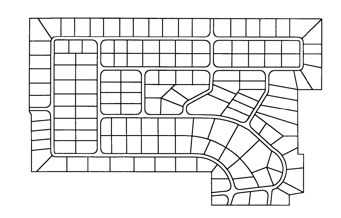
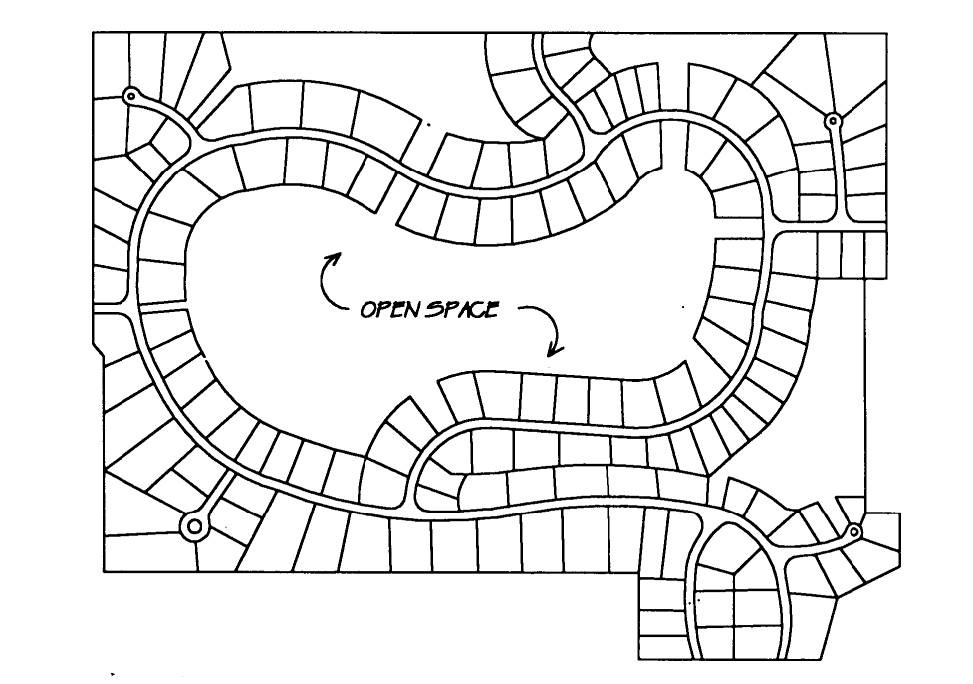
Cluster Subdivision
FIGURE I-2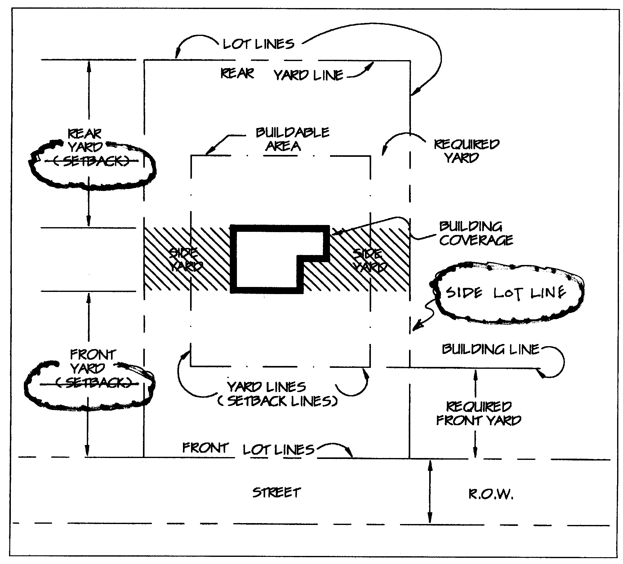
FIGURE I-3
LOT TYPES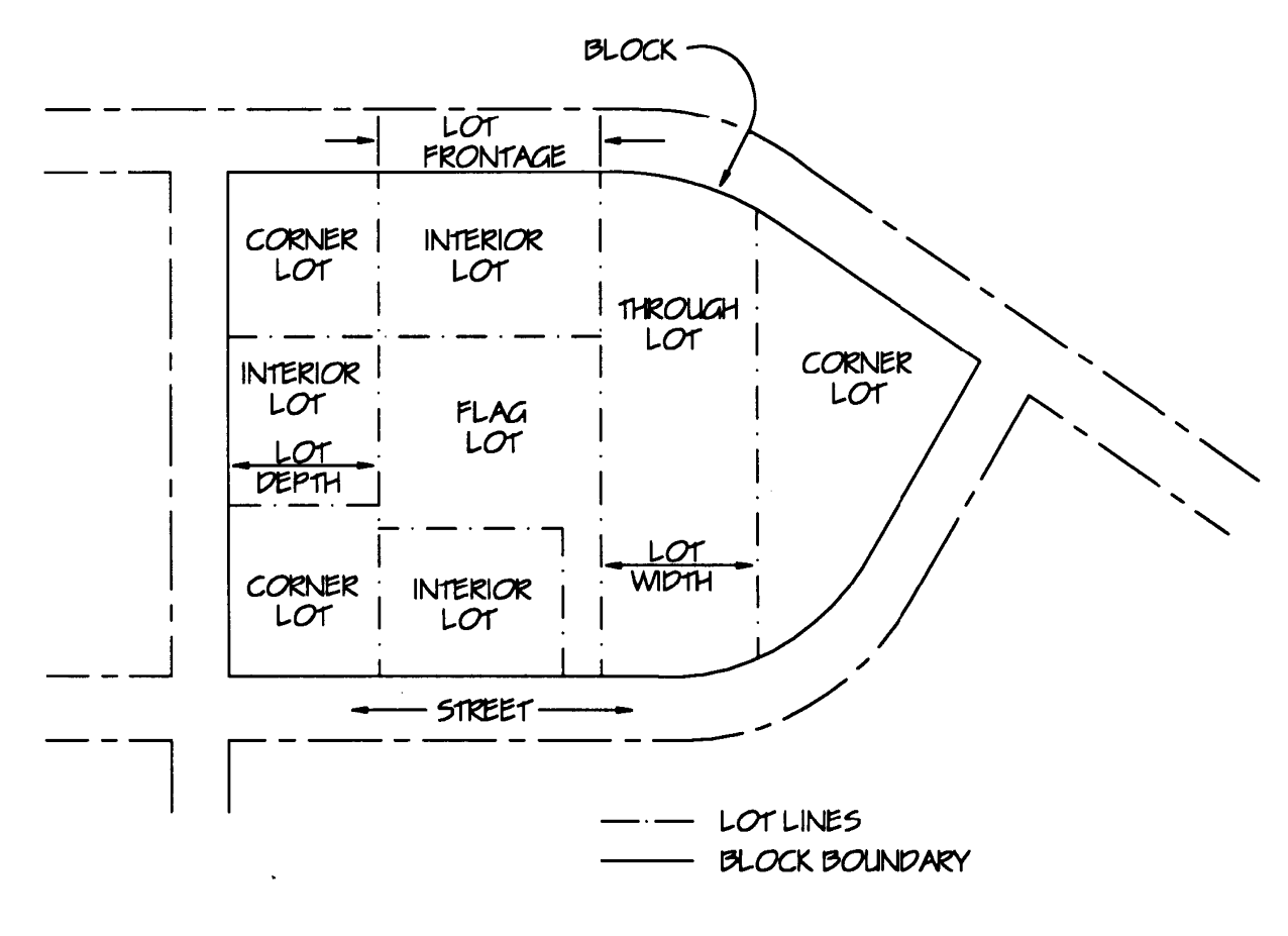
FIGURE I-4
FIGURE I-5
FIGURE II-1
CURVED STREET FRONTAGE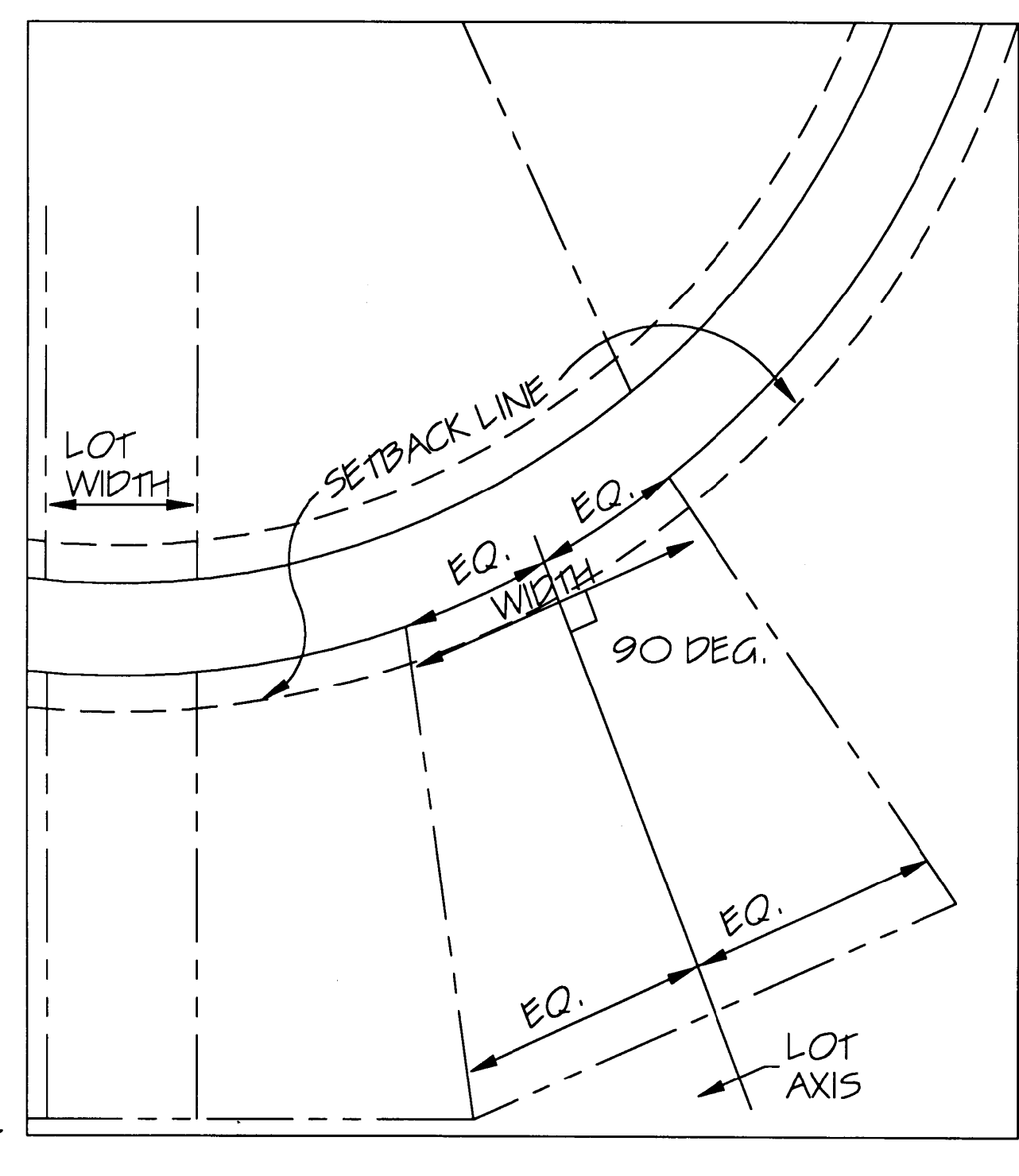
FIGURE II-2
STREET ACCESS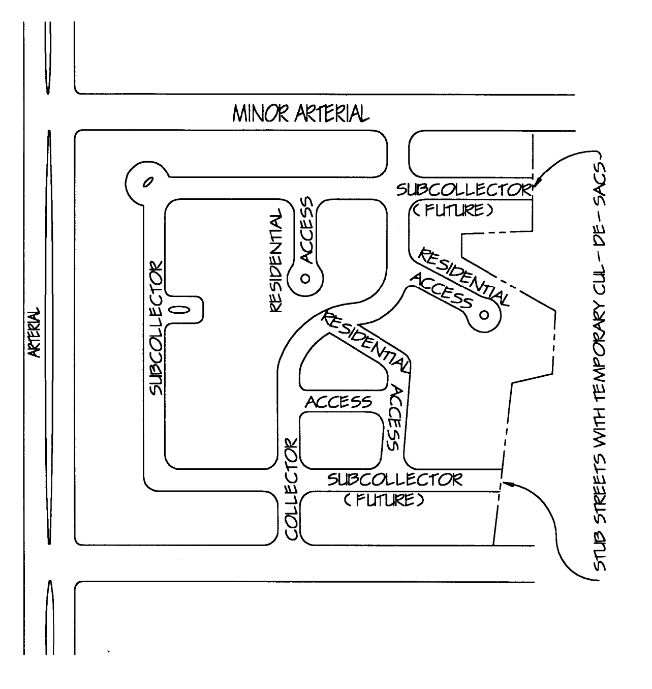
FIGURE II-3
CORNER LOTS VERSUS INTERIOR LOTS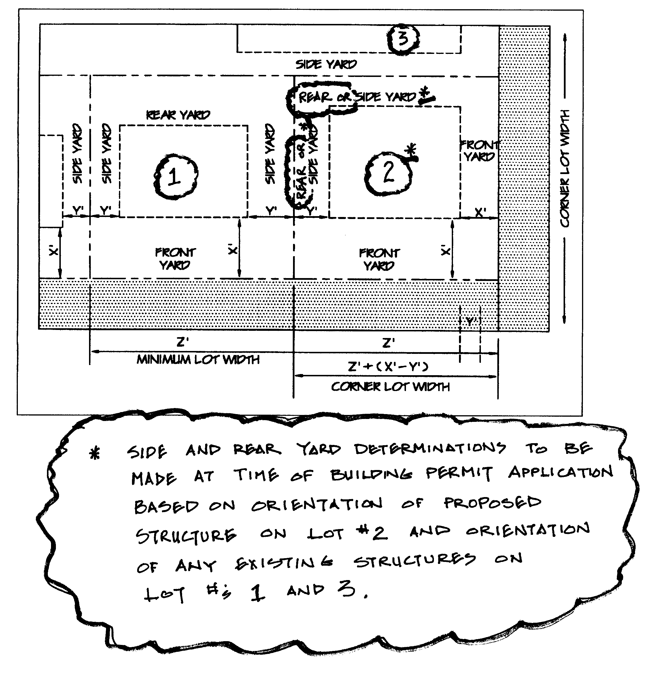
FIGURE II-4
SIGN TRIANGLES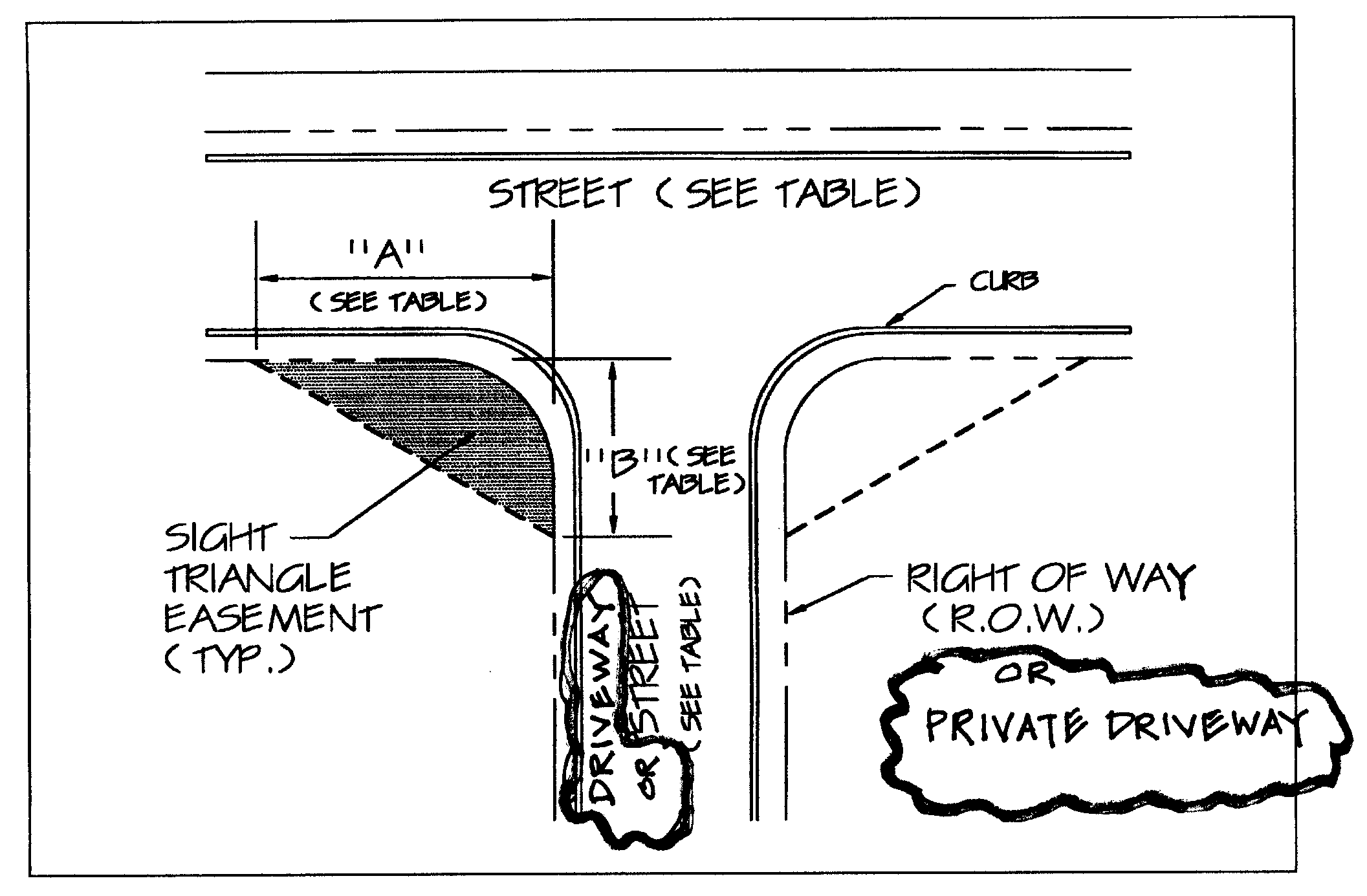
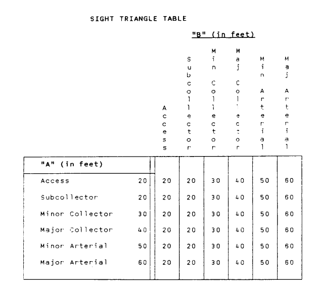
FIGURE II-5
EARTH BERM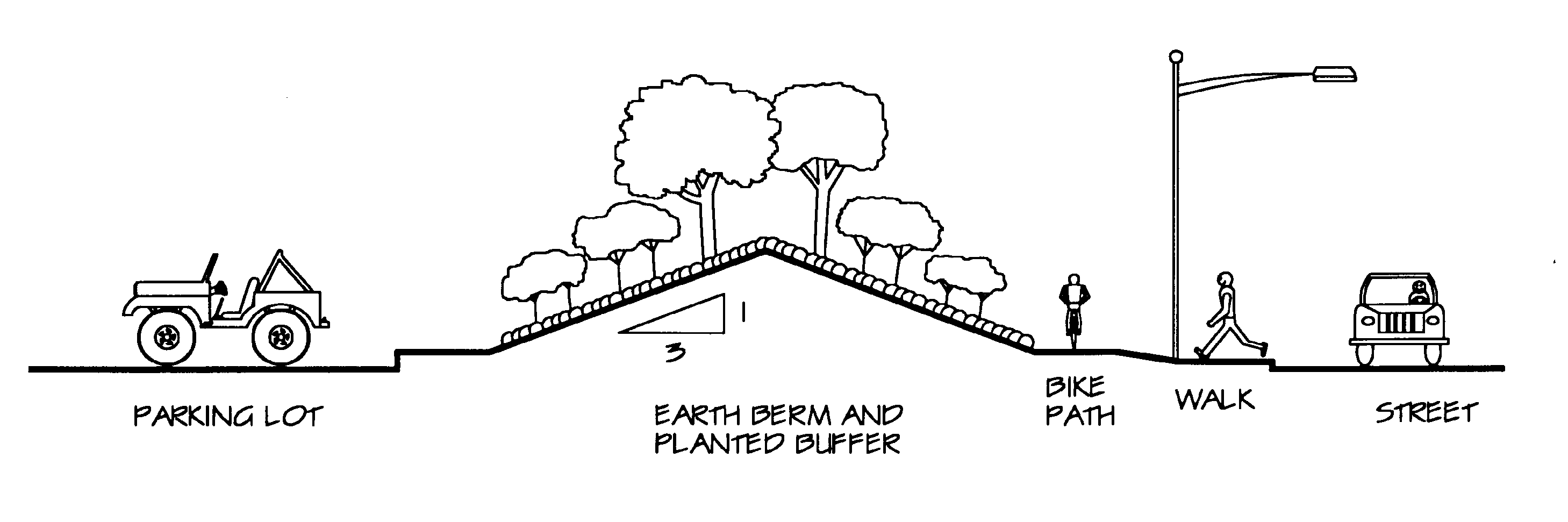
FIGURE II-6
STAGGERED PLANTING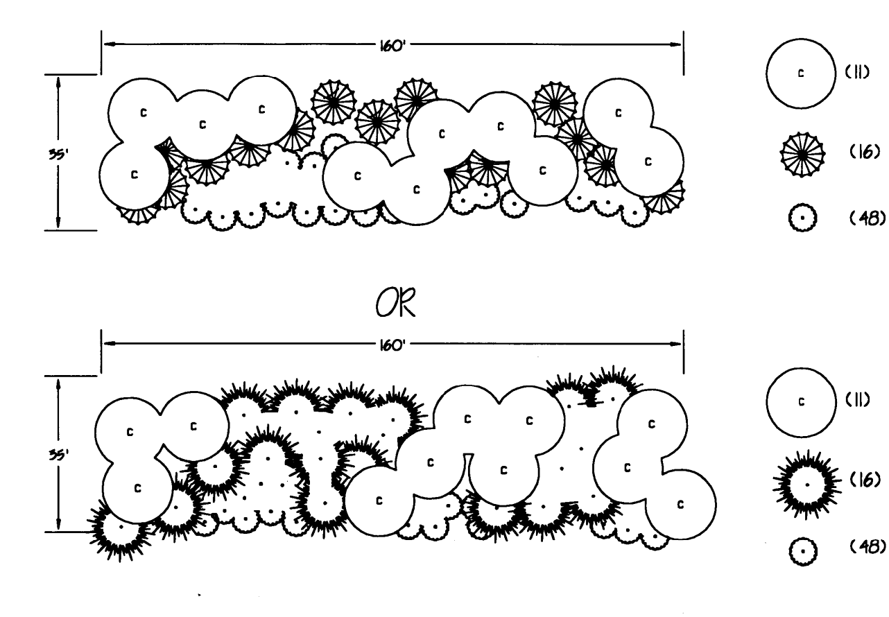
FIGURE II-7
TRANSITIONAL BUFFER ZONES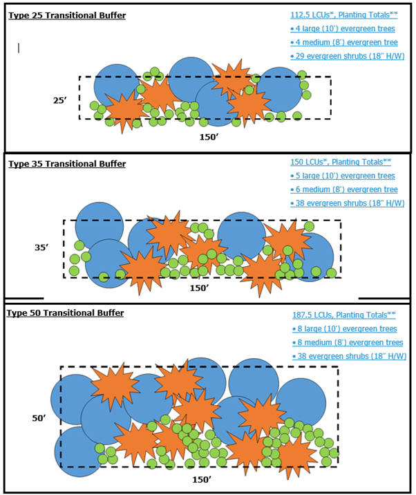
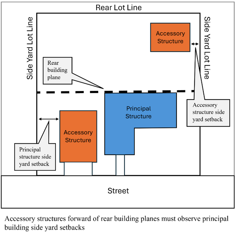
FIGURE II-7.1
ACCESSORY BUILDING SETBACK
FIGURE II-7.2
ACCESSORY BUILDING SETBACK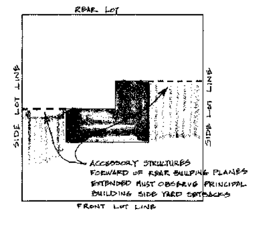
NOTES
1.
THE PLAT SHALL CONTAIN ONE OF THE FOLLOWING TITLES AS APPLICABLE:
a.)
PLAT OF EASEMENT DEDICATION
b.)
PLAT OF RIGHT-OF-WAY DEDICATION
c.)
PLAT OF EASEMENT/RIGHT-OF-WAY DEDICATION
2.
ALL EASEMENTS TO BE DEDICATED TO THE COUNTY SHALL BE SPECIFIED AS DRAINAGE AND UTILITY EASEMENTS UNLESS OTHERWISE SPECIFIED BY THE AGENT.
3.
ALL EASEMENTS WHICH DO NOT FOLLOW PROPERTY LINES SHALL BE LOCATED BY A METES AND BOUNDS DESCRIPTION AND OTHER INFORMATION AS NECESSARY TO ACCURATELY LOCATE SUCH EASEMENTS.
4.
ALL EASEMENTS WHICH FOLLOW DITCHES, SWALES, STREAMS, ETC., MAY BE DESIGNATED AS FOLLOWING THE CENTERLINE OF SUCH DITCH, SWALE, OR STREAM. THE OUTER BOUNDARIES OF THE EASEMENT SHALL BE SHOWN.
5.
THE FULL NAME OF THE PROPERTY OWNER AS SHOWN ON THE OWNER'S DEED MUST BE PROVIDED. ALSO PROVIDE THE APPROPRIATE DEED REFERENCE ON THE PLAT.
| Evergreen Trees Botanical/Common Name VA Coastal Plain Native Species =
|
Projected 10-Year Cover Area (square feet)
Height at Planting | Minimum Planting Area (square feet) | Uses/Placement | Environmental Tolerances | Problems | |||||||||||||||
|---|---|---|---|---|---|---|---|---|---|---|---|---|---|---|---|---|---|---|---|---|
| 6' | 8' | 10' |
Parking Lot
|
Screening
|
Small Areas
|
Overhead Utilities
|
Rights-of-Way
|
Restricted Root Z.
|
Poor Soil
|
Partial Shade
|
Full Shade
|
Wet Soil
|
Drought Tolerant
|
Disease
|
Insects
|
Weak Wood
|
Objectionable Fruit
|
Objectionable Roots
| ||
| Cedrus deodora/Deodar Cedar | 75 | 100 | 125 | 50 | X | |||||||||||||||
| Chamaecyparis obtuse/Hinoki Cypress | 75 | 100 | 125 | 50 | X | X | X | X | ||||||||||||
| Cunninghamia lanceolata/China Fir | 75 | 100 | 125 | 50 | X | |||||||||||||||
| Cupressocyparis Leyland/Leyland Cypress | 75 | 100 | 125 | 50 | X | X | ||||||||||||||
| Ilex 'Nellie Stevens'/Nellie Stevens Holly | 75 | 100 | 125 | 50 | X | X | ||||||||||||||
|
Ilex opaca/American Holly
| 75 | 100 | 125 | 50 | X | X | X | |||||||||||||
| Ilex X attenuata/Foster's Holly | 75 | 100 | 125 | 50 | X | X | X | |||||||||||||
|
Juniperus virginiana/Eastern Red Cedar
| X | X | X | X | X | X | X | |||||||||||||
| Juniperus chinensis 'Kaizuka'/Hollywood Juniper | X | X | X | X | X | X | ||||||||||||||
| Magnolia grandiflora/Southern Magnolia | 125 | 150 | 175 | 90 | X | X | X | |||||||||||||
|
Magnolia grandiflora 'Little Gem'/Little Gem Magnolia
| 75 | 100 | 125 | 50 | X | X | X | X | X | X | ||||||||||
|
Myrica cerifera/Bayberry or Wax Myrtle (multi- trunk)
| X | X | X | X | X | X | X | X | ||||||||||||
| Pinus thunbergiana/Japanese Black Pine | 60 | 80 | 100 | 50 | X | X | X | X | X | X | X | |||||||||
| Quercus virginiana/Live Oak | X | X | ||||||||||||||||||
| Thuja occidentalis/Arborvitae | 75 | 100 | 125 | 50 | X | X | X | X | X | |||||||||||
| Thuja orientalis/Oriental Arbovitae | 75 | 100 | 125 | 50 | X | X | X | X | X | |||||||||||
This chart may be revised from time to time by the Zoning Administrator to add or delete species or to update other information based on consultation with the Cooperative Extension Agent and/or landscape professionals.
| Small Deciduous Trees Botanical/Common Name VA Coastal Plain Native Species =
|
Projected 10-Year Cover Area (square feet)
Height at Planting | Minimum Planting Area (square feet) | Uses/Placement | Environmental Tolerances | Problems | |||||||||||||||
|---|---|---|---|---|---|---|---|---|---|---|---|---|---|---|---|---|---|---|---|---|
| 6' | 8' | 10' |
Parking Lot
|
Screening
|
Small Areas
|
Overhead Utilities
|
Rights-of-Way
|
Restricted Root Z.
|
Poor Soil
|
Partial Shade
|
Full Shade
|
Wet Soil
|
Drought Tolerant
|
Disease
|
Insects
|
Weak Wood
|
Objectionable Fruit
|
Objectionable Roots
| ||
| Acer ginnala/Amur Maple | 60 | 80 | 100 | 60 | X | X | X | X | X | X | X | X | ||||||||
| Acer palmatum/Japanese Maple | 60 | 80 | 100 | 60 | X | X | X | X | X | |||||||||||
|
Amelanchier arborea/Serviceberry
| 100 | 125 | 150 | 60 | X | X | X | X | X | X | X | X | ||||||||
|
Cercis canadensis/Eastern Redbud
| 150 | 175 | 200 | 50 | X | X | X | X | X | X | X | X | ||||||||
|
Chionanthus virginicus/White Fringe Tree
| 80 | 100 | 120 | 60 | X | X | X | X | X | |||||||||||
| Crataegus viridis 'Winter King'/Green Hawthorn | 150 | 175 | 200 | 100 | X | X | X | X | X | X | X | X | X | |||||||
| Koelreturia paniculata/Goldenraintree | 150 | 175 | 200 | 100 | X | X | X | X | X | X | X | |||||||||
| Lagerstroemia indica/Crape Myrtle | 150 | 175 | 200 | 100 | X | X | X | X | X | X | X | X | X | |||||||
| Magnolia stellata/Star Magnolia | 100 | 120 | 150 | 60 | X | X | X | X | ||||||||||||
| Magnolia x soulangeana/Saucer Magnolia | 150 | 175 | 200 | 60 | X | X | X | X | ||||||||||||
| Magnolia virginiana/Sweetbay Magnolia | 100 | 125 | 150 | 60 | X | X | X | X | X | X | ||||||||||
| Malus sp./Crabapple | 150 | 175 | 200 | 100 | X | X | X | X | X | X | X | X | X | |||||||
| Prunus cerasifera/Flowering Plum | 100 | 125 | 150 | 100 | X | X | X | X | X | X | X | X | X | |||||||
| Prunus serrulata/Kwanzan Cherry | 150 | 175 | 200 | 100 | X | X | X | X | X | X | X | X | X | |||||||
| Prunus subhirtella/Higan Cherry | 150 | 175 | 200 | 100 | X | X | X | X | X | X | ||||||||||
| Prunus x yedoensis/Yoshino Cherry | 150 | 175 | 200 | 100 | X | X | X | X | X | X | X | X | X | |||||||
This chart may be revised from time to time by the Zoning Administrator to add or delete species or to update other information based on consultation with the Cooperative Extension Agent and/or landscape professionals.
| Medium Deciduous Trees Botanical/Common Name VA Coastal Plain Native Species =
|
Projected 10-Year Cover Area (square feet)
Height at Planting | Minimum Planting Area (square feet) | Uses/Placement | Environmental Tolerances | Problems | |||||||||||||||
|---|---|---|---|---|---|---|---|---|---|---|---|---|---|---|---|---|---|---|---|---|
| 6' | 8' | 10' |
Parking Lot
|
Screening
|
Small Areas
|
Overhead Utilities
|
Rights-of-Way
|
Restricted Root Z.
|
Poor Soil
|
Partial Shade
|
Full Shade
|
Wet Soil
|
Drought Tolerant
|
Disease
|
Insects
|
Weak Wood
|
Objectionable Fruit
|
Objectionable Roots
| ||
|
Betula nigra/River Birch
| 150 | 175 | 100 | X | X | X | ||||||||||||||
| Ginkgo biloba/Ginkgo (male variety) | 150 | 175 | 100 | X | X | X | X | X | ||||||||||||
| Pyrus calleryana/Callery Pear | 150 | 175 | 100 | X | X | X | X | X | X | |||||||||||
This chart may be revised from time to time by the Zoning Administrator to add or delete species or to update other information based on consultation with the Cooperative Extension Agent and/or landscape professionals.
| Large Deciduous Trees Botanical/Common Name VA Coastal Plain Native Species =
|
Projected 10-Year Cover Area (square feet)
Height at Planting | Minimum Planting Area (square feet) | Uses/Placement | Environmental Tolerances | Problems | |||||||||||||||
|---|---|---|---|---|---|---|---|---|---|---|---|---|---|---|---|---|---|---|---|---|
| 6' | 8' | 10' |
Parking Lot
|
Screening
|
Small Areas
|
Overhead Utilities
|
Rights-of-Way
|
Restricted Root Z.
|
Poor Soil
|
Partial Shade
|
Full Shade
|
Wet Soil
|
Drought Tolerant
|
Disease
|
Insects
|
Weak Wood
|
Objectionable Fruit
|
Objectionable Roots
| ||
| Acer platanoides/Norway Maple | 275 | 300 | 180 | X | X | X | X | X | X | |||||||||||
|
Acer rubrum/Red Maple
| 275 | 300 | 180 | X | X | X | X | X | X | X | X | |||||||||
| Acer saccharum/Sugar Maple | 275 | 300 | 180 | X | X | X | X | X | X | |||||||||||
| Fraxinus pennsylvanica/Green Ash (Marshall's Seedless) | 275 | 300 | 180 | X | X | X | X | X | ||||||||||||
| Liquidambar styraciflua 'Rotundiloba'/Fruitless Sweetgum | 275 | 300 | 180 | X | X | X | X | X | X | |||||||||||
| Metasequoia glyptostroboides/Dawn Redwood | 275 | 300 | 180 | X | X | X | X | X | ||||||||||||
|
Nyssa sylvatica/Black Gum
| 275 | 300 | 180 | X | X | X | X | X | ||||||||||||
| Platanus x acerifolia/London Planetree | 275 | 300 | 180 | X | X | X | X | |||||||||||||
| Quercus acutissima/Sawtooth Oak | 275 | 300 | 180 | X | X | |||||||||||||||
| Quercus coccinea/Scarlet Oak | 275 | 300 | 180 | X | X | X | X | |||||||||||||
|
Quercus phellos/Willow Oak
| 275 | 300 | 180 | X | X | X | X | X | ||||||||||||
| Taxodium distichum/Baldcypress | 275 | 300 | 180 | X | X | X | X | X | ||||||||||||
| Tilia cordata/Littleleaf Linden | 275 | 300 | 180 | X | X | X | X | X | ||||||||||||
| Ulmus parvifolia/Chinese Elm | 275 | 300 | 180 | X | X | X | X | |||||||||||||
| Zelkova serrato/Zelkova | 275 | 300 | 180 | X | X | X | X | X | ||||||||||||
This chart may be revised from time to time by the Zoning Administrator to add or delete species or to update other information based on consultation with the Cooperative Extension Agent and/or landscape professionals.
| Evergreen Shrubs Botanical/Common Name VA Coastal Plain Native Species =
|
Projected 10-Year Cover Area (square feet)
Height at Planting | Minimum Planting Area (square feet) | Uses/Placement | Environmental Tolerances | Problems | |||||||||||||
|---|---|---|---|---|---|---|---|---|---|---|---|---|---|---|---|---|---|---|
| 18" |
Parking Lot Screen
|
General Uses
|
Small Areas
|
End Island
|
Screening/Buffering
|
Restricted Root Z.
|
Poor Soil
|
Partial Shade
|
Full Shade
|
Wet Soil
|
Drought Tolerant
|
Full Sun
|
Disease
|
Insects
| ||||
| Abelia grandiflora/Glossy Abelia | 25 | 9 | X | X | X | X | X | X | X | |||||||||
| Aucuba japonica/Japanese Aucuba | 20 | 9 | X | X | X | X | X | |||||||||||
| Berberis julianae/Wintergreen Barberry | 20 | 9 | X | X | X | X | X | X | ||||||||||
| Buxus sempervirens/American Boxwood | 6 | 4 | X | X | X | X | ||||||||||||
| Buxus microphylla/Wintergreen Boxwood | 6 | 4 | X | X | X | X | ||||||||||||
| Camellia japonica/Spring Blooming Camellia | 25 | 9 | X | X | ||||||||||||||
| Camellia sasanqua/Fall Blooming Camellia | 25 | 9 | X | X | ||||||||||||||
| Chamaecyparis pisifera/Cypress | 16 | 6 | X | X | X | X | X | |||||||||||
| Cleyera japonica/Japanese Cleyera | 25 | 9 | X | X | X | X | X | X | X | X | ||||||||
| Cotoneaster salicifolius/Willowleaf Cotoneaster | 9 | 6 | X | X | X | X | X | X | X | X | ||||||||
| Cytisus scoparius/Scotchbroom | 16 | 6 | X | X | X | X | X | X | ||||||||||
| Elaeagnus angustifolia/Russian Olive | 36 | 12 | X | X | X | X | X | X | X | |||||||||
| Euonymus fortunei/Wintercreeper Euonymous | 6 | 3 | X | X | X | X | X | X | X | X | X | X | X | |||||
| Euonymus radicans/Radicans Euonymus | 6 | 3 | X | X | X | X | X | X | X | X | X | X | X | |||||
| Ilex cornuta 'Burfordii'/Burford Holly | 36 | 12 | X | X | X | X | X | X | X | X | X | |||||||
| Ilex cornuta 'Burfordii Nana'/Dwarf Burford Holly | 25 | 9 | X | X | X | X | X | X | X | X | X | |||||||
| Ilex cornuta 'Carissa'/Carissa Holly | 16 | 6 | X | X | X | X | X | X | X | X | X | X | ||||||
| Ilex crenata 'Compacta'/Compacta Holly | 9 | 6 | X | X | X | X | X | X | X | |||||||||
| Ilex crenata 'Helleri'/Helleri Holly | 9 | 6 | X | X | X | X | X | X | X | |||||||||
| Ilex crenata 'Nigra'/Nigra Holly | 9 | 6 | X | X | X | X | X | X | ||||||||||
| Ilex glabra/Inkberry | 16 | 6 | X | X | X | X | X | X | X | |||||||||
| Abelia grandiflora/Glossy Abelia | 25 | 9 | X | X | X | X | X | X | X | |||||||||
| Aucuba japonica/Japanese Aucuba | 20 | 9 | X | X | X | X | X | |||||||||||
| Berberis julianae/Wintergreen Barberry | 20 | 9 | X | X | X | X | X | X | ||||||||||
| Buxus sempervirens/American Boxwood | 6 | 4 | X | X | X | X | ||||||||||||
| Buxus microphylla/Wintergreen Boxwood | 6 | 4 | X | X | X | X | ||||||||||||
| Camellia japonica/Spring Blooming Camellia | 25 | 9 | X | X | ||||||||||||||
| Camellia sasanqua/Fall Blooming Camellia | 25 | 9 | X | X | ||||||||||||||
| Chamaecyparis pisifera/Cypress | 16 | 6 | X | X | X | X | X | |||||||||||
| Cleyera japonica/Japanese Cleyera | 25 | 9 | X | X | X | X | X | X | X | X | ||||||||
| Cotoneaster salicifolius/Willowleaf Cotoneaster | 9 | 6 | X | X | X | X | X | X | X | X | ||||||||
| Cytisus scoparius/Scotchbroom | 16 | 6 | X | X | X | X | X | X | ||||||||||
| Elaeagnus angustifolia/Russian Olive | 36 | 12 | X | X | X | X | X | X | X | |||||||||
| Euonymus fortunei/Wintercreeper Euonymous | 6 | 3 | X | X | X | X | X | X | X | X | X | X | X | |||||
| Euonymus radicans/Radicans Euonymus | 6 | 3 | X | X | X | X | X | X | X | X | X | X | X | |||||
| Ilex cornuta 'Burfordii'/Burford Holly | 36 | 12 | X | X | X | X | X | X | X | X | X | |||||||
| Ilex cornuta 'Burfordii Nana'/Dwarf Burford Holly | 25 | 9 | X | X | X | X | X | X | X | X | X | |||||||
| Ilex cornuta 'Carissa'/Carissa Holly | 16 | 6 | X | X | X | X | X | X | X | X | X | X | ||||||
| Ilex crenata 'Compacta'/Compacta Holly | 9 | 6 | X | X | X | X | X | X | X | |||||||||
| Ilex crenata 'Helleri'/Helleri Holly | 9 | 6 | X | X | X | X | X | X | X | |||||||||
| Ilex crenata 'Nigra'/Nigra Holly | 9 | 6 | X | X | X | X | X | X | ||||||||||
|
Ilex glabra/Inkberry
| 16 | 6 | X | X | X | X | X | X | X | |||||||||
This chart may be revised from time to time by the Zoning Administrator to add or delete species or to update other information based on consultation with the Cooperative Extension Agent and/or landscape professionals.
| Deciduous Shrubs Botanical/Common Name VA Coastal Plain Native Species =
| Projected 10-Year Cover Area (square feet)
Height at Planting | Minimum Planting Area (square feet) | Uses/Placement | Environmental Tolerances | Problems | |||||||||||
|---|---|---|---|---|---|---|---|---|---|---|---|---|---|---|---|---|
| 18" |
Parking Lot Screen
|
General Uses
|
Small Areas
|
End Island
|
Screening/Buffering
|
Restricted Root Z.
|
Poor Soil
|
Partial Shade
|
Full Shade
|
Wet Soil
|
Drought Tolerant
|
Full Sun
|
Disease
|
Insects
| ||
| Azalea calendulaceae/Flame Azalea | 16 | 9 | X | X | X | X | X | |||||||||
| Azalea nudiflorum/Pinxter Bloom | 16 | 9 | X | X | X | X | X | |||||||||
| Berberis thunbergi/Japanese Barberry | 25 | 12 | X | X | X | X | X | X | X | |||||||
| Buddleia davidii/Butterfly-Bush | 25 | 12 | X | X | X | X | X | |||||||||
| Chaenomeles lagenaria/Japanese Flowering Quince | 25 | 12 | X | X | X | |||||||||||
|
Clethra alnifolia/Sweet Pepperbush
| 25 | 12 | X | X | X | X | X | |||||||||
| Cornus sericea/Redosier Dogwood | 25 | 12 | X | X | X | X | X | X | ||||||||
| Cotoneaster/Cotoneaster | 16 | 9 | X | X | X | X | X | X | X | |||||||
| Deutzia gracilis/Slender Deutzia | 9 | 4 | X | X | X | X | X | X | X | |||||||
| Euonymous alatus 'Compacta'/Burning Bush | 25 | 12 | X | X | X | X | X | X | ||||||||
| Forsyhia intermedia/Forsythia | 25 | 12 | X | X | X | X | X | |||||||||
| Hamamelis mollis/Chinese Witch-Hazel | 36 | 15 | X | X | X | X | X | |||||||||
| Hamamelis vernalis/Vernal Witch-Hazel | 36 | 15 | X | X | X | X | X | |||||||||
| Hibiscus syriacus hybrids/Rose of Sharon | 25 | 12 | X | X | X | X | ||||||||||
| Hydrangea macrophylla/Bigleaf Hydrangea | 16 | 9 | X | X | X | |||||||||||
| Hydrangea querifolia/Oakleaf Hydrangea | 16 | 9 | X | X | X | |||||||||||
| Hypericum/St. Johnswort | 9 | 4 | X | X | X | X | X | X | ||||||||
| Ilex verticillata/Winter Berry | 25 | 12 | X | X | X | X | ||||||||||
|
Itea virginica/Virginia Sweetspire
| 25 | 12 | X | X | X | X | X | X | X | |||||||
| Spiraea japonica/Japanese Spirea | 16 | 9 | X | X | X | X | X | X | ||||||||
| Spiraea prunifolia/Double Bridal Wreath | 25 | 12 | X | X | X | X | X | X | ||||||||
| Spiraea x bumalda/Bumald Spirea | 16 | 9 | X | X | X | X | X | X | ||||||||
| Viburnum carlesii/Koreanspice Viburnum | 25 | 12 | X | X | X | X | X | |||||||||
| Viburnum plicatum/Doublelife Viburnum | 36 | 12 | X | X | X | X | X | |||||||||
| Viburnum tinus/Tinus Viburnum | 25 | 12 | X | X | X | X | X | |||||||||
| Weigelia florida/Weigelia | 25 | 12 | X | X | X | X | X | |||||||||
This chart may be revised from time to time by the Zoning Administrator to add or delete species or to update other information based on consultation with the Cooperative Extension Agent and/or landscape professionals.
| Perennials and Ornamental Grasses Botanical/Common Name VA Coastal Plain Native Species =
| Projected 3-Year Cover Area (square feet) | Minimum Planting Area | Uses/Placement | Environmental Tolerances | Problems | ||||||||||||||
|---|---|---|---|---|---|---|---|---|---|---|---|---|---|---|---|---|---|---|---|
| 1 gal. | S.F. |
Height
(feet) |
Parking Lot Screen
|
General Uses
|
Small Areas
|
End Island
|
Screening/Buffering
|
Restricted Root Z.
|
Poor Soil
|
Partial Shade
|
Full Shade
|
Wet Soil
|
Drought Tolerant
|
Full Sun
|
Disease
|
Insects
| |||
| Perennials: | |||||||||||||||||||
| Achillea/Yarrow | 4 | 4 | 2 | X | X | X | X | X | X | ||||||||||
| Astilbe arendsii/False Spirea | 2 | 3 | 2 | X | X | X | X | X | |||||||||||
| Caryopteris x clandonensis/Blue Mist Spirea | 4 | 6 | 2 | X | X | X | X | X | X | ||||||||||
| Coreopsis grandiflora/Coreopsis | 2 | 4 | 1.5 | X | X | X | X | X | X | X | |||||||||
| Coreopsis verticillata/Coreopsis | 2 | 4 | 1.5 | X | X | X | X | X | X | ||||||||||
| Dianthus gratianopolitanus 'Baths Pink'/Bath's Cheddar Pink | 3 | 4 | 1 | X | X | X | X | X | X | ||||||||||
| Dryopteris erythrosora/Autumn Fern | 2 | 3 | 2 | X | X | X | X | X | X | ||||||||||
| Echinacea purpurea/Purple Coneflower | 2 | 3 | 2 | X | X | X | X | X | X | ||||||||||
| Eupatorium/Joe Pye Weed | 4 | 6 | 5 | X | X | X | X | X | X | X | |||||||||
| Gaillardia grandiflora/Blanket Flower | 3 | 4 | 1 | X | X | X | X | X | X | X | |||||||||
| Heliopsis helianthoides/False Sunflower | 4 | 6 | 3 | X | X | X | X | ||||||||||||
| Hemerocallis/Daylily | 2 | 4 | X | X | X | X | X | X | X | X | X | ||||||||
| Hosta/Hosta | 3 | 4 | 3 | X | X | X | X | X | X | ||||||||||
| Iberis sempervirens/Candytuft | 2 | 3 | 1 | X | X | X | X | ||||||||||||
| Iris ensata/Japanese Iris | 3 | 4 | 3 | X | X | X | X | X | X | ||||||||||
| Lavandula angustifolia/Lavender | 3 | 4 | 1.5 | X | X | X | X | X | X | ||||||||||
| Perovskia atriplicifolia/Russian Sage | 4 | 6 | 3 | X | X | X | X | X | X | ||||||||||
|
Rudbeckia fulgida/Black-eyed Susan
| 4 | 6 | 2.5 | X | X | X | X | X | X | X | X | X | |||||||
| Salvia x superba/Perennial Salvia | 3 | 4 | 2 | X | X | X | X | X | X | ||||||||||
| Scabiosa columbaria/Pincushion Flower | 2 | 4 | 1 | X | X | X | X | X | X | ||||||||||
| Sedum spectable 'Autumn Joy'/Autumn Joy Sedum | 4 | 6 | 3 | X | X | X | X | X | X | X | X | X | |||||||
| Stachys byzantina/Lambs Ear | 4 | 6 | 1 | X | X | X | X | X | X | X | |||||||||
| Verbena canadensis/Verbena | 6 | 6 | 1 | X | X | X | X | X | X | X | |||||||||
| Veronica spicata/Speedwell | 2 | 3 | 1 | X | X | X | X | X | X | ||||||||||
| Veronica x 'Sunny Border Blue'/Veronica 'Sunny Border Blue' | 2 | 3 | 2 | X | X | X | X | X | |||||||||||
| Ornamental Grasses: | |||||||||||||||||||
| Calamagrostis acutiflora/Feather Reed Grass | 6 | 9 | 5 | X | X | X | X | X | X | ||||||||||
| Chasmanthium latifolium/Northern Sea Oats | 6 | 9 | 4 | X | X | X | X | ||||||||||||
| Cortaderia selloana/Pampas Grass | 9 | 12 | 6 | X | X | X | X | X | X | ||||||||||
| Liriope muscari/Liriope | 3 | 4 | 1 | X | X | X | X | X | X | X | X | X | X | ||||||
| Miscanthus sinensis/Maiden Grass | 9 | 12 | 5 | X | X | X | X | X | X | ||||||||||
| Miscanthus purpurascens/Miscanthus | 9 | 12 | 5 | X | X | X | X | X | X | ||||||||||
| Muhlenbergia capillaris/Pink Hair Grass | 6 | 9 | 3 | X | X | X | X | ||||||||||||
| Ophiopogon japonicus | 2 | 3 | .5 | X | X | X | X | X | X | X | X | ||||||||
|
Panicum virgatum/Switch Grass
| 6 | 9 | 5 | X | X | X | X | X | |||||||||||
| Pennisetum alopecuroides/Fountain Grass | 6 | 9 | 3 | X | X | X | X | X | X | X | X | ||||||||
| Phalaris arundinacea/Ribbon Grass | 4 | 6 | 3 | X | X | X | X | X | X | ||||||||||
(Ord. No. 25-4, 2-18-25)
MAP III-2
WATERSHED MANAGEMENT AND PROTECTION AREA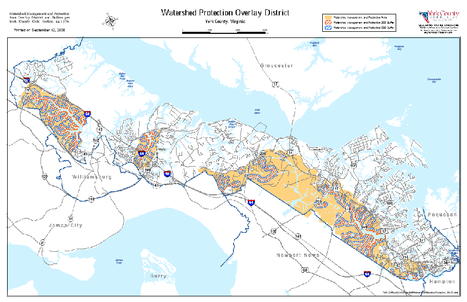
FIGURE V-1
SITE PLAN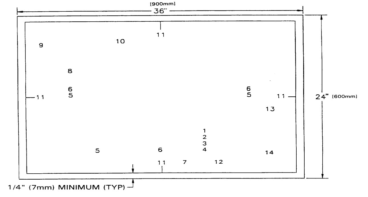
NOTES
1.
ITEMS 1—4, 8, 9, 11, 12 AND 14 MAY NOT BE RELOCATED ON THE DRAWING.
2.
ITEMS 5, 6, 7, 10, AND 13 MAY BE REARRANGED, IF NECESSARY, TO ACCOMMODATE THE BOYD OF THE SITE PLAN.
3.
ARTICLE V OF THE ZONING ORDINANCE APPLIES TO THE PREPARATION AND SUBMISSION OF THE SITE PLANS.
SITE PLAN REVIEW/APPROVAL PROCESS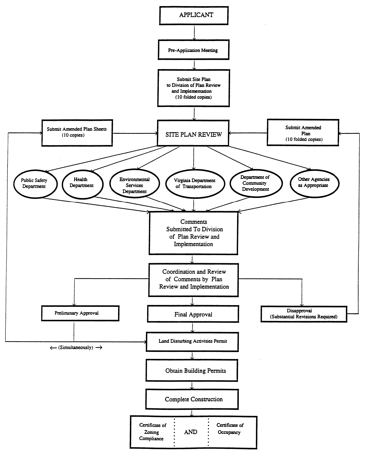
FIGURE VII-1
SIGN TYPES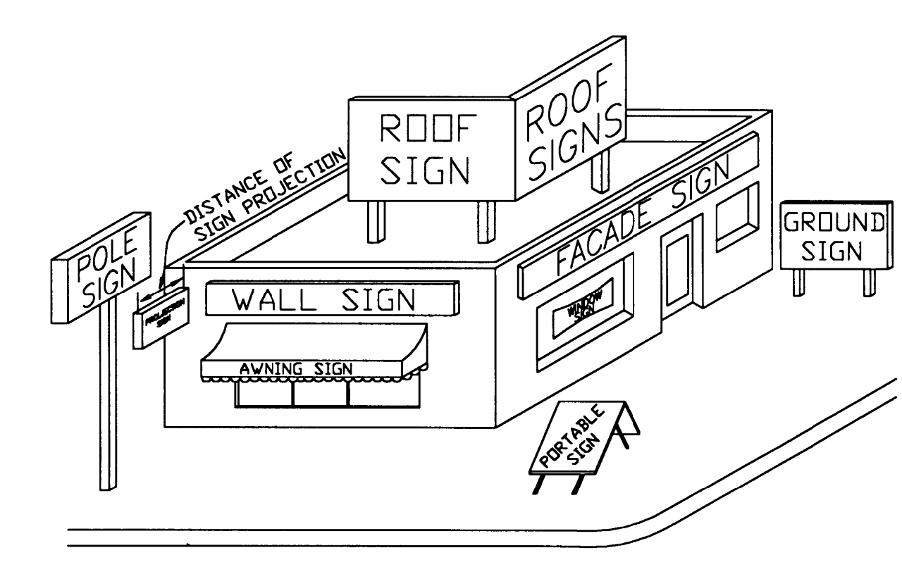
FIGURE VII-2
SIGN AREA - GROUND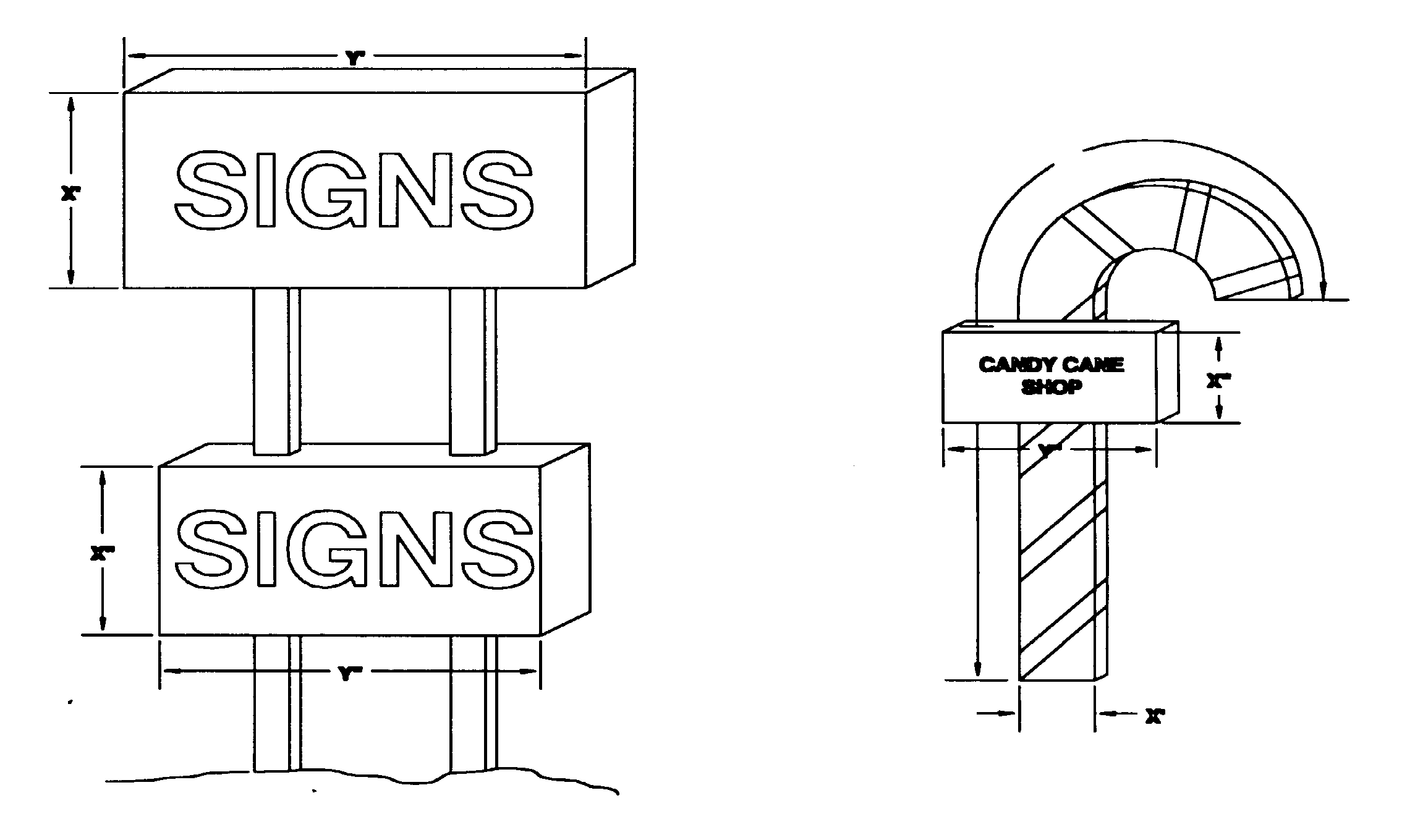
FIGURE VII-2
SIGN AREA - GROUND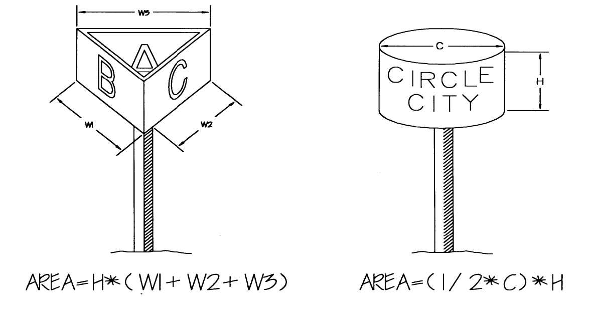
FIGURE VII-3
SIGN AREA - WALL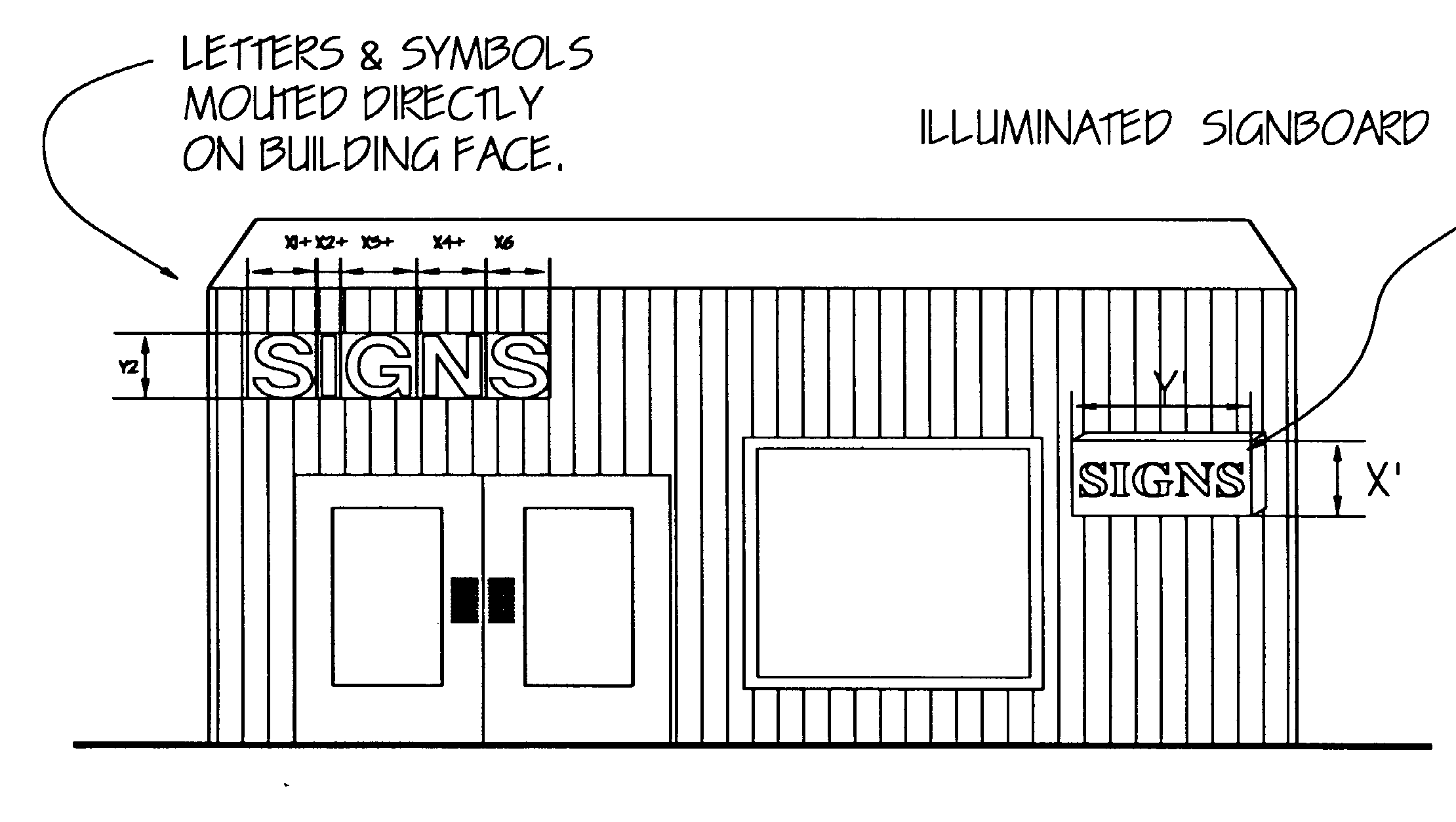
FIGURE VII-4
SIGN AREA - MONUMENT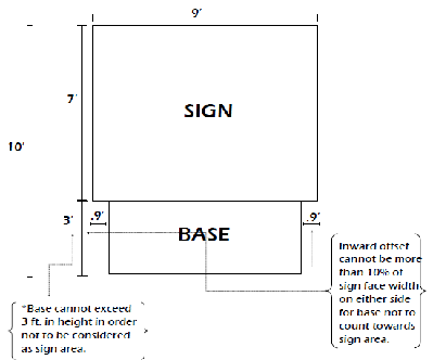
FIGURE VII-4
SIGN AREA - MONUMENT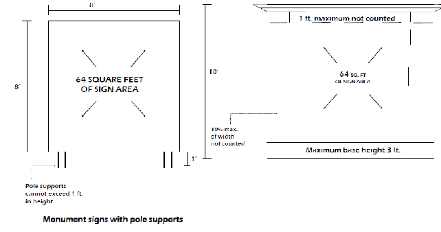
FIGURE VII-5
SIGN AREA - FENCE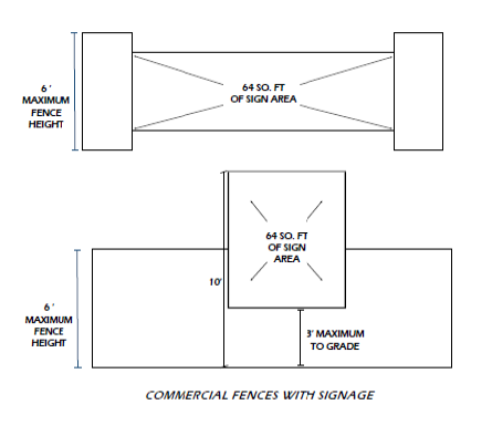

FIGURE VII-6
FIGURE VII-7
SIGN AREA - RESIDENTIAL COMMUNITY IDENTIFICATION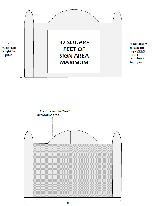
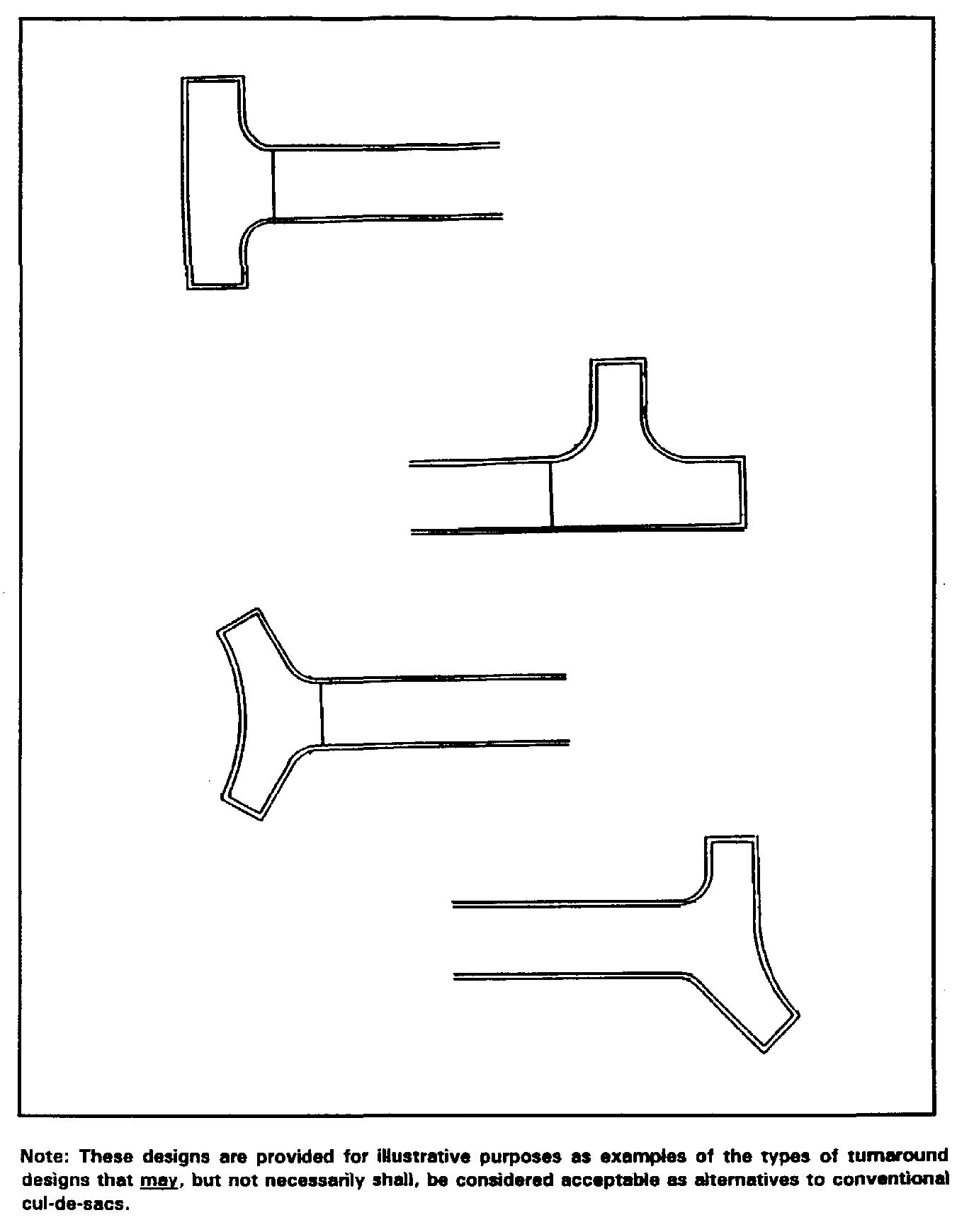
FIGURE VIII-1
ALTERNATIVE TURNAROUND DESIGNS