
Albert Lea City Zoning Code
ARTICLE III
- DISTRICTS
Sec. 50.0196.- Established.
For the purposes of this chapter, the city is divided into districts, as shown on the official zoning map, which, together with all explanatory matter thereof, is adopted by reference and declared to be a part of this chapter. The districts shall be known as follows:
(Code 1980, § 11.03; Code 1997, § 74-216)
Sec. 50.0197. - Scope of regulations.
Zoning district regulations shall be set forth in section 50.0199 in the tabulation of district requirements and in articles IV and V of this chapter.
(Code 1980, § 11.07; Code 1997, § 74-217)
Sec. 50.0198. - Rules for interpretation of boundaries.
Where uncertainty exists as to the boundaries of zoning districts, as shown on the official zoning map, the following rules shall apply:
(1)
Boundaries indicated as approximately following streets, highways or alleys shall be construed to follow the lot lines of the subject parcel.
(2)
Boundaries indicated as approximately following platted lot lines shall be construed as following such lot lines.
(3)
Boundaries indicated as approximately following city limits shall be construed as following the city limits.
(4)
Boundaries indicated as following railroad lines shall be construed to be midway between the main tracks.
(5)
Boundaries indicated as following rivers and streams should be construed to follow the approximate centerline of such river or stream.
(6)
Boundaries indicated as parallel to or extensions of features indicated in subsections (1) through (5) of this section shall be so construed. Distances not specifically indicated on the official zoning map shall be determined by the scale of the map.
(7)
Where the street or property layout existing on the ground is at variance with that shown on the official zoning map, or in other circumstances not covered by subsections (1) through (6) of this section, the board of zoning appeals shall interpret the district boundaries in accordance with chapter 2, article VI, division 3.
(8)
The boundaries of the floodplain zoning district shall be determined by scaling distances of the floodplain zoning map. Where interpretation is needed as to the exact location of the boundaries of the district as shown on the floodplain zoning map, as for example where there appears to be a conflict between a mapped boundary and actual field conditions, the board of zoning appeals shall make the necessary interpretation based on elevations on the regional one hundred (100) year flood profile and other available technical data. Persons contesting the location of the district boundaries shall be given a reasonable opportunity to present their case to the board and to submit technical evidence.
(Code 1980, § 11.08; Code 1997, § 74-218; Ord. No. 205, 6d, § 3, 5-8-2017)
Sec. 50.0199. - Tabulation of district requirements.
The following table depicts zoning district requirements:
Zoning District Requirements
(Code 1980, § 11.50; Code 1997, § 74-219; Ord. No. 163, 4d, 11-25-2013; Ord. No. 205, 6d, § 4, 5-8-2017; Ord. No. 23-099, 7-24-2023)
Sec. 50.0222.- Purpose.
It is the purpose of the R-1 single-family residence district to encourage the establishment and preservation of residential neighborhoods characterized by single-family buildings on medium-sized lots. Nonresidential uses permitted in this district are those that will provide auxiliary service or will contribute to the stability and long-term value of the area for residential purposes.
(Code 1980, § 11.20, subd. 1; Code 1997, § 74-251)
Sec. 50.0223. - Principal permitted uses.
In the R-1 single-family residence district, no building, structure or land shall be used and no building or structure shall be erected, altered or enlarged which is arranged, intended or designed for other than one (1) of the following uses, except as provided in article VIII of this chapter:
(1)
Generally. Single-family, and two (2) family dwellings, except as modified in this division.
(2)
Licensed residential or day care facilities. A licensed residential facility serving six (6) or fewer persons or licensed day care facility serving ten (10) or fewer persons.
(3)
Lodginghouses.
(Code 1980, § 11.20, subd. 2; Code 1997, § 74-252; Ord. No. 10, 3d, § 1, 1-12-1998)
Sec. 50.0224. - Prohibited uses.
(a)
Cannabis products. All commercial cannabis cultivation, retail, transportation, warehousing and manufacturing.
(Ord. No. 24-127, § 1, 9-9-2024)
Editor's note— Ord. No. 24-127, § 1, adopted Sept., 9, 2024, renumbered the former §§ 50.0224—50.0228 as §§ 50.0225—50.0229 and enacted a new § 50.0224 as set out herein. The historical notation has been retained with the amended provisions for reference purposes.
Sec. 50.0225. - Conditional permitted uses.
The following uses shall be permitted in an R-1 single-family residence district only if specifically approved by the planning commission and authorized by the council:
(1)
Religious and cultural. Churches, synagogues, and other places of worship, Sunday school buildings, schools for academic instruction, public libraries, museums, cemeteries, art galleries and similar public cultural uses.
(2)
Recreational. Public and commercial recreational uses such as country clubs, golf courses, swimming pools, and similar comparable uses.
(3)
Two (2) family semidetached and cluster dwellings. Two (2) family semidetached and clustered dwellings on separate lots in accordance with the following conditions:
a.
Each of the lots shall be equal in area or as near equal in area as is reasonably possible.
b.
Each lot shall contain no less than one-half (½) of the minimum land area requirement for a two (2) family dwelling.
c.
Except for setbacks along the common property line or side yards on clustered dwellings, all other setbacks and yard requirements shall be provided in accordance with the requirements of the R-1 single-family district.
d.
Any subdivision of a lot or parcel shall be accomplished in accordance with the subdivision regulations in chapter 38.
(4)
Density zoning. Dwelling units in one (1) or more buildings may be permitted on a site with the maximum number of dwelling units not to exceed the density limitation provided in subsection 50-0199 (2)b. It is the intent of this subsection to allow the development of property in a manner which is superior in compatibility and design compared to development permitted as the principal permitted use in this district. In addition to the standards established in this chapter, the following requirements shall be included within a development approved under this subsection:
a.
Useable open space. Not less than four hundred (400) square feet of useable open space shall be provided for each dwelling unit on the site. Usable open space may not include parking areas and driveways, and the space shall be developed in such a way that it is suitable for the tenants' active and passive recreations. Balconies may provide up to twenty (20) percent of the useable open space requirement.
b.
Parking. Parking shall be provided in accordance with the unit size breakdown. Efficiency apartments shall have one (1) parking space per unit. One (1) bedroom apartments shall have one and one-half (1 ½) parking spaces per unit. Two (2) bedroom and larger apartments shall have two (2) parking spaces per unit. All parking shall be provided off street and entirely within the confines of the site. Not less than fifty (50) percent of all required off-street parking shall be provided in a garage or enclosed space. All open off-street parking areas shall be developed per the design standards contained in section 50-0894.
c.
Landscaping. Landscaping shall be provided on all areas that are not used for parking, driveways, walkways or buildings. Landscaping shall include sod and evergreen as well as deciduous trees and shrubs. Parking lots shall be screened from adjoining residential areas through the use of landscaping. Street trees shall be planted in boulevard areas. The planting of street trees shall be coordinated with the director of parks and recreation and shall meet city standards.
d.
Lighting. Exterior lighting of the site shall be adequate to provide security and shall be compatible in design and character with surrounding residential areas. Lighting shall be directed toward the site or contained on the site and shall not be directed toward adjoining residential areas.
e.
Refuse storage. All refuse storage shall be within the principal building or within an accessory structure designed for that purpose.
f.
Storage of equipment. All equipment, including maintenance equipment, bicycles, recreation vehicles and trailers, mowers and snow removal equipment, shall be stored in an enclosed structure. Outside parking areas shall not be used for the parking of recreational trailers or other accessory vehicles.
g.
Documentation. The applicant shall submit drawings and documentation which clearly shows all improvements to be made on the site, including building elevations, floor plans, lighting, landscaping, site plan, and other documentation required to clearly define the proposed development. The documents shall be made a part of the conditional use permit, and all other developments shall be in accordance with the documents.
(Code 1980, § 11.20, subd. 3; Code 1997, § 74-253; Ord. No. 209, 6d, § 1, 11-13-2017; Ord. No. 226, 11d, § 1, 6-10-2019; Ord. No. 21-052, § 1, 3-8-2021; Ord. No. 22-083, § 1, 10-10-2022; Ord. No. 23-097, § 1, 5-22-2023; Ord. No. 24-127, § 1, 9-9-2024)
Editor's note— See editor's note § 50.0224.
Sec. 50.0226. - Accessory uses and buildings.
In the R-1 single-family residence district, accessory uses, buildings or structures customarily incidental to a principal permitted use or conditionally permitted use, located on the same lot therewith, are permitted, including:
(1)
Residential. Living quarters of persons employed on the premises and not rented or otherwise used as a separate dwelling.
(2)
Signs. No billboard, signboard or advertising sign shall be permitted except as provided in article IV of this chapter.
(3)
Accessory buildings. Accessory buildings and structures customarily incidental to any principal use.
(4)
Customary home occupations. Home occupations, as defined in section 50.0002, such as personal and professional services, handicrafts, dressmaking, millinery, laundry, preserving, and home cooking, provided that not more than twenty-five (25) percent of the gross floor area of one (1) floor of the residence shall be used for such purposes. In addition, such customary home occupation shall meet the criteria as specified in section 50.0022.
(Code 1980, § 11.20, subd. 4; Code 1997, § 74-254; Ord. No. 24-127, § 1, 9-9-2024)
Editor's note— See editor's note § 50.0224.
Sec. 50.0227. - Dimension requirements.
In the R-1 single-family residence district, building height; lot area, width and depth; yard setbacks; and special requirements shall be those set forth in section 50.0199 in the table of district requirements.
(Code 1980, § 11.20, subd. 5; Code 1997, § 74-255; Ord. No. 24-127, § 1, 9-9-2024)
Editor's note— See editor's note § 50.0224.
Sec. 50.0228. - Off-street parking and loading.
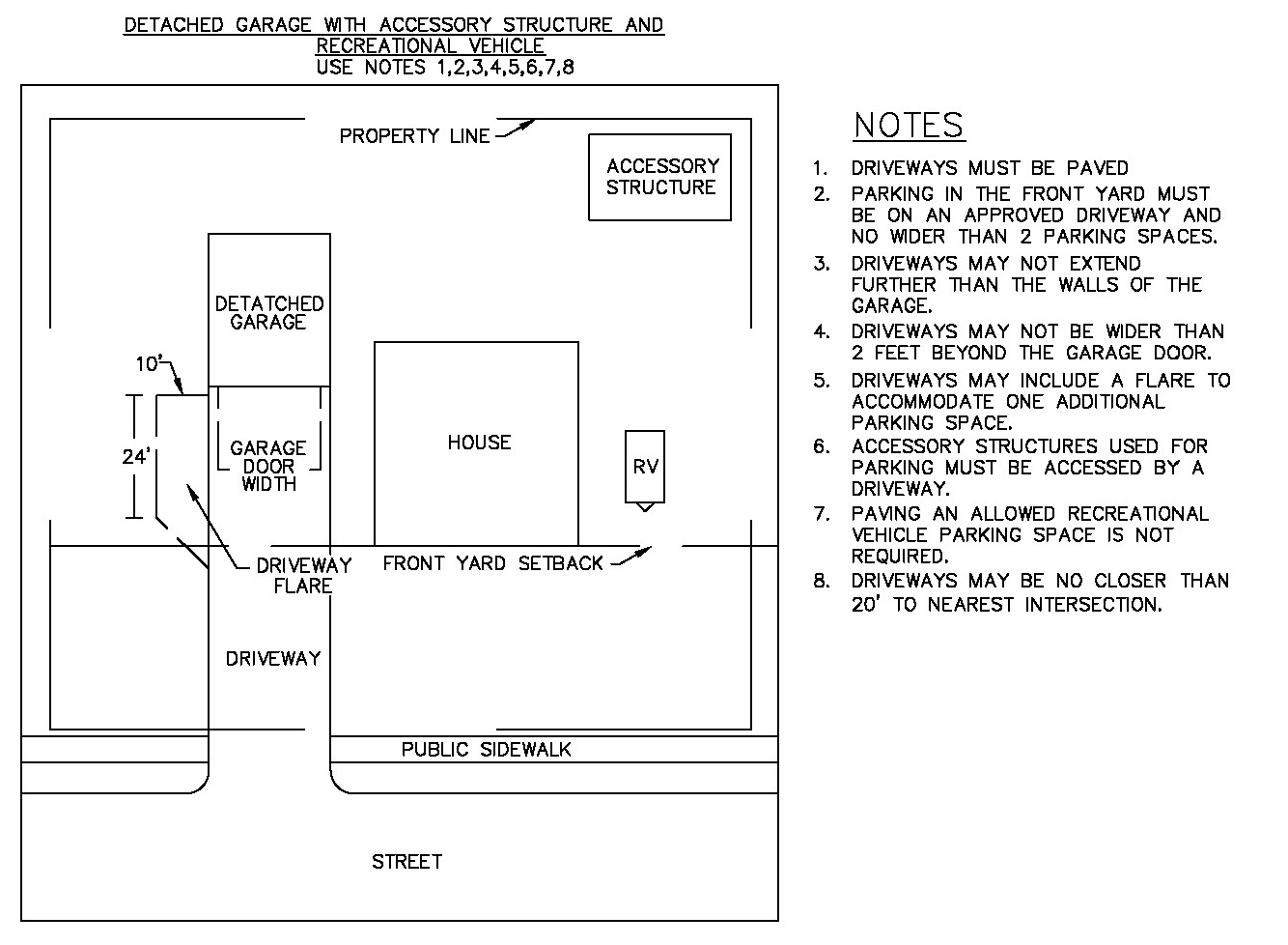
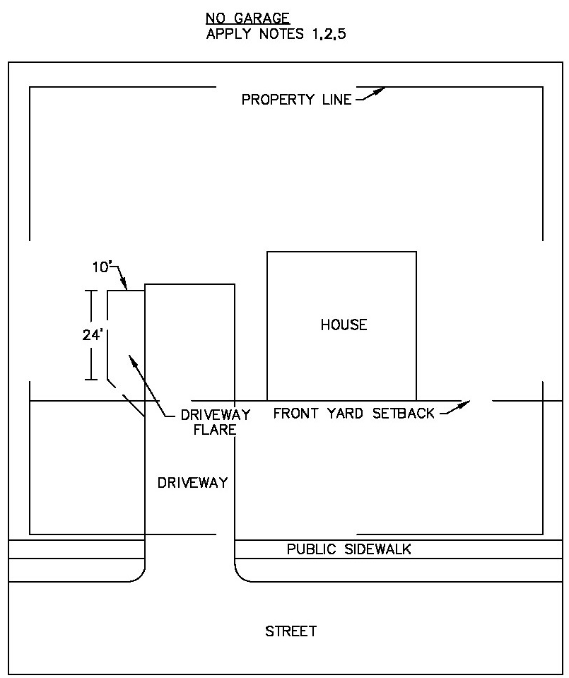
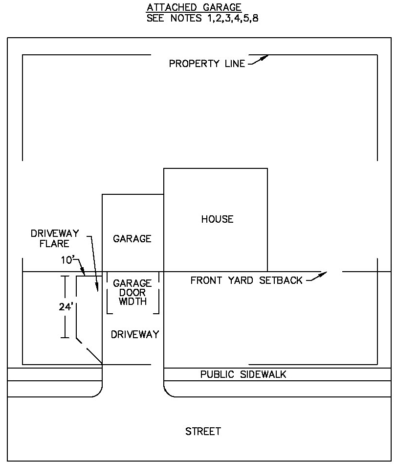
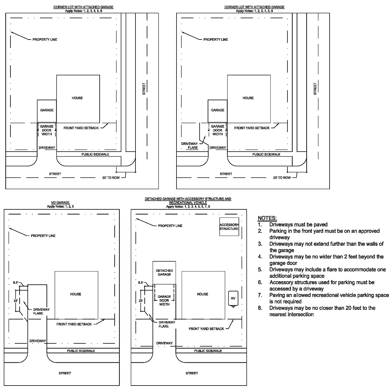
In the R-1 single-family residence district, off-street parking and loading facilities shall be provided as specified in article V of this chapter. The graphics provided in this section are to be used to illustrate the regulations. Where there is confusion, the text regulations govern.
(1)
Parking in the front yard must be on an approved driveway. Where driveways lead to a garage, attached or detached, the driveway portion in the front yard may not extend past the further of the side walls of the garage or two (2) feet beyond the garage door. Dimensional standards for parking spaces are provided in article V.
(2)
Driveways in the front yard may include a paved flare or hammerhead to accommodate one (1) additional parking space per unit. In no case should the paved flare exceed two hundred forty (240) square feet (10ft by 24ft) and in no case should the paved hammerhead exceed four hundred (400) square feet. The flare apron must adjoin the driveway at a forty-five (45) degree angle or less.
(3)
Accessory structures in the rear or side yard and used for vehicle parking must be accessed by an approved driveway.
(4)
Accessory structures used primarily for storage are not required to have a driveway.
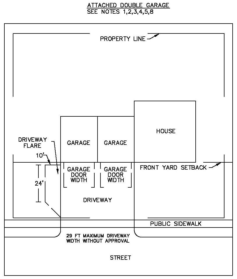
(Code 1980, § 11.20, subd. 6; Code 1997, § 74-256; Ord. No. 227,16d, § 1, 10-28-2019; Ord. No. 20-248, § 1, 10-12-2020; Ord. No. 23-092, § 1, 5-22-2023; Ord. No. 24-127, § 1, 9-9-2024)
Editor's note— See editor's note § 50.0224.
Sec. 50.0229. - Use qualifications.
Certain uses permitted within the R-1 single-family residence district shall be subject to further qualifications as provided in section 50.0023.
(Code 1980, § 11.20, subd. 7; Code 1997, § 74-257; Ord. No. 24-127, § 1, 9-9-2024)
Editor's note— See editor's note § 50.0224.
Sec. 50.0250.- Purpose.
It is the purpose of the R-2 one (1) to four (4) family residence district to encourage the establishment and preservation of medium-high density residential neighborhoods characterized by one (1) to four (4) family buildings, for owner or rental occupancy. Nonresidential service permitted in this district will provide auxiliary service and will contribute to the stability and long-term value of the area for residential purposes.
(Code 1980, § 11.21, subd. 1; Code 1997, § 74-291)
Sec. 50.0251. - Principal permitted uses.
In the R-2 one (1) to four (4) family residence district, no building, structure or land shall be used and no building or structure shall be erected, altered or enlarged which is arranged, intended or designed for other than one (1) of the following uses, except as provided in article VIII of this chapter:
(1)
Generally. All principal permitted uses as regulated in the R-1 single-family residential district, except as modified in this section.
(2)
Residential. Single-family, two (2) family, three (3) family, and four (4) family dwellings.
(3)
Lodginghouses.
(Code 1980, § 11.21, subd. 2; Code 1997, § 74-292)
Sec. 50.0252. - Prohibited uses.
(a)
Cannabis products. All commercial cannabis cultivation, retail, transportation, warehousing and manufacturing.
(Ord. No. 24-127, § 1, 9-9-2024)
Editor's note— Ord. No. 24-127, § 1, adopted Sept., 9, 2024, renumbered the former §§ 50.0252—50.0255 as §§ 50.0253—50.0256 and enacted a new § 50.0252 as set out herein. The historical notation has been retained with the amended provisions for reference purposes.
Sec. 50.0253. - Conditional permitted uses.
In the R-2 one (1) to four (4) family residence district, the following uses shall be permitted only if specifically approved by the planning commission and authorized by the council:
(1)
Generally. Any conditionally permitted use as regulated in the R-1 district, except as modified in this section.
(2)
Clinics. Medical clinics, including the offices of physicians, surgeons, and dentists for the care, diagnosis and treatment of persons in need of medical or surgical attention, but not including overnight accommodations for patients.
(3)
Convalescent homes. Nursing homes, rest homes for convalescent patients, children's nurseries and similar uses.
(4)
Offices or studios. A professional office or studio of an architect, artist, dentist, lawyer, engineer, physician, teacher or similar professional person, but not including educational institutions with organized classes exceeding twelve (12) students or trainees. Not more than one (1) full-time employee of the operator shall be employed in any such operation devoted to such use. In addition, such professional office shall meet the criteria as specified in section 50.0022(1) through (6).
(5)
Supervised living facilities. The number of persons accommodated should not exceed one (1) person for each seven hundred fifty (750) square feet of lot area.
(6)
Clustered dwellings. One (1) to four (4) attached, semidetached or detached clustered dwelling units, including townhouses and patio homes, on individual lots in accordance with the following conditions:
a.
The property shall be in single ownership or control at the time the conditional use permit is applied for and approved.
b.
The total land area, including the individual lots plus common space, shall contain a minimum of three thousand (3,000) square feet of lot area per dwelling unit.
c.
Except for setbacks along the common property lines or side yards for clustered dwellings, all other setbacks and yard requirements shall be provided in accordance with the requirements of this district.
d.
Common areas shall be protected by covenants running with the land. The covenants shall require that a homeowners' association be held responsible for the maintenance of the common open spaces, accessory buildings, the exterior of the dwelling units, and any legal obligations.
e.
The subdivision of the parcel or lot to provide for the proposed development shall be accomplished in accordance with the subdivision regulations in chapter 38. Building permits may be granted after approval of the preliminary plat by the council. No sale of individual lots may occur until the final plat is approved by the council and registered with the county recorder.
(7)
Density zoning. Dwelling units in one (1) or more buildings may be permitted on a site with the maximum number of dwelling units not to exceed the density limitations provided in section 50.0199(2)b. It is the intent of this subsection to allow the development of property in a manner which is superior in compatibility and design compared to development permitted as a principal permitted use in this district. In addition to the standards established in this chapter, the following requirements shall be included within a development approved under this subsection:
a.
Useable open space. Not less than four hundred (400) square feet of useable open space shall be provided for each dwelling unit on the site. Useable open space may not include parking areas and driveways, and the space shall be developed in such a way that it is suitable for the tenants' active and passive recreation. Balconies may provide up to thirty (30) percent of the useable open space requirement.
b.
Parking. Parking shall be provided in accordance with the unit size breakdown. Efficiency apartments shall have one (1) parking space per unit. One (1) bedroom apartments shall have one and one-half (1½) parking spaces per unit. Two (2) bedroom and larger apartments shall have two (2) parking spaces per unit. All parking shall be provided off street and entirely within the confines of the site. Not less than fifty (50) percent of all required off-street parking shall be provided in a garage or enclosed space. All open off-street parking areas shall be developed per the design standards contained in section 50.0894.
c.
Landscaping. Landscaping shall be provided on all areas that are not used for parking, walkways, or buildings. Landscaping shall include sod and evergreen, as well as deciduous trees and shrubs. Parking lots shall be screened from adjoining residential areas through the use of landscaping. Street trees shall be planted in boulevard areas. The planting of street trees shall be coordinated with the director of parks and recreation and shall meet city standards.
d.
Lighting. Exterior lighting of the site shall be adequate to provide security and shall be compatible in design and character with surrounding residential areas. Lighting shall be directed toward the site or contained on the site and shall not be directed toward adjoining residential areas.
e.
Refuse storage. All refuse storage shall be within the principal building or within an accessory structure designed for that purpose.
f.
Storage of equipment. All equipment, including maintenance equipment, bicycles, recreation vehicles and trailers, mowers, and snow removal equipment, shall be stored in an enclosed structure. Outside parking areas shall not be used for the parking of recreational trailers or other accessory vehicles.
g.
Documentation. The applicant shall submit drawings and documentation which clearly shows all improvements to be made on the site, including building elevations, floor plans, lighting, landscaping, site plans and other documentation required to clearly define the proposed development. The documents shall be made a part of the conditional use permit, and all development shall be in accordance with the documents.
(Code 1980, § 11.21, subd. 3; Code 1997, § 74-293; Ord. No. 226, 11d, § 2, 6-10-2019; Ord. No. 24-127, § 1, 9-9-2024)
Editor's note— See editor's note § 50.0252.
Sec. 50.0254. - Accessory uses and buildings.
(a)
Generally. In the R-2 one (1) to four (4) family residence district, accessory uses, buildings or structures shall be as permitted and regulated in the R-1 district, and any accessory to a principal or conditionally permitted use in the R-2 district.
(b)
Customary home occupations. Customary home occupations shall be as permitted as regulated in section 50.0022.
(Code 1980, § 11.21, subd. 4; Code 1997, § 74-294; Ord. No. 24-127, § 1, 9-9-2024)
Editor's note— See editor's note § 50.0252.
Sec. 50.0255. - Dimensional requirements.
In the R-2 one (1) to four (4) family residence district, building height; lot area, width and depth; yard setbacks; and special requirements shall be those set forth in section 50.0199 in the table of district requirements.
(Code 1980, § 11.21, subd. 5; Code 1997, § 74-295; Ord. No. 24-127, § 1, 9-9-2024)
Editor's note— See editor's note § 50.0252.
Sec. 50.0256. - Off-street parking and loading.
In the R-2 one (1) to four (4) family residence district, off-street parking and loading facilities shall be provided as specified in article V of this chapter. The graphics provided in this section are to be used to illustrate the regulations. Where there is confusion, the text regulations govern. For one (1) and two (2) family residences, the following shall apply.
(1)
Parking in the front yard must be on an approved driveway. Where driveways lead to a garage, attached or detached, the driveway portion in the front yard may not extend past the further of the side walls of the garage or two (2) feet beyond the garage door. Dimensional standards for parking spaces are provided in article V of this chapter.
(2)
Driveways in the front yard may include a flare to accommodate one (1) additional parking space per dwelling unit.
(3)
Accessory structures in the rear or side yard and used for vehicle parking must be accessed by an approved driveway.
(4)
Accessory structures used primarily for storage are not required to have a driveway.
Off-street parking and loading in R-2 District
(Code 1980, § 11.21, subd. 6; Code 1997, § 74-296; Ord. No. 227,17d, § 1, 10-28-2019; Ord. No. 24-127, § 1, 9-9-2024)
Editor's note— See editor's note § 50.0252.
Sec. 50.0274.- Purpose.
It is the purpose of the R-3 multifamily residence district to assist in the maintenance and development of desirable residential neighborhoods, characterized by high-density development, appropriate levels of service and choice of tenancy. Nonresidential uses permitted in the district shall be limited to those uses and buildings that will provide stability and dignity to the area as a residential neighborhood.
(Code 1980, § 11.22, subd. 1; Code 1997, § 74-331)
Sec. 50.0275. - Principal permitted uses.
In the R-3 multifamily residence district, no building, structure or land shall be used and no building or structure shall be erected, altered or enlarged which is arranged, intended or designed for other than one (1) of the following, except as provided in article VIII of this chapter:
(1)
Generally. All principal permitted uses as regulated in the R-2 one (1) to four (4) family residence district, except as modified in this section.
(2)
Residential. Multifamily dwellings for any number of families or housekeeping units, including row houses, provided that the minimum width of each individual dwelling unit in any row house, measured from interior wall to interior wall along the exterior front wall shall not be less than eighteen (18) feet.
(3)
Lodginghouses.
(4)
Clinics. Medical clinics, including the offices of physicians, surgeons and dentists, for the care, diagnosis and treatment of persons in need of medical or surgical attention, but not including overnight accommodations for patients.
(5)
Convalescent homes. Nursing homes or rest homes for convalescent patients, children's nurseries and similar uses.
(Code 1980, § 11.22, subd. 2; Code 1997, § 74-332)
Sec. 50.0276. - Prohibited uses.
(a)
Cannabis products. All commercial cannabis cultivation, retail, transportation warehousing and manufacturing.
(Ord. No. 24-127, § 1, 9-9-2024)
Editor's note— Ord. No. 24-127, § 1, adopted Sept., 9, 2024, renumbered the former §§ 50.0276—50.0279 as §§ 50.0277—50.0280 and enacted a new § 50.0276 as set out herein. The historical notation has been retained with the amended provisions for reference purposes.
Sec. 50.0277. - Conditional permitted uses.
In the R-3 multifamily residence district, the following uses shall be permitted only as specifically approved by the planning commission and authorized by the council:
(1)
Generally. Any conditionally permitted use as regulated in the R-2 district.
(2)
Institutional. Hospitals for human care, provided that principal buildings shall be at least one hundred fifty (150) feet distance from any lot line in any residential district.
(3)
Cultural. Colleges for academic instruction.
(4)
Mortuary. A mortuary or funeral home, when located on premises with frontage on a road officially designated as an arterial or collector street on the transportation plan.
(5)
Supervised living facilities. The number of persons accommodated shall not exceed one (1) person for each six hundred twenty (620) square feet of lot area.
(6)
Clustered dwelling units. Attached, semidetached or detached clustered dwelling units, including townhouses and patio homes, on individual lots in accordance with the following conditions:
a.
The length of a building shall not exceed one hundred sixty (160) feet.
b.
The property shall be in single ownership or control at the time the conditional use permit is applied for and approved.
c.
The total land area, including the individual lots plus common space, shall contain a minimum of three thousand (3,000) square feet per dwelling unit.
d.
Except for setbacks along the common property lines or side yards for clustered dwellings, all other setbacks and yard requirements shall be provided in accordance with the requirements of this district.
e.
Common areas shall be protected by covenants running with the land. The covenants shall require that a homeowners' association be held responsible for the maintenance of the common space, accessory buildings, the exterior of the units, and other legal obligations.
f.
The subdivision of the parcel or lot to provide for the proposed development shall be accomplished in accordance with the subdivision regulations in chapter 38. Building permits may be granted after approval of the preliminary plat by the council. No sale of individual lots may occur until the final plat is approved by the council and registered with the county recorder.
g.
Limited occupancy specialty hotels are permitted, not to exceed one (1) guest for each five hundred (500) square feet of lot area and not to exceed more than fifteen (15) guestrooms.
(Code 1980, § 11.22, subd. 3; Code 1997, § 74-333; Ord. No. 24-127, § 1, 9-9-2024)
Editor's note— See editor's note § 50.0276.
Sec. 50.0278. - Accessory uses and buildings.
In the R-3 multifamily residence district, accessory uses, buildings or structures shall be as permitted and regulated in the R-2 district and any accessory use, building or structure customarily incidental or accessory to a principal or conditionally permitted use in the R-3 district.
(Code 1980, § 11.22, subd. 4; Code 1997, § 74-334; Ord. No. 24-127, § 1, 9-9-2024)
Editor's note— See editor's note § 50.0276.
Sec. 50.0279. - Dimensional requirements.
In the R-3 multifamily residence district, building height, lot area, width, and depth, yard setbacks and special requirements shall be those set forth in section 50.0199 in the table of district requirements.
(Code 1980, § 11.22, subd. 5; Code 1997, § 74-335; Ord. No. 24-127, § 1, 9-9-2024)
Editor's note— See editor's note § 50.0276.
Sec. 50.0280. - Off-street parking and loading.
In the R-3 multifamily residence district, off-street parking and loading facilities shall be provided as specified in article V of this chapter.
(Code 1980, § 11.22, subd. 6; Code 1997, § 74-336; Ord. No. 24-127, § 1, 9-9-2024)
Editor's note— See editor's note § 50.0276.
Sec. 50.0307.- Purpose.
It is the purpose of the R-O multifamily residence-office district to restore economic value to developed sections of the city where old, large estate properties are no longer practical for single-family residency and where residential properties along major thoroughfares can be removed and replaced by modern residential and office buildings and in areas generally surrounding the central business district where a wide choice of land uses is desirable while still maintaining a noncommercial environment.
(Code 1980, § 11.23, subd. 1; Code 1997, § 74-371)
Sec. 50.0308. - Principal permitted uses.
In the R-O multifamily residence-office district, no building, structure or land shall be used and no building or structure shall be erected, altered or enlarged which is arranged, intended or designed for other than one (1) of the following, except as provided in article VIII of this chapter:
(1)
Generally. Those principal and accessory permitted uses, excluding single- and two (2) family dwellings as regulated in the R-3 multifamily residence district, except as modified in this section.
(2)
Institutional. Hospitals and sanitariums for human care, provided that principal buildings shall be at least one hundred fifty (150) feet distance from any lot line in any residential district.
(3)
Cultural. Colleges for academic instruction.
(4)
Mortuary. Mortuary or funeral homes.
(5)
Offices. Business or professional offices.
(6)
Studios. Art, television, radio, music and dance studios and conservatories.
(Code 1980, § 11.23, subd. 2; Code 1997, § 74-372)
Sec. 50.0309. - Prohibited uses.
(a)
Cannabis products. All commercial cannabis cultivation, retail, transportation warehousing and manufacturing.
Editor's note— Ord. No. 24-127, § 1, adopted Sept., 9, 2024, renumbered the former §§ 50.0309—50.0312 as §§ 50.0310—50.0313 and enacted a new § 50.0309 as set out herein. The historical notation has been retained with the amended provisions for reference purposes.
Sec. 50.0310. - Conditional permitted uses.
In the R-O multifamily residence-office district, the following uses shall be permitted only if specifically approved by the planning commission and authorized by the council:
(1)
Generally. Any conditional use permitted and regulated in the R-3 district, except as modified in this section.
(2)
Hotels.
(3)
Residential. Single- and two (2) family dwelling units following thorough consideration of planning objectives for the tract in question.
(4)
Supervised living facilities. The number of persons accommodated shall not exceed one (1) person for each five hundred (500) square feet of lot area.
(5)
Clustered dwelling units. Attached, semidetached, or clustered dwelling units, including townhouses and patio homes, on individual lots in accordance with the following conditions:
a.
The length of a building shall not exceed one hundred sixty (160) feet.
b.
The property shall be in single ownership or control at the time the conditional use permit is applied for and approved.
c.
The total land area, including the individual lots plus common space, shall contain a minimum of three thousand (3,000) square feet of lot area per dwelling unit.
d.
Except along the common building lines or side yards of clustered dwellings, setbacks and yard requirements shall be provided in accordance with the requirements of this district.
e.
Common areas shall be protected by covenants running with the land. The covenants shall require that a homeowners' association be held responsible for the maintenance of the common open space, accessory buildings, the exterior of the units and any other legal obligations.
f.
The subdivision of the parcel or lot to provide for the proposed development shall be accomplished in accordance with the subdivision regulations in chapter 38. Building permits may be granted after approval of the preliminary plat by the council. No sale of individual lots may occur until the final plat is approved by the council and registered with the county recorder.
(Code 1980, § 11.23, subd. 3; Code 1997, § 74-373; Ord. No. 24-127, § 1, 9-9-2024)
Editor's note— See editor's note § 50.0309.
Sec. 50.0311. - Accessory uses and buildings.
(a)
Generally. In the R-O multifamily residence-office district, accessory uses, buildings or structures shall be as permitted and regulated in the R-O district, and any accessory use, building or structure customarily incidental or accessory to a principal or conditionally permitted use in the R-O district.
(b)
Service. Restaurants, shops and personal service establishment within apartment buildings, hotels, recreation buildings and office buildings shall be permitted, provided all entrances shall be from within such building or project and no exterior business sign shall be permitted.
(Code 1980, § 11.23, subd. 4; Code 1997, § 74-374; Ord. No. 24-127, § 1, 9-9-2024)
Editor's note— See editor's note § 50.0309.
Sec. 50.0312. - Dimensional requirements.
In the R-O multifamily residence-office district, building height; lot area, width and depth; yard setbacks; and special requirements shall be those set forth in section 50.0199 in the table of district requirements.
(Code 1980, § 11.23, subd. 5; Code 1997, § 74-375; Ord. No. 24-127, § 1, 9-9-2024)
Editor's note— See editor's note § 50.0309.
Sec. 50.0313. - Off-street parking and loading.
In the R-O multifamily residence-office district, off-street parking and loading facilities shall be provided as specified in article V of this chapter.
(Code 1980, § 11.23, subd. 6; Code 1997, § 74-376; Ord. No. 24-127, § 1, 9-9-2024)
Editor's note— See editor's note § 50.0309.
Sec. 50.0343.- Purpose.
The purpose of the R-P residential preservation district is to create a special district in which the principal purpose is the preservation of the existing housing stock and in addition to make provision for limited redevelopment and new construction or conversion permitting the same residential densities typical of the area. This district also provides for related nonresidential uses such as professional offices, mortuaries, clinics, churches and similar uses subject to conditional use permit review.
(Code 1980, § 11.24, subd. 1; Code 1997, § 74-411)
Sec. 50.0344. - Principal permitted uses.
In the R-P residential preservation district, no building, structure or land shall be used and no building or structure shall be erected, altered or enlarged which is arranged, intended or designed for other than one (1) of the following, except as provided in article VIII of this chapter:
(1)
Generally. Residential dwellings of one (1) to six (6) dwelling units subject to the criteria established in section 50.0199 in the table of district requirements (nonconforming lots, land uses and structures).
(2)
Lodginghouses.
(3)
Institutional. A licensed residential facility serving six (6) or fewer persons or a licensed day care facility serving ten (10) or fewer persons.
(4)
Public facilities. Publicly owned and operated facilities by city, county, and state and federal governments as required to provide services to the residential area. Such facilities include parks, playgrounds, recreation and community center buildings, golf courses, swimming pools and similar recreation uses, including structures and concessions as are necessary for their operation, administrative buildings and utility stations, and public school district facilities.
(5)
Offices or studios. A professional office or studio of an architect, artist, counseling professional and similar professions having not more than one (1) full-time employee of the operator and subject to the provisions of section 50.0022 pertaining to customary home occupations.
(Code 1980, § 11.24, subd. 2; Code 1997, § 74-412)
Sec. 50.0345. - Prohibited uses.
(a)
Cannabis products. All commercial cannabis cultivation, retail, transportation warehousing and manufacturing.
(Ord. No. 24-127, § 1, 9-9-2024)
Editor's note— Ord. No. 24-127, § 1, adopted Sept., 9, 2024, renumbered the former §§ 50.0345—50.0350 as §§ 50.0346—50.0351 and enacted a new § 50.0345 as set out herein. The historical notation has been retained with the amended provisions for reference purposes.
Sec. 50.0346. - Conditional permitted uses.
In the R-P residential preservation district, the following uses shall be permitted only if specifically approved by the planning commission and authorized by the city council:
(1)
Religious and cultural. Churches, synagogues and other places of worship; Sunday school buildings; private schools for academic instruction; public libraries; museums; art galleries; and similar public and cultural uses.
(2)
Recreational. Public or commercial recreational uses such as country clubs, golf courses, swimming pools, and similar and comparable uses.
(3)
Density zoning. Dwelling units in one (1) or more buildings may be permitted on a single site with the maximum number of dwelling units not to exceed the density limitation provided in section 50-0199(2)b. It is the intent of this subsection to allow the development of property in a manner which is superior in compatibility and design compared to development permitted as a principal permitted use in this district. In addition to the standards established in this chapter, the following requirements shall be included within a development approved under this subsection:
a.
Useable open space. Not less than four hundred (400) square feet of useable open space shall be provided for each dwelling unit on the site. Useable open space may not include parking areas and driveways, and the space shall be developed in such a way that it is suitable for the tenants' active and passive recreation. Balconies may provide up to twenty (20) percent of the useable open space requirement.
b.
Parking. Parking shall be provided in accordance with the unit size breakdown. Efficiency apartments shall have one (1) parking space per unit. One (1) bedroom apartments shall have one and one-half (1½) parking spaces per unit. Two (2) bedroom and larger apartments shall have two (2) parking spaces per unit. All parking shall be provided off street and entirely within the confines of the site. Not less than fifty (50) percent of all required off-street parking shall be provided in a garage or enclosed space. All open off-street parking areas shall be developed per the design standards contained in section 50-0894.
c.
Landscaping. Landscaping shall be provided on all areas that are not used for parking, driveways, walkways or buildings. Landscaping shall include sod and evergreen, as well as deciduous trees and shrubs. Parking lots shall be screened from adjoining residential areas through the use of landscaping. Street trees shall be planted in boulevard areas. The planting of street trees shall be coordinated with the director of parks and recreation and shall meet city standards.
d.
Lighting. Exterior lighting of the site shall be adequate to provide security and shall be compatible in design and character with surrounding residential areas. Lighting shall be directed toward the site or contained on the site and shall not be directed toward adjoining residential areas.
e.
Refuse storage. All refuse storage shall be within the principal building or within an accessory structure designed for that purpose.
f.
Storage of equipment. All equipment, including maintenance equipment, bicycles, recreation vehicles and trailers, mowers and snow removal equipment, shall be stored in an enclosed structure. Outside parking areas shall not be used for the parking of recreational trailers, other accessory vehicles, commercial trucks of over nine (9) tons GVW or semi-tractors or trailers.
g.
Documentation. The applicant shall submit drawings and documentation which clearly shows all improvements to be made on the site, including building elevations, floor plans, lighting, landscaping, site plans, and other documentation required to clearly define the proposed development. The documents shall be made a part of the conditional use permit, and all other development shall be in accordance with the documents.
(4)
Clinics. Medical clinics, including the offices of physicians, surgeons and dentists, for the care, diagnosis and treatment of persons in need of medical or surgical attention, but not including overnight accommodations for patients.
(5)
Convalescent homes. Nursing homes, rest homes for convalescent patients, children's nurseries and similar uses.
(6)
Clustered dwelling units. One (1) to four (4) attached, semidetached or detached clustered dwelling units, including townhouses and patio homes, on individual lots in accordance with the following conditions:
a.
The property shall be in single ownership or control at the time the conditional use permit is applied for and approved.
b.
The total land area, including the individual lots plus common space, shall contain a minimum of one thousand five hundred (1,500) square feet of lot area per dwelling unit.
c.
Except for setbacks along the common property lines or side yards of clustered dwellings, all other setbacks and yard requirements shall be provided in accordance with the requirements of this district.
d.
Common areas shall be protected by covenants running with the land. The covenants shall require that a homeowners' association be held responsible for the maintenance of the common open spaces, accessory buildings, the exterior of the dwelling units, and any legal obligations.
e.
The subdivision of the parcel or lot to provide for the proposed development shall be accomplished in accordance with the subdivision regulations in chapter 54. Building permits may be granted after approval of the preliminary plat by the council. No sale of individual lots may occur until the final plat is approved by the council and registered with the county recorder.
(7)
Institutional. Hospitals for human care, provided that principal buildings shall be at least one hundred fifty (150) feet distance from any lot line in any residential district.
(8)
Cultural. Colleges for academic instruction.
(9)
Mortuary. A mortuary or funeral home, when located on premises with frontage on a road officially designated as an arterial or collector street on the transportation plan.
(10)
Supervised living facilities. The number of persons accommodated shall not exceed one (1) person for each five hundred (500) square feet of lot area.
(11)
Limited occupancy specialty hotel. A limited occupancy specialty hotel not to exceed one (1) guest for each five hundred (500) square feet of lot area and not to exceed more than fifteen (15) guestrooms.
(12)
Limited retail in historic residence. Limited retail in the historic residence subject to conditions individually established by the city planning commission and city council.
(Code 1980, § 11.24, subd. 3; Code 1997, § 74-413; Ord. No. 447, 2d, § 2, 11-12-1996; Ord. No. 226, 11d, § 3, 6-10-2019; Ord. No. 21-053, § 1, 3-8-2021; Ord. No. 24-127, § 1, 9-9-2024)
Editor's note— See editor's note § 50.0345.
Sec. 50.0347. - Accessory uses and buildings.
In the R-P residential preservation district, accessory uses, buildings or structures customarily incidental to a principal permitted use or conditionally permitted use, located on the same lot therewith, are permitted, including the following:
(1)
Residential. Living quarters of persons employed on the premises and not rented or otherwise used as a separate dwelling.
(2)
Accessory buildings. Accessory buildings and structures customarily incidental to any principal use.
(3)
Customary home occupations. Home occupations as defined in section 50.0002 and subject to criteria as specified in section 50.0022.
(Code 1980, § 11.24, subd. 4; Code 1997, § 74-414; Ord. No. 24-127, § 1, 9-9-2024)
Editor's note— See editor's note § 50.0345.
Sec. 50.0348. - Dimensional requirements.
In the R-P residential preservation district, building height; lot area, width and depth; yard setbacks; and special requirements shall be those set forth in section 50.0199 in the table of district requirements.
(Code 1980, § 11.24, subd. 5; Code 1997, § 74-415; Ord. No. 24-127, § 1, 9-9-2024)
Editor's note— See editor's note § 50.0345.
Sec. 50.0349. - Off-street parking and loading.
In the R-P residential preservation district, off-street parking and loading facilities shall be provided as specified in article V of this chapter.
(Code 1980, § 11.24, subd. 6; Code 1997, § 74-416; Ord. No. 24-127, § 1, 9-9-2024)
Editor's note— See editor's note § 50.0345.
Sec. 50.0350. - Use qualifications.
Certain uses permitted within the R-P residential preservation district shall be provided as specified in article V of this chapter.
(Code 1980, § 11.24, subd. 7; Code 1997, § 74-417; Ord. No. 24-127, § 1, 9-9-2024)
Editor's note— See editor's note § 50.0345.
Sec. 50.0351. - Landscaping.
Landscaping shall be provided in accordance with section 50.0935 for all areas of a site not covered by buildings, paved parking, or paved driveways.
(Code 1997, § 74-418; Ord. No. 93, 3d, § 3, 6-27-2005; Ord. No. 24-127, § 1, 9-9-2024)
Editor's note— See editor's note § 50.0345.
Sec. 50.0374.- Purpose.
It is the purpose of the B-1 neighborhood business district to permit and to encourage the establishment of small convenience goods and personal service centers located as to be a functional and harmonious part of a residential neighborhood.
(Code 1980, § 11.30, subd. 1; Code 1997, § 74-451)
Sec. 50.0375. - Prohibited uses.
(a)
Cannabis products. All commercial cannabis cultivation, retail, transportation, warehousing and manufacturing excluding retail of low potency cannabis products not more than five (5) percent of the retail products available as measured by existing utilized shelf or display space.
(b)
Sexually oriented business.
(c)
Tobacco stores.
(d)
Liquor stores.
(Ord. No. 24-127, § 1, 9-9-2024)
Editor's note— Ord. No. 24-127, § 1, adopted Sept., 9, 2024, renumbered the former § 50.0375 as § 50.0376 and enacted a new § 50.0375 as set out herein. The historical notation has been retained with the amended provisions for reference purposes.
Sec. 50.0376. - Conditional use permit.
(a)
All uses within the B-1 neighborhood business district shall be permitted only by conditional use permit.
(b)
All elements of the site development shall be controlled within the conditional use permit, including the following:
(1)
Building design and construction.
(2)
Site layout and development.
(3)
Parking and traffic flow.
(4)
Fencing and screening.
(5)
Paving and drainage.
(6)
Signs and canopies.
(7)
Waste collection and storage devices.
(8)
Landscaping.
(Code 1980, § 11.30, subd. 2; Code 1997, § 74-452; Ord. No. 24-127, § 1, 9-9-2024)
Editor's note— See editor's note § 50.0375.
Sec. 50.0394.- Purpose.
It is the purpose of the B-2 community business district to permit and encourage the establishment of commercial shopping centers and automotive oriented establishments in the areas along major highways and thoroughfares and to provide for business uses of a community-wide scale.
(Code 1980, § 11.31, subd. 1; Code 1997, § 74-491)
Sec. 50.0395. - Principal permitted uses.
In the B-2 community business district, no building, structure or land shall be used and no building or structure shall be erected, altered or enlarged which is arranged, intended or designed for other than one (1) of the following uses, except as provided in article VIII of this chapter:
(1)
Vocational and technical schools, industrial training centers, colleges and universities.
(2)
Retail stores.
(3)
Personal services and business services:
a.
Personal service establishments.
b.
Post offices and telegraph offices.
c.
General business services.
d.
Eating and drinking places, restaurants, cocktail lounges, including entertainment.
e.
Hotels.
(4)
Processing. Bakery, catering establishment, laundry or dyeing and cleaning works.
(5)
Ice storage and distribution stations.
(6)
Minor fabrication and repair. Appliance and television repair shops, muffler shops, radiator repair and similar services.
(7)
Automotive service stations including auto repairing, tire repair shops, muffler shops, radiator repair and similar services.
(8)
Drive-in uses. Drive-in banks, building and loan companies and similar financial institutions with drive-in or drive-up facilities, drive-in eating places, food sale shops, liquor stores, and similar automotive oriented retail sales.
(9)
Mortuaries.
(10)
Studios. Art, television, radio, music and dance, conservatories.
(11)
Animal hospitals, veterinary clinics.
(12)
Automotive, farm implement, and marine sales and services. Automobiles, trucks, trailers, farm implements, motor homes, manufactured homes, boats and marine equipment, and associated repair facilities such as body and fender shops, paint shops, and radiator repair, but not including dismantling, parting, crushing or salvage.
(13)
Nurseries, garden centers, agricultural supplies
(14)
Lumberyards, home improvement centers, and agricultural building supplies.
(15)
Commercial parking garages and lots. Commercial parking garages and lots for passenger vehicles only, provided a reservoir space is provided within the garage or lot for holding cars awaiting entrance, which reservoir space shall have a capacity of no less than two (2) vehicles.
(16)
Collection, packaging, and shipping of light metals such as aluminum cans and other products such as newspaper and cardboard for the purpose of recycling. The actual processing of the materials is not permitted.
(17)
Churches and religious buildings.
(18)
Clubs.
(19)
Clinics and hospitals.
(20)
Cannabis products. General retail, retail of low potency cannabis products, transportation, delivery, and retail of medical cannabis products. The following are standard requirements for all general and medical retail, excluding low potency cannabis products:
a.
The building does not share air space, egress or ingress with neighboring property.
b.
Access to where product is stored must be resilient and strong enough to resist attempts at being broken to gain entry.
(Code 1980, § 11.31, subd. 2; Code 1997, § 74-492; Ord. No. 24-108, § 1, 3-11-2024; Ord. No. 24-116, § 1, 5-28-2024; Ord. No. 24-127, § 1, 9-9-2024)
Sec. 50.0396. - Conditional permitted uses.
In the B-2 community business district, conditional uses are permitted as follows:
(1)
Commercial recreation. Any type of commercial recreation, including drive-in theaters, baseball fields, swimming pools, skating rinks, golf driving ranges, and similar open-air facilities.
(2)
Climate controlled personalized storage or mini-warehousing provided that no mini-warehousing tenant space is utilized for retail sales, processing or manufacturing. Mini-warehousing shall be developed with a minimum of 250 square feet of office, retail or accessway that is established within the required glass area facing the primary front yard. The percentage of climate control, configuration of structure, fencing, landscaping and other factors shall be considered within the conditional use application process.
(3)
Sexually oriented business. As regulated in section 50.0027 and 50.0031.
(Code 1980, § 11.31, subd. 3; Code 1997, § 74-493; Ord. No. 24-108, § 1, 3-11-2024; Ord. No. 24-127, § 1, 9-9-2024)
Sec. 50.0397. - Accessory uses and buildings.
In the B-2 community business district, accessory uses and buildings are permitted as follows:
(1)
Generally. Any accessory use, building or structure customarily incidental to a principal permitted use or conditionally permitted use, located on the same lot therewith.
(2)
Signs. Signs are regulated in article IV of this chapter.
(Code 1980, § 11.31, subd. 4; Code 1997, § 74-494)
Sec. 50.0398. - Dimensional requirements.
In the B-2 community business district, building height; lot area, width and depth; yard setbacks; and special requirements shall be those set forth in section 50.0199.
(Code 1980, § 11.31, subd. 5; Code 1997, § 74-495)
Sec. 50.0399. - Performance, locational and site development standards.
All land uses within the B-2 community business district shall conform to the requirements of article VI of this chapter.
(Code 1980, § 11.31, subd. 6; Code 1997, § 74-496)
Sec. 50.0400. - Off-street parking and loading.
In the B-2 community business district, off-street parking and loading facilities shall be provided as specified in article V of this chapter.
(Code 1980, § 11.31, subd. 7; Code 1997, § 74-497)
Sec. 50.0401. - Landscaping.
Landscaping shall be provided in accordance with section 50.0935 for all areas of a site not covered by buildings, paved parking, or paved driveways.
(Code 1997, § 74-498; Ord. No. 93, 3d, § 4, 6-27-2005)
Sec. 50.0402. - Building design standards.
(a)
Intent and application.
(1)
It is the intent of the community to establish a series of attractive entrances along the main thoroughfares within the city. The purpose of these design standards is to establish a quality first impression to travelers on these corridors and to ensure minimum building design standards in order to protect neighboring investments.
(2)
These design standards apply to all new construction and to the expansion of existing buildings that are being expanded by more than fifty (50) percent of the building's existing gross floor area.
(b)
Materials, orientation, windows, roofs, and accessory structures.
(1)
Materials on vertical surfaces or building fascia. All building vertical surfaces, including front, side, and rear, shall have building finishes made of fire-resistant and low-maintenance construction materials that may include: Face brick, architectural or decorative block or concrete, stone, stucco, aluminum, engineered siding products, or steel with limited exposed fasteners. Steel with exposed fasteners may be allowed on building faces not substantially visible from a public street. Exposed fasteners may be allowed for no more than sixty (60) percent of any individual remaining building face that is visible from a public street. The color of materials shall be part of the manufacturing and construction process.
(2)
Orientation. For purposes of this section, the term "front of a building" means the lineal and vertical surface facing a public street. The front of the building shall have a clearly defined entrance and shall incorporate required windows and doors. If the building abuts more than one (1) street, the zoning official will determine what is the front for purposes of window placement.
(3)
Required windows. The front of the building shall have a minimum of ten (10) percent, but not less than ten (10) feet, of the lineal ground floor in windows. The bottom of these windows shall not be more than forty-eight (48) inches above the surrounding ground or sidewalk level and the required glass area shall extend vertically a minimum of five (5) feet. Not more than fifty (50) percent of the window space may be covered with external or internal signs, including temporary signs as specified in section 50.0846(a)(2).
(4)
Rooftop equipment. The roof design shall provide screening of rooftop equipment as seen from any public street, alley or residential zoning district.
(5)
Ground equipment. The site design shall provide for screening of ground mounted equipment, exterior duct work and like equipment. Individual exterior units can be exempted if it meets the intent of the district design standards as determined by the zoning official.
(6)
Trash. Exterior trash enclosures are required and shall be designed with materials similar to materials used on the principal building. Trash enclosures shall be adequate in height to screen trash containers and materials but shall not be less than six (6) feet in height.
(7)
Accessory buildings. Accessory buildings shall be designed with materials similar to the materials used on the principal building.
(Code 1997, § 74-499; Ord. No. 132, 4d, § 1, 7-26-2010; Ord. No. 23-097, § 2, 5-22-2023; Ord. No. 24-108, § 1, 3-11-2024; Ord. No. 25-135, § 1, 5-27-2025)
Sec. 50.0403. - Prohibited uses.
(a)
Cannabis products. All commercial cannabis cultivation, warehousing and manufacturing.
(Ord. No. 24-127, § 1, 9-9-2024)
Sec. 50.0433.- Purpose.
It is the purpose of the B-3 central business district to permit and to encourage the establishment of a wide variety of shopping goods and services in the central business area of the community in such a way as to attract customers in a large trade area. Those uses which result in the creation of large open spaces, interfere with the easy movement of the shopping pedestrians or interfere with the overall intended function of the central business district will be excluded.
(Code 1980, § 11.32, subd. 1; Code 1997, § 74-531)
Sec. 50.0434. - Principal permitted uses.
In the B-3 central business district, no building, structure or land shall be used and no building or structure shall be erected for other than one (1) of the following uses, except as provided in article VIII of this chapter pertaining to nonconforming uses:
(1)
Generally. Trade services, retailing, personal service and business service establishments, automotive service stations and auto repair, but excluding motor vehicle sales, outdoor marine sales, lumberyards, home improvement or home care centers, and similar uses requiring large outdoor storage, sales, and display areas.
(2)
Hotels, restaurants, lounges, entertainment.
(3)
Commercial parking garages and lots. Commercial parking garages and lots for passenger vehicles only, provided a reservoir space is provided within the garage or lot for holding cars awaiting entrance, which reservoir space shall have a capacity of no less than two (2) vehicles.
(4)
Apartments, condominiums, housekeeping rooms, and housing for elderly may be permitted above the first or ground floor when the first or ground floor is developed for a business activity.
(5)
Public transportation terminals.
(6)
Limited manufacturing associated with a retail service within the same building.
(7)
Churches and religious buildings.
(8)
Clubs.
(9)
Clinics and hospitals.
(10)
Retail sales of low potency cannabis products not more than five (5) percent of the retail products available as measured by existing utilized shelf or display space.
(Code 1980, § 11.32, subd. 2; Code 1997, § 74-532; Ord. No. 24-127, § 1, 9-9-2024)
Sec. 50.0435. - Conditional permitted uses.
In the B-3 central business district, the following uses may be permitted only if specifically approved by the planning commission and authorized by the council: None.
(Code 1980, § 11.32, subd. 3; Code 1997, § 74-533)
Sec. 50.0436. - Accessory uses and buildings.
In the B-3 central business district, accessory uses and buildings shall be permitted as follows:
(1)
Any accessory use, building or structure customarily incidental to a principal permitted use or conditionally permitted use, located on the same lot therewith.
(2)
Signs. Signs are regulated in article IV of this chapter.
(Code 1980, § 11.32, subd. 4; Code 1997, § 74-534)
Sec. 50.0437. - Dimensional requirements.
In the B-3 central business district, building height; lot area, width and depth; yard setbacks; and special requirements shall be those set forth in section 50.0199.
(Code 1980, § 11.32, subd. 5; Code 1997, § 74-535)
Sec. 50.0438. - Performance, locational and site development standards.
All land uses within the B-3 central business district shall conform to the requirements of article VI of this chapter.
(Code 1980, § 11.32, subd. 6; Code 1997, § 74-536)
Sec. 50.0439. - Off-street parking and loading.
In the B-3 central business district, off-street parking and loading facilities shall be provided as specified in article V of this chapter, unless a waiver from such parking requirements is granted by the city council. Such a waiver shall be applied for in writing and approved under the following conditions:
(1)
Evidence is provided that demonstrates the proposed use will have a peak parking demand less than the required parking of this division. Factors to be considered when reviewing the proposed parking demand shall include, but not be limited to, the following:
a.
Size of building;
b.
Type of use;
c.
Number of employees;
d.
Projected frequency and volume of delivery or services vehicles;
e.
Storage of vehicles on-site;
f.
Presence of viable, sustainable shared parking facilities;
g.
Presence of viable, sustainable on-street parking options.
(2)
Up to one hundred (100) percent of the parking required by ordinance can be waived with approval from the city council. In addition, parking spaces can be provided off-site pursuant to the joint and off-site parking provisions of this division as described below.
a.
Location of parking on the lot. Off-street parking shall not be located between the building facade and the front lot line or street right-of-way. Off-street parking shall be located less than five (5) feet from any property line except as provided through access drives or by shared or joint parking agreements as permitted by this division.
b.
Required screening. Any off-street parking space or parking lot that abuts a street right-of-way or adjacent residential use shall be buffered by a landscaped area no less than five (5) feet wide in which is located in a continuous row of shrubs no less than three and one-half (3½) feet high, or by a wall no less than four (4) feet and no more than six (6) feet high, in addition to any requires shade trees.
(Code 1980, § 11.32, subd. 7; Code 1997, § 74-537; Ord. No. 20-231, § 1, 3-23-2020)
Sec. 50.0440. - Landscaping.
Landscaping shall be provided in accordance with section 50.0935 for all areas of a site not covered by buildings, paved parking, or paved driveways. Within the B-3 district, less than twenty (20) percent of the site may be landscaped when building coverage and parking exceed eighty (80) percent of the site. However, all areas available for landscaping shall be landscaped within the intent of the landscaping provisions of section 50.0935.
(Code 1997, § 74-538; Ord. No. 93, 3d, § 5, 6-27-2005)
Sec. 50.0441. - Prohibited uses.
(a)
Cannabis product. All commercial cannabis cultivation, retail, transportation, warehousing and manufacturing excluding retail of low potency cannabis products not more than five (5) percent of the retail products available as measured by existing utilized shelf or display space.
(b)
Sexually oriented businesses.
(c)
Predominantly tobacco retail.
(d)
Liquor stores.
(Ord. No. 24-127, § 1, 9-9-2024)
Sec. 50.0454.- Definitions.
The following words, terms and phrases, when used in this division, shall have the meanings ascribed to them in this section, except where the context clearly indicates a different meaning:
Diversified freeway development center means:
(1)
A diversified commercial development having a common identification and image.
(2)
A center located on a freeway quadrant on a twenty-five-acre (25-acre)or larger site.
(3)
A diversified center primarily oriented to serving freeway users and a regional/national market.
(4)
A center having a minimum size anchor facility of one (1) or more buildings primarily providing services to freeway users, with the anchor facility consisting of not less than twenty thousand (20,000) square feet of aggregate ground floor area with not less than fifteen thousand (15,000) square feet of ground floor area in the primary anchor building. The anchor facility shall include diversified business activities and as a minimum shall include:
a.
A sit-down restaurant.
b.
A fueling facility for all types of highway vehicles providing all common fuel types.
c.
A convenience retail service store oriented to travelers.
d.
Showers, restrooms and break areas for persons involved in the trucking industry.
e.
A service and convenience area for persons in the trucking industry, including desks, telephones and computer connections.
f.
Primary mechanical repair services for the trucking industry.
g.
In addition, anchor facilities may include, but are not required to include, any of the allowable uses within the B-4 district.
(5)
A center sharing a common access point and having a common service road system.
(6)
A center adjacent to a freeway interchange quadrant that has four (4) direction access and egress from the freeway.
(Code 1997, § 74-571; Ord. No. 440, 2d, § 1(11.33, subd. 2), 1-8-1996)
Sec. 50.0455. - Purpose.
It is the purpose of the B-4 freeway interchange zone to provide for an intense cluster of development at a freeway interchange, similar to a shopping center and termed a "diversified freeway development center."
(Code 1997, § 74-572; Ord. No. 440, 2d, § 1(11.33, subd. 1), 1-8-1996)
Sec. 50.0456. - Principal permitted uses.
In the B-4 freeway interchange zone principal permitted uses are as follows:
(1)
Motor vehicle fueling facilities for all size highway vehicles and providing all common fuel types.
(2)
Restaurants.
(3)
Diversified services for the traveling public and truck transport industry.
(4)
Hotels and motels.
(5)
Offices.
(6)
General retail sales.
(7)
Medical facilities.
(8)
Retail sales of low potency cannabis products not more than five (5) percent of the retail products available as measured by existing utilized shelf or display space.
(Code 1997, § 74-573; Ord. No. 440, 2d, § 1(11.33, subd. 3), 1-8-1996; Ord. No. 24-127, § 1, 9-9-2024)
Sec. 50.0457. - Prohibited uses.
In the B-4 freeway interchange zone, prohibited uses are as follows:
(1)
Industry.
(2)
Automotive or truck sales, except for those in fully enclosed buildings with no outdoor sales or display area.
(3)
Residential uses other than overnight accommodations or residences for service personnel accessory to principal uses.
(4)
Cannabis products. All commercial cannabis cultivation, retail, transportation, warehousing and manufacturing excluding retail of low potency cannabis products not more than five (5) percent of the retail products available as measured by existing utilized shelf or display space;
(5)
Sexually oriented businesses;
(6)
Predominately tobacco retail; and
(7)
Liquor stores.
(Code 1997, § 74-574; Ord. No. 440, 2d, § 1(11.33, subd. 4), 1-8-1996; Ord. No. 24-127, § 1, 9-9-2024)
Sec. 50.0458. - Dimensional requirements.
In the B-4 freeway interchange zone, dimensional requirements are as follows:
(1)
Building height. Building height shall be as follows:
a.
Allowable stories: N/A.
b.
Maximum height in feet of the principal structure: one hundred twenty (120).
c.
Maximum height in feet of accessory structures: twenty-five (25).
(2)
Lot area requirements. Lot area requirements shall be as follows:
a.
Twenty-five acres minimum site size; no individual minimum lot area.
b.
Lot width at building line: N/A.
c.
Lot depth: N/A.
d.
Allowable percentage of lot coverage: forty (40).
(3)
Setbacks. Yard setback minimum requirements shall be as follows:
a.
Front, building line to street line: twenty-five (25) feet.
b.
Side: none.
c.
Rear: none.
d.
Corner, building line to street line: none.
e.
Setback from R district boundary: seventy-five (75) feet.
(Code 1997, § 74-575; Ord. No. 440, 2d, § 1(11.33, subd. 5), 1-8-1996)
Sec. 50.0459. - Performance, locational and site development standards.
(a)
All land uses within the B-4 freeway interchange zone shall conform to the requirements of article VI of this chapter.
(b)
Landscaping shall be provided in accordance with section 50.0935 for all areas of a site not covered by buildings, paved parking, or paved driveways.
(Code 1997, § 74-576; Ord. No. 440, 2d, § 1(11.33, subd. 6), 1-8-1996; Ord. No. 93, 3d, § 6, 6-27-2005)
Sec. 50.0460. - Off-street parking and loading.
In the B-4 freeway interchange zone, off-street parking and loading facilities shall be provided as specified in article V of this chapter.
(Code 1997, § 74-577; Ord. No. 440, 2d, § 1(11.33, subd. 7), 1-8-1996)
Sec. 50.0461. - Accessory uses and buildings.
In the B-4 freeway interchange zone, any accessory use, building or structure customarily incidental to the principal permitted use located on the same lot therewith is permitted.
(Code 1997, § 74-578; Ord. No. 440, 2d, § 1(11.33, subd. 8), 1-8-1996)
Sec. 50.0462. - Signs permitted in the B-4 freeway interchange zone.
(a)
General development signs. One (1) general development sign may be permitted for each ten (10) acres of land area within the designated B-4 district. A minimum size B-4 district (twenty-five (25) acres) shall be permitted two (2) general development signs. A general development sign may include an electronic reader board but may not include other forms of flashing or rotating lights. A general development sign may carry logos and symbols representative of major businesses on the site and a common identification name for the site. The general development sign is not intended to carry other advertising messages other than on the reader board. A general development sign shall not exceed one hundred (100) feet in height or one thousand (1,000) square feet in total sign area per sign face. No part of a freestanding general development sign shall overhang a public right-of-way. Such signs shall be located two hundred (200) feet apart, and may be located anywhere within the B-4 zone subject to landowner approval.
(b)
Business signs. Each detached freestanding business within the district shall be permitted one (1) freestanding business sign not to exceed three hundred (300) square feet in sign area per sign face or one hundred (100) feet in height. Each cluster of businesses consisting of an aggregate floor area of five thousand (5,000) square feet within a common building shall be permitted one (1) freestanding business sign not to exceed three hundred (300) square feet in sign area per sign face or one hundred (100) feet in height. Such business signs shall be located not less than one hundred (100) feet from any other freestanding sign and may be located anywhere within the B-4 district subject to property owner approval. No part of a freestanding business sign may overhang a public right-of-way.
(c)
Signs on building faces. Signs may be permitted on all building faces. The maximum aggregate sign area on a building face shall not exceed twenty-five (25) percent of the first floor level of the building on which the sign is located, and, for multistory buildings, additional sign area shall not exceed an area greater than five (5) percent of the face of the remainder of the multistory building as measured above the first floor. However, the sign may be placed anywhere on the building face, as long as the aggregate sign area for that face is not exceeded. Roof signs shall not be permitted.
(d)
Information, direction and private traffic control signs. Signs indicating information, direction and private traffic control movement or services provided shall not exceed one hundred (100) square feet in sign area per side, twenty (20) feet in height, and shall not carry any advertising message other than name, service, identification or logo. The area of the signs shall not be counted as part of the aggregate sign area for the site. Signs on fueling area canopies shall be considered as information, direction and private traffic control signs.
(e)
Compliance. Other than as stated in this section, signs shall conform to the standards established in article IV of this chapter.
(Code 1997, § 74-579; Ord. No. 440, 2d, § 1(11.33, subd. 9), 1-8-1996; Ord. No. 142, 4d, § 1, 10-10-2011; Ord. No. 160, 4d, § 1, 4-8-2013; Ord. No. 176, 4d, § 3, 11-25-2013)
Sec. 50.0473.- Purpose.
It is the purpose of the interstate development district to:
(1)
Provide an opportunity for owners of large parcels of land visible from or adjacent to interstate highways 90 and 35 to develop planned, integrated, and diversified development serving interstate transportation, goods movement, the traveling public, local industry and commerce, and the community.
(2)
Encourage planned commercial and industrial development by requiring an interstate development district to have a minimum land area at the time of rezoning.
(3)
Enhance the development of job opportunities for the community and interstate related activities.
(4)
Preserve land along interstate highways for high quality commercial and industrial development intended to enhance services to freeways, and maintain a high quality community image as seen by the traveling public.
(Code 1997, § 74-580; Ord. No. 29, 3d, § 1, 5-24-1999; Ord. No. 172, 4d, § 2, 10-14-2013)
Sec. 50.0474. - Principal permitted uses.
In the interstate development district, no building, structure, or land shall be used and no building or structure shall be erected, altered or changed which is arranged, intended or designed for other than one (1) of the following uses and is in compliance with the provisions of this division, except as provided in article VIII of this chapter:
(1)
Retailing and consumer services, governmental offices and facilities, financial and business centers and services.
(2)
Eating and drinking places, restaurants, cocktail lounges, theaters and entertainment.
(3)
Retail and convenience retail including vehicle fuel.
(4)
Hotels, motels, and hospitality facilities.
(5)
Automotive, truck, agricultural, and recreational vehicle sales and services.
(6)
Lumberyards, home improvement centers, and agricultural building supplies.
(7)
Churches and religious buildings.
(8)
Clubs.
(9)
Clinics and hospitals, medical centers and services.
(10)
Public and private transportation terminals and heliports.
(11)
Industrial offices, research and training centers.
(12)
Manufacturing. Light manufacturing or processing, including assembling, fabricating, altering, converting, finishing, treating, packaging or bottling.
(13)
Warehousing and wholesaling. The storage, handling, assembly and distribution of goods and materials for retail, wholesale or on-site use except any hazardous combustible materials and flammable liquids or gases.
(14)
Multifamily residential, including townhouses of three (3) or more units, subject to a useable open space requirement of four hundred (400) square feet per dwelling unit.
(15)
Day care either as a freestanding use or incorporated into a residential, business, or industrial land use.
(16)
Retail of low potency cannabis products not more than five (5) percent of the retail products available as measured by existing utilized shelf or display space.
(Code 1997, § 74-581; Ord. No. 29, 3d, § 1, 5-24-1999; Ord. No. 40, 3d, § 1, 4-24-2000; Ord. No. 172, 4d, § 2, 10-14-2013; Ord. No. 24-127, § 1, 9-9-2024)
Sec. 50.0475. - Prohibited uses.
In the interstate development district, no building, structure or land shall be used and no building or structure shall be erected, altered or enlarged which is arranged, intended or designed for any of the following uses:
(1)
Outdoor advertising devices, billboards.
(2)
Sexually oriented businesses.
(3)
Personalized storage or mini-warehousing.
(4)
The processing of iron ore, pulp wood, auto reduction, or similar uses as are permitted by conditional use in the I-2 industrial district, section 50.0532.
(5)
Cannabis products. All commercial cannabis cultivation, retail, transportation, warehousing and manufacturing excluding retail of low potency cannabis products not more than five (5) percent of the retail products available as measured by existing utilized shelf or display space;
(6)
Predominantly tobacco retail; and
(7)
Liquor stores.
(Code 1997, § 74-583; Ord. No. 29, 3d, § 1, 5-24-1999; Ord. No. 172, 4d, § 2, 10-14-2013; Ord. No. 24-127, § 1, 9-9-2024)
Sec. 50.0476. - Accessory uses and buildings.
In the interstate development district, all uses customarily accessory to the principal use shall be incorporated into the principal buildings or structures, including outside storage, active and inactive, subject to the provisions of section 50.0478(g).
(Code 1997, § 74-584; Ord. No. 29, 3d, § 1, 5-24-1999; Ord. No. 172, 4d, § 2, 10-14-2013)
Sec. 50.0477. - Site plan review submittals and process.
(a)
All proposals submitted for development shall include:
(1)
A landscape plan showing any landscaping to be retained, and proposed landscaping by species, size, quantity, and common name.
(2)
A site plan including topography, vegetation, wetlands, floodplains, access and egress (both existing and proposed), building locations, parking and loading, and stormwater retention and drainage.
(3)
External architectural plans including views of each building facade, as seen from the interstate highways, local streets and adjoining properties, and drawings and descriptions of building materials.
(4)
Certificate of survey, including existing and proposed buildings, lot lines, lot coverage calculations, areas of all impervious surface.
(5)
Location of any outside storage.
(b)
The developer shall submit an application to the city planner for site plan review by the planning commission.
(c)
Site plan review shall follow the same procedures set forth in section 50.0052.
(Code 1997, § 74-585; Ord. No. 29, 3d, § 1, 5-24-1999; Ord. No. 172, 4d, § 2, 10-14-2013)
Sec. 50.0478. - Performance, locational and site development guidelines.
(a)
All land uses within the IDD district shall conform to the requirements of article VI of this chapter.
(b)
All land development within the IDD district shall be developed in accordance with the approved site and building plan.
(c)
All land shall be developed to standards consistent with the purpose of this district as stated in section 50.0473.
(d)
All areas not used for building and parking on a developed site shall be landscaped. A minimum of twenty (20) percent of the site for each building or development shall be landscaped. Landscape materials shall consist of grasses, wild flowers, gardens, lawn, wetlands, ponds, deciduous and coniferous trees, decorative walls and similar materials. Landscape design shall enhance architectural features, preserve natural features, and screen loading and utility functions of the site. All undeveloped land shall be left in its natural state with adequate ground cover to reduce blowing dust.
(e)
All truck parking or loading shall be treated with landscape methods and materials compatible with and similar to the building materials of the principle building in order to de-emphasize the views of these facilities from the interstate highways, local streets, and abutting properties.
(f)
All building facades must be designed with architecturally finished materials, with primary building materials being limited to the following:
(1)
Modular masonry materials such as brick, block and stone.
(2)
Precast concrete or aggregate panels.
(3)
Stucco or stucco-like materials.
(4)
Glass.
(5)
Prefinished metal panels.
a.
The use of prefinished metal panels shall be allowed, provided that no more than seventy (70) percent of the front elevation consists of such material. Elevations with interstate exposure on a lot that abuts the interstate right-of-way shall include non-metal accent materials covering at least thirty (30) percent of said elevation.
b.
The city council may approve materials other than those listed here, if the following criteria are met:
1.
The project advances specific policies and provisions of the city's comprehensive plan;
2.
A positive effect is made on the area in which the project is proposed;
3.
The deviation alleviates an undue burden on the proposed project.
(g)
Outside storage, active or inactive, is permitted on property located within this district, provided that the following standards are met:
(1)
All outside storage is one hundred (100) percent screened from view of any public road. All screening requirements can be achieved by placement of all storage in a location where the building or existing landscaping/vegetation provides full screening from any public road; the installation of an opaque wall or fence that is no less than six (6) feet in height (chain link fence with or without opacity slats is not considered proper screening); or the installation of a significant landscape screen (which is defined by achieving desired opacity at three (3) years from installation). A combination of landscaping and fencing may be required based on the topography and views of the outside storage from the interstate or public roads. Active outside storage may exceed the height of the fence or landscaping screen by up to ten (10) feet over the top of the fence or screen if a thirty (30) foot setback is established from the fence or screen to the storage materials.
(2)
No more than ten (10) percent of the gross floor area of the building on the property is used for inactive outside storage.
(3)
No more than fifty (50) percent of the total property area is used for active outside storage.
(Code 1997, § 74-587; Ord. No. 29, 3d, § 1, 5-24-1999; Ord. No. 172, 4d, § 2, 10-14-2013)
Sec. 50.0479. - Dimensional requirements.
(a)
Minimum site size at the time of rezoning shall be forty (40) acres.
(b)
Building height. No building, sign, or architectural feature shall exceed one thousand four hundred (1,400) feet MSL, and building height shall be subject to airport height restrictions.
(c)
Total lot coverage by buildings shall not exceed forty (40) percent.
(d)
The minimum setback from a street or highway right-of-way line shall be twenty-five (25) feet. The setback from other lot lines or a requirement for a setback greater than twenty-five (25) feet shall be established on a site-by-site basis by the architectural and site development review subcommittee.
(e)
Side yard setbacks shall be determined through site plan review.
(Code 1997, § 74-588; Ord. No. 29, 3d, § 1, 5-24-1999; Ord. No. 32, 3d, § 1, 1-10-2000; Ord. No. 172, 4d, § 2, 10-14-2013)
Sec. 50.0480. - Signs permitted in the IDD interstate development district.
(a)
Freestanding business signs. Each detached freestanding business within the district shall be permitted one (1) freestanding business sign not to exceed three hundred (300) square feet in sign area per sign face or one hundred (100) feet in height.
(b)
General development sign. Each cluster of businesses consisting of a total of one hundred thousand (100,000) square feet of ground floor area or greater, or located on twenty-five (25) or more acres may have an additional freestanding sign to identify the development. Said sign may be one hundred (100) feet in height and one thousand (1,000) square feet in sign area per sign face. Said sign may only include a common identification name for the site and logos and symbols representative of major businesses for the site. The general development sign is not intended to carry other advertising messages.
(c)
Freestanding signs and general development signs shall be placed a minimum distance of one hundred (100) feet apart measured at any angle.
(d)
Signs on building faces. Signs may be permitted on all building faces. The maximum aggregate sign area on a building face shall not exceed twenty-five (25) percent of the first floor level of the building on which the sign is located. For multistory buildings, additional sign area shall not exceed an area greater than five (5) percent of the face of the remainder of the multistory building as measured above the first floor. However, the sign may be placed anywhere on the building face, as long as the aggregate sign area for that face is not exceeded.
(e)
Roof signs. Roof signs shall not be permitted.
(f)
Information, directional and private traffic control signs. Signs indicating information, direction, and private traffic control movement or services provided shall not exceed fifty (50) square feet in area per sign face, twenty (20) feet in height, and shall not carry any advertising message other than name, service, identification or logo.
(g)
Compliance. Other than as stated in this section, signs shall conform to the standards established in article IV of this chapter.
(Code 1997, § 74-589; Ord. No. 29, 3d, § 1, 5-24-1999; Ord. No. 142, 4d, § 1, 10-10-2011; Ord. No. 160, 4d, § 1, 4-8-2013; Ord. No. 172, 4d, § 2, 10-14-2013; Ord. No. 176, 4d, § 3, 11-25-2013)
Sec. 50.0481. - Off-street parking and loading.
In the IDD district, off-street parking and loading facilities shall be provided as specified in article V of this chapter, and in addition, the architectural and site development review subcommittee may establish additional parking requirements but may not reduce the requirements stated in article V of this chapter. Shared parking facilities will be encouraged.
(Code 1997, § 74-590; Ord. No. 29, 3d, § 1, 5-24-1999; Ord. No. 172, 4d, § 2, 10-14-2013)
Sec. 50.0503.- Purpose.
It is the purpose of the I-1 limited industrial district to create industrial areas that will not adversely affect adjacent business or residential neighborhoods by permitting industrial establishments whose operations are relatively free from objectionable influences. Residential and certain institutional uses are not permitted as principal uses within this district.
(Code 1980, § 11.40, subd. 1; Code 1997, § 74-616)
Sec. 50.0504. - Principal permitted uses.
In the I-1 limited industrial district, no building, structure or land shall be erected, altered or changed which is arranged, intended or designed for other than one (1) of the following uses, except as provided in article VIII of this chapter:
(1)
Manufacturing. Any light manufacturing use or process, including assembling, fabricating, altering, converting, finishing, processing, treating, packaging or bottling, except any use or process specifically excluded in this division or which would not be in keeping with the purpose of the district as stated in section 50.0503. Such determination shall be made by the zoning administrator upon review of the building permit application.
(2)
Warehousing, storage and wholesaling. The storage, handling, assembly and distribution of goods and materials for retail, wholesale or on-site use except any hazardous combustible materials and flammable liquids or gases. The determination of hazardous materials shall be made by the zoning administrator following the standards and guidelines set forth in the state building code.
(3)
Retailing and consumer services. Those uses permitted under section 50.0395 which are principal permitted uses in the B-2 district unless modified in this division, shall be permitted uses in the I-1 district.
(4)
Freight stations and transportation terminals.
(5)
Personalized storage or mini-warehousing, provided that no mini-warehouse is utilized for retail sales, processing or manufacturing.
(6)
Cannabis products. General retail, wholesaler, testing facility, transportation, delivery, low potency retail and medical retailer.
(Code 1980, § 11.40, subd. 2; Code 1997, § 74-617; Ord. No. 24-117, § 1, 5-28-2024; Ord. No. 24-127, § 1, 9-9-2024)
Sec. 50.0505. - Prohibited uses.
In the I-1 limited industrial district, no building, structure or land shall be used and no building or structure shall be erected, altered or enlarged which is arranged, intended or designed for any of the following uses:
(1)
Residential.
a.
Dwellings;
b.
Apartments;
c.
Roominghouses, lodginghouses and boardinghouses;
d.
Supervised living facilities;
e.
Convalescent, nursing or rest homes;
f.
Fraternity and sorority houses and similar cooperative housing;
g.
Hospitals;
h.
Manufactured home parks;
i.
Hotels or motels.
(2)
Industrial.
a.
The processing of raw or primary materials into other materials such as the manufacturing of alloys and synthetics.
b.
Any cannabis exterior cultivation.
c.
Sexually oriented businesses.
(Code 1980, § 11.40, subd. 3; Code 1997, § 74-618; Ord. No. 24-127, § 1, 9-9-2024)
Sec. 50.0506. - Conditional permitted uses.
In the I-1 limited industrial district, the following uses may be permitted only if specifically approved by the planning commission and authorized by the council:
(1)
Microbusiness, microbusiness with retail, mezzobusiness, mezzobusiness with retail, or manufacturer.
(Code 1980, § 11.40, subd. 4; Code 1997, § 74-619; Ord. No. 24-127, § 1, 9-9-2024)
Sec. 50.0507. - Accessory uses and buildings.
In the I-1 limited industrial district, accessory uses and buildings are permitted as follows:
(1)
Generally. Any accessory use, building or structure customarily incidental to a principal permitted use or conditionally permitted use, located on the same lot therewith.
(2)
Signs. Signs are regulated in article IV of this chapter.
(3)
Residential. Dwellings and sleeping or boarding accommodations for watchmen, caretakers, operators or crews as are customarily incidental and necessary to a permitted use.
(Code 1980, § 11.40, subd. 5; Code 1997, § 74-620)
Sec. 50.0508. - Dimensional requirements.
In the I-1 limited industrial district, building height; lot area, width and depth; yard setbacks; and special requirements shall be those set forth in section 50.0199.
(Code 1980, § 11.40, subd. 6; Code 1997, § 74-621)
Sec. 50.0509. - Off-street parking and loading.
In the I-1 limited industrial district, off-street parking and loading facilities shall be provided as specified in article V of this chapter.
(Code 1980, § 11.40, subd. 7; Code 1997, § 74-622)
Sec. 50.0510. - Performance, locational and site development standards.
All land uses within the I-1 limited industrial district shall conform to the requirements of article VI of this chapter.
(Code 1980, § 11.40, subd. 8; Code 1997, § 74-623)
Sec. 50.0529.- Purpose.
It is the purpose of the I-2 industrial district to create industrial areas to accommodate a wide variety of industrial establishments which may operate to their maximum advantage without adversely affecting other nearby uses and activities.
(Code 1980, § 11.41, subd. 1; Code 1997, § 74-661)
Sec. 50.0530. - Principal permitted uses.
In the I-2 industrial district, no building, structure or land shall be used and no building or structure shall be erected, altered or enlarged which is arranged, intended or designed for other than one (1) of the following uses, except as provided in article VIII of this chapter:
(1)
Any industrial use which is not specifically prohibited in this division or any industrial use not listed as a conditional use in section 50.0532 may be a principal permitted use.
(2)
The following cannabis uses shall be allowed as a principal permitted use: micro, mezzo, manufacturer, wholesaler, testing facility, transportation, delivery, low potency manufacturer, medical cultivator, or medical processor.
(Code 1980, § 11.41, subd. 2; Code 1997, § 74-662; Ord. No. 24-127, § 1, 9-9-2024)
Sec. 50.0531. - Prohibited uses.
In the I-2 industrial district, no building, structure or land shall be used and no building or structure shall be erected, altered or enlarged which is arranged, intended or designed for any of the following uses:
(1)
Residential.
a.
Dwellings;
b.
Apartments;
c.
Roominghouses, lodginghouses and boardinghouses;
d.
Supervised living facilities;
e.
Convalescent, nursing or rest homes;
f.
Fraternity and sorority houses and similar cooperative housing;
g.
Hospitals; hotels or motels; or
h.
Manufactured home parks.
(2)
Cannabis retail sales.
(3)
Sexually oriented businesses.
(4)
Liquor stores.
(5)
Predominantly tobacco retail.
(Code 1980, § 11.41, subd. 3; Code 1997, § 74-663; Ord. No. 24-127, § 1, 9-9-2024)
Sec. 50.0532. - Conditional permitted uses.
In the I-2 industrial district, the following uses may be permitted when located more than four hundred (400) feet from a residential district and subject to other conditions as may be required:
(1)
Wrecking and salvage yards. Junkyards, including automobile wrecking and industrial metal and waste salvage.
(2)
Railroad yards.
(3)
Acid manufacture.
(4)
Cement, lime, gypsum or plaster of Paris manufacture.
(5)
Distillation of bones.
(6)
Explosive manufacture or storage.
(7)
Fat rendering.
(8)
Fertilizer manufacture.
(9)
Garbage reduction, dumping, or incineration.
(10)
Gas manufacture.
(11)
Glue manufacture.
(12)
Petroleum refining, including bulk storage.
(13)
Smelting of tin, cooper, zinc, or iron ores.
(14)
Stockyards or slaughter of animals.
(15)
Cultivator. Interior only.
(16)
Cannabis. Medical combined.
(Code 1980, § 11.41, subd. 4; Code 1997, § 74-664; Ord. No. 24-127, § 1, 9-9-2024)
Sec. 50.0533. - Accessory uses and buildings.
In the I-2 industrial district, accessory uses and buildings are permitted as follows:
(1)
Generally. Any accessory use, building or structure customarily incidental to a principal permitted use or conditionally permitted use, located on the same lot therewith.
(2)
Signs. Signs are regulated in article IV of this chapter.
(Code 1980, § 11.41, subd. 5; Code 1997, § 74-665)
Sec. 50.0534. - Dimensional requirements.
In the I-2 industrial district, building height; lot area, width and depth; yard setbacks; and special requirements shall be those set forth in section 50.0199.
(Code 1980, § 11.41, subd. 6; Code 1997, § 74-666)
Sec. 50.0535. - Off-street parking and loading.
In the I-2 industrial district, off-street parking and loading facilities shall be provided as specified in article V of this chapter.
(Code 1980, § 11.41, subd. 7; Code 1997, § 74-667)
Sec. 50.0536. - Performance, locational and site development standards.
All land uses within the I-2 industrial district shall conform to the requirements of article VI of this chapter.
(Code 1980, § 11.41, subd. 8; Code 1997, § 74-668)
Sec. 50.0566.- Purpose.
It is the purpose of the I-3 diversified industrial district to allow diversified industrial, commercial and residential development in the older central core areas of the city by preserving existing and encouraging new construction and conversion of land uses. This district is intended to encourage the retention of strong existing industries and also to encourage entrepreneurialism, startup industries, business services, live/work developments, and other residential opportunities.
(Code 1980, § 11.42, subd. 1; Code 1997, § 74-701)
Sec. 50.0567. - Principal permitted uses.
In the I-3 diversified industrial district, no building, structure or land shall be used and no building or structure shall be erected, altered or enlarged which is arranged, intended or designed for other than one (1) of the following, except as provided in article VIII of this chapter:
(1)
Residential uses above the first floor level, and live/work developments.
(2)
Hotels, motels, lodginghouses, residential hotels, and single-room-occupancy hotels.
(3)
Day care facilities for children and adults.
(4)
Offices, studios and business services.
(5)
Eating and drinking places, restaurants, cocktail lounges, and places of entertainment.
(6)
Automotive service stations and associated services, including auto repair, tire repair shops, muffler shops, radiator repair, body shops and similar services.
(7)
Manufacturing, warehousing, storage, wholesaling.
(8)
Industrial activities such as processing of raw or primary materials into other materials such as the manufacturing of alloys and synthetics.
(9)
Freight stations and transportation terminals.
(Code 1980, § 11.42, subd. 2; Code 1997, § 74-702)
Sec. 50.0568. - Conditional permitted uses.
In the I-3 diversified industrial district, conditional permitted uses are as follows:
(1)
Veterinary clinics, veterinary hospitals, and animal shelters.
(Code 1980, § 11.42, subd. 3; Code 1997, § 74-703; Ord. No. 24-127, § 1, 9-9-2024)
Sec. 50.0569. - Prohibited uses.
In the I-3 diversified industrial district, no building, structure or land shall be used and no building or structure shall be erected, altered or enlarged which is arranged, intended or designed for any of the following uses:
(1)
Any of those uses permitted by conditional use in section 50.0532 pertaining to I-2 industrial district conditional permitted uses.
(2)
Billboards.
(3)
Single-family homes, duplexes, apartment buildings or first floor residential uses.
(4)
Nursing homes or convalescent care.
(5)
Cannabis products. All commercial cannabis cultivation, retail, transportation, warehousing and manufacturing.
(6)
Sexually oriented businesses;
(7)
Liquor stores; and
(8)
Predominantly tobacco retail.
(Code 1980, § 11.42, subd. 4; Code 1997, § 74-704; Ord. No. 24-127, § 1, 9-9-2024)
Sec. 50.0570. - Accessory uses.
In the I-3 diversified industrial district, accessory uses are permitted as follows:
Signs as regulated in article IV of this chapter, except for billboards.
(Code 1980, § 11.42, subd. 5; Code 1997, § 74-705)
Sec. 50.0571. - Dimensional requirements.
In the I-3 diversified industrial district, building height; lot area, width and depth; yard setbacks; and special requirements shall be those set forth in section 50.0199.
(Code 1980, § 11.42, subd. 6; Code 1997, § 74-706)
Sec. 50.0572. - Off-street parking and loading.
In the I-3 diversified industrial district, off-street parking and loading facilities shall be provided as specified in article V of this chapter.
(Code 1980, § 11.42, subd. 7; Code 1997, § 74-707)
Sec. 50.0573. - Performance, locational and site development standards.
All land uses within the I-3 diversified industrial district shall conform to the requirements of article VI of this chapter.
(Code 1980, § 11.42, subd. 8; Code 1997, § 74-708)
Sec. 50.0595.- Purpose.
It is the purpose and intent of the AG agricultural district to provide a district within newly annexed areas in which existing agricultural uses may be continued. The district is intended to provide for continued conforming agricultural districts and structures, to prevent scattered nonagricultural development in those areas not yet ready for urban development or provided with urban services, and to secure economy of governmental expenditure for public services and utilities.
(Code 1980, § 11.54, subd. 1; Code 1997, § 74-751)
Sec. 50.0596. - Principal permitted uses.
In the AG agricultural district, no building, structure or land shall be used and no building or structure shall be erected, altered or enlarged which is arranged, intended or designed for other than the following uses except as is provided in division 16 of this article:
(1)
General farming, including:
a.
The raising of crops, livestock, and poultry;
b.
Dairying;
c.
Horticulture;
d.
Truck gardening; and
e.
Similar bona fide agricultural enterprises.
(2)
One (1) and two (2) family dwellings in conjunction with farming operations, but no more than two (2) dwellings per parcel.
(3)
Raising or harvesting of trees including nurseries, conservation areas including water supply works, flood control and watershed protection works, fish and game hatcheries, forest preserves and game refuges.
(4)
Public utility buildings, such as substations, transformer stations and regulator stations without service or storage yards.
(5)
Mining, quarrying, excavating of sand and gravel in accordance with other applicable requirements of this chapter.
(Code 1980, § 11.54, subd. 2; Code 1997, § 74-752)
Sec. 50.0597. - Prohibited uses.
The AG agricultural district shall not include commercial feedlots and intensive livestock raising. When these uses are annexed into the city and included within the AG agricultural district, they shall be considered nonconforming and regulated accordingly. Commercial feedlots and intensive livestock raising, as referred to in this division, include any lots or buildings or combinations of lots and buildings intended for the confined feeding, breeding, raising or holding of animals or poultry and specifically designed as a confinement area in which manure may accumulate or where a concentration of animals or poultry is such that a vegetative cover cannot be maintained within the enclosure.
(Code 1980, § 11.54, subd. 3; Code 1997, § 74-753)
Sec. 50.0598. - Accessory uses and buildings.
In the AG agricultural district, permitted accessory uses and buildings include accessory uses or buildings or structures customarily incidental to agricultural use, located immediately around the farm residence, and used exclusively for agricultural operations. Pastures and pasturing are permitted accessory uses.
(Code 1980, § 11.54, subd. 4; Code 1997, § 74-754)
Sec. 50.0599. - Use qualifications.
Land within the AG agricultural district shall not be subdivided into lots and blocks for urban development nor shall any parcel be divided in such a way as any remaining parcel is less than twenty (20) acres.
(Code 1980, § 11.54, subd. 5; Code 1997, § 74-755)
Sec. 50.0617.- Purpose.
Land may be zoned PD planned development district, subject to the requirements of this division, to:
(1)
Further the public health, safety, morals and general welfare in an era of increasing urbanization.
(2)
Encourage innovations in residential, commercial and industrial development and renewal.
(3)
Stimulate opportunities for better housing and recreation.
(4)
Provide for shops and industrial plants conveniently located near each other.
(5)
Accommodate changes in the technology of land development.
(6)
Encourage a more creative approach in the utilization of land which may be characterized by special features of the geography, topography, size or shape of a particular property.
(7)
Provide a compatible and stable environment in harmony with that of the surrounding area.
(Code 1980, § 11.55, subd. 1; Code 1997, § 74-791)
Sec. 50.0618. - General requirements.
General requirements for PD planned development district are as follows:
(1)
Ownership. The tract shall be a development of land under unified control at the time of application. No permits shall be granted for such development unless the applicant has acquired actual ownership of or executed a binding sales contract for all of the property comprising such tract. For purposes of this division, ownership shall include a recorded lease of not less than fifty (50) years duration. The term "unified control" includes sole ownership or ownership of portions of such development by two (2) or more wholly owned subsidiaries of a single owner or by such single owner and one (1) or more of its wholly owned subsidiaries or by a legally established association of owners.
(2)
Minimum size. No planned development may include less than three (3) acres of contiguous land.
(3)
Maximum development intensity. No more than fifty (50) percent of the net land area of the subject tract may be developed (covered) with principal and accessory buildings.
(4)
Comprehensive plan. The development should be planned so that it is consistent with the comprehensive plan for the community.
(5)
Harmony. The planned development should be planned and developed to harmonize with any existing or imminent development in the area surrounding the project site.
(6)
Open space. A minimum of twenty (20) percent of the total land area shall be developed for open air and useable landscaped open spaces which shall be made an integral part of the plan. Such space should be effectively separated from automobile traffic and parking and readily accessible. The term "open space" does not include space devoted to streets and parking.
(7)
Density. For a planned development district, within which residential uses are proposed, a maximum increase in density of fifty (50) percent of the permitted density of the residential zoning district existing on the site may be allowed, based on planning commission and staff evaluation of design excellence, landscaping and distinctiveness in setting. The actual amount of density increase permitted shall be a matter of negotiation between the city and the landowner following review of the preliminary plan in which an initial density is proposed. In recognizing that the planned development process is designed to encourage flexibility and innovative planning and design, it becomes a matter of benefit to both the landowner and community to agree upon an appropriate density having economic, aesthetic and practical value. It is intended that the city be the arbiter in all cases where density increase is proposed.
(Code 1980, § 11.55, subd. 2; Code 1997, § 74-792)
Sec. 50.0619. - Uses generally.
All uses within the PD planned development district shall be conditional uses and include, but are not limited to, the following, in addition to section 50.0620:
(1)
Multiple dwelling units.
(2)
Commercial and industrial developments.
(3)
Public or private education facilities.
(4)
Attached, semidetached or clustered dwelling units, including townhouses and patio homes, on common or on individual lots in accordance with the following conditions:
a.
Not more than eight (8) dwelling units shall be attached.
b.
The property shall be in single ownership or control at the time the application for planned development district zoning is submitted.
c.
Common areas shall be protected by covenants running with the land. The covenants shall require that a homeowners' association be held responsible for the maintenance of the common open space, accessory buildings, the exterior of the dwelling units, and any other legal obligations.
d.
The subdivision of the parcel or lot to provide for the proposed development shall be accomplished in accordance with the subdivision regulations in chapter 38. Building permits may be granted after approval of the preliminary plat by the council. No sale of individual lots may occur until the final plat is approved by the council and registered with the county recorder.
(5)
Prohibited uses.
a.
All cannabis products. All commercial cannabis cultivation, retail, transportation, warehousing and manufacturing.
b.
Sexually oriented businesses.
(Code 1980, § 11.55, subd. 3(A)—(D); Code 1997, § 74-793; Ord. No. 24-127, § 1, 9-9-2024)
Sec. 50.0620. - Manufactured home parks.
(a)
Conditional use. In the PD planned development district, manufactured home parks are conditional uses subject to the requirements of this section.
(b)
Submission of plans with conditional use permit. In addition to such other information that may be required by this division, an application for a conditional use permit for a manufactured home park shall be accompanied by a plot plan, building plan, utility plan, a fuel facility and storage plan, drainage plan, street and pedestrian way plan, and landscaping plan. All plans must be drawn to scale of one (1) inch to one hundred (100) feet or larger and certified by a registered civil engineer or land surveyor.
(c)
Design standards. The following manufactured home park design standards are minimum requirements and may be exceeded; greater standards may be required for a specific planned development district:
(1)
Access. All manufactured home parks shall have a minimum of two (2) access roads leading from a public street.
(2)
Minimum lot size. The parking sites or lots for manufactured homes must be clearly identified on the plan. The minimum lot size is five thousand (5,000) square feet with the minimum lot dimension being fifty (50) feet in width along a mobile home park street and one hundred (100) feet in depth. Larger lots are encouraged and typically are required for the larger manufactured homes.
(3)
Parking site ground coverage. Manufactured homes and their attachments shall not cover more than thirty (30) percent of the ground area of each manufactured home parking site, as measured perpendicular to the outer edge of the roof.
(4)
Parking bays. Each manufactured home site shall be provided with a motor vehicle parking bay for at least one (1) motor vehicle. The parking bay shall be constructed of four (4) inch reinforced concrete with six (6) by six (6) by ten (10) gauge wire mesh or the equivalent of two (2) inches of asphalt overlaid on a six-inch gravel base. The parking bay shall be constructed perpendicular to the manufactured home park roadway and shall permit the vehicle to be entirely off the roadway.
(5)
Roadway design. Roadways shall be constructed to city standards with a mountable curb and a paved width of thirty-three (33) feet.
(6)
Residential units. Residential units shall meet state and Department of Housing and Urban Development standards for manufactured housing. Residential units shall be installed on an approved support system and anchored in accordance with state requirements. Additions to residential units shall be of the same materials and manufactured to the same standards as or better than the original unit. Units shall be skirted with all-weather materials compatible in design with the original unit.
(7)
Yard setback requirements. One (1) side only zero (0) lot line development may be permitted when residential unit placement is previously determined at the time of the original plan. In all cases, residential units shall be provided with a twenty-five (25) foot setback from the front property line along the manufactured home park street. A five (5) foot setback shall be provided from all other property lines, except for zero (0) side lot setbacks as previously stated. The front property line is that property line having the shortest width along a mobile home park street.
(8)
Accessory buildings; basements. Accessory buildings, basements, cellars and storm shelters shall be permitted in a manufactured home park as provided in a plan adopted pursuant to this division.
(9)
Carports. Carports constructed of the same or similar material as the original unit, attached thereto, and manufactured to HUD standards may be provided and may be enclosed on one (1) end. The enclosed end may have a storage unit incorporated therein. The storage unit shall not exceed eight (8) feet in depth and the width of the carport shall not exceed twelve (12) feet. Access to storage may not be from within the manufactured home.
(10)
Common areas. Common areas developed for the use of the park residents shall be provided in one (1) or more locations and shall be equivalent in area to four hundred (400) square feet of common area per residential unit for which the park is designed. Common areas shall not have length or width dimensions of less than one hundred (100) feet except for walkway systems. Walkway systems are not counted in the square feet requirements unless incorporated into a common area already providing the minimum dimensions.
(11)
Park management buildings. Buildings shall be provided for park management purposes. Buildings shall be required for the parking of maintenance equipment, for a management office, and for a storm shelter. Additional park management buildings may be permitted. All park management buildings shall be shown on the manufactured home park planned development district.
(12)
Storage. There shall be no outside storage in manufactured home parks, except that licensed motor vehicles not in excess of twelve thousand (12,000) pounds gross weight and one (1) licensed recreational vehicle may be parked on the parking bay or within a carport. Park management may provide storage buildings for storage of vehicles.
(13)
Maintenance. All manufactured homes shall be maintained structurally sound and free of exterior deterioration. Manufactured home parks shall be maintained free of litter and debris, and closed storage containers shall be provided for the storage of refuse. Manufactured homes damaged by wind, hail, fire or other natural causes or damaged by persons or animals shall be repaired within ninety (90) days.
(14)
Commercial uses prohibited. Commercial uses shall be prohibited in manufactured home parks except for customary home occupations as defined by section 50.022. Commercial uses include the marketing of manufactured homes from a sales lot in a manufactured home park. Manufactured homes may be sold on the lot on which they are installed for occupancy.
(15)
Landscaping. All areas not developed with buildings, manufactured homes, parking areas, streets or walkways shall be landscaped with live landscape materials, and the periphery of all mobile home parks shall be screened with live landscaping.
(16)
Boundary markers. Permanent iron surveyor stakes shall be placed at the corners of all parking sites and manufactured home park boundaries.
(17)
New parks and expansions to parks. New manufactured home parks and expansions to existing mobile manufactured home parks shall be subject to the requirements of chapter 38.
(18)
Placement of new or replacement homes. The placement of new or replacement manufactured homes in existing manufactured home parks or on individual lots of record shall not be permitted.
(19)
Anchoring of homes. All manufactured homes must be securely anchored to an adequate anchored foundation system that resists floatation, collapse and lateral movement. Methods of anchoring may include but are not to be limited to use of over-the-top or frame ties to ground anchors. This requirement is in addition to applicable state or local anchoring requirements for resisting wind forces.
(Code 1980, § 11.55, subd. 3(E); Code 1997, § 74-794; Ord. No. 188, 5d, § 8, 10-27-2014)
Sec. 50.0621. - Preliminary development plan filing.
(a)
An applicant for a PD planned development district shall submit a preliminary development plan to the planning commission, with a written statement and the currently required fee established by the city for reviewing and processing such plans. Such application shall be signed by the owner of every property within the boundaries of the proposed planned development.
(b)
The drawings, which are part of the preliminary development plan, shall contain the following information and any additional information required in this division or by the city staff:
(1)
Location and size of the site and nature of the landowner's interest in the land to be developed; legal description of the site.
(2)
The density and type of the land use to be allocated to the several parts of the site to be developed.
(3)
The location and size of any common open space and the form of organization proposed to own and maintain such space.
(4)
A site plan showing the location of all existing and proposed principal and accessory buildings and other structures, parking lots, buffer strips, plantings, driveways, curb cuts, open areas, etc.
(5)
A vicinity map showing the location of the site in relation to the surrounding neighborhood.
(6)
Architectural sketches, at an appropriate scale, showing building height section, interior layout and proposed uses.
(7)
Proposals for the distribution of sanitary waste and stormwater.
(8)
Provisions for design, location and width of proposed streets and public ways.
(9)
For plans which call for phased development over a period of years, a schedule showing the proposed times within which applications for final approval of all sections of the planned unit development are intended to be filed.
(10)
A topographic map of the subject property, prepared by a registered civil engineer or a licensed land surveyor, covering the entire tract proposed for development and indicating existing conditions and development for an additional area including at least three hundred (300) feet from tract boundaries. Such map shall be drawn at a scale no smaller than one (1) inch equals one hundred (100) feet, shall indicate topography at two (2) foot contour intervals and shall show in accurate detail the topography, existing buildings and existing land and vegetation features.
(11)
Plans for all public and private utilities proposed to serve the site.
(c)
The written statement which is a part of such application shall include the following:
(1)
A description of the character of the planned development and the manner in which it has been planned to take advantage of the planned development regulations.
(2)
Economic feasibility analysis.
(3)
A statement of provisions for ultimate ownership and maintenance of all parts of the development, including streets, buildings, structures, utilities and open spaces.
(4)
Total anticipated population to occupy the planned development, with breakdowns as to the number of school-age children, adults and families.
(Code 1980, § 11.55, subd. 4(A); Code 1997, § 74-795)
Sec. 50.0622. - Preliminary development plan approval
(a)
Within sixty (60) days after the receipt of the application for a PD planned development district by the planning commission, a public hearing upon the application shall be held by the planning commission. The commission may continue the hearing from time to time and refer the matter back to the planning staff for a further report. However, the public hearing shall be concluded within sixty (60) days after the date of the first public hearing unless the landowner shall consent in writing to an extension of the time within which the hearings shall be concluded.
(b)
Within fifteen (15) days after the conclusion of the public hearings, the planning commission shall forward the plan to the council with a written staff report recommending that the plan be approved, approved with modifications, or disapproved and giving reasons for these recommendations.
(c)
If preliminary approval, subject to conditions, is granted by the city council, the landowner shall, within sixty (60) days after receiving a copy of the written resolution of the council, notify the council of the acceptance or refusal to accept all such conditions. Refusal of the landowner to accept the conditions shall constitute denial of the plans by the council. Failure of the landowner to notify the council of his acceptance or denial of the conditions to the plan within such time period shall constitute acceptance of the conditions by the landowner.
(d)
The granting or denial of preliminary approval by written resolution shall be based on findings as set forth in this subsection and shall state in full in what respects the plan would or would not be in the public interest, including, but not limited to, the findings of fact and conclusions of the following:
(1)
The plan is consistent with the objectives of planned developments.
(2)
The relationship, beneficial or adverse, of the proposed planned development to the area in which it is proposed to be developed.
(3)
The proposed distribution of buildings, streets, and open space will permit better site planning and thus benefit both the residents or users of the development and the community as a whole.
(4)
Such distribution or location will not unduly increase the bulk of buildings, density of population or employment, or intensity of use to the detriment of areas outside the development by restricting access to light and air or by creating traffic congestion.
(Code 1980, § 11.55, subd. 4(B); Code 1997, § 74-796)
State Law reference— Time deadline for agency action, Minn. Stats. § 15.99.
Sec. 50.0623. - Final development plan approval.
(a)
Within six (6) months following the approval of the preliminary development plan as provided in this division, the applicant shall file with the planning commission a final development plan containing in its final form the information required in the preliminary plan. In its discretion and for good cause, the planning commission may extend for six (6) months the period for filing of the final development plan. A public hearing on an application for a final approval of the plan or part thereof shall not be required, providing the plan or the part thereof submitted for final approval is in substantial compliance with the plan given tentative approval.
(b)
If the plan as submitted for final approval is not in substantial compliance with the preliminary plan, the planning commission shall, within sixty (60) days of the date of the application for final approval is filed, so notify the landowner, setting forth the particular ways in which the plan is not in substantial compliance. The landowner may:
(1)
Treat such notification as denial of the final approval;
(2)
Refile his plan so that it does substantially comply with the preliminary plan; or
(3)
File a written request with the planning commission that it hold a public hearing on the application for final approval. Any such hearings shall be held within thirty (30) days after a request for such hearing is made. Within sixty (60) days of either such hearing or refiling, the planning commission shall recommend and the council shall be required to either grant final approval to the plan or deny final approval to the plan.
(c)
If the council fails to act, either by grant or denial of the final approval of the plan, within the time prescribed, the landowner may, after twenty (20) days' written notice to the council, file a complaint in district court and, upon showing the planning commission or council has failed to act either within the time prescribed or subsequent to the receipt of such notice, the plan shall be deemed to have been finally approved. The district court can enter an order directing the county recorder to record the plan as submitted for final approval, without the approval of the council.
(d)
If a plan or a section thereof is given final approval and thereafter the landowner shall abandon the plan or the section thereof that has been finally approved or if the landowner shall fail to commence the planned development within eighteen (18) months after final approval has been granted, such final approval shall terminate and be deemed null and void unless such time period is extended by the council upon written application of the landowner. The planned development zoning district created by the approval of the plan shall revert back to the zoning classification that applied to the land prior to approval of the planned development district. The zoning district reversion shall be communicated to the planning commission and city council at its next regular meeting, and the zoning map shall be changed accordingly.
(Code 1980, § 11.55, subd. 4(C); Code 1997, § 74-797)
Sec. 50.0624. - Tiny home parks.
(a)
Conditional use. In the PD planned development district, tiny home parks are conditional uses subject to the requirements of this section.
(b)
Submission of plans with conditional use permit. In addition to such other information that may be required by this division, an application for a conditional use permit for a tiny home park shall be accompanied by a plat as required in City Code chapter 38, article II a publicly dedicated utilities plan, drainage plan, street and pedestrian plan, and landscaping plan. All plans must be drawn to scale of one (1) inch or one hundred (100) feet or larger and certified by a registered civil engineer or land surveyor.
(c)
Design standards. The following tiny home park design standards are minimum requirements and may be exceeded; greater standards may be required for a specific planned development district:
(1)
Access. All tiny home parks shall have a minimum of two (2) access roads leading from a public street.
(2)
Minimum lot size. The parking sites or lots for tiny homes must be clearly identified on the plan. The minimum lot size is one thousand five hundred (1,500) square feet with the minimum lot dimensions being thirty-five (35) feet in width along a tiny home park street and forty-five (45) feet in depth. Larger lots are allowed.
(3)
Parking site ground coverage. Tiny homes and their attachments shall not cover more than forty (40) percent of the ground area of each tiny home site, as measured perpendicular to the outer edge of the room.
(4)
Parking bays. Each tiny home site shall be provided with a motor vehicle parking bay for at least one (1) motor vehicle. The parking bay shall be constructed of four-inch reinforced concrete with six (6) by six (6) by 10-gauge wire mesh or the equivalent of two (2) inches of asphalt overlaid on a six-inch gravel base. The parking bay shall be constructed perpendicular to the tiny home park roadway and shall permit the vehicle to be entirely off the roadway.
(5)
Roadway design. Roadways shall be constructed to city standards found in City Code section 39.129 with a mountable curb and a paved width of twenty-eight (28) feet minimum.
(6)
Residential units. Residential units shall meet Minnesota State Residential Code Appendix Q for tiny housing. Residential units shall be installed on an approved support system and anchored in accordance with state requirements. Site built tiny homes must be built to Minnesota State Building Code on permanent foundations. Additions to the residential units shall not be allowed excepting self-supporting decks and awnings.
(7)
Yard setback requirements. Residential units shall be provided with a fifteen-foot setback from the front property line along the tiny home park street. A five-foot setback shall be provided from all other property lines. The front property line is the property line having the shortest width along a tiny home park street.
(8)
Accessory buildings; basements. Accessory buildings, basements, cellars and storm shelters shall be permitted in a tiny home park as provided in a plan adopted pursuant to this division.
(9)
Carports. Carports constructed of the same or similar material as the original unit, independently supported, and meeting Minnesota State Building Code standards may be provided and may be enclosed on one (1) end. The enclosed end may have a storage unit incorporated therein. The storage unit shall not exceed eight (8) feet in depth and the width of the carport shall not exceed twelve (12) feet. Access to storage may not be from within the tiny home.
(10)
Common areas. Common areas for the use of the park residents shall be in compliance with City Code section 38.126.
(11)
Park management buildings. Buildings may be provided for park management purposes. Buildings shall be required for the parking of maintenance equipment, for a management office if supplied, and for a storm shelter if required by the Conditional Use Permit. Additional park management buildings may be permitted. All parking management buildings shall be shown on the tiny home park planned development.
(12)
Storage. There shall be no outside storage in tiny home parks, except that licensed motor vehicles not in excess of twelve thousand (12,000) pounds gross weight and one (1) licensed recreational vehicle may be parked on the parking bay. Carports as allowed in subsection (9). Park management may provide storage buildings for storage of vehicles.
(13)
Maintenance. All tiny homes shall be maintained structurally sound and free of exterior deterioration. Tiny home parks shall be maintained free of litter and debris, and closed storage containers shall be provided for the storage of refuse. Tiny homes damaged by wind, hail, fire or other natural causes or damaged by persons or animals shall have a plan for repair within ninety (90) days.
(14)
Commercial uses prohibited. Commercial uses shall be prohibited in tiny home parks except for customary home occupations as defined by section 50.0022. Commercial uses include the marketing of tiny homes from a sales lot in a tiny home park. Tiny homes may be sold on the lot on which they are installed for occupancy.
(15)
Landscaping. All areas not developed with buildings, tiny homes, parking areas, streets or walkways shall be landscaped with live landscape materials and the periphery of all tiny home parks shall be screened with live landscaping.
(16)
Boundary markers. Permanent iron surveyor stakes shall be placed at the corners of all individual sites and tiny home park boundaries.
(17)
New parks and expansions to parks. New tiny home parks and expansions to existing tiny home parks shall be subject to the requirements of chapter 38.
(18)
Anchoring of homes. All tiny homes must be securely anchored to an adequate anchored foundation system that resists floatation, collapse and lateral movement. Methods of anchoring may include but are not to be limited to use of over-the-top or frame ties to ground anchors. This requirement is in addition to applicable state or local anchoring requirements for resisting wind forces. Site built tiny homes must be built to code on permanent foundations.
(Ord. No. 24-120, § 1, 5-28-2024)
Sec. 50.0650.- Purpose and authority.
The city hereby finds and declares that:
(1)
An airport hazard endangers the lives and property of users of the Albert Lea Municipal Airport, and property or occupants of land in its vicinity, and also if of the obstructive type, in effect reduces the size of the area available for the landing, takeoff, and maneuvering of aircraft, thus tending to destroy or impair the utility of said airport and the public investment therein.
(2)
The creation or establishment of an airport hazard is a public nuisance and an injury to the region served by the Albert Lea Municipal Airport.
(3)
For the protection of the public health, safety, order, convenience, prosperity, and general welfare, and for the promotion of the most appropriate use of land, it is necessary to prevent the creation or establishment of airport hazards.
(4)
The prevention of these airport hazards should be accomplished, to the extent legally possible, by the exercise of the police power without compensation.
(5)
The prevention of the creation or establishment of airport hazards, and the elimination, removal, alteration, mitigation, or marking and lighting of existing airport hazards are public purposes for which political subdivisions may raise and expend public funds.
(6)
The Albert Lea Municipal Airport is an essential public facility that serves an important public transportation role and provides a public good.
(Code 1997, § 74-831; Ord. No. 159, 4d, § I, 4-8-2013)
Sec. 50.0651. - Short title.
(a)
This division shall be known as the "Albert Lea Municipal Airport Zoning Ordinance." Those sections of land affected by this division are indicated in exhibit A, which is included at the end of this division.
(b)
This division amends the city Zoning Ordinance, chapter 74 of the Municipal Code, by amending article III, division 16 by replacing with this division, and amending article I, section 50.0002 by removing definitions for airport zoning from section 50.0002 and replacing such definitions by including them in article III, division 16 as found in section 50.0652.
(Code 1997, § 74-832; Ord. No. 159, 4d, § II, 4-8-2013)
Sec. 50.0652. - Definitions.
The following words, terms and phrases, when used in this division, shall have the meanings ascribed to them in this section, except where the context clearly indicates a different meaning:
Airport means the Albert Lea Municipal Airport located in the city.
Airport elevation means the established elevation of the highest point on the usable landing area which elevation is established to be one thousand two hundred sixty-one (1,261) feet above mean sea level.
Airport hazard means any structure, tree, or use of land which obstructs the air space required for, or is otherwise hazardous to, the flight of aircraft in landing or taking off at the airport, and any use of land which is hazardous to persons or property because of its proximity to the airport.
Commissioner means the commissioner of the state department of transportation.
Conforming use means any structure, tree, or object of natural growth, or use of land that complies with all the applicable provisions of this division or any amendment to this division.
Dwelling means any building or portion thereof designed or used as a residence or sleeping place of one (1) or more persons.
Established residential neighborhood in a built-up urban area (ERN-BUUA) means an area which, if it existed on or before January 1, 1978, (for low density structures and lots) and an area which, if it existed on or before January 1, 1978, (all other land uses) shall be considered a conforming use that shall not be prohibited except as provided below in section 50.0654(b)(5). The following criteria shall be applied and considered in determining what constitutes an ERN-BUUA:
(1)
Location of the airport.
(2)
Nature of the terrain within safety zones A and B.
(3)
Existing land uses and character of the neighborhood around the airport.
(4)
Population of the community.
(5)
That the average population density in all areas within one (1) mile of any point on a runway be equal to or greater than one (1) dwelling unit per acre.
(6)
Population density near the airport compared with population density in other areas of the community.
(7)
The age and the economic, political, and social stability of the neighborhood and the community as a whole.
(8)
The proximity of supporting school, commercial, religious, transportation and other facilities, and their degree of integration with residential land uses.
(9)
Presence or absence of public utilities including, but not limited to, public sanitary sewer system, electric service and gas mains.
(10)
Whether or not the factors listed in subsections (8) and (9) of this definition tend to make the community surrounding the airport a self-sufficient unit.
(11)
Whether the areas within one (1) mile of the perimeter of the airport property would be considered primarily residential in character.
(12)
Other material factors deemed relevant by the governmental unit in distinguishing the area in question as established, residential, urban and built-up.
Height, for the purpose of determining the height limits in all zones set forth in this division and shown on the zoning map, the datum shall be mean sea level elevation unless otherwise specified.
Landing area means the area of the airport used for the landing, taking off, or taxiing of aircraft.
Low density residential lot means a single lot located in an area which is zoned for single-family or two (2) family residences and in which the predominant land use is such type of residences.
Low density residential structure means a single-family or two (2) family home.
Nonconforming use means any preexisting structure, tree, natural growth, or land use which is inconsistent with the provisions of this division or an amendment hereto.
Nonprecision instrument runway means a runway having an existing or planned straight in instrument approach procedure utilizing air navigation facilities with only horizontal guidance, and for which no precision approach facilities are planned or indicated on an approved planning document.
Other than utility runway means a runway that is constructed for and intended to be used by jet aircraft or aircraft of more than twelve thousand five hundred (12,500) pounds maximum gross weight, or is four thousand nine hundred (4,900) feet or more in length.
Person means an individual, firm, partnership, corporation, company, association, joint stock association, or body politic, and includes a trustee, receiver, assignee, administrator, executor, guardian, or other representative.
Planned, as used in this division, refers only to those proposed future airport developments that are so indicated on a planning document having the approval of the Federal Aviation Administration, the state department of transportation office of aeronautics, and the city.
Precision instrument runway means a runway having an existing instrument approach procedure utilizing an instrument landing system (ILS), a microwave landing system (MLS), or a precision approach radar (PAR), a transponder landing system (TLS), or a satellite-based system capable of operating to the same level of precision guidance provided by the other included systems. Also, a runway for which a precision instrument approach system is planned and is so indicated on an approved planning document.
Runway means any existing or planned paved surface or turf-covered area of the airport which is specifically designated and used or planned to be used for the landing and/or taking off of aircraft.
Slope means an incline from the horizontal expressed in an arithmetic ratio of horizontal magnitude to vertical magnitude.
Slope

Slope = 3:1 = 3 feet horizontal to 1 foot vertical
Structure means an object constructed or installed by man, including, but without limitations, buildings, towers, smokestacks, earth formations, and overhead transmission lines.
Traverse ways, for the purpose of determining height limits as set forth in this division, shall be increased in height by seventeen (17) feet for interstate highways; fifteen (15) feet for all other public roadways; ten (10) feet or the height of the highest mobile object that would normally traverse the road, whichever is greater, for private roads; twenty-three (23) feet for railroads; and for waterways and all other traverse ways not previously mentioned, an amount equal to the height of the highest mobile object that would normally traverse it.
Tree means any object of natural growth.
Utility runway means a runway that is constructed for, and intended to be used by propeller-driven aircraft of twelve thousand five hundred (12,500) pounds maximum gross weight and less, and is less than four thousand nine hundred (4,900) feet in length.
Visual runway means a runway intended solely for the operation of aircraft using visual approach procedures, with no straight in instrument approach procedure and no instrument designation indicated on an approved planning document.
Water surfaces shall have the same meaning as land for the establishment of protected zones.
(Code 1997, § 74-833; Ord. No. 159, 4d, § III, 4-8-2013)
Sec. 50.0653. - Air space obstruction zoning.
(a)
Air space zones. In order to carry out the purpose of this section, as set forth above, the following air space zones are hereby established: primary zone, horizontal zone, conical zone, approach zone, precision instrument approach zone, and transitional zone, and whose locations and dimensions are as follows:
(1)
Primary zone. All that land which lies directly under an imaginary primary surface longitudinally centered on a runway and extending two hundred (200) feet beyond each end of Runway 17/35 and Runway 5/23. The elevation of any point on the primary surface is the same as the elevation of the nearest point on the runway centerline. The width of the primary surface is:
a.
One thousand (1,000) feet for Runway 17/35.
b.
Five hundred (500) feet for Runway 5/23.
(2)
Horizontal zone.
a.
All that land which lies directly under an imaginary horizontal surface one hundred fifty (150) feet above the established airport elevation, or a height of one thousand four hundred eleven (1,411) feet above mean sea level, the perimeter of which is constructed by swinging arcs of specified radii from the center of each end of the primary surface of each runway and connecting the adjacent arcs by lines tangent to those arcs. The radius of each arc is:
1.
Ten thousand (10,000) feet for Runway 17/35.
2.
Five thousand (5,000) feet for Runway 5/23.
b.
When a five thousand (5,000) foot arc is encompassed by tangents connecting two (2) adjacent ten thousand (10,000) foot arcs, the five thousand (5,000) foot arc shall be disregarded in the construction of the perimeter of the horizontal surface.
(3)
Conical zone. All that land which lies directly under an imaginary conical surface extending upward and outward from the periphery of the horizontal surface at a slope of twenty to one (20:1) for a horizontal distance of four thousand (4,000) feet as measured outward from the periphery of the horizontal surface.
(4)
Approach zone. All that land which lies directly under an imaginary approach surface longitudinally centered on the extended centerline at each end of a runway. The inner edge of the approach surface is at the same width and elevation as, and coincides with, the end of the primary surface. The approach surface inclines upward and outward at a slope of forty to one (40:1) for Runway 5/23. The approach surface expands uniformly to a width of three thousand six hundred (3,600) feet for Runway 5/23 at a distance of ten thousand (10,000) feet, then continues at the same rate of divergence to the periphery of the conical surface.
(5)
Precision instrument approach zone. All that land which lies directly under an imaginary precision instrument approach surface longitudinally centered on the extended centerline at each end of Runway 17/35, a precision instrument runway. The inner edge of the precision instrument approach surface is at the same width and elevation as, and coincides with, the end of the primary surface. The precision instrument approach surface inclines upward and outward at a slope of fifty to one (50:1) for a horizontal distance of ten thousand (10,000) feet expanding uniformly to a width of four thousand (4,000) feet, then continues upward and outward for an additional horizontal distance of forty thousand (40,000) feet at a slope of forty to one (40:1), expanding uniformly to an ultimate width of sixteen thousand (16,000) feet.
(6)
Transitional zone. All that land which lies directly under an imaginary surface extending upward and outward at right angles to the runway centerline and centerline extended at a slope of seven to one (7:1) from the sides of the primary surfaces and from the sides of the approach surfaces until they intersect the horizontal surface or the conical surface. Transitional surfaces for those portions of the precision instrument approach surface which project through and beyond the limits of the conical surface, extend a distance of five thousand (5,000) feet measured horizontally from the edge of the precision instrument approach surface and at right angles to the extended precision instrument runway centerline.
(b)
Height restrictions. Except as otherwise provided in this division, and except as necessary and incidental to airport operations, no structure or tree shall be constructed, altered, maintained, or allowed to grow in any air space zone created in subsection (a) of this section, so as to project above any of the imaginary air space surfaces described in said subsection (a) of this section. Where an area is covered by more than one (1) height limitation, the more restrictive limitation shall prevail.
(c)
Boundary limitations. The air space obstruction height zoning restrictions set forth in this section shall apply for a distance not to exceed one and one-half (1½) miles beyond the perimeter of the airport boundary and in that portion of an airport hazard area under the approach zone for a distance not exceeding two (2) miles from the airport boundary.
(Code 1997, § 74-834; Ord. No. 159, 4d, § IV, 4-8-2013)
Sec. 50.0654. - Land use safety zoning.
(a)
Safety zone boundaries. In order to carry out the purpose of this division, as set forth above, to restrict those uses which may be hazardous to the operational safety of aircraft operating to and from the city airport, and, furthermore, to limit population and building density in the runway approach areas, thereby creating sufficient open space to protect life and property in case of an accident, there are hereby created and established the following land use safety zones:
(1)
Safety zone A. All land in that portion of the approach zones of a runway, as defined in section 50.0653(a), which extends outward from the end of the primary surface a distance equal to two-thirds (⅔) of the planned length of the runway, which distance shall be:
a.
Three thousand three hundred thirty-three (3,333) feet for Runway 17/35.
b.
Two thousand four hundred (2,400) feet for Runway 5/23.
(2)
Safety zone B. All land in that portion of the approach zones of a runway, as defined in section 50.0653(a), which extends outward from safety zone A, a distance equal to one-third (⅓) of the planned length of the runway, which distance shall be:
a.
One thousand six hundred sixty-seven (1,667) feet for Runway 17/35.
b.
One thousand two hundred (1,200) feet for Runway 5/23.
(3)
Safety zone C. All land which is enclosed within the perimeter of the horizontal zone, as defined in section 50.0653(a), and which is not included in safety zone A or safety zone B.
(4)
Exceptions; established residential neighborhoods. The following described lands are designated as established residential neighborhoods in built-up urban areas, based upon the state of development of the areas on January 1, 1978. Land uses which were in existence in these areas on January 1, 1978, are exempt from the use restrictions of subsections (b)(2) and (3) of this section, and are subject to the provisions of subsection (b)(5) of this section.
Established Residential Neighborhoods
(b)
Use restrictions.
(1)
General. Subject at all times to the height restrictions set forth in section 50.0653(b), no use shall be made of any land in any of the safety zones defined in subsection (a) of this section which creates or causes interference with the operations of radio or electronic facilities on the airport or with radio or electronic communications between the airport and aircraft, make it difficult for pilots to distinguish between airport lights and other lights, results in glare in the eyes of pilots using the airport, impairs visibility in the vicinity of the airport, or otherwise endangers the landing, taking off, or maneuvering of aircraft.
(2)
Zone A. Subject at all times to the height restrictions set forth in section 50.0653(b), and to the general restrictions contained in subsection (b)(1) of this section, areas designated as zone A shall contain no buildings, temporary structures, exposed transmission lines, or other similar above ground land use structural hazards, and shall be restricted to those uses which will not create, attract, or bring together an assembly of persons thereon. Permitted uses may include, but are not limited to, such uses as agriculture (seasonal crops), horticulture, animal husbandry, raising of livestock, wildlife habitat, light outdoor recreation (non-spectator), cemeteries, and automobile parking.
(3)
Zone B. Subject at all times to the height restrictions set forth in section 50.0653(b), and to the general restrictions contained in subsection (b)(1) of this section, areas designated as zone B shall be restricted in use as follows:
a.
Each use shall be on a site whose area shall not be less than three (3) acres.
b.
Each use shall not create, attract, or bring together a site population that would exceed fifteen (15) times that of the site acreage.
c.
Each site shall have no more than one (1) building plot upon which any number of structures may be erected.
d.
A building plot shall be a single, uniform, and non-contrived area, whose shape is uncomplicated and whose area shall not exceed the following minimum ratios with respect to the total site area:
Minimum Ratios for Building Plots in Zone B
e.
The following uses are specifically prohibited in zone B:
1.
Churches.
2.
Hospitals.
3.
Schools.
4.
Theaters.
5.
Stadiums.
6.
Hotels.
7.
Motels.
8.
Trailer courts.
9.
Campgrounds.
10.
Other places of frequent public or semi-public assembly.
(4)
Zone C. Zone C is subject only to height restrictions set forth in subsection (b) of this section, and to the general restrictions contained in subsection (b)(1) of this section.
(5)
Exemptions; established residential neighborhoods.
a.
Land uses which existed as of January 1, 1978, in the established residential neighborhoods set forth in subsection (a)(4) of this section, and as shown on the zoning map, are subject to the height restrictions of section 50.0653(b), and the general restrictions of subsection (b)(1) of this section. Land uses which come into existence after January 1, 1978, are treated as though they were not in a designated established residential neighborhood and are subject to the zone A or zone B restrictions as the case may be.
b.
Land uses in established residential neighborhoods which violate any of the following restrictions are prohibited as safety hazards and must be acquired, altered or removed at public expense. Those conditions are as follows:
1.
The following land uses if they exist in safety zones A or B and in an ERN-BUUA are considered by the commissioner to constitute airport safety hazards so severe, either to persons on the ground or to the air-traveling public, or both, that they must be prohibited under local airport zoning ordinances:
(i)
Any structure which a person or persons customarily use as a principal residence and which is located entirely inside safety zone A within one thousand (1,000) feet of the end of the primary zone;
(ii)
Any structure which a person or persons customarily use as a principal residence and which is located entirely within safety zones A or B and which penetrates an imaginary approach surface as defined by section 50.0653(a);
(iii)
Any land use in safety zones A or B which violates any of the following standards:
A.
The land use must not create or cause interference with the operation of radio or electronic facilities on the airport or with radio or electronic communication between the airport and aircraft;
B.
The land use must not make it difficult for pilots to distinguish between airport lights and other lights;
C.
The land use must not result in glare in the eyes of pilots using the airport or impair visibility in the vicinity of the airport.
(iv)
Any isolated residential building lot zoned for single-family or two (2) family residences on which any structure, if built, would be prohibited by subsections (5)b.1.(i), (ii) or (iii) of this section. The term "isolated residential building lot" means one located in an area in which the predominant land use is single-family or two (2) family residential structures; and
(v)
Any other land use which presents, in the opinion of the commissioner, a material danger to the landing, taking off, or maneuvering of aircraft or to the safety of persons on the ground. In making such a determination, the commissioner shall consider the following factors:
A.
Possibility that the land use may contribute to or cause a collision of two (2) or more aircraft or an aircraft and some other object.
B.
Possibility that the land use may, in case of an aircraft accident, cause an explosion, fire, or the release of harmful or noxious fumes, gases, or substances.
C.
Tendency of the land use to increase the number of persons that would be injured in case of an aircraft accident.
D.
Effect of the land use on availability of clear areas for emergency landings.
E.
Flight patterns around the airport, the extent of use of the runway in question, the type of aircraft using the airport, whether the runways are lighted, whether the airport is controlled, and other similar factors.
(c)
Boundary limitations. The land use zoning restrictions set forth in this section shall apply for a distance not to exceed one (1) mile beyond the perimeter of the airport boundary and in that portion of an airport hazard area under the approach zone for a distance not exceeding two (2) miles from the airport boundary.
(Code 1997, § 74-835; Ord. No. 159, 4d, § V, 4-8-2013)
Sec. 50.0655. - Airport map.
The several zones herein established are shown on the city airport zoning map consisting of six (6) sheets, prepared by the city department of public works and titled: (1) Airspace Zoning; (2) Land Use Zoning; (3) Runway 17 Land Use Zoning Detail; (4) Runway 5/23 Land Use Zoning Detail; (5) Runway 35 Land Use Zoning Detail; and (6) Runway 35 Land Use Zoning Detail and Established Residential Neighborhood; dated September, 2012, attached to Ord. No. 159, 4d, and made a part hereof, which maps, together with such amendments thereto as may from time to time be made, and all notations, references, elevations, data, zone boundaries, and other information thereon, shall be and the same is hereby adopted as part of this division and on file with the city.
(Code 1997, § 74-836; Ord. No. 159, 4d, § VI, 4-8-2013)
Sec. 50.0656. - Nonconforming uses.
Regulations not retroactive. The regulations prescribed by this division shall not be construed to require the removal, lowering, or other changes or alteration of any structure or tree not conforming to the regulations as of the effective date of the ordinance from which this division is derived, or otherwise interfere with the continuance of any nonconforming use. Nothing herein contained shall require any change in the construction, alteration, or intended use of any structure, the construction or alteration of which was begun prior to the effective date of the ordinance from which this division is derived, and is diligently prosecuted and completed within two (2) years thereof.
(Code 1997, § 74-837; Ord. No. 159, 4d, § VII, 4-8-2013)
Sec. 50.0657. - Permits.
(a)
Future uses. Except as specifically provided in subsections (a)(1) and (2) of this section, no material change shall be made in the use of land and no structure shall be erected, altered, or otherwise established in any zone hereby created unless a permit therefore shall have been applied for and granted by the zoning administrator, hereinafter, provided for. Each application for a permit shall indicate the purpose for which the permit is desired, with sufficient particularity to permit it to conform to the regulations herein prescribed. If such determination is in the affirmative, the permit shall be granted.
(1)
However, a permit for a tree or structure of less than seventy-five (75) feet of vertical height above the ground shall not be required in the horizontal and conical zones or in any approach and transitional zones beyond a horizontal distance of four thousand two hundred (4,200) feet from each end of the runway except when such tree or structure, because of terrain, land contour, or topographic features, would extend the height or land use limit prescribed for the respective zone.
(2)
Nothing contained in this foregoing exception shall be construed as permitting or intending to permit any construction, alteration, or growth of any structure or tree in excess of any of the height limitations established by this division as set forth in section 50.0653 and the land use limitations set forth in section 50.0654.
(b)
Existing uses. Before any existing use or structure may be replaced, substantially altered or repaired, or rebuilt within any zone established herein, a permit must be secured authorizing such replacement, change or repair. No permit shall be granted that would allow the establishment or creation of an airport hazard or permit a nonconforming use, structure, or tree to become a greater hazard to air navigation than it was on the effective date of the ordinance from which this division is derived or any amendments thereto, or than it is when the application for a permit is made. Except as indicated, all applications for such a permit shall be granted.
(c)
Nonconforming uses abandoned or destroyed. Whenever the zoning administrator determines that a nonconforming structure or tree has been abandoned or more than eighty (80) percent torn down, deteriorated, or decayed, no permit shall be granted that would allow such structure or tree to exceed the applicable height limit or otherwise deviate from the zoning regulations. Whether application is made for a permit under this subsection or not, the zoning administrator may order the owner of the abandoned or partially destroyed nonconforming structure, at his own expense, to lower, remove, reconstruct, or equip the same in the manner necessary to conform to the provisions of this division. In the event the owner of the nonconforming structure shall neglect or refuse to comply with such order for ten (10) days after receipt of written notice of such order, the zoning administrator may, by appropriate legal action, proceed to have the abandoned or partially destroyed nonconforming structure lowered, removed, reconstructed, or equipped and assess the cost and expense thereof against the land on which the structure is or was located. Unless such an assessment is paid within ninety (90) days from the service of notice thereof on the owner of the land, the sum shall bear interest at the rate of eight (8) percent per annum from the date the cost and expense is incurred until paid, and shall be collected in the same manner as are general taxes.
(Code 1997, § 74-838; Ord. No. 159, 4d, § VIII, 4-8-2013)
Sec. 50.0658. - Variances.
Any person desiring to erect or increase the height of any structure, permit the growth of any tree, or use his property not in accordance with the regulations prescribed in this division may apply to the board of zoning appeals, hereinafter provided for, for a variance from such regulations. If a person submits an application for a variance by certified mail to the members of the board and the board fails to grant or deny the variance within four (4) months after the last member receives the application, the variance shall be deemed to be granted by the board. When the variance is granted by reason of the failure of the board to act on the variance, the person receiving the variance shall notify the board and the commissioner, by certified mail, that the variance has been granted. The applicant shall include a copy of the original application for the variance with this notice to the commissioner. The variance shall be effective sixty (60) days after this notice is received by the commissioner subject to any action taken by the commissioner pursuant to Minn. Stats. § 360.063, subd. 6a. Such variances shall be allowed where it is duly found that a literal application or enforcement of the regulations would result in practical difficulty or unnecessary hardship, and relief granted would not be contrary to the public interest but do substantial justice and be in accordance with the spirit of this division, provided that any variance so allowed may be subject to any reasonable conditions that the board or commissioner may deem necessary to effectuate the purpose of this division. The board of zoning appeals may request review of a variance application by the state department of transportation airport zoning director prior to making a decision.
(Code 1997, § 74-839; Ord. No. 159, 4d, § IX, 4-8-2013)
Sec. 50.0659. - Hazard marking and lighting.
(a)
Nonconforming uses. The owner of any nonconforming structure or tree is hereby required to permit the installation, operation, and maintenance thereon of such markers and lights as shall be deemed necessary by the zoning administrator, to indicate to the operators of aircraft in the vicinity of the airport the presence of such airport hazards. Such markers and lights shall be installed, operated, and maintained at the expense of the city.
(b)
Permits and variances. Any permit or variance deemed advisable to effectuate the purpose of this division and be reasonable in the circumstances, and granted by the zoning administrator or board, shall require the owner of the structure or tree in question, at his own expense, to install, operate, and maintain thereon such markers and lights as may be necessary to indicate to pilots the presence of an airport hazard.
(Code 1997, § 74-840; Ord. No. 159, 4d, § X, 4-8-2013)
Sec. 50.0660. - Airport zoning administrator.
It shall be the duty of the city zoning official to administer and enforce the regulations prescribed herein. Applications for permits and variances shall be made to the zoning administrator upon a form furnished by them. Permit applications shall be promptly considered and granted or denied by them in accordance with the regulations prescribed herein. Variance applications shall be forthwith transmitted by the board of zoning appeals for action by the board, hereinafter provided for.
(Code 1997, § 74-841; Ord. No. 159, 4d, § XI, 4-8-2013)
Sec. 50.0661. - Board of adjustment.
(a)
Establishment. The board of zoning appeals shall serve as the board of adjustment for this division.
(b)
Powers. The board of adjustment shall have and exercise the following powers:
(1)
Hear and decide appeals from any order, requirement, decision, or determination made by the zoning administrator in the enforcement of this division.
(2)
Hear and decide special exceptions to the terms of this division upon which such board of zoning appeals under such regulations may be required to pass.
(3)
Hear and decide specific variances.
(c)
Procedures.
(1)
The board of zoning appeals shall adopt rules for its governance and procedure in harmony with the provisions of this division. Meetings of the board of zoning appeals shall be held at the call of the chairperson and at such other times as the board of zoning appeals may determine. The chairperson, or in his absence the acting chairperson, may administer oaths and compel the attendance of witnesses. All hearings of the board of zoning appeals shall be public. The board of zoning appeals shall keep minutes of its proceedings showing the vote of each member upon each question or, if absent or failing to vote, indicating such fact, and shall keep records of its examinations and other official actions, all of which shall immediately be filed in the office of the zoning administrator and shall be a public record.
(2)
The board of zoning appeals shall make written findings of facts and conclusions of law giving the facts upon which it acted and its legal conclusions from such facts in reversing, affirming, or modifying any order, requirement, decision, or determination which comes before it under the provisions of this division.
(3)
The concurring vote of a majority of the members of the board of zoning appeals shall be sufficient to reverse any order, requirement, decision, or determination of the zoning administrator or to decide in favor of the applicant on any matter upon which it is required to pass under this division, or to effect any variation in this division.
(Code 1997, § 74-842; Ord. No. 159, 4d, § XII, 4-8-2013)
Sec. 50.0662. - Appeals.
(a)
Any person aggrieved, or any taxpayer affected by any decision of the zoning administrator made in his administration of this division may appeal to the board of zoning appeals. Such appeals may also be made by any governing body of a municipality or county, which is of the opinion that a decision of the zoning administrator is an improper application of this division as it concerns such governing body or board.
(b)
All appeals hereunder must be commenced within thirty (30) days of the zoning administrator's decision, by filing with the zoning administrator a notice of appeal specifying the grounds thereof. The zoning administrator shall forthwith transmit to the board of zoning appeals all papers constituting the record upon which the action appealed from was taken. In addition, any person aggrieved, or any taxpayer affected by any decisions of the zoning administrator made in his administration of this division who desires to appeal such decision shall submit an application for a variance, by certified mail, to the members of the board of zoning appeals in the manner set forth in Minn. Stats. § 360.068, subd. 2.
(c)
An appeal shall stay all proceedings in furtherance of the action appealed from, unless the zoning administrator certifies to the board of zoning appeals after the notice of appeal has been filed with it, that by reason of the facts stated in the certificate a stay would, in his opinion, cause imminent peril to life or property. In such case, proceedings shall not be stayed except by order of the board of zoning appeals on notice to the zoning administrator and on due cause shown.
(d)
The board of zoning appeals may, in conformity with the provisions of this division, reverse or affirm, in whole or in part, or modify the order, requirement, decision or determination, as may be appropriate under the circumstances, and to that end shall have all the powers of the zoning administrator.
(Code 1997, § 74-843; Ord. No. 159, 4d, § XIII, 4-8-2013)
Sec. 50.0663. - Judicial review.
Any person aggrieved, or any taxpayer affected by any decision of the board of zoning appeals, or any governing body of a municipality, county, or airport zoning board, which is of the opinion that a decision of the board of zoning appeals is illegal may present to the district court of the county a verified petition setting forth that the decision or action is illegal, in whole or in part, and specifying the grounds of the illegality. Such petition shall be presented to the court within thirty (30) days after the decision is filed in the office of the board of zoning appeals. The petitioner must exhaust the remedies provided in this division before availing himself of the right to petition a court as provided by this section.
(Code 1997, § 74-844; Ord. No. 159, 4d, § XIV, 4-8-2013)
Sec. 50.0664. - Penalties.
Every person who shall construct, establish, substantially change, alter or repair any existing structure of use, or permit the growth of any tree without having complied with the provision of this division or who, having been granted a permit or variance under the provisions of this division, shall construct, establish, substantially change or substantially alter or repair any existing growth or structure or permit the growth of any tree, except as permitted by such permit or variance, shall be guilty of a misdemeanor. The zoning administrator may enforce all provisions of this division through such proceedings for injustice relief and other relief as may be proper under the laws of Minn. Stats. § 360.073 and other applicable law.
(Code 1997, § 74-845; Ord. No. 159, 4d, § XV, 4-8-2013)
Sec. 50.0665. - Conflicts.
Where there exists a conflict between any of the regulations or limitations prescribed in this division and any other regulations applicable to the same area, whether the conflict be with respect to the height of structures or trees, the use of land, or any other matter, the more stringent limitation or regulation shall govern and prevail.
(Code 1997, § 74-846; Ord. No. 159, 4d, § XVI, 4-8-2013)
Sec. 50.0666. - Severability.
(a)
In any case in which the provision of this division, although generally reasonable, is held by a court to interfere with the use or enjoyment of a particular structure or parcel of land to such an extent, or to be so onerous in their application to such a structure or parcel of land, as to constitute a taking or deprivation of that property in violation of the state constitution or the Constitution of the United States, such holding shall not affect the application of this division as to other structures and parcels of land, and to this end the provisions of this division are declared to be severable.
(b)
Should any section or provision of this division be declared by the courts to be unconstitutional or invalid, such decision shall not affect the validity of this division as a whole or any part thereof other than the parts so declared to be unconstitutional or invalid.
(Code 1997, § 74-847; Ord. No. 159, 4d, § XVII, 4-8-2013)
Sec. 50.0667. - Effective date.
This division shall take effect on thirty (30) days following its final passage and adoption.
(Code 1997, § 74-848; Ord. No. 159, 4d, § XVIII, 4-8-2013)
Sec. 50.0668. - Exhibit A.
The following exhibit A affects all or a portion of the following sections of land:
Exhibit A: City Zoning Ordinance
(Code 1997, § 74-848, Exh. A; Ord. No. 159, 4d, 4-8-2013)
Sec. 50.0693.- Floodway district.
The floodway district shall include those areas designated as floodway on the flood insurance rate maps adopted in section 50.0003(d)(2). For lakes, the floodway district shall include those floodplain areas at and below the ordinary high water level.
(Code 1997, § 74-870; Ord. No. 114, 3d, § 1, 2-11-2008; Ord. No. 188, 5d, § 9, 10-27-2014)
Sec. 50.0694. - Purpose.
It is the purpose of the F-1 floodway district to regulate development within the floodway in order that a clear channel for flood flow may be maintained free of obstructions and the potential for loss of life and property or other hazards to public safety are reduced.
(Code 1980, § 11.57, subd. 1; Code 1997, § 74-871)
Sec. 50.0695. - Permitted uses.
The following uses have a low flood damage potential, and do not involve structures, fill, obstructions, excavations, storage of materials or equipment, or any other obstructions to flood flows and may be permitted within the F-1 floodway district subject to the issuance of a certificate of compliance by the zoning administrator:
(1)
Nurseries and horticulture;
(2)
Golf courses;
(3)
Tennis courts;
(4)
Driving ranges;
(5)
Archery ranges;
(6)
Picnic grounds;
(7)
Boat launching ramps;
(8)
Swimming areas;
(9)
Parks, wildlife and nature preserves;
(10)
Single- or multiple-purpose recreational trails;
(11)
Residential and institutional yards and open space; and
(12)
Parking areas.
(Code 1980, § 11.57, subd. 2; Code 1997, § 74-872; Ord. No. 114, 3d, § 1, 2-11-2008)
Sec. 50.0696. - General requirements.
Land within the F-1 floodway district is subject to all of the requirements of the underlying zoning district.
(Code 1980, § 11.57, subd. 3; Code 1997, § 74-873; Ord. No. 188, 5d, § 10, 10-27-2014)
Sec. 50.0697. - Standards for use of land.
No temporary or permanent structure, fill including that for roads and levees, deposit, obstruction, storage or other uses may be allowed in the F-1 floodway district which, when acting alone or in combination with existing or reasonably anticipated future uses, adversely affects the capacity of the floodway or increases flood heights. Fill may only be deposited in the floodway in accordance with section 50.0023, and any fill deposited in the floodway shall be no more than the minimum amount necessary to conduct the proposed use of the land. Generally, fill shall be limited to that needed to grade or landscape for that use and shall not in any way obstruct the flow of floodwaters. Fill shall be protected from erosion by vegetative cover.
(Code 1980, § 11.57, subd. 4; Code 1997, § 74-874)
Sec. 50.0698. - Conditional permitted uses.
In the F-1 floodway district, the following uses shall be permitted only if specifically approved by the planning commission and authorized by the city council:
(1)
Uses requiring fill or storage of materials or equipment, structures accessory to open space uses, placement of fill, and extraction of sand, gravel and other materials.
(2)
Uses constructed on or over the water surface, such as marinas, docks, piers, wharfs and water control structures. A conditional use permit is not required for seasonal docks licensed by the city.
(3)
Public and semipublic service facilities such as railroads, streets, bridges, utility transmission lines, pipelines and other public utilities.
(4)
Structural works for flood control, such as levees, dikes and floodwalls, constructed to any height where the intent is to protect individual structures and levees or dikes where the intent is to protect agricultural crops for a frequency event equal to or less than the ten (10) year frequency flood event.
(Code 1980, § 11.57, subd. 5; Code 1997, § 74-875)
Sec. 50.0699. - Standards for review of conditional uses.
In the F-1 floodway district, conditional uses shall be reviewed in accordance with section 50.0052, and in addition, the following shall apply:
(1)
Prior to granting a conditional use permit or processing an application for a conditional use permit, the applicant shall obtain all necessary state and federal permits and make certification to the zoning administrator that all necessary permits have been received.
(2)
The applicant shall submit certification by a registered professional engineer, registered architect or registered land surveyor that the finished fill and the building elevations, if any, were accomplished in compliance with this division.
(3)
Fill, dredge, spoil and all other similar materials deposited or stored in the floodplain shall be protected from erosion by vegetative cover, mulching, riprap or other acceptable method.
(4)
Dredge, spoil sites and sand and gravel operations shall not be allowed in the floodway unless a long-term site development plan is submitted which includes an erosion/sedimentation prevention element to the plan.
(5)
Structural works for flood control that will change the course, current or cross section of protected wetlands or public waters shall be subject to Minn. Stats. ch. 105. Community-wide structural works for flood control intended to remove areas from the regulatory floodplain shall not be allowed in the floodway.
(6)
A levee, dike or floodwall constructed in the floodway shall not cause an increase in the one hundred (100) year or regional flood, and the technical analysis must assume equal conveyance or storage loss on both sides of a stream.
(7)
The storage or processing of materials that are, in time of flooding, flammable, explosive or potentially injurious to human, animal or plant life is prohibited.
(8)
Storage of other materials not listed in subsection (7) of this section or equipment may be allowed if readily removable from the area within the time available after a flood warning and in accordance with a plan approved by the city and made a part of the conditional use permit.
(9)
Accessory structures not designed for human habitation may be constructed and placed on the building site if designed so as to offer the minimum obstruction to the flow of floodwaters. Accessory structures shall be constructed with the longitudinal access parallel to the direction of flood flow and placed approximately on the same flood flow as those of adjoining structures. Accessory structures must be elevated on fill to one (1) foot above the regulatory flood protection elevation.
(Code 1980, § 11.57, subd. 6; Code 1997, § 74-876; Ord. No. 114, 3d, § 1, 2-11-2008; Ord. No. 188, 5d, § 11, 10-27-2014)
Sec. 50.0700. - Prohibited uses.
Recreational vehicles on individual lots of record and new recreational vehicle campgrounds, parks, subdivisions, or associations shall not be allowed in the F-1 floodway.
(Code 1997, § 74-877; Ord. No. 114, 3d, § 1, 2-11-2008)
Sec. 50.0729.- Flood fringe district.
The F-2 flood fringe district shall include those areas designated as zone AE and outside of the floodway on the flood insurance rate map adopted in subsection 50.0003(d)(2). For lakes, the flood fringe district shall include those floodplain areas above the ordinary high water level. Uses and standards contained herein pertain only to those areas of a parcel that are within the flood fringe.
(Code 1997, § 74-910; Ord. No. 114, 3d, § 1, 2-11-2008; Ord. No. 188, 5d, § 12, 10-27-2014; Ord. No. 215, 8d, § 1, 5-29-2018)
Sec. 50.0730. - Purpose.
It is the purpose of the F-2 flood fringe district to permit development in flood fringe areas on the basis that the development is completed in accordance with standards which will protect it from the regional flood.
(Code 1980, § 11.58, subd. 1; Code 1997, § 74-911; Ord. No. 215, 8d, § 1, 5-29-2018)
Sec. 50.0731. - Permitted uses.
Permitted uses are those uses of land or structures allowed in the underlying zoning districts that comply with the standards in section 50.0732.
(Code 1980, § 11.58, subd. 2; Code 1997, § 74-912; Ord. No. 215, 8d, § 1, 5-29-2018)
Sec. 50.0732. - Standards for flood fringe permitted uses.
(a)
Maintaining hydraulic capacity of stream channels. Floodplain developments shall not adversely affect hydraulic capacity of the channel and adjoining floodplain of any tributary watercourse or drainage system where a floodway or other encroachment limit has not been specified on the floodplain zoning map.
(b)
Issuance of state and federal permits. Prior to granting a permit or conditional use permit or processing an application for a permit or conditional use permit, the applicant shall obtain all necessary state and federal permits and make certification to the city planner that all necessary permits have been received.
(c)
Certification. The applicant shall submit certification by a registered professional engineer, registered architect or registered land surveyor that the finished fill and the building elevations, if any, were accomplished in compliance with the provisions of this division. A registered professional engineer or architect shall certify that the floodproofing methods are adequate to withstand the flood depth, pressures, velocities, impact and uplift forces.
(d)
All structures, including accessory structures, must be elevated on fill so that the lowest floor, as defined, is at or above the regulatory flood protection elevation. The finished fill elevation for structures must be no lower than one (1) foot below the regulatory flood protection elevation and the fill must extend at the same elevation at least fifteen (15) feet beyond the outside limits of the structure.
(e)
Accessory structures. As an alternative to the fill requirements of subsection (d) of this section, structures accessory to the permitted uses identified in section 50.0731 may be permitted to be internally/wet floodproofed to the FP3 or FP4 floodproofing classifications in the state building code, provided that:
(1)
The accessory structure constitutes a minimal investment, does not exceed five hundred seventy-six (576) square feet in size, and is only used for parking and storage.
(2)
All portions of floodproofed accessory structures below the regulatory flood protection elevation must:
a.
Be adequately anchored to prevent flotation, collapse or lateral movement and designed to equalize hydrostatic flood forces on exterior walls;
b.
Be constructed with materials resistant to flood damage; and
c.
Have all service utilities be watertight or elevated to above the regulatory flood protection elevation.
(3)
Designs for meeting this requirement must either be certified by a registered professional engineer or meet or exceed the following criteria:
a.
To allow for the equalization of hydrostatic pressure, there must be a minimum of two (2) automatic openings in the outside walls of the structure, with a total net area of not less than one (1) square inch for every square foot of enclosed area subject to flooding; and
b.
There must be openings on at least two (2) sides of the structure and the bottom of all openings must be no higher than one (1) foot above the lowest adjacent grade to the structure. Using human intervention to open a garage door prior to flooding will not satisfy this requirement for automatic openings.
(f)
The cumulative placement of fill or similar material on a parcel must not exceed one thousand (1,000) cubic yards, unless the fill is specifically intended to elevate a structure in accordance with subsection (d) of this section, or if allowed as a conditional use under section 50.0733.
(g)
The storage of any materials or equipment must be elevated on fill to the regulatory flood protection elevation.
(h)
All service utilities, including ductwork, must be elevated or watertight to prevent infiltration of floodwaters.
(i)
All fill must be properly compacted and the slopes must be properly protected by the use of riprap, vegetative cover or other acceptable method.
(j)
All new principal structures must have vehicular access at or above an elevation not more than two (2) feet below the regulatory flood protection elevation, or must have a flood warning/emergency evacuation plan acceptable to the city council.
(k)
Accessory uses, such as yards, railroad tracks, and parking lots, may be at an elevation lower than the regulatory flood protection elevation. However, any facilities used by employees or the general public must be designed with a flood warning system that provides adequate time for evacuation if the area is inundated to a depth and velocity such that the depth (in feet) multiplied by the velocity (in feet per second) would exceed a product of four (4) upon occurrence of the regional (one (1) percent chance) flood.
(l)
Manufactured homes and recreational vehicles must meet the standards of section 50.0736.
(Code 1980, § 11.58, subd. 3; Code 1997, § 74-913; Ord. No. 114, 3d, § 1, 2-11-2008; Ord. No. 188, 5d, § 13, 10-27-2014; Ord. No. 215, 8d, § 1, 5-29-2018)
Sec. 50.0733. - Conditional use permits.
The following uses and activities may be allowed as conditional uses, if allowed in the underlying zoning district(s) or any applicable overlay district.
(1)
Storage of any material or equipment below the regulatory flood protection elevation.
(2)
The cumulative placement of more than one thousand (1,000) cubic yards of fill when the fill is not being used to elevate a structure in accordance with section 50.0732(d).
(3)
The use of methods to elevate structures above the regulatory flood protection elevation, including stilts, pilings, parallel walls, or above-grade, enclosed areas such as crawl spaces or tuck under garages, shall meet the standards in section 50.0734.
(Code 1980, § 11.58, subd. 4; Code 1997, § 74-914; Ord. No. 114, 3d, § 1, 2-11-2008; Ord. No. 215, 8d, § 1, 5-29-2018)
Sec. 50.0734. - Standards for review of conditional uses.
In the F-2 flood fringe district, conditional uses shall be reviewed in accordance with section 50.0052.
(1)
The standards listed in section 50.0732(d) through (i) apply to all conditional uses.
(2)
Residential basements, are not allowed below the regulatory flood protection elevation.
(3)
All areas of nonresidential structures, including basements, to be placed below the regulatory flood protection elevation must be structurally dry floodproofed, meeting the FP1 or FP2 floodproofing classification in the state building code, which requires making the structure watertight with the walls substantially impermeable to the passage of water and with structural components capable of resisting hydrostatic and hydrodynamic loads and the effects of buoyancy.
(4)
The placement of more than one thousand (1,000) cubic yards of fill or other similar material on a parcel (other than for the purpose of elevating a structure to the regulatory flood protection elevation) must comply with an approved erosion/sedimentation control plan.
a.
The plan must clearly specify methods to be used to stabilize the fill on site for a flood event at a minimum of the regional (one (1) percent chance) flood event.
b.
The plan must be prepared and certified by a registered professional engineer or other qualified individual acceptable to the city.
c.
The plan may incorporate alternative procedures for removal of the material from the floodplain if adequate flood warning time exists.
(5)
Storage of materials and equipment below the regulatory flood protection elevation must comply with an approved emergency plan providing for removal of such materials within the time available after a flood warning.
(6)
Alternative elevation methods other than the use of fill may be utilized to elevate a structure's lowest floor above the regulatory flood protection elevation. The base or floor of an enclosed area shall be considered above-grade and not a structure's basement or lowest floor if:
a.
The enclosed area is above-grade on at least one (1) side of the structure;
b.
It is designed to internally flood and is constructed with flood-resistant materials; and
c.
It is used solely for parking of vehicles, building access or storage. The alternative elevation methods provided in subsections (6)a and b of this section are subject to the following additional standards:
1.
Design and certification. The structure's design and as-built condition must be certified by a registered professional engineer as being in compliance with the general design standards of the state building code and, specifically, that all electrical, heating, ventilation, plumbing and air conditioning equipment and other service facilities must be at or above the regulatory flood protection elevation or be designed to prevent floodwater from entering or accumulating within these components during times of flooding. Structure shall be subject to a non-conversion agreement with upon the issuance of any permit.
2.
Abovegrade, fully enclosed areas such as crawl spaces or tuck under garages must be designed to internally flood and the design plans must stipulate:
(i)
The minimum area of openings in the walls where internal flooding is to be used as a floodproofing technique. There shall be a minimum of two (2) openings on at least two (2) sides of the structure and the bottom of all openings shall be no higher than one (1) foot above grade. The automatic openings shall have a minimum net area of not less than one (1) square inch for every square foot of enclosed area subject to flooding unless a registered professional engineer or architect certifies that a smaller net area would suffice. The automatic openings may be equipped with screens, louvers, valves, or other coverings or devices provided that they permit the automatic entry and exit of floodwaters without any form of human intervention; and
(ii)
That the enclosed area will be designed of flood-resistant materials in accordance with the FP3 or FP4 classifications in the state building code and shall be used solely for building access, parking of vehicles or storage.
(Code 1980, § 11.58, subd. 5; Code 1997, § 74-915; Ord. No. 188, 5d, § 14, 10-27-2014; Ord. No. 215, 8d, § 1, 5-29-2018)
Sec. 50.0735. - Standards for public utilities, railroads, roads, and bridges in the F-2 flood fringe zone.
(a)
Public utilities. All public utilities and facilities such as gas, electrical, sewer, and water supply systems to be located in the floodplain must be floodproofed in accordance with the state building code or elevated to the regulatory flood protection elevation.
(b)
Public transportation facilities. Railroad tracks, roads, and bridges to be located within the floodplain must comply with sections 50.0732 and 50.0733. These transportation facilities must be elevated to the regulatory flood protection elevation where failure or interruption of these facilities would result in danger to the public health or safety or where such facilities are essential to the orderly functioning of the area. Minor or auxiliary roads or railroads may be constructed at a lower elevation where failure or interruption of transportation services would not endanger the public health or safety.
(c)
On-site water supply and sewage treatment systems. Where public utilities are not provided:
(1)
On-site water supply systems must be designed to minimize or eliminate infiltration of floodwaters into the systems and are subject to the provisions in Minn. Rules ch. 4725.4350, as amended; and
(2)
New or replacement on-site sewage treatment systems must be designed to minimize or eliminate infiltration of floodwaters into the systems and discharges from the systems into floodwaters, they must not be subject to impairment or contamination during times of flooding, and are subject to the provisions in Minn. Rules ch. 7080.2270, as amended.
(Code 1997, § 74-916; Ord. No. 215, 8d, § 1, 5-29-2018)
Sec. 50.0736. - Standards for manufactured homes and recreational vehicles in the F-2 flood fringe zone.
(a)
Manufactured homes. New manufactured home parks and expansions to existing manufactured home parks are prohibited in any floodplain district. For existing manufactured home parks or lots of record, the following requirements apply:
(1)
Placement or replacement of manufactured home units is prohibited in the floodway district.
(2)
Placement or replacement of manufactured home units in the flood fringe district is subject to all other requirements of F-2 zone and the following standards:
a.
New and replacement manufactured homes must be elevated in compliance with section 50.0732(d) and must be securely anchored to an adequately anchored foundation system that resists flotation, collapse and lateral movement. Methods of anchoring may include, but are not limited to, use of over-the-top or frame ties to ground anchors. This requirement is in addition to applicable state or local anchoring requirements for resisting wind forces.
b.
New or replacement manufactured homes in existing manufactured home parks must meet the vehicular access requirements for subdivisions in flood.
(b)
Recreational vehicles. New recreational vehicle parks or campgrounds and expansions to existing recreational vehicle parks or campgrounds are prohibited in any floodplain district. Placement of recreational vehicles in existing recreational vehicle parks or campgrounds in the floodplain must meet the requirements below.
(1)
Recreational vehicles are exempt from the provisions of this division if they meet the criteria listed in section 50.0732(e) and they are placed in any of the following areas:
a.
Individual lots or parcels of record.
b.
Existing commercial recreational vehicle parks or campgrounds.
c.
Existing condominium-type associations.
(2)
Criteria for exempt recreational vehicles.
a.
The vehicle must have a current license required for highway use.
b.
The vehicle must be highway ready, meaning on wheels or the internal jacking system, attached to the site only by quick disconnect type utilities commonly used in campgrounds and recreational vehicle parks.
c.
No permanent structural type additions may be attached to the vehicle.
d.
Accessory structures may be permitted, provided that they constitute a minimal investment, do not hinder the removal of the vehicle should flooding occur, and meet the standards outlined in section 50.0732(e).
(Code 1997, § 74-917; Ord. No. 215, 8d, § 1, 5-29-2018)
Sec. 50.0756.- Purpose.
It is the purpose of the F-3 general floodable district to outline areas of the city which are known to flood as a result of a local runoff not associated with stream flow and to regulate development therein.
(Code 1980, § 11.59, subd. 1; Code 1997, § 74-946)
Sec. 50.0757. - Permitted uses.
Those uses permitted within the F-3 general floodable district shall be the same as those permitted in the underlying zoning district.
(Code 1980, § 11.59, subd. 2; Code 1997, § 74-947)
Sec. 50.0758. - General requirements.
(a)
All new structures constructed within the F-3 general floodable district shall be at an elevation at or above the elevation designed on the zoning map for the F-3 district in which the structure is proposed to be located.
(b)
The applicant shall submit certification by a registered professional engineer, registered architect or registered land surveyor that the finished fill and the building elevations, if any, were accomplished in compliance with the provisions of this chapter. A registered professional engineer or architect shall certify that the floodproofing methods are adequate to withstand the flood depth, pressures, velocities, impact and uplift forces. Where a nonconforming structure is extended or substantially altered, the conditional use permit conditions shall specifically state the manner in which the nonconforming use or structure differs from the provisions of this chapter.
(Code 1980, § 11.59, subd. 3; Code 1997, § 74-948)
Sec. 50.0786.- Intent and purpose.
The intent of this division is to reduce the effects of overcrowding and overdevelopment, to prevent pollution of waters of the community, to minimize flood damages, to maintain property values, and to maintain natural characteristics of shorelands and adjacent water areas by controlling lot sizes, placement of structures on lots, and alteration of shoreland areas.
(Code 1997, § 74-965; Ord. No. 425, 2d, § 6, 11-28-1994)
Sec. 50.0787. - Statutory authorization and policy.
(a)
This shoreland division is adopted pursuant to the authorization and policies contained in Minn. Stats. ch. 103F, Minn. Rules 6120.2500—6120.3900, and the planning and zoning enabling legislation in Minn. Stats. ch. 462.
(b)
The uncontrolled use of shorelands of the city affects the public health, safety and general welfare not only by contributing to pollution of public waters, but also by impairing the local tax base. Therefore, it is in the best interests of the public health, safety and welfare to provide for the wise subdivision, use, and development of shorelands of public waters. The state legislature has delegated responsibility to local governments of the state to regulate the subdivision, use, and development of shorelands of public waters and thus preserve and enhance the quality of surface waters, conserve the economic and natural environmental values of shorelands, and provide for the wise use of waters and related land resources. This responsibility is hereby recognized by the city.
(Code 1997, § 74-966; Ord. No. 425, 2d, § 6, 11-28-1994)
Sec. 50.0788. - General provisions.
(a)
Jurisdiction. The provisions of this division shall apply to the shorelands of the public water bodies as classified in section 50.0789.
(b)
Compliance. The use of any shoreland of public waters; the size and shape of lots; the use, size, type, and location of structures on lots; the installation and maintenance of water supply and waste treatment systems; the grading and filling of any shoreland area; and the cutting of shoreland vegetation shall be in full compliance with the terms of this division and other applicable regulations.
(c)
Enforcement. The zoning administrator is responsible for the administration and enforcement of this division. Any violation of the provisions of this division or failure to comply with any of its requirements (including violations of conditions and safeguards established in connection with variances, conditional uses, or certificates of compliance) shall constitute a misdemeanor and shall be punishable as defined by law. Violations of this division can occur regardless of whether or not a permit is required for a regulated activity pursuant to section 50.0112.
(d)
Certificate of zoning compliance. The zoning administrator shall issue a certificate of zoning compliance for each activity requiring a permit as specified in section 50.0112. This certificate will specify that the use of land conforms to the requirements of this chapter. Any use, arrangement, or construction at variance with that authorized by permit shall be deemed a violation of this division and shall be punishable as provided in section 50.0112.
(Code 1997, § 74-968; Ord. No. 425, 2d, § 6, 11-28-1994)
Sec. 50.0789. - Shoreland classification.
The public waters of the city and its environs have been classified consistent with the criteria found in Minnesota Rules, part 6120.3300, and the protected waters inventory map for the county. The shoreland area for the waterbodies listed below shall be as defined in section 50.0002 and as shown on the shoreland management district zoning map.
(1)
Lakes classification.
DNR Lake Classification
(2)
Rivers and streams. All protected watercourses in the city and its environs shown on the protected waters inventory map for the county, a copy of which is hereby adopted by reference, are classified as tributary streams and are also shown on the shoreland management district map.
Rivers and Streams
(Code 1997, § 74-969; Ord. No. 425, 2d, § 6, 11-28-1994; Ord. No. 24-110, § 1, 3-11-2024)
Sec. 50.0790. - Allowable land uses.
The shoreland management district is an overlay district and the land uses allowable for the shoreland management district shall be in compliance with all of the regulations specified in this chapter for the underlying districts. The allowable land uses shall be in conformance with the criteria specified in Minn. Rules 6120.3200, subp. 3.
(Code 1997, § 74-970; Ord. No. 425, 2d, § 6, 11-28-1994)
Sec. 50.0791. - Shoreland development standards.
The following standards shall apply to all shorelands of the protected waters extending up to three hundred (300) feet from the ordinary high-water mark, or the first tier of lots on existing riparian development, or the first tier of lots beyond a public street in existing development when the street is adjacent to public waters. Where the requirements of the underlying zoning district, as shown on the official zoning map, are more restrictive than these shoreland management zoning standards, the more restrictive standards shall apply:
(1)
Lot area and width standards. Only land above the ordinary high-water level of public waters can be used to meet the lot area standards. Lot width standards must be met at both the ordinary high-water level and at the building line. The lot area (in square feet) and lot width (in feet) standards for single, duplex, triplex and quad or higher density residential lots created after the date of enactment of this section for the lake and river and stream classifications are the following:
a.
Unsewered areas.
1.
Natural environment lakes: Goose Lake.
Lot Area and Width Standards for Goose Lake Unsewered Areas
2.
Recreational development lakes: Albert Lea Lake, Pickerel Lake and White Lake (Chapeau Lake).
Lot Area and Width Standards for Albert Lea Lake (Chapeau Lake) Unsewered Areas
3.
General development lakes: Fountain Lake.
Lot Area and Width Standards for Fountain Lake Unsewered Areas
4.
Rivers and streams. There are no minimum lot size requirements for rivers and streams. The lot width standards for single, duplex, triplex and quad or higher density residential developments for the river and stream shoreland areas defined in section 50.0789 are:
Lot Area and Width Standards for
Rivers and Streams Unsewered Areas
b.
Sewered areas.
1.
Natural environment lakes: Goose Lake.
Lot Area and Width Standards for Goose Lake Sewered Areas
2.
Recreational development lakes: Albert Lea Lake, Pickerel Lake and White Lake (Chapeau Lake).
Lot Area and Width Standards for Albert Lea Lake, Pickeral Lake and White Lake (Chapeau Lake) Sewered Areas
3.
General development lakes: Fountain Lake.
Lot Area and Width Standards for Fountain Lake Sewered Areas
4.
Rivers and streams. There are no minimum lot size requirements for rivers and streams. The lot width standards for single, duplex, triplex and quad or higher density residential developments for the river and stream shoreland areas defined in section 50.0789 are:
Lot Area and Width Standards for Rivers and
Streams Sewered Areas
(2)
Placement, design, and height of structures.
a.
Placement of structures on lots. When more than one (1) setback applies to a site, structures and facilities must be located to meet all setbacks. Where structures exist on the adjoining lots on both sides of a proposed building site, structure setbacks may be altered without a variance to conform to the adjoining setbacks from the ordinary high water level, provided the proposed building site is not located in a shore impact zone. Structures shall be located as follows:
1.
Structure and on-site sewage system setbacks (in feet) from ordinary high-water level.
Structure and On-Site Sewage System Setbacks
2.
Additional structure setbacks. The following additional structure setbacks apply, regardless of the classification of the water body:
Additional Structure Setbacks
3.
Bluff impact zones. Structures and accessory facilities, except stairways and landings, must not be placed within bluff impact zones.
4.
Uses without water-oriented needs. Uses without water-oriented needs must be located on lots or parcels without public waters frontage, or, if located on lots or parcels with public waters frontage, must either be set back double the normal ordinary high-water level setback or be substantially screened from view from the water by vegetation or topography, assuming summer, leaf-on conditions.
5.
Significant historic sites. No structure may be placed on a significant historic site in a manner that affects the values of the site unless adequate information about the site has been removed and documented in a public repository.
6.
Steep slopes. The zoning administrator must evaluate possible soil erosion impacts and development visibility from public waters before issuing a permit for construction of sewage treatment systems, roads, driveways, structures, or other improvements on steep slopes. When determined necessary, conditions must be attached to issued permits to prevent erosion and to preserve existing vegetation screening of structures, vehicles, and other facilities as viewed from the surface of public waters, assuming summer, leaf-on conditions.
b.
Height of structures. All principal structures in the shoreland management district shall follow the maximum building height requirements of the underlying zoning district but shall not exceed thirty-five (35) feet in height. All accessory structures shall not exceed fifteen (15) feet in height in a shoreland management district. Building heights in excess of these limits may be allowed through approval of a shoreland impact plan and conditional use permit as regulated under section 50.0112 and section 50.0795.
(3)
Shoreland alterations. Alterations of vegetation and topography will be regulated to prevent erosion into public waters, fix nutrients, preserve shoreland aesthetics, preserve historic values, prevent bank slumping, and protect fish and wildlife habitat.
a.
Vegetation alterations. Vegetation alteration necessary for the construction of structures and connection to the city sewer system and the construction of roads and parking areas regulated by this section are exempt from the vegetation alteration standards that follow.
1.
Intensive vegetation clearing within the shore impact zone and on steep slopes is not allowed.
2.
In shore impact zones and on steep slopes, limited pruning and trimming of trees is allowed to provide a view to the water from the principal dwelling site and to accommodate the placement of stairways and landings, picnic areas, access paths, beach and watercraft access areas, and permitted water-oriented accessory structures or facilities, provided that:
(i)
The screening of structures, vehicles, or other facilities as viewed from the water, assuming summer, leaf-on conditions, is not substantially reduced; and
(ii)
Along rivers, existing shading of water surfaces is preserved.
3.
A permit from the Development Services Department is required for any clearing or alterations within the shore impact zone and on steep slopes.
The provisions of this subsection (3)a is not applicable to the removal of trees, limbs, or branches that are dead, diseased, or pose safety hazards.
b.
Topographic alterations/grading and filling. Grading permits will be provided by the city in accordance with section 50.0023. The following considerations and conditions must be adhered to for the issuance of construction permits, grading and filling permits, conditional use permits, variances and subdivision approvals in shoreland management areas:
1.
A grading permit will be required for the movement of more than ten (10) cubic yards of material on steep slopes within a shoreland management district or for the movement of more than fifty (50) cubic yards of material outside of steep slopes within a shoreland management district.
2.
Grading or filling in any wetland must be evaluated to determine the extent of impact to the functions and values of the wetland area. This evaluation must also include a determination of whether the wetland alteration being proposed requires permits, reviews, or approvals by other local, state, or federal agencies such as a watershed district, a local governmental unit, the state department of natural resources, or the United States Army Corps of Engineers. The applicant will be so advised.
3.
Alterations must be designed and conducted in a manner that ensures only the smallest amount of bare ground is exposed for the shortest time possible. Mulches or similar materials must be used, where necessary, for temporary bare soil coverage, and a permanent vegetation cover must be established as soon as possible.
4.
Methods to minimize soil erosion and to trap sediments before they reach any surface water feature must be used. Altered areas must be stabilized to acceptable erosion control standards consistent with the field office technical guides of the county soil and water conservation district and the United States Soil Conservation Service.
5.
Fill or excavated material must not be placed in a manner that creates an unstable slope. Plans to place fill or excavated material on steep slopes must be reviewed by qualified professionals for continued slope stability and must not create finished slopes of thirty (30) percent or greater.
6.
Any alterations below the ordinary high-water level of the waterbodies described in section 50.0789 must first be authorized by the commissioner under Minn. Stats. Ch. 103G.
7.
Alterations of topography must only be allowed if they are accessory to permitted or conditional uses and do not adversely affect adjacent or nearby properties.
8.
Placement of natural rock riprap, including associated grading of the shoreline and placement of a filter blanket, is permitted if the finished slope does not exceed three (3) feet horizontal to one (1) foot vertical, the landward extent of the riprap is within ten (10) feet of the ordinary high-water level, and the height of the riprap above the ordinary high-water level does not exceed three (3) feet; and
9.
Excavations where the intended purpose is connection to a public water, such as boat slips, canals, lagoons, and harbors, must be controlled by local shoreland controls. Permission for excavations may be given only after the commissioner has approved the proposed connection to public waters.
(4)
Placement and design of roads, driveways, and parking areas.
a.
Public and private roads and parking areas must be designed to take advantage of natural vegetation and topography to achieve maximum screening from view from public waters. Documentation must be provided by a qualified individual that all roads and parking areas are designed and constructed to minimize and control erosion to public waters consistent with the field office technical guides of the county soil and water conservation district.
b.
Roads, driveways, and parking areas must meet structure setbacks and must not be placed within bluff and shore impact zones, when other reasonable and feasible placement alternatives exist. If no alternatives exist, they may be placed within these areas, and must be designed to minimize adverse impacts.
c.
Public and private watercraft access ramps, approach roads, and access-related parking areas may be placed within shore impact zones provided the vegetative screening and erosion control conditions of this subpart are met. For private facilities, the grading and filling provisions of this section must be met.
(5)
Stormwater management. The following general and specific standards shall apply:
a.
General standards.
1.
When possible, existing natural drainageways, wetlands and vegetated soil surfaces must be used to convey, store, filter, and retain stormwater runoff before discharge to public waters.
2.
Development must be planned and conducted in a manner that will minimize the extent of disturbed areas, runoff velocities, erosion potential, and reduce and delay runoff volumes. Disturbed areas must be stabilized and protected as soon as possible and facilities or methods used to retain sediment on the site.
3.
When development density, topographic features, and soil and vegetation conditions are not sufficient to adequately handle stormwater runoff using natural features and vegetation, various types of constructed facilities such as diversions, settling basins, skimming devices, dikes, waterways, and ponds may be used. Preference must be given to designs using surface drainage, vegetation, and infiltration rather than buried pipes and manmade materials and facilities.
b.
Specific standards.
1.
Impervious surface coverage of lots must not exceed thirty-five (35) percent of the lot area in residential areas. For areas zoned for commercial and industrial development, impervious surface may exceed thirty-five (35) percent, provided that specific drainage and water quality measures are provided as included in this section and other city development standards.
2.
When constructed facilities are used for stormwater management, documentation must be provided by a qualified individual that they are designed and installed consistent with the field office technical guide of the county soil and water conservation district.
3.
Newly constructed stormwater outfalls to public waters must provide for filtering or settling of suspended solids and skimming of surface debris before discharge.
(6)
Additional review criteria. Conditional uses allowable within shoreland areas shall be subject to the review and approval procedures, and criteria and conditions for review of conditional uses as established in this section for the underlying districts. The following additional evaluation criteria and conditions shall apply within shoreland areas:
a.
Factors and criteria.
1.
Existing recreational use of the surface waters and likely increases in use associated with the proposed land use;
2.
Physical and aesthetic impacts of increased density;
3.
Suitability of lands for the proposed use;
4.
Level of current development in the area;
5.
Amounts and types of ownership of undeveloped lands; and
6.
Use and upgrading of inconsistent land uses shall be in compliance with the requirements of sections 50.0981 through 50.0986.
b.
Evaluation criteria. A thorough evaluation of the waterbody and the topographic, vegetation, and soil conditions on the site must be made to ensure:
1.
The prevention of soil erosion or other possible pollution of public waters, both during and after construction;
2.
The visibility of structures and other facilities as viewed from public waters is limited;
3.
The site is adequate for water supply and on-site sewage treatment if not available from the city; and
4.
The types, uses, and numbers of watercraft that the project will generate are compatible in relation to the suitability of public waters to safely accommodate these watercraft.
c.
Conditions attached to permits. The zoning administrator, upon consideration of the criteria listed above and the purposes of this division, shall attach conditions to the issuances of the building permit and certificate of compliance as the zoning administrator deems necessary to fulfill the purposes of this article. Such conditions may include, but are not limited to, the following:
1.
Increased setbacks from the ordinary high water level;
2.
Limitations on the natural vegetation to be removed or the requirement that additional vegetation be planted;
3.
Special provisions for the location, design, and use of structures, watercraft launching and docking areas, and vehicle parking areas;
4.
Project review by the state department of natural resources, if requested by the zoning administrator.
(Code 1997, § 74-971; Ord. No. 425, 2d, § 6, 11-28-1994; Ord. No. 24-110, § 1, 3-11-2024)
Sec. 50.0792. - Special provisions for commercial, industrial, public/semipublic, agricultural, forestry and extractive uses and mining of metallic minerals and peat.
(a)
Standards for commercial, industrial, public and semipublic uses. The following standards apply to commercial, industrial, public and semipublic uses if they are located within an appropriately zoned area within a shoreland management district.
(1)
Surface water-oriented commercial uses and industrial, public, or semipublic uses with similar needs to have access to and use of public waters may be located on parcels or lots with frontage on public waters. Those uses with water-oriented needs must meet the following standards:
a.
In addition to meeting impervious coverage limits, setbacks, and other zoning standards in this division, the uses must be designed to incorporate topographic and vegetative screening of parking areas and structures; and
b.
Uses that require short-term watercraft mooring for patrons must centralize these facilities and design them to avoid obstructions of navigation and to be the minimum size necessary to meet the need.
(2)
Uses without water-oriented needs must be located on lots or parcels without public waters frontage, or, if located on lots or parcels with public waters frontage, must either be set back double the normal ordinary high water level setback or be substantially screened from view from the water by vegetation or topography, assuming summer, leaf-on conditions.
(b)
Agriculture use standards. General cultivation farming, grazing, nurseries, horticulture, truck farming, sod farming, and wild crop harvesting are permitted uses if steep slopes and shore impact zones are maintained in permanent vegetation or operated under an approved conservation plan approved by the field office technical guides of the county soil and water conservation districts, as provided by a qualified individual or agency. The shore impact zone for parcels with permitted agricultural land uses is equal to a line parallel to and fifty (50) feet from the ordinary high water level.
(c)
Forest management standards. The harvesting of timber and associated reforestation must be certified by the applicant to be conducted consistent with the provisions of the Minnesota Nonpoint Source Pollution Assessment-Forestry and the provisions of Water Quality in Forest Management "Best Management Practices in Minnesota."
(d)
Extractive use standards.
(1)
Site development and restoration plan. An extractive use site development and restoration plan must be developed, approved, and followed over the course of operation of the site. The plan must address dust, noise, possible pollutant discharges, hours and duration of operation, and anticipated vegetation and topographic alterations. It must also identify actions to be taken during operation to mitigate adverse environmental impacts, particularly erosion, and must clearly explain how the site will be rehabilitated after extractive activities end.
(2)
Setbacks for processing machinery. Processing machinery must be located consistent with setback standards for structures from ordinary high water levels of public waters.
(Code 1997, § 74-972; Ord. No. 425, 2d, § 6, 11-28-1994)
Sec. 50.0793. - Planned developments.
To encourage more creative design and greater environmental sensitivity in the development of land, planned development districts (PD) may be permitted in the shoreland management district subject to the requirements of sections 50.0617 through 50.0623 and provisions which apply to conditional uses in section 50.0617.
(Code 1997, § 74-973; Ord. No. 425, 2d, § 6, 11-28-1994)
Sec. 50.0794. - Subdivision and platting.
All subdivisions and plats shall be in accordance with the city's platting procedures and requirements as regulated in chapter 38.
(Code 1997, § 74-974; Ord. No. 425, 2d, § 6, 11-28-1994)
Sec. 50.0795. - Shoreland impact plan.
Landowners and developers desiring to develop land or construct any dwelling or any other artificial obstruction on land located within any shoreland district shall first submit a permit application and a plan of development hereinafter referred to as a shoreland impact plan, which shall set forth proposed provisions for sediment control, stormwater management, maintenance of landscaped features, and any additional matters intended to set forth proposed changes requested by the applicant. This plan will also affirmatively disclose what, if any, change will be made in the natural condition of the earth, including loss or change of earth ground cover, destruction of trees, grade courses and wetlands. The plan shall demonstrate the minimization of tree removal, ground cover change, loss of natural vegetation and grading changes as much as possible, and shall affirmatively provide for the relocation or replanting of as many suitable trees as possible that are proposed to be removed. The purpose of the shoreland impact plan shall be to eliminate and minimize potential pollution, erosion and siltation as much as possible.
(Code 1997, § 74-975; Ord. No. 425, 2d, § 6, 11-28-1994)
Sec. 50.0796. - Variances.
Variances may be granted by the city council in accordance with section 50.0112. In extraordinary cases, but only when the proposed use is determined to be in the public interest. The following additional criteria shall apply within shoreland areas:
(1)
The use shall not result in the placement of an artificial obstruction which shall restrict the passage of storm and floodwater in such a manner as to increase the height of flooding, except obstructions approved by the U.S. Army Corps of Engineers in conjunction with sound floodplain management.
(2)
The use shall not result in incompatible land uses or which shall be detrimental to the protection of surface and groundwater supplies.
(3)
The use shall be in keeping with land use plans and planning objectives for the city or which shall increase or cause danger to life or property.
(4)
The use shall be consistent with the objectives of encouraging land uses compatible with the preservation of the natural land forms, vegetation and wetlands within the city.
(5)
There shall be a hardship as defined in section 50.0002.
(6)
No permit or variance shall be issued unless the applicant has submitted a shoreland impact plan as required and set forth in section 50.0795. In granting any variance, the city council may attach such conditions as they deem necessary to ensure compliance with the purpose and intent of this division.
(Code 1997, § 74-976; Ord. No. 425, 2d, § 6, 11-28-1994)
Sec. 50.0797. - Nonconformities.
All legally established nonconformities as of the date of this section may continue and will be managed according to the provisions of sections 50.0981 through 50.0986. In addition, the following standards will also apply in shoreland management districts. Where there is a conflict between this subdivision and sections 50.0981 through 50.0986, the conflict shall be resolved in such a manner that will tend to eliminate or bring into compliance the nonconformity.
(1)
A variance from setback requirements must be obtained before any use, building or any other permit is issued for a nonconforming lot within the shoreland management district. The variance shall be obtained pursuant to sections 50.0112 and 50.0796.
(2)
All additions or expansions to the outside dimensions of an existing nonconforming structure must meet the setback, heights, and other requirements of section 50.0791. Any deviation from these requirements must be authorized by a variance pursuant to sections 50.0112 and 50.0796.
(3)
Nonconforming land uses within the shoreland management district shall not be enlarged or increased pursuant to sections 50.0981 through 50.0986.
(Code 1997, § 74-977; Ord. No. 425, 2d, § 6, 11-28-1994)
Sec. 50.0798. - Water supply and sewage treatment.
(a)
Water supply. Any public or private supply of water for domestic purposes must meet or exceed standards for water quality of the state department of health and the state pollution control agency.
(b)
Sewage treatment. Any premises used for human occupancy must be provided with an adequate method of sewage treatment as follows:
(1)
Publicly-owned sewer systems must be used where available.
(2)
All private sewage treatment systems must be certified to meet or exceed the Minnesota Pollution Control Agency's standards for individual sewage treatment systems.
(3)
On-site sewage treatment systems must be set back from the ordinary high water level in accordance with the setbacks contained in section 50.0791.
(4)
All proposed sites for individual sewage treatment systems shall be evaluated in accordance with the criteria in subsections a. through d. below. If the determination of a site's suitability cannot be made with publicly available, existing information, it shall then be the responsibility of the applicant to provide sufficient soil borings and percolation tests from on-site field investigations.
a.
Depth to the highest known on calculated groundwater table or bedrock;
b.
Soil conditions, properties and permeability;
c.
Slope; and
d.
The existence of lowlands, local surface depressions, and rock outcrops.
(5)
Nonconforming sewage treatment systems shall be regulated and upgraded in accordance with sections 50.0981 through 50.0986.
(Code 1997, § 74-978; Ord. No. 425, 2d, § 6, 11-28-1994)
Sec. 50.0809.- Purpose.
A prosperous downtown is critical to the overall economic health of the city. The purpose of the diversified central district is to provide for high density residential and mixed use commercial development in the area of the city surrounding the central business core. The intended effect is to establish a greater population base in the downtown to support downtown activities and create an urban village atmosphere. The diversified central district is intended to be a compact, walkable, pedestrian-scale area where people can live, work, learn and play.
(Code 1997, § 74-979; Ord. No. 163, 4d, 11-25-2013)
Sec. 50.0810. - Review required.
All development in the diversified central district is subject to an administrative site plan, which includes the review and submittal of a site plan, utility plan, landscape plan, building elevations, and grading/stormwater management plan, subject to review and approval of the city staff.
(Code 1997, § 74-980; Ord. No. 163, 4d, 11-25-2013)
Sec. 50.0811. - Principal permitted uses and conditional permitted uses.
In the diversified central district, no building, structure or land shall be used and no building or structure shall be erected for other than one (1) of the following uses, except as provided in article VIII of this chapter pertaining to nonconforming uses. The DCD is intended to encourage mixed use development with multifamily housing above commercial. However, standalone residential or commercial is permitted subject to the permitted uses below:
(1)
Commercial uses.
a.
Retail merchandise business, including, but not limited to, grocery, hardware, drug, clothing, furniture, household goods, florist, antiques, bookstore and sporting goods;
b.
Personal and general service business, including, but not limited to, barber, shoe repair, skin care, photography, tailor and laundry;
c.
Professional services, including, but not limited to, finance, insurance, medical and dental clinic, real estate office, and attorney's office;
d.
Offices of a general nature;
e.
Eating and drinking places, restaurants, cocktail lounges, including entertainment, but excluding sexually oriented businesses;
f.
Processing, bakery, or catering establishments;
g.
Minor fabrication and repair, such as, appliances and electronics repair, but not including auto repair;
h.
Studios, including, but not limited to, art, television, radio, music and dance;
i.
Clubs and membership organizations;
j.
Day care facilities;
k.
Clinics and medical offices;
l.
Hotels, motels and hospitality facilities;
m.
Research and call centers;
n.
Indoor recreation and indoor athletic facilities;
o.
Parking structures;
p.
Small animal veterinary services with no outdoor kennels or runs;
q.
Movie theaters, bowling alleys, and performing entertainment centers.
(2)
Residential uses.
a.
Apartments;
b.
Condominiums;
c.
Housekeeping rooms;
d.
Assisted living and continuum of care facilities;
e.
Time shares;
f.
Other similar multi-occupancy residences within buildings of two (2) or more residential units.
g.
For properties zoned diversified central district (DCD) that are within the heritage preservation district, a minimum of fifty (50) percent of the main floor facing the front street shall be a principal permitted use or conditional permitted use other than a residential use as listed in (a)—(f) of this section.
(3)
Public, civic, and institutional uses.
a.
Public or semi-public facilities;
b.
Vocational and technical schools, colleges, and universities;
c.
Churches, religious institutions, or any other similar type of assembly use.
(4)
Other uses. Other uses not specifically listed in this division, but for which the zoning administrator or other authorized agent of the city has determined that the use is consistent with the intent for permitted uses in this district.
(5)
Conditional permitted uses. In the DCD, the following uses may be permitted only if specifically approved by the planning commission and authorized by the council, subject to section 50.0052:
(a)
The expansion of a legal nonconforming single-family home;
(b)
Buildings over four (4) stories in height;
(c)
Buildings with materials other than those listed in section 50.0818(b).
(Code 1997, § 74-981; Ord. No. 163, 4d, 11-25-2013; Ord. No. 23-093, § 1, 5-22-2023)
Sec. 50.0812. - Prohibited uses.
The following uses are expressly prohibited in the diversified central district, except when subject to legal, nonconforming status outlined in section 50.0983 of City Code:
(1)
Vehicle sales, services, repairs and maintenance;
(2)
Car, truck, or other vehicle washes;
(3)
Motor freight/warehousing;
(4)
Sexually oriented businesses;
(5)
Warehousing and storage lots;
(6)
Motor fuel stations.
(7)
Cannabis products. All commercial cannabis cultivation, retail, transportation, warehousing and manufacturing;
(8)
Liquor stores; and
(9)
Predominantly tobacco retail stores.
(Code 1997, § 74-982; Ord. No. 163, 4d, 11-25-2013; Ord. No. 20-249, § 1, 10-12-2020; Ord. No. 24-127, § 1, 9-9-2024)
Sec. 50.0813. - Accessory uses and buildings.
In the diversified central district, accessory uses and buildings shall be permitted as follows:
(1)
Any accessory use, building or structure customarily incidental to a principal permitted use or conditionally permitted use, located on the same lot therewith.
(2)
Signs. Signs are regulated in article IV of this chapter.
(Code 1997, § 74-983; Ord. No. 163, 4d, 11-25-2013)
Sec. 50.0814. - Dimensional requirements.
In the DCD, building height, lot area, width and depth, yard setbacks, and special requirements shall be consistent with section 50.0199 in the table of district requirements.
(Code 1997, § 74-984; Ord. No. 163, 4d, 11-25-2013)
Sec. 50.0815. - Off-street parking and loading.
In the DCD, off-street parking and loading facilities shall be provided as specified in article V of this chapter, unless a waiver from such parking requirements is granted by the city council. Such a waiver shall be applied for in writing and approved under the following conditions:
(1)
Evidence is provided that demonstrates the proposed use will have a peak parking demand less than the required parking of this division. Factors to be considered when reviewing the proposed parking demand shall include, but not be limited to, the following:
a.
Size of building;
b.
Type of use;
c.
Number of employees;
d.
Projected frequency and volume of delivery or service vehicles;
e.
Storage of vehicles on-site;
f.
Presence of viable, sustainable shared parking facilities;
g.
Presence of viable, sustainable on-street parking options.
(2)
Up to one hundred (100) percent of the parking required by the ordinance can be waived with approval from the city council. In addition, parking spaces can be provided off-site pursuant to the joint and off-site parking provisions of this division as described below:
a.
Location of parking on the lot. Off-street parking shall not be located between the building facade and the front lot line or street right-of-way. Nor shall off-street parking be located less than five (5) feet from any property line except as provided through access drives or by shared or joint parking agreements as permitted by this division.
b.
Required screening. Any off-street parking space or parking lot that abuts a street right-of-way or adjacent residential use shall be buffered by a landscaped area no less than five (5) feet wide in which is located in a continuous row of shrubs no less than three and one-half (3½) feet high, or by a wall no less than four (4) feet and no more than six (6) feet high, in addition to any requires shade trees.
(Code 1997, § 74-985; Ord. No. 163, 4d, 11-25-2013; Ord. No. 20-233, § 1, 3-23-2020)
Sec. 50.0816. - Performance, locational and site development standards.
All land uses within the DCD shall conform to the requirements of article VI of this chapter. The following standards shall also apply:
(1)
Density. While commercial development is permitted, a development within the DCD for higher density residential units is also allowed. The total number of dwelling units allowed in a DCD development shall be between ten (10) and sixty (60) dwelling units per acre.
(2)
Site visibility triangle. No building, structure, wall, fence, vegetation, or other obstruction shall be permitted in any yard or setback which poses a danger to vehicular traffic or pedestrians by obscuring the view from any street. Visibility from any street shall be unobstructed above the height of two and one-half (2½) feet within the triangle described as beginning from a point at the paved edge (or face of a curb) of the intersection, two (2) sides of which extend a distance of fifteen (15) feet along the edge of each street and the third side being a line connecting the other sides.
(Code 1997, § 74-986; Ord. No. 163, 4d, 11-25-2013)
Sec. 50.0817. - Landscaping standards.
(a)
The applicant shall submit to the city a landscaping plan for all site work requiring a building permit. The plan shall identify the location and size of both existing vegetation to be retained and proposed new vegetation, typical planting materials and phasing of landscape installation, and planting methods. The zoning administrator or other authorized agent shall approve the landscape plan before a building permit can be issued.
(b)
Parking lots larger than nineteen (19) spaces and/or six thousand (6,000) square feet in size shall be provided with at least one (1) shade tree for every eight (8) parking spaces or fraction thereof, located in internal planting islands and perimeter buffer strips along the street edges of the lot.
(Code 1997, § 74-987; Ord. No. 163, 4d, 11-25-2013)
Sec. 50.0818. - Building design standards.
(a)
In general. All buildings and structures shall meet applicable building code requirements. Additionally, the following standards are established to encourage architectural creativity and diversity, to create a lessened visual impact upon surrounding land uses, and to establish uniformity in acceptable exterior construction materials for development within the diversified central district.
(b)
All building facades must be designed with architecturally finished materials, with primary building materials (as defined by more than fifty (50) percent of the front building facade) being limited to the following:
(1)
Modular masonry materials, such as brick, block and stone.
(2)
Precast concrete or aggregate panels.
(3)
Stucco or stucco-like materials.
(4)
Glass.
(5)
Non-corrugated metal roofing, siding, or prefabricated metal panels shall be allowed with hidden fasteners.
(c)
The following building types and materials are expressly prohibited in the diversified central district:
(1)
Exposed, untextured, uncolored, unaugmented concrete.
(d)
All additions and outbuildings constructed after the erection of an original building or buildings shall be constructed of materials comparable to those used in the original construction and shall be designed in a manner conforming to the original architectural design and general appearance.
(Code 1997, § 74-988; Ord. No. 163, 4d, 11-25-2013; Ord. No. 24-109, § 1, 3-11-2024)