
Alpine City Zoning Code
3.01 General
Provisions
3.01.010 Short Title
3.01.020 Statement Of Purpose
This ordinance is created and enacted to aid in the implementation of the Alpine City Comprehensive Plan, and to promote the health, safety and welfare of the inhabitants of Alpine City. The City of Alpine shall utilize powers granted to it by the Utah Code to accomplish the following:
- Assure the proper use and management of the natural beauty and resources of Alpine City;
- Protect life and property from avalanche, flood and geologic hazard;
- Encourage a density of development that will be expressive of a satisfying community life, that will conserve natural resources, protect scenic values, and prevent traffic congestion;
- Encourage imaginative and innovative concepts in residential and commercial development that will perpetuate the visual character of Alpine, and result in economy in the provisions of municipal services.
3.01.030 Conflict With Existing Ordinances
3.01.040 Effect On Previous Ordinances And Maps
3.01.050 Enforcement
3.01.060 Building Permits
Construction, alteration, repair, or removal of any building or structure or any part thereof, as provided or as restricted in this ordinance shall not be commenced except upon issuance of a building permit by the Building Inspector. The Building Inspector shall verify proper zoning.
- Occupancy Permit. Land, buildings or premises in any zone shall hereafter be used only for a purpose permitted in such a zone and in accordance with the appropriate regulations. A permit of occupancy shall be issued by the Zoning Administrator to the effect that the use, building or premises conform to provisions of this and all related ordinances, regulations and requirements prior to occupancy, for any building erected, enlarged or altered structurally for the occupancy or use of any land. Such a permit is needed whenever use or character of any building or land is to be changed.
- Inspection. The Zoning Administrator or Building Inspector is authorized to inspect or to have inspected all buildings and structures during the course of their construction, modification, or repair, and to inspect land uses to determine compliance with the provisions of this ordinance. The Zoning Administrator or any authorized employee of the City shall exercise the right to enter any building for the purpose of determining the use, or to enter premises for the purpose of determining compliance with this ordinance, provided that such right of entry is to be used only at reasonable hours. In no case shall entry be made to any occupied building in the absence of an owner or tenant thereof without written permission of an owner, or written order of a court of competent jurisdiction.
- Site Plan Required. A detailed site plan, drawn to scale shall be filed with the Building Inspector as part of any application for a building permit. The site plan shall show where pertinent:
- Scale and north arrow;
- Lot Lines and their dimensions including existing boundary monuments;
- Adjacent streets, roads, rights-of-way and easements;
- Location of all existing structures on subject property
- Irrigation and/or drainage easements;
- If not in an approved subdivision, an indication of the average slope of the lot based upon application of the formula provided in DCA 3.01.100 Part 4.
- Motor vehicle access, including individual parking stalls, circulation patterns, curb, gutter, and sidewalk location;
- Necessary explanatory notes;
- Name, address and telephone number of builder and owner; and,
- The above, and any other information that may be requested by the Zoning Administrator or Building Inspector.
- Show Setbacks and building height.
- Attach a copy of the drainage plan and comply with the overall subdivision drainage plan.
- Demolition of Homes. A demolition permit must be issued before any demolition takes place: (added by Ordinance 2004-13 on 9/28/04)
- Demolition Permit must be reviewed by the City Engineer and may be referred to the Planning Commission.
- All Utilities must be notified prior to the demolition.
- Must comply with site plan requirements.
- Notify and comply with the Utah Division of Air Quality.
Amended by Ord. 2025-21 on 9/23/2025
3.01.070 Uses Prohibited In Zones Unless Specifically Permitted
3.01.080 Licensing
3.01.090 Amendments To The Zoning Ordinance Or Zoning Map
- Amendments to the Zoning Ordinance. Amendments to the Zoning Ordinance may be initiated by the City Council, the Planning Commission, the staff, or by an owner of real property in the area included in the proposed amendment.
Amendments to the Zoning Ordinance:- Shall first be submitted to the Planning Commission for its review and recommendation.
- The Planning Commission shall provide appropriate notice and hold a public hearing on proposed amendments to the zoning ordinance before making a recommendation to the City Council. The Planning Commission may hold additional public hearings if deemed necessary or appropriate by the Planning Commission.
- The Planning Commission shall prepare and make a recommendation to the City Council on proposed amendments to the zoning ordinance that represents the Planning Commission’s recommendation for regulating the use and development of land within all or any part of the area of the City.
- The City Council shall consider each proposed amendment to the zoning ordinance recommended by the Planning Commission. The City Council shall have the option to hold a public hearing(s).
- The City Council may adopt or reject amendments to the zoning ordinance either as proposed by the Planning Commission or after making any revisions the City Council considers appropriate.
- Shall first be submitted to the Planning Commission for its review and recommendation.
- Amendments to the Zoning Map (Zone Change). Amendments to the Zoning Map may be initiated by the City Council, the Planning Commission, the staff, or by an owner of real property in the area included in the proposed amendment.
Any application to change the boundary of a zone shall include an accurate map or other sufficient legal description of the area proposed for change. Applicants shall submit ten (10) copies of all required documentation to the City Planner at least fourteen (14) days prior to the public hearing.
Amendments to the Zoning Map (Zone Change):- Shall first be submitted to the City Planner for its review before an applicant may apply to the Planning Commission.
- If the applicant chooses to apply to the Planning Commission for a proposed zone change, the applicant shall pay the associated fee and the City Recorder shall set a public hearing for the Planning Commission on the proposed amendment to the zoning map, and shall provide appropriate notice for said public hearing. The public hearing shall be held before the Planning Commission may make a recommendation to the City Council. The Planning Commission may hold additional public hearings if deemed necessary or appropriate by the Planning Commission.
- The Planning Commission shall prepare and make a recommendation to the City Council on each proposed amendment to the zoning map that comes before the Planning Commission.
- The City Council shall consider each proposed amendment to the zoning map recommended by the Planning Commission. The City Council shall have the option to hold a public hearing(s) on the proposed zone change.
- The City Council may approve or deny the proposed amendment to the zoning map, either as proposed by the Planning Commission or after making any revision the City Council considers appropriate.
- Written Notification of Property Owners.
See Article 2.04.020 - Sign.
See Article 2.04.030
(Amended by Ordinance 2000-03, 3/28/00; 2007-04, 4/10/07)
Amended by Ord. 2020-18 on 10/13/2020
Amended by Ord. 2022-20 on 6/28/2022
3.01.100 Official Zone Map
The location and boundaries of each of the zones are shown on the Official Zone Map of Alpine City, Utah - (Revised by Ord. 94-02: 2/8/94). Said Map is hereby declared to be an official record and a part of this Ordinance and said Official Zone Map and all notations, reference and other information shown thereon shall be as much a part of this Ordinance as if the matters and other information set forth by said map were fully described herein. Said Official Zone Map shall be identified by the signature of the Mayor of the City, attested to by the City Recorder, and placed in the office of the City Recorder. Whenever such amendments or changes are made in zone boundaries, such amendments or changes shall be made by the City Recorder on the Official Zone Map promptly.
No changes of any nature shall be made in the Official Zone Map except in conformity with the procedure set forth under DCA 3.01.080. Any unauthorized change of whatever kind by any person or persons shall be considered a violation of this Ordinance and punishable as provided in this Ordinance.
Regardless of the existence of purported copies of the Official Zone Map, which may from time to time be made or published, the Official Zone Map, which shall be located in the office of the City Recorder shall be the final authority in determining current status.
- Boundaries of Zones. Where uncertainty exists with respect to the boundaries of various zones, the following rules shall apply:
- Where the indicated boundaries on the zone map are approximately street or alley lines, said street or alley shall be construed to be the zone boundaries.
- Where the indicated boundaries are approximately lot lines, said lot lines shall be construed to be the zone boundaries unless other indicated.
- Where land has not been subdivided into lots and blocks, the zone boundaries shall be determined by use of the scale of measurement shown on the map.
- Declaration. In establishing the zones, the boundaries thereof, and other regulations and restrictions applying within each of the zones, due and careful consideration was given, among other things, to compatibility with the General Plan, suitability of the land for particular uses, and the character and intent of the zone; with a view of conserving the value of buildings and encouraging the most appropriate use of land throughout the City.
3.01.110 Definitions
ACCESSORY BUILDING. A detached subordinate building, the use of which is appropriate, subordinate, and customarily incidental to that of the main building or to the main use of the land and which is located on the same lot or parcel of land with the main building or use.
ACCESSORY DWELLING UNIT. A subordinate dwelling unit within and part of a principal dwelling and which has its own cooking, sleeping and sanitation facilities.
AGRICULTURE. The tilling of soil, the raising of crops, horticulture, the gardening, but not including the keeping or raising of domestic animals or fowl, except household pets, and not including any agricultural industry or business such as fruit packing plants, commercial egg production, or similar uses.
APIARY. Any place where one (1) or more colonies of bees are located.
AVERAGE SLOPE OF LOT. The average slope of a lot, expressed as the percent of slope, to be determined via computer modeling. AutoCAD or ESRI products are acceptable programs to be used for determining the average slope of lot; any other program must be pre-approved by the City Engineer.
BEEKEEPING EQUIPMENT. Anything used in the operation of an apiary, such as hive bodies, supers, frames, top and bottom boards, and extractors.
BLOCK. The land surrounded by streets or other rights-or-way, other than an alley, or land which is designated as a block or any recorded subdivision plat
BUILDABLE AREA. (Ord. 94-02, 2/8/94) A lot or portion thereof possessing all of the following physical characteristics:
- The area contains no territory having a natural slope of twenty (20) percent or greater;
- The area contains no territory which is located in any identified flood plain or within any recognized inundation zone, mud flow zone or zone of deformation, or lands subject to earth slippage, landslide or rockfall;
- The engineering properties of the soil provide adequate structural support for the intended use;
- The area does not possess any other recognized natural condition, which renders it unsafe for building purposes;
- The area is within the building setback envelope as determined in accordance with the setback provisions of the zone; and
- The area is readily capable of vehicular access from the adjacent public street over a driveway having a slope of not more than twelve (12) percent with no cut or fill greater than five feet as measured at the finished grade of the centerline alignment.
BUILDING. Any structure having a roof supported by columns or walls, built for the support, shelter, or enclosure of persons, animals, chattels, or property of any kind.
CIVIC BUILDING. A structure owned by the City and used for governmental purposes, including administrative buildings (City Hall) fire stations, police stations, libraries, but not including shop and repair facilities.
COLONY. Bees in a hive including queens, workers, or drones.
CONDITIONAL USE. A use of land that, because of its unique characteristics or potential impact on the municipality, surrounding neighbors, or adjacent land uses, may not be compatible in some areas or may be compatible only if certain conditions are required that mitigate or eliminate the detrimental impacts.
CONDOMINIUM. The ownership of a single unit in a multi-unit project together with an undivided interest in common in the common areas and facilities of the property as provided by state law.
CUSTOMARY RESIDENTIAL ACCESSORY STRUCTURE. A structure constructed on the same zoning lot as a dwelling and which is intended for the incidental and exclusive use of the residents of said dwelling, including but not limited to detached garages, carports, green houses, storage buildings, and satellite dishes.
CROSSWALK or WALKWAY or PEDESTRIAN WAY. A right-of-way designed for use by pedestrians and not intended for use by motor vehicles of any kind; a crosswalk or walkway or pedestrian-way may be located within or without a street right-of-way, at grade, or grade- separated from vehicular traffic.
DESIGNATED BUILDABLE AREA. A lot or portion thereof possessing all of the following physical characteristics: (Added by Ord. 2004-13, 9/28/05)
- The area contains no territory having a natural slope of twenty (20) percent or greater;
- The area contains no territory which is located in any identified flood plain or within any recognized inundation zone, mud flow zone or zone of deformation, or lands subject to earth slippage, landslide or rockfall;
- The engineering properties of the soil provide adequate structural support for the intended use;
- The area does not possess any other recognized natural condition, which renders it unsafe for building purposes;
- The area is within the building setback envelope as determined in accordance with the setback provisions of the zone; and
- The area is readily capable of vehicular access from the adjacent public street over a driveway having a slope of not more than twelve (12) percent with no cut or fill greater than five feet as measured at the finished grade of the centerline alignment .
DEVELOPMENT. Any change to a parcel of ground, which alters it from its natural state in any way. This includes clearing, excavation, grading, installation of any infrastructure or erection of any types of buildings.
DRIVEWAY. A private roadway, the use of which is limited to persons residing, employed, or otherwise using or visiting the lot on which the roadway is located.
DWELLING. Any building or portion thereof designed or used exclusively as the more or less permanent residence or sleeping place of one or more persons or families.
DWELLING CLUSTER. A Group of three (3) or more single-unit detached Dwellings whose respective Buildable Areas are located no more than 400 feet from one Buildable Area to the next closest Buildable Area as measured from the midpoint of each Buildable Area.
DWELLING UNIT. One or more rooms in a building or portion thereof designed, occupied, or intended as a residence for a family with complete and independent facilities for living, sleeping, eating, cooking, and sanitation provided within the dwelling unit. See also Dwelling, Single Family.
DWELLING, MULTIPLE-UNIT. A building arranged to be occupied by two (2) or more families, the structure having two (2) or more attached dwelling units.
DWELLING, SINGLE FAMILY. A building arranged or designed to include only one (1) dwelling unit occupied by one (1) family, including extended living areas or an accessory apartment which may be approved as provided elsewhere in this Code.
EASEMENT. That portion of a lot or lots reserved for present or future use by a person or agency other than the legal owner(s) of said properties. The easement may be for use on, under, or above said lot or lots.
ELECTRIC BICYCLE (CLASS 1). bicycle equipped with an electric motor that: has a power output of not more than 750 watts; has fully operational pedals on permanently affixed cranks; is fully operational as a bicycle without the use of the electric motor; provides assistance only when the rider is pedaling; and ceases to provide assistance when the bicycle reaches the speed of 20 miles per hour. For the purpose of City ordinances, shall not be considered a motorized vehicle.
ENVIROMNETAL IMPACT STUDY. A study which is described by means of written narrative as well as maps, a geographical area in terms of existing: (1) slope, (2) soils, (3) water courses, (4) water table, (5) flood hazard areas, (6) geologic hazards, (7) vegetative types, (8) wildlife, (9) wildlife habitat, and (10) available urban services, i.e., electricity, gas, roads, schools, culinary water, sewage facilities, police and fire protection, (11) air quality and movement, (12) noise, (13) aesthetics and cultural, (14) land use, (15) open space and trails, (16) recreational facilities.The study recommends measures which, if undertaken, will mitigate or obviate acts resulting from development of the proposed subdivision, and discusses the benefits to be gained from such subdivision. The study also evaluates the potential area-wide economic impact of the subdivision on both private and public economic sectors and the potential impact on school systems.
ESSENTIAL FACILITIES. Utilities, sanitary and public safety facilities provided by a public utility or other governmental agency for overhead or surface or underground services, excluding any building, electrical substation, or transmission line of fifty (50) KV or greater capacity, except by conditional use permit.
EXPOSED FACE OF RETAINING WALL. The part of a retaining wall that is above ground and visible. An exposed face of a retaining wall shall be considered visible from the nearest public right of way when the alignment of the wall is within 60 degrees of parallel to the nearest public right of way.
FAMILY. An individual or two (2) or more persons related by blood, marriage, adoption, or guardianship; or a group of not more than four (4) persons, (excluding domestic help) who are not related, living in a dwelling unit as a single housekeeping unit and using common cooking facilities. “Family” does not exclude the care of foster children.
FENCES. A fence shall include any tangible barrier, an obstruction of any material, a line of obstacles, lattice work, screen, wall, hedge, or continuous growth of shrubs with the purpose of preventing passage or view across a boundary or lot line. (Ord. 2004-13, 9/28/04)
- Privacy fences are structures where the field of vision through the fence is less than 50%.
- Open-style fences are structures where the field of vision through the fence is 50% or greater.
FINAL PLAT. A subdivision map prepared in accordance with the provisions of this Ordinance, which is designed to be placed on record in the office of the County Recorder.
FIRE PROTECTION. Such water supply, water lines, fire hydrants, and other protective devices as may be required in accordance with the provisions of this Ordinance.
FLOOD HAZARD. A hazard to land or improvements due to inundation or overflow water having sufficient velocity to transport or deposit debris, scour the surface soil, dislodge or damage buildings, or erode the banks of water courses.
FRONTAGE. The width of the lot or parcel of land measured at the required front setback-line.
GARAGE/CARPORT (PRIVATE). A structure for the parking or temporary storage of automobiles, but which does not involve commercial repairing or storage.
GEOLOGIC HAZARD. A hazard inherent in the surface or subsurface of the earth or artificially created, which is dangerous or potentially dangerous to life, property, or improvements, due to movement, failure, or shifting of earth.
GROUP LIVING ARRANGEMENT. A group living or congregate living arrangement where groups of more than four unrelated persons live together in a single dwelling unit, including, but not limited to, a batching apartment, Congregate Living Unit, Assisted Living Facility, Nursing Care Facility, Residential Facility for Persons With a Disability, dormitory, student housing, fraternity, club, institutional group, half-way house, or similar group living or congregate living arrangement.
GUEST HOUSE. An accessory building constructed on the same zoning lot as the principle Single-Unit dwelling to be used for temporary occupancy.
HANDICRAFT PRODUCTION. Production of an individual's one-of-a-kind objects for sale on the site.
HELICOPTER. A manned aircraft in which lift, flight and landing is achieved by means of one or more power-driven horizontal propellers.
HELIPORT. An area on land or upon a building or structure set aside and used for the landing or takeoff of helicopters or other manned rotary wing aircrafts capable of vertical takeoff or landing.
HIVE. A frame hive, box hive, box, barrel, log, gum skep, or other artificial or natural receptacle which may be used to house bees.
HOME OCCUPATION. Any gainful occupation, service, profession or similar activity conducted in a consistent and ongoing manner within a dwelling. Business activity consisting primarily of the sale of goods produced elsewhere on the premises (i.e. retail sales establishment) shall not qualify as a home occupation.
HOBBY BEEKEEPER. A person who owns or has charge of eight (8) or fewer hives of bees.
HONEYBEE. The common honeybee, Apis mellifera species, at any stage of development, but not including the African honeybee, Apis mellifera scutellata species, or any hybrid thereof.
HOUSEHOLD PETS. Animals or fowl ordinarily permitted to a residence and kept for company or pleasure, such as dogs, cats, fish and canaries. Household pets do not include inherently or potentially dangerous animals or fowl, or those normally considered agricultural livestock.
IMPERVIOUS MATERIAL. Matter that is impenetrable as by moisture.
IMPROVEMENT. Work, objects, devices, facilities, or utilities required to be constructed or installed in a subdivision. Such improvements may include, but are not limited to, street construction to required standards water facilities, sewer facilities, sidewalks, curbs and gutters, drainage facilities, street trees, street signs, street lights, traffic control or safety devices, fire hydrants, and such other facilities or construction required by the Subdivision Ordinance, Subdivision Regulations, or by the Planning Commission and/or City Council for the necessary proper development of the proposed subdivision.
IMPROVEMENT COMPLETION ASSURANCE. A surety bond, letter of credit, financial institution bond, cash, assignment of rights, lien, or other equivalent security required by the City to guarantee the proper completion of landscaping or an infrastructure improvement required as a condition precedent to recording a subdivision plat or development of a commercial, industrial, mixed-use, or multi-family project. IMPROVEMENT WARRANTY. An applicant’s unconditional warranty that the applicant’s installed and accepted landscaping or infrastructure improvement complies with the City’s written standards for design, materials, and workmanship; and will not fail in any material respect, as a result of poor workmanship or materials within the improvement warranty period. IMPROVEMENT WARRANTY PERIOD. A period no later than one (1) year after the City’s acceptance of required landscaping; or no later than one (1) year after the City’s acceptance of required infrastructure, unless the City determines for good cause that a one (1) year period would be inadequate to protect the public health, safety, and welfare; and has substantial evidence on record of prior poor performance by the applicant or that the area upon which the infrastructure will be constructed contains suspect soil and the City has not otherwise required the applicant to mitigate the suspect soil.
LAND, AGRICULTURAL. Land whose primary use is determined to be agricultural in the Land Use Element of the Alpine City General Plan, or which is included in an agricultural district in the Alpine Zoning Ordinance.
LAND, COMMERCIAL. Land whose optimum use is determined to be commercial in the Land Use Element of the Alpine City General Plan, or which is included in a commercial district in the Alpine Zoning Ordinance.
LAND, INDUSTRIAL. Land whose optimum use is determined to be industrial in the Land Use Element of the Alpine City General Plan, or which is included in an industrial or manufacturing district in the Alpine Zoning Ordinance.
LAND USE ELEMENT of the GENERAL PLAN. A coordinated plan which has been prepared and adopted for the purpose of guiding development of land use.
LIGHT TRESPASS. Light from an artificial source which can be measured on a neighboring property, and subject to the foregoing, the maximum allowed vertical illuminance at any point on the plane of the property line is 0.1 foot-candles.
LOT. A tract of land regardless of any label, that is created by and shown on a subdivision plat that has been recorded in the Office of the County Recorder. Lots shall be generally rectangular in nature, and shall have no more than five sides without an exception being recommended by the Planning Commission and approved by the City Council; the front of a property, located at the front right of way, does not count against this requirement.
LOT, ADJACENT. A lot or parcel of land that shares all or part of a common lot line or boundary with another lot or parcel of land or that is directly across a public street or right-of-way.
LOT, CORNER. A lot abutting upon two (2) or more streets at their intersection or upon two (2) parts of the same street, such streets or parts of the same street forming an interior angle of less than one hundred thirty-five (135) degrees.
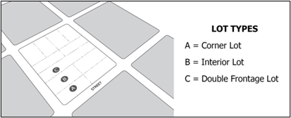
LOT, DOUBLE FRONTAGE. A lot where the front and rear lot lines both front on a street. See figure provided for “LOT, CORNER”.
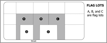
LOT, FLAG. A lot of irregular configuration in which an access strip (a strip of land of a width less than the required lot width) connects the main body of the lot to the street frontage.
LOT, INTERIOR. A lot other than a corner lot. See figure provided for “LOT, CORNER”.
LOT LINE ADJUSTMENT. A relocation of a lot line boundary between adjoining lots or between a lot and adjoining parcels in accordance with §10-9a-608 of Utah State Code (as amended) whether or not the lots are located in the same subdivision and with the consent of the owners of record. Lot line adjustment does not mean a new boundary line that creates an additional lot or constitutes a subdivision. Lot line adjustment does not include a boundary line adjustment made by the Utah Department of Transportation (UDOT).
MAJOR STREET PLAN. The most recently adopted "Alpine City Transportation Master Plan Map" which shows existing public streets and which has been officially adopted by the Planning Commission and City Council as the Major Street Plan
MOBILE HOME. A detached dwelling designed for long-term occupancy and to be transported on its own wheels, or on a flatbed or other trailer or detachable wheels, and arriving at the site where it is to be occupied as a complete dwelling unit ready for occupancy except for connections to utilities and other minor work. Removal of such wheels or placing such dwelling unit on a foundation shall not remove such unit from classification as a mobile home. Excluded from this definition shall be those permanent dwelling structures that are constructed of component parts that are transported to the building site and which meet structural requirements of the Uniform Building Code and which are finished with exterior building material that is typical of permanent residential buildings.
MUNICIPAL UTILITY EASEMENT. An easement that is created or depicted on a plat recorded in the Office of the County Recorder and is described as a municipal utility easement granted for public use; is not a protected utility easement or a public utility easement as defined in §54-3-27 of Utah State Code (as amended); the City or the City’s affiliated governmental entity uses and occupies to provide a utility service, including sanitary sewer, culinary water, electrical, stormwater, or communications or data lines; is used or occupied with the consent of the City in accordance with an authorized franchise or other agreement; is used or occupied by a specified public utility in accordance with an authorized franchise or other agreement and is located in a utility easement granted for public use, or is described in §10-9a-529 of Utah State Code (as amended) by a specified public utility.
NON-CONFORMING USE. A building or structure, or portion thereof, or use of a building or land which does not conform to use regulations for the district in which it is situated, but which is in conformity with said regulations, if any, at the time of its establishment.
OFF STREET PARKING. An area adjoining a building providing for the parking of automobiles which does not include a public street but has convenient access to it.
OFFICE, PROFESSIONAL. A building or space used by persons such as accountants, architects, artists, dentists, designers, engineers, lawyers, physicians, realtors, teachers, and others who, by virtue of training and for license, are qualified to perform services of a professional nature, and where storage of goods and sale of merchandise is minimal and secondary to performance of the service.
OFF-SITE. Of or pertaining to land, area or facilities not located within the boundaries of a final plat of a subdivision.
ON-SITE. Of or pertaining to land, area or facilities located within the boundaries of a final plat of a subdivision.
OUTDOOR LIGHTING. External lighting on a building or a property and any other artificial illumination of a property.
OUTDOOR RECREATION AREAS. Areas of a property used for recreation purposes, including but not limited to: soccer fields, sports courts, swimming pools, tennis courts, pickleball courts, basketball courts, sports fields, arenas, and other areas of recreation.
OWNER OCCUPANT. means, except as set forth in Subsection (3) of this definition:
- an individual who:
- possesses, as shown by a recorded deed, fifty (50) percent or more ownership in a dwelling unit; and
- occupies the dwelling unit with a bonafide intent to make it his or her primary residence; or
- an individual who:
- is a trustor of a family trust which:
- possesses fee title ownership to a dwelling unit;
- was created for estate planning purposes by one (1) or more trustors of the trust; and
- occupies the dwelling unit owned by the family trust with a bonafide intent to make it his or her primary residence. Each living trustor of the trust shall so occupy the dwelling unit except for a trustor who temporarily resides elsewhere due to a disability or infirmity. In such event, the dwelling unit shall nevertheless be the domicile of the trustor during the trustor’s temporary absence.
- is a trustor of a family trust which:
- A person who meets the requirements of Subsections (1) and (2) of this definition shall not be deemed an owner occupant if the property on which the dwelling unit is located has more than one (1) owner and all owners of the property do not occupy the dwelling unit with a bona fide intent to make the dwelling unit their primary residence.
- A claim that a person is not an owner occupant may be rebutted only by documentation, submitted to the Planning and Zoning Department, showing that the person who occupies the dwelling unit has a bona fide intent to make the dwelling unit his or her primary residence as indicated by the following documents which show such person:
- is listed as a primary borrower on documents for any loan presently applicable to the property where the dwelling unit is located;
- has claimed all income, deductions, and depreciation from the property on his or her tax returns for the previous year;
- is the owner listed on all rental documents and agreements with tenants who occupy the dwelling unit, including any accessory apartment;
- is the owner listed on all insurance, utility, appraisal, or other contractual documents related to the property; and
- is a full-time resident of Utah for Utah State income tax purposes.
- Any person who claims to be an owner of the dwelling unit, but who does not occupy it, shall provide documentation to the Planning and Zoning Department which shows such person:
- has not claimed any income, tax deduction, or depreciation for the property on the person’s tax returns for the previous year;
- is not listed as an owner on any rental document or agreement with any tenant who occupies the dwelling unit, including any accessory apartment; and
- is not listed as an owner on any insurance, utility, appraisal, or a agreement related to the property.
- Any person, or group of persons, who fails, upon request of the Planning and Zoning Department, to provide any of the documents set forth in Subsections (3)(a) or (3)(b) of this definition or who provides a document showing that ownership of a dwelling unit is shared among persons who do not all occupy the dwelling unit shall mean for the purpose of this Title that such person or persons shall not be deemed an “owner occupant” of the dwelling unit in question.
- A claim that a person is not an owner occupant may be rebutted only by documentation, submitted to the Planning and Zoning Department, showing that the person who occupies the dwelling unit has a bona fide intent to make the dwelling unit his or her primary residence as indicated by the following documents which show such person:
OPEN SPACE. The use of land which leaves soil generally undisturbed and upon which natural vegetation, whether or not native to the area, occupies the major visible aspect of the land.
PARCEL. Any real property that is not a lot.
PARCEL BOUNDARY ADJUSTMENT. A recorded agreement between owners of adjoining parcels adjusting the mutual boundary, either by deed or by a boundary line agreement in accordance with §10-9a-524 of Utah State Code (as amended), if no additional parcel is created and none of the property identified in the agreement is a lot or the adjustment is to the boundaries of a single person’s parcels. Parcel boundary adjustment does not mean an adjustment of a parcel boundary line that creates an additional parcel or constitutes a subdivision. Parcel boundary adjustment does not include a boundary line adjustment made by UDOT.
PERMANENT MONUMNET. Any structure of concrete, masonry and/or metal permanently placed on or in the ground, including those expressly placed for surveying reference, which meets the requirements of the local jurisdiction for permanent monuments.
PERMITTED USE. A use of land for which no conditional use permit is required.
PLAT. An instrument subdividing property into lots as depicted on a map or other graphic representation of land that a licensed professional land surveyor makes and prepares in accordance with §10-9a-603 or §57-8-13 of Utah State Code (as amended).
POTENTIAL GEOLOGIC HAZARD AREA. An area that is designated by a Utah Geological Survey map, county geologist map, or other relevant map or report as needing further study to determine the area’s potential for geologic hazard; or has not been studied by the Utah Geological Survey or a county geologist but presents the potential of geologic hazard because the area has characteristics similar to those of a designated geologic hazard area. May be referred to in this title as “sensitive lands”.
PRIMARY USE. The main use to which the premises is devoted and the primary purpose for which the premises exists. An ancillary use's square footage shall not exceed the primary use's square footage.
PRODUCE STANDS. Any temporary or permanent structure, used for the sale of agricultural products, that is sited on the lot on which the majority of products being offered for sale have been grown. The agriculture products offered for sale must be primarily fresh whole fruits and or vegetables. Certain animal products may also be sold as part of the produce stand, these are limited to fresh eggs, raw milk, fresh cheese, fresh yogurt, raw honey, bees wax, honeycomb, butter, sour cream, and beef jerky.
PUBLIC HEARING. A hearing at which members of the public are provided a reasonable opportunity to comment on the subject of the hearing.
PUBLIC MEETING. A meeting that is required to be open to the public under the Open and Public Meetings Act, §52-4 of Utah State Code (as amended).
PUBLIC USE. A use operated or supervised exclusively by a public body, such use having the purpose of serving the public health, safety, or general welfare, and including uses such as public schools, parks, playgrounds, and other recreational facilities, administrative and service facilities, and public utilities.
QUASI PUBLIC USE. A use operated by a private non-profit educational, religious, recreational, charitable or philanthropic institution, having the primary purpose of serving the general public, such as churches, private schools, hospitals and similar uses.
REASONABLE ACCOMMODATION. A reasonable change in any rule, policy, practice, or service necessary to afford persons with a disability equal opportunity to use and enjoy a dwelling when compared to similarly-situated persons or groups.
RECREATION, PUBLIC. Recreation facilities operated by a public agency and open to the public with or without a fee.
RESIDENCE. A dwelling unit where an individual or family is actually domiciled at a given point in time and not a place of temporary sojourn or transient visit. Temporary sojourn or transient visit shall be thirty (30) days or less.
RESIDENTIAL FACILITY FOR PERSONS WITH A DISABILITY. A residence in which no more than eight (8) unrelated persons with a disability resides and which is:
- Licensed or certified by the Department of Human Services under Title 62A, Chapter 2, of the Utah Code, Licensure of Programs and Facilities; or
- Licensed or certified by the Department of Human Health under Title 26, Chapter 21, Health Care Facilities Licensing and Inspection Act.
RETAINING WALL. Any structure designed to resist the lateral displacement of soil or other materials. Examples include block walls, rock walls, concrete walls and segmented walls. A retaining wall is not considered a fence.
REVIEW COMMENTS. Requests issued to an applicant by the City as part of the review cycle process, including requests for modifications to plats, plans, designs, reports, and studies submitted with the application, requests to supplement any incomplete information, document, or material submitted with or that was required to have been submitted with the application, and requests to correct any other deficiency with an application to ensure compliance with this Title and all other governing laws, land use regulations, applicable land use decisions, ordinances, and standards.
REVIEW CYCLE. The process described in §10-9a-604.2 of Utah State Code (as amended), and described in this Title, consisting of one (1) full cycle of a subdivision applicant’s submittal of a complete application, the City’s review of that application, the City’s response to that application, and the applicants reply to the City’s response.
REVIEW RESPONSE. The applicant’s response to the City’s review comments, including a written response addressing each review comment and the submission of revised, modified, or corrected plats, plans, and other information, documents, and materials.
SENSITIVE LANDS. Means the same as “geologic hazards” and “potential geological hazard areas” definitions. Sensitive lands shall also mean and include those lots or parcels as identified on the City’s Sensitive Lands map.
SHORT TERM RENTAL. Temporary lodging or place of stay that is rented (including but not limited to: hotels, motels, bed and breakfast, boarding houses, etc.) for a period of thirty (30) consecutive days or less.
SITE PLAN. A plot of a lot, drawn to scale, showing its actual measurements, the size and location of any existing buildings or buildings to be erected, the location of the lot in relation to abutting streets, north point, scale, utility easements, vehicle access, and such other information as may be required by the Planning Commission.
SIGN. Any device for visual communication to the public displayed out-of-doors, including signs painted on exterior walls, and interior illuminated signs, to be viewed from out-of-doors, but not including a flag, badge, or ensign of any government or government agency.
Sports Court. An outdoor hard-surfaced court (not including parking lots) designed for athletic purposes (i.e. basketball court, tennis court, pickleball court, etc.)
STREET, PUBLIC. A thoroughfare which has been dedicated and accepted by proper public authority (or abandoned to the public) or a thoroughfare not less than twenty-four (24) feet wide which has been made public by right of use and which affords the principal means of access to abutting property.
STREETS, ROADS, and HIGHWAYS.
- Street, Arterial. A street, existing or proposed, which serves or is intended to serve as a major traffic way, and is designated an arterial street on the Major Street Plan.
- Street, Collector. A street, existing or proposed, of considerable continuity, which is the main means of access to arterial streets, and is designated a collector street on the Major Street Plan.
- Street, Cul-de-sac. A street which is designed to remain permanently closed at one end with the closed end terminated by a vehicular turnaround. For purposes of these regulations, the length of a cul-de-sac street shall be measured from center of turn- around to the point of connection to the next intersection street. (DCA 4.07.040 Part 9, Subdivision Ordinance)
- Street, Frontage, or Frontage Road. A minor street or road which is parallel to and adjacent to a limited access major street and which provides access to abutting properties and protection from through traffic.
- Street, Minor. A street, existing or proposed, which is supplementary to a collector street and of limited continuity, which serves or is intended to serve the local needs of a neighborhood and to give access to abutting properties.
- Street, Partial, Width. A street parallel and contiguous to a property line and of lesser right-of-way width than will eventually be required; the additional needed right-of-way width to be obtained in the future from the abutting property owner prior to development as frontage.
- Street, Public. A thoroughfare which has been dedicated or abandoned to the public and accepted by proper public authority.
- Street Right-of-Way. That portion of land dedicated to public use for street and utility purposes.
- Street, Stub. A street or road extending from within a subdivision boundary and terminating there; with no permanent vehicular turnaround. Stub streets are provided to permit adjacent undeveloped parcels of land to be developed later by continuing the stub street to the extended connecting street system.
STRUCTURE. Anything constructed, the use of which requires fixed location upon the ground, or attached to something having a fixed location upon the ground, and which creates an impervious material on or above the ground; definition includes "building."
SUBDIVIDER. Any person, firm, corporation, partnership or association who causes land to be divided into two or more parcels of land for himself or others. SUBDIVISION. Any land that is divided, subdivided, or proposed to be divided into two (2) or more lots, or other division of land for the purpose, whether immediate or future, for offer, sale, lease or development either on the installment plan or upon any and all other plans, terms and conditions. The term "Subdivision includes:
- The division or development of land whether by deed, metes and bounds description, devise and testacy, map, plat or other recorded instrument, regardless of whether the division includes all or a portion of a parcel or lot; and
- Except as provided below, divisions of land for residential and nonresidential uses, including land used or to be used for commercial, agricultural and industrial purposes.
Subdivision does not include:
- A bona fide division or partition of agricultural land for the purpose of joining one of the resulting separate parcels to a contiguous parcel of unsubdivided agricultural land, if neither the resulting combined parcel nor the parcel remaining from the division or partition violates an applicable land use ordinance;
- A boundary line agreement recorded with the Office of the County Recorder between owners of adjoining parcels adjusting the mutual boundary in accordance with §10-9a-524 of Utah State Code (as amended) if no new parcel is created;
- A recorded document, executed by the owner of record revising the legal descriptions of multiple parcels into the one (1) legal description encompassing all such parcels or joining a lot to parcel;
- A boundary line agreement between owners of adjoining subdivided properties adjusting the mutual lot line boundary in accordance with §10-9a-524 and §10-9a-608 of Utah State Code (as amended) if no new dwelling lot or housing unit will result from the adjustment and the adjustment will not violate any applicable land use ordinance;
- A bona fide division of land by deed or other instrument if the deed or other instrument states in writing that the division is in anticipation of future land use approvals on the parcel or parcels does not confer any land use approvals, and has not been approved by the land use authority;
- A parcel boundary adjustment;
- A lot line adjustment;
- A road, street, or highway dedication plat;
- A deed or easement for a road, street, or highway purpose; or
- Any other division of land authorized by law.
SUBDIVISION AMENDMENT. An amendment to a recorded subdivision in accordance with §10-9a-608 of Utah State Code (as amended) that vacates all or a portion of the subdivision; alters the outside boundary of the subdivision; changes the number of lots within the subdivision; alters a public right-of-way, a public easement, or public infrastructure within the subdivision; or alters a common area or other common amenity within the subdivision. Subdivision amendment does not include a lot line adjustment between a single lot of an adjoining lot or parcel that alters the outside boundary of the subdivision.
Subdivision Application. A land use application for the subdivision of land.
SUBDIVISION IMPROVEMENT PLANS. The civil engineering plans associated with required infrastructure improvements and municipally controlled utilities required for a subdivision
Subdivision Ordinance Review. Review by the City to verify that a subdivision application meets the criteria of the City’s ordinances.
Subdivision Plan Review. A review of the applicant’s subdivision improvement plans and other aspects of the subdivision application to verify that the application complies with the City’s ordinances and applicable installation standards and inspection specifications for infrastructure improvements.
SUBDIVISION REQUIREMENTS. Those requirements that are adopted by the City and applicable County or State entities for the necessary and proper development of a proposed subdivision. Includes all applicable zoning regulations, governing laws, land use regulations, applicable land use decisions, ordinances, standards, designs and specifications.
SUSPECT SOIL. Soil that has a high susceptibility for volumetric change, typically clay-rich, having more than a three percent (3%) swell potential, bedrock units with high shrink or swell susceptibility, or gypsiferous silt and clay, gypsum, or bedrock units containing abundant gypsum commonly associated with dissolution and collapse features.
VICINITY MAP (Location Map). A map or drawing showing where a subdivision, or proposed subdivision is located.
YARD. A required space on a lot other than a court, unoccupied and unobstructed from the ground upward, by buildings, except as otherwise provided herein.
YARD, FRONT. A space between the front of the main building on a lot and the front lot line or line of an abutting street or right-of-way and extending across the full width of a lot. The depth (or setback) of the front yard is the minimum distance between the front lot line, and the front-most part of the primary structure of the nearest main building at the foundation level. (Primary structure includes overhangs, porches, and decks).
YARD, FRONT, CORNER. For corner lots, the front yard shall be designated based on the following criteria:
a) The orientation of the principal building primarily faces the yard.
b) The official address assigned to the property.
c) The location of the front door or main entrance of the principal building.
d) If none of the above clearly identifies a front yard, the yard adjacent to the street with the longest continuous street frontage shall be deemed the front yard.
YARD, REAR. A space between the back wall of the nearest main building extending the full width of the lot and the lot line that is most distant from, and is most nearly parallel with, the front lot line. If the rear lot line is less than ten feet (10’) in length, or if the lot comes to a point at the rear, the rear lot line shall be deemed to be a ten foot (10’) line parallel to the front line, lying wholly within the lot for the purpose of establishing the minimum rear yard. The depth (or setback) of the rear yard is the minimum distance between the rear lot line and the rearmost part of the primary structure of the nearest main building at the foundation level.
(Primary structure includes overhangs, porches and decks. See drawing in Appendix A). (Ord. 2004-13, 9/28/04)
YARD, SIDE. A yard that is neither a front yard nor a rear yard. The depth (or setback) of the side yard is the minimum distance between the side lot line and the nearest part of the primary structure of the nearest main building at the foundation level. (Primary structure includes overhangs, porches and decks).
ZONING LOT (Ord. 94-02, 2/8/94). A lot or parcel of land which:
- Meets all area (lot size), frontage (width), setback (yard), and other zoning requirements applicable within the zone in which it is located;
- Abuts upon and has direct access to a street which has been dedicated to the City or otherwise accepted by the City as a City Street;
- Is served by the minimum level of improvements required for issuance of a building permit or for which the construction of the minimum level of improvements is secured through the posting of a performance guarantee; and
- Is shown as a separate lot on the final plat of a subdivision or similar development, which has been approved in accordance with the applicable ordinance, or is legally exempted from compliance with said ordinance. A parcel which is part of an unapproved or illegal subdivision shall not qualify as a zoning lot.
(Amended by Ord. 2004-14 on 9/28/04; Ord. 2009-16, 10/13/09; Ord. 20011-06, 03/08/11; Ord. 2011-12, 10/25/11; Ord. 2014-11, 6/24/14; Ord. 2015-02, 02/10/15; Ord. 2015-07, 05/26/15)
Amended by Ord. 2018-07 on 10/9/2018
Amended by Ord. 2019-02 on 4/23/2019
Amended by Ord. 2020-07 on 2/25/2020
Amended by Ord. 2020-02 on 4/14/2020
Amended by Ord. 2020-08 on 4/28/2020
Amended by Ord. 2020-04 on 7/28/2020
Amended by Ord. 2022-08 on 3/22/2022
Amended by Ord. 2022-19 on 7/12/2022
Amended by Ord. 2023-01 on 1/10/2023
Amended by Ord. 2023-29 on 11/28/2023
Amended by Ord. 2024-08 on 3/12/2024
Amended by Ord. 2024-14 Subdivision Approval Amendments on 5/14/2024
Amended by Ord. 2025-08 on 6/10/2025
Amended by Ord. 2025-19 on 9/23/2025
3.01.120 Fees And Charges
(Ord. 94-02, 2/8/94). All costs for the processing of applications for zone changes, subdivision reviews, conditional use approvals, Appeal Authority rulings, and similar actions required under the terms of this ordinance shall be borne by the applicant. The City Council may, by resolution, establish fees for the processing of such applications and the administration of this ordinance and provide for the assessment and collection thereof.
Amended by Ord. 2021-03 on 2/9/2021
3.01.130 Criteria For Determining Lot Width And Area Requirements
General criteria for determining setback requirements:
- All set backs are to be measured to the foundation of the building.
- An abutting fire place (up to two feet), bay window (up to two feet) and uncovered steps to basement shall not be included in set back measurement.
- An uncovered patio or deck less than (18) eighteen inches in height from ground surface shall be allowed within ten (10) feet of the rear property line.
- Lot Width. For purposes of determining compliance with the lot width requirements, the measurement of lot width shall be made along a line situated parallel to the front lot line at the minimum front setback.
In the instance of a lot where more than seventy five percent (75%) of the front lot line abuts upon a cul-de-sac or curve in the adjacent street, having a radius of less than eighty (80) feet, the width of lot shall be measured along a line which is at right angle to the point of tangency of said curve, at the approximate mid-point of the abutting front lot line, and at distance of from the front lot line equal to the front setback for the zone. - Lot Area. For purposes of determining compliance with lot area requirements, the area shall include all territory within the boundaries of the lot, including any area devoted to easements, and any territory adjacent or within the boundary of the lot previously conveyed or proposed for conveyance to the City by the owner for use as an urban trail. This does not apply to a Planned Residential Development.
- Lot Width. For purposes of determining compliance with the lot width requirements, the measurement of lot width shall be made along a line situated parallel to the front lot line at the minimum front setback.