
Amherst City Zoning Code
ARTICLE VII
AMBRIAR ACCESS MANAGEMENT AREA
Sec. 24-425.- Definitions.
The following words, terms and phrases, when used in this article, shall have the meanings ascribed to them in this section, except where the context clearly indicates a different meaning:
AASHTO means the American Association of State Highway and Transportation Officials.
Access means to provide vehicular or pedestrian entrance or exit to a property.
Access connection/point means any driveway or other point of entry and/or exit such as a street, road, or highway that connects to the general street system.
Capacity means the ability of the highway to provide service to the volume of vehicles seeking to use the highway. Capacity is most often considered the maximum amount of traffic that can be accommodated by a highway during the peak hours of demand. Sometimes it refers to the entire roadway, and sometimes to a single lane.
Commercial entrance means an entrance serving all access points other than an individual private residence. A residential subdivision entrance is a commercial entrance.
Connection spacing means the distance between connections, measured from the closest edge of pavement of the first connection to the closest edge of pavement of the second connection along the edge of the traveled roadway.
Corner clearance means the distance from an intersection to the nearest driveway.
Cross access means a service drive providing vehicular access between two or more contiguous sites so that the driver need not enter the public street system.
Design speed means the maximum safe speed that can be maintained over a specified section of highway when conditions are so favorable that the design features of the highway govern, as defined in the latest edition of AASHTO's A Policy on Geometric Design of Highways and Streets.
Driveway means an access that is not a public street, road, or highway.
Frontage road means a public or private street or road auxiliary to and normally alongside and parallel to the main highway, constructed for the purposes of maintaining local road continuity and the controlling of direct access to the main highway while providing access to private properties.
Functional classification means a classification system that defines a public roadway according to its purposes and hierarchy in the state highway system.
Interchange means a portion of roadway that provides vehicular access from one road to another.
Lane means the portion of a roadway for the movement of a single line of vehicles. The term "lane" does not include the gutter or shoulder of the roadway.
Median means that portion of a highway separating the opposing traffic flows.
Outparcel means a parcel of land abutting and external to the larger, main parcel, which is under the same ownership and has roadway frontage.
Service road means a public or private street or road, auxiliary to and normally located parallel to a controlled access facility that maintains local road continuity and provides access to parcels adjacent to the controlled access facility. (Reference Frontage road.)
Shared access means a driveway connecting two or more contiguous sites to the public street system.
Sight distance means the distance visible to the driver of a vehicle measured along the normal travel path of a roadway from a designated location and to a specified height above the roadway when the view is unobstructed by traffic. For crossovers and commercial entrances, sight distance is the distance measured between the height of the driver's eye (3.5 feet) and the height of an object (4.25 feet) without horizontal or vertical obstruction to the line of sight.
Stopping sight distance means the distance required by a driver of a vehicle, traveling at a given speed, to bring the vehicle to a stop after an object on the roadway becomes visible. The term "stopping sight distance" includes the distance traveled during driver perception and reaction times and the vehicle braking distance.
Stub road means a portion of street or right-of-way access drive used as an extension to an abutting property that may be developed in the future.
Trip means a single or one-direction vehicle movement with either the origin or the destination inside a study area. A vehicle leaving the highway and entering a property is one trip. Later when the vehicle leaves the property and reenters the highway, it is a second trip.
Turn lane means an auxiliary lane that provides deceleration, so that disruption to through traffic is minimized, and provides adequate storage outside of the through lane which the turn is being made.
(Zoning Ord. 2003, § 18.1-922.03)
Sec. 24-426. - Purpose.
The intent of this article is to encourage well-planned, high-density development, to provide and manage access to development while preserving the flow of traffic and to ensure adequate infrastructure in the Ambriar area. Major thoroughfares, including highways and other arterials, serve as the primary network for moving people and goods. These transportation corridors also provide access to businesses and homes and have served as the focus for commercial and residential development. Access systems must be properly designed to accommodate the access needs of development while retaining the transportation function.
(Zoning Ord. 2003, § 18.1-922.01)
Sec. 24-427. - Applicability.
The provisions of this article shall apply to all property that accesses the Ambriar corridor. The Ambriar corridor is defined as that portion of S. Main Street from Waugh's Ferry Road south to the town corporate limits.
(Zoning Ord. 2003, § 18.1-922.02)
Sec. 24-428. - Variance.
(a)
The board of zoning appeals may authorize a variance to the application of these access standards and regulations. The granting of a variation shall be in accordance with the purpose and intent of these standards and regulations and shall not be considered until every feasible option for meeting access standards is explored.
(b)
Applicants for a variance from these standards and regulations must provide proof of unique or special conditions that the strict application of the provisions would deny all reasonable access; endanger public health, welfare or safety; or cause an exceptional and undue hardship on the applicant, as distinguished from a special privilege or convenience sought by the applicant. This shall include proof that:
(1)
Indirect or restricted access cannot be obtained.
(2)
No engineering or construction solutions can be applied to mitigate the condition.
(3)
No alternative access is available from a street with a lower functional classification than the primary roadway.
(Zoning Ord. 2003, § 18.1-922.04)
Sec. 24-429. - Access connection and driveway design.
(a)
Driveway width shall meet the following guidelines:
(1)
If the driveway is a one-way in or one-way out drive, then the driveway shall be a minimum width of 14 feet of pavement and shall have appropriate signage designating the driveway as a one-way connection.
(2)
For two-way access, each lane shall have a width of 12 feet.
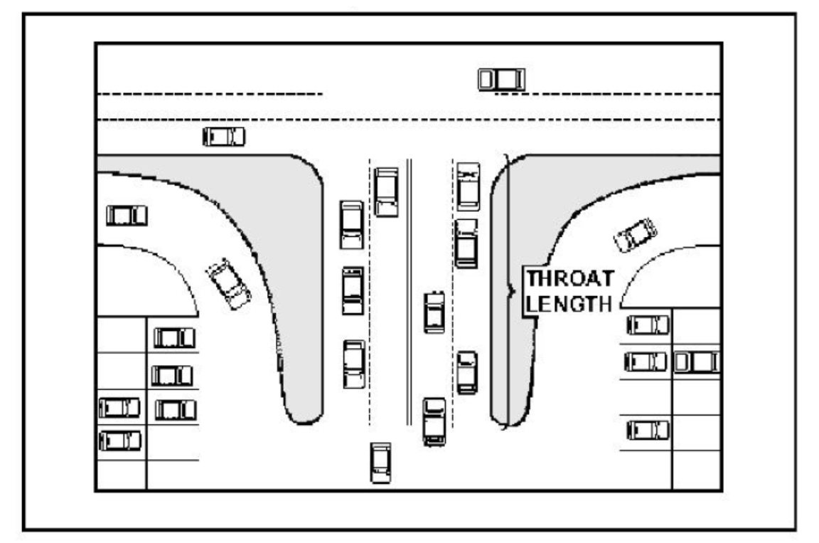
Figure 24-429. Throat Length Illustration
(b)
Driveway grades, turnout radii, approaches, and lengths shall conform to VDOT's standards.
Table 24-429. Throat Length Measurements
(1)
Driveway approaches must be designed and located to provide an exiting vehicle with an unobstructed view. Construction of driveways along acceleration or deceleration lanes and tapers is prohibited.
(2)
Driveways shall have sufficient length and size for all vehicular queuing, stacking, maneuvering, standing, and parking to be carried out completely beyond the right of way line. The length of driveways, or throat length, shall be designed in accordance with table 24-429. These measures generally are acceptable for the principal access to a property and are not intended for any minor supplemental driveways to that same property.
(3)
Where a site is being redeveloped on a small property with no reasonable alternative access, it may be difficult to get these driveway lengths. In these cases, the driveway may be positioned to take advantage of the on-site location with the most depth.
(4)
Driveways that enter the major thoroughfare at traffic signals must have at least two outbound lanes (one for each turning direction) of at least 12 feet width and one inbound lane with 14 feet width of pavement.
(Zoning Ord. 2003, § 18.1-922.05)
Sec. 24-430. - Requirements for outparcels and phased development plans.
(a)
In the interest of promoting unified access and circulation systems, development sites under the same ownership or consolidated for the purposes of development and comprised of more than one building site shall not be considered separate lots for the purpose of the application of access standards and regulations. The number of connections permitted shall be the minimum number necessary to provide adequate access to these properties, not the maximum available for that frontage. This shall also apply to phased development plans. The owner and all lessees within the affected area are responsible for compliance with the requirements of these access standards and regulations.
(b)
All access to outparcels must be internalized using the shared circulation system of the principal development or retail center. This access shall be designed to avoid excessive movement across parking aisles and queuing across surrounding parking and driving aisles.
(Zoning Ord. 2003, § 18.1-922.06)
Sec. 24-431. - Subdivision of land.
Each lot shall be entitled one driveway/connection per parcel as of right on said public thoroughfares. When subsequently subdivided, access to all newly created lots shall be provided via the permitted access connection. This may be achieved through subdivision roads, shared and cross accesses, and service drives installed as per this article.
(1)
Parcels in existence as of January 1, 2008, with frontages that exceed minimum driveway spacing requirements as shown in the driveway and corner clearance spacing section may be permitted additional access connections.
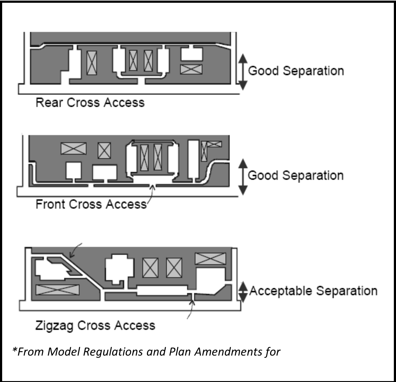
Figure 24-431. Cross Access Types
(2)
Existing parcels with frontage less than the minimum connection spacing for that corridor may not be permitted a direct connection to the thoroughfare under this article where the planning commission determines alternative reasonable access is available to the site. For example, the planning commission could allow for a temporary driveway with the stipulation that joint and cross access be established as adjacent properties develop.
(Zoning Ord. 2003, § 18.1-922.07)
Sec. 24-432. - Shared and cross access.
(a)
Adjacent commercial or office properties classified as major traffic generators (i.e., shopping center, office parks) shall provide cross access, pedestrian access and bicycle access to allow circulation between sites.
(b)
A system of shared use driveways and cross access easements as shown in Figure 24-432 shall be established wherever feasible and the building site shall incorporate the following:
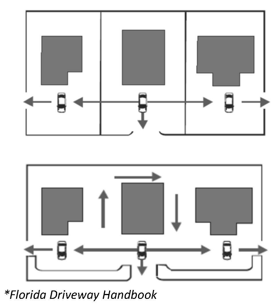
Figure 24-432. Shared and Cross
Access Illustration
(1)
A continuous service drive or cross access extending the entire length of each block served to provide for driveway separation consistent with the access classification system and standards.
(2)
A design speed of ten miles per hour (mph) and sufficient width to accommodate two-way travel aisles designed to accommodate automobiles, service vehicles, and loading vehicles.
(3)
Stub roads and other design features to make it visually obvious that the abutting properties may be tied in to provide cross access via a service drive.
(4)
A unified access and circulation system plan that includes coordinated or shared parking areas is encouraged.
(c)
Pursuant to this article, the owner shall record an easement with the deed, in a form approved by the town attorney, allowing cross access to and from other properties served by the shared use driveways and cross access or service drives.
(d)
Shared parking areas shall be permitted a reduction in required parking spaces if peak demand periods for proposed land uses do not occur at the same time periods.
(e)
The planning commission may reduce required separation distance of access points where they prove impractical, provided all of the following requirements are met:
(1)
Joint access driveways and cross access easements are provided wherever feasible in accordance with this article.
(2)
The site plan incorporates a unified access and circulation system in accordance with this article.
(3)
The property owner shall enter a written agreement with the town, recorded in deed in a form acceptable to the town attorney, that pre-existing connections on the site will be closed and eliminated after construction of each side of the joint use driveway.
(f)
The planning commission may modify or waive the requirements of this article during the site plan or subdivision review process where the characteristics or layout of abutting properties would make development of a unified or shared access and circulation system impractical.
(Zoning Ord. 2003, § 18.1-922.08)
Sec. 24-433. - Interchange areas.
The distance to the first connection of an interchange shall be at least 660 feet where the posted speed limit is greater than 45 miles per hour (mph) or 440 feet where the posted speed limit is 45 mph or less. This distance shall be measured from the end of the taper for that quadrant of the interchange.
(Zoning Ord. 2003, § 18.1-922.09)
Sec. 24-434. - Access standards; driveway and corner clearance spacing.
(a)
All access connections on roadway segments shall maintain a 440-foot separation from any other driveway or intersection where the posted speed limit is above 45 miles per hour (mph), and a 245-foot separation from any other driveway or intersection where the posted speed limit is 45 miles per hour (mph) or below with the exception of access connections for single-family residential and agricultural land uses to the extent possible.
(b)
Driveway spacing shall be measured from the closest edge of the pavement to the next closest edge of the pavement (see Figure 24-434 for points of measurements).
(c)
Additional access connections may be allowed where the property owner can demonstrate upon review of a traffic impact analysis of the proposed connection submitted by the applicant that safety and efficiency of travel on the thoroughfare will be improved by providing more than one access to the site.
(d)
If the access connection spacing standards listed above cannot be achieved, the planning commission may reduce required separation distances of access points, provided that:
(1)
Shared access driveways and cross access easements are provided wherever feasible in accordance with these regulations;
(2)
The connection does not create a safety or operational problem upon review of a site-specific traffic impact analysis of the proposed connection prepared by a licensed engineer and submitted by the applicant; or
(3)
At an intersection, where no other access to the property is available and shared access driveways and cross access easements are not feasible, the planning commission may allow construction of an access connection along the property line farthest from the intersection. In such cases, directional connections (i.e., right in/out) may be required.
(e)
Corner clearance for connections shall be measured from the closest edge of pavement of the intersection to the next closest edge of pavement of the first access point from the intersection (see Figure 24-434).
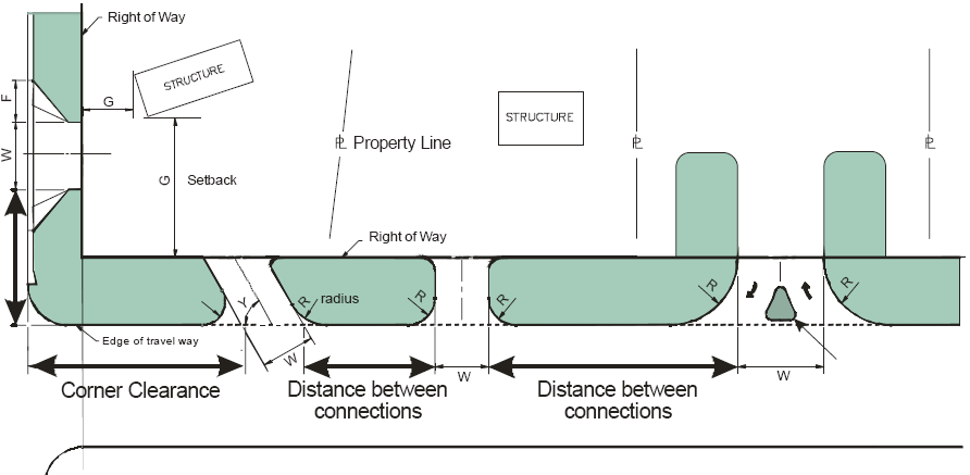
Figure 24-434. Measurement Details for Corner Clearance and Access Spacing
(f)
Corner clearance for connections shall meet or exceed the minimum connection spacing requirements for that roadway.
(g)
New connections shall not be permitted within the functional area of an intersection or interchange as defined by the connection spacing standards of this chapter, unless:
(1)
No other reasonable access to the property is available; and
(2)
The planning commission determines that the connection does not create a safety or operational problem upon review of a site-specific study of the proposed connection prepared by a registered engineer and submitted by the applicant.
(h)
Where no other alternatives exist, the planning commission may allow construction of an access connection along the property line farthest from the intersection. In such cases, directional connections (i.e., right in/out, right in only, or right out only) may be required.
(i)
In addition to the required minimum lot size, all corner lots shall be of adequate size to provide for required front yard setbacks and corner clearance on street frontage.
(Zoning Ord. 2003, § 18.1-922.10)
Sec. 24-435. - Minimum frontage.
The minimum lot width for all parcels with frontage on South Main Street shall not be less than the minimum connection spacing standards of that thoroughfare, except as otherwise provided in this article. Flag lots shall not be permitted direct access to the thoroughfare and interior parcels shall be required to obtain access via a public or private access road in accordance with the requirements of this article.
(1)
Existing parcels with frontage less than the minimum connection spacing for that corridor may not be permitted a direct connection to the thoroughfare under this article where the planning commission determines alternative reasonable access is available to the site. For example, the planning commission could allow for a temporary driveway as provided in the access standards section with the stipulation that joint and cross access be established as adjacent properties develop.
(2)
Additional access connections may be allowed where the property owner demonstrates that safety and efficiency of travel on the thoroughfare will be improved by providing more than one access to the site.
(Zoning Ord. 2003, § 18.1-922.11)
Sec. 24-436. - Limits of use designation.
(a)
Key locations within the traffic impact overlay have been identified for the future installation of traffic calming devices, preferably roundabouts. The intersections targeted for these devices are at South Main Street and Lancer Lane, South Main Street and the U.S. Route 29 Bypass ramps, and South Main Street and the northern most entrance to the Ambriar Shopping Center. There shall be a 200-feet-in-diameter limit of use designation that is measured from the center point (see Figure 24-436) of the intersections listed above.
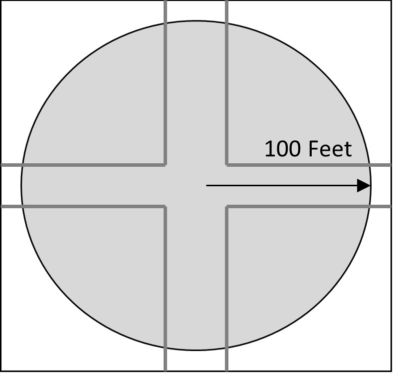
Figure 24-436. Limits of Use
(b)
Prior to the construction of parking or any other accessory uses within the limits of use area, the applicant must demonstrate that the accessory use or parking required by this chapter could not be adequately accommodated elsewhere on the property. Execution of a shared parking agreement per the zoning ordinance may be used to satisfy the zoning ordinance parking requirements.
(c)
In the event that VDOT determines that all or a portion of said area is required for public road improvements and thus initiates the process of acquiring the necessary right of way, the property owner shall be responsible for relocating any parking or other accessory use installed within the designated limits of use area. The relocation of such uses shall occur at the owner's expense. Any costs associated with design and reconstruction of the limits of use area for purposes of public road improvements (to include removal of existing accessory uses) shall be the responsibility of VDOT.
(d)
The limits of use area shall be marked on any applicable site plan submitted to the town planning commission for review.
(Zoning Ord. 2003, § 18.1-922.12)
Sec. 24-437. - Pedestrian accommodations.
(a)
Bicycle and pedestrian ways shall be established in new construction and reconstruction projects along South Main Street unless one or more of these conditions are met:
(1)
Bicyclists and pedestrians are prohibited by law from using the roadway. In this instance, a greater effort may be necessary to accommodate bicyclists and pedestrians elsewhere within the right of way or within the same transportation corridor.
(2)
The cost of establishing bikeways or walkways would be excessively disproportionate to the need or probable use. Excessively disproportionate is defined as exceeding 20 percent of the cost of the larger transportation project.
(b)
Bicycle and pedestrian facilities shall be provided on any new or reconstructed streets in accordance with VDOT regulations.
(c)
Bicycle racks shall be located in convenient, visible, well-lit areas, with easy access, near main entrances. The racks should not interfere with pedestrian traffic and should be protected from potential damage by motor vehicles. They may be located within the public right-of-way with town and VDOT approval. The following requirements shall also apply:
(1)
All vehicle parking facilities containing less than ten parking spaces shall provide one bicycle rack with no less than four spaces.
(2)
For vehicle parking facilities containing more than ten parking spaces the applicant shall provide one bicycle rack with no less than four spaces plus two bicycle parking spaces for each additional ten parking spaces in the lot. However, no more than 20 bicycle parking spaces shall be required in any one parking facility.
(d)
Bicycle and pedestrian facilities shall be designed with security considerations including street lighting, bushes no greater than two feet in height, and tree branches no lower than six feet in height. To provide clear visibility of pedestrians approaching intersection crosswalks at night, the approaches to and all street corners should be well-illuminated. All intersection lighting should illuminate the crossing and waiting areas and/or create backlighting to make the pedestrian silhouette clearly visible on the approach.
(e)
Pedestrian facilities shall include shade trees where possible.
(f)
A sidewalk shall be provided between all new building entrances and all streets adjacent to the development site. The sidewalk shall provide a direct connection to existing public right-of-way and public sidewalks or transit stops.
(g)
A sidewalk shall be provided between any new building entrance and all other new or existing building entrances on the same development site. Entrances used for loading and unloading freight are not subject to this standard. Internal pedestrian paths provided in conformance with this subsection shall provide weather protection features such as awnings or arcades within 30 feet of all customer entrances.
(h)
A sidewalk shall be provided immediately adjacent to the exterior wall of a new building greater than 100 feet in length when the wall is located next to a street or parking lot. A pedestrian path shall also be provided along the entire length of the wall when the public entrance is located in that area. Exceptions to this standard include:
(1)
If the edge of the building is within 20 feet of a public sidewalk and the building entrance is connected to the public sidewalk by an on-site pedestrian facility.
(2)
If the edge of the building is bordered by a perimeter of landscaping that does not exceed 30 feet in width and an on-site pedestrian facility is constructed at the edge of the landscaped area.
(i)
A 20-foot-wide bicycle/pedestrian easement shall be provided to connect cul-de-sacs, or to pass through blocks in excess of 660 feet.
(j)
Where needed for purposes of traffic safety or access to nearby schools, playgrounds, public parks, trails, shopping facilities, or other community facilities, new developments may be required to dedicate a public right of way for bicycles and pedestrians, not less than 20 feet in width.
(k)
Pedestrian access points at property edges and to adjacent lots shall be coordinated with existing development to provide pedestrian circulation between developments.
(l)
All on-site pedestrian walkways located in vehicle use areas shall be distinguished from driving surfaces through the use of durable, low maintenance smooth surface materials to enhance pedestrian safety and comfort, as well as the attractiveness of the walkways.
(Zoning Ord. 2003, § 18.1-922.13)
Sec. 24-438. - Connectivity.
(a)
The street system of a proposed subdivision shall be designed to coordinate with existing, proposed, and planned streets outside of the subdivision as provided in this article.
(b)
Wherever a proposed development abuts unplatted land or a future development phase of the same development, street stubs shall be provided, as deemed necessary by the town, to provide access to abutting properties or to logically extend the street system into the surrounding area. The restoration and extension of the street shall be the responsibility of any future developer of the abutting land.
(Zoning Ord. 2003, § 18.1-922.14)
Sec. 24-439. - Nonconforming access features.
(a)
Permitted access connections in place as of January 1, 2008, that do not conform with the standards herein shall be designated as nonconforming features and shall be brought into compliance with applicable standards under the following conditions:
(1)
When new access connection permits are requested;
(2)
Increase in trip generation of 100 or more additional peak hour trips due to new building construction or change in use; or
(3)
As roadway improvements allow.
(b)
If the principal activity on a property with nonconforming access features is discontinued for a consecutive period of two years or discontinued for any period of time without a present intention of resuming that activity, then that property must thereafter be brought into conformity with all applicable connection spacing and design requirements, unless otherwise exempted by the permitting authority. If the activity is discontinued and renewed with a different activity, property owner must provide a traffic impact analysis to show that the new activity will not increase the number of trips.
(Zoning Ord. 2003, § 18.1-922.15)
Sec. 24-440. - Site plan/subdivision plan review standards.
(a)
In addition to the existing town site plan and subdivision plat review, applicants shall submit the information listed below for:
(1)
Location of all properties' access point on both sides of the road where applicable.
(2)
Location of all proposed and existing access points for the site.
(3)
Plat map showing property lines, right-of-way, and ownership of abutting properties.
(4)
Distances to neighboring existing exit/entrance points, median openings, traffic signals, intersections, and other transportation features on both exit/entrance sides of the property.
(5)
Number and direction of lanes to be constructed for the driveway.
(6)
All planned transportation features (such as auxiliary lanes, signals, etc.).
(7)
Pedestrian and bicycle accommodations.
(8)
Trip generation data or appropriate traffic impact studies.
(9)
Parking and internal circulation plans.
(10)
Location of limits of use boundaries when applicable.
(11)
A detailed description of any requested variance and the reason the variance is requested.
(b)
The town reserves the right to require traffic and safety analysis where safety is or may be an issue or where significant problems already exist. (Refer to section 24-42.)
(Zoning Ord. 2003, § 18.1-922.16)