


Anoka City Zoning Code
DIVISION 6
OVERLAY DISTRICTS
Sec. 78-340. - Sensitive Development District.
(a)
Purpose and intent. The purpose and intent of the Sensitive Development District is to create residential development that is designed to prevent and mitigate irreversible damage to natural resources and to preserve and enhance their values to the public. Development shall be regulated to minimize the risk of environmental damage to these areas. This is accomplished through density control, lot size, public land dedication and tree preservation. Residential development in these areas should encourage creativity, variety and use of quality materials. River use and recreation on and along the Rum River is encouraged as the Rum River is viewed as a recreational asset to the city.
(b)
Establishment of district boundaries. Boundaries for the Sensitive Development District are as shown on the official zoning map.
(c)
Applicability. In the event other city ordinances or state statutes address the same topics covered in this section, the more restrictive language shall apply.
(d)
Uses. Permitted, interim, accessory, and prohibited uses in this district shall be governed by the R-1 Single-Family District, with the following exceptions:
(1)
Conditional uses in the R-1 district shall be prohibited in the Sensitive Development District.
(2)
Townhouse use is permitted east of the westerly line of the southeast corner of the northwest quarter of section 31, township 32, range 24.
(e)
Lot requirements. The lot area requirements for the Sensitive Development District are as follows:
(1)
Every lot within the Rum River Wild and Scenic River District on which a single-family dwelling is to be erected shall not be less than 15,000 square feet. Every lot not within the Rum River Wild and Scenic River District on which a single-family dwelling is to be erected shall not be less than 12,500 square feet, except for lots east of the easterly line of the west half of the southwest corner of the southwest quarter of section 30, township 32, range 24 may be a minimum of 10,000 square feet.
(2)
Townhouse lot area regulations. The minimum lot area per dwelling unit shall not be less than 4,500 square feet.
(3)
Every lot on which a single-family dwelling is to be erected shall not be less than 75 feet in width, nor less than 120 feet in depth. Lots on cul-de-sac streets shall have a minimum frontage of 50 feet on the right-of-way line.
(4)
In no case shall the impervious surface coverage of a nonriparian single-family lot exceed 35 percent of the area of the lot. Lots within the Rum River Wild and Scenic River District shall not exceed a 25 percent impervious surface coverage. Impervious surface coverage for townhomes shall not exceed 50 percent of the area of the lot.
(5)
Lots within the Rum River Wild and Scenic River District shall be governed by requirements set forth in the state department of natural resources' Rum River Wild and Scenic Regulations and the city Rum River Protection Ordinance.
(f)
Density. No more than 45 single-family lots may be created west of the westerly line of the southeast corner of the northwest quarter of section 31, township 32, range 24. No more than 60 townhouse lots or 35 single-family lots may be created east of the westerly line of the southeast corner of the northwest quarter of section 31, township 32, range 24. Residential densities in all other Sensitive Development District areas shall be governed by lot size requirements listed in this section.
(g)
Front, side, and rear yard requirements. Front, side, and rear yard requirements shall be governed by the R-1 Low Density Residential District standards for single-family use and by the R-2 Medium Density Residential District standards for townhomes.
(h)
Maximum building height. The maximum building height shall be governed by the R-1 Low Density Residential District standards for single-family use and by the R-2 Medium Density Residential District standards for townhomes.
(i)
Special regulations. Special regulations in the Sensitive Development District shall be as follows:
(1)
Riparian lots may only be used for public purpose. Private docks may be located on public lands provided agreements are in place to allow such docks. Any installation of docks must meet regulations set forth by the state department of natural resources and the city. Any other public uses of land shall follow regulations set forth in the city Rum River Protection Ordinance.
(2)
Any lot line of nonriparian lots west of the westerly line of the southeast corner of the northwest quarter of section 31, township 32, range 24 must be set back a minimum of 220 feet from the property line of the river.
(3)
Planned unit developments (PUDs) are not permitted within the Sensitive Development District.
(4)
Private lots may not be located upon any existing public easements used for trail purposes.
(j)
Tree preservation/reforestation.
(1)
Any tree removal must meet regulations set forth in other sections of this Code, including, but not limited to, the Rum River protection and tree preservation sections.
(2)
Each single-family lot shall be required to have a minimum of four trees on the lot. Trees shall be a minimum of 2½ inches in diameter if deciduous, or six feet in height if coniferous, measured at 4½ feet above ground. Trees that exist on a newly subdivided lot may be used towards this calculation.
(3)
Each single-family lot shall be required to have a total of ten shrubs located on the lot, four of which shall be located in the required front yard.
(k)
Architectural control.
(1)
General. No more than one single-family dwelling with the same exterior configuration shall be erected on any five abutting, contiguous, successive or adjoining lots starting at any point, leading in any direction or around any corner.
(2)
Garages.
a.
Side or rear entry garages. For single-family dwellings, the primary garage entry may face either the rear or side property line, but shall not face the interior of the lot. If this option is chosen, only eleven design features in subsection (k)(3)c of this section shall be required. Driveways leading to the garage shall be no greater than 12 feet wide starting at the front property line until a point eight feet in front of the front line of the garage.
b.
Front facing garages. For single-family dwellings, if the primary garage entry faces the right-of-way, the following design features shall be required:
1.
The garage must be stepped back five feet from the front line of the house for property that is zoned sensitive development and is located south of County Road 116.
2.
Windows on the garage door.
3.
Decorative paneling. Flat front garage doors are prohibited.
4.
The color of the garage door must be similar to that of the house.
c.
Townhouse garages. For townhouses, the primary garage entry door shall be located at the rear of the unit.
(3)
Design elements for single-family and townhouses.
a.
At least 75 percent of the opaque materials of the front facade must consist of two of the following materials:
1.
Brick or stone (if 75 percent of the facade is brick or stone a second material is not required).
2.
Wood.
3.
Cement board lap siding with accent shakes.
4.
Vinyl or aluminum siding (no more than 30 percent of the front facade shall consist of vinyl or aluminum siding).
b.
Other additional materials may be used only if 75 percent of the facade consists of materials listed above.
c.
A minimum of 11 design features listed below must be incorporated into the design of each house unless otherwise specified in other parts of this section.
1.
At least four design features from the following list must be used in construction of a residential building:
(i)
Change in elevation of roof ridge.
(ii)
Change in direction of roof ridge.
(iii)
Roof with dormers (minimum of two dormers, unless Eyebrow Dormer).
(iv)
Bay or oriel window.
(v)
Porch or veranda (covering a minimum of 40 percent of the overall width of the front facade and a minimum of eight feet in depth).
(vi)
Portico or shed roof accent over the front entry (minimum covered area of four feet by ten feet).
(vii)
Facade modulation (other than items listed herein; minimum of 12 inches in depth).
(viii)
Roof overhangs (minimum 12 inches on front, side and rear elevations).
(ix)
Roof pitch of 8-12 or 12-12.
2.
At least three design features from the following list must be used in construction of a residential building:
(i)
Hip roof.
(ii)
Gable accent.
(iii)
Side-by-side windows (within eight-inch; minimum of 50 percent of windows in each story).
(iv)
Door sidelights.
(v)
Door transom.
(vi)
Window transom.
(vii)
Side garage bump-out (minimum size three feet by ten feet, exclusive of garage area).
3.
The remaining four items may be selected from the following list or from the items listed above:
(i)
Decorative door architrave.
(ii)
Decorative window architrave.
(iii)
Decorative window cornice.
(iv)
Decorative trim molding (including, at a minimum, fascia, soffit and corner trim).
(v)
Architectural elements (e.g., quoins, pilasters, soldier courses, friezes, cornices, dentils, etc.).
(vi)
Pent roof or pent roof return.
(vii)
Accent siding.
(ix)
Shutters (all front, rear and side elevations).
(x)
Window grids (permanent).
(xi)
Decorative front door (minimum 25 percent glazing).
(xii)
Decorative gable vents.
(xiii)
Keystone (over all first-floor, front facade windows and doors).
(l)
Enforceability, violation. Unless expressly provided otherwise, it shall be a misdemeanor for any person or entity to violate any provisions of this chapter, including this section, any rule or regulation adopted in pursuance of any such provision, or any other order lawfully enforcing this chapter or this section. In addition to seeking prosecution of a violation as a misdemeanor, the city may separately, or in conjunction with the misdemeanor prosecution, bring an action for specific performance to enforce any provisions of this chapter, including this section, any rule or regulation adopted in pursuance of such provision, or any order lawfully enforcing this chapter, including this section.
(Prior Code, § 74-270; Ord. of 10-15-2018)
Sec. 78-341. - Mississippi River Corridor Critical Area (MRCCA).
(a)
Authority, intent and purpose.
(1)
Statutory authorization. This Mississippi River Corridor Critical Area (MRCCA) section is adopted pursuant to the authorization and policies contained in Minnesota Statutes, chapter 116G, Minnesota Rules, parts 6106.0010—6106.0180, and the planning and zoning enabling legislation in Minnesota Statutes, chapters 462 and 473.
(2)
Policy. The Legislature of Minnesota has delegated responsibility to local governments of the state to regulate the subdivision, use and development of designated critical areas and thus preserve and enhance the quality of important historic, cultural, aesthetic values, and natural systems and provide for the wise use of these areas.
(b)
General provisions and definitions.
(1)
Jurisdiction. The provisions of this section apply to land within the river corridor boundary as defined in this section and shown on the official City of Anoka Zoning Map.
(2)
Enforcement. The City of Anoka is responsible for the administration and enforcement of this section. Any violation of its provisions or failure to comply with any of its requirements including violations of conditions and safeguards established in connection with grants of variances or conditional uses constitutes a misdemeanor and is punishable as defined by law. Violations of this section can occur regardless of whether or not a permit is required for a regulated activity listed in subsection (c)(2) of this section.
(3)
Severability. If any subsection, clause, provision, or portion of this section is judged unconstitutional or invalid by a court of competent jurisdiction, the remainder of this section shall not be affected thereby.
(4)
Abrogation and greater restrictions. It is not intended by this section to repeal, abrogate, or impair any existing easements, covenants, or deed restrictions. However, where this section imposes greater restrictions, the provisions of this section shall prevail. All other sections inconsistent with this section are hereby repealed to the extent of the inconsistency only.
(5)
Underlying zoning. Uses and standards of underlying zoning districts apply except where standards of this overlay district are more restrictive.
(6)
Definitions. Unless specifically defined below, words or phrases used in this section shall be interpreted to give them the same meaning they have in common usage and to give this section its most reasonable application. Where this section defines words or phrases defined elsewhere in the City of Anoka City Code, the definitions within this section shall prevail. For the purpose of this section, the words "must" and "shall" are mandatory and not permissive. All distances, unless otherwise specified, are measured horizontally.
Access path means an area designated to provide ingress and egress to public waters.
Adjacent means having a boundary that physically touches or adjoins.
Agricultural use means a use having the meaning given under Minnesota Statutes, section 40A.02.
Alternative design means subdivision design methods such as conservation design, transfer of development density, or similar zoning and site design techniques that protect open space and natural areas.
Biological and ecological functions means the functions of vegetation in stabilizing soils and slopes, retaining and filtering runoff, providing habitat, and recharging groundwater.
Bluff means a natural topographic feature having:
a.
A slope that rises at least 25 feet where the grade of the slope averages 18 percent or greater, measured over any horizontal distance of 25 feet, from the toe of the slope to the top of the slope. Where the slope begins below the ordinary high water level, the ordinary high water level is the toe of the slope. See Figure 1; or
Figure 1. Bluff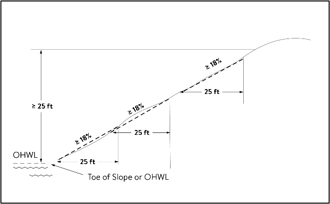
b.
A natural escarpment or cliff with a slope that rises at least ten feet above the ordinary high water level or toe of the slope, whichever is applicable, to the top of the slope, with a slope of 75 degrees or greater. See Figure 2.
Figure 2. Natural Escarpment Bluff and Bluff Impact Zone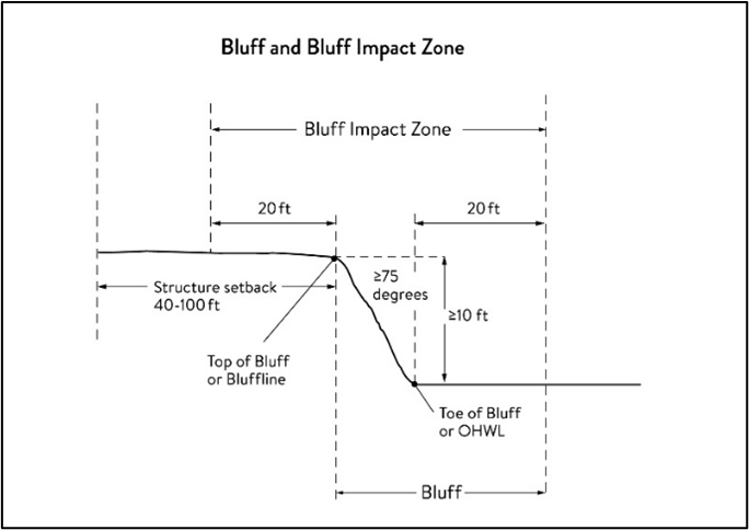
Bluff impact zone (BIZ) means a bluff and land located within 20 feet of the bluff. See Figure 2 for natural escarpment or cliff example and Figure 3 for more common bluff example.
Figure 3. Bluff Impact Zone, Bluffline, Toe of Bluff, and Top of Bluff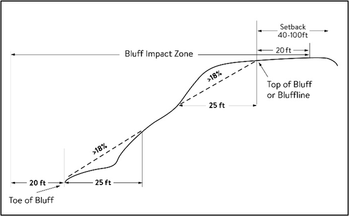
Bluffline means a line delineating the top of the bluff. More than one bluffline may be encountered proceeding landward from the river. See Figure 2 for natural escarpment or cliff example and Figure 3 for more common bluff example.
Bluff, Toe of, means a line along the bottom of a bluff, requiring field verification, such that the slope above the line exceeds 18 percent and the slope below the line is 18 percent or less, measured over a horizontal distance of 25 feet. See Figure 2 for natural escarpment or cliff example and Figure 3 for more common bluff example.
Bluff, Top of, means a line along the top of a bluff, requiring field verification, such that the slope below the line exceeds 18 percent and the slope above the line is 18 percent or less, measured over a horizontal distance of 25 feet. See Figure 2 for natural escarpment or cliff example and Figure 3 for more common bluff example.
Buildable area means the area upon which structures may be placed on a lot or parcel of land and excludes areas needed to meet requirements for setback, rights-of-way, bluff impact zones, historic properties, wetlands, designated floodways, land below the ordinary high water level of public waters, and other unbuildable areas.
Building means a structure with two or more outside rigid walls and a fully secured roof and affixed to a permanent site.
Certificate of compliance means a document written after a compliance inspection, certifying that the development complies with applicable requirements at the time of the inspection.
Commissioner means the commissioner of the Minnesota Department of Natural Resources.
Conditional use means a use having the meaning given under Minnesota Statutes, chapters 394 and 462.
Conservation design means a pattern of subdivision that is characterized by grouping lots within a portion of a parcel, where the remaining portion of the parcel is permanently protected as open space.
Conventional subdivision means a pattern of subdivision that is characterized by lots that are spread regularly throughout a parcel in a lot and block design.
Deck means a horizontal, unenclosed, aboveground level structure open to the sky, with or without attached railings, seats, trellises, or other features, attached or functionally related to a principal use or site.
Developer means having the meaning given under Minnesota Statutes, section 116G.03.
Development means having the meaning given under Minnesota Statutes, section 116G.03.
Discretionary action means an action under this section related to land use that requires a public hearing by local ordinance or statute, such as preliminary plats, final subdivision plats, planned unit developments, conditional use permits, interim use permits, variances, appeals, and rezonings.
Dock means having the meaning given under Minnesota Rules, chapter 6115.
Electric power facilities means equipment and associated facilities for generating electric power or devices for converting wind energy to electrical energy as identified and defined under Minnesota Statutes, section 216E.
Essential services means underground or overhead gas, electrical, communications, steam, or water distribution, collection, supply, or disposal systems, including storm water. Essential services include poles, wires, mains, drains, pipes, conduits, cables, fire alarm boxes, traffic signals, hydrants, navigational structures, aviation safety facilities or other similar equipment and accessories in conjunction with the systems. Essential services does not include buildings, treatment works as defined in Minnesota Statutes, section 115.01, electric power facilities or transmission services.
Feedlot means having the meaning given for animal feedlots under Minnesota Rules, chapter 7020.
Floodplain means having the meaning given under Minnesota Rules, chapter 6120.
Fully reconstructs means the reconstruction of an existing impervious surface that involves site grading and subsurface excavation so that soil is exposed. Mill and overlay and other resurfacing activities are not considered fully reconstructed.
Hard-surface trail means a trail surfaced in asphalt, crushed aggregate, or other hard surface for multi-purpose use, as determined by local, regional, or state agency plans.
Historic property means an archaeological site, standing structure, site, district, or other property that is:
a.
Listed in the National Register of Historic Places or the State Register of Historic Places or locally designated as a historic site under Minnesota Statutes, chapter 471; or
b.
Determined to meet the criteria for eligibility to the National Register of Historic Places or the State Register of Historic Places as determined by the director of the Minnesota Historical Society; or
c.
An unplatted cemetery that falls under the provisions of Minnesota Statutes, chapter 307, in consultation with the Office of the State Archaeologist.
Impervious surface means a constructed hard surface that either prevents or retards the entry of water into the soil and causes water to run off the surface in greater quantities and at an increased rate of flow than prior to development. Examples include rooftops, decks, sidewalks, patios, parking lots, storage areas, and driveways, including those with concrete, asphalt, or gravel surfaces.
Intensive vegetation clearing means the removal of all or a majority of the trees or shrubs in a contiguous patch, strip, row, or block.
Interim use means a use having the meaning given under Minnesota Statutes, chapters 394 and 462.
Land alteration means an activity that exposes the soil or changes the topography, drainage, or cross-section of the land, excluding gardening or similar minor soil disturbances.
Local government means counties, cities, and townships.
Lot means having the meaning given under Minnesota Rules, chapter 6120.
Lot width means the shortest distance between lot lines measured at both the ordinary high water level and at the required structure setback from the ordinary high water level. See Figure 4.
Figure 4. Lot Width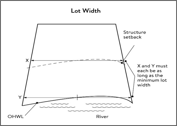
Marina means having the meaning given under Minnesota Rules, chapter 6115.
Mississippi River Corridor Critical Area (MRCCA) means the area within the river corridor boundary as defined in this section.
Mississippi River Corridor Critical Area (MRCCA) Plan means a chapter in the City of Anoka comprehensive plan.
Mooring facility means having the meaning given under Minnesota Rules, part 6115.0170.
Native plant community means a plant community identified by the Minnesota Biological Survey or biological survey issued or adopted by a local, state, or federal agency.
Natural-surface trail means a trail composed of native soil and rock or compacted granular stone, primarily intended for hiking, equestrian, or mountain bike use, as determined by local, regional, or state agency plans.
Natural vegetation means any combination of ground cover, understory, and tree canopy that, while it may have been altered by human activity, continues to stabilize soils, retain and filter runoff, provide habitat, and recharge groundwater.
Nonconformity means having the meaning given under Minnesota Statutes, section 394.22.
Nonmetallic mining means construction, reconstruction, repair, relocation, expansion, or removal of any facility for the extraction, stockpiling, storage, disposal, or reclamation of nonmetallic minerals such as stone, sand, and gravel. Nonmetallic mining does not include ancillary facilities such as access roads, bridges, culverts, and water level control structures. For purposes of this definition, "facility" includes all mine pits, quarries, stockpiles, basins, processing structures and equipment, and any structures that drain or divert public waters to allow mining.
Off-premise advertising signs means those signs that direct attention to a product, service, business, or entertainment venue that is not exclusively related to the premises where the sign is located.
Ordinary high water level (OHWL) means having the meaning given under Minnesota Statutes, section 103G.005.
Overlay district means a zoning district applied over one or more previously established zoning districts, establishing additional or stricter standards and criteria for covered properties in addition to those of the underlying zoning district. Overlay districts are often used to protect historic features and natural resources such as shoreland or floodplain.
Parcel means having the meaning given under Minnesota Statutes, section 116G.03.
Patio means a constructed hard surface located at ground level with no railings and open to the sky.
Picnic shelter means a roofed structure open on all sides, accessory to a recreational use.
Planned unit development (PUD) means a method of land development that merges zoning and subdivision controls, allowing developers to plan and develop a large area as a single entity, characterized by a unified site design, a mix of structure types and land uses, and phasing of development over a number of years. Planned unit development includes any conversion of existing structures and land uses that utilize this method of development.
Plat means having the meaning given under Minnesota Statutes, sections 505 and 515B.
Port means a water transportation complex established and operated under the jurisdiction of a port authority according to Minnesota Statutes, chapter 458.
Primary conservation areas (PCAs) means key resources and features, including shore impact zones, bluff impact zones, floodplains, wetlands, gorges, areas of confluence with tributaries, natural drainage routes, unstable soils and bedrock, native plant communities, cultural and historic properties, and significant existing vegetative stands, tree canopies, and other resources identified in local government plans.
Private facilities means private roads, driveways, and parking areas, private water access and viewing facilities, decks and patios in setback areas, and private signs.
Professional engineer means an engineer licensed to practice in Minnesota.
Public facilities means public utilities, public transportation facilities, and public recreational facilities.
Public recreation facilities means recreational facilities provided by the state or a local government and dedicated to public use, including parks, scenic overlooks, observation platforms, trails, docks, fishing piers, picnic shelters, water access ramps, and other similar water-oriented public facilities used for recreation.
Public river corridor views (PRCVs) means views toward the river from public parkland, historic properties, and public overlooks, as well as views toward bluffs from the ordinary high water level of the opposite shore, as seen during the summer months and documented in the MRCCA plan/chapter of the comprehensive plan.
Public transportation facilities means all transportation facilities provided by federal, state, or local government and dedicated to public use, such as roadways, transit facilities, railroads, and bikeways.
Public utilities means electric power facilities, essential services, and transmission services.
Public waters means having the meaning given under Minnesota Statutes, section 103G.005.
Readily visible means land and development that are easily seen from the ordinary high water level of the opposite shore during summer months.
Resource agency means a federal, state, regional, or local agency that engages in environmental, natural, or cultural resource protection or restoration activities, including planning, implementation, and monitoring.
Retaining wall means a vertical or nearly vertical structures constructed of mortar and rubble masonry, rock, or stone regardless of size, vertical timber pilings, horizontal timber planks with piling supports, sheet pilings, poured concrete, concrete blocks, or other durable materials.
Rock riprap means natural coarse rock placed or constructed to armor shorelines, streambeds, bridge abutments, pilings and other shoreline structures against scour, or water or ice erosion.
River corridor boundary means the boundary approved and adopted by the Metropolitan Council under Minnesota Statutes, section 116G.06, as approved and adopted by the legislature in Minnesota Statutes, section 116G.15, and as legally described in the State Register, volume 43, pages 508 to 518.
River-dependent use means the use of land for commercial, industrial, or utility purposes, where access to and use of a public water feature is an integral part of the normal conduct of business and where the use is dependent on shoreline facilities.
Selective vegetation removal means the removal of isolated individual trees or shrubs that are not in a contiguous patch, strip, row, or block and that does not substantially reduce the tree canopy or understory cover.
Setback means a separation distance measured horizontally.
Shore impact zone (SIZ) means land located between the ordinary high water level of public waters and a line parallel to it at a setback of 50 percent of the required structure setback or, for agricultural use, 50 feet landward of the ordinary high water level. See Figure 5.
Figure 5. Shore Impact Zone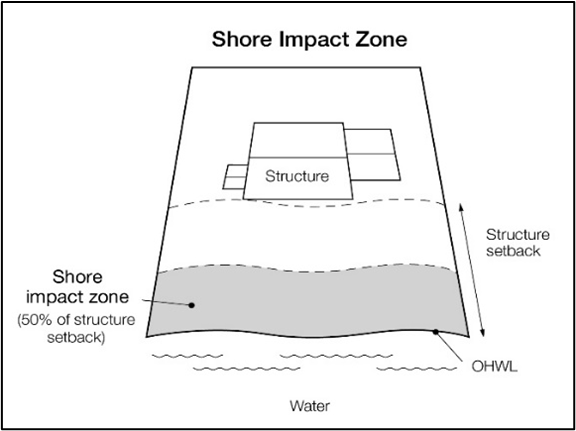
Shoreline facilities means facilities that require a location adjoining public waters for ingress and egress, loading and unloading, and public water intake and outflow, such as barge facilities, port facilities, commodity loading and unloading equipment, watercraft lifts, marinas, short-term watercraft mooring facilities for patrons, and water access ramps. Structures that would be enhanced by a shoreline location, but do not require a location adjoining public waters as part of their function, are not shoreline facilities, such as restaurants, bait shops, and boat dealerships.
Steep slope a natural topographic feature with an average slope of 12 to 18 percent, measured over a horizontal distance equal to or greater than 50 feet, and any slopes greater than 18 percent that are not bluffs.
Storm water management facilities means facilities for the collection, conveyance, treatment, or disposal of storm water.
Structure means a building, sign, or appurtenance thereto, except for aerial or underground utility lines, such as sewer, electric, telephone, or gas lines, and utility line towers, poles, and other supporting appurtenances.
Subdivision means having the meaning given under Minnesota Statutes, section 462.352.
Subsurface sewage treatment system means having the meaning given under Minnesota Rules, part 7080.1100.
Transmission services means:
a.
Electric power lines, cables, pipelines, or conduits that are:
1.
Used to transport power between two points, as identified and defined under Minnesota Statutes, section 216E.01, subd. 4; or
2.
For mains or pipelines for gas, liquids, or solids in suspension, used to transport gas, liquids, or solids in suspension between two points; and
b.
Telecommunication lines, cables, pipelines, or conduits.
Treeline means the more or less continuous line formed by the tops of trees in a wooded area when viewed from a particular point. The treeline is determined during all seasons as if under full foliage.
Variance means having the meaning given under Minnesota Statutes, section 394.22.
Water access ramp means a boat ramp, carry-down site, boarding dock, and approach road, or other access that allows launching and removal of a boat, canoe, or other watercraft with or without a vehicle and trailer.
Water-oriented accessory structure means a small building or other improvement, except stairways, fences, docks, residential irrigation pump covers, and retaining walls, that, because of the relationship of its use to public waters, needs to be located closer to public waters than the normal structure setback. Examples include gazebos, sheds, screen houses, fish houses, pump houses, and detached decks and patios.
Water quality impact zone means land within the shore impact zone or within 50 feet of a public water, wetland, or natural drainage route.
Wetland means the meaning given under Minnesota Statutes, section 103G.005.
Wharf means having the meaning given under Minnesota Rules, part 6115.0170.
(c)
Administration.
(1)
Purpose. The purpose of this section is to identify administrative provisions to ensure this section is administered consistent with its purpose.
(2)
Permits. A permit is required for the construction of buildings or building additions (including construction of decks and signs), the installation and/or alteration of sewage treatment systems, vegetation removal consistent with this section.
(3)
Variances. Variances to the requirements under this section may only be granted in accordance with Minnesota Statutes, section 462.357 and must consider the potential impacts of variances on primary conservation areas, public river corridor views, and other resources identified in the MRCCA plan. In reviewing the variance application, the governing body shall:
a.
Evaluate the impacts to these resources. If negative impacts are found, require conditions to mitigate the impacts that are related to and proportional to the impacts, and
b.
Make written findings that the variance is consistent with the purpose of this section.
(4)
Conditional and interim use permits. All conditional and interim uses, required under this section must comply with Minnesota Statutes, section 462.3595 and must consider the potential impacts on primary conservation areas, public river corridor views, and other resources identified in the MRCCA plan. In reviewing the application, the governing body shall:
a.
Evaluate the impacts to these resources and if negative impacts are found, require conditions to mitigate the impacts that are related to and proportional to the impacts.
(5)
Application materials. Applications for permits and discretionary actions required under this section must submit the following information unless the zoning administrator determines that the information is not needed.
a.
A detailed project description; and
b.
Scaled maps and plans, dimensional renderings, maintenance agreements, and other materials that identify and describe:
1.
Primary conservation areas;
2.
Public river corridor views;
3.
Buildable area;
4.
Existing and proposed topography and drainage patterns;
5.
Proposed storm water and erosion and sediment control practices;
6.
Existing and proposed vegetation to be removed and established;
7.
Ordinary high water level, blufflines, and all required setbacks;
8.
Existing and proposed structures; and
9.
Existing and proposed impervious surfaces.
(6)
Nonconformities.
a.
All legally established nonconformities as of the date of this ordinance may continue consistent with Minnesota Statutes, section 462.357, subd. 1e.
b.
New structures erected in conformance with the setback averaging provisions of this section are conforming structures.
c.
Site alterations and expansion of site alterations that were legally made prior to the effective date of this ordinance are conforming. Site alterations include vegetation, erosion control, storm water control measures, and other nonstructural site improvements.
d.
Legally nonconforming principal structures that do not meet the setback requirements of this section may be expanded laterally provided that:
1.
The expansion does not extend into the shore or bluff impact zone or further into the required setback than the building line of the existing principal structure (see Figure 6); and
2.
The expanded structure's scale and bulk is consistent with that of the original structure and existing surrounding development.
Figure 6. Expansion of Nonconforming Structure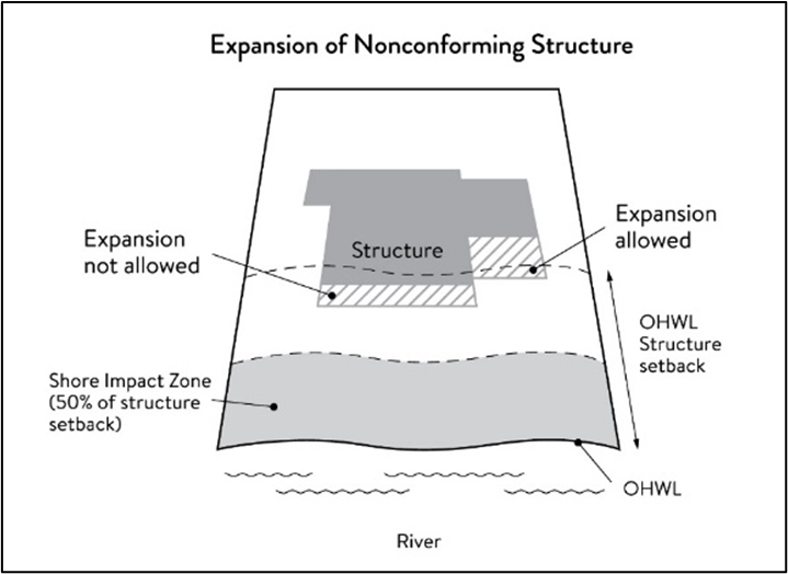
(7)
Notifications.
a.
Amendments to this section and to the MRCCA plan must be submitted to the commissioner as provided in Minnesota Rules, part 6106.0070, subp. 3, items B—I.
b.
Notice of public hearings for discretionary actions, including conditional and interim use permits, variances, appeals, rezonings, preliminary plats, final subdivision plats, and PUDs, must be sent to the following entities at least ten days prior to the hearing:
1.
The Commissioner in a format prescribed by the DNR;
2.
National Park Service; and
3.
Where building heights exceed the height limits specified in this section as part of the conditional use or variance process, adjoining local governments within the MRCCA, including those with overlapping jurisdiction and those across the river.
c.
Notice of final decisions for actions in subsection (c)(7)b. of this section including findings of fact, must be sent to the Commissioner, the National Park Service, and adjoining local governments within the MRCCA within ten days of the final decision.
d.
Requests to amend district boundaries must follow the provisions in Minnesota Rules, part 6106.0100, subp. 9, item C.
(8)
Accommodating disabilities. Reasonable accommodations for ramps or other facilities to provide persons with disabilities access to the persons' property, as required by the Federal Americans with Disabilities Act and the Federal Fair Housing Act and as provided by Minnesota Rules, chapter 1341, must:
a.
Comply with this section; or
b.
If this section cannot be complied with, ramps or other facilities are allowed with an administrative permit provided:
1.
The permit terminates on either a specific date or upon occurrence of a particular event related to the person requiring accommodation; and
2.
Upon expiration of the permit, the ramp or other facilities must be removed.
(d)
MRCCA Districts.
(1)
Purpose. The purpose of this section is to establish districts under which building height and structure placement are regulated to protect and enhance the Mississippi River's resources and features consistent with the natural and built character of each district.
(2)
District description and management purpose. The MRCCA within the city is divided into the following MRCCA Districts:
a.
Rural and Open Space (ROS).
1.
Description. The ROS District is characterized by rural and low-density development patterns and land uses, and includes land that is riparian or visible from the river, as well as large, undeveloped tracts of high ecological and scenic value, floodplain, and undeveloped islands. Many primary conservation areas exist in the district.
2.
Management purpose. The ROS District must be managed to sustain and restore the rural and natural character of the corridor and to protect and enhance habitat, parks and open space, public river corridor views, and scenic, natural, and historic areas.
b.
River Neighborhood (RN).
1.
Description. The RN District is characterized by primarily residential neighborhoods that are riparian or readily visible from the river or that abut riparian parkland. The district includes parks and open space, limited commercial development, marinas, and related land uses.
2.
Management purpose. The RN District must be managed to maintain the character of the river corridor within the context of existing residential and related neighborhood development, and to protect and enhance habitat, parks and open space, public river corridor views, and scenic, natural, and historic areas. Minimizing erosion and the flow of untreated storm water into the river and enhancing habitat and shoreline vegetation are priorities in the district.
c.
River Towns and Crossings (RTC).
1.
Description. The RTC District is characterized by historic downtown areas and limited nodes of intense development at specific river crossings, as well as institutional campuses that predate designation of the MRCCA, and that include taller buildings.
2.
Management purpose. The RTC district must be managed in a manner that allows continued growth and redevelopment in historic downtowns and more intensive redevelopment in limited areas at river crossings to accommodate compact walkable development patterns and connections to the river. Minimizing erosion and the flow of untreated storm water into the river, providing public access to and public views of the river, and restoring natural vegetation in riparian areas and tree canopy are priorities in the district.
d.
Separated from River (SR).
1.
Description. The SR District is characterized by its physical and visual distance from the Mississippi River. The district includes land separated from the river by distance, topography, development, or a transportation corridor. The land in this district is not readily visible from the Mississippi River.
2.
Management purpose. The SR district provides flexibility in managing development without negatively affecting the key resources and features of the river corridor. Minimizing negative impacts to primary conservation areas and minimizing erosion and flow of untreated storm water into the Mississippi River are priorities in the district. The RTC district must be managed in a manner that allows continued growth and redevelopment in historic downtowns and more intensive redevelopment in limited areas at river crossings to accommodate compact walkable development patterns and connections to the river. Minimizing erosion and the flow of untreated storm water into the river, providing public access to and public views of the river, and restoring natural vegetation in riparian areas and tree canopy are priorities in the district.
(3)
MRCCA district map. The locations and boundaries of the MRCCA districts established by this section are shown on the official Anoka Zoning Map which is incorporated herein by reference. The district boundary lines are intended to follow the centerlines of rivers and streams, highways, streets, lot lines, and municipal boundaries, unless a boundary line is otherwise indicated on the map. Where district boundaries cross un-subdivided property, the district boundary line is determined by use of dimensions or the scale appearing on the map.
(e)
Special Land Use Provisions.
(1)
Purpose. To identify development standards and considerations for land uses that have potential to negatively impact primary conservation areas and public river corridor views.
(2)
Underlying zoning. Uses within the MRCCA are generally determined by underlying zoning, with additional provisions for the following land uses:
a.
Agricultural Use. Perennial ground cover is required within 50 feet of the ordinary high water level and within the bluff impact zone.
b.
Feedlots. New animal feedlots and manure storage areas are prohibited. Existing animal feedlots and manure storage areas must conform with Minnesota Rules, chapter 7020.
c.
Forestry. Tree harvesting and biomass harvesting within woodlands, and associated reforestation, must be consistent with recommended practices in Conserving Wooded Areas in Developing Communities: Best Management Practices in Minnesota.
d.
Nonmetallic mining. Nonmetallic mining requires a conditional use permit or interim use permit issued by the local government, subject to the following:
1.
New nonmetallic mining is prohibited within the shore impact zone and bluff impact zone and within the required structure setback from the bluffline and OHWL;
2.
Processing machinery must be located consistent with setback standards for structures as provided in this section;
3.
Only one barge loading area, which must be limited to the minimum size practicable, is permitted for each mining operation;
4.
New and, where practicable, existing nonmetallic mining operations must not be readily visible and must be screened by establishing and maintaining natural vegetation. The unscreened boundaries of nonmetallic mining areas are limited to only the barge loading area;
5.
A site management plan must be developed by the operator and approved by the local government before new nonmetallic mining commences. Operations must be consistent with the site plan throughout the duration of operations at the site. The site management plan must:
i.
Describe how the site will be developed over time with an emphasis on minimizing environmental risk to public waters;
ii.
Explain where staged reclamation may occur at certain points during the life of the site;
iii.
Address dust, noise, storm water management, possible pollutant discharges, days and hours of operation, and duration of operations; and
iv.
Describe any anticipated vegetation and topographic alterations outside the pit, and reclamation plans consistent with the stated end use for the land.
6.
Existing and new nonmetallic mining operations must submit land reclamation plans to the local government compatible with the purposes of this ordinance.
e.
River-dependent uses. River-dependent uses must comply with the following design standards:
1.
Structures and parking areas, except shoreline facilities and private roads and conveyances serving river-dependent uses as provided in this section must meet the dimensional and performance standards in this section, must be designed so that they are not readily visible, and must be screened by establishing and maintaining natural vegetation;
2.
Shoreline facilities must comply with Minnesota Rules, chapter 6115 and must:
i.
Be designed in a compact fashion so as to minimize the shoreline area affected;
ii.
Minimize the surface area of land occupied in relation to the number of watercraft or barges to be served;
3.
Dredging and placement of dredged material are subject to existing federal and state permit requirements and agreements.
f.
Wireless communication towers. Wireless communication towers require a conditional or interim use permit and are subject to the following design standards:
1.
The applicant must demonstrate that functional coverage cannot be provided through co-location, a tower at a lower height, or a tower at a location outside of the MRCCA;
2.
The tower must not be located in a bluff or shore impact zone; and
3.
Placement of the tower must minimize impacts on public river corridor views.
4.
Comply with the general design standards in this section.
(f)
Structure height and placement and lot size.
(1)
Purpose. To establish standards that protect primary conservation areas and public river corridor views from development impacts and ensure that new development is sited consistent with the purpose of the MRCCA.
(2)
Structure height. Structures and facilities must comply with the following standards unless identified as exempt in subsection (l) of this section.
a.
Structures and facilities must comply with the following standards unless identified as exempt in subsection (l) of this section.
1.
ROS District: 35 feet.
2.
RN District: 35 feet.
3.
RTC District: 48 feet, provided tiering of structures away from the Mississippi River and from blufflines is given priority, with lower structure heights closer to the river and blufflines, and that structure design and placement minimizes interference with public river corridor views. Structures over 48 feet are allowed as a conditional use in accordance with this section.
4.
SR District: Height is determined by underlying zoning, provided the allowed height is consistent with that of the mature treeline, where present, and existing surrounding development, as viewed from the OHWL of the opposite shore.
b.
Height is measured on the side of the structure facing the Mississippi River.
c.
In addition to the conditional use permit requirements of this section, criteria for considering whether to grant a conditional use permit for structures exceeding the height limits must include:
1.
Assessment of the visual impact of the proposed structure on public river corridor views, including views from other communities;
2.
Determination that the proposed structure meets the required bluff and OHWL setbacks;
3.
Identification and application of techniques to minimize the perceived bulk of the proposed structure, such as:
i.
Placing the long axis of the building perpendicular to the river;
ii.
Stepping back of portions of the facade;
iii.
Lowering the roof pitch or use of a flat roof;
iv.
Using building materials or mitigation techniques that will blend in with the natural surroundings such as green roofs, green walls, or other green and brown building materials;
v.
Narrowing the profile of upper floors of the building; or
vi.
Increasing the setbacks of the building from the Mississippi River or blufflines;
4.
Identification of techniques for preservation of those view corridors identified in the MRCCA Plan; and
5.
Opportunities for creation or enhancement of public river corridor views.
d.
Structure and impervious surface placement.
1.
Structures and impervious surface must not be placed in the shore or bluff impact zones unless identified as an exemption in subsection (l) of this section.
2.
Structures, impervious surfaces, and facilities must comply with the following OHWL setback provisions unless identified as exempt in subsection (l) of this section.
i.
ROS District: 200 feet from the Mississippi River.
ii.
RN District: 100 feet from the Mississippi River and 75 feet from the Rum River.
iii.
RTC District: 75 feet from the Mississippi and Rum River.
3.
Structures, impervious surfaces, and facilities must comply with the following bluffline setback provisions unless identified as exempt in subsection (l) of this section:
i.
ROS District: 100 feet.
ii.
RN District: 40 feet.
iii.
RTC District: 40 feet.
iv.
SR District: 40 feet.
4.
Where principal structures exist on the adjoining lots on both sides of a proposed building site, the minimum setback may be altered to conform to the average of the adjoining setbacks, if the new structure's scale and bulk riverward or bluffward of the setbacks required under this section are consistent with adjoining development. See Figure 7.
Figure 7. Structure Setback Averaging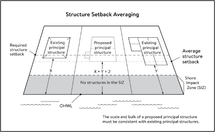
5.
Subsurface sewage treatment systems, including the septic tank and absorption area, must be located at least 75 feet from the ordinary high water level of the Mississippi River and all other public waters.
e.
Lot size and buildable area.
1.
The width of lots abutting the Mississippi River in the ROS District must be at least 200 feet, unless alternative design methods are used that provide greater protection of the riparian area.
2.
All new lots must have adequate buildable area to comply with the setback requirements of this section, so as to not require variances to use the lots for their intended purpose.
(g)
Performance standards for private facilities.
(1)
Purpose. To establish design standards for private facilities that are consistent with best management practices and that minimize impacts to primary conservation areas, public river corridor views and other resources identified in the MRCCA plan.
(2)
General design standards. All private facilities must be developed in accordance with the vegetation management and land alteration requirements of this section.
(3)
Private roads, driveways, and parking areas. Except as otherwise provided in this section, private roads, driveways and parking areas must:
a.
Be designed to take advantage of natural vegetation and topography so that they are not readily visible;
b.
Comply with structure setback requirements in accordance with this section; and
c.
Not be placed within the bluff impact zone or shore impact zone, unless otherwise exempt under this section, and designed in accordance with this section.
(4)
Private water access and viewing facilities.
a.
Private access paths must be no more than:
1.
Eight feet wide, if placed within the shore impact zone; and
2.
Four feet wide, if placed within the bluff impact zone.
b.
Private water access ramps must:
1.
Comply with Minnesota Rules, parts 6115.0210 and 6280.0250; and
2.
Be designed and constructed consistent with the applicable standards in Design Handbook for Recreational Boating and Fishing Facilities.
c.
Design and construction of private stairways, lifts, and landings are subject to the following standards:
1.
Stairways and lifts must not exceed four feet in width on residential lots. Wider stairways may be used for commercial properties and residential facilities held in common, if approved by the zoning administrator;
2.
Landings for stairways and lifts on residential lots must not exceed 32 square feet in area. Landings larger than 32 square feet are allowed for commercial properties and residential facilities held in common, if approved by the zoning administrator;
3.
Canopies or roofs are prohibited on stairways, lifts, or landings;
4.
Stairways, lifts, and landings must be located in the least visible portion of the lot whenever practical; and
5.
Ramps, lifts, mobility paths, or other facilities for persons with physical disabilities are allowed for achieving access to shore areas in accordance with this section.
d.
One water-oriented accessory structure is allowed for each riparian lot or parcel less than 300 feet in width at the ordinary high water level, with one additional water-oriented accessory structure allowed for each additional 300 feet of shoreline on the same lot or parcel. Water-oriented accessory structures are prohibited in the bluff impact zone and must:
1.
Not exceed 12 feet in height;
2.
Not exceed 120 square feet in area; and
3.
Be placed a minimum of 10 feet from the ordinary high water level.
(5)
Decks and patios in setback areas. Decks and at-grade patios abutting the principal structure may encroach into the required setbacks from the ordinary high water level and blufflines without a variance, when consistent with this section, provided that:
a.
The encroachment of the deck or patio into the required setback area does not exceed 15 percent of the required structure setback;
b.
The area of the deck or patio that extends into the required setback area occupies no more than 25 percent of the total area between the required setback and the 15 percent using the formula:
[Required setback depth (feet) x 0.15 x lot width at setback (feet) x 0.25 = maximum total area]
c.
The deck or patio does not extend into the bluff impact zone. See Figure 8.
Figure 8. Deck and Patio Encroachment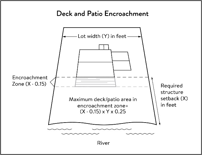
(6)
Off-premise and directional signs.
a.
Off-premise advertising signs must:
1.
Meet required structure placement and height standards in this section.
2.
Not be readily visible from the Mississippi or Rum rivers.
b.
Directional signs for patrons arriving at a business by watercraft must comply with the following standards:
1.
They must be consistent with Minnesota Statutes, section 86B.115.
2.
Only convey the location and name of the establishment and the general types of goods and services available, if located in a shore impact zone.
3.
Be no greater than ten feet in height and 32 square feet in surface area; and
4.
If illuminated, the lighting must be fully shielded and directed downward to prevent illumination out across the river or to the sky.
(7)
Fences. Fences between principal structures and the river are allowed if fences are:
a.
Not higher than four feet, unless immediately surrounding a swimming pool and appurtenances thereto such as a patio or deck, which in that case, not higher than six feet.
b.
A maximum opaqueness of 50%.
c.
Not located within a bluff.
d.
Not located in the regulatory floodplain.
(h)
Performance standards for public facilities.
(1)
Purpose. To establish design standards for public facilities that are consistent with best management practices and that minimize impacts to primary conservation areas, public river corridor views and other resources identified in the MRCCA plan. Public facilities serve the public interest by providing public access to the Mississippi River corridor or require locations in or adjacent to the river corridor and therefore require some degree of flexibility.
(2)
General design standards. All public facilities must be designed and constructed to:
a.
Minimize visibility of the facility from the river to the extent consistent with the purpose of the facility;
b.
Comply with the structure placement and height standards in subsection (f) of this section, except as provided in subsection (l) of this section;
c.
Be consistent with the vegetation management standards and the land alteration and storm water management standards of the section, including use of practices identified in Best Practices for Meeting DNR General Public Waters Work Permit GP 2004-0001, where applicable;
d.
Avoid primary conservation areas, unless no alternative exists. If no alternative exists, then disturbance to primary conservation areas must be avoided to the greatest extent practicable, and design and construction must minimize impacts; and
e.
Minimize disturbance of spawning and nesting times by scheduling construction at times when local fish and wildlife are not spawning or nesting.
(3)
Right-of-way maintenance standards. Right-of-way maintenance must comply with the following standards:
a.
Vegetation currently in a natural state must be maintained to the extent feasible;
b.
Where vegetation in a natural state has been removed, native plants must be planted and maintained on the right-of-way; and
c.
Chemical control of vegetation must be avoided when practicable, but when chemical control is necessary, chemicals used must be in accordance with the regulations and other requirements of all state and federal agencies with authority over the chemical's use.
(4)
Crossings of public water or public land. Crossings of public waters or land controlled by the commissioner are subject to approval by the commissioner according to Minnesota Statutes, sections 84.415 and 103G.245.
(5)
Public utilities. Public utilities must comply with the following standards:
a.
High-voltage transmission lines, wind energy conversion systems greater than five megawatts, and pipelines are regulated according to Minnesota Statutes, chapters 216E, 216F, and 216G respectively; and
b.
If overhead placement is necessary, utility facility crossings must minimize visibility of the facility from the river and follow other existing right-of-ways as much as practicable.
c.
The appearance of structures must be as compatible as practicable with the surrounding area in a natural state with regard to height and width, materials used, and color.
d.
Wireless communication facilities in accordance with subsection (e)(2)f. of this section.
(6)
Public transportation facilities. Public transportation facilities shall comply with structure placement and height standards in subsection (f) of this section. Where such facilities intersect or about two or more MRCCA districts, the least restrictive standards apply. Public transportation facilities must be designed and constructed to give priority to:
a.
Providing scenic overlooks for motorists, bicyclists, and pedestrians;
b.
Providing safe pedestrian crossings and facilities along the river corridor;
c.
Providing access to the riverfront in public ownership; and
d.
Allowing for use of the land between the river and the transportation facility.
(7)
Public recreational facilities. Public recreational facilities must comply with the following standards:
a.
Buildings and parking associated with public recreational facilities must comply with the structure placement and height standards in subsection (f) of this section, except as provided in subsection (l) of this section;
b.
Roads and driveways associated with public recreational facilities must not be placed in the bluff or shore impact zones unless no other placement alternative exists. If no alternative exists, then design and construction must minimize impacts to shoreline vegetation, erodible soils and slopes, and other sensitive resources.
c.
Trails, access paths, and viewing areas associated with public recreational facilities and providing access to or views of the Mississippi River are allowed within the bluff and shore impact zones if design, construction, and maintenance methods are consistent with the best management practice guidelines in Trail Planning, Design, and Development Guidelines.
1.
Hard-surface trails are not allowed on the face of bluffs with a slope exceeding 30 percent. Natural surface trails are allowed, provided they do not exceed eight feet in width.
2.
Trails, paths, and viewing areas must be designed and constructed to minimize:
i.
Visibility from the river;
ii.
Visual impacts on public river corridor views; and
iii.
Disturbance to and fragmentation of primary conservation areas.
d.
Public water access facilities must comply with the following requirements:
1.
Watercraft access ramps must comply with Minnesota Rules, chapters 6115.0210 and 6280.0250; and
2.
Facilities must be designed and constructed consistent with the standards in Design Handbook for Recreational Boating and Fishing Facilities.
e.
Public signs and kiosks for interpretive or directional purposes are allowed in the bluff or shore impact zones, provided they are placed and constructed to minimize disturbance to these areas and avoid visual impacts on public river corridor views.
f.
Public stairways, lifts, and landings must be designed as provided in this section.
(i)
Vegetation management.
(1)
Purpose. To establish standards that sustain and enhance the biological and ecological functions of vegetation; preserve the natural character and topography of the MRCCA; and maintain stability of bluffs and steep slopes and ensure stability of other erosion-prone areas.
(2)
Applicability. This section applies to:
a.
Shore impact zones;
b.
Areas within 50 feet of a wetland or natural drainage route;
c.
Bluff impact zones;
d.
Areas of native plant communities; and
e.
Significant existing vegetative stands identified in the MRCCA plan.
(3)
Activities allowed without a vegetation permit.
a.
Maintenance of existing lawns, landscaping and gardens;
b.
Removal of vegetation in emergency situations as determined by the City of Anoka;
c.
Right-of-way maintenance for public facilities meeting the standards of this section;
d.
Agricultural and forestry activities meeting the standards of this section;
e.
Selective vegetation removal, provided that vegetative cover remains consistent with the management purpose of the MRCCA District, including removal of:
1.
Vegetation that is dead, diseased, dying, or hazardous;
2.
Vegetation to prevent the spread of diseases or insect pests;
3.
Individual trees and shrubs; and
4.
Invasive non-native species.
(4)
Activities allowed with a vegetation permit.
a.
Only the following intensive vegetation clearing activities are allowed with a vegetation permit:
1.
Clearing of vegetation that is dead, diseased, dying, or hazardous;
2.
Clearing to prevent the spread of diseases or insect pests;
3.
Clearing to remove invasive non-native species.
4.
Clearing to prepare for restoration and erosion control management activities consistent with a plan approved by the City of Anoka.
5.
The minimum necessary for development that is allowed with a building permit or as an exemption under subsection (l) of this section.
b.
General performance standards. The following standards must be met, in addition to a restoration plan under this section, in order to approve a vegetation permit:
1.
Development is sited to minimize removal of or disturbance to natural vegetation;
2.
Soil, slope stability, and hydrologic conditions are suitable for the proposed work as determined by a professional engineer.
3.
Clearing is the minimum necessary and designed to blend with the natural terrain and minimize visual impacts to public river corridor views and other scenic views;
4.
Vegetation removal activities are conducted so as to expose the smallest practical area of soil to erosion for the least possible time; and
5.
Any other condition determined necessary to achieve the purpose of this section.
(5)
Prohibited activities. All other intensive vegetation clearing is prohibited.
(6)
Vegetation restoration plan.
a.
Development of a vegetation restoration plan and reestablishment of natural vegetation is required:
1.
For any vegetation removed with a permit under this section;
2.
Upon failure to comply with any provisions in this section; or
3.
As part of the planning process for subdivisions as provided in this section.
b.
Restoration plan performance standards. The vegetation restoration plan must satisfy the application submittal requirements in this section, and:
1.
Vegetation must be restored in one or more of the following restoration priority areas:
i.
Areas with soils showing signs of erosion, especially on or near the top and bottom of steep slopes and bluffs;
ii.
Shoreline areas within 25 feet of the water with no natural vegetation, degraded vegetation, or planted with turf grass;
iii.
Areas on steep slopes and bluffs that are visible from the river with no natural vegetation, degraded vegetation, or planted with turf grass; or
iv.
Other approved priority opportunity area, including priorities identified in the MRCCA plan, if none of the above exist.
2.
Include vegetation that provides suitable habitat and effective soil stability, runoff retention, and infiltration capability. Vegetation species, composition, density, and diversity must be guided by nearby patches of native plant communities and by Native Vegetation Establishment and Enhancement Guidelines;
3.
Any highly erodible soils disturbed during removal and/or restoration must be stabilized with deep-rooted vegetation with a high stem density;
4.
Vegetation removed must be restored with vegetation to the greatest extent practicable. Replacement of non-native vegetation with native vegetation is encouraged. The area (square feet) of the restored vegetation should be similar to that removed to the greatest extent practicable.
5.
For restoration of removed native plant communities, restored vegetation must also provide biological and ecological function equivalent to the removed native plant communities. The area (square feet) of the restored vegetation should be equivalent to that removed;
6.
Be prepared by a qualified individual; and
7.
Include a maintenance plan that includes management provisions for controlling invasive species and replacement of plant loss for three years.
c.
A certificate of compliance will be issued after the vegetation restoration plan requirements have been satisfied.
(j)
Land alteration standards and stormwater management.
(1)
Purpose. To establish standards that protect water quality from pollutant loadings of sediment, nutrients, bacteria, and other contaminants; and maintain stability of bluffs, shorelines, and other areas prone to erosion.
(2)
Land alteration.
a.
Within the bluff impact zone, land alteration is prohibited, except for the following, which are allowed by permit.
1.
Erosion control consistent with a plan approved by the local government or resource agency and consistent with this section;
2.
The minimum necessary for development that is allowed as an exception under subsection (l) of this section; and
3.
Repair and maintenance of existing buildings and facilities.
b.
Within the water quality impact zone, land alteration that involves more than ten cubic yards of material or affects an area greater than 1,000 square feet requires a permit.
(3)
Rock riprap, retaining walls, and other erosion control structures.
a.
Construction, repair, or replacement of rock riprap, retaining walls, and other erosion control structures located at or below the OHWL must comply with Minnesota Rules, part 6115.0215, subp. 4, item E, and 6115.0216, subp. 2. Work must not proceed until approved by the commissioner, permitted by the U.S. Army Corps of Engineers, and any other permits are obtained. See Figure 9.
Figure 9. Riprap Guidelines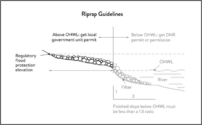
b.
Construction or replacement of rock riprap, retaining walls, and other erosion control structures within the bluff impact zone and the water quality impact zone are allowed with a permit consistent with provisions of this section provided that:
1.
If the project includes work at or below the OHWL, the commissioner has already approved or permitted the project.
2.
The structures are used only to correct an established erosion problem as determined by the City of Anoka.
3.
The size and extent of the structures are the minimum necessary to correct the erosion problem and are not larger than the following, unless a professional engineer determines that a larger structure is needed to correct the erosion problem:
i.
Retaining walls must not exceed five feet in height and must be placed a minimum horizontal distance of ten feet apart; and
ii.
Riprap must not exceed the height of the regulatory flood protection elevation.
c.
The use of gabion cages/walls is prohibited unless no other erosion control technique or structure(s) is feasible.
d.
For retaining walls, the use of natural stone is encouraged such as fieldstone boulders.
e.
Repair of existing rock riprap, retaining walls, and other erosion control structures above the OHWL does not require a permit provided it does not involve any land alteration.
(4)
Stormwater management.
a.
In the bluff impact zone, storm water management facilities are prohibited, except by permit if:
1.
There are no alternatives for storm water treatment outside the bluff impact zone on the subject site;
2.
The site generating runoff is designed so that the amount of runoff reaching the bluff impact zone is reduced to the greatest extent practicable;
3.
The construction and operation of the facility does not affect slope stability on the subject property or adjacent properties; and
4.
Mitigation based on the best available engineering and geological practices is required and applied to eliminate or minimize the risk of slope failure.
b.
In the water quality impact zone, development that creates new impervious surface, as allowed by exemption in subsection (l) of this section, or development that fully reconstructs existing impervious surface of more than 10,000 square feet, requires a stormwater permit. Multipurpose trails and sidewalks are exempt if there is down gradient vegetation or a filter strip that is at least five feet wide.
c.
In all other areas, storm water runoff must be directed away from the bluff impact zones or unstable areas.
(5)
Development on steep slopes. Construction of structures, impervious surfaces, land alteration, vegetation removal, or other construction activities are allowed on steep slopes if:
a.
The development can be accomplished without increasing erosion or storm water runoff;
b.
The soil types and geology are suitable for the proposed development; and
c.
Vegetation is managed according to the requirements of this section.
(6)
Conditions of land alteration permit approval.
a.
Temporary and permanent erosion and sediment control measures retain sediment onsite consistent with best management practices in the Minnesota Stormwater Manual;
b.
Natural site topography, soil, and vegetation conditions are used to control runoff and reduce erosion and sedimentation;
c.
Construction activity is phased when possible;
d.
All erosion and sediment controls are installed before starting any land disturbance activity;
e.
Erosion and sediment controls are maintained to ensure effective operation;
f.
The proposed work is consistent with the vegetation standards in this section; and
g.
Best management practices for protecting and enhancing ecological and water resources identified in Best Practices for Meeting DNR General Public Waters Work Permit GP 2004-0001.
(7)
Compliance with other plans and programs. All development must:
a.
Be consistent with Minnesota Statutes, chapter 103B, and local water management plans completed under Minnesota Statutes, chapter 8410;
b.
Meet or exceed the wetland protection standards under Minnesota Rules, chapter 8420; and
c.
Meet or exceed the floodplain management standards under Minnesota Rules, sections 6120.5000—6120.6200.
(k)
Subdivision and land development standards.
(1)
Purpose.
a.
To protect and enhance the natural and scenic values of the MRCCA during development or redevelopment of the remaining large sites;
b.
To establish standards for protecting and restoring biological and ecological functions of primary conservation areas on large sites; and
c.
To encourage restoration of natural vegetation during development or redevelopment of large sites where restoration opportunities have been identified in MRCCA Plans.
(2)
Applicability.
a.
The design standards in this section apply to subdivisions, planned unit developments and master-planned development and redevelopment of land involving ten or more acres for contiguous parcels that abut the Mississippi River and 20 or more acres for all other parcels, including smaller individual sites within the following developments that are part of a common plan of development that may be constructed at different times:
1.
Subdivisions;
2.
Planned unit developments; and
3.
Master-planned development and redevelopment of land.
b.
The following activities are exempt from the requirements of this section:
1.
Minor subdivisions consisting of three or fewer lots;
2.
Minor boundary line corrections;
3.
Resolutions of encroachments;
4.
Additions to existing lots of record;
5.
Placement of essential services; and
6.
Activities involving river-dependent commercial and industrial uses.
(3)
Application materials. Project information listed in subsection (c)(5) of this section must be submitted for all proposed developments.
(4)
Design standards.
a.
Primary conservation areas, where they exist, must be set aside and designated as protected open space in quantities meeting the following as a percentage of total parcel area:
1.
CA-ROS District: 50%;
2.
CA-RN District: 20%;
3.
CA-RTC, CA-UM, and CA-UC Districts: 10%; and
4.
CA-SR District: 10% if the parcel includes native plant communities or provides feasible connections to a regional park or trail system, otherwise no requirement.
b.
If the primary conservation areas exceed the amounts specified in this section, then protection of native plant communities and natural vegetation in riparian areas shall be prioritized.
c.
If primary conservation areas exist but do not have natural vegetation (identified as restoration priorities in the MRCCA Plan), then a vegetation assessment must be completed to evaluate the un-vegetated primary conservation areas and determine whether vegetation restoration is needed. If restoration is needed, vegetation must be restored in accordance with this section.
d.
If primary conservation areas do not exist on the parcel and portions of the parcel have been identified in the MRCCA plan as a restoration area, vegetation must be restored in the identified areas in accordance with this section and the area must be set aside and designated as protected open space.
e.
Storm water treatment areas or other green infrastructure may be used to meet the protected open space requirements if the vegetation provides biological and ecological functions.
f.
Land dedicated for public river access, parks, or other open space or public facilities may be counted toward the protected open space requirement.
g.
Protected open space areas must connect open space, natural areas, and recreational areas, where present on adjacent parcels, as much as possible to form an interconnected network.
(5)
Permanent protection of designated open space.
a.
Designated open space areas must be protected through one or more of the following methods:
1.
Public acquisition by a government entity for conservation purposes;
2.
A permanent conservation easement, as provided in Minnesota Statutes, chapter 84C;
3.
A deed restriction; and
4.
Other arrangements that achieve an equivalent degree of protection.
b.
Permanent protection methods must ensure the long-term management of vegetation to meet its biological and ecological functions, prohibit structures, and prohibit land alteration, except as needed to provide public recreational facilities and access to the river.
(l)
Exemptions.
(1)
Purpose. To provide exemptions to structure placement, height and other standards for specific river or water access dependent facilities as provided in Minnesota Statutes, section 116G.15 Subd. 4.
(2)
Applicability.
a.
Uses and activities not specifically exempted must comply with this section. Uses and activities exempted under shore impact zone and bluff impact zone must comply with the vegetation management and land alteration standards in this section.
b.
Uses and activities in this section are categorized as:
1.
Exempt - E. This means that the use or activity is allowed;
2.
Exempt if no alternative - (E). This means that the use or activity is allowed only if no alternatives exist; and
3.
Not exempt - N. This means that a use or activity is not exempt and must meet the standards of this ordinance.
(3)
Use and activity exemptions classification.
a.
General uses and activities.
b.
Public utilities.
c.
Public recreational facilities.
d.
River-dependent uses.
1 River-dependent commercial, industrial, and utility structures are exempt from height limits only if greater height is required for operational reasons.
e.
Private residential and commercial water access and use facilities.
(Ord. No. 2023-1780, § 1, 10-16-2023)