
Arden City Zoning Code
APPENDIX 8
BYWAY AREA RESOURCES
A.
This Appendix establishes general design principles and expectations for development along the designated byways of New Castle County. It establishes guidelines for building design, site design and amenities. These guidelines serve as an advisory supplement to the Unified Development Code (UDC) and do not supersede or negate those regulations. These guidelines offer a more detailed explanation of design when applying the UDC. Compliance with these guidelines is mandatory for applications seeking to reduce scenic corridor standards pursuant to UDC Section 40.18.210.D.3.
1.
Goals and Objectives. These design principles are intended for the protection, preservation and enhancement of the character-defining features, unique qualities and resources of the byway, including scenic, natural, cultural, historic, archeological and recreational features. The primary protection and enhancement objectives are scenic viewshed protection and historic resource protection.
2.
Conservation Design. To the greatest extent feasible, applications should use conservation design strategies, consistent with the goals and objectives encompassed in the term conservation design as defined in Division 40.33.300.
3.
Context Sensitive Solutions (CSS). All applications should use context sensitive solutions, materials, and methods compatible with the character of the community's existing culture and landscape (e.g., the visible features of an area, its characteristics, historic improvements, landforms, and how they integrate with natural or man-made features). CSS is an approach to integrating land use and transportation decision-making and design that takes into consideration the communities and lands through which streets, roads and highways pass. A developer using CSS would plan and design streets, roads and highways so that they are more sensitive to local communities and lands. CSS recognizes that transportation projects can be an asset for communities and enhance the environment. CSS is a collaborative, interdisciplinary approach that leads to preserving and enhancing scenic, historic, community and environmental resources. Characteristics of CSS include:
a.
the project is in harmony with the community, and it preserves the environmental, scenic, aesthetic, historic and natural resource values of the area;
b.
the project is perceived as adding lasting value to the community as a whole; and
c.
the project involves efficient and effective use of resources (time and budget) of all involved stakeholders.
4.
Building Scale, Bulk and Mass. The scale and proportions of new construction on properties along designated byways should be compatible with buildings on adjacent properties.
a.
Buildings should be designed to use scaling of architecture and material elements to reduce the appearance of the height and length of building facades through the use of changes in wall plane, height and materials. The appearance of mass can be minimized through the use of design elements such as porches, porticos, bay windows, dormer windows and pergolas.
b.
Reduction of Visual Bulk: the effective visual bulk of development should be reduced so that structures do not create negative impacts on adjacent properties or "stand out" prominently when seen from a distance. The form, mass, profile and architectural features of the buildings should be designed to be compatible with the scale and character of the visible community.
c.
General Massing: Buildings should be divided into smaller parts, including detached buildings, to reduce effective visual bulk. This is especially important in visible hillside settings.
5.
Enhanced Resource Protection. In addition to the protections and other standards of Article 10, applications should also preserve and protect the following natural, cultural and other character-defining features: mature forests, stone walls, old lanes, hedge rows, fence rows, historic vegetative plantings and visible cultural remnants of past human settlement. These features should be integrated into the overall plan for the property.
6.
Minimal Impact to the Byway. Applications should avoid visual intrusions into the scenic viewshed. If visual intrusions are unavoidable, the nature, intensity and quantity of the intrusion should be minimized. All unavoidable visual intrusions should be mitigated with an appropriate level of compensating features.
7.
Open Space Design and Relationship to Designated Byways. Designs should support open space systems that protect scenic vistas, contributing visual features, resource areas and other character-defining features. Designs should be configured to provide a contiguous and viable greenway and recreational system along the byway.
8.
Curbs. In general, curbs should be avoided consistent with a naturalized open-section road capable of supporting disconnected runoff managed in above-ground stormwater best management practices. If roadways or other areas are intended to be dedicated to the State, DelDOT may determine curb need. Alternative materials may be used, subject to acceptability of design by County or State agencies.
9.
Sidewalks. If sidewalks are required for public safety or accessibility purposes, trails and shared- use pathways in lieu of sidewalks are encouraged. Alternative materials may be used, subject to acceptability of design by County or State agencies. Alignments may vary to adjust to existing topographic and natural features. Other forms of egress easements or agreements are encouraged to ensure public accessibility or connectivity to existing paths and trails.
B.
Viewshed Composition. A corridor is composed of four (4) sub-districts as follows:
1.
Sub-District 1 (SD-1): Those portions of the corridor that are within the right-of-way as specified by Delaware Department of Transportation's (DelDOT) Functional Classification Map and are thereby under the jurisdiction of DelDOT.
2.
Sub-District 2 (SD-2): Those portions of the corridor that are within two hundred (200) feet of either side of the right-of-way or property line, whichever is greater, of a designated scenic road (SD-1) and which are also within established scenic viewsheds or contain vista points as depicted on viewshed maps contained in Appendix 8.
a.
SD-2 are the protective areas immediately adjacent to the scenic road rights-of-way that require the highest degree of viewshed protection.
b.
All areas within SD-2 (with the exception of visual intrusions) should be protected, conserved and enhanced. Within SD-2, a building's largest facade should not directly face the scenic viewshed along the scenic road, unless the viewshed plan demonstrates that the proposed design and screening will reduce impact to the byway.
c.
Visual intrusions into this sub-district should be in compliance with the Subdistrict Standards Table. Impacts should be minimized and mitigated in accordance with the findings of a viewshed plan prepared pursuant to Appendix 1.
d.
Existing structures in SD-2 are exempt from the standards contained in the Subdistrict Standards Table. Additions to or modification of such structures should mitigate impacts to viewsheds consistent with the objectives of this Appendix.
3.
Sub-District 3 (SD-3): Those portions of the corridor that are between two hundred (200) feet and six hundred sixty (660) feet of the right-of-way or property line, whichever is greater (SD-1), and which are also within established scenic viewsheds or contain vista points.
a.
Development permitted within this sub-district should maximize conservation design strategies and minimize impacts and visual intrusions into the viewshed, pursuant to the Subdistrict Standards Table.
b.
Visual intrusions into this sub-district should be in compliance with the Subdistrict Standards Table. Impacts should be minimized and mitigated in accordance with the findings of a viewshed plan prepared pursuant to Appendix 1.
4.
Other Areas: Those portions of the corridor that would otherwise be within Scenic Districts 1, 2 or 3 but are not within established scenic viewsheds or do not contain vista points are considered Other Areas.
C.
Byway Development Standards Table. The sub-district development standards contained in the Subdistrict Standards Table regulate street yard setbacks, visible building facade, landscaping and grading/earthwork for development along a designated byway. The purpose of these standards is to reduce the overall impact of development on the scenic resources and intrinsic qualities of the byways and, where feasible, complement or enhance views from designated byways.
1.
Street yard and paving setbacks reduce direct impacts to roadway visibility, provide for proper ingress and egress, reduce infringements on adjoining properties, provide room to buffer objectionable uses or soften the impact of such uses, and serve as filtration areas for storm water run-off.
a.
Street yard and paving setbacks established by this Appendix may be reduced by the Department. Modification should mitigate impacts to viewsheds consistent with the objectives of this district. The Department will not grant modifications beyond the standards required for the zoning district as set forth in Article 4.
b.
The applicant should document the mitigated impact on a viewshed plan, depicting the extent to which the modification reduces paving or shifts paving or buildings out of the viewshed.
2.
Visible building facade standards reduce the overall impact of a building facade on the byway through selective screening or alternative building placement and architectural design. The Subdistrict Standards Table establishes the maximum visible building facade as seen from a designated byway. The building façade square footage is calculated by multiplying the building façade length by the building façade height as depicted on architectural renderings and a viewshed plan.
3.
Buildings located outside the scenic viewshed or scenic vistas are exempt from visible building height requirements except where the visible building height will affect the scenic viewshed or scenic vista. Under such circumstances, only the building height within 660 ft. of the right of way should be mitigated when the height would otherwise infringe upon the scenic viewshed or scenic vista and as viewed from a byway. For example, for Other Areas that are within 100 to 150 feet from the right of way, only twenty (20) percent of allowable building height may be visible.
Subdistrict Standards Table
Examples of Viewshed Preservation Techniques
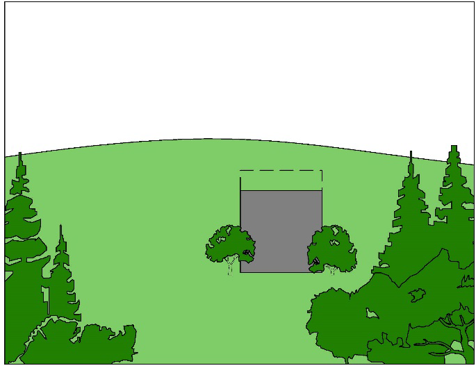 Figure 1 - Building height is reduced and building screened to minimize impact on
the viewshed Figure 1 - Building height is reduced and building screened to minimize impact on
the viewshed | 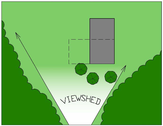 Figure 2 - Building in viewshed is reoriented and screened to reduce impact on viewshed Figure 2 - Building in viewshed is reoriented and screened to reduce impact on viewshed |
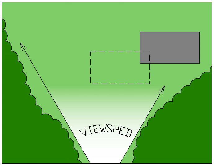 Figure 3 - Building is relocated to be partly outside the viewshed Figure 3 - Building is relocated to be partly outside the viewshed | 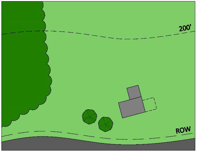 Figure 4 - Addition to existing structure is placed to the rear of the building rather
than directly in the viewshed Figure 4 - Addition to existing structure is placed to the rear of the building rather
than directly in the viewshed |
D.
Resources. Below is list of maps and studies that may be used while planning for development along designated byways:
1.
Identified Intrinsic Qualities Map.
2.
Reference to Viewshed GIS Maps.
3.
Subdistricts Map.
4.
Illustrative Graphics regarding visual intrusions.
5.
Land section graphic showing subdistricts.
E.
Relevant Studies.
1.
Brandywine Valley Scenic River and Highway Study (prepared by New Castle County).
2.
Brandywine Valley National Scenic Byway Corridor Management Plan (prepared to fulfill the requirements of the Delaware State and National Scenic Byway Programs).
3.
Red Clay Valley Scenic River and Highway Study (prepared by New Castle County).
4.
Red Clay Valley Scenic Byway Corridor Management Plan (prepared to fulfill the requirements of the Delaware State Byway Program).
5.
Harriet Tubman Underground Railroad Byway Corridor Management Plan (prepared to fulfill the requirements of the Delaware State and National Scenic Byway Programs) (2012).
6.
Open Space and Historic Resources Preservation of the White Clay Valley (in conjunction with the Delaware State Greenspace Program).
7.
Southern New Castle County Scenic River and Highway Study (prepared by New Castle County).
8.
Delaware Bayshore Byway Corridor Management Plan (prepared to fulfill the requirements of the Delaware State and National Scenic Byway Programs).
(Ord. No. 22-072, § 16, 10-11-2022)