
Ardmore City Zoning Code
CHAPTER 3
- Development Review Procedures
Sec. 301 - General
A.
Authority to File Applications. An application for development review or approval under this UDC must be filed by the person having legal authority to take action in accordance with the approval sought. Unless otherwise expressly stated, that person is presumed to be the record owner, purchaser under contract from the record owner with signature from that owner, or the duly authorized agent of the record owner in the absence of satisfactory proof to the contrary. City officials are authorized to require proof of legal authority to take the action sought. The City Commission, Planning Commission, Board of Adjustment, City Manager and City department heads may initiate any action under this UDC with or without an application from the property owner.
1.
When the City of Ardmore proposes zoning classifications in order to revise its comprehensive plan or official map or to identify areas which require specific land use development due to topography, geography, or other distinguishing features, including but not limited to flood plain, drainage, historical preservation, in blighted areas, or otherwise desires to amend the Unified Development Code to provide for rezoning an area wide tract, parties in interest and citizens shall have an opportunity to be heard at a public hearing before any such amendment shall become effective. At least 15 days' notice of the date, time, and place of the hearing shall be published in the newspaper of general circulation in the municipality. Said notice shall include a map of the area to be effected which indicates street names or numbers, streams, or other significant landmarks in the area. In addition, a sign is to be posted on designated properties within the area effected by the proposed rezoning classification, those properties to be determined at the sole option of the city. The sign and the lettering thereon shall be of sufficient size so as to be clearly visible and legible from the public street or streets toward which it faces. The notice shall state: (1) the date, time, and place of the public hearing; and (2) who will conduct the public hearing; and (3) the desired zoning classification; and (4) the proposed use of the property; and (5) other information as may be necessary to provide adequate and timely notice.
B.
Where to File Applications, Form of Application. Applications required under this Chapter shall be submitted to the Development Services Department, and must be submitted on forms and in such numbers as required by the Development Services Director.
C.
Application Fees. Applications must be accompanied by the nonrefundable fee established by City Commission. Fees shall not be required for applications initiated by the City Commission, Planning Commission, Board of Adjustment, City Manager or City department heads.
D.
Complete Applications. Applications that do not include required information or that are not accompanied by required fees will be returned to the applicant as incomplete, and no further processing of the application will occur until the deficiencies are corrected. Applications will be reviewed for completeness within 5 City business days of filing. If the official designated to receive the application determines it is complete, the application will be processed. If the official determines that the application is incomplete, the application will be returned to the applicant along with an explanation of the application's deficiencies.
E.
Application Processing Cycles. Officials responsible for accepting applications, after consulting with review and decision-making bodies, may promulgate processing cycles for applications. Processing cycles may establish:
1.
Deadlines for receipt of complete applications;
2.
Dates of regular meetings;
3.
The scheduling of staff reviews and staff reports on complete applications;
4.
All required steps in the application process (including public hearings, and reviews by other agencies); and
5.
Required time-frames for action by review and decision-making bodies.
F.
Content of Notice.
1.
All notices required under this UDC must:
a.
Indicate the time and place of all scheduled public hearings;
b.
Describe the property involved in the application by legal description and street address if one exists;
c.
Describe the nature, scope and purpose of the proposal; and
d.
Indicate the location and source of additional information on the proposal.
2.
In the case of written and published notice, a map of the area to be affected, including street names or numbers and other significant landmarks shall be required.
G.
Written Notice. Unless otherwise expressly stated, when the provisions of this UDC require that written notice be provided, the official responsible for accepting the application shall provide written notice by first class mail to all owners of the subject property and all property owners within 300 feet of the subject property. The notice shall be deposited in the U.S. mail by the Development Services Department at least 20 days before the first scheduled public hearing. Ownership information shall be obtained from the County Courthouse by a certified abstract company.
H.
Published Notice. When the provisions of this UDC require that notice be published in the newspaper, the official responsible for accepting the application shall ensure that notice is published in a newspaper of general circulation within the City at least 15 days before the date of the first scheduled public hearing.
I.
Posted Notice. When the provisions of this UDC require that notice be posted on the subject property, notice of public hearing shall be given by a sign or signs, as may be required, placed on the property affected by such proposal. Such sign (or signs) and the lettering thereon shall be of sufficient size so as to be clearly visible and legible from the public street toward which it faces. Signs shall be placed on the affected property at least 20 days before the date of the public hearing.
J.
Constructive Notice. Minor technical deviations from specified notice requirements shall not be deemed to impair notice where there is actual notice. When required written notices have been properly addressed and deposited in the mail, failure of a party to receive such notice shall not invalidate any subsequent action. In all cases, however, the requirements for the timing of the notice and for specifying the time, date and place of a hearing and the general location of the subject property shall be strictly construed. If questions arise at the hearing regarding the adequacy of notice, the body hearing the matter shall make a finding regarding whether there was compliance with the notice requirements of this chapter.
K.
Cost of Notice. The cost of the legal publication and posting the property as required by this UDC shall be the responsibility of the applicant.
L.
Summary of Procedures Requiring Notice.
M.
Action By Review and Decision-Making Bodies.
1.
Review and decision-making bodies may take any action on an application that is consistent with the notice given, including, but not limited to, approving the application, approving the application with conditions or denying the application.
2.
Review bodies may recommend and decision-making bodies may impose conditions on the application or allow amendments to the application if the effect of the conditions or amendments is to allow a less intensive use or zoning district than indicated in the application or to reduce the impact of the development or to reduce the amount of land area included in the application.
3.
Decision-making bodies may not approve an application for a greater density of development, a more intensive use, a more intensive zoning district, reduced setbacks, more dwelling units, greater height, more access points or fewer improvements than indicated in the notice.
4.
Conversely, decision-making bodies may approve an application for a lower density of development, a less intensive use, a less intensive zoning district, increased setbacks, less dwelling units, less height, less access points or more improvements than indicated in the notice.
N.
Inaction By Review and Decision-Making Bodies.
1.
Review Bodies. When a review body fails to take action on an application, the application will be forwarded to the decision-making body with no recommendation.
2.
Decision-Making Bodies. When a decision-making body fails to take action on an application within a required time-frame, that inaction will be deemed a denial of the application.
O.
Continuation of Public Hearings. A public hearing for which proper notice was given may be continued to a later date without again complying with the notice requirements, provided that the continuance is set for a date and time certain and announced at the original public hearing. If the public hearing is canceled for lack of a quorum or any other reason, notice of the continuance shall be posted at the place of the original public hearing.
(Ord. No. 2606, § I, 4-5-99; Ord. No. 2723, 8-19-02; Ord. No. 2839, 12-4-06)
Sec. 302 - Summary of Review Procedures
• = Review and Report
▲ = Public Hearing and Recommendation
+ = Public Hearing and Final Approval (except administrative approval)
* = Appeal
(Ord. No. 2723, 8-19-02)
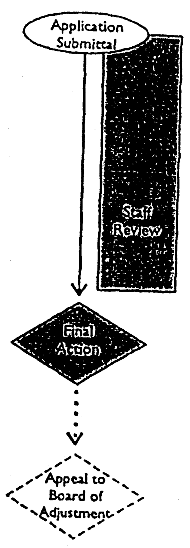
Sec. 303 - Written Interpretation
A.
Applicability. The Planning Director shall have authority to make all written interpretations concerning the provisions of this UDC and the Official Zoning Map.
B.
Application. A request for interpretation shall be submitted to the Planning Director in a form established by the Planning Director and made available to the public.
C.
Review and Action by Planning Director. Within 10 days after a request for interpretation has been submitted, the Planning Director shall: (1) review and evaluate the request in light of the text of this UDC, the Official Zoning Map, the Comprehensive Plan and any other relevant information; (2) consult with other staff, as necessary; and (3) render an opinion. The interpretation shall be provided to the applicant in writing by mail.
D.
Official Record. The Planning Director shall maintain an official record of interpretations. The record of interpretations shall be available for public inspection during normal business hours.
E.
Appeal.
1.
Appeals of written interpretations made by the Planning Director shall be taken to the Board of Adjustment within 30 days of mailing of the interpretation, in accordance with the procedures in Sec. 313.
2.
In considering such an appeal, the Board of Adjustment shall review the interpretation and public testimony in light of the Comprehensive Plan, this UDC and the Official Zoning Map, and any other land use policies adopted by the Planning Commission or City Commission, whichever are applicable. The Board of Adjustment shall modify or reject the interpretation only if it is not supported by substantial competent evidence or if the interpretation is contrary to the Comprehensive Plan, this UDC or the Official Zoning Map.
Written Interpretation
Sec. 304 - Building Permit
A.
Applicability.
1.
Whenever any structure or building is to be improved or erected, moved or structurally altered, a building permit shall be obtained from the Building Official.
2.
No building permits may be issued for any structure on any lot in a subdivision unless the lot has been included in a final plat which has been duly recorded or unless the lot qualifies under the following exceptions:
a.
The use, combination or recombination of portions of previously platted lots where the total number of lots is not increased and the resulting subdivision meets or exceeds the requirements of this UDC and all other applicable ordinances of the City of Ardmore; or
b.
The public acquisition by purchase or dedication of parcels of land for the widening or opening of streets or other public improvements; or
c.
A lot split, as defined in this UDC; or
d.
A legal nonconforming lot of record.
B.
Application. Every applicant for a building permit shall furnish the following information:
1.
A plot plan, drawn to scale, showing the exact size, shape and dimension of the lot to be built upon, the exact size and location on the lot of all existing buildings, structures and easements, and the exact size and location on the lot of the structure or building proposed to be repaired, altered, erected or moved, and the size, arrangement, number of parking stalls, movement of vehicles and ingress and egress drives for all off-street parking and loading facilities.
2.
A declaration of the existing and intended use of each existing and proposed building or structure on the lot and the number of families and housekeeping units that each existing building currently accommodates and is proposed to accommodate upon completion of construction.
3.
Any additional information deemed necessary by the Building Official to determine compliance with these regulations.
4.
A survey of the boundaries of the lot on which the improvement is proposed to be located may be required by the Building Official. If required, such survey shall be prepared by a surveyor registered in the State of Oklahoma.
C.
Review and Action by Building Official. The Building Official shall be responsible for conducting reviews to determine if intended uses, buildings or structures comply with all applicable regulations and standards, including this UDC and the building code. The Building Official shall not issue a building permit unless the plans, specifications and intended use of such building or structures or part thereof conform in all respects to the provisions of this UDC and the building code.
D.
Expiration and Lapse of Approval.
1.
If the work described in any building permit has not begun within 6 months from the date of issuance, the building permit shall expire and be of no further effect. In such cases, no further work shall occur until a new building permit has been obtained.
2.
If, after commencement of construction, work is discontinued or no substantial work has occurred for a period of 6 months, the building permit shall expire and be of no further effect. In such cases, no further work shall occur until a new building permit has been obtained.
(Ord. No. 2723, 8-19-02)
Sec. 305 - Certificate of Occupancy
A.
Applicability. No change shall be made in the use of any land, building or structure until a certificate of occupancy is obtained from the Building Official certifying compliance with all of the provisions of this UDC.
B.
Application. An application for a Certificate of Occupancy shall be filed with the Building Official when a structure or use is ready for use or occupancy.
C.
Exception. Whenever a Building Permit is issued for the erection of a new building or structure, a Certificate of Occupancy shall be required. Where the use of the building or structure is changed from that for which the permit is issued, or where the intended use is not clearly stated on the building permit, a new Certificate of Occupancy will be required. In a building designed for multiple tenants the occupancy permits may be given as portions of the building are ready for occupancy.
D.
Review, Inspection and Action by Building Official. Within 10 days after filing of a complete application for a Certificate of Occupancy, the Building Official shall inspect the use or structure. If the Building Official determines that the use or structure complies with all applicable provisions of the building code and this UDC, a Certificate of Occupancy shall be issued.
E.
Effect of Approval. No permit or license required by the City of Ardmore or other governmental agency shall be issued by any department, official or employee unless the application for such permit or license is accompanied by a Certificate of Occupancy issued by the Building Official.
F.
Temporary Certificate of Occupancy. Pending the issuance of a permanent Certificate of Occupancy, a temporary certificate may be issued. The temporary certificate shall be valid for a period established by the Building Official, pending completion of an addition, or during partial occupancy of a structure.
G.
Unlawful to Occupy Without Valid Certificate of Occupancy. It is unlawful to occupy any building that does not have a valid Certificate of Occupancy or Temporary Certificate of Occupancy.
Certificate of Occupancy
(Ord. No. 2723, 8-19-02)
Sec. 306 - Reserved.
Editor's note— Ord. No. 2897, § 1), adopted April 5, 2010, repealed § App. C, § 306, which pertained to flood damage prevention permit and derived from Ord. No. 2723, adopted 8-19-02 and Ord. No. 2782, adopted 4-4-05.
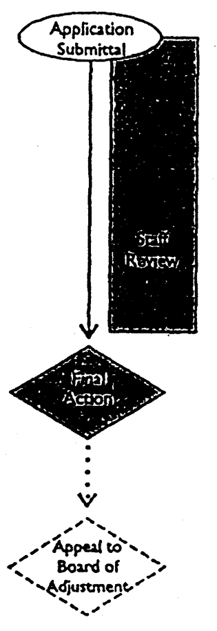
Sec. 307 - Oil and Gas Well Permit
A.
Applicability. Before any oil and/or gas well may be drilled within the corporate limits of the City of Ardmore, an application for an Oil and Gas Well Permit shall be filed with the Planning Director.
B.
Application. An application for an Oil and Gas Well Permit shall contain the following information:
1.
A copy of the approved and filed application to drill from the Oklahoma Corporation Commission, which application shall contain:
a.
The name and address of the operator of the lease.
b.
A description of the lease or the lands involved in the drilling unit.
c.
A plat showing the location of the well and ownership of the land.
2.
The name and address of the drilling contractor.
3.
Satisfactory evidence of liability and property damage insurance as required by this section.
4.
Evidence of compliance with the performance standards in Sec. 709.
C.
Liability Insurance Required. Any drilling firm, contractor, and/or operator within the corporate limits of the City of Ardmore, shall carry public liability and property damage in the amounts provided by State law.
D.
Review and Action by Planning Director. The Planning Director shall be responsible for conducting reviews to determine if the proposed oil or gas well complies with all applicable regulations and standards, including this UDC and the building code. No permit shall be issued unless the plans and specifications conform in all respects to the provisions of this UDC and the building code.
E.
Appeal. Appeals of oil and gas well permits denied by the Planning Director shall be taken to the Board of Adjustment within 30 days of mailing of the interpretation, in accordance with the procedures in Sec. 313.
F.
Enforcement. This section may be enforced by injunction, by cancellation of the permit of the operator to continue drilling, or in any other legal manner in a court of competent jurisdiction after notice of violation of this section has been given to the operator and he has not complied within 30 days.
G.
Expiration and Lapse of Approval. Property owners shall have 6 months from the date of approval of an Oil and Gas Well Permit to carry out the proposed improvements. In such cases, no further work shall occur until a new permit has been obtained.

Oil and Gas Well Permit
(Ord. No. 2723, 8-19-02)
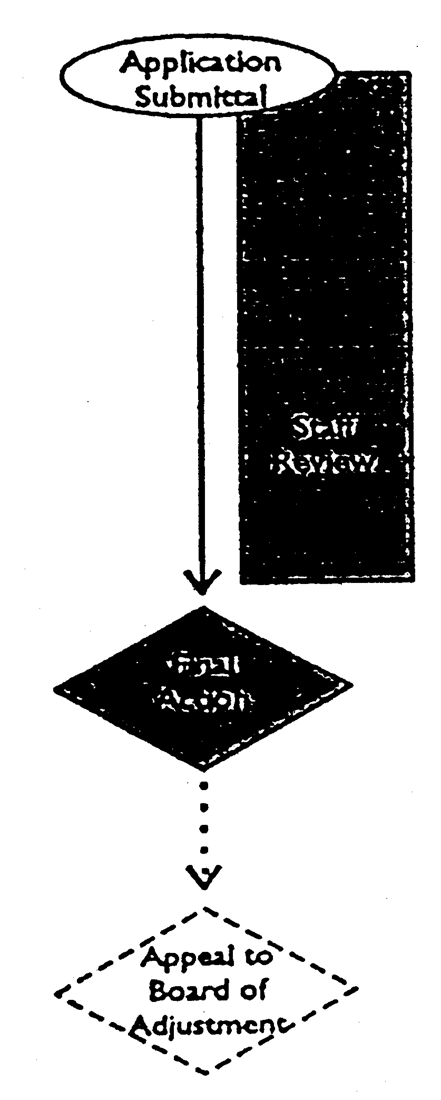
Sec. 308 - Temporary Use Permit
A.
Applicability. Temporary uses operating for less than 90 days within a one-year time period shall obtain a temporary use permit from the Planning Director that outlines conditions of operations to protect the public, health, safety and welfare.
B.
Temporary Uses Types. Temporary uses shall be deemed to include short-term or seasonal uses that are not otherwise allowed by the zoning district regulations of this UDC but excluding any temporary occupancy pending construction or rezoning.
1.
Fundraising Activities by Not-for-Profits. Fundraising or noncommercial events for nonprofit religious, educational or community service organizations where the public is invited to participate in outdoor activities and which last longer than 48 hours. This description shall not preclude the use of not-for-profit facilities for events conducted entirely within a building.
2.
Business Promotional Events. Promotional activities lasting not longer than 90 days intended to attract attention to a specific place, business, organization, event or district, through the use of signs and attention attracting devices, as determined by the Planning Director.
3.
Special and Seasonal Sales Events. Significant commercial activities lasting not longer than 180 days intended to sell, lease, rent or promote specific merchandise, services or product lines, including but not limited to: warehouse sales, tent sales, trade shows, flea markets, farmer's markets (including horticultural products), Christmas tree lot sales, product demonstrations or parking lot sales of food, art work or other goods
4.
Entertainment or Amusement Events. Short-term cultural and entertainment events including public or private events lasting not longer than 30 days intended primarily for entertainment or amusement, such as concerts, plays or other theatrical productions, circuses, fairs, carnivals or festivals.
5.
Carnival or Circus. Carnivals and circuses shall be restricted to the fairgrounds, except as otherwise provided in City Code Section 15-2.
6.
Temporary Religious Services. Temporary facilities for religious services (such as tent revivals) shall ensure provisions for parking do not infringe on the surrounding residential neighborhood. In addition, restrictions on hours of operation may be imposed to ensure compatibility with neighboring uses.
7.
Temporary Batching or Mixing Facilities. Temporary cement, concrete, or asphalt batching facilities shall be permitted in all districts only by a conditional use permit (see Sec. 314) according to the following provisions. A batch plant that is on-site with the project for which product is being supplied does not require a C.U.P., but must comply with the following provisions.
a.
The temporary facility is used in connection with the construction of a permanent building, street, or similar project in the city limits of Ardmore.
b.
The conditional use permit shall be granted for any length of time up to a maximum of 6 months. The City Manager has the right to extend the conditional use permit for any length of time up to a maximum of an additional 6 months.
c.
The conditional use permit shall provide for the mitigation of land use conflicts caused by the temporary facility, including, but not limited to, the impacts of dust, noise, visual impacts, parking requirements, and/or hours of operation.
8.
Garage or Yard Sales. Garage, yard or other temporary sales are authorized only in compliance with this section.
a.
General.
(i)
An application to hold the sale must be requested with permit issued by the Development Services Department.
(ii)
No person shall hold more than three garage sales, not exceeding three consecutive days in length for each sale, conducted at any location during a 12-month period.
(iii)
Each sale must be held at a residence by a person who does not habitually engage in the business of selling such tangible personal property at retail.
(iv)
Each sale must be conducted in such a manner so that it does not create a disturbance or become a nuisance to the neighborhood.
(v)
Persons conducting a sale shall be restricted to the selling of only personal property that belongs to such person, and which has not been purchased for the purpose of resale.
(vi)
The sale are shall be confined to the premises for which the license had been issued, and all goods shall be removed at the expiration of the sale period.
b.
Application.
(i)
Application may be made with the following information:
(1)
Name and address of the applicant;
(2)
Location of proposed sale; and
(3)
Dates during which the sale will be held.
(ii)
A garage sale application will be issued at the Department of Development Services prior to the close of business on the Wednesday prior to the sale.
(iii)
If a residential sale is not held on the dates for which the permit is issued or is terminated during the first day of the sale because of inclement weather conditions, and an affidavit by the permittee to this effect is submitted, the Development Services Department may issue another permit to the applicant for a residential sale to be conducted at the same location within 30 days from the date when the first sale was to be held.
c.
Permit and Sign Stickers. The permit shall be displayed in a prominent place on the property holding the sale; and the sign stickers shall be placed on the front of all permitted signs prior to placement.
d.
Signs.
(i)
No more than 2 signs shall be posted with one sign being in the front yard of the property where the sale is being held.
(ii)
Such signs shall not exceed 4 square feet in area and 40 inches in height.
(iii)
All signs shall have the permit tag affixed thereto and shall not be placed on utility poles or in medians, or to obstruct or impair the view of vehicular or pedestrian traffic.
(iv)
All signs shall be immediately removed at the conclusion of the sale.
(v)
Any sign shall be no closer than 3 feet to the back of the street curb or edge of pavement.
(vi)
If signs are placed in front or alongside any occupied residence, the person in control of the sale advertised by such signs shall receive written permission from the occupant prior to erecting such signs.
e.
Exceptions. Neighborhood sales, community sales, or civic organization sales shall be exempt from the requirements of this section, provided a temporary use has been approved by the Building Official.
f.
Penalties for Violations. It shall be an offense punishable by a fine not to exceed $100.00 to conduct a garage, yard or other temporary sale in violation of this Section.
(i)
Written notice will be issued for a first sale conducted without a permit, with citations issued from any subsequent sales held at the same location without a permit.
(ii)
Any signs found illegally placed, without sign stickers, will be immediately removed by City or State officials.
(iii)
Any signs left in the right-of-way or in the yard at the expiration of the permit period will be removed, with a citation issued to the person who applied for and received a permit and stickers for such signs.
C.
Time Limit. Temporary uses will be permitted for a maximum period of time as given in F. below.
D.
Application. An application for a temporary use permit shall include the following:
1.
A written description of the proposed use or event, the duration of the use or event, the hours of operations, anticipated attendance, and any buildings/structures signs or attention-attracting devices used in conjunction with the event, as well as a response to each of the criteria established in subsection E. below.
2.
A sketch plan showing the location of proposed structures (including onsite rest rooms and trash receptacles), parking areas, activities, signs and attention attracting devices in relation to existing buildings, parking areas, streets and property lines.
3.
Written confirmation from the property owner agreeing to the temporary use.
4.
Any additional information deemed necessary by the Planning Director.
E.
Review and Action by Planning Director.
1.
Application should be made at least 10 days in advance of the requested start date for a temporary use.
2.
The Planning Director shall make a determination whether to approve, approve with conditions or deny the permit within 5 working days after the date of application. Any applicant denied a permit by the Planning Director shall be notified in writing of the reasons for the denial and of the opportunity to appeal the denial to the Board of Adjustment.
F.
Temporary Use Approval Criteria. Temporary uses shall comply with the following standards:
1.
Land Use Compatibility. The temporary use must be compatible with the purpose and intent of this UDC and the zoning district in which it will be located. The temporary use shall not impair the normal, safe, and effective operation of a permanent use on the same site. The temporary use shall not endanger or be materially detrimental to the public health, safety or welfare, or injurious to property or improvements in the immediate vicinity of the temporary use, given the nature of the activity, its location on the site, and its relationship to parking and access points.
2.
Compliance with Other Regulations. A Building Permit or Temporary Certificate of Occupancy may be required before any structure used in conjunction with the temporary use is constructed or modified. All structures and the site as a whole shall meet all applicable building code, zoning district, and fire code standards and shall be promptly removed upon the cessation of the use or event. Upon cessation of the event or use, the site shall be returned to its previous condition (including the removal of all trash, debris, signage, attention attracting devices or other evidence of the special event or use).
3.
Hours of Operation and Duration. The duration and hours of operation of the temporary use shall be consistent with the intent of the event or use and compatible with the surrounding land uses. The duration and hours of operation shall be established by the Planning Director at the time of approval of the temporary use permit.
4.
Traffic Circulation. The temporary use, as determined by the City Engineer, shall not cause undue traffic congestion or accident potential given anticipated attendance and the design of adjacent streets, intersections and traffic controls.
5.
Off-Street Parking. Adequate off-street parking shall be provided for the temporary use, and it shall not create a parking shortage for any of the other existing uses on the site.
6.
Public Conveniences and Litter Control. Adequate onsite rest room facilities may be required. Adequate onsite solid waste containers may also be required. The applicant shall provide a written guarantee that all litter generated by the event or use shall be removed at no expense to the City.
7.
Appearance and Nuisances. The temporary use shall be compatible in intensity, appearance and operation with surrounding land uses in the area, and it shall not impair the usefulness, enjoyment or value of adjacent property due to the generation of excessive noise, dust, smoke, glare, spillover lighting, or other forms of environmental or visual pollution.
8.
Signs and Attention-Attracting Devices. The Planning Director shall review all signage in conjunction with the issuance of the permit, although a sign permit is not required. The Planning Director may approve the temporary use of attention attracting devices. The number and types of signs and attention-getting devices allowed shall be evaluated on the following criteria:
a.
Type and size of the proposed event or use;
b.
Safety considerations (sight distance setbacks, sidewalks in area, etc.);
c.
Lighting considerations (disturbance of nearby residents or adverse affects to traffic on adjacent streets); and
d.
Aesthetic concerns (appearance, illumination, number and size of signs and attention-getting devices proposed).
9.
Other Conditions. The Planning Director may establish any additional conditions deemed necessary to ensure land use compatibility and to minimize potential adverse impacts on nearby uses, including, but not limited to, time and frequency of operation, temporary arrangements for parking and traffic circulation, requirements for screening/buffering, and guarantees for site restoration and cleanup following the temporary use. Conditions may include, but shall not be limited to:
a.
Modifications or restrictions to the hours of operation, duration of the event, size of the activity or other operational characteristics.
b.
The posting of a performance bond to help ensure that the operation of the event or use and the subsequent restoration of the site are conducted according to required stipulations.
c.
If the permit applicant requests the City to provide extraordinary services or equipment or if the Planning Director otherwise determines that extraordinary services (e.g., traffic control or security personnel) or equipment should be provided to protect the public health or safety, the applicant shall be required to pay to the City a fee sufficient to reimburse the City for the costs of these services if not provided by the applicant. This requirement shall not apply if the event or use has been anticipated in the budget process and sufficient funds have been included in the budget to cover the costs incurred.
d.
Obtaining liability and personal injury insurance in such form and amount as the Planning Director finds necessary to protect the safety and general welfare of the community.
G.
Appeal. Appeals of temporary use permits denied by the Planning Director shall be taken to the Board of Adjustment within 30 days of mailing of the denial, in accordance with the procedures in Sec. 313.
Temporary Use Permit
(Ord. No. 2723, 8-19-02; Ord. No. 2757, 12-15-03)
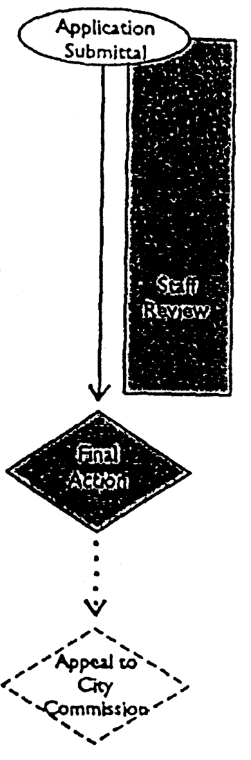
Sec. 309 - Site Development Plan
A.
Review Period. Plans submitted for review under this section shall be processed and the applicant notified in writing of such approval or disapproval within 10 working days from the date of submittal to the Planning Director. Any notice of disapproval shall state the reason for disapproval.
B.
Application. When development plan approval is required, such plan shall be submitted to the Planning Director in a form established by the Planning Director, along with a nonrefundable fee that has been established by the City Commission. The application shall contain the following information:
1.
Plans at a size of 24 inches by 36 inches, with the date, scale, north point, title, name of owner and name of person preparing the plan;
2.
The location of existing boundary lines and dimensions of the tract;
3.
The centerline of existing watercourses, drainage features and location and size of existing and proposed streets and alleys;
4.
The approximate location, size and setback from the property lines of all existing and proposed buildings and land improvements;
5.
A parking lot plan as required by Sec. 708;
6.
The approximate location and size of proposed signs, if known;
7.
A landscape plan illustrating existing vegetation and trees, and the following:
a.
Location, quantity and type of proposed plantings;
b.
Planting schedule listing all plant materials and their quantity; and
c.
Any proposed irrigation.
C.
Review and Action by Planning Director. The Planning Director shall review each Development Plan application and act to approve or deny the Site Plan application. A Development Plan application may not be approved unless the Planning Director finds that the proposed project complies with all applicable provisions of this UDC and with all adopted plans and policy documents of the City. The Planning Director may grant approval with conditions only to the extent that such conditions specify the actions necessary to bring the application into complete compliance with this UDC and adopted plans and policy documents. A conditional use application may be processed concurrently with the development plan per Section 314.
D.
Appeal.
1.
Any applicant who is aggrieved by a decision of the Planning Director to disapprove a development plan may, within 10 days after receipt of notice of such decision, appeal such decision to the City Commission by filing written notice thereof with the Planning Director.
2.
The development plan shall then be reviewed by the City Commission on its earliest available regular meeting date and subject to mailing written notice at least 10 days prior to the public hearing to all property owners of property adjacent to and directly across the street and/or alley from the subject property. The applicant shall be responsible for all mailing costs.
3.
The City Commission shall approve the development plan if it finds that such plan complies with the requirements of this section and all other city codes, rules and regulations. The applicant shall be notified in writing within 5 days of such meeting of the approval or disapproval of such application. Any notice of disapproval shall state the reason for disapproval.
4.
The right to appeal provided by this subsection pertains to the sole issue of whether the development plan complies with the requirements of this UDC. Nothing shall be construed as limiting the otherwise lawful exercise of judgment or discretion by the City Commission.
E.
Expiration and Lapse of Approval. Property owners shall have 12 months from the date of approval of a Site Development Plan to secure a Building Permit to carry out the proposed improvements. If a Building Permit has not been obtained within 12 months of the date of approval, the approval shall lapse and be of no further effect.
Development Plan
(Ord. No. 2723, 8-19-02)
Sec. 310 - Sign Permit
A.
Applicability. Before a sign is erected, enlarged, replaced or relocated, a permit must be obtained from the City and the construction work inspected and approved by the Building Official. All signs must comply with the applicable sections of the building code as adopted by the City. All electrical installations associated with the erection and installation of a sign must be performed by an electrical contractor licensed by the City. When the name of a business changes, a non-conforming sign shall be made to conform or be removed.
B.
Exemptions. The following signs are exempt from permit requirements:
1.
Signs in the nature of cornerstones, commemorative tablets and historical signs that are attached to or carved into the building;
2.
Non-illuminated identification signs with noncommercial messages that indicate addresses, building entrances and exits, traffic and pedestrian directional signs and other similar signs for the convenience of the public provided such signs do not exceed 4 square feet;
3.
Non-illuminated signs located inside a building provided the sign does not exceed 32 square feet;
4.
The replacement of a sign face, provided the structure or frame of the sign is not altered or replaced;
5.
General maintenance of a sign or sign structure.
C.
Application. The following information shall be submitted with each sign permit application:
1.
A completed sign permit application form;
2.
Plans and specifications of the sign and support structure, including all dimensions, structural support and electrical specifications;
3.
For freestanding and projecting signs, a site plan that includes the location of existing and proposed signs in relationship to property lines, driveways, existing and future buildings and other site features as may be appropriate.
D.
Review and Action by Planning Director. The Planning Director must review each Sign Permit application in light of this UDC and act to approve, approve with conditions or deny the permit. The Planning Director may grant approval with conditions only to the extent that such conditions specify the actions necessary to bring the application into complete compliance with this UDC.
E.
Appeal. Appeals of sign permits denied by the Planning Director shall be taken to the Board of Adjustment within 30 days of mailing of the interpretation, in accordance with the procedures in Sec. 313.
F.
Expiration and Lapse of Approval. Property owners shall have 12 months from the date of approval of a Sign Permit to carry out the proposed improvements.

Sign Permit
(Ord. No. 2723, 8-19-02)
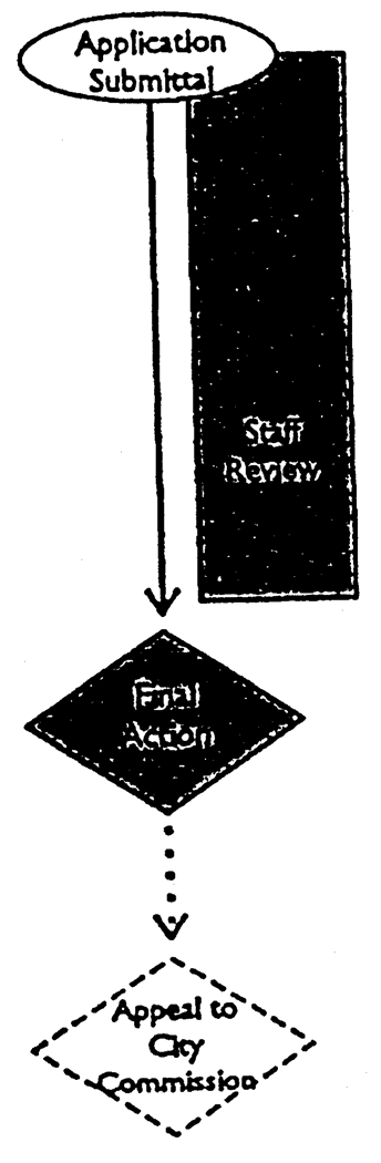
Sec. 311 - Administrative Adjustment
A.
Purpose. Administrative adjustments are specified deviations from otherwise applicable development standards where development is proposed that would be:
1.
Compatible with surrounding land uses;
2.
In keeping with the public interest; and
3.
Consistent with the purposes of this UDC.
B.
Applicability. The Planning Director, upon written request, shall have the authority to authorize a variance of up to 10 per cent from any numerical standard set forth in any section in Chapter 6 and Sections 702, 703, 704, 707, 708, 709, 710 and 711 in Chapter 7.
C.
Application. An application for an administrative adjustment shall include a brief description of the requirement to be varied and any other material necessary to ensure the criteria in subsection E. below are met.
D.
Review and Action by Planning Director. The Planning Director shall review the application and approve, approve with conditions or deny the application based upon the criteria below. A written decision including affirmative findings on the criteria set forth below shall be mailed to the applicant.
E.
Administrative Adjustment Criteria. To approve an application for an Administrative Adjustment, the Planning Director shall make an affirmative finding that the following criteria are met:
1.
That granting the Administrative Adjustment will ensure the same general level of land use compatibility as the otherwise applicable standards;
2.
That granting the Administrative Adjustment will not materially and adversely affect adjacent land uses and the physical character of uses in the immediate vicinity of the proposed development because of inadequate buffering, screening, setbacks and other land use considerations;
3.
That granting the Administrative Adjustment will not adversely affect property values in any material way; and
4.
That granting the Administrative Adjustment will be generally consistent with the purposes and intent of this UDC.
F.
Appeals. Appeal of an administrative adjustment denied by the Planning Director shall be taken to the Board of Adjustment within 30 days of the mailing of the Planning Director's decision in accordance with Sec. 313.
G.
Expiration and Lapse of Approval. Property owners shall have 6 months from the date of approval of an Administrative Adjustment to secure any necessary permits to carry out the proposed improvements. If such permits have not been obtained within 6 months of the date of approval, the approval shall lapse.

Administrative Adjustment
(Ord. No. 2723, 8-19-02)
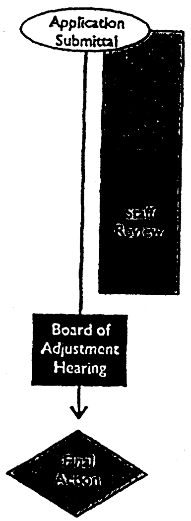
Sec. 312 - Variance
A.
Applicability. The Board of Adjustment is authorized to grant variances from the zoning district dimensional standards and off-street parking and loading standards of this UDC that will not be contrary to the public interest or the spirit of this UDC where, owing to special conditions, a literal enforcement of the provisions of this UDC would result in unnecessary physical (not economic) hardship to the property owner.
B.
Application. An application for a Variance shall be submitted to the Planning Director, along with such accompanying material as is required to ensure compliance with the criteria in subsection D. below. Application procedures are described in Section 301 and include notification of owners of property within 300 feet.
C.
Review and Action by Board of Adjustment. The Board of Adjustment shall hold a public hearing on the variance request, and, at the close of the public hearing act to approve, approve with conditions or deny the application based on the review criteria set out in this section. A concurring vote of at least four members of the Board of Adjustment shall be required to approve any variance request.
D.
Review Criteria. A variance may be granted by the Board of Adjustment upon an affirmative finding that all of the following conditions exist:
1.
The requested variance arises from conditions that are unique to the subject property, that are not ordinarily found in the same zoning district and that are not a result of the owner's intentional action;
2.
The granting of the permit for the variance will not adversely affect the rights of adjacent property owners or residents;
3.
The strict application of the applicable standards will constitute an unnecessary physical hardship (not economic hardship) because the property cannot be used for an otherwise allowed use without coming into conflict with applicable site development standards;
4.
The variance is the minimum action necessary to alleviate the hardship and observes the spirit of this UDC; and
5.
The variance desired will not adversely affect the public health, safety or general welfare or impair the purposes or intent of this UDC or the Comprehensive Plan.
E.
Findings of Fact. The Board of Adjustment shall make a determination on each of the above approval criterion and enter its findings in the official record. Findings of fact shall be based on evidence presented at the public hearing on the variance request. A negative finding of fact on any of the five criteria shall require a negative vote on the application as a whole.
F.
Use Variances Prohibited. The Board of Adjustment may not grant use variances, which are variances that have the effect of allowing a use within a specific zoning district that is not allowed by the Use Table of Sec. 501.
G.
Variance Affecting Rights-of-Way Prohibited. The Board of Adjustment may not grant a variance that will have the effect of allowing a use or structure to extend into a public right-of-way or easement.
H.
Conditions of Approval. In granting a variance, the Board of Adjustment may impose such conditions, safeguards and restrictions upon the premises benefitted by the variance as may be necessary to reduce or minimize any potentially injurious effect of the variance upon other property in the area. A copy of the Board's letter of conditional approval shall be filed with the deed records at the County.
I.
Expiration and Lapse of Approval. Property owners shall have 6 months from the date of approval of a Variance to secure any necessary permits to carry out the proposed improvements. If permits have not been obtained within 6 months of the date of Variance approval, the approved Variance shall lapse.
J.
Appeals From the Board's Decision. An appeal may be taken by the applicant or an aggrieved party to the Carter County District Court within 30 days after the Board's action. The City shall charge no cost for such appeal.
Variance
(Ord. No. 2723, 8-19-02; Ord. No. 2801, 10-17-05)
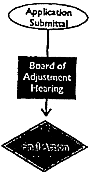
Sec. 313 - Appeal of Administrative Decision
A.
Applicability. Appeals to the Board of Adjustment pertaining to regulations in the Unified Development Code may be taken by any person aggrieved, or by any officer, department, board or commission of the City of Ardmore affected by any decision of the Director of Development Services. Such appeal shall be taken within 30 days from the date of the decision by filing with the officer from whom the appeal is taken and with the City Clerk at the time the notice is filed. The officer from whom the appeal is taken shall forthwith transmit to the Board of Adjustment all of the papers constituting the record upon which the action appealed from was taken.
B.
Effect of Appeal. An appeal shall stay all proceedings in furtherance of the action appealed from unless the officer from whom the appeal is taken certifies to the Board of Adjustment after the notice of appeal shall have been filed with him that by reason of facts stated in the certificate a stay would, in his opinion, cause imminent peril to life or property. In such case, proceedings shall not be stayed other than by a restraining order which may be granted by the Board of Adjustment or by a court of record on application and notice to the officer from whom the appeal is taken and on the cause shown.
C.
Review and Action by Board of Adjustment.
1.
The Board of Adjustment shall fix a reasonable time for the hearing of the appeal, give public notice, as well as due notice to the parties in interest, and decide the same within a reasonable time. At the public hearing, any party may appear in person or by agent or by attorney.
2.
The Board of Adjustment shall grant to the administrative official's decision a presumption of correctness, placing the burden of persuasion of error on the appellant.
3.
In exercising the appeal power, the Board of Adjustment shall have all the powers of the official from whom the appeal is taken, and the Board of Adjustment may reverse or affirm wholly or partly or may modify the decision being appealed. The Board's decision is final.
4.
If the Board of Adjustment determines that it is necessary to obtain additional evidence in order to resolve the matter, it shall remand the appeal to the official from whom the appeal is taken, with directions to obtain such evidence and to reconsider the decision in light of such evidence.
5.
A concurring vote of four members of the Board of Adjustment shall be necessary to reverse any order, requirement, decision, or determination of an administrative official.
D.
Review Criteria. An appeal of an administrative decision shall be sustained only if the Board of Adjustment finds that the administrative official erred.
E.
Findings of Fact. Every decision of the Board of Adjustment shall be accompanied by written findings of fact specifying the reason for the decision. These findings shall be filed in the office of the Board of Adjustment within 10 days after the date of the final action.
Appeal of Administrative Decision
(Ord. No. 2723, 8-19-02; Ord. No. 2782, 4-4-05)
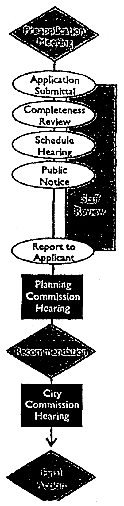
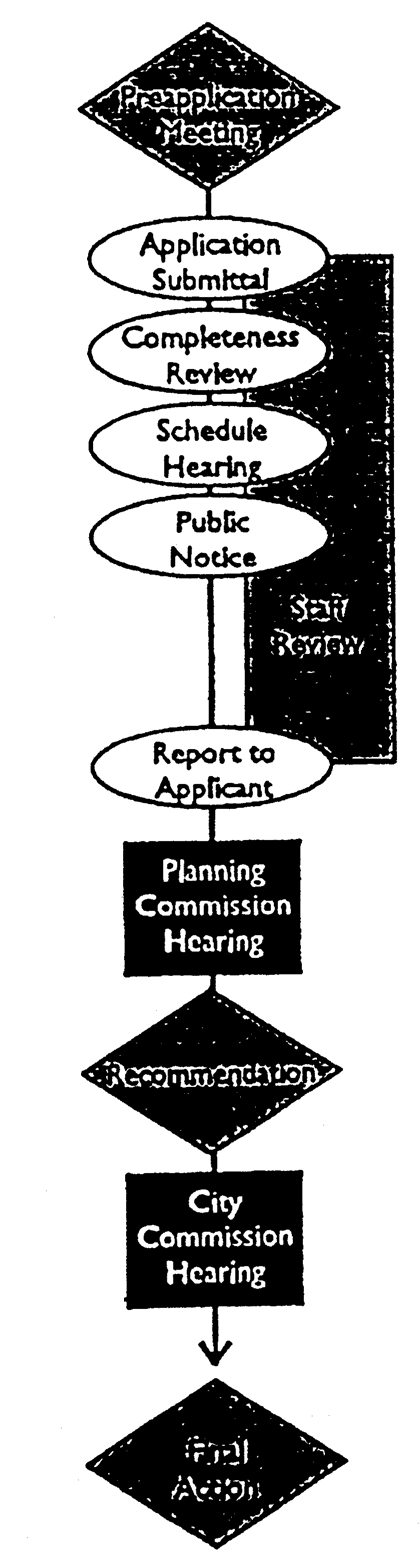
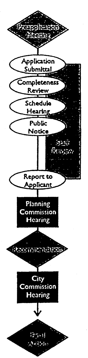
Sec. 314 - Conditional Use Permit
A.
Applicability. Uses designated under the various zoning districts herein as conditional uses are so classified because they may have site specific impacts that require the discretionary review of the City Commission. The following procedure is established to integrate the conditional uses properly with other land uses located in the district. These uses shall be reviewed and authorized or denied according to the following procedure.
When properties carrying a (PFI) zoning designation are to be rezoned for non-public use it shall require that the proposed use(s) be by conditional use permit approval; the applications shall be processed at the same time.
B.
Application. An application for a Conditional Use Permit shall contain all of the required elements of a Site Development Plan, as set forth in Sec. 309. Review of the proposed Development Plan shall occur concurrently with Conditional Use Permit review. Application procedures are described in Sec. 301 and include notification of owners of property within 300 feet.
C.
Review and Recommendation by Planning Commission [301M]. After appropriate notice and public hearing, the Planning Commission shall vote to recommend to the City Commission that the application be approved: 1) as submitted, 2) as amended, 3) subject to modification, or 4) recommend to the City Commission that the application be denied. The following review criteria will be considered in the review and recommendation:
1.
Congestion in the streets is not increased; because….
2.
Safety from fire, panic, and other danger is not jeopardized; because….
3.
Provision of adequate light and air is not disturbed; because….
4.
Overcrowding of land does not occur; because….
5.
Undue congestion of population is not created; because….
6.
Value of buildings will be conserved; because….
7.
Granting this request will not create inadequate provision of transportation, water, sewerage, schools, parks, or other public requirements; because….
8.
The most appropriate use of land is encouraged; because….
9.
In addition to the requirements of 1 through 8 above, the following additional criteria shall apply for review of conditional use permits for temporary shelters:
A.
The facility shall be located at least 2,000 feet from a school, public park or public playground or another homeless shelter;
B.
No congregating outside of building which is visible from a public street shall be allowed;
C.
A minimum of 6 feet tall sight screening shall be provided on the side and rear property lines of the facility;
D.
No temporary structures such as tents, lean-to or make-shift structures shall be allowed on the property;
E.
The structure utilized as a homeless shelter shall be at least 50 feet from any side or rear lot line.
A negative finding of fact on any of the 8 [9] Criteria shall require a negative vote on the application as a whole.
If, by 5:00 p.m. on the fourth (City) workday prior to the scheduled public hearing, a written protest or petition against the application has been received by the City, and if such protest represents 50 percent or more of the area of lots immediately abutting the territory, or by the owners of 50 percent or more of the area of the lots within a 300-foot radius of the exterior boundary of the territory included in a proposed change, or separated therefrom only by an alley or street less than 300 feet wide, such application shall not become effective except by the favorable vote of two-thirds of the membership (6 out of 9), or 100 percent of members attending (5 of 9).
D.
Review and Action by City Commission [301M]. The City Commission shall hold a hearing on the application. The City Commission shall approve the application as submitted and recommended by the Planning Commission, or approve the application subject to modification, or deny the application.
If a protest against the application, as described in [Sec.] 314C, has been received and considered by the Planning Commission, such application shall not become effective except by the favorable vote of four-fifths (⅘) of all the members of the City Commission.
E.
Conditions. The City Commission may make its approval of any Conditional Use Permit subject to conditions when, in its judgment, compliance of the applicant to said conditions would diminish adverse impacts of the proposed use on surrounding uses. The conditions to be met shall be made an integral part of the City Commission action authorizing the Conditional Use Permit. A copy of the letter of approval shall be filed with the property deed records at the County. At any time after approval, any property owner within 300 feet from the subject site may, on written request and verified information, petition the City to reconsider its approval due to the applicant not meeting attached conditions of approval.
F.
Expiration and Lapse of Approval. Property owners shall have 6 months from the date of approval of a Conditional Use Permit to secure any necessary permits to carry out the proposed improvements. If permits have not been obtained within 6 months of the date of approval, the approval shall lapse; however extensions up to 12 months may be granted upon approval by the Building Official.
G.
Successive Applications. If an application is not approved, an application for the same purpose shall not be filed for a period of 12 months from the date of Commission action, except upon demonstration of significant/substantive changes that address the factors leading to previous denial.
Conditional Use Permit
(Ord. No. 2653, 6-19-00; Ord. No. 2723, 8-19-02; Ord. No. 2758, 1-20-04; Ord. No. 2801, 10-17-05; Ord. No. 2815, 5-1-06; Ord. No. 3147, § I, 1-17-23)
Sec. 315 - Subdivision
A.
Applicability. The term "subdivision" includes all divisions of a tract or parcel of land into 2 or more lots, building sites or other division for the purpose, whether immediate or future, of sale or building development, including all divisions of land involving the dedication of a new street or a change in existing streets; however, the following shall not be subject to the subdivision rules and regulations of this municipality:
1.
The combination or recombination of portions of previously platted lots where the total number of lots is not increased and the resulting subdivision meets or exceeds the requirements of this Subdivision Code and all other applicable ordinances of the City of Ardmore, Oklahoma.
2.
The public acquisition by purchase or dedication of parcels of land for the widening or opening of streets or other public improvements.
Approval of a subdivision, as defined in Sec. 1104, shall be required before any of the following activities occur:
a.
The division of land (for any purpose) into two or more parcels;
b.
Development on a parcel not previously platted; or
c.
Development that involves the construction of any public improvements that are to be dedicated to the City.
B.
Unlawful to Record Plat Without City Commission Approval. It shall be unlawful to offer and cause to be recorded any plan, plat or replat of land within the City limits of Ardmore at the Carter County Courthouse unless the same bears the endorsement and approval of the City Commission.
C.
Types of Subdivision.
1.
Lot Split. Division of a previously platted lot into two lots fronting on an existing public street or a private street built to public street standards.
2.
Minor Subdivision. Any subdivision of 4 lots or less that does not involve the dedication of public rights-of-way, easements or new streets. Minor subdivision may involve either rural or urban land or otherwise replat land where no public dedication is required and no off-site improvements are required.
3.
Major Subdivision. Any subdivision of land that does not fit the definition of a lot split or minor subdivision.
D.
Optional Preapplication Conference.
1.
Whenever any subdivision is proposed, the subdivider or his agent may submit to the staff a preapplication including sketch plans showing existing conditions within the site and in the vicinity, and a letter that conveys the intentions of the subdivider as to the proposed layout and type of development.
2.
The purpose of the preapplication consideration is to acquaint the subdivider with the plans and policies of the City significant to the proposed subdivision.
3.
Within 15 days of submittal of a preapplication, the Planning Director shall inform the subdivider that the plans and data as submitted or as modified do or do not meet the requirements of these regulations. When the Planning Director finds the plans and data do not meet the requirements of these regulations, the reasons shall be provided to the applicant in writing.
E.
Lot Split.
1.
Application. Whenever any lot split is proposed to be made, the owner or his agent shall submit to the Planning Director an application for review and approval which shall consist of:
a.
An application form as prescribed by the Planning Director.
b.
Four copies of each certified survey prepared by a land surveyor registered in the State of Oklahoma, showing the dimensioned location of structures and easements thereon, together with the precise nature, location and dimensions of both of the following:
(i)
The proposed new lot; and
(ii)
The remaining portion of the original lot after the split.
c.
The Planning Director may require additional plat information regarding adjacent property, in order to ensure that future access needs can be met.
2.
Review and Action by Review Committee. Lot split requests shall be administered by a Review Committee composed of the City Engineer, the Building Official, and the Planning Director, or their official designee. Approval of a request shall be by unanimous signed consent of said committee. Said committee shall not approve a lot split if:
a.
A new public street or alley is needed; or
b.
All easement requirements have not been satisfied; or
c.
Substandard or unusable lots according to the UDC would be created; or
d.
The lot has previously been split in accordance with these regulations (requires a minor subdivision).
3.
Recording of Lot Split. The lot split approval and the survey plats for both new lots created shall be recorded by the applicant at the Carter County Courthouse within 7 days of approval by the Review Committee.
4.
Appeal. In the event of denial by the Review Committee, the application for a lot split may be submitted to the City Commission as a regular agenda item for their review, modification, approval or denial.
Lot Split
F.
Minor Subdivision.
1.
Minor subdivision shall occur in a single stage through review of a final plat in accordance with Sec. 315.L. below. The plat shall not include dedication of public rights-of-way or construction of new public streets (which require major subdivision approval) or off-site improvements. Provided that the Planning Commission approves the proposed minor subdivision, final approval by the City Commission may be accomplished through use of the consent agenda.
2.
The contents of the final plat for a minor subdivision shall be reduced from those for a major subdivision to include only the following:
a.
Name of subdivision with lot and block numbers.
b.
The name of the engineer preparing the plat with seal and registration number.
c.
Record owner.
d.
Date of drawing, north point, graphic scale and location of tract by legal description, giving acreage.
e.
Vicinity map.
f.
True courses and distances to the 2 nearest established section corners or bench marks or other recognized permanent monuments which shall accurately describe the location of the plat.
g.
Exact boundary lines of the tract indicated by a heavy line giving dimensions to the nearest 1/100 th and angles to the nearest minute, which shall be balanced and closed with an error of closure not to exceed 1 to 5,000.
h.
Municipal, county or section lines accurately tied to the lines of the subdivision by distances and angles.
i.
Street, alley and other right-of-way lines with location and width, and with street names indicated.
j.
Lot lines with dimensions to the nearest 1/100 th foot, necessary internal angles, arcs and chords and radii or rounded corners.
k.
Building setback lines with dimensions.
l.
Easements and public service or utility right-of-way lines giving dimensions, locations and purposes.
m.
Accurate location and description of all monuments.
n.
Certificate of Registered Land Surveyor.
o.
Certificate of Owner.
p.
Certificate of Final Plat Approval by the Ardmore Planning Commission.
q.
Certificate of Recording with the County Clerk.
r.
Certificate of the County Treasurer showing payment of all ad valorem taxes and special assessments.
s.
Certificate of Department of Environmental Quality showing adherence to state sanitation laws if not served by public water and sewer.
t.
Certified legal description.
3.
Documents. The final plat for a minor subdivision shall be accompanied by the following information and documents unless shown on the plat itself:
a.
Bill of assurance including, but not limited to, the following provisions:
(i)
Establishment of easements;
(ii)
Procedures by which amendments to the bill of assurance can be made;
(iii)
Reference to the City's approval of the final plat; and
(iv)
A statement indicating a preferred choice among the following options to guarantee installation of required on-site improvements:
(1)
A letter of credit, bond or cash deposit approved by the City Engineer in the amount of the required improvements to be submitted prior to the filing of the final plat and issuance of any building permits for land within the area of the plat; or
(2)
Construction of required subdivision infrastructure improvements and inspection and approval of said improvements prior to filing of the final plat and issuance of any building permits for land within the area of the plat.
b.
Certificate of approval of water supply and sanitary disposal system by the appropriate county health/environmental agency when not connected to the City municipal system.
c.
All calculations and field notes when required by the City Engineer.
d.
If the plat or any associated construction plans are developed using computer-aided drafting software, the project engineer shall provide the City with a copy of the digital data along with a paper copy of the submittal. Digital data shall be provided in a form acceptable to the City Engineer.
Minor Subdivision
G.
Major Subdivision. Major subdivision shall occur in two stages, beginning with review of a preliminary plat, followed by review of a final plat. A subdivider may submit a preliminary plat and final plat concurrently for review and consideration by both the Planning Commission and City Commission as long as all provisions of this UDC are met.
For subdivisions of (AG) District property, the planning commission may consider and approve, or approve with conditions, variances and modifications when the subdivider can show that a provision of the subdivision regulations would cause unnecessary hardship if strictly adhered to, and when in the opinion of the commission a departure may be made without destroying the intent of the provision. Such variance or modification shall be in writing and set forth the reasoning to justify the decision.
Such variances and modifications are intended to include: widening and paving streets adjacent to the property; constructing section and quarter-section line streets; minimum driveway widths and maximum building setbacks; temporarily land-locked parcels pending new street construction; the maximum depth-to-width ratio; double-frontage lots; and delayed installation of improvements.
H.
Application for Preliminary Plat Approval. An application for Preliminary Plat Approval shall be made on forms furnished by the Planning Director, and shall include 20 sets of the following.
1.
Standards for Presentation. The Preliminary Plat shall be clearly and legibly drawn. The size of the plat shall not be smaller than 8½ by 11 inches. The plat of a subdivision containing 6 acres or more shall be drawn at a scale of 1 inch equals 100 feet, unless otherwise determined by the City. The seal of a professional engineer registered in the State of Oklahoma is required on all plans and documents submitted for approval.
2.
Preliminary Plat Data. The Preliminary Plat shall contain the following information:
a.
Proposed name of the subdivision and proposed names of any public streets.
b.
Name and address of the owner of record, the subdivider, the land surveyor and the engineer preparing the plat, date of survey, north point and graphic scale.
c.
Preliminary engineering certificate, and location of the tract by legal description, giving acreage.
d.
Vicinity map locating streets and highways, section lines, railroads, schools, parks and other significant features within ½ mile of the proposed subdivision.
e.
Exact boundary lines of the tract, indicated by a heavy line, giving dimensions, angles and at least one bearing.
f.
Contour intervals to sea level datum of not more than 2 feet when the slope is less than 4 per cent, and not more than 5 feet when the slope is greater than 4 per cent, referenced to a United States Geological Survey or Coast and Geodesic Survey bench mark or monument.
g.
Natural features within and surrounding the proposed subdivision including streams, drainage channels, bodies of water, wooded areas and other significant natural features. On all water courses leaving the tract, the direction of flow shall be indicated, and for all water courses entering the tract, the drainage area above the point of entry shall be noted.
h.
Man-made and other cultural features within and surrounding the proposed subdivision, including existing and platted streets, bridges, culverts, utility lines, pipe lines, power transmission lines structures, all easements, park areas, city and county lines, section lines and other significant information.
i.
Names of owners of unsubdivided property abutting the proposed subdivision.
j.
Zoning districts for the subject property and all adjacent property.
k.
Proposed layout, including lot lines with rough dimensions, lot numbers, block numbers, street and alley lines with proposed street names, right-of-way widths, and sites reserved for parks, playgrounds, schools, etc., sites for nonresidential, non-public uses, and building lines with dimensions.
3.
Written Documentation. The Preliminary Plat submitted shall also be accompanied by the following written information:
a.
Existing and proposed covenants and restrictions.
b.
Source of water supply.
c.
Provisions for sewage disposal, drainage and flood control.
d.
Typical cross sections of all streets. Centerline profiles of approximate street grades derived from office computations may be required by the City Engineer if deemed necessary.
e.
Such other information as the subdivider wishes to bring to the attention of the Planning Commission and the City.
I.
Review and Report by Planning Director.
1.
Upon receipt of an application for a Certificate of Preliminary Plat Approval, the Planning Director shall review the application for conformance to these rules and regulations, and shall also consider letters of recommendation for approval or disapproval from City, County and State agencies, as well as from the affected utility companies.
2.
The Planning Director shall submit a written report to the Planning Commission at its regular meeting on all applications for preliminary plat approval.
3.
In considering a submittal, the staff may recommend such changes as necessary to meet the intent of these rules and regulations and to serve the best interests and needs of the community.
J.
Review and Recommendation by Planning Commission.
1.
The Planning Commission shall, prior to acting on a Preliminary Plat, hold a public hearing thereon at such time and upon such notice as the Planning Director may designate.
2.
The subdivider may request direction and input on an application from the Planning Commission at its next regular meeting. In such case, the Planning Commission need not take action on any preliminary plat application received less than 25 days before its meeting.
3.
Planning Commission approval or disapproval of a Preliminary Plat shall be reported to the subdivider in writing within 5 days after the meeting at which it was considered.
4.
A disapproved Preliminary Plat may be resubmitted to the Planning Commission for consideration after suggested changes have been made.
K.
Review and Action by City Commission.
1.
The action of the Planning Commission on the Preliminary Plat shall be transmitted to the City Commission for its review and approval, disapproval or modification.
2.
Approval of the Preliminary Plat by the City Commission shall be given by its issuance of a Certificate of Preliminary Plat approval which shall list the conditions, if any, of such approval.
3.
If the application is disapproved, the applicants shall be so notified in writing and the reasons therefore shall be enumerated.
4.
In the event the City Commission decides not to concur in the action of the Planning Commission on the Preliminary Plat, the Preliminary Plat shall be returned to the Planning Commission with appropriate suggestions for revision and reconsideration.
5.
Any Preliminary Plat approved by the City Commission shall be subject to the following qualifications:
a.
Approval of the Preliminary Plat is only tentative, pending submission of the final plat for approval by both the Planning Commission and City Commission. Additional conditions affecting public health and safety may be added to any subsequent final plat approval.
b.
Approval of the Preliminary Plat shall be effective and binding upon the Planning Commission for one year and thereafter only as long as work is actively progressing on development of the final plat and/or installation of required improvements. After one year, if no progress has been made on improvements or final plat approval, the subdivider must obtain Preliminary Plat approval again from the Planning Commission. The fee for such reconsideration shall be 25 per cent of the amount for a new application.
c.
Receipt by the subdivider of the Certificate of Preliminary Plat approval is authorization to proceed with the preparation of any necessary plans and specifications for the installation of any improvements required subject to the approval of agencies having authority and preparation of the Final Plat.
Major Subdivision
L.
Application for Approval of Final Plat. Whenever the provisions of these rules and regulations have been complied with and while the Certificate of Preliminary Plat Approval is in effect, the subdivider may submit an application for review and approval of the Final Plat which shall consist of the Final Plat and the following documents:
1.
Standards for Presentation. The Final Plat submission shall consist of the original drawing, plus 20 prints, along with other documents as are necessary to meet the requirements of this section. The subdivider shall also furnish the Commission with one reproducible mylar or other comparable transparent print of the Final Plat showing the executed certificates as specified by the City.
2.
Scales for Presentation. The Final Plat shall be clearly and legibly drawn in black ink on reproducible mylar or other comparable transparent print. The size of the plat shall not be larger than 30 inches by 42 inches, including margins, when the plat is drawn at a scale of 1 inch equals 100 feet. Plats may, upon the approval of the City, be drawn on larger sheets provided that reductions to the above maximum size will be legible in all respects. The City may require specific scales to be used.
3.
Final Plat Content. The Final Plat shall contain the following information:
a.
Name of subdivision with lot and block numbers.
b.
The name of the engineer preparing the plat with seal and registration number.
c.
Record owner.
d.
Date of drawing, north point, graphic scale and location of tract by legal description, giving acreage.
e.
Vicinity map and key map when more than one sheet is required to present the plat.
f.
True courses and distances to the nearest established land corners or bench marks or other recognized permanent monuments which shall accurately describe the location of the plat.
g.
Exact boundary lines of the tract indicated by a heavy line giving dimensions to the nearest 1/10 th and angles to the nearest minute, which shall be balanced and closed with an error of closure not to exceed 1 to 5,000.
h.
Municipal, county or section lines accurately tied to the lines of the subdivision by distances and angles.
i.
Street, alley and other right-of-way lines with location and width, and with street names indicated.
j.
Street center lines showing angles of deflection, angles of intersection, radii, length of tangents and arcs, and degree of curvature with basis of curve data.
k.
Lot lines with dimensions to the nearest 1/10 th foot, necessary internal angles, arcs and chords and radii or rounded corners.
l.
Building setback lines with dimensions.
m.
Easements and public service or utility right-of-way lines giving dimensions, locations and purposes.
n.
Accurate outlines and description of any areas to be dedicated or reserved for public use or acquisition with the purpose indicated thereof; and any areas to be reserved by deed restriction or covenant for common usage of all property owners.
o.
Accurate location and description of all monuments.
p.
Certificate of Registered Land Surveyor.
q.
Certificate of Owner.
r.
Certificate of Final Plat Approval by the Ardmore Planning Commission.
s.
Certificate of Recording with the County Clerk.
t.
Certificate of the County Treasurer showing payment of all ad valorem taxes and special assessments.
u.
Certificate of Department of Environmental Quality showing adherence to state sanitation laws if not served by public water and sewer.
v.
Certificate of Acceptance by the Ardmore City Commission.
w.
Certified legal description.
4.
Documents. The Final Plat shall be accompanied by the following information and documents unless shown on the plat itself:
a.
Bill of assurance including, but not limited to, the following provisions:
(i)
Dedications of streets and alleys, parks and other public lands;
(ii)
Establishment of easements;
(iii)
Procedures by which amendments to the bill of assurance can be made;
(iv)
Reference to the City's approval of the Final Plat; and
(v)
A statement indicating a preferred choice among the following options to guarantee installation of required improvements:
(1)
A letter of credit, bond or cash deposit approved by the City Engineer in the amount of the required improvements to be submitted prior to the filing of the final plat and issuance of any building permits for land within the area of the plat; or
(2)
Construction of required subdivision infrastructure improvements and inspection and approval of said improvements prior to filing of the final plat and issuance of any building permits for land within the area of the plat.
b.
Certificate of approval of water supply and sanitary disposal system by the appropriate county health/environmental agency when not connected to the City municipal system.
c.
All calculations and field notes when required by the City Engineer.
d.
If the plat or any associated construction plans are developed using computer-aided drafting software, the project engineer shall provide the City with a copy of the digital data along with a paper copy of the submittal. Digital data shall be provided in a form acceptable to the City Engineer.
M.
Staff Review Procedures.
1.
If no registered engineer is available on the City staff, the City may cause a registered engineer to check the Final Plat for correctness, charging the cost to the subdivider.
2.
Upon receipt of an application for a Final Plat Approval, the Planning Director shall review the application for conformance to these rules and regulations, and shall also consider letters of recommendation for approval or disapproval from City, County and State agencies, as well as from affected utility companies.
3.
The Planning Director shall submit a written report to the Planning Commission at its regular meeting on all applications for final plat approval.
4.
In considering a submittal, the staff may recommend such changes as necessary to meet the intent of these rules and regulations and to serve the best interests and needs of the community.
5.
Prior to constructing any necessary public improvements and recording of any Final Plat, a complete set of construction drawings shall be submitted to and approved by the City Engineer.
N.
Review and Recommendation by Planning Commission.
1.
The Planning Commission shall, prior to acting on a Final Plat, hold a public hearing thereon at such time and upon such notice as the Planning Director may dictate.
2.
Planning Commission approval or disapproval of a Final Plat shall be reported to the subdivider in writing within 5 days after the meeting at which it was considered.
3.
A disapproved Final Plat may be resubmitted to the Planning Commission for consideration after suggested changes have been made.
O.
Review and Action by City Commission.
1.
The action of the Planning Commission on the Final Plat shall be transmitted to the City Commission for its review and approval, disapproval or modification.
2.
Approval of the Final Plat by the City Commission shall be given by its issuance of a Notice of Final Plat approval which shall list the conditions, if any, of such approval.
3.
If the application is disapproved, the applicants shall be so notified in writing and the reasons therefore shall be enumerated.
4.
Approval of a Final Plat by the Planning Commission and City Commission shall be acceptance of any of the dedications shown on the plat; however, maintenance bonds and certification of improvements shall also be required as specified in the following sections.
P.
Certificate of Final Plat Approval. Whenever a subdivider has been issued a Notice of Final Plat Approval by the Planning Commission and the City Commission, an officer of the Planning Commission shall sign and execute a Certificate of Final Plat Approval certifying the approval of the Planning Commission on the face of the Plat together with a certification by the City Clerk and Mayor of the City Commission certifying the acceptance of the Plat by the City Commission.
Q.
Recording of Final Plat. Prior to recording of the approved Final Plat with the Carter County Courthouse, a certified reproducible film print of the Final Plat with all certificates endorsed shall be submitted to the Planning Director who will verify completeness and secure signatures of the Planning Commission and City Commission prior to filing with the County.
R.
Certification of Improvements, Request for Acceptance.
1.
Upon completion of the installation of the improvements required by these rules and regulations, a letter shall be submitted by a registered professional engineer certifying that all improvements and installations have been made in accordance with the submitted construction plans and drawings and the standards established by the City and County.
2.
The letter shall request acceptance by the City for operation and maintenance.
3.
The City shall inspect the improvements and submit the request for acceptance for operation and maintenance to the City Commission within 60 days of the date on the letter requesting acceptance.
4.
A 2-year maintenance bond or other form of acceptable guarantee shall be required for all streets and utility improvements prior to acceptance by the City Commission.
S.
Letters of Credit, Bonds, or Other Guarantees. Prior to recording of the final plat at the Carter County Courthouse, the City Engineer shall certify that the City has received one of the following:
1.
Completion of Improvements. A letter submitted by the subdivider's engineer and approved by the City Engineer stating that all improvements and installations to the subdivision required for its approval under the terms of these rules and regulations have been made, added or installed and done so in accordance with these specifications; or
2.
Cash Payment. A cash payment in the full amount of the estimated construction costs, as determined by the City Engineer, necessary to complete the improvements and installations for the subdivision in compliance with these rules and regulations. Said cash payment and any accretions therefrom are to be held in trust by the City of Ardmore pending final completion of the improvements for which said payment was made; or
3.
Performance Bond. A performance bond which shall be in the amount determined by the City Engineer to be sufficient to complete the improvements and installations for the subdivision in compliance with these rules and regulations; or
4.
Letter of Credit. A letter of credit, approved by the City Engineer, from a bank or credit union, guaranteeing an amount payable to the city, which will cover the total cost of all required on-site and off-site improvements as part of the Final Plat approval by the City Commission and which meets these rules and regulations; or
5.
Other Guarantee. Some other guarantee, approved by the City Attorney, including but not limited to a lien against real property which will serve as collateral or security for payment of required improvements under these rules and regulations.
T.
Modifications and Expiration of Guarantees. The City will establish time periods and expiration dates for letters of credit, bonds or other guarantees and shall have authority to modify and extend such instruments. When a portion of the required improvements are made within a subdivision, the letter of credit, cash payment, bond or other guarantee may be reduced, reimbursed or modified to reflect partial completion of those improvements.
U.
Vacation of Plat, Lot, Street or Alley. Recorded subdivision plats, lots and dedicated streets and alleys may be vacated by the owner or the City upon filing the necessary petition to the District Court in accordance with Statutes of the State of Oklahoma.
V.
Public Right-of-Way and Easement Closures.
1.
Any landowner abutting a public right-of-way or easement may petition to close such property according to the procedures below. Such closure shall occur by ordinance following a duly noticed public hearing of the City Commission.
2.
Based on a list of all property owners within a 100-foot radius of the affected segment of the public right-of-way or easement prepared by a certified abstractor and provided by the petitioner, notice of public way or easement closure shall be mailed to said property owners at least 30 days prior to any public hearing on the issue.
3.
Notice of intent to close such public right-of-way or easement shall be mailed to all franchise holders at least 20 days prior to any public hearing on the issue.
4.
The City of Ardmore shall retain the right to reopen the public right-of-way or easement without expense to the municipality.
(Ord. No. 2656, 7-17-00; Ord. No. 2723, 8-19-02)
Sec. 316 - Historic Districts and Structures
A.
Purpose. This section is designed to allow for designation of, and to subsequently protect, properties which have been determined architecturally, archaeologically, culturally or historically significant to the City of Ardmore, Oklahoma, and to allow interested parties the opportunity to arrange for the preservation of such properties. The City Commission finds that the historic, architectural, cultural, and aesthetic features of the City represent some of the finest and most valuable resources of the City and such resources are the embodiment of the heritage of the people of Ardmore. Therefore, it is hereby declared that the purpose of this section shall be as follows:
1.
To promote the designation of historic properties and landmarks, and the creation of historic districts for the educational, cultural, economic and general welfare of the public;
2.
To strengthen the City of Ardmore economic base by the revitalization, preservation, protection and enhancement of those structures and districts which reflect outstanding elements of the City's cultural, artistic, social, economic, political, architectural, historic or other heritage;
3.
To promote the City of Ardmore's outstanding historic or architectural structures or districts by providing civic pride on the history and accomplishment of the past;
4.
To promote the stabilization and improvement of the aesthetic and economic vitality and value of such structures and districts;
5.
Promote the sound and orderly preservation of historic areas as a whole, and of the individual properties therein, which embody important elements of social, economic, political or architectural history for the education, pleasure and enrichment of all citizens; and
6.
Enhance property values within historic areas.
B.
Proposal for Designation of HP District.
1.
The Historic Preservation Board, the City Commission, Planning Commission, the Planning Director or owners of one or more parcels of land within an area may propose the designation of an HP district and the application of the HP district regulations to an area of the City. If initiated by the property owners, the application shall be made upon forms or pursuant to standards set by the Historic Preservation Board for this purpose.
2.
The initial proposal shall include a rationale for the designation of the proposed district, related, to the maximum extent practicable, to the Criteria for Consideration set forth below.
3.
Where practicable, the proposal itself shall include prospective regulations for the HP district and draft findings to be used by the Historic Preservation Board, the Planning Commission and the City Commission in approving the designation of the district. Where such regulations and/or findings are missing or incomplete in the proposal, they shall be added by the Historic Preservation Board, in consultation with the Planning Director, and the proposal shall not be forwarded to the Planning Commission by the Historic Preservation Board until they have been added.
4.
The proposal for the designation of the HP district shall also include an accurate map or legal description of the area proposed for inclusion in the HP district.
C.
Controls. No building permit shall be issued by the City for alteration, construction, demolition, or removal of any property or structure within a district proposed for designation from the date of the meeting of the Historic Preservation Board at which an application form is first presented until its final disposition by the City Commission unless such alterations, removal or demolition is authorized by formal action of the City Commission as necessary for preservation of the public health, welfare, or safety. In no event shall the delay be for more than 120 days. Within the limits of the Downtown Historic District, there shall be no new construction of metal buildings, metal facades or metal additions to existing buildings.
D.
HP District Designation Process.
1.
The procedure for designating an HP district and applying the HP district regulations to an area of the City shall be the same as for any other zoning map amendment (see Sec. 319), provided that if the proposal for application of the HP district regulations did not originate with the Historic Preservation Board, the Planning Commission shall forward the proposal to the Historic Preservation Board for its review and comment prior to acting on it. The Historic Preservation Board shall forward its recommendation regarding a proposed district designation to the Planning Commission.
2.
The Historic Preservation Board shall provide notice and hold a hearing on the proposed application of the HP district to an area of the City, and this shall be the hearing required by O.R.S. § 11-1-43-104. The Planning Commission shall not be required to hold a separate hearing; the secretary of the Planning Commission shall assist the Historic Preservation Board in complying with the notice requirements of O.R.S. § 11-1-43-106, as well as those of O.R.S. § 11-1-43-104.
3.
The Historic Preservation Board shall, no later than thirty days after completion of the public hearing on the matter, recommend to the Planning Commission that:
a.
The proposal to apply the HP district regulations to the proposed area of the City be approved;
b.
That it be denied; or
c.
That it be approved subject to specified conditions.
4.
The Planning Commission shall consider the proposal at its next regular meeting, occurring at least 14 days after receipt of the recommendation from the Historic Preservation Board. The Planning Commission may, but shall not be required to hold an additional public hearing on the proposal.
5.
The Planning Commission shall forward its recommendation to the City Commission.
6.
Where an HP district is applied to an area of the City, it shall be given a unique name (which shall include the words "Historic Preservation") which shall be used to identify it on the map and in this Code.

HP District Designation
E.
Standards for Application of HP District.
1.
Criteria for Consideration. The following criteria shall be considered in the determination of whether the HP district should be applied to an area of the City:
a.
Character, interest or value of the area because of its unique role in the development, heritage or cultural characteristics of the City of Ardmore, State of Oklahoma or nation or other society;
b.
Occurrence of a notable historical event in the area;
c.
Identification of the area or places therein with a person or persons who contributed notably to the culture and development of the city, state, nation or society;
d.
Presence in the area of buildings or other structures which either are designated historic structures or which have significant potential for designation of historic structures;
e.
Embodiment in multiple buildings in the area of distinctive elements of architectural design, detail material or craftsmanship related to a uniqueness to the area or the related distinctiveness of a craftsmen, master builder or architect, or a style or innovation;
f.
Archaeological value in the sense that the area has produced or can be expected to yield, based on physical evidence, information affecting knowledge of history or prehistory; or
g.
Other unique historical value.
2.
Historic Preservation Board Recommendation. In considering whether to apply the HP District to an area of the City, the Planning Commission and the City Commission shall give great weight to the recommendation of the Historic Preservation Board.
3.
Findings. In recommending the application of the HP District to an area of the City, the Historic Preservation Board shall make express findings regarding the specific structures, landscapes or other physical aspects of the district on which it bases the determination required by the criteria above. Where the designation is made based on the general character of the district, these findings may include, but shall not necessarily be limited to:
a.
Scale of buildings and structures typical of the area;
b.
Architectural style typical of the area;
c.
Architectural period typical of the area;
d.
Building materials typical of the area;
e.
Colors used in buildings typical of the area;
f.
Signage and street furniture typical of the area;
g.
Landscapes typical of the area;
h.
Typical relationships of buildings to the landscapes in the area;
i.
Typical relationships of buildings in the area to the street;
j.
Setbacks and other physical patterns of building in the area;
k.
Typical patterns of rooflines of buildings in the area;
l.
Typical patterns of porch and entrance treatments of buildings in the area.
4.
Where the designation is made based on the character of a limited number of specific buildings in the area, the findings may include, but shall not necessarily be limited to:
a.
Architectural style of the buildings;
b.
Architectural period of the buildings;
c.
Textures and colors of materials used in the buildings;
d.
Shapes of the buildings; May 15, 1998
e.
Colors of the materials used in the buildings;
f.
Rooflines of the buildings;
g.
Porch and entrance treatments of the buildings;
h.
Height and mass of the buildings;
i.
Rhythms of solids to voids of the buildings; and
j.
Relative proportions of the buildings (width to height, width to depth).
5.
In acting on a recommendation for application of the HP district to an area of the City, if the Planning Commission recommends approval of a recommendation of the Historic Preservation Board that the area be so designated, the Planning Commission shall expressly accept the findings of the Historic Preservation Board regarding these criteria or shall adopt amended or substituted findings.
6.
In acting on a recommendation for application of the HP district to an area of the City, if the City Commission approves recommendation of the Historic Preservation Board that the area be so designated, the city commission shall expressly accept the findings of the Historic Preservation Board (or the amended or substituted findings of the Planning Commission) regarding these criteria or shall adopt amended or substituted findings.
7.
The findings approved by the City Commission shall become a part of the regulations of the designated HP district and shall be considered by the Historic Preservation Board when acting on Certificates of Appropriateness in the district.
F.
Effect of Designation as HP District. The adoption of the recommendation of the Historic Preservation Board for the application of the HP district regulations to an area of the city shall have the following effects:
1.
The regulations for the proposed HP district, as included in the proposal creating the district, shall be applicable to all properties within the district.
2.
Because it is an overlay district, the regulations for the underlying zoning district shall remain in effect, except as provided in the next paragraph.
3.
In case of any conflict between the regulations applicable in the underlying district and the regulations of the HP overlay district, the regulations of the overlay district shall apply, even where the applicable regulation may not be the "higher" standard.
4.
The findings adopted by the City Commission, in accordance with the previous section, shall define the scope of the City's interest in protecting the historic resource and shall provide the guidelines to be used by the Historic Preservation Board, along with the applicable regulations, in considering whether to grant or deny a Certificate of Appropriateness within the district.
G.
Historic Structure Designation Process.
1.
Reserved.
2.
The Historic Preservation Board shall have the authority to designate additional historic structures in the City.
3.
The Historic Preservation Board shall provide notice and hold a hearing on the proposed designation of a building as a historic structure district to an area of the City. The process for notice and a hearing shall be the same as that for notice and a hearing before the Planning Commission on proposals for zoning map amendments.
4.
The Historic Preservation Board shall, no later than 30 days after completion of the hearing on the matter, vote to designate the building, or a part thereof, as a historic structure, or vote not to designate it as a historic structure.
H.
Standards for Designation of Historic Structure.
1.
Criteria for Consideration. The following criteria shall be considered in the determination of whether a particular building, or a part thereof, should be designated as a historic structure.
a.
Character, interest or value of the structure because of its unique role in the development, heritage or cultural characteristics of the City of Ardmore, State of Oklahoma or nation or other society;
b.
Occurrence of a notable historical event in or near the building;
c.
Identification of the building with a person or persons who contributed notably to the culture and development of the City, state, nation or society;
d.
Embodiment in the building of distinctive elements of architectural design, detail material or craftsmanship related to a uniqueness to the area or the related distinctiveness of a craftsmen, master builder or architect, or a style or innovation; or
e.
Other unique historical value of the building.
2.
Findings. In recommending the designation of a building as a historic structure, the Historic Preservation Board shall make specific findings regarding the designation, which findings may include, but shall not necessarily be limited to the following:
a.
Architectural style of the building;
b.
Architectural period of the building;
c.
Materials used in the building;
d.
Textures and colors of the materials used in the building;
e.
Shape of the building;
f.
Roofline of the building;
g.
Porch and entrance treatment of the building;
h.
Rhythm of solids to voids of the building;
i.
Height and mass of the building; and
j.
Relative proportions of the building (width to height, width to depth).
3.
The findings approved by the Historic Preservation Board shall become a part of the record designating the historic structure and shall be considered by the Historic Preservation Board when acting on Certificates of Appropriateness for the structure.
I.
Effect of Designation as Historic Structure. The adoption of the recommendation of the Historic Preservation Board for the application of the historic regulations to a structure shall have the following effects:
1.
The applicable provisions of this section shall apply to the building.
2.
The regulations for the applicable zoning district shall remain in effect, except as provided in the next paragraph.
3.
The findings adopted by the Historic Preservation Board, in accordance with the previous section, shall define the scope of the City's interest in protecting the historic structure and shall provide the guidelines to be used by the Historic Preservation Board, along with the applicable regulations, in considering whether to grant or deny a Certificate of Appropriateness.
J.
Certificate of Appropriateness.
1.
Applicability. A certificate of appropriateness shall be required in the following circumstances before the commencement of work upon any historic structure or on any building or structure located within the HP District.
a.
Whenever such work requires a building or fence permit issued by the City.
b.
Whenever such work includes the erection, moving, demolition, reconstruction, restoration or alteration of the exterior of any structure or site, except when such work satisfies all the requirements of ordinary maintenance and repair as defined in Chapter 11.
c.
No building or fence permit shall be issued by the Building Official for any historic structure or site located within the HP District or any individually designated structure until the application for such permit has been reviewed by the Historic Preservation Board and a Certificate of Appropriateness has been approved by the Historic Preservation Board.
2.
Procedures.
a.
To apply for a Certificate of Appropriateness, the applicant shall apply to the Building Official for a building permit, furnishing two copies of such plans, elevations, perspectives and specifications as required by a building permit, together with such other materials as may be required on an application form furnished by the Historic Preservation Board. The Building Inspector shall forward to the Historic Preservation Board the application for a building permit.
b.
The secretary to the Historic Preservation Board shall inform the applicant of the meeting date at which the application shall be considered. The applicant shall have the right to be heard and may be accompanied or represented by counsel and/or one or more construction or design professionals at the meeting.
c.
After hearing the applicant, and any recommendations from the Planning Director, the Historic Preservation Board shall take one of the following actions:
(i)
Approve the proposed work and issue a certificate of appropriateness for it;
(ii)
Approve the proposed work with conditions and issue a conditional certificate of appropriateness for it; or
(iii)
Deny the certificate of appropriateness.
d.
Applications received by 5:00 p.m. the day after the Historic Preservation Board meeting held on the second Tuesday of each month will be considered by the Board at their next monthly meeting. If the Board fails to consider and act on the application within 45 days after such meeting, the application shall be deemed approved and the Building Official shall issue a Certificate of Appropriateness noting the "deemed approval" on it.
e.
In the case of the disapproval of plans by the Historic Preservation Board, the Board shall state in writing the reasons for such disapproval and may include suggestions in regard to actions the applicant might take to secure the approval of the Board concerning future issuance of a Certificate of Appropriateness.
f.
Work performed pursuant to the issuance of a Certificate of Appropriateness shall conform to the requirements of such certificate, if any. It shall be the duty of the Building Official to inspect from time to time any work performed pursuant to a Certificate of Appropriateness to assure such compliance. In the event that such work is not in compliance, the building inspector shall issue a stop work order and/or citation as prescribed by ordinance. The Historic Preservation Board may request by resolution that the building inspector inspect the work and issue a stop work order.
3.
Certificate. It shall be the responsibility of the Building Official to issue the actual Certificate of Appropriateness, with any designated conditions, and to maintain a copy of the Certificate of Appropriateness, together with the proposed plans. These shall be public documents for all purposes.
4.
Criteria. The Historic Preservation Board shall determine whether to grant a certificate of appropriateness based on the following criteria:
a.
Consistency of the proposed work with the regulations of the applicable HP District or individual structure designation;
b.
Consistency of the proposed work with the regulations of the underlying zoning district;
c.
Consistency of the proposed work with the findings adopted by the City Commission in designating the applicable HP District or individual structure designation;
d.
For a historic structure, consistency of the proposed work with the findings adopted by the Historic Preservation Board in designating it a historic structure, or comparable record of findings from a state or federal listing; and
e.
Other objective evidence regarding the consistency of the proposed work with the purposes of the city in adopting this ordinance and, more specifically, with the preservation of an identified historic structure or other resource.
5.
Guidelines. The Historic Preservation Board shall use the Secretary of the Interior's pamphlet entitled, "Standards for Rehabilitation and Guidelines for Rehabilitating Historic Buildings" as guidelines.
a.
Every reasonable effort shall be made to provide a compatible use for a property which requires minimal alteration of the building, structure or site and its environment, or to use a property for its originally intended purpose.
b.
The distinguishing original qualities or character of a building, structure, or site and is environment should not be destroyed. The removal or alteration of any historic material or distinctive architectural features should be avoided when possible.
c.
All buildings, structures and sites shall be recognized as products of their own time. Alterations that have no historic basis and which seek to create an earlier appearance shall be discouraged.
d.
Changes which may have taken place in the course of time are evidence of the history and development of a building, structure or site and its environment. These changes may have acquired significance in their own right, and this significance shall be recognized and respected.
e.
Distinctive stylistic features or examples of skilled craftsmanship which characterize a building, structure or site shall be treated with sensitivity.
f.
Deteriorated architectural features which are to be repaired rather than replaced, wherever possible. In the event replacement is necessary, the new material should match the material being replaced in composition, design, color, texture and other visual qualities. Repair or replacement of missing architectural features should be based on accurate duplications of features, substantiated by historic physical or pictorial evidence rather than on conjectural designs or the availability of different architectural elements from other buildings or structures.
g.
The surface cleaning of structures shall be undertaken with the gentlest means possible. Sandblasting and other cleaning methods that will damage the historic building material shall not be undertaken without approval from the Historic Preservation Board.
h.
Every reasonable effort shall be made to protect and preserve archeological resources affected by, or adjacent to any project.
i.
Contemporary design for alterations and additions to existing properties shall not be discouraged when such alterations and additions do not destroy significant historic, architectural, or cultural material and when such design is compatible with the size, scale, color, material, a character of the property, neighborhood or environment. Wherever possible, new additions or alterations to a structure shall be done in such a manner that if such additions or alterations were to be removed in the future, the essential form and integrity of the structure would be unimpaired.
6.
Supplemental Guidelines. The Historic Preservation Board shall develop such supplemental guidelines as it may find necessary to implement the regulations of a particular HP District or the findings applicable to the designation of a historic structure or a particular HP District. Such guidelines may include the following:
a.
Charts of acceptable colors;
b.
Charts or samples of acceptable materials for siding, foundations, roofs or other parts of buildings;
c.
Illustrations of appropriate architectural details;
d.
Numerical specifications of appropriate rhythms or proportions;
e.
Numerical specifications of appropriate relationships to streets, sidewalks, other structures and buildings;
f.
Illustrations of appropriate porch treatments or entrances;
g.
Illustrations of appropriate signage or street furniture.
K.
Certificate of Economic Hardship.
1.
Application. Application on forms prescribed by the Historic Preservation Board for a Certificate of Economic Hardship may be made by an owner or his agent who has been denied a certificate of appropriateness for any work specified.
2.
General Provisions and Procedures. The Historic Preservation Board may require that the applicant for a certificate of economic hardship submit any or all of the following information before it makes a determination on the application.
a.
An estimate of the costs of the proposed construction, alteration, demolition, or removal and an estimate of any additional costs that would be incurred to comply with the recommendations of the Historic Preservation Board for changes necessary for the issuance of a certificate of appropriateness.
b.
A report from a licensed engineer or architect with experience in rehabilitation as to the structural soundness of any structures on the property and their suitability for rehabilitation.
c.
The estimated market value of the property in its current condition; (1) after completion of the proposed construction, alteration, demolition, or removal; (2) after any changes recommended by Historic Preservation Board and, in the case of a proposed demolition, after reconstruction of the existing property for continued use.
d.
In the case of proposed demolition, an estimate from an architect, developer, real estate consultant, appraiser, or other real estate professional experienced in rehabilitation as to the economic feasibility or rehabilitation or reuse of the existing structure on the property.
e.
Any other reasonable information which may make the Historic Preservation Board's determination economically sound.
3.
Hearing Required. After the application for certificate of economic hardship has been submitted, the Historic Preservation Board shall hold a hearing at which the applicant, neighboring property owners, preservation organizations, or others with a demonstrated interest in the subject matter, may testify concerning economic hardship.
4.
Determination of Economic Hardship. The Historic Preservation Board shall review all the evidence and information required of any applicant for a certificate of economic hardship and make a determination within 45 days of receipt of the application whether the denial of a certificate of appropriateness has deprived, or will deprive, the owner of the property of reasonable use of, or economic return on, the property. If the Historic Preservation Board denies such a certificate of economic hardship, the applicant may proceed with the proposed work only in accordance with a duly approved certificate of appropriateness.
L.
Demolition.
1.
No structure or tract within any Historic Preservation District shall be demolished or removed unless such demolition shall be approved by the Historic Preservation Board and a certificate of appropriateness for such demolition shall be granted. The procedure for issuance of a certificate of appropriateness for demolition shall be the same as for the issuance of other certificates of appropriateness with the following modifications:
a.
After the hearing, the Historic Preservation Board may approve the Certificate of Appropriateness thereby authorizing the demolition, or the Historic Preservation Board may deny the Certificate of Appropriateness and postpone the demolition or removal for a period not to exceed 120 days. The purpose of such a postponement would be to allow the Board and any interested parties to explore alternatives to demolition.
b.
At the conclusion of any such period of postponement, the Historic Preservation Board within 30 days thereafter shall hold a second hearing for the purpose of considering whether or not the demolition or removal will be allowed. If disallowed, then an appeal may be made to the City Commission in accordance with appeal procedures set out in this UDC.
c.
Within 60 days, the City Commission may deny or approve the demolition, or may enter an order postponing the demolition for an additional period not to exceed 120 days from the date of such order. The purpose of such a postponement would be to allow the City Commission and any interested parties to explore alternatives to demolition. At the conclusion of this final period of postponement, the Planning Director shall issue a permit approving the demolition.
2.
Supplemental Criteria. In determining whether to issue a certificate of appropriateness for demolition, the Historic Preservation Board, and, on appeal, the City Commission, shall consider the following criteria, in addition to the criteria specified above.
a.
The uniqueness of the structure as a representative type of style of architecture, historic association or other element of the original designation criteria applicable to such structure or tract.
b.
The condition of the structure from the standpoint of structural integrity and the extent of work necessary to stabilize the structure.
c.
The economically viable alternatives available to the demolition applicant, including:
(i)
Donation of a part of the value of the subject structure or site to a public or nonprofit agency, including the conveyance of development rights and facade easement.
(ii)
The possibility of sale of the structure or site, or any part thereof, to a prospective purchaser capable of preserving such structure or site.
(iii)
The potential of such structure or site for renovation and its potential for continuing use.
(iv)
The potential of the subject structure or site for rezoning in an effort to render such property more compatible with the physical potential of the structure. The ability of the subject structure or site to produce a reasonable economic return on investment for its owner, provided however, that it is specifically intended that this factor shall not have exclusive control and effect, but shall be considered along with all other criteria contained in this section.
M.
Minimum Maintenance.
1.
Every person in charge of an improvement on a designated historic structure or in an historic district shall keep in good repair (1) all of the exterior portions of such improvement and (2) all interior portions thereof which, if not so maintained, may cause or tend to cause the exterior portions of such improvement to deteriorate, decay or become damaged or otherwise to fall into a state of disrepair.
2.
The provisions of this section shall be in addition to all other provisions of law requiring any such improvement to be kept in good repair.
3.
The Historic Preservation Board may enforce the provisions of this section at law or at equity.
N.
Taxes. Nothing in this section shall be construed as reason for an increased evaluation of property for purposes of ad valorem taxation because of historic designation.
O.
Property Owned by Public Agencies. The requirements, provisions, and purposes of this article apply to all property owned by the City or any other public agency; provided, however, designation pursuant to this section shall not affect the validity of prior actions of the City Commission approving plans, programs, or authorizations for public trust, agencies or authorities of the City without an express amendment of such plan, program or authority.
(Ord. No. 2723, 8-19-02; Ord. No. 2782, 4-4-05; Ord. No. 2871, 6-16-08)
Sec. 317 - Planned Unit Development (PUD)
A.
Preapplication Conference Required. Before submitting an application for rezoning to the PUD District, the applicant shall confer with the Planning Director in order to become familiar with the PUD review process. The Planning Director will inform the applicant of any potential problems that might arise and the information required for filing the application. At the preapplication conference, the applicant shall provide the following:
1.
Boundaries of the property involved;
2.
Existing roadways, easements and waterways;
3.
A general plan of development at a level of detail sufficient to indicate the nature and scope of the project including its magnitude in terms of approximate number and types of dwelling units, location and extent of nonresidential elements, proposed locations of major open space areas, and major circulation facilities; and
4.
Proposed treatment of the perimeter of the PUD bordering other zoning districts.
B.
Application. Following the preapplication conference, the applicant may proceed in preparing a formal application for a PUD. The application shall consist of a simultaneous submission of a rezoning application, preliminary plat (when required) and proposed development plan in accordance with Sec. 309. Applications shall be accompanied by a nonrefundable fee, a certified ownership list and proof of ownership.
C.
Development Plan Required. No building permits shall be issued on land within any PUD district except in accordance with an approved development plan.
D.
Development Plan. A development plan must accompany the filing of an application for a PUD. The development plan shall be a precise, graphic, and written representation of the applicant's intended development, including:
1.
A survey of the property.
2.
Location and description of all buildings and uses with setback lines.
3.
Vehicular circulation and pedestrian circulation.
4.
Parking, loading, and paving plan.
5.
Stormwater drainage plan.
6.
Landscaping plan and proposed maintenance provisions.
7.
Gross area, lot area, and open space calculated to the nearest tenth of an acre.
8.
Delineation of any proposed construction phasing of the PUD.
9.
Proposed signage.
10.
Rights-of-way, easements, and utility locations.
11.
Indication of existing natural features of the property, including water courses, floodplains, unique natural features, and vegetation.
12.
Topography, if deemed necessary by the Planning Director during the preapplication conference.
13.
Building elevations, if deemed necessary by the Planning Director during the preapplication conference.
14.
Other information deemed necessary by the Planning Director during the preapplication conference.
E.
Other PUD Requirements. The following requirements shall be met by any proposed PUD:
1.
The maintenance and perpetual existence of required private open spaces, easements, and rights-of-way shall be guaranteed by creation of entities and the imposition of real conditions, covenants and restrictions as required by the City Commission.
2.
When individual lots that are not a part of an approved and platted subdivision are to be sold for the purpose of construction, a new subdivision plat shall be submitted, approved, and filed with Carter County prior to the sale of lots and granting of any building permit.
3.
In the event that a subdivision plat is not required for approval of the entire PUD, no building permit for any structure within the PUD shall be granted until conveyances for any required public easements, streets, rights-of-way, or other public areas shall have been accepted by the City Commission and filed with Carter County.
4.
Where public improvements are to be constructed or where improvements are to be made upon lands to be conveyed to the City of Ardmore, the landowner shall, in accordance with approved construction plans, execute the required improvements and obtain the proper inspections, or provide a letter of credit approved by the City to cover costs of the required improvements prior to obtaining any building permit within the PUD.
F.
Hearing and Recommendation by Planning Commission. After notice and public hearing, the Planning Commission shall vote to recommend to the City Commission that the PUD application be approved as submitted, or as amended, or be approved subject to modification; or recommend to the City Commission that the application be denied.
If, by 5:00 p.m. on the fourth (City) workday prior to the scheduled public hearing, a written protest or petition against the application has been received by the City, and if such protest represents 50 percent or more of the area of lots immediately abutting the territory, or by the owners of 50 percent or more of the area of the lots within a 300-foot radius of the exterior boundary of the territory included in a proposed change, or separated therefrom only by an alley or street less than 300 feet wide, such application shall not become effective except by the favorable vote of two-thirds of the membership (6 out of 9), or 100 percent of members attending (5 of 9).
G.
Hearing and Action by City Commission. If the City Commission approves the PUD zone and associated development plan, it shall be in the form of an ordinance which shall specify all conditions and schedules necessary to insure that the proposed PUD is accomplished.
H.
Protest of Approval. If a protest against the application, as described in [Sec.] 314C, has been received and considered by the Planning Commission, such application shall not become effective except by the favorable vote of four-fifths (⅘) of all the members of the City Commission.
I.
Freestanding Commercial Building Permits. Where a PUD contains both proposed residential development and commercial development, no building permit for a freestanding or separate commercial structure shall be issued until building permits have been issued for at least one-half of the number of dwelling units on which the authorization of the commercial use is based.
J.
Designation on Official Zoning Map. The Official Zoning Map, after final approval of the PUD zoning district, shall reflect the development plan by showing:
1.
The precise area of the PUD district, and
2.
A reference to the ordinance adopted by the City Commission outlining development standards and permitted uses for the PUD.
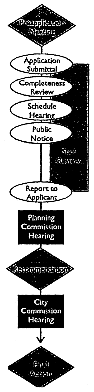
PUD Designation
(Ord. No. 2750, 7-21-03; Ord. No. 2815, 5-1-06; Ord. No. 2871, 6-16-08)
Sec. 318 - Text Amendment
A.
Applicability. A text amendment may be initiated by the City or by the property owner (or duly authorized agent/representative) upon filing an application with the Planning Director.
B.
Hearing and Recommendation by Planning Commission. After notice and public hearing, the Planning Commission shall vote to recommend to the City Commission that the amendment be approved as submitted, or be approved subject to modification; or recommend to the City Commission that the amendment be denied.
C.
Hearing and Action by City Commission.
1.
The application shall be transmitted to the City Commission with the report and recommendation of the Planning Commission within 15 days from the date of Planning Commission action.
2.
The City Commission shall hold a hearing on each application. Following the public hearing, the City Commission shall approve the application as submitted, or approve the application subject to modification, or deny the application based upon the criteria below.
D.
Review Criteria. The Planning Commission and City Commission shall consider the following criteria in their review of UDC text amendments. Proposed text amendments that satisfy all of the criteria may be approved.
1.
The amendment must be consistent with the purpose of this UDC;
2.
The amendment must not adversely affect the public health, safety, or general welfare; and
3.
The amendment is necessary because of changed or changing social values, new planning concepts or other social or economic conditions in the areas affected.
(Ord. No. 2723, 8-19-02)
Sec. 319 - Map Amendment (Rezoning)
A.
Application. An owner or a duly authorized agent or representative may make application for the amendment of the Official Zoning Map by filing an application with the Planning Director.
B.
Hearing and Recommendation by Planning Commission. After notice and public hearing, the Planning Commission shall vote to recommend to the City Commission that the application be approved as submitted, or as amended, or be approved subject to modification; or recommend to the City Commission that the application be denied.
If, by 5:00 p.m. on the fourth (City) workday prior to the scheduled public hearing, a written protest or petition against the application has been received by the City, and if such protest represents 50 percent or more of the area of lots immediately abutting the territory, or by the owners of 50 percent or more of the area of the lots within a 300-foot radius of the exterior boundary of the territory included in a proposed change, or separated therefrom only by an alley or street less than 300 feet wide, such application shall not become effective except by the favorable vote of two-thirds of the membership (6 out of 9), or 100 percent of members attending (5 of 9).
C.
Hearing and Action by City Commission.
1.
The application shall be transmitted to the City Commission with the report and recommendation of the Planning Commission within 15 days from the date of Planning Commission action.
2.
The City Commission shall hold a hearing on each application. Following the public hearing, the City Commission shall approve the application as submitted, or approve the application subject to modification, or deny the application based upon the criteria below. Conditions shall be filed with the deed records at the County Courthouse.
D.
Protest of Approval. If a protest against the application, as described in [Sec.] 314C, has been received and considered by the Planning Commission, such application shall not become effective except by the favorable vote of four-fifths (⅘) of all the members of the City Commission.
E.
Review Criteria.
1.
Zoning district designations should give consideration to their impacts upon adjacent property and existing land uses.
2.
Transportation access and vehicular traffic generated must be considered when determining the most appropriate zoning district designation.
3.
Downzoning to a less intensive use might be recommended in certain areas where the character of development has already changed or will change over time giving consideration to the existing zoning district classification and resulting permitted land uses which have been in effect for 20 years.
4.
Industrial uses should be concentrated along major arterial roadways and the railroad to afford proper access and minimize traffic, noise, and visual impacts.
5.
Major commercial uses should be concentrated along the Commerce Street corridor, along the Interstate 35 corridor, and within the downtown central business district. Efforts should be taken to avoid stripping many of the arterial and collector streets with commercial land uses and zoning because of the resulting high number of curb access points, traffic safety concerns, pedestrian conflict points, and potential land use conflicts with adjacent properties to the rear of commercial uses.
6.
Office uses should be concentrated around the downtown central business district, along major collector and arterial streets, near the hospital and medical complex, and as a transition use or buffer between residential uses and nearby commercial or industrial uses.
7.
Multifamily uses should be located in a variety of areas around Ardmore, should be provided with good street access, and should be used as a potential transition or buffer use between single family residential uses and nearby commercial, office or industrial uses, or major transportation corridors.
8.
Public schools and parks should be located, where practical and economically feasible, near the clients served and with consideration given to both vehicular and pedestrian access.
9.
Agricultural land uses should be located at the edge or fringe areas of Ardmore so potential land use conflicts can be minimized and so agricultural and other associated uses can be protected from encroaching urban uses.
10.
High impact uses that create large amounts of noise, odor, traffic, or other forms of identified and verified nuisances on residential land uses should be located as far as possible from residential neighborhoods or, as an alternative, positive measures must be taken to mitigate negative impacts on nearby neighborhoods.
11.
Commercial and industrial land uses, when located along major transportation entrance corridors to Ardmore, shall give care and concern for appearance, design, visual impact and traffic safety.
12.
Spot zoning, the zoning of a small individual parcel of land different from the majority of other zoning district classifications in the surrounding area, shall generally be discouraged, but may be used as a buffer zone or for public benefit.
13.
Single family residential land uses should include small lots, medium sized lots, and provisions for large estate type lots, and all primary residential uses within neighborhoods should back or side onto arterial streets in order to encourage quiet, safe, and low-volume localized traffic movements.
14.
Higher intensity land uses should be strategically placed and developed with design features that utilize increased setbacks, landscaping, berms, fencing, buffering uses, and other separations to be compatible with low intensity development.
15.
Large community-serving shopping areas, major retail and service activities should be located at the intersection of arterial or collector streets.
16.
In addition to the above outlined policies used for zoning district designations, there are certain sensitive development corridors and areas which must undergo further planning study as development pressures increase and as applications are received for either annexation, rezoning and subdivision actions. These sensitive corridors and areas include:
a.
The north and south Interstate 35 corridor;
b.
The east Highway 199 corridor;
c.
The proposed northwest and southwest arterial transportation loop system connecting Prairie Valley Road to Fox Den Rd. and U.S. Highway 70 from Hedges Road to Fox Den Rd.;
d.
The proposed P Street Southeast arterial corridor from U.S. 70 north to Sam Noble Parkway;
e.
The Downtown Executive Airport and adjacent land south of Lake Murray Drive corridor and nearby Oklahoma State Park lands;
f.
U.S. Highway 70 as it traverses the City from east to west;
g.
The 12th Street NW corridor; and
h.
The North Rockford Road corridor from Broadway to Veterans Boulevard.
F.
Successive Applications. If the City Commission denies an application for a map amendment, an application for the same or any more intensive district on any portion of the subject tract may not be refilled for a period of one year from the date of the City Commission public hearing on the proposed amendment.
G.
Concurrent Amendment of Future Land Use Map. The City Commission may process a concurrent amendment to the Future Land Use Map of the Comprehensive Plan, provided that at least one of the following criteria has been met:
1.
Changed projections from those on which the boundary was based (for example, regarding public services of the extension of utilities);
2.
Changed assumptions (for example, regarding demographic trends);
3.
New issues not recognized in the Comprehensive Plan;
4.
Recognition of a need for additional detail or comprehensiveness; or
5.
Data, typographical or drafting errors.
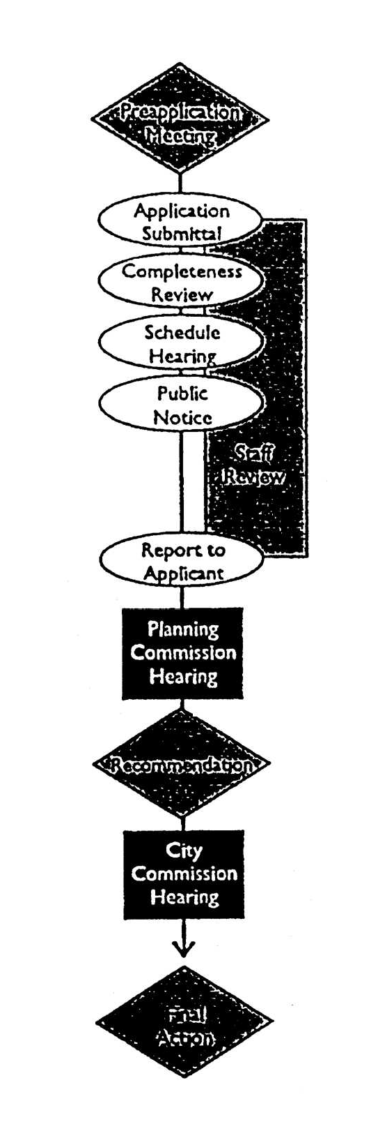
Text or Map Amendment
(Ord. No. 2723, 8-19-02; Ord. No. 2782, 4-4-05; Ord. No. 2815, 5-1-06)