
Atlantic Beach City Zoning Code
ARTICLE III
- ZONING REGULATIONS
Sec. 24-31.- Scope.
The provisions of this chapter shall be administered in accordance with the rules set forth within this article and the detailed regulations governing each zoning district. Administrative procedures and the responsibilities of the city commission, the planning and community development director, and the community development board are set forth herein. Procedures for the filing of applications, for amendments to this chapter, the appeal of decisions on any matter covered within this chapter and the land development regulations are also included herein.
(Ord. No. 90-24-253, § 3(Exh. A), 10-14-24)
Sec. 24-46.- City commission.
It shall be the responsibility of the city commission to perform the following duties and responsibilities in accordance with this chapter:
(a)
To enforce this chapter in accordance with, and consistent with, the adopted comprehensive plan for the City of Atlantic Beach.
(b)
To make amendments to the comprehensive plan, this chapter, the zoning map by a simple majority vote of the city commission after holding required public hearings, and after considering a written recommendation from the community development board performing its functions as the local planning agency.
(c)
To approve or deny requests for subdivisions, plats and changes to plats and other previously approved special conditions of use or development in accordance with the requirements of this chapter after holding required public hearings and after considering a written recommendation from the community development board where required by this chapter.
(d)
To authorize limited waivers, on a case-by-case basis, from a specific provision(s) of the land development regulations as set forth within this chapter and as may be contained within other chapters of city Code.
(e)
To establish fees related to the administrative costs of carrying out the requirements of this chapter.
(f)
To appoint a planning and community development director to administer the provisions of this chapter, who shall be the city manager or his/her designee.
(g)
To hear and decide appeals where it is alleged there is an error in any order, requirement or administrative decision made by the planning and community development director in the enforcement of this chapter or other provision of the Code of Ordinances regulating the use and development of land.
(Ord. No. 90-24-253, § 3(Exh. A), 10-14-24)
Sec. 24-47. - Community development board.
The community development board shall be appointed by the city commission. The organization and procedures under which this board operates, its arrangement of meetings, adoption of rules and its method of hearing and acting upon variances, uses-by-exception or other related matters shall be in conformity with the provisions as set forth within this chapter and chapter 14 of the city Code. It shall be the responsibility of the community development board:
(a)
To approve or deny use-by-exceptions and variances in accordance with the provisions of this chapter.
(b)
To hear and make recommendations to the city commission related to changes in zoning district classifications and amendments to the comprehensive plan.
(c)
Rulings and decisions of the community development board shall constitute rendition of such decisions and rulings and, unless a later dated written order is issued, the date of the meeting at which the decision or ruling was made shall be the effective date of such ruling or decision, subject to any timely filed appeals.
(d)
The community development board shall also serve as the local planning agency for the City of Atlantic Beach and shall provide those functions as set forth in Chapter 163, Florida Statutes, as may be amended.
(Ord. No. 90-24-253, § 3(Exh. A), 10-14-24)
Sec. 24-48. - Planning and community development director.
The planning and community development director shall have the following authorities and responsibilities:
(a)
To administer and implement this chapter and accomplish actions required by this chapter, including proper notices as specified in this chapter or as otherwise required and the receiving and processing of appeals.
(b)
To provide written instructions to applicants related to the required process for requests as required under this chapter and to assist applicants in understanding the provisions of this chapter.
(c)
To receive and initiate the processing of all zoning and land use related applications.
(d)
To maintain all records relating to this chapter and its administration, as may be set forth in this chapter or otherwise be necessary.
(e)
To recommend to the community development board and the city commission, amendments to this chapter, the zoning map, and the comprehensive plan, with a written statement outlining the need for such changes.
(f)
To conduct necessary field inspections required to advise the community development board and the city commission related to zoning and land use matters.
(g)
To review site development plans, applications for certain building permits, including site and lot plans, to determine whether the proposed construction, alterations, repair or enlargement of a structure is in compliance with the provisions of this chapter and the comprehensive plan. The building official's signature, stating approval, shall be required on all development plans before a building permit shall be issued.
(h)
To grant administrative variances in accordance with section 24-64.
(i)
To post signs and provide for proper published notice of zoning requests in accordance with section 24-51 and to forward appropriate agenda information to be considered at the regular scheduled meetings of the community development board to members at least five (5) days prior to the meeting date.
(j)
To recommend for hire such persons as necessary to assist in the fulfillment of the requirements of the office and delegate to these employees the duties and responsibilities assigned to the planning and community development director as may be necessary to carry out properly, the functions of the office.
(Ord. No. 90-24-253, § 3(Exh. A), 10-14-24)
Sec. 24-49. - Appeals.
Appeals of administrative decisions made by the planning and community development director and appeals of final decisions of the community development board may be made by adversely affected person(s) in accordance with the following provisions. Appeals shall be heard at a public hearing within a reasonable period of time with proper public notice, as well as due notice to the interested parties as set forth in section 24-51 hereof. At the hearing, any party may appear in person, by agent or by attorney.
(a)
Appeals of administrative decisions of the planning and community development director. Appeals of a decision of the planning and community development director may be made to the city commission by any adversely affected person(s), or any officer, board or department of the city affected by a decision of the planning and community development director made under the authority of this chapter.
Such appeal shall be filed in writing with the city clerk within thirty (30) days after rendition of the final order, requirement, ruling, decision or determination being appealed.
The planning and community development director shall, upon notification of the filing of the appeal, transmit to the city commission, all the documents, plans, or other materials constituting the record upon which the action being appealed was derived. A duly noticed public hearing, which shall be de novo, will be held by the city commission at a date and time set by the city manager or his/her designee.
(b)
Appeals of decisions of the community development board. Appeals of a decision of the community development board may be made to the city commission by any adversely affected person(s), any officer, board or department of the city affected by any decision of the community development board made under the authority of this chapter. Such appeal shall be filed in writing with the city clerk within thirty (30) days after rendition of the final order, requirement, decision or determination being appealed. The appellant shall present to the city commission a petition, duly verified, setting forth that the decision being appealed is in conflict with or in violation of this chapter, in whole or in part, and specifying the grounds of the conflict or violation. A duly noticed public hearing, which shall be de novo, will be held by the city commission at a date and time set by the city manager or his/her designee.
(c)
Stay of work. An appeal to the city commission shall stay all work on the subject premises and all proceedings in furtherance of the action appealed, unless the administrator shall certify to the city commission that, by reason of facts stated in the certificate, a stay would cause imminent peril to life or property. In such case, proceedings or work shall not be stayed except by order, which may be granted by the city commission after application to the officer from whom the appeal is taken and on due cause shown.
(Ord. No. 90-24-253, § 3(Exh. A), 10-14-24)
Sec. 24-50. - Vested rights.
(a)
Determination of vested rights. The determination of vested rights shall be based upon factual evidence provided to the City of Atlantic Beach. Each vesting determination shall be based on an individual case-by-case basis. Applications for a determination of vested rights shall be submitted to the planning and community development director, who shall issue a written order in response to each application consistent with Florida law and this section. The applicant shall have the burden of proof to demonstrate the entitlement to vested rights pursuant to the requirements of Florida law and shall provide all information as may be required. All development subject to an approved vested rights determination shall be consistent with the terms of the development approval upon which the vesting determination was based.
(b)
Expiration of vested rights.
(1)
Statutory vested rights determinations which have been recognized by the city, shall not have a specific expiration date unless specified in other ordinances, development permits or statutory limitations. Such vested rights may expire as otherwise allowed or required by applicable law.
(2)
Common law vested rights determinations, which have been recognized by the city, shall remain valid for a period of up to five (5) years from the date the determination is made unless otherwise specified by the written order vesting determination, provided that the city may cancel and negate such vested rights prior to the expiration of said time period if it is demonstrated that the request for a vested rights determination was based on substantially inaccurate information provided by the applicant, or that the revocation of said vested rights is clearly established to be essential for the health, safety and welfare of the public.
(3)
Requests to extend the time period of a vested rights determination shall be made to the city commission and shall be granted only upon showing of good cause.
(c)
Appeals of vested determinations. An appeal of a vested determination may be made in accordance with the processes of section 24-49(a).
(Ord. No. 90-24-253, § 3(Exh. A), 10-14-24)
Sec. 24-51. - Public hearings and required notice.
Notice of all public hearings required under these land development regulations shall be provided by the administrator or designee in accordance with the following provisions:
(a)
Except as provided in subsection (c) herein, the following procedures shall apply to ordinances that amend the text of the adopted comprehensive plan.
(1)
Public hearings. The community development board shall hold one (1) advertised public hearing and the city commission shall hold two (2) advertised public hearings on proposed ordinances that amend the text of the adopted comprehensive plan.
The first public hearing at city commission shall be held at the transmittal stage, prior to the transmittal of the proposed amendment to the state planning agency pursuant to F.S. § 163.3184. The second public hearing at city commission shall be held at the adoption stage, within one hundred eighty (180) calendar days of receipt of any comments from the state planning agency, unless such time frame is extended pursuant to F.S. § 163.3184. Should the second public hearing at city commission not be timely held, the amendment application shall be deemed withdrawn pursuant to F.S. § 163.3184. All public hearings shall be held on a weekday after 5:00 p.m.
(2)
Notice. All notices regarding ordinances that amend the text of the adopted comprehensive plan, shall comply with the requirements of F.S. §§ 163.3184 and 166.041, unless otherwise specified herein.
a.
Published notice. At least ten (10) calendar days prior to each public hearing, the city manager or his/her designee shall have published an advertisement giving notice of the public hearing in accordance with Chapter 166, Florida Statutes.
The required advertisement shall be one-quarter (¼) page in a standard size or a tabloid size newspaper, and the headline in advertisement shall be in a type no smaller than eighteen (18) point. The advertisement shall not be placed in that portion of the newspaper where legal notices and classified advertisements appear. The notice shall be published in a newspaper of general circulation in the city. The notice shall state the date, time, place of the meeting, and the place or places within the city where the proposed ordinances may be inspected by the public. The notice shall also advise that interested parties may appear at the meeting and be heard with respect to the proposed ordinance.
Advertisements for ordinances that amend the text of the adopted comprehensive plan shall be in substantially the following form:
NOTICE OF COMPREHENSIVE PLAN TEXT CHANGE
The City of Atlantic Beach proposes to adopt the following ordinance (title of the ordinance).
A public hearing on the ordinance will be held on (date and time) at (meeting place).
b.
Mailed notice. At least fourteen (14) calendar days prior to the first public hearing, notice shall be sent by U.S. mail to each real property owner whose land is subject to the proposed text change and also to owners whose land is within three hundred (300) feet of the subject parcel(s) and whose address is known by reference to the latest ad valorem tax records. The notice shall state the date(s), time(s), place(s) of the public hearing(s) and the place or places within the city where the application may be inspected by the public. The notice shall also advise that interested parties may appear at the meeting and be heard regarding the application. A copy of the notice shall be kept available for public inspection during the regular business hours of the office of the city clerk.
(b)
Except as provided in subsection (c) herein, the following procedures shall apply to ordinances that amend the future land use map series of the adopted comprehensive plan.
(1)
Public hearings. The community development board shall hold one (1) advertised public hearing and the city commission shall hold two (2) advertised public hearings on proposed ordinances that amend the future land use map series of the adopted comprehensive plan.
The first public hearing at city commission shall be held at the transmittal stage, prior to the transmittal of the proposed amendment to the state planning agency pursuant to F.S § 163.3184. The second public hearing at city commission shall be held at the adoption stage, within one hundred eighty (180) calendar days of receipt of any comments from the state planning agency pursuant to F.S § 163.3184. All public hearings shall be held on a weekday after 5:00 p.m.
(2)
Notice. All notices regarding ordinances that amend the future land use map series of the adopted comprehensive plan, shall be as required by F.S §§ 163.3184 and 166.041 unless otherwise specified herein.
a.
Published notice. At least ten (10) calendar days prior to each public hearing, the city manager or his/her designee shall have published an advertisement giving notice of the public hearing.
The required advertisement shall be one-quarter (¼) page in a standard size or a tabloid size newspaper, and the headline in advertisement shall be in a type no smaller than eighteen (18) point. The advertisement shall not be placed in that portion of the newspaper where legal notices and classified advertisements appear. The notice shall be published in a newspaper of general circulation in the city. The notice shall state the date, time, place of the meeting, and the place or places within the city where the proposed ordinances may be inspected by the public. The notice shall also advise that interested parties may appear at the meeting and be heard with respect to the proposed ordinance.
Advertisements for ordinances that amend the future land use map series of the adopted comprehensive plan shall be in substantially the following form:
NOTICE OF FUTURE LAND USE MAP CHANGE
The City of Atlantic Beach proposes to adopt the following ordinance (title of the ordinance).
A public hearing on the ordinance will be held on (date and time) at (meeting place).
The advertisement shall contain a geographic location map which clearly indicates the area covered by the proposed ordinance. The map shall include major street names as a means of identification of the general area. In addition to being published in the newspaper, the maps must be part of the online notice required pursuant to F.S. § 50.0211.
b.
Mailed notice. At least fourteen (14) calendar days prior to the first public hearing, notice shall be sent by U.S. mail to each real property owner whose land is within three hundred (300) feet of the subject parcel(s) and whose address is known by reference to the latest ad valorem tax records. The notice shall state the date(s), time(s), place(s) of the public hearing(s) and the place or places within the city where the application may be inspected by the public. The notice shall also advise that interested parties may appear at the meeting and be heard regarding the application. A copy of the notice shall be kept available for public inspection during the regular business hours of the office of the city clerk.
(c)
The following procedures shall apply to ordinances for small-scale comprehensive plan amendments that amend the future land use map series and related text amendments.
For site specific future land use map amendments involving the use of fifty (50) acres or less and text changes that relate directly to, and are adopted simultaneously with, the small scale future land use map amendment, the following public hearing and notice requirements shall apply:
(1)
Public hearings. The community development board shall hold one (1) advertised public hearing and the city commission shall hold two (2) advertised public hearings the latter of which shall be the adoption hearing as required by F.S. §§ 163.3187 and 166.041. All public hearings shall be held on a weekday after 5:00 p.m.
(2)
Notice. All notices regarding ordinances for small-scale comprehensive plan amendments that amend the future land use map series and related text amendments, shall be provided by the city manager or his/her designee as required by F.S. §§ 163.3187 and 166.041, unless otherwise specified herein.
a.
Published notice. At least ten (10) calendar days prior to each public hearing, an advertisement giving notice of the public hearing shall be published.
The required advertisement shall be one-quarter (¼) page in a standard size or a tabloid size newspaper, and the headline in advertisement shall be in a type no smaller than eighteen (18) point. The advertisement shall not be placed in that portion of the newspaper where legal notices and classified advertisements appear. The notice shall be published in a newspaper of general circulation in the city. The notice shall state the date, time, place of the meeting, and the place or places within the city where the proposed ordinances may be inspected by the public. The notice shall also advise that interested parties may appear at the meeting and be heard with respect to the proposed ordinance.
Advertisements for ordinances for small-scale comprehensive plan amendments that amend the future land use map series and related text amendments shall be in substantially the following form:
NOTICE OF SMALL SCALE COMPREHENSIVE PLAN AMENDMENT
The City of Atlantic Beach proposes to adopt the following ordinance (title of ordinance).
A public hearing on the ordinance shall be held on (date and time) at (meeting place).
The advertisement shall contain a geographic location map which clearly indicates the area covered by the proposed ordinance. The map shall include major street names as a means of identification of the general area. In addition to being published in the newspaper, the maps must be part of the online notice required pursuant to F.S. § 50.0211.
b.
Mailed notice. At least fourteen (14) calendar days prior to the first public hearing, notice shall be sent by U.S. mail to each real property owner whose land is within three hundred (300) feet of the subject parcel(s) and whose address is known by reference to the latest ad valorem tax records. The notice shall state the date(s), time(s), place(s) of the public hearing(s) and the place or places within the city where the application may be inspected by the public. The notice shall also advise that interested parties may appear at the meeting(s) and be heard regarding the application. A copy of the notice shall be kept available for public inspection during the regular business hours of the office of the city clerk.
c.
Posted notice. At least fourteen (14) calendar days prior to the first public hearing, a sign identifying the request, including date(s), time(s) and place(s) of the public hearing(s), shall be posted on the subject parcel. Such sign shall be erected in full view of the public street on each street side of the land subject to the application. Where the property subject to the request does not have frontage on a public street, a sign shall be erected at the nearest public right-of-way with an attached notation indicating the general direction and distance to the land subject to the application. Sign(s) shall be removed after a decision is rendered on the application. The failure of any such posted notice sign to remain in place after the notice has been posted shall not be deemed a failure to comply with this requirement, nor shall it be grounds to challenge the validity of any decision made by the community development board or the city commission.
(d)
The following procedures shall apply to ordinances that change the text of the land development regulations, other than those that revise the actual list of permitted, conditional or prohibited uses within a zoning category.
(1)
Public hearings. The community development board shall hold one (1) advertised public hearing and the city commission shall hold two (2) advertised public hearings on proposed ordinances that change the text of the land development regulations, other than those that revise the actual list of permitted, conditional or prohibited uses within a zoning category. All public hearings shall be held on a weekday after 5:00 p.m.
(2)
Notice. All notices regarding ordinances that change the text of the land development regulations, other than those that revise the actual list of permitted, conditional or prohibited uses within a zoning category, shall be in accordance with F.S. § 166.041, unless otherwise specified herein.
a.
Published notice. At least ten (10) calendar days prior to each public hearing, the city manager or his/her designee shall have published an advertisement giving notice of the public hearing.
The required advertisement shall be one-quarter (¼) page in a standard size or a tabloid size newspaper, and the headline in advertisement shall be in a type no smaller than eighteen (18) point. The advertisement shall not be placed in that portion of the newspaper where legal notices and classified advertisements appear. The notice shall be published in a newspaper of general circulation in the city. The notice shall state the date, time, place of the meeting, and the place or places within the city where the proposed ordinances may be inspected by the public. The notice shall also advise that interested parties may appear at the meeting and be heard with respect to the proposed ordinance.
Advertisements for ordinances that change the text of the land development regulations, other than those that revise the actual list of permitted, conditional or prohibited uses within a zoning category shall be in substantially the following form:
NOTICE OF LAND DEVELOPMENT REGULATIONS TEXT CHANGE
The City of Atlantic Beach proposes to adopt the following ordinance (title of the ordinance).
A public hearing on the ordinance will be held on (date and time) at (meeting place).
b.
Posted notice. At least fourteen (14) calendar days prior to the first public hearing, a sign identifying the ordinance, including date(s), time(s) and place(s) of the public hearing(s), shall be posted along the street frontage of city hall and city community centers.
c.
Online notice. At least fourteen (14) days prior to the first public hearing, a notice identifying the ordinance, including date(s), time(s), and place(s) of the public hearing(s), shall be posted to the City of Atlantic Beach website.
d.
In addition to the notices listed above, the city shall post notices on city social media accounts, within monthly newsletters, and similar methods (such as Facebook, digital newsletters, etc.) to notify residents.
(e)
The following procedures shall apply to ordinances initiated by an applicant other than the city to change the actual official zoning map designation of a parcel or parcels.
(1)
Public hearings. The community development board shall hold one (1) advertised public hearing and the city commission shall hold two (2) advertised public hearings on proposed ordinances initiated by an applicant other than the city to change the actual official zoning map designation of a parcel or parcels. All public hearings shall be held on a weekday after 5:00 p.m.
(2)
Notice. All notices regarding ordinances initiated by an applicant other than the city to change the actual official zoning map designation of a parcel or parcels, shall be provided by the city manager or his/her designee in accordance with F.S. § 166.041, unless otherwise specified herein.
a.
Published notice. At least ten (10) calendar days prior to each public hearing, an advertisement giving notice of the public hearing shall be provided.
The required advertisement shall be one-quarter (¼) page in a standard size or a tabloid size newspaper, and the headline in advertisement shall be in a type no smaller than eighteen (18) point. The advertisement shall not be placed in that portion of the newspaper where legal notices and classified advertisements appear. The notice shall be published in a newspaper of general circulation in the city. The notice shall state the date, time, place of the meeting, and the place or places within the city where the proposed ordinances may be inspected by the public. The notice shall also advise that interested parties may appear at the meeting and be heard with respect to the proposed ordinance.
Advertisements for ordinances initiated by an applicant other than the city to change the actual official zoning map designation of a parcel or parcels shall be in substantially the following form:
NOTICE OF ZONING MAP CHANGE
The City of Atlantic Beach proposes to adopt the following ordinance (title of the ordinance).
A public hearing on the ordinance will be held on (date and time) at (meeting place).
The advertisement shall contain a geographic location map which clearly indicates the area covered by the proposed ordinance. The map shall include major street names as a means of identification of the general area. In addition to being published in the newspaper, the maps must be part of the online notice required pursuant to F.S. § 50.0211.
b.
Mailed notice. At least fourteen (14) calendar days prior to the first public hearing, notice shall be sent by U.S. mail to each real property owner whose land is within three hundred (300) feet of the subject parcel(s) and whose address is known by reference to the latest ad valorem tax records. The notice shall state the date(s), time(s), place(s) of the public hearing(s) and the place or places within the city where the application may be inspected by the public. The notice shall also advise that interested parties may appear at the meeting and be heard regarding the application. A copy of the notice shall be kept available for public inspection during the regular business hours of the office of the city clerk.
c.
Posted notice. At least fourteen (14) calendar days prior to each public hearing, a sign identifying the request, including date(s), time(s) and place(s) of the public hearing(s), shall be posted on the subject parcel. Such sign shall be erected in full view of the public street on each street side of the land subject to the application. Where the property subject to the request does not have frontage on a public street, a sign shall be erected at the nearest public right-of-way with an attached notation indicating the general direction and distance to the land subject to the application. Sign(s) shall be removed after a decision is rendered on the application. The failure of any such posted notice sign to remain in place after the notice has been posted shall not be deemed a failure to comply with this requirement, nor shall it be grounds to challenge the validity of any decision made by the community development board or the city commission.
(f)
The following procedures shall apply to ordinances that change the text of the land development regulations to revise the actual list of permitted, conditional or prohibited uses within a zoning category.
(1)
Public hearings. The community development board shall hold one (1) advertised public hearing and the city commission shall hold two (2) advertised public hearings on proposed ordinances that change the text of the land development regulations to revise the list of permitted, conditional or prohibited uses within a zoning category.
All public hearings shall be held on a weekday after 5:00 p.m. The second public hearing before the city commission shall be held at least ten (10) calendar days after the first public hearing.
(2)
Notice. All notices regarding ordinances that change the text of the land development regulations to revise the list of permitted, conditional, or prohibited uses within a zoning category, shall be in accordance with F.S. § 166.041, unless otherwise specified herein.
a.
Published notice. At least ten (10) calendar days prior to each public hearing, the city manager or his/her designee shall have published an advertisement giving notice of the public hearing.
The required advertisement shall be one-quarter (¼) page, except that in no case shall it be less than two (2) columns wide by ten (10) inches long, in a standard size or a tabloid size newspaper, and the headline in advertisement shall be in a type no smaller than eighteen (18) point. The advertisement shall not be placed in that portion of the newspaper where legal notices and classified advertisements appear. The advertisement shall be placed in a newspaper of general paid circulation in the city and of general interest and readership in the city, not one (1) of limited subject matter, pursuant to Chapter 50, Florida Statutes. The notice shall state the date, time, place of the public hearing; the title of the proposed ordinance and the place or places within the city where the proposed ordinance may be inspected by the public. The notice shall also advise that interested parties may appear at the meeting and be heard regarding the proposed ordinance.
Advertisements for ordinances that change the text of the land development regulations to revise the actual list of permitted, conditional, or prohibited uses within a zoning category shall be in substantially the following form:
NOTICE OF LAND DEVELOPMENT REGULATIONS TEXT CHANGE
The City of Atlantic Beach proposes to adopt the following ordinance (title of the ordinance).
A public hearing on the ordinance will be held on (date and time) at (meeting place).
b.
Mailed notice. At least fourteen (14) calendar days prior to the first public hearing, notice shall be sent by U.S. mail to each real property owner whose land is subject to the proposed text change and also to owners whose land is within three hundred (300) feet of the subject parcel(s) and whose address is known by reference to the latest ad valorem tax records. The notice shall state the date(s), time(s), place(s) of the public hearing(s) and the place or places within the city where the application may be inspected by the public. The notice shall also advise that interested parties may appear at the meeting and be heard regarding the application. A copy of the notice shall be kept available for public inspection during the regular business hours of the office of the city clerk.
(g)
The following procedures shall apply to ordinances initiated by the city that change the actual zoning map designation for a parcel or parcels of land involving ten (10) contiguous acres or more.
(1)
Public hearings. The community development board shall hold one (1) advertised public hearing and the city commission shall hold two (2) advertised public hearings on proposed ordinances that change the actual zoning map designation for a parcel or parcels of land involving ten (10) contiguous acres or more.
All public hearings shall be held on a weekday after 5:00 p.m. The second public hearing before the city commission shall be held at least ten (10) calendar days after the first public hearing.
(2)
Notice. All notices regarding ordinances initiated by the city that change the actual zoning map designation for a parcel or parcels of land involving ten (10) contiguous acres or more, shall be provided by the city manager or his/her designee in accordance with F.S. § 166.041, unless otherwise specified herein.
a.
Published notice. At least ten (10) calendar days prior to each public hearing, an advertisement giving notice of the public hearing shall be published.
The required advertisement shall be one-quarter (¼) page, except in no case shall it be less than two (2) columns wide by ten (10) inches long, in a standard size or a tabloid size newspaper, and the headline in advertisement shall be in a type no smaller than eighteen (18) point. The advertisement shall not be placed in that portion of the newspaper where legal notices and classified advertisements appear. The advertisement shall be placed in a newspaper of general paid circulation in the city and of general interest and readership in the city, not one (1) of limited subject matter, pursuant to Chapter 50, Florida Statutes. The notice shall state the date, time, place of the public hearing; the title of the proposed ordinance and the place or places within the city where the proposed ordinance may be inspected by the public. The notice shall also advise that interested parties may appear at the meeting and be heard regarding the proposed ordinance.
Advertisements for ordinances initiated by the city that change the actual zoning map designation for a parcel or parcels of land involving ten (10) contiguous acres or more shall be in substantially the following form:
NOTICE OF ZONING MAP CHANGE
The City of Atlantic Beach proposes to adopt the following ordinance (title of the ordinance).
A public hearing on the ordinance will be held on (date and time) at (meeting place).
The advertisement shall contain a geographic location map which clearly indicates the area covered by the proposed ordinance. The map shall include major street names as a means of identification of the general area. In addition to being published in the newspaper, the maps must be part of the online notice required pursuant to F.S. § 50.0211.
b.
Mailed notice. Each real property owner whose land the city will redesignate by enactment of the ordinance and whose address is known by reference to the latest ad valorem tax records shall be notified by mail. The notice shall state the substance of the proposed ordinance as it affects that property owner and shall set a time and place for one (1) or more public hearings on such ordinance. Such notice shall be given at least thirty (30) calendar days prior to the date set for the first public hearing, and a copy of the notice shall be kept available for public inspection during the regular business hours of the office of the city clerk.
(h)
The following procedures shall apply to ordinances initiated by the city that change the actual zoning map designation for a parcel or parcels of land involving less than ten (10) contiguous acres.
(1)
Public hearings. The community development board shall hold one (1) advertised public hearing and the city commission shall hold two (2) advertised public hearings on proposed ordinances initiated by the city that change the actual zoning map designation for a parcel or parcels of land involving less than ten (10) contiguous acres. All public hearings shall be held on a weekday after 5:00 p.m.
(2)
Notice. All notices regarding ordinances initiated by the city that change the actual zoning map designation for a parcel or parcels of land involving less than ten (10) contiguous acres, shall be provided by the city manager or his/her designee in accordance with F.S. § 166.041, unless otherwise specified.
a.
Published notice. At least ten (10) calendar days prior to each public hearing, an advertisement giving notice of the public hearing shall be published.
The required advertisement shall be one-quarter (¼) page in a standard size or a tabloid size newspaper, and the headline in advertisement shall be in a type no smaller than eighteen (18) point. The advertisement shall not be placed in that portion of the newspaper where legal notices and classified advertisements appear. The notice shall be published in a newspaper of general circulation in the city. The notice shall state the date, time, place of the meeting, and the place or places within the city where the proposed ordinances may be inspected by the public. The notice shall also advise that interested parties may appear at the meeting and be heard with respect to the proposed ordinance.
Advertisements for ordinances initiated by the city that change the actual zoning map designation for a parcel or parcels of land involving less than ten (10) contiguous acres shall be in substantially the following form:
NOTICE OF ZONING MAP CHANGE
The City of Atlantic Beach proposes to adopt the following ordinance (title of the ordinance).
A public hearing on the ordinance will be held on (date and time) at (meeting place).
The advertisement shall contain a geographic location map which clearly indicates the area covered by the proposed ordinance. The map shall include major street names as a means of identification of the general area. In addition to being published in the newspaper, the maps must be part of the online notice required pursuant to F.S. § 50.0211.
b.
Mailed notice. Each real property owner whose land the city will redesignate by enactment of the ordinance and whose address is known by reference to the latest ad valorem tax records shall be notified by mail. The notice shall state the substance of the proposed ordinance as it affects that property owner and shall set a time and place for one (1) or more public hearings on such ordinance. Such notice shall be given at least thirty (30) calendar days prior to the date set for the first public hearing, and a copy of the notice shall be kept available for public inspection during the regular business hours of the office of the city clerk.
(i)
The following procedures shall apply to applications for variances and uses-by-exceptions.
(1)
Public hearings. The community development board shall hold one (1) advertised public hearing on applications for variances uses-by-exception. The public hearing shall be held on a weekday after 5:00 p.m.
(2)
Notice. Notice of all public hearings for applications for variances and uses-by-exception shall be provided by the city manager or his/her designee in accordance with the following provisions:
a.
Published notice. At least ten (10) calendar days prior to the public hearing, an advertisement giving notice of the public hearing shall be published. The advertisement shall be placed in a newspaper of general paid circulation in the city and of general interest and readership in the city, not one (1) of limited subject matter, pursuant to Chapter 50, Florida Statutes. The notice shall state the date, time, place of the public hearing and the place or places within the city where the application may be inspected by the public. The notice shall also advise that interested parties may appear at the meeting and be heard regarding the application.
b.
Mailed notice. At least fourteen (14) calendar days prior to the public hearing, notice shall be sent by U.S. mail to each real property owner whose land is within three hundred (300) feet of the subject parcel(s) and whose address is known by reference to the latest ad valorem tax records. The notice shall state the date, time, place of the public hearing and the place or places within the city where the application may be inspected by the public. The notice shall also advise that interested parties may appear at the meeting and be heard regarding the application. A copy of the notice shall be kept available for public inspection during the regular business hours of the office of the city clerk.
c.
Posted notice. At least fourteen (14) calendar days prior to the public hearing, a sign identifying the request, including date, time and place of the public hearing, shall be posted on the subject parcel. Such sign shall be erected in full view of the public street on each street side of the land subject to the application. Where the property subject to the request does not have frontage on a public street, a sign shall be erected at the nearest public right-of-way with an attached notation indicating the general direction and distance to the land subject to the application. Sign(s) shall be removed after a decision is rendered on the application. The failure of any such posted notice sign to remain in place after the notice has been posted shall not be deemed a failure to comply with this requirement, nor shall it be grounds to challenge the validity of any decision made by the community development board.
(j)
Applications for waivers.
(1)
Public hearings. The city commission shall hold one (1) advertised public hearing on applications for waivers. The public hearing shall be held on a weekday after 5:00 p.m.
(2)
Notice. Notice of all public hearings for applications for waivers shall be provided by the city manager or his/her designee in accordance with the following provisions:
a.
Published notice. At least ten (10) calendar days prior to the public hearing, an advertisement giving notice of the public hearing shall be published. The advertisement shall be placed in a newspaper of general paid circulation in the city and of general interest and readership in the city, not one (1) of limited subject matter, pursuant to Chapter 50, Florida Statutes. The notice shall state the date, time, place of the public hearing and the place or places within the city where the application may be inspected by the public. The notice shall also advise that interested parties may appear at the meeting and be heard regarding the application.
b.
Mailed notice. At least fourteen (14) calendar days prior to the public hearing, notice shall be sent by U.S. mail to each real property owner whose land is within three hundred (300) feet of the subject parcel(s) and whose address is known by reference to the latest ad valorem tax records. The notice shall state the date, time, place of the public hearing and the place or places within the city where the application may be inspected by the public. The notice shall also advise that interested parties may appear at the meeting and be heard regarding the application. A copy of the notice shall be kept available for public inspection during the regular business hours of the office of the city clerk.
c.
Posted notice. At least fourteen (14) calendar days prior to the public hearing, a sign identifying the request, including date, time and place of the public hearing, shall be posted on the subject parcel. Such sign shall be erected in full view of the public street on each street side of the land subject to the application. Where the property subject to the request does not have frontage on a public street, a sign shall be erected at the nearest public right-of-way with an attached notation indicating the general direction and distance to the land subject to the application. Sign(s) shall be removed after a decision is rendered on the application. The failure of any such posted notice sign to remain in place after the notice has been posted shall not be deemed a failure to comply with this requirement, nor shall it be grounds to challenge the validity of any decision made by the city commission.
(k)
Appeals. The following shall apply to timely filed appeals from decisions made by the planning and community development director or from the community development board.
(1)
Public hearings. The city commission shall hold one (1) advertised public hearing on timely filed appeals from decisions made by the planning and community development director or from the community development board. The hearing shall be de novo. All public hearings shall be held on a weekday after 5:00 p.m.
(2)
Notice. Notice of all public hearings for appeals shall be provided by the city manager or his/her designee in accordance with the following provisions:
a.
Published notice. At least ten (10) calendar days prior to the public hearing, an advertisement giving notice of the public hearing shall be published. The advertisement shall be placed in a newspaper of general paid circulation in the city and of general interest and readership in the city, not one (1) of limited subject matter, pursuant to Chapter 50 of the Florida Statutes. The notice shall state the date, time, place of the public hearing and the place or places within the city where the appeal documents may be inspected by the public. The notice shall also advise that interested parties may appear at the meeting and be heard regarding the appeal.
b.
Posted notice. At least fourteen (14) calendar days prior to the first public hearing, a sign identifying the appeal, including date(s), time(s) and place(s) of the public hearing, shall be posted on the subject parcel. Such sign shall be erected in full view of the public street on each street side of the land subject to the application. Where the property subject to the appeal does not have frontage on a public street, a sign shall be erected at the nearest public right-of-way with an attached notation indicating the general direction and distance to the land subject to the appeal. Sign(s) shall be removed after a decision is rendered on the appeal. The failure of any such posted notice sign to remain in place after the notice has been posted shall not be deemed a failure to comply with this requirement, nor shall it be grounds to challenge the validity of any decision made by the city commission.
(l)
Contest. If no adversely affected party contests the issue of proper notice within thirty (30) calendar days of the city commission, or the community development board, rendering its decision, then notice shall be deemed to be in compliance with this section.
(Ord. No. 90-24-253, § 3(Exh. A), 10-14-24)
Sec. 24-60.- Amendment and repeal.
(a)
The city commission may from time to time amend, supplement or repeal these land development regulations, the zoning district classifications and boundaries, and the restrictions as set forth within this chapter.
(b)
Proposed changes and amendments may be recommended by the city commission, the community development board, a property owner for his own land, or by petition of the owners of fifty-one (51) percent or more of the area involved in a proposed district boundary change, or the planning and community development director.
(Ord. No. 90-24-253, § 3(Exh. A), 10-14-24)
Sec. 24-61. - Process chart.
The following chart indicates which entity has approval authority for various development permit orders.
APPROVAL AUTHORITY
*Recommendation
Figure 3 Approval Authority
(Ord. No. 90-24-253, § 3(Exh. A), 10-14-24)
Sec. 24-62. - Zoning code or map amendment.
(a)
Any portion of this Code may be amended, supplemented, changed, modified, or repealed and the zoning map may be modified by the rezoning of land as provided in this section, provided that all changes are consistent with the comprehensive plan. It is not the purpose of this section to relieve particular hardships, nor to confer special privileges or rights on any person, but only to make necessary adjustments in light of changed conditions
(b)
All applications shall be filed with the planning and community development director on the proper form and shall only be accepted when filed by the owner of the property or their authorized agent. The application submitted shall include the following information:
(1)
The legal description, including the lot and block numbers, of the property to be rezoned;
(2)
The names and addresses of all owners of the subject property;
(3)
Existing and proposed zoning district classification of the property;
(4)
A statement of the petitioner's interest in the property to be rezoned, including a copy of the last recorded warranty deed; and
a.
If joint and several ownership, a written consent to the rezoning petition by all owners of record; or
b.
If an authorized agent, a notarized notice of agent authorization signed by all owners of record; or
c.
If a corporation or other business entity, the name of the officer or person responsible for the application and written proof that said representative has the delegated authority to represent the corporation or other business entity, or in lieu thereof, written proof that the person is, in fact, an officer of the corporation; or
d.
A statement of special reasons and need for and justification to support the rezoning as requested;
e.
Payment of the official filing fee as set by the city commission;
f.
The signature of each owner of the lands sought to be rezoned.
(c)
After the planning and community development director has received a completed application, the request shall be placed on the agenda of the next available meeting of the community development board, provided that the request is received at least thirty (30) days prior to the meeting. The community development board shall review each request for rezoning or code amendment and conduct a public hearing after due public notice in accordance with section 24-51. The community development board shall make a recommendation to the city commission.
(d)
The city commission shall review the recommendations made by the community development board and hold two (2) public hearings, with notice as set forth within section 24-51, to consider the request.
(e)
Following the public hearings, the city commission, by ordinance, may amend the code or zoning map, or it may deny the request. In the case of denial, the city commission shall thereafter take no further action on another application for substantially the same proposal, on the same property, until after three hundred sixty-five (365) days from the date of the denial.
(f)
Applications for a zoning code or map amendment shall be reviewed and evaluated based on the following factors:
(1)
Consistency with the comprehensive plan;
(2)
Consistency with the intent of the land development regulations;
(3)
Consistency with other professional planning principles, standards, information and more detailed plans and studies considered relevant;
(4)
Whether the proposed amendment and development permitted thereunder is premature or otherwise creates or contributes to an urban sprawl pattern of development;
(5)
Whether the proposed amendment will constitute "spot zoning," that is an isolated zoning district unrelated to adjacent and nearby districts;
(6)
Whether the uses permitted under the proposed rezoning will be consistent or compatable with the existing and proposed land uses and zoning of adjacent and nearby properties or the general area; or will deviate from an established or developing logical and orderly development pattern;
(7)
Whether the uses permitted under the proposed rezoning will deviatae from an established or developing development pattern that is logical and orderly;
(8)
Whether the proposed rezoning and development permitted thereunder will result in significant adverse impacts upon property values of adjacent or nearby properties or in the general area more than the types of uses currently permitted; and
(9)
Whether the proposed rezoning and development permitted thereunder will detract from the character and quality of life in the general area or neighborhood by creating excessive traffic, noise, lights, vibration, fumes, odors, dust, physical activities or other detrimental effects or nuisances.
(Ord. No. 90-24-253, § 3(Exh. A), 10-14-24)
Sec. 24-63. - Use-by-exception.
The following steps shall be required to request a use-by-exception. A use-by-exception may be approved only for those uses and activities, which are expressly identified as a possible use-by-exception within a particular zoning district:
(a)
All applications shall be filed with the planning and community development director on the proper form and said application shall only be accepted when filed by the owner of the property or his authorized agent.
(b)
The application shall include the following information:
(1)
The legal description of the property where the use-by-exception is to be located.
(2)
A survey.
(3)
A site plan.
(4)
The names and addresses of all property owners of the subject property.
(5)
A description of the use-by-exception desired, which shall specifically and particularly describe the type, character and extent of the proposed use-by-exception.
(6)
The reason for and justification to support the application for the use-by-exception.
(7)
The signature of the owner, or the signature of the owner's authorized agent, and written authorization by the owner for the agent to act on the behalf of the property owner.
(8)
Payment of the official filing fee as set by the city commission.
(c)
After the planning and community development director has received a complete application, the request shall be placed on the agenda of the next available meeting of the community development board. The community development board shall review each request for a use-by-exception and conduct a public hearing after due public notice in accordance with section 24-51.
(d)
The review of any application for a use-by-exception shall consider each of the following:
(1)
Ingress and egress to property and proposed structures thereon with particular reference to vehicular and pedestrian safety and convenience, traffic flow and control and access in case of fire or catastrophe.
(2)
Off-street parking and loading spaces, where required, with particular attention to the items in [subsection] (1) above.
(3)
The potential for any adverse impacts to adjoining properties and properties generally in the area resulting from excessive noise, glare and lighting, odor, traffic and similar characteristics of the use-by-exception being requested.
(4)
Refuse and service areas, with particular reference to items [subsections] (1) and (2) above.
(5)
Utilities, with reference to locations, availability and compatibility.
(6)
Screening and buffering, with reference to type, dimensions and character.
(7)
Signs, if any, and proposed exterior lighting, with reference to glare, traffic safety, economic effects and compatibility and harmony with properties in the district (see "Signs and advertising," chapter 17).
(8)
Required yards, impervious surface ratios and other open space regulations.
(9)
General compatibility with adjacent properties and other property in the surrounding zoning district as well as consistency with applicable provisions of the comprehensive plan.
(10)
For those properties within the commercial districts, consistency with the intent of section 24-171, commercial development standards.
(11)
Number of similar businesses that exist in the area with consideration that such uses are intended to be an exception and not to excessively proliferate in one (1) area of the city.
(e)
The community development board shall take into consideration all relevant public comments, written or made at the hearing, staff report, testimony and competent and substantial evidence, and shall deny, approve, or approve with conditions, the application for use-by-exception. The final order of the community development board shall state specific reasons and findings of fact, upon which the decision to approve or deny has been based.
(f)
The community development board may, as a condition to the granting of any use-by-exception, impose such conditions, restrictions or limitations in the use of the premises, or upon the use thereof as requested in the application, as the community development board may deem appropriate and in the best interests of the city, taking into consideration matters of health, safety and welfare of the citizens, protection of property values and other considerations material to good land use and planning principles and concepts.
(g)
Any use-by-exception granted by the community development board shall permit only the specific use or uses described in the application as may be limited or restricted by the terms and provisions of the final order of approval. Any expansion or extension of the use of such premises, beyond the scope of the terms of the approved use-by-exception, shall be unlawful and in violation of this chapter and shall render the use-by-exception subject to suspension or revocation by the community development board.
(h)
The community development board may suspend or revoke a use-by-exception permit following notice and hearing pursuant to section 24-51(i) where the community development board determines that the use has become a public or private nuisance because of an improper, unauthorized or other unlawful use of the property.
(i)
Any use-by-exception decision by the community development board may be appealed to the city commission pursuant to section 24-49 of this Code.
(j)
Should the city commission deny the exception, the community development board shall take no further action on another application for substantially the same use on the same property for three hundred sixty-five (365) days from the date of said denial.
(k)
The nonconforming use of neighboring lands, structures or buildings in the same zoning district, or the permitted use of lands, structures or buildings in other zoning districts shall not be considered as justification for the approval of a use-by-exception.
(l)
Unless expressly approved otherwise by the community development board or upon appeal, by the city commission, the use-by-exception shall be granted to the applicant only and shall not run with the title to the property.
(m)
Unless otherwise stipulated by the community development board, the use or construction associated with the use shall commence within twelve (12) months from the date of approval. The planning and community development director, upon finding good cause, may authorize a onetime extension not to exceed an additional twelve (12) months, beyond which time the use-by-exception shall become null and void.
(Ord. No. 90-24-253, § 3(Exh. A), 10-14-24)
Sec. 24-64. - Administrative variances.
The planning and community development director may grant administrative variances to development design standards as set forth in this chapter, excluding changes to lot area, impervious surface area, height, and parking, provided the requested variance is not more than five (5) percent from the standard or requirement requested to be waived. Administrative variances (minor variances) may be requested and granted by the planning and community development director only one (1) time for any particular requirement on a single property within a five-year time period and shall be granted only with written justification as set forth within subsection 24-65(c) or as demonstrated to preserve a regulated tree. Where such variances are requested for side setbacks on both sides of a parcel, the cumulative to be waived shall not exceed five (5) percent of the required setback for a single side. For example, where the required side setback is a combined fifteen (15) feet with a minimum on one (1) side of five (5) feet, the maximum permitted to be waived is three (3) inches on the five-foot setback and six (6) inches on the ten-foot setback for a cumulative total of nine (9) inches. Similarly, for twenty-foot front and rear setbacks, the maximum permitted to be waived on either the front or rear or in combination is twelve (12) inches.
Administrative variances may also be authorized where an inadvertent surveying error has resulted in placement of a building not more than four (4) inches outside of a required building setback line. In such cases, a letter of explanation shall be provided by the surveyor, which shall remain part of the building permit file.
(Ord. No. 90-24-253, § 3(Exh. A), 10-14-24)
Sec. 24-65. - Variances.
(a)
Authority. The community development board is authorized to grant relief from the strict application of certain land development regulations where, due to an exceptional situation, adherence to the land development regulations results in "exceptional practical difficulties or undue hardship" upon a property owner. Examples of land development standards for which a variance may be authorized include but are not limited to:
• Parking standards
• Driveway or drive aisle width
• Setbacks
• Landscaping
• Fence height
• Impervious surface
• Lot width, depth, or area (provided the applicable required density is met)
• Height of accessory structures
(b)
Variances are not authorized to:
• Increase maximum height of principal buildings as established for the various zoning districts
• Increase residential density as established by the comprehensive plan
• Modify the permitted or prohibited uses or any use terms of a property
• Deviate or grant relief from the standards of article IV "Subdivision and Site Improvement Regulations
• Deviate or grant relief from the development standards of a special planned area in accordance with division 6
(c)
Application. A request for a variance shall be submitted on an application form as provided by the city and shall contain each of the following:
(1)
A legal description of the property for which the variance is requested.
(2)
A reasonable statement describing the reasons and justification for the variance.
(3)
A survey or lot diagram indicating setbacks, existing and proposed construction, and other significant features existing on the lot.
(4)
The signature of the owner, or the signature of the owner's authorized agent. Written and notarized authorization by the owner for the agent to act on the behalf of the property owner shall be provided with the application.
(d)
Public hearing. Upon receipt of a complete and proper application, the planning and community development director shall within a reasonable period of time schedule the application for a public hearing before the community development board following required public notice as set forth in section 24-51. At the public hearing, the applicant may appear in person and/or may be represented by an authorized agent.
(e)
Where an application for a use-by-exception is considered concurrently with an application for a variance, approval of the variance shall be contingent upon approval of the use-by-exception by the community development board. In the event that the use-by-exception is denied, any approved variance shall be rendered null and void.
(f)
Grounds for approval of a variance. Applications for a variance shall be considered on a case-by-case basis. Variances shall not be granted solely for personal comfort or convenience, for relief from financial circumstances, or for relief from situations created by the property owner. The community development board shall find that the application is consistent with the definition of a variance, consistent with the purpose and intent of this chapter, and that one (1) or more of the following factors exist to support an application for a variance:
(1)
Exceptional topographic conditions of or near the property.
(2)
Surrounding conditions or circumstances impacting the property disparately from nearby properties.
(3)
Exceptional circumstances preventing the reasonable use of the property as compared to other properties in the area.
(4)
Onerous effect of regulations enacted after platting or after development of the property or after construction of improvements upon the property.
(5)
Irregular shape of the property warranting special consideration.
(6)
Substandard size of a lot of record warranting a variance to provide for the reasonable use of the property.
(7)
Those standards as may be set forth in the applicable section of this code where a variance is sought.
In the event the community development board finds that none of the above exist, then the community development board shall deny the variance.
(g)
Conditions. In granting a variance, the community development board may prescribe appropriate conditions in conformance with and to maintain consistency with city Code. Violation of such conditions, when made a part of the terms under which the variance is granted, shall be deemed a violation of this chapter, and shall be subject to established code enforcement procedures.
(h)
Approval of lesser variances. The community development board shall have the authority to approve a lesser variance than requested if a lesser variance shall be more appropriately in accord with the terms and provisions of this section and with the purpose and intent of this chapter.
(i)
Nearby nonconformity. Nonconforming characteristics of nearby lands, structures or buildings shall not be grounds for approval of a variance.
(j)
Waiting period for re-submittal. If an application for a variance is denied by the community development board, no further action on another application for substantially the same request on the same property shall be accepted for three hundred sixty-five (365) days from the date of denial.
(k)
Time period to implement variance. Unless otherwise stipulated by the community development board, the work to be performed pursuant to a variance shall begin within twelve (12) months from the date of approval of the variance. The planning and community development director, upon finding of good cause, may authorize a one-time extension not to exceed an additional twelve (12) months, beyond which time the variance shall become null and void.
(l)
Transferability. A variance, which involves the development of land, shall be transferable and shall run with the title to the property unless otherwise stipulated by the community development board.
(Ord. No. 90-24-253, § 3(Exh. A), 10-14-24)
Sec. 24-66. - Waiver.
(a)
General. The city commission may grant a waiver from this chapter or other applicable chapters in accordance with this section.
(b)
Limitations. A waiver may be considered only for the following:
(1)
Maximum building height in accordance with section 24-156.
(2)
Article IV "Subdivision and Site Improvement Regulations".
(3)
Development standards as part of a special planned area in accordance with division 6.
(4)
Other land development regulations contained within this city code outside of chapter 24.
(c)
Application. A request for a waiver shall be submitted on an application form as provided by the city and shall contain each of the following:
(1)
A legal description of the property for which the waiver is requested.
(2)
A reasonable statement describing the reasons and justification for the waiver.
(3)
A survey or lot diagram indicating setbacks, existing and proposed construction, and other significant features existing on the lot.
(4)
The signature of the owner, or owner's authorized agent. Written and notarized authorization by the owner for the agent to act on behalf of the property owner shall be provided with the application.
(d)
Public hearing.
(1)
Upon receipt of a complete application, the planning and community development director shall place the request on the agenda for the next available community development board meeting. The community development board shall review the request and conduct a public hearing following required public notice as set forth in section 24-51. The community development board shall make a recommendation to the city commission to approve, approve with conditions, or deny the request.
(2)
The city commission shall review the recommendation made by the community development board and hold one public hearing following required public notice as set forth in section 24-51.
(e)
Grounds for approval of a waiver. A waiver from the land development regulations may be approved only upon showing of good cause, and upon evidence that an alternative to a specific provision(s) of this chapter shall be provided, which conforms to the intent and purpose of these land development regulations. Further, the city commission shall not approve a waiver unless:
(1)
Compliance with such provision(s) would be unreasonable; or
(2)
Compliance with such provision(s) are in conflict with the public interest; or
(3)
Compliance with such provision(s) are a practical impossibility.
(f)
Conditions. In considering a request for a waiver, the city commission may require conditions as appropriate to ensure that the intent of these land development regulations is enforced.
(g)
Time period to implement waiver. Unless otherwise stipulated by the city commission, the work to be performed pursuant to a waiver shall begin within twelve (12) months from the date of approval of the waiver. The planning and community development director, upon finding good cause, may authorize a one time extension not to exceed an addition twelve (12) months, beyond which time the waiver shall become null and void.
(h)
Transferability. A waiver, which involves the development of land, shall not be transferable and shall not run with the title of the property unless otherwise stipulated by the city commission.
(Ord. No. 90-24-253, § 3(Exh. A), 10-14-24)
Sec. 24-67. - Temporary structures and storage within zoning districts.
(a)
Temporary construction trailers or structures.
(1)
Subject to the following provisions, any person may obtain a building permit for the construction and/or use of a temporary trailer or structure to be used only as a construction shed and tool house for contractors and construction workers on the site and limited to the time period of construction. This temporary trailer or structure shall not be placed or erected on the property prior to the issuance of a building permit for the applicable construction and shall be immediately removed upon completion of the construction project or in the absence of a valid, unexpired building permit.
(2)
It shall be a violation of this section for any person to use the construction trailer or structure for sales purposes without first applying to and receiving written permission from the building official.
(3)
Construction trailers and structures shall not be used for the purpose of living quarters, and the trailers or structures shall have upon the unit, or attached thereto, an identification sign designating the owner or company and the words "construction office" in full view.
(b)
Temporary storage structures and uses. Enclosed portable structures intended only for temporary storage may be used subject to the following provisions:
(1)
Within all residential zoning districts, enclosed portable structures intended only for the temporary storage of personal household belongings of occupants of the property may be placed on the property for a period not to exceed ten (10) days. Registration with the planning and community development director shall be required for each such use of any temporary storage structures.
(2)
In the event of damage to a residential dwelling by fire, storm, flood, or other such property loss, this period of time may be extended to fifteen (15) days upon request to and written approval of the city manager.
(3)
Within all nonresidential zoning districts, enclosed portable structures intended only for storage, may be used for temporary storage of items related to the business located on the property, for a period not to exceed thirty (30) days. Such structures shall not be located within required front yards and shall not be used to store any chemical, hazardous, flammable or combustible materials.
(4)
Structures shall not be placed on any street right-of-way or public property.
(c)
All structures. All temporary and portable storage structures, construction trailers and similar structures, shall be constructed, altered, repaired, enlarged, placed, moved or demolished in accordance with applicable provisions of the Florida Building Code as well as all applicable federal, state and local regulations applying to the use and development of land. The issuance of building permits, where required, verifying such compliance shall be administered by the building official.
(Ord. No. 90-24-253, § 3(Exh. A), 10-14-24)
Sec. 24-68. - Comprehensive plan amendments.
(a)
This section establishes the means to amend the adopted comprehensive plan, including amendments to the future land use map.
(b)
All applications shall be filed with the planning and community development director on the proper form and shall contain a statement of special reasons and the need for and justification to support the amendment. Applications for an amendment to the future land use map shall also include:
(1)
Proof of ownership and owner authorization if the owner is not the applicant.
(2)
Survey with legal description and site plan.
(c)
After the planning and community development director has received a completed application, the request shall be placed on the agenda of the next available meeting of the community development board, provided that the completed application is received at least thirty (30) days prior to the meeting. The community development board shall review each request and conduct a public hearing after due public notice in accordance with section 24-51. The community development board shall make a recommendation to the city commission.
(d)
The city commission shall review the recommendations made by the community development board and hold two (2) public hearings, with notice as set forth within section 24-51, to consider the request.
(e)
Applications to amend the comprehensive plan shall be reviewed and evaluated based upon the following factors:
(1)
Consistency with the goals, objectives and policies of the comprehensive plan;
(2)
Consistency with the state comprehensive plan and the northeast Florida strategic regional policy plan;
(3)
Consistency with other adopted policies and plans of the city, the county, the state or other agencies having regulatory authority over the city;
(4)
The potential for adverse impacts to environmentally sensitive lands, the natural environment or the aesthetic quality of the city;
(5)
The potential to cause deficiencies in adopted levels of service or to adversely impact available water supplies, public facilities, infrastructure and services;
(6)
Other professional planning principles, standards, information and more detailed plans and studies considered relevant; and
(7)
Written comments, evidence and testimony of the public.
(f)
In accordance with F.S. Ch. 163.3177(3), modifications to update the schedule of capital improvements may be accomplished by ordinance and are not required to be amendments to the comprehensive plan.
(g)
In cases where a change in the comprehensive plan is needed prior to receiving a change in this code, or the zoning map, nothing shall prohibit the application of an amendment to the comprehensive plan to be processed simultaneously, provided that the consideration of the amendment to the comprehensive plan by the community development board and city commission shall appear first on any agenda. In such instances, separate ordinances will be required for each action.
(Ord. No. 90-24-253, § 3(Exh. A), 10-14-24)
Sec. 24-69. - Development review and issuance of development permits.
(a)
Purpose. The purpose of this section shall be to establish procedures for the submittal, review and approval of construction plans, and the issuance of development permits.
(b)
Procedures. Plans prepared according to the requirements set forth within this section shall be submitted to the building department for distribution, review and comment from appropriate departments of the city. Plans may be denied if they do not meet the intent or the requirements of this section, this chapter, or the Florida Building Code.
(c)
Site development plan required. A site development plan, drawn at a clear and legible scale, shall be required for all development and redevelopment, other than interior renovations and fences, in accordance with the following provisions:
(1)
Single-family, two-family (duplex) or two-unit townhouse and exterior structural alterations or additions thereto, including swimming pools and accessory structures. A certified survey and site development plan accompanied by the required application form and review fee as established by the city commission shall be submitted to the building department. Each of the following items shall be addressed:
a.
All driveways and parking.
b.
All existing and proposed structures.
c.
Setbacks, any platted building restriction lines and height of buildings.
d.
Any jurisdictional wetlands or coastal construction control line, water bodies, any required buffers or significant environmental features.
e.
A pre-construction topographical survey.
f.
A summary table showing proposed impervious surface area, including all structures, walkways, driveways, parking and equipment pads and any other surface defined as impervious in section 24-17 and conceptual stormwater requirements in accordance with section 24-89.
g.
Other information as may be appropriate for the purposes of preliminary review.
(2)
Multi-family, commercial and industrial uses and exterior structural alterations or additions thereto. A certified survey and preliminary site development plan accompanied by the required application form and review fee as established by the city commission shall be submitted the building department. The site development plan shall depict the entire tract proposed for development and shall be drawn at a scale sufficient to depict all required information in a clear and legible manner. Each of the following items shall be provided as appropriate to the project and as further set forth within the application for a particular form of development permit as provided by the building official:
a.
Project boundary with bearings and distances.
b.
Legal description, including property size.
c.
Location of all structures, temporary and permanent, including setbacks, building height, number of stories and square footage (identify any existing structures and uses).
d.
Project layout, including roadways, any easements, parking areas, driveway connections, sidewalks, vehicular and pedestrian circulation.
e.
Existing driveways and roadways within three hundred (300) feet of project boundary.
f.
Existing and proposed right-of-way improvements.
g.
Conceptual stormwater management plan addressing drainage patterns, retention/detention areas, provisions for utilities, including a pre-construction topographical survey, pursuant to section 24-89.
h.
Environmental features, including any jurisdictional wetlands, CCCL, natural water bodies, open space, buffers and vegetation preservation areas. For projects not meeting the thresholds requiring an environmental resource permit from the St. John's River Water Management District, provide conceptual plans showing how project intends to meet the stormwater retention and treatment requirements of section 24-89.
i.
General notes shall include: total project area; impervious surface area; building square footage separated by type of use(s) if applicable; parking calculations; project phasing; zoning district classification and any conditions or restrictions.
j.
Other information as may be appropriate for the purposes of preliminary review.
(d)
Review and approval of development permit applications. An application for a development permit shall include a development plan (consisting of the items described in section 24-69(c) above) and all required information including construction plans that demonstrate compliance with all applicable federal, state, and local land development regulations and permitting requirements. Completed applications shall be submitted to the building department for distribution and reviewed by the appropriate city departments. Upon approval of construction plans and development plans by reviewing departments and payment of required fees, development permits may be issued, and construction plans shall be released for construction.
(e)
Failure to respond. In the case that an applicant fails to make a good faith effort to timely respond to requests for additional information after any application for a development permit is submitted, plans shall remain valid for a period of six (6) months, after the date of latest comments by the city, after which time new plans and a new review fee shall be required.
(f)
Expiration of approved of construction plans. Approved construction plans shall be claimed within ninety (90) days of notice of approval or completed comments, or said plans shall be considered to have expired. Upon expiration, a new submittal and review with applicable fees shall be required. Development review comments shall expire six (6) months from the date that comments are provided to the applicant.
(g)
Expiration of development permits. Development permits shall expire on the six-month anniversary of the date such permits were issued unless development has commenced and continued in good faith. Commencement shall mean the issuance of a valid building permit and the development permit shall remain active along with the building permit. Failure to maintain an active building permit will cause the development permit to expire.
(h)
Retention of expired plans. Any construction plans and supporting documents which have expired shall be discarded following effort to notify the applicant by the building department. It shall not be the responsibility of the city to store or retain expired construction plans.
(i)
Changes to approved plans. Applicants must submit to the city any and all proposed changes to approved plans including, but not limited to, changes required by other regulatory agencies such as the St. John's River Water Management District, Florida Department of Environmental Protection or Florida Department of Transportation. Failure to provide changes to the city for review may result in a stop work order being issued if construction deviates from the approved plans on file with the city.
(Ord. No. 90-24-253, § 3(Exh. A), 10-14-24)
Sec. 24-70. - Land clearing and alteration of site grade or topography.
No lands shall be cleared, grubbed, filled, excavated or topographically altered by any means, and no vegetation on any parcel or lot disturbed, including the installation of impervious surfaces, prior to issuance of all required approvals and development permits authorizing such clearing or alteration. Except as required to meet coastal construction codes as set forth within a valid permit from the Florida Department of Environmental Protection; or as required to meet applicable flood zone or stormwater regulations pursuant to valid permits, the grade, elevation or topography of any parcel, development or redevelopment site shall not be altered.
(Ord. No. 90-24-253, § 3(Exh. A), 10-14-24)
Sec. 24-71. - Fees.
Pursuant to section 24-46(e), the city commission for the City of Atlantic Beach hereby establishes the following fees related to the administrative cost of carrying out the requirements of this chapter and also to cover the costs for planning, zoning, engineering utility and specific use reviews. These fees shall be payable to the city at the time such application or request is filed. Applications for planning and zoning related requests shall not be considered as complete applications until such time as required fees have been paid in full. Fees for specific use verified compliant-based and permit reinstatement reviews must be paid prior to scheduling of subsequent compliance inspections. Fees as required by this section are not refundable.
(a)
Planning and zoning fees. .....
(1)
Appeals .....$500.00
(2)
Determinations of vested rights, Department of Environmental Protection (DEP) letters, or zoning verification letters .....100.00
(3)
Zoning map or text amendment .....
a.
Text amendment .....1,000.00 plus advertising costs
b.
Zoning map amendment .....1,000.00 plus advertising costs
(4)
Use-by-exception .....500.00
(5)
Zoning variance (residential or commercial) or waiver 500.00 .....
(6)
Development review .....
a.
Single- and two-family uses .....100.00
b.
Multi-family uses, per dwelling unit .....100.00
c.
Commercial and industrial uses .....350.00
d.
Public and institutional uses .....350.00
e.
Landscape plan .....100.00
(7)
Subdivision .....
a.
Preliminary plat review .....300.00
b.
Final plat approval (plus recording fees) .....100.00
(8)
Comprehensive plan amendment .....
a.
Less than ten (10) acres .....1,000.00 plus advertising costs
b.
Greater than ten (10) acres .....1,500.00 plus advertising costs
c.
Text amendment .....1,000.00 plus advertising costs
(9)
City of Atlantic Beach land development regulations document .....15.00
(10)
City of Atlantic Beach comprehensive plan document .....15.00
(11)
Zoning and comprehensive plan maps (per page) .....5.00
(b)
Engineering and review fees. .....
(1)
Pre-application review of construction plans .....150.00
For reviews requiring more than three (3) hours, an additional fee of fifty dollars ($50.00) per hour will be charged. Also, additional costs for outside reviews and modeling shall be paid by the applicant.
(2)
Residential building review .....100.00
(3)
Commercial building review .....150.00
(4)
Building modification/right-of-way review .....25.00
(5)
Revocable encroachment permit .....25.00
(c)
Utilities review fees. .....
(1)
Pre-application construction plans review .....150.00
For reviews requiring more than three (3) hours, an additional fee of fifty dollars ($50.00) per hour will be charged. Also, additional costs for outside reviews and modeling shall be paid by the applicant.
(2)
Residential building review .....50.00
(3)
Commercial building review .....75.00
(4)
Building modification/right-of-way review .....25.00
(d)
Specific use review fees. .....
(1)
Dog-friendly dining. .....
a.
Initial application (full year) .....175.00
(Half year) .....90.00
Includes processing of application, initial inspection, permit issuance, and three (3) subsequent quarterly compliance inspections.
b.
Renewal application .....125.00
Includes annual compliance review and inspection, permit issuance, and three (3) subsequent quarterly compliance inspections.
c.
Verified complaint-based compliance .....55.00
Includes one (1) compliance inspection, upon verification of a complaint-based violation. Each additional re-inspection for failed compliance will be charged this same amount.
d.
Permit reinstatement .....55.00
Includes one (1) compliance inspection, upon suspension due to violations documented at time of quarterly inspection, and permit reinstatement/issuance. Each additional re-inspection for failed compliance will be charged this same amount.
(Ord. No. 90-24-253, § 3(Exh. A), 10-14-24)
Sec. 24-80.- Rules for determining boundaries.
Where uncertainty exists with respect to the boundaries of any of the zoning districts, as shown on the official zoning map, the following rules shall apply:
(a)
Unless otherwise indicated, the zoning district boundaries are indicated as approximately following lot lines; center lines of streets, highways or alleys; shorelines of streams, reservoirs or other bodies of water; or civil boundaries; and they shall be construed to follow such lines.
(b)
Where zoning district boundaries are approximately parallel to the center-lines of streets, highways or railroads; streams, reservoirs or other bodies of water, or the lines extended, the zoning district boundaries shall be construed as being parallel thereto and at such distance there from as indicated on the zoning map. If no distance is given, the dimensions shall be determined by the scale shown on the zoning map.
(c)
Where a zoning district boundary line as appearing on the zoning map divides a lot, which is in single ownership, the zoning district classification of the larger portion may be extended to the remainder of the property subject to consistency with the comprehensive plan.
(d)
Where a public road, street or alley is officially vacated or abandoned, the regulations applicable to the property to which it has reverted shall apply to the vacated or abandoned road, street or alley.
(e)
In the case where the exact location of a boundary cannot be determined by the foregoing methods, the planning and community development director in coordination with other city staff shall determine the location of the boundary.
(Ord. No. 90-24-253, § 3(Exh. A), 10-14-24)
Sec. 24-81. - General restrictions upon land, buildings and structures.
(a)
Use. No building or structure shall be placed or erected, and no existing building or structure shall be moved, altered, added to or enlarged, nor shall any land, building, structure or premises be used, designed or intended to be used for any purpose or in any manner other than in conformance with the provisions of this city's Code of Ordinances, this chapter and as allowed in the zoning district in which such land, building, structure or premises are located. Further, no land shall be used or developed except in compliance with the comprehensive plan.
(b)
Number of buildings allowed on a single-family or two-family (duplex) lot. The total number of buildings on any lot with a single-family or two-family (duplex) use shall not exceed three (3) including the principal use structure, detached garages and any other detached building.
(c)
Easements. No buildings or structures shall be placed in an easement where placing a building or structure in the easement is contrary to the terms of the easement or interferes with the use of the easement.
(d)
Percentage of lot occupancy. No building or structure shall be erected, and no existing building or structure shall be moved, altered, enlarged or rebuilt, nor shall any open space surrounding any building or structure be encroached upon or reduced in any manner, except in conformity with provisions of this chapter, including without limitations, the building site requirements, and the area, parking and required yard regulations established by this chapter for the zoning district in which such building or structure is located.
(e)
Density. No structure or property shall be developed or used so as to exceed density allowed under the terms of the comprehensive plan and the limitations for the zoning district in which such structure is located.
(f)
Open space use limitation. No yard or other required open space on a lot shall be considered as providing a required yard or open space for any other structure on an adjacent lot.
(g)
Required lot and occupancy. For residential uses located within single family and two-family zoning districts (RS-1, RS-2, RS-L, R-SM, and RG), structures shall be located on a lot of record, and there shall be no more than one (1) principal use structure on a single lot, unless otherwise provided by the provisions of this chapter.
(h)
Temporary residence. No trailer, basement, tent, shack, garage, recreational vehicle, camper, bus or other accessory building or vehicle shall be used as a residence, temporarily or permanently, nor shall any such residence of temporary character be permitted in any zoning district.
(i)
Short-term rentals prohibited. Private homes including, but not limited to, single-family homes, townhomes, duplexes, multi-family dwellings including condominiums and the like, shall not be rented or leased for a term or period of less than ninety (90) days. No person(s) shall offer or advertise a private home for rent or lease for a term or period of less than ninety (90) days.
(Ord. No. 90-24-253, § 3(Exh. A), 10-14-24)
Sec. 24-82. - Required yards and permitted projections into required yards.
(a)
Required yards. Unless otherwise specified in this chapter, every part of a required yard shall be open and unobstructed from the established grade to the sky, except as provided below and as may be otherwise permitted by this code.
(b)
Structural projections.
(1)
Front and rear yards. Architectural features such as eaves and cornices, roof overhangs, cantilevered bay windows, open balconies, and open porches may project a distance not to exceed forty-eight (48) inches into required front and rear yards. Such balconies and porches may be covered, but shall not be enclosed in any manner, except that balconies and porches within rear yards may be enclosed with screening only.
(2)
Side yards. Eaves and cornices, roof overhangs, cantilevered bay windows, chimneys, and architectural elements intended to create design relief along the side wall plane may project into required side yards, but not beyond twenty-four (24) inches. Additionally, elevators may project into required side yards up to twenty-four (24) inches when added to an existing residential structure.
(3)
Accessory structures. Eaves, cornices, and roof overhangs may project up to twenty-four (24) inches into required setbacks. Enclosed areas are not permitted to project into required setbacks for accessory structures.
(4)
Enclosed projections, such as bay windows, into required yards shall not exceed twelve (12) feet in length nor shall the total length of all enclosed projections exceed twenty percent (20%) of the length of the building façade. Enclosed projections, other than chimneys and elevators, into required yards shall not be less than eight (8) feet above the first floor finished floor elevation.
(c)
Accessibility structures. Required ADA-compliant ramps for person(s) with disabilities may encroach into required yards.
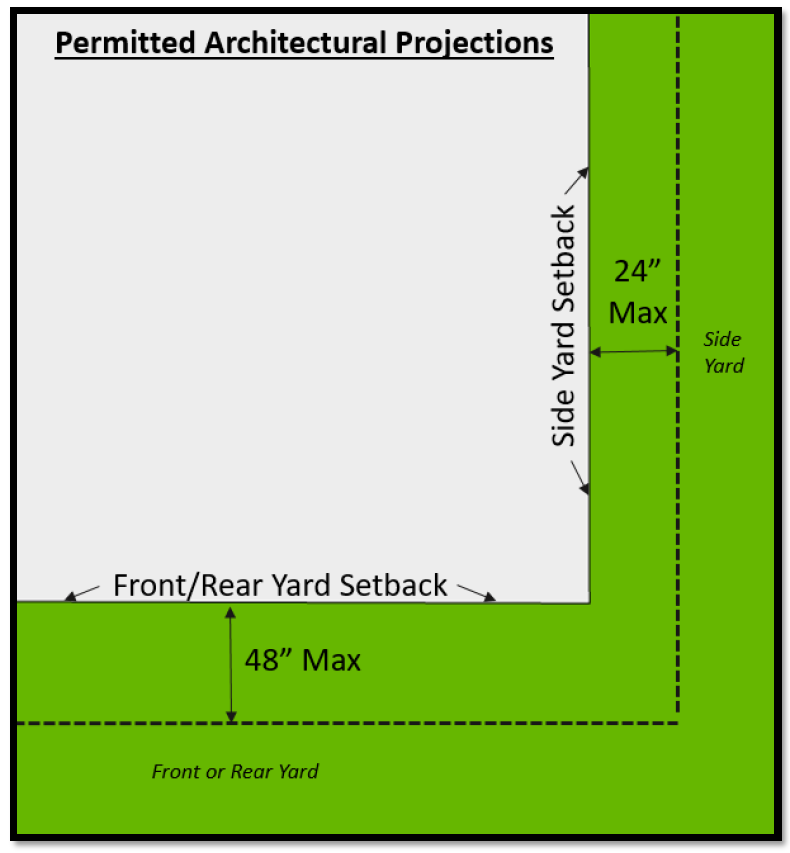
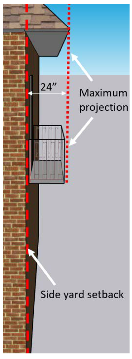
Figure 4 Permitted Structural Projections
(Ord. No. 90-24-253, § 3(Exh. A), 10-14-24)
Sec. 24-83. - Double frontage (through) lots and oceanfront lots.
(a)
Double frontage lots. Unless the prevailing front yard pattern on adjoining lots indicates otherwise or as set forth below, on double frontage lots within residential zoning districts the required front yard shall be provided on each street. For double frontage lots within non-residential zoning districts, the required front yard shall be provided on the street with the higher street classification, unless determined to be in conflict with the prevailing development pattern.
(b)
Special treatment of ocean-front lots. For lots having frontage on the Atlantic Ocean, the front yard shall be the yard which faces the Atlantic Ocean, and the required front yard shall be measured from the lot line parallel to or nearest the ocean.
(c)
Special treatment of Ocean Boulevard lots with double frontage (through lots). For double frontage (through) lots extending between Beach Avenue and Ocean Boulevard, the required front yard shall be the yard, which faces Ocean Boulevard.
(d)
Special treatment of Sailfish Drive lots with double frontage (through lots). For double frontage lots extending between Sailfish Drive and Donner Road or Sandpiper Lane, the required front yard shall be the yard which faces Sailfish Drive.
(Ord. No. 90-24-253, § 3(Exh. A), 10-14-24)
Sec. 24-84. - Lots of record and nonconforming lots of record.
(a)
Multiple lots and parcels treated as a single development parcel. In the case where more than one (1) parcel, platted lot or lot of record has been merged or combined and developed as a single development parcel, such lots shall not later be developed as a single lot, unless all requirements for development as a single lot are met including, but not limited to, minimum lot size requirements, impervious surface area limitations and provision of all required yards for all structures. See Figure 5.
(b)
Nonconforming lots of record.
(1)
Where a residentially-zoned lot or parcel of land does not conform with the requirements of the zoning district in which it is located, but was a legally established and documented lot of record prior to the adoption of this Code or previous codes and applicable City of Atlantic Beach ordinances, such lot or parcel of land may be used for single-family dwellings or residential dwellings consistent with the applicable zoning district regulations and density as designated in the comprehensive plan and this Code, provided the proposed development complies with the minimum yard requirements for the applicable residential zoning district. Multiple lots of record that have been merged or combined and developed as a single development parcel are subject to section 24-84(a) above and subsection (3) below.
(2)
In any zoning district, on a legally established and documented nonconforming lot of record, a structure may be expanded or enlarged provided such expansion or enlargement complies with other provisions of this chapter, including without limitation, yard requirements.
(3)
No lot or parcel in any zoning district shall be divided to create a lot with area, depth, or width less than the requirements of this chapter and the comprehensive plan.
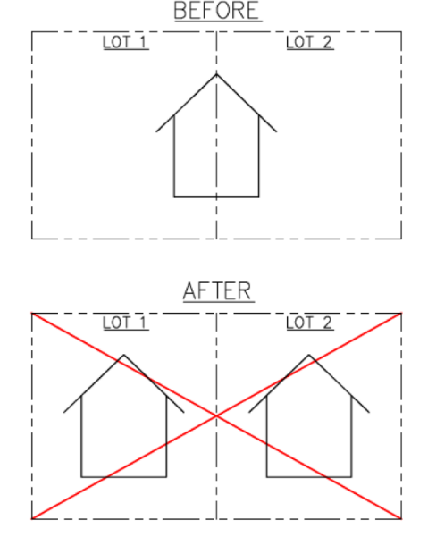
Figure 5 & Joining Lots of Record
(Ord. No. 90-24-253, § 3(Exh. A), 10-14-24)
Sec. 24-85. - Nonconforming structures and uses.
(a)
Intent. Within the established zoning districts, there exist structures, and uses of land that were lawful prior to the adoption or amendment of these land development regulations. Such uses and structures would be prohibited, restricted or regulated through the provisions of this chapter or the adopted comprehensive plan. It is the intent of this section to recognize the legal rights entitled to property owners of existing nonconforming uses and structures, and to permit such nonconformities to continue in accordance with such rights, but not to otherwise encourage their continued survival. Furthermore, the presence of any nonconforming characteristic shall not be considered as justification for the granting of variances, and any nonconforming structure or use, which is made conforming, shall not be permitted to revert to any nonconforming structure or use.
(b)
Nonconforming structures.
(1)
No nonconforming structure shall be expanded or enlarged unless such expansion or enlargement complies with the terms of this section and other applicable provisions of this chapter, including without limitation, building setbacks. See Figure 6 (Enlarging Non-Conforming Structures) below.
(2)
Any nonconforming structure, or portion thereof, that is declared unsafe by the city building official, may be restored to a safe condition. Building permits shall be required.
(3)
A nonconforming structure may be maintained, and repairs and alterations may be made subject to the provisions of this section.
(4)
No additions, expansions, or accessory structures may be constructed which would expand a nonconforming use of land.
(5)
Any existing nonconforming structure that is encroaching into public right-of-way shall not be rebuilt, enlarged, or structurally altered unless such encroachment is removed.
(6)
The voluntary demolition by the owner of any nonconforming structure or portion thereof shall constitute evidence of willful abandonment of such nonconformity (ies) and shall not be reconstructed and all construction thereafter shall comply with the terms of this chapter.
(7)
Notwithstanding the foregoing provisions, legal nonconforming residential structures which incur substantial damage by a natural event may be reconstructed within the previously existing footprint and height as lawfully permitted prior to the occurrence of the natural event provided that such reconstruction is started within one (1) year from such natural event and completed within three (3) years.
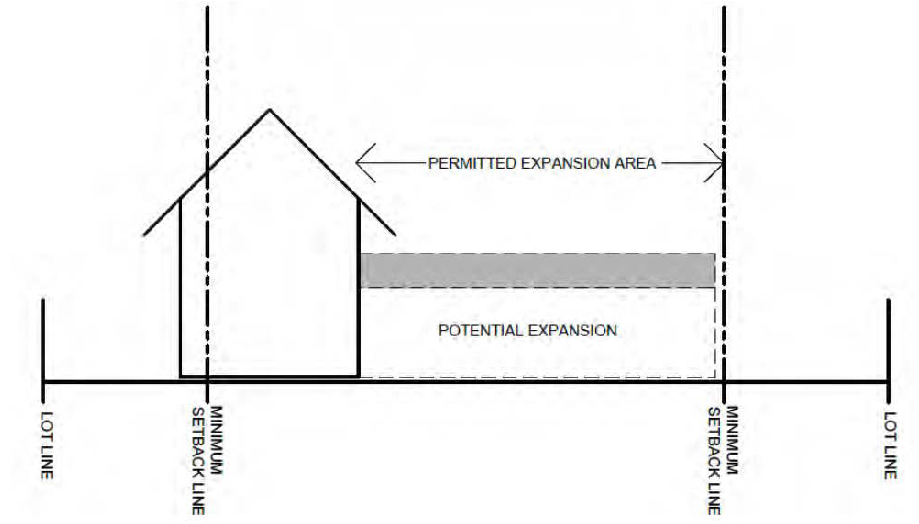
Figure 6 Enlarging Non-Conforming Structures
(c)
Nonconforming uses.
(1)
Continuation of nonconforming uses. Uses of land which were lawfully created at the time such uses were established, but which would not be permitted by the restrictions imposed by these land development regulations or by restrictions imposed by the comprehensive plan, may be continued so long as they remain otherwise lawful and in compliance with the provisions of this section.
(2)
Relocation or expansion of nonconforming uses. A nonconforming use shall not be moved in whole or in part to any other portion of the lot or parcel on which such nonconforming use is located, nor shall a nonconforming use be expanded or enlarged. No additions, expansions, or accessory structures may be constructed which would expand a nonconforming use of land.
(3)
Discontinuance of nonconforming uses. In the event that a nonconforming use of land is discontinued or abandoned for a period of six (6) months or longer, any subsequent use of such land shall conform to the applicable zoning district regulations as set forth within this chapter as well as applicable provisions of the comprehensive plan.
(4)
Natural event. Site improvements or structures located on properties containing a legal nonconforming use which incur substantial damage by a natural event may be reconstructed and the nonconforming use may be resumed as lawfully permitted prior to the occurrence of the natural event, provided that such reconstruction is started within one (1) year from such natural event and completed within three (3) years.
(5)
Voluntary demolition. The voluntary demolition by the owner of any structure containing a nonconforming use shall constitute evidence of willful abandonment of such use and may not be resumed.
(Ord. No. 90-24-253, § 3(Exh. A), 10-14-24)
Sec. 24-86. - Special treatment of lawfully existing two-family dwellings or townhouses affected by future amendments to the official zoning map or the land development regulations.
(a)
Changes to the official zoning map. In the case where a change in zoning district classification is made to the official zoning map, such that two-family (duplex) dwelling or townhouse uses are no longer authorized, any lawfully existing two-family (duplex) dwelling or townhouse, which has been constructed pursuant to properly issued building permits, shall be deemed a vested development, and any two-family (duplex) dwelling or townhouse shall be considered a lawful permitted use within the lot containing the vested development. Furthermore, an existing two-family (duplex) dwelling or townhouse use shall, for that particular use, not be considered as a nonconforming use such that it may be fully replaceable.
(b)
Amendments to the land development regulations. Any lawfully existing two-family (duplex) dwelling or townhouse, which has been constructed pursuant to properly issued building permits prior to the initial effective date of these land development regulations, shall be deemed a vested development, and any two-family (duplex) dwelling or townhouse shall be considered a lawful permitted use within the lot containing the vested development. Furthermore, an existing two-family (duplex) dwelling or townhouse shall, for that particular use, not be considered as a nonconforming use such that it may be fully replaceable.
(Ord. No. 90-24-253, § 3(Exh. A), 10-14-24)
Sec. 24-88. - Design and construction standards for two or more townhouse units.
(a)
Development of two (2) or more townhouse units, shall be allowed only where lot area is in compliance with the density limitations as set forth within the comprehensive plan and consistent with the applicable zoning district unless otherwise determined to be a vested development in accordance with the terms of this chapter. Within areas designated by the comprehensive plan for high density residential development, a minimum lot area of two thousand one hundred seventy-eight (2,178) square feet shall be required for each dwelling unit. For areas designated as medium density, a minimum lot area of three thousand one hundred twelve (3,112) square feet for each dwelling unit shall be required, and within areas designated by the comprehensive plan as low density, a minimum lot area of seven thousand two hundred sixty (7,260) square feet for each dwelling unit shall be required.
(b)
No more than six (6) townhouse units shall be constructed contiguous to each other without a separation of at least fifteen (15) feet between structures.
(c)
No more than two (2) abutting townhouse units shall have a common front building setback. Variations in the front setback shall be at least four (4) feet.
(d)
Townhouse lots shall have at least twenty five (25) feet of street frontage except when developed with rear access.
(e)
All zero lot line development shall provide covenants or other legally binding assurances that all zero lot line buildings can be maintained by the owner.
(f)
Development of townhouses, or conversion to townhouses, shall be allowed in compliance with Florida Building Codes related to adequate firewall separation. Further, development of townhouses, or conversion to townhouses, shall be allowed only in compliance with the applicable residential density as established by the comprehensive plan, and in accordance with this chapter as well as applicable provisions of Part I, Chapter 177, Florida Statutes.
(g)
Adjoining townhouse dwelling units shall be constructed at substantially the same time or in a contiguous sequence.
(Ord. No. 90-24-253, § 3(Exh. A), 10-14-24)
Sec. 24-89. - Stormwater, drainage, storage and treatment requirements.
(a)
Except as required to meet coastal construction codes as set forth within a valid permit from the Florida Department of Environmental Protection; or as required to meet applicable flood zone or stormwater regulations as set forth herein, the elevation or topography of a development or redevelopment site shall not be altered.
(b)
Topography and grading. All lots and development sites shall be constructed and graded in such a manner so that the stormwater drains to the adjacent street, an existing natural element used to convey stormwater, or a city drainage structure after meeting onsite storage requirements, as set forth within this section. The city shall be provided with a pre-construction topographical survey prior to the issuance of a development permit and a post-construction topographical survey prior to the issuance of a certificate of occupancy. Elevations in all topographic surveys will be referenced to NAVD 1988. Said surveys shall be signed and sealed by a licensed Florida surveyor. All new developments and redevelopments shall provide assurance that adjacent or nearby properties not owned or controlled by the applicant will not be adversely affected by drainage or flooding.
(c)
Onsite storage. Except as provided for herein, an applicant shall be required to provide onsite storage of stormwater in accordance with this section as follows:
(1)
Projects which increase the impervious surface on the development parcel by more than four hundred (400) square feet shall provide onsite storage of stormwater for the increase in the impervious surface area only. The four hundred (400) square feet of impervious surface area shall be calculated cumulatively from the adoption date of this ordinance.
(2)
Any modification or replacement of driveway and sidewalk areas only on a developed lot shall not be required to provide onsite storage improvements provided the modification or replacement does not alter the footprint of the existing driveway or sidewalk area.
(3)
Applicants shall provide documentations and calculations to demonstrate compliance with submittal of applications for construction.
(4)
Projects permitted by the St. Johns River Water Management District (SJRWMD), which have an in-compliance existing retention or detention areas that collect and control stormwater are exempt for further onsite storage requirements; provided, however, a copy of the engineer's certification of as-built construction to the SJRWMD must be submitted to the city before building permits for individual lot construction may be issued.
(5)
When onsite storage is required, an as-built survey, signed and sealed by a licensed Florida surveyor, documenting proper construction and required volume of the storage system, must be submitted to and approved by the director of public works prior to permit closeout or issuance of a certificate of occupancy. For an under-ground system, a notarized letter from the general contractor, along with as-built plans and construction photographs will be sufficient to document proper construction.
(6)
In addition, a declaration of restrictive covenant, in recordable form and approved by the city, identifying and describing the required on-site storage improvements to be maintained, shall be executed and recorded in the public records of Duval County, Florida, by the owner of the development parcel and shall be binding on successors and assigns, prior to permit closeouts or issuance of a certificate of occupancy.
(7)
Volume calculations for any projects that require onsite storage shall be based on the following calculation:
V = CAR/12, where
V = volume of storage in cubic feet,
A = total impervious area,
R = 25-year and 24-hour rainfall depth (9.3 inches) over the lot area, and
C = runoff coefficient, which is the difference between impervious area (C=1.0) and undeveloped conditions (C=0.08).
This volume must be stored at least one (1) foot above the wet season water table and below the overflow point to offsite (in many cases this may be the adjacent road elevation). As an option, and as approved by the director of public works, an applicant may implement, at the applicant's cost, offsite storage and necessary conveyance to control existing flood stages offsite, provided documentation showing appropriate authorization for the off-site use and meeting the requirements of this section is submitted and approved by the city.
(d)
Floodplain storage. There shall be no net loss of storage for areas in a special flood hazard area (100-year floodplain), where a base flood elevation has been defined by the Federal Emergency Management Agency (FEMA) on flood insurance rate maps (FIRMs). Site grading shall create storage onsite to mitigate for filling of volume onsite. This storage is in addition to the storage required for the increase in impervious surface area. The applicant shall provide signed and sealed engineering plans and calculations documenting that this "no net loss" requirement is met.
(e)
Stormwater treatment. For all new development or redevelopment of existing properties, excluding single- and two-family uses, where construction meets limits for requiring building code upgrades, stormwater treatment shall be provided for a volume equivalent to either retention or detention with filtration, of the runoff from the first one (1) inch of rainfall; or as an option, for facilities with a drainage area of less than one hundred (100) acres, the first one-half (½) inch of runoff pursuant to Chapter 62-330, Florida Administrative Code (FAC). No discharge from any stormwater facility shall cause or contribute to a violation of water quality standards as provided in Section 62-302, FAC. This treatment volume can be included as part of the onsite storage requirement in subsection (b) of this section.
(f)
NPDES requirements. All construction activities shall be in conformance with the city's National Pollutant Discharge Elimination Systems (NPDES) permit, in addition to the requirements of the St. Johns River Water Management District and the Florida Department of Environmental Protection. NPDES requirements include use of best management practices (BMPs) prior to discharge into natural or artificial drainage systems. All construction projects of one (1) acre or more require a stand-alone NPDES permit. Site clearing, demolition and construction on any size site may not commence until site inspection and approval of the proper installation of a required best management practices erosion and sediment control plan is completed.
(g)
Enforcement. Subsequent to approval of a property owner's final grading, including onsite and/or floodplain storage and stormwater treatment and closeout of the applicable permit or issuance of certificates of occupancy, the improvements shall be maintained by the property owner. In order to ensure compliance with the provisions of this section and the requirements to maintain onsite stormwater improvements over time, the city is authorized to conduct inspections of property, upon reasonable notice and at reasonable times, for the purpose of inspecting said property and/or onsite storage improvements for compliance with this section and with any applicable conditions of previously issued permits. Failure to maintain the improvements will require restoration upon notification by the director of public works, within a stipulated time frame. If restoration is not timely completed, the city shall have the right to complete the restoration, and the city's actual cost incurred, together with a charge of one hundred (100) percent of said costs to cover the city's administrative expenses, shall be charged to the then owner of the property.
(h)
Variances to impervious surface area limits. Variances to impervious surface limits shall be subject to the provisions in section 24-65. Impervious surface requirements shall not be eligible for relief via waivers from the city commission.
(Ord. No. 90-24-253, § 3(Exh. A), 10-14-24)
Sec. 24-90. - Minimum building elevation.
(a)
Buildings and structures that are within a special flood hazard area are subject to the requirements of the Florida Building Code and chapter 8, Flood Hazard Areas.
(b)
Non-residential buildings that are not within a special flood hazard area shall comply with the minimum finished floor of the Florida Building Code.
(c)
Residential buildings, including additions thereto, that are not within a special flood hazard area shall have a finished floor elevation for all living areas at or above the higher of:
(1)
Eight and one-half (8.5) feet NAVD.
(2)
The minimum required by the Florida Building Code.
(Ord. No. 90-24-253, § 3(Exh. A), 10-14-24)
Sec. 24-91. - Building height.
(a)
Maximum height. In no case shall the maximum height of a building within the city exceed thirty five (35) feet in height; provided however, that existing buildings which exceed thirty five (35) feet in height may be repaired to that existing height, no alterations shall be made to any building, which would cause that building to exceed thirty five (35) feet in height.
(b)
Measurement. The height of a building shall mean the vertical distance from the applicable beginning point of measurement to the highest point of a building's roof structure or parapet, and any attachments thereto, exclusive of chimneys. The appropriate method of determining maximum allowable height of a building shall be used in accordance with the following:
(1)
Buildings within, or partially within, a special flood hazard area as delineated on the FEMA flood insurance rate map (FIRM) shall use the minimum finished floor elevation as the beginning point of measurement.
(2)
Oceanfront parcels, regardless of flood zone designation, shall use the calculated average grade of the buildable area, as described in subsection (c) below, as the beginning point of measurement.
(3)
Buildings that are not within a special flood hazard area on parcels that have more than two (2) feet of topographic variation shall use the calculated average grade of the buildable area, as described in subsection (c) below, as the beginning point of measurement. This does not include those parcels where the topographic variation is a city-maintained drainage easement or facility.
(4)
Buildings on parcels that do not have more than two (2) feet of topographic variation and are not within a special flood hazard area shall use the highest pre-construction grade as the beginning point of measurement.
(5)
All accessory structures and buildings shall be measured from the lowest adjacent grade.
(c)
Calculated average grade.
(1)
The calculated average grade shall be determined by the mathematical average of elevation points dispersed at approximately ten-foot equidistant intervals across the buildable area of a parcel. For sites where natural topography has been previously altered or where existing structures remain, this same method shall be used excluding areas where existing structures remain.
(2)
Where required, the certified average grade survey shall be submitted with construction plans, and the average grade shall be depicted on exterior elevation sheets of construction plans.
(3)
Alteration of topography for the purpose of achieving greater height of building is prohibited.
(d)
Height survey required. If the height of a principal building is within one (1) foot of the maximum building height allowed under this section, a survey verifying the building's height may be required.
(Ord. No. 90-24-253, § 3(Exh. A), 10-14-24)
Sec. 24-101.- Intent and purpose.
The City of Atlantic Beach shall be divided by these land development regulations into zoning districts, as listed and described below. These divisions and the requirements set forth herein shall have the purpose of implementing the goals, objectives and policies of the comprehensive plan. Tables 1, 2, and 3 are quick reference guides to residential lot and structure requirements, abbreviations and permitted uses. The following is established in this division:
(a)
The intent of each zoning district.
(b)
General requirements for each zoning district, including:
(1)
Permitted uses.
(2)
Uses-by-exception.
(3)
Minimum lot size.
(4)
Minimum yard requirements.
(5)
Building restrictions.
(6)
Impervious surface.
Table 1 Residential Lot and Structure Requirements
Disclaimer: This table is intended to be a quick reference guide, actual policy language controls in the event of conflicts.
(Ord. No. 90-24-253, § 3(Exh. A), 10-14-24)
Sec. 24-102. - Zoning districts established.
(a)
Uses. Where a proposed use is not specifically listed under permitted or uses by exception, the permissibility of the use will be determined based upon its similarity to listed uses and the compatibility and potential for adverse impacts to existing nearby uses. Permitted uses in any zoning district shall not include adult entertainment establishments, indoor or outdoor firing ranges, indoor or outdoor flea markets, vendors on public rights-of-way, amusement or game centers, pawn shops, bingo halls, game arcades, gaming, video poker establishments, computer game centers, or games played on individual game machines or computers, including any type of card, token or coin-operated video or simulated games or similar activities or machines which are played for any type of compensation or reward.
(b)
The municipal area of the City of Atlantic Beach is hereby divided into the following zoning districts:
Table 2 Zoning Districts
Disclaimer: This table is intended to be a quick reference guide, actual policy language controls in the event of conflicts.
All development of land and parcels within the residential zoning districts shall comply with the residential density limitations as set forth within the adopted comprehensive plan for the City of Atlantic Beach, as may be amended.
Table 3 Permitted Uses
* Subject to additional standards.
Disclaimer: This table is intended to be a quick reference guide, actual policy language controls in the event of conflicts.
(Ord. No. 90-24-253, § 3(Exh. A), 10-14-24)
Sec. 24-103. - Conservation district (CON).
(a)
Intent. The conservation district is composed mostly of open land, water, marsh and wetland areas, consisting primarily of the public River Branch, Dutton Island and Tide Views Preserves. It is intended that the natural and open character of these areas be retained and that adverse impacts to these environmentally sensitive areas, which may result from development, be minimized. To achieve this intent, uses allowed within the conservation districts shall be limited to certain conservation, recreation, very low intensity uses that are not in conflict with the intent of this district, the comprehensive plan or any other applicable federal, state and local policies and permitting requirements.
(b)
Permitted uses. Uses permitted within the conservation district shall be limited to the following:
(1)
Cemetery limited to those lands owned by the existing cemetery as of the January 1, 2002 initial effective date of these land development regulations.
(2)
Nature preserves, public natural resource-based parks, and passive recreational uses and facilities as needed to support such uses.
(3)
Kayak, canoe rentals, and vendors limited to providing equipment or supplies as needed to use these natural resources subject to approval by the city commission.
(4)
Government uses, buildings, and facilities.
(Ord. No. 90-24-253, § 3(Exh. A), 10-14-24)
Sec. 24-104. - Residential, single-family—large lot district (RS-L).
(a)
Intent. The RS-L zoning district is intended for development of low density single-family residential uses in areas where traditional established lot sizes are larger than those typically located throughout the City of Atlantic Beach.
(b)
Permitted uses. The uses permitted within the RS-L zoning district shall be:
(1)
Single-family dwellings.
(2)
Accessory uses (see section 24-151).
(3)
Government uses, buildings and facilities.
(4)
Family day care homes.
(5)
Community residential homes, small.
(c)
Uses-by-exception. Within the RS-L zoning district, the following uses-by-exception may be permitted.
(1)
Churches, subject to the provisions of section 24-153.
(2)
Public and private recreational facilities not of a commercial nature and of a neighborhood scale intended to serve the surrounding residential neighborhood.
(3)
Schools.
(d)
Minimum lot size. Existing legally established lots of record may exist, which do not meet the following lot width, depth or area requirements. These lots may be developed subject to section 24-84(a) and all other applicable land development regulations; however, all lots created after the February 27, 2006 effective date of Ordinance 90-06-189, shall comply with these minimum lot size requirements in order to obtain building permits authorizing development.
The minimum size for lots within the RS-L zoning district shall be:
(1)
Minimum lot or site area: Ten thousand (10,000) square feet.
(2)
Minimum lot width: One hundred (100) feet.
(3)
Minimum lot depth: One hundred (100) feet.
(e)
Minimum yard requirements. The minimum yard requirements in the RS-L zoning district shall be:
(1)
Front yard: Twenty (20) feet.
(2)
Rear yard: Twenty (20) feet.
(3)
Side yard:
a.
Interior: Seven and one-half (7.5) feet.
b.
Corner: Ten (10) feet.
Where there is a platted building restriction line that is greater than the minimum yards listed above, the building restriction line shall be enforced.
(f)
Building restrictions. Additional building restrictions within the RS-L zoning district shall be:
(1)
Maximum impervious surface: Forty-five (45) percent; provided, however, where lawfully existing structures and improvements on a parcel exceed this applicable percentage, additions/modifications to such structures and improvements shall not exceed the pre-existing impervious surface percentage, provided the requirements of section 24-89 are met. However, new development and major remodels shall not exceed forty-five (45) percent regardless of the existing impervious surface percentage.
(2)
Maximum building height: Thirty-five (35) feet.
(Ord. No. 90-24-253, § 3(Exh. A), 10-14-24)
Sec. 24-105. - Residential, single-family district (RS-1).
(a)
Intent. The RS-1 zoning district is intended for development of low density single-family residential areas.
(b)
Permitted uses. The uses permitted within the RS-1 zoning district shall be:
(1)
Single-family dwellings.
(2)
Accessory uses (see section 24-151).
(3)
Government uses, buildings and facilities.
(4)
Family day care homes.
(5)
Community residential homes, small.
(c)
Uses-by-exception. Within the RS-1 zoning district, the following uses-by-exception may be permitted.
(1)
Churches, subject to the provisions of section 24-153.
(2)
Public and private recreational facilities not of a commercial nature and of a neighborhood scale intended to serve the surrounding residential neighborhood.
(3)
Schools.
(d)
Minimum lot area. Existing legally established lots of record may exist, which do not meet the following requirements. These lots may be developed subject to section 24-84(a) and all other applicable land development regulations; however, all lots created after January 1, 2002 must comply with these minimum lot size requirements in order to obtain building permits authorizing development.
The minimum size for lots within the RS-1 zoning district, shall be:
(1)
Lot or site area: Seven thousand five hundred (7,500) square feet.
(2)
Lot width: Seventy-five (75) feet.
(3)
Lot depth: One hundred (100) feet.
(e)
Minimum yard requirements. The minimum yard requirements in the RS-1 zoning district shall be:
(1)
Front yard: Twenty (20) feet.
(2)
Rear yard: Twenty (20) feet.
(3)
Side yard:
a.
Interior: Seven and one-half (7.5) feet.
b.
Corner: Ten (10) feet.
Where there is a platted building restriction line that is greater than the minimum yards listed above, the building restriction line shall be enforced.
(f)
Building restrictions. Building restrictions within the RS-1 zoning district shall be:
(1)
Maximum impervious surface: Forty-five (45) percent; provided, however, where lawfully existing structures and improvements on a parcel exceed this applicable percentage, additions/modifications to such structures and improvements shall not exceed the pre-existing impervious surface percentage, provided the requirements of section 24-89 are met. However, new development and major remodels shall not exceed fort-five (45) percent regardless of the existing impervious surface percentage.
(2)
Maximum building height: Thirty-five (35) feet.
(Ord. No. 90-24-253, § 3(Exh. A), 10-14-24)
Sec. 24-106. - Residential, single-family district (RS-2).
(a)
Intent. The RS-2 zoning district is intended to apply to predominately developed areas of single-family dwellings with platted lots that are smaller than those in the RS-1 zoning district.
(b)
Permitted uses. The uses permitted within the RS-2 zoning district shall be:
(1)
Single-family dwellings.
(2)
Accessory uses (see section 24-151).
(3)
Government uses, buildings and facilities.
(4)
Family day care homes.
(5)
Community residential homes, small.
(c)
Uses-by-exception. Within the RS-2 zoning district, the following uses-by-exception may be permitted:
(1)
Churches, subject to the provisions of section 24-153.
(2)
Public and private recreational facilities not of a commercial nature and of a neighborhood scale intended to serve the surrounding residential neighborhood.
(3)
Schools.
(d)
Minimum lot area. Existing legally established lots of record may exist, which do not meet the following requirements. These lots may be developed subject to section 24-84(a) and all other applicable land development regulations; however, all lots created after January 1, 2002 must comply with these minimum lot size requirements in order to obtain building permits authorizing development. The minimum size for lots within the RS-2 zoning district, shall be:
(1)
Lot or site area: Seven thousand five hundred (7,500) square feet.
(2)
Lot width: Seventy-five (75) feet.
(3)
Lot depth: One hundred (100) feet.
(4)
Notwithstanding subsections 1, 2 and 3, the final lot sizes for new townhouse development developed in accordance with section 24-86 may be less per unit.
(e)
Minimum yard requirements. The minimum yard requirements within the RS-2 zoning district shall be:
(1)
Front yard: Twenty (20) feet.
(2)
Rear yard: Twenty (20) feet.
(3)
Side yard:
a.
Single-family. Combined fifteen (15) total feet and five (5) minimum feet on either side.
b.
Duplex (as permitted by Section 24-86). Seven and one-half (7.5) feet each side.
c.
Townhouse (as permitted by Section 24-86).
(1)
New construction:
i.
Exterior side yard: Seven and one-half (7.5) feet.
ii.
Interior side yard (shared lot line): Zero (0) feet.
(2)
Additions to existing townhouse units:
i.
Exterior side yard: Seven and one-half (7.5) feet.
ii.
Interior side yard: Seven and one-half (7.5) feet for additions that are forward of the existing front plane of the townhouse unit.
iii.
Interior side yard: Zero (0) feet for additions that are behind the existing front plane of the townhouse unit.
d.
Corner lots. The side yard adjacent to a right-of-way containing a street shall be ten (10) feet.
Where there is a platted building restriction line that is greater than the minimum yards listed above, the building restriction line shall be enforced.
(f)
Building restrictions. Building restrictions within the RS-2 zoning district shall be:
(1)
Maximum impervious surface: Forty-five (45) percent; provided, however, where lawfully existing structures and improvements on a parcel exceed this applicable percentage, additions/modifications to such structures and improvements shall not exceed the pre-existing impervious surface percentage, provided the requirements of section 24-89 are met. However, new development and major remodels shall not exceed forty-five (45) percent regardless of the existing impervious surface percentage.
(2)
Maximum building height: Thirty-five (35) feet.
(Ord. No. 90-24-253, § 3(Exh. A), 10-14-24)
Sec. 24-107. - Residential, two-family district (RG).
(a)
Intent. The RG zoning district is intended for development of low and medium density single-family and two-family residential uses.
(b)
Permitted uses. The uses permitted within the RG zoning district shall be:
(1)
Single-family dwellings.
(2)
Two-family (duplex) dwellings, subject to density limitations.
(3)
Accessory uses as set forth in section 24-151.
(4)
Two-unit townhouses, subject to density limitations, compliance with article IV, subdivision regulations and section 24-88.
(5)
Government uses, buildings and facilities.
(6)
Family day care homes.
(7)
Community residential homes, small.
(c)
Uses-by-exception. The following uses may be approved as a use-by-exception within the RG zoning district.
(1)
Child care facilities.
(2)
Churches.
(3)
Public and private recreational facilities not of a commercial nature and of a neighborhood scale intended to serve the surrounding residential neighborhood.
(4)
Schools and community centers.
(d)
Minimum lot area. Existing legally established lots of record may exist, which do not meet the below requirements. These lots may be developed subject to section 24-84(a) and all other applicable land development regulations and density limitations; however, all lots created after January 1, 2002 must comply with the following minimum requirements in order to obtain building permits authorizing development. The minimum size for lots within the RG zoning district shall be as set forth herein.
(1)
Minimum lot area in the RG zoning district:
a.
Residential low density: seven thousand two hundred sixty (7,260) square feet per dwelling unit.
b.
Residential medium density: three thousand one hundred twelve (3,112) square feet per dwelling unit.
(2)
Minimum lot width in the RG zoning district: Fifty (50) feet.
(3)
Minimum lot depth in the RG zoning district: One hundred (100) feet.
(4)
Notwithstanding subsections 1, 2 and 3, the final lot sizes for proposed new townhouse development may be less per unit, subject to density, compliance with article IV, Subdivision Regulations and section 24-88.
(e)
Minimum yard requirements. The minimum yard requirements within the RG zoning district shall be:
(1)
Front yard: Twenty (20) feet.
(2)
Rear yard: Twenty (20) feet.
(3)
Side yard:
a.
Single-family. Combined fifteen (15) feet and five (5) minimum feet on either side.
b.
Duplex. Seven and one-half (7.5) feet each side.
c.
Townhouse.
(1)
New construction:
i.
Exterior side yard: Seven and one-half (7.5) feet.
ii.
Interior side yard (shared lot line): zero (0) feet
(2)
Additions to existing townhouse units:
i.
Exterior side yard: Seven and one-half (7.5) feet.
ii.
Interior side yard: Seven and one-half (7.5) feet for additions that are forward of the existing front plane of the townhouse unit.
iii.
Interior side yard: Zero (0) feet for additions that are behind the existing front plane of the townhouse unit.
d.
Corner lots. The side yard adjacent to a right-of-way containing a street shall be ten (10) feet.
Where there is a platted building restriction line that is greater than the minimum yards listed above, the building restriction line shall be enforced.
(f)
Building restrictions. The building restrictions for the RG zoning district shall be:
(1)
Maximum impervious surface: Forty-five (45) percent; provided, however, where lawfully existing structures and improvements on a parcel exceed this applicable percentage, modifications to such structures and improvements shall not exceed the pre-existing impervious surface percentage, provided the requirements of section 24-89 are met. However, new development and major remodels shall not exceed forty-five (45) percent regardless of the existing impervious surface percentage.
(2)
Maximum building height: Thirty-five (35) feet.
(Ord. No. 90-24-253, § 3(Exh. A), 10-14-24)
Sec. 24-108. - Residential, multi-family district (RG-M).
(a)
Intent. The RG-M zoning district is intended for development of medium to high-density multi-family residential areas.
(b)
Permitted uses. The uses permitted within the RG-M zoning district shall be:
(1)
Single-family dwellings.
(2)
Two-family (duplex) dwellings subject to density limitations.
(3)
Townhouses, subject to density limitations, compliance with article IV, Subdivision Regulations and section 24-88.
(4)
Multi-family dwellings, subject to density limitations.
(5)
Accessory uses as set forth in section 24-151.
(6)
Government buildings and facilities.
(7)
Family day care homes and group care homes.
(8)
Community residential homes, small and large.
(9)
Foster care homes.
(10)
Assisted living facilities with less than fifteen (15) residents.
(c)
Uses-by-exception. The following uses may be approved as a use-by-exception within the RG-M zoning district:
(1)
Churches.
(2)
Public and private recreation facilities not of a commercial nature and of a neighborhood scale intended to serve the surrounding residential neighborhood.
(3)
Child care facilities.
(4)
Schools and community centers.
(5)
Assisted living facilities with fifteen (15) or more residents.
(d)
Minimum lot area. Existing legally established lots of record may exist, which do not meet the following requirements. These lots may be developed subject to section 24-84(a) and all other applicable land development regulations and density limitations; however, all lots created after January 1, 2002, must comply with these minimum lot size requirements in order to obtain building permits authorizing development. The minimum size for lots within the RG-M zoning district shall be as set forth herein.
(1)
Minimum lot or site area:
a.
Residential low density: seven thousand two hundred sixty (7,260) square feet per dwelling unit.
b.
Residential medium density: three thousand one hundred twelve (3,112) square feet per dwelling unit.
c.
Residential high density: two thousand one hundred seventy-eight (2,178) square feet per dwelling unit.
(2)
Minimum lot width in the RG-M zoning district: Forty (40) feet.
(3)
Minimum lot depth in the RG-M zoning district: One hundred (100) feet.
(4)
Notwithstanding subsections 1, 2 and 3, the final lot sizes for proposed new townhouse development may be less per unit, subject to density, compliance with article IV, Subdivision Regulations and section 24-88.
(e)
Minimum yard requirements. The minimum yard requirements in the RG-M zoning are:
(1)
Front yard: Twenty (20) feet.
(2)
Rear yard: Twenty (20) feet.
(3)
Side yard:
a.
Single-family dwellings: Combined fifteen (15) total feet and five (5) minimum feet on either side.
b.
Two-family (duplex) dwellings: Seven and one-half (7.5) feet each side.
c.
Townhouse dwellings:
(1)
New construction: Seven and one-half (7.5) feet exterior side yard and zero (0) feet for the interior side yard (shared lot line).
(2)
Additions to existing townhouse dwellings:
i.
Exterior side yard: Seven and one-half (7.5) feet.
ii.
Interior side yard: Seven and one-half (7.5) feet for additions that are forward of the existing front plane of the townhouse unit.
iii.
Interior side yard: Zero (0) feet for additions that are behind the existing front plane of the townhouse unit.
c.
Multi-family dwellings or non-residential structures: Fifteen (15) feet each side.
d.
Corner lots: The side yard adjacent to a right-of-way containing a street shall be ten (10) feet minimum.
Where there is a platted building restriction line that is greater than the minimum yards listed above, the building restriction line shall be enforced.
(f)
Building restrictions. The building restrictions for the RG-M zoning district shall be as follows:
(1)
Maximum impervious surface: Forty-five (45) percent; provided, however, where lawfully existing structures and improvements on a parcel exceed this applicable percentage, additions/modifications to such structures and improvements shall not exceed the pre-existing impervious surface percentage, provided the requirements of section 24-89 are met. However, new development and major remodels shall not exceed forty-five (45) percent regardless of existing impervious surface percentage.
(2)
Maximum building height: Thirty-five (35) feet.
(Ord. No. 90-24-253, § 3(Exh. A), 10-14-24)
Sec. 24-109. - Residential, Selva Marina district (R-SM).
(a)
Intent. The R-SM zoning district is intended for development of single-family residential areas that were originally developed as Selva Marina and Selva Tierra Planned Unit Developments (PUDs) during the 1970s and 1980s. All development of land and parcels within the R-SM zoning district shall comply with the residential density limitations as set forth within the adopted comprehensive plan for the City of Atlantic Beach, as may be amended. The R-SM district is unique because it replaces eleven (11) separate PUDs with varying design requirements. Standard R-SM zoning district design requirements shall apply to each lot unless otherwise specified.
(b)
Permitted uses. The uses permitted within the R-SM zoning district shall be:
(1)
Single-family dwellings.
(2)
Accessory uses subject to the provisions of section 24-151.
(3)
Community residential homes, small.
(4)
Family day care homes.
(c)
Accessory structures. Accessory structures are subject to the provisions of section 24-151.
(d)
Uses-by-exception. Within the R-SM zoning district, the following uses-by-exception may be permitted:
(1)
Public and private recreation facilities not of a commercial nature and of a neighborhood scale intended to serve the surrounding residential neighborhood.(e) Minimum lot area. Legally established lots of record may exist, which do not meet the requirements of this section. These lots may be developed subject to section 24-84(a) and all other applicable land development regulations; however, all lots created after January 14, 2019 must comply with the following minimum lot size requirements in order to obtain building permits authorizing development.
The minimum size for lots within the R-SM zoning district, which are created after January 14, 2019, shall be:
(1)
Lot area: Nine thousand (9,000) square feet.
(2)
Lot width: Ninety (90) feet.
(3)
Lot depth: One hundred (100) feet.
(f)
Minimum yard requirements. The R-SM zoning district has minimum standard yard requirements and alternative requirements for lots with frontage on Selva Grande Drive, Tierra Verde Drive, Sea Oats Drive, Seminole Road, Saturiba Drive, and 19th Street except for accessory structures as provided in paragraph C above. The minimum yard requirements in the R-SM zoning district are shown in Figure 7 below and shall be:
(1)
Standard front yard: Twenty (20) feet except as follows:
a.
Lots fronting on Selva Grande Drive: Twenty-five (25) feet.
b.
Lots fronting on Tierra Verde Drive: Twenty-five (25) feet.
c.
Lots fronting on Sea Oats Drive and south of 19th Street:
i.
Platted building restriction line of thirty (30) feet along Sea Oats Drive.
ii.
Platted building restriction line of twenty-five (25) feet along Saturiba Drive.
iii.
Platted building restriction line of twenty-five (25) feet along 19th Street.
d.
Lots fronting Seminole Road and south of 19th Street:
i.
Platted building restriction line of twenty-five (25) feet along Seminole Road.
ii.
Platted building restriction line of twenty-five (25) feet along Saturiba Drive.
iii.
Platted building restriction line of twenty-five (25) feet along 19th Street.
(2)
Standard rear yard: Twenty (20) feet except as follows:
a.
Lots fronting Sea Oats Drive and south of 19th Street: Thirty (30) feet.
b.
Lots fronting Seminole Road and south of 19th Street: Thirty (30) feet.
(3)
Standard side yard: Ten (10) feet except as follows:
a.
Lots fronting Sea Oats Drive and south of 19th Street: Fifteen (15) feet.
b.
Lots fronting Seminole Road and south of 19th Street: Fifteen (15) feet.
(4)
If any ambiguity or inconsistencies for R-SM setbacks arise, Figure 7 below shall control.
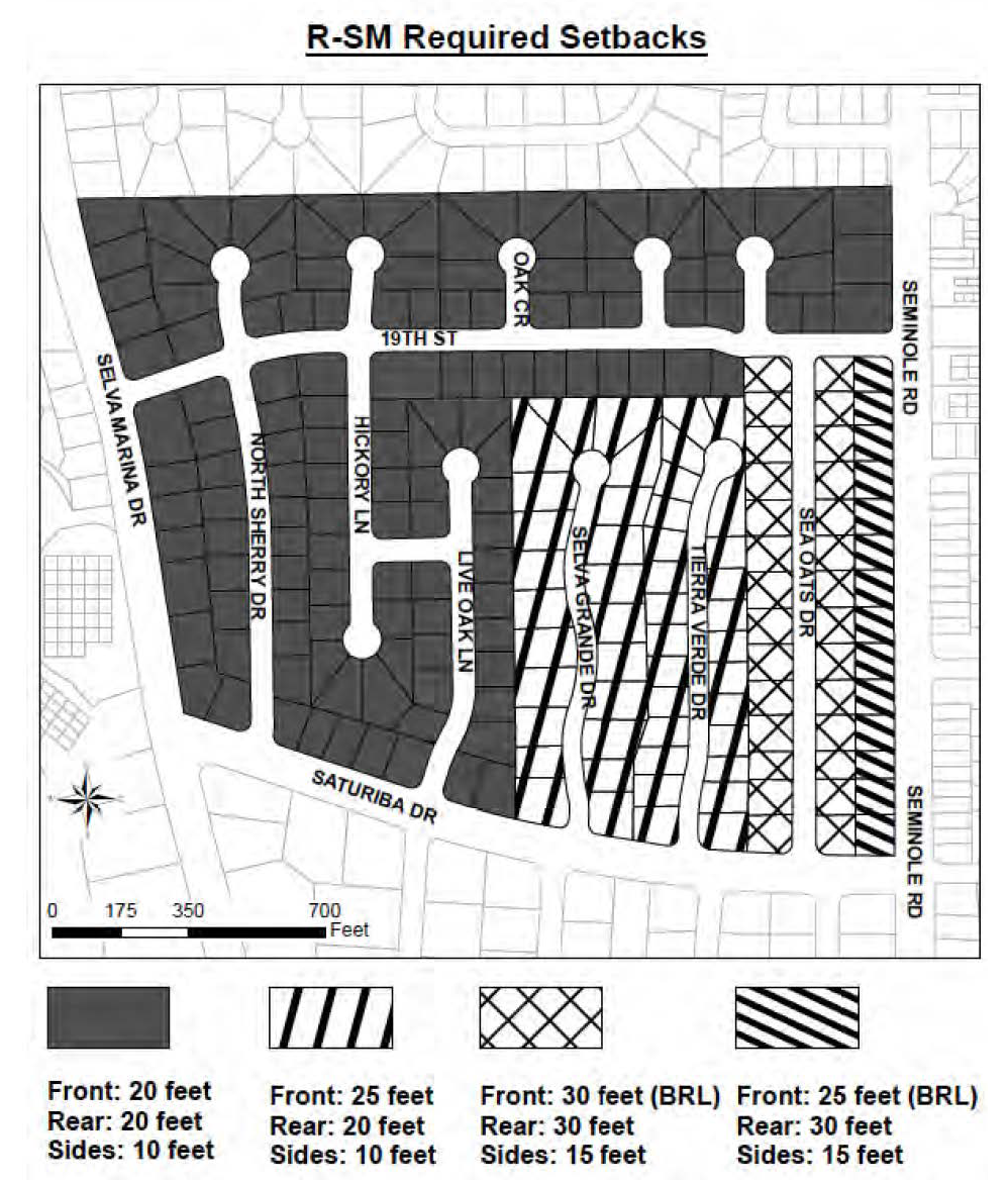
Figure 7 R-SM Required Setbacks
(g)
Building restrictions. The following building restrictions shall apply within the R-SM zoning district:
(1)
Maximum impervious surface: Forty-five (45) percent; provided, however, where lawfully existing structures and improvements on a parcel exceed this applicable percentage, additions/modifications to such structures and improvements shall not exceed the pre-existing impervious surface percentage, provided the requirements of section 24-89 are met. However, new development and major remodels shall not exceed forty-five (45) percent regardless of the existing impervious surface percentage.
(2)
Maximum building height: Thirty-five (35) feet.
(h)
Minimum living area. Minimum living areas for the R-SM zoning district shall be:
(1)
One story: one thousand four hundred fifty (1,450) square feet.
(2)
Two story: one thousand six hundred (1,600) square feet.
(i)
Effect on existing structures and lots. Any structure or lot in existence and in compliance with all applicable city Code requirements in effect prior to the adoption of this section, or lawfully under construction on January 14, 2019, that would become non-conforming by virtue of the adoption of this section shall be regulated pursuant to section 24-85, provided that section 24-85(b)(6) shall not be applicable to reconstruction within the R-SM zoning district. If the city has issued any development permit authorizing uses and or structures prior to the public notice of this section on October 19, 2018, compliance with the provisions of the city's ordinances, including this chapter without limitation, in effect at the time of approval shall apply to such development permit.
(Ord. No. 90-24-253, § 3(Exh. A), 10-14-24)
Sec. 24-110. - Commercial, professional office district (CPO).
(a)
Intent. The CPO zoning district is intended for small, neighborhood scale professional offices with residential design characteristics that make such uses compatible with nearby residential uses.
(b)
Permitted uses. The uses permitted within the CPO zoning district shall be:
(1)
Medical and dental offices (but not hospital), such as chiropractor offices, licensed massage therapist offices, and other health practitioners.
(2)
Professional offices, such as accountant, architect, attorney, engineer, land surveyor, optometrist and similar uses.
(3)
Business offices such as real estate broker, insurance agent, stockbroker and similar uses.
(4)
Single-family dwelling units.
(5)
Child care facilities, in accordance with section 24-152.
(6)
Mixed use projects combining the above permitted uses and those approved as a use-by-exception pursuant to subsection (d) below.
(c)
Limitations. All uses within the CPO zoning district shall be subject to the following standards:
(1)
No outside retail sales, display or storage of merchandise or business activities shall be permitted.
(2)
No vehicles other than typical passenger automobiles, and no trucks exceeding three-quarter-ton capacity, shall be parked on a daily or regular basis within CPO zoning districts.
(3)
No manufacture, repair, mechanical, service or similar work shall be permitted, and no machinery shall be used other than normal office equipment such as typewriters, calculators, computers, bookkeeping machines shall be used in association with any use located within the CPO zoning districts.
(d)
Uses-by-exception. Within the CPO zoning district, the following uses may be approved as a use-by-exception.
(1)
Limited retail sales in conjunction with a permitted professional service being rendered at the time.
(2)
Church or community center.
(3)
Medical or dental laboratory; manufacture of prosthetic appliances, dentures, eyeglasses, hearing aids and similar products.
(4)
Low intensity service establishments such as barber or beauty shops, shoe repair, tailor or dress makers.
(5)
Banks and financial institutions without drive-through facilities.
(6)
Government buildings and facilities.
(7)
Spas, gyms, health clubs.
(8)
Schools for the fine or performing arts or martial arts.
(9)
Off-street parking lots.
(e)
Minimum lot or site requirements. The size for lots within the CPO zoning district shall be:
(1)
Lot or site area: Seven thousand five hundred (7,500) square feet.
(2)
Lot width: Seventy-five (75) feet.
(3)
Lot depth: One hundred (100) feet.
(f)
Minimum yard requirements. The minimum yard requirements within the CPO zoning districts shall be:
(1)
Non-residential or mixed use development:
a.
Front: Twenty (20) feet. When adjacent to Mayport Road, the front yard shall be a maximum of fifteen (15) feet regardless of the building restriction line.
b.
Rear: Twenty (20) feet.
c.
Side: Ten (10) feet. When adjacent to Mayport Road, the side yard shall be a maximum of fifteen (15) feet regardless of the building restriction line.
d.
Platted building restriction lines shall be enforced unless stated otherwise.
(2)
Residential development:
a.
Front: Twenty (20) feet.
b.
Rear: Twenty (20) feet.
c.
Side: Combined fifteen (15) total feet and five (5) minimum feet on either side. For a corner lot, the side yard abutting the street shall be at least ten (10) feet.
d.
Where there is a platted building restriction line that is greater than the minimum yards listed above, the building restriction line shall be enforced.
(g)
Building restrictions. The building restrictions within the CPO zoning districts are:
(1)
Maximum impervious surface for non-residential and mixed-use development: Seventy (70) percent. Where lawfully existing structures and improvements on a parcel exceed this percentage, additions/modifications to such structures and improvements shall not exceed the pre-existing impervious surface percentage, provided the stormwater requirements of section 2489 and landscaping requirements of Division 8 are met. However, new development and major remodels shall not exceed seventy (70) percent regardless of the existing impervious surface percentage.
(2)
Maximum impervious surface for residential development: Forty-five (45) percent; provided, however, where lawfully existing structures and improvements on a parcel exceed this applicable percentage, additions/modifications to such structures and improvements shall not exceed the pre-existing impervious surface percentage, provided the requirements of section 24-89 are met. However, new development and major remodels shall not exceed forty-five (45) percent regardless of the existing impervious surface percentage.
(3)
Maximum building height: Thirty-five (35) feet.
(4)
Commercial development standards in accordance with section 24-172.
(5)
Stormwater management requirements in accordance with section 24-89.
(Ord. No. 90-24-253, § 3(Exh. A), 10-14-24)
Sec. 24-111. - Commercial limited district (CL).
(a)
Intent. The CL zoning district is intended for low intensity business and commercial uses, which are suitable within close proximity to residential uses, and which are intended primarily to serve the immediately surrounding neighborhood. Permitted uses in the CL zoning districts shall not include large-scale discount super-centers or "big-box" retailers or similar commercial uses intended to serve a regional market. Uses shall also not include establishments for live entertainment, or adult entertainment establishments, outdoor entertainment such as putt-putt golf and driving ranges, skateboard facilities, firing ranges, amusement centers, computer game centers or video game arcades and any type of token or coin-operated video or arcade games, movie theaters, tattoo or body artists or studios, pawn shops, billiard and pool halls.
(b)
Permitted uses. The uses permitted within the CL zoning districts shall be as follows:
(1)
Low intensity service establishments such as barber or beauty shops, shoe repair, laundry or dry cleaning pick-up, tailors or dressmakers.
(2)
Low intensity retail sales of items such as wearing apparel, toys, sundries and notions, books and stationery, luggage and jewelry and similar uses; but not sale of lumber, hardware or building materials or similar products.
(3)
Art galleries, libraries, museums and cultural centers.
(4)
Medical and dental offices, but not hospitals.
(5)
Professional offices such as accountants, architects, attorneys, engineers, optometrists and similar uses.
(6)
Business offices such as real estate broker, insurance agents, manufacturing agents and similar uses.
(7)
Banks and financial institutions without drive-through facilities.
(8)
Convenience food stores without fuel sales, but not supermarkets.
(9)
Restaurants without drive-through facilities.
(10)
Government uses, buildings and facilities.
(11)
Child care facilities in accordance with section 24-152.
(12)
Residential use not to exceed the applicable density category as established by the comprehensive plan.
(13)
Mixed use projects combining the above permitted uses and those approved as a use-by- exception pursuant to subsection (c) below.
(c)
Uses-by-exception. Within the CL zoning district, the following uses may be approved as a use-by-exception.
(1)
Medical or dental laboratories.
(2)
Churches and community centers.
(3)
Banks and financial institutions with drive-through facilities.
(4)
Printing shops.
(5)
Spas, gyms, health clubs.
(6)
Schools for the fine or performing arts or martial arts.
(7)
Off-street parking lots.
(8)
On-premises consumption of alcoholic beverages in accordance with chapter 3 of this Code.
(9)
Food truck park in accordance with section 24-166.
(d)
Minimum lot size. The minimum size for lots within the CL zoning district shall be:
(1)
Lot or site area: Five thousand (5,000) square feet.
(2)
Lot width: Fifty (50) feet.
(3)
Lot depth: One hundred (100) feet.
(4)
Notwithstanding subsections 1, 2, and 3, the final lot sizes for proposed new townhouse development may be less per unit, subject to density.
(e)
Yard requirements. The yard requirements for the CL zoning district shall be:
(1)
Front yard: Fifteen (15) feet maximum.
(2)
Rear yard: Zero (0) feet, except minimum ten (10) feet when adjacent to residential zoning.
(3)
Side yard: Zero (0) feet, except minimum ten (10) feet when adjacent to residential zoning.
(f)
Building restrictions. The building restrictions within the CL zoning districts shall be:
(1)
Maximum impervious surface for non-residential, multi-family, or mixed-use development: Seventy (70) percent. Where lawfully existing structures and improvements on a parcel exceed this applicable percentage, additions/modifications to such structures and improvements shall not exceed the pre-existing impervious surface percentage, provided the stormwater requirements of section 24-89 and landscaping requirements of division 8 are met. However, new development and major remodels shall not exceed seventy (70) percent regardless of the existing impervious percentage.
(2)
Maximum impervious surface for residential development: Forty-five (45) percent; provided, however, where lawfully existing structures and improvements on a parcel exceed this percentage, additions/modifications to such structures and improvements shall not exceed the pre-existing impervious surface percentage, provided the requirements of section 24-89 are met. However, new development and major remodels shall not exceed forty-five (45) percent regardless of the existing impervious surface percentage.
(3)
Maximum building height: Thirty-five (35) feet.
(4)
Commercial development standards in accordance with section 24-171.
(5)
Stormwater management requirements in accordance with section 24-89.
(Ord. No. 90-24-253, § 3(Exh. A), 10-14-24)
Sec. 24-112. - Commercial general district (CG).
(a)
Intent. Within the City of Atlantic Beach, the CG zoning district is intended for uses, which provide general retail sales and services for the City of Atlantic Beach and the closely surrounding neighborhoods.
(b)
Permitted uses. It is not possible to list all potential permitted or prohibited general commercial uses within this section, but typical uses permitted within the CG zoning district shall include neighborhood serving uses, which shall mean low intensity commercial uses intended to serve the daily needs of residents of the surrounding neighborhoods. Such uses shall not include manufacturing, warehousing, storage, mini-storage, mini-warehouses, personal storage, or high intensity commercial activities, or commercial uses of a regional nature, or such uses that have the potential for negative impacts to surrounding neighborhoods and properties due to excessive traffic, noise, light or extremely late hours of operation or other factors that may adversely affect existing commercial uses or any nearby residential uses.
The uses permitted in the CG zoning district shall include the following subject to the limitations as set forth within the following subsection (d). Unless otherwise and specifically provided for herein, all business activities, products for sale and services must be located within an enclosed building properly licensed for such use.
(1)
Retail sales of food and nonprescription drugs, clothing, toys, books and stationery, luggage, jewelry, art, florists, photographic supplies, sporting goods, hobby shops and pet shops (not animal kennel or veterinarian), bakery (but not wholesale bakery), home furnishings and appliances, office equipment and furniture, hardware, lumber and building materials, auto, boat and marine related parts, and similar retail uses.
(2)
Service establishments such as barber or beauty shop, shoe repair, restaurants with indoor or outdoor seating areas but without drive-through facilities, health clubs and gyms, laundry or dry cleaner, funeral home, printing, radio and television and electronics repair, surf board repair in association with surf shops, but not the production of surfboards, and similar service uses.
(3)
Banks without drive-through facilities, loan companies, mortgage brokers, stockbrokers, and similar financial service institutions.
(4)
Child care facilities in accordance with section 24-152.
(5)
Business and professional offices.
(6)
Retail plant nursery, landscape and garden supplies. Live plants and nursery stock may be located outside of the adjacent building licensed for such business, provided no obstruction to walkways, parking and internal driving aisles is created.
(7)
Retail sale of beer and wine only for off-premises consumption.
(8)
On-premises consumption of beer and wine only in conjunction with a full-service restaurant, which is a food service use where unpackaged ready-to-consume food is prepared onsite and served to the customer while seated at tables or counters located in a seating area within or immediately adjacent to the building.
(9)
Taproom in conjunction with a brewery or distillery.
(10)
Theaters, but not a multi-screen [exceeding two (2) screens] or regional cineplex.
(11)
Hotel, motel, motor lodge, resort rental and short-term rentals as defined within section 24-17.
(12)
Institutional and government uses, buildings and facilities.
(13)
Churches in accordance with section 24-153.
(14)
Residential use, not exceeding the applicable density set forth in the comprehensive plan.
(15)
The CG district shall permit those uses listed as permitted uses and uses-by-exception in the commercial, professional and office (CPO) zoning district except off-street parking lots.
(16)
All permitted uses in the commercial limited (CL) zoning district.
(17)
Mixed use projects combining the above uses and those approved as a use-by-exception pursuant to subsection (c) below.
(18)
Pharmacies and medical marijuana treatment center dispensing facilities subject to the requirements of section 24-169.
(19)
Gas stations, subject to the requirements of section 24-165.
(20)
Convenience stores subject to the requirements of chapter 13, article 4 as applicable.
(21)
Electric charging stations.
(22)
On-premises consumption of alcohol, indoors only, when located at least one hundred (100) feet from any residentially zoned property. This distance shall be measured in a straight line from the closest distance between the indoor space where consumption will occur to the nearest residentially zoned property.
(c)
Uses-by-exception. Within the CG zoning district, the following uses may be approved as a use-by- exception where such proposed uses are found to be consistent with the uses permitted in the CG zoning districts with respect to intensity of use, traffic impacts and compatibility with existing commercial uses and any nearby residential uses:
(1)
Pet kennel and facilities for the boarding of animals.
(2)
Veterinary clinic.
(3)
On-premises consumption of alcoholic beverages outdoors or when located less than one hundred (100) feet from any residentially zoned property.
(4)
Restaurants and banks with drive-through service where the site contains lanes dedicated solely to drive-through business (this shall not be construed to prohibit restaurants with carry-out service, which are a permitted use).
(5)
Limited wholesale operations, not involving industrial products or processes or the manufacturing of products of any kind.
(6)
Contractors, not requiring outside storage, provided that no manufacture, construction, heavy assembly involving hoists or lifts, or equipment that makes excessive noise or fumes shall be permitted. Not more than one (1) contractor related vehicle shall be parked outdoors on a continuous basis.
(7)
Produce and fresh markets with outdoor sale and display of garden produce only.
(8)
Cabinet shops, woodworking shops and surfboard production.
(9)
Hospitals.
(10)
Sale of new and used automobiles, motorcycles and boats, and automotive leasing establishments, but not temporary car, truck, boat or motorcycle shows or displays.
(11)
Live entertainment in conjunction with a permitted use or approved use-by-exception, not including adult entertainment establishments as defined by F.S. § 847.001(2).
(12)
Off-street parking lots.
(13)
Tattoo or body artists or studios.
(14)
Billiard and pool halls.
(15)
Amusement attraction.
(16)
Food truck park in accordance with section 24-166.
(d)
Limitations on certain uses. Permitted uses within the CG zoning district shall not include large-scale retail establishments, which for the purposes of this chapter shall be defined by their size and as follows:
Large-scale retail establishments shall include those businesses, whether in a stand-alone building or in a multi-tenant building, which occupy a floor area exceeding sixty thousand (60,000) square feet including any interior courtyards, all areas under roof and also any other display, sales or storage areas partially or fully enclosed by any means including walls, tarps, gates or fencing. Large- scale retail establishments are commonly referred to as "big-box" retailers, discount department stores, super-centers, warehouse clubs or by similar terms. Such establishments may offer a similar type of products such as electronics or appliances or office products, but more typically offer a wide variety of general merchandise and departments, which may include home improvement, housewares and home furnishings, sporting goods, apparel, pharmacy, health and beauty products, automotive parts and services and may also include grocery items. This definition shall not be construed to limit the overall size of shopping centers as these are defined within section 24-17, but shall apply to any building where businesses with separate local business tax receipts may share the same interior space of a building which is not separated into individual units by structural fire rated walls or that do not contain separate and distinct exterior entrances.
(e)
Minimum lot size. The minimum size for lots within the commercial general zoning district shall be:
(1)
Lot or site area: Five thousand (5,000) square feet.
(2)
Lot width: Fifty (50) feet.
(3)
Lot depth: One hundred (100) feet.
(4)
Notwithstanding subsections 1, 2, and 3, the final lot sizes for proposed townhouse development may be less per unit, subject to density.
(f)
Yard requirements. The yard requirements within the commercial general zoning district shall be:
(1)
Front yard: Fifteen (15) feet maximum, provided sight line requirements are met. On rights-of- way less than forty (40) feet in width, the minimum front yard shall be ten (10) feet.
(2)
Rear yard: Zero (0) feet, except minimum ten (10) feet where adjacent to existing residential use or residentially zoned property.
(3)
Side yard: Zero (0) feet, except minimum ten (10) feet where adjacent to existing residential use or residentially zoned property.
(g)
General restrictions. The following restrictions shall apply to all development in the commercial general zoning district:
(1)
Maximum impervious surface for non-residential, multi-family or mixed-use development: Seventy (70) percent. Where lawfully existing structures and improvements on a parcel exceed this applicable percentage, additions/modifications to such structures and improvements shall not exceed the pre-existing impervious surface percentage, provided the stormwater requirements of section 24-89 and landscaping requirements of division 8 are met. However, new development and major remodels shall not exceed seventy (70) percent regardless of the existing impervious surface percentage.
(2)
Maximum impervious surface percentage for single-family, two-family, or townhouse development: Forty-five (45) percent; provided, however, where lawfully existing structures and improvements on a parcel exceed this applicable percentage, additions/modifications to such structures and improvements shall not exceed the pre-existing impervious surface percentage, provided the requirements of section 24-89 are met. However, new development and major remodels shall not exceed forty-five (45) percent regardless of existing impervious surface percentage.
(3)
Maximum building height: Thirty-five (35) feet.
(4)
Parking. Off-street parking shall be provided in accordance with section 24-161 of this chapter.
(5)
Commercial development standards in accordance with section 24-171.
(6)
Stormwater management requirements in accordance with section 24-89.
(Ord. No. 90-24-253, § 3(Exh. A), 10-14-24)
Sec. 24-113. - Light industrial and warehousing districts (LIW).
(a)
Intent. The light industrial and warehousing zoning district is intended for light manufacturing, storage and warehousing, processing or fabrication of non-objectionable products, not involving the use of materials, processes or machinery likely to cause undesirable effects upon nearby or adjacent residential or commercial activities. Heavy industrial uses generally identified as industry groups 32-37 by the Standard Industrial Classification (SIC) Code Manual issued by the United States Office of Management and Budget shall not be permitted within the LIW district.
(b)
Permitted uses. The uses permitted within the light industrial and warehousing zoning district shall be:
(1)
Wholesaling, warehousing, mini-warehouses and personal self-storage, storage or distribution establishments and similar uses within completely enclosed buildings.
(2)
Light manufacturing, packaging or fabricating, without noxious or nuisance odors or hazardous operations, within completely enclosed buildings.
(3)
Contractor's yards with outdoor storage. Required front yards yard shall not be used for storage, and a six-foot visual barrier shall be installed around such storage areas so as to conceal view from adjacent properties and streets.
(4)
Heating and air conditioning, plumbing and electrical contractors, wholesale bakeries and similar uses.
(5)
Vocational, technical or trade schools (except truck or tractor driving schools) and similar uses.
(6)
Government buildings, uses and facilities.
(7)
Minor automotive, boat or trailer service.
(8)
Surfboard repair.
(9)
Mixed use projects combining the above uses and those approved as a use-by-exception pursuant to subsection (c) below.
(c)
Uses-by-exception. Within the light industrial and warehousing zoning district, the following uses may be approved as a use-by-exception.
(1)
Bulk storage of flammable liquids or gases subject to provisions of county and state fire codes.
(2)
Communication tower (radio, TV and telecommunications).
(3)
Concrete batching plants.
(4)
Establishments for sale of new and used automobiles, motorcycles, trucks and tractors, boats, automobile parts and accessories (except salvage yards), machinery and equipment, farm equipment, lumber and building supplies, mobile homes, monuments and similar sales establishments.
(5)
Establishments for major automotive repair and towing service.
(6)
Permanent storage of automobiles, motorcycles, trucks and tractors, boats, machinery and equipment, farm equipment and similar uses within completely enclosed buildings.
(7)
Welding shops, metal fabrication and sheet metal works.
(8)
Manufacture and production of boats and surfboards.
(9)
Pain management clinics.
(10)
Processing (excluding animal processing and slaughterhouses).
(11)
Wholesale food processing.
(12)
Off-street parking lots.
(13)
Cabinet shops, woodworking shops.
(14)
Recycling collection center within an enclosed building.
(15)
Truck rental and leasing.
(d)
Minimum lot size. The minimum size for lots within the LIW district shall be:
(1)
Lot or site area: Five thousand (5,000) square feet.
(2)
Lot width: Fifty (50) feet.
(3)
Lot depth: One hundred (100) feet.
(e)
Minimum yard requirements. The minimum yard requirements for the LIW zoning districts shall be as follows:
(1)
Front yard: Twenty (20) feet.
(2)
Rear yard: Ten (10) feet.
(3)
Side yard: Ten (10) feet.
(f)
General restrictions. The following restrictions shall apply to all development in the LIW zoning district:
(1)
Maximum impervious surface: Seventy (70) percent. Where lawfully existing structures and improvements on a parcel exceed this applicable percentage, additions/modifications to such structures and improvements shall not exceed the pre-existing impervious surface percentage, provided the stormwater requirements of section 24-89 are landscaping requirements of division 8 are met. However, new development and major remodels shall not exceed seventy (70) percent regardless of the existing impervious surface percentage.
(2)
Required landscaping shall be provided in accordance with division 8 of this chapter.
(3)
Stormwater management requirements in accordance with section 24-89.
(4)
Maximum building height: Thirty-five (35) feet.
(Ord. No. 90-24-253, § 3(Exh. A), 10-14-24)
Sec. 24-114. - Special purpose district (SP).
(a)
Intent. The special purpose district is intended for a limited single use that does not fit within the conventional zoning districts. Applications to rezone land to special purpose district may be made in accordance with section 24-62. The use proposed for any special purpose district shall be consistent with the comprehensive plan, and the use and any limitations applicable to such use shall be stated within the ordinance establishing the special purpose district.
(b)
Permitted uses. Government uses and public facilities and any other permitted uses shall be limited to those established by the city commission within the ordinance creating a special purpose district, and upon a finding of consistency with the comprehensive plan.
(c)
[Existing salvage yard.] The existing salvage yard, which is restricted to storage and salvage operations of automobiles, trucks, motorcycles, mobile homes, other vehicles, boats, septic tanks and metal scrap is recognized as a lawfully permitted nonconforming use within the SP district. The site area for this existing salvage yard shall not exceed that covered by the blocks or portions thereof limited in location to the following lots of record identified as Section H, to wit: all of Blocks 111, 112, 113, 117, 118, 119, 140, 141, and 142, Plat Book 18, Page 34.
In the case that any lot or parcel within the blocks referenced herein shall cease to be used for a salvage yard as described herein, then and in that case, that particular lot or parcel shall not again be used except in conformance with the requirements of this section, and any autos, boats, parts, or similar remaining materials shall be removed at the owner's expense within six (6) months after receiving written notice from the City of Atlantic Beach and the city may initiate a rezoning application from SP to another district.
(d)
Uses-by-exception. None.
(e)
Minimum lot or site requirements. Minimum required lot area shall be determined based upon the characteristics of the use proposed.
(f)
Minimum yard requirements. Structures shall be a minimum distance of five (5) feet from any property line.
(g)
Building restrictions. The building restrictions applicable to any use permitted within a special purpose district shall be established within the ordinance creating such special purpose district.
(h)
Special requirements. Development within a special purpose district shall be subject to the following provisions:
(1)
Accessory uses shall be determined based upon the specific use permitted within the special purpose district.
(2)
Where a specific permitted use within a special purpose district is ceased for a period of six (6) months or abandoned, the zoning district designation shall remain special purpose (SP), except in the case where the terms of an SP district require reversion to a previous zoning district designation. In all other cases, no future use shall be permitted except in conformance with the requirements of this section and until the ordinance establishing the special purpose district is amended.
(3)
Where a specific permitted use within a special purpose district is ceased for a period of six (6) months, or abandoned, all structures, equipment, stored materials and any refuse shall be fully removed, at the property owner's expense, within six (6) months of receiving written notice from the City of Atlantic Beach in accordance with such order for removal or in accordance with the terms of the ordinance establishing the special purpose district.
(Ord. No. 90-24-253, § 3(Exh. A), 10-14-24)
Sec. 24-115. - Central business district (CBD).
(a)
Intent. The central business district is intended for low intensity, neighborhood scale commercial and retail and food service uses, and professional offices, which are suitable within the constraints of the existing development patterns of the district and which contribute to the commercial, civic and cultural vitality of the City of Atlantic Beach Town Center area. The central business district contains an established development pattern with a predominance of older structures built prior to the current requirements for area, setbacks, parking and other site related elements, and this character should be retained. Figure 8 is a map of the central business district.
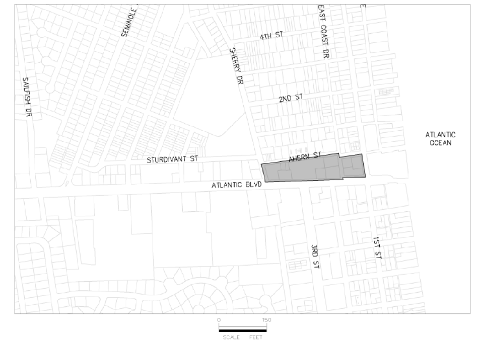
Figure 8 Central Business District Map
(b)
Permitted uses. The uses permitted in the central business district shall be:
(1)
Low intensity service establishments such as barber or beauty shops, shoe repair, laundromat, (but not dry cleaners), tailors or dressmakers.
(2)
Low intensity retail sales of items such as wearing apparel, toys, sundries and notions, books, stationery, luggage, jewelry, or similar uses.
(3)
Medical and dental offices, but not hospitals.
(4)
Professional offices such as accountants, architects, attorneys, engineers, and similar uses.
(5)
Business offices such as real estate broker, insurance agents, and similar uses.
(6)
Banks and financial institutions without drive-through facilities.
(7)
Restaurants, café, coffee shops without drive-up or drive-through service.
(8)
Art galleries, libraries, museums, cultural centers.
(9)
Government use, buildings and facilities.
(10)
Uses authorized pursuant to a right-of-way revocable license agreement.
(11)
A single-family dwelling unit within the same building occupied by a permitted use.
(12)
Mixed use projects combining the above uses and those approved as a use-by-exception pursuant to subsection (c) below.
(13)
On-premises consumption of beer and wine only in conjunction with a full service restaurant.
(14)
On-premises consumption of alcohol, indoors only, when located at least one hundred (100) feet from any residentially zoned property. This distance shall be measured in a straight line from the closest distance between the indoor space where consumption will occur to the nearest residentially zoned property.
(c)
Uses-by-exception. Within the central business district, the following uses may be approved as a use- by-exception.
(1)
Residential, where such residential use is within the same building of a mixed use project subject to density requirements of the comprehensive plan.
(2)
Live entertainment, both indoor and outdoor, in conjunction with a permitted use or approved use-by-exception, not including adult entertainment establishments as defined by F.S. § 847.001(2) and also not including outdoor entertainment such as putt-putt golf and driving ranges, skate park, firing ranges, amusement centers and video game arcades and any type of token or coin-operated video or arcade games, tattoo or body artists or studios, movie theaters, billiard and pool halls.
(3)
Off-street parking lots.
(4)
Hotel, motel, motor lodge, resort rental or tourist court and short term rental.
(5)
On-premises consumption of alcohol when located less than one hundred (100) feet from any residentially zoned property or when occurring outdoors.
(d)
Lot size and yard requirements.
(1)
Subject to meeting required impervious surface area limits, stormwater requirements, access and parking standards, landscaping and buffering, and required sight lines, there are only defined maximum front yard requirements within the central business district.
(2)
Yard requirements. The yard requirements within the central business district shall be:
(a)
Front: 15 feet (maximum)
(b)
Rear: 0 feet (minimum)
(c)
Side: 0 feet (minimum)
(e)
General restrictions. The following restrictions shall apply to all development within the central business district:
(1)
Maximum impervious surface: Seventy (70) percent. Where lawfully existing structures and improvements on a parcel exceed this applicable percentage, additions/modifications to such structures and improvements shall not exceed the pre-existing impervious surface percentage, provided the stormwater requirements of section 24-89 and the landscaping requirements of division 8 are met. However, new development and major remodels shall not exceed seventy (70) percent regardless of the existing impervious percentage.
(2)
Required landscaping shall be provided in accordance with division 8 of this chapter.
(3)
Stormwater management requirements in accordance with section 24-89.
(4)
Maximum building height: Thirty-five (35) feet.
(5)
Commercial development standards in accordance with section 24-171.
(f)
Right-of-way revocable license agreements and uses restrictions. Outside seating for restaurants, coffee shops and sidewalk cafes may be operated by the management of adjacent permitted food service establishments, subject to the provisions of section 19-8.
(Ord. No. 90-24-253, § 3(Exh. A), 10-14-24)
Sec. 24-116. - Traditional marketplace district (TM).
(a)
Intent. The traditional marketplace district is intended for mixed residential and neighborhood retail development. The traditional marketplace district was established to allow redevelopment along commercial corridors with a development pattern more consistent with development that was common prior to the 1950's. This development style is characterized by having maximum setbacks, parking areas in the rear or side yards, and access through rear alleyways. Typically, this style of development also has a mixture of uses with commercial on the first floors and upper stories residential. Today, this style of development is often referred to as new urbanism and is characterized as being walkable and pedestrian friendly.
(b)
Permitted uses. The uses permitted in the traditional marketplace district shall be:
(1)
Service establishments such as barber or beauty shops, shoe repair, laundromat, (but not dry cleaners), tailors or dressmakers; retail sales of items such as wearing apparel, toys, sundries and notions, books, stationery, luggage, jewelry, or similar uses.
(2)
Medical and dental offices, but not hospitals.
(3)
Professional offices such as accountants, architects, attorneys, engineers, and similar uses.
(4)
Business offices such as real estate broker, insurance agents, and similar uses.
(5)
Banks and financial institutions without drive-through facilities.
(6)
Restaurants, café, coffee shops without drive-up or drive-through service.
(7)
Art galleries, libraries, museums, cultural centers.
(8)
Municipal, government buildings and facilities.
(9)
Uses within the rights-of-way pursuant to the revocable license agreement.
(10)
A single dwelling unit within a building occupied by a permitted retail use on the ground floor or a public amenity as described in section 24-116(d) every forty-five (45) feet.
(11)
Multifamily dwelling units within a building occupied by a permitted retail use on the ground floor or a public amenity as described in section 24-116(d) every forty-five (45) feet.
(12)
Spas, gyms, health clubs and schools for the fine or performing arts or martial arts.
(13)
Retail outlets for the sale of food, art, florists, photographic supplies, sporting goods, hobby shops and pet shops (not animal kennel or veterinarian), bakery (but not wholesale bakery), home furnishings and appliances, office equipment and furniture, hardware, lumber and building materials, auto, boat and marine related parts, and similar retail uses.
(14)
Retail sale of beer and wine only for off-premises consumption.
(15)
On-premises consumption of beer and wine only in conjunction with a full service restaurant, which is a food service use where unpackaged ready-to-consume food is prepared onsite and served to the customer while seated at tables or counters located in a seating area within or immediately adjacent to the building.
(16)
Theaters, but not a multi-screen (exceeding two (2) screens) or regional complex.
(17)
Live entertainment indoors and non-amplified.
(18)
Craftsman and artisan studios including metal welding and fabrication shops not to exceed two thousand five hundred (2,500) square feet.
(19)
Mixed use projects combining the above uses and those approved as a use-by-exception pursuant to subsection (c) below.
(20)
Tap room in conjunction with a brewery or a distillery.
(21)
Hotel, motel, motor lodge, resort rental or tourist court and short term rental as defined within section 24-17.
(22)
On-premises consumption of alcohol, indoors only, when located at least one hundred (100) feet from any residentially zoned property. This distance shall be measured in a straight line from the closest distance between the indoor space where consumption will occur to the nearest residentially zoned property.
(23)
Off-street parking lot.
(c)
Uses-by-exception. Within the traditional marketplace district, the following uses may be approved as a use-by-exception.
(1)
Businesses offering amplified live entertainment both indoor and outdoor. This does not include adult entertainment establishments as defined by F.S. § 847.001(2) and also does not include outdoor entertainment such as putt-putt golf and driving ranges, skate park, firing ranges, amusement centers and video game arcades and any type of token or coin-operated video or arcade games.
(2)
On-premises consumption of alcoholic beverages when located less than one hundred (100) feet from any residentially zoned property or when occurring outdoors.
(3)
Veterinary clinics, pet grooming, and pet kennel and facilities for the boarding of animals.
(4)
Food truck park in accordance with section 24-166.
(d)
Lot size and yard requirements. Subject to meeting required impervious surface area limits, stormwater requirements, access and parking standards, landscaping and buffering, and required sight lines, there are no required setbacks within the traditional marketplace district. However, buildings shall be located no more than five (5) feet from a side or front lot line unless the development provides an amenity which activates the street and is accessible to the public. Buildings may be setback farther than five (5) feet from a side or front lot line in order to accommodate one (1) or more of the following amenities:
(1)
Outdoor seating for a restaurant, retail, or similar use accessible to the public;
(2)
Shelter or canopy between the building and the property line accessible to the public;
(3)
Public art such as a sculpture accessible to the public; and
(4)
Greenspace, pocket park, parklet or square accessible to the public.
(e)
General restrictions. The following restrictions shall apply to development and redevelopment the traditional marketplace district:
(1)
Maximum impervious surface: Seventy (70) percent. Where lawfully existing structures and improvements on a parcel exceed this applicable percentage, additions/modifications to such structures and improvements shall not exceed the pre-existing impervious surface percentage, provided the stormwater requirements of section 24-89 and landscaping requirements of division 8 are met. However, new development and major remodels shall not exceed seventy (70) percent regardless of the existing impervious surface percentage.
(2)
Required landscaping shall be provided in accordance with division 8 of this chapter
(3)
Stormwater management requirements in accordance with section 24-89.
(4)
Maximum building height: Thirty-five (35) feet.
(5)
Commercial development standards in accordance with section 24-171.
(f)
Right-of-way lease restrictions. Outside seating for restaurants, coffee shops and sidewalk cafes may be operated by the management of adjacent permitted food service establishments, subject to theprovisions of section 19-8.
(Ord. No. 90-24-253, § 3(Exh. A), 10-14-24)
Sec. 24-117.- Purpose and intent.
The purpose of the special planned area district is to create a mechanism to establish a plan of development or redevelopment for a site where the property owner and the community's interests cannot be best served by the provisions of the conventional zoning districts, and where assurances and commitments are necessary to protect the interests of both the property owner and the public, and also the unique qualities of the City of Atlantic Beach which are expressed throughout this chapter and the comprehensive plan. In addition, the SPA district may be utilized in order to:
(a)
Encourage creative and flexible site design that is sensitive to the site's natural features and adapts to the natural topography;
(b)
Protect environmentally sensitive areas of a development site and preserve on a permanent basis open space and natural features;
(c)
Decrease or minimize nonpoint source pollution impacts by reducing the amount of impervious surfaces in site development; and
(d)
Promote cost savings in infrastructure installation and maintenance by such techniques by reducing the distance over which utilities, such as water and sewer, need to be extended or by reducing the width or length of the streets.
The intent of this section is to provide an appropriate zoning district classification for new development and redevelopment where specific development standards and conditions will be established within the enacting ordinance. The quality of design and site planning are the primary objectives of the SPA district.
(Ord. No. 90-24-253, § 3(Exh. A), 10-14-24)
Sec. 24-118. - Special planned area district required.
The special plan area process may be used at a property owner's discretion, and may also be required by the city where a proposed development or redevelopment project has unique characteristics, special environmental or physical features such that a site development plan is needed as part of the review and approval process.
(Ord. No. 90-24-253, § 3(Exh. A), 10-14-24)
Sec. 24-119. - Permitted uses and site requirements.
(a)
Permitted uses. Any use or mix of uses, which are a permitted use or a permitted use-by-exception, subject to that use being an allowable use within the future land use category as designated by the comprehensive plan, may be proposed within a special planned area district.
(b)
Site requirements. Special planned area districts shall not have a minimum size requirement, but shall otherwise be subject to all applicable requirements of this chapter.
(Ord. No. 90-24-253, § 3(Exh. A), 10-14-24)
Sec. 24-120. - Process for rezoning to special planned area district.
(a)
The procedure for rezoning to special planned area shall be the same as set forth within section 24-62 of this chapter.
(b)
Ownership and commitment information required. An application for rezoning to special planned area shall proceed in general as for other applications for rezoning and, in addition to the information required for such applications, the following shall also be required:
(1)
Evidence of unified control and a written commitment to proceed with the proposed development in accordance with the ordinance creating the special planned area.
(2)
Provision of a written agreement for completion of the development according to plans and schedule approved by the ordinance, and for the continuing operation and maintenance of all privately-owned areas, functions and facilities, which will not be operated or maintained by the city.
(3)
Commitment to bind all successors and assigns in title to any conditions included within the ordinance creating the special planned area which shall also include by reference the application for rezoning and the approved plan of development, and which shall be recorded with the Clerk of the Courts of Duval County.
(4)
Statements providing commitments for the continued maintenance and ownership of all shared and common areas, any private streets, all stormwater management structures and facilities, infrastructure and any other improvements.
(c)
Materials to accompany application. An application for rezoning to special planned area shall include the materials listed in section 24-62 and the following:
(1)
Traffic, environmental or other technical studies and reports as may be required in order to make the findings and determinations called for in the evaluation of the particular application. Any such information shall be provided at the applicant's expense and shall be prepared by professionals who are qualified, licensed or certified to prepare such information using standard accepted methodologies.
(2)
Written narrative describing the intended plan of development.
(3)
A proposed site development plan drawn at an appropriate scale depicting the following:
a.
The general location, grouping, and height of all uses, structures and facilities.
b.
In the case of residential development, the number of dwelling units proposed, their general location, proposed building setbacks, separation between structures and number of stories.
c.
The general location of vehicular and pedestrian circulation systems including driveways, sidewalks, parking areas, and streets to be dedicated.
d.
Open space and all active and passive recreational uses, with estimates of acreage to be dedicated to the city and that to be retained in common ownership. Active and passive recreation shall be sufficient to serve the needs of residents within the proposed development.
e.
A boundary survey and a topographic map at an appropriate scale showing contour lines, including all existing buildings, water bodies, wetland areas and ratio of wetlands to uplands, significant environmental features and existing vegetative communities.
f.
Any archaeological or historic resources, as identified by the State Division of Historical Resources Master Site File.
g.
Site data including total number of acres in the project and acreage to be developed with each proposed use. (Total number of dwelling units separated by type and total nonresidential acreage and square footage of nonresidential structures.)
(4)
Proposed schedules of development, including the following:
a.
Areas to be developed and the phasing schedule for each development area. Individual phases may overlap, but no single phase shall exceed a period of five (5) years.
b.
Terms providing a definition for commencement and a definition of completion.
c.
The construction of streets, utilities and other improvements necessary to serve the proposed development.
d.
The dedication of land to public use, if applicable.
(Ord. No. 90-24-253, § 3(Exh. A), 10-14-24)
Sec. 24-121. - Development standards and criteria.
The special planned area district should not be construed as a mechanism to diminish the requirements set forth elsewhere within this chapter or other chapters of the city Code. Waivers to existing development standards may be approved by the city commission as part of a special planned area rezoning ordinance upon demonstration that an alternative standard will provide a better development outcome with respect to the quality of design and development form. Unless otherwise approved as part of the master site development plan, all applicable requirements of the land development regulations shall apply. Unless otherwise approved as part of the special planned area or planned unit development, the maximum impervious surface coverage shall be forty five (45) percent.
(Ord. No. 90-24-253, § 3(Exh. A), 10-14-24)
Sec. 24-122. - Master site development plan required.
A master site development plan shall be attached as an exhibit to the ordinance or adopted by reference within the ordinance enacting any special planned area district and shall include the following:
(1)
Those items set forth within section 24-120.
(2)
A schedule of development, and if a phased schedule is proposed, phases of not more than five (5) years each.
(3)
All features and special development provisions and conditions capable of being depicted on a map or otherwise provided in notations on the plan or within text attachments.
(Ord. No. 90-24-253, § 3(Exh. A), 10-14-24)
Sec. 24-123. - Platting.
Where lands within a special planned area district will be platted, the platting and recordation procedures and requirements as set forth within article IV of this chapter shall apply.
(Ord. No. 90-24-253, § 3(Exh. A), 10-14-24)
Sec. 24-124. - Modifications to previously approved special planned area districts or master site development plans or planned unit developments (PUD).
(a)
Changes to the terms or conditions of a special planned area district, or to an existing planned unit development approved prior to the enactment of the special planned area district, that are specifically set forth within the ordinance enacting the PUD or SPA district shall require an ordinance revision using the standard process to rezone land.
(b)
Except as provided in subsection (c) below, changes to master site development plans shall require approval by ordinance of the city commission upon finding that the proposed changes remain consistent with the approved special planned area district.
(c)
Minor deviations to a master site development plan or final development plan may be approved by the administrator following review by the building, public works, public utilities and community development departments, upon finding that the requested changes are consistent with the following:
(1)
No change in use;
(2)
No increase in building height, density or intensity of use;
(3)
No decrease in area set aside for buffers or open space;
(4)
No changes to access point or driveways.
(Ord. No. 90-24-253, § 3(Exh. A), 10-14-24)
Sec. 24-125. - Expiration of time limits provided in ordinance.
If development actions set forth within the ordinance creating a special planned area district are not timely taken as prescribed within the ordinance, the right to proceed with the development authorized pursuant to a special planned area ordinance shall expire, and no further development action shall be permitted under same unless an extension has been granted by the city commission.
(Ord. No. 90-24-253, § 3(Exh. A), 10-14-24)
Sec. 24-126. - Effect on previously approved planned unit developments (puds).
PUDs created prior to the effective date of the ordinance enacting the special planned area district provisions shall remain so designated on the zoning map and shall remain subject to all specific terms and conditions as set forth within the particular PUD ordinance. Any proposed change to a previously enacted PUD shall be made in accordance with the procedures as set forth within this division.
(Ord. No. 90-24-253, § 3(Exh. A), 10-14-24)
Sec. 24-151.- Accessory uses and structures.
(a)
Authorization. Accessory uses and structures are permitted within any zoning district, as set forth within this section, where the accessory uses or structures are clearly ancillary, in connection with, and incidental to the principal use allowed within the particular zoning district. Any permanently located accessory structure, which exceeds thirty (30) inches in height, also including without limitation, those which may not require a building permit, are subject to all land development regulations unless otherwise provided for within this chapter. Common accessory structures include, but are not limited to, sheds, detached garages, pergolas, screen enclosures and other similar structures.
(b)
Temporary structures. Temporary structures, such as portable tents, canopies, awnings or other nonpermanent structures shall be limited to special occasion use only, and for a period of not more than ninety-six (96) hours, i.e., four (4) days.
(c)
Number of structures. Single- and two-family properties shall have no more than:
(1)
Three (3) total buildings, including the principal building.
(2)
One (1) shed.
(3)
One (1) detached garage, guest house, pool house, or similar structure.
(d)
Residential, Selva Marina (R-SM) district. All accessory structures within the R-SM district, regardless of type or use of the structure, shall meet the following standards.
(1)
Shall not exceed fifteen (15) feet in height.
(2)
Shall not exceed one hundred sixty (160) square feet, except uncovered decks/patios and screen enclosures with a screen roof may exceed this square footage.
(e)
Location, size, and height. Unless otherwise stated in this section, residential accessory structures such as sheds, pergolas, screen enclosures, and similar structures shall meet the following standards:
(1)
Shall not be located in the required front yard, easements, or drainage features.
(2)
Shall be at least five (5) feet from interior (side and/or rear) lot lines.
(3)
Shall be at least ten (10) feet from corner side lot lines.
(4)
Shall not exceed fifteen (15) feet in height.
(5)
Shall not exceed one hundred sixty (160) square feet, except uncovered decks/patios and screen enclosures with a screen roof may exceed this square footage.
(f)
Uncovered decks and patios.
(1)
There are no setback requirements provided the deck/patio is not greater than one (1) foot above the adjacent grade.
(2)
If greater than one (1) foot above the adjacent grade, the deck/patio shall comply with the yard requirements for the principal structure.
(g)
Outdoor shower enclosures and open exterior stairs.
(1)
Shall be at least three (3) feet from interior lot lines.
(h)
Separation.
(1)
Accessory structures shall be at least three (3) feet from another structure as measured from the eaves.
(2)
If located closer than five (5) feet to a principal structure, it shall be considered attached and comply with the yard requirements for the principal structure.
(3)
These separation standards do not apply to screen enclosures, exterior stairs, outdoor shower enclosures, or uncovered decks/patios.
(i)
Detached garages, guest houses, and pool houses.
(1)
No more than fifteen (15) feet in height and at least five (5) feet from lot lines, except it may be constructed up to twenty five (25) feet in height provided it is at least ten (10) feet from the rear lot line.
(2)
No more than six hundred (600) square feet of covered area on the first story. This includes any portions of the second story that extend beyond the first story footprint such as decks, balconies, and similar structures.
(3)
May exceed the height and square footage requirements if the structure meets the minimum yard requirements for the principal structure.
(4)
A detached garage may contain guest quarters.
(5)
A detached garage must be accessed by a minimum ten (10) foot wide driveway.
(6)
A guest house or guest quarters shall only be used for intermittent and temporary occupancy by a nonpaying guest or family member of the occupant of the primary residence and shall not be leased or rented for any period of time or converted to a dwelling unit.
(7)
A guest house or guest quarters shall not contain a kitchen but may contain a kitchenette, as defined herein.
(j)
Garage apartments.
(1)
A single garage apartment is permitted on double frontage lots that are at least fifty (50) feet wide and located within a residential zoning district.
(2)
Shall not exceed twenty five (25) feet in height.
(3)
Shall be at least twenty (20) feet from the front lot line, ten (10) feet from the rear lot line, and meet he applicable side yard setbacks established for the principal structure.
(4)
Shall be at least twenty (20) feet from the principal building.
(5)
The gross floor area shall not exceed seventy-five (75) percent of the gross floor area of the principal dwelling.
(6)
Shall not be rented or leased for less than ninety (90) consecutive days.
(k)
Mechanical equipment.
(1)
On lots that are within or adjacent to a residential zoning district, equipment such as heating and air conditioning units, pumps, compressors, pool equipment, generators, or similar equipment shall not be located in the required front yard or closer than five (5) feet from any lot line that is adjacent to a residential use. It is the intent of this provision to require placement of such equipment in a location that does not unreasonably disturb neighbors. This requirement shall not apply to replacement of such equipment lawfully installed prior to the effective date of these land development regulations.
(2)
Within non-residential zoning districts, equipment shall be screened from view from public or private streets and parking areas.
(l)
Skate park, skating, bicycle or similar ramps, for use on private property only, placed or constructed in fixed locations and made of wood, block, concrete or similar materials, provided that these are not located within required front yards or the street side yards on a corner lot. Due to excessive noise, which may result from the use of such ramps, time of use shall be limited to the hours between 9:00 a.m. and 10:00 p.m. Such ramps shall be maintained in a safe and good condition and shall be disassembled and removed from the property if allowed to deteriorate to an unsafe or unsightly appearance.
(m)
Satellite dish antennas.
(1)
Residential districts. Satellite dish antennas one (1) meter (39 inches) or less in diameter are permitted in residential districts.
(2)
Non-residential districts. Satellite dish antennas less than two (2) meters (seventy-eight (78) inches) in diameter are permitted in non-residential districts.
(3)
Satellite dish antennas not described above are subject to the following standards:
a.
A building permit is required prior to installation.
b.
Shall not exceed twelve (12) feet in diameter.
c.
Shall not exceed fifteen (15) in height above adjacent grade.
d.
Shall be located in the rear yard and no closer than five (5) feet to any property line.
e.
Shall be limited to one (1) per residential parcel.
f.
Roof mounting is prohibited.
(4)
Satellite dish antennas shall not constitute the principal use of a property.
(n)
Radio and television antennae. All outdoor radio, television and electronic antennae or antennae of any other nature constructed upon, affixed to, structurally repaired or altered upon, or otherwise emplaced to service or act in conjunction with the use of any property must comply with the regulations of this section and chapter unless preempted by policy established by the Federal Communications Commission (FCC).
(Ord. No. 90-24-253, § 3(Exh. A), 10-14-24)
Sec. 24-152. - Child care.
Child care facilities, including day nurseries and kindergartens, and child care provided in private homes, whether operated as a permitted use or permitted as a use-by-exceptions, shall be licensed and operated in accordance with all applicable requirements of the Florida Department of Children and Family Services and any other applicable state requirements, all applicable city Codes, and shall further be subject to the following provisions:
(a)
Minimum lot area shall not be less than five thousand (5,000) square feet.
(b)
Outdoor play areas shall be fully fenced with a minimum four-foot high latching fence, and the size of play area shall meet the state regulations for square feet of play area per child. Within all residential zoning districts, play areas and all play equipment, structures and children's toys shall not be located, maintained or stored within required front or side yard setback areas.
(c)
Where approval of a use-by-exception is required to operate a child care facility, the maximum number of children shall be stated in the application, and in no case shall the maximum permitted number of children be exceeded at any time. The application shall include a site plan showing the location of the building to be used or constructed on the lot, fenced play areas, off-street parking, loading and unloading facilities as required by section 24-161, and traffic circulation, including any drop-off areas.
(d)
Child care provided within private homes, not requiring approval of a use-by-exception, shall be limited to care of not more than five (5) children, unrelated to the operator, within a single time period, and shall be licensed and operated only in accordance with all applicable licensing requirements of the Florida Department of Children and Family Services (DCFS) and the requirements of this chapter. The application for occupational license to provide child care within a private home shall be accompanied by a copy of the current license certificate from the DCFS and a survey or site plan demonstrating compliance with all requirements of this section. The city reserves the right to request of the DCFS an inspection pursuant to F.S. § 402.311 prior to issuance of a local business tax license. Child care in private homes shall be further subject to the following requirements.
a.
No business signs shall be placed upon the lot where child care is provided within private homes.
b.
Play areas and all play equipment, structures and children's toys shall not be located, maintained or stored within required front or side yard setback areas.
c.
Off-street parking, as required by section 24-161, shall be provided, including provision[s] for off-street drop-off and pick-up. Parking and traffic generated by any child care provided within private home facilities shall have no adverse impacts to the volume or circulation of residential traffic.
(Ord. No. 90-24-253, § 3(Exh. A), 10-14-24)(Ord. No. 90-10-212, § 2(Exh. A), 3-8-10; Ord. No. 90-19-240, § 3(Exh. A), 7-8-19)
Sec. 24-153. - Churches.
The minimum development criteria for churches in any zoning district where churches are permitted shall include the following:
(a)
Adequate site area to accommodate all structures and required onsite parking and circulation areas for motor vehicles, in accordance with the parking requirements of this chapter.
(b)
Location on a collector or arterial street with adequate frontage to accommodate ingress-egress driveways in proportion to expected peak attendance levels in order not to disrupt roadway traffic.
(c)
Maintenance of the required clear sight triangle.
(d)
Minimum yard requirements and building restrictions as required within the zoning district in which the facility is located.
(e)
Buffering as required by section 24-167 of this chapter in the form of hedge materials and/or fence or wall, as appropriate, along lot lines adjacent to any residential uses.
(f)
A single dwelling unit for may be permitted and may be attached to, located within, or on the same premises as the church. For dwelling units that are detached from the church building, the minimum yard requirements and building restrictions of the applicable zoning district shall apply.
(Ord. No. 90-24-253, § 3(Exh. A), 10-14-24)
Sec. 24-154. - Outdoor display, sale and storage of furniture, household items, merchandise and business activities outside of enclosed buildings.
(a)
Except as provided in subsection (b) below, the outside display of products, or outside sale of furniture, clothing, dry goods, hardware or other similar merchandise, equipment and materials, shall be prohibited within all nonresidential zoning districts, with the following exceptions:
(1)
Landscaping and garden supplies, nursery stock in containers, patio furniture and ornamental articles for use in lawn, garden or patio areas, displayed for sale on private property only and subject to provision of any required buffering and screening.
(2)
Locations authorized for permanent automotive sales, except that no storage or display of tires, auto parts, tools, service or repair work is permitted outdoors, and no streamers, banners, pennants, balloons, flashing lights or similar items are permitted in any location.
(3)
Temporary outdoor markets limited only to farm and garden produce, arts and crafts, and seasonal items such as Christmas trees and pumpkins, and mobile food vending units, may be permitted on private property subject to approval by the administrator verifying adequate parking, safe site access, and establishing the duration and time of such activities. Other conditions for approval, as appropriate, may be required.
(b)
Within the commercial general (CG) zoning district only, outside display of merchandise shall be permitted only in accordance with the following conditions:
(1)
Display areas must be fully located on private property, shall not be located in any drive aisle, parking or landscaping areas and shall not in any manner interfere with use of a sidewalk, walkway or entrance to a business with a minimum three-foot wide clear area maintained for walkways in front of any such display. All items and any display rack or table must be brought inside at the close of each business day.
(2)
Outside display racks or tables are limited to a maximum size of three (3) feet in height, two (2) feet in depth and five (5) feet in width, and only one (1) outside display rack shall be permitted per business or per lot, as applicable. Display racks or tables must be professionally constructed or manufactured and of a type customarily used for such purposes. Temporary tables constructed of plywood, blocks or other similar materials shall not be used.
(3)
Only merchandise that is sold inside the adjoining business, which holds the valid business license as the owner or lease holder to operate such business, shall be displayed outside.
(4)
No temporary signs, lights, banners, balloons, posters and the like shall be permitted on such displays, except that pricing information attached to individual items for sale is permissible, and such displays shall be maintained in a neat, orderly and uncluttered manner.
(5)
Failure to consistently observe all above conditions shall result in an order from the city to remove all such merchandise and revocation of rights for such future outside displays may follow.
(c)
Unless expressly permitted by this section or elsewhere within these land development regulations, all business-related products services and activities shall be conducted within an enclosed building, subject to compliance with applicable licensing requirements.
(d)
Temporary shows for the outdoor display and sale of automobiles, trucks, motorcycles, boats, RVs and the like, flea markets, swap meets, regardless of the name used to describe these, shall be prohibited in all zoning districts.
(e)
Any signage used for any outside merchandise or activity shall be in accordance with the sign regulations.
(f)
This section shall not be construed to prohibit outdoor restaurant seating on private property where permitted by the property owner and in compliance with other applicable regulations including without limitation required parking, and any required licensing from the division of alcoholic beverages.
(g)
Within all residential zoning districts, and also including any property containing a residential use, household items, furniture and those items customarily intended for indoor use shall not be displayed, maintained or permanently stored outdoors, or in any location on the lot where such items are visible from adjacent properties. Discarded or unused household items shall be stored or properly disposed of to avoid mold, rodent and insect infestations which may result in health risks and which also create unsightly appearances that negatively affect neighborhoods. Such violations shall be corrected immediately upon written order from the city.
(Ord. No. 90-24-253, § 3(Exh. A), 10-14-24)
Sec. 24-155. - Establishments offering live entertainment.
If at any time the community development board shall determine, following a public hearing noticed and governed in accordance with section 24-51, that the live entertainment, for which a use-by-exception has been issued, constitutes a nuisance, is not in the best interests of the public, is contrary to the general welfare or has an adverse effect upon the public health, safety, comfort, good order, appearance or value of property in the immediate or surrounding vicinity, then the community development board may, upon such determination, revoke, cancel or suspend such use-by-exception and related business license. Any person or party applying for and receiving a use-by-exception for live entertainment is hereby placed on notice that the use-by-exception may be canceled, revoked or suspended at any time pursuant to the provisions of this section. Every use-by-exception hereafter granted for live entertainment shall contain a recitation upon the face thereof that the same is subject to revocation, cancellation or suspension for the reasons stated in this section.
(Ord. No. 90-24-253, § 3(Exh. A), 10-14-24)
Sec. 24-156. - Exceptions to height limitations.
Upon specific application, the city commission may grant waivers to the maximum height of buildings as set forth within this chapter only within nonresidential zoning districts and only in accordance with the following:
(a)
In no case shall approval be granted for any height of building within the city exceeding thirty-five (35) feet, except in accordance with section 59 of the city Charter.
(b)
Requests to exceed the maximum height for certain elements of a building may be considered and approved only within nonresidential land use categories and for nonresidential development. Further, any such nonresidential increase to the maximum height of building shall be limited only to exterior architectural design elements, exterior decks or porches, and shall exclude signage, storage space or habitable space as defined by the Florida Building Code and shall be approved only upon demonstration that the proposed height is compatible with existing surrounding development.
(Ord. No. 90-24-253, § 3(Exh. A), 10-14-24)
Sec. 24-157. - Fences, walls and similar structures.
(a)
Permit required. Issuance of a permit is required for any new or replacement fence or wall, and all new or replacement fences and walls shall comply with the following provisions. Nonconforming fences shall not be replaced with nonconforming fences. The term fence and wall may be used interchangeably within this chapter, and shall mean as specifically defined within section 24-17. Fences must be constructed out of materials that are customarily used for fences.
(b)
Height and location.
(1)
Within required front yards, the maximum height of any fence shall be four (4) feet, except as provided below:
a.
When a building is situated on the lot closer to the front setback line, the fence shall not exceed four (4) feet in height forward of the front building line.
b.
Open ornamental aluminum, iron or vinyl or wood fences, similar to the below examples, with vertical rails no more than two (2) inches in width and spacing of at least four (4) inches may be constructed to a maximum height of five (5) feet except in cases as described in following subsection (c).
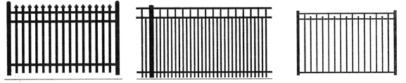
Figure 10 Front Yard Fence Design/Height
(2)
Within required side or rear yards, the maximum height of any fence shall be six (6) feet, except as provided below:
a.
On double frontage lots that have a designated rear yard adjacent to Beach Avenue, in accordance with section 24-83, the maximum fence height within ten (10) feet of the rear property line is four (4) feet.
b.
In the event a residential property is adjacent to a commercial property, an eight (8) foot tall fence may be approved in the rear and/or side yard adjacent to the commercial property.
(3)
Fences, walls, and similar structures in the R-SM zoning district shall be subject to the additional provisions below:
a.
Shall not be located closer to the front lot line than the main residence.
b.
Shall not be located closer to any side lot line that abuts a street than the main residence.
c.
Shall not be constructed of chain link or similar materials.
(4)
The height of fences shall be measured from the established grade at the fence location to the horizontal top rail of the fence. The use of dirt, sand, rocks, timbers, or similar materials to elevate the height of a fence on a mound or above the established grade is prohibited. Vertical elements attached to the fence shall be considered an extension of the fence and included in the height measurement.
(5)
The maximum height of retaining walls on any lot is four (4) feet. A minimum of forty (40) feet shall separate retaining walls designed to add cumulative height or increase site elevation. Signed and sealed construction and engineering plans for retaining walls over thirty-six (36) inches in height shall be required.
(6)
For non-oceanfront lots with uneven topography along a side or rear lot line, the minimum necessary rake of the fence, which is the ability for a fence to adjust to a slope, shall be allowed for the purpose of maintaining a consistent horizontal line along the side and rear of the lot, provided that the height closest to the front of the lot does not exceed six (6) feet.
(7)
No fence, wall, or hedge shall be constructed or installed in such a manner as to interfere with drainage on the site.
(c)
Corner lots. Fences, walls, similar structures and landscaping on corner lots may create obstacles to clear vehicular, bicycle and pedestrian sight visibility resulting in a public safety hazard. Notwithstanding the following provisions, clear sight visibility for fences, walls, landscaping or any structure proposed along the street side of any corner lot shall be reviewed and approved by the planning and community development director, or designee, prior to issuance of the permit required to construct, place or replace any such feature. Sight triangles as defined within section 24-17 shall remain free of visual obstruction.
(1)
For corner lots located on rights-of-way that are less than fifty (50) feet in width, no fence, wall or landscaping exceeding four (4) feet in height, shall be allowed within ten (10) feet of the side lot line which is adjacent to a right-of-way containing a street, except fences may be up to six (6) feet tall within the required rear yard provided it is not closer than five (5) feet to any sidewalk or bike path.
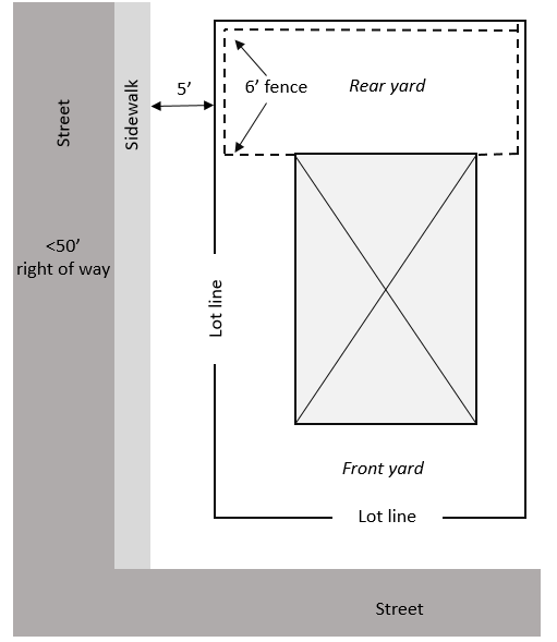
Figure 11 Corner Lot Rear Yard Fence (Right-of-way less than 50 feet in width)
(2)
For corner lots located on rights-of-way fifty (50) feet or greater in width, fences may be constructed within the side yard adjacent to the right-of-way containing a street at a maximum height of six (6) feet provided that the fence is on the private property and shall not be located closer than fifteen (15) feet from the edge of the street pavement or closer than five (5) feet to any sidewalk or bike path.
(3)
Similarly, hedges and landscaping on corner lots shall be maintained at a height that does not interfere with clear vehicular, pedestrian or bicycle sight visibility or use of the public sidewalk or bike path.
(d)
Privacy structures. Privacy structures as defined in section 24-17, may be constructed of any type of material and shall be limited to maximum length of twelve (12) feet and a height of eight (8) feet above the established grade of the lot where such structure is placed, provided that no such structure on a rooftop deck exceeds the maximum permitted height of building. Except for oceanfront lots, where the ocean side is the designated front yard, any such structure shall not be located within the required front yard of a lot and shall be a minimum distance of five (5) feet from side and rear lot lines. The maximum number of privacy structures permitted on one (1) parcel shall be two (2) and they shall be separated by no less than ten (10) feet.
(e)
Maintenance of fences. Fences that have been allowed to deteriorate to an excessive degree have a negative impact on property values and the quality of neighborhoods. Fences that are in a state of neglect, damage or disrepair, shall be repaired, replaced or removed.
Unacceptable fences are identified as those containing any of the following characteristics that can be easily observed from the street or by a neighboring property:
(1)
Components of the fence are broken, bent, visibly rusted or corroded.
(2)
Portions of the fence are no longer connected to support posts and rails.
(3)
Any components are rotten, broken or missing.
(4)
Weeds are overtaking the fence.
(Ord. No. 90-24-253, § 3(Exh. A), 10-14-24)
Sec. 24-158. - Dog-friendly restaurants.
(a)
Purpose and intent. The Dixie Cup Clary Local Control Act, F.S. § 509.233, grants the city the authority to provide exemptions from certain portions of the United States Food and Drug Administration Food Code, as amended from time to time, and as adopted by the State of Florida Division of Hotels and Restaurants of the Department of Business and Professional Regulation, in order to allow patrons' dogs within certain designated outdoor areas of their respective establishments while providing for regulation and enforcement required to promote, protect, and maintain the health, safety and welfare of the public. By authority of F.S. § 509.233(2), there is hereby created in the City of Atlantic Beach, Florida such a local exemption procedure, known as the City of Atlantic Beach Dog-Friendly Restaurants.
(b)
Applicability. No dog shall be allowed in a public food service establishment unless authorized by state law and the public food service establishment has received and maintains an unexpired permit pursuant to this section allowing dogs in designated outdoor dining areas of the establishment.
(c)
Permit requirements. No public food service establishment within the city shall have or allow any dog on its premises unless the food service establishment possesses a valid permit issued in accordance with this section, or unless otherwise permitted pursuant to Florida Statutes.
(1)
Permit application. An applicant for a dog-friendly restaurant permit shall submit the established fees along with the application form created and provided by the city to the designated administrative department. The application shall contain all required narrative and graphical information necessary to determine compliance with the provisions of this section and deemed reasonably necessary for the enforcement of the provisions of this section, but shall require, at a minimum, the following information:
a.
The name, location, and mailing address of the food service establishment.
b.
The appropriate and current division-issued license number for the public food service establishment on all application materials.
c.
The name, mailing address, and telephone contact information for the owner of the public food service establishment.
d.
The name, mailing address and telephone contact information for the manager of the public food service establishment.
e.
The name, mailing address, and telephone contact information for the permit applicant.
f.
A diagram and description of the outdoor area to be designated as available to patrons' dogs, including the following:
1.
Dimensions of the designated area;
2.
A depiction of the number and placement of tables, chairs, and restaurant equipment, if any;
3.
The entryways and exits to the designated outdoor area;
4.
The boundaries of the designated area and of other areas of outdoor dining not available for patrons' dogs;
5.
Any fences or other barriers; and
6.
Surrounding property lines and public rights-of-way, including sidewalks and common pathways.
The diagram or plan shall be accurate and to scale but need not be prepared by a licensed design professional.
g.
A description of the days of the week and hours of operation that patrons' dogs will be permitted in the designated outdoor area.
h.
The property owner's authorization shall also be required if the applicant is not the property owner.
(2)
Fees. The city commission shall establish reasonable fees to cover the cost of processing an initial application and issuing the permit, including a portion for initial permit compliance inspection and program monitoring. Separate fees shall be established for verified complaint-based and permit reinstatement compliance inspections. Such fees are detailed in section 24-69 of this chapter.
(3)
Permit application review and approval. Permit applications submitted under this section shall be reviewed and approved by the administrator in accordance with the following:
a.
The permit application shall be submitted at least thirty (30) days prior to the date anticipated by the food service establishment for inception of the program in the designated outdoor area.
b.
The applicant shall be required to prominently display notice within the food service establishment that application has been made for a dog-friendly restaurant permit. The notice shall indicate the portion of the seating area for which permitting is requested and the anticipated start date of service. The notice shall be displayed commencing the date application is made and continue until such date the permit is issued or the application is withdrawn or abandoned.
c.
No permit shall be issued for any outdoor seating area which has not been properly authorized by the city or which does not meet all applicable criteria of the city's land development regulations and regulations of the division.
d.
For permits authorizing dogs within the outdoor areas of a food service establishment located on any right-of-way or other property of the city or any other governmental entity, the administrator shall require the applicant to produce evidence of the following:
1.
A valid right-of-way, sidewalk, or other permit, license, or lease showing the food service establishment has the right to occupy and use the area; and
2.
A properly executed insurance endorsement providing commercial general liability insurance coverage in an amount of no less than five hundred thousand dollars ($500,000.00) per occurrence and one million dollars ($1,000,000.00) aggregate. The policy shall not have any exclusion for animals or animal bites. All insurance shall be from companies duly authorized to do business in the State of Florida. All liability policies shall be endorsed to provide that the city or any other appropriate governmental entity is an additional insured as to the operation of the outdoor dining area on such government property.
e.
After the administrator determines the application for a permit to be complete and in compliance with this section, the administrator shall cause inspection of outdoor areas of the food service establishment designated in the application for compliance with the provisions of this section. A food service establishment found not in compliance upon such inspection shall have a reasonable time in which to correct any deficiencies found. Upon correction of such deficiencies, the public food service establishment shall request re-inspection and pay a re-inspection fee.
f.
A food service establishment making application for or issued a permit under this section shall provide access to the premises of the food service establishment upon request of the administrator of the city or the division for periodic inspections and monitoring for compliance. Neither advance notice nor written request shall be required for such inspections.
g.
An application shall be deemed abandoned if it remains incomplete in the determination of the administrator for a period of ninety (90) days after notice to the applicant of the deficiencies in the application or if inspection of the food service establishment revealed deficiencies in compliance with this section and the applicant has not requested reinspection within such period.
h.
A permit issued pursuant to this section shall not be transferrable to a subsequent owner upon the sale or transfer of a public food serviced establishment, but shall expire automatically upon the sale, lease, or other transfer of an interest in the food service establishment, and service under such expired permit shall cease. The subsequent owner, lessee, or other person acquiring an interest in the food service establishment shall be required to reapply for a permit pursuant to this section if such person desires to continue to accommodate patrons' dogs according to the provisions of this program.
(4)
Permit expiration. Each permit issued under this section shall expire on September 30 next following issuance, regardless of when issued.
(5)
Permit renewal. Each September, the administrator shall review the compliance records for each public food service establishment with a current dog-friendly restaurant permit and send out renewal notices to those establishments not having substantial and/or habitual violations during the past year. Upon receipt of a complete renewal application and appropriate fees, and successful permit inspection, the administrator shall issue a renewal permit with an effective date of October 1 of that year.
The administrator shall issue a consultation notice to those food service establishments having substantial and/or habitual violations during the past year. At consultation, the administrator and the applicant shall discuss severity and frequency of violations documented during the past year, and the administrator shall determine whether or not the applicant may apply for a probationary renewal permit. Any food service establishment issued consultation notices for two (2) consecutive years shall be prohibited from applying for a dog-friendly restaurant permit.
(6)
Permit revocation. A permit issued under this section may be revoked by the administrator subject to the following conditions.
a.
A permit issued under this section may be revoked by the administrator if, after notice and reasonable time in which the grounds for revocation may be corrected, the food service establishment fails to comply with any condition of approval, fails to comply with the approved diagram, fails to maintain any required state or local license or permit, fails to pay when due any permit, renewal, inspection, or re-inspection fees, is found to be in violation of any provision of this section, this chapter, this Code, or regulations of the division, or there exists any other threats to the health, safety, or welfare of the public. The administrator may suspend the permit and the food service establishment shall cease service under the permit pending correction of the grounds for revocation. If the grounds for revocation are a failure to maintain any required state or local license or permit, revocation may take effect immediately upon giving notice of revocation to the food service establishment owner or manager. A suspension or revocation by the administrator shall be appealable as provided in the general appeal provision of this chapter, but shall remain in effect during the course of such appeal.
b.
If a permit issued to a food service establishment under this section is revoked, no new permit may be approved or issued for such food service establishment until the expiration of one hundred eighty (180) days following the date of such revocation, at which time the applicant may request a consultation with the administrator to discuss issuance of a renewal permit.
(e)
Use-specific standards. In addition to the general development standards and those specific to the applicable zoning district, any public food service establishment that receives a permit to allow dogs within a designated outdoor dining area pursuant to this section shall require observation and compliance with the following use-specific standards.
(1)
The public food service establishment and designated outdoor area shall comply with all permit conditions and the approved diagram.
(2)
Permits shall be conspicuously displayed in the designated outdoor area.
(3)
Waterless hand sanitizer shall be provided at all tables in the designated outdoor area.
(4)
A kit with appropriate materials and supplies for cleaning and sanitizing an area soiled by dog waste shall be maintained in the designated outdoor area. Dog waste shall not be carried in or through indoor portions of the public food service establishment.
(5)
Ingress and egress to the designated outdoor area shall not require entrance into or passage through any indoor area or nondesignated outdoor areas of the public food service establishment.
(6)
No dogs shall be allowed in the designated outdoor areas of the food service establishment if a violation of any of the requirements of this section exists.
(7)
All dogs shall wear a current license tag or rabies tag and the patron shall have a current license certificate or rabies certificate immediately available upon request.
(f)
Required signs. Any public food service establishment that receives a permit to allow dogs within a designated outdoor dining area pursuant to this section shall provide signage in accordance these standards and content.
(1)
Sign standards. Signs must comply with the following:
a.
Lettering must be no less than a thirty-six (36) point font.
b.
Lettering must be in a contrasting color to the sign background so as to be visible and readable.
(2)
Employee-directed content signs. Signs with the following rules must be prominently posted in an employee area.
a.
Employees shall wash their hands promptly after touching, petting, or otherwise handling any dog, and shall wash their hands before entering other parts of the public food service establishment from the designated outdoor area.
b.
Employees shall be prohibited from touching, petting, or otherwise handling any dog while serving food or beverages or while handling tableware.
c.
Employees shall not permit any dog to be in, or to travel through, indoor or nondesignated outdoor areas of the public food service establishment.
d.
Employees shall not allow any dog to come into contact with serving dishes, utensils, tableware, linens, paper products, or any other items involved in food service operations.
e.
Employees shall not allow any part of a dog to be on chairs, tables or other furnishings. Dogs must remain on the floor/ground level and shall not be permitted in the lap of the patron.
f.
Employees shall clean and sanitize all table and chair surfaces with an approved product between seating of patrons.
g.
Spilled food and/or drink must be removed from the floor or ground as soon as possible, but in no event less frequently than between seating of patrons at the nearest table.
h.
Accidents involving dog waste must be immediately cleaned and sanitized with an approved product.
(3)
Patron-directed content. Signs with the following rules must be prominently posted at the entrance to the designated outdoor area allowing dogs.
a.
Patrons shall keep their dogs on a leash at all times and shall keep their dogs under reasonable control.
b.
Patrons shall not leave their dogs unattended for any period of time.
c.
Patrons shall not allow dogs to come into contact with serving dishes, utensils, tableware, linens, paper products, or any other items involved in food service operations.
d.
Patrons shall not allow any part of a dog to be on chairs, tables or other furnishings. Dogs must remain on the floor/ground level and shall not be permitted in the lap of the patron.
e.
Accidents involving dog waste must be immediately cleaned and sanitized with an approved product.
f.
Patrons are advised to wash their hands with waterless hand sanitizer before eating.
(g)
Complaints and reporting requirements. In accordance with F.S. § 509.233, the administrator shall provide the division with the following in a timely manner.
(1)
The administrator shall establish a procedure for accepting, documenting and responding to complaints related to the program in a timely manner.
(2)
The administrator shall in a timely manner provide the division with a copy of all approved applications and permits issued.
(3)
The administrator shall promptly provide the division with copy of all complaints and responses to such complaints.
(4)
All applications, permits, and other materials submitted to the division shall contain the division- issued license number for the public food service establishment.
(Ord. No. 90-24-253, § 3(Exh. A), 10-14-24)
Sec. 24-159. - Home occupations.
(a)
Intent. Certain home occupations may be approved by the planning and community development director upon receipt of an application in compliance with this section, to address the desire of people to conduct limited small-scale home occupations within a personal residence. In accordance with F.S. 559.955, a home occupation shall conform to the residential character and architectural aesthetics of a neighborhood and shall not increase traffic/parking in residential neighborhoods.
(b)
The following regulations shall also apply to all activities approved as home occupations:
(1)
The activities of the home occupation must be secondary to the property's use as a residential dwelling.
(2)
Employees who work at the residential dwelling must also reside in the residential dwelling, except that up to two (2) employees or independent contractors who do not reside at the residential dwelling may work at the home occupation. The business may have additional remote employees that do not work at the residential dwelling.
(3)
The home occupation shall not generate a need for parking greater in volume than a similar residence without a home occupation. Vehicles and trailers used in connection with the home occupation shall be parked in legal parking spaces that are not located within the city right-of- way, on or over a sidewalk, or on any unimproved surfaces at the residence.
(4)
No parking or storage of heavy equipment shall be visible from any street or neighboring property. For the purposes of this paragraph, the term "heavy equipment" means commercial, industrial, or agricultural vehicles, equipment, or machinery.
(5)
The residential property shall be consistent with the uses of the residential areas surrounding the property. Any external modifications shall conform to the residential character and architectural aesthetics of the neighborhood. Signage must be compliance with chapter 17 of this Municipal Code.
(6)
No retail transaction shall be conducted at a structure other than the residential dwelling; however, incidental activities may be conducted at the residential dwelling.
(c)
All other business activities, not specifically approved as a home occupation, shall be restricted to the appropriate nonresidential zoning districts.
(Ord. No. 90-24-253, § 3(Exh. A), 10-14-24)
Sec. 24-160. - Dumpsters, garbage containers and refuse collection areas and above-ground tanks.
(a)
Within residential zoning districts, trash receptacles, garbage, recycling and similar containers shall be shielded from view except during time periods typically associated with refuse collection. Any structure, which serves the purpose to contain or shield such containers, shall not be located within rights-of-way and shall not create interference with clear vehicular or pedestrian travel or sight distance.
(b)
Within commercial, industrial and multi-family zoning districts, dumpsters, trash receptacles, aboveground tanks and similar structures and containers shall be screened from view by fencing or landscaping, or shall be located so that these are not visible from adjacent properties or streets. Dumpsters shall be located at least ten (10) feet away from all lot lines adjacent to a residential use. Above-ground tanks used to store hazardous, chemical or explosive materials may remain unscreened upon determination by the director of public safety that a threat to security and public safety may result from screening such tank(s) from view.
Screening shall consist of either: densely planted trees and shrubs at least four (4) feet in height at the time of installation and of an evergreen variety that shall form a year round visual barrier and shall reach a minimum height of six (6) feet at maturity; or an opaque wood, masonry, brick or similarly constructed fence, wall or barrier. Where a fence, wall or similar type barrier is used, construction materials, finish and colors shall be of uniform appearance. All screening shall be maintained in good condition. Where appropriate, a landscaped berm may be used in place of a fence, wall or trees.
(Ord. No. 90-24-253, § 3(Exh. A), 10-14-24)
Sec. 24-161. - Off-street parking and loading.
(a)
Purpose and intent. Off-street vehicular parking spaces required by this section shall be provided at the time of the construction or expansion of any building for the uses listed in this section. This section is intended to specify appropriate design and location for parking, support the creation of walkable communities, and lessen unnecessary conflicts between vehicles and pedestrians. Parking areas shall be arranged for convenient access and the safety of pedestrians and vehicles; shall provide barriers when located at the perimeter of a lot to prevent encroachment on to adjacent properties; and when lighted, lights shall be directed away from adjacent properties. Table 4 depicts the minimum parking required by use.
(b)
General requirements and limitations for parking areas.
(1)
Adequate drainage shall be provided, and parking areas shall be maintained in a dustproof condition kept free of litter and debris.
(2)
All parking areas shall be paved unless an alternative surface is approved by the director of public works. Any such alternative surface shall be maintained as installed and shall be converted to a paved surface if a failure to maintain results in adverse drainage or aesthetic impacts.
(3)
All parking areas are subject to the landscape requirements set forth is section 24-176.
(4)
Parking for residential uses shall be located within paved or stabilized driveways, private garages or carports or such areas intended for the day-to-day parking of vehicles. Vehicles shall not be routinely parked within grassed or landscaped areas of a residential lot.
(5)
There shall be no sales, service or business activity of any kind within any parking area.
(6)
Parking, stacking, and loading space areas shall not be used for any other purpose, including, but not limited to the storage of equipment, materials, boats, or recreational vehicles.
(7)
Applications to vary from the requirements of this section shall follow the procedures set forth in subsections 24-65(a) and (b). The community development board may approve such application only upon finding that the intent of this section as set forth in preceding subsection (a) is met.
(8)
Parking areas and driveways shall not obstruct stormwater facilities, drainage swales or clear vehicular sight distances.
(9)
Excess parking is discouraged, and in no case shall the number of extra surface parking spaces exceed ten (10) spaces or ten (10) percent, whichever is greater.
(10)
Required parking shall be maintained for the duration of the use it serves.
(c)
Plans required. A composite site plan depicting the arrangement and dimensions of required parking and loading spaces, access aisles and driveways in relationship to the buildings or uses to be served shall be included on all plans submitted for review. Parking calculations demonstrating provision of required parking shall be provided with all building permit applications submitted for review.
(d)
Measurement. Where floor area determines the amount of off-street parking and loading required, the floor area of a building shall be the sum of the horizontal area of every floor of the building. In places of public assembly in which occupants utilize benches, pews or similar seating, each twenty-four (24) lineal inches of such seating, or seven (7) square feet of floor area where no seating is provided, shall be considered one (1) seat. When computations result in requirement of a fractional space, a fraction equal to or more than one-half (½) shall require a full space.
(e)
Uses not specifically mentioned. Requirements for off-street parking and loading for uses not specifically mentioned in this section shall be the same as required for the use most similar to the one (1) sought, it being the intent of this section to require all uses to provide adequate off-street parking and loading.
(f)
Location of required off-street parking spaces.
(1)
Parking spaces for residential uses shall be located on the same property with principal building(s) to be served.
(2)
Parking spaces for uses other than residential uses shall be provided on the same lot or not more than four hundred (400) feet away, provided that such required off-street parking shall in no case be separated from the use it serves by arterial streets or major collector streets, or other similar barriers to safe access between parking and the use, and shall require a shared parking agreement in accordance with this section.
(3)
Off-street parking for all uses other than single and two-family residential shall be designed and constructed such that vehicles will not back into public rights-of-way, unless approved as onstreet parking. Parking spaces shall not extend across any public or private sidewalk or other pedestrian thoroughfare.
(4)
Off-street parking spaces for any use shall not be located where, in the determination of the director of public safety, an obstruction to safe and clear vehicular sight distance would be created when vehicles are parked in such spaces.
(5)
Parking lots shall be accessed from a side street or alley unless no such access is available.
(g)
Parking reductions. Allowable parking reductions in parking space requirements. This section provides procedures and criteria for the reduction of the off-street parking requirements of this chapter, except for residential and lodging uses.
(1)
Tree protection. Required vehicle parking may be reduced by a maximum of ten (10) percent when necessary to preserve legacy trees, as defined in chapter 23. Required vehicle parking may be reduced by a maximum of five (5) percent when necessary to preserve regulated trees, as defined in chapter 23. These reductions cannot be combined.
(2)
Shared parking. A shared parking agreement subject to review and approval by administrator and city attorney shall be required where offsite parking is used to meet parking requirements and shall be recorded with the clerk of courts between cooperating property owners as a deed restriction on both properties and shall not be modified without the consent of the administrator and city attorney. When shared parking is implemented the uses sharing parking must demonstrate different peak-hour parking needs.
(3)
Motorcycle parking. For every two (2) motorcycle parking spaces provided, the required vehicle parking may be reduced by one (1) space, up to five (5) percent of required parking. Each motorcycle parking space must have dimensions of at least four and one-half (4½) feet by eight (8) feet per space.
(4)
Bicycle parking. For each additional four (4) bicycle parking spaces provided, the provision of vehicular parking spaces required by this Code may be reduced by one (1) space, up to a maximum of twenty (20) percent of the total number of vehicular parking spaces required.
(5)
Transportation network company. Developments within the central business district (CBD) and traditional marketplace (TM) district which provide preferred parking spaces or drop-off zones (e.g., covered, shaded, or near building entrance) for TNCs may reduce their parking requirement by two (2) vehicle spaces for every one (1) space which is marked and reserved for TNCs at a preferred location, up to a maximum of ten (10) percent of the total number of vehicular parking spaces required or four (4) vehicle parking spaces, whichever is less. Drop-off zones shall be located so as to minimize impediments to traffic flow.
(6)
On-street parking. Developments shall receive credit for on-street parking. This reduction shall be limited to the number of parking spaces provided along the street frontage directly adjacent to the site.
(h)
Design requirements.
(1)
Parking space dimensions shall meet the following standards.
(a)
Each off-street parking space shall be a minimum of nine (9) feet by eighteen (18) feet, except that smaller dimensions may be provided for single family residential lots, provided that adequate onsite parking is provided to accommodate two (2) vehicles.
(b)
No more than thirty (30) percent of the required parking spaces may be reduced to eight (8) feet by sixteen (16) feet and specifically designated for compact-size automobiles.
(c)
Parallel parking spaces shall be a minimum of eight (8) feet by twenty (20) feet.
(2)
Accessible parking spaces shall comply with the accessibility guidelines for buildings and facilities (ADAAG), and shall have a minimum width of twelve (12) feet.
(3)
Within parking lots, the minimum width for a one-way drive aisle shall be twelve (12) feet, and the minimum width for a two-way drive aisle shall be twenty-two (22) feet. The aisle width may be reduced to ten (10) feet for one-way traffic and eighteen (18) feet for two-way traffic where no parking occurs or where necessary to provide sufficient landscape area around a preserved tree.
(4)
Parking lots containing more than five (5) rows of parking in any configuration shall provide a row identification system to assist patrons with the location of vehicles, and internal circulation shall be designed to minimize potential for conflicts between vehicles and pedestrians.
(5)
Tandem parking configurations are only permitted on residential properties, unless approved as part of a valet parking plan or for a change of use within an existing building.
(6)
Curbs, wheel stops, or parking stops shall be provided next to sidewalks.
(i)
Parking space requirements. Where existing uses, which do not provide the required number of off-street parking spaces as set forth within this paragraph are replaced with similar uses (such as a restaurant replacing a restaurant), with no expansion in size or increase in number of seats, additional parking shall not be required. Any increase in floor area or expansion in building size, including the addition of seats shall require provision of additional parking for such increase or expansion.
CITY OF ATLANTIC BEACH\OFF-STREET PARKING REQUIREMENTS
Table 4 Off-Street Parking Requirements
(j)
Off-street loading spaces. Off-street loading and delivery spaces shall be provided that are adequate to serve the use such that interference with routine parking, pedestrian activity and daily business operations is avoided. Where possible, loading and delivery areas should be located at the rear of a site and shall not be required to back into a public right-of-way. These off-street loading spaces shall be not less than ten (10) feet wide, twenty-five (25) feet long, provide vertical clearance of fifteen (15) feet, and provide adequate area for maneuvering, ingress and egress. The length of one (1) or more of the loading spaces may be increased up to fifty-five (55) feet if full-length tractor-trailers must be accommodated.
(k)
Additional requirements for multi-family residential uses. New multi-family residential development shall provide adequate area designated for parking of routine service vehicles such as used by repair, contractor and lawn service companies. For new multi-family development located east of Seminole Road, three (3) spaces per dwelling unit shall be required in order to accommodate increased parking needs resulting from beach-going visitors.
(l)
Bicycle parking. All new development including any redevelopment or expansion that requires any change or reconfiguration of parking areas, except for single- and two-family residential uses, shall provide bicycle parking facilities on the same site, in accordance with the following:
(1)
Bicycle parking facilities shall be separated from vehicular parking areas by the use of a fence, curb or other such barrier so to protect parked bicycles from damage by cars.
(2)
Bicycle parking facilities shall provide the ability to lock or secure bicycles in a stable position without damage to wheels, frames or components.
(3)
Bicycle parking shall be located in areas of high visibility that are well-lighted.
(4)
Required bicycle parking shall be located no more than fifty (50) feet from the doors and entryways typically used by residents or customers for access to a building, not to include doors intended to be used solely as delivery doors or emergency exits.
(5)
Bicycle parking shall be provided at a rate of one (1) bicycle parking space for every ten (10) required vehicle parking spaces plus two (2) additional bicycle parking spaces. When computations result in requirement of a fractional space, a fraction equal to or more than one-half (½) shall require a full space.
(6)
All required bicycle parking for multi-family residential uses shall be located under or within a covered structure or structures.
(7)
Bicycle parking shall be located so as to not interfere with pedestrian movement and with adequate clearance to give cyclists room to maneuver. An unobstructed pedestrian aisle at least four (4) feet wide shall be provided.
(8)
Each bicycle parking space shall be sufficient to accommodate a bicycle at least six (6) feet in length and two (2) feet wide.
(9)
Each bicycle rack shall be located at least three (3) feet from another bicycle rack or from a wall.
(m)
Illumination values for parking areas. Illumination values at the property line of a new commercial or industrial development or redevelopment shall not be more than 0.2 fc at any point when a project is located next to any residential use or residentially zoned property. The illumination values at the property line of a project adjacent to any other use shall not be more than 1.0 fc. Compliance with these criteria shall not be required between two (2) adjacent nonresidential properties of like zoning or use classification provided that the properties are under the same ownership or have common parking areas or driveways.
At canopied areas, such as those found at drive-through facilities, gas stations, convenience centers, and car-washes, lighting under the canopy, awning, porte cochere, or similar structure shall be either recessed or cut-off fixtures.
The city may require a lighting plan in order to determine compliance with this section.
(n)
Valet parking. Valet parking does not require individual striping and may take into account the tandem or mass storage of vehicles. Non-residential developments may utilize valet parking subject to the following:
(1)
Submission and approval of a site plan that includes the layout and dimensions of the parking spaces and drive aisles showing sufficient parking and maneuverability for a variety of passenger automobiles, motor vehicles, and light trucks.
(2)
The dimensions of valet parking spaces may be reduced to seven and one-half (7 ½) feet stall width by eighteen (18) feet stall length.
(3)
Valet parking spaces shall be provided on-site, unless included in a shared parking agreement approved by the city.
(4)
An on-site drop off area that does not block public right-of-way for vehicles using the valet parking service shall be provided.
(5)
If the valet parking plan includes parking spaces that are required to meet the applicable minimum parking requirements, the valet parking service must be provided for those parking spaces during all operating hours of the use.
(6)
The valet parking service shall not utilize public parking spaces.
(7)
Changes to a parking lot or facility with valet parking that are changed to be self-parking shall require a revised site plan and shall meet the minimum parking requirements of this section.
(Ord. No. 90-24-253, § 3(Exh. A), 10-14-24)
Sec. 24-162. - Driveways and access points.
Driveways and access points shall be constructed in accordance with section 19-7 and as set forth within this section.
(a)
Driveways shall not create more than fifty (50) percent impervious area within the right-of-way.
(b)
The width of a driveway shall not exceed fifty (50) percent of the street frontage width. The remaining frontage shall not be used for vehicular access to the property. This provision may be waived for lots with less than forty (40) feet of street frontage.
(c)
Driveways and access points shall not obstruct stormwater facilities, drainage swales, or clear vehicular sight distance.
(d)
Width and spacing requirements. The maximum width of a driveway at the property line and through the right-of-way shall be as follows:
(1)
Single-family properties: Twenty (20) feet, except circular driveways shall be limited to twelve (12) feet in width.
(2)
Two-family, townhouse, or multi-family properties: Shared driveways shall not exceed twenty four (24) feet in width. Driveways that are not shared shall not exceed twenty (20) feet in width and a minimum separation of ten (10) feet shall be maintained through the right-of-way between adjacent driveways.
(3)
Non-residential and mixed use properties: Twenty-four (24) feet, except thirty six (36) feet on arterial roadways. Driveways with a landscaped island, in accordance with Division 8, shall not exceed forty four (44) feet (including island).
(e)
Number of driveways. New driveways and access points, but not replacements or repairs of legally existing driveways, are subject to the following:
(1)
Single-family and townhouse dwellings shall be limited to one (1) driveway for every fifty (50) feet of street frontage, up to a maximum of three (3) driveways per property.
(2)
Two-family duplex shall be limited to one (1) driveway per dwelling unit.
(3)
Non-residential and multi-family properties shall be limited to one (1) driveway for every one hundred (100) feet of street frontage, or for every two hundred forty-five (245) feet of street frontage if located on an arterial road, up to a maximum of two (2) driveways per street frontage.
(4)
Street frontage calculations shall not include fractions thereof or be rounded up. For example, a non-residential property with less than two hundred (200) feet of street frontage is allowed one (1) driveway.
(f)
Intersections. Driveways shall be at least fifty (50) feet from an intersection with Atlantic Boulevard or Mayport Road and at least twenty five (25) feet from all other intersections. In cases where this distance cannot be achieved due to lot size, driveways shall be located as far away from the intersection as possible. This distance is measured from the intersection of right-of-way lines.
(g)
Setbacks. Residential driveways shall not be closer than three (3) feet to the extension of the side lot line through the right-of-way. This does not apply to shared driveways.
(h)
Shared driveways. Shared driveways shall be permitted subject to provision of a shared access easement or other legally binding agreement between all parties using such access. A copy of the recorded easement or agreement shall be provided to the city prior to issuance of a building permit.
(i)
Interconnectivity. Interconnectivity for vehicles and pedestrians shall be provided so that access to individual properties can be achieved between abutting and nearby developments as an alternative to forcing all movement on public roads. New non-residential and mixed use development and redevelopment sites shall be required to provide for interconnectivity and the sharing of existing access points, in accordance with the following:
(1)
Driveways, access points, and access aisles shall be interconnected with any existing cross access easements or, if absent, existing driveways, access points, and access aisles located on abutting property.
(2)
When the abutting property is undeveloped or where the property owner does not wish to connect, driveways, access points and access aisles shall be brought to the property line so that future interconnection is possible.
(3)
A cross access easement shall be placed upon the joint driveway, access point, and access aisle and conveyed to the city in a manner that grants access to and between properties. The easement document shall include a plot plan prepared by a registered professional surveyor and shall delineate the location of the cross access. Location shall take into consideration linkage to other cross access corridors on adjacent properties.
(Ord. No. 90-24-253, § 3(Exh. A), 10-14-24)
Sec. 24-163. - Storage and parking of commercial vehicles and recreational vehicles and equipment and repair of vehicles in residential zoning districts.
(a)
The storage and parking of commercial vehicles greater than twelve thousand five hundred (12,500) pounds gross vehicle weight shall be prohibited in all residential zoning districts.
(b)
Commercial vehicles of less than twelve thousand five hundred (12,500) pounds gross vehicle weight, shall not be parked or stored on any lot occupied by a dwelling or on any lot in any residential zoning district, except in accordance with the following requirements:
(1)
No more than one (1) commercial vehicle of less than twelve thousand five hundred (12,500) pounds shall be permitted on any residential lot, and such commercial vehicle shall be parked a minimum of twenty (20) feet from the front lot line. Such commercial vehicle shall be used in association with the occupation of the resident.
(2)
In no case shall a commercial vehicle used for hauling explosives, gasoline or liquefied petroleum products or other hazardous materials be permitted to be parked or stored either temporarily or permanently in any residential zoning district.
(3)
Commercial construction equipment or trailers containing construction equipment shall not be parked or stored on any residential lot except in conjunction with properly permitted, ongoing construction occurring on that lot.
(c)
Recreational vehicles, boats, and trailers of all types, including travel, boat, camping and hauling, shall not be parked or stored on any lot occupied by a dwelling or on any lot in any residential zoning district, except in accordance with the following requirements:
(1)
Not more than one (1) recreational vehicle, boat or boat trailer, or other type of trailer shall be stored or parked on any residential lot which is less than ten thousand (10,000) square feet in lot area. A minimum lot area of ten thousand (10,000) square feet is required for storage or parking of any second recreational vehicle, boat or boat trailer, or other type of trailer. In no case may more than a total of two (2) such vehicles and trailers be parked on any residential lot.
(2)
Recreational vehicles, boats or boat trailers, or other type of trailer shall not be parked or stored closer than fifteen (15) feet from the front lot line and shall be parked in a manner that is generally perpendicular to the front property line such that length is not aligned in a manner that extends across the front of the lot, it being the intent that recreational vehicles, boats and trailers that are parked forward of the residence should not excessively dominate the front of the lot.
(3)
Recreational vehicles shall not be inhabited or occupied, either temporarily or permanently, while parked or stored in any area except in a trailer park designated for such use as authorized within this chapter.
(4)
Recreational vehicles parked or stored on any residential lot for a period exceeding twenty-four (24) hours shall be owned by the occupant of said lot.
(d)
Mechanical or other automotive repair work on any motor vehicle shall not be performed out-of-doors within any residential zoning district, except for minor maintenance or emergency repair lasting less than eight (8) hours and performed on a vehicle owned by the occupant of the residential property.
(e)
The provisions of this section shall not apply to the storage or parking, on a temporary basis, of vehicles, materials, equipment or appliances to be used for or in connection with the construction of a building on the property, which has been approved in accordance with the terms of this chapter or to commercial or recreational vehicles, boats or trailers parked within completely enclosed buildings. These provisions shall also not apply to routine deliveries or the use of commercial vehicles in making service calls, provided that such time period is actually in the course of business deliveries or servicing.
(Ord. No. 90-24-253, § 3(Exh. A), 10-14-24)
Sec. 24-164. - Swimming pools, hot tubs, spas and ornamental pools/ponds.
Swimming pools, hot tubs, spas, and ornamental pools/ponds shall be located, designed, operated, and maintained so as to minimize interference with any adjoining residential properties, and shall be subject to the following provisions:
(a)
Lights: Lights used to illuminate any swimming pool, hot tub, spa or ornamental pool shall be arranged so as not to directly illuminate adjoining properties.
(b)
Setbacks: The following setbacks shall be maintained for any swimming pool, hot tub, spa or ornamental pool:
(1)
For swimming pools, hot tubs, spas, the front setback shall be the same as required for a residence located on the parcel where the such is to be constructed, provided, that in no case shall the pool to be located closer to a front lot line than the principal building is located; except that a pool may be located in either yard on a double frontage (through) lot along the Atlantic Ocean and provided that no pool on such lots is located closer than five (5) feet from any lot line.
(2)
For ornamental pools, the front setback shall be a minimum of five (5) feet.
(3)
Minimum required side and rear yard setbacks shall be five (5) feet from any lot line.
(c)
Fences: All swimming pools and any ornamental pools with a depth greater than two (2) feet shall be enclosed by a fence, wall or equivalent barrier at least four (4) feet in height and designed in compliance with all applicable state and local regulations. Such barriers shall be kept in place at all times, maintained, and comply with the regulations in place when the pool was built.
(Ord. No. 90-24-253, § 3(Exh. A), 10-14-24)
Sec. 24-165. - Gas stations.
Notwithstanding other provisions of the city's Code of Ordinances, the following provisions shall apply to the location, design, construction, operation and maintenance of gas stations and the property upon which they are located. In cases of conflict, the following provisions shall be applicable:
(a)
Lot dimensions. A lot containing a gas station shall be of adequate width and depth to meet all setback requirements, but in no case shall a corner lot have less than two (2) street frontages of at least one hundred fifty (150) feet each and an area of at least twenty-two thousand five hundred (22,500) square feet, and an interior lot shall have a street frontage of at least one hundred (100) feet and a minimum area of fifteen thousand (15,000) square feet.
(b)
Access to site. Vehicular entrances or exits for gas stations shall:
(1)
Not be provided with more than two (2) curb cuts for the first one hundred (100) feet of street frontage or fraction thereof;
(2)
Contain an access width along the curb line of the street of not more than forty (40) feet as measured parallel to the street at its narrowest point, and not be located closer than one hundred (100) feet from a street intersection along any arterial or collector street and/or closer than fifty (50) feet from a street intersection on a local street or closer than ten (10) feet from adjoining property;
(3)
Not have any two (2) driveways or curb cuts any closer than twenty (20) feet at both the right-of-way line and the curb or edge of the pavement along a single street.
(c)
Location of fuel pumps and structures. No principal or accessory building shall be located within fifteen (15) feet of the lot line of any property that is residentially zoned. No fuel pump shall be located within twenty (20) feet of any street right-of-way line nor within two hundred fifty (250) feet of the lot line of any property that is residentially zoned.
(d)
Lighting. All lights and lighting, including lighting related signage, on a property with a gas station shall be so designed and arranged so that no source of light shall be directly visible from any residential zoning district; this provision shall not be construed to prohibit interior lighted signs. Illumination values at a property line abutting a residentially zoned property shall not be more than 0.2 fc. The illumination values at all other property lines shall not be more than 1.0 fc. All lighting elements must be consistent in their design throughout the development, be shielded with an opaque material, have cutoff luminaires with less than a ninety-degree angle (down lighting), and may be no more than twenty (20) feet in height. Measurements of light readings shall be taken along any subject property line with a light meter facing the center of the property at six-foot intervals.
(e)
Number of fuel pumps. The maximum number of fuel pumps permitted within a single development shall be four (4).
(f)
Frontage on commercial arterials. Gas stations shall be located on properties with frontage on Atlantic Boulevard or Mayport Road.
(g)
Enhanced landscaping. In conjunction with the requirements of article III, division 8 of this chapter, no less than one (1) shade tree shall be located within twenty-five (25) feet of each property line, for every twenty-five (25) linear feet, or fraction thereof. In addition, one (1) understory tree shall be located within twenty-five (25) feet of each property line, for every fifteen (15) linear feet, or fraction thereof. Trees may be clustered, but shall be no more than fifty (50) feet apart. A variance of up to a maximum twenty-five (25) percent of the enhanced landscaping may be applied for if an applicant can demonstrate valid site constraints due to a property's natural features or conflicts with other design requirements such as parking, drainage, or utilities. Any required trees not planted as a result of an approved variance shall require in lieu of payment as described in chapter 23 of the city's Code of Ordinances, into the tree conservation trust fund.
(h)
Variances. Applications to vary from the requirements of this section shall follow the procedures set forth in section 24-65.
(i)
Hours of operation. The hours of operation shall be restricted to between 5:00 a.m. and 12:00 a.m. on a twenty-four-hour cycle.
(j)
Signage. Any signage on the exterior of the building is strictly prohibited that uses motion pictures, video screens, lasers, light projections, sounds, blinking, flashing, fluttering, inflatable objects, banners, flags, streamers, balloons, or items of similar nature to grab attention. All externally oriented signs on a subject property related to branding and consumable products shall count towards the total signage allowance for the property. Any unpermitted signage, regardless of size and location, for consumable products shall be considered a violation of this section.
(k)
Outdoor sales of consumable goods. Outdoor sales of consumable goods such as ice, newspapers, propane, videos, vending machines or products of similar nature shall be screened from the view of any public right-of-way and any property zoned residential.
(l)
Buffer distance between gas stations. Gas stations seeking operation within the city's municipal boundaries after June 11, 2018 shall not be permitted within one-quarter (¼) mile of another gas station. This buffer distance calculation shall be applied to gas stations located both inside and outside the municipal boundaries of the city.
(m)
Car washes and auto service repair (minor or major) shall not be considered principal or accessory uses in conjunction with a gas station.
(n)
Effect on existing gas stations. As of June 11, 2018, any gas station in existence and operating in compliance with all applicable city Code requirements in effect prior to the adoption of Ordinance 90-18-233, or lawfully under construction, that would become non-conforming by virtue of the adoption of Ordinance 90-18-233, will be considered conforming with regards to use, hours, location, design, construction, operation, maintenance, design guidelines and other applicable provisions of the city's Code of Ordinances if the facility remains in operation. Such existing gas stations shall be required to comply with all applicable city Code of Ordinance provisions in effect prior to the adoption of Ordinance 90-18-233. If any valid application has been received by the city for a permit, site development plan, license, variance, or other approval or compliance determination which is required by the city relative to the development of a gas station prior to the adoption of Ordinance 90-18-233, compliance with the provisions of the city's Code of Ordinances, including without limitation, this chapter 24, in effect at the time such receipt shall be required.
(o)
Discontinuance and abandonment of use. As of June 11, 2018, any gas station that has discontinued operation or has been abandoned for a period of six (6) months shall not be reestablished unless it complies with the requirements of this addition, one (1) understory tree shall be located within twenty-five (25) feet of each property line, for every fifteen (15) linear feet, or fraction thereof. Trees may be clustered, but shall be no more than fifty (50) feet apart. A variance of up to a maximum twenty-five (25) percent of the enhanced landscaping may be applied for if an applicant can demonstrate valid site constraints due to a property's natural features or conflicts with other design requirements such as parking, drainage, or utilities. Any required trees not planted as a result of an approved variance shall require in lieu of payment as described in chapter 23 of the city's Code of Ordinances, into the tree conservation trust fund.
(p)
Reconstruction. Reconstruction of an existing gas station that is deemed conforming under subsection (n) above is permitted at any time and for any reason, including casualty loss, voluntary demolition and rebuilding, or implementation of a façade renovation, site renovation or modernization, provided that after such reconstruction the gas station must comply with the use, hours, location, design, construction, operation , maintenance, design guidelines and other applicable city Code requirements in effect prior to the adoption of Ordinance 90-18-233.
(Ord. No. 90-24-253, § 3(Exh. A), 10-14-24)
Sec. 24-166. - Mobile food vending units (food trucks).
Mobile food vending units, as defined in section 24-17, are subject to the provisions of this section.
(a)
General. All food trucks within the city shall meet the following provisions.
(1)
Shall be located in an area that will not obstruct vehicular or pedestrian traffic, bus stops, or any ingress or egress from building entrances or exits, and must be setback at least fifteen (15) feet from fire hydrants.
(2)
Shall not be located in or block access to ADA parking spaces.
(3)
Shall not operate between the hours of 2:00 a.m. and 7:00 a.m.
(4)
Shall not have amplified music or loudspeakers.
(5)
Any food truck generator(s) used shall operate at a sound decibel of sixty (60) db or less, measured at a distance of ten (10) feet from the generator.
(6)
Shall provide a waste receptacle for public use. The area shall be kept neat and orderly at all times and garbage or trash shall be removed prior to departure of the food truck.
(7)
Shall not dispose of grease or liquid waste into the city's sanitary sewer system. No liquid or grease shall be disposed in tree pits or onto sidewalks, streets or other public places.
(8)
Food trucks must be licensed to operate by the State of Florida and must receive any necessary approvals, including from the Florida Department of Business and Professional Regulations, the Florida Department of Health, and the Florida Department of Agriculture and Consumer Services. Food trucks must comply with applicable state and county health department licensing requirements for preparing and selling food items. All food truck operations must comply with Florida Administrative Code 61C-4.0161, Mobile Food Dispensing Vehicles.
(9)
The parking or storage of food trucks is prohibited in all zoning districts unless otherwise permitted in this chapter.
(b)
City property. Food trucks for special events may be allowed on city property subject to subsection (a) and the provisions below.
(1)
Must obtain approval from the city manager or designee and a special events permit.
(2)
Must be in accordance with section 5-5 of this code regarding prohibition on the use, sale, or distribution of polystyrene foam products on city properties and the beach.
(c)
Private property. Food trucks may be allowed on private property subject to approval of the planning and community development director verifying adequate parking, safe site access, and establishing the duration and time of such activities in addition to subsection (a) and the provisions below.
(1)
A mobile food vending application shall be submitted to the planning and community development director. The application shall include proof of property owner approval, a site plan, proof of required licenses, and any additional information necessary for review.
(2)
No more than two (2) food trucks shall operate on any property at any one time, except when approved as a food truck park.
(3)
Food trucks shall not operate for more than three (3) calendar days per week, except when approved as a food truck park.
(4)
Food trucks shall not be located in the city right-of-way or other public property.
(d)
Food truck parks. Food truck parks approved as a use by exception are subject to the following standards in addition to those in subsection (a) and any conditions set forth by the community development board.
(1)
Shall obtain a building permit from the city.
(2)
Shall provide restroom facilities as required by the Florida Building Code for restaurants.
(3)
Shall meet the parking requirements for restaurants or, if there are no seats, shall provide one (1) parking space per food truck.
(4)
No portion of the food truck park shall be located within one hundred (100) feet of a residentially zoned property. Food truck parks adjacent to a residential property shall provide a buffer as required in section 24-167.
(5)
Shall provide solid waste disposal areas and recycling facilities.
(Ord. No. 90-24-253, § 3(Exh. A), 10-14-24)
Sec. 24-167. - Required buffers between residential and nonresidential uses.
When new development, or a change of use is proposed in any nonresidential zoning district that adjoins a lot in residential use, either to the side or to the rear, buffers as described below shall be provided.
(a)
Where nonresidential development is proposed adjacent to residential development, there shall be a solid masonry wall, or a wood fence, shrubbery or landscaping as approved by the administrator, along required rear and required side yards. Such buffer shall be a minimum of five (5) feet in height at the time of installation, except that within required front yards, such buffer shall be four (4) feet in height. Required buffers shall be constructed and maintained along the entire length of the adjoining lot lines.
(b)
Where landscaping is used as the required buffer, such landscaping shall provide one hundred (100) percent opacity within twelve (12) months of installation.
(c)
Where a wall or fence is used, such wall or fence shall be constructed on the nonresidential property line, and height of the wall or fence shall be measured from the established grade of the nonresidential property, whether filled or not. Buffer walls and fences as required by this section may be constructed to a maximum height of eight (8) feet, subject to approval of the administrator upon demonstration that such height is required to provide adequate buffering between uses. However, in no case shall a wall or fence exceed eight (8) feet in height as measured from the lowest side.
(Ord. No. 90-24-253, § 3(Exh. A), 10-14-24)
Sec. 24-168. - Land clearing, tree removal or damage to existing trees and vegetation.
The removal or damage of a tree(s) and vegetation shall be governed by chapter 23. No lands shall be cleared or grubbed, and no vegetation on any parcel or lot shall be disturbed, prior to issuance of all required approvals and development permits authorizing such activity. Prior to the commencement of any such activities, erosion and sediment control best management practices shall be installed, inspected and approved by a public works director or their designee.
(Ord. No. 90-24-253, § 3(Exh. A), 10-14-24)
Sec. 24-169. - Pharmacies and medical marijuana treatment center dispensing facilities.
(a)
Pharmacies and medical marijuana treatment center dispensing facilities shall not be located within five hundred (500) feet of any the following:
(1)
Another pharmacy or another medical marijuana treatment center dispensing facility located within the city limits, measured by following the shortest route of ordinary pedestrian travel along public thoroughfares from the main entrance of any proposed location of any such business to the main entrance of any existing location of any such business.
(2)
The real property that comprises a public or private elementary, middle or secondary schools, including but not limited to those outside the city limits.
(3)
Religious institutions, including but not limited to those outside the city limits, measured by following the shortest route of ordinary pedestrian travel along public thoroughfares from the main entrance of any proposed location of any such business to the main entrance of any existing location of any such business.
(b)
Pharmacies and medical marijuana treatment center dispensing facilities shall be located on a parcel with frontage on either Atlantic Boulevard or Mayport Road.
(c)
Doors and entryways of medical marijuana treatment center dispensing facilities and pharmacies typically used by customers for access to a building, not to include doors intended to be used solely as delivery doors or emergency exits, shall be located at least one hundred (100) feet from a residentially zoned property line as demonstrated by a survey provided upon request by the city.
(d)
Medical marijuana treatment center dispensing facilities shall operate in compliance with F.S. § 381.986, as amended, and any applicable regulations promulgated by the State of Florida.
(e)
Pharmacies shall operate in compliance with Chapter 465, Florida Statutes as amended, and any applicable regulations promulgated by the state.
(Ord. No. 90-24-253, § 3(Exh. A), 10-14-24)
Sec. 24-170. - Greenway overlay district (GWOD).
(a)
Purpose and intent. It is the purpose and intent of the greenway overlay district (GWOD) to establish standards for parcels adjacent to the East Coast Greenway within the city that will:
(1)
Promote safe, convenient, and attractive pedestrian and bicycle access to the greenway through appropriate land use development and design.
(2)
Activate public space by orienting building and entrances towards the greenway.
(3)
Encourage attractive and active uses to expand the public realm.
(b)
Applicability. The provisions of this section shall apply to new development and substantial redevelopment of properties adjacent to the easterly right of way line of Mayport Road and south of Dutton Island Road, other than single- and two-family development and properties within a special planned area. In the event of a conflict between the provisions of this section and other applicable sections of this code, the provisions of this section shall apply.
(c)
Development standards.
(1)
Buildings shall be setback at least five (5) feet, but not more than fifteen (15) feet, from lot lines adjacent to the greenway to allow adequate space between users of the greenway and buildings, furniture, and patrons of the adjacent businesses.
(2)
Main entrances shall be oriented towards the greenway.
(3)
Vehicular access to corner lots shall be from side streets in order to minimize interactions between greenway users and motorists.
(4)
A minimum five (5) foot wide sidewalk shall connect the greenway to the building entrance.
(d)
Landscaping. In addition to the provisions of division 8 of this chapter, landscaping shall be provided in accordance with the following. Areas within fifteen (15) feet of a front lot line adjacent to Mayport Road which do not contain a building, driveway, or outdoor seating shall contain:
(1)
One (1) shade tree, or two (2) understory trees, for every twenty five (25) linear feet. Fractions shall be rounded down.
(2)
Palm trees may be substituted at a rate of four (4) palms for one (1) shade tree and two (2) palms for one (1) understory tree.
(3)
For corner lots, the corner side yard is excluded from this requirement.
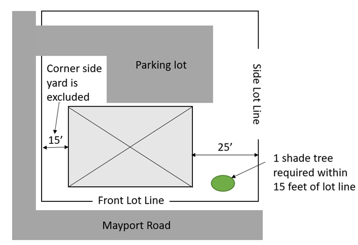
(Ord. No. 90-24-253, § 3(Exh. A), 10-14-24)
Sec. 24-171. - Commercial corridor development standards.
(a)
Intent. The following additional standards and requirements shall apply to those lands within all commercial zoning districts that are located along arterial street corridors within the City of Atlantic Beach. The intent of these additional requirements is to: Enhance the aesthetic and physical appearance of these gateways into the city; enhance and retain property values; promote appropriate redevelopment of blighted areas; and to create an environment that is visually appealing and safe for pedestrians, bicycles and vehicular traffic. New development in the CBD and TM zoning districts may be exempted from the landscaping provisions of this section by the planning and community development director.
(b)
Delineation of commercial corridors. Commercial corridors are defined in section 24-17. They are graphically depicted on the following map:

Figure 11 Commercial Corridor Map
(c)
Building form and finish materials. The following general provisions shall apply to all development in the commercial corridors.
(1)
Roofs, which give the appearance of a flat roof from any street side of the building, are prohibited. Roofs may be gabled, hipped, mansard or otherwise designed so as to avoid the appearance of a flat roof from the adjoining street.
(2)
Open bay doors and other similar large doors providing access to work areas and storage areas shall not open towards or face the commercial corridors.
(3)
The exterior finish of new buildings, and also exterior finish alterations and additions to the front and any street side, or any side visible from adjoining residential properties, of existing buildings shall be of brick, wood, stucco, decorative masonry, exterior insulation and finish systems (EIFS), architectural or split-faced type block, or other finish materials with similar appearance and texture. Metal clad, corrugated metal, plywood or oriented strand board (OSB), and exposed plain concrete block shall not be permitted as exterior finish materials of a building.
(4)
Blank exterior walls facing the commercial corridors, which are unrelieved by doors, windows and architectural detail, shall not be permitted.
(5)
Burglar bars, steel gates, metal awnings and steel-roll down curtains are prohibited on the exterior and interior of a structure when visible from any public street. Existing structures which already have burglar bars, steel gates, metal awnings and steel-roll down curtains shall be brought into compliance with these provisions within a reasonable time after any change of ownership of the property, which shall not be more than ninety (90) days.
(d)
Signs. Signs shall be regulated as set forth within chapter 17 of this Code, except that externally illuminated monument signs are encouraged.
(e)
Lighting. Exterior lighting shall be the minimum necessary to provide security and safety. Direct lighting sources shall be shielded or recessed so that excessive light does not illuminate adjacent properties or the sky.
(f)
Fences. The use of chain link, barbed wire, razor or concertina wire, and similar type fencing shall be prohibited in any required front yard and in any required yard adjoining a street.
(g)
Landscaping and required buffers. The requirements of article III, division 8 of this chapter shall apply, except that the following additional requirements shall also apply to new development and to redevelopment that is subject to the requirements of article III, division 8. Required buffers and landscape materials shall be depicted on all plans submitted for review. See Figure 12 for a graphical depiction of street frontage landscaping requirements.
(1)
A ten-foot wide buffer shall be required along the entire parcel frontage of the commercial corridors, except for driveways. This buffer shall consist of trees as required by division 8 and shall also contain a continuous curvilinear row of evergreen shrubs not less than two (2) feet in height at installation. Buffers shall be kept free of debris and litter and shall be maintained in a healthy condition.
(2)
Along the front of the principal building, a six-foot wide area shall be maintained between the building and the parking area or any walkway. This area shall be used for landscaping.
(3)
Sod or ground cover shall be installed and maintained in a healthy condition. Only organic mulch shall be used, and the excessive use of mulch is discouraged.
(4)
Because of the harsh environment of the commercial corridors, the use of landscape materials that are drought and heat resistant is strongly encouraged. Unhealthy or dead landscape materials, including sod and ground covers shall be replaced within thirty (30) days of written notification from the city to the property owner.
(5)
Stormwater retention or detention facilities may be placed within required buffers, provided that required landscape materials are provided.
(Ord. No. 90-24-253, § 3(Exh. A), 10-14-24)
Sec. 24-172. - Residential development standards.
(a)
Purpose and intent. The diversity of residential types is recognized as an asset to this community's unique character. The purpose of these regulations is also to regulate the future use and development of land in a manner that minimizes incompatible relationships within neighborhoods that may result from new development, which because of excessive height, mass or bulk may result in new development that excessively dominates established development patterns within neighborhoods or excessively restricts light, air, breezes or privacy on adjacent properties.
The further intent of these regulations is to appropriately limit height and bulk and mass of residential structures in accordance with the expressed intent of the citizens of Atlantic Beach, and also to support and implement the recitals of Ordinance 90-06-195 and as more specifically enumerated below:
(1)
To ensure that buildings are compatible in mass and scale with those of buildings seen traditionally within the residential neighborhoods of Atlantic Beach.
(2)
To maintain the traditional scale of buildings as seen along the street.
(3)
To minimize negative visual impacts of larger new or remodeled buildings upon adjacent properties.
(4)
To promote access to light and air from adjacent properties.
(5)
To preserve and enhance the existing mature tree canopy, particularly within front yards.
(b)
Applicability. The development standards and provisions set forth within this section shall apply to development of single-family and two-family dwellings within that area of the city depicted on Figure 13 and generally referred to as Old Atlantic Beach, which for the purposes of this section shall be bounded by:
Ahern Street and Sturdivant Avenue, between the beach and Seminole Road on the south;
Seminole Road, extending north to 11th Street on the west;
11th Street extending east to East Coast Drive, and also including Lots 2, 4, 6, 8, 10, 12, 14, 16, 18, 20, 22, 24, 26, 28, 30 and 32 within Block 14 located on the north side of 11th Street and west of East Coast Drive; and
East Coast Drive extending north to its terminus, then along Seminole Road to 16th Street, and 16th Street extending east to the beach, with the beach being the eastern boundary of this area.
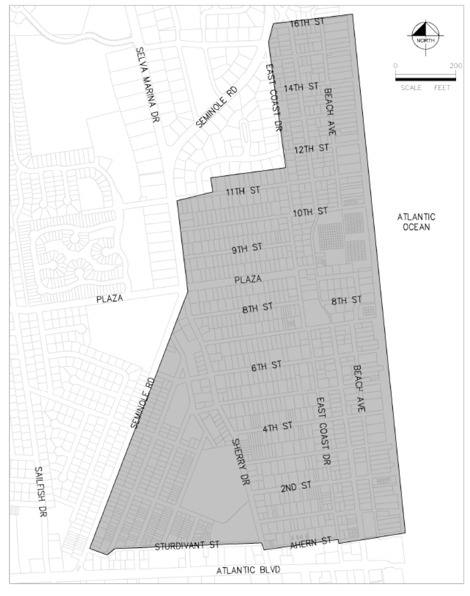
Figure 13 Old Atlantic Beach
Development, as used within this section, shall also include complete redevelopment of lots and certain renovations and additions to single-family and two-family dwellings as set forth herein.
(c)
Additional residential development standards. The following standards and requirements shall apply to that area defined in preceding subsection (b):
(1)
Side wall planes. To avoid stark, exterior side walls from facing the sides of adjacent residences, on two-story and three-story residences, the following standards shall apply to new two-story and three-story single-family and two-family dwellings; to renovations involving structural alterations or additions to the sides of existing single-family and two-family dwellings, and where a second or third-story is added to an existing single-family and two-family dwelling.
a.
Second and third-story exterior side walls, which exceed thirty-five (35) feet in length, shall provide horizontal offsets of at least four (4) feet, or architectural details, design elements or other features, which serve to break-up the appearance of the side wall, such that adjacent properties are not faced on the side by blank two-story or three-story walls void of any architectural design other than siding material or windows.
b.
Such design features may also include balconies, bay windows and other types of projecting windows or architectural details provided that these projections shall not extend more than twenty-four (24) inches into the required side yard (including roof overhangs), shall project at least six (6) inches from the wall, and that a minimum separation of ten (10) feet is maintained between such extensions into the required side yard and any other existing adjacent residential buildings. Enclosed projections, such as bay windows, into required yards shall not exceed twelve (12) feet in length nor shall the total length of all enclosed projections exceed twenty (20) percent of the length of the building façade. Enclosed projections, other than chimneys, into required yards shall not be less than eight (8) feet above the finished first floor elevation.
(2)
Height to wall plate. The maximum height to the top horizontal framing member of a wall from the first-floor finished floor elevation shall not exceed twenty-two (22) feet. Any wall that is above this height shall be inset at least five (5) feet from the exterior wall below.
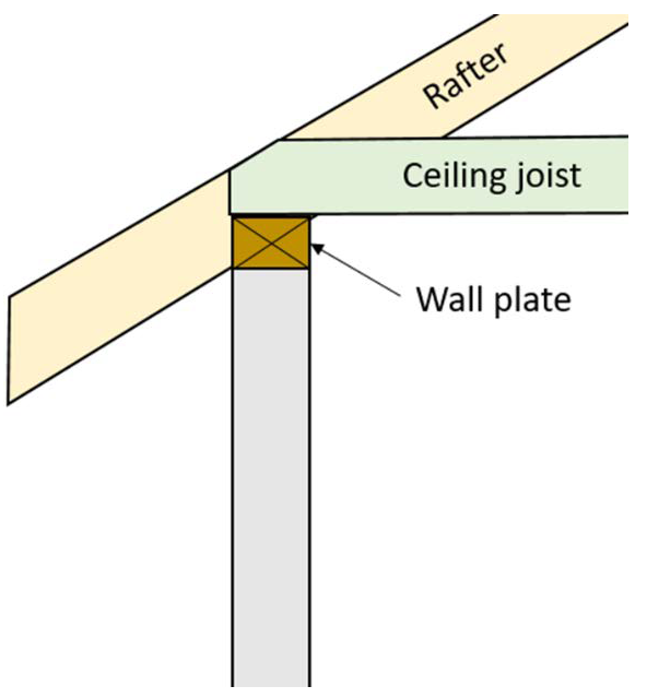
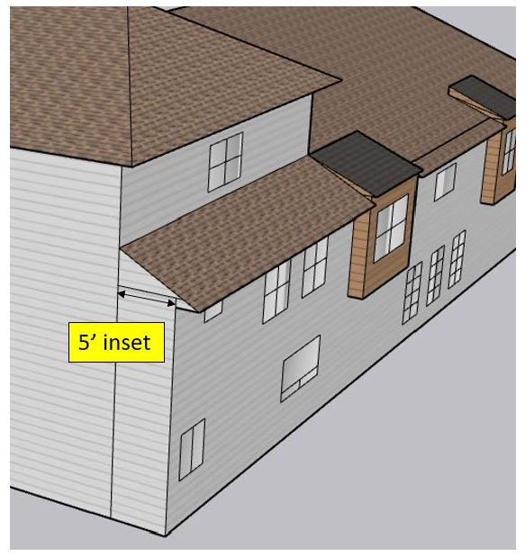
(3)
Third floor footprint. The interior living area of any third-floor shall not exceed fifty (50) percent of the size of the second floor interior living area.
(4)
Shade trees. In order to sustain the existing tree canopy and to provide shade along the residential streets and sidewalks, one (1) shade tree shall be provided within the required front yard and an additional shade tree shall be required on the lot in a location at the property owner's discretion in accordance with the following provisions:
a.
The trees required in this section may be used to satisfy all or a portion of the requirements of section 23-30(1). All other requirements of chapter 23 shall be applicable.
b.
Such required trees shall be installed prior to issuance of a certificate of occupancy or prior to final inspections, as applicable.
c.
Required shade trees shall have a minimum size of four-inch caliper at the time of installation. A list of recommended tree species is available from the city.
d.
Credit shall be provided for the following, and an additional front yard shade tree shall not be required:
1.
Where healthy shade trees exist in the required front yard, which are listed on the recommended tree list and are at least four-inch caliper; or
2.
Where an oak tree exists in the required front yard, which is at least six (6) feet tall; or
3.
Where a healthy shade tree exists in the adjacent right-of-way, which is listed on the city's recommended tree list and is at least four-inch caliper.
e.
Similarly, credit shall be given for the second required shade tree where such tree, as described above, exists elsewhere on the lot.
f.
Where installation of a front yard shade tree is required, such tree shall not be planted within rights-of-way or over underground utilities.
(d)
Special treatment of lawfully existing single-family and two-family dwellings, which would otherwise be made nonconforming by enactment of this section, establishing these residential development standards. Any lawfully existing single-family or two-family dwelling, which has been constructed pursuant to properly issued building permits prior to the effective date of these residential development standards, adopted on September 11, 2006 by Ordinance Number 90-06-195, shall be deemed a vested development, and any such single-family or two-family dwelling shall be considered a lawful permitted structure within the lot or parcel containing the vested development, and shall not be considered as a nonconforming structure with respect to the regulations contained within this section.
(1)
It is the intent of this section to clarify when these residential development standards shall apply in the case of reconstruction or redevelopment following:
a.
A natural event such as a hurricane, wind, flood or fire; or
b.
Redevelopment initiated by a property owner or authorized agent for a property owner.
(2)
The following provisions shall apply only to those improvements, which would otherwise be nonconforming as a result of the requirements of this section.
a.
Structures damaged or destroyed by natural events or by any means not resulting from the actions of the property owner. Any lawfully existing single-family or two-family dwelling, which has been constructed pursuant to properly issued building permits prior to the effective date of these residential development standards, adopted on September 11, 2006 by Ordinance Number 90-06-195, shall be deemed a vested development, and any such singlefamily or two-family dwelling shall be considered a lawful permitted structure within the lot or parcel containing the vested development. Furthermore, any such existing single-family or two-family dwelling, shall not be considered as a nonconforming structure with respect to the regulations contained in this section. Any such single family or two-family dwelling may be fully replaceable in its footprint and of the same size and architectural design existing prior to the natural event or other means not resulting from the actions of the property owner, subject to all applicable building codes and other land development regulations controlling development and redevelopment of such lots or parcels. Any construction that exceeds said footprint size or architectural design shall be in compliance with all applicable provisions of this chapter including minimum yard requirements.
b.
Structures damaged, destroyed or demolished or expanded, by any means resulting from the actions of the property owner or authorized agent for a property owner. Said vested single-family or two-family dwellings, which are rebuilt or renovated, or expanded by more than twenty-five (25) percent in floor area, shall be subject to applicable provisions of these residential development standards for that portion of the structure that is rebuilt, renovated or expanded.
(3)
The provisions of section 24-85 shall otherwise apply to non-vested nonconforming lots, uses and structures.
(e)
Requests to vary from the provisions of the residential development standards. Recognizing that there may be alternative means by which to achieve the purpose and intent of this section, an applicant may request a variance to provisions of this section in accordance with the procedures as set forth within section 24-65 of this chapter, except that the following shall be considered as grounds to approve such requests. Variance requests from the shade tree requirement of this section shall be reviewed using the variance criteria in chapter 23 of this Code.
Requests to vary from the provisions of the residential development standards may be granted, at the discretion of the community development board, upon finding that:
a.
The proposed development will not result in excessive height, mass or bulk that will excessively dominate the established development pattern within the neighborhood or excessively restricts light, air, breezes or privacy on adjacent properties.
b.
The proposed development will be compatible and consistent with the diversity of architectural styles and building forms found in Old Atlantic Beach.
(Ord. No. 90-24-253, § 3(Exh. A), 10-14-24)
Sec. 24-173. - Neighborhood preservation and property maintenance standards.
(a)
Purpose and intent. The City of Atlantic Beach is composed predominantly of older residential subdivisions and neighborhood scale commercial businesses serving these neighborhoods. It is in the public interest of the city to foster diverse and stable neighborhoods and to implement strategies in support of related objectives and policies as expressed within the city's adopted comprehensive plan. The purpose and intent of these regulations is to provide minimum standards for the acceptable conditions of properties and structures within the city and to assist in the implementation of the International Property Maintenance Code, which is adopted as article VIII within chapter 6 of this Municipal Code of Ordinances.
(b)
Appropriate maintenance and upkeep. All areas of a lot and structures that are visible from a street or a neighboring property shall be maintained in an acceptable manner, which shall be defined by the following characteristics:
(1)
Lots are maintained free of litter, trash, debris, discarded belongings, automotive parts and old tires, construction materials, and broken and abandoned items.
(2)
Dead shrubbery or landscaping is removed from lots, and where a resident is unable to maintain a lawn or landscaping, dirt or sand areas are contained in some manner so as to prevent dirt or sand from blowing or washing on to adjacent properties, the street or the city's stormwater system.
(3)
Broken or missing glass in windows or doors is replaced with glass, and where windows or doors are visible from the street, these are not covered with wood, fiberglass, metal, cardboard, newspaper or other similar materials, except for a temporary time period as needed to make proper repairs or to protect windows from wind-borne debris during a storm.
(4)
Trim work, eaves, soffits, gutters, shutters, and decorative features are not broken and are securely attached as intended.
(5)
Household items of any type that are customarily intended to be used and maintained within the interior of a residence are not stored or discarded in any location on a lot that is visible from a street. Similarly, within the rear or side yards of a lot, such items are not stored in a manner or amount such that an unsightly nuisance to neighboring properties or an environment that attracts rodents, insects, or other animals and pests is created.
(Ord. No. 90-24-253, § 3(Exh. A), 10-14-24)
Sec. 24-174. - Boats and watercraft.
These provisions shall apply to all waters over which the city has jurisdictional authority and shall not be construed to apply to waters under the sovereign control of the State of Florida, except as similarly addressed in state law.
(a)
Intent. The purpose and intent of this section is stated as follows:
(1)
To protect water quality and environmentally sensitive areas within and adjacent to the City of Atlantic Beach;
(2)
To protect vegetative communities, wildlife habitats and the natural functions of fisheries, wetlands and estuarine marshes;
(3)
To protect the rights of the public to use waterways for navigation and recreation including the temporary or overnight anchoring of boats; and
(4)
To prohibit the permanent mooring and storage of privately owned watercraft within tributaries and deepwater channels adjoining the Intracoastal Waterway in that such activity has the potential to create obstacles to safe navigation and to interfere with rights of navigation and recreational use and also to create hazards to persons and property where such watercraft may not be attended or secured during storm or hurricane events.
(b)
Unlawful to discharge. It shall be unlawful to discharge, or allow to be discharged, from any watercraft or dock any sewage, refuse, garbage, fuel or other contaminants or any waste material into waters within the City of Atlantic Beach.
(c)
Damage to or destruction of environmentally sensitive areas. It shall be unlawful for any person to operate, dock, moor or anchor any watercraft in a manner that causes damage or adverse impacts to any marine or water resource, wildlife habitat or other environmentally sensitive areas as defined within this chapter and as set forth within the conservation and coastal management element of the comprehensive plan.
(d)
Public docks and anchoring and mooring restrictions.
(1)
Within the waters of Tideviews Preserve and Dutton Island Preserve docking or anchoring shall be restricted to nonmotorized boats and watercraft or to those equipped only with electric trolling motors.
(2)
Within the waters of the River Branch Preserve, no watercraft or floating structure shall be permanently anchored or moored, or tethered to the shore in any manner, it being the express intent of the city that these natural resources of the city be held in the public trust and not used for permanent mooring or storage of privately owned watercraft. Nontrailered watercraft that are observed and documented to be within the waters of the River Branch Preserve for periods of longer than one (1) week, or for which the registered owner can provide no proof of where the watercraft is elsewhere kept, shall be presumed to be permanently kept in the preserve and shall be in violation of this Code and subject to established code enforcement action or other remedies available under applicable law.
(3)
No permanent mooring device shall be placed within any waters east of the right-of-way of the Intracoastal Waterway as delineated by the United States Army Corps of Engineers or within any of it connected creeks or tributaries.
(e)
Live-aboard vessels prohibited. Live-aboard vessels shall be prohibited within all waters under the jurisdictional authority of the City of Atlantic Beach.
(f)
Private property rights. These provisions shall not be construed or enforced to diminish any lawfully established riparian rights or rights of navigation, access or view entitled to private property owners.
(Ord. No. 90-24-253, § 3(Exh. A), 10-14-24)
Sec. 24-175. - Mayport business overlay district.
(a)
Purpose and intent. The purpose and intent of the Mayport business overlay district is to encourage economic development by providing for a mix of uses in the commercial and light industrial zone properties located within the Mayport business overlay district.
(b)
Applicability.
(1)
The Mayport business overlay district provisions set forth within this section shall apply to all use, development and redevelopment of certain commercial limited ("CL"), commercial general ("CG") and light industrial and warehouse ("LIW") zoned properties located within the boundaries of the Mayport business overlay district, and more particularly shown on Figure 16 and described follows:
Atlantic Boulevard between Mayport Road and the southerly extension of Main Street on the south;
Main Street, including the southerly extension to Atlantic Boulevard and North Main Street on the West;
Dutton Island Road West between North Main Street and Mayport Road on the north; and
Mayport Road between Atlantic Boulevard and Dutton Island Road West on the east, including those properties with frontage on Mayport Road on the east side of Mayport Road and north of North Forrestal Circle.
(2)
In the event lots or parcels are designated TM within the Mayport business overlay district, the TM provisions set forth in section 24-116 shall apply to all use, development, and redevelopment of such lots and parcels.
Figure 16 Mayport Business Overlay District
(c)
Permitted uses. The permitted uses on properties zoned CL, CG, and LIW which are included within the Mayport business overlay district shall include those uses enumerated in the property's respective zoning district or districts, as well as any of the following uses:
(1)
Service establishments where a service is provided on-site, such as restaurants, banks or financial institutions, barbers or beauty shops, tailors or dress makers, gyms, printers, fine arts schools, on-site repairmen, minor automotive repair, and childcare facilities.
(2)
Retail sales of foods, clothing, jewelry, toys, books, flowers, art, home furnishings, home appliances, automotive parts, plants, beer and wine only for off-premises consumption.
(3)
Professional and business offices such as doctors, attorneys, architects, and real estate brokers.
(4)
On-premises consumption of beer and wine in conjunction with a restaurant, where at least fifty-one (51) percent of sales are from food and non-alcoholic beverages.
(5)
Other than breweries or distilleries, wholesale operations in conjunction with on-premises retail sales, where at least fifty-one (51) percent of sales are from on-premises retail sales.
(6)
Craftsmen and artist operations in conjunction with on-premises retail and service establishments, such as furniture repair with woodworking, artists' studios with retail sales, surfboard repair with surfboard production, metal welding with decorative iron works and tap room with brewery or distillery, provided the gross enclosed square footage does not exceed two thousand five hundred (2,500) and that all such operations take place within enclosed buildings.
(7)
Contractors where work is performed off-site, such as plumbing, electrical, heating and air conditioning, lawn care, and pest control.
(8)
Hotels, motels, resorts, and short-term rentals as defined in section 24-17.
(9)
Non-amplified live entertainment performed within an enclosed building, not including adult entertainment establishments as defined by F.S. § 847.001(2).
(10)
Civic centers such as libraries, museums, and cultural centers.
(11)
Religious institutions in accordance with section 24-153.
(12)
Mixed use projects combining the uses above, and/or those permitted by right by the zoning district as applicable.
In the event of a conflict between the uses authorized by a respective zoning district and in this subsection, the least restrictive regulation shall be applicable.
(d)
Uses-by-exception. The use-by-exception uses on properties zoned CL, CG, and LIW which are included within the Mayport business overlay district shall include those uses enumerated as uses-by-exception in the property's respective zoning district or districts, as well as any of the following uses:
(1)
Veterinary clinics, pet grooming, pet day cares, and pet kennels including those for the overnight boarding of animals.
(2)
Hospitals.
(3)
On-premises consumption of alcoholic beverages, other than restaurants with on-premises consumption and tap rooms as described in section 24-175(c)(4) and (6) respectively.
(4)
Retail sale of gasoline, diesel, propane, hydrogen, electricity for battery charging or other fuels intended for use in motors.
(5)
Sale of new and used automobiles, motorcycles, boats, and street legal electric vehicles, and automotive leasing establishments.
(6)
Drive-through facilities including those in association with restaurants, banks, retail establishments, pharmacies and ice vending machines.
(7)
Mixed use projects combining the uses above, as approved, and/or those in subsection (c) above as well as those permitted by right or use-by-exception by the zoning district as applicable.
(8)
Craftsmen and artist operations in conjunction with on-premises retail and service establishments, such as furniture repair with woodworking, artists' studios with retail sales, surfboard repair with surfboard production, metal welding with decorative iron works and tap room with brewery or distillery, provided that all such operations take place within enclosed buildings, if the gross enclosed square footage exceeds two thousand five hundred (2,500).
In the event of a conflict between the uses authorized by a respective zoning district and in this subsection, the least restrictive regulation shall be applicable.
(e)
Commercial vehicle regulations. Commercial vehicles parked on CL, CG, or LIW properties with a local business tax receipt and which are included within the Mayport business overlay district are permitted, provided that they are parked within the confines of a property on a stabilized surface such as asphalt, concrete, or pavers and are properly registered. Commercial vehicles shall include all cars, trucks, vans, trailers and other vehicles authorized to operate on public streets.
(f)
Outside storage regulations. The following provisions regarding fencing and landscaping shall be applicable to the use, development, and redevelopment of CL, CG, or LIW zoned properties which are included within the Mayport business overlay district, in addition to other fencing and landscaping regulations contained within the city's Code of Ordinances; provided, however, that, in the event of a conflict between the express provisions below and any other fencing or landscaping regulations, the express provisions below shall apply.
For property with a local business tax receipt where outside storage of equipment, trailers, materials, products not intended for immediate sale as permitted elsewhere in the Code, or other similar items occurs in side and rear yards (only other than properly registered, as applicable, commercial vehicles in accordance with subsection (e) above):
All such outside storage shall be screened from view with fencing and landscaping so that no significant portion is visible from the street or adjoining properties in accordance with the following provisions.
(1)
Fencing shall be made of wood, vinyl, or masonry, except that exposed plain concrete block shall not be permitted
(2)
Fencing shall be at least eighty-five (85) percent opaque.
(3)
Fencing height and location shall be as follows:
a.
Six (6) feet tall in any side yard adjoining a street and located at least ten (10) feet from the property line.
b.
Six (6) feet tall in side yards not adjoining a street and rear yards, except where permitted to be taller by this chapter, and located on the property line.
(4)
Landscaping with proper irrigation shall be required in the area between property lines and fencing in side yards which adjoin a street on corner lots as follows:
a.
A continuous line of shrubs no taller than three (3) feet, provided clear sightlines exist at intersections and driveways in accordance with chapter 19; and
b.
At least one (1) tree found in the City of Atlantic Beach recommended tree list in chapter 23 of the Code of Ordinances for every twenty-five (25) linear feet of street frontage excluding driveways. The trees may be clustered, but shall be no more than fifty (50) feet apart. Fifty (50) percent of all trees shall be shade trees. Palms may be substituted for the required trees at a ratio of two (2) palms for each required tree or four (4) palms for each required shade tree.
(5)
All fencing and landscaping improvements on corner lots shall meet the sight-line provisions contained in chapter 19, as may be amended, of the city's Code of Ordinances.
(g)
Effect of other Code provisions. Except as expressly modified by the provisions of this section, all other provisions of sections 24-110, 24-111 and 24-112, as may be amended, of the city's Code of Ordinances, as well as other applicable provisions in the city's Code of Ordinances, shall remain valid and in full force and effect as to the use, development and redevelopment of all CL, CG, and LIW zoned properties within the Mayport business overlay district.
(Ord. No. 90-24-253, § 3(Exh. A), 10-14-24)
Sec. 24-176.- Applicability, requirements, buffer design standards, maintenance, protection, visibility, and exceptions.
(a)
Intent. It is the intent of these regulations to promote the health, safety and welfare of the current and future residents of the City of Atlantic Beach by establishing minimum standards for the conservation of water, the protection of natural plant communities, the installation and continued maintenance of landscaping, and the protection of trees within the City of Atlantic Beach.
(b)
Applicability. The provisions of this section shall apply to properties that meet one (1) or more of the following:
(1)
New non-residential or multi-family development.
(2)
When the total square footage of a non-residential or multifamily structure is expanded by more than twenty five (25) percent or when cumulative expansions total more than twenty five (25) percent within a two (2) year time frame.
(3)
When the total cost of alteration, expansion, or renovation of a non-residential or multi-family development is equal to or exceeds twenty five (25) percent of the current assessed value of the parcel improvements within a two (2) year time frame. Construction costs shall be determined in accordance with the building evaluation data sheet as established by the International Code Council.
(c)
Landscape plan required.
(1)
Prior to the issuance of any development permit for nonresidential development and multi-family development, a landscape plan shall be approved by the planning and community development director. A landscape plan shall be submitted with site plans applications as required by all other provisions in this chapter. The landscape plan shall be prepared by either the owner or a licensed, registered landscape architect, bearing his seal, or shall be otherwise prepared by persons authorized to prepare landscape plans or drawings pursuant to Chapter 481, Part II, Florida Statutes (landscape architecture).
(2)
The required landscape plan shall be drawn to scale, including dimensions and distances, and shall:
a.
Delineate the vehicular use areas, access aisles, driveways, and similar features;
b.
Irrigation plan in accordance with section 24-178(b);
c.
Designate by name and location the plant material to be installed or preserved in accordance with the requirements of this part. The use of xeriscape landscape materials and methods is strongly encouraged;
d.
Identify and describe the location and characteristics of all other landscape materials to be used;
e.
Show all landscape features, including areas of vegetation required to be preserved by law, in context with the location and outline of existing and proposed buildings and other improvements upon the site, if any;
f.
Include a tabulation clearly displaying the relevant statistical information necessary for the director to evaluate compliance with the provisions of this part. This includes gross acreage, square footage of preservation areas, number of trees to be planted or preserved, square footage of paved areas, and such other information as the director may require; and
g.
Indicate all overhead and underground utilities located on the property and in the right-of- way adjacent to the property to which the landscape plan applies. This shall include overhead and underground electric service lines to all proposed buildings.
h.
A tree protection plan, in accordance with chapter 23, Protection of trees and the natural environment.
(d)
Vehicular use area interior landscaping requirements.
(1)
At least ten (10) percent of vehicular use areas (VUAs) used for off-street parking, employee parking, gas stations, service drives, and access drives shall be landscaped except that the following shall be exempt from this requirement.
a.
Vehicle use areas located within or under a building.
b.
Vehicle use areas within the central business district (CBD) or traditional marketplace (TM).
c.
Development where ten (10) or less parking spaces are required.
(2)
Specialized vehicular use areas closed to the public. Five (5) percent of VUAs used for storage areas for new, used or rental vehicles and boats; motor vehicle service facilities; motor freight terminals; and other transportation, warehousing and truck operations not generally open to the public shall be landscaped.
(3)
Criteria for distribution. Landscape areas shall be distributed throughout the VUA in such a manner as to provide visual relief from broad expanses of pavement and at strategic points to channel and define vehicular and pedestrian circulation. Landscape areas shall contain the following:
a.
At least twenty-five (25) percent of the landscape areas shall be covered with shrubs; the remainder in shrubs, groundcover, mulch or grass. Shrubs shall be spaced on three-foot spacing.
b.
Not less than one (1) tree for every four thousand (4,000) square feet of the VUA.
(4)
Landscape islands and medians.
a.
Each row of parking spaces shall be terminated by a perimeter landscape area or a landscape island. Landscape islands shall have inside dimensions of not less than ten (10) feet wide and seventeen (17) feet long, or thirty-five (35) feet long if a double row of parking, not including the width of the median.
b.
The maximum number of parking spaces allowed between landscape islands is ten (10), except up to twenty (20) parking spaces are allowed between landscape islands when the parking is adjacent to a building.
c.
A landscape median at least fifteen (15) feet wide is required to separate parking rows from access drives and between at least fifty (50) percent of parking rows. Landscape medians may contain a pedestrian walkway provided a planting area at least eight (8) feet wide is maintained.
d.
Each landscape island shall contain at least one (1) shade tree. Landscape islands provided for double rows of parking shall contain two (2) shade trees.
e.
Each landscape median shall contain one (1) shade tree for every twenty five (25) linear feet, or fraction thereof.
f.
Each side of the landscape island or median adjacent to a travel lane shall have a continuous six-inch high curb of concrete or other appropriate permanent material. The use of depressed rain gardens or bioswales in parking lot landscaping is strongly encouraged. Curb stops, rather than continuous curb, may be used to allow runoff to flow to the landscaped area.
(e)
Perimeter landscaping requirements.
(1)
Street frontage landscaping. All VUA that are not entirely screened by an intervening building from any abutting dedicated public street or approved private street, to the extent such areas are not so screened, shall contain the following:
a.
Landscape area.
i.
In districts other than CBD and TM, a landscape area of at least seven (7) feet in width shall be located between the VUA and abutting street right-of-way. This landscape area shall be at least ten (10) feet in width when adjacent to Mayport Road or Atlantic Boulevard.
ii.
In the CBD and TM zoning districts, a landscape area of at least five (5) feet in width shall be located between the VUA and the abutting street right-of-way. This landscape area shall be at least ten (10) feet in width when adjacent to Mayport Road or Atlantic Boulevard.
b.
A durable opaque landscape screen along at least seventy-five (75) percent of the street frontage, excluding driveways. Shrubs, walls, fences, earth mounds and preserved existing under-story vegetation, or combination thereof, may be used so long as the screen is no less than three (3) feet high measured from the property line grade. Walls or fences shall be no more than four (4) feet in height and of wood or masonry at least eighty-five (85) percent opaque. Earth mounds shall not exceed a slope of three (3) to one (1). No less than twenty- five (25) percent of street side frontage of walls or fences shall be landscaped with shrubs or vines.
c.
No less than one (1) tree, located within twenty-five (25) feet of the street right-of-way, for each twenty-five (25) linear feet, or fraction thereof, of VUA street frontage. The trees may be clustered but shall be no more than fifty (50) feet apart. If an overhead power line abuts the street frontage, then the required trees reaching a mature height greater than twenty-five (25) feet shall be located at least fifteen (15) [feet] away from the power line.
d.
At least fifty (50) percent of these required trees shall be shade trees. This provision may be waived by the planning and community development director if it is determined that shade trees will conflict with overhead utilities, however at least fifty (50) percent of the total trees required for landscaping must still be shade trees in accordance with section 24-176(j)(2)c.
e.
The remainder of the landscape area shall be landscaped with trees, shrubs, ground covers, grass, or mulch.
f.
Landscape areas required by this section shall not be used to satisfy the interior landscape requirements; however, the gross area of the perimeter landscaping which exceeds the minimum requirements may be used to satisfy the interior landscape requirements.
g.
If a utility right-of-way separates the VUA from the public street or approved private street, the perimeter landscaping requirements of this section shall still apply.
(2)
Perimeter landscaping adjacent to lot lines. Except those within the central business district, all vehicular use areas that are not entirely screened by an intervening building from an abutting property, to the extent such areas are not screened, shall contain the following:
a.
A continuous landscape area at least five (5) feet wide between the VUAs and the abutting property, landscaped with shrubs, ground covers, preserved existing vegetation, mulch and grass.
b.
No less than one (1) tree, located within twenty-five (25) feet of the outside edge of the VUA, for every fifty (50) linear feet, or fraction thereof, of the distance the VUA abuts the adjacent property. Trees may be clustered but shall be no more than seventy-five (75) feet apart.
c.
A buffer between incompatible land uses as required by section 24-167, if applicable.
d.
If an alley separates the VUA from the abutting property, the perimeter landscaping requirements shall still apply.
(f)
Driveways with landscape islands. A landscape island within a driveway, in accordance with section 24-162, shall be no less than eight (8) feet in width (from back of curb to back of curb) and contain a six-inch continuous raised curb or other alternative approved by the planning and community development director. At least twenty five (25) percent of the landscaped island shall be covered in shrubs; the remainder in shrubs, groundcover, mulch or grass.
(g)
Driveways to adjoining lots. Driveways may be permitted by the planning and community development director to adjoining lots of compatible use.
(h)
If a joint driveway easement is provided between adjacent property, then the required perimeter landscaping for each property shall be provided between the drive and any other vehicular use areas.
(i)
Buffers required between incompatible or different use classifications.
(1)
Where incompatible or different use classifications are adjacent, without an intervening street, a buffer strip shall be required between such uses. Such buffer strip shall be at least ten (10) feet in width the entire length of all such common lot lines and shall be required in the following circumstances:
a.
Multiple-family development when adjacent to lands zoned for single-family dwelling.
b.
Office use or zoning districts, when adjacent to single-family or multiple-family dwellings, mobile home parks or subdivisions or lands zoned for single-family or multiple-family dwellings, mobile home parks or subdivisions.
c.
Mobile home park use or zoning districts, when adjacent to single-family dwellings, multiplefamily dwellings and office uses, or lands zoned for single-family dwellings, multiple-family dwellings or offices.
d.
Commercial and institutional uses or zoning districts, when adjacent to single-family dwellings, multi-family dwellings or mobile home parks or mobile home subdivision uses or lands zoned for single-family dwellings, multi-family dwellings or mobile home parks or mobile home subdivisions.
e.
Industrial uses or zoning districts, when adjacent to any non-industrial uses or zoning districts other than agricultural land uses or zoning districts.
(2)
Required buffers shall at a minimum contain the following landscape materials:
a.
Trees. The total tree count required within the buffer strip shall be one (1) tree for each twenty-five (25) linear feet of required buffer strip, or majority portion thereof.
b.
Ground cover. Grass or other ground cover shall be planted on all areas of the buffer strip.
c.
Visual screen. A visual screen running the entire length of common boundaries shall be installed within the buffer strip, except at permitted access ways. The visual screen may be a wood or masonry wall, landscaping, earth mounds or combination thereof. Earth mounds shall not exceed a slope of three (3) to one (1). If a visual screen which satisfies all applicable standards exists on adjacent property abutting the property line or exists between the proposed development on the site and the common property line, then it may be used to satisfy the visual screen requirements.
d.
Prevailing requirement. Whenever parcels are subject to both the perimeter landscaping requirements and buffer strip requirements of the article, the latter requirements shall prevail.
e.
Hardship. If the planning and community development director determines that the construction of a landscape buffer area required by this section shall create an unreasonable hardship, the director may approve a buffer area with a width no less than five (5) feet, provided such buffer area meets the visual screening requirements of this section.
(3)
The required buffer strip shall not contain principal or accessory uses and structures, vehicular use areas, dumpster pads, signs, equipment, or storage.
(4)
If any conflict exists between the provisions of 24-167 and this subsection, the more restrictive shall apply.
(j)
Landscape design standards.
(1)
Trees required for vehicular use area landscaping may be used to fulfill the tree requirements of this section.
(2)
Standards for landscape materials.
a.
Trees planted shall be on the City of Atlantic Beach Recommended Tree List as contained in article III, chapter 23 of the Code of Ordinances.
b.
Trees used to satisfy the requirements of this division shall have a minimum four (4) inch caliper and a minimum height of ten (10) feet at the time of planting. Palm trees shall have a minimum clear trunk height of eight (8) feet.
c.
A minimum of fifty (50) percent of all required trees shall be shade trees. Where more than ten (10) shade trees are required, at least two (2) different shade tree species shall be used.
d.
Trees shall not be planted closer than two (2) feet from any pavement edge or right-of- way line, as measured from center of trunk. Shade trees shall not be planted closer than four (4) feet from any pavement edge or right-of-way line, as measured from center of trunk.
e.
Palms may be substituted for the required trees at the ratio of two (2) palms for each required tree or four (4) palms for each required shade tree. In no case shall palm trees be substituted for more than fifty (50) percent of required trees, except within the central business district.
f.
Criteria for shrubs, vines and ground covers. Hedges and shrubs used for required street frontage landscaping shall be no less than three (3) feet tall. Hedges and shrubs used elsewhere to form an opaque screen shall be no less than a three-gallon container [of] grown material or equivalent balled and burlap material.
g.
Lawns. Lawn grass may be sodded, plugged, sprigged or seeded, except that solid sod shall be used on grass areas within street rights-of-way disturbed by construction, in swales, on slopes of four (4) to one (1) or greater, and on other areas subject to erosion. When permanent seed is sown during its dormant season, an annual winter grass shall also be sown for immediate effect and protection until permanent coverage is achieved.
h.
Mulch. A minimum two-inch layer of organic mulch, such as wood bark, dead leaves and pine straw, shall be applied and maintained in all tree, shrub, and ground cover planting areas and bare preserved natural areas.
i.
General cleanup. At the completion of work, construction trash and debris shall be removed and disturbed areas shall be fine-graded and landscaped with shrubs, ground cover, grass or two (2) inches of mulch.
(k)
Maintenance, irrigation, and protection of landscaping.
(l)
Maintenance. The property owner shall be responsible for the maintenance of all landscaped areas, which shall be maintained in good condition so as to present a healthy, neat and orderly appearance, free of refuse, debris and weeds. Failure to maintain required landscape areas or to replace within thirty (30) days all required landscaping which is dead, irreparably damaged, or fails to meet the standards of this section, shall be deemed a violation of these land development regulations and subject to code enforcement procedures.
(2)
Irrigation. Landscaped areas shall be provided with an automatic irrigation system. Irrigation systems shall be in accordance with section 24-178 and include moisture or rain sensors.
(3)
Tree pruning. Required trees shall be allowed to develop into their natural habit of growth. Trees may be pruned to maintain health and vigor by removal of dead, weak, damaged or crowded limbs, diseased and insect-infested limbs, and branches which rub other branches.
(4)
Tree protection. Tree protection during construction shall meet the provisions of section 23-32.(l) Intersection visibility. Where an access way intersects with another access way within a vehicular use area, or where an access way is located within a vehicular use area, or where an access way intersects with a street right-of-way, cross visibility within the sight triangle, as defined in this chapter shall be unobstructed at a level between two (2) and eight (8) feet, above elevation of adjacent pavement.
(m)
Special administrative remedies.
(1)
Development parcels with sixty (60) feet or less of street frontage may be exempt from the perimeter landscaping requirements of section 24-176(e)(2) to provide adequate width for drive aisles.
(2)
Where compliance with the landscape requirements would require: the demolition of an existing building; a loss of more than ten (10) percent of the gross required off-street parking for an existing development; or of a loss greater than fifteen (15) percent of the lot area for development, the following administrative remedies may be applied by the planning and community development director:
1.
Reduce the required minimum landscaped area widths up to fifty (50) percent.
2.
Reduce the tree planting requirements by up to twenty-five (25) percent.
3.
If the planning and community development director considers a reduction pursuant to this subsection (b), then the planning and community development director's first priority shall be to require trees along the street frontage and the second priority shall be to require trees within portions of the vehicle use area that are highly visible from any street.
(3)
The planning and community development director may allow the relocation of required landscaped areas to preserve existing trees.
In all cases, a buffer shall always be provided if it is required by section 24-176(i). If the landscape area is less than five (5) feet in width, a minimum six-foot-tall wood or composite fence or masonry wall shall be required.
(Ord. No. 90-24-253, § 3(Exh. A), 10-14-24)
Sec. 24-177. - Florida-friendly landscaping and landscape irrigation.
The Florida Legislature finds that the use of Florida-friendly landscaping and other water conservation and pollution prevention measures intended to conserve or protect the state's water resources serve a compelling public interest and that the participation of homeowners' associations and local governments is essential to the state's efforts in water conservation and water quality protection and restoration, and that Florida-friendly landscaping designs offer significant potential for water conservation benefits. It is the intent of the Florida Legislature to improve landscape irrigation water use efficiency by ensuring that landscape irrigation systems meet or exceed minimum design criteria by requiring local governments to implement regulations to that end.
(Ord. No. 90-24-253, § 3(Exh. A), 10-14-24)
Sec. 24-178. - General provisions.
Definitions are included in the definitions section and are to be used in addition to and in conjunction with chapter 23, protection of trees and the natural environment, of [the] city Code.
(a)
Applicability. The provisions of this section shall apply to the following. (The term lot(s) and parcel(s) may be used interchangeably.)
(1)
New subdivisions; or
(2)
Where new irrigation systems are installed; or
(3)
When more than fifty (50) percent of the irrigation system on a lot is replaced. Fifty (50) percent shall be construed to mean more than half the length of lateral irrigation lines or more than half of the emitters.
(4)
Required landscaping in accordance with section 24-176.
Except as set forth above, these provisions shall not be construed to require changes to permitted or properly installed existing irrigation systems or to landscaping existing as of October 25, 2010. These provisions shall also not apply to bona fide agricultural, greenhouse or nursery activities or to golf courses or athletic fields.
(b)
Irrigation plan.
(1)
Single- and two-family developments are not required to submit an irrigation plan but shall submit an irrigation permit.
(2)
Multi-family and non-residential development shall submit an irrigation plan with the following information prior to the issuance of a building permit:
a.
Delineation of landscape areas, major landscape features, and plant selections.
b.
Delineation of high, moderate, and low water use zones.
c.
Location of rain shut-off devices or moisture sensors.
d.
Location of sprinklers or water outlets and back flow prevention devices.
(3)
Prior to receiving final landscape plan approval, final inspection, or certificate of occupancy as may be applicable, written verification must be provided by a properly licensed qualified contractor, or the property owner, verifying that all irrigated areas are consistent with this section.
(c)
Irrigation system design. Automatic irrigation systems shall be designed to meet the requirements of Appendix F of the Florida Plumbing Code, article IV of this chapter, and section 22-39 of this code. The following shall also be incorporated:
• High volume irrigation is limited to sixty (60) percent of the total landscaped area of the lot. For lawns and turf areas that exceed sixty (60) percent, low or moderate volume irrigation may be used as needed.
• High water use hydrozones shall be located on a separate irrigation zone.
• At least one moisture sensor shall be located in each irrigation zone.
• Emitters shall be sized and spaced to avoid excessive overspray on to impervious surface.
(d)
Appropriate plant selection, location and arrangement.
(1)
Plant selection. Plants used for Florida-friendly lawns and landscaping should be based upon the plant's compatibility with existing conditions of the site including soil type, moisture and light conditions and size at maturity. Consideration should be given to drought and freeze tolerance plants, and where site conditions are suitable, preference in trees should be given to native vegetation and hardwoods that create shade. Appropriate plants are described within the Florida-friendly plant list published by the University of Florida, Extension Institute of Food and Agricultural Sciences (IFAS) or as may be found in other qualified sources of horticultural information.
(2)
Location and arrangement. A key component to saving water and promoting plant health is to group plants in hydrozones according to their water needs. Factors such as soil, climate, sunlight and salt tolerance should also guide the grouping and selection of plants. Low, moderate and high water use hydrozones are described by the following characteristics:
a.
Low water use hydrozones contain plants that rarely require supplemental watering and that are drought tolerant during extreme dry periods such as native shrubs and vegetation, established trees and ground covers and wooded areas.
b.
Moderate water use hydrozones contain plants that once established require irrigation every two (2) to three (3) weeks in the absence of rainfall or when they show visible stress such as wilted foliage or pale color. These are typically perennials, seasonal plants and flower beds.
c.
High water use hydrozones contain plants that require supplemental watering on a regular basis throughout the year. These areas include turf and lawn grasses and are typically characterized as high visibility focal points of a landscaping design where high volume irrigation is used.
(3)
Turf and lawn grasses. Irrigated grass and turf areas shall be considered as high water use hydrozones, and shall be located so that they can be watered using separate irrigation zones. These areas should be consolidated to locations where the functional need calls for lawn and where site conditions are conducive to the health and maintenance of grasses rather than considered as just a fill-in area. For example, despite all efforts, lawn grasses will rarely grow to be healthy and lush under the heavy shade of a dense tree canopy which is emblematic of Atlantic Beach, while ferns, certain ground covers and low-growing native plants flourish with little attention.
(Ord. No. 90-24-253, § 3(Exh. A), 10-14-24)
Sec. 24-179. - Florida-friendly use of fertilizer on urban landscapes.
(a)
Findings. As a result of impairment to the City of Atlantic Beach's surface waters caused by excessive nutrients, or, as a result of increasing levels of nitrogen in the surface water within the boundaries of the City of Atlantic Beach, the governing body of the City of Atlantic Beach has determined that the use of fertilizers on lands within the City of Atlantic Beach creates a risk to contributing to adverse effects on surface and/or ground water. Accordingly, the city commission of the City of Atlantic Beach finds that management measures contained in the most recent edition of the "Florida-Friendly Best Management Practices for Protection of Water Resources by the Green Industries, 2008," may be required by this section.
(b)
Purpose and intent. This section regulates the proper use of fertilizers by any applicator; requires proper training of commercial and institutional fertilizer applicators; establishes training and licensing requirements; establishes a prohibited application period; specifies allowable fertilizer application rates and methods, fertilizer-free zones, low maintenance zones, and exemptions. The section requires the use of best management practices which provide specific management guidelines to minimize negative secondary and cumulative environmental effects associated with the misuse of fertilizers. These secondary and cumulative effects have been observed in and on the City of Atlantic Beach's natural and constructed stormwater conveyances, rivers, creeks, ponds, and other water bodies. Collectively, these water bodies are an asset critical to the environmental, recreational, cultural and economic well-being of the City of Atlantic Beach residents and the health of the public. Overgrowth of algae and vegetation hinder the effectiveness of flood attenuation provided by natural and constructed stormwater conveyances. Regulation of nutrients, including both phosphorus and nitrogen contained in fertilizer, will help improve and maintain water and habitat quality.
(c)
Applicability. This section shall be applicable to and shall regulate any and all applicators of fertilizer and areas of application of fertilizer within the area of the City of Atlantic Beach, unless such applicator is specifically exempted by the terms of this section from the regulatory provisions of this section. This section does not restrict any homeowner or residents from applying fertilizers on their landscape as they deem necessary, but they are strongly recommended to follow the guidelines included herein. This section shall be prospective only, and shall not impair any existing contracts.
(d)
Timing of fertilizer application. No applicator shall apply fertilizers containing nitrogen and/or phosphorus to turf and/or landscape plants during the prohibited application period, or to saturated soils.
(e)
Fertilizer free zones. Fertilizer shall not be applied within ten (10) feet of any pond, stream, watercourse, lake, canal, or wetland as defined by the Florida Department of Environmental Protection (Chapter 62-340, FAC) or from the top of a seawall, unless a deflector shield, drop spreader, or liquid applicator with a visible and sharply defined edge, is used, in which case a minimum of three (3) feet shall be maintained. If more stringent City of Atlantic Beach Code regulations apply, this provision does not relieve the requirement to adhere to the more stringent regulations. Newly planted turf and/or landscape plants may be fertilized in this zone only for a sixty-day period beginning thirty (30) days after planting if needed to allow the plants to become well established. Caution shall be used to prevent direct deposition of nutrients into the water.
(f)
Low maintenance zones. A voluntary ten-foot low maintenance zone is strongly recommended, but not mandated, from any pond, stream, water course, lake, wetland or from the top of a seawall. A swale/berm system is recommended for installation at the landward edge of this low maintenance zone to capture and filter runoff. If more stringent City of Atlantic Beach Code regulations apply, this provision does not relieve the requirement to adhere to the more stringent regulations. No mowed or cut vegetative material may be deposited or left remaining in this zone or deposited in the water. Care should be taken to prevent the over-spray of aquatic weed products in this zone.
(g)
Fertilizer content and application rates.
(1)
Fertilizers applied to turf within the City of Atlantic Beach shall be formulated and applied in accordance with requirements and directions provided by Rule 5E-1.003(2), FAC, Labeling Requirements for Urban Turf Fertilizers.
(2)
Fertilizer containing nitrogen or phosphorus shall not be applied before seeding or sodding a site and shall not be applied for the first thirty (30) days after seeding or sodding, except when hydroseeding for temporary or permanent erosion control in an emergency situation (wildfire, etc.), or in accordance with the stormwater pollution prevention plan for that site.
(3)
Nitrogen or phosphorus fertilizer shall not be applied to turf or landscape plants except as provided in [subsection] (1) above for turf, or in UF/IFAS recommendations for landscape plants, vegetable gardens, and fruit trees and shrubs, unless a soil or tissue deficiency has been verified by an approved test.
(h)
Application practices.
(1)
Spreader deflector shields are required when fertilizing via rotary (broadcast) spreaders. Deflectors must be positioned such that fertilizer granules are deflected away from all streets, driveways and other impervious surfaces, fertilizer-free zones and water bodies, including wetlands.
(2)
Fertilizer shall not be applied, spilled, or otherwise deposited on any impervious surfaces.
(3)
Any fertilizer applied, spilled, or deposited, either intentionally or accidentally, on any impervious surface shall be immediately and completely removed to the greatest extent practicable.
(4)
Fertilizer released on an impervious surface must be immediately contained and either legally applied to turf or any other legal site or returned to the original or other appropriate container.
(5)
In no case shall fertilizer be washed, swept, or blown off impervious surfaces into stormwater drains, ditches, conveyances, or water bodies.
(i)
Management of grass clippings and vegetative matter. In no case shall grass clippings, vegetative material, and/or vegetative debris be washed, swept, or blown off into stormwater drains, ditches, conveyances, water bodies, wetlands, or sidewalks or roadways. Any material that is accidentally deposited shall be immediately removed to the maximum extent practicable.
(j)
Exemptions. The provisions set forth above in this section shall not apply to:
(1)
Bona fide farm operations as defined in the Florida Right to Farm Act, F.S. § 823.14;
(2)
Other properties not subject to or covered under the Florida Right to Farm Act that have pastures used for grazing livestock; and
(3)
Any lands used for bona fide scientific research, including, but not limited to, research on the effects of fertilizer use on urban stormwater, water quality, agronomics, or horticulture.
(k)
Training.
(1)
All commercial and institutional applicators of fertilizer within the City of Atlantic Beach, shall abide by and successfully complete the six-hour training program in the "Florida-Friendly Best Management Practices for Protection of Water Resources by the Green Industries" offered by the Florida Department of Environmental Protection through the University of Florida Extension "Florida-Friendly Landscapes" program, or an approved equivalent.
(2)
Private, non-commercial applicators are encouraged to follow the recommendations of the University of Florida IFAS Florida Yards and Neighborhoods program when applying fertilizers.
(l)
Licensing of commercial applicators.
(1)
Prior to 1 January 2014, all commercial applicators of fertilizer within the city limits of Atlantic Beach, shall abide by and successfully complete training and continuing education requirements in the "Florida-Friendly Best Management Practices for Protection of Water Resources by the Green Industries," offered by the Florida Department of Environmental Protection through the University of Florida IFAS "Florida-Friendly Landscapes" program, or an approved equivalent program, prior to obtaining a City of Atlantic Beach local business tax certificate for any category of occupation which may apply any fertilizer to turf and/or landscape plants. Commercial fertilizer applicators shall provide proof of completion of the program to the City of Atlantic Beach City Clerk's office within one hundred eighty (180) days of the effective date of this section.
(2)
After 31 December, 2013, all commercial applicators of fertilizer within the incorporated area of the City of Atlantic Beach, shall have and carry in their possession at all times when applying fertilizer, evidence of certification by the Florida Department of Agriculture and Consumer Services as a commercial fertilizer applicator per 5E-14.117(18) F.A.C.
(3)
All businesses applying fertilizer to turf and/or landscape plants (including but not limited to residential lawns, golf courses, commercial properties, and multi-family and condominium properties) must ensure that at least one (1) employee has a "Florida-Friendly Best Management Practices for Protection of Water Resources by the Green Industries" training certificate prior to the business owner obtaining a local business tax certificate. Owners for any category of occupation which may apply any fertilizer to turf and/or landscape plants shall provide proof of completion of the program to the City of Atlantic Beach Public Works Director.
(Ord. No. 90-24-253, § 3(Exh. A), 10-14-24)