
Atlantic Beach City Zoning Code
ARTICLE V
- ENVIRONMENTAL AND NATURAL RESOURCE REGULATIONS
Sec. 24-262. - Purpose and intent.
The intent of these regulations is to protect and safeguard the health, safety and welfare of the residents of the City of Atlantic Beach by establishing wellhead protection measures that safeguard the Floridan aquifer from intrusion of any contaminants that may jeopardize present and future public water supply wells in the City of Atlantic Beach. It is also the intent of the City of Atlantic Beach to augment policies adopted in the comprehensive plan that address the protection of public potable water wells.
(Ord. No. 90-24-253, § 3(Exh. A), 10-14-24)
Sec. 24-263. - Establishing and mapping wellhead protection areas.
There is hereby established a wellhead protection area around each public potable water well and/or wellfield. Wellhead protection areas shall be mapped for the edification of the public and to assist the city in safeguarding the ground water resource. Any new public potable water wells shall have the wellhead protection areas added to the wellhead protection map within thirty (30) days of completion of construction of a new well.
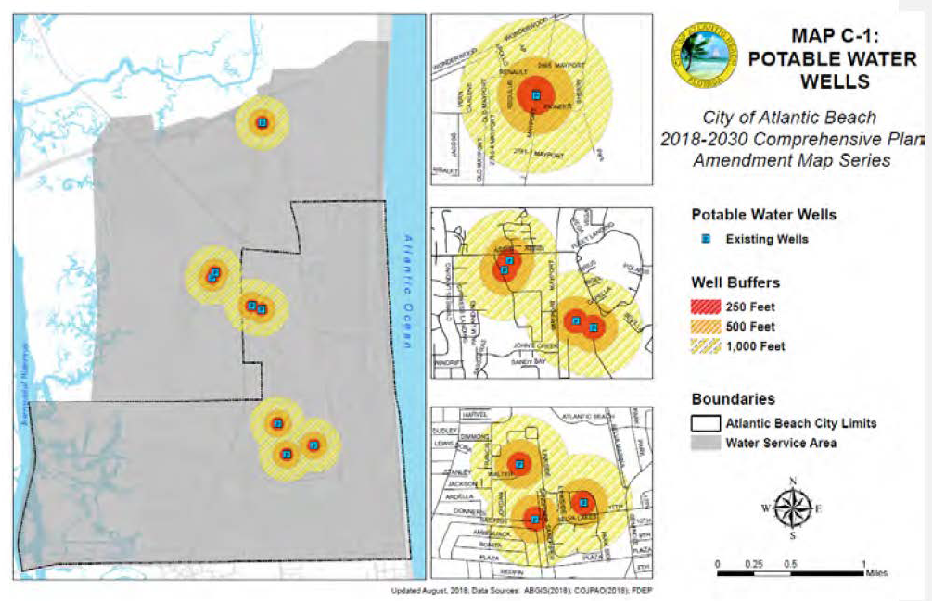
Figure 18 Potable Water Wells
(Ord. No. 90-24-253, § 3(Exh. A), 10-14-24)
Sec. 24-264. - Investigations and monitoring.
(a)
A map shall be developed and kept up-to-date, using the city's GIS system, to show the location of any known private wells within the wellhead protection area that are drilled into the Hawthorne or Floridan aquifer. The mapping shall include a review of available federal, state and local environmental databases including, but not limited to, databases pertaining to Brownfields Redevelopment Programs, Florida Department of Environmental Protection Site Investigation Section Contaminated Sites List, lists of commercial hazardous waste transporters' facilities, hazardous waste notifications, solid waste facilities, storage tank and petroleum contamination/cleanup records, U.S. Environmental Protection Agency Comprehensive Environmental Response, Compensation and Liability Act and Resource Conservation and Recovery Act remedial action sites. Any sites deemed to be potential contamination risks by the city may be investigated by city staff or their consultants. In conducting the investigation, the city shall, at a minimum, consider the condition of such sites; the status of the site within any applicable U.S. Environmental Protection Agency and/or Florida Department of Environmental Protection regulatory program; and, any existing or planned remediation activities and site management plans.
(b)
Using the city's and St. Johns River Water Management District's (SJRWMD) water well database, the city shall map private well locations within the wellhead protection areas and shall assess the depth, use, and condition of each identified private well from available records. The city shall identify wells known or likely to penetrate the Hawthorne Group and/or Floridan aquifer within each wellhead protection area. Thereafter, the city shall have authority to conduct an investigation of each well into the Hawthorne Group and Floridan aquifer to determine the condition of the well and its potential as a contaminant pathway into the Floridan aquifer. The investigation may include a request for records of the well construction, regulatory reports, maintenance logs or other documents and data records available from the owner or from regulatory agencies.
(c)
The city shall have the right to assess to the best of its ability whether any wells are located within, or downgradient in the shallow aquifer gradient from a contaminated site within a wellhead protection area. The city shall determine the condition of the well to prevent the migration of contaminants from non-Floridan aquifers to the Floridan aquifer based on the applicable regulatory standards of design and installation, and proper maintenance practices including but not limited to the following:
(1)
Proper grout seal outside of the casing;
(2)
Presence of an approved and certified backflow prevention device if required;
(3)
Proper sanitary seal on wellhead;
(4)
Concrete pad around wellhead;
(5)
Surface water drainage;
(6)
Well casing integrity; and
(7)
Properly maintained pumping and distribution systems.
(d)
It shall be the responsibility of the city to determine that a public potable water well is at risk of contamination. Once this determination has been made, the city may identify the specific contaminants of concern, and report to the St. Johns River Water Management District (SJRWMD) and Florida Department of Environmental Protection (FDEP).
(Ord. No. 90-24-253, § 3(Exh. A), 10-14-24)
Sec. 24-265. - Prohibitions in wellhead protection areas.
Within a five-hundred-foot radius around an existing public potable water well, those actions and uses established by the Florida Department of Environmental Protection in Rule 62-521.400, FAC, which is adopted by reference, shall be prohibited. Additionally, no existing private wells shall be deepened and no new wells shall be constructed within designated wellhead protection areas that penetrate a portion of the Hawthorne Group or the Floridan aquifer without first obtaining a well construction permit from the City of Jacksonville as provided in environmental protection board Rule 8 and including a review of areas on known contamination at or near the proposed or existing well location. A City of Atlantic Beach well permit from the building department must also be received prior to construction. All new wells within such areas must be fully grouted. Abandonment of existing wells shall be in accordance with applicable SJRWMD requirements and a copy of the plugging and abandonment report shall be submitted to the city.
(Ord. No. 90-24-253, § 3(Exh. A), 10-14-24)
Sec. 24-266. - Requirements within wellhead protection areas.
The following requirements apply to all wells which penetrate the Floridan aquifer ("Floridan aquifer wells"), including private wells, within the boundary of a wellhead protection area.
(a)
All Floridan wells may be inspected by the city or their consultants at any time after the effective date of this ordinance. The city shall prioritize re-inspections for wells that, in its opinion, pose the greatest threat to the Floridan aquifer.
(b)
Floridan aquifer wells that do not have positive piezometric pressure shall have a backflow prevention device in compliance with local plumbing code and Department of Environmental Protection rules.
(c)
Within one (1) year after March 8, 2010, all private Floridan aquifer wells within a wellhead protection area shall be configured with a sanitary seal on the wellhead and a concrete pad around the outside of the well casing to prevent leakage of surface water into the well. Each well shall be finished with a concrete pad a minimum of five (5) feet by five (5) feet and at least three (3) inches thick. The pad shall be finished above ground surface to allow surface water to drain away from the wellhead. The surrounding ground surface should be sloped away from the wellhead, if possible, to further prevent surface water from collecting at the wellhead.
(d)
Floridan aquifer wells shall be drilled, maintained and repaired according to the standards of Chapters 62-524 and 40C-3, FAC.
(e)
The city shall notify the owner of any well that is not found to be in compliance with the requirements of this section of the violation. Any private well not properly constructed or maintained to reasonably prevent contamination from any other aquifer to the Floridan aquifer shall be abandoned, repaired or replaced. The cost of abandonment, repair or replacement shall be the responsibility of the well owner and/or the owner of the property on which the well is located. All private faulty wells found to be out of compliance shall have ninety (90) days to either perform those repairs necessary to bring the private well into compliance with this section or to properly abandon the well pursuant to the appropriate standards and procedures. Copies of inspection reports from the St. Johns River Water Management District confirming that the well has been properly abandoned, repaired or replaced shall be submitted to the city. If the work is not inspected by the St. Johns River Water Management District, the city or their consultant shall inspect the well to confirm that it has been properly abandoned, repaired or replaced at the cost of the owner, and the abandonment, repair or replacement shall be entered into a database of well-related information maintained by the city. Failure to properly repair or abandon a private faulty well, pursuant to the requirements of this section, shall be referred to the special magistrate for code enforcement.
(Ord. No. 90-24-253, § 3(Exh. A), 10-14-24)
Sec. 24-267. - Notice of release or spill of contaminants in wellhead protection areas.
The city shall send written requests to local hazardous release/spill responders to immediately notify the administrator of any and all spills or releases in the water service area. City staff shall determine if an incident has occurred within a wellhead protection area. City staff shall notify the state warning point, department of environmental protection, or other regulatory agencies as required by law, depending on the nature and amount of the spill.
(Ord. No. 90-24-253, § 3(Exh. A), 10-14-24)
Sec. 24-268. - Authority and responsibilities of the city.
The city shall have the following powers and duties:
(a)
Administer and enforce the provisions of these wellhead protection regulations.
(b)
Render all possible assistance and technical advice to private well owners, except that the city shall not design or construct private facilities.
(c)
Perform such other administrative duties as may be necessary.
(d)
The city shall have the right to inspect privately-owned facilities.
(Ord. No. 90-24-253, § 3(Exh. A), 10-14-24)
Sec. 24-270. - Purpose and intent.
Wetlands serve essential ecological functions such as reducing downstream stormwater flow, recharging groundwater, improving water quality, and providing wildlife habitat. Upland buffers help wetlands function by filtering storm runoff from surrounding development, trapping sediment, absorbing nutrients, and attenuating high flows. Buffers also provide high quality wildlife habitat areas and physically separate wetlands and estuaries from developed areas in order to lessen noise, light and chemical pollution and other associated disturbances by humans. The purpose and intent of this division is to provide regulations that contribute to the protection of the vast coastal marsh, estuarine and wetland system associated with the Atlantic Intracoastal Waterway and its tributaries in conjunction with the state and federal regulatory agencies having jurisdictional authority over such resources. It is the express intent of the city that no net loss of jurisdictional wetlands occur through any development action within the city. Any impacted wetlands on a development site shall be replaced elsewhere on the same site or elsewhere within the City of Atlantic Beach where replacement onsite is not possible to achieve reasonable use of the property.
(Ord. No. 90-24-253, § 3(Exh. A), 10-14-24)
Sec. 24-271. - Environmental assessment and protection of wetlands and environmentally sensitive areas.
(a)
It is hereby unlawful for any person to engage in any activity which will remove, fill, drain, clear, destroy, or alter any wetland or upland buffer areas as defined herein without obtaining a development permit from the city in accordance with the provisions of these regulations.
(b)
Environmental assessment required. The wetlands and the environmentally sensitive areas maps (Map A-2 and A-4) as contained within the city's comprehensive plan identify areas that are presumed to have wetlands or significant environmental features. Where a development permit is sought in such areas, an environmental assessment of the site and the potential for impacts to the presumed resource shall be provided by the applicant seeking such permit. City staff may also require an environmental assessment if wetlands or environmentally sensitive areas are suspected on a site that is not shown on the wetlands or environmentally sensitive areas maps. The environmental assessment shall include a delineation of onsite and adjacent wetlands and native upland habitat, as well as an identification of any protected animal species or habitat found on the site. The city may accept an assessment prepared by a licensed environmental professional and may also require the applicant to obtain a formal wetland determination by the St. Johns River Water Management District.
Where the environmental assessment determines that natural jurisdictional wetlands remaining on the site have been damaged or degraded over time through previous development, storm events, improper drainage runoff or other adverse activities, but where wetland vegetation and habitat are predominant in quantity on a proposed development site, all plans submitted for review or permitting shall demonstrate a plan for restoration, enhancement, mitigation or recovery of remaining jurisdictional wetlands. Restated, it is the express intent of the city that no net loss of jurisdictional wetlands occurs through any development action within the city.
(c)
Buffers required from wetlands. The following upland buffers shall be required, except for lands adjacent to isolated wetlands. Upland buffers shall be measured from the Water Management District's or the state's jurisdictional wetland boundary line, unless otherwise stated. Upland buffers shall remain substantially in their undisturbed and natural state.
(1)
Development occurring after the effective date of these amended land development regulations shall provide and maintain a minimum fifty (50) foot buffer between developed areas and the Intracoastal Waterway (ICW). This buffer shall be measured from the mean high water line. This requirement also applies to the portions of tributaries, streams, or other water bodies connected to the Intracoastal Waterway. Such portions of the ICW and these tributaries, streams, or other water bodies subject to this buffer requirement shall be established by the presence of a mean high water line as established in accordance with Section 177.26, Florida Statutes, and such mean high water lines shall be depicted on development plans.
(2)
All development, including subdivisions of three (3) or more lots, shall provide and maintain a natural vegetative upland buffer of at least fifty (50) feet between developed areas and jurisdictional wetlands. In cases where the minimum fifty (50) foot buffer is demonstrated to be unreasonable or impractical, an averaged fifty (50) foot buffer with a minimum no less than twenty-five (25) feet may be provided. In no case shall developed areas be closer than fifty (50) feet to the mean high water line.
(3)
Single- and two-family lots of record platted prior to the effective date of these land development regulations shall be exempt from the fifty (50) foot wetland buffer requirement but shall maintain a twenty-five (25) foot natural vegetative buffer between developed areas and jurisdictional wetlands. In cases where the minimum twenty-five (25) foot buffer is demonstrated to be unreasonable or impractical, an averaged twenty-five (25) foot buffer with a minimum no less than fifteen (15) feet may be provided. In no case shall developed areas be closer than fifty (50) feet to the mean high-water line.
(4)
In an area where the upland buffer is or will be comprised of fill material, or the bank of a stormwater system, with permits by state and federal regulating agencies, the area shall be reestablished as a natural upland buffer by the replanting of plants that are natural and native to the original ecological community. Turf grasses and exotic or non-native plants are prohibited. Upland buffer planting plans shall be provided with the development application.
(5)
Required upland buffers shall be recorded on surveys for new development.
(d)
Exceptions to the upland buffer requirements.
(1)
Man-made canals and stormwater facilities are not considered wetlands, although in some cases, man-made navigable canals connected to waters of the state are protected under these provisions or by regulations of state or federal agencies. For the purposes of this article, manmade canals and ponds clearly excavated in uplands are not considered wetlands and are exempt from the wetland buffer regulations.
(2)
Determinations of vested rights which may supersede the requirement for the fifty-foot or twenty-five-foot upland buffer as applicable shall be made on a case-by-case basis in accordance with the land development regulations and applicable Florida law.
(3)
Variances from the requirement to provide and maintain an upland buffer may be requested in accordance with subsection 24-65 of this chapter, and where such variance is approved, a berm or swale to retain and filter stormwater runoff from the lot shall be required.
(4)
Lots or portions of lots where a lawfully constructed bulkhead, retaining wall, revetment, or the placement of rip-rap was in existence prior to March 8, 2010 shall be exempt from these buffer requirements.
(e)
Maintenance and permitted activities within upland buffers. To protect water quality and wetland functions, it is crucial to limit contamination, disturbance and clearing within upland buffer areas. It is the intent of the city that required upland buffers shall be maintained in a substantially natural and undisturbed state. With the exception of facilities to provide public access for the recreational use of natural resources, any disturbance or clearing of required upland buffers shall be in accordance with the following provisions. Native vegetation removed or destroyed within the upland buffer is a violation of this Code, and the property owner shall be responsible for the restoration of the upland buffer upon order of the special magistrate.
(1)
The following activities are expressly prohibited in any wetland and required upland buffer:
a.
Filling, dredging or soil compaction;
b.
Dumping of any kind including brush, tree and yard waste, weeds, lawn clippings, animal or fish waste, litter and refuse of any type;
c.
Removal of healthy native trees;
d.
Clearing of any living native vegetation;
e.
Installation of sod, irrigation, non-native vegetation of any type or any type of plant materials typically requiring the use of lawn pesticides and fertilizers or chemicals of any kind.
f.
Construction or installation of any building, structure, pool, fence, street, alley, driveway, or parking area.
g.
Construction or installation of any stormwater retention or detention.
(2)
The following activities are permitted within a required upland buffer:
a.
Removal of invasive vegetation or planting of suitable native vegetation.
b.
Minimum clearing of upland and wetland vegetation necessary to construct a properly permitted dock or other improvement to provide lawfully entitled access to navigable waters in accordance with a validly issued and unexpired permit from the City of Atlantic Beach, the Florida Department of Environmental Protection, the St. Johns River Water Management District, and other entity having jurisdiction.
c.
Activities for the owner or occupant's enjoyment including typical backyard outdoor furniture, gazebos and screen structures not exceeding one hundred (100) square feet in size without electrical or plumbing service, but not swimming pools, hot tubs, ornamental pools, spas or pool houses, and provided that all other conditions of this division are met.
(Ord. No. 90-24-253, § 3(Exh. A), 10-14-24)