
Avon City Zoning Code
CHAPTER 7
28 - Development Standards
7.28.010 - Purpose and applicability.
(a)
Purpose. The purpose of the development standards in this Chapter is to establish the minimum requirements for design and development within the Town. The development and design standards in this Chapter shall apply to the physical layout and design of all development, unless exempted by this Development Code. These provisions address the physical relationship between development and adjacent properties, public streets, neighborhoods and the natural environment in order to implement the Comprehensive Plan vision for a more attractive, efficient and livable community.
(b)
Applicability. The general applicability of the provisions of this Chapter are more completely defined in this Section. All new development shall comply with the standards of this Chapter. Any modification to an existing development that is nonconforming to the regulations of this Chapter which results in an addition or removal of fifty percent (50%) or more of the development shall require the entire development to come into compliance.
(Ord. 10-14 §3)
7.28.020 - Parking and loading.
(a)
Purpose. The purpose of this Section is to promote safe access, regulate the amount and location of vehicle parking and maneuvering areas in order to promote a more efficient use of land, enhance urban form, encourage the use of alternative modes of transportation, provide for better pedestrian movement and protect air and water quality. The provisions of this Section are intended to:
(1)
Prevent and alleviate the congestion of public streets;
(2)
Encourage the incorporation of alternative modes of transportation by emphasizing pedestrian circulation and establishing requirements for bicycle parking;
(3)
Minimize the detrimental effects of vehicular use areas on adjacent properties;
(4)
Promote the health, safety and public welfare by establishing minimum requirements for off-street parking and loading areas; and
(5)
Limit parking to encourage more compact, walkable developments.
(b)
Applicability and Location.
(1)
Scope of Regulations. All buildings and structures erected and all uses of land established after the effective date of this Development Code shall conform to the provisions of this Section, subject to any restrictions for the district in which the facilities are located. Changes or additions to existing structures may also require compliance with this Section pursuant to Subsection 7.28.010(b), Applicability.
(2)
Change of Use. If the existing use of a building or structure is converted to a new use, parking or loading facilities shall be provided as required by this Chapter for the new use.
(3)
No Reductions in Existing Parking. Accessory off-street parking and loading facilities in existence on the effective date of this Development Code and located on the same lot as the building or use served shall not hereafter be reduced below the requirements of this Section for a similar new building or use. If such existing facilities are already below the required amount, they shall not be hereafter further reduced.
(4)
Location. All parking spaces required to serve buildings or uses erected, established, altered or enlarged after the effective date of this Development Code shall be located on the same lot as the building or use served, except as otherwise provided in this Section.
(5)
Ownership. Parking and loading facilities which are required by this Development Code shall be owned and held in the same identical ownership as the principal use, structure, ownership interest or lot which such parking and/or loading facilities serve; or shall be owned and held as a common element or limited common element of a common owners' association which is comprised of the property interests for which such parking or loading facilities serve and which common owners' association has been reviewed and approved by the Town, unless located in a public parking district subject to the requirements in Subsection 7.28.020(i).
(c)
Standards.
(1)
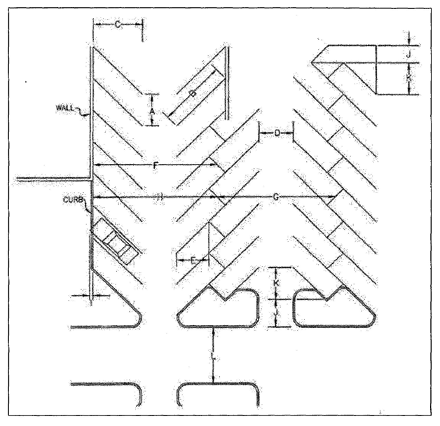
Regular Parking. Conventional parking layout dimensions are provided in Table 7.28-1. Other angled parking layouts may be permitted with approval of the Town Engineer.
Table 7.28-1
Minimum Parking Layout Dimensions (in feet) for
9-foot Regular Parking Stalls at Various Angles
(2)
Diagram. The following diagram shall be used to determine dimension standards in Table 7.28-1, Minimum Parking Layout Dimensions (in feet) for 9-foot Regular Parking Stalls at Various Angles.
(d)
Maximum Parking Spaces Allowed.
(1)
Applicable to Commercial and Industrial Uses. For any commercial or industrial use, off-street surface vehicle parking spaces shall not be provided in an amount that is more than one hundred twenty-five percent (125%) of the minimum requirements established in Table 7.28-2, Off-Street Parking, unless approved by the Director and mitigated through the provision of additional landscaping pursuant to Paragraph (4) below.
(2)
Parking Types Excluded. For the purpose of calculating parking requirements, the following types of parking spaces shall not count against the maximum parking requirement:
(i)
Handicapped accessible parking;
(ii)
Vanpool and carpool parking;
(iii)
On-street parking adjacent to the lot or lots on which the parking located; and
(iv)
Structured parking, underground parking and parking within, above or beneath the building it serves.
(3)
Exceptions. Exceptions up to ten percent (10%) over the maximum parking requirement may be allowed by the Director.
(4)
Additional Landscaping Required. Parking that is provided in excess of the one hundred twenty-five percent (125%) of maximum parking requirement shall be required to increase the internal landscaping requirements pursuant to Subsection 7.28.050(f), Parking Lot Landscaping.
(e)
Off-Street Parking.
(1)
Off-Street Parking. Unless otherwise expressly stated in this Section, off-street parking spaces shall be provided in accordance with Table 7.28-2, Off-Street Parking:
Table 7.28-2
Off-Street Parking
(f)
Handicapped/Accessible Parking. Required accessible parking for nonresidential development shall be provided in conformance with all applicable accessibility standards of the prevailing Americans with Disabilities Act (ADA) and the International Building Code (IBC). Required accessible parking for multi-family residential developments shall be provided in conformance with all applicable accessibility standards of the prevailing Americans with Disabilities Act (ADA), Federal Fair Housing Act (FFHA) and International Building Code (IBC).
(g)
Computation of Parking and Loading Requirements
(1)
Computation. When determination of the number of off-street parking spaces required by this Section results in a requirement of a fractional space, any fraction shall be counted as one (1) parking space.
(2)
Calculation:
(i)
Different Use Areas. Except as provided for in this Section, parking shall be calculated separately for each different use area in a building or on a site, including all accessory uses. Parking spaces for accessory uses not specifically identified in Table 7.28-2, Off-Street Parking, shall be assumed to be included in the principal use requirement.
(ii)
Mixed Use Reduction. If the Director determines that a proposed use represents a combination of uses listed in Table 7.28-2, Off-Street Parking, a fifteen-percent reduction shall apply to the total parking calculation.
(iii)
On-Street Parking. Where there is on-street parking abutting the front property line of any lot or parcel, the minimum off-street parking requirement may be reduced by the Director by one (1) space for each on street space located entirely or partially between two (2) lines formed by the extension (without turning) of the side lot lines of the lot or parcel into the street right-of-way.
(iv)
Electric Vehicle Parking. As required by Section 15.28, Electrical Vehicle Charging Standards, Avon Buildings and Construction, the quantity and location of EV parking spaces must be demonstrated at development plan.
(3)
Parking Based on Floor Area. When the standards use building square footage as a unit of measurement, all calculations shall be based on gross floor area minus ten percent (10%).
(4)
Uses Not Listed: Determination by Director:
(i)
Parking standards for uses not specifically listed in Table 7.28-2, Off-Street Parking, shall be determined by the Director based on the standards for the closest comparable use or by reference to standard parking resources published by the National Parking Association or the American Planning Association.
(ii)
The Director may alternately require the submittal of a parking demand study that justifies estimates of parking demand based on the recommendations of the Institute of Traffic Engineers (ITE) Parking Generation Manual and includes relevant data collected from uses or combinations of uses that are the same or comparable to the proposed use in terms of density, scale, bulk, area, type of activity and location.
(5)
Utilization. Accessory off-street parking facilities provided in accordance with the requirements of this Chapter shall be solely for the parking of passenger motor vehicles of patrons, occupants, visitors or employees of such uses.
(h)
Off-Site Parking.
(1)
Applicability. Off-site parking shall refer to any parking area which is provided and required to meet the minimum parking standards in this Development Code and which is located on a separate lot or ownership interest than the use, structure or lot which the parking serves.
(2)
Design and Location. Off-site parking shall have a direct, adequate and convenient pedestrian connection to the use, structure or lot which such parking serves and shall not be located more than five hundred (500) feet from the use, structure or lot which it serves.
(3)
Control of Off-Site Parking Facilities. In cases where off-site parking facilities are permitted, such facilities shall be owned and in the same identical ownership as the use, structure or lot which the parking serves.
(i)
Public Parking Districts and Facilities. Council may establish public parking districts and approve public parking facilities for designated areas of Town which may be used by property owners within the public parking district to meet the minimum parking requirements set forth in this Section for commercial uses, structures or lots. The procedures for establishing public parking districts and standards for approving public parking facilities are set forth as follows:
(1)
A public parking district shall be first designated in the Avon Comprehensive Plan, which shall indicate the properties served, the potential projected commercial parking required to serve development, the planned capacity and location of the public parking facility, ingress and egress, pedestrian connections, phasing and any other relevant design issues.
(2)
Public parking facilities may be owned by the Town or may be owned by a General Improvement District formed pursuant to Section 31-25-601, et seq., C.R.S., if approved by the Council. The Council shall require the inclusion of all properties which propose and elect to meet their minimum parking requirements for commercial use through the use a public Parking Facility to join the Public Parking District GID in order to participate in defraying the cost of operation and maintenance of such facilities through the imposition of a fee or additional property tax. The Town may require such other formal agreements, covenants or other instruments as may be deemed appropriate and necessary to guarantee the provision of required parking.
(3)
Applicants whose property is within an approved public parking district shall pay forty thousand dollars ($40,000.00) per parking space for parking which is satisfied by public parking provided, or to be provided, within a public parking district. This fee shall be automatically adjusted on the first day of January of each year based on the prior year's forecast of the CDOT Construction Index. The payment in lieu shall be due and payable at the time of the issuance of a building permit or at such other time and pursuant to such other terms as may be determined in a development agreement approved by the Council by ordinance. All funds collected shall be deposited in the Town Public Parking Fund.
(4)
There is established, for the purpose of meeting the demand and requirements for vehicle parking, the Town Public Parking Fund. The Town Public Parking Fund shall receive and distribute funds for the purposes of conducting parking studies or evaluations, including evaluations of alternative transportation means; acquisition, design and construction of parking facilities or alternative transportation means in any area exempted from the off-street parking requirements; maintenance of public parking facilities; payment of bonds or other indebtedness for parking facilities; and administrative services relating to parking.
(j)
Bicycle Facilities. Developments that contain twenty-five (25) or more parking spaces shall provide bicycle parking facilities, which shall comply with the following standards:
(1)
Bicycle parking facilities shall be conveniently located to the entrance of the primary building entrance. In no case shall bicycle facilities be located farther than one hundred fifty (150) linear feet from the primary building entrance.
(2)
Bicycle parking spaces shall be provided at the following rates:
(i)
Bicycle parking spaces shall be provided at a rate of one (1) bicycle parking space for every ten (10) vehicle parking spaces.
(ii)
When bicycle parking spaces are required, the applicant shall provide a minimum of four (4) bicycle parking spaces.
(3)
Bicycle parking facilities shall include a rack or other device designated for bicycles that enable bicycles to be secured.
(4)
Bicycle racks and secured storage facilities shall be located in convenient, visible, well-lit areas with easy access and near main entrances of all commercial, residential and institutional buildings. Such locations shall be clearly noted with signage. The racks and storage facilities shall be located so they do not interfere with pedestrian traffic and shall be protected from potential damage by motor vehicles.
(k)
Design and Maintenance.
(1)
Surfacing - Impervious Materials. All open, off-street parking areas shall be surfaced with asphaltic concrete, concrete or other approved hard surface, which shall be constructed and maintained in accordance with the Director.
(2)
Drainage. All open off-street parking areas shall be graded and drained to dispose of surface water accumulation in accordance with the Town of Avon Stormwater Master Plan. Pre-development hydrology patterns should be maintained as described in Section 7.32.050, Stormwater Drainage.
(3)
Wheel guards. All perimeter parking spaces, except for those associated with single-family and duplex uses, shall be provided with wheel guards or bumper guards located so that no part of parked vehicles will extend beyond the property line.
(l)
Snow Removal and Storage. All sites must adequately manage snow on site according to the following minimum requirements:
(1)
An area equal to twenty percent (20%) of the total impermeable surfaced area of the site, upon which above-ground construction does not occur, shall be designated and developed as a snow storage area.
(2)
Designated snow storage areas shall be located and developed to be compatible with snow removal operations, not less than five (5) feet wide and shall be adjacent to the impermeable area from which the snow is to be removed.
(3)
Runoff from snow storage areas shall conform to Section 7.32.050, Stormwater Drainage.
(4)
On-site snow storage requirements may be waived by the Town Engineer upon the demonstration that an appropriate alternative snow storage site is available and that arrangements have been made for the continuation of snow removal and off-site storage.
(5)
Excavation, retaining walls or other structures within slope maintenance and snow storage easements adjacent to public rights-of-way must be approved by the Town Engineer. No snow storage shall be permitted atop retaining walls.
(6)
Snow storage areas shall be separated from and shall not overlap or encroach upon pedestrian walkways or sidewalks.
(m)
Off-Street Loading.
(1)
General Requirements:
(i)
Location. All required loading berths shall be located on the same lot as the use served. No permitted or required loading berth shall be located within fifty (50) feet of the nearest point of intersection of any two (2) streets, measured from edge of asphalt. No loading berth shall be located in a required front yard.
(ii)
Size. Unless otherwise specified, a required off-street loading berth shall be at least twelve (12) feet in width by thirty-five (35) feet in length, exclusive of aisle and maneuvering space, and shall have a vertical clearance of at least fifteen (15) feet.
(iii)
Access. Each required off-street loading berth shall be designed with appropriate means of vehicular access to a street or alley in a manner which will least interfere with traffic movement, as approved by the Town Engineer. All driveways servicing off-street loading berths shall be in accordance with applicable Town driveway standards.
(iv)
Utilization. Space allocated to any off-street loading use shall not, while so allocated, be used to satisfy the space requirements for any required off-street parking facilities or portions thereof.
(v)
Central Loading. Central loading facilities may be substituted for loading berths on individual lots, provided that the following conditions are fulfilled:
(A)
Each lot served shall have direct access to the central loading area without crossing streets or alleys at grade.
(B)
Total off-street loading berths provided shall meet the minimum requirements herein specified, based on the sum of the several types of uses served.
(vi)
Minimum Facilities. Uses for which off-street loading facilities are required herein, but which are located in buildings of less floor area than the minimum prescribed for such required facilities, shall be provided with the adequate receiving facilities accessible by motor vehicle off any adjacent alley, service drive, parking lot or open space located on the same lot.
(2)
Specific Requirements. The minimum amount of off-street loading or unloading space to be provided shall be as follows:
_______________________________________________
Table 7.28-3
Off-Street Loading Requirement
(Ord. 22-15, § 2(Exh. A); Ord. 21-09 §14; Ord. 20-05, § 2; Ord. 10-14 §3)
_______________________________________________
7.28.030 - Access drive requirements.
(a)
Purpose. The purpose of this Section is to direct the design of access to developments to help ensure the safety and mobility of the traveling public.
(b)
Applicability. The provisions in this Section are applicable to all development.
(1)
The Town Engineer may accept minor modifications from the standards of this section if an equivalent level of public safety can be demonstrated by the applicant requesting the modification. Requests for modifications shall include justification of safety equivalency and a demonstration of the acceptability of the alternative to the relevant emergency service providers. A minor modification may include, but is not limited to, grade percent of private driveway slope or similar.
(c)
State Design Standards. Pursuant to Section 43-2-147 (1)(a), C.R.S., access approaches to roadways under the jurisdiction of the Town must meet the design standards found in Sections 3 and 4 of the Colorado State Highway Access Code, 2 CCR 601-1. In addition, those parcels directly accessing highways under the jurisdiction of the Colorado Department of Transportation shall be required to obtain a State Highway Access Permit pursuant to the State Highway Access Code.
(d)
Additional Standards. In addition to the foregoing, public and private access approaches and driveways shall be subject to the following standards:
(1)
Access By Emergency and Service Vehicle:
(i)
All dwellings and other structures shall be accessible by emergency and service vehicles. All dwellings and other structures shall be accessible by emergency and service vehicles. A maximum grade of ten (10) percent and a minimum centerline radius of forty-five (45) feet is recommended to comply with the International Fire Code (IFC). A maximum grade of eight (8) percent and a minimum centerline radius of forty-five (45) feet is recommended for driveways on north-facing slopes or other slopes prone to icing from lack of winter solar exposure. Curves should be widened generously in both circumstances. Private access drives that do not achieve the minimum or exceed the maximum recommendations must obtain preliminary approval of the proposed driveway design from all emergency providers prior to permit approval and driveway acceptance prior to the issuance of a Certificate of Occupancy.
(ii)
Unless otherwise approved by the Eagle River Fire Protection District, public and private access approaches and driveways in excess of one hundred fifty (150) feet in length shall be provided with adequate area for emergency vehicle turnaround in close proximity to the residence or structure served. Access approaches and driveways in excess of three hundred (300) feet in length shall provide an area adequate for emergency vehicle turnarounds in close proximity to the residence or structure served and shall also provide vehicle turnouts where the driveway is expanded to be at least eighteen (18) feet wide at one-hundred-fifty-foot intervals. Alternatively, the private accesses or driveways may be designed to accommodate two-way traffic. Turnarounds shall be constructed in accordance with Town standards. The Town Engineer may request a turning movement exhibit at any time during application review.
(2)
Driveways in Mountainous Terrain:
(i)
Applicability. All driveway access and parking lots on lots containing slopes in excess of thirty percent (30%).
(ii)
Driveways on lots with slopes greater than thirty percent (30%) shall be designed to ensure safe, convenient and adequate access to individual buildings and shall conform to the following standards:
(A)
Driveways shall to the maximum extent feasible follow natural contour lines.
(B)
Driveways shall minimize disturbance or the cutting of slopes. Shared driveways are encouraged when the design will minimize cut, fill and disturbance of slopes.
(C)
Driveways shall not cross slopes over thirty percent (30%) unless specifically authorized by the PZC, after finding that all of the following conditions and constraints are applicable:
(1)
No alternate location for access is available;
(2)
No significant adverse visual, environmental or safety impacts will result from the driveway crossing, either as originally proposed or as a result of incorporation of remedial improvements provided by the developer to mitigate such impacts.
(iii)
Proposed development on lots with mountainous terrain may require the preliminary layout and design of the individual driveways at the preliminary plan stage and the precise design of the driveway at the final plan stage, to assure that access can be provided to each dwelling unit served by the driveway in compliance with the standards of this Section.
(iv)
Driveways may be considered public improvements and thus collateralized, constructed and subject to the terms and conditions of the other public improvements in the development.
(3)
Driveways Requiring Significant Cuts and/or Fills Discouraged. Driveways that require significant cuts and/or fills are discouraged. Applicants are encouraged to relocate development to areas within the proposed development where such cuts and fills are not required.
(4)
Clearance From Intersections. Driveways shall be restricted for a sufficient distance from any intersection with road approaches to preserve normal and safe movement of traffic. Driveways shall provide the following intersection clearances, exclusive of driveway and intersection return radii or flares.
(i)
A minimum intersection clearance of fifty (50) feet shall be provided for residential driveways and a minimum intersection clearance of one hundred (100) feet shall be provided for commercial driveways.
(ii)
In the Town Core, a minimum intersection clearance of fifty (50) feet shall be provided for residential and commercial driveways where dedicated turn lanes for the driveways will be present. Where there are no dedicated turn lanes, the minimum fifty-foot intersection clearance may be extended at the direction of the Town Engineer.
(5)
Backing Onto Roads Prohibited. All parking areas shall be located and designed in conjunction with a driveway, such that vehicles exiting from a parking space shall not be required to back onto the right-of-way of a public street; provided, however, that vehicles exiting from a parking space for a single-family or duplex dwelling unit may back onto a local street if it does not present any safety concerns. Vehicles exiting from a parking space for any use may also back onto the right-of-way of an alley adjacent to the property.
(6)
Maximum Number of Entryways. Generally, no more than one (1) entryway shall be allowed for any parcel of property where the frontage is less than one hundred (100) feet. Additional entrances or exits for parcels of property having a frontage in excess of one hundred (100) feet shall be permitted only when the applicant demonstrates they are required for necessity, create a better site design and that safety to the traveling public will not be compromised.
(7)
Not Encroach. All driveways shall be located so that the flared portion adjacent to the traveled way shall not encroach upon adjoining property.
(8)
Minimum Width. The minimum width of the commercial access driveway shall be ten (10) feet for a one-way drive and twenty-four (24) feet for a two-way drive. The minimum width of the industrial access driveway shall be twelve (12) and twenty-four (24) feet, respectively.
(9)
Residential Driveway Requirements. Residential curb cuts and driveway grades shall meet the following requirements:
(i)
The driveway curb cut width, not including the radii on driveway return, shall be between ten (10) feet and fourteen (14) feet wide for single-family and duplex lots. Residential multi-family accesses (three [3] or more units) shall have a driveway curb cut width, not including the radii on driveway return, between twenty (20) and twenty-four (24) feet wide;
(ii)
The driveway grade shall not exceed four percent (4%) for the first twenty (20) feet measured from the edge of pavement of the adjoining street, unless otherwise accepted by the Town Engineer and emergency providers as required in 7.28.030.D.1.i;
(iii)
The driveway shall be oriented perpendicular (not to exceed an eleven-degree deflection) to the roadway for the first twenty (20) feet measured from the edge of asphalt of the adjoining street. The driveway shall be oriented between forty-five (45) and one hundred thirty-five (135) degrees crossing through any remaining ROW and snow storage easement. Centerline tangent points shall be used for determining access orientation on curves.
(10)
Sight Distance Triangle. Access driveways shall have a minimum sight distance triangle as calculated in the Colorado State Highway Access Code, 2 CCR 601-1, §4.3.
(11)
Radii. Permissible radii on driveway returns shall be governed by such factors as the width of drive and angular placement. Where the flared edge of an approach controls the turning radius of a vehicle entering the property by a right turn from the adjacent outside traffic lane of the roadway, the radius of that edge shall not be less than ten (10) feet for passenger vehicles and not less than fifty (50) feet where single unit or larger trucks may be expected to use the entrance and the traffic volume on the adjacent road exceeds four hundred (400) AADT.
(12)
Court Drives. Within residential zoning districts, from three (3) to ten (10) dwelling units may share a single drive lane access to a public street through the use of a court drive layout, provided that the following conditions are met:
(i)
Shared drive lanes shall be no longer than one thousand (1,000) feet, shall be at least twenty (20) feet in width and shall be dedicated to a homeowners' association with responsibility for maintaining the shared drive lane and the power to enforce payment of dues from individual homeowners in order to do so. The homeowners' association shall be created and the shared drive lane shall be dedicated to the association before a certificate of occupancy is issued for any dwelling unit using the shared drive lane.
(ii)
Individual driveways leading from the shared court drive lane to each dwelling unit shall be at least twenty (20) feet long, as measured between the front of the garage and the closest edge of the shared drive lane or sidewalk if one exists.
(iii)
The design of the court drive shall be designed by a registered professional engineer and shall permit a passenger vehicle to back out of an individual driveway and turn ninety (90) degrees in either direction without any portion of the vehicle: (1) leaving the individual driveway from which the vehicle is exiting or the shared drive lane or (2) entering on or over the individual driveways of any other residence. The AASHTO turning template for a "P" design vehicle shall be used to confirm that this standard is met.
(iv)
Each court drive is subject to review and approval by Eagle River Fire Protection District for fire hydrant adequacy and emergency vehicle access. All ERFPD issues must be satisfactorily addressed prior to development approval.
(v)
Utility meters shall be located on the court drive side of the dwelling units.
(vi)
Court drive lanes shall accommodate at least one (1) guest parking space for every two (2) lots where a garage driveway is accessed via the drive lane.
Maximum grade for a court drive shall be ten percent (10%) and shall have a maximum grade of four percent (4%) for the first twenty (20) feet from the edge of asphalt of the public roadway and from individual garages
(e)
Drive-Through Requirements. The following standards shall apply to businesses that contain a drive-through establishment, regardless if the drive-through is part of another use (e.g., restaurant or financial institution) or if it is a stand-alone use (e.g., automatic teller machine).
(1)
Location of Stacking Lanes and Use of Audible Electronic Devices:
(i)
Audible electronic devices, such as loudspeakers, automobile service order devices and similar instruments, shall not be located within two hundred fifty (250) feet of any residential dwelling unit.
(ii)
No service shall be rendered, deliveries made or sales conducted within the required front yard or corner side yard; customers served in vehicles shall be parked to the sides and/or rear of the principal building.
(iii)
All drive-through areas, including but not limited to menu boards, stacking lanes, trash receptacles, loudspeakers, drive up windows and other objects associated with the drive-through area, shall be located in the side or rear yard of a property to the maximum extent feasible and shall not cross, interfere with or impede any public right-of-way.
(2)
Stacking Space and Lane Requirements. The number of required stacking spaces shall be as provided for in Table 7.28-5. See Figure 7.28-B for an illustration of stacking spaces
Table 7.28-5
Stacking Space Requirements
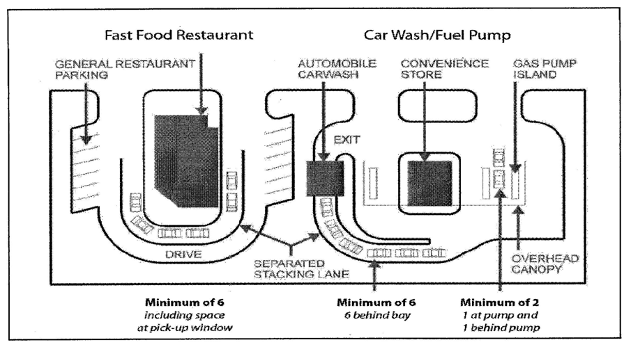
Fig. 7.28-B
Location of stacking spaces and lanes.
Note that the stacking lanes are oriented toward the side and rear yards
rather than the front yard.
(3)
Design and Dimensions. Stacking lanes shall be provided for any use having a drive-through establishment and shall apply comply with the following standards:
(i)
Drive-through stacking lanes shall have a minimum width of ten (10) feet.
(ii)
When stacking lanes are separated from other stacking lanes, bypass lanes or from other site areas, the separation shall be by means of a raised concrete median, concrete curb or landscaping.
(iii)
Stacking lanes shall be set back twenty-five (25) feet from right-of-ways.
(Ord. No. 25-06, § 2(Exh. A); Ord. 10-14 §3)
7.28.040 - Mobility and connectivity.
(a)
Purpose. The purpose of this Section is to:
(1)
Reduce dependency on the automobile;
(2)
Reduce the number of daily trips by a single-occupancy vehicle and preserve the capacity of existing roadways;
(3)
Support the creation of a highly connected transportation system within the Town in order to provide choices for drivers, bicyclists and pedestrians;
(4)
Increase effectiveness of local service delivery; promote walking and bicycling; and connect neighborhoods to each other and to local destinations, such as employment, schools, parks and shopping centers;
(5)
Reduce vehicle miles of travel and travel times; improve air quality; and reduce emergency response times;
(6)
Mitigate the traffic impacts of new development and free up arterial capacity to better serve regional long-distance travel needs.
(7)
Encourage avoidance of the creation of large, isolated tracts without routes for through traffic or pedestrian and bicycle connections.
(8)
Pedestrian and bicycle environments shall be designed in a comfortable and safe manner to encourage these modes of transportation.
(b)
Applicability. All buildings and structures erected and all uses of land established after the effective date of this Development Code shall conform to the provisions of this Section, subject to any restrictions for the district in which the facilities are located. Changes or additions to existing structures may also require compliance with this Section pursuant to Subsection 7.28.010(b), Purpose and Applicability.
(c)
Alternative Transportation Modes. Consideration must be given to alternative transportation modes, bicycle and pedestrian ways and paths and shall be included in site master planning. The standards and criteria in the current Town of Avon Comprehensive Transportation Plan, October 2009, are adopted herein by reference.
(d)
Facilities. Provision of bus turn-outs and shelters is required where deemed necessary by the Director of Transportation and/or Town of Avon Comprehensive Transportation Plan. Where shelters are provided, they shall be installed outside of the sidewalk area. Required turnouts may encroach into the perimeter landscape area. Bus stop and transit shelter standards are found in the Town of Avon Comprehensive Transportation Plan.
(e)
Bicycle and Pedestrian Path Connectivity.
(1)
Provisions shall be made in all developments to encourage the use of bicycle and pedestrian travel through the integration of bicycle and pedestrian paths, trails and/or bicycle lanes that connect to parks, open spaces, schools, public transit and shopping areas. Subdivisions shall connect bicycle and pedestrian paths, trails and/or bicycle lanes to collector and minor arterial streets. Where available, trail linkages areas shall be incorporated into the design of all new subdivisions, multifamily and nonresidential developments.
(2)
Bicycle/pedestrian paths shall be provided between and within developments as necessary to provide pedestrian and bicycle linkages between developments, unless the applicant can demonstrate that to do so would be infeasible. The bicycle/pedestrian paths shall be located within a ROW or an easement.
(3)
Sidewalk systems shall be along the perimeter streets adjacent to the development.
(4)
A continuous internal pedestrian walkway shall be provided from the perimeter public sidewalk to the principal building entrance. Pedestrian walkways or sidewalks shall connect all primary building entrances and must be provided along any facade featuring an entrance that exits into a parking area or travel lane. Pedestrian walkways shall also connect all on-site common areas, parking areas, storage areas, open space and recreational facilities. The walkway must be distinguished from driving surfaces through the use of special pavers, bricks, patterned concrete or other methods approved by the Town to enhance pedestrian safety and the attractiveness of the walkway.
(5)
Adequate bicycle parking facilities shall be provided for each development as provided in Subsection 7.28.020(j), Bicycle Facilities.
(6)
Bicycle paths and lanes constructed within the right-of-way must be in accordance with the standards of the Town of Avon Comprehensive Transportation Plan.
(7)
Bicycle and pedestrian facilities located within gated private communities shall be maintained by the private community through a homeowners' association or other method as approved by the Town.
(8)
Bicycle facilities must connect any adjacent or on-site public park, trail system, open space area, greenway or other public or civic use, including but not limited to schools, places of worship, public recreational facilities or government offices.
(9)
Bicycle/pedestrian paths shall consider the existing travel patterns across public and private lands in their designs.
(10)
Where practicable, sidewalks shall not be placed in areas that are prone to icing.
(f)
Vehicular Circulation.
(1)
Street Standards. All streets shall meet the standards of Town of Avon Comprehensive Transportation Plan.
(2)
Internal Street Connectivity:
(i)
Multiple Connections. New subdivision street circulation shall provide for multiple connections to the existing Town street network wherever feasible as determined by the Director.
(ii)
Cul-de-Sacs and Dead-End Streets.
(A)
Permanent cul-de-sacs and dead-end streets should only be used when topography, the presence of natural features and/or vehicular safety factors make a vehicular connection impractical. Cul-de-sacs are prohibited for commercial and industrial uses.
(B)
All permanent dead-end streets shall be developed as cul-de-sacs and extend no further than one thousand (1,000) feet.
(C)
All cul-de-sacs shall conform to the requirements of the present adopted International Fire Code and are subject to the approval of the local fire district.
(D)
Half streets (i.e., streets of less than the full right-of-way and pavement width) shall not be permitted except where such streets, when combined with a similar street (developed previously or simultaneously) on property adjacent to the development, creates or comprises a street that meets the right-of-way and pavement requirements.
(E)
Whenever cul-de-sac streets are created, at least one (1) ten-foot-wide pedestrian access easement shall be provided, to the maximum extent practicable, between each cul-de-sac head or street turnaround and the sidewalk system of the closest adjacent street or pedestrian sidewalk or pathway.
(3)
External Street and Sidewalk Connections. In addition to the internal street connectivity requirements, circulation plans for all new development or redevelopment shall maintain external street connectivity in accordance with the following standards:
(i)
The arrangement of streets in a development shall provide for the alignment and continuation of existing or proposed streets into adjoining lands in those cases in which the adjoining lands are undeveloped and intended for future development or in which the adjoining lands are developed and include opportunities for such connections. Traffic calming measures shall be integrated into the development to mitigate the impact of potential future "cut-through" traffic.
(ii)
Street rights-of-way shall be extended to or along adjoining property boundaries such that a roadway connection or street stub shall be provided for development at least every one thousand five hundred (1,500) feet for each direction (north, south, east and west) in which development abuts vacant lands. Such street stubs shall not be required to abut adjacent development lacking existing or planned street connections, floodplains, wetlands, riparian buffers, slopes exceeding thirty percent (30%) or other unique site conditions preventing a street connection in the opinion of the Director.
(iii)
Street and sidewalk connections shall be made between neighborhood commercial centers and adjacent residential neighborhoods. Certain residential streets may be candidates for traffic calming treatments upon the recommendation of the Director.
(Ord. 10-14 §3)
7.28.050 - Landscaping.
(a)
Purpose. The purpose of the landscaping standards is to ensure that landscaping in the Town:
(1)
Integrates building sites with natural topography and existing vegetation;
(2)
Minimizes disturbed areas;
(3)
Conserves limited water resources by prescribing acceptable water irrigation design budgets;
(4)
Reduces water use and off-site impacts which can affect the Eagle River;
(5)
Reduces the amount of reflected glare and heat absorbed in and around developments;
(6)
Breaks up large expanses of parking lots; and
(7)
Preserves residential neighborhoods by lessening the impacts of potentially incompatible uses.
(b)
Applicability. This landscaping Section shall apply to all new development and redevelopment as provided in Subsection 7.28.010(b).
(1)
Landscape plans for multi-family and commercial properties shall be designed by a licensed landscape architect, QWEL certified professional, or a professional landscape designer, unless otherwise specified. Inspection and compliance with approved landscape plan must be obtained prior to issuance of a certificate of occupancy.
(2)
Modifications, expansions, or the addition of new irrigated area(s) being added to a property with an existing irrigation system, may require a combined assessment of the total irrigated area and water use as part of the development permit review.
(c)
Landscape Design Irrigation Budget.
(1)
All irrigated landscaped areas must be included in the calculation (Appendix 7B). The total irrigation water cannot exceed a maximum applied landscape design irrigation budget of 7.5 gallons/season/square foot of irrigated landscape area (12 inches/season). At the discretion of the Director of Community Development, an increase in the landscape design irrigation budget to 8 gallons/season /square foot (12.8 inches season) may be permitted if implementing one or more of the following landscaping design elements to incentivize health landscapes:
(i)
Non irrigated protected native vegetation.
(ii)
Ecological restoration areas.
(iii)
Non-irrigated permeable areas.
(iv)
Stormwater conveyance infrastructure.
(d)
Plant Material and Water Need
(1)
Aside from the use of invasive and/or noxious plant species, any plant can be utilized in a landscape plan. The Landscape Design Irrigation Budget (Appendix 7-B) requires each plant to be classified as low water, medium water, or high-water use. These categories are necessary for calculating the plant water need. An estimate of the plant water needs in gallons per square foot per season, must be provided for any proposed vegetation in the proposed landscaping design.
(2)
Each hydrozone shall plant materials with similar water use.
(3)
Plants shall be selected and planted appropriately based upon their compatibility factor and adaptability to the climatic, soils, ignition potential, elevation, and topographical conditions of the project site. To encourage efficient use of water, the following are highly recommended:
(i)
Protection and preservation of native species and natural vegetation to the greatest extent practicable.
(ii)
Selection of plants based on water need, disease, wildfire potential, and pest resistance.
(iii)
Recognition of horticultural attributes of plants (i.e., mature plant size, invasive surface roots) to minimize damage to property or infrastructure.
(iv)
Consideration of the solar orientation and type of plant with plant placement to maximize summer shade and winter solar gain.
(v)
Consideration of wildlife. The Town of Avon does not recommend use of fruit-bearing vegetation that may increase human-wildlife conflicts. Any damage resulting from wildlife foraging on fruit-bearing landscaping material is the responsibility of the property owner.
(4)
Protected native vegetation areas without irrigation are incentivized through the landscape design irrigation budget calculation.
(5)
Invasive and/or noxious plant species are prohibited.
(6)
Turf is not allowed on slopes greater than 4:1. Use of best practices for erosion control will be implemented on steep slopes.
(7)
Irrigation work performed within the drip line of existing trees requires hand grubbing no deeper than 6 inches (6") and must be as far from tree trunk as practically possible. Do not cut roots larger than four inches (4") in diameter (dig under or around).
(8)
Stormwater management practices minimizes runoff and increases infiltration which recharges groundwater and improves water quality. The implementation of stormwater best management practices like use of bioswales in landscape and site plans is encouraged.
(9)
Green stormwater infrastructure is incentivized through the landscape design irrigation budget calculation. The following treatments associated with the landscape and described in the drainage report will have the following hydro zone values:
(i)
Non-irrigated permeable surfaces without plants are incentivized through the landscape design irrigation budget calculation.
(ii)
For purposes of the calculation, stormwater conveyance infrastructure such as vegetated bioswales shall apply a plant factor value representing the plantings with an efficiency value based on the irrigation method. These areas are incentivized through the landscape design irrigation budget calculation.
(10)
Project applicants shall refer to the Town of Avon Engineering Department for information on any applicable stormwater ordinances and stormwater management plans.
(e)
Landscape Buffer. The following regulations apply to properties where a nonresidential district or use abuts a residential district or use:
(1)
A minimum fifteen-foot-wide buffer space shall be provided.
(2)
The buffer shall be designed with adequate landscaping or screening to properly separate the differing uses.
(3)
Walls, boulders, fencing, or a combination of design elements that support the intention of creating a buffer, may be substituted for required shrubs.
(4)
Where a natural buffer exists, as determined by the Director, it shall remain undisturbed.
(5)
Mechanical equipment, permanent detention and temporary erosion and sedimentation control basis are prohibited in the buffer area.
(6)
Utility easements should avoid being placed in the long dimension of a buffer yard.
(7)
Wherever practical, pedestrian access shall be placed through the buffer yard.
(f)
Wildland Urban Interface. All landscaping improvements installed after the effective date of these regulations must comply with any WUI policies, plans, or codes, as adopted and amended by the Avon Town Council.
(1)
Avoid fire-prone plant materials and highly flammable mulches and design landscaping per its wildfire hazard potential. Landscaping design plans for projects in fire-prone areas shall address fire safety and prevention. Further, all landscape plantings for properties in a potentially moderate or high wildfire hazard zone must be predominantly Firewise or placed per best wildfire practices for planting within 30 feet of a residence.
(i)
0-5 feet from a residence. Highly flammable vegetation such as trees or shrubs shall not be planted within the first five feet of any structure. Landscaping in this zone may include hardscaping such as on-grade patios, walkways, driveways, or similar; non-combustible mulch such as pea gravel, cobble and stone; or perennial flower beds or low ground cover.
(ii)
Trees planted immediately adjacent to the five-foot zone that encroach within five feet of a residence should be limbed up to a height of six feet or one-third the total height whichever is less and should be trimmed or pruned to leave at least a two-foot gap between the nearest branch and the building.
(2)
Wildfire mitigation is permitted within areas classified or restricted as non-developable. Proposed mitigation in these areas must be approved by the Town of Avon.
(g)
Road Right-of-Way. Landscaping outside of necessary revegetation materials used for erosion control or that landscaping as installed and maintained by the Town of Avon shall not be permitted in any right-of-way.
(1)
Landscaping placed adjacent to road-right-of-way may not encroach into actual road-right-of-way. Encroaching landscaping may be removed by Town of Avon.
(2)
Approved address markers may be placed in road-right-of-way with permission.
(h)
Landscaping Requirements. All hydrozones shall contain a combination of vegetation or vegetation and non-vegetative alternatives (e.g., boulders) to create creative installations with varying heights.
Table 7.28-7 Landscape Materials - Size and Area Requirements
(i)
Plant selection shall emphasize low-water native mountain region vegetation ('Mountainscape') and shall limit the use of high-water use plant species. All required landscapes, except for dry landscapes, shall include a designed irrigation system.
(j)
Non-Native Turf Grass. Irrigated turf may be used for essential uses including parks, sports fields, playgrounds, and in reasonable portions of residential yards. Use of Kentucky Bluegrass is prohibited in nonessential areas. Nonessential irrigated turf is to be replaced with water-wise landscaping as much as practicably possible without impacting quality of life or landscape functionality.
Examples of nonessential turf areas include but are not limited to: medians; areas adjacent to open spaces or transportation corridors; areas sloped with more than a twenty-five percent grade; storm water drainage and detention basins; commercial, institutional, or industrial properties; areas that are neither designed nor used for passive or active uses.
(k)
Rockeries.
(1)
Purpose. The general intent of the planted rockery standards is to reduce the necessity for excessive grading and encourage stepping of driveways and buildings with a natural landscape feature mimicking a talus slope (1:1 slope consisting of naturally occurring fallen rock with vegetation) common in alpine environments.
(2)
Standards for Planted Rockeries.
(i)
Rockeries may be utilized wherever finished grades cannot meet the recommended standards of this Development Code due to naturally occurring topography and other site development constraints.
(ii)
Rockeries shall be constructed with soil infill between stones for tree, shrub, perennial, or grass plantings.
(iii)
A rockery shall not exceed seven (7) feet in height unless approved by the PZC.
(iv)
The design of rockeries shall be constructed of materials compatible with the site local geology.
(v)
Rockeries over four (4) feet in height shall be structurally designed and certified by a Colorado licensed professional engineer or architect.
(l)
Parking Lot Landscaping. The following landscaping requirements shall be met for all off-street surface parking lots.
(1)
Parking Lot Perimeter Landscaping:
(i)
Perimeter parking lot landscaping a minimum width of six (6) feet shall be required for all parking lots having more than ten (10) spaces.
(ii)
A minimum of eighty percent (80%) of the length of the planting strip shall be used to screen the parking area from the street. The screen shall be a minimum of thirty (30) inches in height and may consist of a berm, wall, plant material, dryscape materials, or combination thereof.
(iii)
Where lots are being developed in a mixed-use district, the parking lot perimeter landscaping requirement may be reduced along an interior lot line, at the discretion of the Director, provided that interior parking lot landscaping applies to both parking lots.
(2)
Internal Landscaping:
(i)
Landscape strips shall be installed between the parking rows of every other double row of parking when parking rows exceed fifty (50) parking spaces.
(ii)
Landscape islands shall be installed for every ten (10) parking spaces contained in a parking row, either within the parking row or at the end of the parking row.
(3)
Curbs. Landscaped areas within parking lots or the along perimeter of the property must be protected from vehicular traffic through the use of continuous concrete curbs. At least one (1) break per thirty (30) lineal feet of curb is required to allow for runoff inflows into the landscaped areas.
(4)
Internal Landscaping Island Design. The intent of internal landscape islands are to separate pedestrians from vehicles. Internal landscape islands shall:
(i)
Be a minimum of six (6) feet in width.
(ii)
Be at least two hundred (200) square feet.
(iii)
Be sunken below the level of the parking lot surface to allow for runoff capture within bioswales or similar.
(iv)
Incorporate low-water deciduous shrubs, deciduous trees, perennials, and or ornamental grasses in each island.
(v)
Contain a minimum of fifty percent (50%) living landscaping material, with a maximum of fifty percent (50%) nonliving landscaping material. Sidewalks or pathways may be counted toward the nonliving landscape material percentage.
(5)
Internal Landscaping Strip Design. The intent of internal landscape strips are to separate pedestrians from vehicles. Internal landscape strips shall:
(i)
Be a minimum of ten (10) feet in width and shall extend the length of the parking row.
(ii)
Include a four-foot-wide sidewalk and a six-foot-wide area for installing landscaping.
(iii)
Meet requirements for interior landscape islands, as outlined above.
(6)
Sight Distance Triangle. A sight distance triangle within the off-street parking area must be established at street intersections by maintaining a maximum height for shrubs and ground cover of thirty (30) inches as measured from the driveway surface. No obstructions are permitted in the sight distance triangle, including tree branches that must be trimmed within eight (8) feet of the ground. All applicable sight distance requirements must be met for parking lot internal circulation and access points to the public right-of-way.
(m)
Landscaping Standards. All landscaping elements, including but not limited to planters, retaining walls and berms, must be specifically approved and shall conform to the following standards:
(1)
Preservation of Existing Vegetation. Landscaping plans should be designed to preserve and protect existing native vegetation and mature trees, unless wildfire mitigation is necessary. Landscape credit shall be awarded for preserved vegetation as indicated in Table 7.28-7, Landscape Units Awarded, above, where the Director accepts the existing vegetation as being in good health and meets the intent of the landscaping requirements of this Chapter.
(i)
No trees or vegetation shall be removed except as specifically allowed in this Section.
(ii)
No trees or vegetation except for noxious, non-native vegetation or vegetation found by the Director to be imminently threatening property, at risk of disease due to overcrowding, posing high fire danger, or potentially encroaching into easements shall be removed.
(iii)
All native landscaping shall be kept in its native state, to the greatest extent practicable.
(iv)
Significant trees and vegetation that are removed from a site shall be replaced as set forth in this Section.
(A)
Significant Trees. Significant trees, as defined by this Section, shall be preserved to the maximum extent feasible.
(1)
A significant tree means a tree of at least eighteen (18) inches in diameter for a deciduous tree and twelve (12) inches for evergreens, measured at a height of fifty-four (54) inches above the ground.
(2)
When a significant tree is removed, it shall be replaced on the lot, with a minimum of two (2) trees a minimum height of eight (8) feet or a minimum caliper of two and one-half (2.5) inches. Alternative landscaping in the way of art installations or similar non-irrigated materials may be considered in lieu of vegetation.
(3)
Replacement trees shall be maintained through an establishment period of at least three (3) years, except that single-family and duplex dwellings shall have an applicable establishment period of one (1) year.
(4)
It is the responsibility of the property owner to preserve and maintain any established significant tree. Maintenance shall include wildfire mitigation.
(5)
Alternative tree removal guidelines are at the discretion of the Director.
(2)
Protective Fencing During Construction. All vegetation shall be fenced in accordance with this subsection before grading or other land-disturbing activity begins. The Director shall consider existing site conditions in determining the exact location of any tree protection fencing.
(i)
Type of Fencing. The developer shall erect a plastic mesh fence, straw bale or equivalent method of fencing at the perimeter of the designated building envelope and a minimum of four (4) feet in height at the drip line around each tree or group of trees within the building envelope to prevent the placement of debris or fill on vegetation to be preserved or within the drip line of any tree.
(ii)
Inspection. All tree and vegetation protection measures shall be inspected and approved by the Director prior to start of any land disturbing activities. Failure to have protection measures inspected prior to the commencement of construction is a violation of this Development Code.
(3)
Allowed Plant Materials. Proposed materials must be specified on development plans. A list of permissible plant species that are compatible with various climate zones found in the Town and that promote water conservation shall be adopted by the Planning and Zoning Commission and may be amended from time to time. The use of native plants as defined by the CO Native Plant Society is recommended. Materials not on the list may be approved if the Director determines that they are equally or more suitable for local soil conditions, climate and water conservation goals and would provide the same or better level of visual benefits, and have desired growth habits. No noxious weeds, as defined by Chapter 8.36, are permitted for use in the Town.
(4)
Noxious Vegetation and Diseased Trees. The identification and removal of noxious, non-native, or diseased vegetation is required and shall be in compliance with Chapter 8.36.
(5)
Dead Landscaping. Replacement may be permitted within a reasonable proximity to the original location. It may not be possible to remove the dead vegetation in its entirety due to erosion or similar concerns. Dead vegetation may be replaced with non-vegetative materials (e.g., a boulder, art/sculpture, etc.), upon approval of the Director.
(6)
Landscape Plan Required. All -landscape plans must note and delineate:
(i)
All planting areas
(ii)
Hydrozones with similar microclimate, soil conditions, slope, and plant materials with similar water demand. Individual hydrozones that mix high and low-water use plants shall not be permitted. Hydrozone areas shall be designated by water use intensity and identified by number, letter, or other designation on the landscape design plan and irrigation design plan.
(iii)
Type of mulch and application depth.
(iv)
Identify soil amendments, type, and quantity.
(v)
Quantify areas of both pervious and impervious hardscapes.
(vi)
Location and installation details of applicable stormwater features including infiltration beds, swales, and basins that allow water to collect and soak into the ground.
(vii)
Detail any applicable rain harvesting, or catchment technologies as permitted by the State of Colorado.
(7)
Irrigation Plan Required.
i.
Irrigation Plans shall demonstrate the following:
(A)
Backflow prevention devices that protect the potable water supply from contamination by the irrigation system and comply with local plumbing codes.
(B)
Manual shut-off valves (such as a gate valve, ball valve, or butterfly valve), near the point of connection of the water supply.
(C)
Master shut-off valves and flow meters integrated with the automatic irrigation controller on all projects except irrigation systems that make use of technologies that allow for the control of sprinklers that are individually pressurized.
(D)
Dedicated landscape water meters or sub meters for all non-residential irrigated landscapes five thousand (5,000) sq. ft. or more.
(E)
For all nonresidential properties, smart irrigation controllers labeled by U.S. Environmental Protection Agency's WaterSense Program or with published reports from Smart Water Application Technologies are required. If a flow meter is used, then the controller shall be able to use inputs from the flow meter/sensor to control irrigation if flows are abnormal.
(F)
Sensors (rain, freeze, wind, soil moisture etc.), either integral or auxiliary, that suspend or alter irrigation operation during unfavorable weather conditions or when sufficient soil moisture is present.
(G)
The following table shall be provided on all irrigation plans:
ii.
The irrigation system design shall:
(A)
Prevent runoff, low head drainage, overspray, or other similar conditions where irrigation water flows onto non-targeted areas, such as adjacent property, non-irrigated areas, hardscapes, roadways, or structures. Restrictions regarding overspray and runoff may be modified if the landscape area is adjacent to permeable surfacing and no runoff occurs or if the adjacent non- permeable surfaces are designed and constructed to drain entirely to landscaping.
(B)
Conform to the hydrozones of the landscape design plan.
(C)
Have matched precipitation rates within a hydrozone, unless otherwise directed by the manufacturer's recommendations.
(D)
Meet the required operating pressure of the emission devices using valve pressure regulators, sprinkler head pressure regulators, inline pressure regulators, booster pumps, or other devices. The pressure and flow measurements identified at the design stage will be verified prior to the installation of the system.
(E)
Meet the requirements set in the American National Standards Institute (ANSI) standard, ASABE/ICC 802-2014 "Landscape Irrigation Sprinkler and Emitter Standard authored by the American Society of Agricultural and Biological Engineers and the International Code Council and verified by an independent third-party.
(F)
Achieve the highest possible sprinkler spacing distribution uniformity using the manufacturer's recommendations. All sprinkler head installed in the turfgrass areas shall have a distribution uniformity of 0.65 or higher using the protocol defined in ASABE/ICC 802-2014 standard.
(G)
Minimum pop-up height for sprinklers in turf-grass areas is 6".
iii.
All irrigation shall be designed and operated according to the watering schedule as imposed by the Eagle River Water and Sanitation District (ERWSD).
iv.
Above ground temporary sprinkler irrigation may be used to establish vegetation on otherwise non-irrigated portions of the landscaped areas; however, such temporary systems must be removed upon sufficient vegetation establishment as determined by the Director, which shall not exceed one (1) year for ground cover, two (2) years for shrubs or three (3) years for trees.
v.
Irrigation Management.
(A)
Irrigation management includes planning water use, monitoring water use, and verifying that the equipment is maintained and properly adjusted for optimal performance.
(B)
Add landscape materials adjustments to the system should be in harmony with the original intent of the irrigation design.
(C)
Scheduling of irrigation events should match the needs of the plants to maintain health, appearance, and meet the function of a landscape.
vi.
Irrigation Audit.
(A)
All multi-family and commercial projects must undergo an irrigation audit prior to Certificate of Occupancy. For single-family projects, the Town may require an irrigation audit for the proposed landscaping depending on the size and or nature of the proposed irrigation system or water demand for landscaping.
(B)
All landscape irrigation audits shall be conducted by a third-party certified landscape irrigation auditor. Irrigation audits shall not be conducted by the person or company who installed the irrigation system.
(C)
The irrigation audit report shall include, but is not limited to:
a.
System test with distribution uniformity for all turf areas and at least 10% of remaining zones for a well-represented collection of zones;
b.
Reporting overspray or runoff that causes overland flow;
c.
Examination of an irrigation schedule, or preparation of one if necessary, including irrigation controller's configuration with application rate, soil types, plant factors, slope, exposure, and any other factors necessary for accurate programming; and
d.
System tune-up recommendation. Applicant will work with auditor to reconcile recommendations & off the punch list to meet the standards.
vii.
Soil Amendment.
(A)
Topsoil of irrigated grasses (including turf), shrubs, perennials, and annuals shall consist of material best suited for the subject property. Depth of topsoil shall reflect the surrounding environmental conditions including annual rainfall and elevation.
(B)
Amended tree soil should have a minimum planting hole diameter of two (2) times as large as the root ball diameter. Both topsoil and subsoil layers shall consist of material best suited for the subject property. The percent of organic matter for the topsoil and subsoil shall be measured by weight in accordance with best planting practices. Depth of topsoil shall reflect the surrounding environmental conditions including annual rainfall and elevation.
(C)
The soil shall have no herbicides, heavy metals, biological toxins or hydrocarbons that impact plant growth or exceed the Environmental Protection Agency's standards for soil containment.
(D)
All applicable soil criteria and standards shall be noted on the landscape design plan.
(1)
Mulch Criteria.
a.
Organic mulch material, depth, and coverage, shall be applied as appropriate to each species and mulch type. It shall be applied to the soil surface and not against the plant stem or high against the base of the trunk to minimize disease.
b.
Organic mulch material includes bark and wood chips. Mulch consisting of construction debris such as pallets is prohibited.
c.
Inorganic mulch includes rock, gravel, or pebbles. Mulch rock shall have a minimum depth of two inches (2"). Inorganic mulch is recommended where practicable as it does not hold or absorb water.
(8)
Revegetation Required.
(i)
All disturbed areas must be adequately reseeded and restored on all projects.
(ii)
In all disturbed areas, soil must be prepared with tilling and the addition of decomposed organic matter such as, but not limited to, compost, composted horse manure or composted chopped straw or hay. Straw tackifier or matting on steep slopes is required to prevent soil erosion. The addition of decomposed organic matter is also required prior to turf installation.
(9)
Guarantee of Installation. Required landscape improvements shall be installed prior to issuance of a certificate of occupancy for all structures.
(10)
Maintenance. All landscape improvements shall be maintained and replaced by the property owner.
(11)
Dry Landscape Substitutions.
(i)
The following table identifies materials that may be used for landscaping purposes:
Table 7.28-8
(n)
Hydrant Clearance and Landscaping. In addition to the provisions of 13.04.100, no landscaping is permitted 20 feet above a hydrant.
(Ord. 23-01, § 2(Exh. A); Ord. 17-12 §4; Ord. 10-14 §3)
7.28.060 - Screening.
(a)
Purpose. Certain site features are required to be screened from public view or adjacent properties, as indicated in this Section. All fences, walls and plant materials used to meet the screening requirements of this Section shall meet the related standards of this Chapter.
(b)
Minimum Screening Requirements. The following shall be screened on all properties:
(1)
All outdoor refuse facilities, compost, and recycling receptacles.
(2)
All antennas shall be located so that they are screened from view from any public right-of-way or neighboring property. Screening may be accomplished by or through the use of landscaping materials, existing structures, sub-grade placements or other means that both screen the antennas and appear natural to the site.
(3)
Satellite dishes shall be screened from neighboring properties. Screening must be accomplished through the placement of the satellite dish on the building. A separately built fence may not be used. If this standard cannot be met in a manner that achieves an operable satellite dish on the property, then the Town will work with the property owner to select the least visually intrusive placement where the satellite dish is operable.
(4)
Temporary installations of oil, gasoline or liquid petroleum gas tanks, if approved, shall be fully screened from view from all public rights-of-way and all neighboring properties.
(c)
Mechanical Equipment. The standards of this Section shall apply to all of the following:
(1)
Electrical and gas-powered mechanical equipment;
(2)
Ductwork and major plumbing lines used to heat, cool or ventilate; and
(3)
Power systems for the building or site upon which the equipment is located.
(4)
Roof and/or wall-mounted antennas and vent openings shall not be considered mechanical equipment for purposes of these screening standards. The standards of this Section are not intended to apply to solar arrays, solar energy collection systems or small wind energy systems, if such systems are otherwise in compliance with applicable building codes and development standards requirements.
(5)
Exterior wall-mounted or free-standing HVAC systems or components, thereof.
(d)
Screening Standards
(1)
Roof-Mounted Mechanical Equipment. Roof-mounted mechanical equipment shall be screened by a parapet wall or similar feature that is an integral part of the building's architectural design. The parapet wall or similar feature shall be of a height equal to or greater than the height of the mechanical equipment being screened. Roof-mounted mechanical equipment, except solar energy collection systems, is prohibited on single-family residential dwellings.
(2)
Wall-Mounted Mechanical Equipment. Wall-mounted mechanical equipment, except portable air conditioning equipment (e.g., window AC units), that protrudes more than six (6) inches from the outer building wall shall be screened from view by structural features that are compatible with the architecture of the subject building. Wall-mounted mechanical equipment that protrudes six (6) inches or less from the outer building wall shall be modified to blend with the color and architectural design of the subject building to the greatest extent practicable.
(3)
Ground-Mounted Mechanical Equipment. Ground-mounted mechanical equipment shall be screened from view by landscaping, a fence or a decorative wall that is integrated into the architecture of the structure. The fence or wall shall be of a height equal to or greater than the height of the mechanical equipment being screened. Ground-mounted mechanical equipment that requires significant air intake and cannot be screened using fencing or landscaping may be modified using alternative techniques (e.g., painting) with Community Development Director approval.
(4)
Alternate Screening. Mechanical equipment that is not screened in full compliance with the screening standards of this Section shall be reviewed in accordance with Section 7.16.080, Development plan. Alternate screening methods may include, but shall not be limited to, increased setbacks, increased landscaping, grouping the equipment on specific portions of a site, architectural features and painting.
(e)
Loading and Service Areas.
(1)
All service areas shall be placed at the rear, on the side of or inside buildings.
(2)
No service area shall be visible from a public right-of-way or from adjacent residential areas.
(3)
Service areas and access drives shall be located so they do not interfere with the normal activities of building occupants or visitors on driveways, walkways, in parking areas or at entries.
(4)
Screening shall be a minimum height of eight (8) feet to screen truck berths, loading docks, areas designated for permanent parking or storage of heavy vehicles and equipment or materials.
(5)
Screening shall be long enough to screen the maximum size trailer that can be accommodated on site.
(f)
Outside Storage Areas. An opaque screen consisting of one (1) or a combination of the following shall be used to screen outdoor storage areas from adjacent properties and ROWs:
(1)
Freestanding walls, wing walls or fences;
(2)
Earthen berms in conjunction with trees and other landscaping; or
(3)
Landscaping, that must be opaque and eight (8) feet in height at maturation.
(g)
Shopping Cart Storage. All shopping carts shall be stored inside the building they serve. Shopping cart corrals shall be made of a material suitable for withstanding weathering and rusting. Plastic corrals are prohibited.
(h)
Refuse Facility/Dumpsters
(1)
All refuse facilities, including new refuse facilities placed on an existing development, shall be completely screened from the public right-of-way and adjacent nonindustrial zoned properties.
(2)
Screening shall be achieved by a six-foot masonry wall or wooden fence. A gate opening to the facility shall be situated so that the container is not visible from adjacent properties or public ROW. Chain-link gates are not permitted. Gates must have tie-backs to secure in the open position.
(i)
Screening Materials and Design.
(1)
Unless otherwise provided in this Section, screening may be accomplished by fencing, plant materials or both fencing and plant materials. Screening with plant materials shall achieve opacity by maturity. Masonry walls may be allowed for screening only if they are designed as an integral component of the building architecture. In all cases, plant materials must be used to screen utility boxes.
(2)
No front, side or rear fence, wall or hedge may be more than six (6) feet in height, unless required in other subsections of Section 7.28.060.
(3)
Berms.
(i)
Minimum Requirements:
(A)
Maximum slope of 4:1 for grassed areas and 3:1 for shrub beds; and
(B)
Berms must be stabilized with vegetation consistent with the requirements of the landscape area.
(C)
Berm may not be installed as a means to block views of neighboring properties or interfere with drainage systems.
(Ord. No. 25-06, § 2(Exh. A); Ord. 23-01, § 2(Exh. A); Ord. 21-09 §15; Ord. 10-14 §3)
7.28.070 - Retaining walls.
(a)
Purpose. The general intent of the retaining wall standards are to reduce the necessity for excessive grading and encourage stepping of driveways and buildings with the natural grade.
(b)
Standards.
(1)
Retaining walls may be utilized only where finished grades cannot meet the recommended standards of this Development Code due to naturally occurring topography and other site development constraints.
(2)
Retaining walls over four (4) feet in height shall be designed with a series of retaining walls with landscaped terraced steps. The width of the terrace between any two (2) four-foot vertical retaining walls shall be at least three (3) feet. Retaining walls higher than four (4) feet shall be separated from any other retaining walls by a minimum of five (5) horizontal feet. Terraces created between retaining walls shall be permanently landscaped.
(3)
A retaining wall shall not exceed seven (7) feet in height unless approved by the PZC and it is demonstrated that no alternative site layout is functional.
(4)
The design of retaining walls shall be constructed of materials compatible with the site and materials of the structures on the site. Retaining walls and cribbing should utilize natural materials, such as boulders, cut rocks, stone-veneer or textured, color-tinted concrete. Timbers and railroad ties are prohibited as retaining wall materials. Where two (2) alternatively designed retaining walls meet, a cohesive transition between walls must be demonstrated.
(5)
Walls four (4) feet in height or taller or any wall supporting a vehicle load or structure shall be structurally designed and certified by a Colorado licensed professional engineer or architect.
(6)
Maintenance. All walls shall be maintained in good repair. Walls shall be regularly inspected to ensure stability and safety, and for aesthetic values.
(Ord. 23-01, § 2(Exh. A); Ord. 10-14 §3)
7.28.080 - Fences.
(a)
Purpose. The purpose of these regulations is to maintain adequate visibility on private property and in public rights-of-way, to maintain the openness of properties to protect the light and air to abutting properties, to provide adequate screening by regulating the height, location and design and to promote the movement of wildlife through portions of Town.
(b)
Fence Design Standards.
(1)
Within the Wildridge Subdivision and RLD Zone Districts. All fences require approval from the Avon Planning and Zoning Commission. Although discouraged in Wildridge and Wildwood, fences should complement the property and landscape rather than contain the property. The following review criteria apply for the review of fence applications:
(i)
Fence material shall be wood and no more than four (4) feet in height. Fence height shall be measured from finished grade. Grade shall not be altered for the purpose of increasing fence height;
(ii)
Fences shall be constructed using a split rail design with no more than two (2) horizontal rails;
(iii)
Fences shall not be located closer than seven and one-half (7.5) feet from the property lines;
(iv)
Fences shall not enclose an area of one thousand two hundred (1,200) square feet or more;
(v)
Fences shall ensure that wildlife migration is not negatively affected with the proposed fence design;
(vi)
If a fence is part of a multi-family project, approval shall be received from the association and the fence design shall be integrated with the overall landscape design of the property; and
(vii)
If a fence is located on a duplex property, written approval shall be received from the adjoining property owner and the fence design must be integrated with the overall landscape design.
(viii)
If a fence is intended to enclose an area containing more than fifty percent (50%) edible food crops, the design must be consistent with the following criteria:
(A)
Have a maximum height of six (6) feet;
(B)
Have a maximum area of two hundred (200) square feet;
(C)
Be at least fifty percent (50%) open;
(D)
Fences with wire mesh are encouraged over solid wood; and
(E)
Fences enclosed on the top and greenhouses are considered accessory structures.
(2)
All other zone districts:
(i)
Compatibility. Walls and fences shall be architecturally compatible with the style, materials and colors of the principal buildings on the same lot. If used along collector or arterial streets, such features shall be made visually interesting by integrating architectural elements, such as brick or stone columns, varying the alignment or setback of the fence, softening the appearance of fence lines with plantings or through similar techniques. A fence or wall may not consist of a solid, unbroken expanse length of more than fifty (50) feet.
(ii)
Materials:
(A)
Stone walls or brick walls with a stone or cast stone cap, treated wood fences, decorative metal, cast iron fences, stucco walls and stone piers are encouraged. Solid walls and fences are permitted only in rear and side yards. Retaining walls are permitted where required for grading purposes. Hedges may be used in the same manner and for the same purposes as a fence or wall.
(B)
Fences used in front yards shall be at least fifty percent (50%) open. Allowable fences are split rail, wrought iron, picket or other standards residential fences of a similar nature approved by the Director.
(C)
Solid fences shall be constructed to meet the wind design criteria including wind speed minimums of the adopted Building Code. 7.28.090 Design Standards.
(D)
Other materials may be incorporated in fences and walls and may be approved by the Director.
(iii)
Prohibited Materials. Contemporary security fencing such as razor wire or barbed wire or electrically charged fences are prohibited. Chain-link fencing with or without slats shall not be used as a fencing material for screening purposes.
(iv)
Height Limitations.
(A)
No more than forty-two (42) inches high between the front building line and the front property line. For corner lots, front yard fence regulations shall apply to both street sides of lot.
(B)
No more than forty-two (42) inches high if located on a side yard line in the front yard, except if required for demonstrated unique security purposes.
(C)
No more than five (5) feet high for an opaque privacy fence located on a rear property line or on a side yard line in the rear yard.
(D)
No more than six (6) feet high for opaque privacy fences that are located directly adjacent to and integrated with the architecture of the house or connected to a courtyard.
(E)
No more than thirty (30) inches high when located within the sight distance triangle. Fences within this sight distance triangle shall not be solid.
(F)
In the Light Industrial and Commercial (IC) zone district, a chain-link fence is permitted so long as it is not higher than six (6) feet anywhere on the premises and not visible at the intersection.
(v)
Maintenance. All fences shall be maintained in good repair. Fences shall be inspected regularly to ensure stability and safety, and for aesthetic values.
(Ord. No. 25-06, § 2(Exh. A); Ord. 23-01, § 2(Exh. A); Ord. 21-09 §16; Ord. 17-12 §5; Ord. 10-14 §3)
7.28.090 - Design standards.
(a)
Purpose. The general intent of the design standards is to implement the Avon Comprehensive Plan vision of an attractive, efficient and livable community that features stable neighborhoods and promotes a mix of uses in well-designed community focal points. The specific purposes of this Section include:
(1)
To achieve the proper and efficient use of the land by promoting an appropriate balance between the built environment and the preservation and protection of open space and natural resources;
(2)
To protect public and private investment through preservation of open spaces, protection of natural resources including existing trees, providing buffers between incompatible uses and along roadways and encouraging the planting of new trees and vegetation as deemed appropriate;
(3)
To promote sound management of water quality and quantity through preservation of natural areas and by encouraging the use of native plant materials;
(4)
To provide appropriate standards to ensure a high quality appearance for residents and visitors of Avon and promote good design while also allowing flexibility, individuality, creativity and artistic expression;
(5)
To protect and enhance the unique mountain character and economic development of Avon by encouraging physical development that is of high quality and is compatible with the character, scale and function of its surrounding area;
(6)
To encourage developments that relate to adjoining public streets, open spaces, parks, trails and neighborhoods with building orientation and physical connections that contribute to the surrounding network of streets and walkways;
(7)
To ensure that the location and configuration of structures, including signs and signage, are visually compatible with their sites and with surrounding sites and structures and that the site design and structures conform to the Avon Comprehensive Plan;
(8)
To ensure that the architectural design of structures and their materials and colors are compatible with the Town's overall appearance, surrounding development, natural and existing landforms and the officially approved development plans, if any, for the areas in which the structures are proposed to be located.
(b)
Applicability.
(1)
The design standards in this Section are applicable as provided in Section 7.28.010, Purpose and Applicability, and as specifically described in the individual sections below.
(2)
Where the Town has adopted area-specific design standards, adopted by public hearing procedures before the Avon Town Council, such as the East Town Center District Plan or West Town Center District Investment Plan, those design standards shall be applicable in addition to these regulations in the identified areas. In the case of conflict, the area-specific design standards shall govern.
(c)
Generally Applicable Design Standards. The design standards in this Section are applicable to all new development as provided in Section 7.28.010, Purpose and Applicability.
(1)
Site Disturbance Envelope. All new development shall define a site disturbance envelope on the site plan. The site disturbance envelope shall delineate an area that identifies the location within which all grading, clearing, excavation and development shall be located on a property, including but not limited to any septic systems, wells, dwellings, buildings or other structures. The site disturbance envelope shall be located to minimize the impact of the development on the site.
(2)
Site Design:
(i)
The location of structures and access shall complement the existing topography and views of the site.
(ii)
New buildings should respond to the climate of Avon and the Eagle River Valley through their orientation, massing, construction and their choice of passive environmental control strategies and active environmental control systems.
(iii)
Buildings on sloping lots with a grade differential in excess of ten (10) feet shall be designed with foundations that step with the existing (natural) grades.
(iv)
Construction activity shall be allowed in a site disturbance envelope as approved by the PZC and shall not encroach into the remaining portions of a lot.
(v)
Buildings shall be oriented to optimize solar access.
(3)
Building Materials and Colors:
(i)
The use of high quality, durable building materials is required. Exterior walls shall be finished with materials used in a manner sympathetic to the scale and architectural style of the building.
(ii)
Preferred materials reflect the Town's sub-alpine character such as native stone, wood siding, masonry or timbers.
(iii)
The following building materials and wall finishes are not permitted on the exterior of any structure:
(A)
Asphalt siding;
(B)
Imitation brick;
(C)
Asbestos cement shingles or siding;
(D)
Imitation log siding; or
(E)
Plastic or vinyl siding.
(iv)
The Planning and Zoning Commission shall consider newly developed materials in light of Subparagraphs (A) through (C) above, and make a determination about appropriateness.
(v)
Indigenous natural or earth tones, such as brown, tan, grey, green, blue or red, in muted, flat colors with an LRV (Light Reflective Value) of sixty (60) or less are required.
(vi)
The following colors are prohibited: neon, Day-Glo, fluorescent, reflective and non-earth tones.
(vii)
All flues, flashing and other reflective materials shall be painted to match and/or appropriately contrast with adjacent materials.
(4)
Roofs:
(i)
Pitched roofs, particularly those located over building entrances, shall be oriented such that excessive snow and ice does not accumulate over or drop onto pedestrian walkways, parking areas or drives. Special protection, such as snow fences, shall be required for roofs so oriented.
(ii)
Overhangs are required on pitched roofs and shall extend at least one and one-half (1.5) feet from the point where the wall meets the roof as horizontally measured from the exterior wall of the structure.
(iii)
Roofing materials shall be suitable for local environmental conditions. Colors shall be natural or earth tones.
(5)
Weather Protection for Pedestrian Areas:
(i)
Building Design:
(A)
Buildings shall be designed so that entries, steps, balconies and pedestrian walkways or sidewalks are protected from precipitation shedding off roofs.
(B)
Sheltering roofs or building projections for protection from rain, wind, snow and ice shall be provided in areas of pedestrian activity around public/ institutional, commercial and mixed-use buildings, including sheltered entranceways at major entrances and pedestrian-oriented façades along public sidewalks or walkways.
(C)
Buildings shall avoid roof designs, canopy structures or other design features that would allow accumulated snow, ice or rain or to fall or slide onto sidewalks or walkways. Roofs shall be designed to protect doorways, exterior stairs, balconies, garage entrances, bicycle parking and pedestrian sidewalks and walkways from snow and ice. Where sloping rooflines incline toward such areas, protective features, such as arcades, loggias and dormers, shall be used to protect pedestrians from falling snow. Such devices need not be continuous if foundation planning beds are located to set the walkway away from the building facades.
(D)
Additional roof design requirements are located in Section 7.28.090, Design Standards.
(ii)
Sidewalk Design:
(A)
Pedestrian walkways shall be clearly defined through the use of consistent pavers and signage.
(B)
Pedestrian walkways shall be designed to minimize potential conflicts with snow management operations and ensure pedestrian safety by:
(1)
Limiting grade changes where possible; and
(2)
Using ramps instead of stairs where a change in grade is necessary.
(6)
Exterior Lighting:
(A)
The location and design of exterior lighting shall comply with Section 15.30, Outdoor Lighting Standards, Avon Buildings and Construction.
(d)
Generally Applicable Residential Design Standards:
(1)
Applicability. The standards in this Section are applicable to the development of any residential development pursuant to Section 7.28.010, Purpose and Applicability.
(2)
Building Separation. The minimum separation between residential buildings, including accessory buildings, is fifteen (15) feet. Architectural projections, such as decks, bay windows and roof overhangs, may project into the separation area, but may not encroach into required setbacks.
(3)
Roofs:
(i)
All residential buildings shall have pitched roofs with a detectable rise. Primary roofs shall have a four-to-twelve (4:12) minimum and a twelve-to-twelve (12:12) maximum. However, other primary roof forms may be permitted if it is demonstrated that the proposed roof design has implemented considerations of environmental and climatic determinants such as snow shedding, drainage, fire safety and solar exposure.
Secondary roofs shall be pitched whenever practicable, consistent with the primary roof. However, flat roofs may be permitted if the flat roof is consistent with the architectural style of the building.
(ii)
All buildings shall incorporate roofline modulation. Rooflines should be designed so as not to deposit snow on parking areas, trash storage areas, stairways, decks and balconies, or entryways. Secondary roofs, snow clips and snow guards should be utilized to protect these areas from roof snow shedding if necessary.
(iii)
Large expanses of bright, reflective materials are not permitted; however, standing seam metal, copper or weathering steel (corten) may be acceptable.
(4)
Materials and Colors. A building's color and materials shall complement and blend with the predominant colors and values of the surrounding natural environment.
(i)
Architectural concepts should utilize a limited number of compatible materials. Exterior materials which complement the hillside setting should be used. Stone, stucco, wood siding, lap siding and exposed wood structural members are encouraged in natural colors or earth tone finishes.
(ii)
All exposed sheet metal and flashing shall be painted or treated to harmonize with the adjacent field colors.
(iii)
Window and skylight casing materials shall be painted or treated to harmonize with building architecture, materials and colors. Mirror-like window tinting is prohibited.
(iv)
Exterior colors should be subdued natural colors or earth-tone finishes which reflect and complement checking the hillside setting of the subdivision and which do not stand out from the site. Inappropriate exterior colors include bright and pastel colors, such as pinks and peaches, and colors which are hot or reflective, such as the primary colors. Contrasting color accents shall be kept to a minimum.
(v)
Materials used for accessory buildings and fences shall be compatible with the architectural concept for the house.
(vi)
All retaining walls and concrete exposed to downhill views shall be colored, textured or painted to harmonize with adjacent soil or plant colors and screened by landscaping to reduce visual impacts.
(5)
Four-Sided Design. All sides of a residential building shall display a similar level of quality and architectural detailing. Architectural features and treatments shall not be restricted to a single facade.
(6)
Duplex, Townhome and Multi-Family Design. Duplex, townhome and multi-family developments shall be designed in a manner that creates a single unified structure and site plan. Unified design shall include, but not be limited to, the use of compatible building materials, architectural style, scale, massing, detail, roof forms and landscaping. While "mirror image" units are not supported, the design intent should be one that creates a unified structure with enough variety and architectural interest to distinguish a duplex, townhome or multi-family structure from a single-family home.
(e)
Design Standards for the Wildridge Subdivision.
(1)
Intent:
(i)
To preserve and enhance the aesthetic qualities of the natural hillsides by designing projects which relate to the slope of the land and minimize the amount of project grading; and
(ii)
To promote development which is visually compatible with the natural topography of the surrounding area.
(2)
Building Height on Steep Slopes. Determining building height on steep slopes has frequently resulted in three-story walls on the downhill side that create an overbearing presence on properties below. Therefore, the visual impact of building height and massing on lots with steep slopes shall be reduced by articulating the building facades and creating proportional stories in a multi-story building.
(3)
Building height will be reduced for buildings or portions of buildings with flat roofs as follows:
(A)
Four-to-twelve (4:12) roof slopes or greater: thirty-five (35) feet.
(B)
Less than a four-to-twelve (4:12) roof slope: thirty (30) feet.
(4)
Building Design:
(i)
Buildings shall have street-facing architectural details and elements which provide a human scale to the facade. Flat, monotonous facades shall be avoided.
(A)
The design of a structure shall create variety and interest along the street elevation. A significant alteration of the massing and composition (not just the exterior colors and materials) of each house or each townhouse or duplex unit must be accomplished.
(B)
The use of architectural features that increase visual prominence should be avoided. Massive, tall elements, such as two-story entries, turrets and large chimneys, should be avoided. Such elements on the downhill face of the structure are of particular concern.
(f)
Single-Family and Duplex Design Standards.
(1)
Entrances and Porches. Entry features and front doors to units should be the dominant elements facing the street. Entrances should be directly accessed and clearly visible from the street. Duplexes shall provide separate covered entries for each dwelling unit.
(2)
Building Design. Duplex developments should relate to the characteristic frontage of the surrounding area by:
(i)
Providing variations in height and massing;
(ii)
Respecting the scale and height of adjacent homes; and
(iii)
Minimizing the impact of its larger scale by articulating the front facades to create depth and interest.
(g)
Townhouse Design Standards.
(1)
Site Layout:
(i)
The intent of this Section is to build townhouses with architectural designs that relate buildings to the street and that achieve a harmonious balance between repetition and variety.
(ii)
Townhouses fronting on a street must all have individual ground-related entries accessible from the street. Configurations where enclosed rear yards back up to a street are prohibited.
(iii)
Developments must emphasize the individual pedestrian entrances rather than private garages to the extent possible, by enhancing entries with a trellis, small enclosed porch or other architectural features that provides cover for a person entering the unit and a transitional space between outside and inside the dwelling.
(2)
Driveways and Private Internal Streets. Where townhouse units are served by private internal streets, developments are encouraged to limit the depth of driveways between the streets and the garage wall to deemphasize vehicular access.
(3)
Common Areas. Townhouse developments with at least six (6) residential units shall provide four hundred (400) square feet of private common area for each unit. This includes landscaped courtyards or decks, front porches, gardens with pathways, children's play areas or other multi-purpose recreational and/or green spaces.
(4)
Building Design:
(i)
Design the primary facade of each townhouse so it is evident where the unit begins and ends. This can be achieved by repeating the principal architectural elements and subtly varying the offsetting of building walls, choice of materials, parapet height and color.
(ii)
The composition of a townhouse grouping requires repetition of architectural elements like entries, bays, cornices and parapets. At the same time, visual interest and streetscape diversity are promoted by variation. Townhouse developments shall achieve balance between repetition and variety by employing modulation techniques on individual units such as changing rooflines, building articulation and windows.
(h)
Multi-Family Design Standards.
(1)
Site Layout. Multi-family buildings shall be oriented parallel to the public street or to the neighborhood's internal streets. Buildings should be organized around open spaces and gathering areas, and courtyard arrangements are encouraged.
(i)
Multiple building developments shall create a composition of buildings and landscape features that complement each other. Site plans must demonstrate a unified organized design that:
(A)
Incorporates open space with solar exposure, such as interior courtyards or on-site natural areas as a unifying element; and
(B)
Provides walkways that connect the entries of each of the multi-family buildings.
(2)
Patios and Balconies. All ground-floor units in buildings containing six (6) or more units shall be provided with a patio directly accessible from the unit. All units about ground-floor level shall be provided with a balcony directly accessible from the unit. Covered private balconies, porches, decks or patios may be used to meet up to fifty percent (50%) of the required common area.
(3)
Common Areas. Multifamily developments with at least six (6) residential units shall provide four hundred (400) square feet of private common area for each unit. This includes landscaped courtyards or decks, front porches, gardens with pathways, children's play areas or other multi-purpose recreational and/or green spaces.
(4)
Building Design. Multi-family buildings shall be designed to provide human scale, interest and variety. Buildings shall consider changes in vertical and/or horizontal articulation, fenestration, building materials, architectural style and/or roof design. The following techniques should be considered along all facades facing a street, common open space and common parking areas:
(i)
Repeating distinctive window patterns.
(ii)
Emphasis of building entries through projecting or recessed forms, detail, color or materials.
(iii)
Variation of material, material modules, expressed joints and details, surface relief, color and texture to break up large building forms and walls surfaces. Such detailing could include sills, headers, belt courses, reveals and window bays.
(iv)
Variation in building form, including, bay windows, shifts in massing or distinctive rooflines consisting of a cornice, banding, parapet wall or other architectural termination.
(v)
Structural offsets from the principal plane of the facade.
(i)
Residential Parking Location and Layout.
(1)
Multi-Family Developments:
(i)
Garage entries, carports, parking areas and parking structures shall be internalized in building groupings or oriented away from street frontage.
(ii)
Parking areas and freestanding parking structures (detached garages or carports) shall not occupy more than thirty percent (30%) of each perimeter public street frontage of a multi-family development.
(iii)
Above-grade parking structures that are visible from perimeter public streets shall be sited so that the narrow end of the parking structure is perpendicular to the perimeter street.
(iv)
Detached garages and carports shall incorporate compatible materials, scale, colors, architectural details and roof slopes similar to those of the primary multi-family buildings.
(v)
Rear walls of detached garages over forty (40) feet in length that back onto the perimeter street or adjacent property lines shall be articulated through the use of window openings or other similar techniques.
(vi)
Temporary structures are not permitted.
(2)
Single-Family and Duplex Residence Garages:
(i)
Front-loading (street-oriented) garage doors shall either recess behind the front façade of the dwelling portion of the structure or a front porch or recess beneath a second floor bay.
(ii)
Side-loaded garages shall provide windows or other architectural details that are consistent with or complement the features of the living portion of the dwelling on the side of the garage facing the street.
(iii)
The use of alley or side-loaded garages or the use of a combination of these garage orientations is required where feasible.
(j)
Mixed-Use and Nonresidential Design Standards.
(1)
Purpose. The mixed-use and nonresidential design standards are intended to protect and preserve the quality and character of the built environment in the Town. More specifically, the purposes of this Section are to:
(i)
Encourage high quality development as a strategy for investing in the Town's future;
(ii)
Emphasize the Town's unique community character while maintaining and enhancing the quality of life for the Town's citizens;
(iii)
Enhance the Town's sense of place by shaping the appearance, aesthetic quality and spatial form of structures and developments;
(vi)
Protect and enhance property values;
(v)
Minimize negative impacts of development on the natural environment;
(vi)
Provide property owners, developers, architects, builders, business owners and others with a clear and equitable set of parameters for developing land;
(vii)
Encourage a pedestrian-friendly and bicyclist-friendly environment;
(viii)
Ensure greater public safety, convenience and accessibility through the physical design and location of land use activities; and
(ix)
Promote both the sustainability of the structure and the overall community.
(2)
Applicability. The design standards in this Section apply to all mixed-use, commercial and industrial structures as provided in Section 7.28.010, Purpose and Applicability.
(3)
Site Layout and Design. Buildings shall be oriented to positively define and frame adjacent public streets and/or public or common spaces, while promoting the collective form of neighborhoods by:
(i)
Building Orientation.
(A)
Buildings shall reinforce the street edges and create pedestrian-scaled open spaces. Buildings on corner lots should be designed to positively define and frame the public area of both streets they front.
(B)
Building fronts and entries shall be oriented toward streets or public plazas and should be arranged to create courtyards and other human-scaled spaces designed to maximize solar access and exposure.
(C)
Ground floors of new buildings shall be at grade or elevated above grade. Ground-floor residential uses should be raised above adjacent sidewalks. Under no circumstances shall a building be sunken below grade.
(ii)
Outparcels. Outparcels and their buildings shall be clustered in order to define street edges, entry points and intimate spaces for gathering or seating between buildings. The even dispersal or outparcel sites in a widely spaced pattern along streets is strongly discouraged. Spaces between buildings on out parcels shall provide small-scale pedestrian amenities such as plazas, seating areas, pedestrian connections, gathering spaces or well-landscaped parking areas.
(iii)
Parking. Parking shall be located behind buildings, underground or at the interior of the lot. Surface parking areas are prohibited between the front facade of the building and the street. Interior parking areas shall be connected with adjacent sites to the maximum extent practicable.
(iv)
Common Spaces. Mixed-use and nonresidential development shall incorporate on-site indoor and outdoor common spaces or community amenities as visible, accessible, focal points. Common spaces shall be connected, to the maximum extent practicable, to pedestrian areas, sidewalks, trails or public open space in order to create functional pedestrian connectors.
(A)
The following features may be used to satisfy the common space or community amenity standard:
(1)
Patio or plaza with seating and landscaping;
(2)
Landscaped mini-park or square;
(3)
Rooftop or community garden; or
(4)
Similar features as approved by the Director.
(B)
Common spaces and community amenities shall be constructed of materials that are of a comparable quality and be of a compatible design as the building they are attached to or the public space in which they are placed.
(C)
Common spaces and community amenities shall be designed to minimize potential conflicts with snow management operations and ensure pedestrian safety by:
(1)
Limiting grade changes where possible; and
(2)
Using ramps instead of stairs, where possible, where a change in grade is necessary.
(4)
Building Layout and Design:
(i)
Building Design. Building design shall be appropriate to the site and a positive element in the architectural character of Avon. Without prescribing a specific architectural style or organization, buildings should provide a sense of proportion and visual balance. New development in Town Core shall maintain a high interaction between pedestrians and the activities inside the buildings at ground level.
(ii)
Four-sided Design. The rear and side elevations of new buildings that are visible from public spaces and adjacent buildings shall be designed with equal care and quality as the front or principal face. If a blank wall cannot be avoided, it shall be detailed, painted or landscaped in a manner that renders the wall attractive to pedestrians.
(iii)
Compatible Design.
(A)
All buildings within a development, including freestanding and accessory buildings, shall be organized around an architectural theme in terms of the character, materials, texture, color and scale of buildings. Themed restaurants, retail chains and other franchise-style architecture shall adjust their standard architectural model to be compatible with a development's architectural character.
(B)
Architectural features which create compatible design include, but are not limited to, the following:
(1)
Overhangs;
(2)
Canopies or porticos;
(3)
Recesses/projections;
(4)
Arcades;
(5)
Raised corniced parapets over the entrance;
(6)
Peaked roof forms;
(7)
Arches;
(8)
Outdoor patios;
(9)
Tower elements (at strategic locations);
(10)
Display windows;
(11)
Integral planters that incorporate landscaped areas or seating areas; and
(12)
Public art/sculptures.
(iv)
Mixed-Use Buildings in Town Core. To encourage appropriate commercial and mixed-use development in the Town Core, all portions of a new mixed-used building with street frontage floor area located on E. Beaver Creek Boulevard, Lettuce Shed Lane, Benchmark Road or Main Street must be determined to be retail-ready.
(v)
Scale and Massing.
(A)
Organize the form and mass of a building to provide human scale to adjacent streets, pedestrian walkways, plazas or other public spaces. Building mass shall be varied to create variety in the character of the adjacent streets and pedestrian places.
(B)
Buildings greater than two stories or thirty (30) feet in height shall be designed to reduce apparent mass and visually anchor the building to the site by including a clearly identifiable base, body and top, with horizontal elements separating these components.
(C)
Break the linear aspects of a building with architectural features, such as:
(1)
Variations in roof form and parapet heights;
(2)
Pronounced recesses and projections;
(3)
Wall plane off-sets;
(4)
Distinct changes in texture and color of wall surfaces;
(5)
Ground level arcades and second floor galleries/balconies;
(6)
Protected and recessed entries; and
(7)
Vertical accents or focal points.
(D)
Where primary building walls exceed three (3) stories or forty-five (45) feet in height, as measured from finished grade to the underside of the eaves, building form shall step back at least eight (8) feet in depth and shall generally occur between twelve (12) feet and forty-five (45) feet above the finished grade, depending on the height of the structure and the surrounding development context.
(1)
Where large variations in topography exist (e.g., a building is backed up to an adjacent hillside) or where other unique site constraints exist, alternatives to the building massing and height configurations required above may be approved.
(2)
Taller structures may require multiple step-backs or variations in building massing and height in order to meet the objectives stated above.
(vi)
Development Transitions. The successful fit of a project into an existing context depends on how it relates to neighboring buildings in terms of setbacks, height, massing, scale, arrangement of shared and private open space and landscaping. New developments shall provide a development transition using an appropriate combination of the following techniques:
(A)
Wrapping the ground floor with a building element or integrated architectural feature (e.g., pedestrian arcade) that is the same height as the adjacent structure; or
(B)
Graduating building height and mass in the form of building step-backs or other techniques so that new structures have a comparable scale with existing structures; or
(C)
Orienting porches, balconies and other outdoor living spaces away from the shared property line to protect the privacy of adjacent residents where applicable.
(vii)
Storefronts and Pedestrian Entrances.
(A)
The first floor of all new buildings shall provide: a pedestrian-friendly environment, with human-scale and natural building materials; extensive storefront windows for display and views into the business; and access directly from adjacent sidewalks.
(B)
When transparency is in conflict with internal functions of the building, other means shall be used to activate the street-facing facades, such as public art, architectural ornamentation or details or color patterns.
(C)
To encourage activity along the building frontage, entrances shall be located at intervals of a maximum of thirty-two (32) feet.
(D)
The primary access to retail spaces on Benchmark Road, Main Street and W. Beaver Creek Boulevard shall be from the sidewalk.
(E)
New buildings should relate to the public space through architectural frontages that provide direct access into them and a transition between their private space and public streetscape.
(1)
New buildings shall be designed with frontages that activate the street by providing direct access to ground-floor commercial spaces.
(2)
To the maximum extent feasible, the principal building entrance shall face an adjacent public street, public plaza or primary public walkway. In cases where the principal entrance does not face the principal street, the entrance shall be connected to the street and adjacent parking areas with a sidewalk.
(F)
In order to ensure that building entrances are welcoming to pedestrians, easily identifiable and accessible from streets and sidewalks, primary entries shall be clearly visible from the street and accentuated from the overall building facade by:
(1)
Differentiated roof, awning or portico;
(2)
Covered walkways or arcades;
(3)
Projecting or recessed entries from the surrounding building facade;
(4)
Detailed doors and doorways with transoms, sidelights, trim details and/or framing;
(5)
Windows within doorways equivalent in size to fifty percent (50%) of door surface area; and
(6)
Decorative nighttime lighting where appropriate.
(G)
Secondary entrances shall have minor architectural detailing that adds visual interest to that portion of the facade.
(H)
Public doors and entryways shall be a combination of glass and metal or wood or solid wood.
(viii)
Building Materials. The means and methods of construction of new buildings should contribute to their durability, usefulness and compatibility. In addition to the general requirements of Paragraph 7.28.090(c)(3), the following regulations shall apply to exterior walls on mixed-use and nonresidential structures.
(A)
Durability of Materials. Materials should be used that have a long life and age well. Materials at the ground floor should be composed and detailed in a manner that enriches the pedestrian experience. Authentic materials are encouraged. Faux or fake materials are prohibited. New materials, such as architectural composite panels, should not imitate other materials, but should reflect their own identity.
(B)
Masonry and stone veneer. Masonry and stone veneer walls should be detailed as masonry-bearing walls, especially at corners, windows and door openings.
(C)
Synthetic materials. The use of synthetic materials is discouraged unless they can be shown to display the ability to age in a manner similar to or superior to the natural materials they replace.
(D)
Trim and molding. Building walls should be trimmed in wood, stone, cast stone, precast concrete or concrete. Foam moldings are discouraged.
(E)
Multiple materials. Two (2) or more wall materials may be combined on one (1) facade, but should be located one above the other with lighter materials above more substantial materials (e.g., wood above stucco or masonry or stucco above masonry).
(F)
Color. Materials and finishes should be composed to provide balanced designs that are appropriate to each style and context. In general, large areas of bright colors should be avoided, although strong accent colors can be successfully used.
(G)
Overhanging Eaves. Due to continual exposure to weathering, all components of overhanging eaves should be constructed of durable materials and properly detailed to provide protection from the elements.
(H)
Drainage. Exposed metal flashing, gutters, downspouts or other building appurtenances must be made of copper, galvanized steel, iron or painted aluminum, applied and fastened in a high-quality manner. When painted, these elements must be finished with baked enamel paint, epoxy paint or a silicon-modified alloy.
(I)
Exterior Elements. Exterior elements, such as porches, trellises, awnings, hand rails and balconies, should be designed in a manner that is consistent with the architectural language of the rest of the building as well as with each other, and should be detailed to last.
(J)
Finishes and Fixtures. Finishes and fixtures, as well as other architectural details, should be consistent with the architectural language of the project.
(ix)
Roofs. Roofs will serve to define scale. In addition to the general requirements of Paragraph 7.28.090(c)(4), the following regulations shall apply to the roofs on mixed-use and nonresidential structures:
(A)
The use of dormers (shed, peaked, eyebrow, etc.) is required to help break up large expanses of roof, to enhance the usability of attic spaces and to add visual interest. Secondary dormers and roof elements shall be proportional to scale and style.
(B)
All primary roofs and secondary shed roofs shall be pitched for drainage purposes, unless otherwise designed incorporating a drainage system.
(C)
Overhangs are required on pitched roofs. The minimum overhang length (measured from the point where the wall meets the roof) is eighteen (18) inches for structures two (2) stories or less. For structures between three (3) and four (4) stories the minimum overhang shall be twenty-four (24) inches. For structures exceeding four (4) stories, the minimum overhang length shall be thirty-six (36) inches for primary roofs.
(D)
Flat roofs are discouraged, except for limited roof areas for the location of concealed mechanical equipment or for architectural effect.
(E)
Roofs shall be varied and articulated; however, valleys and complex roof forms are a potential source of ice build-up and water damage and shall be used carefully and sparingly.
(F)
Roofs shall be proportional to the height and scale of the various building elevations. The primary roofs and upper portion of the walls shall be articulated so as to minimize their visual impact on surrounding properties, which may include such measures as the introduction of decks and the lowering of rooflines.
(G)
In the Town Center, unglazed concrete, copper, metal or terne-coated steel are acceptable roof materials. Wood shake shingles are prohibited. Asphalt and fiberglass are generally discouraged. Tile and metal roofs shall be a dull finish or patina naturally over time and be muted to fit within the context of the overall building design.
(H)
All snowmelt systems must be in compliance with Building Code.
(x)
Windows:
(A)
Openings shall be designed to contribute to the image and form of new buildings.
(B)
All buildings on Main Street, Benchmark Road, Lettuce Shed Lane and E. Beaver Creek Boulevard shall incorporate a storefront design with a large display window or windows of clear glass, bulkheads, recessed entries (where appropriate), transom windows and suitable locations for signs at their ground levels. Modern and creative design solutions may be employed as long as storefront proportions are referenced. Multiple storefronts within the same building should be visually compatible in terms of scale, alignment, color and materials.
(C)
Upper floors shall be differentiated through the use of more solid areas than voids and with smaller vertically oriented windows in a regular pattern. Windows should reflect a rhythm, scale and proportion compatible with the overall building design.
(D)
Aluminum, steel, painted wood or clad wood windows are permitted in all commercial areas. Mirrored glass, snap-in muntins, glass curtain walls and other assemblies which are clearly out of character with the Town Center are prohibited.
(xi)
Decks and Balconies. Where possible, balconies and decks shall be located to take advantage of solar exposure and shall be used in combination with bay windows and other exterior projections. Long, linear balconies such as those that might appear on a common motel are prohibited.
(5)
Parking Structures:
(i)
To the maximum extent feasible, ground floor of parking structures shall be wrapped with retail storefronts or residential uses to provide visual interest and to create pedestrian activity at the street level.
(ii)
Where the feasibility of wrapping parking structures with retail storefronts or residential uses is limited to a portion of the overall structure, active uses shall be focused along those facades adjacent to or most visible from major pedestrian walkways.
(iii)
Exposed portions of underground parking structures shall be faced with base-level materials used on the active portions of the building above the parking structure.
(iv)
Facades of single-use parking structures (e.g., no retail or residential) shall be articulated through the use of three (3) or more of the following architectural features:
(A)
Windows or window-shaped openings;
(B)
Masonry columns;
(C)
Decorative wall inserts or projections;
(D)
Awnings;
(E)
Balconies;
(F)
Changes in color or texture of materials; or
(G)
Integrated landscape planters.
(v)
To the maximum extent feasible, parking structures shall be designed to significantly screen or buffer views of parked cars from surrounding properties through the use of architectural screens and other features.
(vi)
Parking structures shall be oriented to provide pedestrian access to adjacent public walkways, public buildings and public plazas; however, to avoid pedestrian/vehicle conflicts, placing major access points along the area's primary street network shall be avoided where an alternate access point is possible.
(Ord. No. 25-06, § 2(Exh. A); Ord. 21-09 §17; Ord. 18-19, §§11—13; Ord. 13-14 §2; Ord. 10-14 §3)
7.28.100 - Natural resource protection.
(a)
Steep Slopes.
(1)
Purpose. The purpose of this Subsection is to:
(i)
Prevent soil erosion and landslides;
(ii)
Protect the public by preventing or regulating development in locations with steep slopes;
(iii)
Provide safe circulation of vehicular and pedestrian traffic to and within hillside areas and provide access for emergency vehicles necessary to serve the hillside areas;
(iv)
Encourage only minimal grading that relates to the natural contour of the land and reduce necessity of retaining walls;
(v)
Discourage mass grading of large pads and excessive terracing; and
(vi)
Require revegetation and reclamation of slopes disturbed during development.
(2)
Applicability. The standards in this Section shall apply to all new development, with the exception of administrative and minor subdivisions and all other subdivision, PUD and rezoning processes that do not result in an increase in density.
(3)
Standards. Development subject to these standards shall comply with the following standards:
(i)
Development on natural slopes of forty percent (40%) or greater is prohibited.
(ii)
Grading Permits. No grading, excavation or tree/vegetation removal shall be permitted, whether to provide for a building site, for on-site utilities or services or for any roads or driveways, prior to issuance of a building permit in accordance with a grading and excavation plan and report for the site approved by the Town Engineer.
(iii)
Open Space. One hundred percent (100%) of areas with a slope greater than forty percent (40%) shall remain in natural private or public open space, except as expressly allowed in this Section. This area may be credited toward open space requirements and minimum lot area requirements.
(iv)
Minimum Lot Size. Where a lot contains a natural slope area of greater than thirty percent (30%) that is larger than two thousand five hundred (2,500) square feet, the lot shall be a minimum of one (1) acre in size with a minimum street frontage of one hundred fifty (150) linear feet. Lots shall not be mass-graded to avoid this provision.
(v)
Limits on Graded or Filled or Constructed Slopes.
(A)
Grading of slopes to twenty-five percent (25%) or less is greatly encouraged wherever possible.
(B)
Graded or filled or constructed slopes shall not exceed a slope of fifty percent (50%).
(C)
Cut man-made surfaces or slopes shall not exceed a slope between twenty-five percent (25%) and fifty percent (50%) unless it is substantiated, on the basis of a site investigation and submittal of a soils engineering or geotechnical report prepared and approved by the Town Engineer, that a cut at a steeper slope will be stable and will not create a hazard to public or private property.
(D)
Bedrock which is exposed in a cut slope may exceed the maximum cut slope. The cut surface of the bedrock should be "sculptured" to create an irregular profile which approximates natural rock outcroppings on the site. Planting pockets may be created in the sculptured rock for grasses and forbs.
(E)
All cut, filled and graded slopes shall be re-contoured to the natural, varied contour of the surrounding terrain pursuant to Paragraph (xii)(F) below and Section 7.28.050, Landscaping.
(vi)
Natural Design:
(A)
Sharp angles shall be rounded off, in a natural manner, at the top and ends of cut and fill slopes (within approximately five [5] feet of the sharp angle). Where this would damage tree root systems, the amount of rounding off may be reduced and shrubs used instead to hide the transition.
(B)
Slopes providing a transition from graded areas into natural areas should be varied in percent grade both up-slope and across the slope, in the undulating pattern of surrounding natural slopes, so that the top or the toe (or both) of the cut or fill slope will vary from a straight line in plain view.
(C)
Natural grade at the lot lines shall be maintained.
(vii)
Separate Pads:
(A)
Cutting and grading to create benches or pads for buildings or structures shall be avoided to the maximum extent feasible.
(B)
Separate building pads for accessory buildings and structures other than garages, such as tennis courts, swimming pools, outbuildings and similar facilities, shall not be allowed except where the natural slope is twenty percent (20%) or less.
(viii)
Parking Areas. Parking areas should be constructed on multiple levels and follow natural contours as necessary to minimize cut and fill.
(ix)
Retaining Walls. Retaining walls may be used to minimize cut and fill. Retaining walls shall comply with the standards of Section 7.28.070, Retaining walls.
(x)
Natural Drainage Patterns:
(A)
Site design shall not change natural drainage patterns.
(B)
To the maximum extent feasible, development shall preserve the natural surface drainage pattern unique to each site as a result of topography and vegetation. Grading shall ensure that drainage flows away from all structures, especially structures that are cut into hillsides. Natural drainage patterns may be modified on-site only if the applicant shows that there will be no significant adverse environmental impacts on-site or on adjacent properties. If natural drainage patterns are modified, appropriate stabilization techniques shall be employed.
(C)
Development shall mitigate all negative or adverse drainage impacts on adjacent and surrounding sites.
(D)
Standard erosion control methods shall be used during construction to protect water quality, control drainage and reduce soil erosion. Sediment traps, small dams or barriers of straw bales shall be located wherever there are grade changes to slow the velocity of runoff.
(xi)
Revegetation Required. Any area exposed in new development shall be landscaped or revegetated pursuant to the standards and provisions of Paragraph 7.28.100(c)(6), Revegetation plan.
(xii)
Streets, Roads and General Site Access:
(A)
Access to a building or development site shall be by road, street or private access road only.
(B)
Streets, roads, private access roads and other vehicular routes shall comply with all requirements of this Code and design specifications.
(C)
Streets, roads, private access roads and other vehicular routes shall not be allowed to cross slopes between thirty percent (30%) and fifty percent (50%) unless specifically authorized by the PZC after finding that all of the following conditions and constraints are applicable:
1)
No alternate location for access is available; and
2)
No significant adverse visual, environmental or safety impacts will result from the crossing, either by virtue of the design and construction of the street, road, private access road or other vehicular route as originally proposed or as a result of incorporation of remedial improvements provided by the developer to mitigate such impacts.
(D)
Under no circumstances shall any street, road, private access road or other vehicular route cross slopes greater than fifty percent (50%).
(E)
Streets, roads, private access roads and other vehicular routes shall, to the maximum extent feasible, follow natural contour lines.
(F)
Grading for streets, roads, private access roads and other vehicular routes shall be limited to the asphalt portion of the right-of-way, plus up to an additional ten (10) feet on either side of the asphalt as needed, except that when developing access on slopes in excess of twenty percent (25%), only the asphalt portion of the right-of-way shall be graded plus the minimum area required for any necessary curb, gutter or sidewalk improvements. The remainder of the access right-of-way shall be left undisturbed to the maximum extent feasible.
(G)
Roads, other vehicular routes or trails may be required to provide access or maintain existing access to adjacent lands for vehicles, pedestrians, emergency services and essential service and maintenance equipment.
(b)
Stream, River, Waterbody and Wetlands.
(1)
Purpose. This Subsection is intended to minimize erosion, stabilize stream banks, protect and improve water quality, preserve fish and wildlife habitat and preserve the natural aesthetic value of streams, rivers, water bodies and wetland areas of the Town.
(2)
Applicability. This Subsection shall apply to all new development, except for the following development or activities:
(i)
Agricultural activities, such as soil preparation, irrigation, grazing, planting and harvesting;
(ii)
Maintenance and repair of existing public roads, utilities and other public facilities within an existing right-of-way or easement;
(iii)
Maintenance and repair of flood control structures and activities in response to a flood emergency;
(iv)
Wetland and wildlife habitat restoration, construction or enhancement that improves or restores the wetland or stream corridor functions, provided that the proposed activity is approved by the appropriate agency such as the U.S. Army Corps of Engineers; and
(v)
For the purposes of wildfire mitigation in the Wildland Urban Interface (WUI) as determined necessary by a professional wildfire assessment and as approved by the Town of Avon.
The standards of this Section shall apply in addition to the standards of Subsection 7.28.100(d), Flood Damage Prevention. In the event that there is any conflict between the two (2), the more restrictive provision shall apply.
(3)
Nondegradation of Streams, Rivers and Wetlands. The applicant shall show evidence and plans to ensure that the proposed development does not result in reasonably avoidable degradation of streams, rivers or wetlands. This condition shall apply to both the development activities and the ultimate use of the land. Items such as settling ponds, filtration galleries, sand traps and the ultimate maintenance of these items shall be addressed and resolved prior to subdivision approval. See also Subsection 7.28.100(c), Grading, Erosion Prevention and Sedimentation Control.
(4)
Riparian Buffers. The following buffers are established from the mean annual high water line (AHWL), as determined by the Town Engineer, on each side of any perennial stream or river, water body or wetland.
(5)
Riparian Protection Buffer:
(i)
Intent. The riparian protection buffer is intended to protect the habitat, wetland, slopes and features in the immediate vicinity of riparian areas. These areas are typically ecologically rich but sensitive habitats that also serve as critical buffers to sedimentation.
(ii)
Minimum Width. The minimum width of the riparian protection buffer shall be thirty (30) feet from the AHWL.
(iii)
For subdivisions, PUDs or rezonings, the Director may request a specific survey of the extent of riparian zone if unable to easily ascertain the extent.
(iv)
Permitted Uses and Activities. Except as required to accommodate a permitted use or activity, all existing vegetation within the riparian protection buffer shall be preserved and, where necessary to provide adequate screening or to repair damaged riparian areas, supplemented with additional native or adapted planting and landscaping.
(v)
Allowed Activities and Uses. The following uses are allowed in both the riparian protection:
(A)
The planting of native riparian vegetation with hand equipment.
(B)
Agricultural purposes on lands used primarily for agriculture, provided that a ten-foot-wide buffer of natural vegetation is left on the stream bank.
(C)
Maintenance of landscape existing and in compliance with local regulations on November 16, 2010.
(D)
Bank stabilization activities.
(E)
Electric, natural gas, cable communications and telephone utility related activities within an existing right-of-way or easement where necessary.
(F)
The control and maintenance of noxious weeds, provided that non-chemical control methods are used. U.S. EPA-approved herbicides may only be used if applied using a wick device. A wick device applies the herbicide only to the surface of the weed.
(G)
The following management activities:
(1)
Nonmechanized removal of fallen dead branches or fallen dead trees, although this practice is only allowed if the dead vegetation poses an immediate threat to health and safety due to the beneficial wildlife, fisheries and environmental value of fallen dead branches and trees;
(2)
Nonmechanized removal of hazardous leaning trees or dead branches; and
(3)
The clearing of one (1) private trail on a lot of up to three (3) feet in width that serves as access to the waterbody or clearing for a public trail as approved by the Town.
(4)
River access, river recreation and spectating.
(H)
No disturbance of land shall be allowed within riparian buffers, including but not limited to dumping, filling, dredging, new construction, excavating, substantial improvements or modifications, installation of septic systems, scraping by motorized equipment, removal of vegetation or root systems or transferring materials that will reduce the natural storage capacity of the land or interfere with the natural flow pattern of any watercourse or degrade the quality of surface or ground water.
(I)
The construction of bridges over a riparian feature and within the riparian buffer is permitted, provided that bridges are planned and constructed so as to minimize impacts on the riparian feature and minimizes disturbance and removal of vegetation.
(6)
Ephemeral Streams. Development shall not be permitted within the channel of an ephemeral stream, as defined by its AHWL, except that the Town Council may grant waivers or modifications from this prohibition upon a finding that the development will have no adverse environmental impacts or that such impacts will be substantially mitigated.
(c)
Grading, Erosion Prevention and Sedimentation Control.
(1)
Purpose. Siltation of rivers and other water bodies is a leading cause of water quality impairment in rivers and lakes. The purpose of these requirements is to minimize the water quality impacts resulting from land development and other land-disturbing activities.
(2)
Applicability. This Subsection shall apply to any disturbance within one hundred (100) feet of a stream, all grading unless waived by the Town Engineer, all residential development disturbing more than one-quarter (¼) acre, all mixed use, commercial and industrial development and all proposed subdivisions and PUDs.
(3)
Permit Required. No grading shall be performed without first having obtained a permit from the Town Engineer. A grading permit does not allow for the construction of retaining walls or other structural elements.
(i)
All grading must be in conformance with the International Building Code (IBC) as adopted by Chapter 15.
(ii)
The building code as set forth in Chapter 15 shall regulate any exemption to a required grading permit.
(4)
Erosion Control Standards. The applicant shall minimize erosion of soils from a site that is being developed by complying with the following standards. Sediment and mud shall not be discharged from disturbed areas in greater quantities than the fully vegetated undisturbed state.
(i)
Phase Construction. Construction activities such as clearing, grading, road construction and utilities installation shall be phased to minimize soil exposure. Sediment-trapping practices and stream and other water body protection shall be installed and stabilized before site grading or other construction is initiated.
(ii)
Soil Stabilization. All disturbed areas and soil stockpiles shall be surface roughened, mulched, seeded and mulched or otherwise protected from erosive forces if they are to remain exposed and inactive for periods longer than fourteen (14) days or if soil will be exposed during winter, so that erosion will not occur during spring snow melt. Disturbed areas shall be mulched or seeded and mulched within seven (7) days after final grade is reached. Grass or straw mulch shall be crimped in place. On slopes greater than twenty percent (20%) or within fifty (50) feet of any water body, exposed soils shall be hydro-mulched or covered with nets or mats.
(iii)
Excavation. Excavation for footings and foundations shall be minimized to the maximum extent feasible in order to lessen site disturbance, avoid the disruptions of existing natural features, such as mature trees, and ensure compatibility with hillside and sloped terrain. Intended excavation must be supported by detailed engineering plans submitted as part of the application for site development plan approval.
(iv)
Cut and Fill Slopes. Where cut and fill cannot be avoided, slopes shall be designed for long-term stability. Permanent vegetation should be used as the preferred approach to stabilization of cut and fill areas where slopes are less than or equal to two-to-one (2:1). On cut and fill slopes steeper than two-to-one (2:1), stabilization may be attained by utilizing retaining walls, rock walls, up-slope runoff diversions, slope drains or other measures appropriate for the specific situation. Rockfall mitigation will be required for slopes steeper than two-to-one (2:1) if appropriate. Where retaining walls are used, they shall meet the requirements of Section 7.28.070, Retaining Walls. In no case shall the soil surface of a cut and fill slope remain exposed without an approved method of soil stabilization.
(v)
Construction in or Adjacent to a Water Body. Construction in or directly adjacent to any water body, such as culvert or bridge installation, shall require bed and bank stabilization. This may include stream isolation through the use of coffer dams, complete containment of the stream in the area of the disturbance, stream-crossing structures or limits on the dates when in-stream work can be performed.
(vi)
Channels and Ditches. New or re-routed irrigation ditches, receiving channels and streams shall be protected so that flows from the site do not cause erosion and flooding.
(vii)
Stormwater Runoff. Stormwater runoff flows shall be managed to minimize erosion and sediment transport. Concentrated flows shall be diverted away from disturbed slopes. The length and steepness of disturbed slopes shall be minimized or slope drains shall be used.
(viii)
Sediment and Mud Control. Sediment and mud shall be prevented from leaving the construction site by immediate placement of street base or construction of mud pads in access routes. Mud pads shall be at least fifty (50) feet in length and comprised of angular rock and/or a wheel washing facility. Adjacent properties shall be protected by using sediment fences, straw bales and silt traps. Storm sewer inlets shall be protected from entry of sediment-laden water.
(ix)
Sediment Detention:
(A)
When the contributing drainage area, including off-site area, is greater than one (1) acre, sediment detention ponds, infiltration devices and other management practices that store or detain runoff shall be used to treat sediment-containing runoff prior to discharge from the construction site. These practices shall be designed to treat the runoff from the two-year, twenty-four-hour storm. Sediment detention ponds, when included, shall be designed to achieve ninety percent (90%) trap efficiency for all sediments of 0.005 millimeter or larger diameter. If the discharge from the pond is passed through a filtration (i.e., constructed wetland) or infiltration device, the trap efficiency requirements may be reduced at the discretion of the Town Engineer.
(B)
Where the contributing drainage area is less than one (1) acre, a specific engineered design for these sediment trapping facilities shall not be required. As an alternative, silt traps may be used to detain and treat runoff.
(x)
Temporary Sediment Ponds. Temporary sediment ponds that will be removed after successful revegetation of the site shall be designed to safely detain and release all storms up to and including the twenty-five-year, twenty-four-hour storm at its historic, pre-development rate of release. Ponds that will be left as permanent facilities shall have a capacity to safely pass the one-hundred-year flood and meet any dam and diversion requirements of the state engineer.
(xi)
Construction De-Watering. All construction de-watering activities shall conform with the State's construction de-watering permit requirements, which include daily monitoring of total suspended solids with a thirty-day average concentration of no more than thirty (30) milligrams per liter and a seven-day average of no more than forty-five (45) milligrams per liter. Discharges from construction de-watering operations shall be accomplished in a manner that does not cause erosion.
(xii)
Inspection and Maintenance. At a minimum, the applicant shall inspect all erosion and sediment control devices monthly. In addition, the applicant shall inspect all erosion and sediment control devices after any precipitation event that occurs during construction and make any necessary repairs immediately thereafter. An inspection log shall be kept on-site for review by the Town until the project is complete. A copy of the inspection log sheets shall be delivered to the Town at the end of each month during construction.
(xiii)
Permanent Revegetation. Any disturbed area that is not built upon for a period of one (1) year or longer shall be revegetated pursuant to Paragraph 7.28.100(c)(6), Revegetation Plan, below.
(5)
Erosion and Sediment Control Plan. An applicant for any development listed in Paragraph 7.28.100(c)(2), Applicability, shall submit an erosion and sediment control plan prepared by a qualified professional. The plan shall contain the following information:
(i)
Existing Features. Location of all existing and proposed structures and hydrologic features on the site, including intermittent water features, wetlands and the one-hundred-year flood plain and all drainage structures or natural features on the land adjacent to the site and within a minimum of one hundred (100) feet of the site boundary line. The map must show the locations of street gutters, storm sewers, drainage channels, other water conveyance structures, wetlands and other waters that receive storm runoff from the site.
(ii)
Topography. Existing and proposed topography depicted at reasonable contour intervals, to provide necessary detail of the site. Existing and proposed areas with slopes of fifteen percent (15%) to thirty percent (30%) and greater than thirty percent (30%) shall be identified. The map shall extend a minimum of one hundred (100) feet beyond the property line and show the location of the property line. The map shall show elevations, dimensions, location, extent and slope of all proposed grading including building site and driveway grades and the boundary limits of clearing and grading.
(iii)
Plans. Plans of all drainage features, paved areas, retaining walls, cribbing, planting, temporary or permanent soil erosion control measures, rockfall mitigation or other features to be constructed in connection with or as part of the proposed development. As applicable, design drawings of sediment controls, temporary diversions and practices used shall be provided. A brief description including specifications shall also be provided of how the site will be stabilized after construction is completed.
(iv)
Storage Areas. The location of storage areas designated for equipment, fuel, lubricants, chemical and waste storage. Details on spill containment structures shall be provided where storage of these materials is planned. The location of soil stockpiles and snow storage areas shall also be shown, along with the location of any temporary roads designed for use during construction.
(v)
Construction Schedule. The plan shall describe the expected starting and completion dates of the site grading and construction, including the installation and removal time periods of erosion and sediment control measures and the duration of exposure of each area prior to the completion of temporary erosion and sediment control measures.
(vi)
Calculations. Any calculations made for determining rainfall, runoff, sizing of any sediment basins, diversions, conveyance or detention/retention facilities.
(vii)
Other Permits. Evidence of compliance with state and federal requirements to obtain a Colorado Discharge Permitting System (CDPS) or National Pollutant Discharge Elimination System (NPDES) permit for construction sites disturbing an area or one (1) acre or more.
(6)
Revegetation Plan:
(i)
On a parcel of land that has been or will be altered from its natural condition by man-made activities, a revegetation and land reclamation plan prepared and certified by a qualified professional shall be required by the Director for review and approval.
(ii)
The revegetation and land reclamation plan shall depict the type, size and location of any trees and vegetation being planted and illustrate how the site will be recontoured in such a fashion and with sufficient topsoil to ensure that revegetation is feasible.
(iii)
Any slope exposed or created in a new development shall be landscaped or revegetated with native or adapted trees and other native or adapted plant material. New vegetation shall be equivalent to or exceed the amount and erosion-control characteristics of the original vegetation cover in order to mitigate adverse environmental and visual effects.
(iv)
On man-made slopes of twenty percent (20%) or greater, plant materials with deep rooting characteristics shall be selected that will minimize erosion and reduce surface runoff. The planting basin should be kept level with a raised berm around the base of the plant to help retain moisture.
(v)
To the maximum extent feasible, topsoil that is removed during construction shall be conserved for later use on areas requiring revegetation or landscaping, such as cut-and-fill slopes.
(vi)
The plan shall also indicate a time frame for revegetation that is acceptable to the Town and that takes into account optimal seasonal growing conditions. Irrigation shall be provided to the revegetated areas if it is necessary to ensure survival of species planted.
(d)
Flood Damage Prevention.
(1)
Purpose. It is the purpose of this Subsection to promote the public health, safety and general welfare and to minimize public and private losses due to flood conditions in specific areas by provisions designed to:
(i)
Protect human life and health;
(ii)
Minimize expenditure of public money for costly flood control projects;
(iii)
Minimize the need for rescue and relief efforts associated with flooding and that are generally undertaken at the expense of the general public;
(iv)
Minimize prolonged business interruptions;
(v)
Minimize damage to public facilities and utilities, such as water and gas mains; electric, telephone and sewer lines; and streets and bridges located in areas of special flood hazard;
(vi)
Help maintain a stable tax base by providing for the secondary use and development of areas of special flood hazard so as to minimize future flood blight areas; and
(vii)
Ensure that those who occupy the areas of special flood hazard assume responsibility for their actions.
(2)
Applicability. The flood damage prevention regulations of this Subsection shall apply to all areas of Special Flood Hazard Areas (SFHA) within the jurisdiction of the Town and areas removed from the floodplain by the issuance of a FEMA Letter of Map Revision Based on Fill (LOMR-F). The Flood Insurance Study (FIS) for Eagle County, Colorado and incorporated areas dated December 4, 2007, with accompanying Flood Insurance Rate Maps (FIRMs) and any revisions thereto serves as the basis for establishing the SFHA and is adopted by reference. The most recent version of the FIRM received by the Town is on file with the Town Clerk.
(3)
Methods of Reducing Flood Losses. In order to accomplish its purposes, this Subsection includes methods and provisions for:
(i)
Restricting or prohibiting uses that are dangerous to health, safety and property due to water or erosion hazards or that result in damaging increases in erosion or in flood heights or velocities;
(ii)
Requiring that uses vulnerable to floods, including facilities that serve such uses, be protected against flood damage at the time of initial construction;
(iii)
Controlling the alteration of natural floodplains, stream channels and natural protective barriers that may help accommodate or channel floodwaters;
(iv)
Controlling filling, grading, dredging and other development that may increase flood damage; and
(v)
Preventing or regulating the construction of flood barriers that will unnaturally divert floodwaters or that may increase flood hazards in other areas.
(4)
Compliance. No structure or land shall hereafter be constructed, located, extended, converted or altered, nor shall any development occur without full compliance with the terms of this Subsection and other applicable regulations.
(5)
Liability. The degree of flood protection intended to be provided by this Subsection has been determined to be reasonable for regulatory purposes and is based on engineering and scientific methods of study. Floods of greater magnitude may occur and flood heights may be increased by man-made or natural causes, such as ice jams and bridge or culvert openings restricted by debris. This Subsection does not imply that the areas outside the SFHA or land uses permitted outside the SFHA will be free from flooding or flood damages or that compliance with these regulations will prevent any or all damages from flooding. Nor shall this Subsection create a liability on the part of or a cause of action against the Town or any officer or employee of the Town for any flood damages that may result from reliance on this Subsection or any administrative decision.
(6)
Conflicting Regulations. This Subsection is not intended to repeal, abrogate or impair any existing easements, covenants or deed restrictions. Where any provision of this Subsection conflicts or overlaps with another provision of this Development Code, including Subsection 7.28.100(b), Streams, Rivers, Waterbodies and Wetlands; any state or federal law; or any easement, covenant or deed restriction, then the more restrictive provision shall apply.
(7)
General Standards. In all SFHA, the following standards are required:
(i)
Construction Materials and Methods:
(A)
All new construction and substantial improvements shall be constructed with materials and utility equipment resistant to flood damage; and
(B)
All new construction and substantial improvements shall be constructed using methods and practices that minimize flood damage.
(ii)
Utilities:
(A)
All new and replacement water supply systems shall be designed to minimize or eliminate infiltration of floodwaters into the system;
(B)
New and replacement sanitary sewage systems shall be designed to minimize or eliminate infiltration of floodwaters into the systems and discharge from the systems into floodwaters; and
(C)
On-site waste disposal systems shall be located to avoid impairment to them or contamination from them during flooding.
(iii)
Subdivision Proposals:
(A)
A subdivision proposal shall be consistent with the need to minimize flood damage;
(B)
A subdivision proposal shall have public utilities and facilities such as sewer, gas, electrical and water systems located and constructed to minimize flood damage;
(C)
All subdivision proposals shall have adequate drainage provided to reduce exposure to flood damage; and
(D)
Base flood elevation data shall be provided for subdivision proposals and other proposed development that contain at least fifty (50) lots or five (5) acres.
(iv)
Effect of Development. Any proposed development shall be analyzed to determine effects on the flood-carrying capacity of the SFHA.
(v)
Use Regulations. Uses shall be regulated in the SFHA and subareas of the SFHA pursuant to this Subsection.
(A)
Prohibited Uses in Floodway. No development, encroachment, use or alteration in, on or over any part of the floodway shall be permitted that alone or cumulatively with other such uses would cause or result in:
1)
The occupation of permanent or temporary structures.
2)
The development or use of overnight campgrounds or travel trailer parks.
3)
Uses that customarily include the use, storing or processing of materials that are buoyant, flammable, explosive or otherwise potentially injurious to human, animal or plant life during a time of flooding. Examples include, but are not limited to, junkyards, automotive shops and dry cleaners.
4)
Solid waste disposal sites and central collection sewage treatment facilities.
5)
Uses that serve vulnerable populations with limited mobility (including but not limited to child care facilities, elementary schools and senior housing).
6)
The potential of solid debris (including but not limited to, garages, storage sheds, decks or fences) or waste (including but not limited to, septic systems or portable toilets) being carried downstream.
7)
An encroachment that would adversely affect the efficiency and capacity of the floodway, change the direction of flow, cause any increase in the base flood elevation or cause foreseeable damage to others, wherever located.
8)
An encroachment, including fill, new construction, substantial improvements or other development unless certification by a registered professional engineer or architect is provided and demonstrates that encroachments shall not result in any increase in flood levels or velocities during the occurrence of the base flood discharge.
9)
Critical facilities, as defined by the Department of Natural Resources, Colorado Water Conservation Board, Rules and Regulations for Regulatory Floodplains, Rule 6, Critical Facilities, dated November 17, 2010.
10)
Any use prohibited pursuant to Paragraph 7.28.100(b)(4), Riparian Buffers.
(B)
Allowed Uses in Floodway. The following uses shall be permitted within the floodway to the extent that they are not prohibited in a particular area by any underlying zoning district and only if they do not adversely affect the efficiency of the floodway, change the direction of flow or increase the base flood elevation:
1)
Agricultural uses, such as general farming, pasture, grazing, forestry, sod farming and wild crop harvesting.
2)
Recreational uses not requiring permanent or temporary structures designed for human habitation.
3)
Uses accessory to residential uses, including but not limited to lawns, open areas, gardens, driveways and play areas.
4)
Road and highway structures.
(C)
Prohibited Uses in Flood Fringe. No development or uses on or over any portion of the flood fringe shall be permitted that alone or cumulatively with other such development or uses would cause or result in any of the following:
1)
The storage or processing of materials that are buoyant, flammable, explosive or otherwise potentially injurious to human, animal or plant life in a time of flooding.
2)
Solid waste disposal sites and central collection sewage treatment facilities.
3)
The potential of solid debris (including but not limited to garages, storage sheds, decks or fences) or waste (including but not limited to septic systems or portable toilets) being carried downstream.
4)
Critical facilities, as defined by the Department of Natural Resources, Colorado Water Conservation Board, Rules and Regulations for Regulatory Floodplains, Rule 6, Critical Facilities, dated November 17, 2010.
5)
For additional restrictions, see Paragraph 7.28.100(b)(4), Riparian Buffers.
(D)
Allowed Uses in Flood Fringe. Uses shall be allowed within the flood fringe and in areas removed from the floodplain by the issuance of a FEMA LOMR-F subject to the zoning designation of the property and this Subsection and shall comply with the applicable standards of this Subsection.
1)
Residential Structures. Residential structures and uses are allowed, provided that:
(I)
Any residential structure designed for human occupancy or the storage of property shall be constructed, located or improved so that any external wall shall be not less than thirty (30) feet from the stream side of the flood fringe.
(II)
The lowest floor, including the basement, electrical, heating, ventilation, plumbing and air conditioning and other service facilities of any residential building or structure and substantial improvement to any residential structure shall be not less than one (1) foot above the maximum base flood elevation. The lowest adjacent grade surrounding the structure shall be filled to at least the base flood elevation (BFE), compacted with slopes and protected by vegetated cover.
(III)
The lowest interior grade, including crawl spaces, of any residential building or structure, shall not be lower than the lowest adjacent grade.
2)
Nonresidential Structures and Uses. The following nonresidential structures or uses are allowed:
(I)
Agricultural uses, such as general farming, pasture, grazing, outdoor plant nurseries, horticulture, viticulture, truck farming, forestry, wild crop harvesting and sod farming.
(II)
Private and public recreational uses, such as golf courses, tennis courts, driving ranges, archery ranges, picnic grounds, boat launching ramps, swimming areas, parks, wildlife and nature preserves, trap and skeet ranges, hunting and fishing areas, fish hatcheries, hiking, biking and equestrian trails.
(III)
Open area nonresidential uses, such as lawns, gardens, parking areas and play areas.
(IV)
Uses accessory to open space or uses for which a permit is required under this Subsection.
(V)
Railroads, streets, roads, bridges, utility lines and facilities and structures for irrigation, drainage or flood control.
3)
Nonresidential Standards. Nonresidential structures or uses shall comply with the following:
(I)
Any nonresidential structure shall either have the lowest floor, including the basement, not less than one (1) foot above the BFE; or together with attendant utility and sanitary facilities shall be flood-proofed so that below one (1) foot above the computed BFE, the structure is water-tight with walls substantially impermeable to the passage of water; have structural components capable of resisting hydrostatic and hydrodynamic loads and effects of buoyancy; and be certified by an engineer or architect registered in the State of Colorado that the standards of this Subsection are satisfied. Such certifications shall be submitted to the Town Engineer or its designated representative and provide that where a nonresidential structure is intended to be made watertight below one (1) foot above the BFE;
(II)
A registered professional engineer or architect in the State of Colorado shall develop and/or review structural design, specifications and plans for the construction and shall certify that the design and methods of construction are in accordance with current technical criteria; and
(III)
A record of such certificate that includes the specific elevation (in relation to the appropriate datum) that the structures are flood proofed. All flood proofing shall meet the current technical criteria set by the Colorado Water Conservation Board and the Federal Emergency Management Agency. The applicant shall provide the certifications to the Town Engineer.
In the event that floodwaters in the flood fringe can be expected to attain a velocity greater than three (3) feet per second at any point where the proposed development is to occur, then additional flood-proofing shall be required sufficient to withstand such greater water velocity.
4)
Recreational Vehicles. Recreational vehicles that meet the following conditions may be located in the flood fringe:
(I)
The recreational vehicle is located on the site for fewer than thirty (30) consecutive days.
(II)
The recreational vehicle is fully licensed and ready for highway use.
(8)
Floodplain Development Permit. A floodplain development permit shall be obtained from the Town Engineer before the start of construction or development within the SFHA.
(i)
Contents of Floodplain Development Permits. Applications for floodplain development permits are to be submitted to the Town Engineer and shall include the following information as applicable:
(A)
Application Form. A completed application form with all necessary information completed.
(B)
Site Plan. A plan at a scale of one inch equals two hundred feet (1" = 200') or as approved by the Town Engineer, stamped by an engineer registered in the State of Colorado, which includes:
1)
The site location;
2)
A legal description of the parcel;
3)
Base flood limits and water surface elevations;
4)
Floodway limits;
5)
Channel of watercourse;
6)
Existing and proposed contours or elevations at no more than two-foot intervals;
7)
Existing and proposed structures, with the lowest floor elevations (including basements and garages) of each structure;
8)
Proposed elevations to which structures will be flood-proofed (if applicable);
9)
Location and elevations of existing streets, water supply and sanitation facilities;
10)
Limits and total land area of all existing and proposed impervious surfaces, including structures;
11)
Existing water supply ditches, irrigation ditches and laterals; and
12)
All maps shall comply with the National Map Accuracy Standards.
(C)
Channel Cross-Section. A typical cross-section showing:
1)
The channel of the watercourse;
2)
Limits of floodplain adjoining each side of channel;
3)
Cross-section area to be occupied by the proposed development; and
4)
Existing and proposed base flood elevations.
(D)
Construction Specifications. Specifications for construction and materials of buildings, flood-proofing, filling, dredging, grading, channel improvements, storage of materials, water supply and sanitation facilities as applicable.
(E)
Alteration of Water Course. Description of the extent to which any water course will be altered or relocated as a result of the proposed development.
(F)
Floodway Floodplain Development Requirements. If development is proposed in a floodway, then a floodway analysis by a Colorado Registered Professional Engineer must be completed using methodology acceptable to the Federal Emergency Management Agency (FEMA) and Colorado Water Conservation Board (CWCB) and must meet the following guidelines:
1)
If a detailed hydraulic floodway analysis has not been performed, the responsibility for determining the floodway boundary rests with the floodplain development permit applicant. The need for a detailed hydraulic floodway analysis shall be the decision of the Town Engineer.
2)
The Town Engineer may require that the detailed hydraulic floodway analysis be based on the identical hydraulic model which was used to develop the engineering study currently adopted by the Town Council. The applicant should obtain, through the Town Engineer, a copy of the input data representing the computer model used for the effective flood hazard study if available.
3)
The model must then be updated to existing hydraulic conditions to determine what increase in the one-hundred-year water surface elevation levels have already been achieved by development since the floodplain was established.
(I)
Alternative floodway configurations may then be analyzed based on methods as outlined in the current U.S. Army Corps of Engineers HEC-RAS Water Surface Profiles Users Manual and submitted to the Town Engineer for review and approval.
(II)
Approval will be based on demonstration that the cumulative effects of the proposed development, plus the effects of development since the original flood hazard area was established, does not cause a rise in the base flood elevation.
(III)
At the Town Engineer's discretion, where a regulatory floodway has been designated, it may not be necessary to determine the cumulative effects of existing development.
4)
Floodway boundary configurations will be examined and approved by the Town Engineer. The following specific information, for the stream reach one thousand (1,000) feet upstream and one thousand (1,000) feet downstream from the proposed encroachment, must be submitted:
(I)
A copy of the printout for the hydraulic computer model representing the base flood profile run for conditions existing at the time the currently effective floodplain was developed. The printout must include the full input and output listing.
(II)
A copy of the printout from the hydraulic computer model representing the floodway run for the proposed floodway configuration and including developments and other hydraulic changes within the floodplain since the currently effective floodplain was established. The printout must include the full input and output listing with all input changes from the original model highlighted.
(III)
A copy of the floodway data table representing data for the proposed floodway configuration.
(IV)
A copy of the currently effective official engineering study showing the existing floodplain and the proposed floodway configuration.
(V)
Certification from a Colorado Registered Professional Engineer that the proposed floodway configuration, in combination with current floodplain hydraulic conditions, meets FEMA and CWCB requirements when evaluated against flood elevations established when the original floodplain study was completed.
(VI)
Electronic copies of all aforementioned data and model input files of this Section shall be submitted on a suitable medium.
(VII)
LOMR to existing floodways shall continue to use the floodway criteria in place at the time of the adopted floodway delineation as approved by the Town Engineer.
(G)
Report. An engineering report addressing those standards set forth in this Section, signed and sealed by a Colorado Registered Professional Engineer.
(ii) Standards
for Permit Review:
(A)
Completeness. No later than ten (10) days following receipt of a completed application for a floodplain development permit, the Town Engineer shall:
1)
Determine and set a fee in an amount necessary to cover the costs incurred in the review and approval or disapproval of the permit application, including all hearings, copying, mailings, publications, labor, overhead, consultants, experts and attorneys that the Town deems necessary and shall notify the applicant in writing of the amount of the fee. Until the fee is paid to the Town Engineer, the application for the floodplain development permit shall not be further processed.
2)
Determine if the application is complete. If the application is not complete, the Town Engineer shall in writing notify the applicant of the deficiency of the application. Until the information is submitted to the Town Engineer, the application for the floodplain development permit shall not be further processed.
3)
The amount of the fee may be increased at any time if it is determined by the Town Engineer that the fee is not sufficient to cover all costs associated with the floodplain development permit.
(B)
Review of Application. Once the application is complete and the fee is paid, the Town Engineer shall within thirty (30) days either:
1)
Approve the application and grant a permit if the proposed development complies with these regulations. The Town Engineer may attach such permit conditions as deemed necessary in furthering the purpose of the SFHA.
2)
Deny the application if the proposed development does not comply with the regulations of the SFHA. The decision of the Town Engineer shall state, in writing, reasons for the decision and shall be given to the applicant.
(C)
Permit Issued Only for Allowed Use. A floodplain development permit shall not be issued unless the proposed development complies with the standards and uses allowed in the SFHA and will not otherwise violate the purposes and intent of these floodplain regulations.
(D)
Determination of Flood Hazard. In reviewing an application for a floodplain development permit, the Town Engineer shall determine the specific flood hazard at the site and shall evaluate the suitability of the proposed use in relation to the flood hazard.
(E)
Other Permits and Approvals. The floodplain development permit applicant must obtain all other necessary permits and approvals from which approval is required by local, federal or state law, including Section 404 of the Federal Water Pollution Control Act Amendments of 1972, 33 U.S.C. § 1334.
(F)
Issuance of Permit. If the Town Engineer determines that the application for a floodplain development permit meets the purposes and requirements of this Section, the floodplain development permit shall be issued, with the attachments of any conditions as deemed necessary to further the purposes of this Section. Such conditions may include, but are not limited to, specification for modification of waste disposal methods and facilities, landscaping, periods of operation, operational controls, sureties, deed restriction and adequate flood-proofing.
(iii)
Building Permit. The Chief Building Official shall not issue any permit for, nor shall the Director allow any use involving, any building, structure or other development within the SFHA unless a floodplain development permit has been granted for the development.
(iv)
Permit Expiration. A floodplain development permit shall expire two (2) years after the date of issuance if the permittee has not commenced construction under the permit.
(v)
Waiver of Submission Requirements. The Town Engineer may waive any part but not all of the submission requirements imposed by the SFHA upon petition by the applicant that a portion of the submission requirements is inapplicable to the development for which the permit is sought and/or full compliance with the submission requirements would be unreasonable for the applicant and that the proposed development will have an insubstantial impact on the surrounding area. Such a waiver may be granted, after due consideration by the Town Engineer, upon written determination that the information to be submitted is sufficient for the Town Engineer to arrive at a permit decision in full compliance with the law and these floodplain regulations and that the proposed development will have an insubstantial impact on the surrounding area.
(vi)
Notice to Purchaser or Lessee. In addition to the provisions set forth in the administrative regulations, in the event that a permit issued under these floodplain regulations allows a structure to be located in a floodplain, the terms of the permit shall require notice that the structure is being located in a floodplain and must be disclosed to the purchaser or lessee in the purchase contract, deed or lease.
(vii)
Permit Conditions. The Town Engineer may attach such conditions to granting of a permit for proposed development in the floodway, the flood fringe or a flood-prone area, as he or she deems necessary in furthering the purposes of these floodplain regulations. Such conditions may include, but not be limited to, specifications for modifying waste disposal and water supply facilities, landscaping, deed restrictions or adequate flood proofing.
(e)
Geologic Hazard Areas. Certain types of lands in Avon have the potential to pose hazards to human life and safety and to property due to their geologic characteristics. These lands include, but are not limited to, avalanche hazard areas, rockfall hazard areas, landslides, debris fans, talus slopes, areas containing expansive or collapsible soils and rocks and areas susceptible to ground subsidence. Development in certain of these hazard areas also has the potential to cause significant impacts on the environment, including loss of soil and vegetation cover that can cause increased runoff and consequent erosion and sedimentation.
(1)
Purpose. The purpose of this Section is to reduce human exposure to geologic hazards and environmental degradation by limiting development within geologically hazardous areas.
(2)
Development Limitations on Sites in Geologic Hazard Areas. After November 16, 2010, new development is prohibited within geologic hazard areas. In the event that there is no hazard-free area on a platted site, then development shall be restricted to the least hazardous area of a site, as approved by the Director based on a study by a qualified engineer licensed by the State of Colorado. Such development shall incorporate applicable hazard mitigation pursuant to this Section.
(3)
Minimum Mitigation Standards in Geologic Hazard Areas. All development in geologic hazard areas shall comply with minimum standards of this Section. Where a development has been approved with specific geologic hazard mitigation elements, such elements shall be in addition to these minimum standards.
(i)
If structural geologic hazard defenses are required to protect people or structures, they shall be designed by a certified engineer to withstand the impact forces.
(ii)
Utility lines or pipes that cross a geologic hazard area shall be buried within the hazard area. Surface pipes, poles or towers for suspended transmission lines in hazard zones shall be protected by utilizing diversion methods or protection structures.
(iii)
Clear-cutting or other large-scale removal of vegetation shall be prohibited within geologic hazard areas.
(iv)
Extractive operations are prohibited within geologic hazard zones unless there is an approved program of geologic control and defense measures.
(v)
All roads shall avoid geologic hazard areas. Roads intended for winter use shall avoid avalanche hazard areas. If the Director finds that it is not possible to construct a road that avoids these hazard areas, then the Director may approve a road subject to site-specific mitigation methods. Roads that must cross hazardous areas shall be designed to limit exposure and utilize hazard control practices to reduce the danger along exposed road segments. Where the main access road to a proposed development crosses a hazard area, a secondary access is required.
(vi)
Warning signs shall be placed along roads and trails that cross rockfall and avalanche hazard zones.
(vii)
Property owners who develop in geologic hazard areas or obtain driveway access through geologic hazard areas shall bear the costs of any control measures that may be required to mitigate the hazard.
(4)
Geologic Hazard Study:
(i)
Purpose. The purpose of a geologic hazards study is to ensure that development avoids geologic hazard areas whenever possible. Where it is not possible for development to avoid these areas, then the study shall identify mitigation techniques to reduce or minimize the potential impacts of these hazards on the occupants of the property and, as applicable, the occupants of adjacent properties.
(ii)
Applicability. A geologic hazard study shall be required for all subdivisions, PUDs, rezonings and lots that contain or may contain geologic hazards as defined by the Development Code. A geologic hazards study shall be accepted by the Town only when prepared by a professional qualified geologist or registered engineer who has the expertise to map and evaluate geologic hazards and to assess their potential impacts on the development. Maps depicting slopes shall be prepared by a surveyor registered in Colorado.
(iii)
Requirements for Preliminary Approval. With every preliminary application, the applicant shall submit a geologic hazard study that shall provide a detailed site specific analysis that includes the following minimum information:
(A)
A site specific analysis of the property that depicts the locations of geologic hazards in relation to planned development areas. The map shall include an accurate survey depiction, at two-foot contour intervals, of those portions of the property that contain slopes in excess of thirty percent (30%).
(B)
An evaluation of the potential impacts of the geologic hazards on the proposed development and potential impacts on any property surrounding the subject property. This shall include an evaluation of any recent natural or man-made activity associated with the geologic hazards and shall provide an expert opinion as to the degree of severity of the potential geologic hazards.
(C)
A plan with building envelopes that ensure that structures will be located in areas free of geologic hazards or that have been properly mitigated as to all identified hazards. Subdivision plat notes shall be utilized to identify geological hazards present outside of platted building envelopes, as applicable.
(D)
Identification and description of all proposed hazard mitigation and avoidance measures.
(iv)
Referral to Colorado Geological Survey.
(A)
As part of the review of the preliminary application, including but not limited to rezonings, subdivisions and PUDs, the Director shall refer the application to the CGS. Referral of final plat applications will be at the discretion of the Director.
(B)
CGS shall review the application and geologic hazards study and provide comments on potential geologic hazards posed to persons and property. The purpose of this review is to make use of the expertise and judgment of CGS to evaluate the potential impacts of these hazards on development and to make recommendations on the appropriate avoidance or mitigation techniques that may best apply to the proposed development.
(C)
If CGS determines that there are geologic hazards on the property that have not been addressed by the applicant or that the analysis is otherwise incomplete or inadequate, the Town may require the applicant to revise the geologic hazards study to address the hazards.
(D)
The Town shall consider the recommendations of the CGS and apply the appropriate recommendations as conditions of approval of the preliminary plan.
(v)
Requirements for Final Approval. The applicant must demonstrate in the final plan or plat how the development complies with all conditions imposed in the preliminary approval.
(f)
Scenic Views [Reserved].
(g)
Alternative Energy System Standards. The purpose of this Subsection is to establish standards for alternative energy generating systems so that they may be allowed and will be compatible in appropriate locations in the Town.
(1)
General Standards. Any person or association, regardless of the date of establishment, is prohibited from imposing private covenants, conditions, restrictions, deed clauses or other agreements between parties that prevent persons from installing and using alternative energy systems.
(2)
Ground-Mounted Solar Collection System:
(i)
Standards. All ground-mounted solar collection systems shall comply with the following requirements:
(A)
Setbacks, Location and Height:
1)
A ground-mounted solar collection system shall not be located in the front yard between the principal structure and the public right-of-way.
2)
A ground-mounted solar collection system shall comply with all setback requirements for the zone district within which it is located.
3)
An accessory ground-mounted solar collection system in any residential district shall not exceed the greater of one-half (½) the footprint of the principal structure or six hundred (600) square feet, whichever is less. The size of accessory arrays in mixed-use and nonresidential districts shall not exceed one-half (½) of the footprint of the principal structure.
4)
A ground-mounted solar collection system shall not exceed ten (10) feet in height.
(B)
Solar Easements. A property owner who has installed or intends to install a ground-mounted solar collection system shall be responsible for negotiating with other property owners in the vicinity for any necessary solar easement and shall record the easement in the Eagle County land records.
(C)
Additional Standards. A solar array may only be proposed when a solar collection system has been maximized on a property's primary structure.
(3)
Roof-Mounted Solar Collection System:
(i)
Standards. All roof-mounted solar collection systems shall comply with the following requirements:
(A)
Setbacks, Location and Height:
1)
A roof-mounted solar collection system shall not extend more than two (2) feet above a pitched roof or six (6) feet above a flat roof.
2)
With the exception of flat roofs, a roof-mounted solar collection system placed on the roof shall mimic the roof pitch it is attached to.
3)
A roof-mounted solar collection system may be located on an accessory structure.
4)
A development proposed to have a roof-mounted solar collection system located on the roof or attached to a structure or an application to establish a system on an existing structure shall provide a structural certification as part of the building permit application.
(B)
Solar Easements. A property owner who has installed or intends to install a roof-mounted solar collection system shall be responsible for negotiating with other property owners in the vicinity for any necessary solar easement and shall record the easement in the Eagle County land records.
(4)
Small Wind Energy System:
(i)
Definition. A small wind energy system shall mean a wind energy conversion system consisting of a wind turbine, a tower and associated control or conversion electronics that has a rated capacity of not more than one hundred (100) kilowatts (kW) and that is primarily intended to reduce on-site consumption of utility power.
(ii)
Standards. All small wind energy systems shall comply with the following requirements:
(A)
Setback. The base of the tower shall be set back from all property lines, public right-of-ways and public utility lines a distance equal to the total extended height (e.g., if on a roof, roof height plus tower height) plus five (5) feet. A tower may be allowed closer to a property line than its total extended height if the abutting property owner grants written permission and the installation poses no interference with public utility lines or public road and rail right-of-ways. Guy wires and other support devices shall be setback at least five (5) feet from all property lines.
(B)
Sound. Sound produced by the turbine under normal operating conditions, as measured at the property line of any adjacent property improved with a dwelling unit at the time of the issuance of the zoning certificate, shall not exceed fifty-five (55) dBA for any period of time. The fifty-five-dBA sound level may be exceeded during short-term events out of the owner's control such as utility outages and/or severe wind storms.
(C)
Appearance, Color and Finish. The turbine and tower shall remain painted or finished in non-reflective, non-obtrusive color. Bright, luminescent or neon colors, as determined by the Town, are prohibited.
(D)
Clearance. The blade tip or vane of any small wind energy system shall have a minimum ground clearance of fifteen (15) feet as measured at the lowest point of the arc of the blades.
(E)
Signage Prohibited. All signs on a wind generator, tower, building or other structure associated with a small wind energy system visible from any public road, other than the manufacturer's or installer's identification, appropriate warning signs or owner identification, shall be prohibited.
(F)
Lighting. No illumination of the turbine or tower shall be allowed unless required by the FAA.
(G)
Access. Any climbing foot pegs or rungs below twelve (12) feet of a freestanding tower shall be removed to prevent unauthorized climbing. For lattice or guyed towers, sheets of metal or wood or similar barriers shall be fastened to the bottom tower section such that it cannot readily be climbed.
(H)
Requirement for Engineered Drawings. Building permit applications for small wind energy systems shall be accompanied by standard drawings of the wind turbine structure and stamped engineered drawings of the tower, base, footings and/or foundation as provided by the manufacturer.
(I)
Compliance with FAA Regulations. No small wind energy system shall be constructed, altered or maintained so as to project above any of the imaginary airspace surfaces described in FAR Part 77 of the FAA guidance on airspace protection.
(J)
Utility Notification. No small wind energy system shall be installed until evidence has been submitted to the Town that the relevant electric utility company has been informed of the customer's intent to install an interconnected customer-owned generator. Off-grid systems shall be exempt from this requirement.
(K)
Abandonment. If a wind turbine is inoperable for six (6) consecutive months, then the owner shall be notified that he or she must, within six (6) months of receiving the notice, restore his or her system to operating condition. If the owner fails to restore his or her system to operating condition within the six-month time frame, then the owner shall be required, at his or her expense, to remove the wind turbine from the tower for safety reasons. If the owner fails to remove the wind turbine from the tower, the Town may pursue legal action to have the wind generator removed at the owner's expense.
(Ord. No. 23-01, § 2(Exh. A); Ord. 13-14 §2; Ord. 13-09 §2; Ord. 10-14 §3)
7.28.110 - Water tap fees.
The Water Rate Schedule and Tap Fee Schedule, as set forth in Appendix 13-A, Water Rate Schedule/Tap Fee Schedule, is hereby adopted.
(Ord. 11-04 §5)