
Banks City Zoning Code
CHAPTER 151
ZONING CODE
§ 151.001 TITLE.
This chapter shall be known as the City of Banks Zoning Ordinance.
(Ord. 2021-08-02, passed 10-12-2021)
§ 151.002 PURPOSES.
The several purposes of this chapter are: to encourage the most appropriate use of land; to conserve and stabilize the value of property; to aid in the rendering of fire and police protection; to provide adequate open space for light and air; to lessen the congestion on streets; to give an orderly growth to the city; to prevent undue concentrations of population; to facilitate adequate provisions for community utilities and facilities such as water, sewage, electrical distribution systems, transportation, schools, parks, and other public requirements; to promote economic prosperity; and in general to promote public health, safety, convenience, and general welfare.
(Ord. 2021-08-02, passed 10-12-2021)
§ 151.003 HIGHEST STANDARD APPLIES.
Where a provision of this chapter conflicts with another chapter or ordinance, the provision or requirements that are more restrictive shall govern.
(Ord. 2021-08-02, passed 10-12-2021)
§ 151.004 REQUIREMENT VERSUS GUIDELINE.
The use of the word "shall," "must," "required," or similar directive terms, means the Code provision is a requirement. The use of the word "should," "encouraged," "recommended," or similar terms, means the provision is a guideline, which may be imposed as a requirement, but only where the applicable code criteria allow the city decision-making authority to exercise such discretion.
(Ord. 2021-08-02, passed 10-12-2021)
§ 151.005 LOT OF RECORD AND LEGAL LOT DETERMINATION.
The Planning Official, through a Type I land use decision procedure, shall process requests to validate a lot of record. A property owner may request the city deem a lot or parcel a "lot of record." The City Planning Official shall find that a lot of record exists when a lot or parcel was lawfully created prior to the effective date of this Code. Two or more lawfully created lots or parcels subject to a lot of record validation request which are nonconforming to the zoning code, contiguous and under identical ownership shall be combined into one lot of record, except if the creation of the lot(s) or parcel(s) was approved by the city or Washington County under applicable partition or subdivision regulations. A lot of record determination does not authorize a use or development that does not comply with other provisions of this Code. When decided by the Planning Commission, appeals are made to the City Council and subsequently to the Land Use Board of Appeals.
(Ord. 2021-08-02, passed 10-12-2021)
§ 151.006 CODE INTERPRETATIONS.
Some terms or phrases within this Code may be unclear or have 2 or more reasonable meanings. This section provides a process for resolving differences in the interpretation of the Code text.
(A) Authorization of similar uses. Where a proposed use is not specifically identified by this Code, or the Code is unclear as to whether the use is allowed in a particular zone, the Planning Official may find the use permitted or allowed subject to conditional use permit only if it is found to be similar to another use that is permitted or allowed conditionally in the subject zone. However, uses and activities that this Code specifically prohibits in the subject zone, and uses and activities that the Planning Official finds are similar to those that are prohibited, are not allowed.
(B) Code interpretation procedure. Requests for code interpretations, including but not limited to similar use determinations, shall be made in writing to the Planning Official and shall be processed as a Type II review per § 151.232.
(1) The Planning Official may request the matter be heard by the Planning Commission through a Type III process. If so, the Planning Official within 14 days of the inquiry shall advise the person making the inquiry in writing as to when the Planning Commission will make a formal interpretation.
(2) Where an interpretation requires discretion, the Planning Official shall inform the person making the request that Planning Commission review is required and advise the applicant on how to make the request. At a minimum, an application for code interpretation shall include a letter citing the nature and reasons for the request and the city fee for quasi-judicial review. The Planning Commission then shall review relevant background information, including but not limited to other relevant Code sections and previous city land use decisions, and follow the quasi-judicial review and public hearing decision making procedures in § 151.233.
(C) Referral to City Council. Where a code interpretation may have significant citywide policy implications, the Planning Commission may bypass the Type III procedure and refer the request directly to the City Council for its legislative review in a public hearing; such public hearings shall be conducted following the procedure of § 151.234.
(D) Written interpretation. Following the city decision on a code interpretation application, the Planning Official shall mail or deliver the city's decision in writing to the person requesting it, to any other person who specifically requested a copy of the decision, and to those who provided public testimony, as applicable. The decision shall become effective when the appeal period for the decision expires.
(E) Interpretations on file. The city shall keep on file a record of its code interpretations.
(Ord. 2021-08-02, passed 10-12-2021)
§ 151.007 ENFORCEMENT.
Any violation of this chapter or a provision of any permit or land use decision approved under the authority of this chapter is a civil infraction and a nuisance, enforceable under the provisions of Chapter 37, Civil Enforcement, and any other lawful remedy or procedure, including a suit for declaratory and injunctive relief in Circuit Court. The city is entitled to recover its reasonable enforcement costs expended in any such enforcement action to applicable fines and penalties.
(Ord. 2021-08-02, passed 10-12-2021)
§ 151.008 DEFINITIONS.
For the purpose of this chapter, the following definitions shall apply unless the context clearly indicates or requires a different meaning.
ACCESS. The right to cross between public and private property allowing pedestrians and vehicles to enter and leave property.
ACCESSORY USE or ACCESSORY STRUCTURE. A use or structure incidental and subordinate to the main use of the property and located on the same lot as the main use. Accessory structures are of secondary importance or function on the site, and are generally smaller than and detached from the primary structure.
ALLEY. A street which affords only a secondary means of access to property.
ALTERATION. The vertical or horizontal addition to, removal of or from, or physical modification of any exterior part or portion of a historic site or structure. The addition of exterior signs, walls, fences, decks, porches, and the like shall be considered an alteration.
AUTOMOBILE SERVICE STATIONS. A business providing direct services for motor vehicles. Includes gas stations, car washes, and quick lubrication services. Accessory uses may include minor auto repair and tire sales.
BUILDING. Any structure used or intended for supporting or sheltering any use or occupancy.
DAYCARE FACILITY. Institution providing daytime care for children or adults that is subject to state licensing requirements.
DENSITY. A measurement of the number of dwelling units in relationship to a specified amount of land. For information on how to calculate density, see § 151.009.
DEVELOPMENT. All improvements on a site, including alterations to land and new or remodeled structures, parking and loading areas, landscaping, paved or graveled areas, and areas devoted to exterior display, storage, or activities.
DWELLING TYPES.
ACCESSORY DWELLING UNIT. An interior, attached, or detached residential structure that is used in connection with, or that is accessory to, a single-family dwelling.
COTTAGE CLUSTER. A grouping of no fewer than 4 detached dwelling units per acre, each with a footprint of no more than 900 square feet, located on a single lot or parcel that includes a common area.
DETACHED SINGLE DWELLING. A detached building containing 1 dwelling unit and designed for occupancy by 1 household only.
DUPLEX. Two dwelling units on a lot or parcel in any configuration (attached or detached, stacked or side-by-side). In instances where a development can meet the definition of a duplex and also meets the definition of a primary dwelling unit with an accessory dwelling unit (ADU), the applicant shall specify at the time of application review whether the development is considered a duplex or a primary dwelling unit with an ADU.
DWELLING UNIT. One or more rooms in a building that are designed for occupancy by 1 household and that have not more than 1 cooking facility, but not a mobile home.
FOURPLEX. Four dwelling units on a lot or parcel in any configuration (attached or detached, stacked or side-by-side).
HOUSEHOLD. A social unit composed of those living together in the same dwelling and sharing living space and kitchen facilities.
MULTI-DWELLING. More than 4 dwelling units on a lot or parcel. The dwelling units may be located in 1 or more structures on the lot or parcel. The dwelling units may be arranged with 1 dwelling unit per structure or with multiple dwelling units within a structure that are separated vertically and/or horizontally. Multi-dwelling developments may include structures that are similar in form to townhouses, cottage clusters, duplexes, or single detached dwellings.
TOWNHOUSE. A dwelling unit constructed in a row of 2 or more attached units, where each dwelling unit is located on an individual lot or parcel and shares at least 1 common wall with an adjacent unit.
TRIPLEX. Three dwelling units on a lot or parcel in any configuration (attached or detached, stacked or side-by-side).
FAMILY DAY CARE HOME. A home that is registered or certified by the Oregon Department of Education Office of Child Care to provide child care in the provider's home to not more than 16 children, including children of the provider, regardless of full-time or part-time status.
FRONTAGE. All of the property fronting on 1 side of a street that is between intersecting or intercepting streets, or between a street and a water feature or end of a dead-end street.
GRADE, GROUND LEVEL. The average elevation of the finished ground elevation at the centers of all walls of a building, except that if a wall is parallel to and within 5 feet of a sidewalk, the sidewalk elevation nearest the center of the wall shall constitute the ground elevation.
GROSS ACRES. The total land area of a site measured in acres, which includes in its measurement public streets or other areas to be dedicated or reserved for public use.
GROSS FLOOR AREA. The total area of all floors of a building. Floor area is measured for each floor from the exterior faces of a building or structure. Floor area includes stairwells, ramps, shafts, chases, and the area devoted to garages and structured parking. Floor area does not include the following:
(1) Areas where the elevation of the floor is 4 feet or more below the adjacent right-of-way;
(2) Roof area, including rooftop parking;
(3) Rooftop mechanical equipment; and
(4) Roofed porches, exterior balconies, or other similar areas, unless they are enclosed by walls that are more than 42 inches in height for 75% or more of their perimeter.
HAZARDOUS MATERIALS. Substances, which are capable of posing a severe risk to health, safety, or property. The hazard potential of a substance depends on its inherent dangerousness, on the quantity of the material at a site, on how it is stored and how it is used. HAZARDOUS MATERIALS are defined by the U.S. Department of Transportation in 49 C.F.R. pt. 100 through 177. They include explosives, poisons, corrosives, flammables, combustibles, and the like. Consumer commodities of hazardous materials are packaged and distributed in a form intended or suitable for sale through retail outlets or consumption by individuals for purposes of personal care or household use.
HEIGHT OF BUILDING. The vertical distance from the grade to the highest point of the coping of a flat roof, to the deck line of a mansard roof, or to the center height between the highest and lowest points of other types of roofs.
HISTORIC RESOURCE. An individual structure or site of historic significance as defined below, and which is designated as such in the Banks Comprehensive Plan.
HISTORIC SIGNIFICANCE. A building or site with historic significance:
(1) Is associated with a significant historic event or with a person, group of persons, or institution which made a significant contribution to the community, state, or nation;
(2) Represents a distinctive architectural style or building type and includes distinguishing architectural details, materials, or craftsmanship characteristic of a historic architectural style; and/or
(3) The exterior appearance of the building or site must be generally unaltered from the period from which it derives its significance.
HOME OCCUPATION. An occupation or profession carried on by a member or members of the family residing on the premises, which is accessory and subordinate to the primary residential use of the property.
LEVEL OF SERVICE. A measure of traffic conditions at intersections ranging from A (free flow) through F (severe congestion) expressed as a traffic volume to street capacity ratio.
LIVESTOCK. Domestic animals of types customarily raised or kept on farms for profit or other purposes.
LOT. A parcel or tract of land.
LOT AREA. The total horizontal area within the lot lines of a lot exclusive of streets and easements of access to other property.
LOT, CORNER. A lot abutting on 2 or more streets other than an alley, at their intersection.
LOT LINE. The property line bounding a lot.
LOT LINE, FRONT. The lot line separating the lot from the street other than an alley. In the case of a corner lot, the front lot line is the shortest lot line along a street other than an alley. In the case of a through lot, each street has a front lot line.
LOT LINE, REAR. The lot line, which is opposite and most distant from the front lot line. In the case of an irregularly shaped lot, a line 10 feet in length within the lot parallel to and at a maximum distance from the front lot line.
LOT LINE, SIDE. Any lot line not a front or rear lot line.
LOT WIDTH. The average horizontal distance between the side lot lines, ordinarily measured parallel to the front lot line.
MANUFACTURED HOME. A structure constructed for movement on the public highways, which is designed for use as a permanent residence, but not designed and built to the specifications of the state or county building code for conventional structures in effect at the time of its construction and bearing the US Department of Housing and Urban Development certification label for manufactured homes.
MANUFACTURED HOME PARK. A place where 2 or more manufactured homes are located within 500 feet of one another on a lot, tract, or parcel of land under the same ownership, the primary purpose of which is to rent space or keep space for rent to any person for a charge or fee paid or to be paid for the rental or use of facilities or to offer space free in connection with securing the trade or patronage of the person.
MASTER PLANNED DEVELOPMENT. A development constructed on a tract of land of at least 2 acres, planned and developed as an integral unit. The final site development plan functions as a substitute for the site development regulations of the underlying zoning district.
MIXED-USE BUILDING. A building that contains a portion of floor area devoted to allowed residential uses and a portion of floor area devoted to allowed nonresidential uses.
NONCONFORMING STRUCTURE OR USE. A lawful existing structure or use at the time this chapter or any amendment thereto becomes effective, which does not conform to the requirements of the zone in which it is located.
OWNER. An owner of property or the authorized agent of an owner.
PERSON. A natural person, firm, partnership, association, social or fraternal organization, corporation, trust, estate, receiver, syndicate, branch of government, or any group or combination acting as a unit.
RESIDENTIAL HOME. A residence providing care for 5 or fewer physically or mentally disabled persons, who need not be related to each other or to any other home resident. Staff persons required to meet licensing requirements shall not be counted in the number of facility residents.
SIGN. An identification, description, illustration, or device which is affixed to or represented directly or indirectly upon a building, structure, or land, and which directs attention to a product, place, activity, person, institution, or business.
STREET. A public right-of-way that is open for vehicular and pedestrian traffic.
STRUCTURAL ALTERATION. A change to the supporting members of a structure including foundations, bearing walls or partitions, columns, beams, girders, or any structural change in the roof or in the exterior walls.
STRUCTURE. Something constructed or built, or a piece of work artificially built up or composed of parts joined together in some definite manner.
USE. The purpose, for which land or a structure is designed, arranged, or intended, or for which it is occupied or maintained.
VEHICULAR TYPES.
(1) MOTOR VEHICLE. Vehicles that have their own motive power and are used for the transportation of people or goods. MOTOR VEHICLES include motorcycles, passenger vehicles, trucks, and some types of recreational vehicles.
(2) PASSENGER VEHICLE. A motor vehicle designed to carry 10 persons or less including the driver. PASSENGER VEHICLES include cars, minivans, passenger vans, and jeeps.
(3) RECREATIONAL VEHICLE. A vehicle with or without motive power, which is designed for sport or recreational use, or which is designed for human occupancy on an intermittent basis. RECREATIONAL VEHICLES include campers, motor homes, vacation trailers, off-road vehicles, dune buggies, and recreational boats.
(4) TRUCK. A motor vehicle which is designed primarily for movement of property or special purpose equipment, or a motor vehicle that is designed to carry more than 10 persons. TRUCK includes vehicles commonly called trucks, pick-ups, delivery vans, buses, and other similar vehicles.
(5) LIGHT TRUCK. Light trucks are trucks up to 9,999 pounds gross weight (gvw). LIGHT TRUCKS include Class 1 and 2 of the U.S. Truck Classification System. This group generally includes pickups and delivery vans.
(6) MEDIUM TRUCK. Medium trucks are trucks from 10,000 pounds to 19,499 pounds gvw. MEDIUM TRUCKS include Class 3 through 5 of the U.S. Truck Classification System. This group generally includes step-in vans, minibuses, and some light delivery trucks.
(7) HEAVY TRUCK. Heavy trucks are trucks over 19,500 pounds gvw. HEAVY TRUCKS include Class 6 through 8 of the U.S. Truck Classification System. This group generally includes larger delivery trucks, tractor-trailers, and heavy specialty vehicles such as cement mixers and sanitation compactors.
(8) UTILITY TRAILER. A vehicle designed to be pulled by a motor vehicle, which is used to carry property, trash or special equipment. Includes boat trailers.
VEHICLE AND FARM EQUIPMENT REPAIR. Firm servicing passenger vehicles, light and medium trucks and other consumer motor vehicles such as motorcycles, boats and recreational vehicles, as well as farm equipment under 19,500 pounds gross vehicle weight. Services may include repairs, painting, upholstery, and bodywork.
VISION CLEARANCE AREA. A triangular area of a corner lot at the intersection of 2 front lot lines, and through which it is necessary to retain vision clearance in the interest of public safety. The 2 legs of the triangle are of equal length and coincide with the 2 front lot lines. The apex is located at the intersection of the front lot lines, extended if
necessary. The base of the triangle extends diagonally across the corner of the lot intersecting the 2 legs an equal distance from the apex. The size of the triangle and other requirements are specified in § 151.205.
YARD. An open space on a lot, which is unobstructed from the ground upward except as, otherwise provided in this chapter.
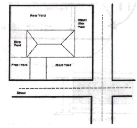
YARD, FRONT. A yard between side lot lines and measured horizontally at right angles to the front lot line to the nearest point of a building or other structure. See Figure 1.5-A.
YARD, REAR. A yard between side lot lines and measured horizontally at right angles to the rear lot line from the rear lot line to the nearest point of a building or other structure. See Figure 1.5-A.
YARD, SIDE. A yard between the front and rear yard measured horizontally at right angles from the side lot line to the nearest point of a building or other structure. See Figure 1.5-A.
YARD, STREET SIDE. A yard adjacent to a street between the front yard and rear lot line measured horizontally and at right angles from the side lot line to the nearest point of a building or other structure. See Figure 1.5-A.
(Ord. 2021-08-02, passed 10-12- 2021)
§ 151.009 CALCULATIONS.
Net acres. For subdivisions, net acres are calculated by subtracting rights-of-ways and open space from gross acres. First, gross acres are reduced by 25% for rights-of-way; then acres are further reduced by 15% for open space. Net acreage is not applicable to partitions, except where a private access lane is created (flag lots) or open space is voluntarily set aside.
(Ord. 2021-08-02, passed 10-12-2021)
§ 151.010 DWELLINGS LOCATED OUTSIDE CITY LIMITS.
(A) Dwellings located outside of the Banks City Limits and within the Banks Urban Growth Boundary may be permitted subject to the provisions of this section.
(B) Building permits.
(1) The homeowner or their authorized representative shall obtain a certificate authorizing Washington County to issue a building permit for a new dwelling. Application shall be made at the city and shall include the following items:
(a) Plot plan showing the dwelling and all other structures, including all exterior dimensions; building elevations drawings for all sides; information describing roofing and siding materials, foundation support systems and materials;
(c) Permit filing fee.
(2) An approved certificate to obtain a permit shall be issued within 10 days by the City of Banks after receipt of the required information indicated above.
(3) The certificate shall be denied when the applicant fails to provide the required information, and/or the proposed dwelling does not comply with the required codes specified herein.
(C) Occupancy requirements. Occupancy of the dwelling shall be governed by the building permit review procedure as administered by Washington County.
(D) Building removal. If the dwelling or other structures are removed from the property and not replaced with another structure within 6 months as evidenced by a building permit, the owner shall perform the following tasks unless otherwise authorized by the City of Banks:
(1) Remove any foundation and perimeter enclosures;
(2) Remove all accessories associated with the dwelling unit;
(3) Permanently disconnect and cap off all utilities including sewer, water, electricity, phone, cable television, and the like in the proper manner and time frame as may be specified by the utility agency; and/or
(4) In the event the owner fails to accomplish the required tasks as noted above, the City of Banks may perform the work and file a lien against the property for the cost to perform the work.
(E) Building abandonment. When a dwelling has been abandoned (not occupied) for a period of time which exceeds 5 or more years, the owner shall request an occupancy inspection and permit approved by the city building official prior to the dwelling being occupied again.
(Ord. 2021-08-02, passed 10-12-2021)
§ 151.020 ZONES.
All lands, tracts, and area within the corporate limits of the City of Banks are hereby included within 1 of the following described land use zones. The uses of land within the corporate limits of the city shall be limited to those permitted in the zone within which lands are situated.
(Ord. 2021-08-02, passed 10-12-2021)
§ 151.021 OVERLAY ZONES.
An overlay zone may be applied to any underlying zone. The regulations of an overlay zone shall be supplementary to and modify the regulations of the underlying zone.
(Ord. 2021-08-02, passed 10-12-2021)
§ 151.022 ZONING CLASSIFICATIONS.
The city is divided into the following zones and overlay, with applicable abbreviated designation/suffix:
Zones | Abbreviation |
Zones | Abbreviation |
Residential Estate | RE |
Low Density Residential | LDR |
Medium Density Residential- Low | MDR-L |
Medium Density Residential- High | MDR-H |
High Density Residential | HDR |
Mixed Use | MU |
Community Facilities | CF |
General Commercial | C |
Downtown Commercial | DC |
General Industrial | I |
Overlay Zones | Suffix |
Historic Resource Overlay | H |
(Ord. 2021-08-02, passed 10-12-2021)
§ 151.023 LOCATION OF ZONES AND OVERLAY ZONES.
(A) The boundaries for the zones and overlay zones listed in this chapter are indicated on the City of Banks Zoning Map, which is hereby adopted by reference. The boundaries shall be modified in accordance with the provisions of this chapter.
(B) The boundaries, legends, symbols, rotations, and references of each of the zoning classifications as depicted on the City of Banks Zoning Map are hereby adopted by reference.
(C) Unless otherwise specified, zone and overlay zone boundaries are section lines; subdivision lines; lot lines; centerlines of street or railroad right-of-way; or the lines extended.
(D) Where the exterior boundary of any zone or overlay zone conforms to the corporate boundary of the city, the city boundary shall likewise be depicted on the City of Banks Zoning Map.
(Ord. 2021-08-02, passed 10-12-2021)
§ 151.024 ZONING MAP.
(A) The City of Banks Zoning Map is hereto attached and by this reference made a part hereof, bearing the signatures of the Mayor and City Recorder of the City of Banks, and entitled City of Banks Zoning Map dated with the effective date of this chapter, it shall be maintained on file at all times in the office of the City Recorder.
(B) Whenever authorized map changes have accumulated, the City Council shall have prepared a revised Zoning Map depicting all changes authorized after the original map was adopted.
(Ord. 2021-08-02, passed 10-12-2021)
§ 151.025 ZONING OF ANNEXED AREAS.
Concurrent with annexation of land to the City of Banks, the City Council, upon considering the recommendation of the Planning Commission, shall enact an ordinance applying applicable zoning designation(s) to the subject land, pursuant to §§ 151.300 through 151.306. The Comprehensive Plan shall guide the designation of zoning for annexed areas.
(Ord. 2021-08-02, passed 10-12-2021)
§ 151.035 PURPOSE.
(A) This subchapter regulates allowed land uses in the residential zones ("uses") and sets forth lot and development standards, including minimum dimensions, area, density, coverage, structure height, and other provisions that control the intensity, scale, and location of development. The regulations of this chapter are intended to implement the City of Banks Comprehensive Plan and the purposes of this Code, per §§ 151.001 and 151.002.
(B) The intent and purpose of each residential zone is described as follows:
(1) The Residential Estate (RE) zone is intended to provide for low-density single family residential uses on large parcels at a density of 2.9 to 5.9 dwellings per net acre.
(2) The Low Density Residential (LDR) zone is intended to provide primarily single-family detached and duplex dwellings at a density of 6.0 to 7.9 dwellings per net acre.
(3) The Medium Density Residential-Low (MDR-L) zone is intended to provide for a blend of detached and attached single-family housing units with limited multi-family housing types at a density of 8.0 to 12.9 dwellings per net acre.
(4) The Medium Density Residential-High (MDR-H) zone is intended to provide for a blend of detached and attached single-family housing units and multi-family housing types at a density of 13.0 to 16.9 dwellings per net acre.
(5) The High Density Residential (HDR) zone is intended to provide for a broad range of housing types at a density of 17.0 to 30.0 dwellings per net acre. The HDR zone also provides opportunities for a limited amount of neighborhood-scale commercial uses.
(6) Mixed-Use (MU) zone is intended to provide a mix of medium density residential uses together with small to medium scale retail commercial and civic uses that emphasize a pedestrian environment.
(Ord. 2021-08-02, passed 10-12-2021)
§ 151.036 PERMITTED LAND USES IN RESIDENTIAL ZONES.
The land uses listed in Table 2.2-A as "P" are permitted in the residential zones, subject to the provisions of this Code. Uses listed as "S" are permitted subject to the specific standards in §§ 151.075 through 151.085. Land uses designated with a "CU" require conditional use approval prior to development or a change in use, in accordance with §§ 151.270 through 151.273. Only land uses which are specifically listed as "P", "S" or "CU" in Table 2.2-A and land uses which are approved as "similar" to those listed in this table may be permitted.
Land Use | RE | LDR | MDR-L | MDR-H | HDR | MU |
Single Dwelling, Detached | P | P | P | P | MPD | MPD |
Accessory Dwelling Unit (Subject to § 151.075) | S | S | S | S | S | S |
Duplex | P | P | P | P | MPD | MPD |
Triplex | N | MPD | MPD | P | P | P |
Fourplex | N | MPD | MPD | P | P | P |
Townhome | N | MPD | P | P | P | P |
Cottage Cluster | N | P | P | P | P | MPD |
Multi-Dwelling | N | MPD | MPD | MPD | P | P |
Manufactured Home - Individual Lot | P | P | P | P | N | N |
Manufactured Home Park (Subject to § 151.076) | N | S | S | S | N | N |
Residential Home (O.R.S. 197.665) | P | P | P | P | P | P |
Family Day Care Home | P | P | P | P | P | P |
Day Care Facility | CU | CU | CU | CU | P | P |
Home Occupation (Subject to § 151.077) | S/CU | S/CU | S/CU | S/CU | S/CU | S/CU |
Agriculture and Horticulture | N | N | N | N | N | N |
Accessory Structure or Use | P | P | P | P | P | P |
Church and Place of Worship | CU | CU | CU | CU | CU | CU |
Club, Lodge and Similar Use | CU | CU | CU | CU | CU | CU |
Government Office and Facilities | CU | CU | CU | CU | CU | CU |
Library, Museum and Comm. Center | CU | CU | CU | CU | CU | CU |
Wireless Communication Facility | N | N | CU | CU | CU | N |
Public Park and Recreational Facility | CU | CU | CU | CU | CU | CU |
Public and Private School | CU | CU | CU | CU | CU | CU |
Bed and Breakfast | CU | CU | CU | CU | N | CU |
Live/Work Residence (Subject to § 151.078) | S | S | S | S | S | S |
Retail Sales and Service (Subject to § 151.079) | N | N | S | S | S | S |
Prof. and Administrative Offices (Subject to § 151.079) | N | N | N | N | N | S |
Medical and Dental Offices/Clinic (Subject to § 151.079) | N | N | N | N | N | S |
Food-Beverage Sales, No Drive-Through | N | N | N | N | N | S |
Similar Use per § 151.006(A) | P/CU | P/CU | P/CU | P/CU | P/CU | P/CU |
Key: P = Permitted, subject to site/development review CU = Conditional use permit required N = Not permitted | ||||||
(Ord. 2021-08-02, passed 10-12-2021)
§ 151.037 DEVELOPMENT STANDARDS FOR RESIDENTIAL ZONES.
The development standards in Table 2.2-B apply to all uses, structures, buildings, and development allowed in the residential zones.
Development Standard | RE | LDR | MDR-L | MDR-H | HDR | MU |
Minimum Density (DU/Net Acre) Maximum Density (DU/Net Acre) (see § 151.110) | 2.9 5.9 | 6.0 7.9 | 8.0 12.9 | 13.0 16.9 | 17.0 30.0 | 10.00 16.9 |
Minimum Lot Area (square feet)1 Single-Family Detached Duplex Triplex Fourplex Townhome Townhome Center Lot Cottage Cluster Multi-Family | 10,0002 10,000 NA NA NA NA NA NA | 7,000 7,000 NA NA NA NA 7,000 NA | 5,000 5,000 6,000 6,000 2,000 4,000 7,000 NA | 4,500 4,500 5,000 5,000 2,000 4,000 7,000 NA | NA NA 5,000 5,000 2,000 4,000 7,000 5,0003 | NA NA 5,000 5,000 2,000 4,000 NA 5,0003 |
Minimum Lot Width (feet) Townhome Townhome Corner Lot All Other | NA NA 70 | NA NA 50 | 20 40 40 | 20 40 40 | 20 40 40 | 20 40 40 |
Minimum Lot Depth (feet) | 1.5 times the minimum lot width, or 100 feet, whichever is less | |||||
Maximum Building Coverage (%) Single-Family Detached Duplex Triplex Fourplex Townhome Cottage Cluster Multi-Family | 50 NA NA NA NA NA NA | 50 60 NA NA NA 60 NA | 50 60 None None 70 70 NA | 50 60 None None 70 70 NA | NA NA None None 80 70 80 | NA NA None None 80 NA 80 |
Setback Requirements: | ||||||
Minimum Front Yard (feet)4 | 15 | 15 | 15 | 10 | 5 | 0 |
Minimum Side Yard (feet) Townhome (interior side yard) Accessory Structures5 | 5 NA 2 | 5 NA 2 | 5 0 2 | 5 0 2 | 0 0 2 | 04 0 2 |
Minimum Street Side Yard (feet) | 10 | 10 | 10 | 10 | 5 | 5 |
Minimum Rear Yard (feet) Accessory Structure All Other | 2 10 | 2 10 | 2 10 | 2 10 | 2 10 | 2 10 |
Maximum Building Height (feet)6 | 30 | 30 | 35 | 35 | 40 | 35 or 457 |
Minimum Landscaping (percent of total site) (see §§ 151.155 - 151.157) | 15 | 15 | 15 | 15 | 15 | 10 |
Notes: 1. Minimum lot sizes may vary from these standards per the lot size averaging provisions in § 152.005 2. Maximum lot size in RE Zone is 15,000 sf. and in the LDR Zone is 10,000 sf. 3. For multi-family, minimum lot size is 5,000 sf. for the first four units, plus 1,000 per unit for additional units 4. A front setback may be reduced by up to 5 feet for unenclosed front porches with a minimum front yard setback of 5 feet where these reductions are permitted. There shall be no encroachment into public utility easements. 5. In the MU Zone, there is no minimum side yard requirement unless abutting LDR, MDR-L or MDR-H zoning, in which case the minimum side yard requirement is 5 feet. 6. Accessory structures located within 5 feet of a side yard shall be less than 15 feet in height. 7. The maximum building height for residential only buildings in the MU Zone is 35 feet. The maximum building height for mixed use buildings in the MU Zone is 45 feet. 8. In all zones, the maximum building height for cottage cluster buildings is 25 feet or 2 stories, whichever is greater. | ||||||
(Ord. 2021-08-02, passed 10-12-2021)
§ 151.038 ACCESSORY USES AND STRUCTURES.
An accessory use or structure shall comply with the requirements for a principal use, except as this chapter specifically allows to the contrary.
(Ord. 2021-08-02, passed 10-12-2021)
§ 151.050 PURPOSE.
(A) This subchapter regulates allowed land uses in the nonresidential zones and sets forth lot and development standards, including minimum dimensions, area, density, coverage, structure height, and other provisions that control the intensity, scale, and location of development. The regulations of this chapter are intended to implement the City of Banks Comprehensive Plan and the purposes of this Code, per § 151.002.
(B) The intent and purpose of each nonresidential zone is described as follows:
(1) Community Facilities Zone CF. The purpose of the Community Facilities Zone is to provide for community facilities on properties owned by public or semi-public agencies, while encouraging protection of natural resources designated by the comprehensive plan under the requirements of statewide planning goals.
(2) General Commercial Zone C. The purpose of the General Commercial Zone is to provide for a broad range of commercial activities to serve the residents of Banks and the surrounding area.
(3) Downtown Commercial Zone DC. The purpose of the Downtown Commercial Zone is to allow a mix of complementary uses in the Banks Downtown/Main Street area, promote pedestrian-friendly development, encourage efficient use of land, and facilitate economic development while preserving the small-town character of Banks.
(4) General Industrial Zone I. The purpose of the General Industrial Zone is to facilitate economic development by providing areas suitable for warehousing, primary and secondary processing, packaging, fabricating of finished goods and equipment with related outdoor storage and incidental sales.
(Ord. 2021-08-02, passed 10-12-2021)
§ 151.051 COMMUNITY FACILITIES ZONE; PERMITTED LAND USES.
(A) The land uses listed here are permitted in the CF Zone as shown, subject to the provisions of this chapter. Only land uses that are specifically listed, and land uses that are approved as "similar" to those listed per § 151.006(A) may be permitted.
(1) Public park and playground, swimming pool, community center, golf course and similar recreational facilities;
(2) Public school and associated facilities; and
(3) Government institution; community service facility; caretaker facility.
(Ord. 2021-08-02, passed 10-12-2021)
§ 151.052 COMMERCIAL ZONES; PERMITTED LAND USES.
The land uses listed in Table 2.3-A as "P" are permitted in the nonresidential zones as shown, subject to the provisions of this chapter. Uses listed as "S" are permitted subject to the Use-Specific standards in §§ 151.075 through 151.085. Land uses designated with a "CU" require conditional use approval prior to development or a change in use, accordance with §§ 151.270 through 151.273. Only land uses which are specifically listed as "P", "S", or "CU" in Table 2.2-A and land uses which are approved as "similar" to those listed in this table may be permitted.
Land Use | C Zone | DC Zone |
Residential Uses | ||
Dwelling units on second or upper story | P | P |
Dwelling units on ground floor | P1 | P1 |
Family day care home | P | P |
Accessory Uses | P | P |
Commercial Uses | ||
Automotive repair and service (includes fueling stations, car wash, tire sales and service, farm equipment, painting and other similar uses) | CU | N |
Automotive sales and rental (includes motorcycles, boats, RVs and trucks) | P | N |
Commercial retail sales and service | P | P |
Personal services | P | P |
Eating and drinking establishments (see also "drive-through facility) | P | P |
Hotel or motel | P | P |
Amusement, entertainment, commercial recreation - Fully enclosed in building - Not fully enclosed in a building | P CU | P CU |
Office uses (professional, medical clinic) | P | P |
Drive-through facility (subject to § 151.082) | CU/S | N |
Recreational vehicle park or campground | CU | N |
Lumber yard | CU | N |
Day care facility | P | P |
Wholesale and distribution business | CU | N |
Public or commercial off-street parking lot or structure | CU | CU |
Institutional Uses | ||
Community service, governmental institution | P | P |
Public utilities | CU | CU |
Medical institutions offering overnight care and treatment | CU | N |
Radio and TV stations and transmitters | CU | N |
Schools | P | P |
Religious institutions | P | P |
Medical, recreational marijuana (subject to § 151.080) | S | N |
Similar use per § 151.006(A) | P/CU | P/CU |
Notes: 1. In the C and DC Zones, ground floor dwelling units must be located behind a street-facing commercial use. Key: P = Permitted, subject to site/development review CU = Conditional use permit required N = Not permitted | ||
(Ord. 2021-08-02, passed 10-12-2021)
§ 151.053 GENERAL INDUSTRIAL ZONE; PERMITTED LAND USES.
The land uses listed here are permitted in the I Zone as shown, subject to the provisions of this chapter. Only land uses that are specifically listed, and land uses that are approved as "similar" to those listed per § 151.006(A) may be permitted.
(A) Uses permitted outright. No building, structure, or land shall be used, and no building or structure shall hereafter be erected, enlarged, or altered in this zone, except for the following uses:
(1) Cold storage plant;
(2) Feed and seed processing and storage;
(3) Laboratories: experimental, dental, medical, photo, or motion picture, research or testing;
(4) Bakeries, creameries, bottling plants, laundries, cleaning and dying plants;
(5) Cabinet shops, electrical, plumbing, or heating shops; welding, sheet metal and machine shops, lumber yards;
(6) Manufacture, assembly, compounding, processing, packaging, or treatment of candy, cosmetics, drugs, pharmaceuticals, toiletries, dairy products, food and beverage products;
(7) Manufacture, assembly, compounding, processing, packaging or treatment of paper products (but not paper itself), textiles, or other fibrous materials;
(8) Manufacturing of pottery or other similar ceramic products;
(9) Manufacturing of precision instruments and equipment such as watches, electronics equipment, medical equipment and devices, photographic equipment, optical goods, and similar products;
(10) Manufacturing, assembly, testing, or repairing of devices, equipment, and systems of an electrical or electromechanical nature;
(11) Manufacturing, assembly, fabrication, warehousing and wholesale distribution of goods, wares, merchandise, articles, substances, or compounds, which are not flammable, explosive, or likely to create fire, radiation or explosive hazards to surrounding property;
(12) Planing mill;
(13) Plastics; molding of, including the manufacture or products thereof, provided all grinding operations are conducted within a building;
(14) Public service and utility;
(15) Single-family dwellings and their accessory uses lawfully established as of June 13, 2014;
(16) Replacement dwellings for single-family dwellings lawfully;
(17) Vehicle and farm equipment repair;
(18) Veterinarian or animal hospital;
(19) Warehousing, distribution, including mini-storage and outdoor storage of equipment;
(20) Accessory use of structure, including caretaker residence; and
(21) Medical marijuana and recreational marijuana, subject to § 151.080.
(1) Automobile service station;
(2) Batteries, paint, pickles, sauerkraut or vinegar, wallboard, cans, soap and cleaning compounds, paper; manufacture of;
(3) Brewery;
(4) Drive-in theaters;
(5) Flour milling, grain storage, or elevator;
(6) Fruit packing and processing; cannery;
(7) Fuel oil distribution (home use only) and storage;
(8) Foundry;
(9) Natural resource extraction, gravel mining and rock crushing, subject to the provisions set forth in § 151.084;
(10) Manufacture of motor vehicles, trucks, recreational vehicles, and utility trailers as well as mobile homes;
(11) Radio and TV transmitters;
(12) Railroad right-of-way, truckage and related facilities;
(13) Slaughterhouse;
(14) Solid waste facilities; auto wrecking yards, junkyards; subject to the provisions of § 151.083;
(15) Stone, marble, and granite grinding, dressing, and cutting;
(16) Any other use held similar to the above uses, as approved by the City Council;
(17) Any processing activity or display essential or incidental to any permitted use in this zone and not conducted entirely within an enclosed building, except for outdoor storage of equipment which is allowed by right division (A)(21); and
(18) Any use or storage of hazardous materials in amounts or forms exceeding consumer commodities.
(Ord. 2021-08-02, passed 10-12-2021)
§ 151.054 DEVELOPMENT STANDARDS FOR NONRESIDENTIAL ZONES.
(A) The development standards in Table 2.3-B apply to all uses, structures, buildings, and development allowed in the nonresidential zones.
Development Standard | CF | C | DC | I |
Minimum lot width and depth | None, unless setbacks are required1 | None, unless setbacks are required1 | None, unless setbacks are required1 | None, unless setbacks are required1 |
Setback Requirements: | ||||
Minimum front yard (feet) | None | None | None | 20 |
Minimum side yard (feet) Abutting residential zone All other | 10 None | 10 None | 10 None | 20 None |
Minimum street side yard (feet) | None | None | None | 20 |
Minimum rear yard (feet) Abutting residential zone All other | 10 None | 10 None | 10 None | 20 10 |
Maximum building height (feet) | 35, or 3 stories, whichever is less | 35, or 3 stories, whichever is less | 45 (60 feet w/height bonus) | 35, or 3 stories, whichever is less |
Minimum landscaping (percent of total site) | 10 | 10 | Non e | 5 |
Build-to line requirement | Non e | Non e | 75 % | Non e |
Notes: 1. If a side yard setback is required, a minimum lot width of 25 feet is required. If a rear yard setback is required, a minimum lot depth of 50 feet is required. | ||||
(B) Height bonus in the DC Zone. Allowed building height is increased by 15 feet for mixed-use buildings in the DC Zone when at least 75% of the gross floor area of the upper story(ies) is for one ormore dwellings as demonstrated on building permit plans.
(C) Build-to line requirement.
(1) This standard is met when a building or buildings are placed within 10 feet from the front property line such that at least 80% of the site's frontage area along a public street is occupied by habitable building space. For this standard, frontage is considered the area between zero to 10 feet from the front property line, extending the entire width of the frontage. Portions of the building not used to meet this standard may setback more than 10 feet from the front property line. The portion of the building used to meet this standard must be habitable building space.
(2) For corner lots in the DC Zone, this standard must be met for Main Street frontages.
(3) The portion of the site's frontage area not occupied by building(s) shall be landscaped or developed as civic space in accordance with division (D) below.
(4) See Figure 2.3-A for an illustration of the build-to line requirement.
Figure 2.3-A

(D) Civic space bonus. A height bonus of 15 additional feet in building height is available to developments that provide a designated and improved as civic space (plaza, landscaped courtyard, or similar space) that is accessible to the public, pursuant to the following:
(1) Civic spaces shall abut a public right-of-way or otherwise be connected to and visible from a public right-of-way by a sidewalk or pedestrian accessway.
(2) All civic spaces will be improved with at least one pedestrian amenity from the following list:
(a) Plaza surfaces (e.g., pavers, landscaping);
(b) Sidewalk extensions;
(c) Street furnishings (e.g., benches, public art, planter with seat wall, informational kiosk, sheltered seating area);
(d) Way-finding signage; or
(e) Similar amenity as approved by the city.
(3) To be eligible for the height bonus, the size of the civic space must be equal to, or greater than, 5% of the gross site area.
(4) This height bonus cannot be combined with the height bonus in division (A) above.
(Ord. 2021-08-02, passed 10-12-2021)
§ 151.065 HISTORIC RESOURCE OVERLAY ZONE H.
(A) Purpose. The purpose of the Historic Overlay Zone is to provide for the preservation, protection, enhancement, and perpetuation of designated historic sites and structures in order to:
(1) Safeguard the city's heritage as embodied and reflected in its historic resources;
(2) Encourage public awareness, knowledge, and appreciation of the city's history and culture;
(3) Foster community pride and sense of identity based on recognition and use of historic resources;
(4) Identify and resolve conflicts between the preservation of historic resources and incompatible improvements or loss of the resource;
(5) Carry out the provisions of Oregon's Statewide Planning Goal 5; and
(6) Maintain the historic integrity of historically significant buildings and sites.
(B) Applicability. The provisions in this section apply to properties that are within the Historic Resource Overlay Zone per the Zoning Map, and to properties that are identified as historic in the Comprehensive Plan.
(C) General provisions. All proposed exterior alterations and demolitions of sites and structures subject to the Historic Resource Overlay Zone shall be subject to the provisions of this section, with the exception of improvements or demolitions required by other governmental agencies.
(1) Approval required. Planning Commission approval of a proposed exterior alteration or demolition is required before a building permit can be issued.
(2) Uses allowed. All uses allowed in the primary zone in which the historic site or structure is located shall be allowed.
(3) Ordinary maintenance and repair. Nothing in this section shall be construed to prevent the ordinary maintenance and repair of a designated historic resource. Ordinary maintenance and repair means any work, the sole purpose and effect of which is to prevent or correct deterioration, decay or damage, including repair of damage caused by fire or other disaster and which does not result in a change in the historic appearance and materials of a property.
(4) Application procedure. Applications for approval of exterior alteration or demolition of a historic resource shall be submitted to the City Recorder and shall include a site plan, architectural drawings, and a description of the proposal and its compliance with the criteria below. There shall be no fee for this procedure. Upon receipt of a complete application, the Planning Commission will schedule a public hearing consistent with the provisions of § 151.233. When demolition is proposed, a notice will be posted on the property consistent with city requirements.
(5) Planning Commission review. The Planning Commission shall issue a decision on the request within 60 days of receipt of a complete application. The Planning Commission may attach conditions necessary to ensure compliance with the purpose of this section, which may include a condition to delay the proposed action for a maximum of 60 days from the date of the decision until a more satisfactory solution can be found.
(6) Review criteria. In evaluating applications for exterior alterations, the Planning Commission shall consider:
(a) The purpose or necessity of the proposed alteration;
(b) The compatibility of the proposed alteration with the traditional historic character and architectural integrity of the structure or site in terms of design, architectural detail, scale, proportion, materials, and texture; and
(c) Whether the proposed alteration is the minimum or least disruptive alteration to meet the desired purpose.
(7) Applications for demolitions. In reviewing applications for demolitions, the Planning Commission shall consider:
(a) The physical condition and safety of the structure; and
(b) Whether a reasonable effort has been made to preserve the structure by restoration or removal, by offering the structure for sale or public acquisition, or by alternative means. Advertising the building for sale for 2 consecutive weeks in a newspaper of general circulation in the Banks area, and documenting that the highest bona fide offer for the structure has not been rejected, shall constitute satisfactory evidence of reasonable effort to preserve the structure.
(Ord. 2021-08-02, passed 10-12-2021)
§ 151.075 ACCESSORY DWELLING UNIT.
(A) An accessory dwelling unit (ADU) may be a detached building, in a portion of a detached accessory building (above a garage or workshop, for example), or a unit attached or interior to the primary dwelling (an addition or conversion of an existing floor, for example).
(B) ADUs shall comply with the following:
(1) A maximum of 1 ADUs is allowed per lot. The ADU may be internal to the primary residence or a detached, separate unit.
(2) The maximum floor area of the ADU shall not exceed 800 square feet or 75% of the primary dwelling's floor area, whichever is smaller. However, ADUs that result from the conversion of a level or floor (basement or attic, for example) of the primary dwelling may occupy the entire level or floor, even if the floor area of the ADU exceeds 800 feet.
(3) Other development standards. ADUs shall meet the development standards for buildings per the underlying zone, except that:
(a) Conversion of an existing legal non-conforming structure to an ADU is allowed, provided that the conversion does not increase the degree of non-conformity.
(b) No off-street parking is required for an ADU.
(c) Detached ADUs shall contain at least 2 detailed design elements from the list in § 151.126.
(d) ADUs are not included in density calculations.
(Ord. 2021-08-02, passed 10-12-2021)
§ 151.076 MANUFACTURED HOME PARK.
(A) Specific standards for the development of manufactured home parks are included because a manufactured home park is a unique type of residential use which deserves special consideration due to its impact unto the community, its roads and utilities. These standards are instead of the standards of §§ 151.270 through 151.273, Conditional Use Permits.
(B) Minimum area - 1 acre.
(C) Access drives shall be provided to each manufactured home space, shall be continuous unless provided with adequate turn-around area or cul-de-sac, and shall have minimum width of 20 feet. Each park shall have a principal access drive of not more than 20 feet for an exterior connection to the public street. A principal access drive that allows on-street parking on 1 side shall be 24 feet wide; and a principal access drive that allows on-street parking on both sides shall be 28 feet wide. All internal roads shall be paved.
(D) Walkways, not less than 2 feet in width, shall be provided from each manufactured home space to service buildings and along at least 1 side of all access drives and internal roads.
(E) Except as required for vision clearance, the outer perimeter of each park shall be improved with:
(1) A sight-obscuring fence or wall not less than 5 nor more than 6 feet in height;
(2) Maintained evergreen landscaping that is at least 10 feet in depth, will mature within 3 years, and reach at least 5 feet in height at maturity; or
(3) A combination of divisions (E)(1) and (E)(2) above.
(F) Unless in conflict with state laws and regulations, all areas covered by manufactured homes and accessory buildings shall be paved with asphalt or concrete, or covered with permanently contained crushed rock.
(G) All open areas, except as otherwise specified herein, shall be suitably landscaped according to plans and specifications approved by the Planning Commission. The areas shall be continuously maintained.
(H) Each manufactured home space shall be improved with 1 patio of concrete or other suitable impervious material, having a minimum area of 150 square feet and 1 crushed rock or better surfaced mobile home pad having a minimum area equal to that of the manufactured home which will be located on the space. In addition each mobile home site shall have 1 parking space, either a carport or paved parking area having a minimum area of 100 square feet.
(I) A minimum of 200 square feet of recreation area for each manufactured home space shall be provided in 1 or more locations within the manufactured home park. The minimum size of each required recreation area shall be 5,000 square feet.
(J) A centralized storage area for boats, campers, camping trailers, and automobiles shall be provided in each manufactured home park. The storage area shall contain a minimum of 160 square feet for each manufactured home space and be enclosed by a sight-obscuring fence. Roads, carports, parking areas, yards, and patios shall not be used for long-term parking or storage of trailers, boats, campers, or other recreational vehicles.
(K) Permanent accessory structures located within any manufactured home space shall be used only as carports or for storage purposes. (Storage buildings shall have a maximum floor area of 25 square feet). Carports shall not exceed 800 square feet in area unless designed to serve 2 adjacent manufactured home spaces in which case they may be 1,600 square feet in area. Storage structures and carports shall be located not less than 6 feet from any manufactured home and shall be subject to all of the applicable permits and building codes of the City of Banks. A storage building (and carport) shall be provided on each manufactured home space.
(L) Signs are limited to 1 identification sign with a maximum area on 1 side of 12 square feet. The sign may be indirectly illuminated, but shall not contain exposed neon or similar tubing and shall not flash, rotate, or move in any way. Design approval of the sign is subject to review of the Planning Commission to assure that it will be harmonious with the neighborhood.
(M) All utilities, i.e., sewer, water, natural gas, electricity, telephone, and television cable shall be underground in locations approved the City Engineer. Each manufactured home space shall be equipped with connections for running water, electricity, and sanitary sewer.
(N) All residents shall execute leases, which have been approved by the city and contain provisions for the assumption of possession of abandoned manufactured homes by the manufactured home park management.
(O) Prior to location of a mobile home in a manufactured home park, the owner or occupant shall establish to the satisfaction of the superintendent of building inspection that the manufactured home is in a condition that conforms to 1 of the following construction standards.
(1) A manufactured home constructed on or after 9-1-1969, shall conform either to standards in effect in Oregon at the time of construction or Oregon standards in effect at the time entry into the park is to occur. Units built between 9-1-1969 and 6-15-1976 shall exhibit the Oregon Department of Commerce Insignia of Compliance. Units built thereafter shall meet the H.U.D. Federal Manufactured Home Safety Standards dated 6-15-1976.
(2) Manufactured homes, constructed prior to 9-1-1969, shall be in a condition that is not less than the substantial equivalent of the above standards.
(P) The services of an architect, a landscape architect, and an engineer, all licensed to practice in Oregon, shall be employed in the preparation and execution of all plans. Upon proof by the applicant that the scope of the proposal does not require the services of an architect, the Planning Director may waive that requirement.
(Q) In the event of denial, applications may be resubmitted within 1 year of the denial, provided the Planning Director finds the denial was based on internal (on-site) factors and new plans have been submitted which are sufficiently modified to warrant consideration by the Planning Commission.
(R) Notwithstanding the above regulations, manufactured home parks must comply with all state regulations pertaining to this type of use.
(S) An adequate number of fire hydrants shall be provided within the manufactured home park so that no mobile home space or structure within the park is more than 400 feet from a hydrant.
(T) Standard streetlights shall be installed at intervals of no more than 200 feet along all access drives and internal roads.
(U) Each manufactured home space shall be legibly numbered so that it may be easily found by emergency vehicles.
(V) A manufactured home located in a manufactured home park smaller than 3 acres shall have:
(1) A pitched roof, except that no standard shall require a slope of greater than a nominal 3 feet in height for each 12 feet in width.
(2) Exterior siding and roofing which in color, material and appearance is similar to the exterior siding and roofing material commonly used on residential dwellings within the community and which is comparable to the predominant materials used on dwellings on adjoining sites as determined by the Planning Commission.
(Ord. 2021-08-02, passed 10-12-2021)
§ 151.077 HOME OCCUPATIONS.
(B) Specifically.
(1) No sign shall be used other than a nameplate not over 2 square feet in area.
(2) There shall be no display that will indicate from the exterior that the building is used for any purpose other than a residence.
(3) There shall be no outside storage of materials other than plant materials. No activities associated with the home occupation shall take place outdoors:
(4) The building shall retain the characteristics and appearance of a residence.
(5) The home occupation shall not alter the residential character of the neighborhood.
(6) There shall be no paid employees other than family members.
(7) The activity shall occupy no more than 1/4 of the floor area of the primary structure.
(8) Family day care homes are residential uses and are not regulated as home occupations.
(9) Specifically prohibited, as a home occupation in a residential zone, is the repair and assembly of motor vehicles, equipment with an internal combustion engine, or large appliances.
(10) There shall be no large-scale commercial vehicle delivery or pickup.
(Ord. 2021-08-02, passed 10-12-2021)
§ 151.078 LIVE/WORK RESIDENCE.
The development standards listed below apply to all live-work residences. Live/work residence means a habitable structure that allows for a professional office or commercial retail or service use to be operated in the same structure, with the business owner's residence located behind the business use on the ground floor or on the upper floor. The permitted live/work housing types are defined below:
(A) Live/work house. A single household detached or attached dwelling with a commercial use occupying one floor and no more than 50% of the total floor area of the entire unit, excluding garage space.
(B) Live/work apartment. A primarily residential multi-story, multi-unit building with some apartments having space designated as available for business use not to exceed 50% of the square footage of the entire apartment unit, excluding the garage.
(Ord. 2021-08-02, passed 10-12-2021)
§ 151.079 COMMERCIAL USES IN RESIDENTIAL ZONES.
Certain commercial uses are allowed in the MU, MDR-L, MDR-H, and HDR zones as indicated in Table 2.2-A. Those commercial uses are: Retail sales and service, professional and administrative offices, medical and dental offices, and food-beverage sales (no drive- through facilities). The following standards apply to commercial uses in residential zones.
(A) The gross floor area of commercial uses in the MU zone shall not exceed 10,000 square feet per lot.
(B) The gross floor area of commercial uses in the MDR-L, MDR-H, and HDR zones shall not exceed 5,000 square feet per lot.
(C) For mixed-use developments abutting Main Street, no more than 50% of the Main Street ground-floor street frontage shall be occupied by residential uses. This standard does not limit residential uses above a street-level commercial or civic use, or behind street-level store fronts abutting Main Street.
(D) Commercial and mixed-use buildings in the MU, MDR-L, MDR-H, and HDR zones shall meet the Build-to Line standard of § 151.054(C).
(E) All commercial operations shall be conducted within enclosed buildings except as expressly authorized through approval of a conditional use permit or as accessory to a primary permitted use; for example, outdoor seating areas for restaurants.
(F) Commercial and residential floor space on the ground floor of a mixed-use building shall have a minimum floor-to-ceiling height of 11 feet for new building construction.
(Ord. 2021-08-02, passed 10-12-2021)
§ 151.080 MEDICAL MARIJUANA AND RECREATIONAL MARIJUANA.
(A) Definitions. For the purpose of this chapter, the following definitions shall apply unless the context clearly indicates or requires a different meaning.
MARIJUANA. All parts of the plant of the genus Cannabis family Moraceae, whether growing or not; the resin extracted from any part of the plant; and every compound, manufacture, salt, derivative, mixture, or preparation of the plant or its resin as currently defined by state law or as may from time to time be amended. The term does not include the mature stalks of the plant, fiber produced from the stalks, oil or cake made from the seeds of the plant, any other compound, manufacture, salt, derivative, mixture, or preparation of the mature stalks (except the resin extracted there from), fiber, oil, or cake, or the sterilized seed of the plant that is incapable of germination.
MARIJUANA FACILITY or FACILITY. Any facility licensed by the state of Oregon to sell marijuana. The term includes both facilities that are registered by the Oregon Health Authority to sell, distribute, transmit, give, dispense or otherwise provide medical marijuana pursuant to O.R.S. Chapter 475, and facilities that are licensed by the Oregon Liquor Control Commission to sell or distribute marijuana for recreational purposes. A FACILITY includes the real property on which the use is proposed or situated and all buildings or other structures on the property used for the storage, distribution, sale or dissemination of marijuana.
(B) Applications. An application for a marijuana facility shall comply with all applicable land use review procedures set forth in this chapter. Applications for all new marijuana facilities and modifications or expansions of existing marijuana facilities shall comply with the substantive requirements of the underlying zone, the standards of this section and any other applicable standards set forth in the Banks Code of Ordinances.
(C) Standards. The following standards shall apply to the establishment, location and operation of all marijuana facilities in the city:
(1) The facility shall be licensed or otherwise registered by the state and at all times shall be in good standing pursuant to state law and any terms or conditions of the facility's state-issued license. The applicant, operator, owner and person in charge of the facility shall also possess any required state license or registration needed to operate the facility and shall be in good standing at all times while operating the facility.
(2) The facility shall meet applicable state and local laws, including but not limited to, building and fire codes, including the payment of all fines, fees and taxes owing to the city.
(3) The facility shall not manufacture or produce on-site any extracts, oils, resins or similar derivatives of marijuana and shall not use open flames or gases in the preparation of any products.
(4) Marijuana shall not be smoked, ingested or otherwise consumed on the premises of the facility.
(5) The facility shall provide for the secure disposal of marijuana remnants or byproducts; such remnants or by-products shall not be placed in the facility's exterior refuse containers.
(6) The facility shall not be co-located on the same tax lot or within the same building with any marijuana grow site or with a smoke shop where tobacco smoking is allowed.
(7) A facility may only operate in the C General Commercial zone or the I Industrial Zone as designated by the official zoning maps of the city.
(8) A facility shall not be located within the buffers specified in this section. Distances shall be measured as a straight line from the closest point of the property on which the facility is located to the closest point of the property on which the buffered use is located:
(a) One thousand feet from any public or private school; and
(b) Five hundred feet from any public or private park or library;
(c) One thousand feet from another marijuana facility; and
(d) Four hundred feet from any residentially zoned property.
(9) Signage for the marijuana facility shall not include logos or illustrations of marijuana leaves and shall emphasize identification of the facility without drawing undue attention.
(10) The facility shall not sell or dispense marijuana in an edible form.
(11) No minor shall be allowed on the premises unless the minor is a medical marijuana qualifying patient and accompanied by a parent, guardian or caregiver whose purpose is to procure the minor's medical marijuana. No minors are allowed on the premises of a recreational marijuana facility.
(12) Sales or any other transfers of marijuana products must occur completely inside the facility building and must be conducted only between the facility operator and the customer. There shall be no walk-up or drive- through service.
(13) The hours of commercial operation for the facility shall be limited to 8:00 a.m. until 5:00 p.m. Monday through Friday.
(14) A change in use (including a rezone) of a neighboring property within any of the buffer distances specified in this section after a permit has been issued for a facility shall not result in the facility being in violation of this section.
(Ord. 2021-08-02, passed 10-12-2021)
§ 151.081 DRIVE-THROUGH FACILITIES.
The following standards apply to drive-through facilities, where they are allowed.
(A) Purpose. Where drive-up or drive-through uses and facilities are allowed, they shall conform to all of the following standards, which are intended to calm traffic, provide for adequate vehicle queuing space, prevent automobile turning movement conflicts, and provide for pedestrian comfort and safety.
(B) Standards. Drive-up and drive-through facilities (i.e., driveway queuing areas, customer service windows, teller machines, kiosks, drop-boxes, or similar facilities) shall meet all the following standards:
(1) Drive-through facilities shall have no more than one service lane.
(2) Drive-through uses shall be located so that access and egress to the drive-through features are from an on-site drive aisle or other on-site circulation facility, not a public street.
(3) Restaurants providing drive-up window service shall have sufficient seating to accommodate anticipated customer volume.
(4) Financial and other commercial establishments that provide drive-up window facilities shall also provide for 24-hour safe, convenient, and readily accessible exterior walk-up window service that is separate from the drive-through facility, such as an automatic teller machine.
(5) The design of the stacking area shall allow customers' vehicles to leave the stacking line for emergency reasons.
(6) Establishments having drive-up window facilities shall have sufficient stacking area to ensure that public rights-of-way and shared access driveways are not obstructed.
(7) Communication's sound system shall not exceed a measurement of 55 decibels at the adjoining property line.
(Ord. 2021-08-02, passed 10-12-2021)
§ 151.082 BED AND BREAKFAST.
The following standards apply to bed and breakfast facilities, where they are allowed.
(A) Accessory use. The use must be accessory to a permitted residential use in the RE, LDR, MDR-L, or MDR-H zones.
(B) Maximum size. A maximum of 6 bedrooms for guests, and a maximum of 12 guests are permitted per night.
(C) Length of stay. The maximum length of stay is 28 days per guest; any stay longer is classified as a hotel or commercial lodging use.
(D) Employees. The inn shall have not more than 2 non-resident employees on-site at any 1 time. There is no limit on residential employees.
(E) Food service. Food service shall be provided only to overnight guests of the business, except where a restaurant use is also an allowed use.
(F) Signs. Signs shall not exceed a total of 4 square feet of surface area on each side of 1 or 2 faces. See also, sign regulations in Chapter 39 of the Banks Municipal Code.
(F) Screening and buffering. The city may require a landscape hedge or fence be installed on the property line separating a detached accessory dwelling from an abutting single-family dwelling for the purposes of visual screening and privacy between uses. Screening and buffering shall conform to the standards of §§ 151.155 through 151.157.
(Ord. 2021-08-02, passed 10-12-2021)
§ 151.083 AUTO WRECKING YARDS OR JUNK YARDS.
In addition to such other requirements as the Planning Commission may stipulate in authorizing this use, the following standards apply:
(A) Minimum lot area - 1 acre;
(B) Minimum building setback distance - front yard, 30 feet; rear yard, 25 feet; side yard, 25 feet, except on corner lots, 30 feet;
(C) Minimum fence setbacks - front yard, 25 feet; rear yard, 5 feet; and side yard, 5 feet;
(D) Fences:
(1) A sight-obscuring fence shall be constructed to completely enclose the wrecking or junkyard. The fence shall be painted 1 color and kept in good repair. It shall be the responsibility of the occupant to maintain the fence;
(2) Front yard fence height - minimum height of 6 feet. However, when such front yard is fronting on any state primary or secondary highway, the fence height shall be a minimum of 8 feet; and
(3) Side or rear yard fence height - minimum of 6 feet.
(E) Exterior storage:
(1) All storage shall be within the fenced area; and
(2) At no time shall any items be piled higher than the fence.
(F) Notwithstanding the above regulations, all auto wrecking yards and junk yards must comply with all state regulations pertaining to this type of use.
(Ord. 2021-08-02, passed 10-12-2021)
§ 151.084 NATURAL RESOURCE EXTRACTION.
(A) The use of premises in any zone for the excavation, mining, extraction, or removal of stone, sand, gravel, day, or other natural deposits may only be authorized by the Planning Commission after public hearing per the Type III procedure.
(B) This use may be authorized by the Planning Commission for the periods as it deems consistent with the public health, safety, and general welfare, and subject to the following provisions.
(C) Additional application submission requirements. In addition to the information required by § 151.272, an application for natural resource extraction shall include the following information:
(1) Topographic map with such cross-sections as are necessary to adequately show the topography of the property in question, the extent of the area to be mined, any natural features and its relation to streets and surrounding property;
(2) Map showing the extent of the proposed excavation and the contours of the ground after the removal of the material.
(3) Narrative describing any impact the excavation may have on surrounding properties and by any improvements or natural features existing at or near the site. Issues to be addressed include noise, dust, traffic, water quality, and other issues specific to the site.
(4) Reclamation. Before approving an application, the Planning Commission may require that the applicant enter into an appropriate agreement with the city for reclamation of such areas to suitable use after completion of excavations, and that an adequate performance bond or other guarantee be furnished covering the cost of restoration or other work.
(Ord. 2021-08-02, passed 10-12-2021)
§ 151.085 TEMPORARY USES.
Temporary uses are characterized by their short-term or seasonal nature and by the fact that permanent improvements are not made to the site. Temporary uses include, but are not limited to: construction trailers, leasing offices, temporary carnivals and fairs, parking lot sales, retail warehouse sales, seasonal sales such as Christmas tree sales and vegetable stands, and similar uses. This Code contains permit procedures for three types of temporary uses. Seasonal and special events, temporary sales offices and model homes, and temporary buildings, trailers, kiosks, and other structures, as follows:
(A) Seasonal and special events. Through a Type II procedure, pursuant to § 151.232, the city shall approve, approve with conditions, or deny a temporary use application for a seasonal or special event, based on the following criteria:
(1) The use is permitted in the underlying zone, and does not violate any conditions of approval for the property (e.g., prior development permit approval).
(2) The use occurs only once in a calendar year and for not longer than 45 consecutive days.
(3) The use is permitted in the underlying land use district and does not violate any conditions of approval for the property (e.g., prior development permit approval).
(4) The applicant, if different than the property owner, has proof of the owner's permission to place the use on the property.
(9) The use does not create adverse off-site impacts including vehicle traffic, noise, odors, vibrations, glare, or lights that affect an adjoining use in a manner in which other uses allowed outright in the district do not affect the adjoining use.
(10) The use is adequately served by sewer or septic system and water, as applicable.
(11) The applicant shall be responsible for maintaining all required licenses and permits.
(B) Temporary sales office or model home. Through a Type II procedure, pursuant to § 151.232, the city shall approve, approve with conditions, or deny a temporary use application for a temporary sales office or model home, based on the following criteria:
(1) Temporary sales office. The use of any real property within the city as a temporary sales office, office for the purpose of facilitating the sale of real property, shall meet all of the following criteria:
(a) The temporary sales office shall be located within the boundaries of the subdivision or tract of land in which the real property is to be sold.
(b) The property to be used for a temporary sales office shall not be permanently improved for that purpose.
(c) Public health, safety, and welfare shall be protected through conditions imposed by the city, regarding temporary utility connections.
(2) Model house. The use of any real property within the city for a model home, including a model home in any subdivision or on any tract of land within the city, shall meet all of the following criteria:
(a) Where the model house is located in a residential zone, it shall be located within the boundaries of the subdivision or tract of land where the real property to be sold is situated.
(b) A model house located in a residential zone shall be designed as a permanent structure that meets all relevant requirements of this Code and other applicable codes and permit requirements.
(c) A model house located in a nonresidential zone, as with a manufactured home sales display lot, shall be removed when the use of the subject site for home sales ends.
(C) Temporary buildings, trailers, kiosks, and other structures. Through a Type II procedure, pursuant to § 151.232, the city shall approve, approve with conditions, or deny an application for a placement and use of a temporary building, trailer, kiosk, or other structure, based on following criteria:
(1) The use is permitted in the underlying zone and does not violate any conditions of approval for the property (e.g., prior development permit approval).
(2) The applicant, if different than the property owner, has proof of the owner's permission to place the use on the property.
(3) The lot development standards of the applicable zone are met.
(8) The use does not create adverse off-site impacts including vehicle traffic, noise, odors, vibrations, glare, or lights that affect an adjoining use in a manner in which other uses allowed outright in the district do not affect the adjoining use.
(9) The use is adequately served by sewer or septic system and water, as applicable.
(10) The structure complies with applicable building codes.
(11) Except where specifically authorized by the City Council, the length of time that the temporary structure may remain on a site shall not exceed 6 consecutive months or a total of 9 months in any one calendar year.
(12) The applicant has obtained and will maintain all required licenses and permits.
(Ord. 2021-08-02, passed 10-12-2021)
§ 151.095 GENERAL EXCEPTIONS TO LOT SIZE REQUIREMENTS.
(A) If a property ownership, consisting of the entire contiguous land holdings held in a single ownership at the time of passage of this chapter, has an area or dimension which does not meet the lot size requirements of the zone in which the property is located, the holdings may be occupied by a use permitted in the zone subject to the other requirements of the zone, provided that if there is an area deficiency, residential use shall be limited to a single-family dwelling or to the number of dwelling units consistent with the density requirement of the zone.
(B) The record of ownership as recorded in the office of the County Clerk at the time of passage of this chapter shall be the basis for application of this exception unless the owner submits proof that a different ownership existed at the time the provisions of this chapter became applicable to the land concerned.
(Ord. 2021-08-02, passed 10-12-2021)
§ 151.096 GENERAL EXCEPTIONS TO FRONT YARD REQUIREMENTS.
(A) Generally. The following exceptions to front yard requirements are authorized for a lot in any zone.
(B) Exceptions.
(1) If there are buildings on both abutting lots, which are within 100 feet of the intervening lot, and the buildings have front yards of less than the required depth for the zone, the depth of the front yard for the intervening lot need not exceed the average depth of the front yards of the abutting lots.
(2) If there is a building on 1 abutting lot which is within 100 feet of the lot, and this building has a front yard of less than the required depth for the zone, the front yard for the lot need not exceed a depth halfway between the depth of the front yard of the abutting lot and the required front yard depth.
(Ord. 2021-08-02, passed 10-12-2021)
§ 151.097 GENERAL EXCEPTION TO BUILDING HEIGHT LIMITATIONS.
Vertical projections such as chimneys, spires, domes, elevator shaft housings, towers, aerials, flagpoles and similar objects not used for human occupancy are not subject to the building height limitations of this chapter.
(Ord. 2021-08-02, passed 10-12-2021)
§ 151.098 PROJECTIONS FROM BUILDINGS.
Architectural features such as cornices, eaves, canopies, sunshades, gutters, chimneys, and flues may project not more than 24 inches into a required yard.
(Ord. 2021-08-02, passed 10-12-2021)
§ 151.110 PURPOSE.
Commercial building design standards regulate the exterior design of commercial buildings to create a pedestrian-friendly environment; provide natural surveillance of public spaces; and maintain and enhance the rural, small-town character of downtown Banks. The standards in this section are intended to be clear and objective to allow a streamlined review process. Each standard has an associated guideline that provides flexibility for discretionary (Type III) review before the Planning Commission if necessary or desired by the applicant.
(Ord. 2021-08-02, passed 10-12-2021)
§ 151.111 APPLICABILITY.
The standards in this section apply to all new commercial and mixed-use development and substantial remodels of, or additions to, existing buildings in the C, DC and MU Zones. For this section, a substantial remodel or addition is any expansion or alteration that impacts more than 50% of the street-facing facade of an existing building.
(A) Transparency standards.
(1) Ground floor entrances oriented to the street shall be at least 40% transparent. This standard may be met by providing a door with window(s), a transom window above the door, or sidelights beside the door. Windows used to meet this standard may count toward the storefront window percentage in division (A)(2) below. Transom windows above a door shall not be covered by an awning, canopy, or similar cover.
(2) Transparent windows shall cover at least 60% of the ground-floor, street-facing elevation of all buildings. For this standard, the ground-floor elevation is the area between the building base (or 30 inches above the sidewalk grade, whichever is less) and a plane 6 feet above the sidewalk grade.
(3) Upper floor, street-facing elevations may have less window coverage than ground-floor elevations. Orientation of upper floor windows shall have a width that is no greater than height.
(4) Side and rear ground-floor building elevations shall provide a minimum of 30% window transparency.
(5) All windows shall have trim, reveals, recesses or similar detailing of not less than 4 inches in width or depth, as applicable.
(6) Windows and display cases shall not break the front plane of the building (e.g., projecting display boxes are not permitted). For durability and aesthetic reasons, display cases, when provided, shall be flush with the building facade (not affixed to the exterior) and have trim that matches the window trim. Window flower boxes are allowed.
(B) Transparency guideline (for discretionary review). Ground floor building elevations should be pedestrian oriented and treated with windows, display areas or glass doorway openings to the extent possible and where appropriate to the design and use of the building. This guideline particularly applies to ground floor building elevations situated along Main Street in the DC Zone.
(C) Defined upper story standard. Building elevations shall contain detailing that visually defines street-level storefronts from upper stories. This standard may be met through any of the following elements:
(1) Awnings or canopies.
(2) Belt course (molding or projecting bricks or stones running horizontally along the face of a building to emphasize the junction between 2 floors).
(3) Similar detailing, materials, or fenestration.
(D) Defined upper story guideline. Building heights at or near the street should help form a sense of enclosure but should not create an undifferentiated high wall out of scale with pedestrians. Upper stories should be clearly differentiated from the ground floor.
(E) Building articulation standards. All building elevations that orient to a public street or civic space must have at least one break in the wall plane for every 25 feet of building length or width, as follows:
(1) A "break" for the purposes of this division is a change in wall plane of not less than 24 inches in depth. Breaks may include but are not limited to an offset, recess, window reveal, pilaster, frieze, pediment, cornice, parapet, gable, dormer, eave, coursing, canopy, awning, column, building base, balcony, permanent awning or canopy, marquee, or similar architectural feature.
(2) Changes in paint color and features that are not designed as permanent architectural elements, such as display cabinets, window boxes, retractable and similar mounted awnings or canopies, and other similar features, do not count toward meeting this break-in-wall-plane standard.
(3) See Figure 3.2-A for visual illustration of building articulation standards.
(F) Building articulation guideline. Building elevations should be varied and articulated to provide visual interest to pedestrians. Within larger projects, variations in architectural elements such as: building elevations, roof levels, architectural features, and exterior finishes should be provided. To balance horizontal features on longer building elevations, vertical building elements, such as building entries, should be emphasized.
Figure 3.2-A
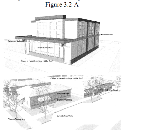
(G) Pedestrian shelter standards.
(1) Permanent awnings, canopies, or recesses shall be provided along at least 60% of ground-floor elevation(s) that abut a public sidewalk or civic space. Pedestrian shelters used to meet this standard shall extend at least 5 feet over the pedestrian area.
(2) Pedestrian shelters shall comply with applicable building codes. If mezzanine or transom windows exist, the shelter shall be below such windows. Pedestrian shelters shall maintain required vertical clearance.
(H) Pedestrian shelter guideline. Ground floor elevations that are located on a sidewalk, or other space where pedestrians are allowed to walk should provide weather protection for pedestrians to the greatest extent possible.
(I) Screening of equipment standard. Rooftop mechanical equipment shall be setback or screened behind a parapet wall so it is not visible from any public right-of-way or civic space. Where such placement and screening is not practicable, the city may approve painting of mechanical units in lieu of screening.
(J) Screening of equipment guideline. All roof, surface, and wall-mounted mechanical, electrical, communications, and service equipment should be screened from view from adjacent public streets by the use of parapets, walls, fences, enclosures, dense evergreen foliage, or by other suitable means.
(K) Exterior building materials standard. This standard applies to the exterior wall(s) of buildings that face a public street or civic space. Table 3.2-1 lists building materials that are primary (P), secondary (S), accent (A), and not allowed (N).
(1) Buildings shall utilize primary materials (P) for at least 60% of the applicable building facades.
(2) Secondary materials (S) are permitted on no greater than 40% of applicable building facades.
(3) Accent materials (A) are permitted on no greater than 10% of applicable building facades as trim or accents only.
(4) Materials listed as N in Table 3.2-1 are prohibited on applicable building facades.
(L) Exterior building materials guideline. Exterior building materials and finishes should convey an impression of permanence and durability. Materials such as masonry, stone, wood, terra cotta, and tile are encouraged. Windows are also encouraged, where they allow views to interior activity areas or displays. Where masonry is used, decorative patterns (other than running bond pattern) should be provided, especially at entrances, building corners and at the pedestrian level. These decorative patterns may include multi-colored masonry units, such as brick, tile, stone, or cast stone, in a layered or geometric pattern, or multi-colored ceramic tile bands used in conjunction with materials such as concrete.
Building Material | Designation |
Brick | P |
Stucco | P |
Stone/masonry | P |
Glass | P |
Finished wood, wood veneers, wood siding | P |
Fiber reinforced cement siding and panels | P |
Vegetated wall panel or trellis | P |
Concrete (poured in place or precast) | S |
Concrete blocks with integral color (ground, polished or glazed finish) | S |
Finished metal panels (anodized aluminum, stainless steel, or copper) with polished, brushed or patina finish | S |
Ceramic tile | S |
Concrete blocks with integral color (split-face finish) | A |
Standing seam and corrugated metal | A |
Glass block | A |
Vinyl siding | N |
Plywood paneling | N |
(Ord. 2021-08-02, passed 10-12-2021)
§ 151.125 PURPOSE.
(A) The following standards are intended to create walkable residential neighborhoods that are visually interesting, compatible with existing development, and avoid monotony in design.
(B) The standards in this section are intended to be clear and objective to allow a streamlined review process. Each standard has an associated guideline that provides flexibility for discretionary review before the Planning Commission if necessary or desired by the applicant.
(Ord. 2021-08-02, passed 10-12-2021)
§ 151.126 RESIDENTIAL DESIGN STANDARDS.
(A) Applicability. The standards in this section apply to all new single detached, duplex, triplex, fourplex, and townhome development, unless otherwise indicated per the divisions below. The standards in this section also apply to conversion of an existing dwelling into one of the subject dwelling types (for example, conversion of a single detached dwelling into a duplex).
(B) Entry location and orientation standard. At least one main entrance for each structure that faces a street, and each townhome unit that faces a street, must meet the following standards.
(1) Be set back no further than 20 feet from the abutting public street or public pedestrian way.
(2) Either:
(a) Face the street;
(b) Be at an angle of up to 45 degrees from the street;
(c) Face a common open space that is adjacent to the street; or
(d) Open onto a porch. If the entrance opens onto a porch, the porch must:
1. Be at least 24 square feet in area with a minimum four-foot depth.
2. Have at least 1 porch entry facing the street.
3. Have a roof that is no more than 12 feet above the floor of the porch.
4. Have a roof that covers at least 30% of the porch area.
(C) Entry location and orientation guideline. Building elevations facing streets, shared courts, and common greens should include pedestrian oriented entrances. Special attention should be given to designing a primary building entrance that is both attractive and functional. Primary entrances should incorporate changes in mass, surface, or finish to emphasize the entrance.
(D) Limitation on parking. Off-street parking is not allowed within the front yard of a dwelling except within a designated driveway or garage.
(E) Garage standards. Where 1 or more garages face a street, the following standards apply:
(1) The front elevation of the garage(s) may not extend in front of the longest, street-facing elevation of the primary dwelling structure.
(2) The width of all garages on the street-facing elevation shall not exceed 60% of the total width of that elevation. The width of the garage shall be measured from the edges of the finished exterior garage wall.
(3) If the front elevation of the garage is set back at least 5 feet from the street-facing elevation of the primary dwelling structure, the garage width standard in division (E)(2) does not apply.
(4) Garages that face a street shall contain at least one of the following design features:
(a) Garage trellis or pergola extending at least 12 inches from the building face;
(b) Windows on 15% of the garage door;
(c) Decorative hardware;
(d) Natural wood finish;
(e) A recess of at least 3 feet behind the primary dwelling; or
(f) Multiple materials finish or colors are used.
(F) Garages guideline. Garages should not be a dominant feature of the front residential elevation. Garage doors should be articulated to reduce their visual impact.
(G) Windows standard. A minimum of 15% of the area of all street-facing facades must include windows or entrance doors. Facades separated from the street property line by a dwelling are exempt from meeting this standard.
(H) Windows guideline. Building elevations facing streets, shared courts, and common greens should include ample levels of glazing to ensure articulation on the facade, daylighting of interior spaces and visibility into the public realm.
(I) Detailed design standards.
(1) All single detached dwellings, duplexes, triplexes and fourplexes shall incorporate at least 5 of the following elements on the street-facing facade. All townhome units shall incorporate at least 2 of the following elements on the street-facing facade. For corner lots, this standard applies to both street-facing facades.
(a) Covered porch at least 36 square feet with a depth not less than 6 feet as measured perpendicular from the face of the main building facade to the edge of the porch.
(b) Recessed entry area at least 2 feet deep, as measured horizontally from the face of the main building facade, and at least 5 feet wide.
(c) Offset on the building face of at least 16 inches from one exterior wall surface to the other.
(d) Dormer that is at least 4 feet wide.
(e) Roof eaves with a minimum projection of 12 inches from the intersection of the roof and the exterior walls.
(f) Roof line offsets of at least 2 feet from the top surface of 1 roof to the top surface of the other.
(g) Tile shingle roofs.
(h) Horizontal lap siding between 3 to 7 inches wide (the visible portion once installed).
(i) Brick, cedar shingles, stucco, or other similar decorative materials covering at least 40% of the street-facing facade.
(j) Gable roof, hip roof, or gambrel roof design.
(k) Window trim around all windows at least 3 inches wide and 5/8 inches deep.
(l) Window recesses, in all windows, of at least three inches as measured horizontally from the face of the building facade.
(m) Balcony that is at least 3 feet deep, 5 feet wide, and accessible from an interior room.
(n) Bay window at least 1 foot deep and 3 feet wide.
(o) Attached garage width, as measured between the edges of the exterior finished garage wall, of 30% or less of the total width of that elevation.
(p) Permanent solar rooftop panels covering at least 60% of the roof area.
(q) Workable shutters on the exterior of ground floor windows.
(J) Detailed design guideline. Building elevations facing streets, shared courts, and common greens should include pedestrian oriented design elements and other design features that provide articulation, variety, interest and quality.
(K) House plan variety standards. This standard applies to new detached single dwelling developments only.
(1) No 2 directly adjacent or opposite dwellings in a single dwelling detached development of more than four units may have the same front or street-facing facade. This standard is met when front or street-facing facades differ from one another by at least 3 of the elements listed in divisions (K)(2) through (K)(7) below. Where facades repeat on the same block face, they must have at least 3 intervening lots between them that meet this standard.
(2) Materials. The plans specify different exterior cladding materials, a different combination of materials, or different dimensions, spacing, or arrangement of the same materials. This standard does not require or prohibit any combination of materials; it only requires that plans not repeat or mirror one another.
(3) Articulation. The plans have different offsets, recesses, or projections; or the front building elevations break in different places. For example, a plan that has a stoop entry (recess) varies from one that has an entry under a front porch (projection). For this standard to apply, a recess must have a minimum depth of 4 feet and a projection or offset must be at least 4 feet in depth.
(4) Variation in roof elevation. The plans have different roof forms (e.g., gable versus gambrel or hip), different roof height (by at least 10%), different orientation (e.g., front-facing versus side-facing gable), different roof projections (e.g., with and without dormer or shed, or different type of dormer or shed), or different roof pitch by more than 2 feet of vertical rise to 12 feet of horizontal run.
(5) Entry or porch. The plans have different configuration or detailing of the front porch or covered entrance.
(6) Fenestration. The plans have different placement, shape, or orientation of windows or different placement of doors.
(7) Height. The elevation of the primary roofline (along the axis of the longest roofline) changes by not less than 4 feet from building to building, or from dwelling unit to dwelling unit, on abutting lots, as applicable. Changes in finished grade of 8 feet or more from 1 lot to the adjacent lot are counted toward change in height for purposes of evaluating facade variation.
(L) House plan variety guideline. New residential developments should provide a variety of house styles and means of articulation along the front facade to avoid repetitive facades along a block face.
(M) Access and parking. This standard applies to new townhome development only. Townhomes with frontage on a public street shall meet the following standards:
(1) Garages on the front facade of a townhouse, off-street parking areas in the front yard, and driveways in front of a townhouse are prohibited unless the following standards are met. For the purposes of this section, "driveway approach" means the edge of a driveway where it abuts a public right-of-way.
(a) Each townhouse lot has a street frontage of at least 15 feet on a local street.
(b) A maximum of 1 driveway approach is allowed for every townhouse. Driveways may be shared.
(c) Outdoor on-site parking and maneuvering areas do not exceed 12 feet wide on any lot.
(d) The garage width does not exceed 12 feet, as measured from the inside of the garage door frame.
(N) Driveway approach. This standard applies to new triplex and fourplex developments only. Driveway approaches shall comply with the following:
(1) The total width of all driveway approaches must not exceed 20 feet per frontage, as measured at the property line. For lots or parcels with more than one frontage, see division (N)(3) below.
(2) Driveway approaches may be separated when located on a local street. If approaches are separated, they must meet applicable driveway spacing standards for local streets.
(3) In addition, lots or parcels with more than one frontage must comply with the following:
(a) Lots or parcels must access the street with the lowest classification. For lots or parcels abutting an alley, access must be taken from the alley.
(b) Lots or parcels with frontages only on collectors and/or arterial streets must meet the applicable access standards for collectors and/or arterials.
(c) Triplexes and fourplexes on lots or parcels with frontages only on local streets may have either:
1. Two driveway approaches not exceeding 20 feet in total width on 1 frontage; or
2. One maximum 12-foot-wide driveway approach per frontage.
(Ord. 2021-08-02, passed 10-12-2021)
§ 151.127 DESIGN STANDARDS FOR COTTAGE CLUSTERS.
(A) Cottage orientation. Cottages must be clustered around a common area and must meet the following standards. A minimum of 50% of cottages within a cluster must be oriented to the common area and must:
(1) Have a main entrance facing the common area;
(2) Be within 10 feet from the common area, measured from the facade of the cottage to the nearest delineation of the common area; and
(3) Be connected to the common area by a pedestrian path.
(a) Cottages within 20 feet of a street property line may have their entrances facing the street.
(b) Cottages not facing the common area or the street must have their main entrances facing a pedestrian path that is directly connected to the common area.
(B) Common area design standards. Each cottage cluster must share a common area in order to provide a sense of openness and community of residents. Common areas must meet the following standards. For cottage cluster subdivisions, the common area may satisfy the open space requirement of § 152.007, Preliminary Plat Approval Criteria and §§ 151.335 through 151.344, Master Planned Development:
(1) The common area must be a single, contiguous, useable piece.
(2) Cottages must abut the common area on at least two sides of the courtyard.
(3) The common area must contain a minimum of 150 square feet per cottage within the associated cluster.
(4) The common area must be a minimum of 15 feet wide at its narrowest dimension.
(5) The common area shall be developed with a mix of landscaping and lawn area, recreational amenities, hard-surfaced pedestrian paths, and/or paved courtyard area. Impervious elements of the common area shall not exceed 75% of the total common area.
(6) Pedestrian paths qualify as part of a common area. Parking areas, required setbacks, and driveways do not qualify as part of a common area.
(C) Community buildings. Cottage cluster projects may include community buildings for the shared use of residents that provide space for accessory uses such as community meeting rooms, guest housing, exercise rooms, day care, or community eating areas. Community buildings must meet the following standards:
(1) Each cottage cluster is permitted 1 community building.
(2) A community building shall not exceed 1,400 square feet of floor area.
(D) Pedestrian access.
(1) An accessible pedestrian path must be provided that connects the main entrance of each cottage to the following:
(a) The common area;
(b) Shared parking areas;
(c) Community buildings; and
(d) Sidewalks in public rights-of-way abutting the site or roadways if there are no sidewalks.
(2) The pedestrian path must be hard-surfaced and a minimum of 5 feet wide.
(E) Parking design.
(1) Clustered parking. Off-street parking may be arranged in clusters of not more than 5 contiguous spaces separated from other clusters by at least 4 feet of landscaping. Clustered parking areas may be covered.
(2) Off-street parking spaces and vehicle maneuvering areas shall not be located:
(a) Within of 20 feet from any street property line, except alley property lines;
(b) Between a street property line, except alley property lines, and cottages abutting the street property line.
(3) Off-street parking spaces shall not be located within 10 feet of any other property line, except alley property lines. Driveways and drive aisles are permitted within 10 feet of other property lines.
(4) Screening. Landscaping or architectural screening at least 3 feet tail shall separate clustered parking areas and parking structures from common courtyards and public streets.
(5) Garages and carports. Garages and carports (whether shared or individual) must not abut common courtyards. Garage doors for individual garages must not exceed 12 feet in width.
(F) Existing structures. On a lot or parcel to be used for a cottage cluster project, a preexisting detached single dwelling may remain within the cottage cluster project area under the following conditions:
(1) The existing dwelling may be nonconforming with respect to the requirements of this Code.
(2) Existing dwellings may be expanded up to the maximum height or footprint required by this code; however, existing dwellings that exceed the maximum height, footprint, and/or unit size of this Code may not be expanded.
(Ord. 2021-08-02, passed 10-12-2021)
§ 151.140 PURPOSE.
This section is intended to provide consistency with the Oregon Transportation Planning Rule (Oregon Administrative Rules, 660-012), Banks Transportation System Plan, and to provide for safe, reasonably direct, and convenient pedestrian access and circulation.
(Ord. 2021-08-02, passed 10-12-2021)
§ 151.141 APPLICABILITY.
The standards in this section apply to all new commercial, mixed-use, industrial, civic, and multi-family development.
(Ord. 2021-08-02, passed 10-12-2021)
§ 151.142
(A) Continuous walkway system. An on-site pedestrian walkway system shall extend throughout the development site and connect to adjacent public sidewalks, if any, consistent with the following:
(1) For commercial, civic and multi-family developments, on-site walkways shall provide direct connections between primary building entrances and all on-site parking areas, adjacent recreational areas and activity/commercial hubs, future phases of development if applicable, and public rights-of-way.
(2) For industrial developments, on-site walkways shall provide safe, reasonably direct, and convenient connections between primary building entrances and all on-site parking areas.
(3) Walkways shall be free from hazards and provide a smooth and consistent surface. The city may require landscape buffering between walkways and adjacent parking lots or driveways to mitigate safety concerns.
(4) The walkway network shall connect to all primary building entrances, consistent with Americans with Disabilities Act (ADA) requirements where required.
(B) Except as required for crosswalks, per division (C) below, where a walkway abuts a driveway or street it shall be raised 6 inches and curbed along the edge of the driveway or street. Alternatively, the city may approve a walkway abutting a driveway at the same grade as the driveway if the walkway is physically separated from all vehicle maneuvering areas. An example of such separation is a row of bollards (designed for use in parking areas) with adequate minimum spacing between them to prevent vehicles from entering the walkway.
(C) Crossings. Where a walkway crosses an on-site parking area or driveway, it shall be clearly marked with contrasting paving materials (e.g., pavers, light-color concrete inlay between asphalt, or similar contrasting material). The crosswalk may be part of a speed table to improve driver-visibility of pedestrians. Painted or thermoplastic striping and similar types of non-permanent applications may be approved for crossings not exceeding 24 feet in length.
(D) Walkway width and surface. Walkways shall be constructed of concrete, asphalt, brick or masonry pavers, or other durable surface, meeting ADA requirements, as approved by the City Engineer. Walkways shall be not less than 4 feet in width, except that concrete walkways a minimum of 6 feet in width are required in commercial developments. The city may also require 6-foot-wide, or wider, concrete sidewalks in other developments where pedestrian traffic warrants walkways wider than 4 feet.
(Ord. 2021-08-02, passed 10-12-2021)
§ 151.155 LANDSCAPING REQUIREMENTS.
(B) Minimum landscape area. All lots shall conform to the minimum landscape area standard of the applicable zone.
(C) Plant selection. A combination of deciduous and evergreen trees, shrubs, and ground covers shall be used for all planted areas, the selection of which shall be based on local climate, exposure, water availability, and drainage conditions, among other factors. When new vegetation is planted, soils shall be amended and irrigation shall be provided, as necessary, to allow for healthy plant growth. The selection of plants shall be based on all the following standards and guidelines:
(1) Use plants that are appropriate to urban areas and the local climate, exposure, and water availability. The presence of utilities and drainage conditions shall also be considered. The city may rely on Oregon State University Extension Service bulletins/University of Washington Urban Forestry Program guidelines/or other expert sources in evaluating landscape plans.
(2) Plant species that do not require irrigation once established (naturalized) are required.
(3) Trees shall be not less than 2-inch caliper at the time of planting. Trees to be planted under or near power lines shall be selected so they will not conflict with power lines at maturity.
(4) Shrubs shall be planted from 5-gallon containers, minimum, where they are for required screens or buffers, and 2-gallon containers minimum elsewhere.
(5) Shrubs shall be spaced in order to provide the intended screen or canopy cover within 2 years of planting.
(6) All landscape areas, whether required or not, that are not planted with trees and shrubs or covered with allowable non-plant material, shall have ground cover plants that are sized and spaced to achieve plant coverage of not less than 75% at maturity.
(7) Bark dust, chips, aggregate, or other non-plant ground covers may be used, but shall cover not more than 25% of any landscape area. Non-plant ground covers cannot be a substitute for required ground cover plants.
(8) Where storm water retention or detention, or water quality treatment facilities are proposed, they shall be planted with water-tolerant species.
(9) Existing mature trees that can thrive in a developed area and that do not conflict with other provisions of this Code shall be retained where specimens are in good health and do not present a hazard.
(10) Landscape plans shall avoid conflicts between plants and buildings, streets, walkways, utilities, and other features of the built environment.
(11) Evergreen plants shall be used where a sight-obscuring landscape screen is required.
(12) Deciduous trees should be used where summer shade and winter sunlight are desirable.
(13) Landscape plans should provide focal points within a development, for example, by preserving large or unique trees or groves or by using flowering plants or trees with fall color.
(14) Landscape plans should use a combination of plants for seasonal variation in color and yearlong interest.
(15) Landscape plans shall provide for both temporary and permanent erosion control measures, which shall include plantings where cuts or fills, including berms, swales, storm water detention facilities, and similar grading, is proposed.
(16) When new vegetation is planted, soils shall be amended and irrigation provided, as necessary, until the plants are established and able to grow on their own.
(D) Xeriscape requirements. All industrial and commercial development that is subject to the requirements of this chapter must incorporate the following xeriscape methods in any landscape plan submitted for city review. For residential development, xeriscape methods are encouraged but not required.
(1) Limited turf areas. Within the required vegetated area, the total amount of lawn (i.e., turf) may not exceed 25% of the total vegetated area. In addition, lawns should be separated from trees, flower beds and other groundcover that do not have similar water needs as lawn/turf. Lawns may not be planted in strips less than 5-feet wide due to the difficulty in controlling irrigation over-spray and resulting water waste in such areas.
(2) Use of drought tolerant plants. Only drought tolerant native and non-invasive exotic species may be used in xeriscape plantings.
(3) Alternative groundcover. Whenever possible, mulched planting beds and native plant communities should be used to meet landscape requirements. Beds may be mulched with any suitable organic or inorganic groundcover, provided that no more than 25% of the total vegetated area ismulched with inorganic material. Preservation and re-establishment of native plant communities as part of landscape designs is encouraged.
(E) Landscaping plan required. A landscape plan is required for submittal and approval for all new subject developments. Submittal of a landscape plan drawn to scale shall show information and conform to requirements as follows:
(1) The location and height of existing and proposed fences, buffering or screening materials.
(2) The location, size, and type of existing trees having a 6-inch or greater diameter measured 4.5 feet above ground.
(3) Method of irrigation for proposed trees and plant materials.
(4) An arborist's report may be required for sites with mature trees to be preserved and protected during construction.
(5) Other information as deemed appropriate by the Planning Official.
(Ord. 2021-08-02, passed 10-12-2021)
§ 151.156 SCREENING AND BUFFERING.
(A) Screening. Screening shall be used to eliminate or reduce the visual impacts of the following uses:
(1) Commercial and industrial uses when abutting residential uses.
(2) Industrial uses when abutting commercial uses.
(3) Service areas and facilities, including garbage and waste disposal containers, recycling bins, and loading areas.
(4) Outdoor storage areas.
(5) Parking areas for 20 or more vehicles.
(6) At and above grade electrical and mechanical equipment, such as transformers, heat pumps, and air conditioners.
(B) Screening methods. Screening may be accomplished by using sight obscuring plant materials (generally evergreens), earth berms, walls, fences, building parapets, building placement or other design techniques. Screening should be a minimum height of 6 feet.
(C) Buffering. Buffering is required between an industrial use and any non-industrial use to mitigate adverse visual impacts, dust, noise or pollution, and to provide for compatibility between dissimilar adjoining uses. Where buffering is required, one of the following buffering alternatives shall be employed:
(1) Planting area. Width not less than 15 feet, planted with either one row of trees staggered and spaced not more than fifteen 15 feet apart; or, at least one row of shrubs forming a continuous hedge at least 5 feet in height within 2 years of planting.
(2) Berm plus planting area. Width not less than 10 feet, with the combined total height of the berm and hedge not less than 5 feet.
(3) Wall plus planting area. Width must not be less than 5 feet with a masonry wall or fence not less than 5 feet in height and lawn, shrubs or ground cover covering the remaining area.
(4) Other approved methods which produce an adequate buffer considering the nature of the impacts to be mitigated.
(Ord. 2021-08-02, passed 10-12-2021)
§ 151.157 FENCES.
(A) Purpose. This section contains the general policies and requirements regarding the location, placement, restrictions, permitting, and fees associated with fences.
(B) Permitting and fees. All new fences and major renovations that change the height or location of an existing fence must have permits. It shall be unlawful for any person, firm, or corporation to construct a fence or modify an existing part thereof without compliance with the standards described herein and first obtaining a permit from the city. A fence permit application signed by the property owner shall include information regarding the type, height, and location of the proposed fence; agreement to maintain the landscape strip in the front yard (if applicable); and be accompanied by a filing fee to cover the cost of permit review and site inspection.
(C) General fence provisions.
(1) A fence on a corner lot shall not violate the 20-foot vision clearance triangle as specified in § 151.205.
(2) In no instance shall a fence extend beyond the property line or be constructed higher than 6 feet above the finished grade of the lot. (A lower height fence may be required as described under division (E) below.).
(3) Fencing shall be installed at least 3 feet from a utility pedestal or electrical transformer and not completely enclose them.
(4) Requirements specified under divisions (C)(1) through (C)(3) above and the specific restrictions specified under divisions (E) through (G) below are applicable to site landscaping such as hedges, trees, and shrubbery.
(5) Fencing for residential swimming pools shall comply with the barrier requirements specified in the International One- and Two-Family Dwelling Code, as administered by the Washington County Building Services Division.
(6) The use of barbed wire, electric fencing (above grade), or other types of injury causing fencing material shall be prohibited in the residential and CF Zones.
(D) Specific front and street side yard fence restrictions.
(1) A fence located in a required front yard or street side yard shall not exceed 3.5 feet in height measured from the original finished grade of the lot, except as provided in (D)(2) below.
(2) Street side yards of corner lots may have a 6-foot fence or hedge installed in the street side yard, provided the following requirements are satisfied.
(a) The street intersection for the corner lot shall be controlled by stop signs on at least 1 of the intersecting streets.
(b) A minimum clear sight distance of up to 250 feet measured from the street intersection along the side yard street shall be provided for a street with a speed limit of 25 mph. For streets with higher speed limits, the minimum clear sight distance shall be equal to 10 times the legal speed of the street.
(c) Driveway access is allowed in the street side yard on the subject property or abutting lot so long as such access is not obscured by a fence.
(E) Specific side and rear yard fence restrictions. Fences located within a required side or rear yard shall not exceed 6 feet in height as measured from the ground on either side of the fence. The fence may be located on the common lot line.
(F) Through lot fence restrictions. In the case of a through lot, the yard facing the rear of the house may be considered a rear yard for fence height purposes, provided there is no driveway access from the rear yard and the minimum clear sight distance for adjacent driveways on either side of the lot is maintained as required under division (D)(3)(b) above. See the illustration in § 151.009.
Figure 3.5-A Fence Height in Front and Street Side Yards

Figure 3.5-B Corner Lots Having Abutting Street Side Yards

Figure 3.5-C Corner Lot Having Street Side Yard Abutting Neighbor's Front Yard

(Ord . 2021- 08- 02, pass ed 10- 12- 2021)
§ 151.170 PURPOSE.
This section contains requirements for vehicle and bicycle parking. It provides standards for the location, size, and design of parking areas to ensure such areas can be accessed safely and efficiently. The code also encourages non-motorized transportation by requiring bicycle parking for some uses.
(Ord. 2021-08-02, passed 10-12-2021)
§ 151.171 GENERAL PROVISIONS.
(A) Where the regulations apply. The regulations of this chapter apply to all parking areas in all zones, at all times, whether parking is required by this Code or put in for the convenience of property owners or users.
(B) Occupancy. All required parking areas must be developed in accordance with the requirements of this code prior to occupancy of any structure on the subject site. Where landscaping, screening or other improvements are required pursuant to this Code, all such improvements must be installed and approved by the Planning Official prior to occupancy.
(C) Calculations of amounts of required and allowed parking.
(1) When computing parking spaces based on floor area, parking structures and non-leasable floor spaces, such as storage closets, mechanical equipment rooms, and similar spaces, are not counted.
(2) The number of parking spaces is computed based on the primary uses on the site except as stated in division (C)(3), below. When there are two or more separate primary uses on a site, the minimum and maximum parking for the site is the sum of the required or allowed parking for the individual primary uses. For shared parking, see § 151.172(D) below.
(3) When more than 20% of the floor area on a site is in an accessory use, the required or allowed parking is calculated separately for the accessory use. An example would be a 10,000 square foot building with a 7,000 square foot warehouse and a 3,000 square foot accessory retail area. The minimum and maximum parking would be computed separately for the retail and warehouse uses.
(D) Use of required parking spaces. Required parking spaces must be available for residents, customers, or employees of the use. Fees may be charged for the use of required parking spaces. Required parking spaces may not be assigned in any way to a use on another site, except for shared parking pursuant to § 151.172(D).
(E) Proximity of parking to use. Required parking spaces for nonresidential uses must be located on the site of the use or in a parking area that has its closest pedestrian access point within 1,320 feet of the site.
(F) Improvement of parking areas. Motorized vehicle parking is allowed only within garages, carports, and other approved structures, and on driveways or parking lots. For residential uses, tandem parking arrangements are allowed.
(Ord. 2021-08-02, passed 10-12-2021)
§ 151.172 NUMBER OF REQUIRED PARKING SPACES.
Use | Minimum Number of Vehicle Parking Spaces Required |
Residential Uses | |
Single-family detached dwelling | 2 per dwelling |
Duplex | 2 per unit (4 total) |
Townhome | 2 per unit |
Cottage cluster | 2 per unit |
Triplex, fourplex and multi-family | 1 per unit for studio or 1-bedroom; 2 per unit for 2 or more bedrooms |
Commercial Uses | |
Automotive repair, service, sales, rental | 1 per 1,000 sf. of floor area |
Commercial retail sales and service | 1 per 400 sf. of floor area |
Eating and drinking establishments | 1 per 300 sf. of floor area |
Hotel or motel | 1 per guest room |
Amusement, entertainment, commercial recreation | 1 per 500 sf. of floor area, or per conditional use permit |
Office uses (professional, medical, clinic) | 1 per 500 sf. of floor area |
Day care centers | 1 per 2,000 sf. of floor area |
Wholesale and distribution business | 1 per 1,5000 sf. of floor area |
Institutional Uses | |
Community service, governmental institution | Per conditional use permit |
Medical institutions offering overnight care and treatment | 1 per 2 beds |
Schools Elementary and middle school High School | 1 per classroom 1 per classroom |
Religious institutions, public assembly | 1 per 100 sf. of assembly space |
Industrial/Manufacturing Uses | |
Industrial/manufacturing/processing Less than 100,000 sf. of floor area 100,000 sf. of floor area or greater | 1 per 3,000 sf. 1 per 4,000 sf. |
Warehousing and storage | 0.5 per 1,000 sf. of floor area |
(C) Maximum amount of parking allowed. In the nonresidential zones, the maximum number of off-street parking spaces allowed per use is:
(1) One and one-fifth times the minimum parking required for uses fronting a street with adjacent on-street parking spaces; or
(2) One and one-half times the minimum parking required for uses fronting a street with no adjacent on-street parking
(D) Shared parking. Required parking facilities for two or more uses, structures, or parcels of land may be satisfied by the same parking facilities used jointly, to the extent that the owners or operators show that the need for parking facilities does not materially overlap (e.g., uses primarily of a daytime versus nighttime nature; weekday uses versus weekend uses), and provided that the right of joint use is evidenced by a recorded deed, lease, contract, or similar written instrument establishing the joint use.
(Ord. 2021-08-02, passed 10-12-2021)
§ 151.173 PARKING DETERMINATION.
The applicant may propose a parking standard that is different than the standard under § 151.172, above, for review and action by the Planning Commission through a Type III procedure pursuant to § 151.233. The parking analysis, at a minimum, shall assess the expected parking demand and available supply for existing and proposed uses on the subject site; opportunities for shared parking with other uses in the vicinity; existing public parking in the vicinity; transportation options existing or planned near the site; and other relevant factors.
(Ord. 2021-08-02, passed 10-12-2021)
§ 151.174 OFF-STREET PARKING DESIGN STANDARDS.
(A ) Generally . All off-street parking lots shall be designed in accordance with city standards for stalls and aisles as set forth in the below drawing and table.

(1) For 1 row of stalls use "C" plus "D" as minimum bay width.
(2) Public alley width may be included as part of dimension "D", but all parking stalls must be on private property, off the public right-of-way.
(3) For estimating available parking area, use 350 sq. ft. per vehicle for stall, aisle and access areas.
(4) The stall width for self-parking of long duration is 8.6 feet; for higher turnover self-parking is 9.0 feet; and for supermarkets and similar facilities is 9.5 to 10.0 feet.
(5) The minimum aisle width for 2-way traffic and for emergency vehicle operations area is 24 feet. The minimum aisle width for emergency vehicle access (one-way traffic) is 20 feet.
(6) Where appropriate bumper overhang area is provided (extruded curbs), "G" can be subtracted from "C" to determine stall depth. Dimensions of required recreational vehicle spaces are 10-feet by 25- feet.
(B) Specifically.
(1) For 1 row of stalls use "C" plus "D" as minimum bay width.
(2) Public alley width may be included as part of dimension "O," but all parking stalls must be on private property, off the public right-of-way.
(3) For estimating available parking area, use 350 square feet per vehicle for stall, aisle, and access areas.
(4) The stall width for self-parking of long duration is 8.6 feet; for higher turnover self-parking, is 9.0 feet; and for supermarkets and similar facilities is 9.5 to 10.0 feet.
(5) The minimum aisle width for 2-way traffic and for emergency vehicle operations area is 24 feet. The minimum aisle width for emergency vehicle access (1-way traffic) is 20 feet.
(6) Where appropriate bumper overhang area is provided (extruded curbs), "G" can be subtracted from "C" to determine stall depth. Dimensions of required recreational vehicle spaces are 10 feet by 25 feet.
(a) Parking space plans. No building permit shall be issued until plans are presented that show property that is and will remain available exclusively for off-street parking. The subsequent use of property for which the permit is issued shall be conditional upon the unqualified continuance and availability of the amount of parking space required by this chapter. Reduction of the amount of required off-street parking shall be considered a violation of this chapter. Parking plans shall be drawn to scale and shall delineate parking spaces, drives and aisles, bumper rails, and other features required by this chapter.
(C) Surfacing. All off-street parking spaces and driveways shall be hard surfaced with concrete, asphaltic cement, or similar surface, which is resistant to dust, and mud. Type and thickness of this hard surface must be approved by the City Engineer.
(D) Bumper rails. All required off-street parking spaces, except those for single-family residences, must be equipped with bumper rails located in such a manner as to prevent vehicles from striking landscaping, fences, buildings, or walls, or from overhanging their spaces in a manner which might obstruct aisles, walks, or other spaces or property.
(E) Access and maneuvering.
(1) Groups of more than 4 off-street parking spaces shall be served by a driveway or aisle so that no backing movements or other maneuvering within a street other than an alley will be required.
(2) Service drives or aisles to off-street parking areas shall be designed and constructed to facilitate the flow of traffic and to provide maximum safety to pedestrians and vehicular traffic on the site.
(3) Service drives or aisles shall be clearly and permanently marked and defined through the use of bumper rails, fences, buildings, walls, paintings, or other appropriate markers and shall not be considered as parking spaces.
(Ord. 2021-08-02, passed 10-12-2021)
§ 151.175 PARKING LOT LANDSCAPING.
All the following standards shall be met for parking lots with 4 or more parking spaces. If a development contains multiple parking lots, then the standards shall be evaluated separately for each parking lot.
(A) A minimum of 10% of the total surface area of subject parking areas, as measured around the perimeter of all parking spaces and maneuvering areas, shall be landscaped. Such landscaping shall consist of canopy trees distributed throughout the parking area. A combination of deciduous and evergreen trees, shrubs, and ground cover plants is required. The trees shall be planned so that they provide a 50% canopy cover over the parking lot when the trees reach maturity.
(B) All parking areas with more than 20 spaces shall provide landscape islands with trees that break up the parking area into rows of not more than 10 to 12 contiguous parking spaces. Landscape islands and planters shall have dimensions of not less than 48 square feet of area and no dimension of less than 6 feet, to ensure adequate soil, water, and space for healthy plant growth.
(C) All required parking lot landscape areas not otherwise planted with trees must contain a combination of shrubs and groundcover plants so that, within 2 years of planting, not less than 75% of that area is covered with living plants.
(D) Wheel stops, curbs, bollards, or other physical barriers are required along the edges of all vehicle-maneuvering areas to protect landscaping from being damaged by vehicles. Trees shall be planted not less than two feet from any such barrier.
(E) Trees planted in tree wells within sidewalks or other paved areas shall be installed with root barriers, consistent with applicable nursery standards.
(Ord. 2021-08-02, passed 10-12-2021)
§ 151.176 PARKING LOT ENCLOSURE AND SCREENING.
(A) Any portion of an off-street parking area, other than that for a single-family residence, which adjoins a residential zone shall be screened from the adjoining residential area by a sight-obscuring fence having a minimum height of 6 feet, and/or by a dense evergreen landscape screen which attains a height of at least 6 feet within 2 growing seasons.
(B) Parking lots abutting a public street, sidewalk or walkway shall be screened using a sight-obscuring fence, low-growing hedge or low garden wall to a height of between 3 feet and 4 feet.
(Ord. 2021-08-02, passed 10-12-2021)
§ 151.177 BICYCLE PARKING.
All uses that are subject to site design review shall provide bicycle parking, in conformance with the standards in the table below, and following divisions.
(A) Minimum required bicycle parking spaces. Uses shall provide long- and short-term bicycle parking spaces, as designated in the table below. Where 2 options are provided (e.g., 2 spaces, or 1 per 8 bedrooms), the option resulting in more bicycle parking is used.
USE CATEGORIES | SPECIFIC USES | LONG-TERM SPACES (COVERED OR ENCLOSED) | SHORT-TERM SPACES (NEAR BUILDING ENTRY) |
USE CATEGORIES | SPECIFIC USES | LONG-TERM SPACES (COVERED OR ENCLOSED) | SHORT-TERM SPACES (NEAR BUILDING ENTRY) |
Residential Categories | |||
Household Living | Multi-Family | 1 per 4 units | 2, or 1 per 20 units |
Group Living | 2, or 1 per 20 bedrooms | None | |
Dormitory | 1 per 8 bedrooms | None | |
Commercial Categories | |||
Retail Sales and Service | 2, or 1 per 12,000 sq. ft. of floor area | 2, or 1 per 5,000 sq. ft. of floor area | |
Lodging | 2, or 1 per 20 rentable rooms | 2, or 1 per 20 rentable rooms | |
Office | 2, or 1 per 10,000 sq. ft. of floor area | 2, or 1 per 40,000 sq. ft. of floor area | |
Commercial outdoor recreation | 8, or 1 per 20 auto spaces | None | |
Major event entertainment | 8, or 1 per 40 seats per CU review | None | |
Industrial Categories | |||
Manufacturing and production | 2, or 1 per 15,000 sq. ft. of floor area | None | |
Warehouse and freight movement | 2, or 1 per 40,000 sq. ft. of floor area | None | |
Institutional Categories | |||
Basic utilities | Bus transit center | 8 | None |
Park and ride | 8, or 5 per acre | None | |
Community service | 2, or 1 per 10,000 sq. ft. of floor area | 2, or 1 per 10,000 sq. ft. of floor area | |
Parks (active recreation areas only) | None | 8, or per CU review | |
Schools | Grades 2-5 | 1 per classroom, or per CU review | 1 per classroom, or per CU review |
Grades 6-12 | 2 per classroom, or per CU review | 4 per school, or per CU review | |
Colleges | Excluding dormitories (see group living above) | 2, or 1 per 20,000 sq. ft. of net building area, or per CU review | 2, or 1 per 10,000 sq. ft. of net building area, or per CU review |
Medial centers | 2, or 1 per 70,000 sq, ft. of net building area, or per CU review | 2, or 1 per 40,000 sq. ft. of net building area, or per CU review | |
Religious institutions and places of worship | 2, or 1 per 4,000 sq. ft. of net building area | 2, or 1 per 2,000 sq. ft. of floor area | |
Institutional Categories | |||
Day care | 2, or 1 per 10,000 sq. ft. of net building area | None | |
Other Categories | |||
Other categories | Determined through land use review, site design review, or CU review, as applicable | ||
(B) Exemptions. This section does not apply to single-family and two-family housing (attached, detached, or manufactured housing), home occupations, agriculture and livestock uses.
(C) Location. Bicycle parking should be no farther from the main building entrance than the distance to the closest vehicle space, or 50 feet, whichever is less. Long-term (i.e., covered) bicycle parking should be incorporated whenever possible into building design. Short-term bicycle parking, when allowed within a public right-of-way, should be coordinated with the design of street furniture, as applicable.
(D) Design. "Inverted U" or "staple" style racks should be considered. Bicycle racks shall provide a secure point of contact so that both the frame and wheel of a bicycle may be locked to the rack using a standard U lock. Bicycle racks are recommended to provide two points of contact between the rack and the bicycle in order to hold the bicycle securely and prevent pivoting or tipping. Individual "inverted U" or "staple" style racks shall be placed to encourage bicycles to be parked parallel to the rack and achieve maximum capacity. Where multiple racks are placed together, racks shall be placed parallel to each other spaced on 4- foot centers to allow access to both sides of each rack. Racks shall be placed so that a 6-foot bicycle may be parked without interference from nearby walls or fixed objects.
(E) Visibility and security. Bicycle parking for customers and visitors of a use shall be visible from street sidewalks or building entrances, so that it provides sufficient security from theft and damage.
(F) Options for storage. Long-term bicycle parking requirements for multiple family uses and employee parking can be met by providing a bicycle storage room, bicycle lockers, racks, or other secure storage space inside or outside of the building.
(G) Lighting. For security, bicycle parking shall be at least as well lit as vehicle parking.
(H) Reserved areas. Areas set aside for bicycle parking shall be clearly marked and reserved for bicycle parking only.
(I) Hazards. Bicycle parking shall not impede or create a hazard to pedestrians. Parking areas shall be located so as to not conflict with vision clearance standards.
(Ord. 2021-08-02, passed 10-12-2021)
§ 151.178
No building or structure subject to the use requirements of this section shall be erected, nor shall any such existing building or structure be altered in any zone so as to increase its gross floor area to an amount exceeding 25% of its existing gross floor area at the time of passage of this chapter, nor shall a change of use occur without prior provisions for off-street loading space in conformance with the requirements of this section.
(A) Number of required spaces. The following numbers and types of berths shall be provided for the specified uses per Table 3.6-C below. The uses specified below shall include all structures designed, intended, or arranged for the use.
Use | Aggregate Floor Area (sq. ft.) | Berths Required | Type |
Freight terminals, industrial plants, manufacturing or wholesale establishments, warehouses | 12,000 - 36,000 36,000 - 60,000 60,000 - 100,000 each additional 50,000 or fraction thereof | 1 2 3 1 additional | A A A A |
Auditorium, motel convention halls, or sport arenas | 25,000 - 150,000 150,000 - 400,000 each additional 250,000 or fraction thereof | 1 2 1 additional | B B B |
Department stores, retail establishments, restaurants, funeral homes, and commercial establishments not otherwise specified | 7,000 - 24,000 24,000 - 50,000 50,000 - 100,000 Over 100,000 Each additional 50,000 or major fraction thereof | 1 2 3 1 additional | B B B B |
Hotels or office buildings | 25,000 - 40,000 40,000 - 100,000 Each additional 100,000 or major fraction thereof | 1 2 1 additional | B B B |
Schools | Over 14,000 | 1 | B |
(B) Design standards. Required off-street loading space shall be provided in berths which conform to the following minimum specifications.
(1) Type "A" berths shall be at least 60 feet long by 12-feet wide by 15-feet high, (inside dimensions), with a 60-foot maneuvering apron.
(2) Type "B" berths shall be at least 30-feet long by 12-feet wide by 14 feet 6 inches high, (inside dimensions), with 30-foot maneuvering apron.
(Ord. 2021-08-02, passed 10-12-2021)
§ 151.190 PURPOSE.
This section includes provisions intended to control outdoor lighting in order to reduce light pollution, preserve the night sky for astronomy, protect flora and fauna from the negative effects of artificial light, and conserve energy.
(Ord. 2021-08-02, passed 10-12-2021)
§ 151.191 APPLICABILITY.
The standards in this subchapter apply to all new development in all zones.
(Ord. 2021-08-02, passed 10-12-2021)
§ 151.192 STANDARD.
All exterior lighting shall be shielded and reflected downward, as shown in Figure 3.7-A, to minimize glare and prevent light trespass on adjacent parcels, other land uses, and street rights-of-way.
Figure 3.7-A

(Ord. 2021-08-02, passed 10-12-2021)
§ 151.205 VISION CLEARANCE REQUIREMENTS.
(A) Generally. Corner lots shall have vision clearance as follows.
(B) Specifically.
(1) In zones where front yards are required, each leg of the vision clearance triangle shall be a minimum of 20 feet in length.
(2) Vision clearance triangles shall be kept free of all visual obstructions from 2 and 1/2 feet to 9 feet above the curb line. Where curbs are absent, the crown of adjacent streets shall be used as the point of reference.
(3) Vision clearance requirements on corner lots may be waived by the City Council or his or her designee, if the City Council finds that:
(a) Traffic entering the intersection is controlled by traffic signals or stop signs;
(b) The distance from the curb line to the property line is 10 feet or more; and
(c) On-street vehicle parking, street trees or other plantings do not interfere with necessary vision clearance; or, in lieu of these 3 findings, that;
(d) Topographic conditions are so extreme that it is not practical to provide required vision clearance.
Figure 3.8-A Vision Clearance Triangle

(Ord. 2021-08-02, passed 10-12-2021)
§ 151.215 TRANSPORTATION FACILITIES.
All land use and development applications shall comply with the following standards and procedures for the purpose of protecting the future operation of the Banks transportation system:
(A) Development standards. The following standards shall be met for all new uses and developments:
(1) All new lots created, consolidated, or modified through a land division, partition, lot line adjustment, lot consolidation, or street vacation must have frontage or approved access to a public street.
(2) Streets within or adjacent to a development shall be improved in accordance with the Banks street design standards (§ 152.052).
(3) Development of new streets, and additional street width or improvements planned as a portion of an existing street, shall be improved in accordance with this section, and public streets shall be dedicated to the applicable road authority.
(4) New streets and drives shall be paved.
(B) Guarantee. The city may accept a future improvement guarantee (e.g., owner agrees not to object to the formation of a local improvement district in the future) in lieu of street improvements if one or more of the following conditions exist:
(1) A partial improvement would create a potential safety hazard to motorists or pedestrians;
(2) Due to the developed condition of adjacent properties, it is unlikely that street improvements would be extended in the foreseeable future and the improvement associated with the project under review does not, by itself, provide increased street safety or capacity, or improved pedestrian circulation;
(3) The improvement would be in conflict with an adopted capital improvement plan; or
(4) The improvement is associated with an approved land partition in a residential zone and the proposed land partition does not create any new streets.
(C) Creation of rights-of-way for streets and related purposes. Streets shall be created through the approval and recording of a final subdivision or partition plat; except the city may approve the creation of a street by acceptance of a deed, provided that the street is deemed in the public interest by the City Council for the purpose of implementing the Comprehensive Plan, and the deeded right-of-way conforms to the standards of this code.
(D) Creation of access easements. The city may approve an access easement when the easement is necessary to provide for access and circulation in conformance with §§ 152.052 (Streets); 152.053 (Blocks) and; 152.054 (Building Sites). Access easements shall be created and maintained in accordance with the Uniform Fire Code Section 10.207.
(Ord. 2021-08-02, passed 10-12-2021)
§ 151.216 CITY MAY REQUIRE TRAFFIC IMPACT ANALYSIS.
(A) The city may require a traffic impact analysis (TIA) prepared by a qualified professional to determine access, circulation, and other transportation requirements in conformance with TIA results. TIA's shall be required for all proposed development that will generate more than 100 a.m. or p.m. peak hour trips per day or 600 average daily trips. Trip calculation shall be based upon Trip Generation, 8th Edition (2008) published by the Institute of Transportation Engineers.
(B) Amendments that affect transportation facilities. Amendments to the comprehensive plan and land use regulations which significantly affect a transportation facility shall assure that allowed land uses are consistent with the function, capacity, and level of service of the facility. This shall be accomplished by one of the following:
(1) Adopting measures that demonstrate that allowed land uses are consistent with the planned function of the transportation facility;
(2) Amending the Comprehensive Plan to provide transportation facilities, improvements, or services adequate to support the proposed land uses; such amendments shall include a funding plan to ensure the facility, improvement, or service will be provided by the end of the planning period;
(3) Altering land use designations, densities, or design requirements to reduce demand for automobile travel and meet travel needs through other modes of transportation;
(4) Amending the planned function, capacity, or performance standards of the transportation facility; or
(5) Providing other measures as a condition of development or through a development agreement or similar funding method, specifying when such measures will be provided.
(Ord. 2021-08-02, passed 10-12-2021)
§ 151.217 WHEN TRAFFIC IMPACT STUDY IS REQUIRED; PREPARATION.
The purpose of this section of the code is to assist in determining which road authorities participate in land use decisions, and to implement Section 660-012-0045(2)(e) of the State Transportation Planning Rule that requires the city to adopt a process to apply conditions to development proposals in order to minimize impacts and protect transportation facilities. This chapter establishes the standards for when a proposal must be reviewed for potential traffic impacts; when a traffic impact analysis must be submitted with a development application in order to determine whether conditions are needed to minimize impacts to and protect transportation facilities; what must be in a traffic impact analysis; and who is qualified to prepare the study.
(A) When a traffic impact study is required. The city or other road authority with jurisdiction may require a Traffic Impact Analysis (TIA) as part of an application for development, a change in use or a change in access. A TIA shall be required when a land use application involves one or more of the following actions:
(1) A change in zoning or a plan amendment designation;
(2) Any proposed development or land use action that a road authority states may have operational or safety concerns along its facility(ies);
(3) An increase in site traffic volume generation by 300 Average Daily Trips (ADT) or more;
(4) An increase in peak hour volume of a particular movement to and from the state highway by 20% or more; or
(5) An increase in use of adjacent streets by vehicles exceeding the 20,000-pound gross vehicle weights by 10 vehicles or more per day;
(6) The location of the access driveway does not meet minimum sight distance requirements, or is located where vehicles entering or leaving the property are restricted, or such vehicles queue or hesitate on the state highway creating a safety hazard; or
(7) A change in internal traffic patterns that may cause safety problems, such as back up onto a street or greater potential for traffic accidents.
(B) Traffic impact study preparation. A traffic impact analysis shall be prepared by a professional engineer in accordance with the requirements of the road authority. If the road authority is the Oregon Department of Transportation (ODOT), consult ODOT's regional development review planner and OAR 734-051-180.
(Ord. 2021-08-02, passed 10-12-2021)
§ 151.218 PERFORMANCE BONDS.
Performance bonds may be required in the cases where the City Council determines that such shall be necessary to guarantee proper completion of required improvements within time periods specified.
(Ord. 2021-08-02, passed 10-12-2021)
§ 151.230.
(A) Purpose. This chapter establishes standard decision-making procedures for the review of land use and development applications, affording the public a means of participating in the local decision-making process in an efficient manner. Table 4.1-A provides a key for determining the applicable review procedure for land use approvals in the City of Banks.
(B) Applicability of review procedures. All land use and development permits and approvals in the city shall follow the procedures contained in this chapter. The procedure "type" assigned to each application governs the decision-making process for that permit or approval. There are 4 types of permit/approval procedures as described below and as identified in Table 4.1-A.
(1) Type I procedure (staff review - zoning checklist). Type I decisions are made by the City Planning Official, or their designee, without public notice and without a public hearing. Type I decisions are not appealable. A Type I procedure is used in applying city standards and criteria that do not require the use of discretion (i.e., there are clear and objective standards).
(2) Type II procedure (administrative/staff review with notice). Decisions are made by the City Planning Official, with public notice and an opportunity for appeal to the Planning Commission. Alternatively, the City Planning Official may refer an administrative land use application to the Planning Commission for its review and decision in a public meeting.
(3) Type III procedure (quasi-judicial review - public hearing). Type III decisions are made by the Planning Commission after a public hearing, with an opportunity for appeal to the City Council; or in the case of a quasi-judicial zone change (e.g., a change in zoning on one property to comply with the Comprehensive Plan), a Type III decision is made by the City Council on recommendation of the Planning Commission. Quasi-judicial decisions involve discretion but implement established policy.
(4) Type IV procedure (legislative review). The Type IV procedure applies to the creation or revision, or large-scale implementation, of public policy (e.g., adoption of regulations, zone changes, annexation, and comprehensive plan amendments). Type IV reviews are considered by the Planning Commission, which makes a recommendation to City Council. City Council makes the final decision on a legislative proposal through the enactment of an ordinance. Appeals of a City Council Type IV decision go to the Oregon Land Use Board of Appeals (LUBA).
Approvals* | Review Procedures | Applicable Regulations |
Adjustments | Type II | |
Amendments to Zoning Map or Text | Type III or IV | |
Annexation | Type IV | |
Code Interpretation | Type II or III | § 151.006 Code Interpretations |
Comprehensive Plan Map or Text Amendment | Type IV | |
Conditional Use Permits | Type III | |
Historic Resource Alteration or Demolition | Typ e III | § 151.065 Historic Resource Overlay Zone H |
Home Occupation | Type I or III | |
Legal Lot Determination | Type I | § 151.005 Lot of Record and Legal Lot Determination |
Master Planned Developments Concept Plan Detailed Development Plan Site Design Review | Type III Type II Type II | |
Modifications to Approved Plans and Conditions Minor Modifications Major Modifications | Type I or II Type III | |
Nonconforming Situations | Type II | § 151.355 Nonconforming Situations |
Parking Determination | Type II | § 151.173 Parking Determination |
Partition or Replat of 2 - 3 lots Preliminary Plat Final Plat | Type III Type I | § 152.004 § 152.009 |
Property Line Adjustments, Including Lot Consolidations | Type I | § 152.012 |
Site Design Review | Type I, II or III | |
Subdivision or Replat of 4 or more lots Preliminary Plat Final Plat | Type III Type II | § 152.004 § 152.009 |
Vpariance | Type III | |
Zoning Checklist | Type I | § 151.231 Type I Procedure |
*The applicant may be required to obtain building permits and other approvals from other agencies, such as a road authority or natural resource regulatory agency. The city's failure to notify the applicant of any requirement or procedure of another agency shall not invalidate a permit or other decision made by the city under this Code. | ||
(Ord. 2021-08-02, passed 10-12-2021)
§ 151.231 TYPE I PROCEDURE (STAFF REVIEW AND ZONING CHECKLIST).
(A) Type I procedure (staff review). The City Planning Official, or designee, without public notice and without a public hearing, makes ministerial decisions through the Type I procedure. Ministerial decisions are those where city standards and criteria do not require the exercise of discretion (i.e., there are clear and objective standards).
(B) Zoning checklist. The City Planning Official reviews proposals requiring a Type I review using a zoning checklist. The zoning checklist is a preliminary review that is intended to ensure a project proposal meets the basic requirements of the applicable zone before more detailed plans are prepared and before the city authorizes the Building Official to issue a building permit.
(C) Application requirements.
(1) Application forms. Approvals requiring Type I review, including zoning checklists, shall be made on forms provided by the city.
(2) Application requirements. When a zoning checklist is required, it shall:
(a) Include the information requested on the application form;
(b) Address the criteria in sufficient detail for review and action; and
(c) Be filed with the required fee.
(D) Approval required. The city shall not act upon an application for land use approval, and a building permit shall not be issued, until the City Planning Official has approved a zoning checklist for the proposed project.
(E) Criteria and decision. The City Planning Official's review of a zoning checklist is intended to determine whether minimum code requirements are met and whether any other land use permit or approval is required prior to issuance of a building permit.
(F) Effective date. A zoning checklist decision is final on the date it is signed by the City Planning Official. It is not a land use decision as defined by O.R.S. 197.015, and therefore is not subject to appeal to the state Land Use Board of Appeals.
(Ord. 2021-08-02, passed 10-12-2021)
§ 151.232 TYPE II PROCEDURE (ADMINISTRATIVE REVIEW WITH NOTICE).
The City Planning Official, or their designee, performs administrative staff reviews through the Type II procedure. Type II decisions are made by the City Planning Official with public notice and an opportunity for appeal to the Planning Commission. Alternatively, the City Planning Official may refer a Type II application to the Planning Commission for its review and decision in a public meeting.
(A) Application requirements.
(1) Application forms. Applications for projects requiring an administrative land use decision shall be made on forms provided by the City Planning Official.
(2) Submittal information. The City Planning Official shall advise the applicant on what constitutes a complete application. At a minimum, the application shall include all of the following:
(a) The information requested on the application form;
(c) A written statement or letter explaining how the application satisfies each and all of the relevant code criteria and standards in sufficient detail;
(d) Information demonstrating compliance with prior decision(s) and conditions of approval for the subject site, as applicable; and
(e) The required fee.
(B) Procedure.
(1) The City Planning Official shall mail notice of a pending Type II decision to the individuals and agencies identified in (B)(2) below no fewer than 14 days prior to making the Type II decision .
(2) The purpose of the Pending Type II notice is to give nearby property owners and other interested people and agencies the opportunity to submit written comments on the application before the Planning Official issues the decision. The intent is to invite people to participate early in the decision-making process. Notices shall be mailed to:
(a) All owners, residents or tenants of record of real property within a minimum of 300 feet of the subject site;
(b) Any person who submits a written request to receive a notice; and
(c) Any governmental agency that is entitled to notice under an intergovernmental agreement entered into with the city and any other affected agencies. At a minimum, the City Planning Official shall notify the road authority if different than the City of Banks. The failure of another agency to respond with written comments on a pending application shall not invalidate an action or permit approval made by the city under this Code.
(d) The city shall notify the Oregon Department of Transportation of projects involving a change access to a state highway.
(3) The notice of pending administrative decision, at a minimum, shall contain all of the following information:
(a) The deadline for submitting written comments, which must be at least 14 days prior to the scheduled decision date or, as applicable, the scheduled Planning Commission meeting date where an application is referred to the Commission for review;
(b) A summary of the proposal and the relevant approval criteria. The notice must have sufficient detail to help the public identify and locate applicable code requirements;
(c) The address and city contact person for submitting written comments; and the date, time, and location the City Planning Official or Planning Commission, as applicable, is scheduled to make a decision on the application;
(d) The street address or other easily understandable reference to the location of the proposed use or development;
(e) Disclosure statement indicating that if any person fails to address the relevant approval criteria with enough detail, they may not be able to appeal to the Land Use Board of Appeals or Circuit Court on that issue, and that only comments on the relevant approval criteria are considered relevant evidence;
(f) Statement that all evidence relied upon by the City Planning Official or Planning Commission, as applicable, to make its decision is in the public record, available for public review. Copies of this evidence can be obtained at a reasonable cost from the city; and
(g) Statement that after the comment period closes, the city will issue its decision and the decision shall be mailed to the applicant and to anyone else who submitted written comments or who is otherwise legally entitled to notice.
(4) The failure of another agency to respond with written comments on a pending application shall not invalidate an action or permit approval made by the city under this Code.
(5) At the conclusion of the comment period, the City Planning Official shall review the comments received and prepare a decision notice approving, approving with conditions, or denying the application based on the applicable Code criteria. Alternatively, the City Planning Official may transmit all written comments received, if any, along with a copy of the application to the Planning Commission for review and decision at its next regularly scheduled meeting.
(6) Where the City Planning Official refers an application subject to administrative review to the Planning Commission, the Planning Commission shall approve, approve with conditions, or deny the application through the Type II procedure based on the applicable Code criteria. The Planning Commission may continue its review to the next meeting to allow the applicant time to respond to questions, provided that the Commission makes a final decision within the 120-day period prescribed under state law (O.R.S. 227.178) and as described in § 151.235. Alternatively, the applicant may voluntarily waive his or her right to a final decision within the 120-day timeframe and the Commission may decide to accept oral and written testimony in a public hearing review of the application, pursuant to § 151.233; in which case, a new public notice must be mailed to those who received the original notice indicating the change to a quasi-judicial (public hearing) review procedure.
(7) Within 7 days of a Type II (administrative) decision, the City Planning Official shall proceed to prepare a notice of decision and mail it to the applicant, property owner (if different), the Building Official, those who provided written comments on the proposal, and those who requested a copy of the decision. The City Planning Official shall cause an affidavit of mailing the notice to be prepared and made a part of the file. The affidavit shall show the date the notice was mailed and shall demonstrate that the notice was mailed to the parties above and was mailed within the time required by law.
(8) The administrative notice of decision shall contain all of the following information:
(a) A description of the applicant's proposal and the city's decision on the proposal, which may be a summary, provided it references the specifics of the proposal and conditions of approval in the public record;
(b) The address or other geographic description of the property proposed for development, including a map of the property in relation to the surrounding area (a copy of assessor's map may be used);
(c) A statement of where the city's decision can be obtained;
(d) The date the decision shall become final, unless appealed; and
(e) A statement that all persons entitled to notice may appeal the decision to the Planning Commission or City Council, as applicable, pursuant to § 151.232(C).
(9) Effective date of decision. Unless the conditions of approval specify otherwise, an administrative decision becomes effective 12 days after the city mails the decision notice, unless the decision is appealed pursuant to § 151.232(C).
(C) Appeal of Type II (administrative) decision. A Type II administrative decision made by the City Planning Official may be appealed to the Planning Commission; and a Type II administrative decision made by the Planning Commission may be appealed to the City Council, as applicable, pursuant to the following:
(1) Who may appeal. The following people have legal standing to appeal a Type II administrative decision:
(a) The applicant or owner of the subject property;
(b) Any person who was entitled to written notice of the Type II decision; and
(c) Any other person who participated in the proceeding by submitting written comments on the application to the city by the specified deadline.
(2) Appeal filing procedure.
(a) Notice of appeal. Any person with standing to appeal, as provided in division (C)(1), above, may appeal a Type II administrative decision by filing a notice of appeal according to the following procedures.
(b) Time for filing. A notice of appeal shall be filed with the City Planning Official within the timeframe specified on the notice of decision; typically, this will be within 10 days of the date the notice of decision is mailed.
(c) Content of notice of appeal the notice of appeal shall be accompanied by the required filing fee and shall contain:
1. An identification of the decision being appealed, including the date of the decision;
2. A statement demonstrating the person filing the notice of appeal has standing to appeal;
3. A statement explaining the specific issues being raised on appeal; and
4. If the appellant is not the applicant, a statement demonstrating that the appeal issues were raised during the comment period.
(3) Scope of appeal. The appeal of a Type II administrative decision shall be a hearing de novo, either before the Planning Commission, where the contested decision was made by the City Planning Official, or before the City Council, where the Planning Commission made the contested decision. The appeal shall not be limited to the application materials, evidence and other documentation, and specific issues raised in the review leading up to the administrative decision, but may include other relevant evidence and arguments. The hearing appeal body may allow additional evidence, testimony, or argument concerning any relevant standard, criterion, condition, or issue.
(Ord. 2021-08-02, passed 10-12-2021)
§ 151.233 TYPE III PROCEDURE (QUASI- JUDICIAL REVIEW; PUBLIC HEARING).
Type III decisions are made by the Planning Commission after a public hearing, with an opportunity for appeal to the City Council.
(A) Application forms.
(1) Application forms. Applications shall be made on forms provided by the City Planning Official.
(2) Submittal information. The City Planning Official shall advise the applicant on what constitutes a complete application. At a minimum, the application shall include all of the following information:
(a) The information requested on the application form;
(b) Plans and exhibits required for the specific approval(s) being sought;
(c) A written statement or letter explaining how the application satisfies each and all of the relevant code criteria and standards in sufficient detail;
(d) Information demonstrating compliance with prior decision(s) and conditions of approval for the subject site, as applicable;
(e) Other information, studies, exhibits, or data as the Planning Official deems necessary to demonstrate compliance with city policies and ordinances; and
(f) The required fee; and
(g) Evidence of neighborhood contact, as applicable, pursuant to § 151.236.
(B) Procedure.
(1) Mailed and posted notice. The city shall mail public notice of a public hearing on a Type III application at least 20 days before the hearing date to individuals and organizations listed below. The City Planning Official shall prepare an affidavit of notice, which shall be made a part of the file. The affidavit shall state the date that the notice was mailed. Notice shall be mailed to:
(a) All owners, residents, or tenants of record of real property within a minimum of 300 feet of the subject site;
(b) Any person who submits a written request to receive a notice; and
(c) Any governmental agency that is entitled to notice under an intergovernmental agreement entered into with the city and any other affected agencies. At a minimum, the City Planning Official shall notify the road authority if different than the City of Banks. The failure of another agency to respond with written comments on a pending application shall not invalidate an action or permit approval made by the city under this Code.
(d) The city shall notify the Oregon Department of Transportation of projects involving a change access to a state highway.
(e) At least 14 days before the first hearing, the applicant or applicant's representative shall post notice of the hearing on the project site in clear view from a public right-of-way using a poster format prescribed by the City Planning Official. The applicant shall submit an affidavit of notice using a form provided by the city, which shall be made a part of the file. The affidavit shall state the date that the notice was posted.
(2) Content of notice. Notice of a Type III hearing to be mailed per division (B)(1) above shall contain all of the following information:
(a) A summary of the proposal and the relevant approval criteria. The notice must have sufficient detail to help the public identify and locate applicable code requirements;
(b) The date, time and location of the Planning Commission hearing;
(c) Describe the street address or other clear reference to the location of the proposed use or development;
(d) A disclosure statement that if any person fails to address the relevant approval criteria with enough detail, they may not be able to appeal to the City Council, Land Use Board of Appeals, or Circuit Court, as applicable, on that issue; and that only comments on the relevant approval criteria are considered relevant evidence;
(e) A statement that a copy of the application, all documents and evidence submitted by or for the applicant, and the applicable criteria and standards shall be available for review at (City Hall/the office of the City Planning Official) and that copies shall be provided at a reasonable cost;
(f) A statement that a copy of the city's staff report and recommendation to the Planning Commission shall be available for review at no cost at least 7 days before the hearing, and that a copy shall be provided on request at a reasonable cost;
(g) A general explanation of the requirements to submit testimony, and the procedure for conducting public hearings; and
(h) A statement that after the public hearing closes, the city will issue its decision, and the decision shall be mailed to the applicant and to anyone else who submitted written comments or who is otherwise legally entitled to notice.
(C) Conduct of the public hearing.
(1) At the commencement of the hearing, the Planning Commission Chairperson, or their designee, shall state to those in attendance all of the following information and instructions:
(a) The applicable approval criteria by Code chapter that apply to the application;
(b) Testimony and evidence shall concern the approval criteria described in the staff report, or other criteria in the comprehensive plan or land use regulations that the person testifying believes to apply to the decision;
(c) Failure to raise an issue with sufficient detail to give the Planning Commission and the parties an opportunity to respond to the issue, may preclude appeal to the City Council or State Land Use Board of Appeals on that issue;
(d) At the conclusion of the initial evidentiary hearing, the Planning Commission shall deliberate and make a decision based on the facts, applicable approval criteria, and arguments in the public record. See division (F), record of the public hearing;
(e) Any participant may ask the Planning Commission for an opportunity to present additional relevant evidence or testimony that is within the scope of the hearing; if the Planning Commission grants the request, it will schedule a date to continue the hearing as provided in division (C)(5) of this section, or leave the record open for additional written evidence or testimony as provided in division (C)(6) of this section.
(2) The public is entitled to an impartial review body as free from potential conflicts of interest and pre-hearing ex parte (outside the hearing) contacts as reasonably possible. Where questions related to ex parte contact are concerned, Planning Commissioners shall follow the guidance for disclosure of ex parte contacts contained in O.R.S. 227.180. Where a Planning Commissioner has an actual conflict of interest, the Commissioner shall disclose such interest and recuse themselves from decision making, except where state law provides otherwise. Where the appearance of a conflict of interest is likely, the Planning Commissioner(s) shall individually disclose their relationship to the applicant in the public hearing and state whether they are capable of rendering a fair and impartial decision. If they are unable to render a fair and impartial decision, they shall be excused from the proceedings.
(3) Presenting and receiving evidence.
(a) The Planning Commission may set reasonable time limits for oral presentations and may limit or exclude cumulative, repetitious, irrelevant or personally derogatory testimony or evidence;
(b) No oral testimony shall be accepted after the close of the public hearing. Written testimony may be received after the close of the public hearing only as provided by this section;
(c) Members of the Planning Commission may visit the property and the surrounding area, and may use information obtained during the site visit to support their decision, if the information relied upon is disclosed at the beginning of the hearing and an opportunity is provided to dispute the evidence.
(4) The Planning Commission, in making its decision, shall consider only arguments in the public hearing record; except that the Commission may take notice of facts not in the hearing record (e.g., local, state, or federal regulations; previous city decisions; case law; staff reports). Upon announcing its intention to take notice of such facts in its deliberations, it must allow persons who previously participated in the hearing to request the hearing record be reopened, as necessary, to present evidence concerning the newly presented facts.
(5) If the Planning Commission decides to continue the hearing, the hearing shall be continued to a date that is at least 7 days after the date of the first evidentiary hearing (e.g., next regularly scheduled meeting). An opportunity shall be provided at the continued hearing for persons to present and respond to new written evidence and oral testimony. If new written evidence is submitted at the continued hearing, any person may request, before the conclusion of the hearing, that the record be left open for at least 7 days, so that they can submit additional written evidence or arguments in response to the new written evidence. In the interest of time, after the close of the hearing, the Planning Commission may limit additional testimony to arguments and not accept additional evidence.
(6) If the Planning Commission leaves the record open for additional written testimony, the record shall be left open for at least 7 days after the hearing. Any participant may ask the Planning Commission in writing for an opportunity to respond to new evidence (i.e., information not disclosed during the public hearing) submitted when the record was left open. If such a request is filed, the Planning Commission shall reopen the record, as follows:
(a) When the record is reopened to admit new evidence or arguments (testimony), any person may raise new issues that relate to that new evidence or testimony;
(b) An extension of the hearing or record granted pursuant to this section is subject to the limitations of § 151.235 and O.R.S. 227.178 ("120-day rule"), unless the applicant waives their right to a final decision being made within 120 days of filing a complete application; and
(c) If requested by the applicant, the Planning Commission shall grant the applicant at least 7 days after the record is closed to all other persons to submit final written arguments, but not evidence, unless the applicant expressly waives this right.
(D) Notice of decision.
(1) The notice of Type III decision shall contain all of the following information:
(a) A description of the applicant's proposal and the city's decision on the proposal, which may be a summary, provided it references the specifics of the proposal and conditions of approval in the public record;
(b) The address or other geographic description of the property proposed for development, including a map of the property in relation to the surrounding area (a copy of assessor's map may be used);
(c) A statement of where the city's decision can be obtained;
(d) The date the decision shall become final, unless appealed; and
(e) A statement that all persons entitled to notice may appeal the Planning Commission's decision to City Council pursuant to § 151.233(C) or may appeal the City Council's decision to the state Land Use Board of Appeals, as applicable.
(E) Appeal of Planning Commission decision. The Planning Commission's decision may be appealed to the City Council as follows:
(1) Who may appeal. The following people have legal standing to appeal:
(a) The applicant or owner of the subject property; and
(b) Any other person who testified orally or in writing during the subject public hearing before the close of the public record.
(2) Appeal filing procedure.
(a) Notice of appeal. Any person with standing to appeal, as provided in division (E)(1), above, may appeal a Type III quasi-judicial decision by filing a notice of appeal according to the following procedures.
(b) Time for filing. A notice of appeal shall be filed with the City Planning Official within the timeframe specified on the notice of decision; typically, this will be within 10 days of the date the notice of decision is mailed.
(c) Content of notice of appeal. The notice of appeal shall be accompanied by the required filing fee and shall contain:
1. An identification of the decision being appealed, including the date of the decision;
2. A statement demonstrating the person filing the notice of appeal has standing to appeal;
3. A statement explaining the specific issues being raised on appeal; and
4. If the appellant is not the applicant, a statement demonstrating that the appeal issues were raised during the comment period.
(3) Scope of appeal. The appeal of a Type III quasi-judicial decision shall be a hearing de novo before the City Council. The appeal shall not be limited to the application materials, evidence and other documentation, and specific issues raised in the review leading up to the quasi-judicial decision, but may include other relevant evidence and arguments. The hearing appeal body may allow additional evidence, testimony, or argument concerning any applicable standard, criterion, condition, or issue.
(F) Record of the public hearing.
(1) The official public record shall include all of the following information:
(a) All materials considered by the hearings body;
(b) All materials submitted by the City Planning Official to the hearings body regarding the application;
(c) The minutes of the hearing;
(d) The final written decision; and
(e) Copies of all notices given as required by this chapter, and correspondence regarding the application which the city mailed or received.
(2) The meeting minutes shall be filed in hardcopy form with the City Recorder. The minutes and other evidence presented as a part of the hearing shall be part of the record.
(3) All exhibits received and displayed shall be marked to provide identification and shall be part of the record.
(G) Final date and appeals to State Land Use Board of Appeals. A quasi-judicial decision or appeal decision, as applicable, is effective the date the city mails the decision. The Planning Commission's decision may be appealed to the City Council. Appeals of City Council decisions under this chapter shall be filed with the state Land Use Board of Appeals pursuant to O.R.S. 197.805 through 197.860.
(Ord. 2021-08-02, passed 10-12-2021)
§ 151.234 TYPE IV (LEGISLATIVE DECISIONS).
(A) Timing of requests. The City Council may establish a schedule for when it will accept legislative code amendment or plan amendment requests, or the City Council may initiate its own legislative proposals at any time, including zone changes required when property is annexed to the City of Banks. Legislative requests are not subject to the 120-day review period under O.R.S. 227.178.
(B) Application requirements.
(1) Application forms. Legislative applications shall be made on forms provided by the City Planning Official.
(2) Submittal information. The application shall contain all of the following information:
(a) The information requested on the application form;
(b) A map and/or plan addressing the appropriate criteria and standards in sufficient detail for review and decision (as applicable);
(c) The required fee, except when the City of Banks initiates the request; and
(d) One copy of a letter or narrative statement that explains how the application satisfies each and all of the relevant approval criteria and standards; and
(e) Evidence of neighborhood contact, pursuant to § 151.236.
(C) Procedure.
(1) Hearings on legislative land use requests are conducted similar to City Council hearings on other legislative proposals, except the notification procedure for legislative land use requests must conform to state land use laws (O.R.S. 227.175), as follows:
(2) The city shall notify in writing the Oregon Department of Land Conservation and Development (DLCD) of legislative amendments (zone change, rezoning with annexation, or comprehensive plan amendment) at least 35 days before the first public hearing at which public testimony or new evidence will be received. The notice shall include a DLCD Certificate of Mailing.
(3) At least 20 days, but not more than 40 days, before the date of the first hearing on an ordinance that proposes to amend the comprehensive plan or any element thereof, or to adopt an ordinance for any zone change, a notice shall be prepared in conformance with O.R.S. 227.175 and mailed to:
(a) Each owner, resident or tenant whose property would be directly affected by the proposal, e.g., rezoning or a change from one Comprehensive Plan land use designation to another, see O.R.S. 227.186 for instructions;
(b) Any affected governmental agency;
(c) Any person who requests notice in writing; and
(d) For a zone change affecting a manufactured home or mobile home park, all mailing addresses within the park, in accordance with O.R.S. 227.175.
(4) At least 10 days before the scheduled City Council public hearing date, public notice shall be published in a newspaper of general circulation in the city.
(5) For each mailing and publication of notice, the City Recorder shall keep an affidavit of mailing/publication in the record.
(D) Final decision and effective date. A legislative land use decision, if approved, shall take effect and shall become final as specified in the enacting ordinance or, if not approved, upon mailing of the notice of decision to the applicant. Notice of a legislative land use decision shall be mailed to the applicant, all participants of record, and the Department of Land Conservation and Development within 20 business days after the City Council decision is filed with the City Recorder. The city shall also provide notice to all persons as required by other applicable laws.
(Ord. 2021-08-02, passed 10-12-2021)
§ 151.235 TIME LIMIT, CONSOLIDATED REVIEW AND CITY PLANNING OFFICIAL'S DUTIES.
(A) Time limit - 120-day rule. The city shall take final action on administrative and quasi-judicial land use applications, pursuant to this chapter, including resolution of all appeals, within 120 days from the date the City Planning Official deems the application complete for purposes of processing, unless the applicant requests an extension in writing. Any exceptions to this rule shall conform to the provisions of O.R.S. 227.178. (Note: The 120-day rule does not apply to legislative land use decisions.).
(B) Time periods. In computing time periods prescribed or allowed by this chapter, the day of the act or event from which the designated period of time begins shall not be included. The last day of the period shall be included, unless it is a Saturday, Sunday, or a legal holiday, in which case the period runs until the end of the next day that is not on a weekend or legal holiday.
(C) Consolidated review of applications. When an applicant applies for more than 1 type of land use or development permit for the same 1 or more contiguous parcels of land, the city may consolidate the applications and review them concurrently. When proceedings are consolidated, required notices may be consolidated, provided the notice shall identify each application to be decided. When more than 1 application is reviewed in a hearing, separate findings and decisions shall be made on each application.
(D) City Planning Official duties. The City Planning Official, or their designee, shall perform all of following duties with regard to administration of this Code:
(1) Prepare application forms based on in the provisions of this Code and applicable state law;
(2) Prepare required notices, and process applications for review and action;
(3) Assist the Planning Commission and City Council in administering the land use hearings process;
(4) Answer questions from the public regarding the city's land use regulations;
(5) Prepare staff reports summarizing pending applications, including applicable decision criteria;
(6) Prepare findings consistent with city decisions on land use and development applications;
(7) Prepare notices affinal decisions, and submit notices with the City Recorder who shall mail a copy of the notices to all parties entitled to notice under this Code; and
(8) Assist the City Recorder in maintaining files and public record for land use applications.
(Ord. 2021-08-02, passed 10-12-2021)
§ 151.236 NEIGHBORHOOD CONTACT.
(A) Purpose and applicability. Applicants for master planned development, subdivision, or site design review on projects involving parcels or lots larger than one acre, and property owner-applicants for zone changes, are required to contact neighboring property owners, residents and tenants and offer to hold a meeting with them prior to submitting an application. This is to ensure that affected property owners are given an opportunity to preview a proposal and offer input to the applicant before a plan is formally submitted to the city, thereby raising any concerns about the project and the project's compatibility with surrounding uses early in the design process when changes can be made relatively inexpensively.
(B) Notice. Notice of the meeting must be given in writing and delivered in person, or by certified mail, to all of the property owners, residents and tenants whose property is located within 300 feet of the site, at their addresses of record at the Washington County Assessor's office, at least 14 days before the meeting and at least 21 days before submitting the application to the city. The notice must state the time, place, and purpose of the meeting, including a description of the proposed development.
(C) Meeting place, date, and time. The meeting must be held within the city limits at a location obtained or provided by the applicant with sufficient room for the expected attendance. The meeting place must be accessible to persons with disabilities. It must be scheduled at a date and time reasonably calculated to allow maximum participation by interested property owners, typically weekdays after 6:00pm or on weekends.
(D) Conduct of meeting. At the meeting, the applicant, or the applicant's agent/representative, must present sufficient information about the proposed development to inform the property owners in attendance of the nature of the proposal and impacts it may have on neighboring properties, including transportation impacts. Persons attending must be allowed to ask questions and make comments. The applicant, or the applicant's agent/representative, must make a sound or video recording or keep written minutes of the meeting that give a true reflection of the matters discussed at the meeting and the views of the participants. The applicant must also make a list of names of persons attending the meeting.
(E) Filing requirements. Proof of having held the meeting, even if no affected property owners attend, is required and must be submitted to the city with a land use application for the application to be deemed complete. Copies of the following information must accompany the land use application: a copy of the notice mailed, certified mail receipts, all addresses for which notice was mailed (e.g., copy of mailing labels), a certificate of personal service for those persons who were provided notice by personal service (including the date of service and the name of the person who provided service), a record or minutes of the meeting with a list of attendees, and copies of the meeting notice and all other written materials provided prior to or distributed at the meeting.
(Ord. 2021-08-02, passed 10-12-2021)
§ 151.237 FILING FEES.
(A) The City Council shall establish by resolution, and may from time to time by resolution amend, a uniform schedule of fees to be paid at the time of filing any application requiring approval or action by the Planning Director, Planning Commission, or City Council under the provisions of the Zoning Code. In like manner, the City Council shall establish the fees to be paid for filing notice of appeal under the provisions of this code.
(B) The fees shall be for the purpose of helping to defray the costs of giving notice of hearing where required, and the expenses to the city in processing and investigating the applications and appeals. Copies of the fee schedule shall be kept at City Hall and shall be available for public inspection.
(Ord. 2021-08-02, passed 10-12-2021)
§ 151.238 TIME LIMIT ON LAND USE APPROVALS.
(A) Land use approvals, with the exception affinal plat applications, zoning map or code amendments, and planned unit developments, which do not expire or in the case of preliminary plat expire after 4 years, shall become void if within 2 years of the date of the final decision a building permit has not been issued and/or no substantial construction has taken place. The City Council may extend the validity of the approval for an additional period not to exceed 1 year on request.
(B) If a decision is appealed beyond the jurisdiction of the city, the 1-year expiration period will not begin until the appeal is terminated.
(Ord. 2021-08-02, passed 10-12-2021)
§ 151.250 PURPOSE.
The purpose of this subchapter is to advance all the following objectives in the public interest:
(A) Carry out the development pattern and plan of the city and its comprehensive plan policies through efficient and effective review of site development proposals;
(B) Provide a discretionary review path for projects that need or prefer more flexibility than is allowed by the clear and objective standards;
(C) Promote the public health, safety, and general welfare;
(D) Provide for adequate multimodal transportation, water supply, sewage, fire protection, pollution control, surface water management, and protection against natural hazards; and
(E) Encourage efficient use of land resources and public services, and the provision of transportation options.
(Ord. 2021-08-02, passed 10-12-2021)
§ 151.251 APPLICABILITY.
(B) Exceptions. Except as specified by a condition of approval of a prior city decision, or as required for uses subject to conditional use permit approval, site design review is not required for the following:
(1) Change in occupancy from one type of land use to a different land use resulting in no increase in vehicular traffic or development;
(2) Single-family detached dwelling (including manufactured home) on its own lot, except as required for properties within the Historic Resource Overlay Zone;
(3) A single duplex;
(4) Nonresidential building addition of up to 500 square feet or 20%, whichever is greater;
(5) Home occupation, except for those requiring a conditional use permit per § 151.077;
(6) Development and land uses that are already approved as part of a site design review or conditional use permit application;
(7) Public improvements required by city standards or as stipulated by a condition of land use approval (e.g., transportation facilities and improvements, parks, trails, utilities, and similar improvements), as determined by the City Planning Official, except where a condition of approval requires site design review; and
(8) Regular maintenance, repair, and replacement of materials (e.g., roof, siding, awnings, etc.), parking resurfacing, and similar maintenance and repair.
(Ord. 2021-08-02, passed 10-12-2021)
§ 151.252 REVIEW PROCEDURE.
(A) Site design review shall be conducted using the Type II procedure in § 151.232, except those proposals that exceed any one of the thresholds in division (B) below.
(B) Proposals exceeding any one of the thresholds below shall be reviewed using the Type III procedure in § 151.233:
(1) The proposed use's estimated vehicle trip generation exceeds 100 average daily trips, based on the latest edition of the Institute of Transportation Engineers (ITE) Manual;
(2) The use exceeds 20,000 square feet of gross leasable floor area; or the project involves more than one-acre total site area;
(5) The proposal involves a conditional use (new or expanded);
(6) The proposal involves a variance under § 151.323.
(Ord. 2021-08-02, passed 10-12-2021)
§ 151.253 APPLICATION SUBMISSION REQUIREMENTS.
All of the following information is required for site design review application submittal, except where the City Planning Official determines that some information is not pertinent and therefore is not required.
(A) General submission requirements.
(2) Public facilities and services impact study. The impact study shall quantify and assess the effect of the development on public facilities and services. The city shall advise as to the scope of the study. The study shall address, at a minimum, the transportation system, including required improvements for vehicles and pedestrians; the drainage system; the parks system; water system; and sewer system. For each system and type of impact, the study shall propose improvements necessary to meet city requirements. The city may require a traffic impact analysis pursuant to § 151.216.
(B) Site design review information. In addition to the general submission requirements per §§ 151.230 through 151.238, an applicant for site design review shall provide the following information, as deemed applicable by the City Planning Official. The City Planning Official may request any information they need to review the proposal and prepare a complete staff report and recommendation to the approval body.
(1) Site analysis/existing conditions map. The site analysis map shall contain all the following information, as the City Planning Official deems applicable:
(a) The applicant's entire property and the properties within 100 feet, and the relationship between the proposed development site and adjacent property and development. The property boundaries, dimensions, and gross area shall be identified;
(b) Topographic contour lines at 2-foot intervals for slopes, except where the Public Works Director determines that larger intervals will be adequate for steeper slopes;
(c) Identification of slopes greater than 15%, with slope categories identified in 5% increments (e.g., 0%-5%, >5%-10%, >10%-15%, >15%-20%, and so forth);
(d) The location and width of all public and private streets, drives, sidewalks, pathways, rights-of-way, and easements on the site and adjoining the site;
(e) Potential natural hazard areas, including, as applicable, the base flood elevation identified on FEMA Flood Insurance Rate Maps or as otherwise determined through site specific survey, areas subject to high water table, and areas designated by the city, county, or state as having a potential for geologic hazards;
(f) Areas subject to overlay zones;
(g) Site features, including existing structures, pavement, large rock outcroppings, areas having unique views, and drainage ways, canals, and ditches;
(h) The location, size, and species of trees and other vegetation (outside proposed building envelope) having a caliper (diameter) of 6 inches greater at 4 feet above grade (DBH);
(i) North arrow, scale, and the names and addresses of all persons listed as owners of the subject property on the most recently recorded deed; and
(j) Name and address of project designer, engineer, surveyor, and/or planner, if applicable.
(2) Proposed site plan. The site plan shall contain all the following information:
(a) The proposed development site, including boundaries, dimensions, and gross area;
(b) Features identified on the site analysis map that are proposed to remain on the site;
(c) Features identified on the site analysis map, if any, which are proposed to be removed or modified by the development;
(d) The location and dimensions of all proposed public and private streets, drives, rights-of-way, and easements;
(e) The location and dimensions of all existing and proposed structures, utilities, pavement, and other improvements on the site. Setback dimensions for all existing and proposed buildings shall be provided on the site plan;
(f) The location and dimensions of entrances and exits to the site for vehicular, pedestrian, and bicycle access;
(g) The location and dimensions of all parking and vehicle circulation areas (show striping for parking stalls and wheel stops);
(h) Pedestrian and bicycle circulation areas, including sidewalks, internal pathways, pathway connections to adjacent properties, and any bicycle lanes or trails;
(i) Loading and service areas for waste disposal, loading, and delivery;
(j) Outdoor recreation spaces, common areas, plazas, outdoor seating, street furniture, and similar improvements;
(k) Location, type, and height of outdoor lighting;
(l) Location of mailboxes, if known;
(m) Name and address of project designer, if applicable;
(n) Locations of bus stops and other public or private transportation facilities; and
(o) Locations, sizes, and types of signs.
(3) Architectural drawings. Architectural drawings shall include, as applicable:
(a) Building elevations with dimensions;
(b) Building materials, colors, and type; and
(c) Name and contact information of the architect or designer.
(4) Preliminary grading plan. A preliminary grading plan prepared by a registered engineer shall be required for development sites one-half acre or larger, or where otherwise required by the city. The preliminary grading plan shall show the location and extent to which grading will take place, indicating general changes to contour lines, slope ratios, slope stabilization proposals, and location and height of retaining walls, if proposed. Surface water detention and treatment plans may also be required.
(a) The location and height of existing and proposed fences, buffering, or screening materials;
(b) The location of existing and proposed terraces, retaining walls, decks, patios, shelters, and play areas;
(c) The location, size, and species of the existing and proposed plant materials (at time of planting);
(d) Existing and proposed building and pavement outlines;
(e) Specifications for soil at time of planting, irrigation if plantings are not drought tolerant (may be automatic or other approved method of irrigation), and anticipated planting schedule; and
(f) An arborist's report may be required for sites with trees of 6 inches DBH or greater that are to be retained and protected.
(6) Deed restrictions. Copies of all existing and proposed restrictions or covenants, including those for roadway access control.
(7) Narrative. Letter or narrative report documenting compliance with the applicable approval criteria contained in § 151.255.
(8) Traffic impact analysis, when required by § 151.216.
(9) Other information determined by the City Planning Official. The city may require studies or exhibits prepared by qualified professionals to address specific site features or project impacts (e.g., traffic, noise, environmental features, natural hazards, etc.), as necessary to determine a proposal's conformance with this Code.
(Ord. 2021-08-02, passed 10-12-2021)
§ 151.254 APPROVAL CRITERIA.
(A) An application for site design review shall be approved if the proposal meets all the following criteria. The city decision-making body, in approving the application, may impose reasonable conditions of approval, consistent with the applicable criteria.
(1) The application complies with all of the applicable provisions of the underlying land use zone, including, but not limited to, building and yard setbacks, lot area and dimensions, density and floor area, lot coverage, building height, building orientation, and other applicable standards;
(2) The proposal includes required upgrades, if any, to existing development that does not comply with the applicable land use zone standards, pursuant to § 151.355 Nonconforming Situations;
(3) The proposal complies with all of the community design standards of this chapter as applicable.
(5) The proposal complies with any applicable regulations of:
(c) Section 151.355 Nonconforming Situations.
(6) For nonresidential uses, all adverse impacts to adjacent properties, such as light, glare, noise, odor, vibration, smoke, dust, or visual impact, are avoided; or where impacts cannot be avoided, they are minimized; and
(7) The proposal meets all existing conditions of approval for the site or use, as required by prior land use decision(s), as applicable.
(B) Note. Compliance with other city codes and requirements, though not applicable land use criteria, may be required prior to issuance of building permits.
(Ord. 2021-08-02, passed 10-12-2021)
§ 151.255 ASSURANCES.
Public improvement required as part of a site design review approval shall be subject to the performance guarantee and warranty bond provisions of § 151.218, as applicable.
(Ord. 2021-08-02, passed 10-12-2021)
§ 151.256 COMPLIANCE WITH CONDITIONS, PERMIT EXPIRATION AND MODIFICATIONS.
Development shall not commence until the applicant has received all applicable land use and development approvals. Construction of public improvements shall not commence until the city has approved all required public improvement plans (e.g., utilities, streets, public land dedication, etc.). The city may require bonding or other assurances for improvements per § 151.218. Site design review approvals are subject to all of the following standards and limitations:
(A) Approval period. Site Design Review approvals shall be effective for a period of 1 year from the date of approval. The approval shall lapse if:
(1) A public improvement plan or building permit application for the project has not been submitted within 1 year of approval; or
(2) Construction on the site is in violation of the approved plan.
(B) Extension. The City Planning Official, upon written request by the applicant, may grant a written extension of the approval period not to exceed 1 year; provided that:
(1) No changes are made on the original approved plan;
(2) The applicant can show intent of initiating construction on the site within the 1-year extension period;
(3) There have been no changes to the applicable Code provisions on which the approval was based. If there have been changes to the applicable Code provisions and the subject plan does not comply with those changes, then the extension shall not be granted; in this case, a new site design review shall be required; and
(4) The applicant demonstrates that failure to obtain building permits and substantially begin construction within 1 year of site design approval was beyond the applicant's control.
(Ord. 2021-08-02, passed 10-12-2021)
§ 151.270 PURPOSE.
There are certain uses which, due to the nature of their impacts on surrounding land uses and public facilities, require a case-by-case review and analysis. Conditional uses are identified in §§ 151.035 through 151.038 and §§ 151.050 through 151.054. The purpose of this chapter is to provide procedures and standards for permitting conditional uses.
(Ord. 2021-08-02, passed 10-12-2021)
§ 151.271 APPROVALS PROCESS.
§ 151.272 APPLICATION SUBMISSION REQUIREMENTS.
In addition to the submission requirements for a Type III review under § 151.233, applications for conditional use permits shall include a description of existing conditions, a site plan, and information on any existing and any proposed restrictions or covenants. (For a more detailed description of each item, please refer to § 151.253 Site Design Review Application Submission Requirements). An application for a conditional use permit shall also contain a narrative report or letter responding to the applicable approval criteria in § 151.273.
(Ord. 2021-08-02, passed 10-12-2021)
§ 151.273 CRITERIA, STANDARDS AND CONDITIONS OF APPROVAL.
The Planning Commission shall approve, approve with conditions, or deny an application for a conditional use, including requests to enlarge or alter a conditional use, based on findings of fact with respect to all of the criteria and standards in divisions (A) and (B), below.
(A) Use criteria.
(1) The site size, dimensions, location, topography, and access are adequate for the needs of the proposed use, considering the proposed building mass, parking, traffic, noise, vibration, exhaust/emissions, light, glare, erosion, odor, dust, visibility, safety, and aesthetic considerations;
(2) The negative impacts of the proposed use, if any, on adjacent properties and on the public can be mitigated through application of other Code standards, or other reasonable conditions of approval;
(3) All required public facilities, including water, sanitary sewer, and streets, have adequate capacity or are to be improved to serve the proposal, consistent with city standards; and
(4) A conditional use permit shall not allow a use that is prohibited or not expressly allowed under this chapter; nor shall a conditional use permit grant a variance without a variance application being reviewed with the conditional use application.
(B) Conditions of approval. The city may impose conditions that are found necessary to ensure that the use is compatible with other uses in the vicinity, and that the negative impact of the proposed use on the surrounding uses and public facilities is minimized. These conditions include, but are not limited to, one or more of the following:
(1) Limiting the hours, days, place, and/or manner of operation;
(2) Requiring site or architectural design features which minimize environmental impacts such as noise, vibration, exhaust/emissions, light, glare, erosion, odor, and/or dust;
(3) Requiring larger setback areas, lot area, and/or lot depth or width;
(4) Limiting the building or structure height, size, lot coverage, and/or location on the site;
(5) Designating the size, number, location, and/or design of vehicle access points or parking and loading areas;
(6) Requiring street right-of-way to be dedicated and street improvements made, or the installation of pathways or sidewalks, as applicable;
(7) Requiring landscaping, screening, drainage, water quality facilities, and/or improvement of parking and loading areas;
(8) Limiting the number, size, location, height, and/or lighting of signs;
(9) Limiting or setting standards for the location, type, design, and/or intensity of outdoor lighting;
(10) Requiring berms, screening, or landscaping and the establishment of standards for their installation and maintenance;
(11) Requiring and designating the size, height, location, and/or materials for fences;
(12) Requiring the protection and preservation of existing trees, soils, vegetation, watercourses, habitat areas, drainage areas, historic resources, cultural resources, and/or sensitive lands; and
(13) Requiring improvements to water, sanitary sewer, or storm drainage systems, in conformance with city standards.
(C) Approved conditional uses and uses existing prior to the effective date of this chapter and now classified in this chapter as a conditional use must apply for a new conditional use permit prior to any change in the use or in lot area, or alteration or enlargement of any structure. The City Planning Official may waive this requirement for minor alterations, i.e. those that will have no impact on neighboring properties and/or the general public.
(Ord. 2021-08-02, passed 10-12-2021)
§ 151.285 PURPOSE.
The purpose of this section is to provide an efficient process for modifying land use decisions and approved development plans, in recognition of the cost and complexity of land development and the need to conserve city resources.
(Ord. 2021-08-02, passed 10-12-2021)
§ 151.286 APPLICABILITY.
This chapter applies when an applicant proposes to modify an approved application or condition of approval.
(Ord. 2021-08-02, passed 10-12-2021)
§ 151.287 MAJOR MODIFICATIONS.
(A) Major modifications. The Planning Commission reviews applications for major modifications through the quasi-judicial procedure under § 151.233. Any 1 of the following changes constitutes a major modification:
(1) A change in land use, from a less intensive use to a more intensive use, as evidenced by, an estimated increase in automobile or truck trips (peak and/or average daily trips), an increase in hours of operation, an increased demand for parking, additional paved area, or similar factors, where the increase is 20% or more;
(2) An increase in floor area in a commercial or industrial development, or an increase in the number of dwelling units in a multifamily development, by 20% or more;
(3) A reduction in required setbacks, or an increase in lot coverage, by 20% or more;
(4) A change in the type and/or location of vehicle access points or approaches, driveways, or parking areas affecting off-site traffic, where the roadway authority determines the change could cause a significant adverse impact on traffic operations or safety (i.e. requiring mitigation);
(5) A reduction to screening, or a reduction to the area reserved for common open space or landscaping by 20% or more; or
(6) Change to a condition of approval, or a change similar to (A)(1) through (5), above, that could have a detrimental impact on adjoining properties.
(7) Other changes similar to those in (A)(1) through (6), above, in scale, magnitude, or impact to adjacent properties, as determined by the City Planning Official.
(B) Major modification applications; approval criteria. Requests for major modifications shall conform to all of the following procedures and criteria:
(1) The applicant shall submit an application form, filing fee, a narrative or letter describing the modification, and a site plan using the same plan format as in the original approval. The city may require other relevant information, as necessary, in evaluating the request;
(4) The Planning Commission shall approve, deny, or approve with conditions an application for major modification based on written findings on the applicable Code criteria, which shall be the same as for the original land use approval (e.g., subdivision, site design review, conditional use, etc.).
(Ord. 2021-08-02, passed 10-12-2021)
§ 151.288 MINOR MODIFICATIONS.
(A) Minor modification. A minor modification is a change to an approved plan or condition of approval that does not meet any of the thresholds for a major modification listed in § 151.287(A). The City Planning Official, through a Type I or II procedure, depending on whether the proposal involves the exercise of discretion, shall review proposals for minor modifications. Minor modifications include technical corrections to comply with codes and regulations, and changes that fall below the thresholds in § 151.287, as determined by the City Planning Official.
(B) Minor modification applications. An application for minor modification shall include an application form, filing fee, letter describing the modification, and site plan using the same plan format as in the original approval. The City Planning Official may require other relevant information, as necessary, in evaluating the request.
(C) Minor modification approval criteria. The City Planning Official shall approve, deny, or approve with conditions an application for minor modification based on findings of compliance or noncompliance with the applicable requirements of the Development Code and the conditions of approval of the original decision.
(Ord. 2021-08-02, passed 10-12-2021)
§ 151.300 PURPOSE.
The purpose of this subchapter is to provide standards and procedures for legislative and quasi-judicial amendments to this Code and Zoning Map. Amendments may be necessary from time to time to reflect changing community conditions, to correct mistakes, or to address changes in the law.
(Ord. 2021-08-02, passed 10-12-2021)
§ 151.301 AUTHORIZATION TO INITIATE AND APPROVE AMENDMENTS.
An amendment to the Comprehensive Plan text or map, and/or to the text or zoning map of this title may be initiated by the City Council, by the Planning Commission, or by application of a property owner or their authorized agent.
(Ord. 2021-08-02, passed 10-12-2021)
§ 151.302 PROCEDURE.
(A) Except for corrections, amendments to zoning code text are legislative (Type IV).
(B) Amendments to the Zoning Map that affect only one parcel are Type III actions. Amendments to the Zoning Map that affect more than one parcel are Legislative (Type IV) actions.
(C) Amendments to the Zoning Map that require an amendment to the Comprehensive Plan are legislative (Type IV) actions.
(D) Amendments that do not meet the criteria under divisions (A) through (C) may be processed as quasi-judicial amendments, pursuant to the Type III procedure.
(Ord. 2021-08-02, passed 10-12-2021)
§ 151.303 CRITERIA.
Planning Commission review and recommendation, and City Council approval, of an ordinance amending the Zoning Map, Zoning Code, or Comprehensive Plan shall be based on all of the following criteria:
(A) If the proposal involves an amendment to the Comprehensive Plan, the amendment must be consistent with the Statewide Planning Goals and relevant Oregon Administrative Rules;
(B) The proposed change is consistent with and supportive of the Comprehensive Plan goals, objectives, and policies (the Comprehensive Plan may be amended concurrently with proposed changes in zoning);
(C) The proposed change is compatible with the surrounding existing and planned land use pattern.
(D) Public facilities (i.e. transportation system, water supply, sewer service, storm water disposal, and police and fire protection) are capable of supporting the uses permitted in the proposed zone.
(Ord. 2021-08-02, passed 10-12-2021)
§ 151.304 RECORD OF AMENDMENTS.
The City Recorder shall maintain records of amendments to the text of this Code and the Zoning Map in a format convenient for public use. In the case of a map amendment, the map shall be made part of the ordinance.
(Ord. 2021-08-02, passed 10-12-2021)
§ 151.305 TRANSPORTATION PLANNING RULE COMPLIANCE.
(A) Amendments that affect transportation facilities. Amendments to the Comprehensive Plan and Zoning Code which significantly affect a transportation facility shall assure that allowed land uses are consistent with the function, capacity, and level of service of the facility identified in the Banks Transportation System Plan. This shall be accomplished by one of the following:
(1) Adopting measures that demonstrate that allowed land uses are consistent with the planned function of the transportation facility;
(2) Amending the TSP or Comprehensive Plan to provide transportation facilities, improvements, or services adequate to support the proposed land uses; such amendments shall include a funding plan to ensure the facility, improvement, or service will be provided by the end of the planning period;
(3) Altering land use designations, densities, or design requirements to reduce demand for automobile travel and meet travel needs through other modes of transportation;
(4) Amending the planned function, capacity or performance standards of the transportation facility; or
(5) Providing other measures as a condition of development or through a development agreement or similar funding method, specifying when such measures will be provided.
(B) Exceptions. Amendments to the Comprehensive Plan or land use regulations with a significant effect on a transportation facility, where the facility is already performing below the minimum acceptable performance standard identified in the Transportation System Plan may be approved when all of the following criteria are met:
(1) The amendment does not include property located in an interchange area, as defined under applicable law;
(2) The currently planned facilities, improvements or services are not adequate to achieve the standard;
(3) Development resulting from the amendment will, at a minimum, mitigates the impacts of the amendment in a manner that avoids further degradation to the performance of the facility by the time of the development; and
(4) The road authority provides a written statement that the proposed funding and timing for the proposed development mitigation are sufficient to avoid further degradation to the facility.
(Ord. 2021-08-02, passed 10-12-2021)
§ 151.306 LIMITATION ON REAPPLICATIONS.
No application of a property owner for an amendment to the text of this chapter or to a zone boundary shall be considered by the City Council within the 1-year period immediately following a previous denial of the request, except the City Council may permit a new application if in the opinion of the City Council new evidence or a change of circumstances warrant it.
(Ord. 2021-08-02, passed 10-12-2021)
§ 151.320 PURPOSE.
This subchapter provides standards and procedures for adjustments and variances, which are modifications to development standards that are not otherwise permitted elsewhere in this Code.
(Ord. 2021-08-02, passed 10-12-2021)
§ 151.321 INTENT.
Adjustments are variances that are intended to provide relief from code standards in specific situations. Both procedures are intended to ensure that the resulting development is compatible with adjacent properties and is consistent with the intent of the Code.
(A) Adjustments. Adjustments provide relief from specific code provisions when a code provision has the unintended effect of preventing reasonable development in conformance with all other code requirements. Adjustments are allowed in limited situations pursuant to § 151.322.
(B) Variances. Variances provide greater flexibility to code standards than adjustments, where the physical characteristics of a site or its surroundings prevent reasonable development in compliance with a code standard.
(Ord. 2021-08-02, passed 10-12-2021)
§ 151.322 ADJUSTMENTS.
Adjustments are minor modifications to Code standards that are intended to provide reasonable flexibility for planned land uses and development. Adjustments are subject to the following standards and procedures. Permitted uses, as provided in this chapter, shall not be adjusted.
(A) Applicability. The City Planning Official or Planning Commission, through a Type II procedure, may adjust the following standards:
(1) Setbacks. Up to a 20% reduction to a minimum setback.
(2) Lot coverage. Up to a 20% increase to the maximum lot coverage.
(3) Lot dimensions. Up to a 20% decrease to a minimum lot dimension.
(4) Lot area. Up to a 20% decrease in minimum lot area.
(5) Other dimensional standards. Up to a 20% increase or decrease in a quantitative (numerical) standard not listed above. This option does not include building code requirements, engineering design standards, public safety standards, or standards implementing state or federal requirements, as determined by the City Planning Official.
(B) Approval criteria. The city may grant an Adjustment only upon finding that all of the following criteria are met. The burden is on the applicant to demonstrate compliance with the criteria.
(1) The adjustment allows for a building plan that is more compatible with adjacent land uses, or it does not create a conflict with adjacent uses;
(2) The adjustment is necessary to allow for normal interior building functions, such as mechanical equipment/utility closets, heating and ventilation systems, restrooms, stockrooms, shelving, and similar interior building functions;
(3) Approval of the adjustment does not create (a) violation(s) of any other adopted ordinance or code standard, and does not create the need for a variance;
(4) An application for an adjustment is limited to one lot per application;
(5) Requests for more than 1 adjustment on the same lot shall be consolidated in 1 application and reviewed concurrently by the city;
(6) Not more than 3 adjustments may be approved for 1 lot or parcel in a continuous 12-month period; and
(7) All applicable building code requirements and engineering design standards shall be met.
(Ord. 2021-08-02, passed 10-12-2021)
§ 151.323 VARIANCES.
(B) Approval criteria. The Planning Commission through a Type III procedure may approve a variance upon finding that it meets all of the following criteria:
(1) The variance is necessary because the subject Code provision does not account for special or unique physical circumstances of the subject site, existing development patterns, or adjacent land uses. A legal lot determination may be sufficient evidence of a hardship for purposes of approving a variance;
(2) The variance is the minimum necessary to address the special or unique physical circumstances related to the subject site;
(3) The need for the variance is not self-imposed by the applicant or property owner. For example, the variance request does not arise as result of a property line adjustment or land division approval previously granted to the applicant;
(4) The variance does not conflict with other applicable city policies or regulations;
(5) The variance will result in no foreseeable harm to adjacent property owners or the public; and
(6) All applicable Building Code requirements and engineering design standards shall be met.
(Ord. 2021-08-02, passed 10-12-2021)
§ 151.324 EXPIRATION.
Approvals granted under this subchapter shall expire if not acted upon by the property owner within 1 year of the city approving the variance. Where the owner has applied for a building permit or final plat, has made site improvements consistent with an approved development plan (e.g., site design review or preliminary subdivision plan), or provides other evidence of working in good faith toward completing the project, the City Planning Official may extend an approval accordingly.
(Ord. 2021-08-02, passed 10-12-2021)
§ 151.335 PURPOSE.
The purposes of this subchapter are to:
(A) Implement the Comprehensive Plan and by providing a means for master planning large development sites as an alternative to piecemeal subdivision development;
(B) Encourage innovative planning that results in projects that benefit the community, for example, through greater efficiency in land use, improved protection of open spaces, transportation efficiency, and housing choices;
(C) Encourage housing options for a range of household sizes, incomes, and lifestyles;
(D) Encourage mixed-use development and diversified employment opportunities;
(E) Promote an economic arrangement of land use, buildings, circulation systems, open space, and utilities;
(F) Preserve to the greatest extent possible the existing landscape features and amenities that may not otherwise be protected through conventional development;
(G) Encourage energy efficiency and improved air and water quality;
(H) Implement public facility master plans; and
(I) Provide flexibility in development standards, consistent with the above purposes.
(Ord. 2021-08-02, passed 10-12-2021)
§ 151.336 APPLICABILITY.
The master planned development designation may be applied over any of the city's zones on sites of 2 acres or more. It is an option available to developers of land.
(Ord. 2021-08-02, passed 10-12-2021)
§ 151.337 REVIEW AND APPROVALS PROCESS.
Review steps. There are 3 required steps to master planned development approval, which may be completed individually or combined for concurrent review:
(A) Application for master planned development concept plan approval.
(B) Application for detailed development plan approval, which may include a preliminary subdivision plan.
(D) Approval process.
(F) The detailed development plan and preliminary subdivision plan shall be reviewed using the Type III procedure in § 151.233 to ensure substantial compliance with the approved concept plan.
(H) Steps (A) through (C), above, may be combined in any manner, so long as the decision-making sequence follows the above order. Notification and hearings may be combined.
(Ord. 2021-08-02, passed 10-12-2021)
§ 151.338 MODIFICATIONS TO DEVELOPMENT STANDARDS.
The development standards of this chapter may be modified through the master plan development process without the need for variance under §§ 151.320 through 151.324. In evaluating this criterion, the Planning Commission shall consider whether the proposal, on balance, exceeds the city's minimum requirements and provides greater public benefit than would otherwise occur under the base Development Code requirements. In evaluating public benefits, the Planning Commission shall apply the following criteria; the city may deny an application for master planned development concept plan approval that does not meet all of the following criteria:
(A) Comprehensive Plan. The modification does not conflict with the Comprehensive Plan. A master planned development shall not exceed the maximum residential density permitted by the underlying zones.
(B) Purpose and intent of Development Code. The modification equally or better meets the purpose and intent of the Development Code section(s) to be modified, as compared to a project that strictly conforms to code standards.
(C) Public benefit. The modification provides a public benefit greater than would result from a project that strictly conforms to code standards, by 1 or more of the following:
(1) Greater variety of housing types, such as a mix of attached and detached housing, or a wider range of lot sizes, than would be allowed under the standard Development Code provisions;
(2) Recreational amenities. Required open space may be reduced from 20% to not less than 15% proportionately (Any reduction in required open space shall be roughly proportional to the estimated value of the offsetting improvements or amenities, as determined by the City Engineer based on a professional appraisal and an applicable construction cost estimate) where the development provides one or more of the following improvements:
(a) Improvements identified in the City of Banks Parks and Recreation Master Plan.
(b) Trail identified in the City of Banks Bicycle and Pedestrian Plan.
(c) Enhanced play environment consisting of a nature play area, universal/all-inclusive play area, or adventure/challenge play area.
(d) Other recreational resource or amenity not listed above but for which the Banks City Council finds is similar.
(3) Greater protection of natural features than would be required of a project that strictly conforms to code standards under the standard Development Code provisions;
(4) Incorporation of natural features into subdivision design, or avoidance of natural hazards [e.g., geological hazards, stream corridor, or flood hazards) necessitating flexible lots sizes, cluster development plan, or other innovative design;
(5) Improved transportation connectivity, such as the provision of pathways and/or other transportation facilities, that would not otherwise be required under minimum code standards;
(6) Sustainable development design meeting the certification criteria of a nationally recognized sustainable development/green building rating system; and/or
(7) Other public benefit, such as the provision of affordable housing.
(B) Engineering design standards. Modifications to the city's engineering design standards require separate variance to such standards approved by the City Engineer. The city may grant such variances concurrently with the master planned development.
(Ord. 2021-08-02, passed 10-12-2021)
§ 151.339 CONCEPT PLAN SUBMISSION.
(A) Submission requirements. An application for a concept development plan shall follow the submission requirements for a quasi-judicial review under § 151.233, and shall include all of the following:
(1) A statement of planning objectives to be achieved by the master planned development through the particular approach proposed by the applicant. This statement should include a description of the character of the proposed development and the rationale behind the assumptions and choices made by the applicant;
(2) A development schedule indicating the approximate dates when construction of the project and its various phases, if any, including public facilities, are expected to be initiated and completed;
(3) A statement of the applicant's intentions with regard to the future selling or leasing of all or portions of the planned development;
(4) Narrative report or letter documenting compliance with the applicable approval criteria contained in § 151.340;
(5) Maintenance plan for any common areas or lands not dedicated to a public agency or owned in fee simple; and
(6) Additional reports or studies prepared by qualified professionals, as required by the City Planning Official, to determine potential project impacts and mitigation, if any, related to: transportation; public facilities; geologic or other hazards; architecture; noise, light, solar access, air quality, or similar concerns; and natural features.
(7) Assurances, including assurances of proposed public benefits under § 151.338(B)(7).
(B) Additional information. In addition to the written information described in division (A) above, the concept plan application shall include all of the following plans, exhibits and information:
(1) Existing conditions map, consistent with § 151.253;
(2) Conceptual site plan, including general land use plan, building envelopes, circulation plan, open space network, general utility connections and alignments, and other information necessary to convey the concept plan;
(3) Grading concept;
(4) Landscape concept, including plan for retention of existing vegetation and general planting areas;
(5) Architectural concept, including plans illustrating intended architectural styles, building heights, massing, and general materials;
(6) Sign concept plan, including locations, general size, style and materials of signs, such as entry monument and wayfinding signs, as applicable; and
(7) Copy of all existing covenants and restrictions, and general description of proposed restrictions or covenants (e.g., for common areas, private drives, if any, parking, and the like).
(Ord. 2021-08-02, passed 10-12-2021)
§ 151.340 CONCEPT PLAN APPROVAL CRITERIA.
The Planning Commission, in approving or approving with conditions a concept plan, shall make findings that all of the following criteria are met. The Planning Commission must deny an application where not all of the criteria are met.
(A) Comprehensive Plan. The proposal conforms to the Comprehensive Plan;
(B) Land division chapter. Except as may be modified under § 151.338, all of the requirements for land divisions under Chapter 152, are met;
(D) Public facilities. The proposal shall demonstrate adequate public facility capacity to serve the proposed development including sewer, water, and the transportation system, except as may be modified under § 151.338;
(E) Open space. Master plans shall contain a minimum of 20% open space, which may be public, private, or a combination of public and private open space. Modifications in the amount of open space provided may be approved with the provision of public benefit per § 151.338(C). Such open space shall be integral to the master plan and connect to a majority of the proposed residential lots. Plans shall provide space for both active and passive recreational uses, and may include but are not limited to: neighborhood parks, pathways/trails, natural areas, plazas, and play fields. Open space areas shall be shown on the final plan and recorded with the final plat or separate instrument; and the open space shall be conveyed in accordance with one of the following methods:
(1) By dedication to the city as publicly owned and maintained open space. Open space proposed for dedication to the city must be acceptable to the Planning Commission with regard to the size, shape, location, improvement, environmental condition (i.e., the applicant may be required to provide an environmental assessment), and approved by City Council based on budgetary, maintenance, and liability considerations; or
(2) By leasing or conveying title (including beneficial ownership) to a corporation, homeowners' association, or other legal entity. The terms of such lease or other instrument of conveyance must include provisions for maintenance and property tax payment acceptable to the city. The city, through conditions of approval, may also require public access be provided, where the open space is deemed necessary, based on impacts of the development, to meet public recreational needs pursuant to the Comprehensive Plan.
(F) Modifications to standards. Modifications to Code standards must conform to the criteria in § 151.338.
(Ord. 2021-08-02, passed 10-12-2021)
§ 151.341 CONCEPT PLAN AND EXPIRATION.
(A) Upon approval of a Concept Plan, the approved plan, including any conditions of approval, shall be binding on future uses and development of the property, except where an approval expires.
(C) Extension. The city may grant extensions of the concept plan approval period, not to exceed 1 year per extension, provided that the extension request is made before expiration of the master planned development approval, the applicant can show intent of applying for detailed development plan review within the 1-year extension period, and there have been no substantive changes to the applicable Comprehensive Plan policies and ordinance provisions on which the approval was based.
(Ord. 2021-08-02, passed 10-12-2021)
§ 151.342 DETAILED DEVELOPMENT PLAN SUBMISSION.
Detailed development plan submittal requirements are determined based on the conditions of approval for the Concept Plan. At a minimum, the detailed development plan submittal shall meet the minimum requirements for final plat submission under § 152.009, and shall contain information demonstrating compliance with the Concept Plan. The detailed development plan and preliminary subdivision plan, if proposed, shall be reviewed using the Type III procedure in § 151.232 to ensure substantial conformance to the approved Concept Plan. Where the proposal is for a multifamily development. Site design review is required, pursuant to §§ 151.250 through 151.256; Site Design Reviews for multifamily development on detailed development plans shall be processed through the Type II procedure.
(Ord. 2021-08-02, passed 10-12-2021)
§ 151.343 DETAILED DEVELOPMENT PLAN APPROVAL CRITERIA.
Approval of the detailed development plan shall be based upon a finding that the final plan substantially conforms to the Concept Plan, including any Concept Plan conditions of approval. Minor changes to the approved Concept Plan may be approved with the detailed plan where the Planning Commission finds that the modification is necessary to correct an error, or to address changes in circumstances beyond the applicant's control that have occurred since the date of project approval. Other changes must be reviewed as modifications under §§ 151.285 through 151.288.
(Ord. 2021-08-02, passed 10-12-2021)
§ 151.344 SUBSEQUENT DEVELOPMENT REVIEWS.
Notwithstanding the provisions of § 151.252, where the city has previously approved a development project in concept as part of a master planned development approval, as determined by the City Planning Official, subsequent land use applications for the same project may be processed through a Type I review.
(Ord. 2021-08-02, passed 10-12-2021)
§ 151.355 PURPOSE AND APPLICABILITY.
(A) Purpose. This subchapter provides standards and procedures for the continuation of uses and developments that are lawfully established but do not comply with current Code standards ("nonconforming situations"). The Code is intended to protect public health, safety, and general welfare, while allowing reasonable use of private property. The subchapter contains 3 sections as follows:
(B) Applicability. The provisions of this chapter apply to nonconforming situations that were lawfully established. Situations that are nonconforming and were not lawfully established must be lawfully established through the appropriate review procedure. The expansion of nonconforming situations is subject to site design review per §§ 151.250 through 151.256.
(1) Nonconforming uses (e.g., uses not allowed in zone) are subject to division (C);
(2) Nonconforming developments (e.g., structure does not meet minimum setbacks) are subject to division (C); and
(3) Nonconforming lots (e.g., lot is smaller than minimum area standard) are subject to division (D).
(C) Nonconforming use. Where a use of land exists that would not be permitted under the current Code but was lawful at the time it was established, the use may continue, provided it conforms to the following standards:
(1) Limited expansion of nonconforming use. Expansion of a nonconforming use shall not exceed 35% percent of the use, and not more than 35% of the lot area, whichever is less, which existed as of 6-12-2014. Expansion of a nonconforming use requires approval of a Type II site design review per §§ 151.250 through 151.256.
(2) Location of nonconforming use. A nonconforming use shall not be moved in whole or in part from 1 lot to another lot, except as to bring the use into conformance with this Code.
(3) Discontinuation or abandonment of nonconforming use. A nonconforming use that is discontinued for any reason other than fire or other catastrophe beyond the owner's control for a period of more than 12 months shall be deemed abandoned and shall no longer be an allowed use. For purposes of calculating the 12-month period, a use is discontinued upon the first occurrence of any 1 of the following:
(a) The date when the use of land is physically vacated;
(b) The date the use ceases to be actively involved in the sale of merchandise or the provision of services; for example, as evidenced by the removal of signs, goods/stock, or office equipment, or the disconnection of telephone or utility service;
(c) The date of termination of any lease or contract under which the nonconforming use has occupied the land;
(d) The date a request for final reading of water and power meters is made to the applicable utility districts;
(e) The date when the owner's utility bill or property tax bill account became delinquent; or
(f) Where data for events listed in divisions (C)(3)(a) through (C)(3)(e), above, is not available, the date of an event similar to those listed in divisions (C)(3)(a) through (C)(3)(e), above, as determined by the Planning Commission.
(4) Application of code criteria and standards to nonconforming use. Once the city deems a use abandoned pursuant to division (B), any subsequent use of the subject lot shall conform to the current standards and criteria of this Code; the prior use shall not be allowed to resume, in whole or in part, under the same or different ownership/management, and any such activity is a violation of this Code.
(5) Extension of nonconforming status for discontinued use. A nonconforming use that is discontinued shall not be considered abandoned where the Planning Commission grants an extension for repair, including as applicable ongoing, active renovation and efforts to lease the subject property. The owner must request the extension within the 6-month period of discontinuance.
(6) Exceptions. Properties on NW Main Street having commercial zone designations prior to 2023 and listed in Ord. 2023-07-11 are exempt from division (C)(1) above as confirmed by the Planning Director.
(D) Nonconforming development. Nonconforming development includes situations where a development exists on the effective date of adoption or amendment of this Code that could not be built under the terms of the Code, for example, by reason of restrictions on lot area, lot coverage, location on a lot, setbacks, height, yard, equipment, access, parking, landscaping, or other physical restriction or requirement. If the development was lawful when constructed, it may remain on the site so long as it remains otherwise lawful and complies with the following regulations:
(1) Expansion. Any expansion of a nonconforming development shall not exceed 30% of the subject building area or development area, as applicable; for example, such area may include floor area or other surface area, paving, parking spaces, landscaping, outdoor storage, signage, lighting, or other developed areas that existed as of 6-12-2014. Expansion of a nonconforming development requires approval of a Type II site design review per §§ 151.250 through 151.256.
(2) Other alterations. A nonconforming development shall not be enlarged or altered in a way that increases its nonconformity. A development or portion thereof may be enlarged or altered in a way that satisfies the current requirements of this Code or moves in the direction conformity.
(3) Destruction. Should a nonconforming development or nonconforming portion of development be destroyed by any means to an extent more than 50% of its current value as assessed by the Washington County Assessor, it shall be reconstructed only in full conformity with this Code. This does not preclude the reestablishment of a nonconforming use after fire or other catastrophe. See also, division (B).
(4) Roadway access. The owner of a nonconforming driveway approach or access to a public street or highway, upon receiving approval from the applicable roadway authority, may be required as a condition of approval to bring the non-conforming access into conformance with the standards of the roadway authority.
(5) Relocation or removal. Once a nonconforming structure, or a portion thereof, is moved to a different lot, it shall thereafter conform to current Code standards.
(6) Exceptions. Properties on NW Main Street having commercial zone designations prior to 2023 and listed in Ord. 2023-07-11 are exempt from divisions (D)(1) and (D)(2) above as confirmed by the Planning Director.
(E) Nonconforming lot. A legal lot or lot of record, as provided by § 151.005, with an area or dimensions that do not meet the standards of the zone in which the property is located, may be occupied by a use permitted in the zone subject to other requirements of the zone.
(Ord. 2021-08-02, passed 10-12-2021; Am. Ord. 2023-07-03, passed 8-8-2023)
§ 151.365 PURPOSE.
(A) The purpose of this subchapter is to promote the public health, safety, and general welfare, and to minimize public and private losses due to flood conditions in specific areas.
(B) Objectives.
(1) To protect human life and health;
(2) To minimize expenditure of public money and costly flood control projects;
(3) To minimize the need for rescue and relief efforts associated with flooding and generally undertaken at the expense of the general public;
(4) To minimize damage public facilities and utilities;
(5) To ensure that those who occupy the areas of special flood hazard assume responsibility for their actions; and
(6) To manage the alteration of special flood hazard areas and stream channels to maintain their natural and beneficial functions.
(C) Methods of reducing flood losses. In order to accomplish these objectives, this subchapter includes methods and provisions for:
(1) Restricting or prohibiting uses which area dangerous to health, safety, and property due to water or erosion control hazards, or which result in damaging increases in erosion or in flood heights or velocities;
(2) Requiring that uses vulnerable to flood, including facilities which serve such uses, be protected against flood damage at the time of initial construction;
(3) Controlling the alteration of natural flood plains, stream channels, and natural protective barriers, which help accommodate or channel flood waters;
(4) Controlling filling, grading, dredging and other development which may increase flood damage; and
(5) Preventing or regulating to construction of flood barriers which will unnaturally divert flood waters or may increase flood hazards in other areas.
(Ord. 2021-08-02, passed 10-12-2021)
§ 151.366 DEFINITIONS.
For the purpose of this subchapter, the following definitions shall apply unless the context clearly indicates or requires a different meaning.
APPEAL. A request for a review of the interpretation of any provision of this subchapter or a request for a variance.
AREA OF SHALLOW FLOODING. A designated AO, or AH Zone on the Flood Insurance Rate Map (FIRM). The base flood depths range from 1 to 3 feet; a clearly defined channel does not exist; the path of flooding is unpredictable and indeterminate; and, velocity flow may be evident. AO is characterized as sheet flow and AH indicates ponding.
AREA OF SPECIAL FLOOD HAZARD. The land in the flood plain within a community subject to a 1% or greater chance offloading in any given year. Designation on maps always includes the letters A or V.
BASE FLOOD. The flood having a one percent chance of being equaled or exceeded in any given year. Also referred to as the "100-year flood." Designation on maps always include the letters A or V.
BASEMENT. Any area of the building having its floor subgrade (below ground level) on all sides.
BELOW-GRADE CRAWL SPACE. An enclosed area below the base flood elevation in which the interior grade is not more than 2 feet below the lowest adjacent exterior grade and the height, measured from the interior grade of the crawlspace to the top of the crawlspace foundation, does not exceed 4 feet at any point.
CONDITIONAL LETTER OF MAP REVISION (CLOMR). A letter from FEMA commenting on whether a proposed project, if built as proposed, would meet the minimum NFIP standards or proposed hydrology changes.
CRITICAL FACILITY. A facility for which even a slight chance of flooding might be too great. Critical facilities include, but are not limited to, schools, nursing homes, hospitals, police, fire and emergency response installations, installations which produce, use or store hazardous materials or hazardous waste.
DEVELOPMENT. Any man-made change to improved or unimproved real estate, including but not limited to buildings or other structures, mining, dredging, filling, grading, paving, excavation or drilling operations or storage of equipment or materials located within the area of special flood hazard.
ELEVATED BUILDING. For insurance purposes, a non-basement building which has its lowest elevated floor raised above ground level by foundation walls, shear walls, post, piers, pilings, or columns.
FLOOD or FLOODING. A general and temporary condition of partial or complete inundation of normally dry land areas from:
(1) The overflow of inland or tidal waters; and/or
(2) The unusual and rapid accumulation of runoff of surface waters from any source.
FLOOD INSURANCE RATE MAP (FIRM). The official map on which the Federal Insurance Administration has delineated both the areas of special flood hazards and the risk premium zones applicable to the community.
FLOOD INSURANCE STUDY. The official report provided by the Federal Insurance Administration that includes flood profiles, the Flood Boundary-Floodway Map, and the water surface elevation of the base flood.
FLOODWAY. The channel of a river or other watercourse and the adjacent areas that must be reserved in order to discharge the base flood without cumulatively increasing the water surface elevation more than 1 foot.
HIGHEST ADJACENT GRADE. The highest natural elevation of the ground surface prior to construction, adjacent to the proposed walls of a structure.
HISTORIC STRUCTURE. A structure that is:
(1) Listed individually in the National Register of Historic Places (a listing maintained by the U.S. Department of the Interior) or preliminarily determined by the Secretary of the Interior as meeting the requirements for individual listing on the National Register;
(2) Certified or preliminarily determined by the Secretary of the Interior as contributing to the historical significance of a registered historic district or to a district preliminarily determined by the Secretary to qualify as a registered historic district;
(3) Individually listed on a state inventory of historic places which have been approved by the Secretary of the Interior; or
(4) Individually listed on a local inventory of historic places in communities with historic preservation programs that have been certified by the State of Oregon Historic Preservation Program.
LETTER OF MAP CHANGE (LOMC). An official FEMA determination, by letter, to amend or revise effective Flood Insurance Rate Maps and/or Flood Insurance Studies. LOMCs are issued in the following categories:
(1) LETTER OF MAP AMENDMENT (LOMA). An amendment to the Flood Insurance Rate Maps based on technical data showing that an existing structure or parcel of land that has not been elevated by fill (natural grade) was inadvertently included in the special flood hazard area because of an area of naturally high ground above the base flood.
(2) LETTER OF MAP REVISION (LOMR). A LOMR revises the current Flood Insurance Rate Map and/or Flood Insurance Study to show changes to the floodplains, floodways or flood elevations. LOMRs are generally based on manmade alterations that affected the hydrologic or hydraulic characteristics of a flooding source and thus result in modification to the existing regulatory floodway, the effective base flood elevation, or the special flood hazard areas.
LOWEST FLOOR. The lowest floor of the lowest enclosed area (including basement). An unfinished or flood resistant enclosure, usable solely for parking of vehicles, building access or storage, in an area other than a basement area, is not considered a building's lowest floor provided that such enclosure is not built so as to render the structure in violation of the applicable non-elevation design requirements of this subchapter.
MANUFACTURED DWELLING. A structure, transportable in one or more sections, which is built on a permanent chassis and is designed for use with or without a permanent foundation when attached to the required utilities. The term MANUFACTURED DWELLING does not include a RECREATIONAL VEHICLE.
MANUFACTURED HOME PARK OR SUBDIVISION. A parcel (or contiguous parcels) of land divided into 2 or more manufactured home lots for rent or sale.
NEW CONSTRUCTION. Structures for which the "start of construction" commenced on or after the effective date of this subchapter.
RECREATIONAL VEHICLE. A vehicle which is:
(1) Built on a single chassis;
(2) Four hundred square feet or less when measured at the largest horizontal projection;
(3) Designed to be self-propelled or permanently towable by a light duty truck; and
(4) Designed primarily not for use as a permanent dwelling but as temporary living quarters for recreational, camping, travel, or seasonal use.
START OF CONSTRUCTION. Includes substantial improvement, and means the date the building permit was issued, provided the actual start of construction, repair, reconstruction, placement or other improvement was within 180 days of the permit date. The actual start means either the first placement of permanent construction of a structure on a site, such as the pouring of slab or footings, the installation of piles, the construction of columns, or any work beyond the stage of excavation; or the placement of a manufactured home on a foundation. Permanent construction does not include land preparation, such as clearing, grading, and filling; nor does it include installation of streets and/or walkways; nor does it include excavation for a basement, footings, foundations or the erection of temporary forms; nor does it include the installation on the property of accessory buildings, such as garages or sheds not occupied as dwelling units or not part of the main structure. For a substantial improvement, the actual start of construction means the first alteration of any wall, ceiling, floor, or other structural part of a building, whether or not that alteration affects the external dimensions of the building.
STRUCTURE. A walled and roofed building, a modular or temporary building, or a gas or liquid storage tank that is principally above ground.
SUBSTANTIAL DAMAGE. Damage of any origin sustained by a structure whereby the cost of restoring the structure to its before damaged condition would equal or exceed 50% of the market value of the structure before the damage occurred.
SUBSTANTIAL IMPROVEMENT.
(1) Any repair, reconstruction, or improvement of a structure, the cost of which equals or exceeds 50% of the market value of the structure either:
(a) Before the improvement or repair is started; or
(b) If the structure has been damaged and is being restored, before the damage occurred. For the purposes of this definition, SUBSTANTIAL IMPROVEMENT is considered to occur when the first alteration of any way, ceiling, floor, or other structural part of the building commences, whether or not that alteration affects the external dimensions of the structure.
(2) The term does not, however, include either:
(a) Any project for improvement of a structure to correct existing violations of state or local health, sanitary, or safety code specifications which have been identified by the local code enforcement official and which are the minimum necessary to assure safe living conditions; or
(b) Any alteration of a structure listed on the National Register of Historic Places or State of Oregon Historic Resources inventory.
VARIANCE. A grant of relief from the requirements of this subchapter which permits construction in a manner that would otherwise be prohibited by this chapter.
WATER DEPENDENT. A structure for commerce or industry which cannot exist in any other location and is dependent on the water by reason of the intrinsic nature of its operations.
(Ord. 2021-08-02, passed 10-12-2021)
§ 151.367 APPLICABILITY.
This subchapter shall apply to all areas of special flood hazards within the City of Banks.
(Ord. 2021-08-02, passed 10-12-2021)
§ 151.368 BASIS FOR ESTABLISHING THE AREA OF SPECIAL FLOOD HAZARD.
The areas of special flood hazard identified by the Federal Insurance Administration in a scientific and engineering report entitled "The Flood Insurance Study for the City of Banks" dated MONTH, DAY, YEAR, with accompanying Flood Insurance Maps are hereby adopted by reference and declared to be a part of this subchapter. The Flood Insurance Study is on file at City Hall. The best available information for flood hazard area identification is outlined in § 151.375 and shall be the basis for regulation until a new FIRM is issued which incorporates the date under § 151.375.
(Ord. 2021-08-02, passed 10-12-2021)
§ 151.369 PENALTIES FOR CONFORMANCE.
No structure or land shall hereafter be constructed, located, extended, converted, or altered without full compliance with the terms of this subchapter and other applicable regulations. Violations of the provisions of this subchapter by failure to comply with any of its requirements (including violations of conditions and safeguards established in connection with conditions) shall constitute a misdemeanor. Any person who violates this subchapter or fails to comply with any of its requirements shall be fined for the violation and in addition shall pay all costs and expenses involved in the case. Nothing herein contain shall prevent the City of Banks from taking such other lawful action as is necessary to prevent or remedy any violation.
(Ord. 2021-08-02, passed 10-12-2021)
§ 151.370 ABROGATION AND SEVERABILITY.
This subchapter is not intended to repeal, abrogate, or impair any existing easements, covenants, or deed restrictions. However, where this subchapter and another ordinance, easement, covenant, or deed restriction conflict or overlap, whichever imposes the more stringent restrictions shall prevail. If any section clause, sentence, or phrase of the subchapter is held to be invalid or unconstitutional by any court of competent jurisdiction, then said holding shall in no way effect the validity of the remaining portions of this subchapter.
(Ord. 2021-08-02, passed 10-12-2021)
§ 151.371 INTERPRETATION.
In the interpretation and application of this subchapter, all provisions shall be:
(A) Considered as minimum requirements;
(B) Liberally construed in favor of the governing body; and
(C) Deemed neither to limit or repeal any other powers granted under Oregon statutes.
(Ord. 2021-08-02, passed 10-12-2021)
§ 151.372 WARNING AND DISCLAIMER OF LIABILITY.
The degree of flood protection required by this subchapter is considered reasonable for regulatory purposes and is based on scientific and engineering considerations. Larger floods can and will occur on rare occasions. Flood heights may be increased by man-made or natural causes. This subchapter does not imply that land outside the areas of special flood hazard or uses permitted within such areas will be free from flooding or flood damages. This subchapter shall not create liability on the part of the City of Banks, any officer or employee thereof, or the Federal Insurance Administration, for any flood damages that result from reliance on this subchapter or any administrative decision lawfully made hereunder.
(Ord. 2021-08-02, passed 10-12-2021)
§ 151.373 ESTABLISHMENT OF DEVELOPMENT PERMIT.
(A) Development permit required. A development permit shall be obtained before construction or development begins with any area of special flood hazard established in § 151.368. The permit shall be for all structures including manufactured homes, as set forth in the "Definitions" and for all development including fill and other activities, also set forth in the "Definitions."
(B) Application for development permit. Application for a development permit shall be made of forms furnished by the City of Banks and may include but not be limited to plans in duplicate drawn to scale showing the nature, location, dimensions, and elevations of the area in question; existing or proposed structures, fill, storage of materials, drainage facilities, and the location of the foregoing. Specifically the following information is required:
(1) Elevation in relation to mean sea level, of the lowest floor (including basement) of all structures;
(2) Elevation in relation to mean sea level of floodproofing in any structure;
(3) Certification by a registered professional engineer or architect that the floodproofing methods of any nonresidential structure meet the floodproofing criteria in § 151.377(B); and
(4) Description of the extent to which a watercourse will be altered or relocated as a result of proposed development.
(Ord. 2021-08-02, passed 10-12-2021)
§ 151.374 DESIGNATION OF LOCAL FLOODPLAIN ADMINISTRATOR.
The City Manager or his/her designee is hereby appointed to administer and implement this subchapter by granting or denying development permit applications in accordance with its provisions.
(Ord. 2021-08-02, passed 10-12-2021)
§ 151.375 DUTIES AND RESPONSIBILITIES OF THE LOCAL ADMINISTRATOR.
Duties of the local administrator shall include, but not be limited to:
(A) Provide base flood elevation and freeboard.
(1) When base flood elevation has been provided in accordance with § 151.368, Basis for Establishing the Areas of Special Flood Hazard, the local Floodplain Administrator shall provide it to the Building Official along with any freeboard requirements established in § 151.377 Specific Standards.
(2) When base flood elevation data has not been provided (A and V Zones) in accordance with § 151.368 Basis for Establishing the Areas of Special Flood Hazard, the local floodplain administrator shall obtain, review, and provide any base flood elevation and floodway data available from a federal, state, or other source, in order to administer § 151.377, Specific Standards, and § 151.378.
(B) Permit review.
(1) Review all development permits to determine that the permit requirements of this subchapter have been satisfied.
(2) Review all development permits to determine that all necessary permits have been obtained from those federal, state, or local governmental agencies from which prior approval is required.
(3) Review all development permits to determine if the proposed development is located in the floodway. If located in the floodway, assure that the encroachment provisions of § 151.379 are met.
(C) Information to be obtained and maintained.
(1) Maintain for public inspection all records pertaining to the provisions of this subchapter.
(2) Where base flood elevation data is provided through the Flood Insurance Study, FIRM, or required as in division (A) of this section, obtain and record the actual elevation (in relation to mean sea level) of the lowest floor (including basements and below-grade crawlspaces) of all new or substantially improved structures, and whether or not the structure contains a basement.
(3) For all new or substantially improved floodproofed structures where base flood elevation data is provided through the Flood Insurance Study, FIRM, or as required in division (A) of this section.
(a) Verify and record the actual elevation (in relation to mean sea level); and
(b) Maintain the floodproofing certifications required in § 151.373(B)(3).
(4) Maintain for public inspection all records pertaining to the provisions of this subchapter.
(D) Alteration of watercourses.
(1) Development shall not diminish the flood carrying capacity of a watercourse. If any watercourse will be altered or relocated as a result of the proposed development the applicant must submit certification by a registered professional engineer that the flood carrying capacity of the watercourse will not be diminished.
(2) Notify adjacent communities, the Department of Land Conservation and Development and other appropriate state and federal agencies, prior to any alteration or relocation of a watercourse, and submit evidence of such notification to the Federal Insurance Administration.
(3) Require that maintenance is provided within the altered or relocated portion of said watercourse, so that the flood carrying capacity is not diminished.
(4) Applicants shall obtain a Conditional Letter of Map Revision (CLOMR) from FEMA before any encroachment, including fill, new construction, substantial improvement, or other development, in the regulatory floodway is permitted. The applicant shall be responsible for preparing technical data to support the CLOMR application and paying any processing or application fees to FEMA.
(E) Requirement to submit new technical data.
(1) Notify FEMA within 6 months of project completion when an applicant had obtained a Conditional Letter of Map Revision (CLOMR) from FEMA, or when development altered a watercourse, modified floodplain boundaries, or modified base flood elevations. This notification shall be provided as a Letter of Map Revision (LOMR).
(2) The applicant shall be responsible for preparing technical data to support the LOMR application and paying any processing or application fees to FEMA.
(3) The Floodplain Administrator shall be under no obligation to sign the community acknowledgment form, which is part of the CLOMR/LOMR application, until the applicant demonstrates that the project will or has met the requirements of this code and all applicable state and federal laws.
(F) Non-conversion of enclosed areas below the lowest floor. To ensure that enclosed areas below the lowest floor continue to be used solely for parking vehicles, limited storage, or access to the building and not be finished for use as human habitation/recreation/bathrooms, and the like, the Floodplain Administrator shall:
(1) Determine which applicants for new construction and/or substantial improvements have fully enclosed areas below the lowest floor that are 5 feet or higher;
(2) Require such applicants to enter into a "Non-Conversion Deed Declaration for Construction Within Flood Hazard Areas" or equivalent. The deed declaration shall be recorded with the City of Banks and shall be in a form acceptable to the Floodplain Administrator.
(G) Interpretation of FIRM boundaries. Make interpretations where needed, as to exact location of the boundaries of the areas of special flood hazards (for example, where there appears to be a conflict between a mapped boundary and actual field conditions). The person contesting the location of the boundary shall be given a reasonable opportunity to appeal the interpretation. Such appeals shall be granted consistent with the standards of Section 60.6 of the Rules and Regulations of the National Flood Insurance Program (44 C.F.R. § 59-76).
(Ord. 2021-08-02, passed 10-12-2021)
§ 151.376 GENERAL STANDARDS.
(A) Anchoring.
(1) All new construction and substantial improvements shall be anchored to prevent floatation, collapse, or lateral movement of the structure.
(2) All manufactured homes must likewise be anchored to prevent floatation, collapse, or lateral movement, and shall be installed using methods and practices that minimize flood damage. Anchoring methods may include, but are not limited to, use of over-the-top frame ties to ground anchors (refer to FEMA's "Manufactured Home Installation in Flood Hazard Areas" for additional techniques).
(B) Construction materials and methods.
(1) All new construction and substantial improvements shall be constructed with materials and utility equipment resistant to flood damage.
(2) All new construction and substantial improvements shall be constructed using methods and practices that minimize flood damage.
(3) Electrical, heating, ventilation, plumbing, and air-conditioning equipment and other service facilities shall be designed and/or otherwise elevated or located so as to prevent water from entering or accumulating within the components during conditions of flooding.
(C) Utilities.
(1) All new and replacement water supply systems shall be designed to minimize or eliminate infiltration of flood waters into the system;
(2) New and replacement sanitary sewage systems shall be designated to minimize or eliminate infiltration of flood waters; and
(3) On-site waste disposal systems shall be located to avoid impairment to them or contamination from them during flooding consistent with the Oregon Department of Environmental Quality.
(D) Subdivision proposals.
(1) All subdivision proposals shall be consistent with the need to minimize flood damage;
(2) All subdivision proposals shall have public utilities and facilities such as sewer, gas, electrical, and water systems located and constructed to minimize or eliminate flood damage;
(3) All subdivision proposals shall have adequate drainage provided to reduce exposure to flood damage; and
(4) Where base flood elevation data has not been provided or is not available from another authoritative source, it shall be generated for subdivision proposals and other proposed developments which contains at least 50 lots or 5 acres (whichever is less).
(E) Review of building permits. Where elevation data is not available either through the Flood Insurance Study, FIRM, or from other authoritative source, applications for building permits shall be reviewed to assure that proposed construction will be reasonably safe from flooding. The test of reasonableness is a local judgment and includes use of historical data, high water marks, photographs of past flooding, and the like, where available. Failure to elevate at least 2 feet above grade in these zones may result in higher insurance rates.
(F) AH Zone drainage. Adequate drainage paths are required around structures on slopes to guide floodwaters around and away from proposed structures.
(Ord. 2021-08-02, passed 10-12-2021)
§ 151.377 SPECIFIC STANDARDS.
In all areas of special flood hazards where base flood elevation data has been provided (Zones A1-30, AH and AE) as set forth in § 151.368, Basis For Establishing the Areas of Special Flood Hazard or § 151.375(A)(2), Use of Other Base Flood Data (in A and V Zones), the following provisions are required:
(A) Residential construction.
(1) New construction and substantial improvement of any residential structure shall have the lowest floor, including basement, elevated to a minimum of one foot above the base flood elevation.
(2) Fully enclosed areas below the lowest floor that are subject to flooding are prohibited, or shall be designed to automatically equalize hydrostatic flood forces on exterior walls by allowing for the entry and exit of floodwaters. Designs for meeting this requirement must be either certified by a registered professional engineer or architect or must meet or exceed the following minimum criteria:
(a) A minimum of 2 openings have a total net area of not less than 1 square inch for every square foot of enclosed area subject to flooding shall be provided.
(b) The bottom of all openings shall be no higher than 1 foot above grade.
(c) Openings may be equipped with screens, louvers, or other coverings or devices provided that they permit the automatic entry and exit of floodwaters.
(B) Nonresidential construction.
(1) New nonresidential construction shall be floodproofed so that below the base flood level the structure is watertight with walls substantially impermeable to the passage of water.
(2) Nonresidential structures shall have structural components capable of resisting hydrostatic and hydrodynamic loads and effects of buoyancy.
(3) Nonresidential construction shall be certified by a registered professional engineer or architect that the design and methods of construction are in accordance with accepted standards of practice for meeting provisions of this division based on their development and/or review of the structural design, specifications and plans. Such certifications shall be provided to the official as set forth in § 151.375(C)(2).
(4) Nonresidential structures that are elevated, not floodproofed, must meet the same standards for space below the lowest floor as described division (A)(2) of this section.
(5) Applicants floodproofing nonresidential structures shall be notified that flood insurance premiums will be based on rates that are one floor below the floodproofed level (e.g. a building floodproofed to the base flood level will be rates as one foot below).
(6) Applicants shall supply a maintenance plan for the entire structure to include but not limited to: exterior envelope of structure; all penetrations to the exterior of the structure; all shields, gates, barriers, or components designed to provide floodproofing protection to the structure; all seals or gaskets for shields, gates, barriers, or components; and the location of all shields, gates, barriers, and components as well as all associated hardware, and any materials or specialized tools necessary to seal the structure.
(7) Applicants shall supply an emergency action plan (EAP) for the installation and sealing of the structure prior to a flooding event that clearly identifies what triggers the EAP and who is responsible for enacting the EAP.
(C) Manufactured dwellings.
(1) Manufactured dwellings supported on solid foundation walls shall be constructed with flood openings that comply with § 151.376(A)(2).
(2) The bottom of the longitudinal chassis frame beam in A zones, shall be at or above the BFE.
(3) The manufactured dwelling shall be anchored to prevent flotation, collapse, and lateral movement during the base flood. Anchoring methods may include, but are not limited to, use of over-the-top or frame ties to ground anchors. (Refer to FEMA's "Manufactured Home Installation in Flood Hazard Areas.").
(4) Electrical crossover connections shall be a minimum of 12 inches above BFE.
(D) Recreational vehicles. Recreational vehicles placed on sites are required to:
(1) Be on the site for fewer than 180 consecutive days; and
(2) Be fully licensed for highway use, on its wheels or jacking system, is attached to the site only by quick disconnect type utilities and security devices, and has no permanently attached additions; or
(3) Meet the requirements of division (C) of this section and the elevation and anchoring requirements for manufactured homes.
(E) Small accessory structures. Relief from elevation or floodproofing as required in division (A) or (B) of this section may be granted for small accessory structures that are:
(1) Less than 200 square feet and do not exceed one story;
(2) Not temperature controlled;
(3) Not used for human habitation and are used solely for parking of vehicles or storage of items having low damage potential when submerged;
(4) Not used to store toxic material, oil or gasoline, or any priority persistent pollutant identified by the Oregon Department of Environmental Quality shall unless confined in a tank installed in compliance with this subchapter or stored at least 1 foot above base flood elevation;
(5) Located and constructed to have low damage potential;
(6) Constructed of materials resistant to flood damage;
(7) Anchored to prevent flotation, collapse, or lateral movement of the structure resulting from hydrodynamic and hydrostatic loads, including the effects of buoyancy, during conditions of the base flood;
(8) Constructed to equalize hydrostatic flood forces on exterior walls by allowing for the automatic entry and exit of floodwater. Designs for complying with this requirement must be certified by a licensed professional engineer or architect or:
(a) Provide a minimum of two openings with a total net area of not less than 1 square inch of every square foot of enclosed areas subject to flooding;
(b) The bottom of all openings shall be no higher than 1 foot above the higher of the exterior or interior grade or flood immediately below the opening;
(c) Openings may be equipped with screens, louvers, valves or other coverings or devices provided the permit the automatic flow of floodwater in both directions without manual intervention.
(9) Constructed with electrical and other service facilities located and installed so as to prevent water from entering or accumulating within the components during conditions of the base flood.
(F) Below-grade crawl spaces. Below grade crawl spaces are allowed subject to the standards as found in FEMA Technical Bulletin 11-01, Crawlspace Construction for Buildings Located in Special Flood Hazard Areas.
(Ord. 2021-08-02, passed 10-12-2021)
§ 151.378 BEFORE REGULATORY FLOODWAY.
In areas where a regulatory floodway has not been designated, no new construction, substantial improvements, or other development (including fill) shall be permitted within Zones A1-30 and AE on the Banks FIRM, unless it is demonstrated that the cumulative effect of the proposed development, when combined with all other existing and anticipated development, will not increase the water surface elevation of the base flood more than 1 foot at any point within the community.
(Ord. 2021-08-02, passed 10-12-2021)
§ 151.379 FLOODWAY.
Located within areas of special flood hazard established in § 151.368 are areas designated as floodways. Since the floodway is an extremely hazardous area due to the velocity of floodwaters which carry debris, potential projectiles, and erosion potential, the following provisions apply:
(A) Except as provided in division (C) of this section, prohibit encroachments, including fill, new construction, substantial improvements, and other development unless certification by a registered professional civil engineer is provide demonstrating through hydrologic and hydraulic analyses performed in accordance with standard engineering practice that encroachments shall not result in any increase in flood levels during the occurrence of the base flood discharge.
(C) Projects for stream habitat restoration may be permitted in the floodway provided:
(1) The project qualifies for a Department of the Army, Portland District, "Regional General Permit for Stream Habitat Restoration (NWP-2007-1023); and
(2) A qualified professional (a registered professional engineer, or staff of the NRCS; the county or fisheries, natural resources or water resources agencies) has provided a feasibility analysis and certification that the project was designed to keep any rise in the 100-year flood levels as close to zero as practically possible given the goals of the project; and
(3) No structures would be impacted by a potential rise in flood elevation; and
(4) An agreement to monitor the project, correct problems, and ensure that flood carrying capacity remains unchanged is included as part of the local approval.
(Ord. 2021-08-02, passed 10-12-2021)
§ 151.380 STANDARDS FOR SHALLOW FLOODING AREAS (AO ZONES).
Shallow flooding areas appear on the FIRM as AO Zones with depth designations. The base flood depths in these zones range from 1 to 3 feet above ground where a clearly defined channel does not exist, or where the path of flooding is unpredictable and where velocity flow may be evident. Such flooding is usually characterized as sheet flow. In these areas the following provisions apply.
(A) New construction and substantial improvements of residential structures and manufactured homes within AO Zones shall have the lowest floor (including basement) elevated above the highest grade adjacent to the building, a minimum of one foot above the depth specified on the FIRM (at least 2 feet if no depth number is specified).
(B) New construction and substantial improvements of nonresidential structures within AO Zones shall either:
(1) Have the lowest floor (including basement) elevated above the highest adjacent grade of the building site, 1 foot or more above the depth number specified on the FIRM (at least 2 feet if no depth number is specified); or
(2) Together with attendant utility and sanitary facilities, be completely flood proofed to or above that level so that any space below that level is watertight with walls substantially impermeable to the passage of water and with structural components having the capability of resisting hydrostatic and hydrodynamic loads and effects of buoyancy. If this method is used, compliance shall be certified by a registered professional engineer or architect as in § 151.377(B)(3).
(C) Require adequate drainage paths around structures on slopes to guide floodwaters around and away from proposed structures.
(D) Recreational vehicles placed on sites with AO Zones on the community FIRM shall either:
(1) Be on the site for fewer than 180 consecutive days; and
(2) Be fully licensed and ready for highway use, on its wheels or jacking system, is attached to the site only by quick disconnect type utilities and security devices and has no permanently attached elevations; or
(3) Meet the requirements of this section above and the elevation and anchoring requirements for manufactured homes.
(Ord. 2021-08-02, passed 10-12-2021)
§ 151.999 PENALTY.
Violation of any provision of this chapter is punishable upon conviction by a fine of not more than $100 for each day of violation, where the offense is a continuing offense, but the fine may not exceed $1,000. A fine of not more than $500 where the offense is not a continuing offense.
(Ord. 2021-08-02, passed 10-12-2021)
APPENDIX A: FRONT, SIDE, AND REAR YARD AREAS
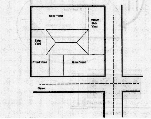
(Ord. 4.041, passed - -)
APPENDIX B: VISION CLEARANCE TRIANGLE
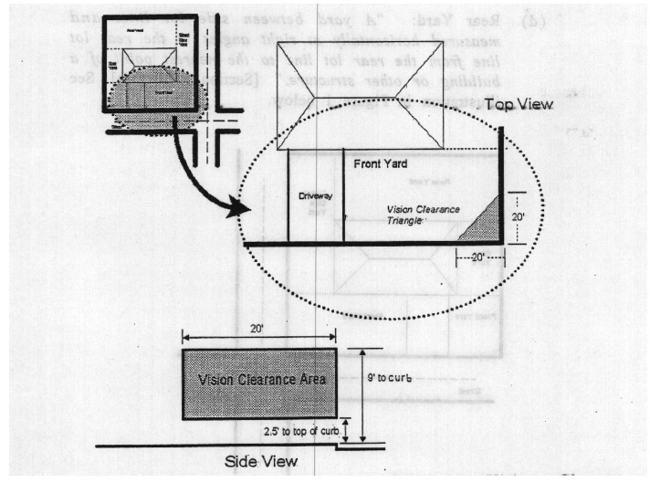
(Ord. 4.041, passed - -)
APPENDIX C: FENCE HEIGHT IN FRONT AND STREET SIDE YARDS
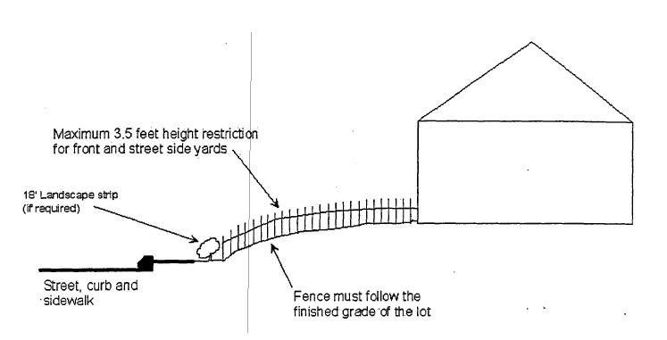
(Ord. 4.041, passed - -)
APPENDIX D: CORNER LOTS HAVING ABUTTING STREET SIDE YARDS

(Ord. 4.041, passed - -)
APPENDIX E: CORNER LOT HAVING STREET SIDE YARD ABUTTING NEIGHBOR’S FRONT YARD

(Ord. 4.041, passed - -)
APPENDIX F: THROUGH LOT YARD AREAS FOR FENCES
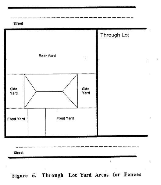
(Ord. 4.041, passed - -)
APPENDIX G: OFF-STREET LOADING SPACES
Use | Aggregate Floor Area (Square Feet) | Berths Required | Type |
Use | Aggregate Floor Area (Square Feet) | Berths Required | Type |
Freight terminals, industrial plants, manufacturing or wholesale establishments, warehouses | 12,000 – 36,000 | 1 | A |
36,000 – 60,000 | 2 | A | |
60,000 – 100,000 | 3 | A | |
each additional 50,000 or fraction thereof | 1 additional | A | |
Auditorium, motel convention halls, or sport arenas | 25,000 – 150,000 | 1 | B |
150,000 – 400,000 | 2 | B | |
each additional 250,000 or fraction thereof | 1 additional | B | |
Hospitals, nursing homes, sanitoria, convalescent homes, and similar institutional uses | 10,000 – 100,000 | 1 | B |
Over 100,000 | 2 | B | |
Department stores, retail establishments, restaurants, funeral homes, and commercial establishments not otherwise specified | 7,000 – 24,000 | 1 | B |
24,000 – 50,000 | 2 | B | |
50,000 – 100,000 | 3 | B | |
Over 100,000 Each additional 50,000 or major fraction thereof | 1 additional | B | |
Hotels or office buildings | 25,000 – 40,000 | 1 | B |
40,000 – 100,000 | 2 | B | |
Each additional 100,000 or major fraction thereof | 1 additional | B | |
Schools | Over 14,000 | 1 | B |
(Ord. 2-2-80, passed 2-19-1980; Am. Ord. passed 4- -1989)