
Barrow County Unincorporated
City Zoning Code
City Zoning Code
ARTICLE IX
ENVIRONMENTAL PROTECTION
Sec. 89-951. - Purpose of article.
This article sets out the minimum requirements and standards for the protection of the natural environment within the county, including restrictions on the use of land near certain rivers and streams, within water supply watersheds, within groundwater recharge areas susceptible to pollution, and in wetlands in order to:
(a)
Protect the drinking water quality of the rivers, streams, reservoirs and aquifers that supply water to the residents of the jurisdiction and the state;
(b)
Protect the natural habitat of animal and plant life relative to water resources; and
(c)
Protect valuable water-related and other natural resources, to help control erosion and river sedimentation, for contribution to drought management, and to help absorb floodwaters.
(Ord. of 10-13-2020)
Sec. 89-966. - Adopted.
The provisions of this division are adopted pursuant to the rules for Environmental Planning Criteria of the Georgia Department of Natural Resources (Chapter 391-3.16), adopted by DNR under O.C.G.A. § 12-2-8, the Metropolitan River Protection Act (O.C.G.A. §§ 12-5-440 et seq.), and the Georgia Erosion and Sedimentation Act of 1975, as amended (O.C.G.A. §§ 12-7-1 et seq.).
(Ord. of 10-13-2020)
Sec. 89-967. - Water supply watershed management plan.
This division is adopted in contemplation of the preparation of a water supply watershed management plan and hereby incorporates such water supply watershed management plan upon its completion and acceptance by appropriate federal, state and county officials as necessary or appropriate.
(Ord. of 10-13-2020)
Sec. 89-968. - Protected rivers and streams; defined.
(a)
Protected rivers and regulated streams.
(1)
"River corridors" are established in the comprehensive plan.
(2)
A "protected state river" is any perennial river or watercourse that has an average annual flow of at least 400 cubic feet per second. Protected rivers have been identified by the Georgia Department of Natural Resources (DNR) and within the comprehensive plan, and include the Apalachee, Mulberry and Middle Oconee Rivers.
(3)
Primary, secondary and first order trout streams, as designated by DNR.
(4)
All other perennial streams and state waters, other than "protected rivers" or "trout streams."
(b)
Criteria for regulated streams. All watercourses that appear as a solid or broken line on the U.S.G.S. Quadrangle Maps shall be regulated streams. Other natural watercourses may be classified as regulated streams if they possess one or more of the following characteristics, as determined by the planning and community development director based on data analysis and/or field review:
(1)
Evidence of significant water flow along the channel or bed of the watercourse, characterized by one or more of the following: hydraulically sorted sediments; wrested vegetation and vegetative litter due to normal stream flow; and loosely rooted vegetation caused by the action of moving water.
(2)
Evidence of hydric soils, hydrophytic vegetation, or wetlands in or around the channel or bed of the watercourse.
(Ord. of 10-13-2020)
Sec. 89-969. - River corridors; restrictions.
(a)
Development permit required. All persons desiring to undertake a permitted activity within a river corridor as mapped in the comprehensive plan, must first obtain a permit from Barrow County. Permit applications are to be filed according to procedures outlined within this Development Code.
(1)
Permits shall be issued only if the activity is in compliance with county regulations and other applicable state, federal, and local regulations.
(2)
The county shall impose conditions on any permit necessary to ensure that any adverse impacts upon the functions and values of the river corridor are prevented or kept to a minimum.
(3)
Permits shall be valid for six months. If the activity has not been completed but substantial progress has been made, one six-month extension to the permit may be granted by the Planning and Community Development Department.
(4)
Permits may be revoked for failure to comply with regulatory guidelines, including conditions attached to the permit.
(b)
Appeals. A variance may be approved if such approval is not contrary to the public interest and where because of a special characteristic of the property and the activity, a literal enforcement of provisions of this Development Code will, in an individual case, result in unnecessary hardship. Appeal procedures are detailed under the appeals article of this Development Code.
(c)
Existing industrial and commercial land uses. Industrial and commercial land uses existing prior to the effective date of this Development Code are exempt from the protection criteria of this Development Code, except as specifically prohibited under this article, provided that:
(1)
The use of the river corridor does not impair the drinking quality of the river water; and
(2)
The activity within the river corridor meets all state and federal environmental rules and regulations.
(Ord. of 10-13-2020)
Sec. 89-970. - Protected rivers and streams; restrictions.
(a)
Protected state rivers. A natural vegetative stream buffer is established along the banks of the Apalachee, Mulberry and Middle Oconee Rivers, as follows:
(1)
The stream buffer shall include all lands within 100 feet of protected state rivers, inclusive of any islands, as measured horizontally from the uppermost part of the riverbank. The area between the top of the banks and the edge of the river shall be included within the stream buffer.
(2)
The following activities are prohibited:
a.
Septic tanks and drainfields;
b.
Hazardous waste, solid waste landfills, or construction and demolition (C&D) landfills;
c.
Commercial or industrial uses that involve handling hazardous materials other than wastes;
d.
Handling areas for the receiving and storage of hazardous waste; and
e.
Surface mining activities.
(3)
No land may be used, and no vegetation shall be disturbed, within the stream buffer by building construction, development activity, septic tanks or septic tank drainfields, the handling of hazardous wastes, or for any other purpose except for the following permitted uses:
a.
A land use existing prior to the adoption of this Development Code.
b.
A single-family dwelling, provided that:
1.
The dwelling is located on a lot having an area of at least five acres, not including any area that lies between the riverbanks.
2.
Only one dwelling is located on the lot.
3.
No septic tank or septic tank drainfield may be located within the stream buffer.
c.
Timber production and harvesting, subject to the following conditions:
1.
Forestry activity shall be consistent with best management practices established by the Georgia Forestry Commission.
2.
Forestry activity shall not impair the drinking quality of the river water as defined by the Federal Clean Water Act, as amended.
d.
Wildlife and fisheries management activities consistent with the purposes of O.C.G.A. § 12-2-8 (as amended).
e.
Public road and utility crossings meeting all requirements of the Georgia Soil Erosion and Sedimentation Control Act.
f.
Public wastewater treatment and natural water quality treatment or purification.
g.
Recreational usage consistent either with the maintenance of a natural vegetative stream buffer or with river-dependent recreation, such as a boat ramp.
h.
Agricultural production and management, subject to the following conditions:
1.
Agricultural activity shall be consistent with best management practices established by the Georgia Soil and Water Conservation Commission.
2.
Agricultural activity shall not impair the drinking quality of the river water as defined by the Federal Clean Water Act.
3.
Agricultural activity shall be consistent with all state and federal laws and all regulations promulgated by the Georgia Department of Agriculture.
i.
Utilities, other than public water or sewerage facilities, provided that:
1.
The utilities shall be located as far from the riverbank as reasonably possible.
2.
Installation and maintenance of the utilities shall be such as to protect the integrity of the stream buffer as well as is reasonably possible.
3.
Utilities shall not impair the drinking quality of the river water.
j.
Other uses permitted by DNR under Section 404 of the Clean Water Act that are also allowed by the property's zoning classification.
(b)
Trout streams. The following shall apply to all streams designated as "trout waters" by the DNR, unless a greater width is otherwise required by other provisions of this article:
(1)
Except for single-family detached dwelling construction (see subsection (b)(2)), land-disturbing activities shall not be conducted within 100 horizontal feet, as measured from the point where vegetation has been wrested by normal stream flow or wave action, of the banks of any state waters classified as "trout streams" by the DNR unless a variance for such activity is granted by the EPD director, except:
a.
Where a roadway drainage structure must be constructed; and
b.
Adequate erosion control measures are incorporated in the project plans and specifications, and are implemented.
(2)
For single-family detached dwelling construction, there shall be a stream buffer established between the residence and any state waters classified as "trout streams" by DNR. In any such stream buffer, no land-disturbing activity shall be allowed between the residence and the point where vegetation has been wrested by normal stream flow or wave action from the banks of the trout waters, as follows:
a.
For primary trout waters, the stream buffer shall be at least 50 horizontal feet, and no variance to a smaller stream buffer shall be granted.
b.
For secondary trout waters, the stream buffer shall be at least 50 horizontal feet, but the EPD director may grant variances to no less than 25 feet.
c.
Regardless of whether a trout stream is primary or secondary, for first order trout waters, which are streams into which no other streams flow except for springs, the stream buffer shall be at least 25 horizontal feet, and no variance to a smaller stream buffer shall be granted.
(c)
Other protected streams and state waters. For all regulated streams and other state waters other than the Apalachee, Mulberry and Middle Oconee Rivers, the following shall apply:
(1)
Watershed protection areas. All perennial streams within watershed protection areas must comply with the natural stream buffer and setback requirements established for streams in each watershed. (See Division 3 of this article.)
(2)
Other streams and waters. For regulated streams and other state waters for which there are no stream buffers or setback restrictions otherwise established by this article, there shall be no land disturbing activities within a 25-foot wide stream buffer extending outward from both of the stream banks as measured from the point where vegetation has been wrested by normal stream flow or wave action, other than drainage structures and roads allowed under a development permit.
(d)
Recordation of restrictions. Restrictions shall be noted on the plats and deeds of included properties to maintain any designated natural stream buffer area, undisturbed area or construction setback required by this article.
(Ord. of 10-13-2020)
Sec. 89-971. - Stream buffers.
Unless more restrictive requirements under this Development Code apply, all perennial streams and other state waters shall be provided with a natural vegetative stream buffer as follows:
(a)
Minimum width of stream buffer.
(1)
The minimum stream buffer width must be provided along any protected state river or trout stream as required under subsections 89-970(a) and (b), respectively;
(2)
The minimum stream buffer width must be provided along any protected stream within any water supply watershed and around any water supply reservoir, as required under sections 89-998 through 89-1000 in this article.
(3)
For all other perennial streams and state waters, the stream buffer is to be established under subsection 89-970(c)(2).
(b)
Minimum setback for land disturbance. All clearing, earth moving, construction and ground disturbance must remain at least 50 feet from the edge of any stream buffer within a water quality critical area. Exceptions include bike and footpaths constructed of permeable material, gravity sanitary sewers, and road crossings perpendicular to streams. The installation of storm sewers will also be allowed. The area that is within this restricted construction area is to be left natural or developed as a trail with a minimum of disturbance to the natural habitat.
(c)
Protection of stream buffers.
(1)
No land disturbing activities shall be conducted within a stream buffer and a stream buffer shall remain in its natural, undisturbed state of vegetation until all land disturbing activities on the construction site are completed. Land disturbing activities may only be allowed as follows:
a.
Where the EPD director determines to allow a variance that is at least as protective of natural resources and the environment; or
b.
Where otherwise allowed by the EPD director pursuant to O.C.G.A. § 12-2-8; or
c.
Where a drainage structure or a roadway structure must be constructed, provided that adequate erosion control measures are incorporated in the project plans and specifications and are implemented; provided, however, that stream buffers of at least 50 feet established pursuant to O.C.G.A. Part 6 of Article 5, Chapter 5 of Title 12, the Georgia Water Quality Control Act, shall remain in force unless a variance is granted by the EPD director.
(2)
A stream buffer is to be included within a conservation or natural resources easement that meets the requirements of this article.
(3)
All stream buffer areas shall be maintained with appropriate indigenous plant species for the maintenance of groundcover and limitation of erosion. Undisturbed natural vegetation is the preferred, optimum state of a stream buffer. In the alternate, careful reestablishment of indigenous vegetation and ground cover is encouraged.
(4)
Once the final stabilization of the site is achieved, a stream buffer may be thinned or trimmed of vegetation, consistent with the terms of any applicable conservation or natural resources easement, as long as a protective vegetative cover remains to protect water quality and aquatic habitat and a natural canopy is left in sufficient quantity to keep shade on the stream bed.
(5)
Any person constructing a single-family residence, when such residence is constructed by or under contract with the owner for his or her own occupancy, may thin or trim vegetation in a stream buffer at any time, consistent with the terms of any applicable conservation or natural resources easement, as long as protective vegetative cover remains to protect water quality and aquatic habitat and a natural canopy is left in sufficient quantity to keep shade on the stream bed.
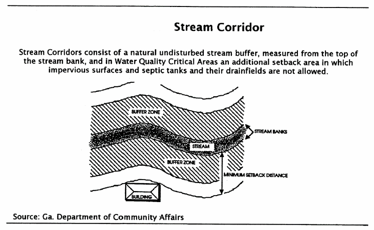
Figure 9.1 - Stream Corridor
Table 9.1. Stream Buffers and Setbacks
Summary of River and Stream Corridor and Water Supply Watershed Requirements
1 Measured outwardly from and perpendicular to the top of each bank of the stream or reservoir.
2 Measured outwardly from and perpendicular to the edge of stream buffer.
3 Within seven-mile radius of water supply intake or bank of water supply reservoir.
(Ord. of 10-13-2020)
Sec. 89-995. - Adopted.
The provisions of this division are adopted pursuant to the rules for Environmental Planning Criteria of the Georgia Department of Natural Resources, adopted by DNR under O.C.G.A. § 12-2-8.
(Ord. of 10-13-2020)
Sec. 89-996. - Establishment of water supply watersheds.
(a)
River Basin, along the Apalachee River. There are three large watersheds having over 100 square miles of drainage above a water supply intake, and five small water supply watersheds having less than 100 square miles of drainage above a water supply intake within Barrow County.
(1)
Large water supply watersheds; established. Large water supply watersheds are hereby designated and shall comprise the land that drains into the Apalachee River Watershed, the Middle Oconee River Watershed and the Mulberry River Watershed. The City of Winder has a primary public water intake on the Mulberry River.
(2)
Small water supply watersheds; established. Small water supply watersheds located within the jurisdiction of the county include: Cedar Creek, Laurel Lane Reservoir, Fort Yargo Lake, Barber's Creek and Bear Creek.
(b)
Protected watersheds; boundaries. All lands within water supply watersheds are designated as watershed protection areas, and include all land that drains to the stream bank from the ridgeline of each watershed. The boundary of the water supply watersheds is defined by the ridgeline of the watershed or by the political boundaries of the county, where those boundaries occur within the watershed.
(1)
Water quality critical area. The water quality critical area shall comprise all lands within seven miles upstream from a public water supply reservoir boundary and all lands located within a seven-mile radius of a public water supply intake, whether or not the intake or reservoir is located within Barrow County. See Figure 9.2.
(2)
Limited development area. The limited development area is established for the remaining part of the watershed protection area outside the water quality critical area.
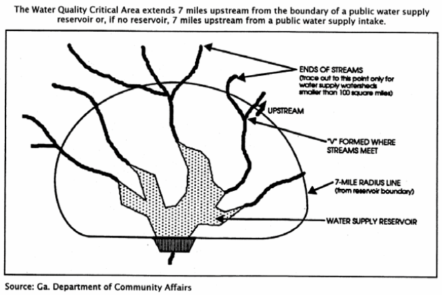
Figure 9.2 - Water Quality Critical Area
(Ord. of 10-13-2020)
Sec. 89-997. - Water supply watersheds; restrictions in general.
(a)
Protected watershed areas; exemptions.
(1)
Silvicultural. Notwithstanding any other provision of this division, forestry practices, in accordance with a forest management plan that incorporates best management practices (BMPs) approved by the Georgia Forestry Commission, shall be permissible within watershed protection areas.
(2)
Agriculture. Notwithstanding any other provisions of this division, the continued cultivation of agricultural crops and the occasional pasturing of livestock shall be permissible within watershed protection areas, provided that the best management practices (BMPs) of the Georgia Department of Agriculture are followed.
(b)
Development permit required. Within a water supply watershed, no land disturbing activity, construction or other development, other than certain exempted activities identified in this article, may be conducted without a permit from Barrow County, and any development or activities must be in full compliance with the terms of this article and other applicable regulations. All activities that are not permissible as of right or as special permit uses shall be prohibited.
(c)
Site plan required. Applications for a development permit within a water supply watershed shall include a site plan in accordance with the permits and procedures section of this Development Code. Except for the exemptions listed in this section, all forms of development within the water supply watershed shall be required to have a site plan prepared and approved according to this Development Code before any building permits or other development-related permits may be issued or any land disturbing activity may take place.
(d)
Restrictions in stream corridors; all watersheds.
(1)
Street runoff and drainage. New streets that cross perennial streams within the water supply watershed areas shall be designed in such a way as to avoid direct runoff from the paved surface into the streams they cross. Such design features shall be shown on the site plan.
(2)
Septic tanks and drainfields. Septic tanks and septic tank drainfields are prohibited in the setback and buffer areas of all stream corridors within water supply watershed areas.
(3)
Utilities. Utilities that cannot be feasibly located outside the stream buffer or setback area must be located as far from the stream bank as reasonably possible. Such utilities must be installed and maintained to protect the integrity of the stream buffer and setback areas as best as reasonably possible and must not impair the quality of the drinking water in the stream.
(Ord. of 10-13-2020)
Sec. 89-998. - Large water supply watersheds; restrictions.
The following limitations shall apply to all perennial streams within a large water supply watershed, in addition to the limitations on land use proscribed by the underlying zoning district:
(a)
Stream corridor setbacks; large water supply watersheds.
(1)
For all perennial streams within the water quality critical area, no impervious surface shall be constructed within a 150-foot setback area on both sides of the streams as measured from the stream banks.
(2)
For all perennial streams within the limited development area of a water supply watershed, there is no additional impervious surface setback required beyond the stream buffer itself.
(b)
Stream buffers; large water supply watersheds.
(1)
For all perennial streams within the water quality critical area, an undisturbed vegetative stream buffer shall be maintained for a distance of 100 feet on both sides of the stream as measured from the stream banks, unless a greater distance is required specifically by this Development Code.
(2)
For all perennial streams within the limited development area, an undisturbed vegetative stream buffer shall be maintained for a distance of 25 feet on both sides of the stream as measured from the stream banks, unless a greater distance is required specifically by this Development Code.
(c)
Land use restrictions; large water supply watersheds.
(1)
Any new facility that handles hazardous materials of the types listed in Section 312 of the Resource Conservation and Recovery Act of 1976 (excluding underground storage tanks) and amounts of 10,000 pounds or more on any one day, shall perform their operations on impermeable surfaces having spill and leak collection systems as prescribed by DNR.
(2)
Agricultural application of animal waste. The application of animal waste on land must be accomplished in accordance with the agricultural best management practices of the Georgia Department of Agriculture.
(Ord. of 10-13-2020)
Sec. 89-999. - Small water supply watersheds; restrictions.
(a)
Impervious surface area restricted. The impervious surface area, including all public and private structures, utilities or facilities, of the entire watershed protection area shall be limited to 25 percent. The board of commissioners must approve any individual development that will result in more impervious surface than 25 percent of the total area of the property as a special use. See the procedures and permits article of this Development Code for approval of special uses.
(1)
Utilities within protected stream corridors.
(b)
Stream corridor setbacks; small water supply watersheds.
(1)
For all perennial streams within the water quality critical area, no impervious surface shall be constructed within a 150-foot setback area on both sides of the stream as measured from the stream banks.
(2)
For all perennial streams within the limited development area, no impervious surface shall be constructed within a 100-foot setback area on both sides of the stream as measured from the stream banks.
(c)
Stream buffers; small water supply watersheds.
(1)
For all perennial streams within the water quality critical area, an undisturbed vegetative stream buffer shall be maintained for a distance of 100 feet on both sides of the stream as measured from the stream banks, unless a greater distance is required specifically by this Development Code.
(2)
(For all perennial streams within the limited development area, an undisturbed vegetative stream buffer shall be maintained for a distance of 50 feet on both sides of the stream as measured from the stream banks, unless a greater distance is required specifically by this Development Code.
(d)
Land use restrictions; small water supply watersheds.
(1)
New hazardous waste treatment or disposal facilities are prohibited.
(2)
New sanitary landfills, if permitted by DNR, shall have synthetic liners and leachate collection systems.
(3)
Any new facility that handles hazardous materials of the types listed in Section 312 of the Resource Conservation and Recovery Act of 1976 (excluding underground storage tanks) and in amounts of 10,000 pounds or more on any one day, shall perform their operations on impermeable surfaces having spill and leak collection systems as prescribed by DNR.
(Ord. of 10-13-2020)
Sec. 89-1000. - Reservoir protection.
A natural stream buffer shall be established and maintained within 150 feet of the banks of any public water supply reservoir boundary within any protected watershed area. Vegetation, land disturbance and land uses shall be controlled by the provisions of the applicable reservoir management plan, as approved by the Georgia Department of Natural Resources (DNR).
(Ord. of 10-13-2020)
Sec. 89-1021. - Protected groundwater recharge areas; defined.
Groundwater recharge areas are defined as "significant recharge areas" by the State of Georgia and are protected relative to their susceptibility to pollution.
(a)
Significant recharge areas. Significant recharge areas are defined by the Georgia Department of Natural Resources (DNR) using criteria developed by them, and have been mapped on DNR's Hydrologic Atlas 18 (1989 Edition, or as may be amended by DNR from time to time).
(b)
Pollution susceptibility category. Categories of relative vulnerability of an aquifer to pollution (classified as higher, average or lower) are defined by the DNR using criteria developed by them, and have been mapped on DNR's Hydrologic Atlas 20 (as may be amended by DNR from time to time) along with the most significant recharge areas.
(Ord. of 10-13-2020)
Sec. 89-1022. - Protected groundwater recharge area restrictions; in general.
Within any significant recharge area, as defined and delineated by the DNR, the following shall apply:
(a)
New hazardous waste treatment or disposal facilities are prohibited.
(b)
No land disposal of hazardous waste shall be permitted within any most significant groundwater recharge area.
(c)
New sanitary landfills, if permitted by DNR and the zoning district, shall have synthetic liners and leachate collection systems.
(d)
Any new facility that involves the treatment, storage or disposal of hazardous waste, if permitted by DNR and the zoning district, shall perform such operations on an impermeable surface having a spill and leak collection system.
(e)
Any new facility that handles hazardous materials of the types listed in Section 312 of the Resource Conservation and Recovery Act of 1976 (excluding underground storage tanks) and in amounts of 10,000 pounds or more on any one day, shall perform their operations on impermeable surfaces having spill and leak collection systems as prescribed by DNR.
(f)
A new above-ground chemical or petroleum storage tank must have secondary containment of 110 percent of the volume of the tank or 110 percent of the volume of the largest tank in a cluster of tanks. This requirement does not apply to:
(1)
Any tank having a maximum capacity of less than 650 gallons; and
(2)
Any tank used for agricultural purposes, provided it complies with all federal requirements.
(Ord. of 10-13-2020)
Sec. 89-1023. - Protected groundwater recharge area restrictions; by classification.
Most of unincorporated Barrow County's water supply, and a portion of Auburn's comes from groundwater. Significant groundwater recharge areas are located in Carl and Auburn, in the unincorporated areas north and south of Highway 29 between Auburn and Winder, and along the Gwinnett County line in western Barrow.
(a)
All significant groundwater recharge areas within Barrow County are classified by DNR as having "lower" pollution susceptibility.
(b)
Within a significant recharge area classified as having "lower" susceptibility to pollution, the following applies:
(1)
New agricultural waste impoundment sites larger than 50 acre-feet must be lined. The liner must be constructed of compacted clay having a thickness of one foot and a vertical hydraulic conductivity of less than 5 x 10⁻⁷ cm/sec or other criteria established by the U.S. Soil Conservation Service.
(2)
A new home* served by a septic tank/drain field system must be approved by the county health department and must have a lot that is at least 110 percent of the minimum lot size required by Table MT-1 of the Department of Public Health's "Manual for On-Site Sewage Management Systems," or the minimum lot size otherwise required by the county health department or zoning classification of the property, whichever is greater.
(3)
A multi-family residential dwelling, all other non-single-family dwellings, a commercial structure and a new manufactured home park served by a septic tank/drain field system must be approved by the county health department and must have a lot or space that is at least 110 percent of the minimum lot or space size required by Table MT-2 of the Department of Public Health's "Manual for On-Site Sewage Management Systems," or the minimum lot size otherwise required by the county health department or zoning classification of the property, whichever is greater.
* A single-family dwelling, including: stick-built home, manufactured home or modular home.
(Ord. of 10-13-2020)
Sec. 89-1046. - Adopted.
The provisions of this division are adopted pursuant to the Rules for Environmental Planning Criteria of the Georgia Department of Natural Resources, adopted by DNR under O.C.G.A. § 12-2-8.
(Ord. of 10-13-2020)
Sec. 89-1047. - Protected wetlands; defined.
(a)
Wetlands: Areas that are inundated or saturated by surface or groundwater at a frequency and duration sufficient to support, and that under normal circumstances do support, a prevalence of vegetation typically adapted for life in saturated soil conditions. Wetlands generally include swamps, marshes, bogs and similar areas.
(b)
Protected wetlands: Those wetlands identified on the National Wetlands Inventory Maps prepared by the U.S. Fish and Wildlife Service, or otherwise approved by the U.S. Army Corps of Engineers based on competent studies prepared by a registered and qualified professional engineer.
(1)
Any new wetland area constructed as a best management practice for stormwater control is also considered a protected wetland once construction is complete.
(Ord. of 10-13-2020)
Sec. 89-1048. - Wetlands map adopted.
The National Wetlands Inventory (NWI) Map prepared by the U.S. Fish and Wildlife Service covering the county is hereby adopted and incorporated herein by reference as the official map of protected wetlands in the county. The NWI Map does not necessarily represent the boundaries of jurisdictional wetlands within the county and cannot serve as a substitute for a delineation of wetland boundaries by the U.S. Army Corps of Engineers, as required by Section 404 of the Clean Water Act, as amended. Any local government action under these regulations does not relieve the landowner from federal or state permitting requirements.
(Ord. of 10-13-2020)
Sec. 89-1049. - Protected wetlands; allowed land uses.
Land uses that may be allowed in a protected wetland if otherwise permitted by the zoning district and by the Section 404 Permit include:
(a)
Timber production and harvesting;
(b)
Wildlife and fisheries management;
(c)
Camping, hiking, hunting and fishing recreation activities;
(d)
Public wastewater treatment and natural water quality treatment or purification facilities; and
(e)
Other uses permitted under Section 404 of the Federal Clean Water Act.
(Ord. of 10-13-2020)
Sec. 89-1050. - Protected wetlands, restrictions.
(a)
Within any protected wetlands area, the following shall apply:
(1)
Buffer required. A 25-foot wide strip of natural indigenous vegetation adjacent and parallel to the edge of a protected wetland shall be established to preserve and improve the quality of water within the protected wetland.
(2)
Prohibited land uses.
a.
Hazardous or toxic waste receiving, treatment or disposal facilities are prohibited.
b.
Sanitary landfills are prohibited.
(3)
Permit required for alteration. Alteration or degradation of a protected wetland requires prior approval of a development permit and approval by the U.S. Army Corps of Engineers under Section 404 of the Federal Clean Water Act, if applicable. Wetlands not falling under the jurisdiction of the corps shall be subject to county permitting only. See the permits and procedures article of this Development Code regarding approval of a development permit.
(Ord. of 10-13-2020)
Sec. 89-1051. - Wetlands certification.
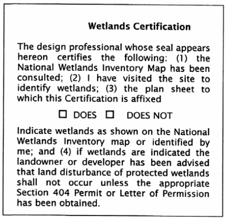
Figure 9.3 - Wetlands Certification Area
Design professionals shall indicate protected wetlands on plans required for a land disturbance permit application. The design professional that prepared the required plans accompanying the permit application shall add a statement to the appropriate plan sheets indicating whether or not wetlands are located on the property. At a minimum, the statement shall be placed on the grading plan; the erosion and sedimentation control plan; and the stormwater management site plan. The wetlands certification shall reflect the design professional's personal investigation regarding the existence of wetlands on the property, and shall read as shown in Figure 9.3, with the appropriate box checked.
(Ord. of 10-13-2020)
Sec. 89-1052. - Permitting requirements.
(a)
Requirement for local permit.
(1)
No land disturbing activity will be permitted within protected wetlands without written permission in the form of a local development permit from the county.
(2)
If the area proposed for development is located within 50 feet of a wetlands boundary, as determined using the National Wetlands Inventory Map, no land disturbance permit will be issued by the county until a Section 404 Permit or letter of permission is issued by the U.S. Army Corps of Engineers if the wetlands area falls under Corps jurisdiction.
(3)
Issuance of a development permit is contingent on full compliance with the terms of this article and other applicable regulations.
(4)
All activities that are not allowed in this Development Code shall be prohibited without prior issuance of a development permit.
(b)
Section 404 Permits; when required.
(1)
If the area proposed for development is located within 50 feet of a protected wetland boundary, as determined from the NWI Map, a U.S. Army Corps of Engineers determination shall also be required.
(2)
If the Corps determines that jurisdictional wetlands are present on the proposed development site and that a Section 404 Permit or letter of permission is required, a development permit will be issued only following issuance of the Section 404 Permit or letter of permission.
(c)
Conservation easement required. Any protected wetlands area that will be retained in any subdivision or development project is to be included within a conservation or natural resources easement that meets the requirements of this article.
(Ord. of 10-13-2020)
Sec. 89-1070. - Purposes of natural resource conservation.
The purposes of this division, among others, are as follows:
(a)
To recognize the current development rights of property owners established through zoning;
(b)
To conserve open land, including those areas containing unique and sensitive natural features such as stream buffers, floodplains, and wetlands, by setting them aside from development;
(c)
To support the continued viability of agricultural activities in the county, including crop production, dairying and managed forestry;
(d)
To reduce erosion and sedimentation by the retention of existing vegetation and to encourage minimization of development on steep slopes;
(e)
To enhance water quality of streams and waterways, and to protect valuable groundwater resources;
(f)
To encourage conservation of scenic views and elements of the county's rural character, and to minimize perceived density by minimizing views of new development from existing roads; and
(g)
To provide notification to property owners of natural resources that must be protected on their property.
(Ord. of 10-13-2020)
Sec. 89-1071. - Designation of conservation areas.
(a)
Primary conservation areas. Primary conservation areas are defined as follows:
(1)
River and stream channels. These areas are defined as the area between the top of bank and the opposite top of bank of any river, stream or other body of water classified as "state waters".
(2)
Required river and stream buffers. Natural vegetative stream buffers along the banks of all protected state rivers and perennial streams and other state waters, as required by this article (except for activities that are exempt from the soil erosion and sedimentation control provisions of the Land Development Activities Article of this Development Code).
(3)
Wildlife habitats of threatened or endangered species. The animal and plant species listed on Table 9.2 have been identified by the federal and/or the state governments as threatened or endangered species in Barrow County.
(4)
Protected wetlands. Wetlands are illustrated generally on the National Wetlands Inventory Maps published by the U.S. Fish and Wildlife Service, and as otherwise delineated by the U.S. Corps of Engineers.
Table 9.2: Threatened or Endangered Species Identified in Barrow County
Source: U.S. Fish and Wildlife Service.
(5)
Buffer areas around wetlands and habitats of endangered species. Additional lands in their natural state provided around designated wetlands and critical wildlife habitats as protective buffers are recognized as primary conservation areas. To qualify, a wetland buffer must extend at least 25 feet from the wetland, and a buffer around a wildlife habitat must be at least 100 feet deep.
(6)
100-year floodplain. All areas within the 100-year floodplain but lying outside any wetland or other designated primary conservation area fall under this category. The boundaries of the 100-year floodplain are designated as the "flood hazard area" on maps prepared by the Federal Emergency Management Agency (FEMA), and must be confirmed as to their specific location by the design professional.
(b)
Secondary conservation areas. Secondary conservation areas are areas that are encouraged (but not required) to be protected. These include:
(1)
Areas greater than 5,000 square feet of steep slopes over 25 percent. Slopes greater than 25 percent can be identified from the topographic data required for the preliminary plat or site plan for a development. Areas comprising 5,000 contiguous square feet or less are not considered secondary conservation areas.
(2)
Areas greater than 40,000 square feet with slopes of 15 percent to 25 percent. Slopes between 15 percent and 25 percent can be identified from the topographic data required for the preliminary plat or site plan for a development. Areas comprising 40,000 contiguous square feet or less are not considered secondary conservation areas.
(3)
Soils with exposed bedrock or rock outcroppings greater than 40,000 sf. Areas with exposed bedrock or rock outcroppings must be identified through observation on each site. Areas comprising 40,000 contiguous square feet or less are not considered secondary conservation areas.
(4)
Mature timber stands or significant trees. Forests and timberlands that have mature stands of trees qualify for conservation consideration. Individual trees that have significance through their size, age, species or historic value may be designated as a secondary conservation area to the extent of the tree's dripline. See Article VIII, Buffers and Tree Conservation.
(5)
Registered historic or archeological assets. Sites or areas registered with the state or the National Register of Historic Places qualify under this category since preservation is desirable but not mandated by law. Information regarding all such sites is available from the Georgia Office of Historic Preservation.
(6)
Viewshed protection areas. These areas may be set aside either to screen the view of the development from abutting roadways or to protect existing scenic views into the development site of rural heritage features. Examples of rural heritage features include the following:
Table 9.3: Rural Heritage Features
If intended to screen the subdivision development, the viewshed buffer must be adequately vegetated with trees and understory growth to provide an opaque screening effect. If intended to preserve a scenic view, the viewshed protection area must provide an adequate width or orientation in order to preserve the view.
(7)
Village greens, parkways. These areas create neighborhood assets by providing open space and passive recreation close to the homes in a subdivision. A village green is an open space area surrounded by streets and/or building lots on at least three sides, and intended for common neighborhood use. A parkway is a narrow strip of open space surrounded by streets on all sides, intended as a landscaped element or passive recreation area for the neighborhood.
(8)
Passive recreational areas. Common open space areas solely designated and improved for passive recreational activities, such as picnicking, walking, relaxation and repose, may be treated as secondary conservation areas. Active recreation areas, including but not limited to golf courses, swimming pools, sports fields and courts, and community buildings and grounds are not considered secondary conservation areas.
(Ord. of 10-13-2020)
Sec. 89-1072. - Allowed uses in natural conservation areas.
The following requirements apply only to land set aside for conservation in fulfillment of the provisions of this article:
(a)
Undisturbed areas. Certain areas identified as primary or secondary conservation areas shall remain in their natural, undisturbed state. Such undisturbed areas include river and stream channels, stream buffers, viewshed buffers, critical wildlife habitats and buffers, wetlands and wetland buffers, and mature timber stands (except for managed forestry activities, including harvesting).
(b)
Allowed uses in other conservation areas. The following uses are allowed in natural resource conservation areas to the extent that they are compatible with the protection and preservation of areas required by law but not otherwise required to remain undisturbed, and are allowed uses under the site's zoning classification:
(1)
Conservation of open land in its natural state (for example, woodland, open field, or managed meadow).
(2)
Agricultural and horticultural uses, including raising crops, pasturelands and dairy operations, along with associated buildings (including residences) that are specifically needed to support an active, viable agricultural or horticultural operation. Specifically excluded are commercial livestock operations involving swine or poultry.
(3)
Pastureland for horses used solely for recreational purposes. Equestrian facility buildings and grounds shall be permitted but may not be located in any primary conservation area.
(4)
Silviculture, in keeping with established standards for selective harvesting and sustained yield forestry, and best management practices endorsed by the Georgia Forestry Commission.
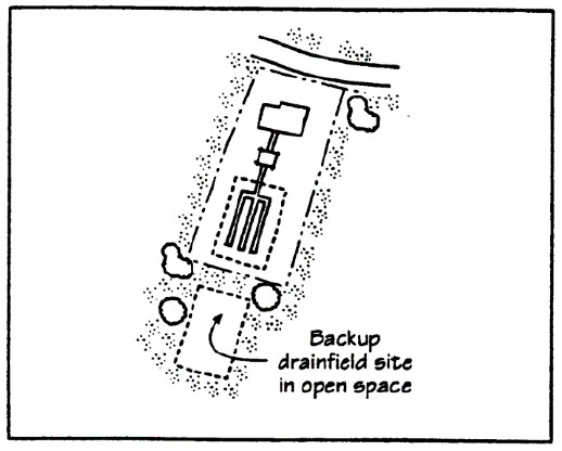
Figure 9.4 - Backup Drainfield
(5)
Neighborhood open space uses such as village greens, commons, picnic areas, community gardens, trails, multi-purpose sports fields, and similar low-impact recreational uses specifically excluding motorized off-road vehicles, rifle ranges, golf courses, sports courts, community recreation buildings and grounds, swimming pools, and other active recreation uses.
(6)
Pathways and trails, and passive recreation activities such as fishing, picnicking, and nature interpretation.
(7)
Water supply, sewage disposal system reserve fields and stormwater detention areas designed, landscaped, and available for use as an integral part of the conservation area. The septic tank and drain field required for on-site sewage disposal must be located on the lot of the house it serves. Areas within a conservation area used for water supply, backup drainfields or stormwater detention must be located outside of any primary conservation area and must be established by easements between the appropriate parties and recognized in the conservation easement covering the area.
(8)
Easements for drainage, access, power, natural gas, sewer or water lines, or other public purposes, as approved by the public works director and in keeping with conservation of the areas they traverse.
(Ord. of 10-13-2020)
Sec. 89-1091. - Conservation or natural resources easements; required.
(a)
Primary conservation areas. All stream buffers required by this article, all protected wetlands, and all other primary conservation areas that are required to be protected by the provisions of this article, shall be permanently protected from further subdivision, development, and unauthorized use as follows:
(1)
By a natural resources easement in a conventional subdivision; or
(2)
By a conservation easement in an open space subdivision or a master planned development.
(b)
Secondary conservation areas. Lands in secondary conservation areas that are designated by the developer for protection shall be included within a natural resources or conservation easement.
(c)
Ownership of land in conservation and natural resources easements. Land within conservation and natural resources easements may be included within the lots in a subdivision, or ownership may be transferred to a homeowners' association or to a nonprofit conservation organization or land trust organized under Georgia law.
(Ord. of 10-13-2020)
Sec. 89-1092. - Natural resources easements.
(a)
Natural resources easements; approval. The natural resources easement, when required, shall be shown on the final subdivision plat and recorded with the clerk of the superior court at the same time as the final plat.
(b)
Natural resources easements; guidelines. The following guidelines are required to be incorporated into any natural resources easement in a form acceptable to the county attorney:
(1)
The easement specifically and clearly identifies the boundaries of the property subject to the easement through reference to the easement area shown on the final subdivision plat;
(2)
The easement contains restrictions as to what the owner may do with the property and specifically delineates what may not be done with the property. Limitations shall be consistent with the type of area protected and the applicable requirements of this Development Code to such areas, and may include but shall not be confined to prohibitions against subdivision, earthmoving, dumping, signs, utility lines, construction, changes to existing structures, and uses made of the property;
(3)
The easement provides for the right of the county to inspect the property to assure observance of restrictions and also provides for enforcement procedures; and
(4)
The easement contains provisions governing its amendment, including provisions that the easement shall not be altered or terminated except with the express written permission of the county.
(Ord. of 10-13-2020)
Sec. 89-1093. - Conservation easements.
(a)
Conservation easements; approval. The conservation easement, when required, shall be approved by the board of commissioners and shall either be:
(1)
Cosigned on behalf of the board of commissioners and donated to a private nonprofit conservation organization or land trust;
(2)
Cosigned on behalf of the board of commissioners and donated to a nonprofit homeowners association; or
(3)
Donated to Barrow County at the option of and if accepted by the board of commissioners.
(b)
Conservation easements; guidelines. The conservation easement shall be created subject to the provisions of O.C.G.A. Article 1 of Chapter 10 of Title 44 which is known as the Georgia Uniform Conservation Easement Act. (Code 1981, § 44-10-1, et seq. enacted by Ga. L. 1992, p. 2227, § 1.) The following guidelines are required to be incorporated into any conservation easement in a form acceptable to the county attorney:
(1)
The easement recognizes and describes in a statement of purpose the special qualities of the property subject to the easement. Conditions within the tract subject to the conservation easement may be shown by map and/or photograph;
(2)
The easement clearly identifies the owner of the property subject to the easement, the holder of the easement, and cosigner, and the responsibilities of the property owner, easement holder, and cosigner;
(3)
The easement specifically and clearly identifies the boundaries of the property subject to the easement, either by metes and bounds legal description or survey plat;
(4)
The easement contains restrictions as to what the owner may do with the property and specifically delineates what may not be done with the property. Limitations shall be consistent with the type of area protected and the applicable requirements of this Development Code to such areas, and may include but shall not be confined to prohibitions against subdivision, earthmoving, dumping, signs, utility lines, construction, changes to existing structures, and uses made of the property;
(5)
The easement provides for the right of the easement holder and cosigner to inspect the property to assure observance of restrictions and also provides for enforcement procedures;
(6)
The easement provides for the maintenance of the open space;
(7)
The easement provides for either enforcement rights or third party enforcement rights, vested in the homeowners' association or the land trust, as the case may be, and in Barrow County; and
(8)
The easement contains provisions governing its amendment, including provisions that the easement shall not be altered or terminated except with the express written permission of all entities having either a property right or enforcement right in the easement.
(Ord. of 10-13-2020)
Sec. 89-1094. - Temporary emergency permit.
(a)
A temporary emergency permit can be issued by the county under this article for the following reasons:
(1)
Maintenance or repair of roads or structures.
(2)
Maintenance or repair of lawfully located roads or structures and of facilities used in the service of the public to provide transportation and utilities, provided that such roads, structures or facilities are not materially changed or enlarged and written notice prior to the commencement of work has been given to the Planning and Community Development Department, and provided that the work is conducted using best management practices to ensure that flow and circulation patterns, chemicals and biological characteristics of the area are not impaired and that any adverse effect of the aquatic environment will be minimized.
(3)
Temporary water-level stabilization measures associated with ongoing silvicultureral operations, provided that they are necessary to alleviate abnormally wet or dry conditions that would have an adverse impact on the conduct of silvicultural activities if not corrected.
(4)
Limited ditching, tilling, dredging, excavating or filling done solely for the purpose of maintaining or repairing existing drainage systems necessary for the cultivation of agricultural crops, provided that the maintenance or repair activity does not result in the impairment, alternation or loss of wetlands not previously subject to agricultural and silvicultural use under the terms and provisions of this article.
(5)
Limited excavation and filling necessary for the repair and maintenance of piers, walkways, nature trails, observation decks, wildlife management shelters, boathouses or other similar water-related structures, provided that they are built on pilings to allow unobstructed flow of water and preserve the natural contour of the area.
(Ord. of 10-13-2020)