
Bartlesville City Zoning Code
SECTION 7
SPECIAL CONDITIONS
7.1 - General.
Subsections 7.2 through 7.11 describe the special conditions under which certain uses are permitted in a zoning district when reference is made to one or more of said subsections in the "Special Conditions" column in the tables of permitted uses. Where special conditions are widely applicable reference should be made to subsequent subsections.
7.2 - Home Occupations
7.2.1
General Provisions
A.
Statement of Intent. The purpose and intent of the Home Occupation provisions contained herein is to permit and regulate the conduct of business in residentially zoned areas within the jurisdictional boundary of the Bartlesville Metropolitan Planning Area, but to do so with the overriding need to:
1.
Ensure the compatibility of Home Occupations with other uses permitted in residential districts;
2.
Maintain and preserve the character of residential neighborhoods; and
3.
Promote the efficient use of public services and facilities by assuring these services are provided to the residential population for which they were planned and constructed.
B.
Definitions.
1.
Home Occupation: Any business or commercial activity conducted within a residential dwelling unit or an approved accessory building located within any residential zoning district which is approved and permitted pursuant to the provisions of this Section. Said Home Occupation shall be located on the same parcel as the primary residential dwelling unit and shall be clearly incidental and secondary to the primary residential use of the parcel.
2.
Accessory Building: A subordinate building, located on the same parcel as the main building, the use of which is clearly incidental to the residential use of the parcel.
3.
Parcel: A contiguous quantity of land in the possession of or owned by, or recorded as the property of, the same person or persons. For the purposes of the regulations contained in this Section, a parcel of land may include more than one legal lot of record which adjoins continuously along the side or rear property line for a minimum length which is at least 50 percent of the length of said side or rear property line. Any adjoining parcel which does not meet this minimum length requirement shall be considered a separate parcel for the purposes of these regulations.
C.
Classification and Permitting.
1.
A Home Occupation shall be classified as either a Minor Home Occupation or a Major Home Occupation as defined below. The distinction between these two classes of Home Occupations is based primarily upon the degree of impact the Home Occupation will have upon the residential neighborhood. The Performance Standards for the operation of the Home Occupation shall determine whether the proposed Home Occupation is a minor or major Home Occupation. Separate permitting procedures shall apply for each of these two types of Home Occupations.
a.
Minor Home Occupation: A Home Occupation which is permitted by right in any residential zoning district.
b.
Major Home Occupation: A Home Occupation which is permitted conditionally with approval by the Board of Adjustment, after a public hearing, whereupon the Board may elect to impose reasonable conditions which are necessary to ensure the purpose and intent of this Section.
2.
No Home Occupation shall be permitted without the prior issuance of either a Minor Home Occupation Permit or a Major Home Occupation Permit. Said permit shall be granted through an application and approval procedure as defined in this Section.
7.2.2
Performance Standards. Home Occupations shall be permitted as accessory uses within any residential zoning district provided they meet the Performance Standards contained in this Section in addition to all of the requirements of the district in which located.
A.
Criteria for a Minor Home Occupation. A Home Occupation shall be classified as a Minor Home Occupation if it complies with all of the following performance criteria:
1.
A Minor Home Occupation shall not change the exterior character of the dwelling. No external alterations inconsistent with the residential use of the property shall be permitted, with the exception of external signage as discussed herein.
2.
A Minor Home Occupation is permitted one (1) non-illuminated wall mounted sign not to exceed three (3) square feet in area. Signage permitted for the operation of a Minor Home Occupation shall be used solely for the purpose of identification (limited to the name and/or occupation and address) and shall not be used for advertising of the home occupation.
3.
A Minor Home Occupation may employ any number of family members who reside on the parcel and may employ up to one (1) additional person who does not reside on the parcel.
4.
Approved hours of operation for a Minor Home Occupation shall be between the hours of 8:00 a.m. to 8:00 p.m. Traffic associated with pickup and deliveries shall also be limited to these hours of operation.
5.
A Minor Home Occupation shall not generate traffic exceeding an average of one (1) vehicle per hour during approved hours of operation. This includes traffic associated with pickup and deliveries to the parcel. Traffic associated with a Minor Home Occupation, including pickups and deliveries, is allowed only during approved hours of operation (8 a.m. to 8 p.m.) and shall not impede traffic circulation within the neighborhood.
6.
A Minor Home Occupation shall not utilize, park and/or store at the parcel more than one (1) private commercial vehicle not to exceed a capacity of two (2) tons. This weight limit of vehicles shall also apply to the pickup and delivery of materials to and from the parcel.
7.
One (1) off-street parking space is required for a Minor Home Occupation if a non-resident employee is utilized in the operation of the Minor Home Occupation. This required parking space shall be in addition to the number of off-street parking spaces required for the residential dwelling use. In addition, a maximum of two (2) on-street parking spaces shall be allowed for a Minor Home Occupation.
S.
There shall be no outdoor storage of materials or products associated with a Minor Home Occupation on the parcel. The indoor storage of materials or products shall not exceed the limitations imposed by any applicable regulations of any authority having jurisdiction, including, but not limited to the fire code, building code, and electrical code.
9.
All business activities associated with a Minor Home Occupation shall take place within an enclosed structure, either within the primary dwelling unit or an accessory building located on the same parcel. If an accessory building is used, said structure shall conform to all applicable Home Occupation regulations contained in this Section.
10.
A Minor Home Occupation shall not generate sewerage or water usage in excess of what is normal in the residential neighborhood.
11.
No equipment or process shall be used in a Minor Home Occupation which creates noise, vibration, glare, fumes, odors, or electrical interference beyond what normally occurs in the applicable residential zoning district.
12.
The primary use of the parcel upon which the Minor Home Occupation is situated shall clearly be the applicant's private residence.
13.
A Minor Home Occupation shall have an approved occupational license and any other licensee(s) as mandated by applicable local, state, and/or federal laws.
B.
Criteria for a Major Home Occupation. A Home Occupation shall be classified as a Major Home Occupation if its operational characteristics exceed the Performance Standards for a Minor Home Occupation. A Major Home Occupation shall be permitted only with approval from the Board of Adjustment, after a public hearing, and in accordance with any special conditions imposed upon the issuance of the Major Home Occupation Permit by the Board.
It should be noted that the Board, in reviewing and approving each individual Major Home Occupation Permit, shall establish upper limits on the operational characteristics of the Home Occupation. These upper limits shall be considered the maximum operating limits for that particular Home Occupation. When the Major Home Occupation matures and exceeds these operating limitations, the business shall be considered a non-residential use and shall be required to relocate to a properly zoned commercial/industrial site. To this extent, the following Performance Standards shall apply to the review and issuance of a Major Home Occupation Permit:
l.
A Major Home Occupation shall not change the exterior character of the dwelling. No external alternations inconsistent with the residential use of the property shall be permitted, with the exception of external signage as discussed herein.
2.
The location, size, number, and illumination of allowed signs for a Major Home Occupation shall be as declared in the approved permit. Signage permitted for the operation of a Major Home Occupation shall be used solely for the purpose of identification (limited to the name and/or occupation and address) and shall not be used for advertising of the home occupation.
3.
A Major Home Occupation may employ any number of family members who reside on the parcel and may employ one (I) or more additional employees not residing on the parcel. The maximum number of employees allowed for a Major Home Occupation shall be as declared in the approved permit.
4.
A Major Home Occupation may operate outside the typical operating hours of 8 o'clock a.m. to 8 o'clock p.m. This shall include traffic associated with pickup and deliveries. Approved hours of operation for a Major Home Occupation shall be as declared in the approved permit.
5.
A Major Home Occupation may generate traffic in excess of an average of one (1) vehicle per hour during approved hours of operation. This includes traffic associated with pickup and deliveries to the parcel. Limitations on traffic for a Major Home Occupation shall be as declared in the approved permit. However, traffic associated with a Major Home Occupation, including pickups and deliveries, shall not impede traffic circulation within the neighborhood.
6.
A Major Home Occupation may utilize, park and/or store at the parcel one (1) or more private commercial vehicles in excess of a two (2) tons capacity. Commercial vehicles used for the pickup and delivery of materials to and from the parcel may also exceed two (2) tons capacity. The number and size of vehicles permitted in the operation of a Major Home Occupation shall be as declared in the approved permit.
7.
One (1) off-street parking space is required for a Major Home Occupation if a non-resident employee is utilized in the operation of the Major Home Occupation. This required parking space shall be in addition to the number of off-street parking spaces required for the residential dwelling use. In addition, the number of on-street parking spaces allowed shall be as declared in the approved permit.
9.
Outdoor storage of materials or products on the parcel may be permitted in accordance with the approved permit. It should be noted that in reviewing the request for outdoor storage in conjunction with an application for a Major Home Occupation, the Board may require screening of stored materials. The indoor storage of materials or products shall not exceed the limitations imposed by any applicable regulations of any authority having jurisdiction, including, but not limited to the fire code, building code, and electrical code.
10.
All business activities associated with a Major Home Occupation shall take place within an enclosed structure, either within the primary dwelling unit or an accessory building located on the same parcel. If an accessory building is used, said structure shall conform to all applicable Home Occupation regulations contained in this Section.
10.
A Major Home Occupation shall not generate sewerage or water usage in excess of what is normal in the residential neighborhood.
11.
No equipment or process shall be used in a Major Home Occupation which creates noise, vibration, glare, fumes, odors, or electrical interference beyond what normally occurs in the applicable residential zoning district.
12.
The primary use of the parcel upon which the Major Home Occupation is situated shall clearly be the applicant's private residence.
13.
A Major Home Occupation shall have an approved occupational license and any other licensees) as mandated by applicable local, state, and/or federal laws.
7.2.3
Approval Procedure
A.
Application. An application for either a Minor or a Major Home Occupation shall be made to the Community Development Director on a form provided by the Planning Department. Separate approval procedures are required for the two (2) types of Home Occupations:
1.
Minor Home Occupation. A permit for a Minor Home Occupation shall be issued by the Community Development Director provided that said Minor Home Occupation is conducted in accordance with all applicable regulations as contained within this Section. An annual permit fee of five dollars ($5.00) for a Minor Home Occupation shall be assessed at the time of issuance and annual renewal. The applicant or any resident located within 300 feet of the Minor Home Occupation may appeal the decision of the Community Development Director to the Board of Adjustment. Appeals to the Board shall be made, in writing, to the Community Development Director for transmittal to the Board. Decisions of the Board of Adjustment may be appealed as provided for in Section 10.4.8.
2.
Major Home Occupation. A permit for a Major Home Occupation shall be issued only by the Board of Adjustment. A public hearing will be conducted by the Board given proper notification as prescribed under Section 10.5 of this Ordinance. The Board will consider the application in light of all applicable City regulations and, in keeping with the Statement of Intent of these regulations, shall approve or deny the application. An annual permit fee of ten dollars ($10.00) for a Major Home Occupation shall be assessed at the time of issuance and annual renewal. Decisions of the Board of Adjustment may be appealed as provided for in Section 10.4.8.
B.
Conditions on Major Home Occupation. In order to ensure that a Major Home Occupation will not become a nuisance to the neighbors or otherwise violate these guidelines, the Board of Adjustment may impose on the issuance of a Major Home Occupation permit reasonable conditions necessary to ensure the purpose and intent of these regulations.
C.
Existing Home Occupations. Home Occupations which have been approved prior to the adoption of these regulations which would be nonconforming under the provisions of this Section shall be grandfathered (to that person at that address) as of the date of this Ordinance.
D.
Time Limit and Renewal. Permits for either a Minor or Major Home Occupation shall be valid for a period of one (1) year from initial date of approval. Notice and renewal of the Home Occupation permit shall be concurrent with the notice and renewal of the required occupational license for the City of Bartlesville. Home Occupation permits for both Minor and Major Home Occupations may be renewed annually by the Community Development Director provided there has not been any violation of the provisions of this Section. Permit fees as stated above shall be assessed at the time of annual renewal. If a Home Occupation permit has not been renewed within thirty (30) days of expiration, the Home Occupation permit shall be determined to be null and void.
7.2.4
Permit Limitations
A.
Transfer of Permit. Once a permit for either a Minor or Major Home Occupation has been approved, it shall not be transferred to another person or to a location other than that stated on the permit.
B.
Inspections. To ensure safety and compliance with these regulations, the Community Development Director may conduct an annual inspection of the parcel covered by said permit. In addition, the Community Development Director shall have the right at additional times, upon reasonable request, to enter and inspect the premises. Any complaint received by the Community Development Director regarding the operation of a Home Occupation will automatically result in a review of the Home Occupation permit by the Community Development Director to ensure compliance with all requirements of this Section.
C.
Violations. If the Community Development Director determines that a violation is occurring or has occurred for any Home Occupation, the Community Development Director shall notify the owner that a violation has occurred and establish an action and time for compliance. If the violation is not abated within a time frame established by the Community Development Director, the Community Development Director may revoke the Home Occupation permit for noncompliance with the criteria set forth within this Section.
D.
Revocation. Revocation of a Home Occupation permit, due to noncompliance with the criteria set forth within this Section or any additional criteria or Performance Standards imposed on the permit by the Board, may take place at any time prior to the expiration date of the permit. If the permit is revoked or is not renewed, it becomes null and void, and said use shall be terminated.
E.
Exceeding Performance Standards.
1.
Minor Home Occupation. If, after a Minor Home Occupation has been established, it is discovered that the operation of the Home Occupation exceeds the Performance Standards permitted for a Minor Home Occupation, then the operator of said Home Occupation shall:
a)
cease any activities which exceed the Performance Standards permitted for a Minor Home Occupation; or
b)
make application for a Major Home Occupation in accordance with the aforementioned procedure for same within ten (10) days of notice by the Community Development Director.
2.
Major Home Occupation. If, after a Major Home Occupation has been established, it is discovered that the operation of the Home Occupation exceeds the Performance Standards as declared in the approved permit, then the operator of said Home Occupation shall:
a)
cease any activities which exceed the identified Performance Standards; or
b)
reapply through the application procedures for a Major Home Occupation requesting a change in the maximum operating limits for the particular Major Home Occupation. This will be treated as a new application for a Major Home Occupation and a permit fee will be assessed; or
c)
relocate the operation to a properly zoned commercial/industrial site.
7.3 - Child Care and Adult Care Facilities
7.3.1
Residentially-Based Child or Adult Care Facilities. Where child or adult care facilities are provided as an accessory use in a residential structure occupied principally as a residential use, said facilities shall be approved pursuant to the Home Occupation Regulations contained in Section 7.2 and as modified herein. The State of Oklahoma Licensing Requirements for Family Child Care Homes and Large Child Care Homes, and any amendments thereto, are hereby adopted, except as modified herein.
7.3.1.1
Child Care Home. A Child Care Home includes both Family Child Care Homes and Large Child Care Homes as defined by the State of Oklahoma, and is a family home which provides care and supervision for children for part of the 24-hour day, complying with the minimum requirements set forth by the State of Oklahoma Department of Human Services (OKDHS).
A Child Care Home shall be a permitted use in all residential zoning districts as a Minor Home Occupation subject to compliance with the performance criteria for a Minor Home Occupation, except as modified by the following conditions:
1.
Approved hours of operation for a Child Care Home shall be between the hours of 6:00 a.m. and 8:00 p.m. Traffic associated with pickup and delivery of children to this family child care home shall also be limited to these hours of operation.
2.
On-street parking is permitted for the pick-up and delivery of children if off-street parking is not feasible.
3.
Play areas shall be enclosed with safe fencing; flexibility in materials and height is allowed, provided safety is ensured and OKDHS requirements are met. Unless in conflict with OKDHS requirements, any site perimeter fencing shall meet requirements set forth in Section 9.5.3.
4.
The performance criteria for a Minor Home Occupation concerning sewerage and water usage (Section 7.2.2.A.10), or noise, vibration, glare, fumes, odors, or electrical interference (Section 7.2.2.A.11) shall not apply to a Child Care Home, except to the extent that such is determined to be remarkable for a Child Care Home by the Community Development Director or his/her designee.
5.
Signage for a Child Care Home shall be limited to that permitted by the Minor Home Occupation performance criteria.
6.
A Child Care Home shall comply with all applicable Federal, State and Local regulations, codes, and requirements.
7.
A copy of the approved license issued by the State of Oklahoma, Department of Human Services, Washington County, shall be provided with the application for a Minor Home Occupation for a Child Care Home.
Modifications to these conditions shall be permitted only with approval from the Board of Adjustment as a Major Home Occupation.
7.3.1.2
Adult Care Facilities. Residentially-based care facilities that provide care for adults for part of the 24-hour day shall be treated as family home facilities that provide care for children as set forth in Section 7.3.1.1.
7.3.2
Commercial Child or Adult Care Facilities. Where child or adult care facilities are provided as the principal use of a structure, said facilities shall be located where permitted in Tables 4.2 and 6.2. Such facilities shall be approved pursuant to any applicable State of Oklahoma Licensing Requirements, and any amendments thereto, except as modified herein.
7.3.2.1
Commercial Child or Adult Care Facilities may be permitted in a residential district as shown in Table 4.2 with approval of a Special Zoning Permit subject to the following conditions:
1.
The site must be at least 10,000 square feet in area.
2.
A solid wall or fence at least six (6) feet high shall be provided and maintained between any outdoor play area on the site and any contiguous property line in a residential district.
3.
The site shall have its main ingress and egress on a major thoroughfare, or on a collector street not more than 2,640 feet (1/2 mile) distant (by the shortest route) from a major thoroughfare.
4.
One parking space per 1.5 employees shall be required.
7.3.2.2
Commercial child or adult care facilities shall be permitted in any nonresidential zoning district as shown in Table 6.2 without additional conditions.
(Ord. No. 3597, § 1(Exh. B), 10-7-24)
7.4 - General Development Standards
The standards contained in this section address the physical relationship between development and adjacent properties, public streets, neighborhoods, and the natural environment. These General Development standards apply to all development involving any zoning approval or approvals pursuant to this Ordinance, subject to the following limitations:
A.
The standards contained in this section apply to all new development unless specifically exempted.
B.
The standards contained in this Section apply to the expansion or improvement of existing uses only if the expansion or improvement:
• Exceeds 25% or more of the original floor area of the building;
• Exceeds more than ten (10) off-street parking spaces; or
• Increases the non-permeable lot coverage by more than 20%; or equals or exceeds fifty percent (50%) of the market value of the structure before the expansion of improvement is started.
• Increases the structure or property value by more than 25%, per the county appraiser's records.
7.4.1 Off-Street Loading Requirements
7.4.1.1 Requirement. Every building or structure hereafter constructed in any district, for nonresidential purposes requiring the receipt or distribution by vehicles of material or merchandise shall provide and maintain on the same lot with such building, at least one (1) off-street loading space.
7.4.1.2 Location. Such space may occupy all or any part of any required yard, or court space, but no such space may be located closer than fifty (50) feet to any residential district unless wholly within a completely enclosed building or unless enclosed on all sides abutting the residential district by a wall of not less than eight (8) feet in height.
7.4.2 Off-Street Parking Requirements
7.4.2.1 Requirement. In all zoning districts, except the C-4 District, in connection with every industrial, commercial, institutional, recreational, residential or any other use, there shall be provided, at the time any building or structure is erected or enlarged or increased in capacity, or any other use is established, off-street parking spaces for automobiles in accordance with the requirements in the "Parking Spaces Required" column in the tables of permitted uses. All such parking spaces shall be accessed by a curb cut or driveway which conforms with all applicable City Codes. Parking space used in connection with an existing and continuing use or building on the effective date of these regulations up to the number required by these regulations, shall be continued and may not be counted as serving a new structure or addition; nor may a parking space be substituted for a loading space or a loading space substituted for a parking space.
7.4.2.2 Size, Surface, Striping, and Drainage and Perimeter Curbing.
A.
Size. Each off-street parking space shall have an area with minimum dimensions as set forth in the following table.
STANDARD PARKING SPECIFICATIONS
B.
Surface.
a.
Nonresidential Uses. All nonresidential parking areas shall be paved with an all-weather surface, to include but not limited to, asphalt, concrete or chip and seal.
b.
Residential Uses of Four or Less Units. All residential parking areas shall be paved with gravel or an all-weather surface, to include but not limited to, asphalt, concrete, or chip and seal. If rock, gravel, or similar inorganic material is used, said area shall be enclosed with a permanent border or frame, shall be a minimum of two (2) inches in thickness, and shall be maintained in this manner.
It shall be unlawful and an offense for any person to park any vehicle on grass, dirt, or similar unpaved surface. Such parking areas shall be maintained in such a manner that no dust will result from continued use. Exceptions or variances to this all-weather surface requirement may be granted by the Board of Adjustment for nonresidential parking areas within the three-mile unincorporated area of the Bartlesville Metropolitan Planning Area where clear evidence of practical difficulty or unnecessary hardship can be shown by the developer.
C.
Striping. Except for all residential units of four or less units and townhomes, all parking stalls shall be marked with white or yellow painted lines not less than four (4) inches wide. Such striping shall delineate parking stall dimensions consistent with the stall number and size requirements set forth herein.
D.
Drainage and Perimeter Curbing. Except for all residential units of four or less units and townhomes, all open, off-street parking shall be graded according to an approved drainage plan and shall have a perimeter curb barrier around the entire parking lot; said curb barrier, not be closer than five (5) feet to any lot line. Grass, plantings, or screening shall be provided in all areas bordering the parking area.
7.4.2.3 Floor Area Defined. For the purpose of applying the requirements for off-street loading and parking, the term "floor area", in the cases of offices, merchandising, or service types of uses, shall mean the gross floor area used or intended to be used by tenants, or for the service to the public as customers, patrons, clients or patients, including areas occupied by fixtures and equipment for display or sale of merchandise. It shall not include areas used principally for non-public purposes, such as storage, incidental repair, processing, or packaging of merchandise, for offices incidental to the management or maintenance of stores or buildings, for rest rooms, utilities, or for fitting or dressing rooms.
7.4.2.4 Lot Area Defined. For the purpose of applying the requirements for off-street loading and parking; the term "lot area" in the case of:
A.
Golf driving range, commercial, shall mean the tee area only.
B.
Retail sales of agricultural products raised on the premises, shall mean the lot area used for display and sale of the products only.
7.4.2.5 Location. Such off-street parking space may occupy all or any part of any required yard or court space; except in an interior side or rear yard which abuts a lesser zoning district, in which case, such off-street parking space may occupy no more than the furthest 50% of said required yard area. For any new use, structure, or building, required off-street parking, which because of the size or location of the parcel cannot be provided on the premises, may be provided on other property not more than four hundred (400) feet distant from the building site. Such parking space shall be deemed to be required parking space associated with the permitted use and shall not thereafter be reduced or encroached upon in any manner. Off-street parking spaces shall be arranged so that no vehicle will back directly onto a street. All private parking areas and circulation drives shall be located off of the street right-of-way. Divisional islands and curbs shall be constructed where necessary to provide such protection.
7.4.2.6 Number of Off-Street Parking Spaces Required. The number of off-street parking spaces require for each use is set forth in the "Parking Spaces Required" column in the tables of permitted uses. It is the intent of these requirements to result in the minimum amount of required parking as excessive amounts of parking yields only result in larger impervious surface areas. If for any reason the classification of any use for the purpose of determining the amount of off-street parking space to be provided by each use is not readily determinable there under; the classification of the use shall be determined by the Community Development Director. All uses, except for single family detached, attached and duplex units, shall provide handicapped accessible parking in accordance with the latest edition of the International Building Code (IBC) as adopted by the City of Bartlesville and the most current Americans with Disabilities Act Accessibility Guidelines (ASAAG). Such spaces shall be considered part of, rather than an addition to the required number of spaces.
7.4.2.7 Shared Parking. Developments or uses with different operating hours or peak business periods may share off-street parking spaces if approved and if the shared parking complies with all of the following standards.
A.
Location. Shared parking spaces must be located within 600 feet of the primary entrance of all uses served, unless remote parking shuttle bus service is provided.
B.
Zoning District Classification. Shared parking areas require the same or a more intensive zoning classification than that required for the use served.
C.
Shared Parking Analysis: Those wishing to use shared parking as a means of satisfying off-street parking requirements shall submit a shared parking analysis that clearly demonstrates the feasibility of the shared parking arrangement. The analysis must address, at a minimum, the size and type of the proposed development, the composition of tenants, the anticipated rate of parking turnover and the anticipated peak parking and traffic loads for al uses that will be sharing off-street parking spaces.
D.
Agreement for Shared Parking: A shared parking plan shall be enforced through written agreement among all owners of record. An attested copy of the agreement between the owners of record shall be approved by the Community Development Director and recorded of record at the County Courthouse prior to the issuance of a building permit for any use to be served by the shared parking area. A shared parking agreement may be revoked only if all required off-street parking spaces will be provided in accordance with Section 7.4.2.
7.4.3 Landscaping Requirements. Landscaping is an important part of land development and helps to define parking areas; mitigate the view of cars and pavement; provide a buffer and screening for residential properties; provide continuity to the streetscape; minimize noise, wind, heat, air pollution, and stormwater runoff and erosion; increase ground permeability; and obtain other environmental benefits associated with green infrastructure. The standards contained in the Section for the provision, installation, and maintenance of landscape planting in and around the various land uses and associated parking areas applied to the development of multifamily uses of three (3) or more units per structure and all nonresidential development. This section sets forth minimum standards through the use of point system which assures that the minimum requirements are met while providing greater flexibility in design, installation, and maintenance required landscaping.
7.4.3.1 General Requirements.
A.
All landscaping shall be hardy plants and shall be maintained thereafter in a neat, healthy, and orderly manner. Withered and/or dead plant materials shall be replaced within a reasonable period of time, but no longer than one growing season. Replacement materials will be required when any tree or shrub is removed or dies. Any tree with a caliper of less than 3 inches shall be replaced by the same caliper of tree. Trees that are larger than 3 inches in caliper shall be replaced with a tree with a minimum caliper of three inches.
B.
Required landscaping materials, including all trees, shrubs, and plants shall be maintained in perpetuity by the then-owner(s) of the property.
C.
Planting shall not be planted or maintained in such a way as to create side obstruction or hazard for vehicular or pedestrian traffic.
D.
Wherever ground in its natural state has been disturbed, approved landscaping or grass shall be fully installed, and established prior to issuance of a Certificate of Occupancy or as approved by the Community Development Director.
E.
The entire site not devoted to floor area, parking, detention, access ways, or pedestrian use shall be appropriately landscaped with grass, trees, shrubs and groundcover.
F.
Required landscaping areas, landscaped islands, and buffer areas shall be designed to integrate parking lot and site drainage in order to increase stormwater infiltration, reduce stormwater runoff velocities, and minimize non-point source pollution.
G.
Property owners and all zoning district shall be responsible for landscaping and maintaining the area within the street right-of-way between the curb line and their property line.
H.
All required landscaping shall be irrigated by one or a combination of the following methods:
• An underground sprinkler system equipped with your rain sensor:
• A drip irrigation system equipped with a rain sensor; or
• A hose attachment within one hundred feet (100') of all landscaped areas.
7.4.3.2 Minimum Size Requirements and Point system
A.
The developer may use any combination of plantings to obtain the necessary number of points required for the development. Different lots and landscapes will lend themselves to different types of plantings. These regulations attempt to encourage creativity and diversity and landscaping.
B.
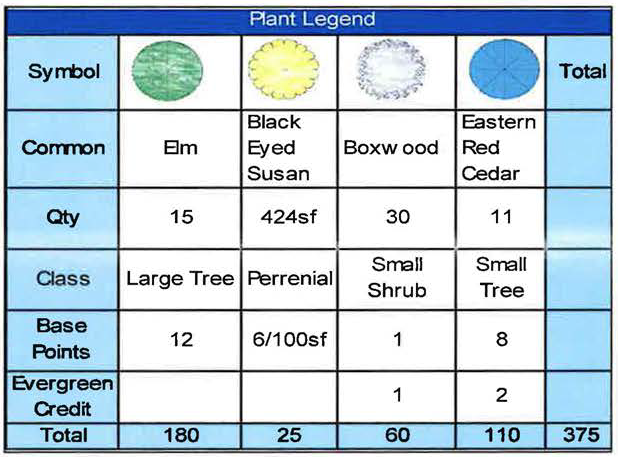
Different types and sizes of plants are worth different point values as set forth in the following table.
C.
The required number of points for any one area may be reduced by 40% if the total planting area is designed as a contiguous green space, serving as an approved vegetated low impact development stormwater management area, to include but not limited to, vegetated infiltration soils, cascade pools, rain gardens, or bioswales.
D.
The caliper of the tree trunk shall be measured at twelve inches (12") above the ground level.
E.
Existing healthy vegetation may be counted toward the required landscaping, subject to approval and plant type classification for point valuation by the Community Development Director.
F.
The use of hard scape materials and other non-living landscape materials, including but not limited to rock, stone, structural or decorative features such as fountains, reflecting pools, artwork, benches, gesturing and walkways, bicycle parking, and recreation facilities, may be proposed with final approval to be granted by the Community Development Director. However, in no case shall such hard scape or non-living landscape materials be approved which would exceed 25% of the total required landscaped area.
7.4.3.3 Minimum Requirements by Land Use Landscaping within any developed area must equal or exceed a minimum number of points in order to obtain approval. The number of points that must be achieved is based upon the land use as identified in the following table. When calculating points, quantities, areas and/or distances, values shall be rounded up to the nearest whole number.
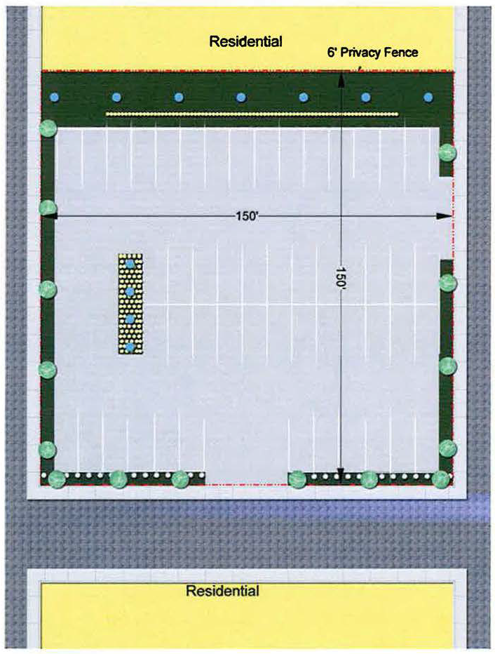
7.4.3.4 Example of Point Calculation and Layout
7.4.4 Drainage and On-Site Detention. All sites, including parking areas, shall be properly graded to provide for adequate storm drainage and on-site detention of stormwater. The proposed method of providing for stormwater drainage, both surface and subsurface, shall conform to the requirements contained in the Subdivision Regulations pertaining to design standards for storm drainage facilities. At the option of the City of Bartlesville, the developer may pay a fee-in-lieu of providing all or part of the required on-site stormwater detention facilities, if it is determined that the existing downstream regional stormwater facilities are sufficient in size and capacity to accommodate the increased flow generated by the proposed development.
7.4.5 Streets, Sidewalks, Access, and On-Site Vehicular Circulation
A.
All streets shall meet the standards and requirements of the Subdivision Regulations for the Bartlesville-Washington County Metropolitan Planning Area.
B.
No principal building shall be constructed on a lot that does not abut a public street, except where a private street has been approved by the City of Bartlesville or Washington County. The frontage of such a lot shall not be less than that required for the applicable zoning district.
C.
All development shall be designed to allow for cross-access to adjacent properties, where practical, to encourage shared parking and shared access points on public and private streets. A cross-access easement must be recorded prior to the issuance of a building permit.
D.
The design of ingress and egress facilities shall comply with the Bartlesville Municipal Code as well as any other applicable local, county, state, or federal regulation or requirement.
7.4.6 Lighting. Whenever exterior lighting is provided on the site, the lighting facilities shall be arranged so that illumination is directed away from adjacent properties and rights-of-way and will not interfere with traffic. Light poles shall not be placed in street rights-of-way or utility easements adjacent to street rights-of-way, except by franchised utility companies or by the City of Bartlesville, as a part of a street lighting project. All outdoor lighting shall be by shielded fixtures. Light fixtures shall be parallel to the final grade and installed so that no direct light will shine beyond the subject property. The height of light poles and fixtures shall be approved through the site plan process. Planning staff may approve an outdoor lighting plan as directed by the MAPC as a condition of site plan approval.
The submitted lighting plan shall include the following:
1.
A scale drawing of the site with all outdoor lighting locations shown;
2.
Pole type and height of fixture from base of the pole;
3.
Lamp type and size; and
4.
Fixture mounting and orientation.
Allowable heights of light fixtures shall be measured from the light-emitting surface to the base of the pole location as follows:
1.
Maximum height of sixteen (16) feet if located within fifty (50) feet of agricultural/residential zoned districts or any public right-of-way;
2.
Maximum height of twenty (22) feet if located within fifty-one (51) feet to two hundred fifty (250) feet of an agricultural/residential zoned district or any public right-of-way;
3.
Maximum height of thirty-five (35) feet if located a minimum of two hundred fifty-one (251) feet of an agricultural/residential zoned district or any public right-of-way;
4.
Maximum fixture height shall not exceed thirty-five (35) feet.
Searchlights shall require a special permit. If granted, such permit shall not be valid for duration longer than forty-eight (48) hours on a specific property, and such permit shall not be granted more than two times in one year. Searchlights shall not be permitted inside residential areas.
7.4.7 Outdoor Storage and/or Display of Materials or Goods. The outdoor storage or display of materials or goods is prohibited in an Office (0) and Neighborhood Shopping (C-2) Zoning District.
7.4.9 Soil erosion and sediment control-related measures are required during any construction activities causing land disturbance. Persons conducting any land disturbing construction activity must provide, implement, and maintain adequate structural and/or nonstructural best management practices (BMPs) to control erosion and prevent the discharge of pollutants to the area waterways and municipal storm water drainage system. All temporary construction site stormwater runoff control BMPs and post-construction stormwater runoff BMPs shall comply with the current City of Bartlesville Construction Standards and all ODEQ stormwater discharge requirements.
Additionally, any project with construction activities resulting in a total land disturbance of greater than or equal to one (1) acre or a disturbance of less than one (1) acre if the construction site is part of a larger common plan of development or sale that totals at least one (1) acre, must obtain a stormwater general permit for construction activities within the State of Oklahoma (OKR10) through the State of Oklahoma's Department of Environmental Quality (ODEQ). The required 'sediment and erosion control plan' and 'stormwater pollution prevention plan (SWP3)' must both be prepared following permit requirements and submitted to the City, as part of the construction plans submittal for review. Both the plans must comply with good engineering practices and meet all provisions of the OKR10 permit and follow city stormwater design requirements. Proof of authorized state permit may be required in a form acceptable to the environmental administrator prior to the allowing of any construction activities to begin.
A.
General.
1.
Soil disturbance shall be conducted in such a manner as to minimize erosion. Soil stabilization shall consider the time of year, site conditions, and the use of temporary and permanent measures.
2.
Properties and channels located downstream from development sites shall be protected from erosion and sedimentation. At points where concentrated flow leaves a site, stable downstream facilities are required.
3.
Soil erosion and sediment control features shall be constructed prior to the commencement of upland disturbance.
4.
If de-watering devices are used, adjacent properties shall be protected. Discharges shall enter an effective sediment and erosion control measure.
5.
For detached single-family residential development occurring one (1) lot at a time, alternatives to the standards of this section may be approved by the city engineer.
B.
Soil stabilization.
1.
Temporary soil stabilization must be initiated immediately on any disturbed areas where construction activities have permanently ceased on any portion of the site or will be temporarily inactive for fourteen (14) or more calendar days on any portion of the site. In the context of this provision, "immediately" means as soon as practicable, but no later than the end of the next work day, following the day when the earth-disturbing activities have temporarily or permanently ceased.
2.
Permanent stabilization shall be completed as soon as practicable, but no later than fourteen (14) calendar days after stabilization measures have been initiated, or seven (7) calendar days if discharging to an impaired water, or ORW, or ARC as defined and required in ODEO's OKR10 Permit. Permanent soil stabilization measures shall be applied to channels (including bed and banks) within fourteen (14) days of the end of primary disturbance of the channel.
3.
Permanent or temporary vegetation shall not be considered established until sufficient ground cover is mature enough to control erosion.
4.
Earthen embankments shall be constructed with side slopes with a vertical to horizontal ratio no steeper than 1:3.
C.
The lids of receptacles and screening enclosures without roof structures shall remain closed between pick-ups, and shall be maintained in working order.
7.4.10 Soil Erosion and Sediment Control. Soil erosion and sediment control-related measures are required for any regulated land disturbance activity, in accordance with the standards of this Section. All temporary measures and permanent erosion control and sediment control shall be maintained continuously in an effective working condition.
A.
General
1.
Soil disturbance shall be conducted in such a manner as to minimize erosion. Soil stabilization shall consider the time of year, site conditions, and the use of temporary and permanent measures.
2.
Properties and channels located downstream from development sites shall be protected from erosion and sedimentation. At points where concentrated flow leaves a site, stable downstream facilities are required.
3.
Soil erosion and sediment control features shall be constructed prior to the commencement of upland disturbance.
4.
If de-watering devices are used, adjacent properties shall be protected. Discharges shall enter an effective sediment and erosion control measure.
5.
For detached single-family residential development occurring one lot at a time, alternatives to the standards of this Section may be approved by the City Engineer.
B.
Soil Stabilization
1.
Temporary soil stabilization shall be applied to disturbed areas within 14 days of the end of soil disturbance to all areas that will not be final graded and stabilized within 45 days.
2.
Permanent stabilization shall be done within 14 days of final grading of the soil. Permanent soil stabilization measures shall be applied to channels (including bed and banks) within 14 days of the end of primary disturbance of the channel.
3.
Permanent or temporary vegetation shall not be considered established until sufficient ground cover is mature enough to control erosion.
4.
Earthen embankments shall be constructed with side slopes with a vertical to horizontal ratio no steeper than 1:3.
C.
Disturbed Areas
1.
Disturbed areas draining less than 1 acre shall be protected by a filter barrier (including filter fences, straw bales, or equivalent measures) to control all off-site runoff. Vegetated filter strips with a minimum width of 25 feet may be used as an alternative only here runoff if sheet flow is expected.
2.
Disturbed areas draining more than 1 but fewer than 5 acres shall be protected by a sediment trap or equivalent control measure at a point down slope of the disturbed area.
3.
Disturbed areas draining more than 5 acres shall be protected by a sediment basin or equivalent control measure at a point down slope of the disturbed area.
D.
Sediment Control
1.
All storm sewer facilities that are or will be functioning during construction shall be protected, filtered, or otherwise treated to remove sediment.
2.
A stabilized mat or aggregate underlain with filter cloth shall be located at any point where traffic will be entering or leaving a construction site to or from a public right-of-way, street, alley, or parking area.
E.
Removal of Temporary Measures
1.
All temporary erosion and sediment control measures shall be removed within 30 days after final site stabilization is achieved or after temporary measures are no longer needed. Trapped sediment and other disturbed soil areas shall be permanently stabilized.
7.4.11 Residential Protection Standards. The residential protection standards of this section are intended to protect residential properties and neighborhoods from the adverse impacts sometimes associated with adjacent multi-family dwellings and nonresidential development, whether public or private.
A.
Applicability and Exemptions. The standards of this section shall apply to all multi-family uses of three (3) or more units per structure and nonresidential development when such development occurs on a site located within 150 feet of any lot within an RS or RE district. Any lot so situated shall be considered a "protected" lot for the purposes of this section. The only exemption from these requirements that shall be considered by the Community Development Director shall be at the request of the owner or owners of the affected property or properties when stated in writing a preference for a standard which is less stringent than that which these standards would require.
B.
Residential Protection Screen. Whenever a development regulated by this Section adjoins or faces property subject to these residential protection standards, the following screening shall be required:
1.
An opaque ornamental fence, masonry or rock wall or dense evergreen hedge or effective equivalent as approved by the Community Development Director, having a height not less than six (6) feet and not more than eight (8) feet, shall be constructed and maintained in good condition along the side and/or rear lot line up to, but not beyond the abutting residential setback building line. Where a regulated development faces any protected property with an intervening public right- of-way, an ornamental fence, masonry or rock wall or dense evergreen hedge or effective equivalent as approved by the Community Development Director, having a height not less than three (3) feet and not more than four (4) feet shall be constructed and maintained in good condition along the lot line.
C.
Loading Operations. No use subject to Residential Protection Standards may conduct loading or unloading operations between the hours of 10:00 p.m. and 6:00 a.m.
7.4.12 Service Facilities. Service facilities, to include but not limited to water supply facilities, sanitary sewers, fire protection services, and any other utility services, both on and off site, shall be provided as is necessary for the proper development of the site. The provisions of such facility shall be as regulated by the standards contained in the Subdivision Regulations for the Bartlesville-Washington County Metropolitan Planning Area. The sanitary sewer expansion fee may be imposed as applicable in accordance with Ordinance #3062.
(Ord. No. 3443, § 1(Exh. A), 1-5-15; Ord. No. 3565, § 1(Exh. A), 1-3-23)
7.5 - Mobile Homes/Manufactured Homes, Recreation Vehicles, Recreational & Other Equipment & Commercial Vehicles
7.5.1
Parking of a mobile home in any district for residential purposes shall be prohibited, except as follows:
7.5.1.1
A mobile home may be parked in a mobile home park as provided by these regulations.
7.5.1.2
Where a residential structure has been built on a lot in an RA, RS or RM District, the Board of Adjustment may, on application of the owner of such lot, permit the parking of one mobile home in the rear yard of such lot, provided the Board makes a finding to the effect that the occupant or proposed occupant of the mobile home would suffer a material hardship, other than a financial hardship, if the mobile home were to be located in a mobile home park rather than on said lot. Such use shall be permitted only subject to the following conditions:
A.
That the mobile home be located not less than 10 feet from any lot line or residential structure, and
B.
That no rent or other compensation be paid for the privilege of parking said mobile home on said lot.
A permit granted under this provision shall be for a period of no more than 180 days, after which it may be renewed by the Board of Adjustment.
7.5.1.3
One freestanding mobile home shall be permissible on an individual parcel of land in the Bartlesville rural area in the Residence Agriculture zoning district subject to compliance with the requirements of Table 4.3. Permits for such freestanding mobile homes shall be issued by the Building Official.
7.5.1.4
Individual mobile homes may be permitted to occupy a zoning lot in RM or RS Residential Districts upon approval of the Board of Adjustment as a Special Zoning Permit with requirements as prescribed at the discretion of the Board, provided:
A.
The mobile home is compatible with the other residential improvements in the neighborhood as to both value and exterior appearance (such as: type of roof, color and gloss of paint, etc.).
B.
The mobile home has skirting made of durable materials suitable for exterior exposures, is installed in accordance with the manufacturer's installation instructions, and is secured to assure stability, to minimize vibrations, to minimize susceptibility to wind damage, and to compensate for possible frost heave. If combustion air for heat-producing appliance(s) is taken from within the under-floor area, ventilation shall be adequate to assure proper operation of the appliance(s). Use of combustible material (such as hay, straw, cardboard, etc.) shall be prohibited.
C.
Tie-downs for all mobile homes shall be provided in accordance with the State Fire Marshal's regulations and applicable Oklahoma Statutes and regulations.
D.
The mobile home is accessible in both the front and back with exterior stairways or steps and handrails as required by the building codes.
7.5.1.5
Individual mobile homes may be permitted in nonresidential zones upon approval of the Board of Adjustment with requirements as prescribed at the discretion of the Board, provided:
A.
If for residential purposes, only if related to another use which is the major activity on the parcel.
B.
If for nonresidential purposes, only for use directly related to the major activity on the parcel.
C.
Such mobile home shall be enclosed with an approved fence or planted hedge, not less than 7 feet in height with no openings to adjoining property other than the required entrances and exits to streets or public places.
7.5.2
Storage of Large Recreational Vehicles, Recreational Equipment and Certain Other Equipment
It is the purpose of these regulations to restrict the storage, in residential districts, of certain types of large recreational vehicles, recreational equipment and certain other equipment. Large recreational vehicles, recreational equipment and other types of equipment which include motor homes, travel trailers, slide-in pickup campers, utility trailers and haulers, watercraft and cattle trailers may not be stored on a vacant parcel in a residential district, and may not be stored nearer a public street than the front or exterior side building line in residential districts other than RA.
However, up to two regulated vehicles and/or pieces of equipment may be stored within a required front or exterior side yard upon determination by the Zoning Administrator that there is not reasonable access to the rear or interior side yard for such storage. In determining reasonable access the administrator shall take into consideration the width of the side yard and the extent to which access may be obstructed by existing improvements to the property. Approval of the Zoning Administrator shall be subject to the following conditions:
A.
Any regulated vehicle or piece of equipment, when stored within a required front or exterior side yard shall be on a surface suitable to prevent ruts and an unkept appearance. The surface must be a suitable replacement for any grass removed, such as pavement, gravel, crushed stone, or brick. Dirt and wood surfaces are prohibited.
B.
No regulated vehicle or piece of equipment shall be stored: closer than 10 feet from the edge of an abutting street pavement; within 2 feet of a sidewalk; so as to create a visibility barrier at an intersection; or be stored so as to violate any other ordinance of the City pertaining to traffic and vehicles.
C.
When stored in a required front yard all regulated vehicles and equipment shall be parked perpendicular to the abutting street (or radially if the abutting street is curved) unless on a circular drive.
7.5.2.1
Regulated Vehicles and Equipment. The above restrictions shall apply to the following types of vehicles and equipment:
A.
Any self-propelled recreational vehicle with an overall length greater than twenty-four feet or more than eight feet in height unless such vehicle is used daily as the owner's principal means of transportation.
B.
Any vehicle constructed with integral wheels to make it mobile and/or towable by a motor vehicle.
C.
Any structure designed to be mounted on a pick-up or truck chassis when stored on the ground.
D.
Any type of watercraft either mounted on a trailer or unmounted.
7.5.2.2
Temporary Parking. This ordinance shall not be construed to prohibit parking a regulated recreational vehicle or other equipment in a front or exterior side yard on a temporary basis for the purpose of loading or unloading, performance of maintenance or accommodating a temporary visitor. No recreational vehicle shall be used for living, sleeping, or housekeeping purposes on the premises, except for temporary living purposes for visitors.
7.5.3
Mobile Home Park Regulations Mobile home parks are intended to accommodate mobile homes for long-term occupancy. Consequently, mobile home parks are viewed as residential areas where environmental amenities are to be provided comparable to those normally found in subdivisions for fixed residences. Every mobile home park shall comply with all other pertinent City and/or State Regulations together with all amendments thereto subsequently adopted.
7.5.3.1
Districts. There shall be two mobile home park zoning districts (RT-1 and RT-2).
7.5.3.2
Criteria. The following table illustrates the criteria for mobile home park zoning districts.
7.5.3.3
Utilities Required. Municipal or other State Health Department approved water system capable of supplying fire hydrants installed in accordance with specifications of Oklahoma Inspection Bureau, and the American Insurance Association. Public sewer system or other disposal system which has been approved for requested number of units by the State Health Department. All mobile homes must be connected to sanitary sewer system within 72 hours of arrival in park. An individual electric service outlet shall be provided for each unit.
7.5.3.4
Wheels and Foundations. The wheels or other transporting devices of any mobile home located in a mobile home park may be removed. Any mobile home located in a mobile home park for more than 72 hours shall be securely anchored to the ground so as to attain the same resistance to wind as a fixed residence of comparable size, and park operators shall require tenants to skirt units so as to enclose the underneath area.
7.5.3.5
Concrete Slab. Each space shall be provided with a concrete slab of sufficient size to support wheels and front parking jack of the mobile home unit parked on the space.
7.5.3.6
Interior Streets. The following shall be minimum dimensions for interior streets:
7.5.3.7
Perimeter screen. Mobile home parks shall be enclosed with an approved fence or planted hedge not less than 7 feet in height with no openings to adjoining property other than the required entrances and exits to streets or public places, unless a finding is made by the Board of Adjustment that this is unnecessary due to the nature of the site.
7.5.3.8
Storm Shelter. Any mobile home park which can accommodate 5 or more mobile homes shall provide a storm shelter. There shall be provided within the shelter a minimum 1,500 sq. ft. with no less than 25 sq. ft. per mobile home parking space. If such shelter is constructed more than one-half (1/2) story above finished grade, a minimum of 400 cu. ft. shall be provided per mobile home space. The structure shall be capable of withstanding 90 m.p.h. wind loads. Adequate ventilation providing a complete change of air once each half (1/2) hour shall be required.
7.5.3.9
Additional Requirements. In addition to the foregoing, the Metropolitan Area Planning Commission and governing body may prescribe at the time of rezoning, such other conditions, requirements or limitations concerning the design, development, and operation of mobile home parks as it may deem necessary.
7.5.4
Recreational Vehicle Parks. Recreational vehicle parks are intended to accommodate recreational vehicles, campers, tent-trailers, etc., used for short-term occupancy, usually in connection with recreation trips, but also for certain business purposes. Such parks normally will require convenient highway access and proximity of other pertinent City and/or State Regulations together with all amendments thereto subsequently adopted.
7.5.4.1
Permitted Districts. Parks for recreational vehicles shall be permitted as follows:
A.
Parks for accommodation of transient or residential use recreational vehicles shall be permitted in RA, RT-1, RT-2, C-6, C-7, or M zoning districts upon review and approval of the Board of Adjustment as a Special Zoning Permit.
B.
Parks for the storage of unoccupied recreational vehicles may be permitted in any C-6, C-7, or M zoning district upon review and approval of the Board of Adjustment.
7.5.4.2
Criteria. The following chart illustrates the criteria for recreational vehicle parks:
7.5.4.3
Sewer. In recreational vehicle parks sanitary sewerage facilities may be provided collectively for temporary park occupants. Such sanitary disposal stations shall be provided for each 100 spaces (or fraction thereof) which are not served with individual sanitary sewer connections. A service building shall be provided for each 25 spaces which shall be furnished with flush toilets, showers, and lavatories.
7.5.4.4
Water. An adequate supply of pure and wholesome water for domestic purposes under sufficient pressure to keep all fixtures sanitary, and from a source approved by the State Health Department shall be provided.
7.5.4.5
Lighting and Electrical Connections.
A.
Adequate night lighting of walks and service buildings shall be provided.
B.
Forty percent (40%) of the camping sites shall be provided with electrical connections which are individually fused and of at least 20 amperes each.
7.5.4.6
Siting. Recreational vehicles and campers located in a recreational vehicle park shall not be permanently fixed to the ground in a manner that would prevent ready removal, nor shall the wheels or similar transporting devices of such vehicles be removed except for repairs.
7.5.4.7
Perimeter Screen. Recreational vehicle parks shall be enclosed with an approved fence or planted hedge not less than 7 feet in height with no openings to any adjoining property in a residential district other than the required entrances and exits to streets or public places, unless a finding is made by the Board of Adjustment that this is unnecessary due to the nature of the site.
7.5.4.8
Other uses. Other uses which may be permitted as a part of a recreational vehicle park development are:
A.
A convenience grocery primarily designed for convenience of campground users.
B.
Commercial laundry equipment primarily designed for convenience of campground users.
7.5.4.9
Additional Requirements. In addition to the foregoing, the Board of Adjustment may prescribe such other conditions, requirements or limitations concerning the design, development, or operation of recreational vehicle parks as it may deem necessary.
7.5.5
Commercial Vehicles and Trucks. One commercial vehicle per family living on the premises shall be permitted to be parked overnight on a residential lot. However, such vehicle shall not be permitted if it exceeds a gross vehicle weight (GVW) of 11,000 pounds rated capacity or if it is transporting any material or residue of material that if released from its container would accelerate the propagation of flame or contaminate the earth, groundwater, or atmosphere.
7.6 - Planned Unit Development
This section provides regulations that apply to Planned Unit Developments, also referred to in this section as PUD; as provided for in Title 11 O.S. Section 43-110 et al as revised. PUDs shall be created pursuant to the regulations provided herein and as further limited, expanded, or modified by the approval of a PUD site development plan through the application, review, and approval process identified herein.
7.6.1
General Provisions:
7.6.1.1
Purpose. PUD sites are intended to be developed as integrated project units giving special consideration of their impacts upon the community and therefore, special attention for their development and expansion. These PUD regulations are aimed at providing this special attention, yet still to encourage the flexibility and innovation in the development of land.
The general purposes of a planned unit development are:
1.
To encourage a more creative approach to the development of land and variety in design, layout and type of structures constructed that will result in a more efficient use of land and open area, the conservation of natural resources and energy, and provide for efficient use of public services, utilities, facilities, and improvements; and
2.
To permit flexibility in design, placement of buildings, and use of open spaces, circulation facilities, and off-street parking areas and to best utilize the potential of sites characterized by special features of geography, topography, size or shape; and
3.
To insure compatibility in the development of land with adjacent land uses and in a manner which promotes a socially and economically desirable development pattern and an attractive and safe living environment; and
4.
To provide better housing, employment and shopping opportunities particularly suited to the needs of the residents of the community.
7.6.1.2
Location. Planned Unit Developments are required on tracts located within a district or districts having the supplemental district designation PUD as identified on the official zoning map for the Bartlesville Metropolitan Area.
Additionally, a supplemental district designation PUD is required when requesting a rezoning of land to an office, commercial (including RM or RT), or industrial zoning district designation, (Note: Governing body approval of the site development plan is also required as part of the rezoning request in this case.)
7.6.1.3
Size. There shall be no minimum or maximum size limitation for the development of a PUD.
7.6.1.4
Underlying Zoning District Standards. In every instance, the PUD is to be reviewed as to the proposed location, character of the uses, and the treatment of the development of the tract with surrounding land uses. The regulations of the underlying zoning district or districts remain applicable except as specifically modified pursuant to the provisions of this section and by the approval of the PUD site development plan.
7.6.1.5
Subdivision of Land. Platting of land in accordance with the Subdivision Regulations for the Bartlesville Metropolitan Area shall be required for any PUD which proposes:
A.
the division or re-division of land into two or more tracts, lots, sites, parcels, units, plots or interests for the purpose of sale, lease or development, anyone of which when subdivided shall contain less than ten (10) acres in area; or
B.
the dedication of any street, alley, easement, public improvement or other public right-of-way or facility.
7.6.2
Uses Permitted in Planned Unit Developments: Land uses permitted in a PUD shall be those as established herein and as further modified by the approval of the PUD site development plan.
7.6.2.1
Principal Uses. The principal land uses in a Planned Unit Development shall be those permitted in the underlying zoning districts(s) involved or those uses permitted in more restrictive zoning districts (i.e., in a commercial district, a Planned Unit Development could be dominated by shopping facilities or dwelling units, but in a multifamily residential district, the predominant land use shall be dwelling units). The principal uses, other than dwellings, which are permitted by right or exception in the RS districts maybe included within a PUD, if such uses do not occupy more than 10% of the gross area of the PUD, and are designed and located to be compatible with the residential uses of the PUD and with the residential use of adjacent properties.
7.6.2.2
Accessory Uses. Accessory uses which are customarily incidental to the principal uses of the PUD are permitted. Accessory signs shall comply with the provisions of the underlying zoning district(s) except as hereinafter provided for accessory commercial uses. Within a PUD in a residential district, accessory commercial uses may be included in accordance with the following provisions:
A.
In developments proposing commercial uses as a part of a PUD within a residential district, the following factors shall be considered:
1.
The relationship of the proposed commercial use to:
a.
The land parcel (both as to boundary, shape, and topographic and other physical features),
b.
Surrounding land and land uses which are impacted by the proposed development, and
c.
The overall arrangement of the proposed development.
2.
The nature of the commercial use as it applies to providing service, convenience and benefit to the residents of the PUD.
B.
In developments proposing more than one business, the aggregate floor area of the commercial uses shall not exceed 50 square feet per dwelling unit nor a total of 30,000 square feet.
C.
Each commercial establishment shall be limited to a maximum of 3,500 square feet of floor area.
D.
Commercial signs shall be limited to one nameplate of not more than 16 square feet for each establishment. Nameplates shall be attached flat against a building wall and shall not be animated, flashing, or have other than indirect illumination. Window signs shall not be permitted.
E.
The commercial area shall be designed primarily for the service, convenience, and benefit of the residents of the PUD, however, a commercial establishment may be permitted which is designed to serve patrons both inside and outside the development if it is determined that a land use problem is not likely upon consideration of the items listed in 7.6.2.2A above.
7.6.3
Site Design Standards. Whereas it is the intent of these regulations to allow flexibility in the regulation of land development and the design of all PUDs, it is deemed necessary to establish standards by which to evaluate good design. To satisfy this necessity, the following design standards are set forth for general application in all PUD projects. These site design standards may be further modified by the approval of the PUD site development plan.
7.6.3.1
Bulk and Area Requirements. The bulk and area requirements for a Planned Unit Development project (including lot area, area per unit, and percent of lot coverage, exclusive of the area of public or private streets, and building setbacks) shall meet the requirements of the underlying zoning district(s) wherein the project is located (as set forth in Tables 4.3, 5.2, and 6.3), except as further modified in Section 7.6. If the project area falls in two or more zoning districts in which Planned Unit Developments are permitted, the area requirements of the project shall be established by calculating the requirements of the various districts as applied to the amount of area in each district. In a PUD, all area used for development purposes, including recreation areas, open space areas, parking lots, and similar spaces, may be counted as part of the aggregate development area for computation of minimum area requirements. The area of Planned Unit Development shall be considered as one parcel regardless of the extent to which the area may be divided by interior streets or other features.
7.6.3.2
Height Requirements. The height of buildings shall not be more than 1-1/2 times the distance between the building line and the edge of pavement of the nearest street. The building measurement shall be from the ground floor level to the eave or top of the vertical wall should there be no eave. Buildings of greater height than otherwise permitted in the underlying zoning district(s) may be permitted through the site development plan review process.
7.6.3.3
Perimeter Requirements. In order to complement development on adjacent properties, at all peripheral lot lines, the building setback from the exterior boundaries of the PUD shall not be less than the minimum yards customarily required for the underlying zoning district(s) in which it is located, unless such perimeter setback requirements is modified or waived when approved by the MAPC. Such modification or waiver shall be based upon findings that topographic conditions, existing trees and other vegetation, proposed land grading and plant materials, or other site conditions perform the same functions as the required yards.
Perimeter screening shall be required for any non-residential structure along exterior boundaries of the PUD which are adjacent to any residentially zoned area. Such screening may be accomplished through the provision of landscaped berms, a compact hedge, fence, wall or a combination of any of these methods and shall be at least five feet in height. This screening shall serve to protect the residents of adjoining residential districts from undesirable views, lighting, noise or similar adverse influences within the PUD project.
7.6.3.4
Off-Street Parking and Loading. Off-street parking and loading spaces shall be provided as specified for the applicable use (as set forth in Tables 4.3, 5.2, and 6.3). Alternate designs providing for reasonable sharing of parking spaces by land uses may be considered through the site development plan review process. Required spaces may be provided on the lot containing the units for which it is intended to serve or in common areas. Common parking area shall be designed and located so as to be accessible to the units it is intended to serve. Provisions for the ownership and maintenance of common parking space as will insure its continuity and conservation shall be incorporated in a subdivision plat, if required, or through recorded private deed restrictions.
Unenclosed off-street parking areas for non-residential uses, containing 5 or more spaces, and unenclosed off-street loading areas shall be screened from adjacent residential zoned areas by the erection of screening wall, fence, or hedge of acceptable design along the lot line or lines in common with the residential district provided that if the parking area is located more than 50 feet from the residential district, screening requirements may be waived through the site development plan review process.
7.6.3.5
Service Facilities. Service facilities, to include but not limited to streets, water supply facilities, sanitary sewers, fire protection services, and stormwater and groundwater detention facilities, both on and off-site, shall be provided as is necessary for the proper functioning of the PUD. These services shall be provided at no cost to the public unless allowed by the governing body. The provision of such facilities shall be as regulated by the standards contained in the Subdivision Regulations for the Bartlesville Metropolitan Area and other applicable codes and ordinances of the City of Bartlesville.
7.6.4
Phased Development. An applicant may submit a PUD phased development plan in lieu of a site development plan for the entire PUD which proposes the overall phased development of the project with the submittal of site development plans for each phase as development occurs. This PUD phased development plan shall be reviewed by the MAPC following the procedures and approval criteria as stated in Section 7.6.5.
A phased development plan for the entire PUD will be treated as a preliminary site development plan for each phase. It must contain the information required in Section 7.6.5.2 and include a description of the phases, showing the approximate area, timing, and sequencing of each phase. Approval of a phased development plan may not exceed 10 years between the first and last phases. In reviewing and approving a PUD phased development plan, the MAPC may require the sequencing of the phases and intervals of time between the scheduled phases as a condition of plan approval.
Thereafter, as development is to occur, final site development plans for each phase shall be submitted to and approved by the MAPC following the procedures and approval criteria contained in Section 7.6.5. If development of the PUD exceeds 10 years, approval of undeveloped phases expires unless extended by the MAPC pursuant to Section 7.6.5. Once expired, further development of the PUD shall be considered as new development and processed pursuant to the steps set forth in this Section.
7.6.5
Administration of Planned Unit Development. A PUD is reviewed in a two-step process: pre-application conference and staff level review of the site development plan, and site development plan review by the Metropolitan Area Planning Commission also referred to in this section as MAPC.
7.6.5.1
General. Any person, corporation, partnership, association, or combination thereof, owning or possessing a property right or interest in or to a tract may make application for the supplemental district designation PUD. Such application shall be accompanied by a site development plan processed in the manner set forth herein.
A supplemental district designation PUD is required when seeking to rezone a tract of land to an office, commercial or industrial district. Note: The rezoning of a tract of land requires governing body review and approval pursuant to Section 12 of this ordinance and at the time of consideration of such rezoning request by the governing body, the PUD site development plan shall also be reviewed and approved by the governing body as part of the rezoning procedure. The MAPC will have final review of a PUD site development plan only in the instance where the zoning of the site is already in place.
7.6.5.2
Application and Site Development Plan. An application for a PUD shall be filed with the Secretary of the MAPC. The application shall be accompanied by the payment of a processing fee, as identified in Appendix A, which shall include advertising and sign costs. The application shall be in such form and content as the MAPC may by resolution establish, provided that three copies of a preliminary site development plan shall accompany the filing of the application. The site development plan shall provide the following information either on the site development plan itself or in written text that accompanies such plan:
A.
Existing topographic character of the land including floodplain areas.
B.
A specific list of proposed land uses for this PUD, including public uses, park land and open space.
C.
The location of all proposed and/or existing buildings and other structures, including height, setback, and size and usage of all such buildings in square footage, off-street parking and loading areas, and external lighting and signage.
D.
A description of the character of the development and the proposed density of the development. Density shall be expressed in numbers of dwelling units for residential area and in floor area ratio for area of each identifiable segment of the development.
E.
The location of thoroughfares which provide access to the development, proposed ingress and egress, anticipated traffic flows to and from the site based upon actual traffic counts for the proposed user or, in the absence of such, rates contained in the ITE publication Trip Generation.
F.
The location of all existing and proposed public service facilities and related existing and proposed easements, including but not limited to water supply facilities, sanitary sewers, fire protection services, and stormwater and groundwater detention facilities, both on and off-site.
G.
Sufficient surrounding area to demonstrate the relationship of the development to adjoining uses, both existing and proposed.
H.
A detailed landscape plan, including proposed screening and buffering of the development from adjoining residential areas.
I.
The expected schedule of development, including information on any proposed multi-phasing of the development.
J.
In addition, the Community Development Director may require the applicant to provide elevations and perspective drawings of proposed buildings as part of a Site Development Plan.
7.6.5.3
Pre-application Conference and Staff Level Review. The Secretary to the MAPC shall then set a pre-application conference with the applicant and the appropriate city staff or review of the proposed site development plan. This meeting shall be scheduled within fourteen (14) days of the receipt of the application. The purpose of this conference is to discuss and resolve conflicts with the proposed site development plan and to provide suggestions for improvement. Comments received from this staff level review of the proposed site development plan will be included in the staff report to the MAPC.
7.6.5.4
Citizen Participation Activities. In order to encourage public participation in the development review process, the applicant of every application for zoning map amendment or other such application which requires a public hearing (such as a Planned Unit Development application) shall provide for citizen participation activities prior to the first public hearing as required by Section 12.l.4 of these regulations.
7.6.5.5
Public Hearing and MAPC Action. The Metropolitan Area Planning Commission Secretary, upon the filing of an application for the supplemental district designation PUD, shall set the matter for public hearing and give 15 days notice thereof by publication in a newspaper of general circulation. Additional notice shall be given by the posting of a sign or signs on the property and by the mailing of a notice to all owners of property within 300 feet of the exterior boundary of the property 20 days prior to the public hearing.
Within 60 days after the filing of an application, the MAPC shall conduct the public hearing and review the site development plan. In its review, the MAPC shall determine the following factors and may, at its discretion, require additional conditions to the PUD which are related to land use and development:
A.
Whether the proposal is consistent with, and promotes the intent and purpose of the Comprehensive Plan.
B.
Whether the proposal is compatible with and harmonizes with existing and expected development of surrounding areas, the natural environment, and the planned capacities of public services and facilities affected by the proposed land use.
C.
Whether the proposal is a unified treatment of the development possibilities of the project site.
D.
Whether the proposal would benefit orderly and proper development of the metropolitan area.
E.
Whether the sidewalks and streets provide a traffic flow compatible with the development and surrounding street pattern.
F.
Whether the proposal is consistent with the public health, safety, and welfare of the community.
Following its review of the site development plan, the MAPC may vote to approve, disapprove, modify, or return the final site development plan to the staff for further consideration.
Upon approval of the site development plan, the Official Zoning Map for the Bartlesville Metropolitan Area shall be amended to reflect the case number of the PUD, which number shall be placed on the location of the subject property on said map. The applicant shall then be authorized to process a subdivision plat for this PUD if such platting of land is required pursuant to the Subdivision Regulations for the Bartlesville Metropolitan Area (refer to Section 7.6.1E).
If the PUD site development plan is a part of a rezoning request, the MAPC shall forward the application along with its recommendation on the rezoning request and the site development plan to the City Councilor Board of County Commissioners for further hearing as provided in Section 12 of this ordinance. Upon final approval by the governing body of the rezoning request, the PUD site development plan and the appropriate ordinance of rezoning, these documents shall become a part of the official records of the City of Bartlesville. The ordinance of rezoning shall adopt the PUD site development plan by reference, and both the legal description and the final site development plan, signed and dated, shall be attached to said ordinance and become a part of the official records of the City of Bartlesville.
7.6.5.6
Time Limitation. A site development plan automatically expires and is void if the applicant fails to file for a building permit or other necessary development permit(s) within three years of the effective date of approval of the site development plan unless:
A.
The applicant has received a time extension for the final site development plan from the MAPC, subject to the following conditions:
1.
The MAPC may extend a final site development plan, for a period of time not to exceed one year, if: (a) unforeseen circumstances or conditions necessitate the extension of the final site development plan, and (b) termination of the approval of the final site development plan would result in unreasonable hardship to the applicant and the applicant is not responsible for the delay, and (c) an extension of the final site development plan will not cause substantial detriment to existing uses in the immediate vicinity of the subject property or to the community as a whole.
2.
The MAPC may grant no more than two extensions, a second extension being granted if: (a) the criteria listed in paragraph 1 above are met, and (b) the applicant has demonstrated reasonable diligence in attempting to meet the time limit imposed, and c) conditions in the immediate vicinity of the subject property have not changed substantially since the final site development plan was first approved by the governing body.
B.
The site development plan approval provides for a time period greater than three years.
7.6.5.7
Issuance of Building Permits. After approval of a site development plan by the MAPC, the Building Official is authorized to issue building permits on lands within said PUD in accordance with the approved site development plan. Said site development plan and other required drawings and/or documents detailing the specifics of the development as are necessary to insure full compliance with the approved PUD shall be submitted to the Building Official for review and approval. No work shall commence on the site of a PUD project prior to the receipt of a building permit for such work, provided, however, that subject to the approval of the City Engineer, excavation, grading, and clearing operations may proceed at any time following approval of the PUD site development plan.
Building permits may be issued on said site development plan prior to the approval of a final subdivision plat by the governing body, if such is required, provided that appropriate financial guarantees for the completion of all public improvements required for the PUD have been provided and accepted by the governing body.
If the PUD is to be developed in phases, all public improvements necessary to assure the proper operation and functioning of each phase shall be constructed and installed prior to the issuance of any building permit for said phase, or appropriate financial guarantees shall be provided to insure the construction of such improvements.
For PUDs proposing commercial uses as a part of a PUD within a residential district, no building permit shall be issued for a freestanding or separate commercial structure until significant progress has been made on other aspects of the proposed development, as follows:
A.
Completion of one-third (113) of the noncommercial features in a project of less than ten (10) acres,
B.
Completion of one-half (1/2) of the noncommercial features in a project of more than ten (10) acres, and
C.
The MAPC has received a satisfactory progress report on such construction activity.
7.6.5.8
Amendments.
A.
Minor amendments. Amendments to an approved PUD which are minor in nature may be authorized by the Community Development Director upon a review of a proposed amended site development plan, incorporating such changes, so long as substantial compliance is maintained with the original approved site development plan and the purposes and standards of the PUD provisions hereof. A change which would represent a minor amendment to an approved PUD site development plan would include:
1.
One which is necessary because of natural features of the subject property not foreseen by the applicant or the City prior to the approval of the preliminary site development plan; and
2.
One which will not have the effect of significantly reducing any area of landscaping, open space, natural area or parking; and
3.
One which will not have the effect of increasing the density or significantly increasing the total amount of floor area of the Planned Unit Development; and
4.
One which will not result in any structure, circulation or parking area being moved significantly in any direction; and
5.
One which will not reduce any setback approved as part of the preliminary site development plan by more than 10% and the required minimum setback is met; and
6.
One which will not result in a significant increase in the height of any structure as approved in the preliminary site development plan; and
7.
One which will not increase or create any adverse impacts or undesirable effects of the PUD on the surrounding neighborhood.
B.
Major amendments. Amendments which would represent a significant departure from the approved site development plan shall require compliance with the notice and procedural requirements as set forth in Section 7.6.5 and the subsequent approval of the amendment by the MAPC. Changes which would represent a major amendment to an approved PUD site development plan would include:
1.
An increase in the density, including the number of housing units;
2.
In residential districts, a change in the mix of houses and multi-dwelling structures and increases in the amount of land for nonresidential uses;
3.
A reduction in the amount of approved open area;
4.
Changes to the vehicular system which result in a significant change in the amount or location of streets, common parking areas, and access to the PUD;
5.
Changes within 50 feet of the perimeter of the PUD where it abuts a residentially zoned area;
6.
Other changes of similar scale that do not meet the seven requirements of a minor PUD amendment as stated above.
7.6.5.9
Abandonment. Where a PUD has been processed pursuant to the supplemental district designation PUD, its abandonment shall require approval of the MAPC.
7.6.6
Appeals. Appeals to the Governing Body from Actions of the MAPC. Any person aggrieved by the final action or decision of the MAPC on a proposed site development plan may appeal such action to the governing body by filing with the Secretary to the MAPC within 10 days of the action appealed from a written notice of appeal stating the grounds thereof.
Appeals to the District Court from Actions of the City Council and/or Board of County Commissioners. Any person aggrieved by the final action or decision of the City Councilor the Board of County Commissioners on a proposed site development plan may appeal such action to the District Court by filing with the City Clerk within 10 days of the action appealed from a written notice of appeal stating the grounds thereof. There shall be no right of appeal from any act of the MAPC taken in its advisory capacity to the City Council or the Board of County Commissioners.
7.7 - Miscellaneous Uses.
This subsection sets forth special provisions applying to certain miscellaneous uses in certain zoning districts. In all instances where a special zoning permit from the Board of Adjustment is required as set forth in Section 10.5 and where the meeting of special conditions is required, such permit shall not be granted before the Board of Adjustment has made a finding to the effect that the proposed use, as described in applications, plans, or other documents submitted by the applicant for such permit, will meet such conditions.
7.7.1
General Uses.
1)
Airport, aircraft landing strip, or heliport shall be located no nearer than 600 feet to any other property in a residential district; shall provide runways or other landing spaces only so located and oriented that aircraft landing and taking off do not normally pass directly over residential district below 200 feet; and shall be so located that air or land traffic shall not constitute a nuisance to neighboring uses. Proponents shall also show that adequate measures will be taken to prevent offensive dust, noise, vibrations, and bright lights; and that the field in question meets the standards of the Federal Aviation Agency for the particular class of field proposed to be developed.
2)
Animal hospital, pound, or shelter; commercial kennel for cats or dogs; livestock sales or feeding facilities; riding academy; public stable; veterinarian's office with animals on the premises; shall be located no nearer than 200 feet minimum to an RS, RM, or RT District subject to review by the Board of Adjustment, and no nearer to a zoning lot line than 100 feet. Proponents of such uses shall show that adequate measures will be taken to prevent odor, dust, noise, or drainage from becoming a nuisance to uses on other properties. Incineration of animal refuse shall be permitted, provided that the incineration facility is smokeless, odorless and meets all environmental regulations. Further, an approved system of biosolid disposal shall be required.
3)
Animal hospital, small animal treatment. Restricted small animal hospitals may be located in the C-5, C-7, or M districts, or within the RA district with approval of a SZP, provided the following conditions are met:
A.
These facilities shall not be permitted within 200 feet of RS, RM, or RT districts.
B.
Plans and specifications for proposed facilities shall detail provisions for soundproofing, avoidance of odors, and satisfactory sanitary services. These plans shall be submitted to the Community Development Department for review.
C.
Such facilities shall be restricted to treatment of common household pets.
D.
Animals shall be kept on the premises only for purposes of medical treatment to the exclusion of boarding.
4)
Automobile laundry shall provide space on the zoning lot for not less than ten automobiles per washing lane.
5)
Automobile, go-cart, miniature auto, racing or driving tracks shall be located not less than one thousand (1,000) feet from any residential district unless enclosed by a solid fence or wall at least six (6) feet high, but in no case shall a track be located less than five hundred (500) feet from any residential district.
6)
Cemetery, columbarium, crematory, or mausoleum shall have its principal entrance or entrances on a major thoroughfare, with ingress and egress so designed as to minimize traffic congestion and shall provide a wall at least six feet high or an evergreen hedge at least six feet high and three feet thick, along all property lines except those adjacent to a street.
7)
Church or other place of worship shall be permitted in the following districts, subject to the indicated site standards, unless more restrictive standards are provided elsewhere in these regulations:
8)
Club or lodge, where permitted in residential districts, shall observe the site standards required for churches in Subparagraph 7.7.1(7) and shall be so located that no ingress or egress (other than a service entrance on an alley) is from any street other than a major thoroughfare. No swimming pool, tennis court, or other recreational facility which is accessory to a private club or lodge shall be located nearer to other property in a residential district than one-half the required yard, and wherever any such facility is located within any part of a required side or rear yard, adjoining property in a residential district shall be effectively protected by a wall, hedge, and/or heavy screen planting, at least six feet high.
9)
College or university shall be located adjacent to a major thoroughfare and shall observe the site standards required for churches in Subparagraph 7.7.1(7).
10)
College dormitory, fraternity or sorority house in an RS district shall have a site area of at least 1 acre and side and rear yards of at least 25 feet each, or in an RM or RT district shall have a site area of at least 10,000 square feet and side and rear yards of at least 10 feet each. Further, such facilities shall have its main ingress and egress on a major thoroughfare.
11)
Dance hall, commercial, shall provide parking with ingress and egress designed so as to minimize traffic congestion, shall be not less than 20 feet from any property line, shall provide a minimum six foot high solid board fence or masonry wall separating the entire area from any abutting property in an R district, and shall show that adequate controls or measures will be taken to prevent offensive noise, light, and vibration.
12)
Earth moving and excavation; depositing of construction materials on the ground: shall be subject to regulations set forth in Subparagraph 7.7.1(17).
13)
Golf driving range, commercial, shall be located only on major thoroughfares. Lights used to illuminate the premises shall be so directed and shielded as not to be an annoyance to any developed residential property. The golf driving platform shall be not less than 200 feet from any RS, RM, and RT district. A special zoning permit may be granted by the Board of Adjustment to be in force for one year only, which permit may be renewed for a period of one year at the expiration of such permit, provided all requirements of these regulations have been and can continue to be complied with. See also Section 7.4.2.4.
14)
Golf course or country club shall be subject to regulations set forth in Subparagraph 7.7.1(8), "Club or lodge."
15)
Institution for human care and similar establishments, including health center; hospital, general (not including animal); institution for correctional, detention, penal, or similar purposes or care of insane, feeble-minded, or narcotic patients; institution for children or the aged; nursing home or rest home; rehabilitation center for handicapped persons; or sanatorium, shall meet the following requirements:
A.
Minimum site standards set forth for churches in Subparagraph 7.7.1 (7) shall be complied with.
B.
The site shall have its main ingress and egress on a major thoroughfare, or on a collector street not more than 2,640 feet (1/2 mile) distant (by shortest street route) from a major thoroughfare.
16)
Junk yard, including salvage and auto wrecking, shall be permitted, provided that all exterior storage and processing areas are screened by solid walls or fences of such height and location as to prevent visibility of stored materials or of materials in process from any point six feet above the ground on any thoroughfare in any residential, commercial, or M-l district, provided such point is not more than 300 feet distant from the nearest part of the fence.
17)
Mining, including extraction of clay, gravel, or sand; quarrying of rock or stone; earth moving and excavation; depositing of construction material, clay, earth, gravel, minerals, rock, sand, or stone, on the ground shall not be construed to be a permitted use in any district, except the M-3 district, unless and until a special zoning permit shall first have been secured from the Board of Adjustment, as provided in Subsection 10.5 hereof, except for the following defined extractions and deposits:
A.
Excavations for the foundation or basement of any building or for a swimming pool for which a building permit has been issued, or deposit on the earth of any building or construction materials to be used in a structure for which a building permit has been issued.
B.
Grading of any parcel of land for a permitted use where no bank is left standing and exposed of more than 4 feet in vertical height and a slope of less than 3: 1, or when less than 25 cubic yards of earth is removed from or hauled to the premises.
C.
Grading in a subdivision which has been approved by the City in accordance with the Bartlesville Metropolitan Area Subdivision Regulations and any amendments thereto.
D.
Any extractive operation existing and operating as such on the effective date of this section; such operation shall conform to the provisions of these regulations within one year of adoption of these regulations.
The Board of Adjustment shall have the power to grant special zoning permits, revocable and valid for specified periods of time, to permit mining or extractions from or deposits on the earth of rock, stone, gravel, sand, earth, minerals, or building or construction materials, as set forth in Subsection 10.5 of these regulations. The Building Official shall make such inspections as he deems necessary or as are required by the Board of Adjustment to ensure that all work is in accordance with the special zoning permit.
18)
Monastery, convent, or similar institution of religious training shall have a site area of at least 10,000 square feet.
19)
Newspaper distribution station shall be maintained in a slightly condition with newspaper, wrappers, and waste materials stored and handled within a completely enclosed structure until removed from the premises.
20)
Place of public assembly, major, including arena, auditorium, coliseum, stadium, or theater, or enclosed or indoor commercial theater with seating capacity of 1,000 or over and drive-in theater, shall meet the following requirements:
A.
Have ingress and egress from a major thoroughfare or from a collector street not more than 300 feet distant (by shortest street route) from a major thoroughfare.
B.
Have ingress and egress so designated as to minimize traffic congestion and hazards.
C.
Meet the site standards required for churches in Subparagraph 7.7.1(7).
A drive-in theater shall be located not less than 200 feet from any RS, RM, or RT district, and no projection screen thereof shall be so located as to be visible from any major thoroughfare within 1,000 feet thereof.
21)
Place of public assembly, minor, including art gallery; auditorium, arena, coliseum, stadium, or theater, or enclosed or indoor commercial theater with seating capacity of less than 1,000; community building; library; and museum, shall meet the same requirements as set forth for major places of public assembly in Subsection 7.7.1(20), except that ingress from and egress to a collector street need not be within 300 feet of a major thoroughfare.
22)
Swimming pool. Any swimming pool, 24 inches or greater in depth, in any district shall:
A.
Be located at least 10 feet from the nearest property line, unless a greater separation is required by Subparagraph 7.7.1(8).
B.
Be enclosed with a fence at least four (4) feet in height having no opening or space greater than four (4) inches, and be equipped with spring or automatic closing and latching gates with the latch being located at the top of the fence so as to prevent uncontrolled access by children from the street or any adjacent property.
C.
Be screened by a masonry wall or solid fence at least six feet high on any side facing the property line of any property in a residential district, unless the pool is more than 30 feet distant from such line.
D.
Require the issuance of a building permit.
No swimming pool shall be permitted in any residential district unless such pool:
A.
is owned and operated by a public agency or a residential group from within the subdivision in which the pool is to be located,
B.
is accessory to a residential use, or
C.
is accessory to a nonresidential use which is permitted in such district.
Except for a pool owned and operated by a public agency or a residential group from within the subdivision in which the pool is to be located, no pool shall be permitted in any residential district unless the pool is intended for the use of, and is used by, only the occupants of the principal use of the property on which the pool is located.
23)
Nursery, Garden Center shall be defined as land or greenhouses used to raise or stock imported flowers shrubs, trees and plants for sale. Accessory sales of nursery-related items may also be included. Examples of such items shall include, but not be limited to: fertilizers, plant food, peat, landscape materials and manually operated hand garden tools, but shall not include hardware, patio furniture, lawn mowers, root-tillers, weed trimmers and the like. Such use may be permitted in an RA Zoning District upon approval of a Special Zoning Permit by the Board of Adjustment. A site development plan shall be drawn to an appropriate scale and indicate existing and proposed structures, drives and parking areas, provisions for site screening and landscaping, site drainage and utilities. One freestanding business sign with a display surface area not exceeding fifty square feet in area per sign face and not exceeding eight feet in height shall be permitted. Provided, however, that for every four feet of frontage exceeding 200 feet an additional one square foot of display surface area may be allowed up to a maximum of 100 square feet. If the property frontage exceeds 200 feet on anyone side an additional changeable copy sign, not to exceed 80 square feet per sign face will be permitted. Illumination of signs, if any, shall be by indirect lighting.
In considering such applications, the Board of Adjustment shall take into account the appropriateness of the proposed site for such use with particular attention to the effect such use will have on traffic ways and adjacent land uses. In approving such use the Board of Adjustment may impose such conditions or requirements as it deems necessary to substantially preserve the property rights of adjoining owners and the public interest.
Any substantial modification or deviation from the approved site development plan must be submitted to the Board of Adjustment for review. A substantial modification shall be any change resulting in an increase in the floor area ratio or impervious surface area of the site; a reduction in the screening or buffer area adjacent to residential properties or public right-of-way; or grading changes which result in the alteration of the drainage pattern.
24)
Bed and Breakfast. For the purpose of these regulations a Bed and Breakfast shall be defined as a use carried on in a structure designed for a single family residence which provides to the general public overnight accommodations and breakfast. Such uses may be permitted in any residential district with approval of a Special Zoning Permit subject to the following conditions:
A.
The operator or host family must reside on the premises.
B.
The bed and breakfast home may have no more than four guest rooms or host more than eight overnight guests at one time.
C.
Guest quarters must be within the principal structure. If guest quarters are to be located within a detached accessory structure (i.e., a garage apartment) approval must be granted by the Board of Adjustment.
D.
One off-street parking space for each guest room is required in addition to the spaces normally required for the dwelling. However, it is not the intent to encourage yards to be destroyed, landscaping removed, or the integrity of the neighborhood altered in order to provide parking. The Board of Adjustment may, upon appeal, waive such additional required parking when it is determined that sufficient parking exists within the neighborhood.
E.
One freestanding or wall-mounted sign with a maximum size of six square feet may be displayed. Its size, color, text and location shall be identified on the permit application. The words "hotel" or "motel" shall not be allowed. Illumination, if any, shall be by general or indirect lighting.
F.
Overnight guests may be provided no more than two (2) meals in a 24-hour period provided that cooking facilities are approved, if necessary, by the County Health Department. Such approval, if needed, is to be secured prior to approval by the Board of Adjustment of a bed and breakfast use.
G.
The Board of Adjustment may grant approval for limited accessory uses which may be determined to be ancillary or supplemental to the bed and breakfast use (i.e., use of facility for wedding receptions, social gatherings and clubs, limited food service, etc.). Such approval shall be granted by the Board of Adjustment based upon a review of specific site considerations (i.e., site area, ingress and egress, off-street parking, buffering, etc.) to insure that the purpose and intent of the Home Occupation Regulations are fulfilled. If such additional accessory uses are approved by the Board of Adjustment, such uses may be further limited by the stipulation of additional operational conditions.
H.
Modifications or variations to the above-stated conditions may be considered and permitted, subject to Board of Adjustment approval.
25)
Public Land Uses Not Included Elsewhere. Uses of public lands in residential districts that are not specifically identified elsewhere in the zoning ordinance may be approved by the Board of Adjustment as a Special Zoning Permit.
The Board of Adjustment shall recommend approval upon finding that the proposed use is consistent with the objectives and policies of the Comprehensive Plan and compatible with the adjacent zoning and land use patterns. Applications for special use permits shall include a detailed description of the nature of the proposed use; a site plan of the property identifying existing and proposed improvements; and sufficient information to enable the Board of Adjustment to determine the impact of the proposed use on adjacent properties, utilities, and rights-of-way.
26)
Shelter/Rescue Mission, Temporary Housing for Homeless, Indigent. A shelter rescue mission may be permitted in such district specified in Section 6.2 after approval of a Special Zoning Permit by the Board of Adjustment. Each application for a permit shall be evaluated as to its probable affect on the adjacent property(ies) and the public safety and welfare, and may be approved or denied as the findings indicate appropriate.
The Board of Adjustment may, in the interest of the public safety and welfare, and to assure compliance with the intent of this ordinance, require such development standards and operational conditions and safeguards as are indicated to be important to the welfare and protection of adjacent property and the community as a whole.
27)
Group Homes for Handicapped. Pursuant to Oklahoma Statute, Title 60, Section 863, group homes for not more than six (6) developmentally or physically disabled persons as defined therein shall be a permitted use in all residential districts. Additionally, between any two group homes or similar community residential facilities serving persons in drug, alcohol, juvenile, child, parole, or other programs of treatment, care, supervision, or rehabilitation in a community setting, there shall be maintained a minimum separation requirement of 1,200 feet in distance as measured in a straight line between lots at the closest points, without regard to intervening structures. In addition, the establishment of a group home as defined in said law shall be approved by the Director of Community Development in accordance with Ordinance No. 2619 which requires notification of property owners within 300 feet of the exterior boundary of the property on which the group home is to be located.
28)
Group Home for Children. Based upon the provisions of the Child Care Facilities Licensing Act (O.S.A. Title 10, Section 401, et al), group homes providing full-time care and community-based services for more than five children but less than thirteen children may be permitted in such district specified in Section 4.2 after approval of a Special Zoning Permit by the Board of Adjustment. Said group home shall provide proof of licensure from the State of Oklahoma. Each application for a permit shall be evaluated as to its probable affect on the adjacent property (ies) and the public safety and welfare, and may be approved or denied as the findings indicate appropriate.
The Board of Adjustment may, in the interest of the public safety and welfare, and to assure compliance with the intent of this ordinance, require such development standards and operational conditions and safeguards as are indicated to be important to the welfare and protection of adjacent property and the community as a whole.
29)
Low-Impact Manufacturing and Processing Uses. Low-impact manufacturing and processing uses engaged in the manufacturing, assembly, research or processing of products and goods shall be permitted in any C-4 or C-5 District and in any M-1 District subject to the following conditions:
A.
All operations must occur entirely within an enclosed structure;
B.
No outdoor industrial wastewater treatment system will be permitted;
C.
Such use shall not produce any airborne emissions, objectionable noise, glare, odor, vibration, dust, or smoke associated with the industrial operation detectable outside a building; and
D.
No outdoor storage of materials or products shall be permitted.
Such uses shall be permitted in any M-2 or M-3 District in accordance with the use conditions for each of these districts as imposed in Section 6 of these regulations.
30)
Live-Work Units. Live-Work Units are established to permit and promote shared occupancy by residential uses in combination with work activities and are a permitted use by right in any commercial or industrial district subject to the following conditions:
A.
A live-work unit is a building or space within a building used jointly for commercial and residential purposes where the residential use of the space is secondary or accessory to the primary use as a place of work.
B.
Within each live/work unit, the living area shall not exceed 40% of the total floor area of the unit.
C.
Live/work units shall be occupied and used only by the business operator, or a family of which at least one member shall be the business operator, of the commercial activity or industry which occupies the work space of the live/work unit. The living space shall not be rented, leased, or sold separately from the working space.
D.
The living space of the live/work unit shall meet basic habitability requirements in compliance with all applicable codes and regulations.
E.
The non-residential component of a live/work unit shall be a use allowed within the applicable zoning district with the following exceptions.
F.
The live/work unit must be in compliance with all applicable City codes and regulations.
G.
In the Downtown Commercial C-4 Zoning District, the living space of a live/work unit shall be located in the rear ground level or second floor and above so that it does not interrupt the appearance of the commercial frontage.
7.7.2
Temporary Uses. It is the purpose of this section to provide for certain temporary uses and to ensure that such uses are compatible with adjacent land uses and consistent with the city's goals and objectives. Refer also to definition of temporary use in Section 12. The following temporary uses are permitted with approval of a temporary use permit and subject to the following provisions and any additional conditions as set out herein.
All such temporary uses shall obtain a temporary use permit and shall comply with the following additional standards:
a)
The temporary use shall not create hazardous vehicular or pedestrian traffic conditions,
b)
The design and installation of all practicable temporary traffic control devices including signage will be used to minimize traffic congestion,
c)
Adequate sanitary facilities, utility, drainage, refuse management, emergency services and access, and similar necessary facilities and services shall be available to serve employees, patrons, or participants,
d)
Where a tent or similar structure is to be used, the applicant shall comply with the requirements of the fire marshal and demonstrate that the tent is flame resistant by providing a certificate of flame resistance or other assurance that the structure has been properly treated with flame retarder and has been maintained as such,
e)
Signage for the temporary use shall not exceed 24 square feet per face and no more than one sign per street frontage shall be permitted. Signs shall be made of treated wood or other durable material. Sign copy shall not be spray painted.
1)
Carnival, circus, or similar temporary amusement enterprise shall have no facilities located nearer to an RS, RM, R T district than 200 feet and no nearer to any occupied residential structure than 500 feet and shall have access drives so located as to minimize traffic hazards. The proponent shall show that adequate measures will be taken to prevent odor, dust, noise, lights and traffic from becoming a nuisance to uses on other properties. A permit for such enterprise shall be valid for a period of not more than seven (7) days and shall not be granted for more than three (3) such periods for the same location within any ninety (90) day period.
2)
Christmas tree and wreath sales, pumpkins or other seasonal materials, temporary shall have its principal entrance or entrances on an arterial street and shall be so located as to minimize traffic hazards. Such sales operations shall be valid for a period of time not to exceed sixty (60) days.
3)
Construction facilities, accessory. A temporary building or yard for construction materials and/or equipment shall be permitted in any zoning district provided it is located on the construction site. If not located on the construction site, a temporary building or yard for construction materials and/or equipment or a temporary batching plant for Portland cement concrete shall be permitted in any zoning district upon obtaining a special zoning permit from the Board of Adjustment after the Board of Adjustment finds that such batching plant, yard, or building is both incidental to and necessary for construction within two miles of the plant, yard, or building. Each permit for such plant, yard, or building shall specify the location of the proposed facility and the area to be served thereby. Each such permit shall be granted for a period of not more than 180 days, and such permit shall not be granted for the same location for more than four such periods during any 30-month period. The applicant shall show that adequate measures will be taken to prevent odor, dust, noise, lights, drainage, and traffic from becoming a nuisance to uses on other properties. Ingress to and egress from such facilities shall be only from major thoroughfares, provided, however, that the Board of Adjustment may approve a location on a minor thoroughfare if the Board finds that such location would give rise to less traffic on residential thoroughfares than would a feasible location on a major thoroughfare.
4)
Off-street parking and loading; temporary, incidental, or for a special event of a noncommercial nature may be permitted provided, however, that each permit shall be valid only for the duration of the designated special event, and provided further that if the designated special event is a seasonal activity, the permit may be granted for the entire season but restricted in use to designated dates and times in which the event is to occur.
5)
Tract office, temporary, both incidental and necessary for the sale or rental of newly-platted or newly constructed property, shall be located within a subdivision to which it is appurtenant and within one-half mile of all property to be serviced from such office. Each such permit shall be valid for a period of twelve (12) calendar months and shall not be granted for periods totaling more than twenty-four (24) months during any thirty (30) month period at the same location.
6)
Outdoor bazaars, cookouts, special fund raising sales and/or similar activities may be permitted in any nonresidential district, or in a residential district if associated with a permitted institutional use, such as a church or school, for a maximum period of two (2) days.
7)
Evangelical and religious revivals and assemblies are permitted in any district as an accessory use on an existing church site for a maximum period of seven (7) days.
8)
Temporary recreational or entertainment related events or activities, such as fairs, concerts, or festivals may be permitted in any nonresidential district, or in a residential district if associated with a permitted institutional use, such as a church or school, for a maximum period of seven (7) days.
9)
Sidewalk sales, temporary retail special sales and displays in parking lots may be permitted in any non residential district for a maximum period of fourteen (14) days not more than six times per year at anyone site.
10)
Block and neighborhood parties are permitted in any residential district for a maximum period of two (2) days.
11)
Portable On-Demand Storage Unit. A portable on-demand storage unit shall be defined to be any container, storage unit, shed-like container or other portable structure not exceeding outside dimensions of sixteen (16) feet in length, eight (8) feet in width, and nine (9) feet in height, that can or is used for the storage of personal property of any kind and which is located for such purposes outside of an enclosed building other than an accessory building or shed which complies with all applicable building and land use requirements. Such unit may be utilized as a temporary structure when in compliance with the following standards:
1.
Portable on-demand storage units shall be in compliance at all times with all sign regulations;
2.
In residentially zoned areas, one (1) portable on-demand storage unit may be located for a period of time not to exceed seven (7) consecutive days in duration from the time of delivery to the time of removal, up to three (3) times per calendar year, provided it is placed on a paved surface and does not obstruct sight visibility. Further, said unit shall be located in a manner which does not hinder access to the site and/or off-street parking spaces
3.
In commercially and industrially zoned areas, one (1) portable on-demand storage unit may be located for a period of time not to exceed thirty (30) consecutive days in duration from the time of delivery to the time of removal, up to four (4) times per calendar year, provided it is placed on a paved surface and does not obstruct sight visibility. Further, said unit shall be located in a manner which does not hinder access to the site and/or off-street parking spaces.
4.
Said portable on-demand storage units are not intended to be used for long-term on-site storage and any such use in any zoning district is expressly prohibited.
5.
The Community Development Director may extend the length of time a portable on-demand storage unit can be located on a site in emergency situations.
(12)
Temporary building or structure. A temporary building or structure without any foundation or footing may be permitted for a period not to exceed 90 consecutive days within a calendar year. Said temporary building or structure shall be removed when the designated time period has ended.
7.7.3
Sexually Oriented Businesses
7.7.3.1
Purpose and Findings:
A.
On the basis of research conducted on a national, regional, state, and local level, the City Council and Board of County Commissioners, hereafter referred to as Governing Body, have found that:
1.
Sexually oriented businesses require special supervision from the public safety agencies and community development agencies of the City/County in order to protect and preserve the health, safety, morals and welfare of the patrons of such businesses as well as the citizens of the City/County.
2.
Sexually oriented businesses are frequently used for unlawful sexual activities, including prostitution and sexual liaisons of a casual nature. The concern over sexually transmitted diseases is also a legitimate health concern of the City/County that demands reasonable regulation of sexually oriented businesses in order to protect the health and well-being of the citizens.
3.
Licensing is a legitimate and reasonable means of accountability to ensure that operators of sexually oriented businesses comply with reasonable regulations and that operators do not knowingly allow their establishments to be used as places of illegal sexual activity or solicitation.
4.
There is convincing documented evidence that sexually oriented businesses, because of their very nature, have a deleterious effect on both the existing businesses around them and the surrounding residential areas adjacent to them, causing increased crime and the downgrading of property values. It is recognized that sexually oriented businesses, due to their nature, have serious and objectionable operational characteristics that contribute to urban blight and downgrade the quality of life in the adjacent area.
5.
The Governing Body desires to minimize and control these adverse effects and thereby protect the health, safety, and welfare of the citizenry. This is done to protect the citizens from increased crime, preserve the quality of life, preserve the property values and character of surrounding neighborhoods, and deter the spread of urban blight.
6.
Locational criteria alone will not adequately protect the health, safety, and general welfare of the people of this City/County.
7.
It is not the intent of this ordinance to suppress any Constitutionally protected speech activities as interpreted under either the Federal or the State Constitutions, but it is our intent to enact a content neutral ordinance which addresses the secondary effects of sexually oriented businesses.
8.
Sexually oriented businesses across the country have lent themselves to ancillary unlawful and unhealthy activities that are frequently uncontrolled by the operators of the establishments. Further, there is presently no mechanism to make the owners of this establishment responsible for the activities that occur on their premises.
9.
Significant numbers of employees of sexually oriented businesses defined in this ordinance as adult theatres and cabarets engage in higher incidence of certain types of illicit sexual behavior than employees of other establishments.
10.
Significant numbers of patrons frequent certain adult theatres, adult arcades, and other sexually oriented businesses for the purpose of engaging in sex within the premises of such sexually oriented businesses.
11.
Sexual acts, including but not limited to masturbation, oral sex and anal sex, historically have occurred at sexually oriented businesses, especially those which provide private or semi-private booths or cubicles for viewing films, videos, or live sex shows; and the offering and providing such space encourages such activities, which creates unhealthy conditions. At lease 50 communicable diseases may be spread by activities occurring in sexually oriented businesses, including, but not limited to, syphilis, gonorrhea, human immunodeficiency virus infection (HIV-AIDS), genital herpes, hepatitis B, Non A, Non B amebiasis, salmonella infections and shigella infections. There have been an increasing cumulative number of reported cases of sexually transmitted diseases, many of which either have no cure or have developed treatment resistant strains in the United States. Historically, sanitary conditions in some sexually oriented businesses are unhealthy, in part, because the activities conducted there are unhealthy, and in part, because of the unregulated nature of the activities and the failure of the owners and the operators of the facilities to self-regulate those activities and maintain those facilities. Further, there has been a high incidence of bodily fluids being found in some areas of sexually oriented businesses.
B.
The Governing Body does not condone or legitimize the distribution of obscene material. The Governing Body recognizes that state and federal law prohibits the distribution of obscene materials, and therefore expects and encourages all law enforcement officials to enforce state obscenity statutes against any such illegal activities within the City/County.
C.
Based on the foregoing findings, it is the intent of the Governing Body to regulate sexually oriented businesses in order to promote the health, safety, morals, and general welfare of the citizens of the City/County, and to establish reasonable and uniform regulations to prevent the deleterious location and concentration of sexually oriented businesses with the City/County. The provisions of this ordinance have neither the purpose nor effect of imposing a limitation or restriction on the content of any communicative materials, including sexually oriented materials. Similarly, it is neither the intent nor the effect of this ordinance to restrict or deny access by adults to sexually oriented materials that are protected by the Federal or the State Constitution, or to deny access by the distributors and exhibitors of sexually oriented entertainment to their intended adult market.
D.
Basis of Findings. The City Council and Board of County Commissioners and their staff have received evidence concerning the adverse secondary effects of sexually oriented commercial uses on the community presented in hearings and in reports made available to the Governing Body and staff, and on findings incorporated in the cases of City of Renton v. Playtime Theatres, Inc., 475 U.S. (1986), Youngv. American Mini Theatres, 427 U. S. 50 (1976), Barnes v. Glen Theatre, Inc., 501 U. S. 560)1991), City of Erie v.Pap's A.M, TDA "Kandyland", 529 U. S. 277 (2000), and City of Los Angeles v. Alameda Books, Inc. 532 U.S. 902 (2001). The Governing Body and staff have access to and rely on studies (dated from 1977 to date) in other communities including, but not limited to, Phoenix, Arizona; Minneapolis, Minnesota; Houston, Texas; Indianapolis, Indiana; Amarillo, Texas; Garden Grove, California; Los Angeles, California; Whittier, California; Austin, Texas; Seattle, Washington; Oklahoma City, Oklahoma; Cleveland, Ohio; Tucson, Arizona; Adams County, Colorado; Manatee County, Florida; St. Paul, Minnesota; State of Minnesota; New Hannover County, North Carolina; Las Vegas, Nevada; Callarangees County, New York; Islip, New York; New York City, New York; Times Square, New York; Cleburne, Texas; Dallas, Texas; El Paso, Texas; Newport News, Virginia; Bellevue, Washington; Desmoines, Washington; St. Croix, Washington; and Beaumont, Texas. The Governing Body also relies on findings from the Report of the Attorney General's Working Group On The Regulation of Sexually Oriented Businesses, (June 6, 1989, State of Minnesota). The Governing Body further expressly relies on Z. J. GiftsD-2, L.L. C. v. City of Aurora, 136 F3d 683 (10th Cir 2003), American Target Advertising, Inc. v. Giani, 199 F3d 1241 (10th Cir 2000), and Heideman v. South Salt Lake City, 348 F3d (10th Cir 2003). City and County law enforcement officials have access to and rely upon criminal statistics from a wide variety and diversity of cities and counties across the nation. Also considered are papers and reports including Exposing Workplace Sexual Violence (Parts I, 2 and 3) by Holsopple, Program Director for the Freedom and Justice Center for Prostitution Resources, Sexually Oriented Businesses: An Insider's View by Shennan, presented to the Michigan House Committee on Ethics and Constitutional Law, January 12, 2000; and the International Municipal Lawyers Association Event papers for 1999, August 2000, September 2001 and October 2002 (various presentations in each.)
E.
The findings and purposes set forth above raise substantial governmental concerns, but do not constitute an exhaustive list of the problems and concerns associated with these businesses. Sexually oriented businesses have operational characteristics, which should be reasonably regulated in order to protect these substantial governmental concerns. Sexually oriented businesses have a more significant offsite effect on neighboring properties than do other businesses. These offsite effects are most pronounced within five hundred (500) feet of the business, and have significant impact for up to one thousand (1,000) feet. A reasonable licensing procedure is an appropriate mechanism to place the burden of that reasonable regulation on the owners and the operators of the sexually oriented businesses. Further, such a licensing procedure will place a heretofore, nonexistent incentive on the operators to see that the sexually oriented business is run in a manner consistent with the health, safety and welfare of its patrons and employees, a well as the citizens of the City/County. It is appropriate to require reasonable assurances that the license is the actual operator of the sexually oriented business, fully in possession and control of the premises an activities occurring therein.
7.7.3.2.
Definitions. The following terms are defined as set forth for use in this ordinance:
1)
SEXUALLY ORIENTED ARCADE means any place to which the public is permitted or invited wherein coin operated, token-operated, or for any form of consideration, or electronically, electrically, or mechanically controlled still or motion picture machines, projectors, video or laser disc players, or other image-producing devices are maintained to show images to five or fewer persons per machine at anyone time, and where the images so displayed are distinguished or characterized by the depicting or describing of "specified sexual activities" or "specified anatomical areas."
2)
SEXUALLY ORIENTED BOOKSTORE, NOVELTY STORE OR VIDEO STORE means a commercial establishment which, as one of its principal purposes, offers for sale or rental for any [form] of consideration any one or more of the following:
(a)
books, magazines, periodicals or other printed matter, or photographs, films, motion pictures, video cassettes or video reproductions, slides, or other visual representations which are characterized by the depiction or description of "specified sexual activities" or "specified anatomical areas";' or
(b)
instruments, devices, or paraphernalia which are designed for use in connection with "specified sexual activities." A commercial establishment may have other principal business purposes that do not involve the offering for sale or rental of material depicting or describing "specified sexual activities" or "specified anatomical areas" and still be categorized as SEXUALLY ORIENTED BOOKSTORE, NOVELTY STORE, or VIDEO STORE. Such other business purposes will not serve to exempt such commercial establishments from being categorized as an SEXUALLY ORIENTED BOOKSTORE, NOVELTY STORE or VIDEO STORE so long as one of its principal business purposes is the offering for sale or rental for consideration the specified materials which are characterized by the depiction or description of "specified sexual activities" or "specified anatomical areas." Provided that if such materials are rented for use on site, the business shall be considered either a sexually oriented arcade or a sexually oriented theater.
3)
SEXUALLY ORIENTED CABARET means a nightclub, bar, restaurant, auditorium, concert hall, or similar commercial establishment which regularly features:
(a)
persons who appear in a state of nudity or semi-nudity'; or
(b)
live performances which are characterized by the exposure of "specified anatomical areas" or by "specified sexual activities". Provided that the provision of films, motion pictures, video cassettes, slides or other photographic reproductions which are characterized by the depiction or description of "specified sexual activities" or "specified anatomical areas", in addition to live entertainment shall not change this classification of business.
4)
SEXUALLY ORIENTED MOTEL means a hotel, motel or similar commercial establishment which:
(a)
offers accommodations to the public for any form of consideration, and 1) provides patrons with closed circuit television transmissions, films, motion pictures, video cassettes, slides, or other photographic reproductions which are characterized by the depiction or description of "specified sexual activities" or "specified anatomical areas"; and 2) has a sign visible from the public right of way which advertises the availability of this adult type of graphic reproductions; or
(b)
offers a sleeping room for rent for a period of time that is less than ten (10) hours; or
(c)
allows a tenant or occupant of a sleeping room to sub-rent the room for a period of time that is less than ten (10) hours.
5)
SEXUALLY ORIENTED THEATER means a commercial establishment designed to accommodate audiences of more than five persons where, for any form of consideration, films, motion pictures, video cassettes, slides, or similar photographic reproductions are regularly shown which are characterized by the depiction or description of "specified sexual activities" or "specified anatomical areas."
6)
EMPLOYEE means a person who performs any service on the premises of a sexually oriented business on a full-time, part-time or contract basis, whether or not the person is denominated an employee, independent contractor, agent or otherwise. Whether or not said person is paid salary, wages, tips or other compensation by the operator or by the customers of said business shall not change the defined status as an "employee". Employee does not include a person exclusively on the premises for repair or maintenance of the premises or equipment on the premises, or for the delivery of goods to or the removal of waste from the premises.
7)
ESCORT means a person who, for wage, fee, tip or other consideration, agrees or offers to act as a companion, guide, or date for another person, or who agrees or offers to privately model lingerie or to privately perform a striptease for another person.
8)
ESCORT AGENCY means a person or business association who furnishes, offers to furnish, or advertises to furnish escorts as one of its primary business purposes for a fee, tip, or other consideration.
9)
ESTABLISHMENT means and includes any of the following:
(a)
the opening or commencement of any sexually oriented business as a new business;
(b)
the conversion of an existing business, whether or not a sexually oriented business, to any sexually oriented business;
(c)
the addition of any sexually oriented business to any other existing sexually oriented business as defined under this ordinance; or
(d)
the relocation of any sexually oriented business.
10)
LICENSEE means a person in whose name a license to operate a sexually oriented business has been issued, as well as the individual listed as an applicant on the application for a license; and in the case of an employee, a person in whose name a license has been issued authorizing employment in a sexually oriented business.
11)
NUDE MODEL STUDIO means any place where a person who appears in a state of nudity or semi-nudity, or who displays "specified anatomical areas" and is provided to be observed, sketched, drawn, painted, sculptured, photographed, or similarly depicted by other persons who pay money or any form of consideration. Nude Model Studio shall not include: (a) a proprietary school licensed by the State of Oklahoma or a college, junior college or university supported entirely or in part by public taxation; (b) a private college or university which maintains and operates educational programs in which credits are transferable to a college, junior college, or university supported entirely or partly by taxation; or (c) in a structure:
(1)
that has no sign visible from the exterior of the structure and no other advertising that indicates a nude or semi-nude person is available for viewing; and
(2)
where in order to participate in a class, a student must enroll at least three days in advance of the class; and
(3)
where no more than one nude or semi-nude model is on the premises at anyone time.
12)
NUDITY or a STATE OF NUDITY means the showing of the human male or female genitals, pubic area, vulva, anus, anal cleft with less than a fully opaque covering, the showing of the female breast with less than a fully opaque covering of any part of the nipple, or the showing of the covered male genitals in a discernibly turgid state. Body paint, body dyes, tattoos, liquid latex whether wet or dried, and similar substances shall not be considered opaque covering.
13)
PERSON means an individual, proprietorship, partnership, corporation, association, or other legal entity.
14)
SEXUAL ENCOUNTER CENTER means a business or commercial enterprise that, as one of its principal business purposes, offers for any form of consideration:
(a)
physical contact in the form of wrestling or tumbling between persons of the opposite sex; or
(b)
contact activities between male and female persons and/or persons of the same sex when one or more of the persons is in a state of nudity.
15)
SEXUALLY ORIENTED BUSINESS means any arcade, bookstore, novelty store, video store, cabaret, motel, theater, escort agency, nude model studio, sexual encounter center, or other business where live performances or recorded media in any form, or various devices are used or made available, for any consideration, to patrons for use in or viewing of specified criminal activity or specified sexual activity.
16)
SPECIFIED ANATOMICAL AREAS means:
(a)
the human male genitals in a discernibly turgid state, even if completely and opaquely covered; or
(b)
less than completely or opaquely covered human genitals, pubic area, vulva, anus or anal cleft.
17)
SPECIFIED CRIMINAL ACTIVITY means any of the following offenses:
(a)
prostitution or promotion of prostitution; dissemination of obscenity; sale, distribution or display of harmful material to a minor; sexual performance by a child; possession or distribution of child pornography; public lewdness; indecent exposure; indecency with a child; engaging in organized criminal activity; sexual assault; molestation of a child; regardless of how denominated, any offense for which a convicted person must register as a sex offender; gambling; or distribution of a controlled substance; or any similar offenses to those described above under the criminal or penal code of other cities, states or countries;
(b)
for which:
1)
less than five years have elapsed since the date of conviction or the date of release from confinement imposed for the conviction, whichever is the later date, if the conviction is of a misdemeanor or an offense;
2)
less than ten years have elapsed since the date of conviction or the date of release from confinement for the conviction, whichever is the later date, if the conviction is of a felony offense; or
3)
less than ten years have elapsed since the date of the last conviction or the date of release from confinement for the last conviction, whichever is the later date, if the convictions are of A) two or more misdemeanors or B) any offenses or combination of misdemeanor offenses occurring within any 24-month period.
(c)
The fact that a conviction is being appealed shall have no effect on the disqualification of the applicant or a person residing with the applicant.
18)
SPECIFIED SEXUAL ACTIVITIES means any of the following:
(a)
the fondling or other erotic touching of human genitals, pubic area, buttocks, anus, vulva or female breasts;
(b)
sex acts, normal or perverted, actual or simulated, including but not limited to intercourse, oral copulation, masturbation, or anal copulation;
(c)
excretory functions as part of or in connection with any of the activities set forth in (a) or (b) above; or
(d)
physical violence, bondage, mutilation, or rape, actual or simulated, as part of or as related to, any of the activities set forth in (a), (b), or (c) above.
19)
SUBSTANTIAL ENLARGEMENT of a sexually oriented business means the increase in floor areas occupied by the business by more than twenty-five percent (25%), as the floor areas exist on the date this ordinance takes effect or the date of the most recent [permit].
20)
TRANSFER OF OWNERSHIP OR CONTROL of a sexually oriented business means and includes any of the following:
(a)
the sale, lease, or sublease of the business;
(b)
the transfer of securities which constitute a controlling interesting the business, whether by sale, exchange, or similar means; or
(c)
the establishment of a trust, gift, or other similar legal device which transfers the ownership or control of the business, except for transfer by bequest or other operation of law upon the death of the person possessing the ownership or control.
7.7.3.3.
Locational, Development and Operational Standards for the Operation of a Sexually Oriented Business.
A.
Location of sexually oriented businesses.
1.
A person commits an offense if that person operates or causes to be operated a sexually oriented business in any zoning district other than those identified in Table 6.2 of this Ordinance.
2.
A person commits an offense if that person operates or causes to be operated a sexually oriented business within five hundred (500) feet of:
(a)
A place of public religious worship;
(b)
A public or private educational facility, including but not limited to, child day care facilities, nursery schools, preschools, kindergartens, elementary schools, private schools, intermediate schools, junior high schools, middle schools, high schools, vocational schools, secondary schools,
continuation
schools, special education schools, junior colleges, and universities; a school include the school grounds, but does not include facilities used primarily for another purpose such as offices and vehicle maintenance facilities and only incidentally used by students;
(c)
A boundary of any RE, Residential Estate, RS, Single-Family Residential, RM, Multi-Family Residential, or RT, Mobile Home Residential zoning district;
(d)
A public park or recreational area which has been designated for park or recreational activities, including but not limited to, a park, playground, nature trail, bicycle or pedestrian paths, swimming pool, reservoir, athletic field, golf course, basketball or tennis courts, wilderness area, or other similar public land within the City or County which is under the control, operation, or management of the City of Bartlesville, Washington County, or any Public Trusts, provided that a recreation area as used in this ordinance shall not be interpreted as including turnpikes and highways that also contain jogging or bicycle paths;
(e)
The property line of a lot, regardless of zoning, actually devoted to a residential use;
(f)
An entertainment business which is oriented primarily towards children or family entertainment. The distance between a sexually oriented business and any use named above shall be measured in a straight line, without regard to the intervening structures, objects or political boundaries, from the nearest exterior boundary of the parcel or the premises where a sexually oriented business is conducted, to the nearest property boundary of the premises of a listed use.
3.
A person commits an offense if that person causes or permits the operation, establishment, substantial enlargement, or transfer of ownership or control of a sexually oriented business within one thousand (1,000) feet of:
(a)
another sexually oriented business, or
(b)
a business licensed pursuant to the alcoholic beverage control regulations of the State where any beverage containing alcohol is sold, distributed or served. The distance between any sexually oriented business and either of the two uses named above shall be measured in a straight line, without regard to the intervening structures, objects or political boundaries, from the nearest exterior walls of the structures in which each business is located.
4.
A person commits an offense if that person causes or permits the operation, establishment, substantial enlargement, or transfer of ownership or control of a sexually oriented business within one thousand (1,000) feet of any residential structure located within any RA, Residential Agriculture zoning district, as measured in a straight line, without regard to intervening buildings, from the nearest exterior wall of the residential structure to the nearest point of the property parcel upon which the sexually oriented business is located.
5.
A person commits an offense if that person causes or permits the operation, establishment, or maintenance of more than one sexually oriented business in the same building, structure, or portion thereof, or the increase of floor area of any sexually oriented business in any building, structure, or portion thereof containing another sexually oriented business.
6.
The provisions of Oklahoma State Statute Title 11, Section 22-109.1 concerning the location of adult novelty shops are hereby adopted in addition to the regulations set forth in this ordinance.
7.
The site shall have its main ingress and egress on a major thoroughfare or on a collector street not more than 2,640 feet (1/2 mile) distance (by shortest street route) from a major thoroughfare.
B.
Development Standards. The development standards for sexually oriented businesses are the same as the applicable zoning regulations for the zoning district in which they are to be located, except as follows:
1.
No merchandise or pictures of the products or entertainment on the premises may be displayed in window areas or any area where they can be viewed from a public sidewalk, street, or right-of-way.
2.
All windows, doors, opening, entrances, etc. shall be located, covered, screened, or otherwise treated so the views of the interior of the establishment are not possible from any public or semi-public area, street, or way.
C.
Operational Standards. It shall be the operator's responsibility to insure compliance of the sexually oriented business, its employees, and its patrons with all standards and obligations contained within this Ordinance as well as the provisions.
1.
No sexually oriented business, except for a sexually oriented motel, may remain open at any time between the hours of eleven o'clock (11:00) p.m. and nine o'clock (9:00) a.m. on weekdays and Saturdays. No sexually oriented business, except a sexually oriented motel, may remain open at any time on Sundays.
2.
No employee or patron under eighteen (18) years of age shall be allowed on the premises of a sexually oriented business.
3.
The operator shall maintain the premises in a clean and sanitary manner at all times. Further, the property and structure shall be maintained in such a manner as to be in full compliance with the International Property Maintenance Code and all other applicable City/County, County, State, and Federal codes and regulations.
4.
The operator shall at all times open every portion of any sexually oriented business for inspection by
the
Police Department, Sheriffs Department or other City and County departments for the purposes of
enforcing
any of the provisions of this Ordinance.
5.
Granting of a certificate of occupancy for the location of a sexually oriented business under these provisions shall be contingent upon the applicant obtaining or maintaining a Sexually Oriented Business License as required by Ordinance No. 3137 and fully complying with all applicable codes and regulations of the City of Bartlesville and Washington County, including, but not limited to building, plumbing, mechanical, electrical, fire, life safety, and property maintenance codes. Failure to comply and maintain full compliance with all applicable codes and regulations may cause the certificate of occupancy for this use to be suspended or revoked. No charge need be brought for suspension or revocation of the certificate of occupancy to occur. Code violations referenced in this subsection may be shown to have occurred by a preponderance of the evidence.
7.7.3.4.
Non-Conforming Sexually Oriented Businesses.
A.
Any sexually oriented business already in operation on the effective date of this Ordinance, which does not meet all of the requirements of this ordinance at the time of adoption, shall be deemed a non-conforming use. Such non-conforming uses shall not in any manner be enlarged, extended, altered, or rebuilt except that such use may be changed to comply with the provisions of this Ordinance. Such uses that are deemed non-conforming pursuant to the terms of this Ordinance shall be permitted to continue for one (1) year following the adoption of the Ordinance, unless such use is terminated for any reason whatsoever prior thereto for a period of thirty (30) days or more. Thereafter, such non-conforming use shall terminate or come into compliance with the terms of this Ordinance. It is provided, however, that notwithstanding the term of the lease, upon the expiration of any lease for a non-conforming sexually oriented business, the sexually oriented business shall no longer be permitted to continue at the same location thereafter. It is further provided that after the effective date of this Ordinance, leases for non-conforming sexually oriented businesses shall not be extended or amended in any way that delays the expiration of the term of the lease. Failure to comply shall render the business illegal and subject to enforcement action.
B.
If two or more sexually oriented businesses are within 1,000 feet of one another and otherwise in a permissible location, the sexually oriented business that was first established by verification of a lawfully issued business license and continually operated at this particular location shall be considered the conforming use and the later-established business(es) shall be considered non-conforming.
C.
A sexually oriented business lawfully operating as a conforming use is not rendered a non-conforming use by the location, subsequent to the grant or renewal of the sexually oriented business license, of any land use identified in Section 7.7.3.3(A) of this ordinance within the locational boundary established therein. This provision applies only to the renewal of a valid business license, and does not apply when an application for a business license is submitted after a business license has expired or has been revoked.
7.8 - Wireless Communications Towers
7.8.1
Purpose. The general purpose of this Section is to establish requirements for the location of wireless communications towers, antennas, and related equipment.
Specifically, the purposes of this Section are:
1.
To protect residential areas and land uses from potentially adverse impacts of towers and antennas;
2.
To encourage the location of towers in non-residential areas;
3.
To minimize the total number of towers throughout the community;
4.
To strongly encourage the joint use of new and existing tower sites as a primary option rather than construction of additional single-use towers;
5.
To encourage users of towers and antennas to locate them, to the extent possible, in areas where the adverse impact on the community is minimal;
6.
To encourage users of towers and antennas to configure them in a way that minimizes the adverse visual impact of the towers and antennas through careful design, siting, landscape screening, and innovative camouflaging techniques;
7.
To enhance the ability of the providers of telecommunications services to provide such services to the community quickly, effectively, and efficiently;
8.
To consider the public health and safety of communication towers; and
9.
To avoid potential damage to adjacent properties from tower failure through engineering and careful siting of tower structures.
7.8.2
Exemptions. The following activities shall be exempt from these regulations:
1.
Wireless communication towers and antennas which do not exceed 50 feet in height above the mean elevation of the ground of the lot or parcel on which it is built;
2.
Antennas and equipment completely located inside of buildings;
3.
Minor modifications of existing wireless communications facilities and attached wireless communications facilities, whether emergency or routine, provided there is little or no change in the visual appearance. Minor modifications are those modifications, including the addition of antennas, to conforming wireless and attached wireless communications facilities that meet the performance standards set forth in this document;
4.
Towers located on property owned, leased, or otherwise controlled by the governing authority of any City, County, public school district, state, or by any agency of the United States of America, will be exempt from the remaining requirements of this ordinance if in compliance with all Performance Standards contained in Section 7.8.5; provided that such exemption will only be available if a commercial lease or license authorizing such antenna or tower has been approved by the applicable governing body; and
5.
Wireless communication towers and antennas which lawfully existed on or before April 12, 1999, including permitted towers or antennas that have not yet been constructed so long as such approval is current and not expired. Routine maintenance, including antenna replacement, shall be permitted on such existing tower. New construction other than routine maintenance shall require compliance with the requirements of this section.
7.8.3
Definitions. The following words, terms, and phrases, when used in this Section, shall have the meanings ascribed to them in this Section, except where the context clearly indicates a different meaning:
a)
Antenna means any exterior transmitting or receiving device used in communications to radiate or capture electromagnetic waves, digital signals, analog signals, radio frequencies, wireless telecommunication signals or other communication signals.
b)
Antenna Support Structure means any building or structure other than a tower which can be used for location of telecommunications facilities.
c)
Height means, when referring to a tower or other structure, the distance measured from the finished grade of the parcel to the highest point on the tower or other structure, including the base pad.
d)
Stealth means any tower of telecommunications facility which is designed to enhance compatibility with adjacent land uses, including, but not limited to, architecturally screened roof-mounted antennas, antennas integrated into architectural elements, and towers designed to look other than like a tower, such as flag poles, light poles, power poles, and trees.
e)
Telecommunications Facilities means any cables, wires, lines, wave guides, antennas, and any other equipment or facilities associated with the transmission or reception of communications which a person seeks to locate or has installed upon or near a tower or antenna support structure.
f)
Tower means any structure more than fifty (50) feet in height that is designed and constructed primarily for the purpose of supporting one or more antennas for telephone, radio and similar communication purposes, including self-supporting lattice towers, guyed towers, or monopole towers. The term includes radio and television transmission towers, microwave towers, common-carrier towers, cellular telephone towers and the like. The term includes the structure and any support thereto.
7.8.4
General Requirements for Towers and Antennas.
1.
Towers are exempt from the maximum height restrictions of the districts where located, however, no tower shall hereafter be constructed in excess of fifty (50) feet in height above mean ground elevation on any property without approval of a building permit. Towers shall be permitted to a height of two hundred (200) feet. Towers in excess of two hundred (200) feet may be permitted with approval of a Special Zoning Permit from the Board of Adjustment.
2.
Towers may be located in a residential (R) district, including the RA, Residential Agricultural district (where approved as a Special Zoning Permit by the Board of Adjustment), only if the site is vacant and unplatted. However, the site may be occupied with a non-residential land use which is a legal use.
3.
Towers and Antennas Permitted by Administrative Approval:
a.
When located within any C-3, C-4, C-5, C-6, C-7, or M District if such tower does not exceed 200 feet in height above the mean elevation of the ground of the lot or parcel on which it is built and if such tower complies with all Performance Standards contained in Section 7.8.5;
b.
When installing an antenna on an existing structure other than a tower (such as a building, sign, power pole, water tower, or other freestanding, non-residential structure) which is less than 50 feet in height, provided the addition of said antennae does not add more than 20 feet to the height of the existing structure;
c.
When installing an antenna on an existing tower of any height, including a pre-existing tower, and further including the placement of additional buildings or other supporting equipment used in connection with said antenna, provided the addition of said antenna does not add more than 20 feet to the height of the existing tower and further provided the total height of the tower and the antenna does not exceed two hundred (200) feet;
d.
When installing an antenna and associated equipment as a co-location on an existing tower or supporting structures.
4.
In zoning districts where a tower, antenna, or related equipment may not be permitted administratively as identified above, then the construction of any such tower, antenna or related equipment may be permitted only with approval of a Special Zoning Permit from the Board of Adjustment pursuant to Section 10.5 of these regulations. In addition to any other requirement of this Section, the following factors shall be considered in the determination to grant or deny a Special Zoning Permit for a tower or antenna:
a)
height of the proposed tower or antenna,
b)
proximity of the tower or antenna to residential structures and adjacent residential lot boundaries,
c)
nature of uses on adjacent and nearby properties,
d)
surrounding topography,
e)
surrounding tree coverage and foliage,
f)
design of the tower or antenna, with particular reference to those design characteristic which have the effect of reducing or eliminating visual obtrusiveness,
g)
proposed routes of ingress and egress to the site,
h)
the total number and size of antennas proposed and the ability of the proposed tower to accommodate co-location requirements,
i)
architectural design of utility building and accessory structures to blend with the surrounding environment,
j)
whether or not there are suitable, existing towers or other supporting structures capable of meeting the technological needs of the applicant, and
k)
the size of the tract and the most likely future development indicated by the Comprehensive Land Use Plan, planned infrastructure, topography, and other physical factors.
7.8.5
Performance Standards. The siting of all wireless communications towers, antennas, and related equipment shall comply with the following Performance Standards unless otherwise noted or unless otherwise modified by the Board of Adjustment as a Special Zoning Permit pursuant to Section 10.5 of these regulations.
1.
All towers must be of monopole type construction. Lattice and guyed towers are prohibited.
2.
All towers over a height of one hundred (100) feet shall be designed and constructed to allow for co-location of at least two other carriers.
3.
The tower shall either maintain a galvanized steel finish, or be painted a neutral color in compliance with any applicable standards of Federal Aviation Administration, so as to reduce visual intrusiveness. The design and maintenance of the equipment, buildings, cabinets, or related structures shall use materials, colors, textures, screening, and landscaping that will blend the tower facilities to the natural setting or the built environment of the primary use.
4.
If an antenna or series of antennas are installed on a structure other than a tower, the antenna and supporting electrical and mechanical equipment must be of a neutral color that is identical to or closely compatible with the color of the supporting structure so as to make the antenna and related equipment visually unobtrusive.
5.
Towers shall not be artificially lighted, unless such lighting is required by the Federal Aviation Administration or other applicable authority.
6.
All towers, antennas, and related equipment shall meet or exceed current standards and regulations of the Federal Aviation Administration and the Federal Communications Commission, together with the regulations of any other governmental agency with the authority to regulate towers and antennas. Applicant shall provide proof of licensure from the Federal Aviation Administration and/or the Federal Communications Commission as well as any other regulatory governmental agency.
7.
All towers must be designed and certified by an engineer to be structurally sound and, at minimum, in conformance with all applicable building codes, and any other standards outlined in this Section.
8.
The use of any portion of a tower for signs other than warning or equipment information signs is prohibited.
9.
All utility buildings and structures accessory to a tower shall meet all the requirements of the underlying zoning district, including minimum building setback requirements.
10.
Towers must be set back a distance equal to at least one hundred ten percent (110%) of the height of the tower from any right-of-way or any adjoining lot line of a residential use, excluding rights-of-way. Setback requirements for towers shall be measured from the base of the tower to the right-of-way line or property line of the parcel of land on which such residential use is located.
11.
Tower facilities shall be landscaped with a continuously maintained buffer of plant materials that effectively screens the view of the tower compound from property within 300 feet used for residential purposes. The standard buffer shall consist of a landscaped strip of a least five (5) feet wide outside the perimeter of the compound. Existing mature tree growth and natural land forms on the site shall be preserved to the maximum extent possible. In some cases, such as towers sited on large, wooded lots, natural growth around the property perimeter may be sufficient buffer.
12.
Towers shall be enclosed by security fencing not less than six (6) feet in height with access through a locked gate. As an alternate to #11 above, a sight proof fence not less than eight (S) feet in height, from finished grade, shall be installed around the tower site with access through a locked gate.
13.
New towers which are less than 200 feet in height shall be a minimum distance of at least one-quarter (11/4) mile from another tower. New towers which are 200 feet in height or greater shall be a minimum distance of at least one-half (1/2) mile from another tower.
14.
Stealth towers shall be exempt from the following requirements: co-location and separation of towers.
7.8.6
Maintenance.
1.
Tower owners shall at all times employ ordinary and reasonable care and shall install and maintain in use nothing less than commonly accepted methods and devices for preventing failures and accidents which are likely to cause damage, injuries, and nuisances to the public.
2.
Tower owners shall install and maintain towers, telecommunications facilities, wires, cables, fixtures, and other equipment in substantial compliance with the requirements of the National Electric Safety Code and all FCC, state, and local regulations, and in such manner that will not interfere with the use of property of any person.
3.
All towers, telecommunications facilities and antenna support structures shall at all times be kept and maintained in good condition, order, and repair so that the same shall not menace or endanger the life or property of any person.
4.
In the event that the use of the tower is discontinued by the tower owner, the tower owner shall provide written notice to the City of Bartlesville of its intent to discontinue use and the date when the use shall be discontinued.
7.8.7
Removal of Abandoned Antenna and Towers. Any antenna or tower that is not operated for a continuous period of twelve (12) months shall be considered abandoned, and the owner of such antenna or tower shall remove the same within ninety (90) days of receipt of notice from the City of Bartlesville notifying the owner of such abandonment. Notice shall be given to the applicant and to the owner of the real estate on which the tower is located if different from the applicant. Abandoned antennas and towers are hereby declared a public nuisance, removable by the City of Bartlesville in accordance with nuisance abatement procedures.
7.9 - Town House Dwelling Units in Residential Multifamily Districts
7.9.1
The land coverage ratio shall not exceed that established for the multifamily zoning districts in which the development is to be located.
7.9.2
Building structural design shall be two stories in height and be compatible with the design of single-family residences within 200 feet of the proposed apartments, and in no event shall the height of any town house apartment exceed thirty-five (35) feet and not more than twenty-five (25) feet to the eave line.
7.9.3
Off-street parking should be provided/acing the interior of the lot. In the event any parking faces the exterior of the lot or driveways are installed closer than twenty-five (25) feet to any side or rear property line, a vision proof fence shall be required not less than five (5) feet in height along the exterior perimeter boundaries of said parking or driveway area.
7.9.4
All City of Bartlesville codes shall be observed in all construction, and in addition, a full fire wall shall be required between each four (4) units.
7.9.5
All units adjacent to exterior property lines shall have a presentable exterior with screening and planters as necessary to preserve the aesthetics of the neighborhood.
7.9.6
Complete plans and specifications including a plot plan, landscape plan, foundation plan, floor plan, elevations, details of construction, cabinet work, plumbing, heating, electrical plans, and related specifications for materials and workmanship quality, together with location of all driveways, driveway widths and location of driveway entrances and exits to all public streets, shall be approved prior to issuance of a building permit. The required plot plan shall show lot lines in relation to each unit and the boundaries of all common areas. The developer must furnish a statement as to the proposed ownership and maintenance of all common areas.
7.9.7
All town house developments must be connected to public sewer and water facilities, and if adjacent to city limits must be annexed to the City of Bartlesville.
7.10 - Highway 75 Overlav District.
This section provides regulations that shall apply within the area to be known as the Highway 75 Overlay District, also referred to as HY75-Oin these regulations, a land use area analyzed separately by the U.S. Highway 75 Corridor Study, incorporated herein by reference and hereby made a part of these regulations, adopted by the Bartlesville City Council and Washington County Board of Commissioners on September 15, 2003. This area is comprised of those properties lying within a one-mile wide area centered along U.S. Highway 75 (one-half mile on either side of the highway) from the Bartlesville city limits (as of September 15, 2003) to County Road 3100, excluding the Prairie View Acres subdivision on County Road 2900.
7.10.1
General Provisions:
A.
Purpose. The purpose of the Highway 75 Overlay District (HY75-0) is to implement the 2003 Highway 75 Corridor Study by guiding development within the Highway 75 Corridor. The goal is to provide a safe and convenient roadway serving the economic and transportation needs of all residents in the City of Bartlesville and Washington County. The HY75-O District overlays the existing zoning district(s) and establishes regulations in addition to those of the underlying district(s). Further, development within the HY75-O District also required compliance with all applicable regulations contained within the Planned Unit Development regulations contained within Section 7.6 of this Ordinance.
B.
Objectives. These regulations are designed to accomplish this purpose by requiring that development proposals meet or exceed US Highway 75 development design standards set forth in Section 7.103 and by permitting deviations from and modifications to the underlying zoning district regulations in appropriate circumstances. The following are specific objectives of the HY75-O District:
1.
Improve safety along US Highway 75 for motorists, pedestrians and bicyclists;
2.
Provide a safe, efficient and convenient roadway by applying access management principles along US Highway 75;
3.
Enhance the business climate along US Highway 75 by promoting quality design,
4.
Improve the appearance of US Highway 75 through minimizing visual clutter by providing a continuous open space or landscaping that separates the roadway from residential and business uses by improving lighting and sign age, incorporating gateway and parkway or boulevard features;
5.
Provide a well-planned and well-maintained quality entry into the City of Bartlesville that facilitates development and improvement of individual sites by encouraging compatible and appropriate land uses and improvements;
6.
Protect property values and value of City public infrastructure investments along the Highway 75 Corridor;
7.
Implement the US Highway 75 Corridor Study with reasonable consideration to the character of the district and its suitability for particular uses; and
8.
Secure more business development within the Bartlesville Metropolitan Planning Area.
C.
Location. The HY75-O District shall be applied to all tracts of land within the area covered by the U.S. Highway 75 Corridor Study. All tracts of land within the HY75-O District shall be identified on the Zoning Map by the letters "HY75-O."
D.
Effect of HY75-O District on Underlying Zoning District Regulations. The HY75-O District regulations shall apply in addition to the underlying zoning district regulations to impose different or additional development requirements and standards for properties within the HY75-O District. In case of conflict between the HY75-O District regulations of this Section and other regulations in this Ordinance, the HY75-O regulations of this Section shall control. Where no special HY75-O District regulation is stated, the regulations of the underlying zoning district shall control.
E.
Relationship to Subdivision Design and Improvement Standards. Except as otherwise provided, the processing and consideration of a development application for land within the HY75-O District shall be separate from the platting procedures contained within the Subdivision Regulations for the Bartlesville Metropolitan Area, and the site development plan required by the HY75-O District regulations shall not b construed as a plat. Flag lots (a property with minimal frontage where access to a public road is provide by a narrow strip of land, often between 15 to 30 feet in width, providing enough room for one private driveway) shall be expressly prohibited within the HY75-O District.
7.10.2
Uses Permitted in the HY75-O District:
A.
Allowed Uses. Within the HY75-O District, unless otherwise restricted, any use permitted in the underlying zoning district shall be permitted.
B.
Exemptions. Within the HY75-O District, the following uses are exempted:
1.
Agricultural or ranch uses;
2.
Rural residences on lots equal or greater than 5-acres;
3.
Rural residences which existed as of the date of these regulations on lots less than 5-acres, recognized as non-conforming uses subject to compliance with the following Section.
C.
Non-Conforming Uses. New developments shall conform to the regulations contained within this Section. Existing, but non-conforming properties, which existed as of the date of these regulations, shall be allowed to continue in the same manner after the adoption of these regulations. However, such non-conforming properties must be brought into compliance with these regulations when:
1.
A property is annexed into the City;
2.
A property owner requests any zoning change;
3.
The principle use on the property is discontinued for a period of six calendar months;
4.
The property is destroyed or significantly altered (60% or greater);
5.
Existing access connections are altered or new access connections are requested;
6.
Enlargements or improvements are made to the property that increase the gross square footage by 25%; or
7.
An increase in trip generation by 25% and/or 100 trips per day.
When any change as identified above occurs, the property owner must demonstrate that the change to the property shall not significantly impair the safe and efficient flow of traffic within the study area. The Community Development Director or his/her designee may require the property owner to provide a site specific traffic study to determine the potential impacts of the proposed changes as part of the site development plan.
7.10.3
Development Design Standards. To further the objectives as identified in Section 7.10.1(B), the following design standards shall be required for all development that occurs within the HY75-O District.
A.
Bulk and Area Requirements. The bulk and area requirements for a development within the HY75-O District (including lot area, area per unit, lot width, percent of lot coverage, minimum yard area and maximum height) shall meet the requirements of the underlying zoning district(s), except as further modified in this Section.
B.
Height Requirements. Regardless of the maximum height permitted for the underlying zoning district no new structure within the HY75-O District shall exceed 3 stories in height, or a maximum of 45-feet, as determined by the definition of building height contained in Section 13 of these regulations.
C.
General Development Standards. All general development standards (including off-street loading and parking, site standards, soil erosion and sediment control, and residential protection standards) as required by Section 7.4 shall apply within the HY75-O District, except as further modified in this Section.
D.
Service Facilities. Service facilities, to include but not limited to streets, water supply facilities, sanitary sewers, fire protection services, stormwater and groundwater detention facilities, both on and off-site, shall be provided as is necessary for the proper service of the development. These services shall be provided at no cost to the public unless allowed by the governing body. The provision of such facilities shall be regulated by the standards contained in the Subdivision Regulations and other codes and ordinances as adopted for the Bartlesville Metropolitan Area.
E.
Streetscape and Landscape Requirements. All new developments within the HY75-O District shall comply with the following streetscape and landscape requirements.
l.
Street Frontage Improvements. Each street shall be designed to include a landscaped grass area along the curb of at least twenty (20) feet in width north of the Caney River and forty (40) feet in width south of the Caney River.
Three (3) street trees shall be planted for each 100 lineal feet of street frontage within this landscaped area adjacent to the street right-of-way. However, for any lot having a street frontage of 100 lineal feet or greater, three (3) street trees shall be required for every sixty (60) feet of street frontage.
Trees shall be planted within the landscaped area and may be clustered at entrances, clustered at corners, planted in a line or other creative ways within the landscaped area as approved by the Community Development Director. Fractions of trees above 0.5 shall be rounded up to the nearest whole number. Said street trees shall be at least 2½ inch caliper as measured three feet up from the base at the time of planting and shall be approved by the MAPC as part of the site development plan approval.
Public sidewalks shall be constructed on all streets as required in the Subdivision Regulations, except along divided highway sections with speed limits greater than 50 miles an hour.
2.
Parking Lot Improvements. In addition to the requirements of Section 7.4.2.8, off-street parking lots located between a non-residential building and the street right-of-way for US Highway 75 and/or any section line, arterial, or collector road shall provide a 90 percent linear landscape buffer between the edge of the parking lot and the adjoining right-of-way. Said landscape buffer shall include both an earthen berm and landscaping and shall have a height not less than three (3) feet and not more than four (4) feet.
F.
Architectural and Aesthetic Standards. All new development within the HY75-O District shall comply with the following architectural and aesthetic requirements.
1.
Building Facade. The front building facade of any building fronting or facing US Highway 75 shall have relief and be articulated with windows, doors, and other design elements. Architectural materials of the front building facade shall blend with the natural environment, and shall include stone, brick, block masonry, and non-reflective glass.
2.
Lighting. Natural and artificial sources of illumination, particularly pedestrian level lighting, lighting of signs and architectural features shall be incorporated into all non-residential developments. These lighting sources shall be so designed to enable people within a development or passing by to see well enough to find their destinations and increase the sense of security without negatively impacting surrounding residences. All lighting fixtures shall be ornamental or decorative where appropriate.
3.
Pedestrian Linkages. Internal sidewalks and designated pedestrian walkways connecting structures and developments shall be incorporated into the site design and identified on the site development plan. Additionally, where feasible, every effort should be made to tie new developments into the Pathfinder Parkway trail system.
G.
Signage Requirements. Signage within the Highway 75 Overlay District shall comply with the provisions set forth in Section 7.11 of these Regulations, however, pole signs, billboards, and roof-mounted signs are expressly prohibited.
H.
Residential Open Space. All residential subdivisions of three lots or more within the HY75-O District shall provide open space that is centrally located and accessible to all of the residents of the subdivision. The following criteria shall be used to determine the amount of open space required for each subdivision.
1.
Residential subdivisions with lot size that average one-acre or greater shall preserve five percent (5%) of the total lot area as open space.
2.
All other single-family detached residential subdivisions shall be required to preserve ten percent (10%) of the total lot area as open space.
3.
All attached residential units and multifamily residential developments shall be required to preserve fifteen percent (15%) of the total lot area as open space.
4.
In no case shall the landscaped area required in Section 7.10 .3(E) be counted toward meeting this open space requirement.
I.
Transportation Access. Maintaining and improving safety along US Highway 75 is of critical importance in the HY75-O District. The following regulations shall apply to all developments abutting or accessing the U.S. Highway 75 right-of-way.
1.
The location and quantity of new driveways onto US Highway 75 shall be strictly regulated within the HY75-O District and shall only be granted with approval from the Local Government Engineer with final approval from the Oklahoma Department of Transportation. New developments shall improve and share existing driveways which access US Highway 75 or shall provide alternate ingress/egress from any intersecting section line, arterial or collector road. Where possible, all traffic from a new development should be directed to a signalized intersection where access can be consolidated on adjacent roadways.
2.
Front and rear access roads along US Highway 75 shall be integrated into the Site Development Plan to ensure a safe and efficient flow of traffic along the corridor and to adjacent properties.
3.
When the physical constraints of the property do not allow for incorporating front or rear access road, the property owner shall provide alternate access strategies which may include the following options:
(a)
Cross access agreements or easements between adjacent property owners or developments to allow local traffic to access adjacent developments without utilizing US Highway 75.
(b)
Joint access, a single point of access to one or more properties, to provide one or more points of entry and access between adjacent developments. At a minimum, property owners shall be required to provide joint access between all adjacent developments.
(c)
New subdivisions, including minor subdivisions, shall share existing access drives where feasible.
4.
Residential developments shall have consolidated access to US Highway 75 and/or adjacent section line, arterial or collector roads when possible. Residential structures shall face internally away from U.S. Highway 75. Roadway connections within residential developments shall be utilized to tie external developments together into a cohesive roadway system. Cul-de-sacs are expressly discouraged within the HY75-O District.
7.10.4
Site Development Plan Approval
A.
Review and Approval. A site development plan shall be submitted, reviewed, and approved for all developments proposed on a tract of land within the HY75-O District as required by the Planned Unit Development regulations contained in Section 7.6 of these Regulations.
In reviewing the site development plan, the MAPC may consider other factors which may be relevant to a particular application which may include the following:
1.
The relationship to neighboring properties;
2.
The zoning and the uses of nearby properties;
3.
The extent to which the proposed use would substantially harm the value of nearby properties;
4.
The extent to which the proposed use would adversely affect the capacity or safety of that portion of the road network influenced by the use, or present parking problems in the vicinity of the property;
5.
The extent to which utilities and services, including, but not limited to, sewer, water service, police and fire protection, and are available and adequate to serve the proposed use;
6.
The ability of the applicant to satisfy any requirements applicable to the specific use imposed pursuant to these regulations;
7.
The gain, if any, to the public health, safety and welfare due to denial of the application as compared to the hardship imposed upon the landowner, if any, as a result of denial of the application;
8.
The conformance of the proposed use to the Highway 75 Corridor Plan, the Comprehensive Land Use Plan, and other adopted planning policies; and
9.
The recommendation of professional staff.
B.
Modification of Underlying District Regulations. An applicant may propose a site development plan that modifies one or more of the restrictions or regulations of the underlying zoning district. However, this may not include a proposed amendment of allowed uses in the underlying zoning district. Any site plan proposing a modification of any underlying zoning district regulation shall be accompanied by a typewritten letter outlining the proposed modification(s) and the reason(s) therefore. No separate vote shall be required on a proposed modification(s) by the MAPC. It is the intent of this Subsection that the MAPC evaluate the proposed site development plan to determine if, as a whole, it is consistent with the approval criteria set forth herein and the purposes of this Section.
C.
Time Limitation and Issuance of Building Permits. As provided for in Sections 7.6.5.6 and 7.6.5.7 of these Regulations.
D.
Amendments. Once a site development plan has been approved, changes or amendments shall be made through the following procedures:
1.
When an application for an amended site development plan is filed, the Community Development Director shall determine whether the amended plan involves substantial changes, minor changes, or reconfiguration of building locations, and shall notify the applicant within seven (7) working days of the nature of the requested changes and of the procedure that applies to consideration of the application for an amended site development plan. The determination of the Community Development Director may be appealed to the Planning Commission, whose decision shall be final.
a.
Substantial changes to the approved site development plan, as defined below, may be approved only by the MAPC after compliance with the notice, public hearing, and procedural requirements of Section 7.6.5. Approval of substantial changes to the approved site development plan shall follow the procedure for original approval of the site development plan set forth herein. Substantial change means:
(1)
Changes of traffic circulation patterns that will affect traffic outside of the project boundaries.
(2)
Modification or removal of conditions attached to the site development plan approval.
(3)
Other changes that do not fit the definition of minor changes, as defined below.
b.
Minor changes to the approved site development plan, as defined below, may be approved by the MAPC without a public hearing. Minor change means:
(1)
A change in the phases as specified in the approved site development plan.
(2)
A maximum five percent (5%) increase in the number of lots.
(3)
A maximum five percent (5%) increases in lot coverage.
(4)
A maximum ten percent (10%) increase in the height of any building.
(5)
A maximum five percent (5%) decrease of any setback.
(6)
A maximum five percent (5%) decreases in areas devoted to open space.
c.
If the application for an amended site development plan involves only reconfiguration of building locations and does not involve either minor changes or substantial changes, as defined in this Section, then the Community Development Director shall review and approve the application if the reconfiguration of building locations complies with the following standards:
(1)
The amended plan does not increase the building coverage, increase the height of any buildings, change the architectural style of the project or buildings, change ownership patterns or stages of construction, decrease the setbacks, reduce pedestrian and bicycle access, decrease the open space of the development, alter the approved streets cape or modify or remove conditions of the approved site development plan; and
(2)
The amended plan does not alter the internal circulation patterns or the ingress and egress to and from the property.
d.
No more than two (2) amended site development plans may be approved that involve either minor changes or a reconfiguration of the building locations as defined in this Section. Any further amendments to the site development plan may only be approved in accordance with the procedure for original approval of site development plans as set forth in this Section.
2.
In determining whether to approve an application for an amended site development plan, the MAPC shall apply the criteria set forth in Section 7.10.4(A). In the event that the application for the amended site development plan is denied, the previously-approved site development plan shall remain in effect.
(Ord. No. 3443, § 3, 1-5-15)
7.11 - Signs and Sign Structures, Including Billboards
ARTICLE I. IN GENERAL
7.11.1. Purpose. These regulations balance the need to protect the public safety and welfare, the need for a well maintained and attractive community, and the need for adequate identification, communication, and advertising. These regulations have the following specific objectives:
A. To promote the creation of an attractive visual environment that promotes a healthy economy by:
a.
Permitting businesses to inform, identify, and communicate effectively;
b.
Preserving natural beauty and to protect property values by promoting reasonable, orderly, and effective display of business and related signs; and
c.
Directing the general public through the use of signs while maintaining attractive and harmonious application of signs on the buildings and sites.
B. To protect and enhance the physical appearance of the community in a lawful manner that recognizes the rights of property owners by:
a.
Encouraging the appropriate design, scale, and placement of signs;
b.
Encouraging the orderly placement of signs on the building while avoiding regulations that are so rigid and inflexible that all signs in a series are monotonously uniform;
c.
Assuring that the information displayed on a sign is clearly visible, conspicuous, legible and readable so that the sign achieves the intended purpose; and
d.
Preserving the quality of urban life in the community by assuring the compatibility of signs with surrounding land uses.
C. To foster public safety along public and private streets within the community by assuring that all signs are in safe and appropriate locations by:
a.
Protecting the public investment in streets and highways;
b.
Promoting the safety and recreation value of public travel; and
c.
Improving the safety of the citizens and visitors to the City of Bartlesville by restrictions upon the size and location of certain types of signs or by the elimination of certain types of signs.
D. To have administrative review procedures that are the minimum necessary to:
a.
Balance the community's objectives and regulatory requirements with the reasonable advertising and way finding needs of businesses.
b.
Allow for consistent enforcement of the Sign Code.
c.
Minimize the time required to review a sign application.
d.
Provide flexibility as to the number and placement of signs so the regulations are more responsive to business needs while maintaining the community's standards.
7.11.2 Requirements of General Applicability
A. Exempted Signs: The following signs are exempt from these regulations.
1.
Any public purpose/safety sign and any other notice of warning required by a valid and applicable Federal, State or local law, regulation or resolution.
2.
Integral, decorative or architectural features of a building, or works of art that do not include a commercial message.
3.
Insignia of governmental or nonprofit organizations when not displayed in connection with a commercial promotion or as advertising.
4.
Religious and other holiday lights and decorations containing no commercial message, and displayed only during the appropriate time of the year.
5.
Flags of the United States, the State of Oklahoma, and any other flag adopted or sanctioned by the Bartlesville City Council or Washington County Board of Commissioners. These flags must be flown in accordance with protocol established by the Congress of the United States for the Stars and Stripes.
6.
Historic Landmark Signs, as defined in Section 7.11.3.
7.
Building and street address markers.
8.
Tablets, grave markers, headstones, statuary or remembrances of persons or events that are noncommercial in nature and tablets such as memorials or cornerstones, provided such are not located on public right-of-way.
9.
The name, date of erection and use of building when built into its walls.
B. Prohibited Signs: The following signs are prohibited.
1.
Abandoned signs, as defined in Section 7.11.3.
2.
Snipe signs as defined in Section 7.11.3, and all other signs located on trees, utility poles, public benches or any other form of public property or within any public right-of-way unless explicitly permitted by the regulations. The person, business, or organization who owns or is advertised or identified on the sign shall be presumed to have permitted the placement of the sign in the absence of evidence to the contrary. Snipe signs are hereby declared to be abandoned property and are subject to being removed by any person.
3.
Human signs, as defined in Section 7.11.3, when located on public right-of-way or public property.
4.
Any sign which includes animation, any visible moving part, osculating lights, visible mechanical movement of any description, or other apparent visible movement achieved by any means that move, change, osculates, or visibly alters in appearance in a manner that is not permitted by these regulations.
5.
Portable signs, as defined in Section 7.11.3.
6.
Animated, moving, flashing, or rotating signs; Three-dimensional (3D) objects, such as vehicles, animals, instruments or other figures; propellers, wind-powered or other similar devises or objects; Inflatable signs, 3-D free form, or similar irregular inflatable objects, tethered balloons larger than twelve inches (12") in diameter, air-dancers, streamers, searchlights, strobe lights, and any clearly similar features; except those specifically exempt from regulation in Section 7.11.2(A), or signs permitted as temporary signs or electronic message centers as regulated herein.
7.
Any sign or portion of a sign which includes an electronic full-motion video display which may or may not include text, including televisions screens, plasma screens, digital screen, flat screens, LED screens, tri-vision technology, video boards and holographic displays.
8.
Signs in the bed of a truck, deck of a truck or trailer, or otherwise on a vehicle when the vehicle is placed in a location not normally expected for such vehicles, and the location apparently has the primary purpose of attracting attention or providing advertising.
9.
Signs located on a fence unless otherwise permitted by the provisions of this Section as a permanent or temporary sign.
10.
Signs containing any words or symbols that would cause confusion because of their resemblance to highway traffic control or direction signals.
11.
Merchandise, equipment, products, vehicles or other items which are not available for purchase, but are intended to attract attention, or for identification or advertising purposes.
12.
Any sign erected upon a roof, parapet, or roof-mounted equipment structure and extending above a roof, parapet, or roof-mounted equipment structure of a building or structure.
13.
Any sign which shall be configured to resemble a warning or danger signal or to cause a driver to mistake the sign for a warning or danger signal; any revolving beam or beacon of light resembling any emergency vehicle light or any sign made to resemble a traffic control sign, or other signs or attention getting devices that raise concerns substantially similar to those listed above.
14.
Any sign constructed of corrugated plastic, fabric, cloth, canvas, foam board, paper, cardboard, poster board, thin-gauge aluminum less than 1/8" thick, engineering wood products including plywood, chipboard, particle board, medium density fiberboard, oriented strand board, or similar products or other materials not specifically manufactured for the purpose of signage, unless otherwise approved by the Community Development Director.
15.
Other Prohibited Signs:
a.
Throwing, dropping, placing, or distributing handbills or other advertising matter upon the sidewalks, streets, alley, or other public places.
b.
Throwing or placing any circulars, handbills, samples, sticker, placard, poster, or other advertising matter in or on any motor vehicle.
c.
Any person, business, or organization which is advertised or identified on such signs shall be presumed to have permitted the placement of the sign in the absence of evidence to the contrary.
C. Signs which do not require a sign permit. The following signs shall not require a permit. However, they shall conform to any applicable sections of this ordinance or any other applicable codes, regulations, or ordinances adopted by the City of Bartlesville.
1.
On-premise signs not visible from public streets.
2.
On-premise perforated window graphics or mesh window graphics with an opacity of 50% or less.
3.
All non-regulated on-premise signs or signs equal to or less than three (3) square feet in area per sign or six square feet in area total, in any residential district.
4.
Signs on a truck, bus, car, boat, trailer or other motorized vehicle and equipment provided all the following conditions are adhered to:
a)
Primary purpose of such vehicle or equipment is not the display of signs.
b)
Such signs are magnetic, decals, or painted upon an integral part of the vehicle or equipment as originally designed by the manufacturer, and do not break the silhouette of the vehicle.
c)
Vehicle/equipment is in operating condition, currently registered and licensed to operate on public streets when applicable, and actively used in the daily function of the business to which such signs relate.
d)
Vehicles and equipment are not used primarily as static displays, advertising a product or service, nor utilized as storage or shelter.
e)
During periods of inactivity exceeding forty-eight (48) hours, such vehicles/equipment are not so parked or placed that the signs thereon are displayed to the public. Vehicles and equipment engaged in active construction projects and the on-premise storage of equipment and vehicles offered to the general public for rent or lease shall not be subjected to this condition.
5.
Political signs, provided that such signs shall be removed within three (3) days after the election to which they refer. All such signs which do not exceed three (3) square feet may be located within the public right-of-way provided sight visibility for traffic along the abutting roadway is not impaired. Any such sign which exceeds three (3) square feet in area shall be placed on private property with approval of the property owner. Further, candidates or organizations indentified on political signs shall be held responsible for compliance.
6.
Nameplates, street address signs, and combination nameplate and street address signs containing no advertising copy, not exceeding two (2) square feet in area and limited to one (1) per street front per use for residential uses.
7.
Street address signs, wall-mounted nameplates and wall-mounted combination nameplate and street address signs containing no advertising copy and not exceeding (6) six square feet in area for non-residential uses.
8.
Changing copy on a legal sign, either freestanding or attached; normal sign maintenance where no structural changes are made; or the changing of the interchangeable letters on signs designed for them. Change on any sign when an increase in square footage occurs shall require a permit.
9.
Temporary, non-illuminated real estate signs, measuring not more than six (6) square feet in area, advertising the sale or rental of premises on which the sign is located. Such sign may remain on the property for a continuous period not to exceed 10 days following the sale of the property. In addition, one "Open House" sign may be placed on the property on the day of the open house only. Directional signs on private property with consent of the property owner may be utilized within the Bartlesville city limits on the day of an open house for a period of eight (8) hours or less. Directional signs on private property with consent of the property owner may be utilized outside the Bartlesville city limits during the sale of the property provided such signs are removed within ten (10) days following the sale of the property.
10.
Temporary, non-illuminated signs not over forty (40) square feet in area, erected in connection with new construction work when displayed only during the actual construction work. Such signs shall be on the construction site and may identify the architects, engineers, contractors, and other firms involved in the construction and may advertise any product or the character or proposed use of the building. (See also Section 7.11.5.B for a larger sign.)
11.
Temporary, non-illuminated on-premise signs advertising "help wanted" or "now hiring", measuring not more than six (6) square feet in area, to be displayed for a period not to exceed three (3) months with a period of one (1) month between signs.
12.
A barber pole, animated or not, which is appurtenant to the barber business and affixed directly to the wall of the exterior of the occupied space. Barber poles shall be no taller than thirty-six (36) inches and no wider than ten (10) inches, and shall be located so as to not interfere with or pose a hazard to pedestrians.
13.
A balloon sign, with or without a message, of twelve (12) inches or less in diameter, tethered in a fixed location with a maximum height of twelve (12) feet, as measured from the grade of the nearest pavement or top of pavement curb, and displayed for no more than two (2) days per week.
14.
Temporary seasonal banners hung from parking lot light standards on private property of non-residential property, provided the banner does not refer to a specific business, product, or sale.
7.11.3. Definitions. The following words and phrased used in these Regulations shall have the following meanings:
Abandoned Sign. A sign which for a period of at least 180 consecutive days or longer no longer advertises or identifies a legal business establishment, product or activity.
Alteration. Any change in size or shape, which changes appearance of a sign, or a change in position, location, construction or supporting structure of a sign, except that a copy change on a sign is not an alteration.
Animation/Animated Sign. The use of action, motion, or color changes, or the optical illusion of action, motion or color changes, including a sign set in motion by movement of the atmosphere, or made up of a series of sections that turn, whether such movement or rotation is by human energy, mechanical or electronic means.
Area of Sign. Refer to measurement standards in Section 7.11.4.
Attached Sign. Any sign attached directly to a building other than temporary signs. Building signs include, but are not limited to, awning sign, building identification sign, canopy sign, marquee sign, mural, projecting sign, wall sign, and window signs.
Attraction or Reader Board. Any sign having changeable copy for the purpose of advertising events, sales, services or products provided on the site. Attraction or reader boards shall be classified as a electronic message center (EMC) or a changeable copy sign (CCS).
Awning. A shelter extending from the exterior wall of a building and composed of non-rigid materials except for the supporting framework.
Awning Sign. Any sign painted on or attached to or supported by an awning.
Balloon Sign. A gas-filled balloon, tethered in a fixed location, that has a sign with a message on its surface or attached in any manner to the balloon.
Banner Sign. A temporary, lightweight sign that contains a message which is attached or imprinted on a flexible surface that deforms under light pressure and that is typically constructed of non-durable materials.
Billboard. An off-premises sign.
Building Identification Sign. Any sign containing the name or address of a building and may include hours of operation and emergency information, such sign being located on the same site as the structure.
Canopy. A permanent roof-like shelter extending from part or all of a building or independent of a building, including any rigid material or cloth or fabric supported by a structural frame.
Canopy Sign. A sign that is permanently affixed to a canopy.
Changeable Copy Sign (CCS). A sign or portion thereof on which the copy or symbols change either automatically through electrical or electronic means (for example, time and temperature units), or manually through placement of letters or symbols on a panel mounted in or on a track system.
Comprehensive Sign Plan (CSP). A coordinated program of all signs, including exempt and temporary signs for a business, or businesses if applicable, located on a development site. The sign program shall include, but not be limited to, indications of the locations, dimensions, colors, letter styles and sign types of all signs to be installed on a site.
Construction Sign or Project Development Sign. A temporary non-illuminated sign used to advertise or display contact information of property owners, opening dates, architects, contractors, engineers, landscape architects and/or financiers, who are engaged with the design, construction, improvement of financing of a residential subdivision with homes under construction within the subdivision to which it pertains or with a commercial project to which it pertains. Such signs are generally constructed of wood, metal or other similar materials. A construction sign or project development sign may include zoning information and advertise or announce future development on the site, however, in no case, shall such sign contain information that pertains to an off-premise use.
Directional Sign. A permanent instructional sign located on private property at or near the public right-of-way, directing or guiding vehicular traffic onto the property and/or toward parking or other identified locations on the property.
Electronic Message Center (EMC). A sign or portion of a sign that utilizes computer-generated messages or some other electronic means of changing copy, words, text, symbols, figures, or images by remote or automatic means, wherein the sequence of messages and rate of change is electronically programmed and can be modified by electronic process.
Freestanding Sign. A permanent sign that is affixed in or upon the ground, self-supporting by one or more structural members which may include a sign structure, fence or wall that is not an integral part of a building, in a fixed location and not attached to a building. Freestanding signs include, but are not limited to, monument signs and pole signs.
Footcandle. A measure of illumination on a surface that is one foot from a uniform source of light of one candle and equal to one lumen per square foot.
Flashing. Flashing shall mean a pattern of changing light illumination where the sign illumination alternates suddenly between fully illuminated and fully non-illuminated, employs inverse illumination, or operates with transitory bursts for periods of less than three (3) seconds for an alternating or changing message or less than six (6) seconds for a single message. This term shall include blinking, strobe, and twinkling illuminations. Animation, as defined, shall not fall under the definition of flashing.
Governmental Sign. A sign erected and maintained pursuant to and in discharge of any governmental functions, or required by law, ordinance or other governmental regulation.
Grade. The ground level of the site at the property line located at the closest distance to the sign.
Height of Sign. Refer to measurement standards in Section 7.11.4.
Historic Landmark Sign. An existing sign, that by its construction materials, unusual age, prominent location, unique design, or craftsmanship from another period, contributes to the cultural, historic, or aesthetic quality of the city's streetscape, and for such reason should be protected, preserved, and restored. Historic landmark signs are exempt from these Regulations.
Holiday Decorations. Signs or displays including lighting which are a non-permanent installation celebrating national, state, and local holidays or holiday seasons.
Human Sign. A sign that is carried, waved, held by, or otherwise attached to a person, and/or a person dressed in costume or other article of clothing, for the purposes of advertising or otherwise drawing attention to business, commodity, service or product.
Illegal Sign. Any sign placed without proper approval or permits as required by this Code at the time of sign placement. Illegal sign shall also mean any sign placed contrary to the terms or time limits of any permit and any nonconforming sign which has not been brought into compliance with any applicable provisions of this Code.
Illuminated Sign. Any sign for which an artificial source of light is used in order to make readable the sign's message, including internally and externally lighted signs and reflectorized, glowing or radiating signs.
Incidental Sign. A sign that provides functional or instructional information, as determined by the Community Development Director, that is incidental, supplemental, or accessory to a permitted use on the site, such as entrance, exit, telephone, restrooms, etc. Such signs shall not be included in the permitted sum of the sign area of identification signs, provided such sign is not larger than necessary to serve the intended instructional purpose, and such sign is not in a location, nor includes design characteristics, including commercial copy or company logos, that constitute or serve the purposes of an identification sign.
Logo, Logogram, or Logotype. An emblem, letter, character, pictograph, trademark, or symbol used to represent any firm, organization, entity, or product.
Lot Frontage. The length of the property line abutting a public street.
Marquee. A permanent roof-like canopy or projection extending from part or all of a building face and constructed of some durable material which may or may not project over a public right-of-way. Commonly found over the entrance of a theater or hotel. See example in Section 7.11.6.D.2.
Marquee Sign. Any sign painted on or attached to or supported by a marquee. See example in Section 7.11.6.D.2.
Monument Sign. A freestanding sign that is detached from a building and having a solid-appearing support structure which is at least seventy-five percent (75%) the width of the sign face, constructed of a permanent material, such as concrete block or brick.
Mural, Sign. A picture on an exterior wall or surface of a building or structure which is intended to convey information to the public promoting or advertising a business, individual, product, or service through the use of text, language, logo, numerals, symbols, or pictorial depiction. See also definition of Super Graphic Sign.
Neon Sign. A sign with tubing that is internally illuminated by neon or other electrically charged gas.
Nonconforming Sign. A sign which was validly installed under laws or ordinances in effect at the time of its installation, but which is in conflict with the current provisions of this Code.
Off-Premises Sign. Any sign used for promoting an interest other than that of a business, individual, products, or service available on the premises where the sign is located, including, but not limited to a billboard.
On-Premises Sign. Any sign used for promoting a business, individual, product or service available on the premises where the sign is located.
Opacity. Restricting transmission of light, expressed as a percentage of light blocked.
Pole Sign. A freestanding sign that is detached from a building that is supported by one or more structural elements that together are less than one-third (1/3) the width of the sign face.
Political and Noncommercial Signs. Any sign designed for the purpose of supporting or opposing a candidate, proposition or other measure at an election or for any other noncommercial expression not related to the advertisement of any product or service or the identification of any business.
Portable Sign. Any movable sign not permanently attached to the ground or a building and easily removable using ordinary hand tools; Any sign which is intended to be movable or capable of being moved, whether or not on wheels or other special supports, with or without lights, with or without arrows, commonly available on a crossbar stands or trailer so as to be capable of being pulled by a motor vehicle from one location to another, typically containing single or double-sided polycarbonate faces with changeable letters or numbers within tracks.
Private Street. Primary access ways that are intended to provide vehicular access to multiple commercial businesses and/or ownerships and are not dedicated as a public thoroughfare.
Projecting Sign. A sign which projects from and is supported by a wall or parapet of a building with the display surface of the sign in a plane perpendicular to or approximately perpendicular to the wall.
Real Estate Sign. Any non-permanent sign pertaining to the sale, exchange, lease, rental, or availability of land, buildings, condominium and similar units, or apartments. Such signs may include building name and address, price and amenities, identity of seller or broker, and similar information.
Revolving or Rotating Sign. An animated sign. See definition of animation/animated sign.
Sandwich Board Sign. Also known as an A-frame sign shall be defined as a portable sign or structure composed of two (2) sign faces mounted or attached on one side so as to form a basically triangular vertical cross section through the faces allowing the sign to stand in an upright position.
Sight Triangle. Located at the intersection of two public streets, or at the intersection of a public street and a private driveway, a triangle formed as follows:
| a. Street/Street Intersection: Measuring from the point of intersection of the front and side lot lines a distance of 30' along said front and side lot lines and connecting the points so established to form a sight triangle on the area of the lot adjacent to the street intersections. | 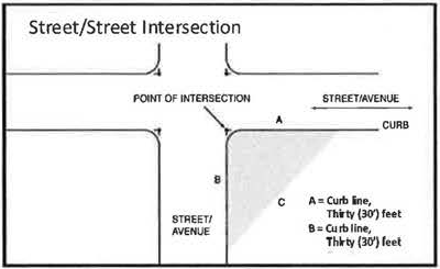 |
| b. Street/Private Driveway Intersection: Measuring from the point of intersection of the front lot line and the sides along the driveway a distance of 25' along each and connecting the points so established to form two sight triangles on the area of the lots adjacent to either side of the private driveway. | 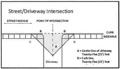 |
Sign. Any object, graphic representation, or device visible from the right-of-way of a sidewalk, street or highway, which is used to advertise, identify, inform, display, direct, or attract attention to an object, person, institution, organization, business, product, service, event or location by any means including words, letters, graphics, figures, designs, symbols, fixtures, colors, motion, illumination or projected images, together with the frame, background, and supports, braces, guys, or anchoring thereof, and any electrical components.
Sign Face. An exterior display surface of a sign including non-structural trim exclusive of the supporting structure.
Site. All the contiguous ground area legally assembled into one development location which is a zoning lot, which is defined as a permanent parcel (lot of record), multiple lots of record, or a portion of a lot of record.
Snipe Sign. Any sign of any materials, including, but not limited to, paper, cardboard, wood or metal when tacked, nailed, or attached in any way to trees, poles, stakes, fences or other objects where such sign may or may not be applicable to the present use of the premises upon which the sign is located.
Special Event Sign. Any temporary sign advertising or pertaining to any civic, patriotic or special event of general public interest.
Street Frontage. The distance of the linear frontage of a lot or lots along a public street which provides a public access thereto.
Supergraphic Sign. A painted design which covers all or a major portion of a wall, building, or structure which is intended to convey information to the public promoting or advertising a business, individual, product, or service through the use of text, language, logo, numerals, symbols, or pictorial depiction. See also definition of Mural Sign.
Temporary Sign. Any sign intended to display or convey a message of a transitory or temporary nature, that is not permanently affixed to a building, structure, or ground.
Vehicle Sign. Any sign permanently or temporarily attached to or placed on a vehicle or trailer.
Wall Sign. Any sign attached to or painted on the wall of a building or structure in a plane parallel or approximately parallel to the plane of said wall and that projects not more than eighteen (18) inches from the building or structure wall. Also includes signs affixed to architectural projections that project from a building provided the copy area of such signs remains on a parallel plane to the face of the building facade or to the face or faces of the architectural projection to which it is affixed.
Window, Area of. The area of a single window includes all of the window panes in an area that is separated by mullions, muntins, or other dividers which are less than four (4) inches wide.
Window Sign. Any sign, excluding open and closed and/or business hours signs, which are viewable through and/or affixed in any manner to a window or exterior glass door such that it is intended to be viewable from the exterior (beyond the sidewalk immediately adjacent to the window), including signs located inside a building, but visible primarily from the outside of the building. A window sign is considered an attached sign. Any on-premise perforated window graphic or mesh window graphic with an opacity of 50% or less shall not be considered a window sign and does not require a sign permit as provided in Section 7.11.2.C.
7.11.4. Measurement Standards
A. Determining Sign Area and Dimensions
1.
For a sign which is framed, outlined, painted or otherwise prepared and intended to provide a background for a sign display, the area and dimensions shall include the entire portion within such background or frame and shall be based upon the outer dimensions of the frame or cabinet.
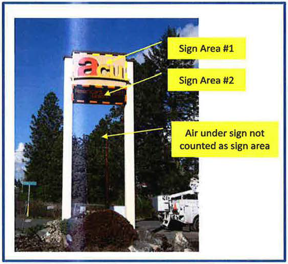
2.
For a sign comprised of individual letters, figures or elements on a wall or similar surface of the building or structure, the area and dimensions of the sign shall encompass a regular geometric shape (rectangle, circle, trapezoid, triangle, etc.), or a combination of regular geometric shapes, which form, or approximate, the perimeter of all elements in the display, the frame, and any applied background that is not part of the architecture of the building. When separate elements are organized to form a single sign, but are separated by open space, the sign area and dimensions shall be calculated by determining the geometric form, or combination of forms, which comprises all of the display areas, including the space between different elements.
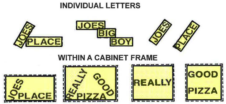
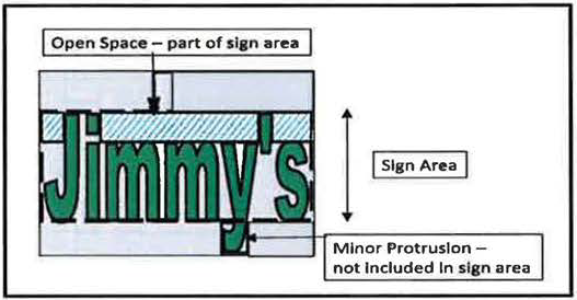
3.
Minor appendages to a particular regular shape, such as an apostrophe, as determined by the Community Development Director, shall not be included in the total area of a sign.
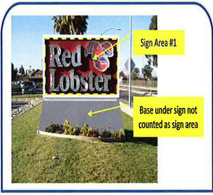
4.
For a freestanding sign, the sign area shall include the frame, if any, but shall not include:
a.
A pole or other structural support unless such pole or structural support is internally illuminated or otherwise so designed to constitute a display device, or a part of a display device.
b.
Architectural features which contain no lettering or logos, that are either part of the building or part of a freestanding structure, and are not an integral part of the sign, and which may consist of landscaping, building or structural forms complementing the site in general.
5.
Multi-faced Signs: The sign area for a sign with more than one face shall be determined by adding together the area of all sign faces visible from any one point. When two identical sign faces are placed back to back or at an angle of forty-five (45) degrees or less, and when such sign faces are part of the same sign structure, the sign area shall be determined by the measurement of one of the faces. Where the two (2) sides of a multi-faced sign are not of equal size, the larger of the two (2) sides is used to determine the sign area.
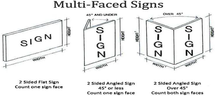
B. Determining Sign Height
1.
The height of a freestanding sign shall be measured from the base of the sign or supportive structure at its point of attachment to the ground, to the highest point of the sign, except as provided in the following paragraph. A freestanding sign on a man-made base, including a graded earth mound, shall be measured from the grade of the nearest pavement or top of any pavement curb.
2.
Where a freestanding sign or sign structure is mounted along a roadway that has a higher grade level as compared to the grade level directly below the freestanding sign or sign structure, then the freestanding sign or structure's height will be measured from the roadway grade level to the highest point of the freestanding sign or sign structure.
3.
Clearance for freestanding and projecting signs shall be measured as the smallest vertical distance between finished grade and the lowest point of the sign, including any framework or other embellishments.
 | 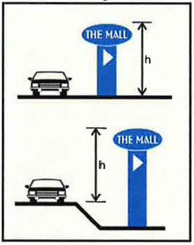 |
C. Determining Street Frontage
Street frontage is that portion of a lot or parcel of land that borders a public street from which public access is provided. Street frontage shall be measured along the common lot line separating said lot or parcel of land from the public street, highway, or parkway.
| 1. Where a lot has public access from more than one street frontage, the linear footage of each frontage shall be calculated separately for the purposes of determining allowable sign area as provided for herein. Public access from an alley shall not be included in the measurement of street frontage. | 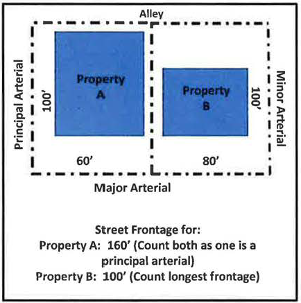 |
| 2. For multi-tenant buildings, street frontage is equivalent to the primary frontage of the tenant space on the first floor as measured from the centerline of the party walls. This shall be the basis for determining the permissible sign area for attached signs for each tenant space, unless otherwise directed by the lot owner. The Community Development Director may exclude any wall length of a building frontage that is clearly unrelated to the frontage criteria. |
ARTICLE II. ON-PREMISES SIGNS
7.11.5. Residential Districts. On-premise signs are allowed as follows in all residential zoning districts:
A. Permanent Signs.
| 1. Residential developments and subdivisions and institutional uses permitted by right within a residential zoning district shall be permitted freestanding monument identification signs as follows. | 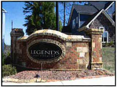 |
| a. Each development may locate a monument sign at each major entrance on private property, not to exceed thirty-two (32) square feet in sign area, to identify the overall development. | |
| b. Monument signs shall be set back from the property line such a distance as is necessary to avoid location within the required sight triangle as defined in Section 7.11.3. |
c.
Monument signs shall not exceed eight (8) feet in height.
d.
Walls attached to monument signs or within several feet of a monument sign are allowed and may include the name of the project, however, said wall shall not exceed four (4) feet in height.
e.
The name of the development shall be in individually applied lettering and with external illumination only.
f.
Residential subdivisions may include a monument sign within a median area at an entry if such monument signs are located within a platted public right-of-way within a signage easement as identified on the recorded plat thereof, and if the Homeowners Association for said subdivision assumes, in writing, all costs and responsibilities for the maintenance of said monument sign.
g.
All such signs shall be externally illuminated, except signs for institutional uses which may be internally illuminated, provided it is made by constant light, and does not exceed seventy (70) footcandles as measured at a distance of two (2) feet from the source of light.
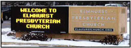
2.
Electronic message centers (EMC) are prohibited in residential zoning districts, except for institutional uses permitted by right, which are permitted an electronic message center subject to the following restrictions:
a.
Shall comprise no more than 50 percent or 16 square feet of the overall sign area of the sign structure, whichever is less;
b.
Display shall stay constant for a period no less than twelve (12) seconds, shall transition between messages and/or message frames instantly, and does not appear to change, travel, scroll, flash, spin, rotate, fade, dissolve, move, vary color, or vary light intensity;
c.
Shall be equipped with auto-dimming technology that automatically dims as light conditions change, from sunset each night to sunrise the next morning, resulting in a maximum light emanation as measured from the nearest residential property line of no more than 0.2 footcandles over ambient lighting conditions; or shall be completely turned off between the hours of 10:00 p.m. and 6:00 a.m., seven days a week.
3.
Home occupations in residential districts are permitted signage as set forth in the Zoning Regulations.
B. Temporary Signs.
1.
Real Estate Signs. See Section 7.11.2.C.8.
2.
Construction Signs or Project Development Signs. One (1) non-illuminated sign (as defined in Section 7.11.3) not exceeding ninety-six (96) square feet in area or twelve (12) feet in height may be placed along each major street frontage for a residential subdivision which is in the process of development and initial sales. Such signs shall be removed after completion of the last house or when eighty percent (80%) of the lots have been sold, whichever occurs first. Signs of forty (40) square feet or less are permitted without a permit as per Section 7.11.2.C.9.
3.
Special Event Signs. A sign advertising or pertaining to any civic, patriotic, or special event of general public interest for noncommercial purposes.
a.
Limited to one (1) per street frontage and located on the same zoning lot as the event is to take place. (See also Off-Premise Signs)
b.
May be erected and maintained for a period not to exceed thirty (30) days and shall be removed within three (3) days of the termination of such event.
7.11.6. Non-Residential Districts. The standards for permanent on-premise signs in non- residential districts as set forth herein are based primarily upon a sign's function, its placement on the building or site, the amount of time the motorist has to view the sign, and the distance from which the sign will be viewed.
The following standards, criteria, and provisions apply to all permanent on-premise signs in non-residential districts and recognize the fact that signs are an important factor in the success of a business, and that the regulation of signs must balance both public and private interests. Numerous interrelated factors contribute to whether a sign is able to fulfill its primary purpose: to be able to be read by its intended audience, generally the passing motorist. Key among those factors is sign design, which includes elements such as letter height, color, style, spacing of lettering or logos, color contrasts between the message and the background, and lighting, which is not regulated herein. Other factors, such as sign location and size, which are critical in determining the visibility and legibility of signs, and which are regulated herein, are based upon reasonable parameters for design that incorporates the normal range of words and elements that are needed to permit signs to be read by their intended audience. Generally, the smaller signs will be associated with lower speed limits and the larger signs associated with higher speed limits.
The standards contained herein for permanent on-premise freestanding and attached signs are based upon the linear street frontage of the lot and the functional classification of the abutting street, as identified by the most current version of the Bartlesville Street Functional Classification Map maintained by the City of Bartlesville Community Development Department. Where uncertainty exists as to the functional classification of the street, such classification shall be determined by the Community Development Director based upon criteria of the existing street to include, but not limited to, speed limit, type of traffic, traffic counts, number of traffic lanes, and type, number, and size of access to abutting properties.
Exception: Sites located within the Downtown Redevelopment District may contain more restrictive provisions. Additionally, sites zoned PUD (Planned Unit Development) are required to submit a Comprehensive Sign Plan (CSP) as part of the PUD approval process.
A. Maximum Number of Permanent On-Premise Signs for Non-Residential Districts
There is no maximum number of permanent signs for either freestanding or attached signs. A lot may have any number of signs provided such signs comply with the maximum sign area, height, separation, and any other applicable requirements as set forth herein.
B. Maximum Size of Permanent On-Premise Signs for Non-Residential Districts
1.
The following table identifies by sign type the maximum square footage of sign area permitted per sign.
Table 1. Maximum Size of On-Premise Permanent Signs
(1)
Freestanding signs include, but are not limited to monument and pole signs.
(2)
Refer to Section 7.11.4.C.
(3)
Attached signs include, but are not limited to awning, building identification, canopy, marquee, mural, projecting, wall, and window signs.
(4)
Includes properties located within 1,000 feet of a principal arterial which has limited access to such principal arterial.
2.
Transfer of Allowed Sign Area from Freestanding to Attached Signs. A property owner may increase the total maximum sign area for attached signs by transferring up to 25% of the total sign area allowed for freestanding signs, if a reduced size freestanding sign is used. If no freestanding sign is used, a property owner may transfer up to 50% of the total sign area allowed for freestanding signs to attached signs. However, in no case shall any portion of the allowed sign area for attached signs be transferred to freestanding signs.
C. Maximum Height Limit for Permanent On-Premise Freestanding Signs
The maximum height for an on-premise permanent freestanding sign is based upon the functional classification of the abutting roadway. Except as otherwise provided in this Section, no freestanding sign shall exceed the maximum height as provided in the following table.
Table 2. Maximum Height for On-Premise Permanent Freestanding Signs
(1)
Refer to Section 7.11.4.B.
(2)
Includes properties located within 1,000 feet of a principal arterial which has limited access to such principal arterial.
D. Additional Provisions Pertaining to Sign Types.
1.
Freestanding Signs.
a.
No portion of a freestanding sign shall be in, or project over, a public right-of-way.
b.
No portion of a freestanding sign shall be located within one hundred (100) feet of any lot which is zoned RE, RS, RM, or RT.
c.
No portion of a freestanding sign shall be located within a sight triangle as defined in Section 7.11.3 of these Regulations or in any manner which creates a sight obstruction between forty-two (42) inches and eight (8) feet above the existing grade for a distance of fifteen (15) feet from any intersection of driveway as measured along the property line.
d.
No sign shall be erected that interferes or obstructs traffic flow or vehicular vision.
e.
Freestanding signs may also contain an electronic message center or changeable copy sign subject to the restrictions identified within sub-section 3 below.
f.
If more than one (1) on-premise freestanding sign is located on a site, there shall be a minimum spacing of one hundred fifty (150) feet between any two signs.
g.
When more than one (1) user occupies a zoning lot, the owner of the lot shall be responsible for allocating permitted freestanding signs among the users.
h.
Monument Sign Bonus. In order to promote a more aesthetic attractive appearance of freestanding signs within the community, a bonus is offered to encourage the installation of monument signs over pole sign, as follows:
1)
The area of any freestanding sign may be increased by fifteen percent (15%) when the freestanding sign is constructed as a monument sign, rather than a pole sign, with at least fifty percent (50%) of the sign structure comprised of brick, stone, or architectural block.
2)
The area of any freestanding sign may be further increased by an additional ten percent (10%) if said monument sign is placed within a landscaped area. The landscaped area shall contain a minimum of two (2) square feet for each square foot of the sign area.
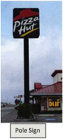 | 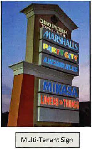 | 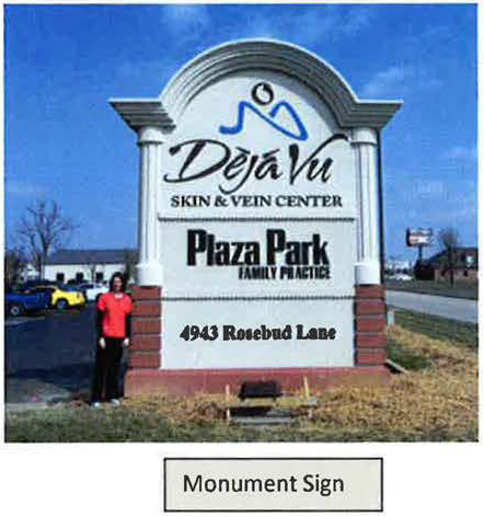 |
2.
Attached Signs.
a.
No portion of an attached sign shall be located within 100 feet of any lot which is zoned RE, RS, RM, or RT.
b.
Attached signs of any type shall not extend more than twelve (12) inches above the roof or parapet line of a building.
c.
For multi-tenant buildings, street frontage is equivalent to the primary frontage of the tenant space on the first floor as measured from the centerline of the party walls. This shall be the basis for determining the permissible sign area for attached signs for each tenant space, unless otherwise directed by the lot owner.
d.
Attached signs may also contain an electronic message center or changeable copy sign subject to the restrictions identified within sub-section 3 below.
e.
Attached signs may be located upon any building wall or facade which is visible from a public street (excluding alleys) or from any public parking lot, except where prohibited in 2a. above.
f.
Attached signs can include any of the following type of signs subject to the following restrictions. Each building or tenant may have multiple attached signs provided the total square footage of all attached signs does not exceed the maximum area permitted in Section 7.11.6.B above.
1)
Projecting signs when designed and placed for the purpose of identifying the businesses for a pedestrian walking along the same side of the street as the business they seek or under a continuous rain canopy projecting from the building. Projecting signs shall have a maximum area of thirty (30) square feet; the bottom of the sign shall be a minimum of eight (8) feet above the sidewalk; the sign shall not project more than five (5) feet from the wall of the building on which the sign is placed; and the adjacent projecting sign shall not be closer than twenty (20) feet.
2)
Building directory signs for the purpose of identifying first floor tenants that do not have outside building frontage or upper floor tenants permitted up to a maximum of eight (8) square feet
3)
Marquee, Canopy and Awning Signs shall have a minimum clearance of eight (8) feet over the ground level unless projecting over a vehicular right-of-way, in which case clearance shall be fourteen (14) feet.
4)
Mural or Supergraphic Signs shall be limited to only one wall, facade, face, or surface of a building.
5)
Wall Signs shall not project more than eighteen (18) inches from the building or structure wall to which it is attached and shall not be greater than eighty percent (80%) of the length of the tenant space or the length of the building frontage for single tenant buildings. The area of any wall sign may be increased by twenty-five percent (25%) when the building is set back at least two hundred (200) feet from the public right-of-way and may be further increased an additional twenty-five percent (25%) for each additional two-hundred (200) feet of setback, or fraction thereof, up to a maximum increase of one hundred percent (100%). Wall signs may be placed upon any building wall which can be viewed from a public right-of-way, provided it does not face the front, side or rear lot line of any abutting lot in any RS, RE, RM, or RT district.
6)
Window Signs shall not exceed fifty percent (50%) of the window surface area on which it is placed or through which it is viewed, however, window signs that are not visible from the abutting public street shall not be counted as an attached sign.
Examples of Attached Signs:
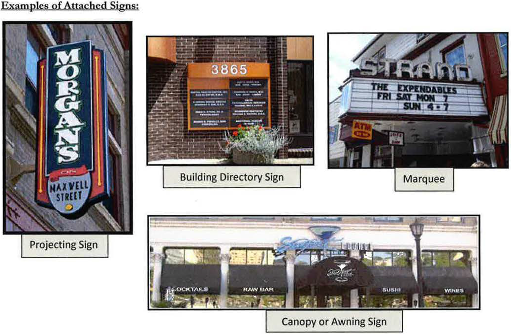
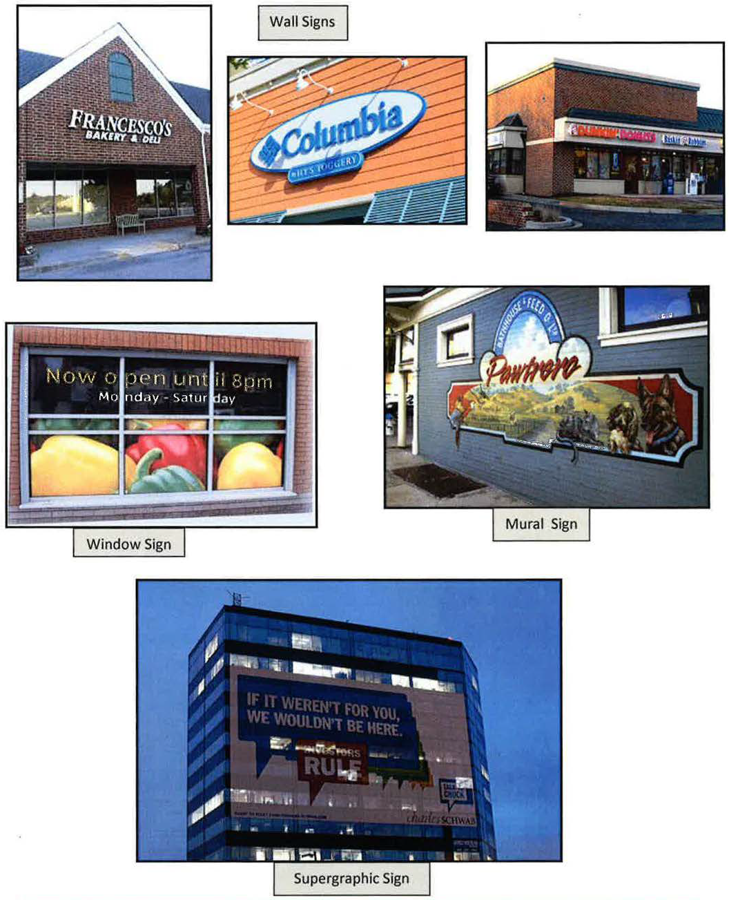
3.
Electronic Message Center/Changeable Copy Signs.
a.
Electronic message centers (EMC) and changeable copy signs (CCS), both electronic and non-electronic, may be utilized on any permitted sign, whether freestanding or attached, and shall be counted towards sign area limitations applicable to the subject site, and subject to the additional limitations established herein.
1)
EMCs may convey its message through either static or alternating message as set forth herein. Animated messages, extended video messages, flashing, or rapid scrolling, and strobe lights are prohibited.
2)
Audio messages, and emissions of smoke, fumes, and vapors are prohibited.
3)
EMCs and CCSs in stadiums or sports fields are not considered signs if they are oriented inward to the playing field.
4)
The commercial content of EMCs and CCSs is limited to on-site advertising only, however, EMCs and CCSs may also contain a non-commercial message, such as time and temperature.
5)
Only one EMC or CCS sign is permitted on a zoning lot for each street on which the development fronts and the sign is visible, unless additional EMCs or CCSs are approved by the Metropolitan Area Planning Commission as part of a Comprehensive Sign Plan (see Section 7.11.6.F below).
6)
Any EMC located within one hundred fifty (150) feet of a lot which is zoned RE, RS, RM, or RT district shall be equipped with auto-dimming technology that automatically dims as light conditions change, from sunset each night to sunrise the next morning, resulting in a maximum light emanation as measured from the nearest residential property line of no more than 0.2 footcandles over ambient lighting conditions; or shall be completely turned off between the hours of 10:00 p.m. and 6:00 a.m., seven days a week.
7)
All EMC signs shall contain a default mechanism that will cause the sign to revert immediately to a black screen if the sign malfunctions.
8)
If an EMC or CCS is installed on a property, no temporary signs are allowed for the property during any time that the EMC or CCS is in use.
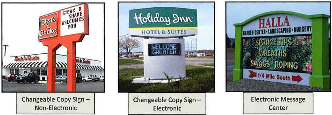
b.
The following additional conditions shall apply to the use of electronic message centers (EMCs) and changeable copy signs (CCS) on a site based upon the functional classification of the abutting street:
1)
Principal Arterial and Major Arterial Streets:
a)
The EMC or CCS does not exceed fifty percent (50%) of the total sign area permitted on the site and no more than eighty percent (80%) of the permitted sign area upon which it is utilized percent;
b)
The display of the entire Electronic Message Center stays constant for a period of at least three (3) seconds.
c)
Transition time between messages and/or message frames is instantly or in a transition of less than one (1) second, and does not appear to change, travel, scroll, flash, spin, rotate, fade, dissolve, move, vary color, or vary light intensity;
d)
The EMC is required to be equipped with a sensor or other device that automatically determines the ambient illumination and shall be programmed to automatically dim to a level which is no greater than 0.3 footcandles over ambient light at all times of the day and night, as measured at ground level using the EMC Illumination Measurement Criteria recommended by the International Sign Association dated April 2011.
e)
No single electronic message is permitted to be repeated by flashing more than once every six (6) seconds.
2)
Minor Arterial and Major Collector Streets:
a)
The EMC or CCS does not exceed thirty percent (30%) of the total sign area permitted on the site and no more than fifty percent (50%) of the permitted sign area upon which it is utilized;
b)
The display of the entire Electronic Message Center stays constant for a period of at least three (3) seconds.
c)
Transition time between messages and/or message frames on an EMC is instantly or in a transition of less than one (1) second, and does not appear to change, travel, scroll, flash, spin, rotate, fade, dissolve, move, vary color, or vary light intensity;
d)
The EMC is required to be equipped with a sensor or other device that automatically determines the ambient illumination and shall be programmed to automatically dim to a level which is no greater than 0.3 footcandles over ambient light at all times of the day and night, as measured at ground level using the EMC Illumination Measurement Criteria recommended by the International Sign Association dated April 2011.
e)
No single electronic message is permitted to be repeated by flashing more than once every six (6) seconds.
E. Other Permanent Signs. The following on-premise signs shall be permitted in all non-residential districts in accordance with the following standards, however, such signs shall not be counted as part of the maximum square footage of sign area as set forth in Section 7.11.6.B, Table 1 above.
1.
Menu Boards.
| a. If a site is occupied by a use which includes a drive-through facility, a maximum of two (2) menu boards not exceeding a maximum of eight (8) feet in height with a combined total of seventy-two (72) square feet of sign area shall be permitted. Such signs shall be oriented to internal vehicular traffic and not directed to traffic on adjacent streets. |  |
| b. If a site is occupied by a use which has drive-in stalls, one drive-in menu board not exceeding a maximum of six (6) feet in height with a total of nine (9) square feet of sign area shall be permitted per stall. |
2.
Permanent Banners. Where banners are used as permanent signs, they shall be included in the total square footage of permanent signage allowed on the site, shall be mounted in or on a permanent sign structure, and shall comply with all provisions of this Section, including all construction and structural requirements, regardless of its size. A new business or a business in a new location may use a temporary banner sign for business identification while awaiting permanent signage for a period not to exceed one hundred twenty (120) days, provided the size shall not exceed the allowable square footage for a permanent sign.
| 3. Incidental signs, including instructional, informational, and directional signs. Incidental signs may be displayed in association with an authorized use and erected without number, provided the signs do not exceed four (4) square feet in area or four (4) feet in height, if freestanding. Incidental signs may include the company name and/or logo but shall not be oriented or located in any manner to constitute additional advertising. |  |
F. Comprehensive Sign Plan (CSP). For the purpose of providing flexibility and incentives for coordinated, well designed sign systems for non-residential properties being developed as a unit, a comprehensive sign plan (CSP) may be considered. A comprehensive sign plan may be allowed for all existing or any new nonresidential developments of three or more separate tenant spaces which: 1) share either the same parcel or structure, or 2) use common access and parking facilities. A CSP requests approval of a comprehensive sign permit establishing the size, location, and design of all signage on such property. Such a plan will establish signage criteria that is tailored to a specific development or location and which may vary from the provisions of this Ordinance, while promoting the use of signs which are aesthetically pleasing, of appropriate scale, and integrated with the surrounding site, buildings and landscape.
National or international franchises shall be given reasonable consideration with respect to company standard logos and lettering styles that are an integral part of the franchise image and identity. The consideration shall not be without restriction and shall be within the boundaries of sound zoning practice and planning and in harmony with the general purpose, spirit and intent of these regulations.
All comprehensive sign plans shall be reviewed by the Metropolitan Area Planning Commission (MAPC) and shall conform to all conditions imposed by said MAPC prior to the issuance of a sign permit. The comprehensive sign plan may contain elements that exceed the permitted height, area, and/or number of signs as specified herein if the MAPC find that:
1.
The development site contains unique or unusual physical conditions, such as topography, proportion, size or relation to a public street that would limit or restrict normal sign visibility;
2.
The proposed or existing development exhibits unique characteristics of land use, architectural style, site location, physical scale, historical interest or other distinguishing features that represent clear variation from conventional development; or
3.
The proposed signage incorporates special design features, such as logos, emblems, murals, or statuaries, that are integrated with building architecture.
All Comprehensive Sign Plans are subject to the following restrictions:
1.
All CSPs shall include the location, size, height, construction material, color, type of illumination and orientation of all proposed signs.
2.
All CSPs shall include all signage to be located within the boundaries of the subject site whether in excess of the provisions of the current sign regulations or not.
3.
CSPs shall not propose a total sign area in square feet exceeding three (3) square feet of signage for every one (1) linear feet of street frontage of the subject property.
4.
CSPs shall not include any prohibited signs.
Additionally, a Comprehensive Sign Plan is required for all Planned Unit Development (PUD) applications which involve either an existing or a new nonresidential development of three or more separate tenant spaces which: 1) share either the same parcel or structure, or 2) use common access and parking facilities.
G. Temporary Signs. In addition to permanent signs, on-premise temporary signs may also be placed on any non-residential site for a limited period of time as a means of publicizing special events such as grand openings, sales, new services, etc., subject to the following standards.
1.
General Regulations for Temporary Signs.
a.
If an EMC or CCS is installed on a property, no temporary signs are allowed for the property during any time that the EMC or CCS is in use.
b.
No temporary sign shall be illuminated.
c.
No freestanding temporary sign shall exceed the maximum height limit for permanent on- premise freestanding signs as set forth in Section 7.11.6.C of these Regulations.
d.
A temporary sign shall not exceed forty (40) square feet in area, unless the sign design has been sealed by an Oklahoma Registered Engineer confirming compliance with all applicable sign construction and structural standards; however, a temporary sign shall not, in any case, exceed ninety-six (96) square feet in area.
e.
All temporary signs attached to a building or structure shall be parallel to the walls of the business and shall be adequately secured through grommets with support anchors on at least four (4) corners, and pulled tight to minimize the amount of wind that can get behind it. Any freestanding temporary sign shall be mounted to a rigid assembly adequate to maintain the sign upright in a moderate wind.
f.
A new business or a business in a new location may use a temporary banner sign for business identification while awaiting permanent signage for a period not to exceed one hundred twenty (120) days, provided the size shall not exceed the allowable square footage for a permanent sign. When used in this manner, such temporary banner will not count toward the time limit identified in 2.a below.
2.
The following temporary signs, as further defined in Section 7.11.3, shall be permitted in accordance with the following standards:
a.
Banners, including tear drop signs, feather signs, or swooper signs.
1)
Regardless of the number of businesses located on a single property, banners shall be permitted for each business as set forth herein; however, no more than one (1) freestanding banner per each one hundred (100) linear feet of street frontage may be displayed at any one time on any single property.
2)
Shall be displayed a maximum of sixty (60) consecutive days, and not more than one hundred twenty (120) days in the same calendar year.
3)
A permit shall be required for each temporary sign displayed and shall be valid for a period of thirty (30) days after which it may be renewed one time for an additional thirty (30) days.
b.
Special Event Signs.
1)
Limited to one (1) per street frontage and located on the same zoning lot as the event is to take place. (See also Off-Premise Signs)
2)
May be erected and maintained for a period not to exceed thirty (30) days and shall be removed within three (3) days of the termination of such event.
c.
Sandwich Board Signs/A-frame Signs.
1)
Shall be permitted within the public right-of-way only in a C-4 (Central Commercial) zoning district, with proper insurance as may be required by the City, within twelve (12) feet of the entrance to the professional, commercial or business activity advertised on the sign.
2)
Limited to a maximum of six (6) square feet of sign area per side with a maximum width of three (3) feet and a maximum height of four (4) feet.
3)
No limit on the number of display days per calendar year.
4)
Shall be displayed only during the hours the premises or business is open to the general public, and shall be removed by the end of business each day.
5)
Limited to not more than one (1) sign per company/business, except in the case of multiple businesses on one property, not more than two (2) signs per property.
6)
Shall not encroach into any portion of a required handicapped ramp; shall not be located closer than two (2) feet from the face of curb to the nearest sign edge leaving a minimum width of five (5) feet of unencumbered walkway for pedestrian traffic.
d.
Temporary Use Signs. Temporary signs that are approved as part of a temporary use, as per Section 7.7.2 of the Zoning Regulations:
1)
Shall be located on the same zoning lot as the temporary use.
2)
Shall be limited to no more than one (1) per street frontage.
3)
Shall be erected no sooner than seven (7) days before the commencement of the temporary use and removed within twenty-four (24) hours following the termination of the temporary use.
e.
Human Signs.
1)
Permitted only as an on-premise sign.
2)
Total sign area displayed shall not exceed twelve (12) square feet or four (4) feet in length.
3)
May not hold or carry wind devices, flags, or balloons.
4)
Bull horns or amplified sound are prohibited.
5)
Shall not stand or walk on podiums, risers, stilts, vehicles, roofs, or other structures so as to be elevated to any point above ground level.
6)
Shall not be illuminated in any way, nor shall any human sign utilize any type of illumination, animation, flashing, blinking and rotating lights or mirrors.
f.
Construction Signs or Project Development Signs.
1)
Shall be limited to a maximum of ninety-six (96) square feet in area and twelve (12) feet in height.
2)
Shall be limited to one (1) sign along each street frontage for a project which is in the process of development.
3)
Shall be removed after completion of construction, or upon issuance of a certificate of occupancy for any building, whichever comes first.
4)
Signs of forty (40) square feet or less are permitted without a permit as per Section 7.11.2.C.
7.11.7 Supplemental Provisions Pertaining to On-Premise Signs
A. Non-Complying On-Premise Signs. Any sign that is not in compliance with the provisions of these Regulations upon its enactment shall be deemed a non-complying sign. All non-complying signs shall be allowed to continue until such time that the business or organization owning the property where the sign is located no longer owns or operates the non-complying signs. All signs, including non-complying signs, must be maintained in accordance with all State and City regulations. If structural alteration or replacement is deemed necessary by the organization, the organization shall obtain a permit to perform any type of maintenance, excluding normal replacement of sign faces, lamps, ballasts, and timers. Non-complying sign faces shall be changes as needed so long as size and configuration remain as originally permitted. Sign structures may be repainted as needed. Permits will be required for all maintenance work with the exception of normal replacement of lamps, ballast, timers, and damaged sign faces. Any sign structure being structurally modified at a cost exceeding 50% of the replacement cost of the sign as to size, additions or configurations shall be immediately brought into compliance with this Section and any other applicable State and City regulations.
B. Variances or Modifications. Variances or modifications from the standards set forth herein may be approved as part of a Comprehensive Sign Plan (CSP) as set forth in Section 7.11.6.F.
C. Substitution of Non-Commercial Speech for Commercial Speech. Notwithstanding anything contained in this Section to the contrary, any sign erected pursuant to the provisions of this Section may, at the option of the owner, contain a non-commercial message in lieu of a commercial message and the non-commercial copy may be substituted at any time in place of the commercial copy. The non- commercial message (copy) may occupy the entire sign face or any portion thereof. The sign face may be changed from commercial to non-commercial messages, or from one non-commercial message to another non-commercial message, as frequently as desired by the owner of the sign, provided that the size, height, setback and other dimensional criteria contained in this Section have been satisfied.
D. Content Neutrality as to Sign Message or Viewpoint. Notwithstanding anything in this Section to the contrary, no sign or sign structure shall be subject to any limitation based upon the content or viewpoint of the message contained on such sign or displayed on such sign structure.
E. Sign Construction and Structural Standards. All signs erected, altered, relocated, constructed, or maintained within the City of Bartlesville shall also comply with the standards set forth in the International Building Code, including Appendix H thereto, the National Electrical Code, and any other applicable code adopted by the City of Bartlesville. Where there is a conflict between any of these codes and this Section, the most restrictive standard or regulation shall govern.
1.
Sign Maintenance Standards.
a.
All signs and sign structures shall be maintained in a good condition, so as to present a neat and orderly appearance. The Community Development Director may order the removal of any sign or sign structure which is in any of the following conditions: those which are excessively weathered, including signs where the condition of the paint or structural material has become so deteriorated as to permit decay, excessive cracking, peeling, chalking, flaking, fading, dry rot or warping; signs which are torn, broken, or where the copy can no longer be seen or is legible by a person with normal eyesight from the intended's point of view; or signs which have inoperative or partially inoperative illuminating or mechanical devices.
b.
Signs and sign structures which become dangerous for one or more of the following reasons shall be taken down and removed or made safe as the Community Development Director deems necessary:
1)
Whenever damaged by fire, earthquake, wind, flood or by any other cause to such an extent that the structural strength of stability is materially less than it was before the catastrophe and is less than the minimum requirements of the Building Code;
2)
Whenever any portion or member thereof is likely to fail or become detached or dislodged, or to collapse and thereby injure persons or property;
3)
Whenever any portion or member thereof is likely to partially or completely collapse as a result of any cause, including but not limited to dilapidation, deterioration, or decay; faulty construction or wiring; or removal, movement or instability of any portion of the ground or building necessary for supporting such structure;
4)
Whenever any portion or member thereof is structurally or electrically unsafe or otherwise hazardous to human life or safety by reason of inadequate maintenance, dilapidation, obsolescence, fire hazard, damage, or abandonment.
c.
All such signs and sign structures determined after inspection by the Community Development Director to be poorly maintained or dangerous shall be deemed a public nuisance and shall be abated by repair, rehabilitation, demolition or removal, by the sign and/or property owner in accordance with Chapter 11 of the Bartlesville Municipal Code.
2.
Sign Contractor's License and Insurance; Exemption. No person shall erect, alter, relocate, construct, or maintain any sign without a valid contractor's license and all required local, State, and Federal licenses. Any person holding a valid contractor's license shall have a current certificate of insurance on file which indemnifies the City of Bartlesville for any form of liability. Any person doing business within the City of Bartlesville may be exempted from this provision, provided he is erecting a sign on the premises occupied by his regular business; however, he must first obtain a permit and show evidence of financial responsibility in the event of accident and meet all other requirements of this Section.
3.
Sign Permit and Fees. No sign shall be erected, constructed, altered, rebuilt, enlarged, extended, converted, maintained, replaced, relocated, until a permit has been issued by the Community Development Department, unless such sign is exempt as per Section 7.11.2.A or 7.11.2.C. Applications for sign permits shall be made upon forms provided by the Community Development Department and shall contain or be accompanied by such plans, drawings, and specifications as are necessary fully to advise of the type, size, shape, location, zone, construction, and materials of the proposed sign, and the building, structure, or premises upon which it is to be placed. The fee for a sign permit shall be as follows:
ARTICLE III. OFF-PREMISE SIGNS, INCLUDING BILLBOARDS
7.11.8 Billboards.
A. Definition. A billboard is a sign, including the supporting sign structure, which directs attention to and/or advertises a business, commodity, service, or entertainment which is conducted, sold, or offered elsewhere than upon the lot on which the sign is located. The following shall not be considered a billboard for the purposes of these regulations: a) directional or official signs authorized by law; and b) temporary event signs and political signs as permitted by Section 7.11 of these regulations.
B. Locations. Billboards may be permitted in any of the following zoning districts: C-5 General Commercial, C-6 Commercial Amusement District, C-7 Highway Commercial District, M-2 General Industrial District (Medium), or M-3 Intensive Industrial District (Heavy), except where expressly prohibited by location within the Highway 75 Overlay District as provided in Section 7.10.3 (G) of the Zoning Regulations. In addition, billboards are specifically prohibited within the original boundaries of the Bartlesville Downtown Redevelopment District as adopted by the City Council by Ordinance No. 3150 on December 20, 2004.
C. General Standards:
1.
No billboard shall be constructed which resembles any official marker erected by a governmental entity, or which by reason of position, shape, or color would conflict with the proper functioning of any official traffic control device.
2.
Billboards shall be constructed in accordance with all State and Local regulations, including building and electrical codes. Stamped structural engineering plans shall accompany sign permit applications and shall be subject to wind speed requirements as set forth in the latest edition of the International Building Code.
3.
All billboards shall be regularly maintained in good and safe structural condition. The painted portions shall be periodically repainted and kept in good condition. The general area in the vicinity of any billboard shall be kept free and clear of sign materials, weeds, debris, trash, and refuse.
4.
Billboards displayed on parked or stationery vehicles, where the primary purpose of the vehicle is to advertise a product or business or to direct people to a business or activity are specifically prohibited.
D. Size, Height, and Location Standards:
1.
Only one (1) billboard structure may be permitted on a lot. A billboard shall not be permitted on a lot that already has a freestanding on-premise sign. Further, an on-premise sign shall not be combined in any manner with a billboard.
2.
Billboards which are erected or painted on a roof are prohibited. Billboards which extend above the roofline of any building on which a sign is erected are prohibited.
3.
The maximum area shall be three hundred (300) square feet per face.
4.
Billboards must set back at least twenty-five (25) feet from the street edge of pavement and/or at least ten (10) feet from all property lines, whichever is greater.
5.
Billboards shall be oriented to be primarily visible from the adjacent roadway.
6.
No billboard shall be erected closer than five hundred (500) feet in any direction to another billboard.
7.
Billboards shall be located a minimum of one hundred (100) feet from any existing residence and two hundred (200) feet from any residential district.
8.
The maximum height of a billboard shall be forty (40) feet except in the case of an elevated roadbed, the allowable height shall be no more than twenty (20) feet above the roadbed at the edge of the pavement, or forty (40) feet, whichever is greater.
9.
All billboards shall maintain a minimum clearance of twelve (12) feet as measured from the ground level at the base of the sign to the bottom of the sign face or to the bottom of the deck, whichever is lower.
E. Design and Construction Standards:
1.
Double-faced signs, V-type signs, and tri-vision signage shall be allowed, however stacked signs or signs in a vertical position with one structure atop the other are prohibited. Side-by-side signage shall be permitted only on parcels abutting U.S. Highway 75 when such signage complies with all other provisions of these regulations.
2.
No billboards shall be constructed by more than two steel posts or columns. Wood posts are specifically prohibited.
3.
Illumination of billboards shall be by constant light, either direct or indirect. No billboard shall contain flashing, intermittent, moving, blinking, or traveling lights, bare bulb illumination, or reflective glitter, except for time, temperature, and date messages. Neither shall a billboard be permitted to have beams or rays directed at any portion of the traveled ways and are of such intensity or brilliance to cause glare or impair the vision of the driver of any motor vehicle or which otherwise interferes with any driver's operation of a motor vehicle.
4.
The use of LED digital display and digital video on billboards, except as permitted above, is specifically prohibited.
5.
Cut-outs or extensions shall be permitted in addition to the maximum 300 square foot display surface area permitted herein, so long as the cutouts or extensions do not exceed 15% of the display surface area or a maximum of 45 square feet. This shall include approval of three dimensional shapes.
F. Nonconforming Billboards: Any billboard lawfully erected and in existence on the effective date of the adoption of this section or located in an area annexed into the City thereafter, which does not conform with the requirements of this section shall be considered as a legal nonconforming billboard and is permitted to remain. Such billboard shall be maintained in a good condition and shall be allowed to remain in existence provided such sign is not:
1.
abandoned or the sign face left vacant or blank for a period of six months; or
2.
damaged or dilapidated to 50% or more of its physical structure or the estimated replacement value.
Said billboard may be rebuilt on the same property provided that:
1.
the size of the sign face does not increase in square footage; and
2.
the sign structure and/or face does not change in its configuration; and
3.
the billboard is made to conform to all other requirements set forth in these regulations.
7.11.9. Other Off-Premise Signs.
A. Special Event Signs. A sign advertising or pertaining to any civic, patriotic, or special event of general public interest for noncommercial purposes.
1.
Up to four (4) special event signs may be located off-premise on private property with consent of the property owner.
2.
May be erected and maintained for a period not to exceed thirty (30) days and shall be removed within three (3) days of the termination of such event.
(Ord. No. 3443, § 2(Exh. B), 1-5-15)
7.12 - Bartlesville Municipal Airport Zoning and Height Restrictions
7.12.1
Purpose. This Section is adopted pursuant to the authority conferred by the Airport Zoning Act, Title 3, Oklahoma Statutes 1991, Section 101 et. seq. It is hereby found that an airport hazard endangers the lives and property of users of Bartlesville Municipal Airport, and property or occupants of land in its vicinity, and also, if of the obstruction type, in effect reduces the size of the area available for the landing, taking off, and maneuvering of aircraft, thus tending to destroy or impair the utility of Bartlesville Municipal Airport and the public investment therein. Accordingly, it is hereby declared:
(1)
that the creation or establishment of an airport hazard is a public nuisance and an injury to the community served by the Bartlesville Municipal Airport;
(2)
that it is therefore necessary in the interest of the public health, public safety, and general welfare that the creation or establishment of airport hazards be prevented; and
(3)
that the prevention of these airport hazards or obstructions should be accomplished, to the extent legally possible, by the exercise of the police power without compensation.
It is further declared that both the prevention of the creation or establishment of airport hazards and the elimination, removal, alteration, mitigation or the marking and lighting of existing airport hazards are public purposes for which political subdivisions may raise and expend public funds and acquire land or property interests therein.
7.12.2
Definitions. As used in this Section, the following terms have the meanings as ascribed to them, unless the context otherwise requires:
(1)
Airport. Bartlesville Municipal Airport (also known as Frank Phillips Field), Bartlesville, Oklahoma.
(2)
Airport Elevation. The highest point of an airport's usable landing area measured in feet from sea level. Bartlesville Municipal Airport has an elevation of seven hundred thirteen (713) feet above mean sea level (MSL).
(3)
Airport Hazard. Any structure or tree or use of land that obstructs the airspace required for the flight of aircraft in landing or taking off at Bartlesville Municipal Airport or is otherwise hazardous to such landing or taking off of aircraft.
(4)
Airport Hazard Area. Any area of land or water upon which an airport hazard might be established if not prevented as provided in this Section.
(5)
Approach Surface. A surface longitudinally centered on the extended runway centerline, extending outward and upward from the end of the primary surface and at the same slope as the approach zone height limitation slope set forth in Section 7.12.4. In plan, the perimeter of the approach surface coincides with the perimeter of the approach zone.
(6)
Approach, Transitional, Horizontal, and Conical Zones. These zones are set forth in Section 7.12.3.
(7)
Board of Adjustment. A board consisting of five (5) members appointed by the City Council of the City of Bartlesville as provided by the laws of the State of Oklahoma; also known as the City of Bartlesville Board of Adjustment.
(8)
Conical Surface. A surface extending outward and upward from the periphery of the horizontal surface at a slope of twenty (20) to one (1) for a horizontal distance of four thousand (4,000) feet.
(9)
Hazard to Air Navigation. An obstruction determined to have a substantial adverse effect on the safe and efficient utilization of the navigable airspace.
(10)
Height. For the purpose of determining the height limits in all zones set forth in this Section and shown on the zoning map, the datum shall be mean sea level elevation unless otherwise specified.
(11)
Horizontal Surface. A horizontal plane one hundred fifty (150) feet above the established airport elevation, the perimeter of which in plan coincides with the perimeter of the horizontal zone.
(12)
Larger than Utility Runway. A runway that is constructed for and intended to be used by propeller driven aircraft of greater than twelve thousand five hundred (12,500) pounds maximum gross weight and jet powered aircraft.
(13)
Nonconforming Use. Any pre-existing structure, object of natural growth, or use of land which is inconsistent with the provisions of this section or an amendment thereto.
(14)
Nonprecision Instrument Runway. A runway having an existing instrument approach procedure utilizing air navigation facilities with only horizontal guidance, or area type navigation equipment, for which a straight-in nonprecision instrument approach procedure has been approved or planned.
(15)
Obstruction. Any structure, growth, or other object, including a mobile object, which exceeds a limiting height set forth in Section 7.12.4.
(16)
Person. An individual, firm, partnership, corporation, company, association, joint stock association, or government entity; includes a trustee, a receiver, an assignee, or a similar representative of any of them.
(17)
Primary Surface. A surface longitudinally centered on a runway. When the runway has specially prepared hard surface, the primary surface extends two hundred (200) feet beyond each end of that runway; for military runways or when the runway has no specially prepared hard surface, or planned hard surface, the primary surface ends at each end of that runway. The width of the primary surface is set forth in Section 7.12.3. The elevation of any point on the primary surface is the same as the elevation of the nearest point on the runway centerline.
(18)
Runway. A defined area on an airport prepared for landing and takeoff of aircraft along its length.
(19)
Structure. An object, including a mobile object, constructed or installed by man, including but without limitation, buildings, towers, cranes, smokestacks, earth formation, and overhead transmission lines.
(20)
Transitional Surfaces. These surfaces extend outward at ninety (90) degree angles to the runway centerline and the runway centerline extended at a slope of seven (7) feet horizontally for each foot vertically from the sides of the primary and approach surfaces to where they intersect the horizontal and conical surfaces. Transitional surfaces for those portions of the precision approach surfaces, which project through and beyond the limits of the conical surface, extend a distance of five thousand (5,000) feet measured horizontally from the edge of the approach surface and at ninety (90) degree angles to the extended runway centerline.
(21)
Tree. Any object of natural growth.
(22)
Zoning Administrator. The Bartlesville Planning Director or such other city employee(s) as may be so designated by the Bartlesville City Council.
7.12.3
Airport Zones. In order to carry out the provisions of this Section, there are hereby created and established certain zones that include all of the land lying beneath the approach surfaces, transitional surfaces, horizontal surfaces, and conical surfaces as they apply to Bartlesville Municipal Airport. Such zones are shown on the Bartlesville Municipal Airport zoning map consisting of one (1) sheet, prepared by Leard Bice Reeder, Inc., and dated June 1996, which is attached to Ordinance No. 2948 and hereby expressly incorporated herein and made a part hereof. An area located in more than one (1) of the following zones is considered to be only in the zone with the more restrictive height limitation. The various zones are hereby established and defined as follows:
(1)
Runway Larger Than Utility With A Visibility Minimum Greater Than ¾ Mile Nonprecision Instrument Approach Zone. The inner edge of this approach zone coincides with the width of the primary surface and is five hundred (500) feet wide. The approach zone expands outward uniformly to a width of three thousand five hundred (3,500) feet at a horizontal distance of ten thousand (10,000) feet from the primary surface. Its centerline is the continuation of the centerline of the runway.
(2)
Transitional Zones. The transitional zones are the areas beneath the transitional surfaces.
(3)
Horizontal Zone. The horizontal zone is established by swinging arcs of five thousand (5,000) feet radii for all runways designated utility or visual and ten thousand (10,000) feet for all others from the center of each end of the primary surface of each runway and connecting the adjacent arcs by drawing lines tangent to those arcs. The horizontal zone does not include the approach and transitional zones.
(4)
Conical Zone. The conical zone is established as the area that commences at the periphery of the horizontal zone and extends outward therefrom a horizontal distance of four thousand (4,000) feet.
7.12.4
Airport Zone Height Limitations. Except as otherwise provided in this Section, no structure shall be erected, altered, or maintained, and no tree shall be allowed to grow in any zone created by this Section to a height in excess of the applicable height limit herein established for such zone. Such applicable height limitations are hereby established for each of the zones in question as follows:
(1)
Runway Larger Than Utility With a Visibility Minimum Greater Than ¾ Mile Nonprecision Instrument Approach Zone. Slopes thirty-four (34) feet outward for each foot upward beginning at the end of and at the same elevation as the primary surface and extending to a horizontal distance of ten thousand (10,000) feet along the extended runway centerline.
(2)
Transitional Zones. Slope seven (7) feet outward for each foot upward beginning at the sides of and at the same elevation as the primary surface and the approach surface, and extending to a height of one hundred fifty (150) feet above the airport elevation which is seven hundred thirteen (713) feet above mean sea level. In addition to the foregoing, there are established height limits sloping seven (7) feet outward for each foot upward beginning at the sides of and at the same elevation as the approach surface, and extending to where they intersect the conical surface. Where the precision instrument runway approach zone projects beyond the conical zone, there are established height limits sloping seven (7) feet outward for each foot toward beginning at the sides of and the same elevation as the approach surface, and extending a horizontal distance of five thousand (5,000) feet measured at ninety (90) degree angles to the extended runway centerline.
(3)
Horizontal Zone. Established at one hundred fifty (150) feet above the airport elevation or at a height of eight hundred sixty-three (863) feet above mean sea level.
(4)
Conical Zone. Slopes twenty (20) feet outward for each foot upward beginning at the periphery of the horizontal zone and at one hundred fifty (150) feet above the airport elevation and extending to a height of three hundred fifty (350) feet above the airport elevation.
(5)
Excepted Height Limitations. Nothing in this Section shall be construed as prohibiting the construction or maintenance of any structure, or growth of any tree to a height up to fifty (50) feet above the surface of the land.
7.12.5
Use Restriction. Notwithstanding any other provisions of this Section, no use may be made of land or water within any zone established by this Section in such a manner as to create electrical interference with navigational signals or radio communication between the airport and aircraft, make it difficult for pilots to distinguish between airport lights and others, result in glare in the eyes of pilots using the airport, impair visibility in the vicinity of the airport, create bird strike hazards, or otherwise in any way endanger or interfere with the landing, takeoff, or maneuvering of aircraft intending to use the airport.
7.12.6
Nonconforming Uses.
(1)
Regulations Not Retroactive. The regulations prescribed in this Section shall not be construed to require the removal, lowering, or other change or alteration of any structure or tree not conforming to the regulations as of the effective date of this Section, or otherwise interfere with the continuance of a nonconforming use. Nothing contained herein shall require any change in the construction, alteration, or intended use of any structure, the construction or alteration of which was begun prior to the effective date of this Section, and is diligently prosecuted.
(2)
Marking and Lighting. Notwithstanding the preceding provision of this Section, the owner of any existing nonconforming structure or tree is hereby required to permit the installation, operation, and maintenance thereon of such markers and lights as shall be deemed necessary by the Zoning Administrator to indicate to the operators of aircraft in the vicinity of the airport the presence of such airport obstruction. Such markers and lights shall be installed, operated, and maintained at the expense of the City of Bartlesville.
7.12.7
Permits and Fees.
(1)
Future Uses. Except as specifically provided in a), (b) and c) hereunder, no material change shall be made in the use of land, no structure shall be erected or otherwise established, and no tree shall be planted in any zone hereby created unless a permit therefore shall have been applied for and granted upon the prior payment of the appropriate permit fees to be established from time to time. Each application for a permit shall indicate the purpose for which the permit is desired, with sufficient particularity to permit it to be determined whether the resulting use, structure, or tree would conform to the regulations herein prescribed. If such determination is in the affirmative, the permit shall be granted. No permit for a use inconsistent with the provisions of this section 14 shall be granted unless a variance has been approved in accordance with Section 7.12.7(4).
(a)
In the area lying within the limits of the horizontal zone and conical zone, no permit shall be required for any tree or structure less than seventy-five (75) feet of vertical height above the ground, except when, because of terrain, land contour, or topographic features, such tree or structure would extend above the height limits prescribed for such zones.
(b)
In areas lying within the limits of the approach zones, but at a horizontal distance of not less than four thousand two hundred (4,200) feet from each end of the runway, no permit shall be required for any tree or structure less than seventy-five (75) feet of vertical height above the ground, except when such tree or structure would extend above the height limit prescribed for such approach zones.
(c)
In the areas lying within the limits of the transition zones beyond the perimeter of the horizontal zone, no permit shall be required for any tree or structure less than seventy-five (75) feet of vertical height above the ground, except when such tree or structure, because of terrain, land contour, or topographic features, would extend above the height limit prescribed for such transition zones.
Nothing contained in any of the foregoing exceptions shall be construed as permitting or intending to permit any construction, or alteration of any structure, or growth of any tree in excess of any of the height limits established by this Section except as set forth in Section 7.12.4(5).
(2)
Existing Uses. No permit shall be granted that would allow the establishment or creation of an obstruction or permit a nonconforming use, structure, or tree to become a greater hazard to air navigation than it was on the effective date of this Section or any amendments thereto or than it is when the application for a permit is made. Except as indicated, all applications for such a permit shall be granted.
(3)
Nonconforming Uses Abandoned or Destroyed. Whenever the Zoning Administrator determines that a nonconforming tree or structure has been abandoned or more than eighty (80) percent torn down, physically deteriorated, or decayed, no permit shall be granted that would allow such structure or tree to exceed the applicable height limit or otherwise deviate from the zoning regulations.
(4)
Variances. Any person desiring to erect or increase the height of any structure, or permit the growth of any tree, or use property, not in accordance with the regulations prescribed in this Section, may apply to the Board of Adjustment for a variance from such regulations. The application for variance shall be accompanied by a determination from the Federal Aviation Administration as to the effect of the proposal on the operation of air navigation facilities and the safe, efficient use of navigable airspace. Such variances shall be allowed where it is duly found that a literal application or enforcement of the regulations will result in unnecessary hardship and relief granted, will not be contrary to the public interest, will not be an airport hazard or create a hazard to air navigation, will do substantial justice, and will be in accordance with the spirit of this Section. Additionally, no application for variance to the requirements of this Section may be considered by the Board of Adjustment unless a copy of the application has been furnished to the Bartlesville Planning Director for advice as to the aeronautical effects of the variance. If the Bartlesville Planning Director does not respond to the application within fifteen (15) days after receipt, the Board of Adjustment may act on its own to grant or deny said application.
(5)
Obstruction Marking and Lighting. Any permit or variance granted may, if such action is deemed advisable to effectuate the purpose of this Section and be reasonable in the circumstances, be so conditioned as to require the owner of the structure or tree in question to install, operate, and maintain, at the owner's expense, such markings and lights as may be necessary. If deemed proper by the board of adjustment, this condition may be modified to require the owner to permit the City of Bartlesville at its own expense to install, operate, and maintain the necessary markings and lights.
7.12.8
Enforcement. The Bartlesville Planning Director is hereby designated the Zoning Administrator. It shall be the duty of the Zoning Administrator to administer and enforce the regulations prescribed herein. Applications for permits and variances shall be made to the Zoning Administrator upon a form created for that purpose. Applications required by this Section to be submitted to the Zoning Administrator shall be promptly considered and granted or denied. Application for action by the Board of Adjustment shall be forthwith transmitted by the Zoning Administrator.
7.12.9
Board of Adjustment.
(1)
A Board of Adjustment, has been created to have and exercise the following powers: (1) to hear and decide appeals where it is alleged there is error in any order, requirement, decision, or determination made by the Zoning Administrator in the enforcement of this Section; (2) to hear and decide special exceptions to the terms of this Section upon which such board of adjustment under such regulations may be required to pass under this Section; (3) to authorize in specific cases such variances from the terms of this Section as will not be contrary to the public interest, where owing to special conditions a literal enforcement of the provisions of this Section will result in unnecessary hardship and so that the spirit of this Section shall be observed and substantial justice done; and (4) exceptions and/or variances may only be allowed by the Board of Adjustment only after notice and hearing as provided in Title 11, O.S. 1991, Section 44-108, as amended.
(2)
The Board of Adjustment shall comply with all regulations of Title 11, Oklahoma State Statutes, and Section 10-4 of this Zoning Code.
(3)
The Board of Adjustment shall make written findings of facts and conclusions of law giving the facts upon which it acted and its legal conclusions from such facts in reversing, affirming, or modifying any order, requirement, decision, or determination which properly comes before it under the provisions of this Section.
(4)
The concurring vote of three (3) members of the Board of Adjustment shall be necessary to reverse any order, requirement, decision, or determination of the Zoning Administrator or decide in favor of the applicant on any matter upon which it is required to pass under this Section, or to effect any variation to this Section.
7.12.10
Appeals to the Board of Adjustment.
(1)
Any person aggrieved, or any taxpayer affected, by any decision of the Zoning Administrator made in the administration of the Section, may appeal to the Board of Adjustment.
(2)
All appeals hereunder must be taken within thirty (30) days from the date of the decision as provided by the rules of the Board of Adjustment, by filing with the Zoning Administrator a notice of appeal specifying the grounds thereof. The Zoning Administrator shall forthwith transmit to the Board of Adjustment all the papers constituting the record upon which the action appealed from was taken.
(3)
An appeal shall stay all proceedings in furtherance of the action appealed from unless the Zoning Administrator certifies to the Board of Adjustment, after the notice of appeal has been filed, that by reason of the facts stated in the certificate a stay would in the opinion of the Zoning Administrator cause imminent peril to life or property. In such case, proceedings shall not be stayed except by order of the Board of Adjustment or notice to the Zoning Administrator and on due cause shown.
(4)
The Board of Adjustment shall fix a reasonable time for hearing appeals, give public notice and due notice to the parties in interest, and decide the same within a reasonable time. Upon the hearing, any party may appear in person or by agent or by attorney.
(5)
The Board of Adjustment may, in conformity with the provisions of this Section, reverse or affirm, in whole or in part, or modify the order, requirement, decision, or determination appealed from and may make such order, requirement, decision as may be appropriate under the circumstances.
7.12.11
Judicial Review of Decisions of Board of Adjustment. Any person aggrieved, or any taxpayer affected, by any decision of the Board of Adjustment who is of the opinion that a decision of the Board of Adjustment is illegal may appeal to the appropriate District Court in the manner as provided in Title 3, Oklahoma Statutes 1991, Section 111, as amended.
Note— (This section adopted previously by the City Council of the City of Bartlesville, Ordinance Number 2948, on May 19, 1997.)