
Bay City City Zoning Code
10.10 Development
Standards
10.10.010 Zone Development Standards Matrix
Zone Development Standards Matrix
| ZONE | SL1 | SL2 | SL3 | NHI | SHI | EHI | MI | LI |
| Maximum Lot Coverage | ||||||||
| Residential D | - | - | 40% | - | - | - | 40% | 25%G |
| Mixed Commercial-Residential/Residential Uses | - | None | 40% | 90% | 90% | 90% | 40% | 25%G |
| Commercial, Industrial, and Other Non-Residential Uses | - | None | 40% | 90% | 90% | 90% | 40% | 25%G |
| Minimum Lot Coverage | None | - | - | - | - | - | - | - |
| Minimum Open Area | ||||||||
| Mixed Commercial-Residential/Residential Uses | None | None | 60% | 10% | 10% | 10% | 60% | 75% |
| Commercial, Industrial, and other Non-Residential Uses | None | None | 60% | 10% | 10% | 10% | 60% | 75% |
| Minimum Landscaped Open Area | 5% | 5% | 10%A | 5%A | 5%A | 5%A | 10%A | - |
| Lot Size | ||||||||
| Minimum Lot Area, all uses except: | None | None | 5,000 sf | None | None | None | 5,000 sf | 15,000 sf |
| Minimum Lot Area, Quadplex and Cottage Cluster | - | - | 7,000 sf | None | None | None | 7,000 sf | 15,000 sf |
| Minimum Lot Area, Townhouses | - | - | 1,500 sf | None | None | None | 1,500 sfE | 1,500 sfE |
| None | None | 40 feet | None | None | None | 40 feet | 100 feet | |
| Minimum Lot Depth | None | None | 40 feet | None | None | None | 40 feet | 100 feet |
| Minimum Common Open Space | - | - | 15%B | 15%B | 15%B | 15%B | 15%B | 15%B |
| Maximum Height | 24 ft | 24 ft | 24 ft | 24 ft>24-36 ft CUPC | 24 ft | 24 ft | 24 ft | 24 ft |
| Setback Requirements I, J | ||||||||
| Front yard | - | - | 20 ft | 0 ft | 20 ft | 20 ft | 20 ft | 20 ft |
| Side Yard | - | - | 5 ft | 0 ft | 5 ft | 5 ft | 5 ft | 5 ft |
| Rear Yard | - | - | 10 ft | 0 ft | 10 ft | 10 ft | 10 ft | 10 ft |
Notes:
- Minimum of the total lot area of a commercial, industrial, or other non-residential use shall be maintained in landscaped open area, located on the street side or in front of the use.
- Subdivisions and planned developments of six lots or units or more, subdivided or developed within a 12-month period shall devote at least 15% of the net buildable site to common open space. An additional 10% lot coverage of structures or other impervious surfaces is allowed for developments providing the minimum open space requirement.
- The maximum height is 24 feet. However, the City Planner may approve a height up to 36 feet when the proposal includes documentation that the development will have sufficient protection from fire through municipal services or has a planned on-site suppression system, as documented through written statements verifying fire suppression capabilities, whether private, public, or a combination thereof, approved in writing by the Bay City Fire Chief.
- Maximum Lot Coverage shall not apply to Cottage Cluster Development as described in Section 10.11.040.B.
- E. Additional Maximum Density standards described in Section 10.11.045.B that may affect lot sizes..
- F. Lot widths shall be reduced for Townhouses as described in Sectiondevelopments
- 10.11.045.B City Planner may adjust this standard, for existing lots of record less than 10,000 sf, for up to 40%.
- Setbacks shall be reduced for Cottage Cluster Development as described in Section 10.11.040.B and for Townhouses as described in Section 10.11.045.B .
- Additional Setback Requirements described in Section 10.10.020.
Amended by Ord. 715 on 6/10/2025
10.10.020 Setback Requirements
- Purpose: Setbacks are required in certain circumstances to insure sufficient open area, sunlight, privacy and visual relief between structures. The following standards are intended to avoid the inflexible standard setbacks typical in some areas, and to promote diversity of design.
- Setbacks from lot lines shall be:
- as described in Section 10.10. 010.
- In the case of a yard abutting a street, with the exception of the front yard, the street yard setback shall be 15 feet and the rear yard setback, with the exception of a rear yard abutting a street, may be reduced to 5 feet.
- Side yard requirements do not apply to the common property line separating townhouses on separate lots.
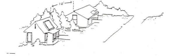
- Distance from Adjacent Building: No development of any sort shall be less than 10 feet from an adjacent dwelling unit, except where development is proposed between two existing structures, and there would be practical difficulty in adhering to this requirement as determined by the Planning Commission e. This standard does not apply to cottage clusters, which are subject to building separation standards in Section 10.11.040.B, or townhouses where attached to townhouses within the same townhouse project.
- Streambank Setback: Structures or other improvements shall be set back from all creeks and streams, including intermittent or seasonal streams (Larson, Patterson, and Jacoby Creek) in accordance with the requirements of Section 10.06.090(C)2, 10.06.100(B)12, 10.10.010(C) and any other applicable standards.
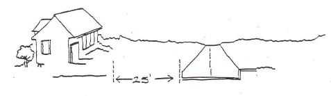
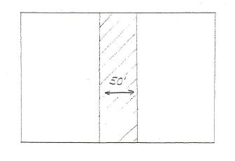
- Tillamook Bay Setback: Structures or other improvements shall be set back from the mean high waterline of Tillamook Bay a minimum of fifty feet (50'). Riparian vegetation shall be maintained within the fifty-foot setback.
- Meadowcreek Subdivision Setbacks:
- To ensure protection of significant wetlands, the setbacks for Lots 23 - 39 only of the October 21, 1995 Meadowcreek Partition Plat, shall be: Front yards 10 feet and rear yards 5 feet. The setbacks for Lots 18 - 21 only, of the October 21, 1995 Meadowcreek Partition Plat, shall be: Front yards 15 feet and rear yards 5 feet.
- In the event that the final plat varies from the October 21, 1995 Partition Plat, then all normal setbacks for the zone shall apply.
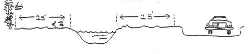
- Stream Side Setback: All structures and uses shall be set back a minimum of 25 feet from Patterson and Jacoby Creek. A stream side setback shall be measured from the bank or mean high water line of the stream and shall be mapped to measurable scale on a site plan.
Amended by Ord. 715 on 6/10/2025
10.10.030 Landscaping, Buffers, Screens And Common Open Space
- Purpose: The Bay City Development Chapter 10 allows uses normally considered to be incompatible within the same zone. To reduce the impacts of adjacent uses on each other, the Planning Commission may require buffers and/or screens in certain circumstances. Generally, more intensive uses require greater amounts of buffering and screening than less intensive uses.
- Buffer and Screen Requirements:
- Planning Commission Authority: The Planning Commission may require buffering and screening of proposed subdivisions, planned developments, and non-residential uses where they adjoin existing residential uses, undeveloped lands, parks, recreation, or other uses which in the opinion of the Planning Commission, may be incompatible with existing uses.
The Planning Commission shall consider the total common open space or landscaped area of the proposed use, the purpose and effectiveness of a buffer or screen, and its maintenance. Buffers and screens may constitute part of the required open space, open area, or setbacks of a proposed use. Buffers and screens shall be required where the Planning Commission finds that the proposed use would be incompatible with existing uses, to block or reduce noise, glare or other emissions, or to maintain privacy. Buffers and screens may be required jointly or separately. - Planning Commission Review: The Planning Commission shall review any proposed development within one hundred (100) feet of either side of Larson Creek in order to determine its impact on the creek and its associated riparian and wetland area. Based on this site specific review, the Planning Commission may permit development up to fifty feet from either side of Larson creek where it determines such development will not adversely impact wetlands or necessary riparian vegetation.
- Buffers: Buffers may be required where the proposed site is large enough, or where the buffer can be part of required open space. Buffers are preferred in areas where existing trees or vegetation may be retained or other natural features such as streams or the bay and the space can be useful for residents or the public.
- Screens: Screens may be required in a limited space (10 feet or less) to visually separate incompatible uses. Screens may consist of existing or planted vegetation, attractive sight obscuring fencing, hedges, walls, or similar techniques. Planted screens should be sufficient to obscure the proposed use within two (2) years. Fences or walls should be required where noise reduction is necessary.
- Riparian Areas:
- A required setback shall be measured from the ordinary mean high water line of the bank of the stream or from the delineated wetland boundary.
- Riparian vegetation shall be protected and retained within the identified setback with the following exceptions:
- The removal of dead, diseased or dying trees which pose an erosion or safety hazard. The city may require that a report be submitted by an appropriately qualified forester or arborist. In geologic hazard areas, hazard overlay zone requirements apply.
- Vegetation removal necessary to provide direct water access for a water-dependent use with a valid development permit approved by the City.
- Prior to the removal of non-native vegetation in a riparian setback area, a re-planting plan for re-planting native vegetation may be required by the City.
- Prior to vegetation removal in wetland areas, a wetland land use notification form shall be submitted and reply received from the Oregon Department of State Lands. Replanting of native wetland vegetation may be required by the City.
- Planning Commission Authority: The Planning Commission may require buffering and screening of proposed subdivisions, planned developments, and non-residential uses where they adjoin existing residential uses, undeveloped lands, parks, recreation, or other uses which in the opinion of the Planning Commission, may be incompatible with existing uses.
- Appropriateness of buffers and screens: The Planning Commission shall require buffers and screens only in locations and dimensions necessary to perform a stated function. The width of buffers may be adjusted to take into account natural features, traffic volumes, proposed setbacks or design, flow or natural values of streams, or other factors. The general criterion is the more intensive the proposed use and its potential for adverse impact, the greater the buffer or screen requirements.
- Illustrations of Types of Buffers and Screens:
- Buffers & Screens:
- Buffers; Horizontal distance from an adjoining use, included on a proposed development property. May be a part of open space or common open space.
- Stream Buffers
- Screening With Trees:
- Screening May Consist Of:
Attractive fencing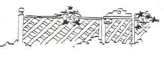
Shrubs or hedges
Earth berms
Existing trees
- Buffers; Horizontal distance from an adjoining use, included on a proposed development property. May be a part of open space or common open space.
- Recommended Buffers:
- Residential From Major Streets: Residential subdivisions and planned developments should be buffered from arterials and collector streets by a minimum of twenty-five (25) feet.
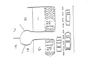
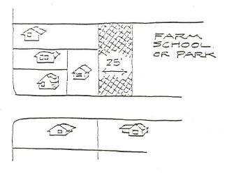
- Residential From Low Intensity Uses: Residential subdivisions or developments should be buffered from adjacent low intensity uses by a minimum of twenty-five (25) feet.
- Residential From High Intensity Uses: Residential developments should be separated from high intensity uses by a minimum of fifty (50) feet and screened where necessary.
NOTE: The proposed use is responsible for the inclusion of the buffer.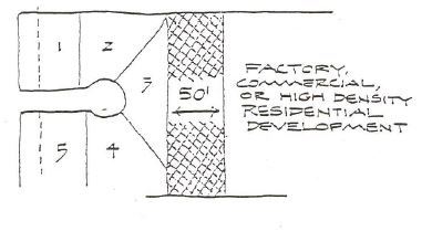
- Other Incompatible Uses: Other incompatible uses, as may be determined by the Planning Commission, may have up to fifty (50) feet of buffer as required by the Planning Commission (which adequate findings of fact) for uses other than those listed on the previous pages which may be incompatible.
- Residential From Major Streets: Residential subdivisions and planned developments should be buffered from arterials and collector streets by a minimum of twenty-five (25) feet.
- Buffers & Screens:
- Common Open Space and Buffer Ownership Requirements
- Common open space or required buffer space shall be maintained in common, public or private ownership under one of the following methods:
- Property owners within the subdivision or development may be listed as common owners of the undivided tract of land, with appropriate deed restrictions attached, and shall be jointly responsible for its maintenance.
- Each owner of property within the proposed development shall retain a proportionate share of undivided ownership in the open space or buffer under the bylaws of an approved homeowners association, who shall hold title with appropriate deed restrictions and responsibilities.
- The City, Tillamook County, the State or public service organizations may accept a dedication of the land for conservation or other use which would maintain its open space characteristics.
- Conservation easements, access easements, deed restrictions, or other provisions for maintaining common open space as a part of platted lots.
- Common open space shall be continuously maintained by the owners of the property in the development.
- Common open space shall be arranged in such a way that it is usable by the residents of the development, or by the public, or in such a manner that it serves a design purpose such as screening or buffering. The developer shall indicate the function of the open space in tentative plans or other applications for land use.
- Uses of common open space may include picnic facilities, hiking trails, storm runoff retention wells or ponds, or natural uses.
- Uses prohibited in common open space areas or buffers are structures or impervious surfaces, disposal of solid waste or clippings, storage of materials or objects, clearing of live trees, placement of signs, or similar uses.
- Common open space or required buffer space shall be maintained in common, public or private ownership under one of the following methods:
- Storage in Yards: Vehicles which are partially dismantled or do not have a valid state license, and other materials or objects which would detract from the open space character of the yard shall not be stored more than 10 days in a front yard or street side yard. Storage of recreation vehicles shall be in a side yard or rear yard.
10.10.040 Fences
- Fences shall not exceed six (6) feet in height above finished grade.
- In clear vision areas, fences shall be no more than three (3) feet in height above finished grade or, if the fences are constructed of obscured chain link fencing, then the fences may be up to six (6) feet in height. However, open wire or split rail fencing which does not obscure views of oncoming traffic may be permitted up to six (6) feet in height.
- Fences shall not block views or solar access to adjacent property.
- Fences shall be constructed of attractive material, such as wood or chain link fencing.
- Material such as barbed wire or used material originally intended for other purposes shall not be allowed.
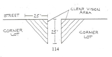
10.10.050 Clear Vision Areas
A clear vision area shall be maintained on the corners of all property at the intersection of two streets, or a street and a railroad. A clear vision area shall contain no planting, fence, wall, structure, or temporary or permanent obstruction exceeding 36 inches in height, except for trees with branches and foliage removed to a height of eight (8) feet above the ground, and opened wire fencing that does not obscure sight more than 10%.
10.10.060 Architectural Design Standards
- Applicability. Architectural design standards apply to multifamily residential, mixed commercial-residential and commercial development.
- Orientation. All buildings shall have at least one primary entrance (i.e., tenant entrance, lobby entrance, breezeway entrance, or courtyard entrance) facing an abutting street (i.e., within 45 degrees of the street property line); or if the building entrance must be turned more than 45 degrees from the street (i.e., front door is on a side or rear elevation) due to the configuration of the site or similar constraints, a pedestrian walkway must connect the primary entrance to the sidewalk
- Site Services. Off-street parking, trash storage facilities, and ground-level utilities (e.g., utility vaults), and similar obstructions shall not be placed between building entrances and the street(s) to which they are oriented. To the extent practicable, such facilities shall be oriented internally to the block and accessed by alleys or driveways.
- Parking. Off-street parking shall be oriented internally to the site to the extent practicable and shall meet the Access and Circulation (Section 10.10.070) requirements of this code.
- Primary Entrances and Windows. The following standards apply to new buildings:
- All Elevations of Building. Architectural designs shall address all elevations of a building. Building forms, detailing, materials, textures, and color shall to contribute to a unified design with architectural integrity. Materials used on the front façade must turn the building corners and include at least a portion of the side elevations, consistent with the building’s overall composition and design integrity.
- Pedestrian Entrances. Ground level entrances oriented to a street shall be at least partly transparent for natural surveillance and to encourage an inviting and successful business environment. This standard may be met by providing a door with a window(s), a transom window above the door, or sidelights beside the door. Where ATMs or other kiosks are proposed on any street-facing elevation, they shall be visible from the street for security and have a canopy, awning, or other weather protection shelter.
- Corner Entrances. Buildings on corner lots are encouraged to have corner entrances. Where a corner entrance is not provided, the building plan shall provide an architectural element or detailing (e.g., tower, beveled corner, art, special trim, etc.) that accentuates the corner location.
- Street Level Entrances. All primary building entrances shall open to the sidewalk and shall conform to Americans with Disabilities Act (ADA) requirements, as applicable. Primary entrances above or below grade may be allowed where ADA accessibility is provided.
- Windows – General. Except as approved for parking structures or accessory structures, the front/street-facing elevations of buildings shall provide display windows, windowed doors, and where applicable, transom windows to express a storefront character.
- Storefront Windows. Storefront windows shall consist of framed picture or bay windows, which may be recessed. The ground floor, street-facing elevation(s) of all buildings shall comprise at least 60 percent transparent windows, measured as a section extending the width of the street-facing elevation between the building base (or 30 inches above the sidewalk grade, whichever is less) and a plane 72 inches above the sidewalk grade.
Amended by Ord. 715 on 6/10/2025
10.10.080 Accessory Uses
- Accessory uses shall comply with all requirements for the principal use except where specifically modified by this Chapter and shall comply with the following limitations:
- A greenhouse or hothouse may be maintained accessory to a dwelling or other use, and the Planning Commission may grant the applicant an additional 5% lot coverage for its placement.
- A guest house without kitchen facilities may be maintained accessory to a dwelling.
- A separate storage, utility, or shop building not incorporated into the garage shall be:
- Placed in the side or rear yard of a lot provided all required setbacks are met;
- Be calculated as part of the total lot coverage allowed as determined by the lot coverage requirement of the zone;
- Shall not exceed a total height of twenty-four (24) feet. Storage, utility or shop buildings incorporated into the garage are governed by the height limitation of the zone; and
- Shall not be more than 800 square feet in size.
- A Garage shall meet the following requirements:
- It is a portion of a residence that measures at least 12 feet by 20 feet in size.
- It has a garage vehicle door and is accessible from the street; or
- It is a detached building or portion of a building not more than 1,200 square feet in area, that measures at least 12 feet by 20 feet in size,
- It has a vehicle garage door and is accessible from the street.
- It is recommended that Accessory Structures should be constructed of similar materials and appearance to the primary structure onsite.
- Accessory Dwelling Units (ADUs): Accessory dwellings, where allowed, are subject to review and approval through a Type I procedure and shall conform to all of the following standards:
- One Unit. A maximum of one Accessory Dwelling is allowed per legal single-family dwelling. The unit may be a detached building, in a portion of a detached accessory building (e.g., above a garage or workshop), or a unit attached or interior to the primary dwelling (e.g., an addition or the conversion of an existing floor).
- Floor Area.
- A detached Accessory Dwelling shall not exceed 1,000 square feet of floor area, or 75 percent of the primary dwelling’s floor area, whichever is smaller.
- An attached or interior Accessory Dwelling shall not exceed 75% percent of the primary dwelling’s floor area. However, Accessory Dwellings that result from the conversion of a level or floor (e.g., basement, attic, or second story) of the primary dwelling may occupy the entire level or floor, even if the floor area of the Accessory Dwelling would be more than 1,000 square feet.
- Other Development Standards. Accessory Dwellings shall meet all other development standards (e.g., height, setbacks, lot coverage, etc.) for buildings in the zoning district, except that:
- Conversion of an existing legal non-conforming structure to an Accessory Dwelling is allowed, provided that the conversion does not increase the non-conformity;
- No off-street parking is required for an Accessory Dwelling;
- Accessory dwellings are not included in density calculations.
- Accessory Dwelling Units shall comply with all applicable fire and life-safety codes.
- Occupancy. The owner of a property that contains an Accessory Dwelling Unit is not required to live in either the primary residence or the Accessory Dwelling Unit.
- Accessory Dwelling Units may not be recreational vehicles, campers or travel trailers, or short term rental unit not originally intended for permanent residential use.
- System development charges will be applied to all Accessory Dwelling Units.
- Detached Accessory Dwelling Units must have their own water meters.
- One Unit. A maximum of one Accessory Dwelling is allowed per legal single-family dwelling. The unit may be a detached building, in a portion of a detached accessory building (e.g., above a garage or workshop), or a unit attached or interior to the primary dwelling (e.g., an addition or the conversion of an existing floor).
10.10.090 Exterior Lighting Standards
- Street lights shall be the minimum necessary wattage to illuminate a specific area, such as an intersection, and shall be at least 200 feet apart.
- Street lights, security lights, flood lights or spot lights shall be shielded so as not to cast glare on adjacent property.
10.10.100 Sign Requirements
- Purpose: The purpose of this Section is to regulate such factors as the size, location, and illumination of signs with the intent of safeguarding and enhancing the City's visual environment, traffic safety and the City's economic well being.
- General Requirements: The following general requirements shall apply to all signs:
- Signs shall not contain flashing elements or moving, rotating or other such animated parts.
- All signs and sign structures shall be erected and attached totally within the site, except where permitted to extend into a street right-of way.
- Signs shall not extend into or over or upon any public street or right-of-way. Except a sign may extend over a public sidewalk provided the bottom of the sign structure shall be at least eight (8) feet above the grade of the sidewalk and the sign does not project more than three (3) feet into the public right-of way.
- Signs or sign support structures shall not be located so as to detract from a motorist’s view of vehicular or pedestrian traffic, or a traffic sign.
- Only one side of a double-faced sign is counted in measuring the area of a sign. Sign area does not include foundation supports and other essential structures which do not serve as a backdrop or border of the sign.
- All signs shall be kept in good repair and maintenance.
- It is the responsibility of the property owner to remove any abandoned sign within 30 days of the termination of its use.
- No sign including its supporting structure shall be placed so that its height exceeds eighteen (18) feet.
- Permanent signs are not permitted on undeveloped sites, i.e. a lot without a use.
- Free Standing signs shall not exceed 18’ in height and shall be limited to one per use and lot.
- All signs shall be designed and located so as to prevent the casting of glare or direct light from artificial illumination upon adjacent public streets, the night sky, or adjacent property.
- Sign lights shall be the minimum lumens necessary to illuminate a specific area.
- Sign lighting shall be indirect or internal so that the immediate source of illumination is not visible when the sign is lighted.
- Signs shall not be lit outside of business hours
- Additional Sign Requirements:
- Low Intensity and Moderate Intensity Sign Requirements:
- Uses permitted outright shall have permanent signs with an area not exceeding four square feet, and be attached to a building.
- Conditional uses shall have permanent signs with an area not exceeding thirty-two (32) square feet.
- Temporary signs with an area not exceeding thirty-two (32) square feet may be permitted by the Planning Commission for a specified time period.
- High Intensity Zone Sign Requirements:
- Permitted and conditional uses shall have permanent signs with an area not exceeding thirty-two (32) square feet unless a larger sign is approved by the Planning Commission.
- Temporary signs with an area not exceeding thirty-two (32) square feet may be permitted by the Planning Commission for a specified time period.
- Permitted and conditional uses may apply to the Planning Commission for a larger permanent sign through Section 10.15, Conditional Uses.
- Shoreland and Estuary Zone Requirements:
- Shoreland 2 Zone requirements shall be the same as the High Intensity Zone Requirements.
- Shoreland 1 and Estuary Zones shall be allowed no signs.
- There shall be no freestanding signs in the Shoreland 2 Zone.
- Temporary signs not exceeding 12 square feet may be permitted in the Shorelands 2 Zone.
- Low Intensity and Moderate Intensity Sign Requirements:
- A sign permit issued by the City shall be required prior to construction or placement of any sign.
10.10.110 Flag Lots
- The City Planner shall designate the front yard of a flag lot to ensure compatibility with adjacent land uses, based on existing development patterns and location of adjacent driveways, utilities, and natural features, as either:
- front yard parallel to the street providing automobile access; or
- front yard parallel to the flagpole from which driveway access is received.
- The City Planner shall review proposals for flag lots pursuant to the standards in subsection D and may impose reasonable conditions to ensure development is compatible with adjacent uses.
- When a flag lot is allowed. A flag lot is allowed only when the following are met:
- An existing dwelling unit or attached garage on the site is located so that it precludes a land division that meets the minimum lot width standard of the applicable zone. The dwelling unit and attached garage must have been on the site for at least five years; or
- The site has dimensions that preclude a land division that meets the minimum lot width standard of the applicable zone and are proposed and a width of less than 75 feet if three lots are proposed.
- Up to three lots are proposed, only one of which is a flag lot; and
- Minimum density requirements for the site will be met.
- Flag lot access pole. The pole portion of the flag lot must meet the following standards:
- The pole must connect to a street;
- The pole must be at least 12 feet wide for its entire length; and
- The pole must be part of the flag lot and must be under the same ownership as the flag portion.
- Minimum lot area. Only the area of the flag portion is included when calculating the minimum lot area. The area of the pole portion of the lot is not included.
- Minimum lot dimensions
- Flag lots are exempt from the minimum front lot line standard.
- The minimum lot width and minimum lot depth required for each flag lot is 40 feet.
- For the purposes of this subsection width and depth are measured at the midpoints of the opposite lot lines if the flag portion of the lot. All other lot dimension standards must be met.
- Vehicle Access. Where it is practical, vehicle access must be shared between the flag lot and the lots between the flag portion of the lot and the street. Factors that may be considered include the location of existing garages, driveways, and curb cuts, stormwater management needs, and tree preservation. Access easements may be used.
715
716
10.10.072 Parking Standards
- Off-street parking spaces shall be provided in the following proportions:
USE Number of Spaces Required Single Family Dwelling 2 per dwelling unit (every 16' of driveway length may be counted as a parking space), 1 of which must be in a garage or carport Duplex, Triplex, Quadplex, Townhouse or Cottage Cluster 1 per unit Multifamily Dwelling 1 per unit Adult Foster Home or Assisted Living Facility 0.5 per four bedrooms Hotel/Motel 1 per unit Retail 1 per 500 square feet gross floor area Retail with large floor area requirements 1 per 1000 square feet gross floor area Office 1 per 600 square feet gross floor area Eating/Drinking Establishment 1 per 200 square feet gross floor area Churches/Meeting Halls and Lodges 1 per 400 square feet gross floor area Auditoriums with fixed seating 1 per six (6) seats Service Stations 2 Child Care Centers 1 per employee on largest shift Schools 1 per classroom Barber, Beauty Shops, or other personal service 1 per 600 square feet gross floor area Manufacturing 1 per employee on largest shift - The NHI zone is exempt from off-street parking requirements.
- On-street credits: The City Planner through a Type I procedure may reduce the off-street parking standards of subsection 10.10.072..1A by one parking space for every one on-street parking space located adjacent to the subject site if the applicant can meet the following criteria:
- Parallel parking, each 24 feet of uninterrupted curb;
- Curb space shall be adjacent and connected to the lot which contains the use;
- Parking spaces shall not obstruct a required clear vision area, nor any other parking that violates any law or street standard;
- On-street parking spaces that may be credited for a specific use may not be used exclusively by that use, but shall be available for general public use at all times. No signs or actions limiting general public use of on-street spaces is permitted;
- On-street parking is on a street that is designed and physically improved to accommodate parking within the right-of-way; and
- On-street parking credit shall not be considered on or adjacent to areas of town zoned Moderate Intensity or Low Intensity (L-I).
- Parallel parking, each 24 feet of uninterrupted curb;
- Shared parking. Required parking facilities for two or more uses, structures, or parcels of land may be satisfied by the same parking facilities used jointly, to the extent that the owners or operators show that the need for parking facilities does not materially overlap (e.g., uses primarily of a daytime versus nighttime nature; weekday uses versus weekend uses), and provided that the right of joint use is evidenced by a recorded deed, lease, contract, or similar written instrument establishing the joint use. Shared parking requests shall be subject to review and approval through a Type I procedure. Exemptions, on-street credits, and shared parking.
- Bicycle Parking:
- Bicycle parking requirements shall apply to all developments that require a site plan or amended site plan for new development, change of use, and building expansions and remodels. Bicycle parking spaces shall provide a convenient place to lock a bicycle and shall not interfere with pedestrian circulation or emergency response personnel.
- Bicycle parking shall be provided in the following ratios:
- MultiFamily Dwellings. Every residential use of five or more multi-family dwelling units shall provide at least one sheltered bicycle parking space for each unit. Sheltered bicycle parking areas may be in a conveniently located garage or storage unit, or under an eave, independent structure, or similar cover.
- Non-Residential Parking. There shall be a minimum of one bicycle space for every seven (7) motor vehicle spaces. At least ten percent (10%) of all bicycle parking spaces shall be sheltered.
- Bicycle parking provided in outdoor areas shall be located near the building entrance.
- Bicycle Parking Facilities Design Standards
- Bicycle parking facilities shall be stationary racks which accommodate bicycle locks securing the frame and both wheels.
- Bicycle parking spaces shall provide a convenient place to lock a bicycle and shall be at least six (6) feet long, two (2) feet wide and seven (7) feet high. Upright bicycle storage structures are exempt from the parking space length standard.
- A 5-foot aisle for bicycle maneuvering shall be provided and maintained beside or between each row of bicycle parking.
- Bicycle racks or lockers shall be anchored to the surface or to a structure.
- Covered bicycle parking facilities may be located within a building or structure, under a building eave, stairway, entrance, or similar area, or under a special structure to cover the parking. The cover shall leave a minimum 7-foot overhead clearance and shall extend over the entire parking space. If a bicycle storage area is provided within a building, a sign shall be placed at the area indicating that it is for bicycle parking only.
- Bicycle parking shall not encroach onto a sidewalk, pathway, plaza, or other area for pedestrian use but may be included in the sidewalk frontage or furnishing zones.
Amended by Ord. 715 on 6/10/2025
10.10.074 Design Requirements
- Off-Street Parking
Whenever off-street parking is required, except for single family dwellings and middle housing, the parking area and space shall be designed, constructed, and maintained in accordance with the following minimum provisions and standards:
- Except for parallel parking, all parking spaces shall be clearly striped to facilitate movement and to help maintain an orderly parking arrangement.
- All parking spaces shall have access from an aisle in the parking area, and each parking area shall be designed so as to eliminate egress by backing out onto any highway, street, or road.
- In order to ensure pedestrian safety, sidewalks of not less than five feet in width may be required to separate any driveway or parking area from a building or highway, street, or road.
- Bumper stops, curbing, or wheel chocks shall be provided to prevent any vehicle from damaging or encroaching upon any required sidewalk or upon any property adjacent to the parking area.
- The surface of the parking area shall be either asphalt or other suitable all-weather material.
- In parking lots with five or more spaces, a maximum of 50% of the spaces may be allotted to compact spaces. Full sized spaces shall be nine by eighteen feet (9’ x 18’); compact spaces shall be eight by sixteen feet (8’ x 16’).
- Parallel parking spaces shall be nine feet by eighteen feet, plus a six-foot maneuvering space for each two parking spaces.
- All parking areas shall have access from a clearly limited and defined driveway not less than fifteen feet wide if for one-way traffic and twenty-two feet wide if for two-way traffic, and not more than twenty-five feet wide.
- Where parking areas are located adjacent to property boundaries and five or more spaces are required or provided for the use, a sight-obscuring buffer consisting of a fence and/or evergreen shrubbery at least to a height of three feet shall be provided.
- Landscaping shall be provided at the entrances to any parking area with more that four spaces in order to visually separate the area from the street, and shall be provided at intervals of five spaces, and at the ends of the bays. A landscaped buffer shall be installed adjacent to all buildings and property lines, and shall be continuously maintained.
- B. Off-Street Parking for Single Family Dwellings and Middle Housing. Parking areas and driveways shall be designed, constructed, and maintained in accordance with the following minimum provisions and standards: 1. Each parking space shall be a minimum of nine by sixteen feet (9’ x 16’); 2. Driveways shall be a minimum of twelve feet wide and a maximum of twenty-five feet wide. 3. Driveway openings shall be at least five feet from the side property line. 4. No two residential driveway openings on the same lot shall be less than twenty feet apart. 5. Driveway openings on corner lots shall be located a minimum of five feet from the ends of curb radius returns. 6. All driveway aprons adjoining a paved street shall be paved a minimum of twenty feet from surface back into the driveway with either asphalt or other suitable all-weather material. 7. Cottage cluster developments are not subject to these standards; see section 10.11.040.B.
- Loading: At the time a structure is erected or enlarged, or the use of a structure or parcel of land is changed, off-street loading spaces shall be provided.
- Merchandise, materials or supplies: Buildings or structures to be built or substantially altered which receive and distribute material or merchandise by truck shall provide and maintain off-street loading berths in sufficient numbers and size to adequately handle the needs of the particular use. If loading space has been provided in connection with an existing use, the loading space shall not be eliminated, if elimination would result in less space than is required, to adequately handle the needs of the particular use. Off-street parking areas used to fulfill the requirements of this Chapter shall not be used for loading and unloading operations except during periods of the day when not required to take care of parking needs.
- Passengers: A driveway designed for continuous forward flow of passenger vehicles for the purpose of loading and unloading passengers shall be located on the site of any school or other meeting place which is designed to accommodate more than 25 persons at one time.
Amended by Ord. 715 on 6/10/2025
10.10.077 Maintenance Of Minimum Chapter Requirements
No lot area, yard, or other open space, or off street parking or loading area shall be reduced by conveyance of other means below the minimum requirements of this Chapter, except by dedication or conveyance for a public use, or shall be used as a dual use for another property except where specifically allowed.
10.10.121 General Requirements
- General Requirements. Except as provided by subsection 5, below, existing substandard streets and planned streets within or abutting a proposed development shall be improved in accordance with the standards of Section 10.10.120 and any other applicable City of Bay City street design standards as a condition of development approval.
- All street improvements, including the extension or widening of existing streets and public access ways, shall conform to Section 10.10.120, and shall be constructed consistent with the City of Bay City street design standards as determined or as approved by the City Public Works Director.
- All new streets shall be contained within a public right-of-way. Public access ways (e.g., pedestrian ways) may be contained within a right-of-way or a public access easement, subject to review and approval of the City Planner and City Public Works Director.
- The purpose of this subsection is coordinate the review of land use applications with roadway authorities and to implement OAR 660-012-0045(2)(e) (Transportation Planning Rule),, which requires the City to adopt a process to apply conditions to development proposals in order to minimize impacts and protect transportation facilities. The following provisions also establish when a proposal must be reviewed for potential traffic impacts; when a Traffic Impact Analysis must be submitted with a development application in order to determine whether conditions are needed to minimize impacts to and protect transportation facilities; the required contents of a Traffic Impact Analysis; and who is qualified to prepare the analysis.
- When a Traffic Impact Analysis is Required. The City or other road authority with jurisdiction may require a Traffic Impact Analysis (TIA) as part of an application for development, a change in use, or a change in access. A TIA shall be required where a change of use or a development would involve one or more of the following:
- A change in zoning or a plan amendment designation;
- Operational or safety concerns documented in writing by a road authority;
- An increase in site traffic volume generation by 300 Average Daily Trips (ADT) or more;
- An increase in peak hour volume of a particular movement to and from a street or highway and the generation of 50 or more peak-hour trips on US 101 or the local transportation system, according to the Institute of Transportation Engineers (ITE) Trip Generation Manual; An increase in the use of adjacent streets by vehicles exceeding the 20,000 pound gross vehicle weights by 10 vehicles or more per day;
- Existing or proposed approaches or access connections that do not meet minimum spacing or sight distance requirements or are located where vehicles entering or leaving the property are restricted, or such vehicles are likely to queue or hesitate at an approach or access connection, creating a safety hazard;
- A change in internal traffic patterns that may cause safety concerns; or
- A TIA required by ODOT pursuant to OAR 734-051-3030.
- Traffic Impact Analysis Preparation. A professional engineer registered by the State of Oregon, in accordance with the requirements of the road authority, shall prepare the Traffic Impact Analysis.
- When a Traffic Impact Analysis is Required. The City or other road authority with jurisdiction may require a Traffic Impact Analysis (TIA) as part of an application for development, a change in use, or a change in access. A TIA shall be required where a change of use or a development would involve one or more of the following:
- The City Planner and/or City Public Works Director may waive or allow deferral of standard street improvements, including sidewalk, roadway, bicycle lane, undergrounding of utilities, and landscaping, as applicable, where one or more of the following conditions in (1) through (4) is met. Where the City Planner and/or City Public Works Director agrees to defer a street improvement, it shall do so only where the property owner agrees not to remonstrate against the formation of a local improvement district in the future.
- The standard improvement conflicts with an adopted capital improvement plan.
- The standard improvement would create a safety hazard.
- It is unlikely due to the developed condition of adjacent property that the subject improvement would be extended in the foreseeable future, and the improvement under consideration does not by itself significantly improve transportation operations or safety.
- The improvement under consideration is part of an approved partition in the HI, MI, or LI zones and the proposed partition does not create any new street.
10.10.122 Transportation Impact Studies
- A transportation impact study shall be required for all development applications in which traffic generated from the proposed development is projected to exceed the capacity of the facility and/or have a significant impact upon any affected transportation corridor or intersection, as determined by the City based on estimated trip generation by the development.
- A transportation impact study shall include, at a minimum, an analysis of: trip generation, modal split, distribution, assignment for the proposed development; and an analysis of the projected impact of the proposed development upon the current operating level of any affected transportation corridor or intersection of regional significant.
- A transportation impact study shall be prepared by and/or under the supervision of a registered professional traffic engineer in the state of Oregon.
- A transportation impact study shall be based on traffic counts obtained within twelve (12) months of the date of the development application. The traffic counts shall reflect representative traffic conditions within transportation corridors and at intersections of regional significance.
- A transportation impact study shall not be required to analyze impacts on affected transportation corridors or intersections of local significance location more than the following distances from the proposed development (as measured by a straight-line distance):
- Less than five hundred (500) new peak hour trips at development site: analyze links and intersections within one half (0.5) miles;
- Five hundred and one (501) new peak hour trips at development site: analyze links and intersections within one (1) mile.
- The City reserves the right to require an applicant to provide additional data and/or analysis as part of a particular transportation impact study, where the City determines that additional information or analysis is required to implements to standards and requirements contained in this section
- No traffic impact study shall be required, pursuant to the provisions of this section, where the proposed development will include fewer than 25 residential dwelling units, or 25,000 square feet of non-residential space.
- Upon the written request of an applicant, the City Council may waive the requirement for a transportation impact study, or limit the scope of analysis and required elements of a traffic impact study where the City Council determines the potential transportation impacts and the required mitigation for the affected transportation corridor.
- The Traffic Impact Study will be used to determine impacts, and propose mitigations. The City will negotiate with the applicant to determine the most appropriate mitigations, which shall then be provided by the applicant or an equivalent payment must be made so that the City can initiate the required transportation system improvement project. These improvements must be proportionate, multimodal – with an emphasis on pedestrian and cycling improvements, and directly related to the impacts of the proposed development.
- Nothing in this Section supersedes any requirements for traffic analysis or mitigation of traffic impacts by the State of Oregon, Tillamook County, or other affected jurisdictions.
10.10.124 Streets
- Functional Classifications: The following street functional classifications are included in the City of Bay City Transportation Plan:
- Arterial streets: Arterial streets primarily move people between destinations, link distant communities, and provide for higher speeds and greater volumes of traffic. Within the City of Bay City and its Urban Growth Area, US 101 is the only roadway designated as an arterial. Because this is an ODOT state facility, arterial street cross sections must be consistent with the current version of the Oregon Highways Design Manual. At the time any project on the state highway is to take place, the City shall ensure that the project is inconsistent with the current regulations.
- Collector Streets
Collector streets link residential and business areas with each other and to US 101, the Arterial Street in Bay City.
- Urban-Downtown Collectors The Bay City North High Intensity Zone (Downtown Bay City) is a network of Urban-Downtown Collectors Streets. This network of streets is designed to provide mobility for all modes of transportation and sufficient parking for downtown businesses with the existing right of way.
- Urban Collector Street Urban Collector Streets are located outside the downtown area and require a more flexible cross-section.
- Local Streets
Local Streets provide for low-volume travel and access to immediately adjacent land; and connect housing, commercial, and industrial land with the collector and arterial system. Streets in Bay City that are not designated as Arterial or Collector are designated as Local Streets.
- Bicycles share the vehicular travel lane on local streets.
- Sidewalks must may be provided as determined by the City Public Works Director unless they are not feasible due to the narrow width and steep terrain of the Local Street. Where sidewalks are not provided, pedestrians share the vehicular travel lane.
10.10.125 Sidewalks
All sidewalks within the City of Bay City shall be constructed and maintained according to City Standards in accordance with the Bay City Municipal Code, including but not limited to those referenced in Section 10.14.170.
- Repairs by Owner: It is hereby the duty of all owners of land adjoining any street in the City to maintain in good repair the sidewalks in front of said land and to reconstruct abandoned driveways with sidewalks and full-height curbs and gutters. The City Council shall have the power and authority to determine the grade and width of all sidewalks, the materials to be used, and the specifications for the repair thereof, upon any street or part thereof, or within any area in the City.
- Liability: The City shall not be liable for injury, damage or loss to any person or property caused in whole or in part by the unsafe, hazardous or defective condition of any sidewalk, or driveway approach, or for the City's failure to provide notice as provided in Subsection E below.
- The owner of the land adjoining any street in the City shall be liable to any person suffering injury by reason of the owner's negligent failure to comply with Subsection A above.
- Notwithstanding Subsection C, if the City is nevertheless required to pay damages or incur attorney fees and costs as a result of an injury allegedly sustained by any person due to the failure of an owner to maintain a sidewalk in good repair in safe condition free of hazards, the owner shall reimburse the City for the amount of damaged paid, and for the attorney fees and costs of defending against the claim for damages. The City may maintain an action in a court of competent jurisdiction to enforce the provisions of this section.
- Notice of Defects: If the owner of any lot or part thereof, or parcel of land shall suffer any sidewalk along the same to become out of repair or shall cause a driveway or driveway approach to become abandoned, upon learning of the condition, the City shall post upon the property in front of which a sidewalk or curbing is to be reconstructed or constructed in lieu of a driveway, which notice shall, in legible characters, direct the owner, agent or occupant of the property, within sixty (60) days from the date of such posting, to construct or reconstruct said sidewalk and curbing, as in such notice is provided, to conform to the adjoining sidewalk and curb, as the Public Works Director may direct. The authorized representative of the City posting the notice shall file with the Recorder an affidavit of the posting of such notice, stating the date and place where the notice is posted. The City Recorder shall, upon receiving the affidavit, send by mail a notice to construct or reconstruct the sidewalk or curbing to conform to the adjoining sidewalk and curbing, as the City may direct, such notice to be mailed to the owner, if known, of such property. If such post office address is unknown to the City Recorder, such notice shall be directed to the owner or agent as is shown by the assessment records of the Assessor of the County of Tillamook, State of Oregon. A mistake in the name of the owner or agent, other than that of the true owner or agent of such property, shall not render the notice void, but, in such case, a posted notice shall be sufficient. The owner, agent or occupant, before constructing or reconstructing the sidewalk or curbing, as in the notice provided, shall obtain from the City a permit so to do in accordance with Subsection A above.
- Repairs by City: If the owner, agent or occupant of any such lot or part thereof, or parcel of land shall fail, neglect or refuse to make the sidewalk repairs within the time designated in Subsection E above, the City shall make the same, and keep an accurate account of the cost of the labor and materials used in making the repairs in front of each lot or parcel of land, and shall report to the City Council the cost of such repairs, and a description of the lot or parts thereof or parcel of land fronting on the sidewalk upon which such repairs were made. The City Council shall, by ordinance, assess upon each of the lots or parts thereof or parcels of land fronting upon sidewalks which have been so repaired or laid the cost of making such repairs or laying the same, including legal, administrative and engineering costs attributable thereof. In each case all such assessments may be combined in one assessment roll and the same shall be entered in the docket of City liens and collected in the same manner as is provided in Article 2.02 for the collection of special assessments for local improvements.
Adopted by Ord. 716 on 12/18/2025
10.10.126 Rights-Of-Way And Street Section Widths
The standards contained in Street Cross Section Standards Table 10.10.127 are intended:
- to provide for streets of suitable location, width, and design to accommodate expected utility placement, vehicle, pedestrian, and bicycle traffic;
- to afford satisfactory access to law enforcement, fire protection, sanitation, utility and road maintenance equipment; and
- to provide a convenient and accessible network of streets, avoiding undue hardships to adjoining properties.
Where a range of street width or improvement options is indicated, the City shall determine requirements based on the advice of a qualified professional and all of the following factors:
- Street classification and requirements of the roadway authority, if different than the City’s street classifications and requirements;
- Existing and projected street operations relative to applicable standards;
- Safety of motorists, pedestrians, bicyclists including consideration of accident history;
- Convenience and comfort for pedestrians/bicyclists;
- Provision of on-street parking;
- Placement of utilities;
- Street lighting;
- Slope stability, erosion control, and minimizing cuts and fills;
- Surface water management and storm drainage requirements;
- Emergency vehicles or apparatus and emergency access, including evacuation needs;
- Transitions between varying street widths (i.e., existing streets and new streets); and
- Other factors related to public health, safety, and welfare.
10.10.127 Street Cross-Section Standards Table
| Street Type | Right-of-Way Width | Curb-to-Curb Paved Width | Motor Vehicle Travel Lanes | Median or Center Turn Lane | Bike Lanes | On-Street Parking | Planting Strips or Tree Wells | Sidewalks |
| Arterials | ||||||||
| Arterial with Turn Lane | Refer to the most recent version of the ODOT Highway Design Manual | |||||||
| Arterial with Median | Refer to the most recent version of the ODOT Highway Design Manual | |||||||
| Collectors | ||||||||
| Urban Downtown Collector: 4th St, A St, B St | 60' | 44' | 10', one travel lane in each direction | - | Shared Space | 7' parallel parking one side | - | 5' on each side |
| Urban Downtown Collector: 5th St, C St. | 62' | 46' | 11', one travel lane in each direction | - | Shared space | 7' parallel parking on each side | - | 5' on each side |
| Urban Collector with Pathway | 60' | 20' | 10', one travel lane in each direction | - | - | - | 3' on each side, buffer pathway | - |
| Urban Collector | 60' | 20' | 10', one travel lane in each direction | - | - | - | 3' on each side, buffer sidewalk | - |
| Local Street | ||||||||
| Local Street | 60' | 20' | 10', on travel lane in each direction | - | - | Parking prohibited on shoulder | 3', buffer sidewalk | - |
| Narrow | 20' | 20' | 20' shared space | - | - | Parking prohibited on shoulder | - | Shared space |
10.10.128 Maintenance Of Public Access
The City shall review, under ORS 368.326 – 368.366, proposals for which the vacation of public easements or rights-of-way which provide access to estuarine waters. Existing rights-of-way and similar public easements which provide access to coastal waters shall be retained or replaced if they are sold, exchanged or transferred. Rights-of-way may be vacated so long as equal or improved access is provided as part of a development project.
10.10.129 Pedestrian Connectivity And Access
- New subdivisions, multi-family developments, planned developments, commercial developments and institutional developments shall conform to all of the following standards for pedestrian access and circulation:
- Continuous Walkway System. A pedestrian walkway system shall extend throughout the development site and connect to adjacent sidewalks, if any, and to all future phases of the development, as applicable.
- Safe, Direct, and Convenient. Walkways within developments shall provide safe, reasonably direct, and convenient connections between primary building entrances and all adjacent parking areas, recreational areas, playgrounds, and public rights-of-way conforming to the following standards:
- The walkway is reasonably direct. A walkway is reasonably direct when it follows a route that does not deviate unnecessarily from a straight line or it does not involve a significant amount of out-of-direction travel.
- The walkway is designed primarily for pedestrian safety and convenience, meaning it is reasonably free from hazards and provides a reasonably smooth and consistent surface and direct route of travel between destinations. The City may require landscape buffering between walkways and adjacent parking lots or driveways to mitigate safety concerns.
- Vehicle/Walkway Separation. Except as required for crosswalks, per subsection d, below, where a walkway abuts a driveway or street it shall be raised six inches and curbed along the edge of the driveway or street. Alternatively, the City may approve a walkway abutting a driveway at the same grade as the driveway if the walkway is physically separated from all vehicle-maneuvering areas. An example of such separation is a row of bollards (designed for use in parking areas) with adequate minimum spacing between them to prevent vehicles from entering the walkway.
- Crosswalks. Where a walkway crosses a parking area or driveway (“crosswalk”), it shall be clearly marked with contrasting paving materials (e.g., pavers, light-color concrete inlay between asphalt, or similar contrasting material). The crosswalk may be part of a speed table to improve driver-visibility of pedestrians.
- Walkway Construction. Walkway surfaces may be concrete, asphalt, brick or masonry pavers, or other City-approved durable surface meeting ADA requirements. Walkways shall be not less than four feet in width, except that the City may require five-foot wide, or wider, sidewalks in developments where pedestrian traffic warrants walkways wider than four feet.
- Multi-Use Pathways. Multi-use pathways, where approved, shall be 10 feet wide and constructed of asphalt, concrete or other City-approved durable surface meeting ADA requirements consistent with the applicable City engineering standards.