
Blacksburg City Zoning Code
ARTICLE V
- DEVELOPMENT STANDARDS
DIVISION 2. - OFF-STREET PARKING, STACKING AND LOADING[4]
Editor's note— Section 2 of Ord. No. 1598, adopted Feb. 8, 2011, states: "That this ordinance shall be effective upon its adoption, subject to the following limited transitional provisions:
(a) Any land development application with a first submission date for plan review that was prior to the adoption of Ordinance 1598 shall be reviewed under the Zoning Ordinance provisions in effect at the time of application.
(b) During the first 30 calendar days after the adoption of Ordinance 1598 (from February 9, 2011 to March 10, 2011), persons submitting land development applications may elect to have the application reviewed under either (i) the provisions of Ordinance 1598 or (ii) the Zoning Ordinance provisions in Section 2103 and Sections 5200—5242 governing parking that were in effect prior to the adoption of Ordinance 1598. At the time of submission, applicants must affirmatively indicate that the requested review be conducted under the prior regulations, and the review cannot mix portions of the previous regulations with the new provisions of Ordinance 1598.
(c) These transitional provisions shall be void 30 calendar days after the adoption of this Ordinance (on or after March 11, 2011), and all land development applications submitted on or after March 11, 2011 shall be subject to the provisions of Ordinance 1598."
Sec. 5100 - Developments and uses requiring a site development plan.
A site development plan must be approved by the Administrator prior to the commencement of the following uses and developments:
(a)
Any use or development in all zoning districts, including conditional uses, except for individually developed single-family detached dwelling units and individually developed two-family dwellings. (Ord. No. 1184, adopted 6-9-98)
(b)
Any change in a previously approved site development plan.
(c)
The conversion of an existing residential use to a commercial, industrial or higher density residential use.
(d)
All public or semipublic buildings.
(e)
All other uses involving a structure requiring review by the Planning Commission under Code of Virginia § 15.2-2232.
(f)
Development of lot or land without access to or abutting on a public right-of-way.
(g)
Any addition of four hundred (400) square feet or more to an existing development and any addition to an existing development which implicates other site development plan requirements.
(h)
Modification to an existing site where other site development plan requirements are implicated.
(Ord. No. 1247, § 18, 9-12-00; Ord. No. 1513, § 1, 4-14-09)
Sec. 5101 - Exceptions.
A site development plan shall not be required for a building addition which is under four hundred (400) square feet in size and which does not implicate any other site development plan requirement, and for any modification to an existing site where no other site development plan requirements are implicated. A site development plan is not required for the development of an accessory structure in the RR1, RR2, R-4, R-5 and OTR zoning districts.
Sec. 5110 - Site plan review procedure.
(a)
Site development plans required by the Town shall be prepared by a professional engineer, architect, certified landscape architect or land surveyor who is registered by the Commonwealth of Virginia and is conducting a practice in accordance with Code of Virginia, § 54.1-400 et seq., as amended. More stringent requirements may be established by the Town Code or the Code of Virginia. This requirement may be waived by the Administrator if the type, scale and/or location of the proposed development does not necessitate such plans.
(b)
Five (5) clearly legible blue or black line copies of a site development plan shall be filed with the Zoning Administrator.
(c)
The Administrator shall be responsible for the receipt, review, processing and approval of site development plans.
(d)
The Administrator may waive the requirement to show on the site development plan specific items as required in Section 5130 if, in the Administrator's opinion, based on recognized planning or engineering principles and the goals of the Zoning Ordinance, they are unnecessary to determine compliance with appropriate codes and ordinances. Such waiver shall not be construed to authorize the reduction or waiver of any standard or required improvement.
(e)
The Administrator may request opinions or decisions from other Town departments, divisions, agencies or authorities of the Commonwealth of Virginia, or from other persons as may be retained.
(f)
Approval or disapproval of a site development plan by the Administrator shall occur within forty (40) days of filing of complete applications in the office of the Administrator, unless extenuating circumstances exist, in which case the time may be extended by the Administrator. The reasons for any disapproval shall identify deficiencies in the plan by reference to specific duly adopted ordinances, regulations, or policies and shall identify modifications or corrections as will permit approval of the site development plan. Specific reasons for disapproval shall be contained either in a separate document or on the plan itself. The Administrator shall act on any proposed site development plan that has been previously disapproved within thirty (30) days after the plan has been modified, corrected and resubmitted for approval.
(g)
To attain approval of any site development plan and prior to the issuance of any building or zoning permit, the developer shall provide the Administrator with a reproducible mylar copy of any plan or plans requested.
(h)
Prior to final approval by the Town, site development plans shall be signed by the owner or developer of the parcel(s) proposed for development. The signature shall certify that the owner/developer is aware of the site design requirements imposed by the site development plan and other applicable Town codes, and shall further certify that the owner/developer agrees to comply with these requirements, unless modified in accordance with local law.
(i)
No building or zoning permit shall be issued by any Town official for any building, structure or use depicted on a required site development plan, until such time as the plan is approved by the Town.
(j) (1) Prior to approval of any site plan, at the Administrator's option there shall be executed by the owner or applicant an agreement to construct required physical improvements located within public rights-of-way or easements or connected to any public facility; and the applicant shall execute and deliver to the Town security approved by the Administrator in the amount of the estimated cost of the required physical improvements as determined by Administrator. The agreement and the security shall provide for completion of all work within a time specified to be determined by the Administrator or before occupancy is allowed in any structure, whichever shall occur first.
(2)
In addition, the applicant shall execute and deliver to the Town security approved by the Administrator in the amount of the estimated cost of required erosion and sediment control measures as determined by the Administrator.
(k)
The approval of a site development plan or the installation of the improvements as required in this chapter [Appendix] shall not obligate the Town to accept improvements for maintenance, repair, or operation. Acceptance shall be subject to local or state regulations where applicable, concerning the acceptance of each type of improvement.
(Ord. No. 1419, § 1, 12-11-07; Ord. No. 2083, § 1, 10-14-25)
Sec. 5120 - Minimum standards and improvements required.
(a)
Any improvement required by this ordinance, or any other ordinance of the Town shall be installed at the cost of the developer unless other written agreements have been reached between the developer, the Town, the Virginia Department of Transportation, and/or any other governmental agency. Where cost-sharing or reimbursement agreements between the Town and applicant are entered into they shall be recognized by formal written agreement prior to site development approval.
(b)
All proposed construction and site improvements shall conform to the provisions of this chapter [Appendix] (the Zoning Ordinance) and Town Code. Further, streets, utilities, stormwater management, and sidewalks shall conform to the applicable provisions of the Subdivision Ordinance, Water System Specifications, and Sewer System Specifications. Erosion and sedimentation provisions shall comply with Chapter 10, Town Code.
(c)
The arrangement of streets on the site shall make provision for the continuation of existing streets in adjoining areas and the incorporation of all mapped rights-of-way within the property. This function shall be governed by the standards prescribed therefor in the Subdivision Ordinance.
(d)
(1)
Sidewalks meeting the design standards of the Subdivision Ordinance shall be provided on public or private land along all parts of a site abutting a developed public street, where such sidewalks do not exist as of the date of the application for site plan approval. The provision of these sidewalks will advance the goal of the Blacksburg comprehensive plan of development of "a network of walkways in the Town to increase the safety and convenience of pedestrian travel." The Town Council finds that the need for such sidewalks in this Town is substantially generated by the development.
(2)
Based on the following conditions, the Zoning Administrator may lessen or eliminate the requirements of this subsection based on the following:
(i)
Whether there is no existing sidewalk network in the area serving both short distance travel and longer distance travel;
(ii)
Whether there are no existing transit stops, educational facilities, bikeways (or other walkways), or public parks within a quarter-mile distance, as measured along publicly dedicated streets, from the closest point of the development to the closest point of the nearest facility as listed above; and
(iii)
Whether existing natural constraints of the property and/or adjacent right-of-way, such as topography, significantly limit or prohibit the feasibility of constructing a Town-standard sidewalk.
(e)
Adequate easements shall be provided for drainage and all utilities. Minimum easement width shall be fifteen (15) feet unless specifically reduced by the Administrator, based on need or the physical characteristics of the site. Where easements do not follow the established lot lines, the nearest edge of any easement shall be a minimum of five (5) feet from any building.
(f)
The site development plan for each phase of a multi-phased development shall demonstrate compliance with the Zoning Ordinance for each phase.
(g)
The applicant shall identify the 100-year floodplain limits for tributaries draining one hundred (100) acres or more. Natural stream valleys within this floodplain shall remain in their natural state in all districts except in Downtown Commercial and General Commercial. In Downtown Commercial and General Commercial districts, the floodplain may be piped, channeled, or otherwise altered, so long as the applicant shows that the resulting 100-year flood elevation will not flood the proposed or existing buildings on site or adjacent sites or existing buildings that currently do not flood. In cases where existing adjacent buildings do currently flood, the changes to the floodplain shall not exacerbate or increase the flooding of existing buildings. Parking structures are not considered habitable spaces and may be designed to flood no more than one (1) foot in depth. All storm drainage improvements shall be designed to carry the ten-year storm.
(Ord. No. 1215, § 29, 5-11-99; Ord. No. 1308, § 61, 8-13-02; Ord. No. 1680, § 1, 5-14-13; Ord. No. 1724, § 1, 6-10-14)
Sec. 5130 - Information required.
Every site development plan shall contain the following information. The information contained under the heading, "optional" may be required by the Administrator as appropriate based upon the planning and engineering issues posed by the project, in order to achieve the goals of this chapter [Appendix] [Appendix] and of the Town Code.
(a)
General information:
Mandatory:
(1)
The name and address of the owner and developer.
(2)
Original date and revision dates.
(3)
Scale of the drawing and number of sheets. The scale of the plan shall be at a scale between one (1) inch equals ten (10) feet and one (1) inch equals fifty (50) feet. The site plan may be prepared on one (1) or more sheets. If preparation is on more than one (1) sheet, match lines shall clearly indicate where the several sheets join.
(4)
Name and address of person or firm preparing the plan.
(5)
Number of floors, floor area, height and location of each building.
(6)
Proposed general use of each building.
(7)
The number, size and type of dwelling units.
(8)
Zoning district and current use of the parcel and each surrounding parcel.
(9)
Address and tax parcel number of the site.
(10)
Owners names for each adjoining parcel.
(11)
Building location.
(12)
Boundary and dimensions of the site.
(13)
Location of the tract or parcel by vicinity map at a scale of not less than one (1) inch equals two thousand (2,000) feet and landmarks sufficient to properly identify the location of the property.
(14)
Sheets shall not exceed twenty-four (24) inches by thirty-six (36) inches in size, nor be less than eighteen (18) inches by twenty-four (24) inches.
(15)
All proffers, conditional use permit conditions, exceptions, or Board of Zoning Appeals actions applicable to the site. (Ord. No. 1184, adopted 6-9-98)
(16)
Proposed phasing and compliance computations for landscaping, parking, open space, and other as necessary for each phase.
(17)
Signature block and approval statement for owner or developer.
(18)
A north arrow referencing true, record, or grid north (Datum of 1983).
(19)
Front elevations and street elevations shall be shown on all commercial, industrial and multi-unit residential developments, regardless of height. (Ord. No. 1184, adopted 6-9-98)
Optional:
(1)
A certificate signed by the engineer or surveyor setting forth the source and title of the owner of the tract and the place of record of the last instrument in the chain of title.
(2)
A minimum of two (2) datum references for elevations used on plans and profiles correlated to U.S. Geological Survey datum where practicable.
(3)
A boundary survey of the tract or site plan limit.
(b)
Erosion and Sedimentation Control:
Mandatory:
(1)
Limits of construction and computed area within limits of construction.
(2)
Provisions and schedules for the adequate control of erosion and sedimentation indicating proposed temporary and permanent control practices and measures which shall be implemented during all phases of clearing, grading and construction in compliance with Chapter 8, Town Code.
Optional:
(1)
Existing topography accurately shown with a maximum of two-foot contour intervals at a scale of not less than fifty (50) feet to an inch.
(2)
Proposed finished grading by contour.
(c)
Lighting:
Mandatory: For any exterior lighting to be installed, a lighting plan showing the height of the lighting fixture, the type of lighting fixture; and the means and sequence of implementation, which shall be carried out.
(d)
Multi-unit Residential:
Mandatory:
(1)
Location, area, and type of open space and specific recreational activity area.
(2)
Improvements necessary for any specific recreational activity.
(3)
The number, size and type of dwelling units, number of bedrooms, and typical floor plan.
(e)
Parking:
Mandatory:
(1)
All off-street parking and parking bays, loading spaces, and walkways indicating type of surfacing, size, angle of stalls, width of aisles and a specific schedule showing the number of parking spaces provided and the number required in accordance with Article V, Division 2, Zoning Ordinance, Town Code.
(2)
Any access easements existing or proposed, with deed book and page number of recordation.
(f)
Screening, Landscaping, and Buffer Yards:
Mandatory:
(1)
Location, type, size and height of all fencing, and screening, where required under the provisions of Article V, Division 3, Zoning Ordinance, Town Code.
(2)
Location of required buffer yards.
(3)
Location, type, height, and detail of any proposed retaining walls.
(4)
A landscape planting chart showing the planting schedule, minimum size at planting, total canopy percentage, species, and total canopy coverage for the site.
(5)
The outline of existing groupings of trees. Physically outstanding or specimen trees within the groups shall be shown if they are to be removed.
(6)
All individual trees with a caliper of five (5) inches or more at a height of two (2) feet above the ground or ornamental trees over twelve (12) feet shall be shown on the plan and labeled as to whether they will be saved or removed.
(7)
Where applicable, parking lot landscaping.
(8)
A landscape design plan, based upon accepted professional design layouts and principles.
(g)
Stormwater Management:
Mandatory:
(1)
Provision for the adequate disposition of natural and stormwater in accordance with design criteria and construction standards of the state or the Town in effect at the time the site plan is submitted indicating location, sizes, types, and grades of ditches, catch basins and pipes, and connections to existing drainage systems. All stormwater management plans shall comply with Appendix B, Subdivision Ordinance, Town Code.
(2)
A detailed stormwater management plan and calculations meeting the standards of Chapter 8, Town Code.
(3)
Location of existing and proposed drainage easements with width noted, and deed book and page number of recordation of existing easements.
(4)
The location of all or any springs within the site and indicate proposed method of treatment.
(5)
Delineation of 100-year floodplain.
(h)
Streets:
Mandatory:
(1)
Existing and proposed streets including street rights-of-way, their names, width, width of surface or distance between curb faces and relation to center line, and street names and route numbers, if applicable, of all adjoining streets.
(2)
Location, type and size of ingress and egress to the site.
(3)
When proposed streets intersect with or adjoin existing streets or travel ways, both edges of existing pavement surface or curb and gutter must be indicated for a minimum of one hundred (100) feet or the length of connection, whichever is the greater distance.
(4)
Sight distance evaluation, horizontal and vertical at all proposed street intersections and entrances.
(5)
Pavement cross-section proposed.
Optional:
(1)
Center lines.
(2)
Connection to proposed Town and Virginia Department of Transportation construction.
(i)
Utilities:
Mandatory:
(1)
Existing and proposed water and sanitary sewer facilities indicating all pipe sizes, types and grades and where connection is to be made to an existing or proposed water and sewer system.
(2)
Existing and proposed easements and rights-of-way, with deed book and page number of recordation, of all utilities shall be clearly defined for the purpose intended, and whether they are to be publicly or privately maintained.
(3)
All existing and proposed fire hydrant locations on-site, or distance and location of nearest hydrant off-site.
Optional:
Electric and other public utility plans.
(j)
Open Space: Site development plans shall delineate, compute and show, where required, suitable area for parks, schools, open space, and other public or private recreation use.
(k)
Signage: Location of existing and proposed freestanding signs on the lot.
(Ord. No. 1247, § 19, 9-12-00; Ord. No. 1513, § 1, 4-14-09)
Sec. 5132 - Administrator's comments—Term of validity.
The Administrator's comments or commitments on a proposed site development plan that did not achieve approval shall maintain efficacy for six (6) months from the date the comments are rendered. After this period, these comments or commitments shall be void.
Sec. 5133 - Approved final site plan—Term of validity.
An approved final site plan shall be valid for five (5) years from the date of approval or for such longer period as the Administrator may at the time of approval determine to be reasonable, taking into consideration the size and phasing of the proposed development. The Administrator upon written request of the applicant for site plan approval made prior to the expiration of the period of validity, and upon extension of all security arrangements, may grant one (1) or more extensions of such approval for additional periods as the Administrator may, at the time of extension, determine to be reasonable, taking into consideration the size and the phasing of the proposed development, and the laws, ordinances, and regulations in effect at the time of the request for an extension. For so long as the final site plan remains valid under this subsection, no change or amendment to any local ordinance, map, resolution, rule, regulation, policy or plan adopted subsequent to the date of approval of the final site plan shall adversely affect the right of the applicant or his or her successor in interest to commence and complete an approved development in accordance with the lawful terms of the recorded final site plan, unless the change or amendment is required to comply with state law or there has been a mistake, fraud or change in circumstances substantially affecting the public health, safety or welfare.
Sec. 5134 - Inspections.
Town agencies responsible for the supervision and enforcement of this chapter [Appendix] shall periodically inspect the site during the period of construction to ascertain compliance with this chapter [Appendix].
Sec. 5135 - Revisions.
(a)
No change, revision or erasure shall be made on any pending or final site development plan or any accompanying data sheet where approval has been endorsed on the plat or sheets unless authorization for such changes is granted in writing by the Administrator.
(b)
Any site development plan may be revised; provided, that the request for revision shall be filed and processed in the same manner as the original site plan.
Sec. 5136 - Record drawings required.
If the Administrator deems it necessary, based on physical considerations of the site or changes during the construction, upon the completion of all required improvements shown on the approved site development plan, the developer shall submit to the Administrator for the governing body two blue line copies for review of the completed as-built site plan or building location plat. The Administrator, based on physical considerations of the site or changes during the construction, may require this plan or plat to be certified by an engineer, architect, or surveyor. Upon the Administrator's approval of this plan or plat, the developer shall submit within thirty days after approval to the Administrator a reproducible mylar copy of this document.
Sec. 5200 - Purpose.
These regulations are intended to provide off-street parking, stacking and loading areas that are appropriate for each use and are more sustainable for the Town as a whole. These regulations are intended to support transportation in a functionally and aesthetically satisfactory manner and to minimize external effects on adjacent land uses. To further an efficient, sustainable transportation system, these regulations are intended to achieve the following goals:
•
support a variety of modes of transportation;
•
provide for connectivity between uses;
•
promote connectivity and transitions between modes of transportation;
•
ensure pedestrian friendly site design;
•
prevent excess parking;
•
reduce impervious surfaces;
•
reduce stormwater runoff and heat island effects; and
•
encourage alternative parking surfaces.
(Ord. No. 1598, § 1, 2-8-11)
Sec. 5201 - General regulations for parking.
(a)
In all districts, off-street parking shall be in a driveway or surfaced parking area. New gravel off-street parking areas shall only be allowed as permitted in Section 5206(c) and (d).
(b)
No recreational vehicle shall be used for living or business purposes, or connected to utility services, except for maintenance purposes or as otherwise provided for in this ordinance.
(c)
Except in the Downtown Commercial Zoning District, off-street parking shall be provided for the following:
(1)
Any new building constructed;
(2)
New uses or conversions of existing buildings for developments that require a site development plan as set forth in article V, division 1 of this ordinance; and
(3)
For enlargements of existing structures.
(d)
For enlargements of existing structures or uses with parking which does not conform to these regulations, required parking shall be provided for the enlargement in accordance with these regulations unless a mass or alternative transportation plan has been approved pursuant to section 5211.
(e)
Pedestrian walkways through parking areas are required in order to guide pedestrians to a safe and convenient path from a parking area to a building or to a drive aisle crossing. Walkways are required at the edges of parking areas when needed to connect the parking area to the proposed use. Where landscape islands are placed such that the landscape islands are a barrier to a direct path of travel to a building, breaks in the landscape islands with crosswalks are required at a maximum separation of one hundred (100) feet for pedestrian access.
(f)
A marked crosswalk shall be provided across any surface parking area drive aisle that separates the principal building entrance from a parking area unless the marking of the crosswalk is deemed to be inconsistent with the objectives of this division by the Administrator because of the configuration of the site development, topography, or other specific conditions. Additional marked crosswalks may be required as deemed necessary by the Administrator based on the number of drive aisles, multiple public entrances to the building, or other safety concerns.
(g)
Site plans for parking structures shall show pedestrian walkways from the parking structure to the uses to be served and to the sidewalks on the public right-of-way. These walkways may be required to be striped or signed as determined by the Administrator.
(h)
A landscaped island or other physical barrier shall separate parking areas within a site from any entrance or exit to the parking area. Adequate street sight distance at any entrance or intersection shall be maintained.
(Ord. No. 1215, § 30, 5-11-99; Ord. No. 1598, § 1, 2-8-11)
Sec. 5202 - Permitted locations.
(a)
Off-street parking spaces that are located on the ground and open to the sky may be located in any required yard unless otherwise required for screening, buffering, landscaping, or unless prohibited by other provisions in this chapter or the Town Code. A parking space for an automobile shall have dimensions as specified in the chart and diagram below, unless an exception is granted by the Administrator due to the shallow depth of a parcel, the location of existing trees, or other similar circumstances.
(b)
Parking structures and carports shall be subject to the minimum yard and setback requirements applicable in the zoning district in which the structure is located.
(c)
All parking spaces required by this ordinance or otherwise provided shall be located so that maneuvering in or backing into a public street shall not be required for ingress or egress from such spaces. Entrances to off-street parking areas for a single-unit dwelling, or a subdivided two-family dwelling, with individual lot frontage located on a local street shall be exempt from this requirement unless determined to be unsafe by the Administrator due to the volume of traffic, number of entrances, impact on sight distances or other impacts.
(d)
The required setback for all parking areas whether surface parking or a parking structure shall be three (3) feet, unless the parking area is immediately adjacent to a public right-of-way. If the parking area is immediately adjacent to a public right-of-way, see section 5427(f).
(Ord. No. 1184, adopted 6-9-98; Ord. No. 1415, § 22, 7-11-06; Ord. No. 1598, § 1, 2-8-11)
Sec. 5204 - Driveways.
(a)
All driveways shall be no less than three (3) feet from a lot line; however, driveways may be adjacent to the lot line if a common driveway is provided for two (2) adjoining lots.
(b)
Vehicular access to public rights-of-way shall be governed by the standards of the Subdivision Ordinance, Town Code Appendix B.
(c)
All entrances constructed from a new or existing street shall be constructed in accordance with the standards of the Subdivision Ordinance, Town Code Appendix B.
(d)
The minimum driveway width for developments requiring a site development plan shall be twenty (20) feet for two-way directional use and fourteen (14) feet for one-way directional use.
(e)
The pavement of vehicular drive aisles, driveways or alleys designed to permit vehicular travel on the site and to and from adjacent property and parking areas shall be as prescribed by the Subdivision Ordinance.
(f)
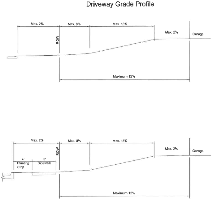
All driveways shall have a maximum grade of twelve (12) percent overall. Shorter segments of driveway may exceed twelve (12) percent, up to a maximum of eighteen (18) percent provided that landings do not exceed two (2) percent at the garage entrance and street entrance through the right-of-way line. Comfort curves (vertical curves) must be provided along the driveway where the difference in the slopes exceeds 1.5% except at the entrance apron.
(g)
All driveways and drive aisles shall not be longer than nine hundred (900) feet, unless a second means of access is provided to a publicly maintained street.
(Ord. No. 1184, 6-9-98; Ord. No. 1598, § 1, 2-8-11; Ord. No. 2083, § 1, 10-14-25)
Sec. 5205 - Parking space dimensions.
(a)
A parking space for an automobile shall have dimensions as specified in the charts and diagrams below:
(Ord. No. 1598, § 1, 2-8-11)
Sec. 5206 - Construction Standards.
(a)
Unless otherwise stated, all parking spaces must be striped or otherwise permanently marked to designate the space.
(b)
Parking bays areas, driveways and interior drive aisles shall be constructed with asphalt or concrete. Alternative surfaces may be used if approved by the Administrator. Surface treatment, gravel, or other material shall not be used, unless the appurtenant street is unpaved or as approved by the Administrator. In reviewing options for parking surfaces other than asphalt or concrete, the Administrator shall consider the intensity of use, frequency of use, size of parking bays, length of travel lanes and the interface of entrances and exits with the public right-of-way. Parking bays or travel lanes constructed of an approved pervious pavement material may be excluded from lot coverage calculations provided product information on performance is submitted that demonstrates the surface remains pervious in the long term and a maintenance plan is approved by the Town. This information may be provided as part of a stormwater management and maintenance plan if such a plan is required. In parking areas containing over ten (10) spaces, additional landscaping standards (section 5427), as set out in this chapter, shall apply.
(c)
Off-street parking areas including drive aisles and driveways may, upon approval of the Administrator, be exempt from provision (b) above if such areas are for a temporary purpose. However, such areas shall be graveled, or have other approved surface treatment, and maintained in accordance with standards approved by the Administrator.
(Ord. No. 1598, § 1, 2-8-11)
Sec. 5210 - General criteria for determining parking.
(a)
When a building includes a combination of uses as set forth in this Division the required parking will be the sum of the required parking for each use.
(b)
Where the parking requirement for a particular use is not defined in this Division, and where no similar use is listed, the Administrator shall determine the number of spaces to be provided based on requirements for similar uses, location of the proposed use, expected demand and traffic generated by the proposed use, and appropriate traffic engineering and planning criteria and information.
(c)
All references to square feet (sq. ft.) in the parking requirements below shall mean the square feet of gross floor area, unless specifically stated otherwise.
(d)
All references to maximum occupancy shall mean the maximum occupancy as determined pursuant to the Virginia Uniform Statewide Building Code.
(e)
Where a fractional space results during calculation of required parking, the determination of whether to round the required number of parking spaces up or down to the next whole number shall be at the discretion of the applicant.
(Ord. No. 1598, § 1, 2-8-11)
Sec. 5211 - Mass or alternate transportation plans.
(a)
The minimum number of parking spaces may be reduced upon the approval of a mass or alternate transportation plan, which details arrangements for the mass or alternate transit of potential visitors to the site, including residents, employees and customers. Such plans shall be subject to the review and approval of the Administrator and Transit Director, prior to the reduction of the number of required parking spaces.
(b)
Each lot for which the minimum number of parking spaces has been reduced shall show a reserve area sufficient in size to accommodate the number of parking spaces which were not required to be constructed. In addition, the developer shall post a letter of credit or other security for a period of two (2) years in an amount sufficient to cover the costs of construction of the parking spaces not required.
(c)
Every approved mass or alternate transportation plan shall be reviewed by the Administrator and Transit Director every two (2) years. The purpose of the review is to ascertain whether the plan has the effect of significantly reducing the automobile traffic to and from the site, and whether the reduced number of parking spaces is sufficient to accommodate the automobile traffic to the site. The Administrator and the Transit Director shall make a determination to this effect. This determination may be appealed to the Board of Zoning Appeals.
(d)
In the event that the Administrator and Transit Director determine that an approved mass or alternate transportation plan has not had the effect of significantly reducing automobile traffic to a site, and that the reduced number of parking spaces is not sufficient to accommodate the automobile traffic to a site, the owner shall construct the number of parking spaces necessary to meet the minimum required under this ordinance.
(Ord. No. 1598, § 1, 2-8-11)
Sec. 5212 - Parking for persons with disabilities.
The number of parking spaces reserved for the disabled shall comply with the federal regulations promulgated pursuant to the Americans with Disabilities Act and the Virginia Uniform Statewide Building Code.
(Ord. No. 1598, § 1, 2-8-11)
Editor's note— Ord. No. 1598, § 1, adopted Feb. 8, 2011, amended App. A, § 5212 title to read as herein set out. Former App. A, § 5212 title pertained to spaces for disabled parking.
Sec. 5213 - Minimum parking for bicycles.
(a)
For developments that require a site development plan as set forth in article V, division 1 of this ordinance, facilities for the off-street parking of bicycles shall be provided as follows:
(b)
Required bicycle stands must be permanently anchored.
(c)
Required bicycle stands must be of inverted U construction and adequately spaced to accommodate multiple bicycles. Other types of construction are allowed as approved by the Administrator provided they meet the intent to allow the secure attachment of multiple bicycles. Ribbon style bicycle racks are not allowed. Required bicycle stands must be located in a safe, accessible area near a public entrance.
(d)
In any case, the Administrator may waive or reduce the bicycle space requirement if the proposed use is in a location not easily accessible to a bicyclist or of a nature such that it is not conducive to bicycling.
(Ord. No. 1598, § 1, 2-8-11)
Sec. 5214 - Minimum parking for motorcycles and scooters.
(a)
For developments that require a site development plan as set forth in article V, division 1 of this ordinance, parking of motorcycles and scooters shall be provided as follows:
(b)
Motorcycle and scooter spaces are not required for parking areas with twenty (20) or fewer required parking spaces.
(c)
Motorcycle and scooter spaces are included in the required minimum parking calculations.
(d)
Every two (2) motorcycle and scooter spaces count as one (1) parking space in parking calculations.
(e)
Motorcycle and scooter spaces shall be a minimum of four and one-half (4½) feet in width by eight (8) feet in length.
(f)
These spaces must be located on the closest drive aisle to the primary entrance.
(g)
In developments of fifty thousand (50,000) square feet or greater, these spaces must be dispersed on the site.
(Ord. No. 1598, § 1, 2-8-11)
Sec. 5215 - Compact parking spaces.
(a)
Compact parking spaces are encouraged.
(b)
Compact parking spaces may comprise up to thirty (30) percent of any parking area.
(c)
Compact parking spaces shall be signed or marked as compact spaces.
(d)
Compact parking spaces are encouraged to be located with access to the drive aisles closest to the primary entrance(s).
(Ord. No. 1598, § 1, 2-8-11)
Sec. 5220 - Minimum parking required and maximum parking allowed.
(a)
A minimum number of off-street parking spaces shall be provided, except in the Downtown Commercial Zoning District, in accordance with the following schedule. The parking space requirements for a use not specifically named herein shall be the same as required for a listed use similar in nature. References to square footage of floor area below refer to gross floor area. There is no minimum number of parking spaces required for allowed uses in the Downtown Commercial District. For uses approved by the granting of a conditional use permit, the provisions contained in section 5220 (b) or (c) must be requested as part of the conditional use permit application.
Schedule A
The schedule sets forth minimum and maximum parking requirements for uses with a combination of functions or operating characteristics.
Schedule B
Specific requirements for the minimum parking required shall be determined by the Administrator based on requirements for similar uses, location of proposed use, number of employees on largest shift, expected demand and traffic generated by the proposed use, and appropriate traffic engineering and planning criteria and information. The maximum number of spaces shall be as shown in section 5220(b). Determination of the minimum requirements in schedule B may be appealed to the Board of Zoning Appeals.
(b)
Parking maximums shall be based on the size of the parking area with the number of parking spaces as calculated using the standards for minimum required parking in section (a). The following parking maximums shall apply:
(c)
Decreasing off-street automobile parking below the required minimum for non-residential uses. The applicant shall submit an application explaining the reduction requested. The request must be based on need and not on such factors as a desire to place a larger building on the site without sufficient supporting parking. All submittals shall include an assessment of the potential impacts on any surrounding residential areas. Multiple reductions may be requested, can be applied cumulatively and include the following:
i.
Reduction of parking through the application for a Mass or Alternative Transportation Plan in accordance with section 5211 or Shared Parking Arrangement in accordance with section 5222.
ii.
Submission of data and analysis justifying the proposed decrease. The submittal shall include actual field data from similar project sites, including data on the number of parking spaces provided, square footage of uses, operational characteristics of the uses, and parking utilization that demonstrates that less parking than the required minimum parking is used on a regular basis. Information from only the proposed location is insufficient. The data and analysis shall be prepared by a professional engineer, architect or landscape architect with experience in site design. The data and analysis is subject to review and approval by the Administrator.
iii.
Reduction in required spaces based on the availability of transit service. When transit service is available within a one-quarter (¼) mile of the site, measured as a pedestrian would walk to the transit stop, and the transit service provides thirty (30) minute peak hour service on a regular schedule then a fifteen (15) percent reduction would be permitted.
(d)
Increasing off-street automobile parking above the allowed maximum for nonresidential uses:
(1)
The applicant shall submit an application explaining the increase requested. The increase requested must be based on need and not on factors such as a desire to have vacant parking spaces visible for marketing purposes. The Applicant shall submit data and analysis justifying the need for the proposed increase. The submittal shall include actual field data from similar project sites, including data on the number of parking spaces provided, square footage of uses, operational characteristics of the uses, and parking utilization that demonstrate the need for increased parking on a regular basis. Information from only the proposed location is insufficient. The data and analysis shall be prepared by a professional engineer, architect or landscape architect with experience in site design. The data and analysis is subject to review and approval by the Administrator.
(2)
If the additional spaces are approved by the Administrator, the spaces may be located on-site or off-site pursuant to section 5221. In all cases, one (1) of the requirement below must be met.
i.
The additional surface parking area shall have thirty (30) percent canopy coverage; or
ii.
The additional surface parking shall be pervious parking material.
(Ord. No. 1598, § 1, 2-8-11; Ord. No. 1845, § 1, 12-12-17; Ord. No. 2002, § 1, 1-10-23)
Editor's note— Ord. No. 1598, § 1, adopted Feb. 8, 2011, amended § 5220 title to read as herein set out. Former § 5220 title pertained to maximum parking required.
Sec. 5221 - Off-site parking permitted, conditions.
Off-street parking spaces may be located on the same lot as the structure or use or off-site, under all of the following conditions:
(1)
Off-site spaces shall be within one thousand (1,000) feet walking distance use, as measured from the parking area entrance along pedestrian walkways, of the primary entrance to the building or use. If the pedestrian access is to cross an arterial street, appropriate safety measures must be present to help the pedestrian cross the street. In any event, safe and convenient pedestrian access should be provided from the structure or use to the parking area.
(2)
Contiguous parking areas providing off-street parking for more than one (1) use shall provide sufficient spaces to comply with the parking requirements for all usages.
(3)
The off-site area may be located in a different zoning district than the structure or use it serves if a parking area is permitted by right or by conditional use permit in the different zoning district.
(4)
The area used for off-site parking must be owned by or leased for at least a twenty (20) year term or through a permanent easement by the owner of the use being served. If the term of the use is limited by a conditional use permit, then the term of the lease agreement may be limited accordingly. At the expiration of the term of a lease, the owner must replace the off-site parking or end the use which required the parking. Town Council may grant a special exception to this requirement under the following criteria: (i) An alternative means of compliance consistent with the intent of this requirement can be shown; or (ii) a lesser lease term is appropriate to the circumstances of the use.
(5)
No changes shall be made to the off-site parking area which would reduce the parking provided for the use, unless other arrangements to provide parking are made by the owner of the use.
(6)
All required handicapped parking spaces for a use must be located on-site.
(7)
All required loading spaces must be located on-site.
(8)
An existing nonconforming parking lot to be used under this section as off-site parking must be landscaped, paved and striped according to the standards of this Division and the Zoning Ordinance.
(Ord. No. 1215, § 34, 5-11-99; Ord. No. 1513, § 1, 4-14-09; Ord. No. 1598, § 1, 2-8-11; Ord. No. 1680, § 1, 5-14-13)
Sec. 5222 - Shared parking arrangements.
Two (2) or more uses may share parking without providing the minimum number of on-site required spaces for each use, under all the following conditions:
(1)
The minimum required number of parking spaces for the combined uses may be reduced by twenty (20) percent for shared parking when hours of operation overlap. Residential uses, except special housing, shall not be allowed to share parking facilities.
(2)
Off-site spaces shall be within one thousand (1,000) feet walking distance of a building entrance or use as measured from the parking area entrance along pedestrian walkways. If the pedestrian walkway access is to cross an arterial street, appropriate safety measures must be present to help the pedestrian cross the street. In any event, safe and convenient pedestrian access, such as a sidewalk or path, must exist or be provided from the structure or use to the parking area.
(3)
When the hours of operation do not overlap, the parking area to be shared must contain at least the minimum required spaces of the largest individual use sharing the lot and shall be developed to the extent of at least being paved and striped according to the standards of this chapter.
(4)
The parking area to be shared must be owned by the owner of one (1) of the uses or leased for at least a 20-year term or through a permanent easement by the owner of the uses being served.
(5)
No changes shall be made to the shared parking area which would reduce the parking provided for the uses, unless the owner of one (1) of the uses makes other arrangements to provide parking. No such changes shall be made without Administrator approval.
(6)
Parking spaces to be shared must not be reserved for a specific person, individual, or use on a twenty-four (24) hour basis.
(7)
Handicap parking spaces cannot be shared, unless the uses that are to share the spaces are adjacent to the handicap spaces and no inconvenience to the users of such spaces would be created.
(8)
Loading spaces shall not be shared.
(9)
Any proposed change in the use of a structure that shares a parking area will require proof that adequate parking is available.
(Ord. No. 1598, § 1, 2-8-11)
Sec. 5223 - Off-site and shared parking.
Off-site and shared parking may be used in combination to develop parking areas, provided all the requirements of this division are met.
(Ord. No. 1598, § 1, 2-8-11)
Editor's note— Ord. No. 1598, § 1, adopted Feb. 8, 2011, amended App. A, § 5223 title to read as herein set out. Former App. A, § 5223 title pertained to off-site and shared facilities.
Sec. 5230 - Stacking spaces for drive-through facilities.
(a)
Stacking spaces shall be provided for any use having a drive-through facility or areas having drop-off and pick-up areas. The following general standards shall apply to all stacking spaces and drive-through facilities:
(1)
Stacking spaces and lanes for drive-through stations shall not impede on and off-site traffic movements, shall not cross or pass through off-street parking areas, shall not be located in front of the building, and shall not create a potentially unsafe condition where crossed by pedestrian access to a public entrance of a building.
(2)
Drive through lanes shall be separated from off-street parking areas. Individual lanes shall be striped, marked or otherwise distinctly delineated.
(3)
Approach lanes for drive-through facilities shall have the following minimum widths:
a.
One lane = Twelve (12) feet.
b.
Two or more lanes = Ten (10) feet per lane.
(4)
All drive-through facilities shall be provided with a bypass lane with a minimum width of ten (10) feet.
(5)
Alleys in residentially zoned areas adjacent to drive-through facilities shall not be used for circulation of customer traffic.
(6)
Each stacking space shall be a minimum of ten (10) feet by twenty (20) feet.
(b)
The number of stacking spaces shall be provided as follows:
(1)
Financial institutions with drive-through windows: Four (4) stacking spaces for the first drive-through window and two (2) stacking spaces for each additional window.
(2)
Car wash: Four (4) stacking spaces per bay/stall for self-service establishments and five (5) stacking spaces per bay/stall for an automated establishment.
(3)
Drive-in or fast food restaurant: Three (3) stacking spaces per drive-through window measured from the order board or station.
(4)
All other uses: Three (3) stacking spaces for each window.
(Ord. No. 1598, § 1, 2-8-11)
Sec. 5240 - Off-street loading, generally.
General provisions:
(1)
All required off-street loading spaces shall be located on the same lot as the structure or use.
(2)
All off-street loading spaces and their appurtenant aisles and driveways shall not be reduced in any manner except upon approval by the Administrator when a change in land use or building size reduces the total number of loading spaces required.
(3)
Loading spaces facing a street shall not exceed thirty (30) feet in width unless screened so as not to be visible from the right-of-way.
(4)
No loading space shall be located within the front yard setback applicable in any residential, office or commercial or industrial district.
(5)
No required off-street loading area shall be used to meet the space requirement for off-street parking, and no loading area shall interfere with the free circulation within the off-street parking area.
(6)
All off-street loading spaces shall have safe and convenient access to a street. If any such spaces are contiguous to a street, the street side of such space shall be curbed.
(7)
All off-street loading areas, including aisles and driveways, shall be constructed and maintained with a dustless surface in accordance with construction standards presented in this ordinance.
(8)
All off-street loading spaces shall comply with the geometric standards in this section.
(9)
When a building includes a combination of uses as set forth in this section, the required number of loading spaces will be the sum of the required loading spaces for each use. In no case shall the development be required to provide in excess of five (5) loading spaces.
(10)
All references to square feet (sq. ft.) in the off-street loading requirements below shall mean the square feet of gross floor area, unless specifically stated otherwise.
(Ord. No. 1215, § 31, 5-11-99; Ord. No. 1598, § 1, 2-8-11)
Sec. 5241 - Loading spaces—Classifications.
A loading space shall consist of a rectangular area of one (1) or more of the following classes:
(1)
Class A. An area at least fourteen (14) feet by fifty-five (55) feet having a vertical clearance of fifteen (15) feet or more, plus adequate area for ingress and egress.
(2)
Class B. An area at least twelve (12) feet by thirty (30) feet having a vertical clearance of fifteen (15) feet or more, plus adequate area for ingress and egress.
(Ord. No. 1598, § 1, 2-8-11)
Sec. 5242 - Minimum loading spaces required.
(a)
Except in the Downtown Commercial Zoning district, and except as provided below, loading spaces shall be provided for retailing, wholesaling, warehousing, processing and similar activities or uses in accordance with the following schedule. "Square footage" refers to gross square footage of the improvement.
(b)
The Administrator may substitute a Class A space for a Class B space if tractor-trailer use is expected. The Administrator may substitute a Class B space for a Class A space if no tractor-trailer use is expected.
(c)
The Administrator may require additional Class A or Class B loading spaces to reduce anticipated traffic congestion due to an expected large number of deliveries. Where the Administrator finds a reduced need or the absence of need for loading spaces, due to a small number of anticipated deliveries, the Administrator may reduce or eliminate the requirement for loading spaces and for Class B spaces allow shared loading.
(Ord. No. 1598, § 1, 2-8-11)
Sec. 5300 - Buffer yards—Purpose.
The purpose of buffer yards is to limit the view and reduce the noise between abutting incompatible uses, and to ease the transition from one (1) zoning district to another. Buffer yards are intended to provide a physical integration of uses which promote the public health, welfare and safety by:
(1)
Preventing visual pollution;
(2)
Preventing the overcrowding of land;
(3)
Preventing the undue congregation of people and vehicles; and
(4)
Promoting the peaceful enjoyment of property within the Town of Blacksburg.
Sec. 5305 - Buffer yards—When required.
(a)
A buffer yard shall be required of any lot in any zoning district when the lot in that district abuts a zoning district of lower intensity.
(b)
When a public right-of-way separates zones of different intensities, the following criteria shall apply, regardless of whether the zoning line is on one (1) side or the other or the center of the public right-of-way:
(1)
If the public right-of-way is an alley, a buffer yard with screening shall be provided as per the table below.
(2)
If the public right-of-way is a local or collector street, a buffer yard with screening shall be provided on any side or rear of the higher intensity use which abuts the right-of-way as per the table below; however the buffer yard shall not be required on the front of the higher intensity use where the front abuts the public right-of-way.
(3)
If the public right-of-way is an arterial street or highway, no buffer yard or screening shall be required for the portion of the higher intensity use abutting the public right-of-way.
(c)
No buffer yard is required within or adjacent to the University zoning district.
(d)
When a site plan is submitted to modify or expand an existing building or site improvements, or accommodate a change in land use, buffer yard and screening requirements shall only be applied to those portions of the site that are directly affected by the proposed improvements, or change in land use, as determined by the Administrator.
Sec. 5310 - Buffer yards—General standards.
(a)
Buffer yards shall contain vegetative and/or architectural screening that achieves the purpose of the buffer yard, and which meets the requirements for screening, below. Trees used for screening purposes shall be suitable as defined in Section 5331.
(b)
The maximum slope of any buffer yard shall be 2H:1V. Additional width shall be added to any portion of any buffer yard which exceeds this slope such that the minimum buffer yard width is met by land less steep than 2H:1V.
(c)
The buffer yard shall be located entirely within the higher intensity zoning district and abutting the zoning district line, or adjacent right-of-way if such right-of-way separates the lot from the zoning district line. However, the buffer yard may be placed in the lower intensity zoning district or partially within both zoning districts if both sides of the zoning district line and entire buffer yard width are within common ownership and a permanent easement is provided over any portion of the buffer yard not within the higher intensity zoning district.
(d)
A driveway required to serve the principal structure on the site may exist in the buffer yard. This driveway shall run substantially perpendicular to the buffer yard.
(e)
Buffer yards shall be maintained in a natural condition free of structures, loading or storage areas, parking, roads, or driveways except as provided for in (d) above.
(f)
Buffer yards required by this Section shall be applied equally to all similarly situated properties. Modifications to these standards may be granted in writing by the Administrator based on the existence of the following circumstances on the proposed building site, or surrounding properties:
(1)
Natural land characteristics such as topography or existing vegetation on the proposed building site would achieve the same intent of this section.
(2)
Innovative landscaping or architectural design is employed on the building site to achieve an equivalent screening or buffering effect.
(3)
The required screening and landscaping would be ineffective at maturity due to the proposed topography of the site, and/or the location of the improvements on the site.
(4)
The topography of adjacent and surrounding sites is such as to render required screening ineffective at maturity.
(g)
When the acreage of a site is significantly larger than the area proposed for physical improvements or active usage, buffer yards shall be reserved as required by this section. However, to achieve the intent of this section, the Administrator may require an alternative location and design for required screening and plantings.
(h)
When property lines abut an adjacent jurisdiction, the Administrator shall determine the specific screening and buffering requirements along that property line after consideration of the zoning designation and or land use of the adjacent property. Requirements shall not exceed those that would be required for similarly situated/zoned property within the Town.
(i)
Buffer yard dimensions and screening requirements shall be provided as detailed in the chart below:
(Ord. No. 1215, § 32, 5-11-99; Ord. No. 1439, 4-10-07; Ord. No. 1680, § 1, 5-14-13)
Sec. 5330 - Screening—When required.
(a)
Screening shall be provided within a buffer yard to ease the transition of one (1) land use or activity to another, to achieve the purposes of the buffer yard. Screening may be accomplished through architectural or vegetative materials.
(b)
Screening shall be provided, in addition to the requirements listed above, for:
(1)
All articles or materials being stored, maintained, repaired, processed, erected, fabricated, dismantled, or salvaged, such that the activity is not visible from surrounding properties or roads.
(2)
Refuse storage and loading areas such that these activities are not visible from surrounding properties or roads.
(3)
Rooftop and ground level mechanical equipment such that it is not visible from surrounding properties or roads.
(4)
All trash dumpsters or containers used for recycling shall be screened so that it is not visible from surrounding properties or roads. At minimum, the dumpster or container shall be screened on three (3) sides with architectural screening supplemented by plantings. Screening shall be based upon the standards below and subject to the approval of the Administrator.
a.
Four (4) foot tall architectural screening is acceptable when household style trash containers are used in place of dumpsters;
b.
The requirement for supplemental plantings may be waived by the Administrator in cases where dumpsters or containers are added to an existing development. In determining whether to grant a waiver, the Administrator shall be guided by these standards: proximity of the facility to residential structures; efficacy of screening to mitigate any adverse effect of the use; and benefit of the screening relative to its cost.
(c)
No screening is required within or adjacent to the University zoning district.
(d)
When a site plan is submitted to modify or expand an existing building or site improvements, or accommodate a change in land use, screening requirements shall only be applied to those portions of the site that are directly affected by the proposed improvements, or change in land use, as determined by the Administrator.
(Ord. No. 1308, § 63, 8-13-02)
Sec. 5331 - Screening—General standards.
(a)
Screening shall be continuous and in place at the time of occupancy. If vehicular or pedestrian access through the screen is necessary, the screening function shall be preserved.
(b)
Screening may be architectural or vegetative, per the requirements below:
(1)
Acceptable architectural screening materials include stockade fences, decorative masonry walls, brick walls, and earth berms, and other like materials approved by the Administrator.
(2)
Architectural screening shall be at least four (4) feet in height, shall be supplemented with plantings, and shall be subject to the provisions of Blacksburg Town Code Section 21-304, "sight triangles established."
(3)
Vegetative material shall be alive and in good health.
(4)
Small evergreen trees shall be at least four (4) feet in height at planting and allowed to grow to at least six (6) feet in height. Large evergreen trees shall be at least six (6) feet in height at planting and allowed to grow to at least ten (10) feet in height. All required evergreen vegetation shall be maintained in good condition.
(5)
Deciduous trees shall be at least one and one-half (1½) inches caliper or ten (10) feet to twelve (12) feet in height. They shall be supplemental and not deemed to be adequate screening in themselves.
(6)
Acceptable vegetative plantings include any tree listing in the "recommended list of trees" for screening purposes; or yew, box honeysuckle or similar dense hedge.
(c)
Screening design and development shall be compatible with the existing and proposed land use and the development character of the surrounding land and structures.
(d)
Screening shall be of sufficient density and diversity to achieve the intent of this section. However, at the time of planting, the spacing of trees shall not exceed twelve (12) feet on center, and the planting pattern shall be staggered. Shrubbery shall be more closely-spaced. Specific exceptions to this requirement may be granted by the Administrator to encourage quality and creativity of design where the intent of this section is met.
(e)
Existing vegetation within buffer yards shall be considered as a substitute for otherwise required landscaping or screening, if in the opinion of the Administrator, the type, size, and density of the existing vegetation complies with the standards and intent of this section.
(f)
When a proposed buffer yard has a variation in elevation of greater than ten (10) vertical feet at any point, the required screening or landscaping within the yard shall be placed to maximize the effectiveness of the screening or landscaping, as determined by the Administrator.
(g)
Trees planted to meet any of the screening requirements may also be used to meet any other landscaping requirement within this Article.
(h)
Screening required by this section shall be applied equally to all similarly situated properties. Modifications to these standards may be granted in writing by the Administrator based on the existence of any of the following circumstances on the proposed building site, or surrounding properties:
(1)
Natural land characteristics such as topography or existing vegetation on the proposed building site would achieve the same intent of this section.
(2)
Innovative landscaping or architectural design is employed on the building site to achieve an equivalent screening or buffering effect.
(3)
The required screening and landscaping would be ineffective at maturity due to the proposed topography of the site, and/or the location of the improvements on the site.
(4)
The topography of adjacent and surrounding sites is such as to render required screening ineffective at maturity.
(Ord. No. 1247, § 20, 9-12-00; Ord. No. 1680, § 1, 5-14-13)
Sec. 5400 - Landscaping—Purpose.
The preservation of existing trees and vegetation, as well as the planting of new trees and vegetation, can significantly add to the quality of the physical environment of the community. The regulations outlined herein are designed to provide for the health, safety and welfare of the residents of the Town. Trees can provide the following benefits to the community:
(1)
Provide buffers and screens against noise, air pollution, and unsightly and incompatible land uses;
(2)
Reduce the hazards of flooding and aid in the control of erosion and storm water runoff. Trees also assist in the stabilization of soil and replenish groundwater supplies;
(3)
Act to moderate extremes of temperature and provide shade;
(4)
Absorb carbon dioxide and supply oxygen in our atmosphere, which is an essential ecological function in the preservation of human and animal life. Trees can provide a haven for birds which, in turn, assist in the control of insects;
(5)
Aid in energy conservation;
(6)
Are physiologically, psychologically, sociologically and aesthetically necessary counterpoints to the man-made urban setting.
Sec. 5410 - Landscaping—When required.
The requirements of this division apply to any development for which a site development plan is required by Article V, Division 1, "Site Development Plans," section 5100.
Sec. 5420 - Landscaping—General standards.
(a)
Acceptable trees include, but are not limited to, those identified as suitable for the intended use in the "Recommended list of trees" figure below. Acceptable vegetative ground cover consists of shrubs and ground cover including grass. Using standards from recognized texts on the subject, the Administrator shall decide the appropriateness of any such trees and ground cover.
(b)
Species of trees shall not be planted if the roots cause damage to public works, the branches are subject to a high incidence of breakage, and the fruit is considered a nuisance or high maintenance, as determined by the Administrator.
(c)
The planting of trees shall be done in accordance with the standardized landscape specifications jointly adopted by the Virginia Nurserymen's Association, the Virginia Society of Landscape Designers and the Virginia Chapter of the American Society of Landscape Architects.
(d)
All trees shall be planted in good condition and meet "American Standard for Nursery Stock" (1990), ANSI Z60.1-1990, as may be amended.
(e)
The developer shall plant, or install, as appropriate grass, tree grates, porous pavers, or similar pervious surfaces, which shall extend to twice the initial drip line of the newly planted tree. Minimum tree grate size shall be five square feet.
(f)
Trees planted to meet any of the requirements below may also be used to meet any other screening or landscaping requirement within this Article.
Sec. 5425 - Tree replacement requirements.
Any trees on the site which are a caliper of five inches or more at a height of one foot above the ground, or ornamental trees over twelve feet in height which are to be removed during site development shall be replaced up to the maximum canopy coverage required in Section 5426 below.
(Ord. No. 1247, § 21, 9-12-00)
Sec. 5426 - Canopy coverage requirements.
(a)
Trees shall be provided within the limits of construction to the extent that at twenty years from the date of planting, tree canopies or covers will provide at least the following minimums:
(b)
Existing trees or wooded areas which are to be preserved, at the applicants option may be included to meet all or part of the canopy requirements, provided the site plan identifies such trees and the trees meet the standards of size, health, placement, etc. set out in this section. The Administrator shall evaluate use of existing trees to ensure they have adequate health and strength to allow such use.
(c)
Existing trees designated to be included as part of these requirements shall be protected during construction by fencing placed at a distance in feet equal to or greater than the diameter of the tree in inches at the height of 4½ feet.
(d)
The extent of canopy at maturity shall be based on published reference texts described below, generally accepted by landscape architects, nurserymen, and arborists.
(Ord. No. 1215, § 33, 5-11-99; Ord. No. 1439, 4-10-07)
Sec. 5427 - Parking lot landscaping.
(a)
The following provisions are intended to require that 5% of the entire parking lot, excluding the access drive, is landscaped with trees and vegetative ground cover. The area of the parking lot is the square foot area of the parking spaces and aisles and interior parking lot islands, excluding access drives that do not contain either parallel or perpendicular parking spaces.
(b)
Within the parking lot there shall be planted one tree per ten spaces, rounded down to the closest whole number.
(c)
Planter islands or peninsulas containing trees shall be located within the parking lot, such that each island or planter is surrounded on at least 3 sides by parking lot or an access road to the parking lot. Their size shall be eighteen feet square in area, or equal total area in irregular shapes such that adequate space is provided for adequate tree canopy maturation.
(d)
Planter islands may be combined or placed together such that more than one tree may be provided in the combined planter island, so long as the total space equals a multiple of the requirements above.
(e)
Perimeter plantings may be used to satisfy this requirement in parking facilities less than forty-two feet in width.
(f)
Perimeter planting beds at least 10 feet in width shall be provided whenever a parking area is immediately adjacent to a public right-of-way. If a question arises as to whether or not a parking area is immediately adjacent to a public right-of-way, the Zoning Administrator shall make the determination. (Ord. No. 1184, adopted 6-9-98)
(1)
Plantings within this area shall include trees and vegetative ground cover.
(2)
Berms may be used in addition to, but not instead of plantings.
Sec. 5428 - Street trees.
(a)
In addition to the requirements set out above, in every development requiring a site development plan, there shall be planted on or adjacent to the site an average of at least one tree for every thirty feet of public street frontage.
(b)
The trees shall be planted adjacent to the public right-of-way on the site being developed, or with the concurrence of the developer, and the Administrator in the public right-of-way.
(c)
The Administrator may reduce or eliminate this standard based on the size, street frontage, existing vegetation, and specific conditions of the site.
Sec. 5429 - Recommended tree species.
Acceptable trees include, but are not limited to, those identified as suitable for the use intended in the table below:
RECOMMENDED TREE SPECIES
P = Parking Lot and Street Trees
L = General Landscape Trees
S = Screening Trees
* = Use of native species is encouraged
Sizes shown in feet are height; sizes shown in inches are caliper
(Ord. No. 1184, adopted 6-9-98; Ord. No. 1308, § 64, 8-13-02)
Sec. 5440 - Landscaping—Modifications.
(a)
Tree canopy and tree replacements shall not be required of playing fields and other nonwooded recreation areas, and other facilities and uses of a similar nature.
(b)
Tree canopy provisions shall not apply where they would negatively affect the preservation of wetlands.
(c)
Landscaping requirements of this Section shall be applied equally to all similarly situated properties. Modifications to these standards may be granted in writing by the Administrator based on the existence of any of the following circumstances on the proposed building site, or surrounding properties:
(1)
Natural land characteristics such as topography or existing vegetation on the proposed building site would achieve the same intent of this section.
(2)
Innovative landscaping or architectural design is employed on the building site to achieve an equivalent screening or buffering effect.
(3)
The required screening and landscaping would be ineffective at maturity due to the proposed topography of the site, and or the location of the improvements on the site.
(4)
The topography of adjacent and surrounding sites is such as to render required screening ineffective at maturity.
(d)
When a site plan is submitted to modify or expand an existing building or site improvements, or accommodate a change in land use, landscaping requirements shall only be applied to those portions of the site that are directly affected by the proposed improvements, or change in land use, as determined by the Administrator.
(e)
No landscaping or screening shall be required which in the opinion of the Administrator interferes with traffic safety, or which violates Town Code Section 21-304.
(Ord. No. 1419, § 1, 12-11-07; Ord. No. 1680, § 1, 5-14-13)
Editor's note— Ord. No. 1680, § 1, adopted May 14, 2013, amended § 5440 title to read as herein set out. Former § 5440 title pertained to landscaping—exceptions.
Sec. 5500 - Purpose of division.
The sign regulations are intended to define, permit, and control the use of signs which are legible from the public right-of-way. Town Council has adopted these regulations in order to achieve all of the following community goals and objectives:
(1)
Protect the health, safety, and welfare of the public.
(2)
Equitably distribute the privilege of using the public environs to communicate private information.
(3)
Safeguard the public use and nature of the streets and sidewalks.
(4)
Protect and enhance the visual environment of the Town.
(5)
Discourage the diminishing of property values with the Town.
(6)
Minimize visual distractions to motorists using the public streets.
(7)
Promote an aesthetically pleasing environment for the citizens of this Town.
(8)
Promote the economic growth of the Town by creating a community image that is conducive to attracting new business and industrial development.
(9)
Permit reasonable legibility and effectiveness of signs and to prevent their over-concentration, improper placement and excessive height, bulk, density, and area.
(10)
Promote the safety of persons and property by requiring that signs not create a hazard due to collapse, fire, decay, or abandonment.
(11)
Ensure that signs do not obstruct fire-fighting efforts, and do not create traffic hazards by confusing or distracting motorists or by impairing drivers' ability to see pedestrians, obstacles, or other vehicles or to read traffic signs.
(12)
Provide for reasonable advertising of business and civic products and services, with recognition of the effects of signage on the character of the community.
(13)
Control visual clutter, and encourage high professional standards in sign design and display.
Sec. 5501 - Standards.
(a)
Any sign displayed in the Town of Blacksburg, shall comply with:
(1)
All provisions of this Article;
(2)
All applicable provisions of the Uniform Statewide Building Code and all amendments thereto; and
(3)
All state and federal regulations pertaining to the display of signage.
(b)
If any two or more sections of the above referenced regulations are in conflict, the provision that provides the most restrictive standard shall apply.
Sec. 5502 - Excluded signs.
The following shall be deemed to be excluded from the regulations of this division:
(1)
Any sign with an area of one square foot or less.
(2)
Signs on the inside of store windows, except those signs specified as "Prohibited Signs" in this Article.
(3)
Signs of a duly constituted governmental body, such as, but not limited to, traffic, warning, directional, street, regulatory signs or governmental signs which are directly related to the health, safety, convenience or welfare of the community. Governmental signs for proprietary or identification purposes shall not be included with this subparagraph and must conform to the regulations of the district in which they are located.
(4)
Memorial signs or bulletin boards, as provided below:
(a)
memorial signs shall be two square feet or less in display area and integrated with the primary structure (not a free-standing sign);
(b)
bulletin boards on which notices of public interest are temporarily posted shall be a maximum 12 square feet in area and mounted on a wall. Bulletin boards shall be excluded only for public uses or permitted civic uses.
(5)
Signs displayed for the direction or convenience of the public, including signs which identify restrooms, location of public telephones, public entrances, freight entrances or the like provided such signs do not exceed a total surface area of three square feet per sign on any lot or parcel.
(6)
Reserved.
(7)
Reserved.
(8)
Gasoline price signs, provided the total area of all such signs is twelve square feet or less.
(9)
Signs displayed during the month of December for the purpose of selling Christmas trees and other holiday vegetation and accessory items.
(10)
Flags of the Commonwealth of Virginia, United States of America, and any other flag of a state or nation flown for noncommercial purposes; or flags displaying purely ornamental and noncommercial information, such as graphic depictions such as flowers and the like.
(11)
Reserved.
(12)
Street address signs, not exceeding 10 square feet in size.
(13)
Signs displayed on a truck, bus, or other vehicle while in use in the normal conduct of business. This section shall not be interpreted to permit the parking for display purposes a vehicle to which a sign is attached or the use of such a vehicle as a portable sign.
(14)
Reserved.
(15)
Menu/Daily Special signs, not exceeding four square feet in size, provided the sign is attached to a building facade.
(16)
Street Graphics.
(17)
Reserved.
(18)
Signs that are not legible from a public right-of-way.
(Ord. No. 1247, § 22, 9-12-00; Ord. No. 1308, § 65, 8-13-02; Ord. No. 1415, § 23, 7-11-06)
Sec. 5503 - Prohibited signs.
The following signs are prohibited in this Town:
(1)
A sign which imitates or approximates an official highway sign or carries the word, "STOP" or "DANGER"; or any sign which obscures a sign displayed by public authority for the purpose of giving traffic instruction or direction or other public information.
(2)
Flashing or revolving lights, or beacons intended to direct attention to a location, building or service, or any similar device otherwise displayed that imitates by its design or use, emergency service vehicles or equipment. Flashing or revolving lights that by their design or use imitate emergency service vehicles or equipment, placed within an establishment so as to be visible from a public right-of-way are also prohibited.
(3)
Any sign, except an official public notice, which is nailed, tacked, posted, or in any other manner attached to any utility pole, or structure supporting wire, cable, or pipe; or to public property of any description.
(4)
Signs advertising activities or products that are illegal under federal, state, Town or county law.
(5)
Any electrical sign that does not display the UL, ETL, CSA or ULC label.
(6)
Any sign that due to its size, location or height obstructs the vision of motorists or pedestrians at any intersection, or similarly obstructs the vision of motorists entering a public right-of-way from private property.
(7)
A sign which obstructs any window or door opening used as a means of egress, or which prevents free passage from one (1) part of a roof to any other part thereof, and a sign which interferes with an opening required for ventilation.
(8)
A sign in a public right-of-way except as provided in Sections 5562, (Banners) 5523, (Location) and 5531(d), (Neighborhood identification signs) of this article. Any sign existing or having been allowed in a public right-of-way may be ordered removed by the Administrator upon thirty (30) days' notice if the use of that right-of-way is changed to require the signs' removal, or if the public right-of-way is to be used for any public purposes inconsistent with the existence of the sign.
(9)
A sign or illumination that causes any glare into or upon any building or land other than the building and land to which the sign is accessory.
(10)
A sign that violates any provision of any federal or state law relative to outdoor advertising.
(11)
Signs with moving components.
(12)
Pennants, streamers, except as provided in Section 5504 (Temporary signs).
(13)
Large floating or stationary balloons.
(14)
Signs attached, painted, or mounted to unlicensed and inoperative or generally stationary vehicles.
(15)
A-frames and portable roadside signs.
(16)
Strip lights or strip lighting.
(17)
Any sign representing or depicting specified sexual activities or specified anatomical areas or sexually oriented goods. Any sign containing obscene text or pictures as defined by the Virginia Code.
(Ord. No. 1278, § 14, 11-13-01; Ord. No. 1340, § 6, 8-12-03)
Sec. 5504 - Temporary signs.
(a)
Temporary signs are permitted provided they meet the standards of this section. The area of any temporary sign maintained per this section shall not count for the allowable permanent sign area for any lot or structure.
(b)
A "temporary sign" is a sign that is not permanently mounted to a building or into the ground. Signs attached by rope, string, chain, tape, paste, and similar mechanisms; signs not rigidly attached to a supporting structure; signs made of paper, cardboard, cloth, and similar materials; and signs that are pushed, hammered or similarly put into the ground are considered temporary signs.
Examples of temporary signs include garage or yard sale signs, political campaign signs, real estate signs, construction signs, menu/daily special signs.
(c)
Each temporary sign shall be maintained in good, safe condition, securely affixed to a building or the ground.
(d)
Temporary sign area per lot shall not exceed thirty-two (32) square feet.
(e)
Any temporary sign pertaining to an event must be removed within ten (10) days after the event. For example, garage or yard sale signs, political campaign signs, and real estate signs are subject to this provision. For all other temporary signs, a maximum posting period of fourteen (14) consecutive calendar days is permitted, up to five (5) times per calendar year. Such signs shall not be attached in any way to utility poles, meter posts, or trees within any public street right-of-way. No person shall put up any notice upon any building, wall, fence or other property of another person without having first obtained the consent of the owner of such property.
(f)
A temporary sign shall not be illuminated.
(g)
Pennants and streamers, without advertising, may be displayed simultaneously with temporary signs, but at no other time.
(h)
In addition to the foregoing, during the two (2) week period beginning one (1) week before the start of classes for the fall term of Virginia Polytechnic Institute and State University and during the Homecoming Weekend (Friday noon through Monday noon) businesses and other persons shall be allowed up to two (2) temporary signs with no permit required, provided:
(1)
Each sign is thirty-two (32) square feet or less in area;
(2)
Each sign is on-premises and attached to the structure or a permanent sign;
(3)
Such signs are displayed no more than fourteen (14) consecutive days.
(Ord. No. 1247, § 23, 9-12-00; Ord. No. 1308, § 66, 8-13-02)
Sec. 5510 - Sign permit process.
(a)
No sign may be erected or displayed, enlarged, relocated, changed, or modified without an approved sign permit, except as provided in Section 5502, "Excluded Signs."
(b)
Applications for a sign permit may be obtained from the Town of Blacksburg department of planning and building.
(c)
Any owner or tenant of a parcel of land upon which a sign is to be displayed, or any authorized agent of such owner or tenant may apply for a sign permit.
(d)
Every application for a sign permit shall include a sketch of the property indicating the lot frontage. The application shall also indicate the square footage and location of all existing signs on the property, and the area, size, structure, design, location, lighting, and materials for the proposed signs. In addition, the Administrator may require that the application contain any other information that is necessary to ensure compliance with, or effectively administer, these regulations.
(e)
All applications for a sign permit in the Planned Commercial, Planned Residential, Planned Industrial, and Planned Manufactured Home districts must be in accord with the sign plan approved for that district.
(f)
All applications for a sign permit for property upon which a permitted conditional use is located must be in accord with the conditional use permit. In the alternative, the applicant may apply for an amended conditional use permit.
(g)
A nonrefundable sign permit fee is due and payable with the filing of a sign permit application. More than one (1) sign on one (1) building or group of buildings located on the same parcel of land may be included on one (1) application provided that all such signs be applied for at one (1) time.
(h)
After the issuance of an approved sign permit, the applicant may install and display any such sign or signs approved. Once installed, the Administrator may inspect the sign(s) for conformance with the approved sign permit and this ordinance.
(i)
Any sign permit issued shall be null and void if any sign for which the permit was issued is not installed in accordance with the permit within six (6) months of the date the permit was approved.
(j)
Maintenance, repair, or restoration of nonconforming signs shall be in accordance with Section 1237, "Nonconforming Signs."
(k)
Upon the occupant's vacating a lot or building, the owner, within six (6) months after vacation shall remove all signs, sign supports, and attendant hardware from the premises, unless the provisions of the next sentence are applicable. An owner with a new tenant or a new owner has six (6) months after such vacation to use or remove all signs, sign supports, and attendant hardware. Each subsequent occupant of the lot or building shall obtain a new sign permit prior to erecting or changing the structure of any sign.
(Ord. No. 1465, § 1(c), 2-12-08; Ord. No. 1513, § 1, 4-14-09)
Sec. 5520 - Sign measurement rules.
Sign area shall be calculated as follows:
(a)
The area of an attached sign where the sign consists of words, numerals or symbols painted on or affixed to a wall, or awning shall be the entire area within a continuous perimeter enclosing the extreme limits of each word, symbol, numeral, groups of symbols, or groups of numerals, where the symbols or numbers are meant to be read as a unit. Where there is a symbol that encompasses or partly encompasses the message of the sign, the sign area shall be the entire area within a continuous perimeter enclosing the extreme limits of the symbol.
(b)
The area of a suspended, attached, or projecting sign, where the letters, numerals, or symbols are on a sign surface which is hung or affixed to a structure, shall be the total area of the hung or affixed surfaces.
(c)
The area of freestanding monument sign shall be the total area above the base visible from the public right-of-way or other point from which the sign is intended to be viewed. Only one (1) display face shall be measured in computing the total sign area where the sign faces are arranged to be viewed at one (1) time.
(d)
The area of a monument sign shall not include the surface area of the base of the sign which is not designed to contain any copy area.
(e)
The area of a V-shaped sign shall be the area of all surfaces legible from the public right-of-way or other point from which the sign is intended to be viewed. Only one (1) face shall be measured if the angle of the sign is forty-five (45) degrees or less.
(f)
The Administrator shall determine the area of any sign not specifically provided for herein, according to the principles contained in this section.
(Ord. No. 1231, § 1, 1-11-00)
Sec. 5521 - Calculation of sign area by facade.
Signage based on building facade is calculated as follows:
(a)
The area of an attached, suspended, awning, cabinet, v-shaped or projecting sign is based on a percentage of the building facade to which the sign is attached as specified by zoning district.
(b)
The area of the facade is calculated by multiplying the width by height of the facade. The height shall be measured by calculating the vertical distance from grade to the top of the wall of a flat roof, or to the eave line of a gable, hip, or gambrel roof. For a multi-establishment building, the area of the facade shall be determined for each individual establishment, and a change in establishment shall constitute a change in facade for the purposes of these calculations.
(c)
In cases where the height of the building cannot be determined the average height shall be twelve (12) feet per story.
(d)
Facades may not be combined for the purposes of calculating sign area.
(e)
For individual buildings occupied by one (1) or more establishments, including shopping centers, a maximum of one hundred twenty (120) square feet of attached, suspended, awning, cabinet, v-shaped, or projecting signage per facade may be allowed. In any event, no building facade shall be covered by signage that exceeds the maximum percentage allowed.
(Ord. No. 1415, § 24, 7-11-06)
Sec. 5522 - Calculation of allowable sign area on corner lots.
(a)
On corner lots, the frontage shall be either (1) the side fronting the street providing primary vehicle access, or (2) the side which the main pedestrian entrance of the structure faces. Where neither of these methods clearly distinguishes the front, the Administrator shall make a determination. Where both of these methods would identify a front, the Administrator shall make the determination.
(b)
For commercial or industrial uses, the front shall not be a primarily residential street.
Sec. 5523 - Required sign clearance and placement.
(a)
Awning signs: Awning signs shall be securely attached to the building, must be at least seven (7) feet above the sidewalk, and shall not extend beyond the curb line. Where there is no curb, awning signs shall not extend beyond the edge of street pavement.
(b)
Attached signs: An attached sign shall not extend above the roof line of a building to which it is attached.
(c)
Directional signs: A directional sign shall be located adjacent to curb cuts, at least three (3) feet from the right-of-way, with no more than one (1) sign per one-way curb cut and two (2) directional signs per two-way curb cut.
(d)
Projecting and suspended signs: Such signs may project from a building wall a maximum of eighteen (18) inches.
(e)
Freestanding monument signs: Such signs shall be located a minimum distance of ten (10) feet from the edge of any public right-of-way, if the right-of-way is fifty (50) feet or more in width. Such signs shall be located a minimum distance of thirty-five (35) feet from the center line of any public right-of-way where the right-of-way is less than fifty (50) feet in width. Freestanding monument signs shall have a maximum height of eight (8) feet, monument style. Freestanding monument signs shall be located within a landscaped area which includes vegetative materials such as shrubs, trees, or flowering plants. This subsection shall not apply to neighborhood identification signs.
(Ord. No. 1184, adopted 6-9-98; Ord. No. 1278, § 15, 11-13-01)
Sec. 5524 - Illumination of signs.
(a)
Signs may be illuminated either through the use of backlighting or direct lighting provided the following standards are met:
(1)
Information on any illumination proposed as part of a sign must be provided by the applicant on the sign permit application.
(2)
No light from any illuminated sign shall cause direct glare into or upon any building other than the building to which the sign is related.
(3)
No light from any illuminated sign shall cause direct glare on to any adjoining piece of property, or any adjoining right-of-way.
(b)
Any sign containing electrical components shall conform to current UL, ETL, CSA, or ULC standards and display a label from one (1) of these recognized testing labs.
Sec. 5525 - Monument sign base requirements.
The base of a monument sign is the structure or apparent structure in direct contact with the ground that supports or appears to support the message portion of a monument sign. All monument signs shall have a minimum base height of eighteen (18) inches and a maximum of four (4) feet. The width of the base shall not exceed twice the height of the total structure and shall not extend more than one (1) foot beyond either outside edge of the message portion of the sign. The minimum width of the base shall be one-half (½) the width of the message portion of the sign.
(Ord. No. 1231, § 2, 1-11-00)
Sec. 5530 - Signage regulations by district.
Signs are permitted within the various zoning districts of the Town in accordance with the regulations set forth below.
Sec. 5531 - Uniform sign regulations for all zoning districts.
(a)
Historic site signs, up to a maximum of one (1) for each site, structure, or landmark registered with the Virginia Landmarks Register or the National Historic Register are permitted in all zoning districts. The maximum size sign permitted is twelve (12) square feet, with a maximum height of nine (9) feet.
(b)
Historic district signs, containing information relating to the historic, architectural, cultural, or archeological significance of the district. The maximum size sign permitted is twelve (12) square feet, with a maximum height of nine (9) feet. The sign plan for historic district signs must be submitted with the rezoning application for the historic district.
(c)
Location sign: Such signs may be freestanding and may be located within the public right-of-way, provided written permission is obtained from the Administrator. Only one (1) location sign per establishment is permitted.
(d)
Neighborhood identification signs, meeting the requirements of this subsection, may be located in any zoning district.
(1)
A neighborhood identification sign shall be a monument style sign with a permanent base, not to exceed five (5) feet from the grade in height.
(2)
The maximum sign area shall be eight (8) square feet.
(3)
The sign shall not be illuminated.
(4)
A neighborhood identification sign shall be located in the public right-of-way, or where insufficient right-of-way exists, within five (5) feet of the right-of-way. A neighborhood identification sign may be located within a median if approved by the Town Engineer and Director of Public Works.
(5)
A maximum of four (4) neighborhood identification signs is permitted for any single neighborhood planning area, as designated by the Department of Planning and Building.
(6)
Every application for a neighborhood identification sign shall be referred to the Historic or Design Review Board, for advisory review.
(Ord. No. 1278, § 16, 11-13-01; Ord. No. 1724, § 1, 6-10-14)
Sec. 5532 - Residential zoning districts.
(a)
A maximum of two (2) permanent signs and three (3) directional signs is permitted per lot in a residential zoning district.
(b)
Of the maximum number of signs permitted in subparagraph (a) above, a maximum of one (1) sign may be a freestanding monument sign, provided the lot contains a minimum of one hundred (100) feet of frontage on a public street.
(c)
One (1) freestanding identification sign is permitted at each principle entrance to a residential development within a residential zoning district, up to a maximum total of two (2) freestanding identification signs.
(d)
In areas of public recreation such as public parks, a governmental entity may erect up to three (3) freestanding monument signs with a combined area of sixty (60) square feet. No individual sign shall exceed thirty-five (35) square feet.
(e)
The following shall apply in the RR1, RR2, R-4, R-5, OTR, RM-27, and RM-48 Zoning Districts:
(Ord. No. 1415, § 25, 7-11-06)
Sec. 5533 - Downtown commercial zoning district.
(a)
A maximum of two signs plus three directional signs is permitted per lot in the Downtown Commercial Zoning District.
(b)
Notwithstanding the foregoing, a maximum of two signs is permitted per establishment in a multi-establishment building.
(c)
Of the maximum number of signs permitted in subparagraph (a) above, a maximum of one sign may be a freestanding monument sign, provided the lot contains a minimum of 100 feet of frontage on a public street.
(d)
The following shall apply in the Downtown Commercial Zoning District:
(Ord. No. 1339, § 22, 9-9-03; Ord. No. 1415, § 26, 7-11-06)
Sec. 5534 - General commercial zoning district.
(a)
A maximum of 3 signs plus three directional signs per lot is permitted in the General Commercial Zoning District.
(b)
Notwithstanding the foregoing, a maximum of two signs is permitted per establishment in a multi-establishment building, and a maximum of two signs is permitted per single-establishment building on a multi-building lot.
(c)
Of the maximum number of signs permitted in subparagraph (a) above, a maximum of one sign may be a freestanding monument sign, provided the lot contains a minimum of 75 feet of frontage on a public street.
(d)
In shopping center developments, one freestanding identification sign shall be allowed announcing the name of the shopping center and listing the tenants. The size of this sign shall be limited to 50 square feet.
(e)
The following regulations apply in the General Commercial Zoning District:
(Ord. No. 1247, § 24, 9-12-00; Ord. No. 1339, § 23, 9-9-03; Ord. No. 1415, § 27, 7-11-06)
Sec. 5535 - Office zoning district.
(a)
A maximum of three (3) signs, plus three (3) directional signs are permitted per lot in the Office Zoning District.
(b)
Notwithstanding the foregoing, a maximum of one (1) sign is permitted per establishment in a multi-establishment building, and a maximum of one (1) sign is permitted per single-establishment building on a multi-building lot.
(c)
Of the maximum number of signs permitted in subparagraph (a) above, a maximum of one (1) sign may be a freestanding monument sign, no greater than thirty-two (32) square feet in total area.
(d)
The following applies in the Office Zoning District:
(Ord. No. 1247, § 25, 9-12-00; Ord. No. 1415, § 28, 7-11-06)
Sec. 5536 - Research and development, and industrial zoning districts.
(a)
A maximum of two (2) signs per lot, plus three (3) directional signs, is permitted in the Research and Development and Industrial Zoning Districts.
(b)
Notwithstanding the foregoing, a maximum of two (2) signs is permitted per establishment in a multi-establishment building, and a maximum of two (2) signs is permitted per single-establishment building on a multi-building lot.
(c)
Of the maximum number of signs permitted in subparagraph (a) above, a maximum of one (1) sign may be a freestanding monument sign, provided the lot contains a minimum of two hundred (200) feet of frontage on a public street. The freestanding monument sign may have a maximum size of one hundred (100) square feet.
(d)
The following shall apply in the Research and Development and Industrial Zoning Districts:
(e)
An advertising sign up to one hundred (100) square feet may be permitted with a conditional use permit in the Industrial District.
(Ord. No. 1247, § 26, 9-12-00; Ord. No. 1415, § 29, 7-11-06; Ord. No. 1513, § 1, 4-14-09)
Sec. 5537. - Mixed Use District.
(a)
A maximum of three (3) signs plus three (3) directional signs per lot is permitted in the MXD District.
(b)
Notwithstanding the foregoing, a maximum of two (2) signs is permitted per establishment in a multiestablishment building, and a maximum of two (2) signs is permitted per single-establishment building on a multibuilding lot.
(c)
Of the maximum number of signs permitted in subparagraph (a) above, a maximum of one (1) sign may be a freestanding monument sign, provided the lot contains a minimum of seventy-five (75) feet of frontage on a public street.
(d)
In the total MXD Development, one (1) freestanding identification sign shall be allowed announcing the name of the MXD Development and may include a listing of the tenants. The size of this sign shall be limited to fifty (50) square feet.
(e)
The following regulations apply in the MXD Zoning District:
(Ord. No. 1439, 4-10-07)
Sec. 5540 - Special signage districts and regulations.
(a)
Off-premises signs. No off-premises signs are permitted in the Town of Blacksburg, except location signs which may be located off-premises.
(b)
Planned developments:
(1)
A signage plan shall be submitted as part of any proposal for a Planned Residential Development (PR), Planned Commercial (PC), Planned Manufactured Home (PMH) or Planned Industrial Development (PIN) district as authorized elsewhere in this ordinance. The signage plan shall be part of the required preliminary development plan. All signage plans shall be of sufficient detail to allow the Commission and Council to judge the compatibility of the proposed signage with the character of the proposed PR, PMH, PC or PIN. At a minimum, all signage plans shall provide information on the general size, location, style, color, and materials of all signs proposed. In evaluating the PR, PMH, PC or PIN proposal, the Commission and Council shall consider the appropriateness of the proposed signage plan in relation to the character of the proposed development, and the surrounding area.
(2)
Prior to the issuance of a sign permit for any sign in an existing planned zoning district, a signage plan, approved by the Administrator, meeting the requirements of this ordinance shall be in place. Such a plan shall be required for each establishment or multi-establishment building and shall establish the location of all proposed signs and the maximum sign area proposed. The Administrator shall approve, approve with conditions, or disapprove, according to the standards in this division, each signage plan. A signage plan shall include the following information:
a.
A site plan showing the location and dimensions of any freestanding monument signs.
b.
A drawing to scale of each facade of an establishment or multi-establishment building indicating the number and size of signs to be allowed on each facade.
c.
Evidence of any unifying design characteristics of the proposed signs in the district. These characteristics may include, design, size, and style of signs; materials and colors; size and style of lettering; placement and location of signs on the building facade; the type, color, and method of lighting.
The Administrator shall review the proposed sign against any existing signage plan and shall approve any proposed sign that the Administrator finds in conformity with the plan. The Administrator shall disapprove, or approve with conditions designed to achieve approval, any sign found not in conformity with the plan.
(c)
Special housing district. A signage plan shall be submitted with every application for a conditional use permit for special housing. All signage plans shall be of sufficient detail to allow the Commission and Council to judge the compatibility of the proposed signage with the character of the neighborhood. At a minimum, all signage plans shall provide information on the general size, location, style, color, and materials of all signs proposed. In evaluating the conditional use permit application, the Commission and Council shall consider the appropriateness of the proposed signage plan in relation to the character of the proposed development, and the surrounding area.
(d)
Designation of additional special signage districts. Special signage districts may be designated by the Town Council without altering the adopted zoning map. Designation of an area as a special signage district would affect on the district sign regulations applicable to that area. The procedure for adopting special signage districts is the same as the procedure for rezoning property.
(e)
Permitted conditional uses. A signage plan shall be submitted as part of any application for a conditional use permit as authorized elsewhere in this ordinance. The signage plan shall be of sufficient detail to allow the Planning Commission and Town Council to judge the compatibility of the proposed signage with the character of the conditional use and the surrounding neighborhood. At a minimum, all signage plans shall provide information on the general size, location, style, color, and materials of all signs proposed. In evaluating the conditional use permit application, the Commission and Council shall consider the appropriateness of the proposed signage plan in relation to the character of the proposed development, and the surrounding area.
(Ord. No. 1513, § 1, 4-14-09)
Sec. 5550 - Damaged and neglected signs.
(a)
The Zoning Administrator shall have the authority to order the removal, without compensation, of any sign or sign structure that due to neglect or damage poses a clear danger to the health, safety and welfare of the public.
(b)
In lieu of removal, the Zoning Administrator may require the immediate repair of any sign or sign structure which has been damaged or which has deteriorated so as to become a public hazard. The repair of any nonconforming sign shall be in accordance with Section 1237.
Sec. 5560 - Reserved.
Editor's note— Ord. No. 1247, § 27, adopted Sept. 12, 2000, repealed § 5560 in its entirety. Formerly, said section pertained to temporary signs. See the Code Comparative Table.
Sec. 5561 - Reserved.
Editor's note— Ord. No. 1247, § 27, adopted Sept. 12, 2000, repealed § 5561 in its entirety. Formerly, said section pertained to application for temporary signs. See the Code Comparative Table.
Sec. 5562 - Banners over the public rights-of-way.
Banners are not permitted over public rights-of-way.
Sec. 5563 - Identification signs at entrances to Town.
Freestanding group identification signs announcing the names of churches, social organizations, and the time and place of meetings of civic clubs shall be permitted at the major entrances of Blacksburg. Additionally, freestanding identification signs announcing the name of the Town of Blacksburg, or governmental purpose, may also be permitted at the major entrances of the Town. Such freestanding monument signs shall not exceed twenty feet in height or fifty square feet in area. Any such sign shall require a sign permit. Groupings of signs along the major entrance routes to the Town shall be designed as an integrated unit, where possible, and shall be landscaped. These signs may be located within a public right-of-way provided approval is granted by the Administrator and the director of public works.
Sec. 5600 - Purpose.
The purpose of outdoor lighting is to provide a safe, secure, enjoyable, productive nighttime environment for both pedestrians and vehicles, while enhancing lighting efficiency. These regulations are designed to protect the general welfare allowing exterior lighting to efficiently light areas, controlling the spillover of light onto adjacent properties, and protect the public safety by preventing glare from outdoor luminaries. The regulations advise on the direction of light emitted from luminaries, and limit the intensity of light on certain adjacent properties.
(Ord. No. 1308, § 67, 8-13-02; Ord. No. 1339, § 24, 9-9-03)
Sec. 5601 - Standards.
(a)
Light sources shall not cast excessive light upon adjacent property or upon a public right-of-way. The maintained horizontal illuminance at grade at adjoining streets shall not exceed 0.5 foot candles, and the maintained horizontal illuminance at grade at adjoining residential properties shall not exceed 0.1 foot candles.
(b)
Light trespass may be controlled or reduced through the use of properly designed luminaries suitable for the task; use of internal or external reflectors and visors; optimum location or placement of luminaries and adjustment or proper selection of mounting height of post, pole or building mounted luminaries, and other methods.
(c)
Light diffusers and ambient light may be visible from adjacent property if the light defusers shield or diffuse the light source.
(d)
Poles supporting lights shall be no taller than twenty (20) feet in a residential district, twenty-five (25) feet in a commercial or office district or a commercial part of a planned development residential district, twenty-five (25) feet in a MXD Development district (regardless of use), and thirty (30) feet in any industrial district.
(e)
This section shall not apply to the light sources on public utility poles in the public right-of-way or to public street lights, which shall meet roadway lighting standards of IES and VDOT for the appropriate roadway classification.
(f)
All exterior lights will be full cutoff luminaries. Exterior lighting shall be designed at or below the following average maintained horizontal illuminance levels for the various uses. Uniformity shall not exceed the ratio listed below, which is a measure of the maximum lighting achieved within the area to the minimum lighting within the areas.
Exterior lighting shall be designed at or below the following average maintained horizontal illuminance levels for the various uses. Uniformity shall not exceed the ratio listed below, which is a measure of the maximum lighting achieved within the area to the minimum lighting within the area.
Source: Illumination Engineering Standards
(Ord. No. 1308, § 67, 8-13-02; Ord. No. 1339, § 24, 9-9-03; Ord. No. 1439, 4-10-07)
Sec. 5719 - Alleys.
(a)
Use of alleys for ingress and egress to other than single unit residential use shall require a conditional use permit in all zoning districts; provided, however, that the use of alleys internal to a MXD district for ingress and egress shall be by right.
(b)
In granting, denying, or conditioning such a conditional use permit, the Town Council shall be guided by these considerations:
(1)
The function of the alley in the neighborhood or other area;
(2)
Length and width of the alley;
(3)
Level of improvement of the alley;
(4)
Level of existing traffic on the alley;
(5)
Function of the alley in the overall transportation network;
(6)
New traffic anticipated to be generated by the proposed use;
(7)
Whether or not additional traffic will have a negative impact on the surrounding neighborhood or area;
(8)
Safety of using the alley for the proposed use; or
(9)
Any additional improvements needed for the proposed use, as determined by the Administrator, based on the impact of the proposed use of the alley and the standard needed to support the existing and proposed uses of the alley.
(Ord. No. 1439, 4-10-07; Ord. No. 1513, § 1, 4-14-09)
Sec. 5720 - Exterior speakers.
(a)
Except provided by subsection (c), speaker noise shall not be audible by an occupant of adjacent property with a property line nearest the source of speaker noise.
(b)
No use featuring an external speaker shall be authorized except by conditional use permit.
(c)
The use of amplified sound systems associated with public park and recreation area uses shall be conditioned to minimize speaker noise audible by occupants of adjacent properties and surrounding neighborhoods. To determine appropriate conditions, the Zoning Administrator may require the applicant to submit a report from a professional noise control engineer on the impact of the proposed amplified sound system. Conditions may include noise limits based on adjoining land uses, noise measurements at property lines, hours of operation, times of day, duration of noise, and noise measuring specifications.
(Ord. No. 1405, § 3, 8-8-06; Ord. No. 1513, § 1, 4-14-09)
Sec. 5730 - Fences and walls.
(a)
Fences may be constructed in any location on any lot, except as prohibited for traffic safety and visibility.
(b)
Fences and walls shall not obstruct views at street intersections, and shall not be located in the sight triangle as defined in Town Code Section 21-304.
(c)
Fences and walls between a street and front building line shall not be more than four (4) feet in height except as required in specific zoning district regulations.
(d)
Fences located behind the front building line shall not exceed eight (8) feet in height.
(e)
Barbed wire, electric wire, or high tensile wire fencing shall only be permitted in the Rural Residential districts. However, barbed wire used in conjunction with and on top of chain link security fencing shall be permitted for allowable storage areas in commercial, industrial, and office districts.
(f)
Gabion retaining walls shall be screened from view of the right-of-way and adjacent properties, except when used for stream flow protection.
(Ord. No. 1415, § 30, 7-11-06)
Sec. 5740 - Lots without public road frontage.
(a)
Existing lots or parcels which do not abut a public right-of-way shall be used for one single-family dwelling only. Such land shall have access to a lawfully developed public street through a private right-of-way which is a minimum of twelve feet wide and has a maintained, all weather surface extending from the parcel to the public street.
(b)
The private right-of-way shall be held in the same fee simple ownership as the parcel served, or shall be within a perpetual private easement to serve the parcel.
Sec. 5750 - Maintenance of required features.
Any features required by this chapter [Appendix], including but not limited to landscaping, parking, bicycle racks, walkways, and pavement striping shall be maintained for the life of the use.
Sec. 5769 - Reserved.
Editor's note— Repealed by Ord. No. 1339, § 25, adopted Sept. 9, 2003.
Sec. 5771 - Recycling trailers.
(a)
Parking spaces, above those occupied by the trailer or bin, or both, required for other establishments using the parking lot shall meet the standards of the Zoning Ordinance.
(b)
Required parking for the trailer or bin or both shall meet the standards of the Zoning Ordinance.
(c)
Parking facilities which are nonconforming as to planter islands, landscaping, or dimensions shall not be required to become conforming due to the placement there of the trailer or bin or both.
(d)
All bin or trailer sites must be paved according to the standards of the Zoning Ordinance and to any other requirements of the Town necessary to enable the pavement to withstand movement of the trailer or bin.
(e)
The placement of the trailer or bin shall meet all site requirements of the applicable district. For this purpose, recycling activities at the trailer or bin shall not involve a loading function.
(f)
A site development plan is required for the placement of a recycling trailer or rolloff recycling bin, or both. This site plan may consist of an amended existing site plan if the Administrator determines that sufficient information exists to determine consistency with the Zoning Ordinance.
(g)
Sufficient room in the opinion of the Administrator must exist on the site to allow for the safe maneuvering of trucks, trailers, and equipment.
(h)
A recycling trailer or rolloff recycling bin may be placed on an undeveloped lot under the above applicable standards. In that case, and for purposes of the Zoning Ordinance, the facility shall be treated as if it were a permanent structure.
(i)
Sidewalks or other pedestrian access shall not be required for the trailer, or bin, or both.
(j)
An attached sign of no greater than six square feet shall be allowed to indicate the name of the recycler and the hours of operation of the facility.
Sec. 5780 - Street names.
The Zoning Administrator shall review and approve proposed street names. Street names which duplicate existing street names, or which closely approximate existing street names, shall be disapproved, because of potential disruption of the E-911 public safety system.
Sec. 5789 - Temporary housing.
(a)
A temporary housing unit may be approved for location during the reconstruction of a permanent single-family home, damaged or destroyed due to natural or other disasters, subject to all yard restrictions.
(b)
The temporary housing unit must be on the same lot as the house being reconstructed and shall be connected to all public utilities.
(c)
Use shall be limited to a period of 12 months or until reconstruction of the structure is complete or a permanent structural certificate of zoning compliance is issued, whichever is sooner.
(d)
Town Council may grant extensions to this period, and may request a recommendation from the Planning Commission.
Sec. 5790 - Yards.
The yard space required for a use or structure shall, during its life, remain free of all uses or occupancies except as follows:
(a)
Fences, walls or landscaping shall be permitted in any required yard, along the edge of any yard; provided, that no fence or wall between a street and a front building line is more than four (4) feet in height except as required in specific zoning district regulations of this chapter [Appendix] and provided that no fence, wall or landscaping is in violation of Blacksburg Town Code Section 21-304.
(b)
Eaves, cornices, window sills and belt courses may project into any required yard a distance not to exceed two feet.
(c)
A deck or patio may project beyond the front building line (but not into the front yard setback) or into a rear yard setback a distance not to exceed five feet.
(d)
Driveways shall be permitted in required yards, but shall be three feet or more from any property line, except where such driveways are developed jointly as a common drive to adjoining lots.
(e)
Handicap ramps shall be allowed to encroach in all yards if the following criteria are met:
(1)
The encroachment by the ramp must be the minimum necessary to accomplish safe access;
(2)
The ramp must meet the current edition of the Virginia Uniform Statewide Building Code and the Town of Blacksburg Code;
(3)
The minimum size of a building entry landing associated with the ramp shall meet Virginia Uniform Statewide Building Code requirements. The maximum building entry landing size shall be six (6) feet by six (6) feet;
(4)
The ramp must be removed after either (i) five (5) years from the date of the building permit issuance, unless the property owner requests an extension (extensions shall be granted in five (5) year increments) or (ii) three (3) months after the time the ramp is no longer needed to accommodate handicap access.
(Ord. No. 1339, § 26, 9-9-03; Ord. No. 1419, § 1, 12-11-07; Ord. No. 1654, § 1, 9-11-2012)